ASSESSMENT OF TENURE ISSUES RELEVANT TO S...
106
0 | Page ASSESSMENT OF TENURE ISSUES RELEVANT TO PAMS FOR A REDD+ STRATEGY IN BANGLADESH: FINAL REPORT Prof. Dr. Mohammed Jashimuddin, National Consultant Land Tenure (Forestry Background) Dr. Md. Suratuzzaman, National Consultant Land Administration Submitted to UN REDD Bangladesh Office November 30, 2017
Transcript of ASSESSMENT OF TENURE ISSUES RELEVANT TO S...
0 | P a g e
ASSESSMENT OF TENURE ISSUES RELEVANT TO
PAMS FOR A REDD+ STRATEGY IN
BANGLADESH: FINAL REPORT
Prof. Dr. Mohammed Jashimuddin, National Consultant Land Tenure (Forestry Background) Dr. Md. Suratuzzaman, National Consultant Land Administration
Submitted to
UN REDD Bangladesh Office
November 30, 2017
1 | P a g e
UN-REDD Bangladesh National Program
The UN-REDD Bangladesh National Program is implemented by Bangladesh Forest Department under the leadership of Ministry of Environment and Forests. United Nations Development Program (UNDP) and Food and Agriculture Organization (FAO) are the two implementing partners.
Citation UN-REDD Bangladesh National Program. 2017. Assessment of Tenure Issues Relevant to PAMs for a REDD+ Strategy in Bangladesh: Final report. UN-REDD Bangladesh National Program, 30 November 2017.
Disclaimer The materials/information presented on this
meeting/event report/publication is the
presenters’/participants’. UN-REDD Bangladesh
National Program makes no statements,
representations, or warranties about the presented
opinions and this do not necessarily represent those of
the United Nations, UN-REDD program’s implementing
agencies including UNDP, FAO and UNEP or its
Member States.
2 | P a g e
Table of Contents ACKNOWLEDGEMENTS ...................................................................................................................... 4
ACRONYMS ....................................................................................................................................... 5
EXECUTIVE SUMMARY ....................................................................................................................... 7
SECTION 1: INTRODUCTION ............................................................................................................. 11
1.1. Background to the study .................................................................................................. 11
1.2. Current status of forest land tenure problems in Bangladesh ........................................... 15
1.3. Study objectives ............................................................................................................... 17
SECTION 2: REVIEW OF LAND TENURE RELATED PROBLEMS AND POLICIES IN BANGLADESH ........... 18
Table 2.1: Important customary resources rights of CHT (Source: Halim, et al., 2007) .............. 20
SECTION 3: STUDY APPROACH AND METHODOLOGY ....................................................................... 21
3.1. Approaches and Methods ..................................................................................................... 21
SECTION 4: FOREST LAND DECLARATION PROCESS AND THE CONCEPT OF FOREST VILLAGERS ........ 22
4.1 Forest Land Declaration Process ............................................................................................ 22
4.1.1. Reserved Forest ............................................................................................................. 22
4.1.2. Attia Forest .................................................................................................................... 24
Table 4.1: Legal status of forest lands in Bangladesh (BFD, 2017) ............................................. 25
Table 4.2: Distribution of Attia forests under Tangail Forest Division ........................................ 26
4.1.3. Protected Forests ........................................................................................................... 26
4.1.4. Vested Forests ............................................................................................................... 26
4.1.5. Acquired Forests ............................................................................................................ 27
4.1.6. Court of Wards ............................................................................................................... 28
4.1.7. Un-classed State Forests ................................................................................................ 28
4.2 The concept of forest villagers ............................................................................................... 29
4.2.1. Concept of Forest Village ................................................................................................ 29
4.2.2. Khasia Ethnic Community: A case of forest villagers ....................................................... 29
SECTION 5: ANALYSIS OF KEY LAND TENURE RELATED PROBLEMS AND POLICIES IN SELECTED FOREST TYPES .............................................................................................................................................. 31
5.1. Status of Forest Land Tenure ............................................................................................ 31
5.1.1. Hill forest zone ......................................................................................................... 31
5.1.1.1. Chittagong Hill Tracts (CHT) .................................................................................. 32
Land Tenure in Chittagong Hill Tracts (CHT) ............................................................................. 33
Land tenure problems in CHT ................................................................................................... 34
5.1.2. Sal forest zone .......................................................................................................... 37
5.1.2.1. Forest land tenure problem in Tangail Forest Division: A case study...................... 38
Table 5.1: Forest lands distribution according to Upazilla in Tangail Forest Division (Source: Tangail Forest Division) ............................................................................................................ 40
5.1.2.2. Forest land tenure problem in Gazipur District: A case study ................................ 40
3 | P a g e
5.1.3. Coastal forest zone ................................................................................................... 41
5.1.3.1. Noakhali Coastal Forest Division: A case study ...................................................... 42
5.1.4. Mangrove forest zone (The Sundarbans) .................................................................. 43
5.1.5. Common land tenure problems in the forests of Bangladesh .................................... 44
5.1.5.1. Problems faced by the BFD ................................................................................... 45
Problems in land survey: .......................................................................................................... 46
5.1.5.2. Problems in Land Administration .......................................................................... 47
Age-old System of Land Administration: .................................................................................. 47
Corruption: .............................................................................................................................. 47
Multiplicity of documents or records of rights:......................................................................... 47
Faulty mutation work and dual ownership: .............................................................................. 48
Land-grabbing: ......................................................................................................................... 48
SECTION 6: REDD+ AND SAFEGUARDS ............................................................................................. 49
6.1. The issue of safeguards ......................................................................................................... 49
6.2. Safeguards: Bangladesh context ............................................................................................ 51
SECTION 7: ACTION PLAN TO RESOLVE THE DISPUTE OF LAND TENURE ISSUES FOR IMPLEMENTING REDD+ ............................................................................................................................................. 53
SECTION 8: LAND TENURE AND REDD+ FINANCE DISTRIBUTION ...................................................... 56
SECTION 9: RECOMMENDED PRAGMATIC ACTIONS/PROGRAMS TO SOLVE FOREST LAND TENURE PROBLEMS ...................................................................................................................................... 59
9.1. General recommendations.................................................................................................... 61
9.2. Land survey related recommendations ................................................................................. 67
9.3. Dealing with forest encroachment ........................................................................................ 68
SECTION 10: CONCLUSION ............................................................................................................... 69
REFERENCES .................................................................................................................................... 71
APPENDICES .................................................................................................................................... 75
Appendix 1: Consultative Workshop report .............................................................................. 75
Appendix 2: Field work report .................................................................................................. 86
Appendix 3: District wise forest land (December 2016) (Source: BFD, 2017) ............................. 98
Appendix 4: Forests of Bangladesh (Source: Management Plan Unit, Bana Bhaban, Agargaon, Dhaka) ..................................................................................................................................... 99
Appendix 5: Forest areas according to forest circles in Bangladesh (2016-17) [Source: Management Plan Unit, Bana Bhaban, Agargaon, Dhaka] ...................................................... 100
Appendix 6: List of land allotted to different Organization/Institution .................................... 101
Appendix 7: Forest Land Classification, land tenure reform and area coverage in Chittagong North Forest Division ............................................................................................................. 103
Appendix 8: Forest land related information of Gazipur district under Dhaka Forest Division (Source: Dhaka Forest Division) .............................................................................................. 104
Appendix 9: Forest Land Classification, land tenure reform and area coverage in Noakhali Coastal Forest Division ........................................................................................................... 105
4 | P a g e
ACKNOWLEDGEMENTS
This Report is the result of a joint effort of the Government of Bangladesh, the Bangladesh Forest Department, UN-REDD Bangladesh National Programme and other stakeholders and partners like district administration, upazila administration, police administration, NGO personnel, CSO members, CMC members, political leaders, social elites, local government representatives and most importantly the forest dependent communities. The writers of this report would like to extend our gratitude and an enormous thank you to senior officers of Bangladesh Forest Department, especially Mr. Shafiul Alam Chowdhury, Honorable CCF, Mr. Rakibul Hasan Mukul, Project Director, UN-REDD Bangladesh National Programme and other officers and staff of BFD both at head office and field offices throughout Bangladesh including DCCFs, CFs, ACCFs, DFOs, ROs for their valuable comments, suggestions, official data and necessary logistical support. We are also indebted to senior officers of district administration, upazila administration, police administration including DCs, ADCs, SPs, ASPs, UNOs for their invaluable comments and suggestions during field work. Members of different socio-political groups including forest dependent communities (both local and indigenous), NGO, CSO, CMC, Journalist, local elites, political leaders and local government representative who have participated in the inception workshop at Dhaka and a number of meetings, FGDs, and KIIs in different forest zones of Bangladesh and played an enthusiastic role in sharing their views regarding land tenure problems and the ways to resolve the problems. This report was made possible because of their combined efforts. Moreover, we also acknowledge the support of the efficient team of UN-REDD Bangladesh National Programme including Mr. Nasim Aziz (Programme Manager), Mr. Shams Uddin, (Governance Coordinator), Mr. Sayeed Mahmud Riadh (former Governance Coordinator), Mr. Mohammad Shahab Uddin (Programme Secretary), Mr. James D’Rozario (Administrative Assistant) and Mr. Md. Moniruzzaman (Communication Officer). The compilation of this report was done by a team of consultants including Dr. Mohammed Jashimuddin (Professor of Forestry, University of Chittagong and National Consultant Land Tenure - Forestry Background) Dr. Md. Suratuzzaman (Deputy Secretary, Bangladesh Secretariat and National Consultant Land Administration).
5 | P a g e
ACRONYMS
AC
ACCF
ACF
ADB
ADC
AF
ASP
BFD
BM
BO
CDSP
CCF
CF
CHT
CMC
COP
CPG
CREL
CS
CSO
DC
DCCF
DFO
DoE
ECA
FAO
FDG
FGD
FPIC
FSO
Assistant Commissioner
Assistant Chief Conservator of Forests
Assistant Conservator of Forests
Asian Development Bank
Additional Deputy Commissioner
Acquired Forests
Assistant Superintendent of Police
Bangladesh Forest Department
Boatman
Beat Officer
Char Development and Settlement Project
Chief Conservator of Forests
Conservator of Forests
Chittagong Hill Tracts
Co-management Committee
Conference of Parties of UNFCCC
Community Patrol Group
Climate Resilient Ecosystems and Livelihoods
Cadastral Survey
Civil Society Organization
Deputy Commissioner
Deputy Chief Conservator of Forests
Divisional Forest Officer
Department of Environment
Ecologically Critical Area
Food and Agricultural Organization of the United Nations
Forest Dependent Group
Focus Group Discussion
Free, Prior, and Informed Consent
Forest Settlement Officer

6 | P a g e
GO
Ha
HDCs
JSS
KII
MoEF
NGOs
NTFP
PAMs
PCJSS
PES
PF
PM
REDD+
RC
RF
RO
R-PP
RS
SA
SES
SP
UNO
UNFCCC
USAID
USF
VCF
VF
Government Order
Hectare
Hill District Councils
Jana Sanghati Samiti
Key Informants Interview
Ministry of Environment and Forests
Non Government Organizations
Non Timber Forest Products
Policies and Measures
Parbatya Chattagram Jana Samhati Samiti
Payment for Ecosystem Services
Protected Forests
Plantation Mali
Reducing emissions from deforestation and forest degradation in
developing countries, and the role of conservation, sustainable
management of forests and enhancement of forest carbon stocks
Regional Council
Reserved Forests
Range Officer
REDD+ Readiness Preparation Proposal
Revisional Survey
State Acquisition
Social and Environmental Standards
Superintendant of Police
Upazila Nirbahi Officer
United Nations Framework Convention on Climate Change
United States Agency for International Development
Un-classed state forests
Village Common Forests
Vested Forests
7 | P a g e
ASSESSMENT OF TENURE ISSUES RELEVANT TO PAMS FOR A REDD+
STRATEGY IN BANGLADESH: FINAL REPORT
Prof. Dr. Mohammed Jashimuddin and Dr. Md. Suratuzzaman
EXECUTIVE SUMMARY Bangladesh is a signatory to the UN Framework Convention on Climate Change (UNFCCC). As part of the country’s long-term strategy to reduce GHG emissions, largely described in its Intended Nationally Determined Contributions (INDC), the Government of Bangladesh has taken initial steps to contribute to this global effort to address climate change, and one of such steps is to develop its capacity to implement REDD+. REDD+ is defined as “reducing emissions from deforestation and forest degradation in developing countries, and the role of conservation, sustainable management of forests and enhancement of forest carbon stocks”. REDD+ aims to incentivize developing countries to contribute to climate change mitigation actions in the forest sector by reducing carbon emissions from deforestation; reducing carbon emissions from forest degradation; conservation of forest carbon stocks; sustainable management of forests; and enhancement of forest carbon stocks. A detailed analysis of unclear land tenure issues is needed to identify appropriate Policy and Measures (PAMs) as unclear land tenure was identified as one of the high priority indirect drivers during the deforestation and forest degradation study supported by UN-REDD Bangladesh National Programme in early 2017. Land tenure in Bangladesh is very complicated. The situation is more complex in Chittagong Hill Tracts (CHT), where forests cover one-third of the total land. Bangladesh’s engagement in REDD+ necessitates a better understanding of the complexities of the tenure situation in the country. By reviewing existing systems under a REDD+ lens, new ideas should emerge for improving forest governance and contributing to the effectiveness of national REDD+ objectives. Land is among the most important assets for people around the world. It can be a vital part of cultural and social identities, a valuable asset to stimulate economic growth, and a central component to preserving natural resources and building societies that are inclusive, resilient, and sustainable. All societies have a system to govern property rights—whether formally defined by law or informally established through customary systems—and these rules evolve and change. Land tenure is the relationship that individuals and groups hold with respect to land and land-based resources, such as trees, minerals, pastures, and water. Land tenure rules define the ways in which property rights to land are allocated, transferred, used, or managed in a particular society. When land tenure is secure, land can be a cornerstone for economic growth and an incentive for investment. But when land rights are insecure, this can lead to conflicts, instability and the exclusion of vulnerable groups, such as women, indigenous people and the poor. So, forest land tenure security and safeguards to the indigenous and other local community people have become the major concern of the REDD+ implementation. Hence, the current study aimed to explore the problems related to land tenure and finding out the ways to resolve those problems.
8 | P a g e
Identifying who has the right to benefit from forest products may be no easy task. The right may be held by the government, individual households or entities, a community, or some combination of the three. Customary systems are particularly complex and may consist of compatible yet to some extent overlapping rights and responsibilities to use different resources. The study was conducted through both secondary and primary data collected from review of literatures, consultative workshop, key informant interviews, and focus group discussion, official data collection and case studies to understand and document land related problems in different forest zones namely, hill forests, sal forests, mangroves and coastal forests. Tenure insecurity due to unclear tenure rights, overlapping rights, land grabbing and elite capture; conflict between customary and formal law, especially in CHT; absence of rules and procedures for registering community forests; conflicting claims, boundary disputes and forest encroachment; outdated or nonexistent land cadastres, etc. are the important land tenure problems. There is also multiple authorities over land matters in the CHT shared by different government and traditional institutions that is creating huge conflicts in land management, such as, conflicts among CHT regional institutions and hill district councils; conflicts between central government institutions and local government institutions; conflicts between central government institutions or regional institutions and traditional institutions; and conflicts between local government institutions and traditional institutions. There is weak role to play by police department according to environmental law, brick burning rules, sawmill rules, mobile court except protecting the Magistrate in this connection. Influential people are connected to forest crimes so police sometimes can’t do anything. Problems in Diara survey, lack of sincerity from forest officials, pending warrants, etc. are some important problems to mention. On the contrary the roles of the police and the administration are not always supportive to the forest department. There is also serious lack of trust and coordination among forest department, administration, law enforcing agencies and local communities in managing and protecting forests. Bangladesh Forest Department (BFD) is the custodian of forests in Bangladesh with the vision to conserve forest, environment and biodiversity and socio-economic development through modern technology and innovation. BFD is mainly responsible for management and administration of forestry activities but forest land administration lies to the revenue department. BFD owns only the reserved forests but the ownerships of protected forests, acquired or vested forests and un-classed state forests remain in favor of Deputy Commissioner (DC). So, the DC has the power to decide on the fate of forest lands. In some cases, DC grants leases or settles forest lands in favor of private individual without consulting BFD that create conflicts between BFD and local people. These local people are sometimes very powerful having support from political or social elites. BFD even cannot continue their regular activities in some cases due to strong opposition from local people or injunction from the Court. Some of the problems faced by the BFD in respect of forest land administration include shortage of manpower, lack of training on forest settlement, lack of logistics and other facilities, insufficient TA and/or DA, fake cases from encroachers or community people, political pressure or influence, weak law enforcement as evident from huge pending warrant to arrest. In some cases protected forests are recorded in the Khas Khatian No. 1 in favor of Deputy Commissioner instead of BFD. However in that case it
9 | P a g e
should be mentioned in the column 9 of the Kash Khatian No. 1 that the land is ineligible for settlement due to protected forest but which is not always mentioned and in some cases the land is classified as non-agricultural land not hill and/or forests. So the Deputy Commissioner sometimes knowingly or unknowingly settles or leases these lands without prior consultation with the BFD. Major conflicting issues arise when forest lands are leased out to government or non-government institutions or enterprises for the purpose of development of roads and railways, rubber and tea garden, orchard, settlement programs, establishment of military base without consulting BFD (UN-REDD Bangladesh National Program, 2016). An official estimate shows that 60,782.30 ha (150,132.29 acre) has so far been transferred to different organization or institutions officially of which only 1.27% (774.65 ha) land has been transferred after de-reserving. There is also a problem in land survey process. The survey department does not always inform the BFD before survey. As a result the survey work is conducted without any representation from the BFD and sometimes wrong record-of-right may be documented on purpose or unknowingly. On the other hand forest department also doesn’t give proper emphasis in this regard. In some cases forest lands were documented during survey in part of a plot number with other owner(s) in the same plot without any boundary demarcation. This really creates serious conflict in fixing boundary of forest lands with other owner(s). Sometimes reduced or divided plot (bata dag) and omitted or dropped plot (chuta dag) are given to allot lands to private ownership. So there should be a coordinated effort in this regards. On the other hand, the land administration system in Bangladesh is corrupt, inefficient, and unreliable and inherently contains systematic weaknesses. Corruption has become a grave issue in this sector. The challenge of land administration is to ensure access to land and property rights through
planned and sustainable land management in Bangladesh. The existing land administration
and management can be characterized as an uncoordinated/disaggregated executive
system which entails a complicated and time consuming land survey and record keeping
process. It has been mentioned in many documents that almost 80 percent of court cases in
rural areas are related to land disputes, for which the responsibility mainly lies with the
current system of land administration. The land administration system in Bangladesh is
grossly mismanaged as being based on age-old or traditional regulations and acute shortage
of manpower. Most of the regulations were enacted during the British period and it lacks
proper land information system. The system is disintegrated which is often responsible for
errors in ownership records. The ownership rights are recorded in three different offices,
each of which is run completely by different executive process. The uncoordinated executive
processes are the source of most of the problems of land administration in Bangladesh,
which leads to endemic nature of land disputes. Thus, the importance of an efficient land
administration and management in a country like Bangladesh cannot be ignored.
Digitization of land record is one of the solutions to minimize disaggregation/disintegration
problem that lies with the current system. Digitization of such records will reduce hassles of
stakeholders and it will help create an integrated system of land records. Muyeed
10 | P a g e
Committee recommends that functions of record keeping and registration have to be
brought within a single executive process at the field level i.e. Tahsil office and Sub-
Registrar’s office both should come within the jurisdiction of a single executive officer, say
the Assistant Commissioner (AC) of Land but this is ignored.
Forest land tenure is an important issue for the BFD and the community people, the major stakeholders in forest management and conservation. The BFD should have the tenure on the forest lands to establish full authority on the land they manage. On the other hand the community people also have the right to have access and enjoy some of the use rights on the forests to secure their livings. It is important to control encroachment of forest lands otherwise there will be no forests in near future lands where BFD can operate. The government may formulate new laws and policies with exemplary punishment (both imprisonment and/or penalty) for the wrong doers and their helpers as well as keeping provisions for rehabilitating those who don’t have other places to settle or other means to live on. However, in case of people who are living inside the forests illegally for long period of time may be identified and listed to be rehabilitated in a suitable place. There is also no life risk allowance for the forest officers and staff who are working in the remote areas like, Sundarbans, CHT, coastal char lands etc. So there might be some provisions for risk allowance, rationing facility like police or military forces as incentives to perform their duties sincerely through gazette notifications from the government. The land problem in CHT is not simply a problem of land conflicts between the hill peoples and Bengalis or the issues of land rights and ownership, nor is it simply a problem of human and constitutional rights of the hill peoples and Bengalis also. The government should amend existing laws and regulations concerning land and land rights such as the Regulation of 1900, the Forest Act of 1927, the Chittagong Hill Tracts Land Acquisition Regulation 1958, and the District Councils Acts of 1989 in accordance with provision of the Articles of 13, 28 and 42 of the constitution of Bangladesh in order to provide with the security of the rights of land property. However, we have to recognize the issue of Bengali settlers and their status in CHT are also central to any solutions to the land problem in CHT, and there is a clear need of political and policy dialogue between the government and JSS on the issue of Bengali settlers to determine their future status in CHT. Effective implementation of the CHT Peace Accord is a must for strengthening the democratic good governance and ensuring the people-oriented and environment-friendly development and rule of law in CHT. Finally, we may conclude that the problem of land tenure should be considered in a holistic approach involving all concerned including BFD, administration, law enforcing agencies, political leaders, pressure groups, NGOs, representatives from local or tribal communities, illegal occupants and resource collectors, and civil society members through series of dialogues and consultations, and formulation of new or amending existing laws, policies, rules and regulations if necessary to conserve forests and biodiversity and reap the benefits of REDD+ in the country.
11 | P a g e
SECTION 1: INTRODUCTION
1.1. Background to the study
Bangladesh is a signatory to the UN Framework Convention on Climate Change (UNFCCC). As part of the country’s long-term strategy to reduce GHG emissions, largely described in its Intended Nationally Determined Contributions (INDC), the Government of Bangladesh has taken initial steps to contribute to this global effort to address climate change, and one of such steps is to develop its capacity to implement REDD+. REDD+ is defined as “reducing emissions from deforestation and forest degradation in developing countries, and the role of conservation, sustainable management of forests and enhancement of forest carbon stocks”. REDD+ aims to incentivize developing countries to contribute to climate change mitigation actions in the forest sector by reducing carbon emissions from deforestation; reducing carbon emissions from forest degradation; conservation of forest carbon stocks; sustainable management of forests; and enhancement of forest carbon stocks.
The Government of Bangladesh, as part of its long term strategies to reduce GHG emissions, has taken initial steps to prepare for the implementation of REDD+ activities. It has established the national REDD+ Steering Committee. It has prepared the REDD+ Readiness Roadmap - endorsed by the REDD+ Steering Committee in December 2012. Subsequently, in June 2013, the UN-REDD Programme invited Bangladesh to submit a REDD+ Readiness Preparation Proposal (R-PP). To support this effort, the UN-REDD Bangladesh National Programme was established to provide technical capacity development assistance to the Government of Bangladesh in designing and implementing its National REDD+ Strategy and in meeting the international requirements under the UNFCCC Warsaw Framework to receive REDD+ results-based finance. One of the key components of the REDD+ readiness process is to identify public policy approaches and interventions, including incentive mechanisms to effectively address key drivers and causes of deforestation and forest degradation (D&D). The Drivers of Deforestation and forest Degradation study completed in early 2017, identified the main drivers and their underlying causes. Weak law enforcement, corruption, poor management, and land tenure were identified as high priority indirect drivers. A detailed analysis of unclear land tenure issues is needed to identify appropriate Policy and Measures (PAMs). Land tenure in Bangladesh is very complicated. The situation is more complex in Chittagong Hill Tracts (CHT), where forests cover one-third of the total land. Bangladesh’s engagement in REDD+ necessitates a better understanding of the complexities of the tenure situation in the country. By reviewing existing systems under a REDD+ lens, new ideas should emerge for improving forest governance and contributing to the effectiveness of national REDD+ objectives.
Deforestation and forest degradation have long been recognized as significant sources of carbon emissions, as trees store carbon and when they are destroyed this carbon is released into the atmosphere contributing to greenhouse gases that cause climate change. As up to 11 percent of carbon emissions are caused by deforestation and forest degradation, it is important that the reduction of these emissions is part of the global plan to fight climate change. REDD+ is the identified mechanism to do so. In addition to their carbon storage role, forests are valuable in many other ways. This includes water regulation, soil protection, non-timber forest products including food and fibre, climate regulation and biodiversity. In
12 | P a g e
fact, it is estimated that 1.6 billion people depend on forests. As such, by conserving forests, REDD+ offers a broad range of social, environmental and economic benefits to developing countries and forest communities.
Land is among the most important assets for people around the world. It can be a vital part of cultural and social identities, a valuable asset to stimulate economic growth, and a central component to preserving natural resources and building societies that are inclusive, resilient, and sustainable. All societies have a system to govern property rights—whether formally defined by law or informally established through customary systems—and these rules evolve and change. Land tenure is the relationship that individuals and groups hold with respect to land and land-based resources, such as trees, minerals, pastures, and water. Land tenure rules define the ways in which property rights to land are allocated, transferred, used, or managed in a particular society. When land tenure is secure, land can be a cornerstone for economic growth and an incentive for investment. But when land rights are insecure, this can lead to conflicts, instability and the exclusion of vulnerable groups, such as women, indigenous people and the poor1. While all societies have land tenure systems, each system has a unique set of rules and no single system of governance can be universally applied. Tenure systems define who can hold and use resources, for what length of time, and under what conditions. These rules may be well defined or ambiguous and open to misinterpretation and exploitation. When both formal and informal systems exist within a society, tenure rules can be overlapping leading to confusion and insecurity. Land tenure may also vary by gender, ethnicity, class, and political affiliation. Different land tenure systems have their advantages and disadvantages. Customary systems, which are often based on traditional, unwritten, and locally relevant rules about how to use and allocate land and resources, facilitate social cohesion, but they may not be able to withstand increasing pressure on land and resources both from within the community and from the outside (compared with statutory systems which provide written legal rules or written case law about these issues). Individual land ownership may put land to the most economically efficient use, but it may exclude disadvantaged populations, such as the poor, and limit state land management options. Public (or state) land ownership may withhold land for conservation purposes or public land management and facilitate more equal access to prime locations, but it may lead to poor land use and land management outcomes as a result of bureaucratic inactivity and corruption. Land and water resources are central to agriculture and rural development, and are intrinsically linked to global challenges of food insecurity and poverty, climate change adaptation and mitigation, as well as degradation and depletion of natural resources that affect the livelihoods of millions of rural people across the world (FAO, 2011a). Ownership of land in Bangladesh is vested in either private individuals or entities of the state. Ownership-rights to land for individuals can be acquired through purchase, inheritance, gift or settlement by the government. The antiquated Transfer of Property Act 1882 and Registration Act of 1908 set out the procedures for titling and registration of land ownership. Land inequality remains a problem in Bangladesh and is exacerbated by elite land grabs and the government’s own incapacity to execute legislation on land ownership ceilings (LANDac, 2016). Many of the rural poor in Bangladesh are either landless, have only
1 https://www.usaidlandtenure.net/what-is-land-tenure/
13 | P a g e
small plots of land, or are depending on tenancy, or sharecropping. Moreover, tenure insecurity is high due to out-dated and unfair laws and policies. This results in increasing conflicts over land rights and wide spread land grabbing. Wealthy and influential people have encroached on public lands with false documents and obtained court decrees to confirm their ownership (ibid). Forest policy and management has been a subject of considerable debate and conflict ever
since the British established a Forest Department and enacted legislations related to
forestry in the 19th century. Some of the major land related problems are conflict between
customary and formal law, absence of rules and procedures for registering community
forests, conflicting claims, boundary disputes and forest encroachment, unclear tenure
rights, overlapping rights, land grabbing and elite capture2, outdated or nonexistent land
cadastres, etc. (Larson, et al., 2013). Both statutory and customary tenure systems are
under stress in the face of global demographic growth, growing food scarcity, and
environmental degradation of land, fisheries, and forest resources—compounded by the
forces of global climate change. When resource tenure and property rights are insecure, the
potential for sustainable resource management is undermined. A study by Halim et al.,
(2007) acknowledges that both internal socio-economic changes within the CHT and a
variety of government-sponsored programs have led to the erosion of customary resource
rights. These include a growing number of applications for, and issue of, private titles among
indigenous peoples; land occupation by Bengali settlers with the complicity of the security
forces, and the subsequent conversion of common forest, swidden and grazing lands into
private landholdings.
Forest tenure regimes, in particular, are often characterized by multiple claims on access
rights, and competing relations about how to manage resources and who to exclude. For
example, within a forest landscape formally owned by the state there may be local groups
or communities who have allocated customary property rights over specific trees and non-
timber forest products to their members, while at the same time confronting settled
migrants who are claiming exclusive rights over specific forest areas. The state may also
have embedded interests in these landscapes, mainly for forest conservation, thus resulting
in complex situations of contested rights (Corbera et al., 2011). Reform advocates argue that
local forest-dependent communities, including indigenous communities, should be able to
exercise a significant share of the forest use and management rights currently held by the
state. They argue that in many contexts, forest management outcomes will be better — that
is, deforestation rates will be lower and biodiversity better protected — and that with
2 Elite capture refers to the process by which local elites - individuals with superior political status due to economic, educational, ethnic, or other social characteristics - take advantage of their positions to amass a disproportionately large share of resources or a flow of benefits (Persha and Andersson, 2014)
14 | P a g e
clearer rights, community members will invest in new kinds of forest-based enterprises
that generate local income3.
Security of tenure is the perception by people that their rights to land will be recognized by
others as legitimate and protected in the event of specific challenges. People often feel
secure when they have a full set of use and transfer rights of sufficient duration to recoup
any labor and capital they invest in land or property and when they are able to enforce
those rights against the claims of others. Some people will refer to a “bundle of rights” in
land and resources. This bundle is composed of various “sticks” — each of which represents
a right to use, manage or transfer the asset. Another important element of security is that
people feel assured that they will be able to capture the benefits derived from those rights
and related investments. The provision of security of tenure and property rights has become
a major vehicle for economic growth, social development, poverty alleviation, and natural
resource management. Security of tenure can be provided from a variety of sources: it may
stem from a community and the user groups that form within it (e.g., water users,
pastoralists, farmer groups); or it can stem from administrative user groups (e.g., districts
organized around key assets) or from government and legal institutions within government.
Therefore, we should not think of secure tenure as strictly formal or informal but
acknowledge it as a broader range of systems4.
A number of processes at the international level (including the UNFCCC, the UN-REDD Programme, the Forest Carbon Partnership Facility [FCPF], the Forest Investment Program [FIP], and the REDD+ Partnership) and efforts from the private sector (under the Verified Carbon Standard [VCS] and other standards) are shaping the institutional landscape of rules and governance structures for implementing REDD+. Many of the potential approaches to REDD+ will be based on national- or sub-national/jurisdictional level emissions accounting, whereby monitoring efforts would ensure that isolated projects do not result in “leakage” by simply displacing deforestation pressures to neighboring forests. The Cancun Agreement calls for REDD+ activities to “be implemented in the context of sustainable development and reducing poverty” and for guidance on social and environmental safeguards to be developed, including safeguard information systems, to assure the “full and effective participation of stakeholders”. It further recognizes the need to take into account both land tenure and gender considerations. These participation and monitoring requirements will place the onus on governments to engage in a REDD+ readiness phase to develop rules and institutions for monitoring compliance and managing or providing some oversight on stakeholder engagement and benefit distribution. Every international REDD+ process acknowledges the importance of clarifying land tenure as a foundation for effective REDD+ institutions and implementation on the ground. However, even in cases where rights are clear, REDD+ activities will create new pressures on land tenure and resource governance 3https://forestsnews.cifor.org/51411/a-promising-but-uncertain-future-for-tenure-rights-
devolution?fnl=en&utm_source=General+contacts&utm_campaign=0185027667-
CIFOR_News_Update_Oktober_2017&utm_medium=email&utm_term=0_282b77c295-0185027667-
116833277 4 https://www.usaidlandtenure.net/what-is-land-tenure/
15 | P a g e
with uncertain impacts on a variety of poor and vulnerable groups, including women, who own and use these assets (USAID, 2013). Again, REDD+ has the potential to result in “the biggest land grab of all time… threatening the very survival of indigenous peoples and local communities”. The ‘No rights no REDD’ movement has arisen primarily in response to the failure of climate negotiations to guarantee a binding commitment to indigenous rights and safeguards for indigenous and other forest people (Larson et al., 2013). During the Fourteenth session of the Conference of the Parties (COP 14), in Poznan, Poland on 9 December 2008, indigenous peoples protested at the exclusion of the word “rights” from the Draft COP14 Decision text on REDD. They chanted “No rights no REDD”5 as many indigenous peoples fear that the implementation of REDD+ may have the same impact on them as the imposition of conservation areas such as national parks. They are apprehensive about implementing REDD+ because such imposition has led to conflicts, physical and economic displacements, food insecurity and loss of income, and loss of biodiversity and traditional knowledge due to prohibition of their traditional livelihoods, resettlement6. So, forest land tenure security and safeguards to the indigenous and other local community people have become the major concern of the REDD+ implementation. Hence, the current study aimed to explore the problems related to land tenure and finding out the ways to resolve those problems.
1.2. Current status of forest land tenure problems in Bangladesh Land is an important natural resource for human being that can be owned as property in the world. No person can deny the necessity of land in human life. In fact, we are originated from earth, we depend and move on it and we physically vanish into it. So, our interest in land is universal and it is one of the human rights. In fact, the Constitution of the People’s Republic of Bangladesh ensures the protection of right to land implies the protection of the basic necessities, e.g., right to food, shelter and social security (Article 15), the emancipation of the toiling masses, the peasants and workers and backward sections of the people from all forms of exploitation (Article 14), the rural development and agricultural revolution (Article 16), protection and improvement of the environment and to preserve and safeguard the natural resources, bio-diversity, wetlands, forests and wild life for the present and future citizens (Article 18A). However, where there is an interest, there is a dispute. Consequently, land dispute results from land interest. As land interest is universal, land dispute is also universal. But proper land laws, well structured land administration, dynamic land management in an environment of good governance, and above all amicable mechanism of dispute settlement may reduce land dispute into a tolerable level. Thus, a significant socioeconomic development may bring about in the life of the common people. Strengthening land rights is central to ending extreme poverty and promoting resilient societies. Clear, secure land rights create incentives that enhance food security, economic
5 http://www.redd-monitor.org/2008/12/09/no-rights-no-redd-indigenous-peoples-protest-in-poznan/
6 https://spectrumsdkn.org/en/home/natural-resource-management/redd-plus/redd-overview/no-rights-no-
redd
16 | P a g e
growth, and sustainable development. It is evident that 50% of forests in the developing world have insecure land tenure, which is often a key driver of deforestation, and 70% of lands in developing countries are unregistered – leaving residents more vulnerable to displacement7. In many countries, land rights and land governance systems are weak. Rights and claims to land are often undocumented and overlapping. Demand for land is rising, fueling competition, conflict, and increasing barriers to access for some groups. Evidence suggests that understanding, clarifying, and enforcing land rights can have a powerful impact on all members of society, especially women. In general, land tenure refers to the possession of rights to the use of land. Systems that define who owns and who can use what resources for how long, and under what conditions. Land tenure can be regarded as agreement(s) held by individuals or groups, recognized by legal statutes and/or customary practice, regarding the rights and duties of ownership, holding, access and/or usage of a particular land unit or the resources therein (FAO, 2011b). Tenure is more usefully understood as a “bundle of rights” that may include various combinations of: access rights – rights to enter an area; withdrawal rights – rights to extract resources, such as through collection of non-timber forest products, timber harvesting, harvesting of agricultural products, etc.; management rights – rights to make decisions about access and use, and to undertake management activities; exclusion rights – rights to determine who can and cannot access, harvest or manage lands and resources; alienation rights – rights to sell and/or lease management or exclusion rights (Schlager and Ostrom 1992; Agrawal and Ostrom, 2001; Ostrom, 2009). Land tenure can be defined as “...the complex relations between land on the one hand and the various interests in land-cultivators, owners, government- on the other”. According to the Survey Act 1875, "tenure" includes all permanent interests in land, with the exception of estates as defined under section 2, and with the exception of those of raiyats having a right of occupancy only. In general land tenure refers to the possession of rights to the use of land. People hold varying kinds of rights in the use of land and are said to belong in different tenure classes. Although it is difficult to rank tenure classes according to the degree of rights which are held, we generally recognize that the owner-operator without debt has the most freedom of action with respect to the use of his inputs. At the other end of this scale of rights in land are found the hired farm laborers and sharecroppers. Between these two extremes are share tenants, cash tenants, mortgaged owners, part-owners, and numerous combinations of these groupings (Jabbar, 1978a). Land tenure reform refers to a change in the pattern of ownership of land; distribution from large to smaller owners is only one aspect of this type of change (Jabbar, 1978b). Natural resources including the forest resources are overexploited due to high population density and sharply skewed distribution of lands. One of the major problems faced by the BFD is the encroachment of forest lands (Appendix 5). The problem is very severe in the hill forests of Chittagong, Cox’s Bazar, Chittagong Hill Tracts and Sylhet, and sal forests of Gazipur, Tangail and Mymensingh. Iftekhar and Hoque (2005) identified limited land availability and unemployment as the major proximate causes of encroachment and, forecasted if no
7http://www.land-links.org/wp-content/uploads/2016/09/USAID_Land_Tenure_Infographic_October-2016.pdf

17 | P a g e
measures are adopted within next three decades the existing natural forests might be encroached. Tenure insecurity, including the potential risks of land grabbing by outsiders and loss of local
user rights to forests and forest land, is one of the main reasons that many indigenous and
other local peoples have publicly opposed REDD+ (Larson et al., 2013). Allocating degraded
forest and non-forestland to the rural poor, a process that began in the late 1970s to settle
shifting cultivators and empower the poor by conferring land tenure, currently constitutes
the core of the participatory forestry program in Bangladesh (Balooni, et al. 2011).
Community forestry programs provide economic opportunities to reduce peoples’
dependence on forest resources, helping to recover biodiversity and increase carbon stocks
– two important goals under the United Nations REDD+ Programme. Jashimuddin and Inoue
(2012a) concluded in their study that Bangladesh can easily compete to receive sufficient
funds for promoting and encouraging VCF management systems in support of the REDD+
program. The forest tenure reforms that include the distribution of forest and other state
land to shifting cultivators/ethnic people in the Chittagong Hill Tracts in Bangladesh are
essentially resettlement efforts to bring socio-political stability by granting land tenure to
the ethnic people. More importantly, these efforts are intended to bring shifting cultivation
areas under the management of the state and to restore tree cover through commercial
plantations (Balooni et al. 2011).
Bangladesh Forest Department undertook several initiatives in private forest tenure arrangement in the past because of settlement efforts to rehabilitate internally displaced people and shifting cultivators by encouraging sedentary farming in the hills. The Betagi-Pomora, the first community forestry project, launched in 1979 in the hills of Rangunia, Chittagong granting landless families 1.62 ha of marginal or degraded government lands with inheritable land use rights, settlement program in the early 1980s for shifting cultivators in the CHT by allocating 2.02 ha of land per household in un-classed state forests (USF) with all land use rights. Around the same time, the Chittagong Hill Tracts Development Board (CHTDB) began a parallel rehabilitation program. In addition to these programs, the BFD created strip plantations and fuelwood plantations on barren public lands during the 1980s as part of the social forestry program (Balooni et al., 2011).
1.3. Study objectives The objectives of the assignment are to identify:
(i) key problems related to land tenure which exerts poor forest governance,
(ii) relevance of tenure issues for the investment approach required for PAMs,
(iii) tenure-related parameters to be monitored for a Safeguards Information System (SIS)
and
(iv) next steps on tenure-related issues to guide further strategy development for the
Programme.
18 | P a g e
SECTION 2: REVIEW OF LAND TENURE RELATED PROBLEMS AND POLICIES IN BANGLADESH
The study aimed to review following land related Rules, Regulations, Policies and Acts to explore the problems, complexities and probable solutions to deal with the forest land tenure in Bangladesh, namely, National Land Use Policy, 2001; Khas Land Settlement Policy, 1997; Non-agricultural khas Land Settlement Policy, 1995; National Fisheries Policy 1998; Chringri Mohal Management Policy, 1998; Jal Mohal Management Policy, 2009; Salt Mohal Management Policy, 1992; Vested Property (Amendment) Law 2011; Balu Mohal and Sand Management Rules, 2011; Protected Area Management Rules 2017; The Acquisition and Requisition of Immovable Properties Ordinance, 1982; Forest Act 1927 and subsequent amendments in 1990 and 2000; The State Acquisition and Tenancy Act, 1950; The Private Forests Ordinance, 1959; Attia Forest (Protection) Ordinance, 1982; Court of Wards Act, 1879; The Land Reform Ordinance, 1984; The Land Reform Board Act, 1989; The Land Appeal Board Act, 1989; The Transfer of Property Act, 1882; CHT Regulation of 1900; Registration Act of 1908; Hill District Council Acts of 1989; The CHT Land Disputes Resolution Commission Act 2001 and subsequent amendment in 2016; The CHT Regulation (Amendment) Act 2003; The Land-Khatian (Chittagong Hill Tracts) Ordinance 1984; and The Survey Act 1875. Most of the problems in policy formulation and implementation arise, because the domains of the ministries are not clearly defined and demarcated and in some cases the defined limits of ministry’s domain are knowingly or unknowingly ignored. A good example is the National Land Use Policy prepared by the Ministry of Land, which often interferes with land use issues concerning crop production, fishery and forestry, for which there are three different ministries. A well-known case of conflicting interests is the delay in leasing of water bodies belonging to the Ministry of land to the Ministry of Fishery and Livestock for fish production. The problem is further compounded by the provisions of the National Water Policy of the Ministry of Water Resources and the Environment Policy of the Ministry of Environment and Forests. Thus, demarcating the domain of each ministry and establishing accountability in adhering to the defined limits of domain seems a serious issue to be addressed in formulating and implementing any meaningful policy (Mandal, 2006). One glaring example is the non-compliance of leasing arrangements of water bodies for fish culture due to triangular actions or inaction of three ministries- Ministry of Land, Ministry of Water Resources and Ministry of Fisheries and Livestock. The history of forestry in Bangladesh is one of continuous depletion of forest resources both in terms of area and quality. Traditionally, plantations and forest reservations have been the tools to combat this depletion. However, increasingly since the early 1980s, forestry in Bangladesh has witnessed a rapid succession of social forestry programmes in an attempt to redress public alienation and to allow for wider participation of local people in forest use and management8. Tenure systems define and regulate how people, communities and others gain access to natural resources, whether through formal law or informal arrangements. The rules of
8 http://mptf.undp.org/factsheet/project/00090410
19 | P a g e
tenure determine who can use which resources, for how long, and under what conditions. They may be based on written policies and laws, as well as on unwritten customs and practices (FAO, 2012a). Tenure is crucial to the livelihoods of billions of people. For many, their food security is linked to their tenure security. People with weak, insecure tenure rights risk losing their means to support themselves if they lose their access to natural resources. Women often have weaker tenure rights where there is discrimination in laws and customs. Tenure systems define who can use which natural resources, for how long and under what conditions. Many tenure problems are caused by weak governance and attempts to address them are affected by the quality of governance9. Inadequate and insecure tenure rights increase vulnerability, hunger and poverty, and can lead to conflict and environmental degradation when competing users fight for control of these resources. Many tenure problems arise because of weak governance, and attempts to address tenure problems are affected by the quality of governance. Weak governance adversely affects social stability, sustainable use of the environment, investment and economic growth. People can be condemned to a life of hunger and poverty if they lose their tenure rights to their homes, land, fisheries and forests and their livelihoods because of corrupt tenure practices or if implementing agencies fail to protect their tenure rights. People may even lose their lives when weak tenure governance leads to violent conflict. Responsible governance of tenure conversely promotes sustainable social and economic development that can help eradicate poverty and food insecurity, and encourages responsible investment (FAO, 2012b) Land governance encompasses statutory, customary and religious institutions as well as covers both the legal and policy framework for land as well as traditional and informal practices that enjoy social legitimacy. Weak land governance leads to many tenure-related problems in Bangladesh (Hossain, 2015). The policy documents are generally devoid of any serious policy analyses, despite lack of reliable data. These are not discussed or debated at any length neither at the ministerial level nor in public so that feedback from various stakeholders is missed (Mandal, 2006). The CHT administrative system includes both formal government institutions and the semi-formalized traditional offices of the three circle chiefs, 380 mauza headmans and karbari in each community village or para (Jashimuddin and Inoue, 2012b). The CHT legal system incorporates both codified and customary laws. Therefore, the rights over forests and other land may not always be clearly defined as a result of the existence of overlapping rights to the same parcel of land. There are also conflicting provisions in the various laws, including the British promulgated CHT Regulations of 1900 on the one hand and the Hill District (Local Government) Council Acts of 1989 and the CHT Regional Council Act of 1998 on the other (Roy, 2002). The existence of mauza reserves has been acknowledged in the CHT Regulation of 1900 (Rule 41A), the main legal instrument for the administration of the region and the primary responsibility to protect these forests is vested upon the mauza headmen (Halim et al., 2007; Halim & Roy, 2006; Roy, 2000). A number of ancillary executive orders of the district administrations were passed during the British period and the Pakistan period, but have otherwise suffered from policy neglect since then (Halim et al., 2007; Halim and Roy,
9 http://www.fao.org/tenure/en/
20 | P a g e
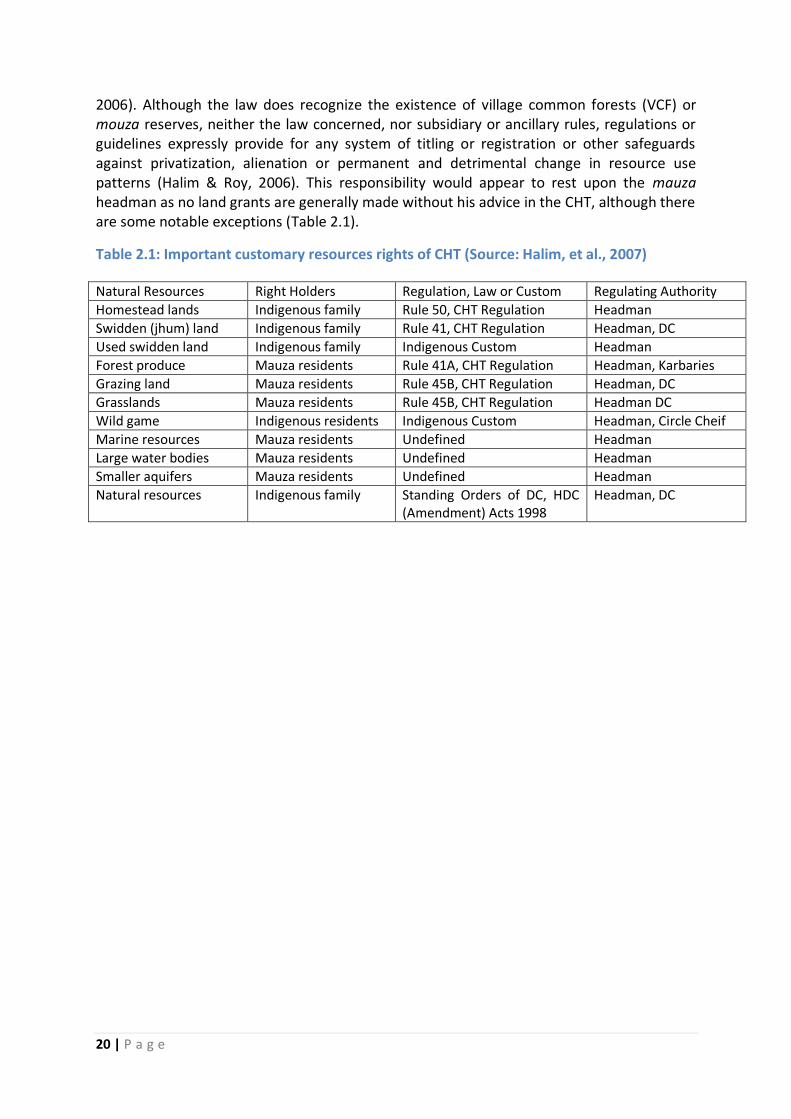
2006). Although the law does recognize the existence of village common forests (VCF) or mouza reserves, neither the law concerned, nor subsidiary or ancillary rules, regulations or guidelines expressly provide for any system of titling or registration or other safeguards against privatization, alienation or permanent and detrimental change in resource use patterns (Halim & Roy, 2006). This responsibility would appear to rest upon the mauza headman as no land grants are generally made without his advice in the CHT, although there are some notable exceptions (Table 2.1).
Table 2.1: Important customary resources rights of CHT (Source: Halim, et al., 2007)
Natural Resources Right Holders Regulation, Law or Custom Regulating Authority
Homestead lands Indigenous family Rule 50, CHT Regulation Headman
Swidden (jhum) land Indigenous family Rule 41, CHT Regulation Headman, DC
Used swidden land Indigenous family Indigenous Custom Headman
Forest produce Mauza residents Rule 41A, CHT Regulation Headman, Karbaries
Grazing land Mauza residents Rule 45B, CHT Regulation Headman, DC
Grasslands Mauza residents Rule 45B, CHT Regulation Headman DC
Wild game Indigenous residents Indigenous Custom Headman, Circle Cheif
Marine resources Mauza residents Undefined Headman
Large water bodies Mauza residents Undefined Headman
Smaller aquifers Mauza residents Undefined Headman
Natural resources Indigenous family Standing Orders of DC, HDC (Amendment) Acts 1998
Headman, DC
21 | P a g e
SECTION 3: STUDY APPROACH AND METHODOLOGY Identifying who has the right to benefit from forest products may be no easy task. The right may be held by the government, individual households or entities, a community, or some combination of the three. Customary systems are particularly complex and may consist of compatible yet to some extent overlapping rights and responsibilities to use different resources (Vhugen et al., 2012). However, this study will be conducted to explore the following:
1. Identifying land tenure problems that could be policy related, elite capture, land
grabbing, overlapping land rights, conflicting land tenure, etc.
2. Identifying causes, processes and extents of forest land encroachments in different
forest types.
3. Identify real world situation with specific case studies
3.1. Approaches and Methods Following methods and/or approaches were used for data collection:
A review of literatures related to forest land and tenure in Bangladesh.
A consultative workshop to develop a comprehensive and acceptable methodology
(Appendix 1).
Official records on forest lands (types and extents), encroachments (number and/or area
encroached), settlements (type, procedure, conflicts, etc.) were collected from different
forest divisions.
Focus Group Discussion (FGD) to explore land tenure problems, land conflicts and the
causes and processes of forest land encroachments. At least 2 FGDs were conducted in
each forest divisions having 7-10 participants (including both male and female) from the
respective forest division in each FGD.
Key Informants Interview (KII) to explore land tenure problems, land conflicts and the
causes and processes of forest land encroachments. At least 10 KII were conducted from
each forest division or region including from civil society members, forest officials, local
elites/leaders, NGO professionals, social/environmental activists, etc.
Case studies to explore specific cases on specific land tenure related problems in
different forest types of Bangladesh. Both good and bad practice examples in forest
sector through FGD or KII were identified first and if possible field visits will be
conducted to observe those case study sites.
The study will be conducted in the following forest types as the land tenure problems are prominent and needs special attention if REDD+ to be implemented in Bangladesh. The forest types include sal forests (Central and northern parts of Bangladesh), hill forests (southeastern and northeastern parts of Bangladesh), and coastal forests (southern parts of Bangladesh). FGD and KII study were conducted to collect information on land tenure related problems involving people from all corners of the society under following categories like, regulators (policy makers, and officials from BFD, administration, police, etc.), users/beneficiaries (forest dependent communities), social accountability group, service provider group (NGO, CMC, CSO, Journalist, local elite), and others (Appendix 2).
22 | P a g e
SECTION 4: FOREST LAND DECLARATION PROCESS AND THE CONCEPT OF FOREST VILLAGERS
4.1 Forest Land Declaration Process
4.1.1. Reserved Forest Forest land declaration process starts with the help of Forest Act 1927 (Act No. XVI of 1927) that was amended first as Forest (Amendment) Act 1990 (Act No. VIII of 1990) and later as Forest (Amendment) Act, 2000 (Act No. X of 2000). This is an Act to consolidate the law relating to forests, the transit of forest-produce and the duty leviable on timber and other forest-produce. According to section 3 of this Act, the Government may constitute any forest-land or waste-land or any land suitable for afforestation which is the property of Government, or over which the Government has proprietary rights, or to the whole or any part of the forest produce of which the Government is entitled, a reserved forest. The process of forest reservation officially starts by issuing a notification in the official Gazette under sub-section (1) of section 4 of the Forest Act 1927 whenever it has been decided to constitute any land reserved forest. The notification under clause (a) declares that it has been decided to constitute such land a reserved forest, under clause (b) specifies the situation and limits of such land, and under clause (c) appoints Forest Settlement Officer (FSO) to inquire into and determine the existence, nature and extent of any rights alleged to exist in favor of any person in or very any land comprised within such limits, or in or over any forest-produce, and to deal with the same. For the purposes of clause (b), it shall be sufficient to describe the limits of the forest by roads, rivers, ridges or other well-known or readily intelligible boundaries. The officer appointed under clause (c) of sub-section (1) shall ordinarily be a person not holding any forest-office except that of Forest Settlement-officer. Nothing in this section shall prevent the Government from appointing any number of officers not exceeding three, not more than one of whom shall be a person holding any forest-office except as aforesaid, to perform the duties of a Forest Settlement-officer under this Act. Section 5 states that, after the issue of a notification under section 4, no right shall be acquired in or over the land comprised in such notification, except by succession or under a grant or contract in writing made or entered into by or on behalf of the Government or some person in whom such right was vested when the notification was issued; and no fresh clearings for cultivation or for any other purpose shall be made in such land except in accordance with such rules as may be made by the Government in this behalf. According to section 6, when a notification has been issued under section 4, the FSO shall publish in Bengali in every town and village in the neighborhood of the land comprised therein, a proclamation under clause (a) specifying, as nearly as possible, the situation and limits of the proposed forest; under clause (b) explaining the consequences which, as hereinafter provided, will ensue on the reservation of such forest; and under clause (c) fixing a period of not less than three months and not more than four months from the date of such proclamation, and requiring every person claiming any right mentioned in section 4 or section 5 within such period either to present to the FSO a written notice specifying or to
23 | P a g e
appear before him and state, the nature of such right and the amount particulars of the compensation (if any) claimed in respect thereof. Subsequent sections deals with inquiry by FSO (section 7); powers of FSO (section 8); extinction of rights (section 9); treatment of claims relating to practice of shifting cultivation (section 10); power to acquire land over which right is claimed (section 11); order on claims to rights of pasture or to forest-produce (section 12); record to be made by FSO (section 13); record where claim is admitted (section 14); exercise of rights admitted (section 15); commutation of rights (section 16); time limit for resolution of claims (section 16A); appeal from order passed under section 11, section 12, section 15 or section 16 (section 17); appeal under section 17 (section 18); and pleaders (section 19). Finally, notification declaring forest reserved is done under sub-section (1) of section 20 when the following events have occurred, namely:- clause (a) the period fixed under section 6 for preferring claims has elapsed, and all claims, if any, made under that section or section 9 have been disposed of by the FSO; clause (b) if any such claims have been made, the period limited by section 17 for appealing from the orders passed on such claims has elapsed, and all appeals (if any) presented within such period have been disposed of by the Divisional Commissioner; and clause (c) all lands (if any) to be included in the proposed forest, which the FSO has, under section 11, elected to acquire under the Acquisition and Requisition of Immovable Property Ordinance, 1982 (Ordinance No. II of 1982), have become vested in the Government under section 11 of that Ordinance, the Government shall publish a notification in the official Gazette, specifying definitely, according to boundary-marks erected or otherwise, the limits of the forest which is to be reserved, and declaring the same to be reserved from a date fixed by the notification. The date so fixed such forest shall be deemed to be a reserved forest under sub-section (2) of section 20. Subsequently, section 22 empowers the Government, within five years from the publication of any notification under section 20, to revise any arrangement made under section 15 or section 18, and may for this purpose rescind or modify any order made under section 15 or section 18, and direct that any one of the proceedings specified in section 15 be taken in lieu of any other of such proceedings, or that the rights admitted under section 12 be commuted under section 16. According to section 23, no right of any description shall be acquired in or over a reserved forest except by succession or under a grant or contract in writing made by or on behalf of the Government or some person in whom such right was vested when the notification under section 20 was issued. However, notwithstanding anything contained in section 23, no right continued under clause (c) of sub-section (2) of section 15 shall be alienated by way of grant, sale, lease, mortgage or otherwise, without the sanction of the Government: Provided that, when any such right is appendant to any land or house, it may be sold or otherwise alienated with such land or house (section 24(1)) and no timber or other forest-produce obtained in exercise of any such right shall be sold or bartered except to such extent as may have been admitted in the order recorded under section 14 (section 24(2)). Reserved forests so notified under sections 4 and 6 of the Forest Act 1927 shall be recorded in favor of Deputy Commissioner provided that there shall be a comment written on the 9th
24 | P a g e
column of the Khatian10 that states “ineligible for settlement due to notified reserved forests under section 4 and 6”. Reserved forests notified under section 20 of the Forest Act 1927 shall be recorded in favor of BFD on behalf of the Government. Most of the reserved forests notified under section 20 have been recorded in Khas Khatian No. 2 during B.S. survey. However, in mouzas where there was no khas land in favor of Deputy Commissioner during the survey the reserved forests notified under section 20 in those mouzas have been recorded in favor of the BFD on behalf of the Government in the Khas Khatian No. 1. As for example, forest lands of ‘Ramgarh-Sitakunda reserved forests mouza’ under Fatikchari and Mirsharai Upazillas have been recorded in favor of the BFD on behalf of the Government in the Khas Khatian No. 1. Official statistics show that around 51.61% (1.33 million ha) of the total forests of Bangladesh has so far been declared as reserved forests under section 20 of the Forest Act 1927 with another 18.90 % (0.49 million ha) of the total forests declared under sections 4 & 6 of the Forest Act 1927 (Table 4.1).
4.1.1.1. Declaring forest reserves in CHT When any area of land is declared to be reserved the claims relating to Jhum over such land are recorded by the Forest Settlement Officer (FSO), who then sends it to the government along with his opinion for allowing or prohibiting such cultivation. The Government may permit or prohibit the claim in whole or in part (Chowdhury, 2012). The practice when allowed is “deemed to be a privilege subject to control, restriction and abolition by the Government” (Section 10, Forest Act 1927). In case of right of pasture or forest produce the FSO can admit it in part or whole, but such right can be commuted in lieu of monetary compensation where alternate forest land is not available (Sections 12-17, Forest Act 1927). The Jhummas claim that in most of the cases procedure for reservation are not followed. Since, the notifications are made in Bangla as per the Act, unfamiliarity with language and complex legal procedure significantly harms the Jhumma rights (Chowdhury, 2012).
4.1.2. Attia Forest The Attia Forest (Protection) Ordinance, 1982 (Ordinance No. XXXIII of 1982) is an Ordinance to make provision for the protection of the Attia Forest in the districts of Dhaka and Tangail. According to section 3 of this Ordinance, notwithstanding anything contained to the contrary in the Forest Act, 1927 (XVI of 1927), or in any other law for the time being in force, or in any judgment, decree or order, the lands comprising of 59,648.70 acres constituting a reserved forest known as the Attia Forest under Notifications mentioned in the Schedule shall, notwithstanding any defect in such constitution or Notifications, be deemed to have been validly constituted a reserved forest and the Notifications so issued shall be deemed to
10 Khatian is the individual land record certificate that indicates genuine title over the land. The term “Khatian” is commonly used to mean “record-of-rights”. Every entry of the Khatian shows its own khatian number, plot numbers, reduced/divided plot (bata dag) and omitted or dropped plot (chuta dag), area, mouza, names and shares of the possessors, descriptions of their rights and superior interests, etc. Different Khatians had been prepared during different surveys. Such as, C.S. Khatian prepared during Cadastral survey (1892-1898) under the Bengal Tenancy Act, 1885; R.S. Khatian prepared during the Revisional Survey (1925-1930); S.A. Khatian prepared during the State Acquisition Survey under the State Acquisition and Tenancy Act, 1950; B.S. Khatian prepared during the Bangladesh Survey (1980-85).

25 | P a g e
have had effect accordingly. The Ordinance also states under sub-section (1) of section 4 that, the constitution of Reserved forest as is referred to in section 3 shall not be called in question on any ground whatsoever before any Court. In this connection sub-section (2) of section 4 declares all suits, appeals, petitions, applications, and other legal proceedings pending immediately before the commencement of this Ordinance in any Court against the Government or any of its officers in which the constitution of the reserved forest or the Notification as are referred to in section 3 has been called in questions in any manner whatsoever shall abate forthwith and shall not be further proceeded with. The main aim of this Ordinance was to protect the Attia forests from any sort of land grabbing, encroachment or illegal occupation of the forests. However current status of Attia forests under Tangail Forests division shows that there are 22,460.07 ha (55,476.38 acres) of Attia forests of which 4,533.26 ha (20.18%) has been encroached. The BFD is trying to bring encroached lands under their management and has so far been able to bring 7,960.55 ha (35.44%) of encroached and fallow lands under social forestry programs. There are still 6,672.90 ha of natural sal forest under Attia forests in the Tangail Forest Division (Table 4.2).
Table 4.1: Legal status of forest lands in Bangladesh (BFD, 2017)
Forest Land classes Area (acre) Area (ha) Percentage of total (%)
Reserved forests declared under section 20
3,287,577.83 1,331,469.02 51.61
Reserved forests declared under section 4 & 6
1,201,851.28 486,750.00 18.90
Protected forests 91,381.89 37,009.67 1.43
Acquired / vested forests
28,591.34 11,579.49 0.44
Un-classed state forests controlled by BFD
42,847.51 17,353.24 0.67
Forest land controlled by BFD
4,652,249.85 1,884,161.19 73.05
Un-classed state forests controlled by revenue department
1,716,609.32 695,226.77 26.95
Total forest land 6,368,859.17 2,579,387.96 100
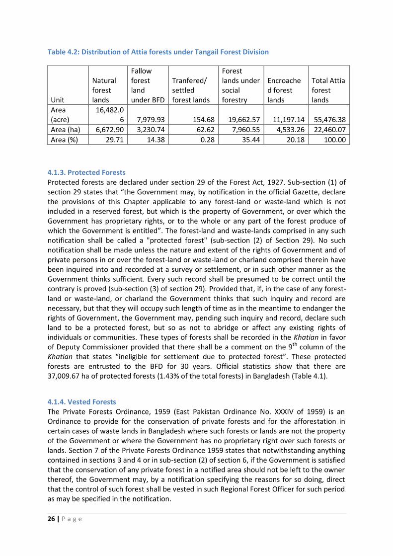
26 | P a g e
Table 4.2: Distribution of Attia forests under Tangail Forest Division
Unit
Natural forest lands
Fallow forest land under BFD
Tranfered/ settled forest lands
Forest lands under social forestry
Encroached forest lands
Total Attia forest lands
Area (acre)
16,482.06 7,979.93 154.68 19,662.57 11,197.14 55,476.38
Area (ha) 6,672.90 3,230.74 62.62 7,960.55 4,533.26 22,460.07
Area (%) 29.71 14.38 0.28 35.44 20.18 100.00
4.1.3. Protected Forests Protected forests are declared under section 29 of the Forest Act, 1927. Sub-section (1) of section 29 states that “the Government may, by notification in the official Gazette, declare the provisions of this Chapter applicable to any forest-land or waste-land which is not included in a reserved forest, but which is the property of Government, or over which the Government has proprietary rights, or to the whole or any part of the forest produce of which the Government is entitled”. The forest-land and waste-lands comprised in any such notification shall be called a "protected forest" (sub-section (2) of Section 29). No such notification shall be made unless the nature and extent of the rights of Government and of private persons in or over the forest-land or waste-land or charland comprised therein have been inquired into and recorded at a survey or settlement, or in such other manner as the Government thinks sufficient. Every such record shall be presumed to be correct until the contrary is proved (sub-section (3) of section 29). Provided that, if, in the case of any forest-land or waste-land, or charland the Government thinks that such inquiry and record are necessary, but that they will occupy such length of time as in the meantime to endanger the rights of Government, the Government may, pending such inquiry and record, declare such land to be a protected forest, but so as not to abridge or affect any existing rights of individuals or communities. These types of forests shall be recorded in the Khatian in favor of Deputy Commissioner provided that there shall be a comment on the 9th column of the Khatian that states “ineligible for settlement due to protected forest”. These protected forests are entrusted to the BFD for 30 years. Official statistics show that there are 37,009.67 ha of protected forests (1.43% of the total forests) in Bangladesh (Table 4.1).
4.1.4. Vested Forests The Private Forests Ordinance, 1959 (East Pakistan Ordinance No. XXXIV of 1959) is an Ordinance to provide for the conservation of private forests and for the afforestation in certain cases of waste lands in Bangladesh where such forests or lands are not the property of the Government or where the Government has no proprietary right over such forests or lands. Section 7 of the Private Forests Ordinance 1959 states that notwithstanding anything contained in sections 3 and 4 or in sub-section (2) of section 6, if the Government is satisfied that the conservation of any private forest in a notified area should not be left to the owner thereof, the Government may, by a notification specifying the reasons for so doing, direct that the control of such forest shall be vested in such Regional Forest Officer for such period as may be specified in the notification.
27 | P a g e
The Private Forest Ordinance was originally enacted in 1945, as the Bengal Private Forest Act, and was re-enacted by the Bangladesh (then East Pakistan) in 1949 before being issued as an Ordinance in 1959. This Ordinance allows the Government to take over management of improperly managed private forest lands, any private lands that can be afforested, and any land lying fallow for more than three years. The lands managed under this ordinance are called ‘vested forests’ and BFD currently manages approximately 8,500 ha of lands as vested forests in the country (FRA, 2000). This area is relatively small, but the area historically affected by this law is much larger. Forest lands acquired under the State Acquisition and Tenancy Act, 1950 can also be vested under section 7 of the Private Forest Ordinance, 1959 for 99 years through Gazette notification for scientific forest management. These forest lands are managed following ‘Vested Forest Management Rules’ and were recorded in the name of land owner but control lies to the BFD. These vested forests after duly acquired by the Government will be considered as reserved forests and will be recorded in favor of BFD.
4.1.5. Acquired Forests The State Acquisition and Tenancy Act, 1950 (East Bengal Act No. XXVIII of 1951) is an Act to provide for the acquisition by the State of the interests of rent-receivers and certain other interests in land in Bangladesh and to define the law relating to tenancies to be held under the State after such acquisition and other matters connected therewith. Prior to the State Acquisition and Tenancy Act, 1950, the tenants were subject to the will of a pyramid of landlords (Zamindars). After the enactment of this act the landlord system had been abolished and vested all the land in the constitution (State). It provided title of the land to its tillers and set limits on extent and kinds of private land holding. The act allowed for retention of the homesteads and agricultural lands, up to a specified limit but did not entitle a tenant to retain forested lands. Therefore, during the period this Act became operative, many people illegally cleared their forests and hastily erected settlements so that government is not able to claim that land. According to the section 20 of State Acquisition and Tenancy Act, 1950 all the lands in excess of 375 standard bigha including hat, bazaar, kachari, open kachari, open water body, and forest has been acquired and considered as Khas land11 of the Government. Later section 3 of the Ordinance No. 98 of 1972 limiting the ceiling on land entitlement states to vest all lands in excess of 100 standard bighas on the Government. These types of acquired lands are considered as Government Khas land. The forest lands so acquired by the government under this Act are called "acquired forests". These forests shall be recorded in favor of Deputy Commissioner till these forest lands are not handed over to BFD for management by the Ministry of Land provided that a comment shall be written on the 9th column of the Khatian that states “ineligible for settlement due to forest”. When these forest lands are handed over to BFD then these shall be recorded in favor of forest department. The BFD currently manages about 9,600 hectares of acquired forests (FRA, 2000). This figure is far smaller than the amount of land historically acquired. The
11
Khas land means ‘Government-owned land properties, which are capable of being utilized for the purpose of development of the state and remaining unused, are normally given to the persons who can utilize the land for their own livelihood’
28 | P a g e
government has reserved many of these acquired lands under the Forest Act, 1927 and those areas are now counted with the reserved forests. Under the State Acquisition and Tenancy Act, the government has also acquired full ownership of many of "vested forests" (under Private Forest Act) and reserved them. The small area that is still managed as "vested forests" are largely lands that the government could not acquire under this Act. Bangladesh has a total of 11,579.49 ha of acquired or vested forests located in different districts namely Moulvibazar, Chittagong, Rangmati, Rangpur, Nilphamari and Naogaon (Table 4.1 and Appendix 3).
4.1.6. Court of Wards Court of Wards Act, 1879 (Act No. IV of 1879) is an Act to amend the law relating to the Court of Wards. The Board of Land Administration shall be the Court of Wards for the territories to which this Act extends. It shall deal with every person and every property of which it may take or retain charge under this Act, or which may be placed under its charge by order of a competent Court, in accordance with the provisions of this Act. According to section 7 of this Act, whenever the sole proprietor of an estate, or all the joint proprietors of an estate are disqualified as provided in the section 6, the Court shall have power to take charge of all the property of every such proprietor or joint proprietor within its jurisdiction, and of the person of any such proprietor or joint proprietor who is resident within its jurisdiction; and also of the person and property of any minor member of the family of any such proprietor or joint proprietor who has an immediate or reversionary interest in the property of such proprietor or joint proprietor. However, the Court shall not be empowered to take charge of the person of a proprietor disqualified under clause (e) of section 6. The property taken the charge by the Court of Wards remains under the jurisdiction of the Deputy Commissioner who usually distributes these lands through settlement. Some of these lands were handed over to BFD where scientific forest management was possible and notified by Gazette. There are a total of 1952.82 ha (4823.48 acres) of Court of Wards forest lands under Dhaka Forest Division of which 1674.71 ha (4136.55 acres) are located in Bhawal Raj Estate of Gazipur district and 278.11 ha (686.93 acres) in Dhaka Nawab Estate of Dhaka district. These lands are considered disputed land ownership by the BFD.
4.1.7. Un-classed State Forests Un-classed state forests (USF), concentrated in CHT, covers about 0.712 million ha of land that is about 27.62% of the total forest land of Bangladesh (Appendix 3), however another estimate shows that total area of USF is 0.73 million ha (Appendix 4). USF can be regarded as the forests not classified as reserved or protected forests and not under the control of BFD. These forests are mostly controlled by the Ministry of Land through the Deputy Commissioner. However, BFD also controls small portion of these forests (0.017 m ha) (Table 4.1, Appendix 3). Almost all of these lands are located in the Chittagong Hill Tracts (CHT) and small portion of these lands are also located in Habiganj, Sylhet and Moulvibazar districts. USF do not have any designation in law and in fact they are the mauza reserves held by the community in common. The rights granted to the Jhummas over the USF are limited and conditional. The state can take them back at will and settle or lease them to anyone. These USF lands are traditionally used by the tribal people for jhum cultivation, grazing, hunting and gathering, and other purposes. However, their customary rights on these lands were not recognized by the DC office, which treated these as khas or state
29 | P a g e
property (Adnan and Dastidar, 2011). The whole area of the district outside the forest reserves has been sub-divided into mauzas, the boundaries of which have been fixed by the Deputy Commissioner (Article 37, CHT Regulation 1900). These mouza lands are state property and classified as un-classed state forests and on the other hand also considered as common property of the mouza residents and controlled and administered by the mouza headman on behalf of the Deputy Commissioner. USF lands have lately been subjected to heavy commercial exploitation in connivance with and collaboration of unscrupulous staff of the concerned public agencies including forest, land revenue and police departments. Besides sharing the same problems as those of the hill forests, the forest management system here suffers from a serious lack of inter-agency coordination (especially between the forest and land revenue departments).
4.2 The concept of forest villagers
4.2.1. Concept of Forest Village In the early 20th century, while forest labor was in serious shortage, the BFD established “Forest Villages” in reserved forest areas, whereby each family was given land for homesteads and agriculture. They used to be allowed to collect all their forest product needs from the forest free of cost and in lieu thereof they used to provide free labor to the BFD and every family had to establish one acre of forest plantation every year. Such forest villages were established in each of the then beat areas in Sylhet, Chittagong, CHT and Cox’s Bazar Forest Divisions (Saha, 1998, Choudhury and Hossain, 2011). Allotments were granted to the forest villagers, ban proja, on a renewable basis for 99 years (Saha and Azam, 2004). Till the seventies they used to be obedient and comply with the instructions of BFD personnel. According to an official statistics there are 452 forest villagers (289 in RF and 113 in PF) occupying 352 ha of forest lands (232ha in RF and 90 ha in PF) in Chittagong North Forest Division (Appendix 7). With the passage of time their population grew large and the BFD’s control became ineffective; political motivations inspired them to become aggressive and most destructive to forests. At present most of these forest villagers are in conflict with the BFD and since they live right inside the reserved forest, they cause the most severe damage to forests (Choudhury and Hossain, 2011). Almost all the forest villages are now expanding at an alarming rate through encroachment. The original villagers have been inviting their relations and allotting forest land to them, due to the absence of any proper village records and demarcation, and the situation appears to be out of control in many areas (Saha and Azam, 2004).
4.2.2. Khasia Ethnic Community: A case of forest villagers The Khasia ethnic community, some of whom have been serving the Sylhet forest division as forest villagers since the early 1950s, is predominant in the northeastern hill forests. Introduction of forest villagers in Sylhet forest division was considered the main force behind forest conservation and plantation expansion. Forest reservations in this division started in 1914, reducing to shifting cultivation and grazing. With the objective of restoring previous forest coverage, the BFD commenced plantation programs in Sylhet forest division in the 1920s, but little was achieved due to labor shortage. To overcome this shortage, the
30 | P a g e
BFD initially registered a few Khasia people as forest villagers in 1952–1953. These people had moved from the nearby Indian border (near the Jaintia hills), and from various parts of Sylhet Forest Division where they had migrated many years before from India. They were granted degraded forest land for building homes and agroforestry practices on the condition that they supply their labor when and where needed for plantation development and protection of the forest from pilferage. Under this scheme, the plantation program gained momentum during 1955–1960 with the establishment of about 200 ha/year, and increased in 1975–1980 to about 500 ha/year (Nath and Inoue, 2014). The Khasia communities have introduced a betel leaf based farming system which is as an appropriate land use management system for the replenishment of the degraded reserve forests of Moulvibazar district, the protection of plantations and the conservation of biodiversity that provided them with social security and substantial economic benefits (Saha and Azam, 2005).
31 | P a g e
SECTION 5: ANALYSIS OF KEY LAND TENURE RELATED PROBLEMS AND POLICIES IN SELECTED FOREST TYPES Due to rapid increase in population, forest lands are encroached illegally. Up to 2006 an estimated 89,000 ha of forest lands have been encroached upon in different forest areas. Insufficient demarcation of the boundaries of national forests has made the situation worse (Rahman, undated). In addition, between 1971 and 2015 more than 20,000 ha of forestlands have been transferred to other agencies for non-forest purposes. Moreover, district administrations have leased out forest lands in many districts. This is quite discernible in the coastal region where forests lands are leased out to private individuals for shrimp culture and salt production pans. Evidently, this was the major cause of disappearance of Chakaria Sundarban at Cox’s Bazar, the second largest mangroves of Bangladesh. Even when there is sufficient land outside the forests, forest lands are grabbed through manipulation by unscrupulous persons. In plain land Sal forest region, particularly, in Gazipur, Tangail and Mymansingh, the problem related to protection of forest land from land grabbers and prevention of encroachment is a daunting task. Most of the forest lands were acquired under the provisions of the State Acquisition and Tenancy Act, 1950. The BFD was entrusted as custodian of such forests, but the record of rights was vested with deputy commissioners. Further, many individuals succeeded to make fake documents, while the administration leased out such forest land to many individuals. Such quadripartite situations call for survey and demarcation of forest lands, correction of record of rights, cancellation of lease orders, and declaration of forest land as reserved forests under the provisions of the Forest Act, 1927 to protect the forests of the region (Rahman, undated).
5.1. Status of Forest Land Tenure
Most of forestlands (about 2.52 Mha) are owned by the government, of which 1.52 Mha are under the management of the BFD and the rest is under the management of the Ministry of Land through Deputy Commissioners. The ownership of the forestland has virtually remained as it was during the last couple of decades. Though the area over which the legal ownership of the government has remained unchanged many forest areas having such government ownership have been encroached and the ownership of such land is questionable. The Forestry Master Plan prepared by ADB (1993) mentioned that about 77,000 hectares of forestland are under encroachment involving about 12,200 families. Choudhury and Hossain (2011) reported that as of June 2006 a total of 89,002 hectares of BFD land was under encroachment.
5.1.1. Hill forest zone Hill Forest is the natural terrestrial forest combining evergreen and deciduous trees covering an area of 1.377 million ha (9.33% of the country) among which 0.677 million ha (around 44% of the total forests) is controlled by BFD (BFD, 2017). Hill forests are located in the hilly areas of Chittagong, Chittagong Hill Tracts, Cox's Bazar, and Sylhet region. Hill forests have been greatly reduced in extent and quality by a large variety of anthropogenic drivers. UN-REDD Bangladesh National Program (2016) identified overpopulation as the key indirect
32 | P a g e
driver of deforestation followed by poverty, weak governance, and unclear land tenure through legal and illegal logging, fuelwood harvesting, encroachment for subsistence, and agriculture in the form of shifting cultivation, that have both degraded and deforested the area.
5.1.1.1. Chittagong Hill Tracts (CHT) Located in the south-east of Bangladesh bordering India and Myanmar, the region, the Chittagong Hill Tracts (CHT), contains an area of 5093 square miles (13,295 square kilometers) or about 10 percent of the land in Bangladesh. Inhabited by a number of indigenous groups (so-called “tribes”), the region is a forest region within Bangladesh considered vital to security and economic interests of Bangladesh. At present, almost one-third of CHT is “Reserved Forests”, and the remaining is “open forest”, known as “Un-classed State Forest” (USF) (Halima and Chowdhury, 2016). Land is a fundamental resource that has everyday dynamics in conflict, violence and development in the Chittagong Hill Tracts (CHT) of Bangladesh. The allocation of rights, restrictions and responsibilities to land (use/access, control and transfer) within the society has been core of the violence in CHT (Islam, 2013). CHT has a unique and exceptional traditional administration and revenue system called “circles” in the USF land that have existed since the 1880s, excluding the regions of the four compact Reserved Forests under the authority of the BFD since 1871. Coinciding slightly with the territories of CHT districts of Bandarban, Khagrachhari and Rangamati, these administrative and revenue circles are known by the ethnicity of the traditional chiefs of Bohmong, Mong, and Chakma respectively. A circle chief or ‘Raja’ heads each circle, which is further divided into Mauzas12 under headmen or Mauza headmen. Mauzas are conventionally comprised of several villages with a Karbari or village headman for each. Chiefs and headmen exercise specific duties and powers in collection of taxes on lands and households of Jhum cultivators. They are further empowered to settle family and civil disputes including land titles and petty crimes other than crimes against the state. The position of Karbari appeared to be a conventional practice of the chiefs and headmen and is certainly not part of the Regulation of 1900. During British period almost all the land in the CHT was taken under state control in different phases and a threefold classification emerged: (i) Reserve Forest (RF) under the Bangladesh Forest Department (BFD), (ii) Protected Forest (PF) owned by the BFD but regulated by the DC office and (ii) Un-classed State Forests (USF) under the DC office. In RFs access and extraction are forbidden without authorization and in PFs access and use are allowed unless forbidden. The USFs do not have any designation in law and in fact they are the mauza reserves held by the community in common. The rights granted to the Jhummas over the USF are limited and conditional. The state can take them back at will and settle or lease them to anyone. Apart from ownership of common land sufficient change was brought to the ownership, occupational and extraction rights of the Jhummas.
12
Mauza is the smallest administrative unit for revenue collection in the CHT containing several villages or hamlets with an average size of 10 miles square and head of the mauza is responsible for the administration of revenue, land, and tribal justice
33 | P a g e
According to the customs of the people of CHT communities, forest and lands were the common property of a specific clan or village community (Jashimuddin and Inoue, 2012b). The concept of land rights (including forest lands) and individual ownership was governed by the prevailing customs of the respective communities. These were all oral traditions rather than written laws (Adnan & Dastidar, 2011; Lasimbang, 2006) institutionalized in the form of social codes or norms mutually upheld by the community. Usually, common rights refer to the generic rights of the hill people through customs and practices that include entitlement to jhum, hunting and gathering, livestock grazing, village common forests, and various other land and forest-based extraction activities (Adnan & Dastidar, 2011; Chakma et al., undated). Circle chiefs, mauza headmen and karbaris regulate these rights and distribute both jhum and plough lands among the hill peoples for cultivation. Some of these common rights are partially acknowledged and regulated but very few are clearly defined. The right to occupy homestead land in rural areas (Rule 50, CHT Regulation 1900) without formal settlement and the right to use timber, bamboo, and other minor forest produce for bona fide domestic purposes (Rule 41A, CHT Regulation 1900; Forest Act 1927) are reserved exclusively for indigenous people (Roy, 2004). The individual rights give individuals entitlement over clearly demarcated land whether as freehold (rights with perpetuity) or leased (rights for a specific period) that includes private forests, commercial plots and plough lands. The significant aspect of British colonial land policy in CHT was that land could neither be sold nor purchased, and was reserved for the hill people or the government (Chowdhury, 2008). In contrary, Pakistan period can be characterized by intensification of resource use for industrial purpose and Bangladesh period by large scale migration of lowland people to CHT that significantly affected the access and use of forests resources (Rasul & Thapa, 2005) creating brutal conflicts between tribal communities and settlers, and more than two decades of insurgency which is theoretically ended up by signing a peace accord in 1997 between the Government of Bangladesh and Jana Sanghati Samiti (JSS), an organization representing indigenous people of the CHT (Jashimuddin and Inoue, 2012b).
Land Tenure in Chittagong Hill Tracts (CHT) A separate legal regime, that blends customary and formal law, exists in the Chittagong Hill Tracts (CHT) region – the principal home of the country’s indigenous people. Authority over land matters in the CHT region is shared by the central government and traditional institutions. The central government operates through its district and sub-district offices; but traditional jurisdiction over natural resource management and land and revenue administration lies with traditional village heads or chiefs (karbaris), the headmen responsible for several villages (mauza) and paramount chiefs or chiefs of revenue circles (rajas). Official government institutions maintain but rarely exercise concurrent jurisdiction (LANDac, 2016). Masum, et al. (2011) also identified conflicts among CHT regional institutions and hill district councils, conflicts between central government institutions and local government institutions, conflicts between central government institutions/regional institutions and traditional institutions, and conflicts between local government institutions and traditional institutions are the major land related conflicts in CHT. The CHT Regulations were subject to indiscriminate changes since the 1960s without any consultation with the Jhummas for whom it was promulgated. For example, rule 34 prohibiting outsiders from owning land in the CHT was amended allowing them to own land
34 | P a g e
if they had resided in the area for 15 consecutive years. But in 1979, rule 34 in the amended form was further amended to legalize the government sponsored settlement program of the Bengalis in the CHT (Roy and Chakma, 2010). This chain of developments followed the enormous disaster that struck the Jhummas in the wake of the commissioning of the Kaptai Hydroelectric project. It allowed the Bengalis to reap the economic benefits generated by the Kaptai Reservoir. The Jhummas systematically felt robbed of their traditional statutory privileges which deepened their sense of alienation from and antagonism towards the Bengalis. Beside Jhum cultivation practice, other significant customary resource rights of the indigenous peoples of CHT include grazing lands for cattle, water bodies and forest. However, access to hunting which is considered by the indigenous people as a customary right has not been recognized by the State legislation. But some of the customary rights to some extent have been recognized by the formal legislation. For example, Rule 50 of CHT Regulation states that indigenous people have the right to occupy homestead lands in the rural area. Rule 41a of CHT Regulation and Forest Act 1927 recognizes that Indigenous people have the right to use timber, bamboo and other minor forest products for the use of domestic purposes (Ahsan, 2011). The indigenous peoples claim that the government ought to show more sincerity in settling land conflict issues as it (the government) still relies on the CHT Land Dispute Resolution Commission Act 2001 (i.e., giving final deciding powers to the Chairman of the Land Commission regarding land disputes, disregarding the capacities/roles of the traditional institutions/leaders to resolve disputes) which has been strongly criticized by indigenous intellectuals and leaders. Hence, land grabbing often with the use of military force is still prevalent in the region, displacing more and more Jhummas in their own land (Tauli-Corpuz et al., 2010). However, very recently the government has amended this anomaly regarding the absolute powers of the Chairman of the Commission by the CHT Land Dispute Resolution Commission (Amendment) Ordinance 2016.
Land tenure problems in CHT Land is widely recognized as the most critical issue in the Chittagong Hill Tracts where indigenous peoples have lost and are continuing to lose their ancestral lands at an alarming rate as a consequence of forceful eviction from and expropriation of their lands through development projects and occupation by the military. To address land-related problems, the Accord provides, inter alia, for the establishment of a Land Commission with a mandate to settle land disputes, including the authority to cancel leases of lands given to non-tribal and non-local people (UN Economic and Social Council, 2011). A lack of recognition and response to their grievances led the tribal population of the CHT to
create the People’s Solidarity Association (Parbatya Chattagram Jana Samhati Samiti or
PCJSS) in 1972. Its armed wing, the Shanti Bahini, emerged in January 1973 and from mid-
1973 an armed conflict began in the CHT, with the Shanti Bahini receiving support from
India (IDMC, 2009). The armed conflict in CHT broke out when the central government
rejected demands by indigenous groups there for constitutional protection and recognition
as a separate community within the new state of Bangladesh. As a counter-insurgency
35 | P a g e
measure, a Government transmigration programme, carried out between 1979 and 1984,
brought an estimated 400,000 Bengali settlers into the Chittagong Hill Tracts, an area which
already had a scarcity of land following the construction of the Kaptai dam. The Kaptai dam,
completed in 1963, inundated 40 per cent of the arable land in the region and displaced
more than 100,000 indigenous peoples, many of whom took permanent refuge in India. The
transmigration programme drastically altered the demographic composition of the
Chittagong Hill Tracts; the percentage of Bengalis in the region rose from 26 per cent in
1974 to 41 per cent in 1981 (in 1951 the Bengalis had accounted for only nine per cent of
the population). In addition, Bengalis illegally occupied the lands of the indigenous peoples
on a large scale. The indigenous population was forcefully relocated to “model villages” and
the Bengalis who could not be accommodated on the land that the relocated or fleeing
indigenous peoples left behind were settled in “cluster villages”, usually next to a military
camp where they served as a protective shield for the military. The forced relocation and
illegal occupation of the lands of the indigenous peoples further escalated the conflict and
this issue became one of the main sources of conflict between the indigenous peoples and
Bengali settlers and the army (UN Economic and Social Council, 2011).
In the absence of restitution of their land and property, many of those displaced due to the
armed conflict have not found durable solutions. The conflict ended officially through a
peace accord in 1997, but many of its causes have persisted, the accord has never been fully
implemented, and many of the displaced remain without a durable solution. Bengali
settlement in the CHT has continued on a smaller scale, and indigenous people continue to
be forcibly displaced from their land, due to evictions by authorities, or by settlers with the
knowledge or direct support of the army. The 1997 peace accord was supposed to represent
a step forward in the recognition of the rights of the Jumma peoples, and offer them a level
of administrative autonomy and authority on land-related matters by transferring more
authority to the Hill District Councils (HDCs), and by creating a Regional Council (RC) and a
land commission to resolve disputes (IDMC, 2009).
The Chittagong Hill Tracts (CHT) Peace Accord set up a Task Force on Rehabilitation of Returnee Refugees and Internally Displaced Persons for the purpose of monitoring and coordinating this process with the government. Internally displaced people (IDP) could not be rehabilitated because government members and tribal members on the Task Force were never able to agree on who qualifies for IDP status, mainly due to the lack of implementation of citizenship reform. The Parbatya Chattagram Jana Samhati Samiti (PCJSS), maintained that the 1997 Accord excluded Bengalis from being re-settled to the CHT. The PCJSS demanded that only tribal people could be classified as IDP and rehabilitated. These PCJSS claims rested on the assumption that citizenship reform, as called for by the Accord, would be fully implemented, vesting sole authority to issue “permanent residency certificates” with the tribal Circle Chiefs. This did not happen. Instead, Bengalis were being issued permanent residency certificates by CHT Deputy Commissioners who happened to be ethnic Bengalis. Thus, as IDPs, Bengalis were qualified to be rehabilitated to the lands titled to them by the Government of Bangladesh in the settler programs of the
36 | P a g e
1980s, while most tribal refugees received nothing as they lacked government issued titles to the lands they occupied decades earlier before the insurgency. No practical steps have been taken to rehabilitate the internally displaced persons. One of the major obstacles to their rehabilitation is disagreement over who qualifies as an internally displaced person. In 2000, the Task Force on Refugees and Internally Displaced Persons compiled a list, identifying 90,208 indigenous families and 38,156 Bengali families as internally displaced families and recommending a package programme to resolve the situation. The inclusion of Bengali settlers who were brought into the region under the transmigration programme carried out between 1979 and 1984 in the list was denounced by PCJSS and the Jumma Refugees Welfare Association, which boycotted subsequent meetings of the Task Force. According to PCJSS, the Task Force unanimously decided, at a meeting in 1998, that only tribal people would be considered as internally displaced persons.29 In 2009, the Task Force was reconstituted but the definition of an internally displaced person is still unresolved and, consequently, this clause of the Accord remains substantially unimplemented (UN Economic and Social Council, 2011). Insecure land tenure, contested ownership between tribal and settler Bengali households, large scale acquisition, incremental land grabbing, etc. are the major problems related to land tenure in CHT. The Peace Treaty includes a number of provisions aimed at the protection of land rights of the indigenous peoples and measures to address the large scales land dispossession suffered by the indigenous peoples. In so doing the Peace Treaty reconstitutes three Hill District Local Government Councils as Hill District Councils (HDCs) with power to supervise state acquisition of land as well as the transfer, sell, and lease of land (Halim and Chowdhury, 2016). According to Mr. Jyotirindra Bodhipriya Larma (known as Shantu Larma), Chairman, CHT Regional Council, the land tenure issue is very important in CHT that depends mainly on the socio-political situation of the area. He accuses that the Peace Accord has not been fully implemented by the government, the regional administrations have not been truly effective, the civil administration in the hills remain controversial as the Deputy Commissioner considers himself as the true representative of the government and do not want to recognize Zilla Parishad or Regional Council, law and order situation is under the military forces not on the hand of police force, and the realities before and after the Peace Accord still remain the same. Mr. Larma also mentioned that CHT Regulation 1900 could be an important guideline in this respect however it has become outdated due to changing situation. Land management issue need to be amended. Current reality of the reserve circle is not the same as 1947. Many reserves are not in existence at the moment and become settlement, like for example, Kasalong reserve has become crowded with human settlement, school and market. Forest boundary is shrinking day by day, both tribal and Bengali people living inside the reserved forests are being elected as Chairman or Member of the union Parishad. So the reality has changed. Although land issue has been included in the Peace Accord but still not transferred to the Zilla Parishad. Mr. Santu Larma demanded that the government should transfer land matters to Zilla Parishad as early as possible through an official order without following any lengthy procedure, Forest Act to be amended to include separate clause for CHT, the occupants of the land should be awarded tenure rights, and BFD activities should be confined to the RF areas declared before 1947.
37 | P a g e
Transfer of forest land is also a problem in the CHT. Whenever there is a need for large chunks of land, the government takes this from forestland. A total of 61,000 hectares of forestland had been transferred till 1984 for various purposes. Also over 46,000 hectares of land (about 75% of that was forest) was submerged and lost when the Kaptai Hydraulic Dam was built in the 1960s (Choudhury and Hossain, 2011). A number of overlapping national, local, regional and traditional institutions exits in CHT. The jurisdictions, functions and authorities of various government institutions are confusing, conflicting, and not clear. In terms of political administration, CHT is currently divided into three administrative districts: Bandarban in the south, Khagrachhari in the north, and Rangamati in the centre. But there is a conflict between central Government and regional Council as well as Conflict between Zilla Parishad and Regional Council. There is also serious lack of security in the remote forests so that forest and other departments cannot work properly. Even social forestry activities cannot be started in the CHT due to non cooperation from the indigenous communities. A total of 28 departments have been vested on Zilla Prishad in CHT but those departments are not running well due to non cooperation and corruption. The CHT Land Dispute Resolution Commission cannot function properly although the CHT Land Dispute Resolution Commission (Amendment) Ordinance 2016 has been enacted as per the proposal of the PCJSS and other indigenous leaders.
5.1.2. Sal forest zone Sal forests cover an area of 0.12 million ha (0.81% of the country and 7.5% of the total forest land controlled by BFD) of Bangladesh. Until the beginning of the 20th century, these forests existed as a continuous belt from the central and northern parts of Bangladesh. Nowadays, they exist mainly in the central part of this country, which is mainly located in the Gazipur, Tangail, Mymensingh and Sherpur districts. There are also some small patches of Sal forests in Comilla, Dinajpur, Rangpur, Naogaon, Thakurgaon, and Panchagarh districts. The Sal forests ecosystem supports a rich and diverse variety of flora and fauna. These forests are dominated by Shorea robusta (90% of the area) and have been severely reduced in area, largely by agriculture and military and industrial encroachment, with the remaining forests mostly degraded (UN-REDD Bangladesh National Program, 2016; Islam and Sato, 2012, Alam et al., 2008). Out of four categories of forest type in Bangladesh, plain land Sal forests are the most endangered and threatened one, having already faced severe deforestation problems. Most of the forest area at present is under occupation by encroachers and the remaining stands are poorly stocked (Alam et al., 2008). Abdullah et al. (2015) reported that the forest area has been reduced by 75% since 1972 but Alam et al. (2008) suggested that forest areas has been reduced by 90%. Weak governance (management) was identified as the main indirect driver leading to deforestation from industrial encroachment and agriculture, and degradation from plantations, illegal logging, and fuelwood harvesting in Sal forests (UN-REDD Bangladesh National Program, 2016). Islam and Sato (2012) found that illegal logging and forest land conversion into different commercial activities are important sources for deforestation. These two agents have been immensely influenced by local corruption and politics along with weak government policies and institutional weakening.
38 | P a g e
The study have identified forest encroachment and illegal occupation, lack of demarcation of khas and forest lands, forest land settlement, lack of training of forest of Range officers and other staff on land tenure and land settlement, cultivation of cash crops on forest lands by the forest dependent communities, lack of coordination of BFD with CMC members, tendency of rich people to make resort in forest or make sophisticated houses in Gazipur and tendency to make project or industry on forest lands as the major problems related to forest lands and land tenure. During the liberation war of Bangladesh in 1971 many people from nearby areas had fled in the deep forest to save their lives from Pakistani forces and took refuge. Most of these people didn’t leave the forests after the liberation war rather settled themselves inside the forests making forest lands as their homes. Some of these people or their successors are still living there without any legal status and creating huge conflicts with the BFD. On the other hand, justice delivery system in Bangladesh is embedded with many limitations that affect resolving land disputes lodged at courts. Resolutions of suits relating land take inordinate delays in most cases; consequently, number of pending cases in courts has increased overwhelmingly.
5.1.2.1. Forest land tenure problem in Tangail Forest Division: A case study Tangail Forest Division was established with a gazette notification in 1968 with 31,300.29 ha forest lands of Mirzapur, Sokhipur, Kalihati and Ghatail Upazilla which were under the control of Mymensingh Forest Division. Later another 18,447.44 ha of forest lands came under the control of Tangail Forest Division with a gazette notification in 1988. Historically, these forests were given to Panni family of Karatia as Jaigir by the Mogal emperor in 17th century. Maharaja of Natore bought these forest estates under the Sunset law during British period. Those forests were under individual ownership. In 1923, the responsibility of management of these forests was considered to vest to the government. Later, these forests were declared as protected forests through a gazette notification in 1925 and subsequently were declared as reserved forests in 1927 and 1928 through 25 gazette notifications following all rules and regulations. Later these forests were vested to the BFD under section 7 of Private Forest Act 1949 for 100 years for the purpose to conserve these forests scientifically. Later, the government acquired these forests under the State Acquisition and Tenancy Act 1950. But question aroused about procedural faults in declaring forest reserves directly under section 20 of the Forest Act 1927 on the basis of previous act without following full procedure under the Forest Act 1927. On the other hand, encroachers or illegal occupants were able to record these forests in their favor according to Record-of-Rights (ROR) of 1962 as they were enjoying these for long time as per family tradition and started paying land tax of the recorded lands. Taking this opportunity people of the locality started to file cases in the Court preparing false documents including the ROR. In this connection the Public Prosecutor (PP) of Tangail has requested the Deputy Commissioner of Tangail, in writing detailing the procedural faults, to resolve the problem who then sent this matter to the Ministry after full inquiry. Based on this the government promulgated the Attia Forest (Protection) Ordinance 1982, an Ordinance to protect the Attia Forest in the district of Dhaka and Tangail.
39 | P a g e
Section 3 of the Attia Forest (Protection) Ordinance 1982 states that “Notwithstanding anything contained to the contrary in the Forest Act 1927 or in any other law for the time being in force, or in any judgment, decree or order, the lands comprising of 24,149.27 ha constituting a reserved forest known as the Attia Forest under Notifications mentioned in the Schedule shall, notwithstanding any defect in such constitution or Notifications, be deemed to have been validly constituted a reserved forest and the Notifications so issued shall be deemed to have had effect accordingly”. It also states that the constitution of reserved forest as is referred to in section 3 shall not be called in question on any ground whatsoever before any Court and all suits, appeals, petitions, applications, and other legal proceedings pending immediately before the commencement of this Ordinance in any Court against the Government or any of its officers in which the constitution of the reserved forest or the Notification as are referred to in section 3 has been called in questions in any manner whatsoever shall abate forthwith and shall not be further proceeded with. It is to be noted that 7,262.31 ha of forests under Sokhipur Upazilla were recorded in favor of individual ownership during Diara Uurvey between 1975-85 of which 5495.38 ha were reserved forests declared under section 20 of the Forest Act 1927 or Attia forests and the rest 1766.93 ha were forests notified under section 6 of the Forest Act 1927. With the objection raised in this connection by the forest department the Ministry of Land requested DG of Land Records and Surveys in 2009 to take necessary actions against the accused officers and staff in this regard and cancelling the Diara survey. But no action has been taken till to date. Encroachment is a big issue at Tangail Forest Division with around 46% forest lands (22,672.06 ha out of 49,747.73 ha total forests) has been reported as encroached so far. The forest dependent communities and other interested persons have been living there for decades by encroaching forests establishing houses, hat, bazaar, masjid, madrasha, and grave yards, etc. and cultivating fallow forest lands. The rate of encroachment has increased due to increase of population. The tendency to encroach forest lands increased after independence. Later political unrest and political backing has aggravated encroachment. Total forest lands of Tangail Forest Division is 49,747.73 ha of which 22,460.08 ha (53%) is reserved forests declared under section 20 of the Forest Act 1927. Remaining 27,287.66 ha (47%) forests, declared as vested forests under section 7 of the Private Forest Ordinance 1959, has been notified under sections 4 and 6 of the Forest Act 1927 after acquiring the land under the State Acquisition and Tenancy Act 1950 (Table 5.1). Since 1989 these forests are under the process of declaration under sections 7 to 20 of the Forest Act 1927. This issue was raised in the monthly meeting of the Tangail district regarding land encroachment but with no success. On the other hand, reserved, protected, acquired or vested forests or any notified land in favor of BFD has to be out of any settlement process. But revenue department time to time has settled forest lands notified in favor of BFD. There is no record of such settlements as the BFD can’t be able to know any settlement until the person who got the settlement show the document to the BFD when only they were denied to use the forests by the forest officials. The Deputy Commissioner of Tangail has been requested time to time not to process any settlement and cancel previously settled lands 1,223 ha under 1197 settlements and raised in the monthly land encroachment related meetings. The deputy commissioner has canceled 586 such settlements so far. Title suit cases regarding

40 | P a g e
these are under trial in different Courts. In most of the cases the encroachers of the canceled settlements can’t be evicted. On the other hand, indigenous people of the Modhupur area consider forest lands as their own land. So they don’t want to involve themselves in any development activity of the BFD. The indigenous people consider having no document of lands as their right to land. Land title problem is the major problem of Tangail Forest Division. A total of 39,984 ha forest lands out of 43,146.86 ha under 130 mouzas of Modhupur, Sokhipur, Ghatail Mirzapur and Kalihati Upazillas has been recorded in favor of BFD. Remaining 3,163.05 ha has been recorded in favor of Deputy Commissioner under Khas Khatian No, 1 and individual persons which are under process of recording in favor of BFD under sections 30 and 31. Another 6,600.87 ha forest lands under 12 mouzas of Sokhipur Upazilla has been recorded in favor of Deputy Commissioner under Khas Khatian No, 1 and individual persons during Diara survey. The cancellation of this Diara survey record is still ongoing.
Table 5.1: Forest lands distribution according to Upazilla in Tangail Forest Division (Source: Tangail Forest Division)
Name of Upazila
Reserved Forest declared under section
20 (ha)
Notified under
section 6 (ha)
Notified under
section 4 (ha)
Total forests
(ha)
Number of
mouzas Comment
Mirzapur 2945.72 121.63 - 3067.35 (6.17%)
21 Deputy Commissioner of Tangail has been requested to take necessary setps to notify forest lands under section 4 to section 6 and section 6 to declare reserved forests under section 20 .
Kalihati 77.34 189.58 - 266.92 (0.54%)
51
Ghatail 2935.63 5912.74 - 8848.37 (17.79%)
03
Sokhipur 15498.56 3619.09 - 19117.65 (38.43%)
49
Modhupur 4725.19 13613.92 108.33 18447.44 (37.08%)
18
Total 26182.44 (52.63%)
23456.96 (47.15%)
108.33 (0.22%)
49747.73 (100%)
142
5.1.2.2. Forest land tenure problem in Gazipur District: A case study Gazipur district was formed in 1984 under Dhaka division with an of area 1741.53 sq km,
located in between 23°53' and 24°21' north latitudes and in between 90°09' and 92°39' east
longitudes. It is bounded by Mymensingh and Kishoreganj districts on the north, Dhaka,
Narayanganj and Narsingdi districts on the south, Narsingdi district on the east, Dhaka and
Tangail districts on the west. There are a total of 26,449.43 ha of forest lands in Gazipur
district under two forets divisions, namely, Dhaka Forest Division (21,351.07 ha) and Wildlife
41 | P a g e
Management and Nature Conservation Division, Dhaka (5098.35 ha) (Appendix 8). All the
forest lands are reserved forests declared under section 20 (13162.07 ha; 49.76% of total),
section 6 (10822.81 ha; 40.91% of the total) and the rest under section 4 (2464.54 ha;
9.31%) of the Forest Act 1927. However there are serious conflicts in land tenure among the
forest department and the local communities including the indigenous people. A total of
2856.05 ha (10.8% of the total) had been recorded in favor of private individuals during
Revisional Survey (RS record). On the other hand a total of 5282.75 ha (19.97% of the total)
had been encroached so far by 26,561 encroachers and 147.21 ha had been encroached by
153 industrial units in Gazipur. Generally people encroach forest lands for the purpose of
building homesteads, schools, mosques, madrasa, playing ground, agricultural land,
industries, fish farms, hatchery, poultry farm, shop, local market, etc. Gazipur being situated
very close to Dhaka and rapid development of communication the people are very much
interested to encroach forest lands and the conflict with the forest department is
aggravating day by day. There is a also a tendency of rich people to make resort in forest or
make sophisticated house in Gazipur and tendency to make project/industry in forest land.
Forest department have tried their best to make the encroached forest lands occupancy
free and were able to reforest 777.3 ha forest lands after making occupancy free. A total of
248 record amendment cases has been filed so far by the forest department. There are also
forest land conflicts between BFD and Court of Wards (ha) on 1674.72 ha (6.33% of the
total) (Appendix 8).
5.1.3. Coastal forest zone Bangladesh is a low-lying deltaic country at the confluence of mighty river systems, namely the Ganges, the Brahmaputra and the Meghna. The land is deep, fertile and flat. Most parts are less than 12 m above the sea level while the highest point is about 1,052 m. Very often the country faces natural disasters, especially cyclones and tidal bores. The alluvial soil deposited by these rivers has created some of the most fertile plains in the world. To stabilize the newly accreted mud flats (locally called ‘Chars’) at the estuaries of Bay of Bengals, Coastal Forest Divisions of Bangladesh Forest Department have been raising mangrove plantations since 1966. These Mangroves serve as protective barrier against cyclones and tidal surges. Bangladesh has 710 Kilometer long coast line. Coastal zone constitutes 32 percent of the area and 28 percent of the population of Bangladesh. Land of coastal area is used mainly for agriculture, shrimp and fish farming, forestry, salt production, ship-breaking yards, ports & industries. Land use in the coastal zone is diverse, competitive and often conflicting. Coastal afforestation initiatives have been started since 1966 after devastating cyclonic storm which took toll of huge human lives & damaged property. Bangladesh is pioneer in protecting coastal areas from natural disasters and stabilizes land areas by planting Sonneratia apetala (Keora) along the coastal belt. Major objectives of coastal plantation initiative in Bangladesh include: protection of human habitation, life, property and agricultural crop from natural disaster; stabilize newly accreted land; increase forest resources of the country; increase & protect fish & other aquatic resources; ameliorate environment from degradation and
42 | P a g e
improve biodiversity; improve resilience through afforestation and community adaptation against adverse impact of climate change; and carbon sequestration13. Coastal forests are located in the coast areas of Noakhali, Lakshmipur, Bhola, Patuakhali, Barguna, Phiruzpur, Chittagong and Cox’s Bazar. Covering an area of 0.196 million ha which is 1.36% of the country and 12.5% of the total forest lands controlled by BFD. These forests are being established in the newly accreted char lands of the coastal areas since 1965 (BFD, 2017). These forests are also termed as para ban. Overpopulation and unclear land tenure have been identified as the main indirect drivers for deforestation in the coastal forests (UN-REDD Bangladesh National Program, 2016). Bangladesh has an estimated 1723 square kilometers of newly accreted lands, locally known as char land, emerging from water in the major river systems and the Bay of Bengal.The newly accreted char lands are given to BFD for plantation usually for 20 years to stabilize the land and make it suitable for human settlement and cultivation. Afforestation in the newly accreted land not only helps in the retention of deposited soil particle, but also hastens the process of raising the land above the tide level. Through the afforestation project, the incoming silt load intercepted by existing stems, twigs, roots and fallen leaves of the plantations. This accelerates the siltation process and in this way the site gets silted and raised in an accelerated manner.
5.1.3.1. Noakhali Coastal Forest Division: A case study Noakhali Coastal Afforestation Division was established in the year of 1966-67 for raising coastal plantations in the newly accreted Char lands. A total of 182,186.23 ha (4,50,000 acre of which Feni district 20,000 acre, Noakhali district 3,80,000 acre and Lakhsmipur district 50,000 acre) newly accreted char lands were handed over to Noakhali Coastal Forest Division from Ministry of Land in 1976 through Gazette notification for 10 years and these lands were declared as reserved forests in 1977 under section 4 of Forest Act 1927. Later these lands were handed over to BFD by MoEF for 20 years in 1990. In 1999, ADC (Revenue) of Noakhali district has been appointed as FSO to process the reservation of 153,846.15 ha (3,80,000 acre) in Noakhali, ADC (Revenue) of Feni district as FSO to process the reservation of 8,097.17 ha (20,000 acre) in Feni, and ADC (Revenue) of Lakhsmipur district to process the reservation of 20,242.91 ha (50,000 acre) in Lakhsmipur through separate Gazette notifications. Official record shows that there are 1,13,162.96 ha forest lands declared under section 4 of Forest Act 1927, 31,722.72 ha under section 6 of Forest Act 1927,and 29,203.38 ha under section 20 of Forest Act 1927, and 16,352.22 ha declared as protected area (National Park) under section 17 of Wildlife (Conservation and Security) Act 2012 (Appendix 9). At present, encroachment is one of the major problems of Noakhali Coastal Forest Division. With the help of elites and land grabbers 54,829.51 acres of land has been encroached by 4,354 encroachers so far. To evict these encroachers different initiatives including filing cases has been taken. To keep the forest lands free from encroachers many initiatives taken so far has been failed, many staff were injured or died. The encroachers are living there permanently for the last 10 years by establishing homesteads or cultivating the lands.
13 http://www.theguardianbd.com/coastal-afforestation-in-bangladesh-and-its-role/
43 | P a g e
Currently there are 128 forest cases under trial in the Court against the encroachers. It may be noted that 3589 acre land of Nijhum Deep National Park (Char Osman Beat of Jahajmara Range) has been encroached with the help of land grabbers in connivance with staff and officers of land department. Land settlement and transfer of forest lands by district or upazilla administration after 20 years of establishing coastal plantations without consulting BFD or deciding what to do with the planted forests is considered an important conflicting issue by the BFD in the coastal areas. District or upazilla administration usually settles these lands by changing the names of the chars or naming it as extension of the chars for which the fate of the coastal plantations are in danger. As for example, after declaration of Nijhum Deep National Park in 2001, some lands were settled in Char Kamala by establishing new mouza as Char Mahid, Char Bahauddin (Damar char) as Char Mizan, Char Rowshan as Char Mizan, Char Kalam as extened Mac pershon and extended Mohammadpur, north-east portion of Char Kalam as extended Char Birbiri. So it is important to take right decision by the government regarding land transfer (Appendices 5&9), afforestation and land settlement. In this connection, the Government may form a Coastal Development Board to take coordinated efforts for land management, afforestation, and livestock and fisheries resources development. Experiences of Char Development and Settlement Project (CDSP) being implemented by both the GoB and the Netherlands government since 2001, which is now in its Phase IV, to resolve land tenure related problems in the coastal areas.
5.1.4. Mangrove forest zone (The Sundarbans) The Sundarbans, the vast majority of mangrove forests, occur in the south-west of Bangladesh between the river Baleswar in the East and the Harinbanga in the West, adjoining to the Bay of Bengal. It is famous for unique ecosystem, river networks, magnificent scenic beauty and natural resources for its wide biodiversity of mangrove flora and fauna both on land and water. Located in the delta region of Padma, Meghna and Brahmaputra river basins, this unique forest area extends across Khulna, Satkhira, Bagerhat districts of Bangladesh. The Sundarbans is considered as the single largest contiguous patch of mangrove forest in the world with an area of approximately 6017 km2. However the area of Sundarbans was 16,700 km2 about 200 years ago. The Whole of Sundarbans was decaled as Ramsar site in 1992, inscribed in the World Heritage List In 1997 by UNESCO World Heritage Sites in order to protect the unique natural resources, plants, animals and the existing ecosystem, declared as an Ecologically Critical Area (ECA) in 1999 by Department of Environment (DoE) under section 5 of the Environment Conservation Act 1995. There are 3 wildlife sanctuaries (East, West and South) declared in 1977 and 3 dolphin sanctuaries (Dhangmari, Chandpai and Dudhmukhi at areas of eastern Sundarbans) declared in 2012 covering an area of approximately 1408 km2 (23% of the total Sundarbans). In 2014 the government declared approximately 1738 km2 of Bay of Bengal bordering south of Sundarbans as marine protected area. The Sundarban ecosystem is characterized by a very dynamic environment due to the effect of tide, flooding, salinity and cyclones. Its rich biodiversity, lush foliage and exuberant flora, fauna and avifauna, combined with its unique culture and ecological significance, makes it a prized natural and cultural resource for not just Bangladesh but the whole of South Asia.
44 | P a g e
Dominated by Heritiera fomes, the Sundarbans is home to 334 species of plants, 49 species of mammals, 320 species of birds, 53 species of reptiles and 400 species of fish specially the elusive key stone species of the Sundarbans Mangrove Forest, the Royal Bengal Tiger, many of which are endangered. About 4 million people depend directly on mangroves for their livelihoods, with 3.5 million of these relying on the Sundarbans area. Mangrove forests in Bangladesh are being generally degraded from over-exploitation, deforestation, land reclamation, increased salinity from reduced upstream water flow, and pollution. Large areas of the headwaters have been cleared for fish and shrimp farming resulting in pollution by chemical into the mangroves. Top-dying disease has also become a concern, with many trees affected each year. There has been a decline in stem density of mangrove species in the natural stands, mostly as a result of this disease. Mangroves provide an important ecological service by protecting the land from tidal storm surges as a result of typhoons, which, in large part, is why so much coastal planting has been done. Although there is planting of mangroves in the area, the vast majority of regeneration is natural. Assisted natural regeneration (5,000 hectares) and enrichment planting (10,000 hectares) under the Sundarbans Biodiversity Conservation Project were implemented, with financial assistance from the Asian Development Bank. The mangroves are harvested to supply paper and hardwood mills as well as other industries such as boat-building, and used for local fuelwood (UN REDD Bangladesh National Program, 2016). The Sundarbans do not show significant deforestation but there has been some negative change in vegetation structure indicating degradation. The key drivers were fuelwood harvesting, illegal and excessive harvesting, pollution (from upstream industry, ship traffic, as well as from shrimp farms and agriculture in the stream headwaters), increasing salinity (which is related to canopy thinning through disease), and reduced freshwater flows as a result of water diversions. Natural disasters are also driving degradation of mangrove forests (UN REDD Bangladesh National Program, 2016). In fact there is no land dispute related to land tenure in the Sundarbans. However due to lack of good governance, greed and poverty there are always conflicts in use rights of forest resources. It is a common phenomenon that local forest dependent people try to collect as much resources as they can legally or illegally that leads to resource destructon and ultimately to forest degradation. Due to lack of manpower and facilities the forest officials cann’t stop this resource degaradation, sometimes they don’t feel to stop this in the absence of any incentive for this type of challenging and risky job or even sometimes admit this degradation illegally by taking bribe. Coast Gurad can not go to action due to legal complexity as forest laws are not included in the schedule of Coast Guard. The Sundarbans has been declared as ECA but there is no warning at the peripheri for 10 km. There is also no land use plan for Sundarbans. Fishing using poisoing technique is also destroying the resources of the Sundarbans. There is also no rehabilitation of forest depenedent communities around the Sundarbans to engage them in non forest livelihood activities and thereby reduce their dependency on forests.
5.1.5. Common land tenure problems in the forests of Bangladesh Tenure insecurity due to unclear tenure rights, overlapping rights, land grabbing and elite capture; conflict between customary and formal law, especially in CHT; absence of rules and procedures for registering community forests; conflicting claims, boundary disputes and forest encroachment; outdated or nonexistent land cadastres, etc. are the important land
45 | P a g e
tenure problems (Larson, et al., 2013). There is also multiple authorities over land matters in the CHT shared by different government and traditional institutions that is creating huge conflicts in land management, such as, conflicts among CHT regional institutions and hill district councils; conflicts between central government institutions and local government institutions; conflicts between central government institutions/regional institutions and traditional institutions; and conflicts between local government institutions and traditional institutions. There is no role to play by police department according to environmental law, brick burning rules, sawmill rules, mobile court except protecting the Magistrate in this connection. Influential people are connected to forest crimes so police sometimes can’t do anything. Problems in Diara survey, lack of sincerity from forest officials, pending warrants, etc. are some important problems to mention. On the contrary the roles of the police are not always supportive to the BFD.
5.1.5.1. Problems faced by the BFD Bangladesh Forest Department (BFD) is the custodian of forests in Bangladesh with the vision to conserve forest, environment and biodiversity and socio-economic development through modern technology and innovation. BFD is mainly responsible for management and administration of forestry activities but forest land administration lies to the revenue department. BFD owns only the reserved forests but the ownerships of protected forests, acquired or vested forests and un-classed state forests remain in favor of Deputy Commissioner (DC). So, the DC has the power to decide on the fate of forest lands. In some cases, DC grants leases or settles forest lands in favor of private individual without consulting BFD that create conflicts between BFD and local people. These local people are sometimes very powerful having support from political or social elites. BFD even cannot continue their regular activities in some cases due to strong opposition from local people or injunction from the Court. Some of the problems faced by the BFD in respect of forest land administration include shortage of manpower, lack of training on forest settlement, lack of logistics and other facilities, insufficient TA and/or DA, fake cases from encroachers or community people, political pressure or influence, weak law enforcement as evident from huge pending warrant to arrest (as for example around 2300 warrants are pending in Tangail district). In some cases protected forests are recorded in the Khas Khatian No. 1 in favor of Deputy Commissioner instead of BFD. However in that case it should be mentioned in the column 9 of the Kash Khatian No. 1 that the land is ineligible for settlement due to protected forest but which is not always mentioned and in some cases the land is classified as non-agricultural land not hill and/or forests. So the Deputy Commissioner sometimes knowingly or unknowingly settles or leases these lands without prior consultation with the BFD.
Major conflicting issues arise when forest lands are leased out to government or non-government institutions or enterprises for the purpose of development of roads and railways, rubber and tea garden, orchard, settlement programs, establishment of military base without consulting BFD (UN-REDD Bangladesh National Program, 2016). An official estimate shows that 60, 782.30 ha (150,132.29 acre) has so far been transferred to different organization or institutions officially of which only 1.27% (774.65 ha) land has been transferred after de-reserving (Appendix 6). According to Forest Policy 1994, no forest land can be used for any purpose other than the forestry without the permission from the head of state. Reserved forest or protected forest notified under gazette shall be ineligible for
46 | P a g e
settlement {Govt. of Bangladesh Vs Abdur Rahman {61 DLR (AD) 2009, Page-129}. However, according to sub-section 1 under section 27 of the Forest Act 1927 the Government may, by notification in the official Gazette, direct that, from a date fixed by such notification, any forest or any portion thereof reserved under this Act shall cease to be a reserved forest. So it is wise to transfer forest lands after de-reserving to avoid conflict or confusions.
Again, National Land Use Policy 2001 clearly argues against the conversion of forests to other forms of land use. However, various land laws and land reforms have been formulated that favor agriculture and industry over forest conservation, including the establishment of industries in privately or government owned forest land, conversion of forests to agriculture, and the establishment of fisheries in mangrove forests. There has been a lack of co-ordination between the land administrating agency and the BFD, especially at the local level. DC deal with land on behalf of the land ministry, and often fail to address the needs of forestry or the environmental aspects of land use. For example, mangroves have been leased for fisheries and hilly tracts with steep slopes for horticulture or farming. Such acts often lead to conflict with forest officials, with the DC invariably winning. As a result, much forest land has been converted to other forms of land use, clearly contravening official forest policy (Biswas and Choudhury, 2007).
Problems in land survey: Forest land survey was conducted in some places of the CHT during 1889-90 but the survey didn’t cover all the mouzas. Cadastral Survey known as ‘C.S. survey’ recorded forest lands in greater Chittagong excluding CHT during 1891-92. Gazette notification before creating plot numbers demarcated forest lands by the boundary of streams, springs, rice fields, homes, etc. or latitudes and longitudes. The R. S. (Revisional Survey) survey recorded most of the forest lands giving plot numbers in favor of Deputy Commissioner for the Government. Some forest lands were recorded in favor of individual ownership although most of the forest lands were recorded in favor of Deputy Commissioner during P.S. (Pakistan Survey) survey or S.A. (State Acquisition) survey in 1954-55. Later B.S. (Bangladesh Survey) survey recorded some of the forest lands in favor of BFD in the Kash Khatian No. 2 but most of the forest lands were recorded in favor of Deputy Commissioner in th Kash Khatian No. 1. Again revenue department has recorded some of the forest lands in favor of individual ownership through settlement without the knowledge of BFD.
There is also a problem in land survey process. The survey department does not always inform the BFD before survey. As a result the survey work is conducted without any representation of the BFD and sometimes wrong record-of-right may be documented on purpose or unknowingly. In some cases forest lands were documented during survey in part of a plot number with other owner(s) in the same plot without any boundary demarcation. This really creates serious conflict in fixing boundary of forest lands with other owner(s). Sometimes reduced or divided plot (bata dag) and omitted or dropped plot (chuta dag) are given to allot lands to private ownership. On the other hand, the land administration system in Bangladesh is corrupt, inefficient, and unreliable and inherently contains systematic weaknesses. Corruption has become a grave issue in this sector.
47 | P a g e
5.1.5.2. Problems in Land Administration The land administration system in Bangladesh is corrupt, inefficient, and unreliable and inherently contains systematic weaknesses. Corruption has become a grave issue in this sector. A World Bank survey reveals that most crimes and corruptions in Bangladesh take place in land-related services. It has estimated that more than 3.2 million land-related cases are pending before the judiciary. A large number of the aggrieved persons is not empowered enough to approach the courts for litigation. Land disputes often lead to violence and criminal offenses. It is said that 80 percent of criminal offenses today stem from land disputes. A majority of them concern the landless or rural people, who are deprived of the right to justice because of their financial incapability. In a developing country like ours land distribution system is often alleged to foster inequality which goes against fundamental rights and fundamental principles of state policies stated in the Constitution promising to establish economic and social justice14.
Age-old System of Land Administration: The land management system in Bangladesh is based on age-old or traditional regulations. Most of the regulations were enacted during the British period. The outdated regulations rely mostly on land officers, revenue collectors and surveyors which paved the way for corruptions. Some of the regulations produce doctored records, thus forcing the land owners to bribe them to keep proper records of their lands. Other than this, a few sub-registrars, revenue officers and surveyors secretly tempt squatters to take over the land of innocent owners. The quality of land management is regarded as a benchmark in civilized societies. Proper processing of land ownership, registration, relocation, mapping, tax payment, will or testament and other legal documents will be possible only with modification of the central infrastructure of land administration.
Corruption: The land administration in Bangladesh is highly corrupt. A survey led by TIB (Transparency International Bangladesh) in 2012 shows that 54.8% of the households that received services from the land administration paid bribe and unregulated money14. The survey also shows that the households in Bangladesh paid TK. 22,612 million during the period between May 2011 and April 2012 as bribe or illegal money in land administration sector! It was found in the survey that 16.6% of the households received services from land administration sector and among them 59% were victims of corruption and harassment. Households became victims of corruption or harassment in receiving services on mutation (34.6%), document of registration (30.1%), searching and collection of documents (29.5%), paying land development tax (18.3%), land survey (6.4%), getting lease and settlement in khas land (1.5%), and others (land acquisition, etc.) (0.9%).
Multiplicity of documents or records of rights: The present structure of land administration is based on three core functions: record keeping, registration and settlement. Each of these functions is handled by different offices. At the lowest tier, the function of record keeping is the jurisdiction of the Tahsil office while
14
http://bdlawdigest.org/drawbacks-of-land-administration-system-in-bangladesh-and-some-feasible-solutions.html#_ftn2 [accessed on 28th November 2017]
48 | P a g e
that of registration is of the office of the sub-registrar and there is a different office that handles the function of settlement. The major problem here is that ownership rights are being recorded in two different offices each of which follows completely different executive jurisdiction process. Tahsil office has a chain of command distending from the Ministry of Law. Similar is the cases with settlement. The problem arises when there is a conflict over land claims and thereby a dispute looms dangerously. Now, to have a satisfactory resolution of the dispute, the most important requirement is the proof of ownership. Now, if one party brings a proof from Tahsil office, another from Registrar’s office and yet another from the Settlement office, and if there happens to be a difference, which is obvious, then how a judge is to adjudicate the dispute? Because these offices are legally constituted and hence the documents authorized by these offices are legally admissible. This multiplicity of documents or records of rights is the central flaw in the system of land administration.
Faulty mutation work and dual ownership: The National Land Revenue Board has not been doing the proper mutation work in due time. As a result, dual ownership is often created. Besides, the Board never properly identified khas land, khas water bodies, khas ponds, enemy property, abandoned property as well as unused land under different government offices. Consequently, land grabbers have occupied these lands. The existing land ceiling has not been properly enforced.
Land-grabbing: Land-grabbing of both rural and urban land by domestic actors is a problem in Bangladesh. Wealthy and influential people have encroached on public lands with false documents and obtained court decrees to confirm their ownership, often with help of officials in land administration and management departments. Among other examples, hundreds of housing companies in urban areas have started to demarcate their project area using pillars and signboard before receiving titles. They use local musclemen with guns and occupy local administrations, including the police. Most of the time, land owners feel obliged to sell their productive resources to the companies at a price inferior to market value. Civil servants within the government support these companies and receive some plot of land in exchange. The Land grabbing culture has been increasing because of non-transparent administration.
49 | P a g e
SECTION 6: REDD+ AND SAFEGUARDS
6.1. The issue of safeguards REDD+ is an international climate mitigation strategy that aims to reduce emissions from deforestation and forest degradation in tropical forest countries, support the role of conservation, sustainable management of forests and enhancement of forest carbon stocks. REDD+ has the overall objective of contributing to the reduction of global carbon emissions from deforestation by improving forest governance at the country level, and by providing financial incentives for halting or reversing forest lost. There are a number of human rights and related international norms relevant to REDD+ activities. These include rights to: culture, non-discrimination, religion, access to justice and effective remedies, decision-making (including information, participation, and consent), self determination, and property (including lands, territories, and resources). A clear, secure, and equitable framework governing tenure and use rights to forests and any applicable/associated rights to carbon is key for effective REDD+ implementation. Statutory rights, or formal written laws implemented by governments and the judiciary and customary tenure and use rights, which are longstanding or traditional practices upheld by communities both form the basis of underlying tenure and use rights to forests (UNEP, 2015). Reducing emissions associated with forests requires reduced rates of deforestation and enhanced forest cover over a sustained period of time. In this context, it is helpful to understand the legal framework for who has the rights to own, manage, and use land, forest resources, and potentially carbon itself. The overall suite of these rights, both statutory and customary, is understood generally as a “bundle of rights”. The “bundle of rights” is a broad concept that includes ownership, tenancy, and other arrangements for access, use, management and alienation of forests. Tenure determines who has rights to what resources, for how long, and under what conditions. Tenure insecurity is one of the main reasons that many indigenous and other local peoples have opposed REDD+. ‘No rights no REDD’ movement has arisen primarily in response to the failure of climate negotiations to guarantee a binding commitment to indigenous rights and safeguards for indigenous and other forest people. During COP 14 in Poznan, Poland on 9 December 2008 indigenous people protested at the exclusion of the word “rights” from the Draft COP 14 Decision text on REDD. In an appeal by the representatives of indigenous peoples, local communities and nongovernmental organizations monitoring the progress of negotiations in Poznan were outraged that the United States, Canada, Australia and New Zealand opposed the inclusion of recognition of the rights of indigenous peoples and local communities in a decision on REDD. According to their demand “this is totally unacceptable for indigenous peoples, local communities and supporting NGOs, as the forests which are being targeted for REDD are those which indigenous peoples have sustained and protected for thousands of years. The rights of forests peoples to continue playing this role and being rewarded for doing so has to be recognized by the UNFCCC Parties. Any REDD mechanism that does not respect and protect the rights of indigenous peoples and local communities will fail”15. Hence, forest land tenure security and safeguards to the indigenous and other local community people have become the major concern of the REDD+ implementation.
15 http://www.tebtebba.org/index.php/content/122-no-rights-no-redd
50 | P a g e
It is critical to recognize the role indigenous peoples and local communities play in relying on and managing a substantial portion of global forests. Indigenous peoples and local communities are often “customary rights holders” whose livelihoods and cultural and spiritual wellbeing depend on the forest. Given the over one billion people living in poverty who depend on forests to sustain their livelihoods, the impacts of deforestation, forest degradation, and any REDD+ activities on those communities are often disproportionate. Indigenous peoples and local communities often play an important role in implementing REDD+ activities. Experiences thus far have demonstrated that failure to respect the rights of indigenous peoples and adequately consider their views through effective participation in decision-making processes can negatively impact REDD+ implementation at the national level. Besides, indigenous peoples and forest-dependent communities can also play a vital function in accurate data collection given their traditional knowledge and relationship to the forest (UNEP, 2015). In December 2010, the Sixteenth Conference of the Parties (COP 16) to the United Nations Convention on Climate Change (UNFCCC) in Cancun agreed to a set of seven safeguards to support REDD+ implementation (also known as UNFCCC REDD+ Safeguards). The UNFCCC REDD+ Safeguards aim not only to mitigate the risk of adverse social and environmental impacts of REDD+ activities, but also to actively promote benefits beyond carbon emission reductions, such as increased land tenure security, enhancing biodiversity, improving forest governance and empowering relevant stakeholders by ensuring their full and effective participation. The UNFCCC REDD+ Safeguards outline a global framework of social, environmental and governance principles according to which REDD+ actions and activities must be implemented. By following this framework, countries can minimize risks posed by REDD+ activities, and maximize potential for realizing REDD+ benefits—both carbon and non-carbon. REDD+ has the potential to help promote environmental and socially sustainable use and conservation of forest resources as part of development strategies, provided safeguards, inclusive gender-responsive beneficiary schemes and traditional and indigenous usage rights are acknowledged and protected. The Warsaw Framework on REDD+ negotiated at COP 19 has highlighted the importance of safeguards implementation in addition to a focus on financing for verified emissions reductions results. On the other hand, while there is a risk that REDD+ can hinder the implementation of the Aichi Targets in specific circumstances, if UNFCCC safeguards are respected and addressed, REDD+ is likely to contribute towards the achievement of these targets. UNFCCC REDD+ Safeguard (c) clearly focuses on the importance of recognizing and respecting the rights of indigenous peoples and local communities. In this way, REDD+ actions and activities must be implemented in accordance with international law regarding indigenous peoples and local communities, and international human rights law. These rights apply both to the individual and the group as a whole, and include: 1) the right to equal enjoyment of internationally-recognized human rights; 2) respect and protection of rights regarding land tenure—including statutory, customary and traditional—and use of natural resources; 3) self-determination; 4) non-discrimination; 5) benefit-sharing; 6) participation, Free, Prior and Informed Consent (FPIC); and 7) respect for traditional knowledge.
51 | P a g e
Again, the REDD+ Social and Environmental Standards (REDD+ SES) aim to promote high social and environmental performance of government-led REDD+ programmes that contribute to human rights, poverty alleviation, and biodiversity conservation. They support development of a country-led, multi-stakeholder safeguards information system and are complementary to carbon accounting standards16. REDD+ SES can be used by governments, NGOs, financing agencies and other stakeholders to support the design and implementation of REDD+ programs that respect the rights of Indigenous Peoples and local communities and generate significant social and biodiversity benefits. These standards are designed for government-led programs of policies and measures implemented at national or state, provincial, or other level and are relevant for all forms of fund-based or market-based financing. REDD+ SES provide countries with a tool to address the REDD+ safeguards listed in Annex 1 of the Cancun agreement (UNFCCC decision 1/CP.16 appendix 1) consistent with the guidance on systems for providing information on how safeguards are addressed and respected agreed at the Durban UNFCCC conference of parties (UNFCCC Decision 12/CP.17 Guidance on systems for providing information on how safeguards are addressed and respected and modalities relating to forest reference emission levels and forest reference levels as referred to in decision 1/CP.16). The REDD+ SES provides a comprehensive framework of principles, criteria and indicators along with guidelines for their use through a participatory and transparent approach at country level. The Standards and the accompanying Guidelines were developed by the REDD+ SES Initiative through an inclusive participatory process from 2009 to provide a best-practice framework that can be used on a voluntary basis as appropriate and relevant to the country context. The REDD+ SES principles, criteria and framework for indicators break down the Cancun safeguards into key constituent elements, with special attention to best practices related to the rights of indigenous peoples and local communities including free, prior and informed consent, effective participation of women and vulnerable and marginalized groups, equitable benefit sharing, and enhancing biodiversity and ecosystem service priorities. The standards can be used to support a country interpretation of safeguards, helping to identify the important constituent elements for the country context. They can also be used to build stakeholder (both government and civil society) capacity to understand detailed issues related to safeguards17. The REDD+SES principles, criteria and indicators identify the issues of concern that define expectations for high level of social and environmental performance. Principles provide the key objectives for high social and environmental performance of REDD+ strategies and activities. Criteria define the conditions to be met related to processes, impacts and policies in order to deliver the principles. Indicators define quantitative or qualitative information needed to show progress achieving a criterion.
6.2. Safeguards: Bangladesh context The issue of safeguards have been given due importance in the constitution of Bangladesh
and some other laws and policies. Section 12 of the Constitution (Fifteenth Amendment)
Act, 2011 (Act XIV of 2011) provides a new Article 18A to safeguard the natural resources,
16
https://theredddesk.org/markets-standards/redd-social-and-environmental-standards-redd-ses 17 http://www.redd-standards.org/redd-ses/process-for-using-redd-ses
52 | P a g e
biodiversity, wetlands, forests and wildlife for the present and future citizens. The Forest Act
of 1927 (Act XVI of 1927) and the Wildlife (Preservation) Order, 1973 (P.O. 23 of 1973)
substituted by the Wildlife (Conservation and Security) Act, 2012 (Act No. 30 of 2012)
provide legal protection of forests and wildlife respectively.
All laws related to forest land declaration have highlighted on the safeguard issues very
carefully. The national forestry policy states that women will be encouraged in homestead
and farm forestry and participatory afforestation programmes. The newly drafted National
Forest Policy 2016 also emphasized to safeguard the rights of local and indigenous
communities especially the women. A study by Sarwar et al. (2007) suggests that the legal,
societal, power relationship within the society and globalization as the externality impacting
on the land rights of the women in Bangladesh. Essentially the study came up with some
concrete recommendations to ensure better access of the women into land. From the study
it was strappingly realized that the women themselves are not often realize that they should
have the title over lands. Many women are aware of these rights, but either do not know
how to exercise them or feel socially barred from exercising them. For these reasons, the
legislative and policy recommendations must be paired with education for men and women
about the benefits to women of land ownership as well as access to improved legal aid to
assist women in asserting these rights. It is also stoutly realized that Civil Society has a very
important role to aware women about their right and assist them to go for social and legal
services including court cases.
Subsection 1 of Section 8 of Wildlife (Conservation and Security) Act 2012 suggests that any
wildlife appearing as threat to human life and resources, or to natural equilibrium can be
removed, killed or rehabilitated if feasible following the procedure outlined in the Act.
Subsection 3 of section 13 also states that when a wetland is declared as sanctuary,
measures shall be taken to protect the occupational, traditional or the right of livelihood of
local community of the area such as – fishermen, boatmen, etc.
Land dispute in CHT is one of the main issues in making situation conflicted and turmoil. The
CHT Accord provides to resolve CHT land disputes through Land Commission in consonance
with the law, custom and practice in force in CHT. In addition, CHT Accord authorizes to
cancel the land leases that were given out as long-term leases to non-residents and that had
not been utilized for more than ten years, but it appears the order has not been enforced.
According to Peace Accord 1997, no land and premises, including the leasable Khas lands,
within the territorial limits of the Hill Districts shall be transferable by Ijara, settlement,
purchase or sale except with the prior permission of the Council; no land, hill or forest under
the controlled and within the jurisdiction of the Council shall be acquired or transferred by
the Government without consultation with or the consent of the Council. Section 3 of the
Chittagong Hill Tracts (Land Acquisition) Regulation, 1958 empowers the Deputy
Commissioner to acquire any land held on valid title if required for public purpose with due
compensation.
53 | P a g e
SECTION 7: ACTION PLAN TO RESOLVE THE DISPUTE OF LAND TENURE ISSUES FOR IMPLEMENTING REDD+ Tenure security is the key to achieving long-term success in forest outcomes and improved livelihoods. Where tenure is secure, those managing the forest (regardless of gender) are more likely to invest their time in improving management practices, and communities that are actively involved in decisions regarding forests tend to have better forest outcomes. It has further been demonstrated that conservation outcomes have been significantly improved by giving women greater authority in managing forests. Some of the key characteristics of secure forest tenure include defined, enforceable, and exclusive rights that cannot be taken away or changed unilaterally and unfairly. There must also be certainty about the boundaries of the resources to which the rights apply and about who is entitled to claim membership in the group where community ownership is allowed. Security of such rights is enhanced if these are granted either in perpetuity or for a period that is clearly spelled out, which should normally be long enough for the participants to realize benefits in full (UNEP, 2015). The lack of secure tenure for local populations is recognized as a principal driver of deforestation in many developing countries (Angelsen 2008). Furthermore, in many cases, tenure is customarily or even legally secured through converting forest to agricultural land, which provides perverse incentives for deforestation (Cotula and Mayers 2009). As a result, local communities often have few incentives to enforce forest resource use rules when their own rights are unprotected. Clarification and increased security of rights is therefore widely seen as the first step toward REDD+ readiness. Despite the tendency to rely on legal enforcement, many countries acknowledge the opportunity offered by REDD+ to build the political will to address longstanding ambiguities in tenure regimes and have highlighted tenure reform within the package of positive benefits that rural populations will receive from engagement with REDD+18. Bangladesh has 2.6 million hectares of forestland, equivalent to almost 18% of country’s total area. There are five broad types of forest according to ecology and geographical location, these are: hill forest, plains forest (dominated by Shorea robusta, or Sal), mangrove, coastal plantations, and wetland forest. The Government’s Forest Department manages 1.6 million hectares of the forest land. According to a national forest resource assessment undertaken in 2010, 11% of the country’s land is under tree cover. However, another 20% - that is approximately 2.5 million hectares - is recorded as ‘other wooded land’ or ‘other land with trees’. Hence, there is potentially an important scope for REDD+ activities in Bangladesh. Land tenure is the foundation for REDD+ success in a country. A number of processes at the international level (including the UNFCCC, the UN-REDD Programme, the Forest Carbon Partnership Facility (FCPF), the Forest Investment Program (FIP), and the REDD+ Partnership and efforts from the private sector under the Verified Carbon Standard (VCS) and other standards are shaping the institutional landscape of rules and governance structures for
18
https://www.land-links.org/issue-brief/land-tenure-and-redd-risks-to-property-rights-and-opportunities-for-economic-growth/
54 | P a g e
implementing REDD+. Many of the potential approaches to REDD+ will be based on national- or sub-national/jurisdictional level emissions accounting, whereby monitoring efforts would ensure that isolated projects do not result in “leakage” by simply displacing deforestation pressures to neighboring forests. The Cancun Agreement (COP 16) calls for REDD+ activities to “be implemented in the context of sustainable development and reducing poverty” and for guidance on social and environmental safeguards to be developed, including safeguard information systems, to assure the “full and effective participation of stakeholders”. It further recognizes the need to take into account both land tenure and gender considerations. These participation and monitoring requirements will place the onus on governments to engage in a REDD+ readiness phase to develop rules and institutions for monitoring compliance and managing or providing some oversight on stakeholder engagement and benefit distribution. Every international REDD+ process acknowledges the importance of clarifying land tenure as a foundation for effective REDD+ institutions and implementation on the ground. However, even in cases where rights are clear, REDD+ activities will create new pressures on land tenure and resource governance with uncertain impacts on a variety of poor and vulnerable groups, including women, who own and use these assets. Large groups of rural populations, many of which belong to traditionally marginalized stakeholder groups (such as ethnic minorities and women) will be impacted by forest carbon mitigation activities. Yet the clarification of relevant stakeholders is a particular challenge for forest carbon projects because of overlapping customary rights and large numbers of potential stakeholders. With the focus of REDD+ readiness at the national level, there is a risk that national governments will simplify the consideration of complex local tenure institutions for the sake of expediency. With pressures on national governments to meet REDD+ readiness requirements, there is an incentive to look for shortcuts to ensure that an issue like clarity of property rights does not impede progress toward receiving benefits and fully engage in REDD+. This simplification could be based on fast-tracking tenure clarification processes, overlooking or disregarding complex local customary tenure regimes, or even undermining existing property rights to benefit the elite. Such a process may systematically exclude certain populations, for example, if national governments focus attention on those with title to land and fail to consider the needs and rights of traditional usufruct rights holders, women, and marginalized groups within communities. The failure to consider a wider set of stakeholders has been observed in A/R activities and has led to the loss of rights and subsequent. The UN-REDD Programme supports nationally-led REDD+ processes and promotes the informed and meaningful involvement of all stakeholders, including Indigenous Peoples and other forest dependent communities, in national and international REDD+ implementation. This support is structured in two-ways: (i) direct support to the design and implementation of UN-REDD National Programmes; and (ii) complementary support to national REDD+ action through common approaches, analyses, methodologies, tools, data and best practices developed through the UNREDD Global Programme. The UN-REDD Programme has developed a number of guidelines and tools that are useful for implementing legal matters related to REDD+ and consistent with the UNFCCC and other relevant international agreements, including: the UN-REDD Social and Environmental Principles and Criteria (SEPC), and its Benefit and Risks Tool (BeRT, in draft form); the Participatory Governance
55 | P a g e
Assessment (PGA); Joint Guidelines on Stakeholder Engagement in REDD+ Readiness (with FCPF); Guidelines on Free, Prior, and Informed Consent (FPIC Guidelines); Guidance on Conducting REDD+ Corruption Risk Assessments and Corruption Risk Mitigation measures; and Guidance Note on Gender Sensitive REDD+. A Guidance Note on National Grievance Mechanisms is currently under development. There are also numerous policy briefs and papers that countries may find informative for REDD+ readiness preparation including the ‘Legal Analysis of Cross-cutting Issues for REDD+ Implementation – Lessons Learned from Mexico, Viet Nam and Zambia’. In addition, the UN-REDD Programme provides targeted support funding to partner countries that can support legal preparedness activities. Finally, the FAO’s Development Law Service manages the LEG-REDD+ Project aimed at providing recommendations for legal reforms supportive of REDD+ to countries that request support (UNEP, 2015). Land tenure and carbon rights constitute critical issues to take into account in achieving emission reductions, ensuring transparent benefit sharing and determining non-permanence (or non-compliance) liabilities in the context of REDD+ strategies and projects (Corbera et al., 2011). Encroachment is occurring in all the forest divisions at different rates. If it continues at the current rate the entire forests in the country will be encroached within next three to four decades. Population pressure and poverty are the main two factors stimulating forestland encroachment. Forests provide new areas for agriculture and a range of subsistence products. With increasing population, more families search land for agriculture or look for fuelwood or timber. Larger number of people also means more labor is available for agricultural activities. Forest encroachment results in forest degradation and forest degradation results in land degradation, and this leads to agricultural stagnation and even a lowering of productivity, which in turn promotes further encroachment and completes the vicious cycle. Different government development initiatives (like, construction of Kaptai hydroelectric dam, Air force base, Cantonments, roads and highways, etc.) directly lead to conversion of forestland. Forest Department’s inefficiency and lack of effective integration of local people in forest management enhance encroachment. Open market economy most often fails to realize the full benefit of the forest and encourage realization of it. Thus it encourages the conversion of forestland into other economically lucrative land uses.
56 | P a g e
SECTION 8: LAND TENURE AND REDD+ FINANCE DISTRIBUTION Tenure issues have got prominence in REDD+ initiatives as tenure security safeguards against risks of involuntary resettlement, tenure status may affect communities’ eligibility to participate in REDD+ activities, tenure security supports more effective forest stewardship (and therefore REDD+), tenure supports the exercise of traditional knowledge and practices contributing to REDD+, tenure will substantially influence the distribution of potential benefits from REDD+, carbon rights will also be shaped by underlying forest tenure, tenure is itself a benefit. Land tenure encompasses a wide spectrum of both formal and informal ownership, access and use rights. In many developing countries, rights to forest land and resources historically have been governed by customary laws and institutions of indigenous peoples, which have been recognized by a broad number of international human rights treaties and jurisprudence (Costenbader and Bellino, 2013). A lack of well-defined and enforced rights to forests and forest land is a significant underlying condition of deforestation in many developing countries. In this regard, two main legal challenges are faced by the countries hosting REDD+ programs. First, the clarification of land, forest and carbon tenure is arguably the single most complicated obstacle to REDD+ with many potential risks. Second, in many cases it may be important for countries to assign or clarify rights to forest carbon or carbon sequestration. Rights determinations will play a fundamental role in the overall establishment and function of REDD+ Systems. For successful REDD regimes, national governments should guarantee that forests remain intact and standing on a permanent basis. This outcome is more likely to occur via: fair and effective treatment of ownership and land ownership and use rights; benefit sharing; monitoring, reporting, and verification (MRV); access to information; and guarantee of public participation in future REDD national legal frameworks (Costenbader, 2009). It is essential that rights bearers have a clear and predictable legal basis for claiming the benefits and opportunities generated by their forests. Property regimes that require forest clearing for establishing and securing property rights should be eliminated, thus effectively delinking secure land rights from deforestation (ibid). The UNFCCC provides the overall framework under which REDD+ should be implemented. Decisions made by the Conference of the Parties to the UNFCCC are of a non-legally binding nature and focus on voluntary operational requirements for REDD+ implementation. Furthermore, many elements of UNFCCC decisions on REDD+ are still being negotiated. Existing UNFCCC decisions do, however, contain the basic responsibilities of all Parties who wish to participate in REDD+. The following activities constitute “REDD+ activities” for the purposes of the UNFCCC: reducing emissions from deforestation; reducing emissions from forest degradation; conservation of forest carbon stocks; sustainable management of forests; and enhancement of forest carbon stocks. Through the UNFCCC, Parties agreed that REDD+ should be implemented in three phases: starting with Phase I - a ‘readiness’ phase (designing national strategies, policies and measures, and capacity building), followed by Phase II - an implementation phase (which includes demonstration activities), and evolving into Phase III – comprised by results-based actions that should be measured, reported, and verified (MRV). Additionally, Parties agreed to promote and support a set of seven
57 | P a g e
safeguards that should be addressed and respected in REDD+ activities (Cancun REDD+ Safeguards). In the UNFCCC context, safeguards are viewed as a means to not only avoid social and environmental risks but to further generate positive benefits through the implementation of REDD+ activities (UNEP, 2015). In developing national REDD+ strategies or action plans, countries should address drivers of deforestation and forest degradation, forest governance issues, gender considerations, safeguards, and full and effective stakeholder participation (including indigenous peoples and local communities). Countries will also need to develop a system for MRV to assess the results of REDD+ activities. All of these requirements should be supported by adequate financing, technology transfer, and capacity building from developed countries. During the 19th Conference of the Parties (COP19) to the UNFCCC, which took place in Warsaw, in 2013, a set of nine decisions on institutional arrangements, methodological guidance and REDD+ finance have led to the conclusion of most of the work plan. Thus, enabling REDD+ implementation in developing countries is required subject to the availability of adequate finance and capacity-building. This set of decisions has come to be broadly referred to as the Warsaw Framework on REDD+ (ibid).
Reducing emissions from deforestation and forest degradation in developing countries
(REDD+) is regarded by its proponents as one of the more efficient and cost effective ways
to mitigate climate change. There was further progress toward the implementation of this
mechanism at the 16th Conference of Parties (COP) in Cancun in December 2010. No rights
no REDD!” This was the catchy slogan that indigenous peoples’ (IPs) representatives and
their supporters chorused inside the venue of the 14th Conference of the Parties (COP) to
the United Nations Framework Convention in Climate Change (UNFCCC) in 2008 in Poznan.
They had taken the stage to demonstrate against the deletion of a reference in relation to
indigenous peoples’ rights (IPR) in negotiations on UNFCCC’s prospective mitigation
instrument ‘Reducing Emissions from Deforestation and Forest Degradation including the
conservation, sustainable management or forests and enhancement of forest carbon stocks’
(REDD+). REDD+ aims at compensating developing countries financially for the costs
incurred in preventing deforestation. Thus, by building on the payment for ecosystem
services-model, it reiterates the dominant focus of liberal environmentalism that favors
market-based approaches to environmental governance (Bernstein 2002). A plurality of
institutional spaces under the UNFCCC and outside it has taken up the issue, and have
pointed out widely that the rights of indigenous and forest peoples would be “directly
affected by REDD measures”. In this, they did not abate their lobbying activities toward a
rights-based approach to REDD+ including an emphasis on the UN Declaration on the Rights
of Indigenous Peoples (UNDRIP), which recognizes IPs’ inherent substantive rights, including
the right to self-determination, collective rights to lands, territories and resources, and
cultural rights, but also their procedural rights and the provision of Free, Prior, and Informed
Consent (FPIC).
A core idea behind underlying REDD+ is to make performance best payment, that is, to pay
forest owners and users to reduce emissions and increase removals. Such payments for
58 | P a g e
environmental (or ecosystem) services (PES) has its merits: it provides strong incentives
directly to forest owners and users to manage forests better and clear less forest land. PES
will fully compensate carbon rights holders that find forest conservation more lucrative than
the alternatives. Although various PES systems for forest conservation have been running
for some time, there are barriers for wide applications. Land tenure and carbon rights must
be clearly defined, yet most deforestation hotspots are characterized by unclear and
contested land rights. Forest carbon must be monitored regularly at a scale where payments
are made. Institutional and governance structures must be established to manage payments
and information, and to link local PES system to national (or global) REDD+ system. Credible
reference levels reflecting what would have happened, without REED+ intervention must be
established. PES might be national REDD+ instrument of choice in the medium long term,
and should be encouraged as a transparent and equitable conservation strategy.
59 | P a g e
SECTION 9: RECOMMENDED PRAGMATIC ACTIONS/PROGRAMS TO SOLVE FOREST LAND TENURE PROBLEMS It is indispensible to give proper emphasis on the use of land as it is a very scarce resource in a densely populated country like Bangladesh. At the first hand identification and management of khas land and wetland may be revisited as elaborated in different policy mainly identifying limitation of land use and management of limited land resources of the country. Khas land means ‘Government-owned land properties, which are capable of being utilized for the purpose of development of the state and remaining unused, are normally given to the persons who can utilize the land for their own livelihood’, but ‘the government land owned by other Ministries and Departments are not necessarily khas land’. Khas land should be revisited to exclude acquired forests (AF) under the State Acquisition and Tenancy Act, 1950, protected forests (PF) under section 29 of the Forest Act, 1927, newly accreted and forested land in coastal region, haor, baor, beel, river, khal, creeks, lake and other water bodies and wetland from Register VIII under Land Management Manual 1990 to avoid lease and should be identified in a new Register prohibiting lease and change of land use for the sake of conservation of these fragile ecosystems (Rahman, undated). Decentralizing property rights from state control to user communities has encouraged people’s participation in forest management. When forest is managed traditionally, communities can have more assured rights than in government initiated programs, particularly in relation to tree ownership. This is because individuals have the authority to devise collective choice rights as well as operational rights (Hlaing et al, 2013). It is important to ensure that the process of identifying, selecting, and sharing information with stakeholders is transparent and inclusive. Involvement of each stakeholder at various stages of REDD+ planning and implementation minimizes potential conflicts and unintended negative consequences, while promoting trust (UNEP, 2015). The challenge of land administration is to ensure access to land and property rights through
planned and sustainable land management in Bangladesh. The existing land administration
and management can be characterized as an uncoordinated/disaggregated executive
system which entails a complicated and time consuming land survey and record keeping
process. It has been mentioned in many documents that almost 80 percent of court cases in
rural areas are related to land disputes, for which the responsibility mainly lies with the
current system of land administration. The land administration is backdated and it lacks
proper land information system. The system is disintegrated which is often responsible for
errors in ownership records. The ownership rights are recorded in three different offices,
each of which is run completely by different executive process. The uncoordinated executive
processes are the source of most of the problems of land administration in Bangladesh,
which leads to endemic nature of land disputes. Thus, the importance of an efficient land
administration and management in a country like Bangladesh cannot be ignored (Hossain,
2015). Digitization of land record is one of the solutions to minimize
disaggregation/disintegration problem that lies with the current system. Digitization of such
records will reduce hassles of stakeholders and it will help create an integrated system of
60 | P a g e
land records (Hossain, 2015). Muyeed Committee recommends that functions of Land
Registration (sub registrar) and record (tehsil) be brought together in a single office at field
level but this is ignored (Hossain, 2015).
Declared forest lands through gazette notification shall remain under the BFD till the lands
are not excluded from the BFD through gazette notification under section 27 of the Forest
Act 1927. If any person prepare any document or land deed of any forest land or part of it
through any settlement suit will be considered as fraudulent. The Ministry of Land and
Ministry of Environment and Forests have served notices time to time to keep the forest
lands out of settlement. Land khatian finalized through gazette notification can’t be
amended without declaration of wrong record-of-rights in khatian by the Dewani Court. For
this purpose Declaration Suit is filed under section 42 of Specific Relief Act 1877 (Act No. I of
1877) to amend the record-of right of any parcel of land. However there is a possibility to
amend land record-of-rights by proposing to the Chairman of the Land Appeal Board when
land of one government department is recorded to another government department.
The predisposing conditions of this country also have an influential effect to the deforestation, and this would be implemented by sustainable alternative livelihood approaches, which provide immediate benefits to poor households. At the same time, Sal forests management will need to be modernized through a long-term forest master plan, including all relevant stakeholders in this process. Granting land rights to the ethnic minorities and taking rigorous measures for enforcing the forest law are also important tasks for the government to protect deforestation. Islam and Sato (2012) also concluded that commercial interferences which are destructive to forest lands should be strictly banned, and an effective policy should be adopted. In addition, there is an urgent necessity to strengthen the BFD through appointing well-trained and motivated forestry professionals, allocating sufficient budget, and developing infrastructures. Finally, the future survival of the Sal forests in Bangladesh depends on the development and effective implementation of forest laws and sustainable forest management plan. BFD undertook several initiatives in private forest tenure arrangement in the past because of settlement efforts to rehabilitate internally displaced people and shifting cultivators by encouraging sedentary farming in the hills. Betagi-Pomora, the first community forestry project, was launched in 1979 granting landless families 1.62 ha of marginal or degraded government lands with inheritable land use rights. There was a settlement program in the early 1980s for shifting cultivators in the CHT by allocating 2.02 ha of land per household in un-classed state forests (USF) with all land use rights. CHTDB also began a parallel rehabilitation program. BFD created strip plantations and fuelwood plantations on barren public lands since the 1980s as part of the social forestry program (Balooni et al., 2011). The armed conflict in the Chittagong Hill Tracts (CHT) broke out in 1973 when the central government rejected demands by indigenous groups there for constitutional protection and recognition as a separate community within the new state of Bangladesh. The relocation of some 400,000 Bengali settlers from the plains to the CHT also fuelled the conflict. No recent estimates of the number of IDPs in the CHT are available. At least 60,000 indigenous people
61 | P a g e
were in 2000 estimated to have been internally displaced during the conflict, while around 60,000 fled to India. In the same year the government estimated that 500,000 indigenous people and settlers had been displaced. The conflict ended officially through a peace accord in 1997, but many of its causes have persisted, the accord has never been fully implemented, and many of the displaced remain without a durable solution. Bengali settlement in the CHT has continued on a smaller scale, and indigenous people continue to be forcibly displaced from their land, due to evictions by authorities, or by settlers with the knowledge or direct support of the army (IDMC, 2009).
Delegated management model can be considered in the CHT where the state maintains
ownership of the resources and delegates management to local groups, most often villages,
for a specific period of time, with the possibility of renewal. Such agreements are generally
subject to national legislation only. In this case, the resources are often uniform and relate
to, for example, community forestry, community fishery, pasture or irrigation group tenure
that all come in many different forms with different bundles of rights. This model is far more
common than the first, with Nepal, India, Thailand, Cambodia or Mongolia providing
examples (Andersen, 2011).
Some of the important Court verdicts are also worth mentioning in this regard including but
not limited to the followings: reserved forest or protected forest notified under gazette shall
be ineligible for settlement {Govt. of Bangladesh Vs Abdur Rahman {61 DLR (AD) 2009, Page-
129}; ruling by the Supreme Court states that land tenure on the reserved forest or
protected forest will be valid if somebody else pays the land development tax {DFO Vs Md.
Sahabuddin (Civil), 12 BLC(AD) 2007, Page-138}; any gazette notification becomes the public
property after passing 30 years from the date it was served {43, DLR(AD) 1991, Page-112};
mutation does not confer title {20 DLR, page – 1019}; the function of a revenue officer is not
a judicial function” {38 DLR, Page- 273}; and it is sufficient to state that mutation is merely
an executive order which doesn’t confer title of the land.
9.1. General recommendations
1. Forest management is very challenging job due to remoteness and lack of enough
facilities for the staff who are outnumbered compared to huge number of forest
dependent communities and forest criminals. They even do not have any incentive to
take life risk to control and protect forest areas. As for example, the forest officials do
not want to go for filing cases against any forest criminal as he will have to appear in
front of the court without having any TA/DA from the department for this purpose even
when he might be posted to a far distant. There is no life risk allowance for them who
are working in the remote areas like, Sundarbans, CHT, coastal char lands etc. So there
might be some provisions for these through gazette notifications from the government.
2. To institutionalize REDD+ like social forestry in Bangladesh the participants of REDD+ can
be given land tenure for a specified period of time on annual renewal basis upon
62 | P a g e
satisfactory achievement in REDD+ activities to safe guard the rights of the participants
and ensuring that they will get reward if they perform as planned. Women and destitute
people of the society should be given priority in this connection. Protected Area
Management Rules 2017 could be an important guide in this respect and government
may adopt similar sort of management rules for REDD+ activities in both protected areas
and other forests. Participants will be rewarded for protecting, conserving and
enhancing forest carbon stocks every year on the basis of their specific contributions.
While implementing REDD+ the loss to the indigenous people and local forest
dependent communities should be considered and if possible should be rehabilitated by
providing alternative livelihood options to them. All forest dependent people should be
given option to involve themselves in REDD+ activities and be rewarded on the basis of
the loss they have to face by not using forest resources as they were doing in the past.
3. Land survey process in Bangladesh is quite lengthy. It involves ten steps to finish
involving multiple levels- field surveys, review processes, editing and final printing of
records. According to the Survey Act 1875, land survey in a district is required to be
completed within five years. But experiences have shown that it took 15-20 years to
finalize and print survey records. So, the Government and the local communities or the
indigenous people should come forward and cooperate with the Land Commission that
may ease to solve the existing land litigation.
4. There is also a problem in land survey process. The survey department does not always
inform the BFD before survey. As a result the survey work is conducted without any
representation from the BFD and sometimes wrong record-of-right may be documented
on purpose or unknowingly. On the other hand forest department also doesn’t give
proper emphasis in this regard. In some cases forest lands were documented during
survey in part of a plot number with other owner(s) in the same plot without any
boundary demarcation. This really creates serious conflict in fixing boundary of forest
lands with other owner(s). Sometimes reduced or divided plot (bata dag) and omitted or
dropped plot (chuta dag) are given to allot lands to private ownership. So there should
be a coordinated effort in case of forest land survey.
5. The Government should appoint Deputy Secretary as Forest Settlement Officer (FSO)
under the Deputy Commissioner (DC) with financial logistic and technical support in the
areas where more land litigated such as Gazipur, Tangail, Chittagong, Cox’s Bazar, Sylhet
etc. so that under the supervision of DC, FSO can complete the process of forest
settlement, demarcate the forest and khas lands and update records accurately. This will
expedite the long standing deadlock in the litigation process of forest lands.
6. Multiplicity of documents or records of rights is the major problem of land
administration. The present structure of land administration is based on three core
functions i.e. Record keeping, Registration and Settlement. Each of these functions is
handled by different offices. Now, if one party brings a proof of ownership from Tahsil
office, another from Registrar’s office and yet another from the Settlement office, and if
there happens to be a difference, which is obvious, then how a judge is to adjudicate the
63 | P a g e
dispute? This multiplicity of documents or records of rights is the central flaw in the
system of land administration, We would suggest to implement Muyeed committee’s
report on land administration so that the functions of record keeping and registration
have to be brought within a single executive process at the field level i.e. Tahsil office
and Sub-Registrar’s office both should come within the jurisdiction of a single executive
officer, say the Assistant Commissioner (AC) of Land under the Directives of Land
Ministry ensuring same structure with full equipped data based office to provide quick
and effective service to the people.
7. Record of Rights (ROR) or Khatian is not conclusive evidence of ownership, and these
merely provide basis for possession at the recording time. Under the prevailing legal
system, khatians along with deeds and mutation documents are relevant for ownership
decisions by a civil court. The lengthy and complex process of ownership determination
should be easier through digitalization of mutation process so that BFD demarcate their
land. In this regard the State Acquisition and Tenancy Act, 1950 need to be amended.
8. Record keeping and information management in entire land sector are done manually.
All land surveys (CS, SA and RS) over more than 100 years were done manually. Upzilla
and union land offices maintain more than dozens of manual registers for maintaining
land records and office operations. Moreover, manual information management system
unwittingly prevents proper monitoring of field operations and is a major hindrance to
ensure accountability. So, all records must be computerized and digitalized.
9. The Government should formulate such act so that no political person influences
officials of the land ministry, administration, revenue or BFD. Members of Parliament
(MPs) are advisor of Khas land distribution (1995 Act) committee but sometimes
government officials have to work on political pressures.
10. The Forest Act 1927 seems to be an old act as the frequency of punishment according to section 26 of the said act is very few due to witness and many other reasons. So, this section may be included in mobile court schedule for getting quick punishment of the forest offender for the greater interest of forest.
11. According to Forest Policy 1994, no forest land can be used for any purpose other than the forestry without the permission from the head of state. The Government should take effective measures to rehabilitate the people in Ashraion project or the ideal village project. For example, in Modhupur Garh area a total of 25,000 people under 9000 families live inside the forest who may destroy the forest if not given proper attention. So, the authority should take necessary step to solve it.
12. Appropriate steps should be taken to ensure priority for women while receiving a variety of information and services of land affairs. Due to the up-gradation of land ownership certificates, ownership and rights of women on lands will be secured. It is necessary to complete the up-gradation work of land ownership certificate all over the country. Considering the gender equality, names of both husband and wife should be incorporated in the allocated lands and houses and where 50 percent ownership of both husband and wife will be ensured according to the Agriculture and Non-agricultural Khas Land Settlement Policy. As a result, social rights and security of the women will be enhanced and ensured. Priority has to be ensured for helpless, poor and widow women while distributing Khas land. In the land ownership record, names of the women will be
64 | P a g e
included and their rights will be established due to modernization of land records. Consequently, women will be financially benefited and their social security will be increased.
13. Forest villagers should be identified and certain amount of land should be settled in favor of them or their successors. Unidentified forest villagers should be evicted from the forest lands and rehabilitated on government khas lands if possible.
14. Lack of trust among the tribal people about the government specially the BFD and its officials is a serious problem in the CHT. Non cooperation from the tribal people in forestry activities: Social forestry activities can’t be implemented in the CHT. Implementation of the CHT Accord is a must for strengthening the democratic good governance and ensuring the people-oriented and environment-friendly development and rule of law in CHT. This is the right time to take initiative for implementation of the CHT Peace Accord.
15. BFD can’t continue its regular activities in the remote areas due to security problem. During 1960s government initiated a project on fruit orchard which was supposed to be distributed among the participants. But as the project failed the government didn’t distribute these lands to the participants rather trying to constitute these lands as RF after declaring these first as PF. BFD should try to improve the trust and if forest land that are not yet declared under section 20 could be dropped out.
16. Responsibility of management of USF (mouza reserve) in the CHT need to be transferred to the Zilla Parishad from the revenue department as per the Peace Accord 1997. According to Peace Accord 1997 PF should go the Zilla Parishad.
17. Raja Devashis Roy, Chakma Circle Chief, in an interview, mentioned that community conserved areas like Village Common Forest (VCF) need to be included in the national forest policy, VCF can be given legal status under section 28 of Forest Act 1927, VCF network established with the facilitation of UNDP can be given official recognition and utilized for the betterment of these forests, Jote permit to be simplified. CHT transit rule can be also simplified to let them transport their own forest resources without hassles under strict regulation.
18. VCF can be given legal status. VCF can be declared as village forest under section 28 of Forest Act 1927. Most of the VCF are in the USF but some are situated in the RF areas. VCF situated in RF areas can be given village forest status under section 28. In Chota Harina mouza a VCF of 80 acres has been given community entitlement with the condition that no one will be able to use it except the people of that locality.
19. There is severe land tenure conflicts in lands declared under section 20 that are not in the possession of BFD. These conflicts should be solved on priority basis.
20. Kaptai dam has islanded some of the reserve forests and there is no meaning of keeping
these island reserves rather can be distributed among the people after de-reserving.
21. People will not cut trees or bamboos if livelihood security is ensured. Tenure security
and livelihood support may be provided. Community tourism and ecotourism may be
introduced involving different stakeholders. Horticulture is a growing sector in the CHT.
There is no well established system for preserving the produces. Establishing value chain
system may help in this regard.
22. Rehabilitation of internally displaced people in the CHT is a major concern of the
government. Deforestation and forest degradation will not be stopped until the
internally displaced people are rehabilitated. In many places of CHT there are many such
65 | P a g e
people living inside or close to forest areas such as in Sajek union as for example. There
is a Task Force of the government in this regard but not functioning.
23. Reserved forest areas may be zoned to get a win-win situation between BFD and people
living inside the forests. Reserved forests that were heavily habituated and given the
status of union parishad such as, Kaptai union parishad, Farua union parishad, etc. can
be declared as mouza after deserving these forests. In Gazipur areas where major
industries have been established may be zoned as industrial area and areas where small
industries were set could be moved to a specified zones set aside for this purpose after
de-reserving to avoid conflicts.
24. Land problems in the CHT are fundamentally rooted in the state-making in CHT during the British rule and in British colonial policies of land, particularly in the absence of “private property” right. This was in part because of the ecology of the region, which was most part a terrain of hills crisscrossed by rivers and was only a few patches of plain land around the valleys. This was also because of British interest in forests of CHT: CHT was made in its entirety a forest land, of which one forth areas were reserved forests, an absolute of property of the state. With the exception of plough land, the remaining areas— the Unclassified State Forests (USF)—were also the property of the state regulated by the traditional administration under the state bureaucracy, namely the Deputy Commissioner while recognizing the customary rights of the hill peoples for Jhum cultivation. Therefore, what is needed the most on the question of land problem is a policy decision of the state on the strategies of the government as to how the state wishes to secure its territory and sovereignty: to the extent in which it be military and violence, or the control of the resources through ethnic, Bengali and/or the state bureaucracy.
25. The Government should incorporate social forestry activities in all three hill Districts as per the section 28 of the Forest Act 1927. The Government may assign to any village community the rights of Government to or over any land which has been constituted a reserved forest, and may cancel such assignment. All forests so assigned shall be called village forests. The Government may also make rules for regulating the management of village forests, prescribing the conditions under which the community to which any such assignment is made may be provided with timber or other forest produce or pasture, and their duties for the protection and improvement of such forest.
26. The Peace Treaty recognizes the political nature of the land problem, but shows dilemmas on the policies of governance. We found Pakistani policies in dealing with the land crisis through de-reservation of part of the Kassalong Reserve aftermath the Kaptai dam as a good policy example to reconsider. A recent research finds that the BFD now controls almost 30 percent of total land areas of the CHT. The old reserved forests such as Kassalong, Renikhyong, Matamuhuri and Sangu which contains one-fourth of the CHT have remained inaccessible since the British rule and are now in fact entirely deforested. In part, they are in most part controlled by the Bangladesh securities forces, while occupied by are a large number of internally displaced hill people communities. Therefore, we submit that the land problem in CHT is not simply a problem of land conflicts between the hill peoples and Bengalis or the issues of land rights and ownership, nor is it simply a problem of human and constitutional rights of the hill peoples and Bengalis also. The government should amend existing laws and regulations concerning land and land rights such as the Regulation of 1900, the Forest Act of 1927,
66 | P a g e
the Chittagong Hill Tracts Land Acquisition Regulation 1958, and the District Councils Acts of 1989 in accordance with provision of the Articles of 13, 28 and 42 of the constitution of Bangladesh in order to provide with the security of the rights of land property. However, we have to recognize the issue of Bengali settlers and their status in CHT are also central to any solutions to the land problem in CHT, and there is a clear need of political and policy dialogue between the government and JSS on the issue of Bengali settlers to determine their future status in CHT.
27. There is a huge land dispute in coastal area especially in greater Noakhali region. Forest resources have been destroyed due to lack of proper guidelines for forest land management and coordination among various agencies. Local petty criminals and extremely impoverished villagers in collaboration with some local influential political leaders as well as land grabbers destroy the forest resources. These criminals, forming the gangs, became forest bandit later on. They either sell the forest resources or burn them in situ to grab the land. Afterwards forest lands are sold and handed over to others. This is identified as the most severe problem. Forest resources were also destroyed due to the lack of proper action taken by law enforcing agency since beginning. Forest department filed cases to the court as per Forest Act, 1927 against forest offences, sometimes these cases were not decided as forest offences. So, the punishment of these cases was very minimal due to inability to produce witness at the court. River erosion is a common phenomenon in coastal areas. Many people become landless due to river erosion. These people encroaches comparatively raised forest land with the help of bandits. Illegal shrimp farming started in Noakhali Forest Division in 1994 when a fishery company named Al-Amin Agro Fisheries followed by Globe Fisheries and Al Baraka Fisheries, who destroyed mangroves of Char Mazid. Several interested group also purchased forest land from the bandits for shrimp farming in due course.
28. Deputy Commissioner (DC) should have to work on land dispute according to existing law so that without prior approval of BFD no agency can acquire any land for their own purpose and on the other hand BFD should make a good working relationship with District Administration and other concern agencies. DC and other departments should be careful about the circular given by the Ministry of Land or other concerned government authority regarding transfer of lands to BFD for the purpose of afforestation or declaring RF or PF according to the Forest Act 1927 and other prevailing laws and regulations.
29. The coastal zone of Bangladesh is often perceived as a zone of multiple vulnerabilities. Forest Department is one of the major actors of coastal zone development. There is a coastal zone management policy. The policy provides the directives and the framework for the development and implementation of integrated coastal zone management plan. It also gives direction for management of the coastal development process. The Coastal Development Strategy (CDS) was approved at the second meeting of the Inter-Ministerial Steering Committee held on 13 February 2006. All concerned authorities should play their role as per the existing policies, laws, regulations and rules of the government.
30. Experiences of Char Development and Settlement Project (CDSP) being implemented by both the GoB and the Netherlands government since 2001, which is now in its Phase IV, to resolve land tenure related problems in the coastal areas.
67 | P a g e
9.2. Land survey related recommendations19
31. Employing trained persons in survey works: It is of key importance to engage properly trained, experienced and educated persons in survey and mapping works. Executive Magistrates should be appointed who would be present in the field during the survey and mapping period. Revenue courts (Executive magistrate’s courts) must be established in the field during the survey works. The contract basis works of survey and mapping must be discontinued. A committee with members of civil society should be formed which would act as a watchdog during the survey works. The presence of Land Revenue Officer in the field must be ensured during the survey works.
32. Efficient surveying, documentation, recording and taxation system: A single parcel basis system of land registration must be established which needs modification of existing laws and introduction of new legislation. It is necessary to create an efficient surveying, documentation, recording and taxation system, which would provide transparent land administration of the government for the public. Redesigning existing register books, indexes and khatiyans and creating a stand-alone “Land Register” showing existing land ownership and new transaction is needed.
33. Combining the functions of record keeping and registration: The functions of record keeping and registration have to be brought within a single executive process at the field level i.e. Tahsil office and Sub-Registrar’s office both should come within the jurisdiction of a single executive officer, say the Assistant Commissioner (Land).
34. Khas land management committee at the national & district level: Khas Land Management Committee at the national level, and a Khas land Management and Distribution Committee at the district level with strong presence of peasants and landless representatives should be established.
35. Reform in the judicial process: Judicial process must friendly towards the people. At present around 0.95 miollion of civil suits are pending with different courts of the country, among which around 80 per cent are land related. A land related case requires 9.5 year on an average to settle. The Government may transfer some cases to the Executive Magistrate’s courts which are tried by the Judicial Magistrates to decrease the pressure of the cases and quick verdict so that the people get their justice in short period of time.
36. Modernizing land survey system: The satellite survey system can be introduced in the place of old-age time consuming and corruption leading cadastral survey.
37. Computerizing record-of-rights: The Record-of-right can be preserved in computer database namely LIS (Land Information System) and the holders of Record-of-Rights can be given land ownership certificate, which can help detecting fabricated documents and preventing multiplicity of suits.
38. Lessening the burden of civil courts: The Revenue Officer can be given power to dispose of suits relating to partition, possession, demarcation of boundary, authenticity of the deed, pre-emption etc. so that the litigants can save their time and money and can thus help taking the burden of Civil Courts off.
19
http://bdlawdigest.org/drawbacks-of-land-administration-system-in-bangladesh-and-some-feasible-solutions.html#_ftn1 [accessed on 28th November 2017]
68 | P a g e
9.3. Dealing with forest encroachment Forest encroachment is a big issue for the BFD. In most of the cases they can’t control this
due to shortage of manpower and logistics, lack of sincerity and dishonesty of the forest
staff, population pressure, greed and lack of awareness among the general public, non-
cooperation from administration or police force, interference from political or influential
people, etc.
The Government and Local Authority Lands and Buildings (Recovery of Possession) Ordinance, 1970 is an Ordinance to repeal and with certain amendments, re-enact the East Bengal Government Lands and Buildings (Recovery of Possession) Act, 1952, and the East Pakistan Government Land (Unauthorized Occupation) Ordinance, 1960, and to consolidate the law relating to recovery of possession and assessment and recovery of compensation and arrear rent from unauthorized occupants of Government and Local Authority lands and buildings. According to section 5 of this Ordinance, If the Deputy Commissioner, on his own motion or on the complaint of or upon information received from anybody or a Local Authority, is satisfied after making such inquiry as he thinks fit, that a person is an unauthorized occupant, he may issue, in the prescribed manner, a notice directing such person to vacate the land, building or part thereof in his occupation within a period of thirty days from the date of service of the notice.
Process of eviction of encroachers The BFD first issues a notice to the encroachers giving a period of 7/10 days to vacate the encroached land. If the person doesn’t vacate the land within the time fixed in the notice, BFD then sends a proposal to evict encroachers to the Deputy Commissioner with detail information including the name and address of encroacher, land schedule, copy of the served notice, trace map, copy of the khatian, copy of gazette notification, land value, etc. The Deputy Commissioner then arranges an eviction according to the Government and Local Authority Lands and Buildings (Recovery of Possession) Ordinance, 1970 (Sections 5 and 6). Immediately after the eviction of encroachment with the accused or without claimant or anonymous encroacher(s) BFD then file case(s) according to the Forest Act 1927. It is important to control encroachment of forest lands otherwise there will be no forests lands in the near future where BFD can operate. The government may formulate new laws and policies with exemplary punishment (both imprisonment and/or penalty) for the wrong doers and their helpers as well as keeping provisions for rehabilitating those who don’t have other places to settle or other means to live on. However, in case of people who are living inside the forests illegally for long period of time may be identified and listed to be rehabilitated in a suitable place.
69 | P a g e
SECTION 10: CONCLUSION Forest land tenure is an important issue for the BFD and the community people, the major stakeholders in forest management and conservation. The BFD should have the tenure on the forest lands to establish full authority on the land they manage. On the other hand the community people also have the right to have access and enjoy some of the use rights on the forests to secure their livings. Bangladesh is gradually succeeding in forest conservation through continuous changes in related policies, laws and regulations. Although the current trend of scientific forest management started with the appointment of Mr. T. Anderson as the Conservator of Forests for the Lower Province (Bihar, Orissa, Bengal and Assam) in 1864 and Sir D. Brandis as the Inspector General of Forests of the Indian Sub-continent in 1865, but the forest policy has been changed very recently towards the conservation of forest and biodiversity from the traditional resource extraction policies. The forest law also has been changed to facilitate social forestry and to strengthen forest protection by providing stiffer penalties and restricting the discretionary powers of forest officials and local magistrates. Currently, Forest (Amendment) Act 2000, Forest Policy 1994, Wildlife (Conservation and Security) Act 2012, Social Forestry (Amendment) Rules 2010, Forest Produce Transit (Control) Rules 2011, Brick Burning (Control) (Amendment) Act 2001, The Saw Mill (License) Rules 2012, and Bangladesh Biological Diversity Act 2012 along with many other related laws, policies and regulations are in effect to manage forests in Bangladesh. The history of forestry in Bangladesh can be characterized as a classic example of continued deforestation and degradation. The forests were exploited to earn revenue and supply raw materials for the ship and rail industries during the British colonial era (1757–1947), and generate revenue and supply raw materials for forest industries during the period of Pakistan’s rule (1947–1971), which also continued into the current period of independent Bangladesh sovereignty. However, the present forest management is almost totally different from the past one in respect of its objectives and philosophy giving utmost priority on protection rather than production and involving local people in forest management. In recent times, Bangladesh has succeeded in reducing distrust and conflict between forestry officials and local people, encroachment on government lands, and the deforestation rate. But, sustainable forest conservation has faced roadblocks that stem from a top-down bureaucratic approach and poor governance system. Forest laws sometimes act as hindrance to sustainable conservation being stricter in nature that both encourages and discourages the forest officials to play their role in a lawful way. These laws also gave enormous power to the forests officers that can be easily abused or misused. So, the government can come up with new policies and legal instruments that are easy to implement, can meaningfully involve community people in forest management, improve governance system and provide stiffer punishment for any sort of unlawful activity. Land tenure and carbon rights constitute critical issues to take into account in achieving emission reductions, ensuring transparent benefit sharing and determining non-permanence (or non-compliance) liabilities in the context of REDD+ strategies and projects (Corbera et al., 2011). Encroachment is occurring in all the forest divisions at different rates. If it continues at the current rate the entire forests in the country will be encroached within next three to four decades. Population pressure and poverty are the main two factors stimulating forestland encroachment. Forests provide new areas for agriculture and a range
70 | P a g e
of subsistence products. With increasing population, more families search land for agriculture or look for fuelwood or timber. Larger number of people also means more labor is available for agricultural activities. Forest encroachment results in forest degradation and forest degradation results in land degradation, and this leads to agricultural stagnation and even a lowering of productivity, which in turn promotes further encroachment and completes the vicious cycle. Different government development initiatives (like, construction of Kaptai hydroelectric dam, Air force base, Cantonments, roads and highways, etc.) directly lead to conversion of forestland. Forest Department’s inefficiency and lack of effective integration of local people in forest management enhance encroachment. Open market economy most often fails to realize the full benefit of the forest and encourage realization of it. Thus it encourages the conversion of forestland into other economically lucrative land uses. It is important to control encroachment of forest lands otherwise there will be no forests in near future lands where BFD can operate. The government may formulate new laws and policies with exemplary punishment (both imprisonment and/or penalty) for the wrong doers and their helpers as well as keeping provisions for rehabilitating those who don’t have other places to settle or other means to live on. However, in case of people who are living inside the forests illegally for long period of time may be identified and listed to be rehabilitated in a suitable place. There is also no life risk allowance for the forest officers and staff who are working in the remote areas like, Sundarbans, CHT, coastal char lands etc. So there might be some provisions for risk allowance, rationing facility like police or military forces as incentives to perform their duties sincerely through gazette notifications from the government. The land problem in CHT is not simply a problem of land conflicts between the hill peoples and Bengalis or the issues of land rights and ownership, nor is it simply a problem of human and constitutional rights of the hill peoples and Bengalis also. The government should amend existing laws and regulations concerning land and land rights such as the Regulation of 1900, the Forest Act of 1927, the Chittagong Hill Tracts Land Acquisition Regulation 1958, and the District Councils Acts of 1989 in accordance with provision of the Articles of 13, 28 and 42 of the constitution of Bangladesh in order to provide with the security of the rights of land property. However, we have to recognize the issue of Bengali settlers and their status in CHT are also central to any solutions to the land problem in CHT, and there is a clear need of political and policy dialogue between the government and JSS on the issue of Bengali settlers to determine their future status in CHT. Effective implementation of the CHT Peace Accord is a must for strengthening the democratic good governance and ensuring the people-oriented and environment-friendly development and rule of law in CHT. Finally, we may conclude that the problem of land tenure should be considered in a holistic approach involving all concerned including BFD, administration, law enforcing agencies, political leaders, pressure groups, NGOs, representatives from local or tribal communities, illegal occupants and resource collectors, and civil society members through series of dialogues and consultations, and formulation of new or amending existing laws, policies, rules and regulations if necessary to conserve forests and biodiversity and reap the benefits of REDD+ in the country.
71 | P a g e
REFERENCES
1. Abdullah, H.M., Mahboob, M.G., Rahman, M.M. and Ahmed, T. 2015. Monitoring natural Sal forest cover in Modhupur, Bangladesh using temporal Landsat imagery, during 1972–2015. International Journal of Environment, 5(1): 1–7.
2. Ahmed, R. and Stacy, N.E. 2016. Forest and agrarian change in the Chittagong Hill Tracts region of Bangladesh. In: L. Deakin, M. Kshatriya and T. Sunderland (eds.) Agrarian change in tropical landscapes, Center for International Forestry Research, pp.190-233.
3. Ahsan, S.M.M. 2011. Conflicting Issues and challenges related to Common Property Management and Customary Rights of the Indigenous People of Chittagong Hill Tracts in Bangladesh. Masters Thesis, Oñati International Institute for the Sociology of Law in September 2011, Antigua Universidad, Spain
4. Ahsan, S.M.M. 2012. Conflicting Issues and Challenges Related to Common Property Management and Customary Rights of the Indigenous People of Chittagong Hill Tracts in Bangladesh (February 13, 2012). Available at SSRN: https://ssrn.com/abstract=2004106 or http://dx.doi.org/10.2139/ssrn.2004106
5. Alam, M., Furukawa, Y., Sarker, S.K. and Ahmed, R. 2008. Sustainability of Sal (Shorea robusta) Forest in Bangladesh: Past, Present and Future Actions. International Forestry Review, 10(1):29-37.
6. Andersen, K.E. 2011. Communal Tenure and the Governance of Common Property Resources in Asia: Lessons from Experiences in Selected Countries. FAO, Land Tenure Working Paper, No. 20.
7. Angelsen, A. (ed). 2008. Moving ahead with REDD: Issues, options, and implications. CIFOR. http://www.cifor.cgiar.org/Knowledge/Publications/Detail?pid=2601.
8. Balooni, K., Inoue, M., Nath, T.K. and De Zoysa, M. 2011. How Social is Socially Oriented Forest Tenure and Land Use Change in Bangladesh and Sri Lanka? ARI Working Paper, No. 166, October 2011, www.nus.ari.edu.sg/pub/wps.htm.
9. BFD, 2017. Official website of Bangladesh Forest Department found at http://www.bforest.gov.bd/. Bangladesh Forest Department, Dhaka, Bangladesh.
10. BFD, 2017. Official website of Bangladesh Forest Department, Dhaka, Bangladesh found at http://www.bforest.gov.bd/ [Last seen on 14th December, 2017].
11. Biswas, S. R. and Choudhury, J. K. 2007. Forests and forest management practices in Bangladesh: the question of sustainability. International Forestry Review, 9(2: 627-640.
12. Choudhury, J. K. and Hossain, M.A.A. 2011. Bangladesh Forestry Outlook Study. Asia-Pacific Forestry Sector Outlook Study II. Working Paper No. APFSOS II/ WP/ 2011/ 33, Food and Agriculture Organization of the United Nations, Bangkok.
13. Chowdhury, R. 2012. Land Dispute Resolution in the Chittagong Hill Tracts: Caught between Liberalism and Legal Pluralism. A thesis submitted to McGill University in partial fulfillment of the degree of LL.M. (Thesis).
14. Corbera, E., Estrada, M., May, P., Navarro, G. and Pacheco, P. 2011. Rights to Land, Forests and Carbon in REDD+: Insights from Mexico, Brazil and Costa Rica. Forests, 2: 301-342; doi:10.3390/f2010301.
15. Costenbader, J. (ed.) 2009. Legal Frameworks for REDD. Design and Implementation at the National Level. IUCN, Gland, Switzerland. xiv + 200 pp.
16. Costenbader, J. and Bellino, I. 2013. REDD+ Guidelines: Legal and Regulatory Frameworks. Original paper commissioned by World Wildlife Fund-US.
72 | P a g e
17. Cotula, L. and Mayers, J. 2009. Tenure in REDD – Start-point or afterthought? Natural Resource Issues No. 15. International Institute for Environment and Development. London, UK.
18. FAO, 2012a. Voluntary Guidelines on the Governance of Tenure: At a glance. Food and Agriculture Organization of the United Nations, Rome, Italy.
19. FAO, 2012b. Voluntary Guidelines on the Responsible Governance of Tenure of Land, Fisheries and Forests in the Context of National Food Security. Food and Agriculture Organization of the United Nations, Rome, Italy.
20. FAO. 2011a. The state of the world’s land and water resources for food and agriculture (SOLAW) – Managing systems at risk. Food and Agriculture Organization of the United Nations, Rome and Earthscan, London.
21. FAO. 2011b. Framework For Assessing And Monitoring Forest Governance. The Program on Forests (Profor), Food and Agriculture Organization of The United Nations, Rome, Italy.
22. FAO. 2016. State of the World’s Forests 2016. Forests and agriculture: land-use challenges and opportunities. Food and Agriculture Organization of the United Nations, Rome.
23. FRA, 2000. Forest Resources of Bangladesh: County Report. Forest Resources Assessment Programme, Working Paper 15, Forestry Department, FAO, Rome, 1999.
24. Halim, S. and Chowdhury, K. 2016. The Land Problem in the Chittagong Hill Tracts: A Human Rights Anatomy. Technical report published in JAMAKON YEAR BOOK 2015, National Human Rights Commission (JAMAKON), Bangladesh, Dhaka.
25. Halim, S., & Roy, R. D. (2006). Lessons learned from the application of human rights-based approaches in the indigenous forestry sector in the Chittagong Hill Tracts, Bangladesh: A case study of the village common forest project implemented by Taungya. URL. http://hrbaportal.org/wp-content/files/1233223431_8_1_1_resfile.pdf
26. Halim, S., Roy, R.D., Chakma, S. and Tanchangya, S.B. 2007. Bangladesh: the interface of customary and state laws in the Chittagong Hill Tracts. In: Leake H (ed) Bridging the gap: policies and practices on indigenous peoples’ natural resource management in Asia. UNDP (United National Development Program), RIPP (Regional Indigenous Peoples’ Program)/AIPP (Asia Indigenous Peoples’ Pact) Foundation, Chiang Mai, pp 41–110.
27. Hlaing, E.E.S., Inoue, M. and Pulhin, J.M. 2013. A Property-Rights Approach to Understanding Regulations and Practices in Community-Based Forest Management: Comparison of Three Systems in the Philippines. Small-scale Forestry, 12(4): 579-596.
28. Hossain, M. 2015. Improving Land Administration and Management in Bangladesh. Final report prepared for the General Economics Division of the Planning Commission to serve as a background study for preparing 7th Five Year Plan (2016-2020). Bangladesh Institute of Development Studies (BIDS), Agargaon, Sher-e-Bangla Nagar, Dhaka, p41.
29. IDMC, 2009. Bangladesh: Indigenous people and religious minorities still affected by displacement. Internal Displacement Monitoring Centre in collaboration with Norwegian Refugee Council (NRC), 16 July 2009, available at http://www.internal-displacement.org/assets/library/Asia/Bangladesh/pdf/Bangladesh-Overview-Jul09.pdf [accessed 21 December 2017]
30. Iftekhar, M.S. and Hoque, A.K.F. 2005. Causes of forest encroachment: An analysis of Bangladesh. GeoJournal, 62: 95–106.
31. Islam, A. 2013. The Land Tenure Dynamics in the Post-conflict Chittagong Hill Tracts (CHT), Bangladesh. Bangladesh Political Science Review, 9(1): 1-9.
73 | P a g e
32. Islam, K. and Sato, N. 2012. Deforestation, land conversion and illegal logging in Bangladesh: the case of the Sal (Shorea robusta) forests. iForest-Biogeosciences and Forestry, 5: 171-178.
33. Jabbar, M.A. 1978a. THE LAND TENURE SYSTEM IN BANGLADESH In: Agrarian Structure and Rural Change. Report prepared for the First FAO World Conference on Agrarian Reform and Rural Development, by the Government of the People's Republic of Bangladesh, Ministry of Agriculture, Dhaka. Chapter 3, pp. 61-87.
34. Jabbar, M.A. 1978b. LAND REFORM IN BANGLADISH. In: Agrarian Structure and Rural Change. Report prepared for the First FAO World Conference on Agrarian Reform and Rural Development, by the Government of the People's Republic of Bangladesh, Ministry of Agriculture, Dhaka. Chapter 14, pp. 134-148.
35. Jashimuddin, M. and Inoue, M. 2012a. Community Forestry for Sustainable Forest Management: Experiences from Bangladesh and Policy Recommendation. FORMATH, 11: 133-166.
36. Jashimuddin, M. and Inoue, M. 2012b. Management of village common forests in the Chittagong Hill Tracts of Bangladesh: Historical background and current issues in terms of sustainability. Open Journal of Forestry, 2(3): 118-134.
37. LANDac, 2016. FOOD SECURITY AND LAND GOVERNANCE FACTSHEET: Bangladesh. http://www.landgovernance.org/assets/20160608-Factsheet-Bangladesh.pdf
38. Larson, A.M., Brockhaus, M., Sunderlin, W.D., Duchelle, A., Babon, A., Dokken, T., Thu Thuy Pham, T.T., Resosudarmo, I.A.P., Selaya, G., Awono, A., and Huynh, T. 2013. Land tenure and REDD+: The good, the bad and the ugly. Global Environmental Change, 23: 678–689.
39. Mandal, M.A.S. 2006. A Synthesis of Agricultural Policies in Bangladesh. Agriculture Sector Review. Volume III, Ministry of Agriculture, Government of Bangladesh, p 31.
40. Masum, K.M., Mamun-Or-Rashid, M., Jashimuddin, M. and Ara, S.J.G. 2011. Land use Conflicts of Chittagong Hill Tracts and indigenous hill people as victim in Bangladesh. Journal of General Education, 1: 62-71.
41. Nath, T. and Inoue, M. 2014. Forest Villagers in Northeastern Hill Forests of Bangladesh: Examining Their Livelihoods, Livelihood Strategies and Forest Conservation Linkages. Small-scale Forestry, 13:201–217.
42. Persha, L. and Andersson, K. 2014. Elite capture risk and mitigation in decentralized forest governance 12 regime. Global Environmental Change 24:265-276.
43. Rahman, L.M. Undated. Bangladesh National Conservation Strategy: Forest resources. IUCN and Bangladesh Forest Department.
44. Rey, D., Roberts, J., Korwin, S., Rivera, L., and Ribet, U. 2013. A Guide to Understanding and Implementing the UNFCCC REDD+ Safeguards. ClientEarth, London, United Kingdom.
45. Roy, R. C. K. 2000. Land rights of the indigenous peoples of the Chittagong Hill Tracts, Bangladesh. Copenhagen: International Work Group for Indigenous Affairs (IWGIA).
46. Roy, R. D. and Chakma, P. 2010. The Chittagong Hill Tracts Accord & Provisions on Lands, Territories, Resources and Customary Law. In: Tauli-Corpuz, V., R. Rovillos and R. Tinda-an. (eds) Hope and Despair: Indigenous Jumma Peoples Speak on then Chittagong Hill Tracts Peace Accord. Tebtebba Foundation, the Philippines.
47. Saha, N. (1998), ‘A study on forest industries of Bangladesh’, The Bulletin of the Kochi University Forests, 25: 1-107.
74 | P a g e
48. Saha, N. and Azam, M.A. 2004. The Indigenous Hill-farming System of Khasia Tribes in Moulvibazar District of Bangladesh: Status and Impacts. Small-scale Forest Economics, Management and Policy, 3(2): 273-281, 2004.
49. Saha, N. and Azam, M.A. 2005. Betel leaf based forest farming by Khasia tribes: A sustainable system of forest management in Moulvibazar district, Bangladesh. Forests Trees and Livelihoods, 15: 275-290.
50. Sarwar, M.G., Islam, R. and Monzoor S. 2007. Women’s Rights to Land in Bangladesh: Roles, Limitations and Transformation. Unnayan Onneshan – The Innovators, Dhaka.
51. Tauli-Corpuz, V., R. Rovillos and R. Tinda-an. 2010 (eds) Hope and Despair: Indigenous Jumma Peoples Speak on the Chittagong Hill Tracts Peace Accord. Tebtebba Foundation, the Philippines.
52. UN Economic and Social Council, 2011. Study on the status of implementation of the Chittagong Hill Tracts Accord of 1997 / submitted by the Special Rapporteur, 18 February 2011, E/C.19/2011/6, available at: http://www.refworld.org/docid/4dbfb1262.html [accessed 21 December 2017]
53. UNEP, 2015. REDD+ Implementation: A Manual for National Legal Practitioners. United Nations Environmental Programme (UNEP) in cooperation with UN-REDD.
54. UN-REDD Bangladesh National Program, 2016. Drivers of Deforestation and Forest Degradation in Bangladesh: Final report. UN-REDD Bangladesh National Program, 10 January 2017.
55. USAID, 2013. Land Tenure and REDD+: Risk to Property Rights and Opportunities for Economic Growth. https://www.land-links.org/issue-brief/land-tenure-and-redd-risks-to-property-rights-and-opportunities-for-economic-growth/
56. Vhugen, D., Aguilar, S., Peskett, L. and Miner, J. 2012. Report prepared for the United States Agency for International Development, USAID Contract No. EPP-I-00-06-00008-00, Task Order 2, under the Property Rights and Resource Governance Project (PRRGP) Task 3.3, Climate Change and Tenure Policy Framework Task Order, under the Prosperity, Livelihoods and Conserving Ecosystems (PLACE) IQC, USAID, USA, p48.
75 | P a g e
APPENDICES
Appendix 1: Consultative Workshop report
Workshop Report On Consultative Workshop on Inception of Forest Governance and Land tenure Studies. UN-REDD Bangladesh National Programme
25 September 2017 Bana Bhaban, Dhaka, Bangladesh
UN-REDD Bangladesh National Programme Bangladesh Forest Department
25 September 2017
76 | P a g e
UN-REDD Bangladesh National Programme
The UN-REDD Bangladesh National Programme is implemented by Bangladesh Forest Department under the leadership of Ministry of Environment and Forests. United Nations Development Program (UNDP) and Food and Agriculture Organization (FAO) are the two implementing partners.
Citation UN-REDD Bangladesh National Programme. 2017. Report on the Consultative Workshop on Inception of Forest Governance and Land tenure Studies. UN-REDD Bangladesh National Programme, Bangaldesh Forest Department. Workshop Proceedings, held on 25 September 2017 at Bana Bhaban, Agargaon, Dhaka.
Disclaimer The materials/information presented on this
meeting/event report/publication is the
presenters’/participants’. UN-REDD Bangladesh
National Programme makes no statements,
representations, or warranties about the presented
opinions and this do not necessarily represent those of
the United Nations, UN-REDD programme’s
implementing agencies including UNDP, FAO and UNEP
or its Member States.
25 SEPTEMBER 2017
77 | P a g e
Executive Summary Bangladesh is a signatory to the UN Framework Convention on Climate Change (UNFCCC).
As part of the country’s long-term strategy to reduce GHG emissions, largely described in its
Intended Nationally Determined Contributions (INDC), the Government of Bangladesh has
taken initial steps to contribute to this global effort to address climate change, and one of
such steps is to develop its capacity to implement REDD+. The Government of Bangladesh
has already prepared and endorsed its REDD+ Readiness Roadmap in 2012. To support this
effort, the UN-REDD Bangladesh National Programme was established to provide technical
capacity development assistance to the Government of Bangladesh in designing and
implementing its National REDD+ Strategy and in meeting the international requirements
under the UNFCCC Warsaw Framework to receive REDD+ results-based finance. One of the
key components of the REDD+ readiness process is to identify public policy approaches and
interventions, including incentive mechanisms to effectively address key drivers and causes
of deforestation and forest degradation (D&D). The Drivers of Deforestation and forest
Degradation study completed in early 2017 identified the main drivers and their underlying
causes. Weak law enforcement, corruption, poor management, and land tenure were
identified as high priority indirect drivers. A detailed analysis of unclear land tenure issues is
needed to identify appropriate Policy and Measures (PAMs). A team of experts in this
concept has started working on it. The team, with its expertise and experiences, has
developed a methodology to address the study issues. However, to make the methodology
more comprehensive and acceptable, a consultative workshop was thought important.
Apart from the BFD itself, the meeting comprised of the participants from all the
organizations that have direct or indirect impacts on creation and management of forest
resources in Bangladesh. The meeting was presided over by the honorable Chief
Conservator of Forest (CCF). This report is the summary of the outcomes that came from the
consultative workshop.
The workshop was started with the welcome speech delivered by Mr. Md. Rakibul Hasan Mukul, Conservator of Forests, Rangamati Circle& National Project Director, UN-REDD Bangladesh National Programme. It was followed by a presentation on the Methodology and Workplan of Forest Governance Study by Prof. Dr. Niaz Ahmed Khan, Consultant, UN-REDD Programme. An open discussion immediately after the presentation followed to get input and suggestion on the methodology of the governance study facilitated by Mr. Rakibul Hasan Mukul. Prof. Dr. Mohammed Jashimuddin and Mr. Suratuzzaman, Consutants, UN-REDD Programme then presented the methodology and workplan of Land Tenure Study which was the followed by another open discussion to get input and suggestion on the methodology of the land tenure study facilitated by Mr. Rakibul Hasan Mukul. Finally, Mr. Shamshur Rahman Khan, Deputy Sectreary, MoEF presented a Technical Remarks as the Guest of Honour and Mr. Mohammed Shafiul Alam Chowdhury, Chief Conservator of Forests, Bangladesh has concluded the workshop with his resourceful and suggestive closing remarks as Chair of the workshop. The whole program was coordinated by Mr. Rakibul Hasan Mukul, Conservator of Forests, Rangamati Circle& National Project Director, UN-REDD Bangladesh National Programme, Mr. Nasim Aziz, Program manager, UN REDD
78 | P a g e
Bangladesh National Programme, and Mr. Sayeed Mahmud Riadh, Governance Coordinator, UN-REDD Bangladesh National Programme. The discussion was quite lively and open. While the team and its efforts were highly lauded by the CCF and other participants, the discussion came up with a number of solid suggestions to further strengthen the methodology for both the Forest Governance and land tenure studies. Major suggestions came up in the form of selection of stakeholders for data collection, data requirements, data formats, field level problems related to forest governance and land tenure, and policies to solve these problems. Major stakeholders of the study will include Forest officials, District and Upazilla administration, District Police administration, political and community leaders, local elites, local government institution member, journalists and forest dependent communities. It is expected that the methods would be developed to a level to catch up with the issues raised by participants in the consultative workshop at Dhaka. The updated methods would be used in the field through face-to-face Key Informant Interviews (KIIs) and Focus Group Discussions (FGDs) to be held in the different forest divisions of the country. The information thus available is expected to have been unbiased, efficient, and consistent.
79 | P a g e
Table of Contents Executive Summary
1. UN-REDD Bangladesh National Programme
2. Background of the workshop
3. Scope of the Report
4. Organization of the Report
5. The summary of the workshop
5.1 Key objective of the meeting
5.2 Organization of the workshop
5.3 Program schedule
5.4. List of suggestions given in the open discussion
5.4.1. List of Participants Joined the Discussion
5.5. Summary of the outputs
6. Conclusions
80 | P a g e
1. UN-REDD Bangladesh National Programme In August of 2010, Government of the People’s Republic of Bangladesh became a partner country of the UN-REDD Program. The UN-REDD Program is the United Nations collaborative program on reducing emission from deforestation and forest degradation, which started in September 2008 to assist developing countries to build capacity to reduce emissions and to participate in a future REDD+ mechanism. As part of its long term strategies to reduce GHG emissions, the Government of Bangladesh has taken steps to prepare for the implementation of REDD+ activities. It has developed the REDD+ Readiness Roadmap - endorsed by the National REDD+ Steering Committee in December 2012. Subsequently, in June 2013, the UN-REDD Program invited Bangladesh to submit a REDD+ Readiness Preparation Proposal (R-PP). Subsequent to approval of UN-REDD Policy Board, the National Project Document was approved in May 2015. The National Program (NP) has the objective to support the Government of Bangladesh in initiating the implementation of its REDD+ Readiness Roadmap by establishing necessary REDD+ management processes, identifying strategic readiness options for completing its National REDD+ strategy, and developing the capacities required to begin implementation of REDD+. The Forest Department of the Ministry of Environment and Forests (MoEF) is the lead Implementing Partner for the UN-REDD National Program, headed by a National Project Director (NPD), supported by Program Management Unit (PMU). United Nations Development Program (UNDP) and Food and Agriculture Organization (FAO) are the two implementing partners. The duration of the NP is from May 2015 to April 2018. 2. Background of the workshop The Drivers of Deforestation and forest Degradation study completed in early 2017 identified the main drivers and their underlying causes. Weak law enforcement, corruption, poor management, and land tenure were identified as high priority indirect drivers. Detailed analyses of weak forest governance and unclear land tenure issues are needed to identify appropriate Policy and Measures (PAMs). A team of experts in these concepts has started working on it. The team consisted of a forest governance expert (Prof. Dr. Niaz Ahmed Khan) and two land tenure experts (Prof. Dr. Mohammed Jashimuddin and Dr. Suratuzzaman). The team, with its expertise and experiences, has developed a methodology to address the study issues. To make the methodology more comprehensive and acceptable, a consultative workshop was thought important. Apart from the BFD itself, the meeting comprised of the participants from all the organizations that believed to have impacts on forest degradation and deforestation in Bangladesh – Forest Department officials, leaders from different forest areas and ethnic communities in Bangladesh, policy makers, development practitioners, researchers – to name a few.
3. Scope of the Report The primary aim of the workshop report is to document the efforts for enriching and validating the methodology of the study on indentifying the major issues related to weak forest governance and unclear forest land tenure in Bangladesh.
81 | P a g e
4. Organization of the Report The report has a cover page delineating the property rights and citation style of the report. It is followed by an elaborated Executive Summary. The third section of the report is the summary of discussions that came through the methodology validation section. A fourth section has been annexed to clarify the contents of the meetings. 5. The summary of the workshop 5.1 Key objective of the meeting
1. To get the proposed forest governance and land tenure study methods validated by forestry practitioners and all other aligned entities.
2. To further upgrade and strengthen the methodologies 5.2 Organization of the workshop The workshop was started with the welcome speech delivered by Mr. Md. Rakibul Hasan Mukul, Conservator of Forests, Rangamati Circle& National Project Director, UN-REDD Bangladesh National Programme. It was followed by a presentation on the Methodology and Workplan of Forest Governance Study by Prof. Dr. Niaz Ahmed Khan, Consultant, UN-REDD Programme. An open discussion immediately after the presentation followed to get input and suggestion on the methodology of the governance study facilitated by Mr. Rakibul Hasan Mukul. Prof. Dr. Mohammed Jashimuddin and Mr. Suratuzzaman, Consutants, UN-REDD Programme then presented the methodology and workplan of Land Tenure Study which was the followed by another open discussion to get input and suggestion on the methodology of the land tenure study facilitated by Mr. Rakibul Hasan Mukul. Finally, Mr. Shamshur Rahman Khan, Deputy Sectreary, MoEF presented a Technical Remarks as the Guest of Honour and Mr. Mohammed Shafiul Alam Chowdhury, Chief Conservator of Forests, Bangladesh has concluded the workshop with his resourceful and suggestive closing remarks as Chair of the workshop. The whole program was coordinated by Mr. Rakibul Hasan Mukul, Conservator of Forests, Rangamati Circle& National Project Director, UN-REDD Bangladesh National Programme, Mr. Nasim Aziz, Program manager, UN REDD Bangladesh National Programme, and Mr. Sayeed Mahmud Riadh, Governance Coordinator, UN-REDD Bangladesh National Programme. The open discussion continued in two sessions. All the suggestions were carefully noted down for further improvement of the methods. 5.3 Program schedule The workshop progressed according to the following program schedule.
Time Activity Presenter / Facilitator
09.30 hrs.- 10.00 hrs. Registration Snacks and Tea
Snacks and Tea will be served at the registration desk
10.00 hrs.-10.10 hrs. Welcome address Mr. Md. Rakibul Hasan Mukul, Conservator of Forests, Rangamati Circle & National Project Director, UN-REDD Bangladesh National Programme
10.10 hrs.-10.40 hrs. Presentation on the Dr. Niaz Ahmed Khan,
82 | P a g e
Methodology and Workplan of Forest Governance Study
professor, University of Dhaka, Consultant , UN-REDD Programme
10.40 hrs. -11.20 hrs. Open Discussion (Inputs from the participants)
Facilitated by Mr. Md. Rakibul Hasan Mukul
11.20 hrs. -11.50 hrs. Presentation on the Methodology and Workplan of Land Tenure Study
Dr. Mohammed Jashimuddin& Mr. Suratuzzaman, Consutants, UN-REDD
11.50 hrs. -12.30 hrs. Open Discussion (Inputs from the participants)
Facilitated by Mr. Md. Rakibul Hasan Mukul
12.30 hrs.-12.40 hrs. Technical Remarks by the Guest of Honour
Shamshur Rahman Khan, Deputy Sectreary, MoEF
12.40 hrs.-12.50 hrs. Remarks by the Guest of Honour
Muhammad Ziaur Rahman,Additional Secretary, MOEF
12.50 hrs.-13.00 hrs. Remarks by Chair Mr. Mohammed Shafiul Alam Chowdhury, Chief Conservator of Forests, Bangladesh
13.00 hr.-13.30 hrs. Lunch & Prayer
5.4. List of suggestions given in the open discussion
SL Major issues raised Suggestions or questions
1. Selection of stakeholders 1. Political and elite people to be included
2. CMC and CPG members to be included
3. Member of local government institution to be
included
2. Anomalies in Land recording system
1. Solve the anomalies
2. Land dispute- error in recording or gazette.
3. Reservation starts with section 4 and continues till
section 6 but there is delay in section 20.
4. As section 20 is not completed so title of BFD on land
is not established.
5. Lengthy process in filing leave to appeal
6. Problem in Patta, Kobuliat, Amalnama, etc.
7. Management Plan Unit may provide data on land
tenure reform
8. Why forest lands are not recorded properly
3. Land tenure problem 1. What is the current situation? How to improve this?
2. Setting short/medium/long term targets
3. Forest land declared through State Acquisition and
Tenancy Act has no problem. But land declared
through Private Forest Ordinance has tenure
problem
4. More pressures for land transfer especially in
Chittagong.
5. Land tenure problem is very high in Sal forest
83 | P a g e
SL Major issues raised Suggestions or questions 6. Recording of forest land was started in Dhaka Forest
Division since 1928.
7. How much forest land is transferred for non-forest
use
8. Encroachers are getting electricity as bringing every
houses under electricity supply system is the motto
of the current government
4. Forest land litigation
1. Problems related to filing forest cases
2. Excessive number of cases
5. Lack of manpower and training facility
1. Recruitment policy to be changed specially for 3rd and
4th class staff. A separate institution is needed for this
purpose. Otherwise it is very difficult for the
department to work under political pressure in the
current system
2. Field level staff to be trained on forest settlement
6. Policy study 1. Focus of the government in forest conservation
2. Best practices guidelines for land tenure by FAO to be
consulted
3. Separate Forest Policy or Act for CHT
4. Need to find out the benefits from logging ban
5. Reserve forest area is getting status of union parishad
or Mouza in CHT.
6. Sajek, a RF area, has no forest
7. One policy option could be not to include those
without legal land tenure documents for providing
electricity facility
7. Process of forest reservation
1. Government is reserving forest lands and on the other hand deserving if needed. What is the solution?
9. Data requirements 1. Classify forest revenue into cease products,
ecotourism and SF benefits
2. Data on VCF may be included
3. Data on private forestry may also be incorporated
10. Corruption Corruption of the forest department people is a driver of forest degradation and deforestation
84 | P a g e
5.4.1. List of Participants Joined the Discussion 1. Mr. Mohammed Shafiul Alam Chowdhury, CCF, Bana Bhaban, Agargaon, Dhaka
2. Mr. Farid Uddin Ahmed, Executive Director, Arannyak Foundation, Dhaka
3. Mr. Md. Abdul Latif Mia, DCCF, Forest Management Wing, Bana Bhaban, Agargaon, Dhaka
4. Mr. Md. Zaid Hussain Bhuiyan, DCCF, Education & Training Wing, Bana Bhaban, Dhaka.
5. Mr. Uttam Kumar Saha, CF, Finance & Administration, Bana Bhaban, Agargaon, Dhaka
6. Mr. Md. Rakibul Hasan Mukul, Conservator of Forests, Rangamati Circle & National Project
Director, UN-REDD Bangladesh National Programme
7. Dr. Md. Zaglul Hossain, CF, Chittagong Circle
8. Mr. Mohammad Abdul Awal Sarker, CF, Social forest Circle, Bogra
9. Mr. Shamshur Rahman Khan, Deputy Secretary, MoEF
10. Mr. R.S.M. Munirul Islam, DFO, Sylhet Division, Sylhet
11. Dr. Md. Zahidur Rahman Miah, DCF, Legal Unit, Bana Bhaban, Agargaon, Dhaka
12. Mr. Md. Ariful Hoque Belal, ACCF, Management Plan Unit, Bana Bhaban, Agargaon, Dhaka
13. Mr. Md. Baktiar Nur Siddiqui, DFO, Dhaka Division, Mohakhali, Dhaka
14. Mr. Mozammel Hoque Shah Chowdhury, DCF, USF Division, Rangamati
15. Mr. Md. Zaheer Iqbal, DCF, RIMS Unit,Banabhaban, Agargaon, Dhaka
16. Mr. Md. Sanaullah Patwary, DFO, Management Plan Division,Chittagong
17. Mr. Md. Tohidul Islam, DFO, Coastal Forest Division, Noakhali
18. Mr. Abu Naser Mohsin Hossain, ACF, SRCWP Project & Wildlife Crime Control Unit, Dhaka
19. Mr. Hossain Md. Siddik, Livestock Department
20. Representative of Ministry of CHT Affairs
21. Mr. Saiful Islam Khan, Freelance Consultant, Forest and Climate Change
22. Prof. Dr. Niaz Ahmed Khan, Dhaka University and Consultant UNDP
23. Prof. Dr. Mohammed Jashimuddin, Chittagong University and Consultant UNDP
24. Dr. Md. Suratuzzaman, Deputy secretary and consultant UNDP
25. Mr. Nasim Aziz, Project Manager, UN-REDD Bangladesh National Programme
26. Mr. Sayeed Mahmud Riadh, Governance Coordinator, UN-REDD Bangladesh National
Programme
85 | P a g e
5.5. Summary of the outputs The discussion was quite lively and open. While the team and its efforts were highly lauded by the CCF and other participants, the discussion came up with a number of solid suggestions to further strengthen the methodology for both the Forest Governance and land tenure studies. Major suggestions came up in the form of selection of stakeholders for data collection, data requirements, data formats, field level problems related to forest governance and land tenure, and policies to solve these problems. Major stakeholders of the study will include Forest officials, District and Upazilla administration, District Police administration, political and community leaders, local elites, local government institution member, journalists and forest dependent communities. A couple of participants suggested to consider political and local elites, CMC and CPG members, and local government institution members as study participants. Some also suggested to formulate separate policies and acts for forest management in CHT. The team noted and agreed to include it in the study. It is expected that the methods would be developed to a level to catch up with the issues raised by participants in the consultative workshop at Dhaka. The updated methods would be used in the field through face-to-face Key Informant Interviews (KIIs) and Focus Group Discussions (FGDs) to be held in the different forest divisions of the country. The information thus available is expected to have been unbiased, efficient, and consistent. 6. Conclusions The consultative workshop came up with a very good number of suggestions. Most of the suggestions are already contained in the existing methods of the inception report. However, a couple of new ideas as outlined in the workshop would also be incorporated in the updated version of the methods. Overall, the workshop has helped improve the potential methods we are going to employ in the upcoming fieldworks to identify the problems related to weak forest governance and unclear forest land tenure in Bangladesh.
86 | P a g e
Appendix 2: Field work report
Field Work Report On
Forest Governance and Land tenure Studies. UN-
REDD Bangladesh National Programme
25 September to 17 October 2017
UN-REDD Bangladesh
National Programme
Bangladesh Forest Department
31 October 2017
87 | P a g e
UN-REDD Bangladesh National
Programme
The UN-REDD Bangladesh National Programme is
implemented by Bangladesh Forest Department under
the leadership of Ministry of Environment and
Forests. United Nations Development Program
(UNDP) and Food and Agriculture Organization
(FAO) are the two implementing partners.
Citation UN-REDD Bangladesh National Programme. 2017.
Field work report on Forest Governance and Land
tenure Studies. UN-REDD Bangladesh National
Programme, Bangaldesh Forest Department. 31
October 2017, Dhaka, Bangladesh.
Disclaimer The materials/information presented on this
meeting/event report/publication is the
presenters’/participants’. UN-REDD Bangladesh
National Programme makes no statements,
representations, or warranties about the presented
opinions and this do not necessarily represent those of
the United Nations, UN-REDD programme’s
implementing agencies including UNDP, FAO and
UNEP or its Member States.
31 OCTOBER 2017
88 | P a g e
Table of Contents
1. UN-REDD Bangladesh National Programme
2. Background of the field work
3. Scope of the Report
4. The summary of the field work
4.1 Key objective of the field work
4.2 Organization of the field work
4.3 Field work schedule
4.4. Field work activities with discussions and suggestions
89 | P a g e
1. UN-REDD Bangladesh National Programme
In August of 2010, Government of the People’s Republic of Bangladesh became a partner
country of the UN-REDD Program. The UN-REDD Program is the United Nations collaborative
program on reducing emission from deforestation and forest degradation, which started in
September 2008 to assist developing countries to build capacity to reduce emissions and to
participate in a future REDD+ mechanism.
As part of its long term strategies to reduce GHG emissions, the Government of Bangladesh has
taken steps to prepare for the implementation of REDD+ activities. It has developed the REDD+
Readiness Roadmap - endorsed by the National REDD+ Steering Committee in December 2012.
Subsequently, in June 2013, the UN-REDD Program invited Bangladesh to submit a REDD+
Readiness Preparation Proposal (R-PP). Subsequent to approval of UN-REDD Policy Board, the
National Project Document was approved in May 2015.
The National Program (NP) has the objective to support the Government of Bangladesh in
initiating the implementation of its REDD+ Readiness Roadmap by establishing necessary
REDD+ management processes, identifying strategic readiness options for completing its
National REDD+ strategy, and developing the capacities required to begin implementation of
REDD+.
The Forest Department (FD) of the Ministry of Environment and Forests (MoEF) is the lead
Implementing Partner for the UN-REDD National Program, headed by a National Project
Director (NPD), supported by Program Management Unit (PMU). United Nations Development
Program (UNDP) and Food and Agriculture Organization (FAO) are the two implementing
partners. The duration of the NP is from May 2015 to April 2018.
2. Background of the field work The Drivers of Deforestation and forest Degradation study completed in early 2017 identified the
main drivers and their underlying causes. Weak law enforcement, corruption, poor management,
and land tenure were identified as high priority indirect drivers. Detailed analyses of weak forest
governance and unclear land tenure issues are needed to identify appropriate Policy and
Measures (PAMs). A team of experts in these concepts has started working on it. The team
consisted of a forest governance expert (Prof. Dr. Niaz Ahmed Khan) and two land tenure
experts (Prof. Dr. Mohammed Jashimuddin and Dr. Suratuzzaman). The team, with its expertise
and experiences, has developed a methodology to address the study issues. To make the
methodology more comprehensive and acceptable, a consultative workshop was organized by
UN-REDD National Programme at Dhaka on 25 September 2017 to validate the methodology.
Apart from the BFD itself, the meeting comprised of the participants from all the organizations
that believed to have impacts on forest degradation and deforestation in Bangladesh – Forest
Department officials, leaders from different forest areas and ethnic communities in Bangladesh,
policy makers, development practitioners, researchers – to name a few. The workshop finalized
the methodology of both the forest governance and land tenure studies with some comments,
recommendations and suggestions from the participants. According to the decision of the
workshop both the studies were conducted based on literature reviews and field data collections
90 | P a g e
from major forest zones in Bangladesh including the sal forest zone, hill forest zone, mangrove
forest zone and costal forest zone.
3. Scope of the Report The primary aim of the field work report is to document the activities and findings of the field
works in different forest zones on indentifying the major issues related to weak forest
governance and unclear forest land tenure in Bangladesh.
4. The summary of the field work 4.1 Key objective of the field work
1. To collect data from different offices including the forest divisions and other field
offices related to forest governance and land tenure studies.
4.2 Organization of the field work The field work was started on 25 September 2017 from Tangail and ended on 17 October in
Noakhali as per the schedule given in 5.3. The field work covered four (4) major foret zones of
Bangladesh located in Tangail, Mymensingh, Gazipur, Rangamati, Chittagong, Khulna, Bagerhat
and Noakhali districts. During the field work data collection was conducted following official
record collection from forest and other related offices like DC office, SP office, etc. The field
work also conducted through key informant interviews (KII) and focus group discussions (FGD).
4.3 Field work schedule
The field work was conducted according to the following schedule.
SL Forest Zone Location/Place Date(s)
1. Sal forests Tangail, Mymensingh, Gazipur 25 to 27 September
2017
2. Hill forests Rangamati and Chittagong 2 to 5 October 2017
3. Mangrove forests Khulna and Bagerhat 9 to 12 October 2017
4. Coastal forests Noakhali 15 to 17 October 2017
4.4. Field work activities with discussions and suggestions
SL Location/Place Activities Respondents Issue/findings
1. Tangail KII 1. Mr. Hossain Md.
Nishad, DFO, Tangail
Forest Division
2. Mr. Sajjaduzzaman,
ACF, Tangail Forest
Division
3. Md. Ashraful Momin
Khan, ADC Revenue,
Forest cases, land
settlement tribunal, Court
of Wards, Attia forests,
forest villagers, forest
reservation, lack of training
on forest settlement,
transfer of forest lands,
problems related to forest
land survey and
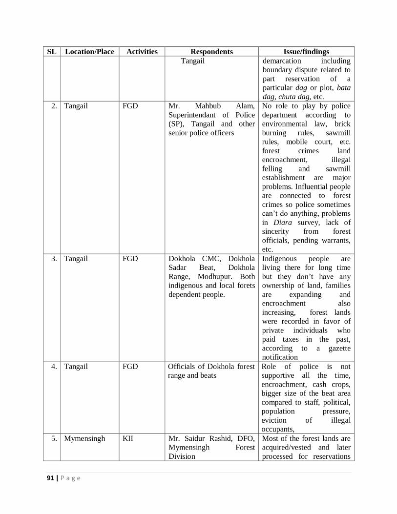
91 | P a g e
SL Location/Place Activities Respondents Issue/findings
Tangail
demarcation including
boundary dispute related to
part reservation of a
particular dag or plot, bata
dag, chuta dag, etc.
2. Tangail FGD Mr. Mahbub Alam,
Superintendant of Police
(SP), Tangail and other
senior police officers
No role to play by police
department according to
environmental law, brick
burning rules, sawmill
rules, mobile court, etc.
forest crimes land
encroachment, illegal
felling and sawmill
establishment are major
problems. Influential people
are connected to forest
crimes so police sometimes
can’t do anything, problems
in Diara survey, lack of
sincerity from forest
officials, pending warrants,
etc.
3. Tangail FGD Dokhola CMC, Dokhola
Sadar Beat, Dokhola
Range, Modhupur. Both
indigenous and local forets
dependent people.
Indigenous people are
living there for long time
but they don’t have any
ownership of land, families
are expanding and
encroachment also
increasing, forest lands
were recorded in favor of
private individuals who
paid taxes in the past,
according to a gazette
notification
4. Tangail FGD Officials of Dokhola forest
range and beats
Role of police is not
supportive all the time,
encroachment, cash crops,
bigger size of the beat area
compared to staff, political,
population pressure,
eviction of illegal
occupants,
5. Mymensingh KII Mr. Saidur Rashid, DFO,
Mymensingh Forest
Division
Most of the forest lands are
acquired/vested and later
processed for reservations
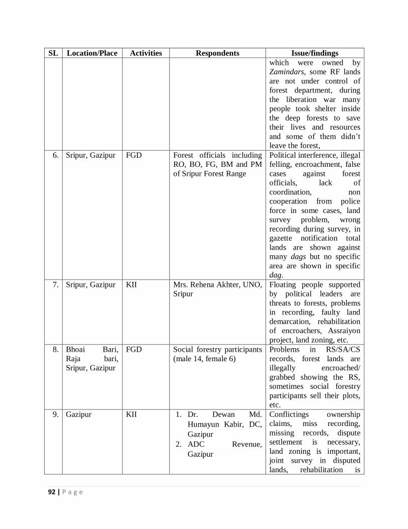
92 | P a g e
SL Location/Place Activities Respondents Issue/findings
which were owned by
Zamindars, some RF lands
are not under control of
forest department, during
the liberation war many
people took shelter inside
the deep forests to save
their lives and resources
and some of them didn’t
leave the forest,
6. Sripur, Gazipur FGD Forest officials including
RO, BO, FG, BM and PM
of Sripur Forest Range
Political interference, illegal
felling, encroachment, false
cases against forest
officials, lack of
coordination, non
cooperation from police
force in some cases, land
survey problem, wrong
recording during survey, in
gazette notification total
lands are shown against
many dags but no specific
area are shown in specific
dag.
7. Sripur, Gazipur KII Mrs. Rehena Akhter, UNO,
Sripur
Floating people supported
by political leaders are
threats to forests, problems
in recording, faulty land
demarcation, rehabilitation
of encroachers, Assraiyon
project, land zoning, etc.
8. Bhoai Bari,
Raja bari,
Sripur, Gazipur
FGD Social forestry participants
(male 14, female 6)
Problems in RS/SA/CS
records, forest lands are
illegally encroached/
grabbed showing the RS,
sometimes social forestry
participants sell their plots,
etc.
9. Gazipur KII 1. Dr. Dewan Md.
Humayun Kabir, DC,
Gazipur
2. ADC Revenue,
Gazipur
Conflictings ownership
claims, miss recording,
missing records, dispute
settlement is necessary,
land zoning is important,
joint survey in disputed
lands, rehabilitation is
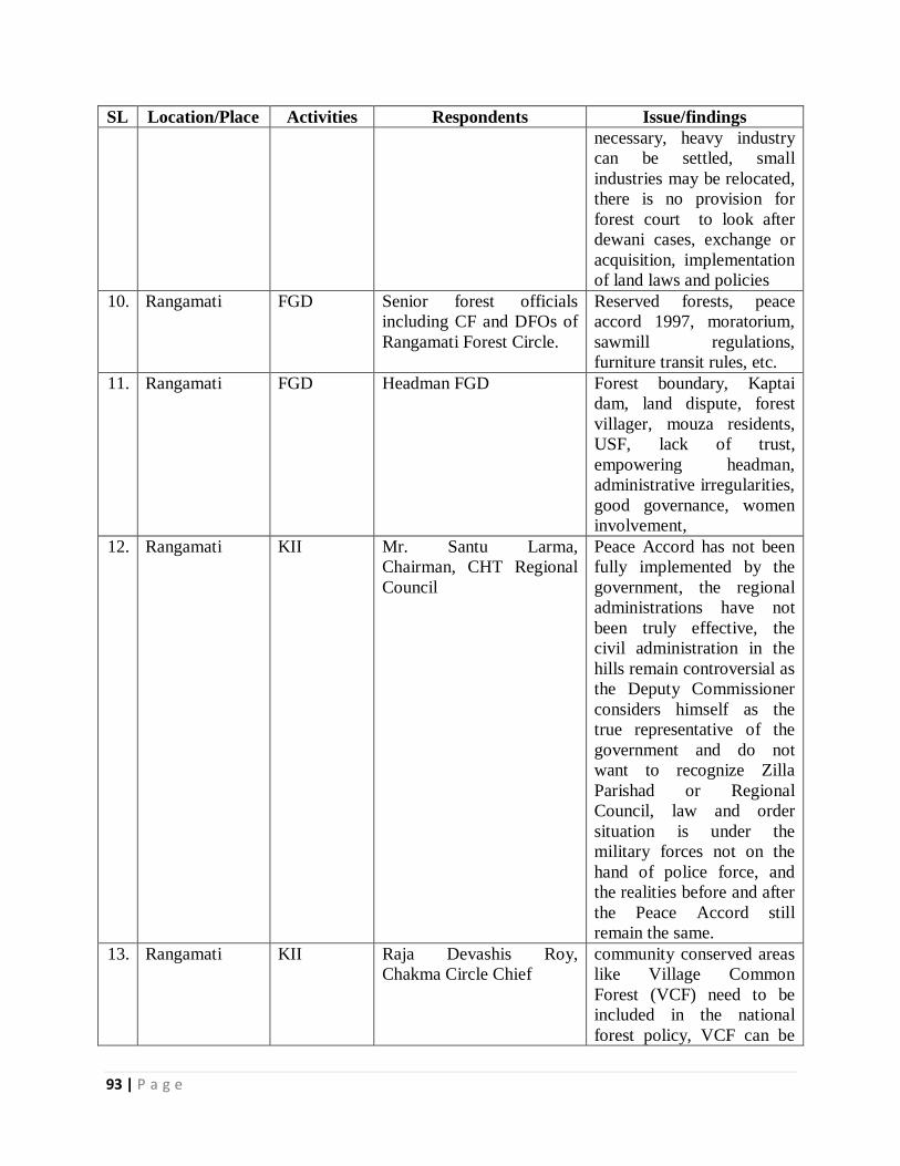
93 | P a g e
SL Location/Place Activities Respondents Issue/findings
necessary, heavy industry
can be settled, small
industries may be relocated,
there is no provision for
forest court to look after
dewani cases, exchange or
acquisition, implementation
of land laws and policies
10. Rangamati FGD Senior forest officials
including CF and DFOs of
Rangamati Forest Circle.
Reserved forests, peace
accord 1997, moratorium,
sawmill regulations,
furniture transit rules, etc.
11. Rangamati FGD Headman FGD Forest boundary, Kaptai
dam, land dispute, forest
villager, mouza residents,
USF, lack of trust,
empowering headman,
administrative irregularities,
good governance, women
involvement,
12. Rangamati KII Mr. Santu Larma,
Chairman, CHT Regional
Council
Peace Accord has not been
fully implemented by the
government, the regional
administrations have not
been truly effective, the
civil administration in the
hills remain controversial as
the Deputy Commissioner
considers himself as the
true representative of the
government and do not
want to recognize Zilla
Parishad or Regional
Council, law and order
situation is under the
military forces not on the
hand of police force, and
the realities before and after
the Peace Accord still
remain the same.
13. Rangamati KII Raja Devashis Roy,
Chakma Circle Chief
community conserved areas
like Village Common
Forest (VCF) need to be
included in the national
forest policy, VCF can be
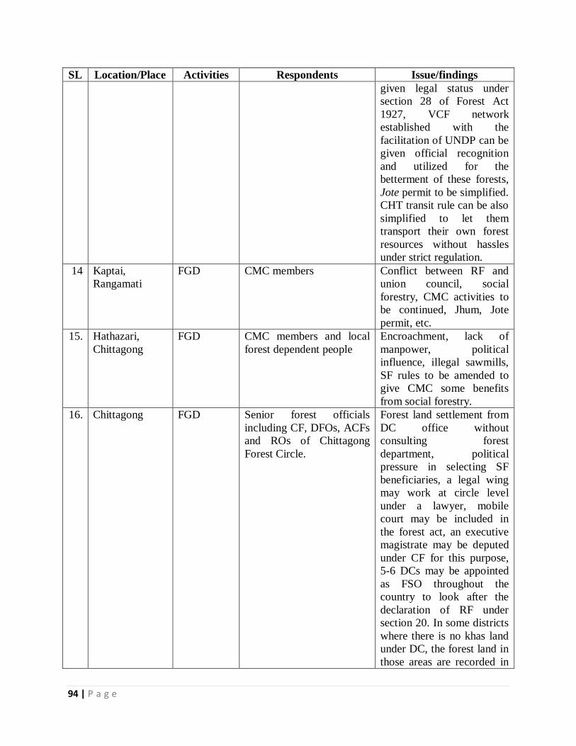
94 | P a g e
SL Location/Place Activities Respondents Issue/findings
given legal status under
section 28 of Forest Act
1927, VCF network
established with the
facilitation of UNDP can be
given official recognition
and utilized for the
betterment of these forests,
Jote permit to be simplified.
CHT transit rule can be also
simplified to let them
transport their own forest
resources without hassles
under strict regulation.
14 Kaptai,
Rangamati
FGD CMC members Conflict between RF and
union council, social
forestry, CMC activities to
be continued, Jhum, Jote
permit, etc.
15. Hathazari,
Chittagong
FGD CMC members and local
forest dependent people
Encroachment, lack of
manpower, political
influence, illegal sawmills,
SF rules to be amended to
give CMC some benefits
from social forestry.
16. Chittagong FGD Senior forest officials
including CF, DFOs, ACFs
and ROs of Chittagong
Forest Circle.
Forest land settlement from
DC office without
consulting forest
department, political
pressure in selecting SF
beneficiaries, a legal wing
may work at circle level
under a lawyer, mobile
court may be included in
the forest act, an executive
magistrate may be deputed
under CF for this purpose,
5-6 DCs may be appointed
as FSO throughout the
country to look after the
declaration of RF under
section 20. In some districts
where there is no khas land
under DC, the forest land in
those areas are recorded in
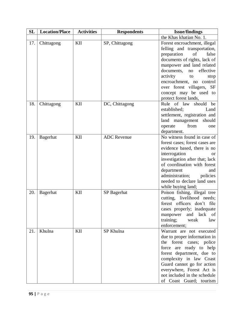
95 | P a g e
SL Location/Place Activities Respondents Issue/findings
the Khas khatian No. 1.
17. Chittagong KII SP, Chittagong Forest encroachment, illegal
felling and transportation,
preparation of false
documents of rights, lack of
manpower and land related
documents, no effective
activity to stop
encroachment, no control
over forest villagers, SF
concept may be used to
protect forest lands,
18. Chittagong KII DC, Chittagong Rule of law should be
established; Land
settlement, registration and
land management should
operate from one
department.
19. Bagerhat KII ADC Revenue No witness found in case of
forest cases; forest cases are
evidence based, there is no
interrogation or
investigation after that; lack
of coordination with forest
department and
administration; policies
needed to declare land uses
while buying land;
20. Bagerhat KII SP Bagerhat Poison fishing, illegal tree
cutting, livelihood needs;
forest officers don’t file
cases properly; inadequate
manpower and lack of
training; weak law
enforcement;
21. Khulna KII SP Khulna Warrant are not executed
due to proper information in
the forest cases; police
force are ready to help
forest department, due to
complexity in law Coast
Guard cannot go for action
everywhere, Forest Act is
not included in the schedule
of Coast Guard; tourism
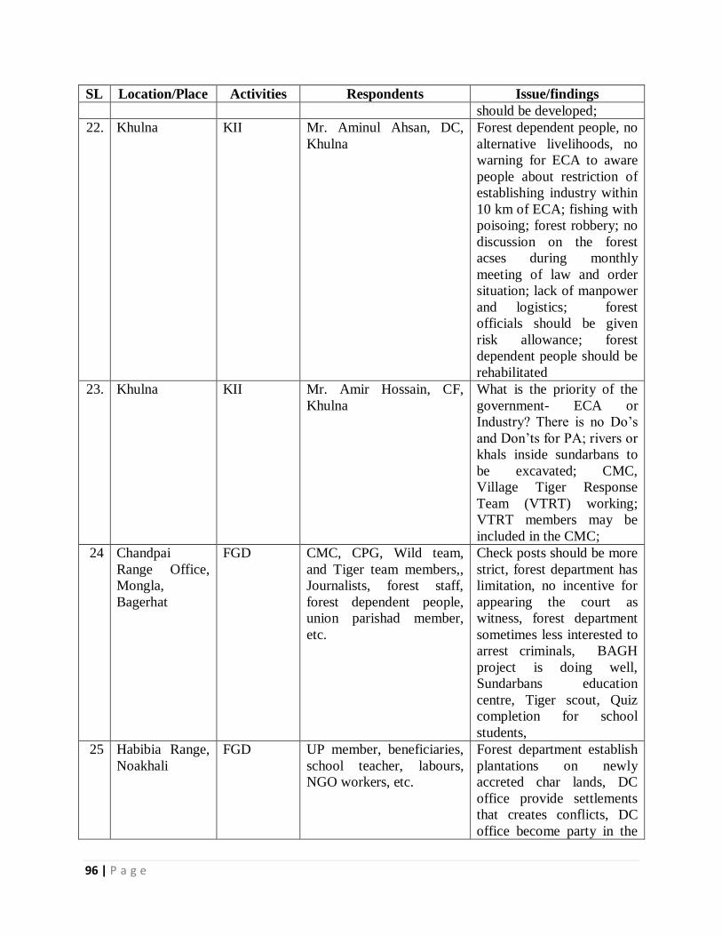
96 | P a g e
SL Location/Place Activities Respondents Issue/findings
should be developed;
22. Khulna KII Mr. Aminul Ahsan, DC,
Khulna
Forest dependent people, no
alternative livelihoods, no
warning for ECA to aware
people about restriction of
establishing industry within
10 km of ECA; fishing with
poisoing; forest robbery; no
discussion on the forest
acses during monthly
meeting of law and order
situation; lack of manpower
and logistics; forest
officials should be given
risk allowance; forest
dependent people should be
rehabilitated
23. Khulna KII Mr. Amir Hossain, CF,
Khulna
What is the priority of the
government- ECA or
Industry? There is no Do’s
and Don’ts for PA; rivers or
khals inside sundarbans to
be excavated; CMC,
Village Tiger Response
Team (VTRT) working;
VTRT members may be
included in the CMC;
24 Chandpai
Range Office,
Mongla,
Bagerhat
FGD CMC, CPG, Wild team,
and Tiger team members,,
Journalists, forest staff,
forest dependent people,
union parishad member,
etc.
Check posts should be more
strict, forest department has
limitation, no incentive for
appearing the court as
witness, forest department
sometimes less interested to
arrest criminals, BAGH
project is doing well,
Sundarbans education
centre, Tiger scout, Quiz
completion for school
students,
25 Habibia Range,
Noakhali
FGD UP member, beneficiaries,
school teacher, labours,
NGO workers, etc.
Forest department establish
plantations on newly
accreted char lands, DC
office provide settlements
that creates conflicts, DC
office become party in the
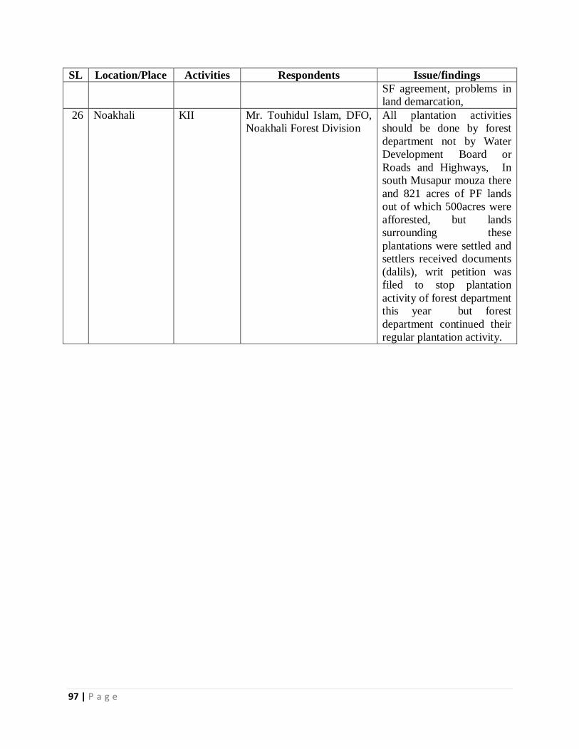
97 | P a g e
SL Location/Place Activities Respondents Issue/findings
SF agreement, problems in
land demarcation,
26 Noakhali KII Mr. Touhidul Islam, DFO,
Noakhali Forest Division
All plantation activities
should be done by forest
department not by Water
Development Board or
Roads and Highways, In
south Musapur mouza there
and 821 acres of PF lands
out of which 500acres were
afforested, but lands
surrounding these
plantations were settled and
settlers received documents
(dalils), writ petition was
filed to stop plantation
activity of forest department
this year but forest
department continued their
regular plantation activity.
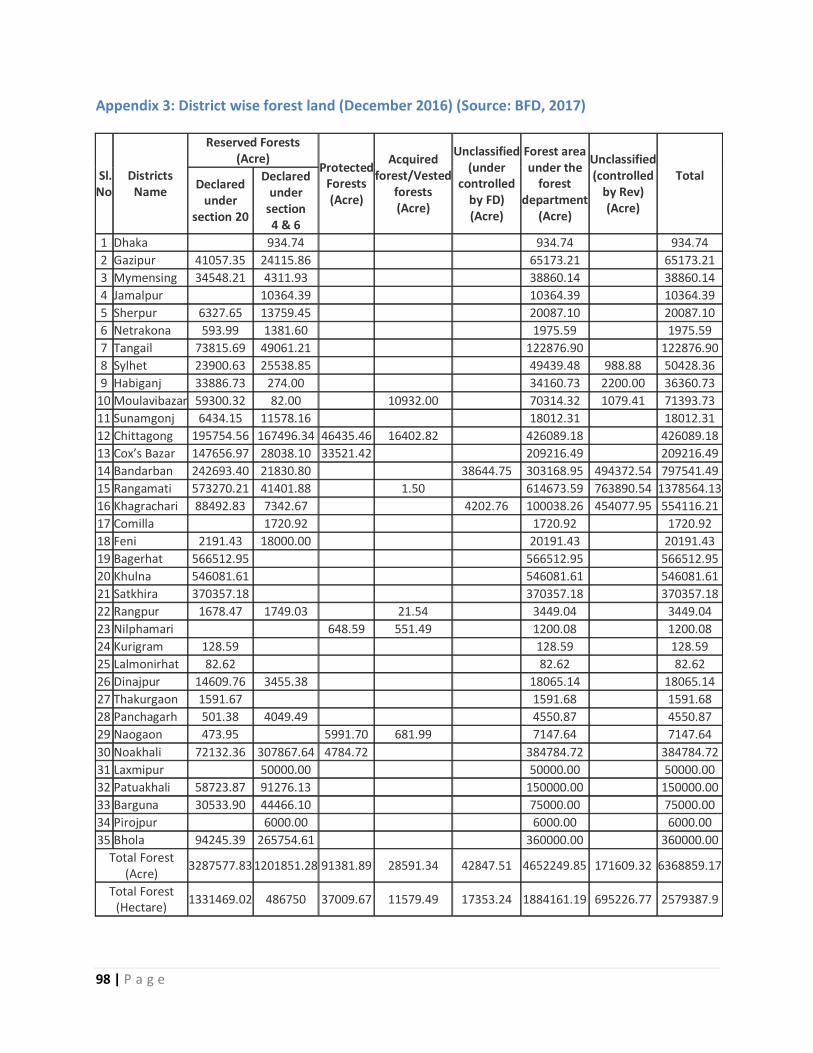
98 | P a g e
Appendix 3: District wise forest land (December 2016) (Source: BFD, 2017)
Sl. No
Districts Name
Reserved Forests (Acre)
Protected Forests (Acre)
Acquired forest/Vested
forests (Acre)
Unclassified (under
controlled by FD) (Acre)
Forest area under the
forest department
(Acre)
Unclassified (controlled
by Rev) (Acre)
Total
Declared under
section 20
Declared under
section 4 & 6
1 Dhaka 934.74 934.74 934.74
2 Gazipur 41057.35 24115.86 65173.21 65173.21
3 Mymensing 34548.21 4311.93 38860.14 38860.14
4 Jamalpur 10364.39 10364.39 10364.39
5 Sherpur 6327.65 13759.45 20087.10 20087.10
6 Netrakona 593.99 1381.60 1975.59 1975.59
7 Tangail 73815.69 49061.21 122876.90 122876.90
8 Sylhet 23900.63 25538.85 49439.48 988.88 50428.36
9 Habiganj 33886.73 274.00 34160.73 2200.00 36360.73
10 Moulavibazar 59300.32 82.00 10932.00 70314.32 1079.41 71393.73
11 Sunamgonj 6434.15 11578.16 18012.31 18012.31
12 Chittagong 195754.56 167496.34 46435.46 16402.82 426089.18 426089.18
13 Cox’s Bazar 147656.97 28038.10 33521.42 209216.49 209216.49
14 Bandarban 242693.40 21830.80 38644.75 303168.95 494372.54 797541.49
15 Rangamati 573270.21 41401.88 1.50 614673.59 763890.54 1378564.13
16 Khagrachari 88492.83 7342.67 4202.76 100038.26 454077.95 554116.21
17 Comilla 1720.92 1720.92 1720.92
18 Feni 2191.43 18000.00 20191.43 20191.43
19 Bagerhat 566512.95 566512.95 566512.95
20 Khulna 546081.61 546081.61 546081.61
21 Satkhira 370357.18 370357.18 370357.18
22 Rangpur 1678.47 1749.03 21.54 3449.04 3449.04
23 Nilphamari 648.59 551.49 1200.08 1200.08
24 Kurigram 128.59 128.59 128.59
25 Lalmonirhat 82.62 82.62 82.62
26 Dinajpur 14609.76 3455.38 18065.14 18065.14
27 Thakurgaon 1591.67 1591.68 1591.68
28 Panchagarh 501.38 4049.49 4550.87 4550.87
29 Naogaon 473.95 5991.70 681.99 7147.64 7147.64
30 Noakhali 72132.36 307867.64 4784.72 384784.72 384784.72
31 Laxmipur 50000.00 50000.00 50000.00
32 Patuakhali 58723.87 91276.13 150000.00 150000.00
33 Barguna 30533.90 44466.10 75000.00 75000.00
34 Pirojpur 6000.00 6000.00 6000.00
35 Bhola 94245.39 265754.61 360000.00 360000.00
Total Forest (Acre)
3287577.83 1201851.28 91381.89 28591.34 42847.51 4652249.85 171609.32 6368859.17
Total Forest (Hectare)
1331469.02 486750 37009.67 11579.49 17353.24 1884161.19 695226.77 2579387.9
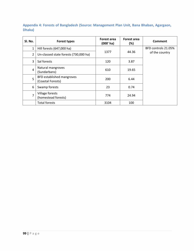
99 | P a g e
Appendix 4: Forests of Bangladesh (Source: Management Plan Unit, Bana Bhaban, Agargaon, Dhaka)
Sl. No. Forest types Forest area
(000' ha) Forest area
(%) Comment
1 Hill forests (647,000 ha) 1377 44.36
BFD controls 21.05% of the country
2 Un-classed state forests (730,000 ha)
3 Sal forests 120 3.87
4 Natural mangroves (Sundarbans)
610 19.65
5 BFD established mangroves (Coastal Forests)
200 6.44
6 Swamp forests 23 0.74
7 Village forests (homestead forests)
774 24.94
Total forests 3104 100
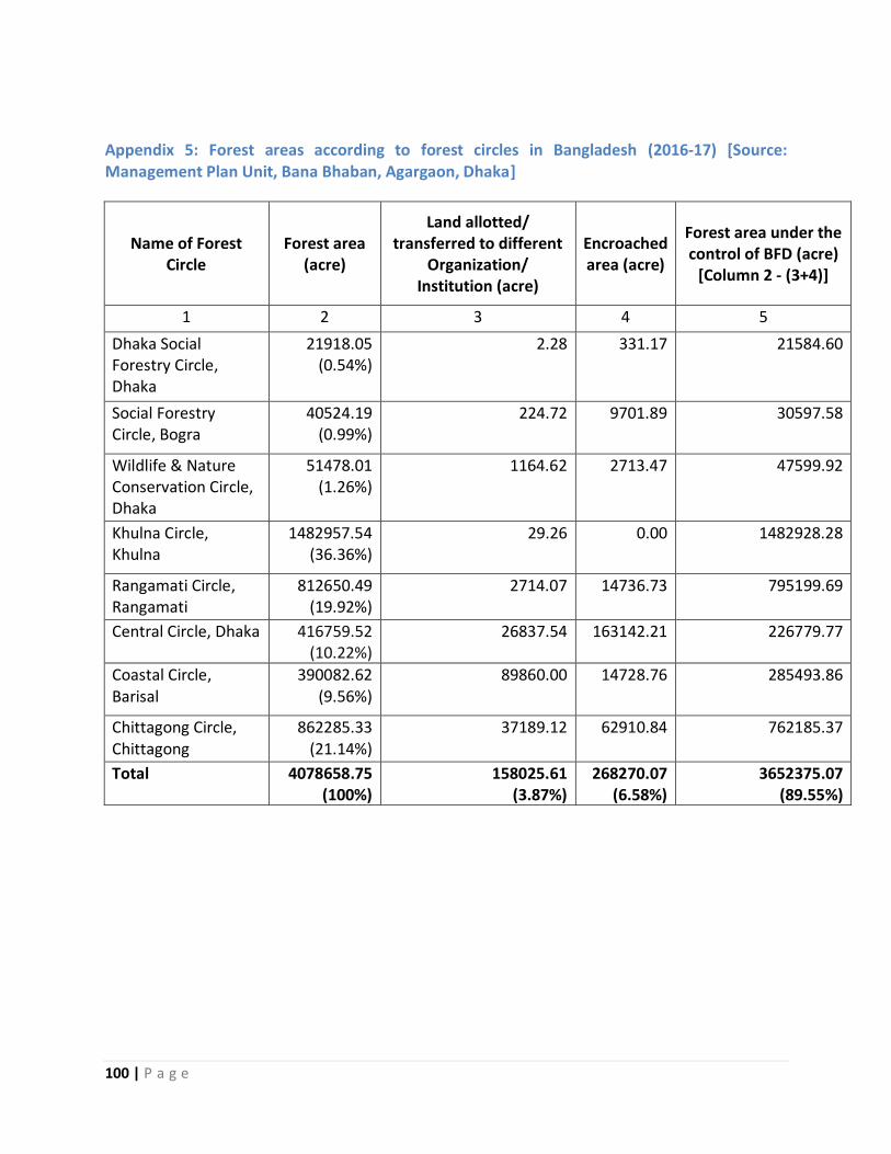
100 | P a g e
Appendix 5: Forest areas according to forest circles in Bangladesh (2016-17) [Source: Management Plan Unit, Bana Bhaban, Agargaon, Dhaka]
Name of Forest Circle
Forest area (acre)
Land allotted/ transferred to different
Organization/ Institution (acre)
Encroached area (acre)
Forest area under the control of BFD (acre)
[Column 2 - (3+4)]
1 2 3 4 5
Dhaka Social Forestry Circle, Dhaka
21918.05 (0.54%)
2.28 331.17 21584.60
Social Forestry Circle, Bogra
40524.19 (0.99%)
224.72 9701.89 30597.58
Wildlife & Nature Conservation Circle, Dhaka
51478.01 (1.26%)
1164.62 2713.47 47599.92
Khulna Circle, Khulna
1482957.54 (36.36%)
29.26 0.00 1482928.28
Rangamati Circle, Rangamati
812650.49 (19.92%)
2714.07 14736.73 795199.69
Central Circle, Dhaka 416759.52 (10.22%)
26837.54 163142.21 226779.77
Coastal Circle, Barisal
390082.62 (9.56%)
89860.00 14728.76 285493.86
Chittagong Circle, Chittagong
862285.33 (21.14%)
37189.12 62910.84 762185.37
Total 4078658.75 (100%)
158025.61 (3.87%)
268270.07 (6.58%)
3652375.07 (89.55%)
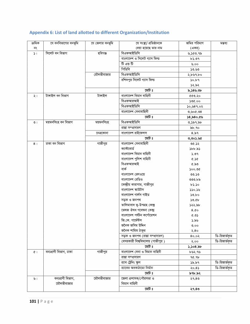
101 | P a g e
Appendix 6: List of land allotted to different Organization/Institution µwgK
bs
‡h ebwefv‡Mi ebf~wg ‡h †Rjvi ebf~wg ‡h ms ’̄v/ cÖwZôvb‡K
†`qv n‡q‡Q Zvi bvg
Rwgi cwigvY
(GKi)
gšÍe¨
1| wm‡jU eb wefvM nweMÄ weGdAvBwWwm 6,153.79
evsjv‡`k I wm‡jU M¨vm wdì 81.37
wU GÛ wU 6.00
wcwWwe 13.63
†gŠjfxevRvi weGdAvBwWwm 2,867.80
iwk`cyi wm‡jU M¨vm wdì 10.87
12.92
‡gvU t 9,146.38
2| Uv½vBj eb wefvM Uv½vBj evsjv‡`k wegvb evwnbx 553.20
weGdAviAvB 135.00
weGdAvBwWwm 10,647.02
evsjv‡`k †mbvevwnbx 3,605.34
‡gvU t 14,940.56
3| gqgbwmsn eb wefvM gqgbwmsn weGdAvBwWwm 3,197.98
iv Í̄v m¤cÖmviY 98.70
‡b·Kvbv evsjv‡`k ivB‡djm 4.97
‡gvU t 3,301.65
4| XvKv eb wefvM MvRxcyi evsjv‡`k †mbvevwnbx
K¨v›U‡evW©
evsjv‡`k wegvb evwnbx
evsjv‡`k cywjk evwnbx
weGdAviAvB
evK©
evsjv‡`k †ijI‡q
evsjv‡`k †iwWI
‡K› ª̀xq KvivMvi, MvRxcyi
evsjv‡`k ¯‹vDUm
evsjv‡`k Mvj©m MvBW
moK I Rbc_
Zvwjgvev` f~-DcMÖn †K› ª̀
‡flR Jla M‡elbv †K› ª̀
evsjv‡`k ch©Ub K‡c©v‡ikb
wR.†K. Mv‡g©›Um
R‰bK Rwmg DwÏb
R‰bK kvwgg VvKzi
35.12
188.91
1.37
5.15
5.93
100.35
33.13
333.89
81.10
110.16
13.80
13.58
122.98
4.50
5.31
1.96
3.00
2.40
moK I Rbc_ (iv Í̄v m¤cÖmviY) 40.02 wW-wiRvf©K…Z
†emiKvix wek¦we`¨vjq (MvRxcyi ) 2.00 wW-wiRvf©K…Z
‡gvU t 1,104.98
5| eb¨cÖvYx wefvM, XvKv MvRxcyi evsjv‡`k †mbv I wegvb evwnbx 862.76
iv Í̄v m¤cÖmviY 75.78
i¨ve †Uªwbs ¯‹zj 19.97 wW-wiRvf©K…Z
i¨v‡ei AeKvVv‡gv wbg©vb 20.41 wW-wiRvf©K…Z
‡gvU t 978.92
6| eb¨cÖvYx wefvM,
‡gŠjfxevRvi
‡gŠjfxevRvi ‡Rjv cÖkvmK/†cŠimfv I
wegvb evwnbx
27.43
‡gvU t 27.43
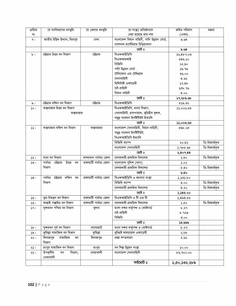
102 | P a g e
µwgK
bs
‡h ebwefv‡Mi ebf~wg ‡h †Rjvi ebf~wg ‡h ms ’̄v/ cÖwZôvb‡K
†`qv n‡q‡Q Zvi bvg
Rwgi cwigvY
(GKi)
gšÍe¨
7| RvZxq Dw™¢` D`¨vb, wgicyi XvKv evsjv‡`k wegvb evwnbx, cvwb Dbœqb †evW©,
b¨vkbvj nv‡e©wiqvg wPwoqvLvbv
9.64
‡gvU t 9.64
8| PÆMÖvg DËi eb wefvM PÆMÖvg weGdAvBwWwm
weGdAviAvB
wewRwe
cvwb Dbœqb †evW©
‡Uwj‡dvb GÛ †UwjMÖvd
‡mbvevwnbx
wgwjUvix GKv‡Wgx
‡bŠ-evwnbx
wegvb evwnbx
16,487.03
549.10
12.90
19.79
36.00
4.62
17.48
158.76
4.00
‡gvU t 17,289.68
9| PÆMÖvg `w¶Y eb wefvM PÆMÖvg weGdAvBwWwm 519.32
10| K·evRvi DËi eb wefvM
K·evRvi
weGdAvBwWwm, grm¨ wefvM,
†mbvevwnbx, nvmcvZvj, f~wgnxb K…lK,
mgy ª̀ M‡elYv BbwówUDU BZ¨vw`
11,006.63
‡gvU t 11,006.63
11| K·evRvi `w¶Y eb wefvM K·evRvi evsjv‡`k †mbvevwnbx, wegvb evwnbx,
mgy ª̀ M‡elYv BbwówUDU,
weGdAvBwWwm BZ¨vw`
598.05
wewRwe K¨v¤ú 20.41 wW-wiRvf©K…Z
evsjv‡`k †mbvevwnbx 1,788.98 wW-wiRvf©K…Z
‡gvU t 2,407.44
12| jvgv eb wefvM ev›`ievb cve©Z¨ †Rjv ‡emiKvix cÖv_wgK we`¨vjq 1.50 wW-wiRvf©K…Z
13| cve©Z¨ PÆMÖvg DËi eb
wefvM
iv½vgvwU cve©Z¨ †Rjv evsjv‡`k cywjk (_vbv) 1.00
‡emiKvix cÖv_wgK we`¨vjq 5.40 wW-wiRvf©K…Z
‡gvU t 6.40
14| cve©Z¨ PÆMÖvg `w¶Y eb
wefvM
iv½vgvwU cve©Z¨ †Rjv weGdAvBwWwm I Ab¨vb¨ ms ’̄v 1,131.80
wewRwe K¨v¤ú 9.00 wW-wiRvf©K…Z
‡emiKvix cÖv_wgK we`¨vjq 4.20 wW-wiRvf©K…Z
‡gvU t 1,145.00
15| Szg wbqš¿Y eb wefvM iv½vgvwU cve©Z¨ †Rjv weGdAvBwWwm I wU GÛ wU 1,494.56
16| KvßvB cvíDW eb wefvM iv½vgvwU cve©Z¨ †Rjv ‡emiKvix cÖv_wgK we`¨vjq 1.50 wW-wiRvf©K…Z
17| my›`ieb cwðg eb wefvM Lyjbv gsjv e›`i KZ©„c¶ I †KvóMvW©
‡bŠ-evwnbx
wewRwe
8.27
8.729
3.00
‡gvU t 19.999
18| my›`ieb c~e© eb wefvM ev‡MinvU gsjv e›`i KZ©„c¶ I †KvóMvW© 8.27
19| Kzwgjøv mvgvwRK eb wefvM Kzwgjøv eywÇó KvjPvivj GKv‡Wgx 2.88
20| w`bvRcyi mvgvwRK eb
wefvM
w`bvRcyi iv Í̄v m¤cÖmviY 2.60
21| iscyi mvgvwRK eb wefvM iscyi eb wkí Dbœqb ms ’̄v 10.00
22| DcK~jxq eb wefvM,
†bvqvLvjx
‡bvqvLvjx evsjv‡`k †mbvevwnbx 86,700.00
me©‡gvU t 1,50,132.289
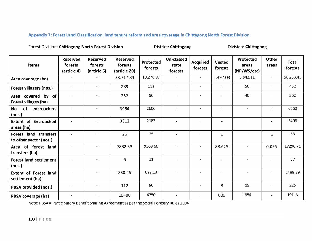
103 | P a g e
Appendix 7: Forest Land Classification, land tenure reform and area coverage in Chittagong North Forest Division
Forest Division: Chittagong North Forest Division District: Chittagong Division: Chittagong
Items Reserved
forests (article 4)
Reserved forests
(article 6)
Reserved forests
(article 20)
Protected forests
Un-classed state
forests
Acquired forests
Vested forests
Protected areas
(NP/WS/etc)
Other areas
Total forests
Area coverage (ha) - - 38,717.34 10,276.97 - - 1,397.03 5,842.11 - 56,233.45
Forest villagers (nos.) - - 289 113 - - - 50 - 452
Area covered by of Forest villages (ha)
- - 232 90 - - - 40 - 362
No. of encroachers (nos.)
- - 3954 2606 - - - - - 6560
Extent of Encroached areas (ha)
- - 3313 2183 - - - - - 5496
Forest land transfers to other sector (nos.)
- - 26 25 - - 1 - 1 53
Area of forest land transfers (ha)
- - 7832.33 9369.66 - - 88.625 - 0.095 17290.71
Forest land settlement (nos.)
- - 6 31 - - - - - 37
Extent of Forest land settlement (ha)
- - 860.26 628.13 - - - - - 1488.39
PBSA provided (nos.) - - 112 90 - - 8 15 - 225
PBSA coverage (ha) - - 10400 6750 - - 609 1354 - 19113
Note: PBSA = Participatory Benefit Sharing Agreement as per the Social Forestry Rules 2004
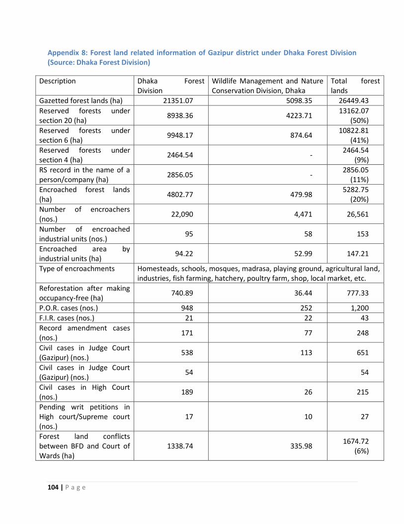
104 | P a g e
Appendix 8: Forest land related information of Gazipur district under Dhaka Forest Division (Source: Dhaka Forest Division)
Description Dhaka Forest Division
Wildlife Management and Nature Conservation Division, Dhaka
Total forest lands
Gazetted forest lands (ha) 21351.07 5098.35 26449.43
Reserved forests under section 20 (ha)
8938.36 4223.71 13162.07
(50%)
Reserved forests under section 6 (ha)
9948.17 874.64 10822.81
(41%)
Reserved forests under section 4 (ha)
2464.54 - 2464.54
(9%)
RS record in the name of a person/company (ha)
2856.05 - 2856.05
(11%)
Encroached forest lands (ha)
4802.77 479.98 5282.75
(20%)
Number of encroachers (nos.)
22,090 4,471 26,561
Number of encroached industrial units (nos.)
95 58 153
Encroached area by industrial units (ha)
94.22 52.99 147.21
Type of encroachments Homesteads, schools, mosques, madrasa, playing ground, agricultural land, industries, fish farming, hatchery, poultry farm, shop, local market, etc.
Reforestation after making occupancy-free (ha)
740.89 36.44 777.33
P.O.R. cases (nos.) 948 252 1,200
F.I.R. cases (nos.) 21 22 43
Record amendment cases (nos.)
171 77 248
Civil cases in Judge Court (Gazipur) (nos.)
538 113 651
Civil cases in Judge Court (Gazipur) (nos.)
54 54
Civil cases in High Court (nos.)
189 26 215
Pending writ petitions in High court/Supreme court (nos.)
17 10 27
Forest land conflicts between BFD and Court of Wards (ha)
1338.74 335.98 1674.72
(6%)
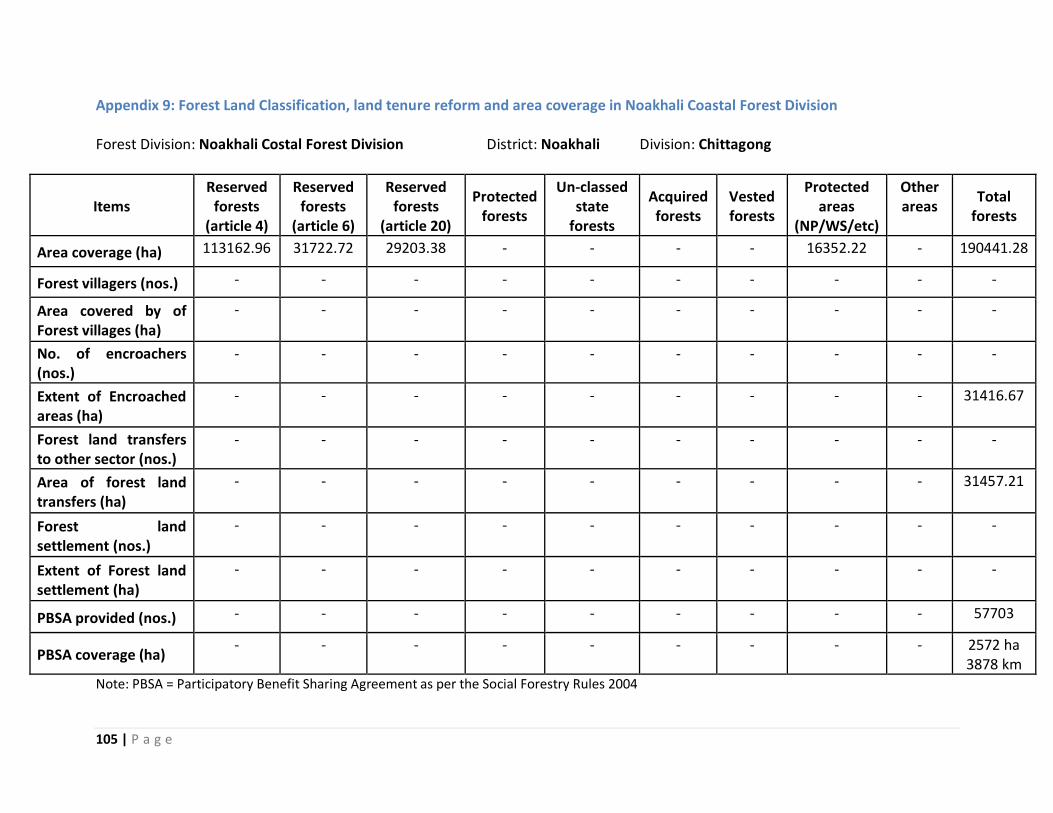
105 | P a g e
Appendix 9: Forest Land Classification, land tenure reform and area coverage in Noakhali Coastal Forest Division Forest Division: Noakhali Costal Forest Division District: Noakhali Division: Chittagong
Items Reserved
forests (article 4)
Reserved forests
(article 6)
Reserved forests
(article 20)
Protected forests
Un-classed state
forests
Acquired forests
Vested forests
Protected areas
(NP/WS/etc)
Other areas
Total forests
Area coverage (ha) 113162.96 31722.72 29203.38 - - - - 16352.22 - 190441.28
Forest villagers (nos.) - - - - - - - - - -
Area covered by of Forest villages (ha)
- - - - - - - - - -
No. of encroachers (nos.)
- - - - - - - - - -
Extent of Encroached areas (ha)
- - - - - - - - - 31416.67
Forest land transfers to other sector (nos.)
- - - - - - - - - -
Area of forest land transfers (ha)
- - - - - - - - - 31457.21
Forest land settlement (nos.)
- - - - - - - - - -
Extent of Forest land settlement (ha)
- - - - - - - - - -
PBSA provided (nos.) - - - - - - - - - 57703
PBSA coverage (ha) - - - - - - - - - 2572 ha
3878 km
Note: PBSA = Participatory Benefit Sharing Agreement as per the Social Forestry Rules 2004