The petroleum potential of the Riphean–Vendian succession ...
ASSESSMENT OF PETROLEUM POTENTIAL KONIAG INC. LAND - ALASKA PENINSULA –
BASED ON REGIONAL GEOLOGY, REVISED STRATIGRAPHIC INTREPRETATION OF HISTORIC
OIL WELLS AND NEW DATA ON OIL SEEPS
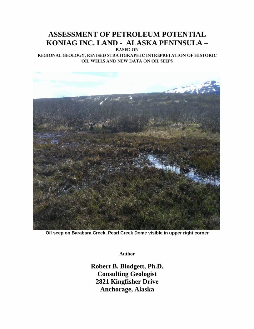
Oil seep on Barabara Creek, Pearl Creek Dome visible in upper right corner
Author
Robert B. Blodgett, Ph.D. Consulting Geologist
2821 Kingfisher Drive Anchorage, Alaska

i
TABLE OF CONTENTS
SUBJECT: PAGE: EXECUTIVE SUMMARY iv INTRODUCTION 1 PURPOSE AND SCOPE 1 SOURCES OF INFORMATION 4 GEOLOGICAL FRAMEWORK 4 STRATIGRAPHY 6
PRE-CENOZOIC (PERMIAN AND MESOZOIC FORMATIONS OF THE ALASKA PENINSULA) 6
UNNAMED PERMIAN LIMESTONE AND PERMIAN AGGLOMERATES AND VOLCANICLASTIC ROCKS 7 KAMISHAK FORMATION 8 TALKEETNA FORMATION 16 KIALAGVIK FORMATION 17 SHELIKOF FORMATION 19 NAKNEK FORMATION 22 STANIUKOVICH FORMATION 23 HERENDEEN FORMATION 24 PEDMAR FORMATION 26 CHIGNIK FORMATION 27 HOODOO FORMATION 28
CENOZOIC FORMATIONS OF THE ALASKA PENINSULA 28
WELLS NEAR OR ADJACENT TO KONIAG CORPORATION LANDS ON THE
ii
ALASKA PENINSULA 29
“EAST FIELD” – ALSO REFERRED TO AS THE BEAR CREEK ANTICLINE OR SALMON CREEK-BEAR CREEK ANTICLINE IN OLDER LITERATURE 30
J.H. COSTELLO #1 30
J.H. COSTELLO #2 31
PACIFIC OIL & COMMERCIAL CO. #1 (ALSO REFERRED TO AS CASEY #1) 32
PACIFIC OIL & COMMERICAL CO. #2 (ALSO REFERRED TO AS CASEY #2) 34
PACIFIC OIL & COMMERICAL CO. #3 (ALSO REFERRED TO AS CASEY #3) 34
STANDARD OIL COMPANY OF CALIFORNIA GRAMMER #1 35 HUMBLE/SHELL BEAR CREEK UNIT #1 37
“WEST FIELD” – UGASHIK CREEK ANTICLINE (OR PEARL CREEK DOME) AREA 42
STANDARD OIL COMPANY OF CALIFORNIA LEE #1 43 STANDARD OIL COMPANY OF CALIFORNIA LATHROP #1 53 STANDARD OIL COMPANY OF CALIFORNIA McNALLY #1 53 ASSOCIATED OIL COMPANY ALASKA #1 54 ASSOCIATED OIL COMPANY FINNEGAN #1 58 WIDE BAY ANTICLINE 59 RICHFIELD WIDE BAY UNIT #1 59 KONIAG CHEVRON USA #1 63 OIL AND GAS SEEPS ON OR ADJACENT TO CURRENT KONIAG, INC. LAND HOLDINGS ON THE NORTHERN PART OF THE ALASKA PENINSULA 67
“WEST FIELD” OR PEARL CREEK DOME AREA 70
iii
“EAST FIELD” – BEAR CREEK ANTICLINE AREA 76 WIDE BAY – WIDE BAY ANTICLINE AREA 82
SOURCE ROCK POTENTIAL IN MESOZOIC STRATA 83 POTENTIAL RESERVOIRS IN MESOZOIC STRATA 85 REGIONAL THERMAL MATURITY 86 STRUCTURAL GEOLOGICAL CONSIDERATIONS 87 SUMMARY 87 RECOMMENDATIONS 88 REFERENCES 88 APPENDICES APPENDIX 1. Blodgett, R.B., and Clautice, K.H., 2005, Oil and Gas Seeps of the Puale
Bay – Becharof Lake - Wide Bay region, northern Alaska Peninsula: Alaska Division of Geological & Geophysical Surveys Preliminary Interpretative Report 2005-6, 13 p., 1 sheet. (IN FOLDER)
APPENDIX 2. Hewitt, R.L., 1940, Final geological report on the Standard Oil Company
of California, Tide Water Associated Oil Company, and Union Oil of California well, Grammer No. 1: San Francisco, Tide Water Associated Oil Co. internal report, 74 p.
(IN FOLDER) APPENDIX 3. Detailed lithologic log for the Grammer #1 well (obtained from the
Alaska Oil and Gas Commission office in Anchorage, Alaska) (IN TUBE) APPENDIX 4. Detailed lithologic log for the Richfield Wide Bay Unit #1 well (obtained
from the Alaska Oil and Gas Conservation Commission office in Anchorage, Alaska) (IN TUBE)
APPENDIX 5. Detailed lithologic log for the Chevron Koniag Chevron USA #1 well
(obtained from the Alaska Oil and Gas Conservation Commission office in Anchorage, Alaska) (IN TUBE)
APPENDIX 6. Another detailed lithologic log for the Chevron Koniag Chevron USA #1
well (obtained from the Alaska Oil and Gas Conservation Commission office in Anchorage, Alaska) (IN TUBE)
iv
APPENDIX 7. Geochemical analyses (work done by Weatherford Laboratories, Shenandoah, Texas) of the Barabara Creek seep oil for Koniag, Inc.
APPENDIX 8. Document providing proof of access for development of subsurface lands of Koniag, Inc. on the Alaska Peninsula.
v
EXECUTIVE SUMMARY
This report presents a review of the geologic framework, stratigraphic setting, previous oil wells that have been drilled to date, known oil and gas seeps, source rocks and potential reservoirs, as well as other factors relating the presence of recoverable liquid and gaseous hydrocarbons on lands of Koniag, Inc. in the northern Alaskan Peninsula. The two best structural features recognized in this regard are the Ugashik Creek and Wide Bay anticlines situated in the Puale Bay-Becharof Lake-Wide Bay region. Both structures would make excellent targets for oil shale and shale gas prospects, as well as for conventional petroleum plays. The Ugashik anticline, including the Pearl Creek Dome at its northern end and the Hubbell Dome at its southern end, is considered to be the most promising structure. This structure was tested in the early 1920’s (based on the prominence of oil seeps on the structure) with primitive cable tool drilling rigs. The wells drilled were for the most part relatively shallow and none reached either the Kialagvik or Kamishak Formations which are identified here as being the primary targets (nonetheless oil and gas shows were noted in the well bores). Upgrading of the road system built from Kanatak to the Pearl Creek Dome oil field in the 1920’s also makes this attractive in terms of having an existing infrastructure already in place. The presence of numerous oil and gas seeps in Jurassic rocks of the northern part of the Alaska Peninsula (Puale Bay-Becharof Lake-Wide Bay region) clearly indicates that a widespread petroleum system is present at relatively shallow depths. The Upper Triassic Kamishak Formation at Puale Bay has long been considered the primary source horizon for hydrocarbons in the region. To the north this same unit was considered until the past few decades to be the probable source for oil seeps on the Iniskin Peninsula in Lower Cook Inlet. Recent study of source rock potential of the Puale Bay region (Decker, 2008) indicate that both the Upper Triassic Kamishak and the essentially Middle Jurassic Kialagvik Formation are organic-rich and make excellent oil-prone source rocks. Both stratigraphic units are found throughout much of the northern Alaska Peninsula in the subsurface, and probably underlie much of the Koniag, Inc. land positions. Historic wells drilled on the Bear Creek anticline (Grammer #1 and Bear Creek #1), several of the wells drilled on the Ugashik Creek anticline (Lee #1 and Alaska #1), on the Wide Bay anticline (Wide Bay Unit #1) all had good oil and gas shows, clearly demonstrating the presence of viable petroleum system at depth on all of these anticlinal structures. One significant factor that limited many of these earlier attempts was the lack of biostratigraphic age control for these wells, leading to miscorrelation and drilling well past original target horizons, as was the case with the Bear Creek #1 well. Identification of reservoirs at depth during drilling must be seriously addressed by future explorationists. Given the emergence of new drilling technology (i.e., directional drilling, hydrofracking) further attention should be focused on rich source bed units such as Upper

vi
Triassic Kamishak Formation and early Middle Jurassic Kialagvik Formation as drilling objectives for oil shale/oil gas plays, as well as for conventional plays. The 2,000 ft+ thick Kamishak Formation (several order times thicker than the time-equivalent Shublik Formation of the North Slope – the prime source horizon there) makes it an excellent target for exploration. The Kialagvik Formation is slightly less organic-rich than the Kamishak, but still has respectable TOC (total organic carbon) values. The latter unit is also deemed a good target in light of the fact that its age equivalent in the Cook Inlet basin, the Middle Jurassic Tuxedni Group, is considered to be the primary source for Cook Inlet oil (Magoon and Anders, 1992).

1
INTRODUCTION
The northern Alaska Peninsula is a petroleum-rich province as evidenced by the abundance of oil and gas seeps in the region (see Blodgett and Clautice, 2005 – Appendix 1). It was one of the first of three primary objectives of the Oil Industry, along the Iniskin Peninsula of Lower Cook Inlet and the Katalla District of the Gulf of Alaska, all of which were actively explored since the start of the 20th Century. However, the discovery of North America’s largest oil field, Prudhoe Bay, lured Industry away and northward in the late 1960’s. Now that Prudhoe Bay and associated fields are in rapid decline, Industry is again expressing renewed interest in southern Alaska. Four major, relatively modern rotary drilled wells (Bear Creek Unit #1, Grammer #1, Wide Bay Unit #1 and Koniag Chevron USA #1) were drilled between 1938-1981 on, or immediately adjacent to, lands that are held by Koniag, Inc. Modern drilling techniques [horizontal drilling (also referred to as directional drilling), hydrofracking, etc.] will make this region a very attractive exploration target [see Blodgett and Sralla, 2008; also several recent articles in Petroleum News on work being done by Bryan Sralla and myself on behalf of Hewitt Mineral Corp. (Ardmore, Oklahoma) on the Alaska Peninsula]. They are also attractive due to the fact that they are close to tidewater, and several old road systems provide existing infrastructure for their development. Both conventional and unconventional petroleum plays are deemed highly probable in this region. With many new players entering the field of petroleum exploration in southern Alaska these past several years, the time is now critical to bring their attention to Koniag’s lands. The proposed study will be invaluable to draw these and other new players to this area, as they do not have access to much of the data I have gathered and summarized here.
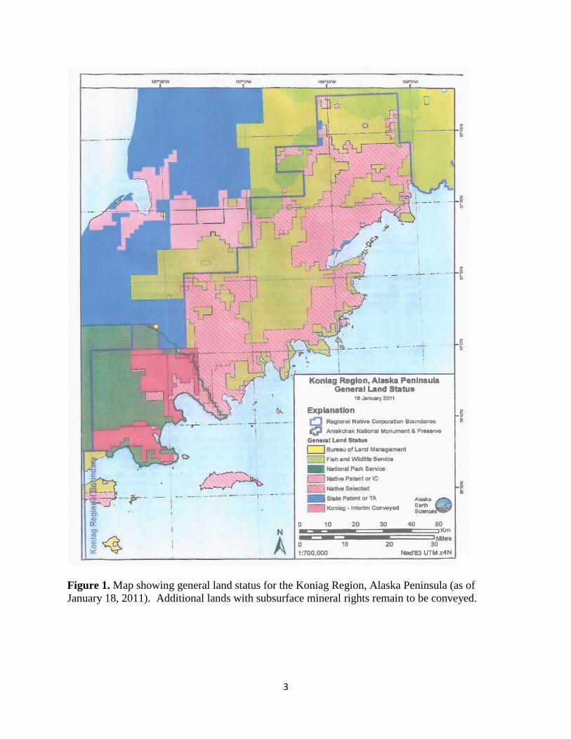
PURPOSE AND SCOPE This report summarizes the petroleum potential and framework geology of lands on the northern part of Alaska Peninsula held by Koniag, Inc. (see Fig. 1). The report is based in part on previously published literature, but also including the proposer’s vast library of archived geologic studies conducted by Industry during the 1920’s-1970’s, as well as his own work in the region. A compilation is also provided in the report of available organic geochemistry data (most useful to the petroleum geologist) available from the four regional wells (Standard Oil Company of California Grammer #1, Humble-Shell Bear Creek #1, Richfield Wide Bay Unit #1 and Chevron Koniag USA #1). In addition, the writer has gone through paleontological materials (Foraminifera kept on microfossil slides donated by Industry) and megafossils preserved on core chips from the four aforementioned wells in hope of providing a revised age and stratigraphic correlations for the various formations exposed in the well bores. These collections are kept at the Alaska Geologic Materials Center (GMC) in Eagle River, Alaska. Foraminifera proved to be only of limited use, but numerous Radiolaria were noted which are deemed to be more useful for unraveling the pre-Cretaceous stratigraphy of the Alaska Peninsula (Foraminifera first become abundant on the

2
Alaska Peninsula during the Cretaceous). Palynological samples (pollen and spores) from Industry sources are also deposited at the GMC, and may prove to be an important new source of biostratigraphic information in future studies. Finally, the results of this study indicate that the best structure for future oil and gas development on Koniag, Inc. lands would be the Ugashik Creek anticline (including the Pearl Creek Dome which forms its northern terminus and the Hubbell Dome which forms its southern terminus). Drilling into the Upper Triassic Kamishak Formation is deemed to be the major objective here, with hopes to developing and unconventional oil shale/gas shale play. Other secondary objectives would be Lower Jurassic Talkeetna Formation (=Bidarka Formation of Kellum, 1945) and the Middle Jurassic Kialagvik Formation. The Wide Bay anticline is also deemed to be a structure worth redrilling. Structures to the south of Wide Bay in Jurassic or older strata are not considered to be good objectives due to high thermal maturity and locally abundant intrusive rocks. In the latter area, the best bet for petroleum development would seem to be in the Upper Cretaceous Chignik and Kaguyak Formations exposed along the Pacific Ocean margin of the Alaska Peninsula or immediately offshore. Appendix 8 provides proof of access for development of subsurface lands of Koniag, Inc. on the Alaska Peninsula.
3
Figure 1. Map showing general land status for the Koniag Region, Alaska Peninsula (as of January 18, 2011). Additional lands with subsurface mineral rights remain to be conveyed.
4
SOURCES OF INFORMATION
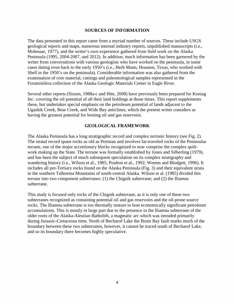
The data presented in this report came from a myriad number of sources. These include USGS geological reports and maps, numerous internal industry reports, unpublished manuscripts (i.e., Molenaar, 1977), and the writer’s own experience gathered from field work on the Alaska Peninsula (1995, 2004-2007, and 2012). In addition, much information has been garnered by the writer from conversations with various geologists who have worked on the peninsula, in some cases dating even back to the early 1950’s (i.e., Herb Mann, Houston, Texas, who worked with Shell in the 1950’s on the peninsula). Considerable information was also gathered from the examination of core material, cuttings and paleontological samples represented in the Foraminifera collection of the Alaska Geologic Materials Center in Eagle River.
Several other reports (Sisson, 1988a-c and Hite, 2008) have previously been prepared for Koniag Inc. covering the oil potential of all their land holdings at those times. This report supplements these, but undertakes special emphasis on the petroleum potential of lands adjacent to the Ugashik Creek, Bear Creek, and Wide Bay anticlines, which the present writer considers as having the greatest potential for hosting oil and gas reservoirs.
GEOLOGICAL FRAMEWORK
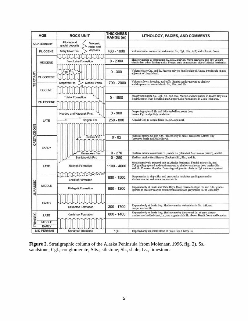
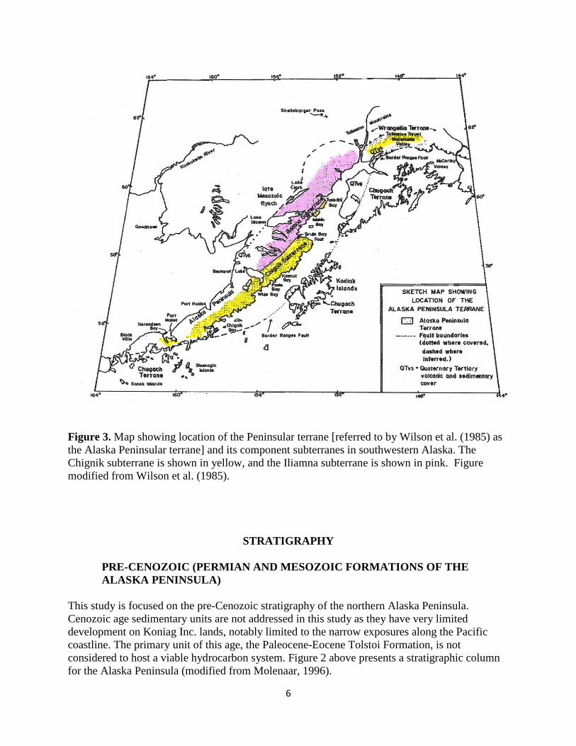
The Alaska Peninsula has a long stratigraphic record and complex tectonic history (see Fig. 2). The stratal record spans rocks as old as Permian and involves far-traveled rocks of the Peninsular terrane, one of the major accretionary blocks recognized to now comprise the complex quilt-work making up the State. The terrane was formally established by Jones and Silberling (1979), and has been the subject of much subsequent speculation on its complex stratigraphy and wandering history (i.e., Wilson et al., 1985; Poulton et al., 1992; Weems and Blodgett, 1996). It includes all pre-Tertiary rocks found on the Alaska Peninsula (Fig. 3) and their equivalent strata in the southern Talkeetna Mountains of south-central Alaska. Wilson et al. (1985) divided this terrane into two component subterranes: (1) the Chignik subterrane; and (2) the Iliamna subterrane. This study is focused only rocks of the Chignik subterrane, as it is only one of these two subterranes recognized as containing potential oil and gas reservoirs and the oil-prone source rocks. The Iliamna subterrane is too thermally mature to host economically significant petroleum accumulations. This is mostly in large part due to the presence in the Iliamna subterrane of the older roots of the Alaska-Aleutian Batholith, a magmatic arc which was intruded primarily during Jurassic-Cretaceous time. North of Becharof Lake the Bruin Bay fault marks much of the boundary between these two subterranes, however, it cannot be traced south of Becharof Lake, and so its boundary there becomes highly speculative.
5
Figure 2. Stratigraphic column of the Alaska Peninsula (from Molenaar, 1996, fig. 2). Ss., sandstone; Cgl., conglomerate; Slts., siltstone; Sh., shale; Ls., limestone.
6
Figure 3. Map showing location of the Peninsular terrane [referred to by Wilson et al. (1985) as the Alaska Peninsular terrane] and its component subterranes in southwestern Alaska. The Chignik subterrane is shown in yellow, and the Iliamna subterrane is shown in pink. Figure modified from Wilson et al. (1985).
STRATIGRAPHY
PRE-CENOZOIC (PERMIAN AND MESOZOIC FORMATIONS OF THE ALASKA PENINSULA)
This study is focused on the pre-Cenozoic stratigraphy of the northern Alaska Peninsula. Cenozoic age sedimentary units are not addressed in this study as they have very limited development on Koniag Inc. lands, notably limited to the narrow exposures along the Pacific coastline. The primary unit of this age, the Paleocene-Eocene Tolstoi Formation, is not considered to host a viable hydrocarbon system. Figure 2 above presents a stratigraphic column for the Alaska Peninsula (modified from Molenaar, 1996).

7
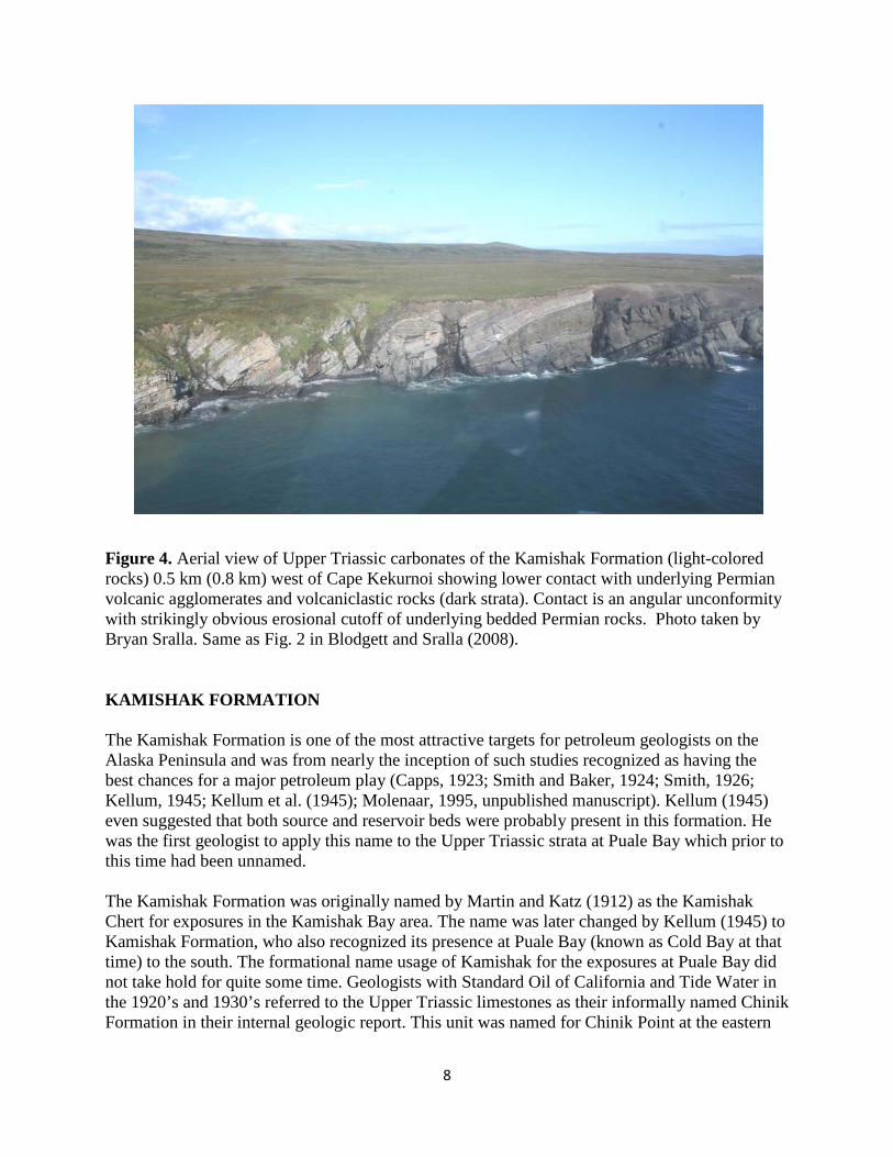
UNNAMED PERMIAN LIMESTONE AND PERMIAN AGGLOMERATES AND VOLCANICLASTIC ROCKS This is oldest stratigraphic unit officially recognized by Detterman et al. (1996). Paleozoic age rocks were unrecognized on the Alaska Peninsula until a field party from Humble Oil (now Exxon) observed Permian limestones in 1956 on a small island approximately one mile ESE of triangulation station “Hike” on the east side of the entrance to Puale Bay. Hanson (1957) provided a detailed description of this unit. The strata exposed here consists of thick-bedded gray-brown weathering limestone bearing an abundant fauna of crinoids stems, smaller foraminifera, ostracodes, brachiopod fragments, as well as many well preserved silicified rugose corals. The fauna was suggested to be indicative of a Middle Permian age. Further discussion and illustration of some of the Permian fauna can be found in Jeffords (1957). In addition, Detterman et al. (1985) provide faunal lists based on USGS collections made from this island. This island is just one of a group of islands which otherwise consist of massive, dark green to black volcanic breccias, agglomerates, and basalt flows. The latter were suggested by Hanson to stratigraphically underlie the Permian limestone and were suggested to be Permian or older in age. Onshore in sea cliffs near Cape Kekurnoi are volcanic agglomerates and sandstones which Hanson (1957) correlated with the agglomerates offshore, and he tentatively referred to both on his sketch map as Permian (?) agglomerates. The Permian (?) agglomerates and sandstones of Hanson (1957) were noted to unconformably underlie unnamed Upper Triassic strata (now referred to the Kamishak Formation). Blodgett and Sralla also noted the same relationship and referred the agglomerates and sandstones to the Permian System and provided a photograph (their Figure 2) showing this relationship as well as demonstrating the contact to be a marked angular unconformity. The writer based on recent fieldwork believes that much more carefully detailed geologic study is needed in the Puale Bay-Cape Kekurnoi area to fully resolve the character of the pre-Upper Triassic stratigraphy. At Cape Kekurnoi is exposed conglomerates which have not as yet been dated paleontologically, and the area is also characterized by numerous fault blocks with little or no stratigraphic continuity. Future fieldwork should incorporate detailed measurement of sections as well as an assiduous search for fossils to provide biostratigraphic age control. A thick succession of dark green to black volcanic and volcaniclastics rocks are also found in the Humble/Shell Bear Creek #1 well starting at a depth of 9,500 feet. The writer feels that this succession most likely correlates with the Permian (?) agglomerates of Hanson (1957) and the Permian agglomerates and volcaniclastic rocks of Blodgett and Sralla (2008). The Permian and older rocks of the Alaska Peninsula are considered by the writer to most likely represent economic basement for the region.
8
Figure 4. Aerial view of Upper Triassic carbonates of the Kamishak Formation (light-colored rocks) 0.5 km (0.8 km) west of Cape Kekurnoi showing lower contact with underlying Permian volcanic agglomerates and volcaniclastic rocks (dark strata). Contact is an angular unconformity with strikingly obvious erosional cutoff of underlying bedded Permian rocks. Photo taken by Bryan Sralla. Same as Fig. 2 in Blodgett and Sralla (2008). KAMISHAK FORMATION The Kamishak Formation is one of the most attractive targets for petroleum geologists on the Alaska Peninsula and was from nearly the inception of such studies recognized as having the best chances for a major petroleum play (Capps, 1923; Smith and Baker, 1924; Smith, 1926; Kellum, 1945; Kellum et al. (1945); Molenaar, 1995, unpublished manuscript). Kellum (1945) even suggested that both source and reservoir beds were probably present in this formation. He was the first geologist to apply this name to the Upper Triassic strata at Puale Bay which prior to this time had been unnamed. The Kamishak Formation was originally named by Martin and Katz (1912) as the Kamishak Chert for exposures in the Kamishak Bay area. The name was later changed by Kellum (1945) to Kamishak Formation, who also recognized its presence at Puale Bay (known as Cold Bay at that time) to the south. The formational name usage of Kamishak for the exposures at Puale Bay did not take hold for quite some time. Geologists with Standard Oil of California and Tide Water in the 1920’s and 1930’s referred to the Upper Triassic limestones as their informally named Chinik Formation in their internal geologic report. This unit was named for Chinik Point at the eastern

9
entrance to Puale Bay, a feature not shown on the present USGS topographic sheet for the Karluk D-4 & D-5 1:63,360 scale quadrangle map nor used on any official maps released by the U.S. Government. According to Hanna et al. (1937b, p. 27) the “point mentioned is known to the natives as “Cape Chinik” and a village bearing that name was formerly located there. At present there is an excellent log cabin built by Fred Grindle for use in winter trapping.” Shell Oil geologists who worked extensively on the Alaska Peninsula during the 1950’s informally referred to it as the Kekurnoi Formation (after Cape Kekurnoi) in their internal reports. The first subsequent application of the name Kamishak Formation to these exposures appears to be Detterman et al. (1996). Outcrops of the formation are recognized along a great extent of the west side of Cook Inlet from just west of the Iniskin Peninsula as far south as the northern part of the Alaska Peninsula. Its southernmost exposures are found on the east side of Puale Bay in the Karluk C-4 and C-5 quadrangle (Blodgett, 2008), where according to Detterman et al. (1996) it has a minimum thickness of 799.5 m (2,625 ft). The Kamishak exposures here extend up the west entrance of the next bay to the north – Alinchak Bay, and comprise the only surficial exposures of the formation close to the land holdings of Koniag Inc. on the Alaska Peninsula. Subsurface occurrences of the formation are indicated as occurring south of Puale Bay at both the Bear Creek No. 1 and Grammer No. 1 wells in the Karluk C-6 quadrangle (Blodgett and Sralla, 2008), the Kamishak is also thought to be present in the subsurface at the Chevron Koniag USA #1 well, but this still has not been paleontologically substantiated in the view of the writer. The contact between the Kamishak Formation and the underlying Permian volcanic agglomerates and volcaniclastic rocks is an angular unconformity.
Figure 5. Distribution of the Kamishak Formation (TrK unit) according to Detterman and et al. (1996). Map shows location of their measured section (Section 1) in this unit [figure from Detterman et al., 1996, fig. 6B].

10
Figure 6. Distribution of unnamed Triassic beds (now referred to Kamishak Formation) at Puale Bay – Alinchak Bay area according to Imlay and Detterman (1977). This figure more accurately reflects the distribution of Upper Triassic strata than that shown in Figure 5 above. Note the presence of Permian (?) beds shown at Cape Kekurnoi which were recognized by Hanson (1957).

11
The Kamishak Formation exposures at Puale Bay were broken into three different informal members by Blodgett (2008): a lowermost biostromal limestone, overlain by a nodular limestone member, which in turn is succeeded by the limestone and shale member which comprises the greater thickness of the formation. Both the biostromal and nodular limestone members are laterally replaced to the northeast by the limestone and shale member. The Kamishak succession exposed at Puale Bay was interpreted by Blodgett (2008) to represent a single upward-deepening succession of late Norian age rocks.
Figure 7. Columnar section of the Kamishak Formation exposed in the Cape Kekurnoi – Puale Bay area according to Detterman et al. (1996 – their Section 1 of their fig. 6). They indicate a total thickness of 799.5 m for the Kamishak Formation.
12
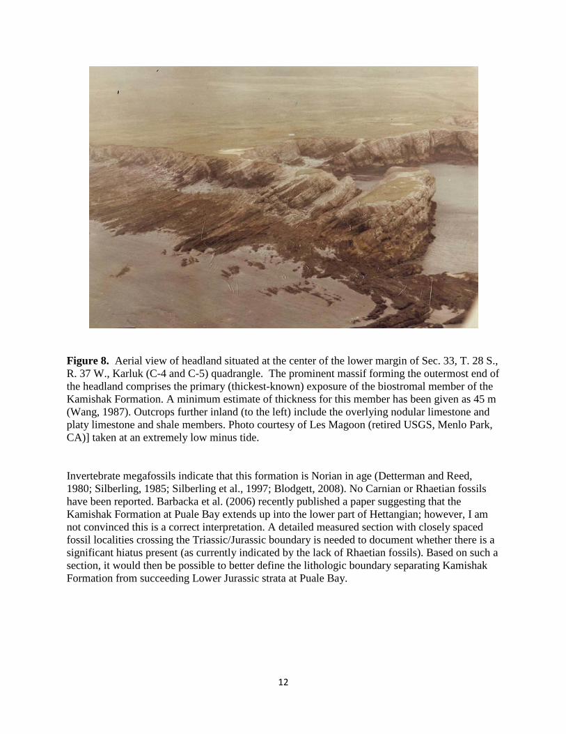
Figure 8. Aerial view of headland situated at the center of the lower margin of Sec. 33, T. 28 S., R. 37 W., Karluk (C-4 and C-5) quadrangle. The prominent massif forming the outermost end of the headland comprises the primary (thickest-known) exposure of the biostromal member of the Kamishak Formation. A minimum estimate of thickness for this member has been given as 45 m (Wang, 1987). Outcrops further inland (to the left) include the overlying nodular limestone and platy limestone and shale members. Photo courtesy of Les Magoon (retired USGS, Menlo Park, CA)] taken at an extremely low minus tide. Invertebrate megafossils indicate that this formation is Norian in age (Detterman and Reed, 1980; Silberling, 1985; Silberling et al., 1997; Blodgett, 2008). No Carnian or Rhaetian fossils have been reported. Barbacka et al. (2006) recently published a paper suggesting that the Kamishak Formation at Puale Bay extends up into the lower part of Hettangian; however, I am not convinced this is a correct interpretation. A detailed measured section with closely spaced fossil localities crossing the Triassic/Jurassic boundary is needed to document whether there is a significant hiatus present (as currently indicated by the lack of Rhaetian fossils). Based on such a section, it would then be possible to better define the lithologic boundary separating Kamishak Formation from succeeding Lower Jurassic strata at Puale Bay.

13
Figure 9. A differing view showing lower part of Kamishak Formation section on the east side of the same headland shown in Fig. 8. The more massively bedded biostromal and nodular limestone members exposed on extreme right of headland and the lower part of the platy limestone and shale member (note finer scale bedding) are exposed on left side (note helicopter for scale). Invertebrate fossils are extremely abundant in the Kamishak Formation, especially in the area of Puale Bay where abundant monotid bivalves [Monotis (Pacimonotis) subcircularis Gabb, and to a much lesser degree, Monotis (Entomonotis) sp. cf. M. (E.) ochotica densistriata (Teller) of Silbering et al. (1997)] are found in the interbedded thin-bedded limestone and shaly limestone that form the upper and greater portion of the formation (Silberling et al., 1997; Blodgett, 2008). Monotis (Pacimonotis) subcircularis is also reported middle member of the Kamishak Formation in the Iliamna Quadrangle (Detterman and Reed, 1980). The hydrozoan genus Heterastridium is also commonly found in beds with M. (P.) subcircularis at both Puale Bay (Blodgett, 2008) and in the middle member of the Kamishak Formation in the Iliamna Quadrangle (Detterman and Reed, 1980). An extremely rich fossil fauna is associated with the lowermost biostromal limestone and nodular limestone members of the Kamishak Formation at Puale Bay (various types of bivalves, gastropods, nautiloids, brachiopods, scleractinian corals, crinoid ossicles, and even an ichthyosaur rib were noted and illustrated by Blodgett (2008).

14
Figure 10. Bedding surface exposure showing typical abundant accumulation of Monotis (Pacimonotis) subcircularis Gabb on bedding plane in lower part of the platy limestone and shale member of the Kamishak Formation.
Figure 11. Slab bearing numerous specimens of Monotis (Pacimonotis) subcircularis Gabb. Limestone and shale member of the Kamishak Formation. California Academy of Sciences locality 29039. Scale marked in cm.

15
The shallow-water fauna of the Kamishak Formation containing scleractininan corals, the hydrozoan Heterastidium, and even color-banded brachiopods found at its base at Puale Bay and in parts of the unnamed middle member of the same formation in the Iliamna Quadrangle (notably at Millits Point) clearly indicate a tropical, warm-water environment. The Kamishak is age correlative to the upper part of the Shublik Formation on the North Slope, but the latter was deposited in a cooler-water, high-latitude setting (it contains no scleractinian corals or the hydrozoan Heterastidium). The abundance of the late Norian flat clam Monotis (Pacimonotis) subcircularis Gabb throughout much of the formation at Puale Bay and in the unnamed middle member of the formation in the Iliamna quadrangle indicate that the Peninsular terrane was positioned close to the western margin of either North or South America (in a tropical setting) as this index fossil is restricted to the western margin of the Western Hemisphere (it occurs from Chile in the south northward to the Brooks Range).
Figure 12. Various views of the sea cliffs between the east side of the entrance to Puale Bay and Alinchak Bay to the northeast. Exposures comprised primarily of Upper Triassic Kamishak Formation and to a lesser degree an unnamed unit of Permian agglomerates and volcaniclastic rocks of Blodgett and Sralla (2008).
16
Papers discussing the paleontology, stratigraphy, and sedimentology of the Kamishak Formation in the Puale Bay-Alinchak Bay area include Blodgett (2008), Blodgett and Sralla (2008), Capps (1923), Detterman et al. (1985, 1996), Fischer (1872, 1875), Frech (1908), Kellum (1945), Kellum et al. (1945), Kummel (1953), Levinson and Jeffords (1956), Martin (1916, 1926), Mojsisovics (1886), Newton (1983a, b; 1990), Pinart (1873), Sralla and Blodgett (2007), Silberling (1985), Silberling et al. (1997), Smith (1925, 1926), Smith and Baker (1924), Wang (1997), Wang et al. (1998), and Whalen and Beatty (2008) TALKEETNA FORMATION (=BIDARKA FORMATION OF KELLUM, 1945) Lower Jurassic strata are well exposed at the surface on the Alaska Peninsula only in the area of Puale Bay and Alinchak Bay. While recognized by early USGS mappers (Capps, 1923; Smith and Baker, 1924; Smith, 1925, 1926; Martin, 1926) these beds remained unnamed in the literature up to 1945. Kellum (1945) established the name Bidarka Formation which he envisioned to include all the previously unnamed Lower Jurassic strata exposed on the east side of Puale Bay (then referred to Cold Bay). Unfortunately his proposed unit did not receive further usage and has long remained ignored and now even long forgotten by geologists. Ralph Imlay, the USGS premier Jurassic paleontologist and stratigrapher, never even made mention of this paper (or even of Kellum’s work in general), and in fact referred these same beds at Puale Bay as the “unnamed Lower Jurassic beds” in Imlay and Detterman (1977, see Fig. 6 above). These beds remained unnamed for most workers until the 1980’s, when Detterman et al. (1983, 1985, and 1987) applied the earlier named Talkeetna Formation to these strata. As noted by Detterman et al. (1985): “The name Talkeetna Formation is here applied to the previously unnamed Lower Jurassic strata exposed on the north shore of Puale Bay and along Alinchak Bay. These rocks are approximately 410 m thick and are lithologically and faunally similar to the Talkeetna Formation in its type area in the Talkeetna Mountains. The rocks are highly tuffaceous gray to green sandstone, siltstone, and limestone with thick interbeds of tuff. Fossils, mainly ammonites (table 3), are present throughout and indicate a Hettangian to Sinemurian (Early Jurassic) age. The contact with the overlying Kialagvik Formation is a fault surface, but displacement is considered to be minor and the formations are probably conformable.” The Talkeetna Formation was named by Martin (1926) for a succession of Lower Jurassic lava, agglomerate, breccias, tuff and lesser amounts sandstone and shale exposed in the eastern Talkeetna Mountains. Martin recognized it as being several thousand feet in thickness. More recent work indicates that the formation is much thicker (Imlay, 1981a; Clift et al., 2005; Draut et al., 2006). Imlay (1981a) considered the Talkeetna Formation here to be 15,000-19,000 feet (4,660-5,790 m) thick and dominated by volcanic rocks, deposited mostly in a marine setting (however, some rich plant beds are now known from Pliensbachian age strata). For a long time the Talkeetna Formation was recognized only in the southern Talkeenta Mountains. Detterman and Hartsock (1966) geographically extended the unit onto the west side of Cook Inlet (Iniskin-Tuxedni Bay area), and the unit name was also applied later by Detterman and Reed (1980) to coeval volcanic rocks in the remainder of the Iliamna quadrangle. A total thickness of 2,225 m was recognized in the Chinitna Bay area by Detterman and Hartsock (1966), probably the maximum attained in Iliamna quadrangle (Detterman and Reed, 1980). Detterman et al. (1983, 1985, 1987, and 1996) extended the Talkeetna Formation further south to include Lower Jurassic strata exposed between Puale Bay and Alinchak Bay on the northern part

17
of the Alaska Peninsula. Previously, these strata were usually left unnamed in the literature (i.e., Imlay and Detterman, 1977; Imlay, 1981a). However, Kellum (1945) proposed the name Bidarka Formation for Lower Jurassic strata at Puale Bay, and it seems plausible to retain the name with some revision pending a future detailed stratigraphic investigation. The Lower Jurassic strata at Puale Bay according to Imlay (1981a) consists of a basal limestone unit (238 m) in thickness, overlain by massive tuffaceous conglomeratic sandstone (317 m) including some siltstone and limestone. Detterman et al. (1996) indicate a total thickness of 404.2 m for the Lower Jurassic sequence at Puale Bay. The Lower Jurassic at Puale Bay is moderately fossiliferous and faunal lists and/or descriptions of ammonites from here can be found in Imlay and Detterman (1977), Imlay (1981a), and Palfy et al. (1999). The age of the beds here appear to range in age from middle Hettangian-early Sinemurian, quite older than any fossiliferous beds known in the Talkeetna Formation in the southern Talkeetna Mountains. The older character of these strata and the total lack of volcanic flow units within the Lower Jurassic succession at Puale Bay suggest that they are not directly equivalent to any of the Talkeetna outcrops known from the Talkeetna Mountains or the west side of Cook Inlet, and that perhaps designating them by the earlier suggested lithostratigraphic name of Bidarka Formation (Kellum, 1945) may well be in order, as was done in Blodgett and Sralla (2008). Publications devoted to aspects of the stratigraphy, paleontology, and sedimentology of the Lower Jurassic Talkeetna Formation in the Puale Bay area include Barbacka et al. (2006), Capps (1923), Detterman et al. (1985, 1996), Imlay (1981), Imlay and Detterman (1973, 1977), Kellum (1945), Kellum et al., (1945), Martin (1926), Palfy (1997), Palfy et al. (1999), Smith (1925, 1926), Smith and Baker (1924). KIALAGVIK FORMATION The Kialagvik Formation was defined by Capps (1923, p. 94-97) for several hundred feet of sandstone, shale, and conglomerate exposed on the northwest shore of Wide Bay (then known as Kialagvik Bay). He did not formally designate a type section at that time for this formation. Detterman et al. (1996) designated two reference sections for Kialagvik, one at Wide Bay (the principal reference section) which measures 626.7 m) and the other at Puale Bay which is 789.5 m thick. The sections exposed at Wide Bay and Puale Bay represents the only known exposures of the Kialagvik Formation. The formation consists of olive-gray to green medium-bedded fine- to medium-grained graywacke, mudstone, siltstone and shale as thick a 790 m. Locally the Kialagvik contains lenses of volcanic pebble conglomerate. Plant debris and carbonaceous material are common throughout the formation. The Kialagvik is abundantly fossiliferous with ammonites and pelecypods. The base of the formation is dated as Toarcian (late Early Jurassic) to Callovian (late Middle Jurassic) age at Puale Bay, while surface exposures of the formation at Wide Bay are wholly Bajocian in age. The Kialagvik is a direct correlative of the essentially age equivalent Tuxedni Group exposed further to the north in the Cook Inlet basin, and in fact in many of the the earliest oil industry reports for the Cold (now Puale) Bay region, rocks of the Kialagvik were referred to as the Tuxedni Formation (the Tuxedni Formation was later raised to group status by Detterman, 1963).

18
The rocks found in the Wide Bay exposures indicate that the lower part of the section was deposited in a nearshore, shallow-water environment. Sandstones are crossbedded and contain lenses of conglomerate and abundant wood and carbonaceous debris (Detterman et al., 1996). The thick-shelled bivalve Trigonia which is typical of nearshore high-energy environments is common here. The upper part of the formation at Wide Bay consists of rhythmically bedded thin siltstone and sandstone, limestone nodules and lenses, and interpreted to have been deposited in deeper-water. The fauna at the Puale Bay section indicates a much deeper paleoenvironment than those found at Wide Bay (Detterman et al., 1996; R.B. Blodgett, personal observation). These consist of mostly ammonites, some small flat bivalves, and fish debris, which occur sparsely and in sporadic isolated beds. The contact of the Kialagvik with the overlying Shelikof Formation is conformable at Puale Bay where this formation is as young as Callovian (late Middle Jurassic) and unconformable at Wide Bay where the Kialagivik is entirely Bajocian (Middle Jurassic). The contact with underlying Talkeetna Formation at Puale Bay is an unconformity (Detterman et al., 1996). Maps showing the areal distribution of this unit in the Ugashik and/or Karluk quadrangles are shown in Capps (1923), Smith and Baker (1924), Kellum et al. (1945), Detterman et al. (1985 1987,1996). Publications that deal with the stratigraphy, paleontology and sedimentology of the Kialagvik Formation include Capps (1923; in which the formation was established), Hyatt (1896), Imlay (1961, 1964, 1984), Detterman et al. (1985, 1996), Imlay and Detterman (1973, 1977), Kellum (1945), Kellum et al., (1945), Martin (1926), Reifenstuhl et al. (2004), Smith (1925, 1926), Smith and Baker (1924), Westermann (1963, 1964, 1969, and 1978) and White (1889).
Figure 13. Ammonites from an exposure of the Kialagvik Formation on the west side of Wide Bay.
19
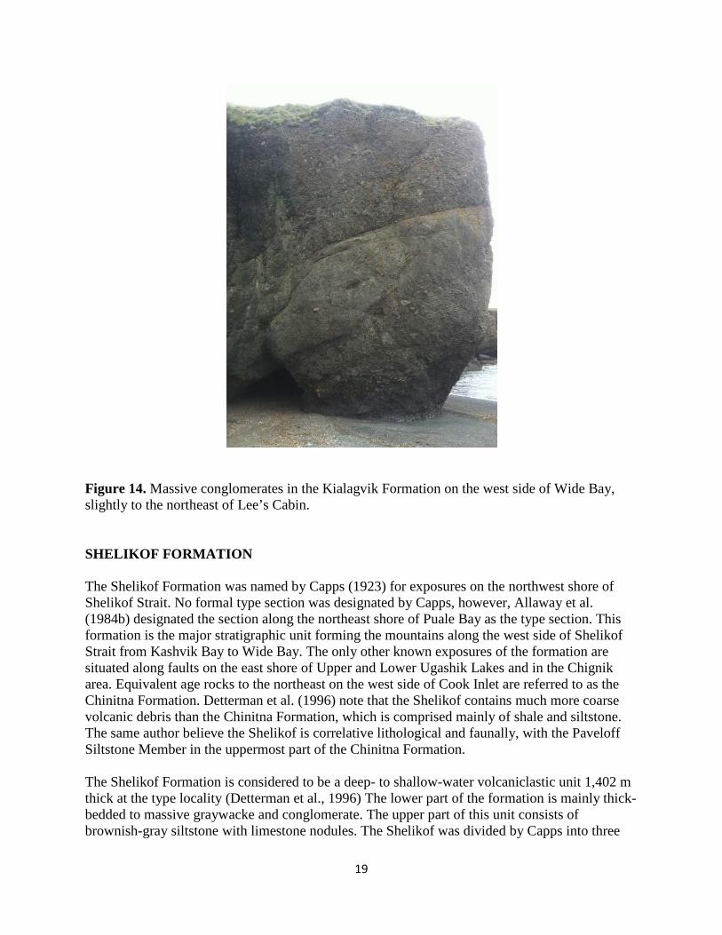
Figure 14. Massive conglomerates in the Kialagvik Formation on the west side of Wide Bay, slightly to the northeast of Lee’s Cabin. SHELIKOF FORMATION The Shelikof Formation was named by Capps (1923) for exposures on the northwest shore of Shelikof Strait. No formal type section was designated by Capps, however, Allaway et al. (1984b) designated the section along the northeast shore of Puale Bay as the type section. This formation is the major stratigraphic unit forming the mountains along the west side of Shelikof Strait from Kashvik Bay to Wide Bay. The only other known exposures of the formation are situated along faults on the east shore of Upper and Lower Ugashik Lakes and in the Chignik area. Equivalent age rocks to the northeast on the west side of Cook Inlet are referred to as the Chinitna Formation. Detterman et al. (1996) note that the Shelikof contains much more coarse volcanic debris than the Chinitna Formation, which is comprised mainly of shale and siltstone. The same author believe the Shelikof is correlative lithological and faunally, with the Paveloff Siltstone Member in the uppermost part of the Chinitna Formation. The Shelikof Formation is considered to be a deep- to shallow-water volcaniclastic unit 1,402 m thick at the type locality (Detterman et al., 1996) The lower part of the formation is mainly thick-bedded to massive graywacke and conglomerate. The upper part of this unit consists of brownish-gray siltstone with limestone nodules. The Shelikof was divided by Capps into three
20
informal members, called the siltstone, sandstone, and conglomerate members. Detterman et al. (1987) in their geologic map of the Ugashik and Karluk quadrangles likewise had a tri-partite division of the Shelikof Formation described as follows in descending order: “1) Sandstone member – Massive to thick-bedded, medium- to coarse-grained dark-green to gray volcanogenic sandstone containing abundant magnetite grains; commonly contains beds of grit and small pebbles. Sandstone northwest of Wide Bay deposited in shallow water with abundant plant debris and the pelecypod Corbicula sp.; southeastward across Wide Bay sandstone was deposited as submarine fans with graded beds, flute and load casts, and flame structures; 2.) Siltstone member—Dark-grayish-olive green to dusky yellow-green thin-bedded siltstone. Numerous 1- to 3-cm-thick beds of limestone and abundant concretions of brown fine-grained limestone in lower part of section. Thin sandstone beds in upper part of section. Siltstone is siliceous with metallic luster on weathered surface. Contains moderately abundant ammonites, mainly Cadoceras sp. and Pseudocadoceras sp., indicative of a Callovian (Middle Jurassic) age. (R.W. Imlay, written commun., 1982); and 3.) Conglomerate member—Mainly massive lenticular submarine channel deposits that are present throughout formation. Clasts primarily well-rounded dark volcanic cobbles; locally polymictic with pebble to boulder sized clasts of limestone, sandstone, and occasional granitic rocks.” Fossils are locally abundant in the Shelikof Formation, but for the most part this unit is unfossiliferous. The fauna consists mainly of ammonites belonging to the genera Cadoceras, Pseudocadoceras, and Stenocadoceras, of early to middle Callovian age. Detterman et al. (1996) report that a few specimens of Iniskinites at Wide Bay and a few species of the genus Cadoceras suggest a Bathonian(?) age for some of the rocks there. Detterman et al. (1996) considered the the contact between the Kialagvik and Shelikof to be conformable at Puale Bay. The contact between the Shelikof Formation and the overlying Naknek Formation is that of profound, low angular unconformity (Morse, 1922; Detterman et al., 1987; R.B. Blodgett, personal observation, 2004 and 2012). References to the paleontology, stratigraphy, and sedimentology of the Shelikof Formation include Allaway (1984a, b), Blome (1981, 1984), Capps (1923), Detterman et al. (1981, 1985, 1987, and 1996), Imlay (1953), Imlay and Detterman (1973), Martin (1926), Smith (1925, 1926), and Smith and Baker (1924).

21
Figure 15. Ammonite belonging to the genus Cadoceras from the upper part of the Shelikof Formation at head of Puale Bay. Upper scale bar in inches, lower scale in cm.
Figure 16. Abundant woody plant debris in the Shelikof Formation at head of Puale Bay.

22
NAKNEK FORMATION The Naknek Formation was established by Spurr (1900) as the Naknek series, being named after exposures along the upper Naknek Lake and Savonski River on the Alaska Peninsula. Martin (1926) revised the unit, changing the name to Naknek Formation and including in it the basal Chisik Conglomerate Member, which had earlier been established as an independent formation by Martin and Katz (1912). The Naknek Formation is the most widespread and persistent formation of the Peninsular terrane, outcrops extending in the south from Black Hill near the southern end of the Alaska Peninsula northward along the west side of Cook Inlet, ultimately terminating in the Nelchina and adjoining areas in the southern Talkeetna Mountains (Grantz, 1960; Trop et al., 2005), northeast of Anchorage. This thick Upper Jurassic formation has variable thicknesses developed along its outcrop belt. On the Iniskin Peninsula on the west side of Cook Inlet, Detterman and Reed (1980) recognized it to be about 1,082 m in thickness. Detterman et al. (1996) gave the average thickness of the formation as being 1,700 to 2,000 m on the Alaska Peninsula. Abrupt lateral facies changes are typical for the Naknek with a varying member nomenclature recognized along the length of its outcrop belt. Both marine and non-marine intervals are recognized. The formation includes beds ranging in age from early Oxfordian to late Tithonian age on the Alaska Peninsula (Detterman in Poulton et al., 1992), but in the Iniskin Peninsula-Tuxedni Bay area, the Naknek Formation includes only beds ranging from early Oxfordian to early Kimmeridgian age (upper age limit based on the upper known range of the bivalve Buchia concentrica which occurs in the Pomeroy Arkose Member). The only occurrence of younger Naknek strata in the Cook Inlet Basin is from Augustine Island where the Tithonian age Buchia piochii (Gabb) was reported by Detterman and Jones (1974). The absence of younger Late Jurassic strata throughout much of the western side of Cook Inlet may reflect a significant pre-latest Cretacous (Campanian-Maastrichtian) erosion event not reflected to the south on the Alaska Peninsula. Throughout much of the onshore region of Cook Inlet, the Naknek is overlain by the Kaguyak Formation, as demonstrated at Augustine Island (Detterman and Jones, 1974; Magoon et al., 1976) and by laterally equivalent non-marine strata of the Kaguyak exposed at Saddle Mountain north of Chinitna Bay. However, in the Lower Cook Inlet COST Well #1, the Lower Cretaceous Herendeen Formation was recognized, which to our knowledge has no known onshore outcrops elsewhere in Cook Inlet. In the Iniskin-Tuxedni region on the west side of Cook Inlet, Detterman and Hartsock (1966) divided the Naknek locally into (ascending order): Chisik Conglomerate Member, lower sandstone member, Snug Harbor Siltsone Member and Pomeroy Arkose Member. The Chisik Conglomerate Member consists of a massive cobble-boulder conglomerate, containing granitic and metamorphic rocks, and lesser volcanic rocks. Detterman in Poulton et al. (1992) reports it to range in thickness from 100-170 m and contain no fossils (being non-marine). The lower sandstone member consists of thick-bedded to massive arkosic sandstone with siltstone interbeds and ranges in thickness from 150-250 m (Detterman in Poulton et al., 1992). The Snug Harbor Siltstone Member (established by Detterman and Hartsock, 1966) consists of thin to massive siltstone with abundant limestone interbeds; it ranges in thickness from 200-250 m according to Detterman in Poulton et al. (1992). The uppermost member, Pomeroy Arkose Member (established by Kirschner and Minard (1948) as the Pomeroy Member of the Naknek Formation)

23
consists of medium- to thick-bedded arkose which is locally conglomeratic and contains siltstone interbeds; its thickness ranges from 250-730 m according to Detterman in Poulton et al. (1992). A number of cool- to cold-water Boreal faunal elements typify the marine fauna of the Naknek Formation: the abundance and diverse representatives of the bivalve Buchia as well the ammonite Cardioceras. Faunal diversity is markedly lower in the Upper Jurassic than in the preceding Lower and Middle Jurassic. Based on biogeographic evidence, Detterman (1988) speculated that the Peninsular terrane was more or less in its present position by Middle Jurassic time. Weems and Blodgett (1996) also indicated that the Naknek marine fauna indicated a cool-water environment, concurring that the Peninsular terrane had already been accreted and in its present position. The placement of the Peninsular terrane against North America by Late Jurassic time is also in accord with the presence of theropod dinosaurs reported from the Naknek Formation near Broad Creek in the Chignik quadrangle, Alaska Peninsula (Blodgett et al., 1995; Druckenmiller et al., 2011; Fowell et al., 2011). References to the paleontology, stratigraphy, and sedimentology of the Naknek Formation in lands close to or within Koniag interest include Blodgett et al. (1995), Detterman et al. (1985, 1996), Imlay (1959, 1981b), Jones and Miller (1976), Martin (1925, 1926), Miller and Detterman (1985), and Weems and Blodgett (1996) STANIUKOVICH FORMATION The Staniukovich Formation was originally established by Atwood (1911) with the name Staniukovich Shale, and was based on rocks exposed on Staniukovich Mountain which is located on the peninsula between Herendeen Bay and Port Moller in the central Alaska Peninsula. Burk (1965) changed the name to Staniukovich Formation, but included within the unit much more stratal thickness than originally considered by Atwood. Detterman et al. (1996) restricted the content of the formation, and tried to stratigraphically restrict to it those beds which Atwood considered to represent a mappable unit. The type section of the formation is found on Staniukovich Mountain in section 30, T. 50 S., R. 73 W., Port Moller D-2 quadrangle. The type section, which consists of siltstone and sandstone, attains a thickness of 246.3 m. Rocks now restricted to the Stanuikovich are also recognized in a small area of the Chignik-Sutwik Island area (on the northwest side of the mountains bordering Chignik Bay, where they underlie the Herendeen Formation and conformably overlie the Indecision Creek Sandstone Member of the Naknek Formation). The only other exposures of the formation to the north are found in the Mount Katmai B-2, B-3, and B-4 1:63,360 quadrangles) where a thickness of up to 100 m is reported (Riehle et al., 1993). In this northeastern-most known exposure of the formation, situated in the Mt. Katmai area, it unconformably overlies the Naknek Formation and unconformably underlies the Herendeen Formation. Surficial exposures of this formation are shown on the map of Detterman et al. (1981; their KJs unit) from the lands currently held by Koniag, Inc. in the norther part of the Chignik Quadrangle. However, more recently investigations indicate that is in error, and that these exposures rather represent the upper part of the Upper Jurassic Naknek Formation. In addition, no known

24
occurrences of this unit is recognized in either the surface or subsurface of their land positions to the north in the Ugashik Quadrangle. HERENDEEN FORMATION This formation was established by Atwood (1911) as the Herendeen Limestone. The type section is exposed along the east shore of Herendeen Bay, north of Coal Harbor (Mine Harbor) and near Marble Point in the Port Moller D-2 and D-3 quadrangles. Redefined by Detterman et al. (1996) as the Herendeen Formation who designated a reference section in the “low hills directly southwest of the hot springs in sec. 14, T. 50 S., R. 73 W., Port Moller D-2 1:63,360 quadrangle.” In addition to the exposures in the Herendeen Bay area, the formation is also recognized to the west of Chignik (Detterman et al., 1981) and in the Mt. Katmai area (including Kaguyak Bay). The farthest north known occurrence of the Herendeen Formation is in the Lower Cook Inlet COST No. 1 well (Magoon, 1986). The formation is directly correlative with the lithologically similar Nelchina Limestone (Hauterivian-Barremian) of the southern Talkeetna Mountains. In the Chignik 1:250,000 scale quadrangle, scattered outcrops of this formation is recognized where it consists of about 30 m of thin-bedded calcarenite, composed mainly of Inoceramus prisms, and thin limy sandstone, all light gray in color (Detterman et al., 1981). The Herendeen Formation conformably overlies the Stanuikovich Formation in the type section, however, in the Mt. Katmai area it unconformably overlies both the Naknek and Staniukovich formations. The upper contact of the formation marks a major regional unconformity, being overlain by either Albian age beds of the Pedmar Formation or Campanian-Maastrichtian age beds of the Chignk or Kaguyak Formations. The formation has been erosionally removed from much of the northern Alaska Peninsula. The distinctive, light-colored outcrops of this formation make it easily recognizable in the field. A strong petroliferous odor is noted in this formation both in the type area and in float samples observed by Blodgett west of Chignik (west side of Broad Creek). I consider this to be one of the primary targets for possible reservoirs in the Cook Inlet-upper Alaska Peninsula Mesozoic province. This unit is not known to be exposed on lands currently held by Koniag Inc. on the northern Alaska Peninsula. However, it is possible that it may be found in the subsurface of their more southerly land holdings in the Chignik Quadrangle. Despite the great abundance of inoceramid bivalve prisms in the Herendeen at Herendeen Bay, no complete whole shell of Inoceramus ovatoides are known from here. In contrast, inoceramid prisms are much less common in the Kaguyak Bay area exposures, while complete whole shells of Inoceramus ovatoides are relatively common. On this basis, a deeper-water paleoenvironment is suggested for the exposures in the Mt. Katmai and Kaguyak Bay areas, in contrast to that in Herendeen Bay (Port Moller) area (Detterman et al., 1996; Blodgett, personal observation, 2004). The age of the formation is considered to be Hauterivian-Barremian (Jones and Detterman, 1966; Jones and Miller, 1976; Miller and Jones, 1981; Riehle et al., 1993; Miller et al., 1995; Detterman et al., 1996).

25
Figure 17. Prominent exposure of the Herendeen Formation in the Kaguyak Bay area, Section 3, T. 19 N., R. 28 W., Afognak C-6 1:63,360 scale quadrangle.
Figure 18. Well developed cross-bedding developed in quartzose sandstones of the Herendeen Formation at the outcrop shown above in Figure 17 in the Kaguyak Bay area, Afognak C-6 1:63,360 scale quadrangle.

26
Figure 19. The inoceramid bivalve Inoceramus ovatoides Anderson, the Hauterivian-Barremian age index fossil for the Herendeen Formation. Complete specimens of this species are relatively common at the prominent exposure of this unit shown in Figure 17, where these specimens were observed. PEDMAR FORMATION
The Pedmar Formation was established by Detterman et al. (1996) based on a thin sequence of Lower Cretaceous (Albian) rocks discovered in 1979 in seacliffs along Katmai Bay (Petering and Smith, 1981; Miller et al., 1982). The type section of the Pedmar Formation was designated as exposures in a seacliff along the north edge of section 24, T. 25 S., R. 34 W., Mount Katmai A-3 1:63,360 quadrangle, beginning at the northeast corner of the section and continuing westward along the cliff for about 760 m (Detterman et al., 1996). The formation is about 82 m thick at the type section and consists of thick-bedded, fine- to medium-grained, gray to olive-gray sandstone. Two poorly exposed siltstone and shale units are present in the upper part of the formation. The contact with the overlying Kaguyak Formation is a disconformity, and the lower contact at the type section is represented by a fault with the Naknek Formation. Another section of the Pedmar Formation is 88 m thick, and was measured 42 km north of the type section on an unnamed mountain peak above an unnamed lake east of Ikgaluik Creek (Mount Katmai B-3 quadrangle). The latter section is composed mostly of siltstone with sandstone interbeds, and disconformably overlies the Herendeen Formation. Rocks equivalent in age to the Pedmar are also present to the southwest in the Port Moller area, as fossil locality there yielded the ammonite Grantziceras sp., indicative of an Albian age. However, there is uncertainty as to precise locality, and no further specimens could be recovered despite an attempt to recollect. Thus, bona-fide outcrops of the Pedmar Formation are known only from the southern part of the Mount Katmai quadrangle. As far as is known, no exposures of the Pedmar Formation are exposed at the surface in lands on or adjacent to Koniag, Inc. land holdings on the northern Alaska Peninsula. However, it is not beyond reason that the unit may be present in the subsurface in their holdings in the Chignik Quadrangle.

27
CHIGNIK FORMATION This formation is not known at the surface or subsurface in the northern portion of the Koniag Inc. lands on the upper Alaska Peninsula. However, its presence is well established in the southern portion of Koniag Inc. lands. Their farthest northern exposure appears to be inland of the Pacific coast in the region of Mount Chiginagak and Mother Goose Lake in the southern Ugashik 1:250,000 scale quadrangle. The Chignik Formation was named by Atwood (1911), who designated its type section on Whalers Creek, Secs. 9 and 10, T. 45 S., R. 60 W., Chignik B-2 1:63,360 scale quadrangle. He included non-marine coal-bearing rocks exposed along Herendeen Bay to much further to the south along the Alaska Peninsula to this unit. Burk (1965) named this lower non-marine coal-bearing section the Coal Valley Member of the Chignik Formation, the type section being the hills above Coal Valley, southeast of Staniukovich Mountain. The Chignik formation includes a number of differing environments, including nearshore marine, tidal flat, and non-marine flood plain and fluvial deposits. The non-marine coal sequence is now recognized to be present at different positions within the formations. Detterman et al. (1996) suggested abandoning the term Coal Valley Member for the basal part of the Chignik, arguing that it was only useful locally on the peninsula between Port Moller and Herendeen Bay, and again reiterated that non-bearing coal-bearing rocks can be found regionally at different stratigraphic levels within the Chignik. The greatest thickness of the Chignik Formation is attained in the area between Port Moller and Chignik Bay (Detterman et al., 1996). This formation was noted by them to thin rapidly both northeast and southwest from this area, becoming entirely marine. Thus, they interpreted this intermediate area to part of a fluvial deltaic system adjacent to a source area northwest of the present-day Alaska Peninsula. Detterman et al. (1996) provide additional information on their designated reference section for the Chignik which is located along the northwest shore of Chignik Lagoon in Secs. 24, 26, and 34, T. 44 S., R. 59 W., Chignik B-2 quadrangle. This section is 490 m thick and consists of nearshore sandstone and siltstone with two intervals of flood-plain and fluvial deposits. This reference section was noted to be slightly thicker and more accessible than the type section. In addition, the authors noted that “coal and carbonaceous shale are present in the nonmarine parts of the section, and some of the sandstone is oil stained (Keller and Cass, 1956). Marine fossils, mainly the bivalves Inoceramus balticus var. kunimiensis and I. schmidti and the ammonite Canadoceras newberryanum, indicate a late Campanian to early Maestrichtian age for the Chignik Formation.” These authors also noted that the lower contact of the Chignik is a major unconformity, with the unit commonly overlying either the Herenedeen or Staniukovich Formation. This unconformity was considered to show only a minore structural discordance, with bedding attitudes differing by no more than a few degrees. They also noted that locally the Chignik is in contact with the overlying Hoodoo Formation, which is partially age equivalent to the Chignik and considered generally “to be a deep-water lateral facies quivalent rather than an overlying unit.” Publications or theses emphasizing the paleontological and stratigraphic aspects of this formation include Atwood (1911), Burk (1965), Detterman (1978), Detterman et al. (1981, 1985, 1987,

28
1996), Fairchild (1977), Hollick (1930), Imlay and Reeside (1954), Jones (1963), Jones and Miller (1976), Knappen (1929), Martin (1926), and Stanton and Martin (1905). HOODOO FORMATION Exposures of this formation within Koniag Inc. lands are limited to areas near the Pacific Ocean coastline. The formation is shown as the Kh unit on the Chignik and Sutwik Island quadrangles map of Detterman et al. (1981) and is shown together with Chignik Formation (as Hoodoo and Chignik Formations, undivided, Khc unit) on the Ugashik Quadrangle map of Detterman et al. (1987). The Hoodoo Formation was established by Burk (1965) for a classic turbidite succession of rhythmically interbedded black shale, siltstone, and sandstone. The type section located along the southeast side of Hoodoo Mountain and the west side of upper Beaver River valley in the Port Moller C-3 1:63,360 quadrangle. This section was reported to be 2,000 to 3,000 feet thick (Burk, 1965, p. 59). The northernmost good exposures of the formation are at Amber Bay (Detterman et al., 1996, p. 33). The formation is considered by many to be a deep-water lateral facies equivalent of the Chignik Formation (Mancini et al., 1978; Molenaar, 1980). Detterman et al. (1996) likewise considered the two formations to represent two distinct facies of the same time-stratigraphic interval. However, in some places the Hoodoo Formation can be seen to onlap and succeed the Chignik Formation. Deposition within the formation is considered to represent submarine slumps and turbidity currents. Marine megafossils are sparse in this unit, but seeming more abundant in the upper part. Fossil taxa identified include the bivalves Inoceramus schmidti, I. balticus, and I. vancouverensis. Ammonites include Diplomoceras notabile, Neophylloceras hetonaise, and Canadoceras newberryanum. This fauna indicates a late Campanian to early Maastrichtian (Late Cretaceous) age. Distinction between the Hoodoo and Chignik can often be difficult in the field, in fact the northernmost exposure of the Hoodoo is at Imuya Bay in the Ugashik quadrangle, where it is mapped as undifferentiated unit of Hoodoo and Chignik Formations undivided. This latter exposure is complicated by being hornfelsed by the nearby intrusion of the Agripina Bay batholith. Publications or theses emphasizing the paleontological and stratigraphic aspects of this formation include Burk (1965), Detterman et al. (1981, 1985, 1987, 1996), Jones (1963), Jones and Miller (1976), Mancini et al. (1978), Molenaar (1980).
CENOZOIC FORMATIONS OF THE ALASKA PENINSULA Cenozoic age stratigraphic units with significant oil/gas prospects are not recognized by the writer as being present to any great extent on current land holdings of Koniag, Inc. Most Cenozoic sedimentary units on Koniag lands are restricted to small outcroppings along the Pacific coastline in the southern part of their holdings, however, none of these exposures are recognized as having much potential for recovery of economic accumulations of oil and/or gas.

29
WELLS NEAR OR ADJACENT TO KONIAG CORPORATION LANDS ON THE ALASKA PENINSULA
Figure 20. Map showing major anticlinal features in the northern part of Koniag Inc. land holdings on the Alaska Peninsula (base map modified from Detterman et al., 1987).
30
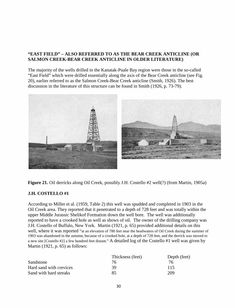
“EAST FIELD” – ALSO REFERRED TO AS THE BEAR CREEK ANTICLINE (OR SALMON CREEK-BEAR CREEK ANTICLINE IN OLDER LITERATURE)
The majority of the wells drilled in the Kanatak-Puale Bay region were those in the so-called “East Field” which were drilled essentially along the axis of the Bear Creek anticline (see Fig. 20), earlier referred to as the Salmon Creek-Bear Creek anticline (Smith, 1926). The best discussion in the literature of this structure can be found in Smith (1926, p. 73-79).
Figure 21. Oil derricks along Oil Creek, possibly J.H. Costello #2 well(?) (from Martin, 1905a)
J.H. COSTELLO #1 According to Miller et al. (1959, Table 2) this well was spudded and completed in 1903 in the Oil Creek area. They reported that it penetrated to a depth of 728 feet and was totally within the upper Middle Jurassic Shelikof Formation down the well bore. The well was additionally reported to have a crooked hole as well as shows of oil. The owner of the drilling company was J.H. Costello of Buffalo, New York. Martin (1921, p. 65) provided additional details on this well, where it was reported “at an elevation of 780 feet near the headwaters of Oil Creek during the summer of 1903 was abandoned in the autumn, because of a crooked hole, at a depth of 728 feet, and the derrick was moved to a new site [Costello #2] a few hundred feet distant.” A detailed log of the Costello #1 well was given by Martin (1921, p. 65) as follows: Thickness (feet) Depth (feet) Sandstone 76 76 Hard sand with crevices 39 115 Sand with hard streaks 85 209

31
Oil sand, not hard 40 240 Sandstone with hard streaks 60 300 Oil sand, soft 8 308 Sandstone with hard streaks 82 390 Oil sand 25 415 Soft argillaceous sandstone 15 430 Soft blue sandstone with oil 5 435 Small showing of oil 45 480 Sandstone with streaks of clay 20 500 Sandstone 120 620 Showing of oil 30 650 Sandstone 50 700 J.H. COSTELLO #2 Miller et al. (1959) reported that this well was drilled and completed in 1904 in the Bear Creek area, total depth not known, but probably abandoned at a shallow depth. It was totally restricted to the upper Middle Jurassic. Martin (1921, p. 65) provides additional information as follows: “Very little drilling had been done at this point at the time the writer left Alaska, in September 1904, but it was reported that the well was only spudded in and reached a depth of 15 feet.”
Figure 22. Rusting equipment at the site of the J.H. Costello #2 well south of Oil Creek.

32
Figure 23. A differing view of the J.H. Costello #2 well site. PACIFIC OIL & COMMERICAL CO. #1 (ALSO REFERRED TO AS CASEY #1) This well was reported by Miller et al. (1959) to have been drilled and completed during the interval of 1903-1904 and to have attained a total depth of 1,421 feet being restricted to the upper Middle Jurassic Shelikof Formation throughout the well bore. The well was stated to be situated on the Trail Creek-Becharof Creek divide. They reported it to have had a strong flow of fresh water, oil residue, and shows of oil and gas. Martin (1921, p. 65) provides the following details on this well: “Another well, also begun in 1903, was drilled by the Pacific Oil & Commercial Co., at an elevation of 580 feet, on the divide between Trail, Dry, and Becharof creeks, to a depth of 1,421 feet. The drill is said to have penetrated several strata filled with thick residual oil having about the consistency of warm pitch. This well was finally abandoned in the summer of 1904 because of the strong, continual flow of fresh water. Its seems safe to assume that this well is near a fault. This assumption may explain the presence of large quantities of fresh water at all depths and the absence of the more volatile and fluid constituents in the oil. In 1904 the machinery from this well was moved to a new location about 2 ¼ miles to the southeast, on Trail Creek….” The following lithologic log was given for this well in Martin (1921, p. 66): Thickness (feet) Depth (feet) Soil 15 15 Gravel 15 30 Blue clay 5 35 Sandstone 103 138
33
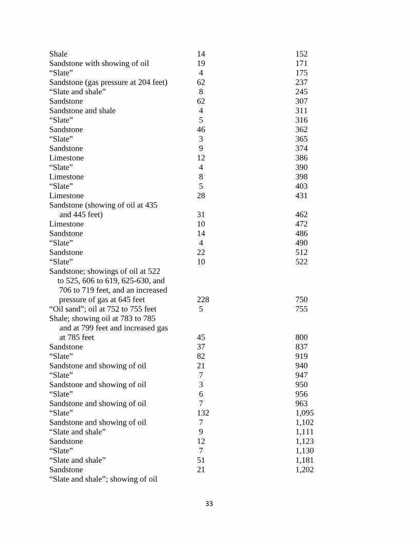
Shale 14 152 Sandstone with showing of oil 19 171 “Slate” 4 175 Sandstone (gas pressure at 204 feet) 62 237 “Slate and shale” 8 245 Sandstone 62 307 Sandstone and shale 4 311 “Slate” 5 316 Sandstone 46 362 “Slate” 3 365 Sandstone 9 374 Limestone 12 386 “Slate” 4 390 Limestone 8 398 “Slate” 5 403 Limestone 28 431 Sandstone (showing of oil at 435 and 445 feet) 31 462 Limestone 10 472 Sandstone 14 486 “Slate” 4 490 Sandstone 22 512 “Slate” 10 522 Sandstone; showings of oil at 522 to 525, 606 to 619, 625-630, and
706 to 719 feet, and an increased pressure of gas at 645 feet 228 750
“Oil sand”; oil at 752 to 755 feet 5 755 Shale; showing oil at 783 to 785 and at 799 feet and increased gas at 785 feet 45 800 Sandstone 37 837 “Slate” 82 919 Sandstone and showing of oil 21 940 “Slate” 7 947 Sandstone and showing of oil 3 950 “Slate” 6 956 Sandstone and showing of oil 7 963 “Slate” 132 1,095 Sandstone and showing of oil 7 1,102 “Slate and shale” 9 1,111 Sandstone 12 1,123 “Slate” 7 1,130 “Slate and shale” 51 1,181 Sandstone 21 1,202 “Slate and shale”; showing of oil
34
at 1,202 to 1,203 feet 8 1,210 Sandstone; showing of oil at 1,314 to 1,321, 1,326 to 1,335, 1,342 to 1,349 and 1,419 to 1,421 feet 211 1,421 PACIFIC OIL & COMMERCIAL CO. #2 (ALSO REFERRED TO AS CASEY #2) Miller et al. (1959) reported the well to have been drilled and completed in 1904 at Trail Creek and to have attained a depth of 1,452 feet, being totally within the upper Middle Jurassic Shelikof Formation. Tools were reported as being lost and that there were shows of oil and gas. Martin (1921, p. 65) provides further information: “… about 2 ¼ miles to the southeast [of Pacific Oil & Commercial Co. #1 well], on Trail Creek, and here a well was drilled to a depth of 1,524 feet, where the tools were lost in October of that year.” In addition, Martin (1921, p. 66) notes that this well was at an elevation of 175 feet on Trail Creek, and provides the following lithologic log: Thickness (feet) Depth (feet) Soil and gravel 10 10 Sandstone 153 163 Shale 12 175 Sandstone; showing of oil at 262 to 265 feet 98 273 Limestone and shale 17 290 Sandstone 22 312 Sandstone and shale 15 327 Sandstone 153 480 Shale 8 488 Sandstone 20 508 Sandstone and shale 17 525 Sandstone; showing of oil at 857 to 867 feet, steady increase of gas at 950 to 959 feet 434 959 Sandstone and shale 34 993 Sandstone; showing of oil at 1,008 to 1,013 feet, increase of gas at 1,061 feet, and gas and showing of oil at 1,150 feet 549 1,542 PACIFIC OIL & COMMERCIAL CO. #3 (ALSO REFERRED TO AS CASEY #3) This well was reported by Miller et al. (1959) to have been drilled and completed during the interval of 1902-1904? and questionably located on Becharof Creek. The total depth was not given by these authors, and was considered to probably have been abandoned at shallow depth. It was also thought to be restricted in the well bore to the upper Middle Jurassic Shelikof Formation. Almost no other reference to this third well can be found in literature and

35
unpublished reports available to writer, however, Morse (1922, p. 10) does makes reference to this well, and reports it to be situated close to main oil seep on Oil Creek (rather than on Becharof Creek). In the same report it was reported that this well reached a depth of 750 feet in 1905 (Morse, 1922, p. 10-11).
Figure 24. Index map (from Blodgett and Sralla, 2008) showing location of the Grammer #1, Bear Creek Unit #1 and Wide Bay Unit #1 wells along the Pacific coast (west side of Shelikof Strait) of the northern part of the Alaska Peninsula. STANDARD OIL COMPANY OF CALIFORNIA GRAMMER #1 This well was the first significant rotary drilled well on the Alaska Peninsula. The operator was Standard Oil Co. of California, and it was drilled together with Tide Water Associated Oil Company and Union Oil Company of California. The well was drilled in the valley of Salmon Creek (see Fig. 24 for location) in the SW ¼, SE ¼ of Section 10, T. 30 S., R. 41 W., Karluk C-6 1:63,360 quadrangle. It was spudded in the upper Middle Jurassic Shelikof Formation on July 17, 1938, and abandoned on March 8, 1940.This well attained a total depth of 7,596 feet (2,315 m), at that time the deepest well drilled in Alaska. According to the limited megafossil data identified by G.D. Hanna in the Tide Water Associated Oil Co. internal report by Hewitt (1940 – see Appendix 1), a Grammoceras fauna (Grammoceras is an ammonite) characteristic of the Kialagvik Formation was obtained in the depth interval 2,116-2,140 ft (645-652 m). A few

36
scattered pectens, brachiopods, unidentified ammonites, and plant remains were reported throughout the depth interval 2,140-2,820 ft (652-860 m). Abundant ammonites identified by Hanna as belonging to the Early Jurassic genus Arietites (restricted to the Sinemurian Stage) were obtained from in the depth interval 2,820-2,924 ft (860-891 m), indicating that it corresponds with to the Lower Jurassic Bidarka Formation of Kellum (1945), which is partly correlative with the Talkeetna Formation as recognized by Detterman et al. (1996) in the Puale Bay area. Fossils obtained lower in the well included a few small undiagnostic pectens (but still reported in the lithologic log as similar to those obtained from Jurassic rocks of the region) in the depth interval 3,724-3,730 ft (1,135-1,137 m) and a few small bivalves at a depth of 4,224 ft (1,287 m) identified by Hanna as belonging to the long-ranging genus Avicula. Although he believed the specimens of Avicula to not be age diagnostic, he noted that they were similar to forms occurring elsewhere in the Lower Jurassic. These specimens were reported to be deposited in the California Academy of Sciences in San Francisco, but an inquiry made to the curator of the paleontologic collections indicate that the specimens from these depths are absent in their collections. The absence of age-diagnostic fossils and open-hole electrical-log data somewhat hinders identification of the stratigraphic units penetrated at depth in Grammer #1 well. Blodgett and Sralla (2008) tentatively placed the upper contact between the Upper Triassic Kamishak Formation and the overlying Lower Jurassic section in the depth interval 3,730-4,224 ft (1,137-1,287 m) on the basis of lithologic transitions from dominantly sandstone, characteristic of the Lower Jurassic, into more abundant calcareous shale and limestone more typical of the Kamishak Formation at Puale Bay. The same authors tentatively placed the base of the Kamishak Formation at ~ 4,790 ft (1,460 m) depth. However, the present author now favors placement of the base of the Kamishak at a much lower depth. Although the lower contact of the Kamishak Formation is not easily interpretable from the limited data at hand, the well evidently penetrated older (probably Paleozoic) basement rocks, as shown by the increasing abundance of highly tuffaceous beds downhole. Slate was finally observed near the bottom of the well. Unfortunately additional biostratigraphic data could not be obtained for this well as only a few micropaleontological slides (Foraminifera) were ever prepared and presently deposited at the Alaska Geologic Materials Center (GMC) in Eagle River, Alaska. The few slides present were almost wholly lacking in foraminifers, though a few good Radiolaria (unstudied) were noted. The GMC has only cores from shallower intervals in this well, deeper cored intervals apparently were never turned over to the GMC (though some lithic chips do exist). Two appendices are included for the well. Appendix 2 consists of the final report by Hewitt (1940) for Grammer #1 well and Appendix 3 consists of a detailed lithologic log for this well (obtained from the Alaska Oil and Gas Commission office in Anchorage, Alaska). This well log provides numerous signs of oil and gas throughout the well bore including records of gas, gilsonite, live (free) oil in fractures, dry oil in fractures, tarry oil, live oil, and dead oil as deep as 7,400 ft (2256 m). Although no commercial quantities of oil were found during the conventional drilling of this well during 1938-1940, the profilic signs of oil and gas shows reported in this well suggests that redrilling it as an oil shale/oil shale prospect may well bear fruit with modern drilling technology.

37
Hewitt (1940, p. 9-10) provided the following commentary concerning his views on the oil and gas indications from this well: “Oil in commercial quantities was not struck in the Grammer No. 1 test well. It was observed, however, in small amounts throughout the greater part of the hole and on several occasions strong flows of gas and salt water created drilling problems. From almost the surface down to 3,760 feet drilling had to be conducted with 120-129 pound mud in order to keep the salt water and gas out of the hole. A string of 11-3/4 inch casing was cemented at 1,054 feet but it did not materially help the situation. At 3,760 feet 126 pound mud began to migrate into the formation and as a lighter mud would not keep back the salt water, 8-5/8 inch casing was run in and cemented. This cement job shut off the water satisfactorily and the well was completed using 90 pound mud. Gas entered the well on several occasions below 3,760 feet, causing sharp drops in the weight of the rotary mud but this usually occurred after the well had been idle for some time.” “Solid hydrocarbons, in the form of gilsonite, were found quite persistently in the fractures in the rocks from 200 to 2,100 feet. Live oil was first observed in the fractures in the shales between 2,100 and 2,200 feet. From this point down to 3,150 feet live oil or tarry residue was seen in small amounts in the fractures of every core. Between 3,150 and 3,250 feet a thick series of light colored, silty ashes or tuff was encountered. These rocks were thoroughly fractured and the breaks carried both live and tarry oil and in many cases the rock itself was stained light brown by oil. Gas was observed bubbling from the fractures as much as 14 hours after the core was taken from the core barrel. A Johnston Formation tester which was run in this formation obtained gassy, heavy mud; watery, gassy mud with oil colors; and finally muddy salt water with a scum of heavy, tarry, black oil.” “Small, but persistent amounts of both live and tarry oil and oil stain were observed in the fracture planes of every core between 3,250 and 6,000 feet. Below 6,000 feet some of the cores appeared dry but many contained oil stain and tarry oil in the fractures. A few showed small amounts of live oil in the mud which coated the cores before they were washed.” “In summary, it should be stated that all the oil, gas and very probably, salt water, encountered in the Grammer No. 1 test well, were closely associated with the intricate system of fractures. None of the formations were sufficiently permeable to allow the migration of either oil or gas within the rocks themselves. No highly organic stratum, suitable as a source of petroleum, was found in the well nor is any such bed known in the sections of the Kanatak District which stratigraphically overlie the formations exposed in the well. It, therefore, seems safe to assume that whatever oil was found in the test well migrated upwards by means of the fracture system. Owing to the uncertain character of the lowermost formations in the well, it is impossible to say whether or not an oil reservoir lies at greater depth. The high degree of induration of these rocks, however, is rather unfavorable for such a reservoir. It is possible, too, that all the oil that was ever present is now thoroughly disseminated throughout the structure.” HUMBLE-SHELL BEAR CREEK UNIT #1 The famous Bear Creek #1 well was the most expensive well drilled in Alaska up until that time. The operator (Humble Oil & Refining Company who acquired the acreage on a farmout from Shell Oil Company) built a road which connected the well with Jute Bay. The well site is situated in Section 36, T. 29 S., R. 41 W., Karluk C-6 1:63,360 quadrangle (see Fig. 24 for location). The well was spudded on September 23, 1957 and the rig was abandoned on March 4, 1959. Total depth attained was 14,374 feet (4,381 m) and drilling started within the upper Middle Jurassic Shelikof Formation. According to Blasko (1976a, p. 37) the well was drilled upstream from the seeps he observed along Bear Creek. The formations encountered in the well bore are now the subject of considerable controversy (see Blodgett and Sralla, 2008). Numerous oil and gas shows were reported from this well, though none obviously proved to be of commercial

38
value. Total organic carbon, rock-eval pyrolysis and vitrinite reflectance data for this well was given in a report authored by Phillips Petroleum Company (1983). Herb Mann (retired geologist from Shell Oil Co., Houston, Texas who oversaw the drilling) provided the following background history on the Bear Creek Unit #1 well: “Our mapping of the Bear Creek area disclosed an anticlinal structure with over 30,000 acres of closure and oil seeps near the top of the structure. Our objective was the Upper Triassic limestone and (or) dolomite exposed at Cape Kekurnoi on Puale Bay. There these carbonates were overlain by good quality oil source rocks mostly of Upper Triassic and Lower Jurassic age. After reviewing all the data and costs, Shell management elected to farmout half interest in our vast holdings on both the Bear Creek and Wide Bay anticlines to Humble. I was in favor of drilling the Bear Creek anticline, but some of my associates thought it was too risky and super expensive, hence the farmout and my friends at Shell took a picture of my head in a bowl with the label beneath it that said “They drill Magma.” …. “Drilling commenced in 1958 and unfortunately tests on minor shows were all failures though there was oil staining down to about 9000 feet. We did identify Monotis pelecypods (Upper Triassic-Norian) but in limy and siliceous shales overlain by thick pyroclastics, nothing like the Monotis-bearing limestone objective and the Lower Jurassic stratigraphy exposed at Cape Kekurnoi. The organic-rich Upper Triassic source beds at Cape Kekurnoi, termed the Kekurnoi Formation internally by Shell Oil geologists, and subsequently assigned to the Kamishak Formation by Detterman and co-workers of the USGS is crowded with abundant remains of the flat-clam Monotis.” (H. Mann, written commun., 2012; Mann and Blodgett, 2012). As noted above, there is considerable disagreement on what formations and ages were encountered during drilling. Detterman (1990, p. 21-22) gives the following interpretation (which the current writer finds unsupported paleontologically or lithostratigraphically for the lower portion of the well bore!): “The well started in bedrock of the Shelikof Formation on the ridge 0.6 mile (1 km) north of Bear Creek, and just east of the axis of the Bear Creek anticline. The upper 1,220 feet (372 m) were in siltstone and greenish-gray volcanogenic sandstone of the Shelikof Formation.” “A sequence of brownish-gray siltstone, shale, and thin sandstone 2,810 feet (856 m) thick of Kialagvik Formation underlies the Shelikof Formation. Three occurrences of oil staining were noted in the formation, particularly in the sandstone. These rocks may have been the source of the oil seeps that occur in the area. A 730-foot (223 m) sequence of tuff and tuffaceous siltstone underlies the Kialagvik Formation. We consider these rocks to be Talkeetna Formation, and that they are terminated at a thrust fault surface at 4,760 feet (1,450 m).” “The entire upper part of the sequence in this well has apparently been thrust over the Kialagvik Formation and older strata. A fault was not mapped along the surface exposure of the anticline in this area, but thrust faults were mapped north and south of this locality (Detterman et al., 1987). About 1,320 feet (403 m) of the Kialagvik Formation are repeated below the fault. These rocks are similar to the lower part of the formation above the fault. A complete sequence of volcanic and volcaniclastic rocks of the Talkeetna Formation underlies the fault. Volcanic flow units and tuffs became thicker and more abundant downward. This locality apparently was close to the volcanic center as evidenced by the thick flow units.” “The contact with the Kamishak Formation is arbitrarily placed at 10,918 feet (3,328 m). At this point the well enters a calcareous siltstone and shale sequence with only minor tuffaceous and flow units. Limestone is missing, but the marked change in lithology suggests a different stratigraphic unit is being drilled. The absence of limestone is troublesome, especially since limestone is present in exposures at Puale Bay just to the northeast and in the Wide Bay well to the southwest. The possibility has to be considered that these underlying rocks represent the Kialagvik Formation again and that second thrust fault is present in this well. The numerous references to fossil molds and the occurrence of hydrocarbons somewhat suggest Kialagvik Formation. The age of these rocks probably could have been documented by more précised information on the abundant fossil material. Fossils in the Upper Triassic Kamishak Formation and the Middle Jurassic Kialagvik Formation are very different and very distinctive.”

39
The above paragraph is very puzzling to the writer (a paleontologist) as he has observed almost no fossils molds in either core chips or cuttings in the lower part of the well that Detterman implied are abundant. Blodgett and Sralla (2008, p. 6-8) provided a quite differing interpretation of the formations and their depth intervals encountered in this well: “The top of the Kamishak Formation is interpreted to be at a depth of 5,000 ft (1,524) and to extend downhole to a depth of ~6,600 ft (2,012 m) (see Fig. 25 below). From the top of the formation to a depth of 5,905 ft (1,800 m), the lithology is typified in ditch cuttings by gray to dark-brown, calcareous silty shale, with a greater fraction of dark-brown argillaceous silty limestone at increasing depth. The limestone content further increases below a depth of 5,905 ft (1,800 m) and then quickly transitions at a depth of 6,080 ft (1,853 m) into light-gray microcrystalline dolomite with scattered varicolored igneous material (dikes?). Even though no megafossils were obtained from small cuttings, the overall lithology in the depth interval 5,000–5,905 ft (1,524–1,800 m) closely matches that of the upper part of the Kamishak Formation exposed at Puale Bay. In fact, when samples from outcrops of the Kamishak Formation were compared side by side with well cuttings under a binocular microscope, they appeared to be nearly identical. Nowhere have we observed such an abundance of carbonates in any of the overlying Jurassic rocks. Both the stratigraphic sequence and the lithology support our interpretation that the Bear Creek No. 1 well penetrated a thick section of the Triassic Kamishak Formation.” “Indirect support of this interpretation was provided by Rock Eval pyrolysis data (Threlkeld et al., 2000). Subsurface total organic-carbon (TOC) contents through the interpreted Kamishak Formation interval range from 0.62 to 1.5 weight percent and average 0.91 weight percent. The hydrogen index averages 243 mg S2/g TOC, but a maximum of 424 mg S2/g TOC (highly oil prone) was obtained near the top of the Kamishak Formation, at a depth of 5,000 ft (1,524 m). These TOC contents and hydrogen-index values signify an oil-and-gas-prone source rock with fair to good generative potential, although only marginal maturity (Ro=0.51) at best is achieved in Bear Creek No. 1 well. All the Jurassic rocks that crop out in the study area …., except the Kialagvik Formation, are known to have very low TOC contents, with mostly inert kerogen.” “We conclusively rule out interpretation of a Middle Jurassic age for the depth interval 5,000–6,601 ft (1,524–2,012 m) on the basis of a lithology unlike that known in the Kialagvik Formation at Puale Bay (fig. 1). Instead, a lithology and TOC content consistent with the Kialagvik Formation occur uphole at a depth of ~1,968 ft (600 m), where TOC contents range from 0.79 to 2.2 weight percent, and average 1.2 weight percent and hydrogen index averages 328 mg S2/g TOC, indicative of a good type II oil-prone source rock.” “The dolomitic depth interval 6,079–6,601 ft (1,853–2,012 m) is anomalous in comparison with any part of the Kamishak Formation cropping out at Puale Bay ….. Although the section has open-hole electrical-log characteristics indicating fair porosity and good permeability, it is notably devoid of bivalves or coral fragments and has a different texture and color from those of the fossiliferous lower part of the Kamishak Formation cropping out west of Cape Kekurnoi. Although these depth intervals may be time-stratigraphically correlative, they represent a different facies and depositional environment. As a result, we speculate that the muddy, microcrystalline dolomites observed in Bear Creek No. 1 well in the depth interval 6,079–6,601 ft (1,853–2,012 m) indicate a very low energy, restricted lagoonal environment, separated from open-marine circulation by the higher-energy, biostromal carbonate observed at Puale Bay.” “Below a depth of 6,600 ft (2,012 m), the lithology quickly grades back to dark-gray siltstone and volcanic rocks with scattered, nearly black limestone. By a depth of 8,000 ft (2,438 m), the lithology consists of very dark gray to nearly black, volcanically derived granule conglomerate and tuff and nearly black limestone. A core chip from a depth of 9,400 ft (2,865 m) consists of dark-gray limestone containing small echinoderm fragments suggestive of a late Paleozoic age.”
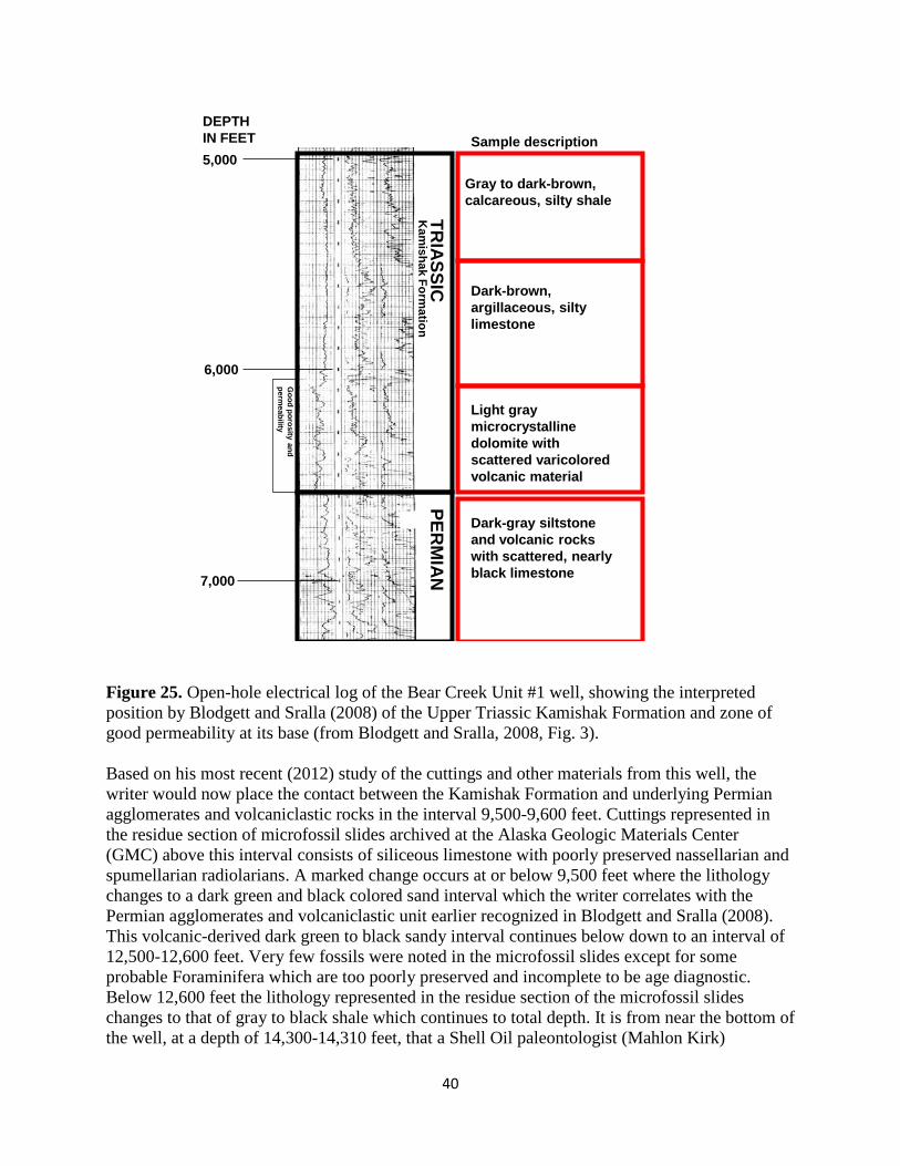
40
Kam
ishak Formation
Gray to dark-brown, calcareous, silty shale
Dark-brown, argillaceous, silty limestone
Light gray microcrystalline dolomite with scattered varicolored volcanic material
PERM
IAN
Dark-gray siltstone and volcanic rocks with scattered, nearly black limestone
5,000
6,000
7,000
TRIA
SSIC
DEPTH IN FEET Sample description
Good porosity and
permeability
Figure 25. Open-hole electrical log of the Bear Creek Unit #1 well, showing the interpreted position by Blodgett and Sralla (2008) of the Upper Triassic Kamishak Formation and zone of good permeability at its base (from Blodgett and Sralla, 2008, Fig. 3). Based on his most recent (2012) study of the cuttings and other materials from this well, the writer would now place the contact between the Kamishak Formation and underlying Permian agglomerates and volcaniclastic rocks in the interval 9,500-9,600 feet. Cuttings represented in the residue section of microfossil slides archived at the Alaska Geologic Materials Center (GMC) above this interval consists of siliceous limestone with poorly preserved nassellarian and spumellarian radiolarians. A marked change occurs at or below 9,500 feet where the lithology changes to a dark green and black colored sand interval which the writer correlates with the Permian agglomerates and volcaniclastic unit earlier recognized in Blodgett and Sralla (2008). This volcanic-derived dark green to black sandy interval continues below down to an interval of 12,500-12,600 feet. Very few fossils were noted in the microfossil slides except for some probable Foraminifera which are too poorly preserved and incomplete to be age diagnostic. Below 12,600 feet the lithology represented in the residue section of the microfossil slides changes to that of gray to black shale which continues to total depth. It is from near the bottom of the well, at a depth of 14,300-14,310 feet, that a Shell Oil paleontologist (Mahlon Kirk)

41
suggested that Monotis bivalves were present (indicative of mid-Late Triassic (mid- to late Norian) age). Examination of the core chips containing these bivalves at the GMC by the writer did not necessarily confirm their identity as Monotis, but rather suggest that they may simply be long ranging pectinoid bivalves (more complete material needed). No microfossils are present in the Foraminifera slides from this lower shale interval. In the opinion of the writer the age of this lowermost shale remains unclear, but would most simply be interpreted to be probably late Paleozoic in age given the seemingly straight-forward stratigraphic succession represented in the well. It should be noted that a marked rapid increase in Ro (vitrinite reflectance) values in this well (see Fig. 26 below) approximately at 8,000 feet depth which indicate a major break in thermal maturity.
Figure 26. Vitrinite reflectance (themal maturity) versus depth plot for the Humble-Shell Bear Creek Unit #1 well (from Molenaar, 1996, fig. 3). Note prominent excursion to the right around 8,000 feet indicating an abrupt increase in Ro values.

42
“WEST FIELD” – UGASHIK CREEK ANTICLINE (OR PEARL CREEK DOME) AREA
The “West Field” wells consist of five wells operated by Standard Oil Company and Associated Oil Company during the Kanatak oil boom in the years of 1923-1926 along the crest of the Ugashik Creek anticline (see Fig. 20). All were drilled with cable tools and most were rather shallow, with the exception of the Standard Oil Company of California Lee #1 well which attained a total depth of 5,034 feet, and the Alaska Oil Company Alaska #1 which reached to 3,033 feet. All of these wells were closely situated to one another along the lower reaches of the WNW-trending ridge of Mount Demian and the base site for the drilling operations is referred to as “Oil Camp” on the USGS 1:63,360 scale topographic map for this area (see Fig. 27 for its location). This ridge is bounded on the south Ugashik Creek and on the north by Little Ugashik Creek as shown on the current USGS Ugashik C-1 quadrangle map (note that Little Ugashik Creek was formerly referred to a Barabara Creek in USGS literature of the 1920s)]. These wells are all more or less situated along the anticlinal crest of the Pearl Creek Dome which forms the northeastern terminus of the Ugashik Creek anticline.
Figure 27. USGS topographic map showing location of the “Oil Camp”, the base camp servicing the five nearby wells which made up the “West Field” during the oil boom of the 1922-1926 in the Kanatak region. The location of road built to access the fields from Kanatak is shown by the dashed line. Most of the road is still visible from the air by helicopter and it would seem quite reasonable that it could be widened and improved given renewed interest in petroleum exploration.
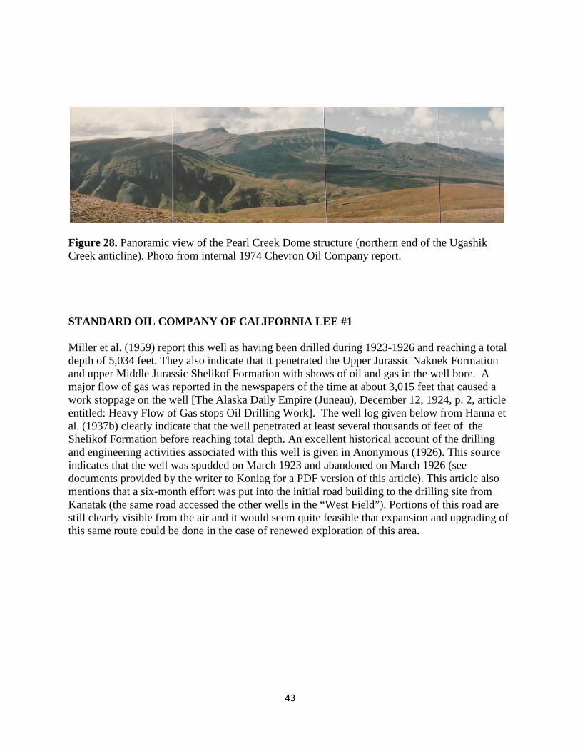
43
Figure 28. Panoramic view of the Pearl Creek Dome structure (northern end of the Ugashik Creek anticline). Photo from internal 1974 Chevron Oil Company report. STANDARD OIL COMPANY OF CALIFORNIA LEE #1 Miller et al. (1959) report this well as having been drilled during 1923-1926 and reaching a total depth of 5,034 feet. They also indicate that it penetrated the Upper Jurassic Naknek Formation and upper Middle Jurassic Shelikof Formation with shows of oil and gas in the well bore. A major flow of gas was reported in the newspapers of the time at about 3,015 feet that caused a work stoppage on the well [The Alaska Daily Empire (Juneau), December 12, 1924, p. 2, article entitled: Heavy Flow of Gas stops Oil Drilling Work]. The well log given below from Hanna et al. (1937b) clearly indicate that the well penetrated at least several thousands of feet of the Shelikof Formation before reaching total depth. An excellent historical account of the drilling and engineering activities associated with this well is given in Anonymous (1926). This source indicates that the well was spudded on March 1923 and abandoned on March 1926 (see documents provided by the writer to Koniag for a PDF version of this article). This article also mentions that a six-month effort was put into the initial road building to the drilling site from Kanatak (the same road accessed the other wells in the “West Field”). Portions of this road are still clearly visible from the air and it would seem quite feasible that expansion and upgrading of this same route could be done in the case of renewed exploration of this area.

44
Figure 29. Rig and camp at the site of the Lee #1 well (from Anonymous, 1926). As noted in the same source “The location of camp buildings in a depression afforded some slight protection from the high winds, and undoubtedly contributed to their often being completely buried under the snow during a greater part of the winter months.”
Figure 30. Two views of the road constructed between Kanatak and the Lee #1 well in the vicinity of Kanatak Pass (from Anonymous, 1926). Portions of this road are still clearly visible aerially from a helicopter. A detailed log of this well was given in the appendix of Hanna et al. (1937b): Location – 1776’ East of SW corner Section 20, T. 29 S., R. 43 W. Elevation – 764’ Spud – March 19, 1923 Abandoned – April 7, 1926

45
Depth from To Feet 0 14 Surface sand and hard sandstone 14 18 Boulders 18 21 Hard sand 21 25 Coarse yellow gravel 25 30 Hard sandstone 30 32 Hard yellow sandstone 32 33 Gravel and sand. Encountered water – Only a
seepage of water see P.B.R. Letter, #124 of 11-23-23.
33 35 Hard yellow sandstone 35 42 Hard conglomerate and sand 42 50 Conglomerate and hard sandstone 50 55 Conglomerate and hard blue sandstone 55 65 Hard blue sandstone and gray sand rock 65 70 Blue coarse sandstone 70 85 Hard sandy shale, streak blue sandstone 85 95 Hard sand gray shale 95 105 Hard blue sand shale 105 120 Hard blue sand 120 125 Hard blue sand and shale 125 135 Hard fine gray sandstone 135 146 Hard gray sandstone 146 149 Hard fine grained gray sandstone 149 150 Hard gray sandstone 150 154 Hard gray fine grained sandstone – Hard gray
sandstone coarse grained only chloroform test shows colors of oil, no oil coming into hole.
154 158 158 162 Hard gray sandstone. Streak of sandy shale. 162 170 Hard gray sandstone 170 180 Hard gray sandstone 180 188 Hard gray fine grained sandstone Hard gray close grained sandstone 188 190 Hard gray sandstone coarser grained 190 191 Hard gray close grained sandstone 191 194 Hard gray sandstone (a little coarser grained) 194 196 Hard gray sandstone 196 201 Hard gray sandstone 201 204 Hard gray sand, steak brown shale turns water slightly red 204 220 Hard gray sandstone 220 225 Hard gray sandstone and conglomerate 225 232 Hard gray sandstone 232 236 Hard gray fine grained sandstone cuts steel badly 236 240 Hard gray sandstone

46
Hard gray sandstone and conglomerate Hard gray sandstone 240 245 Hard gray sandstone and conglomerate 245 259 Hard gray fine grained sandstone, cuts stell badly 259 261 Hard close grained fine gray sandstone 261 263 Hard gray fine grained sandstone 263 267 Hard gray sandstone with streaks of brown and
black shale. Turns water red. 267 282 Hard close grained gray sandstone 282 287 Hard fine grained gray sandstone 287 289 Hard gray close grained sandstone, streaks of brown
shale at 289’ 289 292 Hard fine grained gray sandstone. Streaks of brown
shale and sand 289 to 291’ 292 312 Hard gray fine grained sandstone 312 315 Hard gray sandstone and conglomerate 315 318 Hard gray sandstone and conglomerate and small
streaks of black shale shows colors of oil by chloroform test.
318 327 Hard gray sandstone and conglomerate 327 331 Hard gray sandstone and conglomerate small streak brown shale 331 343 Hard gray sandstone and conglomerate 343 344 Shell of hard gray fine grained sandstone absolutely
solid 344 351 Hard gray fine grained sandstone 351 362 Hard gray sandstone and conglomerate 362 370 Hard gray sandstone and conglomerate. Sandstone
coarser. 370 380 Hard gray sandstone and conglomerate 380 383 Hard gray fine grained sandstone 383 385 Shell of hard fine grained gray sandstone 385 390 Hard fine grained gray sandstone, streak of coarse
sandstone 390 398 Hard fine grained gray sandstone 398 401 Gray sandstone and shale 401 410 Gray sand & shale very fine, less hard. 410 417 Gray sand & shale 417 420 Coarse gray sandstone and conglomerate 420 430 Gray sand and shale 430 448 Hard gray sandstone and conglomerate 448 450 Red sandstone, turns water chocolate color - shows colors of oil. 450 456 Red sandstone and brown shale, turns water chocolate color. 456 460 Hard gray fine grained sandstone
47
460 462 Hard gray fine grained sandstone 462 466 Hard gray sandstone 466 470 Hard gray coarse grained sandstone 470 477 Hard coarse gray sandstone, streaks of sandy gray shale, shows colors of oil. 477 505 Hard gray sandstone 505 510 Hard gray sandstone and shell of fine grained gray
sandstone 510 526 Hard fine grained gray sandstone 526 532 Hard gray sandstone, coarser grained 532 550 Hard gray sandstone 550 562 Hard gray fine grained sandstone 562 568 Hard gray sandstone. Encountered crevices between
562 and 565, water level dropped from 183 to 294 568 575 Hard gray sandstone 575 584 Hard gray sandstone, streaks of red sandstone turns
water reddish color 585 590 Hard gray sandstone 590 597 Shell of hard fine grained gray sandstone 597 604 Hard gray coarser grained sandstone 604 610 Hard gray sandstone 610 614 Hard gray sandstone, finer grained 614 618 Shell of fine grained gray sandstone 618 623 Hard fine grained gray sandstone 623 629 Hard gray coarser grained sandstone 629 642 Hard gray sandstone 642 650 Gray sandstone slightly calcareous, thin streaks brown shale, shows colors of oil. 650 657 Hard gray sandstone slightly calcareous 657 664 Hard gray fine grained sandstone 664 666 Shell of close grained sandstone, absolutely solid 666 677 Hard gray fine grained sandstone 677 684 Gray sandstone coarser with streaks of brown shale
turns water chocolate color 684 700 Hard gray fine grained sandstone 700 708 Hard gray sandstone coarser grained 708 785 Hard gray sandstone 785 792 Hard gray sandstone streaks of close grained hard
sandstone 792 802 Hard gray sandstone 802 808 Hard gray sandstone streaks of close grained gray
sandstone 808 840 Hard gray sandstone 840 865 Hard gray close grained sandstone 865 872 Hard gray close grained sandstone steaks of brown
shale, turns water chocolate color

48
872 892 Hard gray sandstone coarser grained 892 918 Hard gray fine grained sandstone 918 923 Hard fine grained gray sandstone, streaks of sandy
gray shale 923 938 Gray sand, streaks of gray sandy shale, slightly
calcareous 938 945 Gray sandstone, more solid 945 950 Gray sandstone, streaks of brown shale 950 962 Gray sandstone, streaks of brown shale colors of oil,
water reddish color 962 1064 Gray sandstone 1064 1115 Hard gray sandstone 1115 1120 Hard gray sandstone, slightly calcareous 1120 1136 Hard gray close grained sandstone 1136 1159 Hard gray sandstone 1159 1167 Hard gray sandstone, small streak brown shale,
turns water reddish color at 1163 1167 1191 Hard gray sandstone 1191 1197 Gray sandstone coarse grained 1197 1217 Coarse grained gray sandstone 1217 1238 Sharp gray sandstone, cuts bit badly 1238 1265 Gray sandstone 1265 1269 Gray sandstone, streaks sandy gray shale 1269 1273 Gray sandstone 1273 1280 Gray sandstone, streaks of brown shale turns water
chocolate color 1280 1290 Gray sandstone 1290 1296 Gray sandstone, streaks of sandy gray shale. 1296 1305 Gray sandstone, thin streaks of sandy gray shale 1305 1310 Gray sandstone 1310 1348 Hard gray sandstone 1348 1360 Hard gray sandstone, think streaks of black, brittle
shale 1360 1432 Hard gray sandstone 1432 1443 Coarse sandstone and gray shale 1443 1455 Hard fine grained gray sandstone 1455 1460 Hard fine grained sandstone 1460 1468 Hard fine grained gray sandstone. Carbonaceous
streaks from 1466 to 1468 1468 1470 Hard gray sandstone with carbonaceous streaks 1470 1475 Gray sandstone and gray shale 1475 1484 Gray sandstone and gray shale, shows colors of oil 1484 1502 Gray sandstone and gray shale, shows colors of oil 1502 1509 Hard fine grained gray sandstone, streaks brown
shale, shows colors of oil, 600 feet of water in hole, shows no oil coming in hole
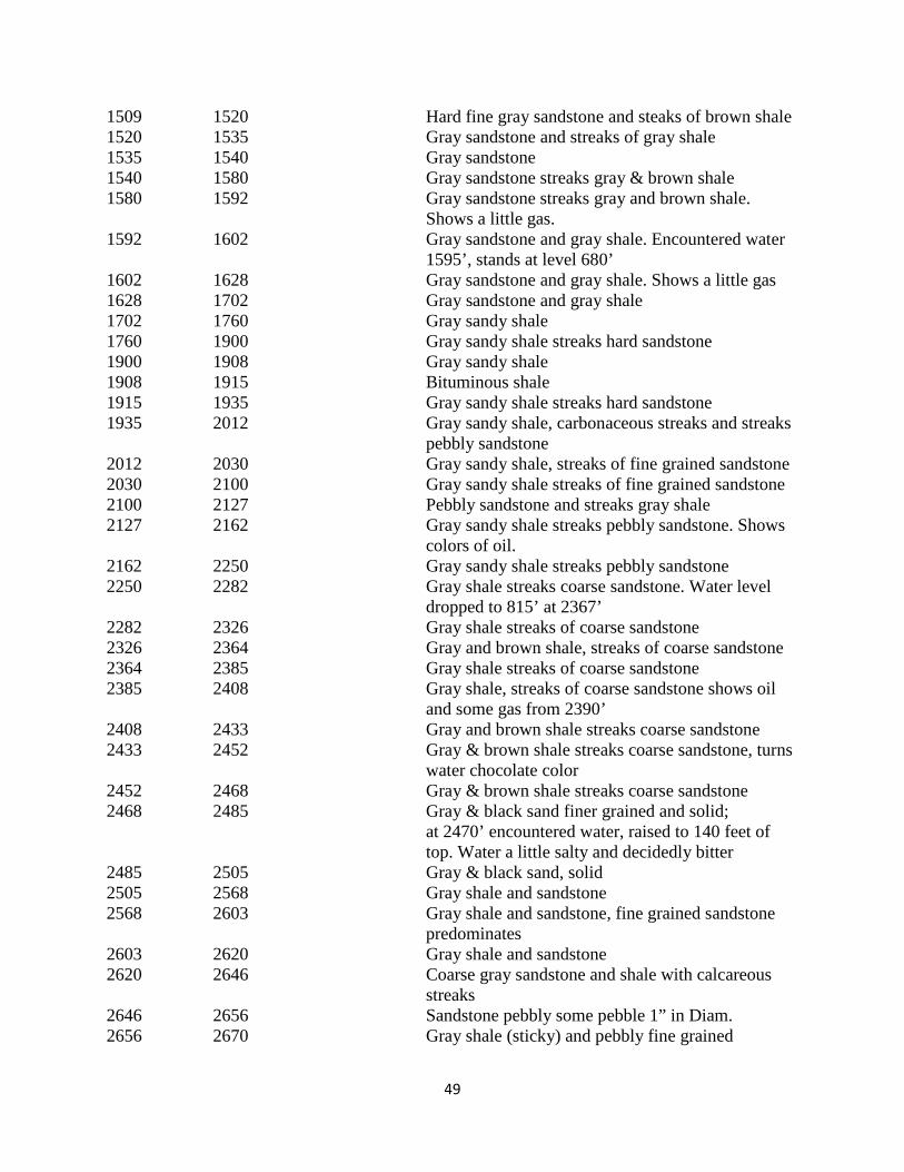
49
1509 1520 Hard fine gray sandstone and steaks of brown shale 1520 1535 Gray sandstone and streaks of gray shale 1535 1540 Gray sandstone 1540 1580 Gray sandstone streaks gray & brown shale 1580 1592 Gray sandstone streaks gray and brown shale.
Shows a little gas. 1592 1602 Gray sandstone and gray shale. Encountered water
1595’, stands at level 680’ 1602 1628 Gray sandstone and gray shale. Shows a little gas 1628 1702 Gray sandstone and gray shale 1702 1760 Gray sandy shale 1760 1900 Gray sandy shale streaks hard sandstone 1900 1908 Gray sandy shale 1908 1915 Bituminous shale 1915 1935 Gray sandy shale streaks hard sandstone 1935 2012 Gray sandy shale, carbonaceous streaks and streaks
pebbly sandstone 2012 2030 Gray sandy shale, streaks of fine grained sandstone 2030 2100 Gray sandy shale streaks of fine grained sandstone 2100 2127 Pebbly sandstone and streaks gray shale 2127 2162 Gray sandy shale streaks pebbly sandstone. Shows
colors of oil. 2162 2250 Gray sandy shale streaks pebbly sandstone 2250 2282 Gray shale streaks coarse sandstone. Water level
dropped to 815’ at 2367’ 2282 2326 Gray shale streaks of coarse sandstone 2326 2364 Gray and brown shale, streaks of coarse sandstone 2364 2385 Gray shale streaks of coarse sandstone 2385 2408 Gray shale, streaks of coarse sandstone shows oil
and some gas from 2390’ 2408 2433 Gray and brown shale streaks coarse sandstone 2433 2452 Gray & brown shale streaks coarse sandstone, turns
water chocolate color 2452 2468 Gray & brown shale streaks coarse sandstone 2468 2485 Gray & black sand finer grained and solid;
at 2470’ encountered water, raised to 140 feet of top. Water a little salty and decidedly bitter
2485 2505 Gray & black sand, solid 2505 2568 Gray shale and sandstone 2568 2603 Gray shale and sandstone, fine grained sandstone
predominates 2603 2620 Gray shale and sandstone 2620 2646 Coarse gray sandstone and shale with calcareous
streaks 2646 2656 Sandstone pebbly some pebble 1” in Diam. 2656 2670 Gray shale (sticky) and pebbly fine grained
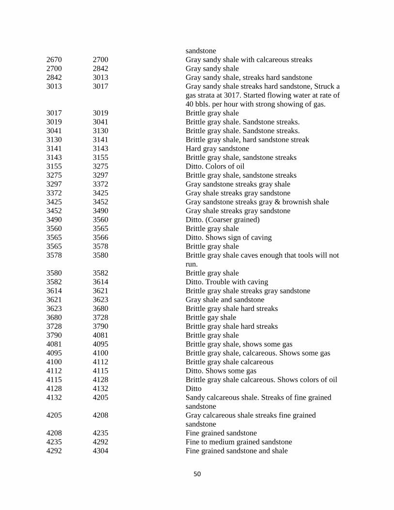
50
sandstone 2670 2700 Gray sandy shale with calcareous streaks 2700 2842 Gray sandy shale 2842 3013 Gray sandy shale, streaks hard sandstone 3013 3017 Gray sandy shale streaks hard sandstone, Struck a
gas strata at 3017. Started flowing water at rate of 40 bbls. per hour with strong showing of gas.
3017 3019 Brittle gray shale 3019 3041 Brittle gray shale. Sandstone streaks. 3041 3130 Brittle gray shale. Sandstone streaks. 3130 3141 Brittle gray shale, hard sandstone streak 3141 3143 Hard gray sandstone 3143 3155 Brittle gray shale, sandstone streaks 3155 3275 Ditto. Colors of oil 3275 3297 Brittle gray shale, sandstone streaks 3297 3372 Gray sandstone streaks gray shale 3372 3425 Gray shale streaks gray sandstone 3425 3452 Gray sandstone streaks gray & brownish shale 3452 3490 Gray shale streaks gray sandstone 3490 3560 Ditto. (Coarser grained) 3560 3565 Brittle gray shale 3565 3566 Ditto. Shows sign of caving 3565 3578 Brittle gray shale 3578 3580 Brittle gray shale caves enough that tools will not
run. 3580 3582 Brittle gray shale 3582 3614 Ditto. Trouble with caving 3614 3621 Brittle gray shale streaks gray sandstone 3621 3623 Gray shale and sandstone 3623 3680 Brittle gray shale hard streaks 3680 3728 Brittle gay shale 3728 3790 Brittle gray shale hard streaks 3790 4081 Brittle gray shale 4081 4095 Brittle gray shale, shows some gas 4095 4100 Brittle gray shale, calcareous. Shows some gas 4100 4112 Brittle gray shale calcareous 4112 4115 Ditto. Shows some gas 4115 4128 Brittle gray shale calcareous. Shows colors of oil 4128 4132 Ditto 4132 4205 Sandy calcareous shale. Streaks of fine grained
sandstone 4205 4208 Gray calcareous shale streaks fine grained
sandstone 4208 4235 Fine grained sandstone 4235 4292 Fine to medium grained sandstone 4292 4304 Fine grained sandstone and shale

51
4304 4315 Shale 4315 4333 Fine grained sandstone 4333 4350 Fine to medium grained sandstone 4350 4360 Fine grained sandstone, solid 4360 4410 Dark gray shale 4410 4433 Dark gray shale with streaks sandstone 4433 4512 Gray shale 4512 4532 Gray shale and sandstone 4532 4573 Fine grained sandstone 4573 4638 Fine to medium grained sandstone 4638 4695 Gray shale & fine grained sandstone 4695 4723 Gray shale – 4710 shows signs of caving 4728 4760 Gray shale, caving 4760 4780 Gray shale 4780 4803 Gray shale and sandstone 4803 4810 Gray shale 4810 4820 Gray shale, shows signs of caving 4820 4830 Gray shale, caving 4830 4860 Gray shale 4860 4870 Ditto (signs of caving) 4870 4880 Ditto (caving) 4880 4893 Ditto 4893 4910 Gray shale 4910 4935 Light gray shale 4935 4968 Gray shale 4968 5034 Light gray shale Hanna et al. (1937b) made this additional statement: “Bailer samples were evidently saved systematically because in 1937 a portion of set was found at the oil camp. The material had been put in screw topped bottles and very few had been broken. Depths, written in pencil were plainly legible. They have been examined in some detail for the present report and have been preserved along with the other collections made during the summer. 3060 Small fragment of hard black shale 3160 Small fragments of hard dark gray shale 3170 Same with some mud 3180 Fragments of hard gray silty shale 3230 Fine friable gray silty shale 3260 Fine friable gray silty shale 4170 Loose brown sand 4180 Loose brown sand 4190 Loose brown sand 4200 Loose brown sand 4210 Loose brown sand 4210 Loose brown sand
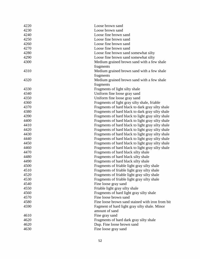
52
4220 Loose brown sand 4230 Loose brown sand 4240 Loose fine brown sand 4250 Loose fine brown sand 4260 Loose fine brown sand 4270 Loose fine brown sand 4280 Loose fine brown sand somewhat silty 4290 Loose fine brown sand somewhat silty 4300 Medium grained brown sand with a few shale
fragments 4310 Medium grained brown sand with a few shale
fragments 4320 Medium grained brown sand with a few shale
fragments 4330 Fragments of light silty shale 4340 Uniform fine loose gray sand 4350 Uniform fine loose gray sand 4360 Fragments of light gray silty shale, friable 4370 Fragments of hard black to dark gray silty shale 4380 Fragments of hard black to dark gray silty shale 4390 Fragments of hard black to light gray silty shale 4400 Fragments of hard black to light gray silty shale 4410 Fragments of hard black to light gray silty shale 4420 Fragments of hard black to light gray silty shale 4430 Fragments of hard black to light gray silty shale 4440 Fragments of hard black to light gray silty shale 4450 Fragments of hard black to light gray silty shale 4460 Fragments of hard black to light gray silty shale 4470 Fragments of hard black silty shale 4480 Fragments of hard black silty shale 4490 Fragments of hard black silty shale 4500 Fragments of friable light gray silty shale 4510 Fragments of friable light gray silty shale 4520 Fragments of friable light gray silty shale 4530 Fragments of friable light gray silty shale 4540 Fine loose gray sand 4550 Friable light gray silty shale 4560 Fragments of hard light gray silty shale 4570 Fine loose brown sand 4580 Fine loose brown sand stained with iron from bit 4590 Fagment of hard light gray silty shale. Minor
amount of sand 4610 Fine gray sand 4620 Fragments of hard dark gray silty shale 4620 Dup. Fine loose brown sand 4630 Fine loose gray sand

53
4640 Fine loose gray sand 4650 Fine loose gray sand. Minor amount of shale
fragments 4660 Fragments of hard gray shale 4670 Fragments of hard gray shale 4680 Fragments of hard gray shale and loose brown sand 4690 Fragments of hard gray shale and loose brown sand The fragments of shale are usually very small due to the action of the drill. They resemble the surface section of the Shelikof very strongly although no fossil fragments were found among them. In general, the material does not appear to be nearly as hard and resistant as do surface outcrops in the region. No coarse sands or pebbles were round in the samples and the arenaceous material was sufficiently friable to have been disintegrated by the drill. The shales were tested for oil residue but found to be barren.” STANDARD OIL COMPANY OF CALIFORNIA LATHROP #1 This well cited by Miller et al. (1959) as being drilled in 1923 and its total depth being unknown, probably being abandoned at shallow depth. It seemingly would have been restricted to the Upper Jurassic Naknek Formation in the well bore. No detailed log was given for this well in Hanna et al. (1937b). STANDARD OIL COMPANY OF CALIFORNIA McNALLY #1 The McNally #1 well was listed by Miller et al. (1959, Table 2) as being drilled in 1925 and to have reached a total depth of 510 feet with the penetrated strata in the well bore restricted wholly to the Upper Jurassic Naknek Formation. A detailed log of this well was given in the appendix of Hanna et al. (1937b): Location – 430’ North – 690’ East of SW ¼ corner, Section 29, T. 29 S., R. 43 W. Elevation – 513’ Spud – June 11, 1925 Suspended – August 22, 1925 Depth from To Feet 0 50 Hard gray sandstone 50 61 Sandstone and conglomerate 61 66 Conglomerate 66 78 Sandstone and conglomerate. Encountered water at 82’ 78 113 Conglomerate 113 125 Sandstone and conglomerate

54
125 133 Hard sandstone 133 145 Conglomerate 145 160 Conglomerate and sandstone 160 170 Hard gray sandstone 170 193 Conglomerate 193 241 Conglomerate and sandstone 241 284 Hard gray sandstone 284 285 Blue sticky clay 285 300 Sandy shale 300 308 Sandy shale and clay 308 332 Hard sandstone. Struck crevice lost water 332’ 332 454 Gray sandstone 454 510 Ditto ASSOCIATED OIL COMPANY ALASKA #1 The Alaska #1 well was cited by Miller et al. (1959) as being drilled between 1923-1926 and having a total depth of 3,033 feet with strata being encountered in the well bore including the Upper Jurassic Naknek Formation and questionably the upper Middle Jurassic Shelikof Formation. The authors also indicated that there was oil residue and shows of oil and gas in this well. A detailed log of this well was given in the appendix of Hanna et al. (1937b): Location – 335’ North, 102’ east of SW corner of Sec. 20, T. 29 S., R. 43 W. Elevation – 693.89 Spud – January 9, 1923 Suspended – December 21, 1925 Depth from To Feet Log 0 10 10 Surface. Yellow sandy shale 10 21 11 Very hard yellow shale 21 25 4 Hard coarse sand 25 30 5 Hard sand and gravel; carries water 30 42 12 Very hard conglomerate, sandy 42 52 10 Hard shell of sandy blue shale 52 75 23 Hard blue sandstone, very slightly calcareous 75 130 55 Hard gray sandy shale 130 150 20 Dark brown shale; gritty. Turns water red Little oil showing only under chloroform text 150 208 58 Very hard gray siliceous sandstone. Fine grained, and tightly cemented 208 215 7 Hard sandy brown shale. Little oil only under
chloroform. 215 426 211 Very hard gray quartzitic sandstone. Fine and
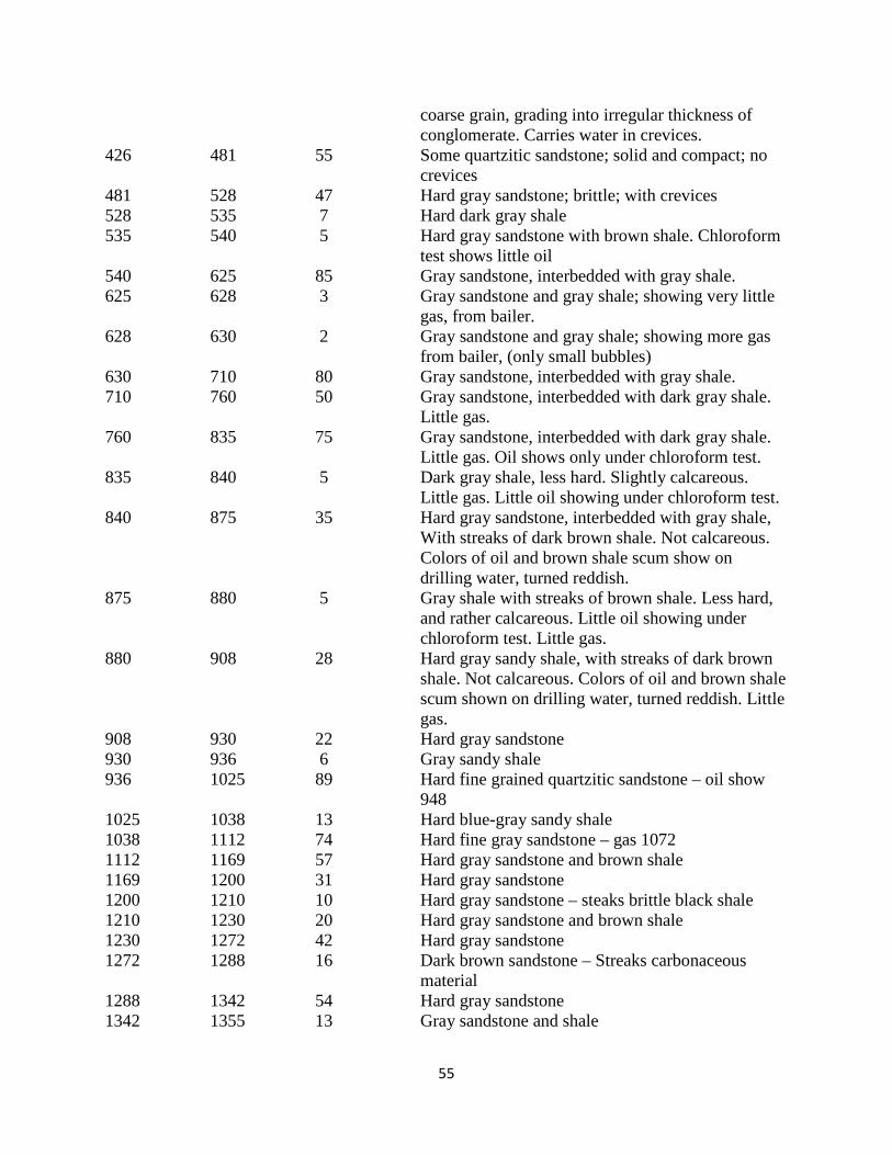
55
coarse grain, grading into irregular thickness of conglomerate. Carries water in crevices.
426 481 55 Some quartzitic sandstone; solid and compact; no crevices 481 528 47 Hard gray sandstone; brittle; with crevices 528 535 7 Hard dark gray shale 535 540 5 Hard gray sandstone with brown shale. Chloroform
test shows little oil 540 625 85 Gray sandstone, interbedded with gray shale. 625 628 3 Gray sandstone and gray shale; showing very little gas, from bailer. 628 630 2 Gray sandstone and gray shale; showing more gas from bailer, (only small bubbles) 630 710 80 Gray sandstone, interbedded with gray shale. 710 760 50 Gray sandstone, interbedded with dark gray shale. Little gas. 760 835 75 Gray sandstone, interbedded with dark gray shale. Little gas. Oil shows only under chloroform test. 835 840 5 Dark gray shale, less hard. Slightly calcareous.
Little gas. Little oil showing under chloroform test. 840 875 35 Hard gray sandstone, interbedded with gray shale,
With streaks of dark brown shale. Not calcareous. Colors of oil and brown shale scum show on drilling water, turned reddish.
875 880 5 Gray shale with streaks of brown shale. Less hard, and rather calcareous. Little oil showing under chloroform test. Little gas.
880 908 28 Hard gray sandy shale, with streaks of dark brown shale. Not calcareous. Colors of oil and brown shale scum shown on drilling water, turned reddish. Little gas.
908 930 22 Hard gray sandstone 930 936 6 Gray sandy shale 936 1025 89 Hard fine grained quartzitic sandstone – oil show 948 1025 1038 13 Hard blue-gray sandy shale 1038 1112 74 Hard fine gray sandstone – gas 1072 1112 1169 57 Hard gray sandstone and brown shale 1169 1200 31 Hard gray sandstone 1200 1210 10 Hard gray sandstone – steaks brittle black shale 1210 1230 20 Hard gray sandstone and brown shale 1230 1272 42 Hard gray sandstone 1272 1288 16 Dark brown sandstone – Streaks carbonaceous material 1288 1342 54 Hard gray sandstone 1342 1355 13 Gray sandstone and shale

56
1355 1420 65 Hard gray sandstone 1420 1430 10 Gray sandstone and brown shale 1430 1440 10 Hard gray sandstone 1440 1450 10 Gray sandstone and brown shale 1450 1553 103 Hard gray sandstone 1553 1604 51 Blue-gray and brown shale – Streaks ss 1604 1618 14 Hard gray sandstone 1618 1630 12 Gray sandstone and brown shale 1630 1668 38 Hard gray sandstone – Gas & oil 1642 1668 1678 10 Blue-gray water sand – salt water 1678 1775 97 Hard-gray sandstone 1775 1778 3 Blue gray water sand – salt water 1778 1899 121 Hard gray sandstone 1899 2048 149 Interbedded gray sandstone & gray sandy shale 2048 2050 2 Hard gray sandstone – streaks brown shale. Oil
show 2050 2100 50 Hard gray sandstone – streaks brown shale. Oil
shows 2100 2264 164 Gray sandstone and shale 2264 2274 10 Conglomerate 2274 2335 61 Sandstone and shale 2335 2342 7 Gray sandstone 2342 2345 3 Hard gray sandstone 2345 2389 44 Gray sandstone 2389 2422 33 Conglomerate 2422 2425 3 Gray sandy shale 2425 2480 55 Conglomerate 2480 2484 4 Hard limey shale 2484 2490 6 Conglomerate 2490 2499 9 Conglomerate and sandstone 2499 2547 48 Rather fine-grained sandstone 2547 2568 21 Sandstone, medium-grained 2568 2580 12 Sandstone some shale 2580 2596 16 Hard gray shale 2596 2616 20 Gray shale streaks of sand 2616 2625 9 Hard gray brittle shale 2625 2630 5 Gray brittle shale 2630 2637 7 Gray shale 2637 2640 3 Gray shale streaks of sand 2640 2649 9 Gray shale-hard brittle streaks 2649 2658 9 Gray shale, streaks of sand 2658 2694 36 Gray shale 2694 2703 9 Gray shale, streaks of sandstone 2703 2749 46 Gray shale, hard streaks 2749 2762 13 Gray shale, calcareous streaks 2749 2762 13 Gray shale, calcareous streaks

57
2762 2774 12 Gray shale, brittle calcareous streaks 2774 2792 18 Gray shale, slightly calcareous, hard streaks 2792 2810 18 Gray shale, calcareous streaks 2810 2821 11 Gray shale, hard streaks 2821 2853 32 Hard shell of shale, caving. 2853 2867 14 Hard tough gray shale 2867 2876 9 Gray shale 2876 2894 18 Gray calcareous shale 2894 2909 15 Gray shale 2909 2959 50 Hard gray shale 2959 3033 74 Gray shale
OIL ANALYSES
Associated Oil Company – Alaska 1 Lab No. 1219 Dated 11-8-24 Sample from 1648 The sample consists of a heavy residual oil, sand, clay and a fibrous material. The oil is completely soluble in chloroform, petroleum, either or carbon bisulfide. The fibrous material has the appearance of manila rope. The oil is evidently heavy crude oil. Signed – L.A. Penn (Chemist) ------------------------------------------------------ INTERNAL NOTE BY CURRENT WRITER: Based on the above log it seems beyond doubt that this well attained total depth within the upper Middle Jurassic Shelikof Formation. Others details from this same report of Hanna et al. (1937b) include:
INDICATIONS:
Indications of oil and gas were very small. Above 840’, oil showed occasionally in the shale rock when tested with chloroform. Below that depth a few colors of oil appeared in the drilling water. A little gas bubble from the bailer frequently, first show at 625’. The showings no doubt would have been larger had the hole been drilled dry instead of wet.
FORMATION CHANGES:
At about 800’ and lower, the formations encountered showed more shale than previous to that depth. Another characteristic was the changing of the rock from altogether a siliceous and arkose mixture to a similar mixture but containing a little calcareous matter. This show first at 835’ slightly, and better at 875’. This change is probably close to the bottom of the Naknek series.

58
ASSOCIATED OIL COMPANY FINNEGAN #1 This well was indicated by Miller et al. (1959) as being drilled in 1923 and having reached at total depth of 560 feet with the strata encountered in the well bore being limited to the Upper Jurassic Naknek Formation. They also note that a “trace of oil” was found during drilling. A detailed log of this well was given in the appendix of Hanna et al. (1937b): Location 1854’ South – 1074’ West of the NE corner Section 30, T. 29 S., R. 45 W. Elevation – 467.5 Spud – April 6, 1923 Abandoned – June 30, 1923 Depth from To Feet Log 0 10 10 Surface 10 243 233 Hard gray siliceous sandstone, tightly cemented.
Varies from fine to coarse grain, grading into irregular thicknesses of conglomerate. Contains crevices carrying water
243 290 47 Hard gray quartzitic sandstone, conglomeratic. Solid and compact. 290 320 30 Hard gray brittle sandstone, with crevices 320 465 145 Gray sandstone, interbedded with gray shale 465 560 95 Gray sandstone, interbedded with gray shale. Shows oil only under chloroform tests.
OIL SANDS 465-560
WATER SANDS
10-243
-----------------------------
Hanna et al. (1937b) note that this was the third well drilled in the West Field, being preceded by Associated Oil Company Alaska No. 1 and by the Standard Oil Company’s Lee No. 1. Another significant item noted in this report is:
“INDICATIONS
Practically no indications of oil were found. The shale cuttings showed a trace of oil under chloroform test. No gas was apparent, although the 500 feet of water in the hole could easily have held it back if present under low pressure.”

59
WIDE BAY ANTICLINE
The Wide Bay anticline is a prominent NE-SW trending feature that runs the length of Wide Bay. Originally it was recognized by Capps (1923) who named it the Kialagvik anticline. Smith and Baker (1924) and Kellum et al. (1945) have referred to it as Wide Bay anticline and it continues to be known by that name on the recent maps of Detterman et al. (1983 and 1987) for the Ugashik Quadrangle which includes the Wide Bay region. Some references in the literature also refer to it as the Bear Creek-Wide Bay anticline in recognition that these two features are actually continuous, and really represent a single longer anticlinal feature.
RICHFIELD WIDE BAY UNIT #1 The Richfield Wide Bay Unit #1 well is the only well located in the Wide Bay area (Fig. 24). It was spudded by Richfield Oil Company on December 13, 1962 and completed on October 17, 1963.
Figure 31. Photo of Wide Bay Unit #1 well drilling platform on the west side of Wide Bay, Alaska Peninsula. Photo courtesy of Gil Mull. Total organic carbon, rock-eval pyrolysis, visual kerogen/vitrinite reflectance for the Wide Bay Unit #1 well was presented in Unknown (1984). Scanning electron micrographs of radiolarians

60
for 100 foot intervals between a depth of 100 feet to 2,300 feet were provided in a report by Unknown (no date), which is available online through the Alaska Geologic Materials Center. A detailed lithologic log of this well available through the Alaska Oil and Gas Conservation Commission have been copied and scanned and can found in Appendix 4 to this report. On this log is a notation that at around 1,500 feet good oil in fractures was observed. This was confirmed in a recent phone conversation with Gil Mull (Santa Fe, New Mexico) who logged the first 2,500 feet of this well. He told me that he remembers the occurrence of “bleeding live oil in fractures” somewhere between the depths of 1,500-2000 feet.” Detterman (1990, p. 20-21) in his review of exploratory wells on the Alaska Peninsula made the following comments: “The Wide Bay exploratory well (well 15, plate 2) was drilled several hundred yards offshore in Wide Bay at the mouth of Short Creek on the west side of Wide Bay in Sec. 5, T. 35 S., R. 44 W., Ugashik B-2 quadrangle. The well was spudded December 13, 1962 and abandoned October 17, 1963, at a total depth of 12, 566 feet (3,827 m).” “The upper 160 feet (48 m) are water and Quaternary sediments. Bedrock of the Kialagvik Formation was encountered at depth, and is similar to rocks of that formation exposed onshore. Brown sandstone and siltstone, locally slightly tuffaceous, constitutes the bulk of the sequence. These rocks are highly fossiliferous and oil staining was noted on some of the sand intervals.” “The contact with the Talkeetna Formation is tentatively placed at 3,270 feet (997 m) on the basis of a marked increase in bedded tuff and tuffaceous sediments along with a change in color and content of the rocks. The lower contact between the Talkeetna and Kamishak Formations at 9,630 feet (2,935 m) is also somewhat doubtful. These formational contacts seems reasonable, in which case the Talkeetna is very thick. Alternatively the sequence may be in part duplicated by faulting as the rocks in the lower part were considerably more fractured than the rocks higher up the hole. The Wide Bay-Bear Creek anticline is known to be thrust faulted locally, so a faulted sequence has to be considered. Another possibility is that the well went through steeply dipping strata near the axis of the anticline.” “The underlying Kamishak Formation is mainly shale and limestone with thick units of bedded tuff similar to the Koniag to the south. Fossil fragments were found throughout, and Triassic flat pelecypods are distinctive so the identification of these beds as Kamishak Formation should be correct.” Blodgett and Sralla (2008, p. 8-9) made a quite drastically differing interpretation of this well from that presented above by Detterman. They noted that this well “penetrated dark, probably Paleozoic volcanic agglomerate and greenstone in the depth interval ~8,819-12,566 ft (2,699-3,830 m), after first penetrating the Middle Jurassic Kialagvik Formation and, later, part of the Lower Jurassic Bidarka Formation of Kellum (1945) (equivalent to the Talkeetna Formation of Detterman et al., 1996, as used by them for the Puale Bay area) from the surface to a depth of 2,300 ft (701 m). The entire Upper Triassic Kamishak Formation is absent, owing to either a major unconformity or faulting. The upper 2,300 ft (701 m) of the well consists of nearly flat lying sedimentary rocks of Early and Middle Jurassic age.” “The oldest authentic megafossils from this well, which were obtained from core 5 in the depth interval 2,235-2236 ft (681.2-681.5 m), consisted of abundant specimens of the ammonite Waehneroceras cf. W. portlocki (Wright), indicative of a middle Hettangian (early Early Jurassic) age (Imlay, 1981, p. 12, 30 [see Fig. 32]. Radiolarians were also recovered from 100-ft (30.5 m) intervals of ditch cuttings from the depth interval 100-2,300 ft (30.5-701 m). These fossils were illustrated with taxonomic identification in an anonymous 37-page report entitled “Richfield Oil Company Wide Bay Unit #1—Scanning Electron Micrographs of Selected Radiolarians” that was donated to the

61
Alaska Geologic Materials Center in Eagle River, Alaska, and catalogued as Geologic Materials Center Data Report No. 53B” [available on-line through the Alaska Geologic Materials Center website].
Figure 32. Two specimens of the ammonite Waehneroceras cf. portlocki (Wright) from then unnamed beds of middle Hettangian age in Wide Bay Unit #1, core 5 at depth of 2,235 to 2,236 ft (681 m) [from Imlay 1981, Plate 2, figs. 14-15] Blodgett and Sralla (2008, p. 8-9) also made the following observations: “The marked increase in depth (60-70°) that was observed in core 6 from the depth interval 3,406-3,411 ft (1,038-1,040 m), together with the higher inducation associated with the siliceous mudstones in this interval, suggests that either an unconformity or a fault separates the interval between cores 5 and 6. Again, as noted above, no lithologic equivalent of the Kamishak Formation was observed in the cuttings and core, and so we presume that such an equivalent is absent in Wide Bay Unit No. 1 well. Below core 6, the penetrated a thick succession of siliceous mudstone and finally, in the lower third, a succession of dominantly dark-dreenish-gray to nearly black greenstone and volcanic agglomerate. The much more highly indurated lithologic succession below a depth of 2,300 ft (701 m) is considered to be of probably late Paleozoic age. This interpretation is supported by the presence of echinoderm fragments of late Paleozoic morphotype in a thin section of chert-granule sandstone from core 16 in the depth interval 7,728-7,734 ft (2,355-2,357 m). We recognized no Upper Triassic rocks in Wide Bay Unit No. 1 well.” Since the time that the above was written, the writer has made some additional new paleontological observations on this well. An additional core chip fragment from core 5 was found (see Fig. 33) which bears another ammonite species, related to, but still differing from Waehneroceras cf. portlocki.
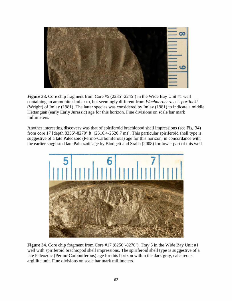
62
Figure 33. Core chip fragment from Core #5 (2235’-2245’) in the Wide Bay Unit #1 well containing an ammonite similar to, but seemingly different from Waehneroceras cf. portlocki (Wright) of Imlay (1981). The latter species was considered by Imlay (1981) to indicate a middle Hettangian (early Early Jurassic) age for this horizon. Fine divisions on scale bar mark millimeters. Another interesting discovery was that of spiriferoid brachiopod shell impressions (see Fig. 34) from core 17 [depth 8256’-8270’ ft (2516.4-2520.7 m)]. This particular spiriferoid shell type is suggestive of a late Paleozoic (Permo-Carboniferous) age for this horizon, in concordance with the earlier suggested late Paleozoic age by Blodgett and Sralla (2008) for lower part of this well.
Figure 34. Core chip fragment from Core #17 (8256’-8270’), Tray 5 in the Wide Bay Unit #1 well with spiriferoid brachiopod shell impressions. The spiriferoid shell type is suggestive of a late Paleozoic (Permo-Carboniferous) age for this horizon within the dark gray, calcareous argillite unit. Fine divisions on scale bar mark millimeters.

63
Molenaar (1996, fig. 3 – see Fig. 35 below) provided vitrinite reflectance values for the Wide Bay Unit #1 well. His age designations for the stratigraphic intervals on this diagram are not based on any paleontological data, and based on the reinterpretation of Blodgett and Sralla (2008) and herein, the interval representing the Kialagvik Formation and Talkeenta Formation (=Bidarka Formation of Kellum, 1945) – that is 0-2,300 ft (or 0-701 m) is situated in the undermature to low-mature range.
Figure 35. Vitrinite reflectance (thermal maturity) versus depth plot for the Richfield Wide Bay Unit #1 well (from Molenaar, 1996, fig. 3). If the age designations given by Detterman (1990) to the corresponding depths were correct, the lower part of the Lower Jurassic and Upper Triassic have Ro values indicating overmature (Ro=2.0-3.6) and supermature (Ro>3.6) levels, condemning these lower beds as possible liquid hydrocarbon source beds. However, I find the available paleontological age control and lithologic correlations suggest that the lower part of the well is much older, probably Late Paleozoic in age.
KONIAG CHEVRON USA #1
This well was spudded by Chevron USA on March 11, 1981 and completed July 9, 1981. Total depth attained was 10,907 feet. The well site is situated in Section 2, T. 38 S., R. 49 W., Sutwik Island D-4 1:63,360 scale quadrangle. The well was spudded in the Upper Jurassic Naknek Formation and is considered to have reached total depth in the Kamishak Formation.

64
A report summarizing geochemical data from cuttings in this well was provided by Groth and Schiefelbein (1990). Another report presenting data on total organic carbon analysis with leaching factor from cuttings (3,-480-3,560 feet and 4,476-7,400 feet) was presented by Brown and Ruth Laboratories, Inc. (1996). A third report presenting another geochemical study of this well was prepared by Minder and Shell Oil Company (1985). All three of these reports are available online through the Alaska Geologic Materials Center. Two detailed logs available through the Alaska Oil and Gas Conservation Commission have been copied and scanned and can be found as Appendices 5 and 6 in this report. Detterman (1990, p. 19-20) provides a detailed history and interpretation of the units drilled: “Koniag #1 (well 25, plate 2) was drilled in Sec. 2, T. 38 S., R. 49 W., Sutwik Island D-4 quadrangle in 1981. The well is about 1.5 miles (2.4 km) inland from Shelikof Strait and was drilled to 10,900 feet (3,322 m). The well was spudded in bedrock of the Snug Harbor Siltstone Member, Naknek Formation, and penetrated 2,125 feet (647 m) of sandy siltstone before going into the thick quartz-biotite-rich arkosic sandstone of the Northeast Creek Sandstone Member. The interval between 4,500 and 4,560 feet (1,372 and 1,390 m) was not logged. The contact with Shelikof Formation is considered to fall within that interval. The Chisik Conglomerate is missing in the well, but we do not know if this was due to nondeposition, erosion, or faulting. Outcrop data from near the well site suggest this area was part of a quiet marine embayment with a low sedimentation rate, and therefore we believe the 4,560 (1,390 m) of Snug Harbor Siltstone and Northeast Creek Sandstone represents a complete Naknek Formation sequence. There are several of these basins or embayments in the Naknek Formation along the Alaska Peninsula. Sequences from several of them are shown on the lithofacies fence diagrams of the upper Mesozoic (Detterman and Miller (1987).” “The interval 4,560 feet (1,390 m) and 7,350 feet (2,240 m) is divided about evenly on slight lithologic evidence into the Shelikof and Kialagvik Formations. The sequence is mainly dark-gray to dark-brown siltstone with a few sandstone interbeds. The sandstone is quartz-rich which suggests Kialagvik Formation, and occurs in the lower part of the sequence. Siltstone in the upper half of this sequence also tends to quartz-rich, so the entire unit may be Kialagvik Formation. These rocks were also deposited in a quiet basin with restricted input and circulation similar to the Naknek Formation.” “The contact with the volcanic sequence of the Talkeetna Formation is sharp. Core #4 crosses the contact and the rocks below the contact are altered and much harder than above, so there is probably a considerable hiatus between the two units, but evidence of an erosional surface is missing. The Talkeetna consists entirely of tuff, flows, and volcanic breccias, all of which is slightly altered. Pyrite, talc, sericite, zeolites, and locally bornite occur in these rocks.” “Limestone with fossils considered to be part of the Kamishak Formation (Upper Triassic) was encountered at 9,575 feet (2,918 m) and continued to total depth. Chert, quartzite, and altered tuff form a considerable part of this moderately deep marine sequence. The abundant tuff here and in the overlying Talkeetna Formation indicates this area was close to a major early Mesozoic volcanic center.” The present author has reviewed the available core and Foraminifera slides present at the Alaska Geologic Materials Center (GMC) in Eagle River and finds some differences between what he has observed and those given above by Detterman. Notably lacking is the absence of good paleontological data (absence of Foraminifera in the GMC collections) to support age interpretations indicated above by Detterman. Review of the Well History (available through AOGCC) indicates that only good indication of petroleum (oil staining) was found in this well in Core #1 in the interval 2316.5-2330.5 feet within the Naknek Formation [Northeast Creek Sandstone Member according to Detterman (1990)]. Six intervals were cored in this well, several samples from which have been photographed and shown below in Figures 36-39.

65
Figure 36. Core chip from Core #1 at 2318-2319 feet depth. This is part of the core consists of coarse-grained sandstone has been obviously oil stained (noted in Well History). Detterman (1990) interprets this interval to be in the Northeast Creek Sandstone Member of the Upper Jurassic Naknek Formation. Fine divisions on scale bar are in millimeters.
Figure 37. Core chip from Core #1 at 2325-2326 feet depth. This is part of the core consists of coarse-grained sandstone has been obviously oil stained (noted in Well History). Detterman (1990) interprets this interval to be in the Northeast Creek Sandstone Member of the Upper Jurassic Naknek Formation. Fine divisions on scale bar are in millimeters.

66
Figure 38. Core chip from of siltstone from Core #3 at 5,999 feet depth. Detterman (1990) interprets this interval to be in the upper Middle Jurassic Shelikof Formation. Fine divisions on scale bar are in millimeters.
Figure 39. Core chip of gray bedded chert from Core #6 at 10,061-10,162 feet depth. Detterman (1990) interprets this interval to be in the upper Middle Jurassic Shelikof Formation. Fine divisions on scale bar are in millimeters.
The present writer does not find many good features to recommend drilling another well in the area of this well. These include the absence of good oil and gas shows at depth (only one oil
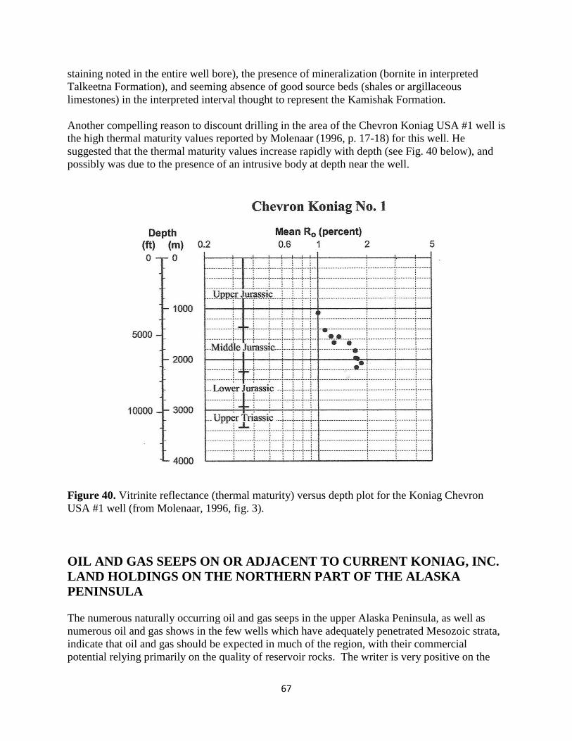
67
staining noted in the entire well bore), the presence of mineralization (bornite in interpreted Talkeetna Formation), and seeming absence of good source beds (shales or argillaceous limestones) in the interpreted interval thought to represent the Kamishak Formation. Another compelling reason to discount drilling in the area of the Chevron Koniag USA #1 well is the high thermal maturity values reported by Molenaar (1996, p. 17-18) for this well. He suggested that the thermal maturity values increase rapidly with depth (see Fig. 40 below), and possibly was due to the presence of an intrusive body at depth near the well.
Figure 40. Vitrinite reflectance (thermal maturity) versus depth plot for the Koniag Chevron USA #1 well (from Molenaar, 1996, fig. 3).
OIL AND GAS SEEPS ON OR ADJACENT TO CURRENT KONIAG, INC. LAND HOLDINGS ON THE NORTHERN PART OF THE ALASKA PENINSULA The numerous naturally occurring oil and gas seeps in the upper Alaska Peninsula, as well as numerous oil and gas shows in the few wells which have adequately penetrated Mesozoic strata, indicate that oil and gas should be expected in much of the region, with their commercial potential relying primarily on the quality of reservoir rocks. The writer is very positive on the

68
potential of a well developed hydrocarbon system in lands on or adjacent to the northern portion of the current land holdings of Koniag Inc., notably in the area the Ugashik Creek anticline, and to a lesser degree the Wide Bay anticline. Oil and gas seeps were the original historic indicators for the presence of hydrocarbon resources, and their presence has been noted dating back to the extraction of bitumen as far back as 5,000 B.C. in the Tigris-Euphrates Valley of Mesopotamia. In fact, nearly all of the original well sites in the early search for hydrocarbons in North America were focused on locations near known oil and gas seeps. Oil and gas seeps are extremely common in the upper part of Alaska Peninsula (notably the Puale Bay – Lake Becharof region) [Fig. 41] and in Lower Cook Inlet (Iniskin Peninsula) and such seeps were noted by the Russians as early as 1857. These seeps figured prominently in the early geological reports by the U.S. Geological Survey and industry on the Alaska Peninsula (Fig. 42). The loci of these seeps were keys to the selection (together with structural geological interpretations) for sites selected for oil drilling up through the 1950s in both areas. An interesting history of the role of oil seepages in the development of the “East Field” near Puale Bay can be found in Lee (1922) who reports: “In the year 1900 H.A. Smith and Tom Hanmore hired a schooner and sent J.H. Lee and Hans Severson with same to look for oil seepages mentioned in Baranoff’s Russian History of Alaska, as reported by the Aleut Indians “back of Cold Bay”. “In August Lee and Severson located two 16-acre claims, two 40-acre claims for the above mentioned gentlemen and other associates known as the “Sunrise Group” Capital. These prospectors visited the locations mentioned, collected oil samples and returned. Controversies arose concerning the method or procedure from this point, in consequence of which I have quite claim deeds to my interests.” “I persuaded Lathrope and Johannsen to put up money against my time and returned to Cold Bay district and in March and April, 1901, located “Beaver Claims” Nos. 1, 2, 3 and 4, all near the head of Oil Creek in the vicinity of the claims previously staked. I then staked two at Dry Bay, four at Bear Creek, four on Salmon Creek, guiding my locations by the presence of seepages and following the apparent strike of the formations, according to my previous experiences in tracing the outcrop of metalliferous veins.” “In 1901 I visited for the first time the region of Pearl Creek, because of reports given me by natives concerning a large seepage or residue patch, similar to the one on Oil Creek. I staked on Pearl Creek twelve claims for myself, Lathrope and Johannsen and bonded four of these in June to Costello.” “In July 1901 Lathrope looked over the ground and departed to the States for the purpose of bonding the balance of these claims for development. Reaching Seattle he accidentally encountered Costello, who was then attempting to obtain claims in Iniskin Bay for development purposes. He bonded to Costello our claims at $26.00 an acre early in 1902. This was a two year bond with no cash payment.”

69
Figure 41. Map showing known oil and gas seeps in the Puale Bay – Becharof Lake – Wide Bay region (from Blodgett and Clautice, 2005).

70
Figure 42. U.S. Geological Survey field party led by W.R. Smith cooking breakfast during summer of 1923 over natural gas seeps along the aptly named Gas Creek (NW of Becharof Lake near southern boundary of Katmai National Park). Gas appears to be emerging from stream gravels above Upper Jurassic Naknek Formation. In this section all oil and gas seeps in or adjacent to land holdings of Koniag, Inc. are discussed, and many cases photodocumented in great detail. Primary sources for this data compilation include Blodgett and Clautice (2005), Blasko (1976a), and Cronin et al. (1999). Secondary sources include Becker and Manen (1989), Blasko (1976b), Capps (1923), Kellum et al. (1945), Martin (1904, 1905a, b, 1921), Smith (1926), and Smith and Baker (1924). Three additional sources (Morris, 1922; Hanna et al., 1937; Hanna et al., 1939) were recently discovered by the writer in the archives of Koniag, Inc. during the time this report was being finalized. These three sources include many reports of seeps in the region noted in the field, or by hearsay, by Standard Oil Company and other company geologists. Many of these have not been chronicled in other officially published sources and need to be further investigated. The report of Blodgett and Clautice (2005) is given here as Appendix 1.
OIL SEEPS ASSOCIATED WITH THE “WEST FIELD” (PEARL CREEK DOME) NEAR THE AXIS OF THE UGASHIK CREEK ANTICLINE
The so-called “West Field” which was the locus of oil drilling on the Alaska Peninsula in the early 1920’s was obviously selected due to the presence of two major oil seeps (localities 11-12 of Blodgett and Clautice, 2005) along Barabara and Pearl Creek of original usage (respectively now shown as Little Ugashik and Barbara Creeks on the current USGS Ugashik C-1 quadrangle topographic sheet). All three of these seeps are situated just west of the axis of the Ugashik Creek anticline and are emerging from near outcrops of the basal part of the Upper Jurassic Naknek

71
Formation [Jnc unit (or conglomerate member) of Detterman et al., 1987). The writer has visited the classic Barabara Creek seep (locality 11 of Blodgett and Clautice, 2005) and was impressed by the size and quality of oil issuing from this seep. It is by far the largest known seep in the upper Alaska Peninsula and the purity of oil in the upper reaches of the seep area exceeds that of all other known seeps that he is familiar with in southern Alaska. Downslope from the seep is a residue patch which was mined during the 1920’s to provide fuel for the drilling operations. This seep is documented photographically in Figs. 45-49. This seep was not reported upon in the definitive regional seep survey of Blasko (1976a), presumably he and his colleagues were unable to locate this during aerial reconnaissance. A sample of oil was collected during the summer of 2012 and a geochemical analysis was done by Weatherford Laboratories (Shenandoah, Texas), the results of which are presented in Appendix 7. The Barabara Creek seep is closely associated with a major fault that trends down the creek (Smith, 1926), and seems most likely that this seep and its associated residue patch are directly linked to fractures along the fault trace. Locality 12 is situated to north of locality 11 along Barbara Creek of the current USGS Ugashik C-1 quadrangle map (it was formerly referred to as Pearl Creek in earlier published maps of the USGS (i.e., Smith and Baker, 1924, Plate II and fig. 6). This locality has not been visited by the writer. Locality 13 is a seep situated near Moore Creek reported by Smith and Baker (1924, p. 209) and Smith (1926). Morris (1922, p. 22) provide further detail on the latter: “Oil was seen by the writer escaping from coarse sands near the base of the east fork of Moore Creek, just over the pass at the head of Lee Creek, in the region of the Hubbell claims. (see map B 9033 in pocket). This is the region sometimes referred to as the “Hubbell dome”.” This seep has not been subsequently relocated according to the current writer’s knowledge since these early reports. The writer recently found a seep which had not been previously reported from the “West Field” in Koniag Inc. archives of old Standard Oil Company of California reports, this one (the Simeon Creek seep) being that of Hanna et al. (1939) which on p. 28 reports as follows: “Two new seepages were discovered in 1938, one in Simeon Creek and one at Jute Bay.
The Simeon Creek seepage is located on the north flank of Mount Burls, near the headwaters of Simeon Creek. A dark, greenish-brown oil is coming from fracture in a massive conglomerate (see Plates 10 and 11). The seepage is on a small shelf on the canyon wall about 25 feet above the bed of the stream and there is no residue patch as other seepages.” The location indicated in their description plots out on the Ugashik Quadangle geologic map of Detterman et al. (1987) within their lower part of the Naknek (Jnc – Conglomerate member of the Naknek) in close proximity to a major strike-slip fault. In the same report are two Plates showing the seepage, the caption for Plate 10 states: “Simeon Creek seepage. One of the two active seepages found on the north slope of Mount Burls near the headwaters of Simeon Creek. A considerable amount is gas is associated with the oil that is coming from fractures in a pebble conglomerate. October 18, 1938.” The caption for Plate 11 states: “Simeon Creek seepage. The fractures in the conglomerate are a few feet above the active oil seepage shown in the preceding picture. October 18, 1938.”

72
Figure 43. Reported oil seeps along the Ugashik Creek anticline (localities 11-13). Most of these are on or adjacent to current land holding of the Koniag Corporation. Locality 11 is the largest seep in the entire Puale Bay - Lake Becharof region and is located on the north side of Barabara Creek (mislabeled Little Ugashik Creek on current USGS Ugashik C-1 quadrangle topographic sheet). Photos of this seep are given in Figure 45-49. All of these seeps are associated with nearby outcroppings of strata belonging to the lowermost part of the Upper Jurassic Naknek Formation (figure from Blodgett and Clautice, 2005).

73
Figure 44. Map from Capps (1923, Fig. 6) showing Barabara Creek oil seep (colored red) and correct original locations of Barabara Creek and Pearl Creek (note the current USGS topographic map of the Ugashik C-1 quadrangle incorrectly labels them as Little Ugashik and Barbara creeks, respectively).
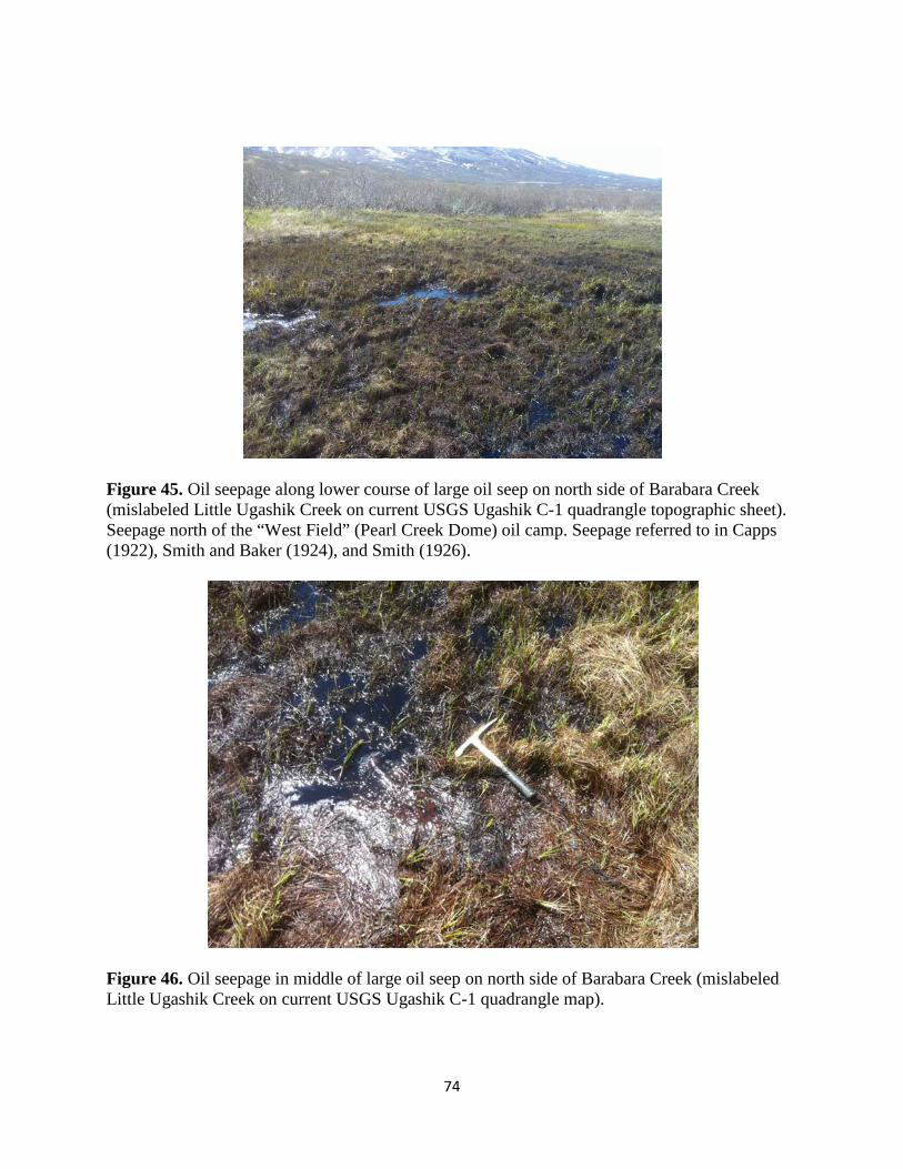
74
Figure 45. Oil seepage along lower course of large oil seep on north side of Barabara Creek (mislabeled Little Ugashik Creek on current USGS Ugashik C-1 quadrangle topographic sheet). Seepage north of the “West Field” (Pearl Creek Dome) oil camp. Seepage referred to in Capps (1922), Smith and Baker (1924), and Smith (1926).
Figure 46. Oil seepage in middle of large oil seep on north side of Barabara Creek (mislabeled Little Ugashik Creek on current USGS Ugashik C-1 quadrangle map).

75
Figure 47. Oil seepage from upper end of large oil seep on north side of Barabara Creek (mislabeled Little Ugashik Creek on current USGS Ugashik C-1 quadrangle map). This is one of the largest and most oil-rich patches at this seep.
Figure 48. Another view of the oil seepage shown above from upper end of large oil seep on north side of Barabara Creek (mislabeled Little Ugashik Creek on current USGS Ugashik C-1 quadrangle map). This is one of the largest and most oil-rich patches at this seep.

76
Figure 49. Another view of the same oil seepage shown in Figures 45-48. OIL AND GAS SEEPS ASSOCIATED WITH THE “EAST FIELD” NEAR THE AXIS OF
THE BEAR CREEK ANTICLINE The so-called “East Field” represents an area of numerous documented oil and gas seeps (see localities 3-10 in Fig. 50) associated with outcroppings of the upper Middle Jurassic Shelikof Formation along the anticlinal axis as well as the flanks of the Bear Creek anticline (earlier referred to as the Salmon Creek-Bear Creek anticline in Capps (1923), Smith and Baker (1924), and Smith (1926). These seeps were the primary lure to bringing in petroleum explorationists to the upper Alaska Peninsula during the first decade of the 20th Century and later on in the 1930s and 1950s. Five cable-tool drilled wells were drilled along the structure (J.H. Costello #1 and #2 and Pacific Oil and Commerical Company #1, #2 and #3), as well as the rotary drilled Grammer #1 and Humble-Shell Bear Creek #1 wells (the latter well had been the most expensive well drilled in Alaska up to that date). 8 oil seeps and one gas seep have been documented along this trend (see Blodgett and Clautice, 2005) for details. The writer has only visited the seeps situated along Oil Creek for which photographs of are provided in Figures 51-57. The main oil seep (Figs. 51-58) along Oil Creek is the most visited seep historically in the region due to its large and obvious size, as well as the extensive tar mat (or residue patch) which exists just downstream of where it is currently seeping. It is situated in the NE1/4 Sec. 10, T. 29 S., R. 40 W., Karluk C-6 1:63,360 scale quadrangle. Blasko (1976a)
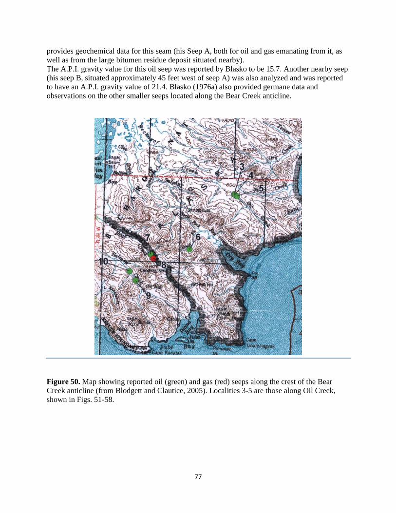
77
provides geochemical data for this seam (his Seep A, both for oil and gas emanating from it, as well as from the large bitumen residue deposit situated nearby). The A.P.I. gravity value for this oil seep was reported by Blasko to be 15.7. Another nearby seep (his seep B, situated approximately 45 feet west of seep A) was also analyzed and was reported to have an A.P.I. gravity value of 21.4. Blasko (1976a) also provided germane data and observations on the other smaller seeps located along the Bear Creek anticline.
Figure 50. Map showing reported oil (green) and gas (red) seeps along the crest of the Bear Creek anticline (from Blodgett and Clautice, 2005). Localities 3-5 are those along Oil Creek, shown in Figs. 51-58.

78
Figure 51. Main oil seep on south side of upper reaches of Oil Creek near the crest of the Bear Creek anticline, Karluk C-6 quadrangle. Photograph taken by author May 30, 2004.
Figure 52. Small lake with oil entering into it from main oil seep at Oil Creek. Seep visible at head of small channel in upper right corner of view.
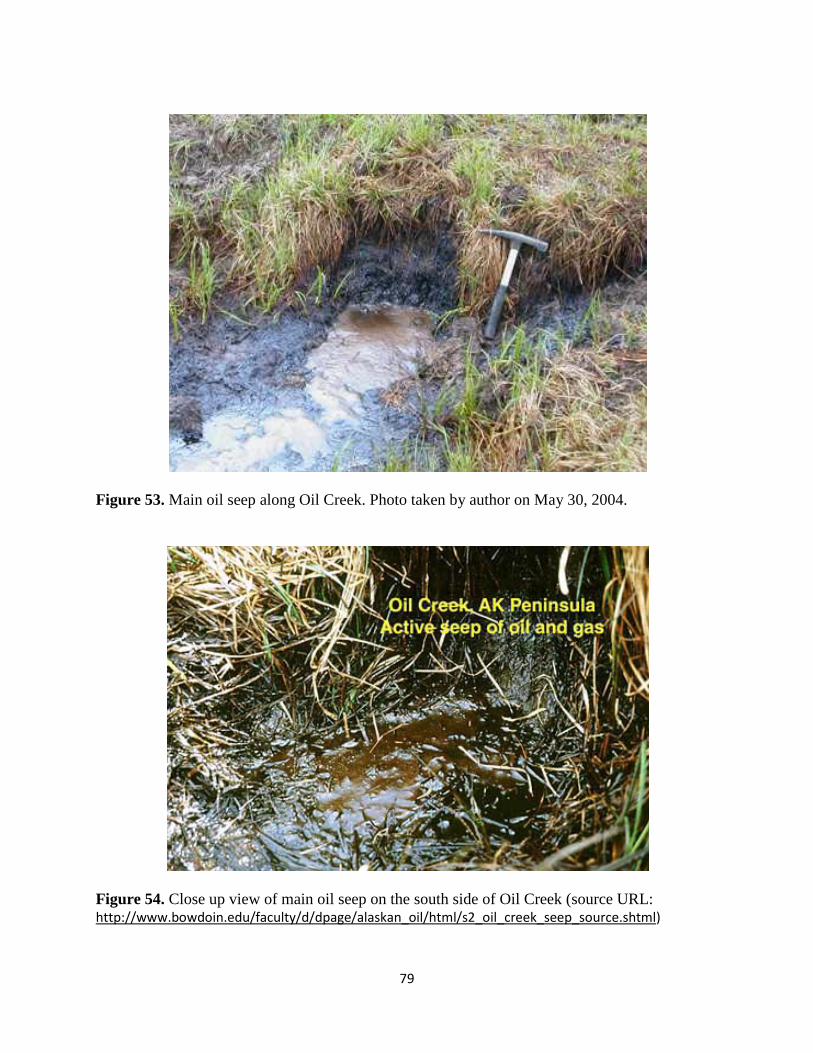
79
Figure 53. Main oil seep along Oil Creek. Photo taken by author on May 30, 2004.
Figure 54. Close up view of main oil seep on the south side of Oil Creek (source URL: http://www.bowdoin.edu/faculty/d/dpage/alaskan_oil/html/s2_oil_creek_seep_source.shtml)
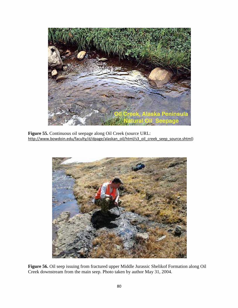
80
Figure 55. Continuous oil seepage along Oil Creek (source URL: http://www.bowdoin.edu/faculty/d/dpage/alaskan_oil/html/s3_oil_creek_seep_source.shtml)
Figure 56. Oil seep issuing from fractured upper Middle Jurassic Shelikof Formation along Oil Creek downstream from the main seep. Photo taken by author May 31, 2004.

81
Figure 57. Small seepage along south side of Oil Creek slightly downstream from outcrop in Fig. 56. Photo taken by author May 31, 2004.
Figure 58. Oil seep issuing from another fractured outcrop of the upper Middle Jurassic Shelikof Formation along Oil Creek. Photo taken May 31, 2004.

82
The writer recently found a seep which had not been previously reported from the “East Field” in an old Standard Oil Company of California report archived with Koniag, Inc. This one (the Jute Bay seep) being that of Hanna et al. (1939) who on p. 28 report as follows:
“Two new seepages were discovered in 1938, one in Simeon Creek and one at Jute Bay.
…………
G.D. Hanna and E.L. Grammer found heavy residue stains in the joint planes of the hard shales outcropping on Jute Bay. The locality is in the cliffs just northwest of the headland, between mouths of Kolmokof and Jute Creeks. The seepage is located from high tide line up the steep slope for several feet. No active, live oil, however was found.”
OIL SEEP AND SOLID HYDROCARBONS FOUND IN THE WIDE BAY AREA A single oil seep and a report of solid hydrocarbons are reported from the northern part of the lower Middle Jurassic Shelikof Formation (localities 14-15 of Blodgett and Clautice, 2005; see Fig. 59 below).
Figure 59. Reported occurrence of oil seep (circle) and solid hydrocarbons from the Wide Bay area, Ugashik B-1 and B-2 quadrangles. No confirmed reports of oil or gas seeps are reported to the south of the Puale Bay-Becharof Lake-Wide Bay area on lands currently owned by Koniag Inc.

83
SOURCE ROCK POTENTIAL IN MESOZOIC STRATA
Both the Upper Triassic Kamishak Formation and late Early- to Middle Jurassic Kialagvik Formation have long been recognized as being the primary source beds for hydrocarbons in the Puale Bay – Becharof Lake – Wide Bay region. A recent study on source rock characteristic of the region confirms that both stratigraphic units are oil-prone and have proven oil general potential (Decker, 2008). In this same study, Decker (p. 24) stated that “Considering the uncorrected pyrolysis results at face value, fully half of the Kamishak Formation limestones plot as good to excellent oil source rocks with TOC values in the 1-5 percent range and HI values greater than 300/ mg/g. A few Kamishak samples fall in the lean gas or gas source categories, and about one-third contain less than 0.5 percent TOC, probably too lean to consider source-prone.” Further on in the same paper (p. 25) Decker states: “The silty mudstones of the Kialagvik Formation follow a trend similar to the Kamishak samples in the plot of HI vs. TOC”…. “More than one-third of the Kialagvik mustones have good to excellent TOC values in the 1-4 percent range; most of these have HI values in the range associated with oil-prone Type II kerogen (300-650 mg/g). Nearly 15 percent of Kialagvik mudstone rank a step lower in terms of source-rock quality. With TOC values in the 0.8-2 percent range and HI values ranging from 200-300 mg/g, these samples would likely generate gas-oil mixtures. Almost 20 percent of Kialagvik mudstones plot as lean to fair gas source rocks, and about 30 percent rank here as nonviable hydrocarbon sources.” Figures 60-62 given below present some of the data referred to by Decker in his paper.
Figure 60. Hydrogen/Oxygen Index from outcrop samples of the Kamishak and Kialagvik Formations on the east side of Puale Bay (from Alaska Division of Geological & Geophysical Surveys PowerPoint presentation (authors: Rocky Reifenstuhl, Paul Decker, Ken Helmold, Robert Gillis, Andrea Loveland, and Robert B. Blodgett).

84
Figure 61. Plot of Hydrogen Index versus TOC values for samples collected from the Kamishak and Kialagvik Formations on the east side of Puale Bay (from Alaska Division of Geological & Geophysical Surveys PowerPoint presentation (authors: Rocky Reifenstuhl, Paul Decker, Ken Helmold, Robert Gillis, Andrea Loveland, and Robert B. Blodgett).
Figure 62. Thermal maturity showing plot of Tmax (degrees C) versus TOC (wt%) of samples collected from the Kamishak and Kialagvik Formations on the east side of Puale Bay (from Alaska Division of Geological & Geophysical Surveys PowerPoint presentation (authors: Rocky Reifenstuhl, Paul Decker, Ken Helmold, Robert Gillis, Andrea Loveland, and Robert B. Blodgett). Note that most of these surface samples plot out at slightly above the under mature/mature boundary.
85
POTENTIAL RESERVOIRS IN MESOZOIC STRATA
Some (but not all) of the Mesozoic formations known from the upper part of the Alaska Peninsula appear to have potential as oil reservoirs. My personal favorites would be Upper Triassic Kamishak Formation (serving as both as reservoir and source in the same formation), the Middle Jurassic Kialagvik Formation, the Lower Cretaceous Herendeen Formation (where present in the subsurface) and Upper Cretaceous Chignik and Hoodoo formations. The Kamishak (the one I most favor) has long been recognized as probably being the best source rock in the region, and it was suggested as the most likely place to find liquid hydrocarbons as far back as the 1920’s. It also served as the primary objective for later drilling in the region during the 1930’s-1950’s (both for the Grammer #1 and Bear Creek Unit #1 wells), as well for the Iniskin Peninsula wells (I.B.A. #1, Beal #1, and Zappa #1) in Lower Cook Inlet which were likewise drilled during the 1930’s and 1950’s. Given the extremely high TOC values present in this unit (Decker, 2008), comparable with those of age equivalent Shublik Formation which provides much of the oil on the North Slope (North America’s largest oil field), this formation should be a primary exploration target given the appearance of newly improved drilling techniques such as horizontal drilling (also referred to as directional drilling) and hydrofracking. The Kialagvik Formation is considered another good target having reservoir potential. Its age equivalent unit in the Cook Inlet Basin is the Tuxdeni Group, which is now recognized as probably being the primary source of Cook Inlet oil (Magoon and Anders, 1992). The Herendeen Formation is likewise another possibly highly attractive target, as it locally seems to have some good porosity locally as in the Kaguyak Bay area, the unit was also suggested as possible reservoir in the Lower Cook Inlet COST No. 1 well (Magoon, 1986). Both the Chignik Formation and Hoodoo Formations are regarded as having some good reservoir potential. Significant oil-stained sands have long been recognized in the Chignik Formation at Chignik Lagoon (Keller and Case, 1956; Molenaar, 1977 (unpublished); Detterman et al., 1996). Turbidite sands within the Hoodoo Formation would seem to be another good objective for petroleum, based on analogues of turbidite sandstone reservoirs in the Monterey Shale of California. Magoon (1986) also indicated the good reservoir character of the Kaguyak Formation in the Lower Cook Inlet COST No. 1 well, the latter unit being an age and facies equivalent further south on the Alaska Peninsula. Another, but possibly less likely target for exploration in the Koniag Inc. lands would the upper Middle Jurassic Shelikof Formation (Morse, 1922). It is a difficult unit to model based on rapidly shifting lithofacies, but sandy intervals may also prove to host oil. It should be noted that all the significant oil seeps along the Bear Creek anticline are within the Shelikof, suggesting a source at least this at this level (but probably much lower, this issue still needs to be resolved with a detailed biomarker analysis). Hite (2008) in his report for Koniag Inc. suggested that the Upper Jurassic Naknek Formation had the most potential for oil reservoirs within Mesozoic units on Koniag Inc. lands, and cited the abundance of heavily oil-stained outcrops in the Puale Bay region. I have participated in many years of field work in the Puale Bay region and have never seen any oil-stained outcrops in the Naknek Formation of this region!!!! I suspect his report stems from the work of a DGGS

86
(Alaska Division of Geological & Geophysical Surveys) field party working in the area in 2004. I was a member of that particular party and our party chief (who will remained unnamed) touted that he had found some strongly oil-stained sands in a Naknek outcrop in several subsequent public lectures. None of the other members of the field party accepted this interpretation, rather believing the touted samples were nothing more than dark colored sands filled with magnetite grains (Shelikof Formation shallow-water sands likewise are commonly enriched in magnetite grains). Unfortunately the report of oil-staining was given in a few public forums, though as I have stated above, I personally have never seen any oil-staining in the Naknek in the Puale Bay region, despite having visited and examined numerous outcrops and sections of the formation in this region. To my knowledge, the only place where oil staining is reported in this unit is in the Koniag Chevron USA #1 well, where oil staining was reported from core in the interval 2316-2330.5 feet in beds questionably as belonging to the Naknek Formation [see well history for this well available on-line though the Alaska Oil and Gas Conservation Commission (or AOGCC)]. Another reason I don’t favor the Naknek Formation as a reservoir is the fact that no oil seeps have been reported in this tremendously thick formation, despite their abundance in the Ugashik Creek anticline (“West Field” or Pearl Creek Dome area) where several major seepages occur at or near the lower contact of the Naknek Formation with the unconformably underlying Shelikof Formation. In the latter instance, it would seem reasonable to suggest that the seepages here are related to the Naknek representing a seal immediately above more porous/permiable beds of the Shelikof Formation.
REGIONAL THERMAL MATURITY Two publications (Johnsson et al., 1992; Molenaar, 1996) provide data overviewing the thermal maturity of rocks of the Alaska Peninsula. Most of the data was based on vitrinite-reflectance data provided by Shell Oil and Chevron. Molenaar (1996, see Fig. 63 below) shows that much of the northern portion of Koniag’s lands on the northern Alaska Peninsula are interpreted to be in the undermature range (Ro<0.6), and those more southerly situated to be primarily low-range mature, (Ro=0.6-1.3). It should be pointed out that outcrop vitrinite-reflectance data was not available to these authors from the Puale Bay-Wide Bay area, and rather in constructing the thermal maturity of this region reliance was placed heavily on vitrinite-reflectance from the shallow rocks interpreted to be Middle Jurassic in age from the Bear Creek and Wide Bay wells. However, as Molenaar (1996, p. 18) points out: “Large oil seeps occur near the crest of the Ugashik anticline (near drill hole 1, fig. 1) and on the Bear Creek anticline (near drill hole 2, fig. 1). These seeps attest to the fact that mature source rocks are present at depth, probably Upper Triassic and (or) possibly Middle Jurassic rocks. The oil probably migrated to the surface via faults or fractures.” Molenaar also noted that locally rocks of this region are raised to overmature status based on presence of large intrusive bodies (such the aforementioned Agripina Bay batholith.

87
Figure 63. Upper portion of the Alaska Peninsula thermal maturity map (from Molenaar, 1996, fig. 1) showing “igneous intrusive and extrusive rocks, thermal maturity of sedimentary rocks at the surface, and drill holes.” Ro vitrinite-reflectance values in percent.
STRUCTURAL GEOLOGICAL CONSIDERATIONS
It goes without saying that the major anticlinal structures found throughout lands held by Koniag Inc. have long been a significant feature in attracting the interest of petroleum explorationists since the early 1900’s. The Ugashik Creek and Wide Bay anticlines (see Fig. 20) remain attractive targets, and given the new developments in horizontal drilling and hydrofracking, attempts to define and focus on such stratigraphic intervals as the Upper Triassic Kamishak Formation and the Middle Jurassic Kialagvik hold great potential for the discovery of major hydrocarbon (both oil and gas) reservoirs.
SUMMARY
The Koniag, Inc. land holdings on the northern part of the Alaska Peninsula (notably the Becharof Lake-Wide Bay-Puale Bay region) have all the components necessary for a significant hydrocarbon province. Oil and gas seeps are present (1); large, closed structures are common (2); and (3) two oil-prone source horizons have been identified. The abundance of oil and gas seeps, oil-stained outcrops, and oil and gas shows in wells all demonstrate that oil and gas were generated and migrated through the section and area of interest at some time in the past. Conventional drilling done in the past with a relatively few number of wells (drilled by both rotary and cable-tool rigs) did not produce commercial quantities of oil, but the area seems to

88
have excellent possibilities for recovery of significant shale oil and shale gas plays, as well as conventional petroleum plays given the advancement of modern drilling techniques. Gas plays are especially obvious when reading the old well reports, as nearly all wells drilled to any significant depth had numerous gas shows. Natural gas was not considered a viable objective in the early drilling activities, but should now be actively considered. Recovery of oil also seems highly likely based on the frequent report of live and dead oil, especially in fractures, in the Grammer #1 well.
RECOMMENDATIONS
It is recommended that the most promising structures identified in this report, notably the Ugashik Creek anticline (including both the Pearl Creek Dome and Hubbell Dome areas) and the area near the Wide Bay anticline be further explored for development. The Upper Triassic-Middle Jurassic succession has characters which indicate that the formations present there would make excellent targets for an oil shale/shale gas play, as well as for a conventional petroleum play. The baseline geologic framework of surface exposures is now relatively well understood, but much remains to be done with understanding the region in the subsurface. Shooting 3-D seismic would be critical in better understanding the structural setting at depth. In addition, drilling activities should pay critical attention to the stratigraphic and age interpretation of strata encountered in the well bore, as this particular issue has held back proper interpretation of what strata were being drilled during earlier operations in the region. Detailed paleontological analysis of microfossils (Radiolaria, pollen and spores) from cuttings (and any core) should be done as quickly as possible in order to determine correct age and formation assignments.
REFERENCES
Allaway, W.H., Jr., and Miller, J.W., 1984a, Newly recognized sedimentary environments in the
Shelikof Formation, p. 34-37, in Coonrad, W.L, and Elliot, R.L., eds., The United States Geological Survey in Alaska: Accomplishments during 1981: U.S. Geological Survey Circular 868.
Allaway, W. H. Jr., Detterman, R. L., Miller, J. W., and Magoon, L. B., 1984b, Stratigraphic
clarification of the Shelikof Formation, Alaska Peninsula; in Stratigraphic Notes, 1983: U.S. Geological Survey Bulletin 1537-A, p. A21-A29.
Anonymous, 1926, Lee No. 1 – A dry hole. Standard Oil Bulletin, April 1926 issue, p. 6-10, 16.
[a PDF copy of this article has been provided to Koniag, Inc.] Atwood, W.W., 1911, Geology and mineral resources of parts of the Alaska Peninsula: U.S.
Geological Survey Bulletin 467, 137 p., 1 sheet.

89
Barbacka, Maria, Pálfy, J., and Smith, P.L., 2006, Hettangian (Early Jurassic) plant fossils from Puale Bay (Peninsular terrane, Alaska): Review of Palaeobotany and Palynology, v. 142, p. 33-46.
Becker, P.R., and Manen, C.-A., 1989, Natural Oil seeps in the Alaskan marine environment:
U.S. Department of Commerce, National and Oceanic Atmospheric Administration (NOAA), Outer Continental Shelf Environmental Assessment Program, Final Reports, v. 62, p. 1–126.
Blasko, D.P., 1976a, Oil and gas seeps in Alaska. Alaska Peninsula, western Gulf of Alaska:
U.S. Bureau of Mines Report of Investigations 8122, 78 p. Blasko, D.P., 1976b, Occurrences of oil and gas seeps along the Gulf of Alaska: Eighth Annual
Offshore Technology Conference, 1976 Proceedings, v. 1, p. 211–220. Blodgett, R.B., 2008, Paleontology and stratigraphy of the Upper Triassic Kamiskak Formation
in the Puale Bay-Cape Kekurnoi-Alinchak Bay area, Karluk C-4 and C-5 Quadrangle, Alaska Peninsula, p. 131-160, in Reifenstuhl, R.R., and Decker, P.L., eds., Bristol Bay--Alaska Peninsula region, Overview of 2004--2007 Geologic Research: Alaska Division of Geological & Geophysical Surveys Report of Investigations 2008-1.
Blodgett, R.B., and Clautice, K.H., 2005, Oil and Gas Seeps of the Puale Bay – Becharof Lake -
Wide Bay region, northern Alaska Peninsula: Alaska Division of Geological & Geophysical Surveys Preliminary Interpretative Report 2005-6, 13 p., 1 sheet.
Blodgett, R.B., and Sralla, Bryan, 2008, A major unconformity between Permian and Triassic
strata at Cape Kekurnoi, Alaska Peninsula; old and new observations on stratigraphy and hydrocarbon potential, in Haeussler, P.J., and Galloway, J.P., eds., Studies by the U.S. Geological Survey in Alaska, 2006: U.S. Geological Survey Professional Paper 1739-E, 13 p. [http://pubs.usgs.gov/pp/pp1739/e/].
Blodgett, R. B., Weems, R. E., and Wilson, F. H., 1995, Upper Jurassic reptiles from the Naknek
Formation, Alaska Peninsula; A glimpse into Alaska's own "Jurassic Park": Geological Society of America, Abstracts with Programs, v. 27, no. 5, p. 6.
Blome, C.D., 1981, Middle Jurassic (Callovian) radiolaria from southern Alaska [abst.]:
Geological Society of America Abstracts with Programs, v. 13, no. 7, p. 411. Blome, C. D., 1984, Middle Jurassic (Callovian) radiolarians from carbonate concretions, Alaska
and Oregon. Micropaleontology, v. 30, no. 4, p. 343-389. Brown and Ruth Laboratories, Inc., 1996, Total organic carbon analysis with leaching factor
from cuttings (3,480-3,560', and 4,476-7,400') of the Chevron U.S.A. Inc. Koniag Chevron USA #1 well: Alaska Division of Geological & Geophysical Surveys Geologic Materials Center Data Report 274, 4 p.

90
Burk, C.A., 1965, Geology of the Alaska Peninsula—Island arc and continental margin (part 1): Geological Society of America Memoir 99, 250 p.
Capps, S.R., 1923, The Cold Bay district, in Mineral resources of Alaska; report on progress of
investigations in 1921: U.S. Geological Survey Bulletin 739, p. 77-116. Clift, P.D., Draut, A.E., Kelemen, P.B., Blusztajn, J., and Greene, A., 2005, Stratigraphic and
geochemical evolution of an arc upper crustal section; the Jurassic Talkeetna Volcanic Formation, south central Alaska: Geological Society of America Bulletin, v. 117, p. 902-925.
Cronin, M.A., Brannon, M.A., Brannon, E., and Moulton, L., 1999, Natural oil seeps in the Puale
Bay area of the Becharof National Wildlife Refuge, and the Blue Creek area of the Alaskan Peninsula National Wildlife Refuge, Alaska: A Report to Refuge Manager, Becharof National Wildlife Refuge, 7 p., 38 figs.
Decker, P.L., 2008, Mesozoic and Cenozoic source rock-characteristics, Puale Bay outcrops and
North Aleutian Shelf COST #1 Well, in Reifenstuhl, R.R., and Decker, P.L., eds., Bristol Bay-Alaska Peninsula region, overview of 2004-2007 geologic research: Alaska Division of Geological & Geophysical Surveys Report of Investigation 2008-1B, p. 11-33.
Detterman, R.L., 1963, Revised stratigraphic nomenclature and age of the Tuxedni Group in the
Cook Inlet region, Alaska: U.S. Geological Survey Professional Paper 475-C, p. C30-C34.
Detterman, R.B., 1978, Interpretation of depositional environments in the Chignik Formation,
Alaska Peninsula, p. B62-B63, in Johnson, K.M., ed., The United States Geological Survey in Alaska—Accomplishments during 1977: U.S. Geological Survey Circular 772-B.
Detterman, R.L., 1988, Mesozoic biogeography of southern Alaska, with implications for the
paleogeography: U.S. Geological Survey Open-File Report 88-662, 27 p. Detterman, R.L., 1990, Stratigraphic correlation and interpretation of exploratory wells, Alaska
Peninsula: U.S. Geological Survey Open-File Report 90-279, 51 p. Detterman, R.L., Case, J.E., Miller, J.W., Wilson, F.H., and Yount, M.E., 1996, Stratigraphic
framework of the Alaska Peninsula: U.S. Geological Survey Bulletin 1969-A, 74 p. Detterman, R.L., Case, J.E., Wilson, F.H., and Yount, M.E., 1987, Geologic map of the Ugashik,
Bristol Bay, and western of Karluk quadrangles, Alaska: U.S. Geological Survey Miscellaneous Investigations Series Map I-1685, scale 1:250,000.
Detterman, R.L., Case, J.E., Wilson, F.H., Yount, M.E., and Allaway, W.H., Jr., 1983, Geologic
map of the Ugashik, Bristol Bay, and western part of Karluk quadrangles, Alaska: U.S. Geological Survey Miscellaneous Field Studies Map MF-1539-A, scale 1:250,000.

91
Detterman, R.L., and Hartsock, J.K., 1966, Geology of the Iniskin-Tuxedni region, Alaska: U.S.
Geological Survey Professional Paper 512, 78 p., 6 sheets, scale 1:63,360. Detterman, R.L., and Jones, D.L., 1974, Mesozoic fossils from Augustine Island, Cook Inlet,
Alaska: American Association of Petroleum Geologists Bulletin, v. 58, no. 5, p. 868-870. Detterman, R.L., Miller, J.W., and Case, J.E., 1985, Megafossil locality map, checklists, and pre-
Quaternary stratigraphic sections of Ugashik, Bristol Bay, and part of Karluk quadrangles, Alaska: U.S. Geological Survey Miscellaneous Field Studies Map 1539-B, 3 sheets, scale 1:250,000.
Detterman, R.L., Miller, T.P., Yount, M.E., and Wilson, F.H., 1981, Geologic map of the
Chignik and Sutwik Island quadrangles, Alaska: U.S. Geological Survey Miscellaneous Investigations Series Map I-1229, 1 sheet, scale 1:250,000.
Detterman, R.L., and Reed, B.L., 1980, Stratigraphy, structure, and economic geology of the
Iliamna quadrangle, Alaska: U.S. Geological Survey Bulletin 1368-B, p. B1-B86, (incl. geologic map, scale 1:250,000).
Draut, A.E., Clift, P.D., and Blodgett, R.B., 2006, Field-trip guide to volcanic and volcanoclastic
deposits of the Lower Jurassic Talkeetna Formation, Sheep Mountain, south-central Alaska: U.S. Geological Survey Open-File Report 2006-1124, 21 p.
Druckenmiller, Patrick, May, Kevin, Blodgett, R.B., and McCarthy, Paul, and Fowell, Sarah,
2011, A step back in time: Oldest record of Alaskan dinosaurs from the Upper Jurassic Naknek Formation, Peninsular terrane: 2011 Western Region Meeting SPE Pacific Section, AAPG 6-14 May 2011, Program with Abstracts, p. 51.
Fairchild, D.T., 1977, Paleoenvironments of the Chignik Formation, Alaska Peninsula:
Unpublished M.S. thesis, University of Alaska (Fairbanks), 168 p. Fischer, P.H., 1872, Sur quelques fossils de l’Alaska, rapports par M. A. Pinart: Comptes
Rendus, v. 75, p. 1784-1786. Fischer, P.H., 1875, Sur quelques fossiles de l’Alaska, in Pinard, A.L., Voyages à la côte nord-
ouest de l’Amérique executés dans les années 1870-1872: Paris, E. Leroux, pt. 1, p. 33-36.
Fowell, S.J., Druckenmiller, Patrick, McCarthy, P.J., Blodgett, R.B., and May, Kevin, 2011,
Paleoecology of Alaska’s Jurassic Park: Geological Society America Abstracts with Programs, v. 43, no. 5, p. 264.
Frech, Fritz, 1908, Die zircumpacifische Trias: Lethaea geognostica, Teil 2, Das Mesozoicum;
Band 1, Trias, v. 4, p. 488-509.

92
Grantz, Arthur, 1960, Geologic map of Talkeetna Mountains (A-1) Quadrangle, and the south third of Talkeetna Mountains (B-1) Quadrangle, Alaska: U.S. Geological Survey Miscellaneous Investigations 314, 1 sheet, scale 1:48,000.
Groth, P. and Schiefelbein, C.F., 1990, A geochemical summary report of cuttings from the
Chevron USA Inc. Koniag #1 well: Alaska Division of Geological & Geophysical Surveys Geologic Materials Center Data Report 160, 10 p.
Hanna, G.D., Leach, C.E., Tallant, R.L., Bryan, J.J., and Scott, E.W., 1937a, Preliminary
geologic report on the Bear Creek Anticline, Alaska—1937: San Francisco, Tide Water Associated Oil Co.– Standard Oil Co. of California– Union Oil Co. of California internal report, 20 p.
Hanna, G.D., Leach, C.E., Tallant, R.L., Bryan, J.J., and Scott, E.W., 1937b, Geology of the
Kanatak district, Alaska Peninsula 1937: San Francisco, Tide Water Associated Oil Co.– Standard Oil Co. of California– Union Oil Co. of California internal report, 92 p., 49 pls. [Document No: Koniag Inc. 20004-01]
Hanna, G.D., Scott, E.W., and Christler (compilers), 1939 (1938), Additional notes on the
geology of the Kanatak District, 1938. Internal report of Tide Water Associated Oil Company, Standard Oil Company of California, Union Oil Company of California, 40 p., 19 pls. [Document No: Koniag Inc. 2005-01]
Hanson, B.M., 1957, Middle Permian limestone on Pacific side of Alaska Peninsula: American
Association of Petroleum Geologists Bulletin, v. 41, no. 10, p. 2376-2378. Hewitt, R.L., 1940, Final geological report on the Standard Oil Company of California, Tide
Water Associated Oil Company, and Union Oil of California well, Grammer No. 1: San Francisco, Tide Water Associated Oil Co. internal report, 74 p.
Hite, D.M., 2008, Hydrocarbon potential of lands within the boundaries of Koniag Incorporation
region, Alaska Peninsula, Alaska. Internal report to Koniag, Inc., 83 p. Hollick, A., 1930, The Upper Cretaceous floras of Alaska: U.S. Geological Survey Professional
Paper 182, 185 p. Hyatt, A., 1896, Report on the Mesozoic fossils (from Alaska): Ann. Rep. U.S. Geol. Surv., vol.
xvii, p. 907-908, pl. 1, Appendix III to W.H. Dall, Report on Coal and Lignite of Alaska. Imlay, R. W., 1953, Callovian (Jurassic) ammonites from the United States and Alaska, Part 2.
Alaska Peninsula and Cook Inlet regions: U.S. Geological Survey Professional Paper 249-B, p. 41-108, pls. 22-55.
Imlay, R. W., 1959, Succession and speciation of the pelecypod Aucella: U.S. Geological Survey
Professional Paper 314-G, p. G155-G169, pls. 16-19.

93
Imlay, R. W., 1961, New genera and subgenera of Jurassic (Bajocian) ammonites from Alaska: Journal of Paleontology, v. 35, no. 3, p. 467-474.
Imlay, R.W., 1964, Middle Bajocian ammonites from the Cook Inlet region, Alaska: U.S.
Geological Survey Professional Paper 418-B, p. B1-B61. Imlay, R.W., 1981a, Early Jurassic ammonites from Alaska: U.S. Geological Survey
Professional Paper 1148, 49 p. Imlay, R.W., 1981b, Late Jurassic ammonites from Alaska: U.S. Geological Survey Professional
Paper 1190, 40 p. Imlay, R.W., 1984, Early and middle Bajocian (Middle Jurassic) ammonites from southern
Alaska: U.S. Geological Survey Professional Paper 1322, 38 p. Imlay, R. W., and Detterman, R. L., 1973, Jurassic paleobiogeography of Alaska: U.S.
Geological Survey Professional Paper 801, 34 p. Imlay, R. W., and Detterman, R. L., 1977, Some Lower and Middle Jurassic beds in Puale Bay-
Alinchak Bay area, Alaska Peninsula: American Association of Petroleum Geologists Bulletin, v. 61, p. 607-611.
Imlay, R.W., and Reeside, J.B., Jr., 1954, Correlation of the Cretaceous formations of Greenland
and Alaska: Geological Society of America Bulletin, v. 65, no. 3, p. 223-246, 1 pl. Jeffords, R.M., 1957, Permian fossils from an island in Puale Bay, Alaska: Houston, Humble Oil
& Refining Co. Geologic Research Report 57-24, 6 p. Johnsson, M.J., Pawlewicz, M.J., Harris, A.G., and Valin, Z.C., 1992, Vitrinite reflectance and
conodont color alteration index data from Alaska: Data to accompany the thermal maturity map of Alaska: U.S. Geological Survey Open-File Report 92,409, three 3.5 inch, high-density Macintosh discs.
Jones, D. L., 1963, Upper Cretaceous (Campanian and Maestrichtian) ammonites from southern
Alaska: U.S. Geological Survey Professional Paper 432, 53 p., 36 pls.
Jones, D.L., and Miller, J.W., 1976, Preliminary geologic map of the Alaska Peninsula showing post-Callovian Mesozoic fossil localities: U.S. Geological Survey Open-File Report 76-76, 2 sheets, scale 1:500,000.
Jones, D.L., and Silberling, N.J., 1979, Mesozoic stratigraphy; the key to tectonic analysis of
southern and central Alaska: U.S. Geological Survey Open-File Report 79-1200, 37 p Keller, A.S. and Cass, J.T., 1956, Petroliferous sand of the Chignik Formation at Chignik
Lagoon, Alaska: U.S. Geological Survey Open-File Report 56-71, 5 p., 2 sheets.

94
Kellum, L.B., 1945, Jurassic stratigraphy of Alaska and petroleum exploration of northwestern America: Transactions of the New York Academy of Sciences, ser. 2, v. 7, no. 8, p. 201-209.
Kellum, L.B., Daviess, S.N., and Swinney, C.M., 1945, Geology and oil possibilities of the
southwestern part of the Wide Bay anticline, Alaska: U.S. Geological Survey Special Publication, 17 p., 9 pls.
Kirschner, C.E., and Minard, D.L., 1948, Geology of the Iniskin Peninsula, Alaska: U.S.
Geological Survey Oil and Gas Investigations Map OM-95, 1 sheet, scale 1:48,000. Knappen, R.S., 1929, Geology and mineral resources of the Aniakchak district: U.S. Geological
Survey Bulletin 797-F, p. 161-227, pl. 6. Kummel, Bernhard, 1953, American Triassic coiled nautiloids: U.S. Geological Survey
Professional Paper 250, 104 p., 19 pls. Lee, J.H., 1922, Statement concerning the early history of operations in the East Cold Bay Field,
obtained by R.R. Morse from Jack Lee on July 6, 1922. Internal document of the Standard Oil Company of California, 1 p. [Document No: Koniag Inc. 2009-01]
Levinson, S.A., and Jeffords, R.M., 1956, Megafossils and spores and pollen from Puale Bay,
Alinchak Bay, and Cape Kekurnoi, Alaska: Houston, Humble Oil & Refining Co. Geologic Research Report, 10 p., 4 pls.
Magoon, L.B., 1986, Stratigraphic units of the COST No. 1 well, in Magoon, L.B., ed., Geologic
studies of the lower Cook Inlet COST No. 1 well, Alaska outer continental shelf: U.S. Geological Survey Bulletin 1596, p. 17-22.
Magoon, L.B., Adkison, W.L., and Egbert, R.M., 1976, Map showing geology, wildcat wells,
Tertiary plant fossil localities, K-Ar age dates, and petroleum operations, Cook Inlet area, Alaska: U.S. Geological Survey Miscellaneous Investigations 1019, 3 sheets, scale 1:250,000.
Magoon, L. B., and Anders, D. E., 1992, Oil-to-Source Rock Correlation Using Carbon Isotopic
Data and Biological Marker Compounds, Cook Inlet-Alaska Peninsula, Alaska, in Moldowan, J. M., Albrecht, P., and Philp, R. P., eds., Biological Markers in Sediments and Petroleum: Prentice Hall, Englewood Cliffs, New Jersey, p. 241-274.
Mancini, E.A., Deeter, T.M., and Wingate, F.H., 1978, Upper Cretaceous arc-trench gap
sedimentation on the Alaska Peninsula: Geology, v. 6, no. 7, p. 437-439. Mann, Herb, and Blodgett, R.B., 2012, Mapping the Bear Creek anticline, Alaska Peninsula:
Alaska Geology – Newsletter of the Alaska Geological Society Newsletter, v. 42, no. 8 (April 2012 issue), p. 9.

95
Martin, G.C., 1904, Petroleum fields of Alaska: U.S. Geological Survey Bulletin 225, p. 365–382.
Martin, G.C., 1905a, The petroleum fields of the Pacific coast of Alaska, with an account of the
Bering River coal deposits: U.S. Geological Survey Bulletin 250, 64 p. Martin, G.C., 1905b, Notes on the petroleum fields of Alaska: U.S. Geological Survey Bulletin
259, p. 128–139. Martin, G.C., 1916, Triassic rocks of Alaska: Geological Society of America Bulletin, v. 27, p.
685-718. Martin, G.C., 1921, Preliminary report on petroleum in Alaska: U.S. Geological Survey Bulletin
719, 83 p. Martin, G.C., 1925, The outlook for petroleum near Chignik: U.S. Geological Survey Bulletin
773-D, p. 209-213. Martin, G.C., 1926, The Mesozoic stratigraphy of Alaska: U.S. Geological Survey Bulletin 776,
493 p. Martin, G.C., and Katz, F.J., 1912, A geologic reconnaissance of the Iliamna region, Alaska:
U.S. Geological Survey Bulletin 485, 138 p. Miller, D.J., Payne, T.G., and Gryc, George, 1959, Geology of possible petroleum provinces in
Alaska: U.S. Geological Survey Bulletin 1094, 131 p., 4 sheets, scale 1:2,500,000. Miller, J.W., and Detterman, R.L., 1985, The Buchia zones in Upper Jurassic rocks on the
Alaska Peninsula, p. 51-53, in Bartsch-Winkler, Susan, and Reed, K.M., eds., The United States Geological Survey in Alaska; Accomplishments during 1983: U.S. Geological Survey Circular 945.
Miller, J.W., Detterman, R.L., and Case, J.E., 1982, Lower Cretaceous (Albian) rocks on the
Alaska Peninsula, p. 83-86, in Coonrad, W.L., ed., 1982, The United States Geological Survey in Alaska; accomplishments during 1980: U.S. Geological Survey Circular 844, 178 p.
Miller, J.W., Elder, W.P., and Detterman, R.L., 1995, Mesozoic macrofossil locality map,
checklists, and pre-Quaternary stratigraphic section of the Mt. Katmai and adjacent parts of the Afognak and Naknek quadrangles, Alaska Peninsula, Alaska: U.S. Geological Survey Miscellaneous Field Studies 2021-G, 3 sheets, scale 1:250,000.
Miller, J.W., and Jones, D.L., 1981, A field guide to some common common megafossils from
post-Callovian Mesozoic rocks of the Alaska Peninsula: U.S. Geological Survey Open-File 81-745, 5 p., 5 pls., 1 table.

96
Minder, Michael and Shell Oil Company, 1985, Geochemical analysis (total organic carbon, rock-eval pyrolysis, and vitrinite reflectance) for Chevron Koniag #1 well: Alaska Division of Geological & Geophysical Surveys Geologic Materials Center Data Report 29, 57 p.
Mojsisovics, Edmund, von, 1886, Arktische Triasfaunen: Mémoires de l'Académie Impériale des
Sciences de St.-Pétersbourg, 7th ser., v. 33, no. 6, 159 p., 20 pls. Molenaar, C.M., 1996, Thermal-maturity patterns and geothermal gradients on the Alaska
Peninsula, in Johnsson, M.J., and Howell, D.G., eds., Thermal evolution of sedimentary basins in Alaska: U.S. Geological Survey Bulletin 2142, p. 11–19. Copy thermal maturity map.
Molenaar, C.M., unpublished manuscript (1977), Mesozoic stratigraphy of the Alaska Peninsula
and Lower Cook Inlet area, Alaska, with a summary of hydrocarbon occurrences. 69 p., 27 figs.
Molenaar, C.M., 1980, Cretaceous stratigraphy, Chignikarea, Alaska Peninsula [abs.]: American
Association of Petroleum Geologists Bulletin, v. 64, no. 5, p. 752. Molenaar, C.M., 1995, Alaska Peninsula, p. 2-4, in Magoon, L.B., Molenaar, C.M., Bruns, T.R.,
Fisher, M.A., Valin, Z.C., Southern Alaska Province (003), in Gautier, D.L., Dolton, G.L., Takahashi, K.I., and Varnes, K.L., eds., 1995 National assessment of United States oil and gas resources--results, methodology, and supporting data: U.S. Geological Survey Digital Data Series 30, CD-ROM.
Molenaar, C.M., 1996, Thermal-maturity patterns and geothermal gradients on the Alaska
Peninsula, in Johnsson, M.J., and Howell, D.G., eds., Thermal evolution of sedimentary basins in Alaska: U.S. Geological Survey Bulletin 2142, p. 11-19.
Moon, C.G., Hanson, B.M., 1956, Reconnaissance geology and petroleum possibilities of the
Alaska Peninsula: Houston, Humble Oil & Refining Co., Exploration Department report, 119 p.
Morse, R.R., 1922, Oil possibilities of the central part of the Alaska Peninsula including the Cold
Bay Region. Internal report of the Standard Oil Company of California, 42 p., 22 pls. [Document No: Koniag Inc. 2010-01]
Newton, C.R., 1983a, Norian (Late Triassic) mollusks of Cordilleran allochthonous terranes:
Paleoecology and paleozoogeography: Santa Cruz, University of California, Ph.D. thesis, 173 p.
Newton, C.R., 1983b, Paleozoogeographic affinities of Norian bivalves from the Wrangellian,
Peninsular, and Alexander terranes, northwestern North America, in Stevens, C.H., ed., Pre-Jurassic rocks in western North American suspect terranes: Society of Economic Paleontologists and Mineralogists Symposium, Sacramento, Calif., 1983, p. 37-48.

97
Newton, C.R., 1990, Triassic-Jurassic boundary section at Puale Bay, Alaska Peninsula;
comparative diversity patterns of skeletal faunas and trace fossils [abs.]: American Association of Petroleum Geologists Bulletin, v. 74, no. 5, p. 730.
Pálfy, Józef, 1997, Calibration of the Jurassic time scale: Unpublished Ph.D. dissertation,
University of British Columbia, Vancouver, British Columbia, 180 p. Pálfy, Józef, Smith, P.L., Mortensen, J.K., and Friedman, R.M., 1999, Integrated ammonite
biochronology and U-Pb geochronometry from a basal Jurassic section in Alaska: Geological Society of America Bulletin, v. 111, no. 10, p. 1537-1549.
Petering, G.W., and Smith, T.N., 1981, Stratigraphic sections, Hallo Bay to Katmai Bay,
Shelikof Strait, Alaska, 1979: U.S. Geological Survey Open-File Report 81-21, 1 sheet. Phillips Petroleum Company, 1983, Total organic carbon, rock-eval pyrolysis and vitrinite
reflectance from the Humble/Shell Bear Creek #1 well and the Amoco David River #1-A well: Alaska Division of Geological & Geophysical Surveys Geologic Materials Center Data Report 13, 7 p.
Pinart, Alphone Louis, 1873, Voyage à la côte nord-ouest de l’Amérique d’Ounalashka à
Kadiak: Bulletin de la Société de Géographie (Paris), série VI, v. 6, p. 561-580. Poulton, T.P., Detterman, R.L., Hall, R.L., Jones, D.L., Peterson, J.A., Smith, P., Taylor, D.G.,
Tipper, H.W., and Westermann, G.E.G., 1992, Western Canada and United States, p. 29-92, in Westermann, G.E.G., ed., The Jurassic of the Circum-Pacific: Cambridge University Press, 676 p.
Reifenstuhl, R.R., 2008, Introduction, in Reifenstuhl, R.R., and Decker, P.L., eds., Bristol Bay-
Alaska Peninsula region, overview of 2004-2007 geologic research: Alaska Division of Geological & Geophysical Surveys Report of Investigation 2008-1A, p. 1-10.
Reifenstuhl, R.R. and Decker, P.L., eds., 2008, Bristol Bay-Alaska Peninsula region, overview of
2004-2007 geologic research: Alaska Division of Geological & Geophysical Surveys Report of Investigation 2008-1 v. 1.0.1, 223 p., 3 sheets, scale 1:50,000.
Reifenstuhl, R.R., Shafer, D.C., Ryherd, T.J., Brizzolara, D.W., and Blodgett, R.B., 2004,
Summary of May 25 – June 4, 2004 field season notes and samples, Puale Bay and Wide Bay areas, Alaska Peninsula: Alaska Division of Geological and Geophysical Surveys Raw Data File 2004-3, 16 p.
Riehle, J.R., Detterman, R.L., Yount, M.E., and Miller, J.W., 1993, Geologic map of the Mount
Katmai Quadrangle and adjacent parts of the Naknek and Afognak quadrangles, Alaska: U.S. Geological Survey Miscellaneous Investigations 2204, 1 sheet, scale 1:250,000.

98
Roderick, J., 1997, Crude Dreams. A Personal History of Oil & Politics in Alaska. Epicenter Press, Fairbanks/Seattle, 447 p.
Silberling, N.J., 1985, Biogeographic significance of the Upper Triassic bivalve Monotis in
circum-Pacific accreted terranes, p. 63-70, in Howell, D.G., ed., Tectonostratigraphic Terranes of the Circum-Pacific Region: Circum-Pacific Council for Energy and Mineral Resources Series No. 1.
Silberling, N.A., Grant-Mackie, J.A., and Nichols, K.M., 1997, The Late Triassic bivalve
Monotis in accreted terranes of Alaska: U.S. Geological Survey Bulletin 2151, 21 p. Sisson, A., 1988a, Estimated Hydrocarbon resource Potential of the Yantarni Block, Koniag
Interest Lands, Alaska Peninsula, Alaska, for Koniag, Inc., 10 p. Sisson, A., 1988b, Estimated Hydrocarbon Resource Potential of Koniag Interest Lands, Ugashik
Area Alaska Peninsula, Alaska: for Koniag, Inc., 24 p. Sisson, A., 1988c, A Comment on the “Estimated Recoverable Reserve” from the Jerry R.
Bergeson and Associates, Inc.’s report “A Valuation of the Yantarni Prospect as of June 20, 1980”, July 1988: for Koniag, Inc., 7 p.
Smith, W.R., 1925, The Cold Bay-Katmai district, in Mineral resources of Alaska; report on
progress of investigations in 1923: U.S. Geological Survey Bulletin 773, p. 183-207. Smith, W.R., 1926, Geology and oil development of the Cold Bay district, in Mineral Resources
of Alaska; report on progress of investigations in 1924: U.S. Geological Survey Bulletin 783, p. 63-88.
Smith, W.R., and Baker, A.A., 1924, The Cold Bay-Chignik district, in Mineral resources of
Alaska; report on progress of investigations in 1922: U.S. Geological Survey Bulletin 755, p. 151-218.
Spurr, J.E., 1900, A reconnaissance in southwestern Alaska, 1898: U.S. Geological Survey
Annual Report, 20, pt. 7, p. 31-264. Sralla, Bryan, and Blodgett, R.B., 2007, Reservoir potential of Late Triassic Kamishak
Formation; Puale Bay, Alaska Peninsula [abs.]: American Association of Petroleum Geologists Annual Convention & Exhibition, Long Beach, 2007, Abstracts, p. 132.
Stanton, T.W., and Martin, G.C., 1905, Mesozoic section on Cook Inlet and Alaska Peninsula:
Geological Society of America Bulletin, v. 16, p. 391-410. Threlkeld, C.N., Obuck, R.C., and Gunther, G.L., 2000, Organic geochemistry data of Alaska:
U.S. Geological Survey Digital Data Series DDS–59, CD–ROM [URL http://energy.cr.usgs.gov/akfinal/].

99
Trop, J., Szuch, D., Rioux, M., and Blodgett, R.B., 2005, Sedimentology and provenance of the Upper Jurassic Naknek Formation, Talkeetna Mountains, Alaska: Bearings on the accretionary tectonic history of the Wrangellia composite terrane: Geological Society of America Bulletin, v. 117, no. 4, p. 570-588.
Unknown, 1984, Total organic carbon, rock-eval pyrolysis, visual kerogen/vitrinite reflectance
for the Richfield Wide Bay well: Alaska Division of Geological & Geophysical Surveys Geologic Materials Center Data Report 22, 5 p.
Unknown, [no date], Scanning electron micrographs of selected radiolarians from the Richfield
Oil Company Wide Bay Unit #1, Alaska Peninsula: Alaska Division of Geological & Geophysical Surveys Geologic Materials Center Data Report 53B, 37 p.
Wang, Jason, 1987, Sedimentology of Norian (Late Triassic) cherts and carbonates from the
Peninsular terrane: Puale Bay, Alaska Peninsula: Syracuse, N.Y., Syracuse University, M.S. thesis, 124 p.
Wang, Jason, Newton, C.R., and Dunne, L., 1988, Late Triassic transition from biogenic to arc
sedimentation on the Peninsular terrane, Puale Bay, Alaska Peninsula: Geological Society of America Bulletin, v. 100, no. 9, p. 1466-1478.
Weems, R. E., and Blodgett, R. B., 1996, The pliosaurid Megalneusaurus: A newly recognized
occurrence in the Upper Jurassic Naknek Formation of the Alaska Peninsula, p. 169-176, in Moore, T. E., and Dumoulin, J. A., (eds.), Geologic Studies in Alaska by the U.S. Geological Survey, 1994: U.S. Geological Survey Bulletin 2152.
Westermann, G.E.G., 1963, Die Ammonitenfauna des Unter-Bajocien der Alaska-Halbinsel und
ihre Bezeihungen [abs.]: Paläontologisches Zeitschrift, v. 37, nos. 1-2, p. 21.
Westermann, G. E. G., 1964, The ammonite fauna of the Kialagvik Formation at Wide Bay, Alaska Peninsula. Part 1, Lower Bajocian (Aalenian): Bulletins of American Paleontology, v. 47, no. 216, p. 327-503, pls. 44-76.
Westermann, G. E. G., 1969, The ammonite fauna of the Kialagvik Formation at Wide Bay,
Alaska Peninsula. Part 2, Sonninia sowerbyi Zone (Bajocian): Bulls. American Paleontology, v. 57, no. 255, 226 p., pls. 1-47.
Westermann, G.E.G., 1978, Alaskinia nom. nov. for Alaskoceras Westermann, 1969 non Miller
and Kummel, 1945; Jurassic Ammonitina: Journal of Paleontology, v. 52, p. 604. Whalen, M.T. and Beatty, T.W., 2008, Kamishak Formation, Puale Bay, in Reifenstuhl, R.R.,
and Decker, P.L., eds., Bristol Bay-Alaska Peninsula region, overview of 2004-2007 geologic research: Alaska Division of Geological & Geophysical Surveys Report of Investigation 2008-1G, p. 105-129.
100
White, C.A., 1889, On invertebrate fossils from the Pacific coast: U.S. Geological Survey Bulletin 51, 102 p., 14 pls.
Wilson, F.H., Detterman, R.L., and Case, J.E., 1985, The Alaska Peninsula terrane; a definition:
U.S. Geological Survey Open-File Report 85-0450, 17 p.