Assessment of Heritage Significance: Otatara Pa Historic Reserve
118
ASSESSMENT OF HERITAGE SIGNIFICANCE OTATARA PA HISTORIC RESERVE JUNE 1997
Transcript of Assessment of Heritage Significance: Otatara Pa Historic Reserve

1Otatara Pa Historic Reserve - Assessment of Heritage Significance
ASSESSMENT OFHERITAGESIGNIFICANCE
OTATARA PA HISTORIC RESERVE
JUNE 1997
2 Otatara Pa Historic Reserve - Assessment of Heritage Significance
ASSESSMENT OFHERITAGESIGNIFICANCE
OTATARA PA HISTORIC RESERVE
Prepared by Elizabeth Pishief, Department of Conservation in association with Waiohiki
Marae and Kevin Jones, Department of Conservation.
Published by
Department of Conservation
East Coast / Hawkes Bay Conservancy
P.O. Box 644
Napier
1997
ISBN 0 - 478 - 01912 - 2
CROWN COPYRIGHT RESERVED
Printed on recycled paper

3Otatara Pa Historic Reserve - Assessment of Heritage Significance
C O N T E N T S
1.0 INTRODUCTION 7
1.1 Purpose 7
1.2 Executive Summary 7
1.3 Management Status 7
1.4 Assessing Historic Values 8
1.5 Developing this Report 8
2.0 HERITAGE DESCRIPTION 9
2.1 The Traditional History 9
2.1.1 Introduction2.1.2 The Original Inhabitants of Heretaunga and the Builders of Otatara
The Maori Land Court Witnesses
Modern Sources of Information about the Original InhabitantsPublished and Secondary Sources which Record the Original
Inhabitants
2.1.3 Two Stories about Otatara prior to the arrival of Ngati KahungunuThe Story of Tupouriao and Tuteihonga
Nga Whakatatara and Otatara
2.1.4 The Arrival of Ngati Kahungunu in HeretaungaNgati Kahungunu leave Turanga
The Story of the Twins Tarakiuta and Tarakitai
Taraia's first appearance in Heretaunga2.1.5 The Consolidation of Ngati Kahungunu�s Mana in Heretaunga
Conquest
� The Capture of Rangikohea
� Rangituehu and Rakaitekura
� The Fate of Otatara
Occupation, Marriage and Mana� The Story of Te Raupare
2.1.6 The Mana of Ngati Kahungunu
The Division of Ngati KahungunuThe Political Position of Ngati Kahungunu
Conclusion
2.2 The Modern History 40
2.2.1 Introduction
2.2.2 The Tangata Whenua

4 Otatara Pa Historic Reserve - Assessment of Heritage Significance
2.2.3 The European HistoryThe Dolbels: Springfield and Redcliffe Stations
The Purchase of Otatara Pa Historic Reserve
Otatara HomesteadThe Quarry
Management
2.2.4 The History of the Archaeology of OtataraAugustus Hamilton
Elsdon Best
Jack GolsonL.M. Groube
Lady Aileen Fox
Ray Withers2.2.5 Archaeological Excavation
2.3 Description of Features 54
2.3.1 Referring to the Site
2.3.2 Otatara Pa - descriptionPossible ditch and bank fences
2.3.3 Hikurangi Pa - description
North-west PlatformNorth Ridge
West Ridge North
Central PlatformSouth-east Ridge
South Platform and Best face
West Ridge SouthSouth-west Ridge
South Ridge
Lower South-east Ridge
2.4 Age of Otatara Pa Historic Reserve 62
2.5 Description of Setting 63
2.6 Physical Modifications 66
2.6.1 Changes in site condition
2.6.2 Site condition2.6.3 Vegetation cover
2.6.4 Damage: Animal stocking, roading, tracking and erosion
2.6.5 Quarrying of Otatara
3.0 SIGNIFICANCE 75
3.1 Historical and Traditional Significance 75
3.2 Cultural Significance 75
3.3 Archaeological and Scientific Significance 76
3.4 Aesthetic and Landscape Significance 77

5Otatara Pa Historic Reserve - Assessment of Heritage Significance
4.0 THREATS 78
4.1 Loss of Purpose 78
4.2 Natural Processes 78
4.3 Visitor Impacts 78
4.4 Management Impacts 79
4.5 Information Loss 79
5.0 RECOMMENDATIONS 80
5.1 Consultation 80
5.2 Purchase/Covenanting 80
5.3 Tourism 80
5.4 Maintenance 80
5.5 Archaeology 81
6.0 INFORMATION SOURCES 82
6.1 Old Plans 82
Landscape ReferencesPa and kainga mentioned in text
Place Names of Heretaunga
Place Names of Hawkes BayPlaces outside Hawkes Bay
6.2 Old Photographs 90
6.3 Photographic Record 91
Aerial Photographs
Photographs and Slides
6.4 Written Archives 92
Primary Sources
Theses, Papers and ReportsNewspaper Articles
Published Books, Journals and Pamphlets
6.5 Document Sources 96
6.6 Maps 96
6.7 Artefacts 96

6 Otatara Pa Historic Reserve - Assessment of Heritage Significance
APPENDICES 97
Appendix 1: Extract from Register of Actively Managed Historic Places -Hawke's Bay Conservancy
Appendix 2: New Zealand Historic Places Trust - Authority 1997/19
Appendix 3: Otatara Pa (V21/168) - Rescue Excavation
Appendix 4: Photogrammetric Plot - Otatara Pa

7Otatara Pa Historic Reserve - Assessment of Heritage Significance
1.0 Introduction
1 . 1 P U R P O S E
This report is an assessment of the historic significance of Otatara Pa Historic
Reserve. The purpose is to establish its significance as a prerequisite to
completing a management plan which will prescribe how to care for this
historic place. The plan will ensure that its meaning and importance are
conserved and interpreted for present and future generations.
1 . 2 E X E C U T I V E S U M M A R Y
Otatara Pa Historic Reserve is situated on the Redcliffe hills on the left bank of
the Tutaekuri river with access off Springfield Road and is adjacent to the
Eastern Institute of Technology at Taradale, Napier, in Hawke�s Bay. Compared
with other sites in New Zealand the site is remarkable for its size. The Otatara
Pa complex covers about 40 hectares, not all of which are included in the
Reserve, and consists of numerous pits and terraces with two pa, a lower one
Otatara, and an upper one, Hikurangi .
Otatara and Hikurangi Pa are of considerable significance to the Ngati
Kahungunu people. From here they spread out, under the mana of Taraia, to
become the dominant iwi in Hawkes Bay and the Wairarapa. Everyone has
whakapapa links with Otatara. Otatara is of national significance - it is linked to
people and places throughout New Zealand - from the Hokianga to Invercargill.
It is a historic reserve, a registered wahi tapu and an archaeological site.
The Reserve is mainly in pasture with scrub growing in the gullies although
Otatara Pa proper, which has been almost totally quarried away, is covered with
rank grass, noxious weeds and some scrub. The major threats are poor pasture
management leading to erosion; animals particularly rabbits and cattle, and the
impact of visitors.
1 . 3 M A N A G E M E N T S T A T U S
Otatara Pa Historic Reserve is managed by the Department of Conservation, East
Coast / Hawke�s Bay Conservancy, in consultation with Waiohiki Marae. It is
located within the Ahuriri Field Centre area which is responsible for managing
remedial work as well as regular maintenance.
This place is a historic place as defined by S.2 of the Historic Places Act 1993, by
virtue of its being both an archaeological site and a wahi tapu as defined in the
Act. It has the following statutory management status:
� Historic Reserve (Reserves Act 1977). It was transferred to the Crown on 1
September 1972 as a public reserve for historic purposes subject to the
Reserves and Domains Act 1953. Its acquisition was notified in the New
Zealand Gazette, 1973, p.1883 and it was named Otatara Pa Historic Reserve.

8 Otatara Pa Historic Reserve - Assessment of Heritage Significance
� Registered Wahi Tapu (Historic Places Act 1993)..
� Archaeological site: (New Zealand Archaeological Association Site Nos. V21/
41 & V21/168) (Historic Places Act 1993) Registered with the New Zealand
Historic Places Trust : No. 6418.
� Hawkes Bay Conservation Management Strategy listing: Inventory No. 80089.
(Conservation Act 1987)
� Napier City Council: Designated site in Western Hills sub district of City of
Napier District Plan: J2/02. Historic reserves (Otatara Pa) Minister of
Conservation (Resource Management Act 1991)
This historic place is scheduled in the Conservancy Register of Actively
Managed Historic Places. �Actively managed� status means it is eligible for the
specific allocation of funding for historic conservation work and the provision
of visitor services. This particular register is maintained by the Conservancy and
a copy of the register entry for this place is Appendix 1. It contains an official
summary of the management intentions for this place.
1 . 4 A S S E S S I N G H I S T O R I C V A L U E S
The Historic Places Trust has a role under its 1993 Act to assess historic
significance and to compile a register and this makes it the statutory authority
in this matter. The Department of Conservation follows the Trust�s system of
registration and applies to the Trust when registration is sought, instead of
setting up its own assessment system. The current Trust assessment criteria are
presented in S.23 of the Act. These criteria are: aesthetic, archaeological,
architectural, cultural, historical, scientific, social, spiritual, technological, or
traditional significance or value.
1 . 5 D E V E L O P I N G T H I S R E P O R T
This report was commissioned by the Hawkes Bay Conservancy. This
assessment of significance would not have been possible without the active co-
operation and enthusiasm of the tangata whenua particularly Nigel Hadfield and
Tipu Tareha of Waiohiki marae who have taken on the role of active kaitiaki for
Otatara because Waiohiki sits in Otatara�s shadow. Tipu Tareha assisted with
the recording of oral history from kaumatua and other knowledgeable people.
Patrick Parsons gave invaluable assistance in locating material in the Maori Land
Court and helped to elucidate the intricacies of Maori traditional history. Kevin
Jones made a major contribution with the preparation of the archaeological
description and assessment, photographs and draft maps. People consulted
were: Labour Hawaikirangi, Heitia Hiha, Peggy Nelson, John Hohepa, Joe
Northover, Tama Tomoana, from Hawkes Bay. People contacted were George
Te Au of Murihiku marae, Invercargill, Kei Merito of Whakatane, the Ngai Tahu
Trust Board.

9Otatara Pa Historic Reserve - Assessment of Heritage Significance
2.0 Heritage Description
O T A T A R A P A H I S T O R I C R E S E R V E H I S T O R Y .
This history of Otatara Pa Historic Reserve is divided into two distinct parts: the
traditional Maori history and the history of the land since it came into European
ownership in 1851.
2 . 1 T H E T R A D I T I O N A L H I S T O R Y
2.1.1 Introduction
�There is no story that is not true... The world has no end and what is good
among one people is an abomination with others�. Chinua Achebe
Things Fall Apart 1
This history of Otatara Pa Historic Reserve cannot be presented without
acknowledging the historiographic and ethical difficulties associated with the
collation and interpretation of orally transmitted traditional stories by a person
from another cultural perspective. These stories have also been altered by
being transcribed and translated from Maori into English by the Maori Land
Court interpreters in order to provide official documentation for the courts.
History is the shaping of the past by those who live in the present and all
histories derive from a particular time, a particular place and a particular cultural
heritage. It is not easy to incorporate Maori oral history into written history.
��The telling of history�, whether it be oral or written, is not and never has been
neutral. It is always a reflection of the priorities of the narrators and their
perceptions of the world.�2
It has been customary for pakeha writers to try and produce a simple
chronological history of Otatara Pa so that their cultural need for �ordered�
history is satisfied.3 As Marshall Sahlins says:
common sense bourgeois realism... when taken as a historiographic
conceit, is a kind of symbolic violence done to other times and other
customs. I want to suggest that one cannot do good history, not even
contemporary history, without regard for the ideas, actions and ontologies
that are not and never were our own. Different cultures, different
rationalities.4
The integrity of oral histories has to be retained when they are transmitted in a
written form. They are focused quite differently from the linear history or
diachronic order of the European academic historical tradition.
Maori oral history is not another source of information, nor even of perception.
The purposes of the oral narrative tradition are to establish meaning for events
and to give a validation for the family�s and the group�s particular claims to mana
and to knowledge. In the oral form of telling history the narrative belongs to the
narrator what is termed the �kinship I� was a common form in the Maori Land
Court cases in the nineteenth century. The individual relates the story as if s/he
1 Judith Binney �Maori Oral
Narratives, Pakeha Written Texts:
Two Forms of Telling History�, in
The New Zealand Journal of History
Vol. 21, No. 2 April 1987, p.28,
(London 1984,p.99).
2 ibid, p16.
3 See Smith, JPS 13: 153;
Best, JPS 27: 48-54; Mitchell, 1948;
Buchanan, 1973; Fox 1978;
Parsons, n.d; Allen, 1994.
4 Marshall Sahlins How Natives
Think - about Captain Cook for
example, 1995, p.13.

10 Otatara Pa Historic Reserve - Assessment of Heritage Significance
were present at the event even though s/he may not have been born. To be
Maori is to share the world with the tipuna and the whanau and so history is told
in these terms.5
Oral history is transmitted by narrative (nga korerorero), by song (waiata), by
proverb (whakatauki) and by genealogy (whakapapa). Oral history continually
changes and is changed just as surely as written history. It is subjective even
though it conveys a new objectivity which enables people to see the past and
the present afresh. �In the korero on the marae there is a constant dialectic
between the past and the present as the past is reordered and the present
reinterpreted.�6
Maori history is structured around kin; - whanau and hapu are the basic concerns
of Maori history. It is the whanau which gives identity to the individual and to
the tipuna. The exploits of the ancestors are the source of the whanau�s mana.
History is told in these terms. It is concerned with the holding and transference
of mana by successive generations. Genealogy is the background of all Maori
history so key narratives may be rearranged in both time and place around the
appropriate leaders. Maori oral narrative is concerned with its own leaders, that
is, the leaders of the hapu or whanau which is relating the story. There will be
conflicts between narratives as whakapapa and kin order their priorities and
their truths. Maori history is agonistic and old conflicts will be refought in
words as anyone who listens to whaikorero on the marae will know.7 �It is
known that certain battles fought and claimed by the tribes in this district as
victories, were by the other side claimed as defeats [of the tribes in this
district].�8
It is important to remember that a significant reason why these stories were
collected was to establish the ownership of various blocks of land which were
before the Maori Land Court. Some traditions have been given more credibility
because the informants were considered by the judges of the Maori Land Court
to be particularly reliable witnesses as their evidence was consistent from case
to case.9 Whether this is truly acceptable in Maori terms is questionable. Two
points need to be noted. First, those historians whose information was
presented in the most European way are considered to be the most correct: the
colonisers were imposing their historiographical methods onto Maori traditional
history. Secondly the reason for establishing the ownership of the land was to
structure Maori land ownership into European style ownership (individual title)
so that the colonisers could acquire the land for themselves and the Maori could
sell it.
The Maori had an intense regard for the land. I.H. Kawharu quotes Judge
Maning�s comment that �The value of land, therefore, not only for its produce,
but also for the dignity and rank that was attached to its ownership, was very
great, and its possession was coveted beyond all other things.�10 Land was
acquired by discovery, conquest, gift and inheritance. But however the land
was acquired if a person wished to maintain title to it he was still bound by the
customary rules of residence or habitual use.11
According to Kawharu settlement evolution followed a pattern. He says that
once adequate subsistence was assured individual families began to move away
from the main settlement to the fertile surroundings. This act of independence
involved forfeiture of rights in the land of the parent tribe, but the independent
5 Binney, op.cit. p.25
6 ibid pp. 16-17
7 ibid, p.21
8 W. J. Prentice in J. G. Wilson (ed),
The History of Hawke�s Bay, 1939,
p.17.
9 Patrick Parsons, (pers. comm.)
10 Maning in Opinions, 1890, p.18 in
I.H.Kawharu, 1977, Maori Land
Tenure, p.46.
11 Kawharu, 1977, p.56.

11Otatara Pa Historic Reserve - Assessment of Heritage Significance
group continued to acknowledge the superior status of the parent tribe and its
principal chief. They �... held to the theory... that the whole lands of the tribe
belonged to all of the tribe and acknowledged themselves bound to join the
other sections in defending all or any part of the tribal estate from
encroachments by strangers.�12
Several of the writers of the secondary sources have commented on the
difficulties associated with Maori traditional history. As W. T. Prentice says:
It has been difficult to sift some of the matters to obtain the correct version
because some of the old men when approached years later tell a different
story ... Though I believe the events recorded are in the main correct I fully
realise that there may be other versions which some may prefer to accept.13
J.H. Mitchell comments:
The Maori people differed so widely in versions of their history that it was
found useless to call them together for discussion. Many times these
meetings ended in uproar. It was found that only by encouragement
could the Maori be prevailed upon to make a contribution and even then
he had to tell history in his own way and without interruption. Under
these circumstances I was forced to adopt the course of taking down
different versions and deciding on their relative merits.14
The traditional history of Otatara Pa is made up of many versions of each story.
The stories have been divided into sections so that the different points of view
can be assimilated more readily. Even though as many different viewpoints are
being given and as nonjudgementally as possible it is understood that this too is
a history fashioned at a �particular time, at a particular place and from a
particular cultural perspective.� However it is hoped that the method used will
illuminate the richness and diversity of the Maori oral tradition and that the
voices of the ancestors will be heard a little more clearly. Unfortunately some
of the stories lack vitality because they are transcriptions which have been
translated by the Native Land Court Interpreters and in the process have lost
some of the richness and charm which the original storytellers would have
given them. When the stories are being quoted directly from the sources
anglicisations e.g. �pas�, �whares�, have been retained, but noted.
2.1.2 The Original Inhabitants of Heretaunga and the Buildersof Otatara.
The first five stories about Otatara have been taken from the traditional history
recorded by the kaumatua during the hearing of the Omahu Case in Hastings in
1889. The stories are recorded in the order in which the witnesses addressed
the court. The stories ot these witnesses are followed by the versions of
modern historians. These modern interpreters of the traditions are followed by
published and unpublished secondary sources which have been collected from
a variety of sources including the Maori Land Court Minute Books and
independently collected stories from kaumatua.
12 Kawharu, 1977, p.46.
13 Prentice, op.cit. p.17.
14 J.H.Mitchell, Takitimu, 1944 p.8.

12 Otatara Pa Historic Reserve - Assessment of Heritage Significance
The Maori Land Court Witnesses
The first claimant, Wiramina Ngahuka, was Ngati Hinepare and Ngati Mahu and a
formidable historian.15 Her evidence was interpreted by Mr A.L.D. Fraser.
She said that:
Turauwha is the only ancestor through whom I have a claim to this land.
Turauwha got part of his right from Toi... Turauwha got his mana from
Toi who was the ancestor as regards the whole of this island.
Whatumamoa was not a descendant of Toi. Whatumamoa got his mana
from his ancestors as regards this land. Prior to Turauwha�s marrying
Kuratawhiti who was a descendant (grand daughter) of Whatumamoa; he
(Turauwha) had rights on the land.
Whatumamoa
Horuru
Hourera
Taiwhiri
Keroa (sp) ====== Kuratawhiti I Taipopia
Tamanohorangi
Turauwha =========== Kuratawhiti II
The descendants of Toi and Whatumamoa were divided into tribes and did
not live together. Ngati Mahu Tapoanui lived in this district. Mahu
Tapoanui was the very beginning of our people - a taniwha or god. Ngati
Mahu were the only people living here in Turauwha�s time. It was before
Taraia I came that Turauwha laid down the boundaries I have given of
the whole of the land before the Court. Turauwha was here and Ngai
Turauwha when Taraia came. They were the only people living within
Turauwha�s boundaries. Ngati Mahu and Ngai Turauwha were one and
the same people. Turauwha�s southern boundary extended to Ngaruroro.
On the other side of the river were Ngati Awa and Rangitane. Ngati Awa
migrated here from the east. Ngati Mahu were on the land.16
Awanuiarangi was father of Maruiwi and they were Ngati Awa. After Turauwha
laid down his boundary the people of Whatumamoa went to the other side of
Ngaruroro. The land there did not belong to Turauwha. The mouth of the river
belonged to Turauwha. Ngati Awa had a right to the other side of Ngaruroro
prior to Otatara fight. Otatara was a fighting pa. It was situated near Taradale on
the banks of the Tutaekuri (Redcliffe). Before the coming of Taraia I, Ngati Awa
and Rangitane lived in that pa. That pa is to the north of Ngaruroro and it is
within the boundaries of Turauwha.17
The second kaumatua was Hohaia Te Hoata, who was Ngati Hinepare. He was
not raised in this area but learnt the history as an adult.18 He was born in the
Hokianga where his mother was a prisoner of the Ngapuhi. He went to Turanga
and spent four years there, his father was Ngati Porou. After the Pakiaka fight
15 Patrick Parsons, (pers. comm.)
16 Maori Land Court, Napier Minute
Book,(NMB), No.18, pp. 314-5.
17 ibid, p.316.
18 Patrick Parsons, (pers.comm.)

13Otatara Pa Historic Reserve - Assessment of Heritage Significance
(situated between Napier and Hastings) in 1857, he decided to come to
Heretaunga. When he arrived he was told the history by the old people at
Omarunui and given their mana.19 His evidence was translated by Hamiora
Mangakohia.20
Paekuha = Hingaoraroa Tata
Tato
Rongokako
Tuteihunga = Tuporiao Tamatea
Rumakina = Koreha Kahungunu
Kearoa = Kuratawhiti a Taiwhiri Kahukuranui
Turauwha = Kuratawhiti a Tamanohorangi Rakaihikuroa
Rakaitekura = Rangituehu Taraia
Hineiao ======================================== Rangitaumaha
He said that Turauwha and Taraia both came from Awanuiarangi and he had not
heard the name of Awanuiarangi being given to either Turauwha or Taraia.
He:
...had never heard of a hapu in Heretaunga being called by that name.
Turauwha�s hapu was Mahutapunui, called at present Ngati Mahu. Ngati
Kahungunu was Taraia�s hapu and his descendants are called by that
name. The proper ancestor for this land [the Omahu block] is Turauwha
who had pa on this land and on those outside of it ... if Ngati Awa had not
been conquered by Taraia, Turauwha, and others they would have
remained possessors of the land.
Hohaia Hoata did not know how long Ngati Awa and Rangitane were disputing
with Turauwha before they came to blows. He said that Turauwha was the first
to live on this land having been born here, either at Mataotao or at Tuhirangi, as
both pa belonged to his father, Kearoa, who had come here from Turanga and
married Kuratawhiti I.21
Hohaia Hoata did not know who came with Kearoa from Turanga. Neither did
he know who had built Otatara Pa. All he knew about it was that it had been
occupied by Ngati Awa and Rangitane and it was attacked by Taraia and
Turauwha. He described it as being a large pa on a large range and that the
earthworks could still be seen. Ngati Awa and Rangitane were the first to
occupy it. The land first belonged to Turauwha, and the Ngati Awa and
Rangitane came and lived on it, so Turauwha fought them. Taraia came while
Turauwha was besieging Otatara. Tini o Haere Te Kura who had come from the
north in search of land came within Turauwha�s boundaries and built pa so that
Turauwha thought they were about to take his land. Even though they were a
numerous people who had seven pa they were the first who were expelled from
this land by Turauwha alone. The remnants of Tini o Haere Te Kura exist in the
country between Whanganui and Taranaki. Turauwha did not have all the mana
19 NMB 18, p.410, p.413.
20 NMB 18, Omahu case, 30/7/1889,
p.413.
21 NMB 18, p.414.

14 Otatara Pa Historic Reserve - Assessment of Heritage Significance
of Heretaunga. His mana did not cross the Ngaruroro river. When Kearoa,
Turauwha�s father, arrived the Rangitane and Ngati Awa were living on that side
of the river and they had the mana on that side. Hohaia Hoata did not know how
long they had been living there.22
He said that the name Ngati Awa is not known in Heretaunga and there is no
such hapu in Hawke�s Bay. They are all living in Taranaki, the descendants of
the remnants of people who were defeated by Turauwha and Taraia. Hohaia
Hoata explained that Totara was the son of Koaupari and he had heard that
Totara went from Heipipi to Turanga where he married Te Aomatarahi�s
daughter, Raumatanui. Te Aomatarahi was a contemporary of Taraia�s and came
to Heretaunga with him. There are five or six generations between Koaupari
and Turauwha according to the whakapapa.23 Hohaia Hoata said Ngati Mahu and
Ngai Turauwha lived together and that he could separate their land, although he
did not know of any separating boundary.24
Meihana Takihi was Ngati Hawea and Ngati Hori. He was born c.1812 and died
in 1890, being buried at Pakowhai Pa where he had lived. After the battle at
Pakake Pa (c.1824) he was taken to Waikato with his mother, Winipere
Rotohenga, a daughter of Hawea�s. His father, Tini Kirunga, was the younger
brother of Karaitiana Takamoana. Meihana Takihi was one of William Colenso�s
native missionaries and a very religious, well trusted and intelligent man who
was an authority on tribal history around Heretaunga. His ancestors did not live
in the shadow of Otatara but at Te Hauke.25 He said that Heretaunga was first
possessed by Ngati Awa and Rangitane.26 He added later that Ngati Koaupari
also lived on the land then.27 Hamiora Rangikohia conducted the case when
Meihana Takihi gave the following evidence:
Pakaumoana, Paretararoa and Turauwha were the chiefs of Otatara Pa. I
heard it from my elders - Tahu a te Rangi was a tohunga and he handed
down this story to his descendants. Taraia killed those chiefs and took
their land. None escaped from Otatara Pa. Turauwha was captured.
Can�t say how old he was then.28
The fourth witness Raniera Te Ahiko was highly regarded as a historian. He was
born in the late eighteenth or early nineteenth century at Taumata-o-he pa which
belonged to Te Uamairangi, principal chief of Ngati Te Upokoiri. His parents, Te
Kere of Ngati Mahuika hapu of Ngati Kahungunu and Pungarehu of Ngati Uranga
were living there under Te Uamairangi�s mana. Raniera�s life was shaped by his
upbringing among the warlike Ngati Te Upokoiri. His intelligence and
command of tribal history earned him respect and he lived among Ngati Te
Upokoiri as their historian. In the 1860s he entered a highly productive and
valuable period as an expert witness in the Native Land Court and with each
succeeding case his reputation as a historian grew. Between 1884 and 1893 he
was a witness for Ngati Te Upokoiri and related hapu in most of the Inland Patea
hearings. Raniera was the principal witness in the Omahu case and in the
judgement he was described as �a clear-headed witness, well acquainted with
the history of this land�. Anaru Te Wanikau said �Raniera had the best
knowledge, his evidence was correct.�29
Raniera Te Ahiko said:
Taraia�s conquest was over Awa and Koaupari. The land was Te Orotu�s
and Turauwha�s. Heipipi was their pa. Otatara Pa was Koaupari�s. Te
22 NMB 18. p.415.
23 See page 16 of this report.
24 NMB 18. p.415.
25 Patrick Parsons. (Pers. comm.)
26 NMB 19, p.77.
27 NMB 19, p.147.
28 NMB 19. p.147.
29 The Dictionary of New Zealand
Biography, Vol II, pp. 513-4

15Otatara Pa Historic Reserve - Assessment of Heritage Significance
Orotu was Whatumamoa�s father and Heipipi was his pa. Koaupari was
an immigrant from Whakatane and Ohiwa. He arrived shortly before
Taraia. Taraia and Koaupari were both driven from their homes.
Koaupari squatted on Turauwha�s land and that is why his people were
slaughtered by Taraia.
I have not heard that descendants of Whatumamoa were killed by
Koaupari. Last named took possession of the whole of the land and had
pas all over it, but did not hear that Whatumamoa�s mana ceased. He
occupied Heipipi pa and that alone. After Koaupari was defeated
Whatumamoa again took the land. Whatumamoa�s pa at Heipipi was
never taken as his god was too powerful for that to be done. When
Koaupari was defeated Taraia and Turauwha lived again on this land.....
When Taraia made his external boundary Turauwha�s pa was Tuhirangi
within that boundary as given by me.30
Paora Kaiwhata (?b.-1892), (Ngati Hinepare and Ngati Mahu) was captured with
his father when the Waikato tribes attacked Te Pakake pa at Ahuriri (Napier) in
about 1824. They spent about 18 months in Waikato before being released. But
instead of joining most of the Ngati Kahungunu at Nukutaurua, Mahia, they
returned to their ancestral lands by Lake Oingo during 1824-5 thus keeping their
�fires of occupation alight�. Paora Kaiwhata learnt the history and customs of his
people from his father. After the fighting at Te Pakiaka in 1857 when Te Hapuku
was driven off the Heretaunga Plains Paora Kaiwhata worked in close co-
operation with Tareha and Renata Kawepo. It was this unity which enabled
them to keep some of their land intact during their lifetimes. Paora Kaiwhata
played an important role in keeping Ngati Kahungunu on the side of the
government, opposed the King Movement and fought against Te Kooti, but he
did not serve the government blindly. He supported the Repudiation movement
in 1873 and considered the influence of the Native Land Court to have been
�nothing but evil.�31
He said that when Otatara was attacked Paretararoa was in the lower pa and
Ngati Awa were in Hikurangi the upper pa although he did not know who was
the chief of that pa.32
Modern Sources of Information about the OriginalInhabitants.
Patrick Parsons, a modern authority on Maori traditional history, says that he has
established from the kaumatua in the Maori Land Court records that there were
two big pa in Heretaunga at the same time: Heipipi, at Bay View, which was
associated with the tangata whenua, Ngati Whatumamoa, and Otatara, at
Taradale, which is generally associated with Ngati Awa. He understands the
Ngati Awa to have been descendants of Toi Kairakau who had the pa, Kapu Te
Rangi, at Ohiwa, Whakatane.33 Toi�s great (or great great) grandsons, Maruiwi
and Koaupari �fell out� with the people at Ohiwa and went off exploring and
looking for somewhere else to live. Maruiwi�s people were nearly all killed
when they fell into Pokopoko ravine near Te Pohue as they were being pursued
by the Tuwharetoa. But Maruiwi�s son Pakaumoana, and a few warriors who had
split off from the main party, escaped the tragedy and went to Heipipi pa where
Pakaumoana married Hinetu, the chief Tunui-a-rangi�s sister. He probably then
went to join his uncle Koaupari at Otatara.
30 NMB 19. pp 218-9.
31 Dictionary of New Zealand
Biography, Vol.II, pp. 252-3.
32 NMB 19, p.408.
33 The archaeology of Kapu te Rangi
is discussed in a later section.

16 Otatara Pa Historic Reserve - Assessment of Heritage Significance
Koaupari was a fighting chief and the grandson of Awanuiarangi, but he was not
able to establish himself anywhere until he reached Otatara. All the old people
say he was the builder of the original Otatara Pa. The old people call him a
squatter. He was not really a tangata whenua.34 When Koaupari arrived with his
people he found the Ngati Whatumamoa people occupying the land north of the
old Ngaruroro river. They were descendants of Mahutapoanui, a great chief
who lived at Waikaremoana. South of the Ngaruroro river were the Rangitane
tribes who were descended from Toi and Whatonga. Through kinship with
Ngati Whatumamoa, combined with strength of arms, Koaupari established
himself at Otatara. When Pakaumoana, his nephew, married Hinetu, it was a
union of Heipipi and Otatara. Their son Paretararoa became chief of Otatara. In
his day, the pa site was located where the Redcliffe road metal quarry is. There
was no mention of the upper pa Hikurangi at this time, which suggests it was
built later.35
Patrick Parsons continues:
There are several problems to do with the people who were present at
Otatara when Taraia came down (from Turanga). In the Minute Books
when the old people are talking about the fights they often say �When
Taraia attacked Otatara he attacked Koaupari, he attacked Totara, he
attacked Paretararoa.� It seems the old people were simply naming the
people they were taught were associated with Otatara, and that they were
not necessarily all contemporary. Further generations - Rumakina and
Kearoa - are not mentioned as being at Otatara when it was sacked. It is
odd that the generations before are named and then two generations are
missed out. It is possible when the old people say �Taraia attacked
Koaupari�, they are meaning he attacked Koaupari�s descendants, because
there are five or six generations between Koaupari and Turauwha.
Mahu Tapoanui
Hanui
Haroa
Hapouri
Hapokere
Hamaitawhiti Awanuiarangi
Te Orotu Awatope
Whatumamoa Koaupari Maruiwi
Houruru Pakaumoana
Hourea Paretararoa
Houpane Tupouriao
Taiwiri Rumakina
Taipopoia Kuratawhiti I ====== Kearoa
Tamanohorangi
Kuratawhiti II =========================== Turauwha
Tumuhuki Pahau Rakaitekura (f)
34 Patrick Parsons - oral interview
with Tipu Tareha.
35 Patrick Parsons, Taradale - the
Maori History, n.d. Typescript, p.1.

17Otatara Pa Historic Reserve - Assessment of Heritage Significance
Whatumamoa had the mana of these lands until Taraia�s invasion. The
Rangitane were here too, but it appears the Ngaruroro river was a
boundary which separated the two groups, and as long as the two
peoples stayed on their own sides of the river no quarrelling took place.36
Patrick Parsons is not sure where Ngati Awa fit into the picture of the
inhabitants of Heretaunga at the time of Taraia�s invasion. He says:
It seems to me that they were a small colony who were hanging in there
grimly and who had intermarried with Whatumamoa. This is where
Turauwha�s rank came from. His mother was Whatumamoa and his
father was Maruiwi, that is, Ngati Awa. 37
The history related by Nigel Hadfield, who is the chairman of the Waiohiki
Marae, and belongs to the Ngati Parau and Ngati Tahuahi hapu, was obtained
from his grandmother Ani Kanara Hadfield (Kawhe) who referred him to Patrick
Parsons for additional information. Nigel also asked other kaumatua and read
history books to add to his knowledge.
Ani Kanara said that Otatara and Hikurangi pa were built by a group of either
Ngati Awa or Te Tini o Awa who came here because there was fighting with the
Nga Puhi people in the Hokianga district. They were led by Te Koaupari. When
they came here they discovered they already had some relatives living at Heipipi
pa. Those people were the Whatumamoa. Also living in the area were the
Rangitane and the Ngati Ira and other smaller tribes. The Ngati Awa and
Whatumamoa joined together and pushed the Rangitane south of the old
Ngaruroro river and the Rangitane built the pa Tanenuiarangi (at Clive, where
Tucker�s Wool Scour is).38
According to T.M.R. (Boy) Tomoana, a Waipatu elder who was interviewed in
1971, the original inhabitants of the Otatara area were the Ngati Hotu and Ngati
Apa tribes. The former tribe is now non-existent and the Ngati Apa is reduced to
a very small number.39
Published and Secondary Sources which Record theOriginal Inhabitants
J.D.H. Buchanan collected a mass of information and several volumes of
references to Maori place names in Hawke�s Bay over a period of sixteen years.
Unfortunately his early death in 1961 prevented him from completing his
regional study, but the material was edited by David Simmons and it was
published in 1973. J.D.H. Buchanan had gathered his information from the
elders of the district, family genealogies, the Maori Land Court records, early
survey maps and so on. He claimed that when the Kurahaupo people arrived:
the main tribal groups... were: south of the Tukituki - the Ngai Tara; in
Central Hawke�s Bay and the Heretaunga plains - the Rangitane; and
north of the Tukituki (sic) - Ngati Awa and Ngati Orotu. Ngati Awa were
the people who built the great hill forts of Heipipi, at the mouth of the Esk,
and Otatara, on the Redcliffe hills above the Waiohiki bridge. ... The
Maruiwi (not to be confused with the Moriori of the Chatham Islands),
were a tribe which grew up here, an offshoot of the Ngati Awa. They left
the district under pressure from Ngati Kahungunu and appear to have
gone north instead of south and after an unhappy generation or two, to
36 Patrick Parsons, (Pers. comm.)
37 Patrick Parsons, (Pers. comm.)
38 Nigel Hadfield: Oral Interview by
Tipu Tareha.
39 Hawke�s Bay Herald Tribune
14/7/71.

18 Otatara Pa Historic Reserve - Assessment of Heritage Significance
have returned to meet annihilation near Te Pohue. Just before Ngati
Kahungunu came south from Te Wairoa, another branch of the Takitimu
peoples, the Ngati Ira, came to this part of the country. 40
The hill above Redcliffe bridge on the north, now being quarried for road
metal, was the site of one of the biggest pa in the country, and one which
was one of the earliest constructed in Hawke�s Bay. This was the famous
Otatara, the stronghold of a vigorous branch of the pre-Kahungunu
people, Te Tini o Awa.41
Later in his history J.D.H. Buchanan says that when the Ngati Kahungunu
established themselves in Hawke�s Bay the people in possession at that time
were the Ngati Awa, who occupied the enormous pa Otatara on the hills above
the Waiohiki bridge, and the Rangitane who occupied the plains.42
J.M. McEwen was born in Rangitane territory in 1915. He had a distinguished
career as a public servant and was Secretary of the Department of Maori and
Island Affairs from 1963 to 1975. He has been a President of the Polynesian
Society and has published various anthropological papers and a Dictionary of
the Niue Language. He has been collecting Rangitane traditions since
childhood and published Rangitane: a Tribal History in 1986. He writes from
a Rangitane perspective.
He says there were several tribes making up the existing population when Taraia
came. The Whatumamoa and Ngati Awa tribes were in the area of Petane and
Ahuriri (Napier). In the Waiohiki (Taradale) area, there were apparently
elements of Ngati Awa, Whatumamoa, and the Ngati Hotuwaipara branch of the
Ngai Tara. The Rangitane occupied the Heretaunga plains, and inland towards
Waipukurau and Takapau. He says that Otatara was in two sections - the upper
part being known as Hikurangi. The occupants were again mixed elements of
Ngati Awa and Whatumamoa as well as the Ngati Hotuwaipara hapu of Ngai
Tara. The chiefs were Hikanui, Whatupounamu, Paretararoa and others.
W.T. Prentice who wrote the Maori history for J.G.Wilson�s History of Hawke�s
Bay which was published in 1939 says:
A writer in these days who attempts to write Maori history requires a good
deal of courage, for he has a very difficult task ... The sources of first-hand
information are almost extinct ... No continuous history of this district has
yet been written ... I have not hesitated to use the writings of such well
known men as Elsdon Best, Sir (sic) Percy Smith, J.A.Wilson, Harry Stowell
and others and also have had access to the old Native Land Court records
of the late Captain Blake, kept by Mr J.T.Blake of Hastings. As a quarter
cast and a licensed interpreter I have had a close intercourse with the
Maori people for 60 years and also some 40 years experience in Native
Land Court work.43
W.T.Prentice records that the people who built Otatara (and Heipipi) were:
a large section of the tribe (the Ngati Awa from Hokianga and
Whakatane) known as Mamoe or Whatumamoa [who] came through to
Hawke�s Bay led by Chief Koau Pari (the cliff shag) ... The Otatara pa
covered about 80 - 100 acres. It was of the village type and consisted of
two pas (sic) the upper one called Hikurangi and the lower one called
Otatara. Heipipi reached its zenith when Tunui-a-Rangi was its
40 J.D.H. Buchanan, D.R. Simmons,
(ed.) "The Maori History and Place
Names of Hawke's Bay" 1973. p.3.
41 Buchanan, 1973 p.81.
42 Buchanan, 1973, p.61.
43 Prentice in Wilson, 1976 p.20.

19Otatara Pa Historic Reserve - Assessment of Heritage Significance
paramount chief. He was a very high tohunga as well as a great chief ...
The Otatara chief at that time was Paritararoa.44
He said that an inmate of Otatara when Taraia came to Heretaunga was a noted
chief, Turauwha, although he was a child at the time.45
2.1.3 Two stories about Otatara prior to the arrival of theNgati Kahungunu.
These stories are collected from diverse sources and the arrangement does not
follow the pattern established in the previous section. Different versions are
juxtaposed to show the complexity and richness of the traditions and the
difficulties involved in attempting to ascertain the �true� story.
The Story of Tupouriao and Tuteihonga.
This story has several versions, and although only one is associated with Otatara,
the people involved are linked with Otatara. The generations do not all
correspond, the place where the events occurred is different from story to story
and consequently it is difficult to establish the facts. It is possible that the
people of the same name, but different generations and, or hapu are confused.
The whakapapa on page 16 is relevant to this traditional story, as well as those
given within this section.
William Colenso, when recording the traditions of the Maori says:
Tawhera dwelt at large towns (pas) (sic) of his own called Matikotai and
Porangahau. Porangahau is not the present Porangahau, but a place of
the same name north of Table Cape.46
Hohaia Te Hoata said that he did not know which people Tupouriao or
Paretararoa belonged to. All that he knew was that Tuporiao was killed at
Turanga by Porangahau.47
Henare Matua who lived at Porangahau and belonged to Ngati Kere, told the
story of Tupouriao when he was giving evidence in the Waipawa case in April
1886.
When Te Porangahau killed Tu Pouriau, his widow and people lamented
his death, principally because there was no avenger of it. Tu Pouriau was
killed at a pa called Rangihoua. They sent to Keroa (sic) and
Kahukurunui to let them know of the death. They came to where his
widow and people were mourning. After a description of the death
Kahukuranui demanded Tuteihunga to be given to him as wife. She was
the widow. She said, �after you have avenged the death we shall speak of
our union as man and wife�. They then attacked Te Porangahau�s pa,
killed him, and took his daughter, Tewe, (sic) prisoner. Rongouruao was
Te Porangahau�s right name. He took the other so as to conceal his
identity with the person who killed Tu Pouriau. Kahukuranui then took
Tuteihunga and returned to Turanga.48
Patrick Parson�s version of the story of Tupouriao is that Paretararoa�s son
Tupouriao married a noted beauty Tuteihonga and they had a son, Rumakina.
When Tupouriao was killed by Porangahau Tuteihonga said she would only
marry the man who avenged her husband�s death. The Ngati Kahungunu chief,
46 William Colenso, �Traditions of
the Maori� Transactions and
Proceedings of the New Zealand
Institute, Vol. XIV, 1881, p.7.
47 NMB 18. p.418.
48 Henare Matua in NMB 11, p. 200.
44 ibid, p.41.
45 ibid, p.43.

20 Otatara Pa Historic Reserve - Assessment of Heritage Significance
Kahukuranui, from Mahia took up the challenge and Porangahau was killed.
Rumakina went to Mahia with Tuteihonga and Kahukuranui, but kept in touch
with his father�s people at Otatara. His son, Kearoa, returned to Heretaunga and
married Kuratawhiti, the principal chieftainess of Ngati Whatumamoa, so their
son Turauwha was the offspring of the senior branch of Ngati Awa and Ngati
Whatumamoa and had rank second to none. During Turauwha�s time Otatara
reached its zenith: he was overlord from the coast to the Kawekas; from the
Ngaruroro to beyond the Esk river. He married his cousin, Kuratawhiti II of
Ngati Whatumamoa, and they had two sons, Tumahuki and Pahau, and a
daughter, Rakai te kura.49
J.H.Mitchell, or Tiaki Hikawera Mitira, (1873-1945) wrote Takitimu which was
published in 1944. The objective of the book was to preserve, for the benefit of
future generations, the story of the migration from Hawaiiki, and the history of
the New Zealand-born ancestors of the same tribe. It was written from the
traditions and facts already recorded and from material gathered personally by
the author and recorded for the first time in Takitimu. In his Introduction he
comments:
The Maori people differed so widely in versions of their history that it was
found useless to call them together for discussion. Many times these
meetings ended in uproar. It was found that only by encouragement
could the Maori be prevailed upon to make a contribution and even then
he had to tell history in his own way and without interruption. Under
these circumstances I was forced to adopt the course of taking down
different versions and deciding on their relative merits.50
He gives a very different version of the story about Tuteihunga saying:
Tu-pouriao, chief of the people and pa of O-tatara, near Taradale, was
killed when he and his people fought against chief Te Porangahau and his
warriors, of the district of the same name. On hearing of the death of Tu-
pouriao, Kahukuranui resolved to make the long journey �if haply the
beauteous but bereaved widow might consider him as a husband.� Tu
Teihonga was in the house of mourning and would remain there until the
death of her former husband was avenged . Kahukuranui promised to
lead his own, and the men of O-tatara against Te Porangahau - his taua
(war party) was 250 strong. Porangahau was taken prisoner and
returned to O-tatara where Tu Teihonga herself put him to death. She
then married Kahukuranui. At that time Tu Teihonga had a daughter
named Tu Rumakina by her first husband Tu-pouriao. This daughter
became the mother of Tu Rauwha who was the chief of O-tatara pa when
Taraia and his warriors captured it.
49 Patrick Parsons "Taradale - the
Maori History" n.d. pp.1-2.
50 Mitchell, 1944, p.8.

21Otatara Pa Historic Reserve - Assessment of Heritage Significance
Awanuiarangi
Awaiti
Awatope Kahungunu
Maruiwi Kahukuranui
Pakaumoana Rakaihikuroa
Paretararoa Tupurupuru Taraia
Tu-pouriao = Tu Teihonga
Tu-Rumakina
Tu-rauwha
Turakura ==================== Te Rangituehu
Hineiao = Rangitaumaha
Te Huhuti51
Another whakapapa given by J.H. Mitchell includes a Tu-rumakina as being
married to Tu Teihonga�s son by Kahukuranui, Rakaipaka.
Kahungunu = Rongomaiwahine
Tu Teihonga = Kahukuranui
Kahungunu = Pou-whare-kura
Ruatapunui = Ruatapui
Tupoho = Kahu-turi
Rakaipaka ============== Turumakina
John White whose History of the Maori was published in 1889 amalgamates
several different stories. He appears to have confused people from different
generations because his version of this tradition is:
Kahu-kura-nui (father of Rakai-te-hiku-roa) after he had returned from
Motu-o (Motuho) took Tu teihonga, who was a widow and woman of high
rank, to wife. Taraia and Porangahau had avenged the death of her
former husband who had been killed by the people of the Here-taonga
district and the Kahungunu people were amalgamated with the Whatu-
ma-moa in the second generation after the arrival of Takitumu from
Hawaiiki.52
Nga Whakatatara and Otatara.
The following tradition related by J.D.H. Buchanan needs to be discussed.
The Whatumamoa, or Ngati Mamoe people, who were in this part of the
world well before Ngati Kahungunu, had two pa on Fernhill, Puketapu
and Pukehou. Ngati Ira, under Te Whakumu, were then in possession of
Otatara. Tara, from Cape Kidnappers, invited Ngati Mamoe to join in an
attack on Otatara. Te Whakuma learnt of their intentions and was
prepared for the attack. He divided his forces into two. The fire was to
burn in two heaps, as he put it. He built an underground passage so that
men could come and go from the pa unobserved by the enemy and so that
51 Mitchell, 1944, Whakapapa p.xi
52 John White, 1889, The Ancient
History of the Maori and Mythology
and Traditions, vol III, p. 122.

22 Otatara Pa Historic Reserve - Assessment of Heritage Significance
he was able to keep his two detachments in contact. After besieging the pa
for several days, Ngati Mamoe had to bring up food supplies. Ngati Ira
ambushed the carrying party and diverted the enemy stores to their own
use. Shortage of food compelled Ngati Mamoe to withdraw to Puketapu
where they were besieged in their turn by Te Whakuma. Two warriors,
Tamanuhiri from Pukehou and Koura from Puketapu sallied forth
offering single combat. Tamanuhiri soon found he had taken on more
than he could cope with and called Koura to withdraw with him. Koura
preferred to fight to the death and both warriors were killed. Te Whakuma
offered to spare Ngati Mamoe on condition that they left Heretaunga and
did not return.53
There is a similar story in �The Land of Tara,�54 but Best says:
So the party of Te-Whakumu came away to Heretaunga and constructed
Nga Whakatatara, a pa situated just across the river from the Pa-
whakairo (near Taradale). In the year 1853 the fosses of that pa (fortified
village) were still extant.55 ...The pa of Nga Whakatatara is known as
Otatara locally.56
In The Pa Maori Best revised this statement and said: �It seems improbable that
Otatara was the same as Nga Whakatatara, the place mentioned in the
following tradition:� He then recounts the story as told by Buchanan.
J. M. McEwen says that:
Te Whakumu settled near Hastings, where he and his people built a large
pa called Ngawhakatatara on the left bank of the Tukituki about eight
kilometres below Patangata. Best �Land of Tara� has assumed that this pa
was the same as Otatara, near Waiohiki, which was attacked by Taraia
and Te Aomatarahi, but it is quite a different pa, some distance away from
Otatara.57
J.H.McEwen says there were three migrations from Hawke�s Bay to the
Wairarapa within a short space of time, those of Te Rangitawhanga, Mahanga
and Te Whakumu, and it is evident that the incidents which occurred during the
migrations have been confused, and that Best assumed that Te Whakumu�s heke
was later than Te Rangitawhanga�s, which does not seem to be correct.58
It appears that Elsdon Best�s �Land of Tara� may be of dubious use when
attempting to establish the traditional history of Otatara, but unfortunately his
misconceptions have been repeated in other works.59
2.1.4 The Arrival of Ngati Kahungunu in Heretaunga
Ngati Kahungunu leave Turanga
In her evidence to the Maori Land Court Wiramina Ngahuka said:
Taraia I came from Turanga. [Gisborne] He left that place on account of
the death of Tupurupuru, his younger brother. He was driven away by
Rakaipaka. His children were here and had intermarried with
Turauwha�s descendants. Those are all the reasons that I know of. He had
laid claim to the mouth of Ngaruroro before he left Turanga. That was
another reason. When Totara went from here (Heipipi) to Nukutaurua
53 Buchanan, 1973, p.87.
54 Elsdon Best, �The Land of Tara�
in Journal of the Polynesian
Society, vol 27, pp.48-54
55 ibid, p.48
56 ibid, p.53
57 J.M. McEwen, Rangitane: a
Tribal History, 1986, pp. 70-1.
58 ibid.
59 cf. Mark Allen �Warfare and
Economic Power in Simple
Chiefdoms: the Development of
Fortified Villages and Polities in Mid-
Hawke�s Bay, New Zealand� - a
dissertation ... for the Degree Doctor
of Philosophy in Anthropology,
1994, UCLA, p.125.

23Otatara Pa Historic Reserve - Assessment of Heritage Significance
(Mahia) and had arrived there, Rakaihikuroa and his children asked him
what sort of place Heretaunga was. Totara said there was no place like it
for abundance of food. Places where sweet food are grown are Wanganui
a Roto and Ngaruroro, he said. Taraia I, a son of Rakaihikuroa, then said
he would become possessed of Ngaruroro as his food vessel. Taraia I then
came to this district. He fought on his way at Waikoao. The Heipipi people
went out against him and he captured some. I heard Taraia attacked
Heipipi at the other end of Waiohinganga stream near Tangoio - on this
side of it. He next attacked Otatara and fought Ngati Awa and Rangitane.
Ngati Awa were defeated. Taraia joined Turauwha in fighting them.
Turauwha�s people were not Ngati Awa, nor were Rangitane.60
Hohaia Hoata said :
Taraia I had his permanent residence at Turanga. I heard when he lived
there that he had a fight and Tupurupuru was killed. He was Taraia�s
younger brother. Rakaipaka killed him ... After that Rakaihikuroa went
to Nukutaurua with Taraia and all their people. They were there a long
time. I know a man named Totara. His pa was Heipipi, the place from
which he went to Turanga, as a chief, and not as a prisoner. He went on
a visit.61
Totara
Tureia
Te Rioterangi
Te Aowheururangi
Ruakete
Hine te Rangi
Wharekotore
Uiraiwaho = Hikawera (Whatuiapiti�s son)
Rangitokumara(m) Whakapakuru (f)
Taraia and Totara lived together at Nukutaurua and fought with the
people there, Kahuparoro and others ... The fight was about the bones of
Tupurupuru which had been brought to that place by Kahuparoro from
Turanga.62
The Story of the Twins Tarakiuta and Tarakitai
John White says the reason Ngati Kahungunu left Turanga was because Rakai-te-
hiku-roa murdered the twins of his sister Rongo-mai-tara and her husband Kahu-
tapere. Rakai-te-hiku-roa was annoyed that the twins were being given
delicacies which he thought his son, Tu-purupuru, should be given. A battle
resulted, and Tupurupuru was killed, as well as many others. Later his bones
were made into fish-hooks, so war was declared to avenge the insult. Rakai-te-
hiku-roa and his people moved south, fighting with the people of Wairoa and
killing many then they moved on again to Arapaoanui where another battle took
place.63
62 NMB 18, p.406
63 John White, 1889, p.122.
60 NMB 18, p.316
61 NMB 18, p.405

24 Otatara Pa Historic Reserve - Assessment of Heritage Significance
Leo Fowler tells the story of the twins Tarakiuta and Tarakitai who were
murdered by Rakaihikuroa.
Rakaihikuroa considered himself to be a very important chief and he was
very jealous of his mana. He occupied a pa near Patutahi. It was part of
a complex of four pa, the other three being occupied by his sons. They
were:
Pukepoto occupied by Rakaihikuroa
Kakarikitau occupied by Tupurupuru
Pakakariki occupied by Rewa
Upokokakariki occupied by Taraia.
There are several versions of this story but the common pattern remains
the same. Rakaihikuroa considered the mana of that area belonged to
him and would pass, in due course, to his eldest son, Tupurupuru. Mana
had its perquisites as well as its less tangible flow of gifts from lesser
persons within the orbit of that mana. These took the form of baskets of
food, occasionally greenstone or other semi-valuable artifacts, toys and so
on. Much to Rakaihikuroa�s disgust and indignation there came a time
when the flow of gifts towards him and his son Tupurupuru slackened and
to make matters worse it came to his notice that an increasing flow was
going to his nephews the twin sons of a chief named Kahutapere, who was
Rakaihikuroa�s cousin. Rakai visited his cousin and suggested he take
steps to restore the staus quo.
Kahutapere however saw nothing wrong with the growing popularity of
his twin sons [which arose from] their fame as top spinners....
Rakaihikuroa ... visited Kahutapere�s pa and saw the twins practising
with their tops. Awaiting a suitable opportunity he deflected the course of
a top with his foot so that it spun into a kumara pit. When the twins
followed it to retrieve it Rakaihikuroa slew them and pulled the roof of the
pit in on top of them.
...when the twins were found to be missing Kahutapere called in his
tohunga [who] sent up a kite with suitable incantations. It flew across the
valley and there remained motionless over a house in Pukepoto Pa.
Kahutapere and his associates were satisfied that this was incontrovertible
evidence that Rakaihikuroa was the perpetrator of the murder and they
set out with a war party to obtain revenge.
On their way to invest the pa the avenging forces encountered
Tupurupuru, Rakaihikuroa�s eldest son. He was killed out of hand.
Outside the palisades of Rakaihikuroa�s pa the beseigers set up a tall and
springy kahikatea pole; from it was suspended the luckless Tupurupuru
with a kite tied across his shoulders and he was swung backward and
forward against the palisades by the vengeful Kahutapere. Rakaihikuroa
endeavoured to catch hold of the swinging corpse to recover the body of
his son, but each time he tried the body was hauled away by Kahutapere.
There is a Wairoa story that his body was made into a fish-hook by one
Kahuparoro and this led to the slaughter of that fisherman and his people
by Rakaihikuroa.

25Otatara Pa Historic Reserve - Assessment of Heritage Significance
Rakaihikuroa�s deed had results exactly opposite to those he intended.
Instead of consolidating the mana of his son Tupurpuru it brought
disaster to all his family and caused the second great emigration of the
Ngati Kahungunu people the first having been that of Rakaipaka.
Rakaipaka was driven out of the district. He went first to Mahia where he
had many troubles, including his battle with Kahuparoro. From Mahia he
went to Wairoa and had more disputes, thence to Ahuriri and settled
finally at Heretaunga.64
Taraia�s First Appearance in Heretaunga
Hohaia Hoata said that:
When Taraia and others left Nukutaurua they went and lived at Wairoa.
Taraia killed no one there. He went there and the major part of his people
remained there. When Taraia came to Arapaoanui with some of his
people he had a fight there. Taraia�s party then went to Heipipi. Taraia
had been informed by Totara that a very powerful chief named Tunui was
there, and Taraia thought that he would try conclusions with him. They
saw some people come out of the pa, but they were protected by the mana
of Tunui from being seized, (from the spell of their chief being over them),
and so none were taken. Ngati Whatumamoa held that pa and Tunui was
their chief. Taraia�s people then went to Otatara. Turauwha and his
people were besieging it. His relations were Rangituehu, and
Rangitaumaha, with him. When Taraia saw these children of his, his
heart was glad. He came from Nukutaurua because he knew these
children of his were here. He joined the attacking party and Otatara was
taken by the united forces of Turauwha and Taraia. Ngati Awa and
Rangitane were defeated. I heard that there were two pas (sic) at Otatara
- one above and one below. Otatara was the name of the lower one and
Hikurangi the name of the upper. Ngati Awa after the defeat went to the
other side of Ngaruroro and so did Rangitane.65
Rangitaumaha and Rangituehu, I have said, were with Turauwha
besieging Otatara Pa, before Taraia�s arrival in Heretaunga. They came
from Turanga after the death of Tupurupuru. Their companions I was not
informed of ... Rangituehu was angry because of an insult from his father
Taraia (sic) and he came away. Rangitaumaha followed him. One came
to Heretaunga. He (Rangituehu) married Rakaitekura at Mataotao pa at
Tuhirangi. They were looking out for wives as news had reached them of
Turauwha�s daughter. Don�t know how long it was before Rangitaumaha
followed Rangituehu. Former married the daughter of the latter.66
Meihana Takihi asserted that:
The people of Wairoa killed and ate Tupurupuru and Taraia arrived there
when they were feasting on him. Don�t know who brought his remains,
but heard it was some of the people of Wairoa, from Turanga. Otatara
was the only pa captured when Heretaunga was taken by Taraia. Otatara
pa was not mentioned in the waiata I gave, as its capture was well known.
Rakaiweriweri was introduced because he turned on Taraia as a traitor.
When Otatara pa was captured and the people killed Taraia laid down his
boundary ... Taraia�s mana remained within these boundaries.67
64 Leo Fowler Te Mana o Turanga
1974, pp.18-19.
65 NMB 18, p.407.
66 NMB 18, p.418.
67 NMB 19, pp.149-150.

26 Otatara Pa Historic Reserve - Assessment of Heritage Significance
Koaopari�s pa during the Otatara fight, was Heipipi. It was not attacked
as Taraia made peace with Tunui. The right of Koaopari to Heipipi did
not cease because of the peace made. Taraia took the mana of the land.
He took Totara the son of Koaopari to Wairoa and that is how he got the
mana I refer to. He did not go as a prisoner, but as a chief. If Raniera Te
Ahiko said Koaopari was killed, defeated, at Otatara, I say he was wrong.
Ngati Awa was defeated at Otatara. They were under Turauwha and
Whatumamoa.68
Meihana Takihi described Taraia�s conquest as a slaughter :
Otatara Pa was taken when Taraia made his conquest. Paretararoa,
Pakaumoana, and others, were the chiefs who were killed. Turauwha was
made prisoner. In a battle, a few would be killed, but in a pa there would
be great slaughter of men, women and children. Did not hear that there
was any escape from that pa. I heard those who were not killed were
drowned. ...69
Paora Kaiwhata said in the Omahu case that he had heard the story of Taraia
given in the court and some parts of it were correct and some wrong.
What is wrong is the statement that Rangitaumaha and Rangituehu came
at different times: they came together with Taraia and Rakaihikuroa -
Tawhao and Rua-tekuri also came with them. When Taraia came from
Nukutaurua he arrived at Wairoa where the two migrations joined.
Ngai Tamawahine joined them (Taraia�s people). They asked the
inhabitants for canoes but were refused. The strangers decoyed them by
means of a naked woman, Hinekura, and killed them ... Rakaihikuroa
stayed at Wairoa with the main body. Ngai Tamawahine came with
Taraia.
The people of Arapaoanui went out to fight Taraia .. and Rakaumoari was
killed, his people defeated. After that Taraia came to Te Uku.
Hinekatorangi, the daughter of Tunui, who was washing clothes there,
was killed, and the party went on to Heipipi on this side of Petane. At
night it was arranged that all the people who had black mats should go to
the beach and look like a whale, while the rest lay in ambush. In the
morning the people of the place, seeing the black object in the water went
out of their pa and approaching the ambush, were captured. Tunui was
seen by Taraia in a karaka grove - he asked him if it was he and asked him
to approach and peace was made.70
Taraia asked Tunui if there were any pawa (muttonfish) at his place but
was answered in the negative. He was told however that they could be
found at the Kidnappers. Taraia wanted some then as he was hungry. He
and his war-party went to the mouth of the river at Keteketerau, near
Petane, but a former entrance of the harbour. Taraia arriving there
Tunui went for his taniwha (Ruamano) and got the muttonfish. Taraia
and his party went to Otatara where a party came with 140 kits of the fish
and being the people of Tunui. (sic). They were consumed at one meal
and Puaro a Taraia was then the name of that place. Otatara was then
attacked in which were Ngati Awa (in Hikurangi the upper pa) and
Paretararoa was in the lower pa. Don�t know who was the chief of the
upper pa. The people of that part came down to those in the lower to assist
68 NMB 19, p.149.
69 NMB 19, pp. 79-80.
70 NMB 19, p.408.

27Otatara Pa Historic Reserve - Assessment of Heritage Significance
them against Taraia. During the night an ambuscade was set against the
upper part and it was taken the next day. The survivors fled to Taranaki.
The lower pa of Paretararoa was not taken but peace was made with it
and the occupants were saved. Te Aomatarahi then took Totara prisoner.
Taraia then returned to Wairoa taking the prisoner with him.71
J.D.H. Buchanan says that Taraia�s party had its first setback at Heipipi, the
Maruiwi pa on the hills at the mouth of the Esk river.
Taraia realised that he was not strong enough to take the pa by storm and
resorted to stratagem. He made a number of men cover themselves with
dark cloaks and at first light in the morning lie on the beach or wallow in
the shallows. The people of Heipipi took them for a stranded shoal of black
fish and came streaming down to the beach to fill their storehouses. They
fell an easy prey to Taraia�s warriors and the massacre was in full swing
when Tunui, the ariki and tohunga of Heipipi, cast a spell on the invaders.
One story says that their arms hung powerless at their sides, another that
tongues of fire leaped and burnt them. The historical fact behind these
stories is, probably, that a stalemate was reached, an armistice agreed to,
and Ngati Kahungunu allowed to proceed unmolested.
The greatest pa of the district, the enormous extent of which can still be
seen on the slopes of the Redcliffe hills, was Otatara. Above it was a
smaller hill top pa, Hikurangi. After an initial success in the capture of
Hikurangi, Taraia again failed to reduce the enemy pa; and again it is
obvious that the two opposing parties came to some mutually satisfactory
arrangement.72
The story which W.T.Prentice gives in the History of Hawkes Bay is that after
Taraia had made peace with Tunui at Heipipi, he and his party proceeded on
their way to attack the huge pa at Otatara.
When he arrived there he camped before the pa and a fishing party
brought him seventy kits of the mutton fish for which he longed. It is
stated they were consumed in one meal. Taraia now made a frontal
attack on the pa. After fierce and continuous fighting all day Taraia
found that by evening he had made no impression. He had noticed that
when the lower pa was attacked the people from the higher pa of
Hikurangi came down to its defence and when the higher pa was attacked
the people from the lower pa went up to its defence. In the evening Taraia
called his warriors together and explained to them his fresh plans of
attack. The main body was to make a frontal attack again, and when the
defenders of the upper pa came down to assist their friends, he, with a few
picked warriors, would go around and attack the upper pa. In the night
this plan was carried out and Hikurangi fell. A few of the defenders
escaped and eventually made their way to their friends at Taranaki.
During the night the people of the lower pa dug a large ditch between the
two pas and this greatly aided in its defence. Though Taraia attacked
Otatara again and again he found he could not take the pa, so he ended
up making peace with the defenders. An inmate of the pa, though a child
at the time, was a noted chief named Turauwha.73
71 NMB 19, p.409.
72 Buchanan, 1973, pp.9-11.
73 Prentice, in Wilson, 1976, p.43.

28 Otatara Pa Historic Reserve - Assessment of Heritage Significance
John White said:
Rakai-te-hiku-roa and his followers went on again to the pas (sic)
Whakaari, Tauranga and Heipipi near Ta-ngoio, the commanders of
which were Tau-tu and Tunui. While they were there a man called Totara
arrived from Here-taonga(sic) and boasted of the abundance of food
procured in his district. A chief called Ta-wao (sic) remarked �Te
Whanganui o rotu so celebrated for its shell fish shall be the mara
(garden) of Ta-wao.� Taraia remarked �Ngaruroro celebrated for its fish,
kahawai, shall be the ipu (calabash or bowl) of Taraia.� Rakai-te-hiku-
roa and party went to the mouth of the Ngaruroro stream and drove Ha-
tupuna, Awa-nui-a-rangi and Whatumamoa, and their people off the land
and captured their principal pa called O-tatara, (Redcliffe near
Taradale).74
S. Percy Smith adds some more details which further complicate the story. He
supplies a whakapapa given to him by Judge McKay to authenticate his version.
He says his informant, Henare Pohio, the descendant of Tunui-a-rangi had told
him that :
...the people of Heipipi were watching the men who went down to the
beach to collect the �seals� lying in the breakers when they saw Taraia�s
warriors rise up and start killing their friends and relatives. They gave a
great shout and a messenger was despatched to their chief and tohunga,
Tunui-a-rangi who was gifted with wonderful powers of makutu or
sorcery. He was lying in a little cave ... but came forth and called his atua
which caused flames to start up in front of the pursuers and blast them,
thus stopping the pursuit and by which many of them were burnt up.
Whatever may have been the real cause of Taraia�s defeat the fact remains
that he abandoned the attempt to take Heipipi and travelled southward
until he came to the Tutaekuri a few miles up which river he found Te-
Tini-o-Awa and the Maru-iwi tribes living in immense pas (sic) the
remains of which are still to be seen at Otarata (sic) and other places.
Taraia and his friends attacked the upper pa and took it and then made
peace with those living in the lower pa.75
S. Percy Smith says that:
It is not easy to fix the date of Taraia�s and Rakaihikuroa�s invasion of
Heretaunga as the genealogical tables exhibit great discrepancies through
(I think) the deeds of one Taraia having been confounded with those of
another man of the same name. But it was probably about 16 or 17
generations ago, say about the years 1500 to 1525.76
74 John White, 1889, Vol.III. p.122.
75 S Percy Smith �The Occupation of
the Wairarapa� in JPS XII p.155.
76 ibid, pp.153-7.

29Otatara Pa Historic Reserve - Assessment of Heritage Significance
The following Whakapapa was supplied to S. Percy Smith by Judge McKay
Tangata whenua lines Ngati Kahungunu lines
Orotu77 Awa-tope
Whatu-mamoa Maru-iwi
Hou-ruru Pakau-moana Hine-tu = Tu-nui-o-rangi78 Kahu-kura-kotare
Hou-rere Pare-tara-roa79 Whaene
Hou-pane Tu-pouri-ao Ringo-iri
Tai-wiri Rumakina Ru-wiki
Tai-popoia Kura-tawhiti = Kearoa Pou-whare-kura
Tama-noho-rangi Rua-tapu
Keora-tawhiti = Tura-uwha Tama-ira
Rakai-te-kura = Rangi-tu-ehu Taraia80 Takaha = Rakai-pai
Hine-i-ao = Rangi-tau-mahu Hika wera
Te Huhuti = Te Whatu-i-apiti Taraia (brother of Te Huhuti)
Te Whawhanga Hine-manu
Te Rangi-ka-whiua Tara-ha
Manawa-kawa Tu-te-rangi
Te Rangi-koia-anake Tu-monokia
Te Hapuku 81 Renata-Kawepo81
This is an example of the difficulties involved with using whakapapa. For some
reason S. Percy Smith has not given Taraia�s descent from Kahungunu, but an
inferior line as being the Ngati Kahungunu line. Taraia, who is crucial in the
history of Ngati Kahungunu, is ancestor-less. This appears to indicate that S.
Percy Smith�s informants did not credit Taraia with quite the mana that the
informants from Heretaunga have given him.
2.1.5 The Consolidation of Ngati Kahungunu�s mana inHeretaunga
Conquest
The Ngati Kahungunu consolidated their position in Heretaunga by skilful use of
conquest, intermarriage, occupation of the land, and mana. The whakapapa of
the individual Maori historians determines which of these methods used to
establish Ngati Kahungunu�s power is emphasised. The proverb �The land is
Turauwha�s but the mana is Taraia�s� which was extensively quoted in the
nineteenth century demonstrates the complexity of the political situation in
Heretaunga from the time of the arrival of Taraia and his people.
77 Smith notes �Orotu is the
ancestor who gave his (or her?)
name to Te Whanganui o Orotu.�
78 Smith notes �This is Tunuiorangi
priest and chief of Heipipi.�
79 Smith notes �It was in the days of
Paretararoa that Taraia attacked
TeTini o Awa at Heipipi etc.�
80 Smith notes �It is said that in the
times of this Taraia Heretaunga was
conquered which cannot possibly be
reconciled with the facts stated in
55& 56.�
81 Both these chiefs died at
Heretaunga, at the end of the 19th
century, at a considerable age.

30 Otatara Pa Historic Reserve - Assessment of Heritage Significance
As Patrick Parsons says:
Taraia�s second bloodless attack on Otatara Pa displaced the high chief
Turauwha and his two hapu: Ngati Awa and Ngati Whatumamoa. He
assumed the mana of the territories owned by these two sub-tribes.
Various of Taraia�s generals, who were also his relatives, were allotted
certain territories where it was their task to subdue the tangata whenua.
These places became the areas of settlement under Taraia�s mana.
Certain lands Taraia reserved for himself. Te Aomatarahi drove the
Rangitane from the land on the coastal side of the Tukituki rivers and was
rewarded with the lands he had conquered as far south as Akitio. Taraia
settled the issue of his father�s first marriage Te Hika a Papauma between
the Tukituki and the old Ngaruroro rivers and his own hapu Te Hika a
Ruarauhanga on the land north of the Ngaruroro as far as Te
Waiohinganga (Esk) which included Te Whanganui a Orotu.82
S Percy Smith said that after the Otatara fight Ngati Kahungunu had
secured a footing in the rich district of Here-taunga and they sent back to
Wairoa for the women and children and the warriors who had been left
behind. They came in several canoes and after a fight with the tangata
whenua at Arapaoanui they proceeded up the Tutaekuri river as far as the
pa of Te Tini o Awa. This latter people on seeing the numbers in his canoes
imagined that Taraia had returned with a stronger force for the purposes
of exterminating them. The Maru-iwi people fled northward eventually
reaching Poverty Bay from whence they moved over the mountains to
Opotiki thence to Te Wai-mana river, where they settled for a time but
were eventually driven out by Ngati Awa and migrated up the Tangi-taiki
Valley, down the Waipunga and finally disappeared as a tribe near the
place called Te Pohue, on the Napier-Taupo road, disappearing as the old
song says down a deep chasm as they fled in the dark.83
[Patrick Parsons� comment is that the Maruiwi perished at Te Pohue generations
before Taraia was born.]84
S. Percy Smith continued that the other group at Otatara, Te Tini o Awa, were
equally alarmed at Taraia�s approach and they abandoned their pa and fled for
safety to the impenetrable forests of Tamaki, where they settled for a time with
Te Tini-o-Ruatamore who then occupied the numerous pa east of Dannevirke.
They were found dwelling there later by the Rangitane and were driven south
towards Wairarapa.85
Paora Kaiwhata said that after peace was made with Otatara, Taraia returned to
Wairoa taking the prisoner Totara with him.
From Wairoa he came here with the main body of his people. They came
by sea to Whakaari. Totara went in the morning up a hill to view
Heretaunga his own place. On his return he saw an oven full of dogs had
been eaten. A foot only was left for his share and he cried. That made him
leave his captor. He got into the canoe in which Taraia was and lay at the
bottom. On arrival at Hukarere he said to Taraia �go straight for
Matariki� and the rest of the canoes followed. When before the mouth of
the Ngaruroro Taraia turned in there but the rest went on to Tukituki
thinking it was Ngaruroro. Taraia who had entered Ngaruroro, found the
people had made a mistake. Taraia asked Totara �what forest is that� and
82 Patrick Parsons �WAI 119
Historical Report for the Waitangi
Tribunal: the Mohaka Purchase and
the Lower Mohaka River�, July 1991,
p.2.
83 JPS, Vol. XII, p.155.
84 Patrick Parsons, (pers. comm.)
85 JPS, Vol.XII, pp.155-6.

31Otatara Pa Historic Reserve - Assessment of Heritage Significance
was told it was Raukawa. Taraia said that that would be his drinking
vessel, (Te Ipo a Taraia). On landing he called the place, also, by the same
name. By the time the other canoes came up he had ... taken possession of
the land and the rest of the party remained on the other side south of
Ngaruroro towards Tukituki. Thus Taraia got the mana of the land at
Ngaruroro. No one was at Otatara Pa this time for the people had fled on
seeing him, including Turauwha. They fled to Puketitiri. Taraia took
possession of the land from Tangoio to Petane and on to Te Iho o te Rei, Te
Whanga, Otatara, Tutaekuri and Ngaruroro. From Tangoio to
Whareponga was occupied by Te Hika a Hineterangi. From there to Te
Wairoaiti, Maraetara, Tamuretahi and Waikokopu was occupied by Te
Hika te Oruarauwhanga. From Kohuturoa to Ohingaora, Poraiti,
Ohurau, Kirikiri o Tamaki and Te Puninga was occupied by the children
of Rakaihikuroa (Aitanga Rakaihikuroa). From there to Te Umuroimata,
Otatara, Tutaekuri and across to Upokohina was occupied by Hika a
Papauma and other hapus.(sic) The people descended from Kahungunu
and Tamatea are occupying all these lands now as far as Wairarapa.86
After Taraia had been living at the mouth of the Ngaruroro for some time
he went to Wairoa and brought with him the people he had previously left
there and took them to live at the mouth of the Ngaruroro. He went to his
own residence. Taraia and Te Aomatarahi then fought Ngati Awa and
Rangitane, and Taraia stopped slaughtering them at Ruahine. Te
Aomatarahi stopped doing so at Akitio ... Taraia then built Te Kauhanga
pa on the south side of Ngaruroro, and lived there. The pa called
Tahunamoa was built by Rangitawhiao. Taraia lived in that pa also.
Raupare was the name of Taraia�s daughter at that time. 87
W.T. Prentice said:
Taraia now left his party and returned to the main body at Wairoa. He
had been accompanied on this expedition by the chiefs Ruatekuri, Te
Aomatarahi, Rangitawhiao and Rangitaumaha. The man, Totara, who
had visited them at Whakaari, was taken prisoner to Wairoa by Te
Aomatarahi. Taraia now prepared his main party for a move to
Heretaunga. With Totara acting as guide, they went to the opening of the
Ngaruroro river.... Later, Taraia and his party proceeded further up the
river and landed at Pakowhai.88
Buchanan said that Taraia allied himself with Ngati Awa rather than with
Rangitane. He established himself first towards the mouth of the Ngaruroro
which then flowed into the Ahuriri lagoon. Later on, when Rangitane had been
pushed south, he occupied their pa, Tanenuiarangi, at Whakatu. 89
The Capture of Rangikohea
Meihana Takahi said:
After Otatara, Taraia went to Wairoa and came back by canoe to
Ngaruroro. He came with Te Aomatarahi, Rongomaipureiora,
Rakaihikuroa and others. When he came the second time, he lived at the
mouth of Ngaruroro. They caught plenty of kahawai and some people
went to cut stakes to build fish-drying stages. The Rangitane caught and
killed some of them and took others, including Rangikohea, Taraia�s son,
86 NMB19, p.410.
87 NMB 18, p.407.
88 McEwan, 1986, p.42.
89 Buchanan, 1973, p.10.

32 Otatara Pa Historic Reserve - Assessment of Heritage Significance
as prisoners. Taraia went after the Rangitane to Waitahora. They heard
Rangikohea repeating an incantation and so they charged the Rangitane
and killed them right into the bush. ...The fugitives ran on and went over
to Kapiti and to Whakatu (Nelson).90
The whole of the land from the time of the Otatara fight to that of
Waitahora, became Taraia�s, Te Aomatarahi�s and Tumapuhia�s.
Ngaruroro was the boundary of Taraia. The other side of Ngaruroro on to
Tukituki and beyond it belonged to Hikapapauma. His possession
extended to Raukawa. South of Tukituki became Te Aomatarahi�s and
Tumapuhia�s from Tukituki to Waimarama. ... Rangitaumaha was
present at these fights. I mean at Otatara and Waitahora fights. He was
on Taraia�s side. After these fights he and his father lived at Tahunamoa
near Waiohiki on this side of Otatara. They built these pas after their
arrival. 91
Henare Matua�s version of the story of the capture of Rangikohea is:
The fugitives (of Rangitane) from Otatara fled to Waitahora and were
followed up. Taraia�s party was defeated and Rangikohea, the son of
Taraia, was taken prisoner. The Rangitane were followed to Poukawa
and Rangikohea was released. 92
Hohaia Hoata said :
Taraia crossed the Ngaruroro and lived at Tarahanga. While there Ngati
Awa and Rangitane attacked him and he was defeated - his son
Rangikohea being taken captive. Taraia then followed the captors ... and
in the morning attacked them and defeating the enemy followed them up
and killed Awanui, Pakipaki, and Omoho certain chiefs. Taraia stopped
and returned to the north of Ngaruroro and lived there. His son was
recovered from the enemy.
Rangituehu and Rakaitekura
Paora Kaiwhata said that the pa:
Taraia had in Heretaunga were Tahunamoa and ... Takutaioterangi, they
were just outside Tareha�s pa Waiohiki. Taraia built a house in
Tahunamoa pa. Turauwha�s people fled with him to Puketitiri, I said.
They had fires in winter only and had birds, but in summer were in a state
of starvation. This made them determine to return to where they had fled
from. They came to Poraiti and found it occupied by Taraia�s people.
Turauwha was with them. They lived in a state of hunger. Taraia seeing
their state took Rangituehu his son (sic) to Turauwha and said take this
child and bring him up to be a chief over you. .... After the gift of
Rangituehu to Turauwha he was handed to Rakaitekura (Turauwha�s
daughter) to take charge of. They were married and Hineiao was their
child (daughter). Hineiao married Rangitaumaha, son of Taraia I.93
The version that Meihana Takihi gives is that when Turauwha was captured
�and tied� ,
Taraia gave Rangituehu to Turauwha to bring up. He married the young
man to his daughter. That is how I know that Turauwha had children.
90 NMB 19, pp.78-80.
91 NMB 19, p.81.
92 Buchanan, 1973 p.102 from
Raukautatahi Case, NMB 14, p.14.
93 NMB 19, pp.410 -11.

33Otatara Pa Historic Reserve - Assessment of Heritage Significance
Rakaitekura was his daughter. Turauwha was the only man saved as far
as I heard.94
Hohaia said that at the time Rakaitekura, the daughter of Turauwha, married
Rangituehu there was no trouble, nor in Hineiao�s time down to Hikawera.
From Turauwha to Hineiao there was no trouble no one was killed. People were
killed in the time of Tuturu and Rangikamangungu. Taraia�s conquest was over
and Rakaitekura married Rangituehu the son of Tupurupuru. 95 Rangituehu took
part in the Otatara fight. If Ngati Awa had not been conquered by Taraia and
others they would have remained possessors of the land. Rangituehu had no
right of his own to the land through conquest, but only through his marriage
with Rakaitekura, (who was Turauwha�s daughter).96
J.H. Mitchell says that for fourteen generations after the conquest of Otatara the
years tell of:
tragedy and feast but never a tinge of alien blood to break the purity that
flowed from the fountain head of the unfoiled victor of the plains, Taraia.
It came to pass that Te Rangi-tuehu, the son of Tupurupuru, nephew of
Taraia, took to wife Ta-Rakura (sic) the daughter of Turauwha, who begat
Hine-i-ao. Hine-i-ao married Te Rangi-taumaha, son of Taraia, who begat
Te Huhuti. Te Huhuti married Te Whati-a-piti (sic), the origin of the
principal tribal name of Heretaunga, (Ngai Te whati-a-piti).97
The reason why peace came so quickly and amicably and without further
bloodshed was because of the marriage of Kahukuranui and Tu-Teihonga.
Kahukuranui was the grandfather of Taraia, while Tu Rauwha was the grandson
of Tu-Teihonga. The whakapapa is as follows:
Rautapu-wahine=Kahukuranui=Tu-Teihonga=Tu-Pouriao
(first wife) (first husband)
Rakai-hikuroa Turumakina
Taraia Tu-Rauwha
The result of this union was that the Ngati-Kahungunu became firmly
established in the Heretaunga district and spread over the island, through
the Wairarapa, Otaki, Rotorua and Waikato districts, ultimately to
become the most numerous, influential and wealthy tribe in the whole of
New Zealand.98
J.H. Mitchell said he had been greatly aided in this chapter by the �facile pens of
both the late Mr A.L.D. Fraser (who had closely associated himself with Maori
land claims, making him the greatest authority on native history in Hawke�s Bay)
and Mr T. Lambert, the author of Old Wairoa.�99
The Fate of Otatara
W.T. Prentice said Taraia built a large pa at Pakowhai which was one of great
importance right down to the arrival of the first missionaries. W.T. Prentice
does not seem to attribute the final conquest of Otatara to Taraia, but appears to
consider that Taraia and the inhabitants of Otatara lived peaceably together.
Leaving these people at their settled home, we will follow out the fate of the
great pa at Otatara. This pa being situated high on the hill had a
94 NMB 19, p.147.
95 NMB 19, pp.217-9.
96 NMB 18, p.410.
97 Mitchell, 1944, p.114.
98 Mitchell, 1944, pp.113-4.
99 ibid, p.114.

34 Otatara Pa Historic Reserve - Assessment of Heritage Significance
commanding view of the district and plains below it. The Pakowhai Pa
came within its view. In after years Pakowhai owed a great deal to
Otatara. It happened there lived at Otatara for some years a splendid
ventriloquist. He could throw his voice into the air. It could be heard far
and wide. Whenever a raiding party appeared it could be seen from
Otatara afar off. This ventriloquist would then throw his warning into the
air �Kia tupato he taua � (be on your guard an enemy approaches). The
people at Pakowhai would thus receive timely warning and were able to
repel any attack.100
He does not say who the people were who finally conquered Otatara but it was
after this period of peaceful coexistence with Taraia�s people.
Later another war party came and laid siege to Otatara. They could not
take it so resorted to strategy. They knew that the besieged would run
short of food and that they would venture out to get supplies if the course
were clear. The raiders withdrew, leaving one section in concealment
near the pa, while another large group hid themselves in the bush near the
fern-root ground, (somewhere near the present Catholic Station).101 The
besieged became wary; when it appeared that the raiders had retired, they
sent two of their men out to the fern-root hill and watched them go. They
lost sight of them while they went through the bush at the bottom of the
hill. Presently they saw two men emerge from the bush on to the fern-root
hill and saw them start digging. The watchers felt relieved to see their
men safe, they little knew that their two men were ambushed and killed
and that the raiders had put two other men in their place. Presently the
besieged men sent two more of their people on the same errand and the
raiders treated them in the same way. Eventually when two more men
joined the diggers on the fern-root hill they felt pleased and repeated the
same thing three or four more times with the same result. The besieged
men now thought that everything was safe. Their fern-root diggers were
not molested so they came to the conclusion that the raiding party had
gone. They threw caution to the wind and opened up the pa and many of
them went to the fern-root ground. They were not molested and they
mounted the hill to join the fern-root diggers. After they left the pa the
party in hiding suddenly appeared and sacked the pa and set fire to it.
Now the fernroot party, when they approached the other diggers soon
found that something was wrong. They became alarmed and looking
around they saw their pa in flames and became panic-stricken. The
enemy came at them from out of the bush on all sides and the ambushed
kept turning round and round looking for a way to escape and finding
none. It was not long before they were overpowered and killed. That fight
was known as the Aroarotahurihuri (the turning about faces) fight.102
Otatara fell, those that escaped fled and joined their friends, and the
Whatumamoa of Otatara and Heipipi, left the district.103 This tribe went
back over the same route their fathers had used years before, but wherever
they went the country was occupied, and they found no place to live. The
line of their retreat was in the form of a horseshoe. Coming back around
a great arch they stopped and later disappeared and the people of the
district did not know where they had gone. 104
100 Prentice in Wilson, 1976, p.44.
101 This is the Mission Vineyards on
Church Road, Greenmeadows.
102 Prentice in Wilson, 1976,
pp.44-5.
103 ibid, p.45.
104 ibid, p.45.

35Otatara Pa Historic Reserve - Assessment of Heritage Significance
Mark Allen claims the Te Aro Aro Tahurihuri fight in which many fern-root
gatherers were killed was several generations after Taraia. Ngati Rakiapaka, a
particular branch of Te Ika a Ruarahanga tried to kill or capture Te Whatuiapiti
through a treacherous ambush at Lake Oingo near Otatara but only succeeded in
killing thirty of his women. Te Whatuiapiti responded to this attack with the Te
Aro Aro Tahurihuri episode and another called Te Roropiri. Ngati Rakiapaka
then moved north.105
However W.T. Prentice continues:
Now to return to Taraia and his raiders, these people had to establish
themselves in the land. This district had become peopled by the Ngai Tara
and the Rangitane tribes and the Ngati Kahungunu, in their process of
establishing themselves, proceeded to fight and expel the local people from
the district.
The conquering of the district was gradual. The raiders divided themselves
into three groups. One of the parties was led by Taraia�s captain Te
Aomatarahi. He conquered the district from the Tukituki south to
Dannevirke and Wairarapa. Another party under Taraia took possession
of the district between Tukituki and Ngaruroro rivers, while a third party,
under Kahutapere took the land from Whanganui a Rotu (Inner Harbour)
up to the Mohaka river.
In these fights with the invaders the people of Tara and Rangitane suffered
severely. They were gradually killed or driven south, out of Hawkes Bay into the
South Island. Some, of course, were left behind and these were absorbed by
marriage with the Ngati Kahungunu. Thus this now numerous tribe became
established on the land and now occupy the country between Mahia in the north
and Wellington in the south.106
Occupation, Marriage and Mana
Raniera Te Ahiko said in his evidence that:
when Hikawera lived at Ngawhakaparari (sic) he had a right to this block
through the conquest of Taraia his ancestor at Otatara. His mana
extended over both land and people. The mana extended to Arapaoanui
to which place that of Taraia extended. It extended to Maungaharuru and
Mohaka.107
Buchanan says that in the Land Court cases heard in the 1870s and 1880s claims
to ownership of the Hawke's Bay blocks were almost always based on conquest
by Taraia.
Taraia undoubtedly acquired the mana over all Heretaunga before many
years had passed but it was the result of his diplomacy rather than of his
military prowess. He was not as good a soldier as his half-brother
Tuwhakawhiurangi, who was an undersized man, but a great leader and
warrior. Taraia�s policy seems to have been to bring about a coalition of
the two peoples of Awa and Kahungunu, by intermarriage. Consequently
we must accept very cautiously the accounts of the slaughter of the Ngati
Awa people and of their flight from Heretaunga to the forests up the
Tutaekuri. Turauwha was one of the chiefs of Otatara. A Maori saying of
last century was �The land is Turauwha�s but the mana is Taraia�s�.108
105 Mark Allen �Warfare and
Economic Power in Simple
Chiefdoms,� 1994, p.131.
106 Prentice in Wilson, 1976, pp.44-7.
107 NMB 19, pp.217-9.
108 Buchanan, 1973, pp. 9-10.

36 Otatara Pa Historic Reserve - Assessment of Heritage Significance
Hohaia Hoata said that he named Rangitaumaha and Rangituehu as ancestors
because they married people of the land.
It is an old custom and holds good to this day. Rangituehu and
Rangitaumaha had no right to the land of their own. I can trace myself
from Turauwha.
Turauwha
Rakaitekura (f)
Hineiao (f)
Hikateko
Ruruarau
Tuku
Hunapo
Manahau
Taumata
Mata Pute
Hohaia Te Hoata (self)109
Occupation is one of my claims to this block from the time of Turauwha
whose pas (sic) are on this land. His bones and those of his successors to
Hikateko are in Tahoka cave outside this block, on the other side of
Tutaekuri opposite Tuhirangi block. It was not customary to bury chiefs
near pas (sic)or kaingas(sic) as it made them tapu.
Mana is one of my grounds of claim. Don�t know how long Ngati Awa and
Rangitane were disputing with Turauwha before they came to blows.
Turauwha was the first to live on this land. He was born here but his
father came here. He was born at Mataotao or at Tuhirangi as both
pas(sic) belonged to his father who came from Turanga. Kearoa (his
father) came from Turanga and married Kuratawhiti.110
Wiramina Ngahuka denied that Taraia took all the lands in this district by
conquering Ngati Awa. She said he got no land within the boundaries of
Turauwha through the conquest of Otatara. She vehemently denied it �He got
no land I say again within Turauwha�s boundary.�111 But she conceded that
Taraia did get land on the other side of Ngaruroro extending to Raukawa.
She said the mana of all this land was Turauwha�s. From him it came to Hikateko
and Hinehore. From Hinehore it went to her. Wiramina claimed that Hikawera
lived at Otatara when Ruruarau and Whakapakare were married, as well as
Otakutae o te Rangi, Tahunamoa and Ngawhakapakare.112 She insisted that
Turauwha was the only ancestor through whom she had a claim to the land. And
he got his mana from Toi who was the ancestor as regards the whole of this
island.
The Story of Te Raupare
J.D.H. Buchanan�s version of the incident regarding Te Raupare which
provoked considerable fighting between two factions of the Ngati Kahungunu is
109 NMB 18, p.418.
110 NMB 18, p.414.
111 NMB 18, p.316.
112 NMB 18, pp.310.

37Otatara Pa Historic Reserve - Assessment of Heritage Significance
that when Taraia built a pa called Tahunamoa at Herepu, (somewhere in the
Twyford district), a great house, called Te Raroakiaki, was to be built in it. This
house was of such importance that Taraia decided that his youngest daughter,
Te Raupare, should be buried at the foot of the main post, �as a sacrifice to the
gods�.113 However she was saved by her uncle, Tuwhakawhiurangi, and kept
hidden for a long time. Finally her parents were told that she was alive. They
were very glad to have her back and affianced her to Tuwhakawhiurangi, but
she ran away with a man named Te Ariariiterangi. A few months later, when
expecting a child, she returned stealthily one night to collect some belongings
and accidently stumbled over her mother Hinepare who woke up and caught
her. The pa was soon in an uproar.114
Augustus Hamilton in Maori Art says:
The following lines from an old song allude to the custom of sacrificing a
slave or member of the tribe. (On the East Coast the victim whatu was
buried at the left-hand back corner of the house at the base of the poupou
in that corner). This song is part of an oriori composed by some member
of the Ngati Kahungunu tribe.
Ka whaihanga Taraia i tona whare,
Ka makaia taua potiki
Hei whatu mo te pou-tua-rongo,
O tona whare, o Te Raro-akiaki.
Then Taraia built his house,
Placing his youngest child
As a whatu for rearmost pillar
Of his house, of Te Raro-akiaki.
Taraia was a very noted ancestor of the Ngati Kahungunu tribe and the
house whose name is given above was erected at Herepu, near Karamu,
Hawke�s Bay.115
According to Meihana Takihi :
Taraia�s object in sacrificing the child was in token of his taking
possession of all the land round about here. The land that Taraia wanted
to regard as taken possession of by him was North of Ngaruroro, on to
Waiohinganga, Titiokura and Mohaka. The land conquered to that extent.
I refer to the old Ngaruroro river.116
2.1.6 The Mana of Ngati Kahungunu
The Division of Ngati Kahungunu
Even then Ngati Kahungunu were divided into factions. Taraia and
Tuwhakawhiurangi belonged to Te Hika a Ruarauhanga and Te Ariariiterangi
belonged to Te Hika a Papauma (these were the children of Rakaihikuroa from
two different wives). As a result of the Te Raupare incident these two hapu,
113 Buchanan, op.cit., p.10.
114 ibid
115 Augustus Hamilton, Maori Art,
1896-1900 , p. 88.
116 NMB 19, p.86.

38 Otatara Pa Historic Reserve - Assessment of Heritage Significance
with their adherents, began a series of raids and counter raids culminating in a
pitched battle on the hills above Pakipaki. This feud, begun because of Te
Raupare, lasted many generations. Taraia himself was killed by a war party
seeking vengeance for an earlier defeat. He was an old man by that time and he
and Hinepare were caught almost alone in a pa by a raiding war party.117
Mark Allen says the oral histories do not mention any serious rifts within the
Ngati Kahungunu of Mid-Hawke�s Bay until Taraia reached old age. Then the
incident with Te Raupare initiated a series of battles in the Heretaunga and
Raukawa vicinity. The fighting continued for a number of years until Huhuti,
Taraia�s grand daughter, married Te Whatuiapiti. This significant political
marriage effectively ended the rift which had begun during Taraia�s time, by
merging Te Ika a Ruarahanga and Te Ika a Papauma. 118
The Political Position of Ngati Kahungunu
Angela Ballara whose thesis is an attempt to discover the origins of the modern
tribe Ngati Kahungunu argues that :
...the descent group, Ngati Kahungunu originated in Turanganui-a-Kiwa
(Poverty Bay) some seventeen generations before 1865. Splinter groups
migrated to Wairoa, Te Mahia and Heretaunga (central Hawke�s Bay)
three to four generations later. Intermarriage with other descent groups
already living in the region, or with other migrants, gradually established
Kahungunu kin links over a wider territory. But Ngati Kahungunu fitted
themselves into an existing fragmented society, which, both before and
during the contact period, managed social relations and exploitation of
the environment through a system of independent social groups. Ngati
Kahungunu as a tribe, meaning a large social group with corporate
functions, did not dominate Hawke�s Bay and Wairarapa until the
nineteenth century. Its eventual ascendancy resulted from a combination
of centripetal forces, some of which arose out of contact with Europeans.119
This may be interpreted as meaning the early history was reinterpreted, after the
event, (during the nineteenth century) to identify a Ngati Kahungunu thread
throughout the traditional histories and that Ngati Kahungunu as such did not
�spread out� and dominate the region as a paramount tribe before the arrival of
the Europeans.
Patrick Parsons confirms this by saying there was no paramount chief in
Hawke�s Bay after Turauwha. The ancient proverb:
�Heretaunga haukunui, Heretaunga ararau.�
�Heretaunga land of many dews, Heretaunga of many pathways.�
figuratively means the people of Heretaunga did not all go under one principal
chief, because they all had enough fertile land to be independent of each
other.120
Mark Allen�s interpretation of the political history of Hawke�s Bay prior to the
arrival of the Europeans is that Ngati Kahungunu were dominant but divided into
separate polities.
In the period from A.D. 1500 to 1550, Mid-Hawke�s Bay was occupied by a
number of separate and though closely related, apparently unallied
117 Buchanan, pp. 10 -11.
118 Mark Allen, 1994, pp.131-2.
119 Heather Angela Ballara �The
Origins of Ngati Kahungunu�,
V.U.W. 1991. p.ii.
120 Patrick Parsons, (pers. comm.)

39Otatara Pa Historic Reserve - Assessment of Heritage Significance
groups. The lack of a collective defense of the region in answer to the
incursion of Ngati Kahungunu around 1550 points to the absence of
regional integration. The invaders of Mid Hawke�s Bay apparently faced
only unco-ordinated and �piece-meal� opposition from separate groups.
Two strong polities were centered at opposite ends of the Inner Harbour at
Otatara and Heipipi. The two sites were inhabited by members of the
same iwi but still did not act in mutual defense upon Taria�s(sic)
invasion.121
The Ngati Kahungunu were unable to storm the immense fortifications of
Otatara and Heipipi yet from the period 1550 to 1625 Taraia established himself
in the vicinity of Otatara through a combination of alliances and military force.
Other branches of Ngati Kahungunu established themselves in other regions
such as the freshwater lakes of Poukawa and Roto a Tara, Waimarama and the
north side of the Inner Harbour. Despite Taraia�s efforts to integrate the region
two rival Ngati Kahungunu factions formed (Te Ika a Ruarahanga and Te Ika a
Papauma) which caused unrest for a number of years. Te Ika a Ruarahanga was
associated with important pa such as Otatara and Oueroa and thus was
associated with the area of greatest mana prior to 1550 - the Inner Harbour and
Tutaekuri River areas. The marriage of Te Whatuiapiti and Huhuti reunified the
two factions thereby reducing the potential conflict between the people of the
Otatara vicinity and those of the inland lakes. The two groups shared leadership
from the descendants of Te Whatuiapiti and Huhuti. They probably continued
to be separate polities but were closely related and strongly allied in the face of
outside threats. The personal power of Te Whatuiapiti seems to have lead to a
perception of the region south of Heretaunga around the inland lakes being
associated with as much if not more mana than the Otatara area.122
Conclusion
This history indicates how complex and interesting Maori traditional history is.
It is impossible to determine the actual course of events at Otatara, but the
significance of those events is not destroyed by this difficulty. The crucial event
is that Taraia arrived in Heretaunga and Otatara is the place which
commemorates that arrival. The stories relate how everyone is linked to Otatara
- through occupation, conquest, marriage and mana - and the whakapapa binds
them all together. The stories tell of the movement of groups between different
areas, the changing balance of power during the time Otatara was inhabited and
the importance of the ancestors to the people. Taraia�s arrival has been
variously described as a bloodless conquest, a truce, a conquest of Otatara, and
he is said to have established his mana over Heretaunga by peaceful means,
judicious political marriages, and/or by fighting and pushing out the original
inhabitants. The stories reveal the different perspectives of all the groups
associated with Otatara and the importance of Otatara to all the people of
Heretaunga because everyone has connections to it through whakapapa. It is a
monument to all the people of Heretaunga, both the original inhabitants and the
newcomers.
121 Mark Allen, 1994, p.133.
122 Mark Allen, 1994. pp.134-7.

40 Otatara Pa Historic Reserve - Assessment of Heritage Significance
2 . 2 T H E M O D E R N H I S T O R Y
2.2.1 Introduction
This modern history of Otatara Pa Historic Reserve is divided into three
sections: the Tangata Whenua, the Europeans, and the Archaeological History
although the divisions inevitably overlap.
2.2.2 The Tangata Whenua
The tangata whenua and the people of Waiohiki who have lived under the
shadow of Otatara have their own personal histories of Otatara. They recall the
time when there were no stories about Otatara because the land had been sold
and nobody talked about it. The Waitangi Tribunal Claims have been of
tremendous social and historical importance to the people because through
them they have rediscovered the old stories and connections and interest in
their history has been stimulated.
The people recall playing at the bottom of the maunga, sliding on sleds and
playing in the Tutaekuri river during the 1940s.123 Later children remember
being shot at with salt in a shot gun by the farmer and being chased off the site
by the quarry manager.124
Boy Tomoana, when interviewed in 1971, said the Maoris in Hawke�s Bay
approached the Historic Places Trust in the early 1950s about the site, and more
recently protested about the quarrying in the vicinity of the site. �But we
couldn�t do anything about it because it was on private land.� He said the
Otatara site is as important to many local Maoris as Kahuranaki peak behind
Havelock North.125
In 1985 the Whakatu freezing Works was closed and many people were made
redundant. An unemployment hui at Waiohiki was organised to discuss
problems and issues arising from the closure of the Works. During this meeting
a bulldozer was seen damaging the archaeological features. The people were so
disgusted that about 100 of them marched across the bridge to the Polytechnic
and demanded that the Director have the bulldozing stopped. Then the marae
got together with the New Zealand Archaeological Association, and started a
weed control programme using some of the young unemployed people of
Waiohiki. The programme did not continue but it raised awareness in the
Waiohiki community who discovered that they are the modern-day descendants
of the people who built Otatara. So they began to seek some form of
management control.126
In 1987 there were cattle on the pa during a fortnight of incessant rain but in
spite of advice that damage was being caused, it was two weeks before they
were removed from the site.127
A pilot Conservation Corps project started recent developments on Otatara.
This project involved consultation with the kaumatua who told the Corps and
leaders about the Maori processes which included a multidenominational
church service: Ratana, Ringatu, Anglican and Catholic. Maori prayers were
used on occasions which inexplicable events occurred, for example, there was
one area where several lawn mowers would not go (broke down). After karakia
they started again.128
123 Labour Hawaikirangi, (pers.
comm.)
124 Nigel Hadfield, (pers. comm.)
(from Transcript of Tape recorded
by Tipu Tareha. 10/6/96).
125 Hawke�s Bay Herald Tribune,
14/7/71.
126 Nigel Hadfield, (pers. comm.)
127 ibid
128 ibid

41Otatara Pa Historic Reserve - Assessment of Heritage Significance
Two young people, Jason Griggs and Ian Pohatu found an argillite adze when
they were removing the fence. The fence was about where the transverse ditch
would have been - half way between Otatara and Hikurangi. Nigel Hadfield said:
We were pulling out a fence post. All the other fence posts pulled out
without any problems - we used the hydraulics on the tractor. There was
one post that just wouldn�t come out, so we disconnected it from the
tractor and dug it out. When that happened they pulled the post out and
the bank caved in revealing the adze. The young people then said a prayer
and brought it down to me because I was working somewhere else on the
site. I said another prayer and at lunch time I took it across to my mother
who was the kuia awhina at Waiohiki Marae - her name is Millie Hadfield,
and she said a karakia over it and she began to cry. I asked her why she
was crying , she was full of emotion, she said that her interpretation of us
finding the tuki was that the tuki was a gift from the ancestors on the pa
for the work that we were putting in there. It was a reward for the love
that we were putting back into the pa site. The reason that we were doing
the work was to reclaim the mana whenua of the pa and to try and
enhance the mana of the site which had been - the mana had been affected
by the quarrying - you know Otatara is a very special place to us.129
The present day people of Waiohiki have their own modern stories and
connections with the place of their ancestors which add to the richness of the
history of Otatara Pa Historic Reserve.
2.2.3 The European history
The Otatara Pa Historic Reserve was part of the Ahuriri Block which Donald
McLean purchased on behalf of the Crown, in November 1851, for £1500.130 The
main part of the reserve is on Block 55, Puketapu Crown Grant District which
was originally granted by the Crown to James Anderson of Napier, settler, on 30
July 1861.131 Further portions were on Blocks 20 and 52, Puketapu Crown Grant
District and were granted to William Colenso of Napier, Provincial Treasurer
from 22 September 1859. Another area of 953 acres, being Blocks 7 and 52 of
the Puketapu Crown Grant District, was granted to him as from 6 August 1863.132
William Colenso (1811-1899) was the first missionary in this part of Hawkes Bay
having arrived in December 1844. He had come to New Zealand in 1834 to be
the first printer for the Church Missionary Society in the Bay of Islands. After he
left the Church he was Inspector of Schools, and secretary/treasurer for the
Hawke�s Bay Provincial Government. He was a notable botanist who wrote
voluminously on scientific subjects and he was the first New Zealander to be
elected a Fellow of the Royal Society. He died in Napier in February 1899.133
The Dolbels: Springfield and Redcliffe Stations
Otatara Pa was owned by members of the Dolbel family for over a century.
Philip Dolbel was the founder of the family in Hawke�s Bay, although he
remained a bachelor all his life. He was born in Jersey in the Channel Islands in
1827 and, after following a seafaring life, he came to New Zealand in 1855.
About a year later he moved to Clive in Hawke�s Bay where he was �engaged in
various pursuits in that district� until 1869. He was a member of the Provincial
Council for 16 years and a member of the Hawke's Bay County Council and the
Napier Harbour Board.
129 ibid.
130 Turton�s Maori Deeds, Province
of Hawkes Bay, DOSLI, October
1993, pp. 488-492.
131 Crown Grant (14/7c/113.)
132 C.G. 1138 (14/7D/132).
133 Dictionary of NZ Biography, Vol.
1, pp.87-9.

42 Otatara Pa Historic Reserve - Assessment of Heritage Significance
In about 1865 Philip Dolbel purchased 900 acres which was to be part of his
estate at Springfield. In 1872 there were 2,430 sheep on Springfield.134 He died
at Springfield on 28 September 1901.135 Redcliffe Station was originally part of
Springfield - the homestead is on the flats by the river near the electricity
substation.136 Philip Dolbel�s brother, Richard, farmed with him. When Philip
died he left his half-share of the jointly owned properties Springfield Station,
Redcliffe Station, and the Mission and Greenmeadows paddocks in trust for his
brother Richard, and on his death, in trust for 21 years for the benefit of
Richard�s children. At the end of that time, the property was to be sold and
divided equally amongst the people entitled to it. In 1906 Richard Dolbel
brought an action in the Supreme Court for partition of the properties and a
decree was issued in 1907.137
In 1908 when Richard died, one of his sons inherited Springfield and the other
(also Philip) inherited Redcliffe. Springfield is still owned by members of the
Dolbel family.138 Redcliffe was owned in a trust for Philip, and subsequently, his
five children. It was subdivided and sold at auction in 1971.139
The Purchase of Otatara Pa Historic Reserve.
In 1969 the Napier City Council, the Hawke�s Bay County Council, members of
the Maori community, and the National Historic Places Trust became interested
in preserving the site for posterity.
A move was made to purchase the pa site and to retain it in perpetuity for the
people of Hawke�s Bay. The motion had been put by the Bishop of Aotearoa, the
Right Reverend Maui Bennett, and passed at a meeting held in the Napier Civic
Chambers in December 1969. Sir Turi Carroll also spoke at the meeting and
urged his fellow Maori to forget the past and join together and build for the
future. He called it a colossal opportunity, �For God�s sake don�t let us miss this
chance. Let us build together and provide somewhere where Maori and Pakeha
can meet together.�140
It was proposed that Napier should establish a Maori village as a tourist
attraction, but this idea met a mixed response from the 20 Maori people at the
meeting. In question, was the conflict which might occur between members of
the different tribes, as many thought the pa might serve tribes alien to the
district and there were suggestions that it would be better on neutral ground.
The meeting was told that the owners of the property were extremely interested
in the project and would be prepared to consider a proposal that an area of up to
12 hectares be acquired.141
In June 1971 the owners of Otatara Pa which was part of Redcliffe Station
offered 68 acres to the Lands and Survey Department for purchase as an Historic
Reserve on very favourable terms - much less than the full market value. 142
Lands and Survey recommended that the Crown provide half the purchase cost
and local bodies the rest. An item on television indicated that local bodies
would be prepared to meet this cost.143
The area of 27.6 hectares, which included most of the earthworks which were
undamaged with an access leg to Springfield Road, was purchased for $10,000
by the Crown, the Napier City Council and the Hawke�s Bay County Council for
the purpose of an historic reserve.
134 Wilson,1976, p.232.
135 Cyclopedia of New Zealand Vol.
6, Christchurch, 1908, p.401.
136 Patrick Parsons, (pers. comm.)
137 Lands & Deeds, Napier : Transfer
No. 191472.
138 Patrick Parsons, (pers. comm.)
139 Daily Telegraph, 19/10/71.
Dominion 23/10/71.
140 Herald Tribune, 18/2/89 quoting
a report of this meeting in the
Herald Tribune, Dec. 1969.
141 Herald Tribune ,18/2/89.
142 Daily Telegraph, 23/6/71. H.B.M.
library Scrapbook.
143 Item: Letter J.R. McKinlay to
Peter Bellwood, N.Z.H.P.T. File.
Vol.1. 29002-014. Also Daily
Telegraph 20/7/71 �Otatara Pa site�s
purchase favoured.�

43Otatara Pa Historic Reserve - Assessment of Heritage Significance
Otatara Homestead
Part of the eastern ridge of the pa and some earthworks are included in land now
owned by the Eastern Institute of Technology.144 This land formerly belonged to
Mrs H.M. Hetley. It had been previously owned by George Prior Donnelly and
his wife Airini who owned vast areas of land which G.P. Donnelly managed
personally. They had married in 6 December 1877 and were a formidable
combination in the successful acquisition of land in Hawke�s Bay and elsewhere.
G P Donnelly had come from Ireland in 1863. He died on 9 August 1917.145
Airini Donnelly (1854/5 - 1909) was a Ngati Kahungunu woman of mana. Her
father was Karauria and her mother was Haromi Te Ata. She was related to
several Hawke�s Bay chiefs: Tiakitai, Kurupo Te Moananui, Tareha, and Renata
Kawepo and had connections with Ngati Te Whatuiapiti and Ngati Te Upokoiri
being an important link between these two warring tribes. She was learned in
Maori traditions and fluent in English and Maori, and from her late teens she
came into prominence as an advocate for her people in the Native Land Court.
She was determined, intelligent and generous and has claims to be the most
outstanding woman in the history of Hawke�s Bay. She was the wealthiest
woman in Hawke�s Bay during this time. She died at Otatara on 7 June 1909.146
Donnelly bought the land and house which was then called Ashridge from
Henry Williams about 1901. Williams had arrived in New Zealand in 1862 and
came to Napier where he established a hardware business specialising in
tinsmithing and plumbing. The business was very successful and he opened
branches in Hastings and Dunville[(?).] The Vulcan Foundry was another part of
his business. The house and grounds at Ashridge were described as �among the
finest in the district.�147
When the Donnellys bought Ashridge they changed its name to Otatara. On 8
July 1914 Otatara homestead was burnt down and some very valuable paintings
and Maori carvings of historic interest were also destroyed.148 It was replaced by
a brick and concrete house which collapsed in the earthquake of 3 February
1931, killing one of the grand-daughters of Maude Perry (Airini and G.P.
Donnelly�s daughter). Maude Perry never lived there again but built a house on
the outskirts of Taradale.149 Another house was built on the site which is near
the Stables Art Centre, part of the Eastern Institute of Technology.
144 C.T. 203/75
145 Napier Museum Library
Biographical Index.
146 Sydney Grant in Dictionary of
New Zealand Biography, Vol. 2,
p.121.
147Cyclopedia of New Zealand:
Taranaki and Hawkes Bay, 1900,
p.119.
148 Auckland Weekly News, 16 July
1914. p.40.
149 Phyllis Fern, (pers. comm.), (now
deceased) sister of the victim.

44 Otatara Pa Historic Reserve - Assessment of Heritage Significance
FIGURE 1: 1936 AERIAL POTOGRAPH, RNZAF - SN18
The Quarry
Quarrying had begun by 1936 when the first aerial photograph was taken.
According to Ray Withers, who owned the quarry prior to its being included in
the Historic Reserve:
after the earthquake there was a lot of rain and a big slip occurred and a
lot of the pa fell away revealing the �red metal � suitable for road making.
The road used to be by the river - the road is built up on material which fell
down from the pa.150
This slip is visible on the 1936 aerial photograph (Figure.1). The land during the
1930s was owned, in equal shares, by Philip Richard Dolbel of Taradale, farmer,
and his four sisters as part of the 948 acres of Redcliffe station.151 The quarry
was marked on the Certificate of Title issued in 1937.
In 1937 part of the quarry was sold to the Taradale Town Board who sold it to
the Hawke�s Bay County in 1955. It was transferred to the Crown for purposes
of a Historic Reserve in 1975 and gazetted as Reserve in 1979.152 In 1949 part of
the quarry was vested in the Napier City Council who employed subcontractors
to excavate the metal for their roads. Proclamation 2179 took part of Lot 1 D.P.
325 containing 2 acres, 2 roods for a quarry, and vested the same in the
Borough of Napier in 1949.153 Ray Withers bought the land for $450 an acre at153N.Z. Gazette, 1949. p.2830, C.T.
102/159 (PROC. 2179) S.O. 2399.
150 Ray Withers, (pers. comm.)
151 C.T. 99/34 dated 2 June 1937.
152 C.T. 99/33.

45Otatara Pa Historic Reserve - Assessment of Heritage Significance
the auction sale in October. The piece he bought was Lot.11, 8 acres 3 roods.154
In 1979 this land was transferred to the Crown for historic purposes.155
In June 1937 Lot 1 DP 6448, which was one rood, twenty-eight and six-tenths
perches, was transferred from the Dolbel family to the Taradale Town Board for
the purposes of a quarry, and in May 1955 this land was transferred to the
County of Hawke�s Bay for the same purpose.156 In February 1975 this part of
the quarry was transferred to the Crown to be included in the Otatara Pa Historic
Reserve. 157
In March 1939 Lot 1, D.P. 6687, of one acre and thirty two perches, was
transferred from the Dolbel family to the Hawke�s Bay County Council. This
piece of land was included in the reserve in February 1975.158
It is not possible to search the title of the original quarry because it has a
restricted title. An interim title for this land was issued in June 1962 registering
Alexander Loudoun and Henry de Denne as proprietors as trustees of the estate
of Richard Dolbel who had died in October 1908. They remained trustees
throughout the lifetime of Richard's son Philip Dolbel, who died in February
1935, and after Philip's death for all of his children. Alexander Loudoun died in
1950, but it was not until 1963 that Henry de Denne was registered as the
surviving proprietor of the land.159 In December 1964 the quarry land was
transferred to Philip Dolbel�s four daughters upon payment of £16/10/5d to
their brother Philip Richard Dolbel�s trustees. Philip Richard Dolbel had died
ten years previously, in December 1954.160 This land was then included with
another 5 acres in a new title issued in 1972 when the Redcliffe estate was
subdivided and sold.
It is apparent from an examination of the Certificates of Title that this particular
piece of land was being quarried by 1937 because it is marked as �quarry
reserve.�161 However it is possible that the quarry was operating by 1925, when
this 3 acres is delineated on C.T.44/8, although it is not described as a quarry,
nor does it have a separate title but is part of the whole block of the Redcliffe
estate which was transferred from Loudoun and de Denne to the five Dolbel
children in June 1935. It remained in the control of the trustees for almost
thirty more years and then acquired its own title.
The land was transferred to Ray Withers Contractors Limited in February 1973.
It had been bought at the auction sale of the Redcliffe estate in October 1971.162
According to Ray Withers he had bought the quarry from a company called
Dragline and Earth Workers Ltd., but this is incorrect.163 However these may
have been the contractors for the Dolbel family and possibly the Napier City
Council and the Hawke�s Bay County Council.
The quarry was transferred to the Crown for purposes of an historic reserve in
May 1979.164 An agreement made when the land was purchased, enabled Ray
Withers to continue his quarrying operations until 30 September 1986 and
during this period he removed at least another 8,711 cubic metres of material
from the site.165
Management
The Otatara Pa Historic Reserve Board was appointed by notice in the New
Zealand Gazette, 1973, p.1833, to control the Reserve. The members were the
154Daily Telegraph 19/10/71.
155 C.T. E1/1224.
156 C.T.44/8.
157 C.T.99/33.
158 C.T.102/158.
159 Transmission 178604, particulars
registered in Vol. A1 Folio 1203, 14
May 1963 Land Registry, Hawke�s
Bay.
160 Transfer 191472 of A1/1203 Land
& Deeds Hawkes Bay, 11 December
1964.
161 C.T.102/158, 102/159 and 99/34.
162Daily Telegraph 19/10/71 Lot 11,
9 acres $450 to Ray Rex Withers of
Hastings & Dominion 23/10/71,
�The metal quarry of about 10 acres
was sold at $440 an acre.�
163 He said the partners were Jim
Lindsay, Greg Hill (his brother-in-
law), Bill Harvey of Harvey Fulton
and Long, Real Estate Agents, and ?
Sorrenson who farmed at Mangatahi.
164 E1/1224.
165 L&S File: RES 7/3/1, Vol. 6, Item
49. Letter to Ray Withers.

46 Otatara Pa Historic Reserve - Assessment of Heritage Significance
Commissioner of Crown Lands for the Land District of Hawke�s Bay, the
chairman of the Napier City Council Reserves Committee, the member for the
Hawke�s Bay County Council representing the Puketapu Riding, the New
Zealand Archaeological Association nominee, the Hawke�s Bay Regional
Committee of the New Zealand Historic Places Trust nominee, a Maori member,
the secretary, the reserves ranger and the co-ordinating planner.166 Meetings
were held three monthly. The last meeting of the Otatara Pa Historic Reserve
Board was held on 26 March 1981.167 The Minister of Lands revoked the
appointment of the boards which became effective from 1 April 1981.168 The
Department of Lands and Survey then took over full responsibility for the
management of the Reserve with unfortunate consequences for the preservation
of the site.
In October 1986 the Waiohiki Marae Committee wrote to the Commissioner of
Crown Lands applying for responsibility and control of the old quarry site on
which Otatara Pa once stood. They wanted to set in motion a project which
would both preserve and enhance the old Pa site. They envisaged following the
existing development plan for the site and planting native trees. A meeting was
arranged between the Department of Lands & Survey, the New Zealand Historic
Places Trust and the Marae Committee. This is the beginning of the official
involvement between Waiohiki Marae and the Department over the
management of Otatara Pa Historic Reserve. In January 1987 the newly formed
Department of Conservation took over the management of the Reserve from the
old Department of Lands & Survey.
2.2.4 The History of the Archaeology of Otatara
The archaeological history of Otatara Pa Historic Reserve reveals some of the
historical developments in New Zealand archaeology as well as
reinterpretations of the site.
The sheer size and complexity of Otatara has captivated the imaginations of
Europeans interested in archaeology since the time of William Colenso in the
middle of the nineteenth century. According to Prentice:
Colenso some ninety-eight years ago, describes it as a strong defensive
work of great extent requiring a great number of men to defend it, and
repel an attacking force. It was only one of the many visible spurs above
the river bed which were fortified. It had a precipitous descent to the river
bed and was in the immediate vicinity of good eel swamps and sea and
river fishing.169
Augustus Hamilton
Augustus Hamilton took the first photographs of Otatara during the late 1890s
and drew the profiles of the now destroyed pa.170 He was a school teacher at
Petane, Bay View and the first curator of the Hawke�s Bay Museum. In 1890 he
became the Registrar of Otago University and in 1903 he was appointed the
second Director of the Colonial Museum in Wellington, (now the Museum of
New Zealand, Te Papa Tongarewa) with instructions from the government to
make a national collection of Maori art and antiquities. He was a noted authority
on Maori material culture.
166 Management Plan Otatara Pa
Historic Reserve Hawke�s Bay, n.d.
(c.1977) Front page.
167 L&S File 7/3/1, Item 114.
168 New Zealand Gazette, 1981,
No.29. p.710.
169 Prentice in Wilson, 1939, (1976),
p.41. This description of Colenso�s
has not been located yet.
170 There are three photographs
known to exist and these are
included in the report, with
comparisons taken in May 1996.

47Otatara Pa Historic Reserve - Assessment of Heritage Significance
FIGURE 2: OTATARA PA 1890S
FIGURE 3: PROFILES OF OTATARA PA IN HAMILTON�S MAORI ART
Profiles of Otatara Pa in Hamilton�s Maori Art are included in the book and
Hamilton says:
Fig.1. Section of a large pa at Taradale, Hawke�s Bay. The sketch section of
the ditches and banks (maioro) show the strength of the defensive works;
such was the extent of the pa that a very large number of men must have
been required to repel a large attacking force. This pa is only one of many
visible from this place. It is situated on a high spur above the river, and
covers several acres.171
It appears that Augustus Hamilton was discussing Otatara Pa proper when he
wrote this description because he has drawn the defensive ditch which has
subsequently been quarried away, although it is apparent on the 1936 aerial
photograph. He also says the pa �covers several acres� which is far smaller than
the whole complex of over 100 acres.
Elsdon Best
The next archaeological description is given by Elsdon Best, an ethnologist who
had done extensive fieldwork among the Tuhoe people in the Ureweras and
who later, while working in the Dominion Museum, wrote a number of
important monographs about all aspects of Maori life. Elsdon Best includes one
of Hamilton�s photograph in his book The Pa Maori and gives the first extensive
description of Otatara which must have been written before 1917 when G. P.
Donnelly died.172
171 Hamilton, 1896 - 1900, p.126.
172 Elsdon Best, The Pa Maori, 1927,
p. 297 (unacknowledged). The man
is thought to be Hamilton�s friend
Henry Hill the Inspector of Schools
for Hawkes Bay, an amateur
geologist and Hamilton�s companion
on many collecting expeditions.
(pers. comm. Ross O�Rourke,
MONZ) This pit has been destroyed
by the quarrying at Otatara.. The
photograph is held by MONZ (see
Photograph collection.)

48 Otatara Pa Historic Reserve - Assessment of Heritage Significance
173 ibid.
This old time pa is situated on a hill on the left bank of the Tutaekuri river
near Redcliffe, Napier district. The site comprises several spurs, where the
end of the ridge abutting on the river breaks down into several short and
somewhat steep spurs. For half a mile along the southern and eastern
slope, extending to the summit of the ridge, are seen innumerable small
terracings betokening former occupation, for all these little terraces were
the sites of either dwelling huts or storage places. The latter are all of the
semi-subterranean type known as matahuhu, rectangular oblong pits
over which an A shaped roof was built. No sign was seen of any rua
kopiha or well-like, wholly subterranean storage places. Of the
rectangular pits a great number are seen varying in size, the largest noted
was 30ft long. See Fig. 75, p.297.173
FIGURE 4: KUMARA PIT INSIDE OTATARA PA
FIGURE 5: COMPARISON OF HAMILTON�S PHOTOGRAPH
Photographer:
Augustus Hamilton.
MONZ, B21205.
Photographer:
Kevin Jones, S & R, DoC,
11 May 1996

49Otatara Pa Historic Reserve - Assessment of Heritage Significance
Opposite the Redcliffe bridge is what was probably the principal entrance
to the pa, situated on a secondary or interior spur of easy grade and a
broad face, flanked on either side by high, narrow topped and prominent
spurs presenting steep faces. Across the face of the gently sloping
intermediate spur runs a defensive earthwork, which extends up the spur
to the south. About the middle of it is an opening that probably represents
the old entrance. The earthwork wall is a light one and would look
absurdly so by the side of the great ramparts of such a pa as Manu-Korihi.
(Waitara, Taranaki.) A short line of similar light earthwork was noted on
top of the spur west of the above and these are the only defensive
earthworks seen on Otatara. There is no sign of any system of
circumvallation, of outer or inner ramparts, trenches or scarps. It is
therefore clear that if Otatara was a fortified position its defences must
have consisted of stockading. The soil is an easily worked one, and at
Taranaki, the Bay of Plenty and many other places, such a place would
have been scarped, trenched and walled into a very strong position.
The Otatara pa or settlement covered in all about 90 or 100 acres and over
this area are innumerable small irregular terracings of the hill slopes on
which the huts of the inhabitants were situated, as also their pits for the
preservation of their kumara (sweet potatoes) and other food supplies. No
terraces of any considerable length or width are seen here. This feature, as
also the lack of earthwork defences, is also seen at the Heipipi pa at
Petane, and forms an interesting item for comparison. In the great pa
areas of Taranaki and the Bay of Plenty this type may be looked for in
vain. Small specimens may be noted in the Wellington district, where
however the formation does not lend itself to the construction of
earthworks or the excavation of fosses.
The following paragraphs have little archaeological merit but are included as an
example of unsubstantiated opinions quoted as facts.
The southern slopes of Otatara show these signs of close occupation for
about half a mile, and the place must have had a huge population when
inhabited. The multitudinous linchets hewn out of the slopes would
accommodate thousands of people. The vast number of such dwelling
places, together with the many store pits tend to prove that the folk who
occupied Otatara must have been diligent cultivators, and that their
principal food supply consisted of the kumara. The rich flats of alluvium
lying at the base of the hills provided them with the very best ground for
cultivation purposes. On all three of the radiating spurs are seen pits
where such supplies were stored, many of which pits could accommodate a
very large quantity of food products.
With regard to the water supply at Otatara, it is clear that water was
obtainable at several places in the gullies within the occupied area.
The finest and best preserved residential sites and store pits are seen on the
spur near Mr Donnelly�s residence. Here as elsewhere, it is seen that the
upper parts of the ridge were closely occupied, so numerous are the
linchets, while the lower slopes, though often presenting a much easier
gradient, show few such tokens of occupation, or absolutely none at all.

50 Otatara Pa Historic Reserve - Assessment of Heritage Significance
When occupied there was probably a stockade enclosing the whole
occupied area, as also lighter palisadings round each little residential site.
Owing to the lack of earthwork defences and large terraces Otatara does
not lend itself to illustration by means of photography, plan or cross
sections.
This is a peculiar statement because Elsdon Best includes a photograph of a pit
and terracing on Otatara in his book, [Fig.4] although he does not acknowledge
his source, which is the Hamilton photograph collection in the Museum of New
Zealand. Elsdon Best should also have been aware of the cross-sections figured
in Maori Art, but since he had developed an antagonism towards Augustus
Hamilton while working under him at the Dominion Museum he may have been
unwilling to give any credit to him. The next paragraph indicates that he did
not recognise the defensive features of Otatara Pa which Augustus Hamilton
drew and which were still visible on the 1936 aerial photograph [Fig.1] and
neither does he note the pronounced scarping on Hikurangi pa, which was
probably defensive.174
It is possible that such a numerous people as the residents of this place
must have been in no great danger of being attacked, or that it was
inhabited in comparatively peaceful times. Again there is some evidence
to show that these old time tribes and correlative clans of the eastern side
of the North Island were not such constant fort-dwellers as those of many
other districts. Cook found the natives of some places on the east coast
dwelling in unfortified villages. 175
Jack Golson
J. Golson played an important role in the 1950s when there was a re-evaluation
of New Zealand archaeology. He stressed the importance of field studies of pa,
instead of the earlier �museum-oriented� approach to archaeology in which
excavation and analysis, or the collecting of artefacts, was pre-eminent.176 His
paper on �Field Archaeology in New Zealand� praises Elsdon Best�s work
because he was the first to produce a detailed monograph on field archaeology.
He says:
The Pa Maori, despite the often wayward organisation of the material,
discloses Best as a field worker of uncommon perception. He describes
fully every feature of his sites, gives measurements and provides plans and
cross-sections. He is conscious of the importance of variations in the form
of the monuments of the same general class and notes regional differences
in this respect.177
L.M. Groube.
In 1971 a Napier- born professional archaeologist at the Australian National
University, L.M. Groube, wrote to the Herald Tribune saying it would be a
permanent condemnation of the citizens of Hawke�s Bay if apathy were to allow
the Otatara pa site to be destroyed.
174 See Archaeological description,
pp.53-59
175 Best, 1975, pp. 295-6. This is the
East Coast proper, not Hawke�s Bay.
176 Groube, 1993
177 J. Golson,The Field Archaeology
of New Zealand. 1957, p.68..

51Otatara Pa Historic Reserve - Assessment of Heritage Significance
He said that:
Otatara Pa is of outstanding prehistoric significance, not only because of
its size, which, before the Redcliffe quarry carved some of it away, was
over 120 acres in extent, but because of the unique form of the site.
Unlike One Tree Hill, Otatara has no true earthwork defences. There is no
defensive ditch isolating it from the ridges which connect with it, although
until the quarry removed it, there had been a much later, much smaller,
fully ditch-defended pa on the bluff above the bridge.
It is to this smaller, more typical pa that the name and a few vague Maori
traditions refer. The larger, sprawling site, with hundreds of small, but
finely chiselled terraces cut into the hard sub-stratum (is) much nearer a
true village than a fort.
As 120 acre villages are extremely rare in pre-history the international
significance of the site is obvious. The site was probably in use when the
Heretaunga Plains were very much different from today. The old Inner
Lagoon stretching from Petane to beyond Pakowhai would have lapped
along the base of the hills behind Taradale immediately below the site.
Canoes would have been up on beaches now buried below tons of alluvial
silts.
In December last year I collected a charcoal sample from one of the
artificial terraces on Otatara. The Carbon 14 date A.D. 1360 is incredibly
early in New Zealand terms and confirms the speculation of early scholars
such as Elsdon Best that this site, preserved because of the extremely hard
material into which it was carved, is one of those few surviving witnesses
of an earlier more peaceful, but extremely prosperous phase of Maori
occupation.
My final appeal is to the Maori people particularly the Ngati Kahungunu
who will lose more than any if this site is to disappear.
Otatara Pa is a symbol of the vitality and resourcefulness of the earliest
agricultural settlers of Hawke�s Bay, the ancestors of Ngati Kahungunu. It
must not be allowed to disappear beneath the blades of a bulldozer.178
Lady Aileen Fox
Lady Fox describes the main features of Otatara Pa Historic Reserve and
discusses the details of the traditional story which relates how the people of the
lower pa dug a large ditch between the two pa thus preventing Taraia from
taking Otatara. She says:
Otatara (N134/1) is the largest and most impressive of the many
prehistoric Maori pa in Hawke�s Bay, comparable in sheer bulk and extent
of the settlement with One Tree Hill in Auckland. The visible remains
consist of a multitude of artificial terraces levelled into the hillsides and
numerous rectangular pits, some over a metre deep. The pits are often
arranged in an orderly fashion in rows or blocks, and most are
surrounded by a �raised rim� of earth to divert storm water, as was the
general practice on the east coast. It is probable that some living terraces
were abandoned from time to time and were replaced by houses and pits
178 L.M. Groube in Herald Tribune
18/2/89 H.B.M. Scrapbook (�HB
Marae�) From Herald Tribune 13/7/
71 in NZHPT File Vol 1.

52 Otatara Pa Historic Reserve - Assessment of Heritage Significance
built elsewhere in the pa. Archaeologists have long puzzled over the
absence of large scale earthwork defences at Otatara, commensurate with
the extent of the pa and the population that the pits and terraces imply.179
Lady Fox then describes the three lines of defence,
The lower is a composite construction some 80 m long, aligned across the
lower slopes of a spur which provides a relatively easy ascent to the main
ridge from the river... It consists of a bank and ditch facing east 1m high
and 5m wide overall, up to the 2.5m entrance gap as noted by Best. It
continues northwards as a scarp backed by a terraced flat, ending in a
semi-circular projection 7.5m x 4m at the edge of the steep slopes.
The upper line marks the north-west limit of the settled area of the pa...
The line was well chosen, starting in a dip at the head of a steep-sided
valley which provided natural defence along the northern side of the pa. It
crosses the 120m high ridge at one of the narrowest points and then fades
out on the western slopes. The earthwork is inconspicuous, consisting of
a low bank with a forward scarp 1m high; like the lower line it was
probably the foundation for a palisade.
There was a third line ... which is only known from an air-photo [Fig.1] ..
(which) shows a double line of transverse defences across the Redcliffe
spur... The markings indicate a ditch between two banks, approximately
30-40m long. It is evident that the ditch was cut across the terracing and
therefore was constructed at a later date. With the 30m high gravel cliffs
on the river side the gully on the north and this transverse earthwork, the
spur became a defensible unit, a separate pa in effect.
Lady Fox while giving a more scientific description of the features of the
Reserve still attempts to interpret the use of the features without adequate
archaeological information. She says �The earthwork is best interpreted as the
foundation for a palisade on either side of a central gateway, with possibly a
fighting stage on the projection at the northern end� and �The present
appearance suggests a place for marshalling the defenders or for a ceremonial
reception of visitors.�180 These interpretations while perhaps plausible are
nevertheless conjecture, but unfortuately become enshrined as facts.
Ray Withers
The recollections of Ray Withers reveal a little more about the history of the
archaeology of Otatara Pa proper (the Quarry). He said that by the time the
Historic Places became involved with the pa (in the early 1970s) most of the
things of interest had gone.
But we did get into a section which looked like a cooking area because we
found lots of shells and black ashes. It was up towards the boundary
fence - the area closest to the hill. Lands and Survey made us push it
around and shape it because it was too dangerous for people going up
there. So it was shaped and covered up - on the hill side. 181
179 Aileen Fox �Otatara Pa:
Archaeology and Maori Tradition in
Hawke�s Bay�, New Zealand
Archaeological Association
Newsletter Vol. 23, No. 4, December
1980, p.235.
180 Lady Fox, 1980, p. 236.
181 Ray Withers. (pers. comm.)

53Otatara Pa Historic Reserve - Assessment of Heritage Significance
2.2.5 Archaeological Excavation
A permit to excavate an archaeological site was issued to Nigel Hadfield in 1989
as part of the work of the Otatara Conservation Corps. It was proposed to
investigate two food storage pits at Otatara Pa in order to restore them for
educational and cultural reasons. Mary Jeal, New Zealand Archaeological
Association (N.Z.A.A.) Filekeeper, was the general supervisor. The excavation
took place in January 1990 when one of the two remaining terraces on the
north-facing slope of Otatara Pa proper was excavated. The excavators included
apprentices from the Conservation Corps project, Hawke's Bay members of
N.Z.A.A., and Mark Allen, a graduate student from the University of California,
Los Angeles, (U.C.L.A.).
A raised-rim pit on the terrace was excavated which revealed a stone rimmed
�jandal� shaped pit, 180cm by 50cm and 55cm deep. The pit appeared to have
been burnt prior to being plugged with a multiple layered deposit. A
depression/pit was also excavated. Both pits were excavated to a depth of
approximately 1m below the level of the rims. They both showed the
construction of fireplaces.182 A radiocarbon date was obtained from a charcoal
sample = NZ 1351 AD 1430-1640 (95%).183
Pam Bain applied for two authorities to modify the site as part of the
development plan for the public use and interpretation of the reserve. The first,
Authority No. 1991/12 was for the purpose of the provision of a walk track,
fencing, interpretation boards and markers. Two radiocarbon dates were
obtained from the damage which occurred as part of the development plan.
They are included in the Table below. The second Authority No. 1995/47 was in
order to erect a waratah standard fence and stiles.
An excavation was undertaken in March 1997, (Authority No.1997/19)
[Appendix 2] by Kevin Jones and others, to investigate a midden on top of an
eroding bank. The bank needed to be stabilised in the interests of public safety
and a condition of the stabilisation was that the midden be thoroughly
investigated. The Report is appended. [Appendix 3].
182 Terrace excavation, Item 18, in
DoC File HIS 113
183 DSIR Report, Item 20 in DoC File
HIS 113.
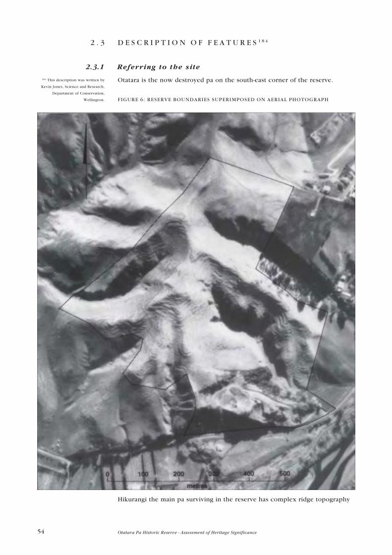
54 Otatara Pa Historic Reserve - Assessment of Heritage Significance
2 . 3 D E S C R I P T I O N O F F E A T U R E S 1 8 4
2.3.1 Referring to the site
Otatara is the now destroyed pa on the south-east corner of the reserve.
FIGURE 6: RESERVE BOUNDARIES SUPERIMPOSED ON AERIAL PHOTOGRAPH
Hikurangi the main pa surviving in the reserve has complex ridge topography
184 This description was written by
Kevin Jones, Science and Research,
Department of Conservation,
Wellington.

55Otatara Pa Historic Reserve - Assessment of Heritage Significance
FIGURE 7: OTATARA PA POSTER (NEW ZEALAND HISTORIC PLACES TRUST)
The different parts of the site are referred to as follows [Fig.8. Names of Features
and Ridges.]
Institute/Airini�s Ridge (the broad ridge running down to the north-east)
north ridge
north-west platform
central platform
south platform
west ridge north (running west from the north-west platform)
west ridge south (running west and south-west from the south platform)
south ridge
south-west ridge
south-east ridge
lower south-east ridge
Best Face (south and south-east of the south platform)
Hamilton slope (the easy slope running up from the car park)
Otatara lower terraces.
In addition there are numerous faces which can be referred to as the �west face
below the south platform� etc.
Fox�s description of the ditches and banks are retained:
No. 1 (now destroyed) on the western approach to Otatara.
No. 2 (across the Hamilton slope)
No. 3 (across the east flank of the north ridge)
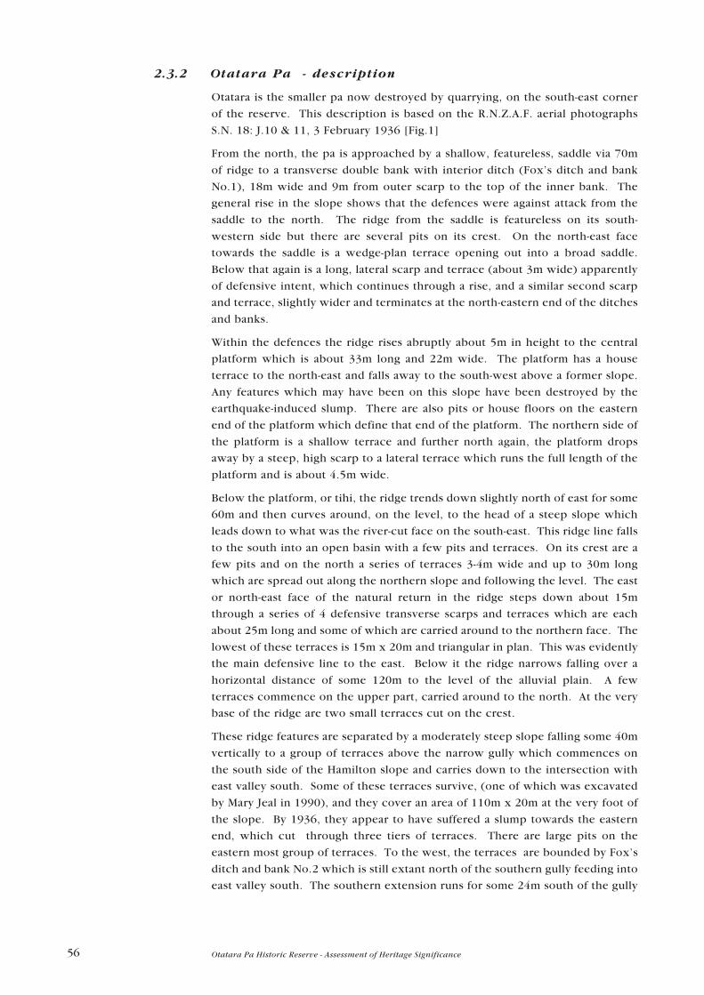
56 Otatara Pa Historic Reserve - Assessment of Heritage Significance
2.3.2 Otatara Pa - description
Otatara is the smaller pa now destroyed by quarrying, on the south-east corner
of the reserve. This description is based on the R.N.Z.A.F. aerial photographs
S.N. 18: J.10 & 11, 3 February 1936 [Fig.1]
From the north, the pa is approached by a shallow, featureless, saddle via 70m
of ridge to a transverse double bank with interior ditch (Fox�s ditch and bank
No.1), 18m wide and 9m from outer scarp to the top of the inner bank. The
general rise in the slope shows that the defences were against attack from the
saddle to the north. The ridge from the saddle is featureless on its south-
western side but there are several pits on its crest. On the north-east face
towards the saddle is a wedge-plan terrace opening out into a broad saddle.
Below that again is a long, lateral scarp and terrace (about 3m wide) apparently
of defensive intent, which continues through a rise, and a similar second scarp
and terrace, slightly wider and terminates at the north-eastern end of the ditches
and banks.
Within the defences the ridge rises abruptly about 5m in height to the central
platform which is about 33m long and 22m wide. The platform has a house
terrace to the north-east and falls away to the south-west above a former slope.
Any features which may have been on this slope have been destroyed by the
earthquake-induced slump. There are also pits or house floors on the eastern
end of the platform which define that end of the platform. The northern side of
the platform is a shallow terrace and further north again, the platform drops
away by a steep, high scarp to a lateral terrace which runs the full length of the
platform and is about 4.5m wide.
Below the platform, or tihi, the ridge trends down slightly north of east for some
60m and then curves around, on the level, to the head of a steep slope which
leads down to what was the river-cut face on the south-east. This ridge line falls
to the south into an open basin with a few pits and terraces. On its crest are a
few pits and on the north a series of terraces 3-4m wide and up to 30m long
which are spread out along the northern slope and following the level. The east
or north-east face of the natural return in the ridge steps down about 15m
through a series of 4 defensive transverse scarps and terraces which are each
about 25m long and some of which are carried around to the northern face. The
lowest of these terraces is 15m x 20m and triangular in plan. This was evidently
the main defensive line to the east. Below it the ridge narrows falling over a
horizontal distance of some 120m to the level of the alluvial plain. A few
terraces commence on the upper part, carried around to the north. At the very
base of the ridge are two small terraces cut on the crest.
These ridge features are separated by a moderately steep slope falling some 40m
vertically to a group of terraces above the narrow gully which commences on
the south side of the Hamilton slope and carries down to the intersection with
east valley south. Some of these terraces survive, (one of which was excavated
by Mary Jeal in 1990), and they cover an area of 110m x 20m at the very foot of
the slope. By 1936, they appear to have suffered a slump towards the eastern
end, which cut through three tiers of terraces. There are large pits on the
eastern most group of terraces. To the west, the terraces are bounded by Fox�s
ditch and bank No.2 which is still extant north of the southern gully feeding into
east valley south. The southern extension runs for some 24m south of the gully

57Otatara Pa Historic Reserve - Assessment of Heritage Significance
to the toe of the hill rising up to the eastern end of the tihi of Otatara (the
quarried pa) where it makes a return to the east along the toe for a distance of
about 15m. This length of ditch and bank shows in the 1890s Hamilton
photograph.
FIGURE 8: NAMES OF FEATURES AND RIDGES

58 Otatara Pa Historic Reserve - Assessment of Heritage Significance
The nature of this return does not suggest that the ditch and bank has a
defensive purpose since it lies at the foot of a very steep slope. This suggests a
nineteenth century age for the ditch and bank and perhaps for the enclosed
terraces, Jeal�s radiocarbon date results notwithstanding.185 These terraces
provide an interesting separate settlement unit, sheltered and sunny, protected
by the slope behind, the ditch and bank, and what may have been swampy
valley, or gully floor to the north and north-east.
The Hamilton slope to the north provides one broad approach to the southern
aspects of Hikurangi and for this reason, Fox�s No. 2 ditch and bank there has
been regarded as defensive. On the Hamilton slope proper (between the two
gullies) the ditch and bank is 83m long and 4m from counter scarp to the top of
the bank. The area of the slope is featureless both in the large area enclosed to
the east between the bank and the edges of the two gullies and to the west on
the slope running up to the face of the south ridge and the lower south-east
ridge. The function of this ditch and bank is therefore a conundrum which
requires archaeological investigation. Archaeology would show, for example,
whether there was palisading and whether there was a ditch on both sides of
the bank.
Possible ditch and bank fences
Some ditch and bank features on Otatara Pa Historic Reserve, conventionally
interpreted as defensive, may be fences.186 This type of fence went out of use by
the 1880s. They are prominent on Kohukete, a large pa some 10kms to the
north of Otatara. The main possible fence line is the one running across the
slope above the car park and through which formal and informal access tracks
run (Fox�s No.2 line). This ran across the broad slope to the foot of the north
face of Otatara. It is noticeable that the lower terraces on Otatara cease abruptly
on their western flank at this line. There may be a functional relationship
between the lower slope terraces and this line.
If this is a ditch and bank fence, then it probably enclosed or excluded stock
being held by the inhabitants of the lower terraces or others living on the flat
land beside the Tutaekuri. Ploughing of a field established on these slopes
would explain the relative lack of surface features. However, no lands (the
banks formed by repeated passes of the plough) are able to be detected on aerial
photographs.
2.3.3 Hikurangi Pa - description
The central and highest platforms on Hikurangi have no apparent ditch and bank
defences, but they do exhibit pronounced scarping, probably of defensive
intent, on most sides. The platforms are spaced along the central ridge line over
220m the altitudes being between 125m and 140m above sea level. The
terraced ridges and faces radiate out to the west, south-east and south of the
platforms.
This description is based on aerial photograph stereo pairs R.N. 1702/30, 31, 16
May 1949. Where terraces are described they are probably for habitation unless
the context makes it clear that they lie at the foot of defensive scarps.
185 File HIS 113, Item 20.
186 Best, 1975, p 295, Fox 1980,
p 236)

59Otatara Pa Historic Reserve - Assessment of Heritage Significance
FIGURE 9: TOP TERRACE - NORTHWEST PLATFORM
Tape and compass map by Pam Bain and El izabeth Pishief , February 1990

60 Otatara Pa Historic Reserve - Assessment of Heritage Significance
North-west Platform
At about 140m above sea level, this is the highest of the platforms and has a plan
area of 65m x 33m.
There is a slight scarp to the south and east (regarded as part of the platform)
and then a steep, high scarp, probably defensive, to a long lower terrace 50m
long and 5m wide. To the east is a line of 2 or 3 raised-rim pits on a lower
terrace and a descent through a few poorly defined terraces to the head of the
gully south of Institute ridge. There is a possible defensive scarp on the west of
the platform and a mild slope along most of the platform�s northern edge with
no obvious scarping or terracing. The platform descends to the south-east by a
narrow ridge flanked by well-defined terraces on the west to a narrow
featureless saddle which rises again to the south-east to the central or main
platform.
North Ridge
The north ridge is narrow with levelling of its crest and it joins, through a large
natural more or less level area, on to the head of the Institute ridge. The near-
level area extends around the head of the gully south of the Institute ridge.
There are a few isolated rectangular storage pits at the head of the Institute
ridge. Further down the Institute ridge towards the Reserve boundary are large
natural terraces, possibly enhanced by human hand.
Across the north ridge less clear and well defined at its crest, commencing 20m
from the northern side of the platform is Fox�s No.3 ditch and bank running due
east for about 50m to the advancing erosion face (of long-standing) at the head
of the gully south of the Institute ridge. The ditch is on the north side. From
bank to outer side of the ditch is about 3.2m and the total height from the base
of the ditch to the top of the bank is about 2m decreasing as one approaches the
crest of the ridge to the west.
West Ridge North
West ridge north runs south-west from the platform and has a flight of closely
spaced terraces on its south side, covering an area of 80m, 50m in plan and
stepping down to the advancing erosion face at the head of the gully. There are
further terraces at the lower end of the ridge worked into the northern end up
200m from the platform. There is some possible defensive scarping at this
western end.
Central Platform
This platform is triangular in plan, presenting high defensive scarps to the north-
east (30m long) to the west (45m long) and the south-east (45m long). To the
south-east the terrace below the defensive scarp falls steeply to the head of the
gully south of south-east ridge. There are indistinct pits on the west side of the
platform. The defensive scarp on the west falls some 8 -10m to a long terrace
65m x 5m in plan which extends along to the south-west to form the western
defensive scarp of the south platform. (This platform is just above the line of
the road.)

61Otatara Pa Historic Reserve - Assessment of Heritage Significance
South-east Ridge
The south-east ridge adjoins the central platform through two defensive scarps
descending from the platform to the head of the ridge by some 25m. The ridge
is 340m long falling to about 70m above sea level at its eastern extremity where
it directly overlooks the Tutaekuri flats. Outside the Reserve boundary further
terraces were probably cultivated before 1949 since the change to bare ground
seems arbitrary. The ridge is extensively terraced on the south side and to a
lesser extent on the north. On the north the terraces take the form of irregular,
but more or less level, long terraces (up to 80m long) and 3-5m wide, running up
to 50m (horizontal distance) down the slope towards, but not into, east gully
north. These form a wedge appearance in the plan view as they trend out to the
north and west from the descending ridge crest. A few pits, rectangular, up to
8m x 4m lie on the terraces. A similar pattern applies on the south side but more
especially within 15 - 20m horizontal distance of the crest. A number of small
blunt ridge ends form the lower slopes of the ridge above the actively eroding
gully on the south side. They are extensively and deeply scarped and terraced,
the scarps possibly being defensive.
South Platform and Best face
This platform is a large unit about 80m long and 50m wide on its southern face.
A low relief central ridge line has a few indistinct pits. There is probable
defensive scarping to the south above the steep Best face, continuing around the
head of west ridge south and on to the north-west facing side joining in an
irregular fashion with the terrace and scarp described above on the west of the
central platform.
To the south on the Best face and the eastern face is a very extensive area 110m
x 60m) with many terraces. These are generally small especially on the steep
eastern face but are commonly up to 14m x 10m in plan on the Best face. A
notable feature is the discontinuity in the plan of the terraces either side of the
platform down the Best face to the head of the south ridge. This suggests that
this line may be an access way through the pa of some antiquity and dating to
the period of occupation.
West Ridge South
The west ridge south descends to the south-west from the south-western corner
of the south platform. It has a central flat area about 20m x 50m in plan at about
the level of the corresponding level area of the south ridge which is about 70m
to the east. Below this to the north and south are several tiers of more or less
continuous terracing, with especially steep high scarps to the south. A further
80m down the ridge there is an area of strong, possibly defensive scarping. The
ridge crest here is marked by lines of rectangular pits, the largest of which is 8m
x 4m and others about 6m x 2m in plan.
South-west Ridge
The south-west ridge is in two more or less level segments. The upper one is
about 100m x 13m in plan and has a large concentration of raised-rim pits on its
crest and on small terraces on its southern flank above a broad terrace about

62 Otatara Pa Historic Reserve - Assessment of Heritage Significance
30m x 8m in plan. There are about 14 distinct pits the largest of which are about
8m long. The faces of this upper segment are unterraced although a few return
on the level around the south side. The lower unit is about 60 m long with a
featureless central ridge line flanked to the north-west and the south-west by
tiered terraces which extend about 25m to the north-west, less to the south.
The bottom terraces are wider and have higher scarps than the rest while the
lowest north-western terrace runs more or less level and continuously around to
the gully which cuts off the lowest terraces on the south side of west ridge
south. There are further pits to the south-east of the southern part of the lower
unit.
South Ridge
The south ridge extends south from the base of the Best (south) face with a level
plan area of about 50m x 12m. Pits lie on the level area and on terraces on the
crest of the ridge which turns again to run across the east-facing slope above the
Hamilton slope and the lower south-east ridge.
Lower South-east Ridge
The lower south-east ridge forms the northern side of the Hamilton slope. On
the north is a mild slope to the east gully (south of the south-east ridge). It is
terraced on its upper south-east facing slopes. Above this is a broad naturally
level area with some large pits. This area then rises to the terraces of the east
face of the south platform and the south ridge.
2 . 4 A G E O F O T A T A R A P A H I S T O R I C R E S E R V E
Four radiocarbon dates have been obtained from Otatara Pa Historic Reserve. It
has not been possible to find the earliest one which was done by Les Groube in
the late 1960s, but the following table sets out the three recovered in the 1990s.
FIGURE 10: TABLE OF C 14 DATES

63Otatara Pa Historic Reserve - Assessment of Heritage Significance
2 . 5 D E S C R I P T I O N O F S E T T I N G .
Otatara Pa Historic Reserve is set on the hills above the Tutaekuri river at
Taradale.
The Tutaekuri River rises in the eastern and southern slopes of the Kaweka
Ranges. Evidence from the early European settlers, about 1852, indicates that
the river was meandering and slow running, with banks of fine alluvium 12 ft to
20ft in depth. Shingle was first recorded in the river bed in 1877. In a few years
the river bed became filled with shingle which subsequently was spread over a
large part of the valley by successive floods.
FIGURE 11: MAP OF HERETAUNGA 1854
Extract from "New Zealand
Journal of Science and
Technology (sec A), Vol. 27,
No.2, 1945; Vol. 27, No.5, 1946
(the diagrams on pages 163 and
165)"

64 Otatara Pa Historic Reserve - Assessment of Heritage Significance
The original lower course of this river was apparently from Puketapu in a
southerly direction towards Omahu, where it followed the course of the Rapo-
ki-ti-Roto-Roa into the Tutaekuri-Waimate. At a later date the Tutaekuri broke
through the hills at Puketapu and entered the plains at Redcliffe (Otatara) and
then flowed in a southerly direction through Waiohiki to its old course
FIGURE 12: ROCHFORT�S MAP 1875
Later this river used the present (1945) silted courses - Saltwater Creek, Parimu
Stream, Muddy Creek and Taipo or Mission Creek. At a still later period it
evidently flowed to the sea in an easterly direction at Awatoto and followed the
present Waitangi.
Extract from "New Zealand
Journal of Science and
Technology (sec A), Vol. 27,
No.2, 1945; Vol. 27, No.5, 1946
(the diagrams on pages 163 and
165)"

65Otatara Pa Historic Reserve - Assessment of Heritage Significance
FIGURE 13: TOPOGRAPHICAL MAP 1939
Subsequently these mouths were blocked with shingle, with the result that the
Tutaekuri again flowed north into the Ahuriri Lagoon.187
It is significant that under natural conditions swamps were intimately associated
with and formed part of the river course from the smallest headwater seepage
and stream along the more level stretches to the mouth. The relative area of
many swamps to the size of the river was such that flood flows were largely
absorbed by these safety mechanisms.
The swamps were important resources of eels and other resources for the
nearby settlements.
187 Campbell, The NZ Journal of
Science and Technology, Aug, 1945,
p. 163.
Extract from "New Zealand
Journal of Science and
Technology (sec A), Vol. 27,
No.2, 1945; Vol. 27, No.5, 1946
(the diagrams on pages 163 and
165)"

66 Otatara Pa Historic Reserve - Assessment of Heritage Significance
2 . 6 P H Y S I C A L M O D I F I C A T I O N S
Sites such as Otatara were probably abandoned as places of settlement by the
early 1820s when the population was decimated by the northern tribes in the
course of the raids and battles around Te Roto-a-Tara and Te Whanganui a
Orotu.188 Many of the survivors fled to Mahia and did not return until the 1840s.
But Otatara may have been abandoned much earlier. �After a defeat the villages
forsaken by the conquered were rarely occupied by the victors.�189 The pa was
within the boundaries of the Ahuriri block purchased from the Maori people in
1851, and the first Crown grant of part of the reserve area was made in 1859.
No houses have been built on it during European occupation although Otatara
Homestead is adjacent to the site.
2.6.1 Changes in site condition
The area of what is now the Otatara Pa Historic Reserve has been photographed
on a number of times beginning with Augustus Hamilton in the mid 1890s.
Aerial photographic coverage commenced in 1936 with an early survey of the
Hawke�s Bay region by the Royal New Zealand Air Force.190 It has been covered
on numerous occasions by New Zealand Aerial Mapping Ltd., beginning in 1949.
These records are sufficient to tell something of the management and
maintenance of the condition of the place since then.
2.6.2 Site condition
The photographs by Augustus Hamilton were: No.1 [Fig.4] which was taken
from the north-west running ridge connecting Otatara to the main part of
Hikurangi looking slightly west of north and No.2 [Fig.14] which was more or
less the reverse view looking towards Otatara from a position on the south ridge
or terraced slopes well below the south platform and more or less level with the
platform of Otatara.191 Kevin Jones took a comparative photograph in 1996.
[Fig.15]
FIGURE 14: OTATARA PA 1899
Photographer:
Augustus Hamilton.
MONZ, B21206.
188 S Percy Smith, 1910, Maori Wars
of the Nineteenth Century.
Christchurch. pp.210-4, 284�94,
297- 305.189 Augustus Hamilton, 1896 -1900,
Maori Art, p. 78.
190 S.N. 18: J9-12, 1936
191 MONZ Neg. Nos. B21205 and
B21206

67Otatara Pa Historic Reserve - Assessment of Heritage Significance
FIGURE 15: OTATARA PA 1996
2.6.3 Vegetation cover
The area of the Otatara Pa Historic Reserve would have been covered in mixed
native grasses (Rhytidosperma spp., Ehrharta stipoides) and tussocks, when it
was lived on and would probably have reverted very quickly to brackenfern
(Pteridium esculentum), manuka (Leptospermum scoparium), and kanuka
(Kunzea ericoides) cover after it was abandoned as a settlement. Broad-leafed
trees, conifers, and araliad (five finger), and coprosma shrublands may have re-
established themselves using the bracken and manuka as nursery cover.192 From
the 1860s, when the Crown grants were taken up, it would have been cleared
and converted to pasture land, possibly with some attempt at improving the
grasses. Sheep, cattle and horses ranged on the land. The photographs taken by
Augustus Hamilton in the 1890s, probably in summer, show a grass cover
dominated by the seedheads of what appear to be danthonia (Rhytidosperma
spp.). Patches of dark-coloured sedge are numerous.
From an early stage there was active gully-head slumping where previously
there had probably been forest. In 1936 and 1949 fairly fresh slumping in
advancing gully-heads is noticeable at the head of east valleys north and south
and in the south valley.193 This phase of natural erosion has only affected
192 Geoff Walls, (Pers. comm.)
193 RNZAF S.N.18, J.10, J.11, 1936;
S.N. 541, R.N. 1702/30, 16 May
1949.

68 Otatara Pa Historic Reserve - Assessment of Heritage Significance
archaeological features towards the toe of the south face of the south-east ridge.
The eastern gullies have now filled appropriately with kanuka and manuka. Also
during the 1930s and 1940s there was a lot of bare earth, presumably induced by
stock, or drought, or both, on the northern face of the south-east ridge and the
north-western faces of the western ridges (outside the area of what is now
reserve).
In recent years there has been minor slumping at the head of east valley north
and this, too, has filled with gorse, manuka, and kanuka.
On the Institute ridge, the grass cover as managed by the Agricultural
Department of the Eastern Institute of Technology consists of a sward of annual
ryegrass and paspalum with some summer grass: legumes are sub-clover and
white clover. The former is an annual which rapidly goes to seed and tends to
persist in poorer pastures. In the formerly less intensively managed grassland
of the reserve, there would have been periodic reversions to longer grasses,
with cocksfoot dominant, but including brome and Ehrharta on the terrace
treads and flat areas. The longer grasses shade the legumes which are
correspondingly reduced. The general trend, without top dressing, and with
minimal stocking and fencing, has been that only certain areas, such as ridge
crests, have been favoured by the sheep. These favoured camping areas have
also been manured by them. In the favoured areas, ryegrass was probably
important in the sward, but the grasses are generally well suited to dry
conditions: cocksfoot, browntop, crested dogstail and ratstail. The banks and
other areas inaccessible to sheep and in many cases north-facing, will have
favoured Danthonia (Rhytidosperma spp.) As at June 1996 after some top
dressing and oversowing in the previous 18 months, the general impression of
the site was of healthy swards of ryegrass and paspalum on the ridges, with
some areas still being camped on, while the banks had a contrasting cover of
Danthonia with spent seed heads and stalks prominent. The even spread of
grasses and grazing should get better with further improvements to fencing.
2.6.4 Damage: Animal stocking, roading, tracking and erosion
Light tracking is evident in the Hamilton photographs. From Hikurangi a track
sidles across the eastern side of the saddle to the south ridge or Best face on
Otatara. On Otatara there is some sign of a track on the Best face south of the
south platform where traffic would naturally tend to go on leaving the main
ridge crest heading down to Otatara or the Hamilton slope.
By 1949 foot tracks are evident running up the Hamilton slope through a central
part of No. 2 ditch and bank. There is a faint trace of a foot track following the
broad terraces east of the north-west platform and west of the main platform,
continuing south to join up with the track mentioned in the previous paragraph.
From 1949 the fencing appears to have been on a line across the south-western
flanks along the current reserve boundary. This rises quite close to the western
faces of the main platforms and continues north west of the north ridge. At the
time the Management Plan (c.1977) was written the Reserve was all in one
paddock and there was only one stock dam. The track which shows very clearly
here was probably there before the fencing, but the installation of the fence
would have accelerated the erosion as stock roamed up and down. The fence

69Otatara Pa Historic Reserve - Assessment of Heritage Significance
was put in in about June 1979.194 (It was removed from the ridgeline onto the
bulldozed track and into the gully in June 1991.)195 At the same time (late 1970s)
a track was also forming in a more south-easterly direction on to the south ridge,
which is the natural line to gain access from the Hamilton slope and east valley
south. The debris from these erosion tracks was probably considerable and will
have been deposited in the gully heads between the west 1, south-west and
south ridges. The current road and track runs across this colluvial deposit. It is
possible that both these tracks have greater antiquity. They follow fairly natural
lines of access and may be original archaeological features of the site pattern.
The farm track was put in sometime between 1949 and the 1960s.196
FIGURE 16: OTATARA 1969
In the 1980s there occurred another disaster in the management of the site
with the bulldozing of a road along the line of the track mentioned in the
previous paragraph, which then sidled over fresh ground with well-formed
terraces below and west of the south platform and across the west ridge south
and the upper end of the south-west ridge. It continued down, skirting the west
side of the south ridge, coming round its south end, and dropping down through
194 L&S File RES 7/3/1. vol 5, Note
between Items 45 and 46 which
discusses the fencing proposals
which were approved by Mary Jeal
and Lady Aileen Fox. and includes a
plan of the proposed subdivision.195 File HIS 113, Item 22.
Photo: N.Z. Aerial Mapping
R.N. 4201/21
196 cf. Aerial photographs 1949, 1969.

70 Otatara Pa Historic Reserve - Assessment of Heritage Significance
many, well-formed terraces, to the easy grade of the Hamilton slope. Water
pipes installed along the road serviced troughs, one of which, at the upper end
of the south ridge, has probably contributed to the sheep camping there. The
road was probably bulldozed for the stock watering system installed by the
Otatara Trust Inc. in order to facilitate the Otatara Trust�s grazing management
scheme in 1986.
The bulldozing was done without first obtaining the prior consent of the
Commissioner of Crown Lands, as was required by Clause 14 of the Licence,
which the Otatara Trust had not signed. The Otatara Trust was told that their
action, which had resulted in damage to the Otatara Pa Historic Reserve, of great
archaeological importance to Hawke�s Bay, could result in a fine of up to
$25,000 if they were convicted of the offence.197
The damage was caused by a pipe digging and laying machine which was used
to open up the ground and lay a water pipe to supply three water troughs. In the
digging process midden and dark earth were exposed, an official sign was
pushed to the edge of a gully and partly buried, and a bank was cut into so that
access could be gained to the water trough.
To compound the problem fifty head of cattle had been put on the Reserve
without approval from the Department. Under the previous Management
Committee, cattle damage had been noted in 1977, and cattle were removed
from the site in 1978. It has been proved that cattle are not desirable on the site
because of the excessive damage they do to the features: pits, terraces, banks,
paths and ditches. In moist soil conditions, cattle very rapidly push large sods
off the edges of terraces and pits. On slopes cattle treading breaks down the
sharp edges of the terraces and large masses of soil are cumulatively carried
down the slope. One trough in particular was sited beside a pit and the cattle
had, after only a few weeks, begun to trample the area and some of the
terraces.198
A meeting of representatives of all those groups and people who were
concerned about Otatara felt that no further grazing of the site, by cattle, should
be permitted. However it was eventually decided that:
Cattle may be used only until such time as the pasture is cleaned-up and
must then be moved promptly. In the event of particularly wet weather,
or damage to archaeological sites, the cattle must be moved forthwith.199
In the 1980s there continued to be heavy stocking with cattle during the winter
when the soil on terraces is compacted and pugged. Sheep can also be
destructive to archaeological sites in certain conditions. During the 1970s and
1980s sheep were camping in large numbers on the drier stony ridges,
especially on the south-west and south ridges. The outlines of pits became
badly eroded and rounded stones in the subsoil became exposed as the topsoil
was disturbed and washed or blown away. The sheep are continuing to camp in
these areas at the present time (1997).200
The Otatara Trust decided not to lease the Reserve and the grazing was offered
to Mr Black the only other adjoining farmer. The Department of Lands and
Survey was then obliged to take over the water supply, unlawfully installed by
the Otatara Trust, and they fully reimbursed the Otatara Trust $10,766, the price
of the installation.
197 Lands and Survey File: RES 7/3/1
Item 43, Letter dated 23 May 1986 to
Secretary
198 Lands and Survey File: RES 7/3/1.
Item 47. Considered at meeting held
10 June 1986.
199 L & S File RES 7/3/1, vol 6, Item
52 Letter (13/6/86) from A Shipp, for
Commissioner of Crown Lands
Napier.
200 Kevin Jones and observations
from aerial photographs.

71Otatara Pa Historic Reserve - Assessment of Heritage Significance
But there had been a curious attempt to avoid paying the full price by making
some imaginative calculations which included reducing the Department�s
contribution by $1,500 as a token acknowledgement that the Department
appreciated the historical value of the Reserve and objected to the damage to
the archaeological features which had depreciated the intrinsic value of the
Reserve.
A comment by the field officer, A. Shipp, who wrote this Report, highlights a
major threat to the conservation and long-term safety of Otatara Pa Historic
Reserve. He said:
I believe that as few of us in this District Office have our roots in
Maoridom, nor are many of us particularly interested in archaeological
sites, it is very difficult for us to appreciate the emotion aroused in many
others by the spoiling of these sites.201
The attitude of departmental staff and their understanding of the significance
and value of historic places as part of New Zealand�s heritage is crucial to the
successful management and conservation of the historic places on the land
managed under the Conservation Act 1986 and the Reserves Act 1977.
In June 1991 work commenced on the Development Plan for the Reserve. The
work included the placing of track markers, realignment of a fence and
excavation for a water pipe. The line for the water pipe followed the bulldozed
track, cut across the end of a terrace and went down through the Hamilton slope
to the car park. This was identified as the line of minimum impact, but three
areas of cultural material were uncovered during the work. Two shell samples
were sent to the University of Waikato Radiocarbon Dating Laboratory. The first
was taken from the area beside the water trough. The second sample was taken
from the third area of cultural damage associated with the edge of a terrace
which had been badly damaged by sheep tracks.
Oblique photographs taken in May 1995 [Fig.17] and June 1996 [Fig.18.] show
slowed but still present sheep erosion on the crest of the south-east ridge,
where the fence line (1979) has been removed and re-aligned down the slope to
the north. The erosion should slow down since the fence was clearly
contributing to the de-stabilisation of these surfaces. A fence line now runs
across the north-western platform from the western boundary down to the
saddle between that platform and the main platform. The saddle is an important
gate complex and has, since 1979, suffered major localised erosion. Now with
increased pedestrian and runner usage there are new desire lines forming at the
head of the Hamilton slope, rising up the slope. These avoid the easy grade of
the disastrous road and go straight up the slope.202
201 ibid, Item 74, Report by A Shipp,
dated 30 January 1987.
202 Kevin Jones.

72 Otatara Pa Historic Reserve - Assessment of Heritage Significance
FIGURE 17: OTATARA, MAY 1995

73Otatara Pa Historic Reserve - Assessment of Heritage Significance
FIGURE 18: OTATARA, JUNE 1996
2.6.5 Quarrying of Otatara
Quarrying had began on Otatara Pa by the early 1930s. It is possible that
quarrying was started in the 1920s.203 Early aerial photographs show a massive
earthquake-induced slump and quarrying, on the south-western side, utilising a
face estimated to be some 45m high with some smaller incisions further to the
east.204 The main area of what is sometimes thought to be quarry is in fact a
rapidly occurring slump. The road at the foot of the hill rises and is less well
formed to accommodate the mass of the slump. There is no roading on the body
of the pa which at this time was approximately a fifth destroyed, with the
destruction having entered into the central platform. By 1949, the south-east
side had been completely quarried away, the south-west excavation had
203 see later in this report.
204 RNZAF SN 18, J10, 3 February
1936

74 Otatara Pa Historic Reserve - Assessment of Heritage Significance
intruded as far as the southern side of the double ditch and bank and the
platform had been bulldozed over and a road put through on its northern side. 205
FIGURE 19: 1949 AERIAL PHOTOGRAPH
There was still a trace of the southern extension of Fox�s No.2 ditch and bank
extending south from the Hamilton slope as shown on the Hamilton
photograph.[Fig. 14]
By 1975 the entire surface of Otatara Pa had been disturbed. A road had been
driven up the northern face some 20 - 30m below the crest of the ridge to a small
quarry or amphitheatre at the western end. There was extensive stripping of
topsoils and subsoils from the ridge crest, some of which was pushed down the
northern slope, but most appears to have been placed and compacted in the
broad head of the gully which is at the toe of the northern slopes of the pa, and
south-west of the Hamilton slope. Extensive stripping of topsoils and filling
appeared to extend over the area shown in Hamilton�s south-west view.206
Ray Withers modified the site during 1982 to fulfill the requirements of the
development proposals.207 The contractor co-operated by quarrying in such a
way as to achieve the greater part of the development concept. He was then
hired to smooth off the sharp faces, construct the exit road and reduce the
gradient of the existing entrance road.208
205 S.N. 541 R.N. 1702/30, 16 May
1949
206 Kevin Jones
207 See p. 56 Archaeological section
208 Dept L&S File RES 7/3/1/ Item
171.

75Otatara Pa Historic Reserve - Assessment of Heritage Significance
3.0 Significance
3 . 1 H I S T O R I C A L A N D T R A D I T I O N A L S I G N I F I C A N C E
Otatara Pa has considerable significance to Ngati Kahungunu as the place where
they gained a foothold in Heretaunga. Different hapu have different versions of
the story of Taraia�s arrival in this area which range from a truce, alliances, a
bloodless conquest and slaughter. Following the encounter at Otatara Taraia and
his people succeeded in establishing themselves in Hawke's Bay and the
Wairarapa. This was achieved in a variety of ways including conquest, political
arrangements and intermarriage.
Otatara Pa is of great historic significance to all of Ngati Kahungunu and to many
related people. All the hapu of Heretaunga have connections to Otatara through
their whakapapa.
Otatara has educational value. People can learn about archaeology, and how
the ancestors of the Maori lived and defended themselves. There is a great
desire among the people to ensure that their children and the next generation
know more than they did about Otatara and its history, and that they understand
and appreciate its significance.
3 . 2 C U L T U R A L S I G N I F I C A N C E
The people of Waiohiki particularly, feel that the place is tapu - Otatara is an
urupa and a wahi tapu. It is an important place and they want people to know
that it is their pa and that they protect it. Their pride requires that it be kept tidy
and looking good for visitors. There is a desire to restore it and ensure it keeps
its identity and is well looked after. At powhiri the kaumatua say �Welcome to
our marae which sits in the shadow of Otatara/Hikurangi.� This acknowledges
our ancestry and tries to relive the memory of our ancestors. Ancestry/
Whakapapa is very important. There is a great deal of feeling for the place
because of the ancestors and the history that has come out about it especially
since the Waitangi Claims have raised people�s awareness of the importance of
the history. The people of Waiohiki say:,
We live in the shadow of Otatara and Otatara is within the area of
influence, our tribal takiwa we hold mana whenua. We are also the
kaitiaki - now in saying that we are not saying we want to keep other
tribes or other groups out of there but we are the ones who are given the
traditional responsibility to look after the pa.
Molly Hadfield (kuia awhina) interpreted the finding of the argillite adze as a gift
from the ancestors on the pa for the work the people of Waiohiki put in there. It
was a reward for the love they are putting back into the pa site. The reason they
were doing the work was to reclaim the mana whenua of the pa and try and
enhance the mana of the site which had been affected by the quarrying. Otatara
is a very special place to the people. It is a very important heritage site, it is
basically the original marae site, the original settlement for the Heretaunga. The

76 Otatara Pa Historic Reserve - Assessment of Heritage Significance
continuity of links through modern stories and activities on the site, as well as
the traditional history with the place of their ancestors is vitally important to the
emotional, spiritual, and cultural well-being of the present people.
3 . 3 A R C H A E O L O G I C A L A N D S C I E N T I F I C
S I G N I F I C A N C E
Otatara Pa Historic Reserve remains of considerable archaeological importance
in Hawke�s Bay, although Otatara Pa proper has been almost completely
destroyed. Very little archaeological information has been obtained from the
site so that at present answers to such questions as the real function and age of
Bank No.2, the purpose and use of the terraces and pits, the way the site was
defended, which are the oldest parts of the site and what is the age of surface
visible features, remain only speculation.
The age of pa is a matter of considerable interest and debate in New Zealand
archaeology. Pa are now considered by most archaeologists to have originated
in Polynesia. It is not known whether pa were present from earliest times in
New Zealand or whether they were a response to later population pressure and
conflict over resources. The dating of fortifications by radio carbon is difficult.
Nevertheless a recent review of the radiocarbon data from throughout New
Zealand has concluded that the earliest pa date from about 1500 AD, (i.e. 450
years B.P.) which is 300 or more years later than the accepted time for first
settlement of New Zealand.
The defensive form of pa has been used to determine pa ages. Elsdon Best�s
theory was that the earliest pa were defended solely by the scarps of terraces.
He thought terraces were simple precursors of more elaborate ditch and bank
fortifications. His ideas were revived in the early 1960s by Jack Golson and Les
Groube. Just before that time the publication of Andrew Sharp�s Ancient
Voyagers in the Pacific (1956) had caused considerable controversy and was
vigorously attacked by scholars who had developed a literal chronology from
traditional genealogies. 209
It was Jack Golson, as editor of the Journal of the Polynesian Society, who
insisted on the need to separate traditional and archaeological sources of
information and to not confuse the two disciplines when interpreting sites. But
he stimulated interest in the relationship between sites, archaeology and
tradition. He appears to have encouraged local volunteer fieldworkers to record
sites, to consider the application of new methods and to consider the wider
significance of the records, by way of distribution maps or relationships with
traditional knowledge.210
There was very little published material on field evidence in 1957 and in
Golson�s opinion most regions were �ill-known�. He reviewed the available
evidence for pa defended solely by terraces, noting records of these at
Whakatane (Kapu te Rangi, presumably) and Waiapu, and he was
unsympathetic to Best�s contention that pa defended solely by terraces were a
typologically simple early form of pa.
Kapu te Rangi (W15/20) had long been recognised as the traditional pa of Toi, of
the Fleet. Two amateur field workers, Mabon and Pullar, attempted to fit this
209 Sorrenson, 1979, 55-56
210 Summarised from Kevin Jones,
Manuscript of East Coast
Monograph, p.27

77Otatara Pa Historic Reserve - Assessment of Heritage Significance
tradition with Elsdon Best�s view, that terraced pa were older than pa fully
defended by ditch and bank. Pullar found what he thought was Kaharoa ash
(erupted 700 years B.P.) on the terraced part of Kapu te Rangi and decided that
the pa was built in two phases: the earliest by Toi at a traditional date consistent
with Kaharoa ash occurring on the terraces (before 700 years B.P. or 1250 A.D.),
and a later ring-ditch pa. The open western-most terraced parts of the pa were
regarded as the early (Archaic) part which fitted the tradition of a landing by Toi
in 1350 A.D. The ring-ditch principal platform was interpreted as Classic Maori.
But Kapu te Rangi has, like many pa in the Whakatane area, a single ring-ditch
platform in association with extensive terracing of adjacent ridge lines, and is
probably no older than 400 years B.P.211
Many of the problems exposed by this discussion of Kapu te Rangi are relevant
to the archaeological understanding of Otatara Pa Historic Reserve. It has a
great skirt of terraces, but they centre on a group of central platforms. The
perimeters of the platforms are not ditched in their present day form, but they
may once have had ditches (now infilled) and palisades above. It is a site of
great archaeological significance but very little scientific investigation or
interpretation has been carried out on it. Thus the archaeological interpretation
and knowledge of the site is limited to comparison and extrapolation from
similar sites.
3 . 4 A E S T H E T I C A N D L A N D S C A P E S I G N I F I C A N C E
The significance of Otatara Pa Historic Reserve is of considerable value in spite
of the loss of Otatara Pa proper. The devastation accentuates the remaining
beauty of the site and underlines the importance of providing for its long term
protection. The archaeological features themselves have considerable aesthetic
appeal and value. They are a tribute to the craft and skill of the original builders
who modified the site with expertise and an apparent sympathy for the
environment.
The views from the site are outstanding and panoramic. They encompass
Napier, Te Whanganui a Orotu, and the sea, the whole of the Heretaunga Plains,
across to Cape Kidnapppers, Te Mata, and Kahuranaki, up the Tutaekuri river,
around to Lake Rotokare, and west to the Kaweka ranges. It is possible on a
clear day to see Ruapehu in the centre of the North Island. It was obviously
chosen for its strategic position as an outstanding vantage point.
211 ibid.

78 Otatara Pa Historic Reserve - Assessment of Heritage Significance
4.0 Threats
Threats to historic places take many forms but five principal types can be
identified. Loss of purpose, natural processes, visitor impacts, management
impacts, and information loss.
4 . 1 L O S S O F P U R P O S E
The sustained loss or purpose for this historic place poses a significant threat, as
identified in Article 7 of the ICOMOS New Zealand Charter. This would lead to
lack of support and income, allowing other threats to manifest themselves.
Now that the original purpose of the historic place is gone, new compatible and
sustainable uses must be developed and maintained.
4 . 2 N A T U R A L P R O C E S S E S
Erosion associated with drought, animal stocking, wind and poor management is
a significant problem on Otatara. Damage which has already occurred has been
discussed in a previous section, but this is an ongoing problem.
Animals, particularly cattle, are a major threat to the archaeological features.
Rabbits contribute to the slow, inevitable destruction of the site, but cattle can
do massive and rapid damage to a site, particularly in wet conditions. Sheep
have been thought to have low impact on archaeological sites but the
information from Otatara indicates that their propensity to camp in the same
places can cause considerable damage to archaeological features. Sheep are
attracted to warm dry areas and the stony ridges of Hikurangi have been badly
affected. The grass is unable to grow and the bare soil on the exposed ridges is
blown away by the wind and the features are destroyed.
A massive slump caused by the 1931 Earthquake destroyed part of Otatara Pa
apparently even before quarrying began. Presumably the steeper parts of
Otatara Pa Historic Reserve will be at risk if another large earthquake occurs.
Weeds do not necessarily threaten the archaeological features, but they may
affect the interpretation of the site by obscuring features, as well as detracting
from the visual or aesthetic values of the reserve. Certain weeds, for example,
blackberry may if they become rampant, tempt managers into using
inappropriate means such as heavy machinery to control them.
4 . 3 V I S I T O R I M P A C T S
A major threat to the site is the lack of understanding on the part of visitors that
constant, even though it is minimal, damage to a site has a cumulative effect and
ultimately leads to the destruction of the site. Although tourism and education
are necessary and intended uses of Otatara Pa Historic Reserve increased

79Otatara Pa Historic Reserve - Assessment of Heritage Significance
numbers of people will have a detrimental effect on the long-term preservation
of the site. Visitors have caused damage by �tracking�. The track up through
Ditch and Bank No.2 is getting more pronounced although there has been an
attempt to alter the walking pattern by developing another walking track
circling around the Reserve. The easy, obvious track from the carpark is the
preferred access to the Reserve with unfortunate consequences for the well-
being of the site.
Children damage by sliding down the hillside destroying the grass cover and
wearing down the features. Mountain bikes are prohibited because they cause
damage. However some visitors disregard notices.
4 . 4 M A N A G E M E N T I M P A C T S .
A threat to the Reserve is the lack of understanding of historic values by some
departmental staff. The history indicates that unnecessary damage occurred to
this site once it was in the care of the Department of Lands & Survey during the
1980s and damage has occurred while the Reserve has been managed by the
Department of Conservation. The land was set aside as a historic reserve in
order to preserve an important part of New Zealand's historic heritage.
Therefore every activity should be directed towards that goal. Preservation is
the purpose, not farming.
4 . 5 I N F O R M A T I O N L O S S
The destruction of important archival sources such as old documents and
photographs and the loss of unrecorded oral history constitute a threat to this
site.

80 Otatara Pa Historic Reserve - Assessment of Heritage Significance
5.0 Recommendations
5 . 1 C O N S U L T A T I O N
Otatara Pa Historic Reserve cannot be adequately managed without full and
ongoing consultation with the tangata whenua. The people of Waiohiki have
taken on the role of active kaitiaki for Otatara Pa Historic Reserve, because their
marae sits in its shadow. However they acknowledge, and the history confirms,
that there are many other hapu who have connections with Otatara. These
people are welcome to participate in the management of the Reserve, but it is
recommended that they co-ordinate their approach with the people of Waiohiki.
5 . 2 P U R C H A S E / C O V E N A N T I N G
Otatara Pa Historic Reserve does not cover the full extent of this important site.
There are several areas on the ridges adjacent to the Reserve which should be
included within it. The photograph of Otatara which was used for a New
Zealand Historic Places Trust poster is of features which are not within the
Reserve. It is recommended that these areas to the north-west and south of the
Reserve be purchased or covenanted in order to preserve the integrity of the
site. It is important that they are managed as part of the Reserve rather than
being under threat from poor management and development proposals.
5 . 3 T O U R I S M
Otatara Pa Historic Reserve has potential for increased promotion as a tourist
attraction. The people of Waiohiki have been taking visitors and school parties
over the Reserve for several years and they feel there need to be opportunities
for increased development of this service. It may be possible for a visitor centre
to be built adjacent to the site or perhaps in the �amphitheatre� of the old quarry
which would facilitate and monitor the development of tourism. These ideas
will need careful evaluation and further consultation with interested and/or
affected parties, but they are worthy of consideration.
5 . 4 M A I N T E N A N C E
It is important to both the people of Waiohiki and the Department of
Conservation�s image that this significant and beautiful historic site is
maintained to a high standard. It is perceived that two major restrictions to
achieving this are insufficient funding and shortage of staff.
It has been suggested that permanent gardeners be employed to maintain the
Reserve. If the land was no longer grazed but mown the problem of stock
damage would be solved. But there are some disadvantages associated with
mowing archaeological sites. Lawnmowers can also flatten and scrape features

81Otatara Pa Historic Reserve - Assessment of Heritage Significance
and thus contribute to their deterioration. The Reserve is a very large area and
the cost of such a policy may be prohibitive.
Parts of the Reserve have been planted in native trees but Otatara pa proper is
infested with weeds which need to be controlled. The eroding areas need to be
stabilised and restored. A major problem, as has already been noted, is that the
sheep camp on the earthworks on the ridges damaging the grass, which leads to
erosion and causes the features to deteriorate. Sheep need shelter and use the
earthworks for that purpose. Patches of forest help modify this behaviour.
Good sheep management is essential to adequate maintenance of the Reserve
and part of that process is the provision of suitable fencing, which has already
been done.
It is recommended that the affected areas be protected from the sheep during
the autumn and the very stony areas be top dressed with soil, protected with a
biodegradable cover to stop wind erosion and sown with grass seed.
If sheep are sheltering in the gullies on Otatara then enhancement of the
shrubland may encourage them into these areas, although the gullies are very
steep.
It is recommended that cattle and horses be totally banned from the Reserve.
Fencing has been erected to subdivide the paddocks into smaller lots. It is
possible to manage sheep so that they maintain the pasture at a satisfactory level
and cattle are not needed.
It may be possible to combine the gardening and the tourism operations in some
way to provide employment opportunities for the people of Waiohiki.
It is recommended that these ideas be discussed and their feasibility be
ascertained as a possible way of integrating satisfactory management outcomes
with active participation of the people of Waiohiki in that management.
5 . 5 A R C H A E O L O G Y
The archaeology of Otatara Pa Historic Reserve is not well understood.
Particular attention could be paid to understanding the fortifications (if there are
any) of the central platforms, the function of the great skirt of flanking terraces,
the ditch and bank across the Hamilton slope and the deposits which may lie
buried under colluvium. It is recommended that opportunity be sought, and if
the tangata whenua approve, that some archaeological investigations of various
features of the site be undertaken. Proposals to the annual Science and
Research bidding round would be one way to start an initiative.

82 Otatara Pa Historic Reserve - Assessment of Heritage Significance
6.0 Information
6 . 1 O L D P L A N S
Longitudinal and transverse sections of �Large Pa at Redcliffe, Taradale� in
Augustus Hamilton, 1896 1901, The Art Workmanship of the Maori, Part 2,
1897, New Zealand Institute, Wellington, p.121[Fig.3]
�Fig. 1. Section of a large pa at Taradale, Hawke�s Bay. The sketch section of the
ditches and banks (maioro) show the strength of the defensive works; such was
the extent of the pa that a very large number of men must have been required to
repel a large attacking force. This pa is only one of many visible from this place.
It is situated on a high spur above the river and covers several acres.� p.126
NZAA Hawke�s Bay File: In an envelope marked N134/1 Pa: Otatara are plans
drawn by Norman Elder. A letter enclosed says that in 1935 he had gone over
Otatara with prismatic and pacing to get a general idea of the layout. The
sketches he drew in 1944 only cover two areas the spur going up from near
Redcliffe substation and the main fosse and rampart facing Redcliffe bridge.
In February 1990 Pam Bain and Elizabeth Pishief drew the pits on the �Top
Terrace�, revised by Victoria Grouden, [Fig. 9]
Land & Deeds Plans RES 7/3/1 Vol. 4.
1) 12805 August - October 1971.
2) 6687 March 1938
3) 6448 July 1936
4) 6801 June 1975
5) 7472 December 1978
Topo of Proposed Picnic area on Otatara Pa Reserve. Fieldbook 1095, p.46.
November 1974. RES 7/3/1. vol 4.
Otatara Pa Historic Reserve Quarry Area drawn by N. Morrison, Dept. Lands &
Survey, September 1976, Govt. Printer, Wellington. L&S File RES 7/3/1.
Otatara Pa Historic Reserve Development Plan Feb. 1995. Scale 1:500
a) Sheet 1, Vertical of Otatara
b) Sheet 2, Oblique of Otatara
Titchener, Monzingo Aitken Ltd., Landscape Architects, ph.06 8781503
Hastings. Held Waiohiki Marae.

83Otatara Pa Historic Reserve - Assessment of Heritage Significance
Otatara Pa Restoration Project New Zealand Conservation Corps, 1989, Concept
Plan. Alan Titchener, Pukehou, Private Bag, Hawke�s Bay. Held Waiohiki Marae.
Otatara Pa Walk Track and Interpretation Development. Scale 1:2000. H W
Scheltus, Department of Conservation, March 1991. Held by Waiohiki Marae.
Map: Fig 6.2. Showing the locations of the inhabitants in mid-Hawkes Bay ca,
1550. In M.W. Allen, Warfare and Economic Power in Simple Chiefdoms: the
Development of Fortified Villages and Polities in Mid-Hawke�s Bay, New
Zealand, Ph. D. Dissertation, UCLA, 1994.
Map: No.4 �Maori Place Names of the Taradale District of Heretaunga�, from
J.D.H. Buchanan, (ed. David Simmons) The Maori History & Place Names of
Hawke�s Bay, Reed, Wellington, 1973, p. 109.
Landscape References
In Gazetteer of New Zealand Place Names, Department of Lands & Survey,
Wellington, 1968. These are included because they show the continuity in
space and time for the relevant names, as the related tribes, Kai Tahu, Rangitane,
Ngati Awa, etc. moved about the country. The names reveal connections which
would otherwise be forgotten.
These are the map references to Otatara.
NZMS No. Sheet No. Grid Ref. Lat.S. Long.E.
A) Otatara suburb 17 Invercargill 30 98 46.26 168.17
town 1 S182 30 98 46.21 68.17
town 19 7 46.26 168.17
town 83 S.I. 46.26 168.17
golf course 2 S181/3 30 99 46.26 168.17
Otatara suburb, town (2 refs) and golf links are related i.e. the golfcourse was
named after the town which later became a suburb of Invercargill.
This Otatara is in Southland three miles south-west of Invercargill on the
opposite bank of the Waihopai River estuary. It is principally a residential area
with small farms and a primary school. Otatara Bush is situated between Otatara
and the Oreti river with the golf links nearby. The wooded area is of young
kahikatea on recent alluvium and of considerable botanical interest.212
NZMS No. Sheet No. Grid Ref. Lat.S. Long.E.
B Otatara homestead 2 N/134/3 25 33 39.33 176.50
homestead 1 N134 25 32 39.33 176.50
pa 1 N134 24 32 39.33 176.49
This is the reference to Otatara Pa Historic Reserve. The homestead is named
after the pa which is adjacent to the farm.
212 Wise�s New Zealand Guide, 6th
ed. 1974, Auckland, p.240.

84 Otatara Pa Historic Reserve - Assessment of Heritage Significance
NZMS No. Sheet No. Grid Ref. Lat.S. Long.E.
C) Otatara bay 105 32 51 41.05 174. 02
This bay is in the Marlborough Sounds.
D) Otatara Marae. No map reference.
A marae located on the Hokianga harbour in Northland.
Landscape References to Hikurangi.
NZMS No. Sheet No. Grid Ref. Lat.S Long.E
A) Hikurangi Town 1 N 20 80 11 35.36 174. 17
town 19 1 35.36 174.17
town 83 N.1 35.36 174.17
Trig/hill 1 N.20 78 12 35.36 174.16
An independendent town district within Whangarei county.213 Takes its name
from a peak to the west which was named after a well-loved peak in Hawaiki,
ancestral home of the Maori. 214 The name may mean �skyward summit� or �sky
peak.�
NZMS No. Sheet No. Grid Ref. Lat.S. Long.E.
B) Hikurangi river 1 N.19 55 00 35.42 174.02
trig 1 N.19 42 18 32.32 173.55
trig 1 N.10 96 78 35.03 174.16
Hikurangi River between Whangarei and Kaikohe. The trig north-west of this
river.
NZMS No. Sheet No. Grid Ref. Lat.S. Long.E.
C) Hikurangi mountain 19 2 37.55 178.04
mountain 83 N.1. 37.55 178.04
hill 10 8 37.55 178.04
Hikurangi Mountain is north west of Tokomaru Bay , at the head of the Waiapu
River valley. The highest peak on the Raukumara Range, 1754 m (5606 ft.) and
is said to be the first place in New Zealand to receive the morning rays of the
sun.215 Held in great respect by the Maori as the resting place of the great canoe
from which the mythological ancestral hero Maui caught his famous fish (the
North Island).216
213 ibid, p.92
214 Wise�s New Zealand Guide: a
gazetteer of New Zealand 8th ed.
1987, p.133.
215 Wise�s 1974 p.92
216 Wise�s 1987, p.133

85Otatara Pa Historic Reserve - Assessment of Heritage Significance
NZMS No. Sheet No. Grid Ref. Lat.S. Long.E.
D) Hikurangi mountain 19 3 38.21 176.54
trig 74 55 03 39.48 176.05
mtn. range 74 55 04 39.47 176.05
stream 74 46 04 39.47 176.59
trig 1 N.86 30 78 38.21 176.51
trig 170 30 80 38.21 176.51
In Urewera National Park, west of the Ikawhenua Range.
NZMS No. Sheet No. Grid Ref. Lat.S. Long.E.
E) Hikurangi stream 1 N.53 41 82 37.30 175.55
trig 1 N.53 39 84 37.29 175.55
trig 1 N.53 39 85 37.29 175.54
Hill and stream west of Tauranga harbour.
NZMS No. Sheet No. Grid Ref. Lat.S. Long.E.
F) Hikurangi Point 1 N.43 94 61 36.51 175.26
A headland in Manaia Harbour on the Coromandel Peninsula opposite Waiheke
Island.
NZMS No. Sheet No. Grid Ref. Lat.S. Long.E.
G) Hikurangi trig 1 N.89 61 82 38.17 178.13
Trig north-west of Tolaga Bay.
NZMS No. Sheet No. Grid Ref. Lat.S. Long.E.
H) Hikurangi trig 1 N.44 12 68 36.47 175.37
Trig north-west of Whitianga.
NZMS No. Sheet No. Grid Ref. Lat.S. Long.E.
I) Hikurangi trig 1 N.74 60 08 38.06 175.05
J) trig 1 N.74 81 98 38.11 175.18
I. & J. are two separate trigs on the same map. I. is N.W. of Otorohanga. J. is E. of
Otorohanga.

86 Otatara Pa Historic Reserve - Assessment of Heritage Significance
NZMS No. Sheet No. Grid Ref. Lat.S. Long.E.
K) Hikurangi homestead. 105 34 59 41.01 174.02
L) Hikurangi Bay - Banks Peninsula.
Pa and kainga mentioned in text
Most of the information about these places has been obtained from The Maori
History & Place Names of Hawke�s Bay by J.D.H. Buchanan.
This book contains a number of maps indicating the location of many of these
places in Hawke�s Bay.
Place Names of Heretaunga
Ahuriri N.124 GR:270430 East and West spits Napier
Harbour, Map 1.
Heipipi N.124 GR:285484 Pa above Petane.
Heretaunga N.142 GR:394005 Pa.
Hikurangi N.134 GR:246334 part of Otatara, a smaller later pa.
Herepu N.134 GR:300240 Pa near Karamu between Pakowhai
and Waiohiki.
Te Iho o te Rei N.124 GR:285461 pa.
Te Kauhanga N.134 pa at Heretaunga opposite
Matahiwi on south of Tukituki.
Kouturoa Kouturoa,
Koturoa, Koutaroa N.123 GR:243423 Pa, inlet and point on west of Inner
Harbour.
Mataotao N.134 GR:189360 pa near Moteo.
Omahu N.134 GR:185284 pa, village.
Omarunui N.134 GR:220329 Kainga, (Maps 1 & 2).
OtakutaeoTeRangi,
Otakutae o te Rangi,
Takutaioterangi N.134. Pa at Waiohiki.
Otatara N.134 GR:245329 pa-area c.90 acres, (Maps 1 & 4).
Te Pakake 1 N.124 GR:313402 Pa, (Map1).
Te Pakake 2 N.124 GR:309440 pa, artificial island in Ahuriri
lagoon (Map 1)
Te Pakake 3 N.134 GR:324133 Pa on West spur of Te Mata hill,
(Map 1).
Pakipaki village.
Pakowhai N.134 GR:290237 Pa, (Map 6).
Pawhakairo N.134 GR:247311 C.19 village of Te Moananui,
(Map 4).

87Otatara Pa Historic Reserve - Assessment of Heritage Significance
Petane N.124 GR:295480 kainga and village, old name,
Oharau.
Pukehou N.134 GR:185275 old pa on Fernhill.
Puketapu 1 N.134 GR:215374 pa, (Map 4)
Puketapu 2 N.134 GR:185275 Fernhill pa, (Map 5)
Puketapu 3 N.134 GR:224357 old Kainga.
Tahunamoa N.134 GR:256318 pa, district, (Maps 1 & 4).
Tanenuiarangi N.134 GR:320263 pa and kainga (alias Rangitane)
(Maps 1 & 10).
Tangoio NMB. pa, also fishing village north
of Bay View
Taumata o he N.134 GR:004258 pa of Te Uamairangi.
Tauranga Pa Ref. NMB
Tuhirangi N.134 GR:165372 pa, (Map 3).
Te Umuroimata N.134 GR:278381 Park Island, (oven of tears),
(Map 4).
Upokohina ?
Upokohuia ? N.134 GR:230313 point N/E of Rotokare, pa, burial
area belonging to Hawea.
Waiohiki N.134 GR:256318 village, Maps 1 & 4.
Whakaari N.125 GR:354578 pa, NMB.
Whakatu N.134 GR:208259 village, (Maps 1 & 6).
Place Names of Hawkes Bay
Akitio N.154-5 GR:854050 village.
Akitio N.154-5 GR:845050 river.
Ahuriri N.126 GR:230460 strait Portland Island. (Fierce
rushing water).
Arapaoanui 1 N.125 GR:412645
Arapaoanui 2 N.125 GR:412645 river..
Te Hauke. N.141 GR:112042 village.
Mohaka N.115 GR:605846 town, pa etc. Map 1.
Ngawhakaparari? Ref. Napier Minute Book 18 p.310.
Ngawhakapakare? Ref. Napier Minute Book 19 p.217-9.
Ngawhakatatara N.141 GR:158020 Kainga on left bank of Tukituki
8km below Patangata.
Patangata. N.134 Pa, on Mangatahi Stream, (Map 12).
Porangahau N.151 GR:035410 river town, kainga of Kaitahi
(Map 14).
Pukehou N.141 GR:082027 name S-W of Poukawa Block.

88 Otatara Pa Historic Reserve - Assessment of Heritage Significance
Puketapu N.142 GR:386982 pa west of Te Apiti Rd, (Map 1).
Puketitiri N.124 GR:971655 bush, village Turanga. Gisborne
district.
Waipukurau N.146 GR:980780 town, Map 2.
Te Wairoa (Wairoa) N.115 GR:770540 river and town, Map 1.
Heretaunga 1 N134 block.
Heretaunga 2 N.149 GR: 430460 road.
Hukarere N.124 GR:335408 Bluff hill.
Keteketerau N.124 GR:290458 old entrance to Te Whanganui a
Orotu towards Bay View.
Kirikiri o Tamaki,
(Te Kirikiriatamaki) N.134 place in Omahu block.
Te Ipo a Taraia /
Te Ipu o Taraia 1 block, the Ngaruroro (Taraia�s cup).
Te Ipo a Taraia /
Te Ipu o Taraia 2 Raukawa range.
Mahia 1 N.116 GR:240780 peninsula.
Mahia 2 N.141 GR:112042 near Te Hauke.
Mahia 3 N.115 GR:481952 stream, tributary of Mohaka.
Maraetara N.124 GR:255455 swamp, originally an arm of Inner
Harbour Te Whanganui a Orotu.
Mataotao N.115 GR:575890 stream.
Matariki (Mataariki) N.134. headland of Ngaruroro. Ref. NMB
19, p.410.
Maungaharuru N.114 GR:200850 Range and Block.
Mohaka N.115 GR:605846 river and town, Map 1.
Motu-o?, Motoho N.124 GR:089417 on south bank of Tutaekuri.
Ngaruroro River N.134 GR:235292 Maps 1 & 6.
Ngarurorowaimate N134 GR:292259 old course of Ngaruroro, also
Karamu, mouth of.
Nukutaurua N.117 GR:346847 Between Whangara and Tawapata -
first settlement of Ngati Kahungunu.
Ohingaora West side of Inner harbour, Bay
north of Poraiti (common name Flax
Bay).
Oingo N.134 GR:173310 lake (Maps 1,3,5).
Omahu N.134 block.
Omarunui N.134 GR:220329 station, originally the flats between
Tutaekuri river and hills (Maps 1 & 4).
Ohurau (Ohuarau) N.124 GR:265405 Promontory on Inner Harbour.

89Otatara Pa Historic Reserve - Assessment of Heritage Significance
Pakiaka 1 N.134 GR:315245 bush and battle field.
Pakiaka 2 N.141 GR:074987 boundary point.
Pakiaka 3 N.124 GR:080648 station.
Pakowhai 1 N.146 GR:180520 block (Map 1).
Pakowhai 2 N.154-5 GR:765025 trig.
Pakowhai 3 N.134 GR:339119 name on Red Beach (Map11).
Pakowhai 4 N.154-5 GR:670922 river, tributary of Mataikona.
Pohopoho Ravine near Te Pohue.
Poukawa
Te Pohue 1 N.124 GR:116688 bush.
Te Pohue 2 N.115 GR:585960 stream, tributary of Waihua.
Puaro a Taraia,
Te Puninga 1 N.134 GR:310290 swamp.
Te Puninga 2 N.134 GR:118225 swamp (Map 5).
Porangahau N.145 GR:785725 stream near Takapau.
Pukehou N.141 GR:060978 block (Map 1).
N.141 GR:085055 block (Map 12).
Poraiti 1 N.124 GR:265405 on west of Inner Harbour.
Poraiti 2 N.134 GR:255396 road.
Raukawa 1 N.134 GR:083102 station, road, range, valley.
Raukawa 2 N.141 GR:040000 bush and block, range
Tahoka Cave
Takapau 1 N.145 GR:807735 trig, plain, block.
Takapau 2 N.151 GR:083373 rock off coast (Map 14).
Tamaki N.145 GR:515545 river, block.
Tarahanga N.134 GR:340285 the Clive district.
Tuhirangi Block
Titiokura N.114 GR:110750 saddle
Tukituki River 1 N.134 GR:340170
Tukituki River 2 N.134 GR:348168 station
Tukituki River 3 N.134 GR:125266 Map 5.
Tutaekuri River 1 N.134 GR:225340 Map 4
Tutaekuri River 2 N.124 GR:085430 Map 1
Tutaekuri River 3 N.115 GR:690991 Map 1
Te Uku Swamp, bluff separating Whirinaki
and Tangoio beaches.
Waikaoa, Waikoau N.125 GR:412645 stream (Arapaoanui river) (upper
reaches).
Waikokopu 1 N.116 GR:204885 township
Waikokopu 2 N.124 GR:254440 inlet, Inner Harbour, south
Maraetara.

90 Otatara Pa Historic Reserve - Assessment of Heritage Significance
Waimarama N.142 GR:396003 hill, district, and block, spring, Pa
(clearwater ) Maps 1 & 2.
Waiohinganga N.124 Esk river.
Waipunga River
Te Wairoaiti,
(Wairoiti) N.124 GR:255450 Inner Harbour
Waitahora1 N.150 GR:660374 stream, Map 1
Waitahora 2 N.115 GR:607975 stream, tributary of Waihua (Map 1).
Waitahora 3 N.134 GR:257168 junction of Awanui & Ngaruroro
rivers (Map8).
Whakaari Peninsula and old whaling station
Te Whanganui
a Orotu N.124 GR:270430 The Inner Harbour, (Map 1).
Whareponga 1 N.124 GR:265475 swamp at NW corner of Inner
Harbour.
Whareponga 2 N.141 GR:068013 (Map 12)
Places outside Hawkes Bay
Hokianga, Inland Patea, Kapiti, Kapu te Rangi pa, Ohiwa, Opotiki, Tangitaiki
Valley, Taranaki, Te Waimana River, Waikato, Wairarapa, Whakatane, Whakatu
(Nelson), Whanganui .
6 . 2 O L D P H O T O G R A P H S
Three photographs of Otatara taken by Augustus Hamilton in the 1890s have
been located.
1. �Otatara Pa�, 1899, Museum of New Zealand Te Papa Tongarewa, B21206.
2. �Kumara pit inside Otatara Pa,� Museum of New Zealand, B 21205. This is
also published in The Pa Maori by Elsdon Best, as Fig. 75. p.297, �Otatara Pa
Village site, near Taradale . Showing how this form of hill village site
presents no prominent artificial feature. The many small linchets are not
discernable. The deeply excavated pit is the only clear sign of man�s
handiwork. (see p.295.)�.
The man in the pit is thought to be Henry Hill, the Inspector of Schools for
Hawke�s Bay, a notable amateur geologist, a member of the Hawke�s Bay
Philosophical Institute and representative on the board of the New Zealand
Institute, (now the Royal Society). (pers. comm. Ross O�Rourke, MONZ) .
3. �Taradale Pa, Hawke�s Bay,� in �Maori Art� Part V, 1900, by Augustus
Hamilton, p.393. The negative has not been located, but a copy negative was
made from the photograph in the book by the Hawkes Bay Museum, Napier,
and is held by them.

91Otatara Pa Historic Reserve - Assessment of Heritage Significance
4. Kevin Jones, Science & Research, Head Office, DoC, took �centenary�
photographs of Otatara Pa proper and the view towards Hikurangi, in May
1996. He holds the negatives in Wellington.
6 . 3 P H O T O G R A P H I C R E C O R D .
Aerial photographs
The earliest aerial photographs were taken by RNZAF in 1936.
1) 1936: RNZAF. SN 18, J/9,J/10, J/11.
Subsequent photographs taken by New Zealand Aerial Mapping document the
changes and deterioration of the site in the past sixty years. They include:
2) 1949: DOSLI, R.N. 1702/30.
3) 4/8/69: SN3188. 4201/21.
4) 29/3/77: SN5104 R.N. H1.
5) 11/11/84: SN8416 N/5
6) 2310-86: SN8675 D/3
7) 26/11/88: SN8985 K/15
8) 24/8/90: SN9116 B/5
9) 18/10/92: SN9240 A/10
10) 2/7/93: SN9311 B/7
NZAM 5/6/75 SN2849 Photo No. A/1 -photocopy in RES 7/3/1. Details quarry.
In January 1995, Waiohiki Marae commissioned DOSLI to fly three aerial
photographs of Otatara. These are on file at DOSLI -( refer to Tom Tuhura.)
Waiohiki Marae also holds a large aerial flown in 1988, which they purchased
from DOSLI.
Kevin Jones S&R, DoC, Wellington, has aerial photographs which he took in:
1988, May 1995, and June 1996.
Photographs and Slides
Les Groube took aerial slides of Otatara in c.1960 which are printed in his thesis
�Settlement patterns in Prehistoric New Zealand,� University of Auckland, 1964.
A copy of one of these slides is held by Helen Leach, Department of
Anthropology, University of Otago. A duplicate is now in the NZAA File
collection: 3 Hukarere Road Napier.

92 Otatara Pa Historic Reserve - Assessment of Heritage Significance
2 slides of Otatara taken by Helen Leach in 1964: Duplicates also in NZAA File.
4 slides of Otatara taken by Helen Leach in 1983 when on an NZAA Conference
Fieldtrip: Duplicates in NZAA File.
6 colour photographs of Otatara Pa taken in December 1990 showing the
palisading and pou erected by the Conservation Corps and three views of parts
of the Reserve. In L & S File RES 7/3/1. Also copies in Photograph Archive, DoC,
Napier.
There are photographs of views of Otatara taken by Mary and Mick Jeal in 1981-
82. Held NZAA Hawke�s Bay File.
Photographs of the damage done to the site when the second waterpipe was laid
in 1990, taken by Elizabeth Pishief, and held in NZAA File, Hawke�s Bay. Copies
in Photograph Archive DoC, Napier.
Mark Allen, U.C.L.A. holds slides of Otatara Pa which were taken in the 1960s.
They show the state of the features at that time and demonstrate the amount of
deterioration which has occurred because of animal stocking since then. Mark
Allen has said that he will return these slides to New Zealand.
6 . 4 W R I T T E N A R C H I V E S
Primary Sources
The Maori Land Court Hastings
� Napier Minute Books.
� Mangaohane Case NMB 9.
� NMB 11 pp.199-202
� Rakautatahi Case NMB 14
� Waikopiro Case NMB 17.
� Omahu Case NMB 18. pp. 306,307,311,314-16, 405-10, 413-15, 418,419
� Omahu Case NMB 19. pp. 76-165, 191, 192, 216-19.
Alexander Turnbull Library
The Mohi Manuscript in Maori.

93Otatara Pa Historic Reserve - Assessment of Heritage Significance
New Zealand Archaeological Association File
� Otatara Site Record Form and File. See DOC File HIS 113, Item 24, for a list
of contents of the Otatara Pa File held by NZAA.
� Heipipi Site Record Form and File.
Department of Conservation Napier
Department of Lands & Survey Files RES 7/3/1 vols. 4-6.
New Zealand Historic Places Trust, Wellington.
Files.
Hawke�s Bay Cultural Trust: Museum Archives
Buchanan Papers
Bibliographical Index
Ebbett Papers, 1950. The traditional Maori History of Otatara Pah, Napier.
(cf. article Daily Telegraph 16/9/1950.)
Prentice Papers.
Theses, Papers and Reports.
Allen, M.W. n.d. Report to the New Zealand Historic Places Trust on Excavations and
Archaeological Sample Collections conducted in Hawke�s Bay, Dept. Anthropology, U.C.L.A.
Allen M.W. n.d. Report of Runanganui o te Kahungunu Pa Research Project , Course and Project
Objectives.
Allen, M.W. 1994, Warfare and Economic Power in Simple Chiefdoms: the Development of Fortified
Villages and Polities in Mid-Hawke�s Bay, New Zealand, Dissertation presented for Ph.D in
Anthropology. U.C.L.A.
Ballara, Heather Angela. 1991, The Origins of Ngati Kahungunu, a thesis submitted to the Victoria
University of Wellington, in fulfillment of the requirements for the degree of Doctor of
Philosophy in History, Victoria University of Wellington.
Dept. Lands & Survey, n.d. Management Plan : Otatara Pa Historic Reserve Hawke�s Bay, Napier.
Groube, L.M. 1964. Settlement Patterns in Prehistoric New Zealand, Thesis presented for M.A.,
University of Auckland.
Groube, L.M. 1965. Settlement Patterns in New Zealand Prehistory, Anthropology Department,
Otago University, Occasional Papers in Archaeology, No. 1.
Huata, C. M.A. Thesis, Auckland University Call No. 85-29.
Jones, Kevin. n.d. East Coast Monograph, manuscript.
Parsons, Patrick. 1991, Claimants Report to the Waitangi Tribunal: Te Whanganui o Orotu
WAI-55-1-12.
Parsons, Patrick. 1991, Historical Report for the Waitangi Tribunal: The Mohaka Purchase and the
Lower Mohaka River. WAI 119.
Pishief, Elizabeth. 1992, Otatara Pa Historic Reserve, Hawke�s Bay Conservancy, Historic Reserve
Inventory, Napier.
94 Otatara Pa Historic Reserve - Assessment of Heritage Significance
Newspaper Articles
Daily Telegraph
16/9/1950 �The story of Otatara�
2/12/1969 �Plans for Restoration of Otatara Pa�
c.17/12/69 �Visit to Otatara Pa site�
13/7/1971 �Appeal to Hawke�s Bay to save unique Pa..�
30/9/1971 �Redcliffe where present...�
19/10/1971 �Redcliffe station auctioned...
11/1/1978 �New Fundraising plan Maoritanga: Pay as�
18/3/1978 Jim McKinlay, Aidan Challis, R. Cottrell.
8/9/1978 �Notice of intention to classify reserve�
27/3 1982 �Otatara Heights�
26/10/1985 �Taradale history dates from...�
n.d. Letter to editor refuting some of above.
30/6/1986 �Maori Pa in Hawkes Bay�
Herald Tribune
13/12/1969 �Impetus plan for building Maori village�
13/7/1971 �Otatara pa site must be saved...�
13/7/1971 �Councils soon to discuss purchase.�
14/7/71 �Keeping up with Joneses� to preserve pa site.�
23/6/1976 �Land for Reserve.�
21/3/1978 �23 archaeologists study Otatara pa.�
2/7/1983 �Peaceful H.B. reserve site of major battles�
30/6/1984 Book review �AA Book of NZ HistoricPlaces�
Dominion
23/10/1971 �Redcliffe Station auctioned�
Published Books , Journals and Pamphlets.
Automobile Association & New Zealand Historic Places Trust, 1984, The AA Book of New Zealand
Historic Places, Lansdowne-Rigby.
Best, Elsdon. 1901, �Te Wanganui a Tara�, Journal of the Polynesian Society, 10: 107-165.
1904, �The Occupation of the Wai-rarapa by Ngati-Kahu-Ngunu�, Journal of the Polynesian
Society, 13: 153-65.
1917, 1918, �The Land of Tara and they who settled it�, Journal of the Polynesian Society,
26: 143-69; 27: 1-25, 44-49-71
1924 The Maori 2:307, 314
1925 Tuhoe: Children of the Mist, Board of Maori Ethnological Research, Wellington.
1925 Maori Agriculture, Dominion Museum Bulletin No. 9. Wellington.
1927, The Pa Maori , Dominion Museum Bulletin No. 6, Wellington.
Buchanan, J.D.H. 1973, The Maori History and Place Names of Hawke�s Bay , D. R. Simmons, (ed.)
Reed, Wellington.
Buck, Sir Peter, 1949, The Coming of the Maori, Christchurch.
Bulmer, Susan, Garry, Law, Douglas, Sutton, (eds), 1983, A Lot of Spadework to be done: essays in
honour of Lady Aileen Fox (N.Z.A.A. Monograph No. 14.) Auckland.

95Otatara Pa Historic Reserve - Assessment of Heritage Significance
Caldwell, Russell. 1994, Whakapapa Ngai Tahu: the Establishment of the Ngai Tahu Beneficial
Register and a Gude to Enrolment Research, Sir Tipene O�Regan, (ed) , Ngai Tahu Maori
Trust Board, Christchurch.
Campbell, D.A. 1945, �Soil-conservation studies applied to farming in Hawke�s Bay: Part II -
Investigations into soil erosion and flooding�, in The New Zealand Journal of Science and
Technology.
Colenso, W. 1880, �Historical Incidents and Traditions of the Maoris of the North Island,�
Transactions and Proceedings of the New Zealand Institute, XIII: 38-57.
Colenso, W. 1881, �Historical Incidents and Traditions of the Maoris of the North Island,�
Transactions and Proceedings of the New Zealand Institute, XIV: 3-33.
1908, Cyclopedia of New Zealand, Vol.VI, Christchurch.
Davidson, Janet. 1984, The Prehistory of New Zealand, Longman Paul, Auckland.
Davidson, Janet. 1987, �The Paa Maaori Revisited�, Journal of the Polynesian Society,
Downes, T.W. �History of Ngati-Kahu-Ngunu� , Journal of the Polynesian Society, 23:28-33, 111-25,
219-25; 24:57-61, 77-85,121-24.125-2; 25:1-8, 33-43,77-88.
Elliott, I.L. 1939, �Brief History of Development of Farming on the Heretaunga Plains.� DSIR Bulletin
No. 70. Land Utilization Report of the Heretaunga Plains.
Fowler, Leo. 1974, Te Mana o Turanga, printed in association with N.Z.H.P.T., Auckland.
Fox, Lady Aileen. 1974(a) �Prehistoric Maori storage Pits: problems in interpretation�, Journal of the
Polynesian Society, 83(2):141-154.
1974(b) �Tiromoana Pa, Te Awanga, Hawke�s Bay: interim report. N.Z.A.A. Newsletter ,
17(4):163-170.
Paul, Auckland, (N.Z.A.A. Monograph No. 6.)
1976(b) Tiromoana Pa, N135/1, Te Awanga, Hawke�s Bay second interim report.
1975. N.Z.A.A. Newsletter ,19(1):27-29
1978 Tiromoana Pa, Te Awanga, Hawke�s Bay, Excavations
1974-5 University of Otago Studies in Prehistoric Anthropology Vol. II (N.Z.A.A. Monograph
No. 8).
1980 �Otatara Pa: Archaeology and Maori tradition in Hawke�s Bay.� N.Z.A.A. Newsletter, 23
(4): 235-240.
1981 �Positive site protection - recent developments in the North Island.� N.Z.A.A. Newsletter,
24 (4): 257-262
1982 �Hawke�s Bay� pp. 62-82 in N. Prickett (ed.) The First Thousand Years , Dunmore Press,
Palmerston North.
1983 �Pa and People in New Zealand: an archaeological estimate of population�. New
Zealand Journal of Archaeology, 5: 5-18.
Hamilton, Augustus.1972, Maori Art, Holland Press, London, (facsimile)
Hughes, H.A.L. Hodgson, & A.C. Harris. 1939, �Soil Survey of the Heretaunga Plains�, DSIR, Bulletin
No. 70 Land Utilization Report of the Heretaunga Plains.
Jeal, Mary. 1985, �Otatara Pa Hawke�s Bay� in New Zealand Historic Places, December Issue,
Wellington.
Jones, Kevin L. 1994, Nga Tohuwhenua mai Te Rangi: A New Zealand Archaeology in Aerial
Photography. Victoria University Press, Wellington.
Kawharu, I. H. 1977, Maori Land Tenure: Studies of a changing institution, Oxford University Press.
Kerr, Bea Te Uranga Tapu. 1992, �Ko Mangere Te Maunga�, in New Zealand Historic Places,
Wellington.
Locke, Samuel. 1882, �Historical Traditions of the Taupo and East Coast Tribes�, Transactions and
Proceedings of the New Zealand Institute, Vol. XV.
McEwen, J.M. 1986, Rangitane: a Tribal History. Wellington.
Mitchell, J.H. 1944, Takitimu: the History of Ngati Kahungunu, Wellington.
Prentice, W.T. 1976, �The Maori History of Hawke�s Bay, � in History of Hawke�s Bay , J G Wilson,
(ed). Capper reprint, Christchurch.

96 Otatara Pa Historic Reserve - Assessment of Heritage Significance
Prickett, N. (ed.) 1982, The First 1000 Years: Regional Perspectives in New Zealand Archaeology,
NZAA Monograph No. 13, Dunmore Press, Palmerston North.
Smith, S. Percy. 1910, Maori Wars of the Nineteenth Century, Christchurch.
White, John. 1887, Ancient Maori History, Vols. 1-4.
Wilson, J.G. (ed.) 1976, History of Hawke�s Bay, Capper Reprint, Christchurch.
6 . 5 D O C U M E N T S O U R C E S
Bowers, Lynda. 1993, Conservation Plan: Tauwhare Pa Scenic Reserve, DoC, Bay of Plenty
Conservancy, Rotorua.
Department of Conservation. 1996, Conservation Plan Shell, Historic Resources, Head Office,
Wellington.
Department of Conservation. 1991, Preliminary Policy Guidelines for the Management of Mangere
Mountain Reserve, - prepared as part of the submission of the Department of Conservation on
the Draft Mangere Mountain Management Plan presented to Manakau City Council on 23 July
1991. Auckland Conservancy.
Hamel & K.L. Jones. 1981. Manual of Vegetation Management on Archaeological Sites, New
Zealand Historic PlacesTrust, Wellington.
Jones K.L. & P.G. Simpson. 1995, Archaeological Site Stabilisation and Vegetation Mangaement:
Case Studies I, Science and Research Series, No. 84. DoC, Wellington.
Jones, K.L. & P.G. Simpson. 1995, Archaeological Site Stabilisation and Vegetation management.
Case Studies II, Auckland and Northland, Otago and Canterbury, and Wellington. Science
and Research Series No.90. DoC, Wellington.
Pearson, Michael, & Sharon Sullivan. 1995, Looking after Heritage Places: the basics of Heritage
Planning for Managers, Landowners and Administrators, Melbourne University Press.
6 . 6 M A P S
There are a number of useful maps locating various places mentioned in the text
in J.D.H. Buchanan� s book, The Maori History and Place Names of Hawke�s
Bay.
The Rivers of the Heretaunga Plains
1) Survey by RM Skeet, about 1854.217
2) Litho by J Rochfort about 1875,218
3) Topographical 1 mile series N 134 of 1939.219
6 . 7 A R T E F A C T S
Listed are the Taonga provenanced to Otatara held in the Hawke�s Bay Museum,
Napier.
38/436 Otatara - Type 2B adze, (argillite)
74/124 Otatara - Type 2B fragment only
84/171 Otatara - Type 1A adze (argillite)
217 NZ Journal of Science and
Technology Aug, 1945, p.165.
218 ibid, p.163
219 ibid, p. 166.

97Otatara Pa Historic Reserve - Assessment of Heritage Significance
Appendices
A P P E N D I X 1
Extract from Register of Actively Managed HistoricPlaces - Hawke's Bay Conservancy
A P P E N D I X 2
New Zealand Historic Places Trust - Authority 1997/19
A P P E N D I X 3
Otatara Pa (V21/168) - Rescue Excavation
A P P E N D I X 4
Photogrammetric Plot - Otatara Pa

98 Otatara Pa Historic Reserve - Assessment of Heritage Significance
Appendix 1

99Otatara Pa Historic Reserve - Assessment of Heritage Significance

100 Otatara Pa Historic Reserve - Assessment of Heritage Significance

101Otatara Pa Historic Reserve - Assessment of Heritage Significance

102 Otatara Pa Historic Reserve - Assessment of Heritage Significance
Appendix 2

103Otatara Pa Historic Reserve - Assessment of Heritage Significance

104 Otatara Pa Historic Reserve - Assessment of Heritage Significance

105Otatara Pa Historic Reserve - Assessment of Heritage Significance

106 Otatara Pa Historic Reserve - Assessment of Heritage Significance
Appendix 3

107Otatara Pa Historic Reserve - Assessment of Heritage Significance

108 Otatara Pa Historic Reserve - Assessment of Heritage Significance
109Otatara Pa Historic Reserve - Assessment of Heritage Significance

110 Otatara Pa Historic Reserve - Assessment of Heritage Significance

111Otatara Pa Historic Reserve - Assessment of Heritage Significance

112 Otatara Pa Historic Reserve - Assessment of Heritage Significance

113Otatara Pa Historic Reserve - Assessment of Heritage Significance

114 Otatara Pa Historic Reserve - Assessment of Heritage Significance

115Otatara Pa Historic Reserve - Assessment of Heritage Significance

116 Otatara Pa Historic Reserve - Assessment of Heritage Significance

117Otatara Pa Historic Reserve - Assessment of Heritage Significance

118 Otatara Pa Historic Reserve - Assessment of Heritage Significance
Appendix 4