Assessment of Geothermal Resources in the Wilbur Hot ... of Geothermal Resources in the Wilbur Hot...
31
Energy Research and Development Division FINAL PROJECT REPORT ASSESSMENT OF GEOTHERMAL RESOURCES IN THE WILBUR HOTSPRINGS AREA, COLUSA AND LAKE COUNTIES, CALIFORNIA MARCH 2013 CEC-500-2013-140 Prepared for: California Energy Commission Prepared by: Renovitas, LLC
Transcript of Assessment of Geothermal Resources in the Wilbur Hot ... of Geothermal Resources in the Wilbur Hot...
E n e r g y R e s e a r c h a n d D e v e l o p m e n t D i v i s i o n F I N A L P R O J E C T R E P O R T
ASSESSMENT OF GEOTHERMAL RESOURCES IN THE WILBUR HOTSPRINGS AREA, COLUSA AND LAKE COUNTIES, CALIFORNIA
MARCH 2013 CE C-500-2013-140
Prepared for: California Energy Commission Prepared by: Renovitas, LLC
PREPARED BY: Primary Author(s): George Crandell Jodie Crandel William Walden Renovitas, LLC 4760 Bamboo Way Fair Oaks, CA 95628 916-929-8001 Contract Number: GEO-10-003 Prepared for: California Energy Commission Cheryl Closson Contract Manager Linda Spiegel Office Manager Energy Generation Research Office Laurie ten Hope Deputy Director ENERGY RESEARCH AND DEVELOPMENT DIVISION Robert P. Oglesby Executive Director
DISCLAIMER This report was prepared as the result of work sponsored by the California Energy Commission. It does not necessarily represent the views of the Energy Commission, its employees or the State of California. The Energy Commission, the State of California, its employees, contractors and subcontractors make no warranty, express or implied, and assume no legal liability for the information in this report; nor does any party represent that the uses of this information will not infringe upon privately owned rights. This report has not been approved or disapproved by the California Energy Commission nor has the California Energy Commission passed upon the accuracy or adequacy of the information in this report.
ACKNOWLEDGEMENTS
Renovitas wants to acknowledge the Sacramento Municipal Utility District (SMUD) for its support of this project. Without SMUD’s matching funds support and desire to see this project to its ultimate completion, the project would not have happened. Specifically, Elaine Sison-Lebrilla and Valentino Tiangco, Ph.D. provided input and the attention to detail needed to make the study a valuable contribution to Sacramento and the State of California
Additionally, the main subcontractor on the project, GeothermEx, performed the field work and data development necessary for successful completion of the project. Specifically, recognition goes to Logan Hackett and Ann Robertson-Tait.
i
PREFACE
The California Energy Commission Energy Research and Development Division supports public interest energy research and development that will help improve the quality of life in California by bringing environmentally safe, affordable, and reliable energy services and products to the marketplace.
The Energy Research and Development Division conducts public interest research, development, and demonstration (RD&D) projects to benefit California.
The Energy Research and Development Division strives to conduct the most promising public interest energy research by partnering with RD&D entities, including individuals, businesses, utilities, and public or private research institutions.
Energy Research and Development Division funding efforts are focused on the following RD&D program areas:
• Buildings End-Use Energy Efficiency
• Energy Innovations Small Grants
• Energy-Related Environmental Research
• Energy Systems Integration
• Environmentally Preferred Advanced Generation
• Industrial/Agricultural/Water End-Use Energy Efficiency
• Renewable Energy Technologies
• Transportation
Assessment of Geothermal Resources in the Wilbur Hot Springs area, Colusa and Lake Counties, California is the final report for the Geothermal Grant and Loan project (grant number GEO-10-003) conducted by Renovitas, LLC . The information from this project contributes to Energy Research and Development Division’s Renewable Energy Technologies Program.
For more information about the Energy Research and Development Division, please visit the Energy Commission’s website at www.energy.ca.gov/research/ or contact the Energy Commission at 916-327-1551.
ii

ABSTRACT
This report presents the results of mapping, rock and water sampling, and geophysical surveys conducted by Renovitas and its project partner, the Sacramento Municipal Utility District, to assess the geothermal resource potential in the Wilbur Hot Springs area and vicinity. The mapping, sampling and surveys were conducted on Bureau of Land Management and California Department of Fish and Game land located in Colusa and Lake Counties in northern California, on property with mineral rights owned by the Trebilcot family.
The goal of this project was to conduct the preliminary resource assessment, geologic mapping and geophysical surveying work necessary to site future temperature gradient or slim-hole geothermal wells in the area. The results from this project provided data needed to determine if the Wilbur Hot Springs area is a viable geothermal resource. The data will be used to plan for future work to ascertain if there is sufficient geothermal potential in the project area for power plant development.
The project work included analysis of existing literature; geological, geochemical and geophysical sampling activities; and development of an exploratory drilling work plan. Data generated by the mapping and geophysical surveys allowed the project team to develop a conceptual model of the geothermal system in the project area. This conceptual model indicated that the geothermal resource in the project area may have geothermal temperatures sufficient for binary power production. However, further exploration and slim-hole well drilling will be required to generate the additional data needed to fully assess the resource. Recommendations for future work are to conduct outreach to stakeholders, prepare California Environmental Quality Act documents and obtain permits for drilling, drill slim-hole wells to further evaluate the resource and prepare a feasibility assessment for power development.
Keywords: Geothermal, Wilbur Hot Springs, Sulphur Creek Mining District, Geothermal Power Development, Colusa County, Lake County, Northern California, Rock Sampling, Water Sampling, Geochemical Survey, Geophysical Survey
Please use the following citation for this report:
Crandel, George; Jodie Crandel; William Walden. (Renovitas, LLC). 2013. Assessment of Geothermal Resources in the Wilbur Hot Springs Area, Colusa and Lake Counties, California. California Energy Commission. Publication number: CEC-500-2013-140.
iii

TABLE OF CONTENTS
Acknowledgements ................................................................................................................................... i
PREFACE ................................................................................................................................................... ii
ABSTRACT .............................................................................................................................................. iii
TABLE OF CONTENTS ......................................................................................................................... iv
LIST OF FIGURES .................................................................................................................................... v
LIST OF TABLES ...................................................................................................................................... v
EXECUTIVE SUMMARY ........................................................................................................................ 1
Introduction ........................................................................................................................................ 1
Project Purpose ................................................................................................................................... 1
Project Results ..................................................................................................................................... 1
Project Benefits ................................................................................................................................... 3
CHAPTER 1: Introduction, Project Overview, and Benefits ........................................................... 4
1.1 Introduction ................................................................................................................................ 4
1.2 Project Overview ........................................................................................................................ 4
1.3 Benefits of Project....................................................................................................................... 6
CHAPTER 2: Geologic, Geochemical and Geophysical Studies .................................................... 8
2.1 GIS Map of Target Area ............................................................................................................ 8
2.2 Geologic Mapping and Geological and Geochemical Work Plan .................................... 10
2.3 Geologic and Geochemical Evaluation of Geothermal Resources for Geothermal Power Development......................................................................................................................................... 11
2.4 Geophysical Work Plan .......................................................................................................... 15
2.5 Gravity and Electrical Methods Geophysical Surveys Report .......................................... 16
2.6 Exploration Drilling Work Plan ............................................................................................. 21
CHAPTER 3: Conclusions and Recommendations:......................................................................... 23
3.1 Conclusions of Completed Investigations in the Project Area .......................................... 23
3.2 Recommendations for Future Investigations ....................................................................... 24
iv
LIST OF FIGURES
Figure 1: GIS Map of Target Area ............................................................................................................ 9 Figure 2: Regional Geologic Map ........................................................................................................... 13 Figure 3: Regional Geologic Map Legend ............................................................................................ 14 Figure 4: Identification and Location of Geophysical Survey Stations ............................................ 17 Figure 5: Geologic, Geophysical and Temperature Cross-Section A-A’ .......................................... 20 Figure 6: Aerial View with Section 'A' (purple dashed line) ............................................................. 22
LIST OF TABLES
Table 1: Amendment 1 Project Tasks ...................................................................................................... 5 Table 2: Wilbur Hot Springs Area Properties and Access .................................................................. 11
v

EXECUTIVE SUMMARY
Introduction Locating geothermal sites that can be developed for electric power generation has been an objective of commercial entrepreneurs and utility companies in California for over 75 years. California has long been a leader in geothermal production in the United States and the world. This project was an attempt to identify new sources for future geothermal power production in the Colusa and Lake Counties region of northern California.
Project Purpose The goal of this project was to evaluate the geothermal energy resource in the Wilbur Hot Springs area of Lake and Colusa counties. The objectives for meeting this goal included collecting and assessing geologic, geochemical, geophysical, and historic drilling data and preparing a geothermal resource model for the project area. Successful completion of these objectives was, however, impacted by existing site conditions. Prior geothermal exploration work in the area indicated development potential, but the area has a history of unclear mineral rights. Additionally, wastes associated with historical gold and mercury mining are present in the most promising geothermal resource areas.
Project Results The initial project included geologic, geochemical and geophysical studies along with analysis and research to define ownership boundaries. It also included temperature gradient wells, deep exploratory drilling, and a geothermal power plant feasibility analysis of the area. This would have led to a detailed assessment of the potential for geothermal power production in the project area.
However, the complexity and time constraints associated with developing mine waste area avoidance plans, obtaining access permissions, and resolving ownership rights necessitated amending the full project to reduce the project scope and budget. Consequently, the project was amended to only perform analysis of the ”as-is” status of mineral and surface access rights and ownership; perform geologic, geochemical and geophysical studies; develop a conceptual model for the resource; and recommend a future drilling plan if there appeared to be significant possibilities for power production. The mapping, sampling and geophysical surveys were conducted on Bureau of Land Management and California Department of Fish and Game administered public land in Colusa and Lake Counties in northern California on property with mineral rights owned by the Trebilcot family.
The amended project tasks included preparation of work plans requiring approval before fieldwork was started, actual fieldwork data collection, data analysis and report preparation. The work plans and reports are provided as individual appendices to this report:
• Appendix A – Geological and Geochemical Work Plan for the SMUD-Renovitas Project, Colusa County, California.
• Appendix B – GEO-10-003 Geologic and Geochemical Evaluation of Geothermal Resources for Geothermal Power Development, Colusa and Lake Counties, California.
1
• Appendix C – Geophysical Work Plan for the SMUD-Renovitas Project, Colusa County, California.
• Appendix D – GEO-10-003-1 Gravity and Electrical Methods Geophysical Surveys Report, Colusa and Lake Counties, California.
• Appendix E – GEO-10-003-1 Exploration Drilling Work Plan for the SMUD-Renovitas Project, Colusa and Lake Counties, California.
Results from the analysis of the historical temperature data plus the additional geochemical water samples taken during fieldwork indicated adequate geothermal temperatures may exist in the area for modern geothermal power generation.
The geophysical fieldwork (gravity and electrical methods) supplied data to refine the geophysical model of the Wilbur Hot Springs area. The geophysical data indicated subsurface conditions in the northern section of the Trebilcot property consistent with geothermal features.
The project team used the historic temperature data andthe fieldwork and geophysical data to develop a geologic model for the area that included the following interpretations:
• A fault in the northwest section of the Trebilcot property that was penetrated by the Cordero and Magma wells likely provides the conduit for thermal fluid surface outflows at Elbow Spring.
• The resistivity data indicate that the thermal fluids could be moving approximately parallel to a cross-section going through the three test wells and Elbow and Blank Springs.
• Surface-mapped rock outcrops in the study area show close correlation with low resistivity and low-gravity anomalies in the Northeast section of the Trebilcot property.
• Blank Spring sampling results indicate consistent chemical temperatures of approximately 140 - 170° centigrade (284 - 338° Fahrenheit).
The results from the project work indicated that the geothermal resource in the project area may have sufficient thermal fluid temperatures (up to 170° centigrade) to support a binary-type power plant. Work completed by this project provided valuable data necessary to develop an updated conceptual model of the geothermal resource in the Wilbur Hot Springs area. The geologic mapping, water sampling data, and geophysical data generated by the project could also be used by anyone interested in the local and regional geologic environment, including historic mining impacts and existing mining waste locations.
The major unresolved issue in considering the project area for possible geothermal power generation is whether there is sufficient permeability for the required geothermal fluid flow at the identified well locations. Recommendations for future work are to: a) conduct outreach to stakeholders; b) prepare California Environmental Quality Act documents; c) obtain required permits; d) drill slim-hole wells to further evaluate the resource; and e) prepare a feasibility assessment for power development.
2

The project team also evaluated logistical issues and access rights in the project area. Many restrictions will likely be placed on any further exploration because of the mining waste in the area and the fact that some of the project area was located in the Cache Creek Consolidated Management Plan and/or the Ukiah Resource Management Plan districts. These future activities were beyond the scope of this project.
Project Benefits This project provided information about a potential geothermal resource in California. Geothermal power is a renewable resource that can help California meet its Renewables Portfolio Standard requirements and additional geothermal power in the state will also help reduce greenhouse gas emissions that contribute to climate change.
3

CHAPTER 1: Introduction, Project Overview, and Benefits 1.1 Introduction Renovitas and its project partner, the Sacramento Metropolitan Utility District (SMUD), have a long-standing relationship working on renewable energy projects. When the Energy Commission’s Geothermal Grant and Loan Program (also known as the GRDA Program) Program Opportunity Notice (PON-10-501) was announced in January 2011, SMUD asked Renovitas to submit a proposal because, as a public utility district that generates for sale more than 50 mega-watts of electricity, SMUD is not eligible for GRDA grant funding. SMUD is very interested in adding geothermal to its energy portfolio, so SMUD and Renovitas partnered in preparing the proposal for investigating the Wilbur Hot Springs area geothermal resource. Renovitas then submitted a grant application to the Energy Commission and the project was approved for funding at the Energy Commission’s June 29, 2011 Business Meeting. The approved project included a funding match share primarily contributed by SMUD.
The goal of the project was to determine whether there is sufficient geothermal potential in the project area (shown in Figure 1 in Chapter 2) to support an electric power plant. The project area is located in northern California, approximately 90 miles north of San Francisco and 19 miles southwest of the town of Williams. As discussed below, the objectives of the original project were to perform pre-drilling geology and geophysical assessments, drill exploration wells in the resource area near Wilbur Hot Springs, and prove or disprove this resource area as viable for geothermal electrical production. The project was later amended to remove the drilling and power plant feasibility assessment tasks originally proposed.
1.2 Project Overview This project consisted of administrative tasks, which were performed by Renovitas, and field work tasks, which were performed by GeothermEx and Western Geco. SMUD provided match funding and report review support.
The original project tasks included:
• Administration
• Geologic, Geochemical and Geophysical Studies
• Temperature Gradient Drilling
• Deep Exploratory Drilling
• Feasibility Assessment
• Technology Transfer Activities
However, shortly after the grant award was approved, concerns were raised about potential mercury contamination in the project area and the impact this would have on project activities. The geothermal features and springs in the project area that make it attractive for potential
4

geothermal power also made it an attractive area for gold and mercury mining because thermal fluids have deposited economic quantities of gold and mercury in veins and altered rock zones. Past mining in the project area left mine tailings and waste piles containing mercury that have contributed to soil and water contamination in the area. The presence of the mine tailings and existing mercury contamination may have subjected Renovitas, SMUD and the Energy Commission to potential liability under the California Water Code and the Federal Comprehensive Environmental Response, Compensation, and Liability Act if project activities disturbed any of the mining tailings and wastes in the project area. Consequently, the project was revised prior to grant execution to include preparation of work plans for each field work subtask that focused on identifying and avoiding known locations of mines, mining waste and other contamination while evaluating this geothermal resource.
Another necessary task for this project was determining mineral rights and property access rights for sampling and reconnaissance activities, and, in the original agreement, exploratory drilling activities. During the time the grant was being executed, SMUD signed an agreement with Geonomics, Inc. for exclusivity to the mineral rights of the Trebilcot property.
Ultimately, funding time constraints and complexities associated with developing mine waste area avoidance plans, obtaining access permissions, and resolving ownership rights necessitated revising the original project to reduce the project scope and budget. To meet the funding time constraints, the project was amended to perform only an analysis of the ”as-is” status of mineral and surface access rights and ownership; conduct geologic, geochemical and geophysical studies; develop a conceptual model for the resource; and recommend a future drilling plan if there appeared to be significant possibilities for power production. This amendment was approved by the Energy Commission at its November 14, 2012 meeting. The amended project tasks are shown in Table 1 and described below:
Table 1: Amendment 1 Project Tasks
Task # Task Name
Phase I
1 Administration
2 Geologic, Geochemical and Geophysical Studies
Source: GRDA Grant #GEO-10-003-01
Task 1, the administration task, addressed the activities necessary to manage the grant project. Project management activities included:
• Submitting monthly reports, payment requests and Critical Project Review (CPR) reports
• Attending CPR meetings to review project progress and make go/no go decisions
• Attending kickoff and final project meetings
• Identifying and obtaining matching funds
5

• Identifying and obtaining required permits, if necessary
• Consulting with the Central Valley Regional Water Quality Control Board
• Attending meetings with other agencies
Renovitas consulted with staff from the California Department of Conservation, Division of Oil Gas and Geothermal Resources (DOGGR), the lead agency for exploratory geothermal drilling activities in California, regarding California Environmental Quality Act (CEQA) and permitting requirements for the originally proposed exploratory drilling. Renovitas also consulted with staff from the Central Valley Regional Water Quality Control Board, who later reviewed both the Geological and Geochemical Work Plan and the Geophysical Work Plan to assist the project in avoiding known mine waste areas. Other agencies consulted included the Colusa County Department of Planning and Development, Lake County Planning Department, Bureau of Land Management and the California Department of Fish and Game.
After consultation with all appropriate agencies, it was determined that no permits would be required for the amended project field work.
Task 2 addressed the activities necessary to conduct the geologic, geochemical and geophysical studies. The task called for the following products:
Subtask 2.1: • Geographic Information System (GIS) Map of Target Area and Area(s) with Mining
Waste and Areas Impaired due to Mercury Pollution
• Geological Mapping and Rock/Water Sampling Work Plan
• Geologic Mapping and Preliminary Exploration Water Geochemical and Stable Isotopic Sampling Report
Subtask 2.2
• Geophysical Survey Work Plan
• Gravity and Electrical Methods Geophysical Surveys Report
• Temperature Gradient Well Drilling Work Plan
• Critical Project Review Report
GeothermEx conducted the data analyses and performed the field work and technical tasks identified for Task 2. Field work was conducted on two (2) occasions during this grant. The first occurred in August 2012 to collect 2 geochemical water samples in the project area. The second occurred November to December 2012 to conduct geophysical surveys in the project area. More detail on field work is provided in Chapter 2 and Appendices B and D.
1.3 Benefits of Project The studies performed as part of this project add valuable geologic, geochemical and geophysical data to the existing public information available on the geothermal resource in the project area. Elements of the geophysical model generated by the project reinforced and updated the conceptual model of the geothermal resource that continues to be developed for
6

the project area. Furthermore, the various agencies that provided input and direction for this project gained additional knowledge of the area geology and locations of waste piles and mining features in the project area.
Benefits to SMUD from development of a geothermal resource in the Wilbur Hot Springs area include support in achieving SMUD’s goals of 90 percent (%) reduction in greenhouse gases (GhG) by 2050, and 37 percent renewable energy by 2020. If a binary geothermal power plant can be built in the area, it would help SMUD achieve these renewable energy and greenhouse gas reduction goals and displace natural gas generation, and also help economic recovery in California through the creation of direct and indirect jobs and revenues derived from power plant construction and development activities.
7

CHAPTER 2: Geologic, Geochemical and Geophysical Studies As a first step toward assessing the geothermal resource in the Wilbur Hot Springs project area, the project team (Renovitas, SMUD, and major subcontractor GeothermEx) located and reviewed publicly available data and other information on the subsurface characteristics of the project area. Then, using those data and the mineral and surface access rights information, GeothermEx identified specific areas for the geological mapping, geochemical sampling, and geophysical surveys to:
1. Determine if future work was appropriate, and,
2. Propose a conceptual geothermal model that would guide any future, more comprehensive exploration
The project area (shown in Figure 1) is located in the northeast corner of the Geysers Known Geothermal Resource Area (KGRA) and has previously been studied for its potential as a geothermal resource, but not in a comprehensive way that would validate the potential for geothermal resource utilization. The main reason that the area has not been studied in depth is that the area is located in a former mercury-mining district and there are several abandoned mines in the geothermal resource area that could affect development of the resource.
2.1 GIS Map of Target Area Figure 1 is the land and mineral rights ownership and use composite GIS map developed by the project team and included in later work plans produced for the project. The project team developed this and all project maps by reviewing publicly available studies of the project area, including mine waste identification and cleanup assessments and geothermal investigations. There are numerous landowners in the area, with several combinations of mineral and surface property rights. This presented a challenge as the team identified where it could perform evaluation work while avoiding known mine and contamination areas.
8
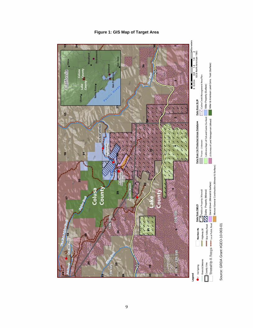
Figure 1: GIS Map of Target Area
Sou
rce:
GR
DA
Gra
nt #
GE
O-1
0-00
3-01
9

2.2 Geologic Mapping and Geological and Geochemical Work Plan The project team developed a work plan to direct the field activities needed to characterize: a) sub-surface conditions, b) geologic structure, and c) potential geothermal reservoir boundaries. The work plan had specific requirements for avoiding any known mining waste in the study area, and directed the field team to document any previously unknown mining waste or features discovered during field work.
The draft Geological and Geochemical Work Plan was submitted to the Energy Commission and the Central Valley Regional Water Quality Control Board (Central Valley Water Board) for review and comment. The Energy Commission provided comments and a final work plan was produced. The Central Valley Water Board wrote a letter to Renovitas indicating it expected no adverse impact to water quality as a result of work plan execution.
The work plan included the following activities:
• Compiling public geologic and geochemical data, including past drilling results from Magma Power Company, Sunoco Energy Development Company, and Cordero Mining Company
• Reviewing past geochemical surveys conducted by the United States Geological Survey (USGS) and others
• Geochemical water sampling of the hot, warm and cold springs in the target area to characterize the contribution of meteoric water to the geothermal system
• Geologic mapping and structural studies aimed at improving existing maps
• Maintaining a 100-foot buffer area zone around known mining features and wastes during field sampling activities
(See Appendix A for the complete Geological and Geochemical Work Plan.)
The major problems encountered during the development of this work plan were property access permissions and avoiding mining features and mining waste areas. SMUD signed an agreement to the Trebilcot mineral rights with Geonomics, Inc., but the surface rights still belong to the Bureau of Land Management (BLM).
The project team held multiple discussions with the Central Valley Water Board on the proposed work plan to ensure that mine wastes areas were not disturbed by project field activities. For reference, Table 2 summarizes public lands to which the team gained access, and private party lands that were not accessed by the team.
10

Table 2: Wilbur Hot Springs Area Properties and Access
Property Party Granting Access Status at time of work plan approval
Public Land BLM* BLM Granted
CDFG** CDFG No permit required for geologic
evaluation; geochemical sampling prohibited.
Colusa County not applicable No Permit Required Lake County not applicable No Permit Required
Private Land Abbott and Turkey Run
Mines Unknown land trust Will not be accessed
Wide Awake Mine (central) Merced General Construction, Inc.
Will not be accessed
Wide Awake Mine (peripheral) David Brown
Will not be accessed
Bailey Minerals Dr. Richard Miller Will not be accessed
Wilbur Hot Springs Dr. Richard Miller Will not be accessed
*BLM = United States Bureau of Land Management **CDFG = California Department of Fish and Game
Source: GRDA Grant #GEO-10-003-01
GeothermEx reviewed and evaluated publicly available data related to the lithological setting in the Wilbur Hot Springs area and then developed a geologic GIS map layer of the project area. This information was used to better understand lithologic contacts and the behavior of surface thermal water outflows and subsurface formations that have been interpreted to control the migration of geothermal fluid.
GeothermEx performed the geologic GIS map layer work and historical data analysis review prior to conducting field work. The actual field work was conducted between August 21 and August 24, 2012, utilizing the approved work plan.
2.3 Geologic and Geochemical Evaluation of Geothermal Resources for Geothermal Power Development The Geological and Geochemical Evaluation (See Appendix B for the complete Geologic and Geochemical Evaluation) presents the results of the focused literature searches and the field work that followed the approved Geological and Geochemical Work Plan. The analysis of the historical data in this report found that the geology of the region had yet to be fully understood. Information reviewed as part of the literature search included:
11
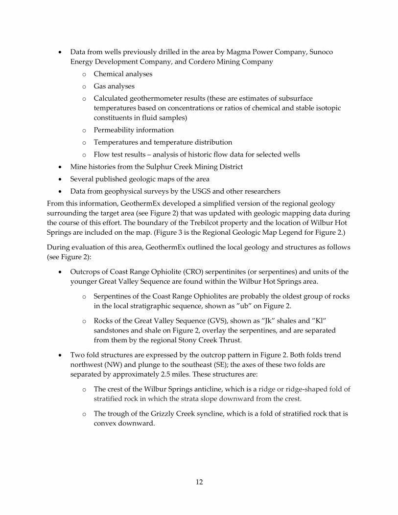
• Data from wells previously drilled in the area by Magma Power Company, Sunoco Energy Development Company, and Cordero Mining Company
o Chemical analyses
o Gas analyses
o Calculated geothermometer results (these are estimates of subsurface temperatures based on concentrations or ratios of chemical and stable isotopic constituents in fluid samples)
o Permeability information
o Temperatures and temperature distribution
o Flow test results – analysis of historic flow data for selected wells
• Mine histories from the Sulphur Creek Mining District
• Several published geologic maps of the area
• Data from geophysical surveys by the USGS and other researchers
From this information, GeothermEx developed a simplified version of the regional geology surrounding the target area (see Figure 2) that was updated with geologic mapping data during the course of this effort. The boundary of the Trebilcot property and the location of Wilbur Hot Springs are included on the map. (Figure 3 is the Regional Geologic Map Legend for Figure 2.)
During evaluation of this area, GeothermEx outlined the local geology and structures as follows (see Figure 2):
• Outcrops of Coast Range Ophiolite (CRO) serpentinites (or serpentines) and units of the younger Great Valley Sequence are found within the Wilbur Hot Springs area.
o Serpentines of the Coast Range Ophiolites are probably the oldest group of rocks in the local stratigraphic sequence, shown as ”ub” on Figure 2.
o Rocks of the Great Valley Sequence (GVS), shown as ”Jk” shales and ”Kl” sandstones and shale on Figure 2, overlay the serpentines, and are separated from them by the regional Stony Creek Thrust.
• Two fold structures are expressed by the outcrop pattern in Figure 2. Both folds trend northwest (NW) and plunge to the southeast (SE); the axes of these two folds are separated by approximately 2.5 miles. These structures are:
o The crest of the Wilbur Springs anticline, which is a ridge or ridge-shaped fold of stratified rock in which the strata slope downward from the crest.
o The trough of the Grizzly Creek syncline, which is a fold of stratified rock that is convex downward.
12

Figure 2: Regional Geologic Map
Sou
rce:
GR
DA
Gra
nt #
GE
O-1
0-00
3-01
13
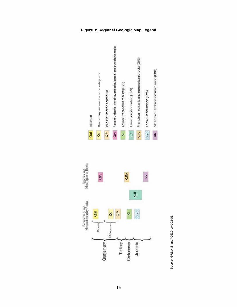
Figure 3: Regional Geologic Map Legend
Sou
rce:
GR
DA
Gra
nt #
GE
O-1
0-00
3-01
14
For the geochemical water sampling, the field team selected two locations, both on BLM land. No sampling was conducted on either private or California Department of Fish and Game land as permission for sample collection was not available at the time of fieldwork efforts. Sample 1 was collected from a spring that emanated from a fault SW of the Wide Awake Mine and Sample 2 was taken at the Abbott Hot Springs. The geochemical results from Abbott Hot Springs sample, coupled with the historical data, indicate that there is a substantial thermal source in the project area.
Initial Conceptual Model of the Geothermal System
Historic information on the site and the data collected were compiled, and an initial conceptual model of the Wilbur Hot Springs area was presented in the evaluation report. Key results and interpretations provided in the report include:
• The main obstacle to producing a well-substantiated geologic map of the region is the fact that the region is underlain by a stratigraphic section of very similar sedimentary rocks that is tens of thousands of feet thick and yet contains few marker horizons.
• The most probable fluid flow path is migration up- dip (upward along bedding planes at an angle greater than horizontal) in permeable strata located on the west flank of the Wilbur Springs anticline.
• Geothermometry data indicate that geothermal fluid temperatures approaching 170° C at economically drillable depths are possible for this resource.
These results comprise the initial conceptual model of the resource, based on all available data at the time the report was compiled. The geologic component of this model was further tested and updated through the subsequent geophysical evaluation.
2.4 Geophysical Work Plan The mapping and sampling data collected in the field by GeothermEx were analyzed and used to determine the next steps for exploration, including the determination that geophysical surveys would be useful to investigate geologic and geothermal subsurface conditions and aid future exploration activities.
GeothermEx developed a geophysical work plan to lay out the steps that would be taken in the field to set up and run the geophysical surveys, which included the use of magnetotelluric (MT) resistivity and gravity geophysical methods. MT resistivity survey equipment measures how different rocks and formations conduct or resist electrical currents. This is known as electrical resistivity and is a function of rock porosity. The gravity survey uses the earth’s gravitational field and the mass of the earth to measure changes in the gravity field that occur due to variations in subsurface materials. For geophysical evaluations, low‐gravity values in geothermal systems may indicate rock that has experienced hydrothermal alteration (that is, rock altered by contact with hot fluids) at depth. High‐gravity values may indicate limited hydrothermal alteration, and therefore a limited hydrothermal reservoir.
15
This work plan also included details on the logistical approach to conducting the geophysical survey work, including issues related to mining waste, how the site would be accessed and access limitations, and methods of geophysical probe placement and retrieval. The work plan also documented what steps would be followed to avoid known mining wastes and to document previously unknown mining waste or features. (See Appendix C for the full Geophysical Work Plan.)
The draft Geophysical Work Plan was submitted to the Energy Commission, the BLM, the California Department of Fish and Game and the Central Valley Water Board for review and comment. The Energy Commission provided comments and a final work plan was produced. The Central Valley Water Board sent an email to Renovitas indicating it expected no adverse impact to water quality as a result of work plan execution. The BLM required GeothermEx to post a bond for the exploration activity and imposed additional requirements during field work to minimize impact due to rainy weather. The California Department of Fish and Game required reporting all findings to the Department, giving consideration to other users, and notifying the Department of field work start and end dates. GeothermEx and the geophysical survey service company accommodated all of these requests.
2.5 Gravity and Electrical Methods Geophysical Surveys Report GeothermEx contracted with Western Geco, a geophysical survey service company, to conduct the MT resistivity and gravity surveys with oversight from GeothermEx. Western Geco conducted field work according to the approved geophysical work plan from November 22 to December 13, 2012. Field work activities included:
• Logistical reconnaissance to evaluate access to the project area and prepare for conducting the geophysical survey.
• MT resistivity survey equipment installation and data collection.
• Differential global positioning system (dGPS) and gravity survey equipment installation and data collection.
Western Geco installed 75 co-located MT resistivity and dGPS stations for data collection on BLM and California Department of Fish and Game land. The field team collected measurements at the rate of 5 to 8 stations per day.
For both the MT resistivity and dGPS surveys, the survey area was covered by an irregular survey grid on a spacing of 500 meters (m) (as shown in Figure 4). GPS units were carried by field personnel to determine the precise location of each surveying station. The dGPS survey crew independently confirmed all survey station locations.
16
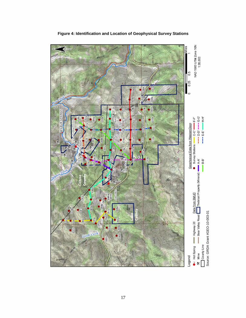
Figure 4: Identification and Location of Geophysical Survey Stations
Sou
rce:
GR
DA
Gra
nt #
GE
O-1
0-00
3-01
17

Because of limited access, the field personnel were required to walk from the access road to the survey station locations with the necessary surveying equipment. Field personnel laid out the surveying equipment at each determined location, taking care to minimize the volume of soil disturbed when setting the survey equipment temporarily in place at each station. Any disturbed soil was replaced after the survey equipment was removed.
Field measurement analysis by GeothermEx and Western Geco determined that the low-resistivity and low-gravity data correlated within the northeast (NE) portion of the study area with the nearby location of hot spring outflows at Wilbur Hot Springs. These low resistivity data were collected just south (S) to southwest (SW) of the springs, in the down-dip direction of thermal outflows. These observations and measurements were then used to update the conceptual geologic model of the geothermal system of the study area.
Updated Geologic Model of the Geothermal System
Developing an acceptable geologic model of the project area for further exploration requires identifying the most probable thermal fluid flow path and distribution of subsurface temperature. Based on the resistivity and gravity data, the information collected from the geologic mapping and geochemical analyses, and historic drilling data, the following scenario appears the most plausible:
• Thermal fluid migrates up-dip in permeable rock strata located on the west flank of the Wilbur Springs anticline.
MT resistivity and gravity data appear to support this scenario. Noteworthy elements of the updated geologic model are as follows:
• MT resistivity data show a zone of low-resistivity extending from 250 meters below ground surface (m bgs) in the vicinity of survey point WS003a (Figure 3) to greater depths in the SW (down-dip) direction.
• Low-gravity anomalies are noted to correlate to areas of low-resistivity, with anomalies noted S and SW of Wilbur Hot Springs and in the southern portion of the study area.
MT resistivity data collected for this investigation were used to extend the A – A’ cross-section (see Purple Line on Figure 4). This cross-section depicts the current understanding of subsurface conditions along a line which now extends from SW at the surface location of the geophysical survey point WS011a to NE through Blank Spring, the Bailey #1, Cordero, and Magma explorations wells, and Elbow Spring.
The A – A’ cross-section in Figure 5 has been designed to display the site-specific features most representative of subsurface conditions in the NE section of the Trebilcot property. Currently, this is the only region of the study area with available subsurface data from drilling. From this cross-section and the current geologic model, the following observations can be made:
• A fault exists to the NW of cross section A-A’. Sandstones, siltstones and basalts of the Great Valley Sequence were penetrated by the Bailey #1, Cordero, and Magma wells.
18
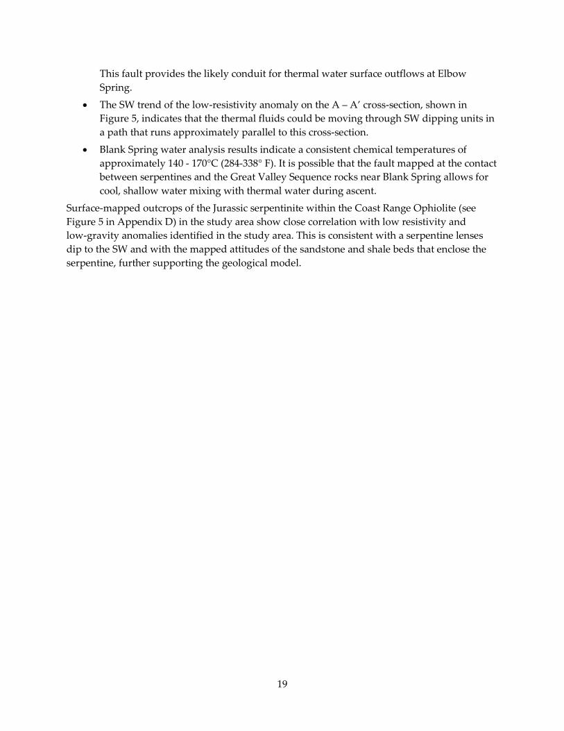
This fault provides the likely conduit for thermal water surface outflows at Elbow Spring.
• The SW trend of the low-resistivity anomaly on the A – A’ cross-section, shown in Figure 5, indicates that the thermal fluids could be moving through SW dipping units in a path that runs approximately parallel to this cross-section.
• Blank Spring water analysis results indicate a consistent chemical temperatures of approximately 140 - 170°C (284-338° F). It is possible that the fault mapped at the contact between serpentines and the Great Valley Sequence rocks near Blank Spring allows for cool, shallow water mixing with thermal water during ascent.
Surface-mapped outcrops of the Jurassic serpentinite within the Coast Range Ophiolite (see Figure 5 in Appendix D) in the study area show close correlation with low resistivity and low-gravity anomalies identified in the study area. This is consistent with a serpentine lenses dip to the SW and with the mapped attitudes of the sandstone and shale beds that enclose the serpentine, further supporting the geological model.
19
Figure 5: Geologic, Geophysical and Temperature Cross-Section A-A’
Sou
rce:
GR
DA
Gra
nt #
GE
O-1
0-00
3-01
20
The key to future geothermal exploration and development in the Wilbur Hot Springs area will be to drill to the proper depth to intercept possible fluid-bearing horizons. The proposed geologic model of up-dip flow in stratigraphic horizons from the SW, illustrated on cross-section A – A’ of Figure 5, was used to develop the strategy for continued exploration of the project area.
Temperature-gradient well drilling would be a common “next step” in many geothermal exploration programs at a similar stage. However, temperature gradient wells would not provide the information required to further evaluate this resource due to the depth of the resource and potential variability in the thermal conductivities of rocks above the resource that would hamper extrapolation of shallow temperatures to depth. Also, most of the project area falls under the Cache Creek Consolidated Management Plan and/or the Ukiah Resource Management Plan. Both plans prohibit temperature gradient well drilling but may allow production slim-hole well drilling. Therefore, it is recommended that any future work proceed to deeper exploratory wells in the form of slim-hole production wells. Details of the proposed future exploration drilling program are in the Exploration Drilling Work Plan (Appendix E ).
A proposed step before staging any exploration drilling would be to fly an aeromagnetic survey over the study area. This geophysical survey method could be used to confirm the attitude of beds dipping W – SW from the Wilbur Springs anticline, thus helping to better identify prospective drilling targets.
See Appendix D for the complete Gravity and Electrical Methods Geophysical Surveys Report.
2.6 Exploration Drilling Work Plan Finally, GeothermEx developed an Exploration Drilling Work Plan for use in future planning and exploration in the targeted Trebilcot lands. The original statement of work and schedule of products for this project included the preparation of a temperature-gradient well drilling work plan, but GeothermEx and the project team have determined that temperature-gradient drilling would not be a suitable next-step for exploration. Instead, the work plan developed for this activity is for production slim-hole wells.
The work plan provides details on the pre-drilling and drilling activities necessary to install up to four slim-hole production wells. The work plan, when executed, would need to be conducted without disturbing mining wastes that are known to be present in the area. The recommended exploration well drilling is a future activity that is not funded by the Energy Commission under this grant.
The recommended drilling locations are shown in Figure 6 along with a plan view of section A-A‘ (shown as purple section view line). See Appendix E for the full Exploration Drilling Work Plan.
21

Figure 6: Aerial View with Section 'A' (purple dashed line)
Sou
rce:
GR
DA
Gra
nt #
GE
O-1
0-00
3-01
22
CHAPTER 3: Conclusions and Recommendations: 3.1 Conclusions of Completed Investigations in the Project Area During the term of this grant project, the project team collected and assessed geologic, geochemical, geophysical, and historic drilling data (presented in Appendices B and D) in order to prepare a conceptual model of the geothermal resource in project area. The project team also evaluated logistical issues and access rights in the project area.
Evaluation of temperature data from previous drilling activities plus the analysis of geochemical data from hot springs within the project area indicates that adequate geothermal temperatures may exist in the area for modern binary-type geothermal power generation.
Geophysical fieldwork (in the form of gravity and electrical resistivity measurements) supplied data necessary to refine the geologic model of the Wilbur Hot Springs area. Interpreted geophysical data from the northern section of the Trebilcot property showed consistency with the SW dip of geologic units, and subsurface resistivity anomalies that were detected may indicate hydrothermal alteration.
The project team developed an updated geologic model for the area that includes the following interpretations:
• A fault in the northwest section of the Trebilcot property that was penetrated by the Cordero, and Magma wells, likely provides the conduit for thermal fluid surface outflows at Elbow Spring.
• The resistivity data indicate that the thermal fluids could be moving approximately parallel to a cross-section going through the three test wells and Elbow and Blank Springs.
• Surface-mapped rock outcrops in the study area show close correlation with low resistivity and low-gravity anomalies in the northeast section of Trebilcot property.
• Blank Spring sampling results indicate consistent chemical temperatures of approximately 140 - 170° C (284 - 338° F)
The results from this project indicate that there may be temperatures sufficient for a binary geothermal power plant in or near the project area. However, a major unresolved issue is whether sufficient permeability is present to provide economic quantities of geothermal fluid necessary for a power plant at the selected well locations and target depths. Establishing the level of permeability will require exploration and production well drilling. Data from future drilling efforts should be used to further refine the geothermal resource model.
Because of mining waste and the fact that some of the project area is located in the Cache Creek Consolidated Management Plan and/or the Ukiah Resource Management Plan districts, many restrictions would likely be placed on further exploration. The suggested plan for further
23
exploration activities and exploration drilling is presented in Appendix E. These future activities are beyond the scope of this GRDA grant project.
3.2 Recommendations for Future Investigations • Conduct Outreach to Surrounding Community and Identified Stakeholders
• Prepare and Submit CEQA Documents
• Obtain Required Permits
• Attempt to Expand Access Rights to Private Lands
• Perform Deep Exploratory and Production Well Drilling
• Conduct Feasibility Assessment for Power Development
24