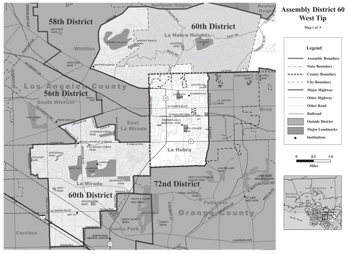
Assembly District 60 58th District West Tip 60th District...
6
NEFF H.S. WHITTIER HOSPITAL LA MIRADA H.S. MONTE VISTA H.S. MEDICAL CENTER OF LA MIRADA LA HABRA H.S. ST JUDE MED CNTR BUENA PARK MEDICAL CENTER FRIENDLY HILLS REGIONAL HOSP. LOMA VISTA MEMORIAL PARK LOS COYOTES CC BIG TEE GC BIOLA UNIV FRIENDLY HILLS CC CANDLEWOOD CC HACIENDA GC PARNELL PARK LA MIRADA PARK BEHRINGER PARK LA MIRADA CREEK PARK MURPHY RANCH PARK MICHIGAN PARK NEFF PARK HACIENDA PARK GARDENHILL PARK WINDERMERE PARK FRONTIER PARK LA MIRADA CREEK PARK ANACONDA PARK RALPH B CLARK REG PARK LAGUNA LAKE PARK LA BONITA PARK WEST COYOTE HILLS NATURE PARK ESTELL PARK VISTA GRANDE PARK VIRGIL GRISSOM PARK LOMA NORTE PARK EMERY PARK EL CENTRO PARK SMITH MURPHY PARK GUADALUPE PARK SAN MIGUEL PARK Fullerton Whittier La Habra Orange County Los Angeles County La Mirada La Habra Heights South Whittier Brea Buena Park Cerritos East La Mirada Hacienda Heights Rowland Heights Colima Rd Stamy Rd La Serna Colima Rd S Euclid St Valley View Ave Imperial Hwy Leffingwell Rd N Euclid St Artesia Blvd Valley Home Ave E Imperial Hwy Lemon Dr Marquardt Ave Telegraph Rd Ocaso Ave Desman Rd Knott Ave Stanton Ave Fullerton Rd Alondra Blvd Ashgrove Dr Santa Gertrudes Ave Wicker Dr S Hacienda Blvd 60th District 72nd District 56th District 58th District MIRADA BLVD EAST RD WEST RD ALONDRA BLVD MULBERRY DR TELEGRAPH RD N GILBERT ST W HABRA BLVD BREA BLVD PAINTER AVE W VALENCIA MESA DR GREENLEAF AVE CHAPMAN AVE SCRIBNER RD 60th District E BA ST A NCHU RY RD H A R B O R B L V D Los Angeles County Ventura County Paci fi c O c e a n Assembly District 60 West Tip Map 1 of 5 36 37 59 41 38 71 54 63 61 67 53 44 72 42 55 40 56 68 60 58 57 49 39 51 47 50 69 52 46 45 48 43 0 1.0 0.5 Miles Mapped Area Legend Assembly Boundary State Boundary County Boundary City Boundary Major Highway Other Highway Other Road Railroad Outside District Major Landmarks Institutions 39 39 90 5
Transcript of Assembly District 60 58th District West Tip 60th District...
NEFF H.S.
WHITTIER HOSPITAL
LA MIRADAH.S.
MONTE VISTA H.S.
MEDICAL CENTER OF LA MIRADA
LA HABRA H.S.
ST JUDEMED CNTR
BUENA PARK MEDICAL CENTER
FRIENDLY HILLS REGIONAL HOSP.
LOMA VISTA MEMORIAL PARK
LOS COYOTES CCBIG TEEGC
BIOLA UNIV
FRIENDLY HILLS CC
CANDLEWOODCC
HACIENDAGC
PARNELLPARK
LA MIRADA PARK
BEHRINGER PARK
LA MIRADA CREEKPARK
MURPHY RANCH PARK
MICHIGANPARK
NEFFPARK
HACIENDAPARK
GARDENHILLPARK
WINDERMEREPARK
FRONTIER PARK
LA MIRADA CREEKPARK
ANACONDAPARK
RALPH B CLARKREG PARK
LAGUNA LAKEPARK
LA BONITA PARK
WEST COYOTE HILLSNATURE PARK
ESTELLPARK
VISTA GRANDE PARK
VIRGIL GRISSOM PARK
LOMA NORTE PARK
EMERYPARK
EL CENTRO PARK
SMITH MURPHYPARK
GUADALUPE PARK
SAN MIGUELPARK
Fullerton
Whittier
La Habra
O r a n g e C o u n t y
L o s A n g e l e s C o u n t y
La Mirada
La Habra Heights
South WhittierBrea
Buena ParkCerritos
East La Mirada
Hacienda Heights RowlandHeights
Colima Rd
Stam
y Rd
La Serna
Colima Rd
S Euclid S
t
Valley V
iew Ave
Imperial Hwy
Leffingwel
l Rd
N Euclid S
t
Artesia Blvd
Valley H
ome Ave
E Imperial Hwy
Lemon Dr
Marquardt A
ve
Telegraph Rd
Ocaso A
ve
Desman Rd
Knott A
ve
Stanton A
ve
Fullerton Rd
Alondra Blvd
Ashgrove Dr
Santa G
ertrudes Ave
Wicker Dr
S Hacienda Blvd
60th District
72nd District
56th District
58th District
MIRADA BLVD
EAST RD
WEST RD
ALONDRA BLVD
MULBERRY DR
TELEGRAPH RD
N GILBERT ST
W HABRA BLVD
BREA BLVD
PAINTER AVE
W VALENCIA MESA DR
GREENLEAF AVE
CHAPMAN AVE
SCRIBNER RD
60th DistrictEBASTANCHURY R
D
HARB
ORBLVD
L o s A n g e l e sC o u n t y
VenturaCounty
Pacific Ocean
Assembly District 60West Tip
Map 1 of 5
36
37
59
41
38
71
54
63
61
67
53
44
72
42
55
40
56
68
6058
5749
39
51
47
50
69
52
4645
48
43
0 1.00.5
Miles
MappedArea
Legend
Assembly Boundary
State Boundary
County Boundary
City Boundary
Major Highway
Other Highway
Other Road
Railroad
Outside District
Major Landmarks
Institutions
39
39
90
5
SIERRA VIST VISTA SCHOOL SCHOOL
ROWLAND H.S.
SCHABARUM PARK
CREEKSIDEPARK SUZANNE
PARK
ROWLAND HTSPARK
THOMAS BURTONPARK
SHADOW OAKPARK
GINGRICHPARK
HACIENDAPARK
SUNSHINEPARK FRIENDSHIP
PARK
BILL BLEVINSPARK
CAROLYN ROSASPARK
REAGANPARK
GLORIA HEERPARK
BABE ZAHARIAS GC
HACIENDA GC
LOS ANGELESROYAL VISTA GC
60th District
58th District
57th District
Industry
Rowland Heights
Walnut
La Habra Heights
Brea
Hacienda Heights
West Covina
La Puente
Industry
Diamond Bar
South San Jose Hills
Valinda
La Serna
Fullerton Rd
Calle Baja
Amar Rd
Arcdale Ave
Nacora St
Walnut Dr
Camino B
elloFairw
ay Dr
Pepperdale Dr
Blue Haven Dr
N Euclid St
Amandr Cir
Camino de Teodoro
Batson Ave Pilario St
PUENTE RD
GALE AVE
EAST RD
PATHFINDER RD
AMAR RD
N LEMON AVE
BREA CANYON RD
BREA CANYON CUTOFF RD
N HARBOR BLVD
N STIM
SON AVE
WEST RD
L o s A n g e l e sC o u n t y
VenturaCounty
Pacific Ocean
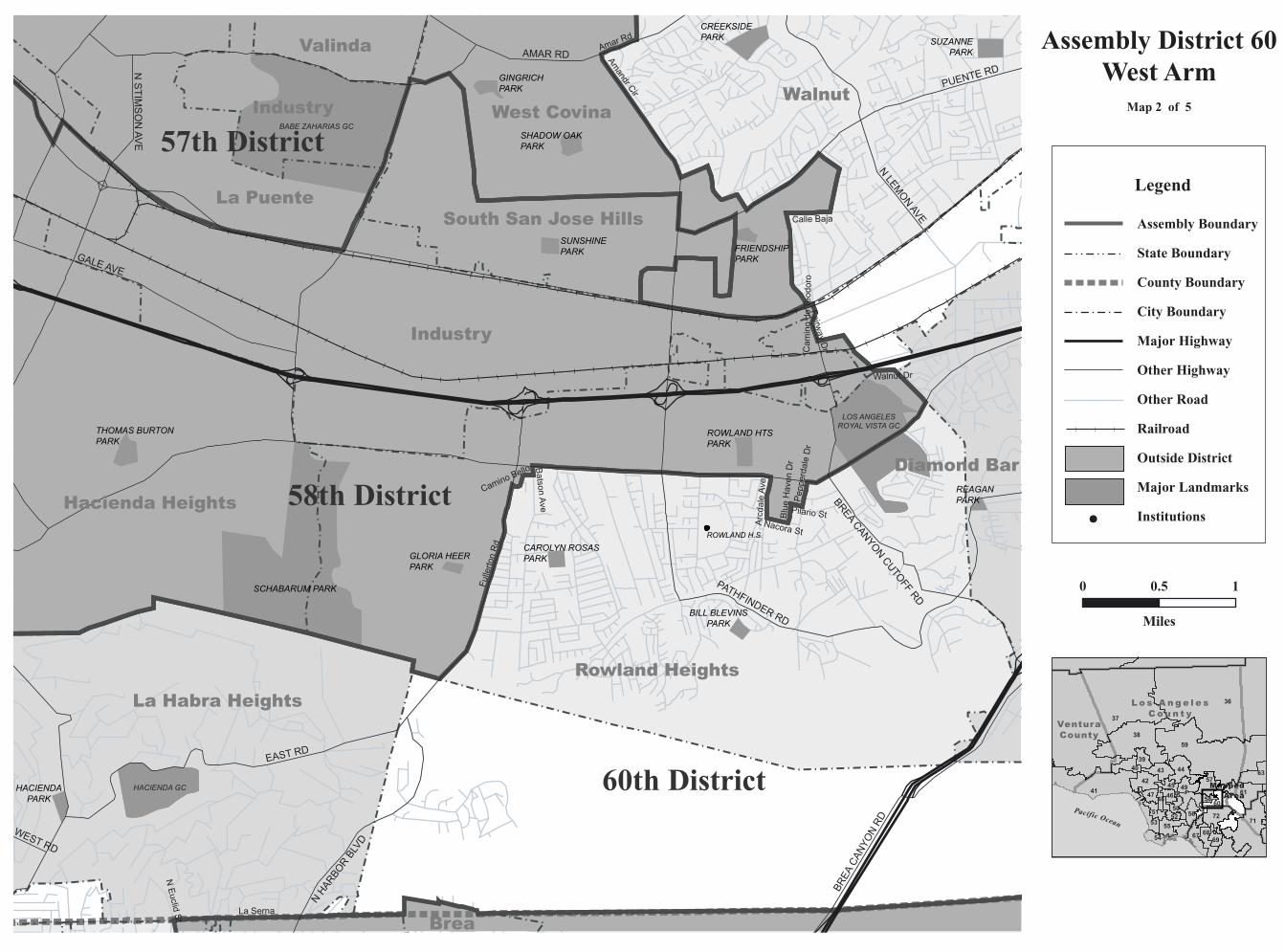
Assembly District 60West Arm
Map 2 of 5
MappedArea
36
37
59
41
38
71
54
63
61
67
53
44
72
42
55
40
56
68
6058
5749
39
51
47
50
69
52
4645
48
43
0 0.5 1
Miles
Legend
Assembly Boundary
State Boundary
County Boundary
City Boundary
Major Highway
Other Highway
Other Road
Railroad
Outside District
Major Landmarks
Institutions

West Covina
Covina
FOREST LAWN MEMORIAL PARK
FRANK G BONELLIREGIONAL PARK
CREEKSIDEPARK
GALSTERWILDERNESSPARK
FRIENDSHIPPARK
KELLOGGPARK
CSUPOMONA
DIAMOND BARGC
VIA VERDE CC
SOUTH HILLS CC
PACIFIC COASTBIBLE COLLEGE
DEVRY INSTOF TECH
West Covina
Industry
Industry
Walnut
San Dimas
Covina
Diamond Bar
Pomona
Rowland Heights
Valinda
South San Jose Hills
60
60
60
57
57
71
10
10
39210
Puente St
Eucalyptus Ln
Calle Baja
Amar Rd
La Pue
nte Rd
Via Verde St
E Lorencita Dr
University Dr
E Cameron Ave
S Monte Verde St
E Holt Av
e
S Chaparro Rd
E Covina Hills R
d
PUENTE RD
E CAMERON AVE
N LEMON AVE
POMONA BLVD
S DIAMOND BAR BLVD
E MERCED AVE
N VINCENT AVE
COVINA HILLS RD
E PUENTE AVE
HEIDELBERG A
VE
GRAND AVE
N CITR
US ST
E RAGING W
ATERS DR
BREA CANYON RD
57th District
60th District
58th District
61stDistrict
36
37
59
41
38
71
54
63
61
67
53
44
72
42
55
40
56
68
60585749
39
51
47
50
69
52
4645
48
43
L o s A n g e l e sC o u n t y
VenturaCounty
Pacific Ocean
0 0.5 1
Miles
Assembly District 60Northwest Part
Map 3 of 5
MappedArea
Legend
Assembly Boundary
State Boundary
County Boundary
City Boundary
Major Highway
Other Highway
Other Road
Railroad
Outside District
Major Landmarks
Institutions

VALENDAH.S.
PLACENTIA-LINDA HOSP
CHINOAIRPORT
60th District
61st District
72nd District
71stDistrict
CHINO AVE
EUCLID
AVE
EDISON AVE
STATE HWY 90
RIVERSIDE DR
PEYTON DR
SCHAEFER AVE
CENTRAL AVE
RAMONA AVE
PHILADELPHIA ST
PRADO RD
E END AVE
S DIAMOND BAR BLVD
PINE AVE
FAIRMONT BLVD
MOUNTAIN
AVE
PUENTE RD
BON VIEW
AVE
PATHFINDER RDKELLOGG DR
STATE HWY 57
ESPERANZA RD
LAKEVIEW AVE
BIRCH ST
CAMINO BR
YANT
S GAREY AVE
RICHFIELD
RD
SOQUEL CANYON RD
N ROSE D
RE CHAPMAN AVE
LAMBERT RD
RIO RANCHO RD
MERRILL AVE
WOODVIEW RD
KODIAK MT DR
COLIMA RD S GRAND AVE
SOQUEL CANYON PKW
Y
PIPE LINE AVE
TOWNE AVE
UM CANYON RD
BASTANCHURY RD
E VALLEY BLVD
PHILLIPS R
ANCH RD
RESERVOIR AVE
ALTA VISTAGC
YORBALINDAGC
IMPERIALGC
GREEN RIVER GC
COUNTRY CLUBVISTA PARK
DIAMONDBAR GC
LOS ANGELESROYAL VISTA GC
GREENRIVERGC
EL PRADOGC
LOS SERRANOSCC
WESTERNHILLS CC
GREEN RIVER GC
CALIFORNIA INSTITUTE
FOR MEN CHINO
CALIFORNIAINSTITUTEFOR WOMEN
Chino
Yorba Linda
Chino Hills
Diamond Bar
L o s A n g e l e sC o u n t y
S a n B e r n a r d i n oC o u n t y
R i v e r s i d eC o u n t y
O r a n g e C o u n t yBrea
Pomona
Placentia
Walnut
Industry
Anaheim
Ontario
Los Serranos
Corona
RowlandHeights
CH I NO H I L L S S TAT E PARK
PRADO
REG PARK
RUBEN S AYALAPARK
CHINOHILLSPARK
MONTA VISTAPARK
COUNTRYPARK
SYCAMORECANYONPARK
SUZANNEPARK
CARLTONPETERSONPARK
MLK JRPARK
SUMMITRIDGE PARK
SNOWCREEKPARK
REAGANPARK
COUNTRYCROSSINGPARK
PHILADELPHIAPARK
PHILLIPSRANCHPARK
PAUL C GROWPARK
YORBAREG PARK
CARBONCANYONREG PARK
YORBA LINDALAKEBED PARK
TRI CITY PARK
TRAVISRANCHYOUTHPARK
VISTADEL RANCHO
PARK
WAGNER PARK
RIODEL OROPARK
VALLEY VIEWSPORTS PARK
HURLESSBARTON PARK
JESSAMYNWESTPARK
BUENA VISTAPARK
SHARPELLPARK
SANANTONIOPARK
FAIRMONTKNOLLSPARK
LOS VAQUEROSPARK
RICHARD SAMP PARK
LASPALOMASPARK
DOMINGUEZTRAILSIDEPARK
JEAN WOODARDPARK
NIXONPARK
RICHARDSAMPPARK
ARROYOPARK
BRADFORD PARK
GOLDEN RODPARK
CHINO HILLS STATE PARK
57
57
60
60
60
71
71
83
83
90
142
142
91
Chino Creek
State Highway 91
Village Center D
r
Yorba Linda Blvd
Mills Ave
Colima Rd
Pine Ave
Fairlynn Blvd
Amberdale Dr
Chino Hills Pky
S Weir
Canyon
Rd
Rim Rd
Canyon Dr
U. P. RR
Valley Blvd
Avenue Rancheros
Pipeline Ave
Walnut DrEucalyptus Ave
Condor Ridge Rd
So. Pacific RR
Rim Trl
36
37
59
41
38
71
54
63
61
67
53
44
72
42
55
40
56
68
6058
5749
39
51
47
50
69
52
4645
48
43
L o s A n g e l e sC o u n t y
VenturaCounty
Pacific Ocean
0 0.5 1 2
Miles
Assembly District 60East Part
Map 4 of 5
MappedArea
Legend
Assembly Boundary
State Boundary
County Boundary
City Boundary
Major Highway
Other Highway
Other Road
Railroad
Outside District
Major Landmarks
Institutions
Villa Park
VALENDAH.S.
VILLA PARKHIGH SCHOOL
CHAPMAN HOSP
KAISER HOSPITAL
PLACENTIA-LINDA HOSP
CEMETERY OF THE HOLY SEPULCHRE
60th District
72nd District
71st District
69thDistrict
NOHL RANCH RD
N GLASSELL ST
LOMA ST
ESPERANZA R
D
KELLOGG DR
CANYON RIM RD
N HEW
ES ST
E SANTIAGO CANYON RD
BIRCH ST
VILLA PARK RDS SERRANO AVE
CAMINO BR
YANT
E TAFT AVE
W KATELLA AVE
CHAPMAN AVE
N ROSE D
R
WEIR
CANYON RD
S GYPSU
M CANYON RD
E YORBA LINDA BLVD
JAMBOREE RD
SANTIAGO CANYON RD
N SANTIAGO BLVD
BASTANCHURY RD
S ROSE D
R
W LINCOLN AVE
E WALNUT AVE
S IMPER
IAL HWY
PASEO
PALOMA
S
S MAIN
ST
PROSPEC
T ST
WANDA R
D
GLASSELL ST
N GRAVIER
ST
E ESPERANZA RD T
S NEW
PORT BLVD
ORANGETH
ORPE AVE
N RICHFIELD
RD
KODIAKMTDR
ALTA VISTAGC
IMPERIAL GC
ANAHEIM HILLSGC
YORBALINDAGC
RIDGELINECC
CHAPMAN UNIV
COUNTRY CLUBVISTA PARK
Orange
Anaheim
Yorba LindaO r a n g e C o u n t y
S a n B e r n a r d i n oC o u n t y
Placentia
BreaChinoHills
Villa Park
Fullerton
Fullerton
TustinFoothills
CHINO HILLS
STATE PARK
CH I NO H I L L S S TAT E PARK
IRVINE REG PARK
SANTIAGO OAKSREG PARKS
WEIRCANYON
PARK
YORBAREG PARK
CARBONCANYONREG PARK
YORBALINDA
LAKEBEDPARK
PETERSCANYONREG PARK
TRICITYPARK
OAK CANYONNATURE CENTER
EL CAMINOPARK
CANYON RIMPARKS
YORBAPARK
PELANCONIPARK
TRAVIS RANCHYOUTH PARK
EISENHOWERPARK
PERALTAPARK
VISTADEL RANCHO
PARK
MCFADDENPARK
IMPERIALPARK
SHAFFERPARK
RIO VISTAPARK
TOYONPARKS
KINGSBRIARPARK
WAGNERPARK
RIODEL OROPARK
VALLEY VIEWSPORTS PARK
HURLESSBARTONPARK
JESSAMYNWESTPARK
BUENAVISTAPARK SHARPELL
PARK
RIVERDALEPARK
SAN ANTONIOPARK
FAIRMONTKNOLLSPARK
LOS VAQUEROSPARK
KRAEMERMEM PARK
RICHARD SAMPPARK
LASPALOMASPARK
DOMINGUEZTRAILSIDEPARK
JEAN WOODARDPARK
TUFFREE HILLPARK
NIXONPARK
EUCALYPTUSPARK
RICHARDSAMPPARK
ARROYOPARK
BRADFORDPARK
GOLDEN RODPARK
55
57
91
90
91
241
261
90
142
91
Highw
ay 241
Village Center D
rYorba Linda Blvd
BN Santa Fe RR
Fairlynn
Blvd
N Orange Olive Rd
E Palm Ave
Richfield R
d
Amberdale Dr
Cambridge St
Collins Ave
Oak Canyon Dr
E Lincoln Ave
N Batavia St
Rio Vista St
Rim Rd
Canyon Dr
Esperanza Rd
E Miraloma Ave
Fletcher Ave
S Lakeview Ave
Condor Ridge Rd
E Lomita Ave
Fee Ana St
N Milford St
Oakmont Ave
N Linda Vista St
Jamboree R
d
N California St
N Clinton St
University DrWalnut Ave
E La Palma A
ve
E Locust Ave
Rim Trl
Fletcher St
S Imperial
Hwy
L o s A n g e l e sC o u n t y
VenturaCounty
Pacific Ocean
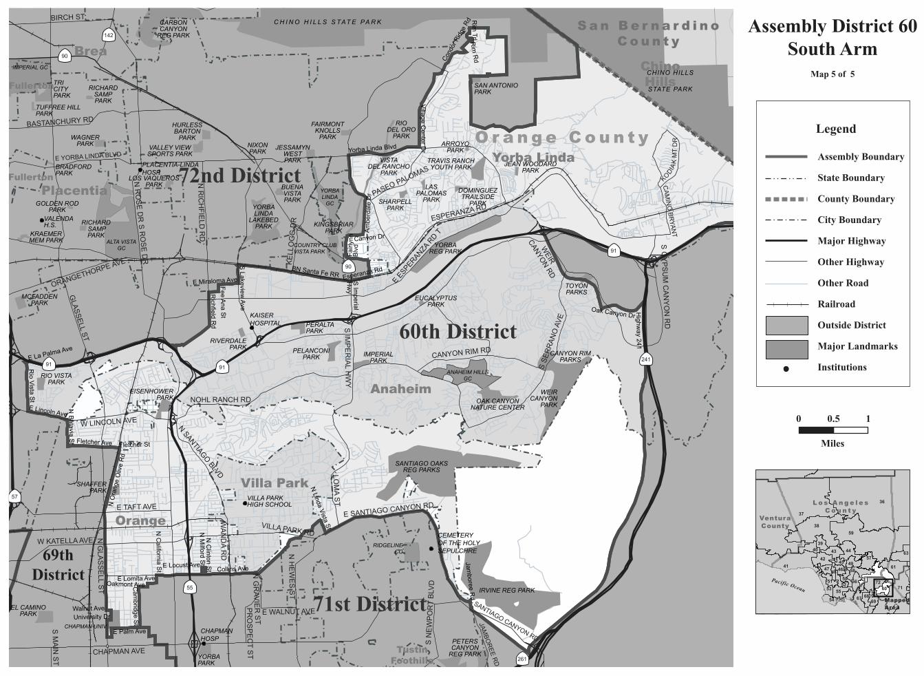
Assembly District 60South Arm
Map 5 of 5
36
37
59
41
38
71
54
63
61
67
53
44
72
42
55
40
56
6860
58
5749
39
51
47
50
69
52
4645
48
43
0 10.5
Miles
MappedArea
Legend
Assembly Boundary
State Boundary
County Boundary
City Boundary
Major Highway
Other Highway
Other Road
Railroad
Outside District
Major Landmarks
Institutions
C A L I F O R N I A A S S E M B LY D I S T R I C T S
Assembly Redistricting Plan (SB 802), September 13, 2001
The Honorable Robert M. Hertzberg, SpeakerState CapitolRoom 219Sacramento, CA 95814
The California State Assembly Rules CommitteeThe Honorable Dennis Cardoza, ChairP.O. Box 942849Sacramento, CA 94249-0001
The California State Assembly Committee on Elections, Reapportionment, and Constitutional AmendmentsThe Honorable John Longville, ChairP.O. Box 942849Sacramento, CA 94249-0001
Produced at California State University NorthridgeDr. Jolene Koester, President
Eugene Turner, Project DirectorDepartment of Geography18111 Nordhoff St.Northridge, CA 91330
with
Rubyjane Domingo, Pat Jolley, Meredith Leonard
2001
About the Maps
These maps present specific informationabout the features comprising the borders of theAssembly Districts of California that were cre-ated after the 2000 Census. Each of the 80 dis-tricts are represented by one to ten maps withthe number depending on the size of the districtand the complexity of the features followed bythe boundary. In general, the boundaries followcounty lines, city limit lines, and roads, butoccasionally canals, streams, and small roadsare followed.
The Assembly boundary data were creat-ed in digital form from Census 2000 TIGERfiles for California by Pactech Incorporated ofPasadena, CA. The boundary files were releasedin two forms, as a file of district polygons andas a file of line segments used to create thepolygons. Where these line segments were iden-tified, those identifiers were used to label themap boundaries. In addition, place boundarieswere created from the TIGER files.
Other map information such as roads,railroads, coastlines, and landmarks wereobtained from Geographic Data Technologies.Dynamap 2000 files (v10.1). Government landownership information such as national forestboundaries was obtained from a governmentland ownership layer prepared by the CaliforniaTeale Data Center.
Maps were prepared from the digitalfiles using Arcmap 8.1 software fromEnvironmental Systems Research Incorporated.An Albers equal area projection was used forthe maps with a central meridian of 120 degreeswest longitude and standard parallels of 30 and40 degrees of latitude. Coordinates are based onNAD83.
conneljw
About the Maps These maps present specific information about the features comprising the borders of the Assembly Districts of California that were created after the 2000 Census. Each of the 80 districts are represented by one to ten maps with the number depending on the size of the district and the complexity of the features followed by the boundary. In general, the boundaries follow county lines, city limit lines, and roads, but occasionally canals, streams, and small roads are followed. The Assembly boundary data were created in digital form from Census 2000 TIGER files for California by Pactech Incorporated of Pasadena, CA. The boundary files were released in two forms, as a file of district polygons and as a file of line segments used to create the polygons. Where these line segments were identified, those identifiers were used to label the map boundaries. In addition, place boundaries were created from the TIGER files. Other map information such as roads, railroads, coastlines, and landmarks were obtained from Geographic Data Technologies. Dynamap 2000 files (v10.1). Government land ownership information such as national forest boundaries was obtained from a government land ownership layer prepared by the California Teale Data Center. Maps were prepared from the digital files using Arcmap 8.1 software from Environmental Systems Research Incorporated. An Albers equal area projection was used for the maps with a central meridian of 120 degrees west longitude and standard parallels of 30 and 40 degrees of latitude. Coordinates are based on NAD83.