
Artshill House, Dinting Road, GLOSSOP, SK13 7EB
36
Artshill House, Dinting Road, GLOSSOP, SK13 7EB Prepared for: Mr A Cassidy Cassidy & Ashton Group Ltd 7 East Cliff Preston Lancashire PR1 3JE Report Reference: SAS_30482455_1_1 Report Date: 11-MAR-2010 Customer Reference: c2926 National Grid Reference: 401990 394800 Site Area: 6232 m² If you have any questions on the contents of this Report please contact Landmark Customer Helpdesk which is open from 9:00am - 5:30pm, Monday - Friday, via one of the following channels: Telephone: 0844 844 9966 Fax: 0844 844 9980 Email: [email protected] Website: www.sitecheck.co.uk In association with:
Transcript of Artshill House, Dinting Road, GLOSSOP, SK13 7EB

Artshill House, Dinting Road, GLOSSOP, SK13 7EB
Prepared for:Mr A CassidyCassidy & Ashton Group Ltd7 East CliffPrestonLancashirePR1 3JE Report Reference: SAS_30482455_1_1 Report Date: 11-MAR-2010 Customer Reference: c2926 National Grid Reference: 401990 394800
Site Area: 6232 m²
If you have any questions on the contents of this Report please contact Landmark Customer Helpdesk which is open from 9:00am - 5:30pm, Monday - Friday, via one of the following channels: Telephone: 0844 844 9966Fax: 0844 844 9980Email: [email protected]: www.sitecheck.co.uk
In association with:

PASSEDThe Sitecheck report dated 11-MAR-2010 and reference SAS_30482455_1_1 for Artshill House, Dinting Road,GLOSSOP, SK13 7EB has examined the sources of potential contamination in terms of historical land use,environmental data and current land uses where known.
INTRODUCTION
This professional opinion determines the level of environmental risk, as to whether a pollutant linkage exists which iscreated when there is a source of contamination, a pathway for it to travel along and receptors, which may be harmed.This risk-based approach underpins the governments approach to contaminated land. If a pollutant linkage exists theproperty may be regarded by the local authority as being "Contaminated Land" for the purposes of Part llA of theEnvironmental Protection Act 1990.
In completing this report Wilbourn Associates has undertaken a review of data made available to it. No site inspection,further enquiries or investigation of surface or ground conditions has been carried out by Wilbourn Associates. Noinformation as to the age, value and type of property has been made available. It is important to note that it is notknown by Wilbourn Associates for what purpose the report has been commissioned.
CONCLUSIONS
In the professional opinion of Wilbourn Associates the level of risk associated with the information disclosed in theassociated Sitecheck report:
1) is unlikely to have an adverse effect on the value of the property, and2) is not such that the property would be designated "Contaminated Land" within the meaning of Part llA of theEnvironmental Protection Act 1990.
OTHER ENVIRONMENTAL FACTORS In this case the following environmental factors have been identified which aclient may wish to be investigated before proceeding further:
An area of Mining InstabilityAn area which may be affected by coal mining activity
Please refer to the relevant section in the report for each of the above factors.
In association with:
Professional Opinion on environmental risk
Philip E. Wilbourn BSc C.Env FRICSChartered Environmental Surveyor

SOURCES OF ADDITIONAL PROFESSIONAL GUIDANCE:
If the report is for valuation, or investment, or other forms of lending decision making there may be issues arising fromthe current occupation, which need to be examined. The Royal Institution of Chartered Surveyors has providedguidance with respect to such matters and specific reference should be made to the guidance note 'Contamination andEnvironmental Matters - their implications for property professionals'. This guidance note is referred to in UKGN1.1paragraphs 9.1 and 9.2 of the RICS Appraisal and Valuation Standards (5th Edition) (The "Red Book").
It is recommended that the client reviews the outputs of any valuation report, which should include a PropertyObservation Checklist, contained at Appendix C for commercial property or Appendix D for rural property in the RoyalInstitution of Chartered Surveyors guidance note 'Contamination and Environmental Matters - their implications forproperty professionals'. Completion of these checklists does not constitute an environmental assessment for thepurposes of Professional Indemnity Insurance where many surveyors are unlikely to have appropriate indemnity cover.Any contamination, which is observed on the site by the surveyor during the normal course of their inspection, can alsobe recorded.
If the property is let, the landlord or the tenant (as appropriate) should take legal advice as to whether the covenants inthe lease constitute legal or financial burdens. The Law Society's "Environmental Law Handbook-5th Edition" providesvaluable assistance.
In leases with no express covenants dealing with environmental matters, lawyers and surveyors need to be aware ofthe extent to which the repairing of covenants can be applied and, when advising tenant clients in particular, will needto draw attention to the client's obligations to comply with enacted legislation.
Should contamination have been observed on site a suitably qualified, insured and experienced professional,preferably with the Specialist in Land Condition (SiLC) accreditation, should quantify whether this could give rise to anaction by a regulator or any other party. A suitable management plan for action incorporated in a Land QualityStatement in accordance with RICS guidance should be put in place and appropriate matters taken up with the tenant /occupier.
In terms of development this report should be seen as a precursor to a thorough investigation of the property forplanning control purposes. The DTI funded guidance published by the Construction Industry Research and InformationAssociation (CIRIA) Brownfields-managing the development of previously developed land-a clients guide may be auseful starting point.
This professional opinion forms part of the Sitecheck Assess report and is subject to Landmark Information Group's Terms and Conditions of Business inforce from time to time. Further information on the methodology and the datasets examined in this professional opinion is included in the Sitecheck AssessPractitioner Guide.
In association with:
Professional Opinion on environmental risk

Report Sections and Details Page
Summary of Site
Aerial Photo
Location Map
Summary Table
Current Land Use
Historical Land Use
Sensitivity
Other Factors
Useful Information
Useful Contacts
-
1
2
3
7
14
19
23
25
26
This section comprises source, pathway and receptor information found on site. Other factors which may affect thesite are also included.
The aerial photo gives an overall view of the area. The smaller large-scale Ordnance Survey map includes the siteboundary and search zone buffer at 250m.
The accurate large-scale Ordnance Survey map confirms the boundary of the subject site. The descriptive text mayidentify other features which could be of relevance but not reported. The smaller aerial photo includes the siteboundary.
This section comprises of a summary table of the information found on site and in its vicinity.
This section contains a map, which shows current land use features. The following pages detail these features andidentify the Reference Number and direction.
This section contains a map, which shows historical land use features. The following pages detail these features andidentify the Reference Number and direction. A table listing all the maps used to source this information is included.
This section contains a map, which shows pathway and receptor features. The following pages detail these featuresand identify the Reference Number and direction. This section also contains a separate Flood Map and flood details.
This section contains information on other factors which may affect the site and its vicinity.
This section contains information which may be of use when interpreting the report.
All textual information is linked by the 'Contact Ref' to this quick reference list of contacts. These contacts may beable to supply additional information or answer any subsequent query relating to that record.
Contents
rpr_sitecheck v27.1
If you would like any further assistance regarding this report then please contactLandmark on (Tel) 0844 844 9966, (Fax) 0844 844 9980, Email: [email protected]
Brought to you by Landmark

Sensitivity
Other Factors
Pathways
Geological
Groundwater Vulnerability
Drift Deposits
Coal Mining Affected Areas
Mining Instability
Radon Potential - Radon Affected Areas
Radon Potential - Radon Protection Measures
Potential for Landslide Ground Stability Hazards
Potential for Running Sand Ground Stability Hazards
Geological Classification: Minor Aquifer (Variably permeable) - These can be fractured or potentiallyfractured rocks, which do not have a high primary permeability, or other formations of variable permeabilityincluding unconsolidated deposits. Although not producing large quantities of water for abstraction, theyare important for local supplies and in supplying base flow to rivers, Soil Classification: Soils of LowLeaching Potential - Soils in which pollutants are unlikely to penetrate the soil layer because watermovement is largely horizontal or they have large ability to attenuate diffuse pollutants. Lateral flow fromthese soils contribute to groundwater recharge elsewhere in the catchment, Map Scale: 1:100,000, MapName: Sheet 17 Derbyshire & North Staffordshire, Contact Ref: 1
Drift Deposit: Low permeability drift deposits occuring at the surface and overlying Major and MinorAquifers are head, clay-with-flints, brickearth, peat, river terrace deposits and marine and estuarinealluvium, Contact Ref: 1
In an area which may be affected by coal mining activity. It is recommended that a coal mining report isobtained from the Coal Authority. Contact details are included in the Useful Contacts section., ContactRef: 7
Risk: Inconclusive Coal Mining,
Affected Areas: The property is not in a radon affected area, as less than 1% of homes are above theaction level, Source: British Geological Survey, National Geoscience Information Service, Contact Ref: 6
Radon Protection Measures: None, Source: British Geological Survey, National Geoscience InformationService, Contact Ref: 6
Hazard Potential: Very Low, Contact Ref: 6
Hazard Potential: Very Low, Contact Ref: 6
ReferenceNumber(Map ID)
ReferenceNumber(Map ID)
PageNo.
PageNo.
-
-
-
-
-
-
-
-
21
21
23
23
23
23
23
23
Summary of Site
If you would like any further assistance regarding this report then please contactLandmark on (Tel) 0844 844 9966, (Fax) 0844 844 9980, Email: [email protected]
Brought to you by Landmark

Other Factors
Geological
Potential for Shrinking or Swelling Clay Ground Stability Hazards
Hazard Potential: Very Low, Contact Ref: 6
ReferenceNumber(Map ID)
PageNo.
-23
Summary of Site
If you would like any further assistance regarding this report then please contactLandmark on (Tel) 0844 844 9966, (Fax) 0844 844 9980, Email: [email protected]
Brought to you by Landmark

If you would like any further assistance regarding this report then please contactLandmark on (Tel) 0844 844 9966, (Fax) 0844 844 9980, Email: [email protected]
Brought to you by Landmark
Page 1 of 28
Aerial Photo
SiteArtshill House, Dinting Road,GLOSSOP,SK13 7EB
Grid Reference 401990, 394800
Report Reference SAS_30482455_1_1
Customer Reference c2926
Size of Site 6232 m²

If you would like any further assistance regarding this report then please contactLandmark on (Tel) 0844 844 9966, (Fax) 0844 844 9980, Email: [email protected]
Brought to you by Landmark
Page 2 of 28
Location Map
SiteArtshill House, Dinting Road,GLOSSOP,SK13 7EB
Grid Reference 401990, 394800
Report Reference SAS_30482455_1_1
Customer Reference c2926
Size of Site 6232 m²

If you would like any further assistance regarding this report then please contactLandmark on (Tel) 0844 844 9966, (Fax) 0844 844 9980, Email: [email protected]
Brought to you by Landmark
Page 3 of 28
Summary Table
Current Land Use
Sources
Waste / Landfill Sites
Statutory Authorisations
Discharge Consents
Industrial Processes
Storage of Hazardous Substances
Contraventions
BGS Recorded Landfill Sites
Licensed Waste Management Facilities (Landfill Boundaries)
Licensed Waste Management Facilities (Locations)
Local Authority Recorded Landfill Sites
Registered Landfill Sites
Registered Waste Transfer Sites
Registered Waste Treatment or Disposal Sites
Local Authority Pollution Prevention and Controls
Contaminated Land Register Entries and Notices
Registered Radioactive Substances
Discharge Consents
Water Industry Act Referrals
Integrated Pollution Controls
Integrated Pollution Control Registered Waste Sites
Integrated Pollution Prevention And Control
Local Authority Integrated Pollution Prevention And Control
Control of Major Accident Hazards Sites (COMAH)
Explosive Sites
Notification of Installations Handling Hazardous Substances (NIHHS)
Planning Hazardous Substance Consents
Local Authority Pollution Prevention and Control Enforcements
Enforcement and Prohibition Notices
Planning Hazardous Substance Enforcements
Prosecutions Relating to Authorised Processes
Prosecutions Relating to Controlled Waters
Substantiated Pollution Incident Register
On Site 0-250m
0 7
0
0
0
0
0
0
0
0
0
0
0
0
0
0
0
0
0
0
0
0
0
0
0
0
0
0
0
0
0
0
2
0
0
0
0
0
2
0
0
0
0
0
0
0
0
0
0
0
0
0
0
0
250-500m
57
0
0
0
1
0
0
0
7
0
0
6
0
11
0
2
0
1
0
0
1
0
0
0
0
0
1

If you would like any further assistance regarding this report then please contactLandmark on (Tel) 0844 844 9966, (Fax) 0844 844 9980, Email: [email protected]
Brought to you by Landmark
Page 4 of 28
Summary Table
Current Land Use
Historical Land Use
Sensitivity
Sources
Sources
Pathways and Receptors
Potentially Contaminative Uses
Miscellaneous
Potentially Contaminative Uses
Potentially Infilled Land
Pathways
Contemporary Trade Directory Entries
Fuel Station Entries
BGS Recorded Mineral Sites
Historical Tanks And Energy Facilities
Potentially Contaminative Industrial Uses (Past Land Use)
Former Marshes
Potentially Infilled Land (Non-Water)
Potentially Infilled Land (Water)
Groundwater Vulnerability
Drift Deposits
Historical Flood Liabilities
Extreme Flooding from Rivers or Sea without Defences
Flooding from Rivers or Sea without Defences
Areas Benefiting from Flood Defences
Flood Water Storage Areas
Flood Defences
On Site
On Site
On Site
0-250m
0-250m
0-250m
0
0
2
7
16
3
0
0
0
0
0
0
0
0
1
1
0
0
0
0
0
0
3
0
0
2
10
0
3
1
n/a
n/a
0
1
1
0
0
0
250-500m
250-500m
250-500m
57
33
2
23
0
4
15
12
0
4
2
n/a
n/a
0
n/a
n/a
n/a
n/a
n/a

If you would like any further assistance regarding this report then please contactLandmark on (Tel) 0844 844 9966, (Fax) 0844 844 9980, Email: [email protected]
Brought to you by Landmark
Page 5 of 28
Summary Table
Sensitivity
Pathways and Receptors
Environmentally Sensitive Receptors
Protected Countryside Areas
Areas of Outstanding Natural Beauty
Environmentally Sensitive Areas
Local Nature Reserves
Marine Nature Reserves
National Nature Reserves
Nearest Surface Water Feature
Ramsar Sites
Sites of Special Scientific Interest
Source Protection Zones
Special Areas of Conservation
Special Protection Areas
Water Abstractions
Forest Parks
National Parks
National Scenic Areas
On Site 0-250m
2 3
0
0
0
0
0
0
0
0
0
0
0
0
0
0
0
0
0
0
0
0
1
0
0
0
0
0
0
0
0
0
250-500m
2
0
0
0
0
0
0
0
0
0
0
0
2
0
0
0

If you would like any further assistance regarding this report then please contactLandmark on (Tel) 0844 844 9966, (Fax) 0844 844 9980, Email: [email protected]
Brought to you by Landmark
Page 6 of 28
Summary Table
Other Factors
Geological
Brine Compensation Area
Coal Mining Affected Areas
Mining Instability
Natural and Mining Cavities
Radon Potential - Radon Affected Areas
Radon Potential - Radon Protection Measures
Potential for Collapsible Ground Stability Hazards
Potential for Compressible Ground Stability Hazards
Potential for Ground Dissolution Stability Hazards
Potential for Landslide Ground Stability Hazards
Potential for Running Sand Ground Stability Hazards
Potential for Shrinking or Swelling Clay Ground Stability Hazards
Shallow Mining Hazards
On Site 0-250m
8 4
0
1
1
0
1
1
0
1
0
1
1
1
0
n/a
n/a
0
0
n/a
n/a
0
1
0
1
1
1
0
250-500m
0
n/a
n/a
n/a
0
n/a
n/a
n/a
n/a
n/a
n/a
n/a
n/a
n/a

If you would like any further assistance regarding this report then please contactLandmark on (Tel) 0844 844 9966, (Fax) 0844 844 9980, Email: [email protected]
Brought to you by Landmark
Page 7 of 28
Current Land Use

If you would like any further assistance regarding this report then please contactLandmark on (Tel) 0844 844 9966, (Fax) 0844 844 9980, Email: [email protected]
Brought to you by Landmark
Page 8 of 28
Current Land Use
Ref No.
Ref No.
SearchBuffer
SearchBuffer
Direction
Direction
Waste / Landfill Sites
Statutory Authorisations
Local Authority Landfill Coverage
Local Authority Recorded Landfill Sites
Registered Landfill Sites
Local Authority Pollution Prevention and Controls
-
-
-
1
2
-
-
-
-
-
-
On Site
On Site
250-500m
0-250m
0-250m
250-500m
250-500m
250-500m
250-500m
250-500m
250-500m
NW
NW
S
W
N
W
W
NE
W
W
W
Name: High Peak Borough Council, - Has supplied landfill data, Contact Ref: 2
Name: Derbyshire County Council, - Had landfill data but passed it to the relevantenvironment agency, Contact Ref: 8
Simmondley Tip, Simmondley Lane, Glossop, Reference: Not Supplied, Positional Accuracy:Positioned by the supplier, Boundary Quality: Moderate, Contact Ref: 2
E R Carpenter Plc, Dinting Lodge Industrial Estate, Dinting Vale, Glossop, Derbyshire,Reference: LG24, Status: Licence lapsed/cancelled/defunct/not applicable/surrendered,Cancelled, Positional Accuracy: Manually positioned to the address or location, BoundaryQuality: Not Applicable, Contact Ref: 1
Wildedge Properties Ltd, Adj. Shaw Lane, Glossop, Derbyshire, Reference: LG10, Status:Licence lapsed/cancelled/defunct/not applicable/surrendered, Cancelled, Positional Accuracy:Manually positioned to the address or location, Boundary Quality: Not Applicable, ContactRef: 1
Glossop Motors, Unit 14 Dinting Vale Works, GLOSSOP, SK13 6LG, Part B - Fuel and PowerIndustry Sector, Reference: P101/80, Status: Authorised, Positional Accuracy: Manuallypositioned within the geographical locality, Contact Ref: 3
Glossop Motors, Unit 14 Dinting Vale Works, GLOSSOP, SK13 6LG, Part B - Fuel and PowerIndustry Sector, Reference: P101/85, Status: Authorised, Positional Accuracy: Manuallypositioned within the geographical locality, Contact Ref: 3
Wienerberger Ltd, Mouslow Quarry, Dinting Road, GLOSSOP, Derbyshire, SK13 9EB, Part B- Mineral Industry Sector, Reference: P63-3/08, Status: Authorised, Positional Accuracy:Manually positioned to the address or location, Contact Ref: 3
Carpenter E R Plc, Dinting Lodge Industrial Estate, GLOSSOP, Derbyshi, Part B - OtherIndustries, Reference: 6/29-56.3, Status: Authorisation has varied, Positional Accuracy:Manually positioned within the geographical locality, Contact Ref: 3
Carpenter E R Plc, Dinting Lodge Industrial Estate, GLOSSOP, Derbyshi, Part B - OtherIndustries, Reference: 6/32-57, Status: Authorised, Positional Accuracy: Manually positionedwithin the geographical locality, Contact Ref: 3
Mobile Auto Service Ltd, Unit 23A, Dinting Vale Works, Dinting Vale, GLOSSOP, Derbyshire,SK13 9LG, Part B - Fuel and Power Industry Sector, Reference: 01/01/15, Status:Authorisation revoked, Revoked, Positional Accuracy: Manually positioned within thegeographical locality, Contact Ref: 3
Sources

If you would like any further assistance regarding this report then please contactLandmark on (Tel) 0844 844 9966, (Fax) 0844 844 9980, Email: [email protected]
Brought to you by Landmark
Page 9 of 28
Current Land Use
Ref No.
Ref No.
SearchBuffer
SearchBuffer
Direction
Direction
Statutory Authorisations
Discharge Consents
Local Authority Pollution Prevention and Controls
Discharge Consents
-
3
3
-
-
-
-
-
-
250-500m
0-250m
0-250m
250-500m
250-500m
250-500m
250-500m
250-500m
250-500m
W
NE
NE
S
W
NW
NW
S
S
Er Carpenter Plc, Glossop Division, Dinting Lodge Industrial Estate, GLOSSOP, Derbyshire,SK13 6LE, Part B - Other Industries, Reference: 6/29 - 56.3, Status: Authorised, PositionalAccuracy: Manually positioned within the geographical locality, Contact Ref: 3
Wienerberger Ltd, Chelwood Brick Septic Tank, Shaw Lane, Glossop, Derbyshire, SewageDischarge, Reference: 016993245, Version: 1, Status: Post National Rivers AuthorityLegislation where issue date > 31/08/1989, Positional Accuracy: Located by supplier to within100m, Contact Ref: 1
Chelwood Brick Ltd , Asdwood Road, Cheadle Hulme , CHEADLE , SK8 5QY, SewerageDischarge, Reference: 016993245-01,Version: Not SuppliedStatus: Not Supplied PositionalAccuracy: Located by supplier to within 100m, Contact Ref: 1
Borough Of High Peak, Dinting Lane Trading Est Swo, Glossop, Derbyshire, Surface WaterDischarge, Reference: 016991070, Version: 1, Status: Authorisation revoked, Revoked,Positional Accuracy: Located by supplier to within 100m, Contact Ref: 1
Mr S. Eastwood, The Lodge, Park Cr, Glossop, Derbyshire, Sewage Discharge, Reference:016991118, Version: 1, Status: Lapsed (under Environment Act 1995, Schedule 23),Positional Accuracy: Located by supplier to within 100m, Contact Ref: 1
United Utilities Water Plc, Newshaw Lane, Brookfield, Derbyshire, Sewerage Discharge,Reference: 01PEA0083, Version: 1, Status: Consent revoked or revised: New Consent issued(Section 37(1)), Positional Accuracy: Located by supplier to within 100m, Contact Ref: 1
United Utilities Water Plc, Newshaw Lane, Brookfield, Derbyshire, Sewerage Discharge,Reference: 016982639, Version: 1, Status: Post National Rivers Authority Legislation whereissue date > 31/08/1989, Positional Accuracy: Located by supplier to within 10m, Contact Ref:1
United Utilities Water Plc, Dinting Lane, Glossp, High Peak, Derbyshire, Sewerage Discharge,Reference: 01PEA0032, Version: 1, Status: Authorisation revoked, Revoked, PositionalAccuracy: Located by supplier to within 100m, Contact Ref: 1
United Utilities Water Plc, Dinting Lane, Glossp, High Peak, Derbyshire, Sewerage Discharge,Reference: 01pea0032, Version: 2, Status: Authorisation revoked, Revoked, PositionalAccuracy: Located by supplier to within 10m, Contact Ref: 1
Sources

If you would like any further assistance regarding this report then please contactLandmark on (Tel) 0844 844 9966, (Fax) 0844 844 9980, Email: [email protected]
Brought to you by Landmark
Page 10 of 28
Current Land Use
Ref No. SearchBuffer
DirectionIndustrial Processes
Integrated Pollution Controls
-
-
-
-
-
-
-
-
-
-
-
250-500m
250-500m
250-500m
250-500m
250-500m
250-500m
250-500m
250-500m
250-500m
250-500m
250-500m
W
W
W
W
W
W
W
W
W
W
W
Carpenter Ltd, Dinting Lodge Industrial Estate, GLOSSOP, Derbyshire, SK13 6LE, Di-Isocyanate Processes, Reference: AU7362, Status: Authorisation superseded by asubstantial or non substantial variation, Superseded, Positional Accuracy: Automaticallypositioned to the address, Contact Ref: 1
Carpenter Ltd, Dinting Lodge Industrial Estate, GLOSSOP, Derbyshire, SK13 6LE, Di-Isocyanate Processes, Reference: AX0496, Status: Authorisation superseded by asubstantial or non substantial variation, Superseded, Positional Accuracy: Automaticallypositioned to the address, Contact Ref: 1
Carpenter Ltd, Dinting Lodge Industrial Estate, GLOSSOP, Derbyshire, SK13 6LE, Di-Isocyanate Processes, Reference: BD7529, Status: Authorisation superseded by asubstantial or non substantial variation, Superseded, Positional Accuracy: Automaticallypositioned to the address, Contact Ref: 1
Carpenter Ltd, Dinting Lodge Industrial Estate, GLOSSOP, Derbyshire, SK13 6LE, Di-Isocyanate Processes, Reference: Bj3659, Status: Authorisation superseded by a substantialor non substantial variation, Superseded, Positional Accuracy: Automatically positioned to theaddress, Contact Ref: 1
Carpenter Ltd, Dinting Lodge Industrial Estate, GLOSSOP, Derbyshire, SK13 6LE, Di-Isocyanate Processes, Reference: Bu8193, Status: Authorisation superseded by a substantialor non substantial variation, Superseded, Positional Accuracy: Automatically positioned to theaddress, Contact Ref: 1
Carpenter Ltd, Dinting Lodge Industrial Estate, GLOSSOP, Derbyshire, SK13 6LE, Di-Isocyanate Processes, Reference: Bv0546, Status: Authorisation superseded by a substantialor non substantial variation, Superseded, Positional Accuracy: Automatically positioned to theaddress, Contact Ref: 1
Carpenter Ltd, Dinting Lodge Industrial Estate, GLOSSOP, Derbyshire, SK13 6LE, Di-Isocyanate Processes, Reference: Bw1378, Status: Authorisation superseded by asubstantial or non substantial variation, Superseded, Positional Accuracy: Automaticallypositioned to the address, Contact Ref: 1
Carpenter Ltd, Dinting Lodge Industrial Estate, GLOSSOP, Derbyshire, SK13 6LE, Di-Isocyanate Processes, Reference: Bw1904, Status: Authorisation superseded by asubstantial or non substantial variation, Superseded, Positional Accuracy: Automaticallypositioned to the address, Contact Ref: 1
Carpenter Ltd, Dinting Lodge Industrial Estate, GLOSSOP, Derbyshire, SK13 6LE, Di-Isocyanate Processes, Reference: By6672, Status: Authorisation superseded by a substantialor non substantial variation, Superseded, Positional Accuracy: Automatically positioned to theaddress, Contact Ref: 1
Carpenter Ltd, Dinting Lodge Industrial Estate, Glossop, Derbyshire, SK13 6LE, Di-Isocyanate Processes, Reference: CA1219, Status: Revoked - Now IPPC, PositionalAccuracy: Automatically positioned to the address, Contact Ref: 1
E R Carpenter Plc, E R Dinting Lodge Industrial Estate, GLOSSOP, Derbyshire, SK13 9LE,Di-Isocyanate Processes, Reference: AJ1864, Status: Application since found to be exemptfrom IPC, Exempt, Positional Accuracy: Automatically positioned in the proximity of theaddress, Contact Ref: 1
Sources

If you would like any further assistance regarding this report then please contactLandmark on (Tel) 0844 844 9966, (Fax) 0844 844 9980, Email: [email protected]
Brought to you by Landmark
Page 11 of 28
Current Land Use
Ref No.
Ref No.
Ref No.
Ref No.
SearchBuffer
SearchBuffer
SearchBuffer
SearchBuffer
Direction
Direction
Direction
Direction
Industrial Processes
Storage of Hazardous Substances
Contraventions
Potentially Contaminative Uses
Integrated Pollution Prevention And Control
Control of Major Accident Hazards Sites (COMAH)
Planning Hazardous Substance Consents
Substantiated Pollution Incident Register
Contemporary Trade Directory Entries
-
-
-
-
-
4
5
250-500m
250-500m
250-500m
250-500m
250-500m
0-250m
0-250m
W
W
W
W
S
SE
S
Carpenter Ltd, Dinting Lodge Industrial Estate, Glossop, Derbyshire, SK13 6LE, IntegratedPollution And Prevention Control Processes, Reference: BS2976IK, Status: Superseded ByVariation, Positional Accuracy: Automatically positioned to the address, Contact Ref: 1
Carpenter Ltd, Glossop Foam Plant, Dinting Lodge Industrial Estat, GLOSSOP, Derbyshire,SK13 9LE, Integrated Pollution And Prevention Control Processes, Reference: WP3531XW,Status: Effective, Positional Accuracy: Automatically positioned to the address, Contact Ref: 1
Carpenter Ltd, Dinting Lodge Industrial Estate, Glossop, Derbyshire, SK13 6LE, Status:Active, Positional Accuracy: Automatically positioned to the address, Contact Ref: 5
Carpenter Limited, Dinting Vale, GLOSSOP, SK13 6LE, Storage of Toxic Substances,Reference: 039173, Status: New application granted conditionally, Granted, PositionalAccuracy: Manually positioned to the address or location, Contact Ref: 4
Authority: Environment Agency - Midlands Region, Lower Trent Area, Incident Date: 18thJuly 2003, Incident Reference: 174851, Water Impact: Category 2 - Significant Incident, AirImpact: Category 4 - No Impact, Land Impact: Category 4 - No Impact, Positional Accuracy:Located by supplier to within 10m, Contact Ref: 1 Pollutant: Organic Chemicals/Products: Surfactants And Detergents,
Eaton Stone Specialists, Artshill House, Dinting Road, Glossop, Derbyshire, SK13 7EB,Stone Products - Manufacturers, Status: Inactive, Positional Accuracy: Automaticallypositioned to the address
Corpak Film Converters, Unit 19, Dinting Lane Industrial Estate, Glossop, Derbyshire, SK137NU, Packaging Materials Manufacturers & Suppliers, Status: Active, Positional Accuracy:Automatically positioned to the address
Sources

If you would like any further assistance regarding this report then please contactLandmark on (Tel) 0844 844 9966, (Fax) 0844 844 9980, Email: [email protected]
Brought to you by Landmark
Page 12 of 28
Current Land Use
Ref No. SearchBuffer
DirectionPotentially Contaminative Uses
Contemporary Trade Directory Entries
6
7
7
8
8
-
9
-
-
-
-
-
-
-
-
0-250m
250-500m
250-500m
250-500m
250-500m
250-500m
250-500m
250-500m
250-500m
250-500m
250-500m
250-500m
250-500m
250-500m
250-500m
S
S
S
SW
SW
SE
SW
W
W
W
W
W
W
W
W
Unitrak Powderflight Ltd, Unit 20, Dinting Lane Industrial Estate, Glossop, Derbyshire, SK137NU, Materials Handling Equipment, Status: Active, Positional Accuracy: Automaticallypositioned to the address
Hague Electrical Services Ltd, Unit 17, Dinting Lane Industrial Estate, Glossop, Derbyshire,SK13 7NU, Electrical Engineers, Status: Active, Positional Accuracy: Automatically positionedto the address
G Tech Electrical Ltd, Unit 17A, Dinting Lane Industrial Estate, Glossop, Derbyshire, SK137NU, Electric Motor Sales & Service, Status: Inactive, Positional Accuracy: Automaticallypositioned to the address
J P C Services, Remlap House, 107, Dinting Vale, Glossop, Derbyshire, SK13 6PB,Commercial Cleaning Services, Status: Inactive, Positional Accuracy: Automaticallypositioned to the address
Jpc Services, Remlap House, 107, Dinting Vale, Glossop, Derbyshire, SK13 6PB,Commercial Cleaning Services, Status: Active, Positional Accuracy: Automatically positionedto the address
P J Barber, Unit 10, Dinting Lane Industrial Estate, Glossop, Derbyshire, SK13 7NU, GarageServices, Status: Active, Positional Accuracy: Automatically positioned to the address
Moore Engineering Ltd, Unit 1, Dinting Vale Business Park, Glossop, Derbyshire, SK13 6JD,Metal Workers, Status: Active, Positional Accuracy: Automatically positioned to the address
Glossop Motors Ltd, Dinting Vale Works, Dinting Vale Business Park, Glossop, Derbyshire,SK13 6LG, Mot Testing Centres, Status: Active, Positional Accuracy: Automatically positionedto the address
Glossop Motors, Dinting Vale Works, Dinting Vale Business Park, GLOSSOP, Derbyshire,SK13 6LG, Garage Services, Status: Inactive, Positional Accuracy: Automatically positionedto the address
Currans Of Glossop Ltd, Dinting Vale Works, Dinting Vale Business Park, Glossop,Derbyshire, SK13 6LG, Road Haulage Services, Status: Active, Positional Accuracy:Automatically positioned to the address
Glossop Motors, Dinting Vale Works, Dinting Vale Business Park, Glossop, Derbyshire, SK136LG, Garage Services, Status: Inactive, Positional Accuracy: Automatically positioned to theaddress
Super Alloys, Dinting Vale Works,Dinting Vale Business Pk, Glossop, Derbyshire, SK13 6LG,Alloys, Status: Active, Positional Accuracy: Manually positioned within the geographicallocality
Farm Feeds, Dinting Vale Business Pk, Glossop, Derbyshire, SK13 6LG, Pet Foods & AnimalFeeds, Status: Active, Positional Accuracy: Manually positioned within the geographicallocality
Ped, Dinting Vale Works,Dinting Vale Business Pk, Glossop, Derbyshire, SK13 6LG, WroughtIronwork, Status: Inactive, Positional Accuracy: Manually positioned to the address or location
Carpenter Ltd, Dinting Lodge Industrial Estate, Glossop, Derbyshire, SK13 6LE, FoamProducts - Rubber & Plastics, Status: Active, Positional Accuracy: Automatically positioned tothe address
Sources
If you would like any further assistance regarding this report then please contactLandmark on (Tel) 0844 844 9966, (Fax) 0844 844 9980, Email: [email protected]
Brought to you by Landmark
Page 13 of 28
Current Land Use
Ref No.
Ref No.
SearchBuffer
SearchBuffer
Direction
Direction
Potentially Contaminative Uses
Miscellaneous
Contemporary Trade Directory Entries
BGS Recorded Mineral Sites
-
-
-
-
-
-
-
-
-
10
-
-
-
250-500m
250-500m
250-500m
250-500m
250-500m
250-500m
250-500m
250-500m
250-500m
250-500m
250-500m
250-500m
250-500m
SE
SE
SE
SE
W
SE
W
W
S
NW
NE
NW
NE
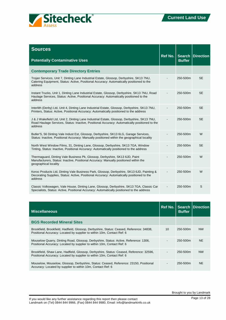
Trojan Services, Unit 7, Dinting Lane Industrial Estate, Glossop, Derbyshire, SK13 7NU,Catering Equipment, Status: Active, Positional Accuracy: Automatically positioned to theaddress
Instant Trucks, Unit 1, Dinting Lane Industrial Estate, Glossop, Derbyshire, SK13 7NU, RoadHaulage Services, Status: Active, Positional Accuracy: Automatically positioned to theaddress
Interlith (Derby) Ltd, Unit 4, Dinting Lane Industrial Estate, Glossop, Derbyshire, SK13 7NU,Printers, Status: Active, Positional Accuracy: Automatically positioned to the address
J & J Wakefield Ltd, Unit 2, Dinting Lane Industrial Estate, Glossop, Derbyshire, SK13 7NU,Road Haulage Services, Status: Inactive, Positional Accuracy: Automatically positioned to theaddress
Butler'S, 56 Dinting Vale Indust Est, Glossop, Derbyshire, SK13 6LG, Garage Services,Status: Inactive, Positional Accuracy: Manually positioned within the geographical locality
North West Window Films, 31, Dinting Lane, Glossop, Derbyshire, SK13 7GA, WindowTinting, Status: Inactive, Positional Accuracy: Automatically positioned to the address
Thermaguard, Dinting Vale Business Pk, Glossop, Derbyshire, SK13 6JD, PaintManufacturers, Status: Inactive, Positional Accuracy: Manually positioned within thegeographical locality
Keroc Products Ltd, Dinting Vale Business Park, Glossop, Derbyshire, SK13 6JD, Painting &Decorating Supplies, Status: Active, Positional Accuracy: Automatically positioned to theaddress
Classic Volkswagen, Vale House, Dinting Lane, Glossop, Derbyshire, SK13 7GA, Classic CarSpecialists, Status: Active, Positional Accuracy: Automatically positioned to the address
Brookfield, Brookfield, Hadfield, Glossop, Derbyshire, Status: Ceased, Reference: 34838,Positional Accuracy: Located by supplier to within 10m, Contact Ref: 6
Mouselow Quarry, Dinting Road, Glossop, Derbyshire, Status: Active, Reference: 1306,Positional Accuracy: Located by supplier to within 10m, Contact Ref: 6
Brookfield, Shaw Lane, Hadfield, Glossop, Derbyshire, Status: Ceased, Reference: 32596,Positional Accuracy: Located by supplier to within 10m, Contact Ref: 6
Mouselow, Mouselow, Glossop, Derbyshire, Status: Ceased, Reference: 23150, PositionalAccuracy: Located by supplier to within 10m, Contact Ref: 6
Sources

If you would like any further assistance regarding this report then please contactLandmark on (Tel) 0844 844 9966, (Fax) 0844 844 9980, Email: [email protected]
Brought to you by Landmark
Page 14 of 28
Historical Land Use

If you would like any further assistance regarding this report then please contactLandmark on (Tel) 0844 844 9966, (Fax) 0844 844 9980, Email: [email protected]
Brought to you by Landmark
Page 15 of 28
Historical Land Use
Ref No. SearchBuffer
DirectionPotentially Contaminative Uses
Historical Tanks And Energy Facilities
Potentially Contaminative Industrial Uses (Past Land Use)
11
11
12
13
-
-
14
-
-
-
-
-
-
-
-
-
-
15
16
17
18
19
20
0-250m
0-250m
250-500m
250-500m
250-500m
250-500m
250-500m
250-500m
250-500m
250-500m
250-500m
250-500m
250-500m
250-500m
250-500m
250-500m
250-500m
0-250m
0-250m
0-250m
0-250m
0-250m
0-250m
W
W
SE
NW
NW
W
NE
S
S
S
W
NE
W
W
W
W
W
E
E
E
SE
E
SW
Tanks, Date of Mapping: 1971 Scale of Mapping: 1:2,500,
Tanks, Date of Mapping: 1974 Scale of Mapping: 1:1,250,
Tanks, Date of Mapping: 1968 Scale of Mapping: 1:2,500,
Electrical Sub Station Facilities, Date of Mapping: 1971 Scale of Mapping: 1:2,500,
Electrical Sub Station Facilities, Date of Mapping: 1974 Scale of Mapping: 1:1,250,
Potential Tanks, Date of Mapping: 1974 Scale of Mapping: 1:1,250,
Tanks, Date of Mapping: 1974 Scale of Mapping: 1:1,250,
Electrical Sub Station Facilities, Date of Mapping: 1974 Scale of Mapping: 1:1,250,
Tanks, Date of Mapping: 1974 Scale of Mapping: 1:1,250,
Electrical Sub Station Facilities, Date of Mapping: 1968 Scale of Mapping: 1:2,500,
Electrical Sub Station Facilities, Date of Mapping: 1974 Scale of Mapping: 1:1,250,
Electrical Sub Station Facilities, Date of Mapping: 1974 Scale of Mapping: 1:1,250,
Tanks, Date of Mapping: 1971 Scale of Mapping: 1:2,500,
Electrical Sub Station Facilities, Date of Mapping: 1971 Scale of Mapping: 1:2,500,
Tanks, Date of Mapping: 1974 Scale of Mapping: 1:1,250,
Tanks, Date of Mapping: 1974 Scale of Mapping: 1:1,250,
Tanks, Date of Mapping: 1971 Scale of Mapping: 1:2,500,
Railways, Date of Mapping: 1899 - 1991
Railways, Date of Mapping: 1894 - 1991
Railways, Date of Mapping: 1894
Railways, Date of Mapping: 1899 - 1991
Railways, Date of Mapping: 1899 - 1991
Air Shafts, Date of Mapping: 1924 - 1954
Sources

If you would like any further assistance regarding this report then please contactLandmark on (Tel) 0844 844 9966, (Fax) 0844 844 9980, Email: [email protected]
Brought to you by Landmark
Page 16 of 28
Historical Land Use
Ref No. SearchBuffer
DirectionPotentially Contaminative Uses
Potentially Contaminative Industrial Uses (Past Land Use)
21
22
23
24
25
26
27
28
29
-
-
-
-
-
-
-
0-250m
0-250m
0-250m
0-250m
250-500m
250-500m
250-500m
250-500m
250-500m
250-500m
250-500m
250-500m
250-500m
250-500m
250-500m
250-500m
SW
NE
NE
W
NE
NW
S
W
SW
S
SW
SE
SW
SW
SE
NW
Air Shafts, Date of Mapping: 1924 - 1954
Railways, Date of Mapping: 1882 - 1982
General quarrying, Date of Mapping: 1894 - 1982
Air Shafts, Date of Mapping: 1924 - 1954
Weapons & ammunition [manufacture and storage], Date of Mapping: 1954
Quarrying of sand & clay, operation of sand & gravel pits, Date of Mapping: 1894
Air Shafts, Date of Mapping: 1924 - 1954
Factory or works - use not specified, Date of Mapping: 1954 - 1982
Printing: miscellaneous exc. newspapers, Date of Mapping: 1894 - 1938
Air Shafts, Date of Mapping: 1924 - 1954
Railways, Date of Mapping: 1924 - 1938
Railways, Date of Mapping: 1894 - 1991
Railways, Date of Mapping: 1954
Pipelines [transport via], Date of Mapping: 1991
Factory or works - use not specified, Date of Mapping: 1991
Quarrying of sand & clay, operation of sand & gravel pits, Date of Mapping: 1899 - 1954
Sources

If you would like any further assistance regarding this report then please contactLandmark on (Tel) 0844 844 9966, (Fax) 0844 844 9980, Email: [email protected]
Brought to you by Landmark
Page 17 of 28
Historical Land Use
Ref No. SearchBuffer
DirectionPotentially Infilled Land
Potentially Infilled Land (Non-Water)
Potentially Infilled Land (Water)
30
31
32
33
34
-
-
35
36
37
0-250m
0-250m
0-250m
250-500m
250-500m
250-500m
250-500m
0-250m
250-500m
250-500m
SW
SW
W
NW
S
S
NW
N
W
W
Unknown Filled Ground (Pit, quarry etc), Date of Mapping: 1991
Unknown Filled Ground (Pit, quarry etc), Date of Mapping: 1991
Unknown Filled Ground (Pit, quarry etc), Date of Mapping: 1991
Unknown Filled Ground (Pit, quarry etc), Date of Mapping: 1982
Unknown Filled Ground (Pit, quarry etc), Date of Mapping: 1991
Unknown Filled Ground (Pit, quarry etc), Date of Mapping: 1991
Unknown Filled Ground (Pit, quarry etc), Date of Mapping: 1982
Unknown Filled Ground (Pond, marsh, river, stream, dock etc), Date of Mapping: 1899
Unknown Filled Ground (Pond, marsh, river, stream, dock etc), Date of Mapping: 1954
Unknown Filled Ground (Pond, marsh, river, stream, dock etc), Date of Mapping: 1954
Sources

If you would like any further assistance regarding this report then please contactLandmark on (Tel) 0844 844 9966, (Fax) 0844 844 9980, Email: [email protected]
Brought to you by Landmark
Page 18 of 28
Historical Land Use
Map Details
The following maps have been analysed for Historical Tanks and Energy Facilities
The following maps have been analysed for Potentially Contaminative Uses and PotentiallyInfilled Land information
1:1,250
1:2,500
1:10,000
1:10,560
Ordnance Survey Plan
Ordnance Survey Plan
Ordnance Survey Plan
Ordnance Survey Plan
Ordnance Survey Plan
Cheshire
Derbyshire
Derbyshire
Cheshire
Cheshire
Derbyshire
Derbyshire
Cheshire
Ordnance Survey Plan
SK0194NE
SK0294NW
SK0294
SK0194
SK09SW
011_00
002_SE
002_SE
011_NE
011_NE
002_SE
002_SE
011_NE
SK09SW
1974
1974
1968
1971
1991
1882
1894
1899
1899
1911
1924
1938
1938
1954
Mapsheet
Mapsheet
Mapsheet
Mapsheet
Published
Published
Published
Published

If you would like any further assistance regarding this report then please contactLandmark on (Tel) 0844 844 9966, (Fax) 0844 844 9980, Email: [email protected]
Brought to you by Landmark
Page 19 of 28
Sensitivity
Flood Map

If you would like any further assistance regarding this report then please contactLandmark on (Tel) 0844 844 9966, (Fax) 0844 844 9980, Email: [email protected]
Brought to you by Landmark
Page 20 of 28
Sensitivity
Sensitivity Map

If you would like any further assistance regarding this report then please contactLandmark on (Tel) 0844 844 9966, (Fax) 0844 844 9980, Email: [email protected]
Brought to you by Landmark
Page 21 of 28
Sensitivity
Ref No.
Ref No.
SearchBuffer
SearchBuffer
Direction
Direction
Pathways
Environmentally Sensitive Receptors
Groundwater Vulnerability
Drift Deposits
Extreme Flooding from Rivers or Sea without Defences
Flooding from Rivers or Sea without Defences
Areas Benefiting from Flood Defences
Flood Water Storage Areas
Flood Defences
Nearest Surface Water Feature
Water Abstractions
-
-
-
-
-
-
-
38
-
On Site
On Site
0-250m
0-250m
0-250m
250-500m
SW
NE
SW
SW
-
-
-
NW
S
Geological Classification: Minor Aquifer (Variably permeable) - These can be fractured orpotentially fractured rocks, which do not have a high primary permeability, or other formationsof variable permeability including unconsolidated deposits. Although not producing largequantities of water for abstraction, they are important for local supplies and in supplying baseflow to rivers, Soil Classification: Soils of Low Leaching Potential - Soils in which pollutantsare unlikely to penetrate the soil layer because water movement is largely horizontal or theyhave large ability to attenuate diffuse pollutants. Lateral flow from these soils contribute togroundwater recharge elsewhere in the catchment, Map Scale: 1:100,000, Map Name: Sheet17 Derbyshire & North Staffordshire, Contact Ref: 1
Drift Deposit: Low permeability drift deposits occuring at the surface and overlying Major andMinor Aquifers are head, clay-with-flints, brickearth, peat, river terrace deposits and marineand estuarine alluvium, Contact Ref: 1
Flood Plain Type: Fluvial, Contact Ref: 1
Flood Plain Type: Fluvial, Contact Ref: 1
None
None
None
Distance: 89m
Chartdell Utilities Ltd, Glossop Brk And Gamesley Brk At Glossop, Abstractions Industrial,Reference: 2569010030, Permit Version: 100, Authorised Start: 01 January, Authorised End:31 December, Positional Accuracy: Located by supplier to within 100m, Contact Ref: 1
Pathways and Receptors

If you would like any further assistance regarding this report then please contactLandmark on (Tel) 0844 844 9966, (Fax) 0844 844 9980, Email: [email protected]
Brought to you by Landmark
Page 22 of 28
Sensitivity
Ref No. SearchBuffer
DirectionEnvironmentally Sensitive Receptors
Water Abstractions
- 250-500m SChartdell Utilities Ltd, Glossop Brk And Gamesley Brk At Glossop, Abstractions Industrial,Reference: 2569010030, Permit Version: 100, Authorised Start: 01 January, Authorised End:31 December, Positional Accuracy: Located by supplier to within 10m, Contact Ref: 1
Pathways and Receptors

If you would like any further assistance regarding this report then please contactLandmark on (Tel) 0844 844 9966, (Fax) 0844 844 9980, Email: [email protected]
Brought to you by Landmark
Page 23 of 28
Other Factors
Other FactorsSearchBuffer
Direction
Brine Compensation Area
Coal Mining Affected Areas
Mining Instability
Radon Potential - Radon Affected Areas
Radon Potential - Radon Protection Measures
Potential for Collapsible Ground Stability Hazards
Potential for Compressible Ground Stability Hazards
Potential for Ground Dissolution Stability Hazards
Potential for Landslide Ground Stability Hazards
Potential for Running Sand Ground Stability Hazards
Potential for Shrinking or Swelling Clay Ground Stability Hazards
On Site
On Site
On Site
On Site
On Site
0-250m
On Site
0-250m
On Site
0-250m
On Site
0-250m
-
E
E
N
N
-
SW
SW
-
S
S
E
SW
E
N
No
In an area which may be affected by coal mining activity. It is recommended that a coal mining report isobtained from the Coal Authority. Contact details are included in the Useful Contacts section., ContactRef: 7
Risk: Inconclusive Coal Mining,
Affected Areas: The property is not in a radon affected area, as less than 1% of homes are above theaction level, Source: British Geological Survey, National Geoscience Information Service, Contact Ref: 6
Radon Protection Measures: None, Source: British Geological Survey, National Geoscience InformationService, Contact Ref: 6
No Hazard
Hazard Potential: No Hazard Contact Ref: 6
Hazard Potential: Moderate Contact Ref: 6
No Hazard
Hazard Potential: Very Low Contact Ref: 6
Hazard Potential: Low Contact Ref: 6
Hazard Potential: Very Low Contact Ref: 6
Hazard Potential: Low Contact Ref: 6
Hazard Potential: Very Low Contact Ref: 6
Hazard Potential: Very Low Contact Ref: 6
Geological

If you would like any further assistance regarding this report then please contactLandmark on (Tel) 0844 844 9966, (Fax) 0844 844 9980, Email: [email protected]
Brought to you by Landmark
Page 24 of 28
Other Factors
Other FactorsSearchBuffer
Direction
Shallow Mining Hazards
-No Hazard
Geological

If you would like any further assistance regarding this report then please contactLandmark on (Tel) 0844 844 9966, (Fax) 0844 844 9980, Email: [email protected]
Brought to you by Landmark
Page 25 of 28
Useful Information
Registered Landfill SitesAt present no complete national data set exists for landfill site boundaries, therefore a point grid reference, provided by the datasupplier, is used for some landfill sites. In certain cases the point grid references supplied provide only an approximate positionand can vary from the site entrance to the centre of the site. Where the exact position of the site is unclear, Landmark constructeither a 100 metre or 250 metre "buffer" around the point to warn of the possible presence of landfill. The size of this "buffer"relates to the positional accuracy that can be attributed to the site. The "buffer" is shown on the map as an orange cross-hatchedcircle and is referred to in the map legend as Potential Landfill Buffer. Where actual boundaries are available, the landfill site areais shown on the map as a red diagonal hatched polygon and referred to in the map legend as Registered Landfill Site.
Local Authority Recorded Landfill SitesLocal Authority landfill data are sourced from individual local authorities that were able to provide information on sites operatingprior to the introduction of the Control of Pollution Act (COPA) in 1974. Appropriate authorities are listed under Local AuthorityLandfill Coverage with an indication of whether or not they were able to make landfill data available. Details of any recordsidentified are disclosed. You should be aware that if the local authority 'Had landfill data but passed it to the relevant environmentagency' it does not necessarily mean that local authority landfill data is included in our other Landfill datasets. In addition if no datahas been made available, for all or part of the search area, you should be aware that a negative response under 'Local AuthorityRecorded Landfill Sites' does not necessarily confirm that no local authority landfills exist.
FloodingThe Sitecheck report flood map plots all flood related features revealed within the search area as supplied by the relevant agency.However, to avoid confusion, the text entry in the body of the report only reveals the detail of the nearest feature in each flood dataset. This is also reflected in the summary table where only a single entry is included to indicate the search buffer of the nearestoccurrence.
Mining Instability DataThe Mining Instability data was obtained on Licence from Ove Arup + Partners Limited (for further information, [email protected]). No reproduction or further use of such data is to be made without the prior written consent of Ove Arup+ Partners Limited. The information and data supplied in the Product are derived from publicly available records and other thirdparty sources and neither Ove Arup + Partners nor Landmark warrant the accuracy or completeness of such information or data.
The information in this Sitecheck Assess Report is derived from a number of statutory and non-statutory sources. While every effort is made to ensureaccuracy, Landmark cannot guarantee the accuracy or completeness of such information or data, nor to identify all the factors that may be relevant. Ifyou are a private individual using this report Landmark recommend that you discuss its contents in full with your professional advisor. It is essential toread this report in conjunction with the Product User Guide and your attention is drawn to the scope of the report section within this guide. The Sitecheck Assess User guide is available free of charge from our website www.sitecheck.co.uk
Landmark Information Group Limited 2010. All Rights Reserved. The copyright on the information and data and its format as contained in this SitecheckAssess Report ("Report") is the property of Landmark Information Group Limited ("Landmark") and several other Data Providers, including (but notlimited to) Ordnance Survey, British Geological Survey, the Environment Agency and Natural England and must not be reproduced in whole or in partby photocopying or any other method, except as allowed by Landmark's Terms and Conditions. The Report is supplied under Landmark's Terms andConditions accepted by the customer. The Copyright, design rights and any other intellectual rights shall remain the exclusive property of Landmarkand/or other Data Providers, whose copyright material has been included in this Report.

If you would like any further assistance regarding this report then please contactLandmark on (Tel) 0844 844 9966, (Fax) 0844 844 9980, Email: [email protected]
Brought to you by Landmark
Page 26 of 28
Useful Contacts
Contact Names and Addresses
1
2
3
4
5
6
Environment Agency National Customer Contact Centre (NCCC)
High Peak Borough Council
High Peak Borough Council Environmental Health Department
High Peak Borough Council Housing & Planning Department
Health and Safety Executive
British Geological Survey Enquiry Service
PO Box 544TempleboroughRotherhamS60 1BY
Town HallBuxtonDerbyshireSK12 6EL
Town HallBuxtonDerbyshireSK17 6EL
Municipal BuildingsHayfield RoadGlossopDerbyshrieSK13 8AF
HSE InfolineCaerphilly Business ParkCaerphillyCF83 3GG
British Geological SurveyKingsley Dunham CentreKeyworthNottinghamNottinghamshireNG12 5GG
www.highpeak.gov.uk
www.highpeak.gov.uk
www.highpeak.gov.uk
www.hse.gov.uk
www.bgs.ac.uk
Telephone 08708 506 506
Telephone 01298 28461Fax 01298 27639
Telephone 01663 751751Fax 01663 751042
Telephone 08701 545500Fax 02920 859260
Telephone 0115 936 3143Fax 0115 936 3276
Please note that the Environment Agency/SEPA have a charging policy in place for enquiries.

If you would like any further assistance regarding this report then please contactLandmark on (Tel) 0844 844 9966, (Fax) 0844 844 9980, Email: [email protected]
Brought to you by Landmark
Page 27 of 28
Useful Contacts
Other Contacts
7
8
The Coal Authority Mining Report Service
Derbyshire County Council
Institution of Civil Engineering Surveyors
The Association of Geotechnical and Geoenvironmental Specialists
The Environmental Auditors Registration Association
The Environmental Industries Commission
The Institution of Civil Engineers
200 Lichfield LaneMansfieldNottinghamshireNG18 4RG
County OfficesMatlockDerbyshireDE4 3AG
26 Market StreetALTRINCHAMCheshireWA14 1PF
Foreham Street83 CopersCope RoadBeckenhamKentBR3 1NR
Welton HouseLimekiln WayLincolnLN2 4US
45 Weymouth StreetLondonW1N 3LD
One Great George StreetWestminsterLONDONSW1P 3AA
www.derbyshire.gov.uk
www.ices.org.uk/ices.asp
www.ags.org.uk/
www.greenchannel.com/iea/earahome.htm
www.eic-uk.co.uk/
www.ice.org.uk
Telephone 0845 7626848
Telephone 01629 580000Fax 01629 580119
Telephone 0161 928 8074
Telephone 020 86588212
Telephone 01522 540069
Telephone 020 79351675
Telephone 0207 222 7722Fax 0207 222 7500

If you would like any further assistance regarding this report then please contactLandmark on (Tel) 0844 844 9966, (Fax) 0844 844 9980, Email: [email protected]
Brought to you by Landmark
Page 28 of 28
Useful Contacts
The Royal Institution of Chartered Surveyors
Wilbourn Associates
Landmark Information Group Limited
12 Great George StreetParliament SquareLondonSW1P 3AD
30 Jessops Riverside800 Brightside LaneSheffieldS9 2RX
Legal and FinancialThe Smith CentreFairmileHenley-on-ThamesOxonRG9 6AB
www.rics.org.uk/
www.environmental-surveyors.com
www.landmarkinfo.co.uk
Telephone 020 7222 7000
Telephone 0844 844 9966Fax 0844 844 9980

Definitions
Terms & Conditions
Services
Intellectual Property
Charges
Termination
Liability
1.
2.
3.
4.
5.
6.
a.
b.
c.
d.
e.
f.
a.
a.
b.
c.
d.
e.
f.
g.
a.
b.
c.
d.
a.
b.
c.
a.
b.
c.
d.
e.
f.
g.
i.ii.iii.
iv.v.vi.
i.
ii.
iii.
iv.
i.ii.
iii.
i.
ii.
iii.
These Terms govern the relationship between You and Landmark whether Youare an unregistered visitor to the Website or are purchasing Services. Wherethese Terms are not expressly accepted by You they will be deemed to havebeen accepted by You, and You agree to be bound by these Terms when Youplace any Order, or pay for any Services provided If the person communicating with Landmark is an Authorised Reseller, they mustensure that You agree to these Terms.The headings in these Terms are for convenience only and shall not affect themeaning or interpretation of any part of these Terms.Landmark may modify these Terms, and may discontinue or revise any or allother aspects of the Services at our sole discretion, with immediate effect andwithout prior notice, including without limitation changing the Services availableat any given time. Any amendment or variation to these Terms shall be postedon our Websites. Continued use of the Services by You shall be deemed anacceptance by You to be bound by any such amendments to the Terms.These Terms, together with the prices and delivery details set out on ourWebsites, Landmark's Privacy Policy and Your Order comprise the wholeagreement relating to the supply of Services to You by Landmark. No priorstipulation, agreement, promotional material or statement whether written or oralmade by any sales or other person or representative on our behalf should beunderstood as a variation of these Terms. Save for fraud or misrepresentation,Landmark shall have no liability for any such representation being untrue ormisleading.These Terms shall prevail at all times to the exclusion of all other terms andconditions including any terms and conditions which You may purport to applyeven if such other provisions are submitted in a later document or purport toexclude or override these Terms and neither the course of conduct betweenparties nor trade practice shall act to modify these Terms.
Landmark will use reasonable care and skill in providing the Services to You,however, the Services are provided on the express basis that the informationand data supplied in the Services are derived from third party sources andLandmark does not warrant the accuracy or completeness of such information ordata. Such information is derived solely from those sources specifically cited inthe Services and Landmark does not claim that these sources represent anexhaustive or comprehensive list of all sources that might be consulted.
You acknowledge that all Intellectual Property Rights in the Services are andshall remain owned by either Landmark or our Suppliers and nothing in theseTerms purports to transfer, assign or grant any rights to You in respect of theIntellectual Property Rights.Subject always to these Terms You may, without further charge, make theServices available to;
the owner of the Property at the date of the Report,any person who purchases the whole of the Property Site, any person who provides funding secured on the whole of the PropertySite,any person for whom You act in a professional or commercial capacity,any person who acts for You in a professional or commercial capacity; andprospective buyers of the Property Site as part of an Information Pack butfor the avoidance of doubt, Landmark shall have no liability to suchprospective buyer unless the prospective buyer subsequently purchasesthe Property Site, and the prospective (or actual) buyer shall not be entitledto make the Service available to any other third party.Accordingly Landmark shall have the same duties and obligations to thosepersons in respect of the Services as it has to You.
Each of those persons referred to in clause 3.b. shall have the benefit and theburden of Your rights and obligations under these Terms. The limitations ofLandmark's liability as set out in clause 6 shall apply to all users of the Service inquestion in aggregate and Landmark shall not be liable to any other person.All parties given access to the Services agree that they will treat as strictlyprivate and confidential the Services and all information which they obtain fromthe Services and shall restrict any disclosure to employees or professionaladvisors to enable the relevant party to conduct its internal business. Therequirement in this clause to treat the Services as confidential shall include arequirement to maintain adequate security measures to safeguard the Servicesfrom unauthorised access, use or copying.Each recipient of the Services agrees (and agrees it will cause its employees,agents or contractors who may from time to time have access to the Services toagree) it will not, except as permitted herein or by separate agreement withLandmark:-
effect or attempt to effect any modification, merger or change to theService, nor permit any other person to do so; orcopy, use, market, re-sell, distribute, merge, alter, add to or carry on anyredistribution, reproduction, translation, publication, reduction to anyelectronic medium or machine readable form or commercially exploit or inany other way deal with or utilise or (except as expressly permitted byapplicable law) reverse engineer, decompile or disassemble the Services,Content or Website; orremove, alter or in any way change any trademark or proprietary markingin any element of the Services and You shall acknowledge the ownershipof the Content, where such Content is incorporated or used into Your owndocuments, reports, systems or services whether or not these are suppliedto any third party.create any product which is derived directly or indirectly from the datacontained in the Services
The mapping contained in any Services is protected by Crown Copyright andmust not be used for any purpose outside the context of the Services or asspecifically provided by these Terms.You are permitted to make five copies of any Report, but are not authorised tore-sell the Report, any part thereof or any copy thereof unless you are anAuthorised Reseller. Further copies may not be made in whole or in part withoutthe prior written permission of Landmark who shall be entitled to make a chargefor each additional copy.
VAT at the prevailing rate shall be payable in addition to the Landmark Fees. Youshall pay any other applicable indirect taxes related to Your use of the Services.An individual or a monthly invoice showing all Orders created by You will begenerated subject to these Terms. You will pay the Landmark Fees at the ratesset out in Landmark's or its Authorised Reseller's invoice. The Landmark Feesare payable in full within 30 days without deduction, counterclaim or set off. Youacknowledge that time is of the essence with respect to the payment of suchinvoices. Landmark reserve the right to amend the Landmark Fees from time totime and the Services will be charged at the Landmark Fee applicable at the dateon which the Service is ordered. We may charge interest on late payment at a rate equal to 3% per annum abovethe base lending rate of National Westminster Bank plc.Landmark or its Authorised Reseller shall not be obliged to invoice any partyother than You for the provision of Services, but where Landmark or itsAuthorised Reseller does so invoice any third party at Your request, and suchinvoice is not accepted or remains unpaid, Landmark or its Authorised Resellershall have the option at any time to cancel such invoice and invoice You directfor such Services. Where Your order comprises a number of Services orseverable elements within any one or more Services, any failure by Landmark orits Authorised Reseller to provide an element or elements of the Services shallnot prejudice Landmark's or its Authorised Reseller's ability to require payment inrespect of the Services delivered to You.
Landmark may suspend or terminate Your rights under these Terms without anyliability to You with immediate effect if at any time:-
You fail to make any payment due in accordance with clause 4;You repeatedly breach or commit or cause to be committed any materialbreach of these Terms; orYou commit a breach and You fail to remedy the breach within 7 days ofreceipt of a written notice to do so; additionally, without prejudice to theforegoing, Landmark may remedy the breach and recover the costs thereoffrom You.
If Your rights are terminated under this clause and You have made an advancepayment We will refund You a reasonable proportion of the balance asdetermined by Us in relation to the value of Services previously purchased.Landmark reserves the right to refuse to supply any or all Services to You withoutnotice or reason.
We provide warranties and accept liability only to the extent stated in this clause6 and clause 7.Nothing in these Terms excludes either party's liability for death or personal injurycaused by that party's negligence or wilful default, and the remainder of thisclause 6 is subject to this provision and Your statutory rights. As most of the information contained in the Services is provided to Landmark byothers, Landmark cannot control its accuracy or completeness, nor is it within thescope of Landmark's Services to check the information on the ground.Accordingly, Landmark will only be liable to You for any loss or damage causedby its negligence or willful default and subject to clause 6.o below neitherLandmark nor any person providing information contained in any Services shallin any circumstances be liable for any inaccuracies, faults or omissions in theServices, nor shall Landmark have any liability if the Services are used otherwisethan in accordance with these Terms. Save as precluded by law, Landmark shall not be liable for any indirect orconsequential loss, damage or expenses (including loss of profits, loss ofcontracts, business or goodwill) howsoever arising out of any problem, event,action or default by Landmark.In any event, and notwithstanding anything contained in these Terms,Landmark's liability in contract, tort (including negligence or breach of statutoryduty) or otherwise howsoever arising by reason or in connection with thisContract (except in relation to death or personal injury) shall be limited to anaggregate amount not exceeding £1 million if the complaint is in relation to aReport on residential property and an aggregate amount not exceeding £10million in respect of any other Report or Service purchased from Landmark.Landmark will not be liable for any defect, failure or omission relating to Servicesthat is not notified to Landmark within six months of the date of the issuebecoming apparent and in any event, within twelve years of the date of theService.You acknowledge that:-
Subject to clause 6.o below You shall have no claim or recourse againstany Third Party Content supplier nor any of our other Suppliers. You willnot in any way hold us responsible for any selection or retention of, or theacts of omissions of Third Party Content suppliers or other Suppliers(including those with whom We have contracted to operate various aspectsor parts of the Service) in connection with the Services (for the avoidanceof doubt Landmark is not a Third Party Content supplier). Landmark doesnot promise that the supply of the Services will be uninterrupted or errorfree or provide any particular facilities or functions, or that the Content willalways be complete, accurate, precise, free from defects of any other kind,computer viruses, software locks or other similar code although Landmarkwill use reasonable efforts to correct any inaccuracies within a reasonableperiod of them becoming known to us;Landmark's only obligation is to exercise reasonable skill and care inproviding environmental property risk information to persons acting in aprofessional or commercial capacity who are skilled in the use of propertyand environmental information and You hereby acknowledge that You aresuch a person;no physical inspection of the Property Site reported on is carried out aspart of any Services offered by Landmark and Landmark do not warrantthat all land uses or features whether past or current will be identified in theServices. The Services do not include any information relating to theactual state or condition of any Property Site nor should they be used ortaken to indicate or exclude actual fitness or unfitness of a Property Site
"Authorised Reseller" means an agent or reseller of Landmark whom Landmark has duly appointed to resell its Reports and Services."Content" means any data, computing and information services and software, and other content and documentation or support materials and updates included in and/or supplied by or through the Websites, in Reports or Services or in any other way by Landmark and shall include Landmark developed and Third Party Content."First Purchaser" means the first person, or legal entity to purchase the Property Site following provision of a Report."First Purchaser's Lender" means the funding provider for the First Purchaser"Information Pack" means a pack compiled by or on behalf of the owner or prospective buyer of the Property Site, designed to aid the marketing or purchase of theProperty Site and containing information provided by or on behalf of the owner or prospective buyer of the Property Site."Intellectual Property Rights" means copyright, patent, design right (registered or unregistered), service or trade mark (registered or unregistered), database right or otherdata right, moral right or know how or any other intellectual property right."Order" means the request for Services from Landmark by You."Property Site" means a land site on which Landmark provides a Service.References to "We", "Us" and "Our" are references to Landmark Information Group Limited ("Landmark"), whose registered office is 7 Abbey Court, Eagle Way, Exeter, EX2 7HY. Where You are not ordering the Services directly from Landmark, but from an Authorised Reseller, references to "Landmark" or "We", "Us" and "Our" shall be construed so as to mean either Landmark and/or the Authorised Reseller as the contextshall indicate.References to "You/Your/Yourself" refer to the contracting party who accesses the Website or places an Order with Landmark."Report" includes any information that Landmark supplies to You including all reports, services, datasets, software or information contained in them."Services" means the provision of any service by Landmark pursuant to these Terms, including without limitation, any Report. "Landmark Fees" means any charges levied by Landmark for Services provided to You."Suppliers" means any organisation who provides data or information of any form to Landmark."Terms" means these Terms & Conditions."Third Party Content" means the services, software, information and other content or functionality provided by third parties and linked to or contained in the Services."Websites" means websites hosted by Landmark and includes the Content and any report, service, document, data-set, software or information contained therein, derived there from or thereby.
LANDMARK TERMS AND CONDITIONS

Contribution
Events Beyond Our Control
Severability
Governing Law
General; Complaints
7.
8.
9.
10.
11.
h.
i.
j.
k.
l.m.
n.
o.
a.
b.
c.
d.
e.
f.
g.
h.
i.
a.
a.
a.
a.
b.
c.
d.
e.
f.
g.
iv.
v.
vi.
vii.
viii.
ix.
i.
ii.
iii.
iv.
for any particular purpose nor should it be relied upon for determiningsaleability or value or used as a substitute for any physical investigation orinspection. Landmark recommends that You inspect and take other advicein relation to the Property Site and not rely exclusively on the Services. Subject to clause 6.o below, Landmark shall not be responsible for error orcorruption in the Services resulting from inaccuracy or omission in primaryor secondary information and data, inaccurate processing of informationand data by third parties, computer malfunction or corruption of data whilstin the course of conversion, geo-coding, processing by computer orelectronic means, or in the course of transmission by telephone or othercommunication link, or printing.Landmark will not be held liable in any way if a Report on residentialproperty is used for commercial property or more than the one residentialproperty for which it was ordered.the Services have not been prepared to meet Your or anyone else'sindividual requirements; that You assume the entire risk as to the suitabilityof the Services and waive any claim of detrimental reliance upon thesame; and You confirm You are solely responsible for the selection oromission of any specific part of the Content;Landmark offer no warranty for the performance of any linked internetservice not operated by Landmark;You will on using the Services make a reasonable inspection of any resultsto satisfy Yourself that there are no defects or failures. In the event thatthere is a material defect You will notify us in writing of such defect withinseven days of its discovery;Any support or assistance provided to You in connection with these Termsis at Your risk;
All liability for any insurance products purchased by You rests solely with theinsurer. Landmark does not endorse any particular product or insurer and noinformation contained within the Services should be deemed to imply otherwise.You acknowledge that if You Order any such insurance Landmark will deem suchas Your consent to forward a copy of the Report to the insurers. Where suchpolicy is purchased, all liability remains with the insurers and You are entirelyresponsible for ensuring that the insurance policy offered is suitable for Yourneeds and should seek independent advice. Landmark does not guarantee thatan insurance policy will be available on a Property Site. All decisions with regardto the offer of insurance policies for any premises will be made solely at thediscretion of the insurers and Landmark accepts no liability in this regard. Theprovision of a Report does not constitute any indication by Landmark thatinsurance will be available on the property. Professional opinions contained in Reports are provided to Landmark by thirdparties, and such third parties are solely liable for the opinion provided. For theavoidance of doubt, those parties providing assessments or professional opinionson Landmark products include RPS Plc & Wilbourn Associates Limited, and anyissues with regard to the provision of such opinion should be taken up with therelevant third party.If Landmark provides You with any additional service obtained from a third party,including but not limited to any interpretation or conclusion, risk assessment orenvironmental report or search carried out in relation to a Report on YourProperty Site, subject to clause 6.o below Landmark will not be liable in any wayfor any information contained therein or any issues arising out of the provision ofthose additional services to You. Landmark will be deemed to have acted as anagent in these circumstances and the supply of these additional services will begoverned by the terms and conditions of those Third Parties. In any event no person may rely on a Service more than 12 months after itsoriginal date.If You wish to vary any limitation of liability as set out in these Terms, You mustrequest such variation prior to ordering the Service. Landmark shall use itsreasonable endeavours to agree such variation but shall not be obliged to do so. Time shall not be of the essence with respect to the provision of the Services.Ordnance Survey have undertaken a positional accuracy improvementprogramme which may result in discrepancies between the positioning of featuresused in datasets in the Services and the updated Ordnance Survey mapping.Subject to clause 6.o below, Landmark and its Suppliers exclude all and anyliability incurred as a result of the implementation of such positional accuracyimprovement programme.Where Landmark provides its own risk assessment in connection with anyReport, Landmark shall carry out such assessment with all reasonable skill andcare but shall have no liability for any such risk assessment conclusion which isprovided for information only, save where Landmark conducted the samenegligently, in which case the provisions of clause 6 shall apply. Notwithstandingthe provision of any such risk assessment conclusion you should carefullyexamine the remainder of the Report and should not take or refrain from takingany action based solely on the basis of the risk assessment. For the avoidance ofdoubt, the provisions of this clause 6n apply solely to risk assessmentsconducted by Landmark, and the provision of any other risk assessment by athird party shall be governed by such third party's terms in accordance with theprovisions of clause 6i above.Landmark obtains much of the information contained in its Report from thirdparties. Landmark will not accept any liability to You for any negligent or incorrectentry, or error or corruption in the Third Party Content supplied to Landmark, butLandmark's Suppliers may be liable for such negligent or incorrect entries, orerrors or corruptions, subject to the terms and conditions on which they supplythe Third Party Content to Landmark.
Save where expressly provided, this clause 7 shall apply solely to EnvirosearchResidential Reports (regardless of the result of such Report). Nothing in thisclause 7 shall operate to override or vary the provisions of clause 6.Landmark are prepared to offer, at their sole discretion, and without anyadmission or inference of liability a contribution towards the costs of anyremediation works required under a Notice (as defined below) on the terms of thisclause 7 ("the Contribution")In the event that a Remediation Notice is served on the First Purchaser or FirstPurchaser's Lender of a Property Site under Part II(A) of the EnvironmentalProtection Act 1990 ("the Notice") Landmark will contribute to the cost of suchworks as either the First Purchaser or First Purchaser's Lender (but not both) arerequired to carry out under the Notice subject to the provisions of this clause 7and on the following terms:
the Contribution shall only apply to contamination or a pollution incidentpresent or having occurred prior to the date of the Report;the Contribution shall only apply where the Property Site is a singleresidential dwelling house or a single residential flat within a block of flats.For the avoidance of doubt, this obligation does not apply to anycommercial property, nor to any Property Site being developed orredeveloped whether for residential purposes or otherwise;the Contribution is strictly limited to the cost of works at the Property Siteand at no other site.the Contribution will not be paid in respect of any of the following:Radioactive contamination of whatsoever nature, directly or indirectlycaused by or contributed to or arising from ionising radiations orcontamination by radioactivity from any nuclear fuel or from any nuclearwaste from the combustion of nuclear fuel or the radioactive toxicexplosive or other hazardous properties of any explosive nuclear assemblyor nuclear component thereof.Asbestos arising out of or related in any way to asbestos or asbestos-containing materials on or in structures or services serving the structures.Naturally occurring materials arising from the presence or requiredremoval of naturally occurring materials except in circumstances wheresuch materials are present in concentrations which are in excess of theirnatural concentration.Intentional non-compliance arising from the intentional disregard of orknowing wilful or deliberate non-compliance by any owner or occupier of
the Property Site with any statute, regulation, administrative complaint,notice of violation, or notice letter of any Regulatory Authority.Any condition which is known or ought reasonably to have been known tothe First Purchaser or the First Purchaser's Lender prior to the purchase ofthe Report.Any condition which is caused by acts of War or an Act of Terrorism.Any property belonging to or in the custody or control of the FirstPurchaser which does not form a fixed part of the Property Site or thestructure. Any fines liquidated damages punitive or exemplary damages.Any bodily injury including without limitation, death, illness or disease,mental injury, anguish or nervous shock.Any financial loss in respect of any loss of any rental, profit, revenue,savings or business or any consequential indirect or economic lossdamage or expense including the cost of rent of temporary premises orbusiness interruption.Any losses incurred following a material change in use of, alteration ordevelopment of the Property Site.
The maximum sum that shall be contributed by Landmark in respect of anyContribution shall be limited to £60,000. In the event that more than one Reportis purchased on the Property Site the Contribution will only be payable under thefirst Report purchased by or on behalf of any First Purchaser or First Purchaser'sLender and no Contribution will be made in respect of subsequent Reportspurchased by or on behalf of such First Purchaser, First Purchaser's Lender orany person connected to them.Landmark shall only pay a Contribution where the Notice is served within 36months of the date of the Report.Any rights to a Contribution under this Clause 7 are not assignable in the event ofa sale of the Property Site and Landmark will not make any Contribution after thedate of completion of such sale.In the event the First Purchaser or First Purchaser's Lender wishes to claim anyContribution, it shall notify Landmark in writing within 3 months of the date of theNotice. The First Purchaser or First Purchaser's Lender (as applicable) shallcomply with all reasonable requirements of Landmark with regard to thecommission and conduct of the remediation works to be carried out under theNotice, and in the event the First Purchaser or First Purchaser's Lender (asapplicable) does not do so, including without limitation, obtaining Landmark'sprior written consent to any estimates for such works or complying with any otherreasonable request by Landmark, Landmark shall not be required to pay anyContribution. Notwithstanding the payment of the Contribution by Landmark theFirst Purchaser or First Purchaser's Lender as applicable shall take allreasonable steps to mitigate any costs incurred in connection with the conduct ofworks required under the terms of any Notice.In the event that the First Purchaser or First Purchaser's Lender receives anycommunication from a statutory authority to the effect that there is an intent toserve a notice received under PartII(A) of the Environmental Protection Act 1990they will advise Landmark within a maximum period of two months from receiptof such communication. This clause 7h and the service of any notice under itshall not affect the provisions of clauses 7 e and g, and any suchcommunications, even if advised to Landmark will not operate as notice underclause 7e. Landmark reserve the right at any time prior to a claim for Contribution beingmade in accordance with clause 7 g) above, to withdraw the offer of payment ofContributions without further notice.
You acknowledge that Landmark shall not be liable for any delay, interruption orfailure in the provision of the Services which are caused or contributed to by anycircumstance which is outside our reasonable control including but not limited to,lack of power, telecommunications failure or overload, computer malfunction,inaccurate processing of data, or delays in receiving, loading or checking data,corruption of data whilst in the course of conversion, geo-coding, processing bycomputer in the course of electronic communication, or printing.
If any provision of these Terms are found by either a court or other competentauthority to be void, invalid, illegal or unenforceable, that provision shall bedeemed to be deleted from these Terms and never to have formed part of theseTerms and the remaining provisions shall continue in full force and effect.
These terms shall be governed by and construed in accordance with English lawand each party agrees irrevocably submit to the exclusive jurisdiction of theEnglish courts If any dispute arises out of or in connection with this agreement (a"Dispute") the parties undertake that, prior to the commencement of Courtproceedings, they will seek to have the Dispute resolved amicably by use of analternative dispute resolution procedure acceptable to both parties with theassistance of the Centre for Dispute Resolution (CEDR) if required, by writtennotice initiating that procedure. If the Dispute has not been resolved to thesatisfaction of either party within 60 days of initiation of the procedure or if eitherparty fails or refuses to participate in or withdraws from participating in theprocedure then either party may refer the Dispute to the Court.
Landmark may assign its rights and obligations under these Terms without priornotice or any limitation.Landmark may authorise or allow our contractors and other third parties toprovide to Landmark and/or to You services necessary or related to the Servicesand to perform Landmark's obligations and exercise Landmark's rights underthese Terms, which may include collecting payment on Landmark's behalf.No waiver on Landmark's part to exercise, and no delay in exercising, any right,power or provision hereunder shall operate as a waiver thereof, nor shall anysingle or partial exercise of any right, power or provision hereunder preclude theexercise of that or any other right, power or provision.Unless otherwise stated in these Terms, all notices from You to Landmark mustbe in writing and sent to the Landmark registered office (or in the case of anAuthorised Reseller, to its registered office address) and subject to paragraph ebelow all notices from Landmark to You will be displayed on our Websites fromtime to time.Any complaints in relation to the Services should, in the first instance, be inwriting addressed to the Customer Service Support Manager at the Landmarkregistered office. Landmark or its agents will respond to any such complaints inwriting as soon as practicably possible.A person who is not a party to any contract made pursuant to these Terms shallhave no right under the Contract (Right of Third Parties) Act 1999 to enforce anyterms of such contract and Landmark shall not be liable to any such third party inrespect of any Services supplied.Landmark's Privacy Policy as displayed on the Website governs the use made ofany information You supply to Landmark.
Landmark Information Group Limited, 7 Abbey Court, Eagle Way, Exeter, EX2 7HY Email: [email protected]© Landmark Information Group Limited
Version 6.04 28 Jul 2007