Article Supporting Facility Management Processes through ...
19
ISPRS Int. J. Geo-Inf. 2018, 7, 191; doi:10.3390/ijgi7050191 www.mdpi.com/journal/ijgi Article Supporting Facility Management Processes through End-Users’ Integration and Coordinated BIM-GIS Technologies Claudio Mirarchi 1 , Alberto Pavan 1 , Francesco De Marco 1 , Xiangyu Wang 2,3,4, * and Yongze Song 3 1 Architecture, Built Environment and Construction Engineering Department (ABC), Politecnico di Milano, Milano 20133, Italy; [email protected] (C.M.); [email protected] (A.P.); [email protected] (F.D.M.) 2 School of Civil Engineering, Tongji University, Shanghai 200092, China 3 Australasian Joint Research Centre for Building Information Modelling, School of Built Environment, Curtin University, Perth 6102, Australia; [email protected] 4 Department of Housing and Interior Design, Kyung Hee University, Seoul 02447, Korea * Correspondence: [email protected]; Tel.: +61-8-9266-9059 Received: 12 March 2018; Accepted: 10 May 2018; Published: 16 May 2018 Abstract: The integration of facility management and building information modelling (BIM) is an innovative and critical undertaking process to support facility maintenance and management. Even though recent research has proposed various methods and performed an increasing number of case studies, there are still issues of communication processes to be addressed. This paper presents a theoretical framework for digital systems integration of virtual models and smart technologies. Based on the comprehensive analysis of existing technologies for indoor localization, a new workflow is defined and designed, and it is utilized in a practical case study to test the model performance. In the new workflow, a facility management supporting platform is proposed and characterized, featuring indoor positioning systems to allow end users to send geo-referenced reports to central virtual models. In addition, system requirements, information technology (IT) architecture and application procedures are presented. Results show that the integration of end users in the maintenance processes through smart and easy tools can overcome the existing limits of barcode systems and building management systems for failure localization. The proposed framework offers several advantages. First, it allows the identification of every element of an asset including wide physical building elements (walls, floors, etc.) without requiring a prior mapping. Second, the entire cycle of maintenance activities is managed through a unique integrated system including the territorial dimension. Third, data are collected in a standard structure for future uses. Furthermore, the integration of the process in a centralized BIM-GIS (geographical information system) information management system admit a scalable representation of the information supporting facility management processes in terms of assets and supply chain management and monitoring from a spatial perspective. Keywords: facility management; maintenance; BIM; indoor mapping; geo-referencing; digital communication; GIS 1. Introduction Facility management is a growing interest for both academic studies and construction industries [1]. The increasing impact of information technology (IT) systems requires more reliable and flexible studies for the improvement of techniques and instruments in practice. Indeed, the term facility management includes an enormous area of action. A first overall definition of facility management
Transcript of Article Supporting Facility Management Processes through ...

ISPRS Int. J. Geo-Inf. 2018, 7, 191; doi:10.3390/ijgi7050191 www.mdpi.com/journal/ijgi
Article
Supporting Facility Management Processes through
End-Users’ Integration and Coordinated
BIM-GIS Technologies
Claudio Mirarchi 1, Alberto Pavan 1, Francesco De Marco 1, Xiangyu Wang 2,3,4,* and Yongze Song 3
1 Architecture, Built Environment and Construction Engineering Department (ABC), Politecnico di Milano,
Milano 20133, Italy; [email protected] (C.M.); [email protected] (A.P.);
[email protected] (F.D.M.) 2 School of Civil Engineering, Tongji University, Shanghai 200092, China 3 Australasian Joint Research Centre for Building Information Modelling, School of Built Environment,
Curtin University, Perth 6102, Australia; [email protected] 4 Department of Housing and Interior Design, Kyung Hee University, Seoul 02447, Korea
* Correspondence: [email protected]; Tel.: +61-8-9266-9059
Received: 12 March 2018; Accepted: 10 May 2018; Published: 16 May 2018
Abstract: The integration of facility management and building information modelling (BIM) is an
innovative and critical undertaking process to support facility maintenance and management. Even
though recent research has proposed various methods and performed an increasing number of case
studies, there are still issues of communication processes to be addressed. This paper presents a
theoretical framework for digital systems integration of virtual models and smart technologies.
Based on the comprehensive analysis of existing technologies for indoor localization, a new
workflow is defined and designed, and it is utilized in a practical case study to test the model
performance. In the new workflow, a facility management supporting platform is proposed and
characterized, featuring indoor positioning systems to allow end users to send geo-referenced
reports to central virtual models. In addition, system requirements, information technology (IT)
architecture and application procedures are presented. Results show that the integration of end
users in the maintenance processes through smart and easy tools can overcome the existing limits
of barcode systems and building management systems for failure localization. The proposed
framework offers several advantages. First, it allows the identification of every element of an asset
including wide physical building elements (walls, floors, etc.) without requiring a prior mapping.
Second, the entire cycle of maintenance activities is managed through a unique integrated system
including the territorial dimension. Third, data are collected in a standard structure for future uses.
Furthermore, the integration of the process in a centralized BIM-GIS (geographical information
system) information management system admit a scalable representation of the information
supporting facility management processes in terms of assets and supply chain management and
monitoring from a spatial perspective.
Keywords: facility management; maintenance; BIM; indoor mapping; geo-referencing; digital
communication; GIS
1. Introduction
Facility management is a growing interest for both academic studies and construction industries
[1]. The increasing impact of information technology (IT) systems requires more reliable and flexible
studies for the improvement of techniques and instruments in practice. Indeed, the term facility
management includes an enormous area of action. A first overall definition of facility management

ISPRS Int. J. Geo-Inf. 2018, 7, 191 2 of 19
is contained in [2] and defined as “an integrated approach for operating, maintaining, improving and
adapting building and infrastructure assets to support the primary objectives of occupants, owners
and facility managers”. This overall approach is focused on the needs of the different actors involved
in the life cycle of goods. Two other interesting definitions are reported in [3,4] highlighting the
importance of non-core services. Thus, the goal of facility management is to provide a suitable
environment to conduct the core businesses. Hence, “communication” between building elements
(including spaces) and facility managers is fundamental for this scope [2,5]. Previous research shows
a tendency on integration of sensory systems and database management systems (DBMS) to support
facility management activities, based on detection of environmental conditions, room occupancy
data, and/or functioning status of plants. Nevertheless, facility management only constitutes a
branch, jointly representing real estate market with property management [6,7] and asset
management [8] (Figure 1).
Figure 1. Real Estate Management—Asset, Property, Facility.
Asset management, monitoring, and traceability within an organization represent a significant
cost element in terms of dedicated resources (times and people) [9]. Hence, in the development of
methods and systems devoted to support the real estate management process, it is critical to consider
an overall vision including maintenance operations, asset traceability and space management
[2,10,11]. Tag systems based on barcodes are usually adopted by organizations to trace the assets, but
they could also be integrated with DBMS to report communication and equipment failures. For
instance, physical building elements (e.g., doors and windows) cannot be equipped with hardware
systems capable of monitoring their functionality and consequently report any damages via signals.
Even if barcode technologies could support both property management and facility management
activities, including tags on spaces and physical elements, some issues cannot overlap, especially
those referring to the exact damage localization on wide elements (e.g., walls and floors). For instance,
an onerous number of tags would be necessary to map out these elements, which would have its
drawbacks due to barcode maintenance needs and possible aesthetic defects. The scope of this
research is to define a technological system, and the related process, capable of supporting both
property management and facility management components, supporting asset traceability, damage
detection and reporting, and communication of failures in building elements (communicating
damages). The system will also include and be used for wide building elements by means of end-
user involvement. This objective is pursued with specific reference to old buildings, characterized by
a high number of daily users (e.g., schools or oratories) and where it is difficult to install sensors
devoted to plant monitoring. In this context, end-users are intended as the habitual users of a real
estate, who have been trained on the usage of a specific reporting application. The scope is pursued
through the definition of an integrated process based on building information modelling (BIM) and
indoor localization systems for end-users, providing a dynamic system that allows further
developments. Hence, end-users can report failure modes by transmitting data through mobile apps

ISPRS Int. J. Geo-Inf. 2018, 7, 191 3 of 19
and a building information model that is connected to an external DBMS allowing the integrated
management of both geometrical and alphanumerical information. The proper integration of end-
users in the process represents a critical point that can reduce the time laps between the damage and
its notification and repair.
This research focuses on the phase of communicating damages in corrective maintenance
processes. Meanwhile, the theorized system is studied to support the entire maintenance work until
the work order is closed and the model is updated. Furthermore, the information collected in a
systematic way should enrich the building information models, ensuring the efficiency of the system
over time. During the life-cycle of real estate management, one of the most important advantages of
BIM is that it can provide precise geometric and semantic information [12–17]. On the contrary, the
geographical information systems (GIS) have strong capability on large spatial scale modelling and
geospatial analysis for the geographical objects and spatially distributed assets [18–22]. Thus, as a
fast-developing trend, BIM-GIS integration can provide a valuable support, offering
geovisualization-based decision making and geospatial modelling [23].
Figure 2 shows a flowchart synthetizing how organizations generally manage a corrective
maintenance work order, from the initial request until the end of the maintenance work [24]. This
schema underlines the problems connected to a traditional management of the maintenance process.
There is a considerable lack of efficiency due to an ineffective communication flow, which does not
guarantee the correct transfer (and storage) of the needed information from the client to the
maintenance company passing through the facility management. Gallaher et al. [25] underlined this
point estimating the annual costs associated to inadequate interoperability in the U.S. capital facilities
industry in $15.8 billion.
Figure 2. Corrective maintenance workflows, flowchart-type.
In this research, the initial processes for facility management support system were studied to
understand their strengths and limitations. Then technologies were investigated to implement and
adapt a system suitable for the defined scope. The focus of this research was based on old buildings
with the involvement of end-users, which required easy to use devices for failures identification and
low maintenance of required systems in a very crowded building occupied also by children.
This article is structured in six sections. Section 2 reports a brief literature review about the actual
methods used in facility management and the previous research developed on the integration of
facility management practices and BIM. Section 3 proposes the applied research methodology.
Section 4 presents the proposed method and the structure of the connected system. Section 5 contains

ISPRS Int. J. Geo-Inf. 2018, 7, 191 4 of 19
a case study that was developed to test the studied processes and the developed system. This section
includes a discussion about academic and practical contributions. Finally, Section 6 is a summary of
the obtained results with some suggestions about possible development of future research.
2. Supporting Methods for Maintenance Operations: Literature Review
Facility management includes many activities coming from different fields. The efficiency of the
management, based on cost reduction and optimal value, could be achieved through the
implementation of integration strategies [26]. Therefore, technological tools are needed to support
the facility manager in monitoring all the management aspects of a real estate. This section
synthesizes the methods, systems, and technological tools most used for facility management
objectives, managing both alphanumeric and geometric data.
2.1. CAFM Systems and BIM
Widespread systems used to support facility management activities are computer aided facility
management (CAFM) [27] or other similar systems as computer maintenance management systems
(CMMS), electronic document management systems (EDMS) and building automation systems (BAS)
[28]. These management systems are based on alphanumeric data management, capable of uploading
data and technical documentation, creating job lists and schedule activities, identifying resources,
tools and materials needed to manage the real estate [29].
Generally, traditional management systems fail in accessing and controlling the information
effectively because data coming from different sources is modified several times during the building
life cycle without an automated synchronization between servers [30]. Another relevant limitation is
the inability to control the building performances and lacking 3D building visualization since CAFM
systems are usually linked with 2D building drawings allowing merely the space management [31].
Thus, CAFM systems are ineffective in managing all the information and they lack the ability to
integrate the geometrical information along with the technological ones.
The integration between BIM and other technologies and techniques used in the market is
progressively changing facility management processes. BIM can be viewed as an approach applied
to the building process, based on the creation of a centralized information platform for building
knowledge shared among different users during the entire building life cycle, from planning to the
management stage [32]. The building information model applied to the facility management can be
interpreted as a building information system connected to a DBMS that provides the ability to process
the geometric information and the non-geometric information including performance, regulations,
materials, and management [33]. Hence, the building information model and the related DBMS
constitute a memory storage platform, shared by players involved in the maintenance process, which
enable the traceability of each building component in terms of location, technical features and total
cost [34].
2.2. BIM-Based Facility Management Supporting Methods
The integration of facility management and BIM has been explored in recent research [3]. One
of the major components of the maintenance policy is the reaction time required between a defect
occurring and a repair being carried out [35]. As stated in the introduction, the communication
between all the parties involved assumes a critical position for maintenance objectives. Recognizing
the importance of communication along with its central role in maintenance processes, different IT
tools and methods, including BIM, can be found in the literature.
The first case is based on a central building information model managed by a facilities manager.
The system has supporting BIM tools and cloud access to communicate damages by the end-users,
the maintenance crew, and the consulting staff. It can be integrated with virtual reality applications
[36]. The interface between different servers (i.e., models and facility management databases) can be
reached using open standards and data specifications (e.g., IFC and COBie) or by implementation of

ISPRS Int. J. Geo-Inf. 2018, 7, 191 5 of 19
proprietary formats linked with interconnected platforms, for the definition of Asset Information
Models [37].
Another application that has been used in the research field in the last few years consists of
mapping building elements with barcodes that are linked with building management databases and
building information models [38]. Barcode is the most widely used technology to trace products and
assets, especially in the industrial and manufacturing sectors [39]. The most common types are the
Quick Response (QR) code [40] and Radio Frequency Identification (RFID) code [41–43]. According
to this method, end-users can report a failure to the facility manager by scanning the QR code through
a mobile device, activating the maintenance process [30].
In the last years, the technological developments in home automation have brought to
propensity a condition-based maintenance approach, based on efficiency status monitoring [44]. This
maintenance process is based on Building Management Systems (BMS) ensuring service control (e.g.,
lighting, fire and air conditioning) monitoring over time status indicators in order to ensure living
comfort, plant efficiency and sustainability [45], and to report and manage failures [37].
A BMS can reduce the need of human intervention and through a data-logger [46] it allows
recording environmental indicator measurements (e.g., temperature, humidity and using time) [47].
Building information models related with the BMS allow creating a link between the design and the
real use of the building-plant system by the end-users.
Table 1, reports a matrix of comparison between each case, namely (case 1) central building
information model for the facility manager and cloud building information model for the end users
and maintenance staff, (case 2) QR code mapping linked with building information models and
DBMS, (case 3) BMS combined with building information models. The advantages column reports
the main functionalities of each method, while in the disadvantages column are identified open issues
and features that can hinder the application of the method.
Table 1. Resuming comparison between facility management (FM) supporting methodologies.
FM Methodology Advantages Disadvantages
Case 1:
Central building
information model
for the facility
manager and cloud
building information
model for the end
users and
maintenance staff.
BIM cloud applications for the
visualization of building
information models are used both
for failure communications from
the end-users and consultation
during the operations for the
maintenance operators. A unique
technology used during all the
maintenance process from the
failure report until the end of the
maintenance work [34,35].
a) Awkward browsing in BIM mobile devices
for the end-users; “ease of use”
requirement not guarantee.
b) A structured method to synchronize the
players involved in the process using
cloud building information models has to
be implemented.
c) No automation and geo-referencing of the
fault communication phase: the facility
manager is not informed automatically
about the failure position because
mapping or localization systems are not
provided.
Case 2:
QR code mapping
linked with building
information models
and DBMS.
Building components are mapped
with barcode tags; end-users can
communicate a failure scanning
barcodes. A central building
information model connected with
a DBMS manages the failure
reports and archives maintenance
data.
Identification data about
components is directly stored in
barcodes [38].
a) Barcode mapping can be onerous if it is
used for all the building components.
b) Barcodes need periodical maintenance
especially in busy buildings.
c) Difficult localization about failure reports
on wide building elements (e.g., walls and
floors).
d) Barcodes can be seen as aesthetics defects.

ISPRS Int. J. Geo-Inf. 2018, 7, 191 6 of 19
Case 3:
BMS combined with
building information
models.
Systems and spaces are equipped
with sensors capable of monitor
functioning status and
environmental conditions. The
connection between BMS and
building information models
combines precision of field data
acquisition and 3D localization
[35,43].
a) Onerous costs of installation and
maintenance especially in the case of old
buildings do not equipped with modern
systems.
b) The management of not-sensorized
building elements is not possible. Barcodes
system integration is necessary.
3. Research Methodology
Starting from the objectives defined in the area of interest of the research that is focused on old
buildings, characterized by a high number of daily users, a first analysis of traditional corrective
maintenance processes and of the existing research in the literature has been defined. Highlighted by
the limitations of the existing technologies and techniques, a possible process framework has been
proposed identifying the suitable technologies through a compared study of the existing solutions.
Finally, starting from the proposed framework, a case study has been developed identifying available
commercial partners for the implementation of the proposed technological framework. Figure 3
shows the research path highlighting the passages above described and the outputs of each passage
(on the right) identifying the main results of the research.
Figure 3. Schematic flowchart of research methodology.
4. End-User Integration and Coordinated BIM-GIS Technologies to Support Management and
Maintenance Operations
Real estate management includes several integrated functions and traceability of the assets is an
important prerequisite to support maintenance and management activities. A considerable part of
the facility management activities is related to the management of the corrective maintenance about
both plant systems and physical building components. Starting from the existing methods and
practices analyzed in Section 2, an alternative method is proposed according to the stated objectives,
with the aims of allowing the management of corrective maintenance for wide building components
integrating technologies usually adopted for building assets traceability from the organizations. The
proposed method is based on the digital communication between mobile apps managed by end-users
on smart devices directly localized on the building information models of a real estate when reporting
a failure.
Nowadays the majority of the population has a mobile device and according to a study
conducted in 2014 by the International Data Corporation, about 3.5 billion people in 2017 (46% of the
entire world population) will have an internet connection and 64% of them will access the mobile
network [48]. Mobile devices are nowadays used daily and could be useful as communication tools
to improve the quality of real estate and urban management [49] involving end-users.

ISPRS Int. J. Geo-Inf. 2018, 7, 191 7 of 19
In this direction, as shown in the case studies reported in [48], some administrations in Europe,
such as the Barcelona Metropolitan Area, and some Britannic organizations are developing mobile
platforms, involving the citizens in reporting urban problems, in order to improve the quality of the
city. These tools are useful to support the urban management, but they are inapplicable in indoor
environments due to limitations of the global positioning system (GPS) technology that they are
based on. Despite these limitations of GPS technology, the concept behind these applications is
efficient and can be extended to indoor environments combining mobile apps for faults
communication with indoor positioning sensors as demonstrated in [50].
4.1. Indoor Localisation Systems for Fault Messages
The proposed system is composed of three main components:
Real Estate central building information model, structured for the facility management scopes.
Real Estate cloud models.
Indoor localization systems for user localization.
The first two parts are the virtual models used to collect and share all the maintenance
information. As proposed in the literature [51–53], the definition of the model must follow the
objectives defined by the as built philosophy. A building information model developed for
maintenance purposes should focus primarily on the correct individuation of the elements that
would need maintenance. In this sense, the localization of each relevant object in the overall building
information model must be assured. Nevertheless, it is not necessary to have a high level of
geometrical detail for each specific object included in the model while the informative part must be
dedicated to all the information needed for maintenance purposes [54].
The third part is conversely a physical part dedicated to the construction of the geo-referencing
system for indoor localization [55]. In this direction, there are several technologies that can be used,
namely infrared, RFID, Wi-Fi fingerprint, ultrasound, and Bluetooth. In particular, Bluetooth indoor
localization systems are technologies structured with indoor localization sensors linked to mobile
apps for mobile devices allowing the user localization and the specification of points of interest [56].
Compared to other solutions, Bluetooth technologies are embedded in common mobile devices.
Furthermore, the required indoor localization sensors are easy to install and they have long-life
batteries. Lastly, the inherent connection to the required mobile application guarantees the direct
integration of the entire process presented in Section 4.2.
Table 2 reports a comparison between the main localization system technologies, highlighting
for each one the characteristic functionalities and the connected disadvantages, summarizing the
literature review [50,55,56].
Table 2. Resuming comparison between most used localization systems for indoor assets.
Localization System Functioning Disadvantages
Sol. 1 Infrared
technologies
Emitter with fixed position in the room,
which is associated with a unique ID
and signal receiver.
a) Short transmission range.
b) Eye contact necessary between emitter
and receiver.
c) No automation and geo-referencing in
complex and labyrinthine
environments, many devices are
needed.
Sol. 2 RFID Based on localization through radio
frequencies.
a) Signal disorders can produce multipath
propagation phenomena.
b) Close contact between two devices is
needed.
Sol. 3 Wi-Fi fingerprint
It is part of the localization techniques
based on Received Signal Strength
Indication (RSSI).
Access point return the position of an
antenna device.
a) Signal disorders can produce multipath
propagation phenomena.
b) Not suitable for environments subjected
to variations over time, because moving
the access point involves variations
across the system.

ISPRS Int. J. Geo-Inf. 2018, 7, 191 8 of 19
Sol. 4 Ultrasound
Used as counting sensors, it is based on
ultrasonic emissions and triangulation
of lens transducers, which locate the
persons’ position.
a) Obstructions that reflect sound waves
hinder the performance of the system.
Sol. 5 Bluetooth (beacons)
Infrastructure availability because
Bluetooth is integrated into common
smartphones. IOS and Android
compatible hardware. They work with
long lasting batteries; not invasive, they
can be positioned everywhere.
a) Proximity sensors, high margin of error.
b) An application for mobile devices is
needed to capture signals from beacons.
The implementation of the Bluetooth-based technology can be divided in three main parts [57].
The hardware portion is constituted by the so-called Bluetooth Low Energy (BLE) beacons. They are
transmitters using the Bluetooth technology to individuate smartphones presence and localize them
through triangulation of signals. To allow the localization of mobile devices, it is required to have
them equipped with a communication protocol (that constitute the second main part of the system)
like Eddystone of iBeacons, contained in specific apps. Finally, the software part (the third one) is
dedicated to the interpretation of data. This last portion constitutes the core of the system allowing
the management of the entire maintenance process, including the creation of the fault notification,
the communication with the facility manager along with the maintenance company and the final
validation of the executed work.
In this environment, data extracted from the building information model are geolocalized and
integrated with GIS information. This can support supply chain management [45] minimizing the
time laps between damage and repair actions. Furthermore, the standard data structure embedded
in the system allows maintenance data visualization in a geospatial environment for further
quantitative analysis.
4.2. Structure of the System
In the proposed system, the identification of elements in the building is done through indoor
localization systems. As already stated, several problems exist for barcodes including the high
number of required labels and their maintenance, especially for wide physical elements such as walls
and floors. Furthermore, tagging elements with lots of barcodes can produce aesthetic defects. In the
proposed system, end-users are involved in the reporting phase through intuitive mobile tools that
allow recognizing the position of the elements instead of the bar code scanning procedure. All the
physical elements identified in this research are available in the market but their integrated usage to
support the facility management phases has not been studied. A first layer is defined to regulate the
specific services available through the mobile app, identifying three main user types: (a) end-user;
(b) maintenance operator and (c) facility manager as shown in Figure 4.
Figure 4. Indoor localization app: registration interface.

ISPRS Int. J. Geo-Inf. 2018, 7, 191 9 of 19
The process is divided in three main areas: (a) the Input phase, in which the end-user can identify
a specific damage and communicate it through the mobile app; (b) the Intermediate phase, in which
the message is forwarded from the end-user to the facility manager; and (c) the Output phase, in
which the work order is closed after being verified by the maintenance person and the end-user.
INPUT phase: damage reporting
This phase starts with the identification of a damaged building element or system by end-users.
After the log-in phase, the end-user can transmit the image of the faulty object through the dedicated
mobile app adding any additional comments. Every fault communication is identified through a
unique ID code that is automatically generated by the system when the end-user sends the message.
Through the interface between the dedicated app, the localization system and the virtual model, the
fault communication generates an “alert object” in the building information model. This object will
show up in the building information model according to the position of the end-user; i.e., where the
photo was taken—and will contain the photo along with comments from the end-user. This phase is
the most delicate. In general, two main aspects can hinder the effectiveness of the system. Firstly, the
accuracy of the localization system is not sufficient to distinguish between two similar features that
are close to each other. Furthermore, the location of the signal is performed on the mobile device and
not on the specific object. Secondly, the error identification phase is based on comments from an end-
user who is not a professional. The first issue can be addressed by training end-users in taking photos
near the damaged component. Furthermore, the photo can be enriched with a viewfinder to point the
damaged element helping the facility manager in identifying the object in the virtual model. The
second issue can be partially overcome because of inherent informative content of the objects
contained in the virtual model. In fact, all the technical information related to the identified object are
available in the building information model. Thus, even if the end-user has no competencies, he or
she must explain the situation, leaving it to the facility manager’s interpretation.
INTERMEDIATE phase: fault message forwarding
At the end of the INPUT phase, the fault message is received by the facility management office
that can localize the fault object on the virtual model and from it read all the connected information.
Thus, the facility manager can query the identified object in the digital model and read all the
technical and maintenance data from which he or she can obtain the information about the
maintenance company commissioned for the specific item.
The localization is performed by the facility manger combining the position of the signal in the
model (defined through the automated creation of an “alert object”), and the attached photo that
points to the element. The IT structure allows two different actions from the facility manager. On the
one hand, the fault object can contain all the information about the defined maintenance company.
In this case, the system allows forwarding the message to the maintainer with any additional
information added by the facility manager. On the other hand, if there is not a defined maintenance
company, the facility manager can consult a list of selected maintainers and select the most suitable
on a map where all the suppliers are geo-localized.
OUTPUT phase: work order closing
The message is sent to the maintenance company using the same mobile app and sharing the
building information model through the cloud to allow the maintainer viewing the position of the
element and all its technical specifications. When the maintenance company receives the fault
message, it has the complete information about the faulty object. Thus, the maintainer can prepare all
the materials needed to proceed with the reparation. At the end of the work, the maintainer can notify
the parties about the executed task through the dedicated application sending a message to both the
end-user and the facility manager. During this phase, the system allows the maintainer to attach a
photo of the repaired item along with the description of the activity carried out in a message. The
question of correct execution is automatically generated by the system as the maintainer notifies that
the work has been completed. If the end-user confirms the correct execution, the facility manager
receives a notification of “work done” and can directly pass the task to the accounting office. On the
ISPRS Int. J. Geo-Inf. 2018, 7, 191 10 of 19
other hand, if the end-user does not confirm the correct execution of the work, the fault is notified
again and the process restart from the first phase.
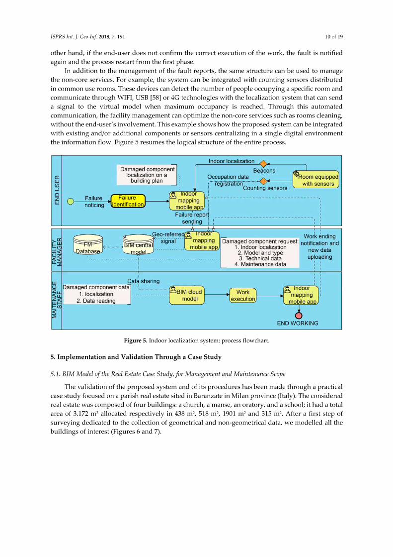
In addition to the management of the fault reports, the same structure can be used to manage
the non-core services. For example, the system can be integrated with counting sensors distributed
in common use rooms. These devices can detect the number of people occupying a specific room and
communicate through WIFI, USB [58] or 4G technologies with the localization system that can send
a signal to the virtual model when maximum occupancy is reached. Through this automated
communication, the facility management can optimize the non-core services such as rooms cleaning,
without the end-user’s involvement. This example shows how the proposed system can be integrated
with existing and/or additional components or sensors centralizing in a single digital environment
the information flow. Figure 5 resumes the logical structure of the entire process.
Figure 5. Indoor localization system: process flowchart.
5. Implementation and Validation Through a Case Study
5.1. BIM Model of the Real Estate Case Study, for Management and Maintenance Scope
The validation of the proposed system and of its procedures has been made through a practical
case study focused on a parish real estate sited in Baranzate in Milan province (Italy). The considered
real estate was composed of four buildings: a church, a manse, an oratory, and a school; it had a total
area of 3.172 m2 allocated respectively in 438 m2, 518 m2, 1901 m2 and 315 m2. After a first step of
surveying dedicated to the collection of geometrical and non-geometrical data, we modelled all the
buildings of interest (Figures 6 and 7).

ISPRS Int. J. Geo-Inf. 2018, 7, 191 11 of 19
Figure 6. Case study real estate geometric modelling.
Figure 7. Real estate BIM modelling, internal view.
The objective of the developed model was to support the facility management activities. Thus,
all the objects contained in the model were characterized by a low level of development in the
geometrical representation related to the scope of the model. This allows for a more dynamic
modelling phase and, as a result, a final model with modest dimensions in terms of hard disk
memory. On the other hand, the level of development in regards to information content was enriched
with all the information obtained from facility operations [59], according to the objectives of the
building information model. An external database, related to the building information model, was
developed to allow archiving the information on all the maintenance activities during this time. All
the objects of interest such as architectural components, MEP components and structural components
have been inserted in the building information model (and in the connected database).
The data collected can be divided in three main classes:
identification data: as the code, type, model, description, maintenance company information;
technical data: obtained from the technical sheets. This information is useful to complete the
component identification and to control the required data in the case of component replacement;
maintenance data: dates of maintenance visits and deadlines, schedules, maintenance contracts,
instructions video URL. This data is useful for the maintenance operators during the work.

ISPRS Int. J. Geo-Inf. 2018, 7, 191 12 of 19
5.2. Application Results on Corrective Maintenance
BIM in the real estate case study was utilized to apply the facility management supporting
method proposed, to assess its applicability to a real prototype, with specific reference to the
management of corrective maintenance.
For the application of the theorized processes, a specific app called Nextome developed by
Noovle [57] was used. The implementation of the system needed the construction of the indoor
localization structure through the installation of several beacons in the real estate. As stated by
Noovle, 150 beacons are sufficient for an average area of 8000 m2 [57]. The real estate configuration
led to install 61 beacons, allocated in the following way:
9 beacons for the church;
10 beacons in the manse;
36 beacons in the oratory;
6 beacons in the school.
A parish priest was the manager of the real estate used in the case study and represented the
facility manger. The priest received a real estate central building information model that was
managed by a BIM modeler engaged to realize the survey, design the model, and upload new data
periodically. The real estate end-users were the parishioners and according to the theorized system,
they were involved in the fault-reporting phase. As shown by the context, the case study included
end-users without high technological skills and background, validating the applicability of the
proposed method to a wide range of situations. In fact, mobile devices are now available to everyone
and the intuitive mobile app structure that was provided to generate reports can encourage end-users
to collaborate according to the facility maintenance needs.
Testing the process reported in Section 4.2 with a real component as shown in Figure 8, the
message was correctly sent from the end-user to the facility manager that individuated the correct
object inside the virtual model and from it extracted all the information required for maintenance
activities.
Figure 8. Building information model fault message reporting interface.
In this case, all the information about the maintenance company was already integrated inside
the damaged object (Figure 9). Thus, in this context, the facility manager can contact the maintenance
company and provide all the essential information needed for an effective maintenance service. Due

ISPRS Int. J. Geo-Inf. 2018, 7, 191 13 of 19
to the level of definition of the virtual objects, developed to be useful for the maintenance phase, the
maintainer can estimate the possible causes of failure and determine the needed operations,
instruments and any logistical constraints. This reduces the needed time for inspections and allows
the maintainer to show up on site and ready to proceed with work.
A building management system, based on components equipped with sensors, can detect the
cause of failures with high precision, but it would be very onerous for an old property like the one
discussed in this case study. Costs for the replacement of plants and systems would not be feasible
and physical building components without sensors would need to be tagged with barcodes,
integrating two technologies. On the other hand, an approach based uniquely on barcode tags for
components and scanning procedures by the end-user for communicating damages could be
inappropriate for this case study. In fact, ecclesiastical buildings are very crowded and costs for
barcode periodical maintenance would be high.
Figure 9. Building information model component database example.
However, in old buildings like the ones in this case study, the real estate data is often collected
and stored in paper archives, and consequently results in loss of information over a period. For this
reason, it is not known if all the geometrical, technical and maintenance data are available during the
survey phase and if the first building information model can be effective and applicable for the
proposed process. Thus, the proposed process could perform poorly in the early phases of its
application due to the unavailability of data in most of the building elements. The experimentation
showed that feedback from end-users during the input phase could help the maintainer in identifying
possible causes of faults and damages by combining the feedback with the information in the virtual
object. In the case of objects with poor informative content, the maintainer is not generally able to
understand the probable causes of faults and/or damages directly. This aspect shows the importance
of a continuous update of the building information model after each maintenance activity. A
structured uploading process is important to improve the efficiency of the system during the years
increasing the database. In this scope, it is thought to regulate the communication between the
maintainer and the real estate BIM modeler. At the end of the work, the maintainer can take a photo
of the product’s barcode, send it to the facility manager allowing him to access the product technical
sheet and to upload the data in the central building information model (Figure 10). Furthermore, the
double check provided by the system in the closing phase guarantees the correct fault resolution. As
a result, the proposed method configures a valid alternative to the ones presented in Section 2 for
supporting facility management activities, specifically for case studies like the one showed in this
paper. Furthermore, not only the proposed system by itself is able to support the corrective

ISPRS Int. J. Geo-Inf. 2018, 7, 191 14 of 19
maintenance for all building components, both systems and physical ones, but also it is easily
integrated with other technologies such as sensors for space management.
During the experimentation of the process, the limited precision of the localization system
proved to be a critical point. While in rooms with high internal height and in the case of large and/or
well-spaced elements, the process shows an effective identification of the fault object in the virtual
model. In other cases, the correct identification of a specific object required a reiteration of the
procedure by the end-user with caused poor performances. Nevertheless, during the experimentation
several private companies were working on new devices for indoor localization, opening the
perspective to possible future improvements.
Figure 10. Flowchart of the process implemented in the case study.
5.3. Academic and Practical Contributions
This research shows how end users’ involvement and integrated BIM-GIS technologies can
support FM activities with a specific focus on old buildings that are characterized by a high number
of daily users. The findings of the approaches and applications include:
The integration of BIM and indoor localization systems that are managed through a central
digital environment allows the identification of every element of an asset in a digital
environment without requiring a prior mapping.
No mapping systems are required for reducing maintenance efforts.
The use of a standardized data structure, inherently defined by the system, allows the update of
future data analysis that are still undervalued.
The integration of standardized information in a BIM-GIS environment allows quantitative
analysis for distributed assets.
Integrating data in a BIM-GIS logic can improve the supply chain management processes.

ISPRS Int. J. Geo-Inf. 2018, 7, 191 15 of 19
Starting from the findings above listed, it is possible to define a comparison analysis between
the proposed framework and the existing methodologies analyzed in Section 2.2. The benefits and
differentiations are summarized as follows (Cases 1, 2 and 3 refer to Table 1):
In the proposed framework, the end users are not required to use complex systems and/or
instruments to identify faults. This principle improves the usability of the system in comparison
with Case 1 and it is aligned with the methodology applied in the case of QR codes (Case 2).
Compared to Case 1, the proposed framework allows the localization of the elements in an
integrated system facilitating the identification of the faults.
Compared to Case 2, the proposed framework allows the localization and management of every
element of the building. The only requirement is the introduction of the element in the building
information model. This peculiarity allows the management of wide building elements such as
walls and floors. In fact, the application of QR codes on wide building elements can pose several
issues, namely the definition of the number of QR codes on a specific element that can present
different characteristics in different points (e.g., layers, thickness, materials) and the correct
identification of localized damages on the specific element. Through the proposed framework,
both the above-mentioned issues are overcome.
Furthermore, in the case of changes in the building (e.g., the introduction of a new element) the
use of QR codes (Case 2) requires the definition of a new QR code, its introduction in the digital
system and the physical application of the QR code on the element. The proposed framework
requires only the introduction of the new element in the building information model to allow its
identification and the consequent activation of the process.
In comparison with Case 3, all the elements can be identified including both the one connected
to the grid and the physical one such as windows, doors, and walls.
The GIS information in the integrated system with a defined and guided data structure allows
the management of distributed assets and the inclusion of supply chain management in the system.
Nevertheless, the data management defined on multiple asset paves the way for the development of
data analytics applications.
In addition, this paper provides an integrated literature review that is analyzed in a systematic
manner. The review presents the existing supporting methods for maintenance operations, the
related technologies and existing technologies for indoor localization applicable in the support of FM
activities.
Finally, the proposed solution can be directly applied in the industry with specific reference to
old buildings. The localization system can be reused in different services such as the security and
emergency management, including the industry site, hospitals, public spaces, and nursing homes.
There are still limitations in the study. First, the precision in the identification of objects is limited
compared to the QR code systems mentioned in the cases in the literature. The direct link between a
QR code and the related object allows a precise and unique identification of the element that is more
difficult using the proposed framework. Next, in comparison to an integrated BMS and BIM system,
the proposed framework is based on the human action in the identification of faults. Hence, the
uncertainty of continuous monitoring for plants needs to be further studied. A delay can be registered
between the fault, its identification from the end-users, and the consequent activation of the process.
Finally, the precise evaluation of the costs related to the effective implementation and maintenance
of the system needs to be evaluated on multiple cases to provide a comparison analysis with the
existing technologies and techniques. This passage constitutes one of the main directions for future
research.
6. Conclusions
The market of Facility Management is increasingly expanding, and efficient systems are
necessary to support manger’s decisions. Facility managers usually manage maintenance and
activities using CAFM systems, which usually cause an inadequate monitoring of building
management features. The introduction of BIM processes can improve the efficiency of building

ISPRS Int. J. Geo-Inf. 2018, 7, 191 16 of 19
management, linking external databases to a virtual representation of a real estate. However, current
research of BIM-based facility management supporting systems shows some open issues especially
in the case of old buildings with a high number of daily users. First, the communication between the
players involved in the facility management operations needs to be improved allowing a better and
useful data transfer. The proposed system provides a platform linking indoor localization systems
with building information models structured for the facility management scope. Results of the
proposed case study indicated that end-users can report a failure by taking a photo through a mobile
device and a facility manager can manage activities and maintenance operations through an
interactive building information model connected with the end-user position in the building. This
process can be an alternative to the one based on barcode systems and sensing components for
localizing indoor failures. For instance, BMS is a good solution for building status monitoring for
components connected to the network, but low performances are expected in failure reporting for
physical building elements (e.g., walls and floors). Furthermore, the implementation of a BMS would
be very onerous, especially for old real estate. The proposed processes showed to be useful even if
several issues were highlighted during the validation phase. Furthermore, less maintenance
operations for the management-system components are required, compared to the BIM-barcode
based system. The system can be integrated with the previous explained technologies and it is
structured to support corrective maintenance operations until the work ends. In addition, the system
can be updated automatically due to the definition of a circular proactive process allowing data
collecting and archiving in the building information model at the end of each maintenance activity.
Thus, maintenance activities are managed in an integrated digital environment that includes fault
notification, activity management, validation, and closing as well as spatial information for supply
chain management and quantitative data analysis.
In conclusion, the proposed framework allows the development of integrated systems to
support FM operations providing several advantages in comparison to existing techniques. First,
every element of the building can be localized and included in the process (no mapping and/or tag
systems required). Second, the entire cycle of maintenance activities is managed through a unique
integrated system including the territorial dimension. Third, data are collected in a standard structure
for future uses.
Future research will be focused on the study of the performance provided by new localization
devices that are now under development, including the definition of more case studies to effectively
prove the functionality in the management of predictive maintenance and non-core services
maintenance. Meanwhile, more comparisons need to be analyzed for the theoretical frameworks and
cases to reveal the gaps between theories and practical issues. Another line of future research is about
the cost of implementation. It is known that one of the main limitations of BIM-based processes
adoption for the existent building management is the time (and consequently cost) needed to the
survey operations and the building information model representation. One of the next steps of
research will be the study of the overall costs needed to implement the systems considering IT
structure, devices, and virtual components (including models and data). In this direction, laser
scanning and augmented reality for indoor navigation are potentially beneficial for the improvement
of the support for maintenance operators and facility managers [60].
Author Contributions: F.D.M., C.M. and A.P. designed and performed the experiments; C.M. A.P. and X.W.
supervised the experiments and analysis; all authors jointly drafted and critically revised the paper; all authors
read and approved the final manuscript.
Acknowledgments: This research was supported in part by the Australian Research Council Discovery Project
(Project No. #DP170104613) by the Australian Government. We would like to thank Noovle for its support in the
definition of the indoor geo-referenced system and of the interface to the Nextome application. Thanks also to
the “Arcidiocesi di Milano” that made possible the development of the case study presented.
Conflicts of Interest: The authors have declared that they have no completing interests.

ISPRS Int. J. Geo-Inf. 2018, 7, 191 17 of 19
References
1. Becerik-Gerber, B.; Jazizadeh, F.; Li, N.; Calis, G. Application areas and data requirements for BIM-enabled
facilities management. J. Constr. Eng. Manag. 2011, 138, 431–442.
2. Brooks, A.; Lilley, G. Enabling technology for outsourced Facilities Management. J. Inf. Technol. Constr.
(ITcon) 2006, 11, 685–695.
3. Parn, E.A.; Edwards, D.J.; Sing, M.C.P. The building information modelling trajectory in facilities
management: A review. Autom. Constr. 2017, 75, 45–55.
4. De Toni, A.F.; Nonino, F.; Montagner, M. Open Facility Management: A Successful Implementation in Public
Administration; IFMA Italia: Milano, Italy, 2009.
5. Jensen, P.A.; Anker Jensen, P. The Facilities Management Value Map: A conceptual framework. Facilities
2010, 28, 175–188.
6. Li, Y.; Cao, Y.Q.; Shi, A.L. A property management system using WebGIS. In Proceedings of the 2010
International Conference on Computer Engineering and Technology (ICCET 2010), Chengdu, China, 16–
18 April 2010; pp. V2683–V2685.
7. Thompson, B. Innovation in property management. J. Prop. Investig. Financ. 2015, 33, 436–445.
8. Mohseni, H.; Setunge, S.; Zhang, G.; Wakefield, R. Markov Process for Deterioration Modeling and Asset
Management of Community Buildings. J. Constr. Eng. Manag. 2017, 143, 04017003, doi: 10.1061/(ASCE)CO.1943-7862.0001272.
9. Andrew, A.; Pitt, M. The development of facilities and estate management in the Scottish central
government civil estate 1989–2015. J. Facil. Manag. 2016, 14, 179–187.
10. Terreno, S.; Anumba, C.J.; Gannon, E.; Dubler, C. The benefits of BIM integration with facilities
management: A preliminary case study. In Proceedings of the Congress on Computing in Civil
Engineering, Austin, Texas, TX, USA, 21–23 June 2015; pp. 675–683.
11. Cardellino, P. Mapping IT innovation in facilities management. Electron. J. Inf. Technol. Constr. 2006, 11,
673–684.
12. Zhu, J.; Wright, G.; Wang, J.; Wang, X. A Critical Review of the Integration of Geographic Information
System and Building Information Modelling at the Data Level. ISPRS Int. J. Geo-Inf. 2018, 7, 66,
doi:10.3390/ijgi7020066.
13. Tan, Y.; Song, Y.; Liu, X.; Wang, X.; Cheng, J.C.P. A BIM-based framework for lift planning in topsides
disassembly of offshore oil and gas platforms. Autom. Constr. 2017, 79, 19–30.
14. Cheng, J.C.P.; Tan, Y.; Song, Y.; Mei, Z.; Gan, V.J.L.; Wang, X. Developing an evacuation evaluation model
for offshore oil and gas platforms using BIM and agent-based model. Autom. Constr. 2018, 89, 214–224.
15. Singh, V.; Gu, N.; Wang, X. A theoretical framework of a BIM-based multi-disciplinary collaboration
platform. Autom. Constr. 2011, 20, 134–144.
16. Park, C.-S.; Lee, D.; Kwon, O.; Wang, X. A framework for proactive construction defect management using
BIM, augmented reality and ontology-based data collection template. Autom. Constr. 2013, 33, 61–71.
17. Wang, T.; Wang, J.; Wu, P.; Wang, J.; He, Q.; Wang, X. Estimating the environmental costs and benefits of
demolition waste using life cycle assessment and willingness-to-pay: A case study in Shenzhen. J. Clean.
Prod. 2018, 172, 14–26.
18. Song, Y.; Wang, X.; Wright, G.; Thatcher, D.; Wu, P.; Felix, P. Traffic Volume Prediction With Segment-
Based Regression Kriging and its Implementation in Assessing the Impact of Heavy Vehicles. IEEE Trans.
Intell. Transp. Syst. 2018, 6, 397, doi:10.3390/ijgi6120397.
19. Song, Y.; Tan, Y.; Song, Y.; Wu, P.; J.Cheng, C.P.; Kim, M.J.; Wang, X. Spatial and temporal variations of
spatial population accessibility to public hospitals: A case study of rural-urban comparison. GIScience
Remote Sens. 2018, 1–27, doi:10.1080/15481603.2018.1446713.
20. Song, Y.; Ge, Y.; Wang, J.; Ren, Z.; Liao, Y.; Peng, J. Spatial distribution estimation of malaria in northern
China and its scenarios in 2020, 2030, 2040 and 2050. Malar. J. 2016, 15, 345.
21. Ge, Y.; Song, Y.; Wang, J.; Liu, W.; Ren, Z.; Peng, J.; Lu, B. Geographically weighted regression-based
determinants of malaria incidences in northern China. Trans. GIS 2017, 21, 934–953.
22. Song, Y.-Z.; Yang, H.-L.; Peng, J.-H.; Song, Y.-R.; Sun, Q.; Li, Y. Estimating PM2.5 Concentrations in Xi’an
City Using a Generalized Additive Model with Multi-Source Monitoring Data. PLoS ONE 2015, 10,
e0142149, doi:10.1371/journal.pone.0142149.

ISPRS Int. J. Geo-Inf. 2018, 7, 191 18 of 19
23. Song, Y.; Wang, X.; Tan, Y.; Wu, P.; Sutrisna, M.; Cheng, J.C.P.; Hampson, K. Trends and Opportunities of
BIM-GIS Integration in the Architecture, Engineering and Construction Industry: A Review from a Spatio-
Temporal Statistical Perspective. ISPRS Int. J. Geo-Inf. 2017, 6, 397.
24. Alsudairi, A. Simulation as a Tool for Assessing the Economical Aspects of Construction Processes. Procedia
Eng. 2015, 118, 1086–1095.
25. Gallaher, M.P. Cost Analysis of Inadequate Interoperability in the U.S. Capital Facilities Industry; National
Institute of Standards and Technology: Gaithersburg, MD, USA, 2004.
26. Atkin, B.; Brooks, A. Total Facilities Management; John Wiley & Sons: West Sussex, UK, 2009.
27. Madritsch, T.; May, M. Successful IT implementation in facility management. Facilities 2010, 27, 429–444.
28. Mohanta, A.; Das, S. ICT-Based Facilities Management Tools for Buildings. In Proceedings of the International
Conference on ICT for Sustainable Development, Ahmedabad, India, 3–4 July 2015; pp. 125–133.
29. Róka Madarász, L.; Mályusz, L.; Tuczai, P. Benchmarking facilities operation and maintenance
management using CAFM database: Data analysis and new results. J. Build. Eng. 2016, 6, 184–195.
30. Patacas, J.; Dawood, N.; Vukovic, V.; Kassem, M. Bim for Facility Management: Evaluating BIM standards
in asset register creation and service life planning. J. Inf. Technol. Constr. 2015, 20, 313–333.
31. Gnanarednam, M.; Jayasena, H.S. The Second World Construction Symposium. In Ability of BIM to Satisfy
CAFM Information Requirements; Socio-Economic Sustainability in Construction: Colombo, Sri Lanka, 2013.
32. Lee, Y.-C.; Eastman, C.; Solihin, W. An ontology-based approach for developing data exchange
requirements and model views of building information modeling. Adv. Eng. Inform. 2016, 30, 354–367.
33. Hijazi, I.; Ehlers, M.; Zlatanova, S. NIBU: A new approach to representing and analysing interior utility
networks within 3D geo-information systems. Int. J. Digit. Earth 2012, 5, 22–42.
34. Kasprzak, C. Aligning BIM with FM: Streamlining the process for future projects. Australas. J. Constr. Econ.
Build. 2012, 12, 68–77.
35. Lee, H.H.; Yin, S.D. Overview of maintenance strategy, acceptable maintenance standard and resources
from a building maintenance operation perspective. J. Build. Apprais. 2009, 4, 269–278.
36. Shi, Y.; Du, J.; Lavy, S.; Zhao, D. A Multiuser Shared Virtual Environment for Facility Management. Procedia
Eng. 2016, 145, 120–127.
37. Shalabi, F.; Turkan, Y. IFC BIM-Based Facility Management Approach to Optimize Data Collection for
Corrective Maintenance. J. Perform. Constr. Facil. 2017, 31, 04016081, doi:10.1061/(ASCE)CF.1943-
5509.0000941.
38. Lin, Y.; Su, Y.; Chen, Y. Developing Mobile BIM/2D Barcode-Based Automated Facility Management
System. Sci. World J. 2014, 2014, 374775, doi:10.1155/2014/374735.
39. Costin, A.; Pradhananga, N.; Teizer, J. Passive RFID and BIM for real-time visualization and location
tracking. In Proceedings of the Construction Research Congress 2014: Construction in a Global Network,
Atlanta, GA, USA, 19–21 May 2014; pp. 169–178.
40. Chu, L.-C.; Lee, C.-L.; Wu, C.-J. Applying QR Code Technology to Facilitate Hospital Medical Equipment
Repair Management. In Proceedings of the 2012 International Conference on Control Engineering and
Communication Technology, Liaoning, China, 7–9 December 2012.
41. Motamedi, A.; Soltani, M.; Hammad, A. Localization of RFID-equipped assets during the operation phase
of facilities. Adv. Eng. Inform. 2013, 27, 566–579.
42. Chai, J.; Wu, C.; Zhao, C.; Chi, H.-L.; Wang, X.; Ling, B.W.-K.; Teo, K.L. Reference tag supported RFID
tracking using robust support vector regression and Kalman filter. Adv. Eng. Inform. 2017, 32, 1–10.
43. Zhao, C.; Wu, C.; Chai, J.; Wang, X.; Yang, X.; Lee, J.-M.; Kim, M.J. Decomposition-based multi-objective
firefly algorithm for RFID network planning with uncertainty. Appl. Soft Comput. 2017, 55, 549–564.
44. Katipamula, S.; Gowri, K.; Hernandez, G. An open-source automated continuous condition-based
maintenance platform for commercial buildings. Sci. Technol. Built Environ. 2017, 23, 546–556.
45. Oti, A.H.; Kurul, E.; Cheung, F. A framework for the utilization of Building Management System data in
building information models for building design and operation. Autom. Constr. 2016, 72, 195–210.
46. Faiz Ahmed, S.; Hazry, D.; Tanveer, M.H.; Joyo, M.K.; Warsi, F.A.; Kamarudin, H.; Wan, K.; Razlan, Z.M.;
Shahriman, A.B.; Hussain, A.T. Energy Conservation and Management System Using Efficient Building
Automation; AIP Publishing: Penang, Malaysia, 2015.

ISPRS Int. J. Geo-Inf. 2018, 7, 191 19 of 19
47. Pasini, D.; Ventura, S.M.; Rinaldi, S.; Bellagente, P.; Flammini, A.; Ciribini, A.L.C. Exploiting Internet of
Things and building information modeling framework for management of cognitive buildings. In
Proceedings of the IEEE 2nd International Smart Cities Conference: Improving the Citizens Quality of Life,
ISC2 2016, Trento, Italy, 12–15 September 2016.
48. Mallart, J. La Tecnologia Movil, Impulso de la Ciudad Inteligente; Facility Management Services: Madrid, Spain,
2015; p. 62.
49. Conway Beaulieu, J.; Athaide, A.; Jalali, R.; El-Khatib, K. Smartphone-based Architecture for Smart Cities.
In Proceedings of the 5th ACM Symposium on Development and Analysis of Intelligent Vehicular
Networks and Applications, Cancun, Mexico, 2–6 November 2015; pp. 79–83.
50. Taneja, S.; Akcamete, A.; Akinci, B.; Garrett, J.; Soibelman, L.; East, E. W. Analysis of three indoor
localization technologies to support facility management field activities Background research. In
Proceedings of the International Conference on Computing in Civil and Building Engineering,
Nottingham, UK, 30 June–2 July 2010.
51. McArthur, J.J. A Building Information Management (BIM) Framework and Supporting Case Study for
Existing Building Operations, Maintenance and Sustainability. Procedia Eng. 2015, 118, 1104–1111.
52. Ente Italiano di Normazione, U. UNI 11337-4:2017—Edilizia e opere di Ingegneria Civile—Gestione Digitale dei
Processi Informativi delle Costruzioni—Parte 4: Evoluzione e sviluppo Informativo di modelli, Elaborati e Oggetti;
Milano, Italy, 2017. Avialable online: http://store.uni.com/catalogo/index.php/uni-11337-4-2017.html
(accessed on 3 April 2017).
53. Chong, H.-Y.; Lee, C.-Y.; Wang, X. A mixed review of the adoption of Building Information Modelling
(BIM) for sustainability. J. Clean. Prod. 2017, 142, 4114–4126.
54. Liu, R.; Brilakis, I.; Lee, S. Issues in BIM for facility management from industry practitioners’ perspectives.
In Proceedings of the ASCE International Workshop on Computing in Civil Engineering, Los Angeles, CA,
USA, 23–25 June 2013; pp. 411–418.
55. Davidson, P.; Piche, R. A Survey of Selected Indoor Positioning Methods for Smartphones. IEEE Commun.
Surv. Tutor. 2017, 19, 1347–1370.
56. Boukhechba, M.; Bouzouane, A.; Gaboury, S.; Gouin-Vallerand, C.; Giroux, S.; Bouchard, B. A novel
Bluetooth low energy based system for spatial exploration in smart cities. Expert Syst. Appl. 2017, 77, 71–82.
57. Nextome Technical Data Sheet; 2016. Avliable online: https://www.nextome.net/infrastructure/ (accessed on
7 October 2016).
58. Yang, J.; Santamouris, M.; Lee, S. Review of occupancy sensing systems and occupancy modeling
methodologies for the application in institutional buildings. Energy Build. 2016, 121, 344–349.
59. Mayo, G.; Issa, R.R.A. Nongeometric Building Information Needs Assessment for Facilities Management.
J. Manag. Eng. 2016, 32, doi:10.1061/(asce)me.1943-5479.0000414.
60. Gheisari, M. Exploring BIM and Mobile Augmented Reality Use in Facilities Management; Construction
Research Congress: Atlanta, GA, USA, 2014; pp. 1941–1950.
© 2018 by the authors. Licensee MDPI, Basel, Switzerland. This article is an open access
article distributed under the terms and conditions of the Creative Commons Attribution
(CC BY) license (http://creativecommons.org/licenses/by/4.0/).


![Plainfield NJ Supporting-Facility Advisory Board Meeting Minutes Members[1]](https://static.fdocuments.in/doc/165x107/577d2a8d1a28ab4e1ea97c91/plainfield-nj-supporting-facility-advisory-board-meeting-minutes-members1.jpg)