Prairieville, Gonzales, St Amant, Geismar Ascension Parish Home Sales March 2012 Versus March 2013
ARTICLE I
PURPOSE AND AUTHORITY
SECTION 1.0 - PURPOSE
It is the purpose of this Zoning Ordinance to promote the public safety, health, morals, convenience and general welfare; to encourage the use of lands and natural resources in Prairieville Township in accordance with their character and trend of community development; to limit the improper use of land; to avoid over-crowding of population; to provide adequate light and air; to lessen congestion on the public streets and highways; to reduce the hazards to life and property; to facilitate adequate provisions for a system of transportation, sewage, drainage, safe and adequate water supply and distribution, education, recreation and other public requirements; to conserve the expenditure of funds for public improvements and services to conform with the most advantageous uses of environment by establishing herein standards for community development in accordance with these objectives, and the Prairieville Township Land Use Plan and by providing for the enforcement of such standards.
It is the further purpose to adopt provisions for each designated zoning district, which within each location, the sizes and use of buildings, land and minimum open spaces, sanitary measures required, and the number of families to be housed in certain areas, in buildings erected or altered in the future are specified.
SECTION 1.1 – AUTHORITY
The Prairieville Township Planning Commission, herein referred to as “Planning Commission”, was created in April, 1972, by the Prairieville Township Board, herein referred to as “Township Board”, under 1959 PA 168, as amended, for the purpose of planning and preparing a master plan; and all other powers, duties and responsibilities provided by the 1943 PA 184 for zoning boards were transferred by resolution to the Planning Commission pursuant to Section 11 of said Township Planning Act. Effective July 1, 2006, the authority for this Ordinance is set forth in 2006 PA 110, as it may from time to time hereafter be amended.

2
ARTICLE II
SHORT TITLE
SECTION 2.0
This Ordinance shall be known and may be cited as the Prairieville Township Zoning Ordinance and will be referred to herein as "this Ordinance".
3
ARTICLE III
RULES APPLYING TO TEXT AND DEFINITIONS
SECTION 3.0 - RULES APPLYING TO TEXT
The following rules of construction apply to the text of this Ordinance:
A. The particular shall control the general.
B. In any case of difference the meaning or implication between the text of this Ordinance and any caption, the text shall control.
C. The word "shall" is always mandatory and not discretionary. The word "may" is permissive.
D. Words used in the present tense shall include the future, and the words used in the singular number shall include the plural, and the plural the singular, unless the context clearly indicates the contrary.
E. The word "erected" shall include the moving upon the land of any structure including mobile homes.
F. The word "building" includes the word "structure".
G. A "building" or "structure" includes any part thereof.
H. The words "used" or "occupied", as applied to any land or building, shall be construed to include the words "intended", "arranged", or "designed to be used", or "occupied".
I. Any word or term not defined herein shall be used with a meaning of common or standard utilization.
J. The terms “adjoining lots and parcels” and “contiguous lots and parcels” are, unless expressly stated otherwise, intended to include lots and parcels separated by highways, roads, streets or natural watercourses.
SECTION 3.1 - DEFINITIONS
For the purpose of this Ordinance, the following terms and words are defined as follows:
1. Access Lot: A type of waterfront lot providing for private or common (semi-private) access to a waterway for one or more access lot beneficiaries. An access lot includes any buffer strips required herein.
1a. Access Lot Beneficiary: The owner/occupant of a waterfront lot and any other person with a right of access to a waterway and/or use of a waterway through a waterfront lot, in whole or in part by fee ownership, easement, lease, license, gift, business invitation, or any other written form of conveyance, dedication, permission or access/use rights. Members of the same family as defined under Section 3.1.30 of this Ordinance shall be collectively considered as one access lot beneficiary.
2. Accessory Building: A subordinate building or a portion of a building, the use of which is incidental to that of the main building it serves and which, unless expressly permitted otherwise in this Ordinance, is located on the same lot as the main building.
2a. Accessory Use: A use subordinate to the main use on a lot and used for the purposes customarily incidental to those of the main use.
3. Agricultural: See "Farm".
4. Alley: Any dedicated public way, other than a street, providing a secondary means of access to a property and not intended for general traffic circulation.
5. Alter or Alteration: The word "alter" or "alteration" in the context of this Ordinance shall mean any change, improvement, or repair to the structure that results in a change or modification to the exterior dimension of said structure. Roofing, siding, insulation, etc. shall not be construed to be a change in the exterior dimension.
4
5a. Animal Shelter: A facility that is operated by a person, humane society, society for the prevention of cruelty to animals or any other non-profit organization for the care of homeless animals.
6. Apartment: A room or suite of rooms, including bath and culinary accommodations, in a multiple dwelling intended or designed for use as a residence by a single family.
7. Bars: See "Tavern".
8. Basement: That portion of the building which is partly underground and which has a majority of its floor
8a. Bed & Breakfast Operations: A use subordinate to the principal use of dwelling unit as a single family dwelling and a use in which transient guests are provided a sleeping room and board in return for payment. The use shall also meet the following criteria:
a. The operation provides accommodations for transient tenants for no longer than a two-week period;
b. The operation is owner occupied; and
c. The operation has eight (8) or fewer sleeping rooms, including rooms occupied by the owner.
9. Billboards and Signs:
a. Billboards: Any structure, including the wall of any building, on which lettered, figured, or pictorial matter is displayed for advertising a business, service, or entertainment which is not conducted on the land upon which the structure is located, or products not primarily sold, manufactured, processed or fabricated on such land.
b. Business signs: Any structure, including the wall of any building, on which lettered, figured, or pictorial matter is displayed for advertising a business, service, or entertainment conducted on the land where the structure is located, or products primarily sold, manufactured, processed, or fabricated on such land.
c. Real Estate Sign: Any temporary structure used only to advertise, with pertinent information, the sale, rental, or leasing of the premises upon which it is located.
d. Identifying Sign: Any structure on the same premises it identifies which serves only (1) to tell the name or use of any public or semi-public building or recreation space, club, lodge, church, or institution; (2) only to tell the name or address of an apartment house, hotel, or motel; or (3) only to inform the public as to the use of a parking lot.
e. Name Plate: A structure affixed flat against the wall of a building which serves solely to designate the name or the name and profession or business occupation of a person or persons occupying the building.
10. Boarding House - Rooming House: A dwelling having one (1) or more kitchens and used for the purpose of providing meals and/or lodging for pay or compensation of any kind, in having four (4) or less sleeping rooms in addition to those used by the immediate family, but excluding bed and breakfast operations.
10a. Boat House: A residential accessory building that is (1) located entirely or partially upon a body of water or in close proximity thereto; and (2) used primarily for the housing or storage of one (1) or more boats and other items of personal property used for boating, fishing and/or swimming purposes.
11. Building: A structure erected on-site, a mobile home or mobile structure, or a pre-manufactured or pre-cut structure which has a roof supported by columns or walls and which is designed primarily for the shelter, support, or enclosure of persons, animals or property of any kind.
12. Building Code: The building or construction code in effect in Prairieville Township herein referred to as “the Township”. In general, the building code will regulate requirements for construction, housing, plumbing, electrical wiring, and fire protection.
13. Building, Height of: The elevation measured from the average finished lot grade at the front of the building to the highest point of the roof.
5
14. Building Inspector: The administrator of the building, housing, plumbing, electrical or other codes that have been adopted or may be adopted in the future by the Township or which the Township is required by law to enforce. The Building Inspector is employed by the Township Board and may also be assigned to perform the duties of the Zoning Administrator.
15. Building Line: A line parallel to the front right-of-way line (or, if there is no front right-of-way line, the front lot line) drawn at a distance representing the minimum horizontal difference between the front right-of-way line (or, if there is not front right-of-way line, the front lot line) and the nearest point of the building. Lots having water frontage - See Section 4.24.
16. Building Permit: A permit issued by the Building Inspector as required by the Building Code regulations. A Building Permit is not a Zoning Permit.
17. Cabin: A detached building which is used for seasonal occupancy as a dwelling or sleeping quarters, but not including motels.
18. Cabin Court: One (1) or more cabins which may be used for seasonal occupancy as a dwelling or sleeping quarters for transients or tourists for a fee, but not including motels.
18a. Campground: A parcel or tract of land set aside and used for camping in tents and/or recreational vehicles on a temporary recreational basis.
18b. Child Care Facility: A facility for the care of children under 18 years of age, as licensed and/or registered and regulated by the State under Act No. 116 of the Public Acts of 1973 and the associated standards and rules promulgated by the State Department of Social Services. Such organizations shall be further defined as follows:
a. “Child care center” or “day care center” means a facility, other than a private residence, receiving one or more pre-school age children for group care for periods of less than 24 hours a day, and where the parents or guardians are not immediately available to the child. It includes a facility, which provides care for not less than two consecutive weeks, regardless of the number of hours of care per day.
The facility is generally described as a childcare center, day care center, day nursery, nursery school, parent cooperative preschool, play group, or drop-in center. “Child care center” or “day care center” does not include (i) a Sunday school, a Vacation Bible School, or a religious instructional class that is conducted by a religious organization where children are in attendance for not greater than three (3) hours per day for an indefinite period, or not greater than eight (8) hours per day for a period not to exceed four (4) weeks during a 12-month period; or (ii) a facility operated by a religious organization where children are cared for not greater than three (3) hours while persons responsible for the children are attending religious services.
b. “Family day care home” means a private home which is the bona fide private residence of the operator of the family day care home and in which one (1) or more, but less than seven (7), minor children are received for care and supervision for periods of less than 24 hours a day, unattended by a parent or legal guardian, except children related to an adult member of the family by blood, marriage, or adoption. It includes a home that gives care to an unrelated child for more than four (4) weeks during a calendar year.
c. “Group day care home” means a private home which is the bona fide private residence of the operator of the group day care home and in which more than six (6) but not more than 12 minor children are given care and supervision for periods of less than 24 hours a day unattended by a parent or legal guardian, except children related to an adult member of the family by blood, marriage, or adoption. It includes a home that gives care to an unrelated child for more than four (4) weeks during a calendar year.
19. Prairieville Township Planning and Zoning Commission: The official legally consummated Township Planning and Zoning Commission of Prairieville Township, Barry County, Michigan.
6
19a. Communication Tower: A radio, telephone, cellular telephone, or television relay structure of skeleton framework, or monopole attached directly to the ground or to another structure, used for the transmission or reception of radio, telephone, cellular telephone, television, microwave, or any other form of telecommunication signals, excluding those customarily accessory to residential dwellings such as television antennas, ham radio antennas, satellite dish antennas, etc.
19b. Deck: A patio or platform without a roof that is anchored to the ground or attached and/or extending in a permanent fashion from the exterior wall or walls of an existing dwelling or structure.
20. Development Plan: A scale drawing which shows the location and dimensions of improvements upon a parcel of land, including but not limited to locations and size of buildings, driveways, parking areas, landscaping sidewalks, signs, utility systems, open spaces, greenbelts, and drainage facilities.
21. Districts: "Districts" as used herein is synonymous with the word "zones" or "zoning district".
22. Dog Kennel: A facility or place which keeps dogs for breeding, sale, leasing, training, trading or sporting purposes, for remuneration.
23. Drive-in Restaurant: A public eating place where a majority of the food that is prepared is served or sold for consumption other than within a building on the premises.
23a Driveway: A passage providing a single lot automotive access to a public or private road. A driveway shall have a width of no less than 12 feet.
24. Dwelling: A single family, two (2)-family or multiple family dwelling.
25. Duplex: Two (2)-family dwelling.
26. Dwelling, Multiple Family: A building containing three (3) or more dwelling units, each with separate housekeeping facilities, designed for residential use and conforming to all other respects to the standards set forth in Section 3.1(26). A motel or hotel shall not be deemed a multiple family dwelling.
27. Dwelling, Single Family: A building containing not more than one (1) dwelling unit designed for residential use, complying with the following standards:
a. It complies with the minimum square footage requirements of this ordinance for the zone in which it is located.
b. It has a core area of living space of at least 20 feet by 20 feet in size.
c. It is firmly attached to a permanent foundation constructed on the site in accordance with the Township building code and shall have a wall of the same perimeter dimensions of the dwelling and constructed of such materials and type as required in the applicable building code for single family dwellings. In the event that the dwelling is a mobile home, as defined herein, such dwelling shall, in addition thereto, be installed pursuant to the manufacturer's setup instructions and shall be secured to the premises by an anchoring system or device complying with the rules and regulations of the Michigan Mobile Home Commission.
d. In the event that a dwelling is a mobile home as defined herein, each mobile home shall be installed with the wheels removed. Additionally, no dwelling shall have any exposed towing mechanism, undercarriage or chassis.
e. The dwelling shall contain no additions or rooms or other areas, which are not, constructed with similar quality workmanship as the original structure, Including permanent attachment to the principal structure and construction of a foundation as required herein.
f. The dwelling shall comply with all pertinent building and fire codes. In the case of a mobile home, all construction and all plumbing, electrical apparatus and insulation within and connected to said mobile home shall be of a type and quality conforming to the "Mobile Home Construction and Safety Standards" as promulgated by the United States Department of Housing and Urban Development, being 24 CFR 3280, and as from time to time such standards may be amended. Additionally, all dwellings shall meet or exceed all applicable roof snow load and strength requirements.
7
28. Dwelling, Two (2) Family: A building containing not more than two (2) separate dwelling units, each with separate housekeeping facilities, designed for residential use and conforming in all other respects to the standards set forth in Section 3.1(26).
29. Dwelling Unit: A building or portion thereof, designed for residential occupancy by one (1) family.
30. Election Campaign Sign: A sign related to a candidate for political office or an issue to be determined at a governmental election.
31. Essential Services by Public Utilities and Other Agencies: This shall include the erection, construction, alteration or maintenance by public utilities, municipal departments or other governmental agencies of electric substation, gas regulator buildings and auxiliary buildings, underground or overhead gas, electrical communication, steam or water transmission or distribution systems, or collection, supply or disposal systems; including: poles, wires, mains, drains, sewers, pipes, cables, towers, fire alarm boxes, police or other call boxes, traffic signals, hydrants and other similar equipment and accessories in connection therewith reasonably necessary for furnishing adequate service by such utilities or agencies, or for the public health or safety or general welfare; but not including offices, buildings or yards used for bulk storage, fabrication or manufacturing of materials used by such utilities or municipal departments or other governmental agencies. Transmission towers or cables associated with radio and television broadcastings are not considered to qualify as essential service.
32. Family (one):
a. An individual or group of two (2) or more persons related by blood, marriage or adoption, together with foster children and servants of the principal occupants, with not more than one additional unrelated person, who are domiciled together as a single, domestic, non-profit housekeeping unit in a dwelling unit, or
b. A collective number of individuals domiciled together in one (1) dwelling unit whose relationship is of a continuing non-transient domestic character and who are cooking and living as a single non-profit housekeeping unit. This definition shall not include any society, club, fraternity, sorority, association, lodge, coterie, organization, or group of students or other individuals whose domestic relationship is of a transitory or seasonal nature or for an anticipated limited duration of a school term or terms or other similar determinable period.
33. Family (immediate): A person related by blood, marriage, or adoption, excluding aunts, uncles and cousins.
34. Farm: All the contiguous neighboring or associated land operated as a single unit on which bonafide farming is carried on directly by the owner or by his agent or by a tenant farmer. Provided that the area thereof is sufficient to constitute the type of farming being performed; and, for the purpose of this Ordinance, farms may be considered as including establishments operated as bonafide green houses, nurseries, orchards, chicken hatcheries, poultry farms, dairy farms, apiaries and other similar activities. The words "agriculture" and "farming" shall be considered as synonymous.
35. Farm Buildings: Any building or structure, other than a dwelling, used or maintained on a farm which is essential and customarily used on farms in the pursuit of agricultural activities.
36. Floor Area: The area of all floors computed by measuring the dimensions of the outside walls of a building. Porches, patios, terraces, breezeways, carports, verandas, garages, unfinished attics, attic floor areas with less than five (5) vertical feet from floor to finished ceiling, and all basements are excluded.
37. Frontage: Repealed by Ordinance # 115
38. Garage - Private: A detached accessory building or portion of main building for the parking or temporary storage of automobiles, boats, house trailers and similar vehicles owned and used by the occupants of the building to which it is accessory or to which it is part of.
39. Garage - Public: A building, other than a private garage, used for the care, repair or storage of equipment, automobiles, boats, trucks, buses, motorcycles, snowmobiles and other similar vehicles, or where such vehicles are parked or stored for remuneration, hire or sale.
8
40. Gasoline Service Station: A building or structure and land area combined, used primarily for servicing motor vehicles, with the usual operating commodities such as gasoline, fuel oil, grease, water, batteries, tires and other minor accessories, or services such as washing, waxing, lubricating, and minor repairs such as the repair of tires, lights, charging of batteries or minor engine repairs and adjustments when conducted within an enclosed building. Major repairs such as engine replacement, painting, body work, and refinishing shall not be included.
41. Grade: An average level of the finished surface of the ground adjacent to the exterior walls of the building or structure.
42. Greenbelt: A planting strip or buffer strip at least ten (10) feet in width, composed of deciduous and/or evergreen trees spaced not more than 30 feet apart and which grow to approximately five (5) feet in height after one (1) full growing season.
43. High Water Line: The line between upland and bottomland that persists through successive changes in water levels, below which the presence and action of the water is so common or recurrent that the character of the land is marked distinctly from the upland and is apparent in the soil itself, the configuration of the surface of the soil, and the vegetation. On an inland lake that has a level established by law, it means the high established level. Where water returns to its natural level as the result of the permanent removal or abandonment of a dam, it means the natural ordinary high-water mark.
44. Home Occupation: An occupation or profession carried on as a subordinate use by a member of a family residing on the premises and conducted entirely within the dwelling or in a detached accessory building located on the premises, and which is clearly incidental and secondary to the use of the premises for dwelling purposes and does not change the character thereof. (See Section 4.19).
45. Hotel: A building having more than two (2) stories above the surface of the ground where lodging with or without meals is furnished to transients or to resident guests for compensation, and containing more than four (4) sleeping units.
46. Inoperable Motor Vehicles: Any motor vehicle, which is unlicensed, dismantled, wrecked or which cannot be operated under its own power and is kept or stored outside a structure. See Ordinance No. Three (3) as provided in the Prairieville Township Ordinances.
47. Institutional or Public Uses: Churches, schools teaching academic subjects, hospitals, convalescent and nursing homes (four (4)-bed homes and larger), parks, civic centers, libraries and other governmental structures.
48. Junk: Any old, worn out or discarded material including but not limited to scrap metal, rope, rags, paper, trash, debris, inoperable motor vehicles and parts, and other old or scrap materials.
49. Junkyard/Salvage Yard: Any parcel of land maintained or operated for the purchase, sale, storage, dismantling, demolition or use of junk, including scrap materials, motor vehicles, machinery, buildings, structures, construction material or other salvaged material. In addition, any premises upon which two (2) or more inoperable motor vehicles are kept or stored outside a building. (See Ordinance No. Three (3) as provided in the Prairieville Township Ordinances.) The storage of used cars in inoperable condition, used or salvaged materials, used furniture and household equipment shall not be considered a junkyard/salvage yard under this Ordinance if said materials are stored entirely within an enclosed building. Furthermore, under no circumstances shall a solid waste sanitary landfill or solid waste disposal area as defined and made licensable under the Solid Waste Management Act, 641 PA 1978, as amended, be considered a junkyard/salvage yard for the purposes of this Ordinance.
50. Land Use Plan: The official and legally recognized Prairieville Township Land Use Plan including and subsequent amendments or addition thereto.
51. Lot/Parcel/Tract: A piece of land described in a recorded plat or by metes and bounds, occupied or intended to be occupied, by a principal building or group of such buildings and accessory buildings, or utilized for a principal use and uses accessory thereto.
51a. Lot Area: The total area within a lot.
9
52. Lot-Corner: A lot which abuts two (2) roads and occupies the interior angle of the intersection of the two (2) road right-of-way lines which make an angle of less than 145 degrees.
53. Lot Coverage: The amount of a lot, stated in terms of percentage that is covered by buildings.
54. Lot-Interior: A lot other than a corner lot.
55. Lot-Through: An interior lot abutting more than one (1) road.
56. Lot-Line: For the purpose of this Ordinance, a lot line is either the boundary line between two (2) lots or the line between the properties of two (2) different owners.
57. Lot-Line-Front: In the case of an interior lot, the boundary line of the lot immediately adjacent to the right-of-way upon which the lot fronts, and in the case of a corner lot, the front lot line shall be the boundary line of the lot immediately adjacent to the street right-of-way on that side of the lot which has the narrowest frontage.
58. Lot-Line-Rear: A lot line which is opposite and most distant from the front lot line and, in case of an irregular shaped lot, a line ten (10) feet in length within the lot, parallel to and at the maximum distance from the front lot line.
59. Lot-Line-Side: Any boundary line not a front lot line or a rear lot line.
60. Lot-Width: The distance between the side lot lines measured at right angles to the lot depth at the required front yard setback line.
61. Lot-Depth: The average distance between the front and rear lot lines measured in the mean direction of the side lot lines.
61a. Lot / Parcel - Vacant: A lot or parcel not having any building upon it.
62. Lot of Record: A lot which is part of a subdivision, the map of which has been recorded in the office of the Register of Deeds; or a lot described by metes and bounds, the deed, land contract, or survey to which has been recorded in the office of the Register of Deeds, or a lot that has been consummated legally by a land contract or survey.
63. Mobile Homes: A structure, transportable in one (1) or more sections, which is built on a chassis and designed to be used as a residence with or without permanent foundation, when connected to the required utilities, and includes the plumbing, heating, air-conditioning, and electrical systems contained in the structure. Mobile home does not include a recreational vehicle.
64. Mobile Home Park: A parcel or tract of land under the control of a person upon which three or more mobile homes are located on a continual non-recreational basis is offered to the public for that purpose regardless of whether a charge is made therefore, together with any building, structure, enclosure, street, equipment, or facility used or intended for use incident to the occupancy of a mobile home and which is not intended for use as a temporary trailer park.
65. Mobile Home Park Lot: A designated site within a mobile home park for exclusive use of the occupants of a single mobile home.
66. Motel: A building or group of buildings having two (2) or fewer stories above the surface of the ground where lodging with or without meals is furnished to transients or to temporary resident guests for compensation, and containing more than four (4) sleeping units.
67. Nightclub: See "Tavern".
68. Non-conforming Building or Structure: Any building or other structure which does not comply with the applicable bulk regulations for the district, either at the effective date of this Ordinance or as a result of a subsequent amendment thereto.
69. Non-conforming Lot of Record: See Section 6.17.
70. Non-conforming Use: Any use, whether a building or structure or a tract of land which does not conform to the applicable use regulations for the district, either at the effective date of this Ordinance or as a result of a subsequent amendment thereto.
10
71. Occupied: Any structure which is being used for dwelling or sleeping purposes. (Also see Section 3.0 - H.)
72. Owner: A person having legal title to the land through a deed or land contract as distinguished from the owner of personal property.
73. Planned Unit Development:
A Planned Unit Development, herein referred to as PUD, is a land development project comprehensively planned as an entity via an overall site plan which may permit flexibility in building siting, mixtures of housing types, usable open spaces and the preservation of natural features. This definition shall include a tract of land having more than one (1) single-family dwelling and/or two (2)-family dwelling upon it other than a mobile home park, a farm (as regulated in the "A" zoning district), or a plat.
74. Persons: "Persons" including any individual, political subdivision, estate, trust, or body of persons, whether incorporated or not, acting as a unit.
75. Principal or Main Use: The primary or predominant use of the premises.
76. Private Road: A non-public passage providing two (2) or more lots automotive access to a public road or another private road.
77. Recreational Vehicle: A vehicle primarily designed and used as temporary living quarters for recreational, camping or travel purposes, including a vehicle having its own motor power or a vehicle mounted on or drawn by another vehicle. This definition includes travel trailers, camping trailers, motor homes, and truck campers as said terms are defined by Michigan statute at MSA 14.15 (12501); MCLA 333.12501.
78. Restaurant: A public eating place where a majority of the food that is prepared is served or sold for consumption within a principal building. A restaurant serving alcoholic beverages shall be classified as a tavern in this Ordinance.
79. Right-of-way: A street, alley or other thoroughfare or easement permanently established for passage or persons or vehicles.
79a. Road Frontage: The largest distance of uninterrupted frontage that one (1) side of a lot has upon a public or a private road.
80. Seasonal Dwelling: A dwelling other than a permanent residence occupied for less than six (6) months in any one (1) year.
81. Setback: The minimum horizontal distance between the nearest point of the building and the abutting right-of-way or, if there is no abutting right-of-way, the abutting lot line. The term may apply to side line, rear line, and front line setbacks. Lots having water frontage - See Section 4.24.
82. Setback Line (Minimum): A line parallel to an abutting right-of-way (or, if there is no abutting right-of-way, the abutting lot line) drawn at the minimum horizontal distance as stipulated in the particular zoning district. The building line shall be at or behind the setback line (minimum). Lots having water frontage - See Section 4.24.
83. Sign: See "Billboards".
83a. Site Condominium: A condominium project in which one or more buildings are intended to be located upon separate sites which constitute individual condominium units. (See Section 3.1.73 defining "Planned Unit Development").
83b. Site Condominium Common Elements: That portion of a site condominium project designed and intended for joint ownership and/or use by the owners of individual site condominium units, as described in the master deed for the site condominium project.
83c. Site Condominium Unit: That portion of a site condominium project designed and intended for separate ownership and use, as described in the master deed for the site condominium project.
11
84. Solid Waste Disposal Site: Any site or tract of land used for the disposition, storage, transfer, collection or reclamation of solid waste material, and operating in conformance to applicable state and local regulations.
85. Special Land Use: A use permitted under certain conditions within a zoning district as regulated in Article VII of this Ordinance. Special land uses which are permitted within a specific zone district are listed in the Use Regulations of all zone districts.
86. Stable-Private: A building used or to be used by an individual for housing horses owned by said individual for the use of himself and his immediate family.
87. Stable-Public: A building used or to be used for the housing of horses for hire by the owner or operator thereof.
88. Story: That portion of a building included between the surface of any floor and the surface of the floor next above it, or if there be no floor above it, then the space between such floor and the ceiling next above it, and exclusive of any mezzanine balcony or basement.
89. Story-Half: That portion of a building between the eaves and the ridge lines of a pitched roof which may or may not be used for tenant purposes.
90. Street: A public or private thoroughfare, which affords the principal means of vehicular access to abutting property including roads and highways but not including an alley.
91. Structure: Anything constructed, erected or to be moved to or from any premises, which is permanently located above or below the ground, including signs and billboards.
92. Tavern: Any establishment or portion thereof where malt, vinous or spirituous liquors are sold for consumption on the premises.
93. Tent: A collapsible shelter of canvas or other fabric.
94. Theater-Indoor: An indoor theater shall be any building or portion thereof used as a place of enactment of significant events or activities or for the presentation of dramatic spectacles, shows, movies or other entertainment. Said building shall have a roof completely sheltering actors and patrons and be open to the public, with or without charge.
95. Theater-Outdoor: An outdoor theater shall be any place other than indoor theater used for the enactment of significant events or activities or the presentation of dramatic spectacles, shows, movies or other entertainment open to the public, with or without charge, including drive-in theaters.
96. Travel Trailer Park: Any site, lot, field or tract upon which three (3) or more occupied recreational vehicles or tents are harbored, either free of charge or for revenue purposes, including any building, structure, tent, vehicle or enclosure used or intended for use as part of the equipment of such travel trailer.
97. Variance: A change or variance in the dimensional requirements of this Ordinance such as lot area, yard or parking regulations or interpretations of the zoning map. A variance shall be granted by the Zoning Board of Appeals in accordance with the provisions of Article IX.
97a. Waterfront Lot: Any lot or parcel of land, whether or not improved, and whether or not platted, any portion of which:
a. Abuts the shoreline of any waterway; or
b. Abuts a promenade, walkway, or other property which itself abuts the shoreline of any waterway and which provides access and/or use rights to the waterway.
97b. Waterway: A natural or man-made lake, river, stream, channel, pond, equal or greater than two (2) acres, or other natural or artificial watercourse.
98. Yard: An open space, on the same lot with a building, unoccupied and unobstructed from the ground upward, except as otherwise provided in this Ordinance. The measurement of a yard shall be construed as the minimum horizontal distance between the right-of-way (or, if there is none, the lot line) and the nearest point of the principal building or structure. See also Section 4.20.
12
99. Yard-Front: A yard extending across the front of the lot between the side lot line and measured between the abutting right-of-way (or if there is no abutting right-of-way, the abutting lot line) and the building line. (See also Section 4.24 as to lots having water frontage).
100. Yard-Rear: A yard extending across the rear of a lot between the side lot line and being the minimum horizontal distance between the rear lot line (or instead the rear right-of-way if there is one) and the rear line of the main building or any other projections other than steps, unenclosed balconies or unenclosed porches. On corner lots, the rear yard shall be considered as parallel to the street upon which the lot has its least dimension. On both corner lots and interior lots, the rear yard shall in all cases be at the opposite end of the front yard. (See also Section 4.24 as to lots having water frontage).
101. Yard-Side: A yard between the side lot line and the nearest point of the building and extending from the rear line of the building to the building line.
102. Zoning Administrator: The administrator of this Ordinance, employed by the Township Board.
103. Zoning Compliance Permit: Any permit issued by the Zoning Administrator indicating compliance with the provisions of this Ordinance.
13
ARTICLE IV
GENERAL PROVISIONS
SECTION 4.0 - PURPOSE
General regulations apply to all districts except as noted in this Ordinance. Where requirements of a general regulation and a district regulation differ, the more restrictive requirement shall prevail.
SECTION 4.1 - APPLICATION REGULATIONS
Zoning affects every structure and extends vertically, except as specifically provided in this Ordinance:
A. No building or structure shall hereafter be erected, razed, altered or moved, nor shall any building or premises hereafter be used for any purpose other than is permitted in the district in which said building or premises are located.
B. No building shall hereafter be erected or altered to exceed the height limitations, or occupy a greater percentage of lot area, or, intrude on the required front yard, rear yard, side yard or inner or outer courts, or accommodate or house a greater number of families, or provide less space per dwelling unit than is specified for the district in which such building is located.
C. No lot area and no yard, court, parking areas or other required space shall be divided, altered, reduced or diminished as to make said area or dimension less than the minimum required under this Ordinance, except where such reduction has been brought about by the expansion or acquisition of public rights-of-way for a street, road or highway. If a required area is already less than the minimum required under this Ordinance, said area or dimension shall not be further divided or reduced.
SECTION 4.2 - LOT - BUILDING RELATIONSHIPS
Hereafter, every building erected, razed, altered or moved shall be located on a lot of record as defined herein, and except in the case of an approved multiple-family dwelling development, a PUD, a mobile home park, or a farm (as regulated in the "A" zoning district), there shall be no more than one (1) principal residential building and its permitted accessory structures located on each lot in any zoning district permitting residential use.
SECTION 4.3 - TEMPORARY BUILDINGS FOR NON-RESIDENTIALUSE
Temporary buildings for non-residential use incidental to construction work shall be permitted. Said use shall not be in conflict with public health, safety, and welfare regulations. The temporary building(s) and all debris shall be removed within 15 days after completion or abandonment of the work.
SECTION 4.4 – TEMPORARY PLACEMENT OF RECREATIONAL VEHICLES AND TENTS
A recreational vehicle or tent may be allowed on a temporary non-commercial basis as a special land use in the “A”, “R-1” and “R-2” zoning classifications on an otherwise vacant lot or on a lot having only an accessory building(s) used primarily for residential purposes upon it, subject to the following requirements:
A. The placement of a recreational vehicle or tent for occupancy upon a parcel shall not exceed a total of 60 days or more than ten (10) weekends in any calendar year. Placement for one (1) weekend day shall be counted as placement for the entire weekend for purposes of this provision.
B. For purposes of this section, the word “day” shall refer to a calendar day (e.g. January 1).
C. Not more than one (1) recreational vehicle or tent may be placed for occupancy upon a parcel.
D. The recreational vehicle or tent shall be served by sewage and water supply facilities located on the same parcel as the recreational vehicle or tent and approved by the Barry County Health Department. The sanitary sewage facility shall be screened from adjoining properties under separate ownership and shall not be located in the front yard.
14
E. Neither rent nor any other fee shall be charged by the property owner for a temporary placement allowed hereunder.
F. The special land use permit shall be valid for a period of one (1) year but shall be automatically renewed annually thereafter unless the Zoning Administrator determines that there has either (1) been a failure to comply with this Ordinance and/or the terms of the special land use permit, or (2) there has been a material change in conditions that may cause the special land use to no longer satisfy the standards set forth in Section 6.11 B. for special land use approval. In the event of either such determination, the Special Land Use permit shall not be renewed unless and until the Planning Commission determines, after due notice and hearing in accordance with Sections 6.10 and 6.11, that the special land use permit should be renewed.
G. Any person who shall permit or cause a recreational vehicle or tent to be placed in violation of the requirements in Section 4.4 shall be in violation of this Ordinance and subject to the sanctions set forth herein.
SECTION 4.5 - OUTDOOR STORAGE OF RECREATIONAL VEHICLES AND TENTS
A. Except as provided below, not more than one (1) recreational vehicle or tent may be stored outdoors on a parcel of land.
B. The outdoor storage of a recreational vehicle or tent shall not be permitted on a parcel of land in the “R-1” or “R-2” zoning classifications having no occupied dwelling upon it unless a special land use permit has been granted in accordance with the standards set forth in Section 6.11.
SECTION 4.6 - INTERSECTION VISIBILITY
On any corner lot in any district, no fence, wall, screen, hedge, sign or other structure or planting shall obstruct vision between the heights of two (2) feet and ten (10) feet within the triangular area formed by the intersecting street right-of-way lines and a street line intersecting them at points which are on said right-of-way lines and 30 feet distant from their point of intersection. Such heights of clear vision area shall be measured from the elevation of the street centerlines at the point of intersection. No fence, wall, screen, hedge, sign, or other structure or planting shall obstruct vision from a driveway or other entrance or exit onto a public or private road between the heights of two (2) feet and ten (10) feet, measured above the elevation of the street center line within ten (10) feet of the public or private road.
SECTION 4.7 - THROUGH LOTS
In any district, a through lot, as herein described, shall have a front yard, as hereinafter provided for its particular district on all frontages along each street lot line.
SECTION 4.8 - ESSENTIAL SERVICES EXEMPTION
Essential services, as defined in Section 3.1 (Definition 31) shall be permitted as authorized by law and other ordinances in any use district, it being the intention hereof to exempt such erection, construction, alteration and maintenance from the application of this Ordinance; provided that electric transmission substations (supply voltage over 46KV) and gas transmission regulator stations (supply pressure over 400 PSIG) shall be subject to the provisions of this Ordinance; and further provided that appropriate permits will be obtained for all construction. Fees will be charged for substations, regulator buildings and auxiliary buildings but not for those elements directly associated with distribution or transmission systems.
15
SECTION 4.9 - REQUIRED WATER SUPPLY AND SEWAGE DISPOSAL FACILITIES
Every building, permanent or temporary, hereafter erected, altered or moved upon any premises and used in whole or in part for dwelling (year round or seasonal), recreational, business, commercial or industrial purposes, including churches, schools, and other buildings in which persons customarily congregate, shall be provided with a safe and sanitary water supply system and means for collecting and disposing of all human excreta and of all water-carried domestic, commercial, industrial and other wastes that may adversely affect health conditions. The written approval of such facilities by the District Department of Health shall be filed with an application for zoning permit.
SECTION 4.10 - GRADES
A. No premises shall be filled or graded so as to discharge surface runoff on abutting premises in such a manner that will cause inconvenience or damage to adjacent properties. When property is developed adjacent to existing properties previously developed, existing grades shall have priority.
B. Leaching ponds or holding ponds to handle maximum water run-off may be required when large buildings or parking lots are constructed.
SECTION 4.11 - REMOVAL OF SOIL, SAND OR OTHER MATERIAL
The removal of soil, sand, topsoil or other material from the land shall only be permitted when such use is in conformance with any applicable Soil and Sedimentation Erosion Control Ordinance. The written approval of the administering agency of said ordinance shall be filed with an application for a zoning permit.
SECTION 4.12 - ADDITIONS TO MOBILE HOMES
Any additions to a mobile home within the Township must, if erected on-site, be constructed in accordance with the Township Building Code and, if pre-manufactured, be in compliance with the "Mobile Home Construction and Safety Standards" as promulgated by the United States Department of Housing and Urban Development, being 24 CFR 3280, and as from time to time such standards may be amended.
SECTION 4.13 - SITE PLAN REVIEW
SECTION 4.13-1 - PURPOSE
The intent of this section is to provide for consultation in a public forum and cooperation between the land developer and the Planning Commission in order that the developer may accomplish his objectives in the utilization of his land in compliance with Township, County and State regulations, and with minimum adverse effect on existing and future land uses, natural resources and streets and highways in the immediate area and vicinity.
SECTION 4.13-2 - DEVELOPMENTS REQUIRING SITE PLAN REVIEW
The Building Inspector shall not issue a building permit for the construction of the following buildings, structures, or uses until a detailed site plan has been reviewed by the Planning Commission:
A. Land uses allowed in the “R-4” Multiple Family, Height Density Residential District.
B. Land uses allowed in the “C-1” Rural Area Convenience, Commercial District, excluding one (1) single family dwelling on a single parcel.
C. Land uses allowed in the “I” Industrial District, excluding one (1) single family dwelling on a single parcel.
D. Land uses allowed in the “P-1” Public Land or “P-2” Semi-public Land Districts.
16
E. Special land uses, excluding home occupation uses.
F. Access lots providing access to more than two (2) access lot beneficiaries. This shall not apply to an access lot serving only access lot beneficiaries who are the owners/occupants of land on an island in the body of water along which the access lot is located.
G. Except as indicated in the following sentence, all land uses on land designated as wetlands or hydric soils on the Prairieville Township Water Resources Map, which map is adopted as a part of this Ordinance. The following land uses are excepted:
1. Fishing, trapping or hunting.
2. Swimming or boating.
3. Hiking.
4. Grazing of animals within the limits of the Michigan Right to Farm Act.
5. Farming, horticulture, silviculture, lumbering and ranching activities, including plowing, irrigation, irrigation ditching, seeding, cultivating, minor drainage, harvesting for the production of food, fiber and forest products, or upland soil and water conservation practices in accordance with the Michigan Right to Farm Act.
6. Construction or maintenance of farm or stock ponds.
7. Maintenance, operation or improvement, which includes straightening, widening or deepening of the following, which is necessary for the production or harvesting of agricultural products.
a. An existing agricultural drain.
b. That portion of a drain legally established pursuant to the Drain Code of 1956, Act No. 40 of the Public Acts of 1956, as amended, being Sections 280.1 to 280.630 of the MCL, which has been constructed or improved for drainage purposes.
c. A drain constructed pursuant to part 303 of 1994 PA 451, as amended, or former 1979 PA 203.
8. Construction or maintenance of farm roads, forest roads or temporary roads for moving, mining, or forestry equipment, if the roads are constructed and maintained in a manner to assure that any adverse effect on the water resources will be otherwise minimized.
9. Drainage necessary for the production and harvesting of agricultural products in a wetland currently owned by a person who is engaged in commercial farming and the land is to be used for the production and harvesting of agricultural products.
10. Maintenance or improvement of public streets, highways or roads within the right-of-way and in such a manner as to assure that any adverse effect on the water resources will be otherwise minimized.
11. Operation or maintenance, including reconstruction of recently damaged parts, of serviceable dikes and levees lawfully in existence on the effective date of inclusion of the site within this overlay district.
SECTION 4.13-3 - APPLICATION
Requests for site plan review shall be made by filing with the Township Clerk the following:
A. A review fee. A schedule of fees for site plan review shall be determined by the Township Board based on the cost of processing the review and shall be made available to the public at the Township Office.
B. Twelve (12) copies of the application for site plan review, which shall contain the following data:
1. The name and address of the applicant.
2. The legal description of the subject parcel of land.
3. The area of the subject parcel of land stated in acres or, if less than one (1) acre, in square feet.
17
4. The present zoning classification of the subject parcel of land.
5. A general description of the proposed development.
6. The name, address and telephone number of the preparer of the site plan, if different than applicant.
C. Twelve (12) copies of the site plan, which shall contain the following data:
1. It shall be of a scale not greater than one (1) inch equals 20 feet, not less than one (1) inch equals 200 feet; however, of such size and accuracy that the Zoning Board of Appeals can readily interpret the plan
2. It shall show an appropriate descriptive legend, north arrow, scale, date preparation, and the name and address of the individual or firm preparing the plan.
3. It shall identify the subject property by lot lines and location, including dimension angles and size, correlated with the legal description.
4. It shall show the topography at not less than four (4)-foot contour intervals and all natural features, including wood lots, and other vegetation patterns, streams, rivers, lakes, drains, wetlands, natural drainage channels, unstable soils and similar features.
5. It shall show existing and proposed man-made features on the site and existing man-made features within 500 feet of the site, such as buildings, structures, high tension towers, pipelines, existing utilities, including water and sewer lines, excavations, bridges, culverts, drains and easements.
6. It shall show the location, proposed finished floor and grade line elevations and size of proposed main and accessory buildings, their relation to one another and to all existing structures on the site, the height of all buildings and square footage of floor space. Site plans for multiple family residential developments and PUDs shall include a density schedule showing the number of dwelling units per acre; including a dwelling showing the type and number of each unit type. In the case of PUDs consisting in whole or in part of site condominium units, the site plan shall show the location and dimensions of all site condominium units and site condominium common elements within the PUD.
7. It shall show the proposed streets, driveways, sidewalks and other vehicular and pedestrian circulation features within and adjacent to the site; also the location size and number of parking spaces in the off-street parking areas and the identification of service lanes, and service parking and loading and unloading areas.
8. It shall show the proposed location, use and size of open spaces and the location of any landscaping, fences or walls on the site. Any proposed alterations to the topography and other natural features shall be indicated.
9. A vicinity map shall be submitted showing the location of the site in relation to the surrounding street system, and shall identify the existing uses and zoning of adjacent properties.
D. Twelve (12) copies of a fully completed State/County Environmental Permit Checklist prepared on a form approved by the Planning Commission. The purpose of the checklist shall be to assist applicants in identifying some possible state and county environmental permit requirements that may be applicable to the subject development.
E. When the completed application is filed, the Township Clerk shall transmit it to the Chairman of the Planning Commission. The applicant shall be given written notice of the date, time and place of the Planning Commission meeting at which the site plan review application will be considered. The written notice shall be mailed to the applicant not less than five days prior to such date. The applicant shall be given the opportunity to appear before the Planning Commission at the time, date and place stated in the notice to present the site plan and discuss it with the Planning Commission.
18
F. The Planning Commission shall have authority to require that copies of the site plan also be submitted to, and letters of review received from any other public agency having jurisdiction over an aspect of the project requiring site plan review, when the Planning Commission determines, in its sole reasonable discretion, that such input would be of material assistance in evaluating whether the site plan meets the standards set forth in Section 4.13-4 of this Ordinance.
G. The Planning Commission shall have the authority to waive some of the data requirements for the site plan cited in Subsection C. above if the Planning Commission determines, in its sole reasonable discretion, that the project is sufficiently minor in size or scope that the other data submitted with the site plan is sufficient to determine compliance with the standards for site plan review set forth in Section 4.13-4 and the other requirements of this Ordinance.
SECTION 4.13-4 - STANDARDS FOR SITE PLAN REVIEW
In reviewing the detailed site plan, the Planning Commission shall ascertain whether or not the proposed site plan is consistent with all regulations of this Ordinance. Further, in consideration of each site plan, the Planning Commission shall endeavor to insure the following:
A. The proper development of roads, easements and public utilities has been provided to protect the general health, safety and welfare of the Township.
B. There is proper relationship between the major thoroughfares and proposed service drives, driveways and parking areas so as to insure the safety and convenience of pedestrian and vehicular traffic.
C. The adverse effects resulting from the locations of buildings and accessory structures will be minimized to the occupants of the subject parcel and the occupants of adjacent properties.
D. The proposed use will not have a harmful effect on the surrounding neighborhood development. Provision for fencing, walls and landscaping devices may be required to provide screening from adjacent land.
E. Minimize erosion, alteration of the ground water table, pollution or other degradation of surface or ground waters and reduction of the natural retention storage capacity of any watercourse or its associated wetlands.
SECTION 4.13-5 - APPROVAL/DISAPPROVAL
After review, the Planning Commission shall either approve or disapprove the site plan. Decisions rejecting, approving or conditionally approving a site plan shall be based upon requirements and standards contained in this Ordinance. If the plan is disapproved, the Commission shall state the reasons for the disapproval.
A. The burden of proof to demonstrate satisfaction of the standards and requirements contained in this Ordinance shall rest upon the applicant. Failure by an applicant to provide reasonable access to the site in question to the Planning Commission or authorized agents of the Planning Commission to collect or verify pertinent data may be deemed to constitute sufficient ground for disapproval of the site plan.
B. Site plan approval shall expire automatically if a building permit has not been obtained and on-site development has not actually commenced within six (6) months from the date site plan approval was granted or such extended time period as may be granted by the Planning Commission pursuant to Subsection “d.” below.
C. A project for which site plan approval has been granted shall be completed within one (1) year thereafter. Site plan approval shall automatically terminate upon expiration of the one (1) year period or any extension thereof granted by the Planning Commission pursuant to Subsection “D.” below.
19
D. The Planning Commission shall have authority to grant, either at the time of site plan approval or thereafter, extensions to the site plan approval expiration periods for project initiation and completion set forth in subsections “B.” and “C.” above if the Planning Commission determines in its sole reasonable discretion that, based upon the size or special nature of the project or other special circumstances regarding the same, such an extension is reasonably needed and will not have a material adverse impact upon the owners or occupants of surrounding properties or to the public health, safety or general welfare.
E. Site plan approval is conditional upon the applicant obtaining all other permits required by federal, state or local law for the project.
SECTION 4.13-6 - CONFORMITY TO APPROVED SITE PLAN REQUIRED
The subject parcel shall be developed and thereafter maintained in complete conformity with the approved site plan and maintained in complete conformity with the approved site plan and any amendments thereto approved pursuant to this Ordinance. Any alterations or modifications to the subject parcel or developments thereon that are inconsistent with the approved site plan or an approved amendment thereto shall be prohibited.
A. Site plan approval may be revoked by the Planning Commission when either: (1) the construction of the project is not in conformance with the approved site plan, or (2) the property owner fails to provide the Zoning Administrator or other authorized agent of The Township reasonable access to the project to verify conformity with the approved site plan. Prior to revoking site plan approval, the Planning Commission shall give the property owner at least ten (10) days’ advance written notice (either personally served or mailed by certified mail to the property owner’s last known address) of the date, time and place of the meeting at which the Planning Commission will conduct a hearing to consider such revocation, of the tentative reasons for such possible revocation, and of the right of the property owner or his/her representative to appear at the Planning Commission meeting and present testimony or other evidence in opposition to any evidence offered in support of revocation of site plan approval. The revocation action authorized hereunder shall be an additional enforcement option available to The Township and shall in no way be deemed to limit or prevent The Township from taking other lawful enforcement actions as it deems necessary or advisable.
SECTION 4.13-7 - AMENDMENT TO SITE PLAN
A proposed amendment or modification to a previously approved site plan may be submitted for review in the same manner as the original application for site plan review.
A. A developer may submit to the Zoning Administrator requests for minor modifications of a previously approved site plan. Such requested modifications may be approved by the Zoning Administrator if the Zoning Administrator determines and certifies to the Planning Commission in writing that the modification does not alter the basic design or specific conditions of the site plan previously approved by the Planning Commission. If the Zoning Administrator determines that the requested modification does not satisfy this criteria, or for any reason deems it desirable to have direct Planning Commission review of the requested modification, such modification will not be allowed unless approved by the Planning Commission.
B. To insure compliance with this Ordinance and conditions imposed at the time of the granting of site plan approval, the Planning Commission may require that a cash deposit, certified check, irrevocable bank letter of credit or surety bond acceptable to the Planning Commission, covering estimated costs of improvements associated with a project which the site plan approval is sought, be deposited with the Clerk of the Township to insure faithful completion of the improvements. The Planning Commission shall require such a security deposit for projects which either (1) are located on a parcel of five (5) acres or more in size, or (2) have an estimated construction cost of $15,000 or more, unless the Planning Commission expressly finds that, given the nature of the project, the improvements to be established as part of the project, and/or the surrounding properties, requiring a security deposit would not materially advance the purposes of this Section.
20
SECTION 4.13-8 - SECURITY DEPOSIT
A. To insure compliance with this Ordinance and conditions imposed at the time of granting of the site plan approval, the Planning Commission may require that a cash deposit, certified check, irrevocable bank letter of credit or surety bond acceptable to the Planning Commission, covering estimated costs of improvements associated with a project for which the site plan approval is sought, be deposited with the Clerk of the Township to insure faithful completion of the improvements.
B. The Planning Commission shall, by resolution, request the Township Clerk to rebate said cash deposit in reasonable proportion to the ratio of work completed on the required improvements as the work progresses. The amount of rebate shall be determined from time to time at regular or special meeting of the Planning Commission based on evidence presented by the applicant and/or appropriate Township officials demonstrating the ratio of work completed on the required improvements.
C. If any improvements are not constructed within the time limit established as part of the site plan approval or within any extension thereof, then the Planning Commission shall by resolution request the Township Board to take appropriate legal steps to insure completion using as much of the security deposit as necessary for such purpose.
D. As used herein, "improvements" means those features and actions associated with a project which are considered necessary by the Planning Commission to protect natural resources, or the health, safety, and welfare of the residents of the Township and future users or inhabitants of the proposed project or project area, including roadways, lighting, utilities, sidewalks, screening and drainage. “Improvements” do not include the entire project which is the subject of zoning approval.
SECTION 4.14 - GREENBELTS
A greenbelt, as defined herein, shall be required for any commercial or industrial use that abuts a residential use on either the side yard or rear yard. In all instances, this may be provided as part of the side or rear yard requirements. If waived in writing by adjacent residential property owners, the greenbelt may be omitted or a fence substituted for the greenbelt if, after public hearing and notice, the Zoning Board of Appeals finds that there would be no adverse effects upon neighboring property resulting from the waiver or omission.
SECTION 4.15 - RESTORATION OF UNSAFE BUILDINGS
Nothing in this Ordinance shall prevent the strengthening or restoring to a safe condition of any part of any building or structure declared unsafe by any Building Inspector in the Township.
SECTION 4.16 - CONTINUED CONFORMANCE WITH REGULATIONS
The maintenance of yards, open spaces, lot areas, height and building limitations, fences, walls, clear vision areas, parking and loading spaces, and all other requirements, for a building or use specified within this Ordinance shall be a continuing obligation of the owner of such building or property on which such building or use is located.
SECTION 4.17 - PARKING AND LOADING SPACES:
A. In all zoning districts, there shall be provided, before any building or structure is occupied or is enlarged or increased in capacity, off-street parking spaces for motor vehicles as follows:
Uses Minimum Parking Spaces Required
1. Dwelling: Two (2) for each dwelling unit.
2. Lodging, rooming and boarding houses:
Two (2) for each three (3) guest rooms or each six (6) beds for guests, whichever is greater.
21
3. Private clubs and lodges: One (1) for each five (5) active members and one (1) for each employee with a minimum of one (1) for each 100 square feet of floor area.
4. Hospital and institutes: Two (2) for each patient bed.
5. Sanitariums or convalescent nursing homes:
One (1) for each two (2) beds.
6. Homes for senior citizens: One (1) for each three (3) beds.
7. Hotels: One (1) for each two (2) guest rooms.
8. Motels: One (1) for each sleeping room.
9. Theaters, auditoriums, stadiums: One (1) for each three (3) seats.
10. Studios, skating rinks, assembly halls and convention halls without fixed seats:
Two (2) for each 100 square feet of floor area open to the public.
11. Bowling alleys: Eight (8) for each alley.
12. Private, elementary and junior high schools:
Two (2) for each three (3) employees normally engaged in or about the buildings and grounds plus one (1) for each eight (8) auditorium seats.
13. Senior High schools and institutions of higher learning:
Two (2) for each three (3) employees normally engaged in or about the building and grounds and one (1) additional for each four (4) students enrolled in the institution.
14. Churches: One (1) for each four (4) seats in the main worship unit.
15. Libraries, museums and post offices: One (1) for each 100 square feet of floor area.
16. Professional offices: One (1) for each 150 square feet of floor area.
17. Restaurants, grills, dining rooms, dairy bars, soda fountains:
One (1) for each two (2) seats.
18. Medical doctors offices or dental clinic:
Ten (10) for each doctor plus one (1) for each employee.
19. Banks, business offices and public buildings not specifically mentioned elsewhere:
One (1) for each 150 square feet of floor area.
20. Mortuaries or funeral homes: One (1) for each 50 square feet of floor area used for services.
21. Taverns: Two (2) for each three (3) seats but not less than 40 spaces in any event.
22. Marinas: Two (2) for each slip or mooring.
23. Civic or social clubs: One (1) for each 50 square feet of assembly room.
24. Public meeting halls and community centers: Two (2) for each 100 square feet of public area.
25. "Drive-in" establishments: Eight (8) for each 125 square feet of ground floor area.
26. Industrial Uses: One (1) parking space for each employee at maximum production.
22
27.
Use Groupings
a. Retailing stores, supermarkets, department stores, billiard or pool rooms, personal service shops, general business:
Two (2) for each 100 square feet of floor area in the basement and on the first floor used for retail sales and one (1) for each 200 square feet of floor area on the second floor used retail sale and one (1) for each 300 square feet of floor area on the third floor used for retail sales, and one (1) for each 400 square feet of floor area on any additional floors used for retail sales.
b. Business offices and/or research laboratories and/or similar uses:
One (1) for each employee on the maximum shift or peak employment period.
c. Other uses not specifically mentioned:
In the case of buildings which are used for uses not specifically mentioned, those provisions for off-street parking facilities for a use which is so mentioned and to which said use is similar in terms of parking demand shall apply.
Mixed uses in the same building:
In the case of mixed uses in the same building, the amount of parking space for each use specified shall be provided and the space for one (1) use shall not be considered as providing required spaces for any other use except as to churches and auditoriums incidental to public and parochial schools permitted herein.
28. Child care center or day care centers:
One (1) for each employee or care giver in addition to one (1) client parking space for each three (3) children.
2 Group day care homes: See Section 4.39.E.6.
B. Joint use of facilities: Provision of common parking facilities for several uses in the same vicinity is encouraged. In such cases, the total space requirement is the sum of the maximum individual requirements.
C. Location of facilities: Off-street parking facilities shall be located as hereafter specified; when a distance is specified, it shall be walking distance measured from the nearest point of the parking facility to the nearest normal entrance to the building or use that such facility is required to serve.
1. For all residential buildings and for all non-residential buildings and used in residential zoning districts, required parking shall be provided on the lot with the building or use it is required to serve.
2. For commercial and all non-residential buildings and used in commercial zoning districts, required parking shall be provided within 300 feet.
D. Size of parking space: Each off-street parking space shall have an area of not less than 200 square feet (exclusive of access drives or aisles) and shall be a minimum of ten (10) feet in width.
E. Requirements of parking area: Every parcel of land hereafter established as an off-street public or private parking area for more than five (5) vehicles, including a municipal parking lot, commercial parking lot, automotive sales and/or service lot, and accessory parking areas for multiple dwellings, businesses, public assembly, and institutions, shall be developed and maintained in accordance with the following requirements:
1. The parking lot and its driveways shall be effectively screened on each side which abuts any zoning district permitting residential use by a greenbelt as regulated in Section 4.14.
23
2. The parking lot and its driveway shall be (1) designed to provide adequate drainage, (2) surfaced with concrete, asphalt pavement, or other approved surface, and (3) maintained in good condition, free of dirt, trash and debris.
3. The parking lot and its driveways shall not be used for repair, dismantling, or servicing of any vehicles.
4. The parking lot shall be provided with entrances and exits so located as to minimize traffic congestion.
5. The parking lot shall be provided with wheel or bumper guards so located that no part of a parked vehicle will extend beyond the parking area.
6. Lighting facilities shall be so arranged as to reflect the light away from adjoining properties.
7. No part of any public or private parking area regardless of the number of spaces provided shall be closer than ten (10) feet to the street right-of-way line.
F. Off-street loading spaces: For every building or addition to an existing building hereafter erected to be occupied by storage, display or goods, retail store or block of stores, wholesale store, market, hotel, hospital, mortuary, laundry, dry cleaning, industry, or other similar uses requiring the receipt or distribution in vehicles of materials or merchandise, there shall be provided and maintained on the same lot with such building or addition (1) an area or means adequate for maneuvering and ingress and egress for delivery vehicles, and (2) off-street loading spaces in relation to floor areas as follows:
1. Up to 20,000 square feet - one (1) space;
2. Twenty thousand (20,000) or more but less than 50,000 square feet - two (2) spaces;
3. One (1) additional space for each additional 50,000 square feet or fraction thereof. Each such loading space shall be at least ten (10) feet in width, 35 feet in length, and 14 feet in height. No such space shall be located closer than 50 feet to any zoning district permitting residential use.
SECTION 4.18 - SIGNS
A. One (1) business sign is permitted for non-residential uses in any "C-1" or "I" Zoning District. If the sign is freestanding, no part of the sign shall be closer than five (5) feet to street right-of-way or obstruct visibility at street intersections.
B. The surface area of a business sign shall not exceed 32 square feet.
C. One (1) permanent residential development identification sign shall be permitted in a residential development (i.e., plat, multiple family development, or PUD). In the "R-1", "R-2" and "R-4" Zoning Districts, the sign shall not exceed 12 square feet. In all other zoning districts, the sign shall not exceed 32 square feet.
D. No sign or sign structure shall be erected at any location where it may interfere with, obstruct the view, or be confused with an authorized traffic sign, signal or device. No rotating beam, beacon, or flashing illumination resembling an emergency light shall be used in connection with any sign.
E. Flashing or blinking lights, and other similar devices used to attract the attention of the public are prohibited.
F. Temporary real estate signs are permitted in all zoning districts. The total area of a temporary real estate sign or signs advertising one (1) lot shall not exceed 12 square feet in area. The total area of a temporary real estate sign or signs advertising more than one (1) lot shall not exceed 24 square feet in area.
G. All signs shall be maintained in good condition and repair.
H. Gasoline service stations and public garages may display, in addition to one (1) business sign, the following signs:
24
1. One (1) freestanding or pylon sign advertising the name of the station or garage and/or the principal products sold on the premises, including any special company or brand name, insignia or emblem; provided, however, that each such sign shall not exceed 32 square feet in area on a side and shall not be hung closer than five (5) feet to the street right-of-way and not less than 14 or more than 30 feet above the ground.
2. Not more than two (2) temporary signs located inside the property line and specifically advertising special seasonal servicing of automobiles or gasoline prices; provided, however, that no such sign shall exceed 12 square feet in area.
3. Directional signs or lettering displayed over individual entrance doors or bays, consisting only of the words "washing", "lubrication", "repair", "mechanic on duty", or other words closely similar: provided, however, that there shall not be more than one (1) such sign over each entrance or bay.
I. No permanent business sign or other type or permanent business sign shall be constructed, erected, or attached to a building prior to the issuance of a permit by the Zoning Administrator.
J. All signs may be illuminated if the source of light is not hazardous; flashing types of signs of any kind are prohibited.
K. Election campaign signs shall be permitted in all zoning districts. They shall be removed within 15 days after the election to which they pertain.
L. The following signs are exempt from the provisions of this Ordinance with respect to permits, height, area and location, unless otherwise specified herein:
1. Highway signs erected by the State if Michigan, Barry County or Prairieville Township.
2. Governmental use signs erected by governmental agencies to designate hours of activity or conditions of use for parks, parking lots, recreational areas, other public space, or for governmental buildings.
3. Directional signs erected in conjunction with private off-street parking areas, provided any such sign does not exceed four (4) square feet in area and is limited to traffic control functions only.
4. Historic signs designating sites recognized by the State Historical Commission as Centennial Farms and Historic Landmarks.
5. Placards posted to control or prohibit hunting/trespassing.
6. Subdivision signs offering real estate for sale not exceeding 32 square feet in area; (a) that such sign shall be removed at such time as 50 percent or more of the lots in such subdivision are sold; and (b) such sign must be maintained as deemed necessary.
7. One (1) construction sign per project, denoting architects, engineers, or contractors in conjunction with the work under construction, other than one (1) and two (2)-family dwellings, provided that such signs do not exceed one (1) per project and 32 square feet in area.
8. Essential service signs denoting utility lines, railroad lines, hazards, and precautions.
9. Memorial signs or tablets which are either (a) cut into the face of a masonry surface or (b) constructed of bronze or other non-combustible material when located flat on the surface of a building.
10. Special decorative displays or signs used for holidays, public demonstrations or promotion of civic welfare or charitable purposes when authorized as a special land use by the Zoning Board of Appeals. In considering such authorization, the Zoning Board of Appeals shall consider the following standards:
a. the size, character and nature of the display on display;
b. the duration or time period during which the sign display or sign will be utilized;
c. the purpose(s) for which the sign/display is to be erected;
d. the arrangements made for the removal of the sign or display after the termination of its usefulness;
25
e. the effect of the proposed sign or display on light and air circulation for lots which are both adjoining and in the surrounding neighborhood of the proposed sign or display;
f. whether or not the sign or display will constitute a traffic hazard; and
g. the effect of the sign or display on the surrounding neighborhood.
M. One (1) permanent sign advertising permitted uses rendered or offered upon or from the premises where the same is situated (except for home occupation signs which shall be governed by Section 4.19.C.8 and rural home occupation signs which shall be governed by Section 6.6.B.5.j) shall be permitted on unplatted land located within the “A”, “R-1”, and “R-2” Zoning Districts, subject to the following limitations:
1. In an “A” Zoning District, sign area shall not exceed 32 square feet.
2. In the “R-1” and “R-2” Zoning Districts, sign area shall not exceed 12 square feet.
SECTION 4.18-1 BILLBOARDS
A. PURPOSE - The purpose of this Section is to regulate the placement and arrangement of billboards within the Township. These regulations are intended to:
1. Protect the public health, safety, and general welfare;
2. Maintain traffic safety and prevent traffic hazards;
3. Preserve the view of natural landscapes;
4. Minimize visual pollution;
5. Protect the rural community character.
B. SCOPE - Billboards shall be allowed as a permitted use within the “C-1” and “I” Zoning Districts and as a special land use within the “A”, “P-1”, and “P-2” Zoning Districts, subject to the provisions of this Section.
1. Spacing
a. No more than two (2) billboards may be located per linear mile of a single street or highway regardless of which side of the street or highway the billboards are located.
b. Billboards shall be located a minimum of 1,000 feet apart, as measured along the street or highway the billboards are located and including billboards on intersecting streets
c. No billboard shall be located within 500 feet of residential zoning district or an existing residential, school, or church building.
d. These spacing requirements shall not be limited to the boundaries of the Township where the subject roadway extends beyond the Township boundaries.
e. No billboard shall be located on or over building roofs.
f. No billboard shall be located on any street or highway by the Barry County Road Commission or the State of Michigan.
2. Setbacks
a. Billboards may not be located less than ten (10) feet from the sideline of the property nor closer than one-half (1/2) of the required building setback distance from the abutting street or highway.
3. Size / Heights
a. The total surface area of any billboard facing one direction shall not exceed 32 square feet.
b. Double-faced or back-to-back structures shall be considered as two (2) billboards pursuant to the spacing requirement in Section 4.18-1.B.1.a. and exempt from the spacing requirement in Section 4.18-1.B.1.b..
26
c. Billboards shall not exceed eight (8) feet in height, as measured from the grade of the abutting street or highway.
4. Lighting
a. Billboards may be illuminated; however, such illumination shall be concentrated upon the surface of the billboard and the billboard shall be so located and arranged so as to avoid glare or reflection onto any portion of any adjacent street or highway, or the path of oncoming vehicles, or onto any adjacent premises.
b. In no event shall any billboard have flashing or intermittent lights, nor shall the lights be permitted to rotate or oscillate.
5. Maintenance
a. All billboards and all appurtenances thereto shall be kept in good repair and in a proper state of preservation with all display surfaces neatly painted and posted at all times.
6. Billboard Permits
a. No billboard shall be erected within any zoning district within the Township until a permit has been obtained from the Township.
b. A fee as may be determined by resolution of the Township Board shall accompany any application for a permit.
c. Permits may be issued for periods up to three (3) years in length, and may be renewed for additional periods up to three (3) years if there is full compliance with all applicable conditions and restrictions, upon payment of one-half (1/2) of the original permit fee.
SECTION 4.19 - HOME OCCUPATIONS
A. Home occupations shall be permitted only after the issuance of a special land use permit as provided in this Ordinance. A home occupation shall not be allowed when, in the opinion of the Planning Commission, the home occupation would change or alter the residential character of the neighborhood.
B. Home occupations, as defined in this section, shall include professional business and personal service on a small scale including, but not limited to: insurance agencies, beauty shops, barber shops, income tax services, repair shops, arts and crafts, real estate, photographic studio, music teaching, small appliance and electrical motor repair, professional office, and consulting services. Other similar uses may be permitted as home occupations, subject to the provisions of this section.
C. All home occupations shall be subject to the following requirements:
1. The home occupation shall be conducted entirely within the dwelling.
2. No home occupation conducted within the dwelling shall occupy an area greater than 25% of the total floor area of the dwelling exclusive of any open porch, attached garage, or similar space not suited for or intended to be occupied as living quarters. In no event, however, may a home occupation occupy an area greater than 300 square feet.
3. The home occupation must be owned and conducted by a person or persons residing in the dwelling on the premises.
4. No occupation shall be conducted upon or from the premises which would constitute a nuisance or annoyance to adjoining residents by reason of noise, smoke, odor, electrical disturbance, traffic, parking, or lighting.
5. There shall be no alteration in the residential character of the premises in connection with such home occupation.
6. There shall be no external evidence of said home occupation, such as window displays, other than the small name plate sign as specified herein.
7. Repealed by Ordinance # 115
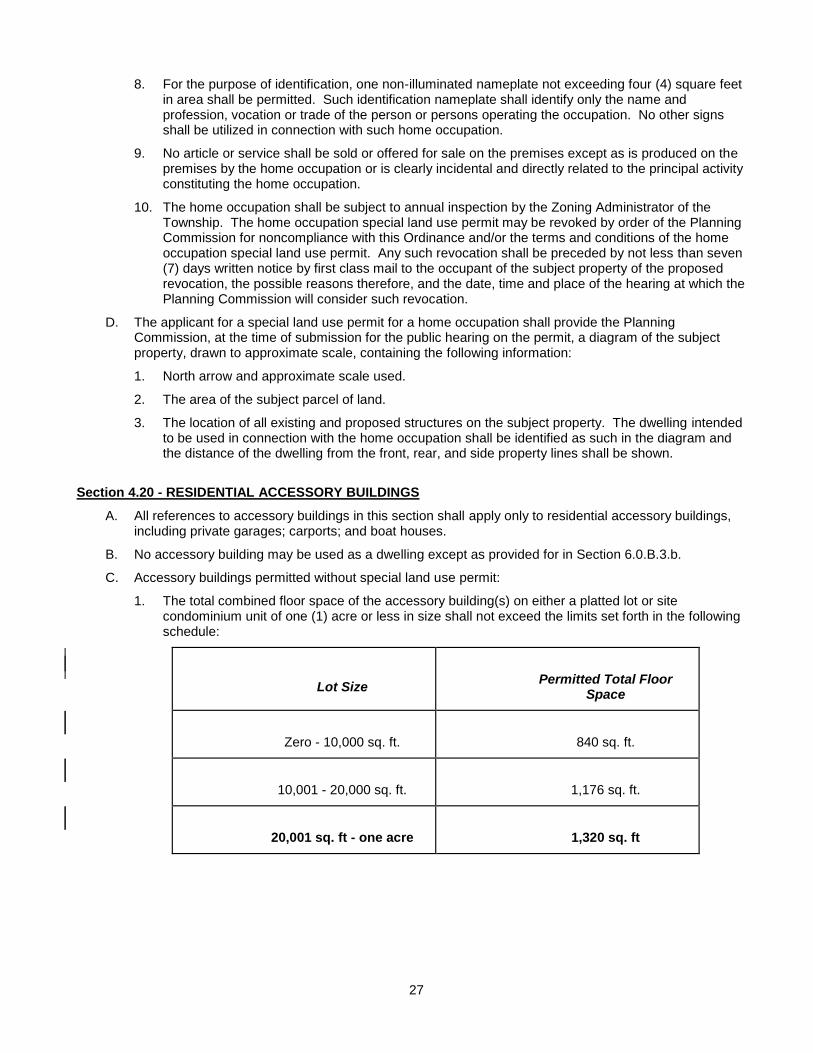
27
8. For the purpose of identification, one non-illuminated nameplate not exceeding four (4) square feet in area shall be permitted. Such identification nameplate shall identify only the name and profession, vocation or trade of the person or persons operating the occupation. No other signs shall be utilized in connection with such home occupation.
9. No article or service shall be sold or offered for sale on the premises except as is produced on the premises by the home occupation or is clearly incidental and directly related to the principal activity constituting the home occupation.
10. The home occupation shall be subject to annual inspection by the Zoning Administrator of the Township. The home occupation special land use permit may be revoked by order of the Planning Commission for noncompliance with this Ordinance and/or the terms and conditions of the home occupation special land use permit. Any such revocation shall be preceded by not less than seven (7) days written notice by first class mail to the occupant of the subject property of the proposed revocation, the possible reasons therefore, and the date, time and place of the hearing at which the Planning Commission will consider such revocation.
D. The applicant for a special land use permit for a home occupation shall provide the Planning Commission, at the time of submission for the public hearing on the permit, a diagram of the subject property, drawn to approximate scale, containing the following information:
1. North arrow and approximate scale used.
2. The area of the subject parcel of land.
3. The location of all existing and proposed structures on the subject property. The dwelling intended to be used in connection with the home occupation shall be identified as such in the diagram and the distance of the dwelling from the front, rear, and side property lines shall be shown.
Section 4.20 - RESIDENTIAL ACCESSORY BUILDINGS
A. All references to accessory buildings in this section shall apply only to residential accessory buildings, including private garages; carports; and boat houses.
B. No accessory building may be used as a dwelling except as provided for in Section 6.0.B.3.b.
C. Accessory buildings permitted without special land use permit:
1. The total combined floor space of the accessory building(s) on either a platted lot or site condominium unit of one (1) acre or less in size shall not exceed the limits set forth in the following schedule:
Lot Size
Permitted Total Floor Space
Zero - 10,000 sq. ft.
840 sq. ft.
10,001 - 20,000 sq. ft.
1,176 sq. ft.
20,001 sq. ft - one acre
1,320 sq. ft
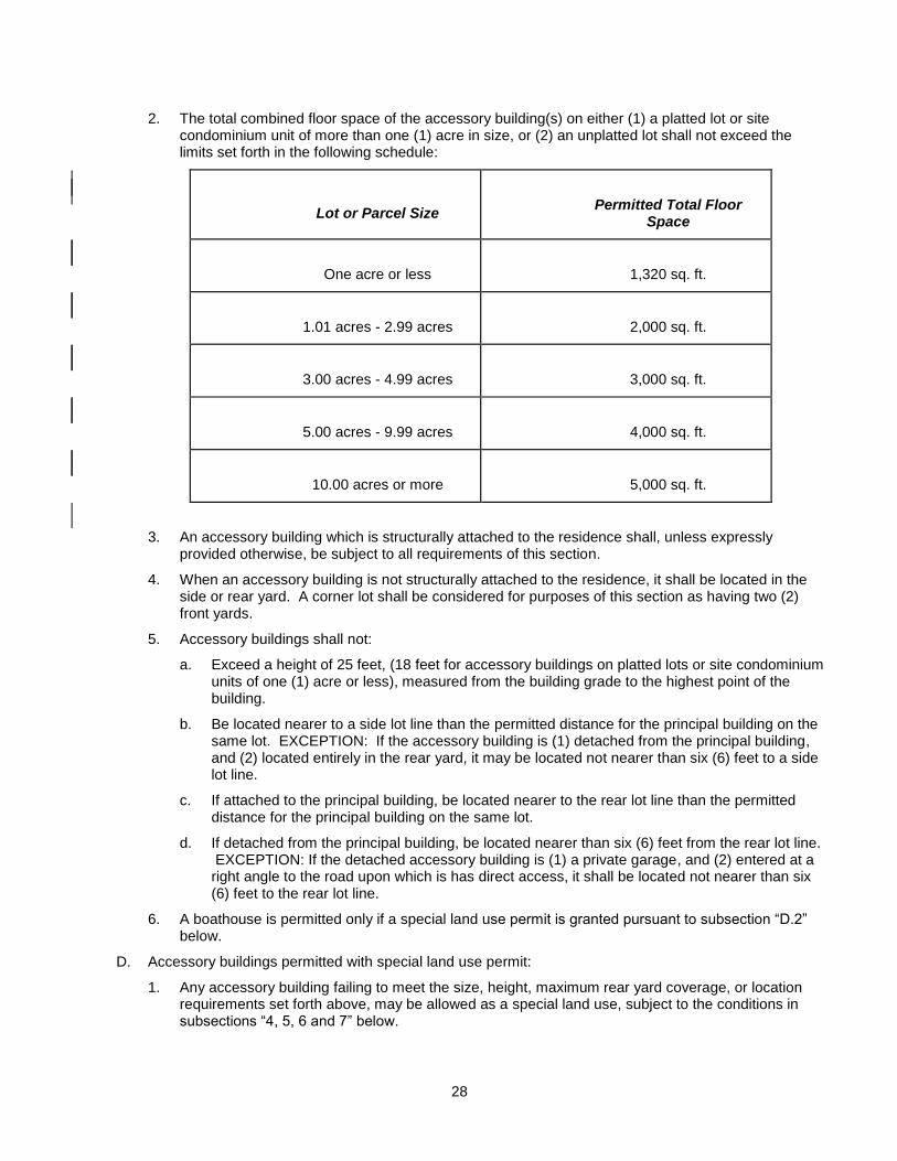
28
2. The total combined floor space of the accessory building(s) on either (1) a platted lot or site condominium unit of more than one (1) acre in size, or (2) an unplatted lot shall not exceed the limits set forth in the following schedule:
Lot or Parcel Size
Permitted Total Floor Space
One acre or less
1,320 sq. ft.
1.01 acres - 2.99 acres
2,000 sq. ft.
3.00 acres - 4.99 acres
3,000 sq. ft.
5.00 acres - 9.99 acres
4,000 sq. ft.
10.00 acres or more
5,000 sq. ft.
3. An accessory building which is structurally attached to the residence shall, unless expressly provided otherwise, be subject to all requirements of this section.
4. When an accessory building is not structurally attached to the residence, it shall be located in the side or rear yard. A corner lot shall be considered for purposes of this section as having two (2) front yards.
5. Accessory buildings shall not:
a. Exceed a height of 25 feet, (18 feet for accessory buildings on platted lots or site condominium units of one (1) acre or less), measured from the building grade to the highest point of the building.
b. Be located nearer to a side lot line than the permitted distance for the principal building on the same lot. EXCEPTION: If the accessory building is (1) detached from the principal building, and (2) located entirely in the rear yard, it may be located not nearer than six (6) feet to a side lot line.
c. If attached to the principal building, be located nearer to the rear lot line than the permitted distance for the principal building on the same lot.
d. If detached from the principal building, be located nearer than six (6) feet from the rear lot line. EXCEPTION: If the detached accessory building is (1) a private garage, and (2) entered at a right angle to the road upon which is has direct access, it shall be located not nearer than six (6) feet to the rear lot line.
6. A boathouse is permitted only if a special land use permit is granted pursuant to subsection “D.2” below.
D. Accessory buildings permitted with special land use permit:
1. Any accessory building failing to meet the size, height, maximum rear yard coverage, or location requirements set forth above, may be allowed as a special land use, subject to the conditions in subsections “4, 5, 6 and 7” below.
29
2. A boat house may be allowed as a special land use, only for the benefit of the occupants of the subject property, subject to the four (4) conditions below as well as the requirements of “5, 6 and 7” that follow:
a. Be located adjacent to a navigable body of water with no minimum setback.
b. Be used to store one (1) or more boats and boating accessories.
c. Be established in compliance with all applicable state and local laws.
d. Complies with all size, height and location requirements set forth in Section 4.20.C, except in the case of accessory buildings on either (1) a platted lot or site condominium unit of more than one (1) acre in size, or (2) unplatted parcels) as otherwise expressly approved by the Planning Commission.
3. An accessory building may be allowed as a special land use in the ”A”, “R-1” and ”R-2” zoning classification(s) on an otherwise vacant lot or on a lot having only another accessory building(s) used primarily for residential purposes upon it, subject to the two (2) conditions below, as well as the requirements in ”5, 6 and 7” that follow:
a. The building may be utilized only for purposes accessory to residential uses allowed in the zone in which it is located.
b. The building shall comply with all size, height and location requirements set forth in the site development requirements for the district in which it is located, except as otherwise expressly approved by the Planning Commission.
4. An accessory building shall not be located closer than six (6) feet to any property line or site condominium unit boundary line.
5. Proposed accessory building(s) shall not have a material adverse impact upon the owners and occupants of adjoining lots. The Planning Commission shall have authority to impose reasonable conditions, including reduction in size, to assure compliance with this standard.
6. All applications requiring a special land use permit hereunder shall be accompanied by 12 copies of a site plan of the subject property, drawn to a selected scale, containing the following information:
a. A NORTH arrow and notation of the selected scale used.
b. All property lines shall be shown with their dimensions.
c. Location and dimensions of all existing and proposed structures (including the height of all proposed accessory buildings) on the subject property and any existing buildings on adjacent property within 50 feet of the subject property.
d. Location of any septic tank and/or dry well on the subject property.
Planning Commission approval of the above required site plan under the standards in Section 4.13-4 shall satisfy the site plan submission and approval requirements of Section 4.13 of this Ordinance.
7. An application for a special land use permit hereunder shall include a statement setting forth the purpose(s) for which the proposed accessory building(s) will be used. No accessory building allowed pursuant to this subsection shall be used for a purpose other than that approved by the Planning Commission.
E. Accessory buildings may be established to serve a residence that is a lawful nonconforming use providing that such accessory building(s) are established in accordance with both the provisions of Section 4.20 and Section 6.19 of this Ordinance, including obtaining any special land use permits mandated thereunder.
30
SECTION 4.21 - GROUND MOUNTED SATELLITE RECEPTION ANTENNAS
A. Ground mounted satellite reception antennas shall be allowed as an accessory use in all zoning classifications.
B. A ground mounted satellite reception antenna shall be located only in a rear yard area and in compliance with all building setback requirements. A corner lot, the side yard of which is substantially a continuation of the front lot line of the lot to its rear, shall be regarded as having two (2) front yards. When a ground mounted satellite reception antenna is located on such a corner lot, it shall not project beyond the continued front line of the rear lot.
C. The maximum height of a ground mounted satellite reception antenna shall be 15 feet.
D. The Zoning Board of Appeals shall have the authority to grant a variance from the foregoing requirements where the applicant shows that practical difficulties exist that would prevent a ground mounted satellite reception antenna from operating properly if established in strict accordance with these provisions.
SECTION 4.22 - YARD ENCROACHMENTS
The yard requirements of all zones are subject to the following permitted encroachments: (see also Section 4.32 entitled “FENCES, WALLS AND SCREENS”)
A. Structures having a height of 18" or less above ground level may project into a required yard.
B. Stairways leading to an abutting waterfront area (including any stairway landings not exceeding 200 square feet in area) may project into the required front yard.
C. Enclosed porches and other enclosed appurtenances shall be considered an integral part of the building to which they are attached and shall be subject to all yard requirements thereof.
D. Chimneys, flues, belt courses, leaders, sills, pilasters, cornices, eaves, gutters and similar features may project into any yard a maximum of 24 inches.
E. Unenclosed and unroofed fire escapes, outside stairways and balconies, may project not more than five (5) feet into the required front and rear yards and three (3) feet into required side yards.
SECTION 4.23 - OUTDOOR STORAGE FACILITIES
A. In all zoning districts permitting residential uses, outdoor storage facilities such as tanks or drums of fuel directly connected with heating devices or appliances shall be enclosed by a fence or screening adequate to conceal such facilities from the street or adjacent property.
B. In all zoning districts permitting residential use, all boats, boat trailers, recreational units or similar vehicles shall be stored neatly, or in an enclosed building, or, in the case of a mobile home park or multi-family development, in an area specifically designed and approved for such use.
SECTION 4.24 – WATERFRONT LOTS
A. Waterfront lots shall have continuous waterway frontage that is not less than the minimum lot width and road frontage requirement for the zoning district in which the lot is situated. Waterway frontage shall be measured by a straight line which connects the boundaries of the lot that extend from the waterway frontage at the points where they intersect the high water line.
B. The front lot line of a waterfront lot shall be that portion of the lot abutting the waterway. The rear lot line of a waterfront lot shall be that portion of the lot immediately adjacent to the street right-of-way. On corner lots, the rear lot line shall be the boundary line of the lot immediately adjacent to the street right-of-way on that side of the lot which has the narrowest frontage.
31
C. Notwithstanding the generally applicable setback requirements specified elsewhere in this Ordinance, all dwellings or other principal buildings and accessory buildings, including any alteration of existing such buildings, on any waterfront lot shall at a minimum be set back from the high water line of the waterway the greater of:
1. 35 feet; or
2. The average setback of existing, legally constructed dwellings or other principal buildings immediately adjacent to the lot at the time of application for a building permit.
D. These setback requirements are intended to facilitate reasonable consistency of horizontal sight lines with respect to the development of waterfront lots, based on the average setback of existing adjacent development, but subject in each instance to a minimum setback of 35 feet from the high water line.
E. The required minimum rear yard setback for principal buildings located on waterfront lots shall be the same as the minimum front yard setback requirement for the zoning district in which the lot is situated.
F. The required minimum rear yard setback for accessory buildings located on waterfront lots shall be a minimum of 25 feet from the abutting road right-of-way.
G. No portion of any dock shall be located within the minimum setback area required for the zoning district in which the lot is situated, as measured from the boundaries of the lot as projected into the waterway.
H. See Section 4.35 for additional requirements applicable to access lots providing waterway access for one (1) or more access lot beneficiaries.
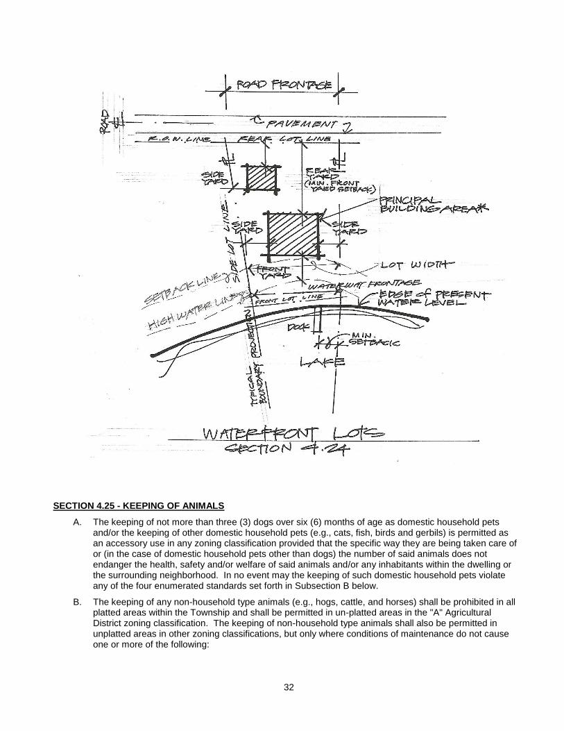
32
SECTION 4.25 - KEEPING OF ANIMALS
A. The keeping of not more than three (3) dogs over six (6) months of age as domestic household pets and/or the keeping of other domestic household pets (e.g., cats, fish, birds and gerbils) is permitted as an accessory use in any zoning classification provided that the specific way they are being taken care of or (in the case of domestic household pets other than dogs) the number of said animals does not endanger the health, safety and/or welfare of said animals and/or any inhabitants within the dwelling or the surrounding neighborhood. In no event may the keeping of such domestic household pets violate any of the four enumerated standards set forth in Subsection B below.
B. The keeping of any non-household type animals (e.g., hogs, cattle, and horses) shall be prohibited in all platted areas within the Township and shall be permitted in un-platted areas in the "A" Agricultural District zoning classification. The keeping of non-household type animals shall also be permitted in unplatted areas in other zoning classifications, but only where conditions of maintenance do not cause one or more of the following:
33
1. Unpleasant odors sufficiently strong to be readily discernible upon adjacent property for any period in excess of 24 hours.
2. Noise sufficiently loud to penetrate indoors upon the property of others for any continuous period in excess of 30 minutes.
3. Flies, insects, or rodents to be attracted to the place where said animals are kept and are thereafter permitted to multiply and escape upon adjoining property.
4. Said animals, alive or dead, or any refuse therefrom are permitted to trespass or be carried upon adjacent property.
C. In addition to the foregoing, the Planning Commission shall have the authority to allow as a special land use the raising of non-household animals in areas that would otherwise be prohibited under the above provisions. In passing upon applications for a special land use permit, the Planning Commission shall be subject to the standards for special land uses set forth in Article VII of this Ordinance. In addition, the Planning Commission shall approve such special land use only in those situations where, in the judgment of the Planning Commission, sufficient land area and isolation from adjoining residences and developments is available and the Commission is satisfied that such animals will be maintained in a proper condition to prevent the same from being a nuisance or annoyance to adjacent property owners or occupants. The Planning Commission shall have the authority to impose such conditions upon the granting of a special land use permit as the Planning Commission determines necessary to insure compliance with the aforementioned standards. These conditions may include, but are not limited to, the number and type of animals permitted, screening, setback requirements, housing, enclosures, health and sanitation protection, and safety measures.
SECTION 4.26 – Repealed by Ordinance #
SECTION 4.27 - GOVERNMENTAL IMPROVEMENTS
The provisions of this Ordinance shall be applicable to and enforceable against the Township itself and all other governmental agencies and units, federal, state or county.
SECTION 4.28 – Repealed by Ordinance #
SECTION 4.29 - SUPPLEMENTARY SETBACK REQUIREMENT
Not withstanding any other provisions of this Ordinance, no building or structure shall hereafter be constructed, erected, or enlarged on a lot abutting a State or Federal Highway or a County Primary or Secondary roadway (interior plat roads are excepted) unless the following minimum building setbacks measured from the right-of-way line are maintained:
A. State or federal trunklines - 75 feet.
B. County primary or secondary roads (excluding interior plat roads) - 50 feet.
SECTION 4.30 - REFUSE
The outdoor storage, parking, accumulating or placing of junk, discarded material, building materials, metal, or solid waste of any kind is hereby prohibited, except in approved and authorized solid waste disposal facilities or salvage yards. (For Junkyard and Junk-Vehicles see Township Ordinance No. 3).
34
SECTION 4.31 - SWIMMING POOLS AND SWIMMING POOL FENCES
A private or public swimming pool shall be considered a structure for purposes of this Ordinance and shall therefore require issuance of a permit. All ground level swimming pools shall be enclosed by a fence, wall or other structure which shall be at least four (4) feet in height as measured from the outside. Any opening under the fence shall be not more than four (4) inches in height. Any fence or wall enclosure shall be of a type that impedes climbing by small children and shall be equipped with a gate that is self-closing and latching type with the latch on the pool side of the gate. Said entranceway shall lead to the shallow end of the pool. If the entire premise is enclosed by a fence or wall this requirement may be waived. Above ground swimming pools need not be fenced, provided that the steps and pool entrance are secured by a self-closing and latching gate with the latch on the pool side of the gate.
SECTION 4.32 - FENCES, WALLS AND SCREENS
No fence, wall, other than necessary retaining wall, or other screening structure located within the side or front yard of a lot in a residential district (other than the front yard of a waterfront lot) shall exceed six (6) feet in height. No such fence, wall, or other screening structure located within the front yard of a waterfront lot in a residential district shall exceed four (4) feet in height. No such fence, wall or other screening structure located within a rear yard of a lot in a residential district shall exceed eight (8) feet in height. Fences, walls (other than necessary retaining walls), and other screening structures shall also comply with the requirements set forth in Section 4.6 of this Ordinance. (See Section 4.24 regarding definition of front and rear yard on waterfront lots).
No electric fences shall be permitted in any residential district or residentially platted area.
SECTION 4.33 - PRIVATE ROADS
A private road which serves more than one separately held parcel with more than one (1) dwelling unit or industrial activity shall have a 66 foot right-of-way. The traveled portion of said right-of-way shall be a minimum of 12 feet in width.
SECTION 4.34 - DIVISIONS OF LAND
No divisions of land will be permitted that do not comply with the applicable area, width, depth, and frontage requirements set forth in this Ordinance. All parcels shall be provided the requisite frontage and individual access on a dedicated public road or a private road constructed to the standards of this Ordinance or the Barry County Road Commission, pursuant to the limitations set forth in Section 4.33
* Also refer to Land Division Act *
SECTION 4.35 – NON-PUBLIC WATERFRONT ACCESS LOT REGULATIONS
No waterfront lot in any zoning district shall be used as an access lot unless it complies with all of the following requirements:
A. An access lot shall have a minimum waterway frontage, a minimum lot width, a minimum road frontage, and a minimum lot area corresponding to the minimum waterway frontage, lot width, road frontage, and lot area requirements for a lot in the zoning district in which the access lot is situated.
B. An access lot providing waterway access to more than one access lot beneficiary shall have a minimum lot depth of at least 75 feet and at least an additional 50 feet of waterway frontage, lot width, and road frontage for each additional access lot beneficiary.
C. Waterway frontage shall be measured by a straight line which connects the boundaries of the access lot that extend from the waterway frontage at the points where they intersect the high water line. Areas consisting of swamp, bog, marsh, or other type of wetland, as commonly defined, shall not be counted towards the minimum waterway frontage required herein, but may be used to meet minimum buffer strip requirements.
35
D. An access lot providing access to two (2) or more access lot beneficiaries shall include a buffer strip on each side of the access lot, parallel with each boundary that extends from the waterway frontage. Each buffer strip shall have a minimum width for the entire depth of the access lot corresponding with the amount of minimum side yard setback required for a principal building in the zoning district in which the access lot is situated.
E. No building or structure of any kind other than fencing shall be constructed or erected upon a required buffer strip. Required buffer strips shall not be used for any motorized vehicular traffic, parking, boat ramps or for storage purposes (including junk, waste or garbage) or other development purpose of any kind, and shall be preserved to provide a natural barrier between the usable portion of an access lot and adjacent lots.
F. No portion of any dock shall be located within the minimum setback area required for the zoning district in which the access lot is situated, as measured from the boundaries of the lot as projected into a waterway.
G. Adequate off-street parking for each access lot beneficiary shall be provided on each access lot.
H. Site plan review shall be required for all access lots providing access to more than one (1) access lot beneficiary.
I. An access lot created as part of a plat or condominium development shall be dedicated at the time of recording of the plat/condominium for use solely by the owners/occupants of lots contained within the plat/condominium, or a specified lesser number thereof, consistent with all applicable laws and ordinances.
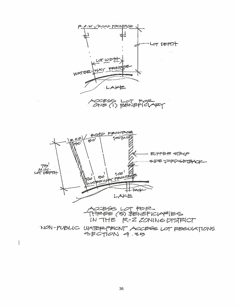
36
37
SECTION 4.36 - SETBACK FROM PRIVATE ROAD INTERSECTING LOT OR PARCEL
In those circumstances where a private road serving more than one parcel or lot of land intersects an individual lot or parcel, there shall be a minimum setback distance of 20 feet between the nearest elevations of any building, structure or portion thereof and the private road.
SECTION 4.37 PRE-MANUFACTURED UNITS USED FOR COMMERCIAL OR INDUSTRIAL PURPOSE
Any mobile home or other pre-manufactured unit (as defined under Rule 408.31106 of the Michigan Administrative Code) that is used for commercial or industrial purposes on either a temporary or permanent basis shall either (1) be certified as complying with the standards for manufacture and certification of pre-manufactured units set forth beginning at Rule 408.31101 of the Michigan Administrative Code, and from time to time as such standards may be amended, or (2) comply with the construction standards contained in the Township Building Code Ordinance.
SECTION 4.38 - MAXIMUM LOT DEPTH
No lot may be established with a depth more than four (4) times its width.
SECTION 4.39 CHILD CARE FACILITIES
A. Each child care facility shall be duly licensed or registered by the State of Michigan Department of Social Services (DSS) continuously and for all times it is operating as a child care facility.
Any child care facility whose license or certificate of registration by the State of Michigan is no longer valid and/or which has been revoked or denied or refused by the DSS shall immediately lose its status and authorization to continue operating as a permitted or Special Land Use.
B. Buildings and lots used for child care facilities shall conform to all state, DSS, and local requirements, rules, and standards.
C. Each child care facility shall provide, equip, and maintain on the premises the minimum square feet of indoor floor space and outdoor play area as required by the DSS. An applicant for a group day care home or child care center or day care center shall submit to the Planning Commission sufficient information and documentation regarding the maximum number of children allowed and the amount of indoor floor space and outdoor play area required by the DSS for the proposed child care facility prior to obtaining special exception use or site plan approval to operate within the Township.
D. The zoning lot occupied by any child care facility shall have a fence which shall be not less than four (4) feet but not more than six (6) feet in height and which shall completely enclose the outdoor area where the minor children play or congregate, except that interior fences within a mobile home park shall not exceed 36 inches in height. In addition, the requirements of Section 4.32 of this Ordinance shall apply to child care facilities. However, the provisions of this subsection 4.39.D. shall not apply to family day care homes.
E. A group day care home licensed or registered under Act No.116 of the Public Acts of 1973 shall be issued a special land use permit if the group day care home meets the following standards:
1. A group day care home shall comply with all the requirements set forth in subsections “A”, “B”, “C” and “D” above.
2. A group day care home shall be located not closer than 1,500 feet to any of the following:
a. Another licensed group day care home, or
b. Another adult foster care small group home or large group home licensed under the adult foster care facility licensing act, Act No. 218 of the Public Acts of 1979, being Section 400.701 to 400.737 of the Michigan Compiled Laws, or
c. A facility offering substance abuse treatment and rehabilitation service to 7 or more people
38
licensed under Article 6 of the Public Health Code, Act No. 698 of the Public Acts of 1978, being Sections 333.6101 to 333.6523 of the Michigan Compiled Laws, or
d. A community correction center, resident home, halfway house, or other similar facility which houses an inmate population under the jurisdiction of the Department of Corrections.
3. The property containing a group day care home shall be maintained in a manner which is consistent with the visible characteristics of the neighborhood.
4. The operation of a group day care home shall not exceed 16 hours of operation during a 24-hour period.
5. One (1) non-illuminated name plate, not more than two (2) square feet in area may be attached to the building which shall contain only the name of the group day care home and/or the name of its owner.
6. A group day care home operator shall provide one (1) off-street parking space for each employee. These parking spaces shall be in addition to the off-street parking facilities serving the residents of the home. These off-street parking spaces shall be located on the zoning lot in such a manner as to provide unblocked automobile access from the street to the off-street parking facilities that are provided on the zoning lot pursuant to Section 6.01.4, and shall also comply with the requirements of Article 6.00.
7. The subsequent establishment of any of the facilities listed in subsection E.2.a.to d. of this section, within 1,500 feet of the licensed or registered group day care home will not affect any subsequent special land use permit renewal, pertaining to the group day care home.
8. The distances specified in subsections 2. and 7. above shall be measured along a road, street, or place maintained by this state or a political subdivision of this state and generally open to use by the public as a matter of right for the purpose of vehicular traffic, not including an alley.
9. An applicant for a group day care home shall submit to the Planning Commission a to-scale rendering which shows the dimensions of the zoning lot, setbacks of all structures on the lot, the proposed location of the fencing, the proposed parking arrangement, and any other features relevant to the application for special land use approval.
SECTION 4.40 – BUILDING HEIGHT
No building shall be erected, reconstructed, or structurally altered to exceed 35 feet in height, except the height limitations of this Ordinance shall not apply to church spires, belfries, cupolas, communication towers/antennas (except as otherwise specifically regulated in this Ordinance), domes not used for human occupancy, chimneys, ventilators, skylights, water tanks, barns, silos, wind generators, bulkheads, and necessary roof-mounted mechanical appurtenances.
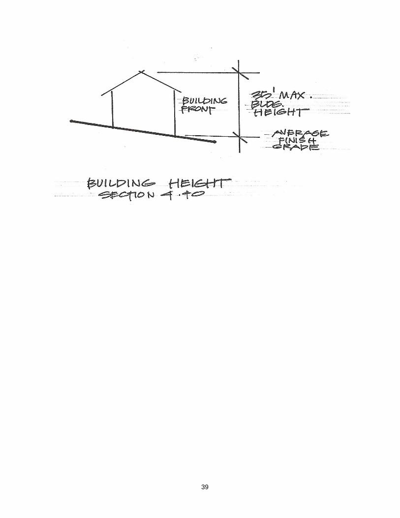
39
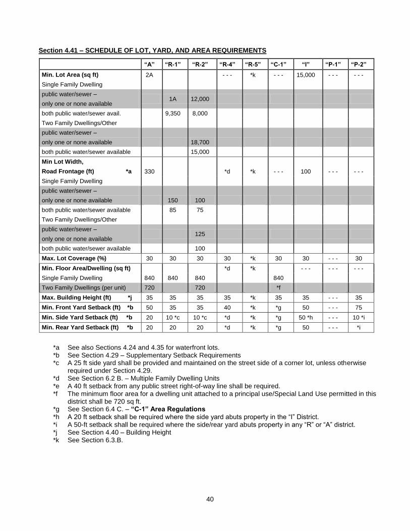
40
Section 4.41 – SCHEDULE OF LOT, YARD, AND AREA REQUIREMENTS
“A” “R-1” “R-2” “R-4” “R-5” “C-1” “I” “P-1” “P-2”
Min. Lot Area (sq ft) 2A - - - *k - - - 15,000 - - - - - -
Single Family Dwelling
public water/sewer –
only one or none available 1A 12,000
both public water/sewer avail. 9,350 8,000
Two Family Dwellings/Other
public water/sewer –
only one or none available 18,700
both public water/sewer available 15,000
Min Lot Width,
Road Frontage (ft) *a 330 *d *k - - - 100 - - - - - -
Single Family Dwelling
public water/sewer –
only one or none available 150 100
both public water/sewer available 85 75
Two Family Dwellings/Other
public water/sewer –
only one or none available 125
both public water/sewer available 100
Max. Lot Coverage (%) 30 30 30 30 *k 30 30 - - - 30
Min. Floor Area/Dwelling (sq ft) *d *k - - - - - - - - -
Single Family Dwelling 840 840 840 840
Two Family Dwellings (per unit) 720 720 *f
Max. Building Height (ft) *j 35 35 35 35 *k 35 35 - - - 35
Min. Front Yard Setback (ft) *b 50 35 35 40 *k *g 50 - - - 75
Min. Side Yard Setback (ft) *b 20 10 *c 10 *c *d *k *g 50 *h - - - 10 *i
Min. Rear Yard Setback (ft) *b 20 20 20 *d *k *g 50 - - - *i
*a See also Sections 4.24 and 4.35 for waterfront lots. *b See Section 4.29 – Supplementary Setback Requirements *c A 25 ft side yard shall be provided and maintained on the street side of a corner lot, unless otherwise
required under Section 4.29. *d See Section 6.2 B. – Multiple Family Dwelling Units *e A 40 ft setback from any public street right-of-way line shall be required. *f The minimum floor area for a dwelling unit attached to a principal use/Special Land Use permitted in this
district shall be 720 sq ft. *g See Section 6.4 C. – “C-1” Area Regulations *h A 20 ft setback shall be required where the side yard abuts property in the “I” District. *i A 50-ft setback shall be required where the side/rear yard abuts property in any “R” or “A” district. *j See Section 4.40 – Building Height *k See Section 6.3.B.
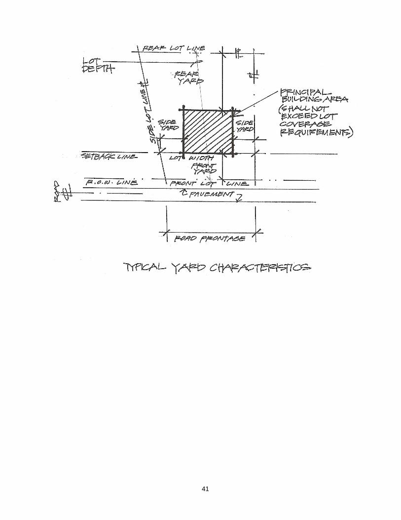
41
42
ARTICLE V
ESTABLISHMENT OF ZONING DISTRICTS
SECTION 5.0 - ZONING DISTRICTS
In order to regulate and restrict the location, erection, alteration or use of building structures or land and to carry out the purposes of this Ordinance, The Township is hereby divided into the following zoning districts:
A. "R-1" Single Family Low Density Residential District
B. "R-2" Single Family and Two Family Medium Density Residential
C. "R-4" Multiple Family High Density Residential District
D. "R-5" Mobile Home Parks
E. "C-1" Commercial District
F. "I" Industrial District
G. "A" Agricultural District
H. "P-1" Public Land
I. "P-2" Semi-Public Land
SECTION 5.1 - ZONING DISTRICT BOUNDARIES
The description of the various use districts of the Township of Prairieville are separated under two (2) headings; to wit: “Unplatted Land” and “Recorded Plats.” Under “Unplatted Land” each section or part of section of the original United States Land Survey of the Township of Prairieville is described and set forth under the various use districts. It is not the intention under “Unplatted Land” to cover any part of land embraced with any plat now of record in said Township and whenever any land described under “Unplatted Land” includes the whole part of any plat now of record, it shall be construed that such plat or part thereof be excepted from the land so described. Under “Recorded Plats” the lots embraced within the various recorded plats now of record in the Township of Prairieville are described and set forth as to their use under the districts herein mentioned. As to any land located in “Unplatted Land” at the time of the adoption of this Ordinance or any amendment thereto, which said land subsequently becomes part of a recorded plat, the use district in which said land is located at the time it becomes a part of such recorded plat shall apply to such land after it becomes a part of such recorded plat until it is specifically otherwise designated in the “Recorded Plats” section of the Ordinance.
(Land) Section One (1), T. 1 N., R. 10 W
"A” Agricultural District: Entire Section except those parts herein described as "R-1" Low Density, Residential, "R-2" Medium Density Residential, "P-1" Public Land, and "C-1" Commercial District.
"R-1” Low Density Residential District: All that part of Stoney Point Island in Crooked Lake located in Land Section 1. Also that land commencing at the Southwest corner of said Section; thence Easterly on South Section line to Lake Shore: thence Northwesterly along Lake until it intersects with the West line of Section 1; thence Southerly on Section line to point of beginning.
"R-2” Medium Density Residential District: All that part East fractional 2, Section 1, lying Easterly of Rankin Road, West of Prairieville Township Park and South of Delton Road, excepting that part described as commencing at the Southwest corner of Lot 33 of the recorded Plat of Bay Section View Resort, thence North 0 degrees 26 minutes, East 116.1 feet; thence South 70 degrees 32 minutes, west 120 feet to the point of beginning of this exception; thence South 70 degrees. 32 minutes west 331.32 feet; thence South 19 degrees 26 minutes East 140.3 feet; thence North 54 degrees 25 minutes East 147.92 feet; thence North 68 degrees 11 minutes East 71.45 feet; thence north 74 degrees 23 minutes East 80.4 feet; thence north 0 degrees 54 minutes East 107.5 feet to point of beginning.
43
"P-1” Public Land District: Beginning at the Southwest corner of Lot 53 of the recorded plat of Bay View Resort; thence North 0 degrees 26 minutes West, 117.16 feet to the center line of Delton Road; thence Southwesterly thereon, 127.03 feet; thence South 0 degrees 26 minutes East, 109.93 feet; thence North 73 degrees 33 minutes 10 sec East, 124.84 feet to the place of beginning. Also all lands lying Southerly of above description and extending to the Northerly Shore of Crooked Lake.
"C-1” Commercial District: Commencing at the southwest corner of Lot 33 of the recorded Plat of Bay View Resort, thence North 0 degrees 26 minutes East 116.1 feet; thence south 70 degrees 32 minutes west 120 feet to the point of beginning; thence south 70 degrees 32 minutes west 331.32 feet; thence south 19 degrees 26 minutes East 140.3 feet; thence north 54 degrees 25 minutes East 147.92 feet; thence north 68 degrees 11 minutes East 71.45 feet; thence north 74 degrees 23 minutes East 80.4 feet; thence north 0 degrees 54 minutes East l07.5 feet to point of beginning.
(Land) Section Two (2), T. 1 N., R. 10 W
"A" Agricultural District: Entire Section except those parts herein described as "R-1" Low Density Residential, "C-1” Commercial District and "P-1" Public Land.
"R-1" Low Density Residential District: All that part south fractional 2 Section 2 lying southwesterly of Parker and southeasterly of Norris Road, except commencing at center 3 post, south 37 degrees, 30 minutes East, 569.25 feet on center line of Parker Road for point of beginning; south 37 degrees, 30 minutes East, 120 feet; south 750 feet; thence southwesterly 420 feet to north and south 3 line 452.5 feet; west on East and west 1/8 line 1,350 feet to center line of Norris Road; northeasterly along center line of Norris Road 1,880 feet; southeasterly 594 feet to the center line of Parker Road to point of beginning.
"C-1” Commercial District: Commencing at the southwest corner of Lot 32 of Supervisor’s Plat village of Prairieville; thence south to the westerly line of Norris Road; thence northeasterly thereon to southeast corner of Lot 33 of said plat, thence west along south line of said plat, thence west along south line of said lot, 76 feet; thence north 84 feet; thence west, 148.2 feet to the place of beginning.
"P-1" Public Land District: Beginning at northeast corner of Lot 51 of the recorded plat of Supervisor's Plat of the Village of Prairieville; thence East, 1002.47 feet; thence south 648.50 feet; thence west, 868.63 feet to the southeast corner or Lot 47 of said plat, thence north along East line of said plat, 395.5 feet to the northeast corner of Lot 48; thence west along north line Lot 48, 127.0 feet; thence north, 239.25 feet to the beginning.
(Land) Section Three (3), T. 1 N., R. 10 W
“A" Agricultural District: Entire Section
(Land) Section Four (4), T. 1 N., R. 10 W
"A" Agricultural District: Entire Section
(Land) Section Five (5), T. 1 N., R 10 W
"A" Agricultural District: Entire Section except those parts herein described as "R-1" Single Family, Low Density Residential, "R-2" Medium Density Residential, "P-1" Public Land and “P-2" Semi-Public Land.
44
"R-1" Single Family, Low Density Residential District: All that part of the Fractional North 1/2 of Section 5, Town 01 North, Range 10 West, Prairieville Township, Barry County, Michigan lying North of Pine Lake, North of Pine Lake Drain and West of Shelp Lake, EXCEPT Commencing at the Northwest corner of said Section for the PLACE OF BEGINNING; Thence East 1205 feet, thence South 1322.22 feet, thence South 87degrees, 50 minutes East 1202 feet, thence South 208 feet, thence South 25 degrees, 10 minutes East 510 feet to Pine Lake, thence West along Pine Lake to the Section line, thence North to the place of beginning, ALSO EXCEPT The Plat of Upson’s Resort, The Replat of Lot No. 19, Plat of Upson’s Resort, the Plat of Shady Heights, and the Plat of Hallwood, ALSO EXCEPT Beginning at the North 1/4 corner of said Section 5, Town 01 North, Range 10 West, thence South along the North and South 1/4 line to the Southwest corner of the North 1/2 of the Northeast 1/4 said Section 5, thence East along the South line of said North 1/2 700.00 feet, thence North 83 degrees, 00 minutes East 450.00 feet, thence North 66 degrees, 00 minutes East 700.00 feet to the shoreline of Shelp Lake, thence Northerly along said shoreline to the West right of way line of Lakeshore Drive, thence Northerly along said West right of way line of Lakeshore Drive to the North line of said Section 5, thence West along said North line of Section 5 back to the place of beginning; ALSO EXCEPT all that part of said Fractional North 1/2 S lying Northerly and Easterly of Hughes Road (also known as Shelp Lake Road) as platted in the Plat of Shady Heights, Barry County Records ALSO EXCEPT all that portion of said Fractional North 1/2 lying South of Houvener Road and East of Lindsey Road, ALSO EXCEPT BEGINNING East 1205 feet from the Northwest corner of said Section 5, thence continuing East to the North 1/4 corner of said Section 5, thence South along the North and South 1/4 line to the North 1/8 line; thence West along said North 1/8 line, to a point South 1322.22 feet from the point of beginning, thence North 1322.22 feet back to the point of beginning. Subject to a right of way for Lindsey Road and Houvener Road.
AND
Section 5, Town 01 North, Range 10 West, That part of the South 1/2 of the Northeast Fractional 1/4 that lies South of Pine Lake, Pine Lake Drain, and West of Shelp Lake; ALSO the North 20 Acres of the West 1/2 of the Southeast Fractional 1/4; ALSO the East 1/2 of the Southeast Fractional 1/4, EXCEPT that portion East of Lindsey Road and South of Houvener Road AND, ALSO EXCEPT that portion of said East 1/2 of the Southeast Fractional 1/4 lying South of the Southerly line of the North 20 Acres of the West 1/2 of the Southeast Fractional 1/4, Extended Easterly to Lindsey Road. EXCEPT that part dedicated as public right of way.
"R-2" Medium Density Residential District: A parcel of land in the Northwest Fractional 1/4 of Section 5, Town 01 North, Range 10 West, described as BEGINNING at the Northwest corner of said Section 5, thence North 90 degrees, 00 minutes East 250 feet along the North line of said Section 5; thence South 01 degrees, 50 minutes East to Pine Lake; thence Southwesterly along the Northerly and Westerly edge of Pine Lake to a point of intersection with the Easterly prolongation of the North line of Lot 21 of the Plat of Hallwood as recorded in Liber 3 of Plats, on Page 49, thence South 81 degrees, 31 minutes 11 seconds West (formerly recorded South 80 degrees 14 minutes West) 184 feet along the North line of said plat to the Westerly line of Island Drive as shown therein; thence South 20 degrees, 19 minutes 11 seconds West (formerly recorded S 19 degrees, 02 minutes West) 64.93 feet along said North line of Island Drive to West line of said Section 5; thence North 2 degrees, 11 minutes 53 seconds West 2015.10 feet along said West line to the Place of Beginning. EXCEPT that part dedicated as public right of way.
45
AND All that part of the Southwest 1/4 of Section 5, Town 1 North, Range 10 West, Prairieville Township, Barry County, Michigan described as: Commencing at the South 1/4 corner of said Section 5; thence North 01 degrees 15 minutes 00 seconds East 1258.50 feet, along the north and south 1/4 line of said Section 5 to the northeasterly corner of Lot 10 of Supervisor’s Plat of Ford’s Point, Prairieville Township, Barry County, Michigan, as recorded in Liber 2 of Plats on Page 72, Barry County Records, for the PLACE OF BEGINNING OF THIS DESCRIPTION: Thence North 89 degrees 30 minutes 00 seconds West 91.00 feet, along the northerly line of said Lot 10, to the northwesterly corner thereof; thence South 01 degrees 15 minutes 00 seconds West 130.00 feet, along the westerly line of said Lot 10 and the southerly extension thereof, to the northerly line of Lot 9 of said plat; thence South 62 degrees 15 minutes 00 seconds West 65.00 feet, along said northerly line to the northerly line of Lot 11 of said plat; thence North 75 degrees 15 minutes 00 seconds West 206.00 feet, along the northerly line of said Lot 11 and Lot 12 of said plat, to the northwesterly corner of said Lot 12; thence North 83 degrees 30 minutes 00 seconds West 289.00 feet, along the northerly line of Lots 13, 14, and 15 of said plat, to the northwesterly corner of said Lot 15; thence North 52 degrees 30 minutes 00 seconds West 33.00 feet, along the northeasterly line of Lot 16 of said plat; thence North 31 degrees 15 minutes 00 seconds West 132.00 feet, continuing along the northeasterly line of Lot 16 and the northeasterly line of Lot 17 of said plat to the northerly corner of said Lot 17; thence North 13 degrees 32 minutes 56 seconds East 137.79 feet; thence South 71 degrees 37 minutes 30 seconds East 425.54 feet; thence North 18 degrees 10 minutes 31 seconds East 6.12 feet; thence South 71 degrees 49 minutes 29 seconds East 39.93 feet; thence South 18 degrees 10 minutes 31 seconds West 6.09 feet; thence South 71 degrees 50 minutes 10 seconds East 49.49 feet; thence South 89 degrees 30 minutes 00 seconds East 211.91 feet, to the north and south 1/4 line of said Section 5; thence South 01 degrees 15 minutes 00 seconds West 28.77 feet, along said north and south 1/4 line to the place of beginning.
AND
46
All that part of the Southwest 1/4 of Section 5, Town 1 North, Range 10 West, Prairieville Township, Barry County, Michigan described as: Commencing at the South 1/4 corner of said Section 5; thence North 01 degrees 15 minutes 00 seconds East 1258.50 feet, along the north and south 1/4 line of said Section 5 to the northeasterly corner of Lot 10 of Supervisor’s Plat of Ford’s Point, Prairieville Township, Barry County, Michigan, as recorded in Liber 2 of Plats on Page 72, Barry County Records, thence North 89 degrees 30 minutes 00 seconds West 91.00 feet, along the northerly line of said Lot 10, to the northwesterly corner thereof; thence South 01 degrees 15 minutes 00 seconds West 130.00 feet, along the westerly line of said Lot 10 and the southerly extension thereof, to the northerly line of Lot 9 of said plat; thence South 62 degrees 15 minutes 00 seconds West 65.00 feet, along said northerly line to the northerly line of Lot 11 of said plat; thence North 75 degrees 15 minutes 00 seconds West 206.00 feet, along the northerly line of said Lot 11 and Lot 12 of said plat, to the northwesterly corner of said Lot 12; thence North 83 degrees 30 minutes 00 seconds West 289.00 feet, along the northerly line of Lots 13, 14, and 15 of said plat, to the northwesterly corner of said Lot 15; thence North 52 degrees 30 minutes 00 seconds West 33.00 feet, along the northeasterly line of Lot 16 of said plat; thence North 31 degrees 15 minutes 00 seconds West 132.00 feet, continuing along the northeasterly line of Lot 16 and the northeasterly line of Lot 17 of said plat to the northerly corner of said Lot 17; thence North 06 degrees 00 minutes 00 seconds West 78.70 feet, along the easterly line of Lot 18 of said plat, to the northeasterly corner thereof; thence North 05 degrees 00 minutes 00 seconds East 121.00 feet, along the easterly line of Lot 19 of said plat to the northeasterly corner thereof; thence North 47 degrees 30 minutes 00 seconds West 100.00 feet, along the northeasterly line of said Lot 19 to the northwesterly corner thereof; thence North 64 degrees 30 minutes 00 seconds West 75.00 feet, along the northerly line of Lot 20 of said plat to the northwesterly corner thereof; thence North 04 degrees 30 minutes 00 seconds East 337.50 feet, along the easterly line of Lot 67 and Lot 52 of said plat, to the northeasterly corner of said Lot 52, for the PLACE OF BEGINNING OF THIS DESCRIPTION: Thence North 75 degrees 30 minutes 00 seconds East 20.00 feet, along the southerly line of Lot 53 of said plat to the southwesterly line of Lot 61 of said plat; thence South 36 degrees 30 minutes 00 seconds East 40.00 feet, along the southwesterly line of said Lot 61 to the southerly corner thereof; thence South 45 degrees 30 minutes 00 seconds East 159.02 feet, along the southwesterly line of Lots 62, 63, 64, and 65 of said plat, to a line bearing South 89 degrees 29 minutes 38 seconds West (formerly described as Due West) from the Southeasterly corner of Lot 1 of Ford’s Channel Plat, Prairieville Township, Barry County, Michigan, as recorded in Liber 4 of Plats on Page 55, Barry County Records; thence South 89 degrees 29 minutes 38 seconds West 96.16 feet; thence South 10 degrees 31 minutes 17 seconds East 16.23 feet; thence South 01 degrees 37 minutes 18 seconds West 81.43 feet; thence South 05 degrees 11 minutes 27 seconds West 49.09 feet; thence South 06 degrees 41 minutes 18 seconds West 13.54 feet; thence South 40 degrees 46 minutes 57 seconds West 19.26 feet; thence North 81 degrees 34 minutes 33 seconds West 67.12 feet, to the easterly line of said Lot 52; thence North 04 degrees 30 minutes 00 seconds East 304.84 feet, along said easterly line to the place of beginning.
“P-1” Public Land District: All that part of the Northwest Fraction 1/4 of Section 5, Town 1 North, Range 10 West, Prairieville Township, Barry County, Michigan described as: Commencing at the Northwest corner of said Section 5; thence North 90degrees 00 minutes 00 seconds East 1205.40 feet, along the northerly line of said Northwest Fractional 1/4; thence South 01degrees 44 minutes 00 seconds East 1328.99 feet, to the PLACE OF BEGINNING OF THIS DESCRIPTION: Thence South 87degrees 50 minutes 00 seconds East 1183.01 feet; thence South 00 degrees, 00 minutes 00 seconds East 208.00 feet; thence South 25 degrees, 10 minutes 00 seconds East 510.00 feet, more or less, to the northerly shore of Pine Lake; thence Westerly along said shore to a line bearing South 01 degrees, 44 minutes 00 seconds East from the place of beginning; thence North 01 degrees, 44 minutes 00 seconds West to the place of beginning.
ALSO
47
All that part of the Northwest Fraction 1/4 of Section 5, Town 1 North, Range 10 West, Prairieville Township, Barry County, Michigan described as: Commencing at the Northwest corner of said Section 5; thence North 90 degrees, 00 minutes 00 seconds East 1205.40 feet, along the northerly line of said Northwest Fractional 1/4; thence South 01 degrees, 44 minutes 00 seconds East 1322.50 feet, to the PLACE OF BEGINNING OF THIS DESCRIPTION: Thence South 73 degrees, 16 minutes 00 seconds West 718.17 feet; thence South 06 degrees, 14 minutes 00 seconds East 24.00 feet, more or less, to the northerly shore of Pine Lake; thence Easterly along said shore to a line bearing South 01 degrees, 44 minutes 00 seconds East from the place of beginning; thence North 01 degrees, 44 minutes 00 seconds West to the place of beginning.
ALSO
All that part of the Northwest Fraction 1/4 of Section 5, Town 1 North, Range 10 West, Prairieville Township, Barry County, Michigan described as: Commencing at the Northwest corner of said Section 5; thence North 90 degrees, 00 minutes 00 seconds East 1139.40 feet, along the northerly line of said Northwest Fractional 1/4 to the PLACE OF BEGINNING OF THIS DESCRIPTION: Thence continuing North 90 degrees, 00 minutes 00 seconds East 66.00 feet, along said northerly line; thence South 01 degrees, 44 minutes 00 seconds East 888.62 feet; thence South 11 degrees, 00 minutes 00 seconds East 312.55 feet; thence Southeasterly 223.95 feet along a 167.00 foot radius curve to the left having a central angle of 76 degrees, 50 minutes 06 seconds and a chord which bears South 47 degrees, 15 minutes 00 seconds East 207.54 feet; thence North 87 degrees, 50 minutes 00 seconds W 156.29 feet; thence Northwesterly 141.29 feet, along a 233.00 foot non tangent curve to the right having a central angle of 76 degrees, 50 minutes 06 seconds and a chord which bears North 26 degrees, 12 minutes 17 seconds West 139.14 feet; thence North 11 degrees, 00 minutes 00 seconds West 315.50 feet; thence North 01 degrees, 44 minutes 00 seconds West 895.86 feet, to the place of beginning.
ALSO
All that part of the Northeast Fractional 1/4 of Section 5, Town 1 North, Range 10 West, Prairieville Township, Barry County, Michigan described as: Commencing at the Northeast corner of said Section 5; thence North 90 degrees, 00 minutes 00 seconds West 1963.5 feet along the northerly line of said Northeast Fractional 1/4 to the center line Lindsey Road; thence South 30 degrees, 45 minutes East 101.6 feet along said center line of Lindsey Road to the PLACE OF BEGINNING OF THIS DESCRIPTION; Thence North 76 degrees, 15 minutes East 299.2 feet; thence South 13 degrees, 45 minutes East 158.4 feet; thence South 76 degrees, 15 minutes West 250.8 feet to the center line of Lindsey Road; thence North 30 degrees, 45 minutes West, along said center line to the place of beginning.
“P-2” Semi-Public Land District: All that part of the Northwest Fraction 1/4 of Section 5, Town 1 North, Range 10 West, Prairieville Township, Barry County, Michigan described as: Commencing at the Northwest corner of said Section 5; thence North 90 degrees, 00 minutes 00 seconds East 250.00 feet, along the northerly line of said Northwest Fractional 1/4 to the PLACE OF BEGINNING OF THIS DESCRIPTION; thence continuing North 90 degrees, 00 minutes 00 seconds East 889.40 feet; thence South 01 degrees, 44 minutes 00 seconds East 895.86 feet; thence South 11 degrees, 00 minutes 00 seconds East 315.50 feet; thence Southeasterly 141.29 feet, along a 233.00 foot curve to the left having a central angle of 76 degrees, 50 minutes 06 seconds and a chord which bears South 26 degrees, 12 minutes 17 seconds East 139.14 feet; thence North 87 degrees, 50 minutes 09 seconds West 42.57 feet; thence North 01 degrees, 44 minutes 00 seconds West 6.49 feet; thence South 73 degrees, 16 minutes 00 seconds West 718.17 feet; thence South 06 degrees, 14 minutes 00 seconds East 24.00 feet, more or less, to the northerly shore of Pine Lake; thence Westerly along said shore to a line bearing South 01 degrees, 50 minutes East from the place of beginning; thence North 01 degrees, 50 minutes West to the place of beginning, EXCEPT that part dedicated as public right of way.(Land) Section Six (6), T. 1 N., R 10 W.
(Land) Section Six (6), T.1 N., R. 10 W.
"A" Agricultural District: Entire Section except those parts herein described as "R-2" Medium Density Residential and "R-5" Mobile Home Parks.
48
"R-2” Medium Density Residential District: Entire Section north of Pine Lake and south of Pine Lake Road except those parts described herein as "R-5" Mobile Home Parks.
"R-5" Mobile Home Parks District: Commencing at the Southwest corner of Section 6, T. 1 N., R. 10 W.; thence North on the west section line 1538 feet; thence north 47 degrees 30 minutes East on the centerline on Pine Lake Road 1452 feet to the place of beginning; thence continuing north 47 degrees 40 minutes East on the centerline 186.18 feet; thence south 47 degrees 03 minutes East 614.34 feet; thence south 41 degrees, 02 minutes East 198.20 feet; thence south 16 degrees 29 minutes East 235.18 feet to Pine Lake thence on traverse line along Pine Lake south 84 degrees 31 minutes west 200 feet; thence North 40 degrees 24 minutes west 902.04 feet to the place of beginning.
(Land) Section Seven (7), T. 1 N., R. 10 W.
"A" Agricultural District: Entire section except those parts herein described as "R-1" Single-Family, Low Density, Residential, “R-2” Medium Density Residential, “R-4” Multiple Family, High Density Residential, “C-1” Commercial District, and “P-1” Public Land.
"R-1" Single Family, Low Density, Residential District: Commencing at the West 1/4 post of Section 7, thence North along the Section line 1248.24 feet; thence North 89 degrees 56 min 15 sec East 523.99 feet; thence south 71 degrees 06 minutes East on the south line of Merlau Avenue 330 feet to the place of beginning; thence South 71 degrees 06 minutes East 321.08 feet; thence south 0 degrees 0 minutes East 752.17 feet thence north 89 degrees 35 minutes west 405 feet; thence north 0 degrees 0 minutes west 425.29 feet; thence north 1 degrees 26 minutes west 275.38 feet; thence north 31 degrees 08 minutes East 185.85 feet to the place of beginning
Commencing at the West 1/4 Post of Section 7, Town 1 North, Range 10 West, thence North 00 degrees 00 minutes 12 seconds West along the West line of Section 7, 1248.24 feet; thence North 89 degrees 56 minutes 15 seconds East along the South line of Merlau Avenue 523.99 feet; thence South 71 degrees 06 minutes 34 seconds East 1011.5 feet; thence South 40 degrees 22 minutes 05 seconds East 1098.40 feet; thence South 72 degrees 57 minutes 05 seconds East 593.95 feet; thence North 84 degrees 38 minutes 52 seconds East 244.33 feet, thence North 60 degrees 16 minutes 45 seconds East 397.66 feet to the place of beginning of this description, the North 60 degrees 16 minutes 45 seconds East 433.23 feet, thence South 31 degrees 21 minutes 28 seconds East 127.3 feet to the West line of Lake Shore Drive, thence South 3 degrees 49 minutes 22 seconds West along the West line of Lake Shore Drive 262.09 feet, thence South 21 degrees 29 minutes 26 seconds East 91.37 feet; thence South 55 degrees 50 minutes 47 seconds West 344.04 feet; thence North 34 degrees 09 minutes 13 seconds West 415.71 feet to the place of beginning
Com at the W 1/4 cor of sd sec; Th 00 degrees 00 minutes 12W, 1248.24 ft; th N89 degrees 56 minutes 15 seconds E alg the S li of Merlau Ave, 523.99 Ft; th S 71 degrees 06 minutes 34 seconds E, 1011.55 ft. th S 40 degrees 22 minutes 05 seconds E, 1098.40 ft; th S 72 degrees 57 minutes 05 seconds E, 261.35 ft to the place of beg; th S 73 degrees 01 minutes 37 seconds E, 156.82 ft; th S 00 degrees 00 minutes 32 seconds W, 293.74 ft; th N 89 degrees 16 minutes 11 seconds W, 150.01 ft th N 00 degrees 00 minutes 32 seconds E, 337.61 ft to the POB
Commencing at the West 1/4 corner of Section 7, Town 1 North, Range 10 West; thence North 00 degrees 00 minutes 12 seconds West along the West section line of Section 7, 1248.24 feet; thence North 89 degrees 56 minutes 15 seconds East along the South line of Merlau Avenue 523.99 feet; thence South 71 degrees 06 minutes 34 seconds East 1011.55 feet; thence South 40 degrees 22 minutes 05 seconds East 1098.40 feet; thence South 72 degrees 57 minutes 05 seconds East 261.35 feet; thence South 73 degrees 01 minutes 37 seconds East 156.82 to the place of beginning; thence continuing South 73 degrees 01 minutes 37 seconds East 176.17 feet; thence South 00 degrees 00 minutes 32 seconds West 244.46 feet; thence North 89 degrees 16 minutes 11 seconds West 168.52 feet; thence North 00 degrees 00 minutes 2 seconds East 293.74 feet to the place of beginning
49
Commencing at the West 1/4 corner of Section 7, Town 1 North, Range 10 West; thence North 00 degrees 00 minutes 12 seconds West along the West section line of Section 7, 1248.24 feet; thence North 89 degrees 56 minutes 15 seconds East along the South line of Merlau Avenue 523.99 feet; thence South 71 degrees 06 minutes 34 seconds East 1011.55 feet; thence South 40 degrees 22 minutes 05 seconds East 1098.40 feet; thence South 72 degrees 57 minutes 05 seconds East 261.35 feet; thence South 73 degrees 01 minutes 37 seconds East 332.99 feet to the place of beginning; thence North 84 degrees 42 minutes 13 seconds East 244.22 feet; thence North 00 degrees 23 minutes 33 seconds East 63.89 Feet; thence South 00 degrees 41 minutes 14 seconds West 307.75 feet; thence North 89 degrees 15 minutes 42 seconds West 283.98 feet; thence North 00 degrees 33 minutes 12 seconds East 5.31 feet; thence North 89 degrees 16 minutes 11 seconds West 11.25 feet; thence North 00 degrees 00 minutes 32 seconds East 244.46 feet to the place of beginning
Commencing at the West ¼ post of Section 7, Town 1 North, Range 10 West, thence North 0 degrees 00 minutes 12 seconds West along the West line of Section 7, 1248.24 feet; thence North 89 degrees 56 minutes 15 seconds East along the South line of Merlau Avenue 523.99 feet; thence South 71 degrees 06 minutes 34 seconds East 1011.55 feet; thence South 40 degrees 22 minutes 05 seconds East 1098.40 feet; thence South 72 degrees 57 minutes 05 seconds East 593.93 feet; thence North 84 degrees 38 minutes 52 seconds East 244.33 feet; thence North 60 degrees 16 minutes 45 seconds East 64.11 feet to the place of beginning of this description; thence North 60 degrees 16 minutes 45 seconds E 333.55 feet; thence South 34 degrees 09 minutes 13 seconds East 415.71 feet to the North Line of Lake Shore Drive; thence South 55 degrees 50 minutes 47 seconds West 236.93 feet; thence North 89 degrees 17 minutes 50 seconds West 330.80 feet; thence North 0 degrees 42 minutes 10 seconds East 307.61 feet to the place of beginning.
“R-2” Medium Density Residential District: Beginning at southwest corner of the Plat of Southgate, thence north 135.87 feet to place of beginning; thence west 230.92 feet; thence north 641.07 feet to lake; thence East along lake to South Gate; thence south 583.23 feet to place of beginning. Also Hemlock Island, Pine Lake Patent #1135305
“R-4” Multiple Family, High Density Residential District: Commencing at the west 1/4 post of Section 7, town 1 north, range 10 west, thence north 0 degrees 00 minutes 12 seconds west along the west line of section 7, 713.21 feet to the place of beginning of this description, thence continuing north 0 degrees 00 minutes 12 seconds west along the section line 166.00 feet, thence north 89 degrees 56 minutes 15 seconds East 523.99 feet; thence south 0 degrees 00 minutes 12 seconds East parallel with the section line 166.00 feet, thence south 89 degrees 56 minutes 15 seconds west 523.99 feet to the place of beginning of this description.
“C-1” Commercial District: All that part northwest fractional 1/2, Section 7 lying northwesterly of Pine Lake. Also that land commencing at a point 535 feet south of the intersection of Doster Road and Merlau Avenue; thence East 523.99 feet; thence south 425 feet; thence west 391 feet; thence south 554 feet; thence west 233 feet; thence north 973 feet to the point of beginning. Also, that land beginning at a point at the northeast corner of the intersection of Doster Road and Four Mile Road; thence north 2340 feet; thence East 450 feet; thence south 467 feet; thence west 120; thence south 1870 feet; thence west 330 feet to the point of beginning
“P-1” Public Land District: Beginning at a point on west line Section 7, 260.00 feet south of west 1/4 post thereof; thence East, 233.0 feet; thence north, 554.0 feet; thence East, 1320.0 feet; thence south, 590.0 feet; thence west, 1553.0 feet to west line said section, thence north thereon, 40.0 feet to the place of beginning.
(Land) Section Eight (8), T. 1 N., R. 10 W.
"A" Agricultural District: Entire Section except those parts herein described as "R-1" Low Density Residential, "R-2" Medium Density Residential and "P-1" Public Land.
"R-1” Low Density Residential District: Commencing at southeast corner of Lot 37 Spring Point #1, thence south along west side of Woodward Ave. 600.27 feet, thence west along north side of Lakeway Dr. 1,228.85 feet, thence north along East side of West Dr. 444 feet, thence East along south side of Alling Rd. 777.66 feet, thence north 64 degrees East 356.48 feet, thence East 150.71 feet to point of beginning.
50
"R-2” Medium Density Residential District: West fractional 2 of the Northwest fractional 1/4. Also Northwest fractional 1/4 of the Southwest fractional 1/4 lying East of Pine Lake. Also that part of the Southwest 1/4 Southwest fractional 1/4 lying Northerly of Buckley Road.
Also the westerly 200 feet of the south 2 of the southeast 1/4 of the northwest 1/4 of Land Section 8 and also the western 200 feet of the northeast 1/4 of the southwest 1/4 of Land Section 8 located north of Handy Lane.
"P-1” Public Land District: Beginning at a point on the North and South 1/4 line, Section Eight (8), 1898.57 feet South of the North 1/4 post thereof; thence South thereon, 407.11 feet; thence North 74 degrees 12 min 11 sec West, 279.70 feet to the center line of Lindsey Road, thence Northeasterly thereon, 423.85 feet to the place of beginning.
(Land) Section Nine (9), T. 1 N., R. 10 W.
"A" Agricultural District: Entire Section.
(Land) Section Ten (10), T. 1 N., R. 10 W.
"A" Agricultural District: Entire Section.
(Land) Section Eleven (11), T. 1 N., R. 10 W.
"A” Agricultural District: Entire Section except those parts herein described as "R-1" Low Density Residential.
"R-1" Low Density Residential District: NE 1/4; beginning at the NE corner of Section 11 described as: commencing Westerly on Section line 429.78 feet to center of road; thence on center of road Southerly 1,737.46 feet more or less; thence Northeasterly along Lake Shore to East line of Section 11; thence Northerly on Section line to point of beginning.
(Land) Section Twelve (12), T. 1 N., R. 10 W.
A” Agricultural District: Entire Section except those parts herein described as "R-1" Low Density Residential and "R-2" Medium Density Residential.
"R-1” Low Density Residential District: All that part Northwest fractional 1/4 lying Southerly of Crooked Lake and Westerly of recorded plats of Hughes Park and Hughes Park No. 1. Also Stoney Point Island in Crooked Lake. Also that land beginning at the NW corner of Section 12 described as: commencing Easterly on Section line 673.85 feet more or less to shore of Lake; thence Southerly along Lake Shore until it intersects the West line of Section 12; thence Northerly on Section line to point of beginning, also commencing at the Southwest corner of said Section; thence South 89 degrees 25 minutes 4 seconds East along south line of said section, 550 feet for place of beginning; thence north 0 degrees 14 minutes 30 seconds west 200 feet; thence north 89 degrees 25 minutes 4 seconds west, 17.0 feet; thence north 0 degrees 14 minutes 30 seconds west, 519.66 feet; thence north 89 degrees 45 minutes 30 seconds East, 636.47 feet; thence north 53 degrees 4 minutes 30 seconds East 157.94 feet; thence south 36 degrees 35 minutes 30 seconds East 249.47 feet; thence south 89 degrees 25 minutes 4 seconds east731.67 feet; thence south 0 degrees 34 minutes 56 seconds west 627.0 feet to south line of said Section, thence west thereon 1618.0 feet to beginning.
51
“R-2” Medium Density Residential District: The South fractional 2 of Section 12 except commencing at the Southwest corner of said Section; thence South 89 degrees 25 minutes 4 seconds east along south line of said section, 550 feet for place of beginning; thence north 0 degrees 14 minutes 30 seconds west 200 feet; thence north 89 degrees 25 minutes 4 seconds west, 17.0 feet; thence north 0 degrees 14 minutes 30 seconds west, 519.66 feet; thence north 89 degrees 45 minutes 30 seconds east, 636.47 feet; thence north 53 degrees 4 minutes 30 seconds east 157.94 feet; thence south 36 degrees 35 minutes 30 seconds east 249.47 feet; thence south 89 degrees 25 minutes 4 seconds east 731.67 feet; thence south 0 degrees 34 minutes 56 seconds west 627.0 feet to south line of said Section, thence west thereon 1618.0 feet to beginning.
(Land) Section Thirteen (13), T. 1 N., R. 10 W.
"A" Agricultural District: Entire Section.
(Land) Section Fourteen (14), T. 1 N., R. 10 W.
"A" Agricultural District: Entire Section.
(Land) Section Fifteen (15), T. 1 N., R. 10 W.
"A" Agricultural District: Entire Section.
(Land) Section Sixteen (16), T. 1 N., R. 10 W.
"A" Agricultural District: Entire Section.
(Land) Section Seventeen (17), T. 1 N., R. 10 W.
"A" Agricultural District: Entire Section except those parts herein described as "P-2" Semi-Public Land.
"P-2” Semi-Public Land District: South 38 acres of East 2 of Northwest 1/4. Also South 30 acres of East 2 of West 2 of Northwest 1/4. Also East 66 feet of North 10 acres of East 2 of West 2 of Northwest 1/4. Also South 17 acres of West 2 of West 2 of Northwest 1/4. Also the north fractional 2 of the southwest fractional 1/4.
(Land) Section Eighteen (18), T. 1 N., R. 10 W.
“A" Agricultural District: Entire Section except those parts herein described as "C-1" Commercial District and "P-2" Semi-Public Land.
"C-1” Commercial District: South 600 feet of West 600 feet of the Southwest fractional 1/4.
"P-2" Semi-Public Land District: Southeast fractional 1/4 of the Northeast fractional 1/4. Also Island in Warner Lake in Southeast 1/4. Also beginning at a point 311 feet south of northwest corner Section 18, thence south 388 feet, thence east 281 feet, thence north 388 feet, thence west 281 feet to place of beginning.
(Land) Section Nineteen (19), T. 1 N., R. 10 W.
“A” Agricultural District: Entire Section except those parts herein described as “R-1”.
52
“R-1” Low Density Residential District: Sec 19, T1N R10W, Beg on the Section line I 2227.61 feet, with bearing referenced to the Michigan Plane Coordinate System-Zone S, N 88 degrees 33 minutes 58 seconds W FROM THE S 1/4 POST OF SD SEC; TH N 00 degrees 49 minutes 14 seconds E, 330 feet; TH N 88 degrees 33 minutes 58 seconds W, 506.15 feet to the E’LY edge of Doster Road; thence along SD RD around a curve to the left with a radius of 611.75 feet to the far end of a chord which bears S 44 degrees 22 minutes 27 seconds E, 343.04 feet; then S 60 degrees 42 minutes 41 seconds E, 95 feet; then around a curve to the right with a radius of 749.20 feet to the far end of a chord which bears S 57 degrees 17 minutes 15 seconds E, 89.49 feet to SD S LI of SD Sec; then S 88 degrees 33 minutes 58 seconds E on same 103.24 feet to POB. 2.62 AC.S M/L
(Land) Section Twenty (20), T. 1 N., R. 10 W.
"A" Agricultural District: Entire Section.
(Land) Section Twenty-one (21), T. 1 N., R. 10 W.
"A" Agricultural District: Entire Section.
(Land) Section Twenty-two (22), T. 1 N., R. 10 W.
"A" Agricultural District: Entire Section except those parts herein described as "C-1” Commercial District and "P-1" Public Land.
"C-1” Commercial District: All that part of the North 400 feet of the Northeast fractional 1/4 of the Northwest fractional 1/4 lying Easterly of Norris Road and West of Crooked Lake.
"P-1" Public Land District: All that part of the South 400 feet of the North 800 feet Northeast fractional 1/4 of the Northwest fractional 1/4 lying Easterly of Norris Road and West of Lower Crooked Lake.
(Land) Section Twenty-three (23), T. 1 N., R. 10 W.
“A” Agricultural District: Entire Section.
(Land) Section Twenty-four (24), T. 1 N., R. 10 W.
“A” Agricultural District: Entire Section except those parts herein described as “P-2” Semi-Public Land.
“P-2” Semi-Public Land District: Commencing at intersection of center lines of Milo Road and Burrows Road; thence East 504.7 feet on center line of Milo Road; thence north 400 feet; thence west 359.7 feet to center line Burrows Road; thence southwest on center line of Burrows Road 458.7 feet to place of beginning.
(Land) Section Twenty-five (25), T. 1 N., R. 10 W.
"A" Agricultural District: Entire Section.
(Land) Section Twenty-six (26), T. 1 N., R. 10 W.
"A" Agricultural District: Entire Section.
(Land) Section Twenty-seven (27), T. 1 N., R. 10 W.
"A" Agricultural District: Entire Section.
53
(Land) Section Twenty-eight (28), T. 1 N., R. 10 W.
"A" Agricultural District: Entire Section.
(Land) Section Twenty-nine (29), T. 1 N., R. 10 W.
"A" Agricultural District: Entire Section.
(Land) Section Thirty (30), T. 1 N., R. 10 W.
"A" Agricultural District: Entire Section except that part herein described as "R-2” Medium Density Residential.
"R-2” Medium Density Residential District: That land beginning on the Range line 252.21 feet Northerly from the West Quarter post of Section 20, town 1 North, Range 10 West, Prairieville Township, Barry County, Michigan and running thence Northerly, on said range line 736.85 feet, thence, East at right angles to said range line, to the edge of Doster Road, thence Southwesterly along same to a point East of beginning, thence West to beginning.
(Land) Section Thirty-One (31), T. 1 N., R. 10 W.
“A” Agricultural District: All that part of Section 31 lying Southerly of Highway M-89 and also that part of the Southeast 1/4 lying Northerly of Highway M-89 and East of Kane Road. Also the East 1/2 of the Northwest 1/4 except a strip of land 371 feet in width across the East 1/2 of the Northwest fractional 1/4 of said Section 31, being more particularly described as follows: to find the place of beginning of this description commence at the Northwest corner of said section; run thence South 00 degrees 00 minutes 10 seconds West along the West line of said section 493.03 feet; thence South 80 degrees 10 minutes 10 seconds East, 1386.16 feet to a point on the West 1/8 line of said section and the place of beginning of this description; thence continuing South 80 degrees 10 minutes 10 seconds East, 1312.96 feet to a point on the North and South 1/4 line of said section, said point being 915.99 feet distant southerly of the North 1/4 post of said section as measured along the said North and South 1/4 line of said section; thence South 00 degrees 00 minutes 20 seconds West along the said North and South 1/4 of said section 376.52 feet; thence North 80 degrees 10 minutes 10 seconds West, 1315.87 feet to a point on the West 1/8 line of said section; thence North 00 degrees 26 minutes 30 seconds East along said West 1/8 line of said section 376.04 feet to the place of beginning. Also excepting that part herein described as “C-1” Rural Area Convenience Commercial District and “I-1” Light Industrial District
“R-1” Low Density Residential District: All that part of Section 31 lying Northerly of Highway M-89 and West of Kane Road except the recorded plats of B-Z Bee Acres and B-Z Bee Acres No. 2 and also excepting the East 1/2 of the Northwest 1/4 except a strip of land 371 feet in width across the East 1/2 of the Northwest fractional 1/4 of said Section 31, being more particularly described as follows: to find the place of beginning of this description commence at the Northwest corner of said section; run thence South 00 degrees 00 minutes 10 seconds West along the West line of said section 493.03 feet; thence South 80 degrees 10 minutes 10 seconds East, 1386.16 feet to a point on the West 1/8 line of said section and the place of beginning of this description; thence continuing South 80 degrees 10 minutes 10 seconds East, 1312.96 feet to a point on the North and South 1/4 line of said section, said point being 915.99 feet distant southerly of the North 1/4 post of said section as measured along the said North and South 1/4 line of said section; thence South 00 degrees 00 minutes 20 seconds West along the said North and South 1/4 of said section 376.52 feet; thence North 80 degrees 10 minutes 10 seconds West, 1315.87 feet to a point on the West 1/8 line of said section; thence North 00 degrees 26 minutes 30 seconds East along said West 1/8 line of said section 376.04 feet to the place of beginning
“I” Industrial District: Commencing at the South 1/4 post of Section 31; thence East along the South line of said Section, 1284.33 feet; thence North at right angles to said South line. 40.0 feet for a place of beginning, continuing thence North, 128.30 feet; thence East, 706.72 feet parallel with said South line to the Westerly line of State Highway M-89; thence South 43 degrees, 10 minutes East along the Westerly line of said highway, 175.91 feet; thence West, 827.05 feet to place of beginning
54
(Land) Section Thirty-two (32), T. 1 N., R. 10 W.
“A” Agricultural District: Entire Section.
(Land) Section Thirty-three (33), T. 1 N., R. 10 W.
"A" Agricultural District: Entire Section except those parts herein described as "P-1" Public Land.
"P-1" Public Land District: South 330 feet of west 330 feet of southeast 1/4 of northeast 1/4.
(Land) Section Thirty-four (34), T. 1 N., R. 10 W.
"A" Agricultural District: Entire Section.
(Land) Section Thirty-five (35), T. 1 N., R. 10 W.
"A" Agricultural District: Entire Section.
(Land) Section Thirty-six (36), T. 1 N., R. 10 W.
"A" Agricultural District: Northwest 1/4 of the Northwest 1/4.
“R-1” Low Density Residential District: All that part Section 36 lying North and West of Highway M-43 except the Northwest 1/4 of the Northwest 1/4.
"R-2” Medium Density Residential District: All that part Section 36 lying Southerly and Easterly of Highway M-43 except that part lying West of a creek and extending West along M-43 420 feet with a frontage along Gull Lake of 370 feet.
"P-1” Public Land District: All that part lying Southerly of Highway M-43 West of a creek and extending West along Highway M-43 420 feet with a frontage along Gull Lake of 370 feet.
(Recorded Plats) Arnold's Plat
"R-2" Medium Density Residential District: Entire Plat.
(Recorded Plats) First Addition to Arnold's Plat
"R-2" Medium Density Residential District: Entire Plat.
(Recorded Plats) Bay View Resort
"R-2" Medium Density Residential District: Entire Plat.
(Recorded Plats) Bay View Resort No. 1
"R-2" Medium Density Residential District: Entire Plat.
(Recorded Plats) Crispe's Plat of Boniface Point.
"R-2" Medium Density Residential District: Entire Plat.
(Recorded Plats) Buckley Plat.
"R-2" Medium Density Residential District: Entire Plat.
55
(Recorded Plats) B-Z Bee Acres
"R-2" Medium Density Residential District: Entire Plat.
(Recorded Plats) B-Z Bee Acres No. 2
"R-2" Medium Density Residential District: Entire Plat.
(Recorded Plats) Dekema Subdivision
"R-2" Medium Density Residential District: Entire Plat.
Recorded Plats) Elmdale
"R-2" Medium Density Residential District: Entire Plat.
(Recorded Plats) Englewood Plat
"R-2" Medium Density Residential District: Entire Plat.
(Recorded Plats) Englewood Plat No. 1
"R-2" Medium Density Residential District: Entire Plat.
(Recorded Plats) Ford's Channel Plat
"R-2" Medium Density Residential District: Entire Plat.
(Recorded Plats) Hallwood
"R-2" Medium Density Residential District: Entire Plat.
(Recorded Plats) Home Acres
"R-2" Medium Density Residential District: Entire Plat.
(Recorded Plats) Homestead
"R-2" Medium Density Residential District: Entire Plat.
(Recorded Plats) Hughes Park
"R-2" Medium Density Residential District: Entire Plat.
(Recorded Plats) Hughes Park No. 2
"R-2" Medium Density Residential District: Entire Plat.
(Recorded Plats) Hyde Away Resort
"R-2" Medium Density Residential District: Entire Plat.
(Recorded Plats) Hyde Away Resort No. 1
"R-2" Medium Density Residential District: Entire Plat.
56
Recorded Plats) Supervisor's Plat of Fords Point
"R-2" Medium Density Residential District: Entire Plat.
(Recorded Plats) Island Plat
"R-2" Medium Density Residential District: Entire Plat.
(Recorded Plats) Lockshore Plat
"R-2" Medium Density Residential District: Entire Plat.
(Recorded Plats) Supervisor's Plat of Long Point
"R-2" Medium Density Residential District: Entire Plat.
(Recorded Plats) Supervisor's Plat of Long Point No. 1
"R-2" Medium Density Residential District: Entire Plat.
(Recorded Plats) Merlau's Pine Lake Plat
"R-2" Medium Density Residential District: Entire Plat.
(Recorded Plats) Pine Point
"R-2" Medium Density Residential District: Entire Plat.
(Recorded Plats) Pleasant Beach
"R-2" Medium Density Residential District: Entire Plat.
(Recorded Plats) Pleasure Point
"R-2" Medium Density Residential District: Entire Plat.
(Recorded Plats) Poplar Beach No. 1 and No. 2.
"R-2" Medium Density Residential District: Entire Plat.
(Recorded Plats) Prairieville Heights
"R-2" Medium Density Residential District: Entire Plat except Lot 1.
"C-1" Commercial District: Lot 1.
(Recorded Plats) Supervisor's Plat of the Village of Prairieville
"R-2" Medium Density Residential District: Entire Plat except lots included under "C-1" Commercial District and "P-1" Public Land.
"C-1” Commercial District: Lot 18 also easterly 141.75 feet of the South 52 feet of Lot 17 also Lots 32, 33 and 46.
57
"P-1" Public Land District: Lots 45, 49 also Lot 48 except the South 147.5 feet thereof.
(Recorded Plats) Ridgewood
"R-2" Medium Density Residential District: Entire Plat.
(Recorded Plats) Sandy Beach
"R-2" Medium Density Residential District: Entire Plat.
(Recorded Plats) Shady Heights
"R-2" Medium Density Residential District: Entire Plat.
(Recorded Plats) Shady Heights No. 2
"R-2" Medium Density Residential District: Entire Plat.
(Recorded Plats) Village of Milo
"A" Agricultural District: Entire Plat.
(Recorded Plats) William C. Schultz Park
"R-2" Medium Density Residential District: Entire Plat.
(Recorded Plats) Shangri-La No. 2
"R-2" Medium Density Residential District: Entire Plat.
(Recorded Plats) Southgate
"R-2" Medium Density Residential District: Entire Plat.
(Recorded Plats) Spring Point
"R-2" Medium Density Residential District: Entire Plat.
(Recorded Plats) Spring Point No. 1
"R-2" Medium Density Residential District: Entire Plat.
(Recorded Plats) Stoney Point
"R-2" Medium Density Residential District: Entire Plat.
(Recorded Plats) Supervisor's Plat of Sunset Point
"R-2" Medium Density Residential District: Entire Plat.
(Recorded Plats) Re-Plat of Lot 19, Upson's Resort
"R-2" Medium Density Residential District: Entire Plat.
58
(Recorded Plats) Sylvan Shores
"R-2" Medium Density Residential District: Entire Plat.
(Recorded Plats) Upson's Resort
"R-2" Medium Density Residential District: Entire Plat.
(Recorded Plats) Wintergreen Point.
"R-2" Medium Density Residential District: Entire Plat.
SECTION 5.2 - ZONING DISTRICT MAP
The locations and boundaries of zoning districts established by this Ordinance may be shown on a map entitled "The Prairieville Township Zoning Map". In case of conflict between the Prairieville Township Zoning Map and the description of boundaries set forth in Section 5.1, the description set forth in Section 5.1 will prevail.
59
ARTICLE VI
ZONING DISTRICT REGULATIONS
SECTION 6.0 - "R-1", SINGLE FAMILY, LOW DENSITY, RESIDENTIAL DISTRICT
A. PURPOSE - The purpose of this zoning district is to provide a stable and sound environment for single family detached dwellings by restricting uses and activities which are not appropriate in such an area and by permitting construction and occupancy of single family dwellings on moderate sized lots.
B. USE REGULATIONS - Land and/or building in the “R-1" zoning district may be used for the following purposes only:
1. One (1) single family dwelling on each lot.
2. Family day care homes licensed or registered under Act No. 116 of the Public Acts of 1973. (See Section 4.39).
3. Accessory buildings and accessory uses, excluding accessory buildings used as guest houses. (See Section 4.20).
4. The following uses may be permitted as special land uses provided that an application for a special land use permit is submitted and approved in accordance with the procedures, provisions and standards of Article VII of this Ordinance:
a. Home occupations as defined herein and regulated in Article IV, Section 4.19 of this Ordinance.
b. Accessory buildings used as guest houses. Guest houses may not (1) contain kitchen facilities, (2) have more than one (1) bathroom and two (2) other rooms, (3) have a living area exceeding 480 square feet, (4) have more than one (1) story, and/or (5) be rented or be used for commercial purposes. Guest houses shall be used only to house guests of the occupants of the principal residence on the parcel. No more than one guest house shall be permitted on a parcel of land.
c. Bed & breakfast operations satisfying all of the following conditions and limitations:
1. The operation provides accommodations for transient tenants for no longer than a two (2) week period;
2. The operation is owner occupied;
3. The operation has eight (8) or fewer sleeping rooms, including rooms occupied by the owner;
4. Rooms utilized for sleeping shall have a minimum size of 120 square feet for two (2) occupants with an additional 30 square feet for each additional occupant to a maximum of four (4) occupants per room;
5. A smoke detector shall be provided for each room in compliance with Section 4b of the State Construction Code enacted under PA 1972, No. 230, located at MCL 125.1504b;
6. Bed and breakfast operations shall have a minimum of two (2) off-street parking spaces plus one (1) additional space per room to be rented;
7. The dwelling unit in which the bed and breakfast operation takes place shall be the principal residence of the owners and said owner shall live on the premises when the bed and breakfast operation is active;
60
8. Breakfast shall be the only meal served to transient tenants which are guests of the bed and breakfast operation. Meals shall not be served for pay to non-tenants of the bed and breakfast operation;
9. The bed and breakfast operation shall provide a bathroom with shower, bath and toilet facilities for every two (2) sleeping rooms available for transient tenants and such bath shall be located on the same floor as the sleeping room(s) it is to serve; and
10. No more than one (1) sign advertising the bed & breakfast operation shall be permitted on the premises. The area of the sign shall not exceed four (4) square feet. The sign may be illuminated.
d. Planned unit developments. (See Section 6.12-5).
e. Group day care homes licensed or registered under Act No. 116 of the Public Acts of 1973. (See Section 4.39).
f. Child care centers or day care centers which, except for the required outdoor area, are completely contained within the building(s) utilized for the uses specified within this Section 6.0.B. (See Section 4.39).
C. AREA REGULATIONS – See Section 4.41- Schedule of Lot, Yard and Area Requirements.
61
SECTION 6.1 - "R-2", SINGLE FAMILY AND TWO FAMILY, MEDIUM DENSITY, RESIDENTIAL DISTRICT
A. PURPOSE - The purpose of this zoning district is to provide a stable and sound environment for single family and two family dwellings, by restricting uses and activities which are not appropriate in such an area and by permitting construction and occupancy of said dwellings in an area on lots that shall accommodate individual private sewer systems and protect the ecological balance of the area. It is intended that this zoning district be utilized around developed or developing areas.
B. USE REGULATIONS - Land and/or buildings in the "R-2" zoning district may be used for the following purposes only:
1. All permitted uses in the "R-1" District shall also be allowed as permitted uses in this District. All special land uses in the "R-1" District shall be allowed as special land uses in this District.
2. Two (2) family dwellings.
3. Boat marinas as a special land use, provided that an application is submitted for a special land use permit and the standards of Article VII of this Ordinance are complied with.
4. Accessory uses customarily incidental to the preceding listed uses including, but not limited to, off-street parking and signs as permitted by this Ordinance.
C. AREA REGULATIONS – See Section 4.41 – Schedule of Lot, Yard and Area Requirements.
62
SECTION 6.2 - "R-4", MULTIPLE FAMILY, HIGH DENSITY, RESIDENTIAL DISTRICT
A. PURPOSE - The purpose of this district and its accompanying regulations is to provide for a stable and sound environment for high density residential development.
B. USE REGULATIONS - Land and/or buildings in the "R-4" zoning district may be used for the following purposes only:
1. High density multiple family dwelling units provided that all of the following requirements are met:
a. Maximum Lot Coverage: 30%.
b. Setback Requirements: The minimum building setback shall be as follows, and shall be measured from the street right-of-way line where applicable:
1. Front Yard - There shall be a front yard of not less than 40 feet, except as regulated in Section 4.29.
2. Side Yard - The side yard setback, except when the side yard abuts a street, shall be at least 15 feet or two (2) times the height of the building, whichever is greater; when a side yard abuts a street, the minimum setback shall, unless otherwise required under Section 4.29, be not less than 40 feet.
3. Rear Yard - The rear yard setback shall, unless otherwise required under Section 4.29, be at least 40 feet or 3/4 of the height of the building, whichever is greater.
4. Building Height - The maximum height for a multiple family dwelling shall be two (2) stories.
5. Minimum Allowable Distance Between Buildings - The minimum allowable distance between buildings shall be 50 feet.
c. Required Parking - Each dwelling unit containing 0 to 2 bedrooms must be provided with at least two (2) parking spaces. Each dwelling unit with more than two (2) bedrooms must have an additional one (1) parking space for each additional bedroom.
d. See Section 4.17 E.1.-7. - Parking and Loading Spaces
e. Street Frontage - Each multiple family dwelling building must abut a dedicated public street.
f. Unit Number and Size - The minimum unit size for multiple family dwellings shall be as follows:
1. 0 bedrooms - (efficiently apartment) - 400 square feet.
2. One (1) bedroom - 500 square feet.
3. Two (2) or more bedrooms - 150 square feet for each additional bedroom above one (1).
4. Multiple family dwelling buildings shall not contain more than eight (8) units, and when located within 132 feet of a single family residentially zoned property shall not contain more than four (4) units. No more than four (4) units shall be allowed at the first floor level.
g. Required Recreation Area – A recreation area equivalent to 500 square feet per unit shall be provided by the developer. Recreation area is defined for the purposes of the Ordinance as that area specifically set aside for outdoor leisure activities.
h. Relationship to Adjoining Property - If a structure, including swimming pools, is proposed to be located within 100 feet of a single family residentially zoned property, a plot plan must be submitted to the Planning Commission which Commission shall review the plan to insure that all structures are constructed and the adjoining area screened and landscaped so that the adjoining single family residential property will not be adversely affected and the adjoining single family residential use will not be discouraged.
63
i. Utilities - All telephone and electrical lines must be placed underground.
j. Vehicular entrances and exits will be constructed with approach lanes, if deemed necessary by the Planning Commission, so as not to interfere with moving traffic. The Planning Commission shall have the authority to require the dedication of sufficient frontage to provide a 100-foot roadway right-of-way where the Commission finds that it can be reasonably anticipated that the adjoining public right-of-way will be required to accommodate a heavy flow of traffic.
k. Every apartment development containing 40 or more units must also contain a minimum of 800 square feet of indoor recreation area at a single location set aside for the apartment residents. For every eight (8) additional units, an additional 100 square feet of area must be provided. The minimum size of any one recreation area shall be 800 square feet.
l. Every development must have a minimum of two (2) access streets connecting said development to a public highway; provided, however, that the Planning Commission may waive this requirement upon a finding of the Commission that due to the particular characteristics of the proposed development that a second access street would not improve traffic safety or could interfere with traffic safety.
2. Family day care homes licensed or registered under Act No. 116 of the Public Acts of 1973. (See Section 4.39).
3. Accessory buildings and uses customarily incidental to the preceding permitted uses.
4. Planned unit developments as a special land use. (See Section 6.12-5).
5. Group day care homes licensed or registered under Act No. 116 of the Public Acts of 1973, as a special land use. (See Section 4.39).
6. Childcare centers or day care centers which, except for the required outdoor area, are completely contained within the building(s) utilized for the uses specified within this Section 6.2.B, as a special land use. (See Section 4.39).
64
SECTION 6.3 - "R-5" MOBILE HOME PARKS, RESIDENTIAL DISTRICT
A. PURPOSE - To provide a place where people may obtain the convenience and economy of mobile home park living.
B. USE REGULATIONS - Land and/or buildings in the “R-5”” zoning district may be used for the following purposes only:
1. Mobile home parks shall be allowed as a permitted use, subject to the following terms and conditions:
a. All mobile home parks shall comply with the requirements imposed by Michigan Public Act 419 of 1976 and any and all amendments thereto and with any and all regulations promulgated thereunder by the Michigan Mobile Home Commission and the Michigan Department of Public Health, except as said Act and regulations may be modified by the provisions herein.
b. All mobile home parks shall have a minimum of ten (10) acres.
c. Mobile homes and permanent park buildings and facilities may not be located closer than 40 feet from any public street right-of-way line or rear property line boundary and may not be located closer than 15 feet from any side property line boundary.
d. The mobile home shall be developed with sites of 5,500 square feet per mobile home unit. This 5,500 square feet for any one (1) site may be reduced up to 20% provided that the minimum individual site is not less than 4,400 square feet. For each square foot of land gained through the reduction of a site below 5,500 square feet, at least 75% of the land saved shall be dedicated as open space, but in no case shall the open space requirement be less than that required under Rule 125.1946 of the Michigan Administrative Code.
e. The minimum floor area for a mobile home in a mobile home park shall be 720 square feet.
f. Accessory buildings and uses customarily incidental to a mobile home park (including but not limited to, buildings housing laundry facilities, offices, restrooms or shower facilities, a pool, and the sale of retail goods for the exclusive use of the residents of the mobile home park) shall be permitted.
g. Sites for recreational vehicle or camping accommodations may be provided within a mobile home park for temporary stays not to exceed 14 days. These sites shall be provided with at least common restrooms, showers, laundry facilities and water supply. Sites for such use shall be separated from the main mobile home park area and adequate greenbelts as defined herein shall be required to separate such uses.
h. All areas provided for use by vehicles shall be surfaced with bituminous asphalt, concrete or similar materials.
i. Preliminary plans for all new mobile home parks or expansions to existing mobile home parks must be submitted to and approved by the Planning Commission as being in compliance with the terms of this Ordinance and all applicable state statutes and regulations promulgated there under before construction may commence. Application for preliminary plan approval shall be made by (1) filing 12 copies of the preliminary plan with the Township Clerk, and (2) paying a preliminary plan review fee as determined by resolution of the Township Board based upon the cost of processing the review and as shall be on file with the Township Clerk for public information.
j. The preliminary plan must include, but shall not be limited to, the following:
1. The name and address of the applicant.
2. The legal description of the subject parcel of land.
3. The area of the subject parcel of land.
65
4. The present zoning classification of the subject parcel of land.
5. The number and size of individual mobile home sites and the location of the streets.
6. The proposed location and method of sewage treatment and disposal.
7. The source and location of the water supply and fire hydrants.
8. The location of access to public roads.
9. Drainage provisions.
10. Site features including all structures, outdoor recreational facilities, walkways, parking and street frontage.
11. The location, size and design of all signs to be placed upon the site.
12. The location and general description of all screening to be retained or established on the site.
13. The preliminary plan shall show the location of the site in relation to the surrounding street system, and shall identify the existing uses and zoning of adjacent properties.
14. The preliminary plan shall be of a scale not greater than one (1) inch equals 20 feet, not less than one (1) inch equals 200 feet; however, of such size and accuracy that Planning Commission can readily interpret the plan.
15. The preliminary plan shall show an appropriate descriptive legend, north arrow, scale, date of preparation, and the name and address of the individual or firm preparing the plan.
16. Property which is subject to preliminary plan approval must be developed in strict compliance with the approved preliminary plan and any amendments thereto which have received the approval of the Planning Commission.
17. The Planning Commission shall have the right and authority to require the mobile home park's developer to file with the Township Clerk at the time of Township approval of a preliminary plan for a new mobile home park or for expansion of an existing mobile home park, a performance bond or bank letter or credit in such amounts as may be determined by the Planning Commission to be necessary to insure the development of the site in accordance with the approved preliminary plans thereto, conditioned upon such proper construction and development. Such bonds, if required, shall continue for the duration of the construction and development of the site and shall be in a face amount which is a reasonable percentage of the estimated total cost of construction and site development. The bond shall be for the purpose of securing the completion of improvements considered necessary to protect natural resources or the health, safety, and welfare of the residents of the Township and adjacent residents and property owners. The Planning Commission shall provide for the rebate of any cash bond filed in this connection in reasonable proportion to the ratio of the work completed on the improvements for which the bond was required.
2. Family day care homes licensed or registered under Act No. 116 of the Public Acts of 1973. (See Section 4.39).
3. Home occupations shall be allowed as a special land use.
4. Group day care homes licensed or registered under Act No. 116 of the Public Acts of 1973, as a special land use. (See Section 4.39).
66
SECTION 6.4 - "C-1" RURAL AREA CONVENIENCE COMMERCIAL DISTRICT
A. PURPOSE - This district is composed of certain lands and structures located in the rural area of the Township and principally along major highways. It is the intent to develop attractive and efficient grouped business areas which are convenient centers for rural residents and the traveling public. In general, many of the existing rural "cross-roads" centers would be included in this zone district and similar new districts may be established as the need arises.
B. USE REGULATIONS - Land and/or buildings in the "C-1" zoning district may be used for the following purposes:
1. Any business primarily for the retail sale of merchandise or services in which any manufacturing, assembling or fabricating is merely incidental to and an unsubstantial part of the business.
2. Gasoline service stations.
3. Motels, restaurants.
4. Drive-in restaurants.
5. Grocery and "general" stores selling primarily convenience goods, including drug stores.
6. Cleaning and laundry pick-up service.
7. Beauty and barber shops.
8. A detached single family dwelling or a dwelling unit attached to a building used principally for another permitted or special land use, subject to the following conditions:
a. The single-family dwelling shall be on a lot or parcel principally used for another permitted or special land use allowed in this zoning classification.
b. A detached single family dwelling shall satisfy all of the criteria set forth in Section 3.1.27. of this Ordinance.
c. No more than one (1) such dwelling unit (whether it be a detached single family dwelling or a dwelling unit attached to a building principally used for another purpose) shall be allowed per lot or parcel.
9. Feed store and farm supply.
10. Grain elevators.
11. Laundromats.
12. Equipment repair and service shops.
13. Community and governmental buildings.
14. Institutional uses.
15. Antique shops.
16. Hardware stores.
17. Lumber yards.
18. Taverns.
19. Appliance stores.
20. Clinics.
21. Branch banks.
22. Florist shops.
67
23. Outdoor theaters - The face side of an outdoor theater screen shall not be seen from any major roads.
24. Accessory uses customarily incidental to the proceeding listed permitted uses including, but not limited to, off-street parking and signs as permitted by this Ordinance and dwellings for human occupancy co-located in the principal structure when such use is necessary to operate a permitted use within this district.
25. Veterinarian clinics as a special land use provided that an application is submitted for a special land use permit and the standards of Article VII of this Ordinance are complied with.
26. Childcare centers or day care centers which, except for the required outdoor area, are completely contained within the building(s) utilized for the uses specified within this Section 6.4B. as a special land use. (See Section 4.39).
C. AREA REGULATIONS – No building or the enlargement of any building shall be hereafter erected unless the following yards, lot areas and building coverage are provided and maintained in connection with such building or enlargement:
1. Maximum Lot Coverage: 30%.
2. Yards for All Buildings – Every building shall be at least 75 feet from a public right-of-way. Every building shall be at least 50 feet from any “R” or “A” zoned property. A side yard shall not be required adjacent to a “C” or “I” zone, but if a building is not constructed to the lot line, there shall be a side yard of not less than ten (10) feet.
3. The minimum floor area for a detached single family dwelling shall be 840 square feet. The minimum floor area for a dwelling unit attached to a building used principally for another permitted or special land use allowed in this zoning classification shall be 720 square feet.
D. OTHER DEVELOPMENT REGULATIONS
1. A greenbelt, as required by Article IV, Section 4.14 of this Ordinance, shall be provided where required.
2. A development plan, in accordance with Article IV, Section 4.13, shall be submitted for uses in this zoning district.
68
SECTION 6.5 - "I", INDUSTRIAL DISTRICT
A. PURPOSE - This district is designed to accommodate wholesale, warehouse and industrial business uses.
B. USE REGULATIONS - Land and/or buildings in the "I" Industrial District may be used for the following purposes only, as permitted uses:
1. Any use allowed as a permitted use in the "C-1" Rural Area Convenience Commercial District.
2. Wholesale sales of services and merchandise, subject to the limitations set forth in Section 6.5.C below.
3. Truck terminal and warehousing businesses, subject to the limitations set forth in Section 6.5.C below.
4. Industrial manufacturing and servicing operations, subject to the limitations set forth in Section 6.5.C below.
5. Machine shops, subject to the limitations set forth in Section 6.5.C below.
6. Other industrial uses of the same general character as the above-enumerated uses, as determined, if necessary, by the Zoning Board of Appeals. Such uses shall be subject to the limitations set forth in Section 6.5.C below.
7. Essential services.
8. Accessory uses customarily incidental to the preceding listed permitted uses including, but not limited to, off-street parking and signs permitted by this Ordinance and dwellings for human occupancy co-located in the principal structure when such use is necessary to operate a permitted use within this district. Accessory uses shall be subject to the limitations set forth in Section 6.5.C to the same extent as the principle use conducted on the premises.
C. LIMITATIONS
1. Outdoor storage in connection with the above permitted uses referencing this Section shall be allowed only in the side and rear yard areas and may not be located within any area required for building setback from side or rear property lines. Such outdoor storage must be visually screened from persons standing at ground level on all abutting property located in other than an "I" zoning district and all abutting public streets. Outdoor storage may not exceed 30% of the floor area of the principal building upon the premises.
2. All business will be conducted in such a manner that no unreasonable noise, smoke, noxious odor, dust, vibration or any other likeness shall exist to effect the ecology of the area.
3. See also greenbelt requirement at Section 4.14 of this Ordinance.
D. SPECIAL LAND USES - The following uses shall be allowed as special land uses in the "I" Industrial District zoning classification provided that an application is submitted for a special land use permit and the standards of Article VII of this Ordinance are complied with:
1. Junk yards/salvage yards, provided that all applicable laws and regulations of the State of Michigan are complied with and said activities are located no less than 300 feet from any body of water.
2. Storage yards for gasoline, petroleum, or other inflammable substances.
3. Lumber yards.
4. Solid waste disposal areas, subject to the provisions contained in Section 6.6.B.5.p.
69
5. Uses of the type enumerated as permitted uses in Sections 6.5.B.2 - 6.5.B.7 above, but which fail to comply with all of the limitations contained in Section 6.5.C. The Planning Commission shall have authority to impose reasonable conditions deemed necessary to minimize or prevent any material adverse impact upon the owners or occupants of nearby lands.
6. Any other industrial use.
E. AREA REGULATIONS - See Section 4.41 – Schedule of Lot, Yard and Area Requirements.
F. Repealed by Ordinance #134
70
SECTION 6.6 - "A" AGRICULTURAL DISTRICT
A. PURPOSE - It is the primary purpose of this zoning district to preserve and enhance the Township's most suitable agricultural areas; avoid conflicts between farm and non-farm uses; and to maintain a large contiguous area where land values can remain relatively stable and the pressures of speculative or potential land development can be avoided. It is further intended that farming operations for the purposes of the production of foods and/or fibers shall take precedence over all other uses in this .district and that the customary noise, dust or odors associated with said production, provided such farming is done in a good husbandry-like manner, shall be considered a necessary part of said farming operation.
B. USE REGULATIONS - Land and/or buildings in the "A" Agricultural District shall be used for the following purposes only:
1. Farms for both general and specialized farming, together with farm dwellings and buildings and other installations associated with such farms. More than one (1) dwelling unit may be permitted as living quarters on a farm for a member or members of the owner's immediate family or for unrelated families having permanent employment on the farm, for which the provisions of Section 4.2 are waived, provided that an application is submitted for a special land use permit and approved.
2. Single family dwellings.
3. Family day care homes licensed or registered under Act No. 116 of the Public Acts of 1973. (See Section 4.39).
4. Accessory buildings and uses customarily incidental to the preceding listed permitted uses including, but not limited to, off-street parking and signs as permitted by this Ordinance. (See Section 4.20 pertaining to residential accessory buildings).
5. Special land uses that may be authorized in this zoning district include the following uses, provided that an application is submitted for a special land use permit and standards of Article VII of this Ordinance are complied with:
a. Publicly or privately owned schools and colleges, subject to the requirement that such uses must have side and rear yards of at least 50 feet.
b. Group day care homes licensed or registered under Act No. 116 of the Public Acts of 1973. (See Section 4.39).
c. Childcare centers or day care centers which, except for the required outdoor area, are completely contained within the building(s) utilized for the uses specified within this Section 6.6.B. (See Section 4.39).
d. Riding stables.
e. Junkyards/salvage yards, provided that all applicable laws and regulations of the State of Michigan are complied with and said activities are located no less than 300 feet from any body of water.
f. Temporary sawmill operations shall not be less than a minimum of 300 feet near any body of water.
g. Two (2)-family dwellings, subject to the following conditions:
1. That all newly built or remodeled two (2)-family dwellings comply fully with BOCA Code requirements.
2. That all two (2)-family dwellings in the Agricultural District meet the area requirements as set forth in subsection C of this section (6.6) except that each unit of the two (2)-family dwelling shall have a minimum floor area of 720 square feet.
71
h. Roadside stands for the sale of farm products grown on the farm, provided that adequate off-street parking shall be provided and no hazardous traffic conditions result from such activity.
i. Housing for transient labor, provided that such housing shall not be occupied for more than 180 days of any calendar year; such use shall comply with all applicable regulations of the State of Michigan and Barry County District Health Office.
j. Rural home occupations: Occupations engaged in upon a residential premise by the resident or residents of the same and which do not materially impair the rural character of the general area and which also comply with the following conditions and limitations:
1. The home occupation conducted upon the premises is clearly incidental and subordinate to the principal use of the premises for residential purposes.
2. The home occupation shall be conducted within the dwelling, attached garage or in a detached accessory building located on the same premises as the dwelling. The term “premises” as used in this section shall include adjoining parcels under common ownership and occupancy. This term shall also include parcels under common ownership and occupancy that would be contiguous to one another except for an intervening public or private right-of-way.
3. No occupation conducted upon the premises shall occupy an area greater than 25% of the combined floor area of the dwelling and any open porch, attached garage and detached accessory building(s).
4. The home occupation must be owned and operated by a person or persons residing on the premises. However, the Planning Commission shall have the authority to permit additional assistants who do not so reside within such dwelling where the same would not materially impair the rural character of the general area or cause traffic congestion or parking problems.
5. No home occupation shall be conducted upon or from the premises which would constitute a nuisance or annoyance to adjoining residents by reason of noise, smoke, odor, electrical disturbance, traffic, parking, or lighting.
6. There shall be no alteration in the rural character of the premises in connection with such home occupation.
7. All articles or material used in connection with the home occupation shall be stored in an enclosed building.
8. For the purposes of identification, one (1) non-illuminated sign not exceeding 12 square feet in area shall be permitted. Such sign shall identify only the name and profession, vocation or trade of the person or persons operating the occupation and contact information. No other such signs shall be used in connection with such home occupation.
9. No article or service shall be sold or offered for sale on the premises except as is produced on the premises by the home occupation or is clearly incidental and directly related to the principal activity constituting the home occupation.
10. The home occupation shall be subject to annual inspection by the Zoning Administrator of the Township. The home occupation special land use permit may be revoked by the Planning Commission for noncompliance with this Ordinance and/or the terms and conditions of the special land use permit. Any such revocation shall be preceded by not less than seven (7) days written notice by first class mail to the occupant of the subject property of the proposed revocation, the reasons therefore, and the date, time, and place of the hearing at which the Planning Commission will consider such revocation.
11. The home occupation shall be permitted only after the issuance of a special land use permit as provided in this Ordinance. A home occupation shall not be allowed if the Planning Commission determines that the home occupation would alter or change the rural/residential character of the area.
72
12. A sketch plan containing the following information shall accompany any application for a special land use permit for a home occupation:
a. North arrow and accurate scale.
b. Area of subject parcel.
c. Location of all existing and proposed structures on the subject site.
d. Identification of all structures intended to be used in connection with the home occupation.
e. Setbacks of all structures from property lines.
f. Access, parking, loading, and proposed on-site circulation.
g. Location and separation distances of structures on adjacent properties.
k. Golf courses and accessory uses.
l. Religious institutions.
m. Cemeteries.
n. The keeping of more than three (3) dogs over six (6) months in age for either commercial or non-commercial purposes. This provision shall include, but not be limited to, (1) the keeping of more than three (3) dogs over six (6) months of age as domestic household pets, (2) dog kennels (see section 3.1.22), and (3) animal shelters (see Section 3.1.5.a). This provision shall not encompass any keeping of dogs that is accessory and incidental to the operation of a veterinarian clinic.
o. Planned unit developments. (See Section 6.12-5).
p. Repealed by Ordinance #55
q. Solid waste disposal areas.
1. Prior to approval of the Planning Commission of a special land use for a solid waste disposal area as defined under the Solid Waste Management Act, 641 PA 1978, as amended, said Planning Commission shall determine that the following limitations and conditions are or shall be strictly complied with in addition to any other requirements contained in the this Ordinance, or in any other Township Ordinance controlling such operations. The following conditions and limitations shall apply specifically to each solid waste disposal area, unless county or state laws or regulations on any particular requirement are more restrictive, and then such more restrictive regulations shall apply.
2. Location.
a. All such operations shall be located on a state highway or county primary road, as defined by the Barry County Road Commission, for ingress and egress thereto, and on a road which does not create traffic through an area developed primarily for residential purposes. Where necessary, the Planning Commission may require the applicant to construct and/or improve to Michigan State Highway specifications, a road to accommodate the truck travel necessitated by the operations as a condition of such operations, and for the purpose of routing traffic around residential areas. A stop sign shall be erected and maintained by the owner/operator at all egress roads of the solid waste disposal area. Under no circumstances shall trucks use private drives or private access routes from the applicant's property which are within 100 feet of any residence.
73
b. Sufficient setback shall be provided from all property lines and public highways to assure adequate lateral support for adjacent public and private property. No solid waste disposal area shall be permitted closer than 100 feet from the interior boundary lines. In addition, no such disposal areas shall be permitted closer than 300 feet to any domicile. No such disposal area shall be permitted loser than 100 feet to adjacent public right-of-ways, property lines or lakes and streams. Such disposal areas shall at no time be permitted where adjoining lateral support for the maintenance of adjoining land is not maintained.
c. Any permanent processing plant and its accessory structures shall not be located closer than 250 feet from the interior boundary lines. In addition, if located within 500 feet of a residence, it shall be obscured by a suitable barrier, not less than eight (8) feet high, with 75% screening. Where practicable, the processing plant shall be as close to the center of the subject property as possible, and at a lower level than the surrounding terrain to lessen visual and noise impact. The foregoing shall not apply to the digging or excavating apparatus, or to the stockpiling or loading and transportation equipment.
3. Any sanitary landfill located within the boundaries of the Township, whether publicly or privately owned, shall be open to Township residents, property owners, and businesses, during established business hours, at a rate competitive with other sanitary landfills in southwestern Michigan.
4. The solid waste disposal area shall be fenced with an eight (8)-foot high chain link fence. Such fence shall be located inside of any berms or screening along the exterior boundaries. The entrance to the disposal area shall have a gate which shall be closed and locked at all times that the disposal area is not open.
5. Nuisance Abatement.
a. Air pollution and vibration, and their effect upon adjacent properties shall be minimized. Interior and adjoining roads used in the solid waste disposal operations shall have their surfaces treated to minimize any air pollution condition.
b. Any security lighting deemed necessary by the owner/operator shall be of the sodium vapor type and shall be aligned so that no part of the illuminated field shall fall on any adjoining residential property.
c. All litter shall be collected from the solid waste disposal area by the end of each working day and either placed in the fill, compacted and covered that day, or stored in a covered container.
d. Every sanitary landfill facility which accepts refuse shall have adequate water supply and facilities equipped with an adapter to fit fire hoses for quick delivery of water to any part of the property for the purpose of extinguishing fires. Capacity shall be such that at least 50 gallons of water per minute can be applied to any fire continuously for at least ten (10) hours. The source of water supply and the facilities to provide the delivery of the water shall be indicated on the plans submitted for approval by the Planning Commission.
e. Rodent traps shall be placed every 100 yards around the perimeter of the sanitary landfill, inside the fence, and shall be regularly inspected and cleaned, not less frequently than once each week.
6. A legible copy of all ground water monitoring reports or data filed on behalf of the owner/operator with the Barry County Health Department or the Michigan Department of Natural Resources shall also be filed by the owner/operator with the Township Clerk within three days from the date of the original filing. This duty shall continue until the termination and complete reclamation of the solid waste disposal area.
74
7. All solid waste disposal area operations, other than the maintenance of equipment within a fully enclosed building, shall be conducted only between the hours of 7:00 a.m. and 6:00 p.m., Monday through Friday, and 7:00 a.m. and 3:00 p.m. on Saturdays and legal holidays. A sign stating the hours and prohibiting dumping at other times shall be placed in a conspicuous location at the entrance.
8. Keys for admittance to the solid waste disposal area shall be filed with the Township Clerk.
9. Solid waste disposal facilities shall have qualified personnel on duty at all times to direct the dumping, spreading, compacting and covering of materials.
10. Liability Insurance.
All sanitary landfill applicants shall be required to carry, in addition to any and all insurance or bonds required by the state law, personal injury and property damage insurance in the amount of not less than 4,000.000.00 dollars for each person injured or property damaged or for any injury or damage to more than one person or one person's property arising out of one occurrence. Such insurance shall cover personal injury or property damage occurring upon the site of the operations as well as personal injury or property damage occurring upon other properties as the result of conditions or activities existing upon the site. A copy of the insurance policy shall be filed with the Township Clerk prior to issuance of a special land use permit hereunder and shall be maintained in effect for a period of not less than 25 years following final closure of the landfill site. The deductible written into the insurance policy shall not exceed five (5) percent of the per incident limit of the liability of the policy. The coverage obtained by the owner/operator to fulfill the requirements of this section shall include the provision that the insurer shall notify the Township Clerk in writing at least 30 days before lapse or cancellation of the insurance for any reason.
11. Prior to the commencement of the construction of any sanitary landfill within the Township, the owner/operator of the proposed landfill shall obtain from each lake, stream, creek, water course and private, residential, agricultural and commercial water well a water sample for complete chemical analysis. These water samples shall be taken from each of the aforementioned water sources within a half mile radius of the exterior boundaries of the property acquired for the sanitary landfill. These samples shall contain the exact location from which they were obtained, the name and address of the property owner who owns the land from which the water samples was taken, and the name and address of the principal uses of the water well; if different from the owner of the property upon which the well is located. The owner/operator of the proposed landfill shall turn these samples over to a properly accredited laboratory for complete analysis. The results of the individual analysis shall be certified by the laboratory, and then filed with the Township Clerk for the purpose of future reference should there at some later date be suspected ground water contamination.
12. Closure of Disposal Area.
Reclamation or rehabilitation of a solid waste disposal area shall be accomplished as soon as practicable following completion of an area. Where possible, such rehabilitation or reclamation shall be accomplished concurrently with the facility's operations. Substantial completion of reclamation and rehabilitation shall be effected within two (2) years after the termination of the waste disposal facility. Inactivity for 12 consecutive months shall constitute, for this purpose, termination of disposal activities. Technical standards which shall control the final reclamation and rehabilitation of the site, and the post-closure monitoring of the site shall be the rules and regulations written by the Department of Natural Resources, Resource Recovery Division, Solid Waste Management for the State of Michigan pursuant to Public Act 641 of 1978, as amended, being Section 299.402 et seq. of the Michigan Compiled Laws and known as the Solid Waste Management Act, or other similar acts which may provide such regulation hereafter.
75
13. Submission of Operational and Closure Plans.
No such land use permit for a solid waste disposal area may be granted hereunder until a plan has been submitted to the Planning Commission disclosing compliance with all of the provisions within this Ordinance, or the matter in which compliance will be secured by the applicants. Such plans shall include, among other things, the following:
a. A contour map of the tract of land involved in the operations, including dimensions of the same, access thereto, abutting public streets, and whether or not the same are on state or county primary roads, additional roads, if any, to be constructed and the location and nature of abutting improvements on adjoining properties. The contour map shall also show the location of any structures to be established upon the site.
b. The number of acres and the location of same, proposed to be operated upon within the following 12-month period after commencement of operations.
c. A written statement indicating the type of solid waste disposal area proposed to be constructed, the nature of the equipment to be used in the operation of the solid waste disposal area, and the types of materials which will be accepted for deposit and/or processing in the solid waste disposal area.
d. A map disclosing the location of all lakes, streams, creeks, watercourses and public, private, residential, agricultural and commercial water wells within 1,000 feet of the solid waste disposal area.
e. A contour map of the tract of land disclosing the final grades and elevations to be established following the completion of the solid waste disposal area, including the proposed uses than being contemplated for the land, and such other matters as may evidence the bonafide nature of the reclamation and rehabilitation plans and the fact that the land will not be devastated and rendered unusable by the proposed solid waste disposal area.
14. Trust Fund for the Mitigation of Landfill Problems. A trust fund shall be established at a convenient bank, within the county, chosen by the Planning Commission. The owner/operator shall agree to pay ten (10) cents per cubic yard of waste disposed of, into the trust fund, for the life of the special exception use permit. Expenditures from the trust fund shall be approved by a committee consisting of one citizen appointed by the Township Board, The Township Supervisor, and one (1) representative of the owner/operator. Funds from the trust fund may be used for, but are limited to, off-site litter control, ground water and surface water monitoring, and payments to adjacent property owners and others, at the discretion of the committee, for damages proven to have been caused as a result of the solid waste disposal area or its operations, The trust fund shall exist and earn interest for 20 years following the closure, and at that time the funds remaining shall be paid to the owner/operator or its successors or assigns.
15. A decision by the Planning Commission on an application for a special land use permit hereunder shall be based upon the criteria set forth in the within Ordinance and shall be based, in addition, on a consideration of the following:
a. The most advantageous use of the land resources and property.
b. The character of the area in question and its particular suitability, if any, for the particular use.
c. Conservation of property values as well as natural resources and the general appropriate trend and character of development in the subject area.
d. The protection and preservation of the general health, safety and welfare of persons within the Township.
e. The scarcity or value of solid waste disposal areas as compared with the effect upon areas near the proposed solid waste disposal operation.
76
16. The Planning Commission may provide for a periodic review of the solid waste disposal area to ascertain compliance with the conditions and limitations imposed upon the same.
r. Land gas recovery processing facilities.
1. Land gas recovery processing facilities shall be recognized as a special land use and controlled by the guidelines thereof. Control of such activities shall be the responsibility of the Planning Commission but shall only be permitted as a special land use in the "A" Agricultural zoning classification. Before a special land use permit shall be granted for this activity, the Township Commission shall be satisfied that the following conditions and limitations are, or shall be, strictly complied with, in addition to any other requirements contained in this Ordinance or in any other Township Ordinance controlling such operations.
2. Location.
a. All such operations shall be located on a site that has been previously used as a sanitary landfill.
b. Sufficient setback shall be provided from all property lines and public highways to assure adequate lateral support for adjacent public and private property.
c. The processing plant and its accessory structures (exclusive of gas well vents and connecting pipelines) shall not be located closer than 100 feet from the exterior property lines and adjoining public rights-of-way and shall where practicable be located at a lower level than the surrounding terrain to lessen visual and noise impact. In addition, the foregoing setback requirement shall apply to the stockpiling or loading of materials and the location of transportation or other equipment used in the gas recovery and processing operation on the site.
d. In addition to the above-mentioned setback requirement, no processing plant, accessory processing structures, or storage of material or equipment used in the gas recovery and processing operation may be located within 1,000 feet of any existing residence.
3. Nuisance Abatement.
a. Noise and vibration shall me minimized in their effect upon adjacent property by the use of modern equipment designed to accomplish such minimization and by proper use of berms, walls, and natural planting screens. All equipment shall be maintained and operated in such a manner so as to eliminate, as far as practicable, excessive noise and vibrations which are not necessary in the operation of such equipment. The landfill gas recovery processing facility shall at all times comply with the noise level limitations set forth in the Township Anti-Noise and Public Nuisance Ordinance for the zoning district in which it is located.
b. Air pollution of the form of dirt, dust and odor shall be kept to a minimum by the use of modern equipment and methods of operation designed to avoid any excessive dust or dirt or other air pollution injurious or substantially annoying to adjoining owners. Interior and adjoining roads used in the operation shall have their surface treated to minimize any such nuisance.
c. Hours. The operation shall be permitted 24 hours of each day seven (7) days per week.
d. Fencing. The processing plant, loading area, storage area and other related appurtenances shall be fully enclosed by a fence having a minimum height of eight (8) feet, posted with no trespassing signs, and maintained so as to prevent unauthorized entry by children and others.
77
e. Cessation. Upon cessation of operations by abandonment or otherwise, the applicants shall, within a reasonable period of time not to exceed 12 months thereafter, remove all plant structures, foundations, buildings, stockpiles and equipment, provided that buildings and structures which have a continuing function under the operational plan and which can be lawfully used under the requirements of the zoning district in which they will be located under such plan may be retained. The Planning Commission shall have the authority in accordance with the provisions of Section 4.13-8 of this Ordinance to impose a security deposit requirement to guarantee ultimate performance of the improvements mandated by this provision.
f. Waste disposal. All solid and liquid waste generated by the gas collection and processing operation (including, but not limited to, construction debris and spent charcoal from the hydrocarbon removal system in the amine processing train) shall be removed from the site on a daily basis and disposed of in a lawful manner.
g. Explosion-proof apparatus. All motors in the gas collection and processing equipment used on the site shall be explosion-proof apparatus as defined under the Township Electrical Code.
4. Submission of Operational Plan.
a. No proposed landfill gas recovery processing facility shall be granted a special land use permit until a plan has been submitted to the Planning Commission disclosing compliance with all of the provisions of the within Ordinance or the manner in which compliance will be secured by the applicant. Such plans shall include, among other things, the following:
1. A map of the tract of land involved in the operations, including dimensions of the same, access to abutting public streets, whether or not the same are "all-weather" roads, additional roads (if any) to be constructed, and the location and nature of abutting improvements on adjoining property.
2. The number of acres and the location of the same proposed to be operated upon after commencement of operations.
3. The type of processing proposed to be conducted and the nature of the equipment to be used.
4. The location of the principal processing plant, any accessory processing structures, and the distance of the same from the boundaries of the site.
b. This provision shall not relieve an applicant of the obligation to comply fully with all site plan review and approval requirements set forth at Section 4.13 of this Ordinance. If the applicant so desires, it may, by providing all necessary documentation and fees, apply for site plan approval at the same time that it applies for a special land use permit.
5. Hearing and Decision.
After receiving an application for a special land use permit for a landfill gas recovery processing facility accompanied by the required plans and specifications the Planning Commission shall hold a public hearing upon such application in the same manner as set forth in Section 6.10 and 6.11 of this Ordinance pertaining to special land uses. Following such hearing, the Planning Commission shall grant or deny the application and set forth its reasons for its decision. Such decision shall be based upon the general criteria set forth in Section 6.11 of this Ordinance as well as a consideration of the following:
a. The most advantageous use of the land, resources and property.
b. The character of the area in question and its peculiar suitability, if any, for particular uses.
78
c. Conservation of property values, as well as natural resources and the general and appropriate trend in character of development in the subject area.
d. The protection and preservation of the general health, safety, and welfare of the Township.
e. The scarcity or value of the resources sought to be processed as compared with the effect upon the adjacent community of the proposed operations.
f. Whether or not the operations were previously in existence prior to the adoption of the text provision concerning the same and the extent and character of such previous operations.
g. The extent and character of any existing permitted uses or non-conforming uses on the site.
In making any decision, the Planning Commission shall have the right and authority, as set forth at Section 6.12 of this Ordinance, to impose additional conditions and limitations with respect to the proposed special land use.
6. Liability Insurance.
All parties receiving a special land use permit hereunder shall be required to carry, in addition to any and all insurance or bonds required by state law, personal injury and property damage insurance in the amount of not less than 4,000,000.00 dollars for each person injured or property damaged or for any injury or damage for more than one person or one person's property arising out of one occurrence. Such insurance shall cover personal injury or property damage occurring upon the site of the operations as well as personal injury or property damage occurring upon other properties as the result of conditions or activities existing upon the site. A copy of the insurance policy shall be filed with the Township Clerk prior to the issuance of a special land use permit hereunder. Such insurance shall be maintained in effect throughout the period of operation of the gas collection and processing plan on the site and until all gas collection and processing plant structures, foundations, buildings, stockpiles, and equipment have been removed from the site in accordance with the provisions of this Ordinance. The deductible written into the insurance policy shall not exceed five (5)% of the per incident limit of the liability of the policy. The coverage obtained by the owner/operator to fulfill the requirements of this Section shall include the provision that the insurer shall notify the Township Clerk in writing at least 30 days before lapse or cancellation of the insurance for any reason.
s. Campgrounds, subject to the standards in Article VII of this Ordinance and to the following additional terms and conditions:
1. The campground shall comply with the regulations for campgrounds promulgated by the Michigan Department of Public Health at Rules 325.1551 & 325.1599 of the Michigan Administrative Code as well as with the supplemental standards and conditions set forth herein.
2. Each campsite shall abut a roadway of a least 20 feet in width exclusive of any area used for parking. Campsites specifically designated for and used only for tent camping need not abut a roadway. All roadways inside the campground shall have an asphalt or compacted gravel surface constructed and maintained so as to provide ready access for emergency vehicles during all times that the campground is open for use. The Planning Commission shall have authority to waive the roadway surfacing requirements where it finds that, because of the temporary or otherwise limited nature of the campground activity and/or the physical characteristics of the campground site, requiring compliance with these requirements would not materially advance the public safety or welfare.
79
3. Commercial uses designed and intended to serve primarily the convenience or recreational needs of the people residing in the campground shall be permitted. No commercial use in a campground may be located on a site abutting a public street bordering the campground. Off-street parking for all commercial uses in the campground shall be provided in accordance with the standards set forth in Section 4.17 of this Ordinance.
4. All campgrounds containing more than 60 campsites shall be located on a state highway or county road, as defined by the Barry County Road Commission, for ingress and egress thereto.
5. Screening shall be established between any manmade improvements on the campground and any adjacent premises utilized for residential purposes or, if vacant, zoned for residential purposes.
6. Campsites, common use areas, roadways, and permanent buildings in the campground shall be so situated and designed as to minimize and adverse effects therefrom to owners and occupants of adjacent properties. A plot plan showing the location of these features shall be submitted to the Planning Commission as part of the application for a special land use permit thereunder.
7. No persons, other than campground employees, shall be permitted to dwell in the campground for more than 100 days on a continuous basis or for more than a total of 150 days per year. Any campground employees dwelling within the campground for more than 150 days per year shall reside in dwellings fully complying with all standards set forth in this Ordinance, the Township Building Code, and all other applicable Township, County, and State laws for dwellings of the type so established.
t. Festivals; concerts; art and craft shows; flea markets; and historical, educational, cultural, entertainment and recreational activities of a rural/agricultural nature, subject to the standards in Article VII of this Ordinance and to the following additional terms and conditions:
1. Ingress to and egress from the premises shall be adequate to ensure the orderly flow of traffic onto and off of the premises and to ensure access for ambulance, fire equipment, and other emergency vehicles.
2. Off-street parking shall be established in accordance with the provisions of Section 4.17 of this Ordinance. In the case of proposed is made under Section 4.17, off-street parking areas sufficient to accommodate peak periods of use shall be provided.
3. Rubbish disposal shall be handled in such a manner as will avoid any littering upon adjoining properties.
4. Adequate public restrooms and other sanitary facilities shall be provided and properly maintained; commensurate with the anticipated peak attendance at the particular activity involved.
5. With respect to a proposed outdoor activity, such security arrangements shall be made, including the hiring of any necessary security personnel, as are necessary and sufficient to provide for the adequate security and protection of the persons attending the outdoor activity and for the preservation of order and protection of property in and around the site of the outdoor activity.
6. Camping incidental or accessory to the principal activity may be allowed by the Planning Commission subject to compliance with the requirements of Section 6.6.B.5.r. of the Ordinance.
u. Custom woodworking, subject to the following conditions:
1. Any lot or parcel of land upon which a building/structure is to be erected shall be of such size that the combined area of all such buildings/structures will not occupy more than 25% of the lot or parcel area.

80
2. Every building or structure shall be located at least 75 feet from a public right-of-way. The first 50 feet from the right-of-way line shall be maintained as open space unencumbered by buildings, structures, sidewalks, or parking areas except for ingress and egress.
3. Where side or rear yards abut property located in an "R" or "A" zoning classification, the minimum side or rear yard requirement shall be 50 feet, except as otherwise expressly approved by the Planning Commission.
4. All articles or material offered for sale or used in connection with the woodworking operation shall be stored in an enclosed building. Outdoor display and/or storage are prohibited.
5. On site retail sale of merchandise is prohibited.
6. Off-street parking shall be provided in accordance with the standards set forth in Section 4.17 of this Ordinance.
7. Buildings, structures, and parking/loading areas shall be situated and designed so as to minimize any adverse effects therefrom to adjacent properties.
8. A greenbelt, as defined in this Ordinance, shall be required for any rear or side yard abutting property located in an "R" or "A" zoning classification.
9. There shall be no alteration in the rural character of the premises nor shall the woodworking operation constitute in any way a nuisance or annoyance to adjoining residents by reason of noise, smoke, odor, traffic, parking, or lighting.
C. AREA REGULATIONS - See Section 4.41 – Schedule of Lot, Yard and Area Requirements.
E. Repealed by Ordinance #134.
81
SECTION 6.7 - "P-1" PUBLIC LAND
A. PURPOSE - Land areas owned by governmental units.
B. USE REGULATIONS:
1. Schools.
2. Cemeteries.
3. Township hall.
4. Township parks.
1. Fire barns.
82
SECTION 6.7-1 - "P-2" - SEMI-PUBLIC LAND
A. PURPOSE - The purpose of this zoning district is to provide for those uses commonly engaged in by non-profit or quasi-public organizations of a religious, charitable, or educational nature.
B. USE REGULATIONS - Land and/or buildings in the "P-2" zoning district may be used for the following purposes only:
1. Churches, religious retreats, church group homes, church offices, and other similar establishments.
2. Grange halls.
3. Scout camps, church camps, and other similar establishments.
4. Educational institutions.
C. AREA REGULATIONS - See Section 4.41 – Schedule of Lot, Yard and Area Requirements.
D. GREENBELT REQUIRMENT - A greenbelt, as defined in this Ordinance, shall be required for any rear or side yard abutting property located in any "R" or "A" zoning classification. The Zoning Board of Appeals shall have the authority to grant a variance from this requirement where there are practical difficulties or unnecessary hardship in the way of carrying out strict compliance with this requirement or where, in the opinion of the Board, the spirit of the foregoing provision would still be observed, there would be no adverse effects upon neighboring property, and substantial justice would thereby be accomplished.
83
ARTICLE VII
SPECIAL LAND USES
SECTION 6.8 - SPECIAL LAND USES
A. PURPOSE - Certain land use activities entitled "special land uses" might be authorized in the various zoning districts but only if adequate safeguards are provided to ensure the protection of public health, safety and general welfare. The special land uses that may be authorized are listed in the "Use Regulation" section of each zoning district.
SECTION 6.9 - SPECIAL LAND USES, EXPLANATION
A. In order to make this Ordinance a flexible zoning control and still afford protection of property values and orderly and compatible development of property within the Township, the Planning Commission, in addition to its other functions, is authorized to approve the establishment of those uses designated as special land uses within the various zoning classifications set forth in the Ordinance.
B. Such special land uses have been so designated because of the unique character of the use, which, in the particular zone involved, under certain physical circumstances, and without proper controls and limitations, could cause it to be incompatible with the other uses permitted in such zoning district and accordingly detrimental thereto.
C. With this in mind, such special land uses are not permitted to be engaged in within the particular zone in which they are listed unless and until the Planning Commission, in its discretion, is satisfied that the same, under the conditions, controls, limitations, circumstances and safeguards proposed therefore, and imposed by said Commission, would meet the special condition set forth in the Ordinance text which designates the special land use and general conditions hereafter set forth.
SECTION 6.10 - SPECIAL LAND USE, APPLICATION AND NOTICE
A. Application for a special land use permit shall be filed with the Township Clerk on a form provided therefore. The applicant shall submit plans and specifications or other data or explanatory material stating the methods by which the applicant will comply with the conditions specified for the special land use permit. At the time of filing a request for a special land use permit, the applicant shall pay the fee determined by the Township Board by resolution to help defray expenses in connection with the application.
B. The Planning Commission shall receive the application, determine the date for a public hearing and shall cause notice to be given in accordance with statutory requirements.
SECTION 6.11 - SPECIAL LAND USE, HEARING PROCEDURE
In hearing a request for a special land use permit, the Planning Commission shall govern by the following principles and procedure:
A. The applicant for a special land use permit shall have the burden of proof, which shall include the burden of going forward with the evidence, and the burden of persuasion on all questions of fact which are to be determined by the Commission.
B. A special land use permit may be granted if the Planning Commission finds from the evidence produced at the hearing that:
1. That all special conditions and limitations set forth in the text of the Ordinance accompanying the special land use designation within a zone classification can and will be complied with.
2. That public services and facilities affected by the proposed land use or activity will be capable of accommodating increased service and facility loads caused by the land use or activity.
84
3. That the proposed land use or activity will not unreasonably interfere with protection of the natural environment and conserve natural resources and energy.
4. That the proposed land use or activity will be compatible with the adjacent uses of land and promote the use of land in a socially and economically desirable manner.
SECTION 6.12 - SPECIAL LAND USE PERMITS, SPECIAL PROVISIONS
The Planning Commission may, and is hereby empowered to add to the specific conditions and limitations enumerated in the Ordinance, others that it may deem necessary to protect adjacent properties, the general neighborhood, the residents and workers therein and to make the use comply with the intent and purpose of the special land use provisions of this Ordinance, other Township ordinances and state and federal statutes. In addition, such special conditions shall meet the following requirements:
A. Be designed to protect natural resources; the health, safety, and welfare of the community; and the social and economical well-being of those persons who will use the land use or activity under consideration, the residents and land owners immediately adjacent to the proposed land use or activity, and the community as a whole.
B. Be related to the valid exercise of the police power, and the purposes that are affected by the proposed use or activity.
C. Be necessary to meet the intent and purpose of this Ordinance, be related to the standards established in the Ordinance for the land use or activity under consideration, and be necessary to insure compliance with those standards.
SECTION 6.12-1 - RECORD OF CONDITIONS
The conditions imposed with respect to the approval of a land use or activity shall be recorded in the record of the approval action and shall remain unchanged except upon the mutual consent of the Planning Commission and the landowner. The Planning Commission shall maintain a record of conditions which are changed.
SECTION 6.12-2 - EARTH REMOVAL, QUARRYING, GRAVEL PROCESSING, MINING AND RELATED COMMERCIAL MINERAL EXTRACTION BUSINESSES
A. Earth removal, quarrying, gravel processing, mining and related commercial mineral extraction businesses shall be recognized as a special land use and controlled by the guidelines thereof. Control of such activities shall be the responsibility of the Planning Commission but shall only be permitted as a special land use in all zoning district classifications. Before a special land use permit shall be granted for this activity, the Planning Commission shall be satisfied that the following conditions and limitations are, or shall be, strictly complied with, in addition to any other requirements contained in this Ordinance or in any other Township Ordinance controlling such operations.
B. Location
1. All such operations shall be located on a primary road, as defined by the Barry County Road Commission, for ingress and egress thereto, or on a road which does not create traffic through an area developed primarily for residential purposes.
2. Sufficient setbacks shall be provided from all property lines and public highways to assure adequate lateral support for adjacent public and private property. No such excavation operation shall be permitted closer than 150 feet to interior boundary lines of the property or such larger setback as may be required by the Planning Commission to adequately protect adjoining properties. However, if the adjoining property is also used for such mining and excavation operation, then the Planning Commission may reduce or eliminate the required setback from that interior boundary line. In addition, such setback may be temporarily reduced to 50 feet if reclamation of the land is promptly effected to increase the setback to at least 150 feet in accordance with the reclamation plan approved by the Commission and adequate lateral support as set forth is at all times maintained.
85
3. No such excavation operation shall be permitted within 50 feet of adjoining public rights-of-way except for the lowering of land adjoining said rights-of-way to the grade level of said rights-of-way. Such excavation businesses shall at no time be permitted where adequate lateral support for the maintenance of adjoining lands is not maintained.
4. The permanent processing plant and its accessory structures shall not be located closer than 100 feet from the interior property lines and adjoining public rights-of-way and shall, where practicable, be located at a lower level than the surrounding terrain to lessen visual and noise impact. In addition, the foregoing shall apply to the digging or excavating apparatus and to the stockpiling or loading of materials and to the location of transportation equipment.
5. No such excavation operation shall be located within 100 feet of the banks of any stream or waterway unless previously approved, in writing, by the Michigan Water Resources Commission, or such other state commission having jurisdiction thereof. No such mining operations shall interfere with the natural established flow of surface waters to the detriment or damage of adjoining public or private properties.
C. Screening
Screening shall be provided along all boundaries of the site which lack natural screening conditions through existing contours or evergreen growth.
D. Nuisance Abatement
1.. Noise and vibration shall be minimized in their effect upon adjacent property by the use of modern equipment designed to accomplish such minimization and by proper use of berms, walls, and natural planting screens. All equipment shall be maintained and operated in such a manner so as to eliminate, as far as practicable, excessive noise and vibrations which are not necessary in the operation of such equipment. The operation shall at all times comply with the noise level limitations set forth in the Township Anti-Noise and Public Nuisance Ordinance for the zoning district in which it is located.
2. Air pollution in the form of dust and dirt shall also be kept to a minimum by the use of modern equipment and methods of operation designed to avoid any excessive dust or dirt or other air pollution injurious or substantially annoying to adjoining property owners. Interior and adjoining roads used in the operations shall have their surface treated to minimize any such nuisance.
3. The operation shall be restricted to the hours of 7:00 a.m. until 7:00 p.m. The Planning Commission may permit operations beyond these time periods if the nature of the operation requires longer hours and the effect upon adjacent properties is minimized to an acceptable level appropriate for such extended hours of operation.
4. Fencing. All dangerous excavations, pits, or pond areas shall be fenced and posted with signs around the perimeter thereof and maintained to prevent injury to children or others, and shall be eliminated as expeditiously as possible.
E. Reclamation of Mined Areas
1. Reclamation and rehabilitation of mined areas shall be accomplished as soon as practicable following the mining or excavation of an area. Rehabilitation and reclamation shall be commenced immediately upon the termination of the mining or excavation operations in any area consisting of one (1) acre or more. Substantial completion of reclamation and rehabilitation shall be effected within one year after termination of mining or excavation activity. Inactivity for a 12-month consecutive period shall constitute, for this purpose, termination of mining activity.
2. The following standards shall control reclamation and rehabilitation:
a. All excavation shall be either to a water-producing depth of not less than five (5) feet below the average summer ground water table in the excavation, or shall be graded or back-filled with non-hazardous, non-flammable, and non-combustible solids to insure:
1) That the excavated area shall not collect stagnant water and not permit the same to remain therein; or,
86
2) That the surface of such area which is not permanently submerged is graded or back-filled as necessary to produce a gently rolling surface that will minimize wind and water erosion, and which will be generally compatible with the adjoining land area.
b. The banks of all excavations shall be sloped to the water line in a water-producing excavation at a slope which shall not be steeper than one (1) foot vertical to four (4) feet horizontal, and to the pit floor in a dry operation at a slope which shall not be steeper than one (1) foot vertical and three (3) feet horizontal.
c. Topsoil of a quality equal to that occurring naturally in the area shall be replaced on excavated areas not covered by water, except where streets, beaches, or other planned improvements are to be completed within a one (1) year period. Where used, topsoil shall be applied to a minimum depth of four (4) inches to support vegetation.
d. Vegetation shall be restored by the appropriate seeding of grasses or the planting of trees and shrubs to establish a permanent vegetation cover on the land surface and to minimize erosion.
e. Upon cessation of mining operations by abandonment or other-wise, the operating company, within a reasonable period of time not to exceed 12 months thereafter, shall remove all plant structures, foundations, buildings, stockpiles and equipment, provided that buildings and structures which have a function under the reclamation plan and which can be lawfully used under the requirements of the zoning district in which they will be located under such plan may be retained.
3. A performance bond, cash, or bank letter of credit shall be furnished to the Township Clerk insuring the proper rehabilitation and reclamation of the mined and excavated areas prior to the commencement of any such mining or excavating operations. The amount of the guarantee shall be not less than $3,000 per acre proposed to be mined or excavated in the following 12 months' period and which has previously been mined or excavated during any preceding period and not reclaimed and rehabilitated in accordance with this Ordinance and the applicant's filed plan. Mined areas resulting in a water depth of five feet of more shall be deemed to be reclaimed areas to within 15 feet of any vertical shoreline thereof and to the extent of the shoreline where the same has been sloped to a grade of not more than one foot vertical to four feet horizontal, for the purpose of this financial guarantee. Such financial guarantee shall be reviewed annually on or about the anniversary date of the excavation permit for adjustment and compliance with the foregoing requirements by the zoning inspector of the Township and the Planning Commission. In no event shall such financial guarantee be less than $3,000 in amount.
F. Submission of Operational and Reclamation Plans
1. No earth removal, quarrying, gravel processing, mining an related commercial mineral extraction businesses shall be allowed or commenced until a plan has been submitted to the Planning Commission disclosing compliance with all of the provisions of the within Ordinance or the manner in which compliance will be secured by the applicant. Such plans shall include, among other things, the following:
a. A contour map of the tract of land involved in the operations, including dimensions of the same, access to abutting public streets, and whether or not the same are "all-weather" roads, additional roads, if any, to be constructed, and the location and nature of abutting improvements on adjoining property.
b. The number of acres and the location of the same proposed to be operated upon within the following 12-month period after commencement of operations.
c. The type of mining or processing proposed to be conducted and the nature of the equipment to be used.
d. The location of the principal processing plant and the distance of any proposed excavation or mining from the boundaries of the site.
87
e. In the event excavation or activities are to be conducted closer than 150 feet from the boundaries of the site, soil borings shall be made on the perimeter of the excavation site in sufficient number to disclose whether conditions exist satisfactory for lateral support of adjacent premises as determined by the Township Engineer. The written consent of the Planning Commission shall be required if mining operations shall be closer than specified in this Ordinance to the boundaries of the site. Such written consent shall only be granted if the Planning Commission determines, in its absolute discretion, that the requested operation will not have a material adverse impact upon adjacent properties. Such written consent may be made subject to such reasonable conditions and limitations, as the Planning Commission deems appropriate.
f. A map of plan disclosing the final grades and elevations to be established following the completion of the mining operations, including the proposed uses then contemplated for the land, future lakes and roads and such other matters as may evidence the bona fide nature of the reclamation and rehabilitation plans and the fact that the land will not be devastated and rendered unusable by the proposed mining activities.
G.. Hearing
1. After receiving an application for a grant of a special land use permit for an earth removal, quarrying, gravel processing, mining, or related commercial mineral extraction business accompanied by the required plans and specifications and permit fees, the Planning Commission shall hold a public hearing upon such application in the same manner as set forth in Sections 6.10 and 6.11 of this Ordinance pertaining to special land uses. Following such hearing, the Planning Commission shall grant or deny the application and set forth its reasons for its decision. Such decision shall be based upon the general criteria set forth in Section 6.11 of this Ordinance as well as a consideration of the following:
a. The most advantageous use of the land, resources and property.
b. The character of the area in question and its peculiar suitability, if any, for particular uses.
c. Conservation of property values, as well as natural resources and the general and appropriate trend and character of development in the subject area.
d. The protection and preservation of the general health, safety, and welfare of the Township.
e. The scarcity or value of the resources sought to be processed as compared with the effect upon the adjacent community of the proposed operations.
f. Whether or not the operations were previously in existence prior to the adoption of the text provision concerning the same and the extent and character of such previous operations.
g. The extent and character of any existing permitted uses or non-conforming uses on the site.
In making any decision, the Planning Commission shall have the right and authority, as set forth at Section 6.12 of this Ordinance, to impose additional conditions and limitations with respect to the proposed special land use.
88
H. Liability Insurance
All parties receiving a special land use permit hereunder shall be required to carry personal injury and property damage insurance while any unreclaimed or unrehabilitated area exists, in the amount of not less than 500,000 dollars for each person or property injured or damaged and not less than 1,000,000 dollars for injury or damage to more than one person or one person's property arising out of one occurrence. Such insurance shall cover injury or damage occurring upon the site of the operations as well as upon properties adjoining thereto, as a result of conditions or activities existing upon the site. The Planning Commission shall have the authority to increase this minimum liability insurance requirement at the time of granting the special land use permit if the Planning Commission determines that, because of unusual characteristics concerning the nature or location of the proposed operation, additional minimum liability insurance is necessary to adequately protect persons and property on or near site of the operation. A copy of the insurance policy shall be filed with the Township Clerk prior to the issuance of a special land use permit hereunder. The deductible written into the insurance policy shall not exceed five (5)% of the per incident limit of the liability of the policy. The coverage obtained by the owner/operator to fulfill the requirements of this Section shall include the provision that the insurer shall notify the Township Clerk in writing at least 30 days before lapse or cancellation of the insurance for any reason.
Section 6.12-3 - COMMUNICATION TOWERS
A. PURPOSE - The purpose of this Section is to accommodate the need for communication while protecting the public health, safety and welfare.
B. SCOPE - Communication towers and telecommunication equipment shall be allowed as a special land use in all zoning classifications, with the exception of the “R-1”, “R-2”, “R-4”, and “R-5” zoning classifications, subject to the provisions of this Section and Sections 4.13 and 6.8 through 6.12-1.
C. COMMUNICATION TOWER PROVISIONS - A communication tower shall be erected, constructed, located or established in compliance with the following:
1. Co-location
a. In order to discourage the proliferation of communication towers, shared use of tower structures is both permitted and encouraged. New tower applications shall not be favorably considered unless the applicant substantially demonstrates that no existing or approved towers can accommodate the planned telecommunications equipment.
b. The application shall include documentation regarding the availability of any existing or approved communication towers within the transmission area that may meet the needs of the applicant. The documentation shall be provided by a qualified and licensed engineer and shall evaluate the following factors:
1) Structural capacity of the existing or approved tower and ability of existing or approved tower to be reinforced, modified or replaced to accommodate planned equipment at a reasonable cost.
2) Geographic service area requirements.
3) Mechanical or electrical incompatibilities.
4) Other limitations that preclude the location of the proposed telecommunications equipment upon an existing or approved tower or building.
c. Any proposed tower shall be designed and constructed to accommodate future co-location by a minimum of two (2) additional users. A letter of intent committing the tower owner and his or her successors to allow the shared use of the tower if an additional user agrees in writing to meet reasonable terms and conditions for shared use shall be provided.
89
d. The placement of telecommunications equipment on roofs, walls, existing towers, and other structures may be approved by the reviewing body provided the equipment meets the provisions of this Section, after submittal of a site plan and a report prepared by a qualified and licensed engineer indicating the existing structure or tower’s suitability to accept the equipment.
2. Tower spacing
Minimum spacing between tower locations shall be one (1) mile in order to prevent a concentration of towers in a single area. This spacing requirement shall not be limited to the boundaries of the Township where the subject roadway extends beyond the Township boundaries.
3. Setbacks
a. A tower shall be set back a minimum of 500 feet from any dwelling, 500 feet from any road right-of-way, and 300 feet from the shoreline of any lake, pond, or stream.
b. A tower shall be set back from all property lines a distance at least equal to its height. The height of a tower shall be determined by measuring the vertical distance from the tower’s point of contact with the ground to the highest point of the tower, including all antennas or other attachments. When towers are mounted upon other structures, the height shall be considered with the combined height of the structure and tower.
c. A tower shall not be located between a principal structure and a public street, with the following exceptions.
1) Towers may be placed within a side yard abutting an internal industrial street within the Industrial District.
2) Towers may be placed within a side yard abutting a local street on sites adjacent to public streets on all sides.
3) A tower’s setback may be reduced or its location to a public street varied by the reviewing body to allow the integration of a tower into an existing or proposed structure, such as a church steeple, utility pole, power line support device, or other similar structure. Any variation shall be approved through a finding by the reviewing body that the deviation meets the purpose of this Section.
d. A tower shall be located on the site so as to minimize its visibility from the public right-of-way and residentially zoned properties.
4. Lighting
Towers shall not be illuminated by artificial means and shall not display strobe lights unless the FAA or other federal or state authority for a particular tower requires such lighting.
5. Signs and Advertising
The use of any portion of a tower for signs other than warning or equipment information is prohibited.
6. Accessory Buildings
a. All buildings and structures accessory to a tower shall be located on the site to blend in with the surrounding environment and shall meet the minimum setback requirements of the underlying zoning district.
b. Accessory structures shall not exceed 720 square feet of gross building area.
7. Site Access / Parking
a. All driveways serving as ingress and egress to the site shall comply with Fire Department accessibility standards.
b. A minimum of one (1) on-site parking space shall be provided.
90
8. Fencing / Screening
a. Security fencing of at least six (6) feet in height (unless required otherwise) shall be required to prevent access to the tower, accessory building/structure, and guyed wires.
b. All towers shall be equipped with an anti-climbing device to prevent unauthorized access.
c. Ground mounted equipment and accessory buildings and structures may be required to be screened from view by suitable vegetation. Landscaping at the site shall be consistent with the character of the area.
9. Abandonment of Unused Towers (or Portions of Towers)
All abandoned or unused towers or portions of towers and associated facilities shall be removed within three (3) months of being abandoned. A copy of the relevant portions of a signed lease which requires the applicant to remove the tower and associated facilities upon cessation of operations at the site shall be submitted at the time of application. In the even that a tower is not removed within three (3) months of cessation of operations at the site, the tower and associated facilities may be removed by The Township and the costs of removal assessed against the property.
10. Additional Application Requirements
In addition to the site plan review information required by Section 4.13-3, application for towers shall include the following:
a. Towers plans and a report from a qualified and licensed engineer which:
1) Describes the tower height and design, including a cross section and elevation.
2) Documents the height above grade for all potential mounting positions for co-located antennas and the minimum separation distance between antennas;
3) Describes the tower’s capacity, including the number and type of antennas/equipment that it can accommodate;
4) Includes an engineer’s stamp and registration number;
5) Indicates that the proposed tower complies with regulations administered by the Federal Communications Commission and the Federal Aviation Administration; and
6) Includes information necessary to allow determination of compliance with Building Code, Electrical Code and other applicable Township Ordinances.
SECTION 6.12-4 - PRIVATE AIRFIELDS OR AIRCRAFT LANDING STRIPS
Private airfields or aircraft landing strips shall be allowed as a special land use in any zoning classification provided, however, that no private airfield or aircraft landing strip may be constructed on any property unless the owner thereof has at least 20 acres of contiguous property. An applicant for a special land use permit under this section shall be accompanied by a site plan drawn to scale showing the location and dimensions of the proposed airfield and the setback from adjoining property lines, wires and poles, adjoining roads and nearby residences. Before granting a special land use permit under this section the Planning Commission shall determine (1) that the private airfield or landing strip will not adversely affect the use and enjoyment of adjoining properties or constitute a safety hazard, (2) that there will be adequate setback distances from adjoining property lines of not less than 200 feet from the ends of the private airstrip to any boundary line of the property, and (3) that there will be adequate clearance of any telephone or power lines or other obstructions which may pose a threat to the landing and take-off of aircraft. The airstrip may not be constructed closer than 500 feet to any existing residence other than the property owner's residence or a residence located on the subject property. Under no circumstances shall any commercial use, except agricultural production activities, be made of any such private airfield or landing strip such as not allowing other persons or firms to use the landing strip; the landing strip shall be for the sole use of the owner's or tenant's private aircraft.
91
Notwithstanding the above, the owners or tenants of the air strip shall have the authority to allow short term use of the private airfield or landing strip by airplanes engaged in local agricultural production activities of such short-term use can be conducted in a manner consistent with the standards set forth above. The Planning Commission shall have the authority to impose reasonable conditions, including limitations on the hours of operation and total days of annual use, designed to assure that the use meets the above standards.
SECTION 6.12-5 - PLANNED UNIT DEVELOPMENTS
A. Location
PUDs shall be allowed as special land uses in the "R-1", "R-2", "R-4" and "A" zoning districts.
B. Uses Permitted
Subject to the provisions of this Ordinance, all residential uses permitted in the "R-1", "R-2", and "R-4" zoning districts shall be permitted in a PUD, except that multiple family dwellings shall not be allowed in the "R-1", "R-2" or "A" zoning districts and two (2)-family dwellings shall not be allowed in the "R-1" zoning district.
C. Waiver
The yard, setback, lot area, lot width and height requirements of the Ordinance are generally waived for a PUD. The Planning Commission, however, may determine that certain setbacks shall be established within all, or a portion of the site, as the Commission deems necessary to satisfy the standards set forth herein and in Section 6.11.
D. Density
The density (dwelling units per acre) in a PUD shall not exceed the maximum density that would be permitted under the minimum lot area requirements of the zoning district in which the PUD is located. The Planning Commission shall have authority to impose a more stringent limitation on density in a PUD if it determines that because of the specific characteristics of the subject site such a limitation is necessary to satisfy the standards set forth herein and in Section 6.11.
E. Application
An application for approval of a PUD hereunder shall be filed with the Planning Commission in accordance with Section 6.10 and shall also be accompanied by 12 copies of a site plan prepared in accordance with the provisions of Section 4.13. Copies of the site plan shall also be submitted by the applicant to and letters of review received from the Barry County Road Commission and the Barry County Drain Commissioner prior to application to the Planning Commission. Twelve (12) copies of each letter of review shall be submitted with the application to the Planning Commission. The Planning Commission shall have authority to require that copies of the site plan also be submitted to and letters of review received from any other public agency having jurisdiction over an aspect of the PUD project.
F. Hearing and General Standards
The Planning Commission shall fix a time for hearing on the PUD and give notice thereof in accordance with applicable statutory requirements. At the hearing, any interested person or party may appear and be heard either in person or by his or her agent or attorney. The Planning Commission shall hear evidence and arguments upon each of the following points, as well as other material matters.
1. Is there anything in the plan which is inconsistent with the intent and purpose of this Ordinance to promote the public health, safety, morals and general welfare, and/or will adjoining property be adversely affected?
2. Is there adequate open space under the proposed plan?
3. The plan shall not omit any necessary street or street right-of-way.
4. Adequate design of grades, paving, gutters, and drainage to handle storm waters, prevent erosion and formation of dust shall be provided.
92
5. Safe and convenient arrangements of pedestrian circulation facilities, roadways, driveways, off-street parking, loading area and illumination shall be provided.
6. External boundaries and landscaping shall be harmonious with that of abutting property.
7. Adequate and safe recreational and play areas will be provided for children.
8. Facilities for the disposal of garbage and refuse shall be provided.
93
ARTICLE VIII
NONCONFORMING USES, LOTS, AND STRUCTURES
SECTION 6.13 - INTENT
Within the districts established by this Ordinance or any subsequent amendments, there exist lots, structures, and uses of land and structures which were lawful before this Ordinance was effective but which would be prohibited, regulated, or restricted under the terms of this Ordinance or amendments thereto.
A. It is the intent of this Ordinance to permit these nonconforming uses, but not to encourage their continuance. If a nonconforming use is discontinued for a period of 12 months or more, the future use shall be in conformity with the provisions of the Ordinance.
B. Such uses are declared to be incompatible with permitted uses in the districts involved. It is further the intent of this Ordinance that nonconformities shall not be enlarged, expanded or extended, nor be used as grounds for adding other structures or uses prohibited elsewhere in the same district.
C. To avoid undue hardship, nothing in this Ordinance shall be deemed to require a change in the plans, construction, or designated use of any building on which actual construction was lawfully begun prior to the effective date of adoption or amendment of this Ordinance and upon which actual building construction has been continuously and diligently carried on.
SECTION 6.14 - CONTINUANCE OF USE
If the cost of repair or replacement of a nonconforming use or structure which has been destroyed by reason of windstorm, fire, explosion or any other act of God or the public enemy exceeds 50% of the total replacement cost of the use or structure, such use or structure shall not be continued or rebuilt except in conformity with the provisions of this Ordinance. This limitation shall not apply to single-family dwellings or their accessory buildings that are nonconforming solely by virtue of the setback and/or minimum total floor area requirements contained in this Ordinance, but shall apply to single-family dwellings and their accessory buildings that are nonconforming by reason of any other requirements contained in this Ordinance (including the minimum core area living space requirement). Single-family dwellings and their accessory buildings that are nonconforming solely by virtue of setback and/or minimum total floor area requirements may be completely rebuilt or replaced so long as their non-conformity is not increased.
SECTION 6.15 - CHANGE OF NONCONFORMING USE
Whenever a zoning district shall be changed, any then legally existing nonconforming use in such changed district may be continued, provided all other regulations governing use are complied with. Whenever a nonconforming use of a building or premises has been changed to a more restricted use or to a conforming use, such use shall not thereafter be changed to a less restricted use.
SECTION 6.16 - REPAIR OF NONCONFORMING BUILDINGS
Nothing in this Ordinance shall prevent the repair, reinforcement or reconstruction of a nonconforming building, or part thereof, rendered necessary by wear and tear or deterioration.
SECTION 6.17 – NONCONFORMING LOTS OF RECORD
Lots of record that are nonconforming because of the lack of the required number of acres, minimum number of square feet, or other dimensional criterion shall be allowed to be built upon, provided that:
A. The lot was legally established by recorded deed or land contract or other legal document prior to the effective date of this Ordinance.
94
B. The front yard requirement shall be as specified in the zoning district in which the lot is situated, except where an established setback of buildings has been previously determined. In such case, the proposed building to be located on the lot will be no closer to the abutting right-of-way than the average setback of existing, legally constructed buildings immediately adjacent to the lot at the time of application for a building permit. The exact setback shall be determined, in each case, by the Zoning Administrator following a site inspection.
C. Except as set forth below for the street side of a corner lot, at least 50 percent of the side yard requirements can be met, but in no case shall a side yard for a principal or accessory building be less than six (6) feet. The minimum required setback for the street side of a corner lot shall, unless otherwise required under Section 4.29, be as follows:
1. Where an established setback of buildings along the street side of a corner lot has been previously determined, the proposed building to be located on the lot shall be no closer to the abutting right-of-way than the existing, legally constructed buildings immediately adjacent to the lot at the time of application for a building permit.
2. Where there is no such established setback, the minimum required setback shall be 25 feet.
D. For nonconforming lots of record that have no water frontage, at least 50 percent of the rear yard requirements can be met.
E. Nonconforming lots of record that have water frontage shall be subject to the provisions of Section 4.24. – Waterfront Lots, B. – D., except that the required rear yard setback for principal and accessory buildings shall be a minimum of 25 feet from the abutting road right-of-way.
F. On nonconforming lots of record that have water frontage, the maximum permitted building height shall be reduced by 1.5 feet for each foot by which the average side yard setback is less than ten (10) feet.
G. An adequate potable water supply and proper safe sewage disposal facilities can be provided in accordance with the requirements of the Barry County Health Department
SECTION 6.18 - NONCONFORMING MOBILE HOMES
Not withstanding the foregoing, a mobile home which is a lawful nonconforming use under this Ordinance may not be replaced with another mobile home unless the replacement mobile home is in full compliance with all applicable standards contained in this Ordinance. An addition to a mobile home which is a lawful nonconforming use will be permitted subject to compliance with the conditions contained in Section 4.12 of this Ordinance.
SECTION 6.19 - EXCEPTION TO NON-CONFORMING USE EXPANSION
Not withstanding the foregoing, the expansion of a nonconforming use or structure to the maximum extent of 30% of the original nonconforming use or structure may be permitted as a special land use under the procedures, standards, limitations and conditions provided in Article VII of this Ordinance and under the following additional conditions:
A. Any permitted expansion shall only be for the accommodation of a type of use or activity which is currently being engaged in within the existing structure, a permitted use within the zoning district or a special land use permit authorized for the site.
B. No expansion shall reduce or eliminate any other Ordinance requirements of the Township.
C. Any expansion of a structure or use permitted hereunder shall terminate at the time of termination of the original nonconforming use or structure and shall not be allowed to continue independently of such original use or structure.
D. Any expansion permitted hereunder shall not affect or alter any other restrictions, limitations or conditions pertaining to the existing nonconforming use or structure that shall remain in full force and effect.
E. Any application hereunder shall be accompanied by a site plan and shall be subject to site plan review by the Planning Commission under the procedure, criteria and provisions of Section 4.13 of this Ordinance.
95
ARTICLE IX
ZONING BOARD OF APPEALS
SECTION 7.0 - PURPOSE
In order that the objectives of this Ordinance may be fully and equitably achieved, that a means shall be provided for competent interpretation of this Ordinance, that adequate but controlled flexibility be provided in the application of this Ordinance, that the health, safety, and welfare of the public be secured, and justice be done, there is hereby established a Prairieville Township Zoning Board of Appeals.
SECTION 7.1 - CREATION, MEMBERSHIP, TERMS OF OFFICE
The Township Board shall appoint a Zoning Board of Appeals to consist of five (5) regular members. The first regular member of the Zoning Board of Appeals shall be a member of the Planning Commission. The remaining regular members, and alternate members, shall be selected from among the electors of the Township residing outside of any incorporated cites or villages. The members selected shall be representative of the population distribution and of the various interests present in the Township. One (1) regular member may be a member of the Township Board, but he/she shall not serve as chairman of the Zoning Board of Appeals. An employee or contractor of the Township Board shall not serve as a member of the Zoning Board of Appeals.
The Township Board may appoint not more than two (2) alternate members for the same term as regular members to the Zoning Board of Appeals. An alternate member may be called to serve as a member of the Zoning Board of Appeals in the absence of a regular member if the regular member will be unable to attend one (1) or more meetings. An alternate member may also be called to serve as a member for the purpose of reaching a decision on a case in which the regular member has abstained for reasons of conflict of interest. The alternate member appointed shall serve in the case until a final decision is made. The alternate member has the same voting rights as a regular member of the Zoning Board of Appeals.
SECTION 7.2 - COMPENSATION
The total amount allowed the Zoning Board of Appeals in any one (1) year as per diem or as expenses actually incurred in the discharge of its duties shall not exceed a reasonable sum which shall be appropriated annually in advance by the Township Board.
SECTION 7.3 - RULES OF PROCEDURE
A. The Zoning Board of Appeals shall adopt its own rules and regulations (See back of this Ordinance) to govern its procedures and to ensure proper conduct of its meetings. Copies of such regulations shall be made available to the public at the office of the Township Clerk.
B. All meetings of the Zoning Board of Appeals may be open to the public and shall be held at the call of the chairman and at such times as the Board may determine.
C. The Board of Appeals shall act by resolution. The concurring vote of a majority of the members of the Board of Appeals shall be necessary to reverse any order, requirement, decision or determination of the Zoning Administrator or to decide in favor of the applicant any matter upon which the Zoning Board of Appeals is required to pass under this Ordinance or to grant variances from the requirements of this Ordinance.
D. Records - Minutes shall be recorded of all proceedings which shall contain evidence and data relevant to every case considered together with the votes of the members and the final disposition of each case. The grounds of every such determination shall be stated and such determination from which the appeal is taken. Such minutes shall accompany and can be attached to the standard forms required of persons appealing as part of the Zoning Board of Appeals' permanent records. Such minutes shall become a public record and as such be filed in the office of the Township Clerk. A copy of the decision shall be sent promptly to the applicant, to the appellant, and to the Zoning Administrator.
96
E. Secretary and Counsel - The Zoning Board of Appeals shall designate one of its members Secretary for the Zoning Board of Appeals, and all records of the Zoning Board of Appeals' action shall be taken and recorded under his direction and filed with the Township Clerk. The Township Attorney shall act as legal counsel for the Zoning Board of Appeals and shall, upon request by the Zoning Board of Appeals, be present at designated meetings.
SECTION 7.4 - DUTIES AND POWERS OF THE ZONING BOARD OF APPEALS
The Prairieville Township Zoning Board of Appeals shall have the following specified duties and powers:
A. Review
Shall hear and decide appeals from and review any administrative order, requirement, decision or determination made by the Zoning Administrator.
B. Interpretation
Shall have the power to:
1. Hear and decide appeals for interpretation of the provisions of this Ordinance.
2. Determine the precise location of the boundary lines between zoning districts when there is dissatisfaction with a decision on such subject made by the Zoning Administrator.
C. Variances
The Zoning Board of Appeals shall have the power to grant nonuse variances relating to the construction, structural changes, or alterations of buildings or structures related to dimensional requirements of this Ordinance or to any other nonuse-related standard in this Ordinance where there are practical difficulties in the way of carrying out the strict letter of this Ordinance so that the spirit of the Ordinance shall be observed, public health and safety secured, and substantial justice done.
Before granting a variance, the Zoning Board of Appeals shall find the following standards aremet:
1. That the variance will not permit the establishment within a zoning district of any use that is not permitted by right within the district.
2. That compliance with the strict letter of this Ordinance would unreasonably prevent the owner from using the property for a permitted purpose, or would render conformity with this Ordinance unnecessarily burdensome.
3. That a grant of the variance applied for would do substantial justice to the applicant as well as to other property owners in the surrounding area, or, in the alternative, that a lesser relaxation than that applied for would give substantial relief to the owner of the property involved and be more consistent with justice to other property owners.
4. That the hardship asserted by the property owner by way of justification for a variance is due to unique circumstances of the property.
5. That the hardship asserted by way of justification for the variance is not self-created.
6. That, in granting a variance, the Zoning Board of Appeals is insuring that the spirit of this Ordinance is observed, public safety secured, and substantial justice done.
D. Other Rules
In addition to the foregoing conditions, the following rules shall be applied in the granting of variances:
1. In granting a variance, the Zoning Board of Appeals may specify, in writing, to the applicant such conditions in connection with the granting that will, in its judgment, secure, substantially, the objectives of the regulations or provisions to which the variance applies. The breach of any such conditions shall automatically invalidate the permit granted.
97
2. No application for a variance which has been denied wholly or in part by the Zoning Board of Appeals shall be submitted for a period of one (1) year from the date of the last denial, except on the grounds of newly discovered evidence or proof of changed conditions found upon inspection by the Zoning Board of Appeals to be valid.
3. Each variance granted shall become null and void unless the provisions of the variance have been utilized by the applicant within six (6) months after granting of the variance. EXCEPTION: Variances granted which render vacant lots that would otherwise be unbuildable from a practical standpoint under the terms of this Ordinance buildable (e.g., variances from lot area, lot width, road frontage, lot depth-to-width ratio or, where necessary from a practical standpoint to render a vacant lot buildable, setback requirements) shall not be subject to this six (6) month limitation.
SECTION 7.5 - HEARING AND NOTICE
Before deciding any of the matters referenced in Section 7.4, the Zoning Board of Appeals shall hold a public hearing on the same, which shall be noticed in accordance with statutory requirements.
SECTION 7.6 - STAY OF PROCEEDINGS
An appeal stays all proceedings in furtherance of the action appealed from unless the officer from whom the appeal is taken certifies to the Zoning Board of Appeals after the notice of the appeal shall have been filed with him that by reason of facts stated in the certificate, a stay would, in his opinion, cause imminent peril to life or property, in which case the proceedings shall not be stayed otherwise than a restraining order which may be granted by the Zoning Board of Appeals or, on application, by the Circuit Court on notice to the officer from whom the appeal is taken and on due cause shown.
98
ARTICLE X
OPEN SPACE PRESERVATION DEVELOPMENTS
SECTION 8.0 - PURPOSE
The purpose of this Section is to offer an alternative to traditional subdivisions through the use of open space preservation development opportunities, as authorized by Section 506 of the Michigan Zoning Enabling Act (Public Act 110 of 2006, as it may from time to time be amended).
A. Assuring permanent preservation of substantial open space and other natural resources;
B. Allowing innovation and greater flexibility in the design of residential developments;
C. Facilitating construction and maintenance of streets, utilities, and public services in a more economical and efficient manner;
D. Providing for site development that maintains a low visual impact, particularly along roadways and abutting properties;
E. Encouraging a less sprawling form of development, thus preserving open space, natural features, and wildlife habitat areas consistent with the Township’s rural character;
F. Ensuring compatibility of design and use between neighboring properties.
These regulations are intended to result in a development substantially consistent with This Ordinance requirements, generally, yet allowing for specific modifications from the general requirements. These regulations are not intended as a device for ignoring the Township’s zoning requirements or the planning concepts upon which this Ordinance has been based.
SECTION 8.1 - SCOPE
An open space preservation development is defined as a residential development where the protection of substantial open space is the primary site development consideration, and the clustering or grouping of dwelling units and/or sites upon a small portion of the property is a fundamental feature.
An open space preservation development shall be permitted within the “R-1”, “R-2”, and “A” zoning districts, subject to the following requirements and standards.
SECTION 8.2 - OPEN SPACE REQUIREMENTS
A. A minimum of 60 percent of the gross contiguous land area of the open space preservation development shall be designated as “open space”.
B. All significant/sensitive environmental resources (steep slopes, wetlands, woodlands, prime agricultural soils, scenic features, etc.) should be considered for inclusion within the designated “open space”.
C. The following land areas within the boundaries of the open space preservation development shall not be included as designated “open space”:
1. land devoted to a residential lot or unit, accessory use, vehicle access, parking, and/or approved land improvement (other than those land improvements specifically referenced in the definition of “undeveloped state” in subsection D below.)
2. public street right-of-way, or right-of-way deeded to the Township
3. private street easements
D. Designated “open space” shall remain perpetually in an undeveloped state. “Undeveloped state” shall be defined as a natural state preserving natural resources, natural features, or scenic or wooded conditions; agricultural use; open space; or a similar use or condition. Land in an undeveloped state does not include a golf course but may include a recreational trail, picnic area, children’s play area, greenway, or linear park.
99
E. Designated “open space” shall, except for open space used for agriculture, consist of contiguous land area and be easily accessible to all residents of the open space preservation development through open space segments between clusters, visual and pedestrian linkages and proximity to such open spaces. Open space design should consider adjacent properties for the purpose of linking open spaces and creating connected open space and wildlife corridors.
F. Division (by platting, site condominiumizing or otherwise) of the designated “open space” is prohibited.
G. Designated “open space” shall be under common ownership or control, such that there is a single person or entity having proprietary responsibility. Sufficient documentation of ownership or control in the form of agreements, contracts, covenants, and/or deed restrictions shall be provided.
H. Designated “open space” shall be set aside through an irrevocable conveyance approved by the Planning Commission, such as:
1. recorded deed restrictions
2. covenants that run perpetually with the land
3. conservation easements
4. land trusts
Such conveyance shall assure that the "open space” will be protected from all forms of development, except as shown on the approved site plan, and shall never be changed to another use. Such conveyance shall also:
1. Indicate the proposed allowable use(s) of the designated “open space”;
2. Require that the designated “open space” be maintained by parties who have an ownership interest in the “open space”; and
3. Provide standards for scheduled maintenance of the “open space”;
I. Failure of the party(ies) having an ownership interest in the designated open space to maintain the open space in accordance with the standards set forth in the terms of conveyance described in subsection “H” above shall constitute a violation of this ordinance and subject the violator(s) to all sanctions, including injunctive relief, provided for under Section 9.6.C of this Ordinance.
SECTION 8.3 - GENERAL DEVELOPMENT REQUIREMENTS
A. An open space preservation development shall be limited to single- and two (2)-family residential dwelling units, provided that the total number of dwelling units does not exceed the density for the open space preservation development permitted by subsection B. below.
B. The total number of dwelling units allowable within an open space preservation development shall not exceed the density allowed by the applicable requirements of the underlying residential zoning district.
The number of residential lots allowable within an open space preservation development shall be determined in the following manner:
1. A parallel design for the project consistent with the State and Township requirements and design criteria for a tentative preliminary plat shall be presented to the Planning Commission for review;
2. The design shall be reviewed to determine the number of lots that could be feasibly constructed following the adopted plat requirements; and
3. The number of lots determined by the Planning Commission in this review shall be the maximum number of residential sites allowable for the open space preservation development.
C. Minimum lot area and width requirements shall not apply within an open space preservation development. All other zoning ordinance dimensional requirements for the underlying zoning district shall apply, unless specifically modified by the Planning Commission.
100
The Planning Commission is authorized to approve specific modifications from the dimensional requirements set forth in this Ordinance. Any dimensional modification shall be approved through a finding by the Planning Commission that the modification meets the purpose of the open space preservation development set forth in Section 8.0. Such a dimensional modification is not subject to variance approval or further relief by the Zoning Board of Appeals.
D. Residential sites shall be designed to accommodate adequate sewage disposal facilities where public sewer is not required.
E. Residential sites shall be confined to cluster areas established within the open space preservation development.
F. Cluster area design standards:
1. A range of approximately five (5) to ten (10) sites per cluster area, arranged in a small, cohesive neighborhood, shall be considered a desirable design feature. as opposed to a linear arrangement.
2. Cluster areas should provide access to accommodate vehicles, utilities, and commonly owned facilities, as well as a linkage to the project open space system.
3. Cluster areas should be visually and physically separated from one another and off-site roadways by open space buffers.
4. Cluster areas should be integrated into the site without causing significant impacts on neighboring properties.
5. Cluster areas should be designed to be compatible with the surrounding community character.
6. The use of single-loaded streets (houses on only one side), especially alongside “open space”, around community common areas, and to create foreground meadows along the public road that serves the development should be incorporated into cluster area designs to avoid a traditional suburban subdivision appearance.
G. Visual screening of dwellings from off-site street networks and open space preservation development boundaries shall be accomplished through the siting of residences, maximizing existing screens, and providing new natural screens and/or open space buffers where appropriate.
H. The proposed open space preservation development shall be under common ownership or control while being constructed, such that there is a single person or entity having proprietary responsibility for the full completion of the project. Sufficient documentation of ownership or control, that indicates the proposed development will be completed in its entirety, shall be submitted with the application for approval.
SECTION 8.4 - DESIGN STANDARDS
A. Interior Street System
The open space preservation development shall be serviced by an interior street system; dwelling units shall not front on or gain direct access from an off-site road network. Interior streets may be public and/or private subject to Township approval.
1. Public streets shall be constructed to the standards of and dedicated to the Barry County Road Commission.
2. Where adjoining areas are not subdivided, the arrangement of streets within the proposed open space preservation development shall be required to be extended to the boundary line of the project to make provision for the future projection of streets into adjoining areas.
3. When an interior street will serve as a connecting link between different land ownerships or different public roads, either currently or within the future, it shall be constructed as a public road in the Barry County road system or, if approved by the Township, it may be a private road located upon a 66-foot public right-of-way/easement granted to the Township for public ingress and egress.
4. If approved as a private road, the Township shall have no obligation or liability for the private road or maintenance thereof by virtue of the right-of-way/easement.
101
5. Where space permits, cul-de-sacs should be designed with a central island where vegetation shall be preserved/established.
6. Street systems should be designed so that their curvature or alignment produces “terminal vistas” of open space elements, such as water features, meadows, or playing fields. This may commonly occur at the terminus of street intersections or through the use of single-loaded streets.
7. Street systems shall be designed to accommodate required emergency vehicle access and circulation.
B. Access
Access to the open space preservation development shall be designed consistent with the rural, natural character of the area.
C. Utilities
Public water and/or sanitary sewer services shall be required where reasonably available.
1. Where such services are not reasonably available, private sewer facilities may be permitted subject to the review and regulation of the Michigan Department of Environmental Quality and/or the Barry County Health Department and the approval of the Township.
2. All utility lines and installations capable of being placed underground, including telephone, electric and cable television, shall be placed underground.
D. Stormwater Management
Stormwater management systems and drainage facilities shall be designed so as to:
1. protect the natural environment, including wetlands, water bodies, watercourses, flood plains, groundwater and soils;
2. retain the natural retention and storage capacity of any wetland, water body, or watercourse, and not increase flooding or the possibility of polluting surface water or groundwater, on-site or off-site; and
3. incorporate and/or use natural drainage systems existing on the site.
E. Street Lighting
Street lighting shall be designed and arranged so as to avoid light spillover onto adjacent premises and so that any light source is shielded or directed so that the light intensity or brightness will not be reasonably objectionable to surrounding areas.
F. Natural Features
The development shall be designed to promote the preservation of natural features.
SECTION 8.5 - REVIEW CRITERIA
In considering an application for approval of an open space preservation development, the Planning Commission shall make its determination on the basis of the site plan review criteria set forth in Section 4.13-4 and the following standards and criteria:
A. The overall design and land uses proposed in connection with an open space preservation development shall be consistent with the intent of the open space preservation development concept and the specific open space/general development/design standards set forth herein.
B. The proposed open space preservation development shall be serviced by the necessary public and/or private facilities to assure the public health, safety, and welfare of project residents and users.
C. The proposed open space preservation development shall be designed to minimize the impact of traffic generated by the development on the surrounding land use and road network.
102
D. The proposed open space preservation development shall be designed so as to be in character with surrounding conditions as they relate to the bulk and location of structures, pedestrian and vehicular circulation, landscaping, and amenities.
E. The proposed open space preservation development shall be designed and constructed so as to preserve the integrity of existing on-site and off-site sensitive and natural environments, including wetlands, woodlands, hillsides, water bodies, and groundwater resources.
F. The designated “open space” shall be of functional value as it relates to opportunities for wildlife habitat, woodland preservation, agricultural use, recreation, visual impact, and access.
G. The proposed open space preservation development shall comply with all applicable federal, state and local regulations.
SECTION 8.6 - APPLICATION GUIDELINES
A. Conceptual Development Plan Review
1. The applicant shall present the following information on the proposed open space preservation development for a conceptual review by the Planning Commission:
a. Sketch plan of the proposed layout;
b. An accurate legal description of the development site;
c. The names and addresses of all current owners of the development site;
d. The total acreage of the project site;
e. The number of acres to be developed by use;
f. The number of acres ineligible for density computation or open space;
g. The number of acres to be preserved as open space;
h. A parallel plan for determining the maximum allowable density as required by Section 8.3.B. This plan shall meet the requirements for a plat based upon PA 288 of 1967, as amended, and the Township Subdivision Control Ordinance. The plan shall be based upon the minimum lot area and the required dimensions for the underlying zoning district;
I. The number and type of proposed dwelling units;
j. The concept of the pedestrian and vehicular circulation system; and
k. The location and dimension of known natural features.
2. Conceptual Development Plan approval shall not constitute an approval of a detailed final development/site plan but shall be deemed a tentative approval of the development concept and layout as a guide to the preparation of the final development/site plan. A request for modification of the conceptual development plan shall be submitted to the Planning Commission for review in the same manner as the original conceptual development plan.
B. Development/Site Plan Review
1. Following conceptual development plan review, an open space preservation development shall undergo a final development/site plan review by the Planning Commission. The final development/site plan review shall conform to the approved conceptual development plan and incorporate any revisions required by the Planning Commission at the conceptual development plan review. If a final development/site plan is not submitted for review within six (6) months of conceptual development plan approval, the Planning Commission may require a resubmission of the conceptual development plan for further review and possible revision. Development/site plan review shall be subject to all appropriate sections of this Ordinance.
2. The following information shall be provided as part of the development/site plan:
a. Boundaries of the open space preservation development;
103
b. A general location map showing the existing zoning designations, uses, and ownerships of the open space preservation development and all land within one quarter (1/4) mile of the boundaries of the open space preservation development;
c. The topography of the site and its relationship to adjoining land;
d. A general description of existing soil conditions per the Barry County Soil Survey Map;
e. Locations and dimensions of wetland areas and other significant natural features such as: woodland areas, slopes in excess of eight (8)%, lakes, ponds, streams and water drainage areas;
f. The location of existing roads adjacent to the open space preservation development with an indication of how they will connect with the proposed circulation system for the proposed development;
g. The pedestrian and vehicular circulation system proposed within the open space preservation development;
h. Delineation of proposed residential cluster areas indicating for each such area its size and number of buildings, dwelling unit density, building envelopes, and orientation of units;
I. The interior open space system and park/recreation areas;
j. Proposed landscaping, including greenbelts, berms, and/or screening;
k. The overall stormwater drainage system;
l. The proposed sewage treatment method and water systems;
m. A colored rendering of the development plan for presentation purposes;
n. The overall plan shall represent the development concept using maps and illustrations for each use; specify square footage or acreage allocated to each use which is not residential; approximate locations of each principal structure in the development; setbacks, and typical layouts and architectural building elevations for each use. The plan shall summarize in a table form, the underlying zoning district requirements and specify, in table form, requested modifications from those requirements;
o. A parallel plan for determining the maximum allowable density as required by Section 8.3.B. This plan shall meet the requirements for a plat based upon PA 288 of the 1967, as amended, and the Township Subdivision Control Ordinance. The plan shall be based upon the minimum lot area and the required dimensions for the underlying zoning district.
p. Maps and written analysis of the significant natural, cultural, and geographic features of and near the site. Analysis must include:
1) existing vegetation;
2) topography;
3) water bodies;
4) streets, rights-of-way, easements; and
5) existing structures.
q. An analysis of vehicular traffic impact of the proposed open space preservation development on existing road network.
r. A specific time schedule for the intended development and construction details, including proposed phasing or timing of all improvements.
s. The names, address, and telephone number of:
1) All persons with an ownership interest in the land on which the open space preservation development will be located together with a description of the nature of each entity’s interest;
104
2) All engineers, attorneys, architects or registered land surveyors associated with the open space preservation development;
3) The developer or proprietor of the open space preservation development; and
4) Any person(s) authorized to represent the owner in the review process.
t. An accurate legal description of the open space preservation development, including appropriate tax identification numbers.
u. A statement as to how common open space and park/recreation areas are to be owned and maintained.
v. A narrative describing how the open space preservation development is consistent with the Township’s Land Use Plan, the capacity and availability of necessary public facilities to the development, and the impact the development will have on adjoining properties.
w. Written reviews/approvals from all applicable regulatory agencies, including but not limited to:
1) Barry County Drain Commission;
2) Barry County Road Commission;
3) Barry-Eaton Public Health Department; and
4) Fire Department having jurisdiction, including the Pine Lake Fire Department.
x. Environmental Permits Checklist.
y. Easements, deed restrictions, and other documents pertaining to the open space system and park/recreation areas.
z. If condominium ownership is proposed, all documentation required by any condominium regulations of the Township; and
aa. Engineering plans presented in sufficient detail to indicate compliance with the engineering standards adopted by the Township, including the cross sections of proposed streets, drive aisles, paved areas, and on-site drainage, including retention and/or detention areas.
C. Public Hearings and Noticing
The Planning Commission shall hold a public hearing on an application for conceptual development plan review and development/site plan review for an open space preservation development. Notice of a public hearing for an open space preservation development shall be accomplished in accordance with Section 6.10.
D. Effect of Approval
After a development/site plan has been approved and construction of any part thereof commenced, no other type of development is permitted on the site without further approval thereof by the Planning Commission after proceedings conducted as in the original application. This limitation shall apply to successive owners.
E. Conformity to Approved Plan
Property which is the subject of approval for an open space preservation development must be developed in strict compliance with the approved development/site plan and any amendments thereto which have received Planning Commission approval. If construction and development does not conform to same, the approvals thereof shall be forthwith revoked pursuant to Section 4.13-6. Upon revocation of such approval, all further construction activities shall cease upon the site other than for the purpose of correcting the violation.
F. Amendment to Approved Plan
A proposed amendment or modification to a previously approved development/site plan shall be submitted to the Planning Commission for review in the same manner as the original application was submitted and reviewed.
105
G. Project Phasing
When proposed construction is to be phased, the project shall be designed in a manner that allows a phase to fully function on its own regarding services, utilities, circulation, facilities, and open space. Each phase shall contain the necessary components to insure protection of natural resources and the health, safety, and welfare of users of the open space preservation development and the residents of the surrounding area.
Each phase of the project shall be commenced within 12 months of the schedule set forth on the approved site plan. If construction of any phase is not commenced within the approved time period, approval of the plan shall become null and void.
H. Security Deposit
The Planning Commission may require that a security deposit, in accordance with Section 4.13-8, be deposited with the Township to insure completion of the site in accordance with the approved plans.
I. Recording of Action
No building permit shall be issued for an open space preservation development and no construction activity commenced within the open space preservation development until an affidavit containing the full legal description of the open space preservation development, specifying the date of final Planning Commission approval, and declaring that all improvements will be carried out in accordance with the approved open space preservation development/site plan, is recorded with the Register of Deeds for Barry County.
In addition, all required public dedications for streets, utility easements or other public facilities, and deed restrictions shall be duly filed with the Township and have been recorded with the Register of Deeds for Barry County.
106
ARTICLE XI
ADMINISTRATION AND ENFORCEMENT
SECTION 9.0 - ADMINISTRATION
The provisions of this Ordinance shall be administered by the Township Board in accordance with the Michigan Zoning Enabling Act (Act 110 of the Public Acts of 2006), as it may from time to time be amended.
The Township Board shall appoint a Zoning Administrator to act as its officer and except as otherwise provided in this Ordinance, the Zoning Administrator shall administer and enforce this Ordinance including the receiving and processing of applications for zoning permits, certificates of occupancy, special land use permits, appeals for variances, or other matters the Zoning Board of Appeals or Planning Commission is required to decide; and the Administrator shall be responsible for the inspection of premises, the issuing of zoning permits, and for instituting proceedings for the enforcement of the provisions of This Ordinance.
SECTION 9.1 – ZONING COMPLIANCE PERMITS
It shall be unlawful for any person to commence excavation for any building or structure or to commence the erection, addition, alteration or repair of any building, structure or parking area, or repair or move any building or structure; and no land use shall be commenced until a zoning compliance permit has been secured by the Zoning Administrator. Except upon a written order of the Township Zoning Board of Appeals, no such zoning compliance permit or certificate of occupancy shall be issued for any building where the construction, addition, alteration or use thereof would be in violation of any of the provisions of this Ordinance.
Each zoning compliance permit shall become null and void within one (1) year following the issuing of said permit unless the provisions of the permit have been utilized or unless re-application is made and approved by the Zoning Administrator.
Exempted from the permit requirements are alterations and ordinary maintenance repairs made on any building or structure that does not affect the external dimension of the structure. This provision shall apply except when in conflict with any of the provisions of Article VIII of this Ordinance in which case the provisions of Article VIII shall apply.
SECTION 9.2 - ZONING COMPLIANCE PERMIT APPLICATION
Application for a zoning compliance permit shall be filed in writing with the Zoning Administrator, signed by the person, firm, co-partnership or corporation requesting the same, or by the duly authorized agent of such person, firm, co-partnership or corporation. There shall be submitted with all applications for zoning compliance permits two (2) copies of a plot plan, giving accurate dimensions on either a scale drawing or a rough sketch. Scale drawings shall be required on all structures and shall contain the following information:
A. Existing or intended use of the structures.
B. Lines and dimensions of the lots to be used.
C. Location upon the lot of all existing and proposed structures and streets.
D. Application for zoning permits under the provision of this Ordinance shall be accompanied by evidence of ownership of all property affected by the coverage of the permit.
E. Evidence that all required federal, state and county licenses or permits (except building permits) have been acquired or that applications have been filed for the same.
F. Other information with respect to the proposed structure, use, lot and adjoining property as may be required by the Zoning Administrator.
107
One (1) copy of both plans and specifications shall be filed in and retained by the office of the Zoning Administrator, and the other shall be given to the applicant when the Zoning Administrator has approved the application and issued the permit. In case of minor alterations, the Zoning Administrator may waive portions of the foregoing requirements obviously not necessary for determination of compliance with this Ordinance. Any permit required by this Ordinance shall be displayed face out, within 24 hours of its issuance by placing the same in a conspicuous place on the premises facing the nearest street and shall be continuously so displayed until all work, or the term for which issued, or the purpose for which issued is completed. Failure to obtain and display and such permit shall constitute a violation of this Ordinance, and shall subject each person or persons or corporation for whose benefit the permit is required and the owner or owners of the premises involved to prosecution from such violation.
The above requirement of submission of a plot plan shall be waived for PUDs requiring site plan approval under this Ordinance.
SECTION 9.3 - PRE-CONSTRUCTION INSPECTION
After the issuance of a zoning compliance permit and before any construction begins, the property owner shall be required to notify the Zoning Administrator. Upon such notification, the Zoning Administrator or his designee shall make a pre-construction field inspection to determine that the provisions of the zoning compliance permit are being met.
The Zoning Administrator shall have the authority to waive this provision where it is obviously not necessary to assure compliance with this Ordinance.
SECTION 9.4 - AMENDMENTS
Amendments or supplements to this Ordinance may be made from time to time in the manner provided by State statute.
Proposals for amendments to this Ordinance may be initiated by the Township Board on its own motion, by the Planning Commission on its own motion, or by petition of one or more persons. A petition by one (1) or more persons for an amendment shall be submitted by application to the Zoning Administrator on a form provided therefore and shall be accompanied by the fee prescribed in Section 9.5 to cover administrative and publication costs.
In reviewing an application for the rezoning of land, whether the application be made with or without an offer of conditions, factors that should be considered by the Planning Commission and the Township Board include, but are not limited to the following:
A. Whether the rezoning is consistent with the policies and uses proposed for that area in the Township’s Master Land Use Plan;
B. Whether all of the uses allowed under the proposed rezoning would be compatible with other zones and uses in the surrounding area;
C. Whether any public services and facilities would be significantly adversely impacted by a development or use allowed under the requested rezoning; and
D. Whether the uses allowed under the proposed rezoning would be equally or better suited to the area than uses allowed under the current zoning of the land.
SECTION 9.4 A. - CONDITIONAL REZONING
A. Intent
It is recognized that there are certain instances where it would be in the best interests of the Township, as well as advantageous to property owners seeking a change in zoning boundaries, if certain conditions could be proposed by property owners as part of a request for a rezoning. It is the intent of this Section to provide a process consistent with the provisions of Section 405 of the Michigan Zoning Enabling Act (MCL 125.3405) by which an owner seeking a rezoning may voluntarily propose conditions regarding the use and/or development of land as part of the rezoning request.
108
B. Application and Offer of Conditions
1. An owner of land may voluntarily offer in writing conditions relating to the use and/or development of land for which a rezoning is requested. This offer may be made either at the time the application for rezoning is filed or may be made at a later time during the rezoning process.
2. The required application and process for considering a rezoning request with conditions shall be the same as that for considering rezoning requests made without any offer of conditions, except as modified by the requirements of this Section.
3. The owner’s offer of conditions may not purport to authorize uses or developments not permitted in the requested new zoning district.
4. The owner's offer of conditions shall bear a reasonable and rational relationship to the property for which rezoning is requested.
5. Any use or development proposed as part of an offer of conditions that would require a special land use permit under the terms of this Ordinance may only be commenced if a special land use permit for such use or development is ultimately granted in accordance with the provisions of this Ordinance.
6. Any use or development proposed as part of an offer of conditions that would require a variance under the terms of this Ordinance may only be commenced if a variance for such use or development is ultimately granted by the Zoning Board of Appeals in accordance with the provisions of this Ordinance.
7. Any use or development proposed as part of an offer of conditions that would require site plan approval under the terms of this Ordinance may only be commenced if site plan approval for such use or development is ultimately granted in accordance with the provisions of this Ordinance.
8. The offer of conditions may be amended during the process of rezoning consideration provided that any amended or additional conditions are entered voluntarily by the owner. An owner may withdraw all or part of its offer of conditions any time prior to final rezoning action of the Township Board provided that, if such withdrawal occurs subsequent to the Planning Commission’s public hearing on the original rezoning request, then the rezoning application shall be referred to the Planning Commission for a new public hearing with appropriate notice and a new recommendation.
C. Planning Commission Review
The Planning Commission, after public hearing and consideration of the factors for rezoning set forth in Section 9.4 of this Ordinance, may recommend approval, approval with recommended changes or denial of the rezoning; provided, however, that any recommended changes to the offer of conditions are acceptable to and thereafter offered by the owner.
D. Township Board Review
After receipt of the Planning Commission’s recommendation, the Township Board shall deliberate upon the requested rezoning and may approve or deny the conditional rezoning request. The Township Board's deliberations shall include, but not be limited to, a consideration of the factors for rezoning set forth in Section 9.4 of this Ordinance. Should the Township Board consider amendments to the proposed conditional rezoning advisable and if such contemplated amendments to the offer of conditions are acceptable to and thereafter offered by the owner, then the Township Board shall, in accordance with Section 11 of the Township Zoning Act (MCL 125.281), refer such amendments to the Planning Commission for a report thereon within a time specified by the Township Board and proceed thereafter in accordance with said statute to deny or approve the conditional rezoning with or without amendments.
E. Approval
1. If the Township Board finds the rezoning request and offer of conditions acceptable, the offered conditions shall be incorporated into a formal written statement of conditions acceptable to the owner and conforming in form to the provisions of this Section. The statement of conditions shall be incorporated by attachment or otherwise as an inseparable part of the ordinance adopted by the Township Board to accomplish the requested rezoning.
109
2. The statement of conditions shall:
a. Be in a form recordable with the Register of Deeds of Barry County or, in the alternative, be accompanied by a recordable affidavit or memorandum prepared and signed by the owner giving notice of the statement of conditions in a manner acceptable to the Township Board.
b. Contain a legal description of the land to which it pertains.
c. Contain a statement acknowledging that the statement of conditions runs with the land and is binding upon successor owners of the land.
d. Incorporate by attachment or reference any diagram, plans or other documents submitted or approved by the owner that are necessary to illustrate the implementation of the statement of conditions. If any such documents are incorporated by reference, the reference shall specify where the document may be examined.
e. Contain a statement acknowledging that the statement of conditions or an affidavit or memorandum giving notice thereof may be recorded by the Township with the Register of Deeds of Barry County.
f. Contain the notarized signatures of all of the owners of the subject land preceded by a statement attesting to the fact that they voluntarily offer and consent to the provisions contained within the statement of conditions.
3. Upon the rezoning taking effect, the zoning map shall be amended to reflect the new zoning classification along with a designation that the land was rezoned with a statement of conditions. The Township Clerk shall maintain a listing of all lands rezoned with a statement of conditions.
4. The approved statement of conditions or an affidavit or memorandum giving notice thereof shall be filed by the Township with the Register of Deeds of Barry County. The Township Board shall have authority to waive this requirement if it determines that, given the nature of the conditions and/or the time frame within which the conditions are to be satisfied, the recording of such a document would be of no material benefit to the Township or to any subsequent owner of the land.
5. Upon the rezoning taking effect, the use of the land so rezoned shall conform thereafter to all of the requirements regulating use and development within the new zoning district as modified by any more restrictive provisions contained in the statement of conditions.
F. Compliance with Conditions
1. Any person who establishes a development or commences a use upon land that has been rezoned with conditions shall continuously operate and maintain the development or use in compliance with all of the conditions set forth in the statement of conditions. Any failure to comply with a condition contained within the statement of conditions shall constitute a violation of this Ordinance and be punishable accordingly. Additionally, any such violation shall be deemed a nuisance per se and subject to judicial abatement as provided by law.
2. No permit or approval shall be granted under this Ordinance for any use or development that is contrary to an applicable statement of conditions.
G. Time Period for Establishing Development or Use
Unless another time period is specified in the Ordinance rezoning the subject land, the approved development and/or use of the land pursuant to building and other required permits must be commenced upon the land within 18 months after the rezoning took effect and thereafter proceed diligently to completion. This time limitation may upon written request be extended by the Township Board if (1) it is demonstrated to the Township Board's reasonable satisfaction that there is a strong likelihood that the development and/or use will commence within the period of extension and proceed diligently thereafter to completion, and (2) the Township Board finds that there has not been a change in circumstances that would render the current zoning with statement of conditions incompatible with other zones and uses in the surrounding area or otherwise inconsistent with sound zoning policy.
110
H. Reversion of Zoning
If approved development and/or use of the rezoned land does not occur within the time frame specified under Subsection G above, then the land shall revert to its former zoning classification as set forth in MCL 125.286i. The reversion process shall be initiated by the Township Board requesting that the Planning Commission proceed with consideration of rezoning of the land to its former zoning classification. The procedure for considering and making this reversionary rezoning shall thereafter be the same as applies to all other rezoning requests.
I. Subsequent Rezoning of Land
When land that is rezoned with a statement of conditions is thereafter rezoned to a different zoning classification or to the same zoning classification but with a different or no statement of conditions, whether as a result of a reversion of zoning pursuant to Subsection H above or otherwise, the statement of conditions imposed under the former zoning classification shall cease to be in effect. Upon the owner's written request, the Township Clerk shall record with the Register of Deeds of Barry County a notice that the statement of conditions is no longer in effect.
J. Amendment of Conditions
1. During the time period for commencement of an approved development or use specified pursuant to Subsection G above or during any extension thereof granted by the Township Board, the Township shall not add to or alter the conditions in the statement of conditions.
2. The statement of conditions may be amended thereafter in the same manner as was prescribed for the original rezoning and statement of conditions.
K. Township Right to Rezone
Nothing in the statement of conditions or in the provisions of this Section shall be deemed to prohibit the Township from rezoning all or any portion of land that is subject to a statement of conditions to another zoning classification. Any rezoning shall be conducted in compliance with this Ordinance and the Township Zoning Act (MCL 125.271 et seq.)
L. Failure to Offer Conditions
The Township shall not require an owner to offer conditions as a requirement for rezoning. The lack of an offer of conditions shall not affect an owner’s rights under this Ordinance.
SECTION 9.5 - FILING FEES AND COSTS
Applications and petitions filed pursuant to the provisions of this Ordinance shall be accompanied by the filing fees specified by the Township Board except where otherwise noted.
The Township Board shall, upon the recommendations of the Planning Commission, by resolution, enact a fee schedule making reasonable charges for the service involved, including cost of hearing and appeals.
All moneys collected shall be deposited in the Township General Fund.
SECTION 9.6 - ENFORCEMENT - VIOLATIONS AND PENALTIES
A. Buildings erected, altered, moved, razed or concerted or any uses of land or premises carried on in violation of any provision of this Ordinance are declared to be a nuisance.
B. The Zoning Administrator shall inspect each alleged violation and shall order correction in writing to the violator, or by posting the premises, of all conditions found to be in violation of this Ordinance. A violation not corrected within a time period as determined by the Zoning Administrator shall be reported to the Township Attorney who shall initiate prosecution procedures.
C. Any person, firm or corporation who violates, disobeys, omits, neglects or refuses to comply with any provision of this Ordinance or any permit or approval issued under this Ordinance, including any conditions imposed thereon, or who causes, allows, or consents to any of the same, shall be deemed to be responsible for a municipal civil infraction as defined by Michigan Statute and shall be punishable by a civil fine determined in accordance with the following schedule:
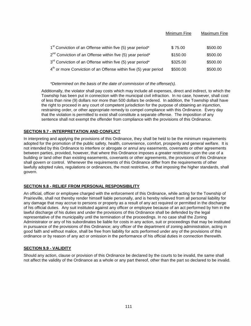
111
Minimum Fine Maximum Fine
1st Conviction of an Offense within five (5) year period* $ 75.00 $500.00
2nd
Conviction of an Offense within five (5) year period* $150.00 $500.00
3rd
Conviction of an Offense within five (5) year period* $325.00 $500.00
4th or more Conviction of an Offense within five (5) year period $500.00 $500.00
*Determined on the basis of the date of commission of the offense(s).
Additionally, the violator shall pay costs which may include all expenses, direct and indirect, to which the Township has been put in connection with the municipal civil infraction. In no case, however, shall cost of less than nine (9) dollars nor more than 500 dollars be ordered. In addition, the Township shall have the right to proceed in any court of competent jurisdiction for the purpose of obtaining an injunction, restraining order, or other appropriate remedy to compel compliance with this Ordinance. Every day that the violation is permitted to exist shall constitute a separate offense. The imposition of any sentence shall not exempt the offender from compliance with the provisions of this Ordinance.
SECTION 9.7 - INTERPRETATION AND CONFLICT
In interpreting and applying the provisions of this Ordinance, they shall be held to be the minimum requirements adopted for the promotion of the public safety, health, convenience, comfort, prosperity and general welfare. It is not intended by this Ordinance to interfere or abrogate or annul any easements, covenants or other agreements between parties, provided, however, that where this Ordinance imposes a greater restriction upon the use of a building or land other than existing easements, covenants or other agreements, the provisions of this Ordinance shall govern or control. Whenever the requirements of this Ordinance differ from the requirements of other lawfully adopted rules, regulations or ordinances, the most restrictive, or that imposing the higher standards, shall govern.
SECTION 9.8 - RELIEF FROM PERSONAL RESPONSIBILITY
An official, officer or employee charged with the enforcement of this Ordinance, while acting for the Township of Prairieville, shall not thereby render himself liable personally, and is hereby relieved from all personal liability for any damage that may accrue to persons or property as a result of any act required or permitted in the discharge of his official duties. Any suit instituted against any officer or employee because of an act performed by him in the lawful discharge of his duties and under the provisions of this Ordinance shall be defended by the legal representative of the municipality until the termination of the proceedings. In no case shall the Zoning Administrator or any of his subordinates be liable for costs in any action, suit or proceedings that may be instituted in pursuance of the provisions of this Ordinance; any officer of the department of zoning administration, acting in good faith and without malice, shall be free from liability for acts performed under any of the provisions of this ordinance or by reason of any act or omission in the performance of his official duties in connection therewith.
SECTION 9.9 - VALIDITY
Should any action, clause or provision of this Ordinance be declared by the courts to be invalid, the same shall not affect the validity of the Ordinance as a whole or any part thereof, other than the part so declared to be invalid.
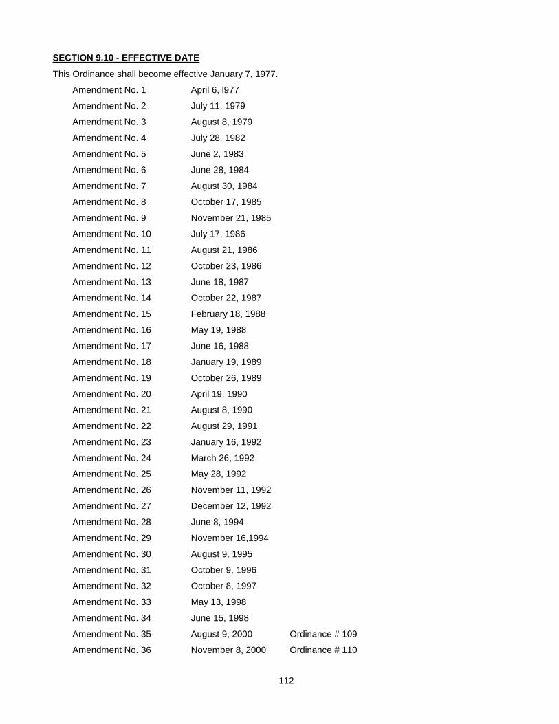
112
SECTION 9.10 - EFFECTIVE DATE
This Ordinance shall become effective January 7, 1977.
Amendment No. 1 April 6, l977
Amendment No. 2 July 11, 1979
Amendment No. 3 August 8, 1979
Amendment No. 4 July 28, 1982
Amendment No. 5 June 2, 1983
Amendment No. 6 June 28, 1984
Amendment No. 7 August 30, 1984
Amendment No. 8 October 17, 1985
Amendment No. 9 November 21, 1985
Amendment No. 10 July 17, 1986
Amendment No. 11 August 21, 1986
Amendment No. 12 October 23, 1986
Amendment No. 13 June 18, 1987
Amendment No. 14 October 22, 1987
Amendment No. 15 February 18, 1988
Amendment No. 16 May 19, 1988
Amendment No. 17 June 16, 1988
Amendment No. 18 January 19, 1989
Amendment No. 19 October 26, 1989
Amendment No. 20 April 19, 1990
Amendment No. 21 August 8, 1990
Amendment No. 22 August 29, 1991
Amendment No. 23 January 16, 1992
Amendment No. 24 March 26, 1992
Amendment No. 25 May 28, 1992
Amendment No. 26 November 11, 1992
Amendment No. 27 December 12, 1992
Amendment No. 28 June 8, 1994
Amendment No. 29 November 16,1994
Amendment No. 30 August 9, 1995
Amendment No. 31 October 9, 1996
Amendment No. 32 October 8, 1997
Amendment No. 33 May 13, 1998
Amendment No. 34 June 15, 1998
Amendment No. 35 August 9, 2000 Ordinance # 109
Amendment No. 36 November 8, 2000 Ordinance # 110
113
Amendment No. 37 June 13, 2001 Ordinance # 111
Amendment No. 38 June 12, 2002 Ordinance # 113
Amendment No. 39 April 9, 2003 Ordinance # 115
Reprinted as amended April 2003 (nn)
Amendment No. 40 March 10, 2004 Ordinance # 117
Amendment No. 41 August 10, 2005 Ordinance # 120
Amendment No. 42 September 19, 2005 Ordinance # 121
Amendment No. 43 October 12, 2005 Ordinance # 123
Amendment No. 44 July 12, 2006 Ordinance # 125
Reprinted February 2007 (nn)
Amendment No. April Ordinance #
Reprinted as amended April 2008
Amendment No. July 9, 2008 Ordinance # 134
Reprinted as amended July 2008
114
PRAIRIEVILLE TOWNSHIP ZONING BOARD OF APPEALS
RULES OF PROCEDURE
1. These rules of procedure are supplementary to the provisions in this Ordinance governing Zoning Board of Appeals activities.
2. Meetings of the Zoning Board of Appeals shall be held at the call of the Chairman and at such other times as the Board shall determine. Notice shall be given as required by this Ordinance and the Michigan Open Meetings Act.
3. All persons present at a Zoning Board of Appeals hearing shall be given an opportunity to speak at such hearing. The Board reserves the right to terminate unreasonably repetitive comments, to terminate comments which are not relevant or germane to the matter under discussion, to terminate the comments of any person which are slanderous or which are so disruptive as to threaten the orderly conduct of business, or to impose reasonable time limits on individual comment.
4. The tentative minutes of a Board meeting shall be considered for approval at the next meeting of the Board. If the minutes are approved with corrections, corrected minutes showing both the original entry and the corrections shall be prepared and made available for public inspection no less than five business days after the meeting at which the minutes were approved.
115
LAND DIVISION ORDINANCE
Adopted: September 10, 1997
An ordinance to regulate partitioning or division of parcels or tracts of land, enacted pursuant but not limited to Michigan Public Act 288 of 1967, as amended, and Act 246 of 1945, as amended, being the Township General Ordinance statute; to provide a procedure therefore; to repeal any ordinance or provision thereof in conflict herewith; and to prescribe penalties and enforcement remedies for the violation of this ordinance.
TOWNSHIP OF PRAIRIEVILLE, BARRY COUNTY, MICHIGAN, ORDAINS:
SECTION I – TITLE
This Ordinance is entitled the “Prairieville Township Land Division Ordinance”.
SECTION II – PURPOSE
This Section sets forth the purpose of this Ordinance.
SECTION III – DEFINITIONS
This Section sets forth the definitions of terms used in this Ordinance.
SECTION IV – PRIOR APPROVAL REQUIREMENT FOR LAND DIVISIONS
This Section provides that land in the Township shall not be divided without the prior approval of the Township Assessor or other official designated by the Township Board and makes exceptions to this approval requirement for land in a recorded plat and for “exempt splits” as defined in the Ordinance.
SECTION V – APPLICATION FOR LAND DIVISION APPROVAL
This Section sets forth the filing requirements for Township Land Division approval, including a tentative parcel map, history of the land proposed to be divided, application fee and other items specified in this section.
SECTION VI – PROCEDURE FOR REVIEW OF APPLICATIONS FOR LAND DIVISION APPROVAL
This Section provides that the Township Assessor or other designee shall approve, approve with conditions, or disapprove the proposed land division within 45 days after receipt of the application and sets forth the procedure to be followed in making such decision.
SECTION VII – STANDARDS FOR APPROVAL OF LAND DIVISIONS
This Section sets forth the standards governing approval of proposed land divisions, including compliance with the State Land Division Act, this Ordinance, a maximum depth to width ratio of four (4) to one (1), and the Township Zoning Ordinance minimum lot width and minimum lot area requirements.
SECTION VIII – ALLOWANCE FOR APPROVAL OF OTHER LAND DIVISIONS
This Section provides for the creation of a parcel designated as “not a development site, as defined under 1967 PA 288, as amended”.
116
SECTION IX – CONSEQUENCES OF NONCOMPLIANCE WITH LAND DIVISION APPROVAL REQUIREMENT
A parcel created in noncompliance with this Ordinance shall not be eligible for any building permits, or zoning approvals, and shall not be recognized as a separate parcel on the assessment roll.
SECTION X – SEVERABILITY
The provisions of this Ordinance are severable.
SECTION XI – REPEAL
All previous Land Division Ordinances affecting unplatted land divisions in conflict with this Ordinance are hereby repealed; however, this Ordinance shall not be construed to repeal any provision in any applicable Zoning Ordinances, Building Codes or other Ordinances of the Township.
SECTION XII – EFFECTIVE DATE
SECTION XIII – REPEAL
All ordinances or parts of ordinances in conflict with this ordinance shall not be construed to repeal any provision in this Ordinance, Building Code Ordinance or Subdivision Ordinance.