ARTICLE I ENACTMENT
383
ARTICLE I ENACTMENT SECTION 1.010 Authority 1.020 Title 1.030 Enactment 1.040 Purpose 1.010. Authority. An ordinance, in pursuance of the authority granted by Sections 13-7-201 through 13-7-401, Tennessee Code Annotated to provide for the establishment of districts within the corporate limits of the Town of Smyrna, Tennessee: to regulate within such districts the location, height, bulk, number of stories and size of buildings and other structures, the percentage of the lot which may be occupied, the sizes of yards, courts and other open spaces, the density of population, and the uses of buildings, structures and land for trade, industry, residence, recreation, public activities and other purposes including areas subject to flooding; to provide methods of administration of this ordinance; and to prescribe penalties for the violation thereof. 1.020. Title. This ordinance shall be known as The Zoning Ordinance of Smyrna, Tennessee dated October 14, 1986. The zoning map shall be referred to as the Official Zoning Map of Smyrna, Tennessee and all explanatory matter thereon is hereby adopted and made a part of this ordinance. 1.030. Enactment. WHEREAS, Section 13-7-201 through 13-7-401 of the Tennessee Code Annotated empowers the Town to enact a zoning ordinance and to provide for its administration enforcement, and amendment, and WHEREAS, The Town Council deems it necessary, for the purpose of promoting the public health, safety, morals, convenience, order, prosperity and general welfare of the Town to enact such an ordinance, and WHEREAS, all the requirements of Section 13-7-201 through 13-7- 401 of the Tennessee Code Annotated with regard to the preparation of the zoning plan of the Planning Commission and subsequent action of the Town Council have been met; NOW THEREFORE BE IT ORDAINED BY THE TOWN COUNCIL THAT THE ZONING ORDINANCE OF SMYRNA, TENNESSEE IS ENACTED INTO LAW.
Transcript of ARTICLE I ENACTMENT

ARTICLE I
ENACTMENT
SECTION
1.010 Authority
1.020 Title
1.030 Enactment
1.040 Purpose
1.010. Authority. An ordinance, in pursuance of the authority
granted by Sections 13-7-201 through 13-7-401, Tennessee Code
Annotated to provide for the establishment of districts within the
corporate limits of the Town of Smyrna, Tennessee: to regulate within
such districts the location, height, bulk, number of stories and size
of buildings and other structures, the percentage of the lot which
may be occupied, the sizes of yards, courts and other open spaces,
the density of population, and the uses of buildings, structures and
land for trade, industry, residence, recreation, public activities
and other purposes including areas subject to flooding; to provide
methods of administration of this ordinance; and to prescribe
penalties for the violation thereof.
1.020. Title. This ordinance shall be known as The Zoning
Ordinance of Smyrna, Tennessee dated October 14, 1986. The zoning
map shall be referred to as the Official Zoning Map of Smyrna,
Tennessee and all explanatory matter thereon is hereby adopted and
made a part of this ordinance.
1.030. Enactment. WHEREAS, Section 13-7-201 through 13-7-401
of the Tennessee Code Annotated empowers the Town to enact a zoning
ordinance and to provide for its administration enforcement, and
amendment, and
WHEREAS, The Town Council deems it necessary, for the purpose of
promoting the public health, safety, morals, convenience, order,
prosperity and general welfare of the Town to enact such an
ordinance, and
WHEREAS, all the requirements of Section 13-7-201 through 13-7-
401 of the Tennessee Code Annotated with regard to the preparation of
the zoning plan of the Planning Commission and subsequent action of
the Town Council have been met;
NOW THEREFORE BE IT ORDAINED BY THE TOWN COUNCIL THAT THE ZONING
ORDINANCE OF SMYRNA, TENNESSEE IS ENACTED INTO LAW.

2
1.040. Purpose. The purpose of this ordinance is to promote the
public health, safety, morals, convenience, order, prosperity
and general welfare by:
a. enhancing the character and stability of residential,
business, commercial, and industrial areas, and promoting the
orderly and beneficial development of such areas;
b. preventing the overcrowding of land;
c. conserving the value of land and buildings;
d. minimizing traffic hazards and congestion;
e. preventing undue concentration of population;
f. providing for adequate light, air, privacy, and sanitation;
g. reducing hazards from fire, flood, and other dangers;
h. assisting in the economic provision, utilization, and
expansion of all services provided by the public, including
but not limited to roads, water and sewer services,
recreation, schools, and emergency services;
i. encouraging the most appropriate uses of land; and
j. enhancing the natural, man-made and historical amenities of
Smyrna, Tennessee.

3
ARTICLE II
DEFINITIONS
SECTION
2.010 Scope
2.020 Definitions
2.030 Use Classifications
2.010. Scope. For the purpose of this ordinance and in order to
carry out the provisions and intentions as set forth herein, certain
words, terms, and phrases are to be used and interpreted as follows:
A. The word "person" includes a firm, association, organization,
partnership, trust, company, or corporation as well as an
individual.
B. The present tense includes the future tense, the singular
number includes the plural, and the plural number includes
the singular.
C. The word "shall" is mandatory.
D. The word "may" is permissive.
E. The words "used" or "occupied" includes the words "intended,"
"designed," or "arranged to be used" or "occupied".
F. The word "lot" includes the words "plot" or "parcel".
2.020. Definitions. The following words, terms, and phrases
are hereby defined as follows and shall be interpreted as such
throughout this ordinance. Terms not herein defined shall have their
standard dictionary definitions or such as the context may imply.
ACCESS: The right to cross between public and private property,
thereby permitting pedestrians and vehicles to enter and leave
property.
ACCESSORY BUILDING: A subordinate building, or structure, the
use of which is incidental to that of a principal building and
located in the side or rear yard on the same lot therewith.
ACCESSORY STRUCTURE: Shall represent a subordinate structure to
the principal structure and, for the purpose of this section,
shall conform to the following:
1. Accessory structures shall not be used for human habitation.
2. Accessory structures shall be designed to have low flood
damage potential.

4
3. Accessory structures shall be constructed and placed on the
building site so as to offer the minimum resistance to the
flow of floodwaters.
4. Accessory structures shall be firmly anchored to prevent
flotation, which may result in damage to other structures.
5. Service facilities such as electrical and heating equipment
shall be elevated or flood proofed.
6. Accessory structures shall only be allowed in the side or
rear yard.
ACCESSORY USE: A use customarily incidental, appropriate, and
subordinate to the principal use of land or buildings and
located within the rear yard upon the same lot therewith.
ADDITION (TO AN EXISTING BUILDING): Any walled and roofed
expansion to the perimeter of a building in which the addition
is connected by a common load-bearing wall other than a
firewall. Any walled and roofed addition that is connected by a
firewall or is separated by independent perimeter load-bearing
walls is new construction.
ADULT-ORIENTED ESTABLISHMENT: Shall be as defined in the Town of
Smyrna Municipal code and include, but shall not be limited to,
adult bookstores, adult motion picture theaters, adult mini-
motion picture establishments, or adult cabarets, and further
means any premises to which the public patrons or members
(regardless of whether or not the establishment is categorized
as a private or members only club) are invited or admitted
and/or which are so physically arranged as to provide booths,
cubicles, rooms, compartments or stalls separate from the common
areas of the premises for the purpose of viewing adult-oriented
motion pictures, or wherein an entertainer provides adult
entertainment to a member of the public, a patron or a member,
when such adult entertainment is held, conducted, operated or
maintained for a profit, direct or indirect. An adult-oriented
establishment further includes, without being limited to , any
adult entertainment studio or any premises that are physically
arranged and used as such, whether advertised or represented as
an adult entertainment studio, rap studio, exotic dance studio,
encounter studio, sensitivity studio, modeling studio or any
other term of like import.
ADVERTISING: Includes any writing, printing, painting, display,
emblem, drawing, sign, or other device designs used or intended
for advertising, whether placed on the ground, rocks, trees,
tree stumps, or other natural structures or on buildings,
structures, milestones, signboards, wallboard, roofboard,
frames, supports, fences or other man-made structure, and any
such advertising is a structure within the meaning of the word
"structure" as utilized in this ordinance.

5
ADVERTISING SIGN OR STRUCTURE: See Sign.
AGRICULTURAL USE: This includes all forms of agriculture,
growing of crops in the open, dairying, grazing, the raising and
maintaining of poultry and other livestock, horticulture,
viticulture, floriculture, forests, and woods, provided,
however, all health codes of Smyrna, Tennessee are complied
with.
The feeding or disposal of community or collected garbage to
animals shall not be deemed an agricultural use, nor shall
commercial feed lots, the raising of furbearing animals, fish or
minnow hatcheries, riding stables, livery or boarding stables or
dog kennels be so considered.
AGRICULTURAL ACCESSORY USE: Those structures or equipment, which
are normally required in the operation of agricultural uses.
ALLEY: A minor right-of-way, dedicated to public use, which
affords a secondary means of vehicular access to the back or
side of properties otherwise abutting a street, and which may be
used for public utility and public service purposes.
ALTERNATIVE FINANCIAL SERVICES: Any non-chartered financial
institution offering check cashing services, currency exchange,
pay-day loans, car title loans, industrial loan and thrift,
and/or similar services as its primary function.
ALTERATION: As applied to a building or structure, means a
change or rearrangement in the structural parts, or an
enlargement, whether by extending a side or by increasing its
height or structural changes, other than repairs, that would
affect safety. The term "alter" in its various modes and tenses
and its practical forms, refers to the making of an alteration.
APPEAL: Means a request for a review of the Building Official's
interpretation of any provision of this Ordinance or a request
for a variance.
AREA, BUILDING: The total areas taken on a horizontal plane at
the main grade level of the principal building and all necessary
buildings exclusive of uncovered porches, terraces, and steps.
AUTO TOWING SERVICES: Establishment that provides for the
removal and temporary storage of wrecked or impounded motor
vehicles but does not include disposal, permanent disassembly,
salvage, or sales of parts.
AUTOMOBILE WRECKING: The dismantling, storage, sale or dumping
of used motor vehicles, trailers, or parts thereof.

6
AUTOMOBILE WRECKING, JUNK, AND SALVAGE YARDS: A lot, land or
structure, or part thereof, used primarily for the collecting,
storage and sale of waste paper, rags, scrap metal, or discarded
material; or for the collecting, dismantling, storage and
salvaging of machinery or vehicles not in running condition or
for the sale of parts thereof.
AVERAGE GROUND ELEVATION: The elevation of the mean finished
grade of the principal structure at the front of a structure.
BASEMENT: A story partly or wholly underground. For purposes
of height measurement, a basement shall be counted as a story
when more than one-half (1/2) of its height is above the average
ground elevations or when subdivided and used for commercial
activities.
BASE ZONING DISTRICT: The term referring to a zoning district
when it is affected by an overlay zoning district.
BED AND BREAKFAST: A private, owner-occupied residence with
guestrooms where overnight accommodations and a morning meal are
provided for compensation.
BEER STORE: A retail store established solely for or to include
for the purposes of the retail sales of beer as defined in the
Tennessee Code Annotated and as provided for under terms and
conditions within the Smyrna Municipal Code, Title 8, Chapter 2.
BOARD: The Smyrna Tennessee Board of Zoning Appeals.
BOARDING HOUSE: See dwelling definitions.
BUFFER STRIP: An area of land, which could include landscaping,
berms, walls, or fences, that is located between land uses of
different character and is intended to mitigate negative impacts
of the more intense use.
BUILDING: Any structure having a roof supported by columns or
by walls, including tents, lunch wagons, dining cars, mobile
homes, mobile offices, and similar structures whether stationary
or movable.
BUILDING COMMISSIONER: The Building Official for the Town of
Smyrna, Tennessee.
BUILDING AREA OF A LOT: That portion of a lot bounded by the
required rear yard, side yards, and the building setback line.
7
BUILDING, ELEVATED: A non-basement building built to have the
lowest floor elevated above the ground level by means of fill,
solid foundation perimeter walls, pilings, columns (posts and
piers), shear walls, or break away walls.
BUILDING, MAIN OR PRINCIPAL: A building in which is conducted
the principal use of the lot on which it is situated. In any
residential district any dwelling shall be deemed to be a main
building on the lot on which it is situated.
BUILDING SETBACK LINE(S), SIDE: A line delineating the minimum
distance between the side property line and a building on a lot
(other than for permitted accessory structures and buildings).
The side setback line extends from the front building setback
line to the rear building setback line. In the case of corner
lots in residential districts, side building setback lines
extend from the front building setback line of the servicing
street to the other front building setback line adjoining the
secondary street which abuts said corner lot.
BUILDING SETBACK LINE, FRONT: A line delineating the minimum
allowable distance between the street right-of-way, or if an
official future street right-of-way has been established, as
shown on the current, adopted Major Thoroughfare Plan Map, from
that future street right-of-way line, and the front of a
principal building on a lot.
The front building setback line extends the full width of the
lot and is parallel to or concentric with the street right-of-
way. No building or structure shall be placed in front of this
building setback line.
BUILDING SETBACK LINE, REAR: A line delineating the minimum
allowable distance between the rear property line and a building
on a lot (other than for permitted accessory structures and
buildings). The rear setback line extends the full width of the
lot.
BULK: Describes the size of buildings or other structures, and
their relationship to each other, and to open areas and lot
lines.
BUSINESS AND COMMUNICATION SERVICES: The provision of clerical
services, goods brokerage, communications of a minor processing
nature, including multi-copy and blueprinting services, custom
printing, but excluding the printing of books, other than
pamphlets and small reports.
CAMPING GROUND: A parcel of land used or intended to be used,
let, or rented for occupancy by campers or for occupancy by

8
camping trailers, tents, or movable or temporary dwellings,
rooms, or sleeping quarters of any kind.
CLIMATE-CONTROLLED: A state of atmospheric regulation in which
temperature and humidity are prevented from reaching extremes.
The source of air temperature regulation shall be via indirect
heating or cooling, not through individual heaters or air
conditioners in individual units. Mainly associated with ―self-
service storage facilities.‖
CLINIC: See Medical Facility.
CONDITIONAL USE: A conditional use is a use that would not be
appropriate generally or without restriction throughout the
zoning district but which, if controlled as to number, area,
location, or relation to the neighborhood, would promote the
public health, safety, morals, order, comfort, convenience,
appearance, prosperity, or general welfare. Such uses may be
permitted in a zoning district as conditional uses, only when
specific provisions for such uses are made in this Ordinance,
conditional uses shall be construed as being synonymous with
special exceptions, as controlled by Section 13-7-206, Tennessee
Code Annotated. See special exceptions.
CONVENIENCE SALES: The retail sale of small convenience items
such as toiletries, tobacco, and magazines. The dispensing of
petroleum products may be included as accessory to convenience
food products retailing.
CONVENIENCE SERVICES: Services which are typically needed
frequently or recurrently, such as barber and beauty care; and
includes the operation of self-service Laundromats but excludes
other apparel cleaning and repair services.
COVERAGE: The lot area covered by all buildings located
therein, including the area covered by all overhanging roofs.
COUNTRY CLUB: A chartered, nonprofit membership club, with
facilities catering primarily to its membership and providing
one or more of the following recreational or social amenities:
golf, riding, club house, pool, dining facilities, and lounge.
CREMATORIUM: A building or structure containing properly
installed, certified apparatus intended for use in the act of
cremation.
DAY CARE CENTER: A facility other than an occupied residence
which receives children for day care or any place, including
nursery schools, which provide definite, specified educational
programs, which receives more than 12 children for related day

9
care services. (See definition of Family Day Care Home for
comparison).
DEVELOPMENT: Any man-made change to improve or unimproved real
estate, including but not limited to buildings, or other
structures, mining, dredging, filling, grading, paving,
excavating, or drilling operations. Agricultural activities
such as plowing or cultivating and gardening activities are not
included in this definition of development.
DISTRICT: Any section or sections of the area lying within
Smyrna, Tennessee, for which the regulations governing the use,
density, bulk, height, and coverage of buildings and other
structures are in force.
DWELLING: A building or part thereof used as a habitation under
one of the following categories:
a. Single detached dwelling means a building and
accessories thereto principally used, designed, or
adapted for use by a single family. With the exception
of a bed and breakfast permitted under the provisions of
this Ordinance, no single detached dwelling or portion
thereof may be rented out to any tenant(s) for a period
of less than three months. As used in this definition,
―tenant (s)‖ shall refer to one or more persons actually
occupying a dwelling or portion thereof.
Notwithstanding the foregoing, if a tenant has occupied
a dwelling for a period of three months or more, the
same tenant’s occupancy may subsequently be extended for
periods of less than three months.
b. Duplex dwelling means a building and accessories thereto
principally used, designed, or adapted for use by two
(2) families, the living quarters of each of which are
completely separate.
c. Apartment dwellings means a building and accessories
thereto principally used, designed, or adapted for use
as occupancy by three (3) or more families each of which
has separate living quarters.
d. Rooming house means a building and accessories thereto
principally used, designed, or adapted to provide living
accommodations for not more than six (6) occupants and
without owner-provided cooking and dining
facilities.(See semi-transient habitation definition).
e. Boarding house means a building and accessories thereto
principally used, designed, or adapted to provide living

10
accommodations for not more than six (6) occupants and
having common cooking and dining facilities.(See semi-
transient habitation definition).
f. Townhouse means a residential structure containing three
or more single nondetached dwelling units separated by a
common vertical wall.
g. Condominium means an apartment building or townhouse,
containing three or more dwelling units being under or
intended for separate ownership, in which individual
living accommodations are provided for each family.
h. Multi-family means a townhouse or apartment dwelling.
For the purposes of these regulations, regardless of how
rental units are equipped, any multi-family dwelling in
which units are available for rental partly on a monthly
basis and partly for a shorter period of time, but with
more than thirty (30) percent of the living units under
the same ownership or management on the same zone lot
being occupied on a less-than-monthly basis, shall be
considered a semi-transient residential activity. If
over thirty (30) percent of such multi-family units
under the same management or ownership are occupied on a
biweekly basis or less, they shall be considered as
transient lodging activity. (See definition of
transient habitation).
i. Triplex dwelling means three units designed for use by
three families located on the same tract (zone lot).
j. Quadraplex dwellings means four units designed for use
by four families located on the same tract (zone lot).
k. Prefabricated or manufactured dwelling means any single
detached dwelling installed on a permanently enclosed
concrete or masonry foundation, with sewer and water
connections designed for permanent connection to
municipal or on-site systems. Such structures are
transportable in more than one section, having a pitched
roof, and are built on a permanent chasis. The term
manufactured dwelling or home does not include a
recreational vehicle.
l. Mobile home or trailer means a vehicular portable
structure designed and constructed in accordance with
the requirements of American National Standards
Institute Standard A119.1, built on a chassis, designed
for year around occupancy and designed to have no
foundation other than wheels, jacks, or skirtings, and

11
which is capable of being moved, towed, or transported
by another vehicle. For the purposes of the National
Flood Insurance program only a mobile home is considered
to be a manufactured home.
m. Zero lot line dwelling means a building or structure
containing two units (duplex), each unit being located
on its own zone lot in separate ownership.
n. Upper story residential means the area of a building
above the ground floor which is principally used,
designed, or adapted for use by one or more households
each of which has separate living quarters.
o. apartment means a separate dwelling that is attached to a single-family residence, or is located in a detached
accessory structure, is subordinate in size to the
principal residence, has off-street parking provided,
and does not change the basic single-family appearance
of the principal structure.
EROSION: Means the process of the gradual wearing away of
landmasses. This peril is not per se covered under the Program.
EXISTING CONSTRUCTION: Any structure for which the "start of
construction" commenced before the effective date of this
Ordinance.
EXISTING MANUFACTURED HOME PARK OR SUBDIVISION: Means a
manufactured home park or subdivision for which the construction
of facilities for servicing the lots on which the manufactured
homes are to be affixed (including, at a minimum, the
installation of utilities, the construction of streets, and
either final site grading or the pouring of concrete pads) is
completed before the effective date of this ordinance.
EXISTING STRUCTURES: See "Existing Construction".
EXPANSION TO AN EXISTING MANUFACTURED HOME PARK OR SUBDIVISION:
Means the preparation of additional sites by the construction of
facilities for servicing the lots on which the manufactured
homes are to be affixed (including the installation of
utilities, the construction of streets, and either final site
grading or the pouring of concrete pads).
FAMILY: One or more persons related by blood, marriage, or
adoption, or a group not all related by blood, marriage, or
adoption, occupying the premises and living as a single non-
profit housekeeping unit as distinguished from a group occupying
a boarding or lodging house or similar dwelling for group use.

12
A family shall not be deemed to include domestic servants
employed by said family. The term family as used herein shall
be construed to include groups of eight (8) or fewer unrelated
mentally retarded or physically handicapped persons and with two
(2) additional persons acting as housekeepers or guardian
residing within the house (See Chapter 24 of Title 13, T.C.A.).
FAMILY DAY CARE HOME: An occupied residence in which a person
provides day care for five or more children or close relatives.
Such care in a family day care home is limited to that care
given to no more than twelve (12) children, including children
living in the home and children of close relatives cared for in
the home. (See definition of Day Care Center for comparison).
FARM: A parcel of land containing five or more contiguous acres
devoted to agricultural use.
FENCE: An artificially constructed barrier of wood, masonry,
stone, wire, metal, vinyl, or other manufactured material or
combination of materials erected as a boundary, privacy screen,
or enclosure.
FENCE, DECORATIVE: A fence constructed of wood, wrought-iron,
vinyl, or brick that is no more than three feet tall.
FINANCIAL, CONSULTING AND ADMINISTRATIVE: Includes the
provisions of financial, insurance, real estate brokerage
services, as well as the provision of advice, designs,
information, or consultation of a professional nature. Also
includes the executive, management, administrative, and desired
activities of private, profit-oriented firms, other than public
utility firms. These activities do not include the storage of
goods and chattels for the purpose of sale unless otherwise
permitted by other provisions of this regulation.
FLOODWAY: The channel of a river or other watercourse and the
adjacent land areas that must be reserved in order to discharge
the base flood without cumulatively increasing the water surface
elevation more than a designated height.
FLOOR: Means the top surface of an enclosed area in a building
(including basement), i.e., top of slab in concrete slab
construction or top of wood flooring in wood frame construction.
The term does not include the floor of a garage used solely for
parking vehicles.
FLOOR AREA: The sum of the gross floor area for each of the
several stories under roof, measured from the exterior limits of
faces of a building or structure.

13
FRONTAGE: All the property on one side of a street between two
intersecting streets (crossing or terminating) measured along
the line of the street, or if the street is dead ended, then all
the property abutting on one side between an intersecting street
and the dead end of the street.
GASOLINE SERVICE STATION: Any area of land, including structures
thereon, that is utilized for the retail sale of gasoline, oil
(but no butane or propane fuels), or automobile accessories, and
incidental services including facilities for lubricating, hand
car washing and cleaning, or otherwise servicing automobiles,
but not including painting or major repair.
GRADE, FINISHED: The completed surfaces of lawns, walks, and
roads brought to grades as shown on official plans or designs
relating thereto.
GREENWAYS PLAN: The adopted Greenways Plan for the Town of
Smyrna, Tennessee.
HEALTH DEPARTMENT: The Rutherford County Health Department.
HEIGHT OF BUILDING OR STRUCTURES: The vertical distance from the
average elevation or finished grade at the building line,
whichever is the highest, to the highest point of the building
or structure.
HISTORIC STRUCTURE: Means any structure that is:
1. Listed individually in the National Register of Historic
Places (a listing maintained by the Department of Interior)
or preliminary determined by the Secretary of the Interior as
meeting the requirements for individual listing on the
National Register;
2. Certified or preliminary determined by the Secretary of the Interior as contributing to the historical significance of a
registered historic district or a district preliminary
determined by the Secretary to qualify as a registered
historic district;
3. Individually listed on a state inventory of historic places in states with historic preservation programs which have been
approved by the Secretary of the Interior; or
4. Individually listed on a local inventory of historic places
in communities with historic preservation programs that have
been certified either:

14
a. By an approved state program as determined by the
Secretary of the Interior, or
b. Directly by the Secretary of the Interior in states
without approved programs.
HOME OCCUPATION: An occupation or profession that is accessory
to a residential use and is customarily carried on in a dwelling
unit or in a building or other structure accessory to a dwelling
unit; carried on by a member of the family residing in the
dwelling unit; and clearly incidental and secondary to the use
of the dwelling unit for residential purposes.
HOSPITAL: See Medical Facilities.
HOUSEHOLD: All the persons occupying the premises and living as
a single nonprofit housekeeping unit regardless of marital
status or relationship as distinguished from a group occupying a
lodging house or dormitory or similar type of group use.
JUNK YARD OR SALVAGE YARD: A lot, land or structure, or part
thereof, used primarily for the collecting, storage and sale of
waste paper, rags, scrap metal, or discarded material; or for
the collecting, dismantling, storage and salvaging of machinery
or vehicles not in running condition or for the sale of parts
thereof. Any lot containing five (5) or more immobile cars
shall be deemed a junkyard.
LANDSCAPING: The planting and maintenance of trees, shrubs,
lawns, and other ground cover or materials, provided that
terraces, fountains, retaining walls, street furniture,
sculptures, or other art objects, and similar accessory features
may be included as landscaping if integrally designed.
LAND WITH INCIDENTAL IMPROVEMENTS: A tract of land which
contains improvements including buildings or other structures
having a total assessed valuation of five thousand dollars
($5,000) or less.
LIGHT INDUSTRY: Is defined, for the purpose of this ordinance,
on the basis of performance in terms of absence of objectionable
noise, smoke, odor, dust, dirt, noxious gases, glare and heat;
and of the creation of industrial wastes, psychological effects
and generation of an undue amount of motor vehicle traffic.
LIQUOR STORE: A retail store established solely for the purposes
of the retail sales of package liquor as defined in the
Tennessee Code Annotated and as provided for under terms and
conditions within the Smyrna Municipal Code, Title 8, Chapter 3.

15
LOADING SPACE: An area twelve (12) feet by sixty-five (65) feet
with a fourteen (14) foot height clearance provided for the
standing, loading, or unloading of a truck or other vehicle.
LOT: A piece, plot, or parcel of land in one ownership, which
may include one or more lots or record, occupied or to be
occupied by one principal building and its accessory buildings,
including the open spaces required under this ordinance.
LOT, AREA: The total surface land areas included within lot
lines.
LOT, CORNER: A lot of which at least two adjoining sides abut
their full lengths on a street, provided that the interior angle
at the intersection of two such sides is less than one hundred
thirty-five (135) degrees.
LOT, DEPTH: The average distance from the street line of the lot
to its rear line, measured in the general direction of the
sidelines of the lot.
LOT, FRONTAGE: That dimension of a lot or portion of a lot
abutting on a street, excluding the side dimension of a corner
lot.
LOT, INTERIOR: A lot other than a corner lot.
LOT, LINES: The boundary dividing a given lot from the street,
an alley or adjacent lots.
LOT OF RECORD: A lot which is part of a subdivision recorded in
the office of the county register of deeds, or a lot described
by metes and bounds, the description of which has been recorded
in the office of the county register of deeds prior to the
effective date of this zoning ordinance.
LOT, WIDTH: The width of a lot at the building setback line
measured at right angles to its depth.
LOWEST FLOOR: Means the lowest floor of the lowest enclosed area
(including basement). An unfinished or flood resistant
enclosure, usable solely for parking of vehicles, building
access or storage in an area other than a basement area is not
considered a building's lowest floor; provided, that such
enclosure is not built so as to render the structure in
violation of the applicable non-elevation design requirements of
this Ordinance.
MAJOR THOROUGHFARE PLAN: The adopted Major Thoroughfare Plan for
the Town of Smyrna, Tennessee.

16
MANUFACTURED HOME PARK OR SUBDIVISION: Means a parcel (or
contiguous parcels) of land divided into two or more
manufactured home lots for rent or sale.
MARINA: A facility for the docking and servicing of boats.
MEDICAL FACILITIES:
Convalescent, Rest or Nursing Home: A health facility where
persons are housed and furnished with meals and continuing
nursing care for compensation.
Dental Clinic or Medical Clinic: A facility for the
examination and treatment of ill and afflicted human
outpatients, provided, however, that patients are not kept
overnight except under emergency conditions.
Hospital: An institution providing health services
primarily for human in-patient medical care for sick or
injured and including related facilities such as services,
and staff offices which are an integral part of the
facility.
Public Health Center: A facility utilized by a health unit
for the provision of public health services.
MICROBREWERY/MICROWINERY/MICRODISTILLERY: A facility in which
beer, wine, or other alcoholic beverages are brewed, fermented,
or distilled for distribution and consumption, generally
referred to as a craft, boutique, or artisan establishment.
Tasting rooms, brewpubs, or other facilities for the consumption
of any alcoholic beverages produced on-site are permitted on the
premises. All relevant federal, state and local regulations
apply, including but not limited to T.C.A. Title 57 and the Town
of Smyrna Municipal Code Title 8.
MINIMUM FLOOR ELEVATION: The lowest elevation permissible for
the construction, erection, or other placement of any floor,
including a basement floor.
MOBILE HOME PARK: Any area, tract, site or plot of land
whereupon mobile homes as herein defined are placed, located and
maintained, and shall include all accessory buildings used in
intended to be used as part of the equipment thereof.
NEW CONSTRUCTION: Means structures for which the "start of
construction" commenced on or after the effective date of this
ordinance. The term also includes any subsequent improvements
to such structure.
17
NEW MANUFACTURED HOME PARK OR SUBDIVISION: Means a manufactured
home park or subdivision for which the construction of
facilities for servicing the lots on which the manufactured
homes are to be affixed (including at a minimum, the
installation of utilities, the construction of streets, and
either final site grading or the pouring of concrete pads) is
completed on or after the effective date of this Ordinance.
NONCOMPLYING:
(a) Any lot of record which does not contain sufficient lot
area to conform to the area requirements for the zoning
district in which the lot is located.
(b) Any lawful building or other structure which does not
comply with any one (1) or more of the applicable bulk
regulations, or
(c) Any lawful use other than a nonconforming use, which does
not comply with any part or any one (1) or more of the
applicable regulations pertaining to:
(1) Location along district boundary;
(2) Accessory off-street parking and loading;
either on the effective date of this Ordinance
or as a result of any subsequent amendment.
NOXIOUS MATTER: Material in gaseous, liquid or solid form which
is capable of causing injury to living organisms, chemical
reactions, or detrimental effects upon the social, economic or
psychological well-being of individuals.
OPEN SPACE: An area on the same lot with a main building which
is open, unoccupied and unobstructed by structures from the
ground to the sky except as otherwise provided in this
ordinance.
OUTSIDE DISPLAY: The placement of goods for sale outside of a
building or structure.
OUTSIDE STORAGE: The placement of materials or equipment outside
of a building or structure for the purposes of storing the
materials or equipment for future use.
OVERALL DENSITY: The residential density in minimum lot size per
family or stated dwelling units per acre of any total lot, or
development area.

18
OVERLAY ZONING DISTRICT: A zoning district established to
prescribe special regulations to be applied to a site in
combination with the regulations of the base zoning district.
OWNER: Includes his duly authorized agent or attorney,
purchaser, devisee, fiduciary, and a person having a vested or
contingent interest in the property in question.
PARKING LOT: An off-street facility including parking spaces
with adequate provisions for drives and aisles for maneuvering
and obtaining access, and for entrance and exit.
PARKING SPACE: An off-street space available for parking one
motor vehicle and having access to a street or alley.
PARTY WALL: A wall on an interior lot line, used or adapted for
joint service between two buildings; such walls shall extend
from the foundation to the underside of the roof sheathing,
without openings which otherwise would permit the spread of fire
from one building to another, and shall fully comply with fire
and all other provisions and standards established for such
walls in the adopted Building Code.
PERSON: An individual, firm, partnership, corporation, company,
association, joint stock association, or body politic, and
includes a trustee, receiver, assignee, administrator, executor,
guardian, or other representative.
PLANNED DEVELOPMENT: A single planned area of land which is
designed and organized to be capable of satisfactory use and
operation as a separate entity without necessarily having the
participation of other building sites or other common property;
the ownership of the common property may be either public or
private. Planned developments consist of relatively large
interrelated developments located on a single tract of land.
Cluster developments and mixed use developments of all types are
planned unit developments. Many shopping centers of various
types fall under this definition of planned development.
PLANNING COMMISSION: The Smyrna Municipal Planning Commission.
PLAT: A map, plan, or layout indicating the location and
boundaries of individual properties.
PREFABRICATED DWELLING: See classification K under the
definition of a dwelling.
PRINCIPAL STRUCTURE: A structure, which constitutes the
principal activity or use, located on a zone lot on which it is
located.

19
PRINCIPAL USE: The specific primary purpose for which land or a
building is used.
PRIVATE WASTEWATER TREATMENT: Individual subsurface sewage
disposal systems (i.e., septic tanks), package treatment plants
or individual aeration systems employed for the collection and
treatment and/or disposal of wastewater, as approved by the
appropriate Department of the State of Tennessee.
PROFESSIONAL OFFICE: The office of a physician, dentist,
attorney, architect, engineer, planner, accountant, or similar
professions.
PUBLIC USES: Public parks, schools, and administrative,
cultural, and services buildings, not including public land or
buildings devoted solely to storage and maintenance of equipment
and materials.
PUBLIC WASTEWATER SYSTEM: A municipal, community, or utility
district sewerage treatment and disposal system of a type
approved by the State Department of Health and Environment, and
the Tennessee Regulatory Authority.
PUBLIC WATER: A municipal, community or utility district water
treatment and distribution system of a type approved by the
State Department of Health and Environment and the Tennessee
Regulatory Authority.
REACH: A hydraulic engineering term to describe longitudinal
segments of a stream or river. A reach will generally include
the segment of the floodplain where flood heights are primarily
controlled by man-made or natural floodplain obstructions or
restrictions.
RECREATIONAL VEHICLE: Means a vehicle that is:
1. built on a single chassis;
2. 400 square feet or less when measured at the largest
horizontal projections;
3. designed to be self-propelled or permanently towable by
a light duty truck; and
4. designed primarily not for use as a permanent dwelling
but as temporary living quarters for recreational,
camping, travel, or seasonal use.
REQUIRED YARD: That portion of a zone lot that is required by
the specific district regulation to be open from the ground to
the sky, and which may contain only explicitly listed
obstructions.

20
RIGHT-OF-WAY: A strip of land acquired by reservation,
dedication, prescription, or condemnation and intended to be
occupied by a highway, street, alley railway, or other
passageway intended for the passage of people or goods.
ROADWAY: The actual road surface including necessary road
shoulders and drainage facilities including ditches, curbs, and
gutters, which is used to transport motor vehicles.
ROOMING UNIT: Living accommodations occupied partly on a monthly
or longer basis and partly for a shorter time period, but with
more than thirty (30) percent of time living units under the
same ownership, control, or management on the same zone lot
being occupied on a less than monthly basis.
SANITARY LANDFILL: An area or site utilized by a public or
private entity for disposal of solid waste or refuse in a manner
which meets the regulations imposed upon the operation and
maintenance of sanitary landfill sites by the State Department
of Health and Environment.

21
SELF-SERVICE STORAGE FACILITIES: Facilities containing units to
be sold or leased for the purpose of storing household goods.
For the purposes of this ordinance, this term shall be
interchangeable with ―mini-warehouses‖, ―convenience storage‖,
and ―household goods storage.‖
SEMI-TRANSIENT HABITATION: Living accommodations occupied partly
on a monthly or longer bases and partly for a shorter time
period, but with more than thirty (30) percent of the living
units under the same ownership, control or management on the
same zone lot being occupied on more than a by-weekly basis but
on less than a monthly basis. (See transient habitation
definition).
SHELTER, FALL-OUT: A structure or portion of a structure
intended to provide protection to human life during periods of
danger from nuclear fall-out, air raids, storms, or other
emergencies.
SHOPPING CENTER: A group of compatible commercial establishments
planned, developed, and managed, as a unit, with an automobile
storage area provided on the property; the center must also be
related in location, size, and type of shop to its trade area.
SIGN, BILLBOARD, OR OTHER ADVERTISING DEVICE: Any structure or
part thereof or device attached thereto, or represented thereon,
which shall display or include any letter, words, model, banner,
flag, pennant, insignia, or any representation used as, or which
is in the nature of, an announcement, direction or
advertisement. The word "sign" includes the word "billboard"
and "posterboard" as well as any other type of advertising
device, but does not include the flag, pennant, or insignia of
any nation, state, city, or other political unit. All signs
fall under the definition of a structure as cited in this
ordinance. Moreover all billboards and posterboards fall under
the definition of a principal structure as cited in this
Ordinance.
SPECIAL EXCEPTION: A use specifically permitted if the owner can
demonstrate to the satisfaction of the Board that it will meet
certain standards, enumerated safeguards, or qualifying
conditions.
START OF CONSTRUCTION: Includes substantial improvement, and
means the date the building permit was issued, provided the
actual start of construction, repair, reconstruction, or
improvement was within 180 days of the permit date. The actual
start means the first placement of permanent construction of a
structure (including a manufactured home) on a site, such as the
pouring of slabs or footings, installation of piles,

22
construction of columns, or any work beyond the stage of
excavation or the placement of a manufactured home on a
foundation.
Permanent construction does not include land preparation, such
as clearing, grading and filling; nor does it include the
installation of streets and/or walkways; nor does it include
excavation for a basement, footings, piers or foundations or the
erection of temporary forms; nor does it include the
installation on the property of accessory buildings, such as
garages or sheds not occupied as dwelling units or not part of
the main structure. For a substantial improvement, the actual
start of construction means the first alteration of any wall,
ceiling, floor, or other structural part of a building whether
or not that alteration affects the external dimensions of the
building.
STORY: That portion of a building included between the upper
surface of any flood and the upper surface of the floor next
above; or any portion of a building between the topmost floor
and the roof which is used for human occupancy in which the
floor area with eight (8) feet or more head clearance equals
fifty (50) percent or ore of the floor area of the next story
below. Provided it is not used as a dwelling unit, a top floor
in which the floor area with eight (8) feet or more of head
clearance equals less than fifty (50) percent of the floor area
of the story next below shall be a "half-story". A basement
shall be considered as a story if more than half of its height
is above the average ground level from which the "height of a
building" is measured of if it is used for commercial purposes.
STREET: A public road, highway, or thoroughfare which
constitutes, or is designed to constitute, the main access to
more than one lot and which has been legally dedicated and
accepted for public use by the Town of Smyrna.
STRUCTURE: Any combination of materials, including buildings,
constructed or erected, the use of which requires location on
the ground or attachment to anything having location on the
ground and including among other things, signs, billboards,
solar devices, antennas, and satellite or T.V. dishes, or other
man-made facilities or infrastructure. Mailboxes shall not be
determined to be a structure.
TEMPORARY SIGN: Temporary signs shall include any sign, banner,
pennant, valance, or advertising display constructed of wood,
metal cloth, canvas, light fabric, cardboard, wallboard, or
other light material, with or without frames, where either by
reason of construction or purpose of sign is intended to be
displayed for a short period of time only.

23
TEMPORARY USE: A use established for limited duration with the
intent to discontinue upon the expiration of the designated
approved time period.
TOURIST HOME - A residential building where lodging is furnished
to transients for compensation, and containing not more than
five (5) sleeping rooms for such transients.
TOXIC MATERIALS: Materials (gaseous, liquid, solid, particulate)
which is capable of causing injury to living organisms by
chemical reaction even when present in relatively small amounts.
TRANSIENT HABITATION: Separate lodging or living accommodations
for rent or lease of a commercial nature. Such uses as hotels,
motels, tourist homes and courts, as well as commercial
campgrounds (sporting and recreational vehicle camps) falls
under this classification.
TRANSIENT HABITATION (cont.) Multi-family dwelling complexes of
all types in which more than thirty (30) percent of their units
are occupied on a biweekly basis or less shall be considered as
being transient habitation.
TRAVEL TRAILER (MOTOR HOME): A vehicular, portable structure
designed as a temporary dwelling for travel, recreation, and
vacation uses.
TRAVEL TRAILER (MOTOR HOME) PARK: A plot of land designed and
equipped to accommodate travel trailers for short periods of
time.
USE: The purpose for which land or a building or other
structure is designed, arranged or intended, or for which it is
or may be occupied or maintained.
VARIANCE: Is a grant of relief from the requirements of this
Ordinance, which permits construction in a manner otherwise,
prohibited by this Ordinance where specific enforcement would
result in unnecessary hardship.
VEHICULAR USE AREA: Any ground surface area except public
rights-of-way, used by any type vehicle whether moving or at
rest for the purpose of driving, parking, loading, storage or
display (automotive sale lots). Also included are activities of
a drive-in nature in connection with banks, restaurants, filling
stations, grocery stores, etc.
WATERCOURSE: Any depression serving to give direction to a flow
of water, having a bed and well-defined banks, where the

24
drainage area above ten (10) acres or more in extent, provided
that it shall, upon the rule or order of the Planning Commission
also include other generally or specifically designated areas
where flooding may occur. The flow of water need not be on a
continuous basis but may be intermittent resulting from the
surface runoff of precipitation.
YARD: An open space on the same lot with a principal building
or structure, open, unoccupied, and unobstructed by buildings
from the ground to the sky except as otherwise provided in this
ordinance, provided that accessory buildings may be located in a
rear yard.
YARD, FRONT: The yard extending across the entire width of the
lot between the nearest part of the principal building or
structure, including porches, and the front lot line.
YARD, REAR: The yard extending across the entire width of the
lot between the nearest part of the principal building or
structure, including porches and the rear lot line.
YARD(S), SIDE: The required space unoccupied measured between
the side lot line and the nearest point of the principal
building or structure, between the front yard and rear yard on
both sides of the principal structure. In the case of corner
lots in residential districts, the required side yards shall be
measured between both side lot lines and their respective
minimum distances from their nearest points of intersection with
the affected principal structure. These required side yards
shall be situated between both necessary front yards, and are
located on both sides of the principal structure running the
entire length of the lot between such front yards.
ZERO LOT LINE DWELLING: (See definition of dwelling types).
ZONE LOT: For purposes of this ordinance, a lot is a parcel of
contiguous land which is or may be developed or utilized under
one ownership as a unit site for a use or group of uses and
which is of at least sufficient size to meet minimum zoning
requirements for use, coverage, and area, and to provide such
yards and other open spaces as are herein required. Such lot
shall have frontage on an improved public street, or on an
approved private street. Unless it constitutes a lot of record
in which case it may front on a permanently dedicated easement.
For the purpose of this definition, the ownership of a zone lot
shall be deemed to include a lease of not less than fifty-(50)
years duration.

25
ZONING MAP: A map, or series of maps and special overlays (the
official copy being maintained at the Smyrna Town Hall) showing
districts and special districts that are established under the
provisions of, and are thereby, a part of this Ordinance.
ZONING COMPLIANCE PERMIT: A written permit issued by the Zoning
Administrator (the Smyrna Planning Director), or his designee
same being required before commencing any construction,
reconstruction, alteration of any building or other structure or
before establishing, extending, or changing any activity or use
on any zone lot.

26
2.030. Use Classification
General Classification Rules
The purpose of these provisions is to classify uses into a number
of specific categories based on their common functional
characteristics and compatibility. This provides a basis for
regulation of uses according to criteria that are relevant to the
public interest in differentiating between zoning districts. A
general statement appears with each broad use classification,
which is intended to provide guidance as to what their common
characteristics are. It is not intended that every use within a
grouping should necessarily be permitted within a given zone
district. Where specific uses within a particular use grouping
are individually listed, only those particular uses are
permitted. Where a use grouping is listed without further
specification or limitation any and all uses within that grouping
may be permitted.
2.031. Listing of Activity Classifications
All activities are hereby classified into the following activity
types:*
A. Residential Activities: Page Number
1. Permanent 35
2. Semi-Transient 36
B Community Facilities Activities:
1. Government Administrative Services 37
2. Community Assembly 37
3. Community Education 38
4. Cultural and Recreational Services 38
5. Essential Service 39
6. Extensive Impact 39
7. Health Care 40
8. Intermediate Impact 40
9. Personal and Group Care Facilities 41
10. Religious Facilities 41
11. Special Institutional Care Facilities 42
* Vacant land, itself, shall not constitute an activity type.

27
C. Commercial Activities:
1. Animal Care and Veterinarian Services 42
2. Automotive Parking 43
3. Automotive Service and Repair 43
4. Building Materials and Farm Equipment 43
5. Consumer Repair Services 44
6. Construction Sales and Services 44
7. Convenience Commercial 45
8. Entertainment and Amusement Services 46
9. Financial, Consulting, and
Administrative 46
10. Food and Beverage Service 47
11. Food Service - Take-Out 48
12. General Business and Communication
Services 48
13. General Personal Service 49
14. General Retail Trade 50
15. Group Assembly 51
16. Professional Services-Medical 52
17. Professional Services-Non-Medical 52
18. Transient Habitation 53
19. Vehicular, Marine Craft, Aircraft, and
Related Equipment Sales, Retail
and Delivery 53
20. Warehousing, Goods, Transport and
Storage 54
21. Wholesale Sales 54
D. Manufacturing Activities:
1. Limited 55
2. Intermediate 56
3. Extensive 57
E. Agricultural, Resource Production, and Extractive
Activities:
1. Agricultural Services 58
2. Crop and Animal Raising 58
3. Commercial Feed Lots and Stockyards 58
4. Mining and Quarrying 59
5. Plant and Forest Nurseries 59

28
2.032. Accessory Uses. In addition to the principal
activities above, each activity type shall be deemed to include
activities customarily associated with, and appropriate,
incidental, and subordinate to the principal activity. The
accessory uses permitted are presented with the use regulation
section of each district.
2.033. Classification of Combinations of Principal
Activities. The following rules shall apply where a single zone
lot contains activities that resemble two or more different
activity types and which are not classified as accessory
activities.
1. SEPARATE CLASSIFICATION OF EACH ESTABLISHMENT
The principal activities conducted on a single zone
lot by each individual establishment, management, or
institution shall be classified separately.
2. SEPARATE CLASSIFICATION OF DIFFERENT MAJOR CLASSES OF
ACTIVITIES CONDUCTED BY A SINGLE ESTABLISHMENT
If the principal activities conducted by a single
establishment, management, or institution resemble two
or more different major classes of activities, to wit,
Residential, Community Facilities, Trade, Services,
Manufacturing, or Agricultural and Extractive
Activities--the principal activities of each major
class shall be classified separately.
3. CLASSIFICATION OF DIFFERENT ACTIVITIES WITHIN THE SAME
MAJOR CLASS, CONDUCTED BY A SINGLE ESTABLISHMENT
If principal activities conducted on a single zone lot
by a single establishment, management, or institution
resemble two or more activity types within the same
major class of activities, all such principal
activities shall be classified in the activity types
within said class the description of which type most
closely portrays the overall nature of such
activities.

29
2.034. RESIDENTIAL ACTIVITIES: CLASS AND TYPE
2.034.1 ACTIVITIES TYPE - PERMANENT RESIDENTIAL ACTIVITIES
A. Intent and Limitations.
This grouping is intended to include permanent
residential activities that involve the occupancy of a
dwelling unit as defined by the Ordinance. This form
of occupancy shall not be construed to include:
- Institutional living arrangements involving
provisions of special care or forced residence,
such as nursing homes, convalescent homes, rest
homes, orphanages, asylums, and prisons; or
- Semi-transient accommodations such as rooming
houses and boarding houses, as well as multi-family
dwelling complexes having more than thirty (30)
percent of their living units occupied on less than
a monthly basis; or
- Transient accommodations such as transient hotels,
motels, tourist homes, or similar establishments;
or
- Dormitories, nurses' residences, fraternity or
sorority houses, monasteries, or convents, or
similar establishments containing group living or
sleeping accommodations; or
- In a building with mixed use occupancy, that part
of the building used for any nonresidential uses,
excepting accessory to residential use.
B. Use Listing
The following dwelling unit types as defined by this
Ordinance are generally considered as permanent
residential activities when located within any
district. (See definition of multi-family dwellings
for possible exceptions). However, only those
dwelling unit types as indicated by individual
district regulations may be permitted therein.
Dwelling, Single Detached
Dwelling, Duplex
Dwelling, Multi-Family
Dwelling, Mobile Home

30
Dwelling, Zero-Lot Line
Dwelling, Accessory Apartment
2.034.2 ACTIVITY TYPE - SEMI-TRANSIENT RESIDENTIAL
ACTIVITIES
This grouping is intended to include residential
activities that are semi-transient in nature and
involve the occupancy of a rooming unit as defined by
this Ordinance. This form of occupancy shall not be
construed to include:
A. Intent and Limitations
Institutional living arrangements involving provisions
of special care or forced residence, such as nursing
homes, convalescent homes, rest homes, orphanages,
asylums, and prisons; or
B. Use Listing
The following rooming unit types are considered as
semi-transient residential activities when they meet
the general limitations for a rooming unit. However,
only those rooming unit types as indicated within
individual district regulations may be permitted
therein.
Boarding House
Rooming House
2.035 COMMUNITY FACILITY ACTIVITIES: CLASS AND TYPE
2.035.1 ACTIVITY TYPE - GOVERNMENT ADMINISTRATIVE
SERVICES
A. Intent and Limitations
This grouping is intended to include the activities
typically performed by public, utility and private
nonprofit administrative offices.
B. Use Listing
City, County, State, and Federal Offices
Civil Defense Facilities
Court Buildings
Fire Department Facilities
Police Department Facilities
Post Offices

31
2.035.2 ACTIVITY TYPE - COMMUNITY ASSEMBLY
A. Intent and Limitations
This grouping includes a broad range of facilities
utilized as public gathering places in conjunction
with various social and recreational events. This
grouping is not intended to include facilities
primarily utilized for profit, nor is it to include
any facility that has the characteristics associated
with extensive impact community facilities.
B. Use Listing
Civic, Social, Fraternal, and Philanthropic
Associations, Private (nonprofit) Clubs, Lodges,
Meeting Halls (other than Labor Union Halls), and
Recreation Centers Temporary Nonprofit Festivals.
2.035.3 ACTIVITY TYPE - EDUCATIONAL FACILITIES
A. Intent and Limitations
This grouping is intended to include services and
facilities typically performed by public, parochial,
and primary and secondary schools. The grouping is
not intended to include special training and schooling
services offered by private individuals for profit, or
by technical schools, colleges, and universities.
B. Use Listing
Primary and secondary schools
2.035.4 ACTIVITY TYPE - CULTURAL AND RECREATIONAL
SERVICES
A. Intent and Limitations
This grouping is intended to include services and
facilities of a cultural or recreational nature, which
are either owned by, or operated for the use and
enjoyment of, the general public. The grouping is not
intended to include entertainment and amusement
facilities, which are operated by private persons as
profit making ventures.

32
B. Use Listing
Art Galleries (Non-Commercial)
Libraries
Museums
Parks, Playgrounds, and Athletic Fields
Recreational Centers and Gymnasiums (Public
Non-Profit)
Swimming Pools and Beaches
Yachting Clubs (Private)
Zoological and Botanical Gardens (Non-Commercial)
2.035.5 ACTIVITY TYPE - ESSENTIAL PUBLIC TRANSPORT,
COMMUNICATION, AND UTILITY SERVICES
A. Intent and Limitations
This grouping is intended to include facilities
necessary and incidental to the operation of
transport, communication, and utility services. The
grouping is not intended to include major transport
terminals or utility production and processing
facilities.
B. Use Listing
Gas Substations
Gas, Electric, and Water Distribution Lines
Pumping Facilities for Water and Sewer Systems
Rights-of-Way for all Modes of Transportation
Sewage Collection Lines
Telephone Switching Facilities
2.035.6 ACTIVITY TYPE - EXTENSIVE IMPACT FACILITIES
A. Intent and Limitations
This grouping includes public activities and
facilities that have a high degree of impact upon
surrounding land use due to hazard and nuisance
characteristics, traffic generation, and parking
requirements.

33
B. Use Listing
Airports, Air Cargo Terminals, Heliports,
Helistops or any other Aeronautical Devices
Detention or Correction Institutions
Electricity Generating Facilities
Garbage Dumps, including Sanitary Landfill
Major Mail Processing Centers
Major Petroleum and Natural Gas Transmissions
Lines and Facilities
Marine Terminals
Motion Picture and Television Production Lots
Railroad Terminals Railroad Yards and other
Transportation Equipment, Marshalling and
Storage Yards
2.035.7 ACTIVITY TYPE - HEALTH CARE FACILITIES
A. Intent and Limitations
This grouping includes medical and other health care
facilities that are required for promotion and
protection of public health and safety. This grouping
is not intended to include the offices, clinics,
laboratories, etc., of private physicians or other
health care professionals.
B. Use Listing
Centers for Observation or Rehabilitation
Convalescent Homes
Hospitals
Medical Clinics
Medical Facilities
2.035.8 ACTIVITY TYPE - INTERMEDIATE IMPACT FACILITIES
A. Intent and Limitations
This grouping is intended to include activities that
have a significant effect upon surrounding land uses
due to their traffic generation characteristics,
parking requirements, land requirements, or potential
nuisances and typically performed by, or the
maintenance and operation of, the following
institutions or installations.

34
B. Use Listing
Cemeteries, Columbariums, Crematoriums, and Mausoleums
Boat Docks, Marinas, and Yacht Clubs
Golf Courses
Radio, Telephone, and Television Towers and
Transmission Facilities
Water Storage Facilities
Water and Sewerage Treatment Plants
Electrical Substations
2.035.9 ACTIVITY TYPE - SPECIAL PERSONAL AND GROUP CARE
FACILITIES
A. Intent and Limitations
This grouping is intended to include facilities for
the care of very young and/or disabled persons who
have need of special care and supervision. The
grouping is not intended to include facilities
primarily oriented to the provision of medical care or
to the long-term care or rehabilitation and medical
patients nor is it to include facilities for
delinquent minors, criminally dangerous, or psychotic.
B. Use Listing
Associations for Physically or Mentally
Handicapped Persons
Day Care Centers
Family Day Care Homes (Limited Child Care)
Nursing Homes
Retirement or Rest Homes
Orphanages
2.035.10 ACTIVITY TYPE - RELIGIOUS FACILITIES
A. Intent and Limitations
This grouping is intended to include facilities
utilized by various religious organizations for
worship or community services functions. The grouping
is not intended to include facilities that primarily
function to produce products, including printed
matter, for sale or general distribution to groups
other than the immediate membership of the
organization.

35
B. Use Listing
Chapels
Churches
Convents or Monasteries
Sanctuaries
Synagogues
Temples
2.035.11 ACTIVITY TYPE - SPECIAL INSTITUTIONAL CARE
FACILITIES
A. Intent and Limitations
This grouping is intended to include facilities that
involve forced residency, full time supervision and/or
walk-in care for:
(1.) individuals legally confined due to violations of law;
(2.) individuals who are addicted to drugs and/or alcohol; and
(3.) individuals who are mentally ill, including the criminally dangerous.
B. Use Listing
Detention and/or Correctional Institutions
Drug and Alcohol Rehabilitation’s Facilities
Half-way Houses (serving convicted felons or
recovering substance abusers)
Institutional Care facilities (including all types of
asylums for the psychotic or insane)
Substance Control Center (Serving recovering substance
abusers)
2.036 COMMERCIAL ACTIVITIES: CLASS AND TYPES
2.036.1 ACTIVITY TYPE - ANIMAL CARE AND VETERINARIAN
SERVICES
A. Intent and Limitations
This grouping is intended to include the activities or
facilities utilized by veterinarians in the care of
small domestic pets. The grouping is not intended to
include facilities or services for treatment of large
farm animals.

36
B. Use Listing
Veterinarian Clinics
Kennels
2.036.2 ACTIVITY TYPE - AUTOMOTIVE PARKING
A. Intent and Limitations
This grouping is intended to include facilities for
parking and/or storage of operative automotive
vehicles. The grouping is not intended to include the
storage of junk or scrap vehicles.
B. Use Listing
Auto Parking Lots
Parking Garages
2.036.3 ACTIVITY TYPE - AUTOMOTIVE SERVICE AND REPAIR
A. Intent and Limitations
This grouping is intended to include establishments
primarily engaged in furnishing auto repair services
to the general public.
B. Use Listing
Auto Glass Repair and Replacement Shops
Auto Inspection and Diagnostic Services
Auto Paint Shops
Auto Towing Services
Bus Maintenance and Repair Shops
Car Washes and Automobile Detailing
Radiator and Muffler Shops
Tire Retreading and Repair Shops
Wheel Alignment and Transmission Repair Shops

37
2.036.4 ACTIVITY TYPE - BUILDING MATERIALS AND FARM
EQUIPMENT SALES
A. Intent and Limitations
These groupings includes firms engaged in the retail
and wholesale sales and storage of materials used in
the construction of buildings and other structures as
well as the retail and wholesale sale and storage of
implements, equipment, as well as feed and seed used
in agricultural pursuits.
B. Use Listing
Farm Equipment and Supplies
Feed Milling and Sales
Heating, Plumbing, and Electrical Supplies
Lumber and Other Building Material Dealers
Retail Nurseries, Lawn and Garden Supply Stores
Seed Storage and Sales
2.036.5 ACTIVITY TYPE - CONSUMER REPAIR SERVICES
A. Intent and Limitations
This grouping is intended to include establishments
primarily engaged in the repair of miscellaneous
objects. The grouping does not include automobile
repair of any type.
B. Use Listing
Blacksmith Shops
Electrical Repair Shops
Gunsmith Shops
Instrument Repair Shops
Lawn Mower Repair Shops
Locksmith Shops
Office Equipment Cleaning and Repair
Refrigeration and Air Conditioning Repair
Reupholstery and Furniture Repair
Saddlery Repair Shops
Watch, Clock, and Jewelry Repair
Welding Shops
38
2.036.6 ACTIVITY TYPE - CONSTRUCTION SALES AND SERVICES
A. Intent and Limitations
This grouping includes the offices, buildings, and
shops of various types of contractors as well as
incidental on-site construction and storage.
B. Use Listing
Builder's Hardware
Carpentering Contractors
Concrete Contractors
Excavation Contractors
General Building Contractors
Glazing Building Contractors
Highway and Street Construction Contractors
Masonry, Stonework, Tile Setting, and Plastering
Contractors
Painting, Paper Hanging, and Decorating
Services
Plumbing, Heating, and Electrical Contractors
Roofing and Sheet Metal Contractors
2.036.7 ACTIVITY TYPE - CONVENIENCE COMMERCIAL
A. Intent and Limitations
This grouping is intended to include firms engaged in
the retail sale, from the premises, of goods and
services which are needed immediately and often and
which are purchased where it is most convenient for
the shopper; as well as the provision of personal
convenience services which are typically needed
frequently or recurrently.
B. Use Listing
Bakeries
Barber Shops
Candy, Nut and Confectionery Stores
Convenience markets where gasoline may be sold
Diary Products
Drug Stores
Fruit Stores
Hardware Stores
Health Spas
Laundry, Cleaning and Garment Services
Meat and Fish Markets

39
News Stands
Shoe Repair Shops
Vegetable Markets
2.036.8 ACTIVITY - ENTERTAINMENT AND AMUSEMENT SERVICES
A. Intent and Limitations
This grouping is intended to include establishments
engaged in providing amusement or entertainment on
payment of a fee for admission charge.
B. Use Listing
Art Galleries--Commercial
Bowling Alleys and Billiard Parlors
Coin Operated Amusement Arcades
Commercial Recreation:
Golf Courses and Driving Ranges
Riding Stables
Skating Facilities
Swimming Pools and Beaches
Tennis Courts
Dance Halls
Exhibition Halls and Commercial Auditoriums
Gardens (Botanical and Zoological)
Marinas, Boat Docks, and Boat Rental
Motion Picture Theaters
Motion Picture Theaters-Drive-In
Recording and Television Production Studios
Theaters - Legitimate
Theatrical Producers, Bands, Orchestras, and
Entertainers
2.036.9 ACTIVITY TYPE - FINANCIAL, INSURANCE, REAL
ESTATE, AND CONSULTATIVE, SERVICES
A. Intent and Limitations
This grouping includes firms engaged in the provision
of financial, insurance, and real estate brokerage
services, as well as advice, designs, information, or
consultations of a professional nature (other than
those classified as Community Facility Activities,
Medical and Professional Service, or Business and
Communication Services).

40
These include the executive, management, or
administrative activities of private, profit-oriented
firms but exclude the sale and/or storage of goods or
chattel unless otherwise permitted by this ordinance.
B. Use Listing
Agricultural Credit Institution
Banking and Bank-Related Functions
Credit Unions
Holding and Investment Organizations
Installment Sales Finance Companies
Insurance Sales and Services
Money Management and Investment Offices
Real Estate Brokers, Managers, and Appraisers
Rediscount and Financing Institutions for Credit
Agencies Other than Banks
Savings and Loan Associations
Securities Commodities, Brokers, Dealers, and
Exchanges
Title Offices
Alternative Financial Services
2.036.10 ACTIVITY TYPE - FOOD AND BEVERAGE SERVICE
A. Intent and limitations
This grouping is intended to include retail
establishment selling prepared foods and drinks to the
general public primarily for consumption on the
premises. The grouping is not intended to include
food preparation facilities that are not open to the
general public and are operated as a subordinate
service for benefit of employees engaged in other
activities.
B. Use Listing
Cafes
Cafeterias
Restaurants
Taverns

41
2.036.11 ACTIVITY TYPE - FOOD SERVICE TAKE-OUT
A. Intent and Limitations
This grouping is intended to include establishments
engaged in the retail sale of prepared food or
beverages for either take out or on premises
consumption either within the principal structure or
within a vehicle parked on the same lot.
B. Use Listing
Drive-In Restaurants
Fast Food Restaurants
2.036.12 ACTIVITY TYPE - GENERAL BUSINESS SERVICE
A. Intent and Limitations
This grouping includes firms engaged in the provision
of clerical, goods brokerage, communications, copying
and blueprint services, custom printing (except books)
but excludes the sale and/or storage of goods and
chattel otherwise permitted by this ordinance.
B. Use Listing
Advertising Agencies and Services
Bus and Transit Terminals for Passengers
Commercial Cleaning Services
Commercial Testing Laboratories
Communication Services:
Radio and Television Broadcasting Studios
Telegraph Offices and Message Centers
Telephone Exchanges and Relay Towers
Television and Recording Production Studios
Computer and Data Processing Services
Credit Reporting, Adjustment, and Collection
Agencies
Detective Agencies and Protective Services
Drafting Services
Employment, Personnel, and Temporary Help Services
Exterminating Services
Interior Decorator and Consulting Services
Mailing, Reproduction, and Commercial Art Services
Management, Consulting, and Public Relations
Services

42
Membership Organizations:
Automobile Clubs
Better Business Bureaus
Chamber of Commerce
Labor Unions
Political Organizations
Professional Associations
News Syndicates
Photofinishing Services
Research and Development Laboratories
Trading Stamp Services
Travel Agencies
Vehicular and Equipment Rental an Leasing
Services
2.036.13 ACTIVITY TYPE - GENERAL PERSONAL SERVICES
A. Intent and Limitations
This grouping includes firms engaged in the retail
sales or rental from the premises, primarily for
personal or household use, of goods and/or services
but excluding goods and services listed in the other
classifications herein.
B. Use Listing
Funeral Services (Undertaking Services)
Catering Services
Clothing Repair and Rental
Photographic Studios
Hat Cleaning Shops
Special Training and Schooling Services:
Art and Music Schools
Barber and Beauty Schools
Dancing Schools
Driving Schools
Athletic Clubs
2.036.14 ACTIVITY TYPE - GENERAL RETAIL TRADE
A. Intent and Limitations
This grouping includes the retail sales or rental from
the premises, primarily for personal or household use,
of goods and/or services; but excluding goods and
services listed under other activity types.

43
B. Use Listing
Antique and Second Hand Merchandise Stores
Automotive Parts (No exterior storage)
Book and Stationery Stores
Camera Stores
Children's and Infant's Stores
Department Stores
Drapery, Curtain, and Upholstery Stores
Family Clothing Stores
Floor Covering Stores
Florists
Furniture Stores
Furriers and Fur Shops
Gift Shops
Grocery Stores
Hardware Stores
Hobby, Toy, and Game Stores
Household Appliance Stores
Jewelry Stores
Luggage Shops
Men's and Boy's Clothing and Furnishing Stores
Miscellaneous Apparel and Accessory Stores:
Bathing Suit Stores
Custom Tailors
Shirt Shops
Sports Apparel Stores
Uniform Stores
Miscellaneous General Merchandise Stores:
Direct Selling Organizations
Mail Order Houses
Miscellaneous Home Furnishings Stores:
Bedding and Linen Stores
Cookware Stores
Cutlery Stores
Glassware and China Shops
Lamp and Shade Shops
Paint and Wallpaper Stores
Music Stores
News Stands
Proprietary Stores
Radio and Television Stores
Sewing and Piece Goods Stores
Shoe Stores
Sporting Goods Stores
Tobacco Shops
Variety Stores
Women's Accessory and Specialty Stores
Women's Ready-to-Wear Store

44
2.036.15 ACTIVITY TYPE - GROUP ASSEMBLY
A. Intent and Limitations
This grouping includes the provision of cultural,
entertainment, educational, and athletic services,
other than those classified as Community Facilities,
to large groups of assembled spectators and/or
participants (500 or more) or that have a substantial
potential impact upon adjoining property.
B. Use Listing
Amusement Parks and Fairgrounds
Commercial Camp Grounds
Commercial Resorts
Commercial Sports Arenas and Playing Fields
Race Tracks (Auto, Motorcycle, Dog, and Horse)
Schools for Profit
Colleges and Universities
Technical and Trade Schools
Drag Strips
2.036.16 ACTIVITY TYPE - PROFESSIONAL SERVICES - MEDICAL
A. Intent and Limitations
This grouping is intended to include establishments
primarily engaged in providing medical, dental, and
other health services to individuals. The grouping
does not include services provided at general care
facilities located within Community Facilities Health
Care.
B. Use Listing
Chiropractors Offices
Dental Offices and Laboratories
Medical Laboratories
Optometrists
Physicians' Offices and Clinics (Out Patient
Services)
Psychologists and Psychotherapists

45
2.036.17 ACTIVITY TYPE - PROFESSIONAL SERVICES - NON
MEDICAL
A. Intent and limitations
This grouping is intended to include a broad listing
of generally recognized professions, other than
medicine, which are compatible with one another and
tend to exert similar impacts upon their surroundings.
B. Use Listing
Accounting, Auditing, and Bookkeeping Services
Artists Studios
Attorneys and Law Offices
Consulting Scientists
Educational and Scientific Research Services
Engineering and Architectural Services
Songwriters and Music Arrangers
Urban Planning Services
Writers and Lecturers
2.036.18 ACTIVITY TYPE - TRANSIENT HABITATION
A. Intent and Limitations
This grouping is intended to include commercial and
institutional establishments engaged in furnishing
lodging, or lodging and meals on a fee basis.
B. Use Listing
Hotels, Motels
Tourist Homes or Courts
Sporting and Recreational Vehicle Camps
(Commercial Camp Grounds)
Bed and Breakfast
2.036.19 ACTIVITY TYPE - VEHICULAR, MARINE CRAFT, AIRCRAFT
AND RELATED EQUIPMENT SALES, RENTAL AND DELIVERY
A. Intent and Limitations
This grouping is intended to include the retail
dealers selling new or used automobiles, boats,
aircraft, recreational vehicles, utility trailers and
motorcycles. Repair Shops and Parts Sales Facilities
are to be included, along with Gasoline Service
Stations.

46
The grouping is not intended to include automotive
distributors, from which the greater part of
wholesales are to dealers or to institutional or
industrial users (See Wholesale Trade-Durable Goods).
B. Use Listing
Aircraft Dealers
Auto and Home Supply Stores
Boat Dealers
Gasoline Service Stations
Motor Vehicle Dealers (New and Used)
Motorcycle Dealers
Recreational and Utility Trailer Dealers
2.036.20 ACTIVITY TYPE - WAREHOUSING, GOODS TRANSPORT, AND
STORAGE
A. Intent and Limitations
This grouping is intended to include establishments
and facilities associated with the warehousing,
storage, and transport of goods. Due to the very
close relationship between these uses and
manufacturing activity and to the extensive impact of
the truck traffic, etc., associated with these uses,
they are included within this grouping even though
certain aspects of these uses are closely aligned with
wholesale trade activity.
B. Use Listing
Freight Forwarders
General Warehousing
Household Goods Storage (including, but not limited
to, mini-warehouses, self-storage facilities, and
convenience storage)
Local and Long Distance Trucking Terminals
Packing an Crating Services
Refrigerated Warehousing
Truck Terminals and Freight Handling

47
2.036.21 ACTIVITY TYPE - WHOLESALE SALES
A. Intent and Limitations
This grouping includes the storage and sale from the
premises of goods to other firms for resale, as well
as the storage of goods and their transfer to retail
outlets' but excludes sale or storage of motor
vehicles, except for parts and accessories.
B. Use Listing
Apparel, Piece Goods, and Notions
Beer, Wine and Distilled Alcoholic Beverages
Chemicals and Allied Products
Drugs, Drug Proprietaries, and Sundries
Electrical Goods and Appliances
Farm Products, Raw Materials
Farm Supplies
Furniture and Home Furnishings
Groceries and Related Products
Hardware, Plumbing, and Heating Equipment and
Supplies
Lumber and Other Construction Materials
Machinery, Equipment, and Supplies
Metals and Minerals
Motor Vehicle and Automotive Parts and Supplies
Paints, Varnishes, and Supplies
Paper and Paper Products
Petroleum and Petroleum Products
Sporting, Recreational, Photographic, and Hobby
Goods
Tobacco and Tobacco Products
Toys and Supplies
2.036.22 ACTIVITY TYPE – RETAIL SALES OF ALCOHOLIC
BEVERAGES
A. Intent and Limitations
This grouping includes the retail sales from the
premises, primarily for personal or household use, of
alcoholic beverages.
B. Use Listing
Package Liquor Stores
Beer Stores

48
2.037 INDUSTRIAL ACTIVITIES: CLASS AND TYPES
2.037.1 ACTIVITY TYPE - MANUFACTURING - LIMITED
A. Intent and Limitations
This grouping is intended to include manufacturing
operations that involve the compounding, processing,
assembling, packaging, treatment or fabrication of
materials necessary to create the following products:
Apparel accessories, such as hats, jewelry,
and umbrellas
Art Objects
Bakery Goods
Beverages (non alcoholic)
Dairy Products
Instruments for Scientific, Medical, Dental,
Engineering, and Other Professional
Purposes
Optical Instruments and Lens
Printed Matter
Signs
All activities and operations within this grouping
shall in all respects comply on a continuous basis
with the performance standards applicable within the
I-1 and I-2 (Light Industrial District).
B. Use Listing
In addition to the manufacturing of the above
products, the following activities and operations are
held to that is limited manufacturing activity:
Book Binding
Data Processing Service
Photocopying
Photoengraving
Precision Machining of Dies, Jigs, and
Fixtures
Printing
Publishing
Record Pressing
Upholstering

49
2.037.2 ACTIVITY TYPE - MANUFACTURING - INTERMEDIATE
A. Intent and Limitations
This grouping is intended to include a broad range of
manufacturing operations. All activities and
operations within this grouping shall in all respects
comply on a continuous basis with the performance
standards applicable within any Industrial District.
The grouping includes the manufacture, compounding,
assembling, packaging, treatment, or fabrication or
various products, except the following:
Cotton Seed Oil
Explosives
Fireworks
Organic Fertilizers
B. Use Listing
Subject to the general intent and limitations set
out above for this type of manufacturing use
grouping all types or variations of manufacturing
activities and operations excepting the following
shall be considered intermediate manufacturing.
Abrasive, Asbestos, and Non-metallic Mineral
Processing
Asphaltic Cement Plants
Atomic Reactors
Automobile Wrecking Yards
Cement and/or Concrete Plants
Chemical Manufacturing in excess of 1 ton per
day
Cotton Ginning
Fat Rendering
Foundaries
Grain Milling
Junk Yards
Offal Processing
Lumber and Wood Products Manufacturing
Meat Products Manufacturing
Dyeing an Finishing of Textiles
Primary Metal Industries
Ordinance and Accessories Manufacturing
Automotive, Truck, and Vehicle Assembly
Manufacturing

50
2.037.3 ACTIVITY TYPE - MANUFACTURING - EXTENSIVE
A. Intent and Limitations
This grouping is intended to include all intermediate
manufacturing activities (Described in A and B above)
and the exceptions listed above for that grouping,
except the use listed below in B.
B. Use Listing
The following activities are held to not fall within
the general definition of extensive manufacturing
activities.*
Arsenals
Atomic Reactors
Explosives Manufacturing and Storage
Fireworks Manufacturing
Radioactive Waste Handling
Solid Waste Disposal (Landfill)
2.038 AGRICULTURAL AND EXTRACTIVE ACTIVITIES: CLASS AND TYPES
2.038.1 ACTIVITY TYPE - AGRICULTURAL ACTIVITIES
A. Intent and Limitations
This grouping is intended to include a variety of
service functions that are directly linked to the
agricultural activities which these functions support.
B. Use Listing
Crop Drying, Storage, and Processing Services
Crop Planting, Cultivating, and Protection Services
Horticultural Services
Soil Preparation Services
Veterinary Services for Livestock
* The definition of Extensive Manufacturing Activities may be
expanded to include the preceding exceptions upon the
consideration of a specific proposed use by the Board of Zoning
Appeals.

51
2.038.2 ACTIVITY TYPE - CROP AND ANIMAL RAISING
A. Intent and Limitations
This grouping is intended to include the raising of
tree, vine, field, forage, and other plant crops
intended to provide food or fiber, as well as keeping,
grazing, or feeding animals for animal products,
animal increase, or value increase, but specifically
excluding commercial feed lots and facilities for the
processing, packaging, or treatment of agricultural
products.
B. Use Listing
Dairies
Farms
Raising of Plants, Animals, and Fish
Truck Gardens
2.038.3 ACTIVITY TYPE - FEED LOTS AND STOCKYARDS
A. Intent and Limitations
This grouping is intended to include facilities and
operations involved in the storage and feeding (other
than pasture grazing) of animals for resale or
slaughter.
B. Use Listing
Feed Lots
Stockyards
2.038.4 ACTIVITY TYPE - MINING AND QUARRYING
A. Intent and Limitations
This grouping is intended to include operations and
facilities either utilized by, or in support of the
extraction of minerals, ores, petroleum, and natural
gas or in the quarrying and collection of stone, said,
and gravel, clay, and other non-metallic minerals
(such as phosphate rock).

52
B. Use Listing
Chemical Fertilizer and Non-metallic Mineral
Mining
Clay, Ceramic, and Refractory Minerals
Coal Mining
Crude Petroleum and Natural Gas Production and
Field
Metal Ore and Mineral Mining
Sand and Gravel Quarrying
Stone Quarrying
2.038.5 ACTIVITY TYPE - PLANT AND FOREST NURSERIES
A. Intent and Limitations
This grouping is intended to include the cultivation
for sale of horticultural specialties, such as
flowers, shrubs, and trees intended for ornamental,
landscaping, or tree planting purposes.
B. Use Listing
Forest Nursery
Plant Nursery

53
ARTICLE III
GENERAL PROVISIONS
SECTION
3.010 Scope
3.020 Only one (1) principal structure on any residential lot
3.030 Lot must abut a public street or dedicated easement
3.040 Rear yard abutting a public street
3.050 Corner lots
3.060 Future street lines
3.070 Reduction in lot area prohibited
3.080 Obstruction to vision at street intersection prohibited
3.090 Access control
3.100 Accessory use regulations
3.110 Buffer strips
3.120 Site plan requirements
3.130 Solar orientation
3.140 Antennas and satellite (TV) dishes
3.150 Landscape treatment regulations
3.160 Minimum design standards for transmission and communications
towers and stations
3.170 Sidewalks
3.180 Fences
3.190 Outside display and outside storage
3.200 Traffic Impact Studies
3.210 All portions of a building or structure must be located within
the boundaries of a parcel
3.010. Scope. For the purpose of the zoning ordinance, there
shall be certain general provisions that shall apply, except as
specifically noted, to the Town as a whole.
3.020. Only one (1) principal structure on any residential lot.
Only one (1) principal structure and its customary accessory building
or structure may hereafter be erected on any residential lot. This
provision does not prohibit planned development complexes as
permitted under Article IV, Section 4.070 of this ordinance, multi-
family dwellings, or mobile home parks.
3.030. Lot must abut a public street or dedicated easement. No
building shall be erected on a lot which does not abut at least one
(1) publicly approved and accepted street for a distance of at least
thirty (30) feet, unless it abuts for at least thirty (30) feet on a
street that has been shown on a final subdivision plat as approved by
the Smyrna Municipal Planning Commission, or unless said lots abuts
for at least fifty (50) feet on a permanently dedicated easement
according to the following standards:

54
(1) such easement shall be at least fifty (50)feet in width, and
shall not be used to provide access to more than one (1) lot
or tract of land.
(2) no access to any lot fronting a public street shall be
utilized as access to any other lot not having public street
frontage by way of a publicly dedicated easement.
(3) no easement shall exceed seven hundred (700) feet in length.
(4) driveway on easement shall be constructed to minimize
erosion or rapid deterioration.
(5) the topography of the easement shall be kept to a minimum
and must be able to provide true access to the property.
(6) maintenance of the easement shall be the responsibility of
the property owner(s).
(7) all required utility easements shall be located outside the
fifty (50) foot roadway easement.
(8) any further subdividing on the easement shall require the
development or building of a public road and meet all road
standards and other requirements as stated in the
Subdivision Regulations of Smyrna, Tennessee.
The above standards shall not be construed to prohibit the
development of buildings on lots or tracts with permanent access
provided by private ways when such development is in the form of
condominium ownership of such private improvements which have been
approved by the Planning Commission and will be in private ownership
and control in perpetuity.
3.040. Rear yard abutting a public street. When the rear yard
of a lot abuts a public street, all structures built in the rear yard
shall observe the same setback from the street right-of-way line,
center line of the street, or property line, as required for adjacent
properties which front on that street. In addition, any structure
located within twenty-five (25) feet of that setback line shall be no
closer to any side property line than the distance required for side
yards on adjoining properties fronting on that street.
3.050. Corner lots. The side yard setback requirements for
corner lots shall be the same as the front setback requirements for
the next adjacent lot fronting on the street that the side yard of
the corner lot faces.

55
3.060. Future Street lines. For the purpose of providing
adequate space for the future widening of streets, required setbacks,
or front yards shall be determined by the right-of-way as shown in
the most current official Smyrna, Tennessee Major Thoroughfare Plan
Map.
3.070. Reduction in lot area prohibited. No lot, even though
it may consist of one or more adjacent lots of record, shall be
reduced in area so that yards, lot area per family, lot width,
building area, or other requirements of the Zoning Ordinance are not
maintained. This section shall not apply when a portion of a lot is
acquired for a public purpose.
3.080. Obstruction to vision at street intersections and
railroad intersections prohibited. On a corner lot in any district
except the Central Business District within the area formed by the
center lines of the intersecting or intercepting streets and/or
railroads and a line joining points on such center lines at a
distance of seventy-five (75) feet from their intersection, there
shall be no obstruction to vision between the height of three and
one-half (3 1/2) feet and a height of ten (10) feet above the average
grade of each street and/or railroad at the center line thereof. The
requirements of this section shall not be construed to prohibit any
necessary retaining wall.
3.090. Access control. In order to promote the safety of the
motorist and pedestrian and to minimize traffic congestion and
conflict by reducing the points of contact the following regulations
shall apply:
A. A point of access for vehicles onto a street shall not
exceed thirty (30) feet in width for all residential, retail
and commercial services land uses. If such a point of
access serves two or more lots, then the point of access may
be increased to a total of thirty-six (36) feet in width.
All points of access shall be so constructed as to provide
for proper drainage of property and public street. A
minimum of a fifteen- (15) inch culvert shall be provided in
the ditch line. For industrial land uses a point of access
for vehicles onto a street shall not exceed forty-five (45)
feet in width.
B. There shall be no more than two (2) points of access to any one public street for each four hundred (400) feet of lot
frontage, or fraction thereof, provided, however, that lots
less than one hundred (100) feet in width shall have no more
than one point of access to any one public street.
C. No point of access shall be allowed within twenty-five (25) feet of the right-of-way line of any public intersection.

56
On collectors or arterial this minimum shall be forty (40)
feet.
D. No curbs on Town streets or right-of-way shall be cut or altered without written approval of the Smyrna Street
Superintendent, and if a state highway, a permit must also
be obtained from the Tennessee Department of Transportation.
E. Where two driveways are provided for one lot frontage, the clear distance between the driveways shall not be less than
twenty-five (25) feet.
F. Cases requiring variances relative to the above provisions
due to topographic limitations shall be heard and acted upon
by the Board of Zoning Appeals, provided, further, that no
curb cuts for off-street automobile storage or parking space
shall be permitted where the arrangement would require that
vehicles back directly onto a public street.
3.100 Accessory use regulations. The use of land, buildings,
and other structures permitted in each of the districts established
by this ordinance are designed by listing the principal uses. In
addition to such principal uses, accessory uses which are customarily
incidental to the permitted principal uses are also permitted in each
district subject to the following conditions:
Each accessory use shall:
A. Be customarily incidental to the principal use established
on the same zone lot.
B. Be subordinate to and serve such principal use.
C. Be subordinate in area, intent, and purpose to such
principal use.
D. Contribute to the comfort, convenience, or necessity of
users of such principal use.
E. Detached accessory structures are allowed in residential districts as follows, whether for one structure or multiple
structures:
1. For parcels up to 15,000 square feet, the maximum
size shall be 600 square feet.
2. For parcels greater than 15,000 square feet up to
1 acre, the maximum size shall be 800 square feet.
3. For parcels greater than 1 acre up to 3 acres,
the maximum size shall be 1,200 square feet.

57
4. For parcels greater than 3 acres up to 5 acres, the
maximum size shall be 1,500 square feet.
5. For parcels greater than 5 acres, the maximum size shall
be 2,400 square feet.
6. For purposes of the square footage calculations listed
above, only the footprint of the structure shall be
included. In the cases of a structure with more than
one floor as defined by the Building Code, the upper
floor will not be counted for purposes of this
provision.
F. Detached accessory structures are allowed in commercial and industrial districts up to ten (10) percent of the total
square footage of the principal structure not to exceed
5,000 square feet in size.
G. Detached agricultural accessory structures of any size are allowed in conjunction with agricultural uses as defined in
Article II on parcels of land at least fifteen (15) acres in
size in the appropriate zoning districts as allowed by this
Ordinance. Agricultural accessory structures must be setback
a minimum of ten (10) feet from any side or rear property
line and be located behind the principal structure. For this
provision to be applicable for a parcel, it must be under
the Greenbelt designation as stipulated by Tennessee Code
Annotated 67-5-1001 through 1050 as administered by the
Tennessee Comptroller of the Treasury.
3.110 Buffer strip. A buffer strip shall be required to be
installed per the chart titled ―Buffer Strip Requirements‖. For
purposes of this chart, the four types of buffers are detailed
below:
Type A:
A Type A buffer shall be at least ten (10) feet wide and be composed
of one (1) row of evergreen trees, spaced not more than twenty (20)
feet apart, which shall be at least six (6) feet tall when planted,
and not less than two (2) rows of shrubs or hedges, spaced not more
than five (5) feet apart and which grow to a height of five (5) feet
or more after one (1) full growing season and which shrubs will
eventually grow to not less than ten (10) feet.
Type B:
A Type B buffer shall be at least twelve (12) feet wide and be
composed of a mix of evergreen trees and deciduous trees spaced no
more than ten (10) feet apart, which shall be at least six (6) feet
tall when planted, supplemented with shrubs or hedges spaced not more
than five (5) feet apart when planted and which grow to a height of
five (5) feet or more after one (1) full growing season.

58
Type C:
A Type C buffer shall be at least fifteen (15) feet wide and be
composed of two (2) rows of evergreen trees spaced not more than
fifteen (15) feet apart and alternating so that the trees are offset,
which shall be at least six (6) feet tall when planted, supplemented
with shrubs or hedges spaced not more than three (3) feet apart when
planted and which grow to a height of five (5) feet or more after one
(1) full growing season.
Type D:
A Type D buffer shall be at least twenty (20) feet wide with a berm
at least four (4) feet high and five (5) feet wide at the top.
Landscaping on top of the berm shall be similar to a Type C buffer.
In addition to these buffer strip requirements, when deemed necessary
by the Planning Commission there shall also be installed a six (6)
feet tall fence of such material as deemed acceptable by the Planning
Commission along the entire length of any required buffer strip. The
Planning Commission shall also have the authority to allow for
existing fencing or vegetation to be used as all or part of a
required buffer strip, and to require a different type of buffer
strip than required per the chart when deemed necessary. When an
allowed nonresidential use is constructed within a residential
district, a Type A buffer shall be required.
R-1 R-2 R-3 R-4 R-5 R-6 C-1 C-2 C-3 C-4 P-O-1 P-O-2 I-1 I-2 I-3 A-1
R-1 A C C C C C B B D D D D
R-2 A C C C C C B B D D D D
R-3 A C C C C C B B D D D D
R-4 A A A C C C C C B B D D D D
R-5 C C C C B C C C B B D D D D
R-6 C C C C B C C C B B D D D D
C-1
C-2 C C C C C C
C-3 C C C C C C
C-4 B B B B B B
P-O-1 B B B B B B
P-O-2 B B B B B B
I-1 D D D D D D
I-2 D D D D D D
I-3 D D D D D D
A-1 D D D D D D
Zone District of Proposed Site Development
Z
on
e D
istr
ict
of
Ab
utt
ing
Site
Buffer Strip Requirements

59
3.120. Site Plans.
A.1. Proposals Requiring Site Plan Approval.
Any proposal for the construction or location of one
(1) or more principal structure on a lot (with the
exception of single-family and two-family dwellings in
single ownership) requires site plan approval.
2. Submittal Deadline. Complete site plans shall be submitted
to the Town Planner at least 17 days prior to the Planning
Commission meeting, if said submittal is to be officially
entertained by the Planning Commission at the next
regularly scheduled meeting thereof.
3. Specifications. Site plan submittals shall not be
considered complete unless the following elements have been
included or addressed:
(1) Scale shall be no smaller than one (1) inch to fifty
(50) feet;
(2) Plans shall not be larger than 24 inches by 36 inches
(E size);
(3) Contours shall be shown at two (2) feet intervals;
(4) Required parking (including handicapped spaces) and
loading/unloading spaces;
(5) Graphic cross-section of any on-site paving required;
(6) Location of existing and proposed fire hydrants,
servicing utilities, with reference to location,
availability, and compatibility;
(7) Maneuvering area;
(8) Openings for ingress/egress to public streets;
(9) Location of the centerline, right(s)-of-way, and edge
of pavement of existing public streets as well as the
location of existing curbing when applicable;
(10) Sidewalks, if required (See Section 3.170);

60
(11) Total square footage of all on-site impervious
surfaces (including buildings, parking lots,
driveways, sidewalks, and roads) and total square
footage of all vehicular use area (including parking
lots, driveway, and roads);
(12) Landscape Treatment Plan (see Section 3.150 or the
Design Review Manual, whichever is applicable);
(13) Storm water drainage calculations and a proposed
drainage plan designed to meet the following:
Storm water detention design and calculations shall
provide adequate detention volume and freeboard within
the detention basin for both the 0.5 inch first flush
volume and the 25-year storm frequency volume, based
on the post development runoff rates. The detention
basin calculations shall include the study of routing
a 50-year storm frequency through an emergency
overflow or by other means as to ensure flooding of
the adjacent structures and properties does not occur.
The detention basin discharge structure shall be
designed as to regulate the post-development runoff
rate based on the 2-, 5-, 10-, and 25-year storm
frequencies by means of a circular orifice, a non-
circular orifice, a rectangular weir, a trapezoidal
weir, a triangular weir, a ―V‖-notch weir, culvert
entrance control structure, or riser overflow opening.
The post-development discharge rate for the 2-, 5-,
10-, and 25-year storm frequencies shall not exceed
the pre-development runoff rates. The detention basin
design and calculations shall also include any offsite
drainage areas contributing to the collected runoff of
the proposed development site, if routed through the
detention basin. All components of the detention
basin design shall also be in accordance with the Town
of Smyrna’s National Pollution Discharge Elimination
System (NPDES) General Permit Application for
Municipal Separate Storm Sewer System (MS4) Phase II
Program and the Town of Smyrna’s Dry Detention Basin
Policy.
(14) Density of the development (dwelling units per acre)
or required open space;
(15) Number of stories (all residential and commercial
structures three (3) or more stories in height require
plans approval by the State Fire Marshall’s office);

61
(16) Required building setbacks and other yard
requirements;
(17) Location map showing the relationship of the proposal
to scale to other developments, land uses, and
streets;
(18) Architectural elevations with materials identified
(See Design Review Manual);
(19) Grading/excavation plans showing all specifics
including location, size, materials, cut and fill
amounts, etc.; and
(20) Additional requirements for Planned Developments (See
Section 4.070) and Multi-Family Developments (See
Section 4.171).
6. Site Plans Requiring Staff Review Only.
The following types of proposals shall require that site
plans be submitted to the specifications and time frames
enumerated in Subsections A.2 and A.3 above and approved by
the Town staff rather than by the Planning Commission:
(1) Site improvements or building additions that meet all
of the following criteria:
(a) Involve 10% or less in scope and area of the
previously approved site plan (existing
development on the zone lot);
(b) Do not exceed 5,000 square feet of building area;
(c) Do not exceed one such addition in any twelve
(12) month period;
(d) Conform to the provisions of the land use plan as
well as provisions of this ordinance;
(e) Do not constitute any threat to the public
welfare, and are not injurious to the property
values within the vicinity or community; and
(f) Do not require the Town staff to decide any major
developmental policy issues.

62
(2) Change in use from one classification to a
different classification as defined in Section 2.030
of this ordinance.
B. Additional Submittal Requirements. The above applications
must be supported by any other information or data as might
be deemed necessary by the Smyrna Municipal Planning
Commission, such as architectural renderings, perspective
illustration of proposed developments, etc.
C. Planned Developments and Mobile Home Parks. Proposals for
planned developments and mobile home parks shall follow
separate provisions outlined in Article IV, Section 4.070 and
4.090 in this ordinance.
D. All site plans shall be prepared and stamped by an individual
licensed and certified by the State of Tennessee to perform
such design service as is required above.
E. Letters of credit for site plans shall be provided according
to the following provisions:
1. All site plans presented for review and approval to the
Smyrna Municipal Planning Commission shall present the
Planning Commission with a document indicating intent to
file a letter of credit for improvements shown on the
site in the amount of one hundred and twenty (120)
percent of cost of said improvements. Such document
shall be approved by the Town Engineer, or other
specified Town employee. It shall specify the amount of
such letter of credit by specific type of on and or off-
site improvements required, i.e., drainage requirements,
landscaping, paving, utilities, etc.
2. Said improvements shown on the site plan may include,
but are not limited to, existing road improvements,
buffer strips, proposed road construction, parking
aisles, parking spaces, driveways, sewer and water
extensions or connections, tiles, culverts, drainage
ways including catch basins, or any other improvements
required by the Planning Commission before the site plan
is approved.

63
3. A letter of credit authorized by the Planning Commission
shall be secured by either an irrevocable letter of
credit or cashier’s check. The beneficiary of the
surety shall be the Town of Smyrna. Such letter of
credit shall comply with all statutory requirements and
shall be satisfactory to the Town Attorney as to form,
sufficiency, and manner of execution.
Accordingly, such letter of credit must be officially
filed and approved on the appropriate form within
Appendix B of the Town of Smyrna Subdivision
Regulations. Moreover, only commercial banks and
federally chartered savings and loan associations
located in the Rutherford or Davidson County, Tennessee,
shall be acceptable institutions for the issuance of a
letters of credit as required for the purposes of these
regulations.
4. The letter of credit must be retained for a period of
one year from the issuance of the certificate of
occupancy wherein such surety instrument shall be
provided, in order to facilitate the improvements
depicted on the approved site plan. If improvements
have been made within the (1) one-year period, Town
Council may release the bond after the inspection of
all required improvements, and approval of those
improvements by the Planning Commission, or its
authorized representative, the Town Engineer. If
improvements have not been installed in a satisfactory
manner, the Town Council of the Town of Smyrna shall
retain and cash the letter of credit to facilitate the
completion of such improvements.
F. Expiration. The approval of any site plan granted under
the provisions of this section (Section 3.120) shall become
expired in any situation wherein a building permit has not
been officially obtained, under the provisions of Section
7.030 of this ordinance, within (1) one-year of the
official approval of said site plan (the date wherein the
Planning Commission approved said site plan). Any
application for a building permit for any land use depicted
on an approved site plan which is made beyond a year after
the approval of such site plan shall be denied and no such
permit shall be granted until a new site plan is prepared
and approved by the Planning Commission under all the terms
established within Section 3.120 of this ordinance.

64
Any such resubmittal shall be stamped by the preparing
professional utilizing the current date. A site plan
approval may be extended by the Town Planner one time if
the developer requests an extension prior to the expiration
of the approved plan. This extension may be for up to (6)
six months and may only be granted if the Town Planner has
received construction plans for review.
3.130. Solar orientation. Solar orientation devices shall
be subject to the required yard setbacks and other requirements
affecting accessory uses and/or structures. The use of
solar/energy devices for the purpose of providing energy is a
permitted use within all zones, either as a part of the
structure, or an independent structure. In order to maximize
solar access, whenever possible the development should place
highest densities on south facing slopes. Furthermore, all
streets should be oriented on an east/west axis to the greatest
possible extent in order that all lots are oriented with their
greatest dimension on a north/south axis. Whenever possible,
lot orientation from the north/south axis should vary no more
than twenty (20) degrees from the north/south axis. There shall
be no solar device within any portion of the required front
yard.
3.140. Antennas and satellite (TV) dishes. For the
purposes of this ordinance all radio and television antennas
shall be construed as accessory uses and/or structures, and
shall thereby be subject to the required yard setbacks, as well
as the other requirements cited within SECTION 3.100 of this
ordinance.
3.150. Landscape Treatment Regulations.
A. Purpose and Intent. The purpose and intent of this section
is to preserve and promote the health, safety, and general
welfare of the public; to facilitate the creation of a
convenient, attractive, and harmonious community; to
conserve properties and their values; and to preserve the
character of an area by preventing the harmful effects of
prejudicial land uses. More specifically, this section is
intended to require the landscaping of parking lots in
order to reduce the harmful effects of wind and air
turbulence, heat and noise, the glare of motor vehicle
lights, the level of carbon dioxide in the atmosphere, and
soil erosion, while providing shade, and enhancing the
blighted appearance of parking lots.

65
B. Applicability. The provisions of this section shall apply
to all developments within the Town of Smyrna as follows:
1. New Sites
No new site development, building or structure shall
hereafter be constructed which involves the creation
or utilization of any vehicular use area unless
landscaping as required by the provisions of this
section is provided.
2. Change of Use
No use shall be changed to another use for which the
zoning ordinance requires additional parking over and
above that required for the previous use, unless
vehicular use area landscaping as required by this
section is provided for such additional parking. The
provisions of this section shall be effective
regardless of whether or not new construction is
necessary to meet the expanded parking requirements
for the new uses.
C. Definitions. All plant materials utilized under the
provisions of this section shall be living plants
(artificial plants are prohibited) and shall fall under the
scope of the following definitions:
QUALITY - Plant materials used in conformance with the
provisions of this ordinance shall conform to the standards
of the American Association of Nurserymen and shall have
passed any inspections required under State regulations.
Bare root plants; with exception of shrubs and hedges,
vines and ground covers shall be prohibited.
DECIDUOUS TREES (Trees which normally shed their leaves in
the fall) - Shall be species having an average mature crown
spread of greater than fifteen (15) feet, and having
trunk(s) which can be maintained with over five (5) feet of
clear wood in areas which have visibility requirements.
Trees having an average mature spread of crown less than
fifteen (15) feet may be substituted by grouping of the
same so as to create the equivalent of a fifteen-(15) foot
crown spread. A minimum of ten (10) feet overall height or
a minimum caliper (trunk diameter, measured six (6) inches
above the ground for trees up to four (4) inches caliper)
of at least one and three fourths (1 3/4) inches
immediately after planting shall be required.

66
Trees of species whose roots are known to cause damage to
public roadways or other public works shall not be planted
closer than fifteen (15) feet to such public works, unless
the tree root system is completely contained within a
barrier for which the minimum interior container dimensions
shall be five (5) feet deep and for which the construction
requirements shall be four (4) inches thick, reinforced
concrete.
EVERGREEN TREES - Evergreen trees shall be a minimum of six
(6) feet high.
SHRUBS AND HEDGES - Shrubs and hedges shall be at least two
(2) feet in average height with three (3) canes when
installed. All plants shall conform to opacity, mature
height, and other requirements within four (4) years after
the date of final approval of each planting or replanting.
Privet, ligustrum species cannot meet the opacity
requirements and may not be used to satisfy the requirement
of this section. The height of the planting shall be
measured from the level of the vehicular use area at the
edge closest to the screening.
VINES - Vines shall be at least twelve (12) inches high at
planting, and are to be generally used in conjunction with
walls or fences.
GRASS OR GROUND COVER - Grass of the fescus (Festuca) or
Bluegrass (Poaceae) family shall be planted in species
normally grown in Smyrna as permanent lawns, and may be
sodded, plugged, sprigged, or seeded; except in swales or
other areas subject to erosion, where solid sod, erosion
reducing net, or suitable mulch shall be used, nurse-grass
seed shall be sown for immediate protection until complete
coverage otherwise is achieved. Grass sod shall be clean
and free of weeds and noxious pests or diseases. Ground
cover such as organic material shall be planted in such a
manner as to present a finished appearance and have
seventy-five (75) percent of complete coverage after two
(2) complete growing seasons. In certain cases, ground
cover also may consist of rocks, pebbles, sand, and similar
materials, if approved by the Planning Commission, or the
Board of Zoning Appeals wherever additional parking is
required by any application for a special exception.

67
D. Existing Landscaping Material
Existing landscape material which is proposed to be used to
fulfill landscape requirements shall be shown on the
required plan, and any material in satisfactory condition
may be used to satisfy these requirements in whole or in
part when, in the opinion of the enforcing officer such
material meets the requirements and achieves the objectives
of this article. Existing healthy trees may be substituted
for trees required for vehicular use property or for
interior landscaping by using the following criteria: a
six (6) inch to twelve (12) inch caliper tree surrounded by
a minimum of one hundred fifty (150) square feet of
landscape area may be substituted for two (2) new trees of
the required minimum size; a twelve (12) inch to twenty-
four (24) inch caliper tree surrounded by a minimum of two
hundred fifty (250) square feet of landscape area may be
substituted for three (3) new trees of the required minimum
size; a twenty-four (24) inch or greater caliper tree
surrounded by a minimum of three hundred (300) square feet
of landscape area may be substituted for four (4) trees of
the required minimum size.
E. Minimum and Maximum Area Standards
The following general and specific area standards shall be
met:
1. General Standard
For each one hundred (100) square feet, or portion
thereof, of vehicular use area, five (5) square feet
of landscaped area shall be provided.
2. Specific Standards
a. Area
The minimum individual landscaped area permitted
shall be sixty-four (64) square feet, with a four
(4) foot minimum dimension to all trees from the
edge of the pavement. In order to encourage the
required landscape areas to be properly
dispersed, no required landscape area shall be
larger than three hundred-fifty (350) square feet
in vehicular use areas under thirty thousand
(30,000) square feet in size, and no required
area shall be larger than fifteen hundred (1,500)
square feet in vehicular use areas over thirty
thousand (30,000) square feet.

68
In both cases, the least dimension of any
required area shall be four(4) feet minimum
dimension to all trees from edge of pavement
where there is a vehicle overhang.
b. Trees
A minimum of one (1) tree shall be required for
each two hundred-fifty (250) square feet or
fraction thereof of required landscaped area.
Trees shall have a clear trunk of at least five
(5) feet above the ground. The remaining area
shall be landscaped with shrubs, or ground cover,
not to exceed two (2) feet in height.
F. Landscape Treatment Plan
(1) Submittal Requirements. Ten (10) complete copies of
the landscape treatment plan shall be submitted with
the site plan. The landscape treatment plan shall not
be considered complete unless the following elements
have been included or addressed:
(a) Scale shall be no smaller than one (1) inch
to one hundred (100) feet;
(b) All landscaped areas shall be shown;
(c) Location and tabular listing of all on-site
landscaping, including the specific nature of the
existing and proposed landscaping;
(d) Parking aisles and individual parking areas;
(e) Points of ingress and egress;
(f) Existing and proposed utilities as well as their
easements;
(g) Dimensions of the lot;
(h) Topography of the lot;
(i) Stormwater drainage characteristics;
(j) Location of existing and proposed fire hydrants;
(k) Any applicable buildings; and
(l) Building setbacks.

69
(2) Submittal Deadline. The landscape treatment plan
shall be submitted to the Town Planner at least 17
days prior to the Planning Commission meeting, if the
site plan for which the landscape treatment plan
supports is to be officially entertained by the
Planning Commission at the next regularly scheduled
meeting thereof. In the case of a special exception
request, the landscape treatment plan shall be
submitted, along with a completed application form, to
the Town Planner no later than 4:30 p.m. ten (10) days
prior to the Board of Zoning Appeals meeting.
G. Enforcement
The provisions of this subsection shall be jointly and
severally used to assure performance of this section.
1. Surety Instrument
The landscaping plan as submitted and approved shall
be secured by a letter of credit made payable to the
town in an amount equal to the estimated cost of the
landscaping plus ten (10) percent, at the time of the
issuance of a building permit or occupancy permit
whenever site plan approval or a special exception is
involved, or at the time of the issuance of an
occupancy permit whenever a change in use is involved.
The period within which all required landscaping
improvements must be completed shall not exceed one
(1) year, at which time said letter of credit shall be
called to complete the approved landscaping plan, if
such improvements have not been properly completed.
However, at the Planning Commission's discretion, such
letter of credit may be extended for a period not to
exceed six (6) months. If this is done an additional
five (5) percent of the cost of securing all necessary
improvements must be figured into the newly reanalyzed
letter of credit. At the end of this period of time,
said letter of credit shall be called to facilitate
all required improvements if such have not been
already completed. Said letter of credit shall be
obtained solely from commercial banks and federally
chartered savings and loan associations located in
Rutherford or Davidson County.

70
2. Building Permit and Certificate of Occupancy
Where landscaping is required under the provisions of
this section, no building permit shall be issued until
the required landscape plan has been submitted and
approved by the Planning Commission whenever changes
of use or site plans are involved, or by the Board of
Zoning Appeals when landscaping pertains to special
exceptions. In no case shall any Certificate of
Occupancy be issued until the landscaping is certified
as having been installed, or either a letter of credit
is received to guarantee such installation.
H. Maintenance
All landscaping materials shall be installed in a sound,
workmanship like manner, and according to accepted, good
construction and planting procedures. Any landscape
material that fails to meet the minimum requirements of
this section at the time of installation shall be removed
and replaced with acceptable materials. The person in
charge of or in control of the property whether as owner,
lessee, tenant, occupant, or otherwise, shall be
responsible for the continued proper maintenance of all
landscaping materials, and shall keep them in a proper,
neat, and orderly appearance, free from refuse and debris,
at all times. All unhealthy or dead plant material shall
be replaced within one (1) year, or by the next planting
period, whichever comes first; while other defective
landscape material shall be replaced or repaired within
three (3) months. Topping trees or the severe cutting of
limbs to stubs larger than three (3) inches in diameter
within the tree crown to such a degree as to remove the
normal canopy shall not be considered proper or permitted
for the maintenance of trees as required by this section.
3.160 TELECOMMUNICATIONS STRUCTURES
A. Purpose & Legislative Intent. 1. The purpose of this Ordinance
is to establish general standards in accordance with federal and
state law for the siting of Telecommunications Facilities, including
Towers, Transmission Equipment, Potential Support Structures, and
related appurtenances, including installations on or within public
Rights-of-Way where permitted herein. In addition to the standards
set forth in these guidelines, applications must follow all
applicable Town, State, and Utility Board standards. The guidelines
also address federal and state laws for the siting, construction,
installation, colocation, modification, operation, and removal of
wireless communications facilities in the public Right-of-Way.

71
2. The goals of this ordinance are to:
(a) Protect residential neighborhoods, corridors, and
certain districts from the adverse impacts of
telecommunications facilities, including towers; and
(b) Encourage the location of towers in non-residential
areas; and
(c) Minimize the total number of towers in the Town by
encouraging colocation strategies; and
(d) Encourage creative and effective use of stealth
technology for the concealment of new installations of
telecommunications facilities; and
(e) Provide standards for the siting, construction,
installation, colocation, modification, operation, and
removal of wireless communications facilities in the Town's
rights-of-way and charges to be uniformly applied to all
applicants; and
(f) Establish basic criteria for applications to site
wireless communications facilities in the rights-of-way and
provide clear guidance to applicants; and
(g) Ensure that wireless communications facilities will
conform to all applicable health and safety regulations and
will blend into their environment to the greatest extent
possible; and
(h) Enhance the ability of wireless communications carriers
to deploy wireless infrastructure quickly, effectively, and
efficiently so that residents, businesses, and visitors
benefit from ubiquitous and robust wireless service
availability; and
(i) Comply with, and not conflict with or preempt, all
applicable state and federal laws.
B. Severability. If any part, section, subsection, paragraph,
sentence, phrase, clause, term, or word in this ordinance is declared
invalid by a court of competent jurisdiction, such finding shall not
affect the validity or enforceability of the remaining portions.
C. General Definitions: For the purposes of this part, the
following general definitions are included to provide greater clarity
to this ordinance for the specific terms referenced herein:

72
1. "Aesthetic plan" means any publically available resolution,
regulation, policy, site plan, or approved plat establishing
generally applicable aesthetic requirements within the
authority. An aesthetic plan may include a provision that
limits the plan's application to construction or deployment that
occurs after the adoption of the aesthetic plan.
2. "Alternative structure" means a structure that is not
primarily constructed for the purpose of holding antennas but on
which one or more antennas may be mounted including, but not
limited to, buildings, water tanks, pole signs, billboards,
church steeples, electric power transmission poles, and
streetlights.
3. "Antenna" means an apparatus designed for the transmitting
and/or receiving of electromagnetic waves, including telephonic,
radio, or television communications. Types of elements include
omni-directional (whip) antennas, sectionalized or sectorized
(panel) antennas, multi or single bay (FM&TV), Yagi, or
parabolic (dish) antennas. This definition does not include
towers.
4. "Applicant" means any person who submits and application
pursuant to this part.
5. "Application" means a request submitted by an applicant to
the Town of Smyrna.
6. "Architecturally indiscernible" means a building, addition,
or feature containing or housing an antenna or related equipment
which is architecturally harmonious in such aspects as façade,
material, height, bulk, scale, form, and design with the
building or structure to which it is to be housed or located.
7. "Authority" means the Town of Smyrna, Tennessee and when
dealing with state-owned property, the State of Tennessee.
This definition does not include a government-owned electric,
gas, water, or wastewater facility that is a division of, or
affiliated with a municipality or county.
8. "Authority-owned potential support structure" or "PSS" means
a PSS owned by an authority but does not include a PSS owned by
a distributor of electric power, regardless of whether an
electric distributor is investor-owned, cooperatively-owned, or
government-owned.
9. "Base station" means equipment and non-tower supporting
structure at a fixed location that enables Federal
Communications Commission ("FCC") licensed or authorized
wireless telecommunications between user equipment and a
73
communications network. Examples include transmission equipment
mounted on a rooftop, water tank, silo, or other above-ground
structure other than a tower. The term does not encompass a
tower as defined herein or any equipment associated with a
tower. The term does not encompass a Tower as defined herein or
any equipment associated with a Tower. "Base station" includes,
but is not limited to:
(a) Equipment associated with wireless telecommunications
services such as private, broadcast, and public safety
services, as well as unlicensed wireless services and fixed
wireless services such as microwave, backhaul, radio
transceivers, antennas, coaxial, or fiber optic cable,
regular or backup power supplies, and comparable equipment,
regardless of technological configuration (including
distributed antenna systems and small-cell networks); any
structure other than a tower that, at the time the
application is filed under this part, supports or houses
equipment described in this definition that has been
reviewed and approved under the applicable zoning or siting
process, or under another regulatory review process, even
if the structure was not built for the sole or primary
purpose of providing such support.
(b) "Base station" does not include any structure that, at
the time the application is filed under this section, does
not support or house wireless transmission equipment.
10. "Breakpoint technology" means the engineering design of a
monopole or any applicable support structure, wherein a
specified point on the monopole is designed to have stresses
concentrated so that the point is at least five percent (5%)
more susceptible to failure than any other point along the
monopole so that in the event of a structural failure of the
monopole, the failure will occur at the breakpoint rather than
at the base plate, anchor bolts, or any other point on the
monopole.
11. "Cellular on wheels" or ("COW") means a temporary wireless
service facility placed on property to provide short-term, high
volume telecommunications services to a specified location and
can be easily removed from the property.
12. "Clear zone" means that portion of the right-of-way that is
intended for pedestrian traffic along the sidewalk. The minimum
width and location of the clear zone shall be determined by the
paved area of any sidewalk within the right-of-way, however, in
all instances, it must be a minimum of forty-eight (48) inches
of width and otherwise compliant with the Americans with
Disabilities Act (ADA) for public sidewalk accessibility. In
74
areas of congested pedestrian activity, a wider minimum portion
of the sidewalk may be required. The location of the clear zone
shall be consistent for the entire block, and in most instances,
it shall be required to be located immediately adjacent to the
façade or adjoining properties. The clear zone must at all
times be free from any items, obstacles, or barriers so as to
allow clear movement for pedestrians along the public right-of-
way.
13. "Colocate", "colocating", and "colocation" mean, in their
respective noun and verb forms, to install, mount, maintain,
modify, operate, or replace small wireless facilities on,
adjacent to, or related to a PSS. "Colocation" does not include
the installation of a new PSS or replacement of ab authority-
owned PSS. The term(s) may also refer to shared use of existing
towers by small cell wireless, or other wireless
telecommunications installations. Colocation is preferred to
the construction of new towers, or PSSs when practical;
14. "Communications facility" means the set of equipment and
network components, including wires and cables and associated
facilities, used by a communications service provider to provide
communications service;
15. "Communications service" means a cable service as defined
in 47 U.S.C. §522(6), telecommunications service as defined in
47 U.S.C. § 153(53), information service as defined in 47 U.S.C.
§153(24) or wireless service;
16. "Communications service provider" means a cable operator as
defined in 47 U.S.C. § 522(5), a telecommunications carrier as
defined in 47 U.S.C. § 153(51), a provider of information
service as defined in 47 U.S.C. §153(24), a video service
provider as defined in Tenn. Code Ann. §7-59-303, or a wireless
provider;
17. "Fee" means a one-time, nonrecurring charge;
18. "Historic district" means a property-area zoned as a
historic district or zone pursuant to Tenn. Code Ann. §13-7-404;
19. "Distributed antenna system" or ("DAS") means a system
consisting of: (1) a number of remote communications nodes
deployed throughout the desired coverage area, each including at
least one (1) antenna for transmission or reception; (2) a high-
capacity signal transport medium (typically fiber optic cable)
connecting each node to a central communications hub site; (3)
radio transceivers located at the hub site (rather than at each
individual node as is the case for small cells) to process or

75
control the communications signals transmitted and received
through the antennas.
20. "Eligible facilities request" means a request for
modification of an existing tower or base station involving
colocation of new transmission equipment; removal of
transmission equipment; or replacement of transmission equipment
that does not substantially change the physical dimensions of
such tower or base station.
21. "Eligible support structure" means any tower or base
station existing at the time the application is filed with the
Town. For the purposes of this part, the definition "eligible
support structure" shall include utility structures currently
housing fiber, cable, and wire used in the distribution of
telecommunications services.
22. "Micro wireless facility" means a small wireless facility
that:
(a) Does not exceed twenty-four inches (24") in length,
fifteen inches (15") in width, and twelve inches (12") in
height; and
(b) The exterior antenna, if any, does not exceed eleven
inches (11") in length.
23. "Monopole" means a structure that consists of a single
vertical pole without guy wires, designed and erected on the
ground to support communications antennas and connected
appurtenances. A monopole could either be a tower or a small
cell support structure but would not include non-tower wireless
communications facilities since those are not originally
designed to support communications antennas and connected
appearances.
24. "Non-tower wireless communications facilities" means
wireless communications facilities other than tower-based
wireless communications. This includes facilities mounted to
existing structures that were not originally intended to
accommodate wireless communications facilities, such as
buildings, utility poles, water towers, steeples, billboards,
flagpoles, and the like.
25. "Ordinance" shall refer to this and all other applicable
sections of the Town of Smyrna Municipal Code and the Town of
Smyrna Zoning Ordinance as amended.

76
26. "Person" means an individual, corporation, limited
liability company, partnership, association, trust, or other
entity or organization, including an authority;
27. "Personal wireless service facility" or ("PWSF") means any
staffed or unstaffed location for the transmission and/or
reception of radio frequency signals or other personal wireless
communications, including commercial mobile services, unlicensed
wireless services, wireless broadband services, and common
carrier wireless exchange access services as defined in the
Telecommunications Act of 1996 (Telecommunications Act), and
usually consisting of an antenna or group of antennas,
transmission cables, feed lines, equipment cabinets or shelters,
and may include a tower. Facilities may include new,
replacement, or existing towers, replacement towers, colocation
on existing towers, base station attached concealed and non-
concealed antenna, dual purpose facilities, concealed towers,
and non-concealed towers, so long as those facilities are used
in the provision of personal wireless services as that term is
defined in the Telecommunication Act.
28. "Planning Commission" means the Town of Smyrna's Municipal
Planning Commission in Smyrna, Tennessee.
29. "Potential support structure for a small wireless facility"
or "PSS" means a pole or other structure used for wireline
communications, electric distribution, lighting, traffic
control, signage, or a similar function, including poles
installed solely for colocation of a small wireless facility.
When "PSS" is modified by the term "new," then "new PSS" means a
PSS that does not exist at the time the application is
submitted, including, but not limited to, a PSS that will
replace an existing pole. The fact that a structure is a PSS
does not alone authorize an application to collocate one,
modify, or replace the PSS until an application is approved and
all requirements are satisfied pursuant to this part. For the
purposes of this part, a PSS could include a monopole or a non-
tower wireless communications facility that is erected within
the public right-of-way or on private property and that does not
exceed forty feet (40') in height in zoning districts allowing
residential uses, or the lesser of either, the maximum building
in height in the associated zoning district, or no more than
fifty (50') feet in zoning districts that disallow residential
uses.
30. "Qualified colocation request" means any request for
colocation of a PWSF on a tower or base station that creates a
substantial change in the facility but is entitled to processing
within ninety (90) days under 47 U.S.C. §332(c)(7).

77
31. "Rate" means a recurring charge;
32. "Residential neighborhood" means an area within the Town of
Smyrna that is zoned or otherwise designed by the Town for
general purposes as an area primarily used for single-family
residences and does not include multiple commercial properties
and is subject to speed limits and traffic controls consistent
with other residential areas.
33. "Right-of-way" or "ROW" means the space, in, upon, above,
along, across, and over all public streets, highways, avenues,
roads, alleys, sidewalks, tunnels, viaducts, bridges, skywalks,
under the control of the authority, and any unrestricted public
utility easement established, dedicated, platted, improved, or
devoted for utility purposes and accepted as such public utility
easement by the Town, but excluding lands other than streets
that are owned by the authority;
34. "Small wireless facility" means a wireless facility with:
(a) An antenna that could fit within an enclosure of no
more than six (6) cubic feet in volume; and
(b) Other wireless equipment in addition to the antenna
that is cumulatively no more than twenty-eight (28) cubic
feet in volume, regardless of whether the facility is
ground-mounted or pole-mounted. For purposes of this
section (16)(a)(ii) "other wireless equipment" does not
include an electric meter, concealment element,
telecommunications demarcation box, grounding equipment,
power transfer switch, cut-off switch, or a vertical cable
run for the connection of power and other services; and
(c) "Small wireless facility" includes a micro wireless
facility.
35. "Smart pole" means any pole, which consists of a design
pre-approved by the Town of Smyrna, for the purpose of also
serving as a telecommunications facility support structure,
including potential support structures for small wireless
facilities.
36. "Staff" means those employees of the Town of Smyrna
assigned to support and/or administer the powers and duties
prescribed by Town of Smyrna ordinances and state law.
37. "Stealth technology" means design techniques applied to
telecommunications structures that will help conceal them or
make them less visible to the casual observer. Implementation
of such techniques shall have the goal of making a

78
telecommunications structure architecturally indiscernible.
Such techniques may include, but are not limited to, facilities
constructed to resemble light poles, trees, flagpoles, steeples,
or other streetscape elements. Stealth technology may also
include concealment wrap, landscaping, and placing applicable
structures underground.
38. "Substantial change" means a modification or colocation of
an eligible support structure if it meets any one or more of the
following criteria:
(a) A telecommunications facility colocation of an
existing PSS structure within a right-of-way that increases
the overall height of the structure, antenna, and/or
antenna array more than ten percent (10%) or ten feet
(10'), whichever is greater.
(b) A telecommunications facility colocation for towers
not in a right-of-way that protrudes from the structure
more than ten percent (10%) or twenty feet (20'), whichever
is greater, or the width of the structure at the elevation
of the colocation, and for towers within a right-of-way,
that protrudes from the structure more than six feet (6').
(c) A telecommunications facility colocation on an
existing structure that fails to meet current building code
requirements, including wind loading.
39. "Transmission Equipment" means equipment that facilitates
transmission for any Federal Communications Commission licensed
or authorized wireless communications service, including, but
not limited to radio transceivers, antennas, coaxial, or fiber-
optic cable, and regular and backup power supply. The term
includes equipment associated with, but not limited to private,
broadcast, and public safety services, as well as unlicensed
wireless services and fixed wireless services as microwave
backhaul.
40. "Utility overhead" means utility infrastructure that is
located primarily above ground as determined by staff. For the
purposes of this ordinance, overhead utilities include, but are
not limited to, power lines and communications lines.
41. "Utility pole" means a structure used for support of
electrical, telephone, cable television, or other video
services, street lighting, or other similar cables and located
within the public right-of-way or utility easement. A small
cell support structure may be incorporated onto a utility pole
provided such pole does not extend, with the application of
small cell support structures.

79
42. "Utility underground" means utility infrastructure that is
located primarily underground as determined by staff. For
purposes of this part, underground utilities include, but are
not limited to, water lines, sanitary sewer lines, storm sewer
lines, culverts, natural gas lines, power lines, certain small
cell support systems/DAS structures, and communications lines.
43. "Wireless backhaul facility" means a communications
facility used to transport communications services by wire from
a wireless facility to a network.
44. (a) "Wireless facility" means equipment at a fixed location
that enables wireless communications between user equipment and
a communications network, including:
(1) Equipment cabinets associated with wireless
communications.
(2) All materials or techniques used to conceal the
installation.
(3) Radio transceivers, antennas, coaxial, or fiber-
optic cable, regular and backup power supplies, and
comparable equipment, regardless of technological
configuration.
(b) Wireless facility does not include:
(1) The structure or improvements on, under, or
within which the equipment is collocated;
(2) Wireline backhaul facilities; or
(3) Coaxial or fiber-optic cable that is between
wireless structures or utility poles or that is
otherwise not immediately adjacent to or directly
associated with a particular antenna; and
(c) "Wireless facility" includes small wireless
facilities.
45. "Wireless provider" means a person who provides wireless
service.
46. "Wireless services" means any service using licensed or
unlicensed spectrum, including the use of WiFi, whether at a
fixed location or mobile, provided to the public.

80
D. Colocation Requirements. Colocation or location on existing
alternative structures is required where possible. Applicants for a
new telecommunications facility must explore all colocation
opportunities and opportunities to locate their antenna on existing
alternative structures whenever possible. Any application for a
telecommunications facility shall utilize eligible support structures
first and then alternative structures.
E. Exemptions and Administratively Approved Sites. Determinations
as to exemptions and administrative approval shall be provided by
staff upon submission of a completed application. A special
exception issued by the Town Planner, or his designee, for
transmission equipment shall not be required under the following
circumstances.
1. Concealed Devices: Transmission equipment which is
concealed within a building or structure so that it is
architecturally indiscernible may be permitted in all zoning
districts subject to building permit procedures and standards, as may
be amended.
2. Additions to Existing Structures in Any Zoning District: An
antenna, dish, or transmitter may be replaced inside of an
existing structure, including but not limited to steeples, silos,
spires, utility water tanks or towers, athletic field lighting poles,
utility poles, and similar structures (but excluding single-family or
duplex dwellings for any commercial use), subject to structural
adequacy and provided the addition of the antenna and any supporting
structure shall not create a substantial change. The setback
requirements for freestanding towers shall not be applied to existing
structures used to support or house an antenna. Additional antennas
may be placed on existing towers without obtaining a special permit.
The placement of antennas in or on this section shall be subject to
the screening landscaping standards of this part if the addition of
the antenna or associated equipment causes any significant change to
the ground-level view of the existing structure as determined by the
Town Planner.
3. Existing towers: Antennas, dishes, or similar equipment or
additional users which do not create a substantial change, may be
added on existing towers without obtaining a special exception, but
shall be subject to all applicable zoning, set-back, design, building
permits, and code regulations.
F. Telecommunications Facilities Located Outside of Right-of-Way. 1.
Except as exempted by regulations of a particular zone, special
exceptions shall be required for all towers provided herein. Such
facilities are subject to the following conditions and approval by
the Town Planner, or his designee:
81
(a) Subject to the issuance of a special exception by the Town
Planner or his designee, commercial towers may be permitted to
locate on publically owned property in all zoning divisions
where special exceptions are required.
(b) Subject to the issuance of a special exception by the Town
Planner, or his designee, commercial towers may only be
permitted to locate on any property, whether publically or
privately owned, that is located in a zone where towers are a
permitted use.
(c) The issuance of any special exception by the Town Planner
is subject to all landscaping standards, colocation
requirements, and any other requirements set forth in the
special exception procedures.
2. Special exception Procedures. A completed application and
the following information must be provided to the Town Planner when
applying for a special exception:
(a) A schematic site plan, including schematic landscape plan
with an elevation view of the type of facility to be placed on
the site.
(b) The site plan shall depict where the tower is to be located
on the site and where additional colocated transmission
equipment, shelters, or vaults can be placed.
(c) Construction plans: Detailed construction plans or
drawings prepared by a licensed engineer certifying that the
tower has sufficient structural integrity and equipment space to
accommodate multiple users shall be required at the time of
applying for a building permit.
(d) Landscape plans: Landscape plans that comply with the
landscaping requirements of this part shall be required at the
time of applying for a building permit.
(e) Identification of the intended user(s) of the tower.
(f) A statement prepared by the applicant that considers other
alternatives to the proposed site and the impact of the proposed
tower. A map of the coverage area identifying all existing
towers and other sites with suitable zoning and adequate land
area to site a tower shall be included. The applicant shall
justify the selection of the proposed site over other available
alternative sites within the identified coverage area weighing
the relative impacts of the proposed site to other available
sites with particular consideration of the impact of the tower

82
upon adjacent properties, historic areas, scenic vistas, and
residential neighborhoods.
(g) Towers shall be sited so as to be as unimposing as
practical. The applicant shall demonstrate that through
location, construction, or camouflage, the proposed facility
will have minimum visual impact upon the appearance of adjacent
properties, views, and vistas or historic areas, scenic assets,
and the integrity of residential neighborhoods. False
representations made in an application shall be grounds for
denial of a siting permit. Town Planner, or his designee, is
specifically empowered to utilize his best and impartial
judgment in assessing and approving or denying the application
based upon such information.
(h) Documentation of the number of other users that can be
accommodated within the design parameters of the tower as
proposed. If the tower will not accommodate the required number
of users, the applicant must demonstrate with compelling
evidence why it is not economically, aesthetically, or
technologically feasible to construct the tower with the
required colocation capability. Applicants failing to fulfill
the colocation requirement are not eligible for administrative
approval by the Town Planner, or his designee.
(i) A statement indicating the owner's commitment to allow
feasible shared use of the tower within its design capacity for
colocation.
(j) Documentation of a valid leasehold or ownership interest in
the underlying property.
(k) The applicant or the landowner shall provide proof of
establishment of a financially secure and legally enforceable
method of removing a tower when it ceases to be used for a
period of twelve (12) months. This financial assurance can be
provided through sinking fund, a lien upon land which has a
greater unencumbered appraised value than the cost of removal of
the tower, a removal bond, a letter of credit or any alternative
financial arrangement which is approved by the Finance Director
as to financial adequacy and the Town Attorney or Assistant Town
Attorney as to legal enforceability. If the applicant or
landowner owns more than one (1) tower, a blanket removal bond
or alternative financial assurance may cover multiple sites.
3. Fees. A non-refundable fee shall be established by the Town
Council and placed on the Town's official schedule of fees. Such fee
must accompany any site plan submitted for the purposes of securing a
building permit for the construction of a tower. The fee covers

83
engineering and other costs associated with the review of a site plan
for a tower.
4. Aesthetics. Towers and antennas shall meet the following
requirements:
(a) Towers shall either maintain a galvanized steel finish or,
subject to any applicable standards of the Federal Aviation
Administration (FAA), be painted a neutral color to reduce
obtrusiveness.
(b) At a tower site, the design of the buildings and related
structures shall, to the extent possible, use materials, colors,
textures, screening, and landscaping that will enable them to
blend into the neutral setting and surrounding built
environment.
(c) If an antenna is installed on a structure other than a
tower, the antenna and supporting electrical and mechanical
equipment must be of a neutral color that is identical to, or
closely compatible with, the color of the supporting structure
so as to make the antenna and related equipment as visually
unobtrusive as possible.
5. Landscape Requirements. Tower sites shall be subject to the
following landscaping standards:
(a) The visual impact of a tower on adjacent properties and
streets shall be minimized to the extent practicable by
utilizing existing topography, structures, and natural
vegetation to screen the tower. For all visual exposures not
equivalently screened by existing structures of natural
vegetation, all tower sites shall be landscaped with a ten foot
(10') deep landscape yard with evergreen trees spaced a maximum
of ten feet (10') on-center or two (2) staggered rows of shrubs
spaced a maximum of eight feet (8') apart. All plantings shall
meet the installation and planting size requirements as
specified below.
(1) Intent. All landscaping materials shall be installed
in a professional manner, and according to accepted
planting procedures specified in the current edition of
American Studies for Nursery Standards.
(2) Screening Trees. Screening trees are used to meet the
tree planting requirements of this part and shall be
installed at a minimum height of eight feet (8') and have a
minimum expected mature spread of eight feet (8').
Recommended species are American Holly, Foster Holly,

84
Southern Magnolia, Eastern Red Cedar, Atlas Cedar, Deodar
Cedar, and Virginia Pine.
(3) Screening Shrubs. All screening shrubs shall be
installed at a minimum size of three (3) gallons and have
an expected maturity height of at least eight feet (8') and
mature spread of at least five feet (5'). Recommended
species include: Fragrant Olive, English Holly, Burford
Holly, Nellie R. Stevens Holly, Wax Myrtle, Cherry Laurel,
English Laurel, and Leatherleaf Viburnum.
(4) Prohibited Plants. The following plants are
prohibited from being used to meet these requirements due
to problems with hardiness, maintenance, or nuisance:
Kudzu Vine, Purple Loosestrife, Japanese Honeysuckle, Shrub
Honeysuckle, Autumn Olive, Common Privet, Tree of Heaven,
Lespedeza, Garlic Mustard, Paulownia, Multiflora Rose,
Siberian Elm, Silver Poplar, Mimosa, Mulberry, and Silver
Maple.
(5) Maintenance. The property owner (or lessee if so
provided in a written lease) shall be responsible for the
maintenance of all installed landscaping. All landscaped
areas must present a healthy, neat, and orderly appearance
and shall be kept free from refuse and weeds. Any
dead or diseased plant material shall be replaced by the
property owner (or lessee if so provided in a written
lease) with new plantings that meet the requirements of
these regulations.
(b) A break in the landscape not to exceed sixteen feet (16')
in width shall be allowed for access for maintenance personnel
and vehicles.
(c) New or existing vegetation, earth berms, existing
topographic features, walls, screening fences, buildings, and
other features other than prescribed above may be used to meet
the requirements of these regulations if the Town Planner finds
that they achieve reasonably equivalent screening as specified
in subsection (a) herein.
(d) In commercial and industrial districts, a sight-obscuring
fence at least eight feet (8') in height and a minimum of
seventy-five percent (75%) opaque may be substituted for
screening trees or screening shrubs as specified in subsection
(a) herein by siting from the Town Planner, or his designee,
when the applicant can demonstrate that it is impractical to
provide living screening material.
85
(e) No screening shall be required if the applicant adequately
demonstrates that the base of the tower site is not visible from
adjoining property or is not otherwise visible from a dedicated
right-of-way.
(f) Site landscaping is not required for antennas which are
being colocated on existing towers, or which are being placed on
other buildings or structures where antenna is allowed as an
accessory use.
(g) No screening shall be required when this screening is
explicitly prohibited by Federal Communications Commission
regulations or is otherwise restricted by site limitations. The
Town Planner, or his designee, shall review and approve any
deviations from the standards specified herein.
6. Colocation Requirements:
(a) New towers of a height of more than on hundred feet (100')
and less than two hundred feet (200') must be designated and
built to accommodate three (3) or more personal communication
system carrier applications and must be made available upon
reasonable terms for colocation to at least three (3) additional
single antenna applications such as paging, 911, two-way, and
emergency management communications. Additionally, the site
must be sufficiently large enough to accommodate at least three
(3) telecommunication equipment shelters, cabinets, or additions
to existing structures.
(b) New towers of a height of two hundred feet (200') up to two
hundred and fifty feet (250') must be designed and built to
accommodate at least three (3) personal communication system
applications and at least three (3) additional single antenna
applications plus at least one (1) additional personal
communication system application and at least one (1) additional
single antenna application for each additional fifty feet (50')
of height, to a maximum of six (6) personal service
communication system carriers and six (6) single antenna
applications, to be made available upon reasonable terms for
colocation.
7. Other Requirements:
(a) Height. No tower shall exceed a height of two hundred and
fifty feet (250') above grade or base ground of the existing
structure.
(b) Design Standards. The proposed site plan and tower design
plans shall meet or exceed all applicable standards, as may
be amended, including, without limitation those of the Federal

86
Communications Commission (FCC), American National Standards
Institute (ANSI), and Institute of Electrical and Electronics
Engineers (IEEE) standards for power density levels and
structural integrity, American Concrete Institute (ACI),
American Standards Testing and Materials Institute (ASTM), the
National Electric Code, National Electric Safety Code, and the
American Steel Institute. The proposed site shall also be
designed and built in compliance with Section 106 of the
National Historic Preservation Act of 1996 if applicable.
(c) Removal of Abandoned Antennas and Towers. Any permitted
tower which is not operated as a personal communication system
carrier application for a continuous twelve (12) months shall be
considered abandoned and the owner of such antenna or tower
shall remove the same within ninety (90) days of receipt of
notice from the Town Planner. Failure to remove an abandoned
tower shall be deemed a violation of these regulations and
subject to all applicable penalties. The owner of the antenna
or tower may appeal the decision of the building official to the
Town Manager, but such owner shall be required to show just
cause why the antenna or tower should not be considered
abandoned and subject to removal. The Town Manager's decision
on the matter shall be final.
(d) Setback. Towers shall be set back from all property lines
on which the tower is located by the distance equal to the
height of the tower's engineered breakpoint on the proposed
structure or the height of the tower. Provided, however, the
minimum setback for any tower shall be fifty feet (50').
(e) Breakpoint technology. For the purposes of these
regulations, the engineered failure point is the location(s) on
the tower that is/are designed to fail when overstressed beyond
the structural parameters of the tower design. This failure
point will cause the overstressed portion of the structure to
fall in upon itself in such a way as to reduce the remaining
stress on the structure to such a level that result in no
further failures of the tower structure.
(1) The lowest engineered failure point is described such
that if the tower should collapse, the tallest remaining
vertical section of the structure shall be equal to the
setback from the abutting property lines.
(2) If the proposed tower is designed with failure points
that allow for the collapse of the structure on itself, a
letter stamped by a licensed professional structural
engineer evidencing the design and fall zone parameters of
the proposed tower shall satisfy the requirements
determining the minimum fall zone setback distance.

87
(3) No portion of the tower structure shall be designed or
constructed so that the height of the tower allows it to
fall across the property line of abutting property.
4) The tower must comply with building codes and other
federal, state, and local regulations.
(f) Guyed Towers. Any tower requiring the use of guy wires is
prohibited. Monopoles and lattice towers are permitted.
(g) A sign will be erected on the site of the proposed tower by
staff within five (5) days of the application being received and
such sign shall be continuously displayed for at least ten (10)
consecutive days prior to the approval of the application to
give notice to the public of the application. The sign shall
contain notice that the application has been filed and further
provide a telephone number to contact the planning department
with any concerns.
G. Telecommunications Facilities Located Inside the Public Right-of-
Way:
1. General Location Criteria: The following shall apply to all
communication facilities locating in the public right-of-way.
(a) Colocation Preference: Whenever an applicant proposes to
place a new wireless facility within two hundred and fifty feet
(250') of an existing wireless facility, whether on a new pole
or an existing potential support structure, the applicant must
either colocate with the existing facility or demonstrate with
clear and convincing evidence that a colocation is either not
technically feasible or space on the existing facility is not
potentially available.
(b) Adherence to an Adopted Aesthetic Plan. Pursuant to Tenn.
Code Ann. 13-24-411, construction or deployments shall adhere to
the Town's adopted aesthetic plan.
(c) General Limitation on New Poles. The standards herein
strongly discourage more than one (1) new pole per five-hundred
feet (500').
(d) Alignment with Other Poles. The centerline of any new pole
must be aligned with the centerlines of existing poles on the
same sidewalk segment, but only if the new pole height does not
conflict with overhead power utility lines and facilities.
(e) Setbacks for Visibility and Access. Any new pole and/or
equipment and other improvements associated with a new or

88
existing pole must set back from intersections, alleyways, and
driveways and placed in locations where it will not obstruct
motorists' sightlines or pedestrian access. In general, no
obstruction will occur when a new structure and/or equipment is
setback at least (i) fifty feet (50') from any intersection,
(ii) six feet (6') from any driveway cut or alleyway entrance
(iii) six feet (6') from any permanent object or existing
lawfully-permitted encroachment in the public right-of-way,
including, without limitation, bicycle racks, traffic signs and
signals, street trees, open tree wells, benches or other street
furniture, streetlights, door swings, gate swings, or sidewalk
café enclosures. An additional setback for a specific pole may
be required when presumptively acceptable setback would
nevertheless obstruct motorists' sightlines or pedestrian
traffic.
(f) Obstructions. Any new pole and/or equipment and other
improvements associated with a new existing pole must not
obstruct any of the following:
(1) Worker access to any above-ground or underground
infrastructure for traffic control, streetlight or public
transportation, including, without limitation, any curb
control sign, parking meter, vehicular traffic sign or
signal, pedestrian traffic sign or signal, or barricade
reflectors;
(2) Access to any public transportation vehicles,
shelters, street furniture, or other improvements at any
public transportation stop;
(3) Worker access to the above-ground or underground
infrastructure owned or operated by any public or private
utility agency;
(4) Fire hydrant access;
(5) Access to any doors, gates, sidewalk doors, passage
doors, stoops, or other ingress and egress points to any
building appurtenant to the right-of-way; or
(6) Access to any fire escape.
(g) Americans with Disabilities Act. Notwithstanding
compliance with the requirements herein, structures and
facilities shall not be in conflict with the Americans with
Disabilities Act by hindering use of the right-of-way.
(h) Historic or Architecturally Significant Structures. Any
new pole and/or equipment and other improvements associated with

89
a new or existing pole may not be placed directly in front of
any historic or architecturally significant structures in
prominent locations. Applicant must comply with federal rules
regarding historic structures and require a Section 106
(National Historic Preservation Act (NHPA)) on all applicable
installation locations.
(i) Public Utility Easements. The Town may prohibit or limit
deployment or colocation of small wireless facilities in public
utility easements when the easements are:
(1) Not contiguous with paved roads or alleys on which
vehicles are permitted.
(2) Located along or the rear of residential lots,
parcels, or tracts.
(3) In an area where no electric distribution or telephone
utility poles are permitted to be deployed.
(j) Potential Support Structure Used for Lighting. The Town
may require lighting to be included on a replacement PSS.
(k) Deployments Affecting Regulatory Signs. If an applicant
submits and application that will affect a regulatory sign as
defined by the Manual on Uniform Traffic Devices, or any sign
requiring breakaway supports, the Town may deny the application.
Under these circumstances, the applicant may seek
reconsideration of the design through a conference which shall
be held within thirty (30) days of such request by the
applicant.
(l) Unsafe, Abandoned, or Inoperable Deployments. When a
deployment as regulated herein is abandoned, deemed unsafe, or
rendered inoperable, the Town shall remove or cause removal or
repair of the deployment in order to restore the right-of-way to
a safe condition.
(m) Undergrounding. The Town may require an applicant to
comply with undergrounding requirements in the right-of-way for
compliance in certain circumstances or locations, or to comply
with an established aesthetic plan.
(n) Restoration and Maintenance of the Right-of-Way. The Town
may require an applicant to:
(1) Repair damage caused by entities entitled to deploy
infrastructure in a right-of-way, including damage to
public roadways, sidewalks, or other pedestrian facilities,
90
and bicycle paths, and to other utility facilities placed
in a ROW consistent with established policies.
(2) Require maintenance or relocation of infrastructure
deployed in the ROW, timely removal of infrastructure no
longer utilized, and require insurance, a surety bond, or
indemnification for claims arising from the applicant's
negligence consistent with established policies. The
Director of Safety and Risk Management shall determine the
amount of insurance or surety bond required for each
project and shall further create written criteria for
determining such amounts which shall be made publically
available.
(o) Work Permits. Notwithstanding approval of applications as
controlled within this part, applicants shall also obtain work
or traffic permits and pay the established fees, if any, prior
to deployment of a PSS or small wireless facility.
(p) Categories of Applications. Every application to locate a
wireless communication facility in the right-of-way shall be
classified according to the following:
(1) Minor modification that:
I. Involves colocation, removal, or replacement of
transmission equipment on an existing wireless tower,
utility pole, or base station.
II. Does not substantially change the physical
dimensions (width, height, and depth) of the existing
wireless tower, pole-mounted equipment, or base
station.)
(2) Major modification that:
I. Involves colocation, removal, or replacement of
transmission equipment on an existing wireless tower
or base station; and
II. Substantially changes the physical dimensions
(width, height, and depth) of the existing wireless
tower or base station or does not qualify for approval
pursuant to 47 U.S.C. § 1455(a) for any lawful reason.
(3) New transmission equipment on an existing utility pole:
I. Siting new transmission equipment on a PSS in the
ROW that does not already support transmission
equipment; or

91
II. Siting a new wireless communication facility on a
new pole or other support structure in the ROW.
(q) Minor Modifications. Minor modifications are additions or
changes to previously approved facilities and covered under 47
U.S.C. § 1455(a), which mandates approval for certain
applications that do not propose a substantial change to the
underlying facility. Federal regulations provide specific
definitions and criteria for approval or denial. The provisions
in this section are intended to assist applicants and
application reviewers to determine whether an application
qualifies for approval as a minor modification.
(1) Criteria for Approval. Staff may approve an
application for a minor modification when it finds that the
proposed project:
I. Involves colocation, removal or replacement of
transmission equipment on an existing wireless tower
or base station; and
II. Does not substantially change the physical
dimensions of the existing wireless tower or base
station.
(2) Criteria for Denial. Notwithstanding any other
provision in this part, and consistent with all applicable
state and federal laws and regulations, the application may
be denied for a minor modification when staff finds that
the proposed project:
I. Does not satisfy the criteria for approval;
II. Violates any legally enforceable standard or
permit condition reasonably related to public health
and safety; or
III. Involves the replacement of the entire support
structure, thus triggering other applicable standards.
(r) Major Modifications.
(1) General Design and Construction Standards. To promote
cleanly organized and streamlined facilities using the
smallest and least intrusive means available to provide
wireless services to the community, wireless facilities in
the public rights-of-way must comply with all applicable
provisions in this section. In the event that any other
law, regulation, or code requires any more restrictive

92
structural design and/or construction requirements, the
most restrictive requirement shall control.
(2) Colocation. Colocation between two separate wireless
service providers on the same support structure is
encouraged whenever feasible and safe.
(3) Antennas on Existing or Replaced Utility Poles. The
antenna(s) associated with installation on existing or
replaced utility poles must be located within the
communication zone and have concealed cable connections,
antenna mount, and other hardware. The maximum dimensions
for panel style antennas shall be thirty inches (30") high
and twelve inches (12") wide. The maximum dimensions for
canister-style antennas shall be thirty inches (30") high
and sixteen inches (16") in diameter.
(4) Antennas on New Stand Alone Poles Without Power or
Other Utility Lines. The antenna(s) associated with
installation on new poles that are not replacing utility
poles may have antennas located on top of the pole,
provided there are no electrical lines located on the
poles. These antennas must have concealed cable
connections, antenna mount, and other hardware. The
maximum dimension shall be forty-eight inches (48") high
and eighteen inches (18") wide.
(5) Equipment Mounting on Existing or Replaced Utility
Poles. All pole-mounted equipment must be installed as
flush to the pole as possible, using stainless steel
banding straps. Through-bolting or use or lag bolts is
prohibited. All pole-mounted equipment shall be located as
close together as possible and, if feasible, on the same
side of the pole. Standard color for all equipment shall
be grey but other colors may be required when installing on
a decorative pole.
(6) Pole-Mounted Equipment Cages or Equipment Shrouds.
When pole-mounted equipment is either permitted or
required, all equipment other than the antenna(s), electric
meter, and disconnect switch must be concealed within an
equipment cage. Equipment cages may not extend more than
twenty-four inches (24") from the face of the pole. The
equipment cage must be non-reflective and be colored gray
or in a color matching the existing pole. Equipment cages
should be mounted flush to the pole. All pole-mounted
equipment must be installed as flush to the pole as
possible. Any standoff mount for the equipment cage may
not exceed four inches (4").

93
(7) Underground Equipment Vaults. Pole-mounted equipment
in self-contained cages is permitted, but equipment in an
environmentally-controlled underground vault may be
required for some areas.
(8) Ground-Mounted Equipment. New ground-mounted
equipment is not permitted, unless the applicant shows
clear and convincing evidence that the equipment cannot be
feasibly installed as a pole-mounted installation, in an
environmentally-controlled underground vault, or within an
existing street feature (such as a bus stop shelter) for a
valid technical reason. Increased costs alone shall be
presumed to be insufficient. In the event that ground-
mounted equipment is used, the applicant must conform to
the following requirements:
I. Self-Contained Cabinet Shroud. The equipment
shroud or cabinet must contain all the equipment
associated with the facility other than the antenna.
All cables and conduits associated with the equipment
must be concealed from view, routed directly through
the tapered metal pole (with the exception of electric
power poles), and undergrounded between the pole and
the ground-mounted cabinet.
II. Concealment. The ground-mounted equipment shall
incorporate concealment elements into the proposed
design. Concealment may include, but shall not be
limited to, public art displayed on the cabinet,
strategic placement in less obtrusive locations, and
placement within existing or replacement street
features.
III. Ambient Noise Suppression. The applicant is
required to incorporate ambient noise suppression
measures and/or required to place the equipment in
locations less likely to impact adjacent residences or
businesses to ensure compliance with all applicable
noise regulations.
IV. Utility Lines. Service lines must be
undergrounded whenever feasible to avoid additional
overhead lines. For metal poles, undergrounded cables
and wires must transition directly into the pole base
without any external junction box.
V. Electric Meter. Each wireless communication
facility must be individually metered. Multiple
operators on a shared pole must have their own meter.
Site operators shall use the smallest and least

94
intrusive electric meter available. Whenever
permitted by the electric service provider, the
electric meter base should be painted to match the
pole.
VI. Telephone/Fiber Optic Utilities. Cabinets for
telephone and/or fiber optic utilities may not extend
more than ten inches (10") from the face of the pole,
and must be painted, wrapped, or otherwise colored to
match the pole.
VII. Spools and Coils. To reduce clutter and deter
vandalism, excess fiber optic or coaxial cables for
wireless communication facilities shall not be
spooled, coiled, or otherwise stored on the pole
except within the approved enclosure such as a cage or
cabinet.
VIII. Underground Conduit. All underground conduit
placed behind the curb face and underneath the
sidewalk must be SCH 80 PVC encased in concrete. All
underground conduit must be rigid conduit when placed:
(1) underneath driveway aprons, (2) within tree well,
or (3) in front of the curb face beneath the street.
IX. Above-Ground Conduit. On wood poles, all above-
ground wires, cables and connections shall be encased
in the smallest section or smallest diameter PVC
channel, conduit, u-guard, or shroud feasible, with a
maximum dimension of four inch (4") diameter, and
painted to match the pole.
X. Ground Rods. All ground rods shall comply with
current ANSI/TIA 222 and other applicable standards.
If attaching to existing utility poles, wireless
communication facilities shall be bonded (connected)
to the existing pole ground as required by the
utility.
XI. Lights. Unless otherwise required for compliance
with FAA or FCC regulations, the facility shall not
include any permanently installed lights. Any lights
associated with the electronic equipment shall be
appropriately shielded from public view. The
provisions in this subsection shall not be interpreted
to prohibit installations on streetlights or the
installation of luminaries on new poles when required.
XII. Generally Applicable Health and Safety
Regulations. All facilities shall be designed,

95
constructed, operated, and maintained in compliance
with all generally applicable health and safety
regulations, including, without limitation, all
applicable regulations for human exposure to RF
emissions.
(s) New and Replacement Poles or Structures.
(1) General Restrictions on New Wood PSS Installations.
In all locations, the Town reserves the right to require a
metal PSS rather than a wood PSS based upon the build
and/or natural environment character of the proposed site
location as found in the aesthetic plan.
(2) Overall Height. The heights of PSS should be
consistent with other poles in the vicinity, the built
environment, the neighborhood character, the overall site
appearance, and the purposes in these standards. In no
case shall a PSS installation exceed forty-feet (40') in
height in zoning districts allowing residential uses, or
where applicable, the lesser or either, the maximum
building height in the associated zoning district, or no
more than fifty-feet (50') in zoning districts that
disallow residential uses.
(3) Pole Diameter. Pole diameter shall be consistent with
the surrounding poles. The applicant shall consider other
poles in the vicinity, the built environment, the
neighborhood character, the overall site appearance, and
the purposes in the guidelines.
(4) Wood Pole Footings and Foundations. All new wood
poles, if permitted, must be direct buried to a depth
determined, stamped, sealed, and signed by a professional
engineer licensed and registered by the State of Tennessee,
and subject to review and approval by staff.
(5) Tapered Metal Pole Footings and Foundations. All new
tapered metal poles must be supported with a reinforced
concrete pier designed, stamped, sealed, and signed by a
professional engineer licensed and registered by the State
of Tennessee, and subject to review and approval by staff.
(6) Tapered Metal Pole Material. All tapered metal poles
must be constructed from hot-dip galvanized steel or other
corrosion-resistant material and finished in accordance
with these guidelines to avoid rust stains on adjacent
sidewalks, buildings, or other improvements.

96
(7) Lighting; Banners. The applicant may be required to
install functional streetlights and/or banner brackets if
technically feasible when it is determined that such
additions will enhance the overall appearance and
usefulness of the proposed facility.
(8) Signage. Signage and labeling on poles and equipment
should be limited only to what is required by FCC and OSHA.
In addition, site node information (pole address, node
identification number, and emergency contact information)
may be included.
(9) Damage of Equipment. Upon notification, the wireless
communication facility provider must rectify any aesthetic
damage to their equipment within thirty (30) days. Any
damage that concerns safety must be addressed immediately
upon its discovery.
(t) Installations on Existing Poles and Other Potential Support
Structures.
(1) General. The standards encourage applicants to
consider existing poles and other potential support
structures prior to any new pole to reduce congestion and
location standards will be considered when reviewing
applications for new facilities installed on existing poles
or other potential support structures in the public right-
of-way.
(2) Privately-Owned Structures. For a privately-owned
structure in public right-of-way onto which an applicant
proposes to attach a wireless communications facility, if
the owner of the structure requires more restrictive
standards than those contained in this part, the more
restrictive standards shall control. If any portion of a
privately-owned structure is on private property, the
applicant must first obtain all applicable zoning and
building permits prior to submittal.
(3) Town-Owned Structures. The Town, in its proprietary
capacity, retains sole and absolute discretion over whether
and on what terms it may allow wireless facilities in the
public right-of-way notwithstanding conflicting design
provisions set forth in this part. Applicants may not
submit any application in connection with a Town-owned pole
or other facilities without a valid and fully executed
agreement to use the specific pole or other facility. The
Town shall not authorize any attachments to Town-owned
infrastructure that negatively impacts the structural
integrity of the support structure.

97
I. Independent Power Source. A wireless
communications facility on a Town-owned potential
support structure may not use the same power source
that provides power for the original purpose of the
potential support structure.
II. Town-Owned Traffic Control Signal Poles. The
Town prohibits wireless facilities (and all other non-
traffic control facilities) on Town-owned traffic
control signal poles.
(u) Additional Design and Construction Standards for Major
Modifications. In addition to all applicable general design and
construction standards, all major modifications to eligible
facilities are to comply with the following requirements:
(1) Coordination with Original Facility Design. The
applicant must design the proposed installation in a manner
that mimics the design and any concealment elements of the
existing facility. To the extent feasible, new facilities
should utilize capacity in existing equipment cages or
cabinets and existing conduits or risers.
(2) Antennas. The guidelines discourage side-mounted
antennas that overhang the roadway, but may permit side-
mounted antennas that overhang the sidewalk provided that
the antenna complies with all applicable setbacks and
vertical clearance requirements.
(3) Structural Integrity. Any additional equipment must
not negatively impact the structural integrity of the
support structure and must comply with all applicable
local, state, and federal codes and regulations.
(v) Minor Technical Exceptions. In some circumstances, strict
compliance with this part may result in undesirable aesthetic
outcomes, and minor deviations may be granted when the need for
such deviation arises from circumstances outside the applicant's
control. For example, if an applicant proposes to construct a
standard configuration facility in an office district, but
required a pole with a slightly wider base due to poor
foundation conditions. In such a circumstance, the Town may
grant a technical exception rather than subjecting an otherwise
preferred design to a standard review. In contrast, if any
applicant proposed a 50-foot tall standard configuration
facility in an office district because it desired additional
service area, the Town would apply standard review because the
need for additional height arises from the applicant's

98
preferences. This section describes the required findings for a
minor technical exception.
(1) Required Findings. Staff may grant a minor technical
exception from strict compliance with the design and
location guidelines herein when:
I. The applicant has requested the exception in
writing;
II. The proposed facility would normally qualify for
minor review but for the need for a minor technical
exception;
III. The need for the exception arises from an
external factor outside the applicant's control that
impacts public health, safety, or welfare, including,
without limitation, soil compaction, existing
congestion or clutter within the right-of-way or other
location-specific condition of phenomenon;
IV. The proposed deviation from the applicable
requirement is less than ten percent (10%) larger than
the generally applicable standard; and
V. The granting of a minor technical exception would
not create an obvious hazard or unreasonable
obstruction in the public right-of-way.
H. Application Requirements and Fees for Small Wireless Facilities.
1. The Town shall require a completed application in adherence
to the following requirements.
(a) An applicant shall include up to twenty (20) small wireless
facilities in a single application.
(1) The application fee shall be one hundred dollars
($100.00) for each of the first five (5) small wireless
facilities in a single application.
(2) An additional two hundred dollar ($200.00) fee for the
first application files following the effective date of
this part.
(3) Beginning on January 1, 2020 and every five (5) year
interval thereafter, the application fee will be raised ten
percent (10%) more than previously required.

99
(4) The annual rate for colocation of a small wireless
facility on a Town-owned PSS shall be one hundred dollars
($100.00) per installation.
(b) Upon submittal of an application to the Town Planner, staff
shall determine whether the application is complete and notify
the applicant of any deficiencies relating to one or more small
wireless facilities included in an application within thirty
(30) days, and if there is a need to conduct a conference with
the applicant to clarify or correct:
(1) Safety considerations not adequately addressed by the
application or regarding which the local authority proposes
additional safety-related alterations to the design;
(2) Potential of conflict with another applicant's
application for the same or a nearby location;
(3) Impact of planned construction or other public works
projects at or near the location identified by the
application;
(4) Alternative design options that may enable colocation
on existing PSS instead of deployment of a new PSS or
opportunities and potential benefits of alternative design
that would incorporate other features or elements of
benefits to the Town.
(c) The Town shall approve or deny any application for
deployment or colocation of small wireless facilities within
sixty (60) days unless circumstances allowing extension to
seventy-five (75) days as allowed by Tenn. Code Ann. §13-24-409
apply.
(d) A preliminary site plan shall be required with a diagram or
engineering drawing depicting the design for installation of the
small wireless facility with sufficient detail for staff to
determine that the design of the proposed installation and any
new PSS of any modification of a PSS is consistent with all
generally applicable aesthetic, design, and safety requirements,
including those specified by the Manual on Traffic Control
Devices. Such a site plan shall include:
(1) The location of the site, including the latitudinal
and longitudinal coordinates of the specific location of
the site;
(2) Identification of any third-party upon whose PSS the
applicant intends to colocate and certification by the

100
applicant that it has obtained approval from the third-
party;
(3) The applicant's identifying information and the
identifying information of the owner of the small wireless
facility and certification by the applicant or the owner
that such person agrees to pay applicable fees and rates,
repair damage, and comply with all generally applicable ROW
requirements for deployment of any associated
infrastructure that is not a small wireless facility and
the contact information for the party that will respond in
the event of an emergency related to the small wireless
facility;
(4) The applicant's certification of compliance with
surety bond, insurance, or other indemnification
requirements; rules requiring maintenance of infrastructure
deployed in ROW; rule requiring relocation or timely
removal of infrastructure ROW no longer utilized; and any
rules requiring relocation or repair procedures for
infrastructure in ROW under emergency conditions, if any,
that the local authority imposes on a general and non-
discriminatory basis upon entities that are entitled to
deploy infrastructure in the ROW; and
(5) The applicant's certification that the proposed site
plan and design plans meet or exceed all applicable
engineering, materials, electrical, and safety standards,
including all standards related to the structural integrity
and weight bearing capacity of the PSS and small wireless
facility. Those standards relevant to engineering must be
certified by a licensed professional engineer.
2. Timeframe for Deployment. If an applicant does not complete
deployment within nine (9) months of receiving approval for an
application, the Town shall require the applicant to complete a new
application and pay an additional application fee, unless both
parties, by mutual agreement agree to an extension, or because the
deployment is delayed because of a lack of commercial power or
communication transport facilities to the site.
3.170. Sidewalks.
A. Sidewalks shall be in the dedicated non-pavement
right-of-way and be at least five (5) feet wide.
Concrete curbs are required for all public ways where
sidewalks are to be constructed, and a grass strip at
least two (2) feet wide shall be installed in single
family residential districts. In multi-family
residential and commercial districts, this requirement

101
may be waived at the discretion of the Planning
Commission.
B. Sidewalks shall be required if a new residential or
commercial development is within two-thousand 2,000 feet
of a public facility, i.e. public school, library, park,
playground, etc., on both sides of the street on which
the developer’s project is located. If the development
includes both sides of the road, the developer would be
responsible for constructing sidewalks on both sides of
the road. Town of Smyrna staff may recommend to the
Planning Commission that construction of a sidewalk only
be done on one side of the road where topography makes
it impractical for sidewalks to be placed on both sides
of the road.
C. New residential and commercial development which
involve the construction of or are along collector or
arterial streets as designated on the Smyrna Major
Thoroughfare Plan shall have sidewalks on both sides of
any street thus classified. The Smyrna Municipal
Planning Commission may, at its’ discretion, remove any
street from this requirement that is, at minimum, a
four lane, limited access, divided highway. A
developer will be required to construct the required
sidewalks only on the side of the road on which the
developer’s project is located. If the development
includes both sides of the road, the developer would be
responsible for constructing sidewalks on both sides of
the road.
Town of Smyrna staff may recommend to the Planning
Commission that construction of a sidewalk only be done
on one side of the road where topography makes it
impractical for sidewalks to be placed on both sides of
the road.
D. There shall be a requirement to dedicate right-of-
way for the development of greenways, bike paths, or
urban trails when a development occurs along or on an
area which has been indicated in the approved Greenways
Plan for a future greenway, bike path, or urban trail.
3.180 Fences. Fences are allowed to be installed on any
lot in any district subject to the following limitations:
A. No encroachment on the front setback is allowed. In the
case of a lot with multiple road frontages, this would
include the front yard setback on which the principal
structure faces. On any road frontage, which the

102
principal structure does not face, a fence could
encroach on the front yard setback provided the
provisions of Article III, Section 3.080 are met.
B. Fences and decorative fences are allowed to be located
along property lines in the side and rear yards.
C. In no case shall a fence or decorative fence encroach
upon a public utility or drainage easement without
prior written approval of the Director of Utilities or
the Town Engineer, whichever is applicable.
D. Decorative fences are allowed to encroach upon a front
yard setback. A decorative fence is a fence constructed
of wood, wrought iron, vinyl, or brick which is no more
than 3 feet tall. The amount of decorative fence
allowed in a front yard is limited to no more than ten
horizontal feet per parcel of land constructed in
individual portions not exceeding five horizontal feet
each. However, no fence or decorative fence is allowed
to encroach upon public right-of-way.
E. Any fence on land utilized for agricultural use as
defined by this Ordinance is exempt from these
provisions other than the prohibition against
encroachment on public right-of-way.
3.190 Outside display and outside storage. Outside display
and outside storage are allowed within the corporate limits of
the Town of Smyrna, Tennessee, subject to the following
limitations:
A. Outside display is allowed within all Commercial and Industrial zoning districts. Outside display is
limited to the sale of motor vehicles, boats,
aircraft, farm equipment, patio furniture and
equipment, storage buildings, carports, building
materials, landscaping materials, and plants.
B. Outside storage is allowed in the C-2, C-3, I-2, and I-3 zoning districts. Outside storage must be located
behind the principal structure away from the public
right-of-way. In the case of a lot with multiple road
frontages, outside storage must be located away from
all public rights-of-way.
C. Outside storage must be adequately screened with fencing and/or a buffer strip. Items allowed to be
stored outside include equipment and materials used in
the everyday operations of the principal use on site.
103
No repair work is allowed to take place outside. In
any case where an area to be used for outside storage
abuts a residential zoning district, consideration for
another location on the lot for the outside storage to
be located shall be given by the Planning Commission
during site plan review.
3.200. Traffic Impact Studies. The purpose of a traffic
impact study is to determine the need for any improvements to
the adjacent and nearby transportation system in order to
maintain a satisfactory level of service, an acceptable level of
safety, and to provide appropriate access to a proposed
development.
A. Requirement. Traffic impact studies are required when a new development meets one of the following
criteria:
1. The expected number of trips generated by the proposed development exceeds 1,000 vehicle trips
per day or 100 vehicle trips per day during the
highest peak hour as defined by the latest edition
of the Institute of Transportation Engineers (ITE)
Trip Generation informational report or by a trip
generation study of comparable land uses prepared
by a qualified and experienced transportation
professional.
2. If a proposed land use generates less than 1,000 vehicle trips per day or 100 vehicle trips per day
during the highest peak hour, a traffic impact
study may be required if:
a. the use is on a site located at or near existing or planned signalized intersections; or
b. the proposed development’s location could create safety concerns due to topography, roadway
geometry, or is near a known high crash/accident
location.
B. Minimum Level of Service. The minimum goal for acceptable roadway function is a level of service
(LOS) ―D‖. This applies to both roadway segments and
signalized intersections. For left turns at
unsignalized intersections on arterial and collector
streets as designated on the Major Thoroughfare Plan,
the minimum goal is LOS ―E‖. The policy goal for side
street approaches to arterial and collector streets is
LOS ―E‖. These goals are to be utilized as screening
tools to assist in the determination of whether or not
the impact of individual projects might be mitigated.
Projects whose study intersections include signalized

104
intersections that operate at LOS ―D‖ or better under
background conditions may not be required to provide
mitigation beyond that needed to facilitate access
into and out of the project site and/or improve
traveler safety adjacent to the project site.
However, projects whose study intersections include
signalized intersections that operate below LOS ―D‖
under background conditions will require that the
project provide mitigation in order to return vehicle
delay to background conditions. This screening
methodology also applies to unsignalized intersections
where the LOS policy goal for left turns and side
street approaches is LOS ―E‖.
C. Types of Traffic Impact Studies. There are three levels of traffic impact studies based on the number
of trips that a development is projected to generate
at the peak hour. If the traffic generation is less
than 100 trips at the peak hour, a Level I study may
be required. If the traffic generation is 100-299
trips at the peak hour, a Level II study is required.
If the traffic generation is greater than 300 trips at
the peak hour, a Level III study is required.
1. Level I studies require analysis of each access that the development has to an existing roadway.
This level of study can be a letter documenting the
trip generation, trip distribution, projected
traffic for the development build-out, capacity/LOS
analyses, and an evaluation for auxiliary lanes and
sight distances. This study should include a map
of the study area with road summary; site plan
including adjacent land uses, driveways and
roadways; access design; queue lengths; and turn
lane warrant analysis. This level of study is at
the discretion of Town staff depending on site
issues and the roads from which access is proposed.
2. Level II studies are complete impact assessments requiring analysis of each access that the
development has to an existing roadway and to the
first control point beyond those access points. A
control point is an intersection controlled by a
traffic signal or stop sign on the existing roadway
onto which the development has access. For cases
where a traffic control device does not exist, Town
staff will determine the extent of the study. This
level of study is a report with documentation of
existing, background, and projected traffic
conditions including trip generation, numerous
figures illustrating the development of the traffic

105
projections for a horizon year appropriate for the
development, capacity/LOS analyses of the site
access and significant adjacent intersections,
evaluation for auxiliary lanes and sight distances
for the site access, and recommendations for the
mitigation of the development impacts. This study
should include a map of the study area with road
summary; site plan including adjacent land uses,
driveways, and roadways; details of approved
projects in the study area; future and project
conditions analysis for nearby intersections;
access design; queue lengths; and turn lane warrant
analysis.
3. Level III studies are a more extensive Level II impact assessment addressing each access point, the
first control point beyond each access point, and
the nearest intersection with a collector or street
of higher classification as shown on the Major
Thoroughfare Plan. This level of study is a report
with documentation of existing, background, and
projected traffic conditions including trip
generation, numerous figures illustrating the
development of the traffic projections for a
horizon year appropriate for the development,
capacity/LOS analyses of the site access and
significant adjacent intersections, evaluation for
auxiliary lanes and sight distances for the site
access, and recommendations for the mitigation of
the development impacts. This study should include
a map of the study area with road summary; site
plan including adjacent land uses, driveways, and
roadways; details of approved projects in the study
area; future and project conditions analysis for
nearby intersections; access design; queue lengths;
accident/crash history; signal coordination
analysis; signal warrant analysis; and turn lane
warrant analysis.
4. Additional study requirements for each level may be required and evaluated on a case-by-case basis.
D. Traffic Impact Study Preparation. The traffic impact study shall be prepared by a registered Professional
Engineer (P.E.) in good standing with the State of
Tennessee and with specific training and experience in
traffic engineering. The cover page shall be stamped
and signed by the licensed engineer responsible for
all of the work presented in the study.
E. Traffic Impact Study Submittal. A traffic impact study shall be submitted with an application for site

106
plan and/or subdivision plat review by the Planning
Commission. When a project will have multiple phases,
it shall be submitted with the plan for the first
phase. For a subdivision with multiple phases, it
shall be submitted with the sketch plat. If an
application is submitted for a planned development as
described in Section 4.070, a traffic study will be
required with the application based on the criteria
found in Section 3.200 A.
F. Traffic Impact Study Expiration. Once a traffic impact study has been submitted and approved, it shall
be effective for a period of five years. Projects
that have a multiyear buildout and have demonstrated
due diligence towards completing the proposed
development shall be exempt from the study sunset
requirement. Due diligence is defined as a project
that has achieved at least 50% of the total project’s
buildout in units or size by the end of the five year
period. If due diligence has not been demonstrated
after the five year time period has elapsed, the
traffic impact study shall be evaluated by Town staff.
This evaluation is necessary to determine the degree
to which background conditions have changed since the
original traffic study was approved. If needed, a new
traffic study will be required in order to provide
information to help determine and decide if any
additional mitigation measures are necessary.
3.210. AAllll ppoorrttiioonnss ooff aa bbuuiillddiinngg oorr ssttrruuccttuurree mmuusstt bbee
llooccaatteedd wwiitthhiinn tthhee bboouunnddaarriieess ooff aa ppaarrcceell. All portions of a
building,accessory building, structure, or accessory structure
as defined in Section 2.020 of this Ordinance, must be fully
located within the boundaries of the parcel of land on which it
is constructed. This includes any portions of said building,
accessory building, structure, or accessory structure that would
not normally be subject to minimum building setback
requirements, such as HVAC units, soffits, bay windows, awnings
or canopies having no supports other than provided by the wall
to which it is attached, flag poles, retaining walls, etc.

107
ARTICLE IV
SUPPLEMENTARY PROVISIONS APPLYING TO SPECIFIC DISTRICTS
SECTION
4.010 Off-street parking requirements
4.020 Off-street loading and unloading requirements
4.030 Temporary use regulations
4.040 Customary incidental home occupations
4.050 Fall-out shelter restrictions
4.060 Gasoline service station restrictions
4.070 Planned development regulations
4.080 Special provisions for party walls
4.090 Development standards for mobile home parks
4.100 Development standards for automobile wrecking, junk and
salvage yards
4.110 Reserved
4.120 Reserved
4.130 Performance standards regulations
4.140 Minimum residential front yard requirements on turn-arounds of
cul-de-sac streets
4.150 Special provisions for residential occupancy in connection
with mini-warehouse facilities
4.160 Development standards as apply to duplex residential
dwellings, as well as zero-lot line two-family dwellings
4.170 Development standards as apply to multi -family dwellings
4.180 Supplemental Side Yard Building Setback Requirements
4.190 Supplementary Provisions for alternative financial services
business to specific districts
4.200 Supplemental Provision for Auto Towing Services Businesses
4.010. Off-street parking requirements. In all districts,
accessory off-street parking shall be provided in conformity with the
requirements set forth in this section for all uses permitted by
right or as a conditional use.
For an enlargement or modification resulting in a net increase
in the floor area or other applicable unit of measure specified
herein, the same requirements shall apply to such net increase in the
floor area or other specified unit of measurement.
In the case of uses where the Planning Commission may be
required to prescribe the number of parking spaces, it shall base its
determination on such factors as the traffic generation of the
facilities, the time of operation of such facilities, their location,
and other such factors as affect the need for off-street parking as
required under the conditional use provisions.

108
Off-street automobile storage or standing space shall be
provided on each lot upon which any of the following uses are
hereafter established. One (1) vehicle space shall be at least one
hundred seventy-one (171) square feet in size (9 feet x 19 feet) and
such space shall be provided with vehicular access to a street or
alley. The required number of parking spaces shall be provided on
property owned by the relevant property owner. Such spaces shall be
located where they are within easy walking distance and easily
accessible to the services and use the service. Street or highway
right-of-way shall not be utilized to meet the minimum number of
required parking spaces. The number of parking spaces provided shall
meet the minimum requirements for the specific uses as set forth
below:
4.010.1 Number of Parking Spaces Required
The number of off-street parking spaces shall be provided
for the specified unit of measure (or fraction on one-half (1/2)
or more thereof) for the following specified uses within the
activity types indicated.
4.010.1.A RESIDENTIAL ACTIVITIES
Type of Residence
Parking Standard
(spaces per unit)
Permanent
Single-Family 2
Two-Family 2
Duplex 2
Triplex 2
Quadruplex 2
Multi-Family (3 or more) 2
Mobile Homes 2
Occupancy primarily of persons
over 60 yrs.
1; lot size to allow
for 1.5 in the future
Upper Story Residential in C-1 1.5
Semi-
Transient
Boarding & Rooming House 1.5
Bed & Breakfast 1.5

109
4.010.2.A.Community Facility Activities
Type of Community Facility Parking Standard
Administrative & Government
1 space/300 SF of gross
floor area + 1 space/3
employees
Airport Passenger Terminals
1.5 spaces for each
passenger at peak hour of
air travel
Aircraft Maintenance, Aircraft
Storage Hangers
1 space/1,000 SF gross
floor area
Air Cargo Terminals
1 space/3,000 SF gross
floor area
Community Assembly
1 space/2 seats
-or-
50% of capacity in persons
(whichever is greater)
B. Educational Facilities
Type of Educational Facility Parking Standard
Kindergarten or Nursery 1 space per employee + 1
space per 4 students
Elementary & Middle School,
Grades 1-7
2 spaces per classroom
-or-
1 space per 5 seats in
auditorium
-or-
1 space per 4 students,
teachers, and employees
(whichever is greater)
High School, Grades 8-12
4 spaces per classroom
-or-
1 space per 5 seats in
auditorium
-or-
1 space per 2 students,
teachers, and employees
(whichever is greater)
Vocational or Trades Schools
4 spaces per classroom
-or-
1 space per 5 seats in
auditorium
-or-
1 space per 2 students,
teachers, and employees
(whichever is greater)

110
C. Cultural and Recreational Services and
Facilities
Type of Cultural/Recreational Facility Parking Standard
Art Galleries, Libraries, Museums,
Zoological and Botanical Gardens,
Planetariums and Aquariums
1 space per 800 SF
gross floor area
Swimming Pools 30% of capacity
Parks, Playgrounds, and Playfields
10 spaces per acre
of land devoted to
recreation + 1 space
per 4 spectator
seats
Recreation Centers and Gymnastics
50% of capacity + 1
space per 2
employees
D. Extensive Impact Type Facilities and Land Uses
Type of Extensive Impact Facility Parking Standard
Correctional or Detention
Institution
1 space per employee +
1 space per patrol car
+ 1 space per 5 inmates
Railroad, Bus, and Transit
Terminals
1 space per 100 SF of
waiting room
Railroad Yards and Other
Transportation Equipment
Marshalling and Storage Yards
1 space per employee
Stadiums, Sports Arenas,
Auditoriums, and Bandstands 1 space per 4 seats
Water & Sewage Treatment Plants 1 space per employee

111
E. Health Care Facilities
Type of Health Care Facility Parking Standard
Centers for Observation or
Rehabilitation, Convalescent
Homes
1 space per 4 beds +
1 space per 1,000 SF gross
floor area + 1 space per
employee
Hospitals 1.5 spaces per bed
Medical or Dental Clinics
5 spaces per staff member,
doctor or dentist
-or-
2 spaces per treatment or
exam room
(whichever is greater)
F. Intermediate Impact Type Facilities and Land
Uses
Type of Intermediate Impact
Facility Parking Standard
Colleges, Junior Colleges, and
Universities
1 space per student + 1
space per teacher + 1
space per employee
Communications and Utility
Services
2 spaces per facility
unless more spaces are
required by the Planning
Commission
G. Special Personal and Group Care Type Facilities
and Land Uses
Type of Special Personal and
Group Care Facility Parking Standard
Associations for Physically or
Mentally Handicapped
1 space for each
employee
Day Care Homes
1 space per 5 pupils +
1 space per employee
not living within the
home
Day Care Centers
1 space for each
employee + 1 space per
5 children
Nursing Homes
1 space for each
employee + 1 space per
2 patients
112
H. Religious Facilities
All Types of Religious Facilities 1 space per 3 seats
4.010.3.A Commercial Activities
4.010.3.A(1) Uses Located on Freestanding Sites
The provisions of this subsection shall apply to uses that
are located on individual lots of record where no parking
is shared with any other use or activity.
Type of Commercial Activity
Parking Standard
(Spaces per square
feet gross floor
area, unless
specified
otherwise)
Animal Care & Veterinarian Services 1 space per 300 SF
Retail Trade
-Apparel & Accessories 1 space per 150 SF
-Storage Shed & Dutch
Barn, Automotive, Marine
Craft, Mobile Homes, and
Aircraft Sales, Rental
and Delivery
2255%% ooff ggrroossss lloott
aarreeaa eexxcceepptt ffoorr
AAuuttoommoottiivvee SSaalleess,,
RReennttaall aanndd
DDeelliivveerryy wwhhiicchh
rreeqquuiirreess aa mmiinniimmuumm
ooff 5500 ssppaacceess
Automotive Services & Repair 1 space per 450 SF
Building Materials & Farm Equipment 1 space per 1,000
SF
Contract Construction Sales 1 space per 500 SF
Contract Construction Services 1 space per 300 SF
Convenience Retail Sales & Services 1 space per 100 SF
Equipment Repair Services 1 space per 500 SF
Entertainment and Amusement Services
-Art Galleries
(commercial)
1 space per 400 SF
-Motion Picture Theaters,
Theaters
1 space per 4
permanent seats +
1 space per 25 SF
of area where
temporary seats
are used

113
-Bowling Alleys &
Billiard Parlors
5 spaces per alley
or 2 pool tables
(whichever is
applicable)
-Coin Operated Amusement
or Arcade
1 space per 250 SF
-Commercial Sporting
Facilities
1 space per
employee + other
spaces as
determined by the
Planning
Commission
-Dance Halls, Studios and
Schools, and Skating
Rinks
1 space per 100 SF
-Exhibition Halls &
Commercial Auditoriums
40% of maximum
capacity in
persons
-Gardens (Botanical &
Zoological)
1 space per
employee + other
spaces as
determined by the
Planning
Commission
-Marinas, Boat Docks &
Boat Rental
1 space per
employee + other
spaces as
determined by the
Planning
Commission
-Recording & Motion 1 space per
Picture Production
each 3 studio
seats
-Theatrical Producers 1 space per Band,
Orchestras and
each 3 seats
Entertainers
-Riding Stables Minimum 5 spaces +
1 space per
employee
-Resorts & Group Camps 1 space per
employee at peak
season + other
spaces as required
by the Planning
Commission
Financial & Real Estate Services
1 space per 200 SF
+ 1 space per
employee
Consulting & Administrative Services 1 space per 400 SF
Food and Beverage Service - General
(Inside Service Only)
1 space per 100 SF

114
Food and Beverage Service - General
(Containing Drive-Through Facilities)
1 space per 100 SF
Food and Alcoholic Beverage Services 1 space per 100 SF
General Business Services
1 space per 400 SF
+ 1 space per
employee
Communications Services 1 space per 300 SF
General Personal Services
-Funeral & Crematory
Services
1 space per 100 SF
-or-
where a chapel is
provided, 1 space
per 4 seats + 1
space per 25 SF of
floor area where
temporary seats
are used
(whichever is
greater)
-All Other Personal
Services
1 space per 200 SF
General Retail Trade
-Department Store 1 space per 250 SF
-Variety Store 1 space per 250 SF
-Misc. General 1 space per 250 SF
-Merchandise Store 1 space per 250 SF
Group Assembly
1 space per 4
permanent seats +
1 space per 25 SF
of area where
temporary seats
are used
Microbrewery/Microwinery/Microdistillery 1 space per 300 SF
Professional Services - Medical 1 space per 300 SF
Professional Services - Non-Medical 1 space per 400 SF
Transient Habitation (Motels & Hotels)
1 space for each
unit in a building
serving transient
guests
4.010.3A. (2) Uses Located Within Commercial Complexes
Where two (2) or more commercial activities are grouped
together on a single site or in any other configuration
that involves the use of shared or common parking
facilities, the parking requirements for such uses shall be
calculated as provided herein.

115
SHOPPING CENTERS
Size of Complex
(Gross Square Footage) Parking Standard
0 - 400,000 SF 5 space per 1,000 SF of gross
leasable area
400,000 - 600,000 SF 5.5 spaces per 1,000 SF of
gross leasable area
600,000 SF and above 6 spaces per 1,000 SF of gross
leasable area
ALL OFFICE COMPLEXES
Four and one-half (4 1/2) spaces per one thousand (1,000) square feet
of gross leasable area.
Section 4.010.3.A. (3) Shared Parking
Where two (2) or more residential, commercial, or industrial
activities are located in the same development and where, in the
opinion of the Planning Commission during site plan review, a more
efficient parking arrangement can be made by allowing the sharing of
parking among the different activities, the sharing of parking may be
allowed. This could occur when activities are such that the peak
parking needs are at different times of the day and/or week and the
total parking needed for the total development is actually less than
a strict calculation under this Article would require. Calculation
of the required parking shall be the required parking for the highest
intensity activity, plus 10 (ten) percent.
This could occur when activities are such that the peak parking
needs are at different times of the day and/or week and the total
parking needed for the total development is actually less than a
strict calculation under this Article would require. Calculation of
the required parking shall be the required parking for the highest
intensity activity, plus 10 (ten) percent.

116
4.010.4.A. Manufacturing and Industrial Activities
Type of Manufacturing/Industrial
Activity Parking Standard
General 1 space per 1,000 SF of gross
floor area -or- 1 space for
each employee during the
largest shift (whichever is
greater)
Warehousing, Foods or Freight
Transport, and Storage
1 space per 3,000 SF gross
floor area + 1 space per
7,000 SF of open storage;
Minimum of 5 spaces shall be
provided
Self-service storage facility 1 space per 3,000 SF of gross
floor area
(*Two (2) spaces shall be
provided in addition to the
above requirement in the
event of an accessory
apartment.)
Manufacturing: Automobile
Wrecking Yards, Scrap Metal
Processing, Junk Yards
1 space per 1,000 SF of gross
floor area -or- 1 space per
8,000 SF gross lot are
(whichever is greater)
4.010.5.A Agricultural, Resource Production, or Extractive
Activities
Type of Agricultural, Resource
Production, or Extractive Activity Parking Standard
Agricultural Services 1 space per employee
and, for veterinary
service, 1 space per 300
SF of gross floor area
Commercial Feed Lots and Stockyards As determined by the
Planning Commission
Mining, Drilling, and Quarrying 1.5 spaces per employee
Plant and Forest Nurseries 5 spaces + 1 space per
employee + 1 space per 5
acres

117
4.010.6.A Other Land Uses
For buildings and land uses not referred to in the pre-
cited activity classifications and specifically listed in the
corresponding use classification listings cited within Section
2.030, the off-street parking requirements shall be determined
by the Board of Zoning Appeals.
4.010.7.A Extension of Parking Space into a Residential District
Required parking space may be extended one hundred (100) feet
into a residential district, provided that:
A. The parking area adjoins a commercial or industrial
district.
B. The parking area has its only access to or fronts upon the
same street as the property in the commercial or industrial
districts for which it provides the required parking
spaces.
C. The parking area is separated from abutting properties in
the residential districts by a buffer strip.
4.010.7.B Requirements for Design of Parking Lots
A. Except for parcels of land devoted to one- and two-family
residential uses, all areas devoted to off-street parking
shall be so designed and be of such size that no vehicle is
required to back into a public street to obtain egress.
B. Each parking space shall be no less than one hundred
seventy-one (171) square feet in area.
C. Entrances and exits for all off-street parking lots shall
comply with the requirements of Section 3.090 of this
ordinance.
D. The parking lot shall be designed in such a manner as to
provide adequate drainage and to eliminate the possibility
of stagnant pools of water.
E. There shall be a parking aisle at least twenty-two (22)
feet wide serving all ninety-(90) degree and sixty (60)
degree angled parking spaces. For all thirty (30) and
forty-five (45) degree angled parking spaces there shall be
a minimum parking aisle of sixteen (16) feet in width.

118
F. All off-street parking areas containing five (5) spaces or
more shall be surfaced with asphalt, concrete, or other
hard surfaced dustless material and so constructed to
provide for adequate drainage for both on and off-site and
to prevent the release of dust. All parking spaces shall
be clearly marked.
G. No parking space(s) serving any residential development
shall be located further than sixty (60) feet from the
respective dwelling unit such space(s) serve.
4.020. Off-street loading and unloading requirements.
Every building or structure hereafter constructed and used for
business or trade involving the receiving or distribution of
vehicles, materials, or merchandise shall provide space for the
loading and unloading of vehicles off the street or public
alley. Such space shall have access to a public or private
alley, or if there is no alley to a public street. The minimum
required spaces for this provision shall be based on the total
usable floor area of each principal building according to the
following table:
Total Usable Floor Area Spaces Required (See ARTICLE
for Principal Building II for Definition)
0 to 9,999 sq. ft. One (1) space
10,000 to 14,999 sq. ft. Two (2) spaces
15,000 to 19,999 sq. ft. Three (3) spaces
Over 20,000 sq. ft. Four (4) spaces, plus one
(1) space for each additional
20,000 sq. ft.
Off-street Loading and Unloading Requirements for Industrial Uses:
5,000 to 40,000 sq. ft. One (1) space
Over 40,000 sq. ft. to
100,000 sq. ft. Two (2) spaces
Each additional 100,000
sq. ft. or major fraction
thereof One (1) space

119
The Board of Zoning Appeals may reduce or increase this
requirement in the interest of safety where unusual or special
conditions are due consideration.
4.030. Temporary use regulations.
The following regulations are necessary to govern the operation of
certain necessary or seasonal use non-permanent in nature.
Application for a Temporary Use Permit shall be made to the Building
Official. Said application shall contain a graphic description of
the property to be utilized and a site plan, to determine yard
requirements setbacks, sanitary facilities, and parking space for the
proposed temporary use. The following uses are deemed to be
temporary uses and shall be subject to the specific regulations and
time limits which follow and to the regulations of any district in
which such use is located:
A. Carnival or Circus: Carnivals or circuses are allowed in the C-
2, I-1, I-2, or F-1 Districts; but only with prior approval from
the Board of Zoning Appeals (BZA). Such permit shall be issued
for a period of not longer than fifteen (15) days. Such use
shall only be permitted on lots where adequate off-street
parking can be provided. The BZA may consider for approval any
carnival or circus that meets the following minimum
requirements:
1. The carnival/circus and all associated vehicles, rides,
and structures shall meet the minimum building setbacks in
the zoning district in which it is to be located.
2. The area to be utilized for the carnival/circus shall
consist of a paved, concrete, or smooth graveled surface;
carnivals/circuses may be permitted on grass areas but only
upon specific approval by the BZA;
3. A minimum of four portalets (portable toilets) or
equivalent permanent bathroom facilities shall be provided
for use by patrons of the carnival/circus;
4. The applicant shall obtain written consent from the
owner of the property for use by the carnival and a copy
shall be filed with the Town Planner or designee;
5. The applicant shall provide certification from the
appropriate agency with the State of Tennessee that all rides
have been inspected in accordance with the appropriate State
requirements and guidelines. This shall be filed with the
Town Planner or designee;

120
6. The applicant shall provide proof of insurance from the
carnival/circus operator as well as from the owner of the
property where the carnival/circus will be located;
7. Traffic control measures may be required by the BZA
including a requirement that the applicant make provisions
for directing traffic during anticipated periods of peak
operation or attendance; and,
8. Other additional standards, including requirements for
the duration of the carnival/circus and the hours of
operation, may be required in order to assure the
compatibility of the carnival/circus with other property in
the vicinity.
B. Christmas Tree Sale: May obtain a thirty-(30) day Temporary Use
Permit for the display and sale of Christmas trees on open lots
in any district.
C. Temporary Buildings: In any district, a Temporary Use Permit may
be issued for contractor's temporary office and equipment sheds
incidental to construction project. Such permit shall not be
valid for more than one (1) year but may be renewed for six-
month extensions; however, not more than three (3) extensions
for a particular use shall be granted. Such use shall be
removed immediately upon expiration of the Temporary Use Permit,
whichever occurs sooner.
D. Religious Tent Meetings: In any commercial district, except the
P-O, Professional and Office District, a temporary structure may
be permitted to house a religious meeting. Such permit shall be
issued for not more than a thirty-(30) day period. Such
activity shall be permitted only on lots where adequate off-
street parking can be provided.
E. Temporary Dwelling Unit In Cases of Special Hardship: In any
residential district, a Temporary Use Permit may be issued to
place a mobile home (double-wide excluded) temporarily on a lot
in which the principal structure was destroyed by fire,
explosion or natural phenomenal. The purpose of such placement
temporarily shall be to provide shelter for only the residents
of the principal structure during the period of reconstruction
and to prevent an exceptional hardship on the same. Placement
of such temporary structure must not represent a hazard to the
safety, health, or welfare of the community. An applicant for a
Temporary Use Permit as provided under this subsection must
produce a written statement from the Smyrna Utilities System and
the appropriate State agency when applicable, approving the
water supply and sewerage disposal systems of the temporary
structure. Such a permit may be initially issued for nine (9)

121
months. A permit may be renewed for up to six (6) months at a
time, the total time for all permits not exceeding a total of
eighteen (18) months.
F. Temporary Outdoor Sales of Food or Retail Merchandise:
Temporary outdoor sales of food or retail merchandise not
accessory to the actual principal use of a property shall be
permitted in the C-2 zone subject to the additional standards
set forth in Article VII, Section 7.061.16. For the purposes of
this section, ―food‖ does not include food and beverages
prepared on site for consumption and ―retail merchandise‖
includes but is not limited to furniture, appliances, floor
coverings, art or decorative items, clothing, and souvenirs.
These uses are required to be reviewed by the Board of Zoning
Appeals to ensure compliance with Article VII, Section 7.061.16.
Any temporary outdoor sales of food or retail merchandise
located on property owned or leased by the Town of Smyrna are
exempt from these requirements. In addition, temporary outdoor
sales are allowed in any zone when a company or non-profit
entity has a private event with no sales to the general public.
However, if there is a permanent commercial building on a site,
temporary outdoor sales are allowed by right provided the
following conditions are met:
1. All merchandise is located so that all fire codes are met; 2. The merchandise, tents, carts, and trash shall be removed at
the end of each day;
3. No cart, trailer or other vehicle capable of being operated or towed on a public roadway are utilized.
G. Mobile Food Vendors: Mobile food vendors are allowed within the
Town of Smyrna in compliance with the requirements detailed
below.
1. Definitions. The following words, terms, and phrases, when used in this section, shall have the meanings ascribed to
them in this section.
a. Canteen truck means a vehicle that operates to provide food services to workers at locations where access to
such services is otherwise unavailable or impractical
(e.g., a construction site); from which the operator
sells food and beverages that require no on-site
preparation or assembly other than the heating of pre-
cooked foods; and is not advertised in any form to the
general public except by virtue of signage on the
vehicle. Products sold from canteen trucks may include
fruits, vegetables, pre-cooked foods such as hot dogs,
pre-packaged foods, and pre-packaged drinks.
b. Commissary means an establishment or facility in a
fixed location that is used for the storage of

122
supplies for a mobile food service vehicle, the
preparation of food to be sold or served at a mobile
food service vehicle, or the cleaning or servicing of
a mobile food service vehicle.
c. Edible food products means those products that are
ready for immediate consumption, including prepackaged
food and food cooked, prepared or assembled on-site.
The term ―edible food products‖ does not include fresh
produce unless the produce has been prepackaged,
cooked, chopped, sliced, mixed, brewed, frozen,
squeezed or otherwise prepared for consumption.
d. Food truck means a vehicle from which edible food
products are cooked, prepared or assembled with the
intent to sell such items to the general public,
provide further that food trucks may also sell other
edible food products and beverages that have been
prepared or assembled elsewhere. Food truck operators
may market their products to the public via
advertising, including social media.
e. Food truck rally means a coordinated and advertised gathering of more than two mobile service vehicles in
one location on a date certain with the intent to
serve the public.
f. Food truck rally permit means a permit issued by the Town for a food truck rally.
g. Ice cream truck means a vehicle from which the
operator sells only pre-packaged frozen dairy or
water-based food products and pre-packaged beverages.
For purposes of this section a non-motorized card from
which such products are sold shall be considered an
ice cream truck.
h. Location means any single property parcel or any
combination of contiguous parcels that are owned or
controlled by a single entity or affiliated entities.
i. Mobile food service vehicle mans a food truck, canteen truck, or ice cream truck and includes any portable
unit that is attached to a motorized vehicle and
intended for use in the operation of a food truck,
canteen truck, or ice cream truck.
j. Mobile food vendor permit means a permit issued by the Town for the operation of a mobile food service
vehicle.
k. Operate means to sell food, beverages, and other
permitted items from a mobile food service vehicle and
includes all tenses of the word.
l. Operator means any person operating or permitted to operate a mobile food service vehicle.
m. Permit administrator means the Town Planner or a
person designated by the Town Planner to oversee the

123
issuance, suspension, and revocation of mobile food
vendor permits and food truck rally permits.
n. Vehicle means every device in, upon, or by which any person or property may be transported or drawn upon a
street, including devices moved by human power.
2. General provisions. a. It is a violation to operate a mobile food service
vehicle at any location except in compliance with the
requirements of this Ordinance.
b. Mobile food service vehicle operators must comply with all federal, state, and local licensing and permitting
regulations and all business tax, sales tax and other
tax requirements.
c. Mobile food service vehicles may not operate within the public right-of-way or on any Town property except
as may be specifically allowed by the Town or as
further detailed in this Ordinance. No unattended food
truck shall be left at any time in the right-of-way or
parked on any other public property overnight.
d. Mobile food service vendors shall not block fire
lanes, designated traffic lanes, or ingress or egress
to a building or street.
e. The Town Manager is hereby authorized to promulgate rules and regulations supplemental to the provisions
herein for the purposed of carrying out the
administration and enforcement of such provisions.
3. Locations and hours of operation. a. Food Trucks
(1) Private residential property. A food truck with a current mobile food vendor permit may operate on
private property within residential districts
subject to the following additional requirements:
a) Written permission from the property owner is obtained, which shall be made available
immediately to the Town upon request. If a
homeowner’s association exists and is the
property owner or if the location is on
private property, any restrictions or
requirements of the homeowner’s association
must be met.
b) A food truck may not operate on an
unimproved parcel.
c) No more than two food trucks may operate at any location.
d) A food truck must leave the site at the end of each day with all trash and debris
removed.
124
e) Hours of operation. In residential
districts, food trucks may operate from 11
AM to 8 PM unless otherwise restricted
further by the property owner. The Town may
permit extended hours of operation for a
food truck rally.
(2) Private nonresidential property. A food truck
with a current mobile food vendor permit may
operate on private property within the C-2 and C-
3 districts subject to the following additional
requirements:
a) Written permission from the property owner is obtained, which shall be made available
immediately to the Town upon request.
b) A food truck may not operate on an
unimproved parcel.
c) No more than two food trucks may operate at any location unless a food truck rally
permit has been issued.
d) Hours of operation. In the C-2 and C-3
districts, food trucks may operate utilizing
the same hours as the business on site,
unless such business is open 24 hours per
day, in which case the food truck may
operate from 7 AM to 9 PM unless otherwise
restricted further by the property owner.
The Town may permit extended hours of
operation for a food truck rally.
e) A food truck may operate on a particular
parcel for no more than 40 days in any
calendar year.
f) A food truck must have parking available on site.
g) A food truck must leave the site at the end of each day with all trash and debris
removed.
b. Canteen trucks. A canteen truck can operate on private property within any zoning district subject to the
following additional requirements:
(1) Written permission from the property owner
is obtained, which shall be made available
immediately to the Town upon request.
(2) The property is undergoing construction
activity. In such case, if streets are a
part of the construction of the site, a
clearly delineated location in which has
boundaries defined by temporary fencing is
required.
125
(3) Hours of operation are 7 AM to 6 PM unless
otherwise restricted further by the property
owner. A canteen truck may operate no longer
than one hour per day ta any one location.
c. Ice cream trucks. An ice cream truck can operate from the public right-of-way at any one location for no
more than 15 minutes before relocating to another
location not less than one-quarter mile from the
previous location. These trucks must park facing the
same direction as traffic at a distance of not more
than 18 inches from the curb face or edge of pavement
and with the service window facing the curb face or
edge of pavement. Ice cream trucks can also operate on
private property subject to the provisions of Section
4.030G.3.a.
4. Operating requirements. a. Vehicle requirements.
(1) Mobile food service vehicles must be
specifically designed and constructed for
the purposed of preparation and sale of the
specific type of food being sold and may not
operate in any manner that is not compatible
with the purpose for which the vehicle has
been designed and constructed.
(2) Mobile food service vehicles must be
licensed and equipped in accordance with the
rules and regulations of all local, state,
and federal agencies having jurisdiction
over such vehicles. The preparation and sale
of food from mobile food service vehicles
must comply with all applicable local,
state, and federal laws and regulations.
b. No mobile food service vehicle may operate in a
location that:
(1) Impedes the ingress to or egress from
another business or otherwise causes undue
interference with access to another
business; or
(2) Blocks the lawfully placed signage of
another business; or
(3) Prevents access to another business by
emergency vehicles.
c. If on or adjacent to a sidewalk, the components of a mobile food service vehicle’s operations, including
signage, seating areas, and patron queue may not
reduce the clear pedestrian path of travel on the
sidewalk to less than six feet. All awnings or

126
canopies of the vehicle shall be at least six feet,
eight inches above the sidewalk.
d. All cooking, heating and electrical equipment and all cooking practices must comply with applicable safety
regulations, including applicable fire and electrical
codes and any other safety requirements imposed by the
Town’s fire and codes departments. No cooking
equipment other than a heating apparatus compliant
with applicable safety regulations may be used in a
canteen truck. No cooking or heating equipment may be
used in an ice cream truck. All mobile food service
vehicles must be equipped with fire extinguishers that
are inspected annually and certified as meeting
National Fire Protection Association standards. No
power cord, cable or equipment shall be extended
across any public street, sidewalk or other public
property.
e. All mobile food service vehicles must comply with the performance standards found in Section 4.130 of this
Ordinance.
f. No mobile food service vehicle may use stakes, rods or any other method of support that must be drilled,
driven or otherwise fixed into or onto asphalt,
pavement, curbs, sidewalks, or buildings.
g. To prevent discharges into waterways, drainage
systems, or public sewer systems, mobile food service
vehicles shall comply with stormwater regulations of
the Town and all regulations regarding prohibited
discharges to public sewers. In addition, each
operator shall have a spill response plan to contain
and remediate any discharge from the vehicle.
h. The area of a mobile food service vehicle operation must be kept neat and orderly at all times. Operation
of a mobile food service vehicle in an area is deemed
acceptance by the operator of the responsibility for
cleanliness of the area surrounding the operations
(not less than 50 feet from all parts of the vehicle)
regardless of the occurrence or source of any waste in
the area. During each period of operation at a
location, the operator must provide proper trash
receptacles for public use that are sufficient and
suitable to contain all trash generated by the mobile
food service vehicle. All trash receptacles must be
emptied when full, and all waste must be removed prior
to departure of a mobile food service vehicle from a
location.
i. Mobile food service vehicles shall serve pedestrians only. No drive-through service is allowed.
j. Signage for each mobile food service vehicle shall be limited to signs on the exterior or interior of the

127
vehicle and one sandwich board sign. All signs on the
exterior of the vehicle shall be secured and shall not
project more than six inches from the vehicle. One
sandwich board sign may be placed outside the mobile
food service vehicle, provided that the base of a
sandwich board sign must be placed no further than two
feet beyond the mobile food service vehicle. Sandwich
board signs shall not exceed eight square feet per
side or 48 inches in height and shall not obstruct or
impede pedestrian or vehicular traffic.
k. Food trucks may not sell alcoholic beverages, except as may be specifically allowed by applicable state
law. Canteen trucks and ice cream trucks are
prohibited from selling alcoholic beverages.
l. Insurance. (1) Mobile food service vehicles must maintain
all motor vehicle insurance coverage
required by applicable state and federal
laws and regulations.
(2) Mobile food service vehicles operating on
Town property shall at all times maintain
such further insurance coverage as may be
required by the Town Manager. In the event
the required coverage is not properly
maintained, permission to operate on Town
property will be immediately revoked.
m. Any food preparation equipment outside of the mobile food service vehicle shall not obstruct vehicular or
pedestrian traffic, and the use and operation of such
equipment shall not create safety hazards for the
public. Food shall not be served to customers directly
from any outside food preparation equipment. Any
smoker or other exterior equipment that generates heat
shall be surrounded with at least three traffic safety
cones.
n. A commissary, as defined in this section, shall not be located in any residential zoning district unless
permitted as a home occupation in compliance with
Section 4.040 of this Ordinance.
5. Mobile food vendor permits. a. The designated permit administrator shall oversee the
issuance, suspension, and revocation of mobile food
vendor permits. No mobile food service vehicle may
operate within the Town without a mobile food vendor
permit issued by the Town. A mobile food vendor permit
authorizes the holder only to engage in the vending of
products from a mobile food service vehicle in
compliance with this Ordinance and as specified on the
permit. The mobile food vendor permit must be

128
prominently displayed when the mobile food service
vehicle is in operation. This section shall not apply
to contractual arrangements between a mobile food
service vehicle operator and any individual, group or
entity for pre-arranged catering at a specific
location for a period of not more than four hours,
provided that the mobile food service vehicle is not
open to or serving the general public. This section
shall also not apply when a mobile food service
vehicle operator is operating as a vendor for a Town
sponsored event.
b. Application. (1) In order to obtain a mobile food vendor
permit, a mobile food service vehicle
operator must complete an application form
provided by the Town. The application shall
include the following information:
a) Name and address of the owner of the vehicle.
b) Name and address of the operator of the vehicle.
c) Color photographs of the exterior
(front, side, and back) of the vehicle
in its final condition and with all
markings under which it operate.
d) A copy of the vehicle license and
registration form reflecting the
vehicle identification number (VIN) of
the vehicle.
e) A copy of the state or county health department license or permit applicable
to mobile food providers.
f) A copy of any alcoholic beverage
license, if applicable.
g) A copy of the operator’s business
license.
h) A certificate of insurance coverage,
including required motor vehicle
insurance coverage.
i) A signed acknowledgment that the
operator has read this Ordinance and
will comply with all applicable
requirements herein.
j) Any additional information required by the permit administrator.
(2) Submittal of an application for a mobile
food vendor permit must be accompanied by
payment of an application fee as set forth
in the fee schedule adopted by the Town
Council, provided that for any mobile food

129
service vehicle previously found to be
operating within the Town without a current
permit, the application fee shall be as set
forth in the fee schedule adopted by the
Town Council.
(3) Each mobile food vendor permit holder shall
have an ongoing duty to provide the Town
with notice of any change to any of the
information submitted with its permit
application, including current photographs
of the mobile food service vehicle in the
event of any change in the appearance of or
signage on the vehicle.
c. Each mobile food vendor permit shall be issued upon verification that an application has been completed in
accordance with the requirements of this Ordinance,
except that no such permit will be issued to an
operator whose permit has been revoked within the
preceding 12 months, or to any person who intends to
operate the same mobile food service vehicle for which
the operator’s permit has been revoked within the
preceding 12 months. If the permit administrator
denies the application, such denial shall be in
writing and provided to the applicant within 15 days
of the receipt of the application.
d. All mobile food vendor permits shall expire on
December 31 of each year. A mobile food vendor permit
may be renewed for the next 12 month period, provided
that all applicable requirements are met and the
permit is not currently suspended or has not been
revoked within the preceding 12 months. The fee for
renewal shall be the same as the application fee for a
new mobile food vendor permit.
e. A mobile food vendor permit may not be transferred
except as part of the sale of a controlling interest
in a business holding the permit or a sale of
substantially all the assets of a business holding the
permit. The operator of the mobile food service
vehicle shall notify the Town within ten days of any
such sale and shall update any information that has
been changed since the submittal of the application
for the mobile food vendor permit.
f. If an operator of a mobile food service vehicle has not previously obtained a mobile food vendor permit
and is found to be operating within the Town, staff
may authorize the operator to continue operation for
not more than two hours, provided that the operations
must comply with the location and hours of operation
requirements set in this Ordinance. Thereafter, the
operator shall not operate a mobile food service

130
vehicle with the Town without first paying the
required application fee and obtaining a mobile food
vendor permit as required by the Ordinance.
6. Food truck rally permits. a. In order to obtain a food truck rally permit, the
entity or organization hosting the food truck rally
must complete an application provided by the Town. The
application shall include the following:
(1) Name and address of the owner of the entity
or organization hosing the food truck rally.
(2) Name of person in charge of the food truck
rally and a telephone number that may be
used to contact such person during the food
truck rally.
(3) Name and address of the owner of the
property on which the food truck rally will
be held, along with the property owner’s
written authorization.
(4) A site plan of the property on which the
food truck rally will be held, showing
proposed location of each food truck;
location of any portable restroom
facilities, if applicable; and location of
any stages, tents, seating area and any
other facilities, structures, or equipment
to be used in conjunction with the food
truck rally.
(5) Written description of the plans for the
food truck rally including parking
locations, traffic control plans, and the
anticipated hours of operation.
(6) A list of all mobile food service vehicles
participating in the food truck rally, along
with confirmation that each vehicle operator
has obtained or will obtain a mobile food
vendor permit from the Town. A temporary
mobile food vendor permit may be obtained
from the permit administrator if a vehicle
operator does not have a mobile food vendor
permit. This permit shall be valid only
during the time period covered by the food
truck rally permit, at the location of the
food truck rally, shall be subject to all
other provisions of this section, and shall
require a fee as set forth in the fee
schedule adopted by the Town Council.
(7) The application shall include payment of the
permit fee as set forth in the fee schedule
adopted by the Town Council.

131
(8) An application shall be submitted at least
15 calendar days prior to the date the food
truck rally is proposed to be held.
b. The Town may require posting of a financial guarantee prior to issuance of a food truck rally permit to
ensure that the premises will be cleared of all debris
during and after the food truck rally.
c. All food truck rally permits shall be subject to the following conditions:
(1) All participating mobile food service
vehicles must hold a valid mobile food
vendor permit.
(2) All lighting and electrical equipment
brought to the site shall be subject to
applicable permitting and inspection
requirements, including payment of
applicable fees.
(3) All tents, stages, and other temporary
facilities shall be subject to safety
inspections by the Town before use.
(4) The location shall be cleared of all trash
and debris at the end of the event and
cleared of all temporary structures and
restored to its previous condition within 48
hours after the end of the event.
(5) Traffic control and pedestrian safety in the
vicinity of the event shall be the
responsibility of the permittee of the
event. The Town may require that Town forces
be employed to assist with traffic control
and pedestrian safety. Costs anticipated by
the Town for these services shall be
estimated by the Town and paid at least ten
days in advance by the permittee as a
condition of the permit. Following the
event, any overpayment shall be refunded to
the permittee, and any underpayment shall be
billed to the permittee.
(6) In order to protect the health, safety, and
welfare of the general public, to mitigate
the potential impacts of a food truck rally
and to ensure compliance with applicable
laws and regulations, the Town may impose
additional conditions and restrictions on
the issuance of a food truck rally permit.
Such conditions and restrictions may
include, but are not limited to, hours of
operation, layout, parking and security, and
insurance requirements.
132
7. Enforcement of these provisions of this section shall be as set forth in Article VII of this Ordinance. Violations of
this section may lead to the revocation of a mobile food
vendor permit or a food truck rally permit by the permit
administrator.
4.040 Customary incidental home occupations. Customary
incidental home occupations are allowed in all residential
districts, subject to the following limitations:
1. There shall be no exterior display or storage of materials
and no other exterior indication of the home occupation or
variation from the residential character of the principal
building, except for an announcement sign of not more than
four (4) square feet in area.
2. No nuisance, offensive noise, vibration, smoke, dust,
odors, heat, glare, or electrical disturbance shall be
generated.
3. No such traffic shall be generated by such home occupation
in greater volumes than would normally be expected in the
neighborhood.
When questions arise regarding the legality of specific home
occupations, the Board of Zoning Appeals shall determine the
legality. However, activities such as dancing instruction, band
instrument instruction, except piano instruction, tea rooms, tourist
homes, real estate offices, convalescent homes, mortuaries, animal
clinics, retail sales business, or any other activity deemed by the
Board to be incompatible with the district or a potential nuisance to
the surrounding area shall not constitute an acceptable home
occupation.
4.050. Fall-out shelter restrictions. Fall-out shelters are
permitted as principal or accessory uses and structures in any
district, subject to the yard and lot coverage regulations of the
district. Areas of underground fall-out shelters extending not more
than thirty (30) inches above the general ground level of the graded
lot shall not be included in computations of lot coverage by all
buildings. The Board of Zoning Appeals may waive side and rear yard
setback requirements to permit construction of joint shelters by two
or more property owners, provided, however, that side and rear yard
setback requirements shall be met where property involved in the
joint proposal abuts or adjoins property not included in the
proposal.
4.060. Gasoline service station restrictions. The following
regulations shall apply to all gasoline service stations:

133
A. There shall be a building setback from all street right-of-
way lines of a distance of not less than forty (40) feet,
except for canopies designed to cover the gasoline pump
islands.
B. Gasoline pumps shall not be located closer than twenty-five
(25) feet to any street right-of-way line.
C. Sign requirements as established in ARTICLE IV, SECTION
4.080, shall be met.
4.070. Planned development regulations. The purpose and intent
of this section is to encourage the total planning of
tracts of land consistent with the long-range general
comprehensive plan of the Town, encourage innovations in
design and the application of sound design principles,
provide a framework within which an effective
relationship of different land uses and activities can
be planned on a total basis, provide a harmonious
relationship with surrounding development, minimizing
such influences as land use incompatibilities, heavy
traffic and congestion, and excessive demands on planned
and existing public facilities, and provide a means of
developing areas of physiographic or other physical
features to enhance natural beauty and other attributes.
This section shall only be used for planned developments
upon determination by the Planning Commission and Town
Council that the proposed development is in harmony with
the purpose and intent as stipulated.
4.071. General provisions. The following general provisions
apply to all planned developments.
A. Ownership and Division of Land: No tract of land may be considered for or approved as a planned development
unless such tract is under single ownership. The
holder of a written option to purchase, any
governmental agency, or a redeveloper under contract
shall be considered landowners for purposes of this
section. Unless otherwise provided as a condition of
approval of a planned unit development, the landowner
of an adopted planned unit development may divide and
transfer parts of such development. The transferee
shall complete each such unit, and use and maintain it
in strict conformance with the adopted final master
development plan.
B. Relationship to Subdivision Regulations: The
uniqueness of each proposal for a planned development

134
may require that there be modification from the
specifications established in the subdivision
regulations adopted by the Smyrna Municipal Planning
Commission. Modifications may be incorporated only
with the approval of the Planning Commission.
C. Common Open Space and/or Dedicated Cross-Easements:
1. In all planned developments there shall be a
dedication of land for common open space and dedicated
cross-easements for utilities.
2. The location, shape, site, and character of the
common open space shall be reviewed in detail.
3. Common open space must be used for amenity or
recreational purposes. The uses authorized for the
common open space must be appropriate to the scale and
character of the planned development considering its
size, density, expected population, topography, and
the number and type of dwellings or structures to be
provided.
4. Common open space must be suitably improved for
its intended uses but common open space containing
natural features worthy of preservation may be left
unimproved. The buildings, structures, and
improvements which are permitted in the common space
must be appropriate to the uses which are authorized
for the common open space and must conserve and
enhance the amenities of the common open space with
regard to its topography and unimproved condition.
5. The use and improvements of common open space
must be planned in relation to any existing or
proposed public or semi-public open space which
adjoins or which is within close proximity to the
perimeter of the planned development.
6. All land shown on the approved planned
development as common open space, when not retained by
the developer, must be conveyed under one of the
following options:
(a) It may be conveyed to a public agency, which will
agree to maintain the common open space and any
building, structures, or improvements, which have
been placed on it.

135
(b) It may be conveyed to a trustee(s) provided in a
deed of record which establishes an association
of similar organization for the maintenance of
the planned development. The common open space
may be conveyed to the trustees subject to the
approval of the Planning Commission and Town
Council which will result in the restriction of
the common open space to the uses specified on
the approved planned development, and which will
provide for the maintenance of the common open
space in a manner which assures its intended
purpose.
7. No common open space may be put to any use not
specified in the final development plan unless
the approved planned development has been amended
to permit that use. However, no change of use
authorized may be considered as a waiver of
enforcement.
8. The developer or any organization established for
the ownership and maintenance of any common open space
shall not dispose of any common open space by sale or
otherwise (except to an organization established to
own and maintain the common open space) without first
offering to dedicate the same to the Town. Said
dedication must be accepted by the Smyrna Town
Council.
9. In the event that the developer or the
organization established to own and maintain common
open space, or any successor organization, shall at
any time after the establishment of the planned
development fail to maintain the common open space in
reasonable order and condition in accordance with the
adopted master development plan, the Building Official
may serve written notice upon such organization and/or
the owners or residents of the planned development.
If deficiencies or maintenance are not corrected after
thirty (30) days, the Building Official shall call
upon any public or private agency to maintain the
common open space. The cost of such maintenance by
such agency shall be assessed proportionally against
the properties within the planned development that
have a right of enjoyment of the common open space,
and shall become a lien on said properties.
10. The common open space of any planned development
that contains any residential units shall conform with
the following minimum standards:
136
a. A minimum of 15% of the gross acreage of the
site shall be set aside as common open
space. This space may be unimproved and
passive in nature and could include steep
slopes, floodplains, other natural features,
or stormwater management areas.
b. A minimum of 30% of the gross acreage set
aside as common open space must be suitably
improved to be usable by the residents in
the area. These improvements could be
swimming pools, courts or fields for various
sports, walking trails, playgrounds,
pavilions, level open fields, or other
amenities that are appropriate for the
proposed development. The proposed amenities
shall be reviewed in detail as a part of the
planned development submittal. Sufficient
information to include drawings, plans,
pictures, or other data shall be included
with the submittal package for review.
c. A concrete slab with a roof shall be
installed for use as a bus stop for the
residents within the development. This bus
stop shall be situated so as to allow for
the transfer of passengers without entering
into the development. The minimum size of
this bus stop shall be two hundred (200)
square feet. The requirement of the
installation of bus stops may be waived if
public right-of-ways are extended through
the development, or if the development is
restricted to senior living.
D. Waiver of Board of Zoning Appeals Action
No action of the Board of Zoning Appeals shall be required
in the approval of a planned development including those
activities or uses which would otherwise require special
use permits as provided by this ordinance.
E. Phasing of Development
1. Within 12 months from and after the effective date of
the ordinance approving the planned development, a
building permit shall be required to be pulled. In the

137
event that a building permit has not been pulled, the
Planning Commission shall review the zoning of the
planned development and may recommend to the Town
Council that action be taken to zone the land back to
the zoning classification placed upon the land prior to
the adoption of the ordinance approving the planned
development.
2. The Planning Commission may permit the development to progress in phases and sections, provided, each phase or
section of the development is so planned and so related
to existing surroundings and available facilities and
services that failure to proceed to subsequent stages
will not have an adverse impact on the initial phases or
sections of the planned development or its surroundings.
F. Annexation
An application for planned development approval may be made
simultaneous with a request for annexation.
4.072. Types of planned developments. Planned developments shall
consist of four (4) types. These are as follows:
A. PRD – Planned Residential District
Any planned development for a land use, uses, or
combination of uses permitted by right or by special
exception in the R-1, R-2, R-3, R-4, R-5, and R-6 districts
as indicated in Article V of this Ordinance shall be
classified as and shown on the official zoning map as a
PRD, Planned Residential District.
B. PCD – Planned Commercial District
Any planned development for a land use, uses, or a
combination of uses permitted by right or by special
exception in the C-1, C-2, C-3, C-4, or P-O districts as
indicated in Article V of this Ordinance shall be
classified as and shown on the official zoning map as a
PCD, Planned Commercial District.
C. PID – Planned Industrial District
Any planned development for a land use, uses, or a
combination of uses permitted by right or by special
exception in the I-1, I-2, and I-3 districts as indicated
in Article V of this Ordinance shall be classified as and
shown on the official zoning map as a PID, Planned
Industrial District.

138
D. PUD – Planned Unit District
Any planned development consisting of a combination of uses
permitted by right or by special exception in a combination
of the zoning districts in Article V of this Ordinance
shall be classified as and shown on the official zoning map
as a PUD, Planned Unit District.
4.073.Minimum lot area and frontage requirements within a
planned development. No minimum lot size or yards shall be
required within a planned development. Every dwelling unit
or other permitted use in the planned development shall
have access to a public road or street either directly or
via an approved private road, pedestrian way, court, or
other area dedicated to public use or reserved for private
use, or common element guaranteeing access. Permitted uses
are not required to front on a public dedicated road or
street.
4.074 Other Developmental Requirements
1. No zero side yard shall be adjacent to any public or
private right-of-way, nor shall it be adjacent to any
parcel of land not being approved by the Planning
Commission and Town Council for a planned development.
2. No portion of a dwelling or architectural features of
a structure shall project over any property line.
3. Where the same interior property line is utilized for
the zero side yard construction of any dividing
structure, such dividing structure shall consist of
double walls separated by a minimum air space of two
(2) inches.
4. Where the same interior property line is utilized for
the construction of any zero side yard structure, all
the provisions of the Building Code adopted by the
Town of Smyrna shall be met, and all such fire walls
shall have a rating as required by the State Fire
Marshall's Office.

139
5. All residential structures must contain a firewall
between the various dwelling units, extending from the
footing to the underside of the roof deck without
openings which would permit the spread of fire.
Such wall shall not have less than two hours fire
rating. The firewall must be bisected by a line
dividing each dwelling unit so that one-half of the
firewall is on each parcel.
4.075 Building Spacing.
A. Minimum Building Spacing: Space between buildings
shall comply with the fire code adopted by the Town
Council.
B. Minimum Distance to Side and Rear Property Line: The
minimum distance between the building and the side
and/or rear property shall comply with the fire code
adopted by the Town Council.
C. Perimeter requirements. If topographical or other
barriers do not provide adequate privacy for existing
uses adjacent to the planned development, the Planning
Commission may impose either of the following
requirements:
1. Structures located on the perimeter of the
planned development must be set back by a
distance sufficient to protect the privacy and
amenity of adjacent existing uses, if applicable.
2. Structures located on the perimeter of the
planned development must be permanently screened
in a manner which is sufficient to protect the
privacy and amenity of adjacent existing uses.
Such screening should be suitably landscaped with
grass and/or ground cover, shrubs and trees.
(See definition of buffer strip).
D. Additional requirements. If a side setback is
requested in any planned development that is less than
10 (ten) feet, the construction materials required for
the sides of any structure subject to that building
setback shall be brick, stone, concrete siding, or
other nonflammable masonry material. HVAC units for
parcels subject to a side setback of less than 10
(ten) feet shall be located in the rear of the
building or on the roof, if applicable.

140
4.076 Administrative procedure.
A. Application for Planned Development Approval
The application shall be accompanied by a nonrefundable fee
established from time to time by the Town Council and shall
include the following:
1. For all planned residential developments:
(a) A map showing available utilities, easements,
roadways, rail lines, and public rights-of-way
crossing and adjacent to the subject property.
(b) A graphic rendering of the existing conditions
and/or aerial photographs showing the existing
conditions and depicting all significant natural
topographical and physical features of the subject
property; location and extent of water courses,
wetlands, floodways, and floodplains on the
property; existing drainage patterns; location and
extent of tree cover; and community greenways and
pedestrian ways in proximity to the subject
property.
(c) A site plan, aerial photograph, or combination thereof depicting the subject and adjoining
properties including the location of structures on
site and within two hundred (200) feet of the
subject property and the identification of the use
thereof.
(d) A drawing defining the general location and maximum number of lots, parcels, or sites proposed to be
developed or occupied by buildings in the planned
development; the general location and maximum
amount of area to be developed for parking; the
general location and maximum amount of area to be
devoted to open space and to be conveyed,
dedicated, or reserved for parks, playgrounds,
recreation uses, public buildings, and other common
use areas; the approximate location of points of
ingress and egress and access streets; the
approximate location of pedestrian, bicycle and
vehicular ways or the restrictions pertaining
thereto; the location of proposed utility
extensions; the location of proposed stormwater
facilities; proposed architectural designs; a
circulation diagram and/or road layout; and the

141
extent of proposed landscaping, planting,
screening, or fencing.
(e) A tabulation of the maximum number of dwelling units proposed by type of dwelling as defined in
Article II of this Ordinance.
(f) A tabulation of the maximum floor area proposed to be constructed.
(g) A written statement generally describing the relationship of the proposed planned development to
the current policies and plans of the Town and how
the proposed planned development is to be designed,
arranged, and operated in order to permit the
development and use of neighboring property in
accordance with the applicable regulations of this
Ordinance.
(h) If the planned development is proposed to be constructed in stages or units during a period
extending beyond a single construction season a
development schedule indicating:
(1) The approximate date when construction of
the project can be expected to begin;
(2) The order in which the phases of the project
will be built;
(3) The minimum area and the approximate
location of common space and public
improvements that will be required at each
stage;
(4) A breakdown by phase for subsections (e) and
(f) above.
(i) Proposed means of assuring the continued
maintenance of common open space or other common
elements and governing the use and continued
protection of the planned development.
(j) A statement setting forth in detail either (1)
the exceptions which are required from the zoning
and subdivision regulations otherwise applicable
to the property to permit the development of the
proposed planned development or (2) the bulk,
use, and/or other regulations under which the
planned development is proposed.
(k) The location and proposed improvements of any
street depicted on the Major Thoroughfare Plan.

142
(l) The planning staff, Planning Commission, or Town
Council may require additional information to be
submitted which may be necessary to make a
determination regarding the application for a
planned development.
2. For all planned commercial, planned industrial and
planned unit developments.
(a) A map showing available utilities, easements,
roadways, rail lines, and public rights-of-way
crossing and adjacent to the subject property.
(b) A graphic rendering of the existing conditions
and/or aerial photographs showing the existing
conditions and depicting all significant natural
topographical and physical features of the
subject property; location and extent of water
courses, wetlands, floodways, and floodplains on
the property; existing drainage patterns;
location and extent of tree cover; and community
greenways and pedestrian ways in proximity to the
subject property.
(c) A site plan, aerial photograph, or combination
thereof depicting the subject and adjoining
properties including the location of structures
on site and within two hundred (200) feet of the
subject property and the identification of the
use thereof.
(d) A drawing defining the general location and
maximum number of lots, parcels, or sites
proposed to be developed or occupied by buildings
in the planned development; the general location
and maximum amount of area to be developed for
parking, including provisions of spaces for
loading; the general location and maximum amount
of area to be devoted to open space and to be
conveyed, dedicated, or reserved for parks,
playgrounds, recreation uses, public buildings,
and other common use areas; the approximate
location of points of ingress and egress and
access streets; the approximate location of
pedestrian, bicycle and vehicular ways or the
restrictions pertaining thereto; the location of
proposed utility extensions; the location of
proposed stormwater facilities; proposed
architectural designs; a circulation diagram

143
and/or road layout; and the extent of proposed
landscaping, planting, screening, or fencing.
(e) A tabulation of the maximum number of dwelling units proposed by type of dwelling as defined in
Article II of this Ordinance.
(f) A tabulation setting forth:
(1) Maximum total square feet of building floor area proposed for commercial uses and
industrial uses, by general type of use.
(2) Maximum total land area, expressed in acres and as a percent of the total development
area, proposed to be devoted to commercial
and/or industrial uses; minimum public and
private open space; streets and off-street
parking and loading areas.
(3) A tabulation of the maximum floor area to be constructed.
(g) A written statement generally describing the relationship of the proposed planned development
to the current policies and plans of the Town and
how the proposed planned development is to be
designed, arranged, and operated in order to
permit the development and use of neighboring
property in accordance with the applicable
regulations of this Ordinance.
(h) If the planned development is proposed to be constructed in stages or units during a period
extending beyond a single construction season a
development schedule indicating:
(1) The approximate date when construction of
the project can be expected to begin;
(2) The order in which the phases of the project
will be built;
(3) The minimum area and the approximate
location of common space and public
improvements that will be required at each
stage;
(4) A breakdown by phase for subsections (e) and
(f) above.
(i) Proposed means of assuring the continued maintenance of common open space or other common
elements and governing the use and continued
protection of the planned development.

144
(j) A statement setting forth in detail either (1)
the exceptions which are required from the zoning
and subdivision regulations otherwise applicable
to the property to permit the development of the
proposed planned development or (2) the bulk,
use, and/or other regulations under which the
planned development is proposed.
(k) The location and proposed improvements of any
street depicted on the Major Thoroughfare Plan.
(l) The planning staff, Planning Commission, or Town Council may require additional information to be
submitted which may be necessary to make a
determination regarding the application for a
planned development.
B. Staff Review of Application
Upon receipt of an application for planned development
approval, the planning staff shall review the
application for completion. In the event the planning
staff determines the application is incomplete, the
planning staff shall notify the applicant of elements
necessary to complete the application. When the
application is complete, the planning staff shall
prepare a written response recommending appropriate
changes, additions, and deletions and identifying any
special concerns with respect to the proposed planned
development.
C. Planning Commission Review of Application
Not more than thirty (30) days after a complete
application for planned development approval has been
filed, staff shall forward the application to the
Planning Commission for review along with the staff’s
written response. During this review, the Planning
Commission members may suggest changes to the proposed
development plan. Within thirty (30) days of the date
of the Planning Commission meeting at which the
planned development is first considered, the Planning
Commission shall make a recommendation to the Town
Council for approval, disapproval, or approval subject
to special conditions.

145
If the Planning Commission fails to make a
recommendation within the thirty- (30) day period, it
shall be deemed to have recommended approval of the
planned development.
D. Town Council Review of Application
The Town Council shall proceed with a planned
development application as an amendment to the Zoning
Map detailed in Section 7.090 of this Ordinance. The
Town Council shall approve, disapprove, or approve
subject to special conditions the planned development
application. The Town Council may condition approval
upon conditions in addition or in substitution to
those placed by the Planning Commission.
Approval by the Town Council shall constitute a change
of the zoning map and shall authorize the applicant to
proceed with the filing of applications for site
plans, subdivision plats, building permits, and any
other permits ordinarily required for development.
These applications shall be reviewed by staff and by
the Planning Commission as established in the Zoning
Ordinance and Subdivision Regulations.
E. Minor Deviations
When filing subsequent applications for required
approvals, the applicant must identify any deviations
from the approved planned development. Staff shall
evaluate the deviations to determine whether they are
substantial or minor in accordance with the following:
1. It provides for less density than the approved plan;
2. It provides greater open space by the elimination of or reduction in the size of the residential,
commercial, or industrial buildings;
3. It modifies the orientation, location, siting, or height of buildings and structures if required by
engineering or other circumstances not foreseen at
the time the planned development was approved. No
change authorized by this section can be greater
than ten (10) percent of the approved planned
development.

146
The evaluation shall be made within ten (10) working
days. If staff finds the application deviates
substantially from the approved application, the
applicant shall apply for an amendment of the planned
development as provided in this section.
F. Amendments
A planned development may be amended in accordance
with the procedure which governs its approval as
provided in this section.
4.080. Special provisions for party walls.
Within the R-6 zoning district zero-lot line dwellings may
be located upon appropriate zone lots, and such dwellings
may be subdivided by party wall into two separate zone
lots, provided that a site plan of such development or
conversion as required in Section 3.120 is approved by the
Planning Commission along with the necessary subdivision
plat(s). Moreover, two separate personal, professional,
and/or business service oriented land uses connected by a
zero-lot line may be located on two separate zone lots,
being adjoined together by party wall within commercial or
professional and office zoning districts, provided that a
site plan of such development or conversion as required in
Section 3.120 is approved by the Planning Commission along
with the necessary subdivision plat(s). In granting
approval of the site plan, the Planning Commission shall be
guided by the following criteria:
(1) Other than the zero lot line separating the two dwelling
units, office units, commercial units or zone lot, all
other minimum lot, yard, and density requirements of the
zoning district shall be met.
(2) No zero side yards shall be adjacent to any public or
private right-of-way.
(3) No portion of a dwelling or architectural feature of a
structure shall project over any property line.
(4) Where the same interior property line is utilized for the
zero side yard construction of any structure, such
structure shall be divided by a fire wall as required by
the building and fire codes adopted by the Town Council.

147
(5) Where the same interior property line is utilized for the
construction of any zero side yard structure, all the
provisions of the Building Code adopted by the Town of
Smyrna shall be met, and all such fire walls shall have a
rating of not less than two (2) hours duration.
(6) At all points of attachment, such buildings shall be
separated from each other by firewalls extending from
footings to the underside of the roof deck without openings
which would permit the spread of fire.
(7) Individual water and sewer services for each zone lot shall
be required.
(8) All the requirements of the Smyrna Subdivision Regulations
shall be met.
(9) All current requirements of the fire code adopted by the
Town of Smyrna must be satisfied.
Other information that shall be provided relating to deed covenants
is as follows:
(1) An agreement covering the status, including the ownership,
maintenance, etc., of the common wall separating the units
or zone lots.
(2) Adequate language to assure proper maintenance etc., of any
portion of the structure where maintenance must be shared
(ex. common roof).
If the correction of a maintenance problem incurred in the
dwelling unit or structure on the zone lot on one parcel
necessitates construction work or access on the dwelling
unit or structure of the other parcel, either parcel owner
shall have an easement on the property of the other for the
purpose of this construction. Each party shall contribute
to the cost of restoration thereof in proportion to such
use without prejudice, however, to the right of any such
owner to call for a larger contribution from the others
under any rule or law requiring liability for negligent or
willful acts or omissions.

148
(3) Adequate language to assure that any property divided under
this provision shall be continuously subject to the unified
plan under which originally approved. Such language shall
so specifically include clear and precise statements
whereby the purchaser is informed that the property may not
be used in any manner which would have the effect of
negating the unified plan under which original approval was
granted and language indicating that the purchaser of any
such parcel understands that in no instance within any R-4
zoning district will any such parcel or zone lot be viewed
as a separate independent parcel for zoning purposes, other
than for the purpose or specific use under which said
parcel was originally approved.
In relation to commercial and professional and office zero-
lot line developments, the variation in the setback
requirements as cited within the appropriate zoning
district shall apply only to the project as originally
approved.
(4) Adequate language covering any and all cross access and
utility easements as are necessary to assure the proper use
and maintenance of all ingress and egress areas, as well as
all utility services.
(5) If a fire wall is destroyed or damaged by fire or other
casualty, any owner may restore it and if the other owners
thereafter make use of the wall, they shall contribute to
the cost of restoration thereof in proportion to such use
without prejudice, however, to the right of any such owner
to call for a larger contribution from the others under any
rule or law requiring liability for negligent or willful
acts or omissions.
Either parcel owner shall have an easement on the property
of the other for the purpose of reconstruction and
protection of the remaining unity from the elements.
4.090. Development standards for mobile home parks. The
following land development standards shall apply for all mobile home
parks:
A. No parcel of land containing less than two (2) acres and less
than ten (10) mobile home spaces, available at the time of first
occupancy shall be utilized for a mobile home park.
B. The mobile home park shall be located on a well drained site,
properly graded to insure rapid drainage and to avoid the
possibility of stagnant pools of water.

149
C. Dimensional Requirements for Parks:
1. Each mobile home park shall have a front yard setback of
thirty (30) feet exclusive of any required yards for each
mobile home space, extending for the full width of the
parcel devoted to said use.
2. Each mobile home park shall provide rear and side yards of
not less than fifteen (15) feet, exclusive of any required
yards for each mobile home space, from the parcel boundary.
3. In instances where a side or rear yard abuts a public
street, said yard shall not be less than thirty (30) feet.
4. No building or structure erected or stationed in a mobile
home park shall have a height greater than two (2) stories
or thirty (30) feet.
5. Each mobile home park shall be permitted to display, on
each street frontage, one (1) identifying sign of a maximum
size of twenty (20) square feet. Said sign(s) shall
contain thereon only the name and address of the park and
may be lighted by indirect lighting only.
D. Dimensional Requirements for Mobile Home Spaces: Each mobile
home space shall be of sufficient size that, in addition to
the mobile home, the following space shall be provided:
1. Each mobile home space shall be at least thirty-six (36)
feet wide and such space shall be clearly defined by
permanent markers.
2. There shall be a front yard setback of ten (10) feet from
all access roads within the mobile home park.
3. Mobile homes shall be harbored on each space so there shall
be at least thirty (30) feet between units on the side and
twenty (20) feet between units on the rear.
4. There shall be at least two (2) paved, off-street parking
spaces for each mobile home space, which shall be on the
same site as the trailer served, and may be located in the
rear or side yard of said trailer space.
5. Each mobile home space shall be provided with a pad, which
shall be a minimum of twelve (12) feet by fifty (50) feet,
which shall be constructed of four (4) inches of compacted
gravel.

150
6. The mobile home park shall be developed to a density
compatible with the district in which it is located;
however, the minimum lot area per mobile home space with
public water and sewer shall be four thousand and four
hundred (4,400) square feet. For doublewide mobile homes,
the minimum lot size shall be six thousand (6,000) square
feet.
No mobile home park shall be permitted unless such park is
served by a public water supply.
E. General Requirements:
1. Roads within the mobile home park shall be paved to a width
of not less than twenty-two (22) feet in accordance with
the procedures and standards for minor residential streets
as specified in the Smyrna Subdivision Regulations; and the
right-of-way shall only be of sufficient width to include
the road surface itself and necessary drainage facilities.
All roads within the mobile home park shall be private
roads and shall not be accepted as public roads.
2. All mobile home spaces within the park shall abut an access
road as described in Subsection E,1, of this section.
3. Each mobile home space shall be provided with the
connection to the sanitary sewer line.
4. Trailers, with or without toilet facilities that cannot be
connected to an approved sewer system shall not be
permitted in a mobile home park.
5. Cabanas travel trailers, and other similar enclosed
structures are prohibited.
6. Mobile homes shall not be used for commercial, industrial,
or other nonresidential uses within the mobile home park,
except that one (1) mobile home in the park may be used to
house a rental office.
7. Ground anchors shall be installed at each mobile home space
to permit tiedowns of mobile homes.
F. Plans and Schedules Required: The following information shall be
shown on the required site plan:
1. The location and legal description of the proposed mobile
home park.

151
2. The location and size of all buildings, improvements, and
facilities constructed or to be constructed within the
mobile home park.
3. The proposed use of buildings showed on the site plan.
4. The location and size of all mobile home spaces.
5. The location of all points of entry and exit for motor
vehicles and the internal circulation pattern.
6. The location of all off-street parking facilities.
7. The location of park and recreation areas.
8. The name and address of the applicant.
9. A comprehensive drainage plan.
10. Such other architectural, engineering, and topographical
data as may be required to permit, appropriate State
agency, the Smyrna Building Official, the staff planner,
and the Board of Zoning Appeals to determine if the
provisions of these regulations are being complied with
shall be submitted with the site plan.
11. A time schedule for development shall be prepared, which
shall demonstrate the applicant's readiness and ability to
provide the proposed services. Said time shall be for a
period of not more than one (1) year.
12. All mobile home parks, which do not conform to the
provisions of the zoning ordinance, shall be governed in
accordance with the provisions of SECTION 6.020 of this
ordinance.
G. Application for Mobile Home Park Building Permit: An application
for a permit to develop and construct a mobile home park shall
be filed in accordance with ARTICLE VII, SECTION 7.060, of this
ordinance and shall be accompanied by all site plans, schedules,
and other information herein required. Said application shall
be processed in the following manner:
1. The written application, plans, and schedules, herein
required will be submitted to the Smyrna Building Official
and staff planner. The Building Official and staff planner
shall dully review these materials and shall coordinate the
review with other affected agencies and departments.
152
2. The Smyrna Building Official and staff planner shall, after
review, recommend approval or disapproval of the proposed
mobile home park to the Board of Zoning Appeals, which then
may authorize the issuance of a permit for construction of
the park as approved, or state the conditions under which
approval for construction may be granted.
4.100. Development standards for automobile wrecking junk and
salvage yards. Because of the nature and character of their
operations, automobile wrecking and salvage yards, junkyards, and
similar uses of land can have a decidedly detrimental effect upon
surrounding properties. Salvage and wrecking yards tend to create
problems of noise, dust, traffic and health hazards, and may
adversely affect property value by their general appearance. The
following standards shall be used as a guide in evaluating whether
proposed land uses, such as those outlines above, will have
properly minimized their objectionable characteristics:
A. All motor vehicles stored or kept in such yards shall
be so kept that they will not catch and hold water
in which mosquitoes may breed and so that they will
not constitute a place or places in which rats,
mice, or other vermin may be harbored, reared, or
propagated.
B. Because of the tendency for salvage yards to promote the
breeding of vermin, no such operation shall be permitted
closer than three hundred (300) feet from any established
residential zone.
C. All outdoor storage of salvage and wrecking operations
shall be conducted entirely within and enclosed opaque
fence, screen, or wall, excepting driveway areas, from
eight (8) to twelve (12) feet in height. Storage between
the road or street and such fence, screen or wall is
expressly prohibited. Any fence, screen, or wall for
concealment shall be maintained in good condition.
D. All such yards shall be so maintained as to be in a
sanitary condition and so as not to be a menace to public
health or safety.
E. Off-Road Parking: As regulated in ARTICLE IV, SECTION
4.010.

153
F. Ingress and Egress: The number of vehicular access driveways
permitted on any single street frontage shall be limited to:
1. One (1) driveway where the parcel to be used has a maximum
road or street frontage of one hundred (100) feet or less.
2. Two (2) driveways where the road or street frontage exceeds
one hundred (100) feet. Driveways used for ingress and
egress shall be limited to twenty-five (25) feet in width
maximum, exclusive of curb returns.
3. Other applicable requirements of Section 3.090 shall be
met.
G. Application for Automobile Wrecking Junk or Salvage Yard
Permit: No person shall own or maintain an automobile
wrecking, junk, or salvage yard within Smyrna until he has
secured a permit from the Smyrna Board of Zoning Appeals.
An application for said permit shall be filed in accordance
with ARTICLE VII, SECTION 7.060, of this ordinance and shall
be accompanied by a detailed site plan, a schedule for
construction, and any other information herein required.
Said application shall be submitted along with any plans and
schedules.
The Board shall vote to approve or disapprove the application
in accordance with the time schedule in SECTION 7.060.
4.110. Reserved
6.120. Reserved
4.130. Performance standards regulations. The purpose of this
section is to establish regulations and standards for the
installation and operation of industrial, commercial, community
facility uses, based upon consideration of the objectionable
characteristics of such uses and the districts in which they are
permitted.
In all districts, as indicated in each respective district, any
permitted use or any conditional use and every building or structure
or tract of land that is established, developed, or constructed shall
comply with each and every performance standard contained herein.
When any use or building or other structure is extended,
enlarged, or reconstructed after the effective date of this Title,
the applicable performance standards shall apply to such extended,
enlarged, or reconstructed portion or portions of such use of
building or other structure.

154
The provisions of this chapter shall apply not withstanding the
issuance after the effective date of this ordinance of any zoning
permit or use and occupancy permit.
Performance standards are not applicable to the temporary
construction, excavation, grading and demolition activities which are
necessary and incidental to the development of facilities on the same
zone lot, on another of several zone lots being developed at the
time, or on the public right-of-way or easement for a community
facility activity.
In the case of any conflict between the activity type and the
performance standards, the latter shall control. In the case of any
conflict between the performance standards set forth herein and any
rules and regulations adopted by other governmental agencies, the
more restrictive shall apply.
The following performance standards regulations shall apply to
all uses of property in the C-1, C-2, C-3, C-4, P-O, I-1, I-2, I-3,
and A-1 Districts. If in the opinion of the Planning Commission
there is question as to whether an existing or proposed land use is
in violation of the following performance standards, it shall be the
responsibility of the property owner and/or person (as defined
herein) in question to provide beyond a doubt that such usage is in
compliance with the applicable performance standard(s).
4.130.1 Prohibition of Dangerous or Objectionable Elements
No land or building in any district shall be used or
occupied in any manner so as to create any dangerous, injurious,
noxious, or otherwise objectionable fire, explosive, or other
hazard; noise or vibration, smoke, dust, odor, or other form of
air pollution; heat, cold, dampness, electrical, or other
disturbance; glare; liquid or solid refuse or wastes; or other
substance, condition, or element in such a manner or in such
amount as to adversely effect the surrounding area.
4.130.2 Performance Standards Regulating Noise
At no point on or beyond the boundary of any lot which
abuts a lot in the same district, shall the sound pressure
level resulting from any use or activity, whether open or
enclosed, exceed the maximum permitted decibel levels for
the designated octave band as set forth in the table
below:

155
Octave Band, Frequency Sound Pressure
In Cycles Per Second Level in Decibels
0-74 79
75-149 74
150-299 66
300-599 59
600-1,199 53
1,200-2,300 47
2,400-4,799 41
4,800 and over 39
Where any P-O, C-1, C-2, C-3, C-4, I-1, I-2, I-3 or A-1
District adjoins a district permitting residences, the maximum
permitted decibel levels at any point on or beyond the district
boundary shall be reduced by six (6) decibels from the maximum
permitted level in the table.
4.130.3 Performance Standards Regulating Vibration
No vibration other than from a temporary construction
operation or a transportation facility shall be permitted which
is discernible without instruments at the zone lot line of the
zone lot on which the vibration source is situated.
For purposes of this section, vibration shall include the
type of vibration which is a reciprocating movement transmitted
through the earth and impact vibration which is an earthborne
vibration produced by two or more objects (or parts of a
machine) striking each other.
4.130.4 Performance Standards Regulating Smoke
No emission shall be permitted at any point from any stack,
chimney, or other source of smoke or visible effluent of a shade
equal to or darker than Ringlemann No. 1 except as provided
below:
Within the I-3 District, the emission of smoke or visible
effluent of a shade equal to Ringlemann No. 2 may be permitted
for six (6) minutes in any four (4) hour period.
Within the I-3 District, the emission of smoke or visible
effluent of a shade darker than Ringlemann No. 2 shall not be
permitted, except that visible gray smoke of a shade equal to
Ringlemann No. 3 may be permitted for three (3) minutes in any
one (1) hour period.

156
4.130.5 Performance Standards Regulating Gases, Dust, and
Particulate Matter
No emission shall be permitted from any stack, chimney, or
other source of any solid or liquid particles in concentrations
exceeding 0.30 grains per cubic foot of the conveying gas at any
point. For measurement of the amount of particles in gases
resulting from combustion, standard correction shall be applied
to a stack temperature of 500 degrees Fahrenheit and 50 percent
excess air. In no case shall any emission be permitted which
will cause any damage to health, animals, vegetation, or other
forms of property or which can cause soiling at any point beyond
the zone lot line on which the source is situated.
4.130.6 Performance Standards Regulating Odors
Odorous matter released from any operation shall not exceed
the lowest concentration, which will produce an olfactory
response in a person beyond the zone lot line.
4.130.7 Performance Standards Regulating Toxic Matter
No emission, which would be demonstrably injurious to human
health, animals, or plant life at or beyond the zone lot line,
will be permitted. Where an industrial use could produce such
emission at a result of accident or equipment misfunction,
adequate safeguards considered standard for safe operation in
the industry involved shall be taken.
4.130.8 Performance Standards Regulating Fire and Explosive
Hazards
The storage, utilization, or manufacture of solid materials
or products ranging from free or active burning to intense
burning may be permitted, but only if said materials or products
are stored, utilized, or manufactured within completely enclosed
buildings having incombustible exterior and protected throughout
by an automatic fire extinguishing system.
All activities involving the use and/or storage and/or
disposal of all types of flammable or explosive material shall
be provided with adequate safety and protective devices against
hazards of fire and explosion, as well as with adequate fire-
fighting and suppression equipment and device standard to the
industry involved. Outdoor storage of any such materials shall
be no less than forty (40) feet from all zone lot lines.

157
4.130.9 Performance Standards Regulating Glare and Heat
Any operation producing intense glare or heat shall be
performed within an enclosure so as to completely obscure such
operation from view from any point along the property line,
except during the period of construction of the facilities to be
used and occupied.
4.130.10 Performance Standards Regulating Electromagnetic
Interference
In all districts, no operations or activities shall be
conducted which cause electrical disturbances to be transmitted
across zone lot lines.
4.130.11 Performance Standards Regulating Radioactive Materials
The Tennessee Department of Health and Environment shall in
accordance with the ―State Regulations for Protection against
Radiation‖ issue the manufacture, storage, and utilization of
radioactive materials.
4.140. Minimum residential front yard requirements on turn-
arounds of cul-de-sac streets. On all lots directly fronting turn-
arounds in residential zoning district the minimum required lot
widths at the front building setback lines as stipulated in Article V
for each respective zoning district therein may be reduced to seventy
(70) percent of said residential district requirement. This
supplemental exemption is designed to foster improved siting of
principal structures on such turn-around.
4.150. Special provisions for residential occupancy in
connection with mini-warehouse facilities. In all industrial zoning
districts wherein mini-warehouse facilities are allowed, residential
occupancy may be permitted as a special exception by the Board of
Zoning Appeals as an accessory use thereof based upon the following
standards:
A. Residential occupancy may be permitted in conjunction with the
office facility situated within the mini-warehouse complex or
facility on the same zone lot, as an accessory use thereof, in
order to facilitate adequate security of the premises according
to the following provisions:
1. No more than one (1) dwelling or rooming unit may be
permitted in conjunction with the office facility situated
within the complex, located on the same zone lot limited to
2 bedrooms of no more than nine hundred (900) square feet.

158
2. Any office-dwelling unit or office-rooming unit permitted
under the provisions of this section shall be strictly
limited to occupancy by two (2) persons employed to manage
the office facility on the same zone lot while providing
security services to the entire mini-warehouse facility
thereon.
3. Prior to issuing a permit for a special exception for this
section, detailed plans must be submitted to the Board
clearly demonstrating the location of the office-dwelling
unit internal to the site, the specific parking spaces and
parking aisles servicing this office-dwelling unit complex,
as well as all other required information as cited in
Sections 7.060 and 7.061 Subsections A, B, and C of Article
VII of this ordinance.
4. It must be demonstrated that all other fire code and
applicable building codes are being met prior to the
approval of a special exception by the Board of Appeals in
this regard.
4.160. Development standards as apply to duplex residential
dwellings, as well as zero-lot line two-family dwellings
A. Purpose
The provisions set forth herein are intended to apply to all
two-family detached dwellings (duplex and zero-lot line two-
family dwellings) as defined by this ordinance regardless of the
district in which such use may be located. It is the express
purpose of these provisions to establish design criteria and to
provide for the implementing of these provisions by the planning
staff in the review of the plot (site) plan required in Section
3.120 of Article III for all zero-lot line two-family dwelling
developments, or by way of appropriate notations, as well as by
architectural and/or perspective illustrations if required by
the planning staff or Planning Commission, in reviewing the
required building permits or subdivision plats pertaining to
duplex dwellings. Provided, however, that in any instance where
this use is located within a planned unit development, this
requirement may be fulfilled by submission of the plans required
by the requirements as cited in Section 4.070 of Article IV.
B. Design Criteria
1. All two-family detached units constructed on individual zone
lots shall be designed to closely resemble in appearance the
other housing units in the neighborhood. Particular
attention should be paid to locating only one entrance door
servicing the front of the structure.

159
2. Exterior building materials shall be of the same type and
quality of other dwelling units in the neighborhood or on
adjoining lots.
3. Each dwelling unit shall be provided with reasonable visual
and acoustical privacy. Fences, walks, and landscaping
shall be provided for the protection and aesthetic
enhancement of the development and privacy of the occupants,
as well as the screening of objectionable views or uses, and
the reduction of noise when required by the Planning
Commission and/or Planning Staff.
4. The appearance and character of the site shall be preserved,
as appropriate, and enhanced by retaining and protecting
existing trees and other site features. Additional new
plant material shall be added for privacy, to enhance the
beauty of buildings and grounds, and to screen objectionable
features.
C. Lots
The minimum lot size required for any such dwelling shall be as
stipulated by the development area per dwelling unit as provided
in each respective district.
D. Parking
1. These requirements shall supplement the parking provisions
contained in Article IV, Section 4.010.
2. No off-street parking areas shall be located in the front of
the structure. Every effort shall be made to locate some of
the required off-street parking in the rear yard, as well as
in the side yard.
4.170. Development Standards as apply to multi-family dwellings
A. Purpose
The provisions set forth herein are intended to provide a
limited number of basic design standards for multi-family
dwellings located on a single zone lot or tract that abuts a
public street. Specifically these provisions are intended to
supplement the site plan provisions located in Article III,
Section 3.120, in an effort to establish safe, attractive, and
efficient design patterns thereof.

160
B. Development Standards
1. No multi-family structure shall contain more than twelve
(12) dwelling units per floor in a single building or
structure.
2. No two adjoining multi-family structures shall be located at
a uniform setback from any front, side or rear property line
of the zone lot being developed, unless such zone lot
contains severe natural constraints such as very steep
topographic slopes, large water bodies, a very narrow, or
odd-shaped configuration, etc., as determined by the
Planning Commission. Every effort shall be made to stagger
the setback of adjoining structures by no less than ten (10)
feet from exterior property lines.
3. At a minimum, there shall be a dimension of no less than
thirty (30) feet between any two structures, as well as
between any structure or building and any exterior property
line.
4. Common open space in a multi-family development,
whether owned and maintained by an established
homeowners’ association or by the owner of the multi-
family complex, is required to be suitably improved
for its intended uses. The location, shape, site, and
character of the open space shall be reviewed in
detail and the proposed uses must be appropriate to
the scale and character of the development.
The following minimum standards for common open space
shall be provided:
a. A minimum of 15% of the gross acreage of the site
shall be set aside as common open space. This
space may be unimproved and passive in nature and
could include steep slopes, floodplains, other
natural features, or stormwater management areas.
b. A minimum of 30% of the minimum gross acreage set
aside as common space must be suitably improved
to be usable by the residents in the area. These
improvements could be swimming pools, courts or
fields for various sports, walking trails,
playgrounds, pavilions, level open fields, or
other amenities that are appropriate for the
proposed development. The proposed amenities
shall be reviewed in detail as part of the
planned development submittal. Sufficient
information to include drawings, plans, pictures,

161
or other data shall be included with the
submittal package for review.
c. A concrete slab with a roof shall be installed
for use as a bus stop for the residents within
the development. This bus stop shall be situated
so as to allow for the transfer of passengers
without entering into the complex. The minimum
size of this bus stop shall be two hundred (200)
square feet. The requirement of the installation
of bus stops may be waived if public right-of-
ways are extended through the development, or if
the development is restricted to senior living.
4.180. Supplemental Side Yard Building Setback Requirements
A. Whenever the minimum side yard building setback line
abuts or directly adjoins any dedicated public
utility and/or drainage easement, additional side
yard building setback requirements shall be declared
in the R-2, R-3, R-4, and R-5 zoning district, unless
approved in writing by the Director of Planning
and/or Town Engineer as appropriate. In the R-2
zoning district, an additional three (3) feet shall
be declared, bringing said side yard building setback
line to a total of fifteen (15) feet. In the R-3, R-
4, and R-5 zoning districts, an additional five (5)
feet shall be declared, bringing the side yard
building setback line to a total of fifteen (15)
feet. All supplementary side yard building setback
requirements shall be so noted on all applicable
preliminary and final subdivision plats.
4.190. Supplemental Provision for Alternative Financial
Services Businesses
In the C-2 and C-3 zoning districts wherein alternative
financial services are allowed, the following special provisions
shall apply:
A. From and after February 10, 2015, no alternative financial services business shall be located less
than 1,320 linear feet (1/4 mile) from another
alternative financial services business measured in
a straight line from the closest point of the
building to the closest point of the second
building. If one or both locations are in a
162
shopping center or strip mall, the measurement shall
be in a straight line from the closest point of the
nearest interior wall containing the business to the
other location’s building or interior wall,
whichever is applicable.
B. From and after February 10, 2015, no alternative financial services business shall be located less
than 1,320 linear feet (1/4 mile) from the property
line of a property zoned for single-family or multi-
family purposes measured in a straight line from the
closest point of the building or interior wall to
the property line.
4.200. Supplemental Provision for Auto Towing Services
Businesses
In the I-1, I-2, and I-3 zoning districts wherein auto towing
services are allowed, the following special provisions shall
apply:
A. The storage facility shall be secured with security fencing at least six (6) feet in height.
B. The required security fencing shall be constructed of wood, vinyl, or masonry and must be opaque so
that vehicles stored within the fenced area are not
visible from a public street or any adjacent
property.
C. All other requirements of the Zoning Ordinance for parking lots, including landscaping, screening, site
plan reviews, and any other applicable Zoning
Ordinance provisions must be met.

163
AARRTTIICCLLEE VV
ZONING DISTRICTS
SECTION
5.010 Classification of districts
5.020 Zoning Map
5.030 Zoning district boundaries
5.040 Zoning of annexed territory
5.050 Specific district regulations
5.010. Classification of districts. For the purpose of this
ordinance, the following zoning districts are hereby established in
the Town of Smyrna, Tennessee:
DISTRICT
ZONING DISTRICT ABBREVIATION
Low-Density Residential R-1
Low-Density Residential R-2
Medium-Density Residential R-3
Medium-Density Residential R-4
High-Density Residential R-5
High-Density Residential R-6
Central Business C-1
General Commercial C-2
Restrictive Highway Service C-3
Neighborhood Service Business C-4
Highway Service C-5
Professional and Office P-O-1
Professional and Office P-O-2
Light Industrial I-1
Light Industrial I-2
Heavy Industrial I-3
Floodway F-1
Airport District A-1

164
Historic Overlay District H-1
Height Overlay District H-2
Lowry Street Overlay District LSO
Enon Springs Gateway Overlay District ESO
5.020. Zoning Map. The location and boundaries of the zoning
districts established by this ordinance are bounded and defined
as shown on the map designated as the Official Zoning Map of
Smyrna, Tennessee. The Zoning Map and any amendment thereto
shall be dated with the effective date of the ordinance that
adopts it. Certified prints of the adopted Official Zoning Map
and amendments thereto shall be maintained in the office of the
Town Planner and shall be available for inspection by the public
at all reasonable times, as long as this ordinance remains in
effect.
5.030. Zoning district boundaries. Unless otherwise indicated,
the district boundary lines are centerlines of streets or blocks
or such lines extended, lot lines, corporate limit lines or the
centerline of the main tracks of a railroad, and the center of
streams when applicable. Such lines drawn as to appear on these
lines are hereby on these lines. Where district boundary lines
approximately parallel a street or other right-of-way, such
district boundaries shall be construed as being parallel thereto
and at such distance therefrom as indicated on the zoning map.
If no distance is given, such dimensions shall be determined by
use of the scale and said zoning map. Questions concerning the
exact locations of district boundaries shall be determined by
the Smyrna Board of Zoning Appeals.
Where a district boundary line divides a lot which was in single
ownership at the time of passage of this ordinance, the Board of
Zoning Appeals may permit the extension of the regulations for
either portion of the lot not to exceed five hundred (500) feet
beyond the district line into the remaining portion of the lot.
5.040. Zoning of annexed territory. All territory, which may
hereafter be annexed to the Town of Smyrna, shall have a
specific zoning district assigned to it as recommended by the
Planning Commission. If no specific zoning district is assigned
or legislative body chooses to annex territory without a
Planning Commission recommendation, such annexed territory shall
be zoned ―Low-Density Residential, R-1‖. Such annexed territory
shall retain such zoning classification until such time as the
necessary studies are made by the Planning Commission and the

165
Official Zoning Map is amended in the manner provided in ARTICLE
VII, SECTION 7.090.
5.050. Specific district regulations. The regulations that
follow in Section 5.051 through 5.054 shall apply in the
fourteen (14) zoning districts established in SECTION 5.010 of
this ordinance. Article II, Sections 2.020 and 2.030 shall be
referred to in ordinance to define the various uses permitted in
the following district regulations.

166
5.051. Residential Districts. The Residential Districts
established by this ordinance are designed to promote and
protect public health, safety, comfort, convenience, prosperity,
and other aspects of the general welfare. These general goals
include, among others, the following specific purposes:
1. To provide sufficient space in appropriate locations for
residential development to meet the housing needs of the
Town's present and expected future population, with due
allowance for the need for a choice of sites and building
types;
2. To protect residential areas, as far as possible, against
heavy traffic and against through traffic of all kinds;
3. To protect residential areas against congestion, by
regulating the density of population and the bulk of
buildings in relation to the land around them and to one
another, and by providing for off-street parking spaces;
4. To require the provision of open space and a maximum
conservation of natural sites in residential areas, and to
encourage the provision of additional open space by
permitting planned development of moderately higher density
and intensity coverage with concomitantly higher standards
of open space, in order to provide large open areas with
greater utility for rest and recreation; and to encourage
the development of more attractive and economic and less
monotonous building forms, by providing freedom of
architectural and site design;
5. To provide for access of light and air to windows and for
privacy by controls over the spacing and height of buildings
and other structures;
6. To provide appropriate space for those public and private
educational, recreational, health, and similar facilities
which serve the needs of nearby residents, which generally
perform their own activities more effectively in a
residential environment, and which do not create
objectionable influences; and
7. To promote the most desirable use of land and direction of
building development in accord with a well-considered plan,
to promote stability of residential development, to protect
the character of the district and its peculiar suitability
for particular uses, to conserve the value of land and
buildings, and to protect the Town's tax revenue.

167
5.051.1 R-1, Low-Density Residential District.
A. District Description:
This district is designed to provide suitable areas
for low-density residential development characterized
by an open appearance. Most generally this district
will consist of single-family detached dwellings
except when otherwise permitted as a planned
development and such other structures as are accessory
thereto. This district also includes community
facilities, public utilities, and open uses, which
serve specifically the residents of the district, or
which are benefited by and compatible with a
residential environment. Further, it is the intent of
this ordinance that this district be located so that
the provision of appropriate urban services and
facilities will be physically and economically
facilitated. It is the express purpose of this
ordinance to exclude from this district all buildings
or other structures and uses having commercial
characteristics whether operated for profit or
otherwise, except that special exception uses and home
occupations specifically provided for in these
regulations for this district shall be considered as
not having such characteristics if they otherwise
conform to the provisions of this ordinance.
B. Uses Permitted:
In the R-1, Low-Density Residential District, the
following uses and accessory uses are permitted:
1. Single-family detached dwelling.
2. Prefabricated dwelling.
3. Customary accessory buildings or structures,
including private garages and non-commercial
workshops, provided they are located in the side
or rear yard and not closer than eight (8) feet
to any lot line.
4. Customary incidental home occupations as
regulated in ARTICLE IV, SECTION 4.030.
5. Agricultural use.
6. Essential Public Transport, Communication and
Utility Services.

168
C. Uses Permitted as Special Exceptions:
In the R-1, Low-Density Residential District, the
following uses and their accessory uses may be
permitted as special exceptions after review and
approval in accordance with ARTICLE VII, SECTION
7.060.
1. Religious Facilities.
2. Educational Facilities.
3. Cultural and Recreation Services.
4. Government Administrative Services.
5. Family Day Care Home.
6. Radio and television towers, and transmission
facilities, water storage facilities and water
and sewage treatment plants.
7. Bed and Breakfast.
8. Accessory apartment.
D. Uses Prohibited:
Mobile homes; mobile home parks; advertising
structures; uses not specifically permitted; or uses
not permitted upon approval as a special exception.
E. Dimensional Regulations:
All uses permitted in the R-1, Low-Density Residential
District shall comply with the following requirements
except as provided in ARTICLE VI.
1. Minimum Lot Size:
Area 15,000 sq. ft.
Area per Family 15,000 sq. ft.
Lot Width at Building
Setback Line 100 feet

169
2. Minimum Yard Requirements:
Front Setback 35 feet
Side 15 feet*
Rear 25 feet
*Side setbacks can be reduced to a total of twenty-
five (25) feet for two (2) lots side by side if the
subdivider wishes to submit a subdivision plat for
Planning Commission approval showing all four setbacks
on each lot. One lot would have a side setback of a
minimum of ten (10) feet while the lot immediately
adjacent would have a side setback of a minimum of
fifteen (15) feet on the sides that are adjacent. The
other side of each lot would require the opposite
minimum setback, i.e., if one side is ten (10) feet
the other side would be fifteen (15) feet and vice
versa.
3. Maximum Lot Coverage: On any lot or parcel of land,
the area occupied by all buildings including
accessory buildings may not exceed thirty-five (35)
percent of the total area of such lot or parcel.
4. Height Requirements: No building shall exceed
thirty-five (35) feet in height, except as provided
in ARTICLE VI, SECTION 6.050. In no case shall
F.A.A. glide path building height restrictions be
exceeded.
5.Parking Space Requirements: As regulated in ARTICLE
IV, SECTION 4.010.

170
5.051.2 R-2, Low-Density Residential District.
A. District Description:
This district is designed to provide suitable areas
for low-density residential development where complete
urban services and facilities are provided or where
the extension of such services and facilities will be
physically and economically installed.
Most generally this district will be characterized by
single family detached dwellings and such other
structures as are accessory thereto. This district is
intended also to permit community facilities and
public utility installations which are necessary to
service and do service specifically the residents of
the district, or which are benefited by and compatible
with a residential environment. It is the express
purpose of this ordinance to exclude from this
district all buildings or other structures and uses
having commercial characteristics and not planned as
an integral part of a total residential development,
whether operated for profit or otherwise, except that
special exception uses and home occupations
specifically provided for in these regulations for
this district shall be considered as not having such
characteristics if they otherwise conform to the
provisions of this ordinance.
B. Uses Permitted:
In the R-2, Low-Density Residential District, the
following uses and their accessory uses are permitted:
1. Single family detached dwelling.
2. Prefabricated dwelling.
3. Customary accessory buildings or structures,
including private garages and non-commercial
workshops, provided they are located in the side
or rear yard and not closer than eight (8) feet
to any lot line.
4. Customary incidental home occupations as
regulated in ARTICLE IV, SECTION 4.030.
5. Essential Public Transport, Communication and
Utility Services.

171
C. Uses Permitted as Special Exceptions:
In the R-2, Low-Density Residential District, the
following uses and their accessory uses may be
permitted as special exceptions after review and
approval in accordance with ARTICLE VII, SECTION
7.060.
1. Educational Facilities.
2. Religious Facilities.
3. Cultural and Recreation Services.
4. Government Administrative Services.
5. Family Day Care Home.
6. Farms.
7. Radio and television towers, and transmission
facilities, water storage facilities and water
and sewage treatment plants.
8. Bed and Breakfast.
9. Accessory apartment.
D. Uses Prohibited:
Mobile home parks; advertising structures; uses not
specifically permitted; or uses not permitted upon
approval as a special exception.
E. Dimensional Regulations:
All uses permitted in the R-2, Low-Density Residential
shall comply with the following requirements except as
provided in ARTICLE VI.
1. Minimum Lot Size:
Area - Single Family
Detached
Dwelling 12,000-sq. ft.
Area Per Family -
Single detached 12,000 sq. ft.
Lot Width at Building
Setback Line 75 feet

172
2. Minimum Yard Requirements:
Front Setback 35 feet
Side 12 feet*
Rear 20 feet
*Side setbacks can be reduced to a total of twenty-two
(22) feet for two (2) lots side by side if the
subdivider wishes to submit a subdivision plat for
Planning Commission approval showing all four setbacks
on each lot. One lot would have a side setback of a
minimum of ten (10) feet while the lot immediately
adjacent would have a side setback of a minimum of
twelve (12) feet on the sides that are adjacent. The
other side of each lot would require the opposite
minimum setback, i.e., if one side is ten (10) feet
the other side would be twelve (12) feet and vice
versa.
3. Maximum Lot Coverage: On any lot or parcel of
land, the area occupied by all buildings including
accessory buildings may not exceed thirty-five
(35) percent of the total area of such lot or
parcel.
4. Height Requirements: No building shall not exceed
thirty-five (35) feet in height, except as
provided in ARTICLE VI, SECTION 6.050. In no case
shall F.A.A. glide path building height
restrictions be exceeded.
5. Parking Space Requirements: As regulated in
ARTICLE IV, SECTION 4.010.

173
5.051.3 R-3, Medium Density Residential
A. District Description:
This district is designed to provide suitable areas
for medium density residential develops shown hereon
complete urban services and facilities are provided or
where the extension of such services and facilities
will be physically and economically facilitated.
Most generally this district will be characterized by
single family detached dwellings and such other
structures as are accessory thereto. As well, multi-
family dwellings developed at a medium density as
planned developments may also be allowed. This
district is intended also to permit community
facilities and public utility installations which are
necessary to service and do service specifically the
residents of the districts, or which are benefited by
and compatible with a residential environment. It is
the express purpose of this ordinance to exclude from
this district all buildings or other structures and
uses having commercial characteristics and not planned
as an integral part of a total residential
development, whether operated for profit or otherwise,
except that special exception uses and home
occupations specifically provided for in these
regulations for this district shall be considered as
not having such characteristics if they otherwise
conform to the provisions of this ordinance.
B. Uses Permitted:
In the R-3, Medium Density Residential District, the
following uses and their accessory uses are permitted:
1. Single family dwelling.
2. Prefabricated dwelling.
3. Customary accessory buildings or structures,
including private garages and non-commercial
workshops, provided they are located in the side
or rear yard and not closer than eight (8) feet
to any lot line.
4. Customary incidental home occupations as
regulated in ARTICLE IV, SECTION 4.030.

174
5. Essential Public Transport, Communication and
Utility Services.
C. Uses Permitted as Special Exceptions:
In the R-3, Medium Density Residential District, the
following uses and their accessory uses may be
permitted as special exceptions after review and
approval in accordance with ARTICLE VII, SECTION
7.060.
1. Boarding or Rooming House.
2. Educational Facilities.
3. Religious Facilities.
4. Cultural and Recreation Services.
5. Government Administrative Services.
6. Associations for Physically or Mentally
Handicapped Persons.
7. Family and Group Care Facilities.
8. Nursing Homes.
9. Retirement or Rest Homes.
10. Orphanages.
11. Family Day Care Home.
12. Radio and television towers, and transmission
facilities, water storage facilities, and water
and sewage treatment plants.
13. Bed and Breakfast.
14. Accessory apartment.
D. Uses Prohibited:
Mobile home parks; advertising structures; uses not
specifically permitted; or uses not permitted upon
approval as a special exception.

175
E. Dimensional Regulations:
All uses permitted in the R-3, Medium Density
Residential shall comply with the following
requirement except as provided in ARTICLE VI.
1. Minimum Lot Size
Area - Single Detached
Dwelling 10,000 sq. ft.
Area Per Family
- Single Detached 10,000 sq. ft.
Lot Width at Building
Setback Line 75 feet
2. Minimum Yard Requirements:
Front Setback 35 feet
Side 10 feet
Rear 20 feet
3. Maximum Lot Coverage: On any lot or parcel of
land, the area occupied by all buildings
including accessory buildings may not exceed
thirty-five (35) percent of the total area of
such lot or parcel.
4. Height Requirements: No building shall exceed
thirty-five (35) feet in height, except as
provided in ARTICLE VI, SECTION 6.050. In no
case shall F.A.A. glide path building height
restrictions be exceeded.
5. Parking Space Requirements: As regulated in
ARTICLE IV, SECTION 4.010.
176
5.051.4. R-4, Medium-Density Residential District.
A. District Description:
This district is designed to provide suitable areas
for medium-density residential development where
sufficient urban facilities are available or where
such facilities will be available prior to
development. Most generally this district will be
characterized by two-family (duplex) detached
dwellings and zero-lot line developments as well as
single-family developments. This district is intended
also to permit community facility and public utility
installations which are necessary to service and do
service specifically the residents of the district, or
which installations are benefited by and compatible
with a residential environment. It is the express
purpose of this ordinance to exclude from this
district all buildings or other structures and uses
having commercial characteristics and not planned as
an integral part of a total residential development,
whether operated for profit or otherwise, except that
special exception uses and home occupations
specifically provided for in these regulations for
this district shall be considered as not having such
characteristics if they otherwise conform to the
provisions of this ordinance.
B. Uses Permitted:
In the R-4, Medium-Density Residential District, the
following uses and their accessory uses are permitted:
1. Duplex dwelling.
2. Zero-lot line dwelling.
3. Single-family dwelling.
4. Prefabricated dwelling.
5. Board and rooming houses.
6. Customary accessory buildings including private
garages and non-commercial workshops provided
they are located in the side or rear yard and not
closer than eight (8) feet to any lot line.
7. Customary incidental home occupations as
regulated in ARTICLE IV, SECTION 4.040.

177
8. Essential Public Transport, Communication,
Government, and Utility Services
C. Uses Permitted as Special Exceptions:
In the R-4, Medium-Density Residential District, the
following uses and their accessory uses may be
permitted as special exceptions after review and
approval in accordance with ARTICLE VII, SECTION
7.060.
1. Community Assembly.
2. Religious Facilities.
3. Educational Facilities.
4. Cultural and Recreation Services.
5. Associations for Physically or Mentally
Handicapped Persons.
6. Family and Group Care Facilities.
7. Nursing Homes.
8. Retirement or Rest Homes.
9. Orphanages.
10. Family Day Care Home.
11. Government Administrative Services.
12. Mobile home parks as regulated in ARTICLE IV,
SECTION 4.090.
13. Radio and television towers, and transmission
facilities, water storage facilities, and water
and sewage treatment plants.
14. Family Day Care Home.
15. Bed and Breakfast.
D. Uses Prohibited:
Uses not specifically permitted or uses not permitted
on approval as a special exception.

178
E. Dimensional Regulations:
All uses permitted in the R-4, Medium-Density
Residential District shall comply with the following
requirements except as provided in ARTICLE VI.
1. Minimum Lot Size:
Area – Duplex Dwelling 10,000 sq. ft.
- Two Family Zero Lot 10,000 sq. ft.
- Single Family Dwelling 6,000 sq. ft
Area Per Family Duplex 5,000 sq. ft.
- Two Family Zero Lot
Line Dwelling 5,000 sq. ft.
Lot Width at Building Setback Line
Duplex 75 ft / 37.5 ft.
For a zero lot line dwelling
Single Family 75 ft.
2. Minimum Yard Requirements:
Front Setback 35 feet
Side 10 feet
Rear 20 feet
3. Maximum Lot Coverage: On any lot or parcel of
land, the area occupied by all buildings
including accessory buildings may not exceed
forty (40) percent of the total area of such lot
or parcel.
4. Height Requirements: No building shall exceed
three (3) stories or thirty-five (35) feet in
height, except as provided in ARTICLE VI, SECTION
6.050. In no case shall FAA glide path building
height restrictions be exceeded.
5. Parking Space Requirements: As regulated in
ARTICLE IV, SECTION 4.010.

179
5.051.5. R-5, High-Density Residential District.
A. District Description:
This district is designed to provide suitable areas for
high-density residential development where sufficient urban
infrastructure is available, or will be made available
prior to development. This district is characterized by
residential structures such as mobile homes situated on
individual zone lots, as well as by mobile home parks
developed at higher densities. Within such parks,
individual mobile homes are developed for rental purposes
on sites containing at least 2 acres. Specific design
standards are cited therewith, in Section 4.090, in order
to achieve quality developments, as well as to protect
property values within the district. This district is
intended also to permit community facility and public
utility facilities and services which are necessary to
service and do service specifically the residents of the
district, or which installations are benefited by and
compatible with a residential environment. It is the
express purpose of this ordinance to exclude from this
district all buildings or other structures and uses having
commercial characteristics and not planned as an integral
part of a total residential development, whether operated
for profit or otherwise, except that special exception uses
and home occupations specifically provided for in these
regulations for this district shall be considered as not
having such characteristics if they otherwise conform to
the provisions of this ordinance.
B. Uses Permitted:
In the R-5, High-Density Residential District, the
following uses and their accessory uses are permitted:
1. Mobile homes on single lots.
2. Customary accessory buildings including private
garages and non-commercial workshops, provided
they are located in the side or rear yard and not
closer than eight (8) feet to any lot line.
3. Customary incidental home occupations as
regulated in ARTICLE IV, SECTION 4.040.
4. Essential Public Transport, Communication,
Government, and Utility Services.

180
C. Uses Permitted as Special Exceptions:
In the R-5, High-Density Residential District, the
following uses may be permitted as special exceptions
after review and approval in accordance with the
provisions cited in ARTICLE VII, SECTION 7.060.
1. Community Assembly.
2. Religious Facilities.
3. Educational Facilities.
4. Cultural and Recreation Services.
5. Mobile home parks as regulated in ARTICLE IV,
SECTION 4.090.
6. Associations for Physically or Mentally
Handicapped Persons.
7. Family and Group Care Facilities.
8. Nursing Homes.
9. Retirement or Rest Homes.
10. Orphanages.
11. Family Day Care Homes.
12. Government Administrative Services.
13. Radio and television towers and transmission
facilities, and water and sewage treatment plants
and water storage facilities.
14. Bed and Breakfast.
D. Uses Prohibited:
Uses not specifically permitted, or uses not permitted
on approval as a special exception.

181
E. Dimensional Regulations:
All uses permitted in the R-5, High-Density
Residential District shall comply with the following
requirements except as provided in ARTICLE VI.
1. Minimum Lot Size:
Area - Mobile Home on
Single Lot 10,000 sq. ft.
- Mobile Home Park 2 acres
Area Per Family
- Mobile Home on
Single Lot 10,000 sq. ft.
- Mobile Home Park
Single-wide Unit 4,400 sq. ft.
Double-wide Unit 6,000 sq. ft.
Lot Width at Building Setback
Line - Mobile Home on Single Lot 70 ft.
- Mobile Home Park N/A, See
Section 4.090
of Article IV
for Applicable
Standards
2. Minimum Yard Requirements:
Front Setback
- Mobile Home on Single Lot . . . . 35 feet
- Mobile Home Park . . . . . . . . 30 feet
- Single Mobile Home Within
Mobile Home Park . . . . . . . . 10 feet
Side
- Mobile Home on Single Lot . . . . 10 feet
- Mobile Home Park . . . . . . . . 15 (30*) feet
- Single Mobile Home Within
Mobile Home Park . . . . . . . . 30 feet
between units
Required when adjoining public street
182
Rear
- Mobile Home on Single Lot . . . . 20 feet
- Mobile Home Park . . . . . . . . 10 (30*) feet
- Single Mobile Home Within
Within Mobile Home Park . . . . 20 feet
between units
3. Maximum Lot Coverage:
- Mobile Home on Single Lot: On any lot or
parcel of land, the area occupied by
buildings or structures, including accessory
structures, may not exceed forty (40) percent
of the total area of such lot or parcel.
- Mobile Home Parks: See Standards Cited in
Article IV, Section 4.090.
4. Height Requirements:
- Mobile Home on Single Lot: No mobile home shall
exceed thirty (30) feet in height. In no case
shall F.A.A. glide path building height
restrictions be exceeded.
- Mobile Home Parks: No building, structure, or
mobile home shall be erected or placed within
any mobile home park having a height greater
than thirty (30) feet.

183
5.051.6 R-6, High-Density Residential District.
A. District Description:
This district is designed to provide suitable areas for
high-density residential development where sufficient urban
facilities are available or where such facilities will be
available prior to development. Most generally this
district will be characterized by residential structures
each containing a multiple number of dwelling units. This
district is intended also to permit community facility and
public utility installations which are necessary to service
and do service specifically the residents of the district,
or which installations are benefited by and compatible with
a residential environment. It is the express purpose of
this ordinance to exclude from this district all building
or other structures and uses having commercial
characteristics and not planned as an integral part of a
total residential development, whether operated for profit
or otherwise, except that special exception uses and home
occupations specifically provided for in these regulations
for this district shall be considered as not having such
characteristics if they otherwise conform to the provisions
of this ordinance.
B. Uses Permitted:
In the R-6 High-Density residential District, the
following uses and their accessory uses are permitted:
1. Multi-family dwelling.
2. Board and rooming houses.
3. Customary accessory buildings including private
garages and non-commercial workshops provided they
are located in the side or rear yard and not
closer than eight (8) feet to any lot lines.
4. Customary incidental home occupations as regulated
in ARTICLE IV, SECTION 4.040
5. Essential Public Transport, Communications,
Government, and Utility Service.

184
C. Uses Permitted as Special Exceptions:
In the R-6, High-Density Residential District, the
following uses and their accessory uses may be
permitted as special exceptions after review and
approval in accordance with ARTICLE VII, SECITON
7.060.
1. Community Assembly.
2. Religious Facilities.
3. Educational Facilities.
4. Cultural and Recreation Services.
5. Associations for Physically or Mentally
Handicapped Persons.
6. Family and Group Care Facilities.
7. Nursing Homes.
8. Retirement or Rest Homes.
9. Orphanages.
10. Family Day Care Home.
11. Government Administrative Services.
12. Mobile home parks as regulated in ARTICLE IV, SECTION 4.090.
13. Radio and television towers, and transmission facilities, water storage facilities and water and
sewage treatment plants.
14. Family Day Care Home.
15. Bed and Breakfast.
C. Uses Prohibited:
Uses not specifically permitted or uses not permitted
on approval as a special exception.

185
D. Dimensional Regulations:
All uses permitted in the R-6, High-Density
Residential District shall comply with the following
requirement except as provided in Article VI.
1. Minimum Lot Size
Area 15,000 sq.ft.
Area Per Family 3,000 sq. ft.
Lot Width at Building Setback
Line 75 feet
2. Minimum Yard Requirements:
Front Setback 35 feet
Side 10 feet
Rear 20 feet
3. Maximum Lot Coverage: On any lot or parcel of
land, the area occupied by all buildings
including accessory buildings may not exceed
forty (40) percent of the total area of such lot
or parcel.
2. Height Requirements: No building shall exceed
thirty-five (35) feet in height, except as
provided in ARTICLE VI, SECTION 6.050. In no
case shall F.A.A. glide path building height
restrictions be exceeded.
3. Parking Space Requirements: As regulated in
ARTICLE IV, SECTION 4.010

186
5.052. Commercial Districts. The Commercial Districts established
by this ordinance are designed to promote and protect the health,
safety, morals, convenience, order, prosperity and other aspects of
the general welfare. These goals include, among others, the
following:
1. To provide sufficient space, in appropriate locations in proximity to established residential areas, for local retail
and service trades catering specifically to the recurring
shopping needs of the occupants of nearby residences.
2. To protect both retail and service developments and nearby
residences against fire, explosions, toxic and noxious
matter, radiation, and other hazards, and against offensive
noise, vibration, smoke, dust and other particulate matter,
odorous matter, heat, humidity, glare, and other
objectionable influences.
3. To protect both retail and service developments and nearby
residences against congestion, by regulating the intensity
of retail and service developments consistent with their
marketing functions, by restricting those types of
establishments which generate heavy traffic, and by
providing for off-street parking and loading facilities.
4. To provide sufficient space in appropriate locations for
commercial districts to satisfy functional needs of Smyrna,
and in particular the need for medical services and the
needs of the general public traveling along major highways.
5. To provide sufficient space in appropriate locations for the
mixture of compatible high-density residential and
restricted commercial developments where standards for
development will provide protection for the environmental
essentials of either.
6. To provide sufficient space in appropriate locations for all
types of commercial and miscellaneous service activities.
7. To enhance the central business district and to promote and
protect its service attributes, to lessen congestion in the
district, to provide for high intensity of land use
consistent with land valuation, and to protect its intended
functional aspects against encroachment by detrimental
influences.

187
8. To promote the most desirable use of land and direction of
building development in accord with a well considered plan,
to promote stability of commercial development, to
strengthen the economic districts and their peculiar
suitability for particular uses, to conserve the value of
land and buildings, and to protect Smyrna's tax revenues.

188
5.052.1 C-1, Central Business District
A. District Description
This district is designed to provide for a wide range
of retail, office, amusement, and service uses, and
light industrial processes involving high performance
standards. In addition, this district provides for
governmental uses, and community facilities and
utility necessary to serve the district or which are
required for the general community welfare. The
regulations are structured to permit maximum freedom
of pedestrian movement. Relatively high density and
intensity of use is permitted in this district.
B. Uses Permitted
In the C-1, Central Business District, the following
uses and their accessory uses are permitted:
1. Government administrative services.
2. Community assembly.
3. Automotive parking.
4. Convenience retail sales and services.
5. Consumer repair services.
6. Entertainment and amusement services.
7. Financial, insurance, real estate, and consulting
services, except alternative financial services.
8. Food and beverage services.
9. General business services.
10. General personal services.
11. General retail trade.
12. Professional services - medical.
13. Professional services - non medical.
14. Transient habitation excluding sporting and
recreational vehicle camps.
15. Religious Facilities.

189
16. Signs as regulated by Town ordinance.
17. Essential public transport, communication, and
utility services.
C. Uses Permitted as Special Exceptions:
In the C-1, Central Business District, the following
uses and their accessory uses may be permitted as
special exceptions after review and approval in
accordance with ARTICLE VII, SECTION 7.060.
1. Limited manufacturing conducted in completely
enclosed building.
2. Upper story residential dwelling as per the
supplemental requirements cited in Section E.6.
below, as well as the requirements cited in
ARTICLE VII, SECTION 7.060.C.9.
3. Day Care Centers.
4. Microbrewery/Microwinery/Microdistillery.
D. Uses Prohibited:
Industrial uses; warehousing and storage uses; except
those which are located within and incidental to
permitted uses; automobile wrecking, junk, and salvage
yards; uses not specifically permitted or uses not
permitted upon approval as a special exception.
E. Dimensional Regulations:
All uses permitted in the C-1, Central Business
District shall comply with the following requirements
except as provided in ARTICLE VI.
1. Minimum Lot Size: No minimum lot size shall be
required in the C-1 Districts.
2. Minimum Yard Requirements: Front yard – twenty-
five (25) feet. If a building or buildings on an
adjacent lot or lots provide front yards less
than twenty (20) feet in depth, a front yard
equal to the average of adjacent front yards
shall be provided. Rear yard – twenty (20) feet.
Side yard - none is required. However, if an
open area extending along a side lot line is

190
provided, it shall be at least ten (10) feet
wide, and it shall be unobstructed.
3. Maximum Lot Coverage: There are no restrictions
on the area occupied by all buildings including
accessory buildings on a lot or parcel located in
the C-1 District.
4. Height Requirements: The maximum height of all
buildings located in the C-1 District shall be
established as follows, except as provided in
ARTICLE VI, SECTION 6.050. In no case shall
F.A.A. glide path building height restrictions be
exceeded.
a. The maximum building height at the street
line shall be four (4) stories or fifty (50)
feet.
b. For each foot the building is setback from
the street line, the height of the building
may be increased by 1.5 feet to a maximum
height of sixty-five (65) feet.
5. Parking Space Requirements: As regulated in
ARTICLE IV, SECTION 4.010.
6. Minimum Floor Area - Upper Story Residential
Dwelling: The minimum floor area for an upper
story residential dwelling unit shall be five
hundred (500) square feet.

191
5.052.2 C-2 General Commercial District.
A. District Description:
This district is designed to provide adequate space in
appropriate locations for uses, which serve the needs
of the motoring public. Moderate and large sized
offices, general retail businesses, transient sleeping
accommodations, and eating and drinking establishments
primarily characterize this district. In addition,
commercial trade and service uses are permitted if
necessary to serve the recurring needs of persons
frequenting these districts. Community facilities and
utilities necessary to serve these districts or those
which are necessary for the general community welfare
are also permitted. Bulk limitations required of uses
in these districts, in part, are designed to maximize
compatibility with lesser intense use of land or
building in proximate residential districts.
Appropriate locations for these districts are along
major traffic arteries. Such districts should be
situated near major transportation interchanges in
clustered developments patterns, and not patterns of
stripped commercial development extending in a
continuous manner along such major traffic arteries.
B. Uses Permitted:
All uses permitted in C-1 are allowed in this district
as well as the following uses:
1. Government administrative services.
2. Cultural and recreational services.
3. Essential public transport, communication, and
utility services.
4. Building materials and farm equipment sales.
5. Contract construction services provided there is
no outdoor storage.
6. Convenience retail sales and services.
7. Consumer repair services.
8. Entertainment and amusement services.

192
9. Financial, insurance, real estate, and consulting
services.
10. Food and beverage services.
11. Food service; take out.
12. Animal care and veterinarian services provided
there is no outside housing of animals.
13. General business services.
14. General personal services.
15. General retail trade.
16. Professional services - medical.
17. Professional services - non medical.
18. Transient habitation: hotels, motels, tourist
homes or courts.
19. Religious facilities.
20. Education facilities.
21. Signs as regulated by Town ordinance.
22. Community assembly.
23. Health care facilities.
24. Intermediate impact facilities.
25. Day Care Centers.
26. Family and Group Care Facilities.
27. Nursing Homes.
28. Retail Sales of Alcoholic Beverages.
C. Uses Permitted as Special Exceptions:
In the C-2, General Commercial District, the following
uses and their accessory uses may be permitted as
special exceptions after review and approval in
accordance with ARTICLE VII, SECTION 7.060.
193
1. Transient habitation: Sporting and recreational
vehicle camps.
2. Group assembly, other than racetracks and drag
strips.
3. Car Washes and Automobile Detailing.
4. Microbrewery/Microwinery/Microdistillery.
D. Uses Prohibited:
Industrial uses; warehousing and storage uses; except
those which are located within and incidental to
permitted uses; or specifically allowed as special
exceptions; truck terminals; junkyard, including
automobile wrecking and salvage; uses not specifically
permitted or uses not permitted upon approval as a
special exception.
E. Dimensional Regulations:
All uses permitted in the C-2, General Commercial
District shall comply with the following requirements
except as provided in ARTICLE VI.
1. Minimum Lot Size: 20,000 square feet.
2. Minimum Yard Requirements:
Front Setback - Thirty-five (35) feet
Side - Fifteen (15) feet
Rear - Twenty (20) feet
3. Maximum Lot Coverage: On any area or parcel of
land, the area occupied by all buildings
including accessory buildings shall not exceed
seventy (70) percent of the total area of such
lot or parcel.
4. Height Requirements: No building shall exceed
forty (40) feet in height, except as provided in
ARTICLE VI, SECTION 6.050. In no case shall
F.A.A. glide path building height restrictions be
exceeded.
5. Parking Space Requirement: As regulated in
ARTICLE IV, SECTION 4.010.

194
5.052.3 C-3, Restricted Commercial District.
A. District Description:
This district is designed to provide for the provision
of general commercial trade and service uses to a
vehicular oriented clientele. This district is
restricted in location to those areas of the community
that fall between certain portions of Lowry Street and
the CSX Railroad Line. Due to the unique
configuration of developable land within these areas,
several of the yard requirements pertaining thereto
have been modified in order to feasibly make use of
such properties. In general, the various land uses
allowed in the Highway Service Districts' are also
permitted within all Restricted Commercial Zoning
Districts.
B. Uses Permitted:
All uses permitted in the C-1 and C-2 Districts are
permitted within the C-3 District, except the
following:
1. Package Liquor Stores.
C. Uses Permitted as Special Exceptions:
In the C-3, Restricted Commercial District, no uses
are permitted as special exceptions.
D. Uses Prohibited:
Industrial uses; warehousing and storage uses except
those which are located within and incidental to
permitted uses; truck terminals; junkyard, including
automobile wrecking and salvage; uses not specifically
permitted or uses not permitted upon approval as a
special exception.
E. Dimensional Regulations:
All uses permitted in the C-3, Restricted Commercial
District shall comply with the following requirements
except as provided in ARTICLE VI.
1. Minimum Lot Size: No minimum lot size shall be
required in the C-3 District.

195
2. Minimum Yard Requirements:
Front Setback - None
Side - Fifteen (15) feet
Rear - None
3. Maximum Lot Coverage: On any area or parcel of
land, the area occupied by all buildings
including accessory buildings shall not exceed
sixty (60) percent of the total area of such lot
or parcel.
4. Height Requirements: No building shall exceed
forty (40) feet in height, except as provided in
ARTICLE VI, SECTION 6.050. In no case shall
F.A.A. glide path building height restrictions be
exceeded.
5. Parking Space Requirement: As regulated in
ARTICLE IV, SECTION 4.010.
196
5.052.4. C-4, Neighborhood Service Business District
A. District Description
This district is designed to provide for uses to serve the
recurring household needs and personal service requirements
of the occupants of nearby residential areas. The
permitted establishments are those which provide for
regular local shopping and which, therefore, are visited
frequently by customers. These districts or
characteristically are small, and are distributed widely
for convenient accessibility by residential area occupants.
They should adjoin collector or arterial streets. Bulk
regulations are established within these districts to
provide for maximum compatibility between the commercial
activity in these districts and adjacent residential
activity, and to lessen the concentration of vehicular
traffic as compared to other commercial districts providing
goods and services for a more extensive marketing area.
B. Uses Permitted
In the C-4, Neighborhood Service Business District, the
following uses and their accessory uses are permitted:
1. Community Assembly.
2. Cultural and Recreational Services.
3. General Business Services.
4. Food and Beverage Service.
5. Professional Services – Medical.
6. Professional Services – Non-medical.
7. Financial, Insurance, Real Estate and Consultative
Services, except alternative financial services.
8. General Personal Services.
9. Convenience commercial except for convenience markets
where gas may be sold.
10. Antique and Second-Hand Merchandise Stores.
11. Book and Stationary Stores.
12. Florists.
13. Gift Shops.

197
14. Clothing and Accessory Stores.
15. Hobby, Toy, and Game Stores.
16. Religious Facilities.
17. Signs as regulated by Town ordinance.
18. Essential public transport, communication, and utility
services.
C. Uses Permitted as Special Exceptions:
In the C-4, Neighborhood Service Business District, the
following uses and their accessory uses may be permitted as
special exceptions after review and approval in accordance
with ARTICLE VII, SECTION 7.060.
1. Health Care Facilities.
2. Special Personal and Group Care Facilities.
D. Uses Prohibited
In the C-4, Neighborhood Service Business District, all
uses, except those uses or their accessory uses
specifically permitted are prohibited, including retail
liquor and package stores.
E. Dimensional Regulations
All uses permitted in the C-4, Neighborhood Service
Business District shall comply with the following
requirements except as provided in ARTICLE VI.
1. Minimum Lot Size: The minimum lot size in the C-4
District shall be 10,000 square feet.
2. Minimum Yard Requirements:
Front Setback 25 feet
Side 15 feet
Rear 20 feet
3. Maximum Lot Coverage: On any lot or parcel of land,
the area occupied by all buildings including accessory
buildings shall not exceed sixty (60) percent of the
total lot area of such lot or parcel.

198
4. Height Requirements: Buildings shall not exceed
thirty-five (35) feet in height except as provided in
Article VI, Section 6.050. In no case shall F.A.A.
glide path building height restrictions be exceeded.
199
5.052.5 P-O-1, Professional and Office District.
A. District Description:
This district is designed to provide adequate space in
appropriate locations suitable for accommodating the
population needs of medical, personal services, and uses
broadly ancillary thereto; and to provide for financial
services as well as professional offices. In addition,
limited commercial trade and service uses are permitted if
necessary to serve the recurring needs of persons
frequenting this district.
Community facilities and utilities necessary to serve this
district, or necessary for the general community welfare
are also permitted. Bulk limitations required of uses in
this district, in part, are designed to maximize
compatibility with lesser intense use of land or building
in proximity to residential districts.
B. Uses Permitted:
In the P-O-1, Professional and Office District, the
following uses and their accessory uses are permitted.
1. Financial, insurance, real estate, and consulting
services, except alternative financial services.
2. Professional services - medical.
3. Professional services - non medical.
4. Government Administrative Services
5. Signs as regulated by Town ordinance.
6. Essential public transport, communication, and utility
services.
C. Uses Permitted as Special Exceptions:
In the P-O-1, Professional and Office District, the
following uses and their accessory uses may be permitted as
special exceptions after review and approval in accordance
with ARTICLE VII, SECTION 7.060.
1. General personal services.
2. Health Care Facilities.
3. Community Assembly.

200
4. Special Personal and Group Care Facilities.
D. Uses Prohibited:
Outdoor storage of goods or materials or equipment;
warehousing or indoor storage of goods or material, beyond
that normally incidental to the above permitted uses; uses
not specifically permitted or uses not permitted upon
approval as a special exception.
E. Dimensional Regulations:
All uses permitted in the P-O-1, Professional and Office
District shall comply with the following requirements
except as provided in ARTICLE VI.
1. Minimum Lot Size: 10,000 sq. ft.
2. Minimum Yard Requirements:
Front Setback 35 feet
Side 15 feet
Rear 20 feet
3. Maximum Lot Coverage: On any lot or parcel of land,
the area occupied by all buildings including accessory
buildings may not exceed sixty (60) percent of the
total area of such lot or parcel.
4. Height Requirements: No buildings shall exceed forty
(40) feet in height, except as provided in ARTICLE VI,
SECTION 6.050. In no case shall F.A.A. glide path
building height restrictions be exceeded.
5. Parking Space Requirements; As regulated in ARTICLE
IV, SECTION 4.010.

201
5.052.6 P-O-2, Professional and Office District.
A. District Description:
This district is designed to provide adequate space in
appropriate locations suitable for accommodating the
population needs of medical, personal services, and uses
broadly ancillary thereto; and to provide for financial
services as well as professional offices. In addition,
limited commercial trade and service uses are permitted if
necessary to serve the recurring needs of persons
frequenting this district.
Community facilities and utilities necessary to serve this
district, or necessary for the general community welfare
are also permitted. Bulk limitations required of uses in
this district, in part, are designed to maximize
compatibility with lesser intense use of land or building
in proximity to residential districts.
B. Uses Permitted:
In the P-O-2, Professional and Office District, the
following uses and their accessory uses are permitted.
1. Financial, insurance, real estate, and consulting
services, except alternative financial services.
2. Professional services - medical.
3. Professional services - non medical.
4. Government Administrative Services.
5. General business services.
6. General personal services.
7. Health care facilities.
8. Signs as regulated by Town ordinance.
9. Essential public transport, communication, and utility
services.

202
C. Uses Permitted as Special Exceptions:
In the P-O-2, Professional and Office District, the
following uses and their accessory uses may be permitted as
special exceptions after review and approval in accordance
with ARTICLE VII, SECTION 7.060.
1. Community Assembly.
2. Special Personal and Group Care Facilities.
D. Uses Prohibited:
Outdoor storage of goods or materials or equipment;
warehousing or indoor storage of goods or material, beyond
that normally incidental to the above permitted uses; uses
not specifically permitted or uses not permitted upon
approval as a special exception.
E. Dimensional Regulations:
All uses permitted in the P-O-2, Professional and Office
District shall comply with the following requirements
except as provided in ARTICLE VI.
1. Minimum Lot Size: 10,000 sq. ft.
2. Minimum Yard Requirements:
Front Setback 35 feet
Side 15 feet
Rear 20 feet
3. Maximum Lot Coverage: On any lot or parcel of land,
the area occupied by all buildings including accessory
buildings may not exceed sixty (60) percent of the
total area of such lot or parcel.
4. Height Requirements: No buildings shall exceed forty
(40) feet in height, except as provided in ARTICLE VI,
SECTION 6.050. In no case shall F.A.A. glide path
building height restrictions be exceeded.
5. Parking Space Requirements; As regulated in ARTICLE
IV, SECTION 4.010.

203
5.052.7 C-5 Highway Service District.
A. District Description:
This district is designed to provide adequate space in
appropriate locations for uses, which serve the needs
of the motoring public. Automobile and other
vehicular service establishments, transient sleeping
accommodations, and eating and drinking establishments
primarily characterize this district. In addition,
commercial trade and service uses are permitted if
necessary to serve the recurring needs of persons
frequenting these districts. Community facilities and
utilities necessary to serve these districts or those
which are necessary for the general community welfare
are also permitted. Bulk limitations required of uses
in these districts, in part, are designed to maximize
compatibility with lesser intense use of land or
building in proximate residential districts.
Appropriate locations for these districts are along
major traffic arteries. Such districts should be
situated near major transportation interchanges in
clustered developments patterns, and not patterns of
stripped commercial development extending in a
continuous manner along such major traffic arteries.
B. Uses Permitted:
All uses permitted in C-1 are allowed in this district
as well as the following uses:
1. Government administrative services.
2. Cultural and recreational services.
3. Essential public transport, communication, and
utility services.
4. Building materials and farm equipment sales.
5. Contract construction services provided there is
no outdoor storage.
6. Convenience retail sales and services.
7. Consumer repair services.
8. Entertainment and amusement services.

204
9. Financial, insurance, real estate, and consulting
services.
10. Food and beverage services.
11. Food service; take out.
12. Animal care and veterinarian services provided
there is no outside housing of animals.
13. General business services.
14. General personal services.
15. General retail trade.
16. Professional services - medical.
17. Professional services - non medical.
18. Transient habitation: hotels, motels, tourist
homes or courts.
19. Vehicular, marine craft, aircraft, and related
equipment sales, rental and delivery, except for
motor vehicle dealers (new and used), motorcycle
dealers, boat dealers, and recreational and
utility trailer dealers.
20. Limited manufacturing conducted in completely
enclosed building.
21. Religious facilities.
22. Education facilities.
23. Wholesale sales provided there is no outdoor
storage.
24. Signs as regulated by Town ordinance.
25. Community assembly.
26. Health care facilities.
27. Intermediate impact facilities.
28. Day Care Centers.
29. Family and Group Care Facilities.

205
30. Nursing Homes.
C. Uses Permitted as Special Exceptions:
In the C-5, Highway Service District, the following
uses and their accessory uses may be permitted as
special exceptions after review and approval in
accordance with ARTICLE VII, SECTION 7.060.
1. Transient habitation: Sporting and recreational
vehicle camps.
2. Group assembly, other than racetracks and drag
strips.
3. Motor vehicle dealers (new and used), motorcycle
dealers, boat dealers, and recreational and
utility trailer dealers.
4. Automotive service and repair, except for auto
towing services.
D. Uses Prohibited:
Industrial uses; warehousing and storage uses; except
those which are located within and incidental to
permitted uses; or specifically allowed as special
exceptions; truck terminals; junkyard, including
automobile wrecking and salvage; uses not specifically
permitted or uses not permitted upon approval as a
special exception.
E. Dimensional Regulations:
All uses permitted in the C-5, Highway Service
District shall comply with the following requirements
except as provided in ARTICLE VI.
1. Minimum Lot Size: 1 acre
2. Minimum Yard Requirements:
Front Setback - Thirty-five (35) feet
Side - Fifteen (15) feet
Rear - Twenty (20) feet
3. Maximum Lot Coverage: On any area or parcel of
land, the area occupied by all buildings
including accessory buildings shall not exceed

206
seventy (70) percent of the total area of such
lot or parcel.
4. Height Requirements: No building shall exceed
forty (40) feet in height, except as provided in
ARTICLE VI, SECTION 6.050. In no case shall
F.A.A. glide path building height restrictions be
exceeded.
5. Parking Space Requirement: As regulated in
ARTICLE IV, SECTION 4.010.

207
5.053. Industrial Districts. The Industrial Districts established
by this ordinance are designed to promote and protect the health,
safety, morals, convenience, order, prosperity, and other aspects of
the general welfare. These goals include, among others, the
following specific purposes:
1. To provide sufficient space, in appropriate locations to
meet the needs of the area of Smyrna's expected economic
expansion for all types of distributive, industrial and
related activities, with due allowance for the need for
choice of suitable sites.
2. To protect distributive, industrial and related activities,
as well as residential and related activities by providing
for the separation of these uses, and, as far as possible,
provided that appropriate space needs for distributive and
industrial activities are available by prohibiting the use
of such space for residential purposes.
3. To encourage industrial development which is free from
danger of fire, explosions, toxic or noxious matter,
radiation, smoke, dust or other particulate matter, and
other hazards, and from offensive noise, vibration, odorous
matter, heat, humidity, glare, and other objectionable
influences, by permitting such development areas where this
ordinance restricts the emission of such nuisances, without
regard to the industrial products and processes involved.
4. To protect adjacent residential and commercial areas, and to
protect the labor force in other establishments engaged in
less offensive types of industrial and related activities,
by restricting those industrial activities which involve
danger of fire, explosions, toxic or noxious matter,
radiation, smoke, dust, or other particulate matter, and
other hazards, or create offensive noise, vibration, heat,
humidity, glare, and other objectionable influences, by
permitting such development in areas where this ordinance
restricts the emission of such nuisances, without regard to
the industrial products or processes involved.
5. To protect industrial activities and related development
against congestion, as far as is possible and appropriate in
each area, by limiting the bulk of buildings in relation to
the land around them and to one another, and by requiring
space off public ways for parking and loading facilities
associated with such activities.
208
6. To promote the most desirable use of land and direction of
building development, to promote stability of industrial and
related development, to strengthen the economic base of the
Smyrna area, to protect the character of these districts and
their peculiar suitability for particular uses, to conserve
the value of land and buildings, and to protect Smyrna's tax
revenues.

209
5.053.1 I-1, Light Industrial District:
A. District Description:
This district is primarily designed to accommodate
existing industrial area within the community that
area relatively limited in their amount of developable
acreage, due to the pre-existing layout of streets and
blocks within such areas. Within this district
therefore, the necessary yard requirements are less
restrictive than those cited within the I-2 Light
Industrial District. The I-1 District is designed for
a wide range of industrial and related uses which
conform to a high level of performance standards.
Industrial establishments of this type, within
completely enclosed buildings, provide a buffer
between Commercial Districts and other industrial uses
which involve more objectionable nuisances. New
residential development is excluded from this
district, both to protect residences from an
undesirable environment and to ensure the reservation
of adequate areas for industrial development.
Community facilities which provide needed services to
industrial development are permitted.
B. Uses Permitted.
In the I-1, Light Industrial District, the following
uses and accessory uses are permitted:
1. Warehousing goods transport and storage.
2. Airports, air cargo terminals, and heliports.
3. Wholesale sales.
4. Limited manufacturing.
5. Intermediate manufacturing.
6. Aircraft dealers.
7. Animal care and veterinary services.
8. Agricultural activities.
9. Essential public transport, communication, and
utility services.

210
10. Signs as regulated by Town ordinance.
11. Plant and forest nurseries.
12. Building materials and farm equipment sales.
13. Dairies and truck gardens.
14. Auto towing services.
C. Uses Permitted as Special Exceptions
In the I-1, Light Industrial District, the following
uses and their accessory uses may be permitted as
special exceptions after review and approval in
accordance with ARTICLE VII, SECTION 7.060.
1. Group assembly, other than racetracks (auto,
motorcycle, dog, and horses), and drag strips.
2. Food and beverage service.
3. Food service take-out.
4. Commercial recreation.
5. Contract construction services.
6. Consumer repair services.
7. Intermediate impact facilities.
8. Government administrative services.
9. Automotive service and repair, except for auto
towing services.
10. Convenience commercial.
11. General business service.
12. General personal service.
13. General retail trade.
14. Boat dealers.
15. Religious facilities.
211
16. Entertainment and Amusement Services
D. Uses Prohibited
Uses not specifically permitted or uses not permitted
upon approval as a special exception.
E. Dimensional Regulations
All uses permitted in the I-1, Light Industrial
District shall comply with the following requirements
except as provided in ARTICLE VI. (Non-conforming
uses):
1. Minimum Lot Size: No minimum lot size is
required in the I-1 District.
2. Minimum Yard Requirements:
Front Yard 30 feet
Side Yard 20 feet
Rear Yard 25 feet
3. Maximum Lot Coverage: On any lot or parcel of
land, the area occupied by all buildings
including accessory buildings may not exceed
sixty (60) percent of the total lot area of such
lot or parcel.
4. Height Requirements: No building shall exceed
F.A.A. glide path restrictions except as provided
in Article VI, Section 6.050 and in no case shall
any building exceed fifty (50) feet in height.
5. Parking Space Requirements: As regulated in
Article IV, Section 4.010.

212
5.053.2 I-2, Light Industrial District.
A. District Description:
This district like the I-1 District is designed for a
wide range of industrial and related uses which
conform to a high level of performance standards.
Industrial establishments of this type, within
completely enclosed buildings, provide a buffer
between Commercial Districts and other industrial uses
which involve more objectionable influences. New
residential development is excluded from this
district, both to protect residences from an
undesirable environment and to ensure the reservation
of adequate areas for industrial development.
Community facilities which provide needed services to
industrial development are permitted.
B. Uses Permitted:
In the I-2, Light Industrial District, the following
uses and their accessory uses are permitted:
1. Warehousing, goods transport and storage.
2. Airports, air cargo terminals, and heliports.
3. Wholesale sales.
4. Limited manufacturing.
5. Intermediate manufacturing.
6. Aircraft dealers.
7. Animal care and veterinary services.
8. Essential public transport, communication, and
utility services.
9. Signs as regulated by Town ordinance.
10. Plant and forest nurseries.
11. Building materials and farm equipment sales.
12. Dairies and truck gardens.
13. Auto towing services.

213
C. Uses Permitted as Special Exceptions
1. Group assembly, other than racetracks (auto,
motorcycle, dog, and horses), and drag strips.
2. Food and beverage service.
3. Food service take-out.
4. Commercial recreation.
5. Contract construction services.
6. Consumer repair services.
7. Intermediate impact facilities.
8. Government administrative services.
9. Automotive service and repair, except for auto
towing services.
10. Convenience commercial.
11. General business service.
12. General personal service.
13. General retail trade.
14. Religious facilities.
D. Uses Prohibited
Uses not specifically permitted or uses not permitted
upon approval as a special exception.
E. Dimensional Regulations
All uses permitted in the I-2, Light Industrial
District shall comply with the following requirements
except as provided in ARTICLE VI, SECTION 6.020(Non-
conforming uses):
1. Minimum Lot Size: No minimum lot size is
required in the I-2 District.
2. Minimum Yard Requirements:
Front Yard 60 feet

214
Side Yard 30 feet
Rear Yard 30 feet
3. Maximum Lot Coverage: On any lot or parcel of
land, the area occupied by all buildings
including accessory buildings may not exceed
fifty (50) percent of the total lot area of such
lot or parcel.
4. Height Requirements: No building shall exceed
F.A.A. glide path restrictions except as provided
in Article VI, Section 6.050 and in no case shall
any building exceed fifty (50) feet in height.
5. Parking Space Requirements: As regulated in
Article IV, Section 4.010.

215
5.053.3 I-3, Heavy Industrial District.
A. District Description:
This district is designed to accommodate industrial
uses which involve more objectionable influences and
hazards, and which therefore, cannot be reasonably
expected to conform to a high level of performance
standards, but which are essential for the economic
viability of the Smyrna area. No new residential
developments are permitted, thereby insuring
protection of such developments from an undesirable
environment while at the same time ensuring adequate
areas for industrial activities.
B. Uses Permitted:
In the I-3, Heavy Industrial District, the following
uses and their accessory uses are permitted:
1. All uses that are permitted in the I-1, and I-2
Light Industrial District.
2. Extensive manufacturing, with the exception of;
ordinance and accessories manufacturing, and junk
yard.
3. Extensive impact facilities.
4. Signs as regulated by Town ordinance.
5. Farm equipment and supplies.
6. Feed milling and sales.
7. Lumber and other building material dealers.
8. Seed and storage sales.
9. Building materials and farm equipment sales.
10. Farms.
C. Uses Permitted as Special Exceptions:
In the I-3, Heavy Industrial District, the following
uses and their accessory uses may be permitted as
special exceptions after review and approval in
accordance with ARTICLE VII, SECTION 7.060.

216
1. Group assembly activities, other than schools for
profit, colleges and universities, technical and
trade schools, commercial resorts, and commercial
campgrounds.
2. Outdoor storage materials to be used in
manufacturing.
3. Mining and quarrying.
4. Feed lots and stock yards.
5. Ordinance and accessories manufacturing.
6. Wrecking, junk, and/or salvage yards.
7. Automotive wrecking yards.
8. Automotive Service and Repair Facilities, except
for auto towing facilities.
9. Adult-oriented establishments.
D. Uses Prohibited:
Uses not specifically permitted or uses not permitted
upon approval as a special exception.
E. Dimensional Regulations:
All uses permitted in the I-3, Heavy Industrial
District shall comply with the following requirements
except as provided in ARTICLE VI, SECTION 6.020
(nonconforming uses):
1. Minimum Lot Size: No minimum lot size is
required in the I-3 District.
2. Minimum Yard Requirements:
Front Setback 100 feet
Side 50 feet
Rear 50 feet
3. Maximum Lot Coverage: On any lot or parcel of
land, the area occupied by all buildings
including accessory buildings may not exceed
fifty (50) percent of the total area of such lot
or parcel.

217
4. Height Requirements: No buildings shall exceed
eighty (80) feet in height, except as provided in
ARTICLE VI, SECTION 6.050. In no case shall
F.A.A. glide path building height restrictions be
exceeded.
5. Parking Space Requirements: As regulated in
ARTICLE IV, SECTION 4.010.

218
5.054. Floodway District. The Floodway District established by this
ordinance is designed to promote the public health, safety, and
general welfare and to minimize or eliminate loss of life and
property, health and safety hazards, disruption of commerce and
governmental services, unusual public expenditures for flood
protection and relief, and impairment of the tax base by
provisions designed to prohibit or restrict developments which
are dangerous to health, safety, or property in times of flood
or which cause undue increases in flood heights or velocities;
to require that developments vulnerable to floods, including
public facilities which serve such development, shall be
protected against flood damage at the time of initial
construction; and to protect individuals from purchasing lands
which are unsuitable for development purposes because of flood
hazard.
5.054.1 F-1, Floodway District
A. Floodways Established
The degree of flood protection required by this ordinance is
considered reasonable for regulatory purposes and is based on
engineering and scientific methods of study. Larger floods may
occur on rare occasions. Flood heights may be increased by man-
made or natural cases, such as channel siltation or bridge
openings restricted by debris. This ordinance shall not create
a liability on the Town of Smyrna or an officer or employee
thereof for any flood damages that result from reliance on this
ordinance or any administrative decision lawfully made
thereunder.
Floodways are hereby established for the purpose of meeting the
needs of the streams to safely carry floodwaters; to protect the
stream channels and their floodplains from encroachment so that
flood heights and flood damages will not be appreciably
increased; to provide the necessary regulation for the
protection of the public health and safety in areas subject to
flooding; and to reduce the financial burdens imposed on the
community by floods. In applying the provisions of this
ordinance, floodways shall be defined as established in Article
IX of this ordinance.
B. Uses Permitted:
In the F-1, Floodway District, the following open-type uses are
permitted in the floodway subject to the approval of the
Planning Commission and to such conditions as the Planning

219
Commission may specify to preserve the character of adjoining
districts and to protect the public interest.
1. Uses permitted in floodway adjacent to residential
districts.
a. Agriculture and forestry, general farming, truck gardening, cultivation of field crops, orchards,
nurseries, turf farming, livestock grazing, and other
uses of a similar nature.
b. Open-type public and semi-public recreational uses or facilities such as golf courses, driving ranges, archery
ranges, picnic grounds, parks, playgrounds, and other
uses of a similar nature provided no principal structure
is located within the floodway.
c. Yard areas, lawns, green and open spaces, wildlife habitat and refuges, hiking trails, nature trails,
bikeways, and other uses of a similar nature.
d. Railroads, streets, bridges, and public or private utilities.
e. Marinas and boat launching ramps provided that no principal buildings are located within a floodway.
2. Uses permitted in floodway adjacent to commercial and
industrial districts.
a. Any of the above permitted uses.
b. Loading and unloading areas, parking lots, and other uses of a similar nature provided no principal structure
is located within the floodway.
D. Uses Prohibited:
All uses not expressly permitted shall be prohibited.
E. Other Regulations:
Notwithstanding any provision to the contrary, under all
circumstances Article IX of this ordinance must be followed
with regards to the F-1 Floodway District.

220
5.055. A-1, Airport District.
A. District Description:
The A-1 Airport District is designed to accommodate
airport uses which involve objectionable influences
and hazards, and therefore, cannot be reasonably
expected to conform to a high level of performance
standards, but which are essential for the economic
viability of the area. No new residential
developments are permitted, thereby ensuring
protection of such developments from an undesirable
environment while at the same time ensuring adequate
areas for airport activities. The uses accommodated
within this district would allow for development
suitable to an airport. The A-1, Airport District is
designed to provide adequate space in appropriate
locations for uses that serve the needs of the
motoring and aviation related public. The A-1, Airport
District should serve the major transportation
interchanges of vehicle, rail and air transportation.
B. Uses Permitted:
In the A-1, Airport District, the following uses and
their accessory uses are permitted:
1. All uses allowed in the I-3 Heavy Industrial
District.
2. Government administrative services.
3. Automotive parking.
4. Consumer repair services.
5. Financial, insurance, real estate and consulting
services, except alternative financial services.
6. General business services.
7. General personal services.
8. Professional services – medical.
9. Professional services – non-medical.

221
10. Cultural and recreational services.
11. Food and beverage services.
12. Food service; takeout.
13. Transient habitation; hotels, motels, tourist
homes or courts.
14. Motor vehicle rentals.
15. Intermediate impact facilities.
16. Technical or Trade Schools.
17. Colleges or Universities.
18. Signs as regulated by Town ordinance.
19. Essential public transport, communication, and
utility services.
20. Community assembly.
C. Uses Permitted as Special Exceptions:
In the A-1, Airport District, the following uses and
their accessory uses may be permitted as special
exceptions after review and approval in accordance
with ARTICLE VII, SECTION 7.060.
1. Entertainment and amusement services.
2. General retail trade.
3. Automotive service and repair.
4. Contract construction services.
D. Uses Prohibited:
Uses not specifically permitted.
E. Dimensional Regulations:
All uses permitted in the A-1, Airport District shall
comply with the following requirements except as
provided in ARTICLE VI, SECTION 6.020 (nonconforming
uses):

222
1. Minimum Lot Size: No minimum lot size is required in the A-1 District.
2. Minimum Yard Requirements:
Front Setback 50 feet
Side 25 feet
Rear 25 feet
The front setback is measured from the edge of the
public road right-of-way.
3. Maximum Lot Coverage: On any lot or parcel of land, the area occupied by all buildings including
accessory buildings may not exceed fifty (50)
percent of the total area of such lot or parcel.
4. Height Requirements: Buildings shall not exceed eighty (80) feet in height, except as provided in
ARTICLE VI, SECTION 6.050. In all cases the Code
of Federal Regulations 14, Part 77 shall be met.
5. Parking Space Requirements: As regulated in
ARTICLE IV, SECTION 4.010.

223
5.056. H-1, Historic Overlay District.
A. District Description:
The H-1 Historic Overlay District is designed for the
purposes of protecting and preserving the heritage of
historic sites in the Town; safeguarding the character
and heritage of the Town by preserving the District as
a whole and individual property therein that embodies
important elements of the social, economic, cultural,
political or architectural history of the Town;
promoting and conserving the District for the
education, pleasure, and enrichment of residents of
the Town; creating an aesthetic atmosphere and
fostering civic beauty; stabilizing and enhancing
property values throughout the District; enhancing the
attraction of the Town to tourists and visitors; and
promoting the education and patriotic heritage of the
present and future citizens of the Town, all of which
purposes contribute to the improvement and general
health and welfare of the Town and the residents of
the District.
B. Uses Permitted:
The uses permitted in the underlying district shall be
permitted in the H-1 Historic Overlay District.
C. Uses Permitted as Special Exceptions:
The uses permitted in the underlying zone as special
exceptions shall be permitted as special exceptions in
the H-1 Historic Overlay District.
D. Uses Prohibited:
Uses not specifically permitted in the underlying
zoning district are not permitted in the H-1 Historic
Overlay District.
E. Dimensional Regulations:
All dimensional regulations shall be as required in
the underlying zoning district.

224
F. Procedure for Establishment of an H-1 Historic Overlay
District
The H-1 Historic Overlay District classification may
be superimposed in addition to existing zoning
classifications subject to the following guidelines:
1. Historic Zoning Commission Recommendation
Required
Recommendations for the establishment of H-1
Historic Overlay District zoning overlays shall
be submitted by the Historic Zoning Commission to
the Planning Commission. At that point, the
recommendation shall proceed as specified in
Article VII, Section 7.090. These
recommendations may originate from the Historic
Zoning Commission through its own initiative or
from a request submitted by property owners to
the Commission.
2. Criteria for Recommendation of H-1 Historic
Overlay District
Prior to submitting a recommendation to the
Planning Commission for the establishment of a H-
1 Historic Overlay District, the Commission shall
determine that the area being recommended meets
one (1) or more of the following criteria:
a. It is associated with an event which has
made a significant contribution to local,
state, or national history;
b. It includes structures associated with the
lives of persons significant in local,
state, or national history;
c. It contains structures or groups of
structures which embody the distinctive
characteristics of a type, period, or method
of construction, or that represent the work
of a master, or that possess high artistic
values, or that represent a significant and
distinguishable entity whose components may
lack individual distinction;
d. It has yielded or may be likely to yield
archaeological information important in
history or prehistory; or
e. It is listed in the National Register of
Historic Places.
225
3. Review Guidelines
Prior to the establishment of a H-1 Historic
Overlay District, the Commission shall adopt for
such district a set of review guidelines which it
will apply in ruling upon the granting or denial
of a certificate of appropriateness. Such review
guidelines shall be consistent with the purposes
of this ordinance and with regulations and
standards adopted by the Secretary of the
Interior pursuant to the National Historic
Preservation Act of 1966, as amended, applicable
to the construction, alteration, rehabilitation,
relocation, or demolition of any building,
structure or other improvement situated within a
H-1 Historic Overlay District. Prior to adoption
of review guidelines for a District, the
Commission shall hold a public hearing. The
Commission shall notify property owners in the
affected area at least 10 calendar days prior to
the date of the public hearing of the date, time,
and place of the public hearing, as well as
giving them a copy of the proposed guidelines.
In addition, notice of public hearing shall be
published in a newspaper of general circulation
in Smyrna at least 15 days prior to the date of
public hearing.
G. Administration
1. No building permit for construction, alteration,
rehabilitation, moving or demolition to be
conducted within the H-1 Historic Overlay
District shall be issued by the Building Official
until the project has been submitted to, and
received a written certificate of appropriateness
from, the Commission.
2. Administration shall be by the Town Planner and
the Commission, and all items regulated within
the H-1 Historic Overlay District shall be
submitted to the Commission through the Planning
Department for review.

226
3. Building permit required. All alterations,
additions, or new construction which, previous to
the establishment of the H-1 District, required
that application be made for a building permit
shall continue to require that application be
made for a building permit, and approval obtained
before the work on such alterations, additions,
or new construction can begin. In addition, it
shall be required that application be made in the
same manner for any work, including but not
limited to alterations, additions, demolition,
removal or new construction, which alters or
contributes to the exterior appearance of
existing structures.
H. Maintenance and Repair of Improvements
Every person in charge of an improvement in a historic
district shall keep in good repair all of the exterior
portions of such improvements and all interior
portions thereof which, if not so maintained, may
cause or tend to cause the exterior portions of such
improvement to deteriorate, decay, or become damaged
or otherwise fall into a state of disrepair.
I. Remedying of Dangerous Conditions
In any case where the Town shall order or direct the
construction or removal, alteration, or demolition of
any improvement in a historic district for the purpose
of remedying conditions determined to be dangerous to
life, health, or property, nothing contained in this
Section shall be construed as making it unlawful for
any person, without prior issuance of a certificate of
appropriateness, to comply with such order of
direction. However, the Town shall give the
Commission notice of any proposed order or direction
which affects or may affect the exterior appearance of
any structure, or site on or in the environs of a H-1
Historic Overlay District. The Commission shall be
afforded adequate opportunity to review and provide
written comments upon any action proposed by an
enforcement agency within a H-1 Historic Overlay
District prior to the initiation of any said action.

227
J. Injunctive Powers and Penalties
Where it appears that the owner or person in charge of
an improvement on a landmark site or preservation site
threatens to start, or has started, work in violation
of this Section, then the Town shall apply to an
appropriate court for an injunction against a
violation of this Section. If an order of the court
enjoining or restraining the violation does not
receive immediate compliance, then the Town Attorney
shall apply to an appropriate court to punish the
violation pursuant to applicable law.

228
5.057. H-2, Height Overlay District.
A. District Description:
This district is designed to provide for building
heights in appropriate locations that exceed the
height limits in the base zoning district. All uses
and dimensional regulations are governed by the base
zoning district. In evaluating appropriate locations
for this overlay district, it is imperative that the
ability for fire and rescue personnel to accomplish
there task is maintained. It is also imperative that
the appropriateness of the building height in context
with the surrounding area be considered when
establishing this district.
B. Uses Permitted:
The uses permitted in the base zoning district shall
be permitted in the H-2 Height Overlay District.
C. Uses Permitted as Special Exceptions:
The uses permitted in the base zoning district as
special exceptions shall be permitted as special
exceptions in the H-2 Height Overlay District.
D. Uses Prohibited:
Uses not specifically permitted in the base zoning
district are not permitted in the H-2 Height Overlay
District.
E. Dimensional Regulations:
All dimensional regulations shall be as required in
the base zoning district, except as provided in
ARTICLE VI and Item F of this Section.
F. Height Limitations:
There shall be no height limitation in the H-2 Height
Overlay District. Said buildings and structures shall
comply with all relevant state and local codes and all
other conditions and provisions contained within the
base zoning district.

229
5.058. LSO, LOWRY STREET OVERLAY DISTRICT
A. District Description:
Lowry Street serves as the historic central corridor
through the Town of Smyrna. The Town seeks to preserve and
enhance the existing cultural resources along this corridor
while also establishing a new mixture of uses and
facilitating economic vitality that will improve the visual
character and function of the corridor. The LSO District
shall supplement the standards of the base districts and
provide measures to enhance the character of Lowry Street.
For the purpose of this ordinance and for the purpose of
implementing the Lowry Street Revitalization Plan, the
Lowry Street Overlay District is divided into the following
sub-districts:
TTaabbllee 11
AAbbbbrreevviiaattiioonn SSuubbddiissttrriicctt NNaammee
CCDDDD CCeennttrraall DDeeppoott DDiissttrriicctt
MMUUDD MMiixxeedd--UUssee DDeevveellooppmmeenntt DDiissttrriicctt
MMUUCC MMiixxeedd--UUssee CCoorrrriiddoorr DDiissttrriicctt
RRFFDD RRaaiillrrooaadd FFrroonnttaaggee DDiissttrriicctt
B. Overlay District Map:
The Lowry Street Overlay District applies to property
generally located along Lowry St, as shown in Figure 1:
Overlay District Map. The map depicts the approximate
location of the various sub-districts. This information is
provided for reference purposes only, and in case of
conflict between the map in this Subsection and the
Official Zoning Map, the Official Zoning Map shall control.
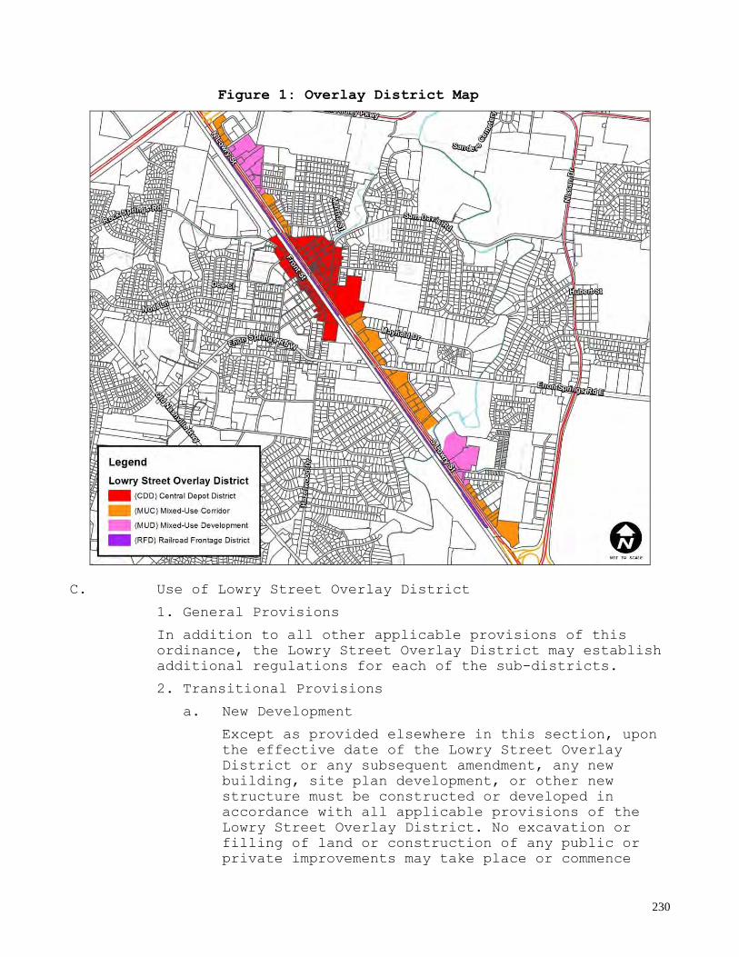
230
Figure 1: Overlay District Map
C. Use of Lowry Street Overlay District
1. General Provisions
In addition to all other applicable provisions of this
ordinance, the Lowry Street Overlay District may establish
additional regulations for each of the sub-districts.
2. Transitional Provisions
a. New Development
Except as provided elsewhere in this section, upon
the effective date of the Lowry Street Overlay
District or any subsequent amendment, any new
building, site plan development, or other new
structure must be constructed or developed in
accordance with all applicable provisions of the
Lowry Street Overlay District. No excavation or
filling of land or construction of any public or
private improvements may take place or commence

231
except in conformity with the Lowry Street Overlay
District.
b. Additions
Except as provided elsewhere in this section, upon
the effective date of the Lowry Street Overlay
District or any subsequent amendment, any addition
to an existing building, buildings or site
improvements must be constructed or developed in
accordance with all applicable provisions of the
Lowry Street Overlay District if any of the
following criteria are met:
i. The addition or site improvement fronts a public right-of-way; or
ii. The gross footprint of the addition exceeds
25% of the gross floor area of the existing
building or structure being modified.
iii. An addition of ten (10) or more parking spaces to the site, landscape and lighting
criteria to be met.
Only additions or improvements that meet the above
criteria are required to comply with the provisions
of the Lowry Street Overlay District. Additions
shall not force compliance of the whole building or
entire site. Alterations to the existing building
shall be considered Modifications and are subject
to Section C.2.c.
c. Modifications
Except as provided elsewhere in this section, upon
the effective date of the Lowry Street Overlay
District or any subsequent amendment, any
modification to an existing element of a building
or buildings must comply with the provisions of the
Lowry Street Overlay District if all of the
following criteria are met:
i. The building element is regulated by this Article; and
ii. The proposed modification fronts a public
right-of-way.
Only modifications that meet the above criteria are
required to comply with the provisions of the Lowry
Street Overlay District. Modifications shall not
force compliance of the whole building.
d. Repair and Maintenance

232
Routine repairs and maintenance of an existing
building or site are permitted and are not required
to comply with the provisions of the Lowry Street
Overlay District. If elements have deteriorated
beyond the point where they can be retained, they
shall be replaced in kind. Elements that are not
replaced in kind shall be considered Modifications
and are subject to Section C.2.c.
e. Previously Issued Permits and Pending Applications
Previously issued permits and pending applications
will be processed in accordance with and decided
pursuant to the law existing on the date the
application was filed.
3. Conflicting Provisions
In the event that there is a conflict between the
provisions of this ordinance and those of the base
district or the Design Review Manual, the provisions
of this ordinance shall take precedence.
4. Administrative Procedures
a. Prior to initiation of the development review procedure, an applicant shall determine the
applicable sub-district for the subject parcels.
b. Development within the Lowry Street Overlay District shall follow the design review procedures
in Article VIII, Section 8.060 Design Review
Applications and Processing.
5. Deviations from Standards
a. Deviations from the design standards of this section may only be granted by the Planning
Commission as part of the design review process,
when such deviations will enhance the appearance
and design of development subject to review.
b. A request for deviations shall be submitted by the applicant in writing at the time of the initial
filing of the application. The request shall state
the deviation(s) requested; the grounds for the
request; and the facts upon which the applicant is
relying.
c. The Planning Commission may approve the request if it determines the deviation(s) will not be
detrimental to the health, safety, and welfare of
the public; the grounds for the request are unique
to the project; the deviations are necessary to
achieve the design intent of the project; and the
233
deviations are not contrary to the design intent of
the Lowry Street Overlay.
d. The Planning Commission may impose reasonable conditions or restrictions in granting deviation
requests to protect the health, safety, and welfare
of the public and meet the purposes of this
ordinance.
D. Standards Applicable to All Sub-districts:
The following standards are applicable to all sub-districts
in the Lowry Street Overlay District.
1. Uses
RESERVED
2. Site
a. Streets and Blocks
The development or redevelopment of large parcels
shall be designed in a manner to create a network
of streets and blocks that are connected to the
existing street network including sidewalks.
Streets, whether public or private, shall be
designed to accommodate multiple modes of
transportation including vehicles, pedestrians, and
bicyclists. Streetscape design shall be accordance
with the context of adjacent development.
Development of blocks shall follow the standards
for each sub-district.
3. Placement
a. Setbacks are measured at a right angle from adjacent property line.
4. Height
a. Height shall be measured in stories and feet.
Measurement in feet shall be the vertical distance
from the highest point of grade along the primary
street building line to the bottom of the eave on a
sloped roof or the highest point of the roof
surface of a flat roof not including a parapet.
b. Basements as defined by adopted building codes shall not be considered a story.
c. Non-occupiable roof elements such as spires, cupolas, water towers, and similar structures may
exceed the maximum height requirements.
d. Chimneys, flagpoles, skylights, parapets and similar structures may exceed the maximum height
requirements by 6 feet.

234
e. Stairways to the roof, rooftop shade structures, elevator penthouses, and rooftop mechanical
equipment may exceed the maximum height requirement
by 10 feet.
f. All buildings shall comply with current F.A.A. standards as they relate to the Smyrna / Rutherford
County Airport Runways.
5. Articulation/Transparency
a. Permitted attachments to street-facing facades shall meet the following requirements:
i. Awnings/canopies shall have a minimum clear height above adjacent grade of 9 feet and a
minimum depth of 6 feet. A modification to
these standards may be approved by the
Planning Commission to fit an awning/canopy on
an existing building. Awning/canopy
encroachments into a public right-of-way must
be approved by the authority with ownership of
the right-of-way. Awnings and canopies shall
not be internally illuminated.
ii. Balconies shall have a minimum clear height
above grade of 9 feet and a minimum clear
depth of 4 feet. Balconies shall not be fully
enclosed. Balcony encroachments into a public
right-of-way must be approved by the authority
with ownership of the right-of-way.
iii. Bay windows shall have visible support, either by extending the bay to grade with a
foundation or transferring the projection back
to the wall with beams, brackets, or brick
corbeling.
iv. Porches shall have a minimum clear depth of
6 feet excluding steps. Porches may not
encroach into a public right-of-way. Porches
shall not be fully enclosed.
v. Stoops shall have a minimum clear depth of 4 feet. Stoops may not encroach into a public
right-of-way. Stoops shall not be fully
enclosed.
b. Transparency requirements for facades are defined under each sub-district. Transparency shall be
measured by dividing the area of windows and doors
by the total facade area of a street-facing story.

235
6. Parking and Access
a. Number of Spaces Required
The amount of off-street parking required shall be
in accordance with Article IV, Section 4.010 except
as provided elsewhere in this Article.
b. Access
i. Access to parking areas shall be from the side or rear of lots when possible.
ii. Entries to sites from public streets shall
be clear, controlled and safe.
iii. Combined or shared entries between properties shall be required on Lowry Street
and collector streets within the Lowry Street
Overlay District. No more than one curb cut
shall occur per 100 feet of frontage.
iv. Curb cuts shall be limited to 30 feet and
driveway radii shall be kept to a minimum to
facilitate pedestrian traffic.
v. Pedestrian street crossing shall be provided and clearly delineated through the use of a
different pavement color and texture.
Pedestrian crosswalks across Lowry Street
shall follow TDOT standards.
c. On-Street Parking
i. On-street parking may be allowed as part of the development review process. An applicant
may be credited with one or more legally
permitted on-street parking spaces located on
a public right-of-way immediately adjacent to
the subject lot’s street frontage toward the
required minimum off-street parking. The
location and number of on-street parking
spaces shall be identified on the submitted
site plan.
ii. No more than 25 percent of the off-street
parking space requirements shall be met
through the use of on-street parking.
d. Efficiency of Parking Areas
i. In 90 and 60 degree parking configurations, the dimension of two bays of parking and a
moving lane shall be 60 feet minimum. Angled
parking dimensions of 30 and 45 degrees shall
have 12 foot driving lanes for one way
movement, and 18 foot driving lanes for two-

236
way movement. However, if driving lanes also
serve as designated fire lanes, they must be a
minimum of 22 feet in width.
Figure 2: Parking Configuration Diagram
ii. Small lots or lots with shallow front yards,
where parking is permitted between the
building and the street, may develop one-way
angled parking configurations, with curb cuts
narrower than the maximums noted above for
entry and exit lanes as long as such cuts are
not less than 25 feet apart per Section 3.090
of the Municipal Zoning Ordinance.
e. Fit Parking Areas to Site Topography
i. On sloping sites, lines of parking spaces shall run parallel to site contours, with
planted medians taking up any excessive slope.
Paved parking areas or vehicular space areas
shall not exceed a 5% slope.
ii. The detention of runoff within parking areas
or in adjacent landscaped areas shall be
required. Runoff from parking areas shall not
sheet onto public streets or sidewalks.
f. Pedestrian Circulation
i. Public sidewalks shall be constructed along internal and external street frontages.

237
ii. Sidewalks internal to a lot shall be
provided to connect adjacent buildings.
Sidewalks shall have a minimum unobstructed
pathway of 6 feet and shall be connected to
the public sidewalk system along streets.
7. Grading, Drainage, and Topsoil Preservation
a. Topography
i. Building, parking and service areas shall be sited in a manner which minimizes disruption
of the existing topography. Where there is
mature existing vegetation on a site that is
designated for preservation, changes in
topography and runoff patterns shall be
minimized.
ii. The maximum allowable landscaped slope
created by cut or fill shall be 1:3 vertical
to horizontal.
iii. Efforts shall be made to use the existing topography and minimize grading. Grade
relationships to adjoining lots shall allow
for access points between lots.
b. Overland Drainage & Detention
All developments shall comply with the standards in
the stormwater management ordinance and shall use
best management practices for stormwater.
c. Topsoil Stabilization
Topsoil shall not be removed from sites or used in
spoil, unless the amount of excess topsoil is not
needed for landscaping. Topsoil shall be saved
during construction and then placed over landscaped
areas at a depth of at least 6".
8. Preservation of Existing Trees and Site Features
a. Protection of Vegetation Surroundings
Existing trees identified for preservation shall
not be disrupted by grading, construction, or
materials storage which may endanger their
vitality. Within the drip line of mature trees, the
ground elevation shall not be altered, and there
shall be no disturbance of the ground surface
without the approval of the Town Planning Director
and Planning Commission.

238
b. Retention of Existing Trees
Tree Identification: Existing trees shall be shown
on site plan submitted for approval. Existing trees
are divided into two categories:
i. Isolated trees: All trees having an 18-inch or greater caliper shall be delineated along with
caliper size and species. Existing trees over
18 inches shall be marked as ―remaining‖ or
―removed‖ on proposed site plans.
ii. Forested Areas: General outline of forest
stand shall be delineated.
c. Retention of Existing Historic and Natural Features
Streams, wetlands, large rock outcrops, stands of
native vegetation, fence rows, rock walls,
cemeteries and other notable natural features shall
be located on the site plan and preserved wherever
possible.
9. Architecture
The standards in this section shall apply to building
elements and facades that face or are visible from a
street. For the purposes of this section, an alley
shall not be considered a street.
a. Building facades shall be oriented parallel to the street frontage.
b. Building facades that face two streets (corner conditions) shall include architectural features,
such as openings (doors and/or windows) and
attachments (porches, stoops, bay windows, etc.) on
both frontages.
c. Principal buildings shall be oriented so that at least one principal pedestrian entrance faces the
fronting street. For corner conditions, the primary
street shall be considered the fronting street. For
corner lots where both streets have the same
designation, the entrance shall face the street the
building addresses. Required pedestrian entrances
shall be defined by a roof overhang or by being
recessed.
d. Building facades shall only change primary materials along a horizontal line; at inside
corners; or outside corners where they wrap the
corner a minimum of 2 feet.

239
Figure 3: Primary Material Change Diagram
e. With the exception of shopfronts at street level,
transoms, and decorative windows, windows shall be
square or vertically proportioned and rectangular
in shape. Windows shall be generally aligned
between floors. Windows shall not be flush-mounted
to the exterior of the facade on street-facing
elevations.
f. Window shutters, if installed, shall be sized and shaped to match their openings. Shutters shall be
operable or have the appearance of operability
including shutter hardware.
g. Flat roofs shall include a parapet on all street-facing facades. The primary material for parapets
shall match the material of the associated facade.
h. Hipped or gabled roofs on street-facing facades shall be symmetrically pitched.
10. Landscape
a. Reduce Apparent Size and Visibility of Parking Areas
i. Between street frontage and parking lots a minimum 8 feet wide landscape area shall be
provided. All landscape beds planted adjacent
to parking lots shall be a minimum of 8 feet
wide to accommodate car overhang. All parking
lots shall be screened with one 24‖ high
evergreen shrub per 5 linear feet of parking
lot frontage.
ii. There shall be no more than 15 contiguous
parking spaces between landscaped islands.

240
iii. Existing trees located in parking areas shall be preserved when feasible. Existing
healthy trees that are preserved can be used
to meet minimum landscape requirements.
iv. The minimum area of any parking lot
landscaped area is 75 square feet. For every
250 square feet of required landscape area in
parking areas, one tree shall be planted. Tree
requirement calculations shall be rounded up
from decimals of 0.4 or more. These 250 square
feet landscaped areas shall be saturated with
profuse groundcover and/or shrubs. Grass in
and of itself shall not be considered as
meeting these landscaping requirements.
v. All parking area landscape islands shall be planted with a minimum of 1 canopy tree.
Canopy trees planted to meet this requirement
shall count towards the minimum of one tree
per 250 square feet of required landscape area
in parking areas.
b. Landscape Areas
i. Landscape beds or areas which meet minimum parking area requirements shall be located
immediately adjacent to or within the parking
area. Areas with natural vegetation shall be
preserved along property boundaries, whenever
possible.
ii. Landscape beds provided to meet minimum
parking lot requirements must be planted with
shrubs or groundcover. Landscape areas
provided to meet the remaining overall
permeable surface requirements may be planted
in grass. The minimum width of any landscape
area shall be 5 feet.
iii. On sites with challenging topography, alternate landscaping configurations shall be
considered at the discretion of the Department
of Planning and Zoning Staff. Such alternate
configurations shall adhere to the goals set
forth in these guidelines as best as possible.
c. Plant Materials
i. General
• Plant materials shall be installed at a
reasonable size, to provide a sense of
presence and to mitigate microclimate
impacts caused by development.
241
• All landscape zones and plantings
installed by the developer shall be in
compliance with all planting notes. Size
and species identified in the required
planting list shall be as specified on
the approved landscaping plan.
• All species and size of species shall be
in conformance with the most current
edition of the American Standard for
Nursery Stock developed by the American
Association of Nurserymen, Inc.
• All landscape beds shall have a minimum
of 6" of topsoil. If 6" is not present,
topsoil shall be brought on site and
placed on landscape beds. All landscape
beds and planting areas shall be free
from construction debris, concrete,
rocks, clods, stumps, and weeds.
• All landscape plant material shall be
planted to avoid conflict with clear
sight triangles at intersections as
established by the Town of Smyrna.
ii. Trees
• Canopy trees shall be large enough when
installed to have some presence while
allowing views to sites and branching
above pedestrians walking along the
sidewalk. All canopy trees planted in the
LSO District shall be a minimum of 2 ½
caliper. All canopy trees planted along
Lowry Street shall be a minimum of 3‖
caliper. All caliper measurements shall
be taken according to the American
Standard for Nursery Stock
specifications.
• Evergreen trees shall be min 6' in
height, full and well branched; deciduous
ornamental trees shall have a minimum
caliper of 1 1/2". No more than 25% of
site trees may be comprised of ornamental
trees.
• For plantings located within or near
power lines, applicants shall refer to
Middle Tennessee Electric's list of
approved trees:
http://www.mtemc.com/pages.cfm/name/bd04_
z1_approvedtrees.

242
• No trees shall be planted within any Town
of Smyrna easement for utility mains or
services.
• To provide a consistent effect along
Smyrna's arterial streets the preferred
street tree species shall be Oak.
• To provide a consistent effect along all
other collector and local (minor)
streets, the preferred canopy tree
species shall be Willow Oak, London Plan,
and Sawtooth Oak.
• Other street trees that are considered
preferable include:
Ulmus parvifolia ‘Emerii’ or ‘Drake’ -
Lacebark Elm
Quercus robur ‘Fastigiata’ or bicolor
‘Long’ - Columnar English Oak
Tilia americana ‘Pyramidal’ or
‘Boulevard’ - Columnar American Linden
Ginkgo biloba ‘Princeton Sentry’ -
Ginkgo
Quercus macrocarpa - Bur Oak
Zelkova serrata ‘Green Vase’ - Japanese
Zelkova
• Ornamental street trees that are
considered preferable include:
Lagerstoemia indica - Upright species
of Crape Myrtle
Acer buergerianum – Trident Maple
Capinus betulus ‘Fastigiata’ –Pyramidal
European Hornbeam
iii. Shrubs
• Upright shrubs shall be at least 24-
inches high; spreading and/or ornamental
shrubs shall have a minimum spread of
18".
• No shrubs shall be planted within 5 feet
of Town of Smyrna utility mains or
services.
iv. Grasses
Sod shall be required on 3:1 slopes or greater
which are clearly visible from the street or
public parking areas. All areas proposed to be
covered with grass shall be seeded and strawed
or shall be covered with sod at the time of
the issuance of the Certificate of Occupancy.
It shall be the responsibility of the
243
developer and/or property owner to ensure that
grass areas are properly established and
maintained.
11. Buffers
a. Purpose
Buffers are intended for use when the impacts of
different land uses need to be mitigated through
landscape design and transitional features.
b. Performance Criteria
i. Buffers shall provide visual and physical separation between specific and different land
uses, and shall be designed to fit within
their surroundings, not dominate the view.
ii. Buffers shall be required where commercial
or mixed uses adjoin residential areas, where
multi-family residential sites adjoin one or
two family housing zones, and within Planned
Unit Developments with similar adjacencies.
iii. Buffers shall not compromise safety by blocking vision at intersections. They shall
not be placed within 75 feet of any street
intersection as referenced in Section 3.080 of
the Smyrna Zoning Ordinance and shall not be
placed so as to obstruct visibility of
vehicles entering or leaving driveways.
iv. Buffers are not required between different
land uses in the same mixed-use development.
v. Mature natural vegetation shall be retained in such areas and, if necessary, supplemented by
new vegetation to screen sight lines.
Consideration shall be given on a site by site
basis for the removal of existing vegetation.
vi. Buffers shall be located along the outer
perimeter of the parcel and shall extend to
the parcel boundary line or right-of-way line,
provided they do not block visibility
requirements for streets or driveway access.
vii. At the discretion of the Planning Commission, an opaque barrier 6 feet in height
may be required to be located within the
buffer strip. This shall consist of a fence or
wall of opaque or translucent materials
resistant to deterioration by natural causes,
or it shall be of continuous evergreen plant
materials.
244
c. Minimum Standards
i. Buffers shall consist of a densely planted strip at least 15 feet in width, designed to
form an effective buffer in all seasons.
ii. Buffer strips shall consist of 6’ tall
evergreen trees planted 15 foot on center with
a mature growth height of 10 foot minimum,
supplemented with a staggered row of 36‖
shrubs 6 foot on center. Shrubs in buffer
plantings shall consist of 75% evergreen
species and shall grow to a mature height of
no less than 6’.
12. Screening
a. Purpose
Screening is intended to conceal specific areas of
high visual impact such as, service and loading
areas, dumpsters, materials, and utility pads from
off-site views. Screening is required in all LSO
sub-districts.
b. Minimum Standards
i. Vegetative Materials
• Evergreen plants shall be used for
effective year-round screening.
• Evergreen trees shall be a minimum height
of 6 foot at time of planting.
• Evergreen shrubs shall be upright with
the minimum height necessary to fully
screen the intended item, but no less
than 24 inches at the time of planting.
ii. Fencing & Walls
• Fencing and walls used shall fully screen
all intended items from off-site views
and shall be opaque and at least 6’ in
height.
• Fencing and walls shall be constructed
out of materials that match the materials
of the associated building they serve.
• Supplementary evergreen shrubs shall be
included along the fence or wall
perimeter, planted at a maximum 5 feet on
center and at a minimum height of 18
inches.

245
c. Performance Criteria
i. Screening of common service areas, truck loading zones, auto repair and storage areas
from public streets and adjoining property
owners shall be required. Screening shall be
achieved with vegetation, fencing, or walls,
but must be a minimum of 6’ in height.
ii. Garbage collection areas shall be enclosed
by opaque materials on all four sides, with
doors to remove containers. The materials and
colors used for the dumpster enclosure shall
match that of the primary structure on the lot
except in the case of an existing structure
with metal siding; in the case of structures
with metal siding, the materials and colors to
be used for the dumpster enclosure shall be
determined by the Planning Commission. Where
dumpsters are enclosed, the screening shall be
at least 2 feet taller than the dumpster.
Where topography may expose interiors of
garbage collection areas to view, screening
shall be correspondingly taller.
iii. Electric transformers, utility pads, water meters, gas meters, electric meters, and
ground-mounted air conditioning or mechanical
units shall be hidden from public view by
screening. Screening may be achieved with
vegetation, fencing, or walls.
iv. Screening shall not compromise safety by
blocking vision at intersections. They shall
not be placed within 75 feet of any street
intersection as referenced in Section 3.080 of
the Smyrna Zoning Ordinance and shall not be
placed so as to obstruct visibility of
vehicles entering or leaving driveways.
v. Requirements to screen individual utility boxes and pads in hardscape areas such as
private drives and building access routes
shall be eliminated if determined to be
unfeasible by the Planning Commission.
vi. At the discretion of the Planning Commission
screening requirements may be relaxed where
areas are located so they are not visible from
public streets or adjacent properties.
vii. Screens shall not block access to any above ground pad mounted transformer, and shall

246
provide 15 feet of clear access to the
transformer doors.
viii. Screens shall not impede or divert the
flow of water in any drainage way.
13. Lighting
a. Design Criteria
i. To reduce adverse impacts on adjacent sites and minimize energy consumption, lighting
shall be carefully located and its intensity
shall be the minimum necessary for safety.
ii. Lighting levels shall be as even as
possible.
iii. Light fixtures, which cast light primarily downward, shall be used.
iv. LED lighting is preferred.
v. Decorative pedestrian scale lighting shall be located along all streets to match fixture
style of the lighting in the Central Depot
District.
b. Site and Parking Area Lighting
i. Site or parking area lighting shall not cast light beyond property boundaries. Cutoff
devices shall be used to avoid throw onto
adjacent sites, and the performance standards
cited in the Smyrna Zoning Ordinance as
applied to off-site glare shall be followed.
ii. Lighting levels within commercial sites
shall vary according to the land use, fixture
height and spacing. A range 0.5 - 1.0 foot
candles shall be required for commercial
developments and indicated on a photometric
plan as part of the Design Review submittal.
iii. The total height of fixtures shall be in proportion to the building mass with a maximum
height of 25 feet.
iv. Ground-oriented, pedestrian scale lighting
shall be considered as an alternate to pole-
mounted fixtures along sidewalks.
v. Lighting fixtures shall be compatible in style with associated buildings.

247
E. Central Depot District (CDD):
In addition to the requirements of Section D Standards
Applicable to All Districts, the following standards shall
apply to the CDD sub-district.
1. Purpose and Vision
The CDD sub-district is the historic and urban core of
Smyrna and is distinct from the surrounding
development in both form and character. The area is
full of rich, historic character that gives a unique
feeling to Downtown Smyrna. The purpose of the
standards in this section is to enhance the urban core
with a mixture of uses and encourage new development
and redevelopment that is urban, pedestrian-friendly,
and compatible with its historic character.
2. Uses
While this sub-district encourages a diverse mix of
uses, including single family, multi-family,
commercial, office, civic uses, parks, and vertically-
mixed uses, a rezoning or planned development zoning
will be required for uses not permitted by the
underlying base zoning. In such instances, residential
uses should be located in mixed-use buildings or mixed
with commercial or mixed-use development. Where
allowed, residential developments should be limited to
12 dwelling units/acre.
3. Site
a. Minimum Lot Size
There shall be no minimum lot size in the CDD sub-
district.
b. Site Coverage
Sites shall not be covered completely with
impermeable surfaces. A minimum of 10% of the site
shall be devoted to permeable surfaces, with 5% of
the sites vehicular use area or parking area being
devoted to landscaping.
c. Building Coverage
There shall be a maximum building coverage of 90%
including accessory buildings on any lot or parcel
in the CDD.

248
4. Placement
a. Setbacks
i. Front Yard
Commercial/Mixed-Use Buildings: 0 ft. min./10
ft. max.
Residential Buildings: 10 ft. min./20 ft.
max.
ii. Side Yard
0 ft., 10 ft. min. is required between
adjacent buildings
iii. Rear Yard
10 ft.
iv. On corner lots or lots fronting more than
one street, the front yard shall be
established on Lowry Street or Front Street if
the property in question fronts either of
these streets. Contextual front setbacks may
be required at the discretion of the Town
Planning Director and Planning Commission to
ensure compatibility with the existing
character of streets desired to be preserved.
Contextual front setbacks shall be equal to
the average setback of buildings along a
single block face with an established
development character. An established
development character shall be defined as a
block face where two-thirds of the buildings
have front setbacks within a range of 20 feet
of each other.
b. Miscellaneous Standards
i. Commercial/Mixed-Use, Multi-family, and Townhouse building facades shall extend a
minimum of 80% along the front yard setback
zone.
5. Height
a. Building Height
i. Buildings shall have a maximum height of 3 stories/40 ft.
ii. Mixed-use buildings with residential uses on
one or more upper floors may be 4 stories (50’
maximum).
249
iii. First floor ceiling height of Commercial/Mixed-use buildings shall be 12’
min.
b. Raised Foundation
Buildings with ground level residential uses shall
have a minimum raised foundation of 2 ft.
6. Articulation/Transparency
a. Articulation
Street-facing facades of buildings containing
commercial, multi-family, townhouse, or a mixture
of uses shall not exceed 20 feet in length without
a building articulation intended to minimize the
mass of the building. Permitted articulations
include:
i. Façade offset with a minimum depth of 4 feet that extends the full height of the façade.
ii. Façade recess or projection with a minimum
depth of 4 inches and a minimum width of 1
foot that extends the full height of the first
story of the façade.
iii. Variation in building or parapet height of a minimum 2 feet for single story buildings and
4 feet for buildings with two or more stories.
iv. The use of multiple roof forms to create the
effect of different building components.
v. Attachments permitted in this sub-district.
b. Attachments
The following attachments are permitted and subject
to the standards for Attachments applicable to all
sub-districts in Section D.5
Articulation/Transparency.
i. Commercial/Mixed-Use Buildings
Awning, Canopy, Balcony
ii. Residential Buildings
Canopy, Balcony, Stoops, Porches, Bay Windows
c. Transparency
i. Ground Story:
Commercial/Mixed-Use Buildings:
Primary Street Frontage: 50%
Secondary Street Frontage: 20%

250
Residential Buildings:
Primary Street Frontage: 20%
Secondary Street Frontage: 15%
ii. Upper Story
Commercial/Mixed-Use Buildings: 15%
Residential Buildings: 10%
7. Parking and Access
a. Off-Street Parking
i. On-site, off-street surface parking lots shall be located behind the primary building and in
the rear or side yard. Parking permitted in a
side yard shall be limited to one double-
loaded aisle of parking. Off-street parking
shall only be permitted in rear yard for
buildings fronting Lowry Street.
ii. Shared parking, public parking garages and
the provision of off-site and on street
parking are encouraged. The Town Planning
Director and Planning Commission may permit
the reduction of on-site parking as required
in Section 4.010, if these options are
available.
iii. Surface parking shall not be the principal use on any parcel.
b. Above Grade Parking Structures
i. Street-facing facades of parking structures shall be clad with materials and articulated
in accordance with this article so as to look
similar to buildings with other types of uses.
ii. Primary vehicle access shall be located to
minimize potential conflicts with pedestrian
circulation.
iii. Parking structures located at street level and fronting Lowry or Front Street shall have
no less than 80% of the lineal street
frontage, exclusive of access drives and
pedestrian passages, devoted to retail/service
uses at a minimum depth of 20 ft.
c. Shared Parking
i. Shared parking spaces shall be located within 600 linear feet of the primary entrances of
all uses served.

251
ii. Shared parking spaces shall not be separated
from the use they serve by an arterial or
collector street and safe pedestrian access
must be provided from and to the shared
parking areas.
iii. Applicants requesting to use shared parking as a means of satisfying the off-street
parking requirements shall submit
documentation justifying the practicality of
shared parking. Documentation shall display
how the proposed shared parking arrangement
can adequately handle the size of the proposed
development, the anticipated parking rate,
parking turnover, along with the peak parking
and traffic loads.
iv. A shared parking plan shall be enforced
through a written agreement among all owners
involved.
8. Architecture
a. General
i. Garage doors that face a street shall be limited to 9 feet in width.
ii. Drive-through facilities including
associated windows, refuse storage, and menu
and ordering boards shall be located to the
rear of buildings.
b. Materials
i. Wall Primary Materials
Commercial/Mixed-use Buildings
A minimum of 75% of street-facing façades
shall be clad in brick, stone, or cast
stone.
Residential Buildings
A minimum of 75% of street-facing façades
shall be clad in brick, stone, cast stone;
stucco (authentic); wood siding and
shingles; or fiber-cement siding and
shingles.
ii. Wall Secondary Materials
A maximum of 25% of street-facing facades
shall be clad in stucco (authentic); wood
siding and shingles; fiber-cement siding and
shingles; smooth medium density overlay (MDO)

252
panels, and pre-finished metal may be used as
an accent material.
iii. Foundation Materials
Exposed foundations shall be concrete;
decorative concrete block; or clad with brick,
stone, or cast stone.
iv. Trim Materials
Trim shall be wood, fiber-cement, or
composite. Decorative headers and sills in
masonry-clad walls shall be masonry, cast
stone, heavy timber, or steel.
v. Other Materials
Any materials not specifically allowed as
primary materials, secondary materials,
foundation materials, and trim materials are
not allowed at no more than 10% of the entire
building.
9. Landscape
a. Reduce Apparent Size and Visibility of Parking Areas
To mitigate the heat island effect and visual
impact of parking areas, a minimum of 5% of a
site's vehicular use area shall be landscaped. This
landscaping shall be located immediately adjacent
to or within the vehicular use area.
b. Landscape Areas
i. For buildings setback 5 feet or more from the public right-of-way, a minimum 5 feet wide
landscape bed shall be provided along the
street frontage. This landscape bed shall be
planted with a minimum of 1 shrub per 5 linear
feet of frontage. A minimum of ½ of these
shrubs shall be evergreen.
ii. Landscape shall be reduced at frontage of
buildings with front setbacks 5’ or less. No
foundation plantings shall be required, but at
least 2 planters shall be provided at street
level per building.
c. Irrigation
i. All required landscape areas shall be irrigated by an automated irrigation system or
an accessible hose bib located within 200 feet
of all landscape beds and plant materials.

253
F. Mixed-Use Development District (MUD):
In addition to the requirements of D. Standards Applicable
to All Districts, the following standards shall apply to
the MUD sub-district.
1. Purpose and Vision
The MUD sub-district will serve as integral gateway
nodes to the Lowry Street Overlay District and will
place an emphasis on providing a mixture of higher
density residential, office, and commercial land uses.
Internal streets shall create an interconnected system
of blocks. This will be an area where high quality
design and pedestrian oriented environments will be
encouraged through standards that will reinforce and
enhance the community character of the Town of Smyrna.
2. Uses
While this sub-district encourages a diverse mix of
uses, such as multi-family, commercial, office, parks,
and vertically-mixed uses, a rezoning or planned
development zoning will be required for uses not
permitted by the underlying base zoning. In such
instances, residential-only development should be
avoided. Residential uses should be located in mixed-
use buildings or mixed with commercial or mixed-use
development. Where allowed, residential developments
should be limited to 12 dwelling units/acre.
3. Site
a. Minimum Lot Size
There shall be no minimum lot size in the MUD sub-
district.
b. Site Coverage
Sites shall not be covered completely with
impermeable surfaces. A minimum of 15% of the site
shall be devoted to permeable surfaces, with 10% of
the sites vehicular use area or parking area being
devoted to landscaping.
c. Building Coverage
There shall be a maximum building coverage of 85%
including accessory buildings on any lot or parcel
in the MUD sub-district.

254
4. Placement
a. Setbacks
i. Front Yard
Lowry Street: 20 ft. min./80 ft.
max.
All Other Streets (including internal
streets):
Commercial/Mixed-use Buildings: 5 ft.
min./20 ft. max.
Residential Buildings: 10 ft. min./30 ft.
max.
ii. Side Yard
5 ft. min., 10 ft. min. is required between
adjacent buildings
iii. Rear Yard
10 ft.
b. Miscellaneous Standards
i. Commercial/Mixed-Use, Multi-family, and
Townhouse building facades shall extend a
minimum of 70% along the primary street
frontage as defined by the front yard of the
developed parcel.
5. Height
a. Building Height
i. Buildings shall have a maximum height of 3
stories/40 ft.
ii. First floor ceiling height of
Commercial/Mixed-Use Buildings shall be 12’
min.
b. Raised Foundation
Buildings with ground level residential uses shall
have a minimum raised foundation of 1.5 ft.
6. Articulation/Transparency
a. Articulation
Street-facing facades of buildings containing
commercial, multi-family, townhouse, or a mixture
of uses shall not exceed 20 feet in length without

255
a building articulation intended to minimize the
mass of the building. Permitted articulations
include:
i. Façade offset with a minimum depth of 4 feet that extends the full height of the façade.
ii. Façade recess or projection with a minimum
depth of 4 inches and a minimum width of 1
foot that extends the full height of the first
story of the façade.
iii. Variation in building or parapet height of a minimum 2 feet for single story buildings and
4 feet for buildings with two or more stories.
iv. The use of multiple roof forms to create the
effect of different building components.
v. Attachments permitted in this sub-district.
b. Attachments
The following attachments are permitted and subject
to the standards for Attachments applicable to all
sub-districts in Section D.5
Articulation/Transparency.
i. Commercial/Mixed-Use Buildings
Awning, Canopy, Balcony
ii. Residential Buildings
Canopy, Balcony, Stoops, Porches, Bay Windows
c. Transparency
i. Ground Story:
Commercial/Mixed-Use Buildings:
Primary Street Frontage: 50%
Secondary Street Frontage: 20%
Residential Buildings:
Primary Street Frontage: 20%
Secondary Street Frontage: 15%
ii. Upper Story
Commercial/Mixed-Use Buildings: 15%
Residential Buildings: 10%
7. Parking and Access
a. Off-Street Parking

256
i. For buildings with frontage on Lowry Street, off-street surface parking lots may be located
in the front, side or rear yard. Off-street
parking located in the front or side yard
shall be limited to one, double-loaded bay of
parking. For buildings with frontage on other
streets, including internal streets, off-
street parking shall be located to the rear or
side yard. Parking located in the side yard
shall be limited to one, double-loaded bay of
parking.
ii. In the MUD District, shared parking, public
parking garages, on-street parking and the
provision of off-site parking are encouraged.
The Town Planning Director and Planning
Commission may permit the reduction of on-site
parking as required in Section 4.010, if these
options are available.
iii. Surface parking shall not be the principal use on any parcel.
b. Above Grade Parking Structures
i. Street-facing facades of parking structures shall be clad with materials and articulated
in accordance with this article so as to look
similar to buildings with other types of uses.
ii. Primary vehicle access shall be located to
minimize potential conflicts with pedestrian
circulation.
iii. Parking structures located at street level and fronting Lowry or Front Street shall have
no less than 80% of the lineal street
frontage, exclusive of access drives and
pedestrian passages, devoted to retail/service
uses at a minimum depth of 20 ft.
c. Shared Parking
i. Shared parking spaces shall be located within 600 linear feet of the primary entrances of
all uses served.
ii. Shared parking spaces shall not be separated
from the use they serve by an arterial or
collector street and safe pedestrian access
must be provided from and to the shared
parking areas.
iii. Applicants requesting to use shared parking as a means of satisfying the off-street

257
parking requirements shall submit
documentation justifying the practicality of
shared parking. Documentation shall display
how the proposed shared parking arrangement
can adequately handle the size of the proposed
development, the anticipated parking rate,
parking turnover, along with the peak parking
and traffic loads.
iv. A shared parking plan shall be enforced
through a written agreement among all owners
involved.
8. Architecture
a. General
i. Drive-through facilities including associated windows, refuse storage, and menu and ordering
boards shall be located to the rear or side of
buildings. Drive-through facilities on the
side of a building facing Lowry Street shall
be recessed a minimum of 2 feet from the front
facade.
b. Materials
i. Wall Primary Materials
Commercial/Mixed-use Buildings
A minimum of 75% of street-facing façades
shall be clad in brick, stone, or cast
stone.
Residential Buildings
A minimum of 75% of street-facing façades
shall be clad in brick, stone, cast stone;
stucco (authentic); wood siding and
shingles; or fiber-cement siding and
shingles.
ii. Wall Secondary Materials
A maximum of 25% of street-facing facades
shall be clad in stucco (authentic); wood
siding and shingles; fiber-cement siding and
shingles; smooth medium density overlay (MDO)
panels, and pre-finished metal may be used as
an accent material.
iii. Foundation Materials
Exposed foundations shall be concrete;
decorative concrete block; or clad with brick,
stone, or cast stone.

258
iv. Trim Materials
Trim shall be wood, fiber-cement, or
composite. Decorative headers and sills in
masonry-clad walls shall be masonry, cast
stone, heavy timber, or steel.
v. Other Materials
Any materials not specifically allowed as
primary materials, secondary materials,
foundation materials, and trim materials are
allowed at no more than 10% of the entire
building.
9. Landscape
a. Reduce Apparent Size and Visibility of Parking Areas
To mitigate the heat island effect and visual
impact of parking areas, a minimum of 10% of a
site's vehicular use area shall be landscaped. This
landscaping shall be located immediately adjacent
to or within the vehicular use area.
b. Landscape Areas
i. Commercial, office, multi-family and mixed-use buildings shall have 5 feet wide landscape
beds adjacent to buildings where the building
faces the public street or a primary access
drive. Foundation plantings shall be provided
in these beds with a minimum 1 shrub per 5
linear feet of frontage. A minimum of 1/2 of
these shrubs shall be evergreen.
ii. Planting beds shall be consolidated into
areas large enough to give a natural character
to a site, rather than distributed in thin
ribbons. The minimum area of a landscape bed
or zone shall be 75 feet. These beds or zones
shall be clearly delineated on site plan with
square footage.
iii. Landscape beds between parking and public streets shall contain a continuous hedge row
composed of evergreen shrubs with a minimum
planting height of 24 inches and a maximum
spacing of 5 feet on center.
iv. All site perimeters not facing the public
streets or containing off-street parking areas
shall maintain a minimum 5 foot wide landscape
bed. This landscape bed shall be planted with
one canopy or understory trees per 50 linear

259
feet of frontage. No more than 1/3 of these
trees shall be understory.
v. If screening landscape is required along lot perimeter, screening requirements shall
replace perimeter landscape requirements.
c. Front Yard Planting Zones
i. Landscaped areas shall dominate the frontage of any site, where entries are the only
interruptions.
ii. All site boundaries fronting onto streets
and primary access drives shall have a front
yard landscape zone, with a minimum width of 5
feet. A mixture of shrubs and trees shall be
planted in this zone.
iii. In the front yard planting zone, one canopy tree per 50 linear feet shall be planted with
relatively even spacing. Tree requirement
calculations shall be rounded up from decimals
of 0.4 or more. In addition, shrubs shall be
planted at one shrub per 5 linear feet of
frontage within the front yard planting zone.
Shrubs planted to screen parking areas shall
count towards front yard planting zone
requirements.
iv. All canopy trees planted along public
streets shall be columnar and compact in
canopy spread, as well as pruned to provide a
minimum 8 feet of clearance over pedestrian
ways and 14’ of clearance over vehicular
routes.
v. Additional requirements are required for planting along Lowry Street frontage. Accent
shrubs a minimum of 18 inches tall with a
maximum spacing of 4 feet on center, and
understory ornamental trees a minimum of 1.5
inch caliper shall be planted at a minimum of
1 per 50 linear feet in front yard landscape
beds.
vi. If 8’ or more of landscape area is provided
between curb and gutter in the Lowry Street
right-of-way, the Town Planning Director
and/or Planning Commission may require canopy
or understory trees to be planted in the Lowry
Street right-of-way instead of the front yard
planting zone. In this case a compact species
of tree will be selected that can easily be

260
maintained without creating pedestrian or
vehicular conflict. Understory ornamental
trees may be planted in groupings or staggered
in visually pleasing locations relative to the
required canopy tree plantings.
vii. Tree and shrub calculations for front yard planting zones shall not be applied to
frontage that is dedicated to access drive
area.
G. Mixed-Use Corridor District (MUC):
In addition to the requirements of Section D Standards
Applicable to All Districts, the following standards shall
apply to the MUC sub-district.
1. Purpose and Vision
The MUC sub-district will function as a transition
between the higher density nodes of development in the
CDD and MUD sub-districts. This area will also be
mixed-use, but will emphasize low to medium intensity
commercial and will have a more suburban feel.
2. Uses
While this sub-district encourages a diverse mix of
uses, such as multi-family, commercial, office, parks,
and vertically-mixed uses, a rezoning or planned
development zoning will be required for uses not
permitted by the underlying base zoning. In such
instances, residential-only developments should be
limited to 12 dwelling units/acre.
3. Site
a. Minimum Lot Size
Minimum lot size in the MUC district shall be
20,000 square feet.
b. Site Coverage
Sites shall not be covered completely with
impermeable surfaces. A minimum of 20% of the site
shall be devoted to permeable surfaces, with 12% of
the sites vehicular use area or parking area being
devoted to landscaping.
c. Building Coverage
There shall be a maximum building coverage of 70
percent including accessory buildings on any lot or
parcel in the MUC.
4. Placement
a. Setbacks

261
i. Front Yard
Lowry Street: 40 ft. min./80 ft.
max.
All Other Streets: 10 ft. min.
ii. Side Yard
10 ft.
iii. Rear Yard
20 ft.
5. Height
a. Building Height
i. Buildings shall have a maximum height of 3 stories/40 ft.
ii. First floor ceiling height of
Commercial/Mixed-Use Buildings shall be 12’
min.
6. Articulation/Transparency
a. Articulation
Street-facing facades of buildings containing
commercial, multi-family, townhouse, or a mixture
of uses shall not exceed 40 ft. in length without a
building articulation intended to minimize the mass
of the building. Permitted articulations include:
i. Façade offset with a minimum depth of 4 feet that extends the full height of the façade.
ii. Façade recess or projection with a minimum
depth of 4 inches and a minimum width of 1
foot that extends the full height of the first
story of the façade.
iii. Variation in building or parapet height of a minimum 2 feet for single story buildings and
4 feet for buildings with two or more stories.
iv. The use of multiple roof forms to create the
effect of different building components.
v. Attachments permitted in this sub-district.
b. Attachments
The following attachments are permitted and subject
to the standards for Attachments applicable to all
sub-districts in Section D.5
Articulation/Transparency.
i. Commercial/Mixed-Use Buildings

262
Awning, Canopy, Balcony
ii. Residential Buildings
Canopy, Balcony, Stoops, Porches, Bay Windows
c. Transparency
i. Ground Story:
Commercial/Mixed-Use Buildings:
Primary Street Frontage: 40%
Secondary Street Frontage: 10%
Residential Buildings:
Primary Street Frontage: 15%
Secondary Street Frontage: 10%
ii. Upper Story
Commercial/Mixed-Use Buildings: 15%
Residential Buildings: 10%
7. Parking and Access
a. Off-Street Parking
i. On-site, off-street surface parking lots shall be located in the front, side or rear yard.
Off-street parking located in the front yard
for buildings fronting public streets shall be
limited to 60 feet in width (typically one
aisle with two single-loaded bays).
ii. In the MUC District, shared parking and off-
site parking is encouraged. The Town Planning
Director and Planning Commission may permit
the reduction of on-site parking as required
in Section 4.010, if these options are
available.
iii. Surface parking shall not be the principal use on any parcel.
b. Shared Parking
i. Shared parking spaces shall be located within 600 linear feet of the primary entrances of
all uses served.
ii. Shared parking spaces shall not be separated
from the use they serve by an arterial or
collector street and safe pedestrian access
must be provided from and to the shared
parking areas.

263
iii. Applicants requesting to use shared parking as a means of satisfying the off-street
parking requirements shall submit
documentation justifying the practicality of
shared parking. Documentation shall display
how the proposed shared parking arrangement
can adequately handle the size of the proposed
development, the anticipated parking rate,
parking turnover, along with the peak parking
and traffic loads.
iv. A shared parking plan shall be enforced
through a written agreement among all owners
involved.
8. Architecture
a. General
i. Drive-through facilities including associated windows, refuse storage, and menu and ordering
boards shall be located to the rear or side of
buildings. Drive-through facilities on the
side of a building facing Lowry Street shall
be recessed a minimum of 2 feet from the front
facade.
b. Materials
i. Wall Primary Materials
Commercial/Mixed-use Buildings
A minimum of 75% of façades facing Lowry
Street shall be clad in brick, stone, or
cast stone.
Residential Buildings
A minimum of 75% of façades facing Lowry
Street shall be clad in brick, stone, cast
stone; stucco (authentic); wood siding and
shingles; or fiber-cement siding and
shingles.
ii. Wall Secondary Materials
A maximum of 25% of facades facing Lowry
Street shall be clad in stucco (authentic);
wood siding and shingles; fiber-cement siding
and shingles; smooth medium density overlay
(MDO) panels, and pre-finished metal may be
used as an accent material.
iii. Foundation Materials
264
Exposed foundations shall be concrete;
decorative concrete block; or clad with brick,
stone, or cast stone.
iv. Trim Materials
Trim shall be wood, fiber-cement, or
composite. Decorative headers and sills in
masonry-clad walls shall be masonry, cast
stone, heavy timber, or steel.
v. Other Materials
Any materials not specifically allowed as
primary materials, secondary materials,
foundation materials, and trim materials are
allowed at no more than 10% of the entire
building.
9. Landscape
a. Reduce Apparent Size and Visibility of Parking Areas
To mitigate the heat island effect and visual
impact of parking areas, a minimum of 12% of a
site's vehicular use area shall be landscaped. This
landscaping shall be located immediately adjacent
to or within the vehicular use area.
b. Landscape Areas
i. Commercial, office, multi-family and mixed-use buildings shall have 5 feet wide landscape
beds adjacent to buildings where the building
faces the public streets and primary access
drives. Foundation plantings shall be provided
in these beds with a minimum 1 shrub per 5
linear feet of frontage. A minimum of ½ of
these shrubs shall be evergreen.
ii. Planting beds shall be consolidated into
areas large enough to give a natural character
to a site, rather than distributed in thin
ribbons. The minimum area of a landscape bed
or zone shall be 75 feet. These beds or zones
shall be clearly delineated on site plan with
square footage.
iii. Landscape beds between parking and public streets shall contain a continuous hedge row
composed of a double staggered row of
evergreen shrubs with a minimum planting

265
height of 24 inches and a maximum spacing of 5
feet on center.
iv. All site perimeters not facing the public
streets or containing off-street parking areas
shall maintain a minimum 5 feet wide landscape
bed. This landscape bed shall be planted with
one canopy or understory trees per 50 linear
feet of frontage. No more than 1/3 of these
trees shall be understory.
v. If screening landscape is required along lot perimeter, screening requirements shall
replace perimeter landscape requirements.
c. Front Yard Planting Zones
i. Landscaped areas shall dominate the frontage of any site, where entries are the only
interruptions.
ii. All site boundaries fronting onto streets
and primary access drives shall have a
landscape zone, with a minimum width of 5
feet. A mixture of shrubs and trees shall be
planted in this zone.
iii. In the front yard planting zones, one canopy tree per 50 linear feet shall be planted with
relatively even spacing. Tree requirement
calculations shall be rounded up from decimals
of 0.4 or more. In addition shrubs shall be
planted at one shrub per 5 linear feet of
frontage within the front yard planting zone.
Shrubs planted to screen parking areas shall
count towards front yard planting zone
requirements.
iv. All canopy trees planted along public trees
shall be columnar and compact in canopy
spread, as well as pruned to provide minimum
of 8 feet of clearance over pedestrian ways
and 14’ of clearance over vehicular routes at
the time the tree matures and its canopy
spreads over street or sidewalk areas.
v. Additional requirements are required for planting along Lowry Street frontage. Accent
shrubs a minimum of 18 inches tall with a
maximum spacing of 4 feet on center, and
understory ornamental trees a minimum of 1.5
inch caliper shall be planted at a minimum of
1 per 50 linear feet in front yard landscape
beds.

266
vi. If 8’ or more of landscape area is provided
between curb and gutter in the Lowry Street
right-of-way, the Town Planning Director
and/or Planning Commission may require canopy
or understory trees to be planted in the Lowry
Street right-of-way instead of the front yard
planting zone. In this case a compact species
of tree will be selected that can easily be
maintained without creating pedestrian or
vehicular conflict. Understory ornamental
trees may be planted in groupings or staggered
in visually pleasing locations relative to the
required canopy tree plantings.
vii. Tree and shrub calculations for front yard planting zones shall not be applied to
frontage that is dedicated to access drive
area.
H. Railroad Frontage District (RFD):
In addition to the requirements of Section D. Standards
Applicable to All Districts, the following standards shall
apply to the RFD sub-district.
1. Purpose and Vision
The RFD runs the length of the corridor between Lowry
Street and the existing railroad. The lack of depth
and impacts from the railroad limit the uses feasible
for lots in this district. The RFD District will be
mixed-use, with an emphasis on low intensity
commercial. Buildings will have shallow setbacks from
Lowry Street with parking located primarily to the
side of buildings. Development and redevelopment must
have an efficient site layout to promote the highest
and best use for the constrained lots in this
district.
2. Uses
While this sub-district encourages a diverse mix of
uses, such as multi-family, commercial, office, parks,
and vertically-mixed uses, a rezoning or planned
development zoning will be required for uses not
permitted by the underlying base zoning. In such
instances, residential-only developments should be
limited to 12 dwelling units/acre.
3. Site
a. Minimum Lot Size
There shall be no minimum lot size in the RFD
District.

267
b. Site Coverage
Sites shall not be covered completely with
impermeable surfaces. A minimum of 10% of the site
shall be devoted to permeable surfaces, with 5% of
the sites vehicular use area or parking area being
devoted to landscaping.
c. Building Coverage
There shall be a maximum building coverage of 60
percent including accessory buildings on any lot or
parcel in the RFD District.
4. Placement
a. Setbacks
i. Front Yard
Commercial/Mixed-use Buildings: 5 ft. min.
Residential Buildings: 10 ft. min.
ii. Side Yard
5 ft.
iii. Rear Yard
5 ft.
5. Height
a. Building Height
i. Buildings shall have a maximum height of 2 stories/30 ft.
ii. Buildings with parking at ground level may
have a maximum height of 3 stories/40 ft.
Parking at ground level shall be completely
screened by a building façade.
iii. First floor ceiling height of Commercial/Mixed-Use buildings shall be 12’
min.
b. Raised Foundation
Buildings with ground level residential uses shall
have a minimum raised foundation of 2 ft.
6. Articulation/Transparency
a. Articulation
Street-facing facades of buildings containing
commercial, multi-family, townhouse, or a mixture

268
of uses shall not exceed 40 ft. in length without a
building articulation intended to minimize the mass
of the building. Permitted articulations include:
i. Façade offset with a minimum depth of 2 feet that extends the full height of the façade.
ii. Façade recess or projection with a minimum
depth of 4 inches and a minimum width of 1
foot that extends the full height of the first
story of the façade.
iii. Variation in building or parapet height of a minimum two feet for single story buildings
and four feet for buildings with two or more
stories.
iv. The use of multiple roof forms to create the
effect of different building components.
v. Attachments permitted in this sub-district.
b. Attachments
The following attachments are permitted and subject
to the standards for Attachments applicable to all
sub-districts in Section D.5
Articulation/Transparency.
i. Commercial/Mixed-Use Buildings
Awning, Canopy, Balcony
ii. Residential Buildings
Canopy, Balcony, Stoops, Porches, Bay Windows
c. Transparency
i. Ground Story:
Commercial/Mixed-Use Buildings: 40%
Residential Buildings: 20%
ii. Upper Story
15%
7. Parking and Access
a. Off-Street Parking
i. On-site, off-street surface parking lots shall be located in side or rear yards. Parking in
the front yard shall only be allowed at the
discretion of the Town Planning Director and
Planning Commission.
8. Architecture
a. General

269
i. Drive-through facilities including associated windows, refuse storage, and menu and ordering
boards shall be located to the rear or side of
buildings. Drive-through facilities on the
side of buildings facing Lowry Street shall be
recessed a minimum of 2 feet from the front
facade.
b. Materials
i. Wall Primary Materials
Commercial/Mixed-use Buildings
A minimum of 75% of façades facing Lowry
Street shall be clad in brick, stone, or
cast stone.
Residential Buildings
A minimum of 75% of façades facing Lowry
Street shall be clad in brick, stone, cast
stone; stucco (authentic); wood siding and
shingles; or fiber-cement siding and
shingles.
ii. Wall Secondary Materials
A maximum of 25% of facades facing Lowry
Street shall be clad in stucco (authentic);
wood siding and shingles; fiber-cement siding
and shingles; smooth medium density overlay
(MDO) panels and pre-finished metal may be
used as an accent material.
iii. Foundation Materials
Exposed foundations shall be concrete;
decorative concrete block; or clad with brick,
stone, or cast stone.
iv. Trim Materials
Trim shall be wood, fiber-cement, or
composite. Decorative headers and sills in
masonry-clad walls shall be masonry, cast
stone, heavy timber, or steel.
v. Other Materials
Any materials not specifically allowed as
primary materials, secondary materials,
foundation materials, and trim materials are

270
allowed at no more than 10% of the entire
building.
9. Landscape
a. Reduce Apparent Size and Visibility of Parking Areas
To mitigate the heat island effect and visual
impact of parking areas, a minimum of 5% of a
site's vehicular use area shall be landscaped. This
landscaping shall be located immediately adjacent
to or within the vehicular use area.
b. Landscape Areas
i. Commercial, office, multi-family and mixed-use buildings shall have 5 feet wide landscape
beds adjacent to buildings where the building
faces the public streets and primary access
drives. Foundation plantings shall be provided
in these beds with a minimum 1 shrub per 5
linear feet of frontage. A minimum of 1/3 of
these shrubs shall be evergreen.
ii. Planting beds shall be consolidated into
areas large enough to give a natural character
to a site, rather than distributed in thin
ribbons. The minimum area of a landscape bed
or zone shall be 75 feet. These beds or zones
shall be clearly delineated on site plan with
square footage.
iii. Landscape beds between parking and public streets shall contain a continuous hedge row
composed of a double staggered row of
evergreen shrubs with a minimum planting
height of 24 inches and a maximum spacing of 5
feet on center.
iv. All site perimeters not facing the public
streets or containing off-street parking areas
shall maintain a minimum 5 feet wide landscape
bed. This landscape bed shall be planted with
one canopy or understory trees per 50 linear
feet of frontage. No more than 1/3 of these
trees shall be understory.
v. If screening landscape is required along lot perimeter, screening requirements shall
replace perimeter landscape requirements.
c. Front Yard Planting Zones

271
i. Landscaped areas shall dominate the frontage of any site, where entries are the only
interruptions.
ii. All site boundaries fronting onto streets
and primary access drives shall have a
landscape zone with a minimum width of 5 feet.
A mixture of shrubs and trees shall be planted
in this zone.
iii. In the front yard planting zones, one canopy tree per 50 linear feet shall be planted with
relatively even spacing. Tree requirement
calculations shall be rounded up from decimals
of 0.4 or more. In addition shrubs shall be
planted at one shrub per 5 linear feet of
frontage within the front yard planting zone.
Shrubs planted to screen parking areas shall
count towards front yard planting zone
requirements.
iv. All canopy trees planted along public trees
shall be columnar and compact in canopy
spread, as well as pruned to provide minimum
of 8 feet of clearance over pedestrian ways
and 14’ of clearance over vehicular routes at
the time the tree matures and its canopy
spreads over street or sidewalk areas.
v. Additional requirements are required for planting along Lowry Street frontage. Accent
shrubs a minimum of 18 inches tall with a
maximum spacing of 4 feet on center, and
understory ornamental trees a minimum of 1.5
inch caliper shall be planted at a minimum of
1 per 50 linear feet in front yard landscape
beds.
vi. If 8’ or more of landscape area is provided
between curb and gutter in the Lowry Street
right-of-way, the Town Planning Director
and/or Planning Commission may require canopy
or understory trees to be planted in the Lowry
Street right-of-way instead of the front yard
planting zone. In this case a compact species
of tree will be selected that can easily be
maintained without creating pedestrian or
vehicular conflict. Understory ornamental
trees may be planted in groupings or staggered
in visually pleasing locations relative to the
required canopy tree plantings.

272
vii. Tree and shrub calculations for front yard planting zones shall not be applied to
frontage that is dedicated to access drive
area.
I. Definitions:
Articulation: Changes in the surface of a building façade
that minimize the mass of the building and creates visual
interest.
Attachment: Elements attached to a building façade that
serve a function and create visual interest (see: Awning,
Balcony, Bay Window, Canopy, Porch, Stoop)
Awning: A façade attachment that consists of a material
secured to a frame and used to protect an opening from the
weather.
Balcony: A façade attachment that consists of a platform
enclosed by a wall or railing and accessed from an upper
level opening.
Bay Window: A façade attachment that consists of a window
or group of windows that is part of an interior space and
projects from the building façade.
Canopy: A façade attachment that is an overhead structure
supported by the building façade and used to accentuate or
protect a building entrance from the weather.
Decorative Window: A type of window opening with a unique
shape or glazing that is secondary to the standard window
openings within a building facade.
Porch: A façade attachment that consists of a covered
platform supported by columns and typically located on the
ground floor of a structure.
Shopfront: A type of opening that consists primarily of
glazing and is associated with commercial uses at street
level.
Stoop: A façade attachment that consists of a covered
platform supported by columns or the building façade and
used to protect a building entrance from the weather.
Stucco (authentic): An exterior finish for building
facades that is typically made from a combination of

273
cement, sand, hydrated lime, and water and applied when
wet.
Transparency: The glazing in a window or door opening.
5.059. ESO, ENON SPRINGS GATEWAY OVERLAY DISTRICT
A. District Description:
Enon Springs Road is a gateway into the heart of the Town
of Smyrna. The Town wishes to establish a framework for
site planning and design to ensure development of a high
quality. These regulations set standards for all
commercial, residential, institutional, industrial, and
office development. It is the intent of these regulations
to establish standards that will be reflective and
protective of the community amenities in the area and to
enhance the quality of life for the citizens of Smyrna and
Rutherford County. It is the intent of the Enon Springs
Gateway Overlay District regulations to protect and enhance
the character of the land throughout the district.
The purposes of the Enon Springs Gateway Overlay District
regulations shall include the following:
1. Encourage high quality development as a strategy for investing the Town’s future;
2. Emphasize the proposed interstate access as a major entryway into the Town;
3. Maintain and enhance the quality of life for Smyrna’s citizens;
4. Shape the District’s appearance, aesthetic quality, and spatial form;
5. Reinforce the civic pride of citizens through appropriate development;

274
6. Increase awareness of aesthetic, social, and economic values;
7. Protect and enhance property values;
8. Minimize negative impacts of development on the natural environment;
9. Provide property owners, developers, architects, engineers, builders, business owners and others with a
clear and equitable set of regulations for developing
land;
10. Enhance the Town’s sense of place and contribute to
the sustainability and lasting value of the Town; and
11. Shape and develop the District in a manner that is
beneficial to the district and the entire Town.
B. Overlay District Map:
The Enon Springs Gateway Overlay District applies to
property generally located along Enon Springs Road, as
shown in Figure 1: Overlay District Map. This information
is provided for reference purposes only, and in case of
conflict between the map in this Subsection and the
Official Zoning Map, the Official Zoning Map shall control.
FFiigguurree 11:: OOvveerrllaayy DDiissttrriicctt MMaapp

275
C. Use of Enon Springs Gateway Overlay District
1. General Provisions

276
In addition to all other applicable provisions of this
ordinance, the Enon Springs Gateway Overlay District
establishes additional regulations for the district.
2. Transitional Provisions
a. New Development
Except as provided elsewhere in this section, upon
the effective date of the Enon Springs Gateway
Overlay District or any subsequent amendment, any
new building, site plan development, or other new
structure must be constructed or developed in
accordance with all applicable provisions of the
Enon Springs Gateway Overlay District. No
excavation or filling of land or construction of
any public or private improvements may take place
or commence except in conformity with the Enon
Springs Gateway Overlay District.
b. Additions
Except as provided elsewhere in this section, upon
the effective date of the Enon Springs Gateway
Overlay District or any subsequent amendment, any
addition to an existing building, buildings or site
improvements must be constructed or developed in
accordance with all applicable provisions of the
Enon Springs Gateway Overlay District if any of the
following criteria are met:
i. The addition or site improvement fronts a public right-
of-way; or
ii. The gross footprint of the addition exceeds 25% of the gross floor area of the existing building or
structure being modified.
iii. An addition of ten (10) or more parking spaces to
the site, landscape and lighting criteria to be
met.
Only additions or improvements that meet the above
criteria are required to comply with the provisions
of the Enon Springs Gateway Overlay District.
Additions shall not force compliance of the whole
building or entire site. Alterations to the
existing building shall be considered Modifications
and are subject to Section C.2.c.
c. Modifications
Except as provided elsewhere in this section, upon
the effective date of the Enon Springs Gateway
Overlay District or any subsequent amendment, any
modification to an existing element of a building
or buildings must comply with the provisions of the

277
Enon Springs Gateway Overlay District if all of the
following criteria are met:
i. The building element is regulated by this
Article; and
ii. The proposed modification fronts a public
right-of-way.
Only modifications that meet the above criteria are
required to comply with the provisions of the Enon
Springs Gateway Overlay District. Modifications
shall not force compliance of the whole building.
d. Repair and Maintenance
Routine repairs and maintenance of an existing
building or site are permitted and are not required
to comply with the provisions of the Enon Springs
Gateway Overlay District. If elements have
deteriorated beyond the point where they can be
retained, they shall be replaced in kind. Elements
that are not replaced in kind shall be considered
Modifications and are subject to Section C.2.c.
e. Previously Issued Permits and Pending Applications
Previously issued permits and pending applications
will be processed in accordance with and decided
pursuant to the law existing on the date the
application was filed.
3. Conflicting Provisions
In the event that there is a conflict between the
provisions of this ordinance and those of the base
district or the Design Review Manual, the provisions
of this ordinance shall take precedence.
4. Administrative Procedures
Development within the Enon Springs Gateway Overlay
District shall follow the design review procedures in
Article VIII, Section 8.060 Design Review Applications
and Processing.
5. Deviations from Standards
a. Deviations from the design standards of this
section may only be granted by the Planning
Commission as part of the design review process,
when such deviations will enhance the appearance
and design of development subject to review.
b. A request for deviations shall be submitted by the applicant in writing at the time of the initial
filing of the application. The request shall state

278
the deviation(s) requested; the grounds for the
request; and the facts upon which the applicant is
relying.
c. The Planning Commission may approve the request if
it determines the deviation(s) will not be
detrimental to the health, safety, and welfare of
the public; the grounds for the request are unique
to the project; the deviations are necessary to
achieve the design intent of the project; and the
deviations are not contrary to the design intent of
the Enon Springs Gateway Overlay District.
d. The Planning Commission may impose reasonable conditions or restrictions in granting deviation
requests to protect the health, safety, and welfare
of the public and meet the purposes of this
ordinance.
D. Development Standards:
1. Uses
RESERVED
2. Site
a. Streets and Blocks
The development or redevelopment of large parcels
shall be designed in a manner to create a network
of streets and blocks that are connected to the
existing street network including sidewalks.
Streets, whether public or private, shall be
designed to accommodate multiple modes of
transportation including vehicles, pedestrians, and
bicyclists. Streetscape design shall be accordance
with the context of adjacent development.
3. Parking and Access
a. Number of Spaces Required
The amount of off-street parking required shall be
in accordance with Article IV, Section 4.010 except
as provided elsewhere in this Article.
b. Access
i. Access to parking areas shall be from the side
or rear of lots when possible.
ii. Entries to sites from public streets shall be
clear, controlled and safe.
iii. Combined or shared entries between
properties shall be required on Enon Springs
Road and collector streets within the Enon

279
Springs Gateway Overlay District. No more
than one curb cut shall occur per 100 feet of
frontage.
iv. Curb cuts shall be limited to 30 feet and driveway radii shall be kept to a minimum to
facilitate pedestrian traffic.
v. Pedestrian street crossings shall be provided
and clearly delineated through the use of a
different pavement color and texture.
Pedestrian crosswalks shall follow TDOT
standards.
c. Fit Parking Areas to Site Topography
i. On sloping sites, lines of parking spaces
shall run parallel to site contours, with
planted medians taking up any excessive
slope. Paved parking areas or vehicular space
areas shall not exceed a 5% slope.
ii. The detention of runoff within parking areas or in adjacent landscaped areas shall be
required. Runoff from parking areas shall not
sheet onto public streets or sidewalks.
d. Pedestrian Circulation
i. Public sidewalks shall be constructed along
internal and external street frontages.
ii. Sidewalks internal to a lot shall be provided
to connect adjacent buildings. Sidewalks
shall have a minimum unobstructed pathway of
6 feet and shall be connected to the public
sidewalk system along streets.
4. Grading, Drainage, and Topsoil Preservation
a. Topography
i. Building, parking and service areas shall be
sited in a manner which minimizes disruption
of the existing topography. Where there is
mature existing vegetation on a site that is
designated for preservation, changes in
topography and runoff patterns shall be
minimized.
ii. The maximum allowable landscaped slope created by cut or fill shall be 1:3 vertical
to horizontal.
iii. Efforts shall be made to use the existing
topography and minimize grading. Grade

280
relationships to adjoining lots shall allow
for access points between lots.
b. Overland Drainage & Detention
All developments shall comply with the standards in
the stormwater management ordinance and shall use
best management practices for stormwater.
c. Topsoil Stabilization
Topsoil shall not be removed from sites or used in
spoil, unless the amount of excess topsoil is not
needed for landscaping. Topsoil shall be saved
during construction and then placed over landscaped
areas at a depth of at least 6".
d. Pervious Surface Areas
A minimum of 20% of the site area shall be pervious
upon completion of the development. Above ground
detention facilities and landscape areas shall
count toward this requirement.
5. Preservation of Existing Trees and Site Features
a. Protection of Vegetation Surroundings
Existing trees identified for preservation shall
not be disrupted by grading, construction, or
materials storage which may endanger their
vitality. Within the drip line of mature trees, the
ground elevation shall not be altered, and there
shall be no disturbance of the ground surface
without the approval of the Town Planning Director
and Planning Commission.
b. Retention of Existing Trees
Tree Identification: Existing trees shall be shown
on site plan submitted for approval. Existing trees
are divided into two categories:
i. Isolated trees: All trees having an 18-inch or
greater caliper shall be delineated along
with caliper size and species. Existing trees
over 18 inches shall be marked as ―remaining‖
or ―removed‖ on proposed site plans.
ii. Forested Areas: General outline of forest
stand shall be delineated.
c. Retention of Existing Historic and Natural Features
Streams, wetlands, large rock outcrops, stands of
native vegetation, fence rows, rock walls,
cemeteries and other notable natural features shall

281
be located on the site plan and preserved wherever
possible.
6. Architecture
a. Building facades shall be oriented parallel to the
street frontage.
b. Principal buildings shall be oriented so that at
least one principal pedestrian entrance faces the
fronting street. For corner conditions, the
primary street shall be considered the fronting
street. For corner lots where both streets have
the same designation, the entrance shall face the
street the building addresses.
c. Building facades shall only change primary
materials along a horizontal line; at inside
corners; or outside corners where they wrap the
corner a minimum of 2 feet.
Figure 2: Primary Material Change Diagram
d. With the exception of shopfronts at street level,
transoms, and decorative windows, windows shall be
square or vertically proportioned and rectangular
in shape. Windows shall be generally aligned
between floors.
e. Window shutters, if installed, shall be sized and shaped to match their openings. Shutters shall be
operable or have the appearance of operability
including shutter hardware.
f. Flat roofs shall include a parapet on all street-facing facades. The primary material for parapets
shall match the material of the associated facade.

282
g. Hipped or gabled roofs on street-facing facades shall be symmetrically pitched.
h. Building Scale
i. Provide appropriate building massing for intended use. Moderate building massing by
stepping back the building height, varying
visual height, varying the front plane of the
building, and providing breaks in large
developments to allow pedestrian connections.
ii. The façade of the building shall be divided
into distinct sections no more than forty (40)
feet in width and each section taller than it
is wide. Large expanses of blank walls shall
be prohibited.
iii. Windows, columns, and other elements shall
be used to reinforce the verticality of the
façade.
i. Building Composition
i. Incorporate cornice, pediments, varying roof
lines, windows, entrances and projecting
canopies.
ii. Incorporate common design elements from
adjoining developments where a design concept
or style exists. Respect scale, massing, and
materials of adjacent development.
iii. Define the building entrance with
appropriate prominence and visibility.
j. Building Articulation
i. For ground level retail uses, the façade
surface area shall incorporate a minimum of
50% window or void area.
ii. For ground level office and other commercial
uses, the façade surface area shall
incorporate a minimum of 35% window or void
area.
iii. For upper levels of all commercial uses, the
façade surface area should incorporate a
minimum of 20% window or void area.
iv. All buildings shall incorporate a ―base,
body, and cap‖.
1) The base may be established by use of a different material or color. The base may
be an entire level for a multi-level

283
building or a minimum of 24‖ for a single
level building. For building with large
expanses of glass on the first floor the
base may be established with a minimum of an
8‖ raised mullion.
2) The body of the building should be a minimum of 50% of the area of the façade.
3) The cap may be established with a cornice or a molding. The cap may be an entire level
for a multi-level building.
k. Materials
i. General Standards
1) Materials shall be consistent on all sides
of a building with direct public visibility.
2) Materials shall be chosen in consideration
of materials used on neighboring structures.
3) A palette of materials shall be established
for all projects.
4) Developments with multiple buildings may
have multiple palettes of materials.
However, the individual palettes should be
coordinated for some shared materials.
5) More durable materials, such as brick and
stone, shall be utilized in high impact
areas such as the base of walls and adjacent
to entrances. EIFS and other materials
susceptible to impact shall not be used in
these locations.
6) Primary materials shall compose at least 75%
of the façade for all sides of a building
with direct public visibility and at least
50% of the façade for the entire building.
No more than 10% of the façade for the
entire building may be accent materials.
ii. Commercial Uses
1) Primary materials shall be brick, cast stone, or synthetic stone.
2) Secondary materials may be EIFS, cementitious siding or panels, ground-face
or polished-face concrete masonry
(integrally colored), or architectural metal
panels with durable finish and defined
profile.

284
3) Accent materials may be metal copings, flashings, and trim, wood trim, cementitious
trim, or any other material not specifically
allowed as a primary or secondary material.
iii. Multi-Family Uses
1) Primary materials shall be brick, cast stone, synthetic stone, or cementitious
siding.
2) Secondary materials shall be brick, stone, synthetic stone, cementitious siding,
ground-face or polished-face concrete
masonry (integrally colored), painted wood,
architectural metal panels with durable
finish and defined profile, or vinyl trim.
3) Tertiary materials may be metal copings, flashings, and trim, wood trim, or
cementitious trim.
4) Prohibited materials are smooth-face concrete masonry, vinyl siding, and
corrugated metal ―R‖ panels.
iv. Industrial Uses
1) Primary materials shall be brick, tilt-up concrete panels (painted), ground-face or
polished-face concrete masonry, or
architectural metal panels with durable
finish and defined profile.
2) Accent materials may be metal copings, flashings, and trim, wood trim, cementitious
trim, or any other material not specifically
allowed as a primary material.
l. Color
i. General Standards
1) Provide a coordinated palette of all
materials and colors.
2) Avoid bright and vibrant colors for primary
materials.
3) Bright and vibrant colors may be used on
accent elements to create interest.
4) Developments with multiple buildings may
have multiple palettes of materials and
colors. However, the individual palettes
should be coordinated for some shared
materials and colors.

285
ii. Primary building materials may be up to three
colors but shall not be bright or vibrant
colors.
iii. Secondary and tertiary building materials
may be up to three colors and may be brighter
than what is used on the primary building
materials.
m. Roof Design
i. All roof mounted equipment, including HVAC
units, fans, ductwork, antennas, etc., shall
be screened from public view by parapets,
roof-mounted screen walls, or other approved
methods.
ii. Parapets and towers that project above other
portions of the building shall be finished on
all visible sides with materials similar to
the primary side.
iii. Fuel station canopies shall not be flat.
Pitched roofs or other treatments shall be
provided to add interest to the roof.
Support columns shall be wrapped in brick,
stone, or other approved durable material.
7. Landscape
a. Reduce Apparent Size and Visibility of Parking
Areas
i. Between street frontage and parking lots a
minimum 8 feet wide landscape area shall be
provided. All landscape beds planted adjacent
to parking lots shall be a minimum of 8 feet
wide to accommodate car overhang. All parking
lots shall be screened with one 24‖ high
evergreen shrub per 5 linear feet of parking
lot frontage. Such shrubs are required to
achieve a minimum of 36‖ height at maturity.
ii. There shall be no more than 15 contiguous parking spaces between landscaped islands.
iii. Existing trees located in parking areas shall be preserved when feasible. Existing healthy
trees that are preserved can be used to meet
minimum landscape requirements.
iv. The minimum area of any parking lot
landscaped area is 75 square feet. For every
250 square feet of required landscape area in
parking areas, one tree shall be planted.
Tree requirement calculations shall be

286
rounded up from decimals of 0.4 or more.
These 250 square feet landscaped areas shall
be saturated with profuse groundcover and/or
shrubs. Grass in and of itself shall not be
considered as meeting these landscaping
requirements.
v. All parking area landscape islands shall be planted with a minimum of 1 canopy tree.
Canopy trees planted to meet this requirement
shall count towards the minimum of one tree
per 250 square feet of required landscape
area in parking areas.
b. Landscape Areas
i. Landscape beds or areas which meet minimum
parking area requirements shall be located
immediately adjacent to or within the parking
area. Areas with natural vegetation shall be
preserved along property boundaries, whenever
possible.
ii. Landscape beds provided to meet minimum parking lot requirements must be planted with
shrubs or groundcover. Landscape areas
provided to meet the remaining overall
permeable surface requirements may be planted
in grass. The minimum width of any landscape
area shall be 5 feet.
iii. Foundation planting is required along all fronts and sides of buildings and any rear
facade visible from a public street.
Foundation plantings shall be a combination
of shrubs and groundcover in consolidated
beds and/or planting strips.
iv. On sites with challenging topography, alternate landscaping configurations shall be
considered at the discretion of the
Department of Planning and Zoning Staff. Such
alternate configurations shall adhere to the
goals set forth in these guidelines as best
as possible.
c. Plant Materials
i. General
1) Plant materials shall be installed at a
reasonable size, to provide a sense of
presence and to mitigate microclimate
impacts caused by development.

287
2) All landscape zones and plantings installed
by the developer shall be in compliance with
all planting notes. Size and species
identified in the required planting list
shall be as specified on the approved
landscaping plan.
3) All species and size of species shall be in conformance with the most current edition of
the American Standard for Nursery Stock
developed by the American Association of
Nurserymen, Inc.
4) All landscape beds shall have a minimum of 6" of topsoil. If 6" is not present, topsoil
shall be brought on site and placed on
landscape beds. All landscape beds and
planting areas shall be free from
construction debris, concrete, rocks, clods,
stumps, and weeds.
5) All landscape plant material shall be planted to avoid conflict with clear sight
triangles at intersections as established by
the Town of Smyrna.
6) Large areas of gravel, pine straw, bark, mulch or bare soil shall be prohibited.
Areas shall be landscaped with sod, seed,
turf, groundcover, or shrubs. Decorative
stone may be considered in combination with
ground cover and shrubs, but shall not
exceed 20% of the required mulch area on
site.
ii. Trees
1) Canopy trees shall be large enough when
installed to have some presence while
allowing views to sites and branching above
pedestrians walking along the sidewalk. All
canopy trees planted in the ESGO District
shall be a minimum of 2 ½‖ caliper. All
canopy trees planted along Enon Springs Road
shall be a minimum of 3‖ caliper. At least
10% of required trees shall be a minimum of
4‖ caliper and an additional 15% of required
trees shall be a minimum of 3‖ caliper. All
caliper measurements shall be taken
according to the American Standard for
Nursery Stock specifications.
2) Evergreen trees shall be min 6' in height,
full and well branched; deciduous ornamental
trees shall have a minimum caliper of 1
288
1/2". No more than 25% of site trees may be
comprised of ornamental trees.
3) A minimum five feet diameter mulch area
shall be provided at the base of all trees.
4) For plantings located within or near power lines, applicants shall refer to Middle
Tennessee Electric's list of approved trees:
http://www.mtemc.com/pages.cfm/name/bd04_z1_
approvedtrees.
5) No trees shall be planted within any Town of Smyrna easement for utility mains or
services.
6) Street trees are required along all public streets. These trees are required to be
spaced at no less than 1 tree for every 40’
of street frontage.
7) Street trees shall be controlled to eliminate conflict with trucks and vehicles
on roadways and pedestrians on walkways.
Street trees shall be selected to allow for
pruning of lower limbs to a minimum of 7
feet clearance over pedestrian ways and 15.5
feet clearance over vehicular streets at the
time the tree matures and canopy extends
over the street or sidewalk.
8) To provide a consistent effect along Smyrna's arterial streets the preferred
street tree species shall be Oak.
9) To provide a consistent effect along all other collector and local (minor) streets,
the preferred canopy tree species shall be
Willow Oak, London Plane, and Sawtooth Oak.
10) Other street trees that are considered preferable include:
Ulmus parvifolia ‘Emerii’ or ‘Drake’ -
Lacebark Elm
Quercus robur ‘Fastigiata’ or bicolor
‘Long’ - Columnar English Oak
Tilia americana ‘Pyramidal’ or
‘Boulevard’ - Columnar American Linden
Ginkgo biloba ‘Princeton Sentry’ -
Ginkgo
Quercus macrocarpa - Bur Oak
Zelkova serrata ‘Green Vase’ - Japanese
Zelkova
11) Ornamental street trees that are considered preferable include:
Lagerstoemia indica - Upright species
of Crape Myrtle

289
Acer buergerianum – Trident Maple
Capinus betulus ‘Fastigiata’ –Pyramidal
European Hornbeam
iii. Shrubs
1) Upright shrubs shall be at least 24-inches
high; spreading and/or ornamental shrubs shall
have a minimum spread of 18".
2) No shrubs shall be planted within 5 feet of
Town of Smyrna utility mains or services.
iv. Grasses
Sod shall be required on 3:1 slopes or greater
which are clearly visible from the street or
public parking areas. All areas proposed to be
covered with grass shall be seeded and strawed
or shall be covered with sod at the time of
the issuance of the Certificate of Occupancy.
It shall be the responsibility of the
developer and/or property owner to ensure that
grass areas are properly established and
maintained.
8. Buffers
a. Purpose
Buffers are intended for use when the impacts of
different land uses need to be mitigated through
landscape design and transitional features.
b. Performance Criteria
i. Buffers shall provide visual and physical
separation between specific and different land
uses, and shall be designed to fit within
their surroundings, not dominate the view.
ii. Buffers shall be required where commercial
or mixed uses adjoin residential areas, where
multi-family residential sites adjoin one or
two family housing zones, and within Planned
Unit Developments with similar adjacencies.
iii. Buffers shall not compromise safety by
blocking vision at intersections. They shall
not be placed within 75 feet of any street
intersection as referenced in Section 3.080 of
the Smyrna Zoning Ordinance and shall not be
placed so as to obstruct visibility of
vehicles entering or leaving driveways.
iv. Buffers are not required between different
land uses in the same mixed-use development.

290
v. Mature natural vegetation shall be retained
in such areas and, if necessary, supplemented
by new vegetation to screen sight lines.
Consideration shall be given on a site by site
basis for the removal of existing vegetation.
vi. Buffers shall be located along the outer
perimeter of the parcel and shall extend to
the parcel boundary line or right-of-way line,
provided they do not block visibility
requirements for streets or driveway access.
vii. At the discretion of the Planning
Commission, an opaque barrier 6 feet in height
may be required to be located within the
buffer strip. This shall consist of a fence or
wall of opaque or translucent materials
resistant to deterioration by natural causes,
or it shall be of continuous evergreen plant
materials.
c. Minimum Standards
i. Buffers shall consist of a densely planted
strip at least 15 feet in width, designed to
form an effective buffer in all seasons.
ii. Buffer strips shall consist of 6’ tall evergreen trees planted 15 foot on center with
a mature growth height of 10 foot minimum,
supplemented with a staggered row of 36‖
shrubs 6 foot on center. Shrubs in buffer
plantings shall consist of 75% evergreen
species and shall grow to a mature height of
no less than 6’.
9. Screening
a. Purpose
Screening is intended to conceal specific areas of
high visual impact such as, service and loading
areas, dumpsters, materials, and utility pads from
off-site views.
b. Minimum Standards
i. Vegetative Materials
1) Evergreen plants shall be used for effective
year-round screening.
2) Evergreen trees shall be a minimum height of
6 feet at time of planting.
3) Evergreen shrubs shall be upright with the
minimum height necessary to fully screen the

291
intended item, but no less than 24 inches at
the time of planting.
ii. Fencing & Walls
1) Fencing and walls used shall fully screen
all intended items from off-site views and
shall be opaque and at least 6’ in height.
2) Fencing and walls shall be constructed out
of materials that match the materials of the
associated building they serve.
3) Supplementary evergreen shrubs shall be
included along the fence or wall perimeter,
planted at a maximum 5 feet on center and at
a minimum height of 18 inches.
c. Performance Criteria
i. Screening of common service areas, truck
loading zones, auto repair and storage areas
from public streets and adjoining property
owners shall be required. Screening shall be
achieved with vegetation, fencing, or walls,
but must be a minimum of 6’ in height.
ii. All dumpster/refuse collection areas shall be enclosed with a masonry wall that is a
minimum of two feet in height taller than the
top of the refuse container used for
collection as well as matches the color and
materials of the building with a base and a
cap. The enclosure should also have an
opaque fence that is the same height as the
masonry wall.
iii. Electric transformers, utility pads, water
meters, gas meters, electric meters, and
ground-mounted air conditioning or mechanical
units shall be hidden from public view by
screening. Screening may be achieved with
vegetation, fencing, or walls.
iv. Screening shall not compromise safety by blocking vision at intersections. They shall
not be placed within 75 feet of any street
intersection as referenced in Section 3.080
of the Smyrna Zoning Ordinance and shall not
be placed so as to obstruct visibility of
vehicles entering or leaving driveways.
v. Requirements to screen individual utility boxes and pads in hardscape areas such as
private drives and building access routes
292
shall be eliminated if determined to be
unfeasible by the Planning Commission.
vi. At the discretion of the Planning Commission screening requirements may be relaxed where
areas are located so they are not visible
from public streets or adjacent properties.
vii. Screens shall not block access to any above
ground pad mounted transformer, and shall
provide 15 feet of clear access to the
transformer doors.
viii. Screens shall not impede or divert the flow
of water in any drainage way.
10. Streets
a. All streets, both public and private, are required
to be designed and constructed to the standards as
required by the Town of Smyrna Subdivision
Regulations.
b. All streets must provide means of emergency and
service vehicle access.
c. Developments with private streets shall provide for
the long term operation, maintenance and
replacement by the Homeowners Association. The
H.O.A. must have long term financial capability to
meet its obligations.
d. Streets shall be designed to provide continuation
between adjacent properties when such continuation
is necessary for convenient movement of traffic,
effective fire and police protection, efficient
provisions of utilities and road maintenance.
11. Streetscapes
a. Sidewalks are required on both sides of all public
streets.
b. Sidewalks are required to be connected between
adjoining neighborhoods and commercial
developments.
c. All public right-of-way shall be graded to
anticipate sidewalk connections between lots and
across driveway access points.
d. All sidewalks shall be designed to avoid conflicts
with existing and proposed utilities.
e. All utility lines within new streets shall be
underground, unless otherwise approved by the
Planning Commission.

293
f. Utility boxes and pads shall be consolidated at
locations that can be screened. Screening can be
accomplished with evergreen shrubs.
12. Site Design
a. Building Siting and Orientation
i. The physical entrance to the building shall
face the public street.
ii. All building facades that face a public
street shall have the same architectural
material treatment.
iii. A rear façade shall not face a primary
façade of an adjacent building unless it is
adequately screened or contains architectural
treatment that is consistent with the primary
façade. Adequate screening shall be
equivalent to a Type ―C‖ buffer as established
in Section 3.110.
iv. For multifamily buildings, the building
design shall face the public street and/or
private road as the primary façade.
v. End units will be permitted to face the public
street and/or private roads with architectural
material treatment that is consistent with the
primary façade.
vi. The rear façade facing a public street and/or
private road is allowed where year round
screening is provided equivalent to a Type ―C‖
Buffer as established in Section 3.110.
b. Service Facilities Orientation
i. Service loading and unloading areas shall be
located in the side or rear of properties.
ii. Orientation toward a primary façade of an
adjoining building shall not be allowed.
iii. Dumpsters/refuse collection areas shall not
be located between the building facade and the
street.
c. Parking
i. On sites of 1 acre or less, no more than one
double loaded parking bay is allowed between
the building and the street.
ii. The scale of non-residential parking lots
that have 200 parking spaces or more shall be
reduced by breaking the lot into smaller

294
sublots utilizing linear landscape islands
with a 20’ minimum width. For every 200
parking spaces in the lot, a 20’ wide
landscape island is required.
iii. Shared parking where complementary uses are
located is encouraged. Shared accesses are
encouraged between different sites via cross
access agreements.
d. Sidewalks
i. All sidewalks shall provide a minimum of 5’
unobstructed width.
ii. Sidewalks adjacent to parking stall that allow
a vehicular overhand on the sidewalk shall be
a minimum of 7’ in width.
iii. Sidewalks shall be developed to connect with
adjacent properties and developments in order
to promote and reinforce pedestrian
connectivity. Sidewalks shall connect
building entries within and between
developments and shall connect the site to the
public right-of-way.
iv. Truncated domes as required to meet the
requirements of the Americans with
Disabilities Act shall be brick pavers that
are brick red in color.
13. Lighting
a. Design Criteria
i. To reduce adverse impacts on adjacent sites
and minimize energy consumption, lighting
shall be carefully located and its intensity
shall be the minimum necessary for safety.
ii. Lighting levels shall be as even as possible.
iii. Light fixtures, which cast light primarily
downward, shall be used.
iv. LED lighting is preferred.
v. Decorative pedestrian scale lighting shall be
located along all streets to match fixture
style of the lighting utilized by the Town in
the Central Depot District.
b. Site and Parking Area Lighting
i. Site or parking area lighting shall not cast
light beyond property boundaries. Cutoff
devices shall be used to avoid throw onto

295
adjacent sites, and the performance standards
cited in the Smyrna Zoning Ordinance as applied
to off-site glare shall be followed.
ii. Lighting levels within commercial sites shall
vary according to the land use, fixture height
and spacing. A range 0.5 - 1.0 foot candles
shall be required for commercial developments
and indicated on a photometric plan as part of
the Design Review submittal.
iii. The total height of fixtures shall be in
proportion to the building mass with a maximum
height of 25 feet.
iv. Ground-oriented, pedestrian scale lighting
shall be considered as an alternate to pole-
mounted fixtures along sidewalks.
v. Lighting fixtures shall be compatible in style
with associated buildings.
vi. All proposed light fixtures shall be located on
landscape plans to prevent conflicts with
landscaping.
14. Signage
a. Pole signs are not allowed in the Enon Springs
Gateway Overlay District. Ground-mounted monument
signs as allowed by the Town of Smyrna Sign
Ordinance are allowed.
b. All other private signage within the Enon Springs
Gateway Overlay District shall follow the Town of
Smyrna Sign Ordinance.
c. Street and traffic control signage within the Enon
Springs Gateway Overlay District shall utilize
decorative poles consistent in style with the
fixtures required for lighting. All street and
traffic control signage shall be coordinated with
and approved by the Town of Smyrna Public Works
Department.
ARTICLE VI
EXCEPTIONS AND MODIFICATIONS
296
SECTION
6.010 Scope
6.020 Nonconforming Uses
6.030 Nonconforming Buildings in Floodplain Districts
6.040 Bulk and Lot Size Non-compliance
6.050 Exceptions to Height Limitations
6.060 Lots of Record
6.070 Exceptions to Setback Requirements
6.080 Absolute Minimum Lot Size
6.010. Scope. ARTICLE VI of this ordinance is devoted to
providing for the necessary exceptions and modifications to the
specific zoning district provisions and the supplementary provisions
provided in ARTICLE IV and ARTICLE V.
6.020. Nonconforming uses. This districts established in this
ordinance (as set forth in district regulations in ARTICLE V) are
designed to guide the future use of land in Smyrna, Tennessee by
encouraging the development of desirable residential, commercial, and
industrial areas with appropriate groupings of compatible, and
related uses and thus promote and protect the public health, safety,
and general welfare.
As a necessary corollary, in order to carry out such purposes,
nonconforming uses which adversely affect the development of such
areas must be subject to certain limitations. The provisions
governing nonconforming uses set forth in this Article are therefore
established to contain the existing undesirable conditions resulting
from such incompatible nonconforming uses, which are detrimental to
the achievement of such purposes. While such uses are generally
permitted to continue, this ordinance is designed to restrict any
expansion of such uses beyond the site which the use occupied upon
the effective date of this ordinance.
In the case of buildings or other structures not complying with
the bulk regulations of this ordinance, the provisions governing
noncomplying buildings or other structures set forth in this Article
are established in order to permit the continued use of such
buildings or other structures, but to limit the creation of
additional noncompliance or increase in the degree of noncompliance.
297
These provisions are thus designed to preserve the character of
the districts established in this ordinance in light of their
suitability to particular uses, and thus to promote the public
health, safety, and general welfare.
6.021. Provisions Governing Nonconforming Uses Applicability
The provisions of this chapter are applicable to all uses
which are not permitted within the districts in which they are
located. Additionally, buildings and other structures located
within the floodway are considered within the regulations of
nonconforming uses.
6.022. Construction or Use Permit Approved Prior to Ordinance
Adoption
Nothing contained herein shall require any change in the
overall layout, plans, construction, site or designated use of
any development, building, structure, or part thereof where
official approvals and required building permits have been
granted before the enactment of this ordinance, or any amendment
thereto, the construction of which, conforming with such plans,
shall have been started prior to the effective date of this
ordinance and completion thereof carried on in a normal manner
within the subsequent six (6) months period, and not
discontinued until completion except for reasons beyond the
builder's control.
In the event that the activity or construction of such
building or other structures is not substantially underway and
being diligently pursued within the six (6) month period
following the issuance of a building permit, then such permit
shall automatically lapse and the provisions of this ordinance
shall apply.
6.023. Repairs and Alterations
Nothing in this Article shall prevent the strengthening or
restoring to a safe condition of any part of any building or
structure declared unsafe by proper authority.
6.024. Zone Lot Containing Nonconforming Use
A zone lot containing a nonconforming use shall not be
reduced in area except to comply with Section 6.023.
298
6.025. Continuation of Nonconforming Use
Any nonconforming use which shall become nonconforming upon
enactment of this ordinance, or any subsequent amendments
thereto, may be allowed to continue in operation and be
permitted provided that no change in use (See Section 6.026) is
undertaken.
6.026. Change of Nonconforming Use
6.026.1 General Provisions
For the purpose of this chapter, a change in use is a
change to another use either under the same activity type
or any other activity type or major class of activity;
however, a change in occupancy or ownership shall not, by
itself, constitute a change of use.
A nonconforming use may be changed to any conforming
use, and the applicable bulk regulations and accessory off-
street parking requirements shall apply to such change of
use or to alterations made in order to accommodate such
conforming use.
6.026.2 Land With Incidental Improvements
In all districts a nonconforming use of land, not
involving a building or structure, or in connection with
which any building or structure thereon is incidental or
accessory to the principal use of the land, shall be
changed only to a conforming use.
6.026.3 Nonconforming To Conforming Use
Whenever a nonconforming use is changed to a
conforming use, such use shall not thereafter be changed
again to a nonconforming use.
6.027. Expansion of Nonconforming Uses
6.027.1 General Provisions
Any nonconforming use which shall become nonconforming
upon enactment of this ordinance, or any subsequent
amendments thereto, may be allowed to expand operations and
construct additional facilities which involve an actual
continuance and expansion of the nonconforming use provided
that any such expansion shall not violate the provisions as
set out below.

299
6.027.2 Land With Incidental Improvements
In all districts a nonconforming use of land, not
involving a building or structure, or in connection with
which any building or structure thereon is incidental or
accessory to the principal use of the land, shall not be
allowed to expand through the addition of buildings or
other structures.
6.027.3 Adequate Space for Expansion
No expansion or any nonconforming use shall infringe
upon, or increase the extent of any infringement existing
at the time of adoption of this ordinance, upon any open
space required by this ordinance. All required yard
setback requirements must be adhered to in any such
expansion project.
6.027.4 Expansion Limited
Any expansion of a nonconforming use permitted under
the provisions of this section shall take place only upon
the zone lot(s) on which said use was operating at the time
the use became nonconforming. Nothing within this
provision shall be construed so as to permit expansion of
any nonconforming use through the acquisition and
development of additional land.
6.027.5 Expansion upon Land Subject to Flood
No expansion of any nonconforming use shall violate
the provisions of Section 6.030.
6.028 Damage or Destruction
6.028.1 General Provisions
Any nonconforming use which shall become nonconforming
upon enactment of this ordinance, or any subsequent
amendments thereto, may be permitted to reconstruct damaged
or destroyed facilities which involve any actual
continuance of the nonconforming use provided that any such
reconstruction shall not violate the provisions set out
below.

300
6.028.2 Change in Use Prohibited
No reconstruction of damaged or destroyed facilities
may occur which shall act to change the nonconforming use
(as regulated in Section 6.026 above) to other than a
permitted use.
6.028.3 Land in Use Prohibited
In all districts, when a nonconforming building or
other structure or improvements located on "land with
incidental improvements" (as defined by this ordinance) is
damaged or destroyed to the extent of twenty-five (25)
percent or more of the assessed valuation of all buildings,
and other structures or other improvements located thereon
(as determined from the assessment rolls effective on the
date of damage or destruction), such nonconforming use
shall terminate and the tract of land shall therefore be
used only for a conforming use.
6.028.4 Infringement upon Open Space Restricted
No reconstruction of damaged or destroyed facilities
utilized by a nonconforming use shall increase the extent
of any infringement upon any open space required by this
ordinance.
6.028.5 Reconstruction of Flood Damaged Property
The provisions of Section 6.030 shall apply to the
reconstruction of all buildings and structures associated
with any nonconforming use located within floodway
district.
6.029 Discontinuance
When a nonconforming use of land or the active operation of
substantially all the nonconforming uses in any building or
other structure or tract of land is discontinued for a period of
one (1) year, then the land or building or other structure shall
thereafter be used only for conforming use. Intent to resume
active operations shall not affect the foregoing provision.

301
6.030.Special Provisions Governing Nonconforming Buildings
within the Floodway District
6.030.1 General Provisions
In all districts or portions thereof which extend into the
floodway districts as established by Section 5.054, any building
or other structure or use which is not permitted by the floodway
district provisions shall become nonconforming upon the
effective date of this ordinance, or subsequent amendment as
applicable.
6.030.2 Enlargement of Buildings within the Floodway
A building or other structure which is nonconforming by
reason of location within the floodway shall not be enlarged or
expanded but may be altered, or repaired as set forth in Section
6.023 or as may be expressly authorized by the Board of Zoning
Appeals in order to incorporate flood-proofing measures provided
that such alteration will not increase the level of the 100-year
flood or extend the normal life of such nonconforming building
or structure.
6.030.3 Special Provisions Governing Reconstruction of
Building or Structure Located within the Floodway
District
Within the floodway district any building or structure in
existence prior to the effective date of this ordinance that is
hereafter destroyed or substantially damaged by any means may be
reconstructed and used as before only if the following
requirements are met.
A. The reconstruction does not exceed the volume and external
dimensions of the original structure and does not offer any
greater obstruction to the flow of floodwaters than did the
original structure.
B. Nonresidential structures may be reconstructed only if the
lowest floor (including basement) elevation is at least one
(1) foot above the level of the 100-year flood or the
structure is floodproofed (in accordance with the
requirements of Section 4.110 to a height of at least one
(1) foot above the level of the 100-year flood).
C. Residential structures may be reconstructed only if the
lowest floor (including basement) of the structure is
elevated to a point at least three (3) feet above the level
of the 100-year flood.

302
D. That no reconstruction or alteration permitted herein shall
result in any increase in the level of the 100-year flood.
6.040 Bulk and Lot Size Noncompliance
6.040.1 General Provisions
The provisions of this chapter shall control buildings and
other structures which do not meet the bulk or any other
provisions applicable in the districts in which they are located
except those provisions which pertain to activity or use.
6.040.2 Continuation of Use
The use of a noncomplying building or other structure or
parcel may be continued, except as otherwise provided by this
chapter.
6.040.3 Repairs and Alterations
Repairs, incidental alterations, or structural alterations
may be made in noncomplying buildings or other structures
subject to the provisions of Section 6.040.4 through 6.040.6.
6.040.4 Enlargements or Conversions
A noncomplying building or other structure may be enlarged
or converted, provided that no enlargement or conversion may be
made which would either create a new noncompliance or increase
the degree of noncompliance of any portion of a building or
other structure or parcel.
6.040.5 Buildings Noncomplying as to Lot Area
If a building does not comply with the applicable district
regulations on lot area per dwelling unit (lot area being
smaller than required for the number of dwelling units on such
zone lot) such building may be converted (except when in the
floodway district), provided that the deficiency in the required
lot area is not thereby increased (for example, a noncomplying
building on a lot of three thousand five hundred (3,500) square
feet, which before conversion required a lot area of 5,000
square feet and was, therefore, deficient by one-thousand five
hundred (1,500) square feet, can be converted into any
combination of dwelling units allowed in the zoning district in
question requiring a lot area of no more than five-thousand
(5,000) square feet.

303
6.040.6 Damage or Destruction of Noncomplying Uses
A noncomplying building which is damaged or destroyed may
be reconstructed, provided the damage or destruction is less
than 25% of the assessed value of the structure according to the
records of the Rutherford County Assessor of Property at the
time of the damage or destruction.
6.050 Exceptions to Height Limitations
The height limitations of this ordinance shall not apply to
church spires, belfries, cupolas and domes not intended for
human occupancy; monuments, water towers, transmission towers,
windmills not in residential zones, chimneys, smokestacks,
conveyors, flag poles, public and semi-public radio towers,
masts and aerials. Height exceptions for radio towers and
windmills in residential zoning districts shall be allowed only
when approved by the Board of Zoning Appeals.
6.060 Lots of Record. The following provisions shall apply to
all existing lots of record:
A. Where the owner of a lot consisting of one or more adjacent
lots of official record at the time of the adoption of this
ordinance does not own sufficient land to enable him to
conform to the yard or other requirements of this
ordinance, an application may be submitted to the Board of
Zoning Appeals for a variance from the terms of this
ordinance. Such lot may be used as a building site,
provided, however, that the yard and other requirements of
the district are complied with as closely in the opinion of
the Board of Zoning Appeals as possible.
B. No lot which is now or hereafter built upon shall be so
reduced in area that the yards and open space will be
smaller than prescribed by this ordinance, and no yard,
court, or open space provided around any building for the
purpose of complying with the provisions hereof, shall
again be considered as a yard, court, or other open space
for another building.
C. Where two or more lots of record with a continuous frontage
are under the same ownership, or where a substandard lot of
record has continuous frontage with a larger tract under
the same ownership, such lots shall be combined to form one
or more building sites meeting the minimum requirements of
the district in which they are located.

304
6.070 Exceptions to Setback Requirements
The front setback requirement of this ordinance for dwellings
shall not apply to any lot where the average depth of existing
setbacks on the developed lots located within one hundred (100)
feet on each side of such lot is less than the minimum required
front yard depth. In such cases, the front yard setback may be
less than required but not less than the average of the existing
depth for front yards on developed lots within one hundred (100)
feet on each side of the lot. In residential districts,
however, the setback shall in no case be less than fifteen (15)
feet from the street right-of-way line.
6.080 Absolute Minimum Lot Size
In no case shall the Zoning Administrator, the Building
Official, or the Board of Zoning Appeals permit any zone lot in
a residential district to be used as building site which is less
than six thousand (6,000) square feet in total area and thirty
(30) feet in width at its narrowest point, or has a front
setback of less than fifteen (15) feet and a side setback of
less than five (5) feet, with the exception of officially
approved planned developments.
305
ARTICLE VII
ADMINISTRATION AND ENFORCEMENT
SECTION
7.010 Administration of the ordinance
7.020 The enforcement officer
7.030 Building permits
7.040 Temporary use permits
7.050 Certificate of occupancy
7.060 Procedure for authorizing special exceptions
7.070 Board of Zoning Appeals
7.080 Variances
7.090 Amendments to the ordinance
7.100 Penalties
7.110 Remedies
7.120 Separability
7.130 Interpretation
7.140 Effective date
7.010 Administration of the ordinance
Except as otherwise provided, no structure or land shall after
the effective date of this ordinance be used and no structure or
part thereof shall be erected, altered, or moved unless in
conformity with the regulations herein specified for the
district in which it is located. In their interpretation and
application, the provisions of this ordinance shall be
considered minimum requirements adopted for the promotion of
public health, safety, morals, convenience, order, prosperity,
and general welfare of the community. Where other ordinances,
resolutions, or regulations heretofore adopted or which may be
adopted hereafter impose greater restrictions than those
specified herein, compliance with such other ordinances,
resolutions, or regulations is mandatory.
7.020 The enforcement officer
The provisions of this ordinance shall be administered and
enforced by the Building Official. In performance of
administering and enforcing this ordinance, he shall:
A. Issue all Building Permits and make and maintain records
thereof.
B. Issue all Certificates of Occupancy and make and maintain
records thereof.

306
C. Issue and renew, where applicable, all Temporary Use
Permits and make and maintain records thereof.
D. Maintain and keep current zoning maps and records of
amendments thereto.
E. Receive, file and forward to the Board of Zoning Appeals
all applications for variances or other matters on which
the Board is required to act under the provisions of this
ordinance.
F. Conduct inspections as required in this ordinance and such
other inspections as are necessary to insure compliance
with the various other general provisions of this
ordinance. The Building Official shall posses the right to
enter upon any premises for the purpose of making
inspections of buildings or premises necessary to carry out
his authorized duties.
7.030 Building permits
It shall be unlawful to commence the excavation for or the
construction of any building or other structure, including
accessory structures, to commence the moving, alteration,
or repair of any structure, or to commence the filling of
land without a permit therefore, issued by the Building
Official. If said excavation or construction is begun
without a proper building permit the building permit fee
shall be double or twice the original cost of the permit if
legal compliance had been obtained as is required.
No Building Permit shall be issued by the Building Official
except in conformity with the provisions of this ordinance,
unless there is received a written order from the Board of
Zoning Appeals in the form of an administrative review,
special exception, or variance as provided by this
ordinance.
A. Application:
Application for a Building Permit shall be made in
writing to the Building Official on forms provided for
that purpose. All applications for Building Permits
shall be accompanied by a plan or a plat in duplicate,
drawn to scale, and showing the following:
1. The actual shape, location, and dimensions of the
lot to be built upon.

307
2. The shape, size, and location of all buildings or
other structures to be erected, altered, or
moved and of buildings or other structures
already on the lot and the elevation of the
building site.
3. The existing and intended use of all such
buildings or other structures.
4. Location and design of off-street parking areas
and off-street loading areas, and such other
information concerning the lot or adjoining lots
as may be essential for determining whether the
provisions of this ordinance are being observed.
B. Fee:
The Smyrna Town Council shall establish a schedule of
fees and a collection procedure for Building Permits.
The schedule of fees shall be posted in the office of
the Building Official and Town Hall. Only the Town
Council may alter or amend the fee schedule. Until
the appropriate fee has been paid in full, no action
shall be taken on any application.
C. Building Permit Issuance Procedure:
1. Single-Family Residential
The following items shall be completed prior to
the issuance of a building permit for a single-
family residential development:
(a) Site plan approval, if necessary (by staff);
(b) Subdivision of land, if necessary;
(c) Water and sewer inspected and approved;
(d) Binder placed on the roads;
(e) All drainage improvements installed;
(f) Approval by the Director of Utilities and the
Director of Public Works or their appropriate
representatives;

308
(g) Approval of building plans by the Plans
Examiner; and
(h) All appropriate water, sewer, and gas tap fees
must be paid.
2. Multi-Family Residential, Commercial, and
Industrial
The following items shall be completed prior to the
issuance of a building permit for multi-family
residential, commercial, or industrial developments:
(a) Site plan approval;
(b) Subdivision approval, if necessary;
(c) Grading permit approval;
(d) Approval of building plans by the Plans
Examiner;
(e) Approval of appropriate permit(s) from the State
Fire Marshall’s Office, if necessary; and
(h) All appropriate water, sewer, and gas tap fees
must be paid.
3. If the proposed excavation, construction, moving, or
alteration as set forth in the application is in
conformity with the provisions of this ordinance, the
Building Official shall issue a Building Permit for
such excavation or construction. If an application
for a Building Permit is not approved, the Building
Official shall state in writing on the application
the cause for such disapproval. Issuance of a permit
shall in no case be construed as a waiving of any
provisions of this ordinance.

309
D. Construction Progress:
Any Building Permit issued becomes invalid if work
authorized by it is not commenced within six (6) months of
the date of issuance, or if the work authorized by the
permit is suspended or discontinued for a period of six (6)
months. A building permit may be extended by the Building
Official if requested by the permit holder prior to the
expiration date of the permit. Such request must be
accompanied by an application fee as set by the Town
Council. A building permit may also be renewed after its’
expiration if application for renewal is filed with the
Building Official within 90 calendar days of the expiration
date. Such request must be accompanied by an application
fee as set by the Town Council. After the 90 day window
has expired, continuation of construction requires
application for a new building permit at the rate as
established by the Town Council.
7.040 Temporary use permit
It shall be unlawful to commence construction or development
of any use of a temporary nature unless a permit has been
obtained from the Town Building Official, as provided for in
ARTICLE IV, SECTION 4.030 of this ordinance. Application for
a Temporary Use Permit shall be made in writing to the
Building Official on the form provided for that purpose. A
schedule of fees shall be established by the Smyrna Town
Council. Such schedule shall be posted in the office of the
Building Official and Town Hall. Until the appropriate fee
has been paid in full, no action shall be taken on any
application.
7.050 Certificate of occupancy
No land or building or other structure or part thereof
hereafter erected, moved, or altered in its use shall be used
until the Building Official shall have issued a Certificate
of Occupancy stating that such land, structure, or part
thereof is found to be in conformity with the provisions of
this ordinance. Within three (3) days after notification
that a building or premises or part thereof is ready for
occupancy of use, it shall be the duty of the Building
Official to make a final inspection thereof, and to issue a
Certificate of Occupancy if the building or premises or part
thereof is found to conform with provisions of this
ordinance, or, if such certificate is refused, to state the
refusal in writing with the cause for such refusal.

310
Prior to the issuance of the Certificate of Occupancy, all
impact fees shall be paid, all parking areas shall be paved
where required by site plan approval, and all utilities shall
have been inspected and approved. All landscaping, pavement
striping, and other items as shown on the approved site plan
shall be installed or a letter of credit shall be submitted
in accordance with the specifications set forth in Section
3.120.E. However, if the Building Official determines that
any of those items must be installed to ensure safety, then
installation of said items shall be required.
7.060 Procedure for authorizing special exceptions
The following procedure is established to provide procedures
for review of a proposed use as a conditional use or special
exception by the Board of Zoning Appeals. The procedure
shall be the same whether review is required under Section
13-7-206 of the Tennessee Code Annotated, by this ordinance,
or whether a review is requested by the Building Official to
determine whether a proposed use is potentially noxious,
dangerous or offensive.
A. Application:
An application shall be filed with the Board of Zoning
Appeals for review. Said application shall show the
location and intended uses of the site, the names of the
property owners, existing land uses within two hundred
(200) feet, as well as all pertinent information as cited
within Section 3.120.A. of this ordinance which is
necessary to properly evaluate the effect that the request
will have on adjacent and nearby properties. All such
applications shall be presented to the Office of the
Town Planner.
B. General Requirements:
A conditional use permit (a special exception) shall be
granted provided the Board finds that it:
a. Is so designed, located, and proposed to be
operated so that the public health, safety, and
welfare will be protected.
b. Will not adversely affect other property in the
area in which it is located.
c. Is within the provision of "Special Exceptions" as
set forth in this ordinance.

311
d. Conforms to all applicable provisions of this
ordinance for the district in which it is to be
located as well as the provisions cited in Sections
7.060 and 7.061, and is necessary for public
convenience in the location planned.
C. Criteria for Review:
Prior to the issuance of a special exception, the Board
shall make written findings certifying compliance with
the specific rules governing individual special
exceptions(Section 7.061), and that satisfactory
provisions and arrangement has been made concerning all
the following where applicable:
1. Ingress an egress to property and proposed structures
thereon with particular reference to automotive and
pedestrian safety and convenience, traffic flow and
control, and access in case of fire or catastrophe.
2. Off-street parking and loading areas where required,
with particular attention to the items in item 1.
above, and the economic, noise, vibrations, glare, or
odor effects of the special exception on or by
adjoining properties and properties generally in or
near the district.
3. Refuse and service areas, with particular reference to
the items in 1. and 2. above.
4. Utilities, with reference to locations, availability,
and compatibility.
5. Screening and buffering with reference to type,
dimensions and character.
6. Signs, if any, and proposed exterior lighting with
reference to glare, traffic, safety, economic effect,
and compatibility and harmony with properties in the
district.
7. Required yard and other open space.
8. General compatibility with adjacent properties and
other property in the district.
9. The following additional rules apply for upper story
residential development proposals:

312
a. All upper story residential development proposals
shall require a certified statement demonstrating
a firm agreement for parking reserved exclusively
for the use of the upper story residential
development.
b. All upper story residential development proposals
shall be in compliance with all Building,
Utility, and Housing Codes within the Smyrna
Municipal Code.
D. Restrictions:
In the exercise of its approval, the Board may impose such
conditions upon the proposed uses of buildings or land as
it may deem advisable in the furtherance of the general
purposes of this ordinance.
E. Validity of Plans:
All approved plans, conditions, restrictions, and rules
made a part of the approval of the Board shall constitute
certification on the part of applicant that the proposed
use shall conform to such regulations at all times.
F. Time Limit:
All applications reviewed by the Board shall be decided
within sixty (60) days of the date of application, and the
applicant shall be provided with either a written notice of
approval or denial.
7.061 Conditional Use Permits
In addition to the requirements of the applicable district and
the general requirements set forth above in Section 7.060.C, a
conditional use permit shall be granted for the community
facilities activities specified herein, only when the following
standards established are met as part of the condition for
issuing the permit in the applicable zone.
It shall be unlawful to issue any building permit or conditional
use permit under Sections 7.030 and 7.060 of this ordinance to
any use of land approved as a conditional use or special
exception, if such a request for said permit is officially made
after a period of twelve (12) months has lapsed between the date
wherein the plans for said conditional use (special exception)
are officially approved, this being the date of the approval of
such plans by the Board of Zoning Appeals, and the date wherein

313
a building permit for said use is officially requested. After
this period of time has elapsed, all previously approved plans
shall be considered null and void. Thereafter, a new set of
plans prepared by either a licensed professional surveyor or
engineer, depending upon the nature of said plans, shall be
prepared utilizing the current date, to be resubmitted to the
Board of Zoning Appeals under the requirements of Sections 7.060
and 7.061 for approval.
No applicable permits shall be issued concerning said request
until approval of such plans is obtained from the Board of
Zoning Appeals. Letters of credit for such plans shall be
provided according to the following provision:
1. All plans presented for review and approval as
conditional uses (special exceptions) by the Smyrna
Board of Zoning Appeals shall subsequently be bonded by
a letter of credit, as per provision 4 below. This
surety instrument shall cover improvements shown on the
site in the amount of one hundred and twenty (120)
percent of cost of said improvements.
2. Said improvements shown on such plans may include, but
are not limited to, existing road improvements, buffer
strips, landscaping requirements, proposed road
construction, parking aisles, parking spaces,
driveways, sewer and water extensions or connections,
tiles, culverts, drainage ways including catch basins,
or any other improvements required by the Board of
Zoning Appeals before such plans are approved.
3. A letter of credit authorized by the Planning
Commission shall be secured by either an irrevocable
letter of credit or cashier’s check. The beneficiary
of the surety shall be the Town of Smyrna. Such letter
of credit shall comply with all statutory requirements
and shall be satisfactory to the Town Attorney as to
form, sufficiency, and manner of execution.
Accordingly, such letter of credit must be officially
filed and approved on the appropriate form within
Appendix B of the Town of Smyrna Subdivision
Regulations. Moreover, only commercial banks and
federally chartered savings and loan associations
located in the Rutherford or Davidson County,
Tennessee, shall be acceptable institutions for the
issuance of a letters of credit as required for the
purposes of these regulations.

314
4. The letter of credit must be retained for a period of
one year from the issuance of the certificate of
occupancy for the structure/site requiring previous
site plan approval as a conditional use (special
exception). If improvements have been made within the
one-year period, the Town Council shall release the
bond after the inspection of all required improvements,
and approval of those improvements by the Board of
Zoning Appeals, or its authorized representative. If
improvements have not been installed in a satisfactory
manner, the Town Council of the Town of Smyrna shall
retain and cash the letter of credit to facilitate the
completion of such improvements.
7.061.1 Special Conditions for Education Facilities
A. No such facilities shall be permitted on a zone lot
unless such lot contains the acreage recommended for
such facilities by the appropriate state agency.
B. The traffic generated by such facility shall be safely
accommodated along the streets which will provide
access to the site.
C. The location and design of such facilities shall not
have an adverse effect upon surrounding properties.
D. The off-street parking requirements of this ordinance
in Article IV, Section 4.010 shall apply.
7.061.2 Special Conditions for Religious Facilities
A. No such facilities shall be permitted on a zone lot
unless it contains twice the lot area requirements of
the district except those facilities proposed in the R-
1 and R-4 Districts where the minimum district lot size
shall apply.
B. The location, size, and design of such facilities shall
be situated so that the proposed facility shall be
compatible with the development within the surrounding
area, thus reducing the impact upon such area.
C. Such facilities shall be located only on arterial or
collector streets as shown on the official Major
Thoroughfare Plan.
D. All bulk regulations of the district shall be met.

315
E. The off-street parking requirements of this ordinance
in Article IV, Section 4.010, shall apply.
7.061.3 Special Conditions for Cultural and Recreational Services
A. No such activity shall be permitted on a zone lot
unless it contains twice the lot area requirements of
the zone district, except art galleries, libraries, or
museums in which the primary activity is to be carried
out indoors.
B. All bulk regulations of the zone district shall apply.
C. The off-street parking requirements of this ordinance
shall apply.
D. Fencing, screening, landscaping shall be provided as
appropriate to protect the surrounding area.
E. The location and operation of such facility shall be
in keeping with the character of the surrounding area
and shall not have an adverse affect on the properties
within the surrounding area.
F. The site and architectural plans shall first be
approved by the Planning Commission taking into
account the above conditions.
7.061.4 Special Conditions for Government Administrative Services
A. All of the bulk regulations of the zone district shall
apply.
B. The off-street parking requirements shall be as
follows:
Minimum of one space for each three (3) employees, plus
one space per three hundred (300) square feet of gross
floor area. The loading requirements in Article IV,
Section 4.020. shall be met.
C. The location of such facility shall be determined such
that the most efficient services to the community is
provided.
D. The location of such facility shall not materially
increase traffic on surrounding streets.
E. The location of such facility shall not have an adverse
effect on surrounding properties. Fencing, screening,
316
and landscaping may be required as appropriate to
protect the surrounding residential area.
F. The site plans for such facility is first approved by
the Planning Commission taking into account the above
factors as well as any other pertinent factors.
7.061.5 Special Conditions for Intermediate Impact Facilities
A. The location, size, and design of such facilities shall
be such that the proposed development shall be
compatible with the development within the surrounding
area, thus reducing the impact upon the surrounding
area.
B. The traffic generated by such facility shall be safely
accommodated along collector and arterial streets
without traversing local minor streets.
C. The proposed facility shall provide a basic community
function or essential service necessary for a
convenient and functional living environment in order
to be located on the proposed site.
D. The off-street parking requirements shall be based upon
a recommendation from the Planning Commission.
E. The site plan for such facilities shall first be
approved by the Planning Commission taking into account
the above conditions as well as any other pertinent
factors related to the use and operation of such
facility.
7.061.6 Special Conditions for Essential Public Transport,
Communication, and Utility Services.
A. The location of such facility shall be within an area
in order to provide the most efficient service to the
community.
B. All of the bulk regulations of the zone district shall
apply.
C. The location of such facility shall not materially
increase traffic on surrounding streets.
D. The location of such facility shall not have an adverse
effect on surrounding properties.

317
E. There shall be provided along the entire site
boundaries fencing, screening, and landscaping, as
appropriate to protect the surrounding residential
area.
F. The site plan for such facility is first approved by
the Planning Commission taking into account the above
conditions as well as any other pertinent factors.
7.061.7 Special Conditions for Special Personal and Group Care
Facilities.
1. Family Day Care Homes
A. No such facility shall be permitted on a zone lot
unless it contains a minimum of twenty (20,000)
square feet.
B. All bulk and setback regulations of the district
shall be met.
C. One accessory off-street parking space for each
five children accommodated in this childcare
facility shall be provided.
D. Special passenger loading and unloading facilities
shall be provided on the same zone lot for
vehicles to pick-up or deliver passengers. Such
facilities shall provide for driveways that do not
require any back-up movements by vehicles to enter
or exit the zone lot.
E. All regulations of the State of Tennessee that
pertain to the use shall be met. All applications
shall include a statement from the State of
Tennessee, Department of Human Services that
affirms that the proposed family day care home has
the ability to comply with all regulations of the
State of Tennessee with respect to the use.
F. The facility shall be located so as to be
compatible with the surrounding area and provide
safety to those using such facility.
G. Fencing, screening, and landscaping shall be
provided as appropriate to protect the surrounding
area.

318
2. Special Conditions for All Other Uses in this
Category. Associations for Physically or Mentally
Handicapped Persons, Family and Group Care Facilities,
Nursing Homes, Retirement or Rest Homes, Orphanages,
Day Care Centers.
A. No such facility shall be permitted on a zone lot
unless it contains a minimum of ten thousand
(10,000) square feet, or twice the lot area
requirements of the zone district whichever is
greater.
B. All bulk and setback regulations of the district
shall be met.
C. The requirement of the accessory off-street
parking regulations of this ordinance in Article
IV, Section 4.010 shall apply.
D. All regulations of the State of Tennessee shall be
met.
E. All public utilities and sewage disposal shall be
available to the site, and shall be subject to
approval by the Director of Utilities, and site
and architectural plans for such a facility shall
be approved by the Planning Commission taking
into account the above conditions as well as any
other pertinent factors.
F. The facility shall be located so as to be
compatible with the surrounding area and provide
safety to those using such facility.
G. Fencing, screening, and landscaping shall be
provided as appropriate to protect the
surrounding area.
7.061.8 Special Conditions for Scrap Operation Activity (junk yard,
salvage yard, etc.), in the I-3 District.
A. The location and topography of the site shall be
situated so that fencing, screening, and landscaping
can be provided as appropriate.
B. The scrap operation shall not include any open burning
activity on the site.
C. The bulk regulations and performance standards of this
ordinance shall apply.

319
D. Insect and rodent control measures shall be provided as
approved by the County Health Department.
E. All required fences and landscaped screens shall be
maintained in a neat and attractive manner.
F. The operation of such facility shall not have an
adverse effect on the properties in the surrounding
area.
G. The operation and location of such facility shall not
produce damaging pollution to surrounding streams.
7.061.9 Special Conditions for Group Assembly Activities
A. The location, size, and design of such facilities shall
be situated so that the proposed development shall be
compatible with the development within the surrounding
area, thus reducing the impact upon the surrounding
area.
B. The traffic generated by such facility shall be safely
accommodated along arterial and collector streets
without traversing local minor streets.
C. The off-street parking requirements shall be based upon
a recommendation from the Planning Commission; and
D. The site plan for such facilities shall be approved by
the Planning Commission taking into account the above
conditions as well as any other pertinent factors
related to the use and operation of such facilities.
E. When an application for a Group Assembly permit
includes amusement parks, sports arenas, fairgrounds,
racetracks, and similar recreational pursuits, the
following requirements shall be observed.
(1) The minimum size site shall be twenty-five (25)
acres;
(2) The minimum setback of all structures from all
public roads shall be one hundred (100) feet;
(3) Such facility shall be situated so that no
residential use is located closer than five
hundred (500) feet from building entrance of the
principal use at the time of approval;

320
(4) Access to such facility shall be by a paved
public road and such road shall be either a major
arterial or major collector. Traffic shall not
be directed through residential streets;
(5) Off-street parking shall be provided at a minimum
of one (1) space for each two- (2) seats or one-
half (1/2) of the total capacity in persons
whichever is greater. For those facilities which
are not utilized on a regular and frequent basis,
parking may be provided on adjacent parcels of
land provided further that any parcel so used is
located no more than five hundred (500) feet from
the lot boundary;
(6) Any lighting provided at such facilities shall be
designed so that no direct light falls on
adjacent residential property;
(7) Accessory uses may be permitted in conjunction
with the principal use of the property provided
that such uses are physically designed as a part
of or within the principal structure. Such uses
may include food sales, beverage sales, gift or
souvenir shops, and similar activities;
(8) Accessory structures may be permitted which are
incidental and subordinate to the principal
structure. Such structures may not be located
within any required setback or buffer area.
7.061.10 Special Conditions for Feedlots and Stockyards.
A. The location of such an activity shall be in an area
sparsely developed during the length of time the use as
a stockyard or feedlot is anticipated.
B. No such facilities shall be permitted on a zone lot
unless it contains twice the lot area requirements of
the district; provided, however, that if such activity
includes outdoor animal pens the minimum lot area shall
be four (4) acres.
C. Any permit issued hereunder shall be based on a site
plan or other documents submitted with an application
which shall indicate the following:
(1) Existing contours of the site and up to one
hundred (100) feet beyond the site boundary.
321
Contours intervals shall be at two (2) foot
intervals.
(2) Location of the area in which the proposed
keeping of animals is to be conducted.
(3) Location of all proposed buildings, animal pens,
roadways and other facilities proposed on the
site.
(4) Proposed method of drainage of the animal pens.
(5) Proposed fencing of the site.
(6) Insect, rodent, and odor control measures shall
be provided to the satisfaction of the Board of
Zoning Appeals.
D. The owner shall establish to the satisfaction of the
board that the operation of such facility shall not
have an adverse effect on the properties in the
surrounding area.
E. In any instance where sales of any type are to be
conducted at the site, the board shall ensure that
adequate parking is available.
7.061.11 Special Conditions for Mining Quarrying Activity.
A. The location of such an activity shall be in an area
sparsely developed during the length of time the mining
or quarrying activity is anticipated.
B. Any permit issued hereunder shall be based on a site
plan or other documents submitted with an application
which shall provide for the following:
(1) Existing contours of the site and up to one
hundred (100) feet beyond the site boundary.
Contours intervals shall be at two (2) foot
intervals.
(2) Location of the area in which the proposed
quarrying activity is to be conducted.
(3) Location of all proposed buildings, crusher and
screening equipment, roadways and other
facilities proposed on the site.
(4) Proposed method of drainage of the quarry area.

322
(5) Proposed fencing of the quarry area. Fencing
shall be provided around all open excavations.
(6) Methods proposed for blasting. Open blasting
commonly referred to, as "pop shots" shall be
prohibited.
(7) Methods proposed to control noise, vibration and
other particulate matter in order to meet the
performance standards as set out in this
ordinance.
(8) Finished contours of the site after the quarrying
operation has been terminated. The site shall be
graded and/or filled so as to be in substantial
conformity with the topography of the surrounding
lands. All fill material shall be a non-toxic,
non-flammable, and non-combustible solid. All
areas that are back-filled shall be left so that
adequate drainage is provided.
(9) A comprehensive traffic impact study of both
volume and vehicle weight impacts as they relate
to the existing and proposed street system.
(10) Prior to review and approval of such activity,
the developer shall submit eight copies of an
Environmental Impact Statement (EIS) and a
Reclamation Plan, prepared by an independent
engineer licensed in the State of Tennessee. The
following standard format for Environmental
Impact Statements shall be followed:
a. Description of the proposed development.
b. Survey of existing environmental conditions.
A survey of existing environmental
conditions shall include an informative
description of these factors:
1. Slope stability
2. Foundation conditions
3. Terrain
4. Soil erodibility
5. Watershed boundaries
6. Highway and bridge capability
7. Neighborhood character
8. Population density

323
9. Public facilities – within one and one-
half (1½) miles of site
10. Archeological survey
c. Engineering report. An engineering report
discussing the details of alternative
engineering methods to accomplish the
proposed development shall include the
following;
1. Cut and fill operation
2. Clearing
3. Removal of ground cover
4. Erosion control measures
5. Buffering plan
6. Blasting procedures and safety measures
7. Reclamation plan (criteria detailed in
part e)
d. An assessment of environmental impact. An
identification of the nature, magnitude, and
extent of all environmental impacts. Each
development should be evaluated based on its
potential impact on the environment as well
as how the environment will impact the
project. Specific impacts to be addressed
include:
1. Impact on geological features and
resources
2. Impact on rock and soil stability
3. Impact on soil erodibility
4. Impact on aquifers, groundwater, and
open streams
5. Impact on plant and animal life
6. Impact on social fabric and community
structures
7. Impact on aesthetics and character
8. Impact on existing infrastructure
including schools, bridges, traffic
density and mix, water supply, and other
utilities
9. Impact and number of persons exposed or
affected by pollutants (parts per
million) and noise (db), and indicated
time and duration.
10. A detailed description of the measures to be taken during the extraction and
reclamation process to assure protection
of:

324
a. The quantity and quality of surface
and groundwater systems, both on and
off site, from adverse effects
b. The rights of present users to such
water
c. Alternative sources of water at
least equal in quantity and quality,
how it would be obtained by the
present users if necessary
11. A list of the steps to be taken to
comply with applicable air, water, and
blasting laws and regulations
e. Reclamation Plan. The reclamation plan shall
consist of the following:
1. Use, capability, and productivity of
land prior to the development
2. A description of the use which is
proposed to be made of the land
following reclamation
3. A detailed description of how the
proposed post-development land use is to
be achieved
4. A list of the revegetation, safety, and
engineering techniques proposed to be
used in the reclamation
5. Certificate of public liability
insurance
6. A statement of the consideration which
has been given to maximizing the
utilization and conservation of the
mineral being covered so that re-
affecting the land in the future can be
minimized
7. An estimated breakdown on a cost per
acre basis of the proposed reclamation
(11) Mining/quarrying operations shall not be located closer than 2 miles to any school site, church,
or property zoned residential measured from the
property line of the operation to the property
line of the school, church, or property zoned
residential.
(12) A mining/quarrying operation shall not be located closer than 3 miles to another mining/quarrying

325
operation, measured from property line to
property line.
(13) The area of a site where the mining/quarrying activity is taking place shall be a minimum of
1,500 feet from any public right-of-way.
(14) Extraction operations shall not be allowed in a floodplain, drainage areas, or areas deemed to be
environmentally sensitive.
C. Approval for mining and quarrying activity may also
include accessory concrete batching plants, asphaltic
cement mixing plants and/or rock crushing activities on
the same zone lot or adjoining zone lots which may have
directly opposing frontages on the same public street.
If such accessory activities are included on the quarry
site, the total site must meet all the special
condition requirements for mining and quarrying
activities; however, in conditions of multiple zone
lots, the outer perimeter of the site shall be
considered the lot line.
D. Before issuing a special exception, the Board of Zoning
Appeals shall require the owner of the quarry facility
to execute a bond as calculated by staff of the Town of
Smyrna to restore the land in the manner prescribed in
the reclamation plan, including the removal of all
structures and machinery. Said bond shall be for a
period of two years, with review by the Planning
Commission at that time to consider renewal /
recalculation of the bond.
E. Any permit issued hereunder shall not be for a period
exceeding five (5) years. After the expiration date of
such special permit, the board may review and grant an
extension of time in the manner and procedure as
prescribed for an original application, and
F. The site plan is first approved by the Planning
Commission taking into account the above conditions as
well as any other factors related to the use and
operation of such facilities.
7.061.12 Special Conditions for Intermediate Manufacturing
(Commercial Storage of Explosives, etc.).
A. The location of such an activity shall be in an area
likely to be sparsely developed for reason of

326
topography, lack of existing or planned utilities,
accessibility or for similar cause.
B. Such facility shall not be located on a site having an
area of less than fifty (50) acres.
C. All regulations of the State Fire Marshall and the
Smyrna Fire Department relating to the storage of
potential and/or octane explosives shall be met.
D. Any special permit issued hereunder shall be for a
period not exceeding five (5) years. After the
expiration date of such special permit, the board may
review and grant an extension of time in the same
manner and procedure as prescribed for an original
application.
E. The site plan shall be approved by the Planning
Commission taking into account the above conditions as
well as any other factors related to the use and
operation of such facilities.
7.061.13 Special Conditions for Automotive Service and Repair
Facilities
A. The location, size, and design of such facilities
shall be such that the proposed use shall be
compatible with the development within the surrounding
area thus reducing the impact upon the surrounding
area.
B. Fencing, screening, and landscaping shall be provided
as appropriate to project the surrounding area. In
this respect, there shall be an opaque buffer
screening on-site customer and service parking areas
from the surrounding properties.
C. All repair and service work must be conducted within a
totally enclosed structure(s). There shall be no
outdoor storage.
7.061.14 Special Conditions for Special Institutional Care
Facilities
In those districts where authorized as a conditional use,
the following supplementary regulations shall apply to all
uses classified in the special institutional care activity
type.

327
A. The location, size, and design of such facilities
shall be such that the proposed development shall be
compatible with the development within the surrounding
area, thus reducing the impact upon the surrounding
area.
B. The traffic generated by such facility shall be safely
accommodated along designated arterial or collector
streets as shown on the official major thoroughfare
plan without traversing local minor streets.
C. The purpose(s) of the facility must be clearly
established by the agency responsible ad the
appropriate staff services must be provided to achieve
the stated purpose(s).
D. The facility providing residence facilities shall have
resident twenty-four (24) hour staff and appropriate
professional services shall be supplied.
E. The off-street parking requirements shall be
determined by the Board of Zoning Appeals.
F. The minimum side and rear yards shall be one hundred
(100) feet for a one (1) and two (2) story building,
increased by ten (10) feet for each additional story.
G. Any use classified in this category must connect to a
public water and sewer system.
H. No facility permitted under the provisions of this
section shall be located within one thousand (1,000)
feet of any church, day care center, nursery school or
public park. The distance shall be measured by a
straight line from the nearest corner of the building
of a potential licensee to the nearest corner of the
main entrance of the church, day care center, nursery
school or public park, where the centerline intersects
with the margins of the public road.
7.061.15. Special Conditions for Bed and Breakfasts
A. Meals shall be served to guests only.
B. The number of rooms available for rent shall be no
more than six.
C. The length of stay shall be no longer than ten days.
D. Adequate parking shall be provided as required in
Article IV, Section 4.010.1.A (2) (b).

328
7.061.16. Special Conditions for Temporary Outdoor Sales
of Food or Retail Merchandise
A. Approval in writing of the owner of the subject
property where the proposed use is to be located shall
be included with the application. The owner may be the
applicant.
B. The site shall be improved to provide adequate parking
as determined by the BZA and shall provide for an on-
site turn around area so that backing onto the street
will not be necessary. In the event the proposed
location will be on the site of an existing use or
structure, the applicant must provide verification
that the total site will continue to meet the minimum
parking requirements established in Article IV of
this Ordinance.
C. Traffic control measures may be required by the BZA.
These may include a requirement that the applicant
make provisions for directing traffic during expected
peak hours of operation.
D. Tents will be permitted provided they are erected in
conformance with all applicable codes. Any such tent
must provide emergency exit remote from the point of
entrance into the tent. Tents must be located on a
paved, concrete, or graveled surface and in no event
may be erected in a grass area. Tents must be
maintained in good condition.
E. Any site must be located so that all parts of all
structures and inventory on the site are no more than
five hundred feet from an operable fire hydrant.
F. A site shall not be approved for a period of more than
14 days at any one time and no more than 28 days for
any twelve month period. A deposit in the amount of
four hundred dollars $400 shall be made with the Town
to ensure removal of all temporary structures and
merchandise. In the event this removal does not occur
in the time specified in the approval of the permit,
the deposit shall not be refunded and the Town will
remove the temporary structures and merchandise.
G. Adequate provisions shall be made for restroom
facilities on the site. In the event the applicant
utilizes the restroom facilities of another existing
business on site or adjacent to the site, the

329
applicant must submit a written agreement from the
affected business owner.
H. No permit shall be granted where the site to be
utilized is in violation of any building, fire,
electrical, and/or other codes as adopted by the Town.
I. Adequate provision shall be made for solid waste
management. If a dumpster is to be located on site, it
shall be located in such a manner as to minimize
impact on adjoining properties or other businesses on
the same lot of record.
J. The BZA may require that additional standards be met in
order to assure compatibility of the proposed location
with adjoining properties.
K. Within 60 days of the passage of this amendment, any
existing site that is in violation of this amendment
must be brought into compliance.
7.061.17. Special Conditions for Microbreweries, Microwineries,
and Microdistilleries
A. No outdoor storage is allowed.
B. The maximum building square footage dedicated for such
use is 4,000 square feet.
C. An off-street loading and unloading zone must be
provided.
D. The door must remain closed for any street facing
loading bay except when actively in use.
E. Fencing, screening, and landscaping shall be provided as
appropriate to protect the surrounding area.
F. The off-street parking requirements of this ordinance
shall apply.
7.061.18. Special Conditions for Adult-Oriented Establishments
A. No adult-oriented establishment shall be located in any
zone except within the I-3 zone.
B. No adult-oriented establishment shall be located within
1500 feet of any public recreational area, including
specifically, but not limited to parks, whether town,
state, or national, YMCA facilities, museums, theaters,

330
or historical sites listed on the National Register of
Historic Places; school or college; day care center;
religious facility; cemetery or funeral home.
C. No adult-oriented establishment shall be located within
1350 feet of any residential zone.
D. No adult-oriented establishment shall be located within
2500 feet of Interstate 24 or State Route 840.
E. No adult-oriented business shall be located within
1000 feet of another adult-oriented business.
F. All signs for an adult-oriented establishment shall
require sign permits. A signage plan must be submitted
and approved at the same time the applicant seeks
approval for the special exception.
G. All building elevations of an adult-oriented
establishment shall be well lit but in such a manner
that the lighting shall not constitute a hazard outside
of the site. Building elevations, including a
photometric plan, must be submitted and approved at the
same time the applicant seeks approval for the special
exception.
H. All measurements shall be made in a straight line,
without regard to the intervening structures or
objects from the nearest property line of the lot
where an adult-oriented business operates, to the
nearest property line of the premises of the specific
use listed above. The presence of a city, county or
other political subdivision boundary shall be
irrelevant for purposes of calculating and applying
distance requirements established herein.
I. All windows and doors shall have an opaque covering
such as blinds, drapery, or other material, so as to
prevent individuals under the age of eighteen (18)
from viewing the materials therein.
J. All adult-oriented establishments shall meet all of
the requirements specified in the Smyrna Municipal
Code.
7.061.19. Special Conditions for Motor Vehicle Dealers (New and
Used), Motorcycle Dealers, Boat Dealers, and
Recreational and Utility Trailer Dealers
A. There shall be a physical separation of any display area
or any parking area from the public right-of-way. The
separation shall be provided by one of the following
options:

331
1. A solid wall that is no less than 24 inches in height and no more than 36 inches in height.
The wall shall be constructed of concrete,
stone, brick, or similar materials; or
2. A fence that is no less than 24 inches in height and no more than 36 inches in height
that includes solid masonry pillars with
wrought iron or similar materials between the
pillars.
3. The landscape area as required by Design Review.
B. Chain link fence, barbed wire, razor wire, or similar
fencing is prohibited within 25 feet of a public right-
of-way.
C. Fencing or walls within 25 feet of a public right-of-way
shall be no more than 36 inches in height.
D. The display area for all vehicles for sale or rental on
site shall be setback at least 20 feet from the edge of
the street to allow for landscaping, visibility for
ingress/egress to the site, and other requirements under
Design Review. Display areas are specifically
prohibited in any landscaped area or public right-of-
way.
E. When located within 300 feet of a residential district,
no outside speaker system shall be permitted and
automobile service doors shall be closed except for
entry and exit of automobiles.
F. Service doors facing any district that permits
residential uses or a legally occupied residential
structure shall be screened by a solid wall or opaque
fence with a minimum height of six feet and no more than
ten feet, in addition to any required landscape buffer
yard.
G. All buildings, structures, and outdoor storage uses
shall be located a minimum of 25 feet from any district
boundary that permits residential uses or a legally
occupied residential structure, and all buildings,
structures, and outdoor storage shall be screened from
any district boundary that permits residential uses or a
legally occupied residential structure by a solid wall
or opaque fence with a minimum height of six feet and no
more than ten feet, in addition to any required
landscape buffer yard.

332
H. All repair and service operations in conjunction with a
sales use shall be conducted entirely within a fully
enclosed building.
I. All requirements of the State of Tennessee for this use
must be met.
7.061.20. Special Conditions for Automotive Service and Repair
A. There shall be a physical separation of any display area or any parking area from the public right-of-way. The
separation shall be provided by one of the following options:
1. A solid wall that is no less than 24 inches in height and no more than 36 inches in height.
The wall shall be constructed of concrete,
stone, brick, or similar materials; or
2. A fence that is no less than 24 inches in height and no more than 36 inches in height
that includes solid masonry pillars with
wrought iron or similar materials between the
pillars.
3. The landscape area as required by Design Review.
B. Chain link fence, barbed wire, razor wire, or similar fencing
is prohibited within 25 feet of a public right-of-way.
C. Fencing or walls within 25 feet of a public right-of-way
shall be no more than 36 inches in height.
D. Service doors facing any district that permits residential
uses or a legally occupied residential structure shall be
screened by a solid wall or opaque fence with a minimum height
of six feet and no more than 10 feet, in addition to any
required landscape buffer yard.
E. All buildings, structures, and outdoor storage uses shall be
located a minimum of 25 feet from any district boundary that
permits residential uses or a legally occupied residential
structure, and all buildings, structures, and outdoor storage
shall be screened from any district boundary that permits
residential uses or a legally occupies residential structure by
a solid wall or opaque fence with a minimum height of six feet
and no more than ten feet in addition to any required landscape
buffer yard.
F. All repair and service operations shall be conducted
entirely within a fully enclosed building.

333
G. No storage of cars visible from rights-of-way for more than
7 days is permitted.
H. No storage area of wrecked or junked cars is permitted to be
visible. Such area must be screened completely by an opaque
fence and/or landscaped area as approved by the Board of Zoning
Appeals.
I. All vehicle parking shall be accomplished on the site, and
in no case shall a parked vehicle encroach into the public
right-of-way.

334
7.070. Board of Zoning Appeals.
In accordance with 13-7-205 Tennessee Code Annotated, a Smyrna
Board of Zoning Appeals, consisting of five members, is hereby
established. All members of such Board shall be appointed by
the Town Council.
A. Term of Office of Board Members, Removal, and
Vacancies
The members of the Board of Zoning Appeals, shall
serve for a three (3) year term, or until their
respective successors are appointed and qualified.
The Board first appointed should serve respectively
for the following terms: one for (1) year, two for (2)
years, and two for (3) years. All members of the
Board of Zoning Appeals shall serve with such
compensation as may be fixed by the Town Council and
may be removed from membership on the Board of Zoning
Appeals for continued absence or just causes.
Any member being so removed shall be provided, upon
his/her request, a public hearing upon the removal
decision before the Town Council. Vacancies of said
Board of Zoning Appeals should be filled for the
unexpired term of those members whose position has
become vacant in the manner provided herein for the
appointment of such member.
B. Procedure.
Meetings of the Board of Zoning Appeals shall be held
at the call of the chairman, and at such other times
as the board may determine. Such chairman, or in his
absence, the acting chairman, may administer oaths and
compel the attendance of witnesses. All meetings of
the Board shall be open to the public. The Board
shall adopt rules of procedure and shall keep records
and action taken thereon which shall be public
records.
C. Appeals to the Board:
An appeal to the Smyrna Board of Zoning Appeals may be
taken by any person, firm, or corporation aggrieved
by, or by any governmental office, department, board,
or bureau affected by, any decision of the Building
Official or other administrative Official based in
whole or in part upon the provisions of this
ordinance.

335
Such appeal shall be taken by filing with the Board of
Zoning Appeals a notice of appeal specifying the
grounds thereof. The Building Official shall transmit
to the Board all papers constituting the record upon
which the action appealed was taken.
The Board shall fix a reasonable time for the hearing
of the appeal, given public notice thereof, as well as
due notice to the parties in interest, and decided the
same within a reasonable time. Upon the hearing, any
person or party may appear in person, by agent, or by
attorney.
D. Stay of Proceedings:
An appeal stays all legal proceedings in furtherance
of the action appealed from, unless the Building
Official certifies to the Board of Zoning Appeals,
after such notice of appeal shall have been filed,
that by reason of facts stated in the certificate such
stay would cause eminent peril to life or property.
In such instance, the proceedings shall not be stayed
otherwise than by a restraining order, which may be
granted by the Board or by a court of competent
jurisdiction on application, on notice to the Building
Official, and on due cause shown.
E. Appeal to the Court:
Any person or persons or any board, taxpayer,
department, or bureau of the Town aggrieved by any
decision of the Board may seek review by a court of
competent jurisdiction of such decision in a manner
provided by the laws of the State of Tennessee. Denial
by the Board disallows any future appeal, request for
a variance, or request for a special exception
regarding the same request on the same property to the
Board unless so ordered by a court of competent
jurisdiction.

336
F. Powers of the Board:
The Board of Zoning Appeals shall have the following
powers:
1. Administrative Review:
To hear and decide appeals where the appellant
alleges that there is error in any order,
requirement, permit, decision, determination or
refusal made by the Building Official or other
administrative official in the carrying out or
enforcement of any provision of this ordinance.
2. Special Exceptions:
To hear and decide applications for special
exceptions as specified in this ordinance, hear
requests for interpretation of the Zoning Map,
and for decision on any special questions upon
which the Board of Zoning Appeals is authorized
to pass.
3. Variances:
To hear and decide applications for variances
from the terms of this ordinance.
7.080. Variances.
The purpose of a variance is to modify the strict application
of the specific requirements of this ordinance in the case of
exceptionally irregular, narrow, shallow, or steep lots, or
other exceptional physical conditions, whereby such strict
application would result in practical difficulty or
unnecessary hardship which would deprive an owner of the
reasonable use of his land. The variance shall be used only
where necessary to overcome some obstacle which is preventing
an owner from using his property under this ordinance.
A. Application:
After denial of a permit, a property owner may
make application for a variance, using any form
that might be made available by the Board of
Zoning Appeals.

337
All applications must contain all pertinent
information as cited in Section 3.120.A. within
this ordinance necessary to clearly ascertain the
relationship of the applicable land use to it's
subject property, as well as to all adjacent
properties, along with any necessary supporting
information as required, in order that the board
be able to clearly analyze and evaluate said
variance request.
B. Fee:
A fee as set by the Town Council payable to the
Town of Smyrna shall be charged to cover partial
review and processing of each application for a
variance, except that the fee shall be waived for
a governmental agency.
C. Hearings:
Upon receipt of an application and fee, the Board
shall hold a hearing to decide whether a variance
to the ordinance provisions is, in fact,
necessary to relieve unnecessary hardships, which
act to deprive the property owner of the
reasonable use of his land. The Board shall
consider and decide all applications for
variances within thirty (30) days of such hearing
and in accordance with the standards provided
below.
D. Standards for Variances not Involving Special
Flood Hazard Areas
The board shall not grant a variance unless it
makes findings based upon evidence presented to
it as follows:
1. The particular physical surroundings, shape,
topographic conditions of the specific
property involved that would result in a
particular hardship upon the owner as
distinguished from a mere inconvenience, if
the strict application of this ordinance
were carried out must be stated.

338
2. The conditions upon which the petition for a
variance is based would not be applicable,
generally, to other property within the same
district.
3. The variance will not authorize activities
in a zone district other than those
permitted by this ordinance.
4. Financial returns only shall not be
considered as a basis for granting a
variance.
5. The alleged difficulty or hardship has not
been created by any person having an
interest in the property after the effective
date of this ordinance.
6. That granting the variance requested will
not confer on the applicant any special
privilege that is denied by this ordinance
to other lands, structures, or buildings in
the same districts.
7. The variance is the minimum that will make
possible the reasonable use of the land,
building, or structure.
8. The granting of the variance will not be
detrimental to the public welfare or
injurious to other property or improvements
in the area in which the property is
located.
9. The proposed variance will not impair an
adequate supply of light and air to adjacent
property, substantially increase the
congestion in the public streets, increase
the danger of fire, endanger the public
safety, or substantially diminish or impair
property values within the area.
10. Variances may be issued for the
reconstruction rehabilitation or restoration
of structures listed on the National
Register of Historic Places or the State
Inventory of Historic Places upon a
determination that the variance is the
minimum necessary so as not to destroy the

339
historic character and design of the
building, and provided the proposed
reconstruction, rehabilitation or
restoration will not result in the structure
losing its historic designation.
7.090. Amendments to the ordinance.
The regulations, restrictions, and boundaries set forth in this
ordinance may from time to time be amended, supplemented,
changed, or repealed by the Town Council of the Town of Smyrna.
Any member of the Town Council may introduce such legislation,
or any official, board, or any other person may present a
petition to the Town Council requesting an amendment or
amendments to this ordinance. These amendments must be in
relation to the Comprehensive Plan and the general welfare of
the community.
An application by an individual for an amendment shall be
accompanied by a fee as set by the Town Council payable to the
Town of Smyrna, and shall also be accompanied by maps, drawings,
and data necessary to demonstrate that the proposed amendment is
in general conformance with the general plan of the area and
that public necessity, convenience, and general welfare, require
the adoption of the proposed amendment. An accurate legal
description and scale drawing of the land and existing buildings
shall be submitted.
The Planning Commission shall review and make recommendations to
the Town Council on all proposed amendments to this ordinance.
The Planning Commission in its review and recommendation and the
Town Council in its deliberation shall make specific findings
with regard to the following grounds for an amendment and shall
note that the same in the official record as follows:
A. The amendment is in agreement with the general plan
for the area;
B. It has been determined that the legal purposes for
which zoning exists are not breached;
C. It has been determined that there will not be adverse
effect upon adjoining property owners unless such
adverse effect can be justified by the overwhelming
public good or welfare;

340
D. It has been determined that no one property owner or
small group of property owners will benefit materially
from the change to the detriment of the general
public.
No amendment to this ordinance shall become effective unless it
shall have been proposed by or shall have first been submitted
to the Smyrna Municipal Planning Commission for review and
recommendation. The Planning Commission shall have thirty-(30)
days following the Planning Commission meeting wherein such
amendment is entertained within which to submit its report. If
the Planning Commission disapproves the amendment within the
thirty-(30) days, it shall require the favorable vote of a
majority of the entire membership of the Town Council to become
effective. If the Planning Commission fails to submit a report
within the thirty-(30) day period, it shall be deemed to have
recommended approval of the proposed amendment.
No change or departure from the text or maps as certified by the
Planning Commission shall be made, unless such change or
departure be first submitted to the Planning Commission and
approved by it, or, if disapproved, received the favorable vote
of a majority of the entire membership of the Town Council.
Before enacting an amendment to this ordinance, the Town Council
shall hold a public hearing thereon, at least fifteen (15) days
notice of the time and place of which shall be published in a
newspaper of general circulation in the Town of Smyrna.
7.100. Penalties.
Any persons violating any provision of this ordinance shall be
guilty of a misdemeanor, and shall be fined not less than
twenty-five (25) dollars nor more than fifty (50) dollars for
each offense. Each day such violations continue shall constitute
a separate offense.
7.110. Remedies.
In case any building or other structure is erected, constructed,
altered, repaired, converted, or maintained, or any building,
structure, or land is used, in violation of this ordinance, the
Building Official or any other appropriate authority or any
adjacent or neighboring property owner who would be specifically
damaged by such violation, in addition to other remedies, may
institute an injunction, mandamus, or other appropriate action
or proceeding to prevent such unlawful erection, construction,
or reconstruction, alteration, repair, conversion, maintenance,

341
or use; or to correct or abate such violation; or to prevent
occupancy of such building, structure, or land.
7.120. Separability.
Should any section, clause, or provision of this ordinance be
declared invalid or unconstitutional by any court of competent
jurisdiction, such declaration shall not affect the validity of
the ordinance as a whole or any part thereof which is not
specifically declared to be valid or unconstitutional.
7.130. Interpretation.
Whenever the conditions of this ordinance require more
restrictive standards than are required in or under any other
statute, the requirements of this ordinance shall govern.
Whenever the conditions of any other statute require more
restrictive standards than are required by this ordinance, the
conditions of such statute shall govern.
7.140 Effective date
This ordinance shall take effect and be in force from and after
the date of its adoption, the public welfare demanding it.

342
ARTICLE VIII
DESIGN REVIEW
SECTION
8.010 Intent and Purpose
8.020 Role of the Smyrna Planning Commission
8.030 Design Review Manual
8.040 Development Subject to Design Review
8.050 Development Exempt from Design Review
8.060 Design Review Applications and Processing
8.070 Design Review Standards
8.080 Public Works
8.090 Application; Vested Rights
8.100 Continuing Maintenance
8.110 Prohibitions
8.010 INTENT AND PURPOSE
The purpose of this article is to conserve property values within the
Town of Smyrna by establishing procedures for the design review of
each development henceforth erected, reconstructed, or altered, and
thereby
(A) To promote qualities in the environment that sustains the community’s economic well being.
(B) To foster the community’s attractiveness and functional utility
as a place to live and work.
(C) To preserve the community’s heritage by maintaining the integrity
of any area(s) enjoying a discernible character contributing to
this heritage.
(D) To safeguard public investment within the community.
(E) To raise the level of citizen expectations favoring the quality
of the community’s visual environment.
8.020 ROLE OF THE SMYRNA MUNICIPAL PLANNING COMMISSION
The Smyrna Municipal Planning Commission shall administer the
provisions of this article in its’ dual role as the Planning
Commission and Design Review Commission as established by the Town
Council under T.C.A. 6-54-133. These provisions include the
following, without limitation:
(A) Certification that proposed development comports with the design standards set forth herein.
343
(B) Recommend amendments, as necessary, to the Design Review Manual
for approval by a majority of the entire membership of the Smyrna
Town Council.
(C) Consultation with municipal and other appropriate
agencies on matters addressed in this article.
(D) Adoption of such rules of procedure as the Planning Commission
may deem necessary.
8.030 DESIGN REVIEW MANUAL
To further the purposes of this article as set forth herein, there is
hereby adopted a Design Review Manual. Amendments to the Design
Review Manual, shall be made by ordinance approved by a majority of
the entire membership of the Smyrna Town Council, with appropriate
input from the Smyrna Municipal Planning Commission.
8.040 DEVELOPMENT SUBJECT TO DESIGN REVIEW
Development, including any buildings, structures, or physical
improvements pertaining thereto, shall be subject to the provisions
of this article if:
(A) Approval of this development is conditioned upon one or more of
the following:
1. Plot Plan or Site Plan approval under ARTICLE III, including a
new structure or any addition to an existing structure
totaling fifty (50) percent of the gross floor area.
2. Final planned unit development master development plan
approval under ARTICLE IV, unless the plan envisages the
construction exclusively of one- and two-family dwellings.
(B) The development is a public building costing in excess of twenty-
five thousand dollars ($25,000) which may be regulated by the
Town of Smyrna under applicable law. Any other government entity
will be strongly encouraged to comply.
(C) Any development, which requires approval by the Planning
Commission, which the planning staff determines to possess,
design characteristics that merit review under this article.
Reasons for the planning staff’s determination must be clearly
stated in writing. Appeals from the staff’s determinations shall
be filed with the Planning Commission within sixteen (16) days
thereof, and resolved by the commission within sixty (60) days of
said filing.

344
Development within the Town limits shall be subject to the provisions
of this article.
8.050 DEVELOPMENT EXEMPT FROM DESIGN REVIEW
Reconstruction or repairs required for immediate public health or
safety reasons, as determined by the Town Manager or his designee,
are expressly exempted from the requirements of this article.
Development on property zoned C-1 under the Town of Smyrna Zoning
Ordinance is also exempt. Development on property zoned C-3 is
subject to Design Review, but due to the size and shape of parcels
within that district the Planning Commission may require the
landscaping specifications in Section 3.150 of the Zoning Ordinance
in lieu of the requirements in the Design Review Manual.
8.060 DESIGN REVIEW APPLICATIONS AND PROCESSING
8.060.1 Pre-application Conference
Any prospective applicant for a development approval permit that may
require design certification under this article may request a
preliminary conference with the planning staff by filing a written
request no later than sixteen (16) days prior to the planning staff
meeting at which the pre-application conference is sought.
Accompanying the request shall be ten (10) copies of such preliminary
exterior drawings, site plans, and related materials as the applicant
wishes to bring to the planning staff attention. Viewpoints
expressed by the planning staff shall be advisory only; no legally
enforceable rights or expectations of any kind shall vest until the
applicant’s formal application for design review has been processed
in accordance with all the provisions of this article.
8.060.2 Submission to Planning Staff; Review by Staff
Applicants for design review certification shall submit to the Town
Planning Staff, the photographs, site plans, site landscaping plans
and schematic building plans referenced in Section 3 of the Design
Review Manual, adopted by the Town of Smyrna, concurrent with the
adoption of this article. The Town Planning Staff will review all
submittals. Written comments of all planning staff members will be
made available to developers at least one week prior to the Planning
Commission meeting, in which their project will be heard. Only on
determining that the application comports with the requirements of
Section 3, the Town Planning Staff shall transmit the application
with all written staff comments and recommendations to the Planning
Commission members.

345
8.060.3 Review by Planning Commission
The Planning Commission shall approve with conditions or disapprove
an application for design review certification within sixty (60) days
of the application’s initial review by the Smyrna Municipal Planning
Commission, unless the commission and the applicant agree to a
greater time period. Absent such an agreement, all applications not
acted upon by the Planning Commission within sixty (60) days shall be
deemed approved. Minutes shall be kept of the Planning Commission’s
proceedings and reasons for its’ decisions shall be clearly stated in
this record. An approved application and its’ supporting exhibits
shall be endorsed as approved by the Commission or its’ authorized
representative.
8.060.4 Appeal of Planning Commission Actions
Any person aggrieved by a planning commission action under this
article may appeal the action to the Town Council per TCA 6-54-
133. Any appeal shall be made by the property owner within 60
days of the date of the Planning Commission decision. The appeal
will be heard by the Town Council at the next available meeting.
8.070 DESIGN REVIEW STANDARDS
In reviewing applications, the Planning Commission shall ensure that
the proposed development satisfies the criteria for the applicable
category or type of development as these criteria are set forth, by
category or type, in the Town of Smyrna Design Review Manual, and in
any pertinent Town of Smyrna land use or building regulations and
ordinance. In the case of a conflict between ordinances, the more
stringent shall govern.
8.080 PUBLIC WORKS
In reviewing the design of public buildings as specified in Section
8-201, (B), of this ordinance, undertaken by governmental agencies,
other than the Town of Smyrna, the Planning Commission shall submit a
written report of its’ recommendations to the agency proposing to
construct the public project and seek to the extent permitted under
applicable law or through communication with the agency to secure
such modifications in the work’s design as comport with the standards
of this article.
8.090 APPLICATION; VESTED RIGHTS
The provisions of this article shall not be applicable to any
property owner whose actions prior to this article’s effective date
have created a vested right to develop under applicable state or
federal law. All other development or proposed development shall be
subject to the article’s provision.

346
8.100 CONTINUING MAINTENANCE
Following the construction or modify action of any development, the
design of which is approved pursuant to this article, the development
shall be maintained in accordance with the following standards:
(A) Buildings and appurtenances, including signs, shall be cleaned
and painted or repaired as required to maintain an attractive
appearance.
(B) Illuminated elements of buildings and signs shall be replaced as
required to maintain the effect for which designed.
(C) Landscape materials, other than plantings, which have
deteriorated shall be reconstituted or replaced.
(D) Plantings shall be kept watered, fed, cultivated, and pruned to
give a healthy appearance during all seasons. Plant materials
which have deteriorated shall be replaced with healthy plantings.
(E) Parking areas shall be kept in an orderly state, properly marked,
and clear of litter and debris.
(F) Vacant property shall be kept free of refuse and debris, and shall have the vegetation cut periodically during the growing
season as referenced in the Zoning Ordinance.
Failure to comply with the requirements of this section, after a
notice of noncompliance has been issued by the Town Planner with a
stated time frame for compliance, shall be deemed a violation of this
zoning ordinance and shall be subject to the sanctions set forth in
ARTICLE VII, SECTION 7.100 as well as to the revocation of any
permit, license, certificate or other approval initially issued by
the city as a basis for construction and/or occupancy of the
development on which the violation has occurred.
8.110 PROHIBITIONS
No building permit, license, certificate, or other approve
entitlement shall be issued or given by the Town with respect to any
development subject to design review, until the development has been
approved pursuant to this article. No certificate of use or
occupancy shall be given for any such development until the Planning
Staff has certified that the development has been completed in
accordance with the design approved by the Planning Commission;
provided, however, that the Planning Staff, in its’ discretion, may
elect to grant a Certificate of Occupancy subject to a reasonable
bond guaranteeing that the applicant will complete the development in
accordance the approved design within a time certain. This procedure
is detailed in Article VII of this ordinance.
347
ARTICLE IX
FLOODPLAINS
SECTION
9.010 Statutory Authorization
9.020 Statement of Purpose
9.030 Objectives
9.040 Definitions
9.050 General Provisions
9.060 Administration
9.070 Provisions for Flood hazard Reduction
9.080 Variance Procedures
9.090 Legal Status Provisions
9.010 Statutory Authorization. The Legislature of the State of
Tennessee has in Sections 13-7-201 through 13-7-210 Tennessee Code
Annotated delegated the responsibility to local government units to
adopt regulations designed to promote the public health, safety, and
general welfare of its citizenry. Therefore, the Town of Smyrna,
Tennessee Town Council does ordain as follows:
A. The Town of Smyrna Town Council wishes to maintain eligibility in
the National Flood Insurance Program and in order to do so must
meet the requirements of 60.3 of the Federal Insurance
Administration Regulations found at 44 CFR Ch. 1 (10-1-04
Edition).
B. Areas of the Town of Smyrna are subject to periodic inundation
which could result in loss of life and property, health and
safety hazards, disruption of commerce and governmental services,
extraordinary public expenditures for flood protection and
relief, and impairment of the tax base, all of which adversely
affect the public health, safety, and general welfare.
C. These flood losses are caused by the cumulative effect of
obstructions in floodplains, causing increases in flood heights
and velocities; by uses in flood hazard areas which are
vulnerable to floods; or construction which is inadequately
elevated, flood-proofed, or otherwise unprotected from flood
damages.
9.020 Statement of Purpose. It is the purpose of this Ordinance
to promote the public health, safety, and general welfare, and to
minimize public and private losses due to flood conditions in
specific areas. This Ordinance is designed to:
B. Restrict or prohibit uses which are vulnerable to water or
erosion hazards, or which result in damaging increases in
erosion, flood heights, or velocities;

348
C. Require that uses vulnerable to floods, including community
facilities, be protected against flood damage at the time of
initial construction;
D. Control the alteration of natural floodplains, stream channels,
and natural protective barriers which are involved in the
accommodation of floodwaters;
E. Control filling, grading, dredging and other development which
may increase flood damage or erosion; and,
F. Prevent or regulate the construction of flood barriers which will
unnaturally divert flood waters or which may increase flood
hazards to other lands.
9.030 Objectives.
The objectives of this Ordinance are:
A. To protect human life, health, and property;
B. To minimize expenditure of public funds for costly flood control
projects;
C. To minimize the need for rescue and relief efforts associated
with flooding and generally undertaken at the expense of the
general public;
D. To minimize prolonged business interruptions;
E. To minimize damage to public facilities and utilities such as
water and gas mains, electric, telephone, and sewer lines,
streets, and bridges located in floodable areas;
F. To help maintain a stable tax base by providing for the sound use
and development of flood prone areas in such a manner as to
minimize blight in flood areas;
G. To ensure that potential homebuyers are notified that property is
in a floodable area; and
H. to maintain eligibility for participation in the National Flood
Insurance Program.
9.040 Definitions. Unless specifically defined below, words
or phrases used in this Ordinance shall be interpreted as to give
them the meaning they have in common usage and to give this Ordinance
its’ most reasonable application given its stated purpose and
objectives.

349
ACCESSORY STRUCTURE: A subordinate structure to the principal
structure and, for the purpose of this section, shall conform to
the following:
1. Accessory structures shall not be used for human
habitation.
2. Accessory structures shall be designed to have low flood
damage potential.
3. Accessory structures shall be constructed and placed on the
building site so as to offer the minimum resistance to the
flow of floodwaters.
4. Accessory structures shall be firmly anchored to prevent
flotation which may result in damage to other structures.
5. Service facilities such as electrical and heating equipment
shall be elevated or flood-proofed.
ACT: The statutes authorizing the National Flood Insurance
Program that are incorporated in 42 U.S.C. 4001-4128.
ADDITION (TO AN EXISTING BUILDING): Any walled and roofed
expansion to the perimeter of a building in which the addition
is connected by a common load-bearing wall other than a
firewall. Any walled and roofed addition, which is connected by
a firewall or is separated by an independent perimeter load-
bearing wall, shall be considered ―New Construction‖.
APPEAL: A request for review of the local enforcement officer’s
interpretation of any provision of this Ordinance or a request
for variance.
AREA OF SHALLOW FLOODING: A designated AO or AH Zone on a
community’s Flood Insurance Rate Map (FIRM) with one percent or
greater annual chance of flooding to an average depth of one to
three feet where a clearly defined channel does not exist, where
the path of flooding is unpredictable and indeterminate, and
where velocity flow may be evident. (Such flooding is
characterized by ponding or sheet flow.)
AREA OF SPECIAL FLOOD-RELATED EROSION HAZARD: The land within a
community which is most likely to be subject to severe flood-
related erosion losses. The area may be designated as Zone E on
the Flood Hazard Boundary Map (FHBM). After the detailed
evaluation of the special flood-related erosion hazard area in
preparation for publication of the FIRM, Zone E may be further
refined.
AREA OF SPECIAL FLOOD HAZARD: The land in the floodplain within
a community subject to a one percent or greater chance of
flooding in any given year. The area may be designated as Zone

350
A on the FHBM. After detailed ratemaking has been completed in
preparation for publication of the FIRM, Zone A usually is
refined into Zones A, AO, AH, A1-30, AE, or A99.
BASE FLOOD: The flood having a one percent chance of being
equaled or exceeded in any given year.
BASEMENT: That portion of a building having its’ floor subgrade
(below ground level) on all sides.
BREAKAWAY WALL: A wall that is not part of the structural
support of the building and is intended through its’ design and
construction to collapse under specific lateral loading forces,
without causing damage to the elevated portion of the building
or supporting foundation system.
BUILDING: Any structure built for support, shelter, or
enclosure for any occupancy or storage. (See Structure)
DEVELOPMENT: Any man-made change to improved or unimproved real
estate, including, but not limited to, buildings or other
structures, mining, dredging, filling, grading, paving,
excavating, drilling operations, or permanent storage of
equipment or materials.
ELEVATED BUILDING: A non-basement building built to have the
lowest floor of the lowest enclosed area elevated above the
ground level by means of fill, solid foundation perimeter walls
with openings sufficient to facilitate the unimpeded movement of
floodwater, pilings, columns, piers, or shear walls adequately
anchored so as not to impair the structural integrity of the
building during a base flood event.
EMERGENCY FLOOD INSURANCE PROGRAM OR EMERGENCY PROGRAM: The
program as implemented on an emergency basis in accordance with
section 1336 of the Act. It is intended as a program to provide
a first layer amount of insurance on all insurable structures
before the effective date of the initial FIRM.
EROSION: The process of the gradual wearing away of landmasses.
This peril is not per se covered under the Program.
EXCEPTION: A waiver from the provisions of this Ordinance which
relieves the applicant from the requirements of a rule,
regulation, order or other determination made or issued pursuant
to this Ordinance.
EXISTING CONSTRUCTION: Any structure for which the ―Start of
Construction‖ commenced before the effective date of the first
floodplain management code or ordinance adopted by the community

351
as a basis for that community’s participation in the National
Flood Insurance Program (NFIP).
EXISTING MANUFACTURED HOME PARK OR SUBDIVISION: A manufactured
home park or subdivision for which the construction of
facilities for servicing the lots on which the manufactured
homes are to be affixed (including, at a minimum, the
installation of utilities, the construction of streets, final
site grading or the pouring of concrete pads) is completed
before the effective date of the first floodplain management
code or ordinance adopted by the community as a basis for that
community’s participation in the National Flood Insurance
Program (NFIP).
EXISTING STRUCTURES: See ―Existing Construction‖.
EXPANSION TO AN EXISTING MANUFACTURED HOME PARK OR SUBDIVISION:
The preparation of additional sites by the construction of
facilities for servicing the lots on which the manufactured
homes are to be affixed (including the installation of
utilities, the construction of streets, and either final site
grading or the pouring of concrete pads).
FLOOD OR FLOODING: A general and temporary condition of partial
or complete inundation of normally dry land areas from:
1. The overflow of inland or tidal waters;
2. The unusual and rapid accumulation or runoff of surface
waters from any source.
FLOOD ELEVATION DETERMINATION: A determination by the
Administrator of the water surface elevations of the base flood,
that is, the flood level that has a one percent or greater
chance of occurrence in any given year.
FLOOD ELEVATION STUDY: An examination, evaluation and
determination of flood hazards and, if appropriate,
corresponding water surface elevations, or an examination,
evaluation, and determination of mudslide (i.e., mudflow) or
flood-related erosion hazards.
FLOOD HAZARD BOUNDARY MAP (FHBM): An official map of a
community, issued by the Federal Emergency Management Agency,
where the boundaries of areas of special flood hazard have been
designated as Zone A.
FLOOD INSURANCE RATE MAP (FIRM): An official map of a
community, issued by the Federal Emergency Management Agency,
delineating the areas of special flood hazard or the risk
premium zones applicable to the community.

352
FLOOD INSURANCE STUDY: The official report provided by the
Federal Emergency Management Agency, evaluating flood hazards
and containing flood profiles and water surface elevation of the
base flood.
FLOODPLAIN OR FLOOD-PRONE AREA: Any land area susceptible to
being inundated by water from any source (See ―Flooding‖).
FLOODPLAIN MANAGEMENT: The operation of an overall program of
corrective and preventive measures for reducing flood damage,
including but not limited to emergency preparedness plans, flood
control works, and floodplain management regulations.
FLOOD PROTECTION SYSTEM: Those physical structural works for
which funds have been authorized, appropriated, and expended and
which have been constructed specifically to modify flooding in
order to reduce the extent of the area within a community
subject to a ―special flood hazard‖ and the extent of the depths
of associated flooding. Such a system typically includes
hurricane tidal barriers, dams, reservoirs, levees or dikes.
These specialized flood modifying works are those constructed in
conformance with sound engineering standards.
FLOODPROOFING: Any combination of structural and nonstructural
additions, changes, or adjustments to structures which reduce or
eliminate flood damage to real estate or improved real property,
water and sanitary facilities, structures and their contents.
FLOOD-RELATED EROSION: The collapse or subsidence of land along
the shore of a lake or other body of water as a result of
undermining caused by waves or currents of water exceeding
anticipated cyclical levels or suddenly caused by an unusually
high water level in a natural body of water, accompanied by a
severe storm, or by an unanticipated force of nature, such as a
flash flood, or by some similarly unusual and unforeseeable
event which results in flooding.
FLOOD-RELATED EROSION AREA OR FLOOD-RELATED EROSION PRONE AREA:
A land area adjoining the shore of a lake or other body of
water, which due to the composition of the shoreline or bank and
high water levels or wind-driven currents, is likely to suffer
flood-related erosion damage.
FLOOD-RELATED EROSION AREA MANAGEMENT: The operation of an
overall program of corrective and preventive measures for
reducing flood-related erosion damage, including but not limited
to emergency preparedness plans, flood-related erosion control
works, and floodplain management regulations.
353
FLOODWAY: The channel of a river or other watercourse and the
adjacent land areas that must be reserved in order to discharge
the base flood without cumulatively increasing the water surface
elevation more than a designated height.
FLOOR: The top surface of an enclosed area in a building
(including basement), i.e., top of slab in concrete slab
construction or top of wood flooring in wood frame construction.
The term does not include the floor of a garage used solely for
parking vehicles.
FREEBOARD: A factor of safety usually expressed in feet above a
flood level for purposes of floodplain management. ―Freeboard‖
tends to compensate for the many unknown factors that could
contribute to flood heights greater than the height calculated
for a selected size flood and floodway conditions, such as wave
action, bridge openings, and the hydrological effect of
urbanization of the watershed.
FUNCTIONALLY DEPENDENT USE: A use which cannot perform its’
intended purpose unless it is located or carried out in close
proximity to water. The term includes only docking facilities,
port facilities that are necessary for the loading and unloading
of cargo or passengers, and ship building and ship repair
facilities, but does not include long-term storage or related
manufacturing facilities.
HIGHEST ADJACENT GRADE: The highest natural elevation of the
ground surface, prior to construction, adjacent to the proposed
walls of a structure.
HISTORIC STRUCTURE: Any structure that is:
1. Listed individually in the National Register of Historic
Places (a listing maintained by the U.S. Department of
Interior) or preliminarily determined by the Secretary of
the Interior as meeting the requirements for individual
listing on the National Register;
2. Certified or preliminarily determined by the Secretary of
the Interior as contributing to the historical significance
of a registered historic district or a district
preliminarily determined by the Secretary to qualify as a
registered historic district;
3. Individually listed on the Tennessee inventory of historic
places and determined as eligible by states with historic
preservation programs which have been approved by the
Secretary of the Interior; or
4. Individually listed on a local inventory of historic places
and determined as eligible by communities with historic
preservation programs that have been certified either:

354
a. By an approved state program as determined by the
Secretary of the Interior; or
b. Directly by the Secretary of the Interior.
LEVEE: A man-made structure, usually an earthen embankment,
designed and constructed in accordance with sound engineering
practices to contain, control, or divert the flow of water so as
to provide protection from temporary flooding.
LEVEE SYSTEM: A flood protection system which consists of a
levee or levees and associated structures such as closure and
drainage devices which are constructed and operated in
accordance with sound engineering practices.
LOWEST FLOOR: The lowest floor of the lowest enclosed area,
including a basement. An unfinished or flood resistant
enclosure used solely for parking of vehicles, building access
or storage in an area other than a basement area is not
considered a building’s lowest floor; provided that such
enclosure is not built so as to render the structure in
violation of the applicable non-elevation design requirements of
this Ordinance.
MANUFACTURED HOME: A structure, transportable in one or more
sections, which is built on a permanent chassis and designed for
use with or without a permanent foundation when attached to the
required utilities. The term ―Manufactured Home‖ does not
include a ―Recreational Vehicle‖, unless such transportable
structures are placed on a site for 180 consecutive days or
longer.
MANUFACTURED HOME PARK OR SUBDIVISION: A parcel (or contiguous
parcels) of land divided into two or more manufactured home lots
for rent or sale.
MAP: The Flood Hazard Boundary Map (FHBM) or the Flood
Insurance Rate Map (FIRM) for a community issued by the Agency.
MEAN SEA LEVEL: The average height of the sea for all stages of
the tide. It is used as a reference for establishing various
elevations within the floodplain. For the purposes of this
Ordinance, the term is synonymous with National Geodetic
Vertical Datum (NGVD) or other datum, to which base flood
elevations shown on a community’s Flood Insurance Rate Map are
referenced.
NATIONAL GEODETIC VERTICAL DATUM (NGVD): As corrected in 1929
is a vertical control used as a reference for establishing
varying elevations within the floodplain.

355
NEW CONSTRUCTION: Any structure for which the ―Start of
Construction‖ commenced after the effective date of this
ordinance or the effective date of the first floodplain
management ordinance and includes any subsequent improvements to
such structure.
NEW MANUFACTURED HOME PARK OR SUBDIVISION: A manufactured home
park or subdivision for which the construction of facilities for
servicing the lots on which the manufactured homes are to be
affixed (including, at a minimum, the installation of utilities,
the construction of streets, and either final site grading or
the pouring of concrete pads) is completed after the effective
date of this ordinance or the effective date of the first
floodplain management ordinance and includes any subsequent
improvements to such structure.
NORTH AMERICAN VERTICAL DATUM (NAVD): As corrected in 1988 is a
vertical control used as a reference for establishing varying
elevations within the floodplain.
100-YEAR FLOOD: see ―Base Flood‖.
PERSON: Includes any individual or group of individuals,
corporation, partnership, association, or any other entity,
including State and local governments and agencies.
RECREATIONAL VEHICLE: A vehicle which is:
1. Built on a single chassis;
2. 400 square feet or less when measured at the largest
horizontal projection;
3. Designed to be self-propelled or permanently towable by a
light duty truck; and
4. Designed primarily not for use as a permanent dwelling but
as temporary living quarters for recreational, camping,
travel, or seasonal use.
REGULATORY FLOODWAY: The channel of a river or other
watercourse and the adjacent land areas that must be reserved in
order to discharge the base flood without cumulatively
increasing the water surface elevation more than a designated
height.
RIVERINE: Relating to, formed by, or resembling a river
(including tributaries), stream, brook, etc.
SPECIAL HAZARD AREA: An area having special flood, mudslide,
(i.e., mudflow) and/or flood-related erosion hazards, and shown
on an FHBM or FIRM as Zone A, AO, A1-30, AE, A99, or AH.

356
START OF CONSTRUCTION: Includes substantial improvement, and
means the date the building permit was issued, provided the
actual start of construction, repair, reconstruction,
rehabilitation, addition, placement, or other improvement was
within 180 days of the permit date. The actual start means
either the first placement of permanent construction of a
structure (including a manufactured home) on a site, such as the
pouring of slabs or footings, the installation of piles, the
construction of columns, or any work beyond the stage of
excavation; and include the placement of a manufactured home on
a foundation. (Permanent construction does not include initial
land preparation, such as clearing, grading and filling; nor
does it include the installation of streets and/or walkways; nor
does it include excavation for a basement, footings, piers, or
foundations or the erection of temporary forms; nor does it
include the installation on the property of accessory buildings,
such as garages or sheds, not occupied as dwelling units or not
part of the main structure. For a substantial improvement, the
actual start of construction means the first alteration of any
wall, ceiling, floor, or other structural part of a building,
whether or not that alteration affects the external dimensions
of the building.
STATE COORDINATING AGENCY: The Tennessee Department of Economic
and Community Development’s Local Planning Assistance Office as
designated by the Governor of the State of Tennessee at the
request of the Administrator to assist in the implementation of
the National Flood Insurance Program for the state.
STRUCTURE: For purposes of this section, means a walled and
roofed building that is principally above ground, a manufactured
home, a gas or liquid storage tank, or other man-made facilities
or infrastructures.
SUBSTANTIAL DAMAGE: Damage of any origin sustained by a
structure whereby the cost of restoring the structure to its’
before damaged condition would equal or exceed 50 percent of the
market value of the structure before the damage occurred.
SUBSTANTIAL IMPROVEMENT: Any repairs, reconstructions,
rehabilitations, additions, alterations, or other improvements
to a structure, taking place during a 5-year period, in which
the cumulative cost equals or exceed 50 percent of the market
value of the structure before the ―Start of Construction‖ of the
improvement. The market values of the structure should be (1)
the appraised value of the structure prior to the start of the
initial repair or improvement, or (2) in the case of damage, the
value of the structure prior to the damage occurring. This term
includes structures which have incurred ―Substantial Damage‖,
regardless of the actual repair work performed.
357
For the purposes of this definition, ―Substantial Improvement‖
is considered to occur when the first alteration of any wall,
ceiling, floor, or other structural part of the building
commences, whether or not that alteration affects the external
dimensions of the building. The term does not, however, include
either: (1) Any project for improvement of a structure to
correct existing violations of state or local health, sanitary,
or safety code specifications which have been pre-identified by
the local code enforcement official and which are the minimum
necessary to assure safe living conditions and not solely
triggered by an improvement or repair project; or, (2) Any
alteration of a ―Historic Structure‖, provided that the
alteration will not preclude the structure’s continued
designation as a ―Historic Structure‖.
SUBSTANTIALLY IMPROVED EXISTING MANUFACTURED HOME PARKS OR
SUBDIVISIONS: Where the repair, reconstruction, rehabilitation,
or improvement of the streets, utilities, and pads equals or
exceeds 50 percent of the value of the streets, utilities, and
pads before the repair, reconstruction, or improvement
commenced.
VARIANCE: A grant of relief from the requirements of this
Ordinance which permits construction in a manner otherwise
prohibited by this Ordinance where specific enforcement would
result in unnecessary hardship.
VIOLATION: The failure of a structure or other development to
be fully compliant with the community’s floodplain management
regulations. A structure or other development without the
elevation certificate, other certification, or other evidence of
compliance required in this Ordinance is presumed to be in
violation until such time as that documentation is provided.
WATER SURFACE ELEVATION: The height, in relation to the
National Geodetic Vertical Datum (NGVD) of 1929, (or other
datum, where specified) of floods of various magnitudes and
frequencies in the floodplains of riverine areas.
9.050 General Provisions.
A. Application
This Ordinance shall apply to all areas within the
incorporated are of the Town of Smyrna, Tennessee.

358
B. Basis for Establishing the Areas of Special Flood Hazard
The Areas of Special Flood Hazard identified on the Town of
Smyrna, Tennessee, Federal Emergency Management Agency,
Flood Insurance Study (FIS) and Flood Insurance Rate Map
(FIRM), Community Panel Number 470169, dated January 5,
2007, and October 16, 2008, along with all supporting
technical date, are adopted by reference and declared to be
part of this Ordinance.
C. Requirement for Development Permit
A development permit shall be required in conformity with
this Ordinance prior to commencement of any development
activities.
D. Compliance
No land, structure, or use shall hereafter be located,
extended, converted or structurally altered without full
compliance with the terms of this Ordinance and other
applicable regulations.
E. Abrogation and Greater Restrictions
This Ordinance is not intended to repeal, abrogate, or
impair any existing easements, covenants, or deed
restrictions. However, where this Ordinance conflicts or
overlaps with another regulatory instrument, whichever
imposes the more stringent restrictions shall prevail.
F. Interpretation
In the interpretation and application of this Ordinance,
all provisions shall be: (1) considered as minimum
requirements; (2) liberally construed in favor of the
governing body, and; (3) deemed neither to limit nor repeal
any other powers granted under Tennessee statutes.
G. Warning and Disclaimer of Liability
The degree of flood protection required by this Ordinance
is considered reasonable for regulatory purposes and is
based on scientific and engineering considerations. Larger
floods can and will occur on rare occasions. Flood heights
may be increased by man-made or natural causes. This
Ordinance does not imply that land outside the Areas of
Special Flood Hazard or uses permitted within such areas
will be free from flooding or flood damages. This
Ordinance shall not create liability on the part of the

359
Town of Smyrna, Tennessee or by any officer or employee
thereof for any flood damages that result from reliance on
this Ordinance or any administrative decision lawfully made
hereunder.
H. Penalties for Violation
Violation of the provisions of this Ordinance or failure to
comply with any of its’ requirements, including violation
of conditions and safeguards established in connection with
grants of variance shall constitute a misdemeanor
punishable as other misdemeanors as provided by law. Each
day such violation continues shall be considered a separate
offense. Nothing herein contained shall prevent the Town
of Smyrna, Tennessee from taking such other lawful actions
to prevent or remedy any violation.
9.060 Administration.
A. Designation of Ordinance Administrator
The Town Planner is hereby appointed as the Administrator
to implement the provisions of this Ordinance.
B. Permit Procedures
Application for a development permit shall be made to the
Administrator on forms furnished by the community prior to
any development activities. The development permit may
include, but is not limited to the following: plans in
duplicate drawn to scale and showing the nature, location,
dimensions, and elevations of the area in question; existing
or proposed structures, earthen fill placement, storage of
materials or equipment, and drainage facilities.
Specifically, the following information is required:
1. Application stage
a. Elevation in relation to mean sea level of the
proposed lowest floor, including basement, of all
buildings where BFE’s are available, or to the
highest adjacent grade when applicable under this
Ordinance.
b. Elevation in relation to mean sea level to which any
non-residential building will be flood-proofed where
BFE’s are available, or to the highest adjacent
grade when applicable under this Ordinance.
c. Design certificate from a registered professional
engineer or architect that the proposed non-
residential flood-proofed building will meet the

360
flood-proofing criteria in Section G.2 of this
Ordinance.
d. Description of the extent to which any watercourse will be altered or relocated as a result of proposed
development.
2. Construction Stage
Within unnumbered A zones where flood elevation data are not
available, the Administrator shall record the elevation of
the lowest floor on the development permit. The elevation
of the lowest floor shall be determined as the measurement
of the lowest floor of the building relative to the highest
adjacent grade.
For all new construction and substantial improvements, the
permit holder shall provide to the Administrator an as-built
certification of the regulatory flood elevation or flood-
proofing level upon the completion of the lowest floor or
flood-proofing. Within unnumbered A zones where flood
elevation data is not available, the elevation of the lowest
floor shall be determined as the measurement of the lowest
floor of the building relative to the highest adjacent
grade.
Any lowest floor certification made relative to mean see
level shall be prepared by or under the direct supervision
of a registered land surveyor and certified by same. When
flood-proofing is utilized for a non-residential building
said certification shall be prepared by or under the direct
supervision of a professional engineer or architect and
certified by same.
Any work undertaken prior to submission of the certification
shall be at the permit holder’s risk. The Administrator
shall review the above-referenced certification data.
Deficiencies detected by such review shall be corrected by
the permit holder immediately and prior to further work
being allowed to proceed. Failure to submit the
certification or failure to make said corrections required
hereby, shall be cause to issue a stop-work order for the
project.
3. Duties and Responsibilities of the Administrator
Duties of the Administrator shall include, but not be
limited to:
a. Review of all development permits to assure that the permit requirements of this Ordinance have been

361
satisfied, and that proposed building sites will be
reasonable safe from flooding.
b. Advise to permittee that additional federal or state permits may be required, and if specific federal or
state permit requirements are known, require that
copies of such permits be provided and maintained on
file with the development permit. This shall
include Section 404 of the Federal Water Pollution
Control Act Amendments of 1972, 33 U. S. C. 1334.
c. Notification to adjacent communities and the
Tennessee Department of Economic and Community
Development, Local Planning Assistance Office, prior
to any alteration or relocation of a watercourse,
and submission of evidence of such notification to
the Federal Emergency Management Agency.
d. For any altered or relocated watercourse, submit
engineering data/analysis within six (6) months to
the Federal Emergency Management Agency to ensure
accuracy of community flood maps through the Letter
of Map Revision process. Assure that the flood
carrying capacity within an altered or relocated
portion of any watercourse is maintained.
e. Record the elevation, in relation to mean sea level or the highest adjacent grade, where applicable, of
the lowest floor including basement of all new or
substantially improved buildings, in accordance with
Section 9.070.
f. Record the actual elevation in relation to mean sea level or the highest adjacent grade, where
applicable, to which the new or substantially
improved buildings have been flood-proofed in
accordance with Section 9.070.
g. When flood-proofing is utilized for a structure, the Administrator shall obtain certification of design
criteria from a registered professional engineer or
architect in accordance with Section 9.070.
h. Where interpretation is needed as to the exact
location of boundaries of the areas of special flood
hazard (for example, where there appears to be a
conflict between a mapped boundary and actual field
conditions) the Administrator shall make the
necessary interpretation. Any person contesting the
location of the boundary shall be given a reasonable
opportunity to appeal the interpretation as provided
in this Ordinance.
i. When base flood elevation data or floodway data have not been provided by the Federal Emergency
Management Agency, then the Administrator shall
obtain, review, and reasonably utilize any base
flood elevation and floodway data available from a

362
Federal State, or other sources, including data
developed as a result of these regulations, as
criteria for requiring that new construction,
substantial improvements, or other development in
Zone A on the community FIRM meet the requirements
of this Ordinance.
Within unnumbered A zones, where base flood
elevations have not been established and where
alternative data is not available, the Administrator
shall require the lowest floor of a building to be
elevated or flood-proofed to a level of at least
three (3) feet above the highest adjacent grade
(lowest floor and highest adjacent grade being
defined in Section D of this Ordinance). All
applicable data including elevations or flood-
proofing certifications shall be recorded as set
forth in Section 9.070.
j. All records pertaining to the provisions of this
Ordinance shall be maintained in the office of the
Administrator and shall be open for public
inspection. Permits issued under the provisions of
this Ordinance shall be maintained in a separate
file or marked for expedite retrieval within
combined files.
9.070 Provisions for Flood Hazard Reduction.
A. General Standards
In all flood prone areas the following provisions are
required:
1. New construction and substantial improvements to
existing buildings shall be anchored to prevent
flotation, collapse, or lateral movement of the
structure;
2. Manufactured homes shall be elevated and anchored to
prevent flotation, collapse, or lateral movement.
Methods of anchoring may include, but are not limited
to, use of over-the-top or frame ties to ground anchors.
This standard shall be in addition to and consistent
with applicable state requirements for resisting wind
forces;
3. New construction and substantial improvements to
existing buildings shall be constructed with materials
and utility equipment resistant to flood damage;
4. New construction or substantial improvements to existing
buildings shall be constructed by methods and practices
that minimize flood damage;

363
5. All electrical, heating, ventilation, plumbing, air
conditioning equipment, and other service facilities
shall be designed and/or located as to prevent water
from entering or accumulating within the components
during conditions of flooding;
6. New and replacement water supply systems shall be
designed to minimize or eliminate infiltration of flood
waters into the system;
7. New and replacement sanitary sewage systems shall be
designed to minimize or eliminate infiltration of flood
waters into the systems and discharges from the systems
into flood waters;
8. On-site waste disposal systems shall be located and
constructed to avoid impairment to them or contamination
from them during flooding;
9. Any alteration, repair, reconstruction, or improvements
to a building that is in compliance with the provisions
of this Ordinance shall meet the requirements of ―New
Construction‖ as contained in this Ordinance; and,
10. Any alteration, repair, reconstruction, or improvements to a building that is not in compliance with the
provisions of this Ordinance shall be undertaken only if
said nonconformity is not further extended or replaced.
B. Specific Standards
These provisions shall apply to ALL Areas of
Special Flood Hazard as provided herein:
1. Residential Construction: Where base flood elevation
data is available, new construction or substantial
improvement of any residential building (or manufactured
home) shall have the lowest floor, including basement,
elevated no lower than three (3) feet above the base
flood elevation. Should solid foundation perimeter walls
be used to elevate a structure, openings sufficient to
facilitate equalization of flood hydrostatic forces on
both sides of exterior walls and to ensure unimpeded
movement of floodwater shall be provided in accordance
with the standards of Section 9.070.
Within unnumbered A zones, where base flood elevations
have not been established and where alternative data is
not available, the Administrator shall require the lowest
floor of a building to be elevated or flood-proofed to a
level of at least three (3) feet above the highest
adjacent grade (lowest floor and highest adjacent grade
being defined in Section 9.040 of this Ordinance). All
applicable data including elevations or flood proofing

364
certifications shall be recorded as set forth in Section
9.060.
2. Non-Residential Construction: New construction or
substantial improvement of any commercial, industrial, or
non-residential building, when BFE data is available,
shall have the lowest floor, including basement, elevated
or flood-proofed no lower than one (1) foot above the
level of the base flood elevation.
Within unnumbered A zones, where base flood elevations
have not been established and where alternative data is
not available, the Administrator shall require the lowest
floor of a building to be elevated or flood-proofed to a
level at least three (3) feet above the highest adjacent
grade (lowest floor and highest adjacent grade being
defined in Section 9.040 of this Ordinance). All
applicable data including elevations or flood proofing
certifications shall be recorded as set forth in Section
9.060.
Buildings located in all A zones may be flood-proofed, in
lieu of being elevated, provided that all areas of the
building below the required elevation are watertight,
with walls substantially impermeable to the passage of
water, and are built with structural components having
the capability of resisting hydrostatic and hydrodynamic
loads and the effects of buoyancy. A registered
professional engineer or architect shall certify that the
design and methods of construction are in accordance with
accepted standards of practice for meeting the provisions
above, and shall provide such certification to the
Administrator as set forth in Section 9.060.
3. Elevated Buildings: All new construction or substantial
improvements to existing buildings that include ANY fully
enclosed areas formed by foundation and other exterior
walls below the base flood elevation or required height
above the highest adjacent grade, shall be designed to
preclude finished living space and designed to allow for
the entry and exit of flood waters to automatically
equalize hydrostatic flood forces on exterior walls.
a. Designs for complying with this requirement must
either be certified by a professional engineer or
architect or meet the following minimum criteria:
1) Provide a minimum of two openings having a
total net area of not less than one square
inch for every square foot of enclosed area
subject to flooding;

365
2) The bottom of all openings shall be no
higher that one foot above the finished
grade;
3) Openings may be equipped with screens,
louvers, valves or other coverings or
devices provided they permit the automatic
flow of floodwaters in both directions.
b. Access to the enclosed area shall be the minimum
necessary to allow for parking of vehicles (garage
door) or limited storage of maintenance equipment
used in connection with the premises (standard
exterior door) or entry to the elevated living
area (stairway or elevator); and
c. The interior portion of such enclosed area shall
not be partitioned or finished into separate rooms
in such a way as to impede the movement of
floodwaters and all such petitions shall comply
with the provisions of Section 9.060 of this
Article.
4. Standards for Manufactured Homes and Recreational
Vehicles
a. All manufactured homes placed or substantially
improved on: (1) individual lots or parcels; (2)
in expansions to existing manufactured home parks
or subdivisions; or (3) in new or substantially
improved manufactured home parks or subdivisions,
must meet all of the requirements of new
construction, including elevations and anchoring.
b. All manufactured homes placed or substantially
improved in an existing manufactured home park or
subdivision must be elevated so that either:
1) When base flood elevations are available the lowest floor of the manufactured home is
elevated on a permanent foundation no lower
than one (1) foot above the level of the base
flood elevation; or,
2) Absent base flood elevations the manufactured home chassis is elevated and supported by
reinforced piers (or other foundation
elements) at least three (3) feet in height
above the highest adjacent grade.
c. Any manufactured home which has incurred
―substantial damage‖ as the result of a flood or
that has been substantially improved must meet the
standards of Section 9.070 of this Article.
d. All manufactured homes must be securely anchored
to an adequately anchored foundation system to
resist flotation, collapse, and lateral movement.
366
e. All recreational vehicles placed on identified
flood hazard sites must either:
1) Be on the site for fewer than 180 consecutive days;
2) Be fully licensed and ready for highway use. (A recreational vehicle is ready for highway
use if it is licensed, on its wheels or
jacking system, attached to the site only by
quick disconnect type utilities and security
devices, and has no permanently attached
structures or additions.
3) The recreational vehicle must meet all of the requirements for new construction, including
the anchoring and elevation requirements of
Section 9.070.B.4 a through d 4 if on the
site for longer than 180 consecutive days.
5. Standards for Subdivisions: Subdivisions and other
proposed new developments, including manufactured home
parks, shall be reviewed to determine whether such
proposals will be reasonably safe from flooding. If a
subdivision proposal or other proposed new development is
in a flood-prone area, any such proposals shall be
reviewed to ensure that:
a. All subdivision proposals shall be consistent with
the need to minimize flood damage.
b. All subdivision proposals shall have public
utilities and facilities such as sewer, gas,
electrical, and water systems located and
constructed to minimize or eliminate flood damage.
c. All subdivision proposals shall have adequate
drainage provided to reduce exposure to flood
hazards.
d. Base flood elevation data shall be provided for
subdivision proposals and other proposed
developments (including manufactured home parks
and subdivisions) that are greater than fifty lots
and/or five acres in area.
C. Standards for Areas of Special Flood Hazard with Established
Base Flood Elevations and with Floodways Designated
Located within the Areas of Special Flood Hazard established
in Section 9.050 are areas designated as floodways. A
floodway may be an extremely hazardous area due to the
velocity of floodwaters, debris, or erosion potential. In
addition, the area must remain free of encroachment in order
to allow for the discharge of the base flood without

367
increased flood heights and velocities. Therefore, the
following provisions shall apply:
1. Encroachments are prohibited, including earthen fill
material, new construction, substantial improvements, or
other developments within the regulatory floodway.
Development may be permitted, however, provided it is
demonstrated through hydrologic and hydraulic analyses
performed in accordance with standard engineering
practices that the cumulative effect of the proposed
encroachments or new development, when combined with all
other existing and anticipated development, shall not
result in ANY increase to the water surface elevation of
the base flood level, velocities, or floodway widths
during the occurrence of a base flood discharge at any
point within the community. A registered professional
engineer must provide supporting technical data and
certification thereof.
2. New construction or substantial improvements of buildings
shall comply with all applicable flood hazard reduction
provisions of Section 9.070.
D. Standards for Areas of Special Flood Hazard Zones AE with
Established Base Flood Elevations but Without Floodways
Designated
Located within the Areas of Special Flood Hazard established
in Section 9.050 where streams exist with base flood data
provided but where no floodways have been designated, (Zones
AE) the following provisions apply:
1. No encroachments, including fill material, new
structures or substantial improvements shall be located
within areas of special flood hazard, unless
certification by a registered professional engineer is
provided demonstrating that the cumulative effect of the
proposed development, when combined with all other
existing and anticipated development, will not increase
the water surface elevation of the base flood more than
one (1) foot at any point within the community. The
engineering certification should be supported by
technical data that conforms to standard hydraulic
engineering principles.
2. New construction or substantial improvements of
buildings shall be elevated or flood proofed to
elevations established in accordance with Section 9.070.
E. Standards for Streams without Established Base Flood
Elevations or Floodways (A Zones)

368
Located within the Areas of Special Flood Hazard
established in Section 9.050, where streams exist but no
base flood data has been provided (A Zones), OR where a
floodway has not been delineated, the following provisions
shall apply:
1. When base flood elevation data or floodway data have
not been provided in accordance with Section E, then
the Administrator shall obtain, review, and reasonably
utilize any scientific or historic base flood elevation
and floodway data available from a Federal, State, or
other source in order to administer the provisions of
Section 9.070 ONLY if data is not available from these
sources, then the following provisions (2 & 3) shall
apply.
2. No encroachments, including structures or fill
material, shall be located within an area equal to the
width of the stream or twenty feet whichever is
greater, measured from the top of the stream bank,
unless certification by a registered professional
engineer is provided demonstrating that the cumulative
effect of the proposed development, when combined with
all other existing and anticipated development, will
not increase the water surface elevation of the base
flood more than one (1) foot at any point within the
community. The engineering certification should be
supported by technical data that conforms to standard
hydraulic engineering principles.
3. In special flood hazard areas without base flood
elevation data, new construction or substantial
improvements of existing buildings shall have the
lowest floor of the lowest enclosed area (including
basement) elevated no less than three (3) feet above
the highest adjacent grade at the building site.
Openings sufficient to facilitate the unimpeded
movements of floodwaters shall be provided in
accordance with the standards of Section 9.070.
F. Standards for Areas of Shallow Flooding (AO and AH Zones)
Located within the Areas of Special Flood Hazard established
in Section 9.050 are areas designated as shallow flooding
areas. These areas have special flood hazards associated
with base flood depths of one to three feet (1’-3’) where a
clearly defined channel does not exist and where the path of
flooding is unpredictable and indeterminate; therefore, the
following provisions apply:
1. All new construction and substantial improvements of
residential and non-residential buildings shall have

369
the lowest floor, including basement elevated to at
least 1’ above the flood depth number specified on the
Flood Insurance Rate Map (FIRM), in feet, above the
highest adjacent grade. If no flood depth number is
specified, the lowest floor, including basement, shall
be elevated at least three (3) feet above the highest
adjacent grade. Openings sufficient to facilitate the
unimpeded movements of floodwaters shall be provided in
accordance with the standards specified in Section
9.070.
2. All new construction and substantial improvements of
non-residential buildings may be flood-proofed in lieu
of elevation. The structure together with attendant
utility and sanitary facilities must be flood-proofed
and designed watertight to be completely flood-proofed
to at least one (1) foot above the specified FIRM flood
level, with walls substantially impermeable to the
passage of water and with structural components having
the capability of resisting hydrostatic and
hydrodynamic loads and the effects of buoyancy. If no
depth number is specified, the lowest floor, including
basement, shall be flood-proofed to at least three (3)
feet above the highest adjacent grade. A registered
professional engineer or architect shall certify that
the design and methods of construction are in
accordance with accepted standards of practice for
meeting the provisions of this ordinance and shall
provide such certification to the Administrator to set
forth above and as required in Section 9.060.
3. Adequate drainage paths shall be provided around slopes
to guide floodwaters around and away from proposed
structures.
4. The Administrator shall certify the elevation or the
highest adjacent grade, where applicable, and the
record shall become a permanent part of the permit
file.
G. Standards for Areas Protected by Flood Protection System
(A-99 Zones)
Located within the Areas of Special Flood Hazard established
in Section E are areas of the 100-year floodplain protected
by a flood protection system but where base flood elevations
and flood hazard factors have not been determined. Within
these areas (A-99 Zones) all provisions of Section 9.060 and
Section 9.070 shall apply.

370
H. Standard for Unmapped Streams
Located within the Town of Smyrna, Tennessee are unmapped
streams where Areas of Special Flood Hazard are neither
indicated nor identified. Adjacent to such streams the
following provisions shall apply:
1. In areas adjacent to such unmapped streams, no
encroachments including fill material or structures
shall be located within an area of at least equal to
twice the width of the stream, measured from the top of
each stream bank, unless certification by a registered
professional engineer is provided demonstrating that
the cumulative effect of the proposed development, when
combined with all other existing and anticipated
development, will not increase the water surface
elevation of the base flood more than one (1) foot at
any point within the locality.
2. When new elevation data is available, new construction
or substantial improvements of buildings shall be
elevated or flood-proofed to elevations established in
accordance with Section 9.070.
9.080 Variance Procedures.
The provisions of this section shall apply exclusively to Areas
of Special Flood Hazard with the Town of Smyrna, Tennessee.
A. Board of Zoning Appeals
1. The Town of Smyrna Board of Zoning Appeals shall hear
and decide appeals and requests for variances from the
requirements of this Ordinance.
2. Variances may be issued for the repair or
rehabilitation of historic structures (see definition)
upon a determination that the proposed repair or
rehabilitation will not preclude the structure’s
continued designation as a historic structure and the
variance is the minimum to preserve the historic
character and design of the structure.
3. In passing upon such applications, the Board of Zoning
Appeals shall consider all technical evaluations, all
relevant factors, all standards specified in other
sections of this Ordinance, and:
a. The danger that materials may be swept onto
other property to the injury of others;
b. The danger to life and property due to flooding
or erosion;

371
c. The susceptibility of the proposed facility and
its’ contents to flood damage;
d. The importance of the services provided by the
proposed facility to the community;
e. The necessity of the facility to a waterfront
location, in the case of a functionally
dependent facility;
f. The availability of alternative locations, not
subject to flooding or erosion damage, for the
proposed use;
g. The relationship of the proposed use to the
comprehensive plan and floodplain management
program for that area;
h. The safety of access to the property in times of
flood for ordinary and emergency vehicles;
i. The expected heights, velocity, duration, rate
of rise and sediment transport of the
floodwaters and the effects of wave action, if
applicable, expected at the site, and;
j. The costs of providing governmental services
during and after flood conditions including
maintenance and repair of public utilities and
facilities such as sewer, gas, electrical, and
water systems, and streets and bridges.
4. Upon consideration of the factors listed above, and the
purposes of this Ordinance, the Board of Zoning Appeals
may attach such conditions to the granting of variances
as it deems necessary to effectuate the purposes of
this Ordinance.
5. Variances shall not be issued within any designated
floodway if any increase in flood levels during the
base flood discharge would result.
B. Conditions for Variances
1. Variances shall be issued upon a determination that the
variance is the minimum relief necessary, considering
the flood hazard; and in the instance of a historical
building, a determination that the variance is the
minimum relief necessary so as not to destroy the
historic character and design of the building.
2. Variances shall only be issued upon a showing of good
and sufficient cause, a determination that failure to
grant the variance would result in exceptional
hardship, a determination that granting the variance
will not result in increased flood heights, additional
threats to public safety, extraordinary public expense,

372
create nuisance, cause fraud on or victimization of the
public, or conflict with existing local laws or
Ordinances.
3. Any applicant to whom a variance is granted shall be
given written notice that the issuance of a variance to
construct a structure below the base flood level will
result in increased premium rates for flood insurance,
and that such construction below the base flood level
increases risks to life and property.
4. The Administrator shall maintain the records of all
appeal actions and report any variances to the Federal
Emergency Management Agency upon request.
9.090 Legal Status Provisions.
A. Conflict with Other Ordinances
In case of conflict between this Ordinance or any part
thereof and the whole or part of any existing or future
Ordinance of the Town of Smyrna, Tennessee, the most
restrictive shall in all cases apply.
B. Validity
If any section, clause, provision, or portion of this
Ordinance shall be held to be invalid or unconstitutional
by any court of competent jurisdiction, such holding shall
not affect any other section, clause, provision, or portion
of this Ordinance which is not of itself invalid or
unconstitutional.

373
ARTICLE X
SMYRNA/RUTHERFORD COUNTY AIRPORT HEIGHT ZONING ORDINANCE
SECTION
10.010 Enactment
10.020 Definitions
10.030 Airport Zones
10.040 Airport Zone Height Limitations
10.050 Use Restrictions
10.060 Nonconforming Uses
10.070 Permits
10.080 Enforcement
10.090 Judicial Review
10.100 Penalties
10.110 Conflicting Regulations
10.120 Severability
10.010 Enactment
A. Statutory Authorization. This ordinance is adopted
pursuant to the authority conferred by Tennessee Code 42-6-
103.
B. Scope. An ordinance regulating and restricting the height of structures and objects of natural growth and otherwise
regulating the use of property, in the vicinity of the
Smyrna/Rutherford County Airport by creating the
appropriate zones and establishing the boundaries thereof;
providing for changes in the restrictions and boundaries of
such zones, defining certain terms used herein; referring
to the Smyrna Airport Part 77, Airspace Plan and avigation
easements which are incorporated in and made a part of this
ordinance; providing for enforcement; establishing a board
of adjustment; and imposing penalties.
C. Purpose. It is hereby found that an obstruction has the potential for endangering the lives and property of users
of Smyrna/Rutherford County Airport, and property or
occupants of land in its vicinity; that an obstruction may
affect existing and future instrument approach minimums of
Smyrna/Rutherford County Airport; and that an obstruction
may reduce the size of areas available for the landing,
takeoff, and maneuvering of aircraft, thus tending to
destroy or impair the utility of Smyrna/Rutherford County
Airport and the public investment therein. Accordingly, it
is declared:
1. That the creation or establishment of an obstruction has the potential of being a public nuisance and may
374
injure the region served by Smyrna/Rutherford County
Airport.
2. That it is necessary in the interest of the public health, public safety, and general welfare that the
creation or establishment of obstructions that are a
hazard to air navigation be prevented; and
3. That the prevention of these obstructions should be accomplished, to the extent legally possible, by the
exercise of police power without compensation.
It is further declared that the prevention of the creation
or establishment of hazards to air navigation, the
elimination, removal, alteration, or mitigation of hazards
to air navigation, or the marking and lighting of
obstructions are public purposes for which a political
subdivision may raise and expend public funds and acquire
land or interests in land.
D. Title. This ordinance shall be known and may be cited as the Smyrna/Rutherford County Airport Height Zoning
Ordinance.
E. Adoption by Airport Authority. The Smyrna/Rutherford
County Airport Authority hereby adopted this ordinance when
meeting in regular session on October 12, 2005 and
recommends its adoption by the Town of Smyrna, City of
LaVergne, and Rutherford County to be incorporated into
their respective zoning ordinances.
10.020 Definitions
As used in this Ordinance, unless the context otherwise
requires, the following words and terms shall have the following
meanings:
A. Airport – Smyrna/Rutherford County Airport
B. Airport Elevation – 543 MSL (Mean Sea Level)
C. Airport Zoning Map – A map produced in order to outline the horizontal and vertical limits beyond which the
projection of any structure or tree will constitute an
airport hazard, dated 2005 contained in the Airport Master
Plan, identified as Part 77, Airspace Plan, and
incorporated into this ordinance and made a part hereof.

375
D. Approach Surface – A surface longitudinally centered on
the extended runway centerline, extending outward and
upward from the end of the primary surface and at the same
slope as the approach zone height limitation slope set
forth in Section IV of this Ordinance.
E. Approach, Transitional, Horizontal, and Conical Zones –
Zones set forth in Section 10.030 of this Ordinance.
F. Avigation Easements – Perpetual rights for the use and
benefit of the public in its use of Smyrna Airport, as
described, identified, and recorded with the County of
Rutherford, Deed Book 208, Page 145.
G. Board of Zoning Appeals – A Board consisting of five (5) members, appointed by the Town Council as provided in
Article 7.070 of the Municipal Zoning Ordinance.
H. Conical Surface – A surface extending outward and upward from the periphery of the horizontal surface at a slope of
20 to 1 for a horizontal distance of 4000 feet.
I. Hazard to Air Navigation – An obstruction determined to have a substantial adverse affect on the safe and
efficient utilization of the navigable airspace.
J. Height – For the purpose of determining the height limits in all zones set forth in this Ordinance and shown on the
Airport Zoning Map.
K. Horizontal Surface – A horizontal plane 150 feet above the established airport elevation, the perimeter of which in
plan coincides with the perimeter of the horizontal zone.
L. Larger than Utility Runway – A runway that is constructed for and intended to be used by propeller driven aircraft
of greater than 12,500 pounds maximum gross weight and jet
powered aircraft. Smyrna’s runway 01/19 and runway 14/32
meet this designation.
M. Nonconforming Use – Any pre-existing structure, object of natural growth, or use of land which is inconsistent with
the provisions of this ordinance or an amendment thereto.
N. Non-Precision Instrument Runway – A runway having an
existing instrument approach procedure utilizing air
navigation facilities with only horizontal guidance or
area type navigation equipment, for which a straight-in
non-precision instrument approach procedure has been

376
approved or planned. Smyrna’s Runway 01/19 and Runway 14
meet this designation.
O. Obstruction – Any structure, growth, or other object,
including a mobile object, which exceeds a limiting height
set forth in Section 10.040 of this Ordinance.
P. Person – An individual, firm, partnership, corporation,
company, association, joint venture, or governmental
entity; includes a trustee, a receiver, and assignee, or a
similar representative of any of them.
Q. Precision Runway Instrument – A runway having an existing instrument approach procedure utilizing an Instrument
Landing System (ILS) or other Precision Approach such as a
Global Positioning System (GPS). Smyrna’s Runway 32 and 14
meet this designation. It also means a runway for which a
precision approach system is planned and is so indicated
on an approved airport layout plan or any other planning
document. Smyrna Runway 01 and 19 meet this designation.
R. Primary Surface – A surface longitudinally centered on a runway and extending 200 feet beyond each end of that
runway. The width of the primary surface is set forth in
Section III of this Ordinance. The elevation of any point
on the primary surface is the same as the elevation of the
nearest point on the runway centerline.
S. Runway – A defined area of an airport prepared for landing and take-off of aircraft along its length.
T. Structure – An object, including a mobile object,
constructed or installed by man, including but without
limitation, buildings, towers, cranes, smokestacks, earth
formations, and overhead transmission lines.
U. Town Council – Smyrna Town Council
V. Transitional Surfaces – These surfaces extend outward at 90 degree angles to the runway centerline and the runway
centerline extended at a slope of seven (7) feet
horizontally for each foot vertically from the sides of
the primary and approach surfaces to where they intersect
the horizontal and conical surfaces. Transitional surfaces
for those portions of the precision approach surfaces,
which project through and beyond the limits of the conical
surface, extend a distance of 5,000 feet measured
horizontally from the edge of the approach surface and at
90 degree angles to the extended runway centerline.

377
W. Tree – Any object of natural growth.
X. Utility Runway – A runway that is constructed for and
intended to be used by propeller driven aircraft of 12,500
pounds maximum gross weight and less.
Y. Visual Runway – A runway intended solely for the operation of aircraft using visual approach procedures.
Z. Zoning Map – Smyrna Airport’s Master Plan Update, Part 77 Airspace Plan, attached to this Ordinance and made a part
hereof.
10.030 Airport Zones
In order to carry out the provisions of this Ordinance, there
are hereby created and established certain zones which include
all of the land lying beneath the approach surfaces as they
apply to Smyrna Airport. Such zones are shown on the Smyrna
Airport Zoning Map. An area located in more than one (1) of the
following zones is considered to be only in the zone with the
more restrictive limitation. The various zones are hereby
established and defined as follows:
A. Utility Runway Visual Approach Zone (Future Runway
14L/32R) – the inner edge of this approach zone coincides
with the width of the primary surface and is 500 feet
wide. The approach zone expands outward uniformly to a
width of 1,250 feet at a horizontal distance of 5,000 feet
from the primary surface. Its centerline is the
continuation of the centerline of the runway.
B. Runway Larger Than Utility With A Visibility Minimum As Low As ¾ Mile Nonprecision Instrument Approach Zone
(Runway 01, Runway 19, and Runway 14) – The inner edge of
this approach zone coincides with the width of the primary
surface and is 1,000 feet wide. The approach zone expands
outward uniformly to a width of 4,000 feet at a horizontal
distance of 10,000 feet from the primary surface. Its
centerline is the continuation of the centerline of the
runway.
C. Precision Instrument Runway Approach Zone (Runway 32,
future Runway 32L) – The inner edge of this approach zone
coincides with the width of the primary surface and is
1,000 feet wide. The approach zone expands outward
uniformly to a width of 16,000 feet at a horizontal
distance of 50,000 feet from the primary surface. Its
centerline is the continuation of the centerline of the
runway.
378
D. Transitional Zones – The transitional zones are the areas beneath the transitional surfaces.
E. Horizontal Zones – The horizontal zones are established by swinging arcs of 10,000 feet radii from the center of each
end of the primary surface of each runway and connecting
the adjacent arcs by drawing lines tangent to those arcs.
The horizontal zones do not include the approach and
transitional zones.
F. Conical Zones – The conical zones are established as the area that commences at the periphery of the horizontal
zone and extends outward there from a horizontal distance
of 4,000 feet.
10.040 Airport Zone Height Limitations
Except as otherwise provided in this ordinance, no structure
shall be erected, altered, or maintained, and no tree shall be
allowed to grow in any zone created by this Ordinance to a
height in excess of the applicable height limit herein
established for such zone. Such applicable height limitations
are hereby established for each of the zones in question as
follows:
A. Utility Runway Visual Approach Zone (Future Runway
14L/32R) – Slopes twenty (20) feet outward for each foot
upward beginning at the end of and at the same elevation
as the primary surface and extending to a horizontal
distance of 5,000 feet along the extended runway
centerline.
B. Runway Larger Than Utility With A Visible Minimum Greater Than ¾ Mile Nonprecision Instrument Approach Zone (Runway
01, Runway 19, Runway 14, Future Runway 14R) – Slopes
thirty-four (34) feet outward for each foot upward
beginning at the end of and at the same elevation as the
primary surface and extending to a horizontal distance of
10,000 feet along the extended runway centerline.
C. Precision Instrument Approach Zone (Runway 32, Future
Runway 32L) - Slopes fifty(50) feet outward for each foot
upward beginning at the end of and at the same elevation
as the primary surface and extending to a horizontal
distance of 10,000 feet along the extended runway
centerline; thence slopes upward forty (40) feet
horizontally for each foot vertically to an additional
horizontal distance of 40,000 feet along the extended
runway centerline.
379
D. Transitional Zones - Slopes seven (7) feet outward for
each foot upward beginning at the sides of and at the same
elevation as the primary surface and the approach surface,
and extending to a height of 150 feet above the airport
elevation which is 543 feet above mean seal level. In
addition to the foregoing, there are established height
limits sloping seven (7) feet outward for each foot upward
beginning at the sides of and at the same elevation as the
approach surface, and extending to where they intersect
the conical surface. Where the Runway 32 approach zone
projects beyond the conical zone, there are established
height limits sloping seven (7) feet outward for each foot
upward beginning at the sides of and at the same elevation
as the approach surface, and extending a horizontal
distance of 5,000 feet measured at 90 degree angles to the
extended runway centerline.
E. Horizontal Zone – Established at 150 feet above the
airport elevation or at a height of 693 feet above mean
sea level.
F. Conical Zone – Slopes twenty (20) feet outward for each foot upward beginning at the periphery of the horizontal
zone and at 150 feet above the airport elevation and
extending to a height of 350 feet above the airport
elevation.
G. Excepted Height Limitations – Nothing in this Ordinance
shall be construed as prohibiting the construction or
maintenance of any structure, or growth of any tree to a
height above the surface of the land (AGL) as follows:
1. Runway 01 – 25 feet 2. Runway 32 (Future Runway 32L) – 30 feet 3. Runway 19 – 60 feet 4. Runway 14 (Future Runway 14R) – 50 feet
10.050 Use Restrictions
Notwithstanding any other provisions of this Ordinance, no use
may be made of land or water within any zone established by this
Ordinance in such a manner as to create electrical interference
with navigational signals or radio communication between the
airport and aircraft, make it difficult for pilots to
distinguish between airport lights and others, result in glare
in the eyes of pilots using the airport, impair visibility in
the vicinity of the airport, create bird strike hazards, or
otherwise in any way endanger or interfere with the landing,
takeoff, or maneuvering of aircraft intending to use the
airport.

380
10.60 Nonconforming Uses
A. Regulations Not Retroactive – The regulations prescribed by this Ordinance shall not be construed to require the
removal, lowering, or other change or alteration of any
structure or tree not conforming to the regulations as of
the effective date of this Ordinance, or otherwise
interfere with the continuance of nonconforming use.
Nothing contained herein shall require any change in the
construction, alteration, or intended use of any
structure, the construction or alteration of which was
begun prior to the effective date of this Ordinance, and
is diligently prosecuted.
B. Marking and Lighting – Notwithstanding the preceding
provision of this Section, the owner of any existing
nonconforming structure or tree is hereby required to
permit the installation, operation, and maintenance
thereon of such markers and lights as shall be deemed
necessary by the Smyrna/Rutherford County Airport
Authority to indicate to the operators of aircraft in the
vicinity of the airport the presence of such airport
obstruction. Such markers and lights shall be installed,
operated and maintained at the expense of the Airport
Authority.
10.070 Permits
A. Future Uses—Except as specifically provided in a, b and c hereunder, no material change shall be made in the use of
land, no structure shall be erected or otherwise
established, and no tree shall be planted in any zone
hereby created unless a permit therefore shall have been
applied for and granted by the Town of Smyrna Codes
Department. Each application for a permit shall indicate
the purpose for which the permit is desired, with
sufficient particularity to permit it to be determined
whether the resulting use, structure or tree would conform
to the regulations herein prescribed. If such
determination is in the affirmative, the permit shall be
granted. No permit for a use inconsistent with the
provisions of this Ordinance shall be granted unless a
variance has been approved in accordance with Section VII,
4.
1. In the area lying within the limits of the horizontal zone and conical zone, no permit shall be required for
any tree or structure less than seventy-five feet of
vertical height above the ground, except when, because

381
of terrain, land contour, or topographic features,
such tree or structure would extend above the height
limits prescribed for such zones.
2. In areas lying within the limits of the approach
zones, but at a horizontal distance of not less than
4,200 feet from each end of the runway, no permit
shall be required for any tree or structure less than
seventy-five feet of vertical height above the ground,
except when such tree or structure would extend above
the height limit prescribed for such approach zones.
3. In the areas lying within the limits of the transition zones beyond the perimeter of the horizontal zone, no
permit shall be required for any tree or structure
less than seventy-five feet of vertical height above
the ground, except when such tree or structure,
because of terrain, land contour, or topographic
features, would extend above the height limit
prescribed for such transition zones.
Nothing contained in any of the foregoing exceptions shall be
construed as permitting or intending to permit any construction,
or alteration of any structure, or growth of any tree in excess
of any of the height limits established by this Ordinance except
as set forth in Section IV.
B. Existing Uses—No permit shall be granted that would allow
the establishment or creation of an obstruction or permit
a nonconforming use, structure, or tree to become a
greater hazard to air navigation than it was on the
effective date of this Ordinance or any amendments thereto
or than it is when the application for a permit is made.
Except as indicated, all applications for such a permit
shall be granted.
C. Nonconforming Uses Abandoned or Destroyed—Whenever the
Town of Smyrna determines that a nonconforming tree or
structure has been abandoned or more than 80% torn down,
physically deteriorated, or decayed, no permit shall be
granted that would allow such structure or tree to exceed
the applicable height limit or otherwise deviate from the
zoning regulations.
D. Variances—Any person desiring to erect or increase the
height of any structure or permit the growth of any tree
or use property not in accordance with the regulations
prescribed in this Ordinance, may apply to the Board of
Zoning Appeals for a variance from such regulations. The
application for variance shall be accompanied by a

382
determination from the Federal Aviation Administration as
to the effect of the proposal on the operation of air
navigation facilities and the safe, efficient use of
navigable airspace. Such variances shall be allowed where
it is duly found that a literal application or enforcement
of the regulations will result in unnecessary hardship and
relief granted, will not be contrary to the public
interest, will not create a hazard to air navigation, will
do substantial justice, and will be in accordance with the
spirit of this Ordinance. Additionally, no application for
variance to the requirements of this Ordinance may be
considered by the Board of Zoning Appeals unless a copy of
the application has been furnished to the
Smyrna/Rutherford County Airport Authority for advice as
to the aeronautical effects of the variance. If the
Smyrna/Rutherford County Airport Authority does not
respond to the application within fifteen (15) days after
receipt, the Board of Zoning Appeals may act on its own to
grant or deny said application.
E. Obstruction Marking and Lighting—Any permit or variance
granted may, if such action is deemed advisable to
effectuate the purpose of this Ordinance and be reasonable
in the circumstances, be so conditioned as to require the
owner of the structure or tree in question to install,
operate and maintain, at the owner’s expense, such
markings and lights as may be necessary.
10.080 Enforcement
It shall be the duty of the Town of Smyrna to administer and
enforce the regulations prescribed herein. Applications for
permits and variances shall be made to the Town of Smyrna upon a
form published for that purpose. Applications required by this
Ordinance to be submitted to the Town of Smyrna shall be promptly
considered and granted or denied. Application for action by the
Board of Zoning Appeals shall be forthwith transmitted thereto.
10.090 Judicial Review
Any person aggrieved, or any taxpayer affected, by any decision
of the Board of Zoning Appeals, may appeal to the Court of Town
of Smyrna as provided by the laws of the State of Tennessee.
10.100 Penalties
Violation of the provisions of this Ordinance or failure to
comply with any requirements stated herein shall constitute a
violation of the Smyrna Municipal Code as well as state code as
provided in TCA 42-6-110. Each violation of this ordinance may be
383
punishable under state criminal statutes as provided by the laws
of the State of Tennessee. Each day a violation continues to
exist shall constitute a separate offense.
10.110 Conflicting Regulations
Where there exists a conflict between any of the regulations or
limitations prescribed in this Ordinance and any other
regulations applicable to the same area, whether the conflict be
with respect to the height of structures or tree, and the use of
land, or any other matter, the more stringent limitation or
requirement shall govern and prevail.
10.120 Severability
If any of the provisions of this Ordinance or the application
thereof to any person or circumstances are held invalid, such
invalidity shall not affect other provisions or applications of
the Ordinance which can be given effect without the invalid
provision or application, and to this end, the provisions of this
ordinance are declared to be severable.