
Arran Development Environmental Statement - dana … · Underwater Noise 17 ... FEED Front End...
186
Arran Development Environmental Statement (D/4197/2017) 2018
Transcript of Arran Development Environmental Statement - dana … · Underwater Noise 17 ... FEED Front End...

Arran Development
Environmental Statement (D/4197/2017)
2018
Arran Development Environmental Statement
1
Environmental Statement Details
Section A: Administrative Information
A1 – Project Reference Number
Please confirm the unique ES identification number for the project.
Number: D/4197/2017
A2 - Applicant Contact Details
Company name: Dana Petroleum (E&P) Limited
Contact name: Niall Bell
Contact title: Environmental Team Lead
A3 - ES Contact Details (if different from above)
Company name:
Contact name:
Contact title:
A4 - ES Preparation
Please confirm the key expert staff involved in the preparation of the ES:
Name Company Title Relevant Qualifications/Experience
Niall Bell Dana Petroleum (E&P) Limited
Environmental Team Lead
25 years’ experience in environmental management in oil and gas and other marine sectors
PhD in Environmental Impacts of Drill Cuttings Piles
Kenneth Couston Xodus Group EIA Delivery Lead
IEMA Practitioner
9 years’ experience as environmental consultant
Undergraduate and postgraduate degree in environmental disciplines
A5 - Licence Details
a) Please confirm licence(s) covering proposed activity or activities
Licence number(s): P359, P1051 and P1720
b) Please confirm licensees and current equity
Licensee Percentage Equity
Dana Petroleum (E&P) Limited 20.43%
Zennor North Sea Limited 47.36%
Shell UK Limited 23.68%
Dyas UK Limited 8.53%
Arran Development Environmental Statement
2
Section B: Project Information
B1 - Nature of Project
a) Please specify the name of the project.
Name: Arran Development
b) Please specify the name of the ES (if different from the project name).
Name: Arran Development Environmental Statement
c) Please provide a brief description of the project.
The Arran Development comprises development of the Arran North and Arran South fields in United Kingdom Continental Shelf (UKCS) Blocks 23/11 and 23/16 in the central North Sea. Dana is proposing to develop Arran via two drill centres, North and South, with two wells at each drill centre location. Both drill centres will be tied back to the Shell-operated Shearwater host platform in Block 22/30 via the existing Scoter riser. A new 60 km pipeline and umbilical will be installed between Arran and Shearwater.
B2 - Project Location
a) Please indicate the offshore location(s) of the main project elements (for pipeline projects please provide information for both the start and end locations).
Quadrant number(s): 23
Block number(s): 11a, 16b and 16c.
Arran North - Latitude: 57° 30' 12.30" N Longitude (W / E): 2° 1' 31.85" E
Shearwater C - Latitude: 57° 1' 51.77" N Longitude (W / E): 1° 57' 17.78" E
Distance to nearest UK coastline (km): 225
Which coast? England / Wales / Scotland / NI
Distance to nearest international median line (km): 3
Which line? UK / Norway
B3 - Previous Applications
If the project, or an element of the project, was the subject of a previous consent application supported by an ES, please provide details of the original project
Name of project: Arran
Date of submission of ES: July 2010
Identification number of ES: D/4069/2010
Arran Development Environmental Statement
3
EIA Quality Mark
This Environmental Statement (ES), and the Environmental Impact Assessment (EIA) carried out to identify the significant environmental effects of the proposed development, was undertaken in line with the EIA Quality Mark Commitments.
The EIA Quality Mark is a voluntary scheme, operated by the Institute of Environmental Management and Assessment (IEMA), through which EIA activity is independently reviewed, on an annual basis, to ensure it delivers excellence in the following areas:
EIA Management;
EIA Team Capabilities;
EIA Regulatory Compliance;
EIA Context & Influence;
EIA Content;
EIA Presentation; and
Improving EIA Practice.
To find out more about the EIA Quality Mark please visit www.iema.net/qmark.
Arran Development Environmental Statement
4
Table of Contents
ABBREVIATIONS 6
NON-TECHNICAL SUMMARY 10 Introduction 10 Drilling Operations 12 Subsea Operations 12 Environment 14 Environmental Impact Methodology 15 Discharges to Sea 16 Seabed Disturbance 17 Underwater Noise 17 Interactions with other Sea Users 18 Atmospheric Emissions 18 Accidental Events 19 Environmental Management 20 Conclusions 20
1 INTRODUCTION 21 1.1 The Arran Field 21 1.2 Project Background and Purpose 22 1.3 Scope of EIA 22 1.4 Legislation and Policy 23 1.5 Environmental Management 25
2 PROJECT DESCRIPTION 27 2.1 Consideration of Alternatives 27 2.2 Drilling Description 29 2.3 Subsea 33 2.4 Pipeline and Umbilicals 35 2.5 Host Modifications 41 2.6 Production 42 2.7 Vessel Requirement 47 2.8 Decommissioning 48
3 ENVIRONMENT DESCRIPTION 50 3.1 Introduction 50 3.2 Physical Environment 50 3.3 Biological Environment 59 3.4 Conservation 70 3.5 Socio-Economic Environment 73
4 EIA METHODOLOGY 77 4.1 EIA Overview 77 4.2 Environmental Issues Identification, including stakeholder consultation 77 4.3 Human Health 77 4.4 Environmental Significance 77 4.5 Cumulative Impact Assessment 81
Arran Development Environmental Statement
5
4.6 Transboundary Impact Assessment 82 4.7 Habitats Regulation Appraisal 82 4.8 Data Gaps and Uncertainties 82
5 IMPACT ASSESSMENT 84 5.1 Introduction 84 5.2 Discharges to Sea 84 5.3 Physical Presence 95 5.4 Atmospheric Emissions 108 5.5 Accidental Events 112
6 ENVIRONMENTAL MANAGEMENT 132 6.1 Environmental Management System 132 6.2 Environmental Management and Commitments 133
7 CONCLUSIONS 134 7.1 Scottish National Marine Plan 134 7.2 Protected Species and Sites 135 7.3 Cumulative and Transboundary Impacts 135 7.4 Environmental Impacts 136 7.5 Final Remarks 137
APPENDIX A – ASPECTS RAISED IN SCOPING 138
APPENDIX B – ENVID WORKSHOP OUTPUT 142
APPENDIX C – NOISE PROPAGATION MODELLING 154
APPENDIX D – SUPPORTING DATA FOR ACCIDENTAL EVENTS ASSESSMENT 171
APPENDIX E – COMMITMENTS REGISTER 174
REFERENCES 178

Arran Development Environmental Statement
6
Abbreviations
ºC Celsius
ACA Action Co-ordinating Centre
AHV Anchor Handling Vessel
AS Arran South
BAT Best Available Technique
BEIS (Dept for) Business, Energy & Industrial Strategy
bbl Barrel
bbl/d Barrels/day
BC Background concentrations
BEP Best Environmental Practice
BODC British Oceanographic Data Centre
BOP Blowout Preventer
CATS Central Area Transmission System
Cd Cadmium
Cefas Centre for Environment, Fisheries & Aquaculture Science
CH4 Methane
CO Carbon monoxide
CO2 Carbon dioxide
CO2e Carbon dioxide equivalent
CPR Continuous Plankton Recording
cSAC Candidate Special Area of Conservation
dB Decibel
DECC Department of Energy and Climate Change
Defra Department for Environment, Food & Rural Affairs
DMA Dead man anchor
DP Dynamically Positioned
DREAM Dose Related and Effect Assessment Model
DSV Dive Support Vessel
DTI Department of Trade and Industry
EBS Environmental Baseline Survey
EC European Commission
EEC European Economic Community
EEMS Environmental and Emissions Monitoring System
EIA Environmental Impact Assessment
EIF Environmental Impact Factor
ENVID Environmental Issues Identification
EPS European Protected Species
ERRV Emergency Response and Rescue Vessel
Arran Development Environmental Statement
7
ES Environmental Statement
ETAP Eastern Trough Area Project
EU European Union
EUNIS European Nature Information System
FEAST Feature Activity Sensitivity Tool
FEED Front End Engineering Design
FPSO Floating Production, Storage and Offloading vessel
FRS Fisheries Research Services
g Gram
GHG Greenhouse gas
H2S Hydrogen sulphide
HDJU Heavy duty jack-up
HESS High Energy Seismic Survey
HF High-Frequency hearing weighting (cetacean)
HMCS Harmonised Mandatory Control System
HRA Habitats Regulations Appraisal
HSSE Health, Safety, Security and Environment
HSE MS Health, Safety and Environmental Management System
Hz Hertz
ICES International Council for the Exploration of the Sea
IEMA Institute of Environmental Management and Assessment
IEEM Institute of Ecology and Environmental Management
IMO International Maritime Organisation
IOGP international Association of Oil & Gas Producers
IPCC International Panel on Climate Change
ISO International Organization for Standardization
ITOPF International Tanker Owners Pollution Federation Limited
IUCN International Union for the Conservation of Nature
JNCC Joint Nature Conservation Committee
kgm-3
Kilogram per cubic metre
KHz Kilohertz
km Kilometre
km2 Square kilometres
kg Kilogram
LAT Lowest astronomical tide
LP Low Pressure
LSE Likely Significant Effect
LTOBM Low toxicity oil-based mud
m Metre
ms-1
Metres per second
m2 Square metre

Arran Development Environmental Statement
8
m3 Cubic metre
MAH Major Accident Hazard
MarLIN Marine Life Information Network
MBES Multi-beam echo sounder
MCZ Marine Conservation Zone
MDAC Methane derived authigenic carbonate
MEG Mono-ethylene glycol
MEI Major Environmental Incident
mg/l Milligrams per litre
mm Millimetre
MMO Marine Management Organisation (or Marine Mammal Observer
mmscf Million standard cubic feet
MMMU Marine Mammal Management Unit
MSV Multi-purpose support vessel
MT Million tonnes
N2O Nitrous oxide
NaCl Sodium chloride
NBN National Biodiversity Network
NCMPA Nature Conservation Marine Protected Area
NCP National Contingency Plan
nm Nautical mile
NMFS National Marine Fisheries Service
NMPI National Marine Plan Interactive
NO2 Nitrogen dioxide
NORBRIT Norway-UK Joint Contingency Plan
NOx Nitrogen oxides
OBM Oil-based mud
OCNS Offshore Chemical Notification Scheme
OESEA UK Offshore Energy Strategic Environmental Assessment
OGA Oil & Gas Authority
OGUK Oil and Gas United Kingdom
OPEP Oil Pollution Emergency Plan
OPRED Offshore Petroleum Regulator for Environment and Decommissioning
OSCAR Oil Spill Contingency and Response
OSPAR Oslo and Paris Commission
Pa Pascal
PAH Polycyclic aromatic hydrocarbon
PAM Passive Acoustic Monitoring
PEC Predicted Environmental Concentration
PLONOR Poses Little Or No Risk To The Environment
PMF Priority Marine Features

Arran Development Environmental Statement
9
PNEC Predicted No Effect Concentration
ppm Parts per million
PTS Permanent Threshold Shift
rms Root square mean
ROV Remote Operating Vehicle
s Seconds
SAC Special Area of Conservation
SCANS-II Small Cetaceans in the European Atlantic and North Sea
SCI Site of Community Importance
SCOS Special Committee On Seals
SEA Strategic Environmental Assessment
SEL Sound Exposure
SFF Scottish Fishermen’s’ Federation
SINTEF Stiftelsen for industriell og teknisk forskning
SIMOPs Simultaneous Operations
SMRU Sea Mammal Research Unit
SNCB Statutory Nature Conservation Bodies
SNH Scottish Natural Heritage
SO2 Sulphur dioxide
SOPEP Ship Oil Pollution Emergency Plan
SOx Sulphur oxides
SPA Special Protection Area
SPL Sound Pressure Level
SSS Side scan sonar
t Metric tonne
t/d Metric tonne per day
THC Total hydrocarbons
TTS Temporary Threshold Shift
UK United Kingdom
US United States
UKCS UK Continental Shelf
UKOOA UK Offshore Operators Association
US CEQ United States Council on Environmental Quality
VOC(s) Volatile organic compound(s)
WBM Water-based mud
µg.g-1
Micrograms per gram
µm Micrometre
μPa Micro Pascal
μPa2s Micro Pascal squared per second

Arran Development Environmental Statement
10
Non-Technical Summary
Introduction
This Environmental Statement (ES) presents the findings of the Environmental Impact Assessment (EIA) conducted by Dana Petroleum (E&P) Limited (Dana) for the development of the Arran field by drilling four wells; two at Arran North and two at Arran South, in United Kingdom Continental Shelf (UKCS) Blocks 23/11a, 23/16b and 23/16c (Figure 0.1). Production from the four proposed wells will be processed on the existing Shearwater platform facilities. Arran is a gas condensate field located in the central North Sea approximately 240 km east of Aberdeen and approximately 3 km from the United Kingdom (UK)/Norway median line. Detailed design is due to commence in 2018 with first gas expected at the end of Q4 2020.
Figure 0.1: Location of the Arran field in the context of the UKCS
Arran Development Environmental Statement
11
Consideration of Alternatives
The development option selected for the Arran Development was arrived at following a documented technical and commercial host and concept selection process. The selection process took cognisance of environmental, health and safety, technical, Project execution, and commercial issues and risks and included a comprehensive value assurance review.
Well engineering studies demonstrated that two drill centres were optimal for the Project, balancing drilling cost and risk against subsea infrastructure costs. The subsurface work programme demonstrated that four wells, two at each drill centre, provided the optimum reserves recovery solution.
Early in the screening process for processing facilities, fifteen host and concept options were initially considered, as well as standalone solutions both for Arran on its own and in conjunction with other developments in the area. As documented in the 2010 Environmental Statement (Dana Petroleum, 2010), export to Lomond via a new bridge-linked platform was the outcome of the ‘Select’ and ‘Define’ stages. However, this option was cancelled in 2013 before the Project was sanctioned. Since that time, it became necessary to re-consider the host selection to ensure the Project remains commercially viable, and the host selection screening process was revisited. Five options were taken further into the screening process:
Option 1: Subsea tie-back to the North Everest platform;
Option 2: Subsea tie-back to the Shearwater platform;
Option 3: New platform at Arran North, with gas export to the Central Area Transmission System (CATS) T1 system and condensate export to the CATS riser tower;
Option 4: New riser platform at Arran North with subsea tie-backs from Arran North and Arran South manifolds. Gas export to CATS T1 system and condensate export to the CATS riser tower; and
Option 5: Floating Production, Storage and Offloading vessel (FPSO) at Arran North with subsea tie-backs from Arran North and Arran South manifolds. Gas export to CATS T1 system and condensate export via shuttle tanker.
Following review of the options against Dana technical and commercial screening criteria, it was determined that the only viable option was the subsea tieback to Shearwater (Option 2) and this is presented as the selected option in this ES.
A highly insulated pipeline was selected to maintain the temperature of the fluids and thus reduce the likelihood hydrate formation as continuous hydrate inhibition was found to be impractical for the field due to the size and weight of the required hydrate inhibitor recovery plant not being compatible with availability on the existing offshore facilities. A high specification pipeline insulation system was therefore chosen. This will minimise the operational restart issues which are implicit for a long subsea tie-back.
A material selection study was undertaken to assess if a carbon steel pipeline could be used should continuous corrosion inhibitor injection to the system occur. The material selection study indicated that the availability of the corrosion inhibitor would have to be in excess of 98% throughout field life to ensure a sufficiently low corrosion rate to maintain a safe pipeline wall thickness. This was deemed unpractical and a pipeline comprised of a steel with high corrosion resistance (called ‘316L stainless steel’) was determined to provide the most appropriate solution for long term integrity of the pipeline system. This concept requires no corrosion inhibition or the intelligent pigging of the line.
Early studies for pipeline options centred on a new pipeline from Arran to Shearwater, installation of a new riser and new topside reception facilities. However, this concept was found not to be economically viable and the potential risks (e.g. schedule) associated with large scale brownfield modifications too great. To avoid the high costs of brownfield modifications, a review of the possibility of commingling Arran fluids with those of Scoter and Merganser and tie-in Arran next to the Scoter manifold was conducted and deemed to be a suitable option. Subsequent reviews revised this option to tie-in at the Scoter riser base at Shearwater, due to the expectation that Scoter and Merganser fields will have ceased production by the time of Arran start-up.
Pipeline routing between Arran North, Arran South and Shearwater has been selected as a compromise between minimising the length of the pipeline route and avoiding seabed features that would have required additional seabed preparation work. The pipeline section between Scoter and Shearwater has been routed as close to the existing pipeline as safely and technically feasible to limit the requirement to place structures in previously unused seabed (which could interact with the benthos or with other sea users).

Arran Development Environmental Statement
12
Drilling Operations
Arran will be developed by the drilling of four wells, two each from drill centres at Arran North and Arran South. Due to water depths in the area it is expected this will be carried out by an anchored semi-submersible drilling rig or a heavy-duty jack-up rig (HDJU). It is intended to drill the two Arran North wells from one drilling location and the two Arran South wells from a second drilling location. Drilling is expected to start in Q3 2019 and complete in Q4 2020.
The Arran reservoir is expected to be uniform in nature and the four wells will therefore be of a similar design and each well will be drilled to approximately 5,175 m (16,978 feet). The well will be drilled in five sections of successively smaller diameters (i.e. 42", 26", 17½", 12¼" and 8½"). Different types of mud are planned to be used for different parts of the wells. For the top two sections (42" and 26"), seawater and regular bentonite sweeps will be pumped downhole to remove cuttings and keep the hole clean. Cuttings from these top whole sections will be discharged seat the seabed (i.e. drilled without a marine riser in place). For the 17½", 12 ¼" and 8 ½" hole sections, an oil-based mud with low toxicity (called low toxicity oil-based mud, or LTOBM) will be used and the cuttings recovered and returned to the surface for treatment on the drill rig (i.e. drilled with a marine riser in place to return cuttings to the drill rig). The cuttings will be removed from the LTOBM in shale shakers, contained and shipped to shore for further treatment and ultimately disposal. The LTOBM will be treated and recycled back into the LTOBM system.
Steel casings will be installed in the wells to provide structural strength to support the subsea trees, isolate unstable formations, different formation fluids and separate different wellbore pressure regimes. Each steel casing will be cemented into place to provide a structural bond and an effective seal between the casing and formation.
Prior to production, each well will be cleaned up to remove any waste and debris remaining in the well to prevent damage to the pipeline or topsides production facilities. A well test may then be conducted at the drill rig to obtain reservoir information and fluid samples.
Subsea Operations
Installation of structures, pipeline and umbilical is expected to commence in Q2 2020 and to be completed in Q4 2020, although some installation work may be undertaken in 2019 if viable.
Subsea trees will be installed on top of the wellheads by the drill rig to control flow. The subsea tree is the main barrier between the reservoir and the primary well control element, and also provides a mechanism for flow control and well entry. All wells will have a safety valve installed which is an isolation device that is hydraulically operated and fail-safe closed. Two manifolds will be installed, one at Arran North and one at Arran South. These manifolds will be piled structures. The trees and manifolds used will be fishing friendly and incorporate protection structures to provide the snag load resistance required.
Approximately 60 km of 12" production pipeline and 60 km of umbilicals will be required. It is anticipated that the pipeline and umbilical will be laid in two separate trenches. The pipeline will be trenched and buried to prevent the upheaval buckling and for protection. The umbilical will be trenched with either natural or mechanical backfill for protection. Further work will be undertaken to determine if the pipeline and umbilical can be laid in the same trench or not, and as to whether surface lay of the umbilical may be possible.
Design work to date suggests that rock dump may be required for upheaval buckling mitigation and additional protection. A provisional allowance for rock based on provisional estimates has been included for, although the locations for the spot rock placement are not yet known and it is assumed that rock placement may be required at any point along the pipeline route. The umbilical is not expected to require any rock placement. In addition placement of concrete protection mattresses and/or rock is expected to be required at locations where the pipeline and umbilical will exit the trench to pass over existing pipelines and cables and at the approaches to the tie-in structures and the Shearwater platform. It is anticipated that up to 450 mattresses of approximately 6 m x 3 m will be required in total subject to validation during detailed design.
Geophysical and geotechnical surveys have been carried out along all pipeline and umbilical routes and the final routes will be revised as required during Front End Engineering Design (FEED). A pre-lay survey will be carried out prior to installation to determine whether any new obstructions have appeared. During installation, boulders and/or debris may need to be moved away from the pipeline and umbilical corridors.
Figure 0.2 shows the indicative subsea layout for the Arran field and export pipeline to Shearwater.

Arran Development Environmental Statement
13
Figure 0.2: Indicative subsea layout for the Arran development and export pipeline to Shearwater

Arran Development Environmental Statement
14
Environment
Information about the environment in the Project area and its surroundings was collated to allow an assessment of those features that might be affected by the proposed Project activities, or which may influence the impact of the operations. The key sensitivities of the areas are summarised below in Table 0.1.
Table 0.1: Environmental sensitivities in the area of the proposed Arran Development
Environmental sensitivity
Plankton
In the northern and central areas of the North Sea, the dinoflagellate genus Ceratium dominates the phytoplankton community. Phytoplankton levels within the central North Sea, based on the Phytoplankton Colour Index, spike in April. A second, lesser spike is seen in August before levels decrease through the winter months when light and temperature are reduced. Overall abundance of Calanus finmarchicus has declined significantly over the last 60 years. This has mainly been attributed to changes in seawater temperature and salinity. Calanus finmarchicus has been replaced by boreal and temperate Atlantic and neritic species; in particular, a relative increase in the populations of Calanus helgolandicus has occurred.
Seabed and associated species
Survey work carried out at Arran North, Arran South and along the export pipeline to Shearwater A platform showed the water depth varied between 78m and 88m, becoming deeper towards the south, south-east and north-east. The seabed is poor to moderately sorted fine sand with some instances of medium sand. In addition, there are areas of coarse sands and pebbles. In terms of the European Nature Information System (EUNIS) habitat classification, these seabed types (or habitat types) can be classified as ‘Paramphinome jeffreysii, Thyasira spp. and Amphiura filiformis in offshore circalittoral sandy mud’.
The benthic macrofaunal community is dominated by the worm Paramphinome jeffreysii, with a greater abundance of individuals found along the pipeline and umbilical route compared to within the Arran field. Other groups of species found along the pipeline and umbilical route included crustaceans, worms, tusk shells, starfish, seapens, soft corals and sponges. The ocean quahog, a large bivalve considered to be threatened and/or declining across the north-east Atlantic, has been recorded in low densities in the Project area.
Recording the presence or absence of features of conservation importance was an objective of the survey. Areas of high sediment reflectivity were investigated in the area of the Arran North drill centre using camera drops and confirmed to be Methane Derived Authigenic Carbonate (MDAC) structures. MDAC structures can form potentially sensitive habitats or features and are listed on Annex I of the EC Habitats Directive 92/43/EEC as submarine structures made by leaking gas.
It is unlikely that any particular seasonal sensitivities exist in the communities present on the seabed.
Fish
The Arran field and associated pipeline to Shearwater is located in an area that is utilised as a spawning and nursery ground by mackerel, Norway pout, sandeel, plaice and cod, as a spawning ground for lemon sole, and as a nursery ground by haddock, blue whiting, spurdog, herring, whiting, ling, European hake, anglerfish and spotted ray. Norway pout spawns into the water column over extensive areas, as opposed to particular limited types of seabed.
Seabirds In the Arran field and along the pipeline route, vulnerability to surface oiling is low throughout the year, or there are no data available. Seabirds are most vulnerable to oil spills during moulting, when they become flightless and spend a lot of time on the sea surface.
Marine Mammals
Six cetacean species occur regularly over large areas of the North Sea: harbour porpoise, bottlenose dolphin, white-beaked dolphin, Atlantic white-sided dolphin, killer whale and minke whale. A further four cetacean species, Risso’s dolphin, common dolphin, long-finned pilot whale and sperm whale are also considered to use the North Sea as a key part of their range. A further eleven cetacean species have been recorded as occasional visitors in the central North Sea.
Conservation
The East of Gannet and Montrose fields Nature Conservation Marine Protected Area (NCMPA) is the closest site of conservation interest to the Project location, located approximately 20 km to the west of Shearwater (Figure 0.3). This NCMPA lies within a shallow sediment plain in the central North Sea. The NCMPA is designated due to the presence of sandy seabed which is suitable habitat for the ocean quahog. The southern part of the designated NCMPA includes one of very few examples of deep-sea mud on the continental shelf in the North Sea. The area supports diverse faunal communities that include sea urchins, sea cucumbers, worms and molluscs.
Other Sea Users
The Arran Development is located in International Council for Exploration for the Seas statistical rectangles 43F1, 43F2 and 44F2. Although fished by UK and international vessels, this rectangle is rated as low in terms of fishing value and effort.
There are several active oil and gas fields in the vicinity. The closest active fields to the Arran locations are the Mungo and Lomond fields.
Shipping density is low in the area surrounding the Arran Development location with an average density of 0.1 to 5 vessels passing the area per week.

Arran Development Environmental Statement
15
Figure 0.3: Sites of conservation interest in the vicinity of the Project area
Environmental Impact Methodology
Offshore activities can involve a number of environmental interactions and impacts due, for example, to operational emissions and discharges and general disturbance. The objective of the EIA process is to incorporate environmental considerations into the Project planning, to ensure that best environmental practice is followed and, ultimately, to achieve a high standard of environmental performance and protection. The process also allows for any potential concerns identified by stakeholders to be addressed appropriately. In addition, it ensures that the
Arran Development Environmental Statement
16
planned activities are compliant with legislative requirements and Dana’s Health, Safety, Security and Environment policy.
The main processes used to identify which potential impacts this EIA process should concentrate on were environmental issues identification, based on the accumulated experience of relevant engineers and environmental specialists, and agreed through scoping and consultation with the main offshore regulator the Offshore Petroleum Regulator for Environment and Decommissioning (OPRED) and its advisors: Marine Scotland, the Joint Nature Conservation Committee (JNCC) and the Scottish Fishermen’s’ Federation (SFF). Together, these approaches led to the identification of the following key issues for assessment:
Discharges to sea, such as cuttings and chemicals;
Seabed disturbance, such as through rig anchoring or spud can placement (depending on final rig selected), rock placement pipelay and drilling discharges;
Underwater noise, and potential effects on marine mammals;
Interactions with other sea users;
Atmospheric emissions; and
Accidental events.
To help inform these assessments, the following supporting studies were also conducted:
Site-specific seabed survey to assess the possible presence of habitats and species of conservation importance;
Drill cuttings dispersion modelling, to assist in assessing the fate and impacts of cuttings discharged to the seabed from the drilling process;
Accidental hydrocarbon release modelling, to facilitate assessment of the impacts from worst case scenarios regarding accidental spills of condensate; and
Underwater noise modelling, to assess the impacts of loud underwater noise on marine mammals resulting from hammer piling and vessel use during the Project.
Discharges to Sea
Discharges to sea during the drilling phase of the Project include mud, cuttings, cement and clean-up and well test chemicals. Discharges due to installation of subsea infrastructure include chemicals used in pipeline flooding and cleaning, installation and commissioning of spools, manifolds and umbilicals. These discharges may lead to potential impacts to the seabed or water column through the following mechanisms:
Increased suspended solids in the water column;
Settlement of cuttings and muds on the seabed that may:
o Alter the seabed topography and habitat due to the introduction of different grain sizes, which can affect oxygen movement within the sediment;
o Smother the benthic organisms where deposition is high;
o Impair the feeding and respiratory systems of benthic organisms due to deposition of fine particles and increased concentrations of suspended particles near the seabed; and
Potential toxic impacts from the muds and chemical additives.
In addition, it is possible that limited disturbance of a possible accumulation of cuttings around the base of the Shearwater A platform may be required to enable access to disconnect the existing production pipeline and to connect the new production pipeline. Such disturbance, if it occurs, would be temporally and spatially limited and almost all of the suspended cuttings are likely to settle back within the existing accumulation.
During operation, Arran field water will be treated and disposed of via the Shearwater produced water system, the capacity for which will be increased in order to accommodate the additional production from Arran.
Discharges associated with the Arran Development will not occur within any protected area. In addition, the modelling of discharges demonstrates that the discharges do not spread sufficiently far to interact with any
Arran Development Environmental Statement
17
protected areas. As such, there is considered to be no Likely Significant Effect (LSE) on Special Area of Conservations (SACs), Special Protection Areas (SPA)s, NCMPAs and Marine Conservation Zones (MCZs) and hence no impact on any conservation objectives or site integrity.
The consequence of the potential impact resulting from discharges to sea is considered to be negligible and not significant for installation and commissioning activities, and minor and not significant during the operational phase.
Seabed Disturbance
The drilling of two wells at each of the two drilling locations (Arran North and Arran South) is likely to be conducted using a semi-submersible drill rig or a HDJU. If a semi-submersible rig is selected it will be moored using 8 anchors. The maximum anchor spread radius will be 2,500 m, of which approximately 1,000 m of anchor line is estimated to lie on the seabed. A small area of seabed where each anchor is placed will be compressed as the anchors sink into the seabed. Consequently, the placement of the anchors will cause localised direct damage to the habitats and species at the point of placement, whilst the movement of the associated lines as they sweep back and forth across the seabed will affect the benthos for the duration they remain in position.
Physical disturbance is also likely to be caused during installation of the pipeline, umbilical, manifolds, rock and other subsea structures which can cause mortality or displacement of benthic species in the direct footprint. The significance of direct habitat loss or mortality of sessile seabed organisms depends on the footprint of the area of disturbance, the level of tolerance of the affected habitat and species to direct disturbance, the conservation value of the affected habitat or species and the uniqueness of the affected habitats or species assemblages to the area.
In addition to the direct loss and/or disturbance of benthic habitats, seabed disturbance will also potentially lead to the smothering of benthic species and habitats due to sediment suspension and re-settlement. Rock placed on the seabed, installation of subsea facilities, especially the trenching of pipeline and umbilical, and installation and retrieval of anchors and/or spud cans associated with the drill rig is likely to result in some sediment suspension and re-settlement. Exposure to higher than normal loads of suspended sediment has the potential to negatively affect adjacent habitats and species. The re-settlement of sediments can result in the smothering of epifaunal benthic species.
Seabed impacts associated with the Arran Development will not occur within any SAC, SPA, NCMPA or MCZ. In addition, any seabed impacts do not spread sufficiently far to interact with any protected areas. As such, there is considered to be no LSE on SACs, SPAs, NCMPAs and MCZs and hence no impact on conservation objectives or site integrity.
Considering all of the above, noting that there will be no impact on protected sites or on species from protected sites and that the footprint of the Project for the life of field will be localised, the residual consequence of seabed disturbance is ranked as minor. Direct seabed disturbance and indirect impacts due to sediment suspension will occur only during the drilling and installation activities and are thus considered an ‘infrequent’ activity in terms of likelihood. As a result, the residual risk to seabed species and habitats from the Arran Development is negligible and is therefore not significant.
Underwater Noise
Many species found in the marine environment use sound to understand their surroundings, track prey and communicate with members of their own species. Some species, mostly toothed whales, dolphins and porpoise, also use sound to build up an image of their environment and to detect prey and predators through echolocation. The potential impacts of industrial noise on species may include impacts to hearing and displacement of the animals themselves and potential indirect impacts which may include displacement of prey species or stress.
Noise sources that have been identified as likely to occur during the Arran Development and which, depending on the specific nature of the sources, could cause injury or disturbance to marine mammals and fish are limited to vessel use, acoustic transponders for positioning of vessels and subsea equipment, and hammered piling of the single manifold at each of the two drill centres.
The noise emissions from vessel activities are low enough that injury to marine mammals briefly encountering the vessels is unlikely to occur. For animals that remain in very close proximity to vessel (approximately 10 m), approximately one hour of exposure to the noise would be required before injury could occur. Since animals would be unlikely to remain so close to the vessels for any length of time, not least because the vessels will likely be moving, injury is unlikely to occur. As such, there will be no residual impact related to injury of marine mammals.

Arran Development Environmental Statement
18
For marine mammals, the potential for injury is limited to within 2 m of the piling for the most sensitive species (harbour porpoise) and less than 1 m for all other species. The likelihood of injury occurring will be further reduced by implementing a series of mitigation measures based on the JNCC ‘Guidelines for minimising the risk of disturbance and injury to marine mammals from piling’, which includes a soft-start procedure and visual monitoring of a 500 m mitigation zone.
It is possible that noise emissions from vessels on site for the drilling and installation activities could disturb marine mammals undertaking normal foraging activities and passing through the Project area. However, the zones within which noise might be sufficiently loud to affect behaviour are, by in large, small, and will occur for a matter of days or weeks at any one time.
Considering all of the above, including that there will be no impact on protected sites or on species from protected sites, the residual consequence of underwater noise emissions is ranked as minor. Although most vessel use will occur during the drilling and installation periods, there is likely to be a limited requirement for vessel use during maintenance activities and the residual impact will therefore occur intermittently over the life of the Arran Development. As a result the residual impact of the noise emitted by the Arran Development will be minor and is therefore not significant.
Interactions with other Sea Users
Use of the sea by both the oil and gas and the fishing industries brings with it the potential for interactions. Impacts arising from this interaction can include direct and indirect exclusion of fishing from certain areas, damage to fishing gear from seabed debris and obstacles, and damage to oil and gas industry subsea facilities by fishing gear.
Although there will be an increase in the number of vessels in the area during the installation and commissioning of the Arran Development, these activities will only be of a relatively limited duration. Standard communication and notification procedures will be in place to ensure that all vessels operating in the area are aware of the activities, including the presence of the drilling rig.
Whilst the drill rig is on location in the Arran field, a temporary safety zone of 500 m will be maintained. The purpose of this safety zone is to ensure the safety of all personnel involved in the drilling activities and to minimise the risk of collisions between the vessels involved with the drilling activities and other vessels in the area. Following the drill rig going off site, an exclusion zone of 500 m radius around each drill centre will be maintained throughout Project life. The purpose of this safety zone is to limit the potential for interaction between the subsea infrastructure and demersal fishing gear.
The pipelay, rock placement and associated support vessels will exclude other sea users around their immediate vicinity, but only for a very short period of time (estimated 60 days maximum at any one location).
The residual consequence of the Project on other sea users is ranked as negligible. The exclusion zones and snag risk will be present for the entire Project life and, for this reason, the likelihood has been ranked as continuous. As a result, the residual risk on other sea users by the Arran Development will be minor and is therefore not significant.
Atmospheric Emissions
The emission of gases to the atmosphere from the Arran Development could potentially result in impacts at a local, regional, transboundary and global scale. Local, regional and transboundary issues include the potential generation of acid rain from nitrogen and sulphur oxides (NOX and SOX) released from combustion, and the human health impacts of ground level nitrogen dioxide (NO2), sulphur dioxide (SO2), both of which will be released from combustion) and ozone (O3), generated via the action of sunlight on NOX and volatile organic compounds (VOCs). On a global scale, concern with regard to atmospheric emissions is increasingly focused on global climate change.
Atmospheric emissions from the Arran Development will be related largely to fuel consumption by the drill rig, installation vessels and helicopters and flaring activities during the possible well testing. Additionally, limited flaring is anticipated during commissioning and operation of the field.
Any releases from drilling, installation and commissioning vessels will be transitory, whilst emissions from operational activities will intermittent throughout the life of the field.
The Arran Development area is too remote from other industrial activities (including other offshore oil and gas activity) for there to be any likely cumulative effects in terms of local air quality. Whilst there may be an increase in flaring at the existing Shearwater platform, the additional potential emissions are sufficiently low that no cumulative
Arran Development Environmental Statement
19
impact on local air quality is expected. Although the drilling activities associated with the Arran Development will be at closest approximately 3 km from the UK/Norway median line, due to the lack of receptors in the offshore Norwegian sector closest to the Arran field, there will be no significant transboundary impacts.
Overall, the assessment shows that the potential emissions from the Arran Development will likely have a limited cumulative effect in the context of the release of greenhouse gas (GHG) into the environment and their contribution to global climate change (i.e. will no cumulative or transboundary impact).
Considering all of the above, including that there will be no impact on protected sites or on species from protected sites, the residual consequence of atmospheric emissions is ranked as negligible. As the majority of emissions will occur during the drilling and installation phases and the only operational emissions will be the limited flaring and maintenance activities, the frequency is defined as infrequent. As a result the residual risk of atmospheric emissions from the Arran Development will be negligible and is therefore not significant.
Accidental Events
The risk of an accidental hydrocarbon spillage to the sea is often one of the main environmental concerns associated with oil-industry activities. Spilled hydrocarbons at sea can have a number of environmental and economic impacts, the most conspicuous of which are on seabirds and coastal areas. The actual impacts depend on many factors, including the location, volume and type of hydrocarbon spilled, the sea and weather conditions at the time of the spill, and the oil spill response. The expected produced hydrocarbon is gas condensate and the following events have been identified as having the potential to cause a release of produced hydrocarbons during drilling or operation:
• Release of condensate in the event of an uncontrolled well blow-out at Arran South (83,250 m3 condensate
and 81 m3 water over 80 days);
• Instantaneous pipeline inventory loss of condensate at Shearwater (240 m3); and
• Instantaneous pipeline inventory loss of condensate at Arran South (266 m3).
Well blowout modelling indicates that the shortest arrival time to Norwegian waters in the winter season to be less than one hour, the shortest arrival time to Danish waters was predicted in the winter season to be 10 days. For all four seasons, the maximum time-averaged thickness over the surface of the sea was less than 200 µm; the majority of the surface oil was <5 µm thick. Shoreline oiling did not occur above the assigned light oiling threshold of 0.1 litres/m
2.
The stochastic modelling for the pipeline release scenarios showed that for all four seasons, the maximum time-averaged thickness over the surface of the sea was <5 µm. Additionally, shoreline oiling did not occur above the assigned light oiling threshold of 0.1 litres/m
2. The Shearwater pipeline release scenario modelling indicated in the
winter, spring and autumn it would take 12 hours to cross into Norwegian waters and 15 days and 10 hours to cross into Danish waters. The Arran South pipeline release scenario modelling indicated in the winter it would take less than one hour for the condensate to cross into Norwegian waters and 25 days and 4 hours to cross into Danish waters in the winter.
Spill risk during drilling associated with hose failure during transfer of drilling mud, diesel and chemicals has also been identified. These spills are expected to be small in volume and procedures will be in place to reduce the risk of spillage, in particular written procedures, regular inspection of equipment and provision of spill kits. Larger blowouts could reach the coastline, but are considered to be remote events, i.e. of very low probability. Similarly, an uncontrolled release from a vessel has been identified as a risk, but one which is considered unlikely to occur. The consequences of a significant release of hydrocarbons from the Arran Development will vary depending on factors such as wind speed and direction and sea state, as well as the time of year.
Even with comprehensive prevention measures in place, the residual risk of spill remains, and integral to offshore operations is the formulation of detailed and fully tested contingency response plans. Dana has in place a range of response/mitigation measures to address such risks. All activities will be covered Oil Pollution Emergency Plans (OPEPs) and Shipboard Oil Pollution Emergency Plans (SOPEPs) as appropriate. The OPEP (or SOPEP) sets out the responses required and the available resources for dealing with all spill sizes.
The planning, design and support of all activities for the Arran Development will aim to eliminate or minimise potential environmental risks. These impacts will be mitigated through equipment design, spill risk reduction measures and provision of appropriate spill response arrangements. Dana’s management processes will ensure that these mitigation commitments are implemented and monitored.
Arran Development Environmental Statement
20
Given the potential for the extended geographical spread from a worst-case release (including with protected sites), the residual consequence is ranked as major. In significance ranking terms, the likelihood of occurrence is considered ’remote’. As a result of the major consequence and remote occurrence, the residual risk will be minor and is therefore not significant.
Environmental Management
The management of environmental risks associated with Dana’s activities is integral with the business decision making process. Environmental hazards are identified at all stages in the hydrocarbon lifecycle and risks are assessed and managed via a structured Health, Safety and Environmental Management System (HSE MS).
The Dana HSE MS is the mechanism that communicates the Company standards and allows them to be maintained. It will be the mechanism by which the commitments specified in this ES will be tracked. This structured management approach will be used to encourage the ongoing process of identification, assessment and control of environmental risks will continue throughout planning and operations. The Dana HSE MS has been developed and maintained to meet the principal requirements of the ISO 14001:2004 Environmental Standard. The environmental elements within the management system have been independently verified by approved certification bodies in 2006, 2009, 2013 and most recently in March 2015. During all audits the system was found to be in compliance with OSPAR Recommendation 2003/5 and OPRED required industry standards.
An Health, Safety, Security and Environmental (HSSE) plan has been developed for the Arran Development to summarise how HSSE issues will be managed for the Arran Development and how effective implementation of the Dana HSSE Policy will be achieved.
Conclusions
The Arran Development EIA has considered the objectives and marine planning policies of the Scottish National Marine Plan across the range of policy topics including natural heritage, air quality, cumulative impacts and oil and gas. Dana considers that the Arran Development is in broad alignment with such objectives and policies.
The Dana HSE MS will ensure that measures described in this environmental statement to minimise and mitigate against environmental impact will be delivered by the project through the establishment of an environmental management plan for the installation, commissioning and production operations on the Arran Development.
Overall, it is concluded that the proposed Arran Development, will not result in any significant long-term environmental impacts.

Arran Development Environmental Statement
21
1 Introduction
1.1 The Arran Field
Arran is a gas condensate field located approximately 240 km east of Aberdeen in Blocks 23/11a, 23/16b and 23/16c of the central North Sea (Figure 1.1). Arran was discovered in 1985 when Shell drilled well 23/11-1.
Historically, Arran has been defined as two separate fields; for the purposes of this ES, Arran North is used to refer to the north-western part of the Arran field and Arran South is used to refer to the eastern and south-eastern part of the Arran field. Arran is not currently exploited for the production of oil and gas.
Figure 1.1: Location of the Arran field in the context of the UKCS

Arran Development Environmental Statement
22
1.2 Project Background and Purpose
Dana Petroleum (E&P) Limited (Dana) engages in various exploration, production and development activities throughout the northern, central and southern North Sea, and in the Moray Firth. Dana holds a total of 28 operated and 47 non-operated licences acquired through successful licensing rounds and acquisitions. Dana’s stated strategy is to continue to invest in its UK exploration portfolio and convert exploration prospects into reserves and production. As part of this strategy, Dana proposes to develop the Arran field by drilling four wells, two at Arran North and two at Arran South. The wells will be tied back to the Shell-operated Shearwater platform bypassing the Scoter manifold (Figure 1.1). This is termed the ‘Arran Development’ in this ES.
As the operator of the Arran field, Dana will carry out the Project operations on behalf of the owners of the field. The equity breakdown is as follows:
Dana: 20.43%;
Zennor North Sea Limited: 47.36%;
Shell UK Limited: 23.68%; and
Dyas UK Limited: 8.63%.
The Arran Development has a number of potential economic benefits for the UK:
Generation of additional revenue to the UK Government from increased oil and gas production;
Contribution to the security of the UK’s energy supply;
On a local and national scale, the Project may secure or add to the offshore employment in the area, in particular during the drilling and installation phases; and
Provision of additional pipeline infrastructure which may facilitate future developments in the area.
Front End Engineering Design (FEED) for the Project is scheduled to be completed in 2018, following which Detailed Design, construction and commissioning will take place through to 2020. First gas is expected to be produced at the end of Q4 2020. The preliminary schedule for the Arran Development is illustrated in Figure 1.2.
Figure 1.2: Indicative schedule for the development of the Arran Development
1.3 Scope of EIA
The overall aim of the EIA is to assess the potential environmental impacts that may arise from the Arran Development and to identify the measures that will be put in place to reduce these potential impacts.
The EIA process is integral to the Project, assessing potential impacts and alternatives, and identifying design and operational elements to help reduce the potential impacts of the Project as far as reasonably practical. The process also provides for stakeholder involvement so that issues can be identified and addressed as appropriate at an early stage, and helps the planned activities comply with environmental legislative requirements and with Dana’s environmental policy.
Arran Development Environmental Statement
23
The EIA scope includes installation, commissioning, operational and decommissioning activities of the Project over which Dana has operational control. These include:
Installation, commissioning, operation and maintenance of infrastructure, including pipeline and subsea facilities;
Development well construction;
Modifications to host facilities;
Operational shipping and loading activities occurring within the Arran Development area1; and
Decommissioning of the Arran Development (including the wells, pipeline and umbilical).
The EIA considers both routine and accidental events where there are potential environmental impacts.
The following Arran Development components are outside the scope of this EIA:
Transport of hydrocarbons following processing at Shearwater;
Pre-construction, maintenance and transport of infrastructure outside the Project area (e.g. at ports); and
Further activities that might be undertaken at prospects for which the Arran Development could act as an enabler; such development, should it occur, would be the subject of any necessary additional environmental assessment and approval from the Offshore Petroleum Regulator for Environment and Decommissioning (OPRED) (previously the Department of Energy and Climate Change (DECC)).
This ES reports the EIA process and the results of the assessment. The scope of the EIA was developed during scoping and wider consultation (refer to Chapter 4). Full details of the methods applied during the EIA process are described in Chapter 4.
Key elements of this ES include the following:
A non-technical summary of the ES;
Description of the background to the Project; role of the EIA and legislative context (this chapter);
Description of the Project and alternatives considered (Chapter 2);
Description of the environment and identification of the key environmental sensitivities which may be impacted by the Project (Chapter 3);
Description of the methods used to identify and evaluate the potential environmental impacts, including consultation undertaken during the EIA (Chapter 4);
Detailed assessment of key potential impacts, including assessment of potential cumulative and transboundary impacts (Chapter 5);
Description of the environmental management measures (Chapter 6);
Conclusions (Chapter 7); and
Appendices containing information to support the impact assessment.
The ES is submitted to the oil and gas regulator (OPRED) to inform the decision on whether or not the Project may proceed, based on the residual levels of potential impact, and is subject to formal public consultation.
1.4 Legislation and Policy
The EIA reported in this ES has been carried out in accordance with the requirements of the Offshore Petroleum Production and Pipelines (Assessment of Environmental Effects) Regulations 1999, as amended. These Regulations require the undertaking of an EIA and the production of an ES for certain types of offshore oil and gas developments likely to have a significant impact on the environment.
1 ‘Project area’ is defined as Arran North , Arran South, the pipeline route between Arran North and Arran South, the pipeline
route between Arran South and Shearwater and the umbilical route between Arran North and Shearwater C.
Arran Development Environmental Statement
24
An EIA is mandatory for any offshore oil and gas development that is expected to produce more than 500 tonnes of oil per day or more than 500,000 m
3 gas per day. An EIA is also required for pipelines greater than 40 km in length
or with an overall diameter of more than 800 mm. The Arran Development triggers an EIA on the grounds of both gas production rate and pipeline length.
There are a number of other key regulatory drivers applicable to the Project, with the key UK legislation being:
The Petroleum Act 1998;
The Petroleum Licensing (Production) (Seaward Areas) Regulations 2008;
Energy Act 2008, as amended;
The Offshore Petroleum Activities (Conservation of Habitats) Regulations 2001, as amended;
Offshore Petroleum Activities (Conservation of Habitats) Regulations 2001, as amended;
The Offshore Marine Conservation (Natural Habitats &c.) Regulations 2007, as amended;
The Offshore Petroleum Activities (Oil Pollution Prevention and Control) Regulations 2005, as amended;
The Offshore Chemical Regulations 2002, as amended;
The Merchant Shipping (Prevention of Pollution by Garbage) Regulations 1998;
The Merchant Shipping (Oil Pollution Preparedness, Response & Co-operation Convention) Regulations 1998;
The Merchant Shipping (Prevention of Air Pollution from Ships) Regulations 2008 (as amended);
Oil Pollution Preparedness, Response and Co-operation Convention Regulations 1998 as amended;
The Offshore Installations (Emergency Pollution Control) Regulations 2002;
The Marine and Coastal Access Act 2009;
The Marine (Scotland) Act 2010;
The Marine Strategy Regulations 2010 (which implement the European Marine Strategy Framework Directive); and
Offshore Installations (Offshore Safety Directive) (Safety Case etc.) Regulations 2015.
The EIA Regulations require that the EIA should consider the likely significant impacts of a project on the environment. The scope of the EIA is informed by a number of different processes, including scoping with the Regulators, environmental issues identification (ENVID) and consultation with stakeholders. Following this, the decision process related to defining whether or not a project may potentially significantly impact on the environment is the core principle of the EIA process. The EIA Regulations themselves do not provide a specific definition of significance, but they indicate that the methods used for identifying and assessing potential impacts should be transparent and verifiable. Despite this being inherently a subjective process, a defined methodology has been developed to make the assessment as objective as possible.
In addition, European Union Directive 92/43/EEC on the conservation of natural habitats and of wild flora and fauna, more commonly known as the Habitats Directive, provides protection to European sites (SACs), and the Birds Directive (SPAs), collectively referred to as Natura 2000 or European sites, are applicable to the Project. Under Article 6(3) of the Habitats Directive, “any plan or project which is not directly connected with or necessary to the management of a European site but would be likely to have a significant impact on such a site, either individually or in-combination with other plans and projects, shall be subject to an appropriate assessment of its implications for the European site in view of the site’s conservation objectives.”
The Habitats Directive applies the precautionary principle to these sites and projects can only be permitted when it is ascertained that there will be no adverse impact on the integrity of any European-designated site(s). Where adverse impacts are identified a project may only be permitted in the absence of alternative solutions if there is an Imperative Reason of Overriding Public Interest (IROPI) for the project to go head. Where this is the case, Member States are required to take all compensatory measures necessary to ensure that the overall coherence of the Natura 2000 network is protected.
Arran Development Environmental Statement
25
For offshore oil and gas, the requirements of the Habitats Directive are transposed through the Offshore Petroleum Activities (Conservation of Habitats) Regulations 2001. In accordance with these Regulations, the impacts of a project on the integrity of a European site are assessed and evaluated as part of the Habitat Regulations Appraisal (HRA) process. Relevant information required by OPRED as part of the HRA process is provided in Chapter 5. In a similar type of process, the Marine (Scotland) Act 2010 and the Marine and Coastal Access Act 2009 require the potential for significant risk to the conservation objectives of NCMPAs and MCZs (respectively) to be assessed. As for the HRA process, the relevant information is presented in Chapter 5.
Underpinned by the UK Marine Policy Statement, the Scottish Government adopted the National Marine Plan in early 2015 (Scottish Government, 2015) to provide an overarching framework for marine activity in Scottish waters, in an aim to enable sustainable development and the use of the marine area in a way that protects and enhances the marine environment whilst promoting both existing and emerging industries. This is underpinned by a core set of general policies which apply across existing and future development and use of the marine environment; policies of particular relevance to the Arran Development include:
General planning principle: There is a presumption in favour of sustainable development and use of the marine environment when consistent with the policies and objectives of the Plan;
Economic benefit: Sustainable development and use which provides economic benefit to Scottish communities is encouraged when consistent with the objectives and policies of this Plan;
Natural heritage: Development and use of the marine environment must:
o Comply with legal requirements for protected areas and protected species.
o Not result in significant impact on the national status of Priority Marine Features.
o Protect and, where appropriate, enhance the health of the marine area.
Noise: Development and use in the marine environment should avoid significant adverse effects of manmade noise and vibration, especially on species sensitive to such effects;
Air quality: Development and use of the marine environment should not result in the deterioration of air quality and should not breach any statutory air quality limits;
Engagement: Early and effective engagement should be undertaken with the general public and interested stakeholders to facilitate planning and consenting processes; and
Cumulative impacts: Cumulative impacts affecting the ecosystem of the Marine Plan area should be addressed in decision-making and Plan implementation.
Sectoral policies are also outlined in the Plan where a particular industry brings with it issues beyond those set out in the general policies. Specifically for the Arran Development, oil and gas objectives and policies are of relevance; these are detailed in Chapter 7, along with comment on the degree to which the Project is aligned with such objectives and policies.
1.5 Environmental Management
Dana is committed to managing all environmental impacts associated with its activities on the UKCS. Continuous improvement in environmental performance is sought through effective project planning and implementation, emissions reduction, waste minimisation, waste management (including for naturally occurring radioactive material), and energy conservation. Dana’s HSSE policy is presented in Figure 1.3.

Arran Development Environmental Statement
26
Figure 1.3: Dana’s HSSE policy

Arran Development Environmental Statement
27
2 Project Description
2.1 Consideration of Alternatives
2.1.1 Process
The development option selected for the Arran Development was arrived at following a documented technical and commercial host and concept selection process. The selection process took cognisance of environmental, health and safety, technical, Project execution and commercial issues and risks and included a comprehensive value assurance review. Although the Project EIA doesn’t commence until later in the design process, environmental considerations are part of the concept selection process.
The process has also involved extensive discussion with key external stakeholders, including the Oil & Gas Authority (OGA). At a number of points within the option selection process, Dana has engaged with the OGA to consider how the Arran Development might facilitate other developments in the region, with consequent reductions in development cost and, importantly, reduced likelihood of cumulative environmental impact. At this time, the use of the proposed Arran infrastructure by further developments has not been confirmed. However, Dana will continue to engage with external stakeholders on this development issue.
2.1.2 Selection of well strategy
Well engineering studies demonstrated that two drill centres were optimal for the Project, balancing drilling cost and risk against subsea infrastructure costs. The subsurface work programme demonstrated that four wells, two at each drill centre, provided the optimum reserves recovery solution. Survey data collected to date has noted the presence of potential shallow gas hazards at both Arran North and Arran South and work is ongoing to determine the exact locations of the wells.
2.1.3 Selection of processing facilities
Early in the screening process for processing facilities, fifteen host2 and concept options were initially considered,
as well as standalone solutions both for Arran on its own and in conjunction with other developments in the area. As documented in the 2010 Environmental Statement (Dana Petroleum, 2010), export to Lomond via a new bridge-linked platform was the outcome of the ‘Select’ stage process and this option proceeded through to the ‘Define’ stage. However, this option was cancelled for commercial reasons in 2013 before the Project was sanctioned. Since that time it become necessary to re-consider the host selection to ensure the Project remains commercially viable, and the host selection screening process was revisited. Five options were taken further into the screening process:
Option 1: Subsea tie-back to the North Everest platform;
Option 2: Subsea tie-back to the Shearwater platform;
Option 3: New platform at Arran North, with gas export to the Central Area Transmission System (CATS) T1 system and condensate export to the CATS riser tower;
Option 4: New riser platform at Arran North with subsea tie-backs from Arran North and Arran South tie-in structures. Gas export to CATS T1 system and condensate export to the CATS riser tower; and
Option 5: Floating Production, Storage and Offloading vessel (FPSO) at Arran North with subsea tie-backs from Arran North and Arran South tie-in structures. Gas export to CATS T1 system and condensate export via shuttle tanker.
Following review of the options against Dana technical and commercial screening criteria, it was determined that the only viable option was the subsea tieback to Shearwater (Option 2). This option was thus approved by the Project partners and is presented as the selected option in this ES. 2 A host is an installation that processes fluids from a number of separate oil, gas or condensate fields, including facilities that
may be tied-back to the installation.
Arran Development Environmental Statement
28
2.1.4 Selection of pipeline specifications and route
Early engineering studies identified that for a tie-back to existing processing facilities, as is proposed herein, the pipeline diameter and insulation requirement would be unaffected by the host option selected. A highly insulated pipeline was selected to maintain the temperature of the fluids and thus reduce the likelihood hydrate formation
3.
Continuous hydrate inhibition was found to be impractical for the field due to the size and weight of the required hydrate inhibitor recovery plant not being compatible with availability on the existing offshore facilities. A high specification pipeline insulation system was therefore chosen. This will minimise the operational restart issues which are implicit for a long subsea tie-back. A 12" nominal bore pipeline offers a balance between capital expenditure, operational flexibility and the desire to limit the restriction that a smaller pipeline diameter imposes on flow from the wells (i.e. a larger diameter allows less restricted flow but incurs a greater initial financial outlay). The internal pipe is contained with an outer carrier pipe with insulation within the annulus forming what is called a ‘pipe-in-pipe’ system.
A material selection study was undertaken to assess if a carbon steel pipeline could be used should continuous corrosion inhibitor injection to the system occur. The material selection study indicated that the availability of the corrosion inhibitor would have to be in excess of 98% throughout field life to ensure a sufficiently low corrosion rate to maintain a safe pipeline wall thickness. The risks associated with maintaining this high availability of corrosion inhibitor were assessed as being too great for the development and a corrosion resistant alloy (CRA) was determined to provide the most appropriate solution for long term integrity of the pipeline system. This concept requires no corrosion inhibition or the intelligent pigging
4 of the line. The specific CRA material will be determined
during detailed design.
Early studies for pipeline options centred on a new pipeline from Arran to Shearwater, installation of a new riser and new topside reception facilities. However, this concept was found not to be economically viable and the potential risks (e.g. schedule) associated with large scale brownfield modifications too great. To avoid the high costs of brownfield modifications, a review of the possibility of commingling Scoter and Merganser fluids with Arran and tie-in of Arran at the Scoter riser was conducted and deemed to be a suitable option. Subsequent reviews revised this option to tie-in at the Scoter riser base at Shearwater, due to the expectation that Scoter and Merganser fields will have ceased production by the time of Arran start-up
Pipeline routing between Arran North, Arran South and Scoter has been selected as a compromise between minimising the length of the pipeline route and minimising environmental impact on the seabed. The new pipeline section between Scoter and Shearwater has been routed as close to the existing Scoter pipeline as safely and technically feasible to limit impact on previously unused seabed (which could interact with the benthos or with other sea users). The existing Shearwater to Scoter pipeline will be cleaned and left in situ until decommissioning but is not part of the Arran Development.
Selection of two single trenches for the pipeline and umbilical is the base case for the Development, for a number of key reasons, which include:
In the case of a shared trench, there is a significant risk of damage (and thus environmental risk) to the umbilical when using the backfill plough if the umbilical has ridden up in the trench. If this occurred, backfilling could not occur and those areas would require significant extra rock volume to mitigate for the upheaval of the pipeline. Rock placement is not a preferred solution in environmental terms;
The presence of the umbilical introduces uncertainty in the pipeline upheaval buckling analysis in terms of the performance of the backfill. This could lead to too little or too much rock being placed, which could result in snag risk (where too little rock is placed) or additional seabed impact (where too much rock is placed) compared to the minimum required; and
The trenching vessel would need to be demobilised after pipeline trenching and remobilised after umbilical lay to backfill the pipeline, and pipeline backfilling would be delayed due to umbilical lay needing to be undertaken prior to backfilling. Both these activities would mean additional vessel use, which has associated environmental (e.g. emissions) and societal (e.g. temporarily blocking access to sea area) impacts.
3 Hydrates are compounds formed of water and other substances which can be generated in pipelines and form solid plugs that
restrict flow. 4 A device called a pig is run through the pipeline to force out the contents, clean the pipeline or collect data on pipeline
condition.

Arran Development Environmental Statement
29
There is also the possibility that the pipeline between Arran North and Arran South is surface-laid in a bundle, this would be approximately 24ʺ in diameter.
2.1.5 Decommissioning
The future decommissioning activities that will be required for Arran will depend on the regulatory regime in place at the time of decommissioning. To that end, the specific decommissioning requirements cannot be known during design work. However, it has been Dana’s approach to the option selection process that no design decisions would knowingly prohibit Dana from meeting its decommissioning obligations, as much as they can be known at the point of option selection.
2.2 Drilling Description
2.2.1 Nature of the reservoir
The Arran reservoir consists of upper and lower Forties sandstones with the hydrocarbon bearing reservoir interval approximately 8,000 – 9,100 feet (approximately 2,400 – 2,800 m) below sea surface. The Arran reservoir will be developed with long sub-horizontal wells (between 80° and 90° relative to the vertical) and will be produced under natural depletion (i.e. there will be no requirement to inject gas or water in the reservoir to maintain production). The Arran reservoir contains gas condensate fluids at or near the temperature and pressure at which some of the gas will become liquid. The initial liquid yield is expected to be approximately 45 to 65 barrels per million standard cubic feet (bbl/mmscfd). Fluid temperatures are expected to be sufficient such that there is no wax appearance and, in conjunction with selection of an insulated pipeline, there is no wax deposition risk during initial normal well operations. The hydrogen sulphide (H2S) and carbon dioxide (CO2) levels are estimated to be low at a maximum of 7 parts per million (ppm) and 2.5% mole respectively.
2.2.2 Drilling strategy
Arran will be developed by the drilling of four wells, two each from drill centres at Arran North and Arran South. It is intended to drill the two Arran North wells from one drilling location and the two Arran South wells from a second drilling location. Each well will be connected to a tie-in structure by rigid spool pieces, which may be stored on the seabed temporarily during installation. If this occurs, spools would be confined to within the 500 m safety zone around each tie-in structure. The final location of the two wells at each drill centre has not yet been confirmed, but it is possible that they will be separated by a maximum of 80 m. In order to establish the final well location and angle of drilling, it may be necessary to drill a pilot hole for each well (a pilot hole is a test drilling exercise that allows the driller to predict what will be encountered along the profile of the well). Drilling of the Arran wells is expected to commence in Q3 2019 and be completed in late 2020.
2.2.3 Drill rig
Although the rig contract has not been finalised, given the water depth at the Arran North and South drill centres, it is expected that a semi-submersible or jack-up drill rig will be utilised. If a semi-submersible drill rig is selected, this will maintain station during drilling activities via the use of up to 8 anchors i.e. it will not maintain station using dynamic positioning (DP). However, a heavy duty jack-up (HDJU) rig is an alternative and the drill centre architecture currently considers both as possibilities. The jack-up would use spud cans to keep on station. The drill rig which will be mobilised for the Project will be fitted with a blowout preventer (BOP). The function of the BOP is to prevent uncontrolled flow from the well by closing in the well at the seabed if required. The BOP is made up of a series of hydraulically operated rams that can be closed in an emergency from the drill floor and from a safe location elsewhere on the drill rig.
2.2.4 Well design
The Arran reservoir is expected to be uniform in nature and the four wells will therefore be of a similar design.
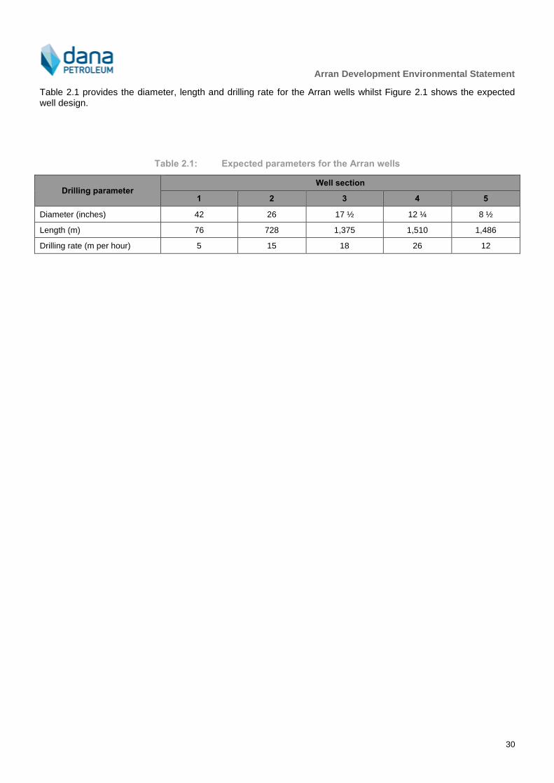
Arran Development Environmental Statement
30
Table 2.1 provides the diameter, length and drilling rate for the Arran wells whilst Figure 2.1 shows the expected well design.
Table 2.1: Expected parameters for the Arran wells
Drilling parameter Well section
1 2 3 4 5
Diameter (inches) 42 26 17 ½ 12 ¼ 8 ½
Length (m) 76 728 1,375 1,510 1,486
Drilling rate (m per hour) 5 15 18 26 12
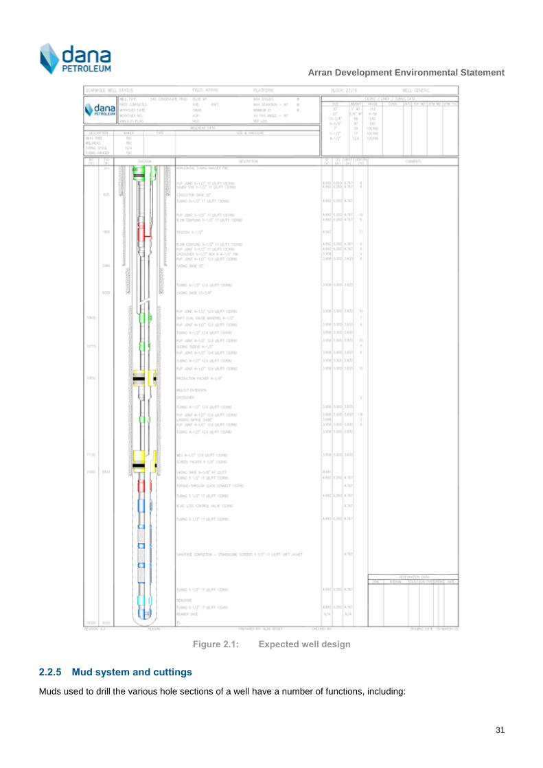
Arran Development Environmental Statement
31
Figure 2.1: Expected well design
2.2.5 Mud system and cuttings
Muds used to drill the various hole sections of a well have a number of functions, including:
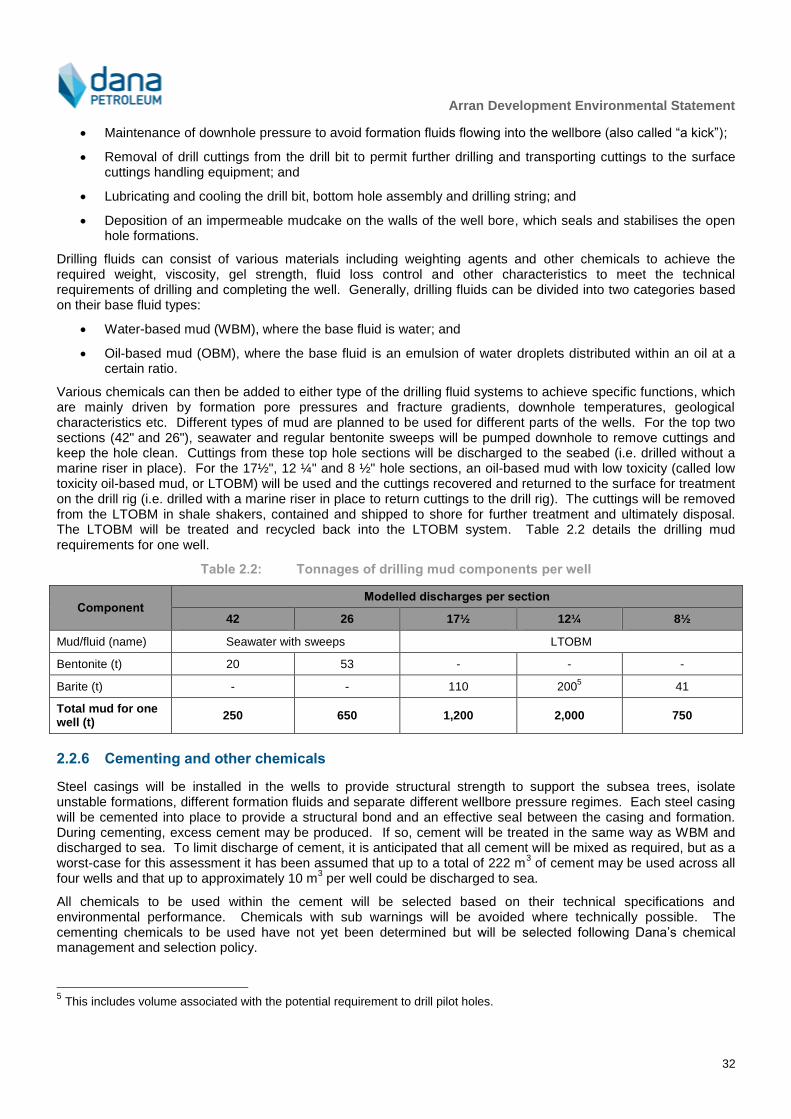
Arran Development Environmental Statement
32
Maintenance of downhole pressure to avoid formation fluids flowing into the wellbore (also called “a kick”);
Removal of drill cuttings from the drill bit to permit further drilling and transporting cuttings to the surface cuttings handling equipment; and
Lubricating and cooling the drill bit, bottom hole assembly and drilling string; and
Deposition of an impermeable mudcake on the walls of the well bore, which seals and stabilises the open hole formations.
Drilling fluids can consist of various materials including weighting agents and other chemicals to achieve the required weight, viscosity, gel strength, fluid loss control and other characteristics to meet the technical requirements of drilling and completing the well. Generally, drilling fluids can be divided into two categories based on their base fluid types:
Water-based mud (WBM), where the base fluid is water; and
Oil-based mud (OBM), where the base fluid is an emulsion of water droplets distributed within an oil at a certain ratio.
Various chemicals can then be added to either type of the drilling fluid systems to achieve specific functions, which are mainly driven by formation pore pressures and fracture gradients, downhole temperatures, geological characteristics etc. Different types of mud are planned to be used for different parts of the wells. For the top two sections (42" and 26"), seawater and regular bentonite sweeps will be pumped downhole to remove cuttings and keep the hole clean. Cuttings from these top hole sections will be discharged to the seabed (i.e. drilled without a marine riser in place). For the 17½", 12 ¼" and 8 ½" hole sections, an oil-based mud with low toxicity (called low toxicity oil-based mud, or LTOBM) will be used and the cuttings recovered and returned to the surface for treatment on the drill rig (i.e. drilled with a marine riser in place to return cuttings to the drill rig). The cuttings will be removed from the LTOBM in shale shakers, contained and shipped to shore for further treatment and ultimately disposal. The LTOBM will be treated and recycled back into the LTOBM system. Table 2.2 details the drilling mud requirements for one well.
Table 2.2: Tonnages of drilling mud components per well
Component Modelled discharges per section
42 26 17½ 12¼ 8½
Mud/fluid (name) Seawater with sweeps LTOBM
Bentonite (t) 20 53 - - -
Barite (t) - - 110 2005 41
Total mud for one well (t)
250 650 1,200 2,000 750
2.2.6 Cementing and other chemicals
Steel casings will be installed in the wells to provide structural strength to support the subsea trees, isolate unstable formations, different formation fluids and separate different wellbore pressure regimes. Each steel casing will be cemented into place to provide a structural bond and an effective seal between the casing and formation. During cementing, excess cement may be produced. If so, cement will be treated in the same way as WBM and discharged to sea. To limit discharge of cement, it is anticipated that all cement will be mixed as required, but as a worst-case for this assessment it has been assumed that up to a total of 222 m
3 of cement may be used across all
four wells and that up to approximately 10 m3 per well could be discharged to sea.
All chemicals to be used within the cement will be selected based on their technical specifications and environmental performance. Chemicals with sub warnings will be avoided where technically possible. The cementing chemicals to be used have not yet been determined but will be selected following Dana’s chemical management and selection policy.
5 This includes volume associated with the potential requirement to drill pilot holes.

Arran Development Environmental Statement
33
Chemicals to be used during well completion (the point at which the downhole equipment is assembled to enable production from the well) will be limited to a maximum of 70 m
3 of sodium chloride (NaCl) brine. It is expected that
up to 7 m3 of solids-free LTOBM will be recovered to the drill rig during completion activities (it will be subsequently
shipped to shore).
2.2.7 Well testing and clean-up
Prior to production, each well will be cleaned up to remove any waste and debris remaining in the well to prevent damage to the pipeline or topsides production facilities. A well test may then be conducted at the drill rig to obtain reservoir information and fluid samples. The likely sequence of events for well testing and clean-up will be as follows:
Open well and flow;
Initially the well will produce only sodium chloride brine which will be discharged to sea via the drilling rig;
The water/hydrocarbon interface fluids will be captured and tested:
If oil in water concentration is equal to or below 30 milligrams per litre (mg/l) then the fluids will be discharged overboard in accordance with permits; or
If oil in water concentration is above 30 mg/l they will be filtered until they are below 30 mg/l for overboard discharge.
Produced hydrocarbons will be flared;
Clean-up will be monitored to capture data the amount of water and suspended solids in the produced fluids (called the basic sediment and water specification);
After the well has been cleaned up, the well may be flowed for a test period of up to 24 hours, during which time up to 1,350 tonnes of gas and approximately 209 m
3 of condensate may be flared; and
Close well in, ready for production.
2.2.8 Well workovers and interventions
The Arran wells have been designed with a minimum planned intervention philosophy for the life of the wells. However, it is recognised that unplanned well maintenance could be necessary in the case of equipment failure. In this case, wireline intervention using an electrical cable used to lower tools into the well may be performed from a light well intervention vessel (this is a smaller vessel than a traditional semi-submersible drill rig or ship). Coiled tubing intervention, where a long metal pipe instead of an electrical cable is used, would is expected to require a semi-submersible drill rig although light well intervention vessel capabilities are currently increasing.
2.3 Subsea
2.3.1 Overview
An overview of the proposed subsea layout is shown in Figure 2.2. Further detail on each of the components is given in the subsequent sections of this chapter. Installation of structures, pipeline and umbilical is expected to commence in Q2 2020 and to be completed in Q4 2020.
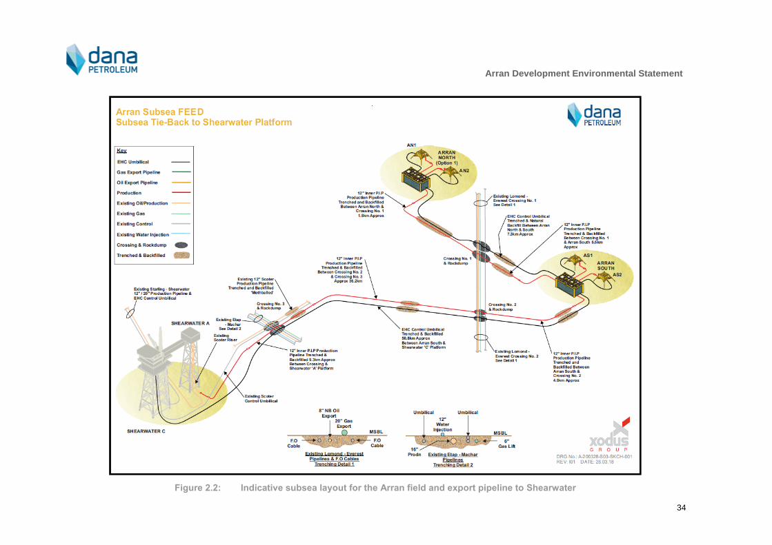
Arran Development Environmental Statement
34
Figure 2.2: Indicative subsea layout for the Arran field and export pipeline to Shearwater

Arran Development Environmental Statement
35
2.3.2 Subsea positioning
The placement of the subsea components requires a high degree of accuracy and to facilitate their positioning transponders will be installed on the structures prior to load out. Prior to installation a visual Remotely Operated Vehicle (ROV) survey will be carried out to verify the seabed condition and ensure no obstacles are present which may prevent successful installation. The position of the structure during deployment will be determined by the vessels acoustic positioning system and positioning transponders mounted on the structure and seabed.
Heading and attitude of the structure will be determined using a high accuracy subsea gyro which may be mounted on the structure, or on an ROV which rigidly docks onto the structure. The use of a dead man anchor (DMA) deployed on the seabed and orientation rigging may be required to achieve heading positional accuracy.
2.3.3 Wellheads and subsea trees
Subsea trees will be installed on top of the wellheads by the drill rig to control flow. The subsea tree is the main barrier between the reservoir and the primary well control element, and also provides a mechanism for flow control and well entry. All wells will have a safety valve installed which is an isolation device that is hydraulically operated and fail-safe closed. During drilling, the subsea trees will be controlled from the drill rig whilst during production the subsea trees will be remotely controlled from Shearwater via a control umbilical that connects between each of the tie-in structures. The valves will be controlled using a subsea control module, which will be mounted on the subsea tree. As the system will be open loop (i.e. fluids are discharged on each actuation), hydraulic fluid will be selected with due consideration to potential environmental impact.
The trees used will be fishing friendly and incorporate protection structures to provide the snag load resistance required. Each of the trees and associated protection structures will measure approximately 9.5 m x 9 m at the seabed and have a height above the seabed of approximately 5.5 m.
2.3.4 Tie-in structures
Two tie-in manifold structures will be installed, one at Arran North and one at Arran South. The tie-in structures will be of slab sided ‘fishing friendly’ designed with snag free details to limit potential for fishing gear snagging and allow gear to be recovered in the event that interaction with fishing gear occurs. The structures and foundations will be designed for potential fishing gear snag loads and will therefore incorporate piled foundations to resist these potential loads. Roof panels will be provided to avoid ingress of fishing gear into the structures and provide protection from dropped objects. The tie-in structures will be approximately 7 m x 7 m and reach approximately 4 m above the seabed, subject to detailed design. Each tie-in structure will be connected to each well by a 6" rigid spool piece of approximately 50m in length and to the export pipeline by a 12" production tie-in spool of approximately 60 m length.
Four piles will be required for each structure, with each pile measuring a maximum of approximately 0.6 m in diameter and approximately 20 m in length. Structure installation will be from a construction vessel, with a ROV used during piling. Diver intervention may be required during some parts of the installation, e.g. pile pinning.
2.4 Pipeline and Umbilicals
2.4.1 Pipeline requirements
The following production pipelines will be required::
12inch NB production pipeline 7.3 km between the Arran North and Arran South tie-in structures;
12inch NB production pipeline 50.4 km between Arran South and existing Scoter riser on the Shearwater A platform.
2.4.2 Umbilical requirements
The following umbilicals of approximately 6" outside diameter will be required to connect the following:
7.3 km between the Arran North and Arran South tie-in structures;

Arran Development Environmental Statement
36
51 km between Arran South and umbilical riser on the Shearwater C platform.
The umbilicals will be used to provide the chemical, electrical and hydraulic control and communications services to the Arran field subsea trees via the tie-in structures. The umbilical will connect Shearwater C to the Arran South tie-in structure and Arran South to Arran North.
2.4.3 Seabed preparation
Geophysical and geotechnical surveys have been carried out along all pipeline and umbilical routes and the final routes will be confirmed during FEED. A pre-lay survey will be carried out prior to pipeline and umbilical installation to determine whether any new obstructions have appeared. During installation, boulders and debris may need to be moved away from the pipeline and umbilical corridors.
2.4.4 Pipeline and umbilical lay
The pipeline and umbilical will be trenched and backfilled (Figure 2.3) to prevent upheaval buckling and provide protection.. Further work may be undertaken during detailed design to determine if the pipeline and umbilical can be laid in the same trench as the pipeline although this is not currently considered likely.
Figure 2.3: Indicative iillustration of trenched and backfilled pipeline
The pipeline and umbilical will be trenched using a plough or other mechanical trenching tool, and then mechanically backfilled. The target trench depth and cover requirements will be determined during detailed design.
The pipeline may be laid by S-lay, J-lay or Reel Lay method. Although unlikely, it is also possible that an anchored vessel may be used, or a bundle pipeline system for the infield section, depending on the final contractor selection. S-lay, J-lay and Reel lay installations would involve use of dynamically positioned (DP) vessels. Figure 2.4 shows a schematic of an S-lay operation
Should a pipelay vessel which uses anchors for station keeping be utilised, the vessel would deploy twelve anchors that are used to pull the barge along. For this method of installation the anchors have to be retrieved and redeployed continuously with an anchor handling vessel as the barge typically can only move 500 m with anchors deployed in this manner. The use of an anchor barge requires a pre-lay anchor corridor to be surveyed as the anchors can be up to 1,000 m either side of the vessel which would be out with the surveyed route corridor width of 540 m (270 m either side of the route centre line).

Arran Development Environmental Statement
37
Figure 2.4: Typical ‘S’ lay operation
Potential does exist that the pipeline between Arran North and South could be installed as a bundle by a controlled depth tow method (CDTM) where the pipeline would be towed into position with an oversized carrier pipe designed to provide sufficient buoyancy. The carrier pipe would then subsequently be flooded to provide stability. In this instance the pipeline between Arran North and South would not be trenched and would remain on the surface of the seabed.
A DP construction vessel with a carousel will carry out umbilical installation. It is proposed that the umbilical will be pulled up an existing J-tube on Shearwater ‘C’ platform and laid away towards the Arran South tie-in structure. Lay between Arran South and Arran North can be in either direction depending on rig location and access considerations. The umbilical will subsequently be pulled in and connected to the relevant subsea structure with diver assistance. Once the pipeline and umbilical are laid, the route of each will be surveyed to confirm its location. The potential for simultaneous umbilical lay and trenching exists, but its adoption would depend upon which installation contractor undertakes the work and assessment of associated risks.
2.4.5 Pipeline protection and crossings
The pipelines will be buried for protection and to mitigate against upheaval buckling. Upheaval buckling may occur in a pipeline where thermal expansion forces cause the pipeline to move as shown in Figure 2.5. Burial, when of sufficient depth, provides download to prevent upwards movement of the pipeline by resisting the expansion forces.
The potential for upheaval bucking is related to the temperature and pressure in the pipeline and the as-trenched shape of the pipeline where deviations in height away from a perfectly straight pipe are susceptible to upheaval buckling. The pipeline burial depth is designed to be sufficient to prevent upheaval buckling for the majority of deviations in height. For larger imperfections, the backfill cover height provided by the backfilled sediment may not, on its own, be sufficient to resist upheaval buckling and at these locations additional placement of rock may be required. Placement of rock (rockdump) is considered the most appropriate mitigation measure for upheaval buckling. Whilst trenching to a greater depth could reduce the requirement for rock, there are practical limitations on achievable depth, and experience from the wider area within which Arran is located suggests that burial to a greater depth is not likely to be guaranteed, and rock dump would likely still be required to ensure that snagging points did not present themselves.
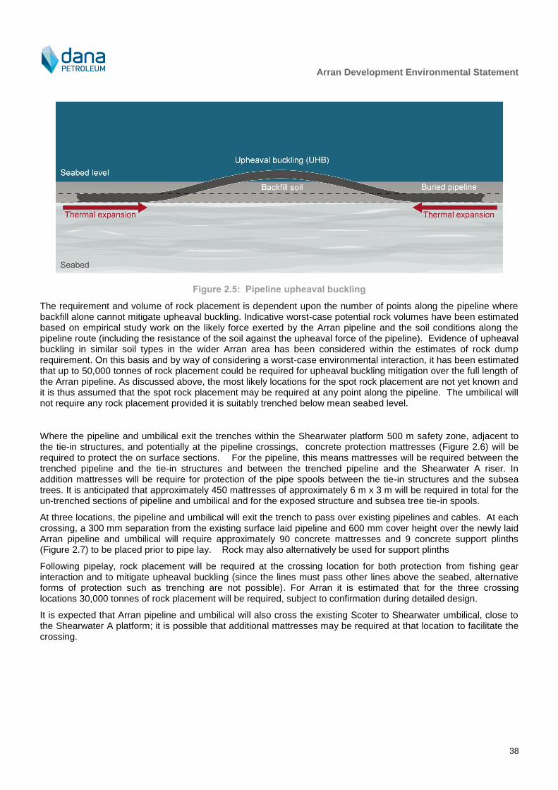
Arran Development Environmental Statement
38
Figure 2.5: Pipeline upheaval buckling
The requirement and volume of rock placement is dependent upon the number of points along the pipeline where backfill alone cannot mitigate upheaval buckling. Indicative worst-case potential rock volumes have been estimated based on empirical study work on the likely force exerted by the Arran pipeline and the soil conditions along the pipeline route (including the resistance of the soil against the upheaval force of the pipeline). Evidence of upheaval buckling in similar soil types in the wider Arran area has been considered within the estimates of rock dump requirement. On this basis and by way of considering a worst-case environmental interaction, it has been estimated that up to 50,000 tonnes of rock placement could be required for upheaval buckling mitigation over the full length of the Arran pipeline. As discussed above, the most likely locations for the spot rock placement are not yet known and it is thus assumed that the spot rock placement may be required at any point along the pipeline. The umbilical will not require any rock placement provided it is suitably trenched below mean seabed level.
Where the pipeline and umbilical exit the trenches within the Shearwater platform 500 m safety zone, adjacent to the tie-in structures, and potentially at the pipeline crossings, concrete protection mattresses (Figure 2.6) will be required to protect the on surface sections. For the pipeline, this means mattresses will be required between the trenched pipeline and the tie-in structures and between the trenched pipeline and the Shearwater A riser. In addition mattresses will be require for protection of the pipe spools between the tie-in structures and the subsea trees. It is anticipated that approximately 450 mattresses of approximately 6 m x 3 m will be required in total for the un-trenched sections of pipeline and umbilical and for the exposed structure and subsea tree tie-in spools.
At three locations, the pipeline and umbilical will exit the trench to pass over existing pipelines and cables. At each crossing, a 300 mm separation from the existing surface laid pipeline and 600 mm cover height over the newly laid Arran pipeline and umbilical will require approximately 90 concrete mattresses and 9 concrete support plinths (Figure 2.7) to be placed prior to pipe lay. Rock may also alternatively be used for support plinths
Following pipelay, rock placement will be required at the crossing location for both protection from fishing gear interaction and to mitigate upheaval buckling (since the lines must pass other lines above the seabed, alternative forms of protection such as trenching are not possible). For Arran it is estimated that for the three crossing locations 30,000 tonnes of rock placement will be required, subject to confirmation during detailed design.
It is expected that Arran pipeline and umbilical will also cross the existing Scoter to Shearwater umbilical, close to the Shearwater A platform; it is possible that additional mattresses may be required at that location to facilitate the crossing.
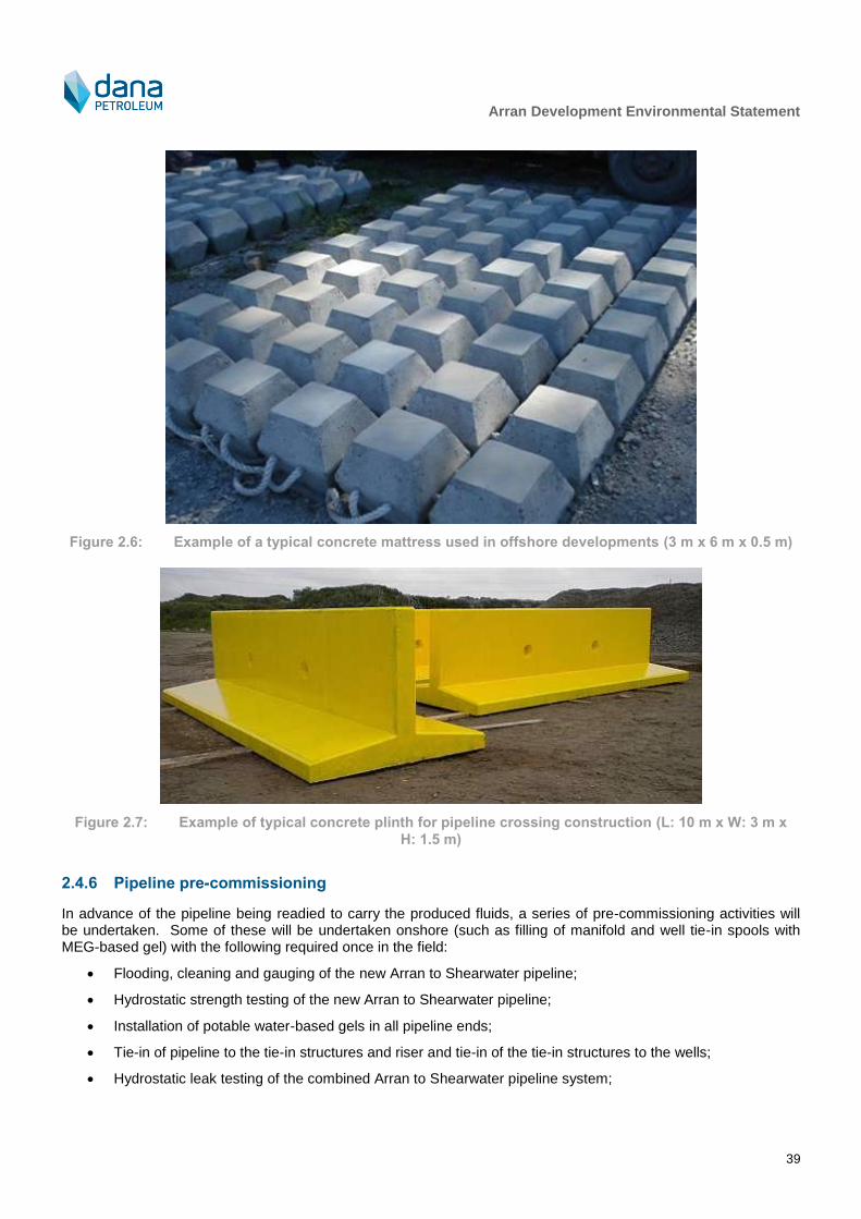
Arran Development Environmental Statement
39
Figure 2.6: Example of a typical concrete mattress used in offshore developments (3 m x 6 m x 0.5 m)
Figure 2.7: Example of typical concrete plinth for pipeline crossing construction (L: 10 m x W: 3 m x
H: 1.5 m)
2.4.6 Pipeline pre-commissioning
In advance of the pipeline being readied to carry the produced fluids, a series of pre-commissioning activities will be undertaken. Some of these will be undertaken onshore (such as filling of manifold and well tie-in spools with MEG-based gel) with the following required once in the field:
Flooding, cleaning and gauging of the new Arran to Shearwater pipeline;
Hydrostatic strength testing of the new Arran to Shearwater pipeline;
Installation of potable water-based gels in all pipeline ends;
Tie-in of pipeline to the tie-in structures and riser and tie-in of the tie-in structures to the wells;
Hydrostatic leak testing of the combined Arran to Shearwater pipeline system;

Arran Development Environmental Statement
40
De-watering of approximately 4,000 m3 via the Shearwater platform and mono-ethylene glycol (MEG) swab
of the combined Arran to Shearwater pipeline system; and
Filling of the Arran to Shearwater pipeline system with nitrogen as part of the dewatering operation. The pipeline shall be left filled with nitrogen at a minimum pressure of 1 bar above seabed ambient pressure. The pipeline may then be further pressurised with nitrogen if required to facilitate start-up operations.
A summary of the chemical use and discharge for pipeline pre-commissioning are shown in Table 2.3.
Table 2.3: Chemical use and discharge for pre-commissioning of the Arran to Shearwater pipeline
Activity Chemical use Chemical discharge to sea
Flood, clean, gauge, hydrotest and gel-fill the new pipeline
Hydrotest inhibitor;
Tracer dye
MEG-based gel.
Discharged to sea at the seabed or Shearwater platform during initial or subsequent operations.
Install spools and tie-in structures MEG-based gel
Dye sticks.
Discharged to sea at the Shearwater platform.
Barrier test Arran tie-in structures and Arran wells and leak test complete pipeline system
MEG/water
Tracer dye.
Discharged to sea at the seabed.
De-water complete pipeline system MEG. Discharged to sea at the Shearwater platform.
2.4.7 Umbilical pre-commissioning
In advance of the umbilical being readied to carry the necessary fluids, a series of pre-commissioning activities will be undertaken. Estimates of the types of chemicals that will be used and discharged are shown in Table 2.4.
Table 2.4: Chemical use and discharge for pre-commissioning of the Arran to Shearwater umbilical
Activity Chemical use Chemical discharge to sea
Installation and post-installation testing
Water based hydraulic control fluid; and
MEG/water.
The hydraulic control fluid remains in the umbilical cores during operation of the field, with small intermittent discharges occur during opening and closing of the hydraulic valves (i.e. this is an open loop system).
Most of the MEG/water will be moved into the Arran pipeline during chemical (Methanol) core displacement (see below) and onto the Shearwater process system for discharge during production. The remaining MEG/water will stay in the umbilical spare chemical cores for the life of field unless the spare umbilical cores are utilised.
Chemical core displacement
Methanol. Chemicals will remain in the umbilical cores until operation commences, at which point they will be used to treat the produced fluids and enter the Shearwater process system for discharge over field life.
2.4.8 Operation and maintenance
During its operational life time, the pipeline will be subject to a number of inspections to examine its integrity. External inspection will be done using a combination of ROV/autonomous operated underwater vehicle and towed sonar. The frequency of such maintenance will be determined by ongoing risk assessment. It is currently expected that inspections will primarily consist of:
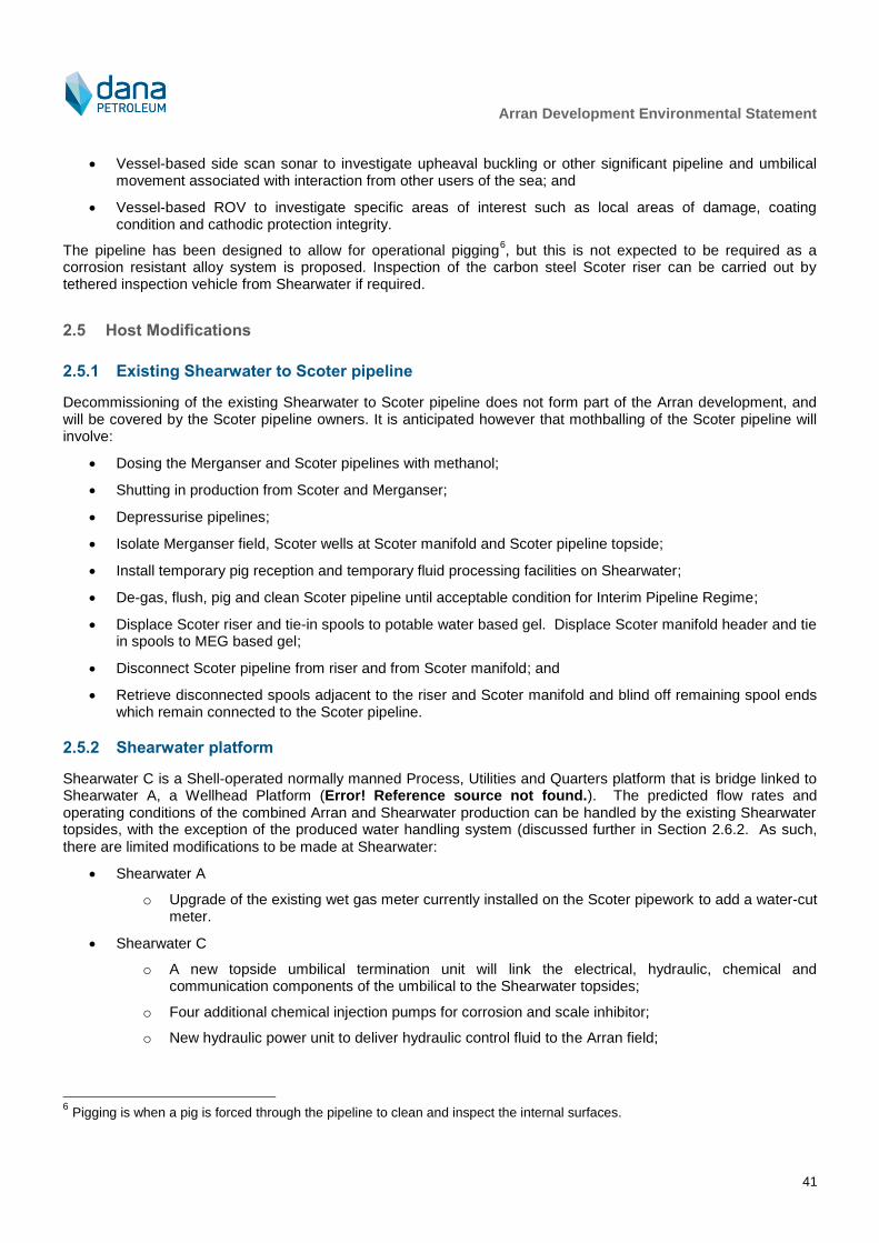
Arran Development Environmental Statement
41
Vessel-based side scan sonar to investigate upheaval buckling or other significant pipeline and umbilical movement associated with interaction from other users of the sea; and
Vessel-based ROV to investigate specific areas of interest such as local areas of damage, coating condition and cathodic protection integrity.
The pipeline has been designed to allow for operational pigging6, but this is not expected to be required as a
corrosion resistant alloy system is proposed. Inspection of the carbon steel Scoter riser can be carried out by tethered inspection vehicle from Shearwater if required.
2.5 Host Modifications
2.5.1 Existing Shearwater to Scoter pipeline
Decommissioning of the existing Shearwater to Scoter pipeline does not form part of the Arran development, and will be covered by the Scoter pipeline owners. It is anticipated however that mothballing of the Scoter pipeline will involve:
Dosing the Merganser and Scoter pipelines with methanol;
Shutting in production from Scoter and Merganser;
Depressurise pipelines;
Isolate Merganser field, Scoter wells at Scoter manifold and Scoter pipeline topside;
Install temporary pig reception and temporary fluid processing facilities on Shearwater;
De-gas, flush, pig and clean Scoter pipeline until acceptable condition for Interim Pipeline Regime;
Displace Scoter riser and tie-in spools to potable water based gel. Displace Scoter manifold header and tie in spools to MEG based gel;
Disconnect Scoter pipeline from riser and from Scoter manifold; and
Retrieve disconnected spools adjacent to the riser and Scoter manifold and blind off remaining spool ends which remain connected to the Scoter pipeline.
2.5.2 Shearwater platform
Shearwater C is a Shell-operated normally manned Process, Utilities and Quarters platform that is bridge linked to Shearwater A, a Wellhead Platform (Error! Reference source not found.). The predicted flow rates and operating conditions of the combined Arran and Shearwater production can be handled by the existing Shearwater topsides, with the exception of the produced water handling system (discussed further in Section 2.6.2. As such,
there are limited modifications to be made at Shearwater:
Shearwater A
o Upgrade of the existing wet gas meter currently installed on the Scoter pipework to add a water-cut meter.
Shearwater C
o A new topside umbilical termination unit will link the electrical, hydraulic, chemical and communication components of the umbilical to the Shearwater topsides;
o Four additional chemical injection pumps for corrosion and scale inhibitor;
o New hydraulic power unit to deliver hydraulic control fluid to the Arran field;
6 Pigging is when a pig is forced through the pipeline to clean and inspect the internal surfaces.
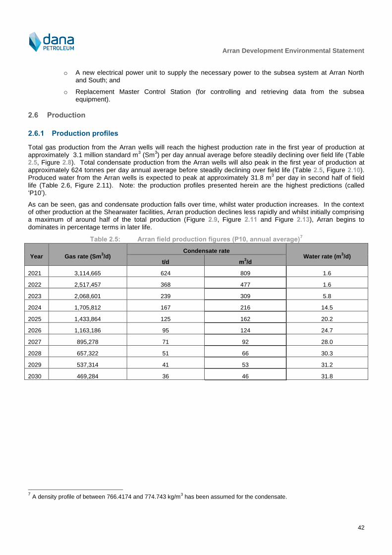
Arran Development Environmental Statement
42
o A new electrical power unit to supply the necessary power to the subsea system at Arran North and South; and
o Replacement Master Control Station (for controlling and retrieving data from the subsea equipment).
2.6 Production
2.6.1 Production profiles
Total gas production from the Arran wells will reach the highest production rate in the first year of production at approximately 3.1 million standard m
3 (Sm
3) per day annual average before steadily declining over field life (Table
2.5, Figure 2.8). Total condensate production from the Arran wells will also peak in the first year of production at approximately 624 tonnes per day annual average before steadily declining over field life (Table 2.5, Figure 2.10). Produced water from the Arran wells is expected to peak at approximately 31.8 m
3 per day in second half of field
life (Table 2.6, Figure 2.11). Note: the production profiles presented herein are the highest predictions (called ‘P10’).
As can be seen, gas and condensate production falls over time, whilst water production increases. In the context of other production at the Shearwater facilities, Arran production declines less rapidly and whilst initially comprising a maximum of around half of the total production (Figure 2.9, Figure 2.11 and Figure 2.13), Arran begins to dominates in percentage terms in later life.
Table 2.5: Arran field production figures (P10, annual average)7
Year Gas rate (Sm3/d)
Condensate rate Water rate (m
3/d)
t/d m3/d
2021 3,114,665 624 809 1.6
2022 2,517,457 368 477 1.6
2023 2,068,601 239 309 5.8
2024 1,705,812 167 216 14.5
2025 1,433,864 125 162 20.2
2026 1,163,186 95 124 24.7
2027 895,278 71 92 28.0
2028 657,322 51 66 30.3
2029 537,314 41 53 31.2
2030 469,284 36 46 31.8
7 A density profile of between 766.4174 and 774.743 kg/m
3 has been assumed for the condensate.
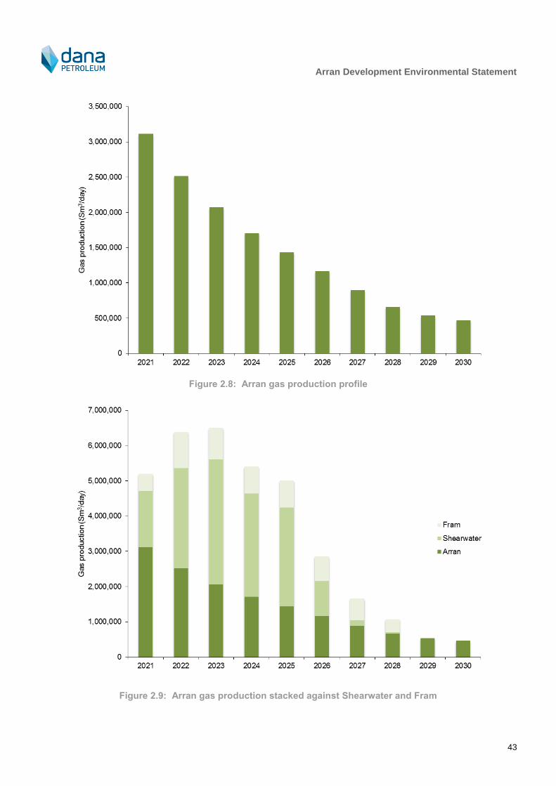
Arran Development Environmental Statement
43
Figure 2.8: Arran gas production profile
Figure 2.9: Arran gas production stacked against Shearwater and Fram

Arran Development Environmental Statement
44
Figure 2.10: Arran condensate production profile
Figure 2.11: Arran condensate stacked against Shearwater and Fram

Arran Development Environmental Statement
45
Figure 2.12: Arran water production profile
Figure 2.13: Arran water production stacked against Shearwater and Fram

Arran Development Environmental Statement
46
2.6.2 Produced water
Produced water will be disposed of via the existing Shearwater produced water system, The original produced water treatment package was designed for a maximum of 5,000 bbls/day (795 m3/day) and consists of an HP hydrocyclone, two LP hydrocyclones, a produced water degasser, and a produced water recycle pump. A new treatment package was installed and commissioned on Shearwater in 2016. The package consists of a membrane system and the Compact Flotation Unit (CFU), and its total maximum capacity is 4,400 bpd, however the planned water debottlenecking will increase this to ~8,000 bpd. Depending on the treatment requirements, produced water leaving degasser can either flow through membrane and CFU, or can bypass either of these two elements. If fluids are of sufficient cleanliness, they can be discharged directly overboard downstream of the degasser via the PW caisson, bypassing the entire package.
As a result of Arran coming online, there will be no requirement to modify any current chemical use. However, Shell are intending to bring the Fram field online, which will result in changes to specific chemicals currently used (although the type will not change). This process is independent of Arran coming online and is being managed by Shell; it is discussed further in Section 5.2. The following requirements will continue to be met at Shearwater once Arran production is brought on line:
The use and/or discharge of all production chemicals will be subject to risk assessment and permitting under the Offshore Chemicals Regulations;
Oil in water discharge via the produced water system will be within the existing approved limits, which currently include:
o A maximum monthly average of oil (dispersed) in water content of 30 mg/l or less;
o The maximum concentration not to exceed 100 mg/l at any time; and
o Quantity of dispersed oil in produced water discharged must not exceed 1 tonne in any 12 hour period.
2.6.3 Power generation, flaring and venting
The existing combustion equipment on Shearwater includes gas turbines for main power generation and compressor drive and diesel engines for air compression, emergency power and for driving fire pumps. There will be an incremental power demand from bringing Arran production online against the current requirement at Shearwater but no new power generation facilities will be required. The potential impact from the small increase in fuel use is assessed in Section 5.4.
The Shearwater flare system comprises both a low pressure and high pressure flare system that accepts hydrocarbons under the following conditions:
Base load – this includes all the gas used for safe and efficient operation of the process facility and flare system under normal operating conditions;
Operational changes – this includes gas flaring resulting from the start up and planned shut-down of equipment during production amongst others; and
Emergency shutdown – this includes any gas flared during an emergency.
Apart from the base load flare required for the safe and efficient operation of the process and flare systems under normal operating conditions, gas is flared on Shearwater only during emergency pressure relief, during periods of process instability typically after start up and shut down, or during unavailability of the gas compression system. The production from the Arran field will not change the current operating conditions at Shearwater with respect to flaring. However, there will be temporary increases in flaring as a result of Arran production coming online due to:
Initial start-up;
Planned shut down and start-up; and
Unplanned shut down and start-up.
Unplanned shut down and start-up is anticipated to occur on average one and a half times per year, with shut down flaring anticipated to take a maximum of approximately 30 hours and start-up flaring a maximum of approximately

Arran Development Environmental Statement
47
100 hours. The potential impact of atmospheric emissions due to these additional flaring instances is assessed in Section 5.4.
The Shearwater installation does not currently vent and there will be no changes to this venting requirement as a result of Arran production.
2.6.4 Flow assurance
Gas condensate from Arran will be susceptible to hydrate formation at a temperature above the minimum seabed ambient. The pipeline will be insulated using a high specification pipe-in-pipe system which will enable fluids to arrive above hydrate formation temperature through the expected field life. The operating philosophy will be that depressurisation of the pipeline will not be required after a planned shutdown, or within a given length of time following an unplanned shutdown. However, if an unplanned shutdown exceeds this given length of time then the flowline system will be depressurised and restarted at low pressure until the water in the pipeline has been dosed with methanol. Methanol will be injected at start-up to inhibit hydrates caused by low temperatures, and will be required until the pipeline is warmed up to operating temperature.
Based on measured brine concentrations of the Arran produced fluids, the risk of scaling (salt deposits from the produced fluids being deposited on the internal surfaces of the pipeline) is considered to be low. However, as a precaution against interruption to production, scale inhibitor injection will be available at the two Arran tie-in structures.
Despite the pipeline being constructed from a corrosion resistant alloy, there is still a requirement for injection of corrosion inhibitor to protect the existing carbon steel Scoter riser at Shearwater.
It is recognised that, as a result of Shell bringing the Fram field online, there may be a requirement for the specific chemicals that are currently used at Shearwater (and which the Arran field will currently make use of) to be changed. Should this be required, any such changes would be subject of further assessment by both Shell and Dana as part of the chemical permitting process and they are not discussed further herein.
2.7 Vessel Requirement
The vessels expected to be involved in the installation, commissioning and operation of the Arran field are described in Table 2.6. Helicopters will also be required for transportation of personnel during installation and commissioning, but there will be no additional ongoing operational helicopter requirement beyond current demand at Shearwater as a result of Arran production.

Arran Development Environmental Statement
48
Table 2.6: Estimated vessel types and number of days8 required for the Arran field development
Operation Vessel type
Number of days
2019 2020 2021 onwards
Drilling
Drilling Drill rig 165 194 -
Anchor handling Anchor handling vessel
18 - -
Emergency response and rescue (ERRV) Safety vessel 165 194 -
Supply vessel Supply vessel 165 194 -
Pipeline and umbilical installation
Pipeline and umbilical surveys Survey vessel - 60
Pipelay Pipelay vessel - 72 -
Subsea facilities installation DSV - 88 -
Umbilical lay Umbilical lay vessel - 25 -
Trenching and backfilling Trenching vessel - 81 -
Rock placement and pipeline crossings Rock placement vessel
- 16 -
Guard vessel Fishing guard boat - 220 -
Shearwater topsides modifications
Additional accommodation during modifications Walk to work vessel - 42 -
Operation
Inspection and maintenance of subsea structures Survey vessel - - 5 surveys taking 5 days (total 25 days) over the life of Arran.
2.8 Decommissioning
Decommissioning of oil and gas facilities in the UK is regulated under the Petroleum Act 1998, as amended by the Energy Act 1998. The UK’s international obligations on decommissioning are governed principally by the Oslo-Paris Convention for the Protection of the Marine Environment of the North-East Atlantic (OSPAR Convention). OPRED’s “Guidance on the Content of Offshore Oil and Gas Field Development Plans” states “in accordance with the UK's international obligations, all installations emplaced after 9 February 1999 must be completely removed to shore for reuse, recycling or final disposal on land”. DECC (2011) provides specific guidance on decommissioning activities and Dana will adopt the approach outlined by OPRED in that guidance. This is summarised in Figure 2.14 and shows the process leading to approval of a decommissioning programme.
8 Includes travel time of vessels to reach the Project area.

Arran Development Environmental Statement
49
Figure 2.14: Decommissioning approach
The production wells will be plugged and abandoned at the end of field life. It is likely that cement plugs will be set across the reservoir sections, across casing shoes and in the conductor casing, and that the conductor casing will be cut below the seabed. The well abandonment will follow legislation and guidelines applicable at the time.
Dana will recover the manifolds, spools and any supporting structures (e.g. mattresses) at the end of field life.
The OSPAR provisions do not apply to pipelines, however, DECC (2011) guidance sets out UK policy on pipeline decommissioning.
The decommissioning strategy for the pipeline and umbilical will depend on a number of factors including, the availability of suitable technology and the potential environmental, safety and cost implications of decommissioning methods at the end of field life. The ultimate intention is to leave the seabed of the development area in such a condition that it will pose no risk to the marine environment or to other sea users.
Prior to the end of field life there may well be changes to the statutory decommissioning requirements as well as advances in technology and knowledge. Dana will aim to utilise recognised industry standard environmental practice during all decommissioning operations in line with the legislation and guidance in place at the time of decommissioning. Discussions on what may be required will be held with the Regulator as early as possible before decommissioning commences.
Prior to the decommissioning process, re-use and recycling alternatives will be considered where feasible to reduce the potential for materials having to go to landfill. In advance of the decommissioning process an inventory of Project equipment will be made and the potential for further reuse will be investigated. As an integral component of the decommissioning process, Dana will undertake a study to comparatively assess the technical, financial, health, safety and environmental aspects of decommissioning options, for which a further EIA may be required at that time.

Arran Development Environmental Statement
50
3 Environment Description
3.1 Introduction
It is important in any EIA process that the main physical, biological and socio economic sensitivities of the receiving environment are well understood. As such, this section describes the main characteristics of the environment in and around the Arran field and associated pipeline route to Shearwater and highlights the key sensitivities.
This section draws on a number of information sources including published papers, relevant strategic environmental assessments (SEAs) and site specific investigations. Key Project-specific studies used to inform this environmental description include:
Habitat assessment (Gardline, 2015a):
o Environmental survey in 2015 of the seabed at Arran North and Arran South locations, the then two possible pipeline and umbilical routes between Arran North and South and an export pipeline route south to the Shearwater A platform. Conducted as part of full environmental baseline surveys and habitat assessments. Acoustic survey (bathymetry and sidescan) together with stills photography and sediment grab sampling at 33 stations was undertaken along the route to describe and map the benthic habitats present. This report details the results of the habitat investigation.
Environmental baseline survey (EBS) (Gardline, 2015b):
o EBS based on the above description.
Metocean study for the Arran Field (PhysE, 2013a, 2013b):
o Meteorological and oceanographic data gathering to inform the Arran Development.
This environmental description covers the infrastructure illustrated in Figure 1.1 in Chapter 1.
3.2 Physical Environment
3.2.1 Weather and sea conditions
Meteorological Office data for the central North Sea (1854 – 1994) show that winds prevail from the south south-west and south, although they can occur from all directions. Average wind speeds over the year equate to moderate to strong breezes (6 – 13 ms
-1) (DTI, 2001), with gales (greater than 17.5 ms
-1) being most frequent
during winter months (November – March). Wind strengths in winter are typically in the range of 6-11 ms-1
with higher winds of force 17-32 ms
-1 being much less frequent (DECC, 2016). The wind rose for the Arran field area
presented in Figure 3.1 shows the wind direction and speed to be variable throughout the year.
Offshore tidal current speed in the region are relatively consistent between 0.25 ms-1
and 0.51 ms-1
during mean spring tides (BODC, 1998). Water currents of the Project area and wider North Sea are shown in Figure 3.2 and maximum current speeds detailed in Table 3.1.
The average wave height in the central North Sea follows a gradient decreasing from the northern area of the Fladen/Witch Ground to the southern area of the Dogger Bank. The waves in the Project area, including the Shearwater platform average 2.11 – 2.40 m in height over the year (NMPI, 2017). The maximum extreme wave conditions for the Arran field are presented in Table 3.2.
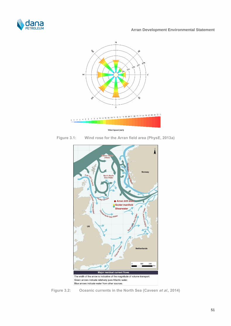
Arran Development Environmental Statement
51
Figure 3.1: Wind rose for the Arran field area (PhysE, 2013a)
Figure 3.2: Oceanic currents in the North Sea (Caveen et al., 2014)

Arran Development Environmental Statement
52
Table 3.1: Maximum current speeds for the Arran field (Dana Petroleum, 2010)
Current direction 1 year 10 year
Speed (ms-1
): surface Speed (ms-1
): seabed Speed (ms-1
): surface Speed (ms-1
): seabed
North 0.52 0.30 0.57 0.33
North-east 0.44 0.26 0.48 0.28
East 0.35 0.20 0.38 0.22
South-east 0.37 0.22 0.41 0.23
South 0.43 0.25 0.47 0.27
South-west 0.40 0.23 0.44 0.25
West 0.39 0.23 0.43 0.25
North-west 0.59 0.34 0.64 0.37
Table 3.2: Maximum extreme wave conditions9 for the Arran field (PhysE, 2013b)
Direction Maximum wave height (m) Mean wave period (s) Range of maximum wave period (s)
North 20.8 11.0 9.9 – 12.6
North-east 13.7 8.9 8.1 – 10.2
East 20.8 11.0 9.9 – 12.6
South-east 20.7 10.9 9.9 – 12.5
South 19.5 10.7 9.6 – 12.2
South-west 21.1 11.1 10.0 – 12.7
West 21.8 11.3 10.2 – 12.9
North-west 23.1 11.6 10.4 – 13.3
3.2.2 Bathymetry and seabed conditions
The North Sea is a large shallow sea with a surface area of around 750,000 km2. Water depths generally gradually
deepen from south to north (between approximately 20 m and 200 m; DTI, 2001). The main topographic features in the central North Sea include the Dogger Bank, a large sublittoral sandbank submerged through sea-level rise located in the south-west corner of the region that marks the division between the southern North Sea and central North Sea.
During August and September 2015, a Dana-commissioned habitat assessment and EBS was carried out in the Project area. The survey consisted of the Arran North and Arran South locations, the two possible pipeline and umbilical routes between Arran North and South and the export route south to the Shearwater platform. The Arran North Site covered 6.65 km by 4.2 km and incorporated the two potential drill centre options at Arran North, as well as three possible relief well locations. The Arran South site covered 4.4 km x 3.6 km and incorporated the Arran South drill centre and two possible relief well locations. Whilst the text herein discusses the Project area as a whole, for ease of presentation of data in this ES the survey area has been broken down in figures as follows:
Area 1: the corridor between Arran North and Arran South;
Area 2: the northern part of the corridor running between Arran South and Shearwater A platform; and
Area 3: the southern part of the corridor running between Arran South and Shearwater A platform.
9 50 year return period.

Arran Development Environmental Statement
53
The bathymetry in the vicinity of the Project area is shown in Figure 3.3 and Figure 3.4. Around the Arran North drilling sites the seabed gently undulates and water depths range from 82.2 m lowest astronomical tide (LAT) to 88.3 m LAT (Gardline, 2015a). Water depths along the proposed pipeline routes that will join Arran North to Arran South are similar, ranging between 78 m LAT in the east to 84.5 m LAT in the west. Water depths at Arran South are generally shallower than Arran north, ranging between 76.7 m LAT to 84.5 m LAT. The seabed gently undulates within the survey area, becoming deeper towards the south, south-east and north-east. Water depth generally increases as you move south from Arran South to the Scoter manifold where depth peaks at 87.9 m LAT. The seabed along the proposed pipeline route between the Scoter manifold and the Shearwater A platform gently undulates, shoaling towards the east. Water depth gradually increases south from the Scoter manifold, reaching 90.9 m LAT at Shearwater A. Throughout the entire Project area, seabed gradients do no not exceed 1°.
Seabed sediments in the central North Sea generally comprise a veneer of unconsolidated terrigenous and biogenic deposits, generally significantly less than 1 m thick (Andrews et al., 1990). DECC (2016) reports that sand and slightly gravelly sand covers much of the seabed of the central North Sea and occurs within a wide range of water depths from the shallow coastal zone to 110 m in the north and to below 120 m in isolated deeps in the centre known as the Devil’s hole (JNCC, 2010a, DECC, 2016). Sediments may have an increasing mud content in basins and in deeper waters to the north. Recent mapped information (JNCC, 2010a) indicates seabed sediments in the central North Sea consist largely of sand or muddy sand, with smaller isolated areas of coarse sediment or mud and sandy mud.
The majority of the Project area is covered in poor to moderately sorted fine sand with some instances of medium sand, as illustrated by Figure 3.5 (Gardline, 2015b). However, at two survey stations (one at the Arran South drill centre and the other along the pipeline route) very coarse sand and pebbles were recorded (Figure 3.6). Excluding these two sites, the mean particle size ranged from 121 µm to 331 µm. Total organic matter ranged from 0.09% (at Arran South drill centre) to 0.65% (at a sample station along the pipeline route), while total organic carbon ranged from 0.05% (at the Arran South drill centre) to 0.23% (close to the Scoter manifold). The total hydrocarbon concentrations recorded were below the minimum threshold value considered for any opportunistic species to be prevalent, but were sufficient to potentially have an influence on faunal community composition and faunal diversity (Gardline, 2015b).
Figure 3.7 and Figure 3.8 illustrate seabed features in the Project area. Around Arran North, the dominant seabed type is loose medium dense silty sand with areas of shell fragments, shells and gravels. Areas of high reflectivity were investigated at survey stations in the area of the Arran North drill centre using camera drops and confirmed to be Methane Derived Authigenic Carbonate (MDAC) structures (Figure 3.9). MDAC may also be present at a third survey station in the Arran North area, but this could not be confirmed from the field data. MDAC structures can form potentially sensitive habitats or features and are listed on Annex I of the EC Habitats Directive 92/43/EEC as submarine structures made by leaking gas. This habitat is defined as submarine structures consisting of sandstone slabs, pavements, and pillars up to 4 m high, formed by aggregation of carbonate cement resulting from microbial oxidation of gas emissions, mainly methane. The formations are interspersed with gas vents that intermittently release gas. Around Arran South the seabed was characterised in a similar way to Arran North except that there was no MDAC identified and numerous shallow irregularly shaped depressions containing gravelly sandy sediment were observed to the east. The seabed along the pipeline route between Arran South and Shearwater was characterised by an interpreted dominant seabed of loose to medium dense silty sand. Occasional shell fragments, shell and gravel as well as numerous boulders up to 0.7 m in diameter occur throughout the pipeline route. Numerous shallow irregularly shaped depressions containing what was interpreted to be gravelly sandy sediment were observed to the eastern end of the pipeline route between Arran North and Arran South and around Arran South itself.
Table 3.3 summarises the heavy metal and total hydrocarbon concentrations recorded during the 2015 survey campaign. These have then been compared to their respective OSPAR background concentrations (BC) in sediments (OSPAR, 2005). Normalised concentrations of cadmium (Cd) were above the BC at several stations. No other metals were above BC levels.

Arran Development Environmental Statement
54
Figure 3.3: Bathymetry of the north of the Project area (Gardline, 2015a)
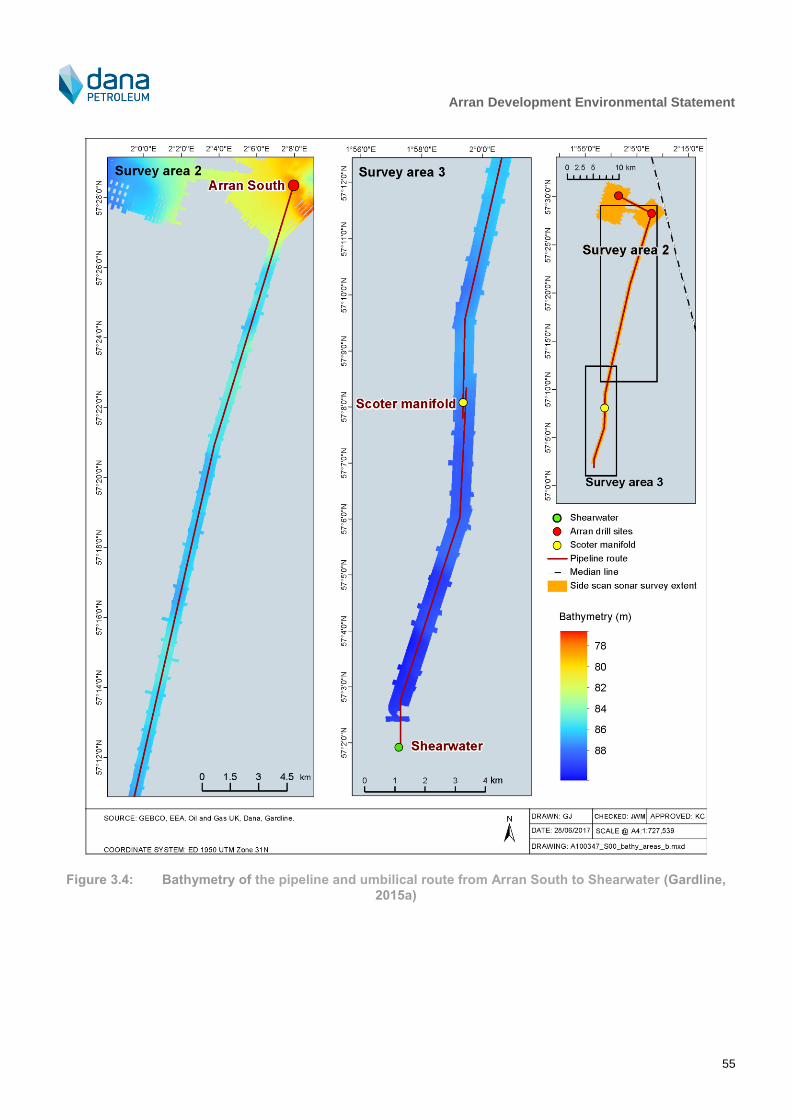
Arran Development Environmental Statement
55
Figure 3.4: Bathymetry of the pipeline and umbilical route from Arran South to Shearwater (Gardline,
2015a)

Arran Development Environmental Statement
56
Figure 3.5: Poor to moderately sorted fine to medium sand found around the Arran North and South
drill centres (Gardline, 2015a)
Figure 3.6: Example of coarse sand and pebbles found on the pipeline and umbilical route close to the
Arran South drill centre (Gardline, 2015a)
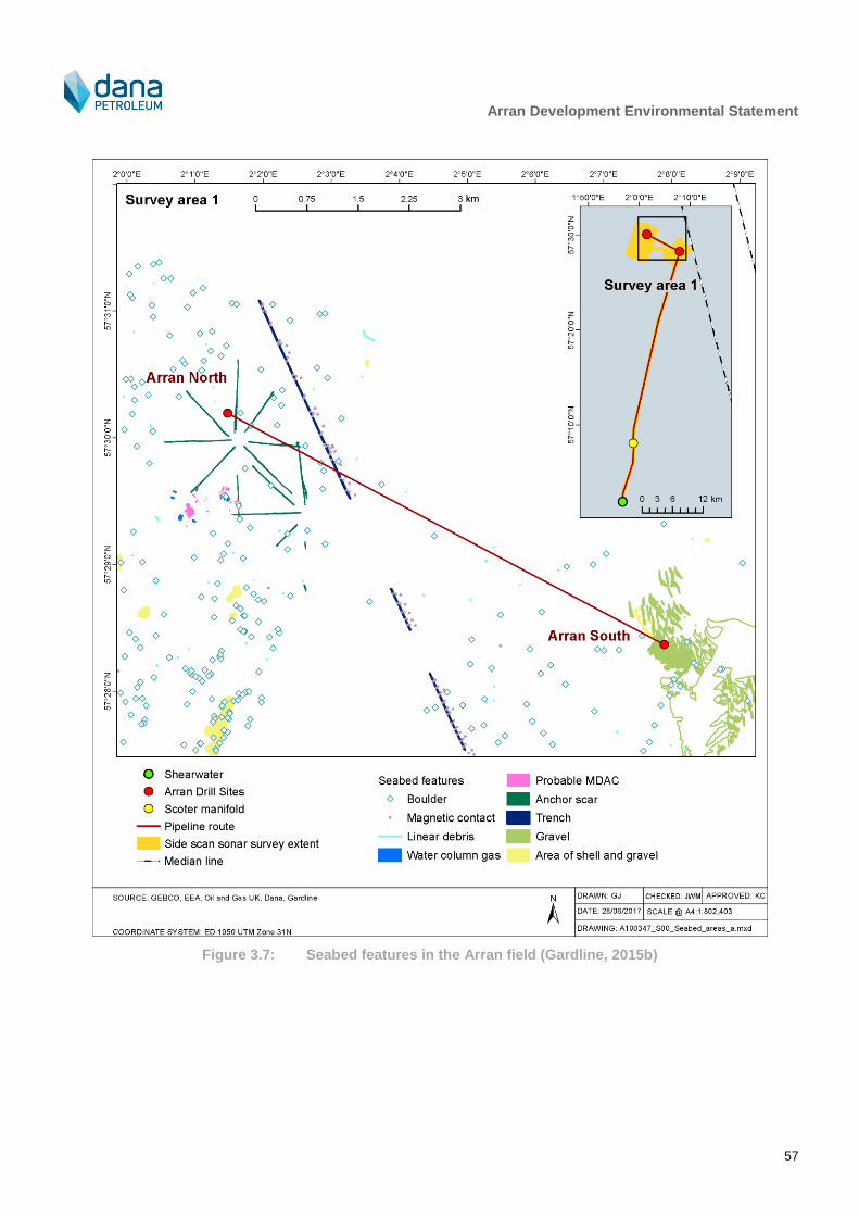
Arran Development Environmental Statement
57
Figure 3.7: Seabed features in the Arran field (Gardline, 2015b)
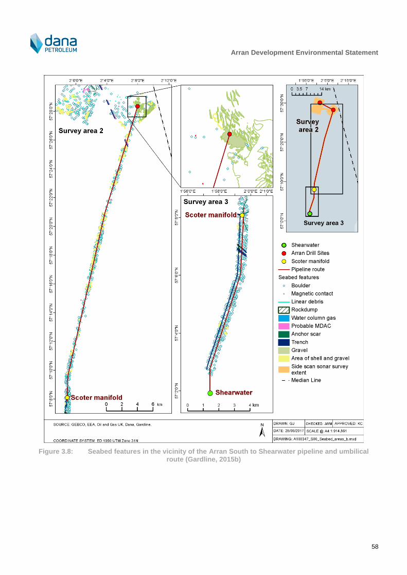
Arran Development Environmental Statement
58
Figure 3.8: Seabed features in the vicinity of the Arran South to Shearwater pipeline and umbilical route (Gardline, 2015b)
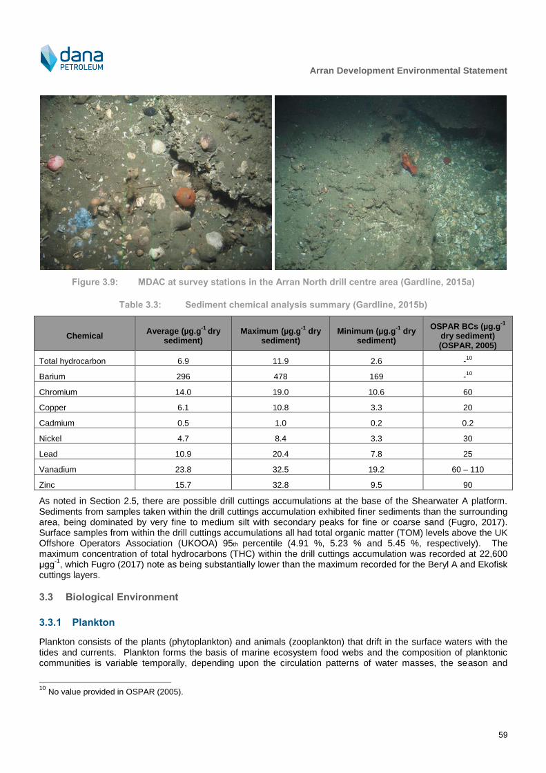
Arran Development Environmental Statement
59
Figure 3.9: MDAC at survey stations in the Arran North drill centre area (Gardline, 2015a)
Table 3.3: Sediment chemical analysis summary (Gardline, 2015b)
Chemical Average (µg.g
-1 dry
sediment) Maximum (µg.g
-1 dry
sediment) Minimum (µg.g
-1 dry
sediment)
OSPAR BCs (µg.g-1
dry sediment) (OSPAR, 2005)
Total hydrocarbon 6.9 11.9 2.6 -10
Barium 296 478 169 -10
Chromium 14.0 19.0 10.6 60
Copper 6.1 10.8 3.3 20
Cadmium 0.5 1.0 0.2 0.2
Nickel 4.7 8.4 3.3 30
Lead 10.9 20.4 7.8 25
Vanadium 23.8 32.5 19.2 60 – 110
Zinc 15.7 32.8 9.5 90
As noted in Section 2.5, there are possible drill cuttings accumulations at the base of the Shearwater A platform. Sediments from samples taken within the drill cuttings accumulation exhibited finer sediments than the surrounding area, being dominated by very fine to medium silt with secondary peaks for fine or coarse sand (Fugro, 2017). Surface samples from within the drill cuttings accumulations all had total organic matter (TOM) levels above the UK Offshore Operators Association (UKOOA) 95th percentile (4.91 %, 5.23 % and 5.45 %, respectively). The maximum concentration of total hydrocarbons (THC) within the drill cuttings accumulation was recorded at 22,600 μgg
-1, which Fugro (2017) note as being substantially lower than the maximum recorded for the Beryl A and Ekofisk
cuttings layers.
3.3 Biological Environment
3.3.1 Plankton
Plankton consists of the plants (phytoplankton) and animals (zooplankton) that drift in the surface waters with the tides and currents. Plankton forms the basis of marine ecosystem food webs and the composition of planktonic communities is variable temporally, depending upon the circulation patterns of water masses, the season and
10
No value provided in OSPAR (2005).
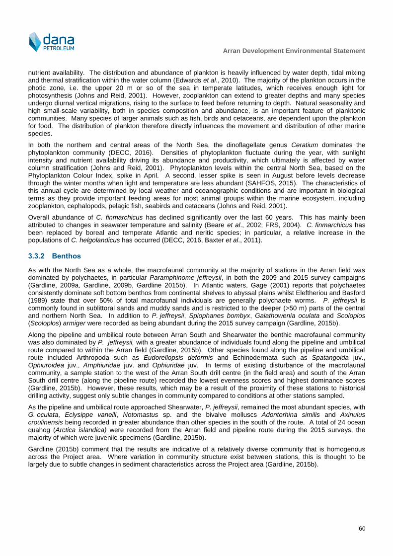
Arran Development Environmental Statement
60
nutrient availability. The distribution and abundance of plankton is heavily influenced by water depth, tidal mixing and thermal stratification within the water column (Edwards et al., 2010). The majority of the plankton occurs in the photic zone, i.e. the upper 20 m or so of the sea in temperate latitudes, which receives enough light for photosynthesis (Johns and Reid, 2001). However, zooplankton can extend to greater depths and many species undergo diurnal vertical migrations, rising to the surface to feed before returning to depth. Natural seasonality and high small-scale variability, both in species composition and abundance, is an important feature of planktonic communities. Many species of larger animals such as fish, birds and cetaceans, are dependent upon the plankton for food. The distribution of plankton therefore directly influences the movement and distribution of other marine species.
In both the northern and central areas of the North Sea, the dinoflagellate genus Ceratium dominates the phytoplankton community (DECC, 2016). Densities of phytoplankton fluctuate during the year, with sunlight intensity and nutrient availability driving its abundance and productivity, which ultimately is affected by water column stratification (Johns and Reid, 2001). Phytoplankton levels within the central North Sea, based on the Phytoplankton Colour Index, spike in April. A second, lesser spike is seen in August before levels decrease through the winter months when light and temperature are less abundant (SAHFOS, 2015). The characteristics of this annual cycle are determined by local weather and oceanographic conditions and are important in biological terms as they provide important feeding areas for most animal groups within the marine ecosystem, including zooplankton, cephalopods, pelagic fish, seabirds and cetaceans (Johns and Reid, 2001).
Overall abundance of C. finmarchicus has declined significantly over the last 60 years. This has mainly been attributed to changes in seawater temperature and salinity (Beare et al., 2002; FRS, 2004). C. finmarchicus has been replaced by boreal and temperate Atlantic and neritic species; in particular, a relative increase in the populations of C. helgolandicus has occurred (DECC, 2016, Baxter et al., 2011).
3.3.2 Benthos
As with the North Sea as a whole, the macrofaunal community at the majority of stations in the Arran field was dominated by polychaetes, in particular Paramphinome jeffreysii, in both the 2009 and 2015 survey campaigns (Gardline, 2009a, Gardline, 2009b, Gardline 2015b). In Atlantic waters, Gage (2001) reports that polychaetes consistently dominate soft bottom benthos from continental shelves to abyssal plains whilst Eleftheriou and Basford (1989) state that over 50% of total macrofaunal individuals are generally polychaete worms. P. jeffreysii is commonly found in sublittoral sands and muddy sands and is restricted to the deeper (>50 m) parts of the central and northern North Sea. In addition to P. jeffreysii, Spiophanes bombyx, Galathowenia oculata and Scoloplos (Scoloplos) armiger were recorded as being abundant during the 2015 survey campaign (Gardline, 2015b).
Along the pipeline and umbilical route between Arran South and Shearwater the benthic macrofaunal community was also dominated by P. jeffreysii, with a greater abundance of individuals found along the pipeline and umbilical route compared to within the Arran field (Gardline, 2015b). Other species found along the pipeline and umbilical route included Arthropoda such as Eudorellopsis deformis and Echinodermata such as Spatangoida juv., Ophiuroidea juv., Amphiuridae juv. and Ophiuridae juv. In terms of existing disturbance of the macrofaunal community, a sample station to the west of the Arran South drill centre (in the field area) and south of the Arran South drill centre (along the pipeline route) recorded the lowest evenness scores and highest dominance scores (Gardline, 2015b). However, these results, which may be a result of the proximity of these stations to historical drilling activity, suggest only subtle changes in community compared to conditions at other stations sampled.
As the pipeline and umbilical route approached Shearwater, P. jeffreysii, remained the most abundant species, with G. oculata, Eclysippe vanelli, Notomastus sp. and the bivalve molluscs Adontorhina similis and Axinulus croulinensis being recorded in greater abundance than other species in the south of the route. A total of 24 ocean quahog (Arctica islandica) were recorded from the Arran field and pipeline route during the 2015 surveys, the majority of which were juvenile specimens (Gardline, 2015b).
Gardline (2015b) comment that the results are indicative of a relatively diverse community that is homogenous across the Project area. Where variation in community structure exist between stations, this is thought to be largely due to subtle changes in sediment characteristics across the Project area (Gardline, 2015b).

Arran Development Environmental Statement
61
At Arran North and Arran South, epifaunal density was higher around the boulders and areas of MDAC than in the areas of sand. Visible fauna included polychaetes, Pagurus bernhardus, tusk shells, starfish, bryozoa such as flustridae, seapen (such as Pennatula phosphorea) and soft corals (such as Alcyonium digitatum , hydroids and sponges. Between the two drill centres visible fauna was sparse but where present similar to that at the two drill centres. From Arran South to Shearwater, epifauna was similarly sparse and typical of soft bottom sediments. Examples of visible fauna are given in Figure 3.10.
Arran North drill centre: Arthropoda (P. bernhardus), mollusca (Buccinidae), echinodermata (Ophiuroidea), cnidaria (Actiniaria), cnidaria (Hydractinia echinata) and porifera
(Demospongiae).
South of Scoter manifold: Annelida (Polychaeta), arthropoda (Caridea, Liocarcinus depurator), mollusca (Scaphopoda), echinodermata (Cidaris cidaris) and cnidaria (P. phosphorea).
Arran North drill centre: Annelida (Polychaeta), mollusca (Scaphopoda) and cnidaria (A. digitatum).
Arran South drill centre: Annelida (Polychaeta), echinodermata (Asteroidea) and porifera (Demospongiae).
Figure 3.10: Examples of visible fauna observed during the 2015 survey campaign (Gardline, 2015a)
Based on the information provided in the Gardline Surveys and the Marine Scotland MAPS National Marine Plan interactive (NMPi) database the area could be classified as ‘Paramphinome jeffreysii, Thyasira spp. and Amphiura filiformis in offshore circalittoral sandy mud’ (A5.376) as per the European Nature Information System (EUNIS) habitat classification (EmodNet & JNCC, 2016). The predominant habitat in the area is deemed to correspond to the features “Continental shelf muds, sands and mixed sediments” (FEAST, 2017).
As noted in Section 2.5, there are possible drill cuttings accumulations at the base of the Shearwater A platform.
Arran Development Environmental Statement
62
Fugro (2017) report P. Jeffreysii to dominate, but a range of pollution tolerant species were also observed in high numbers, including Capitella capitata.
3.3.3 Fish and shellfish
The following commercially important species use the Project area for both spawning and nursery grounds (see Table 3.4 and Figure 3.11 – Figure 3.13): cod (Gadus morhua), Norway pout (Trisopterus esmarkii), mackerel (Scomber scombrus), sandeel (Ammodytes marinus), Norway lobster (Nephrops norvegicus) and plaice (Pleuronectes platessa). Lemon sole (Microstomus kitt) spawn in the vicinity of the Project area but do not use the area as a nursery ground. The Project area lies within the nursery grounds for anglerfish (Lophius piscatorius), European hake (Merluccius merluccius), herring (Clupea harengus), ling (Molva molva), spurdog (Squalus acanthias), whiting (Merlangius merlangus), haddock (Melanogrammus aeglefinus) and blue whiting (Micromesistius poutassou) (Coull et al., 1998, Ellis et al., 2012). Of these species, mackerel, Norway pout, blue whiting, herring, cod, whiting, ling, anglerfish, spurdog and sandeel are considered Priority Marine Features (PMF) (SNH, 2014).
Although there is fish spawning and nursery activity in the vicinity at certain times of the year, the spawning and nursery areas tend to be transient (Cefas, 2001), and are part of larger offshore areas (Coull et al., 1998, Ellis et al., 2012). Fisheries sensitivity maps produced by Aires et al. (2014) for Marine Scotland Science detail aggregations of fish species in the first year of their life. The sensitivity maps illustrate that the probability of cod, haddock, whiting, Norway pout, herring, mackerel, horse mackerel (Trachurus trachurus), sprat (Sprattus sprattus), blue whiting, plaice, sole (Solea solea), European hake and anglerfish aggregations in the area as being low.
Several species of elasmobranchs are known to occur around the Project area including basking sharks (Cetorhinus maximus), blue sharks (Prionace glauca), porbeagle (Lamna nasus) and spiny dogfish (Squalus acanthias) (NMPI, 2017).
May to August is reported as being of elevated concern compared to other times of the year with regards to noise emissions from seismic surveys (OGA, 2017) (Note: no seismic surveys are proposed in the current project).
3.3.4 Marine reptiles
Five species of marine turtles are found in UK waters, the leatherback turtle (Dermochelys coriacea), Kemp’s Ridley turtle (Lepidochelys kempii), green turtle (Chelonia mydas), loggerhead turtle (Caretta caretta) and the hawksbill turtle (Eretmochelys imbricata). Of these, the leatherback turtle is the most frequently recorded in the central North Sea. However, records are sparse with most accounts being made from the shoreline (NBN, 2015).

Arran Development Environmental Statement
63
Table 3.4: Fish spawning and nursery timings in the Project area (Coull et al., 1998, Ellis et al., 2012)
Species J F M A M J J A S O N D
Mackerel N N N N SN SN SN N N N N N
Lemon sole
Norway pout N SN SN N N N N N N N N N
Haddock N N N N N N N N N N N N
Blue whiting N N N N N N N N N N N N
Spurdog N N N N N N N N N N N N
Herring N N N N N N N N N N N N
Cod N SN SN N N N N N N N N N
Whiting N N N N N N N N N N N N
Ling N N N N N N N N N N N N
European hake N N N N N N N N N N N N
Anglerfish N N N N N N N N N N N N
Sandeel N N N N N N N N N N N N
Plaice N N N N N N N N N N N N
Spotted ray N N N N N N N N N N N N
Spawning S = Peak Spawning N = Nursery
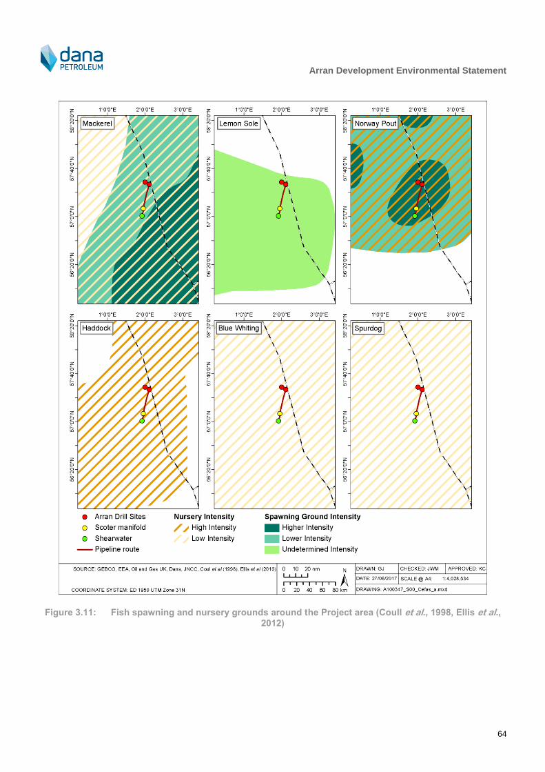
Arran Development Environmental Statement
64
Figure 3.11: Fish spawning and nursery grounds around the Project area (Coull et al., 1998, Ellis et al., 2012)
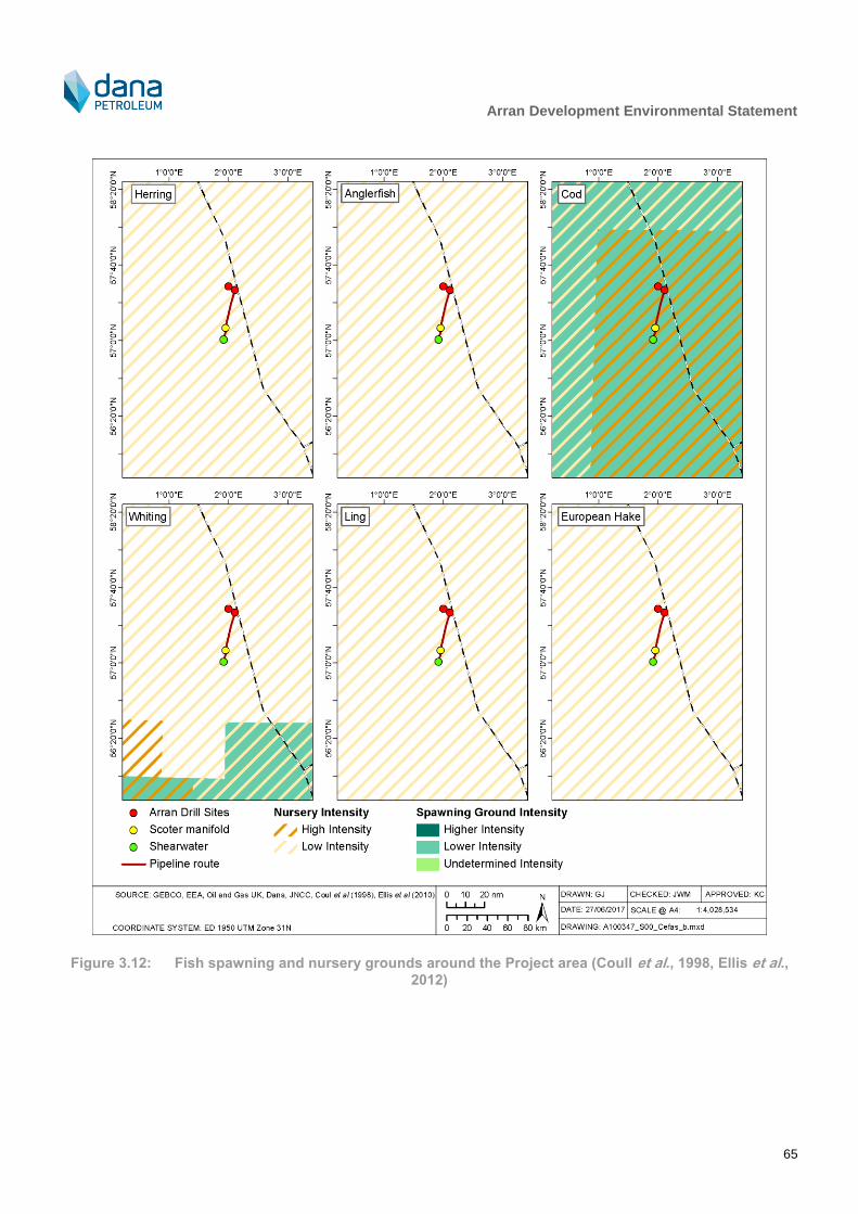
Arran Development Environmental Statement
65
Figure 3.12: Fish spawning and nursery grounds around the Project area (Coull et al., 1998, Ellis et al., 2012)
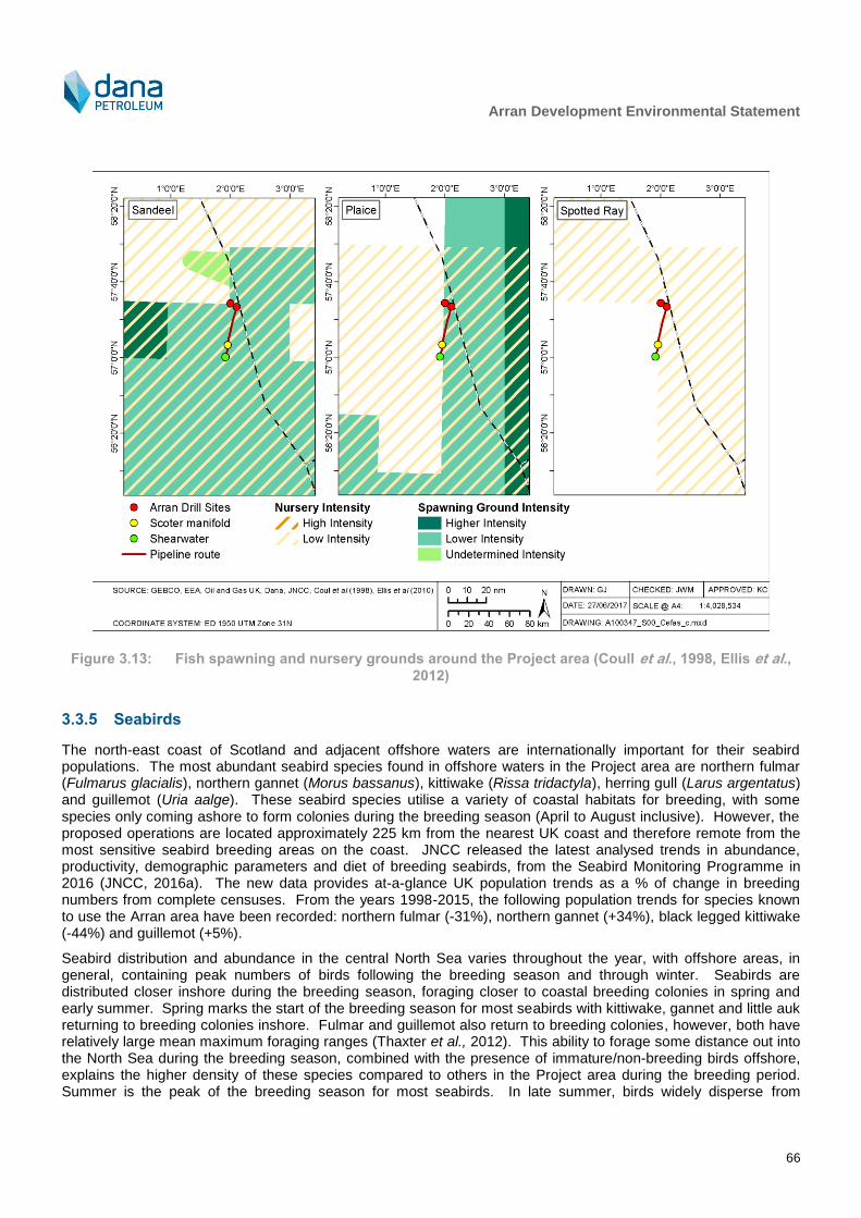
Arran Development Environmental Statement
66
Figure 3.13: Fish spawning and nursery grounds around the Project area (Coull et al., 1998, Ellis et al., 2012)
3.3.5 Seabirds
The north-east coast of Scotland and adjacent offshore waters are internationally important for their seabird populations. The most abundant seabird species found in offshore waters in the Project area are northern fulmar (Fulmarus glacialis), northern gannet (Morus bassanus), kittiwake (Rissa tridactyla), herring gull (Larus argentatus) and guillemot (Uria aalge). These seabird species utilise a variety of coastal habitats for breeding, with some species only coming ashore to form colonies during the breeding season (April to August inclusive). However, the proposed operations are located approximately 225 km from the nearest UK coast and therefore remote from the most sensitive seabird breeding areas on the coast. JNCC released the latest analysed trends in abundance, productivity, demographic parameters and diet of breeding seabirds, from the Seabird Monitoring Programme in 2016 (JNCC, 2016a). The new data provides at-a-glance UK population trends as a % of change in breeding numbers from complete censuses. From the years 1998-2015, the following population trends for species known to use the Arran area have been recorded: northern fulmar (-31%), northern gannet (+34%), black legged kittiwake (-44%) and guillemot (+5%).
Seabird distribution and abundance in the central North Sea varies throughout the year, with offshore areas, in general, containing peak numbers of birds following the breeding season and through winter. Seabirds are distributed closer inshore during the breeding season, foraging closer to coastal breeding colonies in spring and early summer. Spring marks the start of the breeding season for most seabirds with kittiwake, gannet and little auk returning to breeding colonies inshore. Fulmar and guillemot also return to breeding colonies, however, both have relatively large mean maximum foraging ranges (Thaxter et al., 2012). This ability to forage some distance out into the North Sea during the breeding season, combined with the presence of immature/non-breeding birds offshore, explains the higher density of these species compared to others in the Project area during the breeding period. Summer is the peak of the breeding season for most seabirds. In late summer, birds widely disperse from

Arran Development Environmental Statement
67
breeding colonies into many areas of the North Sea. Seabirds continue to disperse into the North Sea during autumn. Great black-backed and herring gull move from Norway into the North Sea. Fulmar remain numerous and widespread across the northern and central North Sea. Kittiwake distribution moves further south with large numbers of birds found off the Yorkshire coast.
Oil & Gas UK conducted a series of seabird surveys to assess the distribution and abundance of both onshore and offshore seabird populations. From these surveys the ‘Seabird Oil Sensitivity Index’ (SOSI) has been compiled to assess the possible threat of surface pollution to seabirds (JNCC, 2016b). This index is based on the following information:
The amount of time spent in the water;
The extent to which species are reliant on the marine environment; and
The rate at which the population is able to recover with low numbers.
Table 3.5 presents the SOSI for Blocks occupied by and surrounding the Project area. For blocks with no data, values have been populated using the method provided by JNCC (2016b), whereby data from nearby months or blocks are used in lieu of the missing data. Figure 3.14 and Figure 3.15 visually present seabird vulnerability to oiling in and around the Project area. Vulnerability is categorised as low throughout the year with data missing for some blocks in April and November. There are no periods of elevated concern with regards to seabirds and hydrocarbon release reported for the blocks of interest (OGA, 2017).
Table 3.5: Seabird vulnerability to oil pollution in the vicinity of the Project (JNCC, 2016b)
Block J F M A M J J A S O N D
22/10 5 5 5 5 5 5 5 5 5 5 N 5
23/6 5 5 5 N 5 5 5 5 5 5 N 5
22/20 5 5 5 N 5 5 5 5 5 5 N 5
23/16 5 5 5 N 5 5 5 5 5 5 N 5
23/17 5 5 5 N 5 5 5 5 5 5 N 5
22/25 5 5 5 5 5 5 5 5 5 5 N 5
23/21 5 5 5 N 5 5 5 5 5 5 N 5
23/22 5 5 5 N 5 5 5 5 5 5 N 5
Key: 1- Extremely High, 2 – Very High, 3 – High, 4 – Moderate, 5 – Low, N – No Data

Arran Development Environmental Statement
68
Figure 3.14: Seabird vulnerability within the vicinity of the Project area (JNCC, 2016b)

Arran Development Environmental Statement
69
Figure 3.15: Seabird vulnerability within the vicinity of the Project area (JNCC, 2016b)
Arran Development Environmental Statement
70
3.3.6 Cetaceans
Six cetacean species occur regularly over large areas of the North Sea: harbour porpoise (Phocoena phocoena), bottlenose dolphin (Tursiops truncatus), white-beaked dolphin (Lagenorhynchus albirostris), Atlantic white-sided dolphin (Lagenorhynchus acutus), killer whale (Orcinus orca) and minke whale (Balaenoptera acutorostrata). A further four cetacean species, Risso’s dolphin (Grampus griseus), common dolphin (Delphinus delphis), long-finned pilot whale (Globicephala melas) and sperm whale (Physeter macrocephalus) are also considered to use the North Sea as a key part of their range. A further eleven cetacean species have been recorded as occasional visitors in the North Sea (Reid et al., 2003).
Surveys undertaken for the ‘Small Cetaceans in the European Atlantic and North Sea (SCANS-III)’ project identified harbour porpoise as the most abundant cetacean species in the Project area, followed by minke whale (Hammond et al., 2017).
As shown in Table 3.6, in the immediate vicinity of the Project area, four species of cetacean (harbour porpoise, minke whale, white-beaked dolphin and Atlantic white-sided dolphin) have been recorded (BODC, 1998, Reid et al., 2003) in moderate to low densities.
Table 3.6: Cetacean occurrence in the Project area (Reid et al., 2003)
Species Description of occurrence
Harbour porpoise The harbour porpoise is frequently found throughout the UK waters. They usually occur in groups of one to three individuals in shallow waters, although they have been sighted in larger groups and in deep water. It is not thought that the species migrate.
Minke whale Minke whales usually occur in water depths of 200 m or less throughout the northern and central North Sea. They are usually sighted in pairs or in solitude; however, groups of up to 15 individuals can be sighted feeding (Reid et al., 2003). It appears that animals return to the same seasonal feeding grounds (Reid et al., 2003).
3.3.7 Seals
Both grey (Halichoerus grypus) and harbour seals (Phoca vitulina) are resident in UK waters and are widespread along the coastline of eastern Scotland. Grey and harbour seals are protected under Annex II of the EU Habitats Directive (92/43/EEC as amended by 97/62/EC).
Grey and harbour seals will feed both in inshore and offshore waters depending on the distribution of their prey, which changes both seasonally and yearly. Both species tend to be concentrated close to shore, particularly during the pupping and moulting season. Seal tracking studies from the Moray Firth have indicated that the foraging movements of harbour seals are generally restricted to within a 40 – 50 km range of their haul-out sites (SCOS, 2014). The movements of grey seals can involve greater distances than those of the harbour seal, and trips of several hundred km from one haul-out to another have been recorded (SMRU, 2011). As the Project area is located approximately 225 km offshore, these species may be encountered in the vicinity from time to time, but are unlikely to use the area with any regularity or in great numbers. This is confirmed by the latest grey and harbour seal density maps which report the presence of grey and harbour seals in the Project area between zero and one individual per 25 km
2 (Russell et al., 2017).
3.4 Conservation
Figure 3.16 shows conservation areas in the vicinity of the Project area. The East of Gannet and Montrose Fields NCMPA is located approximately 21 km to the west of the Project. This NCMPA lies within a shallow sediment plain in the central North Sea. The NCMPA is designated due to the presence of sandy seabed which is suitable habitat for the A. islandica, a large mollusc considered to be threatened and/or declining across the north-east Atlantic. The southern part of the designated NCMPA includes one of very few examples of deep-sea mud on the continental shelf in the North Sea. The area supports diverse faunal communities that include sea urchins, sea cucumbers, worms and molluscs (JNCC, 2014). OSPAR (2009a) indicates the greatest threat to A. islandica from human activities comes from fishing, harvesting and sand/gravel extraction. A total of 24 A. islandica were
Arran Development Environmental Statement
71
recorded from the Arran field and pipeline route during the 2015 surveys, the majority of which were juvenile specimens (Gardline, 2015b).
The closest site designated for Annex I features under the Habitats Directive is the Scanner Pockmarks SAC, located approximately 103 km to the north (Figure 3.16). This is designated for ‘submarine features made by leaking gases’. As detailed in Section 3.2.2, MDAC, which is listed as such an Annex I feature, was observed south of Arran North during the 2015 survey campaign (see Figure 3.7).
The closest MCZ is the Fulmar MCZ, located approximately 47 km to the south of Shearwater. The Fulmar MCZ is designated on account of subtidal mud and subtidal sand, with some mixed sediment patches. The sediments provide a stable habitat, supporting a diverse range of marine life including A. islandica.
Cetaceans are the European Protected Species (EPS) most likely to be recorded in the region, even if only in low numbers. EPS are species protected by law throughout the EU listed in Annexes II and IV of the Habitats Directive 92/43/EEC. The European sturgeon Acipenser sturio and leatherback turtle are also classed as EPS and occur in UK waters, although the Project area is located at the furthest extent of their ranges and their occurrence in any numbers is unlikely.
The only species listed on Annex II of the EC Habitats Directive that is likely to occur in the vicinity of the Project area with any regularity is the harbour porpoise. The harbour porpoise is the most common cetacean in UK waters, being widely distributed and abundant throughout the majority of UK shelf seas, both inshore and offshore. Due to the species’ wide geographical distribution and the lack of knowledge with regards to their feeding and breeding habitats, there has been difficulty in selecting sites essential for their life and reproduction, as required under the Habitats Directive. Although potential calving grounds have been identified in the German North Sea (Sonntag et al., 1999) no such areas are currently recognised in UK waters. Grey and harbour seals are also Annex II species but due to the distance from shore they are unlikely to be present in any significant numbers in the area. The Southern North Sea candidate SAC (cSAC), located approximately 182 km south of Shearwater, has been proposed based on the presence of harbour porpoise.
The basking shark and spiny dogfish are classed as vulnerable under the International Union for Conservation of Nature (IUCN) Red list. The blue shark is classed as near threatened. In addition, basking sharks are protected under the Wildlife and Countryside Act 1981 (as amended).
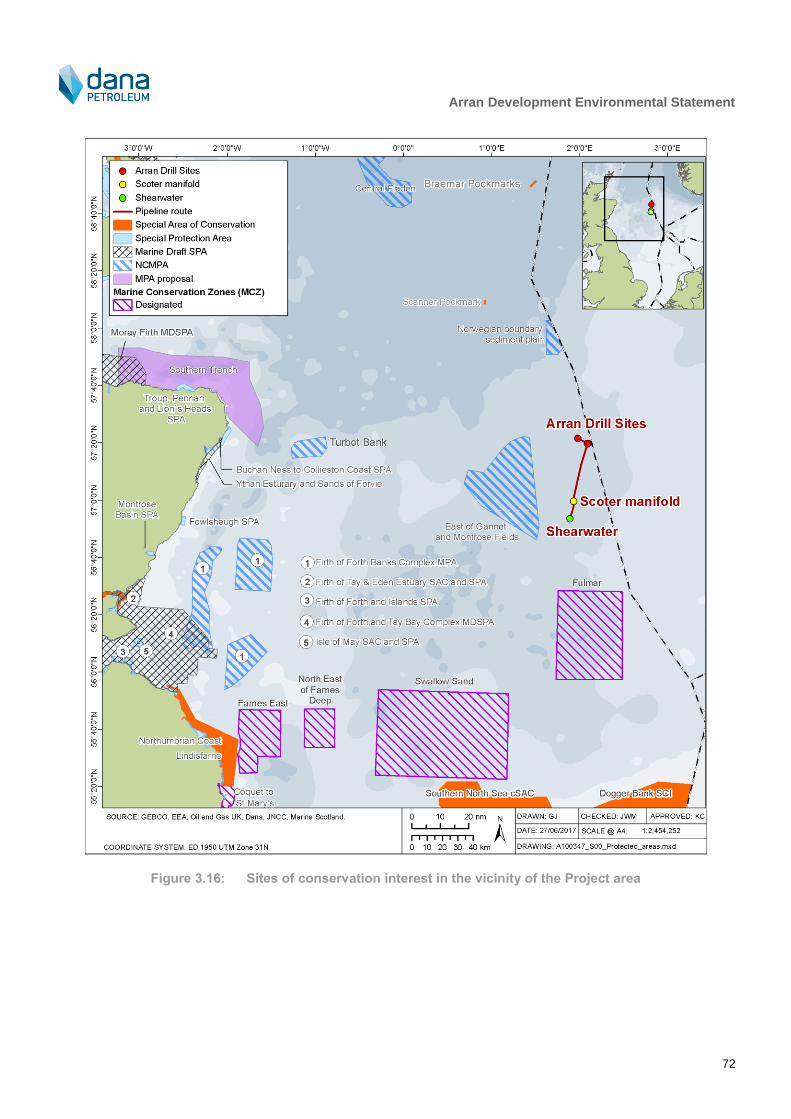
Arran Development Environmental Statement
72
Figure 3.16: Sites of conservation interest in the vicinity of the Project area

Arran Development Environmental Statement
73
Table 3.7: Conservation sites within 200 km of the Project
Conservation site Qualifying interest Distance from Project (km)
(nearest point)
East of Gannet and Montrose Fields NCMPA
Offshore deep sea mud and A. islandica
22
Fulmar MCZ (designated) Offshore deep sea mud and A. islandica
47
Norwegian Boundary Sediment Plain NCMPA
A. islandica 56
Scanner Pockmark Site of Community Importance (SCI)
Submarine structures made by leaking gas
107
Swallow Sand MCZ (designated) Subtidal sand and coarse sediment and North Sea glacial tunnel valleys
121
Turbot Bank NCMPA Sandeel 163
Southern North Sea cSAC Harbour porpoise 182
Central Fladen NCMPA Burrowed mud and sub-glacial tunnel 188
Firth of Forth Banks Complex MPA A. islandica, offshore subtidal sands and gravel, shelf banks and mounds and moraines.
195
3.5 Socio-Economic Environment
3.5.1 Commercial fisheries
The North Sea has important fishing grounds and is fished throughout by both UK and international fishing fleets, targeting demersal, pelagic and shellfish fish stocks. The Project lies within International Council for the Exploration of the Sea (ICES) statistical rectangles 43F1, 43F2 and 44F2. Table 3.8 lists the live weight and economic value of fish and shellfish landings into Scotland from 43F1, 43F2 and 44F2 in 2015 (Scottish Government, 2017).
Shellfish landings comprise 79% of the liveweight and 54% of the monetary value of the total catch from ICES rectangle 43F1, whilst demersal contributes 46% and 21% of the liveweight and value respectively and the pelagic fishery contributes less than 1% of both. The information on the liveweight landings and monetary value for 43F2 is disclosive therefore the information cannot be broken out into species type. Where results are given as “D”, fewer than five vessels (of more than 10 m in length) undertook fishing activity in this rectangle year and to ensure anonymity the Scottish Government does not release details of effort for that rectangle. In rectangle 44F2, the absence of data for this rectangle indicates that no UK vessels and/or foreign vessels landings into the UK undertook fishing activity in rectangle 44F2 in 2016. The effort and landings value of catch are considered low compared to the wider North Sea area (NMPI, 2018). In addition to this low effort, it is thought that there is limited foreign fishing activity (SFF, pers. comm.).
Logbooks submitted by fishermen ordinarily allow the seasonal pattern of fishing effort to be examined (Table 3.9). However, the limited fishing in the Project area means that data were only available for three months in ICES rectangle 43F1.
There are no sites of aquaculture cultivation or protected shellfish waters on the coastline closest to the Arran Development.

Arran Development Environmental Statement
74
Table 3.8: UK landings from ICES rectangles 43F1 and 43F2 (Scottish Government, 2017)
Species type
43F1 43F2
Live-weight (tonnes) Value (£) Live-weight (tonnes) Value (£)
Demersal 106 136,761 D D
Shellfish 127 528,622 D D
Pelagic 1 967 D D
Total 234 666,349 D D
Table 3.9: Number of days fished per month (all gears) in ICES rectangles 43F1, 43F2 and 44F2 in 2015
(Scottish Government, 2017)
Year J F M A M J J A S O N D Total
ICES rectangle 43F1
2016 D D 20 D 59 nd D D 149 14 nd 13 272
ICES rectangle 43F2
2016 nd nd nd nd nd nd D nd D nd nd nd D
ICES rectangle 44F2
2016 nd nd nd nd nd nd nd nd nd nd nd nd nd
Note: Monthly fishing effort by UK vessels landing into Scotland: green = 0 – 100 days fished, yellow = 101 – 200, orange =201-300, red = ≥301, D = Disclosive, nd= no data.
3.5.2 Oil and gas activities
Blocks 22/30, 23/11, 23/16 and 23/21 are all licenced for oil and gas development (Figure 3.17). Table 3.10 lists development within 40 km of the Arran Development area.
Table 3.10: Oil and gas installations in the vicinity of the Project area
Installation Approximate distance from nearest point of Project infrastructure (km)
Mungo 5
Elgin 7
Erskine 7
Lomond 8
Pierce FPSO Haewene Brim 18
Pierce FPSO 18
Eastern Trough Area Project (ETAP) 23
Jade 27

Arran Development Environmental Statement
75
Installation Approximate distance from nearest point of Project infrastructure (km)
Banff 38
3.5.3 Military activity
There are no designated military or submarine exercise areas in the vicinity of Project area (UK Government, 2015). Naval and air force exercise areas are predominantly concentrated in more coastal regions, around the Firth of Forth and around the coast of the Shetland and Orkney Isles (UK Government, 2015).
3.5.4 Shipping activity
The North Sea contains some of the world’s busiest shipping routes, with significant traffic generated by vessels trading between ports at either side of the North Sea and the Baltic. North Sea oil and gas fields also generate moderate vessel traffic in the form of support vessels (DECC, 2016).
An average of between 0.1 to 5 vessels per week pass the vicinity of the Project area with the majority of traffic consisting of small to medium sized cargo ships and tankers (MMO, 2014). Other vessels that pass within the vicinity of the Project area include dredging or underwater operation vessels and fishing vessels.
3.5.5 Renewables
The UK Offshore Energy Strategic Environmental Assessment 3 (OESEA 3) Consultation (DECC, 2016) considers licensing and leasing for renewable energy, oil and gas, and carbon transportation and storage throughout UK waters. The conclusion of the SEA is to restrict the areas offered for leasing and licensing, temporally or spatially through the exclusion of certain areas together with a number of mitigation measures to prevent, reduce and offset significant adverse impacts on the environment and other users of the sea. Currently there is no renewable activity in the vicinity of the Project.
3.5.6 Cables and pipelines
The Project crosses the Central North Sea fibre optic cable and the Lomond – Everest line that runs alongside it on two occasions; once between Arran North and Arran South, and once between Arran South and Scoter manifold. The only other crossing is of the pipeline feeding into the ETAP gathering system, between Scoter manifold and Shearwater.
3.5.7 Archaeology
NMPI (2017) shows a number of wreck sites in the blocks within which the Arran Development will be located. However, none are likely to be found close to the proposed subsea infrastructure, and no archaeological features of interest were identified in the 2015 survey campaign (Gardline, 2015b).

Arran Development Environmental Statement
76
Figure 3.17: Other sea users activity in the vicinity of the Project area

Arran Development Environmental Statement
77
4 EIA Methodology
4.1 EIA Overview
Offshore activities can involve a number of environmental interactions and impacts due, for example, to operational emissions and discharges and general disturbance. The objective of the EIA process is to incorporate environmental considerations into the Project planning, to ensure that best environmental practice is followed and, ultimately, to achieve a high standard of environmental performance and protection. The process also allows for any potential concerns identified by stakeholders to be addressed appropriately. In addition, it ensures that the planned activities are compliant with legislative requirements and Dana’s Health, Safety, Security and Environment policy.
4.2 Environmental Issues Identification, including stakeholder consultation
The main objective of the ENVID process is to identify the key potential environmental issues requiring discussion and assessment, and to agree practicable measures (mitigation) to eliminate or minimise harm to the environment. The ENVID process was initiated at an early stage within the Project and formed an integral part of the scoping phase with the relevant consultees. To solicit feedback on the proposed activities, Dana issued a letter to relevant stakeholders, which outlined the proposed activities and EIA scope and requested feedback on the proposals. Key issues that were raised included:
Ensuring sufficient justification of Project decisions in the ES;
Use of the most up to date, relevant baseline environmental and societal data for the assessment of potential impact; and
Consideration of the potential impacts of the proposed activities on fisheries, specifically potential snag risk from trenching activities.
A full list of issues raised by consultees, along with Dana’s response, is given in Appendix A.
The ENVID process was kept under review through the EIA, with mitigation revised as understanding of the Project increased and based on consultee feedback. The key issues that were assessed in this ES are therefore a combination of issues identified as significant during the early ENVID process (including ENVID workshop, the output of which is detailed in Appendix B
11), issues of importance raised by consultees, and issues that have
become clearer with enhanced Project definition.
4.3 Human Health
Human health impacts from routine and accidental events were considered during the EIA and were determined to largely require no further assessment within the EIA process, especially since activities will be managed to meet industry requirements for safe operations. Section 5.4 describes possible local air quality issues associated with the Project.
4.4 Environmental Significance
4.4.1 Overview
The EIA Regulations require that the EIA should consider the likely potentially significant impacts of a project on the environment. The decision process related to defining whether or not a project is likely to significantly impact on the environment is the core principle of the EIA process. The EIA Regulations themselves do not provide a specific definition of significance. However, the methods used for identifying and assessing potential impacts should be transparent and verifiable.
11
Note: the ENVID workshop appendix reflects the information available at the time the workshop was taken and should not be
viewed as a record of the final impact assessment (the final record is presented within the main body of this document).

Arran Development Environmental Statement
78
The method presented here has been developed by reference to the Institute of Ecology and Environmental Management (IEEM) guidelines for marine impact assessment (IEEM, 2010), the Marine Life Information Network (MarLIN) species and ecosystem sensitivities guidelines (Tyler-Walters et al., 2001) and guidance provided by Scottish Natural Heritage (SNH) in their handbook on EIA (SNH, 2013).
Once the scope of the EIA studies has been established, it is important to standardise the assessment of potential impacts. Despite this being a subjective process, the use of a defined methodology framework, as outlined below, makes the assessment of environmental significance as objective and transparent as possible and consistent between different topics.
The significance of any potential impact, whether that is direct or indirect (both of which are considered within this EIA), is determined through the use of a risk assessment approach which employs the standard risk assessment philosophy of:
Magnitude of potential impact (consequence) x likelihood of occurrence (frequency/probability) = Risk
The following sections describe the criteria that have been used to assess the significance of potential impacts.
4.4.2 Consequence of potential impact
The consequence of each potential impact (Table 4.1) is considered against the following two drivers:
Potential environmental impact: Consideration of potential environmental sensitivities and scientific evidence on potential environmental impacts; and
Stakeholder concern: Consideration of other users (potential conflict/ concern resolution), interest groups, media and the general public (wider concern), and perceived potential impacts.
This approach allows important consideration of public perception of a project as well as quantitative risk assessment of potential environmental sensitivity based on available data.
Once each of the two consequences has been assessed, a final single consequence rating for the potential impact (prior to mitigation) must be assigned. Overall ranking is undertaken using agreed rules applied by experienced assessors. Key rules employed are:
A potential impact rated as severe by either of the consequence drivers remains severe;
A potential impact rated as moderate for one of the two drivers is seriously considered for major ranking in the overall ranking;
All lower rankings are examined for important negative criteria before overall ranking can be considered negligible; and
In cases of uncertainty, the highest ranking of the two should be taken as the final ranking.
Table 4.1: Environmental consequence criteria definitions
Category Potential environmental impact Stakeholder concern
Severe
Regional (widespread) potential impact on the quality or availability of a habitat and/or wildlife with no recovery expected or irreversible alteration (permanent).
Long-term effect on the conservation objectives of nationally/internationally protected sites, habitats or populations.
Major transboundary effects expected.
Major contribution to cumulative effects.
International concern and extensive international media interest likely.
Well established and widely held areas of concern, including perception of threat to the global environment.
Decrease in the availability or quality of a resource to the extent of affecting over five plus years the wellbeing of the persons using that resource (e.g. fishing access or recreational use).
Potential major effect on health.
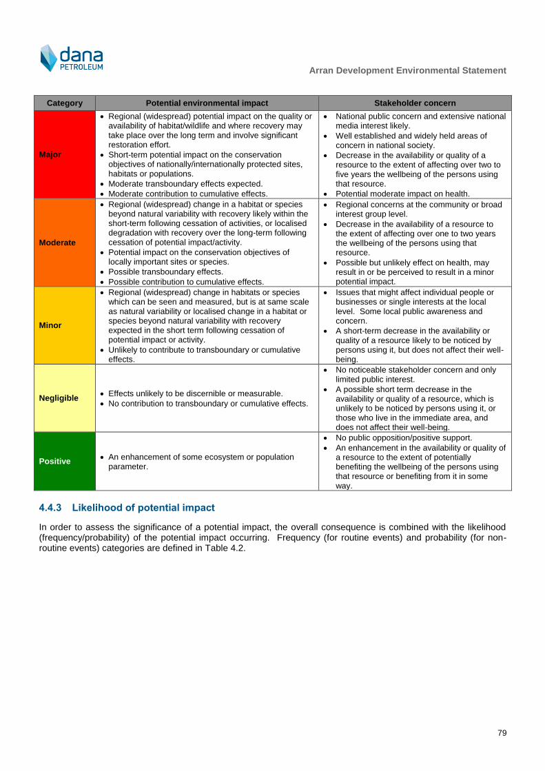
Arran Development Environmental Statement
79
Category Potential environmental impact Stakeholder concern
Major
Regional (widespread) potential impact on the quality or availability of habitat/wildlife and where recovery may take place over the long term and involve significant restoration effort.
Short-term potential impact on the conservation objectives of nationally/internationally protected sites, habitats or populations.
Moderate transboundary effects expected.
Moderate contribution to cumulative effects.
National public concern and extensive national media interest likely.
Well established and widely held areas of concern in national society.
Decrease in the availability or quality of a resource to the extent of affecting over two to five years the wellbeing of the persons using that resource.
Potential moderate impact on health.
Moderate
Regional (widespread) change in a habitat or species beyond natural variability with recovery likely within the short-term following cessation of activities, or localised degradation with recovery over the long-term following cessation of potential impact/activity.
Potential impact on the conservation objectives of locally important sites or species.
Possible transboundary effects.
Possible contribution to cumulative effects.
Regional concerns at the community or broad interest group level.
Decrease in the availability of a resource to the extent of affecting over one to two years the wellbeing of the persons using that resource.
Possible but unlikely effect on health, may result in or be perceived to result in a minor potential impact.
Minor
Regional (widespread) change in habitats or species which can be seen and measured, but is at same scale as natural variability or localised change in a habitat or species beyond natural variability with recovery expected in the short term following cessation of potential impact or activity.
Unlikely to contribute to transboundary or cumulative effects.
Issues that might affect individual people or businesses or single interests at the local level. Some local public awareness and concern.
A short-term decrease in the availability or quality of a resource likely to be noticed by persons using it, but does not affect their well-being.
Negligible Effects unlikely to be discernible or measurable.
No contribution to transboundary or cumulative effects.
No noticeable stakeholder concern and only limited public interest.
A possible short term decrease in the availability or quality of a resource, which is unlikely to be noticed by persons using it, or those who live in the immediate area, and does not affect their well-being.
Positive An enhancement of some ecosystem or population
parameter.
No public opposition/positive support.
An enhancement in the availability or quality of a resource to the extent of potentially benefiting the wellbeing of the persons using that resource or benefiting from it in some way.
4.4.3 Likelihood of potential impact
In order to assess the significance of a potential impact, the overall consequence is combined with the likelihood (frequency/probability) of the potential impact occurring. Frequency (for routine events) and probability (for non-routine events) categories are defined in Table 4.2.

Arran Development Environmental Statement
80
Table 4.2: Likelihood guidance
Likelihood category
Routine (planned) operation frequency Accidental event probability
5 Continuous emission or activity over life of field or Project
Likely
More than once per year
Event likely to occur more than once on the facility
4
Regular emission or activity
Once per year for ≤ 6 months OR
Once per month for ≤ 15 days OR
Once per day for ≤ 12 hours
Possible
One in 10 years
Could occur within the life time of the Project
3
Intermittent emission or activity
Once per year for ≤1 month OR
Once per month for ≤ 3 days OR
Once per day for ≤ 2 hours
Unlikely
One in 100 years
Event could occur within life time of 10 similar facilities. Has occurred at similar facilities.
2
Infrequent emission or activity
One off event or activity over the life time of development > 10 days duration OR
Once per year for ≤ 5 days OR
Once per month for ≤ 8 hours
Remote
One in 1,000 years
Similar event has occurred somewhere in industry or similar industry but not likely to occur with current practices and procedures.
1 One off event or activity of ≤ 10 days duration
Extremely remote
One in 10,000 years
Has never occurred within industry or similar industry but theoretically possible.
0 Will not occur Not applicable12
4.4.4 Overall risk and potential impact significance
For every potential impact, the potential risk is obtained by combining the consequence and likelihood via the matrix presented in Table 4.3. Both significance and likelihood are semi-quantitative representing best judgements on the basis of knowledge and experience available. A matrix allows a consistent basis for presenting such a broad-based risk assessment. Interpretation of the overall risk in terms of potential impact significance can then be undertaken (Table 4.4).
12
It is not possible to conclude with complete certainty that an accidental event would not happen and thus this option is not
made available in the EIA.
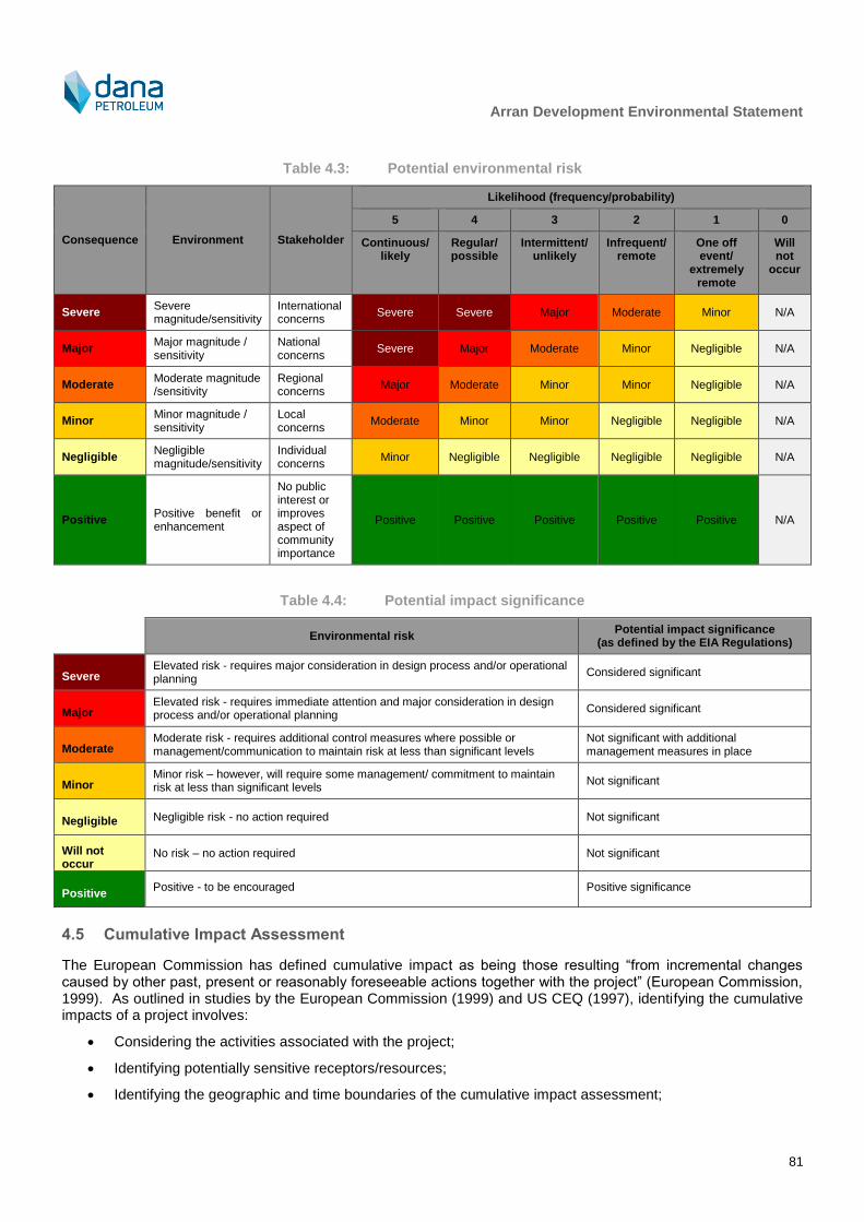
Arran Development Environmental Statement
81
Table 4.3: Potential environmental risk
Consequence Environment Stakeholder
Likelihood (frequency/probability)
5 4 3 2 1 0
Continuous/ likely
Regular/ possible
Intermittent/ unlikely
Infrequent/ remote
One off event/
extremely remote
Will not
occur
Severe Severe magnitude/sensitivity
International concerns
Severe Severe Major Moderate Minor N/A
Major Major magnitude / sensitivity
National concerns
Severe Major Moderate Minor Negligible N/A
Moderate Moderate magnitude /sensitivity
Regional concerns
Major Moderate Minor Minor Negligible N/A
Minor Minor magnitude / sensitivity
Local concerns
Moderate Minor Minor Negligible Negligible N/A
Negligible Negligible magnitude/sensitivity
Individual concerns
Minor Negligible Negligible Negligible Negligible N/A
Positive Positive benefit or enhancement
No public interest or improves aspect of community importance
Positive Positive Positive Positive Positive N/A
Table 4.4: Potential impact significance
Environmental risk Potential impact significance
(as defined by the EIA Regulations)
Severe Elevated risk - requires major consideration in design process and/or operational planning
Considered significant
Major Elevated risk - requires immediate attention and major consideration in design process and/or operational planning
Considered significant
Moderate Moderate risk - requires additional control measures where possible or management/communication to maintain risk at less than significant levels
Not significant with additional management measures in place
Minor Minor risk – however, will require some management/ commitment to maintain risk at less than significant levels
Not significant
Negligible Negligible risk - no action required Not significant
Will not occur
No risk – no action required Not significant
Positive Positive - to be encouraged Positive significance
4.5 Cumulative Impact Assessment
The European Commission has defined cumulative impact as being those resulting “from incremental changes caused by other past, present or reasonably foreseeable actions together with the project” (European Commission, 1999). As outlined in studies by the European Commission (1999) and US CEQ (1997), identifying the cumulative impacts of a project involves:
Considering the activities associated with the project;
Identifying potentially sensitive receptors/resources;
Identifying the geographic and time boundaries of the cumulative impact assessment;
Arran Development Environmental Statement
82
Identifying past, present and future actions which may also impact the sensitive receptors/resources;
Identifying impacts arising from the proposed activities; and
Identifying which impacts on these resources are important from a cumulative impacts perspective.
To assist the assessment of cumulative impacts, a review of existing and forthcoming developments (including oil and gas, cables and renewables) that could have the potential to interact with the Project was undertaken; the output of this review is reported in the Environment Description (Section 3.5). The impact assessment has considered these projects when defining the potential for cumulative impact (Chapter 5).
4.6 Transboundary Impact Assessment
The EIA Directive requires special procedures in the case that a project may have potentially significant impacts on the environment of other countries. For the purposes of providing adequate and effective consultation, any country which may be an affected party should be consulted. The impact assessment presented in Chapter 5 contains sections which identify the potential for, and where appropriate, assessment of transboundary impacts. For the Arran Development, this is an important issue for consideration given the proximity to the UK/Norway median line (approximately 3 km).
4.7 Habitats Regulation Appraisal
Under Article 6.3 of the Habitats Directive, it is the responsibility of the Competent Authority13
to make an Appropriate Assessment of the implications of a plan, programme or in this case project, alone or in combination, on a Natura site (SAC or SPA) in view of the site’s conservation objectives and the overall integrity of the site.
As part of the assessment of impacts on key receptors, for those receptors that are a qualifying feature of a Natura site, relevant information on SACs or SPAs has also been provided as part of the impact assessment process. This information will then be used by the Competent Authority to determine the need for, and subsequently carry out (if required), an appropriate assessment of the project.
As outlined in Section 1.4, there is an analogous process for NCMPAs and MCZs that are designated under the Marine (Scotland) Act 2010 and the Marine and Coastal Access Act 2009.
4.8 Data Gaps and Uncertainties
The North Sea has been extensively investigated by numerous researchers, meaning that this EIA has been able to draw on a significant volume of published data. This bank of published data has been supplemented by a site survey programme and studies undertaken on behalf of Dana to collect Project specific-baseline data, ensuring a robust baseline is available against which to assess impact.
The EIA process aims to identify and characterise potential impacts using information on the current status of the environment as a basis. As potential impacts are predicted based on currently available Project and environmental information, there is some uncertainty in predictions. Impact predictions are based on Project-specific surveys and the most up to date scientific knowledge and data analysis techniques currently available. Where appropriate, studies have been commissioned to inform the impact assessment, including:
Drill cuttings dispersion modelling, to assist in predicting the fate and impacts of cuttings discharged to the seabed from the drilling process;
Accidental hydrocarbon release modelling, to facilitate assessment of the impacts from worst case scenarios regarding a possible condensate release from a well blowout or loss of pipeline inventory; and
Underwater noise modelling, to predict the impacts of loud underwater noise on marine mammals resulting from hammer piling and vessel use during the Project.
When evaluating and characterising potential impacts that could be associated with the Project, a variety of inputs are used, including baseline environmental data, engineering design data, worst case assumptions, modelling
13
Competent Authority is the authority responsible for determining all permit/licence applications. For oil and gas projects located in UK waters the Competent Authority is OPRED.

Arran Development Environmental Statement
83
results, estimation of emissions and Project footprint. These inputs carry varying levels of uncertainty and conservatism (e.g. the final dimensions of seabed structures will not be confirmed until later in the Detailed Design phase of the Project) and although potential impacts may occur, they are not certain to occur (for example, there is some uncertainty in marine mammal response to certain noise emissions). As such, all the potential impacts (whether predicted, residual, cumulative or transboundary) described in this ES are to a greater or lesser extent potential impacts which may or may not occur. To account for this uncertainty, worst case assumptions have been made, and where key uncertainties exist they have been outlined within the relevant section of the impact assessment (Chapter 5).

Arran Development Environmental Statement
84
5 Impact Assessment
5.1 Introduction
The key issues identified for assessment during the EIA process are as follows:
1) Discharges to sea
a) Discharge of drilling muds, cuttings, cementing and completion chemicals from drilling operations, routine chemical use and discharge to sea during pipeline installation and commissioning and discharge of produced water during operation, resulting in changes in water quality, localised and temporarily increased suspended solid concentrations, and possible impacts to organisms in the water column and on the seabed.
2) Physical presence
a) Seabed disturbance
i) Direct loss of benthic species and seabed habitat, wider indirect disturbance to the benthic environment through the suspension and re-settlement of sediments and introduction of new habitat resulting from installation of structures, use of anchor and placement of rock.
b) Underwater noise
i) Possible injury and disturbance to marine mammals and fish through noise from vessel use and the hammered piling of some seabed structures in the Arran field. For the small-scale nature of the proposed drilling activities, the noise emissions are of little concern for cetaceans and they are not considered further in this assessment as a standalone emission. However, they have been considered as part of the assessment of cumulative noise emissions.
c) Interactions with other sea users
i) Potential temporary interference with shipping and fishing activities during drilling, installation, loss of access to seabed for fisheries on a temporary or permanent basis, increased risk of vessel collisions through the presence of vessels during drilling, installation activities.
3) Atmospheric emissions
a) Contribution to global greenhouse gases through emission of CO2 and generation of acid rain from NOx and SOx resulting from fuel use during installation and operation and from flaring during well testing, commissioning and operation.
4) Accidental events
a) Potential for toxicity and smothering impacts to marine species and habitats through the release of hydrocarbons and chemicals from a well blowout or pipeline inventory loss and accidental release of chemicals and fuel from vessels
The impact assessment for each of these topics is presented in the following sections.
5.2 Discharges to Sea
5.2.1 Description and quantification of potential impact
Discharges to sea during the drilling phase of the Project include mud, cuttings, cement and clean-up at well test chemicals. Discharges due to installation of subsea infrastructure include chemicals used in pipeline flooding and cleaning, installation and commissioning of spools, manifolds and umbilicals. These discharges may lead to potential impacts to the seabed or water column through the following mechanisms:
Increased suspended solids in the water column;
Settlement of cuttings and muds on the seabed that may:
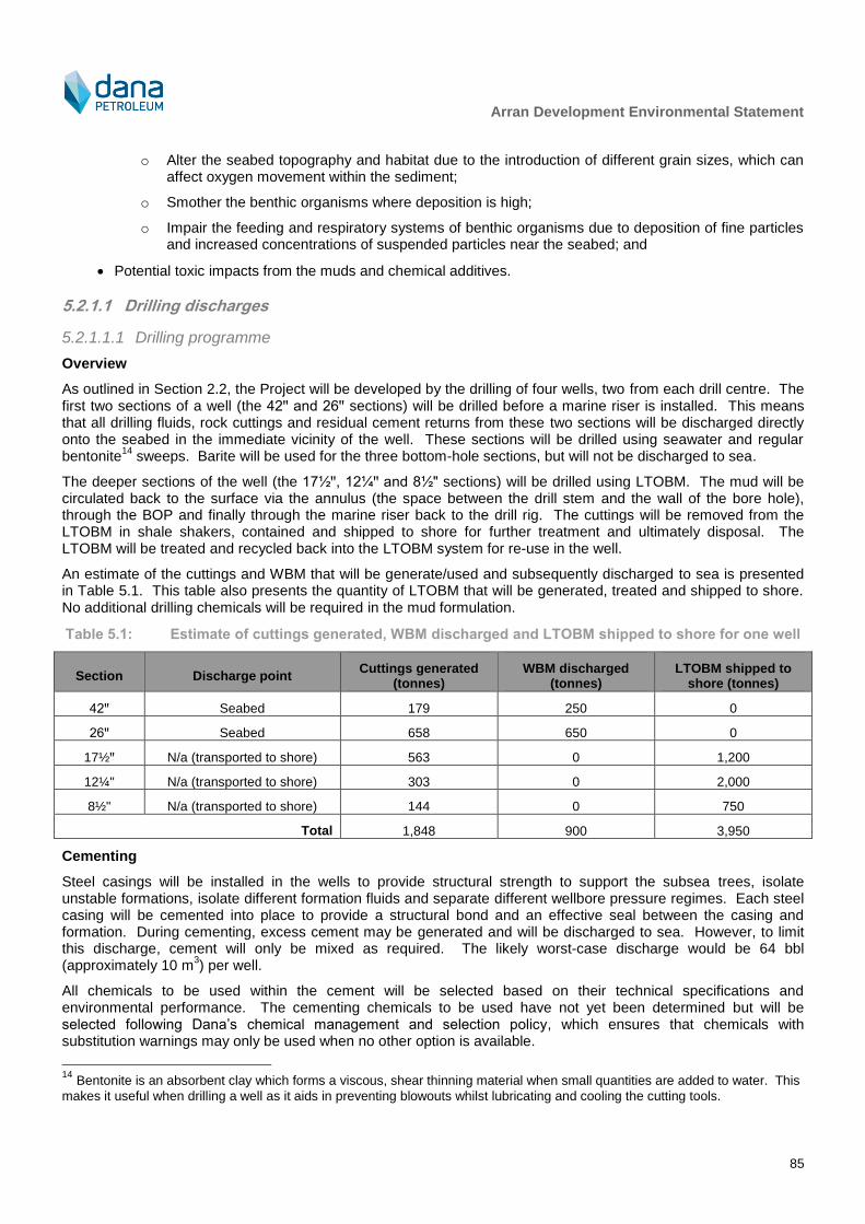
Arran Development Environmental Statement
85
o Alter the seabed topography and habitat due to the introduction of different grain sizes, which can affect oxygen movement within the sediment;
o Smother the benthic organisms where deposition is high;
o Impair the feeding and respiratory systems of benthic organisms due to deposition of fine particles and increased concentrations of suspended particles near the seabed; and
Potential toxic impacts from the muds and chemical additives.
5.2.1.1 Drilling discharges
5.2.1.1.1 Drilling programme
Overview
As outlined in Section 2.2, the Project will be developed by the drilling of four wells, two from each drill centre. The first two sections of a well (the 42ꞌꞌ and 26ꞌꞌ sections) will be drilled before a marine riser is installed. This means that all drilling fluids, rock cuttings and residual cement returns from these two sections will be discharged directly onto the seabed in the immediate vicinity of the well. These sections will be drilled using seawater and regular bentonite
14 sweeps. Barite will be used for the three bottom-hole sections, but will not be discharged to sea.
The deeper sections of the well (the 17½ꞌꞌ, 12¼ꞌꞌ and 8½" sections) will be drilled using LTOBM. The mud will be circulated back to the surface via the annulus (the space between the drill stem and the wall of the bore hole), through the BOP and finally through the marine riser back to the drill rig. The cuttings will be removed from the LTOBM in shale shakers, contained and shipped to shore for further treatment and ultimately disposal. The LTOBM will be treated and recycled back into the LTOBM system for re-use in the well.
An estimate of the cuttings and WBM that will be generate/used and subsequently discharged to sea is presented in Table 5.1. This table also presents the quantity of LTOBM that will be generated, treated and shipped to shore. No additional drilling chemicals will be required in the mud formulation.
Table 5.1: Estimate of cuttings generated, WBM discharged and LTOBM shipped to shore for one well
Section Discharge point Cuttings generated
(tonnes) WBM discharged
(tonnes) LTOBM shipped to
shore (tonnes)
42ꞌꞌ Seabed 179 250 0
26ꞌꞌ Seabed 658 650 0
17½ꞌꞌ N/a (transported to shore) 563 0 1,200
12¼" N/a (transported to shore) 303 0 2,000
8½" N/a (transported to shore) 144 0 750
Total 1,848 900 3,950
Cementing
Steel casings will be installed in the wells to provide structural strength to support the subsea trees, isolate unstable formations, isolate different formation fluids and separate different wellbore pressure regimes. Each steel casing will be cemented into place to provide a structural bond and an effective seal between the casing and formation. During cementing, excess cement may be generated and will be discharged to sea. However, to limit this discharge, cement will only be mixed as required. The likely worst-case discharge would be 64 bbl (approximately 10 m
3) per well.
All chemicals to be used within the cement will be selected based on their technical specifications and environmental performance. The cementing chemicals to be used have not yet been determined but will be selected following Dana’s chemical management and selection policy, which ensures that chemicals with substitution warnings may only be used when no other option is available.
14
Bentonite is an absorbent clay which forms a viscous, shear thinning material when small quantities are added to water. This
makes it useful when drilling a well as it aids in preventing blowouts whilst lubricating and cooling the cutting tools.
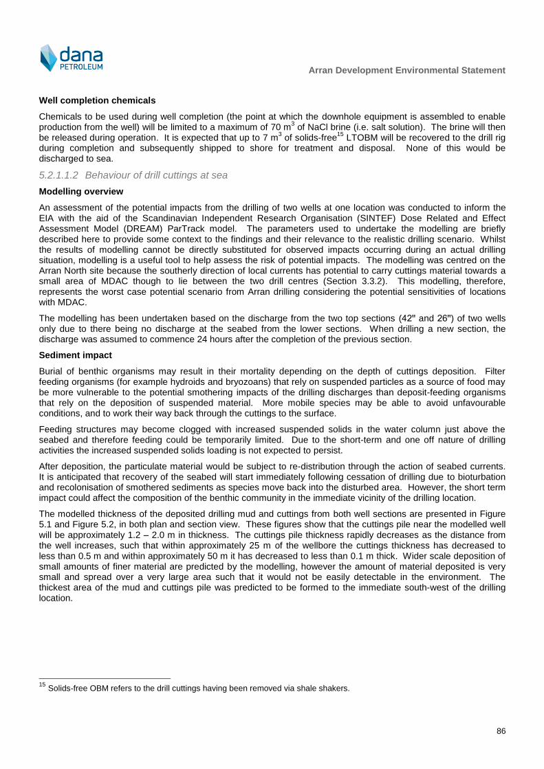
Arran Development Environmental Statement
86
Well completion chemicals
Chemicals to be used during well completion (the point at which the downhole equipment is assembled to enable production from the well) will be limited to a maximum of 70 m
3 of NaCl brine (i.e. salt solution). The brine will then
be released during operation. It is expected that up to 7 m3 of solids-free
15 LTOBM will be recovered to the drill rig
during completion and subsequently shipped to shore for treatment and disposal. None of this would be discharged to sea.
5.2.1.1.2 Behaviour of drill cuttings at sea
Modelling overview
An assessment of the potential impacts from the drilling of two wells at one location was conducted to inform the EIA with the aid of the Scandinavian Independent Research Organisation (SINTEF) Dose Related and Effect Assessment Model (DREAM) ParTrack model. The parameters used to undertake the modelling are briefly described here to provide some context to the findings and their relevance to the realistic drilling scenario. Whilst the results of modelling cannot be directly substituted for observed impacts occurring during an actual drilling situation, modelling is a useful tool to help assess the risk of potential impacts. The modelling was centred on the Arran North site because the southerly direction of local currents has potential to carry cuttings material towards a small area of MDAC though to lie between the two drill centres (Section 3.3.2). This modelling, therefore, represents the worst case potential scenario from Arran drilling considering the potential sensitivities of locations with MDAC.
The modelling has been undertaken based on the discharge from the two top sections (42ꞌꞌ and 26ꞌꞌ) of two wells only due to there being no discharge at the seabed from the lower sections. When drilling a new section, the discharge was assumed to commence 24 hours after the completion of the previous section.
Sediment impact
Burial of benthic organisms may result in their mortality depending on the depth of cuttings deposition. Filter feeding organisms (for example hydroids and bryozoans) that rely on suspended particles as a source of food may be more vulnerable to the potential smothering impacts of the drilling discharges than deposit-feeding organisms that rely on the deposition of suspended material. More mobile species may be able to avoid unfavourable conditions, and to work their way back through the cuttings to the surface.
Feeding structures may become clogged with increased suspended solids in the water column just above the seabed and therefore feeding could be temporarily limited. Due to the short-term and one off nature of drilling activities the increased suspended solids loading is not expected to persist.
After deposition, the particulate material would be subject to re-distribution through the action of seabed currents. It is anticipated that recovery of the seabed will start immediately following cessation of drilling due to bioturbation and recolonisation of smothered sediments as species move back into the disturbed area. However, the short term impact could affect the composition of the benthic community in the immediate vicinity of the drilling location.
The modelled thickness of the deposited drilling mud and cuttings from both well sections are presented in Figure 5.1 and Figure 5.2, in both plan and section view. These figures show that the cuttings pile near the modelled well will be approximately 1.2 – 2.0 m in thickness. The cuttings pile thickness rapidly decreases as the distance from the well increases, such that within approximately 25 m of the wellbore the cuttings thickness has decreased to less than 0.5 m and within approximately 50 m it has decreased to less than 0.1 m thick. Wider scale deposition of small amounts of finer material are predicted by the modelling, however the amount of material deposited is very small and spread over a very large area such that it would not be easily detectable in the environment. The thickest area of the mud and cuttings pile was predicted to be formed to the immediate south-west of the drilling location.
15
Solids-free OBM refers to the drill cuttings having been removed via shale shakers.

Arran Development Environmental Statement
87
Figure 5.1: Mud and cuttings accumulation on the seabed (Note: red arrow is the transect illustrated in
Figure 5.2)
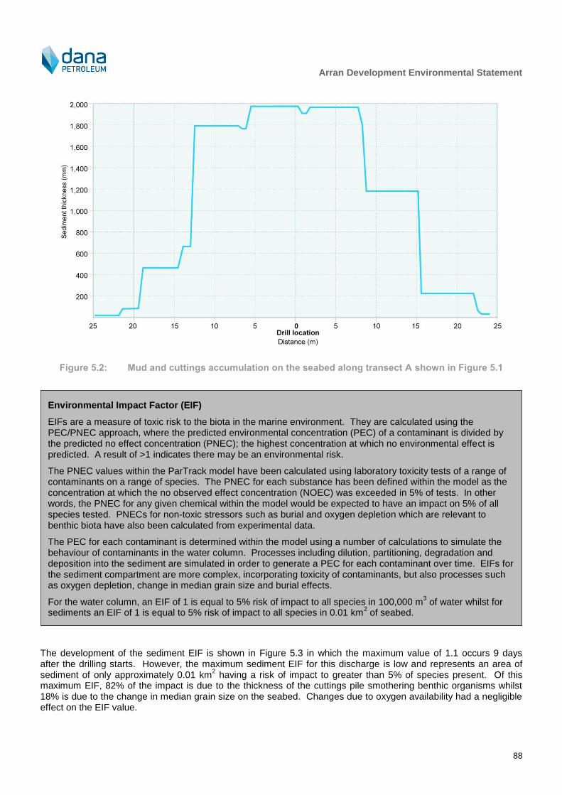
Arran Development Environmental Statement
88
Figure 5.2: Mud and cuttings accumulation on the seabed along transect A shown in Figure 5.1
The development of the sediment EIF is shown in Figure 5.3 in which the maximum value of 1.1 occurs 9 days after the drilling starts. However, the maximum sediment EIF for this discharge is low and represents an area of sediment of only approximately 0.01 km
2 having a risk of impact to greater than 5% of species present. Of this
maximum EIF, 82% of the impact is due to the thickness of the cuttings pile smothering benthic organisms whilst 18% is due to the change in median grain size on the seabed. Changes due to oxygen availability had a negligible effect on the EIF value.
Environmental Impact Factor (EIF)
EIFs are a measure of toxic risk to the biota in the marine environment. They are calculated using the PEC/PNEC approach, where the predicted environmental concentration (PEC) of a contaminant is divided by the predicted no effect concentration (PNEC); the highest concentration at which no environmental effect is predicted. A result of >1 indicates there may be an environmental risk.
The PNEC values within the ParTrack model have been calculated using laboratory toxicity tests of a range of contaminants on a range of species. The PNEC for each substance has been defined within the model as the concentration at which the no observed effect concentration (NOEC) was exceeded in 5% of tests. In other words, the PNEC for any given chemical within the model would be expected to have an impact on 5% of all species tested. PNECs for non-toxic stressors such as burial and oxygen depletion which are relevant to benthic biota have also been calculated from experimental data.
The PEC for each contaminant is determined within the model using a number of calculations to simulate the behaviour of contaminants in the water column. Processes including dilution, partitioning, degradation and deposition into the sediment are simulated in order to generate a PEC for each contaminant over time. EIFs for the sediment compartment are more complex, incorporating toxicity of contaminants, but also processes such as oxygen depletion, change in median grain size and burial effects.
For the water column, an EIF of 1 is equal to 5% risk of impact to all species in 100,000 m3 of water whilst for
sediments an EIF of 1 is equal to 5% risk of impact to all species in 0.01 km2 of seabed.

Arran Development Environmental Statement
89
0
0.2
0.4
0.6
0.8
1
1.20 1 3 4 5 6 8 9
10
11
13
14
15
16
18
19
20
21
23
24
28
43
91
222
372
522
672
822
972
1,1
22
1,2
72
1,4
22
1,5
72
1,7
22
EIF
Time (days)
Grain size
Oxygen
Thickness
Figure 5.3: Sediment impact and recovery (from the start of drilling)
Water column impact
Both the physical and chemical impacts of drilling discharges in the sea can also result in potential impacts to the water column. Discharges to the water column have the potential to affect fish, planktonic organisms and organisms living at or near the seabed. Organisms affected could experience interference with feeding, respiration and migration due to increased concentrations of suspended particles near the seabed and in the water column.
Increased suspended solids, especially near the seabed, may result in direct irritation to certain types of marine organisms, abrading protective mucous coatings and increasing their susceptibility to parasites and infections, as well as affecting growth, reproduction and feeding.
The water column EIF is greatest during the drilling of the tophole section of the well (when discharges will occur at the seabed) but that it returns to zero within two weeks of the drilling ceasing. The magnitude of the EIF varies with the metocean conditions and composition of the discharge with the maximum EIF of 981 occurring after 5 days. Being the only chemical included in the model, and given that the drill cuttings themselves present no toxic effect to marine species in the water column, the bentonite in the cuttings discharge is responsible for 100% of the toxic risk to the biota in the marine environment.
5.2.1.2 Aqueous discharges
5.2.1.2.1 Installation and commissioning
A variety of chemicals will be discharged to sea during installation and commissioning of the pipeline and umbilical. These will include hydrotest inhibitor, tracer dye and MEG-based gel.
5.2.1.2.2 Operation
The Arran field water will be treated and disposed of via the Shearwater produced water system, the capacity for
which will be increased in order to accommodate the additional production from Arran.
Arran Development Environmental Statement
90
5.2.2 Mitigation
A number of management and mitigation measures will be adopted by Dana to reduce, where possible, the potential impacts from discharges to sea:
Maximise efficient use and recovery of LTOBM;
The preference will be for the zero discharge of LTOBM contaminated cuttings, but where this is inevitable, Dana will ensure these are cleaned to within the legislative limit applying at the time of operation:
A rig audit will be conducted to the ensure rig is in compliance with all relevant guidelines and legislation;
During well clean-up, water/hydrocarbon interface fluids will be captured and tested:
o If oil in water concentration is equal to or below 30 milligrams per litre (mg/l) then the fluids will be discharged overboard in accordance with permits; or
o If oil in water concentration is above 30 mg/l they will be filtered until they are below 30 mg/l for overboard discharge.
Environmental risk assessment as part of Offshore Chemical Regulations approval process, and identification of measures to reduce risk including chemical selection procedures, will be carried out to obtain approval for chemical use prior to operations commencing;
Oil in water discharge via the produced water system will be within the existing approved limits as follows:
o A maximum monthly average of oil (dispersed) in water content of 30 mg/l or less;
o The maximum concentration not to exceed 100 mg/l at any time; and
o Quantity of dispersed oil in produced water discharged must not exceed 1 tonne in any 12 hour period.
5.2.3 Cumulative and transboundary impact
With regard to the seabed, the area of sediment impacted at each drill centre by discharged WBM and cuttings to a thickness of 10 mm or more is very localised and predicted not to spread further than 50 m from the drill centre. This has a good recovery potential due to natural processes such as resuspension/redistribution and biodegradation. Whilst there is potential for similar oil and gas drilling activity at other locations in the central North Sea, the impacts from these activities on the benthic environment will be similarly limited both spatially and temporally. These factors, together with the absence of known imminent drilling projects in the close vicinity of Arran, limit the likelihood of benthic impacts from drilling discharges in the area acting additively or synergistically in terms of footprint or persistence.
The limited quantity of chemicals discharged during the life of Project, for example during well clean-up and maintenance operations, and the use of appropriate management and mitigation measures limits the likelihood of any measurable impacts. For this reason, no significant cumulative impacts are expected due to chemical discharges. The transient nature of impacts to the water column, the short duration of the proposed operations and the management and mitigation measures that Dana will have in place will also mean that no significant cumulative impacts are expected with regard to the water column.
In addition, given the limited spatial extent of the drill cuttings dispersal, even though the drilling will take place at a location approximately 3 km from the UK/Norway median line at its closest point, no transboundary impacts are expected due to the limited extent of water column and seabed impacts.
5.2.4 Decommissioning
There will be limited potential for decommissioning activities to negatively impact the marine environment through discharges to sea. It is possible that there may be some re-suspension of deposited cuttings during the removal of wellhead infrastructure, but recovery and re-colonisation would be expected to occur as during drilling and installation. The mitigation measures described in this section with respect to selection and optimisation of chemical use will also apply to the decommissioning process and chemical risk assessments will be conducted in line with the applicable regulations at the time.

Arran Development Environmental Statement
91
Considering the above, the potential impacts from decommissioning are thus likely to be no greater in magnitude to those experienced during drilling and installation and thus not significant.
5.2.5 Protected Sites
The conclusions on the impacts presented in this section have taken account of protected sites as relevant. It is important to note, however, that discharges associated with the Arran Development will not occur within any SAC, SPA, NCMPA or MCZ. In addition, the modelling of discharges demonstrates that the discharges do not spread sufficiently far to interact with any protected areas. As such, there is considered to be no LSE on SACs, SPAs, NCMPAs and MCZs and hence no impact on any conservation objectives or site integrity.
5.2.6 Residual impact
Seabed impacts
The accumulation of cuttings above 10 mm thick around each of the two drill centres will be approximately 50 m by 50 m in size, therefore this accumulation of cuttings has little likelihood of overlapping with other cuttings piles from other wells from the Project or other developments. The majority of the seabed around each drill location has been characterised as fine to coarse sand (see Section 3.2.2). The area within which direct seabed and habitat impacts will occur as a result of the Project is small relative to the wider occurrence of similar habitats within the areas surveyed and across the central North Sea. As described in Section 3.2.2, small areas of MDAC were recorded approximately 1 km south of Arran North. As shown in Figure 5.4, the drill cuttings will not interact with the MDAC and there will be no impact on that particular habitat type.
Various studies have indicated that there are only limited and transient impacts to seabed infauna from the deposit of drill cuttings and entrained WBMs from single well sites (e.g. Daan and Mulder, 1993). Although this study investigated a well site with more sections drilled causing a larger impact than in this Project, the results are still applicable. Similarly, Neff (2005) reported that as WBM is non-toxic or practically non-toxic to marine animals, the impacts of WBM cuttings piles on bottom living biological communities are caused mainly by burial and low sediment oxygen concentrations caused by organic enrichment, rather than any inherent toxicity in the drill cuttings themselves. Recovery of benthic communities from burial and organic enrichment occurs by recruitment of new colonists from planktonic larvae and migration from adjacent undisturbed sediments and usually begins shortly after completion of drilling and is often well advanced within a year.

Arran Development Environmental Statement
92
Figure 5.4: Drill cutting thickness in relation to locations identified as hosting MDAC

Arran Development Environmental Statement
93
Drill cuttings disturbance at Shearwater A
Disturbance of the drill cuttings through gaining of access to the riser at the base of Shearwater A could result in re-distribution of some of the contents of the accumulation onto the surrounding seabed, along with entrained contaminants. Modelling conducted by Det Norske Veritas (DNV, 2006 reported in OSPAR, 2009b), undertaken as part of wider research on the potential impact of drill cuttings being left in situ, estimated that approximately 97% of material disturbed during trawling by fishing gear would immediately re-settle without becoming suspended in the water column. Of the remaining 3%, the majority would re-settle within the existing accumulation area. The predicted limited extent of disturbance is corroborated by the observations of several instances of cuttings pile disturbance reported in OSPAR (2009b), which were as follows:
High intensity overtrawling of a cuttings accumulation in 70 m water depth resulted in spread of contamination, but not be at a rate likely to pose wider contamination or toxicological threats to the marine environment;
Dredging of the North West Hutton platform cuttings pile (much larger than the small accumulation at Shearwater A) including repeated dredge backflushes resulting in significant re-suspension of cuttings material showed:
o Drifting of re-suspended material was low during operations;
o Hydrocarbon concentrations on dredged cuttings were similar to those on undisturbed cuttings, and whilst levels of alkylphenol ethoxylates and barium were higher in the dredge-recovered water at the platform topsides, hydrocarbon levels in the water remained low, indicating that the majority of hydrocarbons remained bound to the cuttings and did not become free in the dredged water;
o Corroborating the above, hydrocarbons were not increased significantly in the seawater samples from monitoring stations as a result of the dredging, and there was no detectable oil in the plumes generated during the trial; and
o There were no visible indications of an oil sheen at the surface, and little discernible effect was seen in the water column more than 100 m from the dredging operations.
Use of high-pressure water jets to clear oil-based mud cuttings from the Hutton Tension Leg platform, causing significant re-suspension of cuttings, had no major effect on the spatial distribution of cuttings contamination, or on biological communities located more than 100 m from the original platform location.
The investigations at North West Hutton and the Hutton Tension Leg Platform suggest that release of hydrocarbons into the water column from disturbed drill cuttings is minimal, and the majority of hydrocarbons present would remain bound to the cuttings (OSPAR, 2009b). On this basis, the potential impact on receptor groups such as benthic fauna is likely to be minimal.
Water column impacts
Water column residual impacts relate to both the physical and chemical affects predominantly experienced by planktonic species. Considering the relatively limited area over which the water column is modelled to be affected, drilling activity at the Arran field is not considered to represent a significant residual impact to impact to the water column. The suspended particulates from the drilling discharges from the first two well sections will be spatially restricted in the lower water column as they will be discharged at the seabed; therefore it is unlikely that there will be any significant residual impact on zooplankton feeding, as these will generally be located higher in the water column. Where cuttings are returned to the drill rig (i.e. from the third well section and beyond), they will be shipped to shore and not discharged to sea.
Although there are likely to be a number of discharges of inhibited seawater during in-field operations (e.g. installation and commissioning of infrastructure), discharges will be limited in quantity and occur only intermittently. These are likely to be rapidly dispersed in the turbulent offshore environment meaning that there is no possibility of significant impact to species in the water column.
Operational discharges of produced water will occur as part of the current Shearwater process. There will be no requirement to modify any chemical use in the produced water system as part of the Arran production coming online. However, it is recognised that Shell intend to bring the Fram field online prior to Arran becoming operational, and the specifics of the Fram produced fluids mean that there could be changes to the specific chemicals used by the Shearwater production system. Should these changes be required to allow Fram to
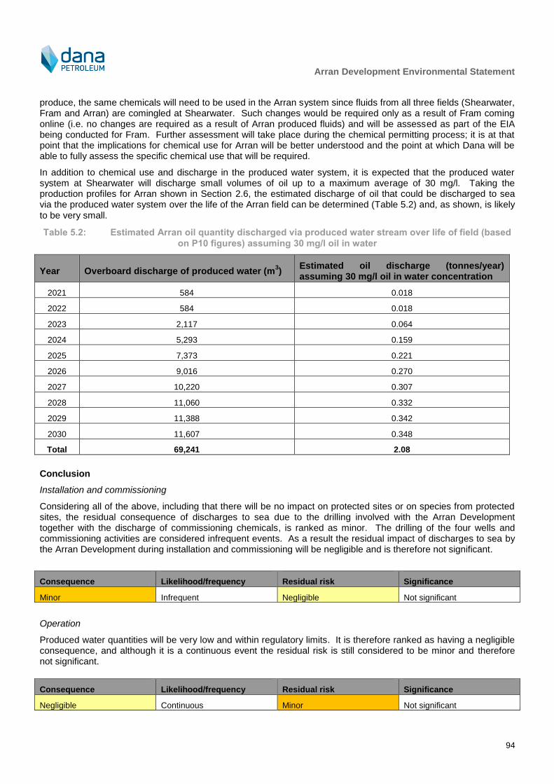
Arran Development Environmental Statement
94
produce, the same chemicals will need to be used in the Arran system since fluids from all three fields (Shearwater, Fram and Arran) are comingled at Shearwater. Such changes would be required only as a result of Fram coming online (i.e. no changes are required as a result of Arran produced fluids) and will be assessed as part of the EIA being conducted for Fram. Further assessment will take place during the chemical permitting process; it is at that point that the implications for chemical use for Arran will be better understood and the point at which Dana will be able to fully assess the specific chemical use that will be required.
In addition to chemical use and discharge in the produced water system, it is expected that the produced water system at Shearwater will discharge small volumes of oil up to a maximum average of 30 mg/l. Taking the production profiles for Arran shown in Section 2.6, the estimated discharge of oil that could be discharged to sea via the produced water system over the life of the Arran field can be determined (Table 5.2) and, as shown, is likely to be very small.
Table 5.2: Estimated Arran oil quantity discharged via produced water stream over life of field (based
on P10 figures) assuming 30 mg/l oil in water
Year Overboard discharge of produced water (m3)
Estimated oil discharge (tonnes/year) assuming 30 mg/l oil in water concentration
2021 584 0.018
2022 584 0.018
2023 2,117 0.064
2024 5,293 0.159
2025 7,373 0.221
2026 9,016 0.270
2027 10,220 0.307
2028 11,060 0.332
2029 11,388 0.342
2030 11,607 0.348
Total 69,241 2.08
Conclusion
Installation and commissioning
Considering all of the above, including that there will be no impact on protected sites or on species from protected sites, the residual consequence of discharges to sea due to the drilling involved with the Arran Development together with the discharge of commissioning chemicals, is ranked as minor. The drilling of the four wells and commissioning activities are considered infrequent events. As a result the residual impact of discharges to sea by the Arran Development during installation and commissioning will be negligible and is therefore not significant.
Consequence Likelihood/frequency Residual risk Significance
Minor Infrequent Negligible Not significant
Operation
Produced water quantities will be very low and within regulatory limits. It is therefore ranked as having a negligible consequence, and although it is a continuous event the residual risk is still considered to be minor and therefore not significant.
Consequence Likelihood/frequency Residual risk Significance
Negligible Continuous Minor Not significant

Arran Development Environmental Statement
95
5.3 Physical Presence
5.3.1 Seabed
5.3.1.1 Description and quantification of potential impact
The drilling of two wells at each of the two drilling locations (Arran North and Arran South) is likely to be conducted using a semi-submersible drill rig or a HDJU. If selected, the semi-submersible rig will be moored using 8 anchors. The maximum anchor spread radius will be 2,500 m, of which approximately 1,000 m of the anchor line is estimated to lie on the seabed. A small area of seabed where each anchor is placed will be compressed as the anchors sink into the seabed. Consequently, the placement of the anchors will cause localised direct damage to the habitats and species at the point of placement, whilst the movement of the associated lines as they sweep back and forth across the seabed will affect the benthos for the duration they remain in position. If the HDJU is selected this will use spud cans to remain on location. Typically, three or four spud cans will be used, each with a footprint of approximately 380 m
2, which will impact an area of 1,520 m
2. The HDJU would have two placements (Arran
North and Arran South) therefore resulting in a total potential impact area of approximately 3,280 m2. In terms of
seabed impacts the anchored rig and anchor lines in conjunction is the worst case option and has therefore been included in the seabed impact calculations below.
There is a possibility that an anchored pipelay vessel will be used to lay the production pipeline. The vessel would carry 12 anchors, which would be deployed up to 1 km from the hull of the vessel. The vessel would then pull itself along by winching in the forward anchor chains. At regular intervals, anchors would need to be recovered and redeployed by anchor handling vessels. The vessel is able to pull itself approximately 500 m per anchor deployment, and therefore over the total pipeline length of 57.7 km, approximately 116 full redeployments would be required, equalling 1,392 individual anchor placements. Each anchor contact with the seabed will be approximately 5 m by 8 m, or 40 m
2, which multiplied by the number of anchor placements required gives a total direct impact
area of 55,680 m2.
Physical disturbance is also likely to be caused during installation of the pipeline, umbilical, manifolds, rock and other subsea structures which can cause mortality or displacement of benthic species in the direct footprint. The significance of direct habitat loss or mortality of sessile seabed organisms
16 depends on the footprint of the area of
disturbance, the level of tolerance of the affected habitat and species to direct disturbance, the conservation value of the affected habitat or species and the uniqueness of the affected habitats or species assemblages to the area.
There is an option to lay the 7.3 km pipeline between Arran North and Arran South on the surface of the seabed rather than trenching it. However, given that trenching the pipeline is expected to directly disturb more sediment than a surface laid pipeline, and also generate more sediment resuspension (indirect disturbance), a trenched pipeline is the worst case option and has therefore been assumed for the assessment of impacts on the seabed.
In addition to the direct loss and/or disturbance of benthic habitats, seabed disturbance will also potentially lead to the smothering of benthic species and habitats due to sediment suspension and re-settlement. Rock placed on the seabed, installation of subsea facilities, especially the trenching of pipeline and umbilical, and installation and retrieval of anchors or spud cans associated with the drill rig and pipelay vessel is likely to result in some sediment suspension and re-settlement. Exposure to higher than normal loads of suspended sediment have the potential to negatively affect adjacent habitats and species. The re-settlement of sediments can result in the smothering of epifaunal benthic species (Gubbay, 2003), with the degree of impact related to their ability to clear particles from their feeding and respiratory surfaces. However, Defra (2010) states that impacts arising from sediment re-suspension are short-term (generally over a period of a few days to a few weeks); in addition, infaunal communities are naturally habituated to sediment transport processes and are therefore less susceptible to the direct impacts of increased sedimentation rates and will work their way back to the seabed surface through blanket smothering. Further, O’Neill, Summerbell and Breen (2008) report a number of nearshore trawl dredging activities that saw sediment resuspension occurring up to 30 m behind a trawl, but with maximum widths of sediment plumes limited to around 2 m. Jiang, Fissel and Borg (2007) reported modelled results from cable burial and removal that suggested sedimentation rates are high within 10 m of the trenching activities but dropped rapidly outside of that area. HELCOM (2017), cite OSPAR (2008) in stating that smothering of habitats around cable laying can be
16
Sessile refers to an organism that is anchored to a substrate, thus cannot move about freely.

Arran Development Environmental Statement
96
“generalise to a 2 meters distance”. These additional studies support the assertion that the indirect area of sediment resuspension would be larger than the direct footprint but within similar orders of magnitude.
Table 5.3 quantifies the area of seabed that may be directly and indirectly impacted by the Project. As a precautionary estimate, it has been assumed that sediment re-suspension and settlement will occur within an area equal to twice the area that the direct footprint will occupy. This approximation has been derived partly from work reported in Rogers (1990) that demonstrated indirect disturbance from dredging affected an area approximately six times larger than the direct impact. Compared to the area from which that was reported, the Arran Development area is relatively quiescent and any sediment particles are likely to settle quite quickly (as there is little bottom current). Although the finer particles may be disturbed and may remain suspended for some time before resettling, the relatively low bottom currents in the Arran Development area suggest they will not be carried particularly far. Given the indirect effect in the Arran Development area is likely to be substantially reduced compared to that reported by Rogers (1990), the smaller estimate of the indirect area affecting twice the direct area has been assumed. Further, O’Neill, Summerbell and Breen (2008) report a number of nearshore trawl dredging activities that saw sediment resuspension occurring up to 30 m behind a trawl, but with maximum widths of sediment plumes limited to around 2 m. Jiang, Fissel and Borg (2007) reported modelled results from cable burial and removal that suggested sedimentation rates are high within 10 m of the trenching activities but dropped rapidly outside of that area. HELCOM (2017), cite OSPAR (2008) in stating that smothering of habitats around cable laying can be “generalise to a 2 meters distance”. These additional studies support the assertion that the indirect area of sediment resuspension would be larger than the direct footprint but within similar orders of magnitude.
Table 5.3: Quantification of the area of seabed that may experience direct or indirect disturbance
Parameter Direct
area (km2)
Indirect area (km
2)
Short-term disturbance of the seabed
8 x drill rig anchors (5 m x 9 m) at Arran North 0.00036 0.00072
8 x drill rig anchors (5 m x 9 m) at Arran South 0.00036 0.00072
8 x 2.5 km drill rig anchor chains at Arran North, each abrading an area of seabed assumed to be 1,000 m x 10 m
0.08 0.16
8 x 2.5 km chains at Arran South, each abrading an area of seabed assumed to be 1,000 m x 10 m 0.08 0.16
1,392 pipelay vessel anchor (5 m x 8 m) placements 0.05568 0.11136
Buried pipeline and umbilical 1.749000 3.498000
7 x transponders (1 m x 1 m) 0.000007 0.000014
Total short-term 1.965407 3.930814
Long-term presence of infrastructure on the seabed (note that the indirect area of disturbance will be temporary)
Wellhead and subsea tree (x 4) 0.000342 0.000684
Tie-in structures (x 2) 0.000147 0.000294
6" tie-in spool 0.000030 0.000061
12" tie-in spool 0.000073 0.000146
450 (6 m x 3 m) mattresses between trenches at Arran North, Arran South manifolds and Shearwater A and two mattresses (6 m x 3 m) at the Scoter umbilical crossing
0.008136 0.016272
Nine concrete plinths (10 m x 3 m) for pipeline crossings 0.000270 0.000540
50,000 tonnes of rock placement for upheaval buckling prevention 0.049000 0.098000
30,000 tonnes of rock placement for crossings 0.017500 0.035000
Total long-term 0.08 0.15
Total 2.04 4.08
Arran Development Environmental Statement
97
The ocean quahog, found on the OSPAR (2008) list of threatened and declining habitats and species, has been recorded during surveys of the Project area. The ocean quahog is considered to be moderately tolerant of smothering. It is a burrowing species that can switch between suspension and surface deposit feeding. It is thought to preferentially engage in suspension feeding, remaining buried in the sediment with its inhalant and exhalent siphons exposed. It periodically buries itself further in the sediment, respiring anaerobically often for one to seven days (although the longest record is 24 days) before returning to the surface (Tyler-Walters and Sabatini, 2008). Ocean quahog is thought to be tolerant of increased suspended sediment levels. It is expected that it will be able to maintain its position in the sediment, and may temporarily switch to deposit feeding whilst disturbed sediment settles out (Tyler-Walters and Sabatini, 2008). Considering the above, it is likely that any specimens that are buried by installation activities will be able to recover to the surface before succumbing to anoxia.
5.3.1.2 Mitigation
A number of management and mitigation measures will be adopted by Dana to reduce, where possible, the potential impacts of the Project on benthic habitats and species:
A detailed anchor pattern for the use of a semi-submersible drill rig or a spud can location assessment for the use of a HDJU will be developed prior to mobilisation; this will take account of any environmental sensitivities around the site noted in environmental assessments made during a rig site survey undertaken prior to deployment (this will include avoidance of any known MDAC);
Should the drill rig need to leave the site, for example due to a break in activity over winter, on its return the same anchor pattern/spud can placement will be used where possible;
The volumes and locations of rock and mattress used will be refined during Detailed Design to reduce the footprint on the seabed to the extent practicable;
The spread of rock placement will be restricted through the use of a fall pipe system held a few metres above the seabed to accurately place rock material;
Pipeline and umbilical may be installed in the same trench (as far as the pipeline is trenched), this will be considered in future design work;
Backfilling should prevent berms that may pose a snag risk being present, where natural backfill is used Dana commit to using chain mats or similar to mitigate against berms.
5.3.1.3 Cumulative and transboundary impact
DECC (2016) identifies that the sources of cumulative physical disturbance to the seabed associated with oil and gas activities include drill rigs, wellhead placement and recovery, subsea template and manifold installation and piling, umbilical and pipeline installation and trenching and decommissioning of infrastructure. Of these, pipelay is considered to account for the largest spatial extent. Whilst the Arran Development will result in a predicted direct total disturbance of approximately 2 km
2 and an indirect impact of approximately 4 km
2 of seabed, the majority of
this area is considered to be short-term disturbance of the seabed and this area of seabed is relatively small compared to available similar habitat in the vicinity of the Project and of the North Sea. There are nine other oil and gas projects within a 40 km radius of the Project and it is likely that these projects will have similar magnitudes of seabed footprint to the Arran Development. This, combined with the lack of sensitive seabed habitats in the vicinity of the Project, means that the cumulative impact of the Project on the seabed is considered to be negligible.
The Offshore Energy SEA for UKCS waters (DECC, 2016) states that seabed impacts are unlikely to result in transboundary effects and even if they were to occur, the scale and consequences of the environmental effects in the adjacent state territories would be less than those in UK waters and would be considered unlikely to be significant. Although Arran South is closest to the UK/Norway median line at 3 km, direct and indirect seabed impacts will not extend this far from the Arran Development and transboundary impacts will not occur.
5.3.1.4 Decommissioning
Any potential impacts that decommissioning operations (e.g. removal of Project infrastructure) may have through seabed disturbance will occur in an area that experienced seabed disturbance during the installation operations. The potential impacts from decommissioning operations are likely to be similar in magnitude to those experienced during installation and thus not significant.
Arran Development Environmental Statement
98
5.3.1.5 Protected sites
Marine Scotland’s FEAST tool indicates that the habitat features expected in the area may show a low to moderate sensitivity to increased levels of siltation, a moderate to high sensitivity to change in seabed type and a moderate sensitivity to surface and sub-surface abrasion and penetration. As such it is considered unlikely that the sensitivities indicated by the FEAST tool would translate to a significant impact on any protected sites or features. The conclusions on the impacts presented in this section have taken account of protected sites as relevant. It is important to note that seabed impacts associated with the Arran Development will not occur within any SAC, SPA, NCMPA or MCZ. In addition, any seabed impacts do not spread sufficiently far to interact with any protected areas. As such, there is considered to be no LSE on SACs, SPAs, NCMPAs and MCZs and hence no impact on conservation objectives or site integrity.
5.3.1.6 Residual impact
Seabed and habitat impacts (direct impacts)
In an evaluation of threats and impacts to circalittoral muddy sand and slightly mixed sediment (which is similar to that recorded in the Arran Development area), Budd (2006) suggested that the threat from infrastructure installation offshore was low. Although substratum loss was deemed to cause decline of species in the area of direct footprint, species that inhabit this type of benthic habitat were deemed to be highly recoverable. Similar tolerance and recoverability to habitat loss have been reported for other similar habitats such as “seapens and burrowing megafauna in circalittoral fine mud” (Hill, 2004a), “Virgularia mirabilis and Ophiura spp. with Pecten maximus on circalittoral sandy or shelly mud” (Hill and Wilson, 2004) and “Amphiura filiformis, Mysella bidentata and Abra nitida in circalittoral sandy mud” (Hill, 2004b).
With regards to sensitivity of species recorded during the 2015 survey campaign, Ager (2005) report that S. bombyx, one of the most commonly occurring species in the Project area, is tolerant to smothering and increased suspended sediment. As a result, this polychaete is found over a range of sediment types and it is one of the most frequently recorded species in the wider North Sea. S. bombyx is a short-lived annelid with high reproductive potential, enabling it to exist in areas of high physical disturbance resulting from wave and tidal action. It should be noted, however, that some of the species encountered, such as S. armiger, are intolerant of physical disturbance.
Whilst there is little quantitative information available on the likely recovery time from the physical disturbance, indications are available from studies carried out for seabed disturbance by towed fishing gear (as reviewed by Løkkeborg, 2005). These suggest that it is likely that some level of recovery will occur in the sediments following operations. However, the longevity of physical scars on the seabed is dependent on the type and energy of the local benthic environment. Scars in higher energy, sandy or shallow environments may disappear within days or months of initial disturbance, whilst those in lower-energy silty and deeper areas may still be faintly visible after 18 months. As discussed in Section 3.2.2, the seabed sediments in the Project area comprise fine to coarse sand. Consequently seabed scars and berms resulting from the proposed Project are likely to persist only in the short to medium term, and the likelihood of anchor mounds forming from placement or pull out of anchors is low. Also, the review by Løkkeborg (2005) notes that biological communities in a physically disturbed seabed typically show recovery well before the scars themselves have disappeared.
Where the pipeline and other subsea infrastructure is placed on or buried in the seabed, there will be direct disturbance to, and displacement of, species present. However, the majority of the subsea infrastructure will be trenched and buried allowing access to benthic species. The Arran Development’s long-term direct footprint on the seabed will amount to just approximately 0.05 km
2 and are therefore unlikely to be of significance.
Suspension and re-settlement of sediments (indirect impacts)
For the circalittoral muddy sand and slightly mixed sediment habitat (which is similar to that recorded in the Arran Development area) Budd (2006) states that threats to this benthic habitat type from smothering and increases in suspended sediment were deemed low and not sensitive. Similar tolerance and recoverability to smothering and increased sediment load have been reported for other similar habitats such as “seapens and burrowing megafauna in circalittoral fine mud” (Hill, 2004a), “Virgularia mirabilis and Ophiura spp. with Pecten maximus on circalittoral sandy or shelly mud” (Hill and Wilson, 2004) and “Amphiura filiformis, Mysella bidentata and Abra nitida in circalittoral sandy mud” (Hill, 2004b).
Arran Development Environmental Statement
99
With regards to sensitivity of species recorded during the 2015 survey campaign, Ager (2005) reports that S. bombyx, one of the most commonly occurring species in the Project area, is tolerant to smothering. As noted above, this species appears to be able to exist in areas of high physical disturbance resulting from wave and tidal action where regular resuspension and settlement of sediments will occur.
An estimate of the area of seabed likely to be indirectly impacted by the Project is provided in Table 5.3.
Installation activities will likely result in the raising of sediment plumes into the water column, which will then re-settle onto the seabed. These include the trenching and burying of the pipeline and umbilical, which will cause the most significant amount of sediment plumes. Installation and retrieval of anchors and anchor lines/spud cans associated with the drill rig at Arran North and Arran South will also cause the suspension of sediments. Defra (2010) states that impacts to the benthic environment in general arising from sediment re-suspension are short-term (generally over a period of a few days to a few weeks). The installation of the pipeline, umbilical and other seabed infrastructure and presence of drill rig anchors (if a semi-submersible rig is selected) will cause the suspension of sediment but are considered to have a short-term indirect impact on the water column due to the short time scales and wide area of the activities. The impacts from these items to benthic habitats and species will be localised and are not expected to result in large scale changes in the benthic community in the long-term.
Conclusion
Considering all of the above, noting that there will be no impact on protected sites or on species from protected sites and that the footprint of the Project for the life of field will be localised, the residual consequence of seabed disturbance is ranked as minor. Direct seabed disturbance and indirect impacts due to sediment suspension will occur only during the drilling and installation activities and are thus considered an ‘infrequent’ activity in terms of likelihood. As a result, the residual risk to seabed species and habitats from the Arran Development is negligible and is therefore not significant.
Consequence Likelihood/frequency Residual risk Significance
Minor Infrequent Negligible Not significant
5.3.2 Noise
5.3.2.1 Description and quantification of potential impact
Many species found in the marine environment use sound to understand their surroundings, track prey and communicate with members of their own species. Some species, mostly toothed whales, dolphins and porpoise, also use sound to build up an image of their environment and to detect prey and predators through echolocation. Exposure to natural sounds in the marine environment may elicit responses in marine species; for example, harbour seals have been shown to respond to the calls of killer whales with anti-predator behaviour (Deecke et al., 2002). In addition to responding to natural sounds, fish and marine mammals may also respond to man-made noise. The potential impacts of industrial noise on species may include impacts to hearing and displacement of the animals themselves and potential indirect impacts which may include displacement of prey species or stress.
Whilst there is a lack of species specific information collected under controlled or well documented conditions, enough evidence exists for fish and marine mammals to suggest that sound may have a potential biological impact and that noise from man-made sources may affect animals to varying degrees depending on the sound source, its characteristics and the susceptibility of the species present (e.g. Nowacek et al., 2007, report this specifically for cetaceans). Such a potential impact on the life activities of marine mammals and fish is called ‘behavioural disturbance’. In addition to potential behavioural disturbance, marine mammals and fish exposed to an adequately high sound source may experience physical effects, which may be a temporary shift in hearing ability (termed a temporary threshold shift; TTS) (e.g. Finneran et al., 2005) or, if the source level is sufficiently high, may be physical damage to the hearing apparatus which may not be reversed; in this case there may be a permanent threshold shift (PTS) (Southall et al., 2007), which is considered to be an ‘injury’ to the animal.
Noise sources that have been identified as likely to occur during the Arran Development and which, depending on the specific nature of the sources, could cause injury or disturbance to marine mammals and fish are limited to vessel use, acoustic transponders for positioning of vessels and subsea equipment and hammered piling of the single manifold at each of the two drill centres. The drill rig will use anchors or spud cans (depending on final rig selected) to maintain station and there is thus no requirement for ongoing use of dynamic positioning. To
Arran Development Environmental Statement
100
understand the potential for these noise sources to affect marine mammals, noise propagation modelling has been undertaken.
The noise propagation modelling, detailed in full in Appendix C, provides the assessment with a set of ranges within which potential injury and disturbance effects may occur. However, it is important to bear in mind when viewing the potential range of effects that there is not a hard and fast ‘line’ where an impact will occur on one side and not on the other; the actual amount of noise received by an animal, individual variations, and uncertainties regarding behavioural response mean that in reality it is much more complex than drawing a contour around a location. The ranges that the noise propagation modelling provides therefore offer a way in which the potential spatial extent of the impact can be understood and in which the impact assessment presented herein can define the magnitude of the potential impact. Nonetheless, a series of ranges for potential impacts for vessels associated with the Arran Development (i.e. sources of continuous noise) have been derived and these are shown in
Table 5.4 and Table 5.5. For piling, an impulsive noise, potential injury and disturbance ranges are detailed in Table 5.6; because different species groups exhibit different sensitivity to certain noises, the potential injury zones for each of these different groups is shown.
Table 5.4 also details, in the final column, the length of time that an animal would have to remain within 10 m of a noise source to experience onset of injury. This is not to say that an animal would remain so close to a noise source, rather the time shown of approximately 1 hour demonstrates that transient exposure by a marine mammal to a Project noise source whilst the animal moves through the Project area would not likely result in any injury.
Table 5.4: Summary of range of potential marine mammal injury for Arran Development vessel activity
Scenario Onset of injury with an animal
swimming at 1.5 ms-1
Length of time an animal would have to remain within 10 m of the source to
experience injury
Individual vessel Will not occur Approximately 1 hour
ERRV, supply vessel and guard vessels operating concurrently.
Will not occur Approximately 1 hour
Table 5.5: Summary of range of potential marine mammal disturbance for Arran Development vessel
activity
Vessel Estimated range of onset of potential disturbance (km)
Maximum time this type of vessel will be on site/activity will occur during installation
Diving support vessel 1.9 58 days
ERRV 6.9 239 days
Trenching vessel, pipelay vessel, rock placement vessel
7.2 75 days
Anchor handling, supply, survey or MS vessel
9.5 206 days
Drilling occurring concurrently alongside ERRV, supply vessel and guard vessels.
18.4 239 days

Arran Development Environmental Statement
101
Table 5.6: Summary of range of potential marine mammal injury and disturbance distances for Arran
Development piling (with soft-start and assuming 1.5 ms-1
swim speed)
Piling scenario Low-
frequency cetacean
17
Mid-frequency cetacean
Harbour porpoise
Potential injury zone from the first single pulse < 1 m < 1 m 2 m
Potential injury zone from the multiple pulses built up with soft start < 1 m < 1 m < 1 m
Estimated range of onset of potential disturbance from multiple pulses built up with soft start
400 m
Few data appear to be available in the public domain relating to the source noise level and characteristics for acoustic transponders. Vickery (1998) describes a typical source level as being greater than 195 dB re 1 μPa @ 1 m, but notes that the frequency range can vary anywhere between 8 to 300 kilohertz (kHz) depending on the system type and range requirements. A datasheet for the Nautronix NASNET system shows a typical source level of up to 196 dB re 1 μPa @ 1 m, but no information appears available relating to the typical ‘on time’ of the system and pulse lengths. It was, therefore, considered not appropriate to undertake detailed modelling of this source and, instead, a qualitative assessment is undertaken.
In terms of the potential impacts on fish, review of published potential impact zones from vessels and piling suggest they are likely to be limited to tens or hundreds of metres from the noise source, if any responses do occur (e.g. De Robertis and Handegard, 2012, Chevron, 2013, Mueller-Blenkle et al., 2010, Schulze and Ring Pettersen, 2007).
5.3.2.2 Mitigation
The primary measure of reducing potential impact will be to limit the duration of the noise emitting activities; for example, vessels will only be deployed where necessary and the number of acoustic beacons used for positioning will be limited as far as is practicable during installation activities.
Dana will adhere to JNCC guidelines for reducing the potential for injury and disturbance to marine mammals from piling (JNCC, 2010b). The measures from the JNCC (2010b) guidance are summarised below:
A suitably trained marine mammal observer (MMO) will conduct a pre-piling search over a 30 minute period prior to the commencement of piling. This will involve a visual assessment to determine if any marine mammals are within a 500 m monitoring zone (measured from the location of the piling). Should operations cease for ten minutes or more, a pre-piling search will be undertaken before the re-commencement of activities;
Should any marine mammals be detected within 500 m of the piling operations, these operations will be delayed until marine mammals have moved outside the mitigation zone. In this case, there will be a 20 minute delay from the time of the last marine mammal sighting to the commencement of activities;
The piling rig will be powered up slowly over 20 minutes in order to give marine mammals time to leave the area. Build-up of power will occur in uniform stages to provide a constant ‘ramp-up’ in amplitude. These soft start procedures will also be undertaken if the operations are stopped for at least 10 minutes, to allow for checking of the visual observation zone to determine if any marine mammals have entered the area whilst the piling activities were suspended. If marine mammals have re-entered the observation zone, restart of the operations will be delayed until 20 minutes after the last sighting of the marine mammal; and
If piling is required to commence in sub-optimal conditions for visual monitoring, consideration will be given to using passive acoustic monitoring (PAM) in addition to MMOs. Use of PAM in conditions that are sub-optimal for visual monitoring enhances the probability of detecting marine mammals (when vocalising), reducing the likelihood of potential negative impacts.
17
Examples of low-frequency cetaceans include the larger baleen whales such as the minke and humpback whales. Mid-
frequency cetaceans include the majority of species likely to be found in the Arran Development area, including the white beaked and white-sided dolphins. The harbour porpoise is the only high-frequency cetacean that is likely to be found in the Arran Development area.
Arran Development Environmental Statement
102
5.3.2.3 Cumulative and transboundary impact
It is possible that the various noise sources within the Arran Development could act cumulatively to result in a significant impact to marine mammals. As such, modelling has been conducted on a number of possible scenarios, as outlined in
Table 5.4. As can be seen, the noise levels are sufficiently low that injury is not predicted from any activity, cumulatively or otherwise, and the potential disturbance zones are small and, for the most part, highly limited in temporal extent. Cumulative impact from sources within the Arran Development is therefore not expected.
As presented in Chapter 4, during the process of the EIA a list of other projects was identified which, together with the Arran Development, have the potential to result in potential cumulative impacts. In theory, any project that regularly emits underwater noise has the potential to act cumulatively with the Arran Development. Cetacean and fish populations are free-ranging and long-distance movement is likely to be frequent. Any animal experiencing a significant impact from one project is likely to belong to a much wider ranging population and there is the potential for that same animal to subsequently come into contact with noise from other projects. However, potential injury and disturbance impacts resulting from the Arran Development are not expected to be significant (see Section 5.3.2.6), and significant cumulative impact from an animal encountering noise emissions from multiple projects within a short period of time is therefore considered highly unlikely. As a result the cumulative impact is considered to be not significant.
The Arran Development area is 3 km from the UK/Norway median line at its closest point and up to 26 km at it’s furthest. Since sound emissions capable of potentially causing injury are unlikely to occur for marine mammals and would be unlikely to be received directly by fish across median lines, direct transboundary impact from injury is not likely to occur. However, given that disturbance zones may reach up to a number of kilometres for some restricted periods (e.g. during drilling and installation of seabed infrastructure), and since an animal experiencing an impact in UK waters would likely belong to a much wider ranging population and thus likely to cross median lines, such a potential impact could qualify as a transboundary impact. However, since injury is not expected from the Arran Development and since any disturbance is expected to be not significant, potential transboundary impacts are therefore considered not significant.
5.3.2.4 Decommissioning
Any potential impact that decommissioning operations may have through noise emissions will occur in an area that experienced noise emissions during the installation operations. Should wells be abandoned, it is possible that wellheads will be cut off below the seabed; these cutting activities would result in noise emissions. Such noise emissions would be of short-term duration only. Given the residual impact from installation and operation is considered to be not significant, the potential impact from decommissioning is also considered to be not significant.
There will be no noise emissions from the Arran Development post-decommissioning as all Project infrastructure will have been removed.
5.3.2.5 Protected sites
As described in Section 3.3.6 and 3.3.7, there are four species of marine mammal listed on Annex II of the Habitats Directive that are known to occur in UK waters. The Arran Development area is well beyond the predicted foraging range for bottlenose dolphin from the Moray Firth SAC, especially since this population is restricted largely to within the 20 m depth contour around the Scottish east coast. For grey and harbour seals, the generally accepted maximum average foraging range is 200 km and 50 km respectively, which means that the Arran Development area is also beyond the foraging range for these species. Since there is no potential for underwater noise emissions to interact with these species, there is concluded to be no LSE on any SAC designated for these interests and it is not necessary to consider the conservation objectives or integrity of any sites in further detail. For harbour porpoise, animals making use of the Southern North Sea cSAC may also make use of the Project area. However, there is expected to be no injury to harbour porpoise from the Project activities, and no effect of disturbance at the population level. As such, there will be no LSE on this protected site.
SPAs are excluded from consideration with regard to LSE and underwater noise as such sites are designated for bird interests and thus of no relevance to underwater noise.
This assessment also considers there to be no potential for underwater noise emissions to interact with protected features of an NCMPA or MCZ (primarily as there are no sites designated for features that may be affected by
Arran Development Environmental Statement
103
noise emissions within the Project area or wider North Sea) and there is therefore no significant risk to the conservation objectives of any NCMPA or MCZ being achieved.
5.3.2.6 Residual impact
Vessel noise
The noise emissions from vessel activities are low enough that injury to marine mammals briefly encountering the vessels is unlikely to occur. For animals that remain in very close proximity to vessel (approximately 10 m), approximately one hour of exposure to the noise would be required before injury could occur. Since animals would be unlikely to remain so close to the vessels for any length of time, not least because the vessels will likely be moving, injury is unlikely to occur. As such, there will be no residual impact related to injury for marine mammals.
To understand the residual impact on animals that may be experiencing some disruption to normal behaviour, it is important to consider a number of factors including the size and location of the potential disturbance zone (larger areas mean a greater potential to interact with a greater number of animals) and length of time for which the sound source will be present (the longer the period the greater potential to have significant effects). Behavioural changes such as moving away from an area for short periods of time, reduced surfacing time, masking of communication signals or echolocation clicks, vocalisation changes and separation of mothers from offspring for short periods, do not necessarily imply that detrimental effects will result for the animals involved (JNCC, 2010b). Temporarily affecting a small proportion of a population would be unlikely to result in population level effects and would be considered as trivial disturbance (i.e. would not be significant disturbance). In contrast, affecting a large proportion may be considered non-trivial disturbance (i.e. could be significant disturbance).
The potential disturbance zones from vessels mean that the noise emissions would not represent a barrier to wider, regional movements of marine mammals.
In terms of the length of time that vessels could be on site, the installation activities are limited to relatively short periods of less than 60 days. However, the drill rig and associated emergency response and rescue, guard and supply vessels will be present for up to 165 days in 2019 and a further 194 in 2020, representing the temporally greatest source of noise emissions for the Project. To understand the residual impact on animals experiencing disturbance to normal behaviour during the time that these vessels are present, it is important to understand what proportion of the population this represents. Determining this proportion for marine mammals is in itself not a simple task since it is not clear how north-east Atlantic marine mammal populations act at a local level. For example, minke whales are likely to make use of the entire north-east Atlantic, so the population can be viewed as one, whilst other species may display more local fidelity and be viewed as a series of sub-populations. The Statutory Nature Conservation Bodies (SNCBs, 2013) note that marine mammals of almost all species found in UK waters are part of larger biological populations whose range extends into the waters of other States and/or the High Seas. In order to obtain the best conservation outcomes for many species, it is necessary to consider the division of populations into smaller management units. This requires an understanding of the geographical range of populations and subpopulations, in order to provide advice on impacts at the most appropriate spatial scale. The output of the SNCB exercise investigating how marine mammal populations may act (SNCBs, 2013) is the determination of Marine Mammal Management Units (MMMU) for species including harbour porpoise, white-beaked dolphin and white-sided dolphin. These MMMUs and associated population estimates can be interpreted in the context of the potential disturbance zones to consider the potential for a significant impact to occur.
The percentage of the regional populations of marine mammals that have the potential to experience some form of disturbance from the drill rig is shown in Table 5.7. Since only a small number of individual animals would have the potential to exhibit some form of change in behaviour for the period in which they encounter sound from the drill rig and associated vessels, it would be largely undetectable against natural variation (as demonstrated by the very small percentage of population that could potentially be affected) and would have no residual impact at the population level.

Arran Development Environmental Statement
104
Table 5.7: Numbers of marine mammals within the potential behavioural disturbance zone of the drill
rig, ERRV, guard vessel and supply vessel at any one time
Species
Density estimates per km
2 (JNCC, 2010b,
Hammond et al., 2013, Hammond et al., 2017)
Maximum number of animals predicted to be
in the behavioural change impact zone
Regional population size (SNCBs, 2013)
Percentage of regional population potentially affected
(%)
Atlantic white-sided dolphin
<0.04018
<43 69,293 <0.06
White-beaked dolphin
0.047 <50 15,895 <0.31
Harbour porpoise 0.333 <355 227,298 <0.16
Minke whale 0.007 <8 23,163 <0.04
Piling noise
For marine mammals, the potential for injury is limited to within 2 m of the piling for the most sensitive species (harbour porpoise) and less than 1 m for all other species. The likelihood of injury occurring will be further reduced by implementing a series of mitigation measures based on the JNCC ‘Guidelines for minimising the risk of disturbance and injury to marine mammals from piling’ (JNCC, 2010b), which includes a soft-start procedure and visual monitoring of a 500 m mitigation zone. These measures, outlined in Section 5.3.2.2, will result in the area of potential injury for marine mammals effectively being eliminated. The only potential impact that could therefore occur is through changes to behaviour within 400 m of the piling. It is likely that few, if any, marine mammals could be present within this zone. The small potential impact zone means that the noise emissions would not represent a barrier to wider, regional movements of marine mammals. In addition, piling activity is anticipated to occur for a maximum of one 48 hour period in total.
For fish species, potential impact zones are likely to be limited to tens or hundreds of metres. Whilst estimates of fish populations are generally not available, it is likely that many millions of individuals make up most species populations (e.g. Mood and Brooke, 2010). The injury to small numbers of fish would not constitute a large scale reduction in population and the movement of fish tens or hundreds of metres away from a vessel would not constitute large scale movement by individuals of a species (in any case, fish are constantly moving from location to location) and vessel noise would be highly unlikely to result in population level impacts.
Transponder noise
Injury and disturbance ranges are expected to be substantially less than those typically predicted for sub-bottom profiling activities, such that for the low-frequency whales the potential injury ranges will be in the very low metres and even for the most sensitive species (harbour porpoise) may only be tens of metres or very low hundreds. Since such injury zones tend to require animals to remain in the vicinity of the sound source for 24 hours, injury is not expected from use of the acoustic transponders. In terms of disturbance to marine mammals from use of the acoustic transponders, this would likely be limited to hundreds of metres of the long base line array. Even if disturbance were to occur within hundreds of metres of the transponders, this is not a great distance in the context of the available waters in the North Sea and the noise emissions would not represent a barrier to wider, regional movements of marine mammals. The acoustic transponders would only be deployed when installation vessels are on site (i.e. up to 60 days at any one time). For fish, as for vessel noise, the likely limited impact zones and the large population sizes of species likely to encounter noise mean there will be no impacts at the population level.
EPS
The highly restricted injury zones, the short term nature of the noise generating activities, the low density of marine mammals in the Project area and the proposed mitigation measures mean that there will be a negligible risk of injury or disturbance as a result of the Arran Development activities. As such, there will be no injury or significant disturbance to an EPS and no requirement to apply for an EPS licence.
18
JNCC (2010a) present a combined estimate of 0.040 animals per km2 for Atlantic white-sided and white-beaked dolphins
hence this value will be an upper maximum mean for this species.

Arran Development Environmental Statement
105
Conclusion
Considering all of the above, including that there will be no impact on protected sites or on species from protected sites, the residual consequence of underwater noise emissions is ranked as minor. Although most vessel use will occur during the drilling and installation periods, there is likely to be a limited requirement for vessel use during maintenance activities and the residual impact will therefore occur intermittently over the life of the Arran Development. As a result the residual impact of the noise emitted by the Arran Development will be minor and is therefore not significant.
Consequence Likelihood/frequency Residual risk Significance
Minor Intermittent Minor Not significant
5.3.3 Other sea users
5.3.3.1 Description and quantification of potential impact
Increased vessel traffic and collision risk
The temporary physical presence of Project vessels has the potential to interfere with other sea users that may be present in the area and may increase the risk of vessel collision.
Drilling activities are expected to start in Q3 of 2019 and last for approximately 324 days. Installation of subsea structures, pipeline and umbilical is expected to commence in Q2 2020 and complete in Q4 2020. In understanding the potential risk over the proposed drilling period, a precautionary scenario with respect to physical presence is that a drill rig (anchored or with spud cans) will be used for the drilling of each well over with a supply vessel and standby vessel on site for the same duration. One anchor handling vessel will be on site for up to 18 days to tow the drill rig into place. Between Q3 2019 and Q4 of 2020 vessel activity around the Project area will be at its’ highest.
Temporary and life of field exclusion
Whilst the drill rig is on location in the Arran field, a temporary safety zone of 500 m will be maintained. The purpose of this safety zone is to ensure the safety of all personnel involved in the drilling activities and to minimise the risk of collisions between the vessels involved with the drilling activities and other vessels in the area.
The pipelay, rock placement and associated support vessels will exclude other sea users around their immediate vicinity but only for a very short period of time (60 days maximum).
Following the drill rig going off site, an exclusion zone of 500 m radius around each drill centre will be maintained throughout Project life. The purpose of this safety zone is to limit the potential for interaction between the subsea infrastructure and demersal fishing gear. There will be no protection or exclusion zones maintained around any of the other subsea infrastructure, even in the event of surface laying between the Arran North and Arran South drill centres.
Snagging risk
Disturbance of the seabed resulting in raised or depressed areas and steep changes in gradient can increase the risk of deployed fishing gear pulling through large masses of sediment instead of travelling over the surface. This may result in a number of undesirable effects including contamination of catches with large amounts of sediment retained in nets, damage to gear, or if gear becomes stuck (snagged), loss of gear and danger to the vessel and crew. Placement of infrastructure on the seabed, while unlikely to cause contamination, can also increase the risk of snagged gear, and because the infrastructure is solid and heavy and resists gear being pulled free, if gear does become snagged, the risks to the gear, vessel and crew can be even higher. The Arran Development will involve several instances of seabed sediment disturbance, and will require the installation of infrastructure that has the potential to form a snagging risk. The potential for snagging risks associated with each Project activity is discussed below.
Anchors, which may be used to keep a semi-submersible drilling rig on location, and may also be used to keep the pipelay vessel on location, create depressions in the seabed when they are deployed, and pull up mounds of sediment when recovered. In combination these features are called anchor scars. If a jack up rig is used for
Arran Development Environmental Statement
106
drilling, it will deploy large feet on the ends of the legs (called spud cans) that will be forced into the sediment in order to provide stability for the rig. What the rig is eventually moved off station, these spud cans will leave large depressions in the seabed. Both anchor scars and spud-can depressions form a potential snagging risk. The trench for the umbilical, which will be 1.8 m deep and left open to backfill naturally, may also form a snag risk, from the trench itself and from the berms which may be formed along the edges during the trenching process.
The degree of snagging risk caused by anchor mounds, spud-can depressions and trenches depends partly on the consistency of the sediment. Sandy, uncohesive sediment will provide relatively little resistance to towed gear. Gear is more likely to be able to pull through sandy sediment, and any sediment that is collected in the gear is likely to wash out. Cohesive clay sediment is likely to generate more resistance to gear, and if it becomes caught in the gear, is less likely to wash out, and is therefore more likely to contaminate gear and catches. In addition, mounds, depressions and berms formed in clay sediments are likely to persist for longer, while features formed in sand are likely to be re-worked by the currents fairly rapidly. As discussed in Section 3.2.2, the seabed sediments in the Project area comprise fine to coarse sand. Consequently anchor mounds, spud can depressions, trenches and berms formed during activities at Arran are only likely to persist in the short term to medium, and are unlikely to pose a significant snagging risk.
Snagging may also occur on infrastructure that is temporarily or permanently installed in the Project area. Temporary snagging risks may be posed by the anchors and chains of the semi-submersible drill rig (if used) and the anchored pipelay vessel (if used). For the drill rig, the anchor chains may be up to 2,500 m long, and therefore the majority of the anchor spread will be out with the safety zone. However, the area beyond the safety zone will be monitored by a guard vessel capable of alerting other sea users to the presence of the anchors. Similarly, the anchors of the pipelay vessel would be deployed up to 1,000 m from the hull of the vessel. The pipelay vessel will not have a safety zone in place around it, however, the pipelay vessel itself, the attendant anchor handling vessel and the Project guard vessel will be in the area and able to warn other vessel about the snagging risk.
No safety zone will be in place along the pipeline and umbilical and, as such, once the installation and support vessels have moved out of the area, there will be no statutory restrictions on fishing in the vicinity. The majority of the pipelines will be trenched and buried, however there is a possibility that the 7.3 km pipeline between Arran North and Arran South will be surface laid, and this will therefore form a snagging risk for any fishing vessels that deploy gear close to the pipeline. In addition, the physical presence of any rock placement and subsea facilities on the seabed will pose a snagging risk for fishing vessels.
5.3.3.2 Mitigation
A number of mitigation measures will be employed to reduce the impact on other sea users:
A vessel traffic survey will be undertaken for the area closer to the proposed start of drilling as part of the
standard permitting process, together with a collision risk assessment;
During installation the number of vessels and length of time they are required on site will be reduced as far
as practicable through careful planning of the installation activities;
A safety zone of 500 m in radius will be established around the drill rig during drilling and around each drill
centre for the life of the Project;
A standby and support vessel will operate during the period that the drill rig is in place. These vessels will
ensure that other sea users are aware of the presence of the anchor spread outside of the drill rig safety
zone;
Information on the location of subsea infrastructure and vessel operations will be communicated to other
sea users (via the United Kingdom Hydrographic Office) through the standard communication channels
including Kingfisher, Notice to Mariners and Radio Navigation Warnings;
Infrastructure will be marked as hazards on admiralty charts and entered into the Fishsafe system so that it
may be avoided by fishing vessels;
Regular maintenance and pipeline route inspection surveys will be undertaken;
Subsea trees will be designed to be fishing friendly;
The majority of the pipeline and umbilical will be trenched and/or buried, eliminating snag risk (the pipeline
and umbilical will exit trenches close to each end of the route and also at crossing locations);
Arran Development Environmental Statement
107
Where the pipeline is trenched and buried, exposed sections will be protected using concrete mattresses
and/or rock deposited at a gradient designed to allow fishing gear to pass without snagging;
A post-development survey of the anchoring locations and the open umbilical trench will be conducted, and
any anchor scars, spud can depressions and trench berms that are considered to pose a snagging risk will
be flattened using a chain mat; and
Should wells be abandoned, wellheads will be cut off below the seabed leaving the seabed free of
infrastructure that could pose a snagging risk to fishing gear.
5.3.3.3 Cumulative and transboundary impact
Due to the low levels of shipping activity in the Project area, the wide expanse of water available to navigate in and the limited number of vessels to be deployed for the Project, it is not anticipated that there will be any significant cumulative impacts with respect to vessel collision risk.
DECC (2016) report that exclusion from an area and snagging risk from oil and gas activities are cumulative to those resulting from natural obstructions, shipwrecks and other debris. As noted in Section 5.3.3.1, however, the
area of exclusion during the Project will be small in comparison with the total fishing area available and will be largely temporary and thus the impact is likely to be low. Consequently, there will be no significant cumulative impact.
The area in which the Project is located is regularly fished by vessels of other nations and any effect on their landings could constitute a transboundary impact. However, the potential impact on fisheries is considered not significant and it is unlikely that the Project will result in any transboundary impacts.
5.3.3.4 Decommissioning
Any potential impacts on other sea users regarding collision risk and temporary exclusion from the Project area that decommissioning operations may have will occur at a similar level to impacts during installation operations. However, removal of Project infrastructure will act to remove any potential snag risk in the longer term.
5.3.3.5 Residual impact
Increased vessel traffic and collision risk
Although there will be an increase in the number of vessels in the area during the Project life, these activities will only be of a relatively limited duration. As noted in the mitigation measures above, standard communication and notification procedures will be in place to ensure that all vessels operating in the area are aware of the activities, including the presence of the drill rig, vessels required to install subsea facilities and vessel requirements during maintenance activities.
The Project is located in an area of relatively low levels of shipping activity in comparison to other areas of the North Sea. The vessels utilising the waters around the Project area are primarily small to medium sized cargoships and tankers but fishing vessels and dredging/underwater operation vessels also pass through (MMO, 2014). With the limited vessel requirement and the mitigation measures to be deployed, there is little risk of an increase in the risk of vessel collision as a consequence of increased vessel activities. In addition, many of the activities associated with the Project will be temporary in nature, and there is sufficient sea area around both the drilling locations and pipeline route for route adjustments by non-Project vessels during drilling and installation activities.
Temporary and life of field exclusion
As outlined in Section 5.3.3.1 vessels will be excluded temporarily from an area that incorporates the anchors and
anchor lines during drilling (by way of a safety zone and guard vessel), and then from an area of approximately 0.8 km
2 around each of the two drilling centres for the life of the Project. Areas in the immediate vicinity of the
pipeline and umbilical route will be excluded on an ad hoc basis during the installation period and during routine inspection and maintenance. However, this is considered transient and extremely localised. Taking into account the localised nature of the access restrictions posed by the Project and the low level of vessel traffic, the overall risk of interference with fishing and shipping activity is considered to be low.
Snagging risk

Arran Development Environmental Statement
108
Fishing in the Project area is conducted using demersal (seabed) and pelagic (mid water column) trawling. Consequently, there is potential risk of direct interactions with both demersal gear and pelagic gear. However, landing statistics (detailed in Section 3.5.1) suggest fishing across the Project area is low, especially in the Arran field itself. Snagging risks associated with the pipeline and subsea facilities cannot be eliminated entirely; however, the mitigation measures detailed above will reduce the risk of snagging considerably.
Anchor mounds, spud can depressions and trench berms could also potentially pose a risk to fishing vessels. Once the anchors or spud cans from the drill rig and the anchors from the pipelay vessel (if an anchored model is used) have been removed from the seabed, the anchor mounds and spud can depressions that may potentially form will tend to be flattened over time into the sediment through the erosive and redistributive action of currents, bioturbation and general sediment mobility. The same processes will reduce the height and gradient of any trench berms. As outlined in the seabed impact assessment (Section 5.3.1), anchor mounds, spud cans and trench berms are only likely to persist around the drilling locations in the short to medium term. Due to the temporary nature of any resultant mounds and berms, it is likely that the risks related to the Project are limited.
The umbilical will be installed in an open trench that will backfill through natural processes over time. Although seabed currents in the Arran Development area are low, subsea engineering experience from sandy sediments of the central North Sea suggest that sediment cover will begin to take place within one season following umbilical installation. Typically, maximum natural backfill will have occurred within only 1 – 2 years following installation. A post-installation survey will take place to record initial conditions and the ongoing umbilical monitoring regime will collected information on the status of the umbilical in the trench over time. Dana will consider the results of the ongoing monitoring to determine whether backfilling to the extent required to keep the umbilical in place and to avoid snagging from fisheries has taken place. Depending on the results, possible remediation could be investigated.
Conclusion
Considering all of the above, the residual consequence of the Project on other sea users is ranked as negligible. The exclusion zones and snag risk will be present for the entire Project life and, for this reason, the likelihood has been ranked as continuous. As a result, the residual risk on other sea users by the Arran Development will be minor and is therefore not significant.
Consequence Likelihood/frequency Residual risk Significance
Negligible Continuous Minor Not significant
5.4 Atmospheric Emissions
5.4.1 Description and quantification of potential impact
The emission of gases to the atmosphere from the Arran Development could potentially result in impacts at a local, regional, transboundary and global scale. Local, regional and transboundary issues include the potential generation of acid rain from nitrogen and sulphur oxides (NOX and SOX) released from combustion, and the human health impacts of ground level nitrogen dioxide (NO2), sulphur dioxide (SO2), both of which will be released from combustion) and ozone (O3), generated via the action of sunlight on NOX and volatile organic compounds (VOCs). On a global scale, concern with regard to atmospheric emissions is increasingly focused on global climate change. The Intergovernmental Panel on Climate Change (IPCC) in its fourth assessment report states that ‘Most of the observed increase in global average temperatures since the mid-20th century is very likely due to the observed increase in anthropogenic GHG concentrations.’ Climate change projections included in the IPCC report for Europe and Africa forecast a temperature increase of between 2.3 °C and 5.3 °C in the period from 2080 to 2099. GHGs include water vapour, carbon dioxide (CO2), methane (CH4), nitrous oxides (N2O), O3 and chlorofluorocarbons. The most abundant GHG is water vapour, followed by CO2. IPCC (2007) reports a 35% increase in CO2 concentrations compared to pre-industrial concentrations and states that the combustion of fossil fuels is the primary contributor. Atmospheric emissions from the Arran Development will be related to fuel consumption by the drill rig, installation vessels and helicopters and flaring activities during the possible well testing. Additional flaring and fuel use is anticipated during commissioning and operation of the field. A summary of predicted atmospheric emissions for the Arran Development is provided in Table 5.8.
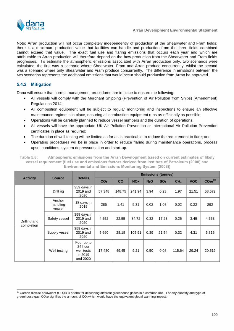
Arran Development Environmental Statement
109
Note: Arran production will not occur completely independently of production at the Shearwater and Fram fields; there is a maximum production value that facilities can handle and production from the three fields combined cannot exceed that value. The exact fuel use and flaring emissions that occurs each year and which are attributable to Arran production will therefore depend on the how production from the Shearwater and Fram fields progresses. To estimate the atmospheric emissions associated with Arran production only, two scenarios were calculated; the first was a scenario where Shearwater, Fram and Arran produce concurrently, whilst the second was a scenario where only Shearwater and Fram produce concurrently. The difference in emissions between the two scenarios represents the additional emissions that would occur should production from Arran be approved.
5.4.2 Mitigation
Dana will ensure that correct management procedures are in place to ensure the following:
All vessels will comply with the Merchant Shipping (Prevention of Air Pollution from Ships) (Amendment)
Regulations 2014;
All combustion equipment will be subject to regular monitoring and inspections to ensure an effective
maintenance regime is in place, ensuring all combustion equipment runs as efficiently as possible;
Operations will be carefully planned to reduce vessel numbers and the duration of operations;
All vessels will have the appropriate UK Air Pollution Prevention or International Air Pollution Prevention
certificates in place as required;
The duration of well testing will be limited as far as is practicable to reduce the requirement to flare; and
Operating procedures will be in place in order to reduce flaring during maintenance operations, process
upset conditions, system depressurisation and start-up.
Table 5.8: Atmospheric emissions from the Arran Development based on current estimates of likely
vessel requirement (fuel use and emissions factors derived from Institute of Petroleum (2000) and Environmental and Emissions Monitoring System (2008))
Activity Source Details Emissions (tonnes)
CO2 CO NOx N2O SO2 CH4 VOC CO2e19
Drilling and completion
Drill rig 359 days in 2019 and
2020 57,348 148.75 241.94 3.94 0.23 1.97 21.51 58,572
Anchor handling vessel
18 days in 2019
285 1.41 5.31 0.02 1.08 0.02 0.22 292
Safety vessel 359 days in 2019 and
2020 4,552 22.55 84.72 0.32 17.23 0.26 3.45 4,653
Supply vessel 359 days in 2019 and
2020 5,690 28.18 105.91 0.39 21.54 0.32 4.31 5,816
Well testing
Four up to 24 hour
well tests in 2019
and 2020
17,480 49.45 9.21 0.50 0.08 115.64 29.24 20,519
19
Carbon dioxide equivalent (CO2e) is a term for describing different greenhouse gases in a common unit. For any quantity and type of greenhouse gas, CO2e signifies the amount of CO2 which would have the equivalent global warming impact.
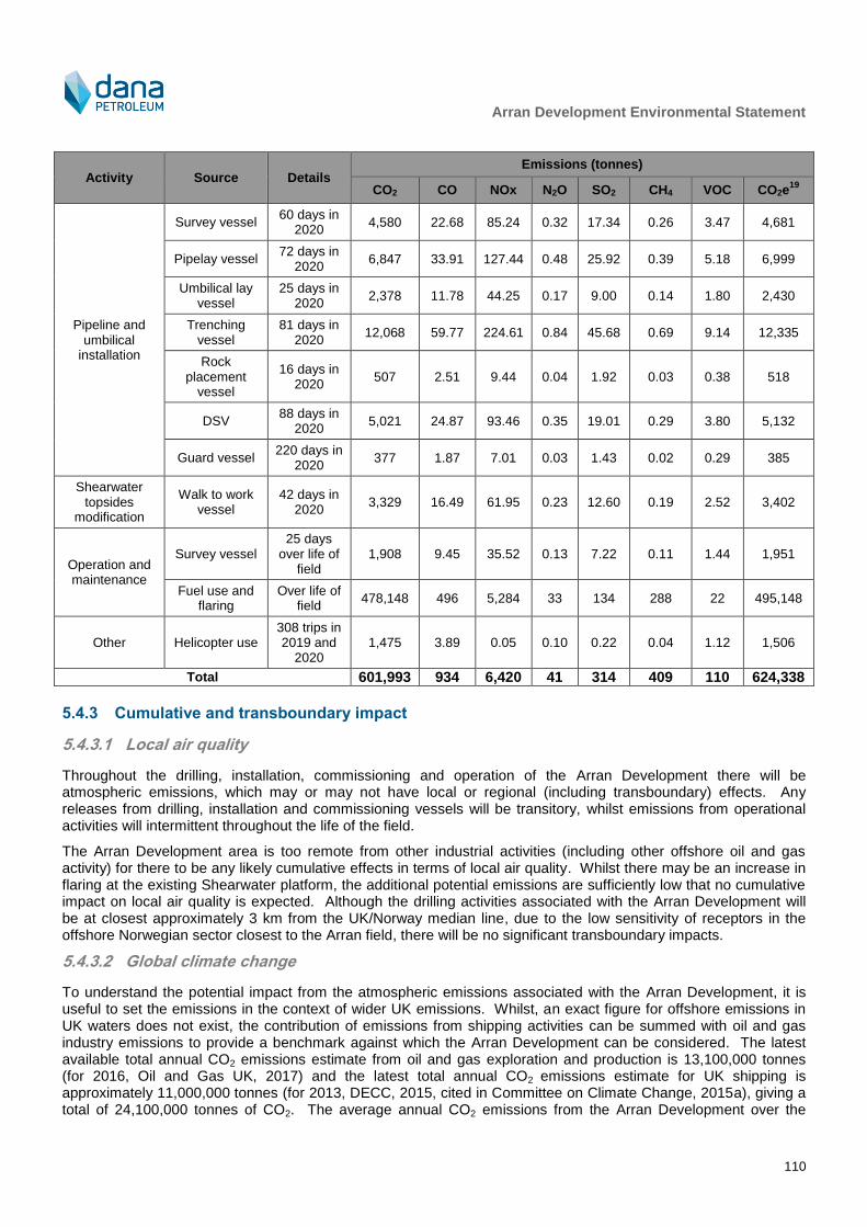
Arran Development Environmental Statement
110
Activity Source Details Emissions (tonnes)
CO2 CO NOx N2O SO2 CH4 VOC CO2e19
Pipeline and umbilical
installation
Survey vessel 60 days in
2020 4,580 22.68 85.24 0.32 17.34 0.26 3.47 4,681
Pipelay vessel 72 days in
2020 6,847 33.91 127.44 0.48 25.92 0.39 5.18 6,999
Umbilical lay vessel
25 days in 2020
2,378 11.78 44.25 0.17 9.00 0.14 1.80 2,430
Trenching vessel
81 days in 2020
12,068 59.77 224.61 0.84 45.68 0.69 9.14 12,335
Rock placement
vessel
16 days in 2020
507 2.51 9.44 0.04 1.92 0.03 0.38 518
DSV 88 days in
2020 5,021 24.87 93.46 0.35 19.01 0.29 3.80 5,132
Guard vessel 220 days in
2020 377 1.87 7.01 0.03 1.43 0.02 0.29 385
Shearwater topsides
modification
Walk to work vessel
42 days in 2020
3,329 16.49 61.95 0.23 12.60 0.19 2.52 3,402
Operation and maintenance
Survey vessel 25 days
over life of field
1,908 9.45 35.52 0.13 7.22 0.11 1.44 1,951
Fuel use and flaring
Over life of field
478,148 496 5,284 33 134 288 22 495,148
Other Helicopter use 308 trips in 2019 and
2020 1,475 3.89 0.05 0.10 0.22 0.04 1.12 1,506
Total 601,993 934 6,420 41 314 409 110 624,338
5.4.3 Cumulative and transboundary impact
5.4.3.1 Local air quality
Throughout the drilling, installation, commissioning and operation of the Arran Development there will be atmospheric emissions, which may or may not have local or regional (including transboundary) effects. Any releases from drilling, installation and commissioning vessels will be transitory, whilst emissions from operational activities will intermittent throughout the life of the field.
The Arran Development area is too remote from other industrial activities (including other offshore oil and gas activity) for there to be any likely cumulative effects in terms of local air quality. Whilst there may be an increase in flaring at the existing Shearwater platform, the additional potential emissions are sufficiently low that no cumulative impact on local air quality is expected. Although the drilling activities associated with the Arran Development will be at closest approximately 3 km from the UK/Norway median line, due to the low sensitivity of receptors in the offshore Norwegian sector closest to the Arran field, there will be no significant transboundary impacts.
5.4.3.2 Global climate change
To understand the potential impact from the atmospheric emissions associated with the Arran Development, it is useful to set the emissions in the context of wider UK emissions. Whilst, an exact figure for offshore emissions in UK waters does not exist, the contribution of emissions from shipping activities can be summed with oil and gas industry emissions to provide a benchmark against which the Arran Development can be considered. The latest available total annual CO2 emissions estimate from oil and gas exploration and production is 13,100,000 tonnes (for 2016, Oil and Gas UK, 2017) and the latest total annual CO2 emissions estimate for UK shipping is approximately 11,000,000 tonnes (for 2013, DECC, 2015, cited in Committee on Climate Change, 2015a), giving a total of 24,100,000 tonnes of CO2. The average annual CO2 emissions from the Arran Development over the
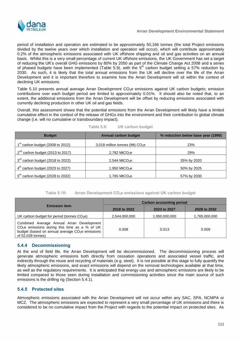
Arran Development Environmental Statement
111
period of installation and operation are estimated to be approximately 50,166 tonnes (the total Project emissions divided by the twelve years over which installation and operation will occur), which will contribute approximately 0.2% of the atmospheric emissions associated with UK offshore shipping and oil and gas activities on an annual basis. Whilst this is a very small percentage of current UK offshore emissions, the UK Government has set a target of reducing the UK’s overall GHG emissions by 80% by 2050 as part of the Climate Change Act 2008 and a series of phased budgets have been implemented (Table 5.9), with the 5
th carbon budget setting a 57% reduction by
2030. As such, it is likely that the total annual emissions from the UK will decline over the life of the Arran Development and it is important therefore to examine how the Arran Development will sit within the context of declining UK emissions.
Table 5.10 presents annual average Arran Development CO2e emissions against UK carbon budgets; emission contributions over each budget period are limited to approximately 0.01%. It should also be noted that, to an extent, the additional emissions from the Arran Development will be offset by reducing emissions associated with currently declining production in other UK oil and gas fields.
Overall, this assessment shows that the potential emissions from the Arran Development will likely have a limited cumulative effect in the context of the release of GHGs into the environment and their contribution to global climate change (i.e. will no cumulative or transboundary impact).
Table 5.9: UK carbon budget
Budget Annual carbon budget % reduction below base year (1990)
1st carbon budget (2008 to 2012) 3,018 million tonnes (Mt) CO2e 23%
2nd
carbon budget (2013 to 2017) 2,782 MtCO2e 29%
3rd
carbon budget (2018 to 2022) 2,544 MtCO2e 35% by 2020
4th
carbon budget (2023 to 2027) 1,950 MtCO2e 50% by 2025
5th
carbon budget (2028 to 2032) 1,765 MtCO2e 57% by 2030
Table 5.10: Arran Development CO2e emissions against UK carbon budget
Emission item Carbon accounting period
2018 to 2022 2023 to 2027 2028 to 2032
UK carbon budget for period (tonnes CO2e) 2,544,000,000 1,950,000,000 1,765,000,000
Combined Average Annual Arran Development CO2e emissions during this time as a % of UK budget (based on annual average CO2e emissions of 52,028 tonnes)
0.008 0.013 0.009
5.4.4 Decommissioning
At the end of field life, the Arran Development will be decommissioned. The decommissioning process will generate atmospheric emissions both directly from cessation operations and associated vessel traffic, and indirectly through the reuse and recycling of materials (e.g. steel). It is not possible at this stage to fully quantify the likely atmospheric emissions, and exact emissions will depend on the removal technologies available at that time, as well as the regulatory requirements. It is anticipated that energy use and atmospheric emissions are likely to be limited compared to those seen during installation and commissioning activities since the main source of such emissions is the drilling rig (Section 5.4.1).
5.4.5 Protected sites
Atmospheric emissions associated with the Arran Development will not occur within any SAC, SPA, NCMPA or MCZ. The atmospheric emissions are expected to represent a very small percentage of UK emissions and there is considered to be no cumulative impact from the Project with regards to the potential impact on protected sites. As
Arran Development Environmental Statement
112
such there is considered to be no LSE on SACs and SPAs and hence no impact on conservation objectives or site integrity. This assessment also considers there to be no potential for atmospheric emissions to interact with protected features of an NCMPA or MCZ and there is therefore no significant risk to the conservation objectives of any NCMPA or MCZ.
5.4.6 Residual impact
Given the temporally restricted nature of the majority of the atmospheric emissions from the Project and taking into account the distance that the Arran Development is from any potentially sensitive receptors, it is not expected that atmospheric emissions will negatively impact local air quality. In terms of global climate change (i.e. cumulative and transboundary impacts), the Arran Development will add a relatively small increment to the overall offshore emissions of the UK and the release of GHG into the environment and their contribution to global warming will be negligible or minor in relation to those from the wider offshore industry and outputs at a national or international level. Any cumulative impact is therefore considered not to have a direct impact on climate change.
Considering all of the above, including that there will be no impact on protected sites or on species from protected sites, the residual consequence of atmospheric emissions is ranked as negligible. As emissions will occur throughout the life of the Arran Development, the frequency is defined as regular. As a result the residual risk of atmospheric emissions from the Arran Development will be negligible and is therefore not significant.
Consequence Likelihood/frequency Residual risk Significance
Negligible Regular Negligible Not significant
5.5 Accidental Events
5.5.1 Description and quantification of potential impact
5.5.1.1 Introduction
The potential impact of any accidental hydrocarbon and chemical release will be determined by the location of the release, characteristics and weathering properties of the released material, the direction of travel and whether environmental sensitivities lie in the path of the release. These environmental sensitivities will have spatial and temporal variations. Therefore, the likelihood of any accidental release having a potential impact on the environment must consider the likelihood of the release occurring against the probability of that hydrocarbon or chemical reaching a sensitive area and the environmental sensitivities present in that area at the time of hydrocarbon or chemical release. The probability definitions presented in Table 4.2 in Chapter 4 have been
developed to take account of this.
Note: It is considered that the implication of any natural disasters affecting the offshore region, such as an earthquake or extreme sea conditions, would most likely be the accidental events described in this section and are not considered separately. Mitigation relevant to minimise the risk of accidental events occurring from operational failure is likely to be appropriate in limiting the likelihood of such natural disasters.
5.5.1.2 Sources and likelihood of occurrence
Blowout and well releases
Primary well control is the process which maintains a hydrostatic pressure in the wellbore greater than the pressure of the hydrocarbons in the formation being drilled via a drilling fluid / mud. If the formation pressure is greater than the hydrostatic pressure of the drilling fluid in the wellbore the well will flow and the hydrocarbons will enter into the wellbore. If the primary well control fails this flow may be stopped by closing the BOP, which is the initial stage of secondary well control. Secondary well control is completed by circulating out the hydrocarbons and displacing the wellbore to the new kill weight drilling fluid / mud. If primary and secondary well control fail, a blowout may occur.
A surface blowout is defined as an uncontrolled flow of formation hydrocarbons from the reservoir to the surface which occurs as a result of loss of primary and secondary well control, and may lead to the potential for release of
Arran Development Environmental Statement
113
hydrocarbons to the environment. An underground blowout is when downhole pressure exceeds the fracture pressure of a formation and hydrocarbons flow into the weaker formation.
The proposed Arran wells will be drilled from a semi-submersible or HDJU drill rig. Whilst historical data for frequency of blowouts from drill rigs on the UKCS between 1990 and 2007 (Table D.1, Appendix D) do not provide information on the severity of the event or whether the blowout or well leak led to an oil accidental release, they do provide an indication of overall frequency of blowouts in the UKCS. Between 1990 and 2007, blowout frequency was 0.014 incidents per year.
Blowouts are actually extremely rare events in modern drilling (Oil & Gas UK, OGUK, 2009; Table D.2, Appendix D); whilst over 6,000 development wells drilled on the UKCS between 1980 and 2010 (UKOOA, 2010), International Association of Oil & Gas Producers (IOGP, 2010) report that only 34 development drilling blowouts were recorded over the same period (and those blowouts also included a number in Norwegian sectors of the North Sea). Based on IOGP (2010) analysis (detailed in Table D.3 in Appendix D) and on the probability definitions in Table 4.2 in Chapter 4, the likelihood of a blowout or well release is considered remote to extremely remote. Nevertheless, as the consequence of a hydrocarbon release of any nature is potentially significant, Dana will implement rigorous measures to reduce the potential for a failure of well control and will respond should an incident occur (these are detailed in Section 5.5.2).
Drill rig accidental releases
The proposed wells will be drilled from a semi-submersible or HDJU drill rig. Potential accidental releases from drill rigs may be caused by mechanical failure, operational failure or human error, and release sources include drilling muds, oil and chemicals and hydraulic fluids.
During the period 2001 to 2007, 172 years of operational activity were logged by drill rigs on the UKCS with no accidental releases greater than 100 tonnes recorded. Indeed, the majority of accidental releases recorded were less than 1 tonne (Table D.4, Appendix D). The most common types of accidental release from drill rigs were found to be associated with drilling (42%); 94% of which were less than 1 tonne. The second most common type of release was from maintenance/operational activities (27%), with 97% of these less than 1 tonne. In addition to accidental releases generally being small volumes, the number and frequency of accidental releases has declined in recent years (Table D.5, Appendix D).
Other than blowouts, the types of scenarios associated with drill rigs which could result in the greatest environmental impact could be collision, explosion or vessel grounding (although the latter is unlikely to be associated with Arran activities), which could result in a total loss of hydrocarbon inventory. The largest fuel inventories will be associated with the drill rig, although it is unlikely that the maximum storage capacity of marine diesel would be maintained for any extended period. In terms of collision with drill rigs, available data indicate a reduction in the frequency of such incidents between 1990 and 2007 (Table D.6, Appendix D).
Subsea tie-backs
Of all accidental releases reported from subsea tie-back facilities between 1975 and 2007, the majority (over 70%) were less than 1 tonne (TINA Consultants Ltd pers. comm., 2013) (detailed in Appendix D).
Pipelay and other support vessel accidental releases
Potential sources of accidental releases from pipelay and support vessel operations include:
Upsets in bilge treatment systems;
Storage tank failure of lube oils, fuel oil (diesel), oil-based mud, base oil and chemicals;
Accidental release during maintenance activities including equipment removal and lubrication;
Refuelling and cargo loading operations in port; and
Damage sustained during a collision, grounding or fire.
The most frequently reported accidental releases from vessels are associated with upsets in bilge treatment systems and are usually small (<1 tonne). The most recent Advisory Committee on Protection of the Sea report on discharges to sea states that approximately 87% of accidental chemical releases involved Poses Little Or No Risk To The Environment (PLONOR) chemicals, which are considered to ‘pose little or no risk’ to the environment. No chemicals that are included in the OSPAR list of chemicals for priority action (i.e. those which are considered to
Arran Development Environmental Statement
114
pose the greatest potential impact) were released and none of the releases were recorded as having resulted in a significant environmental impact.
5.5.1.3 Behaviour of hydrocarbons at sea
The potential environmental impact of an accidental hydrocarbon release depends on a wide variety of factors, which include:
Accidental release volume;
Type of hydrocarbon released;
Direction of travel of the slick;
Weathering properties of the hydrocarbon;
Any environmental sensitivities present in the path of the slick (these may change with time); and
Sensitivity of the sea and beaching locations.
The Oil Spill Contingency and Response (OSCAR) model has been developed by Sintef to model the fate of accidentally released hydrocarbons at sea. It has a built-in oil database, containing over 110 oils, along with various gridded wind and current files, originally produced by the Norwegian Met Office. OSCAR is a three-dimensional model, designed to predict the fate of oil particles at the surface, sub-surface and once dissolved. OSCAR calculates and records the distribution in three physical dimensions, plus time, of a contaminant on the water surface, along shorelines, in the water column, and in the sediments.
Seasonal (winter – December to February, spring – March to May, summer – June to August and autumn – September to November) stochastic modelling using OSCAR was undertaken in line with the Oil Pollution Emergency Plans (OPEP) guidance provided by OPRED (BEIS, 2017a). A minimum of 110 runs were performed for each season, with the historical meteorological data used to inform the model spanning a period of 5 years from 2008 – 2013.
The accidental release scenarios modelled for the Project are detailed in Table 5.11. In line with current regulatory and industry commentary and experience with worst-case scenario identification, the following assumptions have been made while undertaking the modelling for the Arran Development:
Interactions: all scenarios are run with the assumption that there is no response from any party, operator, local or national government. This approach is taken in order to view the worst-case predictions of a spill and should be used as guidance only to build and define oil spill contingency and response plans; and
Timeframes: all modelled runs were given at least a full 30 days following cessation of release. The extra run time was in order to fully examine the fate of released hydrocarbons.
In order to set limits for when the spilled hydrocarbon can be considered insignificant in the environment, the following thresholds have been used:
A minimum surface oil thickness threshold of 0.3 μm has been used for all modelled scenarios; and
The limit of 0.1 litres/m2 for shoreline oiling
20 was applied to all scenarios in agreement with the lowest
band of light oiling, as set out in ITOPF (2011).
The draft guidance on Offshore Safety Directive Submissions (BEIS, 2017b) states that the ES should present all modelling included in relevant project Major Accident Hazard Risk Assessments (MAHRAs) and OPEPs. Arran is a subsea development and does not therefore have a safety case. As such, there are no major accident hazards (MAHs) and therefore no major environmental incidents (MEIs) associated with the project during the production period. However, during the drilling phase, an assessment of MEI potential will be included at that time through the MAT/SAT applications. As the project is gas condensate development it is not conceivable that any spill could constitute an MEI as currently defined under the regulations.
20
No shoreline oiling above the threshold value occurred in any scenarios modelled. Therefore shoreline oiling plots have not been displayed.

Arran Development Environmental Statement
115
Following review of the modelling for the well blowout and pipeline loss scenarios, it was decided that such scenarios were by far the worst case, and additional modelling for a diesel release would not add further value to the assessment.
Table 5.11: Summary of accidental release scenarios modelled for the Project
Scenario No.
Scenario description Hydrocarbon type Release volume Modelled depth of release
Model type
1 Well blowout at Arran South 2 (AS2) using the highest unconstrained well flow rate for 80 days
21
Arran gas condensate 271,649,170 Sm3 gas,
83,250 m3
condensate
and 81 m3 water over 80
days (variable flowrate)
Seabed Stochastic
2 Instantaneous pipeline inventory loss at Shearwater
Arran gas condensate 240 m3
of condensate Seabed Stochastic
3 Instantaneous pipeline inventory loss at Arran South
Arran gas condensate 266 m3 of condensate Seabed Stochastic
Scenario 1: Well blowout at AS2
The surface probability of contamination is presented in Figure 5.5. Surface minimum arrival time of released hydrocarbon is illustrated in Figure 5.6. Table 5.12 presents the minimum crossing times to all relevant median
lines. Although the model predicts this scenario to cause hydrocarbon to spread over a wide area of the central North Sea, Figure 5.7 illustrates that the majority of the released hydrocarbon is extremely thin
22.
For all four seasons, the maximum time-averaged thickness over the surface of the sea was less than 200 µm; the majority of the surface oil was <5 µm thick. Shoreline oiling
20 did not occur above the assigned light oiling
threshold of 0.1 litres/m2.
Scenario 2: Pipeline release at Shearwater
The surface probability of contamination is presented in Figure 5.8. Surface minimum arrival time of released hydrocarbon is illustrated in Figure 5.9. Table 5.12 presents the minimum crossing times to all relevant median lines. Although the model predicts this scenario to cause hydrocarbon to spread over a part of the central North Sea, Figure 5.10 illustrates that the majority of the released hydrocarbon is extremely thin.
For all four seasons, the maximum time-averaged thickness over the surface of the sea was <5 µm. Shoreline oiling
20 did not occur above the assigned light oiling threshold of 0.1 litres/m
2.
Scenario 3: Pipeline release at Arran South
The surface probability of contamination is presented in Figure 5.11. Surface minimum arrival time of released hydrocarbon is illustrated in Figure 5.12. Table 5.12 presents the minimum crossing times to all relevant median lines. Although the model predicts this scenario to cause hydrocarbon to spread over a part of the central North Sea, Figure 5.13 illustrates that the majority of the released hydrocarbon is extremely thin.
For all four seasons, the maximum time-averaged thickness over the surface of the sea was <5 µm. Shoreline oiling
20 did not occur above the assigned light oiling threshold of 0.1 litres/m
2.
For all scenarios there was no shoreline oiling and therefore no further consideration has been given to shoreline issues in this section (for clarity, this means that there will be no interaction with any sites of aquaculture cultivation or with any shellfish protected waters).
21
AS2 location chosen as closest well to the UK/Norwegian transboundary line leading to the highest possibility of
hydrocarbons crossing the median line. The 80 day release period covers the time between the release commencing and well kill being achieved via relief well. 22
Model outputs are extremely sensitive to small changes in environmental inputs. Time-averaging output provides a means of
looking at typical values of output from a particular scenario and filters out fluctuations in values. The time-averaged thickness is thus the average of the results for thickness of surface oil in the model grid and provides an indication of the typical thickness of surface oil that occurs in each model grid during a stochastic simulation.

Arran Development Environmental Statement
116
Table 5.12: Minimum crossing times to median lines
Scenario Median line crossed Minimum crossing time Season
Scenario 1: Well blowout at AS2
UK / Norway Less than 1 hour Winter
UK / Denmark 10 days 0 hours Winter
UK / Sweden 23 days 8 hours Autumn
UK / Germany 24 days 20 hours Winter
UK / Netherlands 26 days 23 hours Winter
Scenario 2: Pipeline release at Shearwater
UK / Norway 0 days 12 hours Winter, spring and autumn
UK / Denmark 15 days 10 hours Winter
UK / Sweden Does not cross Does not cross
UK / Germany Does not cross Does not cross
UK / Netherlands Does not cross Does not cross
Scenario 3: Pipeline release at Arran South
UK / Norway Less than 1 hour Winter
UK / Denmark 25 days 4 hours Winter
UK / Sweden 78 days 19 hours Spring
UK / Germany Does not cross Does not cross
UK / Netherlands Does not cross Does not cross

Arran Development Environmental Statement
117
Figure 5.5: Scenario 1 – well blowout: surface probability of contamination (above 0.3 μm thick)
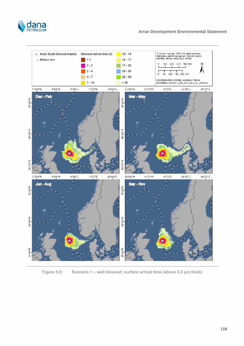
Arran Development Environmental Statement
118
Figure 5.6: Scenario 1 – well blowout: surface arrival time (above 0.3 μm thick)
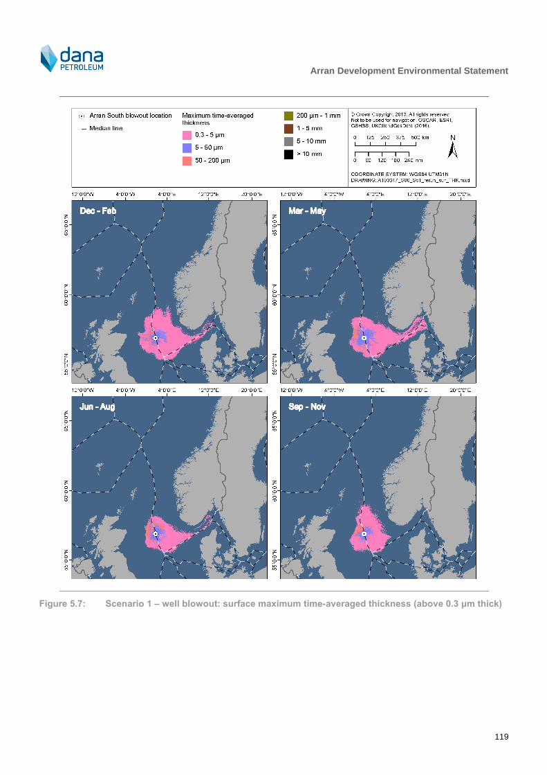
Arran Development Environmental Statement
119
Figure 5.7: Scenario 1 – well blowout: surface maximum time-averaged thickness (above 0.3 μm thick)

Arran Development Environmental Statement
120
Figure 5.8: Scenario 2 – pipeline release at Shearwater: surface probability of contamination (above
0.3 μm thick)

Arran Development Environmental Statement
121
Figure 5.9: Scenario 2 – pipeline release at Shearwater: surface arrival time (above 0.3 μm thick)
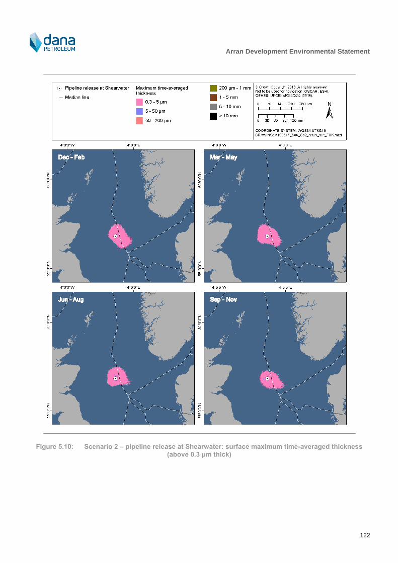
Arran Development Environmental Statement
122
Figure 5.10: Scenario 2 – pipeline release at Shearwater: surface maximum time-averaged thickness
(above 0.3 μm thick)

Arran Development Environmental Statement
123
Figure 5.11: Scenario 3 – pipeline release at Arran South: surface probability of contamination (above
0.3 μm thick)

Arran Development Environmental Statement
124
Figure 5.12: Scenario 3 – pipeline release at Arran South: surface arrival time (above 0.3 μm thick)

Arran Development Environmental Statement
125
Figure 5.13: Scenario 3 – pipeline release at Arran South: surface maximum time-averaged thickness
(above 0.3 μm thick)

Arran Development Environmental Statement
126
5.5.1.4 Environmental vulnerability to spills
Environmental vulnerability to spills is a function of both the likelihood of impact from a spill (as considered in previous sections) and the sensitivity of the environment.
There can be impacts on plankton in the immediate area of the release for the duration of the release due to the dissolution of aromatic fractions into the water column. Such effects will be greater during a period of plankton bloom and during fish spawning periods. Contamination of marine prey including plankton and small fish species may then lead to aromatic hydrocarbons accumulating in the food chain. These could have long-term chronic effects such as reduced fecundity and breeding failure on fish, bird and cetacean populations. This may affect fish stocks of commercially fished species. A major release could also have a localised effect on the fishing industry, should certain areas be temporarily closed to fishing.
Juvenile fish and eggs are potentially the most sensitive life-stage to hydrocarbon discharges. As outlined in Section 3.3.3, a number of commercially important pelagic and demersal fish species are found in the vicinity of the Project.
The JNCC has stated in a memorandum to the UK Parliament that the greatest risks to nature conservation of oil on the offshore sea surface are to seabirds (JNCC, 2011). The seasonal vulnerability of seabirds to surface pollutants in the immediate vicinity of the Project, derived from JNCC block-specific data, suggest that seabirds in this area have an overall low vulnerability to surface pollution (see Section 3.3.5). The magnitude of any impact will depend on the number of birds present, the percentage of the population present, their vulnerability to spilled hydrocarbons and their recovery rates from oil pollution. The physical impact of a spill is one of plumage damage leading to loss of insulation and waterproofing.
Cetaceans are also present in the vicinity of the Project area (see Section 3.3.6). In the event of a spill, the potential impact, will depend on the species and their feeding habits; the overall health of individuals before exposure; and the characteristics of the hydrocarbons. It is thought unlikely that a population of cetaceans in the open sea would be affected by a spill in the long-term (Aubin, 1990). Baleen whales are particularly vulnerable whilst feeding, as oil may stick to the baleen if the whales "filter feed" near surface slicks. Cetaceans are pelagic (move freely in the oceans) and migrate. Their strong attraction to specific areas for breeding or feeding may override any tendency cetaceans have to avoid hydrocarbon contaminated areas.
5.5.2 Mitigation
The following provides an overview of proposed measures that either reduce the probability of failure of an accidental release, or reduce the consequences in the event of a spill:
The Offshore Installations (Offshore Safety Directive) (Safety Case etc.) Regulations 2015 implement the EC Offshore Directive. As part of this, a verification scheme exists for safety and environment critical elements (SECEs). Dana will identify SECEs in future design stages;
Wells and associated subsea infrastructure will be designed as per OGUK best practice;
The drill rig will have a minimum 10,000 pound per square inch BOP stack (standard for drill rigs);
Installation personnel will be given full training in chemical release prevention and actions to be taken in the event of an accidental chemical release;
An appropriate OPEP will be in place, including modelling and appropriate response planning;
Shipboard Oil Pollution Emergency Plans (SOPEPs) will be in place where required;
Development of and conformance to appropriate maintenance procedures;
Simultaneous operations (SIMOPs) will be actively identified and managed;
The drill rig will be subject to an audit which will cover oil spill response, procedural controls, bunkering and storage arrangements;
Bunkering operations will be kept to good light and weather conditions where practicable;
Observers will be posted during bunkering operations;

Arran Development Environmental Statement
127
Visual inspection of hoses and connections prior to use;
Test certification of loading hoses and valves;
The pipeline will be constructed to meet the requirements of the Pipeline Safety Regulations 1996;
Chemical storage areas will be contained to prevent accidental release of chemicals;
Tool box talks will highlight the importance of minimising the risk of spills occurring.
Any spill risk at Shearwater will be covered under Shearwater OPEPs and procedures.
5.5.3 Cumulative and transboundary impact
Existing hydrocarbon spill risks in the North Sea are associated primarily with oil and gas industry activities as well as other marine industries such as merchant shipping and fishing. As indicated by historical data, the likelihood of one major accidental release occurring is remote or extremely remote, limiting the cumulative impact from the Arran Development and other existing installations. Detailed OPEPs will be in place, outlining the response measures to be implemented in the event of any accidental release.
Worst-case scenario spill modelling indicates some probability that in the event of an accidental hydrocarbon release a transboundary impact could result but that this was remote to extremely remote (data used to inform the probability are described in Appendix D). Therefore, consultation under the Espoo Convention, is not required as a result of the Arran Development. The Espoo Convention requires notification and consultation only for projects likely to have a significant adverse environmental impact across boundaries.
The risk of a spill having a transboundary impact, particularly from North Sea operations, is recognised by the UK Government and other governments around the North Sea. International agreements are in place for dealing with transboundary spill incidents. In the event of a major spill which is predicted to drift into Norwegian waters, the Norway-United Kingdom Joint Contingency (NORBRIT) plan will be activated. This plan operates within the framework of the National Contingency Plans and is oriented towards major spills. It becomes operational when agreement to the request for its implementation is reached. Responsibility for implementing joint action rests with the Action Co-ordinating Authority (ACA) of the country on whose side of the median line a spill originated. The UK’s ACA is the Counter Pollution Branch of the Maritime Coastguard Agency.
5.5.4 Environmental Management System
The management of environmental risks associated with Dana’s activities is integral with the business decision making process. Environmental hazards are identified at all stages in the hydrocarbon lifecycle and risks are assessed and managed via a structured Health, Safety and Environmental Management System (HSE MS).
The Dana HSE MS is the mechanism that communicates the Company standards and allows them to be maintained. It will be the mechanism by which the commitments specified in this ES (commitments which are above and beyond statutory requirements are listed in Appendix E) will be tracked. This structured management approach will be used to encourage the ongoing process of identification, assessment and control of environmental risks will continue throughout planning and operations.
The Dana HSE MS has been developed and maintained to meet the principal requirements of the ISO 14001:2004 Environmental Standard. The environmental elements within the management system have been independently verified by approved certification bodies in 2006, 2009, 2013 and most recently in March 2015. During all audits the system was found to be in compliance with OSPAR Recommendation 2003/5 and OPRED required industry standards.
An HSSE plan has been developed for the Arran Development to summarise how HSSE issues will be managed for the Arran Development and how effective implementation of the Dana HSSE Policy will be achieved. The objective of this HSSE Plan, and the complementary main Subcontractors’ HSSE plan, is to ensure that the necessary systems and processes are in place to:
Ensure compliance with relevant statutory provisions as outlined in the Project’s Regulatory Requirements Register;

Arran Development Environmental Statement
128
Design and install facilities which, in addition to meeting all their technical and business goals, will reduce future risks to personnel, the environment and equipment to a level which is tolerable, and as low as is reasonably practicable; and
Execute all phases of the work without significant negative impact on the environment.
Through all phases of the Project, the Development Management Team will ensure that effective, practical and achievable measures which provide for the protection of the environment are in place. To implement the HSSE Plan, the following will be undertaken:
Publicise and communicate Dana HSSE policies and involve all staff, workforce and contractors through participation and consultation, and provide an effective system of communication throughout the Arran Development;
Clearly assign responsibility and accountability for the organisation, activities and arrangements to implement the HSSE policies;
Ensure that HSSE issues are planned and managed with the same priority as other business activities;
Utilise contractors who have a track record of commitment to recognised HSSE standards and who promote industry best practices, and integrate these contractors into the development organisation to ensure effective operations are delivered;
Report, investigate and address incidents to prevent recurrence;
Maintain effective systems for monitoring, performance measurement, audit and review; and
Learn from the active audits and reviews and reactive investigations to strive for continuous improvement in HSSE performance.
5.5.5 Decommissioning
Cessation of production will remove one of the main sources of potential accidental hydrocarbon release since there will no longer be a hydrocarbon flow from the well or through the pipeline system. Vessels will be required to execute decommissioning activities, with potential impacts related to accidental hydrocarbon and chemical release from those vessels likely to occur at a similar magnitude to that of installation activities.
5.5.6 Protected Sites
5.5.6.1 Direct interaction with coastal sites
As outlined in Section 5.5.1.3, shoreline oiling above the assigned light oiling threshold of 0.1 litres/m2 does not
occur and thus direct interaction with any coastal or onshore protected sites will not occur.
5.5.6.2 Direct interaction with receptors from coastal sites found offshore
In addition to direct interaction with a site (i.e. hydrocarbon crossing the boundary of a site), it is necessary to consider the potential that some qualifying features of some sites are mobile (e.g. seabirds, marine mammals) and that some individuals may forage or move through the area within which an accidental release has occurred. In terms of marine mammals for which sites are designated, as outlined in Section 5.3.2.5, bottlenose dolphin
associated with the Moray Firth SAC are generally restricted to the 20 m depth contour and are thus unlikely to be found in the vicinity of any potential hydrocarbon release. Given the distance that any accidental release would remain from the UK coast (Figure 5.5 – Figure 5.13) and given that harbour seals usually forage within 40 – 50 km of their haul-out sites (SCOS, 2014), there is unlikely to be any interaction with harbour seals from SACs on the east Scottish coast. Grey seals may forage up to 200 km from haul-outs (e.g. McConnell et al., 1999) and mainly on the seabed at depths of up to 100 m (SCOS, 2014). However, after breeding, most grey seals at an SAC disperse away from the site, making it very difficult to assign an individual to a particular SAC outside of the breeding season. Grey seal usage of an SAC is therefore very time and space-specific. On this basis, and reviewing available data on grey seal movements (e.g. Cronin et al., 2011, SMRU Ltd, 2011, Russell and McConnell, 2014), it is considered that a 20 km radius around SACs may be used as a guide to the potential for interactions with projects. Given this distance, there is unlikely to be any interaction with grey seals from SACs on the east Scottish coast.
Arran Development Environmental Statement
129
Seabirds will move offshore from SPAs outside of the breeding season, which may bring them into contact with hydrocarbon surface oiling, in the event of such a release. Outside of the breeding season, it is very difficult to apportion these birds to specific SPAs, as discussed by Furness (2014) in their study on defining biological appropriate, species-specific, geographic non-breeding season population estimates for seabirds. Furness (2014) used existing data and literature in order to determine biologically defined minimum population scales for key seabird species. For many seabirds, once breeding is complete, individuals are no longer restricted to foraging within certain distances (i.e. foraging ranges) from their breeding colony as there is no longer any requirement to return to eggs or chicks. The result is that birds become widely dispersed over large distances, often intermingling with birds from other breeding colonies (typically of the same species) and in some cases birds that have migrated from overseas breeding colonies (Furness, 2014). Given that individuals from an SPA population become so widely dispersed, the potential for an accidental release from the Arran Development to impact any of these protected sites becomes significantly diluted as birds present at the site are likely to belong to many coastal locations (i.e. they are unlikely to all belong to one or a few of the closest coastal SPAs). Potential impacts on protected sites during the non-breeding season (i.e. when they are offshore) are therefore expected to be negligible.
5.5.6.3 Direct interaction with offshore sites
For direct interaction with offshore sites without a land component, surface occurrence of released hydrocarbon within the site is taken as an indication that the site has the potential to be impacted. A hydrocarbon release encountering a site (offshore or coastal) has been considered for inclusion in this assessment where the probability of the encounter occurring (in the event of a very low probability accidental hydrocarbon release) is equal to or greater than 5%. On this basis, interaction may occur with the following offshore sites and the potential for LSE has been investigated:
Scanner Pockmark SCI;
East of Gannet and Montrose Fields NCMPA;
Norwegian Boundary Sediment Plain NCMPA;
Central Fladen NCMPA;
Fulmar MCZ; and
Swallow Sand MCZ.
For these sites, all of which are designated for seabed features, the likelihood of an effect from an accidental hydrocarbon release will be determined by the direction of travel of the release, the amount of oil released, prevailing weather and sea conditions and water depth.
The Arran field will produce a gas condensate which has a gravity of approximately 48.7 – 51.5 °API and therefore floats on water
23. Once the lighter fractions of the hydrocarbon have evaporated, the remaining fraction is
expected to form a stable water-in-oil emulsion. Results from the modelling demonstrate that the surface hydrocarbon coverage is modelled to have a maximum time-averaged thickness of less than 200 µm (i.e. <0.2 mm), with the majority of the surface coverage less than <5 µm (i.e. less than 0.005 mm). Therefore, given that the offshore sites located closest to the Arran Development are in water depths ranging from a minimum of 80 m to a maximum of approximately 120 m, and those at the extent of the possible geographical range where surface thickness is at its minimum are in water depths of approximately 50 – 150 m, it is very unlikely that hydrocarbons would be redistributed to these depths in sufficient quantities or thickness to affect the protected seabed features. For these reasons, there is predicted to be no LSE on sites designated for seabed features and these sites are screened out of further assessment (and here this term is used to apply to potential impacts on SACs, SPAs, NCMPAs and MCZs).
5.5.6.4 Cumulative effects
It is important to consider the potential for cumulative impacts to arise from the Arran Development acting upon the environment along with other developments. In terms of the potential for accidental releases from multiple projects to act together, the small releases outlined earlier in this assessment section are of little concern due to the their
23
If API gravity is greater than 10, the hydrocarbon is lighter than water and floats; if less than 10, it is heavier and thus sinks.

Arran Development Environmental Statement
130
spatially and temporally restricted nature. However, larger releases, such as could potentially occur from a well blowout or loss of pipeline inventory, may act cumulatively with releases from other oil and gas projects or industries to affect the integrity of protected sites. Although, as described in Section 5.5.1, such releases are extremely uncommon, consideration is given both to releases occurring simultaneously and to releases occurring a number of years apart. In the first instance of simultaneous releases, the key to limiting the potential for impact would be restricting interaction between released fluids and the protected sites (as it is for a single release) and a co-ordinated response strategy between involved parties would likely be developed, focussing on the sites most at risk. Where releases occur some time apart, the potential impact would be related to the extent to which sites had recovered from interaction with a previous release. The recovery period of impacted sites could be extended should it be impacted by subsequent spills.
5.5.6.5 Conclusions
Considering the absence of direct interaction with coastal sites, the lack of effect on mobile receptors from coastal sites (e.g. marine mammals, seabirds) and that there will be no interaction with the seabed of offshore sites, there will be no LSE on SACs and SPAs and hence no impact on conservation objectives or site integrity. This assessment also considers there to be no potential to interact with protected features of an NCMPA or MCZ and there is therefore no significant risk to the conservation objectives of any NCMPA or MCZ being achieved.
5.5.7 Residual impact
5.5.7.1 Accidental hydrocarbon release
Although the probability of catastrophic releases from the Arran Development is remote, and even though no shoreline oiling will occur, even with comprehensive prevention measures in place the residual risk of accidental release, and thus impact on the marine environment, remains. This is recognised to be true for the offshore oil and gas industry in general and the formulation of detailed and fully tested contingency response plans is thus integral to such projects. As such, Dana will have in place a range of response/mitigation measures to address these risks (detailed in Section 5.4.2). All activities at the Project will be covered by appropriate OPEPs and SOPEPs which will set out the responses required and the available resources for dealing with spills of all sizes. The planning, design and support of all activities for the Project will aim to eliminate or minimise potential environmental risks. As described in Section 5.4.2, these impacts are being mitigated through the equipment design, spill risk reduction measures and provision of appropriate spill response arrangements. Dana’s management processes will ensure that these mitigation commitments are implemented and monitored.
The Water Framework Directive requires nation states to manage the water environment on the basis of units that make sense in environmental terms – these are termed ‘River Basin Districts’ and include all interdependent rivers, lochs, estuaries, coastal waters and associated underground waters. A loss of hydrocarbons from the Arran facilities will not interact with coastal waters. As such, no further consideration of such water bodies is required (i.e. there is no significant impact from the proposed activities). The Marine Strategy Framework Directive aims to develop mechanisms to achieve ‘Good Environmental Status’ for EU waters. As part of this, nation states are required to develop a set of targets/indicators for good environmental status and to monitor the status of its water bodies. Specifically for the UK, this means the Greater North Sea and Celtic Sea areas. The Marine Strategy Framework Directive has a broader remit than the Water Framework Directive, with components such as noise, commercial fisheries and biodiversity being of interest. Through the impact assessment presented in this section, the potential for the Arran Development to compromise the good environmental status of UKCS waters has effectively assessed the impact on all relevant features considered by the Marine Strategy Framework Directive. As the impact assessment concludes that there is no significant impact from the proposed activities, there will be no negative impact on the good environmental status of the waters within which the activities will take place.
5.5.7.2 Chemical spills
In addition to the hydrocarbon spill risk, there is also the risk of a chemical spill. Chemical spills may occur during chemical transfer, chemical/mud handling, or through mechanical failure. The fate of any chemical entering the water column is dependent upon how physicochemical properties influence its partitioning between seawater and its susceptibility to degradation (DTI, 2001). Given the high energy marine environment of the wider area, chemical spills are expected to disperse in the offshore marine environment with a possible negligible to minor localised and transient impact on plankton or fish egg/larvae, depending on the season.
Arran Development Environmental Statement
131
Spill prevention measures in place will encompass chemicals as well as hydrocarbon spills. Pre-mobilisation audits and bridging documentation will ensure that these prevention procedures are in place on drill rigs, support and supply vessels. Personnel will also be given full training in environmental awareness and spill prevention methods. Procedures will be in place to further reduce the risk of spillage, in particular written procedures, regular inspection of equipment and provision of spill kits. Chemical spill risks at Shearwater will be covered under platform specific procedures and other spill prevention measures.
To reduce the potential risk of chemicals offshore, Dana continually works with its chemical suppliers to ensure that chemical use is minimised without compromising technical performance. Furthermore, Dana recognises that substitution is an important part of the OSPAR Harmonised Mandatory Control Scheme (HMCS) and is committed to use of non-substitution chemicals and to the investigation of alternative where this is not possible. Information on specific chemical use and associated environmental impact assessment will be provided in the relevant permit (e.g. Master Application Template/Subsidiary Application Template) prior to the commencement of activity. Dana endeavour to use chemicals with a good environmental profile (PLONOR, Cefas Offshore Chemical Notification Scheme (OCNS) group E or Gold banded chemicals) where possible to reduce potential impacts from these chemicals on the marine environment.
5.5.7.3 Conclusion
Given the potential for the extended geographical spread from a worst-case release (including with protected sites, as described in Section 5.5.6) and the potential to affect species at the community level or to inhibit their natural range, the residual consequence is ranked as major. In significance ranking terms, the likelihood of occurrence is considered ’remote’. As a result of the major consequence and remote occurrence, the residual risk will be minor and is therefore not significant.
Consequence Likelihood/frequency Residual risk Significance
Major Remote Minor Not significant
Arran Development Environmental Statement
132
6 Environmental Management
6.1 Environmental Management System
The management of environmental risks associated with Dana’s activities is integral with the business decision making process. Environmental hazards are identified at all stages in the hydrocarbon lifecycle and risks are assessed and managed via a structured Health, Safety and Environmental Management System (HSE MS).
The Dana HSE MS is the mechanism that communicates the Company standards and allows them to be maintained. It will be the mechanism by which the commitments specified in this ES (commitments which are above and beyond statutory requirements are listed in Appendix E) will be tracked. This structured management approach will be used to encourage the ongoing process of identification, assessment and control of environmental risks will continue throughout planning and operations.
The Dana HSE MS has been developed and maintained to meet the principal requirements of the ISO 14001:2004 Environmental Standard. The environmental elements within the management system have been independently verified by approved certification bodies in 2006, 2009, 2013 and most recently in March 2015. During all audits the system was found to be in compliance with OSPAR Recommendation 2003/5 and OPRED required industry standards.
An HSSE plan has been developed for the Arran Development to summarise how HSSE issues will be managed for the Arran Development and how effective implementation of the Dana HSSE Policy will be achieved. The objective of this HSSE Plan, and the complementary main Subcontractors’ HSSE plan, is to ensure that the necessary systems and processes are in place to:
Ensure compliance with relevant statutory provisions as outlined in the Project’s Regulatory Requirements Register;
Design and install facilities which, in addition to meeting all their technical and business goals, will reduce future risks to personnel, the environment and equipment to a level which is tolerable, and as low as is reasonably practicable; and
Execute all phases of the work without significant negative impact on the environment.
Through all phases of the Project, the Development Management Team will ensure that effective, practical and achievable measures which provide for the protection of the environment are in place. To implement the HSSE Plan, the following will be undertaken:
Publicise and communicate Dana HSSE policies and involve all staff, workforce and contractors through participation and consultation, and provide an effective system of communication throughout the Arran Development;
Clearly assign responsibility and accountability for the organisation, activities and arrangements to implement the HSSE policies;
Ensure that HSSE issues are planned and managed with the same priority as other business activities;
Utilise contractors who have a track record of commitment to recognised HSSE standards and who promote industry best practices, and integrate these contractors into the development organisation to ensure effective operations are delivered;
Report, investigate and address incidents to prevent recurrence;
Maintain effective systems for monitoring, performance measurement, audit and review; and
Learn from the active audits and reviews and reactive investigations to strive for continuous improvement in HSSE performance.

Arran Development Environmental Statement
133
6.2 Environmental Management and Commitments
A commitments register is presented in Appendix E which summarises mitigation and management measures above and beyond regulatory requirements identified during the EIA process. These will be implemented as part of the Arran Development. Each commitment will be reviewed regularly to ensure that it is being met. Objectives and targets are also used for setting goals for continuous improvement in performance as part of Dana’s HSE MS. In this way, environmental management is an ongoing process and will continue beyond implementation of mitigation measures identified during this EIA in order to strive for continuous improvement.
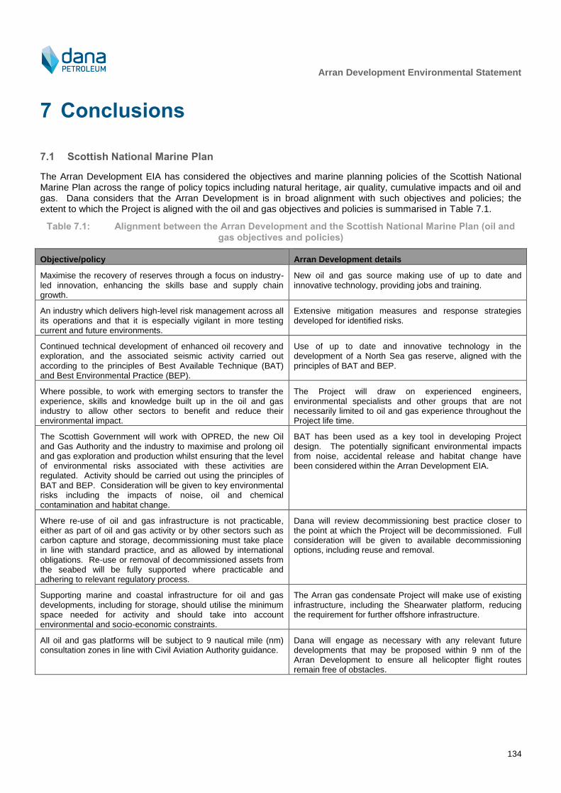
Arran Development Environmental Statement
134
7 Conclusions
7.1 Scottish National Marine Plan
The Arran Development EIA has considered the objectives and marine planning policies of the Scottish National Marine Plan across the range of policy topics including natural heritage, air quality, cumulative impacts and oil and gas. Dana considers that the Arran Development is in broad alignment with such objectives and policies; the extent to which the Project is aligned with the oil and gas objectives and policies is summarised in Table 7.1.
Table 7.1: Alignment between the Arran Development and the Scottish National Marine Plan (oil and
gas objectives and policies)
Objective/policy Arran Development details
Maximise the recovery of reserves through a focus on industry-led innovation, enhancing the skills base and supply chain growth.
New oil and gas source making use of up to date and innovative technology, providing jobs and training.
An industry which delivers high-level risk management across all its operations and that it is especially vigilant in more testing current and future environments.
Extensive mitigation measures and response strategies developed for identified risks.
Continued technical development of enhanced oil recovery and exploration, and the associated seismic activity carried out according to the principles of Best Available Technique (BAT) and Best Environmental Practice (BEP).
Use of up to date and innovative technology in the development of a North Sea gas reserve, aligned with the principles of BAT and BEP.
Where possible, to work with emerging sectors to transfer the experience, skills and knowledge built up in the oil and gas industry to allow other sectors to benefit and reduce their environmental impact.
The Project will draw on experienced engineers, environmental specialists and other groups that are not necessarily limited to oil and gas experience throughout the Project life time.
The Scottish Government will work with OPRED, the new Oil and Gas Authority and the industry to maximise and prolong oil and gas exploration and production whilst ensuring that the level of environmental risks associated with these activities are regulated. Activity should be carried out using the principles of BAT and BEP. Consideration will be given to key environmental risks including the impacts of noise, oil and chemical contamination and habitat change.
BAT has been used as a key tool in developing Project design. The potentially significant environmental impacts from noise, accidental release and habitat change have been considered within the Arran Development EIA.
Where re-use of oil and gas infrastructure is not practicable, either as part of oil and gas activity or by other sectors such as carbon capture and storage, decommissioning must take place in line with standard practice, and as allowed by international obligations. Re-use or removal of decommissioned assets from the seabed will be fully supported where practicable and adhering to relevant regulatory process.
Dana will review decommissioning best practice closer to the point at which the Project will be decommissioned. Full consideration will be given to available decommissioning options, including reuse and removal.
Supporting marine and coastal infrastructure for oil and gas developments, including for storage, should utilise the minimum space needed for activity and should take into account environmental and socio-economic constraints.
The Arran gas condensate Project will make use of existing infrastructure, including the Shearwater platform, reducing the requirement for further offshore infrastructure.
All oil and gas platforms will be subject to 9 nautical mile (nm) consultation zones in line with Civil Aviation Authority guidance.
Dana will engage as necessary with any relevant future developments that may be proposed within 9 nm of the Arran Development to ensure all helicopter flight routes remain free of obstacles.

Arran Development Environmental Statement
135
Objective/policy Arran Development details
Consenting and licensing authorities should have regard to the potential risks, both now and under future climates, to oil and gas operations in Scottish waters, and be satisfied that installations are appropriately sited and designed to take account of current and future conditions.
The Arran Development has been developed in a way that there will not be a significant impact on the physical, biological and socio-economic environment. This demonstrates an appropriate siting within North Sea. The selection of the proposed concept for the Arran Development gave due consideration to how best to develop the field in the context of existing and future developments in the region.
Consenting and licensing authorities should be satisfied that adequate risk reduction measures are in place, and that operators should have sufficient emergency response and contingency strategies in place that are compatible with the National Contingency Plan (NCP) and the Offshore Safety Directive.
Potential environmental impacts have been reviewed as part of this EIA and relevant mitigation measures developed. The Dana response strategy to accidental hydrocarbon release has been developed with due reference to the NCP.
7.2 Protected Species and Sites
The majority of species protected under Annex I of the Birds Directive that are present within the North Sea will generally be found much closer to shore and may only encounter the Project with any regularity during the limited period of the drilling and installation activity.
There will be no significant impact on any Annex I habitat (of the Habitats Directive).
The presence within the Arran Development area of species protected under Annex II of the Habitats Directive is limited to marine mammals. Marine mammal species that may be present in the Arran field and along the pipeline route to Shearwater occur in relatively low densities, or occur only occasionally, or as casual visitors. Dana has assessed whether the noise emitting operations (e.g. vessel use and limited hammer piling) associated with the Arran Development have the potential to result in injury or disturbance to any species. This assessment concluded that there is a very low likelihood of injury (such as temporary or permanent hearing loss), or disturbance as a result of the activities associated with the Project and that potentially significant environmental impacts would be unlikely to result in population level impacts.
There are a number of offshore and coastal conservation areas on the Scottish mainland that have been designated under the Habitats Directive as SACs, under the EU Birds Directive as SPAs and under the Marine Scotland Act 2010 and Marine and Coastal Access Act 2009 as NCMPAs and MCZs. The potential for significant impacts on any such site has been considered within each impact assessment, with particular focus given to the potential for an accidental hydrocarbon release to interact with such sites. Given the remote location of the Arran field, the short term duration of installation activities along the pipeline route and the mitigation and management measures in place (including for well blowout), the Arran Development is considered unlikely to affect the conservation objectives or site integrity of any SAC and SPA and neither is there a significant risk to the conservation objectives of the NCMPAs or MCZs.
Considering all of the above, no significant impacts are expected upon protected species and habitats.
7.3 Cumulative and Transboundary Impacts
A review of each of the potentially significant environmental impacts associated with the Arran Development and the mitigation measures proposed against the range of other activities in the region (detailed in Chapter 5) indicates that no significant cumulative impacts are expected.
Potential transboundary environmental impacts originate in one country but have an effect on the environment in another country. A review of each of the potentially significant environmental impacts associated with the Arran Development and the mitigation measures proposed indicates that no significant transboundary impacts are expected. Hydrocarbon release modelling undertaken for the Arran Development indicates some probability in the event of a worst case hydrocarbon release that a transboundary impact could result, particularly in Norwegian waters and to a lesser extent in Swedish, Danish, German and Dutch waters. The assessment of release likelihood demonstrates that the likelihood of a release large enough to lead to such a transboundary impact is low and that potential transboundary impacts are much reduced when likely intervention strategies are considered.

Arran Development Environmental Statement
136
7.4 Environmental Impacts
The residual environmental impact for the Arran Development (i.e. following application of any mitigation) is summarised in Table 7.2.
Table 7.2: Summary of residual environmental impact
Impact Mitigation identified? Residual risk Significance
Discharges to sea
Project impact – installation and commissioning
Yes Negligible Not significant
Project impact – operational Yes Minor Not significant
Cumulative The areas of impact are extremely limited and there will be rapid recovery of receptors. Combined with the absence of known imminent projects in the Project area, there is limited scope for any cumulative impact.
Not significant
Transboundary The spatial extent of discharges to sea, including primarily drill cuttings, will be extremely limited and will not be detectable across median lines.
Not significant
Physical presence
Seabed
Project impact Yes Negligible Not significant
Cumulative The highly localised area of seabed impact, the lack of sensitive seabed habitats in the Project area and the absence of known imminent projects in the Project area means there is no mechanism by which cumulative impact can occur.
Not significant
Transboundary Although Arran South is closest to the UK/Norway median line at 3 km (Arran South drill centre, but is 26 km at its furthest, at Shearwater), direct and indirect seabed impacts will not extend this far from the Arran Development and transboundary impacts will not occur.
Not significant
Underwater noise
Project impact Yes Minor Not significant
Cumulative Modelling of Project noise sources occurring simultaneously has demonstrated no potential for cumulative impact with regards injury or disturbance to marine mammals or fish. Whilst cetacean and fish populations are free-ranging and long-distance movement is likely to be frequent, and whilst these animals may subsequently come into contact with noise from other projects, injury and disturbance impacts resulting from the Arran Development are not expected to be significant and significant cumulative impact from the unlikely scenario of an animal encountering noise emissions from multiple projects within a short period of time is therefore considered highly unlikely.
Not significant
Transboundary The Arran Development area is a minimum of 3 km (Arran South drill centre) from the UK/Norway median line at its closest point and up to 26 km (Shearwater) at its furthest. Since sound emissions capable of potentially causing injury are unlikely to occur for marine mammals and would be unlikely to be received directly by fish across median lines, direct transboundary impact from injury is not likely to occur. However, given that disturbance zones may reach up to a number of kilometres for some restricted periods (e.g. during drilling and installation of seabed infrastructure), and since an animal experiencing an impact in UK waters would likely belong to a much wider ranging population and thus likely to cross median lines, such a potential impact could qualify as a transboundary impact. However, no injury is expected from the Arran Development and any disturbance will be trivial in nature.
Not significant

Arran Development Environmental Statement
137
Other sea users
Project impact Yes Minor Not significant
Cumulative Due to the low levels of shipping and fishing activity in the Project area, the wide expanse of water available to navigate in and the limited number of vessels to be deployed for the Project, it is not anticipated that there will be any significant cumulative impacts with respect to vessel collision risk. The area of exclusion during the Project will be small in comparison with the total fishing area available and will be largely temporary and thus the impact very limited.
Not significant
Transboundary The Project area may be fished by vessels other nations and any effect on their landings could constitute a transboundary impact. However, the potential impact on fisheries is considered not significant for any vessel regardless of origin.
Not significant
Atmospheric emissions
Project impact Yes Negligible Not significant
Cumulative The Arran Development area is too remote from other industrial activities (including other offshore oil and gas activity) for there to be any likely cumulative effects in terms of local air quality. In terms of global climate change, the emissions from the Arran Development will have a limited cumulative effect in the context of the release of GHGs into the environment and their contribution to global climate change.
Not significant
Transboundary Emissions to air will enter the atmosphere, contributing to global anthropogenic emissions totals and constituting a transboundary impact. However, the emissions from the Arran Development will have a limited effect in the context of the release of GHGs globally.
Not significant
Accidental events
Project impact Yes Minor Not significant
Cumulative Historical data indicate that the likelihood of one major accidental release occurring is remote or extremely remote; the likelihood of two potentially significant releases occurring is substantially lower.
Not significant
Transboundary Modelling undertaken for the Project (refer to section 5.5.1.3), which assumed no response measures were implemented (in order to understand the worst-case outcome), indicates some probability that in the event of a worst case accidental hydrocarbon release a transboundary impact could result. The risk of a release having a transboundary impact, particularly from North Sea operations, is recognised by the UK Government and other governments around the North Sea and International agreements are in place for dealing with transboundary spill incidents.
Not significant
7.5 Final Remarks
Based on the findings of the Arran Development EIA and the identification and subsequent application of the mitigation measures identified for each potentially significant environmental impact (which will be managed through Dana’s HSE Management System), it is concluded that the Project will result in no significant environmental impact. The commitments made in this ES commitments which are above and beyond statutory requirements are listed in are summarised in Appendix E.

Arran Development Environmental Statement
138
Appendix A – Aspects Raised in Scoping
Aspect raised Dana response
JNCC
Protected sites and features, such as the East of Gannet and Montrose Fields NCMPA and areas of MDAC, should be considered in the EIA.
Consideration has been given to protected sites and features (including both this protected site and MDAC) within each relevant section of the impact assessment (Chapter 5).
The impact assessment should use the latest Seabird Oil Sensitivity Index data.
The environmental baseline presented in Chapter 3 makes use of the latest seabird sensitivity data.
Northern Lighthouse Board
Confirmed that the scope of the EIA was appropriate from their perspective.
Dana appreciate the time taken to respond. This ES has presented the impact assessment in line with the scoping letter.
SFF
Temporary and permanent loss of fishing ground should be assessed.
This has been considered within the impact assessment in Chapter 5.
Dana should be clear on how the pipeline and umbilical will be installed, and the reasons for the options selected.
The project description in Chapter 2 includes a clear description of the proposed activities, and a justification for the options selected.
Pipelay trenching/burial has the potential to leave behind clay berms (spoil heaps), which can be a hazard for fishing gear.
The sediments in the Arran area are fine to coarse sand and the likelihood of clay berms being formed is low. The pipeline will be trenched and backfilled (although there is still an option to surface lay between Arran North and Arran South), such that berms will not be left. The umbilical will be left in an open trench, but Dana will consider appropriate mitigation (which may include use of chain mats) to ensure that any clay berms that do form will be removed prior to completion of installation activities.
Impacts on fish and fisheries, from spawning through to catching, should be considered in the EIA.
This has been considered within the impact assessment in Chapter 5.
Although fishing is low in the vicinity of the Project area, fishing patterns are cyclical and there will be certain times of the year (April – July) when a local increase in fishing activity is expected.
A description of seasonal variation in fishing activity has been included in Chapter 3. Such variation has been considered in the assessment given in Chapter 5, but since Project related drilling and installation activities will occur throughout the year then the possibilities to minimise temporary interaction through time-based mitigation is limited.
There may be a level of foreign fishing effort to consider. This has been noted in the fishing activity baseline in Chapter 3 and considered as part of the impact assessment in Chapter 5.
Decommissioning must be considered within the assessment.
Each impact assessment presented in Chapter 5 includes a specific section on potential impacts from decommissioning activities.
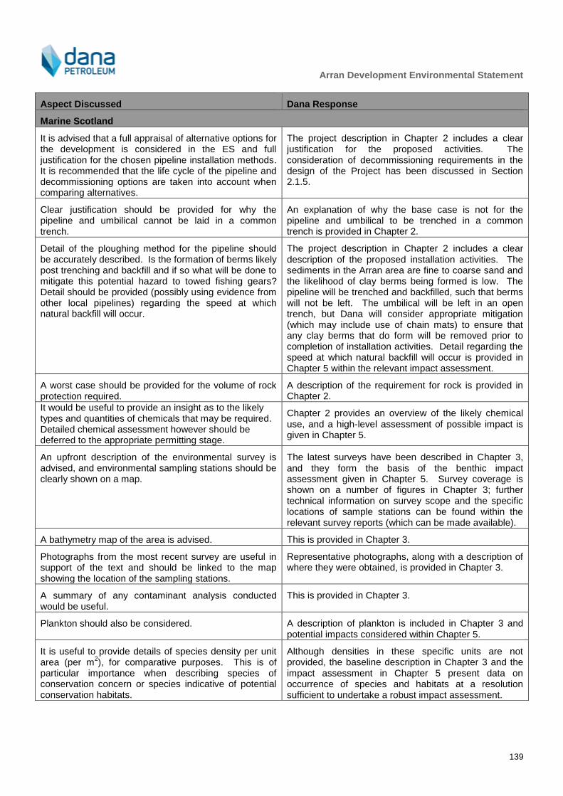
Arran Development Environmental Statement
139
Aspect Discussed Dana Response
Marine Scotland
It is advised that a full appraisal of alternative options for the development is considered in the ES and full justification for the chosen pipeline installation methods. It is recommended that the life cycle of the pipeline and decommissioning options are taken into account when comparing alternatives.
The project description in Chapter 2 includes a clear justification for the proposed activities. The consideration of decommissioning requirements in the design of the Project has been discussed in Section 2.1.5.
Clear justification should be provided for why the pipeline and umbilical cannot be laid in a common trench.
An explanation of why the base case is not for the pipeline and umbilical to be trenched in a common trench is provided in Chapter 2.
Detail of the ploughing method for the pipeline should be accurately described. Is the formation of berms likely post trenching and backfill and if so what will be done to mitigate this potential hazard to towed fishing gears? Detail should be provided (possibly using evidence from other local pipelines) regarding the speed at which natural backfill will occur.
The project description in Chapter 2 includes a clear
description of the proposed installation activities. The sediments in the Arran area are fine to coarse sand and the likelihood of clay berms being formed is low. The pipeline will be trenched and backfilled, such that berms will not be left. The umbilical will be left in an open trench, but Dana will consider appropriate mitigation (which may include use of chain mats) to ensure that any clay berms that do form will be removed prior to completion of installation activities. Detail regarding the speed at which natural backfill will occur is provided in Chapter 5 within the relevant impact assessment.
A worst case should be provided for the volume of rock protection required.
A description of the requirement for rock is provided in Chapter 2.
It would be useful to provide an insight as to the likely types and quantities of chemicals that may be required. Detailed chemical assessment however should be deferred to the appropriate permitting stage.
Chapter 2 provides an overview of the likely chemical use, and a high-level assessment of possible impact is given in Chapter 5.
An upfront description of the environmental survey is advised, and environmental sampling stations should be clearly shown on a map.
The latest surveys have been described in Chapter 3,
and they form the basis of the benthic impact assessment given in Chapter 5. Survey coverage is shown on a number of figures in Chapter 3; further technical information on survey scope and the specific locations of sample stations can be found within the relevant survey reports (which can be made available).
A bathymetry map of the area is advised. This is provided in Chapter 3.
Photographs from the most recent survey are useful in support of the text and should be linked to the map showing the location of the sampling stations.
Representative photographs, along with a description of where they were obtained, is provided in Chapter 3.
A summary of any contaminant analysis conducted would be useful.
This is provided in Chapter 3.
Plankton should also be considered. A description of plankton is included in Chapter 3 and potential impacts considered within Chapter 5.
It is useful to provide details of species density per unit area (per m
2), for comparative purposes. This is of
particular importance when describing species of conservation concern or species indicative of potential conservation habitats.
Although densities in these specific units are not provided, the baseline description in Chapter 3 and the impact assessment in Chapter 5 present data on occurrence of species and habitats at a resolution sufficient to undertake a robust impact assessment.
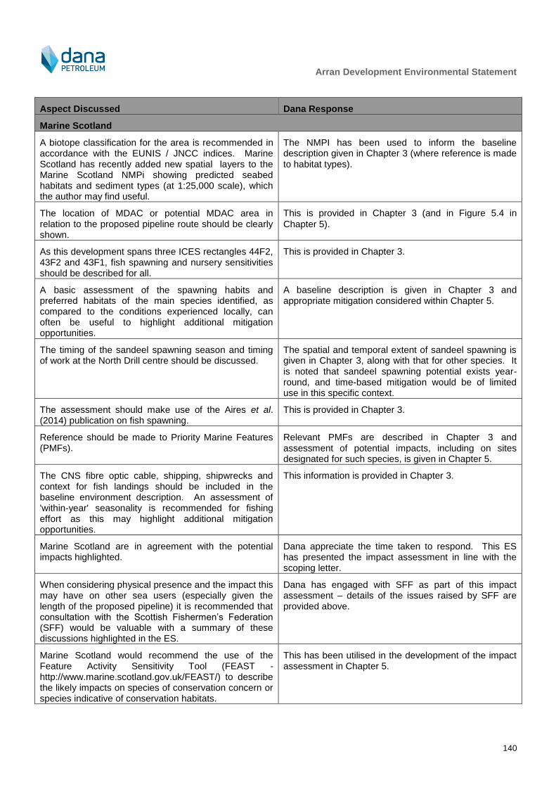
Arran Development Environmental Statement
140
Aspect Discussed Dana Response
Marine Scotland
A biotope classification for the area is recommended in accordance with the EUNIS / JNCC indices. Marine Scotland has recently added new spatial layers to the Marine Scotland NMPi showing predicted seabed habitats and sediment types (at 1:25,000 scale), which the author may find useful.
The NMPI has been used to inform the baseline description given in Chapter 3 (where reference is made to habitat types).
The location of MDAC or potential MDAC area in relation to the proposed pipeline route should be clearly shown.
This is provided in Chapter 3 (and in Figure 5.4 in
Chapter 5).
As this development spans three ICES rectangles 44F2, 43F2 and 43F1, fish spawning and nursery sensitivities should be described for all.
This is provided in Chapter 3.
A basic assessment of the spawning habits and preferred habitats of the main species identified, as compared to the conditions experienced locally, can often be useful to highlight additional mitigation opportunities.
A baseline description is given in Chapter 3 and appropriate mitigation considered within Chapter 5.
The timing of the sandeel spawning season and timing of work at the North Drill centre should be discussed.
The spatial and temporal extent of sandeel spawning is given in Chapter 3, along with that for other species. It is noted that sandeel spawning potential exists year-round, and time-based mitigation would be of limited use in this specific context.
The assessment should make use of the Aires et al. (2014) publication on fish spawning.
This is provided in Chapter 3.
Reference should be made to Priority Marine Features (PMFs).
Relevant PMFs are described in Chapter 3 and
assessment of potential impacts, including on sites designated for such species, is given in Chapter 5.
The CNS fibre optic cable, shipping, shipwrecks and context for fish landings should be included in the baseline environment description. An assessment of 'within-year' seasonality is recommended for fishing effort as this may highlight additional mitigation opportunities.
This information is provided in Chapter 3.
Marine Scotland are in agreement with the potential impacts highlighted.
Dana appreciate the time taken to respond. This ES has presented the impact assessment in line with the scoping letter.
When considering physical presence and the impact this may have on other sea users (especially given the length of the proposed pipeline) it is recommended that consultation with the Scottish Fishermen’s Federation (SFF) would be valuable with a summary of these discussions highlighted in the ES.
Dana has engaged with SFF as part of this impact assessment – details of the issues raised by SFF are provided above.
Marine Scotland would recommend the use of the Feature Activity Sensitivity Tool (FEAST - http://www.marine.scotland.gov.uk/FEAST/) to describe the likely impacts on species of conservation concern or species indicative of conservation habitats.
This has been utilised in the development of the impact assessment in Chapter 5.
Arran Development Environmental Statement
141
Aspect Discussed Dana Response
Marine Scotland
Since 1998, international obligations have effectively meant that all installations should be designed for complete removal at the end of field life. Therefore the application should detail how the operator has taken this requirement into account when designing the proposed infrastructure and protective materials, particularly given the relatively short field life expected.
The extent to which decommissioning has been incorporated into Project design is noted in Chapter 2.
The ES should discuss how the proposed works comply with Scotland's National Marine Plan.
Chapter 7 provides a list of relevant policies and the extent to which the Project is aligned.
It is advised that the UK Offshore Energy Strategic Environmental Assessment 3 (OESEA3) is reviewed and incorporated into the assessment.
This has been used within the environmental baseline in Chapter 3 and within the impact assessment in Chapter 5.

Arran Development Environmental Statement
142
Appendix B – ENVID Workshop Output

Arran Development Environmental Statement
143
ID Project aspect Description of potential effects Project stage relevance? Mitigation Potentially
significant in EIA terms?
Stakeholder expectation to assess in ES?
Take forward
further in EIA?
Discharges to Sea
1 Routine discharge oil based drill cuttings, including those contaminated with reservoir hydrocarbons (i.e. drilling through pay zone).
Cuttings, hydrocarbons, dissolved metals, dissolved organics and any chemicals released to sea may cause detrimental impacts on local water quality and marine flora and fauna.
Drilling Yes
Return to rig for cleaning and transfer to shore Selection of chemicals with less potential for environmental impact (all) Environmental risk assessment through the MATs/SATs system (OCR and OPPC) (all) Skip and ship for LTOBM from lower well sections
Yes Yes Scoped In
Subsea installation No
Topsides modifications No
Operations No Decommissioning No
2 Routine discharge of water based drill cuttings - top hole cuttings will go direct to the seabed
Cuttings, dissolved metals, dissolved organics and any chemicals released to sea may cause detrimental impacts on local water quality and marine flora and fauna.
Drilling Yes
Selection of chemicals with less potential for environmental impact (i.e. PLONOR) (all) Environmental risk assessment through the MATs/SATs system (OCR) (all)
Yes Yes Scoped In Subsea installation No
Topsides modifications No
Operations No
Decommissioning No
3 Routine chemical use and discharge to sea during drilling and installation (including cementing during drilling, well completion, pipeline commissioning, subsea structure commissioning and decommission of existing pipeline). This includes flushing of fluids through the produced water system at the sea surface through Shearwater produced water system. Chemical use also to include from the new pipeline pre commissioning, gels and dye in new pipelines or structures, release from spool tie ins and barrier checks on the trees (dye and meg discharge). The discharge location for dewatering of the new pipeline could be at Shearwater or Arran and may be up to 5,000m
3.
Chemicals discharged to sea may cause contamination of seawater and disturbance to aquatic ecosystem.
Drilling Yes
Selection of chemicals with less potential for environmental impact (all) Environmental risk assessment through the MATs/SATs system (OCR) (all)
No Yes Scoped In
Subsea installation Yes
Topsides modifications Yes
Operations No
Decommissioning No
4 Routine chemical use and discharge to during operation (e.g. well workover, subsea valves, leak detection dyes) and any incremental discharge at Shearwater (e.g. deck cleaning, deck drainage run-off). There are no scale squeeze requirements. There will be an open loop system meaning that small volumes of hydraulic fluid could be released (< 10 litres per actuation) with few actuations planned. Chemical injection valves (hydraulic fluid) mean releases at manifolds too (refer to the previous ES). The existing J-tube at Shearwater C is likely filled with biocide which will be released to sea during umbilical installation (<15m3 - one off discharge).
Chemicals discharged to sea may cause contamination of seawater and disturbance to aquatic ecosystem.
Drilling No
Selection of chemicals with less potential for environmental impact (all) Environmental risk assessment through the MATs/SATs system (OCR) (all)
No No Scoped Out
Subsea installation No
Topsides modifications No
Operations Yes
Decommissioning No

Arran Development Environmental Statement
144
ID Project aspect Description of potential effects Project stage relevance? Mitigation Potentially
significant in EIA terms?
Stakeholder expectation to assess in ES?
Take forward
further in EIA?
Discharges to Sea
5 Routine discharge of ballast water and removal/fall-off of fouling growth from ships (note: vessels likely to only have come from as far as Norway).
Ballast water and marine growth on ships coming into the Project area may contain non-native organisms. Some species may survive and establish themselves. Non-native species may cause serious ecological impacts, particularly if they become invasive. Drilling Yes
IMO Ballast Water Management Convention, including Ballast water plan and log book (all) Fouling procedures for vessels under hire (all) No No Scoped Out
Subsea installation Yes
Topsides modifications Yes
Operations Yes
Decommissioning Yes
6 Routine blackwater production (i.e. sewage), grey water (i.e. from showers, laundry, hand and eye wash basins and drinking fountains) and food waste (macerated) disposal (from vessels and drilling rig and any incremental occurrence at Shearwater). Walk to work vessel may be required at Shearwater during topsides modifications. Would be located within the 500 m safety zone. Additional survey inspection and maintenance vessels required only periodically.
Discharge of sewage, grey water and macerated food has an associated BOD and may contribute to organic enrichment in the vicinity of the discharge possibly leading to a small increase in plankton and fish population.
Drilling Yes Treatment to IMO standards (all)
No No Scoped Out
Subsea installation Yes
Topsides modifications No
Operations Yes
Decommissioning Yes
7 Routine seawater usage for cooling within drilling process (e.g. engine cooling) and any incremental requirement at Shearwater. However, no changes to existing seawater requirements at Shearwater.
Discharge may be at a higher temperature than the surrounding water, however any effect is likely to be minimal due to dilution effects. Potential release of chemicals (mainly biocide) within discharged cooling water to sea may have a negative impact on the marine environment.
Drilling Yes
No No Scoped Out
Subsea installation No
Topsides modifications No
Operations Yes
Decommissioning No
8 Incremental produced water discharges at Shearwater as a result of the Arran production. Historically there have been problems with efficiency and oil and water separation at Shearwater but these have been resolved through a review of chemical selection.
Oil, dissolved metals, dissolved organics and chemicals released to sea in produced water may cause detrimental impacts on local water quality and marine flora and fauna. Potential for oily sheens to appear and possible seabird contamination. Also prospect of medium term transboundary pollution issues.
Drilling No
Yes Yes Scoped In
Subsea installation No
Topsides modifications No
Operations Yes
Within existing consent limits Demonstration of BAT
Decommissioning No
9 Incremental sand discharges at Shearwater as a result of the Arran production. There is no scale expected.
Oil, dissolved metals and dissolved organics released to sea in sand and scale may cause detrimental impacts on local water quality, the seabed and marine flora and fauna (e.g. smothering of benthic fauna).
Drilling Yes
Control for sand generation by way of sand screens installed during completion
No No Scoped Out Subsea installation No
Topsides modifications No
Operations Yes Within existing consent limits
Decommissioning No

Arran Development Environmental Statement
145
ID Project aspect Description of potential effects Project stage relevance? Mitigation Potentially
significant in EIA terms?
Stakeholder expectation to assess in ES?
Take forward
further in EIA?
Physical Presence
1 Installation and burial of pipelines and umbilicals (trenched and buried as the base case), spot rock placement for upheaval buckling, mattresses (required within the 500 m safety zones where the pipeline exists the trench), installation of wellheads, trees, manifolds etc. Seabed preparation work including removal of boulders. Three crossings will be required, with rock placement and mattressing.
Direct damage to benthic habitats and fauna. Increased turbidity of water column and wider smothering caused by the resultant sediment plume. The new structures may also provide an artificial reef effect.
Drilling No
Yes Yes Scoped In
Subsea installation Yes
The volumes and locations of rock and mattress used will be refined during detailed design to reduce the footprint on the seabed to the extent practicable. The spread of rock placement will be restricted through the use of a fall pipe system held a few metres above the seabed to accurately place rock material. DECC have queried whether the pipeline and umbilical could be installed in same trench, but there is a temperature issue - will be considered in future design work.
Topsides modifications No
Operations Yes
Decommissioning Yes
2 Disturbance of historical cuttings pile at Shearwater is a possibility.
Resuspension of hydrocarbon-contaminated cuttings could result in toxic impact on marine species. [Post-ENVID workshop Xodus reviewed the information on cuttings piles at Shearwater A and determined that the piles were not in close proximity to the proposed installation operations, thus this issue has been scoped out]
Drilling No
No No Scoped Out
Subsea installation Yes
Topsides modifications No
Operations No
Decommissioning No
3 Anchoring of drilling rig (which could be an anchored semi-submersible). Rig movements similar to the previous ES - one siting at North, one at South. The walk to work vessel will likely be DP but could be anchored.
Direct damage to benthic habitats and fauna. Increased turbidity of water column and wider smothering caused by the resultant sediment plume.
Drilling Yes
Anchor plan, including restricting number of anchor movements (all)
Yes Yes Scoped In Subsea installation No
Topsides modifications Yes
Operations No
Decommissioning No
4 Disturbance of features of archaeological interest. No wrecks have been reported from geophysical data presented in the EBS or Habitat Assessment and none are known to be present from the literature. This impact mechanism is not discussed further.
Drilling Yes
No No Scoped Out
Subsea installation Yes
Topsides modifications No
Operations No
Decommissioning Yes

Arran Development Environmental Statement
146
ID Project aspect Description of potential effects Project stage relevance? Mitigation Potentially
significant in EIA terms?
Stakeholder expectation to assess in ES?
Take forward
further in EIA?
Physical Presence
5 Physical presence of the subsea infrastructure, including deposited material, for the life of the development.
Long term potential obstruction or exclusion from structures laid/fixed on seabed, e.g. wells, manifolds, associated pipelines and anchors may impede commercial fishing activities (including through snag risk) and other sea users. Includes permanent (for life of field) safety zones.
Drilling Yes
UKHO standard communication channels including Kingfisher, Notice to Mariners and radio navigation warnings (all) Consultation will be undertaken with relevant authorities and organisations (all) Development and implementation of a fishery liaison strategy (all)
Yes Yes Scoped In Subsea installation Yes
Berms - back filling should prevent berms that may pose a snag risk being present
Topsides modifications No
Operations Yes
Regular maintenance and pipeline route inspection surveys. Fishing friendly structures will be installed with exclusions zones (two new at the two Arran drill centres)
Decommissioning Yes
6 Temporary physical presence of vessels (including guard vessels during installation and additional supply vessels to Shearwater platform to provide additional chemicals required due to Arran) and wet storage (of spools, which would occur within 500 m zones if required)
Short term potential obstruction or exclusion from vessel use may impede commercial fishing activities and other sea users. Includes temporary safety zones (where required).
Drilling Yes As above (all)
Yes Yes Scoped In
Subsea installation Yes
Topsides modifications Yes
Operations Yes
Regular maintenance and pipeline route inspection surveys.
Decommissioning Yes
7 Light emissions from installation, drilling rig and vessel activities. There will be no additional permanent additional lighting.
Disturbances to the seabird communities, particularly migrating species.
Drilling Yes
Lighting directed below the horizontal plane unless required for technical or safety reasons (all)
No No Scoped Out Subsea installation Yes
Topsides modifications No
Operations Yes
Decommissioning Yes
8 Noise emissions from installation, drilling rig and vessel activities (including operations). Hammered piling of manifolds at Arran North and South, with 4 piles per manifold. Transponders for positioning of subsea equipment - between 3 and 7 present during installation activities (not required for drilling).
Disturbances to the animal communities may occur within a range of several km. Potential injury to fauna (e.g. birds and cetaceans) by short range exposure (<5m).
Drilling Yes Limit the duration of the noise emitting activities (all)
Yes Yes Scoped In Subsea installation Yes
Topsides modifications No
Operations Yes
Decommissioning Yes
9 Use of airguns during VSP Disturbances to the aquatic ecosystem may occur within a range of several km. Potential injury to fauna (e.g. plankton, fish and cetaceans) by short range exposure (< 5 m). Effects short-term and transient. [Following the ENVID, Dana confirmed that this would not be required]
Drilling Yes Adoption of JNCC measures. Block restrictions on seismic activity
No No Scoped Out Subsea installation No
Topsides modifications No
Operations No
Decommissioning No
Arran Development Environmental Statement
147
ID Project aspect Description of potential effects Project stage relevance? Mitigation Potentially
significant in EIA terms?
Stakeholder expectation to assess in ES?
Take forward
further in EIA?
Physical Presence
10 Use of explosives in well perforation and abandonment
Down-hole explosions release noise and vibration to surrounding seabed and water. Effects are short-term and negligible.
Drilling Yes Adoption of JNCC measures (all)
No No Scoped Out
Subsea installation No
Topsides modifications No
Operations No
Decommissioning Yes
11 Physical interaction between vessels and wildlife Could lead to exclusion of marine species from an area, or to collision between vessel and animals, or to corkscrew injury
Drilling Yes
No No Scoped Out
Subsea installation Yes
Topsides modifications Yes
Operations Yes
Decommissioning Yes
12 Impact on seascape. There is no surface infrastructure and the limited vessel presence will be sufficiently offshore not to affect visual amenity.
Drilling Yes
No No Scoped Out
Subsea installation Yes
Topsides modifications Yes
Operations Yes
Decommissioning Yes

Arran Development Environmental Statement
148
ID Project aspect Description of potential effects Project stage relevance? Mitigation Potentially
significant in EIA terms?
Stakeholder expectation to assess in ES?
Take forward
further in EIA?
Atmospheric Emissions
1 Use of diesel on drilling rig (operations, transit etc.) Emissions of CO2, CH4, CO, VOCs, SOx, NOx and particles of carbon (soot) may contribute to global warming, acid precipitation, ozone depletion and deterioration of local air quality. Possible transboundary issues.
Drilling Yes
Operations will be carefully planned to reduce vessel numbers and the duration of operations (all) Low sulphur diesel (all) All vessels will comply with the Merchant Shipping (Prevention of Air Pollution from Ships) (Amendment) Regulations 2014 (all) All vessels will have the appropriate UKAPP or IAPP in place as required (all)
Yes Yes Scoped In
Subsea installation No
Topsides modifications No
Operations No
Decommissioning No
2 Use of diesel for transit and working by supply vessel, standby vessel, survey vessels, pipelay barge, trenching vessel, dive support vessel, other support vessels etc.
Emissions of CO2, CH4, CO, VOCs, SOx, NOx and particles of carbon (soot) may contribute to global warming, acid precipitation, ozone depletion and deterioration of local air quality. Possible transboundary issues.
Drilling Yes Low sulphur diesel (all)
Yes Yes Scoped In
Subsea installation Yes
Topsides modifications Yes
Operations Yes
Decommissioning Yes
3 No major additional routine fugitive emissions (e.g. from seals, welds, valves, pipes, pumps, flanges etc., (drilling rig, vessels and Shearwater), few additional valves required.
Emissions of VOCs and CH4 may contribute to global warming, formation of localised photochemical smog, and deterioration of local air quality
Drilling Yes
Maintenance programme (all) Demonstration of BAT (all)
No No Scoped Out Subsea installation Yes
Topsides modifications Yes
Operations Yes
Decommissioning Yes
4 Flaring during well testing and clean-up will occur at the drilling rig, but no extended well tests are expected.
Emissions of CO2, CH4, CO, VOCs, SOx, NOx and particles of carbon (soot) may contribute to global warming, acid precipitation, ozone depletion and deterioration of local air quality. Possible transboundary issues.
Drilling Yes
Flaring management plan (for the drill rig) Demonstration of BAT The length of well testing will be limited as far as is practicable to reduce the requirement to flare No Yes Scoped In
Subsea installation No
Topsides modifications No
Operations No
Decommissioning No
5 Incremental power generation at Shearwater as a result of Arran production. However, gas compression will be within the existing capacity of the platform. New methanol facilities will be required, but will not have significant power requirements and will not operate continuously. Other packages will use compressed air from the platform (e.g. scale inhibitor and corrosion inhibitor).
Emissions of CO2, CH4, CO, VOCs, SOx, NOx and particles of carbon (soot) may contribute to global warming, acid precipitation, ozone depletion and deterioration of local air quality. Possible transboundary issues.
Drilling No
No No Scoped Out
Subsea installation No
Topsides modifications No
Operations Yes Demonstration of BAT/energy optimisation
Decommissioning No
Arran Development Environmental Statement
149
ID Project aspect Description of potential effects Project stage relevance? Mitigation Potentially
significant in EIA terms?
Stakeholder expectation to assess in ES?
Take forward
further in EIA?
Atmospheric Emissions
6 Incremental fuel usage at Shearwater as a result of Arran production - see ID5.
Emissions of CO2, CH4, CO, VOCs, SOx, NOx and particles of carbon (soot) may contribute to global warming, acid precipitation, ozone depletion and deterioration of local air quality. Possible transboundary issues.
Drilling No
No No Scoped Out
Subsea installation No
Topsides modifications No
Operations Yes Demonstration of BAT/energy optimisation
Decommissioning No
7 Any incremental operational flaring of excess hydrocarbons (e.g. for pressure relief and gas disposal/testing) at Shearwater as a result of Arran production. There will be an increase in flaring during initial start up and planned and unplanned start up and shut downs. There is both an HP and LP flare system on Shearwater.
Emissions of CO2, CH4, CO, VOCs, SOx, NOx and particles of carbon (soot) may contribute to global warming, acid precipitation, ozone depletion and deterioration of local air quality. Dense particles may contaminate seawater. Possible transboundary issues.
Drilling No
No Yes Scoped In
Subsea installation No
Topsides modifications No
Operations Yes
Flaring management plan for Shearwater Demonstration of BAT
Decommissioning No
8 Shearwater has no vent consent and there will be no incremental venting of unburnt hydrocarbons (e.g. tank & process vents) at Shearwater as a result of Arran production.
Emissions of VOCs and CH4 may contribute to global warming (unburned VOCs and methane have a high global warming potential), formation of localised photochemical smog, and deterioration of local air quality
Drilling No
No No Scoped Out
Subsea installation No
Topsides modifications No
Operations Yes
Flaring management plan for Shearwater Demonstration of BAT
Decommissioning No

Arran Development Environmental Statement
150
ID Project aspect Description of potential effects Project stage relevance? Mitigation Potentially
significant in EIA terms?
Stakeholder expectation to assess in ES?
Take forward
further in EIA?
Waste
1 Routine generation and disposal of all waste streams Disposal to land of inert waste materials
Drilling Yes
Project waste management plan, use of licensed waste contractors/sites, waste transfer notes
No No Scoped Out
Subsea installation Yes
Project waste management plan, use of licensed waste contractors/sites, waste transfer notes
Topsides modifications Yes
Project waste management plan, use of licensed waste contractors/sites, waste transfer notes
Operations Yes
Modifications to Shearwater waste management plan (if required)
Decommissioning Yes
Project waste management plan, use of licensed waste contractors/sites, waste transfer notes
2 Routine generation and disposal of special/ hazardous wastes, e.g. oily rags, medical waste, solvents, batteries, computers, fluorescent tubes, oil/grease/chemical cans/drums/sacks, contaminated produced sand, contaminated cuttings, pigging waste, and halons. LTOBM cuttings will be skipped and shipped to shore (there is no reinjection facility and Dana does not permit overboard discharge).
Disposal to land of special/ hazardous waste materials
Drilling Yes
Project waste management plan, use of licensed waste contractors/sites, waste consignment notes Skip and ship of LTOBM managed through Danas EMS/existing contractors
No No Scoped Out Subsea installation Yes
Project waste management plan, use of licensed waste contractors/sites, waste consignment notes
Topsides modifications Yes
Project waste management plan, use of licensed waste contractors/sites, waste consignment notes
Operations Yes
Modifications to Shearwater waste management plan (if required)
Decommissioning Yes
Project waste management plan, use of licensed waste contractors/sites, waste consignment notes
3 Routine generation and disposal of wastes for recycling, e.g. paper, card, toner cartridges, fluorescent tubes, wood and clean metal drums
Recycling activities
Drilling Yes
Project waste management plan, use of licensed waste contractors/sites, waste transfer notes
No No Scoped Out
Subsea installation Yes
Project waste management plan, use of licensed waste contractors/sites, waste transfer notes
Topsides modifications Yes
Project waste management plan, use of licensed waste contractors/sites, waste transfer notes
Operations Yes
Modifications to Shearwater waste management plan (if required)
Decommissioning Yes
Project waste management plan, use of licensed waste contractors/sites, waste transfer notes

Arran Development Environmental Statement
151
ID Project aspect Description of potential effects Project stage relevance? Mitigation Potentially
significant in EIA terms?
Stakeholder expectation to assess in ES?
Take forward
further in EIA?
Waste
4 Routine generation and disposal of radioactive wastes (disposal on- and offshore) (e.g. LSA scale, contaminated cuttings, radiation sources in safety/ detection equipment etc.)
Disposal to land or sea of radioactive wastes
Drilling Yes
Project waste management plan, use of licensed waste contractors/sites, waste consignment notes, further assessment as part of permits to handle such waste
No No Scoped Out
Subsea installation Yes
Project waste management plan, use of licensed waste contractors/sites, waste consignment notes, further assessment as part of permits to handle such waste
Topsides modifications Yes
Project waste management plan, use of licensed waste contractors/sites, waste consignment notes, further assessment as part of permits to handle such waste
Operations Yes
Modifications to Shearwater waste management plan (if required), further assessment as part of permits to handle such waste
Decommissioning Yes
Project waste management plan, use of licensed waste contractors/sites, waste consignment notes, further assessment as part of permits to handle such waste

Arran Development Environmental Statement
152
ID Project aspect Description of potential effects Project stage relevance? Mitigation Potentially
significant in EIA terms?
Stakeholder expectation to assess in ES?
Take forward
further in EIA?
Accidental Events
1
CATASTROPHIC Accidental discharge/ spill of oil to sea (e.g. spills of crude oil, fuel oil, diesel from e.g. drilling rig and other vessels, lubricating oil, flare dropout, hydraulic oil, base oil, cable oil, produced water spills over 100 mg/l, well blowout, loss of pipeline containment). Spills caused by e.g. collision, mechanical failure (e.g. hose failure during tanker offload), loss of well control, human error, corrosion & erosion etc.
Larger spills may contaminate/pollute surrounding water and cause disturbance to the aquatic ecosystem and other users / communities. Impact on seabird populations and protected habitats and species (e.g. mammals). Potential shoreline impact and associated environmental concerns. Possible transboundary impacts.
Drilling Yes Blowout preventer OPEP, including modelling and appropriate response planning Maintenance procedures (all) SIMOPS (all)
Yes Yes Scoped In Subsea installation Yes SOPEP
Topsides modifications Yes SOPEP
Operations Yes Existing Shearwater OPEP and procedures, including modelling and appropriate response planning
Decommissioning Yes SOPEP
2
SMALL SCALE Accidental discharge/ spill of oil to sea (sources as ID1 and drilling and installation diesel bunkering). There are no additional spill sources introduced at Shearwater. The mothballed Scoter pipeline inventory after cleaning will be less than or equal to 30 ppm, but it will remain buried so there is little likelihood of loss of inventory. [Note: this aspect is no longer relevant to the Arran Project; this issue will be addressed through the Scoter decommissioning programme.]
Smaller spills may cause localised, short-term contamination of seawater and limited damage to the aquatic ecosystem.
Drilling Yes Rig drain system will be closed loop Procedures will be put in place for bunker transfer, other bulk storage transfers and mud-handling in order to reduce the risk of release Bulk handling procedures and personnel training (all) Fail safe valves will be installed on hoses (all) Maintenance procedures (all) Vessels will be selected which comply with IMO/MCA codes for prevention of oil pollution (all) Pre-mobilisation audits will be carried out including a comprehensive review of spill prevention procedures (all) Preferred operational procedures to be in place on board vessels including use of drip trays under valves, use of pumps to decant lubricating oils, use of lockable valves on storage tanks and drums (all) SOPEP (all)
No Yes Scoped In
Subsea installation Yes Bunkering procedures
Topsides modifications Yes
Operations Yes Existing Shearwater OPEP and procedures, including modelling and appropriate response planning
Decommissioning Yes Bunkering procedures

Arran Development Environmental Statement
153
ID Project aspect Description of potential effects Project stage relevance? Mitigation Potentially
significant in EIA terms?
Stakeholder expectation to assess in ES?
Take forward
further in EIA?
Accidental Events
3
Accidental discharge/ spill of chemicals to sea including drilling chemicals from the drilling rig. There will be no additional chemical inventory storage on Shearwater but there will be more frequent visits to top up the store. Loss of umbilical inventory could include methanol, scale inhibitor, corrosion inhibitor and water based hydraulic fluid. There will be no chemicals in the mothballed pipeline (seawater only).
Chemicals discharged to sea may cause contamination of seawater and disturbance to aquatic ecosystem.
Drilling Yes Chemical storage areas contained to prevent accidental release of chemicals (all) Maintenance procedures (all) Pre-mobilisation audits will be carried out including a comprehensive review of spill prevention procedures (all)
No Yes Scoped In Subsea installation Yes
Topsides modifications Yes
Operations Yes Existing Shearwater OPEP and procedures, including modelling and appropriate response planning
Decommissioning Yes
4
Accidental deposit of materials on the seabed (e.g. loss of cables, pipelines, air guns, barrels, stingers, ROV etc.), including from modifications to Shearwater.
Interaction with seabed (direct or indirect) and other sea users (e.g. exclusion, snag risk)
Drilling Yes Installation and SIMOPS procedures will be in place to reduce the potential for dropped objects (all) Training and awareness will be provided to installation contractors (all) Lift planning will be undertaken to manage risks during lifting activities, including the consideration of prevailing environmental conditions and the use of specialist equipment where appropriate (all) All lifting equipment will be tested and certified (all) Procedures will be put in place to make sure that the location of any lost material is recorded and that significant objects are recovered where practicable (all) Debris clearance surveys will be carried out at appropriate points through the Project life-cycle (including following the completion of drilling activities) and reported to DECC using PON 2 notification (all)
No No Scoped Out
Subsea installation Yes
Topsides modifications Yes
Operations Yes
Decommissioning Yes

Arran Development Environmental Statement
154
Appendix C – Noise Propagation Modelling
C.1 Acoustic Concepts and Terminology
Sound travels through the water as vibrations of the fluid particles in a series of pressure waves. The waves comprise a series of alternating compressions (positive pressure variations) and rarefactions (negative pressure fluctuations). Because sound consists of variations in pressure, the unit for measuring sound is usually referenced to a unit of pressure, the Pascal (Pa). The unit usually used to describe sound is the decibel (dB) and, in the case of underwater sound, the reference unit is taken as 1 μPa, whereas airborne sound is usually referenced to a pressure of 20 μPa. To convert from a sound pressure level referenced to 20 μPa to one referenced to 1 μPa, a
factor of 20 log (20/1) i.e. 26 dB has to be added to the latter quantity. Thus a sound pressure of 60 dB re 20 Pa
is the same as 86 dB re 1 Pa, although care also needs to be taken when converting from in air to in water noise levels due to the different sound speeds and densities of the two mediums, resulting in a conversion factor of 62 dB. All underwater sound pressure levels in this assessment are described in dB re 1 μPa. In water the sound source strength is defined by its sound pressure level in dB re 1μPa, referenced back to a representative distance of 1 m from an assumed (infinitesimally small) point source. This allows calculation of sound levels in the far-field. For large distributed sources, the actual sound pressure level in the near-field will be lower than predicted.
There are several descriptors used to characterise a sound wave. The difference between the lowest pressure variation (rarefaction) and the highest pressure variation (compression) is the peak to peak (or pk-pk) sound pressure level. The difference between the highest variation (either positive or negative) and the mean pressure is called the peak pressure level. Lastly, the root mean square (rms) sound pressure level is used as a description of the average amplitude of the variations in pressure over a specific time window. These descriptions are shown graphically in Figure C.0.1.
Figure C.0.1: Graphical representation of acoustic wave descriptors
The rms sound pressure level (SPL) is defined by Equation 1:
Equation 1: rms sound pressure level formula
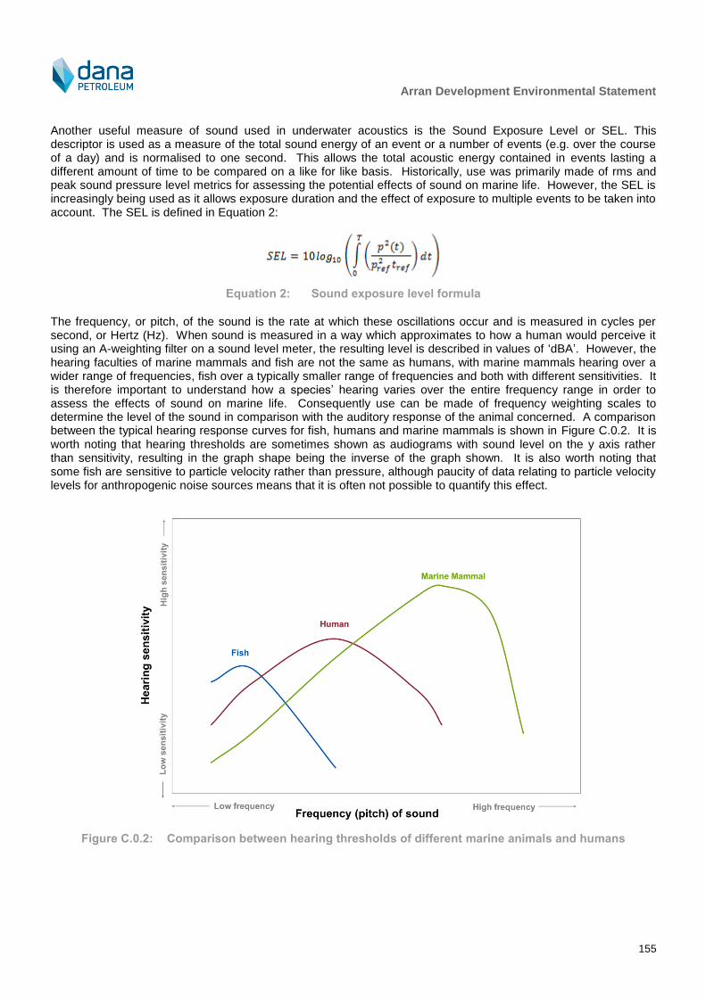
Arran Development Environmental Statement
155
Another useful measure of sound used in underwater acoustics is the Sound Exposure Level or SEL. This descriptor is used as a measure of the total sound energy of an event or a number of events (e.g. over the course of a day) and is normalised to one second. This allows the total acoustic energy contained in events lasting a different amount of time to be compared on a like for like basis. Historically, use was primarily made of rms and peak sound pressure level metrics for assessing the potential effects of sound on marine life. However, the SEL is increasingly being used as it allows exposure duration and the effect of exposure to multiple events to be taken into account. The SEL is defined in Equation 2:
Equation 2: Sound exposure level formula
The frequency, or pitch, of the sound is the rate at which these oscillations occur and is measured in cycles per second, or Hertz (Hz). When sound is measured in a way which approximates to how a human would perceive it using an A-weighting filter on a sound level meter, the resulting level is described in values of ‘dBA’. However, the hearing faculties of marine mammals and fish are not the same as humans, with marine mammals hearing over a wider range of frequencies, fish over a typically smaller range of frequencies and both with different sensitivities. It is therefore important to understand how a species’ hearing varies over the entire frequency range in order to assess the effects of sound on marine life. Consequently use can be made of frequency weighting scales to determine the level of the sound in comparison with the auditory response of the animal concerned. A comparison between the typical hearing response curves for fish, humans and marine mammals is shown in Figure C.0.2. It is worth noting that hearing thresholds are sometimes shown as audiograms with sound level on the y axis rather than sensitivity, resulting in the graph shape being the inverse of the graph shown. It is also worth noting that some fish are sensitive to particle velocity rather than pressure, although paucity of data relating to particle velocity levels for anthropogenic noise sources means that it is often not possible to quantify this effect.
Figure C.0.2: Comparison between hearing thresholds of different marine animals and humans

Arran Development Environmental Statement
156
C.2 Thresholds for Assessing the Effects of Sound on Marine Mammals
C.2.1 Introduction
Underwater noise has the potential to affect marine life in different ways depending on its noise level and characteristics. Richardson et al. (1995) defined four zones of noise influence which vary with distance from the source and level. These are:
The zone of audibility: this is the area within which the animal is able to detect the sound. Audibility itself does not implicitly mean that the sound will have an effect on the marine mammal;
The zone of masking: this is defined as the area within which noise can interfere with detection of other sounds such as communication or echolocation clicks. This zone is very hard to estimate due to a paucity of data relating to how marine mammals detect sound in relation to masking levels (for example, humans are able to hear tones well below the numeric value of the overall noise level);
The zone of responsiveness: this is defined as the area within which the animal responds either behaviourally or physiologically. The zone of responsiveness is usually smaller than the zone of audibility because, as stated previously, audibility does not necessarily evoke a reaction; and
The zone of injury/hearing loss: this is the area where the sound level is high enough to cause tissue damage in the ear. This can be classified as either TTS or PTS. At even closer ranges, and for very high intensity sound sources (e.g. underwater explosions), physical trauma or even death are possible.
For this study, it is the zones of injury and disturbance (i.e. responsiveness) that are of concern (there is insufficient scientific evidence to properly evaluate masking and the type and magnitude of sound from the development is not high enough to cause death). In order to determine the potential spatial range of injury and disturbance, a review has been undertaken of available evidence, including national and international guidance and scientific literature. The following sections summarise the relevant thresholds for onset of effects and describe the evidence base used to derive them.
C.2.2 Injury to marine mammals
Sound propagation models can be constructed to allow the received noise level at different distances from the source to be calculated. To determine the consequence of these received levels on any marine mammals which might experience such noise emissions, it is necessary to relate the levels to known or estimated impact thresholds. The Joint Nature Conservation Committee guidance (JNCC, 2010b) recommends using the injury criteria proposed by Southall et al. (2007), which are based on a combination of linear (i.e. un-weighted) peak pressure levels and mammal hearing weighted (M-weighted) sound exposure limit. The M-weighting function is designed to represent the bandwidth for each group within which acoustic exposures can have auditory effects. The categories include low-frequency cetaceans (LF) (i.e. marine mammal species with an estimated functional hearing range between 7 Hz – 22 kHz, such as the minke whale), mid-frequency cetaceans (MF) (i.e. marine mammal species with an estimated functional hearing range between 200 Hz – 160 kHz, such as the common dolphin), high-frequency cetaceans (HF) (i.e. marine mammal species with an estimated functional hearing range between 200 Hz – 180 kHz, such as the harbour porpoise) and pinnipeds in water (pinnipeds being a suborder of carnivorous aquatic mammals that includes the seals, walruses and similar animals having finlike flippers). The M-weighting curves are shown graphically in Figure C.0.3.
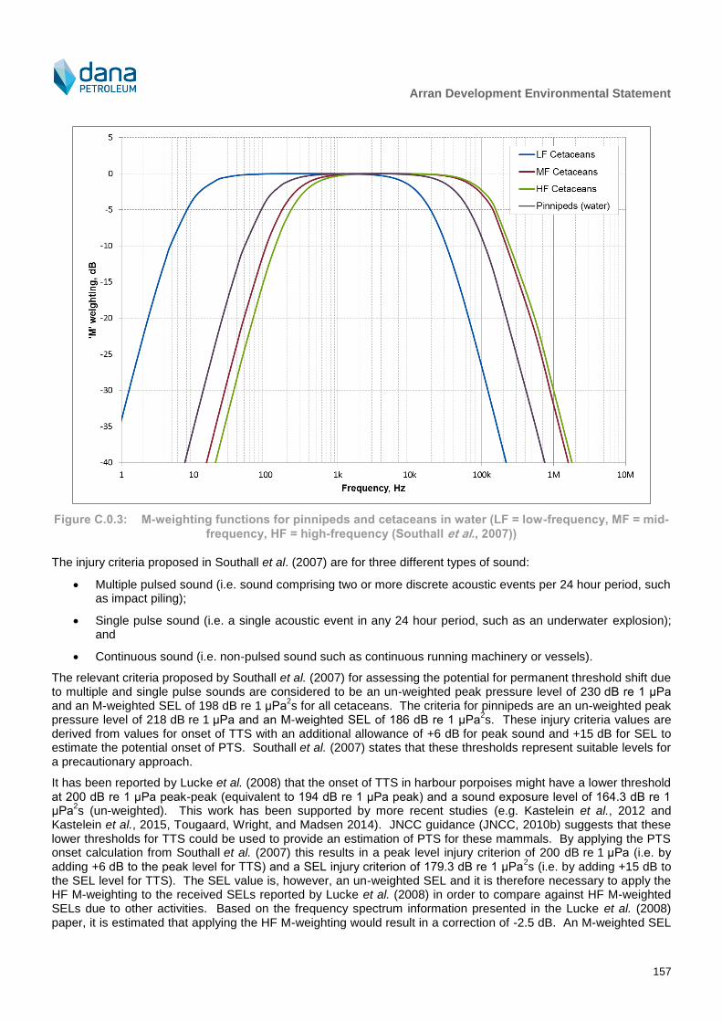
Arran Development Environmental Statement
157
Figure C.0.3: M-weighting functions for pinnipeds and cetaceans in water (LF = low-frequency, MF = mid-
frequency, HF = high-frequency (Southall et al., 2007))
The injury criteria proposed in Southall et al. (2007) are for three different types of sound:
Multiple pulsed sound (i.e. sound comprising two or more discrete acoustic events per 24 hour period, such as impact piling);
Single pulse sound (i.e. a single acoustic event in any 24 hour period, such as an underwater explosion); and
Continuous sound (i.e. non-pulsed sound such as continuous running machinery or vessels).
The relevant criteria proposed by Southall et al. (2007) for assessing the potential for permanent threshold shift due to multiple and single pulse sounds are considered to be an un-weighted peak pressure level of 230 dB re 1 μPa and an M-weighted SEL of 198 dB re 1 μPa
2s for all cetaceans. The criteria for pinnipeds are an un-weighted peak
pressure level of 218 dB re 1 μPa and an M-weighted SEL of 186 dB re 1 μPa2s. These injury criteria values are
derived from values for onset of TTS with an additional allowance of +6 dB for peak sound and +15 dB for SEL to estimate the potential onset of PTS. Southall et al. (2007) states that these thresholds represent suitable levels for a precautionary approach.
It has been reported by Lucke et al. (2008) that the onset of TTS in harbour porpoises might have a lower threshold at 200 dB re 1 μPa peak-peak (equivalent to 194 dB re 1 μPa peak) and a sound exposure level of 164.3 dB re 1 μPa
2s (un-weighted). This work has been supported by more recent studies (e.g. Kastelein et al., 2012 and
Kastelein et al., 2015, Tougaard, Wright, and Madsen 2014). JNCC guidance (JNCC, 2010b) suggests that these lower thresholds for TTS could be used to provide an estimation of PTS for these mammals. By applying the PTS onset calculation from Southall et al. (2007) this results in a peak level injury criterion of 200 dB re 1 μPa (i.e. by adding +6 dB to the peak level for TTS) and a SEL injury criterion of 179.3 dB re 1 μPa
2s (i.e. by adding +15 dB to
the SEL level for TTS). The SEL value is, however, an un-weighted SEL and it is therefore necessary to apply the HF M-weighting to the received SELs reported by Lucke et al. (2008) in order to compare against HF M-weighted SELs due to other activities. Based on the frequency spectrum information presented in the Lucke et al. (2008) paper, it is estimated that applying the HF M-weighting would result in a correction of -2.5 dB. An M-weighted SEL
Arran Development Environmental Statement
158
criterion of 177 dB re 1 μPa2s has therefore been adopted in order to estimate the potential injury ranges for
harbour porpoise.
For continuous sound, the relevant criteria proposed by Southall et al. (2007) are an un-weighted peak pressure level of 230 dB re 1 μPa and an M-weighted SEL of 215 dB re 1 μPa
2s for all cetaceans. The criteria for pinnipeds
are an un-weighted peak pressure level of 218 dB re 1 μPa and an M-weighted SEL of 203 dB re 1 μPa2s.
It is important to note that the above criteria were developed using a precautionary approach, meaning that:
The criteria do not take into account the potential for recovery in hearing between subsequent pulses or days of exposure, and are therefore likely to overestimate hearing damage caused by time varying exposure;
The M-weighting curves are heavily generalised, in that they emphasise the frequency range at which each hearing classification is deemed to be most sensitive. In reality, the hearing threshold audiograms for individual mammal species will not adhere to this shape, but will instead comprise a much narrower “trough” shape, showing peak sensitivity somewhere in the range identified by the hearing group classification and decreasing sensitivity with increasing and decreasing frequency about this “trough”; and
The peak pressure difference between TTS and PTS was arbitrarily taken to be 6 dB for pulsed sound, compared to 15 dB for continuous sound, meaning that the pulsed sound criteria are potentially very precautionary.
All of the criteria, summarised in Table C.0.1, are based on Southall et al. (2007) except for the criteria for injury to harbour porpoise which are based on Lucke et al. (2008).
Note: Since the modelling was completed, the possibility of JNCC formally adopting new thresholds proposed by United States National Oceanic and Atmospheric Administration (NOAA) at some point during 2018 has been identified. However, the modelling that has already been conducted does not suggest noise levels or impact ranges that are likely to be of major concern for the project activities and environmental setting. As the risk of injury or significant is not considered to be great for the proposed activities, the modelling has not been updated in anticipation of adoption of such thresholds.
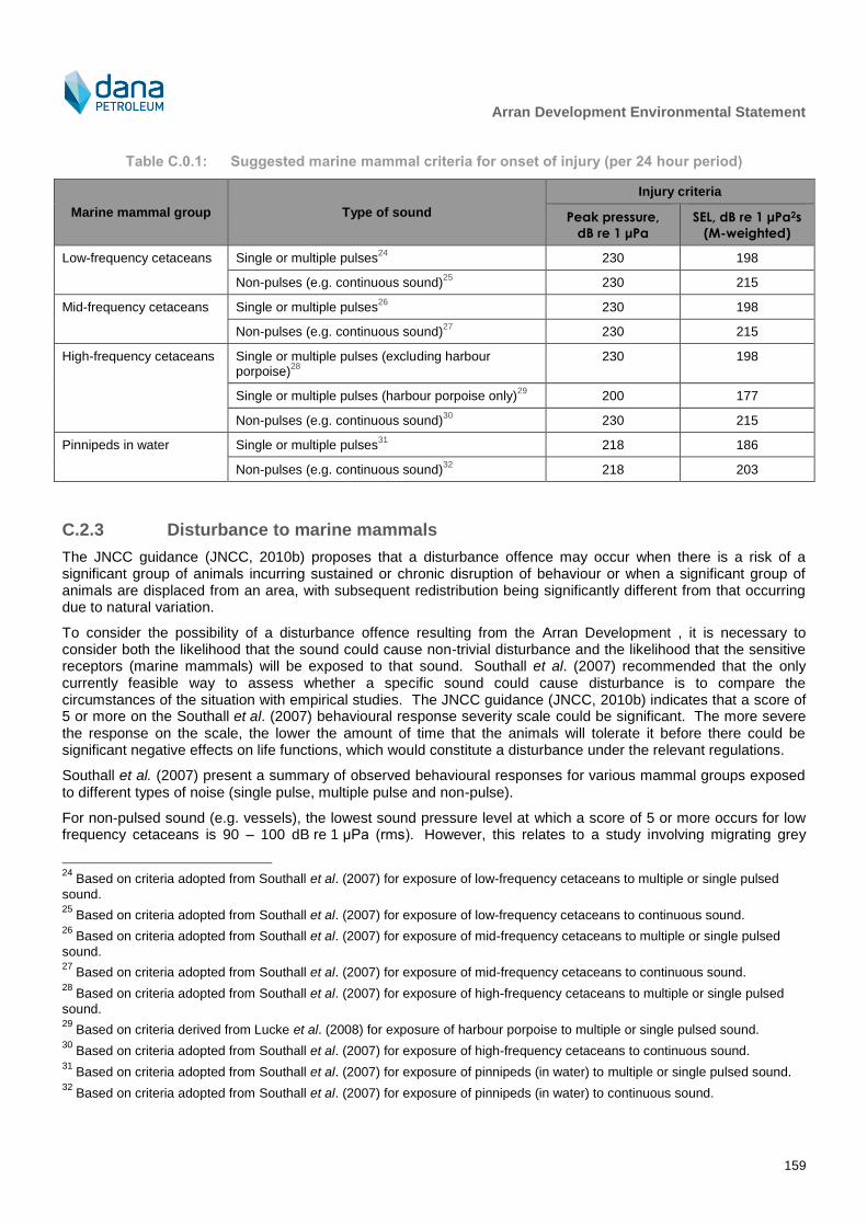
Arran Development Environmental Statement
159
Table C.0.1: Suggested marine mammal criteria for onset of injury (per 24 hour period)
Marine mammal group Type of sound
Injury criteria
Peak pressure,
dB re 1 μPa
SEL, dB re 1 μPa2s
(M-weighted)
Low-frequency cetaceans Single or multiple pulses24
230 198
Non-pulses (e.g. continuous sound)25
230 215
Mid-frequency cetaceans Single or multiple pulses26
230 198
Non-pulses (e.g. continuous sound)27
230 215
High-frequency cetaceans Single or multiple pulses (excluding harbour porpoise)
28
230 198
Single or multiple pulses (harbour porpoise only)29
200 177
Non-pulses (e.g. continuous sound)30
230 215
Pinnipeds in water Single or multiple pulses31
218 186
Non-pulses (e.g. continuous sound)32
218 203
C.2.3 Disturbance to marine mammals
The JNCC guidance (JNCC, 2010b) proposes that a disturbance offence may occur when there is a risk of a significant group of animals incurring sustained or chronic disruption of behaviour or when a significant group of animals are displaced from an area, with subsequent redistribution being significantly different from that occurring due to natural variation.
To consider the possibility of a disturbance offence resulting from the Arran Development , it is necessary to consider both the likelihood that the sound could cause non-trivial disturbance and the likelihood that the sensitive receptors (marine mammals) will be exposed to that sound. Southall et al. (2007) recommended that the only currently feasible way to assess whether a specific sound could cause disturbance is to compare the circumstances of the situation with empirical studies. The JNCC guidance (JNCC, 2010b) indicates that a score of 5 or more on the Southall et al. (2007) behavioural response severity scale could be significant. The more severe the response on the scale, the lower the amount of time that the animals will tolerate it before there could be significant negative effects on life functions, which would constitute a disturbance under the relevant regulations.
Southall et al. (2007) present a summary of observed behavioural responses for various mammal groups exposed to different types of noise (single pulse, multiple pulse and non-pulse).
For non-pulsed sound (e.g. vessels), the lowest sound pressure level at which a score of 5 or more occurs for low frequency cetaceans is 90 – 100 dB re 1 μPa (rms). However, this relates to a study involving migrating grey
24
Based on criteria adopted from Southall et al. (2007) for exposure of low-frequency cetaceans to multiple or single pulsed
sound. 25
Based on criteria adopted from Southall et al. (2007) for exposure of low-frequency cetaceans to continuous sound. 26
Based on criteria adopted from Southall et al. (2007) for exposure of mid-frequency cetaceans to multiple or single pulsed
sound. 27
Based on criteria adopted from Southall et al. (2007) for exposure of mid-frequency cetaceans to continuous sound. 28
Based on criteria adopted from Southall et al. (2007) for exposure of high-frequency cetaceans to multiple or single pulsed
sound. 29
Based on criteria derived from Lucke et al. (2008) for exposure of harbour porpoise to multiple or single pulsed sound. 30
Based on criteria adopted from Southall et al. (2007) for exposure of high-frequency cetaceans to continuous sound. 31
Based on criteria adopted from Southall et al. (2007) for exposure of pinnipeds (in water) to multiple or single pulsed sound. 32
Based on criteria adopted from Southall et al. (2007) for exposure of pinnipeds (in water) to continuous sound.

Arran Development Environmental Statement
160
whales. For mid frequency cetaceans, a response score of 8 was encountered at a received level of 90 – 100 dB re 1 μPa (rms), but this was for one mammal (a sperm whale) and might not be applicable for the species likely to be encountered near this development (e.g. white-beaked dolphin). For these species, a response score of 3 was encountered for received levels of 110 – 120 dB re 1 μPa (rms), with no higher severity score encountered. For high frequency cetaceans, a number of individual responses with a response score of 6 are noted ranging from 80 dB re 1 μPa (rms) and upwards. There is a significant increase in the number of mammals responding at a response score of 6 once the received sound pressure level is greater than 140 dB re 1 μPa (rms).
Southall et al. (2007) presents a summary of observed behavioural responses due to multiple pulsed sound, although the data are primarily based on responses to seismic exploration activities. Although these datasets contain relevant data for low-frequency cetaceans, there are no strong data for mid-frequency or high-frequency cetaceans. Low frequency cetaceans, other than bow-head whales, were typically observed to respond significantly at a received level of 140 – 160 dB re 1 μPa (rms). Behavioural changes at these levels during multiple pulses may have included visible startle response, extended cessation or modification of vocal behaviour, brief cessation of reproductive behaviour or brief/minor separation of females and dependent offspring. The data available for mid-frequency cetaceans indicate that some significant response was observed at a sound pressure level of 120 – 130 dB re 1μPa (rms), although the majority of cetaceans in this category did not display behaviours of this severity until exposed to a level of 170 – 180 dB re 1μPa (rms). Furthermore, other mid-frequency cetaceans within the same study were observed to have no behavioural response even when exposed to a level of 170 – 180 dB re 1μPa (rms).
According to Southall et al. (2007) there is a general paucity of data relating to the effects of sound on pinnipeds in particular. One study using ringed, bearded and spotted seals (Harris, 2001) found onset of a significant response at a received sound pressure level of 160 – 170 dB re 1 μPa (rms), although larger numbers of animals showed no response at noise levels of up to 180 dB re 1 μPa (rms). It is only at much higher sound pressure levels in the range of 190 – 200 dB re 1 μPa (rms) that significant numbers of seals were found to exhibit a significant response. For non-pulsed sound, one study elicited a significant response on a single harbour seal at a received level of 100 – 110 dB re 1 μPa (rms), although other studies found no response or non-significant reactions occurred at much higher received levels of up to 140 dB re 1 μPa (rms). No data are available for higher noise levels and the low number of animals observed in the various studies means that it is difficult to make any firm conclusions from these studies.
Southall et al. (2007) also notes that, due to the uncertainty over whether high-frequency cetaceans may perceive certain sounds and due to paucity of data, it was not possible to present any data on responses of high frequency-cetaceans. However, Lucke et al. (2008) showed a single harbour porpoise consistently showed aversive
behavioural reactions to pulsed sound at received sound pressure levels above 174 dB re 1 μPa (peak-peak) or a
SEL of 145 dB re 1 μPa2s, equivalent to an estimated
33 rms sound pressure level of 166 dB re 1 μPa. Southall et
al. (2007) presents criteria for disturbance due to exposure to single-pulsed sound. These are an un-weighted peak pressure level of 224 dB re 1 μPa and an M-weighted SEL of 183 dB re 1 μPa
2s for all cetaceans. The
criteria for pinnipeds are an un-weighted peak pressure level of 212 dB re 1 μPa and an M-weighted SEL of 171 dB re 1 μPa
2s.
Clearly, there is much intra-category and perhaps intra-species variability in behavioural response. As such, a conservative approach should be taken to ensure that the most sensitive cetaceans remain protected.
The High Energy Seismic Survey workshop on the effects of seismic (i.e. pulsed) sound on marine mammals (HESS, 1997) concluded that mild behavioural disturbance would most likely occur at rms sound levels greater than 140 dB re 1 μPa (rms). This workshop drew on studies by (Richardson et al., 1995) but recognised that there was some degree of variability in reactions between different studies and mammal groups. Although this is based on now outdated studies, the level of 140 dB re 1 μPa (rms) is consistent with the lowest range for onset of disturbance due to multiple pulsed sound identified in Southall et al. (2007). Consequently, for the purposes of this study, a precautionary level of 140 dB re 1 μPa (rms) is used to indicate the onset of low level marine mammal disturbance effects for all mammal groups for impulsive sound. It is worth noting however that this level could be over pessimistic and that any ranges of potential low level disturbance predicted as a result of this study should be treated as very precautionary.
33
Based on an analysis of the time history graph in Lucke et al. (2007) the T90 period is estimated to be approximately 8 ms,
resulting in a correction of 21 dB applied to the SEL to derive the rmsT90 sound pressure level. However, the T90 was not directly reported in the paper.

Arran Development Environmental Statement
161
The United States (US) National Marine Fisheries Service guidance (NMFS, 2005) sets the Level B harassment threshold
34 for marine mammals at 160 dB re 1 μPa (rms) for impulsive noise and 120 dB re 1 μPa (rms) for
continuous noise. The value for impulsive sound sits in the upper-mid range for disturbance effects identified in Southall et al. (2007) and consequently this criterion has been used (in lieu of more suitable up to date criteria) for assessing onset of potentially strong behavioural reaction in this study, although it should be borne in mind that this value is possibly over-pessimistic. The value for continuous sound sits roughly mid-way between the range of values identified in Southall et al. (2007) but is lower than the value at which the majority of mammals responded at a response score of 6 (i.e. once the received rms sound pressure level is greater than 140 dB re 1 μPa). Taking into account the paucity and high level of variation of data relating to onset of behavioural effects due to continuous sound, it is recommended that any ranges predicted using this number are viewed as probabilistic and possibly over-precautionary. The criteria proposed for use in assessing the spatial extent of marine mammal disturbance due to different types of sound is summarised in
Table C.0.2.
Table C.0.2: Suggested marine mammal criteria for onset of disturbance
Type of sound/criteria metric Effect Marine mammal hearing group
All cetaceans Pinnipeds
Single pulses
Peak sound pressure level, dB re 1 μPa Potential strong behavioural reaction35
224 212
SEL, dB re 1 μPa2s 183 171
Multiple pulses
rms sound pressure level, dB re 1 μPa Potential strong behavioural reaction36
160
Low level marine mammal disturbance
37
140
Continuous sound
rms sound pressure level, dB re 1 μPa Potential strong behavioural reaction38
120
C.3 Noise Modelling Methodology
C.3.1 Introduction
Increasing the distance from the noise source usually results in the level of noise getting lower, due primarily to the spreading of the sound energy with distance, analogous to the way in which the ripples in a pond spread after a stone has been thrown in.
The way that the noise spreads (geometrical divergence) will depend upon several factors such as bathymetry, pressure, temperature gradients, and salinity, as well as surface and bottom conditions. Thus, even for a given locality, there are seasonal variations to the way that sound will propagate. However, in simple terms, the sound energy may spread out in a spherical pattern (close to the source) or a cylindrical pattern (much further from the source) or somewhere in between, depending on several factors. In shallow waters, the propagation mechanism is also coloured by multiple reflections from the seabed and the water surface.
34
Level B Harassment is defined as having the potential to disturb a marine mammal or marine mammal stock in the wild by
causing disruption of behavioural patterns, including, but not limited to, migration, breathing, nursing, breeding, feeding, or sheltering but which does not have the potential to injure a marine mammal or marine mammal stock in the wild. 35
Based on criteria adopted from Southall et al. (2007) for behavioural effects due to single pulsed sound. 36
Based on NMFS (2005) Level B harassment criterion for pulsed sound. 37
Based on HESS (1997) criterion for onset of mild behavioural disturbance due to pulsed sound. 38
Based on NMFS (2005) Level B harassment criterion for continuous sound.
Arran Development Environmental Statement
162
There are several methods available for estimating the propagation of sound between a source and receiver ranging from very simple models which simply assume spreading according to a 10 log (r) or 20 log (r) relationship (where r is the distance from source to receiver) to full acoustic models
39 (e.g. ray tracing, normal mode, parabolic
equation, wavenumber integration and energy flux models). In addition, semi-empirical models are available which lie somewhere in between these two extremes in terms of complexity. In choosing which propagation model to employ, it is important to ensure that it is fit for purpose and produces results with a suitable degree of accuracy for the application in question, taking into account the context. Thus, in some situations (e.g. very low risk due to underwater noise, range dependent bathymetry is not an issue) a simple model will be sufficient, particularly where other uncertainties outweigh the uncertainties due to modelling. On the other hand, some situations (e.g. very high source levels, complex source and propagation path characteristics, highly sensitive receivers and low uncertainties in assessment criteria) warrant a more complex modelling methodology.
The first step in choosing a propagation model is therefore to examine these various factors, as set out below:
Balancing of errors/uncertainties
o There is a paucity of data relating to the effects of sound on marine life, particularly for behavioural effects. Many of the studies for behavioural disturbance fail to properly define dose-response relationships (concentrating on the animal response with little analysis of the noise “dose”) and, taking into account context and location specific factors as well as habituation, it is extremely difficult to estimate the potential error in the effect thresholds. However, referring to the wide ranging spread of onset levels leading to an effect presented in Southall et al. (2007), it is speculated that the uncertainty due to onset of effects could well be a magnitude of tens of decibels.
Range dependant bathymetry
o The proposed Project area and area of likely noise impact are located in water depths between approximately 80 and 90 m, with a median depth for the study area determined as for input to the modelling as 90 m. Subsequently, to model the effects at distances remote from the Project operations, the propagation model should ideally take range dependant bathymetry into account.
On the basis of the above factors, it is considered that potential errors due to uncertainty regarding the effects of sound on marine mammals as well as uncertainties in source data are likely to be greater than the uncertainties inherent in acoustic modelling. A semi-empirical sound propagation model has been selected to provide a reasonable balance between complexity and technical robustness. It should be borne in mind that calculated noise levels (and associated range of effects) will vary depending on actual conditions at the time (day-to-day and season-to-season) and that the semi-empirical model predicts a typical worst case scenario. Taking into account factors such as animal behaviour and habituation, any injury and disturbance ranges should be viewed as indicative and probabilistic ranges to assist in understanding potential impacts on marine life rather than lines either side of which an impact definitely will or will not occur (this is a similar approach to that adopted for airborne noise where a typical worst case is taken, though it is known that day to day levels may vary to those calculated by 5 – 10 dB depending on wind direction etc.).
C.3.2 Continuous Noise Source Propagation Modelling
Noise propagation modelling for this assessment was carried out using the Xodus SubsoniX noise model, which implements the sound propagation model developed by Rogers (1981). The Rogers sound propagation model is a semi-empirical, range dependent propagation model which is based on a combination of theoretical considerations and extensive experimental data. Consequently, unlike purely theoretical sound propagation models, the calibration for the Rogers model is built into the model itself and it has subsequently been successfully benchmarked against other sound propagation models (e.g. Schulkin and Mercer, 1985, Etter, 2013, Toso et al., 2014) and has been used previously in underwater noise assessments for tidal and wind energy developments (e.g. Dawoud et al., 2015). The model takes into account the following parameters:
Third-octave band source sound level data;
39
It is worth noting that additional complexity does not always equate to greater accuracy and may not always be preferable.
Many more complex models work over a limited frequency range and the complexity and range of inputs can make them very context specific. Consequently, the model outputs can vary significantly depending on the input assumptions which in themselves can change day-to-day and season-to-season.
Arran Development Environmental Statement
163
Range (distance from source to receiver);
Water column depth (input as bathymetry data grid);
Sediment type;
Sediment and water sound speed profiles and densities; and
Sediment attenuation coefficient.
The propagation loss is calculated using Equation 3:
Equation 3: Transmission loss as a function of distance and environmental properties
Where is the range, the water depth, the bottom loss, the limiting angle and the absorption coefficient
of sea water ( is a frequency dependant term which was calculated based on Ainslie and McColm (1998)). The
limiting angle, is the larger of and where is the maximum grazing angle for a skip distance and is the
effective plane wave angle corresponding to the lowest propagating mode, as shown in Equation 4 and Equation 5.
Equation 4: Maximum grazing angle
Equation 5: Plane wave angle for lowest propagating mode
Where is the sound speed gradient in water (taken to be 0.2 s-1
for the purposes of the modelling) and is the
frequency. The bottom loss is approximated by Equation 6:
Equation 6: Bottom loss as a function of water and sediment density and sound speed
Where is the density of sediment, the density of water, the sound speed in the sediment, the sound
speed in water and is the sediment attenuation coefficient.
The SubsoniX model also takes into account the depth dependent cut-off frequency for propagation of sound (i.e. the frequency below which sound does not propagate), given by Equation 7:
Equation 7: Propagation cut-off frequency
Where and are the sound propagation speeds in the substrate and water.
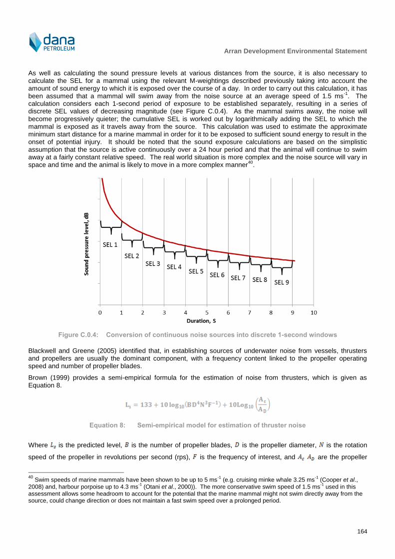
Arran Development Environmental Statement
164
As well as calculating the sound pressure levels at various distances from the source, it is also necessary to calculate the SEL for a mammal using the relevant M-weightings described previously taking into account the amount of sound energy to which it is exposed over the course of a day. In order to carry out this calculation, it has been assumed that a mammal will swim away from the noise source at an average speed of 1.5 ms
-1. The
calculation considers each 1-second period of exposure to be established separately, resulting in a series of discrete SEL values of decreasing magnitude (see Figure C.0.4). As the mammal swims away, the noise will become progressively quieter; the cumulative SEL is worked out by logarithmically adding the SEL to which the mammal is exposed as it travels away from the source. This calculation was used to estimate the approximate minimum start distance for a marine mammal in order for it to be exposed to sufficient sound energy to result in the onset of potential injury. It should be noted that the sound exposure calculations are based on the simplistic assumption that the source is active continuously over a 24 hour period and that the animal will continue to swim away at a fairly constant relative speed. The real world situation is more complex and the noise source will vary in space and time and the animal is likely to move in a more complex manner
40.
Figure C.0.4: Conversion of continuous noise sources into discrete 1-second windows
Blackwell and Greene (2005) identified that, in establishing sources of underwater noise from vessels, thrusters and propellers are usually the dominant component, with a frequency content linked to the propeller operating speed and number of propeller blades.
Brown (1999) provides a semi-empirical formula for the estimation of noise from thrusters, which is given as Equation 8.
Equation 8: Semi-empirical model for estimation of thruster noise
Where is the predicted level, is the number of propeller blades, is the propeller diameter, is the rotation
speed of the propeller in revolutions per second (rps), is the frequency of interest, and are the propeller
40
Swim speeds of marine mammals have been shown to be up to 5 ms-1
(e.g. cruising minke whale 3.25 ms-1
(Cooper et al.,
2008) and, harbour porpoise up to 4.3 ms-1
(Otani et al., 2000)). The more conservative swim speed of 1.5 ms-1
used in this assessment allows some headroom to account for the potential that the marine mammal might not swim directly away from the source, could change direction or does not maintain a fast swim speed over a prolonged period.

Arran Development Environmental Statement
165
disc are and swept area of cavitation respectively. The swept area of cavitation refers to area of the propeller (when modelled as a flat disc) which moves at sufficient speed to produce bubbles as a result of cavitation.
C.3.3 Piling Noise Propagation Model
Sound propagation modelling for the piling scenario specified for this assessment was based on an extended version of the semi-empirical model developed by Marsh-Schulkin (Marsh and Schulkin, 1962). The sound propagation model uses several concepts including:
Refractive cycle, or skip distance;
Geometric divergence;
Deflection of energy into the bottom at high angles by scattering from the sea surface;
A simplified Rayleigh two-fluid model of the bottom for sand or mud sediments; and
Absorption of sound energy by molecules in the water.
The following inputs are required to the model:
Third-octave band source sound level;
Discreet range (distance from source to receiver);
Water column depth and sediment layer depth;
Sediment type (sand/mud);
Sea state; and
Source directivity characteristics.
The model is based on a combination of acoustic theory and empirical data from around 100,000 measurements and has been found to provide good predictions.
The water depth has been taken from available data relating to the Arran field as approximately 90 m. A pile diameter of 0.6 m has been modelled, with a hammer blow rate of 12 blows/minute.
The sound generated and radiated by a pile as it is driven into the ocean floor is complex, due to the many components which make up the generation and radiation mechanisms. However, a wealth of experimental data is available which allow us to predict with a good degree of accuracy the sound generated by a pile at discrete frequencies. For this study, the source noise levels were based on a combination of measured noise data for other projects and extrapolations.
Third-octave band noise spectra are presented in the literature for various piling activities (e.g. CDoT, 2001, Nedwell et al., 2003, Nedwell and Howell, 2004, Thomsen et al., 2006, Nedwell et al., 2007, Nehls et al., 2007, De Jong and Ainslie, 2008, Wyatt, 2008, Matuschek and Betke, 2009). Thomsen et al. (2006) derived third-octave sound pressure level at 1 m based on measurements on a 1.6 m diameter pile during piling of the FINO1 platform and these data (both SEL and peak) have been used as the source level spectrum in this assessment.
Reducing the diameter of a pile will result in a reduction in emitted noise. It is therefore necessary to correct the noise level for the 1.6 m pile to a pile diameter to be used for this type of project. Nehls et al. (2007) present a comparison of methods for estimating corrections to pile source noise strengths in order to correct for the pile diameter. Although there is no definitive method of making this correction (the actual noise levels depends not only on the pile diameter but also on the properties of the sediment, pile driving energy etc.), a quadratic relation between pile diameter and noise emission can be assumed. Thus, the correction to the noise level for the smaller pile diameter, D, is 40 x log(D2/D1). A pile diameter of 0.6 m has been assumed for this Project (based on data supplied by Dana) and this results in a -7 dB correction being applied to the noise spectra reported by Thomsen et al. (2006). The same spectrum shape is assumed for peak, rms and SEL spectra.
Wyatt (2008) provides a method for estimating the peak-to-peak sound pressure level of a pile of known diameter, D, using the equation P = 230.25 x D
0.0774. For a 0.6 m diameter pile, and assuming a correction of -6 dB to
convert from a peak-to-peak level to a peak level, this results in a peak pressure level of 222 dB re 1 μPa (pk) and
Arran Development Environmental Statement
166
this value was used in this assessment. Root mean square (rms) sound pressure levels were calculated assuming a typical T90 pulse duration (i.e. the period that contains 90% of the total cumulative sound energy) of 0.1 s.
The SEL exposure resulting from piling noise assumes that each hammer blow will contribute to the overall exposure of the marine mammal, and that the piling operation has a fixed duration over which the number of blows per minute remains constant. Subsequently, the SEL exposure is calculated by considering the total number of blows likely to be experienced by a mammal fleeing the site of the piling operation at a constant speed. It also assumes that there is no hearing recovery between hammer blows and therefore represents a worst-case conservative assessment.
Peak and rms sound pressure levels are not cumulative in the same way as SEL exposure, and assessments are made against levels for individual hammer blows. The source levels used in this assessment are given in Table C.0.3.
Table C.0.3: Piling noise source data used for this assessment
Description rms sound pressure
level @ 1 m, dB re 1 μPa
Peak sound pressure level @ 1 m, dB re 1 μPa
SEL (per strike) @ 1 m, dB re 1 μPa
2s
Source of data
Piling noise source data
199 216 189 Spectral shape taken from Thompsen et al. (2006) and
adjusted for pile diameter
For the piling noise assessment, the potential for a soft-start procedure is also considered. A twenty minute soft period of reduced hammer energy is assumed, which results in a 10 dB reduction per hammer blow. This modelling scenario assumes an instant switchover from low to high energy hammer blows (“on/off”) after a twenty minute period. In reality, one would expect to see a gradual “ramping up” of hammer blow energy over the course of the soft start period.
C.3.4 Exposure Calculations
As well as calculating the un-weighted rms and peak sound pressure levels at various distances from the source, it is also necessary to calculate the SEL for a mammal using the relevant M-weightings described above taking into account the number of pulses to which it is exposed. For piling operations, the SEL sound data for a single hammer blow was utilised, along with the maximum number of subsequent pulses expected to be received by marine mammals in order to calculate cumulative exposure. The mammal has been modelled as swimming away from the source at a constant speed. The hammer blows to which the mammal is exposed in closest proximity to the pile dominate the sound exposure. This is due to the logarithmic nature of sound energy summation.
The SEL calculations described above have also been conducted to estimate the benefit of soft start operations. In this case, it is assumed that the energy of each hammer blow will be lower at the start of piling operations for a certain window of time. For this calculation, it is assumed that each hammer blow will be attenuated by 10 dB for a period of 20 minutes during the soft start procedures. The sound modelling makes the assumption that the mammal does not re-approach the site of the piling in the same day.
C.4 Source Noise Data
C.4.1 List of noise sources considered
The potential noise associated with this Project are as follows;
Piling;
Drilling;
Flotel (walk to work vessel);
Anchor handling vessel (AHV);
Diving support vessel (DSV);
Pipelay vessel;

Arran Development Environmental Statement
167
Rock placement;
Rock placement vessel;
Trenching;
Trenching vessel;
Emergency response and rescue vessel (ERRV);
Supply vessel; and
Guard vessel.
As well as these individual noise sources, it has been assumed that various operating scenarios will exist, combining several of these noise sources. Subsequently, the following scenarios are also considered;
Trenching and trenching vessel operating simultaneously; and
Drilling, ERRV, supply and guard vessels operating simultaneously.
Because impulsive noise (piling) and continuous noise (vessel, construction, and drilling noise) are assessed using different criteria, it is not practical to combine them for the purposes of modelling scenarios involving both types of noise. Consequently, for scenarios where both types of noise are generated concurrently a worst-case assessment should be approached, where exclusion zones are based on the activity which is most injurious.
Noise source data has been taken from a combination of publicly available noise data for other similar developments, empirical calculations and theoretical predictions. It should be noted that even where specific noise measurement data is available, these data are often not in a suitable form for assessing the impacts of noise on wildlife. Consequently, it is often necessary to apply empirical corrections to convert from, for example, rms sound pressure levels to SEL or peak pressure levels.
C.4.2 Acoustic Modelling Parameters
The model requires inputs relating to the physical characteristics of the marine environment in which the activities are taking place. These input parameters are given in Table C.0.4.
Table C.0.4: Model input parameters
Parameter Value
Sediment classification Fine sand
Sound speed gradient, 0.0199 s-1
Speed of sound in water, 1487.8 ms-1
Speed of sound in sediment, 1702.0 ms-1
Water density, 1.027 kgm-3
Sediment density, 1.856 kgm-3
Sediment attenuation coefficient, 0.7 dBm-1
kHz-1
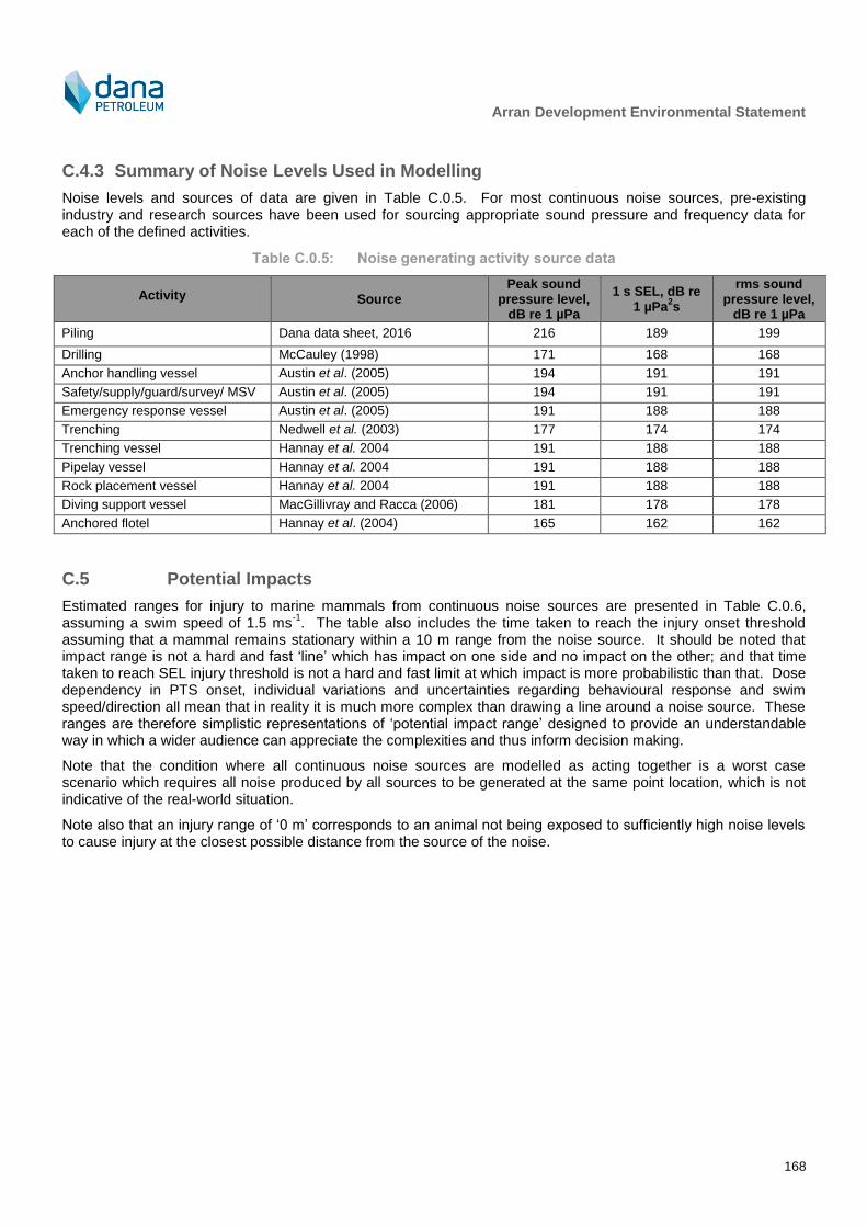
Arran Development Environmental Statement
168
C.4.3 Summary of Noise Levels Used in Modelling
Noise levels and sources of data are given in Table C.0.5. For most continuous noise sources, pre-existing industry and research sources have been used for sourcing appropriate sound pressure and frequency data for each of the defined activities.
Table C.0.5: Noise generating activity source data
Activity Source Peak sound
pressure level, dB re 1 µPa
1 s SEL, dB re 1 µPa
2s
rms sound pressure level,
dB re 1 µPa
Piling Dana data sheet, 2016 216 189 199
Drilling McCauley (1998) 171 168 168
Anchor handling vessel Austin et al. (2005) 194 191 191
Safety/supply/guard/survey/ MSV Austin et al. (2005) 194 191 191
Emergency response vessel Austin et al. (2005) 191 188 188
Trenching Nedwell et al. (2003) 177 174 174
Trenching vessel Hannay et al. 2004 191 188 188
Pipelay vessel Hannay et al. 2004 191 188 188
Rock placement vessel Hannay et al. 2004 191 188 188
Diving support vessel MacGillivray and Racca (2006) 181 178 178
Anchored flotel Hannay et al. (2004) 165 162 162
C.5 Potential Impacts
Estimated ranges for injury to marine mammals from continuous noise sources are presented in Table C.0.6, assuming a swim speed of 1.5 ms
-1. The table also includes the time taken to reach the injury onset threshold
assuming that a mammal remains stationary within a 10 m range from the noise source. It should be noted that impact range is not a hard and fast ‘line’ which has impact on one side and no impact on the other; and that time taken to reach SEL injury threshold is not a hard and fast limit at which impact is more probabilistic than that. Dose dependency in PTS onset, individual variations and uncertainties regarding behavioural response and swim speed/direction all mean that in reality it is much more complex than drawing a line around a noise source. These ranges are therefore simplistic representations of ‘potential impact range’ designed to provide an understandable way in which a wider audience can appreciate the complexities and thus inform decision making.
Note that the condition where all continuous noise sources are modelled as acting together is a worst case scenario which requires all noise produced by all sources to be generated at the same point location, which is not indicative of the real-world situation.
Note also that an injury range of ‘0 m’ corresponds to an animal not being exposed to sufficiently high noise levels to cause injury at the closest possible distance from the source of the noise.
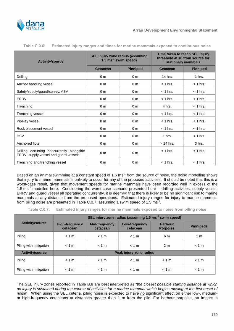
Arran Development Environmental Statement
169
Table C.0.6: Estimated injury ranges and times for marine mammals exposed to continuous noise
Activity/source
SEL injury zone radius (assuming 1.5 ms
-1 swim speed)
Time taken to reach SEL injury threshold at 10 from source for
stationary mammals
Cetacean Pinniped Cetacean Pinniped
Drilling 0 m 0 m 14 hrs. 1 hrs.
Anchor handling vessel 0 m 0 m < 1 hrs. < 1 hrs.
Safety/supply/guard/survey/MSV 0 m 0 m < 1 hrs. < 1 hrs.
ERRV 0 m 0 m < 1 hrs. < 1 hrs.
Trenching 0 m 0 m 4 hrs. < 1 hrs.
Trenching vessel 0 m 0 m < 1 hrs. < 1 hrs.
Pipelay vessel 0 m 0 m < 1 hrs. < 1 hrs.
Rock placement vessel 0 m 0 m < 1 hrs. < 1 hrs.
DSV 0 m 0 m 1 hrs. < 1 hrs.
Anchored flotel 0 m 0 m > 24 hrs. 3 hrs.
Drilling occurring concurrently alongside ERRV, supply vessel and guard vessels.
0 m 0 m < 1 hrs. < 1 hrs.
Trenching and trenching vessel 0 m 0 m < 1 hrs. < 1 hrs.
Based on an animal swimming at a constant speed of 1.5 ms-1
from the source of noise, the noise modelling shows that injury to marine mammals is unlikely to occur for any of the proposed activities. It should be noted that this is a worst-case result, given that movement speeds for marine mammals have been recorded well in excess of the 1.5 ms
-1 modelled here. Considering the worst-case scenario presented here – drilling activities, supply vessel,
ERRV and guard vessel all operating concurrently, it is deemed that there is likely to be no significant risk to marine mammals at any distance from the proposed operations. Estimated injury ranges for injury to marine mammals from piling noise are presented in Table C.0.7, assuming a swim speed of 1.5 ms
-1.
Table C.0.7: Estimated injury ranges for marine mammals exposed to noise from piling noise
Activity/source
SEL injury zone radius (assuming 1.5 ms-1
swim speed)
High-frequency cetacean
Mid-frequency cetacean
Low-frequency cetacean
Harbour Porpoise
Pinnipeds
Piling < 1 m < 1 m < 1 m 6 m 2 m
Piling with mitigation < 1 m < 1 m < 1 m 2 m < 1 m
Activity/source Peak injury zone radius
Piling < 1 m < 1 m < 1 m < 1 m < 1 m
Piling with mitigation < 1 m < 1 m < 1 m < 1 m < 1 m
The SEL injury zones reported in Table B.8 are best interpreted as “the closest possible starting distance at which no injury is sustained during the course of activities for a marine mammal which begins moving at the first onset of noise”. When using the SEL criteria, piling noise is expected to have no significant effect on either low-, medium- or high-frequency cetaceans at distances greater than 1 m from the pile. For harbour porpoise, an impact is

Arran Development Environmental Statement
170
predicted out to distances of 6 m and out to 2 m for pinniped species. With a 20 minute soft start procedure in place, no impact is predicted at any distance greater than 1 m for all marine mammal groups except harbour porpoise, for which an impact is predicted out to 2 m.
No impact is predicted when making an assessment against peak injury criteria for any marine mammal group.
The estimated ranges for onset of disturbance effects from continuous noise are shown in
Table C.0.8. It should be noted that these values are based on an average water depth of 90 m and that in reality the range will vary depending on both source and receiver location.
It is important to place the results in
Table C.0.8 in the context of the baseline noise environment, i.e. that the 120 dB re 1 μPa rms sound pressure level criterion for disturbance from continuous noise is within the range of typical baseline noise levels in the area.
It is therefore important to understand that exceeding the criteria for potential onset of disturbance effects does not in itself mean that disturbance will occur. Southall et al. (2007) notes that “…the available data on behavioural responses do not converge on specific exposure conditions resulting in particular reactions, nor do they point to a common behavioural mechanism. Even data obtained with substantial controls, precision, and standardised metrics indicate high variance both in behavioural responses and in exposure conditions required to elicit a given response. It is clear that behavioural responses are strongly affected by the context of exposure and by the animal’s experience, motivation, and conditioning. This reality, which is generally consistent with patterns of behaviour in other mammals (including humans), hampered our efforts to formulate broadly applicable behavioural response criteria for marine mammals based on exposure level alone.”
Table C.0.8: Estimated disturbance ranges for marine mammals during construction
Source/vessel Estimated range for onset of disturbance41
Piling 3.8 km (mild disturbance), 0.4 km (strong
disturbance)
Drilling 0.4 km
AHV 9.5 km
Safety/supply/guard/survey/MSV 9.5 km
ERRV 6.9 km
Trenching 1.1 km
Trenching vessel 7.2 km
Pipelay vessel 7.2 km
Rock placement vessel 7.2 km
DSV 1.9 km
Anchored flotel 0.2 km
Drilling occurring concurrently alongside ERRV, supply vessel and
guard vessels
18.4 km
Trenching and trenching vessel 10.0 km
41
Based on exceeding criteria for disturbance of 120 dB re 1 µPa rms for continuous noise sources 140 dB re 1 µPa rms for
mild behavioural response to impulsive stimuli and 160 dB re 1 µPa rms for strong behavioural response to impulsive stimuli.

Arran Development Environmental Statement
171
Appendix D – Supporting Data for Accidental
Events Assessment
Table D.0.1: Blowout frequency for drill rigs per unit per year on UKCS (OGUK, 2009)
Type of facility
Number of blowout events for a given period
1990 – 1999 2000 – 2007 1990 – 2007
Number Frequency per
year Number
Frequency per year
Number Frequency
per year
Drill rig 13 0.020 3 0.0066 16 0.014
Table D.0.2: Well blowouts during different operational phases 1980 – 2008 (IOGP, 201042
)
Descriptor
Drilling
Completion Workover Wireline
Production
Total Development
drilling Exploration Other External
(1) Internal
(1)
Number of well blowouts
34 17 2 9 20 4
7 1 94
Percentage 36.17% 18.08% 2.16% 9.57% 21.27% 4.25% 7.44% 1.06% 100% (1)
External causes include storm, military activity and ship collision whilst internal causes refer to upsets within the production process itself.
Table D.0.3: Projected frequency of blowout and well release incidents for the Project
Scenario
Blowout Well release
Historical frequency
(IOGP, 2010) (individual units given
per operation)
Values for the Project Historical frequency
(IOGP, 2010) (individual units given
per operation)
Values for the Project
Estimated frequency per
year (3)
Estimated return period
(years) (3)
Estimated frequency per year
(3)
Estimated return period
(years) (3)
Development drilling (1) (2)
4.8 x 10⁻⁵
1.9 x 10⁻⁴
5,208 3.90 x 10⁻⁴
1.6 x 10⁻³
641
Completion (1) (2)
5.40 x 10⁻⁵
2.2 x 10⁻⁴
4,630 2.20 x 10⁻⁴
8.8 x 10⁻⁴
1,136
Production (1)
3.90 x 10⁻⁵
1.6 x 10⁻⁴
6,410 2.90 x 10⁻⁶
1.2 x 10⁻⁵
86,207
Workover 1.00 x 10⁻⁴
3.3 x 10⁻⁵
30,000 3.20 x 10⁻⁴
1.1 x 10⁻⁴
9,375
(1) Assumes 4 production wells in total. (2) Assumes development drilling and completion will occur for approximately one year. (3) Based on approach from Scandpower (2006), which uses the historical frequency to estimate the event return period, or
average recurrence interval of an event.
42
Blouwout and well release frequencies reported by IOGP are for offshore operations of North Sea standard (i.e. the same
type of operations as occur in the North Sea but not necessarily located in the North Sea).
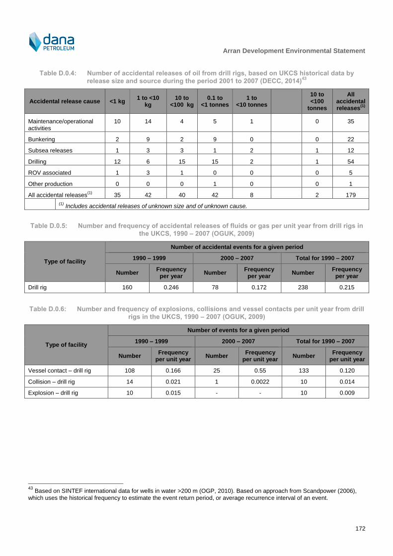
Arran Development Environmental Statement
172
Table D.0.4: Number of accidental releases of oil from drill rigs, based on UKCS historical data by
release size and source during the period 2001 to 2007 (DECC, 2014)43
Accidental release cause <1 kg 1 to <10
kg 10 to
<100 kg 0.1 to
<1 tonnes 1 to
<10 tonnes
10 to <100
tonnes
All accidental releases
(1)
Maintenance/operational activities
10 14 4 5 1 0 35
Bunkering 2 9 2 9 0 0 22
Subsea releases 1 3 3 1 2 1 12
Drilling 12 6 15 15 2 1 54
ROV associated 1 3 1 0 0 0 5
Other production 0 0 0 1 0 0 1
All accidental releases(1)
35 42 40 42 8 2 179
(1) Includes accidental releases of unknown size and of unknown cause.
Table D.0.5: Number and frequency of accidental releases of fluids or gas per unit year from drill rigs in
the UKCS, 1990 – 2007 (OGUK, 2009)
Type of facility
Number of accidental events for a given period
1990 – 1999 2000 – 2007 Total for 1990 – 2007
Number Frequency
per year Number
Frequency per year
Number Frequency
per year
Drill rig 160 0.246 78 0.172 238 0.215
Table D.0.6: Number and frequency of explosions, collisions and vessel contacts per unit year from drill
rigs in the UKCS, 1990 – 2007 (OGUK, 2009)
Type of facility
Number of events for a given period
1990 – 1999 2000 – 2007 Total for 1990 – 2007
Number Frequency
per unit year Number
Frequency per unit year
Number Frequency
per unit year
Vessel contact – drill rig 108 0.166 25 0.55 133 0.120
Collision – drill rig 14 0.021 1 0.0022 10 0.014
Explosion – drill rig 10 0.015 - - 10 0.009
43
Based on SINTEF international data for wells in water >200 m (OGP, 2010). Based on approach from Scandpower (2006),
which uses the historical frequency to estimate the event return period, or average recurrence interval of an event.

Arran Development Environmental Statement
173
Table D.0.7: Number of accidental releases from subsea tiebacks to oil producing facilities (1975 to
2007) (TINA Consultants Ltd pers. comm., 2013)
Accidental release cause ≥10 g to <100 g
≥0.1 kg to <1 kg
≥1 kg to <10 kg
≥10 kg to <100 kg
≥0.1 tonnes to
<1 t
≥1 tonnes to <10
All accidental releases
(1)
Fixed 1 1 3 7 5 6 23
Floating 0 2 0 0 0 1 3
All accidental releases(1)
1 3 3 7 5 7 27
(1) Includes accidental releases of unknown size and of unknown cause.
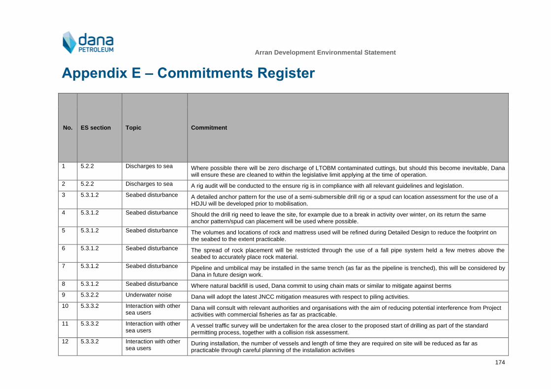
Arran Development Environmental Statement
174
Appendix E – Commitments Register
No. ES section Topic Commitment
1 5.2.2 Discharges to sea Where possible there will be zero discharge of LTOBM contaminated cuttings, but should this become inevitable, Dana will ensure these are cleaned to within the legislative limit applying at the time of operation.
2 5.2.2 Discharges to sea A rig audit will be conducted to the ensure rig is in compliance with all relevant guidelines and legislation.
3 5.3.1.2 Seabed disturbance A detailed anchor pattern for the use of a semi-submersible drill rig or a spud can location assessment for the use of a HDJU will be developed prior to mobilisation.
4 5.3.1.2 Seabed disturbance Should the drill rig need to leave the site, for example due to a break in activity over winter, on its return the same anchor pattern/spud can placement will be used where possible.
5 5.3.1.2 Seabed disturbance The volumes and locations of rock and mattress used will be refined during Detailed Design to reduce the footprint on the seabed to the extent practicable.
6 5.3.1.2 Seabed disturbance The spread of rock placement will be restricted through the use of a fall pipe system held a few metres above the seabed to accurately place rock material.
7 5.3.1.2 Seabed disturbance Pipeline and umbilical may be installed in the same trench (as far as the pipeline is trenched), this will be considered by Dana in future design work.
8 5.3.1.2 Seabed disturbance Where natural backfill is used, Dana commit to using chain mats or similar to mitigate against berms
9 5.3.2.2 Underwater noise Dana will adopt the latest JNCC mitigation measures with respect to piling activities.
10 5.3.3.2 Interaction with other sea users
Dana will consult with relevant authorities and organisations with the aim of reducing potential interference from Project activities with commercial fisheries as far as practicable.
11 5.3.3.2 Interaction with other sea users
A vessel traffic survey will be undertaken for the area closer to the proposed start of drilling as part of the standard permitting process, together with a collision risk assessment.
12 5.3.3.2 Interaction with other sea users
During installation, the number of vessels and length of time they are required on site will be reduced as far as practicable through careful planning of the installation activities
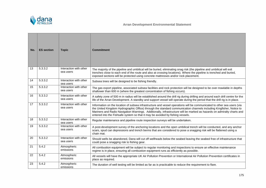
Arran Development Environmental Statement
175
No. ES section Topic Commitment
13 5.3.3.2 Interaction with other sea users
The majority of the pipeline and umbilical will be buried, eliminating snag risk (the pipeline and umbilical will exit trenches close to each end of the route and also at crossing locations). Where the pipeline is trenched and buried, exposed sections will be protected using concrete mattresses and/or rock placement.
14 5.3.3.2 Interaction with other sea users
Subsea trees will be designed to be fishing friendly.
15 5.3.3.2 Interaction with other sea users
The gas export pipeline, associated subsea facilities and rock protection will be designed to be over-trawlable in depths shallower than 600 m (where the greatest concentration of fishing occurs).
16 5.3.3.2 Interaction with other sea users
A safety zone of 500 m in radius will be established around the drill rig during drilling and around each drill centre for the life of the Arran Development. A standby and support vessel will operate during the period that the drill rig is in place.
17 5.3.3.2 Interaction with other sea users
Information on the location of subsea infrastructure and vessel operations will be communicated to other sea users (via the United Kingdom Hydrographic Office) through the standard communication channels including Kingfisher, Notice to Mariners and Radio Navigation Warnings. Additionally, infrastructure will be marked as hazards on admiralty charts and entered into the Fishsafe system so that it may be avoided by fishing vessels.
18 5.3.3.2 Interaction with other sea users
Regular maintenance and pipeline route inspection surveys will be undertaken.
19 5.3.3.2 Interaction with other sea users
A post-development survey of the anchoring locations and the open umbilical trench will be conducted, and any anchor scars, spud can depressions and trench berms that are considered to pose a snagging risk will be flattened using a chain mat.
20 5.3.3.2 Interaction with other sea users
Should wells be abandoned, Dana will cut off wellheads below the seabed leaving the seabed free of infrastructure that could pose a snagging risk to fishing gear.
21 5.4.2 Atmospheric emissions
All combustion equipment will be subject to regular monitoring and inspections to ensure an effective maintenance regime is in place, ensuring all combustion equipment runs as efficiently as possible.
22 5.4.2 Atmospheric emissions
All vessels will have the appropriate UK Air Pollution Prevention or International Air Pollution Prevention certificates in place as required.
23 5.4.2 Atmospheric emissions
The duration of well testing will be limited as far as is practicable to reduce the requirement to flare.
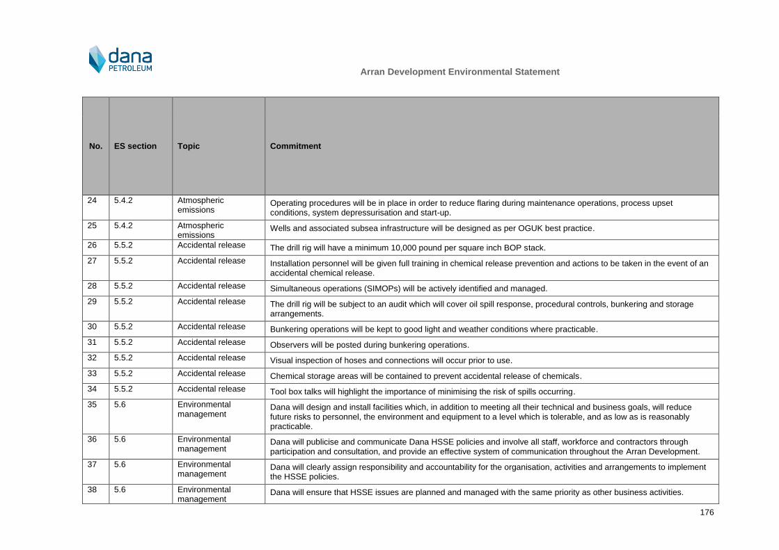
Arran Development Environmental Statement
176
No. ES section Topic Commitment
24 5.4.2 Atmospheric emissions
Operating procedures will be in place in order to reduce flaring during maintenance operations, process upset conditions, system depressurisation and start-up.
25 5.4.2 Atmospheric emissions
Wells and associated subsea infrastructure will be designed as per OGUK best practice.
26 5.5.2 Accidental release The drill rig will have a minimum 10,000 pound per square inch BOP stack.
27 5.5.2 Accidental release Installation personnel will be given full training in chemical release prevention and actions to be taken in the event of an accidental chemical release.
28 5.5.2 Accidental release Simultaneous operations (SIMOPs) will be actively identified and managed.
29 5.5.2 Accidental release The drill rig will be subject to an audit which will cover oil spill response, procedural controls, bunkering and storage arrangements.
30 5.5.2 Accidental release Bunkering operations will be kept to good light and weather conditions where practicable.
31 5.5.2 Accidental release Observers will be posted during bunkering operations.
32 5.5.2 Accidental release Visual inspection of hoses and connections will occur prior to use.
33 5.5.2 Accidental release Chemical storage areas will be contained to prevent accidental release of chemicals.
34 5.5.2 Accidental release Tool box talks will highlight the importance of minimising the risk of spills occurring.
35 5.6 Environmental management
Dana will design and install facilities which, in addition to meeting all their technical and business goals, will reduce future risks to personnel, the environment and equipment to a level which is tolerable, and as low as is reasonably practicable.
36 5.6 Environmental management
Dana will publicise and communicate Dana HSSE policies and involve all staff, workforce and contractors through participation and consultation, and provide an effective system of communication throughout the Arran Development.
37 5.6 Environmental management
Dana will clearly assign responsibility and accountability for the organisation, activities and arrangements to implement the HSSE policies.
38 5.6 Environmental management
Dana will ensure that HSSE issues are planned and managed with the same priority as other business activities.

Arran Development Environmental Statement
177
No. ES section Topic Commitment
39 5.6 Environmental management
Dana will utilise contractors who have a track record of commitment to recognised HSSE standards and who promote industry best practices, and integrate these contractors into the development organisation to ensure effective operations are delivered.
40 5.6 Environmental management
Project personnel will report, investigate and address incidents to prevent recurrence.
41 5.6 Environmental management
Project personnel will maintain effective systems for monitoring, performance measurement, audit and review.
42 5.6 Environmental management
Dana will learn from the active audits and reviews and reactive investigations to strive for continuous improvement in HSSE performance.
Arran Development Environmental Statement
178
References
Ager, O.E.D. (2005). Spiophanes bombyx A bristleworm. In Tyler-Walters H. and Hiscock K. (eds) Marine Life Information Network: Biology and Sensitivity Key Information Reviews, [on-line]. Plymouth: Marine Biological Association of the United Kingdom.
Ainslie, M.A. and McColm, J.G. (1998). A Simplified Formula for Viscous and Chemical Absorption in Sea Water. The Journal of the Acoustical Society of America, 103(3), 1671 – 1672.
Aires, C., Gonz lez-Irusta, J.M. and Watret, R. (2014). Scottish Marine and Freshwater Science Report, Vol 5 No 10, Updating Fisheries Sensitivity Maps in British Waters. Online at http://www.scotland.gov.uk/Publications/2014/12/3334 [Accessed 29/08/2017].
Alldredge, A.L., Elias, M. and Gotschalk, C.C. (1986). Effects of drilling muds and mud additives on the primary production of natural assemblages of marine phytoplankton. Marine Environmental Research, 19, 157 – 176.
Andrews, I.J., Long, D., Richards, P.C., Thomson, A.R., Brown, S., Chester, J.A. and McCormac, M. (1990). United Kingdom offshore regional report: the geology of the Moray Firth. London: HMSO for the British Geological Survey.
Aubin St., D.J. (1990). Physiologic and Toxic Effects on Pinnipeds. Chapter 4: J.R. Geraci and D.J. St. Aubin (eds.), Sea Mammals and Oil: Confronting the Risks. San Diego, California: Academic Press, Inc., 103 - 127.
Austin, M. and MacGillivray, A. (2005). Maersk Rover Acoustic Source Level Measurements. Sakhalin Energy 12.
Baxter, J.M., Boyd, I.L., Cox, M., Donald, A.E., Malcolm, S.J., Miles, H., Miller, B. and Moffat, C.F. (Editors) (2011). Scotland's Marine Atlas: Information for the national marine plan. Marine Scotland, Edinburgh. pp. 191. Available at: http://www.scotland.gov.uk/Publications/2011/03/16182005/0 [Accessed 29/08/2017].
BEIS (2017a). Guidance Notes For Preparing Oil Pollution Emergency Plans For Offshore Oil and Gas Installations and Relevant Oil Handling Facilities. October 2017.
BEIS (2017b). Environmental Information for Offshore Safety Directive Submissions - A Guide. BEIS OFFSHORE ENVIRONMENT UNIT (OEU). April 2017.
Beare, D.J., Batten, S., Edwards, M. and Reid, D.G. (2002). Prevalence of boreal Atlantic, temperate Atlantic and neritic zooplankton in the North Sea between 1958 and 1998 in relation to temperature, salinity, stratification intensity and Atlantic inflow. Journal of Sea Research, 48, 29 – 49.
Blackwell, S.B. and Greene, C.R. (2005). Sounds from an Oil Production Island in the Beaufort Sea in Summer: Characterisations and Contribution from Vessels. The Journal of the Acoustical Society of America, 119(1), 182 – 196.
BODC (1998). UKDMAP. Version 3.00. Includes supplementary Seabirds and Cetaceans software.
Brown, N. (1999). Thruster Noise. Dynamic Positioning Conference, Houston.
Budd, G.C. (2006). Abra alba and Nucula nitidosa in circalittoral muddy sand or slightly mixed sediment. In Tyler-Walters H. and Hiscock K. (eds) Marine Life Information Network: Biology and Sensitivity Key Information Reviews, [on-line]. Plymouth: Marine Biological Association of the United Kingdom. Available at http://www.marlin.ac.uk/habitats/detail/62/abra_alba_and_nucula_nitidosa_in_circalittoral_muddy_sand_or_slightly_mixed_sediment [Accessed 29/08/2017].
Caveen, A.J., Fitzsimmons, C., Pieraccini, M., Dunn, E., Sweeting, C.J., Johnson, M.L., Bloomfield, H., Jones, E.V., Lightfoot, P., Gray, T.S., Stead, S.M. and Polunin N.V.C. (2014). Diverging Strategies to Planning an Ecologically Coherent Network of MPAs in the North Sea: The Roles of Advocacy, Evidence and Pragmatism in the Face of Uncertainty. Advances in Marine Biology, 69, 325 – 370.
Cefas (2001). Technical report produced for the DTI Strategic Environment Assessment – SEA2. North Sea Fish and Fisheries.
Chevron (2013). Rosebank Project Environmental Statement. May 2013. D/4160/2013.

Arran Development Environmental Statement
179
Committee on Climate Change (2015a). UK Emissions by Sector – Shipping. Available at https://www.theccc.org.uk/charts-data/ukemissions-by-sector/shipping/ [Accessed 29/08/2017].
Committee on Climate Change (2015b). Chapter 6: Budget recommendation. Available at https://d2kjx2p8nxa8ft.cloudfront.net/wp-content/uploads/2015/11/Fifth-Carbon-Budget_Ch6_Budget-recommendation.pdf [Accessed 29/08/2017].
Cooper, L.N., Sedano, N., Johansson, S., May, B., Brown, J.D., Holliday, C.M., Kot, B.W. and Fish, F.E. (2008). Hydrodynamic performance of the minke whale (Balaenoptera acutorostrata) flipper. Journal of Experimental Biology, 211, 1859 – 1867.
Coull, K.A., Johnstone, R. and Rogers, S.I. (1998). Fisheries sensitivity maps in British waters, UKOOA Ltd, Aberdeen.
Cronin, M.A., Jessopp, M.J. and Del Villar, D. (2011). Tracking grey seals on Irelands’ continental shelf Report to National Parks & Wildlife Service, Department of Arts, Heritage and Gaeltacht. November 2011. Online at http://www.npws.ie/sites/default/files/publications/pdf/Tracking%20grey%20seals_Final%20report%202011.pdf [Accessed 29/08/2017].
Daan, R. and Mulder, M. (1993). Long term effects of OBM cutting discharges at a drilling site on the Dutch Continental Shelf. NIOZ-report 1993-15, NIOZ, Texel, The Netherlands: 1-27.
Dana Petroleum (2010). Arran Environmental Statement July 2010 DECC Reference D/4069/2010.
Dawoud, W.A., Negm, A.M., Saleh, N.M. and Bady, M.F. (2015). Impact Assessment of Offshore Pile Driving Noise on Red Sea Marine Mammals. International Journal of Environmental Science and Development, 7(1), 10 – 15.
DCENR (2007). Impact assessment for exploratory and appraisal drilling activities.
De Jong, C.A.F. and Ainslie, M.A. (2008). Underwater Radiated Noise due to the Piling for the Q7 Offshore Wind Park. The Journal of the Acoustical Society of America, 123(5), 2987.
De Robertis, A. and Handegard, M.O. (2012). Fish avoidance of research vessels and the efficacy of noise-reduced vessels: a review. ICES Journal of Marine Science, 70(1), 34 – 45.
DECC (2009). UK Offshore Energy Strategic Environmental Assessment. Future leasing for offshore wind farms and licensing for offshore oil and gas storage. Environmental Report. Available online at http://www.offshore-sea.org.uk/consultations/Offshore_Energy_SEA/index.php [Accessed 29/08/2017].
DECC (2011). Guidance Notes - Decommissioning of Offshore Oil and Gas Installations and Pipelines under the Petroleum Act 1998. March 2011. Version 6.
DECC (2014). PON1 data. Online at https://itportal.beis.gov.uk/eng/fox/pon1/PON1_PUBLICATION_EXTERNAL/viewCurrent [Accessed 29/08/2017].
DECC (2016). OESEA3 Environmental Report. Future Leasing/Licensing for Offshore Renewable Energy, Offshore Oil and Gas, Hydrocarbon Gas and Carbon Dioxide Storage and Associated Infrastructure. Available online at: https://www.gov.uk/government/consultations/uk-offshore-energy-strategic-environmental-assessment-3-oesea3. [Accessed 22/06/2017].
Deecke V.B., Slater, P.J.B. and Ford, J.K.B. (2002). Selective habituation shapes acoustic predator recognition in harbour seals. Nature, 420, 171 – 173.
Defra (2010). Charting Progress 2. The State of UK Seas. Available online at http://chartingprogress.defra.gov.uk [Accessed 29/08/2017].
DTI (2001). Strategic Environmental Assessment of the Mature Areas of the Offshore North Sea. SEA 2 September 2001. Department of Trade and Industry.
EC (1999). Guidelines for the Assessment of Indirect and Cumulative Impacts as well as Impact Interactions. ISBN 92-894-1337-9.
Edwards, M., Beaugrand, G., Halaouet, P., Licandro, P., McQuatters-Gollop, A. and Wootton, M. (2010). Ecological Status Report: results from the CPR survey 2009/ 2010. SAHFOS Technical Report 8 1-8, Plymouth UK.

Arran Development Environmental Statement
180
EEMS (2008). Guidelines for the Compilation of an Atmospherics Emissions Inventory.
Eleftheriou, A. and Basford, D.J. (1989). The macrobenthic infauna of the offshore northern North Sea. Journal of the Marine Biological Association of the UK, 69, 123 – 43.
Ellis, J.R., Milligan, S., Readdy, L., South, A., Taylor, N. and Brown, M (2012). Mapping the spawning and nursery grounds of selected fish for spatial planning. Report to the Department of Environment, Food and Rural Affairs from Cefas. Defra Contract No. MB5301.
EmodNet and JNCC, 2016. Predicted Seabed Habitats - EUSeaMap2 Broad-Scale Predictive Habitat Map - September 2016. Data layers available on the Marine Scotland NMPI database at: https://marinescotland.atkinsgeospatial.com/nmpi/. [Accessed 16/06/2017].
Etter, P.C. (2013). Underwater Acoustic Modeling and Simulation. CRC Press.
European Commission, 1999. Guidelines for the Assessment of Indirect and Cumulative Impacts as well as Impact Interactions.
FEAST (2017). Feature Activity Sensitivity Tool. Available online at http://www.marine.scotland.gov.uk/FEAST/ [Accessed 29/08/17].
Finneran, J.J., Carder, D.A., Schlundt, C.E. and Ridgway, S.H. (2005). Temporary threshold shift in bottlenose dolphins (Tursiops truncatus) exposed to mid-frequency tones. Journal of the Acoustical Society of America, 118(4), 2696 – 2705.
FRS (2004). Zooplankton and climate change – the Calanus story. Online at https://www.webarchive.org.uk/wayback/archive/20170108122323/http://www.gov.scot/Uploads/Documents/ME02Zooplankton.pdf [Accessed 29/08/2017].
Fugro (2017). Environmental Monitoring Survey Shearwater. Environmental Monitoring Report. Fugro EMU Report No. J/1/25/2366.
Gage, J.D. (2001). Deep-sea benthic community and environmental impact assessment at the Atlantic Frontier. Continental Shelf Research, 21, 957 – 986.
Gardline (2009a). UKCS Quads 22 and 23 Barbara and Phyllis Development Environmental Baseline Report, reference 8130.6
Gardline (2009b). UKCS Quads 22 and 23 Barbara and Phyllis Development Geotechnical Report, reference 8130.7.
Gardline (2015a). Arran development Habitat Assessment Report, Project number 10576.5.
Gardline (2015b). Arran development Environmental Baseline Survey, Project number 10576.6/
Gubbay, S. (2003). Marine aggregate extraction and biodiversity. Information, issues and gaps in understanding. Report to the Joint Marine Programme of the Wildlife Trusts and WWF-UK.
Gundlach, E.R. and Hayes, M. (1978). Classification of coastal environments in terms of potential vulnerability to oil spill damage. Marine Technology Society Journal, 12(4), 18 – 27.
Hammond, P. S., Lacey, C., Gilles, A., Viquerat, S., Bӧrjesson, P., Herr, H., MacLeod, K., Ridoux, V., Santos, M. B., Scheidat, M., Teilmann, J. and Øien, N. (2017). Estimates of cetacean abundance in European Atlantic waters in summer 2016 from the SCANS-III aerial and shipboard surveys.
Hammond, P. S., Macleod, K., Berggren, P., Borchers, D.L., Burt, L., Cañadas, A., Desportes, G., Donovan, G.P., Gilles, A., Gillespie, D., Gordon, J., Hiby, L., Kuklik, I., Leaper, R., Lehnert, K., Leopold, M., Lovell, P., Øien, N., Paxton, C.G.M., Ridoux, V., Rogan, E., Samarra, F., Scheidat, M., Sequeira, M., Siebert, U., Skov, H., Swift, R., Tasker, M.L., Teilmann, J., Van Canneyt, O. and Vázquez, J.A. (2013). Cetacean abundance and distribution in European Atlantic shelf waters to inform conservation and management. Biological Conservation, 164, 107 – 122.
Hannay, D., MacGillivary, A., Laurinolli, M. and Racca, R. (2004). Source Level Measurements from 2004 Acoustics Programme. Sakhalin Energy.
Harris R.E., Miller, G.W. and Richardson, W.J. (2001). Seal Responses to Airgun Sounds during Summer Seismic Surveys in the Alaskan Beaufort Sea. Marine Mammal Science, 17(4), 795 – 812.

Arran Development Environmental Statement
181
HELCOM (2017). First version of the ‘State of the Baltic Sea’ report – June 2017. Online at http://stateofthebalticsea.helcom.fi [Accessed 15/12/18].
HESS (1997). Summary of Recommendations Made by the Expert Panel at the HESS Workshop on the Effects of Seismic Sound on Marine Mammals. Pepperdine University, Malibu, California.
Hill, J.M. (2004a). Seapens and burrowing megafauna in circalittoral fine mud. In Tyler-Walters H. and Hiscock K. (eds) Marine Life Information Network: Biology and Sensitivity Key Information Reviews, [on-line]. Plymouth: Marine Biological Association of the United Kingdom. Online at http://www.marlin.ac.uk/habitats/detail/131/seapens_and_burrowing_megafauna_in_circalittoral_fine_mud [Accessed 29/08/2017].
Hill, J.M. (2004b). Amphiura filiformis, Mysella bidentata and Abra nitida in circalittoral sandy mud. In Tyler-Walters H. and Hiscock K. (eds) Marine Life Information Network: Biology and Sensitivity Key Information Reviews, [on-line]. Plymouth: Marine Biological Association of the United Kingdom. Online at http://www.marlin.ac.uk/habitats/detail/368/amphiura_filiformis_mysella_bidentata_and_abra_nitida_in_circalittoral_sandy_mud [Accessed 29/08/2017].
Hill, J.M. and Wilson, E. (2004). Virgularia mirabilis and Ophiura spp. with Pecten maximus on circalittoral sandy or shelly mud. In Tyler-Walters H. and Hiscock K. (eds) Marine Life Information Network: Biology and Sensitivity Key Information Reviews, [on-line]. Plymouth: Marine Biological Association of the United Kingdom. Online at http://www.marlin.ac.uk/habitats/detail/66/virgularia_mirabilis_and_ophiura_spp_with_pecten_maximus_on_circalittoral_sandy_or_shelly_mud [Accessed 29/08/2017].
IEEM (2010). Guidelines for Ecological Impact Assessment in Britain and Ireland, marine and Coastal. August 2010. Final Version 5.
International Association of Oil and Gas Producers (IOGP) (2010). Environmental performance data. Online at http://www.iogp.org/data-series#2673469-environmental-performance-indicators [Accessed 29/08/2017].
Institute of Petroleum (2000). Guidelines for the calculation of estimates of energy use and gaseous emissions in the decommissioning of offshore structures. Institute of Petroleum, London.
IPCC (2007). Climate Change 2007: The Physical Science Basis. Contribution of Working Group I to the Fourth Assessment Report of the Intergovernmental Panel on Climate Change [Solomon, S., D. Qin, M. Manning, Z. Chen, M. Marquis, K.B. Averyt, M.Tignor and H.L. Miller (eds.)]. Cambridge University Press, Cambridge, United Kingdom and New York, NY, USA.
ITOPF (2011). Recognition of oil on shorelines. Online at http://www.itopf.com/fileadmin/data/Documents/TIPS%20TAPS/TIP6RecognitionofOilonShorelines.pdf [Accessed 29/08/2017].
Jiang, J., Fissel, D.B. and Borg, K. (2007). Sediment Plume and Deposition Modeling of Removal and Installation of Underwater Electrical Cables on Roberts Bank, Strait of Georgia, British Columbia, Canada. Presented at ECM10 2007.
JNCC (1999). Seabird vulnerability in UK Waters: Block Specific Vulnerability, 1999.
JNCC (2011). UK Deepwater Drilling – implications of the Gulf of Mexico spill. Memorandum submitted by the Joint Nature Conservation Committee). Online at http://www.publications.parliament.uk [Accessed 29/08/2017].
JNCC (2014). Description of Nature Conservation Marine Protected Areas. Online at http://jncc.defra.gov.uk/page-6478 [Accessed 29/08/2017].
JNCC (2010a). UKSeaMap2010. Online at http://jncc.defra.gov.uk/page-5534 [Accessed 29/08/2017].
JNCC, (2010b). The protection of marine European Protected Species from injury and disturbance. Guidance for the marine area in England and Wales and the UK offshore marine area. Prepared by the Joint Nature Conservation Committee, Natural England and Countryside Council for Wales. June, 2010.
JNCC (2016a). Seabird Population Trends and Causes of Change: 1986-2015 Report. Online at http://jncc.defra.gov.uk/page-3201 [Accessed 29/08/2017].
JNCC (2016b). Seabird Oil Vulnerability Index. Joint Nature Conservation Committee. Available online at http://jncc.defra.gov.uk/page-7373 [Accessed 16/06/2017].

Arran Development Environmental Statement
182
Johns, D.G. and Reid, P.C., (2001). An Overview of Plankton Ecology in the North Sea. Technical Report TR_005 produced for Strategic Environmental Assessment-SEA2.
Kafas, A., Jones, G., Watret, R., Davies, I., Scott, B., (2012). Representation of the use of marine space by commercial fisheries in marine spatial planning. ICES CM I: 23.
Kastelein, R.A., Gransier, R., Hoek, L. and Olthuis, J. (2012). Temporary Threshold Shifts and Recovery in a Harbor Porpoise (Phocoena Phocoena) after Octave-Band Noise at 4 kHz. The Journal of the Acoustical Society of America, 132(5), 3525 – 3537.
Kastelein, R.A., Gransier, R., Schop, J. and Hoek, L. (2015). Effects of Exposure to Intermittent and Continuous 6-7 kHz Sonar Sweeps on Harbour Porpoise (Phocoena Phocoena) Hearing. The Journal of the Acoustical Society of America, 137(4), 1623.
Løkkeborg, S. (2005). Impacts of trawling and scallop dredging and benthic habitats and communities, FAO Technical Paper No. T472. Food and Agriculture Organisation of the United Nations, Rome.
Lucke, K., Lepper, P.A., Blanchet, M-A. and Siebert, U. (2008). Testing the Acoustic Tolerance of Harbour Porpoise Hearing for Impulsive Sounds. Bioacoustics, 17(1-3), 329 – 331.
Furness, R. (2014). Biologically appropriate, species-specific, geographic non-breeding season population estimates for seabirds. Unpublished report MacArthur Green Ltd.
MacGillivray, A. and Racca, R. (2006). Underwater acoustic source level measurements of Castoro and Fu Lai, Jasco Research, Vancouver, B.C.
Marsh, H.W. and Schulkin, M. (1962). Shallow-Water Transmission. The Journal of the Acoustical Society of America, 34, 863.
Matuschek, R. and Betke, K. (2009). Measurements of Construction Noise during Pile Driving of Offshore Research Platforms and Wind Farms. In Proc. NAG/DAGA Int. Conference on Acoustics, 262–65.
McBreen, F., Askew, N., Cameron, A., Connor, D., Ellwood, H. and Carter, A. (2011). UK SeaMap 2010 Predictive mapping of seabed habitats in UK waters, JNCC Report 446, ISBN 0963 8091.
McCauley, R. (1998). Radiated Underwater Noise Measured From the Drilling Rig Ocean General, Rig Tenders Pacific Ariki and Pacific Frontier, Fishing Vessel Reef Venture and Natural Sources in the Timor Sea, Northern Australia. C98-20. Centre for Marine Science and Technology, Curtin University of Technology.
McConnell, B.J., Fedak, M.A., Lovell, P. and Hammond, P.S. (1999). Movements and foraging areas of grey seals in the North Sea. Journal of Applied Ecology, 36, 573 – 590.
MMO (2014). Mapping UK shipping density and routes from AIS. Online at https://www.gov.uk/government/uploads/system/uploads/attachment_data/file/317770/1066.pdf [Accessed 29/08/2017].
Mood, A. and Brooke, P. (2010). Estimating the number of fish caught in global fishing each year. Fishcount.
Mueller-Blenkle, C., McGregor, P.K., Gill, A.B., Andersson, M.H., Metcalfe, J., Bendall, V., Sigray, P., Wood, D.T. and Thomsen, F. (2010). Effects of Pile-driving Noise on the Behaviour of Marine Fish. COWRIE Ref: Fish 06-08, Technical Report 31st March 2010.
NBN (2015). NBN Gateway - National Biodiversity Network Dermochelys coriacea dataset. Online at from https://data.nbn.org.uk/ [Accessed 29/08/2017].
Nedwell, J.R. and Howell, D. (2004). A Review of Offshore Windfarm Related Underwater Noise Sources. Cowrie Rep 544: 1–57.
Nedwell, J., Turnpenny, A., Langworthy, J. and Edwards, B. (2003). Measurements of Underwater Noise during Piling at the Red Funnel Terminal, Southampton, and Observations of Its Effect on Caged Fish. Subacoustics LTD. Report 558.
Nedwell, J.R., Turnpenny, A.W.H., Lovell, J., Parvin, S.J., Workman, R., Spinks, J.A.L. and Howell, D. (2007). A Validation of the dBht as a Measure of the Behavioural and Auditory Effects of Underwater Noise. Subacoustech Report Reference: 534R1231 to Chevron Ltd, TotalFinaElf Exploration UK PLC, Department of Business, Enterprise and Regulatory Reform, Shell UK, ITF, JNCC, Subacoustech, Southampton, UK.
Arran Development Environmental Statement
183
Neff, J.M. (2005). Composition, environmental fates and biological effect of water based drilling muds and cuttings discharged to the marine environment. Battelle.
Nehls, G., Betke, K., Eckelmann, S. and Ros, M. (2007). Assessment and cost of potential engineering solutions for the mitigation of the impacts of underwater noise arising from the construction of offshore wind farms. Cowrie report ENG-01-2007. 48 pp.
NMFS (2005). Scoping Report for NMFS EIS for the National Acoustic Guidelines on Marine Mammals. National Marine Fisheries Service.
NMPI (2017). The Scottish Government National Marine Plan Interactive. Online at http://www.scotland.gov.uk/Topics/marine/seamanagement/nmpihome/nmpi [Accessed 29/08/2017].
Nowacek, D.P., Thorne, L.H., Johnston, D.W. and Tyack, P.L. (2007). Responses of cetaceans to anthropogenic noise. Mammal Review, 37(2), 81 – 115.
O’Neill, F.G., Summerbell, K. and Breen, M. (2008). The suspension of sediment by scallop dredges. Fisheries Research Services Internal Report No 08/08.
OGA (2017). Other Regulatory Issues – Version at 2nd August 2017.
OGUK (2009). Accident statistics for offshore units on the UKCS 1990-2007 Issue 1 April 2009.
OGUK (2015). Guidelines for the abandonment of wells, Issue 5, July 2015.
OGUK (2017). Environmental Report. Online at https://oilandgasuk.co.uk/wp-content/uploads/2017/12/Environment-Report-2017.pdf [Accessed 22/01/2017].
OSPAR (2005). Agreement on Background Concentrations for Contaminants in Seawater, Biota and Sediment. OSPAR
OSPAR (2008). Case Reports for the OSPAR List of threatened and/or declining species and habitats. OSPAR Commission. Available at: http://qsr2010.ospar.org/media/assessments/p00358_case_reports_species_and_habitats_2008.pdf [Accessed 01/11/2017]
OSPAR (2009a). Background Document for Ocean quahog arctica islandica. Online at http://qsr2010.ospar.org/media/assessments/Species/P00407_Ocean_quahog.pdf [Accessed 29/08/2017].
OSPAR (2009b) Assessment of the possible effects of releases of oil and chemicals from any disturbance of cuttings piles (2009 update), OSPAR Commission, London. Publication number 337/2009.
OSPAR (2010). Background Document for Seapen and Burrowing megafauna communities. Biodiversity Series. 27 pages.
Otani, S., Naito, Y., Kato, A., and Kawamura, A. (2000). Diving behaviour and swimming speed of a free-ranging harbour porpoise, phocoena phocoena. Marine Mammal Science, 16, 811 – 814.
PhysE (2013a). Metocean Criteria for the Arran Field. Volume 2 - Operational Presentations. C531-R-594-13 (2F).
PhysE (2013b). Metocean Criteria for the Arran Field. Volume 1 – Design Criteria. C531-R-594-13 (2F).
Reid, J., Evans, P.G.H. and Northridge, S. (2003). An atlas of cetacean distribution on the northwest European Continental Shelf. Joint Nature Conservation Committee, Peterbourgh.
Richardson, W.J., Thomson, D.H., Greene Jr., C.R. and Malme, C.I. (1995). Marine Mammals and Noise. Academic Press.
Rogers, P.H. (1981). Onboard Prediction of Propagation Loss in Shallow Water. DTIC Document.
Rogers, C.S. (1990). Reponses of coral reefs and reef organisms to sedimentation. Marine Ecology Progress Series, 62, 185 – 202.
Russell, D. J. F., Jones, E. L. and Morris, C. D. (2017). Updated Seal Usage Maps: The Estimated at-sea Distribution of Grey and Harbour Seals. Scottish Marine and Freshwater Science Vol 8 No 25, 25pp. DOI: 10.7489/2027-1.
Arran Development Environmental Statement
184
Russell, D. and McConnell, B. (2014). Seal at-sea distribution, movements and behaviour. Report to DECC. URN: 14D/085. March 2014 (final revision).
SAHFOS (2015). Sir Alister Hardy Foundation for Ocean Science. CPR Data: Standard Areas. Online at https://www.sahfos.ac.uk/data/map-data/ [Accessed 29/08/2017].
Scandpower (2006). Blow-out and well release frequencies- based on SINTEF Offshore blow-out database 2006. Report No. 90.005.001/R2.
Schmidt, V., Weber, T.C., Wiley, D.N. and Johnson, M.P. (2010). Underwater tracking of humpback whales (Megaptera novaeangliae) with high-frequency pingers and acoustic recording tags. IEEE Journal of Oceanic Engineering, 35(4), 821 – 836.
Schulkin, M. and Mercer, J.A. (1985). Colossus Revisited: A Review and Extension of the Marsh-Schulkin Shallow Water Transmission Loss Model (1962). DTIC Document.
Schulze, P.E. and Ring Pettersen, A. (2007). Offshore seismic surveys may impair hearing and cause ear damage in marine fish and mammals. ISBN: 978-82-7478-261-7.
SCOS (2014). Scientific advice on matters related to the management of seal populations: 2014. Online at http://www.smru.st-andrews.ac.uk/documents/2589.pdf [Accessed 29/08/2017].
Scottish Government (2015a). Scotland’s National Marine Plan. The Scottish Government, Edinburgh 2015. ISBN: 978-1-78544-214-8.
Scottish Government (2016). Scottish Sea Fisheries Statistics, 2015. Scottish Government. Online at http://www.gov.scot/Topics/Statistics/Browse/Agriculture-Fisheries/provisionalfishstats [Accessed 29/08/2017].
SMRU (2011). Utilisation of space by grey and harbour seals in the Pentland Firth and Orkney waters. Scottish Natural Heritage Commissioned Report No. 441.
SNCBs (2013). Management units for marine mammals in UK waters. Cover note prepared by the UK Statutory Nature Conservation Bodies.
SNH (2013). A handbook on environmental impact assessment Guidance for Competent Authorities, Consultees and others involved in the Environmental Impact Assessment Process in Scotland. Online at http://www.snh.gov.uk/docs/A1198363.pdf [Accessed 29/08/2017].
SNH (2014). Priority Marine Features in Scotland’s seas. Online at http://www.snh.gov.uk/docs/A1327320.pdf [Accessed 29/08/2017].
Sonntag, R.P., Benke, H., Hiby, A.R., Lick, R. and Adelung, D. (1999). Identification of the first harbour porpoise (Phocoena phocoena) calving ground in the North Sea. Journal of Sea Research, 41, 225 – 232.
Southall, B.L., Bowles, A.E., Ellison, W.T., Finneran, J.J., Gentry, R.L., Greene Jr, C.R. and Kastak, D. (2007). Marine Mammal Noise-Exposure Criteria: Initial Scientific Recommendations. Aquatic Mammals, 33(4), 411 – 521.
Stone, C.J., Webb, A. and Tasker, M.L. (1995). The distribution of auks and Procellariiformes in north-west European waters in relation to depth of sea. Bird Study, 42, 50 – 56.
Thaxter, C.B., Lascelles, B., Sugar, K., Cook, A.S.C.P., Roos, S., Bolton, M., Langston, R.H.W. and Burton, N.H.K. (2012). Seabird foraging ranges as a tool for identifying candidate Marine Protected Areas. Biological Conservation, 156, 53 – 61.
Thomsen, F., Lüdemann, K., Kafemann, R. and Piper, W. (2006). Effects of Offshore Wind Farm Noise on Marine Mammals and Fish. Biola, Hamburg, Germany on Behalf of COWRIE Ltd.
Toso, G., Casari, P. and Zorzi, M. (2014). The Effect of Different Attenuation Models on the Performance of Routing in Shallow-Water Networks. In Underwater Communications and Networking (UComms), 2014, 1–5. IEEE.
Tougaard, J., Wright, A.J. and Madsen, P.T. (2014). Cetacean Noise Criteria Revisited in the Light of Proposed Exposure Limits for Harbour Porpoises. Marine Pollution Bulletin, 90(1-2), 196 – 208.
Tyler-Walters, H., Hiscock, K., Lear, D.B. and Jackson, A. (2001). Identifying species and ecosystems sensitivities. Final report to the Department of Environment, Food and Rural Affairs from the Marine Life Information Network (MarLIN), Marine Biological Association of the United Kingdom, Plymouth. Contract CW0826.

Arran Development Environmental Statement
185
UK Government (2015). The defence training estate. Online at https://www.gov.uk/guidance/defence-infrastructure-organisation-and-the-defence-training-estate [Accessed 29/08/2017].
UKOOA (2001). An Analysis of U.K. Offshore Oil and Gas Environmental Surveys 1975-95. Heriot- University.
UKOOA (2010). Knowledge Centre – Operations. Online at http://oilandgasuk.co.uk/knowledge_centre.cfm [Accessed 29/08/2017].
UKOOA (2006). Report on the analysis of DTI UKCS oil accidental release data from the period 1975 - 2005. A report prepared by TINA Consultants Ltd. October 2006.
US CEQ (1997). Considering cumulative effects. Online at http://energy.gov/sites/prod/files/nepapub/nepa_documents/RedDont/G-CEQ-ConsidCumulEffects.pdf [Accessed 29/08/2017].
Vickery, K. (1998). Acoustic positioning systems – a practical overview of current systems. Dynamic Positioning Conference, October 13 – 14, 1998. Sensors.
Wyatt, R. (2008). Joint Industry Programme on Sound and Marine Life - Review of Existing Data on Underwater Sounds Produced by the Oil and Gas Industry.