ARMENIA & EUROPE
51
ARMENIA & EUROPE CARTOGRAPHIC PERSPECTIVES © Second Edition By T. S. Kahvé Executive Chairman Global View Ararat Heritage London 2012
Transcript of ARMENIA & EUROPE
ARMENIA & EUROPE CARTOGRAPHIC PERSPECTIVES ©
Second Edition
By T. S. Kahvé
Executive Chairman
Global View
Ararat Heritage
London 2012

1
INTRODUCTION
Armenia is a geographic region, as well as a geopolitically encompassed territory outlining a country and its nation – thus maintaining
its integral aspects. Geographic terms defining other yet broader regions of the Globe - for example, Anatolia, Scandinavia or Siberia
– are invariably cited more regularly. Armenia, however, possesses a primacy that others lack. It is referred to in the Bible as the Land
of Ararat – The Bible’s Sacred Highland – with additional Global references regarding its majestic zenith.
Although the compiled cartography is not extensive, it projects the appropriate timeline reasonably well; from a deep-rooted BC era
to the present age, with emphases on the Nineteenth and the Twentieth centuries. Additionally it is appropriate to take into account
the new Global currents that have emerged since the last decade of the Twentieth century. Civilisations – or their certain aspects –
have begun to emerge as influential geopolitical factors. Consequently, the emphasis has begun to depart from the longstanding and
rigid physical geographic outlines to ones based on cultural demarcations that divide civilisations geographically. External European
Cultural Frontiers possess such defining outlines with the outside World – intercontinental and maritime.
If one takes into account geographic aspects exclusively, the Arabian world has had an intercontinental formation – Western Asia and
North Africa – for a considerable period. European Cultural Frontiers, on the other hand, possess an outstanding primacy. They can
be effectively classified as encompassing – with minor enclave type exceptions – nations belonging to the European Civilisation, thus
consolidating a specific geography. That geography, classified as Greater Europe, is a continuous landmass, plus its islands. From a
longitudinal point of view it stretches from Gibraltar to Vladivostok, thus maintaining Atlantic and Pacific outlooks. From a latitudinal
point of view it stretches from Scandinavia to Armenia. The latter’s continental frontiers are the most southerly and possess great
significance. Frontiers of Europe: Union of Cultures within a Civilisation

2
The future of Europe’s security will significantly depend on the security of its External Cultural Frontiers. Russia possesses by far the
longest of such demarcations. It has to maintain its Pacific outlook, as well as its vast international frontiers in the southeast, stretching
from the boundaries of China’s Sinic Civilisation – Confucianist oriented Buddhism – to the north-western regions of the Caspian Sea,
where they run parallel with the Islamic world. A failure of these frontiers with the outside world would be catastrophic, not only for
Russia but for Western Europe as well. European Security Integration
In the West, the maritime frontiers with the Atlantic Ocean – most relevant for Western Europe – have always been secure from non-
European elements. In the south, however, land, as well as maritime frontiers, have an unstable history. There was a time when Iberia
and the Balkans and practically all the European islands of the Mediterranean and the Aegean seas were lost to non-European forces.
The recovery process was costly on all counts. European Defence Community
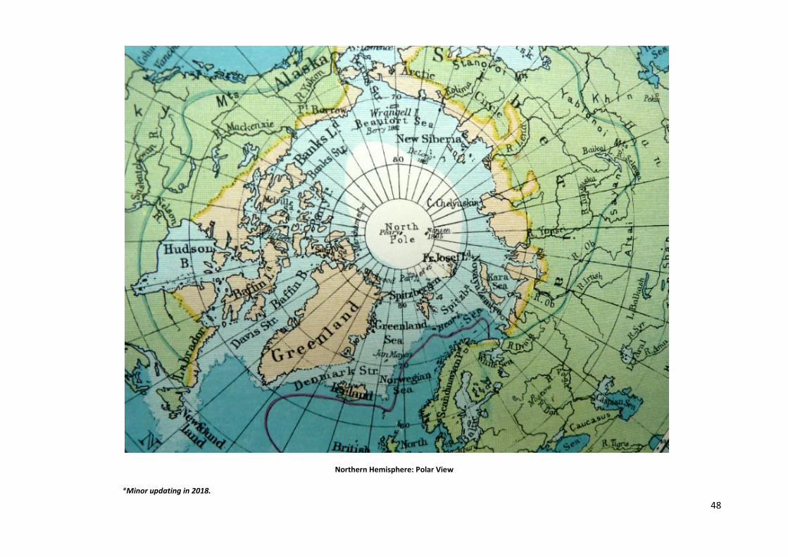
Intercontinental European frontiers in the frozen north are extensive. A Polar view of the Northern Hemisphere demonstrates that
the European zone faces North America across a vast maritime zone. This inhospitable region is very sparsely populated and possesses
practically no geopolitical risks. Such risks, however, can be intentionally created. The aforementioned vast maritime frontiers
separating the two are only political and not cultural, as both sides belong to the same civilisation, usually referred to as the Western
Civilisation. That term, of course, has a long history, but now it has become inflicted with politicized aspects with unreasonable
additions and subtractions. Moreover, no civilisation should be classified according to the needle of the compass. Consequently, due
to such characteristics, it is prudent to utilise it only in political or politicized literature. It is best to maintain the term ‘European
Civilisation’, as it reflects the origin of longstanding fundamentals appropriately.
T. S. Kahvé London February 2012

3
Posidonius , c 135 BC–51 BC – the Greek philosopher, astronomer and mathematician – proposed that earth was sling-shaped, as an oval. Petrus Bertius, 1565–1629, the Flemish historian, geographer and
cartographer – implemented that insight in the form of a world map. It was published in his work: Ancient Geography, Paris, 1630. The above illustration is a detail encompassing the map’s western sector.
4
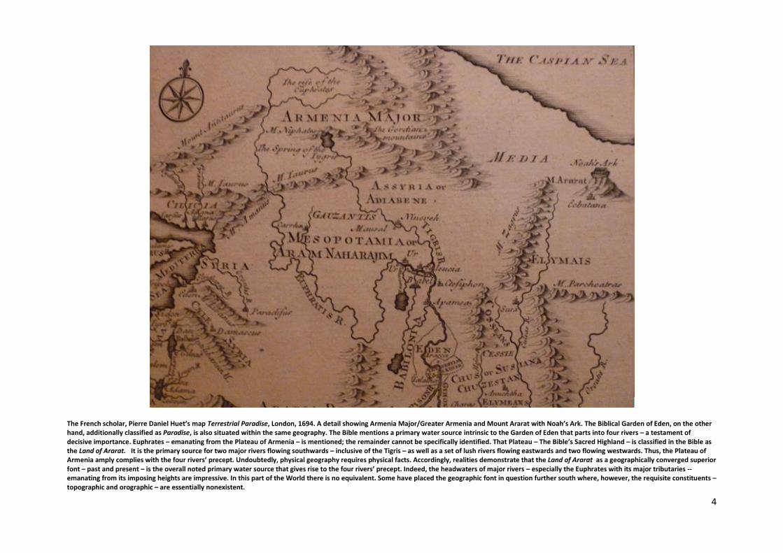
The French scholar, Pierre Daniel Huet’s map Terrestrial Paradise, London, 1694. A detail showing Armenia Major/Greater Armenia and Mount Ararat with Noah’s Ark. The Biblical Garden of Eden, on the other hand, additionally classified as Paradise, is also situated within the same geography. The Bible mentions a primary water source intrinsic to the Garden of Eden that parts into four rivers – a testament of decisive importance. Euphrates – emanating from the Plateau of Armenia – is mentioned; the remainder cannot be specifically identified. That Plateau – The Bible’s Sacred Highland – is classified in the Bible as the Land of Ararat. It is the primary source for two major rivers flowing southwards – inclusive of the Tigris – as well as a set of lush rivers flowing eastwards and two flowing westwards. Thus, the Plateau of Armenia amply complies with the four rivers’ precept. Undoubtedly, physical geography requires physical facts. Accordingly, realities demonstrate that the Land of Ararat as a geographically converged superior font – past and present – is the overall noted primary water source that gives rise to the four rivers’ precept. Indeed, the headwaters of major rivers – especially the Euphrates with its major tributaries -- emanating from its imposing heights are impressive. In this part of the World there is no equivalent. Some have placed the geographic font in question further south where, however, the requisite constituents – topographic and orographic – are essentially nonexistent.
5
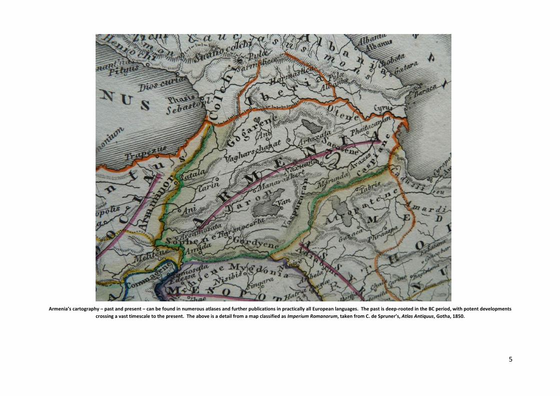
Armenia’s cartography – past and present – can be found in numerous atlases and further publications in practically all European languages. The past is deep-rooted in the BC period, with potent developments
crossing a vast timescale to the present. The above is a detail from a map classified as Imperium Romanorum, taken from C. de Spruner’s, Atlas Antiquus, Gotha, 1850.
6
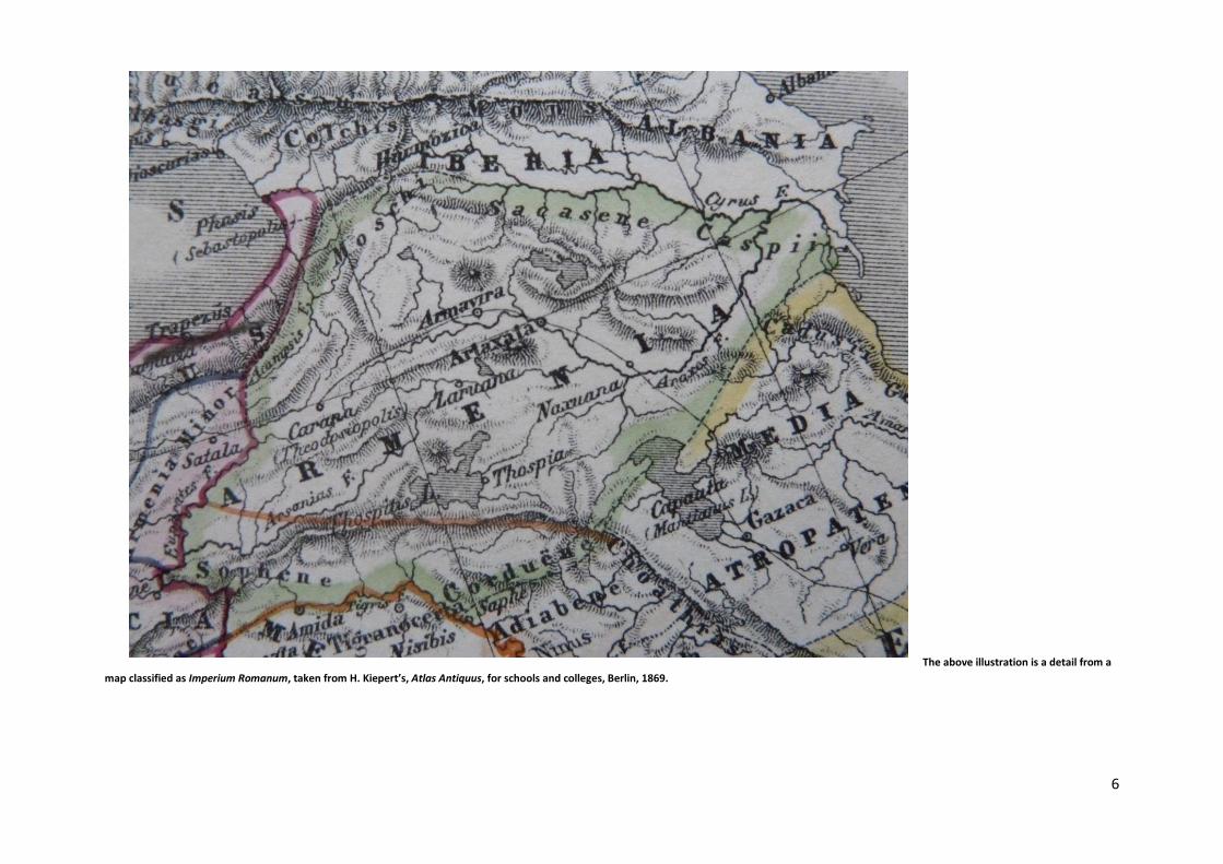
The above illustration is a detail from a
map classified as Imperium Romanum, taken from H. Kiepert’s, Atlas Antiquus, for schools and colleges, Berlin, 1869.

7
Spruner’s, Atlas Antiquus, 1850, records the national provinces of the Armenian Highland entirely, the illustrated cartography is a detail from the map ‘Armenia’ also outlining the country’s most eastern
provinces: Siunikh, Artsakh and Phaitakharan. The latter province – leading to the Caspian Sea – is the only region of Armenia that is not part of its Plateau geographically. Consequently, it only possesses
historic and political connotations. Diocesan maps and manuscripts of the subsequent period clearly record that during the seventeenth century, for example, a number of Armenia’s provinces – despite adverse
factors – had maintained their prosperity. In this respect Artsakh in the East and Vaspurakan in the West are good examples. Consult Gabriella Uluhogian’s, Un’ Antica Mappa Dell’ Armenia: Monasteri e
santuari dal I al XVII Secolo, published in conjunction with Università di Bologna, Ravenna, 2000.
8
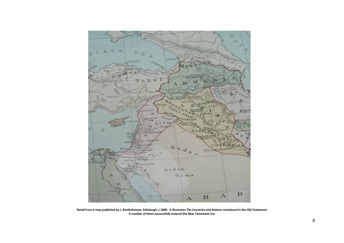
Detail from a map published by J. Bartholomew, Edinburgh, c 1890. It illustrates The Countries and Nations mentioned in the Old Testament. A number of them successfully entered the New Testament era.

9
A detail from a map classified as The Roman Empire in the New Testament Period, published by Rand McNally, Chicago, c 1885. This is a most relevant period as Armenia, in 301, became the first country to acknowledge Christianity as the state religion. The Roman Empire later followed suit.
Christianity and Governance
10
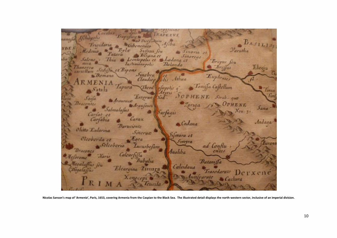
Nicolas Sanson’s map of ‘Armenia’, Paris, 1653, covering Armenia from the Caspian to the Black Sea. The illustrated detail displays the north-western sector, inclusive of an imperial division.
11
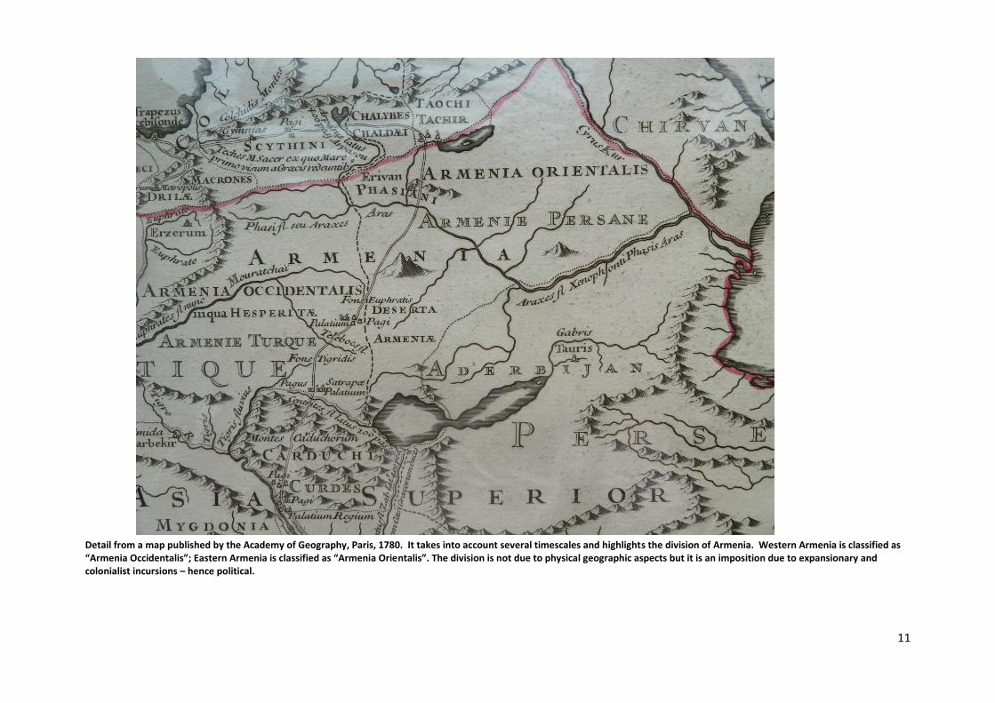
Detail from a map published by the Academy of Geography, Paris, 1780. It takes into account several timescales and highlights the division of Armenia. Western Armenia is classified as “Armenia Occidentalis”; Eastern Armenia is classified as “Armenia Orientalis”. The division is not due to physical geographic aspects but it is an imposition due to expansionary and colonialist incursions – hence political.
12
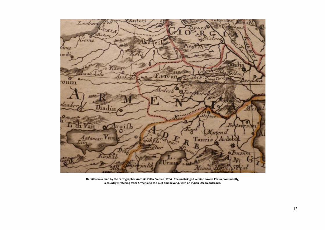
Detail from a map by the cartographer Antonio Zatta, Venice, 1784. The unabridged version covers Persia prominently, a country stretching from Armenia to the Gulf and beyond, with an Indian Ocean outreach.

13
A detail from a copper engraved map: ‘Chart of the Caspian Sea’; published according to an Act of Parliament by T. Cadell in the Strand, London, 1784. It delineates mostly the Eastern sector of Armenia prior to the descent of Tsarist Russia to the region. A good selection of period maps can be found in R. Galichian’s, Historic Maps of Armenia: The Cartographic Heritage, London, 2004.
14
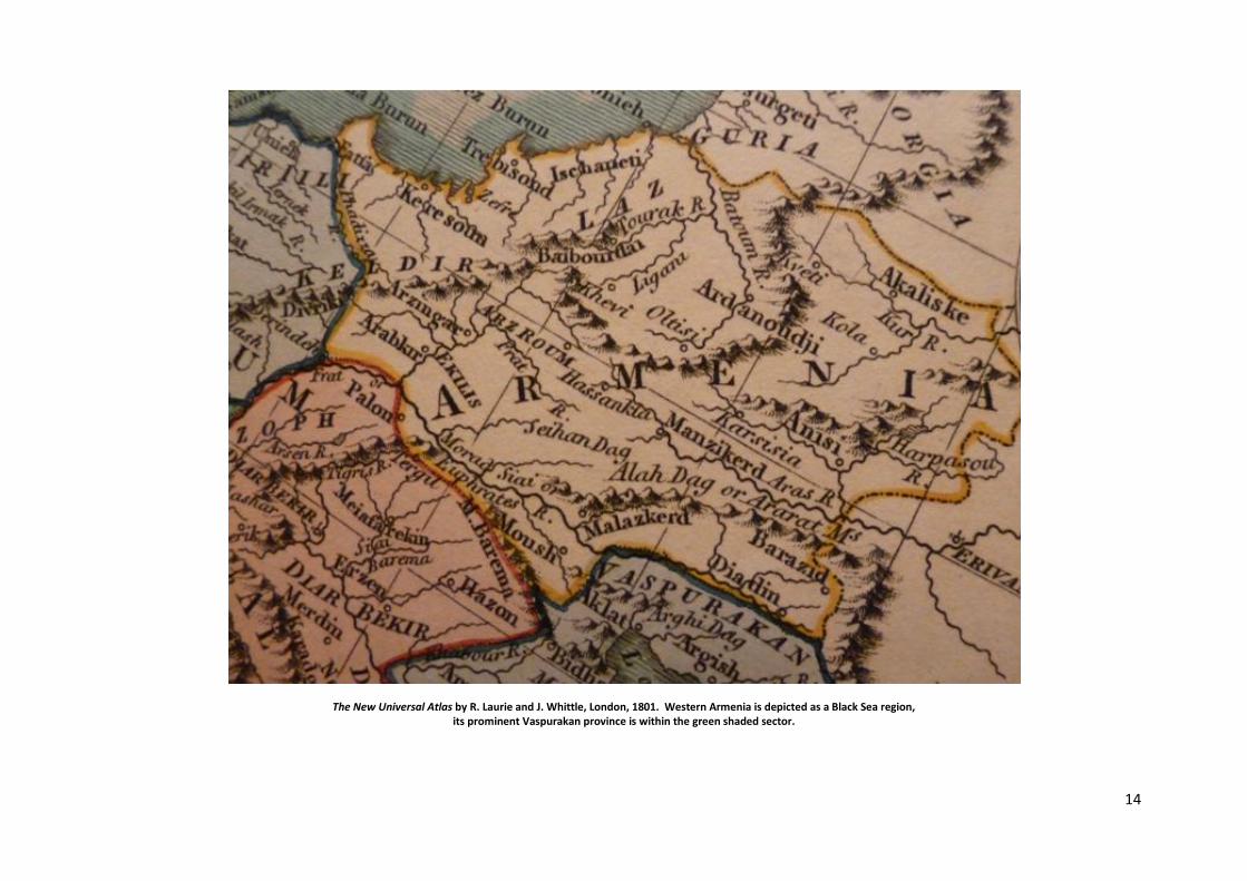
The New Universal Atlas by R. Laurie and J. Whittle, London, 1801. Western Armenia is depicted as a Black Sea region, its prominent Vaspurakan province is within the green shaded sector.
15
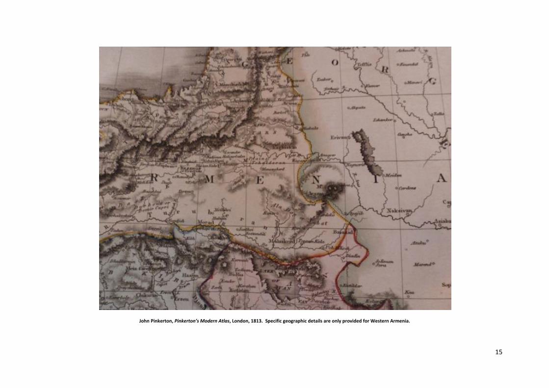
John Pinkerton, Pinkerton’s Modern Atlas, London, 1813. Specific geographic details are only provided for Western Armenia.
16
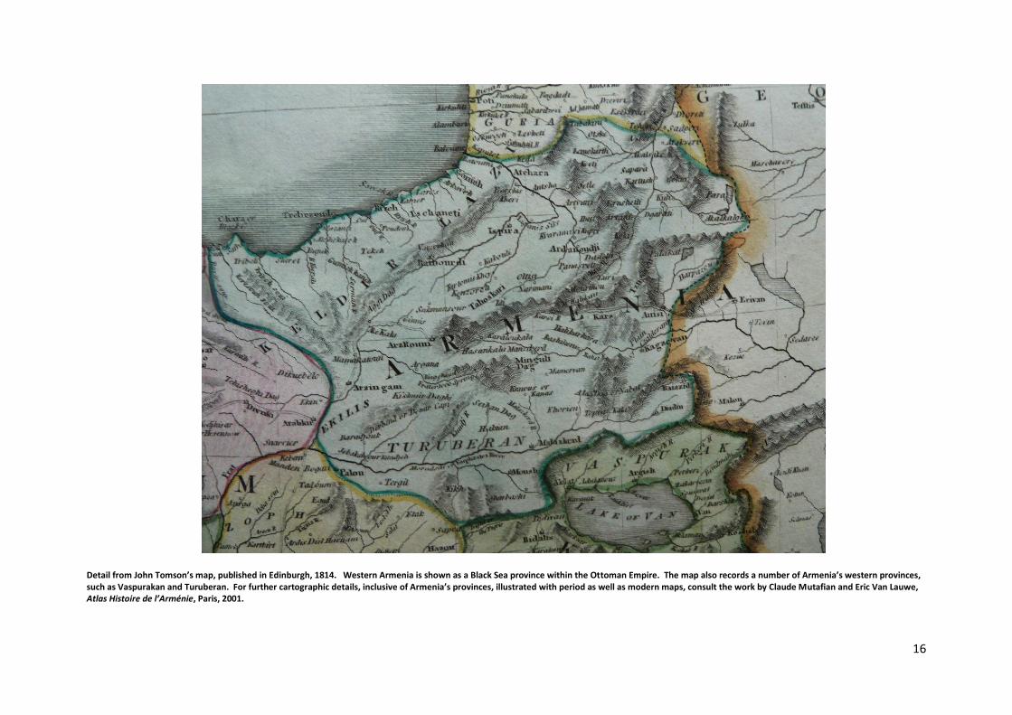
Detail from John Tomson’s map, published in Edinburgh, 1814. Western Armenia is shown as a Black Sea province within the Ottoman Empire. The map also records a number of Armenia’s western provinces, such as Vaspurakan and Turuberan. For further cartographic details, inclusive of Armenia’s provinces, illustrated with period as well as modern maps, consult the work by Claude Mutafian and Eric Van Lauwe, Atlas Histoire de l’Arménie, Paris, 2001.
17
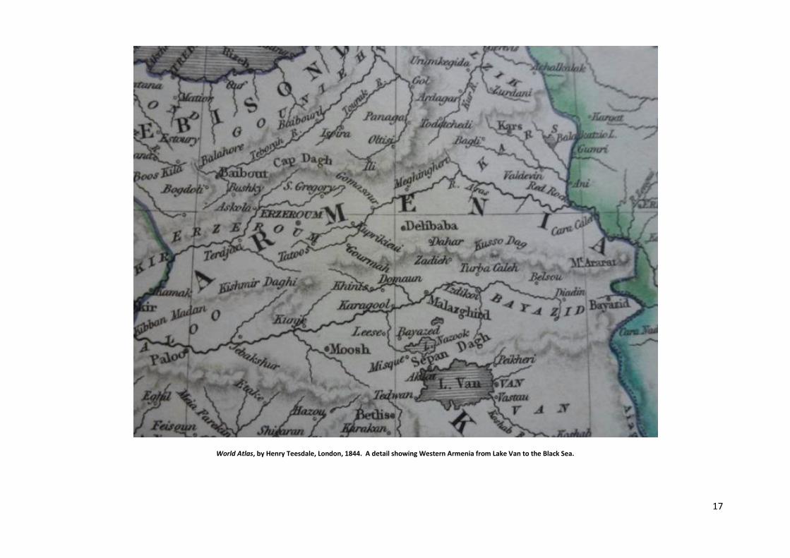
World Atlas, by Henry Teesdale, London, 1844. A detail showing Western Armenia from Lake Van to the Black Sea.
18
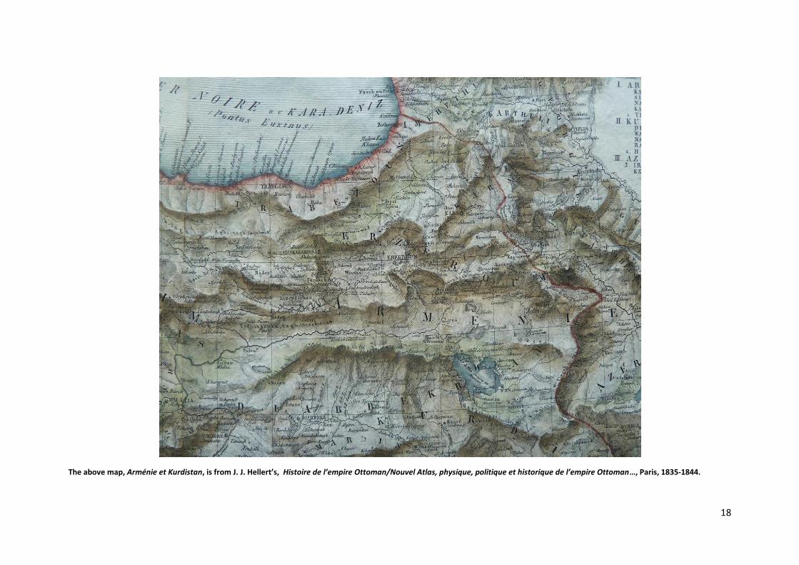
The above map, Arménie et Kurdistan, is from J. J. Hellert’s, Histoire de l’empire Ottoman/Nouvel Atlas, physique, politique et historique de l’empire Ottoman…, Paris, 1835-1844.

19
Heller’s aforementioned map also classifies the regions of Armenia. Kars, Erzeroum, Nakhitschevan and Karabagh/Artsakh are Armenia proper hence they are looked upon as Armenia Major/Greater Armenia or similarly Armenia Prima. Trabezoun represents the Black Sea region, thus it is within the subdivision of Pontus. The Sivas region, also referred to as Lesser Armenia or Armenia Minor, is often not classified as within the Plateau of Armenia geographically. Kurdistan includes Diarbekr, Wan/Van, Mosul as well as lands well beyond, such as Mesopotamia. The northern section of Van province, however, where the lake is situated, is part of Armenia’s Vaspurakan province, a region where Armenians were an outright majority. Azerbaijan or Azerbeidschan refers to northern Iran, situated south of the Araxes River. Consequently, Persian / Iranian provinces are specified. Caspian Tatars inhabiting north-east of the Araxes river also adopted that title during the First World War – primarily for expansionary motives – and established a republic with that name. Formerly, that region was known as Shirvan. For anomalies relevant to more recent developments, consult R. Galichian’s, The Invention of History, second edition, London and Yerevan, 2010.
Extermination of the Christian Caucasian Albanians
Prior to the broad set of Islamic invasions in history, the lowland later referred to as Shirvan was the Kingdom of the Caucasian Albanians (AGVANK in Armenian), who had expanded southwards from the north-eastern Caucasus, thus severing the Armenian Kingdom (PHAITAKHARAN PROVINCE) from the Caspian Sea. Caucasian Albanians had a specific language and culture – now lost – and, similar to the Armenians, who entirely inhabited the highlands (Plateau of Armenia) immediately to the west, were Christians. This lost Christian nation was thoroughly exterminated and its country occupied by the invading Islamised itinerant Caspian Tatar tribes emanating from Central Asia. Further invaders from the same Central Asia region include the Seljuks and the Turkoman nomadic confederations. Linguistically they all belong to the different branches of the Altaic group of languages; by origin they are strictly foreign to lands west
and south of the Caspian Sea. Their geography of origin extends to the gates of Mongolia. In the past, only the Russians – situated further north – have fought broadly and decisively in order to eliminate them as a destructive force that exterminated significantly more advanced national cultures and realms. As a result, during certain timelines, Russia has shielded Central Europe from this expansionist peril that has constantly challenged the European Civilisation in the East. In a modern World, it is also imperative for the rest of Europe and the American continents to provide a shield accordingly.
The Roman world labelled significantly less hostile invading tribes as Barbarians; they, of course, did not exterminate Christian cultures. The annihilation in question is a centuries’ past catastrophe. Nevertheless, due to assertive extant developments, its modern multilateral destructive variant will incrementally penetrate European Cultural Frontiers from the South and the East. Unfortunately, the European regimes of the 21st Century are unable to control the External European Cultural Frontiers of the European Civilisation effectively – astonishingly divided they remain. Under the circumstances, Europe’s survival necessitates a progressively altered defensive mindset. Thus, it is imperative to shield decisively the External Cultural Frontiers of the Civilisation militarily as well as ideologically. Shields of Europe. For the specific geography of the past also consult the aforecited atlases by C. de Spruner (1850) and H. Kiepert (1869). Further relevant folding maps are available in “Soviet Armenian
Encyclopedia” [Հա յկական Սովետական Հանրագիտարան ], (1987), vol 7․
20
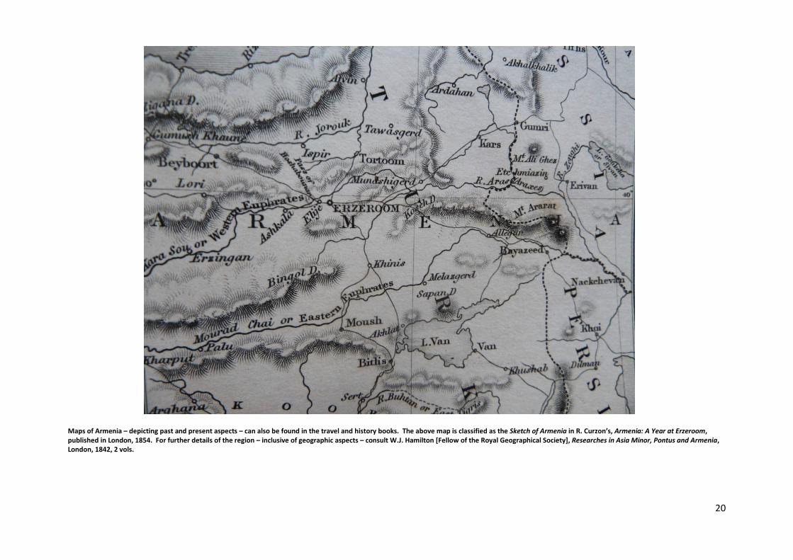
Maps of Armenia – depicting past and present aspects – can also be found in the travel and history books. The above map is classified as the Sketch of Armenia in R. Curzon’s, Armenia: A Year at Erzeroom, published in London, 1854. For further details of the region – inclusive of geographic aspects – consult W.J. Hamilton [Fellow of the Royal Geographical Society], Researches in Asia Minor, Pontus and Armenia, London, 1842, 2 vols.
21
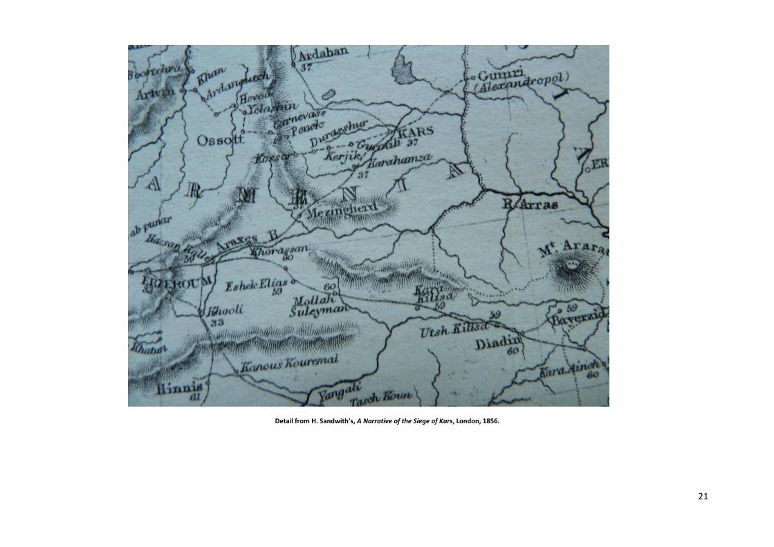
Detail from H. Sandwith’s, A Narrative of the Siege of Kars, London, 1856.

22
The Imperial Atlas of Modern Geography, Blackie & Sons, Glasgow, 1859. A detail displaying the two major lakes of Armenia.

23
A map from H. M. Hozier’s, Russo-Turkish War, London, 1878, V. vols. It displays the eastern Black Sea region inclusive of Western Armenia and Kurdistan - situated further south. The war of 1877-78 was fought on two fronts, the Balkans and Armenia. The Balkan theatre was led by Tsar Alexander II, known as ‘Tsar Liberator’ for the emancipation of the serfs. The commander on the Armenian front was his close confidant Count Loris-Melikov, who was later appointed the Prime Minister of Russia, given the foremost task of introducing reforms. The Russian forces in Armenia possessed a significant proportion of Armenian soldiers and officers, inclusive of their commander. Russia was victorious in both fields of conflict. The objective was to free a number of European nations from a non-European yoke. Earlier that century, it was the joint military assistance extended to the Greeks – by Britain, France and Russia – that saved Greece from destruction and established it as an independent kingdom. In this respect the naval battle of Navarino in the Ionian Sea – Western Greece – during the Greek War of Independence (1821-1832) was a key turning point. Indeed, it was during the conflict’s second year that the Ottoman forces invaded the Aegean island of Chios, massacred 20,000 of its Greek inhabitants and deported the rest of its 70,000 Greek population. The geography of the South in general, including Greece had generated marked interest. Lord Byron, for example, had travelled to the country, but unfortunately, he was to succumb to its terrible conditions. Years earlier he had visited San Lazzaro near Venice in order to undertake Armenian studies. Pertaining to the aforementioned successful epoch – up to and including Tsar Alexander II’s timeline – Russia had been endowed with an intellectual level of European Civilisational capacity relevant to specific developments beyond its frontiers. The aforementioned shielding and liberatory outreach conducted with the two other European Great Powers, Britain and France is a further example of some prominence. Undoubtedly, Russia’s geography – inclusive of its overall interests -- was a plus point for such a European psychology, thoroughly pertinent to the occupied European nations in the South by a most hostile foreign civilisation. Inaction would have practically guaranteed a set of exterminations of Europeans. Unfortunately due to a set of most detrimentally politicized inter-European rivalries – the Crimean war being the best example – the two aforecited European Great Powers stepped back from the aforementioned European Civilisational outreach: a significant regression. The next European upheaval began with the Bulgarian Massacres of 1876, inflicted by the same foreign miscreant as in the case of Greece. No European power came forth to eliminate the most detrimental foreign occupation of South European peoples, except Russia. Thus, as noted above, it was Russian forces led by Alexander II from the Balkans, and Loris-Melikov, through Western Armenia, who liberated downtrodden European nations. To this success one can also add that had it not been for Russia’s progress beyond the Caucasus Mountains during the earlier decades of the same century, such countries as Georgia and Armenia would have disappeared entirely. Accordingly, until the assassination of Tsar Alexander II, Russia proved to be the Northern Light – a temporary psychology. Hence, in 1894 when Abdul Hamid’s Ottoman Turkish regime commenced the Armenian Genocide – a gigantic extermination in contrast to the Bulgarian Massacres, as the objective is the destruction of a nation – Russia took no measures to halt the initial procedures of the Great Crime, despite the fact that it was geographically in an ideal position to do so: a regression of some magnitude. Indeed, there are times when the European Civilisation and its nations have to be shielded from the Barbarian and the Enemy Within Propensity, the alternative is steady obliteration – time waits for nobody. From Alexander II to Nicholas II A particularly brief period of Russian history involving two key adverse developments can be classified as: from zenith to collapse. These events are the assassination of Tsar Alexander II and the murder of Nicholas II, in 1881 and 1918 respectively. The adversity primarily emanates from the fact that Alexander III, the successor Tsar, promptly refused to implement the reforms initiated by Count Loris-Melikov. Consequently, the latter walked out of Russian politics and retired to South of France. Thus, essential socio-political progress was halted. At first there was little change. Over time, however, serious unrest developed and culminated in the 1905 revolutionary upheavals. In 1914, as an Allied Power, the country entered the First World War -- as expected it was ill prepared on numerous counts. The collapse came about with the Bolshevik revolution of 1917, the defeat by Germany, and finally in 1918 the murder of Tsar Nicholas II. A retrospective view demonstrates that the Bolsheviks were a false dawn. A true reconstruction had to wait for the 21st Century. Hence, the progressive path initiated by Alexander II and Count Loris-Melikov carry significant weight. Russian history has now turned a full circle.
24
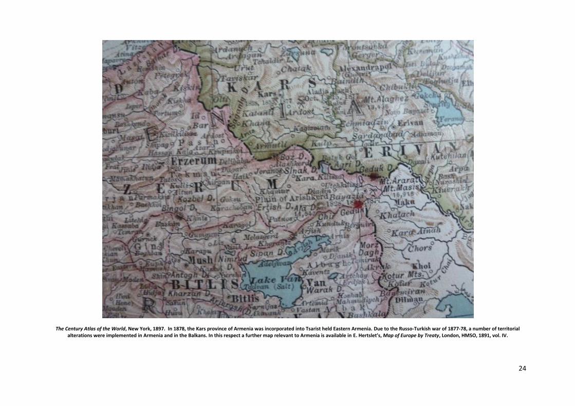
The Century Atlas of the World, New York, 1897. In 1878, the Kars province of Armenia was incorporated into Tsarist held Eastern Armenia. Due to the Russo-Turkish war of 1877-78, a number of territorial alterations were implemented in Armenia and in the Balkans. In this respect a further map relevant to Armenia is available in E. Hertslet’s, Map of Europe by Treaty, London, HMSO, 1891, vol. IV.

25
These are the Six Provinces, often referred to as the Armenian Provinces, which included regions beyond Armenia proper but excluded Cilicia – also known as Little Armenia or Lesser Armenia – a key Armenian region with a high population density on the Mediterranean coastline of Anatolia. The Six Provinces were established shortly after the Berlin Treaty of 1878. The aforementioned treaty failed to protect Western Armenia, as the most appropriate and necessary treaty, San Stefano was not implemented. In this respect, consult Armenia, the Armenians and the Treaties by M.G. Rolin-Jaequemyns – the outstanding international lawyer – published in London, 1891. Further details are available in C.J. Walker’s, Armenia: the Survival of a Nation, London, 1980. Folding maps in books on Western Armenia, relevant to the fourth quarter of the nineteenth century, can be found in C.B. Norman’s, Armenia and the Campaign of 1877, London, 1878 and G.H. Hepworth’s, Through Armenia on Horseback, New York, 1898. Regarding Cilicia, consult T.S.R. Boase’s (ed), The Cilician Kingdom of Armenia, Edinburgh, Scottish Academic Press, 1978. The Armenian population was constantly in danger. In 1914, shortly before the Great War, Europe insisted that two European Inspector Generals be appointed to the region. With the addition of a Black Sea zone, the number of Provinces increased to seven. A Dutch administrator and a Norwegian officer were appointed. The onset of the Great War, however, halted the projects’ completion. Without Europe, Armenia could not be protected. During the First World War, nonetheless, Russia placed Armenia at a disadvantage by dispatching most of the Armenian soldiers and officers to the German front. Although by 1917 Western Armenia had been mostly liberated by the Russian forces, they had to withdraw due to their collapse on the German front and the destabilisation caused by the Bolshevik revolution. Consequently, Armenia could only be defended by a few.

26
W.G. Blackie, The Comprehensive Atlas and Geography of the World, London, 1882; a detail showing the Caucasus Mountains, Georgia and Armenia. Later, during the Russo-Turkish cooperation of the initial Bolshevik/Soviet period, Georgia had to relinquish sections of its territories in the east to the Caspian Tatars, newly concocted as Azeris.
27
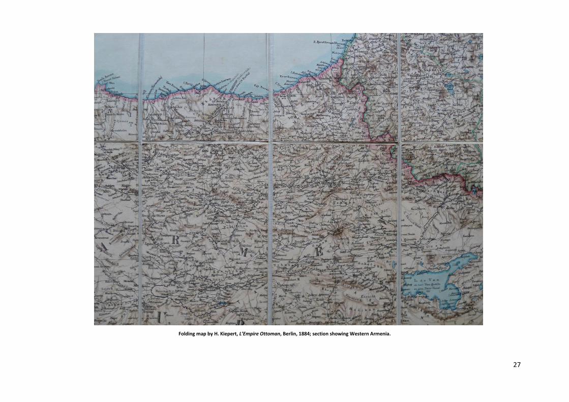
Folding map by H. Kiepert, L’Empire Ottoman, Berlin, 1884; section showing Western Armenia.
28
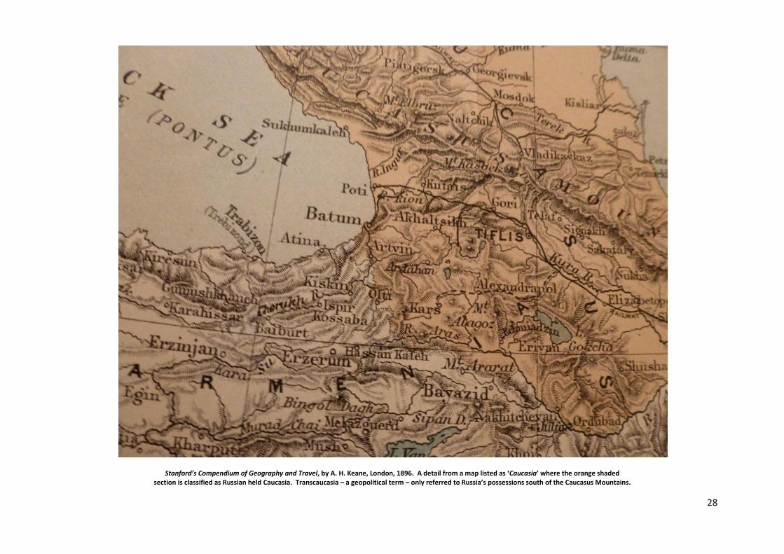
Stanford’s Compendium of Geography and Travel, by A. H. Keane, London, 1896. A detail from a map listed as ‘Caucasia’ where the orange shaded section is classified as Russian held Caucasia. Transcaucasia – a geopolitical term – only referred to Russia’s possessions south of the Caucasus Mountains.
29
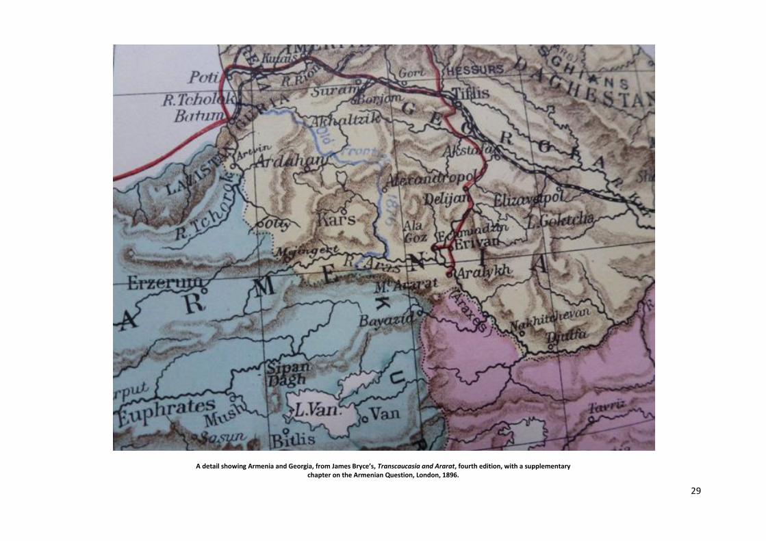
A detail showing Armenia and Georgia, from James Bryce’s, Transcaucasia and Ararat, fourth edition, with a supplementary chapter on the Armenian Question, London, 1896.
30
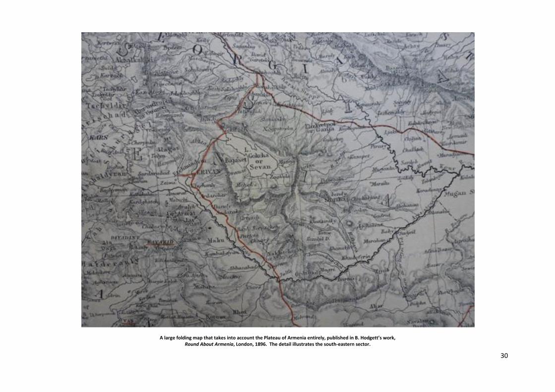
A large folding map that takes into account the Plateau of Armenia entirely, published in B. Hodgett’s work, Round About Armenia, London, 1896. The detail illustrates the south-eastern sector.
31
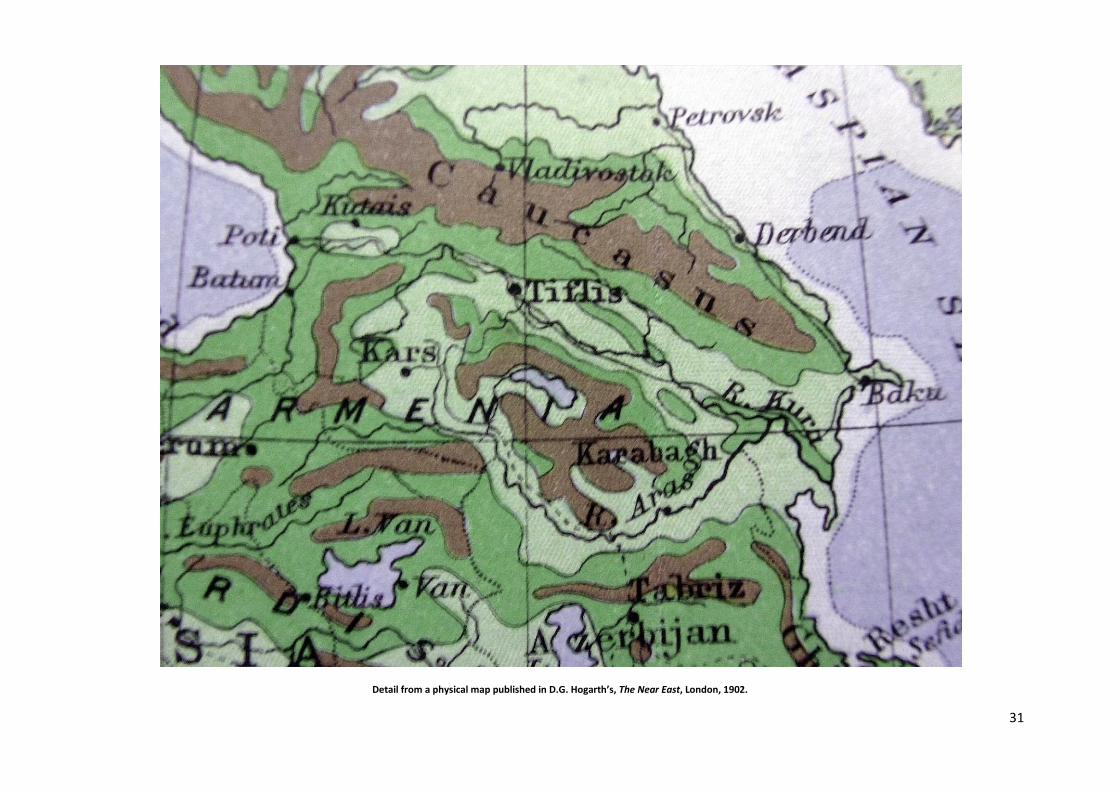
Detail from a physical map published in D.G. Hogarth’s, The Near East, London, 1902.

32
Detail from the ethnographic map published in D.G. Hogarth’s, The Near East, London, 1902. For Western Armenia, also consult Leon Dominian’s work, The Frontiers of Language and Nationality in Europe, The American Geographical Society of New York, 1917.

33
The above ethnographic map is a detail from an inset provided in A. J. Toynbee’s New York publication of 1917 and refers approximately to the pre-war demography of Western Armenia, as distinct from Eastern Anatolia and Northern Kurdistan. The shaded classifications are: - Armenians: yellow - Kurds: orange - Turks and Laz: shades of blue - Assyrians and Chaldeans: dark green - Pontic Greeks of the Black Sea region: red lines

34
A detail from J. Bartholomew’s, Atlas of World’s Commerce, Edinburgh, 1907.
35
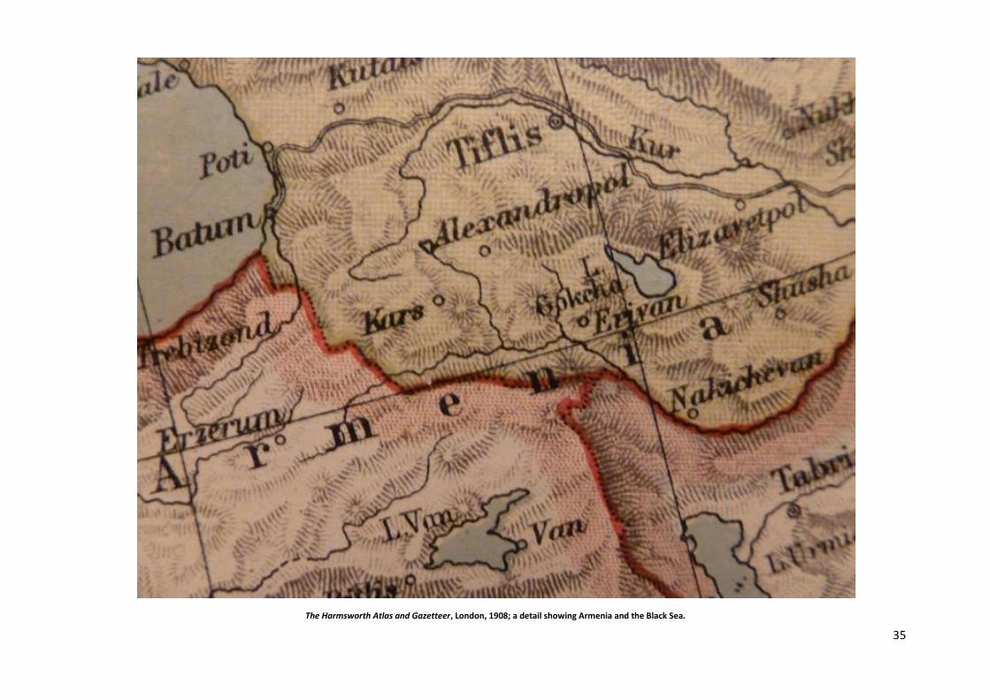
The Harmsworth Atlas and Gazetteer, London, 1908; a detail showing Armenia and the Black Sea.
36
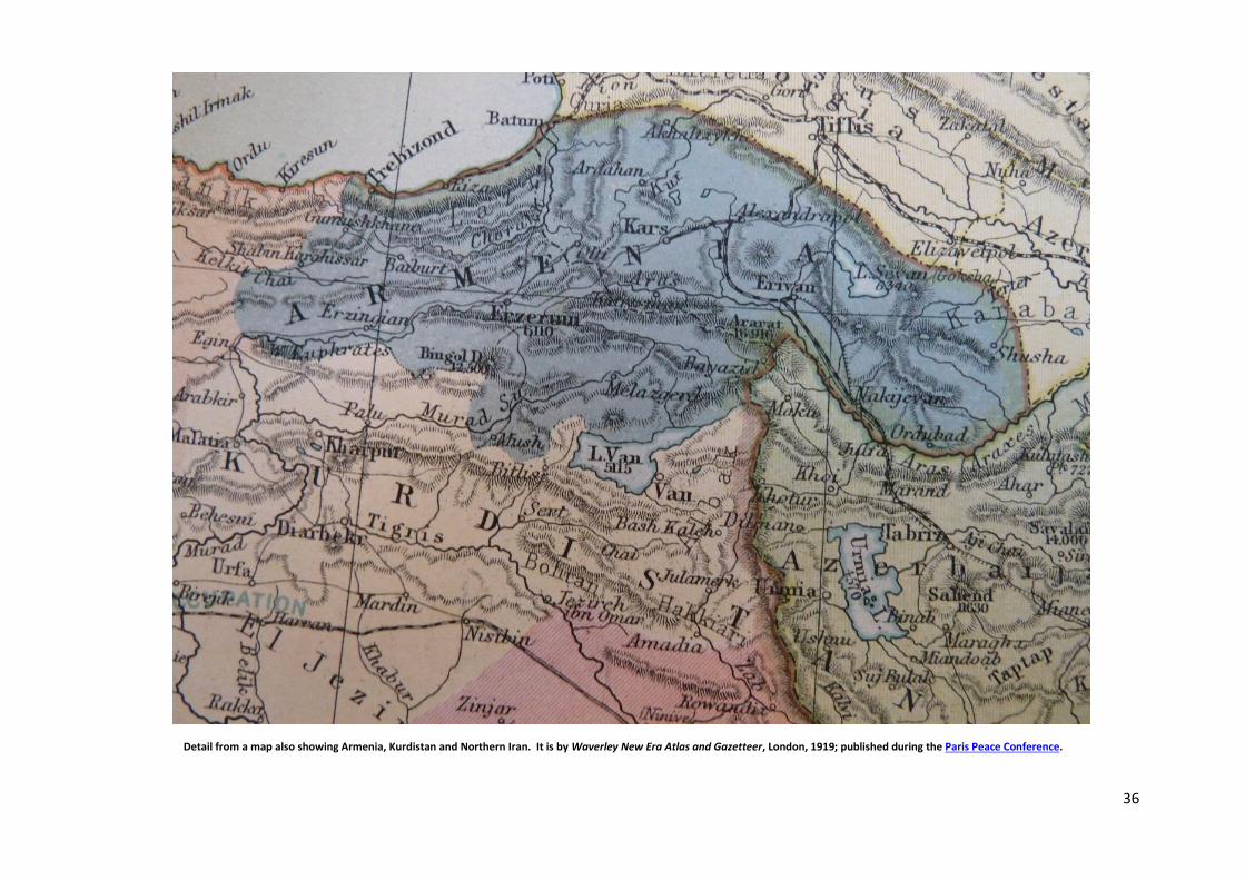
Detail from a map also showing Armenia, Kurdistan and Northern Iran. It is by Waverley New Era Atlas and Gazetteer, London, 1919; published during the Paris Peace Conference.

37
Waverley New Era Atlas, showing Armenia in greater detail.

38
H.F.B. Lynch, Armenia: Travels and Studies, London, 1901, II Vols.; the folding map is by Lynch and Felix Oswald; the illustrated details cover the Pontic regions of the Black Sea. The said region was delimited within Armenia in Woodrow Wilson’s Arbitration of 1920. For its long term survival, it was imperative for Armenia to possess an outlet to the sea. Such a psychology was also applied to Poland in the Versailles Treaty of 1919, despite the fact that the Polish population in the newly acquired region of the Baltic Sea was not significant. At the end of the Second World War that procedure was expanded even further.

39
The Times Atlas, London and Edinburgh, 1920-1922. Detail from a map recording the frontiers of Armenia with Anatolia and Northern Kurdistan according to Woodrow Wilson’s arbitration. International Treaties: Legal and Political

40
The above map is from Oliver Baldwin’s book, published in London, 1924. It records the frontiers of Armenia with Anatolia and Northern Kurdistan according to Woodrow Wilson’s arbitration.
41
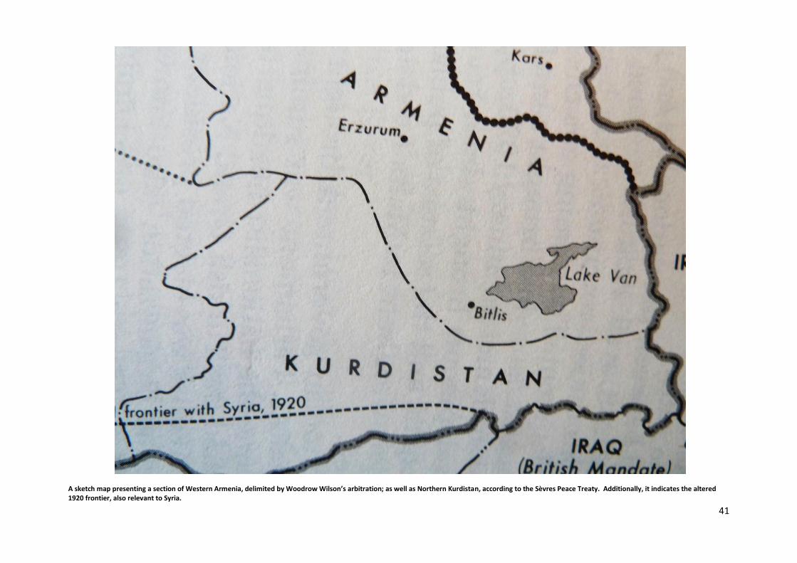
A sketch map presenting a section of Western Armenia, delimited by Woodrow Wilson’s arbitration; as well as Northern Kurdistan, according to the Sèvres Peace Treaty. Additionally, it indicates the altered 1920 frontier, also relevant to Syria.

42
A sketch map demonstrating the fundamentals relevant to Armenia’s geopolitical consolidation deemed applicable by the international community during and after the Paris Peace
Conference. It was published in André Mandelstam’s, La Société des Nations et les puissances devant le problème arménien, Paris, 1926, and subsequent reprints.
A more recent work with noteworthy maps and illustrations is by Mathew Karanian, The Armenian Highland: Western Armenia and the First Armenian Republic of 1918,
Pasadena/California, Stone Garden Press, 2019, 312 pp. [The noteworthy maps are by Robert Hewsen].
43
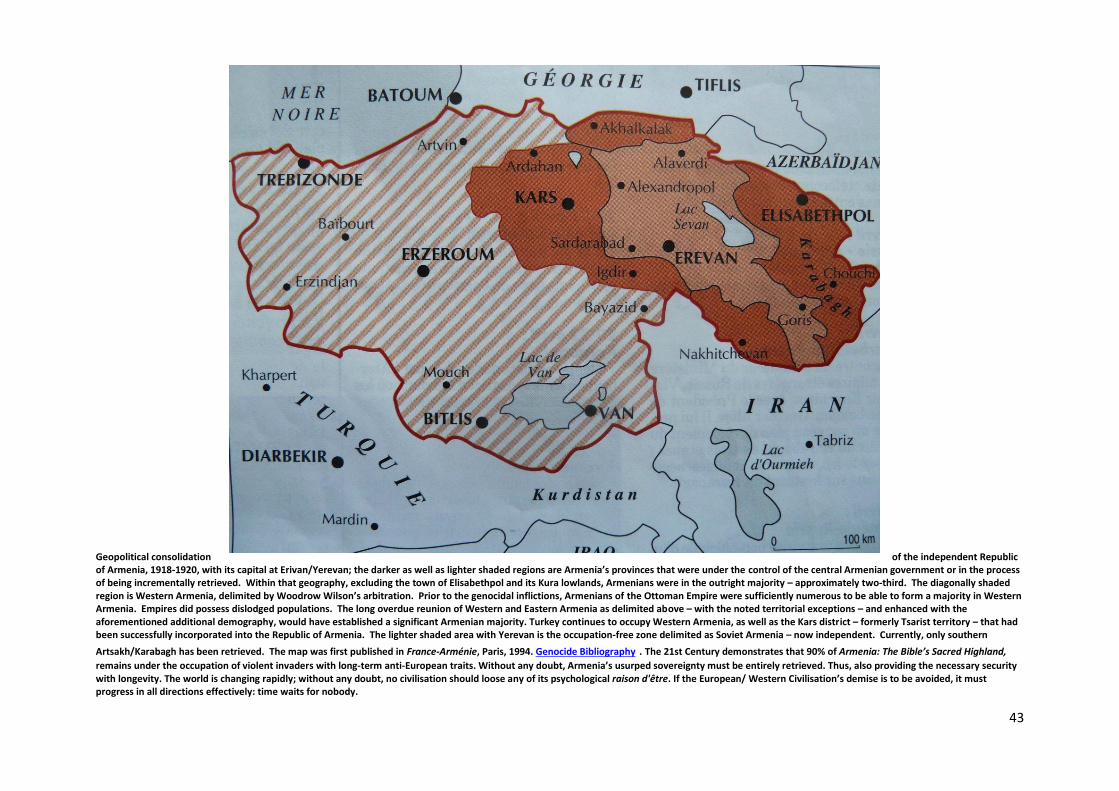
Geopolitical consolidation of the independent Republic of Armenia, 1918-1920, with its capital at Erivan/Yerevan; the darker as well as lighter shaded regions are Armenia’s provinces that were under the control of the central Armenian government or in the process of being incrementally retrieved. Within that geography, excluding the town of Elisabethpol and its Kura lowlands, Armenians were in the outright majority – approximately two-third. The diagonally shaded region is Western Armenia, delimited by Woodrow Wilson’s arbitration. Prior to the genocidal inflictions, Armenians of the Ottoman Empire were sufficiently numerous to be able to form a majority in Western Armenia. Empires did possess dislodged populations. The long overdue reunion of Western and Eastern Armenia as delimited above – with the noted territorial exceptions – and enhanced with the aforementioned additional demography, would have established a significant Armenian majority. Turkey continues to occupy Western Armenia, as well as the Kars district – formerly Tsarist territory – that had been successfully incorporated into the Republic of Armenia. The lighter shaded area with Yerevan is the occupation-free zone delimited as Soviet Armenia – now independent. Currently, only southern
Artsakh/Karabagh has been retrieved. The map was first published in France-Arménie, Paris, 1994. Genocide Bibliography . The 21st Century demonstrates that 90% of Armenia: The Bible’s Sacred Highland,
remains under the occupation of violent invaders with long-term anti-European traits. Without any doubt, Armenia’s usurped sovereignty must be entirely retrieved. Thus, also providing the necessary security with longevity. The world is changing rapidly; without any doubt, no civilisation should loose any of its psychological raison d'être. If the European/ Western Civilisation’s demise is to be avoided, it must progress in all directions effectively: time waits for nobody.
44
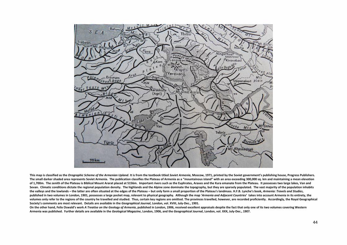
This map is classified as the Orographic Scheme of the Armenian Upland. It is from the textbook titled Soviet Armenia, Moscow, 1971, printed by the Soviet government’s publishing house, Progress Publishers. The small darker shaded area represents Soviet Armenia. The publication classifies the Plateau of Armenia as a “mountainous island” with an area exceeding 300,000 sq. km and maintaining a mean elevation of 1,700m. The zenith of the Plateau is Biblical Mount Ararat placed at 5156m. Important rivers such as the Euphrates, Araxes and the Kura emanate from the Plateau. It possesses two large lakes, Van and Sevan. Climatic conditions dictate the regional population density. The highlands and the Alpine zone dominate the topography, but they are sparsely populated. The vast majority of the population inhabits the valleys and the lowlands – the latter are often situated at the edges of the Plateau – but only form a small proportion of the Plateau’s landmass. H.F.B. Lynche’s book, Armenia: Travels and Studies, published in two volumes in London, 1901, possesses a large pocket map, relevant to physical geography. Although the map ‘Armenia and Adjacent Countries’ takes into account Armenia in its entirety, the volumes only refer to the regions of the country he travelled and studied. Thus, certain key regions are omitted. The provinces travelled, however, are recorded proficiently. Accordingly, the Royal Geographical Society’s comments are most relevant. Details are available in the Geographical Journal, London, vol. XVIII, July-Dec., 1901. On the other hand, Felix Oswald’s work A Treatise on the Geology of Armenia, published in London, 1906, received excellent appraisals despite the fact that only one of its two volumes covering Western Armenia was published. Further details are available in the Geological Magazine, London, 1906, and the Geographical Journal, London, vol. XXX, July-Dec., 1907.
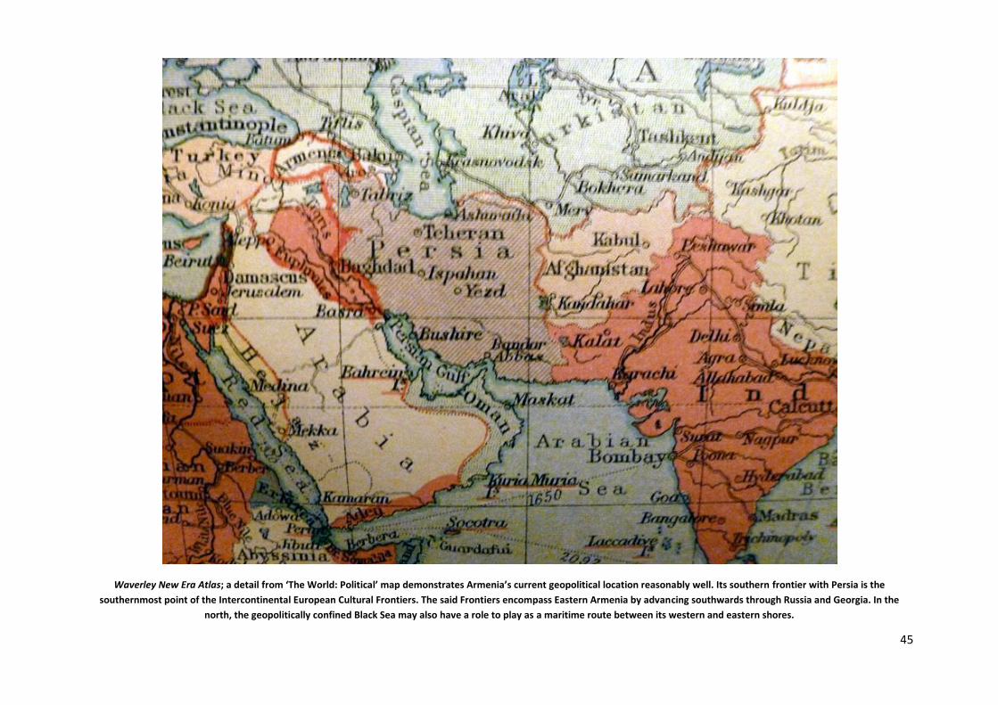
45
Waverley New Era Atlas; a detail from ‘The World: Political’ map demonstrates Armenia’s current geopolitical location reasonably well. Its southern frontier with Persia is the
southernmost point of the Intercontinental European Cultural Frontiers. The said Frontiers encompass Eastern Armenia by advancing southwards through Russia and Georgia. In the
north, the geopolitically confined Black Sea may also have a role to play as a maritime route between its western and eastern shores.
46
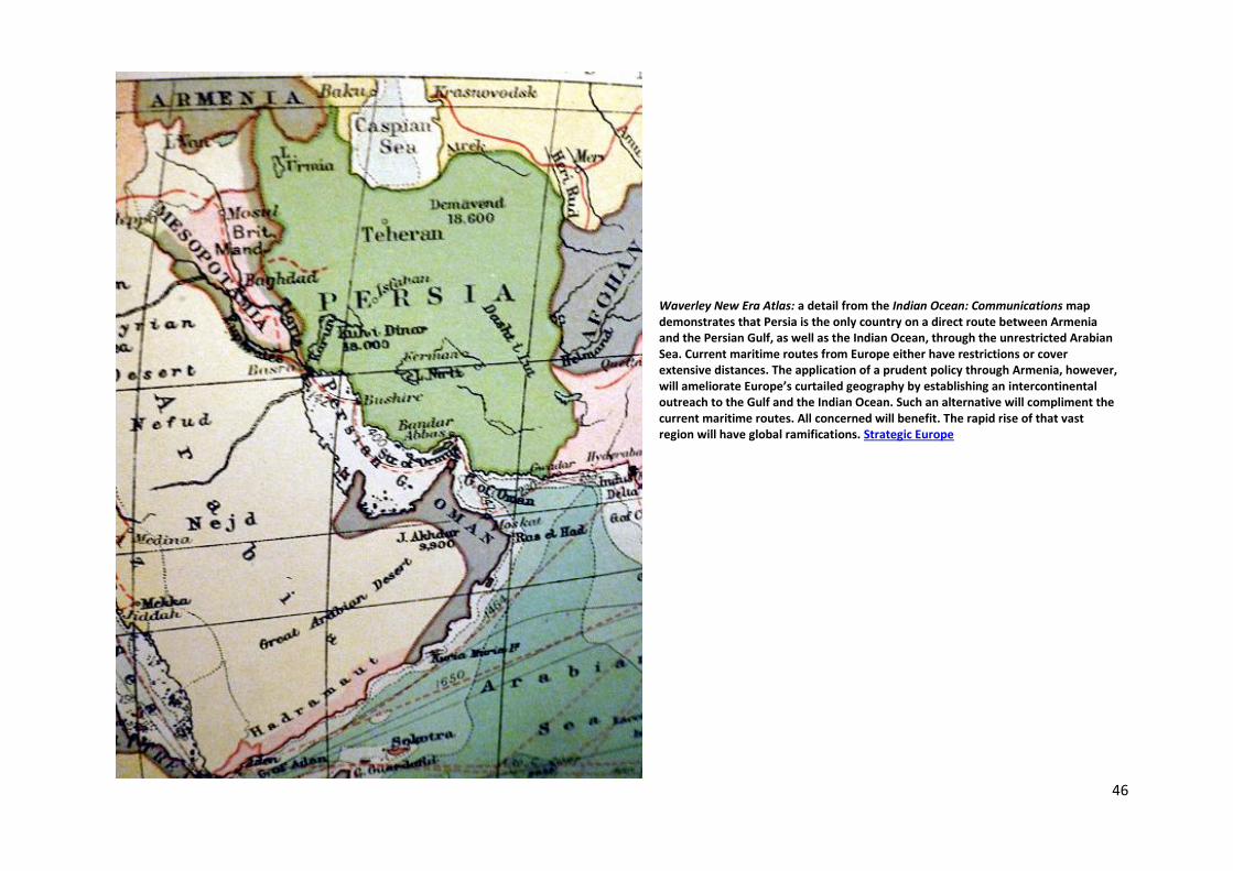
Waverley New Era Atlas: a detail from the Indian Ocean: Communications map demonstrates that Persia is the only country on a direct route between Armenia and the Persian Gulf, as well as the Indian Ocean, through the unrestricted Arabian Sea. Current maritime routes from Europe either have restrictions or cover extensive distances. The application of a prudent policy through Armenia, however, will ameliorate Europe’s curtailed geography by establishing an intercontinental outreach to the Gulf and the Indian Ocean. Such an alternative will compliment the current maritime routes. All concerned will benefit. The rapid rise of that vast region will have global ramifications. Strategic Europe
47
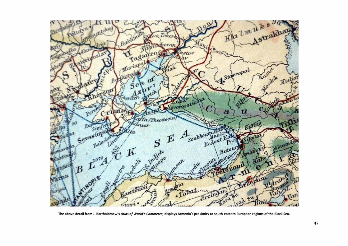
The above detail from J. Bartholomew’s Atlas of World’s Commerce, displays Armenia’s proximity to south-eastern European regions of the Black Sea.
48
Northern Hemisphere: Polar View
*Minor updating in 2018.

49
The Babylonian Map of the World
It may be appropriate to conclude Armenia and Europe: Cartographic perspectives, with a significantly earlier reference. Accordingly, it is prudent to commence with the 6th Century BC
Babylonian Map of the World. It is a clay tablet designated to be the oldest legible cartography in the world – with cuneiform inscriptions – currently displayed at the British Museum – first
published in 1899. It is a depiction of the known world in the West that concentrates geographically on Mesapotamia, encompassed by a circular formation recorded to be bitter water, thus
symbolising the saline sea water of a maritime geography. The triangular projections record regions beyond that maritime outlining. The longitudinal formation of the map also incorporates
over a dozen integral references, such as cities and kingdoms. The Land of Ararat is placed in the northeast section of that formation and marked as Urartu, the Armenian Kingdom of that
timeline. Further south, the centre of the map is dominated by the Euphrates flowing southwards. Babylon is recorded on that prominent river. Euphrates and Tigris emanate from the
Plateau of Armenia and flow towards the Gulf. The fertile region between the two rivers – now in Iraq – is geographically referred to as Mesapotamia. At an earlier timeline – 4000 BC – its
southerly region was inhabited by the Sumerians, and by 3200 BC Sumerians had established a number of important cities and invented writing. Within that timeline Sumerians were possibly
the most advanced culture/ civilisation of this Planet. However, they were eventually overrun by the Akkadians and the Babylonians. Assyria, once again a later development was situated at
the northern regions of Mesapotamia, and was the southern neighbour of Armenia. At times the latter’s southern regions were occupied by the assertive Assyrians. All the aforementioned
peoples of Mesapotamia spoke related semitic languages, except the Sumerians.
It is also interesting to note that ancient cuneiform clay tablets of Mesapotamia, held by the British Museum, record that Noah’s Ark was built in Sumeria and it sailed northwards. The Bible’s
narrative completes that development by recording that the Ark came to rest upon the Mountains of Ararat. A specifically relevant set of factors relate to the links between the Plateau of
Armenia and Sumeria Bible’s Sacred Highland [p. 2]. Additionally, of course, during specific periods, Euphrates and Tigris, as natural avenues of communication could only have advanced such
ties markedly. Near East.
50
Geographically, Armenia encompasses a territory over 300,000 sq. km, comprising the historic birthplace of the Nation. Currently only a
small strip of that land is inhabited by its Nation, namely the republic of Armenia and recently recovered Artsakh, in history the latter is
a province of the former’s monarchies; essentially they belong to the same geography. The rest of the country remains under occupation,
with its Armenian population exterminated, Islamised or wandering the Globe in the form of a Diaspora; the latter is now the vast
majority. Thus, geographically, there is a significant difference between Armenia—also referred to as the Plateau of Armenia or Greater
Armenia—and its republics.
The country possesses a deep rooted history of 3000 years—a record that highlights mainly its monarchic period—with its foundations resting upon its antecedent Urartu timeline.
Beyond that point, however, there are thousands of years of cultural material history; accordingly archaeological developments remain decisive. By origin the Urartu Armenians were
separate from the Semitic peoples of the South such as the influential Assyrians.
Philologically, Urartu is an intramural development of the Plateau; its closest link is modern Armenian. Nevertheless, due to the emphatic Indo-European people’s migrations of the
distant past, Armenian has been classified as a special branch of the Indo-European languages. In history, as a matter of course, numerous languages have altered and progressed
conclusively. Indeed, the spread of the Indo-Europeans across a vast territory, from Scandinavia to Northern India, is impressive. Nevertheless, they were unable to alter significantly
the original ethnology of the country. As anthropologically the Nation remains Armenoid predominantly; fundamentally, of course, that reality is the conception of the Plateau of
Armenia. Thus, according to these paradigms, external factors were only influential philologically.
Publications relevant to Armenia and the Armenians in English are extensive. This is especially the case regarding the visual and performing arts and literature inclusive of biographies;
additionally one can highlight national architecture — inclusive of cross-stones — illuminated manuscripts, Church History, Genocide, the Diaspora, paintings, photography, textiles—
inclusive of rugs—handicrafts in general, and of course, the culinary arts. Travel and topographical publications began to appear in greater numbers after the first quarter of the
nineteenth century. Good topographical works, however, are a mid-twentieth century development. Overall writings on the country, of course, hark back significantly: one can even
refer to translated passages from Classical Greece.
Scholarly works in English pertaining to Armenia’s overall history, inclusive of the modern period, are not numerous. Thus, good overall accounts are more recent developments. Even
then, certain epochs and developments have to be highlighted by specific works. ■ For anthropology, the work by S. Coon, The Races of Europe, published in the United States, in
1939 by Macmillan, is a substantial work of 739 pp. It is reasonably relevant for the Armenian perspective. Carlton Stevens Coon was a professor of Anthropology at the University of
Pennsylvania; lecturer and professor at Harvard University, and president of the American Association of Physical Anthropology. ■ Pertaining to the Urartu period, Boris Pietrovsky’s
work can be consulted, The Ancient Civilization of Urartu, Spokane/Washington, 1969. ■ Regarding the tribal treks from the North and the West, to ancient Ararat, also refer to the
work by Charles Burney and Prof. David Marshall Lang, The Peoples of the Hills, London, 1971. ■ For a reasonably broad work covering history from a substantially early period, with
illustrations and a chronological table, consult Prof. David Marshall Lang’s, Armenia: Cradle of Civilization, London, third edition, 1980. ■ For the middle ages—pertaining to the
Byzantine era—the multi-volume, Cambridge Medieval History, vol. IV—part I, published in 1965 is relevant. ■ Regarding Cilicia, the medieval Armenian Kingdom, established on the
Eastern Mediterranean coastline of Anatolia, consult: T.S. Boase, The Cilician Kingdom of Armenia, Edinburgh, 1978. ■ Two works by Christopher J. Walker are jointly most
comprehensive, especially for more modern times, Armenia: The Survival of a Nation, London, first edition, 1980; and Visions of Ararat: Writings on Armenia, London and New York,
1997. ■ A reasonable work for the Soviet Period is by A.A. Aslanyan, A.B. Bagdasaryan, L.A. Valesyan and S.M. Dulyan, Soviet Armenia, published in Moscow, 1971, by Progress
Publishers. ■ The work edited by Prof. Richard G. Hovannisian is proficient, The Armenian People from Ancient to Modern Times, New York, 1997, 2 vols. ■ Prof. George A.
Bournoutian’s work remains broadly popular, A Concise History of the Armenian People, Costa Mesa/California, second edition, 2002. The two final academics mentioned have
published further works regarding the history of Armenia and its provinces. A more recent publication is by Prof. Simon Payaslian, History of Armenia, New York, 2008.
HISTORY OF ARMENIA BOOKS IN ENGLISH A BRIEF ANNOTATED BIBLIOGRAPHY LONDON, MARCH 2019