Arkoma Basin Petroleum Past, Present, and...
91
Arkoma Basin Petroleum Past, Present, and Future Neil H. Suneson Oklahoma Geological Survey Oklahoma City Geological Society & Oklahoma Geological Survey Geology Workshop March 7, 2012
Transcript of Arkoma Basin Petroleum Past, Present, and...
Arkoma Basin Petroleum Past, Present, and Future
Neil H. Suneson
Oklahoma Geological Survey
Oklahoma City Geological Society & Oklahoma Geological Survey
Geology Workshop
March 7, 2012

Have shamelessly taken other peoples’ slides from all over the internet, so special thanks to: OGS colleagues Dan Boyd, Rick Andrews, Brian Cardott USGS geologists for posting powerpoints AAPG for having Bulletin online OGS for having publications online Bill Gates for Print Screen Note: This presentation will be posted on OGS website
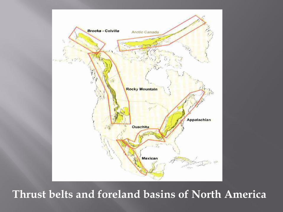
Thrust belts and foreland basins of North America

Arkoma Basin – one of many (Black Warrior, Fort Worth, Kerr) petroleum-bearing foreland basins.
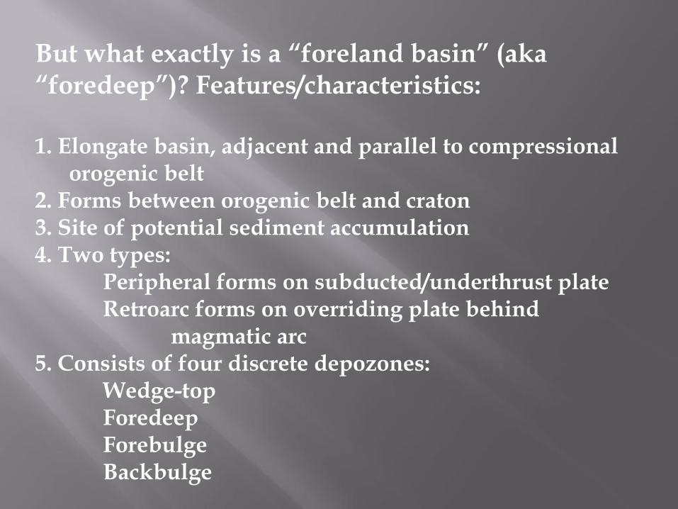
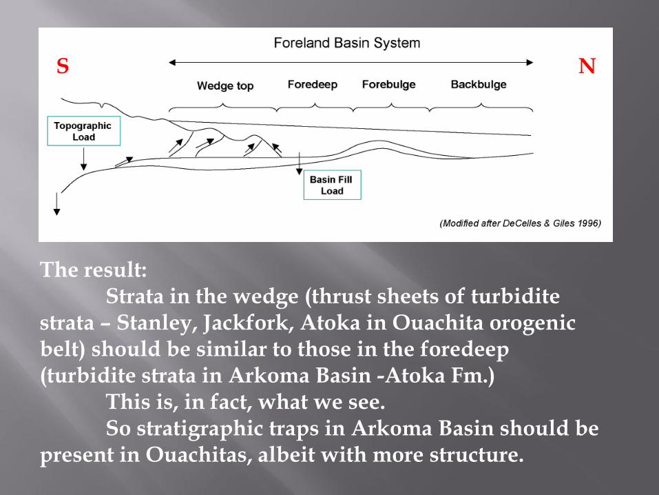
But what exactly is a “foreland basin” (aka “foredeep”)? Features/characteristics: 1. Elongate basin, adjacent and parallel to compressional
orogenic belt 2. Forms between orogenic belt and craton 3. Site of potential sediment accumulation 4. Two types: Peripheral forms on subducted/underthrust plate Retroarc forms on overriding plate behind magmatic arc 5. Consists of four discrete depozones: Wedge-top Foredeep Forebulge Backbulge
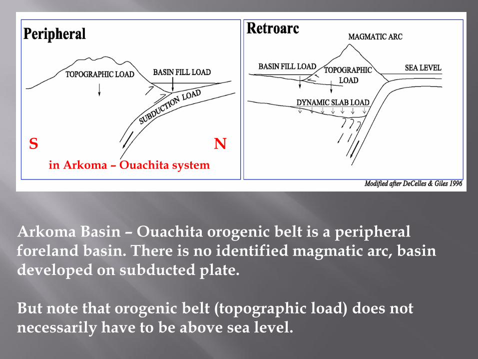
Arkoma Basin – Ouachita orogenic belt is a peripheral foreland basin. There is no identified magmatic arc, basin developed on subducted plate. But note that orogenic belt (topographic load) does not necessarily have to be above sea level.
in Arkoma – Ouachita system
S N
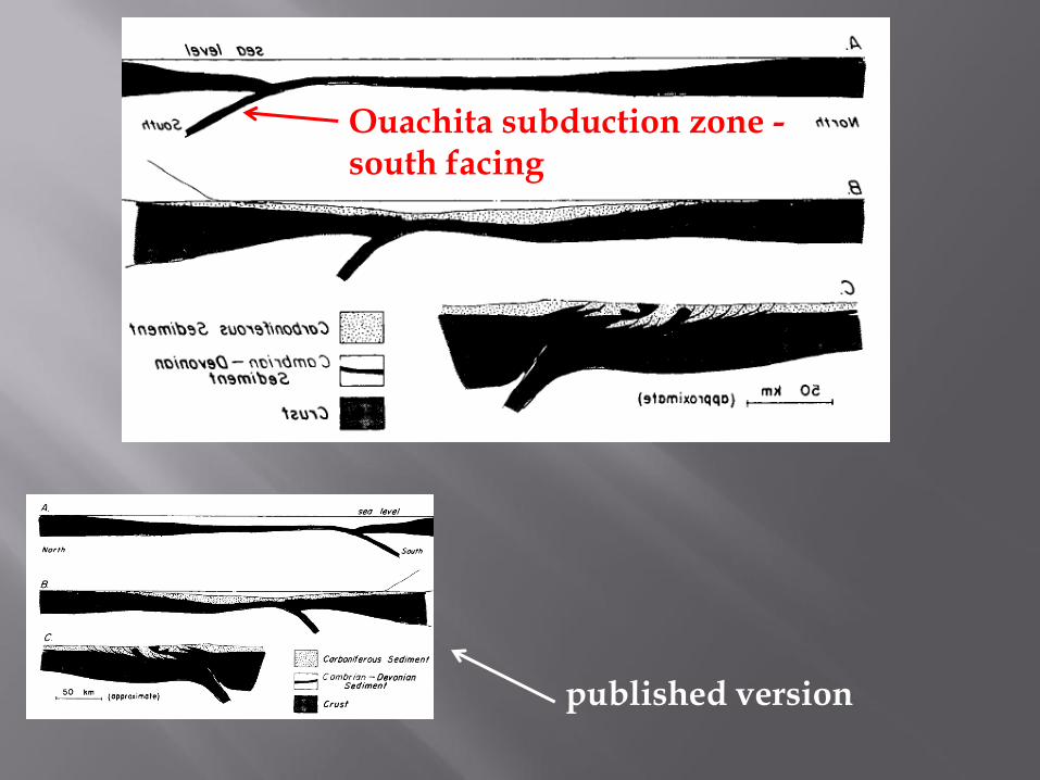
Ouachita subduction zone - south facing
published version

Carboniferous strata in Ouachitas record a south-to-north migration of the orogenic wedge and foredeep, with foredeep strata becoming progressively incorporated into the wedge. “High” to south only locally breaks sea level, and topography on wedge top traps most of what little sediment comes from south.
S N
Older foredeep sediments – moving thrust sheets
S N
The result: Strata in the wedge (thrust sheets of turbidite strata – Stanley, Jackfork, Atoka in Ouachita orogenic belt) should be similar to those in the foredeep (turbidite strata in Arkoma Basin -Atoka Fm.) This is, in fact, what we see. So stratigraphic traps in Arkoma Basin should be present in Ouachitas, albeit with more structure.
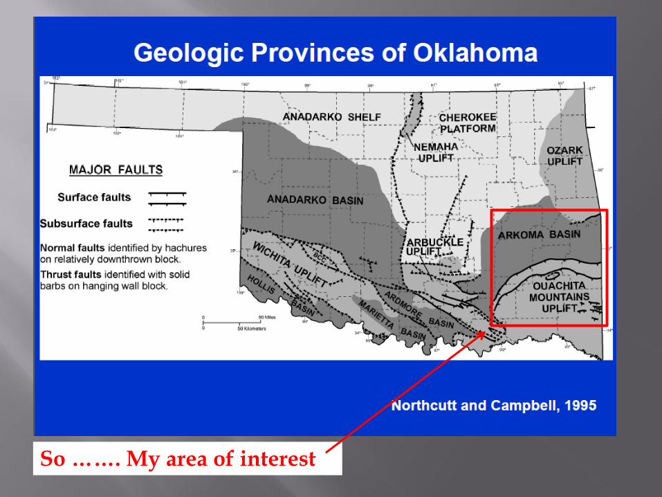
So ……. My area of interest
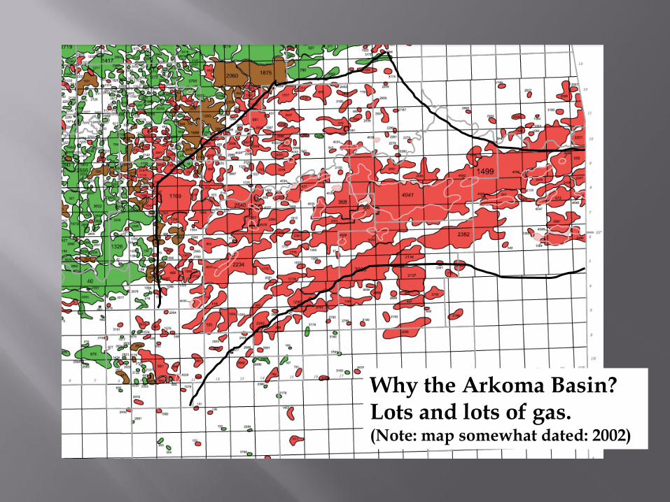
Why the Arkoma Basin? Lots and lots of gas. (Note: map somewhat dated: 2002)
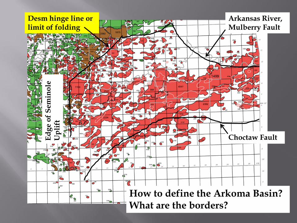
How to define the Arkoma Basin? What are the borders?
Choctaw Fault
Arkansas River, Mulberry Fault
Desm hinge line or limit of folding
Ed
ge o
f S
em
ino
le
Up
lift

“Structural” boundary of Arkoma Basin (from 1968 AAPG Memoir showing folds in the Arkoma Basin)
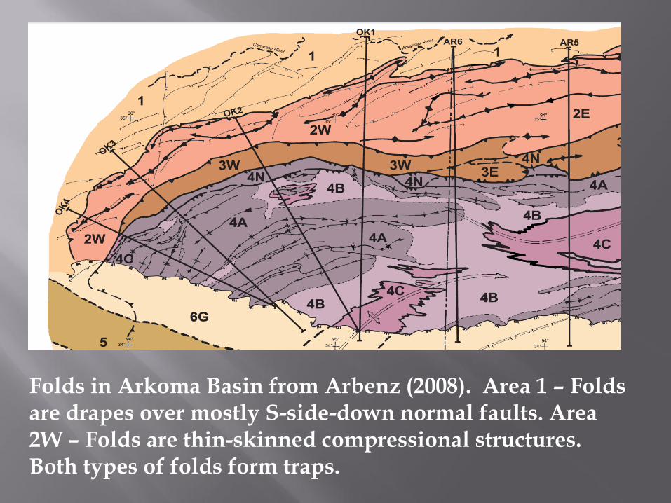
Folds in Arkoma Basin from Arbenz (2008). Area 1 – Folds are drapes over mostly S-side-down normal faults. Area 2W – Folds are thin-skinned compressional structures. Both types of folds form traps.
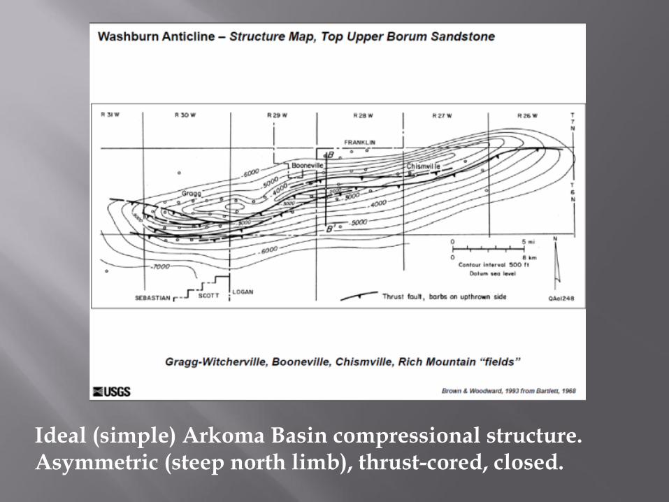
Ideal (simple) Arkoma Basin compressional structure. Asymmetric (steep north limb), thrust-cored, closed.
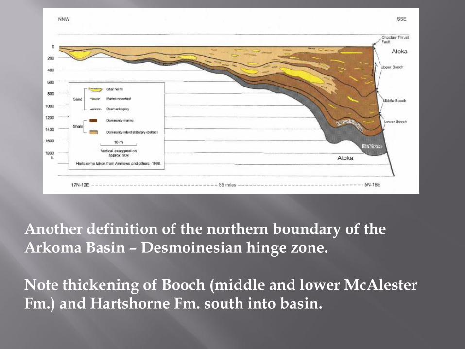
Another definition of the northern boundary of the Arkoma Basin – Desmoinesian hinge zone. Note thickening of Booch (middle and lower McAlester Fm.) and Hartshorne Fm. south into basin.
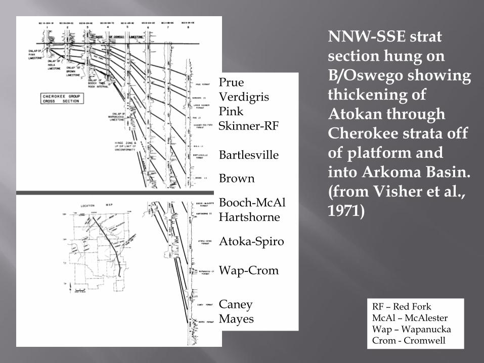
Prue Verdigris Pink Skinner-RF Bartlesville
Brown
Booch-McAl Hartshorne
Atoka-Spiro Wap-Crom
Caney Mayes
NNW-SSE strat section hung on B/Oswego showing thickening of Atokan through Cherokee strata off of platform and into Arkoma Basin. (from Visher et al., 1971)
RF – Red Fork McAl – McAlester Wap – Wapanucka Crom - Cromwell
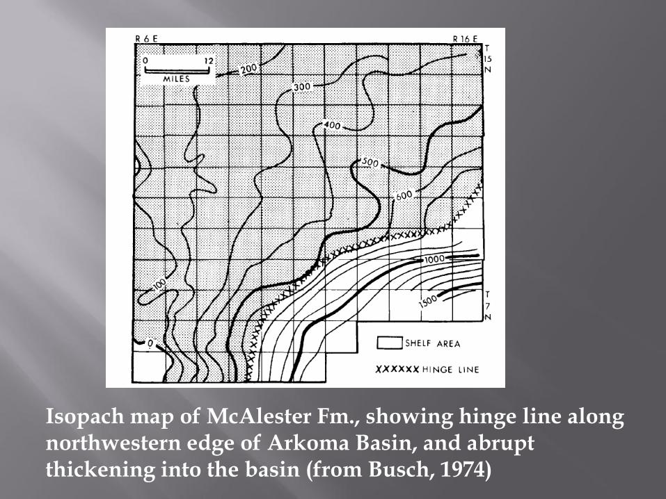
Isopach map of McAlester Fm., showing hinge line along northwestern edge of Arkoma Basin, and abrupt thickening into the basin (from Busch, 1974)

My source for OK reservoir strata:
ARKOMA BASIN COMPLETIONS (>100)
Calvin* Fanshawe Caney* Allen* Gilcrease*/Morris* Woodford* Senora* Red Oak Hunton* Thurman* Panola Viola* Red Fork*/Earlsboro* Brazil Simpson* Bartlesville*/Salt* Cecil Arbuckle* Savanna Spiro Booch*/McAlester Wapanucka* Hartshorne Union Valley* Atoka Lime* Cromwell* (*other provinces, too)
Atoka* Jefferson*
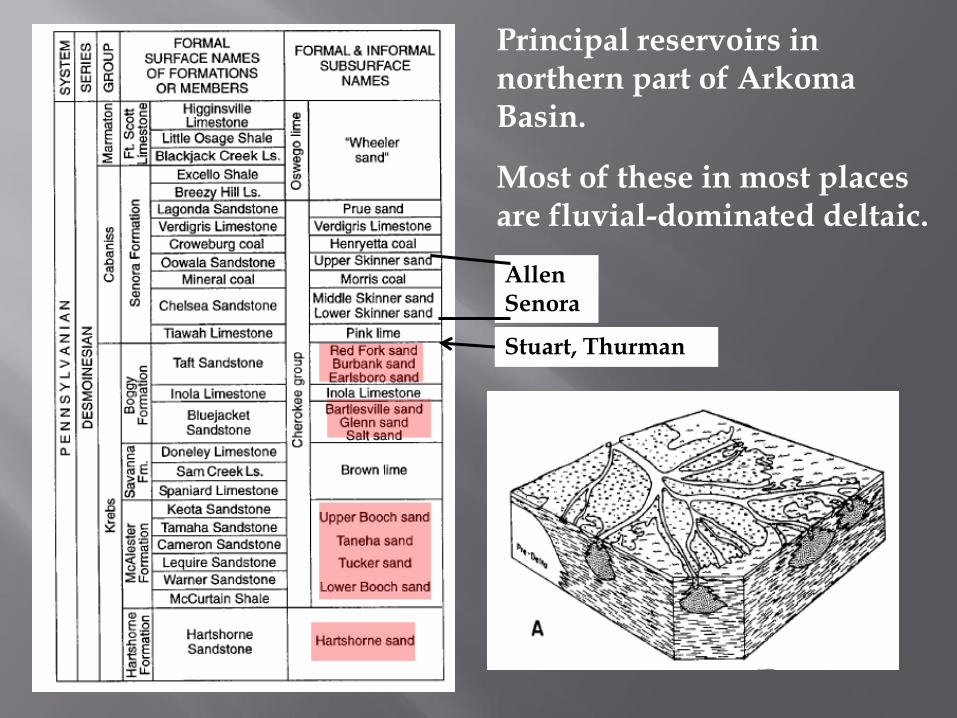
Allen Senora
Stuart, Thurman
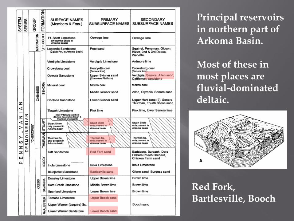
Principal reservoirs in northern part of Arkoma Basin.
Most of these in most places are fluvial-dominated deltaic.
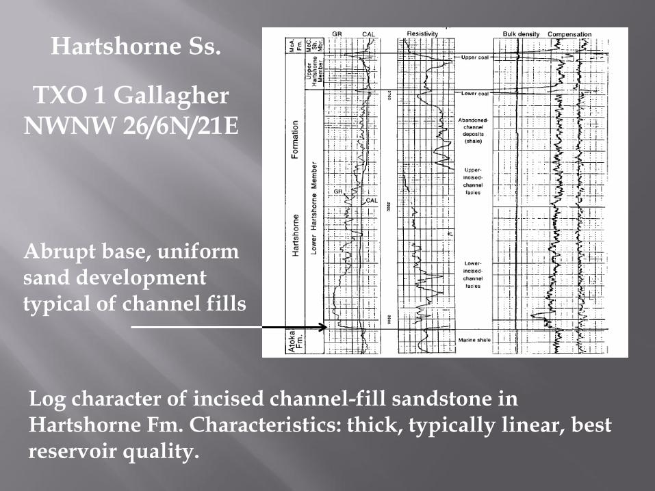
TXO 1 Gallagher NWNW 26/6N/21E
Log character of incised channel-fill sandstone in Hartshorne Fm. Characteristics: thick, typically linear, best reservoir quality.
Abrupt base, uniform sand development typical of channel fills
Hartshorne Ss.
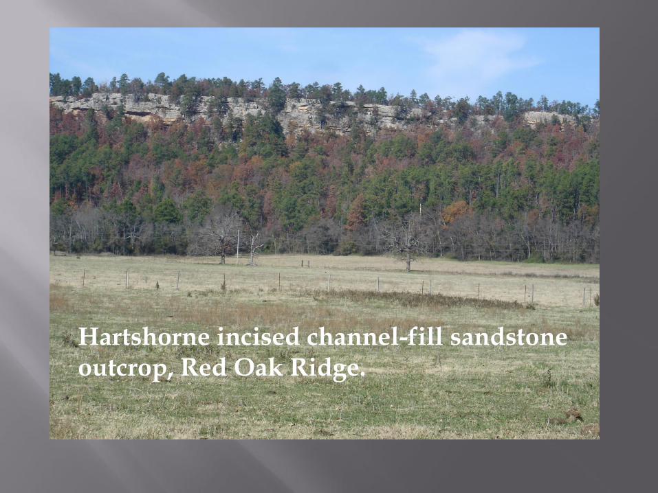
Hartshorne incised channel-fill sandstone outcrop, Red Oak Ridge.

Desmoinesian units are mostly fluvial-deltaic. Upper Atokan units are shallow marine. Middle Atokan units are mostly deep-water.
Lower Atokan and Morrowan units are shallow marine.
Principal reservoir units in southern part of Arkoma Basin
Remember this slide
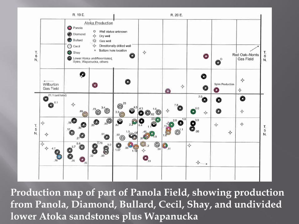
Production map of part of Panola Field, showing production from Panola, Diamond, Bullard, Cecil, Shay, and undivided lower Atoka sandstones plus Wapanucka
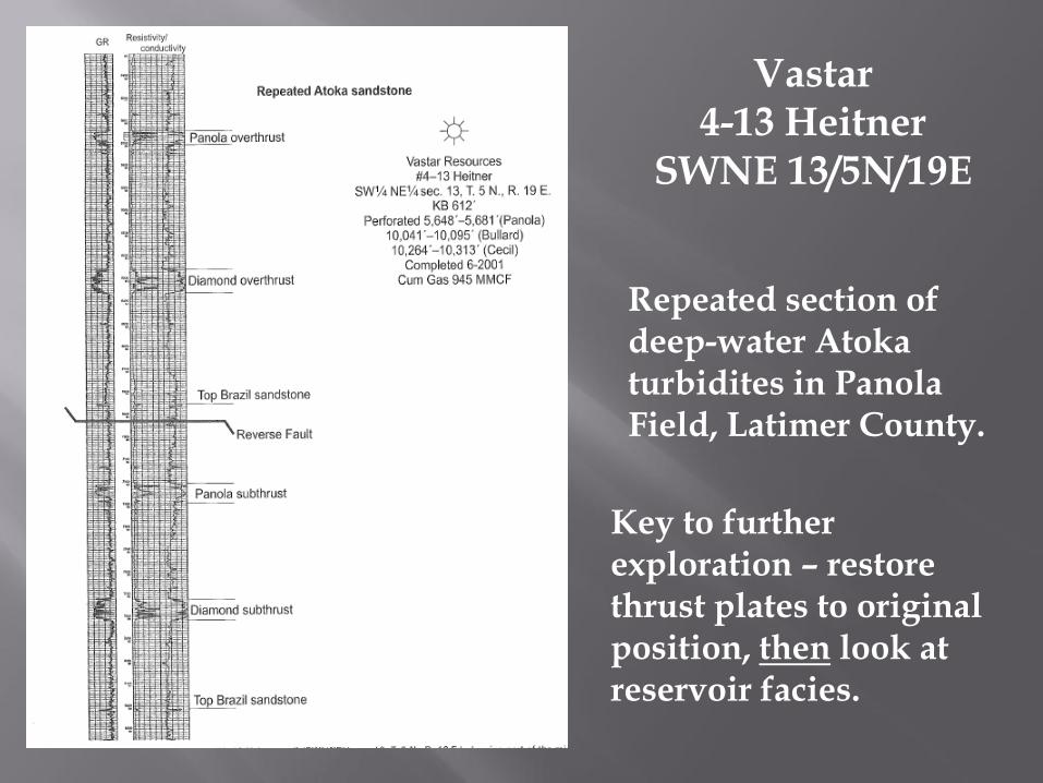
Vastar 4-13 Heitner
SWNE 13/5N/19E Repeated section of deep-water Atoka turbidites in Panola Field, Latimer County. Key to further
exploration – restore thrust plates to original position, then look at reservoir facies.
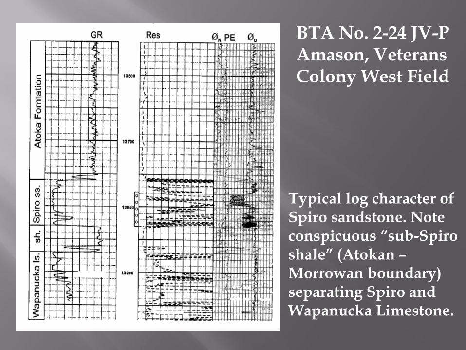
Typical log character of Spiro sandstone. Note conspicuous “sub-Spiro shale” (Atokan – Morrowan boundary) separating Spiro and Wapanucka Limestone.
BTA No. 2-24 JV-P Amason, Veterans Colony West Field
OUACHITA OROGENIC BELT COMPLETIONS
Spiro/Wapanucka Jackfork Stanley Arkansas Novaculite Bigfork
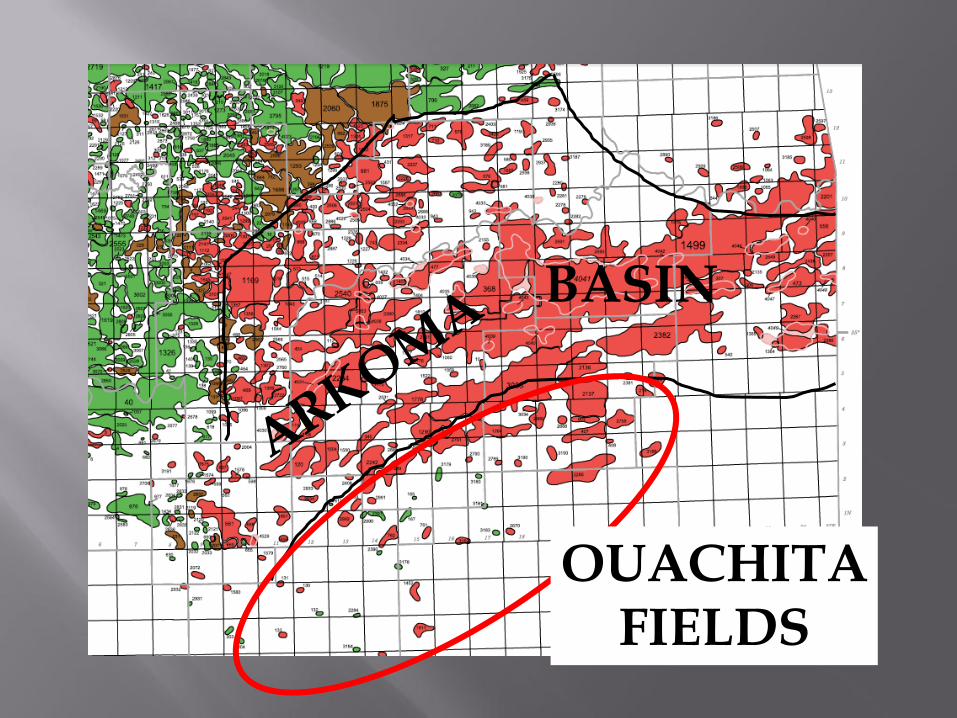
BASIN
OUACHITA FIELDS
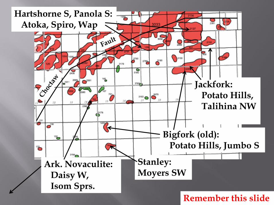
Jackfork: Potato Hills, Talihina NW
Bigfork (old): Potato Hills, Jumbo S
Stanley: Moyers SW
Ark. Novaculite: Daisy W, Isom Sprs.
Hartshorne S, Panola S: Atoka, Spiro, Wap
Remember this slide
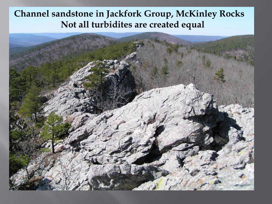
Channel sandstone in Jackfork Group, McKinley Rocks Not all turbidites are created equal

HISTORY OF HYDROCARBON EXPLORATION AND DEVELOPMENT
IN THE ARKOMA BASIN AND OUACHITA MOUNTAINS
Exploration periods: ● Solids Are Good period (pre-1910) ● Anticlines Are Good period (1910 – 1935) ● Geologic Maps Are Good period (1935 – 1950) ● Drilling Deeper Is Good period (1950 – 1980) ● Thrust Plates Are Good period (1980 - ~1990) ● Horizontal Wells Are Good period (~1990 – present) ● The Future
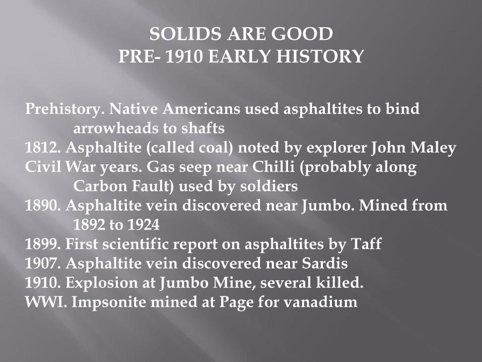
SOLIDS ARE GOOD PRE- 1910 EARLY HISTORY
Prehistory. Native Americans used asphaltites to bind arrowheads to shafts 1812. Asphaltite (called coal) noted by explorer John Maley Civil War years. Gas seep near Chilli (probably along Carbon Fault) used by soldiers 1890. Asphaltite vein discovered near Jumbo. Mined from 1892 to 1924 1899. First scientific report on asphaltites by Taff 1907. Asphaltite vein discovered near Sardis 1910. Explosion at Jumbo Mine, several killed. WWI. Impsonite mined at Page for vanadium

Early asphalt and asphaltite pits and mines in western Ouachita Mtns., Arkoma Basin, and Cretaceous overlap (from 1911 OGS Bulletin 2).
Upper photos – asphalt pits (location not given). Lower photo – pile of gypsonite (sic) (gilsonite?)
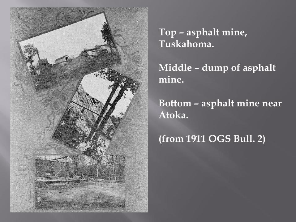
Top – asphalt mine, Tuskahoma. Middle – dump of asphalt mine. Bottom – asphalt mine near Atoka. (from 1911 OGS Bull. 2)
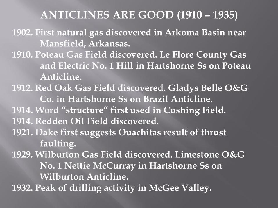
ANTICLINES ARE GOOD (1910 – 1935)
1902. First natural gas discovered in Arkoma Basin near Mansfield, Arkansas. 1910. Poteau Gas Field discovered. Le Flore County Gas and Electric No. 1 Hill in Hartshorne Ss on Poteau Anticline. 1912. Red Oak Gas Field discovered. Gladys Belle O&G Co. in Hartshorne Ss on Brazil Anticline. 1914. Word “structure” first used in Cushing Field. 1914. Redden Oil Field discovered. 1921. Dake first suggests Ouachitas result of thrust faulting. 1929. Wilburton Gas Field discovered. Limestone O&G No. 1 Nettie McCurray in Hartshorne Ss on Wilburton Anticline. 1932. Peak of drilling activity in McGee Valley.
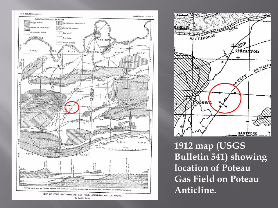
1912 map (USGS Bulletin 541) showing location of Poteau Gas Field on Poteau Anticline.
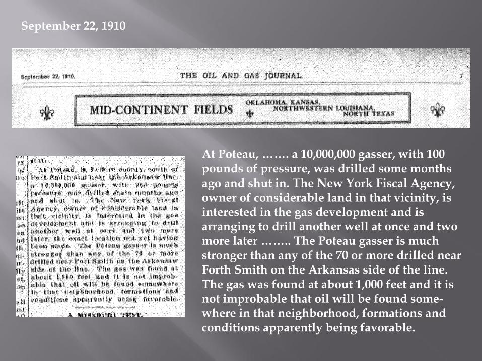
At Poteau, ……. a 10,000,000 gasser, with 100 pounds of pressure, was drilled some months ago and shut in. The New York Fiscal Agency, owner of considerable land in that vicinity, is interested in the gas development and is arranging to drill another well at once and two more later …….. The Poteau gasser is much stronger than any of the 70 or more drilled near Forth Smith on the Arkansas side of the line. The gas was found at about 1,000 feet and it is not improbable that oil will be found some-where in that neighborhood, formations and conditions apparently being favorable.
September 22, 1910
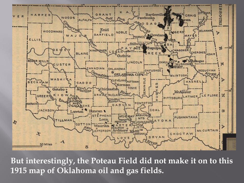
But interestingly, the Poteau Field did not make it on to this 1915 map of Oklahoma oil and gas fields.
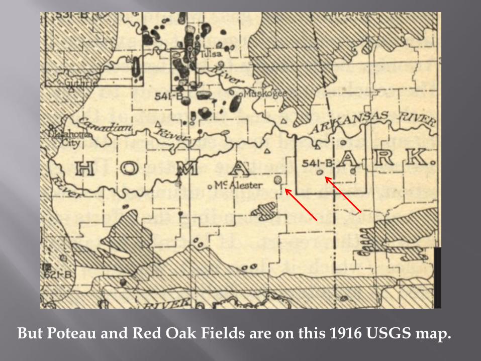
But Poteau and Red Oak Fields are on this 1916 USGS map.
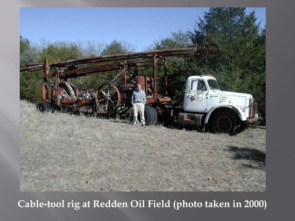
Cable-tool rig at Redden Oil Field (photo taken in 2000)
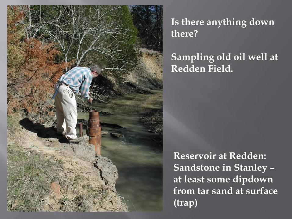
Is there anything down there? Sampling old oil well at Redden Field.
Reservoir at Redden: Sandstone in Stanley – at least some dipdown from tar sand at surface (trap)
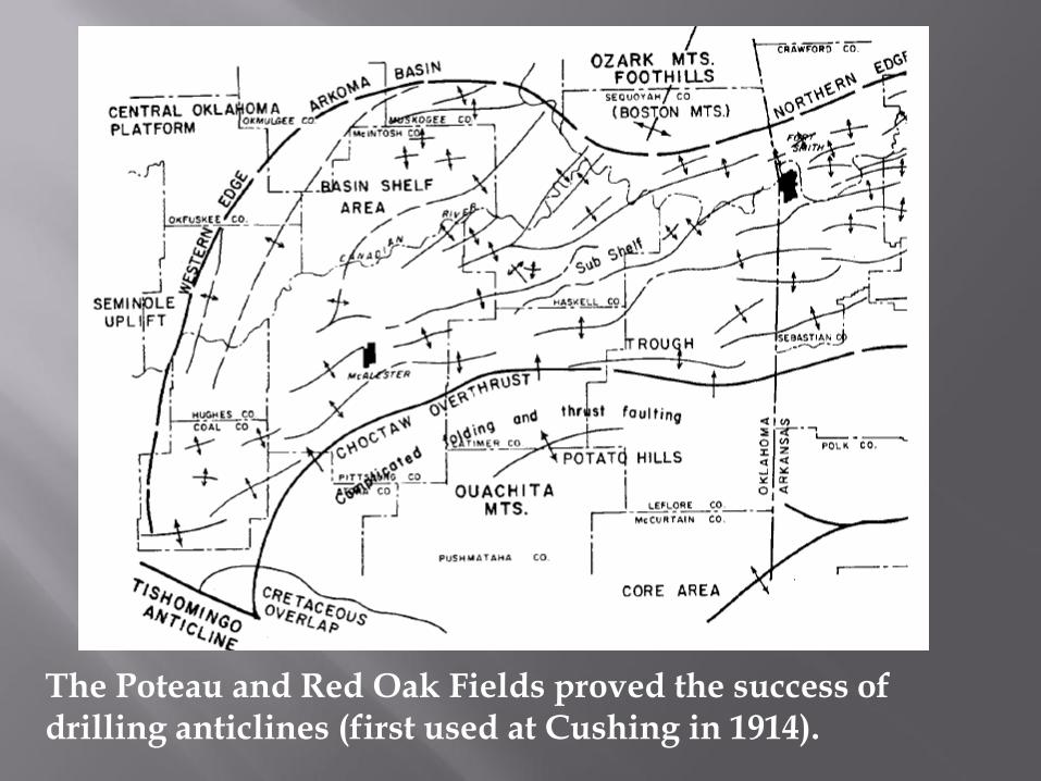
The Poteau and Red Oak Fields proved the success of drilling anticlines (first used at Cushing in 1914).
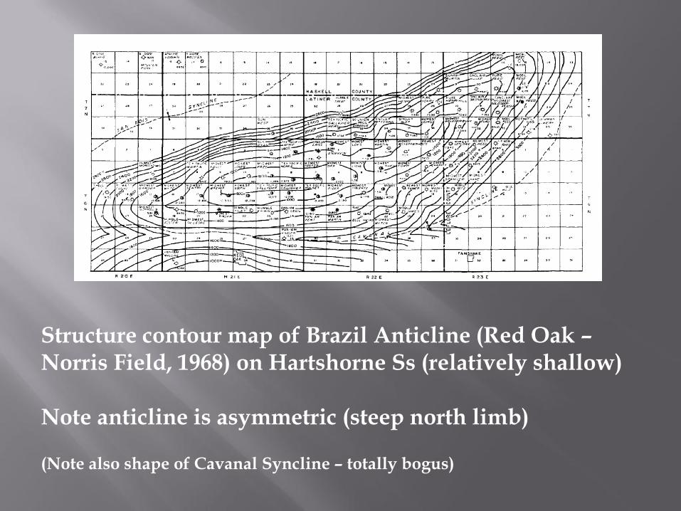
Structure contour map of Brazil Anticline (Red Oak – Norris Field, 1968) on Hartshorne Ss (relatively shallow) Note anticline is asymmetric (steep north limb) (Note also shape of Cavanal Syncline – totally bogus)
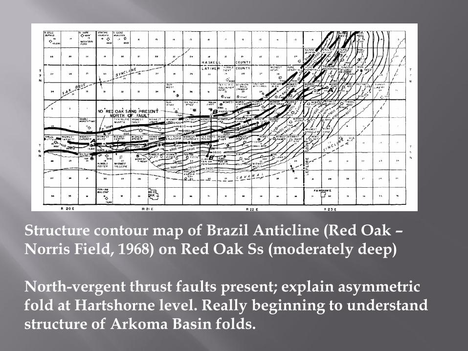
Structure contour map of Brazil Anticline (Red Oak – Norris Field, 1968) on Red Oak Ss (moderately deep) North-vergent thrust faults present; explain asymmetric fold at Hartshorne level. Really beginning to understand structure of Arkoma Basin folds.
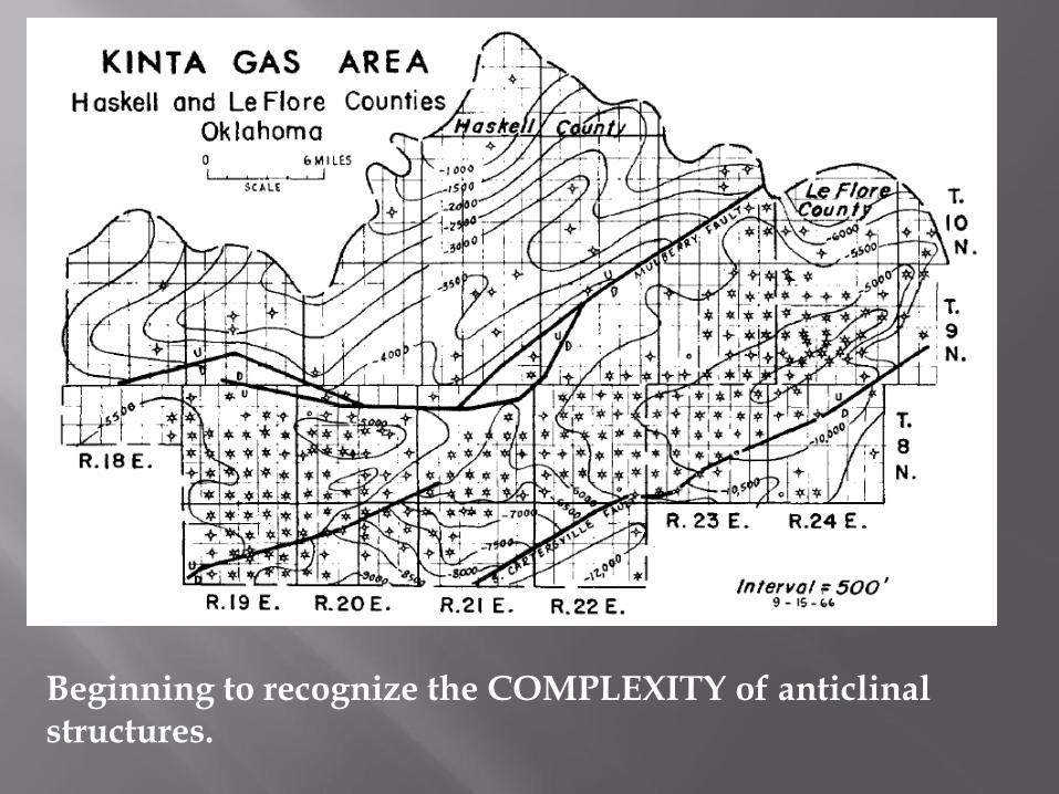
Beginning to recognize the COMPLEXITY of anticlinal structures.
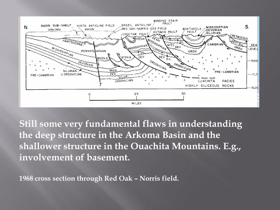
Still some very fundamental flaws in understanding the deep structure in the Arkoma Basin and the shallower structure in the Ouachita Mountains. E.g., involvement of basement. 1968 cross section through Red Oak – Norris field.
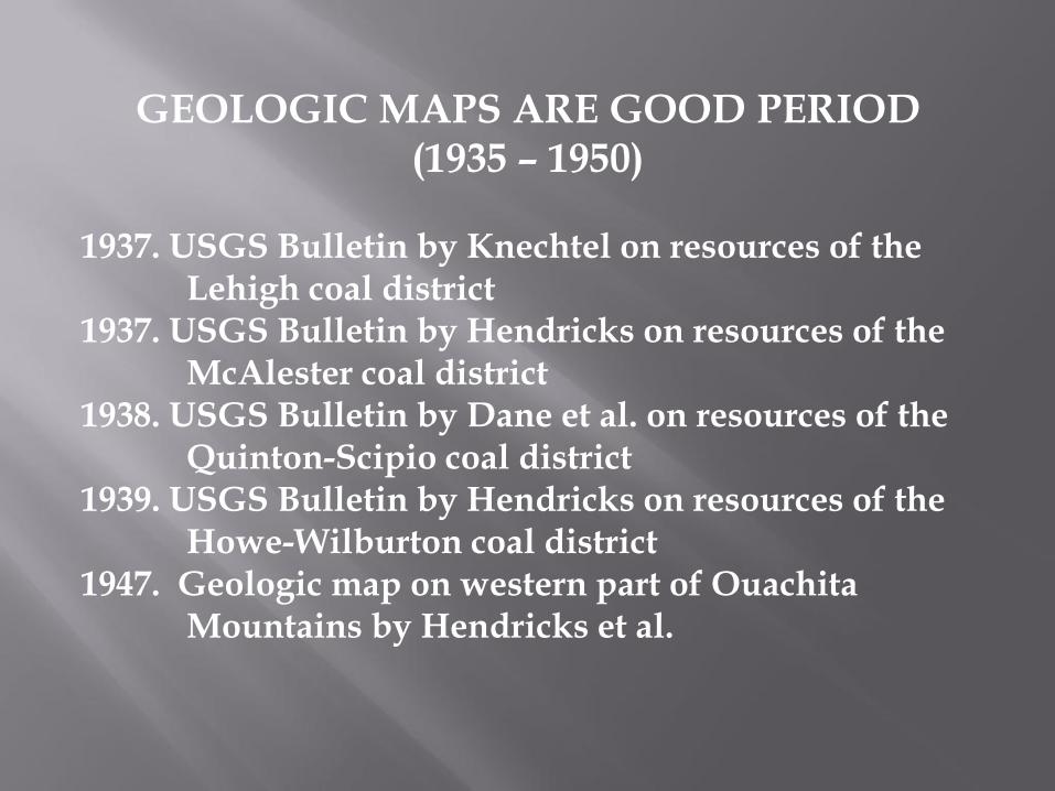
GEOLOGIC MAPS ARE GOOD PERIOD (1935 – 1950)
1937. USGS Bulletin by Knechtel on resources of the Lehigh coal district 1937. USGS Bulletin by Hendricks on resources of the McAlester coal district 1938. USGS Bulletin by Dane et al. on resources of the Quinton-Scipio coal district 1939. USGS Bulletin by Hendricks on resources of the Howe-Wilburton coal district 1947. Geologic map on western part of Ouachita Mountains by Hendricks et al.
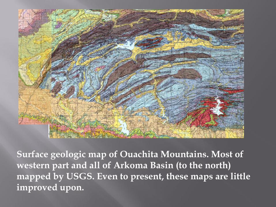
Surface geologic map of Ouachita Mountains. Most of western part and all of Arkoma Basin (to the north) mapped by USGS. Even to present, these maps are little improved upon.
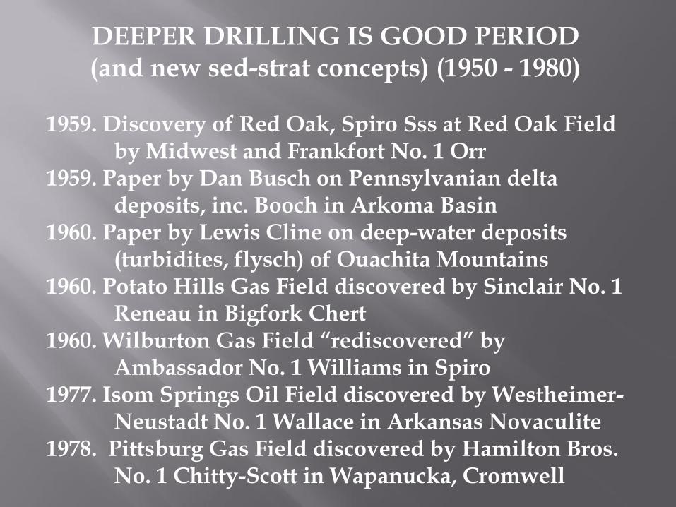
DEEPER DRILLING IS GOOD PERIOD (and new sed-strat concepts) (1950 - 1980)
1959. Discovery of Red Oak, Spiro Sss at Red Oak Field by Midwest and Frankfort No. 1 Orr 1959. Paper by Dan Busch on Pennsylvanian delta deposits, inc. Booch in Arkoma Basin 1960. Paper by Lewis Cline on deep-water deposits (turbidites, flysch) of Ouachita Mountains 1960. Potato Hills Gas Field discovered by Sinclair No. 1 Reneau in Bigfork Chert 1960. Wilburton Gas Field “rediscovered” by Ambassador No. 1 Williams in Spiro 1977. Isom Springs Oil Field discovered by Westheimer- Neustadt No. 1 Wallace in Arkansas Novaculite 1978. Pittsburg Gas Field discovered by Hamilton Bros. No. 1 Chitty-Scott in Wapanucka, Cromwell
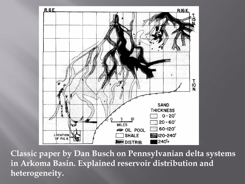
Classic paper by Dan Busch on Pennsylvanian delta systems in Arkoma Basin. Explained reservoir distribution and heterogeneity.
Principal reservoirs in northern part of Arkoma Basin. Most of these in most places are fluvial-dominated deltaic.
Red Fork, Bartlesville, Booch
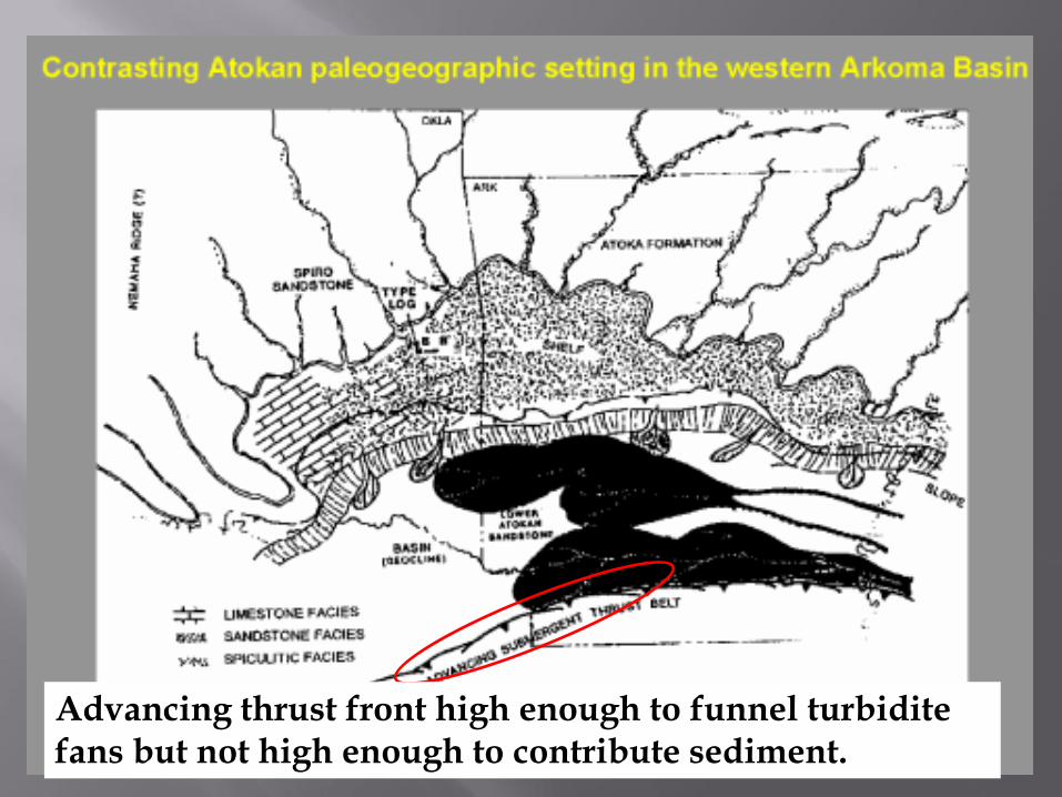
Advancing thrust front high enough to funnel turbidite fans but not high enough to contribute sediment.
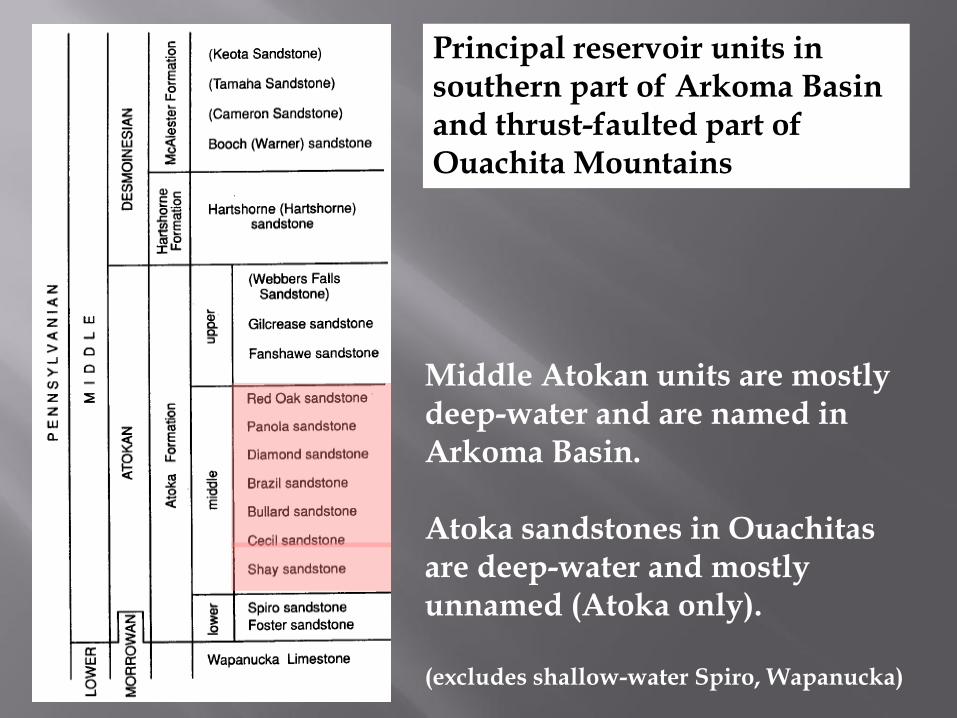
Middle Atokan units are mostly deep-water and are named in Arkoma Basin. Atoka sandstones in Ouachitas are deep-water and mostly unnamed (Atoka only). (excludes shallow-water Spiro, Wapanucka)
Principal reservoir units in southern part of Arkoma Basin and thrust-faulted part of Ouachita Mountains
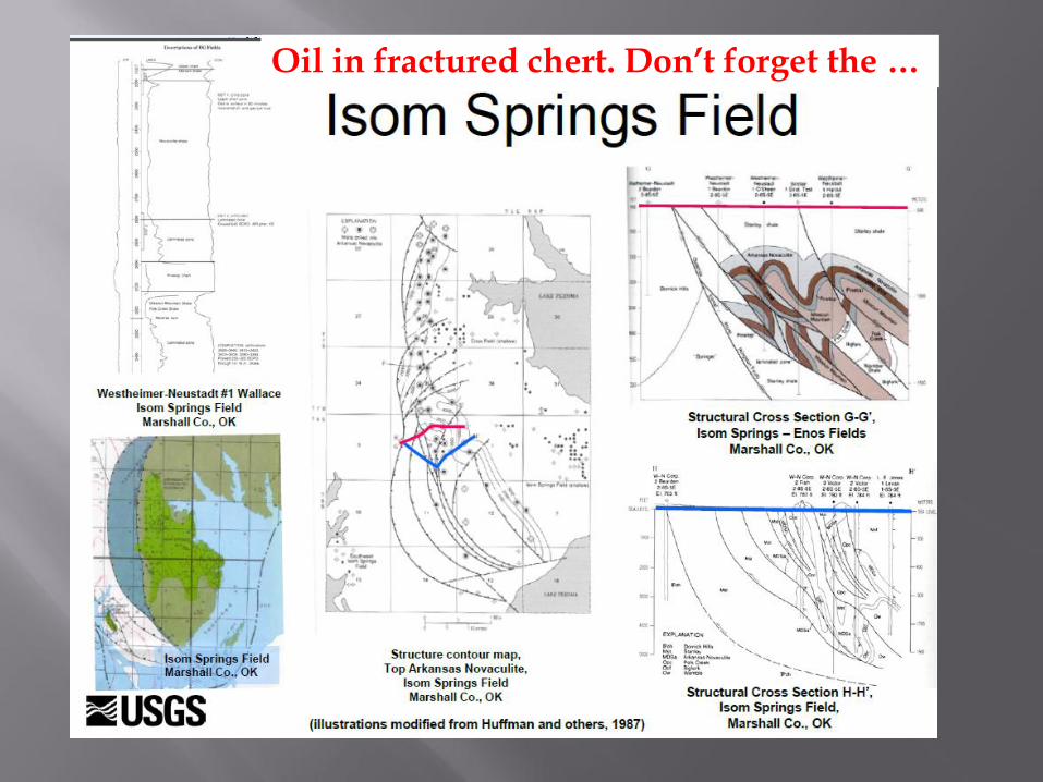
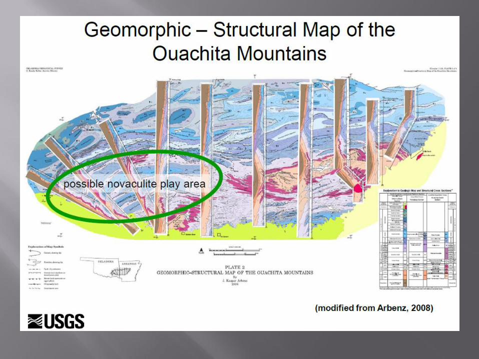
Oil in fractured chert. Don’t forget the …
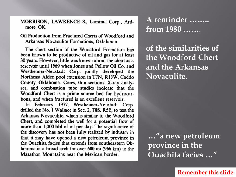
A reminder …….. from 1980 ……. of the similarities of the Woodford Chert and the Arkansas Novaculite.
…”a new petroleum province in the Ouachita facies …”
Remember this slide
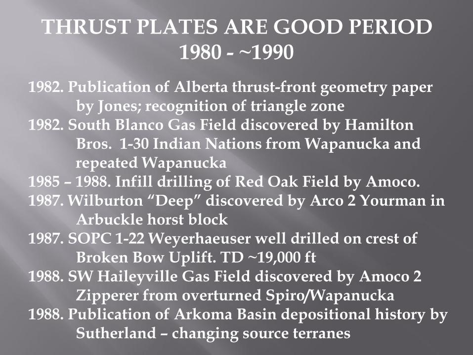
THRUST PLATES ARE GOOD PERIOD 1980 - ~1990
1982. Publication of Alberta thrust-front geometry paper by Jones; recognition of triangle zone 1982. South Blanco Gas Field discovered by Hamilton Bros. 1-30 Indian Nations from Wapanucka and repeated Wapanucka 1985 – 1988. Infill drilling of Red Oak Field by Amoco. 1987. Wilburton “Deep” discovered by Arco 2 Yourman in Arbuckle horst block 1987. SOPC 1-22 Weyerhaeuser well drilled on crest of Broken Bow Uplift. TD ~19,000 ft 1988. SW Haileyville Gas Field discovered by Amoco 2 Zipperer from overturned Spiro/Wapanucka 1988. Publication of Arkoma Basin depositional history by Sutherland – changing source terranes
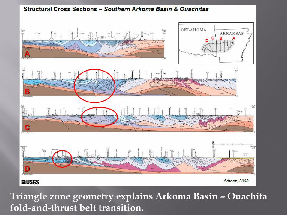
Triangle zone geometry explains Arkoma Basin – Ouachita fold-and-thrust belt transition.
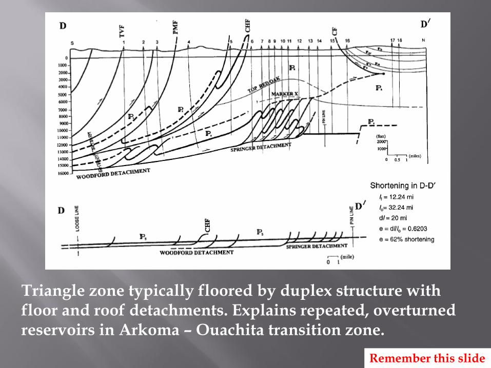
Triangle zone typically floored by duplex structure with floor and roof detachments. Explains repeated, overturned reservoirs in Arkoma – Ouachita transition zone.
Remember this slide
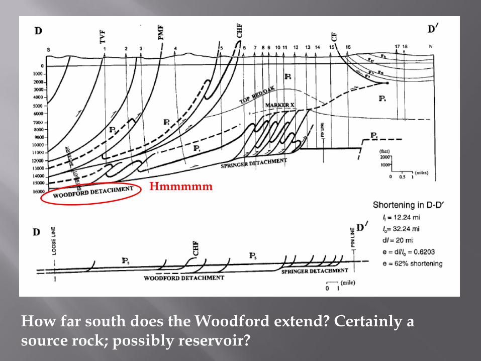
Hmmmmm
How far south does the Woodford extend? Certainly a source rock; possibly reservoir?
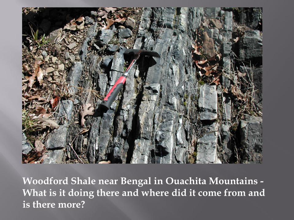
Woodford Shale near Bengal in Ouachita Mountains - What is it doing there and where did it come from and is there more?
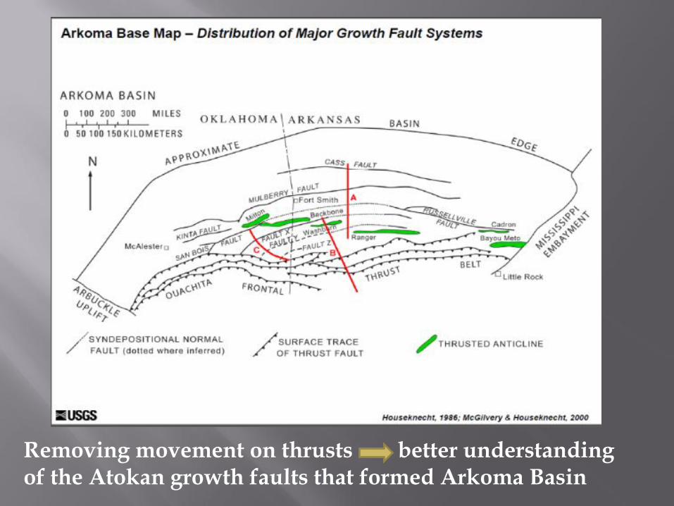
Removing movement on thrusts better understanding of the Atokan growth faults that formed Arkoma Basin
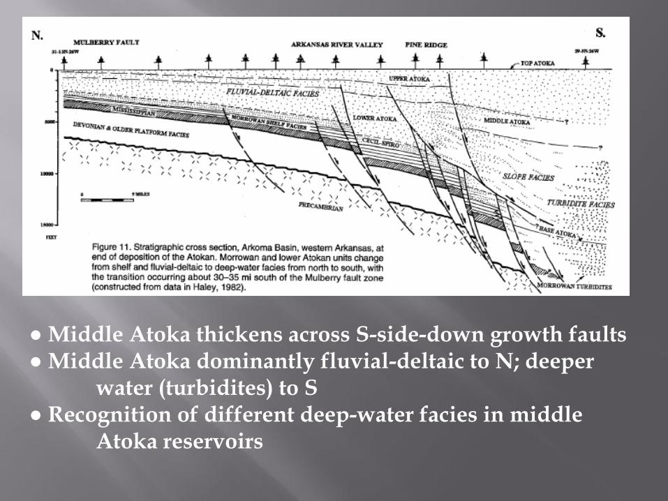
● Middle Atoka thickens across S-side-down growth faults ● Middle Atoka dominantly fluvial-deltaic to N; deeper water (turbidites) to S ● Recognition of different deep-water facies in middle Atoka reservoirs
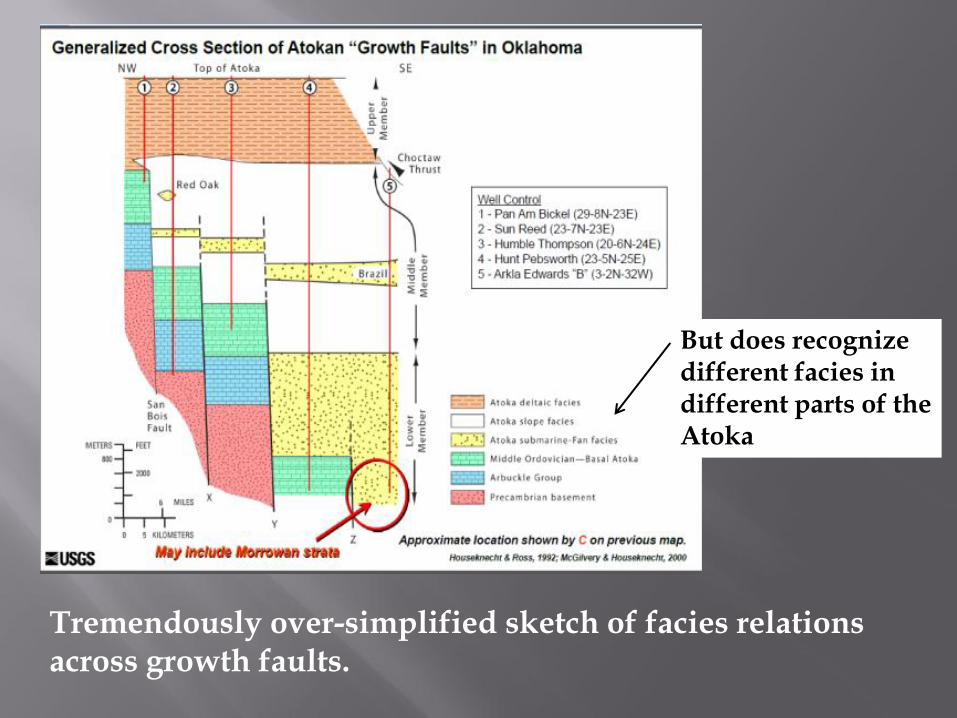
Tremendously over-simplified sketch of facies relations across growth faults.
But does recognize different facies in different parts of the Atoka
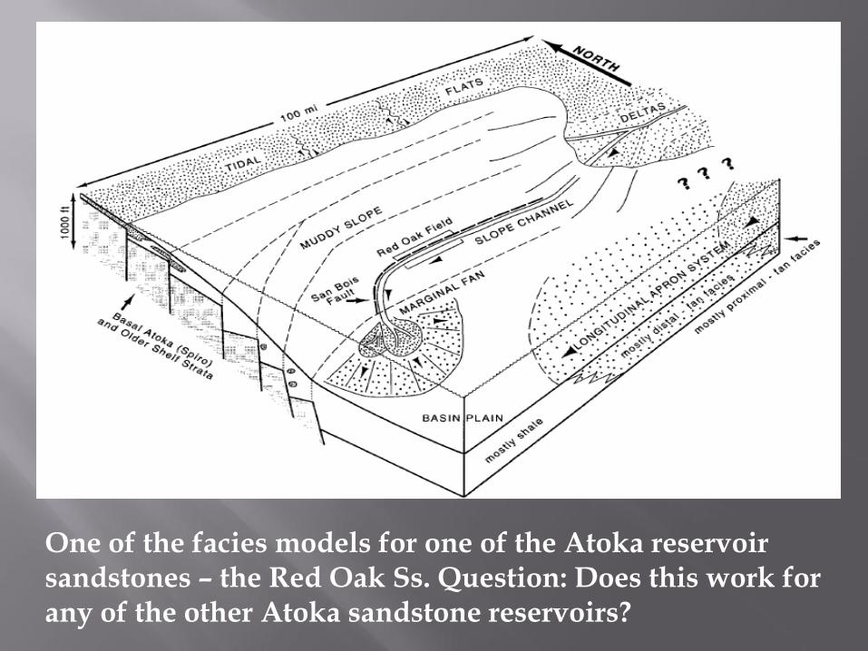
One of the facies models for one of the Atoka reservoir sandstones – the Red Oak Ss. Question: Does this work for any of the other Atoka sandstone reservoirs?
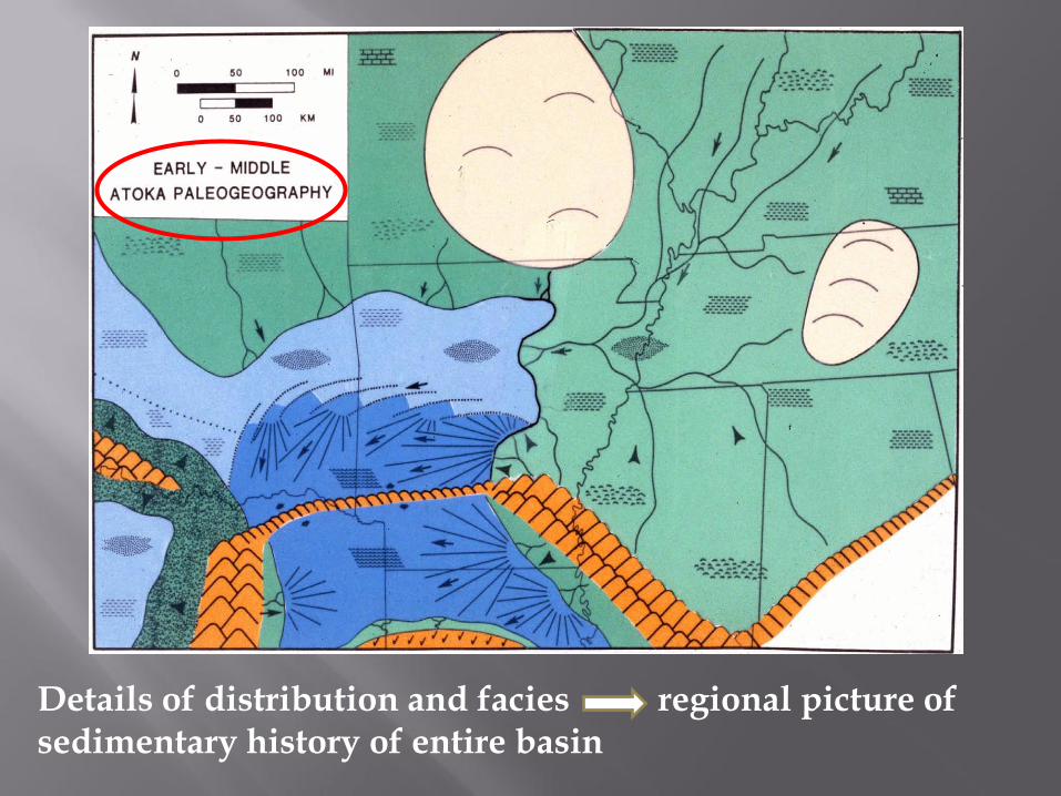
Details of distribution and facies regional picture of sedimentary history of entire basin
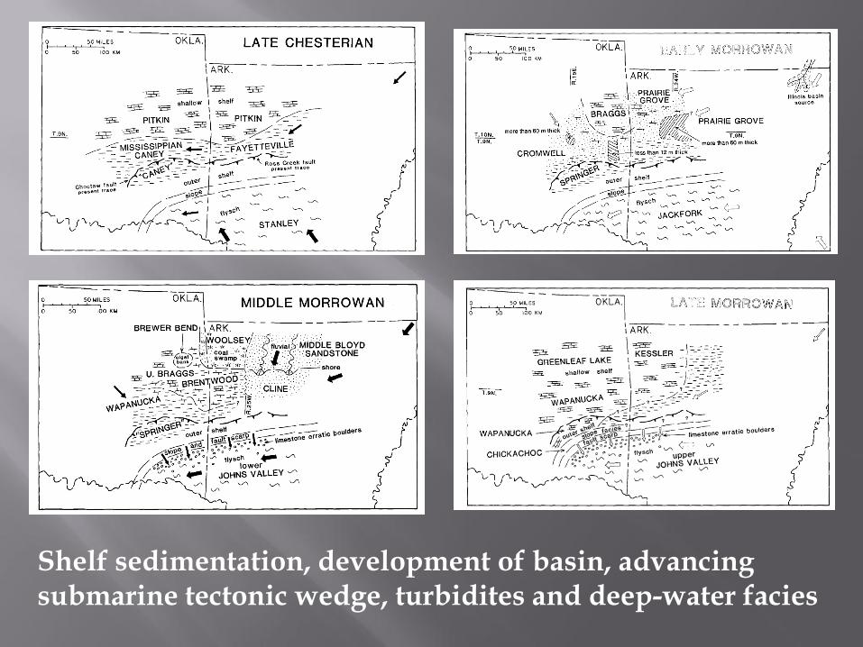
Shelf sedimentation, development of basin, advancing submarine tectonic wedge, turbidites and deep-water facies
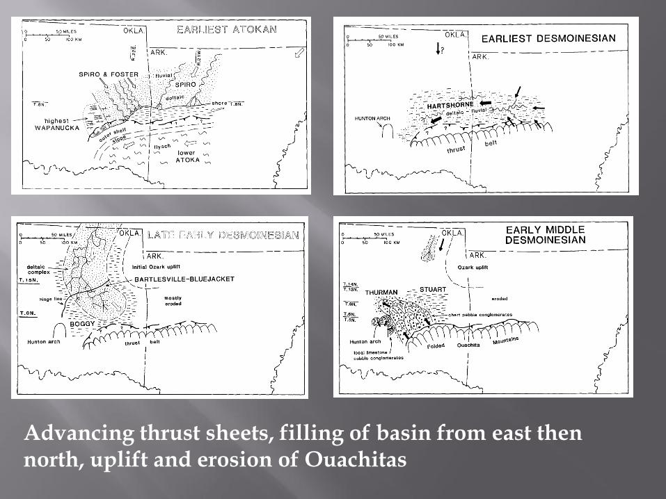
Advancing thrust sheets, filling of basin from east then north, uplift and erosion of Ouachitas
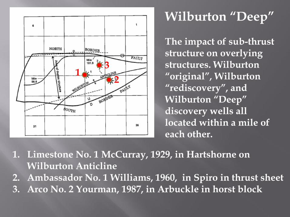
Wilburton “Deep” The impact of sub-thrust structure on overlying structures. Wilburton “original”, Wilburton “rediscovery”, and Wilburton “Deep” discovery wells all located within a mile of each other.
1. Limestone No. 1 McCurray, 1929, in Hartshorne on Wilburton Anticline
2. Ambassador No. 1 Williams, 1960, in Spiro in thrust sheet 3. Arco No. 2 Yourman, 1987, in Arbuckle in horst block
1 2
3
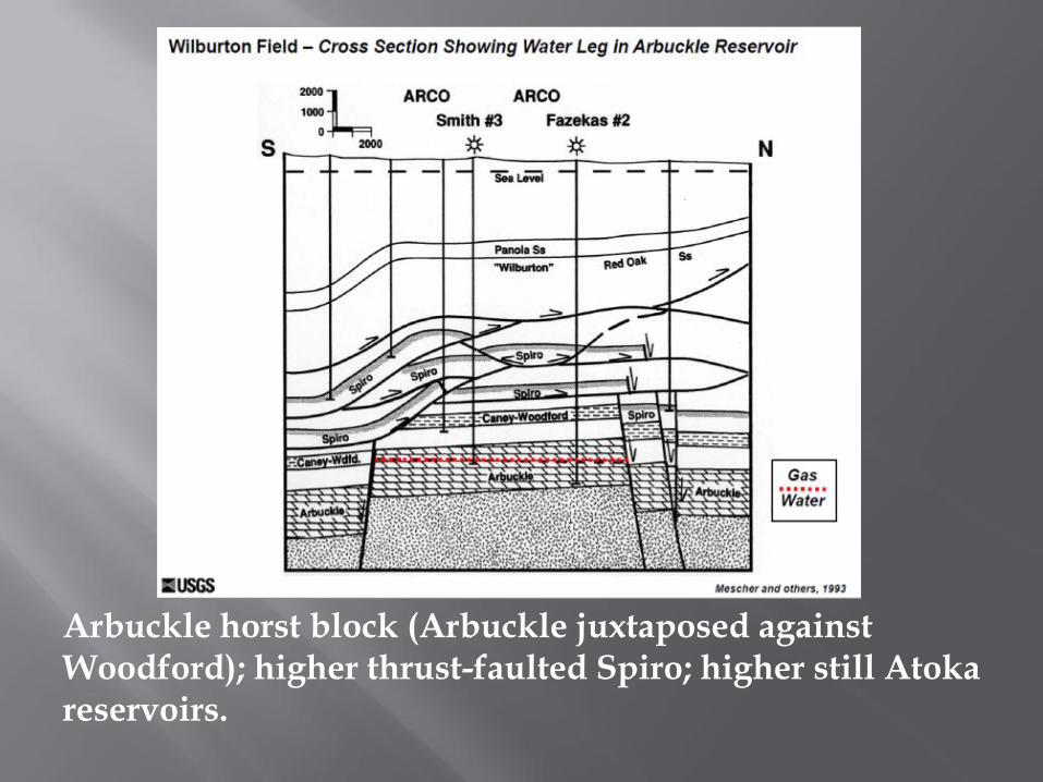
Arbuckle horst block (Arbuckle juxtaposed against Woodford); higher thrust-faulted Spiro; higher still Atoka reservoirs.
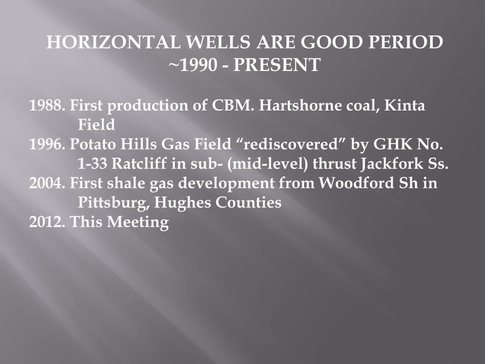
HORIZONTAL WELLS ARE GOOD PERIOD ~1990 - PRESENT
1988. First production of CBM. Hartshorne coal, Kinta Field 1996. Potato Hills Gas Field “rediscovered” by GHK No. 1-33 Ratcliff in sub- (mid-level) thrust Jackfork Ss. 2004. First shale gas development from Woodford Sh in Pittsburg, Hughes Counties 2012. This Meeting
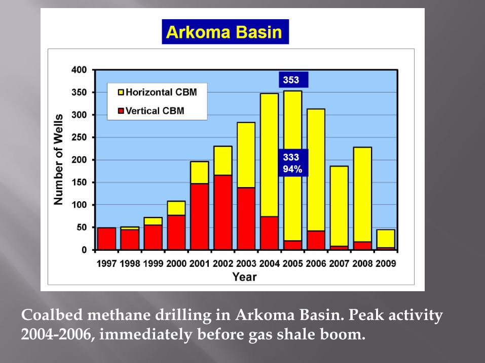
Coalbed methane drilling in Arkoma Basin. Peak activity 2004-2006, immediately before gas shale boom.
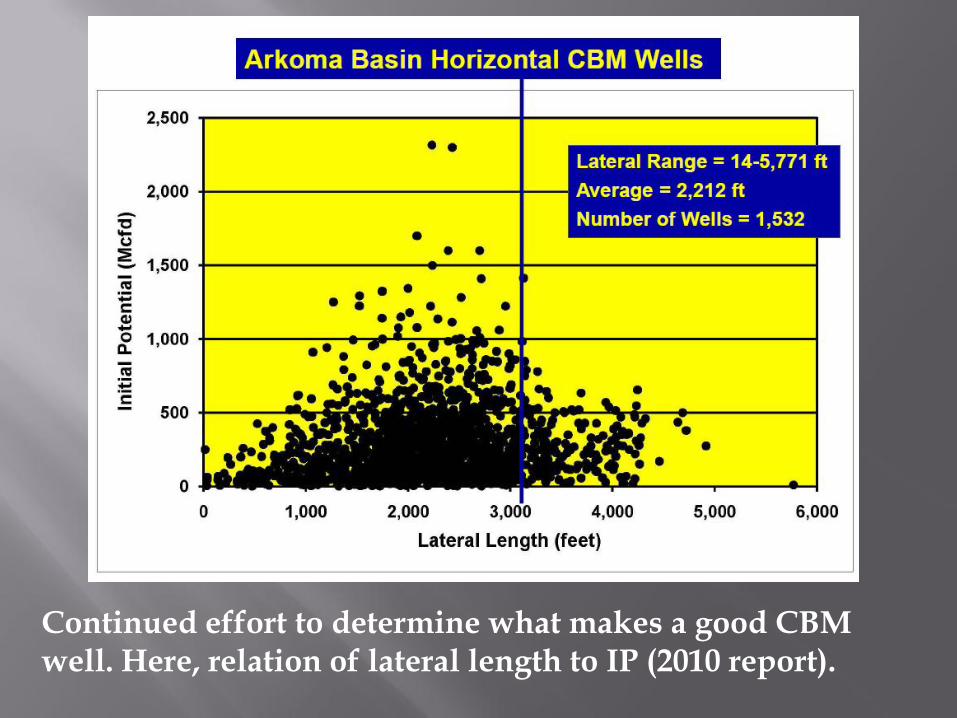
Continued effort to determine what makes a good CBM well. Here, relation of lateral length to IP (2010 report).
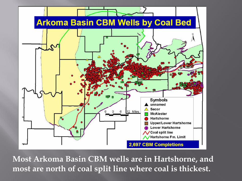
Most Arkoma Basin CBM wells are in Hartshorne, and most are north of coal split line where coal is thickest.
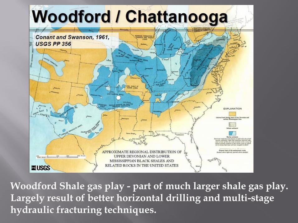
Woodford Shale gas play - part of much larger shale gas play. Largely result of better horizontal drilling and multi-stage hydraulic fracturing techniques.
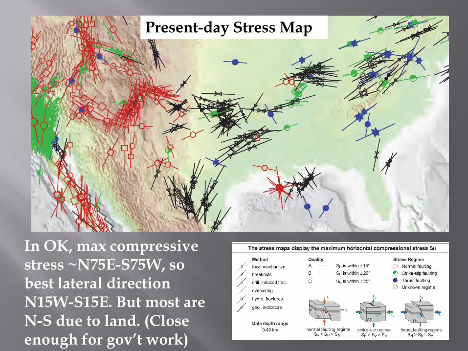
Present-day Stress Map
In OK, max compressive stress ~N75E-S75W, so best lateral direction N15W-S15E. But most are N-S due to land. (Close enough for gov’t work)
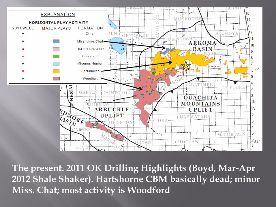
The present. 2011 OK Drilling Highlights (Boyd, Mar-Apr 2012 Shale Shaker). Hartshorne CBM basically dead; minor Miss. Chat; most activity is Woodford

THE FUTURE of Arkoma Basin and Ouachita Mountains
Petroleum Exploration To ignore the two killers: ● Awful gas prices (currently) ● No infrastructure (how long?)
Plays, concepts, and unknowns:
Arkoma Basin: ● more Woodford Shale development* (okay okay) ● middle Atoka Fm. sandstone facies ● transition-zone structure to east ● organic shales in middle Atoka Fm.* Ouachita Mountains: ● Woodford Shale – how far to S beneath thrusts? ● early – middle Paleozoic shelf edge ● organic shales in Atoka Fm.* ● structure/fractured Atoka Fm. sandstones in frontal belt* ● anticlines ● Jackfork – another Potato Hills? ● Stanley – hints from old fields ● Arkansas Novaculite – remember Isom Springs ● Bigfork Chert*
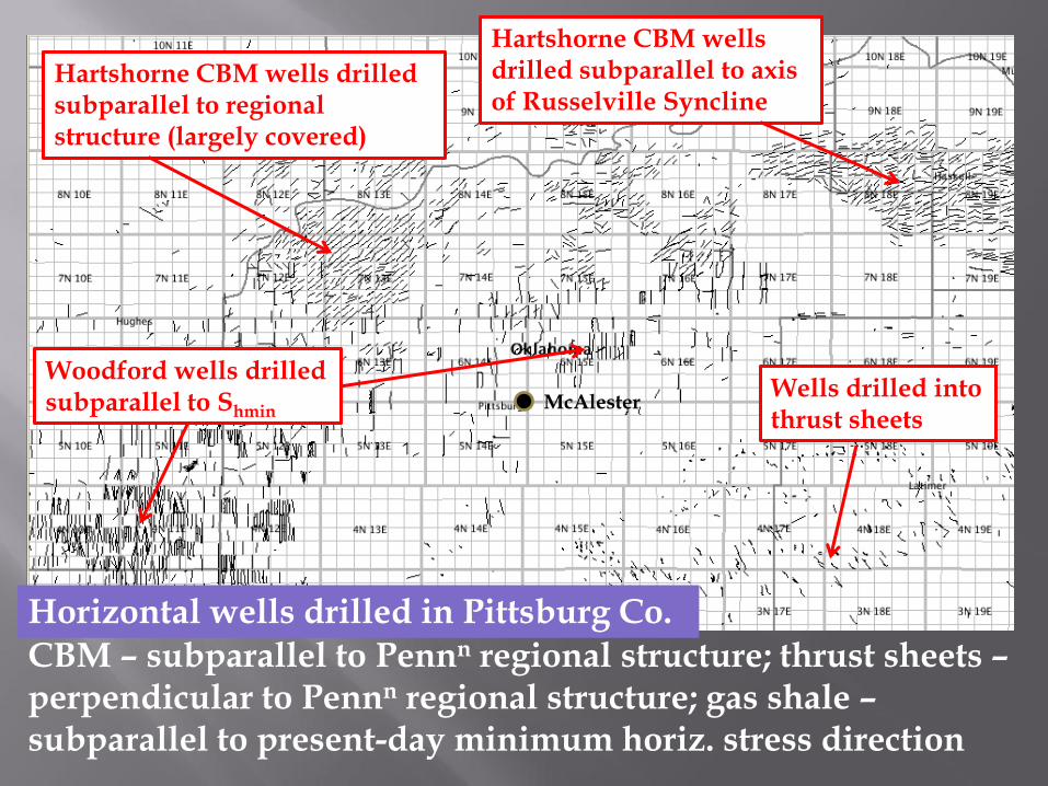
Hartshorne CBM wells drilled subparallel to regional structure (largely covered)
Hartshorne CBM wells drilled subparallel to axis of Russelville Syncline
Woodford wells drilled subparallel to Shmin
Wells drilled into thrust sheets
Horizontal wells drilled in Pittsburg Co.
CBM – subparallel to Pennn regional structure; thrust sheets – perpendicular to Pennn regional structure; gas shale – subparallel to present-day minimum horiz. stress direction
McAlester
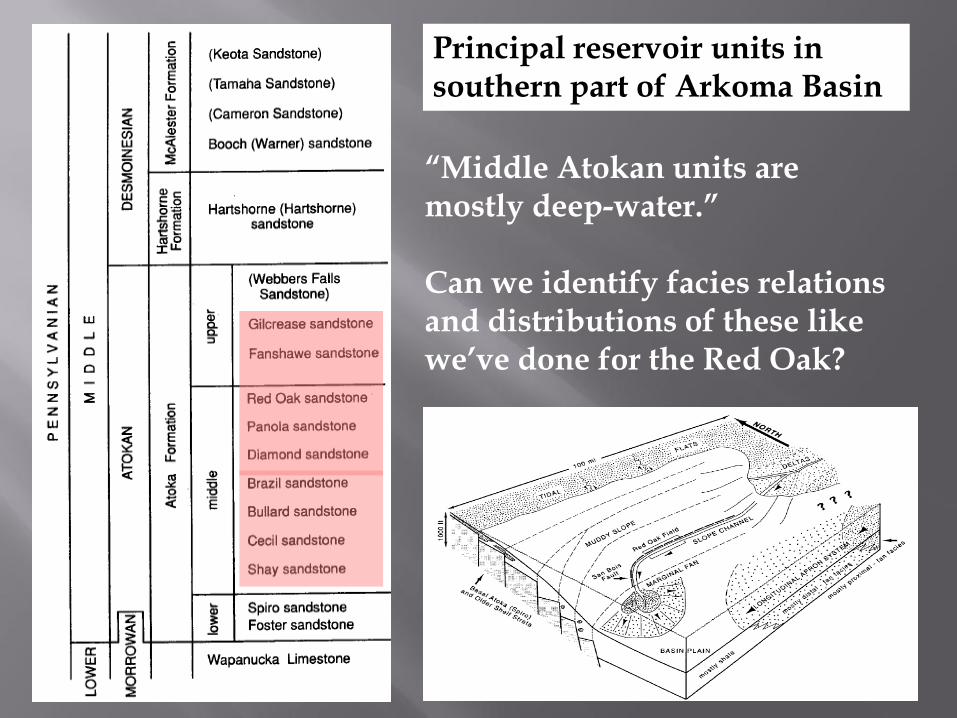
“Middle Atokan units are mostly deep-water.” Can we identify facies relations and distributions of these like we’ve done for the Red Oak?
Principal reservoir units in southern part of Arkoma Basin
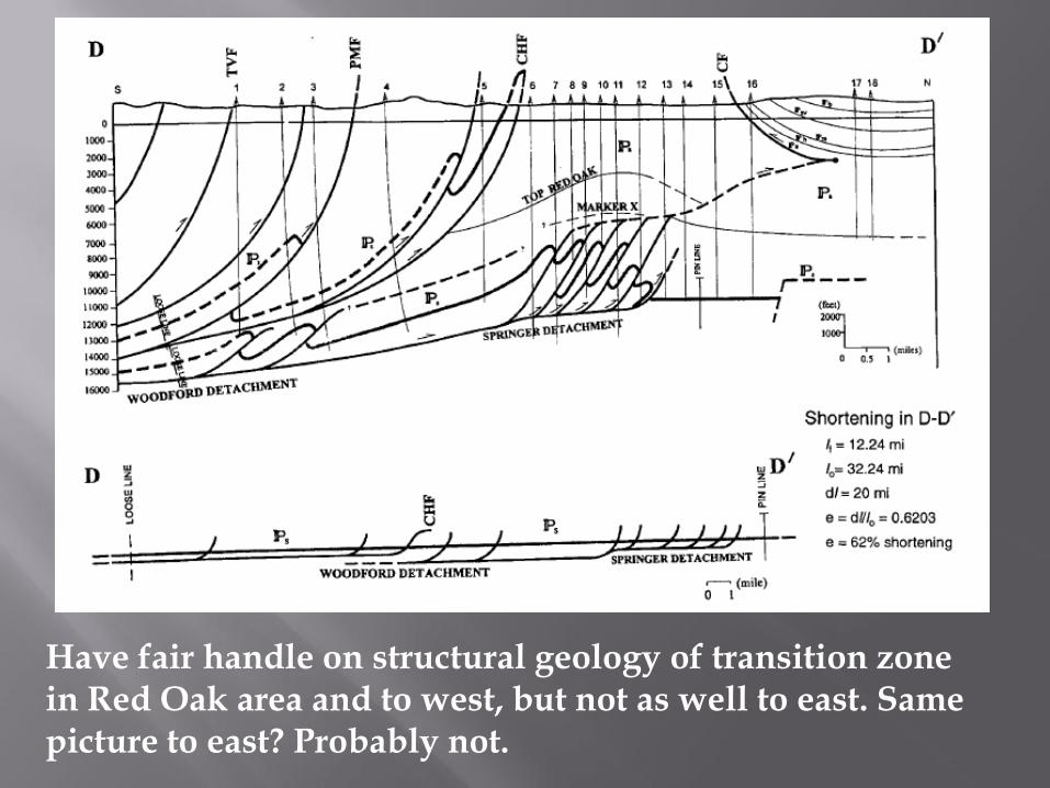
Have fair handle on structural geology of transition zone in Red Oak area and to west, but not as well to east. Same picture to east? Probably not.
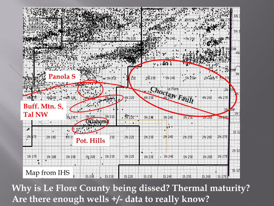
Pot. Hills
Buff. Mtn. S, Tal NW
Panola S
Why is Le Flore County being dissed? Thermal maturity? Are there enough wells +/- data to really know?
Map from IHS
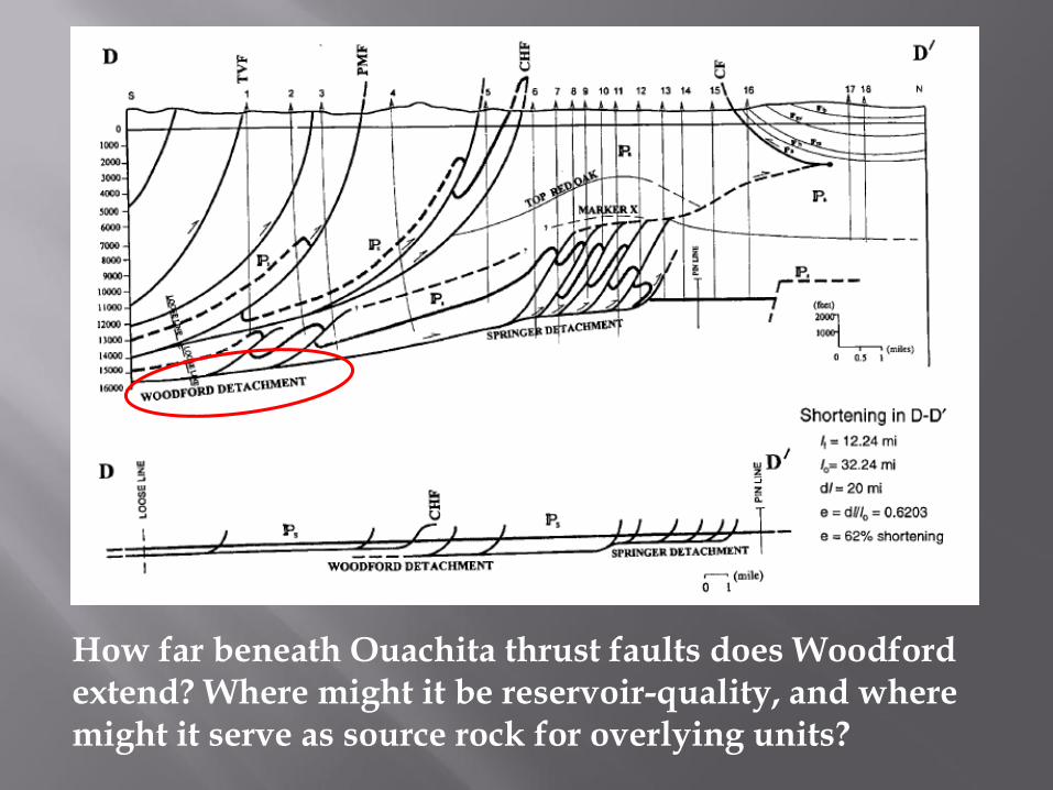
How far beneath Ouachita thrust faults does Woodford extend? Where might it be reservoir-quality, and where might it serve as source rock for overlying units?
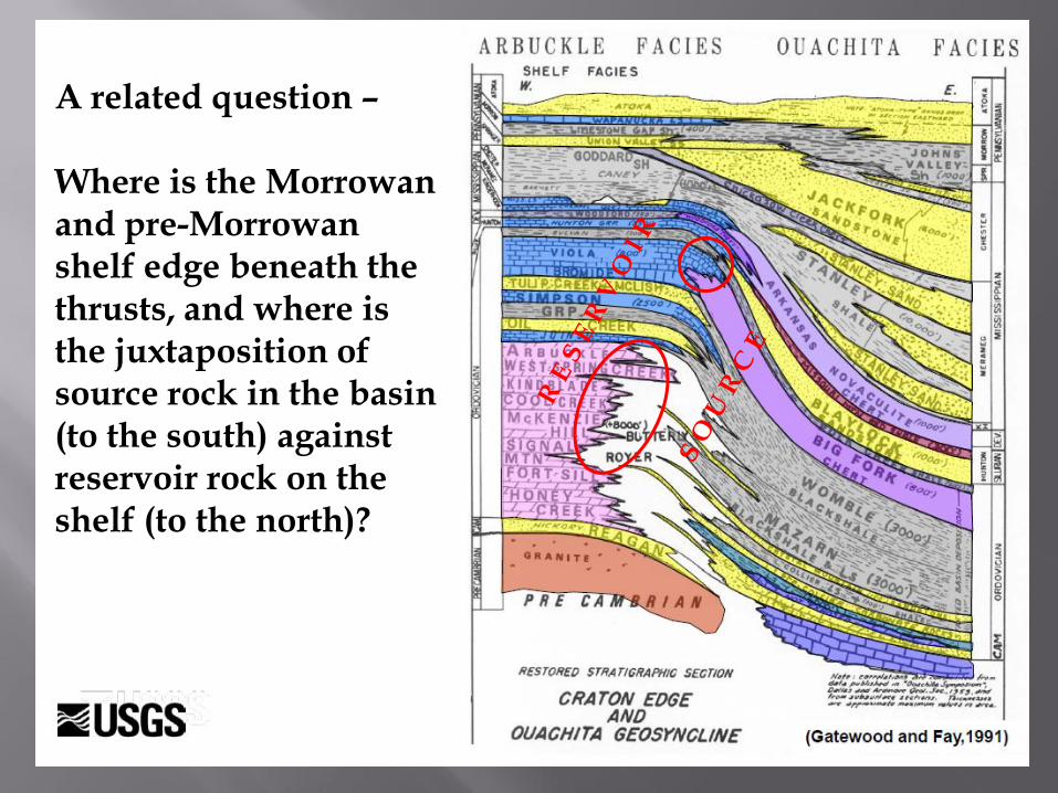
A related question – Where is the Morrowan and pre-Morrowan shelf edge beneath the thrusts, and where is the juxtaposition of source rock in the basin (to the south) against reservoir rock on the shelf (to the north)?
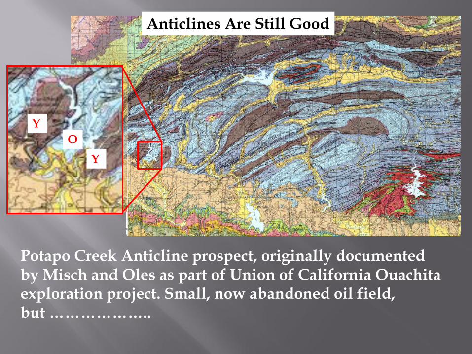
Potapo Creek Anticline prospect, originally documented by Misch and Oles as part of Union of California Ouachita exploration project. Small, now abandoned oil field, but ………………..
Y
Y
O
Anticlines Are Still Good
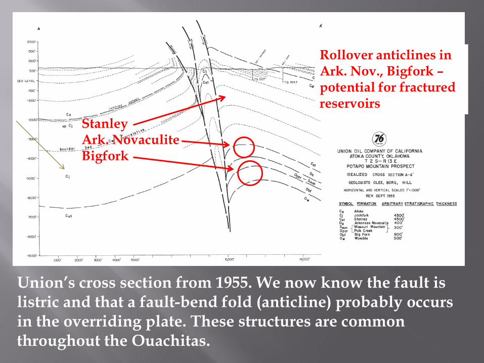
Union’s cross section from 1955. We now know the fault is listric and that a fault-bend fold (anticline) probably occurs in the overriding plate. These structures are common throughout the Ouachitas.
Rollover anticlines in Ark. Nov., Bigfork – potential for fractured reservoirs
Stanley Ark. Novaculite Bigfork

Jackfork fields in northern Ouachitas – production from fractured/tight sandstones, anticlinal crests, and ...
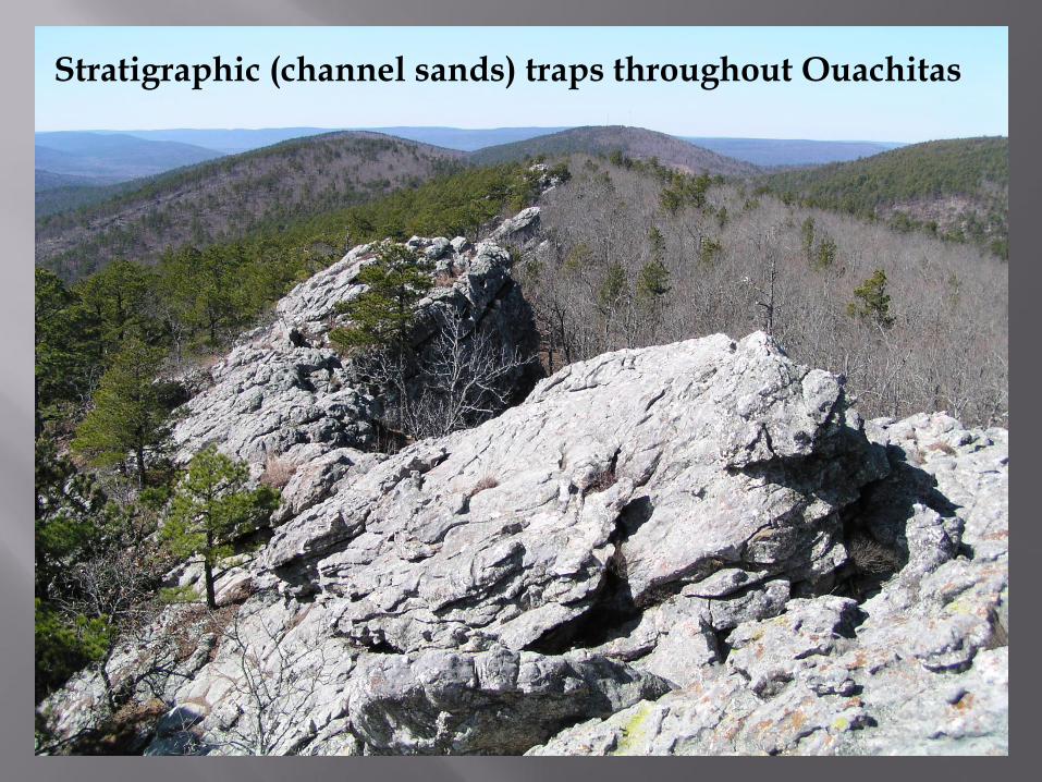
Stratigraphic (channel sands) traps throughout Ouachitas
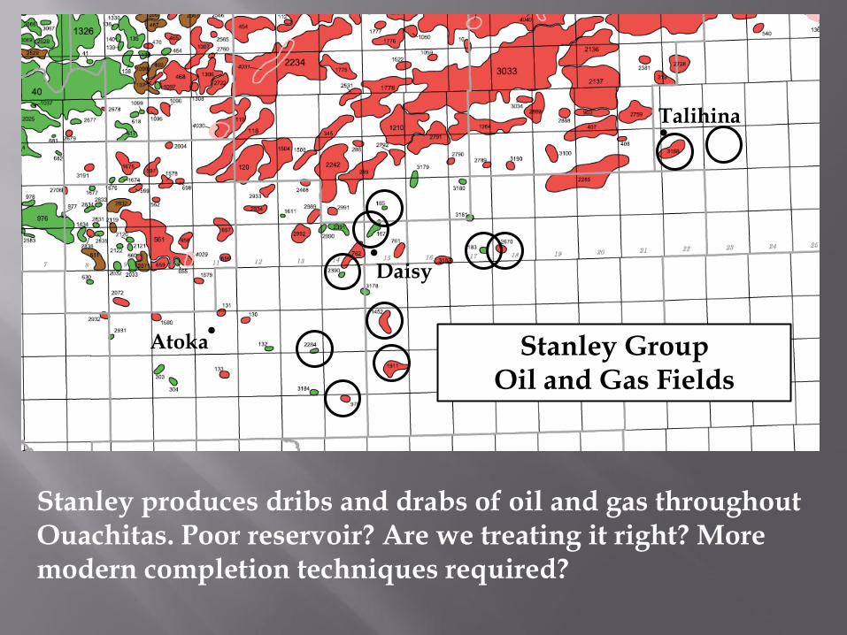
Stanley Group Oil and Gas Fields
Stanley produces dribs and drabs of oil and gas throughout Ouachitas. Poor reservoir? Are we treating it right? More modern completion techniques required?
. Talihina
. Atoka
. Daisy
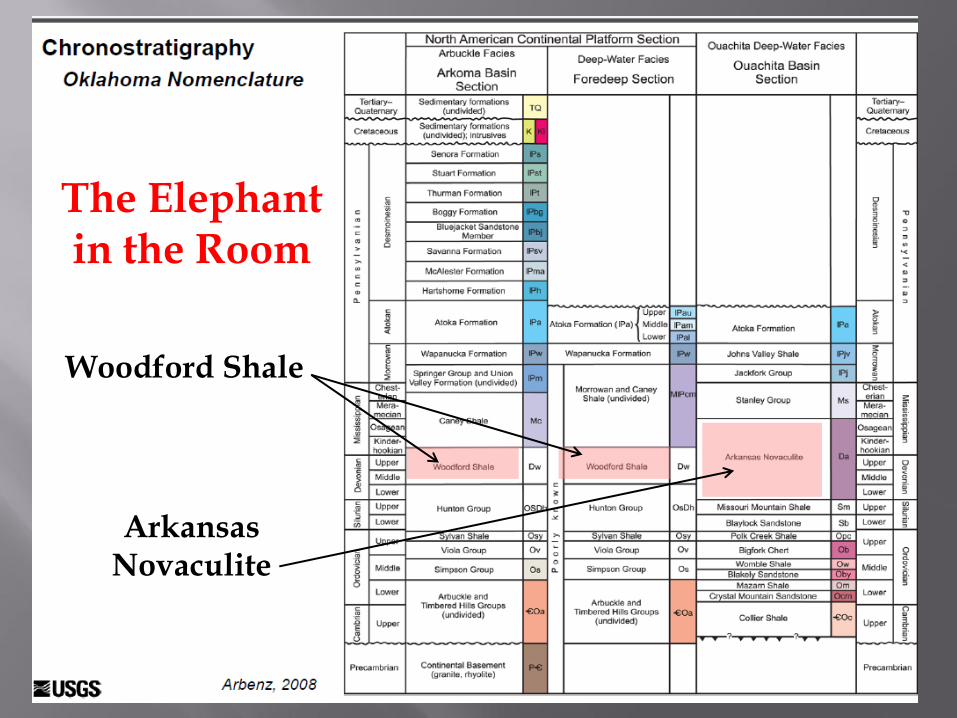
The Elephant in the Room
Woodford Shale
Arkansas Novaculite