
ARIZONA’S HISTORICAL SUCCESSES IN WATER … has a long history of developing pro-active solutions...
19
January 2014 ARIZONA’S NEXT CENTURY: A STRATEGIC VISION FOR WATER SUPPLY SUSTAINABILITY 24 ARIZONA’S HISTORICAL SUCCESSES IN WATER MANAGEMENT Water is the foundation, not only for long-term economic stability, but also for securing the success of generations of future Arizonans. Strong, forward-looking, leadership at the highest levels of State government on water issues is vital to ensure a stable future for our citizens. The Arizona Department of Water Resources (ADWR) is the logical leader in initiating this discussion and developing a comprehensive foundation to work from in this process. Arizona has a long history of developing pro-active solutions to the challenges of developing water supplies in our arid state. The support and commitment of our current political leaders is crucial to continuing to meet those challenges (see Appendix I – Timeline History of Arizona Water Management). While we reside in what some perceive as a harsh environment, those with great vision and leadership have harnessed the natural resources needed to support a thriving Arizona economy. This vision started well before statehood. Below is an overview of just a few of those achievements, which not only can serve as a guide for future planning, but will also provide a sense of the significant time and commitment required to realize the benefits of new projects. This is important to illustrate because although large-scale importation projects may not be needed until sometime in the future, the planning and politics of constructing such projects or water supply benefits of implementing management approaches can take decades to accomplish. Much of Arizona enjoys the benefit of secure water supplies today, in large part due to the vision and efforts of its past leaders. Establishing and pursuing a vision for water security for future generations of Arizonans must begin well in advance of the need to ensure orderly development, avoid economic disruption, and protect the unique environment that we all enjoy. Taming the Salt River In the late 1860’s early settlers in the Phoenix area were dependent primarily upon the unregulated flow of the Salt River through diversions and canals to sustain agricultural development. The river was unpredictable - prone to both extreme flooding and droughts. Efforts to dam the river to provide more consistent and reliable supplies were impeded by the inability to finance the construction of a dam on the river (estimated at the time to cost approximately $5,000,000). A series of droughts in the 1890s and floods in the early part of the 20 th century, however, highlighted the need to control the river. With the passage of the National Reclamation Act of 1902 4 , funding for projects with low-interest federal loans paved the way for the incorporation of the Salt River Valley Water Users' Association (SRP) the following year, becoming the first multipurpose project under the new Act. In 1903, over 200,000 acres of private ranching and farm lands in the association were pledged as collateral for the construction of Roosevelt Dam with a reservoir storage capacity of nearly 1.4 million acre-feet 5,6 (MAF), located approximately 76 miles northeast of Phoenix. 4 Benjamin Fowler, an Arizona businessman, went to Washington D.C. to lobby for the federal government for this new law to find a way to finance the dam in Arizona. 5 One acre-foot is 325,851 gallons or approximately enough water to provide for approximately two families of four living in a single-family home for one-year. 6 From 1989 to 1996, the dam was modified by the US Bureau of Reclamation. In addition to raising the dam's height 77 feet in elevation which increased its storage capacity by 20 percent, the modification included construction of two new spillways, installation of new outlet works, and power plant modifications.
Transcript of ARIZONA’S HISTORICAL SUCCESSES IN WATER … has a long history of developing pro-active solutions...

January 2014
ARIZONA’S NEXT CENTURY: A STRATEGIC VISION FOR WATER SUPPLY SUSTAINABILITY
24
ARIZONA’S HISTORICAL SUCCESSES IN WATER MANAGEMENT Water is the foundation, not only for long-term economic stability, but also for securing the success of generations of future Arizonans. Strong, forward-looking, leadership at the highest levels of State government on water issues is vital to ensure a stable future for our citizens. The Arizona Department of Water Resources (ADWR) is the logical leader in initiating this discussion and developing a comprehensive foundation to work from in this process. Arizona has a long history of developing pro-active solutions to the challenges of developing water supplies in our arid state. The support and commitment of our current political leaders is crucial to continuing to meet those challenges (see Appendix I – Timeline History of Arizona Water Management). While we reside in what some perceive as a harsh environment, those with great vision and leadership have harnessed the natural resources needed to support a thriving Arizona economy. This vision started well before statehood. Below is an overview of just a few of those achievements, which not only can serve as a guide for future planning, but will also provide a sense of the significant time and commitment required to realize the benefits of new projects. This is important to illustrate because although large-scale importation projects may not be needed until sometime in the future, the planning and politics of constructing such projects or water supply benefits of implementing management approaches can take decades to accomplish. Much of Arizona enjoys the benefit of secure water supplies today, in large part due to the vision and efforts of its past leaders. Establishing and pursuing a vision for water security for future generations of Arizonans must begin well in advance of the need to ensure orderly development, avoid economic disruption, and protect the unique environment that we all enjoy. Taming the Salt River In the late 1860’s early settlers in the Phoenix area were dependent primarily upon the unregulated flow of the Salt River through diversions and canals to sustain agricultural development. The river was unpredictable - prone to both extreme flooding and droughts. Efforts to dam the river to provide more consistent and reliable supplies were impeded by the inability to finance the construction of a dam on the river (estimated at the time to cost approximately $5,000,000). A series of droughts in the 1890s and floods in the early part of the 20th century, however, highlighted the need to control the river. With the passage of the National Reclamation Act of 19024, funding for projects with low-interest federal loans paved the way for the incorporation of the Salt River Valley Water Users' Association (SRP) the following year, becoming the first multipurpose project under the new Act. In 1903, over 200,000 acres of private ranching and farm lands in the association were pledged as collateral for the construction of Roosevelt Dam with a reservoir storage capacity of nearly 1.4 million acre-feet5,6 (MAF), located approximately 76 miles northeast of Phoenix.
4 Benjamin Fowler, an Arizona businessman, went to Washington D.C. to lobby for the federal government for this new law to find a way to finance the dam in Arizona. 5 One acre-foot is 325,851 gallons or approximately enough water to provide for approximately two families of four living in a single-family home for one-year. 6 From 1989 to 1996, the dam was modified by the US Bureau of Reclamation. In addition to raising the dam's height 77 feet in elevation which increased its storage capacity by 20 percent, the modification included construction of two new spillways, installation of new outlet works, and power plant modifications.

January 2014
ARIZONA’S NEXT CENTURY: A STRATEGIC VISION FOR WATER SUPPLY SUSTAINABILITY
25
Although the construction of Roosevelt Dam was SRP’s most visible and costly component, an integral part of the project was also the construction and improvement of a system of canals designed to distribute the water from the Salt River among the various members living in the valley. As construction began, water rights to the Salt River in the Phoenix metropolitan area were settled in Hurley v. Abbott (1910)7. The decision, known as the Kent Decree in recognition of the presiding judge, Edward H. Kent, was a landmark in water law and still serves as an integral part of the water management structure in Arizona today. Between 1923 and 1945, five additional dams were constructed on the Salt and Verde Rivers to increase the storage capacity to greater than 2.5 MAF on the system and to generate hydropower (see Figure 1). Today, SRP supplies power to more than 970,000 retail customers in three Arizona counties, including most of the metropolitan Phoenix area. Integrated operation of the six reservoirs on the Salt and Verde Rivers, as well as the Granite Reef Diversion Dam and its system of canals, makes SRP an important provider of water to the Phoenix area. SRP annually delivers approximately 1 MAF of water to the Phoenix area through an extensive system of reservoirs, wells, canals and irrigation laterals and manages a 13,000-square-mile watershed. Additionally, SRP operates the C.C. Cragin Reservoir (formerly known as Blue Ridge Reservoir8), located on the Mogollon Rim which, in the near future, will provide renewable water supplies to the Town of Payson. Development of the Colorado River At the same time central Arizona was harnessing the Salt River, development of the waters of the Colorado River was also taking shape. Modern use of Colorado River water for irrigation began in the late 1800s when water was diverted for use in California’s Imperial Valley. By 1901, some 100,000 acres of farmland were irrigated with Colorado River water in the Imperial Valley. As settlers and farmers in southwestern Arizona, southeastern California and the Mexicali Valley in Mexico were expanding their farming operations, rapid development in the Los Angeles basin was increasing the need for long-term water supplies. But, like the Salt River, the Colorado River was prone to highly variable and sporadic
7 No. 4564, Decision and Decree, March 1, 1910 8 Blue Ridge Reservoir was built by the Phelps Dodge Corporation in 1965 to provide water for its mining operations. SRP acquired the reservoir in 2005 as part of the Gila River Indian Community Water Rights Settlement approved by the 2004 Arizona Water Settlement Act to help facilitate the settlement of the Community’s water rights claims.
Figure 1. Salt River Project Watershed and Service Area (SRP)

January 2014
ARIZONA’S NEXT CENTURY: A STRATEGIC VISION FOR WATER SUPPLY SUSTAINABILITY
26
flow regimes. From 1905 to 1907, floods impacted communities along the River, making continued reliance on its flows unpredictable. In order to deliver Colorado River water to the Imperial Valley, water had to be diverted south of the Mexican border through an old overflow channel of the River to bypass a ridge of sand hills separating the Imperial Valley from the Colorado River. To accommodate this diversion, Mexico demanded the right to take up to one-half of the diverted water. California preferred to construct a US only canal as the solution to having to share water supplies with the Mexican farmers. Farmers in the Imperial Valley could not come up with the finances necessary for such a project and worked for years to convince Congress to construct a new aqueduct. It was not until Los Angeles got interested in augmenting its water supplies that significant progress was made. In 1920, California interests joined with Arthur Powell Davis, nephew of the famous explorer John Wesley Powell and Director of the US Interior Department’s Reclamation Service (now the Bureau of Reclamation), who supported the idea of a large dam on the Lower Colorado River to help expand the west. The year 1922 proved to be one of the most important years in the development of the Colorado River. Even before Los Angeles entered the picture, leaders in the Colorado River Basin States outside of California were becoming concerned about the rapidly expanding uses in the state that contributed the least amount of runoff to the River. In February of 1922, the US Interior Department issued the Fall-Davis Report9, which recommended construction of an “All-American Canal”, a storage reservoir "at or near Boulder Canyon," and the development of hydroelectric power to repay the cost of the dam. In April of that same year, Congressman Phil Swing from the Imperial Valley and Senator Hiram Johnson of California introduced a bill to implement the recommendations contained in the Fall-Davis Report. Then, in June of 1922, the US Supreme Court, in Wyoming v. Colorado, found that the doctrine of prior appropriation applied to surface water rights regardless of state lines. The doctrine of prior appropriation was the cornerstone of western water law which gave legal entitlement to the first person using water-"first in time, first in right” – and was recognized within each of the seven Colorado River Basin States as the basis for the appropriation and use of surface water10. Prior to this decision, it was uncertain whether the doctrine of prior appropriation applied to users in two or more states on a common river system. The outcome of this case made it clear that California, which was developing faster in both population and political power than any other area in the west, could potentially acquire rights to most of the water of the Colorado River to the detriment of the slower-growing states. As a result of the Supreme Court’s decision and rapid development in California, the states in the Upper Colorado River Basin were forced to oppose all reclamation projects in the Lower Colorado River Basin until their own interests were safeguarded. Prior to the events in 1922, Congress had already authorized the seven Basin States to negotiate a compact to divide the water between the seven states. However, representatives from each state and Secretary of Commerce Herbert Hoover, representing the federal government, were unable to reach an agreeable division between the individual states. Instead, they did reach agreement to equally divide the River 11between the Upper and Lower Basin. The resulting 1922 Colorado River Compact (Compact) apportioned 7.5 MAF each to the Upper Basin (Colorado, New Mexico, Utah, Wyoming and a portion of 9 The Fall-Davis Report, named for Secretary of the Interior Albert Fall and Arthur Powell Davis; who was now head of the Reclamation Bureau 10 In 1864, the first Arizona Territorial Legislature adopted the Howell Code, which established the doctrine of prior appropriation for surface water in Arizona– “First in Time, First in Right.” 11 At this time the Colorado River was assumed to have an average annual flow of approximately 17 MAF.
January 2014
ARIZONA’S NEXT CENTURY: A STRATEGIC VISION FOR WATER SUPPLY SUSTAINABILITY
27
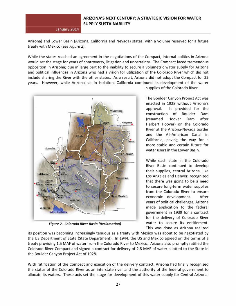
Arizona) and Lower Basin (Arizona, California and Nevada) states, with a volume reserved for a future treaty with Mexico (see Figure 2). While the states reached an agreement in the negotiations of the Compact, internal politics in Arizona would set the stage for years of controversy, litigation and uncertainty. The Compact faced tremendous opposition in Arizona; due in large part to the inability to secure a volumetric water supply for Arizona and political influences in Arizona who had a vision for utilization of the Colorado River which did not include sharing the River with the other states. As a result, Arizona did not adopt the Compact for 22 years. However, while Arizona sat in isolation, California continued its development of the water
supplies of the Colorado River. The Boulder Canyon Project Act was enacted in 1928 without Arizona’s approval. It provided for the construction of Boulder Dam (renamed Hoover Dam after Herbert Hoover) on the Colorado River at the Arizona-Nevada border and the All-American Canal in California, paving the way for a more stable and certain future for water users in the Lower Basin. While each state in the Colorado River Basin continued to develop their supplies, central Arizona, like Los Angeles and Denver, recognized that there was going to be a need to secure long-term water supplies from the Colorado River to ensure economic development. After years of political challenges, Arizona made application to the federal government in 1939 for a contract for the delivery of Colorado River water to secure its entitlement. This was done as Arizona realized
its position was becoming increasingly tenuous as a treaty with Mexico was about to be negotiated by the US Department of State (State Department). In 1944, the US and Mexico agreed on the terms of a treaty providing 1.5 MAF of water from the Colorado River to Mexico. Arizona also promptly ratified the Colorado River Compact and signed a contract for delivery of 2.8 MAF of water allotted to the State in the Boulder Canyon Project Act of 1928. With ratification of the Compact and execution of the delivery contract, Arizona had finally recognized the status of the Colorado River as an interstate river and the authority of the federal government to allocate its waters. These acts set the stage for development of this water supply for Central Arizona.
Figure 2. Colorado River Basin (Reclamation)
January 2014
ARIZONA’S NEXT CENTURY: A STRATEGIC VISION FOR WATER SUPPLY SUSTAINABILITY
28
During this time, California was continuing to increase its use of the River and would prove to be a major hurdle to fulfillment of Arizona’s vision for its future prosperity. In 1946, the Central Arizona Project Association was formed to educate Arizonans about the need for a Central Arizona Project (CAP) and to lobby Congress to authorize its construction. Arizona Senators Ernest McFarland and Carl Hayden introduced the first bill to authorize the CAP in 1947. It would take another 21 years, including 11 years of legal battles with California, before this project would be realized. Through this entire period California continued to increase its reliance on this supply and, with its large and expanding Congressional delegation, fought the passage of a CAP bill. Arizona filed suit in the US Supreme Court (Arizona v. California) in 1952 to secure its legal entitlement to Colorado River water. In the proceedings, California argued that, not only was Arizona already using its Colorado River entitlement via its tributaries, specifically the Gila River, but that because of Arizona’s use of the Gila River, California was entitled to an additional 1 MAF from the mainstem of the Colorado River. After a significant shift in legal strategy, Arizona argued that its tributaries were separate from the Colorado River and the rights that Arizona had acquired to the waters of the Colorado River. Furthermore, Arizona claimed that rights to the Gila River were acquired prior to the Compact and were protected as “perfected rights”12 under Article VIII of the Compact. Specifically, Arizona’s legal argument was solidified in the language and the legislative intent of the 1928 Boulder Canyon Project Act, which recommended an allocation of 2.8 MAF of mainstem Colorado River water to Arizona plus the waters of the Gila River that was shared with New Mexico. In 1963, the US Supreme Court upheld Arizona’s claim13. The Court affirmed that the Boulder Canyon Project Act of 1928 divided the mainstem flow of the Colorado River between the Lower Basin States, with 2.8 MAF per year going to Arizona, 4.4 MAF per year going to California and 300,000 acre-feet per year going to Nevada. Further, the Court affirmed that “the tributaries are not included in the waters to be divided but remain for the exclusive use of each State14”. This element of the decision was vital for any future CAP as there would not likely have been enough water remaining in Arizona’s Colorado River apportionment to justify the construction of the project had the Court found that the use of the Gila River (approximately 1 MAF) was part of Arizona’s apportionment. With its victory in the US Supreme Court, the battle for the CAP went back to Congress. It would take eight more years to get a bill through Congress and, although Arizona’s dream of a CAP would become a reality, it would come at a large cost in the face of California’s political strength in Congress. Several issues arose in the ensuing years that influenced the framework of the authorizing legislation for the CAP, specifically:
1) California’s ultimatum that their support of the project required receipt of its full 4.4 MAF apportionment during shortages, essentially giving California a priority over the CAP;
2) A study released by the Upper Basin States that showed insufficient water supplies available to justify the project; and
3) Growing opposition to the construction of two new dams proposed in the Grand Canyon to supply the power required for the project.
12 Meaning the use was in place prior to 1922 when the Compact was signed. 13 AZ v. CA. 373 U.S. 546 (1963) 14 Opinion in AZ v CA, 1963

January 2014
ARIZONA’S NEXT CENTURY: A STRATEGIC VISION FOR WATER SUPPLY SUSTAINABILITY
29
For many years during the discussions on the CAP, the source of power to operate the project was from two proposed dams to be located in the Grand Canyon. Ultimately bowing to pressure from the environmental and recreational communities who vehemently opposed the proposed dams, Arizona agreed to energy derived from coal mined through lease agreements with the Navajo Nation and Hopi Tribe and a thermoelectric generating facility near Page, Arizona – the Navajo Generating Station (NGS). While these issues continued to be debated in Congress, Arizona’s need for the CAP increased. Beginning in the 1950’s, central Arizona’s dependence on groundwater supplies increased significantly, a situation that would be solved in part by the CAP (and would later become another important component in Arizona’s water management history). Through the dedication and leadership of Arizona’s congressional delegation, Senator Hayden, Senator Paul Fannin and Congressmen John J. Rhodes, the Colorado River Basin Project Act was signed by President Johnson on September 30, 1968.
The Colorado River Basin Project Act represented a compromise for Arizona, but it did provide Arizona the project it needed to finally utilize its full Colorado River entitlement. In order to get the Act passed, Arizona agreed to a California priority of 4.4 MAF ahead of the CAP. It is important to note that this compromise on Arizona’s part was with the agreement and inclusion of language in the Act that water supply augmentation would be explored by the federal government, limiting the impact of differential priority to water in the Lower Basin. To accomplish this, the Act provided for a 10-year study of water resources west of the Continental Divide in return for a 10-year moratorium on any studies aimed at bringing outside water into the Colorado River Basin (this moratorium was extended for another 10 years in 1978). The Act also identified US Bureau of Reclamation (Reclamation) as the entity to fund and construct the CAP, but authorized the Secretary of the Interior to enter into a master contract with an Arizona entity that has the power to levy assessments on real property to repay the federal government for certain costs of construction when the system was complete. In 1971, the Arizona Legislature created the Central Arizona Water Conservation District to provide a means for Arizona to repay the federal government for the reimbursable costs of construction of the CAP and to manage and operate the CAP system.
Figure 3. Central Arizona Project (CAP)
January 2014
ARIZONA’S NEXT CENTURY: A STRATEGIC VISION FOR WATER SUPPLY SUSTAINABILITY
30
Construction began at Lake Havasu in 1973 and was completed 20 years later south of Tucson. The entire project cost over $4 billion to construct15 (see Figure 3). While presented in an extremely abbreviated fashion above, the history of the beginnings of water management on the Colorado River system is not without its controversies. The Colorado River Compact did not solve all of the issues that were to arise over the ensuing decades between the Basin States, water users, Mexico and the federal government. It has served as a platform for multiple states with very different agendas, strategies and needs coming together to solve immediate problems and is still the cornerstone of the entire “Law of the River” (see Appendix II), which governs the uses on the Colorado River today. Further, the history provides perhaps the most notable example of Arizonans coming together to aggressively protect and pursue their rights. The fortunes we enjoy today are directly a result of prior generations of Arizonans who envisioned bringing Colorado River water uphill into Phoenix and Tucson. The CAP was the strategic vision for Arizona from the 1940s until its completion in the early 1990s. Not without controversy, Arizona still was able to rally around the CAP, knowing that it would strengthen and bolster Arizona’s future. Private Contributions While the development of the Salt River and Colorado River are the largest examples of Arizonan’s joining efforts to develop water supplies, there are many other examples across Arizona of water users pooling their resources and expertise and developing water supplies and water storage and delivery infrastructure to the benefit of the region. A notable example is the extensive system developed by Phelps Dodge Corporation – a major mining company in Arizona (acquired by Freeport-McMoRan Copper & Gold Inc. in 2007) – to construct three large dams, reservoirs, pumping plants, pipelines and other support facilities in six different Arizona counties in cooperation with federal, state and local agencies. With wartime efforts increasing the demand for copper in the 1940s, the need for Phelps Dodge to secure additional water supplies to increase its production was critical16. After extensive exploration and analysis of the water resources strategies in place at the time in Arizona, the company noted that SRP had constructed Bartlett Dam on the Verde River to regulate the flow of the Verde River in the 1930s, protecting the Phoenix area from floods and providing water for irrigation. However, the reservoir was insufficient to capture floodwaters in every year and in some years floodwaters would flow unused down the river, sometimes inundating portions of the Phoenix area. With this in mind, Phelps Dodge and SRP entered into an agreement which resulted in the construction of Horseshoe Dam in 1946 upstream from Bartlett to reduce floodflows below Bartlett and to provide SRP with additional storage for water uses in the Phoenix area. In exchange for this $2.5 million investment, Phelps Dodge secured credits for 250,000 acre-feet of water from the Black River in eastern Arizona. Intended for use at its Morenci Mine operations, the water was pumped 700 feet to the rim of Black Canyon and then gravity fed roughly six and a half miles to Willow Creek. The water was then transported another 21 miles to Eagle Creek and then another 30 miles to a diversion point near Morenci17.
15 http://www.cap-az.com/index.php/cap-background 16 Prior to 1937, the company had secured rights on Eagle Creek, Chase Creek and the San Francisco River for its Morenci Mine operation. 17 Schwantes, Charles A., Vision & Enterprise Exploring the History of Phelps Dodge Corporation, University of Arizona Press, 2000.
January 2014
ARIZONA’S NEXT CENTURY: A STRATEGIC VISION FOR WATER SUPPLY SUSTAINABILITY
31
Phelps Dodge also constructed Show Low Reservoir in 1953 on the Show Low Creek tributary of the Little Colorado River, from which it delivered water 100 miles through a tributary of the Salt River, enabling a water exchange that allowed additional diversions from the Black River for the Morenci Mine. Phelps Dodge continued its water supply development efforts constructing Blue Ridge Reservoir on East Clear Creek. Water stored in Blue Ridge was pumped to the Mogollon Rim, ultimately flowing to the Verde River, where it augmented SRP supplies and allowed additional Black River diversions. These cooperative projects continue to serve as a model for advancing water resource planning and development in many portions of the Arizona. Groundwater Management At the same time Arizona was struggling in its efforts to develop the CAP, reliance on groundwater continued to increase. Early in Arizona’s history, groundwater was identified separately from surface waters by the Courts as either flowing in underground streams or percolating through the soil beneath the land surface. Beginning as far back as 1904, the Arizona Territorial Supreme Court adopted the common law rule that percolating water was the property of the overlying land owner and not subject to appropriation as was surface water18. Litigation would dominate the management of groundwater in Arizona for the next 76 years.
In the 1930’s, the combination of increased cotton prices, improved technology in well pumping efficiency, and the availability of inexpensive power, largely from the newly constructed hydroelectric dams on the Salt, Verde, and Colorado Rivers, led to increased groundwater pumping in central Arizona. As a result, individual well owners were experiencing declining water levels and difficulties in producing water as neighboring well owners were competing for the same groundwater supply, naturally leading to economic disruption and litigation. In response to growing concerns over increased groundwater pumping, the first commission to study groundwater was appointed by then Governor Rawghlie Clement Stanford in 1938. The sole notable accomplishment was convincing the Arizona Legislature of the need to appropriate funds to have the US Geological Survey (USGS) investigate groundwater conditions throughout the State and publish a report with regard to these investigations. The report, issued by the USGS in 1943, found that groundwater depletion would continue to increase as lands continued to be developed. As a result of the USGS report, two bills were introduced in the 1945 regular legislative session. The first bill, originally drafted by SRP and other irrigation districts, proposed transferring groundwater from private to public ownership and requiring permits for new uses of groundwater. This would accomplish two things: 1) groundwater supplies would be quantified and appropriated amongst the existing users, setting priorities of rights, just as was done for surface water, and 2) limit or even preclude additional farming operations from locating into the State, thereby limiting competition for resources and protecting market shares for existing farmers. The second bill required the registration of all irrigation wells in the state, which would accomplish little more than identifying all well owners and their location in the State. Neither bill was approved by the Legislature. Arizona’s inability to adopt a comprehensive groundwater management strategy would not go unnoticed by the opponents to the CAP. In the first federal government salvo in moving the State towards legislative groundwater management, the US Department of Interior declared that the CAP 18 Howard v. Perrin, 1904 (See Appendix I)

January 2014
ARIZONA’S NEXT CENTURY: A STRATEGIC VISION FOR WATER SUPPLY SUSTAINABILITY
32
would not be approved until Arizona took steps to restrict groundwater irrigated agriculture. In response to this federal declaration, Governor Sydney P. Osborn reintroduced both the irrigation district bill and the well registration bill in a special session. The well registration bill, which only required the registration of all irrigation wells throughout the state, was better received than the irrigation district proposal and thus was passed by the Legislature becoming the Groundwater Code of 1945. It was immediately recognized that the 1945 Code did nothing to stop groundwater depletion and again, in 1948, the federal government threatened the future of the CAP.
A more comprehensive Groundwater Code was finally enacted in 1948. It provided for designation of ten critical areas within the State (defined as areas without sufficient groundwater to provide irrigation for cultivated lands at then current rates of withdrawal) and prohibited the expansion of groundwater irrigated agriculture within these critical areas. However, the Code did nothing to address existing pumping nor did it apportion the use of groundwater among the overlying landowners within the critical areas. The provision allowing existing groundwater pumping to continue was widely criticized, as it did nothing to stop the existing groundwater overdraft. In response, a second groundwater study commission was initiated in 1951, charged with drafting a meaningful groundwater bill. The commission introduced a bill in the 1952 legislative session that not only would have divided the State’s groundwater basins into three separate management classifications, but also, and most notably, would have changed the long-held common law rule of groundwater use to a publicly-owned resource subject to appropriation. The bill was not passed by the Legislature. Instead, the Legislature passed a bill establishing yet another groundwater study commission. In addition to the legislative efforts, these issues were being actively litigated at the time. In 1952, a case before the Arizona Supreme Court resulted in one of the most controversial decisions in the history of Arizona groundwater law. In Bristor I19, the Court found that “the common-law concept that the owner of the overlying land owns the percolating waters under its surface is fallacious and that the vested rights of the users of percolating waters are more fully protected under the law of prior appropriation than under the so-called common-law rule.” It was the Court’s opinion that to “permit the present underground water race to continue unabated, without regulation or control, would inevitably lead to exhaustion of the underground supply and consequently to economic disaster.”20 Left unchanged, this opinion would have dramatically altered Arizona groundwater law by making the State’s groundwater supplies subject to the law of prior appropriation. The Arizona Supreme Court’s opinion in Bristor I raised so much controversy that a rehearing was granted the following year. In 1953, the Arizona Supreme Court reversed its opinion in Bristor I, affirming the police power of the Legislature to regulate groundwater and reinstituting the common law rule with the addition of the doctrine of reasonable use. Under this doctrine, a landowner could pump as much water as could be put to reasonable use on the land from which it was pumped. However, no limits on the amount of water that could be reasonably used were defined, and landowners found themselves competing for the same supply. The Court’s reversal in Bristor II21 was seen by some as a failure to adequately allocate the State’s diminishing groundwater reserves. In their dissent, Justices Phelps and Udall predicted that “the mad race to ‘mine’ percolating waters…will continue unabated
19 Bristor v. Cheatham, (Bristor I), 73 Ariz. 228, 240 P2d. 185 (1952) 20 Bristor I 21 Bristor v. Cheatham, (Bristor II), 75 Ariz. 227, 255 P2d. 173 (1953)

January 2014
ARIZONA’S NEXT CENTURY: A STRATEGIC VISION FOR WATER SUPPLY SUSTAINABILITY
33
until such time as these waters are declared to be public in character and suitable regulatory measures are adopted.”22 Following the decision in Bristor II, the groundwater study commission introduced a bill that would: prohibit new groundwater irrigated farmland in the Salt River and Santa Cruz River Valleys; reduce groundwater use on a pro-rata basis; provide for the purchase and retirement of irrigated acreage in critical groundwater areas for municipal and industrial water supplies; and create a regulatory groundwater agency. The bill never made it out of committee. As a last ditch effort to develop meaningful groundwater legislation, Governor Howard Pyle was able to extend the commission by only one month to address what he considered the “failure… to deal effectively for more than 20 years with our continuously diminishing supplies of underground water.”23 The failure of the legislation left the resolution of groundwater issues to the courts. Meanwhile, the State’s dependence on groundwater was continuing to increase. Coupled with extended droughts on the Salt and Verde Rivers between 1942 and 1948, and again between 1953 and 1957, groundwater was legally being pumped at rates that far exceeded recharge. The concept that the water beneath the land belonged to the landowner, together with the doctrine of reasonable use, encouraged landowners to pump as much water as they needed without regard to the impact on neighboring wells. Unfortunately, natural groundwater systems act independently of legal rules and regulations. An aquifer provides a common supply for all to pump from and is not bound by land ownership or the boundaries of the critical groundwater areas. The hydrologic reality that all pumping from the common source can affect all land overlying it was still largely ignored. Although the 1948 Code put restrictions on development of new agricultural lands (although it lacked any enforcement provisions), it was silent on obtaining water to supply new non-agricultural development. Cities and towns relied on transporting groundwater from one location to another location where the water was put to use. Although the area of pumping and the area of use were usually within the water service area of the water provider, in some instances water was being pumped from outside the service area and transported back to the urbanizing areas for domestic and industrial uses. This situation would also lead the state towards yet more complicated litigation. In fact, such transportation of groundwater was one of the issues that ultimately led to Arizona’s current groundwater management structure. In a series of decisions between 1969 and 1974, the Arizona Supreme Court tackled the issue of transportation of groundwater. In response to a lawsuit filed in 1969 (Jarvis v ASLD I)24, the Court issued an injunction against the City of Tucson prohibiting the transportation of groundwater from its well fields in the Avra and Altar Valleys, which had been designated as a critical area. The Court held that the property right in percolating waters was only a right to use the water, limited by reasonable use, on overlying land, not ownership of the source. The Court ruled that a person may not transport groundwater away from the overlying land if it would cause damage to other lands. The Court found that transporting groundwater away from a critical groundwater area would inevitably damage other lands in the area.
22 Bristor II 23 Letter from Howard Pyle, Governor of the State of Arizona to Wesley Bolin, Secretary of State, Arizona State Archives. 24 Jarvis v. State Land Department (Jarvis I), 104 Ariz. 527, 456 P. 2d. 385 (1969).

January 2014
ARIZONA’S NEXT CENTURY: A STRATEGIC VISION FOR WATER SUPPLY SUSTAINABILITY
34
Then, in 1970 (Jarvis v ASLD II)25, the Court modified its injunction on Tucson based on the surface water statute (ARS § 45-147) for determining appropriative rights, which gives preference to municipal and domestic uses over agricultural uses. The Court allowed Tucson to purchase and retire irrigated farmlands and transport the “annual historical maximum use” of groundwater that had been applied to the irrigated acreage. This allowed the City of Tucson to annually pump the highest volume of groundwater used on the acquired farms in a single year, thus allowing more pumping than ever. In 1974 (Jarvis v ASLD III)26, the Court finally modified its previous decision and limited Tucson’s pumping to the average of the “annual historic maximum use.” The Arizona Supreme Court’s 1976 decision in FICO v. Bettwy27is often considered the single event that prompted the passage of the 1980 Groundwater Management Act. At issue were several mining companies operating south of Tucson that were pumping groundwater in the Sahuarita-Continental Critical Groundwater Area to provide water for their mining operations located several miles away outside the critical groundwater area but within the same acquifer. Farmers Investment Company (FICO), owner of approximately 7,000 acres of farmland within the critical groundwater area, sued to enjoin the mining companies from transporting groundwater away from the area, claiming that the use of the water off “the land from which the water was taken” would damage FICO’s lands and therefore violated the reasonable use doctrine established in Bristor II. The mines defended their actions by asserting that the phrase “the land from which the water was taken” should be defined as the land over the common source and argued that, hydrologically, the water was being used on the same land from which it was being taken because both lands overlay the same aquifer. Further, the mines argued that the transportation of groundwater does not add to the depletion of the aquifer as long as the water is used, and eventually recharged, within the same aquifer. Adding another dimension to this dispute, the City of Tucson intervened in the case, claiming that the mines were polluting the groundwater basin from which Tucson withdrew much of its water to supply its customers (although that water was being transported away from the basin by Tucson). In its decision in FICO, the Court recognized that the State had been committed to the reasonable use doctrine in an earlier case (Bristor II) and had operated for almost 50 years in this manner. The Court held in favor of FICO, ruling that under the doctrine of reasonable use, water may not be pumped from one area and transported to another if other wells suffer injury or damage, even if both areas overlay a common source. Additionally, counter to its earlier finding in Jarvis II, the Court stated that it was the Legislature’s and not the Court’s responsibility to establish rights based on economic interest and “…if it is the State’s interest to prefer mining over farming” then the Legislature would have to decide this. The Court went further in this same opinion and limited the City of Tucson’s withdrawals for transportation away from the groundwater basin to amounts consistent with what was pumped before 1972, the date of its intervention in the case. In summary, the Court held that FICO was entitled to an injunction against the mines from transporting groundwater away from the critical groundwater area, and the mines were entitled to an injunction against Tucson from transporting groundwater away from the groundwater basin. 25 Jarvis v. State Land Department (Jarvis II), 106 Ariz. 506, 479 P. 2d. 169 (1970). 26 Jarvis v. State Land Department (Jarvis III), 113 Ariz. 230, 550 P. 2d. 227 (1976). 27 Farmer’s Investment Company v. Bettwy, 113 Ariz. 520, 558 P. 2d. 14 (1976).
January 2014
ARIZONA’S NEXT CENTURY: A STRATEGIC VISION FOR WATER SUPPLY SUSTAINABILITY
35
The impact of this decision was a great blow to the second and third largest water use sectors in Arizona. The mines were vital to the State’s economy and needed access to groundwater to do business. Additionally, some of the largest cities were transporting groundwater long distances to supply their customers with reliable water supplies. Rather than FICO pursuing enforcement of its injunction following the decision, a negotiated settlement was reached between the parties. However, the decision and settlement did not end the legal interpretation of the phrase “the land from which the water is taken” and the issue of transportation of groundwater from the critical groundwater areas and groundwater basins remained uncertain. After years of confusion and uncertainty, it was clear that Arizona’s groundwater laws would have to be addressed by the Legislature, particularly in light of the Court’s conflicting opinions. In 1976, the mines and the cities formed a complex alliance. In 1977, agricultural interests were also persuaded to join this alliance to draft amendments to the 1948 Code. Temporary amendments to the 1948 Code were adopted in the spring of 1977 and were intended to apply only until a comprehensive plan providing for groundwater use, allocation, and distribution could be enacted. The 1977 Act established a permit system allowing for the transportation of groundwater (certain transportations were allowed without a permit) and the creation of a Groundwater Study Commission charged with developing a comprehensive groundwater code for Arizona. The Study Commission was required to produce a draft report by June 30, 1979 and a final bill by December 31, 1979. Most notable was the inclusion in the 1977 Act of the provision that the Study Commission’s proposed recommendations would become law if the Legislature failed to enact groundwater legislation by September 7, 1981. This provision was included to address the long-standing inability to enact effective groundwater management regulations and was designed to force the Legislature to act once and for all. Concurrent with the discussions on groundwater management, the federal government again weighed in on the CAP. In 1979, the Carter Administration announced that the CAP would be among the water projects cut from the federal budget. Although later removed from the “hit list”, US Secretary of the Interior Cecil Andrus, warned that if Arizona failed to enact a groundwater code, the CAP would be eliminated. The events that would lead to Arizona’s adoption of the 1980 Groundwater Management Act were now in place. The Groundwater Management Act (GMA) was enacted into law in a special session of the Legislature in June of 1980. No other State has a comparable groundwater management strategy that not only protects the State’s economy, but ensures its future economic stability. The GMA was developed with the assistance of the three major water using sectors: agriculture, municipal and mining. The framework is intended to protect existing users and serve new uses with non-groundwater supplies, reserving the groundwater supply as a hedge against future shortages. The GMA established a timeline for reduction and elimination of groundwater pumping in certain areas of the State - designating Active Management Areas (AMA) and Irrigation Non-Expansion Areas (INA) to facilitate this process (see Figure 4).

January 2014
ARIZONA’S NEXT CENTURY: A STRATEGIC VISION FOR WATER SUPPLY SUSTAINABILITY
36
Figure 4. Active Management Areas & Irrigation Non‐Expansion Areas (ADWR)

January 2014
ARIZONA’S NEXT CENTURY: A STRATEGIC VISION FOR WATER SUPPLY SUSTAINABILITY
37
Within the AMAs, the GMA requires a “100-year Assured Water Supply” for new development and imposes mandatory water conservation requirements for agricultural, municipal and industrial groundwater users. Finally, the Act created the Arizona Department of Water Resources (ADWR) to administer and enforce Arizona’s water management policies and laws for all water supplies, and to protect Arizona’s Colorado River entitlement. Subsequent significant modifications to the GMA have been enacted to: protect rural areas from groundwater transportation; encourage the use of non-groundwater supplies through the Underground Storage and Recovery Program; and allowed new subdivisions to obtain an assured water supply determination by enrolling the Central Arizona Groundwater Replenishment District (CAGRD), a district created to replenish groundwater used in excess of allowable groundwater pumping by its members. The decreasing dependence on groundwater supplies, coupled with the creation in 1996 of the Arizona Water Banking Authority (AWBA), has reduced the State’s vulnerability to water supply shortages by leaving groundwater in the aquifer for use during supply shortages. The AWBA was created to store Arizona’s unused Colorado River entitlement for backup water supplies and to further protect Arizona communities from water supply shortages. To date, the AWBA has stored nearly 3.5 MAF of Central Arizona Project water (CAP water) to protect against shortages, while Arizona communities and other water interests have stored an additional 5 MAF of CAP water and reclaimed water for future uses. Resolution of Tribal Water Rights Arizona is home to 22 Indian Reservations (see Figure 5 - Tribal Communities in Arizona). In 1908, the US Supreme Court held that a tribe’s rights to water were established when the reservation was created and by creating the reservation, Congress implicitly reserved all the waters of the river necessary for the purposes for which the reservation was created (Winters v. United States)28. Rather than litigating these claims, water users and the State of Arizona have been working for decades to develop equitable distribution of Arizona’s water supplies in cooperation with its tribal communities. The successes in this area are outlined below and include decreed rights as well as congressionally authorized water rights settlements. The remaining outstanding tribal claims are discussed in later sections. United States Supreme Court Decreed Rights Four Arizona Indian reservations along the Colorado River were decreed entitlements by the US Supreme Court to divert water from the Colorado River pursuant to Arizona v. California (1963). The reservations and their annual Colorado River entitlements are listed below:
• Cocopah – 9,707 acre-feet • Colorado River Indian Tribes – 662,402 acre-feet • Fort Mohave – 103,535 acre-feet • Fort Yuma – 6,350 acre-feet
Congressionally Authorized Settlements Ak Chin Indian Community By Congressional action in 1978 and 1984, the Ak Chin Indian Community was provided an annual entitlement to 75,000 acre-feet of CAP water and other Colorado River water in normal and wet years (85,000 acre-feet when other surface water is available). Congress amended the 1984 Act in 1992 to
28 207 U.S. 564 (1908)
January 2014
ARIZONA’S NEXT CENTURY: A STRATEGIC VISION FOR WATER SUPPLY SUSTAINABILITY
38
authorize the Community to lease any unused CAP water to off-reservation users within the Tucson, Pinal and Phoenix AMAs. Tohono O’odham Nation The Southern Arizona Water Rights Settlement Act (SAWRSA) was enacted by Congress in 1982 to address the water right claims of the San Xavier and Shuck Toak Districts of the Tohono O’odham Nation. SAWRSA provided the districts an annual entitlement to 37,800 acre-feet of CAP water and 28,200 acre-feet of settlement water to be delivered by the US Secretary of the Interior to the two districts. The districts may also collectively pump annually up to 13,200 acre-feet of groundwater from non-exempt wells. In addition to state and local financial contributions, the City of Tucson contributed 28,200 acre-feet annually of reclaimed water to be used by the Secretary to facilitate deliveries to the districts (through sale or exchange). In December 2004, the Arizona Water Settlements Act amended the 1982 SAWRSA and provided a mechanism to implement the Settlement. The amendment identified Non-Indian Agricultural (NIA) Priority CAP water as the water source of the Settlement. The Nation may lease its CAP water within the CAP service area. State law was amended to provide additional protection to groundwater resources on the San Xavier Reservation, and allow the Nation to store its CAP water at a groundwater savings facility (GSF). The Nation’s water right claims will not be completely satisfied until the claims of the Sif Oidak District in Pinal County, commonly known as Chui Chu, are addressed. While that district currently holds a contract for 8,000 acre-feet of CAP water, it has stated a need of an additional amount of almost 20,000 acre-feet. Salt River-Pima Maricopa Indian Community The Salt River-Pima Maricopa Indian Community Water Rights Settlement Act of 1988 was enacted by Congress approving an agreement providing the Community an annual entitlement to 122,400 acre-feet
Figure 5. Tribal Communities in Arizona (ADWR)
January 2014
ARIZONA’S NEXT CENTURY: A STRATEGIC VISION FOR WATER SUPPLY SUSTAINABILITY
39
of water plus storage rights behind Bartlett and modified Roosevelt Dams. Sources of water for the Community under the settlement include the Salt and Verde Rivers, groundwater and CAP water. The Community is allowed to pump groundwater, but must achieve safe-yield29 when the East Salt River Valley Sub-basin in the Phoenix AMA Groundwater Basin does so. The Community has leased its 13,300 acre-foot CAP water allocation to municipalities in the Phoenix metropolitan area. Fort McDowell Yavapai Nation (formerly Ft. Mc Dowell Indian Community) In 1990, Congress ratified an agreement between the Fort McDowell Indian Community and federal and State parties, including: SRP; Roosevelt Water Conservation District; the cities of Chandler, Mesa, Phoenix, Glendale, Scottsdale, and Tempe; the Town of Gilbert; CAP the United States; and the State of Arizona. Under that agreement, the Fort McDowell Indian Community is provided an annual entitlement to 35,223 acre-feet of water from the Verde River and CAP. The 18,233 acre-feet of CAP water in the Fort McDowell water budget may be leased for up to 100 years off-reservation within Pima, Pinal, and Maricopa counties. Currently, 4,300 acre-feet is being leased to the City of Phoenix. This settlement also provides for a minimum stream flow of 100 cubic feet per second (CFS) on the Lower Verde River. San Carlos Apache Tribe The water rights claims of the San Carlos Apache Tribe to the portion of the reservation within the Salt River Watershed were settled through Congressional enactment of the San Carlos Apache Tribe Settlement Act of 1992. The Tribe was awarded an annual entitlement of up to 71,445 acre-feet of CAP water and water from the Salt, Gila and Black Rivers. The Tribe is authorized to lease its allocation of 64,135 acre-feet of CAP water off-reservation within Pima, Maricopa, Pinal, Gila, Graham, and Greenlee counties. Groundwater may also be pumped on the reservation. The agreement also includes a 100-year lease with the City of Scottsdale for a portion of the Tribe’s CAP water. The water right claims of the San Carlos Apache Tribe to the portion of the reservation within the Upper Gila River Watershed will be the subject of separate negotiations or litigation. Yavapai-Prescott Indian Tribe Congress enacted the Yavapai-Prescott Indian Tribe Water Settlement Act in 1994. The Act settled the Tribe’s water rights claims by: 1) confirming the Tribe’s right to pump groundwater within the boundaries of the reservation; 2) providing for relinquishment of the Tribe’s CAP water contract, the proceeds to be used to fund a water service contract with the City of Prescott; and 3) providing that the Tribe may divert a portion of the water from Granite Creek that, at the time, was diverted by the Chino Valley Irrigation District. The Act also provided authorization to the Tribe and the City of Prescott to market their CAP water to the City of Scottsdale, which has been completed (500 acre-feet from the Tribe and 7,127 acre-feet from Prescott, respectively). Zuni Indian Tribe President George W. Bush signed P.L. 108-34, the Zuni Indian Tribe Water Rights Settlement Act, into law in June, 2003. The Act awards the tribe a right to annually use 5,500 acre-feet of surface water from the Little Colorado River and up to 1,500 acre-feet of underground water, both for wetland restoration
29 Safe yield is the condition where water pumped out of the aquifer is in balance with water entering the aquifer, whether naturally or artificially.
January 2014
ARIZONA’S NEXT CENTURY: A STRATEGIC VISION FOR WATER SUPPLY SUSTAINABILITY
40
at the Zuni Heaven Reservation. It also grandfathers existing surface and groundwater uses in the area, restricts future wells near the reservation and facilitates local environmental programs. Gila River Indian Community President George W. Bush signed P.L. 108-451, the Arizona Water Settlements Act, into law in December, 2004. Title II of the Act provided approval of the Gila River Indian Water Settlement Agreement. The Settlement provided the Community an annual entitlement to an average of 653,500 acre-feet of water from various sources including: CAP water, reclaimed water (through CAP water exchanges), groundwater, and surface water from the Gila, Verde and Salt Rivers. It also gave leasing authority to the Community for its CAP water as long as the water is leased within Arizona. In partial fulfillment of its obligations under the Settlement Agreement, the State enacted legislation to provide protection to certain water resources of the Community. White Mountain Apache Tribe Federal legislation authorizing the White Mountain Apache Tribe Water Rights Quantification Agreement became law in December 2010. The parties executed a revised settlement agreement in 2013 to conform the Agreement to the federal legislation. Other actions are required for the settlement to become final, including approval of the settlement agreement by the adjudication courts. Under the settlement agreement, the White Mountain Apache Tribe is entitled to an annual depletion totaling 27,000 acre-feet of surface water and groundwater from the Salt and Little Colorado River watersheds and 25,000 acre-feet of CAP water (23,782 of which is NIA Priority CAP water previously set aside for future Indian tribal settlements). The Tribe will lease its CAP water to several Phoenix area cities and CAP. Water Conservation & Reuse Water conservation is the foundation of Arizona’s water management strategy and is an area where the State of Arizona and its citizens have achieved unparalleled water supply improvements that serve as a model for water managers throughout the world. The GMA created the Phoenix, Pinal, Prescott, and Tucson, and later the Santa Cruz, AMAs. A major component of the GMA is the requirement for statutorily-mandated water conservation by municipal, industrial and agricultural water users located in those areas. In addition, the programs enacted by the State’s policy leaders have also spurred adoption of many voluntary conservation programs throughout the State. The majority of Arizona’s total water use, 86 percent of the state’s total municipal water use and 61 percent of the state’s total industrial water use, occurs in the AMAs and is subject to mandatory water conservation programs. While 39 percent of the state’s agricultural water use occurs in the AMAs (and is subject to statutorily-mandated water conservation requirements), nearly 50 percent of the State’s total agricultural water use is in the Yuma area where agricultural water users have voluntarily employed state-of-the-art agricultural water conservation measures to stretch the water supplies vital to that area’s economy. In addition to the statutorily-mandated water conservation requirements for AMAs in the GMA, Arizona’s policy leaders went even further in 2005 with the passage of Arizona House Bill 227730. Under the provisions of this bill, codified in law at A.R.S. §45-341, et. seq., water systems in Arizona that serve 30 Arizona Revised Statutes Title 45, Chapter 1, Article 14
January 2014
ARIZONA’S NEXT CENTURY: A STRATEGIC VISION FOR WATER SUPPLY SUSTAINABILITY
41
at least 15 connections used by year-round residents, or that regularly serves at least 25 year-round residents, must submit a water use report every year, and a system water plan every five years that contains the following:
1) A Water Supply Plan that describes the service area, transmission facilities, monthly system production data, historic water demands for the past five years, and projected water demands for the next 5, 10 and 20 years; and
2) A Drought Preparedness Plan that includes drought and emergency response strategies, a plan of action to respond to water shortage conditions, and provisions to educate and inform the public; and
3) For those communities located outside of the AMAs, a Water Conservation Plan that addresses measures to control system leaks and lost water, considers water rate structures that encourage efficient use of water, and plans for public information and education programs on water conservation.
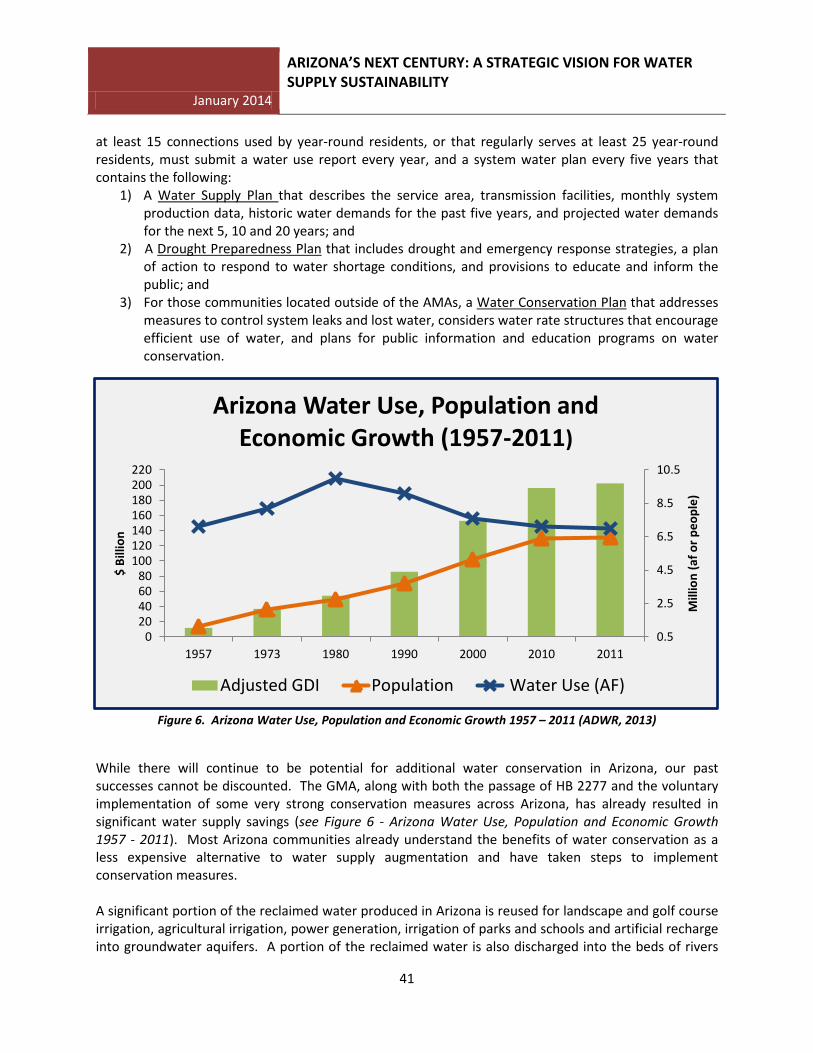
Figure 6. Arizona Water Use, Population and Economic Growth 1957 – 2011 (ADWR, 2013)
While there will continue to be potential for additional water conservation in Arizona, our past successes cannot be discounted. The GMA, along with both the passage of HB 2277 and the voluntary implementation of some very strong conservation measures across Arizona, has already resulted in significant water supply savings (see Figure 6 - Arizona Water Use, Population and Economic Growth 1957 - 2011). Most Arizona communities already understand the benefits of water conservation as a less expensive alternative to water supply augmentation and have taken steps to implement conservation measures. A significant portion of the reclaimed water produced in Arizona is reused for landscape and golf course irrigation, agricultural irrigation, power generation, irrigation of parks and schools and artificial recharge into groundwater aquifers. A portion of the reclaimed water is also discharged into the beds of rivers
0.5
2.5
4.5
6.5
8.5
10.5
020406080
100120140160180200220
1957 1973 1980 1990 2000 2010 2011
Mill
ion
(af o
r peo
ple)
$ Bi
llion
Arizona Water Use, Population and Economic Growth (1957-2011)
Adjusted GDI Population Water Use (AF)
January 2014
ARIZONA’S NEXT CENTURY: A STRATEGIC VISION FOR WATER SUPPLY SUSTAINABILITY
42
and streams, benefiting the environment by providing habitat for wildlife and adding aesthetic and economic value to Arizona’s landscape. While these benefits are important locally and notable, there may be additional opportunities to further leverage these locally available supplies to replace existing uses of limited groundwater and surface water supplies, while maintaining or enhancing our natural ecosystems. A 1989 Arizona Supreme Court Decision, Arizona Public Service Company v. Long31 held that reclaimed water is owned by the entity that produces it. The Court ruled that until reclaimed water is returned to the system as surface water or groundwater, it has the legal character of neither surface water nor groundwater and, therefore, a treatment plant operator that produces reclaimed water is free to use it without regard to the laws governing surface water and groundwater. This ruling creates a strong incentive for reuse by allowing those who generate reclaimed water to maintain the right to reuse or market that water. Currently, Arizona, along with California, Florida, and Texas, leads the nation in utilization of reclaimed water32. Increased utilization of reclaimed water is not without challenges. For example, although the Arizona Department of Environmental Quality (ADEQ) administers a comprehensive regulatory program governing the safe use of reclaimed water, public perception of water quality limitations still remains a significant obstacle for water managers. Developing a strong recycled water program must appropriately address public health and safety concerns and the significant capital and operating costs associated with reuse infrastructure. Increased utilization of this supply is anticipated to be one of the least-cost alternatives available to Arizona to meet local water supply imbalances. Full utilization of this locally available supply has the potential to reduce future water supply imbalances by more than 50 percent in the year 2110. In order to provide a long-term sustainable water supply for the citizens throughout the State, water managers must address the challenge of long-held public perceptions and, while protecting public health and welfare, remove regulatory barriers to ensure Arizona’s continued economic and environmental viability into the future. Summary Arizona’s water management history not only highlights the motivation and vision that our past leaders have exhibited, but also the time, effort, steadfastness and political will it took to develop the water management programs and water supply projects that are the foundation of our vibrant economy and quality of life. It took nearly 50 years to secure Arizona’s Colorado River entitlement and achieve deliveries of CAP water to Central Arizona. It took over 70 years of sometimes confusing and inconsistent court rulings before the Arizona Legislature proactively and meaningfully addressed groundwater management for the benefit of Arizonans and passed the Groundwater Management Act in 1980. However, and more importantly, this history underscores Arizona’s standing as a State that aggressively secures, delivers, protects and manages its water supplies, creating a viable and economically stable environment in which to live and do business. Arizona’s future as an economic leader in the Southwestern US will depend on this same determination, tenacity and the willingness to do what it takes to protect and develop its water supplies for its current and future citizens. 31 160 Ariz. 429, 773 P.2d 988 (1989) 32 Water and Wastes Digest @ http://www.wwdmag.com/EPA-Releases-Updated-Version-of-Guidelines-fo-Water-Reuse-article6636


![ARIZONA’S NEXT CENTURY: A STRATEGIC VISION FOR … · January 2014 [ARIZONA’S NEXT CENTU RY: A STRATEGIC VISION FOR WATER SUPPLY SUSTAINABILITY] 9 EXECUTIVE SUMMARY Arizona’s](https://static.fdocuments.in/doc/165x107/5b1861b57f8b9a37258bd992/arizonas-next-century-a-strategic-vision-for-january-2014-arizonas-next.jpg)