Arid Region Landforms and Eolian Processes 18 CHAPTER 18 • ARID REGION LANDFORMS AND EOLIAN...
25
18 Arid Region Landforms and Eolian Processes In most deserts, running water operates only occasionally, so it may seem odd that water rather than wind is the chief landforming agent in dry regions. How can this be? What features in arid regions are produced predominantly by the action of flowing water? Stream channels in desert areas are often quite different from those in humid regions. What are some of those differences? What combination of factors causes these differences? A variety of landforms in many deserts today could not have been created under present conditions of aridity; they are evidence of landscapes formed under earlier, wetter climatic conditions. What is some landform evidence of climatic change in deserts? How might the most recent cooler, wetter period experienced by midlatitude deserts be associated with glaciation? Over most land surfaces the wind exerts little influence on land- form development, but under certain circumstances it can be an important geomorphic agent. Why is wind so limited as a major agent in landform development? Under what conditions and in what environments is the wind an important agent in shaping the land? Sand dunes, and the landscapes that they exist in, are often fragile environments that require protection from certain human activities. Why are these environments fragile, and why is it important to protect them? What measures can be taken to minimize erosion, soil loss, and environmental degradation in sand dune areas? ■ ■ ■ ■ ■ ■ ■ ■ ■ ■ CHAPTER PREVIEW B ecause of their low amounts of precipitation, arid region landscapes look quite different from those of other climatic environments in many ways. The limited water supply restricts rock weathering as well as the amount of vegetation present. Without extensive vegetation to hold weathered rock matter (regolith) in place, the weathered rock particles that are produced are often stripped away when storms do occur. As a result, while hillslopes in humid regions tend to be rounded and mantled by soil, mountains and hill slopes in arid regions are generally angular, with extensive, barren exposures of bedrock. Desert lowlands may be filled in with sediments eroded from uplands, or they may consist of just a thin cover of sediments overlying rock strata. Many desert landscapes have a majestic beauty—a fact underscored by the frequent use of desert locations by filmmakers throughout the history of movie making. One reason desert scenery is so striking is that desert landscapes often display, in stark beauty, the colors, characteristics, and structure of the rocks that make up the area. The desert’s barrenness reveals considerable evidence about landforms and geomorphic processes that is much more difficult to observe in humid environments, with their extensive cover of soil and vegetation. Much of our understanding of how landscapes and landforms develop in a wide variety Opposite: Joshua Tree National Park, in the arid climate of California’s Mojave Desert, features a distinctive landscape of fractured granite hills and boulders. J. Petersen ▼ 491
Transcript of Arid Region Landforms and Eolian Processes 18 CHAPTER 18 • ARID REGION LANDFORMS AND EOLIAN...

18Arid Region Landforms and Eolian Processes
In most deserts, running water operates only occasionally, so it may seem odd that water rather than wind is the chief landforming agent in dry regions.
How can this be?What features in arid regions are produced predominantly by the action of fl owing water?
Stream channels in desert areas are often quite different from those in humid regions.
What are some of those differences?What combination of factors causes these differences?
A variety of landforms in many deserts today could not have been created under present conditions of aridity; they are evidence of landscapes formed under earlier, wetter climatic conditions.
What is some landform evidence of climatic change in deserts?How might the most recent cooler, wetter period experienced by midlatitude deserts be associated with glaciation?
Over most land surfaces the wind exerts little infl uence on land-form development, but under certain circumstances it can be an important geomorphic agent.
Why is wind so limited as a major agent in landform development?Under what conditions and in what environments is the wind an important agent in shaping the land?
Sand dunes, and the landscapes that they exist in, are often fragile environments that require protection from certain human activities.
Why are these environments fragile, and why is it important to protect them?What measures can be taken to minimize erosion, soil loss, and environmental degradation in sand dune areas?
■
■
■
■
■
■
■
■
■
■
CHAPTER PREVIEW
B ecause of their low amounts of precipitation, arid
region landscapes look quite different from those
of other climatic environments in many ways. The limited
water supply restricts rock weathering as well as the amount
of vegetation present. Without extensive vegetation to hold
weathered rock matter (regolith) in place, the weathered
rock particles that are produced are often stripped away
when storms do occur. As a result, while hillslopes in humid
regions tend to be rounded and mantled by soil, mountains
and hill slopes in arid regions are generally angular, with
extensive, barren exposures of bedrock. Desert lowlands
may be filled in with sediments eroded from uplands, or
they may consist of just a thin cover of sediments overlying
rock strata.
Many desert landscapes have a majestic beauty—a fact
underscored by the frequent use of desert locations by
filmmakers throughout the history of movie making. One
reason desert scenery is so striking is that desert landscapes
often display, in stark beauty, the colors, characteristics, and
structure of the rocks that make up the area. The desert’s
barrenness reveals considerable evidence about landforms
and geomorphic processes that is much more difficult to
observe in humid environments, with their extensive cover
of soil and vegetation. Much of our understanding of
how landscapes and landforms develop in a wide variety
Opposite: Joshua Tree National Park, in the arid climate of California’s Mojave Desert, features a distinctive landscape of fractured granite hills and boulders.J. Petersen
▼
491
55061_18_Ch18_p490_521 pp2.indd 49155061_18_Ch18_p490_521 pp2.indd 491 6/7/08 5:22:09 PM6/7/08 5:22:09 PM
C H A P T E R 1 8 • A R I D R E G I O N L A N D F O R M S A N D E O L I A N P R O C E S S E S492
of environments has come from important studies and scientific explorations conducted in desert regions.
Although the wind plays an important role in arid region geomorphology, you may be surprised to learn that, overall, running water does more geomorphic work than the wind does in arid regions. Wind erosion is mainly confined to picking up fine, dust-sized (silt and clay) particles from desert regions and to dislodging loose rock fragments of sand-sized materials. Still, we tend to associate arid environments with eolian (wind) geo-morphic processes because of the notable accumulations of wind-deposited sediment displayed in some desert areas, usually in the form of sand dunes. With its sparse vegetation and other envi-ronmental characteristics, eolian geomorphology reaches its opti-mum in arid environments. However, because the air has a much lower density than water, even in deserts the geomorphic work of the wind is outmatched by fluvial geomorphic processes. We should understand, too, that eolian processes and landforms are not confined to arid regions; they are also conspicuous in many coastal areas and in any area where loose sediments are frequently exposed to winds strong enough to move them.
Surface Runoff in the DesertLandforms, rather than vegetation, typically dominate desert scen-ery. The precipitation and evaporation regimes of an arid climate result in a sparse cover of vegetation and in addition, because many weathering processes require water, relatively low rates of weathering. With low weathering rates, insufficient vegetation to break the force of raindrop impacts, and a lack of extensive plant root networks to help hold rock fragments in place, a blanket of moisture-retentive soil cannot accumulate on slopes. Soils tend to be thin, rocky, and discontinuous. This absence of a continu-ous vegetative and soil cover gives desert landforms their unique character. Under these surface conditions of very limited inter-ception and low permeability, much of the rain that falls in the desert quickly becomes surface runoff available to perform fluvial geomorphic work. With little to hold them in place, any grains of rock that have been loosened by weathering may be swept away in surface runoff produced by the next storm. Ironically, although desert landscapes strongly reflect a deficiency of water, the effects of running water are widely evident on slopes as well as in valley bottoms ( ● Fig. 18.1). Where vegetation is sparse, running water, when it is available, is extremely effective in shaping the land.
Desert climates characteristically receive small amounts of precipitation and are subjected to high rates of potential evapo-transpiration. In exceptional circumstances, years may pass with-out any rain in certain desert areas. Most desert locations, however, receive some precipitation each year, although the frequency and amount are highly unpredictable. Rains that do fall are often brief and limited in their spatial coverage, but they can also be quite intense. While times of rainfall are short, unreliable, and difficult to predict, potential evapotranspiration remains high throughout the year in most arid regions. The most important impact of rain on landform development in deserts is that when rainfall does oc-cur, much of it falls on impermeable surfaces, producing intense
runoff, generating flash floods, and operating as a powerful agent of erosion.
The visible evidence of water as a geomorphic agent in arid regions stems not only from the climate of those areas today, but also from past climates. Paleogeographic studies reveal that most deserts have not always had the arid climates that exist today. Geomorphologists studying arid regions have found certain land-forms that are incompatible with the present climate, and they attribute these features to the work of water under earlier, wetter climates. A great majority of desert areas were wetter at intervals in the past. For midlatitude and subtropical deserts, the most re-cent major wet period was during the Pleistocene Epoch. While glaciers were advancing in high latitudes and in high-elevation mountain regions during the Pleistocene, precipitation was also greater than it is today in those basins, valleys, and plains of the middle and subtropical latitudes that are now desert areas. At the same time, cooler temperatures for these regions meant that they also experienced lower evaporation rates. In many of today’s des-erts, evidence of past wet periods includes deposits and wave-cut shorelines of now-extinct lakes ( ● Fig. 18.2) and immense can-yons occupied by streams that are now too small to have eroded such large valleys.
Running water is a highly effective agent of landform devel-opment in deserts even though it operates only occasionally. In most desert regions, running water is active just during and shortly after rainstorms. Desert streams, therefore, are typically ephem-eral channels, containing water only for brief intervals. Ephemeral stream channels are exposed and dry the rest of the time. In con-trast to perennial channels, which flow all year and are typical of hu-mid environments, ephemeral streams do not receive seepage from groundwater to sustain them between episodes of surface runoff. Ephemeral streams instead generally lose water to the groundwa-ter system through infiltration into the channel bed. Because of the low weathering rates in desert environments, most arid region
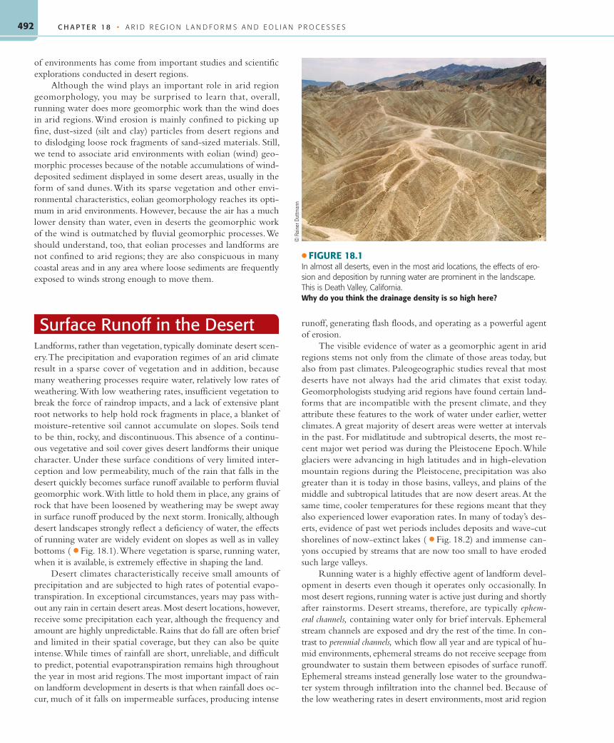
● FIGURE 18.1In almost all deserts, even in the most arid locations, the effects of ero-sion and deposition by running water are prominent in the landscape. This is Death Valley, California.Why do you think the drainage density is so high here?
© R
aine
r Dut
tman
n
55061_18_Ch18_p490_521 pp2.indd 49255061_18_Ch18_p490_521 pp2.indd 492 6/7/08 5:22:10 PM6/7/08 5:22:10 PM

493
streams receive an abundance of coarse sediment that they must transport as bed load. As a result, braided channels, in which mul-tiple threads of flow split and rejoin around temporary deposits of coarse-grained sediments, are common in deserts ( ● Fig. 18.3).
Unlike the typical situation for humid region streams, many desert streams undergo a downstream decrease, rather than increase, in discharge. A discharge decrease occurs for two major reasons: (1) water losses by infiltration into the gravelly stream
● FIGURE 18.2Many desert basins in Nevada, Utah, and California have remnant shorelines that were created by wave action from lakes they contained during the Pleistocene. The linear feature extending across this hillslope in Utah is a shoreline from one of these ancient lakes.What can we learn about climate change from studying these relict lake features?
D. S
ack
D. S
ack
● FIGURE 18.3This braided stream in Canyon de Chelly National Monument near Chinle, Arizona, splits and rejoins multiple times as it works to carry its extensive bed load of coarse sand.Why do you think the number and position of the multiple channels can change rapidly?
S U R FA C E R U N O F F I N T H E D E S E R T
55061_18_Ch18_p490_521 pp2.indd 49355061_18_Ch18_p490_521 pp2.indd 493 6/7/08 5:22:11 PM6/7/08 5:22:11 PM

C H A P T E R 1 8 • A R I D R E G I O N L A N D F O R M S A N D E O L I A N P R O C E S S E S494
channel accumulate downstream, and (2) evaporation losses in-crease downstream due to warmer temperatures at lower eleva-tions. As a result of the diminishing discharge, many desert streams terminate before reaching the ocean. The same mountains that contribute to aridity through the rain-shadow effect can ef-fectively block desert streams from flowing to the sea. Without sufficient discharge to reach ultimate base level, desert streams terminate in depressions in the continental interior where they commonly form shallow, ephemeral lakes. Ephemeral lakes evap-orate and disappear and then reappear when rain provides another episode of adequate inflow. During the cooler and wetter times of the Pleistocene Epoch, many closed basins in now-arid regions were filled with considerable amounts of water that in some cases formed large perennial freshwater lakes instead of the shallow ephemeral lakes that they contain today.
Where surface runoff drains into closed desert basins, sea level does not govern erosional base level as it does for streams that flow into the ocean and thereby attain exterior drainage. Desert drainage basins characterized by streams that terminate in interior depressions are known as basins of interior drainage ( ● Fig. 18.4);
such streams are controlled by a regional base level instead of ultimate base level. When sedimentation raises the elevation of the desert basin floor located at the stream’s terminus, the stream’s base level rises, which causes a decrease in the stream’s slope, velocity, and energy. If tectonic activity lowers the basin floor, the regional base level is depressed, which may lead to re-juvenation of the desert stream. Tectonism has even created some desert basins of interior drainage with floors below sea level, as in Death Valley, California, the Dead Sea Basin in the Middle East, the Turfan Basin in western China, and Australia’s Lake Eyre (see Map Interpretation: Desert Landforms).
Many streams found in deserts originate in nearby humid re-gions or in cooler, wetter mountain areas adjacent to the desert. Even these, however, rarely have sufficient discharge to sustain flow across a large desert ( ● Fig. 18.5). With few tributaries and virtu-ally no inflow from groundwater, stream water losses to evapora-tion and underground seepage are not replenished. In most cases, the flow dwindles and finally disappears. The Humboldt River in Nevada is an outstanding example; after rising in the mountains of central Nevada and flowing 465 kilometers (290 mi), the river
● FIGURE 18.4The Sierra Nevada (across entire upper part of photo) poses a topographic barrier to streams on its rain-shadow side (lower part of photo) and did so even during the wetter times of the Pleistocene so that few flowed to the sea. The other streams filled depressions to form lakes, most of which are completely dry today. This image, oriented with north to the right, shows the bed of Owens Lake (large white area in photo center), which shrank because of climate change and then desiccated when its waters were diverted to urban areas in Southern California. A small amount of moisture (elongated dark zones) occupied part of the dry lake bed when the photo was taken.
NAS
A/Ea
rth O
bser
vatio
ns L
ab/J
ohns
on S
pace
Cen
ter
55061_18_Ch18_p490_521 pp2.indd 49455061_18_Ch18_p490_521 pp2.indd 494 6/7/08 5:22:13 PM6/7/08 5:22:13 PM

495
disappears into the Humboldt Basin, a closed depression. Only a few large rivers that originate in humid uplands have sufficient volume to survive the long journey across hundreds of kilome-ters of desert to the sea ( ● Fig. 18.6). Called exotic streams, the rivers that successfully traverse the desert erode toward a base level governed by sea level and provide drainage that is external to the arid region. Classic examples of exotic streams include the Nile (Egypt and Sudan), Tigris-Euphrates (Iraq), Indus (Pakistan), and Murray (Australia) Rivers. Under natural conditions, the Colorado River of the United States and Mexico would reach ultimate base level at the head of the Gulf of California most of the time, but because of huge water withdrawals from the river by people, in actuality, it rarely flows all the way to the gulf.
Water as a Geomorphic Agent in Arid Lands
When rain falls in the desert, sheets of water run down unpro-tected slopes, picking up and moving sediment. Dry channels quickly change to flooding streams. The material removed by runoff and surface streams is transported, just as in humid lands, until flow velocity decreases sufficiently for deposition to occur. Eventually these streams disappear when seepage and evaporation losses exceed their discharge. Huge amounts of sediment can be deposited along the way as a stream loses volume and velocity. The processes of erosion, transportation, and deposition by run-ning water are essentially the same in both arid and humid lands. However, the resulting landforms differ because of the sporadic nature of desert runoff, the lack of vegetation to protect surface
materials against rapid erosion, and the common occurrence of streams that do not reach the sea.
Arid Region Landforms of Fluvial ErosionAmong the most common desert landforms created by surface runoff and erosion are the channels of ephemeral streams. Known as washes or arroyos in the southwestern United States, barran-cas in Latin America, and wadis in North Africa and Southwest Asia, these channels usually form where rushing surface waters cut into unconsolidated alluvium ( ● Fig. 18.7). These typically grav-elly, braided channels are prone to flash floods, which makes them potentially very dangerous sites. Though it may sound strange, many people have drowned in the desert—during flash floods.
In areas of weak, easily eroded clays or shales, rapid ero-sion from surface runoff can produce a dense network of barren
● FIGURE 18.5A stream flows through a deep gorge in the Atlas Mountains of Morocco. This is the arid, rain-shadow side of the mountains, facing the Sahara. This stream loses water by infiltration and evaporation and disappears into the Sahara. Note the steeply dipping, folded rocks of the Atlas and the thin line of vegetation along the stream channel.Was the gorge eroded by the stream with this amount of flow? If not, what factors might have produced more discharge to erode the deep canyon?
J. P
eter
sen
● FIGURE 18.6A false-color satellite image of the Nile River meandering across the Sahara in Egypt. The irrigated croplands that appear dark red contrast with the lighter tones of the barren desert terrain. The Nile is an exotic stream. Its headwaters are in the wetter climates of the Ethiopian High-lands and lakes in the East African Rift Zone, which support its northward flow across the Sahara to the Mediterranean Sea.
NAS
A
W AT E R A S A G E O M O R P H I C A G E N T I N A R I D L A N D S
55061_18_Ch18_p490_521 pp2.indd 49555061_18_Ch18_p490_521 pp2.indd 495 6/7/08 5:22:14 PM6/7/08 5:22:14 PM

C H A P T E R 1 8 • A R I D R E G I O N L A N D F O R M S A N D E O L I A N P R O C E S S E S496
slopes and ridges dissected by a maze of steep, dry gullies and ravines. Early fur trap-pers in the Dakotas called such areas “bad lands to cross” ( ● Fig. 18.8). The phrase stuck, and those regions are still called the Badlands, while that type of rugged, bar-ren, and highly dissected terrain is termed badlands topography. Badlands topography has an extremely high drainage density, de-fined as the length of stream channels per unit area of the drainage basin. Besides the Dakotas, extensive badlands can be seen in Death Valley National Park in California, Big Bend National Park in Texas, and south-ern Alberta, Canada. Badlands generally do not form naturally in humid climates be-cause the vegetation there slows runoff and erosion, leading to lower drainage densities. Removing the vegetation from clay or shale areas by overgrazing, mining, or logging, however, can cause badlands topography to develop even in humid environments.
A plateau is an extensive, elevated re-gion with a fairly flat top surface. Plateaus
● FIGURE 18.7This dry streambed, or wash, has a channel bed of coarse alluvium and conveys water only during and slightly after a rainstorm.Why would this desert stream channel have a high risk for flash floods?
D. S
ack
● FIGURE 18.8In badlands, such as these in South Dakota, impermeable clays that lack a soil cover produce rapid runoff, leading to intensive gully erosion and a high drainage density.Was this rugged terrain named appropriately?
Copy
right
and
pho
togr
aph
by D
r. Pa
rvin
der S
. Set
hi
55061_18_Ch18_p490_521 pp2.indd 49655061_18_Ch18_p490_521 pp2.indd 496 6/7/08 5:22:16 PM6/7/08 5:22:16 PM

497
are generally dominated by a structure consisting of horizon-tal rock layers. Many striking plateaus exist in the deserts and semiarid regions of the world. An excellent example in the United States is the Colorado Plateau, centered on the Four Corners area of Arizona, Colorado, New Mexico, and Utah. In tectonically uplifted desert plateau regions such as this, streams and their tributaries respond to uplift by cutting narrow, steep-sided canyons. Where the canyon walls consist of horizon-tal layers of alternating resistant and erodible rocks, differential weathering and erosion exert a strong influence on the canyon walls. Canyons in these areas tend to have stair-stepped walls, with near-vertical cliffs marking the resistant layers (ordinarily sandstone, limestone, or basalt) and weaker rocks (often shales) forming the slopes. The distinctive walls of the Grand Canyon have this appearance, which exposes the structure of horizon-tal rock layers of varying thickness and resistance ( ● Fig. 18.9). The rim of the Grand Canyon is a flat-topped cliff made of a caprock, a term that refers to a resistant horizontal layer that forms (caps) the top of a landform.
Caprocks top plateaus and constitute canyon rims, but they also form the summits of other, smaller kinds of flat-topped land-forms that, although they are found in many climate regions, are most characteristic of deserts. Weathering and erosion will even-tually reduce the extent of a caprock until only flat-topped, steep-sided mesas remain (mesa means “table” in Spanish). A mesa has a smaller surface area than a plateau and is roughly as broad across as it is tall. Mesas are relatively common landscape features in the Colorado Plateau region. Through additional erosion of the caprock from all sides, a mesa may be reduced to a butte, which is a similar, flat-topped erosional remnant but with a smaller sur-face area than a mesa ( ● Fig. 18.10). Mesas and buttes in a land-scape are generally evidence that uplift occurred in the past and that weathering and erosion have been extensive since that time. Variations in the form of the slope extending down the sides of buttes, mesas, and plateaus are related to the height of the cliff at the top, which is controlled by the thickness of the caprock in comparison to the size of landform feature. Monument Valley, in the Navajo Tribal Reservation on the Utah–Arizona state line, is
an exquisite example of such a landscape formed with a caprock that is particularly thick, contributing to the distinctive scenery ( ● Fig. 18.11). Many famous west-ern movies have been filmed in Monument Valley and in nearby areas of the Colorado Plateau because of the striking, colorful, and photogenic desert landscape.
Sheet wash and gully development generally accom-plish extensive erosion of mountainsides and hillslopes fringing a desert basin or plain. Particularly in desert re-gions with exterior drainage or a sizable trunk stream on the basin or plain, this fluvial action, aided by weather-ing, can lead to the gradual erosional retreat of bedrock slopes. This retreat of the steep mountain front can leave behind a more gently sloping surface of eroded bedrock, called a pediment ( ● Fig. 18.12). Characteristically in desert areas, there tends to be a sharp break in slope be-tween the base of steep hills or mountains, which rise at angles of 20 to 30º or steeper, and the gentle pediment, whose slope is usually only 2 to 7º. Resistant knobs of the bedrock comprising the pediment may project up above the surface on some pediments. These resistant knobs are referred to as inselbergs (from German: insel, island; berg, mountain).
Geomorphologists do not agree on exactly how pediments are formed, perhaps because dif-ferent processes may be respon-sible for their formation in dif-ferent regions. However, there is general agreement that most pediments are erosional surfaces created or partially created by the action of running water. In some areas, weathering, perhaps when the climate was wetter in the past, may also have played a strong role in the development of pediments.
Mesa ButtePlateau
● FIGURE 18.10Plateaus, mesas, and buttes are developed through weathering and erosion in areas of horizontal rock layers with a resistant caprock. An excellent example of this terrain is the Colorado Plateau of Arizona, Colorado, New Mexico, and Utah.
● FIGURE 18.9The earliest European American explorers of the Grand Canyon took along an artist to record the geomorphology of the canyon, here beautifully shown in great detail. Aridity creates an environment where the bare rocks are exposed to our view; differential weathering and erosion give the stair-stepped quality to the walls of the Grand Canyon.
USGS
W AT E R A S A G E O M O R P H I C A G E N T I N A R I D L A N D S
55061_18_Ch18_p490_521 pp2.indd 49755061_18_Ch18_p490_521 pp2.indd 497 6/7/08 5:22:20 PM6/7/08 5:22:20 PM

C H A P T E R 1 8 • A R I D R E G I O N L A N D F O R M S A N D E O L I A N P R O C E S S E S498
Arid Region Landforms of Fluvial DepositionDeposition is as important as erosion in creating landform features in arid regions, and in many areas sedimentation by water does as much to level the land as does erosion. Many desert areas have wide expanses of alluvium deposited either in closed basins or at the base of mountains by streams as they lose water in the arid en-vironment. As the flow of a stream diminishes, so does its capacity—the amount of load it can transport. Most landforms developed by fluvial deposition in arid lands are not exclusive to desert regions
but are particularly common and visible in dry environments due to their thin soil and sparse vegetative cover.
Alluvial Fans Where streams, particu-larly ephemeral (sporadic) or intermittent (seasonal) ones, flow out of uplands through narrow canyons and onto open plains, their channels may flare out to become wide and shallow. Because stream discharge (Q) equals channel cross-sectional width (w) and depth (d ) multiplied by flow velocity (v) (Q = wdv), the increase in width causes a decrease in flow velocity, reducing stream competence (maximum size of load) and stream capacity (maximum amount of load). Discharge also decreases as water seeps from the channel into coarse alluvium below. As a result, most of the sediment load carried by such streams is deposited along the base of the highlands.
Upstream of the mouth of the canyon, the channel is constrained by bedrock valley walls, but as it flows out of the canyon, the channel is free to not only widen but also shift its position laterally. Sediments are initially deposited just beyond the canyon mouth, building up the lowland area near the mountain front. Eventually this aggradation causes the channel to shift laterally where it begins to deposit and build up another zone close to the mountain front and adjacent to the first aggraded area. The canyon mouth serves as a pivot point an-choring the channel as it swings back and forth over the lowlands near the mountain front, leaving allu-vium behind. This creates a fan-shaped depositional landform, called an alluvial fan, in which deposi-tion takes place radially away from that pivot point, or fan apex ( ● Fig. 18.13).
An important characteristic of an alluvial fan is the sorting of sediment that typically occurs on its surface. Coarse sediments, like boulders and cobbles, are deposited near the fan apex where the stream first undergoes a decrease in competence and ca-pacity as it emerges from the confinement of the canyon. In part because of the large size of the clasts deposited there, the slope of an alluvial fan is steep-est at its apex and gradually diminishes, along with grain size, with increasing distance downstream
from the canyon mouth. In areas where the uplands generate de-bris flows rather than stream flows, debris flow fans or even mixed debris and alluvial fans are constructed instead of purely alluvial fans. Debris flow fans tend to be steeper than alluvial fans and do not display the same degree of downslope sorting shown by the fluvial counterpart.
Although they can be found in mountainous areas of almost any climate, alluvial fans are particularly common where ephemeral or intermittent streams laden with coarse sediment flow out of a mountainous region onto desert plains or into arid interior basins.
● FIGURE 18.11The caprock in Monument Valley, Arizona, is particularly thick and represents a rock layer that once covered the entire region. The prominent buttes are erosional remnants of that layer.Compare this photo to the diagram in Figure 18.10. How were these landforms produced?
Copy
right
and
pho
togr
aph
by D
r. Pa
rvin
der S
. Set
hi
● FIGURE 18.12Pediments are erosion surfaces cut into bedrock beyond the present mountain front in arid regions. Pediments most commonly occur in desert areas with exterior drainage that can remove a portion of the erosion products. At many locations, pediment surfaces are covered with a thin veneer of alluvium, and their gently sloping surface may be interrupted by resistant knobs of bedrock, called inselbergs, that stick up above the pediment surface.
Bedrock
Alluvial plain
Alluvialveneer
Streamchannel
Inselberg
Inselberg
Mountainfront
Pediment
55061_18_Ch18_p490_521 pp2.indd 49855061_18_Ch18_p490_521 pp2.indd 498 6/7/08 5:22:21 PM6/7/08 5:22:21 PM

499
In the western United States, alluvial fans are a major landform fea-ture in landscapes consisting of fault-block mountains and basins, as in the Great Basin of California, Nevada, and Utah ( ● Fig. 18.14). Here streams laden with sediment periodically rush from canyons cut into uplifted fault-block mountains and deposit their load in the adjacent desert basins. Everything else being equal, fans asso-ciated with larger drainage basins within the uplifted fault-block mountains tend to have greater area and be less steep than fans developed from streams draining smaller upland drainage basins.
Large, conspicuous alluvial fans develop in environmental set-tings like the Great Basin for several reasons. First, highland areas in desert regions are subject to intense erosion, primarily because of the low density of vegetative cover, steep slopes, and the oro-graphically intensified downpours that can occur over mountains. In addition, streams in arid regions typically carry a greater con-centration of sediment load (in comparison to the discharge) than comparable streams in more humid regions. As the streams flow from confined mountain canyons into desert basins, they deposit most of their coarse sediment near the canyon mouth. Flowing into the desert basin, their width increases, their depth and velocity decrease, and their volumes are significantly reduced through infil-tration into the alluvial channel bed. Not far from the canyon, the stream itself may disappear, or it may occasionally reach the desert basin floor where it deposits its remaining load, the silts and clays. Extensive alluvial fans are not as common in humid as in arid re-gions because most highland streams in moist climates are peren-nial and have sufficient flow to continue across adjacent lowlands.
Along the bases of mountains in arid regions, adjacent alluvial fans may become so large that they join together along their sides to form a continuous ramplike slope of alluvium called a bajada ( ● Fig. 18.15). A bajada consists of adjacent alluvial fans that have coalesced to form an “apron” of alluvium along the mountain base.
Where extensive fans coalesce over very wide areas, they form a piedmont alluvial plain, like the area surrounding Phoenix, Arizona ( ● Fig. 18.16).
Piedmont alluvial plains generally have rich soils and the potential to be transformed into pro-ductive agricultural lands. The major obstacle is inadequate water supply to grow crops in an arid environment. In many world regions, arid allu-vial plains are irrigated with water diverted from mountain areas or obtained from reservoirs on ex-otic streams. The alluvial farmlands near Phoenix are a good example, producing citrus fruits, dates, cotton, alfalfa, and vegetables.
Where a veneer of alluvium has been depos-ited on a pediment, the land surface may closely resemble a water-deposited alluvial fan. In some situations, it may not be possible to determine the existence of an underlying pediment without either excavating through the surface alluvium or finding the erosional pediment surface exposed in the walls of washes or gullies. In locations where no exten-sive pediment exists, alluvial deposits beneath the fans can be tens or even hundreds of meters thick. In contrast, the layer of alluvium overlying a pedi-ment is only a relatively thin layer, no more than a few meters deep and sometimes much less.
Playas Desert basins of interior drainage surrounded by moun-tains are sometimes called bolsons. Most bolsons were formed by faulting that created basins between uplifted mountains. The low-est part of most bolsons is occupied by a landform called a playa (in Spanish: playa, beach or shore), which is the fine-grained bed of an ephemeral lake. Occasionally, large rainfall (or snowmelt) events or wet seasons cover the playa with a very shallow body of water, called a playa lake. Direct precipitation onto the playa, inflow from surface runoff, or discharge from the groundwater zone can contribute water to the playa lake. The playa lake may persist for a day or two or for several weeks ( ● Fig. 18.17). Wind blowing over the playa lake moves the shallow water, along with its suspended and dissolved load, around on the playa surface. This helps to fill in any low spots on the playa and contributes to mak-ing playas one of the flattest of all landforms on Earth. Playa lakes lose most of their water by evaporation to the desert air.
Although playas are very flat, considerable variation exists in the nature of playa surfaces. Playas that receive most of their water from surface runoff typically have a smooth clay surface, some-times called a clay pan, baked hard by the desert sun when it is dry but extremely gooey and slippery when wet. In contrast, salt-crust playas, also known as salt flats or salinas, receive much of their water from groundwater, are damp most of the time, and are encrusted with salt mineral deposits crystallizing out of the evapo-rating groundwater ( ● Fig. 18.18). Some salt-crust playas com-posed of an orderly sequence toward the lowest part of the playa of carbonates, sulfates, and chlorides (for example, calcite, gypsum, and halite, respectively) are the floors of desiccated, ancient lakes that occupied now-desert basins during the Pleistocene Epoch.
Playas are useful in several ways. For one, companies mine the rich deposits of evaporite minerals, including such important
● FIGURE 18.13Alluvial fans are constructed at the base of a mountain range. Where streams come out of confined canyons, they are free to widen, which causes a decrease in stream velocity, capacity, and competence. The apex of a fan lies at the mouth of the canyon or wash. Fans, such as this one in Death Valley, California, are particularly common landforms in the arid Basin and Range region of the western United States.How do alluvial fans differ from pediments?
Copy
right
and
pho
togr
aph
by D
r. Pa
rvin
der S
. Set
hi
W AT E R A S A G E O M O R P H I C A G E N T I N A R I D L A N D S
55061_18_Ch18_p490_521 pp2.indd 49955061_18_Ch18_p490_521 pp2.indd 499 6/7/08 5:22:23 PM6/7/08 5:22:23 PM

C H A P T E R 1 8 • A R I D R E G I O N L A N D F O R M S A N D E O L I A N P R O C E S S E S500
industrial chemicals as potassium chloride, sodium chloride, so-dium nitrate, and borates, that have been deposited in some playa beds. Also, the extensive, flat surfaces of some playas make them suitable as racetracks and airstrips. Utah’s famous Bonneville Salt Flats mark the bed of an extinct Pleistocene lake. The western portion of the Salt Flats, where world land-speed records are set,
still floods to a depth of 30 to 60 centimeters (1–2 ft) in the cool, wet, winter season. The hard, flat playa surface at Edwards Air Force Base, in California’s Mojave Desert, has served for many decades as a landing site for military aircraft and, in recent de-cades, for the space shuttle. These landings have occasionally been disrupted due to flooding of the playa.
● FIGURE 18.14Map of the Great Basin of the western United States showing major lakes that existed during glacial times. More than 100 lakes formed in the fault-block basins of this region during the Pleistocene Epoch.Why are there only a few remnant lakes in this region today?
55061_18_Ch18_p490_521 pp2.indd 50055061_18_Ch18_p490_521 pp2.indd 500 6/7/08 5:22:24 PM6/7/08 5:22:24 PM

501
Wind as a Geomorphic AgentOn a worldwide basis, wind is less effective than running water, waves, groundwater, moving ice, or mass movement in accom-plishing geomorphic work. Under certain circumstances, however, wind can be a significant agent in the modification of topography. Landforms—whether in the desert or elsewhere—that are created
by wind are called eolian (or aeolian) landforms, after Aeolus, the god of winds in classical Greek mythology ( ● Fig. 18.19). The three principal conditions necessary for wind to become an ef-fective geomorphic agent are a sparse vegetative cover, the presence of dry, loose materials at the surface, and a wind velocity that is high enough to pick up and move those surface materials. These three conditions occur most widely in arid regions and on beaches, although they are also found on or adjacent to exposed lake beds, areas of recent alluvial or glacial deposition, newly plowed fields, and overgrazed lands.
A dense vegetative cover reduces wind velocity near the surface by providing frictional resistance. It also prevents wind from being directed against the land surface and holds mate-rials in place with its root network. Without such a protective cover, fine-grained and sufficiently dry surface materials are subject to removal by strong gusts of wind. If surface particles are damp, they tend to adhere together in wind-resistant aggregates due to increased cohesion provided by the water. The arid conditions of deserts therefore make those regions most susceptible to wind erosion.
Eolian processes have many things in common with fluvial processes because air and water are both fluids. Some important contrasts also exist, however, due to fundamental dif-ferences between gases and liquids. For example, rock-forming materials cannot dissolve in air, as some can in water; thus air does not erode by corrosion or move load in solution. Other-wise, the wind detaches and transports rock fragments in ways comparable to flowing water, but it does so with less overall effectiveness because air has a much lower density than water. Another difference is that, compared to streams, the wind has fewer lateral or vertical limitations on movement. As a result, the dissemination of material by the wind can be more wide-spread and unpredictable than that by streams.
A principal similarity between the geomorphic proper-ties of wind and running water is that flow velocity controls their competence—that is, the size of particles each can pick up and carry. However, because of its low density, the com-petence of moving air is generally limited to rock fragments that are sand sized or smaller. Wind erosion selectively en-trains small particles, leaving behind the coarser and heavier particles that it is not able to lift. Like water-laid sediments, wind deposits are stratified according to changes in its veloc-ity although within a much narrower range of grain sizes than occurs with most alluvium.
Wind Erosion and TransportationStrong winds blow frequently in arid regions, whipping up loose surface materials and transporting them within turbulent air cur-rents. Wind erodes surface materials by two main processes. The first of these is deflation, which is similar to the hydraulic force
● FIGURE 18.15A bajada is formed when a series of alluvial fans coalesce, forming a continuous alluvial slope along the front of an eroding mountain range. This example is from Death Valley, California.Why would a series of alluvial fans have a tendency to eventually join to form a bajada?
Copy
right
and
pho
togr
aph
by D
r. Pa
rvin
der S
. Set
hi
● FIGURE 18.16A large desert alluvial plain in Arizona that is extensively urbanized.
NAS
A/Go
ddar
d Sp
ace
Flig
ht C
ente
r Sci
entif
ic V
isua
lizat
ion
Stud
io
W I N D A S A G E O M O R P H I C A G E N T
55061_18_Ch18_p490_521 pp2.indd 50155061_18_Ch18_p490_521 pp2.indd 501 6/7/08 5:22:27 PM6/7/08 5:22:27 PM

C H A P T E R 1 8 • A R I D R E G I O N L A N D F O R M S A N D E O L I A N P R O C E S S E S502
of running water. Deflation occurs when wind blow-ing fast enough or with enough turbulence over an area of loose sediment is able to pick up and remove small fragments of rock. The finest particles trans-ported by winds, clays and silts, are moved in suspen-sion, buoyed by vertical currents ( ● Fig. 18.20). Such particles essentially comprise a fine dust that will re-main in suspension as long as the strength of upward air currents exceeds the tendency of the particles to settle out to the ground due to the force of grav-ity. The sediments carried in suspension by the wind make up its suspended load. If the wind velocity sur-passes 16 kilometers (10 mi) per hour, surface sand grains can be put into motion. As with fluvial trans-portation, particles that are too large to be carried in eolian suspension are bounced along the ground as part of the bed load in the transportation process of saltation. When particles moving in eolian salta-tion, which are typically sand sized, bounce on the ground, they generally dislodge other particles that are then added to the wind’s suspended or saltating load. Even larger sand grains too heavy to be lifted into the air are pushed forward along the ground surface, in a process called surface creep. Grains with low saltation trajectories become organized into
small wave forms termed ripples. The velocity required for the wind to pick up and start to move a grain is greater than that re-quired to keep it moving, and this is primarily due to such surface factors as roughness and cohesion.
The second way that the wind erodes is by abrasion. Once the wind obtains some load, the impact of those wind-driven solid particles is more effective than the wind alone in dislodging and entraining other grains or for breaking off new fragments of rock. This process is analogous to abrasion that occurs with stream flow and the other geomorphic agents, but eolian abrasion operates on a much more limited scale. Most eolian abrasion is quite literally sandblasting, and quartz sand, which is common in many desert areas, can be a very effective abrasive agent in eolian processes. Yet sand grains are typically the largest size of clast that the wind can move, and they rarely are lifted higher than 1 meter (3 ft) above the surface. Consequently, the effect of this natural sandblast is limited to a zone close to ground level.
Where loose dust particles exist on the land surface, they will be picked up and carried in suspension by strong winds. The result is a thick, dark, swiftly moving dust cloud swirling over the land. Dust storms ( ● Fig. 18.21) can be so severe that visibility drops to nearly zero and almost all sunlight is blocked. They can also be highly destructive, removing layers of surface materials and depositing them elsewhere, sometimes in thick, choking new layers, all within a matter of a few hours. The infamous Dust Bowl era of the 1930s particularly impacted the southern Great Plains of the United States in this way when devastating dust storms were brought about by years of drought and poor agricultural practices. Sandstorms may occur in areas where sand is abun-dant at the surface. As previously noted, sand grains are larger and heavier than dust particles, thus most sandstorms are con-fined to a low level near the surface. Evidence of the restricted
Cour
tesy
She
ila B
razie
r
● FIGURE 18.17Badwater, in Death Valley, California. The playa surface, seen just behind the edge of the playa lake water, is the lowest elevation in North America at 86 meters (282 ft) below sea level. Badwater, the small lake, is fed by groundwater that flows down from the surrounding mountains into alluvial deposits under the surface of the basin. The water quickly evaporates in this extremely arid environment.Why was this small lake called Badwater?
● FIGURE 18.18This view of Death Valley shows deposits of salt left behind by evapora-tion primarily of groundwater derived from the surrounding mountains. Evaporation is accumulating salts in the mud in the foreground, creating the playa microtopography known as puffy ground.
J. P
eter
sen
55061_18_Ch18_p490_521 pp2.indd 50255061_18_Ch18_p490_521 pp2.indd 502 6/7/08 5:22:28 PM6/7/08 5:22:28 PM

503
height of desert sandstorms can be seen on vehicles that have traveled through the desert, as well as on fence posts, utility poles, and other structures. The pitting, gouging, and abrad-ing effects of natural sandblast are more damaging to the lower
portions of vehicles and other objects that were subjected to the abrasion.
Erosion by deflation can produce shallow depressions in a barren surface of unconsolidated materials. These depressions,
● FIGURE 18.19This view of sand dunes, again in Death Valley, shows how eolian processes can create a stunningly beautiful landscape.What makes the processes that formed these dunes so different from those that form alluvial fans?
Copy
right
and
pho
togr
aph
by D
r. Pa
rvin
der S
. Set
hi
● FIGURE 18.20Wind moves sediment in the transportation processes of suspension, saltation, and surface creep. Some of the bed load forms ripples, which can be seen moving forward when the wind is strong.Why are grains larger than sand not generally moved by the wind?
WindSuspension (dust)
Saltation
Surface creep
Ripples on sand surface
Surface creep
5
4
3
2
1
Cm In.2
1
Saltation
W I N D A S A G E O M O R P H I C A G E N T
55061_18_Ch18_p490_521 pp2.indd 50355061_18_Ch18_p490_521 pp2.indd 503 6/7/08 5:22:30 PM6/7/08 5:22:30 PM

C H A P T E R 1 8 • A R I D R E G I O N L A N D F O R M S A N D E O L I A N P R O C E S S E S504
which can vary in diameter from a few centimeters to a few kilometers, are called deflation hollows. Deflation hollows are particularly common in nonmountainous arid regions. They tend to collect rainwater and may hold water for a time, depending on permeability and evaporation rates. Thus deflation hollows, like bolsons, frequently contain playas. Many thousands of defla-tion hollows that contain playas occur in the semiarid southern High Plains of West Texas and eastern New Mexico in the United States. Often deflation hollows form at sites that were already ex-hibiting a slight depression or where vegetation cover has been breached by overgrazing, fire, and other means.
Deflation has traditionally been considered one of several possible factors that help to produce desert pavement (reg in North Africa, gibber in Australia), a close-fitting mosaic of gravel-sized stones that overlies a deposit of mostly finer grained sediments. Desert pavement is common in many arid regions, particularly in parts of the Sahara, interior Australia, the Gobi in central Asia, and the American Southwest. If deflation selectively removes the smaller particles (clays, silts, and possibly sands) from a desert surface of mixed particle sizes, the gravel-sized clasts left behind can form a concentration of stones at the surface overly-ing the mixed grain sizes below ( ● Fig. 18.22). Sheet wash (un-channelized running water) may contribute to the formation of desert pavement by selectively eroding only the fine-grained clasts from an area of mixed grain sizes. Research has also shown that pavements can form by eolian deposition, rather than erosion, of the fine-grained sediments found beneath the stony surface layer. Regardless of its origin, desert pavement is important for the protection it affords the finer material below the surface layer of gravel. Pavement formation stabilizes desert surfaces by prevent-ing continuous erosion. Unfortunately, off-road recreational ve-hicles can disrupt the surface stones and disturb this stability, thus damaging desert ecological systems.
Like deflation, eolian abrasion is also re-sponsible for creating interesting desert land-form features. Where the land surface is exposed bedrock, wind abrasion can polish, groove, or pit the rock surface and in some cases produces ventifacts, which are individual wind- fashioned rocks. A ventifact is a rock that has been trimmed back to a smooth slope on one or more sides by sandblast. Because of frictional effects at the surface, the ability of the wind to erode by abra-sion increases with increasing distance from the ground surface, at least up to a certain height. Thus, abrasion carves the windward side of a rock into a smooth, sloping surface, or face. Ventifacts subjected to multiple sand-transporting wind di-rections have multiple faces, called facets, which meet along sharp edges ( ● Fig. 18.23). Although not extremely common, ventifacts are plentiful in local areas where wind and surface rock con-ditions are ideal for their formation.
Another feature often attributed to wind abrasion is the pedestaled, or balanced, rock—commonly and incorrectly thought to form where eolian abrasion attacks the base of an in-dividual rock so that the larger top part appears
balanced on a thinner pedestal below. Actually, such forms result from various physical and chemical weathering processes in the damper environment at the base of an exposed rock and are not typically related to eolian abrasion ( ● Fig. 18.24).
Rates of eolian erosion in arid regions often reflect the strength and kinds of the exposed surface materials. Where eo-lian abrasion affects rocks of varying resistance, differential erosion etches away softer rocks faster than the more resistant rocks. Even in desert locations of extensive soft rock, such as shale, or semi-consolidated sediments, like ancient lake deposits, abrasion may not act in a uniform fashion over the entire exposure. A yardang is a wind-sculpted remnant ridge, often of easily eroded rock or semilithified sediments, left behind after the surrounding material
● FIGURE 18.21Dust storms occur when strong winds mobilize, erode, and suspend silt particles, picked up in areas of barren soil or alluvium. This is a dust storm in Texas during the “Dust Bowl” era of the 1930s.Can you suggest a continent that might be a source of major dust storms today?
NOA
A/Ge
orge
E. M
arsh
Alb
um
● FIGURE 18.22Some desert pavement may be created when the fine-grained fraction of a deposit of mixed grain sizes is removed by the wind or by sheet wash, leaving a lag of stones at the surface.Is desert pavement a surface indestructible by human activities? Why?
J. P
eter
sen
55061_18_Ch18_p490_521 pp2.indd 50455061_18_Ch18_p490_521 pp2.indd 504 6/7/08 5:22:31 PM6/7/08 5:22:31 PM
505
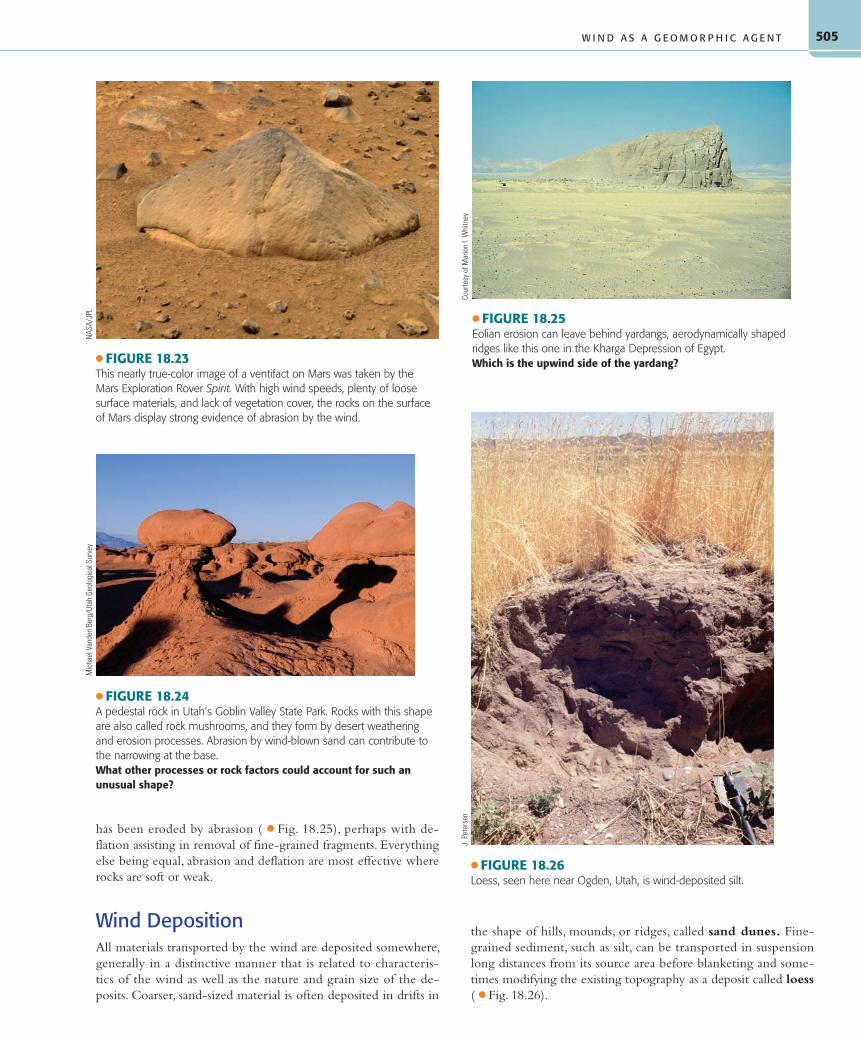
has been eroded by abrasion ( ● Fig. 18.25), perhaps with de-flation assisting in removal of fine-grained fragments. Everything else being equal, abrasion and deflation are most effective where rocks are soft or weak.
Wind DepositionAll materials transported by the wind are deposited somewhere, generally in a distinctive manner that is related to characteris-tics of the wind as well as the nature and grain size of the de-posits. Coarser, sand-sized material is often deposited in drifts in
the shape of hills, mounds, or ridges, called sand dunes. Fine-grained sediment, such as silt, can be transported in suspension long distances from its source area before blanketing and some-times modifying the existing topography as a deposit called loess ( ● Fig. 18.26).
● FIGURE 18.23This nearly true-color image of a ventifact on Mars was taken by the Mars Exploration Rover Spirit. With high wind speeds, plenty of loose surface materials, and lack of vegetation cover, the rocks on the surface of Mars display strong evidence of abrasion by the wind.
NAS
A/JP
L
● FIGURE 18.24A pedestal rock in Utah’s Goblin Valley State Park. Rocks with this shape are also called rock mushrooms, and they form by desert weathering and erosion processes. Abrasion by wind-blown sand can contribute to the narrowing at the base.What other processes or rock factors could account for such an unusual shape?
Mic
hael
Van
den
Berg
/Uta
h Ge
olog
ical
Sur
vey
● FIGURE 18.25Eolian erosion can leave behind yardangs, aerodynamically shaped ridges like this one in the Kharga Depression of Egypt.Which is the upwind side of the yardang?
Cour
tesy
of M
ario
n I.
Whi
tney
W I N D A S A G E O M O R P H I C A G E N T
● FIGURE 18.26Loess, seen here near Ogden, Utah, is wind-deposited silt.
J. P
eter
sen
55061_18_Ch18_p490_521 pp2.indd 50555061_18_Ch18_p490_521 pp2.indd 505 6/7/08 5:22:32 PM6/7/08 5:22:32 PM
C H A P T E R 1 8 • A R I D R E G I O N L A N D F O R M S A N D E O L I A N P R O C E S S E S506
Sand Dunes To many people, the word desert evokes the image of endless sand dunes, blinding sandstorms, a blazing sun, mirages, and an occasional palm oasis. Although these features do exist, particularly in Arabia and North Africa, most of the areas of the world’s deserts have rocky or gravelly surfaces, scrubby vegeta-tion, and few or no sand dunes. Nevertheless, sand dunes are cer-tainly the most spectacular features of wind deposition, whether they occur as seemingly endless dune regions, called sand seas (or ergs), as small dune fields, or as sandy ridges inland from a beach ( ● Fig. 18.27).
Dune topography is highly variable. For instance, dunes in the great sand seas of the Sahara and Arabia look like roll-ing ocean waves. Others have aerodynamic crescent forms. Eolian sand deposits can also form sand sheets, with no dune forma-tion at all. Research has shown that the specific type of dune that forms depends on the amount of sand available, the strength and direction of sand-transporting winds, and the amount of veg-etative cover. As wind that is carrying sand encounters surface obstacles or topographic obstructions that decrease its velocity, the sand is deposited and piles up in drifts. These sand piles also interfere with wind velocity and the sand-transporting capabili-ties of the wind, so the dunes grow larger until equilibrium is reached between dune size and the ability of winds to feed sand to the dune.
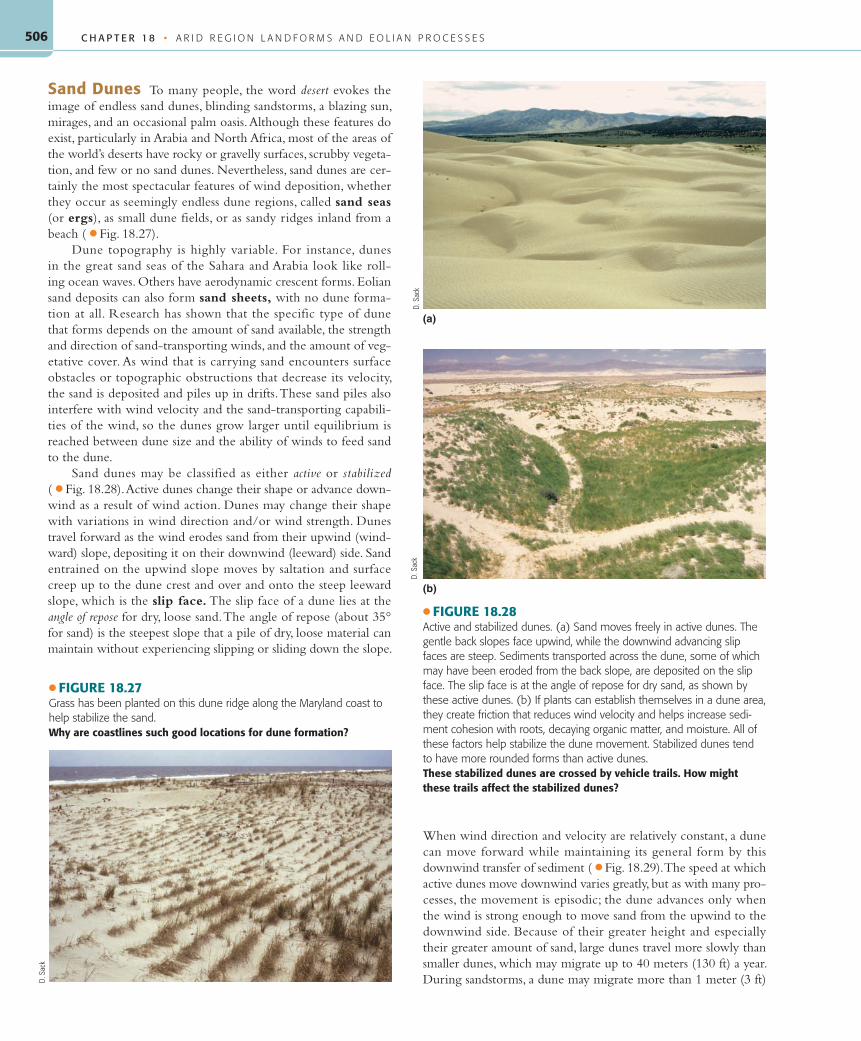
Sand dunes may be classified as either active or stabilized ( ● Fig. 18.28). Active dunes change their shape or advance down-wind as a result of wind action. Dunes may change their shape with variations in wind direction and/or wind strength. Dunes travel forward as the wind erodes sand from their upwind (wind-ward) slope, depositing it on their downwind (leeward) side. Sand entrained on the upwind slope moves by saltation and surface creep up to the dune crest and over and onto the steep leeward slope, which is the slip face. The slip face of a dune lies at the angle of repose for dry, loose sand. The angle of repose (about 35° for sand) is the steepest slope that a pile of dry, loose material can maintain without experiencing slipping or sliding down the slope.
When wind direction and velocity are relatively constant, a dune can move forward while maintaining its general form by this downwind transfer of sediment ( ● Fig. 18.29). The speed at which active dunes move downwind varies greatly, but as with many pro-cesses, the movement is episodic; the dune advances only when the wind is strong enough to move sand from the upwind to the downwind side. Because of their greater height and especially their greater amount of sand, large dunes travel more slowly than smaller dunes, which may migrate up to 40 meters (130 ft) a year. During sandstorms, a dune may migrate more than 1 meter (3 ft)
● FIGURE 18.27Grass has been planted on this dune ridge along the Maryland coast to help stabilize the sand.Why are coastlines such good locations for dune formation?
D. S
ack
● FIGURE 18.28Active and stabilized dunes. (a) Sand moves freely in active dunes. The gentle back slopes face upwind, while the downwind advancing slip faces are steep. Sediments transported across the dune, some of which may have been eroded from the back slope, are deposited on the slip face. The slip face is at the angle of repose for dry sand, as shown by these active dunes. (b) If plants can establish themselves in a dune area, they create friction that reduces wind velocity and helps increase sedi-ment cohesion with roots, decaying organic matter, and moisture. All of these factors help stabilize the dune movement. Stabilized dunes tend to have more rounded forms than active dunes.These stabilized dunes are crossed by vehicle trails. How might these trails affect the stabilized dunes?
(a)
(b)
D. S
ack
D. S
ack
55061_18_Ch18_p490_521 pp2.indd 50655061_18_Ch18_p490_521 pp2.indd 506 6/7/08 5:22:35 PM6/7/08 5:22:35 PM

507
in a single day. Some dunes are affected by seasonal wind reversals so that they do not advance, but the crest at the top moves back and forth annually under the influence of seasonally opposing winds.
Stabilized dunes maintain their shape and position over time. Vegetative cover normally stabilizes dunes. If the vegetation cover becomes breached on a stabilized dune, perhaps due to the effects of range animals or off-road vehicles, the wind can then remove some of the sand, creating a blowout. In places where plants, in-cluding trees, lie in the path of an advancing dune, the sand cover may move over and smother the vegetation. Where invading dunes and blowing sands are a problem, attempts are frequently made to plant grasses or other vegetation to stabilize the dunes, halting their advance. Vegetation can stabilize a sand dune if plants can
gain a foothold and send roots down to moisture deep within the dune ( ● Fig. 18.30). This task is difficult for most plants because the sand itself offers little in the way of nutrients and because of its high permeability and limited moisture.
One extensive area of stabilized dunes in North America is the Sand Hills of Nebraska. This region features large dunes that formed during a drier period between glacial advances in the Pleistocene Epoch. These impressive dunes are now stabilized by a cover of grasses ( ● Fig. 18.31). Similar stabilized dunes are found along the southern edge of the Sahara, where sand dunes that were active during drier conditions in the recent geologic past are now stabilized by vegetation. Both locations involve changes in climate that affected sand supply, wind patterns, and
moisture availability (see Map Interpretation: Eolian Landforms).
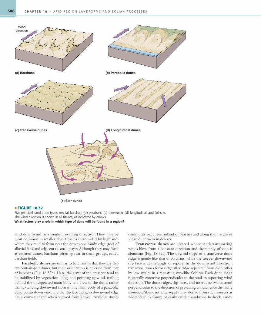
Types of Sand Dunes Sand dunes are classified according to their shape and their re-lationship to the wind direction. The different types are also related to the amount of available sand, which affects not only the size but also the shape of sand dunes.
Barchans are one kind of crescent-shaped dune ( ● Fig. 18.32a). The two arms of the cres-cent, called the dune’s horns, point downwind ( ● Fig. 18.33). The main body of the crescent lies on the upwind side of the dune. From the desert floor at its upwind edge, the dune rises as a gentle slope up which the sand moves un-til it reaches the highest point, or crest, of the dune and, just beyond that, the slip face at the angle of repose. The slip face is oriented per-pendicular to the barchan’s arms. The arms ex-tend downwind beyond the location of the slip face. Barchans form in areas of minimal sand supply where winds are strong enough to move
Effective wind direction
Direction of dunemovement
Saltatingsand grains
Upwind side
Previousslipfaces
Slipfaces are created asdune advances layer by layer
Slipface
Downwindside
● FIGURE 18.29Active dunes move downwind. The wind transports sand from the dune’s upwind side, up its back slope toward the sharp dune crest. The sand then slides down the steeper slip face on the downwind (leeward) side of the dune, causing the dune to advance, or migrate. Sand supply, dune size, wind speed, and duration of the wind are major factors controlling the speed of dune advance.Why does the inside of the migrating dune consist of former slip faces?
● FIGURE 18.30A sand dune advances into a vegetated area on the Oregon coast. In coastal dune regions, landscape change is common as dunes move inland and are subsequently invaded by plants.Explain how plants can stabilize dunes.
D. S
ack
● FIGURE 18.31The rolling grazing lands of the Sand Hills in central Nebraska were once a major region of active sand dunes.Why are these dunes no longer active today?
© D
avid
B. L
oope
/ Uni
vers
ity o
f Neb
rask
a
W I N D A S A G E O M O R P H I C A G E N T
55061_18_Ch18_p490_521 pp2.indd 50755061_18_Ch18_p490_521 pp2.indd 507 6/7/08 5:22:37 PM6/7/08 5:22:37 PM
C H A P T E R 1 8 • A R I D R E G I O N L A N D F O R M S A N D E O L I A N P R O C E S S E S508
sand downwind in a single prevailing direction. They may be most common in smaller desert basins surrounded by highlands where they tend to form near the downslope, sandy edge (toe) of alluvial fans, and adjacent to small playas. Although they may form as isolated dunes, barchans often appear in small groups, called barchan fields.
Parabolic dunes are similar to barchans in that they are also crescent-shaped dunes, but their orientation is reversed from that of barchans (Fig. 18.32b). Here, the arms of the crescent tend to be stabilized by vegetation, long, and pointing upwind, trailing behind the unvegetated main body and crest of the dune, rather than extending downwind from it. The main body of a parabolic dune points downwind, and the slip face along its downwind edge has a convex shape when viewed from above. Parabolic dunes
commonly occur just inland of beaches and along the margin of active dune areas in deserts.
Transverse dunes are created where sand-transporting winds blow from a constant direction and the supply of sand is abundant (Fig. 18.32c). The upwind slope of a transverse dune ridge is gentle like that of barchans, while the steeper downwind slip face is at the angle of repose. In the downwind direction, transverse dunes form ridge after ridge separated from each other by low swales in a repeating wavelike fashion. Each dune ridge is laterally extensive perpendicular to the sand-transporting wind direction. The dune ridges, slip faces, and interdune swales trend perpendicular to the direction of prevailing winds, hence the name transverse. Abundant sand supply may derive from such sources as widespread exposure of easily eroded sandstone bedrock, sandy
Winddirection
(a) Barchans (b) Parabolic dunes
(c) Transverse dunes (d) Longitudinal dunes
(e) Star dunes
● FIGURE 18.32Five principal sand dune types are: (a) barchan, (b) parabolic, (c) transverse, (d) longitudinal, and (e) star. The wind direction is shown in all figures, as indicated by arrows.What factors play a role in which type of dune will be found in a region?
55061_18_Ch18_p490_521 pp2.indd 50855061_18_Ch18_p490_521 pp2.indd 508 6/7/08 5:22:39 PM6/7/08 5:22:39 PM

509
alluvium deposited by exotic streams or during wetter climates in the Pleistocene Epoch, or from sandy deltas and beaches left in the landscape after the desiccation of ancient lakes.
Longitudinal dunes are long dunes aligned parallel to the average wind direction (Fig. 18.32d). There is no consistent
distinction between the back slopes and slip faces of these dunes, and their summits may be either rounded or sharp. Strong winds are important to the formation of most lon-gitudinal dunes, which do not migrate but instead elongate in the downwind direc-tion. Small longitudinal dunes, such as those found in North America, may simply rep-resent the long trailing ridges of breached parabolic dunes or a sand streak extending from a somewhat isolated source of sand. Much higher and considerably longer than these are the impressive longitudinal dunes that cross vast areas of the flatter, more open desert topography of North Afr ica, the Kalahari, the Arabian peninsula, and interior Australia ( ● Fig. 18.34). These dunes develop under bidirectional wind regimes, where the two major sand-transporting wind direc-tions come from the same quadrant, such as a northwesterly and southwesterly wind. A type of large longitudinal dune called a seif (pronounced safe; from the Arabic for “sword”) is found in the deserts of Arabia and North Africa. Seif dunes are huge, sinu-ous rather than linear, sharp-crested dunes, sometimes hundreds of kilometers long, whose troughs are almost free of sand. They may reach 180 meters (600 ft) in height.
Star dunes are large, widely spaced, pyramid-shaped dunes in which ridges of sand radiate out from a peaklike center to resemble a star in map view (Fig. 18.32e). These dunes are most common in ar-eas where there is a great quantity of sand, changing wind directions, and an extremely hot and dry climate. Star dunes are station-ary, but ridges and slip faces shift orientation with wind variations.
Dune Protection To many who visit the desert or beaches, dunes are one of nature’s most beautiful landforms. How-ever, dune areas are also very attractive sites for recreation, and they are particularly in-viting for drivers of off-road vehicles. Al-though dunes appear to be indestructible and rapidly changing environments that do not damage easily, this is far from the truth. Dunes are fragile environments with easily impacted ecologies. Because dune regions are the result of an environmental balance
between moving dunes and the plants trying to stabilize them, the environmental equilibrium is easily upset. Many of the most spectacular dune areas in the United States have special protec-tion in national parks, national monuments, or national seashores, such as White Sands, New Mexico; Great Sand Dunes, Colorado;
● FIGURE 18.33A small barchan in southern Utah.On this photo, which side of this dune faces the wind, right or left?
D. S
ack
● FIGURE 18.34A satellite view of longitudinal dunes in the Sahara. The width of this image represents approximately 160 kilometers (100 mi) of terrain, from left to right.Estimate the ground length of the dunes in this satellite image.
NAS
A
W I N D A S A G E O M O R P H I C A G E N T
55061_18_Ch18_p490_521 pp2.indd 50955061_18_Ch18_p490_521 pp2.indd 509 6/7/08 5:22:39 PM6/7/08 5:22:39 PM
C H A P T E R 1 8 • A R I D R E G I O N L A N D F O R M S A N D E O L I A N P R O C E S S E S510
Indiana Dunes, Indiana; and Cape Cod, Massachusetts. Many dune areas, however, do not have special protection, and environmental degradation is a constant threat.
There are many practical reasons for dune preservation. In coastal zones, dunes play an important role in coastal protection and are sometimes the last defense of coastal communities from storm waves ( ● Fig. 18.35). They are particularly important along the low-lying Gulf and Atlantic coasts of the United States where occasional hurricanes or “nor’easters” batter coastlines and erode beaches in front of the dunes. In nations such as the Netherlands, coastal dunes are extremely important because the land behind them is below sea level; thus a breach through the dunes could mean disaster. Coastal dune regions also are critical wildlife habi-tats, especially for many bird species.
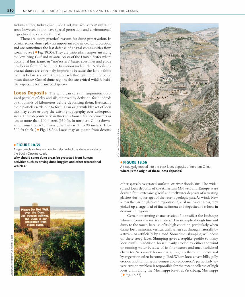
Loess Deposits The wind can carry in suspension dust-sized particles of clay and silt, removed by deflation, for hundreds or thousands of kilometers before depositing them. Eventually these particles settle out to form a tan or grayish blanket of loess that may cover or bury the existing topography over widespread areas. These deposits vary in thickness from a few centimeters or less to more than 100 meters (330 ft). In northern China down-wind from the Gobi Desert, the loess is 30 to 90 meters (100–300 ft) thick ( ● Fig. 18.36). Loess may originate from deserts,
other sparsely vegetated surfaces, or river floodplains. The wide-spread loess deposits of the American Midwest and Europe were derived from extensive glacial and meltwater deposits of retreating glaciers during ice ages of the recent geologic past. As winds blew across the barren glaciated regions or glacial meltwater areas, they picked up a large load of fine sediment and deposited it as loess in downwind regions.
Certain interesting characteristics of loess affect the landscape where it forms the surface material. For example, though fine and dusty to the touch, because of its high cohesion, particularly when damp, loess maintains vertical walls when cut through naturally by a stream or artificially by a road. Sometimes slumping will occur on these steep faces. Slumping gives a steplike profile to many loess bluffs. In addition, loess is easily eroded by either the wind or running water because of its fine texture and unconsolidated character. As a result, loess-covered regions that are unprotected by vegetation often become gullied. Where loess covers hills, gully erosion and slumping are conspicuous processes. A particularly se-vere erosion problem is responsible for the recent collapse of high loess bluffs along the Mississippi River at Vicksburg, Mississippi ( ● Fig. 18.37).
● FIGURE 18.35A sign directs visitors on how to help protect this dune area along the South Carolina coast.Why should some dune areas be protected from human activities such as driving dune buggies and other recreational vehicles?
Copy
right
and
pho
togr
aph
by D
r. Pa
rvin
der S
. Set
hi
● FIGURE 18.36A steep gully eroded into the thick loess deposits of northern China.Where is the origin of these loess deposits?
© M
icha
el A
ndre
ws/
Earth
Sce
nes
55061_18_Ch18_p490_521 pp2.indd 51055061_18_Ch18_p490_521 pp2.indd 510 6/7/08 5:22:42 PM6/7/08 5:22:42 PM
511
Motorcycles ridden on this desert hillslope in Utah have stripped the vegetation, compacted the soil, instigated accelerated erosion, and seriously marred the aesthetic beauty of the landscape, which is referred to as the viewshed.
hether you prefer to call them off-road vehicles (ORVs) or all-terrain vehicles
(ATVs), driving motorized vehicles of any kind over the desert landscape off estab-lished roadways has tremendous nega-tive impacts on desert flora and fauna, the habitat of those organisms, the stability of landforms and landforming processes, and the aesthetic beauty of the natural desert environment. Deserts are particularly fragile environments primarily because of the low amount and high variability of precipitation. The climatic regime leads to slow rates of weathering, slow rates of soil forma-tion, low density of vegetation, unusual species of plants and animals specially adapted to the hostile conditions of severe moisture stress, and rapid gen-eration of surface runoff when precipita-tion does occur.
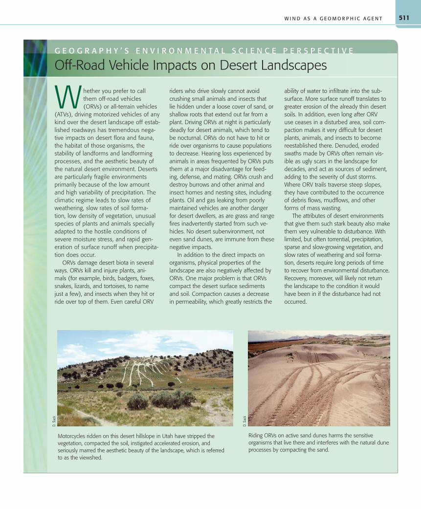
ORVs damage desert biota in several ways. ORVs kill and injure plants, ani-mals (for example, birds, badgers, foxes, snakes, lizards, and tortoises, to name just a few), and insects when they hit or ride over top of them. Even careful ORV
riders who drive slowly cannot avoid crushing small animals and insects that lie hidden under a loose cover of sand, or shallow roots that extend out far from a plant. Driving ORVs at night is particularly deadly for desert animals, which tend to be nocturnal. ORVs do not have to hit or ride over organisms to cause populations to decrease. Hearing loss experienced by animals in areas frequented by ORVs puts them at a major disadvantage for feed-ing, defense, and mating. ORVs crush and destroy burrows and other animal and insect homes and nesting sites, including plants. Oil and gas leaking from poorly maintained vehicles are another danger for desert dwellers, as are grass and range fires inadvertently started from such ve-hicles. No desert subenvironment, not even sand dunes, are immune from these negative impacts.
In addition to the direct impacts on organisms, physical properties of the landscape are also negatively affected by ORVs. One major problem is that ORVs compact the desert surface sediments and soil. Compaction causes a decrease in permeability, which greatly restricts the
ability of water to infiltrate into the sub-surface. More surface runoff translates to greater erosion of the already thin desert soils. In addition, even long after ORV use ceases in a disturbed area, soil com-paction makes it very difficult for desert plants, animals, and insects to become reestablished there. Denuded, eroded swaths made by ORVs often remain vis-ible as ugly scars in the landscape for decades, and act as sources of sediment, adding to the severity of dust storms. Where ORV trails traverse steep slopes, they have contributed to the occurrence of debris flows, mudflows, and other forms of mass wasting.
The attributes of desert environments that give them such stark beauty also make them very vulnerable to disturbance. With limited, but often torrential, precipitation, sparse and slow-growing vegetation, and slow rates of weathering and soil forma-tion, deserts require long periods of time to recover from environmental disturbance. Recovery, moreover, will likely not return the landscape to the condition it would have been in if the disturbance had not occurred.
G E O G R A P H Y ’ S E N V I R O N M E N T A L S C I E N C E P E R S P E C T I V E
Off-Road Vehicle Impacts on Desert Landscapes
W
D. S
ack
D. S
ack
W I N D A S A G E O M O R P H I C A G E N T
Riding ORVs on active sand dunes harms the sensitive organisms that live there and interferes with the natural dune processes by compacting the sand.
55061_18_Ch18_p490_521 pp2.indd 51155061_18_Ch18_p490_521 pp2.indd 511 6/7/08 5:22:46 PM6/7/08 5:22:46 PM

C H A P T E R 1 8 • A R I D R E G I O N L A N D F O R M S A N D E O L I A N P R O C E S S E S512
Because of its high calcium carbonate content and un-leached characteristics, loess is the parent material for many of Earth’s most fertile agricultural soils. Extensive loess deposits are found in northern China, the Pampas of Argentina, the North European Plain, Ukraine, and Kazakhstan. In the United States, the midwestern plains, the Mississippi Valley, and the Palouse region of eastern Washington are underlain by rich loess soils ( ● Fig. 18.38). All these areas are extremely productive grain-farming regions.
Landscape Development in Deserts
Geomorphic landscape development in arid climates is compa-rable in many ways to that in humid climates, but not in all ways. Weathering and mass movement processes operate, and fluvial processes predominate, in both environments but at different rates and with the tendency to produce some different landform and landscape features in the two contrasting environments. Arid envi-ronments experience the added regionally or locally important effect of eolian processes, which are not very common in humid settings beyond the coastal zone. The major differences in the results of geomorphic work in arid climates, as compared to humid cli-mates, are caused by the great expanses of exposed bedrock, a lack of continuous water flow, and a more active role of the wind in arid regions.
Some desert landscapes, such as most of those in the American Southwest, are found in regions of considerable topo-graphic relief, whereas others, like much of the Sahara and in-terior Australia, occupy huge expanses of open terrain with few mountains. An excellent example of a typical desert land-scape in a region of considerable structural relief is found in
● FIGURE 18.37The steep and unstable loess bluffs of Vicksburg, Mississippi.Why might the instability of loess cliffs be a problem?
© V
icks
burg
Con
vent
ion
and
Visi
tors
Bur
eau
● FIGURE 18.38Map of the major loess regions of the world (shown in yellow). Most loess deposits are peripheral to deserts and recently glaciated regions.
55061_18_Ch18_p490_521 pp2.indd 51255061_18_Ch18_p490_521 pp2.indd 512 6/7/08 5:22:48 PM6/7/08 5:22:48 PM

513
the Basin and Range region of western North America. The region extends from west Texas and northwestern Mexico to eastern Oregon. It includes all of Nevada and large portions of New Mexico, Arizona, Utah, and eastern California. Here, more
than 200 mountain ranges, with basins between them, dominate the topography. The Great Basin—a large subregion character-ized by interior drainage, numerous alternating mountain ranges and basins, active tectonism, and centered on Nevada— occupies
much of the central and northern part of the Basin and Range.
Fault-block mountains in the Basin and Range region rise thousands of meters above the desert basins, and many form continu-ous ranges ( ● Fig. 18.39). These high ranges, such as the Guadalupe Mountains, Sandia Mountains, Warner Mountains, and the Pan-amint Range, to name just a few, encourage orographic rainfall. Fluvial erosion dissects the mountain blocks to carve canyons be-tween peaks and cut washes between inter-fluves. Where active tectonism continues so that the uplift of mountain ranges matches or exceeds the rate of their erosion, as in the Great Basin, fluvial deposition constructs al-luvial fans extending from canyon mouths outward toward the basin floor. In many ba-sins, the alluvial fans have coalesced to create a bajada. In these tectonically active basins with interior drainage, playas often occupy the lowest part of the basin, beyond the toe of the alluvial fans ( ● Fig. 18.40a). Although the mountain ranges create considerable roughness, the wind can remove sandy al-luvium from the toe areas of alluvial fans, sand-sized aggregates of playa sediments,
● FIGURE 18.39A false-color satellite image of Death Valley, California, which is a desert bolson in the Basin and Range region. Death Valley lies between the Amargosa Range to the northeast and the Panamint Range to the southwest. Alluvial fans, which constitute much of the red areas of this image, dominate the edges of the valley.What do you think the white areas are in the center of the valley?
Cour
tesy
NAS
A GS
FC, M
ITI,
ERSD
AC, J
AROS
, and
U.S
./Jap
an A
STER
Sci
ence
Team
L A N D S C A P E D E V E L O P M E N T I N D E S E R T S
● FIGURE 18.40(a) Alluvial fans and playas tend to occur in mountain and basin deserts of active tectonism, which typically have interior drainage. (b) Pediments and inselbergs are common in desert areas that have been tectonically stable since a distant period of mountain formation. Development of exterior drainage helps transport sediment eroded from the mountains out of the basin.
Alluvial fans
Alluvial fansAlluvial fill
Dune fieldPlaya Inselburgs
Pediment
Dune field
Alluvial fill(a) (b)
55061_18_Ch18_p490_521 pp2.indd 51355061_18_Ch18_p490_521 pp2.indd 513 6/7/08 5:22:49 PM6/7/08 5:22:49 PM

C H A P T E R 1 8 • A R I D R E G I O N L A N D F O R M S A N D E O L I A N P R O C E S S E S514
and, in some cases, sandy sediment from beaches left behind by ancient perennial lakes. These sediments may be trans-ported relatively short distances before being deposited in lo-cal dune fields.
Pediments lie along the base of some mountains, partic-ularly in the tectonically less active areas south of the Great Basin, where much of the terrain is open to exterior drainage. In these areas, mountains are being lowered and the pediments extended. Resistant inselbergs remain on some of the pedi-ments. Sandy alluvium along streams and sandy deposits left by ancient rivers and deltas provide sediment to be reworked by the wind into occasional dune fields. The landscapes of the Mojave Desert in California and parts of the Sonoran Desert in Arizona have localities where uplift along faults has been inactive long enough for the landscape to be dominated by ex-tensive desert plains interrupted by a few isolated inselbergs as reminders of earlier, tectonically active, mountainous land-scapes (Fig. 18.40b).
The geologic structures and geomorphic processes found in desert areas are, for the most part, the same as those found in humid regions. It is variations in the effects and rates of these processes that make the desert landscape distinctive. Although fault-block mountains and fault-block basins dominate the
● FIGURE 18.41Uluru (Ayers Rock) is a striking sandstone inselberg, an erosional remnant, rising above the arid, flat interior of the Australian Outback. Kata Tjuta (The Olgas), in the background, formed as another erosional remnant divided into many bedrock hills by the widening of joints.Explain how inselbergs form.
© D
avid
Bal
l
● FIGURE 18.42This view of the Green River Overlook in Canyonlands National Park, Utah, illustrates the dramatic beauty of desert landscapes.What aspects of this environment make this an attractive landscape?
Nat
iona
l Par
k Se
rvic
e - C
anyo
nlan
ds
55061_18_Ch18_p490_521 pp2.indd 51455061_18_Ch18_p490_521 pp2.indd 514 6/7/08 5:22:52 PM6/7/08 5:22:52 PM

515515
geologic structure of immense regions of the American West and other arid locations around the world, it is important to know that desert landscapes are as varied as those of other climatic environments. Deserts exist at localities where the landscape has developed in nearly every imaginable geologic setting, includ-ing volcanoes, ash deposits and lava flows, folded rocks form-ing ridges and valleys, horizontal strata, and exposures of massive intrusive rocks. Where arid climates occur in expansive regions of largely open, low- relief terrain, as in the ancient and geologi-cally stable deserts of Australia and the Sahara, common land-forms include inselbergs surrounded by extensive desert plains ( ● Fig. 18.41), deflation hollows, playas, washes, the channels of ancient streams, and the beds of shallow, ancient lakes. With limited terrain roughness, areas of large longitudinal dunes can develop in these settings.
Arid landscapes and eolian landscapes in any climatic environment can be beautiful and stark, but those who are
unfamiliar with these environments too often misunderstand them. Deserts are not wastelands, and dunes are not merely piles of sand. It is true that most desert and eolian areas have little to offer in terms of directly exploitable economic value, but their unique characteristics and scenic beauty fully qualify them for preservation and protection. The austere, angular character of their landforms, the fragility of their environments, the special nature of their biota, and the opportunities they provide for learning about how certain Earth systems operate continue to attract those who seek to understand and experience arid and eolian environments ( ● Fig. 18.42). One only needs to count the number of national parks, national monuments, and other scenic attractions in the arid southwestern United States and in regions of sand dunes to find ample support for their survival. Deserts and dune localities are places with a beauty all their own and are areas worthy of appreciation and appropriate envi-ronmental protection.
regional base levelexotic streamwash (arroyo, barranca, wadi)badlandsplateaucaprockmesabuttepedimentinselbergalluvial fanfan apexdebris flow fanbajada
piedmont alluvial plainbolsonplayaplaya lakeclay pansalt-crust playa (salt flat, salina)eolian (aeolian)deflationsurface creepripplesdust stormsandstormdeflation hollowdesert pavement (reg, gibber)
ventifactyardangsand duneloesssand sea (erg)sand sheetslip faceblowoutbarchanparabolic dunetransverse dunelongitudinal duneseifstar dune
Define & Recall
1. What are eolian landforms? What geomorphic agent most significantly affects the desert landscape?
2. How do climate and vegetation affect landforms in the desert?
3. How do basins of interior drainage differ from basins of ex-terior drainage?
4. How does an exotic stream differ from an ephemeral stream? Give three examples of exotic streams.
5. How does the formation of a mesa or butte differ from the formation of a pediment?
6. Describe the main characteristics of an alluvial fan. 7. Why do temporary lakes form in bolsons? How are such
lakes related to playas? 8. What are the major differences between deflation and eolian
abrasion?
Discuss & Review
Chapter 18 Activities
C H A P T E R 1 8 A C T I V I T I E S
55061_18_Ch18_p490_521 pp2.indd 51555061_18_Ch18_p490_521 pp2.indd 515 6/7/08 5:22:56 PM6/7/08 5:22:56 PM