Areas eligible for LEADER funding in England · Wool Towns North Pennine Dales Chilterns Solway,...
1
Peak Brecks Yorkshire Dales Cotswolds Cumbria Fells & Dales Herefordshire Kestevens Staffordshire Northumberland Uplands Fieldfare Clay Vales Wool Towns North Pennine Dales Chilterns Solway, Border & Eden Lindsey Action Zone Worcestershire Southern Shropshire Wash Fens Eastern Plateau Oxfordshire North Wessex Downs Heart of Wessex Atlantic & Moor Torridge & North Devon Rural Surrey Greater Dartmoor LEAF West Norfolk New Forest Waveney Valley North York Moors, Coast & Hills East Kent Southern Dorset Cheshire East West Kent Loddon & Test Broads Wensum & Coast Making It Local Central Sussex Essex Rivers Northern Dorset Heritage Coast Coast, Wolds, Wetlands & Waterways West of England REAL Devon East Leicestershire Plain Action Western Somerset North Nottinghamshire Vale Action Kent Downs & Marshes North & West Northamptonshire Beds & Hunts Claylands West Cornwall East Peak Lancashire North & Bowland South Pennines Coastal Action Zone West Cheshire & Warrington Wealden & Rother Rural Partnership Coast to Coast Northern Lincolnshire South and East Cornwall Greensand Ridge South Devon Coastal Cambridgeshire Fens Forest & Tewkesbury Borough Sussex Downs & Coastal Plain Northumberland Coast & Lowlands Lancashire West South Nottinghamshire Lancashire West Heritage Coast Durham Coast & Lowlands Bolsover & North East Derbyshire Cambridgeshire Fens North Warwickshire & Hinckley & Bosworth Rural Peterborough & Rutland Northern Lincolnshire Mersey Rural Lancashire Pennine Moors Heritage Coast Heritage Coast South Devon Coastal Mersey Rural Kent Downs & Marshes Essex Rivers Areas eligible for LEADER funding in England (c) Crown Copyright and database reserved 2017 Ordnance Survey Licence No. 100022861 Rural Statistics Unit, Defra [email protected] Source: Defra 0 50 100 25 Miles
Transcript of Areas eligible for LEADER funding in England · Wool Towns North Pennine Dales Chilterns Solway,...
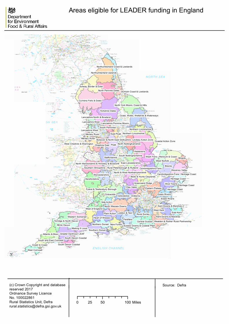
Peak
Brecks
Yorkshire Dales
Cotswolds
Cumbria Fells & Dales
Herefordshire
Kestevens
Staffordshire
Northumberland Uplands
Fieldfare
Clay ValesWool Towns
North Pennine Dales
Chilterns
Solway, Border & Eden
Lindsey Action Zone
Worcestershire
Southern Shropshire
Wash Fens
Eastern Plateau
Oxfordshire
North Wessex Downs
Heart of Wessex
Atlantic & Moor
Torridge & North Devon
Rural Surrey
Greater Dartmoor LEAF
West Norfolk
New Forest
Waveney Valley
North York Moors, Coast & Hills
East Kent
Southern Dorset
Cheshire East
West KentLoddon & Test
BroadsWensum & Coast
Making It Local
Central Sussex
Essex Rivers
Northern Dorset
Heritage Coast
Coast, Wolds, Wetlands & Waterways
West of England
REAL Devon
East Leicestershire
Plain ActionWestern Somerset
North Nottinghamshire
Vale Action
Kent Downs & Marshes
North & West NorthamptonshireBeds & Hunts Claylands
West Cornwall
East Peak
Lancashire North & Bowland
South Pennines
Coastal Action ZoneWest Cheshire & Warrington
Wealden & Rother Rural Partnership
Coast to Coast
Northern Lincolnshire
South and East Cornwall
Greensand Ridge
South Devon Coastal
Cambridgeshire Fens
Forest & Tewkesbury Borough
Sussex Downs & Coastal Plain
Northumberland Coast & Lowlands
Lancashire West
South Nottinghamshire
Lancashire West
Heritage Coast
Durham Coast & Lowlands
Bolsover & North East Derbyshire
Cambridgeshire Fens
North Warwickshire & Hinckley & BosworthRural Peterborough & Rutland
Northern LincolnshireMersey Rural
Lancashire Pennine Moors
Heritage Coast
Heritage Coast
South Devon Coastal
Mersey Rural
Kent Downs & Marshes
Essex Rivers
Areas eligible for LEADER funding in England
(c) Crown Copyright and databasereserved 2017Ordnance Survey Licence No. 100022861Rural Statistics Unit, [email protected]
Source: Defra
0 50 10025 Miles