Archer Waste Transfer Station - ntepa.nt.gov.au
73
1. Archer Waste Transfer Station Water Quality Monitoring and Management Plan City of Palmerston
Transcript of Archer Waste Transfer Station - ntepa.nt.gov.au

1.
Archer Waste Transfer Station Water Quality Monitoring and
Management Plan City of Palmerston

City of Palmerston i Archer Waste Transfer Station– Water Quality Monitoring and Management Plan
DOCUMENT CONTROL RECORD
Job EZ18122
Document ID 171420-17
Author(s) Ritsuko Maeda
DOCUMENT HISTORY
Rev Reviewed by Approved by Issued to Date
1 Bruce Ryan Bruce Ryan City of Palmerston 17/10/18
Recipients are responsible for eliminating all superseded documents in their possession.
EcOz Pty Ltd. ABN: 81 143 989 039 Winlow House, 3rd Floor 75 Woods Street DARWIN NT 0800 GPO Box 381, Darwin NT 0800
Telephone: +61 8 8981 1100 Facsimile: +61 8 8981 1102 Email: [email protected] Internet: www.ecoz.com.au
RELIANCE, USES and LIMITATIONS This report is copyright and is to be used only for its intended purpose by the intended recipient, and is not to be copied or used in any other way. The report may be relied upon for its intended purpose within the limits of the following disclaimer.
This study, report and analyses have been based on the information available to EcOz Environmental Consultants at the time of preparation. EcOz Environmental Consultants accepts responsibility for the report and its conclusions to the extent that the information was sufficient and accurate at the time of preparation. EcOz Environmental Consultants does not take responsibility for errors and omissions due to incorrect information or information not available to EcOz Environmental Consultants at the time of preparation of the study, report or analyses.

City of Palmerston ii Archer Waste Transfer Station– Water Quality Monitoring and Management Plan
TABLE OF CONTENTS
1 INTRODUCTION .........................................................................................................................................1
1.1 Purpose and objective ..........................................................................................................................1
2 BACKGROUND ..........................................................................................................................................1
2.1 The site .................................................................................................................................................1
2.1.1 Site surface ...................................................................................................................................1 2.1.2 Waste streams ..............................................................................................................................2
3 CONCEPTUAL SITE MODEL ....................................................................................................................4
4 SAMPLING PLAN .......................................................................................................................................6
4.1 Data quality objectives .........................................................................................................................6
4.2 Sampling media ...................................................................................................................................6
4.3 Standards and guidelines .....................................................................................................................7
4.4 OH&S requirements .............................................................................................................................8
5 PERFORMANCE CRITERIA ......................................................................................................................9
6 NON CONFORMANCE RESPONSE PLAN .............................................................................................10
7 ACCOUNTABILITY ..................................................................................................................................11
8 ANALYSIS AND REPORTING .................................................................................................................11
8.1 Laboratory analysis ............................................................................................................................11
8.2 Guideline criteria ................................................................................................................................12
8.3 Reporting ............................................................................................................................................12
9 REFERENCES ..........................................................................................................................................13
Appendices
ENVIRONMENT PROTECTION LICENCE 233
ECOZ CSM AND RA 2016
SAMPLING AND ANALYSIS QUALITY PLAN
Tables
Table 3-1 Summary of conceptual site model ...................................................................................................4 Table 4-1 Data quality objectives ......................................................................................................................6 Table 4-2 Sampling media .................................................................................................................................7 Table 4-3 Hazard management for surface water sampling .............................................................................8 Table 5-1 WQMMP performance criteria ...........................................................................................................9 Table 7-1 Roles and responsibilities ................................................................................................................11
Figures
Figure 1 Site locality and proposed sampling locations ....................................................................................3

City of Palmerston 1 Archer Waste Transfer Station– Water Quality Monitoring and Management Plan
1 INTRODUCTION
1.1 Purpose and objective
This water quality monitoring and management plan (WQMMP) has been developed by EcOz Environmental Consultants (EcOz) on behalf of City of Palmerston for the Archer Waste Transfer Station located on Lot 11497 Town of Palmerston plan(s) S2013/193, Elrundie Avenue, Archer NT 0830 (the site).
This WQMMP supplements the sampling and analysis quality plan (SAQP) completed and submitted by EcOz for the site to City of Palmerston on 10 July 2018. The implementation of a WQMMP is a requirement requested by the Northern Territory Environment Protection Agency (NT EPA) to satisfy the conditions of their current Environmental Protection Licence (EPL 233) for the site. A copy of EPL 233 is provided within Appendix A.
The purpose of this WQMMP is to ensure any water discharges from the site does not impact the surrounding and receiving environment. Relevant Territory and National acceptance criteria has been identified to ensure site operations and activities meet the proposed water quality monitoring objectives and targets for the site including performance indicators and contingency plans.
The SAQP which documents the proposed sample requirements such as when, where and how the necessary environmental samples will be collected is also included as part of the WQMMP document. The implementation of both the WQMMP and SAQP will ensure the site meets the requirements of the EPL and not cause harm to the site and surrounding environment.
2 BACKGROUND
2.1 The site
The site area is approximately 16 hectares, however the main areas of use for storage of waste and green waste occupies less than 2 hectares. The site is bounded by Channel Island Road to the north and east, vacant bushland to the west and the former Archer landfill to the south. The south eastern portion of the site lies within the former Archer landfill. The boundary of the former landfill extends further to the south. A number of landfill gas bores were noted along the southern boundary of the site, associated with the remediation currently being undertaken of the former landfill. EcOz understands that there are also a number of groundwater monitoring wells located hydraulically down gradient of the site which were installed as part of the former landfill environmental investigation.
2.1.1 Site surface
A site inspection was undertaken by EcOz on 3 July 2018 to assess the current status of the site. The site was observed as being clean and tidy with effective waste storage of separate waste streams. No offensive odour was noted from the site or the areas near the waste skips and containers.
The majority of the site surface is sealed with bitumen with the exception of the green waste area and truck access to the general waste skip bins which are unsealed. Some areas of the site are grassed however no waste is stored or contained in these areas. There is an unlined storm water drain that runs north-south of the site in between the road beside the gatehouse and unsealed section to the west. There is also another storm water drain which was grassed over at the time of the inspection along the southern boundary of the site. It is understood that storm water fills and pools in these drains during the wet season however according to site personnel, the site has never flooded due to heavy rainfall as it has been built up to be more elevated than the surrounding area.

City of Palmerston 2 Archer Waste Transfer Station– Water Quality Monitoring and Management Plan
All waste is stored above the ground, segregated and contained in appropriate bins or containers. Hazardous wastes such as batteries and paints are stored on raised pallets within a concrete bunded area to capture and prevent spillages. Similarly, waste oil is contained in an above ground tank within a concrete bund and shade cover to prevent overheating of waste oil. Minor staining of the concrete was observed, most likely due to minor spills during handling and disposal. However, the concrete appeared in good condition with no signs of cracking or damage. Appropriate spill containment equipment such as spill kits, fire extinguishers and hoses were noted around the site.
On the day of the site inspection, minor amounts of litter were observed across the site due to windy conditions. However, EcOz understands that litter is regularly collected and disposed of by site personnel as part of their weekly site audit and to ensure the site complies with their current EPL 233.
2.1.2 Waste streams
The site operates as a waste transfer station for the temporary holding of the following waste streams:
Paper and cardboard
Plastics
Glass and aluminium cans
General domestic household waste
Oils and grease
Steel/metal
Batteries
Paint
White goods and gas bottles
The waste from the site is transported and disposed of at Shoal Bay landfill on a regular basis, as required. The site also accepts green waste which is heaped in a mound in the western portion of the site before being processed into mulch for sale on site.
The site does not accept any commercial or industrial waste including tyres and car bodies.

GFSample siteEphemeral stream
! ! ! ! Unlined stormwater drain(A) Batteries(B) Paint(C) White goods(D) General waste(E) Paper/ cardboard/plastics/ glass/ aluminiumcans(F) Waste oil(G) Gatehouse(GW) Green waste
! ! ! ! ! ! ! ! ! ! ! !! ! ! !
! !! !
! ! ! ! ! ! ! ! ! ! ! ! ! ! ! ! ! ! ! ! ! ! ! ! ! ! ! ! ! ! ! ! ! ! ! ! ! ! ! ! ! !
!!
!!
!!
!!
!!
!
!!
!!
!!
!!
!!
!!
!!
!!
!!
!!
!!
!!
!!
!!
!!
!!
! ! ! ! ! ! ! ! ! ! ! !
!!
!!
!!
!!
!!
!!
!!
!!
!!
!!
!!
!!
!!
!!
!!
!!
!!
!!
!!
GF
GF
GF
GFGF
GF
GF
SW01
SW02
SW03
SW04SW05
SW06
SW07
G
B
C
E
F
GW
DDD
A
714800 714840 714880 714920 714960 715000 71504086
1500
086
1504
086
1508
086
1512
086
1516
0
0 20 4010MetresO
MAP INFORMATIONScale: 1:1,250 at A4Projection: Transverse MercatorDate Saved: 21/09/2020Client: City of PalmerstonAuthor: KM (updated AF)DATA SOURCEProject Data: EcOzTopographical Data:EcOzImagery: ESRI Basemaps / OSM
EcOz makes every effort to ensure this map is free of errors but does notwarrant the map or its features as either spatially or temporally accurate or fitfor a particular use. EcOz provides this map without any warranty, eitherexpress or implied.
Path: Z:\01 EcOz_Documents\04 EcOz Vantage GIS\EZ18122 - Archer Waste facility EPL\Surfacewater sampling map.mxd
Figure 1. Site layout and sampling locations

City of Palmerston 4 Archer Waste Transfer Station– Water Quality Monitoring and Management Plan
3 CONCEPTUAL SITE MODEL
A conceptual site model (CSM) and risk assessment (RA) was undertaken by EcOz for the site in October 2016. The report also details the site and surrounding environment in relation to geology, hydrogeology, and hydrology. A copy of the CSM and RA report is included within Appendix B.
Following the site inspection, the CSM for the site was reviewed and Table 3-1 summarises the updated conceptual site model which takes into account the current condition and status of site operations and activities.
Table 3-1 Summary of conceptual site model
Source of contamination
Contaminants of concern
Pathway and receptor
Risk
General household waste
Ammonia Heavy metals Hydrocarbons
(TRH/BTEX) Polycyclic aromatic
hydrocarbons (PAHs)
Pathways: Vertical migration through the soil and into groundwater.
Surface runoff during the wet season.
Receptors: Local streams and further down gradient into the Elizabeth River.
LOW
The potential environmental risk and thereby impact is considered low given that the waste is fully contained in skips and regularly transported and disposed of at Shoal Bay landfill. Most household waste is already contained in plastic bags, thereby reducing the potential of direct contact with the environment. The surface condition directly beneath the skips could not be inspected however no obvious evidence of staining or leaching of surface nearby was noted.
The weekly site audit should visually detect any pollution from the skips prior to any contamination occurring.
Listed wastes (batteries, oils, paint)
Heavy metals Acids TRH/BTEX PAHs Solvents
LOW
All listed waste is stored either in a contained tank or on raised pallets within a concrete bund. The concrete bunds were inspected to be in good condition with no signs of cracking or damage. Minor oil stains were observed near the oil storage tank however this is not considered to be significant enough to cause environmental pollution. Therefore, the potential environmental risk and impacted is considered low.
The weekly site audit should visually detect any pollution from the skips prior to any contamination occurring.
Green waste Nutrients Phenolics BOD Herbicides
MODERATE
The potential migration of contaminants associated with green waste through

City of Palmerston 5 Archer Waste Transfer Station– Water Quality Monitoring and Management Plan
Source of contamination
Contaminants of concern
Pathway and receptor
Risk
Pesticides surface runoff is considered moderate due to the unsealed nature of the ground beneath the green waste storage area. The risk via vertical migration into groundwater is considered low given the topography of this area which slopes downwards to the east, south-east into the stormwater drains. Most of the rainfall during wet season that falls in this area is likely to drain fairly quickly into the stormwater drains and according to site personnel, surface water does not pool near the green waste storage areas. Given the shallow nature of groundwater in the area, the natural stream located adjacent to the east of the site is likely to be indicative of the groundwater beneath the site during the wet season.
Unsealed areas
Total suspended solids
Sediments Pollutants in
sediment Dust
Pathway: Surface runoff and air
Receptors: Local streams, public (nearby residents and staff)
MODERATE
The potential risk and impact from unsealed areas through surface runoff is considered moderate. Most of the runoff is likely to be captured in stormwater drains on site before eventually discharging into the Elizabeth River located approximately 2 km to the south of the site. Therefore, the impact to Elizabeth River may be minimal, however may be still noticeable in the stream located adjacent to the site to the east.
Dust from unsealed areas is recognised as causing an impact given the site is located approximately 300 m south east of the closest residential properties and the prevailing dry season winds coming from the south east. Complaints of dust from nearby residents was not noted by site personnel and efforts are made as part of their weekly audit to suppress dust using water carts and avoiding disturbance of these areas.

City of Palmerston 6 Archer Waste Transfer Station– Water Quality Monitoring and Management Plan
4 SAMPLING PLAN
The following sections describe the proposed sampling design and data quality objectives, including quality assurance and quality control (QAQC) measures and occupational health and safety (OHS) requirements.
The SAQP is included within Appendix C which specifies the sampling plan, location, frequency, methods and procedures, equipment, and analysis.
4.1 Data quality objectives
The data quality indicators and how they will be evaluated are summarised in Table 4-1 below.
Table 4-1 Data quality objectives
Data Quality Indicators
Evaluation Criteria
Documentation and data completeness.
Site conditions and characteristics accurately described. Sampling locations accurately documented. Sampling techniques aligned with relevant industry and regulatory guidelines. Field Quality Assurance and Quality Control (QAQC) methods undertaken and accurately documented. Sufficient photographic and written evidence obtained and documented. Samples obtained from all identified areas/zones of concern and justification documented.
Data comparability. Use of appropriate techniques for documentation, sampling, storage, transport of samples. Use of a National Association Testing Authorities (NATA) accredited laboratory for all sample analysis. Undertake QAQC data validation on laboratory data.
Data representativeness.
Obtain a sufficient number of samples at each location to allow confidence in site characterisation. Obtain samples from all pertinent areas/zones of the site. Obtain samples from all appropriate media.
Precision for Sampling and Analysis.
Use of suitably qualified and experienced personnel. Obtain field QAQC samples in compliance with relevant regulatory guidelines and standards. Assess Relative Percentage Differences (RPDs) and any exceedance of the acceptability value (≥50%). Explore any non-conformance during data validation and assess whether data is acceptable.
4.2 Sampling media
Based on the updated CSM, the appropriate sample media to be assessed for the site has been identified as surface water resulting from surface runoff during the wet season. All storm water drains and nearby streams were observed to be dry during the site inspection.
Although there are groundwater monitoring wells located down gradient of the site, they were installed for the purpose of investigating impacts resulting from the former Archer landfill. Groundwater from these wells are unlikely to be representative of actual site conditions and are likely to be influenced by contamination caused by the former landfill.
Dust from the site is also exacerbated by dust generated from the former landfill to the south which is mostly unsealed and has large portions of the land disturbed by machinery. Regular effort is made by site personnel to suppress dust through use of water carts and avoiding vehicle traffic over unsealed areas. Given that no complaints have yet been made by the general public, air sampling at this stage is not

City of Palmerston 7 Archer Waste Transfer Station– Water Quality Monitoring and Management Plan
considered necessary. The weekly site audit undertaken by site personnel which includes assessment of dust and implementation of control measures is considered adequate at this stage.
Table 4-2 below summarises the sampling media to be assessed.
Table 4-2 Sampling media
Media
Sampling Required Rationale
Yes No
Soils and Sediment x
All waste is contained in appropriate bins or skips, or contained in tanks or within concrete bunds. No staining or gross contamination of site soils was observed. The weekly site audit should visually detect any pollution from the skips prior to any contamination occurring.
Surface water x Surface runoff during the wet season across the site may carry contaminants into stormwater drains, in particular from green waste area.
Ground water x
Groundwater contamination due to site operations and activities is highly unlikely as no waste is buried and all waste is contained appropriately. Adjacent stream to the east of the site is likely to be indicative of groundwater conditions beneath the site during wet season. The weekly site audit should visually detect any pollution from the skips prior to any contamination occurring.
Air Quality (including dust) x Not considered necessary at this stage. Visual weekly assessment deemed adequate.
4.3 Standards and guidelines
To ensure quality and accuracy of measurements, the sampling methods and procedures for the collection of surface water at the site were developed in accordance with the following standards and guidelines:
Australian Standard on Water Quality Sampling - Part 1: Guidance on the design of sampling programs, sampling techniques and the preservation and handling of samples (AS/NZS 5667.1:1998);
Australian Standard on Water Quality Sampling - Part 4: Guidance on sampling from lakes, natural and man-made (AS/NZS 5667.4:1998);
Australian Standard on Water Quality Sampling – Part 6: Guidance on sampling of rivers and streams (AS/NZS 5667.6:1998);
Australian Standard on Water Quality Sampling – Part 10: Guidance on sampling of waste waters (AN/NZS 5667.10:1998)
ANZECC & AMRCANZ 2000, Australian Guidelines for Water Quality Monitoring and Reporting, National Water Quality Management Strategy Paper No 7, Australian and New Zealand Environment and Conservation Council and Agriculture and Resource Management Council of Australia and New Zealand, Canberra.
ANZECC & AMRCANZ 2000, Australian and New Zealand Guidelines for Fresh and Marine Water Quality, National Water Quality Management Strategy Paper No 4, Australian and New Zealand Environment and Conservation Council and Agriculture and Resource Management Council of Australia and New Zealand, Canberra.
City of Palmerston 8 Archer Waste Transfer Station– Water Quality Monitoring and Management Plan
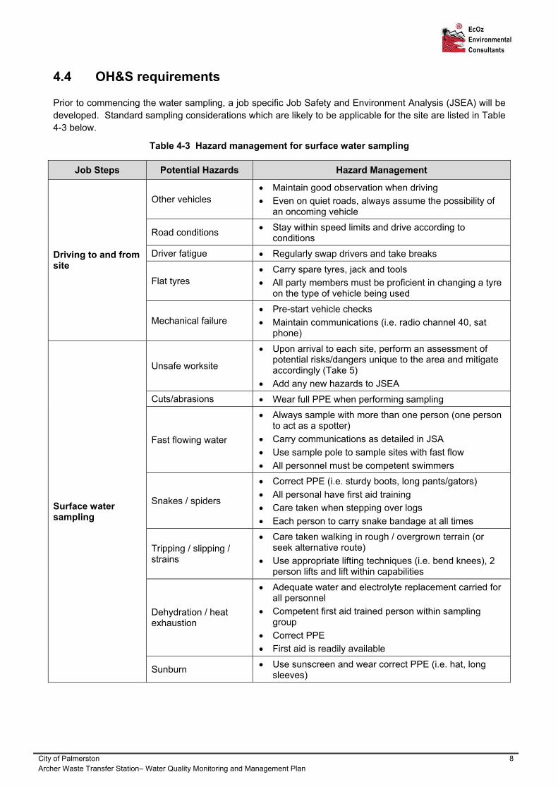
4.4 OH&S requirements
Prior to commencing the water sampling, a job specific Job Safety and Environment Analysis (JSEA) will be developed. Standard sampling considerations which are likely to be applicable for the site are listed in Table 4-3 below.
Table 4-3 Hazard management for surface water sampling
Job Steps Potential Hazards Hazard Management
Driving to and from site
Other vehicles Maintain good observation when driving
Even on quiet roads, always assume the possibility of an oncoming vehicle
Road conditions Stay within speed limits and drive according to conditions
Driver fatigue Regularly swap drivers and take breaks
Flat tyres Carry spare tyres, jack and tools
All party members must be proficient in changing a tyre on the type of vehicle being used
Mechanical failure Pre-start vehicle checks
Maintain communications (i.e. radio channel 40, sat phone)
Surface water sampling
Unsafe worksite
Upon arrival to each site, perform an assessment of potential risks/dangers unique to the area and mitigate accordingly (Take 5)
Add any new hazards to JSEA
Cuts/abrasions Wear full PPE when performing sampling
Fast flowing water
Always sample with more than one person (one person to act as a spotter)
Carry communications as detailed in JSA
Use sample pole to sample sites with fast flow
All personnel must be competent swimmers
Snakes / spiders
Correct PPE (i.e. sturdy boots, long pants/gators)
All personal have first aid training
Care taken when stepping over logs
Each person to carry snake bandage at all times
Tripping / slipping / strains
Care taken walking in rough / overgrown terrain (or seek alternative route)
Use appropriate lifting techniques (i.e. bend knees), 2 person lifts and lift within capabilities
Dehydration / heat exhaustion
Adequate water and electrolyte replacement carried for all personnel
Competent first aid trained person within sampling group
Correct PPE
First aid is readily available
Sunburn Use sunscreen and wear correct PPE (i.e. hat, long sleeves)

City of Palmerston 9 Archer Waste Transfer Station– Water Quality Monitoring and Management Plan
5 PERFORMANCE CRITERIA
Table 5-1 below outlines the measures, indicators, and required actions for each environmental aspect that requires monitoring and management at the site to ensure the site meets the requirements of the WQMMP.
Table 5-1 WQMMP performance criteria
Environmental Aspect
Performance Measure Performance Indicator
Action
On site stormwater quality
No obvious or visible impact to water quality.
Physical parameter readings and laboratory analysis reports above the adopted criteria.
Review data and determine cause of exceedances (natural background levels or due to anthropogenic impacts). May not be able to comment on exceedances during the first few rounds until more data is collected to allow trend assessment. If deemed necessary, re-sample to confirm results or collect additional samples from other locations to determine/delineate source and extent of potential impact.
No evidence of gross contamination such as sheen, odour or discolouration.
Environmental incident such as oil spill or loss of containment reported on site. Community complaints.
Immediately follow spill response procedure. 1). Identify source, volume and type of spill. 2). Control and contain the spill by isolating and removing source. 3). Clean the spill using on site spill kit and absorbent material or installing booms or bunds. 4). Dispose of contaminated spill control material appropriately. 5). Undertake additional water sampling to validate clean up. Report significant spills or spills that have entered stormwater to NT EPA Pollution Hotline (1800 064 567).
No evidence of erosion and sedimentation. Water clarity not affected.
Total suspended solids (TSS) and turbidity exceeds adopted criteria.
Investigate methods to stabilise stormwater drains or decrease flow rate along channel to minimise erosion and allow sediments to settle prior to being discharged off-site. Monitor downstream water quality for TSS and turbidity. Measure water quality after

City of Palmerston 10 Archer Waste Transfer Station– Water Quality Monitoring and Management Plan
Environmental Aspect
Performance Measure Performance Indicator
Action
implementation to monitor effectiveness of control methods.
Riparian health along stream to the east of site
No signs of impact to riparian terrestrial and aquatic ecosystems along stream.
Photographic record and visual observations. Physical field parameter readings and laboratory analysis at SW01 and SW05 reports above adopted criteria.
Review data and determine cause of exceedances (natural background levels or due to anthropogenic impacts). Determine whether impact caused by on-site or off-site activities. May not be able to comment on exceedances during the first few rounds until more data is collected to allow trend assessment.
Healthy riparian vegetation.
Maintain photographic record and note any visual observations should health of vegetation appear affected.
Determine whether impact caused by on-site or off-site activities.
Down stream water quality
No obvious or visible impact to downstream water quality.
Physical parameter readings and laboratory chemical analysis at locations SW04 and SW05 reports above the adopted criteria
Determine whether exceedances are significant enough to affect downstream receiving water body i.e. Elizabeth River. It may be beneficial to undertake one round of water sampling of the Elizabeth River for comparative background purposes.
6 NON CONFORMANCE RESPONSE PLAN
Should performance measures not be met and indicators suggest requirement of further investigation or action, depending on the nature of the issue, one or more of the following actions should be considered and undertaken:
Field parameter measurements at existing or additional locations to confirm readings
Additional water sampling and laboratory analysis at existing locations to confirm anomalous results
Water sampling and laboratory analysis at additional locations to determine source and extent of impact
Recommendations to implement additional engineering control measures to improve water quality
Incidents involving spills or loss of containment shall be remedied immediately and reported accordingly, following appropriate spill procedures.

City of Palmerston 11 Archer Waste Transfer Station– Water Quality Monitoring and Management Plan
7 ACCOUNTABILITY
This WQMMP has been developed by EcOz for the City of Palmerston for the site, therefore the responsibility for the implementation and compliance with this plan falls upon a number of parties.
The roles and responsibilities for the WQMMP is outlined in Table 7-1 below.
Table 7-1 Roles and responsibilities
Role Responsibility Contact Details
Site operator Daily site audits Compliance with EPL 233 Reporting environmental incidents Reporting community complaints
Gatehouse – 0408 862 460 Steve – 0448 692 475
City of Palmerston Ensuring site operates under EPL Compliance with site WQMMP Notifying any changes or incidents to NT
EPA
Rishenda Moss Environmental/Emergency Operations Officer [email protected]
EcOz Implementation of WQMMP Undertaking sampling as per SAQP
08 8981 1100
NT EPA Approving WQMMP and SAQP Recommendations for improvement Following up on environmental incidents
General – 08 8924 4218 Pollution Hotline – 1800 064 567 [email protected]
8 ANALYSIS AND REPORTING
8.1 Laboratory analysis
Based on the CSM the following laboratory analysis are proposed for the surface water samples collected from each event:
Total recoverable hydrocarbons (TRH)
Benzene, toluene, ethyl benzene, xylenes, naphthalene (BTEXN)
Total suspended solids (TSS)
Biological oxygen demand (BOD)
Dissolved metals (arsenic, cadmium, chromium, copper, lead, mercury, nickel and zinc)
Ammonia
Phosphorus
Organochlorine and organophosphate (OC/OP) pesticides (only do once at start of each wet season)
Total Phenolics
All primary and duplicate samples will be analysed for the above chemicals of concern.

City of Palmerston 12 Archer Waste Transfer Station– Water Quality Monitoring and Management Plan
8.2 Guideline criteria
The following guidelines have been considered for the site criteria:
Australian and New Zealand Guidelines for Fresh and Marine Water Quality (ANZECC/ARMCANZ 2000) – 95% species protection value for marine waters
Water Quality Objectives for the Darwin Harbour Region for marine and estuarine systems
Urban Stormwater Best Practice Environmental Management Guidelines (CSIRO, 1999)
Queensland Water Quality Guidelines 2009 – Guidelines for Urban Stormwater
Laboratory results and field data will be compared against the most relevant criteria from the above guidelines.
8.3 Reporting
One report at the end of the three monitoring rounds will be submitted to City of Palmerston. The report will include the following:
Analytical results
Basic trend analysis and interpretation including comparison against relevant guidelines and clear identification of any exceedance of adopted criteria
Laboratory certificates of analysis
Quality assurance documentation (e.g. COC, equipment calibration, QAQC reports)
Recommendations
The report will be submitted approximately three weeks following the end of the last sampling round to allow sufficient time for return of laboratory results.
If the results are indicating a contamination issue of concern that requires urgent attention e.g. high TPH levels from a spill, EcOz will notify City of Palmerston as soon as results are received from the laboratory.

City of Palmerston 13 Archer Waste Transfer Station– Water Quality Monitoring and Management Plan
9 REFERENCES
AS/NZS 5667.1:1998. Australian Standard on Water Quality Sampling - Part 1: Guidance on the design of sampling programs, sampling techniques and the preservation and handling of samples
AS/NZS 5667.4:1998. Australian Standard on Water Quality Sampling - Part 4: Guidance on sampling from lakes, natural and man-made
AS/NZS 5667.6:1998. Australian Standard on Water Quality Sampling – Part 6: Guidance on sampling of rivers and streams
AN/NZS 5667.10:1998. Australian Standard on Water Quality Sampling – Part 10: Guidance on sampling of waste waters
ANZECC & AMRCANZ 2000, Australian Guidelines for Water Quality Monitoring and Reporting, National Water Quality Management Strategy Paper No 7, Australian and New Zealand Environment and Conservation Council and Agriculture and Resource Management Council of Australia and New Zealand, Canberra.
ANZECC & AMRCANZ 2000, Australian and New Zealand Guidelines for Fresh and Marine Water Quality, National Water Quality Management Strategy Paper No 4, Australian and New Zealand Environment and Conservation Council and Agriculture and Resource Management Council of Australia and New Zealand, Canberra.
CSIRO, 1999: Urban Stormwater Best Practice Environmental Management Guidelines
National Environment Protection Council (1999). National Environment Protection (Assessment of Site Contamination) Measure 1999 (as amended 2013). Canberra, National Environment Protection Council.
Northern Territory Government. Water Quality Objectives for the Darwin Harbour Region for marine and estuarine systems
QLD Department of Environment and Heritage Protection, 2009: Queensland Water Quality Guidelines – Guidelines for Urban Stormwater

City of Palmerston Archer Waste Transfer Station - Water Quality Monitoring and Management Plan
ENVIRONMENT PROTECTION LICENCE 233

Page of 1 14
NVIRONMENT ROTECTION ICENCEE P L(Pursuant to section 34 of the )Waste Management and Pollution Control Act
Licensee City of PalmerstonLicence Number EPL233
Registered Business Address
City of Palmerston 2 Chung Wah Terrace
Palmerston NT 0830
ABN 42 050 176 900
Premises Address Lot 11497 Town of Palmerston plan(s) S2013/193ELRUNDIE AVE, ARCHER
Anniversary Date: 19 December
Commencement Date: 19/12/2017
Expiry Date: 18/12/2020
Scheduled Activity Collecting, transporting, storing, re-cycling, treating or disposingof a (as per Table 1) on a commercial or fee for listed wasteservice basis, other than in or for the purpose of a sewage treatment plant.
Operating , other than a sewage treatment plant, premisesassociated with collecting, transporting, storing, re-cycling, treating or disposing of a (as per Table 1) on a listed wastecommercial or fee for service basis.
Description Archer Recycling Centre & Waste Transfer Station, off Elrundie Avenue (south of Chung Wah Terrace), Palmerston, Northern Territory

ENVIRONMENT ROTECTION ICENCEP L 233
Page of 2 14
Table 1 - Listed Wastes Authorised to be Handled
Listed Waste
Acidic solutions or acids in solid form
Lead, lead compounds
Waste mineral oils unfit for their original intended use
Waste mixtures, or waste emulsions, of oil and water or hydrocarbon and water
Activity authorised by this licence
Activity not authorised by this licence
ENVIRONMENT ROTECTION ICENCEP L 233
Page of 3 14
TABLE OF CONTENTS
INFORMATION ABOUT THIS LICENCE ................................................................................................................ 4
RULES FOR INTERPRETING THE CONDITIONS OF THIS LICENCE ................................................................. 6
LICENCE CONDITIONS .......................................................................................................................................... 7
GENERAL ................................................................................................................................................................ 7
EARLY SURRENDER OF LICENCE ....................................................................................................................... 8
OPERATIONAL ....................................................................................................................................................... 8
DISCHARGES AND EMISSIONS ........................................................................................................................... 9
RECORDING AND REPORTING ............................................................................................................................ 9
PERFORMANCE IMPROVEMENT ....................................................................................................................... 10
DEFINITIONS ........................................................................................................................................................ 12
ATTACHMENTS1 Conceptual Site Model

ENVIRONMENT ROTECTION ICENCEP L 233
Page of 4 14
a. b.
c.
INFORMATION ABOUT THIS LICENCE
This licence does not in any way relieve the licence holder from its obligations to comply with the Waste (WMPC Act), including the general environmental duty in section Management and Pollution Control Act
12 of the WMPC Act and the duty to notify of incidents causing or threating to cause pollution under section 14 of the WMPC Act.
Duration of a licence (section 40, 43 and 45 of the WMPC Act)
A licence will remain in force until its expiry date or until it is surrendered by the licensee or is suspended or cancelled in accordance with the WMPC Act.
The licensee must notify the Northern Territory Environment Protection Authority (NT EPA) within 14 days after ceasing to conduct the activity.
The licensee may, with the approval of the NT EPA, surrender the licence to the NT EPA.
Amendment or Revocation of a licence (section 37 of the WMPC Act)
The licensee may apply to amend or revoke a condition of this licence.
A fee applies and the application must be made using the designated form via NT EPA Online.
The NT EPA may also amend or revoke a condition of this licence as set out in section 38 of the WMPC Act.
Transfer of a licence (section 46 of the WMPC Act)
The licensee can apply to transfer their licence to another person.
Renewal of a licence (section 40 of the WMPC Act and section 3 of the Regulations)
The licensee may apply for the renewal of their licence not earlier than 90 days, and not later than 30 days,before their licence expires.
A fee applies and the application must be made via NT EPA Online.
Public Register
A copy of environment protection licences and any plans for environmental management, reports, submissions or documents required as a condition of an environment protection licence, will be placed on a register in accordance with section 9 of the WMPC Act.
A copy of the Annual Return will be placed on the register.
The NT EPA makes this register freely available from the NT EPA website.
Environment Protection Objectives (Part 4 of the WMPC Act), and Water Quality Standards (section 73 of the )Water Act
An Environment Protection Objective (EPO) is a statutory instrument to establish principles on which:environmental quality is to be maintained, enhanced, managed or protected;pollution, or environmental harm resulting from pollution, is to be assessed, prevented, reduced, controlled, rectified or cleaned up; andeffective waste management is to be implemented or evaluated.
In accordance with section 18 of the WMPC Act a beneficial use, quality standard, criteria or objective declared under section 73 of the and in force is an environment protection objective for the Water Actpurposes of the WMPC Act.

ENVIRONMENT ROTECTION ICENCEP L 233
Page of 5 14
The following EPOs and Beneficial Use Declarations (BUDs) are relevant to this licence:Declaration of Beneficial Uses and Objectives, Elizabeth Howard Rivers Region Groundwater.
Environmental Interests
This section highlights sensitivity of the surrounding land use and environment associated with the locationof the approved activity.
Sites of Conservation Significance - Darwin Harbour
Cultural Interests
It is the licensee's responsibility to contact the Aboriginal Areas Protection Authority, appropriate land council or other governing body and ensure that any Authority Certificates required as a result of conducting the licenced activity are obtained and complied with.

ENVIRONMENT ROTECTION ICENCEP L 233
Page of 6 14
RULES FOR INTERPRETING THE CONDITIONS OF THIS LICENCE
Where there is a discrepancy between the conditions of this licence and any plan, standard, guideline or other document referred to in this licence, the conditions of this licence prevail to the extent of the inconsistency.Any reference to any standard (Australian or international) in this licence means the relevant parts of the current version of that standard.A reference to any guideline or code of practice (or to the relevant parts of any guideline or code of practice) in this licence means the current version of the guideline or code of practice.Under section 39 of the WMPC Act, any contravention of or failure to comply with this licence by the licensee may be an offence.In determining whether the licensee has committed an offence, the licensee may be liable for the conduct of its directors, employees or agents.The licensee should ensure that each of its directors, employees, contractors or agents are aware of, and comply with, this licence.In this licence, unless the contrary intention appears, words that are defined in the WMPC Act are intendedto have the meaning given to them in that Act.

ENVIRONMENT ROTECTION ICENCEP L 233
Page of 7 14
Table 2 Documents Relevant to Licensed Activity
Reference Document Title
EZ14113-C0301-CSA-R-0001
Updated Conceptual Site Model and Risk Assessment for the Archer Waste Transfer Station, Palmerston. Dated 06 October 2016
EMP01 CS Services NT Environmental Management Plan for Contract No. TS2011-03 Archer Waste Transfer Station
- Archer Waste Transfer Station Emergency Response Plan
LICENCE CONDITIONS
GENERAL
1 The licensee must ensure the contact details recorded in NT EPA Online for this licence are correct at alltimes.
2 The licensee must at all times have a 24 hour emergency contact.
3 The licensee must pay the annual fee calculated in accordance with the method prescribed in the Regulations within 50 business days of the anniversary of the commencement date of this licence, for each year or part of a year that this licence is in force.
4 The licensee must cause clear and legible signage, in English, to be displayed in a prominent location at each public entrance to the premises that includes the following details:
4.1 environment protection licence number issued under the WMPC Act; and
4.2 24 hour emergency contact details.
5 The licensee must cause a copy of this licence to be available for inspection by any person, in hard copy form, at the premises.
6 The licensee must provide to the NT EPA, within 10 business days of a request, a copy of any document, monitoring data or other information in relation to the activity, in the format requested by the NT EPA.
7 All notices, reports, documents or other correspondence required to be provided as a condition of this licence, unless otherwise specified as a condition of this licence, must be provided in electronic form by uploading the document via NT EPA Online (or by emailing [email protected]).
8 The licensee must maintain and implement documents listed in Table 2:
9 Within 10 business days of any amendment being made to a document listed in Table 2 the licensee must provide the amended document to the NT EPA, along with:
9.1 a tabulated summary of the amendment(s) with document references;
9.2 reasons for the amendment(s); and
9.3 an assessment of environmental risk associated with the amendment(s).
10 The NT EPA may require the licensee to revise or amend and resubmit any amended document. Where the NT EPA requires a document to be resubmitted, the licensee must submit it to the NT EPA by the date specified by the NT EPA.
ENVIRONMENT ROTECTION ICENCEP L 233
Page of 8 14
11 The licensee must, for the duration of this licence, implement, maintain and follow a Consultation and Communication Plan which includes a strategy for communicating with persons who are likely to have a real interest in, or be affected by, the activity.
12 The licensee must maintain a Complaint Log for all complaints received by the licensee in relation to the activity.
13 The licensee must ensure that the Complaint Log includes, for each complaint received by the licensee, the following information:
13.1 the person to whom the complaint was made;
13.2 the person responsible for managing the complaint;
13.3 the date and time the complaint was reported;
13.4 the date and time of the event(s) that led to the complaint;
13.5 the contact details of the complainant if known, or where no details are provided a note to that effect;
13.6 the nature of the complaint;
13.7 the nature of event(s) giving rise to the complaint;
13.8 prevailing weather conditions at the time (where relevant to the complaint);
13.9 the action taken in relation to the complaint, including any follow-up contact with the complainant;and
13.10 if no action was taken, why no action was taken.
14 The licensee must implement, maintain and follow an Emergency Response Plan that addresses procedures for responding to emergencies associated with the activity that may cause environmental harm.
EARLY SURRENDER OF LICENCE
15 Any reports, records or other information required or able to be provided by the licensee under this licence must be submitted to the NT EPA prior to the licensee surrendering the licence. If the date on which a report, record or other information is required falls after the date the licensee requests to surrender this licensee, the licensee must provide the report, record or information as far as possible using data available to the licensee up to and including the date the request to surrender the licence is made.
OPERATIONAL
16 The licensee must not collect, transport, store, recycle, treat or dispose of listed waste other than the listed waste specified in Table 1.
17 The licensee must ensure any plant and equipment used by the licensee in conducting the activity:
17.1 is reasonably fit for the purpose and use to which it is put;
17.2 is maintained;
17.3 is operated by a person trained to use the plant and equipment; and
17.4 is operated by, or operated by a person accompanied by, a person trained to handle, store or

ENVIRONMENT ROTECTION ICENCEP L 233
Page of 9 14
dispose of listed waste in connection with the activity.
18 The licensee must ensure that wastewater generated from washing plant and equipment associated withthe activity does not cause pollution.
19 The licensee must segregate waste received at the premises in clearly designated areas for recycling, re-use or disposal.
20 The licensee must segregate waste generated at the premises in clearly designated areas for recycling, re-use or disposal.
21 The licensee must ensure that litter:
21.1 is contained within the boundary of the premises;
21.2 is not deposited or allowed to accumulate in stormwater drain(s), water or leachate dam(s); and
21.3 does not accumulate along the boundary of the premises.
22 The licensee must ensure that all materials that are likely to cause environmental harm are handled and stored in areas with a containment system in accordance with the relevant Australian Standard. Where no relevant Australian Standard exists, the containment system must be sized to contain 110% of the volume of the largest container within the area.
23 The licensee must ensure that all listed waste being transported from the premises is transported by a person licenced under section 30 of the WMPC Act to transport the listed waste.
DISCHARGES AND EMISSIONS
24 The licensee must ensure there is no migration or overflow of a contaminant or waste, which causes or may cause environmental harm, beyond the boundary of the land on which the premises are located. (For the avoidance of doubt, this condition is not intended to authorise the discharge of a contaminant or waste to any land or water which discharge has not been specifically authorised by another condition of this licence.)
25 The licensee must not allow a contaminant or waste, which causes or may cause environmental harm, toenter water.
26 The licensee must ensure that stormwater does not come into contact with a contaminant or waste, which causes or may cause environmental harm.
RECORDING AND REPORTING
27 The licensee must maintain records of the nature, quantities and source of waste, other than listed waste, received at the premises in each successive 12 month period following the commencement date of this licence.
28 The licensee must keep and maintain records relating to the activity undertaken and the listed waste handled by the licensee in each successive 12 month period following the commencement of this licence, which include:
28.1 the date of collection;
28.2 the source of the listed waste;
28.3 the name of the transport company, if not the licensee;
28.4 the vehicle registration;

ENVIRONMENT ROTECTION ICENCEP L 233
Page of 10 14
28.5 a description of the listed waste;
28.6 the quantity of the listed waste;
28.7 the final destination of the listed waste; and
28.8 whether the listed waste was stored, recycled, treated or disposed of.
29 The licensee must retain records relating to waste, including listed waste, as required by the conditions of this licence, for a period of 2 years after the end of the 12 month period to which the record relates.
30 The licensee must keep records of all non-compliances with this licence. These records must be adequate to enable the licensee to comply with the non-compliance notification conditions of this licence.
31 The licensee must notify the NT EPA of any non-compliance with this licence by completing the Non-Compliance Notification via NT EPA Online (or by emailing [email protected]), as soon as practicable after (and in any case within 24 hours after) first becoming aware of the non-compliance.
32 The licensee must include in the notification of non-compliance the following information:
32.1 when the non-compliance was detected and by whom;
32.2 the date and time of the non-compliance;
32.3 the actual and potential causes and contributing factors to the non-compliance;
32.4 the risk of environmental harm arising from the non-compliance;
32.5 the action(s) that have or will be undertaken to mitigate any environmental harm arising from the non-compliance;
32.6 corrective actions that have or will be undertaken to ensure the non-compliance does not reoccur;
32.7 if no action was taken, why no action was taken; or
32.8 a date when an incident investigation report will be submitted to the NT EPA.
33 The licensee must submit a completed Annual Return via NT EPA Online within 10 business days after each anniversary date of this licence, which report relates to the preceding 12 month period.
PERFORMANCE IMPROVEMENT
34 The Licensee must establish an environmental monitoring program for the facility to monitor for potential impacts to the Beneficial Use Declarations and Sites of Conservation Significance, as specified under 'Information about this licence'.
34.1 The monitoring program must be submitted to the NT EPA electronically, six months after the commencement date of this licence and include a sampling and analysis quality plan (SAQP).
34.2 The environmental monitoring program must be implemented at the facility by the first anniversary date of this licence.

ENVIRONMENT ROTECTION ICENCEP L 233
Page of 11 14
END OF LICENCE CONDITIONS
This licence is not valid unless signed below:
Leonie Cooper Director Environment AuthorisationsDelegate of the Northern TerritoryEnvironment Protection AuthorityDated: 26/04/2018
END NOTES
This licence is a new licence and supersedes EPL96-01 issued 19 December 2012, expiring 19 December 2017.

ENVIRONMENT ROTECTION ICENCEP L 233
Page of 12 14
DEFINITIONS
All terms in the Licence which are defined in the have the meaning Waste Management and Pollution Control Actgiven in that Act unless otherwise or further defined in this section.
DEFINITION In this licence, unless a contrary intention appears:
24 hour emergency contact
the phone number of a person who can be contacted at any time and be capable of responding to and providing information about any incident associated with the activity.
Activity the Scheduled activity as described on the covering page of this licence.
Annual fee yearly fee payable in respect of the activity as specified in the WMPC Act and the Regulations.
Annual Return an NT EPA prescribed format for demonstrating and reporting compliance with the conditions of this licence and providing information on waste volumes for the preceding 12 month period.
Business days a day not Saturday, Sunday or a public holiday, in the Northern Territory.
Community feedback number
a telephone number enabling members of the public to contact, at any time, a person or voice mail system that can accept, on behalf of the licensee, enquiries or complaints about the activity, and to which the licensee must respond.
Complaint Log a register of complaints to be maintained by the Licensee that records the details of each complaint received in relation to the activity.
Consultation and Communication Plan
a written plan documenting proposed consultation and communications for the activity before, during and after the activity which includes a strategy for communicating with members of the public who are likely to have a real interest in, or be affected by, the activity.
Contact details includes the 24 hour emergency contact, and name, position title and phone numberof a representative of the licensee who can be contacted about the licence and activity.
Contaminant a solid, liquid or gas or any combination of such substances and includes:(a) noise, odour, heat and electromagnetic radiation;(b) a prescribed substance or prescribed class of substances; and(c) a substance having a prescribed property or prescribed class of properties.
Discharges allow a liquid, gas or other substance to flow out from where it has been confined.
Emergency Response Plan
a written plan documenting the licensee's procedures for responding to emergencies caused by, resulting from or associated with the activity and that may cause environmental harm.
Environmental harm (a) any harm to or adverse effect on the environment; or (b) any potential harm (including the risk of harm and future harm) to or potential adverse effect on the environment, of any degree or duration and includes environmental nuisance.
Environmental nuisance means:(a) an adverse effect on the amenity of an area that:(i) is caused by noise, smoke, dust, fumes or odour; and

ENVIRONMENT ROTECTION ICENCEP L 233
Page of 13 14
(ii) unreasonably interferes with or is likely to unreasonably interfere with the enjoyment of the area by persons who occupy a place within the area or are otherwise lawfully in the area; or(b) an unsightly or offensive condition caused by contaminants or waste.
Incident includes:(a) an accident, emergency or malfunction; and(b) a deliberate action, whether or not that action was taken by the person conducting the activity in the course of which the incident occurred.
Listed waste a waste included under Schedule 2 of the Regulations.
Litter litter, garbage, rubbish, refuse or waste matter, and includes the body of a dead animal.
Maintain kept in a manner that it does not present or cause a risk of environmental harm or a hazard to persons or property or, for the purposes of documents including plans, a process of reviewing and amending documentation to ensure it is relevant.
Material environmental harm
environmental harm that: (a) is not trivial or negligible in nature;(b) consists of an environmental nuisance of a high impact or on a wide scale;(c) results, or is likely to result, in not more than $50,000 or the prescribed amount (whichever is greater) being spent in taking appropriate action to prevent or minimisethe environmental harm or rehabilitate the environment; or(d) results in actual or potential loss or damage to the value of not more than $50,000 or the prescribed amount (whichever is greater).
Non-compliance failure or refusal to comply, whether by act or omission, with obligations or requirements and includes any exceedance of a licence limit.
Non-compliance notification
an NT EPA prescribed format for notifying the NT EPA of a non-compliance.
NT EPA Online online system for Environment Protection Licence (EPL), Environment Protection Approval (EPA) and Waste Discharge Licence (WDL) lodgement and maintenance.
NT EPA Online Vehicle Register
the vehicle register found at NT EPA Online.
Plant and equipment all material items used in association with the activity, including (but not limited to) storage vessels and containers, pipe work and hosing, vehicles (including vessels), tools, and measuring equipment.
Pollute (a) emit, discharge, deposit, or disturb, directly or indirectly, a contaminant or waste;or(b) cause, permit, or fail to prevent, directly or indirectly, the emission, discharge, deposition, disturbance or escape of a contaminant or waste.
Pollution (a) a contaminant or waste that is emitted, discharged, deposited or disturbed or that escapes; or(b) a contaminant or waste, effect or phenomenon, that is present in the environment as a consequence of an emission, discharge, deposition, escape or disturbance or a contaminant or waste.
Premises the premises identified in this licence which includes equipment, plant and structures, whether stationary or portable, and the land on which premises are situated.

ENVIRONMENT ROTECTION ICENCEP L 233
Page of 14 14
Public entrance access to the premises that is utilised by the public.
Putrescible waste the component of the waste stream liable to become putrid. For example, organic matter that has the potential to decompose with the formation of malodorous substances, usually refers to vegetative, food and animal products.
Regulations .Waste Management and Pollution Control (Administration) Regulations
Serious environmental harm
environmental harm that is more serious than material environmental harm and includes environmental harm that:(a) is irreversible or otherwise of a high impact or on a wide scale;(b) damages an aspect of the environment that is of a high conservation value, high cultural value or high community value or is of special significance;(c) results or is likely to result in more than $50,000 or the prescribed amount (whichever is greater) being spent in taking appropriate action to prevent or minimisethe environmental harm or rehabilitate the environment; or(d) results in actual or potential loss or damage to the value of more than $50,000 orthe prescribed amount (whichever is greater).
Solid inert waste solid waste that has no active chemical or biological properties. These wastes do not undergo environmentally significant physical, chemical or biological transformation.
Stormwater water flowing over ground surfaces, in natural streams and drains as a direct result of rainfall over a catchment and consists primarily of rainfall runoff.
Waste (a) a solid, a liquid or a gas; or(b) a mixture of such substances,that is or are left over, surplus or an unwanted by-product from any activity (whetheror not the substance is of value) and includes a prescribed substance or class of substances.
Waste transport certificate the NT EPA waste tracking documentation used to track listed waste being transported interstate as required in accordance with the National Environment Protection (Movement of Controlled Waste Between States and Territories) Measure.
Wastewater water that contains a contaminant or waste.
Water includes:(a) surface water, ground water and tidal waters; (b) coastal waters of the Territory, within the meaning of the Coastal Waters (Northern Territory Powers) Act 1980 of the Commonwealth; and(c) water containing an impurity.
WMPC Act the Northern Territory .Waste Management and Pollution Control Act

City of Palmerston Archer Waste Transfer Station - Water Quality Monitoring and Management Plan
ECOZ CSM AND RA 2016
EcOz Pty Ltd ABN 81 143 989 039
Tel: 08 89811100
e-mail: [email protected]
website: www.ecoz.com.au
Darwin, Northern Territory
Level 3 75 Woods St (cnr Lindsay)
GPO Box 381
Darwin Northern Territory 0801
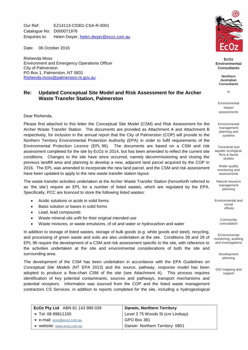
Our Ref: EZ14113-C0301-CSA-R-0001
Catalogue No: D000071976
Enquiries to: Helen Dwyer, [email protected]
Date: 06 October 2016
Rishenda Moss Environment and Emergency Operations Officer City of Palmerston PO Box 1, Palmerston, NT 0831 [email protected]
Re: Updated Conceptual Site Model and Risk Assessment for the Archer Waste Transfer Station, Palmerston
Dear Rishenda,
Please find attached to this letter the Conceptual Site Model (CSM) and Risk Assessment for the
Archer Waste Transfer Station. The documents are provided as Attachment A and Attachment B
respectively, for inclusion in the annual report that the City of Palmerston (COP) will provide to the
Northern Territory Environmental Protection Authority (EPA) in order to fulfil requirements of the
Environmental Protection Licence (EPL 96). The documents are based on a CSM and risk
assessment completed for the site by EcOz in 2014, but has been amended to reflect the current site
conditions. Changes to the site have since occurred, namely decommissioning and closing the
previous landfill area and planning to develop a new, adjacent land parcel acquired by the COP in
2016. The EPL was amended to incorporate the new land parcel, and the CSM and risk assessment
have been updated to apply to the new waste transfer station layout.
The waste transfer activities undertaken at the Archer Waste Transfer Station (henceforth referred to
as ‘the site’) require an EPL for a number of listed wastes, which are regulated by the EPA.
Specifically, PCC are licenced to store the following listed wastes:
Acidic solutions or acids in solid forms
Basic solution or bases in solid forms
Lead, lead compounds
Waste mineral oils unfit for their original intended use
Waste mixtures, or waste emulsions, of oil and water or hydrocarbon and water
In addition to storage of listed wastes, storage of bulk goods (e.g. white goods and steel), recycling,
and processing of green waste and soils are also undertaken at the site. Conditions 28 and 29 of
EPL 96 require the development of a CSM and risk assessment specific to the site, with reference to
the activities undertaken at the site and environmental considerations of both the site and
surrounding area.
The development of the CSM has been undertaken in accordance with the EPA Guidelines on
Conceptual Site Models (NT EPA 2013) and the source, pathway, response model has been
adopted to produce a flow-chart CSM of the site (see Attachment A). This process requires
identification of key potential contaminants, sources and pathways, transport mechanisms and
potential receptors. Information was sourced from the COP and the listed waste management
contractors CS Services, in addition to reports completed for the site, including a hydrogeological
EcOz Environmental
Consultants
Northern
Australian Consultants
in
Environmental
impact
assessments
Environmental management planning and
systems
Terrestrial and aquatic ecological,
flora & fauna studies
Water quality
monitoring and assessments
Natural resource
management planning
Environmental and social
offsets
Community consultation
Environmental monitoring, auditing and investigations
Development planning
GIS mapping and support

Client: Palmerston City Council
Doc Title: Updated Conceptual Site Model and Risk Assessment for the Archer Waste Transfer Station, Palmerston
Page 2
report (GHD 2012), Design Report (W&G 2016a), and engineered drawings for the new proposed landfill
(W&G 2016b).
Based on the CSM, a site specific risk assessment was undertaken in accordance with standard industry
guidelines, including relevant Australian Standards (see Attachment B). Environmental aspects and impacts
were identified, with risk rankings calculated for each potential impact, based on consequence and likelihood
of occurrence. Management and mitigation measures are then assigned to each impact and a residual risk
calculated. This allows prioritisation of risk management.
The CSM and risk assessment are based on all available data provided to EcOz by COP and is targeted
toward the potentially higher risk impacts. Unavoidable impacts associated with the site operations (i.e.
clearing of land) have not been listed in the risk assessment, as they are an accepted outcome of such
activities.
Note that any assumptions or limitations of the CSM and risk assessment are generally attributable to
unavailable data and have been highlighted where applicable.
Although the new waste transfer station site is not yet developed, the CSM and risk assessment consider the
risks and interactions of the site as though it is operational. Construction risks are noted where relevant (e.g.
water runoff and sedimentation), but the reports are designed to be relevant for the operational phase. Any
future changes in operations at the site, such as additional footprint increases, or storage of additional listed
wastes, would need to be considered in an amended CSM and risk assessment.
It is recommended that the CSM and risk assessment are reviewed annually, to ensure continual
improvement and validation of the models, and maintenance of them for site applicability.
Should you have any queries or concerns, please do not hesitate to contact me.
Yours sincerely,
Helen Dwyer Environmental Consultant EcOz Environmental Consultants

Client: Palmerston City Council
Doc Title: Updated Conceptual Site Model and Risk Assessment for Archer Waste Transfer Station
Page 3
Attachment 1: Conceptual Site Model
Context
Table 1. Background information and assumptions
Site The Archer Waste Transfer Station (henceforth referred to as ‘the site’) is the waste transfer station for the Palmerston area. The 16 ha site is located south of the suburb of Bellamack, on the southern side of Elrundie Avenue, and is accessed via the existing Flack Road and Durack Road (Figure 1).
Landfill operations began in 1986 in the area south of the site; the landfill has been decommissioned and capped and is no longer operational. COP acquired a new land parcel west of the entrance to the landfill which is a greenfield site that will be developed in accordance with the engineered plans (see Appendix A). This CSM applies only to the new land parcel.
The new site will include a green waste area, soil blending and sales area, resource recovery centre, recycling education centre and a plant nursery. No landfill will be developed at the site under current plans. As the site is for waste transfer, the majority of waste is transferred to the Shoal Bay Landfill that services the Darwin region.
Infrastructure that will be developed includes a stormwater drainage system, sewage and water supply systems (both to be connected to mains), roads, pavements, offices and sales areas. Wallbridge & Gilbert RFP completed the Design Report for the site (see Appendix A).
Surrounding environment
The site covers an area of greenfield open Eucalyptus woodland environment south of Palmerston. Two existing drainage lines run approximately north to south through the new land parcel. These drain into the Elizabeth River south of the site, which in turn drains into Darwin Harbour. The secondary storm surge zones mapped by the NT Government (DLRM 2011) extend into the southern and eastern portions of the landfill area; this represents 1 in 1000 year storm surge zones (see Figure 2).
Immediately south of the land parcel there is a strip of native bushland, and the Adelaide to Darwin railway line. Further south of this are tidally inundated estuarine mangrove flats. Surrounding land use is dominated by suburban subdivisions on the northern side of Elrundie Avenue, while the land east and west of the site is predominantly vacant. South-east of the current site is the old, decommissioned landfill.
Land units The site is mapped as within three land units; 1c, 2b1 and 4c (as mapped by Fogarty et al. 1984). Land units 1c and 2b1 are mapped as woodland and open Eucalyptus woodland; both are classified as rises, and well drained. Land unit 4c, which covers the eastern most portion of the site, is classified as an open Eucalyptus forest that is poorly drained with common wet season waterlogging.
The historic landfill, south of the current site, was in much poorer land in relation to drainage, as it was subject to intertidal inundation and was within the storm surge zones. The current (new) site has a lower risk of interaction with the nearby tidal zones, and hence less risk of contamination impacts on the Elizabeth River and Darwin Harbour.
Hydrology Undeveloped, the site has two existing drains that flow from north to south and discharge into the Elizabeth River. Drainage is influenced by a ridge that runs on a north-south trajectory through the site, thus shedding water toward the east and west respectively.
Plans for the site include installation of a number of new stormwater drains that will capture surface runoff from the site and flow toward a central storage and treatment area before discharging into the Elizabeth River. It is understood that there are future plans to develop a bioremediation or wetland treatment system for the stormwater. The details of this will be captured in a Stormwater Drainage Quantity and Quality Management Plan, which had not been developed at the time of writing this report, and as such cannot be included in the assessment at this stage. Stormwater flows will drain from the site to the south, into the Elizabeth River, via engineered stormwater drains with erosion and sediment controls in place.

Client: Palmerston City Council
Doc Title: Updated Conceptual Site Model and Risk Assessment for the Archer Waste Transfer Station, Palmerston
Page 4
Hydrogeology Geoscience Australia mapping of the geological units (2.5 million) indicates that the geology underlying the site is predominantly sedimentary rocks. The geotechnical investigations conducted by .Wallbridge & Gilbert RFP (see Appendix A) indicates that the soils underlying the site are sandy (with variations on sandy clay, and sandy silt soils) underlain by claystone and siltstone. This indicates that the soils are relatively porous and water may move both vertically and laterally through the profiles. Groundwater flows to the south-west, toward Darwin Harbour.
In 2012, GHD undertook a hydrogeological assessment of the now decommissioned landfill site, which involved drilling and investigation of seven bores across the site. The results of these investigations indicated that groundwater is shallow (0-6.5 m deep) with levels fluctuating seasonally (shallow during the wet season and deeper during the dry season).
The new site is further north and on higher ground, and would be expected to have lower ground water levels. A map of the hydrogeology of the Darwin region indicates that the western portion of the site is underlain by fresh groundwater, mostly with yields over 5 L/s (see Figure 3). The eastern portion of the site is underlain by brackish/saline groundwater, also with yields over 5 L/s, and likely to be the same formations as that underlying old site.
A review of bore reports from the surrounding region (north) indicates that there is generally deeper aquifer with water struck generally between 20 m and 40 m below ground level (DLRM 2016). The bore reports and previous hydrogeological studies indicate that there is a deeper, high yielding aquifer and a shallow seasonal water table that fluctuates seasonally, and is tidally influenced in the eastern portion of the site.
Waste streams The Archer Waste Transfer Station accepts general household waste, listed wastes (e.g. oils, paint, batteries), green waste, inert general waste and bulk waste, and construction waste. All wastes will be segregated and stored in allocated areas, bunded where appropriate (i.e. for listed wastes). All waste will be stored above ground (i.e. no landfill will occur). Green waste and soil will be stockpiled, and both mulch (from green waste) and soil will be sold to the public. All general waste and listed waste will be transferred to Shoal Bay periodically. The COP aims to recover, recycle and/or divert 10 % of general waste and construction waste from going to Shoal Bay, and a resource recovery centre will be developed to assist by recovering recyclable and re-useable products, for reuse, selling (e.g. tip shop), and public education.
Potential contaminants
Potential contaminants sources are either directly sourced from general and listed waste (e.g. waste oil or battery fluid) or the product of a process occurring at the site (e.g. nutrients from mulching of vegetation).
Key potential contaminants are metals, hydrocarbons, bulk goods, nutrients, and sediment.
Potential pathways
Pathways refer to the mechanism by which contaminants are transported from the site into the surrounding environment and receptors, and include direct and indirect methods (e.g. surface water runoff, dust or gas, and groundwater migration). Potential release mechanisms are also assigned where relevant (for example if a spill is required to result in a release, vs. exposed contaminants that do not require a release mechanism). In some instances, a release mechanism such as a spill may result in a secondary source of contamination (e.g. soil).
Key potential pathways include direct surface water runoff, wind (particularly seasonal breezes) and vertical and lateral movement into the groundwater (see Figure 2). Surface water and groundwater contamination can provide a pathway to downstream surface water bodies, as both discharge into the tributaries of the Elizabeth River, and Darwin Harbour. It should be noted, however, that the risk of groundwater contamination is low as no landfill is occurring, and as such no waste is stored in-ground.
Potential receptors or exposure
Receptors range from individual or specific organisms (e.g. humans) to broader systems (e.g. Darwin Harbour, aquatic ecosystems) that may be exposed to contaminants.
The key potential receptors for the site are water bodies (ground and surface), public users of the site and workers, and local residents. There is no potable use of ground or surface water downstream of the site, largely due to the saline water quality and tidal environment.

710000
710000
711000
711000
712000
712000
713000
713000
714000
714000
715000
715000
716000
716000
717000
717000
718000
718000
719000
719000
8612
000
8613
000
8614
000
8615
000
8616
000
8617
000
8618
000
8619
000
Path: Z:\01 EcOz_Documents\04 EcOz Vantage GIS\EZ14113 - PCC EPL Site Model\01 Project Files\project location.mxd
0 1 20.5KilometresO
MAP INFORMATIONScale: 1:50,000 at A4Projection: GDA 1994 MGA Zone 52Date Saved: 6/10/2016Client: City of PalmerstonAuthor: H. DwyerDATA SOURCEProject Data: City of PalmerstonImagery: ESRI basemap
Figure 1. Map of Archer Waste Transfer Station and surrounding areas
EcOz makes every effort to ensure this map is free of errors but does not warrant the map orits features as either spatially or temporally accurate or fit for a particular use. EcOz providesthis map without any warranty, either express or implied.
Archer Waste TransferStation
New site boundaryOld site boundary (includingdecommissioned landfill)
Elizabeth RiverMitchellCreek
Stuart Highway
Palmerston
Red box indicates map extent
Palmerston

714000
714000
714500
714500
715000
715000
8614
500
8615
000
8615
500
Path: Z:\01 EcOz_Documents\04 EcOz Vantage GIS\EZ14113 - PCC EPL Site Model\01 Project Files\Figure 2 site location and pathways for release.mxd
0 150 30075MetresO MAP INFORMATION
Scale: 1:8,000 at A4Projection: GDA 1994 MGA Zone 52Date Saved: 6/10/2016Client: City of PalmerstonAuthor: H. DwyerDATA SOURCEProject Data: City of PalmerstonImagery: ESRI basemapTopographic data: Aus Govt/NTGPathways: EcOz, City of Palmerston, BOM, GHD
Figure 2. Map of site location and pathways for release
EcOz makes every effort to ensure this map is free of errors but does not warrant the map orits features as either spatially or temporally accurate or fit for a particular use. EcOz providesthis map without any warranty, either express or implied.
Site boundaryTopographic data
1m contoursDarwin-Adelaide Railway
Pathways and receptorsSurface water flows (withoutdrainage in place)Groundwater flows
Prevailing WindsDry SeasonWet Season
Storm Surge 2100Primary storm surge zone (1 in100 ARI)Secondary storm surge zone (1 in1000 ARI)
To Elizabeth River
Elrundie Avenue
Note: Water flow and wind directionare approximate and indicative only.
Red box indicates map extent
Bellamack
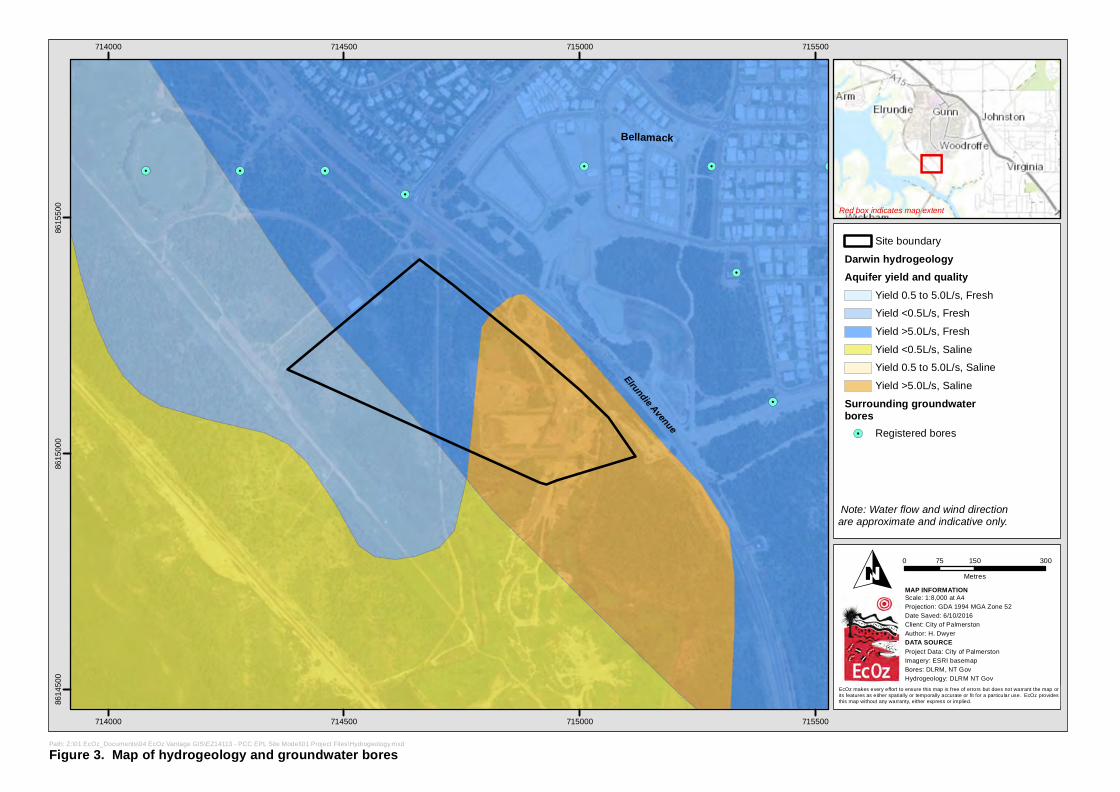
!.
!.!.!.
!.
!.
!.
!.
!.!.
714000
714000
714500
714500
715000
715000
715500
715500
8614
500
8615
000
8615
500
Path: Z:\01 EcOz_Documents\04 EcOz Vantage GIS\EZ14113 - PCC EPL Site Model\01 Project Files\Hydrogeology.mxd
0 150 30075MetresO MAP INFORMATION
Scale: 1:8,000 at A4Projection: GDA 1994 MGA Zone 52Date Saved: 6/10/2016Client: City of PalmerstonAuthor: H. DwyerDATA SOURCEProject Data: City of PalmerstonImagery: ESRI basemapBores: DLRM, NT GovHydrogeology: DLRM NT Gov
Figure 3. Map of hydrogeology and groundwater bores
EcOz makes every effort to ensure this map is free of errors but does not warrant the map orits features as either spatially or temporally accurate or fit for a particular use. EcOz providesthis map without any warranty, either express or implied.
Site boundaryDarwin hydrogeologyAquifer yield and quality
Yield 0.5 to 5.0L/s, FreshYield <0.5L/s, FreshYield >5.0L/s, FreshYield <0.5L/s, SalineYield 0.5 to 5.0L/s, SalineYield >5.0L/s, Saline
Surrounding groundwaterbores!. Registered bores
Elrundie Avenue
Note: Water flow and wind directionare approximate and indicative only.
Red box indicates map extent
Bellamack

Site Activities Potential Contaminant Source
Release Mechanisms
and Pathways3 Receptors
General waste stored in skip
bins for transfer
Listed wastes stored for transfer
Leachate from skip bins
Odours from skip bins
Potential Contaminants
Ammonia, BOD, Metals (Cr, Cu, Cd,
PB, Zn) TPH, PAH, BTEX
Groundwater: Vertical migration
through soils.
Air/Wind Breezes (NW and
SE)
Groundwater Aquifer
Darwin Harbour
Public users of site and staff
Bellamack and suburbs
Local atmosphere
Batteries, waste oil,
paint
Green waste and mulching on site
Leachate and bulk
vegetation
Recycling and storage of recyclables
Bulk wastes (white goods, construction material, steel, cars)
Metals Acidic solutions
Hydrocarbons (TPH, BTEXN)
Ink/solvents
Nutrients (N, P), BOD
Surface water: Rainfall and runoff
Elizabeth River and Tributaries
Odour
Groundwater Vertical migration
through soil.
Gross Pollutants
Terrestrial Ecosystem
Footnotes: 1Potential Release Mechanism (where applicable) 2Potential Secondary Source 3Potential release mechanisms are in bold font, pathways in simple font
Spill/leak1 Soil2
Emissions
Leach Soil
Spills, leaks Leachate
Aquatic fauna (bioaccumulation)
Human consumers
Construction activities
Soils and disturbed
land surfaces
Sediment, and potential pollutants
in sediment
Surface water: Runoff Wind
Surface water Rainfall and runoff
Erosion Soil blending and stockpiling
Vehicle wash-downs
Plant nursery Fertilizer
Soil, vehicle fluids
Sediment, Oil, TPH, BTEXN, Metals
CONCEPTUAL SITE MODEL: ARCHER WASTE TRANSFER STATION

Client: Palmerston City Council
Doc Title: Updated Conceptual Site Model and Risk Assessment for Archer Waste Transfer Station
Page 9
Attachment 2: Environmental Risk Assessment
Risk Assessment Process
The risk assessment process involves identification of environmental aspects and impacts, and is systematic
and consistent with international best practice standard methodologies, including:
AS/NZS ISO 31000:2009: Risk management - Principles and Guidelines (Standard)
HB 203:2006: Environmental risk management - Principles and process (Guide)
HB 158:2010: Delivering assurance based on ISO 31000:2009 - Risk management - Principles and
Guidelines (Guide).
Environmental aspects are defined as the elements of an organisations activities, products or services that
can interact with the environment (e.g. storage of contaminants, vegetation mulching). Environmental
impacts are any change to the environment, whether adverse or beneficial, wholly or partially resulting from
the organisations environmental aspects.
Identifying the environmental aspects and impacts relevant to the Archer Waste Transfer Station allows an
assessment of the environmental risk to be completed, using a standard consequence and likelihood matrix.
Management or mitigation measures can be assigned to each aspect, with a residual risk calculated based
on the resulting potential impacts. Environmental management activities can then be prioritised according to
risk. The aspects and impacts stem from the conceptual site model, with the risk ranking providing further
insight into the consequence and likelihood of impact, allowing significant risks at the site to be identified.
Risks have been assessed for the construction phase (Table 5) and the operational phase (Table 6)
separately.
Risk Rankings
The ranking for event consequence is shown in Table 2. The likelihood of an event occurring provides a
measure of the known or anticipated frequency of occurrences Table 3. Combining likelihood with
consequence provides guidance on risk levels of each aspect and enables ranking of priorities Table 4 to be
identified.
Table 2. Consequence ranking
Consequence
1 Insignificant No/low measurable impact on the environment.
2 Minor Some minor, temporary environmental impact
3 Moderate Contained temporary or permanent minor, localised environmental damage
4 Major Severe environmental damage.
5 Catastrophic Environmental disaster

Client: Palmerston City Council
Doc Title: Updated Conceptual Site Model and Risk Assessment for Archer Waste Transfer Station
Page 10
Table 3. Qualitative measures of likelihood
Probability/Likelihood Likelihood Criteria
A Rare: May occur only in exceptional circumstances 0-1%
B Unlikely: Could occur at some time. 1-10%
C Moderate: Might possibly occur at some time. 11-50%
D Likely: Will probably occur in most circumstances. 51-90%
E Almost Certain:
Expected to occur in most circumstances. 91-100%
Table 4. Risk rankings from combined consequence and likelihood
Consequence
Lik
elih
oo
d
1 2 3 4 5
A 1 3 6 10 15
B 2 5 9 14 19
C 4 8 13 18 22
D 7 12 17 21 24
E 11 16 20 23 25
Where;
Red = extreme risk intolerable
Purple = high risk intolerable or tolerable
Yellow = medium risk tolerable or acceptable
Green = low risk acceptable

Client: Palmerston City Council
Doc Title: Updated Conceptual Site Model and Risk Assessment for Archer Waste Transfer Station
Page 11
Risk assessment
Table 5. Construction Phase Risk Assessment
Aspect Impact Risk Ranking Mitigation/Control Residual Risk
Construction activities
Erosion and sedimentation of surrounding environment, and downstream watercourses (Elizabeth River and Darwin Harbour)
12 (Medium) Implement an Erosion and Sediment Control Plan
Install and maintain erosion and sediment controls as per plan
Visual inspections of erosion and sediment controls post rainfall events
Visual inspections for sedimentation of surrounding environment and waterways post rainfall events
Water quality monitoring of stormwater drains and downstream watercourses for total suspended solids
5 (Low)
Noise and dust emissions and impact on nearby residents
8 (Medium) Record and respond to any complaints received from neighbouring residents
Maintain buffer distance between earthworks areas and residential zones
Implement dust suppression as required (e.g. water carts) to minimise dust emissions
Restrict operating hours to avoid impacts on nearby residents
Maintain skip bin covers as required to minimise wind distribution of waste.
5 (Low)
Greenhouse gas emissions from machinery use
12 (Medium) Maintain vehicles and machinery in good working order
Operate machines in an efficient manner
Avoid use of machinery when not required.
8 (Medium)

Client: Palmerston City Council
Doc Title: Updated Conceptual Site Model and Risk Assessment for Archer Waste Transfer Station
Page 12
Table 6. Operational Phase Risk Assessment
Aspect Impact Risk Ranking Mitigation/Control Residual Risk
Collection and storage of general waste
Pollution of downstream waterways and Darwin Harbour with gross pollutants, metals, hydrocarbons, nutrients, pathogens, and associated impacts on aquatic ecosystem health
13 (High) Separation and storage of general waste in appropriately contained, bunded and sealed or covered containers
Maintenance of storages to ensure waste is contained
Housekeeping to ensure all waste is within designated storages
Maintenance of drainage and bunding downstream around general waste storage area to capture any surface runoff
Inspections and implementation of clean up measure post rainfall as required
Regular removal of stored waste to Shoal Bay Waste Management Facility
Implement a surface water quality monitoring program to identify contamination.
6 (Low)
Groundwater contamination from leachate from storage areas, seeping vertically into groundwater via soils
8 (Medium) Separation and storage of general waste in appropriately contained, bunded and sealed or covered containers
Maintenance of storages to ensure waste is contained
Housekeeping to ensure all waste is within designated storages
Inspections and implementation of clean up measure post rainfall as required
Regular removal of stored waste to Shoal Bay Waste Management Facility
Implement a groundwater quality monitoring program to identify contamination.
5 (Low)
Impacts on local residents of odour (particularly during dry season with SE winds)
8 (Medium) Separation and storage of general waste in appropriately contained, bunded and sealed or covered containers
Ensure storage areas are covered, and all rubbish is within storage areas
Regular removal of stored waste to Shoal Bay Waste Management Facility
Record and respond to complaints received from neighbouring residents.
5 (Low)
Storage of listed wastes (batteries, oil, paint)
Spill of product and contamination of surface water runoff and downstream water bodies
13 (High) Storage of substances in accordance with Listed Waste Management Plan (i.e. bunded, under cover, separated)
Housekeeping and labelling for adequate separation and storage of listed wastes
Spill kit kept at facility and staff trained in spill response
Implement spill response process in Listed Waste Management Plan if required
Maintenance of records and site manifest to monitor volumes
Regular inspections of storage areas to identify potential spills
Regular removal of listed waste to Shoal Bay Waste Management Facility
Implement a surface water quality monitoring program to identify contamination.
6 (Low)
Spills and soil contamination, with additional potential
8 (Medium) Storage of substances in accordance with Listed Waste Management Plan
Housekeeping and labelling for adequate separation and storage of listed wastes
3 (Low)

Client: Palmerston City Council
Doc Title: Updated Conceptual Site Model and Risk Assessment for Archer Waste Transfer Station
Page 13
seepage into groundwater Spill kit kept at facility and staff trained in spill response
Implement spill response process in Listed Waste Management Plan if required
Maintenance of records and site manifest to monitor volumes
Regular inspections of storage areas to identify potential spills (visual inspection for stained soil).
Implement a groundwater quality monitoring program to identify contamination.
Storage and mulching of green waste
Contamination of surface water runoff and downstream waterways with nutrient rich water and organic matter (e.g. TKN, BOD)
8 (Medium) Drainage works to direct surface water runoff around mulch piles
Maintenance of mulch stockpiles to contain mulch in allocated area
Install berms around mulch area to capture mulch prior to runoff entering drains
Visual inspections of mulch stockpile areas following rainfall to identify any issues requiring remediation
Monitoring of downstream waterways to identify any potential impacts on water quality.
3 (Low)
Storage of soil and soil blending
Erosion and sedimentation of surrounding environment, and downstream watercourses (Elizabeth River and Darwin Harbour)
8 (Medium) Implement an Erosion and Sediment Control Plan
Install and maintain erosion and sediment controls as per plan
Visual inspections of erosion and sediment controls post rainfall events
Visual inspections for sedimentation of surrounding environment and waterways post rainfall events
Water quality monitoring of stormwater drains and downstream watercourses for total suspended solids.
3 (Low)
Storage and use of fertilizer for plant nursery
Contamination of surface water runoff and downstream waterways with nutrient rich water
8 (Medium) Drainage works to direct surface water runoff around nursery area
Appropriate storage of fertilizer in covered containers or under cover
Housekeeping of fertilizer storage area and nursery.
3 (Low)
Vehicle wash-downs
Runoff of water contaminated with soil, and oil and fuel residues
8 (Medium) Design wash-down bay to capture water and divert to a pre-treatment system (e.g. oil/water separator) prior to discharge
Visual inspections of wash-down bay and surrounding area for soil staining or visible pollution
Upgrades of wash-down bay as required.
3 (Low)
Storage of bulk wastes
Spread of gross pollutants into surrounding landscape
8 (Medium) Housekeeping, separation and storage of inert wastes in a manner that minimises the spread of gross pollutants (e.g. bunded pallets in dedicated areas)
Monitoring and maintenance of storage areas to minimise impacts on surrounding area, cleaning up as required.
3 (Low)
Recycling activities
Spread of gross pollutants into surrounding landscape
8 (Medium) Housekeeping, separation and storage of inert wastes in a manner that minimises the spread of gross pollutants
3 (Low)

Client: Palmerston City Council
Doc Title: Updated Conceptual Site Model and Risk Assessment for Archer Waste Transfer Station
Page 14
Monitoring and maintenance of storage areas to minimise impacts on surrounding area, cleaning up as required.
General operations
Greenhouse gas emissions from machinery use
12 (Medium) Maintain vehicles and machinery in good working order
Operate machines in an efficient manner
Avoid use of machinery when not required
8 (Medium)
Noise and dust emissions and impact on nearby residents
8 (Medium) Record and respond to any complaints received from neighbouring residents
Maintain buffer distance between earthworks areas and residential zones, and plant vegetation buffers as required around site boundary
Implement dust suppression (e.g. water carts) as required
Restrict operating hours to avoid impacts on nearby residents
Maintain waste storage areas as required to minimise wind distribution of waste.
5 (Low)
Odour emissions and impact on nearby residents
8 (Medium) Maintain good housekeeping and separation of wastes to ensure adequate storage
Record and respond to any complaints received from neighbouring residents
Ensure storage areas are covered to minimise odour
Maintain buffer distance between storage areas and residential areas
Regular removal of stored waste to Shoal Bay Waste Management Facility.
5 (Low)

Client: Palmerston City Council
Doc Title: Updated Conceptual Site Model and Risk Assessment for Archer Waste Transfer Station
Page 15
Key risks and management considerations
The majority of impacts have an inherent risk ranking of ‘Moderate’; only two risks were considered to have
a ‘High’ inherent risk, both of which were related to pollution of surface water. Mitigations or controls have
been assigned to all potential impacts in order to reduce the risks associated with those activities. With the
exception of greenhouse gas emissions from machinery use, the risk of all impacts was reduced to ‘Low’
through the allocation of mitigation measures. Greenhouse gas emissions can be lowered slightly, but are
an inevitable impact of using machinery powered by diesel and fossil fuels, and therefore remain
‘Moderate’.
It is evident from the risk assessment that the highest potential impact related to the operation of the
Archer Waste Transfer Station is the pollution of stormwater runoff and downstream receiving
watercourses, including the Elizabeth River and Darwin Harbour. Associated with this are potential
impacts on aquatic ecosystems and human consumers of fish and other aquatic species (note that there
are no watercourses downstream of the site that provide potable water for human consumption, so human
exposure could only occur through consumption of contaminated seafood and fish). Through appropriate
separation, storage, maintenance and monitoring of the waste storage areas (for both listed wastes and
general waste areas) and green waste and soil areas, and the development of contingency strategies (e.g.
spill response) the risks to surface water quality can be reduced to ‘Low’.
It is noted that additional stormwater management infrastructure may be developed and implemented, such
as detention basins, bioremediation systems or constructed wetlands. Appropriate design, installation and
management of these will further reduce potential impacts to surface water through allowing for passive
on-site water treatment prior to discharge. As this system has not yet been developed it has not been
included in the risk assessment process.
Risks to groundwater quality were considered relatively low as all waste will be stored above ground. A
number of mitigation measures and controls will assist in ensuring the residual risk to groundwater quality
is ‘Low’.
A water quality monitoring program should be established to monitor for potential impacts on water quality
and inform management decisions. This should include monitoring of surface water sites and groundwater
bores upstream (or up gradient), within and downstream of the site to determine whether activities at the
Archer Waste Transfer Station are resulting in impacts to surface or groundwater quality. This would
ensure that contamination would be identified and rectified.
Regular visual inspections and maintenance should also be implemented at the site, including:
Inspections of separate waste areas to ensure it is stored in the appropriate area
Housekeeping inspections
Visual inspections of soil around listed waste storage areas and wash-down bay to check for soil
staining
Inspections of mulch and green waste areas, and soil stockpiles, to ensure stormwater is draining
around storage areas and drains are free of mulch, vegetation or soil
Inspection of erosion and sediment controls
The inspections should inform management and maintenance works, and be tracked through a register to
ensure follow-ups are captured and implemented.
Appropriate management of the Archer Waste Transfer Station will ensure that the City of Palmerston is
able to provide a facility that allows for appropriate waste management and minimisation, with minimal
impacts on the environment and surrounding areas.

Client: Palmerston City Council
Doc Title: Updated Conceptual Site Model and Risk Assessment for Archer Waste Transfer Station
Page 16
References
CS Services 2012, Listed Waste Management Plan – Archer Waste Transfer Facility, CS Services NT,
Palmerston.
Department of Land Resource Management (DLRM) 2011, Darwin Region Storm Surge Inundation Zones
2100, Northern Territory Government, Darwin.
Fogarty, P, Lynch, B and Wood, B 1984, The Land Resources of the Elizabeth, Darwin and Blackmore
Rivers, Land Conservation Unit, Conservation Commission of the Northern Territory.
GHD 2012, Report for Archer Waste Facility Monitoring: Hydrogeological Assessment¸ prepared for
Palmerston City Council by GHD Pty Ltd.
Northern Territory Department of Land Resource Management (DLRM) 2016, Natural Resource (NR)
Maps NT, online map data resource, Northern Territory Government, viewed 13 September 2016,
http://nrmaps.nt.gov.au/;jsessionid=16d1glgzgyuef1jxdwt1hl0euu
Northern Territory Environmental Protection Authority (EPA) 2013, Guidelines on Conceptual Site Models,
Pollution Control, Northern Territory Environmental Protection Authority, Darwin.
Wallbridge & Gilbert RFP (W&G) 2016, Design Report, design for Archer Waste Transfer Station,
Wallbridge & Gilbert, Darwin.

Client: Palmerston City Council
Doc Title: Updated Conceptual Site Model and Risk Assessment for Archer Waste Transfer Station
Appendix A – Design Report

1 | P a g e
Z:\JOBS\2015 Jobs\150303 - Archer Waste Transfer Station - RAH\Design Report\150303_160310_Design Report_V3.docx
PROPOSED WASTE TRANSFER STATION ARCHER, PALMERSTON NT
DESIGN REPORT
Prepared for the City of Palmerston
11 March 2016
Job No. 150303
WALLBRIDGE & GILBERT RFP
Consulting Engineers
DOCUMENT INFORMATION

2 | P a g e
Z:\JOBS\2015 Jobs\150303 - Archer Waste Transfer Station - RAH\Design Report\150303_160310_Design Report_V3.docx
Prepared for City of Palmerston
Project Name Archer Waste Transfer Station
File Name Design Report
Job Reference 150303
Date 11 March 2016
DOCUMENT CONTROL
Version Date Author Author Initials
Reviewer Reviewer Initials
A 10/3/2016 Will Orille WO Rory Hinton RH
CONTACT INFORMATION
WALLBRIDGE AND GILBERT RFP
ABN 15 088 045 229
CAN 088 045 299
Suite 7/9 Keith Lane, Fannie Bay
Northern Territory 0820
GPO Box 563, Darwin
Northern Territory 0801
Telephone 08 8941 1678
Email [email protected]

3 | P a g e
Z:\JOBS\2015 Jobs\150303 - Archer Waste Transfer Station - RAH\Design Report\150303_160310_Design Report_V3.docx
CONTENTS
1. Introduction ...................................................................................................................................... 4
2. PROJECT SCOPE .............................................................................................................................. 4
2.1 Project Objectives ..................................................................................................................... 4
2.2 Wallbridge and Gilbert Scope of Work ........................................................................................ 4
3. EXISTING SITE CHARACTERISTICS .................................................................................................. 5
3.1 General Site Condition and Topography ..................................................................................... 5
3.2 Geotechnical Conditions ............................................................................................................ 5
3.3 Existing Stormwater Drainage and Services ................................................................................ 5
4. STANDARDS AND REFERENCES ...................................................................................................... 6
5. SITE DEVELOPMENT PLAN .............................................................................................................. 6
6. EARTHWORKS AND GRADING DESIGN ............................................................................................ 7
7. ROAD DESIGN .................................................................................................................................. 7
8. PAVEMENT DESIGN ......................................................................................................................... 7
9. STORMWATER DRAINAGE DESIGN .................................................................................................. 8
9.1 General ..................................................................................................................................... 8
9.2 Hydrologic and Hydraulic Calculations ....................................................................................... 8
10. EROSION AND SEDIMENT CONTROL PLAN ...................................................................................... 8
11. WATER RETICULATION AND FIRE RING MAIN ................................................................................. 9
12. SEWER RETICULATION .................................................................................................................. 10
13. Due Diligence/Safety in Design ...................................................................................................... 10
Appendices ............................................................................................................................................ 11
Appendix A – Photographic Record of the Site ..................................................................................... 11
Appendix B – Site Survey .................................................................................................................... 17
Appendix C – Geotechnical Report ....................................................................................................... 18
Appendix D – Design Drawings ............................................................................................................ 19
Appendix E – Sprayed Seal Design Calculations ................................................................................... 20
Appendix F – Shoal Bay Waste Transfer Station Inspection Record ....................................................... 21

4 | P a g e
Z:\JOBS\2015 Jobs\150303 - Archer Waste Transfer Station - RAH\Design Report\150303_160310_Design Report_V3.docx
1. INTRODUCTION
One of the City of Palmerston’s 10 strategic actions and priority areas noted in their Sustainability
Strategy 2013 - 2018 is to recover, recycle and/or divert 10% of the City of Palmerston’s municipal
waste from going to Shoal Bay Landfill (i.e. recover, recycle, re-use) by 2015. Also, City of
Palmerston aim to achieve 10% recovery, recycling and diversion of construction and demolition
waste by 2016 (RAP, recycled concrete etc.).
To provide a suitable facility and infrastructure required to meet these strategic actions, the City of
Palmerston (CoP) has commissioned Wallbridge and Gilbert (W&G) RFP to undertake the design
and documentation of the proposed development of 16 hectares of land at the site of the existing
Archer Waste Transfer Station in Lot 11497, Town of Palmerston.
The proposed development will initially include the following:
Stormwater drainage, water, sewer and electrical services
Roadworks
Weighbridge and Office
Plant Nursery
Soil Blending and Sales
Green Waste Facility
Vehicle Wheel Wash Down Facility
The following future site developments are to be accommodated by the new infrastructure:-
Recycling Education Centre including carpark
Resource Recovery Centre including carpark
Caretaker’s Dwelling
Office building and public ablutions block
2. PROJECT SCOPE
2.1 Project Objectives
To build infrastructure capacity at the Archer Waste Transfer Station that facilitates the City of
Palmerston’s strategic aims of:
1. Recovery, recycling or diversion of 10% of the City of Palmerston’s municipal waste
currently disposed of at Shoal Bay Landfill;
2. Recovery, recycling or diversion of 10% of the City of Palmerston’s construction and
demolition waste currently disposed of at Shoal Bay Landfill.
2.2 Wallbridge and Gilbert Scope of Work
Below is an outline of the scope of work and deliverables for this commission as per the tender
brief issued by CoP on the 19th of May 2015 and Expression of Interest submitted by W&G on the
11th of June 2015:
Site Survey;
Geotechnical Investigation;
Preparation of Site Development Plan;
Bulk Earthworks Design;
Roadworks Design;
Stormwater Drainage Design including erosion and sediment control;
Water Reticulation and Fire Main Design;

5 | P a g e
Z:\JOBS\2015 Jobs\150303 - Archer Waste Transfer Station - RAH\Design Report\150303_160310_Design Report_V3.docx
Sewerage Reticulation Design; and
Electrical Reticulation Design
This document serves as the design report that outlines the process, criteria, guidelines,
considerations, assumptions and design calculations adopted.
3. EXISTING SITE CHARACTERISTICS
3.1 General Site Condition and Topography
An existing waste transfer management facility is located within the south-eastern portion of the
property. Access to this facility is through an existing sealed road that comes off Elrundie Avenue
along the north-eastern boundary of the property.
It is our understanding that the existing access to the Archer Waste site will be closed as part of
the NT Government’s future upgrades to Elrundie Avenue. Therefore, access to the site is
proposed via Flack Road and Durack Road to the west of the Lot.
Other than the aforementioned existing facility and adjacent areas currently being utilised as green
waste areas and temporary stockpile locations, a large proportion of the site is greenfield and
vegetated with open woodland eucalypt forest.
A ridge of land running north-south was noted during the inspection and confirmed through the
survey completed on the 5th of August 2015. An existing track runs along this ridge of land. This
ridge, which roughly divides the site in half has influenced the site layout with respect to bulk
earthworks, road and lot grading, stormwater and sewerage design.
Photographic records of the site have been included in Appendix A.
A copy of the site survey has been included in Appendix B.
3.2 Geotechnical Conditions
A geotechnical investigation was undertaken by Wallbridge & Gilbert RFP (W&G) and HiQA Geotechnical
(HiQA) to assess the underlying soil conditions for road pavement design purposes, and to provide
commentary relevant to site earthworks operations for the proposed Archer Waste Recycling Facilities
project.
A copy of the Geotechnical Report has been included in Appendix C.
3.3 Existing Stormwater Drainage and Services
The following are the existing stormwater drainage structures and site services noted on site:
Two significant open channel stormwater drains presently exist on the site, draining
roughly from the north to the south and are located within the eastern extent of the site.
These drains discharge to mangrove-fringed tributaries, the Elizabeth River and finally the
Darwin Harbour.
A 50mm diameter water meter and service connection is located within the security gate
on the existing site access (off Elrundie Avenue). This service connection appears to come
off a 100mm diameter connection that tees off the existing 450mm diameter MSCL trunk
water main located on the eastern side of Elrundie Avenue.
A 225mm diameter gravity sewer main runs along the eastern side of the Elrundie access
and discharges to an existing sewer pump station located east of the existing waste
transfer station. To the south, a 450mm dia GRP gravity sewer main that runs on the
western side of Elrundie Ave/Channel Island Rd also discharges to the pump station.

6 | P a g e
Z:\JOBS\2015 Jobs\150303 - Archer Waste Transfer Station - RAH\Design Report\150303_160310_Design Report_V3.docx
A sewer rising main of unknown size comes off the sewer pump station and runs to the
north along the western side of Elrundie Avenue.
A PWC power sub-station is located between existing waste transfer station and Elrundie
Avenue.
Power supply to the existing waste transfer station and sewer pump station is provided
through electrical service connections located on the eastern portion of the property.
4. STANDARDS AND REFERENCES
The following are the standards and references used in the design and documentation:
Tender Design Brief including the preliminary site development plan issued by the City of
Palmerston on the 19th of May 2015;
CoP Development Guidelines;
NT Government (Department of Iinfrastructure) Standards;
NTG Department of Transport’s Policy Standard Road Cross Sections.
Austroads 2003, ‘Rural Road Design – A guide to the geometric design of rural roads’;
Austroads 2004, ‘Guide to Pavement Technology Part 2: Pavement Structural Design’.
Austroads 1994, ‘Waterway Design – A guide to the hydraulic design of bridges, culverts
and floodways’.
Power and Water Corporation (PWC) Standards;
AS3500 – National plumbing and drainage;
Argue J. 1986, ‘Storm drainage design in small urban catchments: a handbook for
Australian practice’, ARRB
Australian Rainfall and Runoff, Volumes 1 and 2;
ESC Guidelines by the DLRM;
Best Practice Erosion and Sediment Control by IECA; and
Other relevant/applicable standards.
5. SITE DEVELOPMENT PLAN
The following describes the design development of the site plan:
Tender Design Brief Site including the preliminary site development plan issued by the
City of Palmerston;
Alternative site development plan submitted by W&G included in the Expression of Interest
submitted to CoP on the 11th of June 2015;
Site survey completed on the 5th of August 2015;
Amendments to the preliminary site development plan discussed during the review
meeting with CoP on the 7th of August 2015.
The final site development layout adopted for the detailed design and documentation incorporates the
modifications/adjustments discussed during the review meeting on the 7th of August 2015 and is
summarised below:
The existing Temporary Green Waste is to be retained and the new Temporary Green
Waste to be relocated adjacent to the existing;
The Resource Recovery Centre to be provided with a drop-off for smaller vehicles through
the proposed car park area near the main entrance to the site;
Servicing to the Recycling Education Centre is to accommodate a classroom for a
maximum of 20 students.
A public toilet is to be provided;
Water and sewer services are to be provided for the public toilet, the Caretaker’s Facility,
the Recycling Education Centre and the Office;
Electrical and telecommunication services are to be provided to all lots; and

7 | P a g e
Z:\JOBS\2015 Jobs\150303 - Archer Waste Transfer Station - RAH\Design Report\150303_160310_Design Report_V3.docx
Fire main is to be designed with full site coverage.
The final Site Plan, together with the full set of design drawings (Issued For Tender) have been
included in Appendix D.
6. EARTHWORKS AND GRADING DESIGN
As noted in Sections 3.1 and 3.2 above, the final development layout adopted in the design was
influenced by the existing north-south ridgeline through the site. This ridgeline influenced bulk
earthworks design, stormwater drainage and sewerage design.
Adopting the north-south ridgeline as the alignment for the section of the main access road where the
weighbridge and office are located has significantly reduced the volumes of cut and fill.
The design grading of the site’s internal roads has been undertaken in accordance with CoP’s
Development Guidelines as well as Austroads Standards to suit the intended use/road classification.
The design grading has been kept to the minimum noting that the existing terrain for most part of the
site is suitable for the intended use.
7. ROAD DESIGN
The development’s internal roads have been designed as follows:
2 x 3m traffic lanes + 1.5m shoulders (minimum shoulder seal = 0.5m) with table drains on
either side.
The above is based on Austroads’ recommended rural road cross section for design
AADT of between 500 to 1000 veh/day [Table 4.5, Austroads 2009, ‘Guide to Road Design
Part 3: Geometric Design’], as well as NTG Department of Transport’s Policy Standard
Road Cross Sections [Rural local road].
The geometric design of the roads are in accordance with Austroads 2003, ‘Rural Road
Design – A guide to the geometric design of rural roads’.
As per Item 9.3 of the Economic Development and Infrastructure Committee Meeting
dated 14 May 2015, CoP have committed to seeking consent from the Director Land
Administration to open the section of road and road reserve from Flack Road/Durack Road
to the new entrance of Archer Waste Transfer Station. This existing road is not currently
titled as a formal road reserve. It has also been noted that this existing road requires
remedial work, including road widening, to accommodate increases in vehicular traffic.
The aforementioned road has been included in the survey work. However, the design of
the proposed remedial work/upgrade was not included in this commission.
8. PAVEMENT DESIGN
The pavement design has considered the estimated traffic loads and geotechnical conditions, and was
undertaken in accordance with Austroads 2004, ‘Guide to Pavement Technology Part 2: Pavement
Structural Design’.
Design traffic = 1 x 10^6 ESAs was adopted for this project. No reliable traffic data was available during
the design phase and it was agreed with the City of Palmerston that this design traffic figure would be
suitable for empirical flexible pavement design purposes for this project.
Design subgrade CBR = 15% was adopted for this project, as recommended in the Geotechnical
Investigation Report (refer Appendix C).
Flexible Pavement Design:
8 | P a g e
Z:\JOBS\2015 Jobs\150303 - Archer Waste Transfer Station - RAH\Design Report\150303_160310_Design Report_V3.docx
Figure 8.4 of Austroads 2008, ‘Guide to Pavement Technology Part 2: Pavement Structural Design’ was
used for the empirical pavement design of an unbound granular pavement with thin bituminous surfacing.
This resulted in the following pavement thickness:
200mm combined thickness of base and subbase layers with a minimum base thickness of
130mm.
Therefore, 200mm of Type 2 basecourse adopted, and no subbase layer.
The selected surfacing type is a 14/7 two coat seal, which is typical for rural local roads. An indicative
sprayed seal design was undertaken, to provide spray and spread rates for tendering purposes. The
sprayed seal design calculations are included in Appendix E.
9. STORMWATER DRAINAGE DESIGN
9.1 General
The stormwater drainage system designed for this development consists primarily of table drains and
swale drains, with cross road culverts as required.
As previously noted in W&G’s Expression of Interest for this project, the downstream Stormwater
Drainage Quantity and Quality Management Plan such as wetlands/detention basin, bio-retention
basin and leachate dam have been excluded from this commission and assumed to be undertaken by
others.
9.2 Hydrologic and Hydraulic Calculations
All open drains and culvert capacities have been designed for a Q10 (i.e. 10 year average recurrence
interval) design storm event. Hydrological calculations were based on the Rational Method.
Manning’s Formula for open channel flow was used to determine the hydraulic capacity of table drains
and swales. Culverts were sized based on Austroads 1994, ‘Waterway Design – A guide to the
hydraulic design of bridges, culverts and floodways’.
10. EROSION AND SEDIMENT CONTROL PLAN
The preparation of Erosion and Sediment Control Plans (ESCP) has taken into consideration the
following:
It is proposed that clearing and grubbing works will be confined to the footprint areas of the
infrastructure works, with any additional site clearing occurring in the future as the facility
expands and the need arises.
The ESCP has been prepared in accordance with the Erosion and Sediment Control
Guidelines by the Department of Lands and Resources Management (DLRM), as well the
‘Best Practice Erosion and Sediment Control’ by the International Erosion Control Association
Australasia (IECA);
It has been assumed that the existing waste transfer station, including existing green waste
areas, will be operable during the construction works. However, the remainder of the site will
be closed to public access for safety reasons, and temporary stockpile locations have been
nominated and documented for the stockpiling of topsoil and green waste from clearing and
grubbing operations.
It is envisaged that the cleared material would be pushed to the downhill site of any clearing
to be used as temporary silt bunds during earthworks operations and before the area can be
stabilised.

9 | P a g e
Z:\JOBS\2015 Jobs\150303 - Archer Waste Transfer Station - RAH\Design Report\150303_160310_Design Report_V3.docx
During actual construction, it is expected that the preliminary ESCP prepared by W&G will be
subject to on-going review and monitoring by representatives of DLRM and the contractor and
will need to be adjusted/modified/upgraded by the contractor to suit the site conditions.
11. WATER RETICULATION AND FIRE RING MAIN
The design documentation provides for a new PWC water service connection, dual fire/potable water
meter assembly and an on-lot domestic cold water potable service to the following site facilities:
Facility Facility Water Fixtures 1 AS3500 Water Fixture Units & Flow Rates
Existing Contractors Accommodation
Toilet, Shower, Basin, Sink, Laundry tub, Washing machine, Water heater, Hose tap
29 = 0.46 L/s 2
Existing Contractors Site Office
Toilet, Basin, Sink, Hose tap 13 = 0.39 L/s 2
Existing Vehicle Wash-down Bay
Hose tap
8 = 0.3 L/s
Future Public Toilet and Site Office
3 x Toilet, 3 x Basin, Hose tap, Sink
19 = 0.37 L/s 2
Future Caretaker’s Facility
Toilet, Shower, Basin, Sink, Laundry tub, Washing machine, Water heater, Hose tap
29 = 0.46 L/s 2
Future Recycling Education Centre
Hose tap
8 = 0.3 L/s
Future Resource Recovery Centre
Hose tap
8 = 0.3 L/s
Notes: 1. Water fixture units from AS3500. 2. Probable Simultaneous Flow Rates (PSFR) using AS3500 applied to facilities with
domestic situation similarities.
The domestic water service reticulation is capable of suppling 0.5L/s flow rate to each facility with
fixture limitations imposed thereafter.
The design documentation provides for a fire water main providing the following:-
Full coverage of the development site
Minimum head of 20m at each hydrant
Minimum 10 L/s flow rate from the two most hydraulically disadvantaged hydrants
simultaneously (20 L/s combined flow rate)
The new PWC water service connection has allowed for a 21m long extension of the DN100 DICL
main assumed to terminate immediately upstream of the existing DN50 water meter and service
located at the existing site entrance gates. Extension of the PWC DN100 main to the new water
service is required to provide the required fire-fighting service flow and pressures.
There is a reasonable risk that the PWC DN100 main terminates closer to Elrundie Avenue requiring
additional new DN100 DICL pipe and possibly reconnection of the water service to Bellamack SPS.
In accordance with City of Palmerston subdivision guidelines the site will require a non-potable water
source for any site irrigation, soil blending water and other non-potable uses. This supply will be
provided separately to this development and has not been included in the design documentation.

10 | P a g e
Z:\JOBS\2015 Jobs\150303 - Archer Waste Transfer Station - RAH\Design Report\150303_160310_Design Report_V3.docx
12. SEWER RETICULATION
The design documentation provides for a new PWC sewer service connection and an on-lot pressure
sewer system comprising four package sewage pump stations with small grinder type pumps and a
small diameter combined flow pressure sewer reticulation network servicing the following site
facilities:
Facility Facility Sanitary Drainage Fixtures 1
AS3500 Sanitary Fixture Units & Continuous Flow Rates
Existing Contractors Accommodation
Toilet, Basin, Shower, Sink, Laundry tub, Washing machine
19 = 1.7 L/s *
Existing Contractors Site Office
Toilet, Basin, Sink 7 = 0.55 L/s
Future Public Toilet and Site Office
3 x Toilet, 3 x Basin, Sink
12 = 1.3 L/s
Future Caretaker’s Facility
Toilet, Shower, Basin, Sink, Laundry tub, Washing machine
19 = 1.7 L/s *
* Short duration peak sanitary flows will attenuate within the sewage pumping station pits located at each facility.
A pressure sewer system with four package sewage pumping stations and a small diameter HDPE
common rising main was selected due to unfavourable site topography and to allow economically
staged servicing of the development by adding the pump stations only as needed.
The sewage pump stations will be contractor offered proprietary systems including control boards,
sewage pump out pits with emergency storage provision, 1.5 L/s grinder pumps and associated
pipework, valves and couplings. The design documentation lists the basic requirements of the
package pump stations, including conformance with the requirements of WSA07—2007 ‘Pressure
Sewage Code’, with remaining details to be furnished by the manufacturer for the Principals approval
prior to supply.
The common HDPE sewage rising main has been provided with sufficient capacity for the desired
individual pump station flow rate of 1.5 L/s on the assumption that the individual pump station controls
make provision for pressure shut down should other pumps be operating concurrently with restart by
timer operation.
The sewer rising mains discharge into a small sewerage gas trap pit before gravitating into the PWC
sewer via a new ‘type 5’ sewer connection to be installed as part of this project. The gas trap pit is
provided to limit gases entering from the nearby PWC Bellamack Sewage Pumping Station. The gas
trap pit is to be lined with a spray on polyuria product, equivalent to Tufflon W90, to resist gas attack
as the chamber will be receiving pumped sewage.
The sewer reticulation will connect to the existing DN225 sewer main on the eastern side of the
existing Elrundie access that discharges into the PWC Bellamack Sewage Pumping Station. Inflow to
PWC’s network will consist of pumped inflows at a peak flow rate of 3.0 L/s. No trade waste is to be
discharged to the PWC sewerage system.
13. DUE DILIGENCE/SAFETY IN DESIGN
W&G arranged for a site visit and tour of the existing Shoal Bay Waste Transfer Station. The site visit was
performed on the 30th
of September 2015 and we were accompanied by Ms Meredith Newall (Waste Team
Leader – City of Darwin). The intention of this site visit was to observe an established recycling facility and
to learn about the design and operation issues they were faced with, so as to ensure these were not

City of Palmerston Archer Waste Transfer Station - Water Quality Monitoring and Management Plan
SAMPLING AND ANALYSIS QUALITY PLAN

1.
Archer Waste Transfer StationSampling and Analysis Quality Plan
City of Palmerston

City of Palmerston iArcher Waste Transfer Station – Sampling and Analysis Quality Plan
DOCUMENT CONTROL RECORD
Job EZ20207
Document ID 195889-2
Author(s) Ritsuko Maeda
DOCUMENT HISTORY
Rev Reviewed by Approved by Issued to Date
1 Bruce Ryan Bruce Ryan City of Palmerston 17/10/18
Recipients are responsible for eliminating all superseded documents in their possession.
EcOz Pty Ltd.ABN: 81 143 989 039Winlow House, 3rd Floor75 Woods StreetDARWIN NT 0800GPO Box 381, Darwin NT 0800
Telephone: +61 8 8981 1100Facsimile: +61 8 8981 1102Email: [email protected]: www.ecoz.com.au
RELIANCE, USES and LIMITATIONSThis report is copyright and is to be used only for its intended purpose by the intended recipient, and is not to be copied or used in anyother way. The report may be relied upon for its intended purpose within the limits of the following disclaimer.
This study, report and analyses have been based on the information available to EcOz Environmental Consultants at the time ofpreparation. EcOz Environmental Consultants accepts responsibility for the report and its conclusions to the extent that the informationwas sufficient and accurate at the time of preparation. EcOz Environmental Consultants does not take responsibility for errors andomissions due to incorrect information or information not available to EcOz Environmental Consultants at the time of preparation of thestudy, report or analyses.

City of Palmerston iiArcher Waste Transfer Station – Sampling and Analysis Quality Plan
TABLE OF CONTENTS
1 SAMPLING PLAN ................................................................................................................................ 1
2 SAMPLING LOCATION AND FREQUENCY ........................................................................................ 13 METHODOLOGY AND PROCEDURE .................................................................................................. 3
4 EQUIPMENT ........................................................................................................................................ 3
5 SAMPLE ANALYSIS ............................................................................................................................ 4
AppendicesSURFACE WATER FIELD DATA SHEETCHAIN OF CUSTODY
TablesTable 1-1 Surface water sample location ..................................................................................................... 1
FiguresFigure 1 Proposal sampling locations .......................................................................................................... 2

City of Palmerston 1Archer Waste Transfer Station – Sampling and Analysis Quality Plan
1 SAMPLING PLAN
As the proposed sampling will be undertaken to be timed with the wet season rain events, the fieldwork willbe planned by implementing the following procedures to ensure sufficient, representative water samples arecollected from the site.
∂ Monitor weather forecast (in particular the percent chance of rain)
∂ On the day of sampling, monitor the rainfall radar to determine location and rate of rainfall
∂ Contact the gatehouse on 0408 862 460 prior to arriving on site to confirm water in drains
∂ Alternative contact number is Steve on 0448 692 475
2 SAMPLING LOCATION AND FREQUENCY
A total of seven surface water sampling locations are proposed to be undertaken on three occasions duringthe wet season. The first sampling round would be timed to be completed after the first significant rainfallevent to capture the first flush. The second sampling round will be completed during the middle of the wetseason while the third will be completed towards the end of the wet season.
Indicative sample locations are shown in Table 2-1. All locations were accessible during a site visitundertaken on 3 July 2018 however access may be restricted during the wet season. Therefore, the samplelocations are indicative only and are subject to change.
Table 2-1 below provides details of sample location and rationale.
Table 2-1 Surface water sample location
Sample ID Sample Location RationaleSW01 East of the site, along
stream.To ascertain background surface water and potentiallygroundwater quality.
SW02 Conjunction of twostormwater drains to theeast of the gatehouse.
To capture the surface runoff from the east adjacentto the green waste storage area.
SW03 Further south of SW02along the same drain.
This sample location is adjacent to the battery andpaint storage area. Therefore any contaminationmigrating from this area would be captured by thissample location.
SW04 Located along the southernboundary of the site.
To capture surface runoff and water across the site.
SW05 Located downstream ofSW01 further to the south.
This location is down gradient of the oil storage tankand likely to be indicative of groundwater conditionsimmediately down gradient of the site.
SW06 North up gradient of the site To ascertain the quality of the stormwater/surfacewater coming onto the site for comparative purposes.
SW07 Further south of SW05along the ephemeral stream
To ascertain any downstream impacts on surfacewater

GFSample siteEphemeral stream
! ! ! ! Unlined stormwater drain(A) Batteries(B) Paint(C) White goods(D) General waste(E) Paper/ cardboard/plastics/ glass/ aluminiumcans(F) Waste oil(G) Gatehouse(GW) Green waste
! ! ! ! ! ! ! ! ! ! ! !! ! ! !
! !! !
! ! ! ! ! ! ! ! ! ! ! ! ! ! ! ! ! ! ! ! ! ! ! ! ! ! ! ! ! ! ! ! ! ! ! ! ! ! ! ! ! !
!!
!!
!!
!!
!!
!
!!
!!
!!
!!
!!
!!
!!
!!
!!
!!
!!
!!
!!
!!
!!
!!
! ! ! ! ! ! ! ! ! ! ! !
!!
!!
!!
!!
!!
!!
!!
!!
!!
!!
!!
!!
!!
!!
!!
!!
!!
!!
!!
GF
GF
GF
GFGF
GF
GF
SW01
SW02
SW03
SW04SW05
SW06
SW07
G
B
C
E
F
GW
DDD
A
714800 714840 714880 714920 714960 715000 71504086
1500
086
1504
086
1508
086
1512
086
1516
0
0 20 4010MetresO
MAP INFORMATIONScale: 1:1,250 at A4Projection: Transverse MercatorDate Saved: 21/09/2020Client: City of PalmerstonAuthor: KM (updated AF)DATA SOURCEProject Data: EcOzTopographical Data:EcOzImagery: ESRI Basemaps / OSM
EcOz makes every effort to ensure this map is free of errors but does notwarrant the map or its features as either spatially or temporally accurate or fitfor a particular use. EcOz provides this map without any warranty, eitherexpress or implied.
Path: Z:\01 EcOz_Documents\04 EcOz Vantage GIS\EZ18122 - Archer Waste facility EPL\Surfacewater sampling map.mxd
Figure 1. Site layout and sampling locations

City of Palmerston 3 Archer Waste Transfer Station – Sampling and Analysis Quality Plan
3 METHODOLOGY AND PROCEDURE
The following steps will be undertaken at each sample location:
Assess sample collection point to ensure safety and appropriateness of location
Take photos and GPS coordinates
Record date, time, sample location, and field observations such as weather
Ideally, record in-situ readings directly from the water body being sampled by immersing the water quality meter probes. However, if this is deemed impractical, field readings may be taken from the sampling jug.
Record field parameters once stable, noting parameter units
Label sample bottles with date, time, project and site location details using permanent marker
Required bottles per sample location include:
o one 100mL amber glass bottle
o two glass vials
o one unpreserved metals bottle
o one 500mL green unpreserved bottle
o two purple sulphuric acid preserved bottles
Wear nitrile gloves
Rinse sample jug with decon 90 and rinse with DI water
Fill the jug with sample water and pour into sample bottles ensuring zero headspace for volatile bottles
For samples requiring field filtering for dissolved metals, draw some water into a syringe, place a < 45 um filter on the end of the syringe, rinse the filter by pushing a few drops of the sample through onto the ground, then fill the bottle leaving no headspace.
Immediately place sample bottles in the cooler on ice/ice bricks
Complete the chain of custody (COC) form and deliver samples to the laboratory
One field duplicate will be collected per sampling event for QA/QC purposes.
A copy of the field data sheet is included within Appendix A.
4 EQUIPMENT
The following equipment will be required to undertake the surface water sampling at the site:
Map(s) showing surface water sample locations
GPS – to record sample locations (GDA 94) during the first event, and then coordinates to be uploaded for future events
Printed JSA for the job. This includes all emergency contacts.
EcOz Surface Water Field Data Sheets – See Appendix A

City of Palmerston 4 Archer Waste Transfer Station – Sampling and Analysis Quality Plan
Folder/clipboard and waterproof notebook
Stationary: Pens / pencils, permanent markers for completing sample bottle labelling
Sample bottles supplied by the laboratory. Ensure there are at least 10 sets (primary, duplicate and spares)
Coolers with ice or frozen ice bricks
Calibrated field test meters (pH, Temperature, EC, DO, Turbidity)
Calibration solutions
Camera
Sample pole (extendable) and jug(s)
Decon 90 solution mixed with deionised water (1:20) to clean equipment between sample sites
Syringes and Filters (for dissolved metals)
Powder-free gloves
Spare batteries/charger for camera, GPS and field test meters
Chain of Custody (COC) forms
Plastic sleeves (snap-lock bags) to protect COC forms inside the coolers
PPE – long sleeve high vis shirt, pants, steel capped boots, eye protection, hat, wet weather gear
Garbage bag for used filters, syringes, gloves and any other waste generated during sampling
5 SAMPLE ANALYSIS
Based on the CSM the following laboratory analysis are proposed for the surface water samples collected from each event:
Total recoverable hydrocarbons (TRH)
Benzene, toluene, ethyl benzene, xylenes, naphthalene (BTEXN)
Total suspended solids (TSS)
Biological oxygen demand (BOD)
Dissolved metals (arsenic, cadmium, chromium, copper, lead, mercury, nickel and zinc)
Ammonia
Phosphorus
Organochlorine and organophosphate (OC/OP) pesticides (only do once at start of each wet season)
Total Phenolics
All primary and duplicate samples will be analysed for the above chemicals of concern.
A copy of the COC is included within Appendix B.

City of Palmerston Archer Waste Transfer Station – Sampling and Analysis Quality Plan
SURFACE WATER FIELD DATA SHEET
Surface Water Field Data Sheet PROJECT: Archer Waste Transfer Station DATE and TIME:
SITE NUMBER / NAME:
SAMPLERS NAME: PHOTO NOs:
EASTING: NORTHING:
GENERAL OBSERVATIONS
WATER COLOUR PRESENCE OF AQUATIC FAUNA
ODOUR AQUATIC PLANTS
SURFACE SCUM/ALGAE
EROSION
RIPARIAN CONDITION
GROSS POLLUTANTS
WATER CONDITIONS
APPROX DEPTH OF WATER (m)
WATER FLOW (m/sec)
WEATHER CONDITIONS
Cloud cover/ precipitation/ wind conditions:
FIELD SAMPLES
Parameter Unit Result Meter Used Date of calibration
Temperature °C
D.O %
E.C µS/cm
TDS mg/L
Salinity ppt
pH
ORP mV
Turbidity NTU
LABORATORY SAMPLES
Analytes Requested Containers Used QA/QC Samples Collected
(circle)
Duplicate
Split
Blank
Any other comments or special procedures (see over):

City of Palmerston Archer Waste Transfer Station – Sampling and Analysis Quality Plan
CHAIN OF CUSTODY

ALS Laboratory: please tick
CLIENT: TURNAROUND REQUIREMENTS : Standard TAT (List due date): FOR LABORATORY USE ONLY (Circle)
OFFICE: Non Standard or urgent TAT (List due date): STANDARD TAT Custody Seal Intact? Yes No N/A
ALS QUOTE NO.: Yes No N/A
SAMPLING ROUND: of 3 COC: 1 2 3 4 5 6 7 ˚C
OF: 1 2 3 4 5 6 7 Other comment:
COC emailed to ALS? (YES/NO)
COMMENTS/SPECIAL HANDLING/STORAGE OR DISPOSAL: Please report COA_GL for results comparison against ANZECC 2000 95% protection marine waters. Thank you.
ALS USE
LAB ID SAMPLE ID
MA
TR
IX
SW01 W
SW02 W
SW03 W
SW04 W
SW05 W
SW06 W
Duplicate W
Water Container Codes: P = Unpreserved Plastic; N = Nitric Preserved Plastic; ORC = Nitric Preserved ORC; SH = Sodium Hydroxide/Cd Preserved; S = Sodium Hydroxide Preserved Plastic; AG = Amber Glass Unpreserved; AP - Airfreight Unpreserved PlasticV = VOA Vial HCl Preserved; VB = VOA Vial Sodium Bisulphate Preserved; VS = VOA Vial Sulfuric Preserved; AV = Airfreight Unpreserved Vial SG = Sulfuric Preserved Amber Glass; H = HCl preserved Plastic; HS = HCl preserved Speciation bottle; SP = Sulfuric Preserved Plastic; F = Formaldehyde Preserved Glass; Z = Zinc Acetate Preserved Bottle; E = EDTA Preserved Bottles; ST = Sterile Bottle; ASS = Plastic Bag for Acid Sulphate Soils; B = Unpreserved Bag.
CHAIN OF CUSTODY
PROJECT NUMBER: EZ18122
PROJECT: Archer Waste Transfer Surface Water Sampling
DATE/TIME:
EN/222/18
(Standard TAT may be longer for some tests e.g.. Ultra Trace Organics)
Amber X1 100mL, X2 vials, metals, green plastic 500mL, purple plastic X2
To
tal s
usp
en
de
d s
olid
s
Bio
log
ica
l oxy
ge
n d
em
an
d
EDD FORMAT:
DATE / TIME
EcOz Environmental Consultants
Free ice / frozen ice bricks present upon receipt?
Darwin
TO
TA
L
CO
NT
AIN
ER
S
TOTAL
PROJECT MANAGER: Rmaeda
SAMPLER: RELINQUISHED BY:
Email Reports to: [email protected]
Email Invoice to: [email protected]
SAMPLE DETAILS MATRIX: SOLID (S) WATER (W)
To
tal p
he
no
lics
7
7
Ph
osp
ho
rus
7
Am
mo
nia
OC
/OP
(fir
st r
ou
nd
on
ly)
CONTAINER INFORMATION
Comments on likely contaminant levels, dilutions, or samples requiring specific QC analysis etc.
7
7
W-5
TR
H/B
TE
X/8
Me
tals
TYPE & PRESERVATIVE (refer to codes below)
Random Sample Temperature on Receipt:
COC SEQUENCE NUMBER (Circle)
RELINQUISHED BY: RECEIVED BY:RECEIVED BY:
Additional Information
DATE/TIME:
ANALYSIS REQUIRED including SUITES (NB. Suite Codes must be listed to attract suite price)Where Metals are required, specify Total (unfiltered bottle required) or Dissolved (field filtered bottle required).
DATE/TIME:
DATE/TIME:
CONTACT PH: 8981 1100
SAMPLER MOBILE:
Amber X1 100mL, X2 vials, metals, green plastic 500mL, purple plastic X2
Amber X1 100mL, X2 vials, metals, green plastic 500mL, purple plastic X2
Amber X1 100mL, X2 vials, metals, green plastic 500mL, purple plastic X2
Amber X1 100mL, X2 vials, metals, green plastic 500mL, purple plastic X2
7
7
Amber X1 100mL, X2 vials, metals, green plastic 500mL, purple plastic X2
Amber X1 100mL, X2 vials, metals, green plastic 500mL, purple plastic X2
ADELAIDE 21 Burma Road Pooraka SA 5095Ph: 08 8359 0890 E: [email protected]
BRISBANE 32 Shand Street Stafford QLD 4053Ph: 07 3243 7222 E: [email protected]
GLADSTONE 46 Callemondah Drive Clinton QLD 4680Ph: 07 7471 5600 E: [email protected]
MACKAY 78 Harbour Road Mackay QLD 4740Ph: 07 4944 0177 E: [email protected]
MELBOURNE 2-4 Westall Road Springvale VIC 3171Ph: 03 8549 9600 E: [email protected]
MUDGEE 27 Sydney Road Mudgee NSW 2850Ph: 02 6372 6735 E: [email protected]
NEWCASTLE 5 Rose Gum Road Warabrook NSW 2304Ph: 02 4968 9433 E: [email protected]
NOWRA 4/13 Geary Place North Nowra NSW 2541Ph: 024423 2063 E: [email protected]
PERTH 10 Hod Way Malaga WA 6090Ph: 08 9209 7655 E: [email protected]
SYDNEY 277-289 Woodpark Road Smithfield NSW 2164Ph: 02 8784 8555 E: [email protected]
TOWNSVILLE 14-15 Desma Court Bohle QLD 4818Ph: 07 4796 0600 E: [email protected]
WOLLONGONG 99 Kenny Street Wollongong NSW 2500Ph: 02 4225 3125 E: [email protected]

City of Palmerston Archer Waste Transfer Station – Sampling and Analysis Quality Plan

City of Palmerston Archer Waste Transfer Station - Water Quality Monitoring and Management Plan