Archaeology Impact Assessment Report - Enviro D · PDF fileArchaeology Impact Assessment...
22
Environmental Impact Assessment for the Proposed 400 kV Transmission Line from Omatando Substation to Oshivelo Substation (Portion 2) Archaeology Impact Assessment Report 2014
Transcript of Archaeology Impact Assessment Report - Enviro D · PDF fileArchaeology Impact Assessment...

Environmental Impact Assessment for the Proposed 400 kV Transmission Line from Omatando Substation to Oshivelo Substation (Portion 2) Archaeology Impact Assessment Report
2014
J. & J. KINAHAN, Archaeologists UNSPSC code: 93141707
P.O. Box 22407, Windhoek, Namibia Tel./fax +264+61+236216/256702 Cell 081 3320832
email: [email protected] www.archaeologynamibia.com
29 May 2014 EnviroDynamics (Pty) Ltd Windhoek Attention: Norman van Zyl QRS Job 197.
Kunene Oshivelo powerline: Archaeological impact assessment
QRS Job 197 Kunene Oshivelo powerline Archaeological Impact Assessment
3
Project Name: Kunene Oshivelo powerline: archaeological impact assessment Stage of Report: Final impact assessment report Client: EnviroDynamics (Pty) Ltd for NamPower (Pty) Ltd Specialist Consultant: Dr John Kinahan, Quaternary Research Services, Namibia Date of Release: 29th May 2014 Contributors to the Report: Dr John Kinahan Contact: [email protected]
Declaration
I, Dr J. Kinahan, do not have and will not have any vested interest (either business, financial, personal or other) in the proposed activity proceeding other than remuneration for work performed. Signed:
COPYRIGHT Copyright vests with QRS and the author of this report unless otherwise agreed to in writing. The report may not be copied or transmitted in any form whatsoever to any person without the written permission of the Copyright Holder. This does not preclude the authorities’ use of the report for consultation purposes or the applicant’s use of the report for project-related purposes.

QRS Job 197 Kunene Oshivelo powerline Archaeological Impact Assessment
4
SUMMARY The proposed Kunene Oshivelo powerline will traverse the Omusati, Oshana and Otjikoto Regions of north central Namibia, an area of relatively unknown archaeological importance. It is considered that the project will have a relatively low archaeological impact. The powerline project is divided into two portions, namely Portion 1 Kunene s/s to Omatando s/s, and Portion 2 Omatando s/s to Oshivelo s/s. The report presented here considers the scant available evidence from archaeology and recent ethnography, as well as key environmental indicators, and tests these against a field survey of selected locations on the powerline route. Two significant archaeological sites were found in the course of the survey, One in Portion 1 and one in Portion 2. Only the site found in Portion 2, QRS 197/2, is considered to be especially sensitive, an early village settlement probably of the Oshindonga group. Some mitigation measures are proposed, including the adoption of a Chance Finds procedure as part of the project EMP.
QRS Job 197 Kunene Oshivelo powerline Archaeological Impact Assessment
5
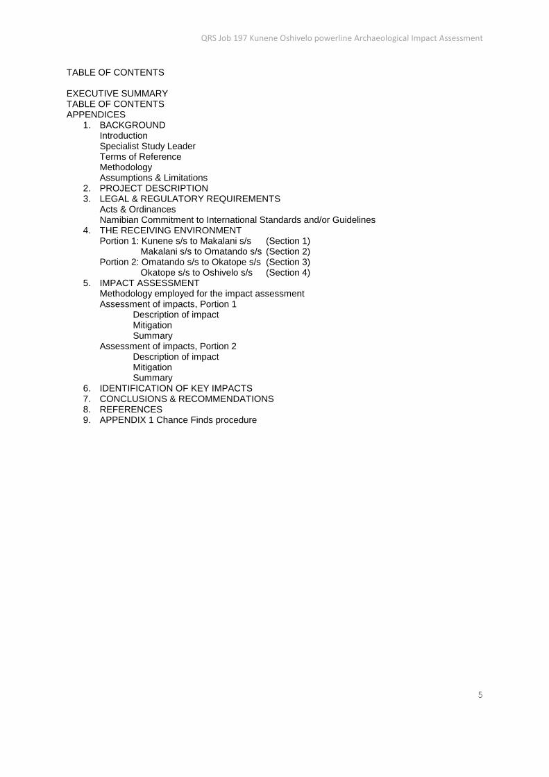
TABLE OF CONTENTS EXECUTIVE SUMMARY TABLE OF CONTENTS APPENDICES
1. BACKGROUND Introduction Specialist Study Leader Terms of Reference Methodology Assumptions & Limitations
2. PROJECT DESCRIPTION 3. LEGAL & REGULATORY REQUIREMENTS
Acts & Ordinances Namibian Commitment to International Standards and/or Guidelines
4. THE RECEIVING ENVIRONMENT Portion 1: Kunene s/s to Makalani s/s (Section 1) Makalani s/s to Omatando s/s (Section 2) Portion 2: Omatando s/s to Okatope s/s (Section 3) Okatope s/s to Oshivelo s/s (Section 4)
5. IMPACT ASSESSMENT Methodology employed for the impact assessment Assessment of impacts, Portion 1 Description of impact Mitigation Summary Assessment of impacts, Portion 2 Description of impact Mitigation Summary
6. IDENTIFICATION OF KEY IMPACTS 7. CONCLUSIONS & RECOMMENDATIONS 8. REFERENCES 9. APPENDIX 1 Chance Finds procedure

QRS Job 197 Kunene Oshivelo powerline Archaeological Impact Assessment
6
1. BACKGROUND Introduction NamPower (Pty) Ltd, the Namibian power utility, proposes to construct a new 400 kV transmission line between Kunene sub-station and Oshivelo sub-station. The powerline, approximately 380 km in length, will traverse the north central regions of Omusati, Oshona and Oshikoto. The area to be crossed by the powerline varies from sparsely populated mopane woodland in the west, to densely settled urban areas centering on Oshikati and Ondangwa.
Although the archaeology of this region is not known in detail, studies at a number of sites have revealed a documented sequence of early hominin and modern human occupation spanning the last one million years (Conroy et al 1992; Kinahan 2011). It is expected that the region will yield important new evidence relating to the establishment of settled agricultural communities during the last two millennia, although no systematic research has yet been carried out to evaluate this.
In order to implement the Kunene Oshivelo powerline project, NamPower (Pty) Ltd is required to follow the environmental assessment process as directed by the Environmental Management Act (2007) and its Regulations (2012). To meet these requirements NamPower has appointed EnviroDynamics (Pty) Ltd to carry out an Environmental Impact Assessment (EIA). The National Heritage Act (2004) makes provision for the assessment of archaeological impacts, and EnviroDynamics has engaged QRS to prepare a baseline study consisting of a desk assessment (submitted 12th March 2014) and a field survey based on limited sampling of the powerline route, as reported here. This report presents the assessment of impacts on the archaeology of the powerline project as may be expected from the construction, operation and decommissioning stages. The report sets out various laws, ordinances and guidelines applicable to the project and presents a series of mitigation proposals.
Specialist Study Leader The archaeological impact assessment was carried out by Dr J. Kinahan of Quaternary Research Services, P.O. Box 22407, Windhoek.
Terms of Reference The sub-consultancy agreement between Enviro Dynamics and QRS concerning the Kunene Oshivelo powerline archaeological impact assessment sets out the following terms of reference designed to meet the requirements of the Namibian Environmental Management Act (7 of 2007), and its Regulations (2012): 1. Identify sensitive archaeological sites within the footprint area of the proposed project and explain the archaeological value of each site. 2. Identify relevant protocols, legal and permit requirements; 3. Assess the anticipated impacts of the project on the archaeology, with particular emphasis on the various phases of the project (i.e. construction, operation and maintenance phase); 4. Provide management actions to avoid/reduce negative impacts or enhance benefits, as well as associated long term monitoring requirements. Methodology The archaeological study was based on protocols developed for archaeological assessment in Namibia, intended to take into account the terms of the National Heritage Act (2004). Thus, the archaeological study identified potential sources of risk posed by the powerline project, and specific to the archaeology of the area as it is known from existing data and from the additional field survey carried out as part of
QRS Job 197 Kunene Oshivelo powerline Archaeological Impact Assessment
7
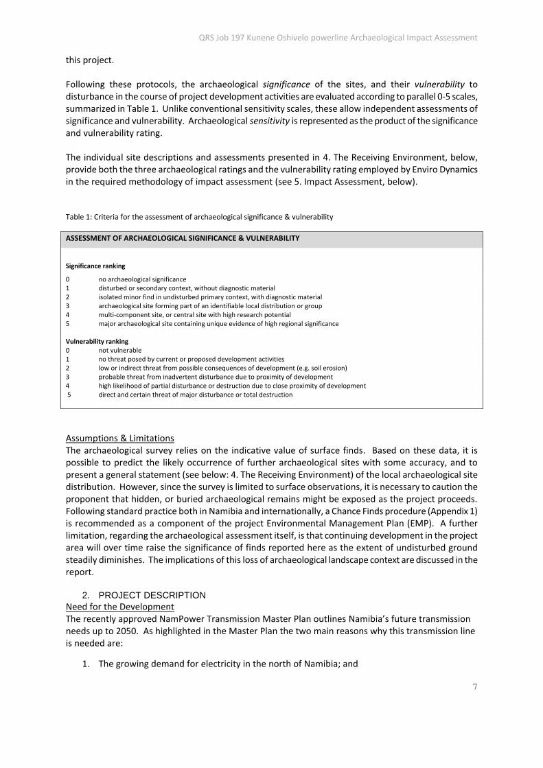
this project. Following these protocols, the archaeological significance of the sites, and their vulnerability to disturbance in the course of project development activities are evaluated according to parallel 0-5 scales, summarized in Table 1. Unlike conventional sensitivity scales, these allow independent assessments of significance and vulnerability. Archaeological sensitivity is represented as the product of the significance and vulnerability rating. The individual site descriptions and assessments presented in 4. The Receiving Environment, below, provide both the three archaeological ratings and the vulnerability rating employed by Enviro Dynamics in the required methodology of impact assessment (see 5. Impact Assessment, below). Table 1: Criteria for the assessment of archaeological significance & vulnerability
ASSESSMENT OF ARCHAEOLOGICAL SIGNIFICANCE & VULNERABILITY
Significance ranking
0 no archaeological significance 1 disturbed or secondary context, without diagnostic material 2 isolated minor find in undisturbed primary context, with diagnostic material 3 archaeological site forming part of an identifiable local distribution or group 4 multi-component site, or central site with high research potential 5 major archaeological site containing unique evidence of high regional significance Vulnerability ranking 0 not vulnerable 1 no threat posed by current or proposed development activities 2 low or indirect threat from possible consequences of development (e.g. soil erosion) 3 probable threat from inadvertent disturbance due to proximity of development 4 high likelihood of partial disturbance or destruction due to close proximity of development 5 direct and certain threat of major disturbance or total destruction
Assumptions & Limitations The archaeological survey relies on the indicative value of surface finds. Based on these data, it is possible to predict the likely occurrence of further archaeological sites with some accuracy, and to present a general statement (see below: 4. The Receiving Environment) of the local archaeological site distribution. However, since the survey is limited to surface observations, it is necessary to caution the proponent that hidden, or buried archaeological remains might be exposed as the project proceeds. Following standard practice both in Namibia and internationally, a Chance Finds procedure (Appendix 1) is recommended as a component of the project Environmental Management Plan (EMP). A further limitation, regarding the archaeological assessment itself, is that continuing development in the project area will over time raise the significance of finds reported here as the extent of undisturbed ground steadily diminishes. The implications of this loss of archaeological landscape context are discussed in the report.
2. PROJECT DESCRIPTION
Need for the Development The recently approved NamPower Transmission Master Plan outlines Namibia’s future transmission needs up to 2050. As highlighted in the Master Plan the two main reasons why this transmission line is needed are:
1. The growing demand for electricity in the north of Namibia; and

QRS Job 197 Kunene Oshivelo powerline Archaeological Impact Assessment
8
2. The need to strengthen the northern section of NamPower's transmission grid to ensure security
of supply.
Route alternatives & selection During the route alternatives selection process and physical route evaluation of the EIA, the following opportunities and constraints were raised:
1. The route was very close to the lower Etaka river channel, Lake Oponono and several smaller pans along the northern boundary of the Etosha Pan, which is a sensitive area to water bird life, especially the critically endangered Blue Crane. Therefore the section from Onanyanga to the proposed site of the Makalani Substation and again the entire section from the Makalani Substation almost to the Oshivelo Substation were located in or very near the breeding grounds of the Blue Crane. This element of the route could lead to unacceptable Blue Crane fatalities, as this species is prone to power line collisions.
2. Moving the section from Onanyanga to the Makalani Substation northward will reduce the risk to birds drastically, while no increased socio-economic constraint is expected.
3. The section between Makalani Substation and Omatando Substation is very densely populated. By using a mono-pole structure and careful route selection the effect on the inhabitants and compensation requirements can be reduced to acceptable levels.
4. Moving the section from the proposed site for the Makalani Substation to the Oshivelo Substation merely further north (away from the water courses and pans mentioned) on a new alignment would cause severe socio-economic disruption with excessive compensation costs, making the project not viable.
5. The route of the existing 132 kV line from Omatando to Okatope could be successfully widened to accommodate the new 400 kV line with limited compensation costs and socio-economic impacts.
6. The route of the existing 132 kV line from Okatope to Oshivelo Substation is very densely populated with major villages and large homesteads. Using the existing route in this section will cause excessive social disruption and compensation cost will be excessive.
7. A new route was set out north of the railway line from near Okatope to Oshivelo substation via a more direct but less populous area. The result is that the socio-economic effect and compensation requirement are lowered significantly.
Proposed new substations & lines
The proposed new substations (SS) and 400 kV transmission (TX) lines will be constructed as follows:
Makalani SS – approximately 500 m x 500 m (25 ha);
Omatando SS expansion – existing substation is to be extended in a north-westerly direction, 230 m x 330 m (7.6 ha);
Section 1: Single circuit TX line approximately 184 km, from the Kunene SS site (this substation site has already received Environmental Clearance) eastward to the Makalani SS located approximately 12 km due south of Oshakati;
Section 2: Single circuit TX line approximately 18 km long, from Makalani SS site north to Omatando SS located on the outskirts of Ongwediva;
Section 3: Single circuit TX line approximately 68 km, from Omatando SS eastward, running along the existing 132 kV TX line to the vicinity of Okatope SS; and
QRS Job 197 Kunene Oshivelo powerline Archaeological Impact Assessment
9
Section 4: Single circuit TX line approximately 106 km, on a new alignment (deviating from 132 kV line), from the vicinity of Okatope SS to Oshivelo SS.
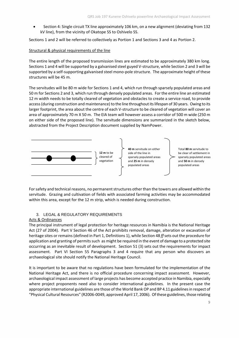
Sections 1 and 2 will be referred to collectively as Portion 1 and Sections 3 and 4 as Portion 2. Structural & physical requirements of the line The entire length of the proposed transmission lines are estimated to be approximately 380 km long. Sections 1 and 4 will be supported by a galvanised steel guyed V-structure, while Section 2 and 3 will be supported by a self-supporting galvanised steel mono-pole structure. The approximate height of these structures will be 45 m. The servitudes will be 80 m wide for Sections 1 and 4, which run through sparsely populated areas and 50 m for Sections 2 and 3, which run through densely populated areas. For the entire line an estimated 12 m width needs to be totally cleared of vegetation and obstacles to create a service road, to provide access (during construction and maintenance) to the line throughout its lifespan of 30 years. Owing to its larger footprint, the area about the centre of each V-structure to be cleared of vegetation will cover an area of approximately 70 m X 50 m. The EIA team will however assess a corridor of 500 m wide (250 m on either side of the proposed line). The servitude dimensions are summarized in the sketch below, abstracted from the Project Description document supplied by NamPower.
For safety and technical reasons, no permanent structures other than the towers are allowed within the servitude. Grazing and cultivation of fields with associated farming activities may be accommodated within this area, except for the 12 m strip, which is needed during construction.
3. LEGAL & REGULATORY REQUIREMENTS
Acts & Ordinances The principal instrument of legal protection for heritage resources in Namibia is the National Heritage Act (27 of 2004). Part V Section 46 of the Act prohibits removal, damage, alteration or excavation of heritage sites or remains (defined in Part 1, Definitions 1), while Section 48 ff sets out the procedure for application and granting of permits such as might be required in the event of damage to a protected site occurring as an inevitable result of development. Section 51 (3) sets out the requirements for impact assessment. Part VI Section 55 Paragraphs 3 and 4 require that any person who discovers an archaeological site should notify the National Heritage Council. It is important to be aware that no regulations have been formulated for the implementation of the National Heritage Act, and there is no official procedure concerning impact assessment. However, archaeological impact assessment of large projects has become accepted practice in Namibia, especially where project proponents need also to consider international guidelines. In the present case the appropriate international guidelines are those of the World Bank OP and BP 4.11 guidelines in respect of “Physical Cultural Resources” (R2006-0049, approved April 17, 2006). Of these guidelines, those relating
Total 80 m servitude to
be clear of settlement in
sparsely populated areas
and 50 m in densely
populated areas
40 m servitude on either
side of the line in
sparsely populated areas
and 25 m in densely
populated areas
12 m to be
cleared of
vegetation

QRS Job 197 Kunene Oshivelo powerline Archaeological Impact Assessment
10
to project screening, baseline survey and mitigation are the most relevant. Archaeological impact assessment in Namibia may also take place under the rubric of the Environmental Management Act (7 of 2007) which specifically includes anthropogenic elements in its definition of environment. The List of activities that may not be undertaken without Environmental Clearance Certificate: Environmental Management Act, 2007 (Govt Notice 29 of 2012), and the Environmental Impact Assessment Regulations: Environmental Management Act, 2007 (Govt Notice 30 of 2012) both apply to the management of impacts on archaeological sites and remains whether these are considered in detail by the environmental assessment or not.
Namibian Commitment to International Standards and/or Guidelines The Government of the Republic of Namibia is signatory to the 1972 World Heritage Convention, which supposes a degree of general commitment to heritage conservation beyond the narrower definitions of the National Heritage Act (27 of 2004). The Government of the Republic of Namibia has not however developed any specific domestic guidelines or adopted any other internationally agreed guidelines. Projects intending to qualify for International Finance Corporation (IFC) assistance, whether initiated by the Government of the Republic of Namibia or any other corporation operating in Namibia, would nonetheless be obliged to conform to the requirements set out in the IFC Performance Standard 8, Cultural Heritage, as well as the specific provisions of the IFC Guidance Note 8, Cultural Heritage, both dated 1st January 2012. In brief, measures to protect cultural heritage from adverse effects of project activities are to be established during the environmental impact assessment process. The definitions of archaeological cultural heritage used by the IFC Performance Standard and Guidance Note 8 are essentially the same as those used in the Namibian National Heritage Act (27 of 2004). The IFC standards require that adequate data collection is carried out and competent professionals should carry out any excavation if this is required in order to rescue cultural heritage threatened by the project. Where excavation of archaeological sites is to be carried out, the IFC standards stipulate that the project “should apply internationally recognized practices to site surveys, excavation, preservation and publication, in addition to compliance with national law. An internationally recognized practice is defined as the exercise of professional skill, knowledge, diligence, prudence and foresight that would reasonably be expected from experienced professionals engaged in the same type of undertaking under the same or similar circumstances globally” (IFC Guidance Note 8, p3).
4. THE RECEIVING ENVIRONMENT
The central northern region of Namibia consists of an extensive deposit of Kalahari and Namib-type sands (approx. 70my to recent) with a single dominant fluvial system, the Cuvelai drainage, a complex of episodic inland delta streams which feed the Etosha basin from the mid-Kunene during seasonal floods (Mendelsohn et al 2002). The drainage lines, or oshanas, may hold standing water for several months. In general, the Cuvelai environment is highly suitable for dryland crop production, combining shallow groundwater and relatively fertile eutric soils. Traditional rain-fed agriculture, concentrating on millet and sorghum, is combined with stock farming to form a secure subsistence economy that has persisted in the area for approximately one thousand years. Very little archaeological research has been carried out in the central northern region of the country (Kinahan 2011; Williams 1991). However, centralized tribal polities have existed in the area for at least five hundred years, according to oral records. Physical archaeological evidence of these communities remains elusive, however, due to the impermanent nature of settlement and an array of cultural practices that militate against archaeological preservation. For example, traditional settlements among the Ovambo-speaking peoples of the region are constructed almost exclusively from highly perishable
QRS Job 197 Kunene Oshivelo powerline Archaeological Impact Assessment
11
local timber and thatch. Also, relatively little pottery – an important archaeological indicator – is used, and in traditional practice there are no formal burial grounds, and the dead are generally buried in or near the settlement in unmarked graves. Settlements are usually moved after the death of the household head, and in doing so, the entire timber palisade forming the perimeter of the settlement is uprooted and taken to the new site, such that very little remains to mark its former position. One feature of the traditional settlement that could not be moved was the large shade tree, usually a marula Sclerocarya birrea, wild fig e.g. Ficus sycomorus, or baobab Adansonia digitata on the edge of the village. Wells are another relatively persistent feature of traditional settlement. These range from small, shallow impoundments, to impressive earthworks with large surrounding spoilheaps, and in areas with hard calcrete, deep shafts, sometimes incorporating extensive timber supports, fences and drinking troughs made from hollowed logs of palm Hyphanae petersiana. Timber resources for these construction needs were, at least in the past, readily available from the mixture of acacia savannah, mopane Colophospermum mopane and broadleaf savannah characterizing the central northern region of Namibia. Wide swathes of the region are relatively treeless grasslands, although this is not as a consequence of deforestation.
Despite the fact that the northern regions of Namibia to be traversed by the powerline project are not well known archaeologically there is a good possibility that the area contains well preserved remains of early farming settlement from the first millennium AD. The following desk level appraisal of the alignment, in sections proceeding from west to east, addresses the likely occurrence of archaeological sites: Portion 1: Kunene s/s to Makalani s/s (Section 1); Makalani s/s to Omatando s/s (Section 2)
Desk study assessment: Ruacana s/s 72 km on bearing 119° mag to 14.84° East Longitude: alignment runs south of two prominent Chuos Fmn quartzite ridges and crosses a small pan complex, both features are likely to be associated with some archaeological remains. From 14.84° East Longitude 27 km on bearing 119°mag to 15.06° East Longitude: alignment runs through apparently uninhabited panveld with small isolated pans, probably of minimal archaeological interest. From 15.06° East Longitude 71 km on bearing 70° mag to 15.69° East Longitude: alignment crosses the Etaka drainage at approximately five points where there is a good likelihood of archaeological remains on the streambanks. From 15.69° East Longitude 19 km on bearing 18° mag to 15.76° East Longitude: alignment runs along the eastern outskirts of Oshakati, an area that is assumed to be highly disturbed and unlikely to contain well preserved archaeological remains. Field assessment:
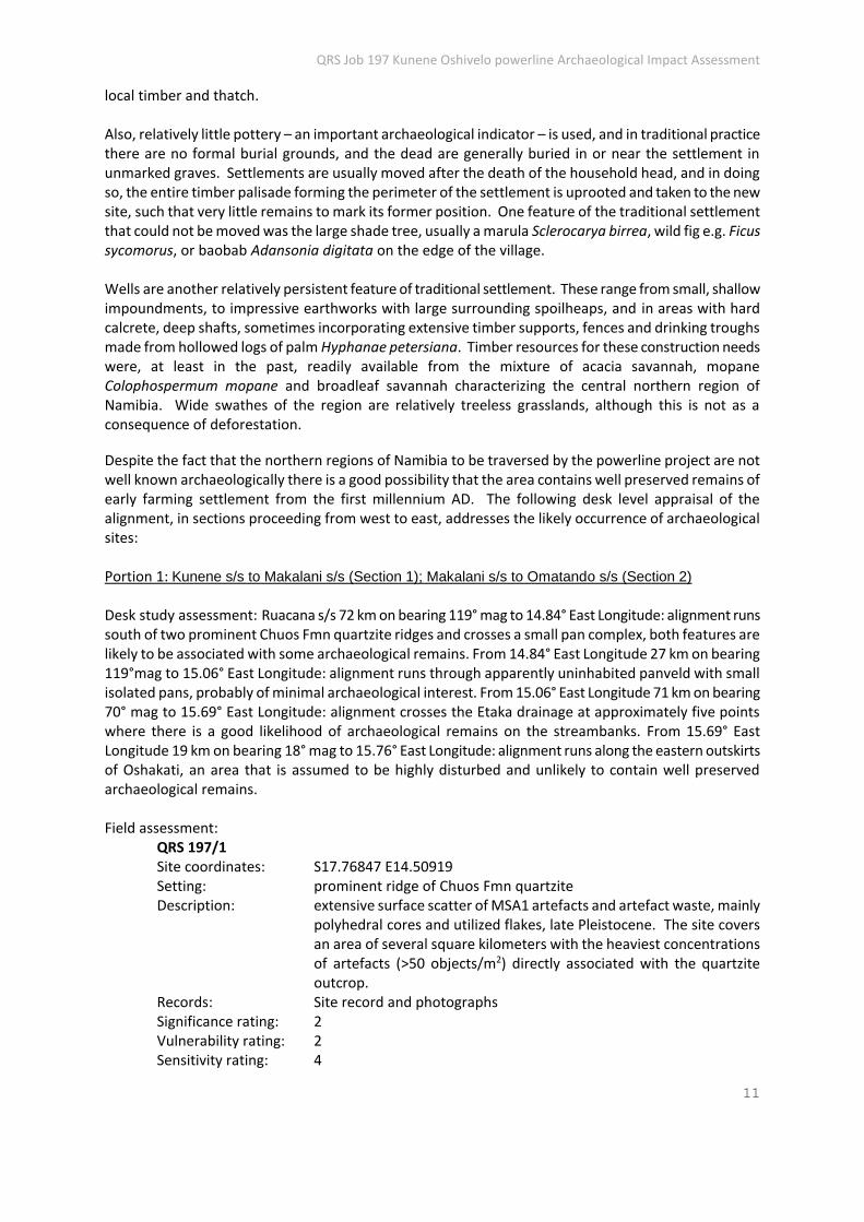
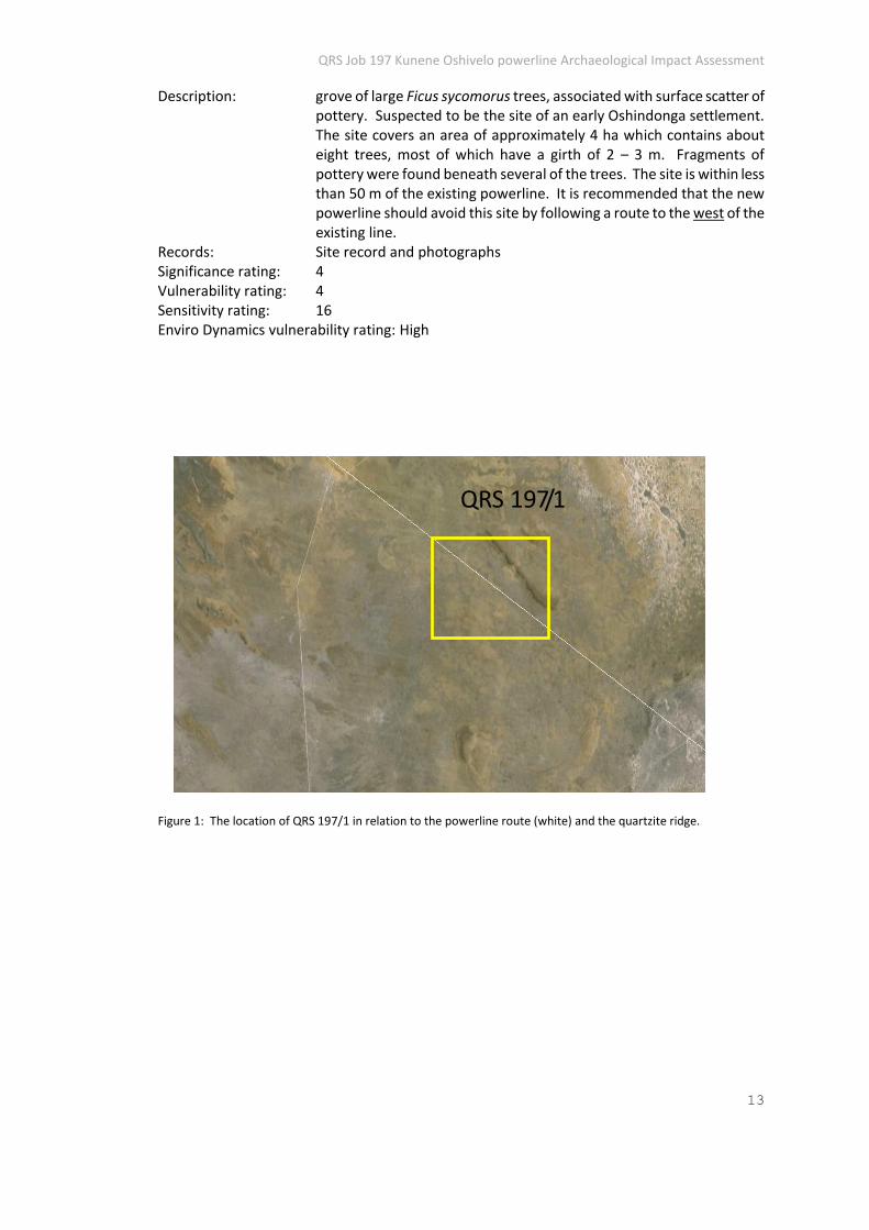
QRS 197/1 Site coordinates: S17.76847 E14.50919 Setting: prominent ridge of Chuos Fmn quartzite Description: extensive surface scatter of MSA1 artefacts and artefact waste, mainly
polyhedral cores and utilized flakes, late Pleistocene. The site covers an area of several square kilometers with the heaviest concentrations of artefacts (>50 objects/m2) directly associated with the quartzite outcrop.
Records: Site record and photographs Significance rating: 2 Vulnerability rating: 2 Sensitivity rating: 4

QRS Job 197 Kunene Oshivelo powerline Archaeological Impact Assessment
12
Enviro Dynamics vulnerability rating: Low Two proclaimed national monument sites are also located in the vicinity of Portion 1, although these sites (listed below) will not be affected by the project. It is likely that other sites of recent historical significance will be identified in the area and placed under special protection by the National Heritage Council.
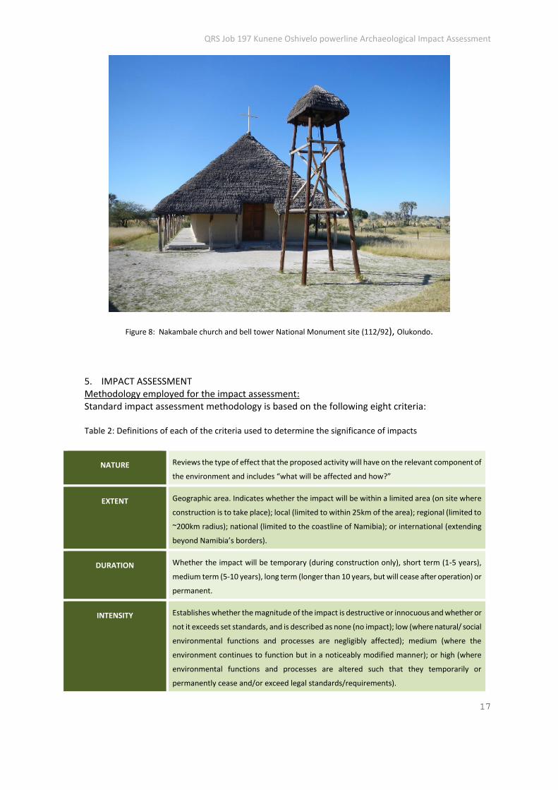
Omungulumbashe battlefield memorial National Monument 116/2004 Site coordinates: S17.98355 E16.02409 Setting: mopane woodland area on southern margin of Omungulumbashe
village, adjacent to village clinic. Description: fenced area containing monuments and information centre. Records: Site record and photographs Significance rating: 4 Vulnerability rating: 1 Sensitivity rating: 4 Enviro Dynamics vulnerability rating: Low Nakambale church & cemetery National Monument 112/92 Site coordinates: S17.76878 E14.69631 Setting: floodplain area near Olukondo southeast of Ondangwa Description: historical Finnish mission station comprising historical church
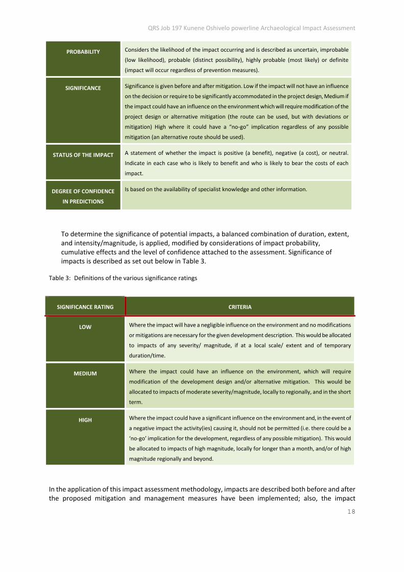
(restored), cemetery, museum (in mission house) and cultural village. Records: Site record and photographs Significance rating: 4 Vulnerability rating: 2 Sensitivity rating: 8 Enviro Dynamics vulnerability rating: Medium
Portion 2: Omatando s/s to Okatope s/s (Section 3); Okatope s/s to Oshivelo s/s (Section 4)
Desk study assessment: From 15.76° East Longitude 39 km on bearing 119° mag to 15.9° East Longitude: alignment runs through densely settled oshana area with some likelihood of archaeological remains. From 15.9° East Longitude 29 km on bearing 134° mag to 16.2° East Longitude: alignment much as previous. From 16.2° East Longitude 36 km on bearing 113° mag to 16.5° East Longitude: alignment as previous but drainage not well developed so less likelihood of archaeological remains. From 16.5° East Longitude 70 km on bearing 122° mag to 17.1° East Longitude: alignment runs through densely settled corridor with little likelihood of archaeological remains except in vicinity of Beisebvlakte pan and Omuthiya River. From 17.1° East Longitude 15 km on bearing 149° mag to 17.18° East Longitude: alignment ends on north bank of Omuramba Owambo near Oshivelo. The area is disturbed but there is some likelihood of archaeological remains near the omuramba. Field assessment:
QRS 197/2 Site coordinates: S17.72390 E15.79009 Setting: floodplain north of Ondangwa
QRS Job 197 Kunene Oshivelo powerline Archaeological Impact Assessment
13
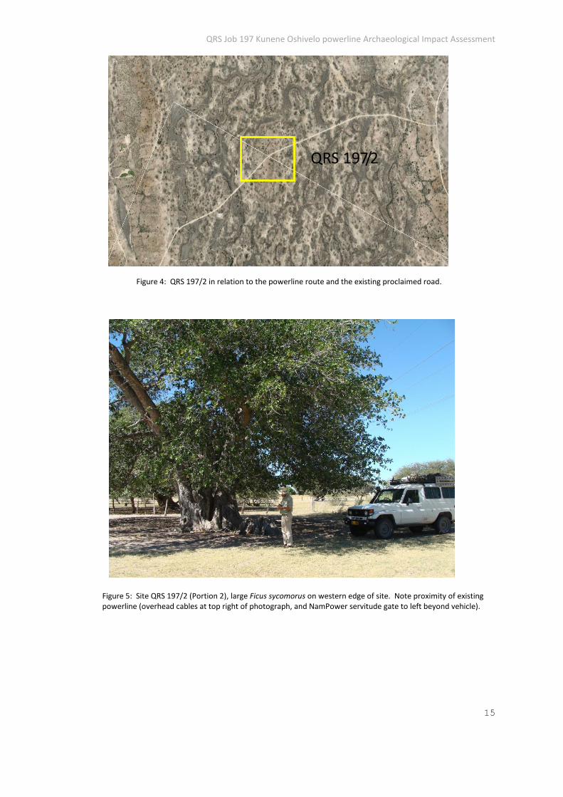
Description: grove of large Ficus sycomorus trees, associated with surface scatter of pottery. Suspected to be the site of an early Oshindonga settlement. The site covers an area of approximately 4 ha which contains about eight trees, most of which have a girth of 2 – 3 m. Fragments of pottery were found beneath several of the trees. The site is within less than 50 m of the existing powerline. It is recommended that the new powerline should avoid this site by following a route to the west of the existing line.
Records: Site record and photographs Significance rating: 4 Vulnerability rating: 4 Sensitivity rating: 16 Enviro Dynamics vulnerability rating: High
Figure 1: The location of QRS 197/1 in relation to the powerline route (white) and the quartzite ridge.
QRS 197/1
QRS Job 197 Kunene Oshivelo powerline Archaeological Impact Assessment
14
Figure 2: Site QRS 197/1 (Portion 1), general view of outcropping Chuos Fmn quartzite near crest of ridge.
Figure 3: Site QRS 197/1 (Portion 1), Late Pleistocene artefacts in fine grained Chuos Fmn quartzite: polyhedral on left, utilized core flake on right.
QRS Job 197 Kunene Oshivelo powerline Archaeological Impact Assessment
15
Figure 4: QRS 197/2 in relation to the powerline route and the existing proclaimed road.
Figure 5: Site QRS 197/2 (Portion 2), large Ficus sycomorus on western edge of site. Note proximity of existing powerline (overhead cables at top right of photograph, and NamPower servitude gate to left beyond vehicle).
QRS 197/2
QRS Job 197 Kunene Oshivelo powerline Archaeological Impact Assessment
16
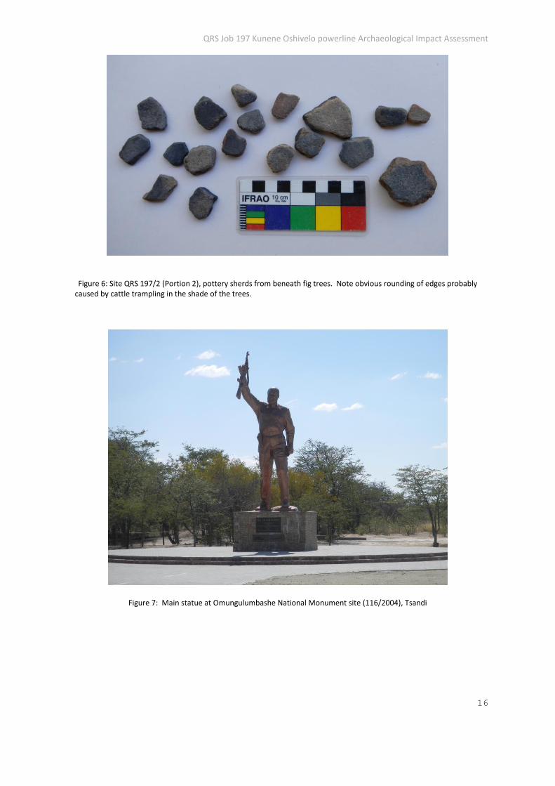
Figure 6: Site QRS 197/2 (Portion 2), pottery sherds from beneath fig trees. Note obvious rounding of edges probably caused by cattle trampling in the shade of the trees.
Figure 7: Main statue at Omungulumbashe National Monument site (116/2004), Tsandi
QRS Job 197 Kunene Oshivelo powerline Archaeological Impact Assessment
17
Figure 8: Nakambale church and bell tower National Monument site (112/92), Olukondo.
5. IMPACT ASSESSMENT Methodology employed for the impact assessment: Standard impact assessment methodology is based on the following eight criteria: Table 2: Definitions of each of the criteria used to determine the significance of impacts
NATURE Reviews the type of effect that the proposed activity will have on the relevant component of
the environment and includes “what will be affected and how?”
EXTENT Geographic area. Indicates whether the impact will be within a limited area (on site where
construction is to take place); local (limited to within 25km of the area); regional (limited to
~200km radius); national (limited to the coastline of Namibia); or international (extending
beyond Namibia’s borders).
DURATION Whether the impact will be temporary (during construction only), short term (1-5 years),
medium term (5-10 years), long term (longer than 10 years, but will cease after operation) or
permanent.
INTENSITY Establishes whether the magnitude of the impact is destructive or innocuous and whether or
not it exceeds set standards, and is described as none (no impact); low (where natural/ social
environmental functions and processes are negligibly affected); medium (where the
environment continues to function but in a noticeably modified manner); or high (where
environmental functions and processes are altered such that they temporarily or
permanently cease and/or exceed legal standards/requirements).
QRS Job 197 Kunene Oshivelo powerline Archaeological Impact Assessment
18
PROBABILITY Considers the likelihood of the impact occurring and is described as uncertain, improbable
(low likelihood), probable (distinct possibility), highly probable (most likely) or definite
(impact will occur regardless of prevention measures).
SIGNIFICANCE Significance is given before and after mitigation. Low if the impact will not have an influence
on the decision or require to be significantly accommodated in the project design, Medium if
the impact could have an influence on the environment which will require modification of the
project design or alternative mitigation (the route can be used, but with deviations or
mitigation) High where it could have a “no-go” implication regardless of any possible
mitigation (an alternative route should be used).
STATUS OF THE IMPACT A statement of whether the impact is positive (a benefit), negative (a cost), or neutral.
Indicate in each case who is likely to benefit and who is likely to bear the costs of each
impact.
DEGREE OF CONFIDENCE
IN PREDICTIONS
Is based on the availability of specialist knowledge and other information.
To determine the significance of potential impacts, a balanced combination of duration, extent, and intensity/magnitude, is applied, modified by considerations of impact probability, cumulative effects and the level of confidence attached to the assessment. Significance of impacts is described as set out below in Table 3.
Table 3: Definitions of the various significance ratings
SIGNIFICANCE RATING CRITERIA
LOW Where the impact will have a negligible influence on the environment and no modifications
or mitigations are necessary for the given development description. This would be allocated
to impacts of any severity/ magnitude, if at a local scale/ extent and of temporary
duration/time.
MEDIUM Where the impact could have an influence on the environment, which will require
modification of the development design and/or alternative mitigation. This would be
allocated to impacts of moderate severity/magnitude, locally to regionally, and in the short
term.
HIGH Where the impact could have a significant influence on the environment and, in the event of
a negative impact the activity(ies) causing it, should not be permitted (i.e. there could be a
‘no-go’ implication for the development, regardless of any possible mitigation). This would
be allocated to impacts of high magnitude, locally for longer than a month, and/or of high
magnitude regionally and beyond.
In the application of this impact assessment methodology, impacts are described both before and after the proposed mitigation and management measures have been implemented; also, the impact
QRS Job 197 Kunene Oshivelo powerline Archaeological Impact Assessment
19
evaluation takes into consideration the cumulative effects associated with this project. Cumulative impacts can occur from the collective impacts of individual minor actions over a period of time and can include both direct and indirect impacts;
Mitigation / management actions are addressed where negative impacts are identified; these are by definition practical mitigation measures (i.e. ways of avoiding or reducing negative impacts). Such measures may require continuous or periodic monitoring (as part of mitigation), as this is needed to assess the effectiveness of mitigation actions, and to modify or adapt mitigation measures over time, should this prove necessary. In the assessment and mitigation of archaeological heritage impacts, it is important to consider the applicable IFC Performance Standards and Guidelines, so as to ensure that the study complies with international as well as national/domestic requirements.
Assessment of impacts, Portion 1: At the construction stage of the powerline it is expected that that the most important types of impact on the archaeological heritage will be physical disturbance or destruction of sites or remains within or close to the designated alignment. Related to this is a second type of impact which may be described as the disruption of the landscape setting or physical context of the archaeological sites or remains. It therefore follows that the extent of such impacts will be both local, in the sense of the specific site, and at the landscape level. Because damage to, or destruction of archaeological heritage sites cannot be reversed, the duration of such impacts is considered to be permanent. Where a high risk of impact is associated with a significant archaeological site and the certainty of disrupting the landscape setting of the site, it is imperative that appropriate mitigation measures are adopted. Due to the fact that archaeological heritage sites in Namibia are characterized by highly dispersed distributions of small sites which together define the archaeological landscape, mitigation of impacts usually involves direct, site-specific actions including mapping, systematic surface collection and excavation and removal in the case of sites such as burials, or graves. Experience has shown that especially for small sites, piecemeal protection measures (eg site cordons) are ineffective where the site concerned is in the near vicinity of the envisaged development. Such impacts as occur at the construction stage are expected to decrease through the operational stage of the powerline, mainly due to the relatively low maintenance requirements of such installations. However, it is to be expected that negative impacts on the archaeological heritage and its landscape setting would accelerate during the decommissioning stage of the project, bringing comparable levels of disturbance to those associated with the construction stage. The intensity of direct impacts is expected to vary according to the proximity of both formal components and uncontrolled spill-over of activities such as bush clearing. Due to the restricted corridor of the powerline project area, combined with satisfactory visibility of archaeological heritage remains, the assessment presented here is based on a medium level of confidence. This is limited however, by the possibility of unanticipated impacts occurring during the construction stage. For this reason, it is recommended that the project EMP adopt the Chance Finds procedure presented as Appendix 1. Mitigation: Following established best practice standards as well as the Namibian legislation and the IFC Standards and Guidance Notes 8, mitigation of archaeological heritage impacts during the powerline construction should include:
a. Integration of the archaeological heritage data presented here with the project EMP and the
QRS Job 197 Kunene Oshivelo powerline Archaeological Impact Assessment
20
development of a framework for a site audit procedure. b. Adoption of the archaeological Chance Finds procedure as part of the project EMP.
Summary: Direct impacts or risks of impact on archaeological sites located near the proposed powerline can be reduced to acceptable levels by the adoption of appropriate mitigation measures including integration of the archaeological heritage record and Chance Finds procedure in the project EMP. Assessment of Impacts, Portion 2: At the construction stage of the powerline it is expected that that the most important types of impact on the archaeological heritage will be physical disturbance or destruction of sites or remains within or close to the designated alignment. Related to this is a second type of impact which may be described as the disruption of the landscape setting or physical context of the archaeological sites or remains. It therefore follows that the extent of such impacts will be both local, in the sense of the specific site, and at the landscape level. Because damage to, or destruction of archaeological heritage sites cannot be reversed, the duration of such impacts is considered to be permanent. Where a high risk of impact is associated with a significant archaeological site and the certainty of disrupting the landscape setting of the site, it is imperative that appropriate mitigation measures are adopted. Due to the fact that archaeological heritage sites in Namibia are characterized by highly dispersed distributions of small sites which together define the archaeological landscape, mitigation of impacts usually involves direct, site-specific actions including mapping, systematic surface collection and excavation and removal in the case of sites such as burials, or graves. Experience has shown that especially for small sites, piecemeal protection measures (eg site cordons) are ineffective where the site concerned is in the near vicinity of the envisaged development. Such impacts as occur at the construction stage are expected to decrease through the operational stage of the powerline, mainly due to the relatively low maintenance requirements of such installations. However, it is to be expected that negative impacts on the archaeological heritage and its landscape setting would accelerate during the decommissioning stage of the project, bringing comparable levels of disturbance to those associated with the construction stage. The intensity of direct impacts is expected to vary according to the proximity of both formal components and uncontrolled spill-over of activities such as bush clearing. Due to the restricted corridor of the powerline project area, combined with satisfactory visibility of archaeological heritage remains, the assessment presented here is based on a medium level of confidence. This is limited however, by the possibility of unanticipated impacts occurring during the construction stage. For this reason, it is recommended that the project EMP adopt the Chance Finds procedure presented as Appendix 1. Mitigation: Following established best practice standards as well as the Namibian legislation and the IFC Standards and Guidance Notes 8, mitigation of archaeological heritage impacts during the powerline construction should include:
a. Integration of the archaeological heritage data presented here with the project EMP and the development of a framework for a site audit procedure.
b. Adoption of the archaeological Chance Finds procedure as part of the project EMP. c. If possible the powerline should be routed to avoid QRS 197/2, with a minimum of 75m radius of
the figtree grove kept clear of pylons, servitude tracks, fences &c.
QRS Job 197 Kunene Oshivelo powerline Archaeological Impact Assessment
21
Summary: Direct impacts or risks of impact on archaeological sites located near the proposed powerline can be reduced to acceptable levels by the adoption of appropriate mitigation measures including integration of the archaeological heritage record and Chance Finds procedure in the project EMP. Special effort should be made to avoid impacts on QRS 197/2 by avoiding the figtree grove as far as possible.
6. IDENTIFICATION OF KEY IMPACTS The key impacts of the Kunene Oshivelo powerline project on the archaeological heritage will be physical disturbance or destruction of sites or remains within or close to the designated footprint of the proposed powerline and its associated surface works, and disruption of the landscape setting or physical context of the archaeological sites or remains. Such impacts will be both local, in the sense of the specific site, and at the landscape level.
7. CONCLUSIONS & RECOMMENDATIONS
The proposed Kunene Oshivelo powerline project will have a relatively low archaeological impact, as determined from a two phase study involving desk assessment of available information and direct field assessment of selected sites along the powerline route. Of the two archaeological sites considered to be significant, only one is especially sensitive, QRS 197/2. In the case of the latter site special precautions are suggested, including the siting of the new powerline to the west of the existing line. It is also recommended that the Chance Finds procedure (Appendix 1) is included as part of the project EMP.
8. REFERENCES
Conroy, G. et al 1992. Otavipithecus namibiensis, first Miocene hominoid from southern Africa. Nature 356: 144-148. Kinahan, J. 2011. From the beginning: the archaeological evidence. In Wallace, M and Kinahan, J. A History of Namibia: from the beginning to 1990. London, Hurst. Mendelsohn, J. et al 2004. Atlas of Namibia: a portrait of the land and its people. Cape Town, David Phillip. Schneider, G. 2004. The Roadside Geology of Namibia. Sammlung Geologischer Fuhrer 97. Berlin, Gebr. Borntraeger. Williams, F.-N. 1991. Precolonial communities of southwestern Africa: a history of Owambo kingdoms 1600-1920. Windhoek, National Archives of Namibia. Additional data sources: National Museum of Namibia Archaeological Accessions Register (B Catalogue) Namib Desert Archaeological Survey GIS database and Radiocarbon dating database
QRS Job 197 Kunene Oshivelo powerline Archaeological Impact Assessment
22
APPENDIX 1
Recommended archaeological Chance Finds procedure The “chance finds” procedure covers the actions to be taken from the discovery of a heritage site or item, to its investigation and assessment by a trained archaeologist or other appropriately qualified person. The “chance finds” procedure is intended to ensure compliance with the relevant provisions of the National Heritage Act (27 of 2004), especially Section 55 (4): “ a person who discovers any archaeological …. object ……must as soon as practicable report the discovery to the Council”. The procedure of reporting set out below must be observed so that heritage remains reported to the NHC are correctly identified in the field.
RESPONSIBILITIES Operator To exercise due caution if archaeological remains are found Foreman To secure site and advise management timeously Superintendent To determine safe working boundary and request inspection Archaeologist To inspect, identify, advise management, and recover remains PROCEDURE Action by person identifying archaeological or heritage material a) If operating machinery or equipment stop work b) Identify the site with flag tape c) Determine GPS position if possible d) Report findings to foreman Action by foreman a) Report findings, site location and actions taken to superintendent b) Cease any works in immediate vicinity Action by superintendent a) Visit site and determine whether work can proceed without damage to findings b) Determine and mark exclusion boundary c) Site location and details to be added to GIS for field confirmation by archaeologist Action by archaeologist a) Inspect site and confirm addition to GIS b) Advise NHC and request written permission to remove findings from work area c) Recovery, packaging and labelling of findings for transfer to National Museum In the event of discovering human remains a) Actions as above b) Field inspection by archaeologist to confirm that remains are human c) Advise and liaise with NHC and Police d) Recovery of remains and removal to National Museum or National Forensic Laboratory, as directed.