Archaelogical Methods - Landscapes LLANOS de MOJOS
17
Archaeology in the lowland American tropics Current analytical methods and applications 3 Archaeological methods for the study of ancient landscapes of the Llanos de Mojos in the Bolivian Amazon CLARK L. ERICKSON edited by PETER W. STAHL The archaeological study of agricultural systems C A M B R I D G E UNIVERSITY PRESS Archaeological gardens and field systems are notoriously difficult to study. They tend to be “artifact poor” contexts, and thus , extremely difficu lt to date with accuracy. Stratigraphy tends to be heavily reworked and eroded, the result of continual cultivation and mixing of soil structure by humans and nature, both during the time of use, and after abandonment. Due to the poor preservation of botanical remains, there is usually no direct evidence for the crops which were cultivated. Technological information on cultivation practices and tools is limited, and rarely is there direct evidence for labor and social organization, land tenure, and efficiency of the system. Ethnographic analogy can be useful in many contexts, but it is usually difficult to determine direct historical ties between contemporary farmers and their previous counterparts. In many situations, ancient field and garden systems have been completely abandoned, breaking any continuity between past and present. Even in cases where ties can be demonstrated, the social, political, economic, and environmental situation has changed so much that the usefulness of direct analogy is limited. Historical records can sometimes be extrapolated back into the past, but agricultural practices are not often discussed in sufficient detail. Despite these limitations to research, certain archaeological field methods, combined with experimental archaeology, can provide the detailed information lacking in cases where historical and ethnographic analogy is inadequate and preservation is poor. In this chapter, I discuss research techniques which have been useful in our study of raised field agriculture in the Bolivian Amazon. Archaeologists and geographers have dispelled the “pristine myth” of the natural environment of the Americas before the arrival of Europeans (Denevan 1992). Ancient landscapes of the Americas show evidence of massive l andscape modification projects undertaken by prehispanic populations. In raised field construction alone, there may have been 173,000 ha o f fie lds a nd can als throughout the wetlands of the Americas (estimate based on Denevan 1982). 6 6 1995
-
Upload
luiz-fernandes -
Category
Documents
-
view
219 -
download
0
Transcript of Archaelogical Methods - Landscapes LLANOS de MOJOS
8/6/2019 Archaelogical Methods - Landscapes LLANOS de MOJOS
http://slidepdf.com/reader/full/archaelogical-methods-landscapes-llanos-de-mojos 1/17
Archaeology in the lowlandAmerican tropics
Current analytical methods and applications
3 Archaeological methods for the study of
ancient landscapes of the Llanos de Mojosin the Bolivian Amazon
CLARK L. ERICKSON
edited by
PETER W. STAHL
The archaeological study of agricultural systems
C A M B R I D G E
UNIVERSITY PRESS
Archaeological gardens and field systems are notoriously difficult to study. They
tend to be “artifact poor” contexts, and thus, extremely difficult to date with
accuracy. Stratigraphy tends to be heavily reworked and eroded, the result of
continual cultivation and mixing of soil structure by humans and nature, bothduring the time of use, and after abandonment. Due to the poor preservation of
botanical remains, there is usually no direct evidence for the crops which were
cultivated. Technological information on cultivation practices and tools is
limited, and rarely is there direct evidence for labor and social organization, land
tenure, and efficiency of the system.
Ethnographic analogy can be useful in many contexts, but it is usually difficult
to determine direct historical ties between contemporary farmers and their
previous counterparts. In many situations, ancient field and garden systems have
been completely abandoned, breaking any continuity between past and present.
Even in cases where ties can be demonstrated, the social, political, economic, and
environmental situation has changed so much that the usefulness of direct
analogy is limited. Historical records can sometimes be extrapolated back intothe past, but agricultural practices are not often discussed in sufficient detail.
Despite these limitations to research, certain archaeological field methods,
combined with experimental archaeology, can provide the detailed information
lacking in cases where historical and ethnographic analogy is inadequate and
preservation is poor. In this chapter, I discuss research techniques which have
been useful in our study of raised field agriculture in the Bolivian Amazon.
Archaeologists and geographers have dispelled the “pristine myth” of the
natural environment of the Americas before the arrival of Europeans (Denevan
1992). Ancient landscapes of the Americas show evidence of massive landscape
modification projects undertaken by prehispanic populations. In raised field
construction alone, there may have been 173,000 ha of fields and canals
throughout the wetlands of the Americas (estimate based on Denevan 1982).
6 61995

8/6/2019 Archaelogical Methods - Landscapes LLANOS de MOJOS
http://slidepdf.com/reader/full/archaelogical-methods-landscapes-llanos-de-mojos 2/17
The study of ancient landscapes 67
3 Archaeological methods for the study of
ancient landscapes of the Llanos de Mojos
in the Bolivian Amazon
C L A R K L . E R I C K S O N
The archaeological study of agricultural systems
Archaeological gardens and field systems are notoriously difficult to study. They
tend to be “artifact poor” contexts, and thus, extremely difficult to date with
accuracy. Stratigraphy tends to be heavily reworked and eroded, the result of
continual cultivation and mixing of soil structure by humans and nature, both
during the time of use, and after abandonment. Due to the poor preservation of
botanical remains, there is usually no direct evidence for the crops which werecultivated. Technological information on cultivation practices and tools is
limited, and rarely is there direct evidence for labor and social organization, land
tenure, and efficiency of the system.
Ethnographic analogy can be useful in many contexts, but it is usually difficult
to determine direct historical ties between contemporary farmers and their
previous counterparts. In many situations, ancient field and garden systems have
been completely abandoned, breaking any continuity between past and present.
Even in cases where ties can be demonstrated, the social, political, economic, and
environmental situation has changed so much that the usefulness of direct
analogy is limited. Historical records can sometimes be extrapolated back into
the past, but agricultural practices are not often discussed in sufficient detail.
Despite these limitations to research, certain archaeological field methods,combined with experimental archaeology, can provide the detailed information
lacking in cases where historical and ethnographic analogy is inadequate and
preservation is poor. In this chapter, I discuss research techniques which have
been useful in our study of raised field agriculture in the Bolivian Amazon.
Archaeologists and geographers have dispelled the “pristine myth” of the
natural environment of the Americas before the arrival of Europeans (Denevan
1992) . Ancient landscapes of the Americas show evidence of massive landscape
modification projects undertaken by prehispanic populations. In raised field
construction alone, there may have been 173,000 ha of fields and canals
throughout the wetlands of the Americas (estimate based on Denevan 1982).
66
When this figure is combined with estimates on terrace construction, artificial
drainage networks, causeways and roads, and forest management, the effect on
the environment is awe-inspiring. The effect of such massive landscape modifica-
tion on the local ecology is unknown, but probably great. These are truly
anthropogenic landscapes.
Landscape archaeology has the potential to provide alternatives for sustainable
agriculture for small farmers. Archaeology can provide details on the long-term
history of local and regional landuse by native tropical peoples over thousands of
years. Today, many of these areas such as the Llanos de Mojos of Bolivia are
abandoned and depopulated. In other areas, large expanses of land have been
appropriated for use by ranchers; thereby, suffering severe degradation through
over exploitation by non-appropriate technologies. Some of this knowledge of
past landuse technologies could be put into use by development agencies for
ecologically sound agricultural production. It can not only aid native peoples, but
can also relieve pressure on fragile landscapes like the tropical forests, by
providing sustainable and appropriate alternatives to western models of
development.
Much of the available historical data regarding the neotropics has an extremely
shallow time depth, extending back only to the arrival of the Spanish and
Portuguese. The archaeological record for the Amazon extends back at least
12, 000 years and much of this includes extensive landscape modification
(Denevan 1992; Piperno and Pearsall 1990; Roosevelt 1989, 1991; citations in
Denevan 1992). Archaeological methods are probably the best means by which
we can address many of these issues regarding ancient landuse and human-
environmental interaction.
Limitations and potential of tropical lowland archaeology
The most commonly cited limitations to traditional archaeology in the tropical
lowlands, are preservation factors and problems of field logistics (for example,
Meggers and Evans 1957, 1983; Roosevelt 1989, 1991:100-155, and see papers,
this volume). The majority of the material culture inventory used by native
peoples of the tropics are organic and are not commonly preserved in hot humid
contexts. Sites are often deeply buried below more recent sediments, covered with
dense vegetation, or redeposited by erosion in downstream locations (see Siegel,
Zeidler, this volume). Easily preserved stone artifacts are rarely found in riverine
and wet savanna locations in Amazonia. The heavy leaching of soils makes
delineation of stratigraphy and households and settlement pattern difficult. The
consensus among many archaeologists is that little can be done beyond studying
the more durable pottery, and developing chronological sequences through the
analysis of ceramic style. Theoretical issues tend to be traditionally grounded in
environmental and ecological paradigms such as carrying capacity, agricultural
potential, and the appropriateness of projecting contemporary ethnographic
8/6/2019 Archaelogical Methods - Landscapes LLANOS de MOJOS
http://slidepdf.com/reader/full/archaelogical-methods-landscapes-llanos-de-mojos 3/17
68 CLARK L. ERICKSONThe study of ancient landscapes 6 9
models back into the past (Meggers 1971; Meggers and Evans 1983; Roosevelt
1991; Steward and Faron 1959).
An alternative to this ecological-chronological focus is the work of Donald
Lathrap and students. Lathrap focused on “big models” of Amazonian prehis-
tory based on archaeological excavations in the Ucayali River Basin of the Upper
Amazon (Brochado and Lathrap 1982; Lathrap 1962, 1970; Lathrap et al.
1985). Some of his best work focused on agricultural origins of tropical cultigens,
complex modeling of population dynamics and migrations, ecological dynamics,
and prehispanic landuse, which successfully integrated archaeological, genetic,
agronomic, ecological, ethnohistorical, ethnographic, and linguistic databases
(Oliver 1992). Due to advances in archaeological methods and research design,
the t radi t ional l imitat ions ci ted for the s tudy of t ropical prehistory never
bothered Lathrap. Excavation at the Real Alto site changed the face of lowland
studies in South America and introduced major breakthroughs in methods and
analytical techniques (Damp 1984; Marcos 1978; Lathrap 1977; Pearsall
1979; Zeidler 1984). Using large-scale horizontal excavations developed in the
midwestern United States, sampling strategies for survey, and botanical recovery
techniques (pollen, opal phytoliths, and flotation), Lathrap and colleagues were
able to address issues of households, community plan and structure, ceremonial
architecture, and ritual activities in a prehispanic tropical context (Damp 1984;
Lathrap et al. 1977; Marcos 1978; Stahl 1986; Zeidler 1984). Recent excavations
at Marajó Island by Roosevelt (1989, 1991) have introduced a number of
productive techniques for sub-surface detection of tropical settlements, dietary
analysis, and mapping. It is now more difficult to use the traditional “lack of
pr ese rv at ion ar gum en t” with the current theoretical perspectives and recovery
techniques available to archaeologists working in the neotropics (see various
papers, this volume).
Prehistory of the Llanos de Mojos
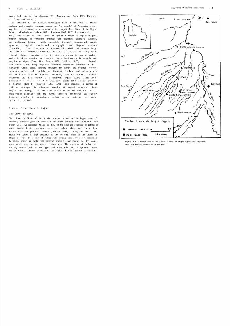
The Llanos de Mojos
The Llanos de Mojos of the Bolivian Amazon is one of the largest areas of
seasonally inundated grassland savanna in the world, covering some 145,000 km2
(Figure 3.1). An additional 55,000 sq km2 of the zone are composed of patches of
dense tropical forest, meandering rivers and oxbow lakes, river levees, large
shallow lakes, and permanent swamps (Denevan 1966a). During the four to six
month wet season, a large proportion of the low-lying terrain of the Llanos de
Mojos is covered by a sheet of surface water ranging from only a few centimeters
to several meters in depth. The savannas gradually drain during the dry season
when surface water becomes scarce in many areas. The alternation of marked wet
and dry seasons, and the waterlogged and heavy soils, have a significant impact
on the present landuse patterns of the region. The indigenous populat ions
San Joaqui
Central Llanos de Mojos Region
populat ion centers 0
major raised fields kilometers
Figure 3.1. Location map of the Central Llanos de Mojos region with important
sites and features mentioned in the text.

8/6/2019 Archaelogical Methods - Landscapes LLANOS de MOJOS
http://slidepdf.com/reader/full/archaelogical-methods-landscapes-llanos-de-mojos 4/17
70 CLARK L. ERI CKSON The study ofancient landscapes 71
developed a complex system of massive earthworks to solve the problems of
water control and agriculture (raised fields, canals, dikes, reservoir impound-
ments, drainage systems), transportation and communication (large raised
causeways and canals), and shortage of good locations for domestic occupation
(raised platform mounds).
The Amazonian basin includes several very diverse environments. Although
primarily seasonally flooded savanna and wetlands, the Llanos de Mojos bears
some resemblance to the riverine systems of the central Amazon. The major“white watery’ rivers (Mamoré, Beni, Maniqui, Guapori) crossing the savannas
provide a microcosm of floodplain environments common to the larger Ama-
zonian rivers (point bars, levee formations, oxbow lakes, gallery forest, and
backwater wetlands) (Denevan 1966a). This is where the largest and apparently
longest-occupied sites are located (Dougherty and Calandra 1981, 1981-2, 1984).
The savannas of Mojos are distinct from the drier savannas common in the
interfluvial zones of the Brazilian Amazon due to the many months of seasonal
inundation and vast areas of permanent wetlands and shallow lakes. Within the
savannas, the gallery forests and wetlands provide a rich bounty of wild resources
for exploitation (fishing, hunting, gathering) not commonly present in interflu-
vial zones of Amazonia. Under intensive cultivation, these zones may have
sustained higher population densities than even the better-documented riverinezones of the central and lower Amazon.
Raised fields
Raised fields are “any prepared land involving the transfer and elevation of soil
above the natural surface of the earth in order to improve growing conditions”
(Denevan and Turner 1974) . Data obtained from experimental archaeology
(Erickson 1985, 1986a, 1986b, 1988a, 1988b; Garaycochea 1986a, 1986b, 1987;
Gomez-Pompa et al. 1982; Kolata 1991; Muse and Quintero 1987; Puleston 1 9 7 7 ;
Ramos 1986, 1990), ethnographic analogy (Denevan and Turner 1974; Jiménez
and Gomez-Pompa 1987), agro-climatological modeling (Grace 1983; Knapp
1991; Kolata and Ortloff 1989), remote sensing (Adams et al. 1981; Lennon 1982,1983), and archaeological survey and excavation (Bray et al. 1987; Culbert et al.
1 9 9 1 ; Eidt 1984; Erickson 1987,1988a; Graffam 1989 ,1990; Hammond et al. 1987;
Knapp and Ryder 1983; Kolata 1986, 1991; Kolata and Graffam 1989; Mathew-
son 1987; Parsons et al. 1985; Poh11989; Siemans 1989; Smith et al. 1968; Stemper
1987; Turner and Harrison 1983; Zucchi and Denevan 1 9 7 9 ; and others) have
provided insights into some of the functions of raised-field technology in the
Americas.’ The benefits of raised cultivation platforms include: ( I ) drainage of
excess water; ( 2) improvement of soil and cultivation conditions through
aeration, mixing, and doubling of the depth of topsoil; and, (3) improved local
microclimatic conditions. Canals and ditches between fields: ( I ) conserve mois-
ture to extend the growing season and counteract drought conditions; ( 2) act as
heat sinks to minimize frost damage; and, (3) provide a medium for aquaculture
and for the capture, production, and recycling of organic sediments and
nutrients.
Raised fields in the Llanos de Mojos
Passing references to evidence for the vast and sophisticated prehispanic agricul-
tural complexes in the Llanos de Mojos were made in publications by Nordens-
kiöld ( 1910) and Métraux (1942). The importance of these prehispanic earth-
works was demonstrated independently by Plafker (1963) and Denevan (1963).
Denevan continued this research for his dissertation and published an excellent
summary monograph in 1966. Through aerial and ground survey and the
interpretation of aerial photography, Denevan (1963, 1966a) and Plafker (1963)
located and described massive complexes of abandoned earthworks including
raised fields, canals, causeways, reservoirs, oriented lakes, surface alignments
features, and mounded occupation sites within the open pampa grasslands. Other
field systems reported since then indicate that the prehispanic earthmoving efforts
may have been even more substantial (Bustos 1976a, 1976b, 1976c, 1978a, r978b,
1978c, 1978d; Dougherty and Calandra 1984; Erickson 1980; Erickson et al. 1991;Lee 1 9 7 9 ; Pinto Parada 1987). Recent research has demonstrated that the densely
forested zones within the Llanos de Mojos also show evidence of intensive
prehispanic occupations and earthworks (Arnold and Prettol 1989; Erickson
1980; Erickson and Faldin 1979) . Denevan (1966a, 1980, 1982) has conservatively
estimated the existence of 100,000 raised field platforms within an area of 72,000
km2, and approximately 503 linear kms of raised causeways in an area of 3,900
km2. The number, size, and density of mound (lomas) and old levee occupation
sites (islas) apparently associated with raised-field farming in the savanna zones
and in the river gallery forests, is astonishing (Bustos 1976c, 1978a, 1978c, 1978d;
Erickson 1980; Erickson et al. 1991) .
The origins of these massive landscape modifications are unclear, owing to a
lack of archaeological research. Our preliminary dating (five radiocarbon dates)from fieldwork in 1990, indicates that some raised fields date to between 800 and
2070 years BP (Erickson et al. 1991) . The vast majority of the earthworks have
been abandoned at least since the arrival of the Spanish, although there is some
evidence that limited construction and use of causeways and canals extended into
the historic period (Denevan 1966a; Pinto Parada 1987). Population within
Amazonia declined rapidly after contact with the Europeans (Denevan r966b,
197ob, 1976). Warfare, disease, exploitation for labor, population reorganiza-
tion, and ethnocide swiftly took their toll on the native population of the Llanos
de Mojos. This post-conquest population collapse is believed to have been
responsible for the abandonment of the raised-field systems (Denevan 1966a).

8/6/2019 Archaelogical Methods - Landscapes LLANOS de MOJOS
http://slidepdf.com/reader/full/archaelogical-methods-landscapes-llanos-de-mojos 5/17
72 CLARK L. ERI CKSON Th e s t u d y of a n c i e n t l a n d s c a p e s 73
Regional cultural development and raised-field agriculture
The lack of general archaeological interest in Amazonia has included the Llanos
de Mojos. Despite evidence of the area’s importance in prehistory (that is, vast
remains of raised-field and causeway-canal systems), relatively few investigations
have been carried out in this zone. Most research has been limited to investi-
gations of the large mound occupation sites (lomas) located along the course of
the Rio Mamoré near Trinidad (Bustos r976a, 1976b, 1978a, 1978b, 1978c, 1978d;Dougherty and Calandra 1981, 1981-82, 1984; Hanke 1957; Kuljis et al. 1977;
Nordenskiold 1910, 1913, 1930; Ryden 1941). Other investigations have concen-
trated on the frontiers of the Llanos de Mojos (Arnold and Prettol 1989; Becker-
Donner 1956; Bustos 1978b; Cordero 1984; Dougherty 1985; Kelm 1953; Nor-
denskiöld 1924b; Reister 1981). Archaeological site surveys have been limited to
zones along the recently constructed road between San Borja and Trinidad where
numerous large precolumbian settlements and agricultural earthworks have been
recently discovered (Bernardo Dougherty: personal communication; Bustos and
Faldin 1978; Erickson 1980; Erickson and Faldin 1979; Erickson et al. 1991; Faldin
1984). A coherent and adequate synthesis of the prehistory of the zone has yet to
be presented, although several attempts have been made to place the limited data
available within the broader context of Amazonian prehistory (Bennett 1936;
Brochado 1984; Brochado and Lathrap 1982; Denevan 1966a; Howard 1947;
Lathrap 1970; Lathrap et al. 1985; Meggers and Evans 1983; Nordenskiold 1910,
1930; Portugal Ortiz 1978; and others).
Much of the previous work in the Llanos de Mojos focused on developing
ceramic chronologies and excavation of the largest mound sites (Bustos 1976a,
1978b; Dougherty and Calandra 1981-82, 1984). The Smithsonian Institution
excavations focused on the excavation of the largest mounds along the Rio
Mamori near Trinidad. Although survey work involving surface collections and
small-scale excavations was carried out on a variety of sites, this was undertaken
in the context of developing and refining the ceramic chronology for the region.
Small excavation units of up to 15 m depth were dug in artificial levels with
concern for applying quantitative seriation (Dougherty and Calandra 1981-2,
1984). The cultural development and social complexity of the Llanos was
systematically downplayed in the reports, and the importance of the prehispanic
raised fields and other evidence of agricultural engineering was often dismissed
(Dougherty and Calandra 1981, 1984).
Traditionally, the raised fields of the Llanos de Mojos have been associated
with the prehispanic occupation sites found throughout the region. In particular,
these included the “mound cultures” along the Rio Mamoré, and the ethnohis-
toric and ethnographic populations recorded for the area (Bustos r976a, 1976b;
Denevan 1966a; Lathrap 1970; Mitraux 1942; Nordenskiold 1924a; Pinto Parada
1987; and others). Few of these sites are near known raised-field blocks. It is
highly likely, however, that the scores of archaeological sites recorded during our
1979 survey in the savanna and forest between Trinidad and San Borja where
major zones of raised fields are reported, were the occupation sites of raised field
farmers (Erickson 1980; Erickson and Faldin 1979; Faldin 1984). This remains to
be demonstrated through direct archaeological association with the agricultural
earthworks.
Of all the archaeological research conducted in the zone, only three projects
have focused on the impressive agricultural remains and causeway earthworks.
The results of the excavations of a moat-embankment structure in the far north of the Llanos de Mojos were presented recently (Arnold and Prettol 1989), and a
large agricultural complex of raised fields, canals, and causeways near San Borja
has been briefly studied and described (Erickson 1980). The joint University of
Pennsylvania/Instituto National de Arqueologia exploratory project conducted
in 1990 at the El Villar site on the Rio Matos provided the first excavations,
detailed topographic mapping, ethnobotanical and soil samples, stratigraphic
profiles, and radiocarbon dates for raised fields and causeways in the central
Llanos de Mojos (Erickson et al. 1991; Jacob 199ra; Jones 1991b).
Any understanding of settlement systems, socio-political organization, or
regional development must take into account the advantages and limitations of
the agricultural infrastructure which supported the population in this region. The
overall project goal of our archaeological investigation of the raised fields of the
Llanos de Mojos is to provide important information relating to: (1) the regional
cultural development; (2) the role of wetland agriculture in developing precolum-
bian tropical lowland societies; and (3) the relationship between intensive
agricultural and socio-political organization.
In many areas, causeways and associated canals commonly co-occur with
raised fields (Denevan 1963, 1966a, 1991; Erickson 1980, Erickson and Faldin
1979; Pinto Parada 1987; Plafker 1963). Several hypotheses regarding this
association are being investigated. Causeways and canals are believed to have
been used for transportation and communication between residential sites and
between sites and fields (Denevan 1966a; Pinto Parada 1987; see also Garson
1980). I have proposed that the massive causeway and canal networks are integral
to the proper functioning of raised fields (Erickson 1980; also see Bustos 1978a;
Lee 1979; Pinto Parada 1987). In addition to serving for transportation, the raised
causeways may have also functioned as flood-control dikes, artificial levees, and
reservoirs to control water at optimal levels during the wet season and to conserve
moisture for dry season cultivation (potentially allowing double or triple
cropping). The associated canals would also have provided a means of diverting
water to where it was needed. Both causeways and canals may have been
important in aquaculture as well, in particular the raising of fish in these artificial
water bodies.
Our study focuses on a much different scale of investigation than the past work
in the Bolivian Amazon. Our investigation is regional in scope, following the
pioneering work in cultural geography of William Denevan (1963, 1966a). The

8/6/2019 Archaelogical Methods - Landscapes LLANOS de MOJOS
http://slidepdf.com/reader/full/archaelogical-methods-landscapes-llanos-de-mojos 6/17
74 CLARK L. ERI CKSON T h e s t u d y of a n c i e n t l a n d s c a p e s 75
multidisciplinary, landscape archaeology approach used here is very
from the previous strategies used by the projects mentioned above.
different
Methodologies for a landscape archaeology
In order to address these broader issues, the Agro-Archaeological Project of the
Beni investigated a number of raised-field complexes using a variety of archaeo-
logical techniques. These included: interpretation of remote sensing imagery
(LANDSAT digital imagery and associated photographic products and standard
stereo pairs of aerial photographs); reconnaissance from small aircraft; ground
survey; topographic mapping with laser theodolite; archaeological excavation;
and agricultural experimentation. Most of these techniques for application in the
Llanos de Mojos were developed, tested, and shown to be successful in my recent
research on precolumbian raised-field agriculture in the Lake Titicaca Basin
(Erickson 1985, 1986a, 1986b, 1987, 1988a, 1988b, 1991, 1992a, 1992b 1993,
Erickson and Brinkmeier 1991; Erickson and Candler 1989; Garaycochea 1986a,
1986b, 1987) and during exploratory research conducted in the Llanos de Mojos
in 1990 (Erickson e t al. 1991).
Although the use of experimental methods in the study of raised-field
agriculture is a relatively new approach (Erickson 1985, 1988a; Gomez-Pompa et
al. 1982; Kolata 1 9 9 1 ; Muse and Quintero 1987; Puleston 1977; Riley and
Freimuth 1979) , the methods used in this study are not new, and have been used in
numerous projects in South America and the Mesoamerican tropics. Elements of
these techniques have been used successfully by many archaeologists and
geographers in the investigations of prehispanic raised fields and agricultural
landscapes in the lowland American tropics (Bray et al. 1987; Darch 1983;
Denevan 1966a; Mathewson 1987; Parsons et al. 1985; Pohl 1989; Puleston 1 9 7 7 ;
Siemans 1989; Stemper 1987; Turner and Harrison 1982; Zucchi and Denevan
1979 and others; general sources of information on methodologies appropriate
for a landscape archaeology can be found in Darch 1983; Denevan et al. 1987;
Farrington 1985; Gleason and Miller 1 9 9 3 ; Harrison and Turner 1978; Killion
1992).
Aerial photographic interpretation
A major limitation to the study of raised fields in the Llanos de Mojos, and other
zones of the humid tropics, is the lack of accurate maps for guiding survey and for
locating sites. Because the area is considered to be of low priority by the
government, maps are either not available for large areas, or they are inaccurate
and of poor scale. The use of remote sensing, in particular aerial photographs and
satellite imagery, has been very important in overcoming this limitation (see
Zeidler, this volume).
Interpretation of aerial photographs and remote sensing has had a long and
important history in the study of raised-field archaeology in the Llanos de Mojos
and elsewhere (Adams et al. 1981; Dahlin and Pope 1989; Denevan 1963, 1966a;
Harrison and Turner 1978; Plafker 1963; Siemans 1989; Siemans and Puleston
1978; Turner and Harrison 1982; and others). These resources become especially
important both for locating potential raised-field locations and for use as base
maps. The raised fields of the Llanos de Mojos were discovered independently by
two individuals using aerial photographs (Denevan 1963; Plafker 1963).
On the basis of previous documentation, my study of aerial photographs in the
collection in the archives of the Instituto Geografico Militar and the Bolivian Air
Force’s Oficina de Aereofotogramia, and on-ground survey within the Llanos de
Mojos, the most extensive and best preserved raised-field complexes and canal-
causeway networks are located: ( I ) along the Rio Apere in central Mojos
southwest of San Ignacio, and near the ranches of El Perú and La Esperanza
(Denevan 1963, 1966a; Plafker 1963); ( 2 ) south of Laguna Rogoaguado in
northern Mojos (Denevan 1966a); and (3) in the savannas between San Ignacio
and San Borja along the San Borja-Trinidad Highway (Denevan 1966a; Doug-
herty and Calandra 1984; Erickson 1980; Erickson et al. 1991; Métraux 1942; see
Figure 3.1). This highway provides relatively easy access to large blocks of
earthworks and can be used as a survey transect across the central Llanos de
Mojos.
Our procedure is to locate prehispanic earthworks on the photographs through
stereoscopic analysis and high magnification. Cultural features are photographi-
cally or xerographically enlarged, with features traced onto base maps for closer
investigation in the field (Figures 3.2-3.5). Whenever possible, series of contact
prints (9 in x 9 in) that can be viewed as stereopairs under low powered
stereoscopes are purchased. Selected photographs with dense remains of raised
fields are often enlarged to I m x I m. Although expensive, these enlargements
bring out additional detail of earthworks, and are better for tracing earthwork
patterns and for guiding fieldwork. Photographs are examined with additional
low power magnification. Despite the low topographic relief (rarely more than
2 m), raised fields and causeways can easily be detected. High contrast black and
white enlargements of original photograph sections are often made from
negatives taken with a camera macro lens (Figure 3.3). We have found that the
xerographic copy machine is an excellent tool for producing high contrast
enlargements of aerial photographs to distinguish fields and earthworks. These
are also useful for making inexpensive field copies, and for creating photo
mosaics without having to damage the original stereopairs.
Visibility can be a problem at times. Raised fields and other earthworks have
been abandoned for at least 500 years, and have undergone considerable erosion.
Cattle grazing, construction of roads and drains, plowing by tractors, and natural
factors such as the annual floods and sediment buildup, have greatly reduced the
earthworks and filled canals with sediments. Despite this destruction, raised
fields, settlements, and other earthworks can be located on aerial photographs of

8/6/2019 Archaelogical Methods - Landscapes LLANOS de MOJOS
http://slidepdf.com/reader/full/archaelogical-methods-landscapes-llanos-de-mojos 7/17
CLARK L. ERICKSON
Figure 3.2. Oblique low altitude aerial photograph showing prehispanic raisedfields at the Arizona ranch, 60 km east of San Borja.
Figure 3.3. Aerial photograph showing several complexes of prehispanic raised
fields at the Santa Fe and La Envidia ranches, 19 km WSW of San Ignacio. The dark
linear and curvilinear features are large causeways.
The study of ancient landscapes 77
Figure 3.4. Digitally enhanced section of an aerial photograph of prehispanic raised
fields near Santa Ana de Yacuma.
Figure 3.5. Aerial photograph of forested islas in the pampa west of San Ignacio.Evidence indicates that most of these features are small prehispanic village mound
sites where raised-field farmers lived, or artificial agricultural earthworks.
scales lower than 1:40,000. Even larger scales of high resolution aerial photo-
graphs can be useful with photographic enlargement or optical magnification.
The rectilinear features of the artificial earthworks contrast sharply with more
random forms of natural features on the landscape. The artificial topographic
relief created by the construction of causeways, canals, and raised fields is also
easily distinguished on stereopairs of aerial photographs. Vegetation, moisture,
and soil differences produce sharp contrasts on the aerial photographs. The field
platforms, causeway surfaces, and mounds tend to support vegetation (trees and
shrubs) adapted to drier environments. Large termite mounds are also common
8/6/2019 Archaelogical Methods - Landscapes LLANOS de MOJOS
http://slidepdf.com/reader/full/archaelogical-methods-landscapes-llanos-de-mojos 8/17
78 CLARK L. ERI CKSONTh e s t u d y o f a n c i e n t l a n d s c a p e s 79
on earthworks. The canals between fields, or alongside causeways, are colonized
by aquatic plants which appear as darker areas in the photographs. Moisture
differences, sometimes in the form of standing water, are also good indicators of
canals and ditches. Other earthworks can be seen in disturbed areas of contem-
porary settlements (for example, the annually burned pampa, and slash and burn
fields within the forest). Because of the low topographic relief and annual
flooding, the most common locations to find occupation sett lements and
prehispanic human agricultural activity are in areas of naturally higher ground.
These areas are generally active or abandoned river levees, or artificial accumu-
lations of fill and midden from many generations of inhabitants. In many cases,
barrow pits and circular canals ring these settlement sites.
Aerial photographs are also important in monitoring the erosion and destruc-
tion of raised fields and associated features. The earthworks have suffered from
extensive destruction recently. Photographs taken between 1959 and the present,
show profound changes in the region. Fields, causeways, and canals have been
destroyed through road construction and associated causeways and drainage
features. Cattle grazing in the pampas has inflicted massive damage through the
leveling of topography by cattle hooves. Some mechanized farming has also
begun to level large areas of pampa. Logging activities and associated infrastruc-
ture (roads, bridges, camps) have caused considerable damage to archaeological
features. Urban development has also taken its toll. For example, the town and
airport of Santa Ana de Yacuma was constructed on top of a large raised-field
block.
The structure and morphology of raised fields vary widely throughout the
Llanos de Mojos (Figures 3.2, 3.3, and 3.4). The nature of this variation is an
important focus of the project. The internal differentiation within field blocks
may be related to land tenure and social groupings responsible for the construc-
tion and maintenance of the field blocks. The structural differences between
discrete field blocks may be related to ethnic or larger scale social groupings, or to
chronological differences. Preliminary analysis of aerial photographs in the
central Llanos de Mojos has shown that, between major field blocks, there tends
to be several kilometers of areas without fields, possibly representing frontiers or
boundaries between social groups.
Aerial survey
As noted above, coverage is limited for key zones, and eroded raised-field remains
are not always clearly visible on some large-scale black and white aerial
photographs. A small aircraft was rented for aerial survey in order to cover as
much of the central Llanos de Mojos as possible. Field systems and causeway-
canal earthworks were photographed at various scales in order to produce field
maps, guide the ground reconnaissance, document changes in landuse an d
vegetation cover, and aid in interpretation of the archive aerial photographs
(Figures 3.2 and 3.5). The visibility of earthworks changes seasonally throughout
the year, due to rainfall and moisture conditions. We found that the best
conditions were after heavy rains when canals of fields and causeways held water,
thereby highlighting patterns. We were also told that several weeks after the
burning of the pampa, when new grasses are beginning to return, is a good time
for delineating canals between raised fields, as their retained moisture permits
more rapid growth of new grasses.
Each step of the flight had to be carefully planned, with duties divided among
the team members. The flight plan was discussed with the pilot and signals were
developed to communicate during the noisy flight. We used four cameras loaded
with different types of film, plus a hand-held video camcorder. A tape recorder,
and the sound on the video, were used to keep a continuous record of the flight
and photographed locations. A Geographic Positioning System (GPS) was used to
record locations when the flight was beyond the area covered by aerial photo-
graphs. We found that low flights were good for areas where we had photo-
graphic coverage to guide us; higher flights were more useful for new areas. A
series of tight curves were made above interesting sites to obtain close, near
vertical photographic coverage. Luckily the pilots of the Beni know the region
well and can be trained to identify archaeological features on their own. One pilot
later found and reported two small blocks of fields on his regular routes after
flying with us on a survey flight.
Digital remote sensing
Remote sensing has become an important tool for archaeologists studying
ancient raised-field agriculture (Adams et al. 1981; Dahlin and Pope 1989;
Siemans 1989). We are in the process of preparing computer-generated classifica-
tions of key zones from digital LANDSAT imagery using the IDRISI software (a
Geographic Information System and remote sensing software package developed
by the Department of Geography, Clark University). These will be used to
produce a series of large-scale environmental base maps for guiding ground
reconnaissance, and for locating earthwork features found in the photographs
and field. The computer can efficiently produce rough maps of vegetation
communities, landuse, forest-pampa boundaries, river courses, and roads over
large areas. The computer-generated vegetation and landuse classifications will
be checked and refined through incorporation of ground data collected during the
field project. UTM and longitude/latitude coordinates can be projected onto
these computer-generated maps.
Another technique used by this project is the computer scanning and digitiza-
tion of aerial photographs using the IDRISI. The scanning of black and white
aerial photographs permits detailed manipulation of the scanned image to
increase contrast, emphasize certain features of the landscape, and delineate
earthworks. The system allows minute features to be enlarged for easier study

8/6/2019 Archaelogical Methods - Landscapes LLANOS de MOJOS
http://slidepdf.com/reader/full/archaelogical-methods-landscapes-llanos-de-mojos 9/17
8 0 CLARK L. ERI CKSON The study of ancient landscapes 8 1
and fieldmap production. Gray scales of the black and white images can be
controlled to define cultural and natural features (Figure 3.4). With ground truth,
UTM or longitude/latitude coordinates can be projected on these images. The
images can also be used as illustrations with the addition of text, legends, and
classifications of landuse features.
A preliminary study has indicated that a computer can recognize signatures of
raised fields (Erickson 1981). Even on the coarse resolution of LANDSAT
imagery, the distinct patterning of reflected light created by the undulating raised-field platforms and canals and the alternating wet-dry land surfaces, produces
distinct patterns that can be distinguished from non-raised-field areas. Whether
these preliminary data can be extrapolated over the entire Llanos de Mojos is not
yet clear.
A mixed media approach (black and white photographs, color photographs,
digitized images, satellite digital imagery from LANDSAT and SPOT, and
topographic survey on the ground) appears to be the best means of studying these
earthworks. The integration of multiple techniques for finding and mapping
raised fields and other earthworks provides flexibility and efficiency. The digital
nature of the topographic and excavation mapping by EDM, GPS point locating,
computer-enhanced aerial photographs, and LANDSAT imagery can be inte-
grated for analysis through a Geographical Information System or other datamanagement.
Ground survey of agricultural earthworks and settlements
Ground survey in the Llanos de Mojos is logistically difficult and expensive.
Throughout most of the area, visibility is limited by dense vegetation cover in the
forests and high grasses in the pampas. Active geomorphological processes have
buried many cultural remains. Despite these limitations, ground survey con-
ducted on foot, horseback, oxcart, canoe, and four-wheel drive vehicles can
locate many sites. The recording of sites through survey (Figure 3.6) is aided by
natural and modern anthropogenic disturbances which provide “windows” in
the vegetation cover and sediment overburden. Road cuts are the most useful, andprovide long survey transects across the pampa and forest. During survey on foot
and by canoe, we have utilized river cuts to find sites. Sherds can be found in situ,
buried in these banks (Cordero 1984; Michel and Lémuz 1992).
We have found that with an understanding of the local geomorphology, site
locations can be predicted more efficiently and accurately than by time consum-
ing 100 percent survey (a difficult endeavor in the humid tropical lowlands, see
Zeidler, this volume). Occupation site locations are similar to those traditionally
reported in the archaeological literature for riverine Amazonia -large mounds on
active or abandoned river levees, or on adjacent uplands (Brochado 1984; Lathrap
1970, 1968b; Lathrap et al. 1985; Meggers and Evans 1983; Meyers 1992;
Roosevelt 1991). Because of the prehispanic importance of the pampas for
agricultural production, many large and small sites are located some distance
from rivers. These sites are commonly islas, or low circular or oval mounds (of up
to several hectares and one to two meters tall), distinguished by tree and shrub
cover (Figure 3.5). The sites within the pampa are commonly established on low
river levee formations of abandoned channels or edges of permanent water bodies
such as swamps, marshes, and lakes. Raised fields are found on the edges of
permanent water (swamps, lakes, marshes), or on the back slopes of abandoned
levees within the waste pampa. In many riverine areas, the geomorphologically
active river floodplains have destroyed or deeply buried all prehispanic sites,making total coverage survey useless. Occupation sites are likely to be covered
with dense vegetation. Without human disturbances, it is often impossible to
make adequate surface collections. Most modern settlements and fields in the
pampa are located on areas of slightly higher topographic relief (islas) to prevent
flooding. Many are old prehispanic settlement mounds. These open and cleared
areas can be easily surveyed, and the disturbances caused by the construction of
post-structure ranch and farm buildings, pits, fences, cattle grazing, burning of
pasture, and swidden cultivation, make adequate surface collections possible.
Tree falls are also potential areas for surface collections, as the uprooting of large
shallow root systems of buttressed tropical forest trees can open up many square
meters for collections.
Figure 3.6. Prehispanic raised fields at the La Envidia ranch. Recent burning of grasses by ranchers has exposed the raised-field platforms and canals.
8/6/2019 Archaelogical Methods - Landscapes LLANOS de MOJOS
http://slidepdf.com/reader/full/archaelogical-methods-landscapes-llanos-de-mojos 10/17
8 2 CLARK L. ERI CKSON T h e s t u d y of a n c i e n t l a n d s c a p e s 83
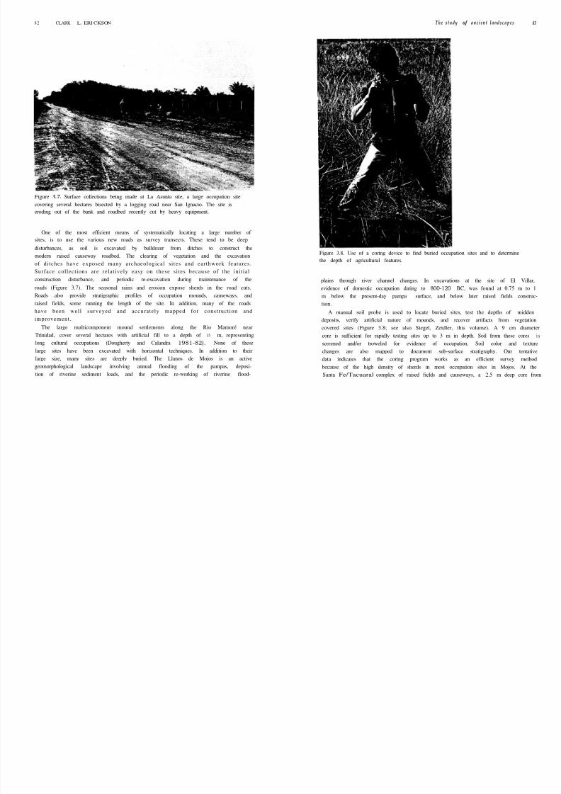
Figure 3.7. Surface collections being made at La Asunta site, a large occupation sitecovering several hectares bisected by a logging road near San Ignacio. The site is
eroding out of the bank and roadbed recently cut by heavy equipment.
One of the most efficient means of systematically locating a large number of
sites, is to use the various new roads as survey transects. These tend to be deep
disturbances, as soil is excavated by bulldozer from ditches to construct the
modern raised causeway roadbed. The clearing of vegetation and the excavation
of di tches have exposed many archaeological s i tes and earthwork features .
Surface col lect ions are relat ively easy on these s i tes because of the ini t ial
construction disturbance, and periodic re-excavation during maintenance of the
roads (Figure 3.7). The seasonal rains and erosion expose sherds in the road cuts.
Roads also provide stratigraphic profiles of occupation mounds, causeways, andraised fields, some running the length of the site. In addition, many of the roads
have been well surveyed and accurately mapped for construct ion and
improvement .
The large multicomponent mound settlements along the Rio Mamoré near
Trinidad, cover several hectares with artificial fill to a depth of 15 m, representing
long cultural occupations (Dougherty and Calandra 1981-82). None of these
large sites have been excavated with horizontal techniques. In addition to their
large size, many sites are deeply buried. The Llanos de Mojos is an active
geomorphological landscape involving annual flooding of the pampas, deposi-
tion of riverine sediment loads, and the periodic re-working of riverine flood-
Figure 3.8. Use of a coring device to find buried occupation sites and to determine
the depth of agricultural features.
plains through river channel changes. In excavations at the site of El Villar,
evidence of domestic occupation dating to 800-120 BC, was found at 0.75 m to 1
m below the present-day pampa surface, and below later raised fields construc-tion.
A manual soil probe is used to locate buried sites, test the depths of midden
deposits, verify artificial nature of mounds, and recover artifacts from vegetation
covered sites (Figure 3.8; see also Siegel, Zeidler, this volume). A 9 cm diameter
core is sufficient for rapidly testing sites up to 3 m in depth. Soil from these cores i s
screened and/or troweled for evidence of occupation. Soil color and texture
changes are also mapped to document sub-surface stratigraphy. Our tentative
data indicates that the coring program works as an efficient survey method
because of the high density of sherds in most occupation sites in Mojos. At the
Santa Fe/Tacuaral complex of raised fields and causeways, a 2.5 m deep core from

8/6/2019 Archaelogical Methods - Landscapes LLANOS de MOJOS
http://slidepdf.com/reader/full/archaelogical-methods-landscapes-llanos-de-mojos 11/17
84 CLARK L. ERI CKSON T h e s t u d y of a n c i e n t l a n d s c a p e s
a causeway produced sherds associated with a possible living floor. The coring
device can also be used to rapidly collect large samples of organic soils from the
bases of canals. These are currently being processed to date the organic content of
the samples using radiocarbon analysis.
In areas lacking maps or aerial photographic coverage, sites recorded during
survey can be very difficult to geographically locate. In addition, the relatively
low, featureless relief topography, combined with frequently changing forest/
savanna boundaries, can make it difficult to locate sites, even with the aid of photographs. Our project has recently begun to use a global positioning system
(GPS) (Magellan NAV 5000) which tracks up to 5 satellites at a time, providing
site locations with an accuracy of approximately 15 m. The system can also be
used to guide ground survey crews to specific sites that were detected during
interpretation of aerial photographs.
The limitations of reliance on aerial photographic interpretation were made
clear during the ground survey. At the Santa Fe and La Envidia ranches near San
Ignacio, large blocks of well preserved raised fields which do not appear on the
aerial photographs (Figure 3.9), were found within forested zones. The slightly
higher ground provided by the linear raised-field surfaces provided appropriate
drained soils for the establishment of large forests. Under the continuous tree
canopy, trees grew in rows, thus mirroring the structure of the fields. It is
apparent that over time, the forest has gradually advanced over the open
grassland. Much of this may be due to grazing cattle which eat grasses but leave
the inedible woody plants that gradually replace the grass cover.
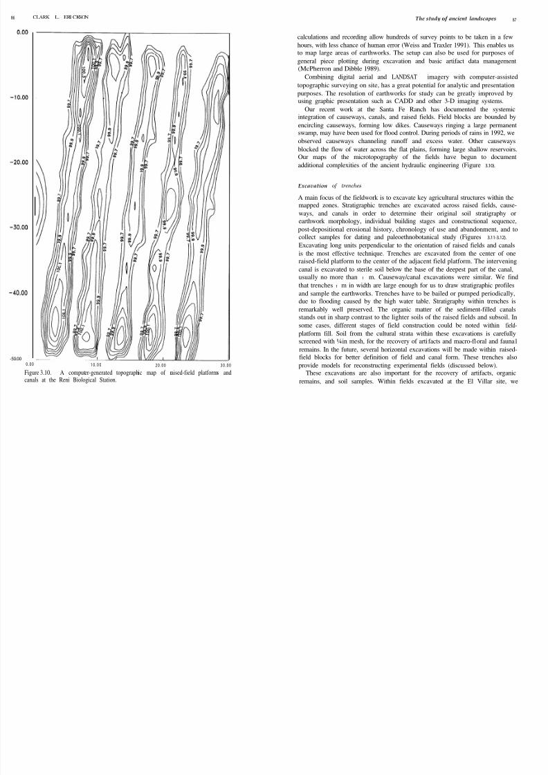
Topographic mapping
Accurate topographic mapping is necessary for assessing the degree of integration
between raised fields, canals, and causeways. Of particular importance are the
mapping of: ( I ) discrete hydrologic units of raised fields and canals; and ( 2)
causeways and associated canals. The generally low topographic relief and
extremely low gradient of the savanna and streams necessitate mapping of the
relative elevations of the aggraded river channels, levees, and the earthworks with
very precise instruments. For this part of the project, an EDM Topcon TotalStation laser theodolite, cabled to a hand-held computer, is used to accurately
record long topographic transects and thousands of survey points for each
hydraulic unit. Computer-generated topographic maps are produced daily from
these points (Figure 3.10). Ground features found in survey (vegetation boundar-
ies, fields, modern landuse, and settlements) are precisely located on maps and
aerial photographs using the portable Global Positioning System (GPS).
The use of the Total Station has many advantages. The theodolite readings are
extremely precise over long distances (up to 2 km). This precision is necessary to
address the hydraulic functions of raised-field systems. Automatic computerFigure 3.9. Clearing of vegetation from raised-field transects in preparation for
topographic mapping at La Envidia. The eroded canals hold water from rainfall.
8/6/2019 Archaelogical Methods - Landscapes LLANOS de MOJOS
http://slidepdf.com/reader/full/archaelogical-methods-landscapes-llanos-de-mojos 12/17
86 CLARK L. ERI CKSON The study of ancient landscapes 87
-50.00
0 . 0 0 1 0 . 0 0 2 0 . 0 0 3 0 . 0 0
Figure 3.10. A computer-generated topographic map of raised-field platforms andcanals at the Reni Biological Station.
calculations and recording allow hundreds of survey points to be taken in a few
hours, with less chance of human error (Weiss and Traxler 1991). This enables us
to map large areas of earthworks. The setup can also be used for purposes of
general piece plotting during excavation and basic artifact data management(McPherron and Dibble 1989).
Combining digital aerial and LANDSAT imagery with computer-assisted
topographic surveying on site, has a great potential for analytic and presentation
purposes. The resolution of earthworks for study can be greatly improved by
using graphic presentation such as CADD and other 3-D imaging systems.
Our recent work at the Santa Fe Ranch has documented the systemic
integration of causeways, canals, and raised fields. Field blocks are bounded by
encircling causeways, forming low dikes. Causeways ringing a large permanent
swamp, may have been used for flood control. During periods of rains in 1992, we
observed causeways channeling runoff and excess water. Other causeways
blocked the flow of water across the flat plains, forming large shallow reservoirs.
Our maps of the microtopography of the fields have begun to document
additional complexities of the ancient hydraulic engineering (Figure 3.10).
Excavation of trenches
A main focus of the fieldwork is to excavate key agricultural structures within the
mapped zones. Stratigraphic trenches are excavated across raised fields, cause-
ways, and canals in order to determine their original soil stratigraphy or
earthwork morphology, individual building stages and constructional sequence,
post-depositional erosional history, chronology of use and abandonment, and to
collect samples for dating and paleoethnobotanical study (Figures 3.11-3.12).
Excavating long units perpendicular to the orientation of raised fields and canals
is the most effective technique. Trenches are excavated from the center of one
raised-field platform to the center of the adjacent field platform. The intervening
canal is excavated to sterile soil below the base of the deepest part of the canal,
usually no more than I m. Causeway/canal excavations were similar. We find
that trenches I m in width are large enough for us to draw stratigraphic profiles
and sample the earthworks. Trenches have to be bailed or pumped periodically,
due to flooding caused by the high water table. Stratigraphy within trenches is
remarkably well preserved. The organic matter of the sediment-filled canals
stands out in sharp contrast to the lighter soils of the raised fields and subsoil. In
some cases, different stages of field construction could be noted within field-
platform fill. Soil from the cultural strata within these excavations is carefully
screened with ¼ in mesh, for the recovery of artifacts and macro-floral and fauna1
remains. In the future, several horizontal excavations will be made within raised-
field blocks for better definition of field and canal form. These trenches also
provide models for reconstructing experimental fields (discussed below).
These excavations are also important for the recovery of artifacts, organic
remains, and soil samples. Within fields excavated at the El Villar site, we

8/6/2019 Archaelogical Methods - Landscapes LLANOS de MOJOS
http://slidepdf.com/reader/full/archaelogical-methods-landscapes-llanos-de-mojos 13/17
88 CLARK L. ERICKSON
Figure 3. 11. Excavation of Trench no. 1 at Santa Fe using natural stratigraphy. Theexcavation unit includes half of two adjacent raised-field platforms and theintervening canal.
recovered potsherds, bone, and charcoal in situ. Samples for ethnobotanical, soil,
and dating analyses are extracted either during excavation, or directly from the
stratigraphic profile after section mapping. Samples are collected for the recovery
of pollen (Pearsall 1989, and this volume), opal phytoliths (Piperno 1988, and this
volume), other ethnobotanical and small fauna1 remains through flotation
(Pearsall 1989; see also Stahl, this volume), and for analysis of soil composition
and fertility. Samples are collected from all natural and cultural strata within
every stratigraphic trench. For comparative purposes, additional samples are
taken from areas where fields are absent.
During the 1990 preliminary project at El Villar, excavations conducted in
fields, canals, and causeways demonstrated the excellent preservation of original
soil stratigraphy within the agricultural earthworks, despite humid tropical
conditions (Erickson et al. 1991). Artifacts, especially ceramics, and carbonized
botanical remains, were abundant within the earthen features, making stylistic
dating, radiocarbon dating, and flotation recovery possible. Permanently water-
logged locations deep within raised-field and canal profiles may also provide

8/6/2019 Archaelogical Methods - Landscapes LLANOS de MOJOS
http://slidepdf.com/reader/full/archaelogical-methods-landscapes-llanos-de-mojos 14/17
90 CLARK L. ERI KSON The study of ancient landscapes 91
opportunities for
wood and bone.
the recovery of highly perishable cultural materials such as
Dating of earthworks
Results from our exploratory investigations indicate that raised-field agriculture
has evolved over a considerable period of time (at least 10,000 years) (Erickson et
al. 1991). The field systems appear to be the result of an accumulation of landscape capital by Mojos farmers, an incremental process of accretionary
growth over time through the piecemeal construction of fields as needed, or
changes made during the routine use and maintenance of the system (Doolittle
1984).Raised fields are dated using a variety of techniques. Relative dating of
construction phases, use periods, and abandonment, is based on stratigraphic
analysis from the excavation trenches. Absolute radiocarbon dates are obtained
from in situ charcoal in field fill, and/or the rich organic sediments of canal fill in
excavation trenches. It may also be possible to cross date ceramics recovered from
field and canal contexts with the ceramic chronologies already established for
excavated mounds along the Rio Mamoré (Dougherty and Calandra 1981,
1981-82).
It is often difficult to directly date raised fields. As they are used over
considerable periods of time, agricultural fields and earthworks represent
continually reworked soils. The fill incorporated into platforms often comes from
various locations. Canals and platforms are subject to periodic re-excavation and
continual erosion, both through use and natural factors. Vertisol formation and
leaching of soil colors, animal burrowing, and termite mound construction often
erase stratigraphic boundaries. Diagnostic artifacts recovered in situ in fill and
canals can potentially be used for comparative dating, but chronological
sequences have only begun to be established and unfortunately cannot be
extrapolated over the whole of the Mojos region. Direct thermoluminescence
dating of ceramics recovered from trenches has not been attempted yet, although
it was a successful means of dating fields in the highlands of Peru (Erickson 1987).
Radiocarbon methods have been very useful in dating field systems. Adequate
samples of charcoal were recovered from raised-field fill and occupation levels
below raised fields at the El Villar site. Bulk soil dates run on the organic content
of sediments from canal bases between raised fields, provide information on canal
use or abandonment. AMS dating may make it possible to work with even very
small organic samples. We have found that a variety of dating techniques must be
used in raised-field research.
Sites along the Rio Mamoré span nearly 3,000 years of continuous or
intermittent occupation; therefore, indirect dating of raised fields through use of
associated sites is probably unreliable, due to the multicomponent nature of
occupations. Certain features of design and proximity between causeways/canals
and field blocks indicate contemporaneity as they were probably constructed as a
single unit or over a relatively short period of time. Stratigraphic relationships can’
also give clues to relative chronology, where younger fields have been constructed
on top of older fields, or where fields have been gradually improved through the
addition of fill over time. In addition to vertical stratigraphic analysis, horizontal
stratigraphy may also be useful for the relative dating of raised fields, as field
blocks are gradually expanded in area over time.
The connection of discrete sites by large causeways and canals, indicatescommunication and transportation between presumably contemporaneous set-
tlements. Raised fields are often crossed by causeways and canals which connect
them with sites on river levees or occupation mounds in the pampa. In addition to
hydraulic functions, these causeways and canals provided easy access to fields for
farmers, and a means for transportation of agricultural produce from raised fields
to settlements.
It should be possible to date fields through the establishment of a seriation of
field and earthwork structure and morphology. The stylistic differences between
field blocks in morphology, scale, and formal structural pattern (wavelengths,
orientations, internal patterning, engineering techniques, size of field platforms,
canals, and blocks) may provide an efficient means of dating the construction,
either intra- or inter-regionally. Such a seriation would prove immensely usefulfor addressing current questions of field development and culture history in the
area, and for guiding future excavations.
Alternatively, the major differences among raised-field blocks in the Llanos de
Mojos may represent environmental, functional, or ethnic differences in field
construction by contemporary farmers. Regional ethnic groupings, internal
group social organization, and land tenure may be mapped into formal spatial
structure of raised-field blocks. At both El Villar and Santa Fe, spatially discrete
field blocks (with d’ff 1 erent wavelengths of canals and platforms) are bounded by
large causeways and canals. Fields are not continuous over the landscape in
Mojos, but rather form independent units or regions which suggests social
organizational units. Aerial photographic interpretation and low altitude flights
over raised fields in Central Mojos also suggest that areas of unoccupied and
unutilized land exist between field blocks.
Ethnobotany
The poor preservation of botanical/organic remains was commonly lamented in
the traditional perspectives on the limitations of tropical archaeology (see
Pearsall, Piperno, Stahl, this volume). In addition to samples from soil probes in
field canals and occupation sites at the sites of El Villar and Santa Fe, samples for
soil, pollen, opal phytolith, and flotation analyses were collected during excava-
tions of trenches in raised fields, canals, and causeways. Surprisingly large
amounts of macroremains of charcoal (primarily wood) were found within

8/6/2019 Archaelogical Methods - Landscapes LLANOS de MOJOS
http://slidepdf.com/reader/full/archaelogical-methods-landscapes-llanos-de-mojos 15/17
92 CLARK L. ERI CKSON
raised-field fill, canals, and within occupation sites at El Villar. This indicates that
flotation could be successfully used in this tropical context (see Pearsall, this
volume).
Tentative results from analysis of archaeological pollen recovered from raised-
field contexts have identified Xanthosoma (possibly gualusa or papa china
cultivated for its taro-like corm), Bixa (possibly urucúi or achiote, used as body
paint and food coloring), and Ilex (possibly gualusa or maté , a strong, caffeine-
rich, ceremonial drink) in addition to a wide range of grasses, trees, and aquaticplants (Jones 1991b; Erickson et al. 1991). The opal phytolith analysis is
incomplete, but preliminary results indicate the presence of similar plants
(Piperno: personal communication).
Experimental archaeology
Experimental construction as a method of raised-field investigation, provides
important insights into how the system functioned, the kinds of crops grown,
labor input in construction and maintenance, nutrient production and cycling,
dynamics of field hydrology, crop productivity, potential carrying capacity,
sustainability of the system over time, and other important issues (Erickson 1985,
1988a, 1988b; Puleston 1997; Muse and Quintero 1987). Because the raised fields
of the Llanos de Mojos have been completely abandoned (possibly for over 500
years), and there is no reference to this technology in the written ethnohistorical
or ethnographic record, archaeological methods are the only means available for
investigating raised-field agriculture. Experimentation or an “applied archaeol-
ogy,” based on what the archaeological research tells us about the technology,
can also be a useful adjunct approach to understanding raised fields.
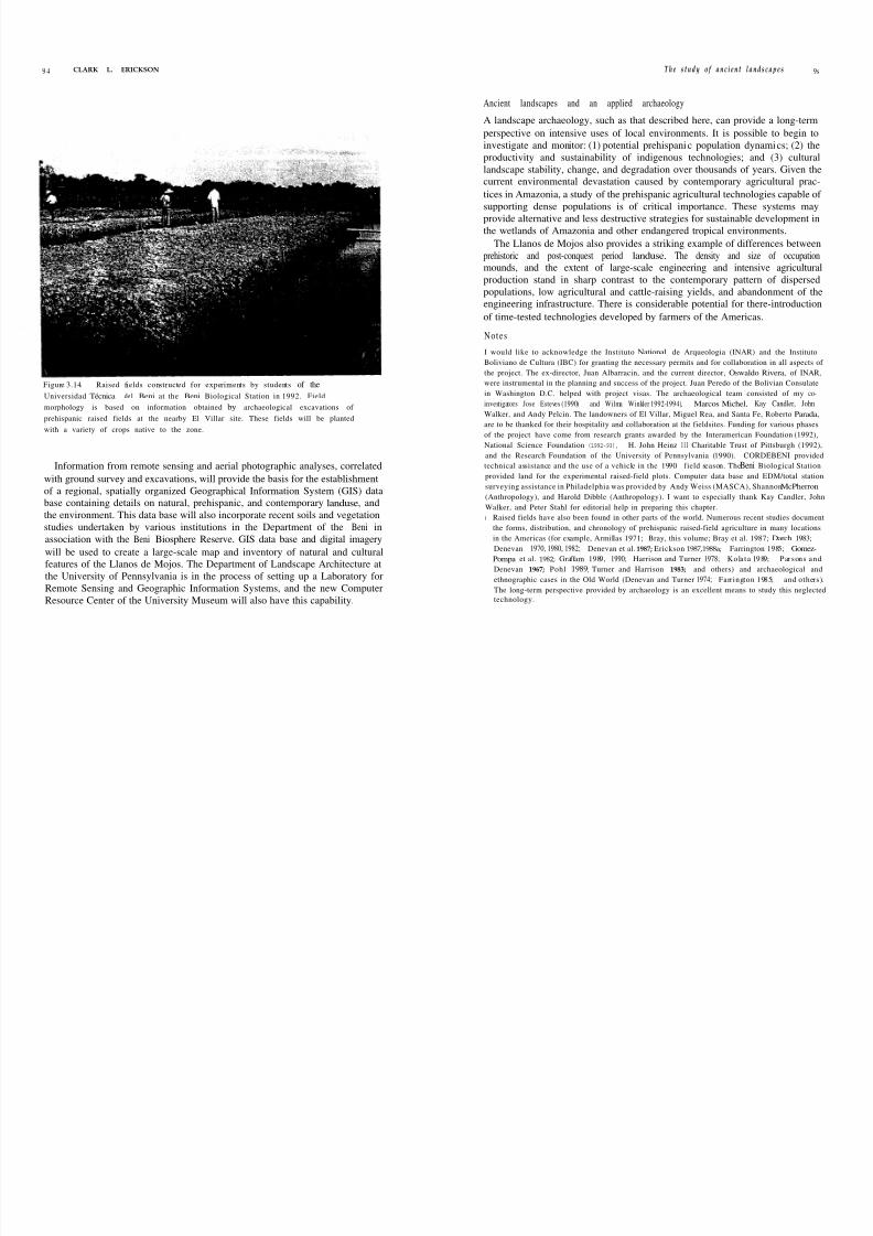
Based on information collected through mapping and excavation of trenches in
fields at the El Villar site (Figure 3.12), models for three different forms of raised
fields were developed for construction in an experimental plot. One half of a
hectare of raised fields was constructed during 1990-91 at the Biological Station
of the Beni in central Mojos (Figures 3.13-3.14). In 1992, agronomy students of
the Universidad Tecnica de1 Beni expanded these fields to include nearly another
0.5 ha of fields. The experimental fields are planted in native crops that were
recorded as being important during the Colonial period. Fields are constructed
and maintained by a group of farmers from a local community. Plans are to
expand and continue these experiments in the contexts of native farming
communities, in collaboration with the Bolivian National Academy of Sciences,
Interamerican Foundation, and the Universidad Tecnica del Beni.
Preliminary results indicate that raised-field farming can be labor efficient, very
productive, and potentially sustainable. Despite heavy rains and massive flooding
during 1991-92, the raised-field platforms remained dry. Water for irrigation was
maintained in the deep canals during much of the dry season. Several older
farmers remarked that it was the first time in their lives that they had seen the
The study of ancient landscapes
Figure 3.13. Oblique aerial photograph of the experimental raised fields at the Beni
Biologica l Station, Porveni r Ranch, 50 km east of San Borja. The fields are being
prepared for the 1992-93 growing season.
pampas produce agricultural crops. Previous attempts at non-raised-field agricul-
ture failed because of inundation by flooding and a high water table. Manioc and
maize did exceptionally well the first year on the experimental raised fields. A dry
season crop is being attempted to gauge the feasibility of year-round multicrop-
ping. Manual labor requirements for field construction are considerable (nearly
800 person-days per ha), but the fields can be farmed continuously for many years
with little labor input for maintenance. When considered over the long run, this
technology appears to be very efficient and productive.
Integration of data from field and laboratory
Many of the traditionally cited limitations to archaeological research in the
humid tropics have been overcome by new technological breakthroughs for the
recovery of data. The costs of labor-intensive archaeological survey and excava-
tion of raised fields is offset by the massive amounts of topographic data collected
quickly and efficiently in digital format. These digital data can easily be integrated
with the impressive amounts of information on remote sensing using LANDSAT
and SPOT, digitized aerial photographs, and piece plotting of artifacts.
93
8/6/2019 Archaelogical Methods - Landscapes LLANOS de MOJOS
http://slidepdf.com/reader/full/archaelogical-methods-landscapes-llanos-de-mojos 16/17
9 4 CLARK L. ERICKSON T h e s t u d y o f a n c i e n t l a n d s c a p e s 9s
Ancient landscapes and an applied archaeology
Figure 3.14. Raised fields constructed for experiments by students of the
Universidad Técnica de1 Beni at the Beni Biological Station in 1992. Field
morphology is based on information obtained by archaeological excavations of
prehispanic raised fields at the nearby El Villar site. These fields will be planted
with a variety of crops native to the zone.
Information from remote sensing and aerial photographic analyses, correlated
with ground survey and excavations, will provide the basis for the establishment
of a regional, spatially organized Geographical Information System (GIS) data
base containing details on natural, prehispanic, and contemporary landuse, and
the environment. This data base will also incorporate recent soils and vegetation
studies undertaken by various institutions in the Department of the Beni in
association with the Beni Biosphere Reserve. GIS data base and digital imagery
will be used to create a large-scale map and inventory of natural and cultural
features of the Llanos de Mojos. The Department of Landscape Architecture at
the University of Pennsylvania is in the process of setting up a Laboratory for
Remote Sensing and Geographic Information Systems, and the new Computer
Resource Center of the University Museum will also have this capability.
A landscape archaeology, such as that described here, can provide a long-term
perspective on intensive uses of local environments. It is possible to begin to
investigate and monitor: (1) potential prehispanic population dynamics; (2) the
productivity and sustainability of indigenous technologies; and (3) culturallandscape stability, change, and degradation over thousands of years. Given the
current environmental devastation caused by contemporary agricultural prac-
tices in Amazonia, a study of the prehispanic agricultural technologies capable of
supporting dense populations is of critical importance. These systems may
provide alternative and less destructive strategies for sustainable development in
the wetlands of Amazonia and other endangered tropical environments.
The Llanos de Mojos also provides a striking example of differences between
prehistoric and post-conquest period landuse. The density and size of occupation
mounds, and the extent of large-scale engineering and intensive agricultural
production stand in sharp contrast to the contemporary pattern of dispersed
populations, low agricultural and cattle-raising yields, and abandonment of the
engineering infrastructure. There is considerable potential for there-introduction
of time-tested technologies developed by farmers of the Americas.
N otes
I would like to acknowledge the Instituto National de Arqueologia (INAR) and the Instituto
Boliviano de Cultura (IBC) for granting the necessary permits and for collaboration in all aspects of
the project. The ex-director, Juan Albarracin, and the current director, Oswaldo Rivera, of INAR,
were instrumental in the planning and success of the project. Juan Peredo of the Bolivian Consulate
in Washington D.C. helped with project visas. The archaeological team consisted of my co-
investigators Jose Esteves (1990) and Wilma Winkler 1992-1994), Marcos Michel, Kay Candler, John
Walker, and Andy Pelcin. The landowners of El Villar, Miguel Rea, and Santa Fe, Roberto Parada,
are to be thanked for their hospitality and collaboration at the fieldsites. Funding for various phases
of the project have come from research grants awarded by the Interamerican Foundation (1992),
National Science Foundation (1992-93), H. John Heinz I I I Charitable Trust of Pittsburgh (1992),
and the Research Foundation of the University of Pennsylvania (1990). CORDEBENI provided
technical assistance and the use of a vehicle in the 1990 field season. The Beni Biological Station
provided land for the experimental raised-field plots. Computer data base and EDM/total station
surveying assistance in Philadelphia was provided by Andy Weiss (MASCA), Shannon McPherron
(Anthropology), and Harold Dibble (Anthropology). I want to especially thank Kay Candler, John
Walker, and Peter Stahl for editorial help in preparing this chapter.
I Raised fields have also been found in other parts of the world. Numerous recent studies document
the forms, distribution, and chronology of prehispanic raised-field agriculture in many locations
in the Americas (for example, Armillas 1971; Bray, this volume; Bray et al. 1987; Darch 1983;
Denevan 1970, 1980, 1982; Denevan et al. 1987; Erickson 1987, 1988a; Farrington 1985; Gomez-
Pompa et al. 1982; Graffam 1989, 1990; Harrison and Turner 1978; Kolata 1989; Parsons and
Denevan 1967; Pohl 1989; Turner and Harrison 1983; and others) and archaeological and
ethnographic cases in the Old World (Denevan and Turner 1974; Farrington 1985; and others).
The long-term perspective provided by archaeology is an excellent means to study this neglected
technology.

8/6/2019 Archaelogical Methods - Landscapes LLANOS de MOJOS
http://slidepdf.com/reader/full/archaelogical-methods-landscapes-llanos-de-mojos 17/17
Contents
Contents
List
List of tables List of contributors
Introduction
PETER W. STAHL
I Archaeological survey and site discovery in the forested
neotropics
JAMES A. ZEIDLER
2 The archaeology of community organization in the tropical
lowlands: a case study from Puerto Rico
P E T E R E . S I E G E L
page xi
xv
xvii
I
7
42
3Archaeological methods for the study of ancient landscapes of
66
the Llanos de Mojos in the Bolivian Amazon
CLARK L . ERICKSON
4 Searching for environmental stress: climatic and anthropogenic 96
influences on the landscape of Colombia
W A R W I C K B R A Y
5“Doing” paleoethnobotany in the tropical lowlands: adaptation 113
and innovation in methodology
D E B O R A H M . PEARSALL
6 Plant microfossils and their application in the New World 130tropics
DOLORES R. PIPERNO
7 Differential preservation histories affecting the mammalian
zooarchaeological record from the forested neotropical1S4
lowlands
PETER W. STAHL
8 Biological research with archaeologically recovered human 181remains from Ecuador: methodological issues
D O U G L A S H . U B E L A K E R
9 Interpreting dietary maize from bone stable isotopes in the198
American tropics: the state of the art
LYNETTE NORR
I O From potsherds to pots: a first step in constructing cultural
context from tropical forest archaeology224
J . SCOTT RAYMOND
I I Returning to Pueblo Viejo: history and archaeology of theChachi (Ecuador)
243
W A R R E N R . D E B O E R
References
Index263
305