AQUATIC NUISANCE WEED CONTROL PRESCRIPTION LONG … · ecosystem. Long Lake is a shallow, eutrophic...
17
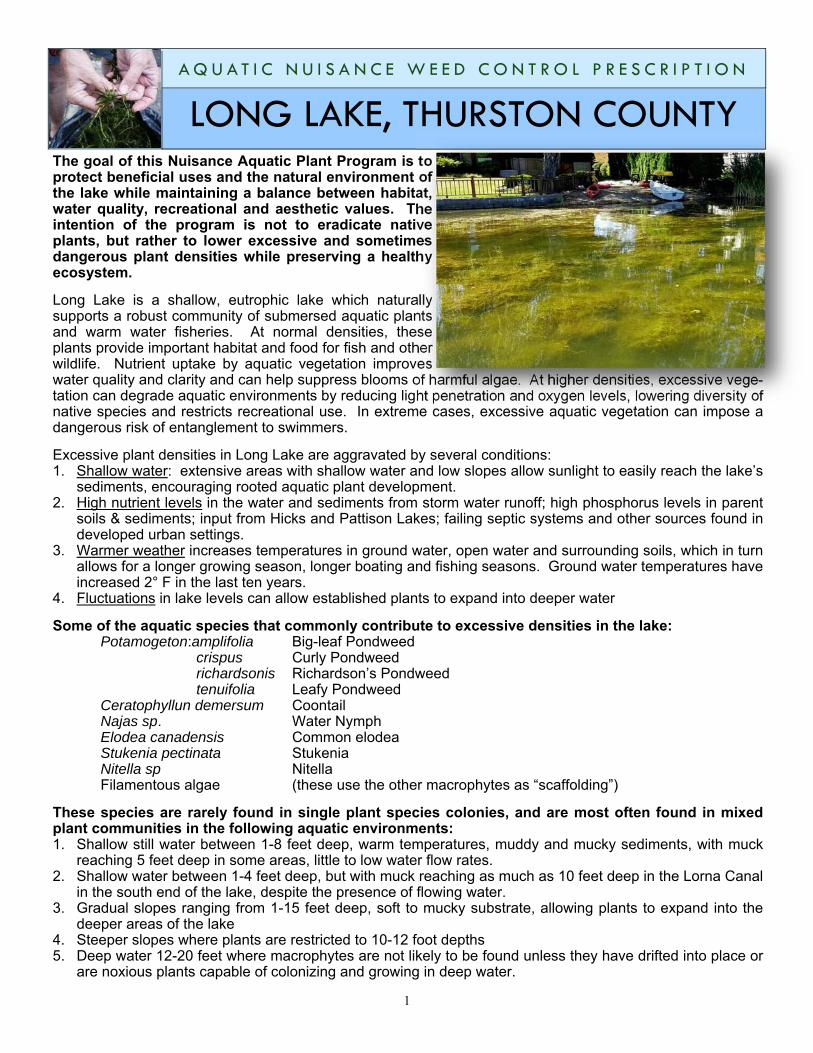
1 The goal of this Nuisance Aquatic Plant Program is to protect beneficial uses and the natural environment of the lake while maintaining a balance between habitat, water quality, recreational and aesthetic values. The intention of the program is not to eradicate native plants, but rather to lower excessive and sometimes dangerous plant densities while preserving a healthy ecosystem. Long Lake is a shallow, eutrophic lake which naturally supports a robust community of submersed aquatic plants and warm water fisheries. At normal densities, these plants provide important habitat and food for fish and other wildlife. Nutrient uptake by aquatic vegetation improves water quality and clarity and can help suppress blooms of harmful algae. At higher densities, excessive vege- tation can degrade aquatic environments by reducing light penetration and oxygen levels, lowering diversity of native species and restricts recreational use. In extreme cases, excessive aquatic vegetation can impose a dangerous risk of entanglement to swimmers. Excessive plant densities in Long Lake are aggravated by several conditions: 1. Shallow water: extensive areas with shallow water and low slopes allow sunlight to easily reach the lake’s sediments, encouraging rooted aquatic plant development. 2. High nutrient levels in the water and sediments from storm water runoff; high phosphorus levels in parent soils & sediments; input from Hicks and Pattison Lakes; failing septic systems and other sources found in developed urban settings. 3. Warmer weather increases temperatures in ground water, open water and surrounding soils, which in turn allows for a longer growing season, longer boating and fishing seasons. Ground water temperatures have increased 2° F in the last ten years. 4. Fluctuations in lake levels can allow established plants to expand into deeper water Some of the aquatic species that commonly contribute to excessive densities in the lake: Potamogeton:amplifolia Big-leaf Pondweed crispus Curly Pondweed richardsonis Richardson’s Pondweed tenuifolia Leafy Pondweed Ceratophyllun demersum Coontail Najas sp. Water Nymph Elodea canadensis Common elodea Stukenia pectinata Stukenia Nitella sp Nitella Filamentous algae (these use the other macrophytes as “scaffolding”) These species are rarely found in single plant species colonies, and are most often found in mixed plant communities in the following aquatic environments: 1. Shallow still water between 1-8 feet deep, warm temperatures, muddy and mucky sediments, with muck reaching 5 feet deep in some areas, little to low water flow rates. 2. Shallow water between 1-4 feet deep, but with muck reaching as much as 10 feet deep in the Lorna Canal in the south end of the lake, despite the presence of flowing water. 3. Gradual slopes ranging from 1-15 feet deep, soft to mucky substrate, allowing plants to expand into the deeper areas of the lake 4. Steeper slopes where plants are restricted to 10-12 foot depths 5. Deep water 12-20 feet where macrophytes are not likely to be found unless they have drifted into place or are noxious plants capable of colonizing and growing in deep water. LONG LAKE, THURSTON COUNTY AQUATIC NUISANCE WEED CONTROL PRESCRIPTION
Transcript of AQUATIC NUISANCE WEED CONTROL PRESCRIPTION LONG … · ecosystem. Long Lake is a shallow, eutrophic...
1
The goal of this Nuisance Aquatic Plant Program is to protect beneficial uses and the natural environment of the lake while maintaining a balance between habitat, water quality, recreational and aesthetic values. The intention of the program is not to eradicate native plants, but rather to lower excessive and sometimes dangerous plant densities while preserving a healthy ecosystem.
Long Lake is a shallow, eutrophic lake which naturally supports a robust community of submersed aquatic plants and warm water fisheries. At normal densities, these plants provide important habitat and food for fish and other wildlife. Nutrient uptake by aquatic vegetation improves water quality and clarity and can help suppress blooms of harmful algae. At higher densities, excessive vege-tation can degrade aquatic environments by reducing light penetration and oxygen levels, lowering diversity of native species and restricts recreational use. In extreme cases, excessive aquatic vegetation can impose a dangerous risk of entanglement to swimmers.
Excessive plant densities in Long Lake are aggravated by several conditions: 1. Shallow water: extensive areas with shallow water and low slopes allow sunlight to easily reach the lake’s
sediments, encouraging rooted aquatic plant development. 2. High nutrient levels in the water and sediments from storm water runoff; high phosphorus levels in parent
soils & sediments; input from Hicks and Pattison Lakes; failing septic systems and other sources found in developed urban settings.
3. Warmer weather increases temperatures in ground water, open water and surrounding soils, which in turn allows for a longer growing season, longer boating and fishing seasons. Ground water temperatures have increased 2° F in the last ten years.
4. Fluctuations in lake levels can allow established plants to expand into deeper water
Some of the aquatic species that commonly contribute to excessive densities in the lake: Potamogeton:amplifolia Big-leaf Pondweed crispus Curly Pondweed richardsonis Richardson’s Pondweed tenuifolia Leafy Pondweed Ceratophyllun demersum Coontail Najas sp. Water Nymph Elodea canadensis Common elodea Stukenia pectinata Stukenia Nitella sp Nitella Filamentous algae (these use the other macrophytes as “scaffolding”)
These species are rarely found in single plant species colonies, and are most often found in mixed plant communities in the following aquatic environments: 1. Shallow still water between 1-8 feet deep, warm temperatures, muddy and mucky sediments, with muck
reaching 5 feet deep in some areas, little to low water flow rates. 2. Shallow water between 1-4 feet deep, but with muck reaching as much as 10 feet deep in the Lorna Canal
in the south end of the lake, despite the presence of flowing water. 3. Gradual slopes ranging from 1-15 feet deep, soft to mucky substrate, allowing plants to expand into the
deeper areas of the lake 4. Steeper slopes where plants are restricted to 10-12 foot depths 5. Deep water 12-20 feet where macrophytes are not likely to be found unless they have drifted into place or
are noxious plants capable of colonizing and growing in deep water.
LONG LAKE, THURSTON COUNTY A Q U A T I C N U I S A N C E W E E D C O N T R O L P R E S C R I P T I O N
2
Impacts: Inadequate management can lead to substantial detriment to recreation, wildlife and aesthetic value: Reduced or no access to swimming Decreased boating and fishing opportunities Some types of watercraft excluded from use (jetskis) Reduced fish and wildlife habitat Impaired water quality Unpleasant odors Public safety
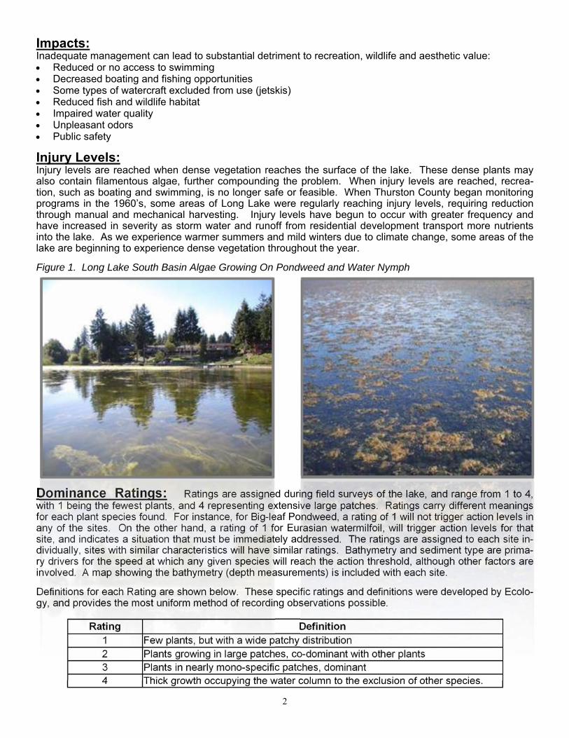
Injury Levels: Injury levels are reached when dense vegetation reaches the surface of the lake. These dense plants may also contain filamentous algae, further compounding the problem. When injury levels are reached, recrea-tion, such as boating and swimming, is no longer safe or feasible. When Thurston County began monitoring programs in the 1960’s, some areas of Long Lake were regularly reaching injury levels, requiring reduction through manual and mechanical harvesting. Injury levels have begun to occur with greater frequency and have increased in severity as storm water and runoff from residential development transport more nutrients into the lake. As we experience warmer summers and mild winters due to climate change, some areas of the lake are beginning to experience dense vegetation throughout the year.
Figure 1. Long Lake South Basin Algae Growing On Pondweed and Water Nymph
Dominance Ratings: Ratings are assigned during field surveys of the lake, and range from 1 to 4, with 1 being the fewest plants, and 4 representing extensive large patches. Ratings carry different meanings for each plant species found. For instance, for Big-leaf Pondweed, a rating of 1 will not trigger action levels in any of the sites. On the other hand, a rating of 1 for Eurasian watermilfoil, will trigger action levels for that site, and indicates a situation that must be immediately addressed. The ratings are assigned to each site in-dividually, sites with similar characteristics will have similar ratings. Bathymetry and sediment type are prima-ry drivers for the speed at which any given species will reach the action threshold, although other factors are involved. A map showing the bathymetry (depth measurements) is included with each site.
Definitions for each Rating are shown below. These specific ratings and definitions were developed by Ecolo-gy, and provides the most uniform method of recording observations possible.
Rating Definition 1 Few plants, but with a wide patchy distribution 2 Plants growing in large patches, co-dominant with other plants 3 Plants in nearly mono-specific patches, dominant 4 Thick growth occupying the water column to the exclusion of other species.

3
Figure 2. Littoral Zone and Nuisance Plant Growth
Areas where nuisance levels of aquatic vegetation have been experienced since 1983 are shown in Figure 2. This roughly coincides with the lake’s littoral zone, and comprises more than 200 acres of the lakes 330 acres. The zone is based on ba-thymetry data and the ability of light to penetrate the water, but milder winters and the introduction of plants that can germinate and grow at greater depths may well increase the littoral’s zone functional size. Under Ecology’s NPDES permit map, 90 acres (approximately 50%) of the littoral zone may be treated annual-ly. Action Levels: Action levels are the thresholds at which control measures must be taken to avoid injury levels. These thresholds vary according to the plant species growing in a given area, and the density or dominance of the plants observed during surveys of the lake. (Figure 3.) Physical characteristics of each area or site on the lake also affect when plants will reach action levels. Dominance Ratings observed and recorded during surveys of the lake serve as a means of quantifying and standardizing density of plants that are found. The dominance ratings used in surveys were taken from the Washington State Department of Ecology’s lake survey methods.
Figure 3. Aquatic Weeds Control Decision Matrix
4
CONTROL OPTIONS:
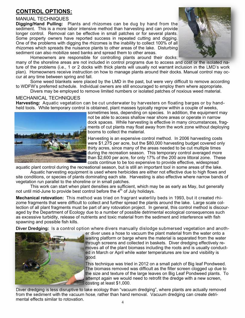
MANUAL TECHNIQUES Digging/Hand Pulling: Plants and rhizomes can be dug by hand from the sediment. This is a more labor intensive method than harvesting and can provide longer control. Removal can be effective in small patches or for several plants. Some property owners have reported success in repeated cutting and digging. One of the problems with digging the rhizomes is the inability to collect 100% of all rhizomes which spreads the nuisance plants to other areas of the lake. Disturbing sediment can also mobilize seed banks and spread them to other areas. Homeowners are responsible for controlling plants around their docks; many of the shoreline areas are not included in control programs due to access and cost or the isolated na-ture of the problems (i.e., 1 or 2 docks with thick plants will usually not warrant inclusion in the LMD’s work plan). Homeowners receive instruction on how to manage plants around their docks. Manual control may oc-cur at any time between spring and fall. Some weed blankets were placed by the LMD in the past, but were very difficult to remove according to WDFW’s preferred schedule. Individual owners are still encouraged to employ them where appropriate. Divers may be employed to remove limited numbers or isolated patches of noxious weed material.
MECHANICAL TECHNIQUES Harvesting: Aquatic vegetation can be cut underwater by harvesters on floating barges or by hand-held tools. While temporary control is obtained, plant masses typically regrow within a couple of weeks,
sometimes less, depending on species. In addition, the equipment may not be able to access shallow near shore areas or operate in narrow dock spaces. While harvesting is effective in many circumstances, frag-ments of cut plants may float away from the work zone without deploying booms to collect the material.
Harvesting is an expensive control method. In 2006 harvesting costs were $1,275 per acre, but the $80,000 harvesting budget covered only thirty acres, since many of the areas needed to be cut multiple times during the recreation season. This temporary control averaged more than $2,600 per acre, for only 17% of the 200 acre littoral zone. These costs continue to be too expensive to provide effective, widespread
aquatic plant control during the recreational season, but is still an important tool in some areas of the lake. Aquatic harvesting equipment is used where herbicides are either not effective due to high flows and site conditions, or species of plants dominating each site. Harvesting is also effective where narrow bands of vegetation run parallel to the shoreline or in small patches. This work can start when plant densities are sufficient, which may be as early as May, but generally not until mid-June to provide best control before the 4th of July holidays.
Mechanical rotovation: This method was tried on fragrant waterlily beds in 1993, but it created rhi-zome fragments that were difficult to collect and further spread the plants around the lake. Large scale col-lection of all plant fragments must be part of any rotovation project. In general, this control method is discour-aged by the Department of Ecology due to a number of possible detrimental ecological consequences such as excessive turbidity, release of nutrients and toxic material from the sediment and interference with fish spawning and possible fish kills.
Diver Dredging: Is a control option where divers manually dislodge submersed vegetation and anoth-er diver uses a hose to vacuum the plant material from the water onto a waiting platform or barge where the material is separated from the water through screens and collected in baskets. Diver dredging effectively re-moves all of the plant biomass including the roots and is usually conduct-ed in March or April while water temperatures are low and visibility is good.
This technique was tried in 2012 on a small patch of Big leaf Pondweed. The biomass removed was difficult as the filter screen clogged up due to the size and texture of the large leaves on Big Leaf Pondweed plants. To attempt again we would need to retrofit the dredge with a new screen, costing at least $1,000.
Diver dredging is less disruptive to lake ecology than “vacuum dredging”, where plants are actually removed from the sediment with the vacuum hose, rather than hand removal. Vacuum dredging can create detri-mental effects similar to rotovation.

5
CULTURAL TECHNIQUES Prevention: The Long Lake Management District, Advisory Committee and landowners are committed to taking steps to prevent the introduction of invasive aquatic weeds and continuing to research and apply methods that reduce nutrient levels, resulting in improved water quality and the reduction of excessive nui-sance weeds. Education for homeowners that emphasizes prevention is provided in several forms, including the Long
News newsletter, published twice yearly, and includes topics such as: Shoreline erosion: Plant native vegetation buffer strips along the lakeshore to filter the nutrients from
rainfall or irrigation runoff coming from lawns. Reduce or eliminate fertilization on lakeside properties. Clean up pet waste. Clean, drain and dry boats when entering or leaving a lake to avoid transporting non-native species. Don't let grass clippings and leaves get into the lake. Low to no phosphorus detergents & fertilizers. Making sure septic systems are properly maintained.
Other items that enhance the LMD prevention efforts are: networking with Water Resources (Stream Team), other external groups and citizen involvement with vegetation monitoring.
Bottom Barrier: Bottom barriers are essentially “underwater blankets” that cover the bottom sediments and the plants growing there. Barriers kill the plants under them, and prevent new plants from establishing. They can be made of many different materials, including burlap, sand-gravel, and a material called Texel, which is specifically manufactured for aquatic plant control. Bottom barriers, screens, and anchor materials that are not biodegradable must be completely removed within two years of placement, according to state regulations. The results of control with bottom barriers have been marginal. Aquatic vegetation can grow through slits in the fabric, which vent gasses created in the organic lake sediment. Floating plants can root into fibrous mats, and nearby plant roots can also recolonize these areas. Barriers have been very difficult to install in the light, loose sediment present in Long Lake and require regular maintenance.
Dredging: Another cultural control is to deepen the lake, which makes conditions less favorable to plants. Deeper water reduces the littoral zone and areas where the aquatic plants may grow. Dredging has been a subject of some discussion in Long Lake, and was studied extensively at Lake Lawrence. Because of the de-tailed engineering reports and demonstration projects for Lake Lawrence, we have a good understanding of the challenges associated with this approach. The volume of sediment that would have to be removed, dis-posal sites, federal and state permit requirements, associated high costs to develop and implement dredging, and lack of equipment staging sites due to Long Lake’s urbanized land uses exclude dredging from consider-ation for any large scale plant control efforts. Additionally, safety concerns would likely close the lake while dredging is underway. Any one of these issues would eliminate dredging from consideration for lake-wide control, but it could be effective in small, localized situations.
BIOLOGICAL TECHNIQUES There are currently no available biological control techniques for submersed vegetation in Long Lake. Grass carp have been the most commonly proposed biological control option in Washington State. Several meet-ings were held with the state’s permitting agency, Washington Department of Fish and Wildlife (WDFW), in 2004 and 2005 when the Integrated Aquatic Vegetation Management Plan was developed. WDFW staff indi-cated at that time that the agency would be unwilling to permit grass carp in Long Lake at any stocking rate. This position has not changed, and grass carp are precluded from use in Long Lake.
CHEMICAL TECHNIQUES Chemical techniques involve the application of herbicides specifically formulated to use in water bodies that have passed three tiers of environmental review: Federal, Washington State, and Thurston County. Aquatic herbicides may be specific to certain habitats (emergent, floating or submersed), or to certain plant properties (broad-leaf or grass-like), or, because of biochemistry, only particular species within any of these larger groups.
Chemical control in Long Lake began in 1991 with a one-time, whole-lake treatment of Eurasian watermilfoil with Sonar®. Up until that time, milfoil was being mechanically harvested, which fragmented and spread the plant throughout the entire lake. The whole-lake Sonar application virtually eradicated the milfoil, and no fur-ther chemical treatments were made. When small patches of milfoil began growing again, the County em-ployed divers to remove the plants by hand. Herbicides were not applied again to nuisance submerged plants in Long Lake until 2007, and are now applied under an NPDES permit issued by the Washington State Department of Ecology.

6
Timing and Treatment: Herbicide applications should occur at a time that will prevent injury levels of nuisance vegetation from occur-ring. Timing will vary according to the specific herbicide that is used and the target plant species, but in gen-eral, control will be most effective early in the species’ growing season in areas where the nuisance plants reached the action levels, typically April-May. This early treatment timing will substantially reduce or eliminate human contact with the treated areas because cool to cold weather generally limits recreational activities. Targeted treatment dates may require an exemption of the fish window as outlined in the APAM Permit.
Sites where action levels are triggered by observed dominance ratings will be considered for possible treat-ment. Prior to treatment, conditions will be verified via survey to determine whether the sites require treat-ment. Adjustments in the specific treatment areas will be made at that time.
Applications are done by contracted licensed, insured, aquatic vegetation management companies using ap-propriate, calibrated application equipment and methods. Work orders, maps and oversight are provided by
County Staff. Sonar: 3 applications to total 150 ppb Slow uptake, slow acting Beginning in early to mid-spring depending on previous monitoring and current lake & weather conditions Clearcast: 2 applications within a week of each other May vary from 300ppb to 500ppb depending on species Rapid uptake, slow acting Aquathol: For use on Water Nymph & in special circumstances. Once the problem has emerged, we may not have enough time to use a slow-acting herbicide, and
scheduling harvesters is very difficult once the season is underway. Do not use within 400 feet of the channelized lake outlet.
Swimming and Lake Use Advisories: Advisory notices and any use restrictions will be posted along the shoreline and at public access points ac-cording to label and APAM permit requirements. Cautionary signs will include the date of the treatment, prod-uct used, and all water use restrictions and precautions.
Active Ingredient/Product/Method Rates Mix
Aquatic applications (Licensed applicator with aquatic certification only)
Fluridone
Sonar®, Sonar Q®, Sonar PR®
Aquatic Broadcast/Eductor
Up to 150 ppb (sum of applica-tions per growth
cycle)
Partial Lake or Reservoir Treatments Where dilution of Sonar with untreated water is anticipated, such as in partial lake or reser-voir treatments, split or multiple applications may be used to extend the contact time to the target plants. The application rate and use frequency of Sonar PR in a partial lake is highly dependent upon the treatment area. An application rate at the higher end of the specified rate range may be required and frequency of applications will wary depending upon the potential of untreated water diluting the Sonar concentration in the treatment area. Use a rate at the higher end of the range where greater dilution with untreated water is anticipated. Application Sites Greater Than 1/4 Mile from a Functioning Potable Water Intake: For single applications, apply Sonar at application rates from 45 to 150 ppb. Split or multiple applica-tions may be made; however, the sum of all applications cannot exceed 150 ppb per annual growth cycle. Split applications should be conducted to maintain a sufficient concentration in the target area for a period of 45 days or longer.
Imazamox
Clearcast®, Clearcast 2.7G®
Aquatic Broadcast/Injection or Broadcast/Eductor
Up to 500 ppb (per application)
Surface Application Clearcast may be broadcast-applied to the water surface or injected below the water sur-face. Apply Clearcast to water to achieve a final concentration of the active ingredient of no more than 500 ppb. Multiple applications may be made during the annual growth cycle to maintain the desired vegetation response.
Endothall
Aquathol K®, Aquathol Super K®
Aquatic Broadcast/Eductor 1 to 5 ppm
Quiescent, Slow Moving or Flowing Water Treatments Use higher labeled rates when making treatments to small areas with an increased potential for rapid dilution or when treating narrow areas such as for boat lanes or shoreline treat-ments where dilution may reduce the exposure of plants to the herbicide. Use lower labeled rates for large contiguous treatment blocks or in protected areas such as coves where reduced water movement will not result in rapid dilution from the target treat-ment area. Personal Protective Equipment (PPE): Mixers, loaders, applicators and other handlers must wear: long-sleeved shirt and long pants, socks and shoes, chemical resistant gloves, pro-tective eyewear and NIOSH-approved half– or full-face respirator with a cartridge or canister approved for dusts and mists or a cartridge with any N, R, P, or HE filter. Note: the quarter-face cup style respirator does not meet this requirement.
7
GENERAL METHODS FOR SELECTING CONTROL OPTIONS:
Prevention Preventative measures are employed throughout the year. Where and whenever possible, preventative
methods are encouraged in order to bring about the highest water quality possible and to minimize the need for other forms of nuisance weed control.
Harvesting Is the preferred method of control in Conservation Areas and narrow strips of weeds. Can be a choice to follow-up where an herbicide application was insufficient to adequately control exces-
sive growth over the length of the growing season.
Manual Control Individual homeowners along the shoreline are responsible for manual control of aquatic weeds from the
shoreline out to the ends of their docks. Small populations (isolated, single plants or very small patches) of aquatic noxious weeds are removed
manually by divers where the numbers are few and plants can be removed from the lake with a minimal threat of fragmentation.
Diver Dredging This method has been proven effective when used on infestations of noxious weeds that are found in
populations exceeding levels where manual removal alone, without the assistance of suction removal from the water column is too time consuming or otherwise unfeasible. An example would be Brazilian elodea found in one or more areas exceeding 1,000 sq. ft.
Herbicide Application Aquathol K® or Aquathol Super K® is a preferred choice of herbicide for high flow areas and where the
plant community is predominantly naiads or curly pondweed. Sonar® or Clearcast® are chosen interchangeably to prevent resistance and for areas dominated by com-
mon elodea. The plant community matrix is variable and changes frequently in response to many factors.
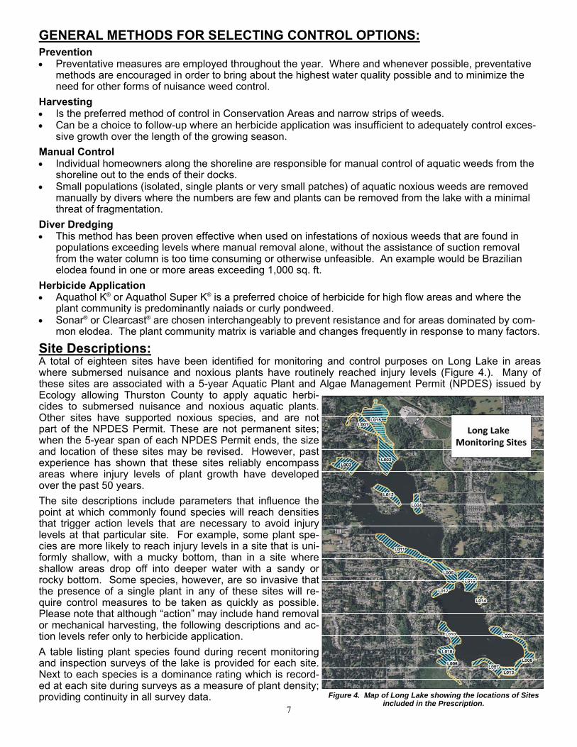
Site Descriptions: A total of eighteen sites have been identified for monitoring and control purposes on Long Lake in areas where submersed nuisance and noxious plants have routinely reached injury levels (Figure 4.). Many of these sites are associated with a 5-year Aquatic Plant and Algae Management Permit (NPDES) issued by Ecology allowing Thurston County to apply aquatic herbi-cides to submersed nuisance and noxious aquatic plants. Other sites have supported noxious species, and are not part of the NPDES Permit. These are not permanent sites; when the 5-year span of each NPDES Permit ends, the size and location of these sites may be revised. However, past experience has shown that these sites reliably encompass areas where injury levels of plant growth have developed over the past 50 years.
The site descriptions include parameters that influence the point at which commonly found species will reach densities that trigger action levels that are necessary to avoid injury levels at that particular site. For example, some plant spe-cies are more likely to reach injury levels in a site that is uni-formly shallow, with a mucky bottom, than in a site where shallow areas drop off into deeper water with a sandy or rocky bottom. Some species, however, are so invasive that the presence of a single plant in any of these sites will re-quire control measures to be taken as quickly as possible. Please note that although “action” may include hand removal or mechanical harvesting, the following descriptions and ac-tion levels refer only to herbicide application.
A table listing plant species found during recent monitoring and inspection surveys of the lake is provided for each site. Next to each species is a dominance rating which is record-ed at each site during surveys as a measure of plant density; providing continuity in all survey data. Figure 4. Map of Long Lake showing the locations of Sites
included in the Prescription.
8
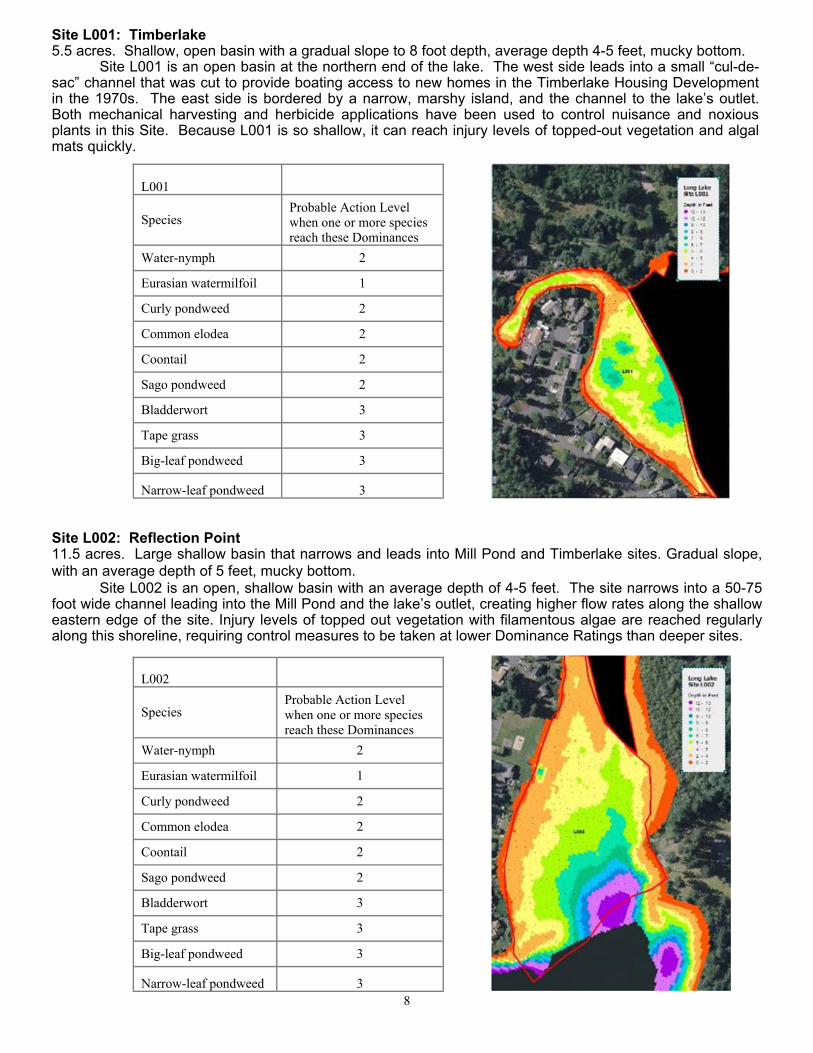
Site L001: Timberlake 5.5 acres. Shallow, open basin with a gradual slope to 8 foot depth, average depth 4-5 feet, mucky bottom. Site L001 is an open basin at the northern end of the lake. The west side leads into a small “cul-de-sac” channel that was cut to provide boating access to new homes in the Timberlake Housing Development in the 1970s. The east side is bordered by a narrow, marshy island, and the channel to the lake’s outlet. Both mechanical harvesting and herbicide applications have been used to control nuisance and noxious plants in this Site. Because L001 is so shallow, it can reach injury levels of topped-out vegetation and algal mats quickly.
L001
Species Probable Action Level when one or more species reach these Dominances
Water-nymph 2
Eurasian watermilfoil 1
Curly pondweed 2
Common elodea 2
Coontail 2
Sago pondweed 2
Bladderwort 3
Tape grass 3
Big-leaf pondweed 3
Narrow-leaf pondweed 3
Site L002: Reflection Point 11.5 acres. Large shallow basin that narrows and leads into Mill Pond and Timberlake sites. Gradual slope, with an average depth of 5 feet, mucky bottom. Site L002 is an open, shallow basin with an average depth of 4-5 feet. The site narrows into a 50-75 foot wide channel leading into the Mill Pond and the lake’s outlet, creating higher flow rates along the shallow eastern edge of the site. Injury levels of topped out vegetation with filamentous algae are reached regularly along this shoreline, requiring control measures to be taken at lower Dominance Ratings than deeper sites.
L002
Species Probable Action Level when one or more species reach these Dominances
Water-nymph 2
Eurasian watermilfoil 1
Curly pondweed 2
Common elodea 2
Coontail 2
Sago pondweed 2
Bladderwort 3
Tape grass 3
Big-leaf pondweed 3
Narrow-leaf pondweed 3
9
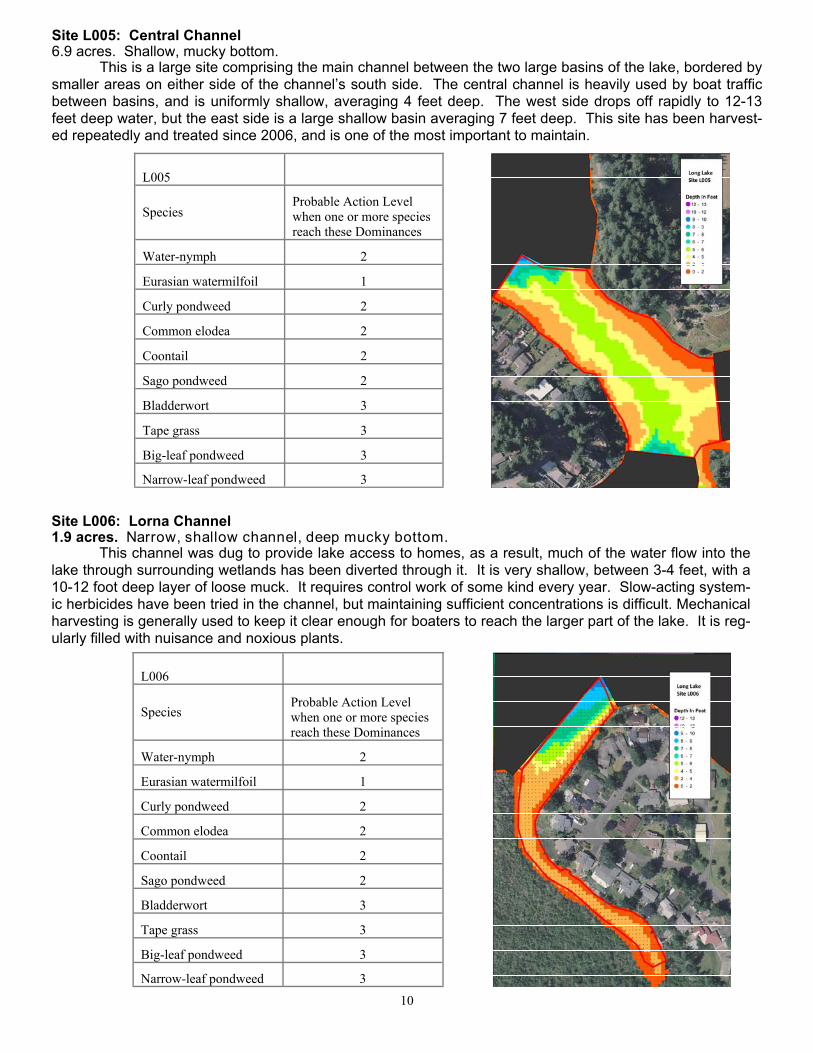
Site L003: Holmes Cove 7 acres. Approximately 3 acres are shallow, averaging 5-6 feet, falling off rapidly to 12-13 feet in the remain-ing area; mucky bottom. This is a 400-500 foot wide cove, bordered by a wetland to the west. There is little to no water flow through this site. Nearly half of the site is relatively shallow, with an average depth of 5-7 feet. This rapidly drops off into a pool with 13 foot depths. Control work has recently been focused on the shallow end of the cove, which requires action to be taken sooner to avoid reaching injury levels. This area has been either har-vested or treated with herbicides on a regular basis.
L003
Species Probable Action Level when one or more species reach these Dominances
Water-nymph 2
Eurasian watermilfoil 1
Curly pondweed 2
Common elodea 2
Coontail 2
Sago pondweed 2
Bladderwort 3
Tape grass 3
Big-leaf pondweed 3
Narrow-leaf pondweed 3
Site L004: Mayes Road 3.5 acres. Shallow, gradual slope to 8 foot depth, average depth 5-6 feet, mucky bottom. This site is located at the narrow point between Holmes Island habitat reserve and the eastern side of the lake along Mayes Road. It is a small site with an average depth of 5-6 feet, and reaches 9 feet over a gradual slope of 200 feet. Control work has included harvesting, with only one herbicide application since 2006.
L004
Species Probable Action Level when one or more species reach these Dominances
Water-nymph 2
Eurasian watermilfoil 1
Curly pondweed 2
Common elodea 2
Coontail 2
Sago pondweed 2
Bladderwort 3
Tape grass 3
Big-leaf pondweed 3
Narrow-leaf pondweed 3
10
Site L005: Central Channel 6.9 acres. Shallow, mucky bottom. This is a large site comprising the main channel between the two large basins of the lake, bordered by smaller areas on either side of the channel’s south side. The central channel is heavily used by boat traffic between basins, and is uniformly shallow, averaging 4 feet deep. The west side drops off rapidly to 12-13 feet deep water, but the east side is a large shallow basin averaging 7 feet deep. This site has been harvest-ed repeatedly and treated since 2006, and is one of the most important to maintain.
L005
Species Probable Action Level when one or more species reach these Dominances
Water-nymph 2
Eurasian watermilfoil 1
Curly pondweed 2
Common elodea 2
Coontail 2
Sago pondweed 2
Bladderwort 3
Tape grass 3
Big-leaf pondweed 3
Narrow-leaf pondweed 3
Site L006: Lorna Channel 1.9 acres. Narrow, shallow channel, deep mucky bottom. This channel was dug to provide lake access to homes, as a result, much of the water flow into the lake through surrounding wetlands has been diverted through it. It is very shallow, between 3-4 feet, with a 10-12 foot deep layer of loose muck. It requires control work of some kind every year. Slow-acting system-ic herbicides have been tried in the channel, but maintaining sufficient concentrations is difficult. Mechanical harvesting is generally used to keep it clear enough for boaters to reach the larger part of the lake. It is reg-ularly filled with nuisance and noxious plants.
L006
Species Probable Action Level when one or more species reach these Dominances
Water-nymph 2
Eurasian watermilfoil 1
Curly pondweed 2
Common elodea 2
Coontail 2
Sago pondweed 2
Bladderwort 3
Tape grass 3
Big-leaf pondweed 3
Narrow-leaf pondweed 3

11
Site L007: East Afflerbaugh 3.5 acres. Narrow strip along shoreline, gradual slope to 12 feet, average depth 9 feet, mucky bottom. This site runs along the southern shore of the lake. Because it is open to high wave and wind ener-gy, much of the site, despite being relatively shallow, does not regularly reach Injury Levels of topped out plants. The eastern side of the site, is more sheltered, and vegetation can reach levels where action needs to be taken. This eastern edge also borders a regular turn-around area for water craft, which was choked with vegetation in 2006 when the prescription for Long Lake Nuisance Vegetation was first developed. It has been both harvested and treated with herbicides.
L007
Species Probable Action Level when one or more species reach these Dominances
Water-nymph 2
Eurasian watermilfoil 1
Curly pondweed 2
Common elodea 2
Coontail 2
Sago pondweed 2
Bladderwort 3
Tape grass 3
Big-leaf pondweed 3
Narrow-leaf pondweed 3
Site L008: Fred’s Cove 4.5 acres. Shallow, open basin with a gradual slope to 8 foot depth, average depth 4-5 feet, mucky bottom. This cove has supported high densities of plant growth, due to its gradual slope. Much of the control work has been focused in the shallower water, and has included harvesting and herbicide application. It is also a part of the turn-around path for water skiers, bringing more traffic into the area.
L008
Species Probable Action Level when one or more species reach these Dominances
Water-nymph 2
Eurasian watermilfoil 1
Curly pondweed 2
Common elodea 2
Coontail 2
Sago pondweed 2
Bladderwort 3
Tape grass 3
Big-leaf pondweed 3
Narrow-leaf pondweed 3

12
Site L009: Lk Forest Park, Walthew Drive 6 acres. Long, fairly narrow strip, gradual slope to 12 foot depth, average depth 9 feet, mucky bottom. This is a long, narrow site that runs along a south facing shoreline. The change in depth is uniform, reaching 13 feet within 100 feet of shore. There is full exposure to southerly winds and chop. This energy, along with the consistent drop in slope to 12 foot depths helps prevent plants from reaching high densities. Many native species will need to reach dominance ratings of 3 and 4 before control measures must be tak-en to prevent injury levels.
L009
Species Probable Action Level when one or more species reach these Dominances
Water-nymph 2
Eurasian watermilfoil 1
Curly pondweed 2
Common elodea 3
Coontail 3
Sago pondweed 3
Bladderwort 3
Tape grass 4
Big-leaf pondweed 4
Narrow-leaf pondweed 4
L010: Long Lk Drive South 5 acres. Shoreline site with gradual slope to 12-13 feet deep, average depth 9 feet, mucky bottom. The lake bottom drops off steadily along much of this site’s shoreline to 12 and 13 foot depths, ex-cept for a 2 acre cove at its northern end that remains shallow for more than 100 feet from the shore. L010 has been treated with Sonar for nuisance vegetation, but because of the difference between the two ends of the site, higher dominance ratings should be reached before herbicides are applied.
L010
Species Probable Action Level when one or more species reach these Dominances
Water-nymph 2
Eurasian watermilfoil 1
Curly pondweed 2
Common elodea 3
Coontail 3
Sago pondweed 3
Bladderwort 3
Tape grass 3
Big-leaf pondweed 3
Narrow-leaf pondweed 3

13
Site L011: Shorewood 11.5 acres. Long narrow strip, depth reaches 13 feet within 100 ft of shore. This site runs between the WDFW Public Launch and the cut between the two main basins of the lake, and is bordered on one side by the large northern basin of the lake. The change in depth is uniform, reaching 13 feet within 100 feet of shore. There is full exposure to northern winds and chop, creating higher magnitudes of wave energy than in other areas of the lake. This energy, along with the consistent change in slope helps prevent plants from reaching high densities. Many native species will need to reach Domi-nance Ratings of 3 and 4 before control measures must be taken to prevent Injury Levels.
L011
Species Probable Action Level when one or more species reach these Dominances
Water-nymph 2
Eurasian watermilfoil 1
Curly pondweed 2
Common elodea 2
Coontail 2
Sago pondweed 2
Bladderwort 3
Tape grass 4
Big-leaf pondweed 4
Narrow-leaf pondweed 3
Site L012: North Holmes Island 3 acres. Long narrow strip along island, depth reaches 13 feet within 60 feet of shore. This is a long strip along the north side of Holmes Island, the slope changes evenly from 0 to 12 feet within 60 feet from the shoreline. Like the Shorewood site, Holmes Island is exposed to wind and chop, cre-ating more wave energy than in other areas of the lake. This high energy, along with the consist change in slope to deeper water helps prevent plants from reaching high densities. Many native species will need to reach Dominance Ratings of 3 and 4 before control measures must be taken to prevent Injury Levels.
L012
Species Probable Action Level when one or more species reach these Dominances
Water-nymph 2
Eurasian watermilfoil 1
Curly pondweed 2
Common elodea 3
Coontail 3
Sago pondweed 4
Bladderwort 4
Tape grass 4
Big-leaf pondweed 4
Narrow-leaf pondweed 3

14
Site L014: Frances Cove 1 acre. Uniformly shallow cove average depth 4-5 feet, mucky bottom. This is a small, shallow cove that typically supports robust plant growth. Nuisance vegetation has been controlled largely through harvesting, requiring only one herbicide application since 2006. Presence of one of the more aggressive plants in low densities may indicate that herbicide application should be con-sidered.
L014
Species Probable Action Level when one or more species reach these Dominances
Water-nymph 2
Eurasian watermilfoil 1
Curly pondweed 2
Common elodea 2
Coontail 2
Sago pondweed 2
Bladderwort 3
Tape grass 3
Big-leaf pondweed 4
Narrow-leaf pondweed 3
Site L013 Southeast Waterlilies 2.6 acre. Uniformly sloping area, average depth 6 feet, mucky bottom. This area was colonized by noxious Fragrant Waterlilies in the 1990s, and was one of the focal are-as for control with herbicides. It now supports robust plant growth, but because of its relative isolation has not been included in the NPDES Permit.
L013
Species Probable Action Level
when one or more species reach these Dominances
Water-nymph 2
Eurasian watermilfoil 1
Curly pondweed 3
Common elodea 3
Coontail 3
Sago pondweed 3
Bladderwort 3
Tape grass 3
Big-leaf pondweed 4
Narrow-leaf pondweed 3
15
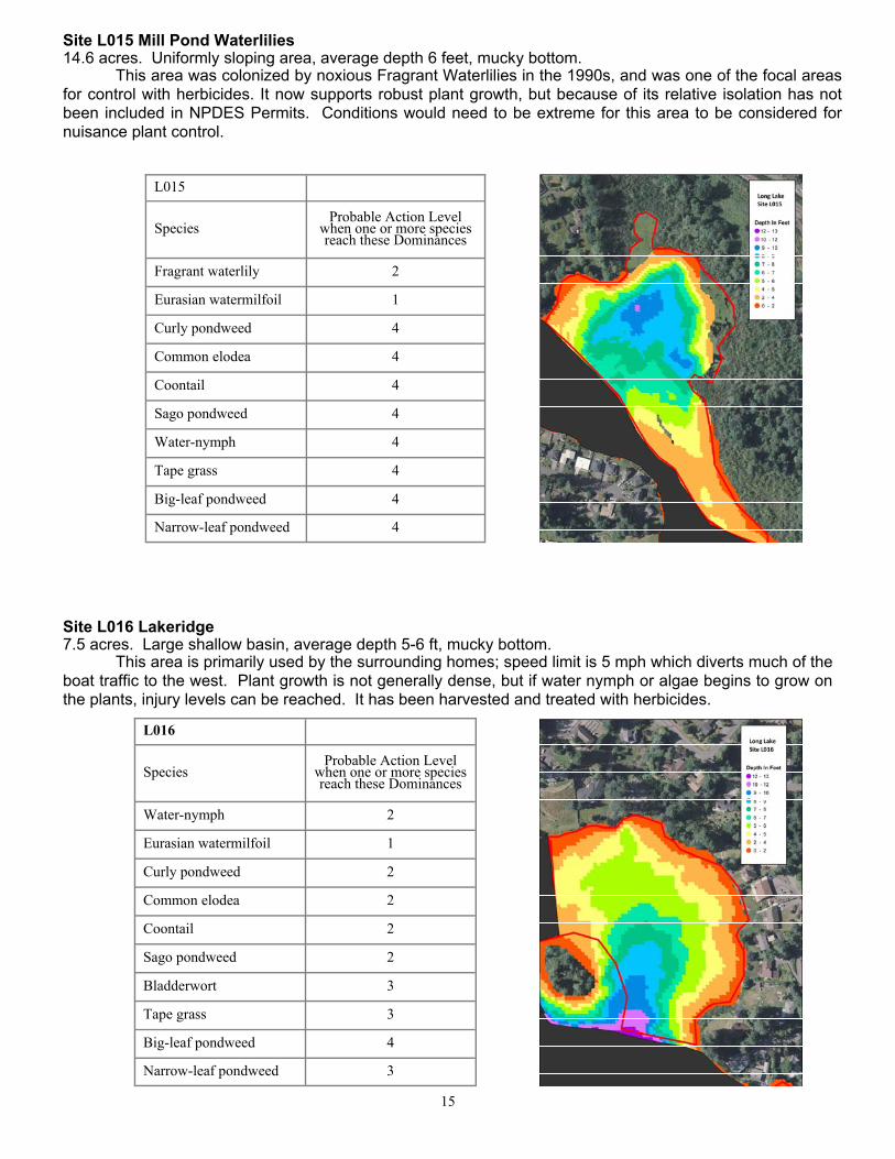
Site L015 Mill Pond Waterlilies 14.6 acres. Uniformly sloping area, average depth 6 feet, mucky bottom. This area was colonized by noxious Fragrant Waterlilies in the 1990s, and was one of the focal areas for control with herbicides. It now supports robust plant growth, but because of its relative isolation has not been included in NPDES Permits. Conditions would need to be extreme for this area to be considered for nuisance plant control.
Site L016 Lakeridge 7.5 acres. Large shallow basin, average depth 5-6 ft, mucky bottom. This area is primarily used by the surrounding homes; speed limit is 5 mph which diverts much of the boat traffic to the west. Plant growth is not generally dense, but if water nymph or algae begins to grow on the plants, injury levels can be reached. It has been harvested and treated with herbicides.
L016
Species Probable Action Level
when one or more species reach these Dominances
Water-nymph 2
Eurasian watermilfoil 1
Curly pondweed 2
Common elodea 2
Coontail 2
Sago pondweed 2
Bladderwort 3
Tape grass 3
Big-leaf pondweed 4
Narrow-leaf pondweed 3
L015
Species Probable Action Level
when one or more species reach these Dominances
Fragrant waterlily 2
Eurasian watermilfoil 1
Curly pondweed 4
Common elodea 4
Coontail 4
Sago pondweed 4
Water-nymph 4
Tape grass 4
Big-leaf pondweed 4
Narrow-leaf pondweed 4

16
Site L017 Long Drive West 4 acres. Narrow strip of shallow water to the east, becoming shallow to the west, mucky bottom. This area was separated from a larger site (#5 and #16) due to a section that drops off rapidly to deeper water, making it difficult to manage as a single unit. The west end of this site is a shallow cover that regularly reaches injury levels. The small size of the shallows means that it is usually not included in herbi-cide treatments.
L017
Species Probable Action Level
when one or more species reach these Dominances
Water-nymph 2
Eurasian watermilfoil 1
Curly pondweed 3
Common elodea 3
Coontail 3
Sago pondweed 3
Bladderwort 3
Tape grass 4
Big-leaf pondweed 3
Narrow-leaf pondweed 3
Site L018 Arbors Cove 7.2 acres. Large shallow basin, average depth 7-8 feet, mucky bottom. This shallow basin has two coves averaging 4-6 feet deep, merging into a deeper area of 8-9 feet. It is a regular turn around area for boats and jet skis. It supports dense, uniform levels of plant growth, includ-ing noxious Curly Pondweed, which is often covered with filamentous algae. Prevailing winds carry floating masses of plants and algae into this area, It has been treated with herbicides and harvested regularly.
L018
Species Probable Action Level
when one or more species reach these Dominances
Water-nymph 2
Eurasian watermilfoil 1
Curly pondweed 3
Common elodea 2
Coontail 2
Sago pondweed 3
Bladderwort 3
Tape grass 4
Big-leaf pondweed 3
Narrow-leaf pondweed 3

17
Conservation Habitat: Conservation Habitat areas were initially based on adjacency to land parcels that were assigned reduced rates and charges by the Lake Management District. These areas now derive from Ecology’s NPDES Per-mit. This Permit is issued every five years, and a map of proposed treatment areas is submitted with the Permit Application; nuisance vegetation outside of these treatment areas must be addressed with non-herbicide methods, such as harvesting. Rules for changing the mapped treatment areas and bounda-ries within the 5-year term of the Permit are ad-dressed in the Permit and Factsheet. While some flexibility is provided for, it is important to note that during the 10 years that Thurston County has held an NPDES Permit, the vast majority of mapped Conser-vation Habitat Areas have fallen within the same gen-eral locations in the lake. The current Permit (2016-2021) designates more than 90 acres as Conserva-tion Habitat. Locations of the current Conservation Areas are shown on the right in Figure 4.
Figure 4. Conservation Areas designated by the current NPDES Permit.
Monitoring: The lake’s shallow water zone, up to 12 ft deep, were surveyed with high accuracy sonar equipment in 2014. Note that the littoral zone where macrophyte growth is supported, extends to greater depths if the slope is gradual. Areas were delimited according to depth, slope, substrate, flow, and previous years’ surveys, and are monitored during the growing season by County Staff. A list of species found to be prevalent in previous years has been developed, with plant density ratings for each species. Note that some species will need con-trol work before others in shallow areas. It is the overall makeup of the plant community as well as the densi-ty of the plants that will indicate control work is necessary. A spreadsheet has been prepared for use during monitoring surveys.
Following the initial control of the plant, inspections will be conducted as part of each season's program. Dominance Ratings will be recorded for species that are observed in each site. Observations will be recorded in a uniform fashion on standardized forms that facilitate monitoring data entry into a database.
Records will be kept to provide historical accounts of weed control strategies and to help evaluate and select future weed control options. As required by Thurston County Policy an annual report and evaluation will be prepared by the Lakes Management department. The report will include: (1) the areas where manual or me-chanical removal occurred, (2) the number of cubic yards removed, and (3) maps of treatment areas and re-sulting Dominance Ratings.
References: Thurston County Department of Water and Waste Management. Long Lake Integrated Aquatic Vegetation Management Plan, September 2004.
Oxygen Depletion Beneath Aquatic Plant Surface Mats. From Pauley et al., The Effects of Triploid Carp Grazing on Lakes in the Pacific Northwest, Washington Cooperative Fishery and Wildlife Unit, School of Fisheries, University of Washington, Seattle, 1988.
Washington State Department of Ecology, Aquatic Plant Manage-ment: http://www.ecy.wa.gov/programs/wq/plants’management/index.html
Revised February, 2017
Thurston County Public Works Noxious Weed & Lakes Management Division
11834 Tilley Road S. Olympia, WA 98512 Phone: 360-786-5576 T.D.D. 360-754-2933
[email protected] www.co.thurston.wa.us/tcweeds