Appropriate Assessment - PA Resources Seismic … Figure 1. Map showing areas of proposed PA...
73
1 RECORD OF THE APPROPRIATE ASSESSMENT UNDERTAKEN UNDER REGULATION 5 OF THE OFFSHORE PETROLEUM ACTIVITES (CONSERVATION OF HABITATS) REGULATIONS 2001 (AS AMENDED) April 2011 Title of Application: Block 17/4B 2D Seismic Survey 1 INTRODUCTION 1.1 This is a record of the Appropriate Assessment, undertaken by the Department of Energy and Climate Change in respect of the undertaking of a 2D seismic survey as proposed in the PON14a application DECC ref. no. 2212 (“the project”) as required under Regulation 5 of the Offshore Petroleum Activities (Conservation of Habitats) Regulations 2001 (S.I. 2001/1754) (as amended) and in accordance with the Habitats Directive (Council Directive 92/43/EEC on the Conservation of natural habitats and of wild fauna and flora) and the Wild Birds Directive (Council Directive 2009/147/EC on the conservation of wild birds). 1.2 The project is not directly connected with, or necessary to, the management of a European site. Based on advice received from Scottish Natural Heritage (SNH) the Appropriate Assessment considers the following designated European sites: • Moray Firth SAC, • Dornoch Firth and Morrich More SAC, • Berriedale and Langwell Waters SAC, • River Oykel SAC, • River Evelix SAC, • River Moriston SAC, • River Spey SAC, • East Caithness Cliffs SPA. 1.3 The purpose of the Appropriate Assessment is to ascertain whether the project will not adversely affect the integrity of the European sites listed above, in terms of their conservation objectives. 1.4 This record should be read in conjunction with the following documentation: • Petroleum Operations Notice No. 14A (PON14A) Notification and/or application for consent for oil and gas surveys and shallow drilling operations. Ref. No. 2212.
Transcript of Appropriate Assessment - PA Resources Seismic … Figure 1. Map showing areas of proposed PA...

1
RECORD OF THE APPROPRIATE ASSESSMENT UNDERTAKEN UNDER
REGULATION 5 OF THE OFFSHORE PETROLEUM ACTIVITES (CONSERVATION OF
HABITATS) REGULATIONS 2001 (AS AMENDED)
April 2011
Title of Application:
Block 17/4B 2D Seismic Survey
1 INTRODUCTION
1.1 This is a record of the Appropriate Assessment, undertaken by the Department of Energy and
Climate Change in respect of the undertaking of a 2D seismic survey as proposed in the
PON14a application DECC ref. no. 2212 (“the project”) as required under Regulation 5 of the
Offshore Petroleum Activities (Conservation of Habitats) Regulations 2001 (S.I. 2001/1754) (as
amended) and in accordance with the Habitats Directive (Council Directive 92/43/EEC on the
Conservation of natural habitats and of wild fauna and flora) and the Wild Birds Directive
(Council Directive 2009/147/EC on the conservation of wild birds).
1.2 The project is not directly connected with, or necessary to, the management of a European site.
Based on advice received from Scottish Natural Heritage (SNH) the Appropriate Assessment
considers the following designated European sites:
• Moray Firth SAC,
• Dornoch Firth and Morrich More SAC,
• Berriedale and Langwell Waters SAC,
• River Oykel SAC,
• River Evelix SAC,
• River Moriston SAC,
• River Spey SAC,
• East Caithness Cliffs SPA.
1.3 The purpose of the Appropriate Assessment is to ascertain whether the project will not
adversely affect the integrity of the European sites listed above, in terms of their conservation
objectives.
1.4 This record should be read in conjunction with the following documentation:
• Petroleum Operations Notice No. 14A (PON14A) Notification and/or application for
consent for oil and gas surveys and shallow drilling operations. Ref. No. 2212.

2
• PA Resources UK Limited (2010). – Block 17/4B 2D Seismic Survey Environmental
Assessment.
• Kongsberg (2010a). Underwater noise propagation modelling and estimate of impact
zones for seismic operations in the Moray Firth. Final report 37399 – FR1 (c).
• Kongsberg (2010b). 2D Seismic Survey in the Moray Firth: Review of noise impact
studies and re-assessment of acoustic impacts.
• Thompson et al. (2010). Assessing the potential impact of oil and gas exploration
operations on cetaceans in the Moray Firth. University of Aberdeen.
• SNH (2010). PA resources Moray Firth 2D Seismic Survey. Letter to DECC dated
11 June 2010. Ref No. B624742.
1.5 The assessment has been undertaken using the best scientific knowledge available and, based
on this knowledge, used a precautionary approach when assessing potential effects.
2 PROJECT LOCATION
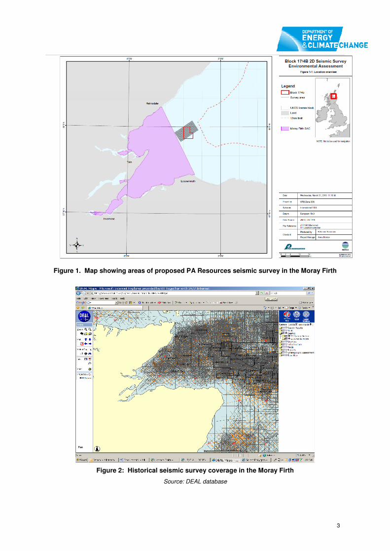
2.1 The proposed 2D seismic survey will be undertaken within Blocks, 17/4, 17/3,11/28 and 11/29
with a total length of line of 493 km and covering a total area of 91 km2 (Figure 1). The
proposed survey programme is, at its closest point, 185 metres from the Moray Firth SAC and
18 km from the nearest coastline.
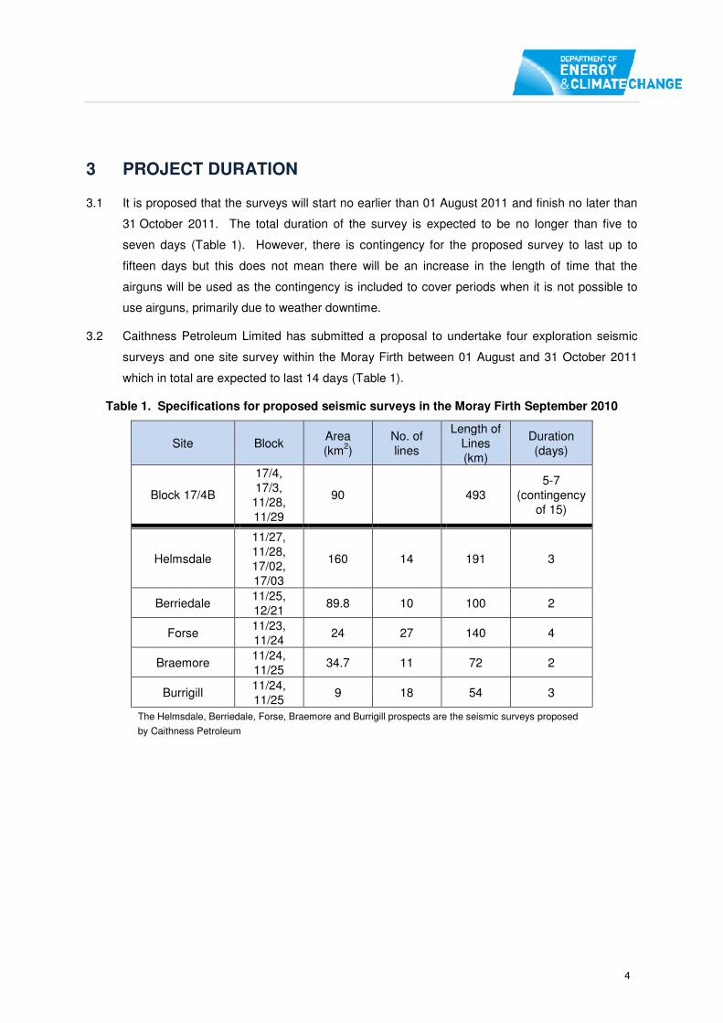
2.2 Seismic surveys have been undertaken in the Moray Firth area since the 1970’s. There are
primarily two types of seismic survey: 2D and 3D, with 3D being less frequent but typically on a
larger scale and with a greater source level sound. The majority of surveys undertaken in the
Moray Firth have been 2D (Figure 2).
3
Figure 1. Map showing areas of proposed PA Resources seismic survey in the Moray Firth
Figure 2: Historical seismic survey coverage in the Moray Firth
Source: DEAL database
4
3 PROJECT DURATION
3.1 It is proposed that the surveys will start no earlier than 01 August 2011 and finish no later than
31 October 2011. The total duration of the survey is expected to be no longer than five to
seven days (Table 1). However, there is contingency for the proposed survey to last up to
fifteen days but this does not mean there will be an increase in the length of time that the
airguns will be used as the contingency is included to cover periods when it is not possible to
use airguns, primarily due to weather downtime.
3.2 Caithness Petroleum Limited has submitted a proposal to undertake four exploration seismic
surveys and one site survey within the Moray Firth between 01 August and 31 October 2011
which in total are expected to last 14 days (Table 1).
Table 1. Specifications for proposed seismic surveys in the Moray Firth September 2010
Site Block Area
(km2)
No. of
lines
Length of
Lines
(km)
Duration
(days)
Block 17/4B
17/4,
17/3,
11/28,
11/29
90 493
5-7
(contingency
of 15)
Helmsdale
11/27,
11/28,
17/02,
17/03
160 14 191 3
Berriedale 11/25,
12/21 89.8 10 100 2
Forse 11/23,
11/24 24 27 140 4
Braemore 11/24,
11/25 34.7 11 72 2
Burrigill 11/24,
11/25 9 18 54 3
The Helmsdale, Berriedale, Forse, Braemore and Burrigill prospects are the seismic surveys proposed
by Caithness Petroleum

5
4 PROJECT DESCRIPTION
4.1 The proposed Block 17/4B seismic survey will involve a single survey vessel undertaking 2D
seismic along a pre-determined pattern of transect lines with the lines spaced at approximately
250m intervals (Figure 1). The total length of the survey transects, during which the airguns will
be operating, will be up to 493 km. Between 2 km and 4 km will also be required at the end of
each survey line to allow the vessel to turn, during which time the airguns could be operating
depending on operational requirements.
4.2 The proposed seismic survey system consists of a G Gun array comprising of two airguns with
a total capacity of 470 cubic inch at 2,000psi. Modelling undertaken by the applicant is based
on sound levels of no greater than 220 dB re 1µPa @ 1m and 183 dB re 1µPa @ 500m.
Additional sound propagation modelling has been used in this assessment, based on different
sound levels:
• Kongsberg sound model based on a 470 cu. inch gun with a peak sound source level
of 243 dB re1. µPa @ 1m.
• Caithness Petroleum sound modelling is based on 228 dB re. 1µPa @ 1m.
This assessment is primarily based on the study undertaken by Kongsberg, supported by the
other studies (Kongsberg 2010b, Caithness Petroleum 2010, PA Resources 2010). The
assessment is therefore based on the most precautionary sound source level of
243 dB re1. µPa @ 1m.
4.3 A single streamer containing the hydrophones will be towed behind the survey vessel. The
length of the streamer will vary between 1,100 and 2,000 metres.
4.4 In addition to the seismic survey vessel, a safety vessel will also be present for the duration of
the proposed survey.

6
Figure 3: Map showing areas of proposed PA Resources and Caithness Petroleum seismic surveys and the area of the Moray Firth R3 OWF zone in the Moray Firth

7
5 SCOPE OF THIS ASSESSMENT
5.1 Detailed analysis, consultation and discussion of the environmental sensitivities related to the
conservation features in the vicinity of the project have taken place prior to this assessment.
DECC has concluded, taking account of the advice received from the Joint Nature
Conservation Committee (JNCC)1 and Scottish Natural Heritage (SNH)
2, that an Appropriate
Assessment is required (SNH 2010).
5.2 The scope of the assessment is based on discussions with, and/or advice received from the
Scottish Government, JNCC, SNH, the University of Aberdeen, CEFAS, the Sea Mammal
Research Unit (SMRU) and the Whale and Dolphin Conservation Society (WDCS), including
the responses received to the consultation on the PON14a application submitted by PA
Resources and the responses to the consultation draft of the Appropriate Assessment which
are summarised in Annex1 to this report.
5.3 Based on the advice received it has been determined that the assessment should consider,
alone and in-combination, the potential direct and indirect impacts on:
• Bottlenose dolphin,
• Harbour seal,
• Atlantic salmon,
• Sea lamprey,
• Freshwater pearl mussel,
• Seabird assemblages.
Bottlenose Dolphin
5.4 The bottlenose dolphin is a qualifying species for the Moray Firth SAC. Sound arising from the
proposed seismic survey has the potential to significantly affect bottlenose dolphins, due to
permanent or temporary physical hearing damage and or displacement. The proposed survey
is, at its closest position, 185 metres outwith the SAC but in areas where there is the potential
for bottlenose dolphins to occur. The surveys could therefore affect bottlenose dolphins or their
prey, both within and outwith the Moray Firth SAC.
Harbour Seals
5.5 Harbour seals are an Annex II feature of the Dornoch Firth and Morrich More SAC. JNCC and
SNH have advised that seismic airguns may affect harbour seals or their prey. The seismic
survey is outwith the SAC but will be undertaken in an area where harbour seals may occur and
1 JNCC advise on nature conservation effects at and
beyond 12 nautical miles.
2 Scottish Natural Heritage advise on nature conservation effects within 12 nautical miles

8
therefore there is a potential effect on harbour seals outwith the Dornoch Firth and Morrich
More SAC.
Atlantic Salmon
5.6 SNH have advised that Atlantic salmon are susceptible to loud underwater sound and that
proposed survey is likely to have a significant effect on the Atlantic salmon which is a qualifying
species for Berriedale and Langwell Waters SAC, River Oykel SAC, River Moriston SAC and
River Spey SAC and have advised that DECC is required to undertake an Appropriate
Assessment in view of these sites’ Conservation Objectives for Atlantic salmon (SNH 2010).
5.7 None of SACs are closer than 20 km from the proposed areas of survey; consequently, there
will be no significant impact on Atlantic salmon within or near the River Oykel SAC, River
Moriston SAC, River Spey SAC and Berriedale and Langwell Waters SAC. The proposed
survey will last no longer than fifteen days and any displacement, should it occur, will, only last
during those days. Low densities of migrating Atlantic salmon may pass the ensonified area
during operations but will not remain in the area. Consequently, any potential adverse effect on
Atlantic salmon would be localised, of short duration and only likely to affect a small number of
individuals. There is also no evidence that any displacement would have any long-term effect
on migratory behaviour.
5.8 There is the potential for in-combination effects with the survey being proposed by Caithness
Petroleum (Caithness Petroleum 2010). This survey is over 20 km from the relevant SACs and
is also of a relatively short duration of no longer than 14 days, during which period some
Atlantic salmon may be displaced.
5.9 SNH have advised the proposal will not adversely affect the integrity of the sites. Therefore,
Atlantic salmon are not considered further in this assessment.
Sea Lamprey
5.10 Sea lamprey spend their adult life in the sea or estuaries but spawn and spend the juvenile part
of their life cycle in freshwater rivers. SNH have advised that the proposed survey could have a
significant effect on sea lamprey, which is a qualifying species for River Spey SAC and have
advised that DECC is required to undertake an Appropriate Assessment in view of the sites
Conservation Objectives for sea lamprey (SNH 2010).
5.11 The River Spey SAC is located on the southern side of the Moray Firth and is approximately
20 km from the nearest survey area and consequently the sound levels from the surveys in the
vicinity of the SAC will be relatively low. Although research indicates that sea lamprey respond
to sound at frequencies of between 20 Hz and 100 Hz (Lenhardt & Sismour 1995) they do not
possess a swim bladder and are less sensitive to sound than fish that do possess a swim
bladder (Maes et al. 2004). In addition sea lamprey leave the River Spey and enter the Moray
Firth during October and November and will be largely absent from the Moray Firth during

9
September when the proposed seismic surveys are planned. It is therefore concluded that they
will not be adversely impacted by the proposed seismic surveys.
5.12 There is the potential for in-combination effects with the survey being proposed by Caithness
Petroleum (Caithness Petroleum 2010). This survey is over 20 km from the relevant SAC and
is also of a relatively short duration of no longer than 14 days. As sea lamprey are largely
absent from the Moray Firth during the period of the proposed survey it is concluded that there
will be no in-combination effect.
5.13 SNH have advised that based on the information provided, the proposed survey will not
adversely affect the integrity of the site. Therefore, sea lamprey are not considered further in
this assessment.
Freshwater Pearl Mussel
5.14 SNH have advised that the proposed surveys is likely to have a significant effect on freshwater
pearl mussel, which is a qualifying species for River Oykel SAC, River Evelix SAC, River
Moriston SAC and River Spey SAC and have advised that DECC is required to undertake an
Appropriate Assessment in view of these sites’ Conservation Objectives for freshwater pearl
mussel (SNH 2010).
5.15 The freshwater pearl mussel is dependent on salmonid fish during the larval stage of their life
cycle, during which time they attach themselves onto the gills of salmon or brown trout until the
following summer when they drop off onto the river bed. There is therefore a theoretical
possibility that, should there be any significant displacement of salmon from their spawning
rivers there could be an adverse effect on the freshwater pearl mussel. As indicated above
(Section 5.7), it is concluded that any potential effect either alone or in-combination on Atlantic
salmon would be localised, of short duration and only likely to affect a small number of
individuals, and there is also no evidence that any displacement would have any long-term
effect on migratory behaviour. Consequently, it is not anticipated that there will be any impact
on the fresh water pearl mussel.
5.16 SNH have advised the proposal will not adversely affect the integrity of the sites. Therefore,
freshwater pearl mussels are not considered further in this assessment.
Seabirds
5.17 The East Caithness Cliffs SPA holds internationally important populations of seabirds,
particularly: guillemot, herring gull, kittiwake, razorbill and shag. In addition, the site qualifies
under Article 4.2 of the Birds Directive as a site hosting a seabird assemblage of greater than
20,000 individuals. Peak seabird activity occurs during June and July, with the fewest birds in
the area between September and November (Brookes 2010). This supports the evidence from
visual surveys that indicate low densities of seabirds at the East Caithness Cliffs after the
breeding season is finished (Mudge et al. 1987).

10
5.18 There is no published evidence of any direct or indirect impacts on seabirds from seismic
surveys. The proposed survey will be undertaken outwith the breeding season when the
majority of seabirds that breed on the East Caithness Cliffs SPA have dispersed into the North
Sea and the level of foraging activity in nearby waters will be relatively low.
5.19 SNH have advised that an Appropriate Assessment is not required in relation to seabird
populations as it is unlikely that the proposal will have a significant effect on any qualifying
interests of the East Caithness Cliffs SPA, either directly or indirectly. Therefore, seabirds are
not considered further.
In-combination effects
5.20 For the purposes of this assessment the consideration of in-combination effects follows
published guidance by including the following plans and projects.
• Approved but as yet uncompleted plans or projects;
• Permitted ongoing activities,
• Plans or projects for which an application has been made and which are currently
under consideration but not yet approved by competent authorities
• Plans and projects which are “reasonably foreseeable” (i.e. developments that are
being planned and with sufficient information available to inform the assessment).
5.21 SNH have advised that the following projects should be considered as part of the in-
combination assessment:
• Caithness Petroleum proposed Braemore, Forse, Berriedale and Helmsdale
Prospects Seismic Surveys and Burrigill site survey,
• Geophysical surveys in relation to renewables development,
• Piling operations proposed for the Highland Deephaven Jetty at Evanton,
• MOD activities (that generate underwater sound),
• Other vessel traffic.
In addition, the likely deployment of a power buoy in the Moray Firth, the likely drilling of an
appraisal well (Knockinnon appraisal well) in the Moray Firth, the likely installation of a Met
Mast (MORL) and the likely deployment of an electricity transmission hub in the outer Moray
Firth has been considered as part of the in-combination assessment.
5.22 Marine Scotland Licensing has confirmed that the proposed works at the Highland Deephaven
Jetty will not involve pile driving operations and instead gravity base moorings are to be used.
It is therefore not included as part of the in-combination assessment.
5.23 Ocean Power Technologies have applied to the Scottish Government for a consent to locate a
power buoy in the Moray Firth. The location of the deployment has yet to be determined but
one of the preferred locations is in Block 17/4. The buoy will be tested for a period of up to
three months before being moved. The exact operational sound will not be known until it has

11
been tested but the maximum sound recorded so far onshore is 86 dB. Although this may vary
once deployed and operating, the maximum sound recorded so far is below the background
ambient sound levels in the Moray Firth and will not therefore cause an in-combination effect.
5.24 Caithness Petroleum have indicated that they plan to drill an appraisal well in Block 11/24,
provisionally planned for July 2011 and would take approximately 90 days to complete. It is
anticipated that a jack-up rig similar to the Ensco 92 will be used for the drilling operation. Jack-
up drilling rigs generate typical noise levels of around 140 dB (Richardson et al. 1995) and
assuming a spherical propagation of noise from the source, it can be seen from Figure 4 that
background noise levels will be reached within a kilometre of the source. The proposed drilling
operations may coincide with the timings of the seismic survey operations.
Figure 4: Propagation of Sound in Water (Source: Richardson et al. 1995)
5.25 Scottish Hydro-Electric Transmission Ltd (SHETL) is developing proposals to upgrade the
electricity transmission infrastructure in the north of Scotland to meet the demand for
connection from various renewable energy proposals. The proposals include installation of a
hub (switching station) to be located in the outer Moray Firth and it is anticipated that the hub
would be installed by piling. The location of the proposed hub has not been finalised nor has
the design for the hub. SHETL have confirmed that the offshore construction will take place in
2012. It is therefore not included as part of the in-combination assessment.
5.26 In October 2009 there were military activities in the Moray Firth associated with a bi-annual
multi-national exercise called Joint Warrior. The MoD has identified the following areas for
proposed Exercise Joint Warrior in 2011 (Figure 5 ):
• QHM Clyde
• West Coast SXA
• East Coast SXA

12
• Cape Wrath Range (Source - http://www.rnopsscotland.com/index.htm)
•
Figure 5: MoD 2011 Exercise Joint Warrior locations (Source:
http://www.rnopsscotland.com/index.htm)
Although a military exercise occurred in 2009, the Moray Firth is not a routinely used Scottish
Exercise Area and there is currently no information available on any further proposed MoD
activities within the Moray Firth during 2011. There are currently no notices to fisherman with
respect to any planned naval exercises in the Moray Firth during 2011.
(http://www.rnopsscotland.com/aboutSXAs.htm [Accessed 20 April 2011]). It is therefore not
possible to include MoD activities as part of the in-combination assessment.
5.27 Since 1913 there has been a military bombing range at Tain on land located next to the inner
Moray Firth. It is one of the busiest bombing ranges in the UK with practice bombs of up to 14
kg being used in addition to 1,000 Ib inert concrete bombs. No data are available on the extent
to which these aerial and terrestrial activities may produce sound within the water column, but
the Moray Firth SAC Management Plan has previously considered the consequences of such
noise as minimal and noted that any potential impacts have been ongoing since at least WWII
The survey may occur during a period of training activity but any in-combination effects are
therefore considered unlikely. An offshore military firing practice area is located in the outer
Moray Firth, but sound modelling suggests that this is sufficiently separated from the seismic
survey area to avoid in-combination effects (Figure 6).

13
Figure 6: Military exercise areas in the Moray Firth
5.28 Vessel traffic is already part of the baseline environment in the Moray Firth and there is no
information that suggests that there will be a significant increase in vessel traffic in the Moray
Firth during September. The presence of an additional two further vessels in the Moray Firth
over a maximum period of 15 days is not expected to cause an adverse effect. There is
therefore no requirement for an in-combination assessment.
5.29 Caithness Petroleum propose to undertake seismic surveys at four prospects and one site
survey within the Moray Firth between 01 August and 31 October 2011 (Figure 3). The
proposed surveys will last for approximately 14 days in total. The survey vessel used will be
the same as that used for the PA Resources survey, so there will be no overlap of operations.
The equipment used for the seismic surveys will also be the same as that for the proposed PA
Resources seismic survey and the sound source for the site survey (160 dB) will be less than
the seismic survey sound source. Caithness Petroleum have undertaken sound modelling
based on a sound source of 228 dB re.1 KPa @ 1m at 100 Hz
5.30 Moray Offshore Renewables Ltd (MORL) have indicated that geophysical surveys along the
cable route are likely to be undertaken during spring 2011. The geophysical surveys would
involve side scan sonar, sub-bottom profiler and multi-beam echo sounder. MORL have also
confirmed potential to undertake geotechnical surveys in 2011 in their renewable energy zone
and cable route. The geotechnical surveys will involve drilling shallow bore-holes.
5.31 In addition MORL have indicated that the installation of a Met Mast is likely to go ahead during
Q3/Q4 2011. It is likely that a steel mono tower or steel framed structure will be secured with
pin pile, mono pile or suction caissons. Detailed information of the piling operations to install the
Met Mast is not likely to be available until Q2 2011. Since the exact nature of the source level
sound is unknown, a typical source level sound propagation model was commissioned from

14
Genesis Oil & Gas Consultants Ltd and the report is included at Appendix 1. Should the piling
operations to install the Met Mast be carried out in Q3 2011, the piling operations may coincide
with the timings of the seismic survey operations, however, piling operations to install the Met
Mast is unlikely to be carried out at the same time due to technical reasons.
5.32 Beatrice Offshore Wind Limited (BOWL) has applied to Marine Scotland to undertake
geotechnical surveys in their renewable energy zone for a week during January 2011.. The
geotechnical survey will involve drilling a number of shallow bore-holes. BOWL have also
indicated that potential geophysical surveys along the cable route might be undertaken during
spring 2011 with MORL.
5.33 The use of a single beam echo sounder may produce a sound source up to 160dB. Other, un-
quantified but lower, sources of sound will also arise from the sub-bottom profiler and side scan
sonar.
5.34 The following proposed projects have therefore been considered for in-combination effects:
• Caithness Petroleum proposed Braemore, Forse, Berriedale and Helmsdale prospects
seismic surveys and Burrigill site survey programme,
• Caithness Petroleum proposed Knockinnon appraisal well drilling programme.
• Geophysical surveys and the installation of Met Mast relating to offshore renewables.
Table 2. Likely affects assessed
Interest Feature Potential Effect
European Site/Habitat
Mo
ray F
irth
S
AC
Do
rno
ch F
irth
a
nd
Mo
rric
h
Mo
re S
AC
Bottlenose dolphin
• Physical damage ����
• Displacement and Disturbance ����
• Displacement of prey ����
Harbour seals
• Physical damage ����
• Displacement and Disturbance ����
• Displacement/reduction of prey species ����
Other considerations
5.35 All cetacean species in UK waters are protected under Annex IV of the Habitats Directive, and
this has been taken into consideration in the environmental impact assessment and disturbance
assessment relating to the seismic survey application. However, apart from the bottlenose

15
dolphin, there is no connection between the other cetaceans and a Special Area of
Conservation, so the other species present in the area are not included within the scope of this
assessment.
Summary of scope
5.36 Based on the advice received and the analysis presented above, the following features will be
assessed:
• Moray Firth SAC – Bottlenose dolphin,
• Dornoch Firth and Morrich More SAC – Harbour seal.

16
6 CONSERVATION OBJECTIVES
6.1 The Habitats Directive does not define what is meant by conservation objectives, but it is
considered that the objectives would be directly related to the desired status of a site in terms of
the interest features for which it has been designated. When these interest features are being
managed in a way which maintains their nature conservation value, then they are said to be in
‘favourable condition’. An adverse effect on integrity is therefore likely to be one which
prevents the site from making the same contribution to favourable conservation status for the
relevant feature as it did at the time of its designation (English Nature 1997).
6.2 Favourable Conservation Status is defined in Article 1(i) of the Habitats Directive as:
(i) conservation status of a species means the sum of the influences acting on the species concerned that may affect the long-term distribution and abundance of its populations within the territory referred to in Article 2;
The conservation status will be taken as "favourable" when:
- population dynamics data on the species concerned indicate that it is maintaining itself on a long-term basis as a viable component of its natural habitats, and
- the natural range of the species is neither being reduced nor is likely to be reduced for the foreseeable future, and
- there is, and will probably continue to be, a sufficiently large habitat to maintain its populations on a long-term basis;
6.3 The published qualifying features and conservation objectives for the Moray Firth SAC and the
Dornoch Firth and Morrich More SAC are attached at Appendix 2. The following summary of
the conservation objectives refer only to the European interest features which are within the
scope of this Appropriate Assessment. It is recognised that other qualifying features and
species are present within the designated areas, but there is no evidence that the proposals will
have any likely significant or adverse effect on those features or species and they are therefore
not considered further in this assessment.
6.4 Moray Firth SAC - Bottlenose dolphin – (SNH 2006a)
Conservation Objective: To avoid deterioration of the habitats of the qualifying species
(Bottlenose dolphin Tursiops truncatus) or significant disturbance to the qualifying species, thus
ensuring that the integrity of the site is maintained and the site makes an appropriate
contribution to achieving favourable conservation status for the qualifying interest.
To ensure for the qualifying species that the following are established then maintained in the
long term.
• Population of the species as a viable component of the site,
• Distribution of the species within the site,
• Distribution and extent of habitats supporting the species,
• Structure, function and supporting processes of habitats supporting the species,

17
• No significant disturbance of the species.
6.5 Dornoch Firth and Morrich More SAC – harbour seal – (SNH 2006b)
Conservation Objective: To avoid deterioration of the habitats of the qualifying species
(Harbour seal Phoca vitulina) or significant disturbance to the qualifying species, thus ensuring
that the integrity of the site is maintained and the site makes an appropriate contribution to
achieving favourable conservation status for the qualifying interest.
To ensure for the qualifying species that the following are maintained in the long term:
• Population of the species as a viable component of the site,
• Distribution of the species within the site,
• Distribution and extent of habitats supporting the species,
• Structure, function and supporting processes of habitats supporting the species,
• No significant disturbance of the species.

18
7 SOUND MODELLING
7.1 Both PA Resources and Caithness Petroleum have commissioned sound modelling studies to
assist in determining likely impacts on the qualifying species, bottlenose dolphin and harbour
seal. It is recognised that both applicants have used slightly differing approaches and that
neither model may on its own provide a robust assessment of the potential area of effect.
Consequently, DECC through Genesis Oil and Gas Consultants Ltd has commissioned
Kongsberg to undertake an independent modelling study to provide the robust evidence
required to assess potential zones of effect (Kongsberg 2010b). This study has been reviewed
by a number of independent experts. Nevertheless, to ensure that all relevant and appropriate
evidence is considered, the most significant results from the sound modelling undertaken by
both applicants and those from the study undertaken by Kongsberg are presented in this
assessment. Conclusions are drawn from findings from all three modelling studies and are
based on the best scientific knowledge on the hearing thresholds of the species concerned.
7.2 Sound modelling undertaken by PA Resources in support of the proposed Block 17/4 seismic
survey is based on predicted sound source of less than 220dB re.1 µPa @ 1m and 183 dB re.1
µPa @ 500m.
7.3 Sound modelling commissioned by Caithness Petroleum is based on a predicted peak sound
source of 228dB re.1 µPa @ 1m at 100 Hz.
7.4 Based on the modelling undertaken by both survey applicants for the bottlenose dolphin there
is predicted to be no physical injury (temporary threshold shift), but potential strong avoidance
may occur at ranges from less than 10 metres to 11 km, depending on the source level sound,
the received sound level and the avoidance threshold (Table 3).
7.5 Based on the modelling undertaken by both survey applicants for pinnipeds, there is predicted
to be a no physical injury (temporary threshold shift) but potential strong avoidance out to 5.1
km (Table 3).
Table 3 Modelled responses to seismic sound sources
Source Source level
at source (dB
re.1 µPa @
1m)
Received
sound level
at source
(dBht)
Distance for
strong
avoidance
(metres)
Pinniped
PA Resources <220 90 900
PA Resources <220 75 5,100
Caithness Petroleum 188 104 <10
Bottlenose
dolphin
PA Resources <220 90 1,800
PA Resources <220 75 11,000
Caithness Petroleum 228 97 <10
Caithness Petroleum 188 92 <10

19
7.6 PA resources have assessed avoidance distances using two levels of hearing threshold:
90 dBht and 75 dBht. The 75 dBht is more precautionary and consequently indicates avoidance
rates occur at greater distances. Caithness Petroleum have undertaken modelling using two
different source level sounds depending on the frequency of either 100 Hz or 1 KHz
7.7 Ambient noise data for both the inner and outer Moray Firth were collected in 2006. The results
of the studies indicated a variation in the level of background sea noise depending on the
location. For the Inner Moray Firth levels of sound ranged from between 104 dB re 1µPa and
119 dB re 1µPa. Background noise levels for outer Moray Firth were recorded as being
approximately 20dB higher than in the inner Moray Firth, with a maximum of 138 dB re 1µPa.
Shipping activities were thought to be responsible for the difference in the background noise
level.
7.8 Sound from airguns has been measured as being between 222 dB re.1µPa @ 1m and 265 dB
re.1µPa @ 1m. For the purposes of the modelling study undertaken by Kongsberg the peak to
peak source level used was 243 dB re.1µPa @ 1m which is based on an airgun with a capacity
of 470 cubic inches. Sound modelling suggests that the airgun sound will remain above
background sea noise at distances beyond 20 km at a frequency of 1 kHz and less than 10 km
at a frequency of 20 kHz.
Figure 7: Predicted propagation loss to the south-west of the proposed survey area in typical summer conditions
7.9 Sound propagation varies in the marine environment depending on the water depth and seabed
characteristics. Modelling undertaken by Kongsberg for four different transects across the
Moray Firth indicated that there were some differences in sound propagation losses depending
on the season and seabed profiles, with rapid attenuation of high and low level frequencies in
shallower waters compared to mid-frequencies of between 500 Hz and 2 kHz. Predicted sound
propagation loss for a transect towards the Moray Firth SAC are presented in Figure 7.
20
7.10 The Kongsberg model considered both un-weighted sound exposure level (SEL) and
M-weighted SEL as supported in relevant scientific literature (e.g. Southall et al. 2007). The
use of M-weighted SEL takes into account the species’ specific audiograms; with the hearing of
some species being adapted for high frequencies and others low frequencies. Bottlenose
dolphins are mid-frequency hearing specialists and using the appropriate filter (Mmf) provides a
more appropriate prediction as to likely zones of potential impact. Similar filters (Mpf) have
been used for assessing potential impacts on pinnipeds (Southall et al. 2007, Kongsberg
2010b).
7.11 The results of the modelling using single pulse M-weighted SEL indicates that for bottlenose
dolphin the greatest distance at which a permanent threshold shift may occur is 2 metres and
for pinnipeds up to 11 metres (Table 4).
7.12 The results of the modelling using M-weighted SEL indicates that, for bottlenose dolphin, the
maximum distance at which a temporary threshold shift is predicted to occur is 55 metres in a
north-easterly direction, away from the SAC. For pinnipeds the distance, in the same direction,
is 75 metres (Table 4).
Table 4. Single shot M-weighted SEL. Maximum potential auditory injury range for mid-frequency range bottlenose dolphin and pinnipeds
Marine Mammal
Species Criteria
Maximum
Distance (metres) Transect
Cetaceans (Mmf)
Mid Frequency
PTS Auditory injury
198 dB re 1 µPa2.s
2 All
Pinnipeds (Mpf) PTS Auditory injury
186 dB re 1 µPa2.s
11 NE (away from SAC)
Cetaceans (Mmf)
Mid Frequency
TTS onset cetaceans
183 dB re 1 µPa2.s
55 NE (away from SAC)
Pinnipeds (Mpf) TTS onset pinnipeds
171 dB re 1 µPa2.s
75 NE (away from SAC)
Source Kongsberg 2010b
7.13 Sound propagation towards the Moray Firth SAC indicate that, for a temporary threshold shift to
commence, in bottlenose dolphin, it must be no greater than 12 metres from the sound source
and for pinnipeds no greater than 60 metres (Kongsberg 2010).
7.14 Cumulative impacts arising from repeated firing of an airgun every seven seconds have been
modelled, assuming that the vessel will move away from a stationary mammal. The results of
the modelling indicate that if the airguns are fired every seven seconds, a bottlenose dolphin
that does not exhibit avoidance behaviour will be at risk of a permanent threshold shift at a
range of less than 5 metres and temporary threshold shift at a range of 20 metres. For
pinnipeds the permanent threshold shift is the same, but the temporary threshold shift range
increases to 200 metres (Table 5). However, it is reasonable to expect, that, if a marine
mammal is affected by the sound source, it will exhibit some avoidance behaviour and move
away. Previous modelling undertaken by Kongsberg has indicated that when there is
avoidance behaviour the distance at which a potential impact could occur is reduced
(Kongsberg 2010a). If consent is issued the JNCC Guidelines on Minimising the Risk of Injury

21
and Disturbance to Marine Mammals from Seismic Surveys would be included in the consent
conditions (Appendix 3). These guidelines require observations and, where appropriate,
passive acoustic monitoring for marine mammals to determine that there are no marine
mammals in the immediate vicinity prior to commencement of the seismic surveys. If any
marine mammal is detected within 500 metres of the airgun, the seismic survey cannot start
until no detections have been made within 500 metres of the airgun for at least 20 minutes
(JNCC 2010). Therefore the imposition of a consent condition requiring Marine Mammal
Observers (MMOs) and Passive Acoustic Monitoring (PAM) should ensure that the possibility
that any marine mammals are present at a distance at which either permanent or temporary
threshold shift could occur is extremely remote.
Table 5. Multi shot M-weighted SEL PTS and TTS auditory injury range for mid-frequency range bottlenose dolphin and pinnipeds
Behaviour Marine Mammal
Species Criteria
Maximum
Distance (metres)
Without avoidance
behaviour, i.e.
moving vessel and
stationary mammal
Cetaceans (Mmf)
Mid Frequency
PTS Auditory injury
198 dB re 1 µPa2.s
<5
Pinnipeds (Mpf) PTS Auditory injury
186 dB re 1 µPa2.s
<5
Cetaceans (Mmf)
Mid Frequency
TTS onset cetaceans
183 dB re 1 µPa2.s
20
Pinnipeds (Mpf) TTS onset pinnipeds
171 dB re 1 µPa2.s
200
Source Kongsberg 2010b
7.15 The sound modelling undertaken by Kongsberg also assessed the potential distance at which
sound from airguns could be detected by marine mammals. The distance at which the airgun
sound may be detected varies depending on the sensitivity of the species to low, mid or high
frequencies. For those of mid-frequency sensitivity, e.g. the bottlenose dolphin, the study
predicts that sound from airguns may be detectable above background sea noise up to a range
of 20km. However, this does not necessarily correlate with potential disturbance that could
result in displacement nor indicate that any disturbance at that range would be significant.

22
8 BOTTLENOSE DOLPHIN – Assessment of potential effects resulting
from the proposed project, alone and in-combination with other projects
8.1 Bottlenose dolphin is a qualifying species for the Moray Firth SAC.
8.2 Potential impacts, alone and in-combination, to bottlenose dolphin from seismic exploration are:
• Physical impacts on bottlenose dolphin due to sound levels from seismic airguns,
• Displacement effects due to sound levels from seismic airguns,
• Displacement effects due to potential impacts from seismic airguns on prey species.
8.3 The population of bottlenose dolphins within the Inner Moray Firth has previously been
estimated to be between 71 and 111 individuals; with 95% confidence limits of between 66 and
161 individuals. Recent estimates suggest that the population could be greater than previously
thought, with median estimates of a bottlenose population for the whole of the east coast of
Scotland from Moray Firth to St Andrews of between 193 and 237 individuals (Thompson et al.
in prep). Since the early 1990s the bottlenose dolphin appears to have expanded their range
from being largely within the inner Moray Firth to a wider area extending around the east coast
of Scotland to St Andrews Bay in Fife. Abundance estimates for St Andrews Bay suggest that
between 89 and 112 bottlenose dolphin use that area during the summer months.
Consequently, a large proportion of the bottlenose dolphins that may be associated with the
Moray Firth SAC are not present in the area at any one time. The exact proportion will vary but
the above figures suggest that between 40% and 58% of the population will not be in the Moray
Firth at any one time. Bottlenose dolphins from the Moray Firth have also been recorded on the
west coast of Scotland and evidence from photo identification suggests that the dolphins
observed in the Moray Firth are highly mobile and that a significant proportion of the population
move between the Moray Firth and Fife (Thompson et al. in prep).
8.4 The Scans II surveys undertaken in the summer of 2005 estimated 412 individuals over a wider
east coast area of Scotland and estimated an overall density of 0.01 dolphins per km2 (SCANS
II 2008).
8.5 Based on an area of the Moray Firth of approximately 5,200 km2 and recognising that at least
40% of the Moray Firth population of bottlenose dolphins of between 193 and 237 individuals
may not be present in the Moray Firth at the time of the proposed surveys; the density of
bottlenose dolphins across the Moray Firth is approximately 0.02 dolphins per km2. Although
this figure is extrapolated from two different population estimates it does support the density
estimates obtained from the SCANS II surveys used in this assessment. Available data also
indicates that densities of bottlenose dolphin will be higher in the inner Moray Firth and in the
inshore waters on the southern side of the Moray Firth, and in inshore waters around the coast
south to St Andrews Bay, and that this is where most bottlenose dolphins will occur. These
areas of higher estimated densities are outwith the predicted zones of disturbance from the

23
proposed seismic survey. Furthermore, the higher numbers of animals expected in these areas
means that likely densities in other parts of their range will be considerably lower than the 0.02
dolphins per km2 that would be expected if they were uniformly distributed across their range.
8.6 A study undertaken in 2009 reviewed all existing cetacean survey data from the Moray Firth,
including the areas of the proposed surveys. All suitable data collected since 1980 were used
including data from the Joint Cetacean Database, University of Aberdeen inshore photo-
identification surveys, visual and acoustic surveys within the SAC, Cetacean Research and
Rescue Unit surveys and Whale and Dolphin Conservation Society line transect surveys of the
outer Moray Firth (Thompson et al. 2010). Although the surveys used differing techniques and
differing effort, the combined results presented within the report provide a comprehensive
overview of the distribution of bottlenose dolphins in the Moray Firth. Data from each of the
surveys are presented within the report and a summary of all data collected from within the
Moray Firth is presented in Figure 8. There are fewer sightings of all cetaceans along the north
coast of the Moray Firth. The results from all surveys that have obtained data across the Moray
Firth are consistent in their findings, in that they indicate that bottlenose dolphins are frequent
along the coastal near-shore waters in the southern Moray Firth but are not frequent in the
central Moray Firth and more northerly coastal waters, including the areas of the proposed
seismic survey. This is further supported by the evidence that the less detectable harbour
porpoises have, by contrast, been recorded throughout the Moray Firth including the waters to
the north. Sea Watch Foundation, a national marine conservation research charity records area
specific sightings of all cetaceans and maintains a database. Reports of recent sightings
(between 31 August 2010 – 16 November 2010) in Northeast Scotland
(http://www.seawatchfoundation.org.uk/region.php) indicate bottlenose dolphins are not
recorded in the more northerly waters. In addition, Figure 9 shows spatial variation in the
occurrence of different dolphin species encountered during aerial line-transect surveys carried
out by University of Aberdeen during August – September 2010. These additional data further
support previous studies that indicate that bottlenose dolphins occur primarily in the inner
Moray Firth and along the coastal near-shore waters in the southern Moray Firth.

24
Figure 8: Summary of the number and species composition of cetacean sightings in different parts of the Moray Firth. The number in each cell refers to the number of sightings, whilst the
pie chart shows the species composition of sightings in each cell. Data sources include all those reviewed in the Thompson et al. 2010 report.
Figure 9: Dolphin sightings during aerial survey in summer 2010 (Thompson et al. 2011 report
in-preparation)

25
8.7 In 2009 a total of sixty-two passive acoustic monitoring devices designed to detect bottlenose
dolphins over a distance of up to 1 km were deployed within the central and southern Moray
Firth between May and October 2009 (Figure 10). Data from the 51 devices recovered to date
were analysed to determine the relative use of the central and southern areas of the Moray
Firth by dolphins. The results from the passive acoustic monitoring supported the previous
findings that bottlenose dolphin occur largely along the southern coastal areas with relatively
few recordings along the central offshore areas (Figure11). The difference between the dolphin
usage of the southern coastal waters and the waters further offshore, presented in Figure 12,
was statistically highly significant (Thompson et al. 2010).
Figure 10: A map showing the location of all acoustic monitoring devices deployed during 2009.
Figure 11: Proportion of days that dolphins were detected at each of the sample sites

26
Figure 12: Variations in the proportion of days in which dolphins were detected by T-PODS at different sites around the east coast of Scotland in the summer of 2008.
Evidence of possible effects on bottlenose dolphin
8.8 Physical damage - Physical effects on the hearing of bottlenose dolphin resulting from airgun
sound can, in theory, be either permanent (permanent threshold shift (PTS)) or temporary
(temporary threshold shift (TTS)). Studies assessing the hearing ability of bottlenose dolphin
indicate that they have nominal hearing in the mid-frequency range of between 150 Hz and 160
kHz and have poor ability to detect sound frequencies above or below this threshold (Southall
et al. 2007). Experiments to determine the onset of TTS on bottlenose dolphin indicate that
TTS can occur from between 182 dB re.1µ2-1 and 204 dB re.1µ
2-1 and recovery has been
recorded to occur within minutes or can take up to 40 minutes, depending on the intensity or
duration of the sound source (Southall et al. 2007; Mooney et al. 2009a;Mooney et al. 2009
b).
8.9 Displacement and Disturbance - Behavioural disturbance may cause disruption in social and
foraging activities including for example: changes in vocal behaviour, breathing rates and signs
of agitation. When such effects arising from disturbance have been recorded, i.e. from some
tourist boats, the evidence suggests that impacted bottlenose dolphins may react by avoiding
the area of disturbance. Consequently, displacement is a visual cue of other potential
behavioural disturbance effects on bottlenose dolphin and can occur over a greater range than
TTS. Data obtained from seismic surveys around the UK have indicated that there are fewer

27
sightings of marine mammals during seismic surveys than at other times, and those that are
recorded are frequently further from the sound source when the airguns are firing than when
they are not firing (Stone & Tasker 2006). There is therefore the potential for some disturbance
from the proposed seismic survey. Modelling undertaken by Subacoustech for PA Resources
suggests a potential behavioural avoidance by bottlenose dolphins from between 1.8km and
11km depending on the threshold level selected (Table 3). Additional modelling undertaken by
BMT for the Caithness Petroleum suggests that bottlenose dolphin may demonstrate strong
avoidance behaviour within 10 metres of the sound source, based on lower source level and
higher avoidance thresholds. Estimated zones of disturbance based on PA Resources
modelling data are presented in Figure 13.
8.10 Based on the data obtained from the SCANS II survey there is a potential density of 0.01
bottlenose dolphin per square kilometre. It is recognised that population densities will vary and
that this figure is derived from a single survey and over a larger area. However, data from
many other surveys also indicate that only low densities of bottlenose dolphin occur within the
proposed survey area (Thompson et al. 2010) and there is no data to contradict the assumption
and observations. (Figure 8 & Figure 11). Based on a bottlenose dolphin density of 0.01 per
square kilometre and assessing this against the predicted area of strong avoidance described
in the modelling undertaken by BMT and Subacoustech it is predicted that up to five bottlenose
dolphins may be impacted at any one time( Table 6). This figure may be higher if the density is
0.02 dolphins/km2; in which case up to 10 bottlenose dolphins may be displaced at any one
time.
Table 6. Numbers of bottlenose dolphin which could be potentially disturbed by the proposed seismic survey
Survey
area
BMT Modelling Scenario Subacoustech modelling
scenario (90 dBht)
Subacoustech modelling
scenario (75 dBht)
Predicted
area of
strong
avoidance
(km2)
Number of
bottlenose
dolphins
disturbed
Predicted
area of strong
avoidance
(km2)
Number of
bottlenose
dolphins
disturbed
Predicted
area of
significant
avoidance
(km2)
Number of
bottlenose
dolphins
disturbed
Helmsdale 161.12 1.6 206.85 2.6 974.81 9.8
Forse 24.46 0.24 80.68 0.80 594.64 5.9
Braemore 34.97 0.35 87.4 0.87 583.49 5.8
Berriedale 90.19 0.9 165.80 1.7 765.99 7.7

28
Figure 13: Estimated zones within which bottlenose dolphin may exhibit behavioural responses during the proposed PA Resources survey.
8.11 Impacts on prey - Bottlenose dolphins in the Moray Firth feed on a variety of fish species that
may be sensitive to sound and vibration and potentially physically impacted or displaced from
the area during seismic survey activity. Published studies on the impacts of seismic surveys on
fish indicate that there is the potential for physical damage to fish within 5 metres of the sound
source with the most significant impact within 1.5 metres of the airgun. Displacement effects
have been reported to be up to a few kilometres and can last up to five days after the cessation
of activities (OSPAR 2009). Studies using G-guns with a peak pressure level of 218 dB re
1µPa @ 5 metres reported startle responses but no significant displacement of any fish away
from the guns (Wardle et al. 2001).
8.12 In-combination – Caithness Petroleum propose to undertake a seismic surveys at four
prospects and a one site within the Moray Firth between 01 August and 31 October 2011
(Figure 3). The proposed seismic surveys will be undertaken using the same vessel and
equipment and will be undertaken sequentially with the PA Resources proposed survey and the
sound source for the site survey (160 dB) will be less than the seismic survey sound source.
None of the proposed surveys will overlap and there will therefore be no in-combination impacts
other than the overall duration of the proposed survey activity and consequently the duration of
any potential displacement.
8.13 The proposed surveys to be undertaken by Caithness Petroleum are predicted to last for
approximately fourteen days. Therefore, the total in-combination duration of all surveys will be

29
no longer than 29 days, and this assumes that the airguns are fired on every day of the
contingency period allowed for delays and weather down-time, which is extremely unlikely.
8.14 Sound modelling commissioned by Caithness Petroleum suggest that there is the potential for
disturbance of bottlenose dolphin at a range of up to 10 metres but there is no data to suggest
that this would result in significant displacement. (Figure 14). However, for the purposes of this
assessment impacts have been assessed based on the more precautionary modelling
undertaken by Subacoustech.
Figure 14: Estimated zones within which bottlenose dolphin may exhibit behavioural responses during the proposed Caithness seismic survey programme
8.15 Caithness Petroleum have indicated that they plan to drill an appraisal well in Block 11/24. The
appraisal well is provisionally planned for July 2011 and would take approximately 90 days to
complete. It is anticipated that a jack-up rig similar to the Ensco 92 will be used for the drilling
operation. Jack-up drilling rigs generate typical noise levels of around 140 dB (Richardson et al.
1995) and assuming a spherical propagation of noise from the source, it can be seen from
Figure 4 that background noise levels will be reached within a kilometre of the source. It is likely

30
that the proposed drilling operations may coincide with the timings of the seismic survey
operations. The proposed exploration well is 5 km from nearest seismic survey location
(Burrigill & Forse). Based on a bottlenose dolphin density of 0.01 per square kilometre and
assessing this against the predicted area of strong avoidance described in the modelling
undertaken by BMT and Subacoustech it is predicted that less than one bottlenose dolphins
may be impacted at any one time. This figure will still be less than one if the density is 0.02 per
square kilometre and it is unlikely that it will cause an in-combination effect. Based on the
above it is concluded that the drilling programme will not have any adverse affect on the
qualifying interest or species relating to the European site, either alone or in combination with
the PA Resources or Caithness Petroleum seismic surveys.
8.16 A cable route geophysical survey is likely to be undertaken during spring 2011 in the Moray
Firth (MORL & BOWL) R3 zone in the outer Moray Firth (Figure 3). The survey will not be
undertaken at the same time as the proposed PA Resources or Caithness Petroleum seismic
and site surveys; consequently, there will be no overlap in operational activities. The source
level sound is reported to be 160 dB and, although the exact nature of the sound is unknown,
this source level is substantially lower than the proposed PA Resources and Caithness
Petroleum surveys and consequently the zone of potential effect would be less than the zone of
potential effect of those seismic and site surveys. A similar geophysical survey in the outer
Moray Firth has been approved by the relevant authority during 2010 and DECC is not aware of
any requirement for an Appropriate Assessment to be undertaken for that operation. Based on
the above it is concluded that the geophysical survey programme will not have any adverse
affect on the qualifying interest or species relating to the European site, either alone or in
combination with the PA Resources or Caithness Petroleum surveys.
8.17 In addition MORL have indicated that the installation of a Met Mast is likely to go ahead during
Q3/Q4 2011 in the Moray Firth (MORL & BOWL) R3 zone. The piling operation to secure the
Met Mast is expected to take between 3-7 days. Since the exact nature of the source level
sound is unknown, a typical source level sound of 192 dB re.1µPa @ 1m from pile driving
operations for monopile has been assumed. This source level sound is lower than that
proposed in PA Resources and Caithness Petroleum surveys and consequently the zone of
potential effect would be less than the zone of potential effect of those seismic surveys.
Genesis Oil & Gas Consultants Ltd have undertaken predictive modelling of sound pressure
levels for the installation of a Met Mast. The report is included at Appendix 1. The report
indicates that any impacts from piling operations will be limited to 20km. However, the piling
operations and the seismic survey are unlikely to take place at the same time due to the
potential for interference with seismic signals compromising the survey effort and MORL have
consulted with Caithness Petroleum and PA Resources Ltd and agreed that piling will not take
place at the same time as seismic activity. Consequently, there will be no overlap in
operational activities. Based on the above it is concluded that the piling operations will not have
any adverse affect on the qualifying interest or species relating to the European site, either
alone or in combination with the Caithness Petroleum or PA Resources surveys.
31
Potential adverse effects on bottlenose dolphins
8.18 Physical Impact – Evidence from three different sound modelling studies indicates that
permanent injury to hearing is extremely unlikely and temporary auditory impacts would only be
likely to occur if a bottlenose dolphin is within 55 metres or less of the airgun (Table 4).
Assessment of the available data on the distribution of bottlenose dolphins within the Moray
Firth suggests that they are unlikely to frequent the proposed seismic survey areas and
therefore suggest that significant numbers of bottlenose dolphin will not occur within the vicinity
of the survey areas during the proposed activities. However, in order to ensure that there are no
marine mammals within the range that could result in auditory physical impact, all proposed
surveys would be required to follow the JNCC’s Guidelines for Minimising the Risk of Injury and
Disturbance to Marine Mammals from Seismic Surveys (Appendix 3). The guidelines require
that visual and/or passive acoustic monitoring must be undertaken prior to the airgun firing to
determine if marine mammals are in the vicinity and also require that a soft start is undertaken
(which requires the volume of airguns to be increased slowly at the start of any survey) to allow
any marine mammals in the vicinity to swim away (JNCC 2010).
8.19 Physical Impact - in-combination. It is concluded that the risk of physical impacts from in-
combination effects relating to the proposed Braemore, Forse, Berriedale and Helmsdale
Prospects seismic survey programme and the Burrigill site survey programme in the Moray
Firth will be no greater than the risk relating to the individual surveys, and insignificant if there is
strict adherence to the JNCC guidelines (Appendix 3). All the proposed seismic surveys will be
using the same sound source and produce the same sound levels and consequently the level
of effect would be similar and the sound source for the Burrigill site survey (160 dB0 will be less
than the seismic survey sound source. The proposed surveys will be undertaken sequentially
and therefore, apart from an increase in the duration of any disturbance (see below) there will
be no in-combination effects. Though the drilling of the proposed appraisal well may coincide
with the seismic surveys, the impact area due to the drilling operations is likely to be restricted
to 1 km from the well location and unlikely to have adverse in-combination effects. There is also
no potential for an adverse in-combination effect resulting from the likely Moray Firth (MORL &
BOWL) R3 zone cable route geophysical survey and the piling operations related to Met Mast
installation as there will be no overlap with the seismic survey activities. Consequently, there
will be no adverse effects arising from potential in-combination physical impacts and
disturbance is the only significant effect that could be expected.
8.20 Displacement and Disturbance - The proposed surveys are not the first surveys to be
undertaken in the Moray Firth. Historically there have been extensive seismic surveys
undertaken in the area (Figure 2). The area of potential displacement and disturbance has
been modelled using two different approaches. The results of the modelling suggest that based
on an average density of between 0.01 and 0.02 animals per square kilometre (as supported by
the observed distribution data) a maximum of between five and ten bottlenose dolphins may be
displaced at any one time (Table 6). For those individuals that may be disturbed, there is no
data to suggest that the zone of displacement would be outwith the preferred areas of the

32
Moray Firth, or that due to the level and duration of possible impact that the displaced
individuals would die or be otherwise adversely impacted.
8.21 It is concluded that, based on the best scientific knowledge available and because there have
been no observed cumulative effects from previous seismic surveys, any disturbance or
displacement will not affect the long-term distribution and abundance of the bottlenose dolphin
population nor will it affect the integrity of the site. There will be no significant disturbance of
the species and there is a sufficiently large habitat to maintain the population on a long-term
basis.
8.22 Displacement and Disturbance - In-combination. Using a density of 0.01 – 0.02 per square
kilometre it can be predicted that approximately between one and twenty bottlenose dolphins
may be displaced at any one time due to disturbance by the proposed Braemore, Forse,
Berriedale and Helmsdale Prospects seismic survey programme and the site survey
programme. Although it will not be possible for the surveys to be undertaken simultaneously,
as they will be using the same vessel and equipment, the disturbance and potential
displacement of up to ten bottlenose dolphins would be of short duration, unlikely to be longer
than fifteen days. Should any bottlenose dolphins be displaced they will not subsequently die
or be adversely affected. If all the proposed surveys proceed there is a potential maximum of
29 days when airguns may be in operation but the surveys will be undertaken sequentially in
different areas across the Moray Firth and none will be undertaken in the areas where there is
relatively high bottlenose dolphin density (Figure 8 & Figure 11). Therefore, any disturbance
and potential displacement will only affect localised areas where there are very low densities of
animals and for relatively short periods of time, and any displaced dolphins would be able to
return to the area once each survey is completed. Although, the drilling of the proposed
appraisal well may coincide with the seismic surveys, the disturbance and potential
displacement of bottlenose dolphins are likely to be very limited. Using a density of 0.01 – 0.02
per square kilometre it is predicted that less than one bottlenose dolphin may be displaced at
any one time due to the drilling operation and is unlikely to have adverse in-combination effects.
The Moray Firth (MORL & BOWL) R3 zone cable route geophysical survey likely to be
undertaken during spring 2011 in the outer Moray Firth will not be carried out at the same time
as the proposed seismic surveys. It is therefore considered that there is no potential for in-
combination effect relating to that geophysical survey, which will not occur at the same time as
the proposed seismic surveys. Though the installation of the Met Mast is planned for during
Q3/Q4, MORL have confirmed that the piling operations to install the Met Mast is unlikely to be
carried out at the same time. The piling operations to secure the Met Mast is expected to take
between 3-7 days and will not be undertaken in an area where there is relatively high
bottlenose dolphin density. Therefore, any disturbance and potential displacement will only
affect localised areas where there are very low densities of animals and for relatively short
periods of time, and any displaced dolphins would be able to return to the area once each
survey is completed. It is therefore considered that there is no potential for a in-combination
33
effect relating to piling operations to install the Met Mastas this will not occur at the same time
as the proposed seismic surveys.
8.23 It is concluded based on the best scientific knowledge available that any cumulative
disturbance or displacement will not affect the long-term distribution and abundance of the
bottlenose dolphin population nor will it affect the integrity of the site. There will be no
significant disturbance of the species and there is a sufficiently large habitat to maintain the
population for the short duration that the proposed surveys will be undertaken.
8.24 Displacement of prey species – There is a potential for an adverse affect on bottlenose
dolphin due to the displacement of prey. However, available data from previous studies
suggest that impacts on fish vary, with some species being displaced and others not, and that
once the sound source causing the displacement ceases, fish quickly return to the area (Wardle
et al. 2001). The proposed survey is for no longer than 15 days and if all the proposed surveys
proceed there is a potential maximum of 29 days when airguns may be in operation. Should
any displacement occur, it would therefore be for a relatively short period of time with fish
returning to the area once the seismic activity is completed (it would also be likely to coincide
with any displacement of the bottlenose dolphin).
8.25 Mitigation measures – Adherence to the JNCC Guidelines for Minimising the Risk of Injury
and Disturbance to Marine Mammals from Seismic Surveys will be a condition of any potential
consent (https://www.og.decc.gov.uk/environment/jncc_seismic_guide.pdf; Appendix 3). The
Guidelines will further reduce the risk of any potential impact on bottlenose dolphins.
Conclusion
8.26 Based on the best scientific knowledge available it is concluded that the proposed PA
Resources seismic survey, both alone and in-combination with other surveys, will not cause an
adverse effect on the integrity of bottlenose dolphin population within the Moray Firth SAC.

34
9 HARBOUR SEAL – Assessment of effects resulting from the proposed
project, alone and in-combination with other projects
9.1 Harbour seal is a qualifying species for Dornoch Firth and Morrich More SAC.
9.2 Potential impacts alone and in-combination, on harbour seals from seismic exploration are:
• Physical impacts on harbour seals due to sound levels from seismic airguns;
• Displacement effects at haul-out sites or foraging areas due to sound levels from
seismic airguns;
• Displacement effects due to potential impacts from seismic airguns on prey species.
9.3 The harbour seal is one of only two seal species that occur regularly within UK waters. In 2009
the total population of harbour seals in the UK was estimated to be approximately 24,250
individuals, of which 20,000 occurred in Scotland. The Moray Firth population is estimated to
be between 1,050 and 1,230 individuals, with a peak count within the Dornoch Firth and
Morrich More SAC (since 2005) of 264 individuals during the month of August (SCOS 2009).
9.4 There has been a widespread decline in the UK harbour seal population over the last ten years,
with a 20% decrease in the Scottish population and a corresponding decrease in the Moray
Firth population (Figure ).
Figure 15: August counts of harbour seal in the Moray Firth since 1992.
9.5 Harbour seals pup during June and July and the females move with their pups into the water
prior to the first high tide. The need for pups to rest appears to restrict nursing seals to
nearshore waters, with female seals restricting their range markedly during the early (and most
intense) part of lactation, with their range restricted to waters within a few kilometres of the
shore (Bekkby & Bjorge 2001, Thompson 1990). The lactation period in a harbour seal lasts
approximately 25 days, so weaning is normally complete by late July. After weaning, pups may

35
not be able to catch enough prey to balance their energy consumption for
several weeks and
may rely on body fat reserves (Muelbert & Bowen 1993). As pups mature, they haul-out less
frequently as their endurance and thus their potential range increases. By September most
pups will have matured and be hauling-out less frequently than during the previous two months,
but may still be within the vicinity of their haul-out sites.
9.6 Peak counts occur at haul-out sites during August, when the seals moult, with adults generally
being faithful to specific haul-out sites.
9.7 Harbour seals occur widely within the Moray Firth. Foraging ranges vary between individuals
and there are known to be seasonal variations, with more frequent and relatively longer
foraging trips away from the haul-out sites during the summer than during the winter months,
when harbour seals may remain closer to the inner Moray Firth area (Thompson et al. 1991).
Data on the distribution of tagged females during June and July show seals foraging widely
within the inner Moray Firth (Parijs et al. 1997)(Figure 16). The period when the proposed
seismic surveys may be taking place could be during the moulting season and seals may spend
more time on land. Shortly after the moulting season the seals may be foraging relatively widely
and spending less time on land.
Figure 16: Daily locations of fourteen adult female harbour seals in the inner Moray Firth during June and July of 1988 - 1994
9.8 The use of haul-out sites varies during the year, with peak usage from June through to August,
during pupping, lactation and, in particular, during the moult. Post-moult, the usage of haul out
sites decreases, with much lower numbers during the winter. Daily variations in the use of
haul-out sites also occur, with greatest numbers ashore two hours of either side of low tide, and
there are also decreases in usage during periods of heavy rain (Duck 2003).

36
9.9 The Dornoch Firth and Morrich More SAC is 28 km from the closest proposed survey area but it
is likely that foraging harbour seals from the SAC will occur in the vicinity. In addition, there are
other haul out sites outwith the SAC which are closer and may be used by harbour seals
associated with the SAC.
Evidence of possible effects on harbour seals
9.10 Physical damage – Experiments on pinnipeds to determine the onset of temporary threshold
shift indicate that for harbour seals this occurs at an SEL 184 dB.re: 1 µ Pa2-s (Koschinski et al.
2003). Southall et al. (2007) suggests that injury to all pinnipeds may occur from multiple pulse
sources at sound exposure levels of 186 dB.re: 1 µ Pa2-s (Mpw) but that this was considered to
be a precautionary figure.
9.11 Displacement and Disturbance – Displacement and disturbance may occur at greater
distances and at lower sound thresholds than those that can potentially cause physical
damage. Data from ringed seals obtained during seismic surveys suggest that there may be
some avoidance during periods when airguns are operating, with seals recorded at 210 metres
from the sound source compared to 150 metres when the airguns were not operating (Harris et
al. 2001). Studies on harbour seals during pile driving activities at two sites in Denmark have
shown some evidence of displacement, but with no overall change in abundance during
construction (Teilmann et al. 2006).
9.12 The applicant has undertaken an assessment based on the perceived sound levels detected by
harbour seals from sound emitted by a seismic survey. The modelling is based on a peak
sound level of no greater than 220dB re.1 µPa @ 1m. The results indicate that the proposed
activity will not cause a temporary threshold shift but may cause strong avoidance behaviour at
a distance of up to 5.1 km from the sound source (Table 3). Variation in perceived sound level
is presented in Figure 17. Estimated zones of disturbance are presented in Figure 18.
9.13 Additional modelling undertaken by Caithness Petroleum suggests a potential behavioural
avoidance by harbour seals of about 10 metres and the estimated zones of disturbance are
presented in Figure 19.
9.14 Modelling undertaken by Kongsberg suggests that, if there is no avoidance behaviour, there is
the potential for auditory impact (temporary threshold shift) at a distance of up to 200 metres
(Table 5).

37
Figure 17: Variation in perceived sound level with distance from source for harbour seal
Figure 18. Disturbance area for harbour seals for proposed seismic survey in Block 17/4b
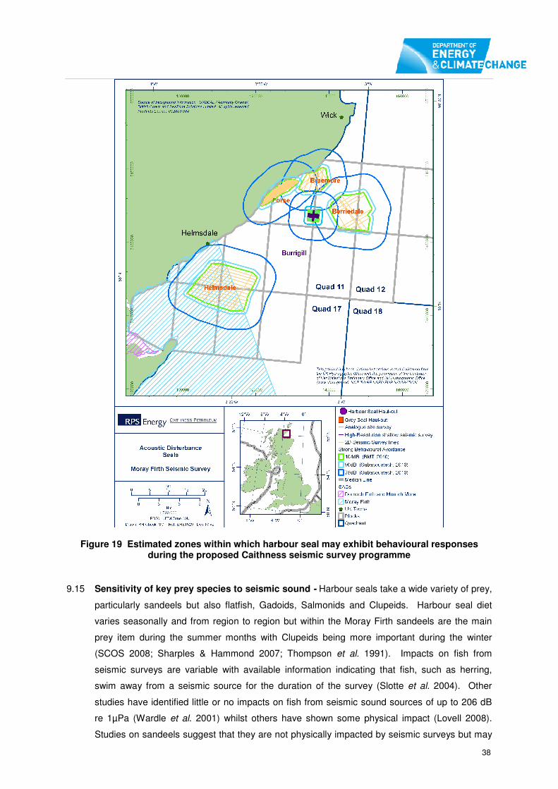
38
Figure 19 Estimated zones within which harbour seal may exhibit behavioural responses during the proposed Caithness seismic survey programme
9.15 Sensitivity of key prey species to seismic sound - Harbour seals take a wide variety of prey,
particularly sandeels but also flatfish, Gadoids, Salmonids and Clupeids. Harbour seal diet
varies seasonally and from region to region but within the Moray Firth sandeels are the main
prey item during the summer months with Clupeids being more important during the winter
(SCOS 2008; Sharples & Hammond 2007; Thompson et al. 1991). Impacts on fish from
seismic surveys are variable with available information indicating that fish, such as herring,
swim away from a seismic source for the duration of the survey (Slotte et al. 2004). Other
studies have identified little or no impacts on fish from seismic sound sources of up to 206 dB
re 1µPa (Wardle et al. 2001) whilst others have shown some physical impact (Lovell 2008).
Studies on sandeels suggest that they are not physically impacted by seismic surveys but may

39
show startle responses and potentially some displacement from the vicinity of the surveys
(Hassel et al. 2004).
9.16 In-combination – There is a proposal to undertake seismic surveys in four prospects: the
Braemore, Forse, Berriedale and Helmsdale Prospects and a site surveys at Burrigill in the
Moray Firth (Figure 3). The proposed seismic surveys will use the same equipment and vessel
and will be undertaken sequentially and the sound source for the site survey (160 dB) will be
less than the seismic survey sound source. None of the proposed surveys will overlap and
there will therefore be no in-combination impacts apart from the overall duration of the
proposed surveys and consequently the potential length of any displacement. Caithness
Petroleum have indicated that they plan to drill an appraisal well in Block 11/24. The well is
provisionally planned for July 2011 and would take approximately 90 days to complete. This
coincides with the pupping and moulting season when seals may spend more time on land.
Shortly after the moulting season the seals may be foraging relatively widely and spending less
time on land. In addition, there is a Moray Firth (MORL & BOWL) R3 zone cable route
geophysical survey likely to be undertaken during spring 2011 and a proposed piling operations
to install the Met Mast during Q3/Q4 in the outer Moray Firth, in an area where there are likely
to be relatively few harbour seals as most will be nearshore during pupping and moulting. The
R3 zone geophysical survey and the piling operations will not overlap with the proposed
seismic surveys.
Potential adverse effects on harbour seals
9.17 Physical Impact – The Dornoch Firth and Morrich More SAC is 28 km away from the closest
point of the proposed seismic survey. The distribution of harbour seals within the Moray Firth
suggests that harbour seals from the SAC may occur within the proposed survey areas;
consequently, there is a potential for physical impact on harbour seals from the SAC resulting
from the seismic surveys. Results from three separate modelling studies indicate that, should
there be no avoidance behaviour, the worst-case assessment is that there could be the
potential zone of auditory impact of up to 200 metres, but permanent effects would only occur
within 11 metres (Table 4). The results of all the models suggest that there will not be any
physical impact on harbour seal present within the Dornoch Firth and Morrich More SAC and
that disturbance is the only potential significant effect.
9.18 In order to ensure that there are no marine mammals within range of a potential auditory
impact, all proposed surveys would be required to follow the JNCC’s Guidelines for Minimising
the Risk of Injury and Disturbance to Marine Mammals from Seismic Surveys (Appendix 3).
The guidelines require that visual monitoring must be undertaken prior to the airgun firing to
determine if marine mammals are in the vicinity and also a soft start which requires the volume
of airguns to be increased slowly at the start of any survey to allow any marine mammals in the
vicinity to swim away (JNCC 2010). Specific requirements relating to that guidance are
provided by the relevant Statutory Nature Conservation Bodies and included in any consents
issued for seismic surveys.

40
9.19 Displacement and Disturbance– It is recognised that there is the potential for mid-frequnecy
sound at 1 KHz to be audible to harbour seals up to 20 km away. However, the most
precautionary results from the modelling indicate that that the potential for disturbance may
extend up to 5,100 metres from the airguns (Table 3). The Dornoch Firth and Morrich More
SAC is 28 km from the proposed survey activity and, although there is a theoretical possibility
that the mid-frequency sound would be audible to seals within the SAC, it is sufficiently far
away and of such relatively short duration that there would be no adverse disturbance of
harbour seals within the SAC (Figure 18). Harbour seals associated with the SAC will occur in
the wider area and may therefore be displaced from around the area of the proposed seismic
survey. Any displacement or disturbance that may occur will be outwith the SAC and for a
relatively short duration. There is no data to suggestthat any displaced seals will not be able to
forage elsewhere within the Moray Firth and there is no data to suggest that any displaced
seals would not survive or be otherwise adversely affected.
9.20 In-combination effects causing potential displacement may arise from the proposal to undertake
seismic and site survey activity elsewhere within the Moray Firth (Figure 19). Some of these
areas are in close proximity to seal haul out sites. Each of the proposed seismic surveys is of
short duration, with the longest being up to four days. Consequently, any displacement or
disturbance that may occur will be outwith the SAC and of relatively short duration. There is no
evidence that any displaced seals will not be able to forage elsewhere within the Moray Firth
and there is no evidence to suggest that any displaced seals would not survive or be otherwise
adversely affected
9.21 The total length of all proposed surveys combined is a maximum of 29 days but a shorter
period is likely (Table 1). As the surveys will be undertaken sequentially there will be no in-
combination sound impacts apart from the overall duration of the proposed surveys and
consequently the potential length of any displacement. Given the highly mobile nature of
marine mammals and the wide distribution of potential prey, it is concluded that any displaced
seals would not encounter difficulties in finding alternative prey sources; particularly given the
predicted relatively minor spatial impact and the duration of the surveys. Although, the drilling of
the proposed appraisal well may coincide with the seismic surveys, the disturbance and
potential displacement of harbour seals is likely to be very limited as the majority of the period
coincides with the pupping and moulting season when seals are at the haul out sites.
Therefore any displacement due to the drilling operations is likely to be limited and it is also
concluded that any displaced seals would not encounter difficulties in finding alternative prey
sources. The Moray Firth (MORL & BOWL) R3 zone cable route geophysical surveys likely to
be undertaken during spring 2011 and the piling operation to install the Met Mast during Q3/Q4
in the outer Moray Firth will be outwith the main areas of usage by harbour seal. The zone of
potential displacement will also be smaller than that of the proposed seismic surveys, and there
will be no overlap with those surveys. Consequently, there will be no in-combination impacts
arising from the proposed drilling, geophysical survey and piling operations.

41
9.22 Displacement of prey species – There is a potential for an adverse effect on harbour seal due
to the displacement of prey. However, available information from previous studies suggest that
impacts on fish vary with some species being displaced and others not. Sandeels are the main
prey for harbour seal in the Moray Firth and studies indicate that, although they are not
physically impacted by seismic surveys, there may be some displacement (Hassel et al. 2004).
However, should any displacement occur, it will be for a relatively short period of time and fish
will return to the area once the seismic survey is completed.
9.23 The potential in-combination effects on harbour seal prey species are that fish could be
displaced from a relatively localised area, or areas, for up to a maximum 29 days (Table 1).
The majority of studies concerning the effects of seismic surveys on fish have found only
localised impacts, with fish behaviour returning to pre-survey levels within five days of survey
completion. The likely consequences of the proposed surveys are that harbour seal will
potentially have to forage outwith the area or areas of displacement for relatively short periods.
9.24 Mitigation measures – Adherence to the JNCC Guidelines for Minimising the Risk of Injury
and Disturbance to Marine Mammals from Seismic Surveys will be a condition of any potential
consent (https://www.og.decc.gov.uk/environment/jncc_seismic_guide.pdf; Appendix 3). The
Guidelines will further reduce the risk of any potential impact on harbour seal.
Conclusion
9.25 Taking into account the temporal and spatial extent of the proposed surveys, the predicted
levels of sound and the results of the sound propagation modelling, it is concluded that the
proposed Block 17/4B seismic survey, both alone and in-combination with other proposed
surveys, will not cause an adverse effect on the integrity of the harbour seal population within
the Dornoch Firth and Morrich More SAC.

42
10 CONCLUSION IN RELATION TO EFFECTS ON THE INTEGRITY
OF EUROPEAN SITES HARBOUR SEAL
Based on the information summarised in this report, it is possible to draw conclusions with
respect to the assessment of the effects of the proposed seismic survey alone, and in-
combination with other plans and projects.
Bottlenose dolphins – The Moray Firth SAC
10.1 It is not considered that the proposed seismic survey will have an adverse effect on the integrity
of the population of bottlenose dolphin in the Moray Firth SAC or the wider area, for the
following reasons:
• The location of the proposed survey, alone and in-combination, is outwith the main
areas used by bottlenose dolphins in the Moray Firth and the number of bottlenose
dolphins likely to be present are low. Consequently, the number of bottlenose dolphins
that may be affected is also low.
• The attenuation of sound arising from the proposed seismic survey will be such that the
zone of any potential permanent threshold shift will be less than five metres from the
airgun. The zone of potential temporary threshold shift will be within 20 metres of the
source. Therefore, for any physical impact to occur the bottlenose dolphin must be in
very close proximity to the survey vessel/sound source.
• Displacement of bottlenose dolphins and or their prey may, as a worst case, occur out
to a range of 11 km from the source. The survey is planned to take up to 15 days and
the relatively few recordings of bottlenose dolphin in the survey area suggest that the
area is infrequently used by this species. Should any displacement occur for the
duration of the survey, or for the other proposed surveys, there are alternative suitable
areas that are used by the bottlenose dolphin, Displaced individuals will not die or be
otherwise adversely affected.
10.2 It would be a condition of any consent that the surveys are undertaken in accordance with the
JNCC ‘Guidelines on Minimising Risk of Injury and Disturbance to Marine Mammals from
Seismic Surveys’. Thus the risk of any potential impact on bottlenose dolphin would be further
reduced.
Harbour seal - Dornoch Firth and Morrich More SAC
10.3 It is not considered that the proposed seismic survey will have an adverse effect on the integrity
of the population of harbour seal in the Dornoch Firth and Morrich More SAC, for the following
reasons:

43
• The location of the proposed survey is at its closest point 28 km from the Dornoch Firth
and Morrich More SAC. The attenuation of sound arising from the proposed seismic
survey will be such that the zone of any potential permanent threshold shift will be less
than five metres from the airgun. The zone of potential temporary threshold shift will be
within 200 metres of the source. Available data suggests that seals foraging outwith the
SAC will avoid the proposed survey area during seismic operations.
• Displacement of harbour seals and or their prey may, as a worst case, occur out to
range of 5.1 km from the source. Therefore, there will be no displacement of harbour
seals within the Dornoch Firth and Morrich More SAC, which is 28 km away from the
nearest survey area. The Block 17/4B survey is planned to take up to fifteen days and
therefore any displacement of seals will be of short duration and there are other suitable
areas used by the harbour seals. Displaced individuals will not die or be otherwise
adversely affected.
10.4 It would be a condition of any consent that the surveys are undertaken in accordance with the
JNCC ‘Guidelines on Minimising Risk of Injury and Disturbance to Marine Mammals from
Seismic Surveys’. Thus the risk of any potential impact on harbour seal would be further
reduced.
Summary
10.5 Based on the best scientific knowledge available it is concluded that the proposed Block 17/4B
seismic survey programme will not adversely affect the integrity of the relevant European sites:
the Moray Firth SAC and the Dornoch Firth and Morrich More SAC, either alone or in
combination with other plans or projects.
10.6 Mitigation measures proposed in the application and consent conditions requiring the
implementation of JNCC Guidance would further reduce the risk of any potential adverse
effects.
10.7 As this Appropriate Assessment has reached a positive conclusion; there is no requirement to
include discussion of potential alternatives to the seismic survey proposals or to consider
whether there are Imperative Reasons of Overriding Public Interest that would be relevant to
consenting the proposals.

44
ANNEX 1: SUMMARY OF RESPONSES TO DRAFT APPROPRIATE ASSESSMENT ISSUED FOR COMMENT June 2010
Organisation Summary of response Amendments
SNH/JNCC
12 August 2010
Joint response with JNCC. Agree with the conclusions of the
Appropriate Assessment with respect to Atlantic Salmon, sea
lamprey, freshwater pearl mussel and seabird qualifying interests.
Do not feel that the appropriate assessment, as it stands, has
made sufficient consideration to ascertain that the proposal will
not adversely affect the integrity of the sites. The use of mitigation
measures would be the most effective way of minimising the risk
of adverse affects on site integrity.
Various amendments made throughout the document
Marine Scotland No response -
University of Aberdeen No Response -
CEFAS No Response -
WDCS Substantial number of comments and maintain the view that it has
not been demonstrated with the required level of scientific
certainty that the plan will not have an adverse effect on the
integrity of any European Site or potential European Sites.
Comments noted and clarifications or amendments made
Care for the Wild
International
11 August 2010
The Appropriate Assessment does not provide sufficient
justification for DECC to approve the proposals according to the
requirements of Article 6.2 of the EU Habitats Directive.
Numerous comments made
Comments noted
Brandon Southall
13 August 2010
Highlighted uncertainly over modelling of disturbance effects but
agreed that results consistent with current scientific understanding
Additional information provided on current understanding of
distribution to highlight that surveys do not impinge on key

45
and best practice. Accepted that duration of surveys may be brief
but they do have the potential to displace significant portion of the
entire population, which is at quite a low level, over fairly large
areas of their identified critical habitat.
Advises that mitigation measures limit the potential for direct injury
to a very low level at start up but that if animals enter the
exclusion zone during operations they could experience TTS/PTS.
Therefore the exclusion zone should exist during operations.
areas of critical habitat, and that they do not have the potential
to displace a significant portion of the entire population.

46
REFERENCES
Bekkby, T. & Bjørge, A. (2000). Diving behaviour of Harbour seal (Phoca vitulina) pups from nursing to
independent feeding. Journal of Sea Research Vol 44: issues 3-4. December 2000, Pages 267-275.
Brookes, K. L. (2009) Assessment of methods used to investigate the impact of offshore wind farms
on seabirds. University of Aberdeen, PhD thesis.
Caithness Petroleum. (2010). Moray Firth 2D Seismic Survey Environmental Impact Assessment
Braemore, Forse, Berriedale and Helmsdale Seismic Survey Programme. DECC Ref: 2217. Report
by RPS Energy.
COWRIE. (2010). Understanding the Environmental Impacts of Offshore Windfarms. 2010. COWRIE
Limited, London.
Duck, C. (2003) Monitoring harbour seals in Special Areas of Conservation in Scotland. Scottish
Natural Heritage Commissioned Report F01AA403
English Nature (1997). Habitats Regulations Guidance Note, HRGN 1. English nature, Peterborough.
English Nature (2001). Habitats Regulations Guidance Note 4 - alone or in combination. English
Nature, Peterborough.
Harris, R.E., Miller, G.W. & Richardson, J.W, (2001). Seal responses to airgun sounds during summer
seismic surveys in the Alaskan Beaufort Sea. Marine mammals Science Vol 17: 4. Pp795 – 812.
Hassel, A., Knutsen, T., Dalen, J., Skaar, K., Lokkeborg, S|., Misund, O., Ostensen, O., Fonn, M. &
Haugland, E.K. (2004). Influence of seismic shooting on lesser sandeel (Ammodytes marinus). ICES
Journal of Marine Science, 61: 1165-1173.
JNCC (2010). JNCC guidelines for minimising the risk of disturbance and injury to marine mammals
from seismic surveys. JNCC Peterborough.
http://www.jncc.gov.uk/pdf/Seismic%20Guidelines%20June%202009_ver01.pdf
Kongsberg. (2010). Underwater noise propagation modelling and estimate of impact zones for
seismic operations in the Moray Firth. Final report 37399 – FR1 (c).
Koschinski, S., Boris, M., Oluf, C., Henriksen, D., Tregenza, N, Ellis, G., Jansen, C. & Kathe, G.
(2003). Behavioural reactions of free-ranging porpoises and seals to the noise of a simulated 2 MW
windpower generator. Mar. Ecol. Prog. Ser. Vol 265: 263–273, 2003.
Lenhardt M.L. & Sismour, E. (1995). Hearing in the sea lamprey (Petromyzon marinus) and the long
nose gar (Lepisosteus spatula). 1995, 259, Session I3, Poster Abstract.
http://www.aro.org/archives/1995/259.html
Lovell, J. (2008). Review of controlled noise exposure experiments on marine mammals. IACMST
2008.
Maes, J. Turnpenny, A. W. H. Lambert D. R. Nedwell J. R. Parmentier A. and Ollevier F. 2004. Field
evaluation of a sound system to reduce estuarine fish intake rates at a power plant cooling water inlet.
Journal of Fish Biology Volume 64 Issue 4,938–946.
Mooney, T.A, Nachtigall, P.E. & Vlachos, S. (2009a) Sonar-induced temporary hearing loss in
dolphins. Biol. Lett. (2009) 5, 565–567.
Mooney, T.A., Nachtigall, P.E., Breese, M., Vlachos, S. & Whitlow W. L. (2009b) Predicting temporary
threshold shifts in a bottlenose dolphin (Tursiops truncatus): The effects of noise level and duration.
J. Acoust. Soc. Am. 125 _3_, March 2009. Pp1816 – 1826.
Mudge, G, P. , Aspinall, S, J. & Crooke, C, H.(1987) A photographic study of seabird attendance at
Moray Firth colonies outside the breeding season, Bird Study, 34: 1, 28 – 36.
Muelbert, M.M.C & Bowen, W.D. (1993). Duration of lactation and post-weaning changes in mass and
body-composition of harbor seal, Phoca-Vitulina, pups. Canadian Journal of Zoology 71:1405–1414.
Natural Power (2010). Marine Mammal Risk Assessment for proposed geophysical surveys May –
August 2010, Moray Firth Zone 1 R3. Moray Offshore Renewable Ltd.

47
OSPAR (2009) Overview of the impacts of anthropogenic underwater sound in the marine
environment, OSPAR Convention for the Protection of the Marine Environment of the North-East
Atlantic (www.ospar.org).
PA Resources (2010). Block 17/4b 2d seismic survey environmental assessment PA Resources
reference: PARUK - bms - pr oJ007 – 7.
Parijs, S.M.V., Thompson, P.M. Tollit, D.J. & Mackay, A. (1997). Distribution and activity of male
harbour seals during the mating season. Anim. Behav., 1997. 54: 35-43.
Roos, S., Humphreys, L., Wernham, C., Burton, N., (2010) Informing appropriate assessment of the
Pentland Firth Strategic area leasing round. Ornithological Scoping Report BTO, Stirling.
SCANS-II. (2008). Small Cetaceans in the European Atlantic and North Sea. Final Report to the
European Commission under project LIFE04NAT/GB/000245.
SCOS ( 2008). Scientific advice on matters related to the management of seal populations. Special
Committee on Seals, UK.
SCOS (2009). Scientific advice on matters related to the management of seal populations: 2009.
Special Committee on Seals, 93pp. http://www.smru.st-andrews.ac.uk/pageset.aspx?psr=411
Sharples, R. & Hammond, P. (2007). Distribution and movements of harbour seals around the coast
of Britain. SMRU report for DTI SEA.
Slotte A., Kansen K., Dalen J. & Ona E. (2004). Acoustic mapping of pelagic fish distribution and
abundance in relation to a seismic shooting area off the Norwegian west coast. Fisheries Research
67: 143–50.
SNH (2006a). Moray Firth Special Area of Conservation Advice under Regulation 33(2) of The
Conservation (Natural Habitats, &c.) Regulations 1994 (as amended) 30 March 2006.
SNH (2006b). Dornoch Firth and Morrich More Special Area of Conservation Advice under Regulation
33(2) of The Conservation (Natural Habitats, &c.) Regulations 1994 (as amended) 30 March 2006.
SNH (2010). Conservation (Natural Habitats, &c.) Regulations 1994, As Amended, Offshore Marine
Conservation (Natural Habitats, & C.) regulations 2007, As Amended. PA resources Moray Firth 2D
Seismic Survey. Letter to DECC dated 11 June 2010. Ref No. B624742
Southall, B.L., Bowles, A.E., Ellison, W.T., Finneran, J.J., Gentry, R.L., Greene Jr., C.R., Kastak,
D.,Ketten, D.R., Miller, J.H., Nachtigall, P.E., Richardson, W.J., Thomas, J.A., and Tyack, P.L. (2007).
Marine mammal noise exposure criteria: initial scientific recommendations. Aquatic Mammals 33:
411– 521.
Stone, C.J. & Tasker M.L. (2006). The effects of seismic airguns on cetaceans in UK waters. Journal
of Cetacean research and Management 8: 255-263.
Stone, C.J., Webb, A., Barton, C., Ratcliffe, N., Reed, T.C., Tasker, M.L., Camphuysen, C.J., &
Pienkowski, M.W. (1995) An atlas of seabird distribution in north-west European waters. JNCC,
Peterborough, UK.
Teilmann, J., Tougaard, J., Carstensen, J., Dietz, R., Tougaard, S. (2006). Summary on seal
monitoring 1999-2005 around Nysted and Horns Rev Offshore Wind Farms. Technical report to
Energi E2 A/S and Vattenfall A/S.
Thompson, P.M., Brookes, K., Cheney, B., Cândido, A., Bates, H., Richardson, N. & Barton, T. (2010).
Assessing the potential impact of oil and gas exploration operations on cetaceans in the Moray Firth.
University of Aberdeen report for DECC, Scottish Government, Cowrie and Oil & Gas UK.
Thompson, P.M., Cheney, B., Ingram, S., Stevick, P., Wilson, B. & Hammond, P.S. (Eds) (In prep.).
Distribution, abundance and population structure of bottlenose dolphins in Scottish waters. Scottish
Natural Heritage Commissioned Report No.XXX (ROAME No.
Thompson, P. M. & Harwood, J. (1990). Methods for estimating the population size of common seals
(Phoca vitulina). Journal of Applied Ecology, 27, 924–938.
Thompson, P.M., Pierce, G.J., Hislop, J.R.G., miller, D. & Diack, J.S.W. (1991). Winter foraging by
common seals (Phoca vitulina) in relation to food availability in the inner Morray Firth, N.E. Scotland.
Journal of Animal ecology (1991). 60:283-294.

48
APPENDIX 1
Predicative modelling of sound pressure levels for the installation of a met-mast in the Moray Firth
From the review of suitable source levels and measurements that have been taken on piling, a good surrogate for the smaller diameter piles are sound measurements obtained from the FINO-1 research platform installation. This was a platform which was installed using 1.5 m diameter piles. Unlike many measurements on piling noise this study actually calculated a source level and provided measurements of the frequency spectrum presented as 1/3
rd octave levels (See figure 1). From the
measurement of the ITAP platform the pile driving was found to generate a broadband peak source level of 228dB (0-peak) re 1µPa @ 1m (ITAP 2005).
Figure 4 Frequency Spectrum (1/3 rd Octave band level) of piling pulses from FINO-1 platform (piles 1.5m)
As can be seen from figure 1 the sound pressure level was highest at the 125Hz centre frequency with additional maxima at 315Hz and 1kHz. It is expected that both MORL piling scenarios would generate comparable frequency spectrums.
These measurements were collected at a distance of 400m but have been back-calculated to calculate the sound pressure level (source level) at a distance of 1 m (using transmission loss calculations).
The frequency output spectrum can be inputted into a modelling programme using the parameters of Smith bank which is a shallow (~20m) sandy sediment environment.
Sound pressure levels in impact pile-driving are dependent on the length and diameter of the pile and the impact energy used to install these. Generally the larger the diameter of the pile, the more force required to install the structure which results in a greater sound pressure level (at source 1m from pile driver). A greater sound pressure level across all frequency bands typically increases the distance that sound can propagate (travel).
The 4.5 m diameter pile which could also be used for the installation of the metmast in a monopole configuration is a comparable size to a windfarm pile. A study measuring 3.5m diameter pile found that the increase in sound level for every 1/3 octave band was in the range of 3-20 dB. If an average of 10 dB is added onto all 1/3
rd octave bands frequency bands this can be considered a suitable value
to apply for modelling of a larger diameter pile, and should be suitable to cover the size category of pile being considered for the metmast (Thomsen, et al. 2006). It should be appreciated that the metmast pile may produce a sound pressure level in excess of the values below as it is greater than the 3.5m pile which the modelling is based on. There is a discussion further below which highlights some of the uncertainties with the model and choice of source level.

49
An in-house modelling programme was used to input the 1/3rd
octave band levels to calculate a source level for a ‘3.5m diameter pile’ which produced a broadband source level of 236.8 dB (zero-peak) re 1µPa @ 1m.
Other factors which will influence the levels of underwater noise will be related to the choice of pile driver used, the energy of the blow of the driver, seabed type, and whether or not the pile is driven in air or underwater.
Predictive sound modelling was carried out for a shallow water environment such as the Smith Bank.
Information on the parameters used in the propagation modelling are provided at the end of this document.

50
Modelling results Sound Pressure Level at 10km for 1.5m diameter pile
Modelling results Sound Pressure Level at 20km for 1.5m diameter pile
Modelling results Sound Pressure Level at 40km for 1.5m diameter pile

51
Modelling results Sound Pressure Level at 10km for larger diameter pile ~4.5m
Modelling results Sound Pressure Level at 20km for larger diameter pile ~4.5m
Modelling results Sound Pressure Level at 40km for larger diameter pile ~4.5m

52
Discussion of modelling results Sound Pressure Level with range
The modelling above is based on no interferences with seabed features such as sandbanks or the coastline, it is of course expected that the topography of the seabed will have an effect on how the sound would propagate.
Larger diameter pile
At very close distances to the pile it is expected that the sound pressure level will be high, but this pressure level is expected to rapidly attenuate with increasing distance from the pile. It is only within the first few metres from the pile that the sound pressure levels are likely to be in excess of 230 dB (zero-peak) (this is currently considered the injury criteria for impulsive sources by Southall et al 2007). Some illustrative sound pressure levels with increasing range are shown below: 1m = 236.8 dB (zero-peak) re 1µPa @ 1m 5m = 229.5 dB (zero-peak) re 1µPa @ 1m 10m = 223.5 (zero-peak) re 1µPa @ 1m The modelling of sound pressure level for the larger diameter pile suggests that out to a distance of 40km the levels will have fallen to ~140-150 dB, based on no interferences with seabed features such as sandbanks or the coastline. It is, of course, expected that the topography of the seabed will have an effect on how the sound would propagate.
Smaller diameter pile
At very close distances to the pile it is expected that the pressure level will be high, but this high sound pressure level is expected to rapidly attenuate with increasing range from the pile. At a distance of 1m from the pile, the sound pressure level is expected to be approximately 228-230 dB (zero-peak). Some illustrative sound pressure levels with increasing range are shown below.
1m = ~228-230 dB (zero-peak) re 1µPa @ 1m
5m = 220 dB (zero-peak) re 1µPa @ 1m
10m 213 dB (zero-peak) re 1µPa @ 1m
The modelling of sound pressure level for the 1.5m diameter pile suggests that out to a distance of 40km the levels will have fallen to ~130-140 dB. Frequency spectrum with range In order to illustrate how the frequency level of sound changes in relation to the distance the sound has travelled, various modelling scenarios with distance were generated, and these frequency specific plots sound pressure levels plots are shown below. This is important when considering how a sound signal (which is made up of difference frequency components) attenuate (decrease in power) with distance travelled. Also included on the plots is a ‘typical’ ambient noise plot (background levels of sound) for the north sea (discussed in more detail at the end of the report) and also the hearing capabilities of two marine mammals. In the example below two audiograms are provided, one for the common seal and the other from the harbour porpoise. Generally in order for a sound to be audible to a receptor it has to be above its hearing ability (e.g. appear higher on the plot when compared to the audiogram plot for the animal). Therefore, when a sound level falls below either the background noise levels or the hearing threshold level of an animal it can be considered to be inaudible to the animal or indistinguishable from background levels. As piling noise is dominated by the low frequency sounds, which attenuate in power very slowly compared to higher frequencies, it can travel very large distances. It should also be considered that the limited audiogram data which is available for marine mammals does not cover all species and also typically does not have comprehensive data on the lower frequency hearing abilities of marine mammals, but the information that is available can be useful to apply as a reasonable estimate when considering if the sound pressure level at a particular frequency is likely to be audible to an animal. Discussion of the larger diameter piles From the modelling outputs it suggests that piling noise is likely to be audible to marine mammals (harbour porpoise and seals) beyond at least 20km, and the piling noise, particularly the low frequency components is likely to be detectable above background noise levels in excess of distances of 40km. Discussion of the smaller diameter piles

53
The frequency specific plots from the modelling of the smaller piles, as expected, follow the same pattern as the larger piles. From the modelling outputs it suggests that piling noise for is still likely to be audible to marine mammals (harbour porpoise and seals) beyond at least 20km, and the piling noise, particularly the low frequency components is likely to be detectable above background noise levels in excess of distances of 40km.

54
Frequency spectrum with increasing distance from the source at 10km for larger diameter pile
Frequency spectrum with increasing distance from the source at 20km for larger diameter pile
Frequency spectrum with increasing distance from the source at 40km for larger diameter pile

55
Frequency spectrum with increasing distance from the source at 10km for Smaller diameter piles
Frequency spectrum with increasing distance from the source at 20km for Smaller diameter piles
Frequency spectrum with increasing distance from the source at 40km for Smaller diameter piles

56
Information on the modelling software used A calm sea state was used in the modelling. Urick (1983) states that theoretical models have limited application in shallow water, and refers to empirical data by Marsh and Schulkin (1962) that correlate frequency, sea state and noise attenuation. These data are based on approximately 100,000 observations in continental shelf waters and result in a distance attenuation factor based on frequency and sea state plus a 'local anomaly' factor in the form of a constant in the attenuation equation based on the same parameters. For the purposes of the model, the tabulated data is converted into linear form (using power and log regressions) to enable a wider range of frequencies to be calculated. The use of this data is considered to be a more reliable method for shallow coastal waters than a traditional geometric model (Erbe and Farmer 2000). The data applies to frequencies in the range of 100 Hz to 10 kHz, while the model uses third-octaves from 10 Hz to 100 kHz, and the extreme ends of the range are extrapolations. These extrapolated frequency attenuation factors have been checked against other methods to assure their validity (Erbe and Farmer 2000). As the model was developed to take into account variations in the sound speed profile with depth it is able to provide an indication of received sound levels with varying depth, thus the modelling used has been run for a sandy sediment environment and the depth chosen for a mid-water level of 30 m. Ambient Noise Level Used The ambient or background noise level is an important component to consider when undertaking noise modelling. The ocean is not a quiet environment, and the ambient noise levels are influenced by physical factors such as the sounds generated by the actions of the wind and the waves, and also to a much lesser degree by biologically produced sounds, for example marine mammal vocalisations. Anthropogenic activities, principally shipping, is a key contributor to ambient noise levels in certain areas. Although there have been a number of studies that have collected measurements on ambient noise levels in the Moray Firth, the raw data was not available in any useable format to use in this modelling. However, there are a number of studies that have collected ambient noise measurements in the North Sea. Therefore, for the purposes of this assessment, ambient noise levels measured at 5 different locations in the North Sea at wind speeds of 3-8 ms have been considered and the third octave band measurements for ambient noise applied in this study are shown below.
Ambient noise measurements measured in 5 different locations in the North Sea at wind speed of 3-8 ms (Reproduced from DEWI 2004)

57
References: DEWI. Standardverfahren zur Ermittlung und Bewertung der Belastung der Meeresumwelt durch
Schallimmissionen von Offshore-Windenergieanlagen,. Abschlussbericht zum Forschungsvorhaben 0327528a an
das BMU, 123pp: Deutsches Windenergie-Institut (DEWI), 2004.
ITAP. Standardverfahren zur Ermittlung und Bewertung der Belastung der Meeresumwelt durch die
Schallimmission von Offshore-Windenergieanlagen. Project 0327528A: The German Federal Environmental
Ministry & ITAP – Institut für technische und angewandte Physik GmbH, 2004.
Southall, B.L, et al. “Marine mammal noise exposure criteria: Initial scientific recommendations.” Aquatic
Mammals 33(4), 2007: 411-521.
Thomsen, F, K Lüdemann, R Kafemann, and W. Piper. Effects of offshore wind farm noise on marine mammals
and fish,. Newbury, UK: Biola, Hamburg, Germany on behalf of COWRIE Ltd, , 2006.

58
APPENDIX 2 Qualifying Features and Conservation Objectives for sites where potential for adverse effects have been identified.
Site Name: Moray Firth SAC The Moray Firth was designated as a Special Area of Conservation (SAC) on 17
th March 2005.
Location
Grid Ref: NH976821 (central point)
Latitude 57º49’00”N
Longitude 03º43’36”W
Area (ha) 151341.67
Summary
The Moray Firth SAC is one of the largest marine SACs in the UK. The designated site lies west of a line between Helmsdale on the Sutherland coast and Lossiemouth on the Moray coast and includes the Beauly/Inverness Firths, and the outer reaches of the Dornoch and Cromarty Firths. The Moray Firth supports the only known resident population of bottlenose dolphin in the North Sea.
Qualifying features for which the site is designated [condition]:
Annex 1 Habitat Primary feature: None
Secondary features: Sandbanks which are slightly covered by sea water all the time [favourable maintained]
Annex 2 Species Primary features: Bottlenose dolphin Tursiops truncatus [unfavourable recovering] Secondary features: None
Conservation objectives:
For Annex I Habitats To avoid deterioration of the qualifying habitat (listed above) thus ensuring that the integrity of the site is maintained and the site makes an appropriate contribution to achieving favourable conservation status for the qualifying interest.
To ensure for the qualifying habitat that the following are maintained in the long term:
• Extent of the habitat on site
• Distribution of the habitat within site
• Structure and function of the habitat
• Processes supporting the habitat
• Distribution of typical species of the habitat
• Viability of typical species as components of the habitat
• No significant disturbance of typical species of the habitat
For Annex II Species To avoid deterioration of the habitats of the qualifying species (listed above) or significant disturbance to the qualifying species, thus ensuring that the integrity of the site is maintained and the site makes an appropriate contribution to achieving favourable conservation status for the qualifying interest. To ensure for the qualifying species that the following are established then maintained in the long term:
• Population of the species as a viable component of the site
• Distribution of the species within the site
• Distribution and extent of habitats supporting the species
• Structure, function and supporting processes of habitats supporting the species
• No significant disturbance of the species

59
Site Name: Dornoch Firth and Morrich More SAC
Location
Grid Ref: NH788863 (central point)
Latitude 57º51’00”N
Longitude 04º02’30”W
Area (ha) 8700.53
Summary
The Dornoch Firth is the most northerly complex estuary in the UK. Situated on the Scottish east coast, the estuary contains extensive areas of soft coastal features of international importance including saltmarshes, dunes and mudflats and sandflats. The area supports a good population of otters in what is the only east coast estuarine site selected for the species in Scotland. The estuary is also home to a significant proportion of the inner Moray Firth population of the common seal. Their numbers represent almost 2% of the UK population.
Qualifying features for which the site is designated [condition]:
Annex 1 Habitat Primary features: Estuaries, mudflats and sandflats not covered by seawaters at low tide, Salicornia and other annuals colonising mud and sand [favourable maintained], Atlantic salt meadows (Glauco-Puccinellietalia maritimae) [favourable maintained], embryonic shifting dunes [favourable maintained], shifting dunes along the shoreline with Ammophila arenaria (‘white dunes’) [favourable maintained], fixed dunes with herbaceous vegetation (‘grey dunes’) (priority feature) [unfavourable no change], decalcified fixed dunes with Empetrum nigrum (priority feature) [unfavourable no change], Atlantic decalcified fixed dunes (Calluno-Ulicetea) (priority feature), humid dune slacks [favourable maintained], coastal dunes with Juniperus spp. (priority feature) [unfavourable no change]
Secondary features: Sandbanks which are slightly covered by sea water all the time, reefs
Annex 2 Species Primary features: Otter Lutra lutra [favourable maintained], common seal Phoca vitulina [unfavourable recovering]
Secondary features: None
Conservation objectives:
For Annex I Habitats To avoid deterioration of the qualifying habitats (listed above), thus ensuring that the integrity of the site is maintained and the site makes an appropriate contribution to achieving favourable conservation status for the qualifying interest. To ensure for the qualifying habitats that the following are maintained in the long term:
• Extent of the habitats on site
• Distribution of the habitats within site
• Structure and function of the habitats
• Processes supporting the habitats
• Distribution of typical species of the habitats
• Viability of typical species as components of the habitats
• No significant disturbance of typical species of the habitats
For Annex II Species To avoid deterioration of the habitats of the qualifying species (listed above) or significant disturbance to the qualifying species, thus ensuring that the integrity of the site is maintained and the site makes an appropriate contribution to achieving favourable conservation status for the qualifying interest. To ensure for the qualifying species that the following are established then maintained in the long term:
• Population of the species as a viable component of the site
• Distribution of the species within the site
• Distribution and extent of habitats supporting the species
• Structure, function and supporting processes of habitats supporting the species
• No significant disturbance of the species

60
APPENDIX3
JNCC guidelines for minimising the risk of injury and disturbance to marine mammals from seismic surveys
August 2010
Introduction
The guidelines have been written for activities on the United Kingdom Continental Shelf (UKCS) and are aimed at reducing the risk of injury to negligible levels and can also potentially reduce the risk of disturbance from seismic surveys to marine mammals including seals, whales, dolphins and porpoises. Whilst there are no objections to these guidelines being used elsewhere JNCC would encourage all operators to determine if any special or local circumstances pertain, as we would not wish these guidelines to be used where a local management tool has already been adopted (for instance in the Gulf of Mexico OCS Region). In this context, JNCC notes that other protected fauna, for example turtles, will occur in waters where these guidelines may be used, and would suggest that, whilst the appropriate mitigation may require further investigation, the soft-start procedures for marine mammals would also be appropriate for marine turtles and basking sharksi. The guidelines require the use of trained Marine Mammal Observers (MMOs) whose role is to advise on the use of the guidelines and to conduct pre-shooting searches for marine mammals before commencement of any seismic activity. A further duty is to ensure that the JNCC reporting forms are completed for inclusion in the MMO report. In addition to the visual mitigation provided by MMOs, if seismic surveys are planned to start during hours of darkness or low visibility it is considered best practice to deploy Passive Acoustic Monitoring (PAM). The 2010 version of the JNCC seismic guidelines reflects amendments (2007 and 2009 amendments) to the Conservation (Natural Habitats &c.) Regulations 1994 (Habitat Regulations, HR) for England and Walesii and the Offshore Marine Conservation (Natural Habitats, &c.) Regulations 2007 (Offshore Marine Regulations, OMR, as amended in 2009 and 2010). Both regulations have revised the definition of deliberate disturbance of ‘European Protected Species’ (EPS), which now excludes
i Basking sharks are protected from intentional capture or disturbance in British waters (up to 12 miles offshore) under a 1998 listing on the Wildlife and Countryside Act (1981), Schedule 5. ii In 2010 a consolidated version of the regulations came into force: The Conservation of Habitats and
Species Regulations 2010.

61
trivial disturbance from the offence. Both regulations now also include the offence of deliberate injury. European Protected Species include cetaceans and turtles. It has been recognised that sound generated from seismic sources has the potential to cause injury and possibly also disturbance to marine mammals. Seismic surveys have therefore the potential to cause a deliberate injury offence as defined under regulations 41(1)(a) and 39(1)(a) and a deliberate disturbance offence as in 41(1)(b) and 39(1)(b) of the HR and OMR, respectively. The JNCC seismic guidelines reflect best practice for operators to follow during the planning, operational and reporting stages. It is considered that compliance with the recommendations in these guidelines will reduce the risk of injury to EPS to negligible levels. Please note that the mitigation measures recommended in the existing guidelines are more relevant to the prevention of injury rather than disturbance as defined in regulations 41(2) and 39(1A), of the HR and OMR, respectively. The onus should be on the entity responsible for the activity to assess whether a disturbance offence is likely to occur. Guidance on how to carry out such risk assessment is provided in the JNCC, NE and CCW document ‘The protection of marine European Protected Species from injury and disturbance’.
In relation to oil and gas seismic surveys in the UKCS, it is a requirement of the consent issued under regulation 4 of the Petroleum Activities (Conservation of Habitats) Regulations 2001 (& 2007 Amendments) by the Department for Energy Climate Change (DECC), that the JNCC Seismic Guidelines must be followed, and the elements of the guidelines that are relevant to a particular survey are incorporated into the legally-binding condition of consent. It should be noted that it is the responsibility of the company issued consent by DECCiii, referred to in these guidelines as the ‘applicant’, to ensure that these guidelines are followed, and it is recommended that a copy of the JNCC guidelines are available onboard all vessels undertaking seismic activities in UK waters. Where relevant, when the survey is completed a MMO report must be submitted to the JNCC.
iii
Department of Energy and Climate Change was formerly known as Department for Business and Regulatory Reform (BERR)

62
Index Section 1 – Assessing and minimising the risk of injury
1.1 The planning stage Section 2 – Marine Mammal Observers (MMOs)
2.1 Role of the MMO
2.2 Training requirements for MMOs 2.3 MMO equipment and reporting forms 2.4 Reporting requirements – the MMO report
Section 3 – Guidance before and during seismic activity
3.1 Pre-shooting search 3.2 Delay if marine mammals are detected within the mitigation
zone (500 metres) 3.3 The soft-start 3.3.1 Soft-start requirements for site survey or Vertical Seismic
Profiling (VSP) 3.3.2. Soft-starts and airgun testing 3.4 Line change 3.4.1 Seismic surveys with an airgun volume of 500 cubic inches or
more 3.4.2 Seismic surveys with an airgun volume of 180 cubic inches or
less 3.5 Undershoot operations
Section 4 – Acoustic monitoring 4.1 Use of PAM as a mitigation tool
Section 5 – Requirements for MMOs and PAM Section 6 – Background Information
6.1. Existing protection to cetaceans
Section 7 – References and contacts

63
Terminology Marine European Protected Species: These are marine species in Annex IV(a) of the Habitats Directive that occur naturally in the waters of the United Kingdom. These consist of several species of cetaceans (whales, dolphins and porpoises), turtles, and the Atlantic Sturgeon.
Marine Mammal Observer (MMO): Individual responsible for conducting visual watches for marine mammals. For some seismic surveys it may be requested that observers are trained, dedicated and / or experienced. The MMO may also be a PAM operative if trained.
• Trained MMO: Has been on a JNCC recognised course
• Dedicated MMO: Trained observer whose role on board is to conduct visual watches for marine mammals (although it could double up as a PAM operative)
• Experienced MMO: Trained observer with 3 years of field experience observing for marine mammals, and practical experience of implementing the JNCC guidelines
• PAM Operative: Person experienced in the use of PAM software and hardware and marine mammal acoustics
Mitigation Zone: The area where a Marine Mammal Observer keeps watch for marine mammals (and delays the start of activity should any marine mammals be detected). Passive Acoustic Monitoring (PAM): Software system that utilises hydrophones to detect the vocalisations of marine mammals.
Seismic Survey: Any survey that uses airguns, including 2D/3D/4D and OBC (On-Bottom Cabling) surveys and any similar techniques that use airguns. Surveys using multibeam systems and sub-bottom profiling equipment such as boomers, pingers etc are not considered in these guidelines. However, the guidelines can be adapted and applied to the operation of such systems if considered appropriate. Shot Point Interval (SPI): Interval between firing of the airgun or airguns. Site Survey: Seismic survey of a limited area proposed for drilling, infrastructure emplacement etc (typically with source size of 180 cubic inches or less). Soft-Start: Turning on the airguns at low power and gradually and systematically increasing the output until full power is achieved (usually over a period of 20 minutes). The appropriate soft-start method is dependant upon the type of seismic survey and is discussed in section 3. United Kingdom Waters: Parts of the sea in or adjacent to the United Kingdom from the low water mark up to the limits of the United Kingdom Continental Shelf. Vertical Seismic Profiling (VSP) or Borehole Seismic: Seismic survey undertaken ‘down hole’ in connection with well operations (typically with a source size of 500 cubic inches).

64
Section 1 – Assessing and minimising the risk of injury
1.1 The Planning Stage When a seismic survey is being planned, the applicant should consider the following recommendations and best practice advice:
• Determine what marine mammal species are likely to be present in the survey area and assess if there are any seasonal considerations that need to be taken into account, for example periods of migration, breeding, calving or pupping. For UKCS activities the ‘Atlas of cetacean distribution in north-west European waters’ (Reid et al. 2003) is a useful starting point.
• Consult the latest relevant regulatory guidance notes; in the UK, DECC issues guidance notes for oil and gas seismic activities.
• As part of the environmental impact assessment, assess the likelihood of injuring or disturbing a European Protected Species. In the UK, it will be necessary to assess the likelihood of committing an offence as defined in the HR and in the OMR.
• Consult the JNCC, NE and CCW guidance on ‘The protection of marine European Protected Species from injury and disturbance’ to assist in the environmental impact assessment. To obtain a copy of the latest draft version of the guidance please contact JNCC.
The operator should whenever possible implement the following best practice measures:
o If marine mammals are likely to be in the area, only commence seismic activities during the hours of daylight when visual mitigation using Marine Mammal Observers (MMOs) is possible.
o Only commence seismic activities during the hours of darkness, or low visibility, or during periods when the sea state is not conducive to visual mitigation, if a Passive Acoustic Monitoring (PAM) system is in use to detect marine mammals likely to be in the area, noting the limitations of available PAM technology (seismic surveys that commence during periods of darkness, or low visibility, or during periods when the observation conditions are not conducive to visual mitigation, could pose a risk of committing an injury offence).
o Plan surveys so that the timing will reduce the likelihood of encounters with marine mammals. For example, this might be an important consideration in certain areas/times, e.g. during seal pupping periods near Special Areas of Conservation for common seals or grey seals.
o Provide trained MMOs to implement the JNCC guidelines. o Use the lowest practicable power levels to achieve the geophysical objectives of the
survey. o Seek methods to reduce and/or baffle unnecessary high frequency noise produced by
the airguns (this would also be relevant for other acoustic energy sources).

65
Section 2 - Marine Mammal Observers 2.1. Role of an MMO The primary role of an MMO is to act as an observer for marine mammals and to recommend a delay in the commencement of seismic activity should any marine mammals be detected. In addition, a MMO should be able to advise the crew on the procedures set out in the JNCC guidelines and to provide advice to ensure that the survey programme is undertaken in accordance with the guidelines. Before the survey commences it is important to attend any pre-mobilisation meetings to discuss the working arrangements that will be in place, and to request a copy of the survey consent issued by DECC (if applicable). An MMO may also work closely with Passive Acoustic Monitoring operatives. As the MMO role in relation to the vessel and survey operations is purely advisory, it is important to be aware of the command hierarchy and communication channels that will be in place, and determine who the main MMO / PAM operative contacts should be. In a typical vessel based seismic survey, the MMO / PAM operative may pass advice to the party chief and client’s representative through the navigators or seismic observers, and it is important to establish what the working arrangements are, as this may vary from one survey to the other. The MMOs should consider themselves as part of the crew and respect the chain of command that is in place. MMOs should make certain that their efforts are concentrated on the pre-shooting search before the soft-start. These guidelines cannot be interpreted to imply that MMOs should keep a watch during all daylight hours, but JNCC would encourage all MMOs to manage their time to ensure that they are available to carry out a watch to the best of their ability during the crucial time - the 30 minutes before commencement of the firing of the seismic source (or 60 minutes if surveying where deep diving marine mammals are likely to be present). Whilst JNCC appreciates the efforts of MMOs to collect data at other times, this should be managed to ensure that those observations are not detrimental to the ability to undertake a watch prior to a soft-start. Where two MMOs are onboard a seismic vessel, JNCC would encourage collaboration to ensure that cetacean monitoring is always undertaken during all daylight hours. 2.2. Training requirements for MMOs A prerequisite for an MMO to be classified as a ‘trained MMO’ is that they must have received formal training on a JNCC recognised course. (Further information on MMO course providers is available at: http://www.jncc.gov.uk/page-4703) 2.3. MMO equipment and reporting forms MMOs should be equipped with binoculars, a copy of the JNCC guidelines and the ‘Marine Mammal Recording Form’ which is an Excel spreadsheet and has embedded worksheets named: ‘Cover Page’, ‘Operations’, ‘Effort’ and ‘Sightings’. A Word document named ‘Deckforms’ is also available, and MMOs may prefer to use this when observing before transferring the details to the Excel spreadsheets. The ability to determine range is a key skill for MMOs to have, and a useful tool to perform this function is a range finding stick. All MMO forms, including a guide to completing the forms, and instructions on how to make and use a range finding stick are available on the JNCC website. 2.4. Reporting requirements – the MMO report

66
A report, the ‘MMO report’, should be sent to the JNCC after the survey has been completed. It is the responsibility of the consent holder to ensure that the MMO report is sent to JNCC. Ideally the MMO report should be sent via e-mail to [email protected], or it can be posted to the address on the front page of these guidelines. Reports should include completed JNCC marine mammal recording forms and contain details of the following:
• The seismic survey reference number provided to the applicant by DECC.
• Date and location of survey.
• Total number and volume of the airguns used.
• Nature of airgun array discharge frequency (in Hz), intensity (in dB re. 1µPa or bar metres) and firing interval (seconds), and / or details of any other acoustic energy used.
• Number and types of vessels involved in the survey.
• A record of all occasions when the airguns were used.
• A record of the watches made for marine mammals, including details of any sightings and the seismic activity during the watches.
• Details of any problems encountered during the seismic survey including instances of non-compliance with the JNCC guidelines.
If there are instances of non-compliance with the JNCC guidelines that constitute a breach of the survey consent conditions, JNCC will copy the report, and their comments on the potential breach to DECC. It is therefore essential that MMO reports are completed as soon as possible after the survey has been completed. Section 3 – Guidance before and during seismic activity
All observations should be undertaken from the source vessel (where the airguns are being deployed from), unless alternative arrangements have been agreed with DECC. The MMO should be positioned on a high platform with a clear unobstructed view of the horizon, and communication channels between the MMO and the crew should be in place before commencement of the pre-shooting search (this may require portable VHF radios). The MMO should be aware of the timings of the proposed operations, so that there is adequate time to conduct the pre-shooting search. Figure 1 illustrates a typical seismic survey with decision making pathways in the event a marine mammal is detected.

67
Figure 1. Flowchart illustrating the decision making pathway of a Marine Mammal Observer during a seismic survey.
3.1 Pre-shooting search The pre-shooting search should normally be conducted over a period of 30 minutes before commencement of any use of the airguns. The MMO should make a visual assessment to determine if any marine mammals are within 500 metres of the centre of the airgun array. In deep waters (>200m) the pre-shooting search should extend to 60 minutes as deep diving species (e.g. sperm whale and beaked whale) are known to dive for longer than 30 minutes. A longer search time in such areas is likely to lead to a greater detection and tracking of deep diving marine mammals. To facilitate more effective timing of proposed operations when surveying in deeper waters, the searches for marine mammals can commence before the end of the survey line (whilst the airguns are still firing); this condition may be necessary for surveys which have relatively fast line turn times. If any marine mammals are detected whilst the airguns are still firing, then no action is required other than for the MMO to monitor and track any marine mammals. The commencement of the soft-start for any subsequent survey lines should be delayed for at least 20 minutes if marine mammals are detected when the airguns have ceased firing.
Pre-shooting search Section 3.1
Start of survey line
End of survey line
Marine mammal detected (within 500m of airguns)
Delay soft-start Section 3.2
Operator allowed to continue survey programme if marine mammals detected once the soft-start has commenced - no ‘shut
Commence soft-start Section
Yes No
Stop firing airguns / line change Section 3.4

68
If PAM is used in conjunction with visual monitoring the PAM operatives should ensure the system is deployed and being monitored for vocalisations during each designated pre-shooting period. 3.2 Delay if marine mammals are detected within the mitigation zone (500 metres) If marine mammals are detected within 500 metres of the centre of the airgun array during the pre-shooting search, the soft-start of the seismic sources should be delayed until their passage, or the transit of the vessel, results in the marine mammals being more than 500 metres away from the source. In both cases, there should be a 20 minute delay from the time of the last sighting within 500 metres of the source to the commencement of the soft-start, in order to determine whether the animals have left the area. If PAM is used it is the responsibility of the PAM operatives to assess any acoustic detections and determine if there are likely to be marine mammals within 500 metres of the source. If the PAM operatives consider marine mammals are present within that range then the start of the operation should be delayed as outlined above. If marine mammals are detected within 500 metres of the centre of the airgun array whilst the airguns are firing, either during the soft-start procedure or whilst at full power, there is no requirement to stop firing the airguns.
In situations where seal(s) are congregating around a drilling or production platform that is within the survey area, it is recommended that the soft-start should commence at a location at least 500 metres from the platform. 3.3 The soft-start The soft-start is defined as the time that airguns commence shooting till the time that full operational power is obtained. Power should be built up slowly from a low energy start-up (e.g. starting with the smallest airgun in the array and gradually adding in others) over at least 20 minutes to give adequate time for marine mammals to leave the area. This build up of power should occur in uniform stages to provide a constant increase in output. There should be a soft-start every time the airguns are used, the only exceptions being for certain types of airgun testing (section 3.3.2), and the use of a ‘mini-airgun’ (single gun volume less than 10 cubic inches), these are used on site-surveys (section 3.3.1). The duration of the pre-shooting search (at least 30 minutes) and the soft-start procedure (at least 20 minutes) should be factored into the survey design. General advice to follow for soft-starts:
• To minimise additional noise in the marine environment, a soft-start (from commencement of soft-start to commencement of the line) should not be significantly longer than 20 minutes (for example, soft-starts greater than 40 minutes are considered to be excessive, and an explanation should be provided within the MMO report).
• Where possible, soft-starts should be planned so that they commence within daylight hours.
• Once the soft-start has been performed and the airguns are at full power the survey line should start immediately. Operators should avoid unnecessary firing at full power before commencement of the line.
• If, for any reason, firing of the airguns has stopped and not restarted for at least 10 minutes, then a pre-shooting search and 20 minute soft-start should be carried out (the requirement for a pre-shooting search only applies if there was no MMO on duty and observing at this time, and if the break in firing occurred during the hours of daylight). After any unplanned break in firing for less than 10 minutes the MMO should make a visual assessment for marine mammals (not a pre-shooting search) within 500 metres

69
of the centre of the airgun array. If a marine mammal is detected whilst the airguns are not firing the MMO should advise to delay commencement, as per the pre-shooting search, delay and soft start instructions above. If no marine mammals are present then they can advise to commence firing the airguns.
• When time-sharing, where two or more vessels are operating in adjacent areas and take turns to shoot to avoid causing seismic interference with each other, the soft-start and delay procedures for each vessel should be communicated to, and applied on, all the vessels involved in the surveying.
3.3.1 Soft-start requirements for site survey or Vertical Seismic Profiling (VSP) Surveys should be planned so that, whenever possible, the soft-start procedures for site surveys and Vertical Seismic Profiles (VSP’s) commence during daylight hours. Whilst it is appreciated that high resolution site surveys / VSP operations may produce lower acoustic output than 2D or 3D surveys it is still considered desirable to undertake a soft-start to allow for marine mammals to move away from the seismic source. For ultra high resolution site surveys that only use a ‘mini-airgun’ (single airgun with a volume of less than 10 cubic inches) there is no requirement to perform a soft-start, however, a pre-shooting search should still be conducted before its use. For site surveys and VSPs, a number of options are available to effect a soft-start.
• The standard method, where power is built up slowly from a low energy start-up (e.g. starting with the smallest airgun in the array and gradually adding in others) over at least 20 minutes to give adequate time for marine mammals to leave the vicinity.
• As the relationship between acoustic output and pressure of the air contained in the airgun is close to linear and most site surveys / VSP operations use only a small number of airguns and a soft-start can be achieved by slowly increasing the air pressure in 500 psi steps. From our understanding, the minimum air pressure which the airgun array can be set to will vary, as this is dependent on the make and model of the airgun being used. The time from initial airgun start up to full power should be at least 20 minutes.
• Over a minimum time period of 20 minutes the airguns should be fired at an increasing frequency (by decreasing the Shot Point Interval (SPI)) until the desired firing frequency is reached.
3.3.2 Soft-starts and airgun testing Airgun tests may be required before a survey commences, or to test damaged or misfiring guns following repair, or to trial new arrays. Individual airguns, or the whole array may need testing, and the airguns may be tested at varying power levels. The following guidance is provided to clarify when a soft-start is required:
• If the intention is to test all airguns at full power then a 20 minute soft-start is required. • If the intention is to test a single airgun on low power then a soft-start is not required.
• If the intention is to test a single airgun, or a number of guns on high power, the airgun or airguns should be fired at lower power first, and the power then increased to the level of the required test; this should be carried out over a time period proportional to the number of guns being tested and ideally not exceed 20 minutes in duration.
MMOs should maintain a watch as outlined in the pre-shooting search guidance (section 3.1) before any instances of gun testing. 3.4 Line Change

70
Seismic data is usually collected along predetermined survey lines. Line change is the term used to describe the activity of turning the vessel at the end of one line prior to commencement of the next line. Depending upon the type of seismic survey being undertaken, the time for a line change can vary. Line changes are not necessary for all types of seismic surveys, for example, in certain regional surveys where there is a significant distance between the lines, and for VSP operations. The guidance relating to line change depends upon the airgun volume.
3.4.1 Seismic surveys with an airgun volume of 500 cubic inches or more
• If the line change time is expected to be greater than 20 minutes, airgun firing should be
terminated at the end of the line and a full 20 minute soft-start undertaken before the next line. A pre-shooting search should also be undertaken during the scheduled line change, and the soft-start delayed if marine mammals are seen within 500 metres of the centre of the airgun array.
3.4.2 Seismic surveys with an airgun volume of 180 cubic inches or less (site surveys)
• If the line change time is expected to be greater than 40 minutes, airgun firing should be terminated at the end of the line and a full 20 minute soft-start undertaken before the next line. The pre-shooting search should also be undertaken during the scheduled line change, and the soft-start delayed if marine mammals are seen within 500 metres of the centre of the airgun array.
• If the line change time is expected to be less than 40 minutes, airgun firing can continue during the turn, but the Shot Point Interval (SPI) should be increased (longer duration between shots). Ideally, the SPI should not exceed 5 minutes during the turn.
Depending upon the duration of the line turns and the nature of seismic survey it may be necessary to vary the soft-start procedures. If an applicant determines that an effective line change can not be achieved using the above methods please contact JNCC at the earliest possible opportunity to discuss the proposed alternative, and include the details of the agreed procedure and the consultation with the JNCC in the application for survey consent. 3.5 Undershoot operations During an undershoot operation, one vessel is employed to tow the seismic source and a second vessel used to tow the hydrophone array, although the main vessel will still tow the hydrophone array. This procedure is used to facilitate shooting under platforms or other obstructions. The MMO may be too far away from the airguns to effectively monitor the mitigation zone, and it is therefore recommended to place the MMO on the source vessel. If this is not possible, for example for logistical reasons, or the health and safety implications of transferring personnel from one vessel to another, the application should explain that the recommended procedure cannot be followed in the application for the survey consent, or the application for a variation of that consent. Irrespective of the MMO location agreed with DECC, the pre-shooting search and soft-start procedures should still be followed prior to undertaking an undershoot operation. Section 4 - Acoustic Monitoring
Visual observation is an ineffective mitigation tool during periods of darkness or poor visibility (such as fog), or during periods when the sea state is not conducive to visual mitigation, as it will not be possible to detect marine mammals in the vicinity of airgun sources. Under such conditions, PAM is considered to be the only currently available mitigation technique that can be used to detect marine mammals. Current PAM systems can be particularly helpful in detecting harbour porpoises within the

71
500 metre mitigation zone, although the systems have their limitations and can only be used to detect vocalising species of marine mammals. PAM systems consist of hydrophones that are deployed into the water column, and the detected sounds are processed using specialised software. PAM operatives are needed to set up and deploy the equipment and to interpret the detected sounds.
4.1 Use of PAM as a mitigation tool PAM can provide a useful supplement to visual observations undertaken by MMOs and JNCC may recommend that it is used as a mitigation tool when commenting on applications for survey consents. However, in many cases it is not as accurate as visual observation for determining range, and this will mean that the mitigation zone will reflect the range accuracy of the system. For example, if the range accuracy of a system is estimated at +/-300 metres, animals detected and calculated to be within 500 metres from the source could, in reality, be 500 + 300 = 800 metres, but their detection would still lead to a delay in the soft-start. Although, at present it is not possible to express the range accuracy of most PAM systems in numerical terms, this example serves to illustrate that it is in the operator’s best interests to use the most accurate system available, and for the PAM operative to factor in a realistic estimate of the range accuracy. Some PAM systems do not have a reliable range determination facility or can only calculate the range for some species. In such cases, the detection of a confirmed cetacean vocalisation should still be used to initiate postponement of the soft-start if the PAM operator is able to make a judgement about the range of the animals from the airgun source, because of their experience gained in differentiating between distant and close vocalisations. In the absence of PAM systems capable of range determination, this expert judgement will constitute the basis for deciding whether an area is free from cetaceans prior to the soft-start. In all cases where PAM is employed, a brief description of the system and an explanation of how the applicant intends to deploy PAM to greatest effect should be included in the application for survey consent. In the last few years, software that processes and analyses cetacean sounds has been developed. An example of this is PAMGuard, an open source software that has been developed as part of the International Association of Oil and Gas Producers Joint Industry Project (JIP). JNCC recognises that PAMGuard is currently in a transition period between use as a research tool and widespread adoption as a monitoring technique. Moreover, JNCC recognises the need to balance proactive implementation of PAM with the need to further develop its capability, for example to include species recognition and baleen whale detection, and therefore encourages users of these systems to actively contribute to their development and refinement. Section 5 – Requirements for MMOs and PAM
Any survey application or consultation received by JNCC will be considered on a case-by-case basis, and the mitigation measures advised to DECC will reflect the particulars of the survey and the importance of the survey area for marine mammals. The following paragraphs are provided as a guide to the advice applicants are likely to receive following submission of an application with JNCC. For areas that are currently considered particularly important for marine mammals, for example in the UK this includes areas West of Scotland, the Moray Firth and Cardigan Bay, JNCC may recommend that:
• The MMOs should be experienced MMOs, and that PAM should be used.

72
• The PAM system should be used to supplement visual observations, or as the main mitigation tool if the seismic survey activity commences during periods of darkness or poor visibility, or during periods when the sea state is not conducive to visual mitigation.
JNCC will advise that two marine mammal observers should be used when daylight hours exceed approximately 12 hours per day (between 1st April and 1st October north of 57O latitude), or the survey is in an area considered particularly important for marine mammals. When a non-dedicated MMO is recommended by JNCC (e.g. for VSPs and certain site-surveys), and the recommendation is incorporated into the conditions of the survey consent, a member of the rig’s or vessels crew can perform the duties providing the crew member is a trained MMO. When a dedicated MMO is recommended and this is a condition of the survey consent, the MMO should be employed solely for the purpose of monitoring the implementation of the guidelines and undertaking visual observations to detect marine mammals during periods of seismic activity. When two dedicated MMOs are requested and this is a condition of the survey consent, both should be employed solely for the purposes of monitoring the implementation of the guidelines and undertaking visual observations, and the use of a crew member with other responsibilities as the second observer is not considered to be an adequate substitute for a dedicated MMO, or to be in compliance with the conditions of the survey consent. Section 6 - Background Information
These guidelines were originally prepared by a Working Group convened by the Department of the Environment, and were developed from a draft prepared by the Sea Mammal Research Unit (SMRU). The guidelines have subsequently been reviewed three times by the Joint Nature Conservation Committee, following consultation with interested parties. 6.1. Existing protection to cetaceans
Section 9 of the Wildlife and Countryside Act 1981 (CRoW amended) prohibits the intentional or reckless killing, injuring or disturbance of any cetacean. The UK is also a signatory to the Agreement on the Conservation of Small Cetaceans of the Baltic and North Seas (ASCOBANS) and has applied its provisions in all UK waters. Amongst other actions required to conserve and manage populations of small cetaceans, ASCOBANS requires range states to "work towards...the prevention of ...disturbance, especially of an acoustic nature". Reflecting the requirements of the Convention on the Conservation of European Wildlife and Habitats (the Bern Convention) and Article 12 of the EC Habitats and Species Directive (92/43/EEC), the UK has the following legislation in place:
• The Conservation of Habitats and Species Regulations 2010
• The Conservation (Natural Habitats, &c.) Regulations 1995 (Northern Ireland) (and 2009 amendments)
• The Conservation (Natural Habitats, &c.) Amendment (No. 2) Regulations 2008 (Scotland) (and 2009 amendments)
• The Offshore Petroleum Activities (Conservation of Habitats) Regulations 2001 (and 2007 amendments),
• The Offshore Marine Conservation (Natural Habitats, &c.) Regulations 2007 (and 2009 and 2010 amendments) (beyond 12 nautical miles UKCS)

73
Section 7 – References and contacts
Further information on DECC’s survey consent procedure can be found at: http://www.og.decc.gov.uk/. A copy of these guidelines, the standard forms (electronic and hard copy) and further background information is available from the above address, or can be found on the JNCC website at: http://www.jncc.gov.uk/page-1534 Reid, J.B., Evans, P.G.H., & Northridge, S.P. (2003). ‘Atlas of cetacean distribution in north-west European waters’ (Online). http://www.jncc.gov.uk/page-2713 If you have any comments or questions relating to these guidelines, or suggestions on how they may be improved, please email [email protected]