Appraising Inundated Properties. How did we get there? 1. By Choice ◦ Sometimes we choose to...
24
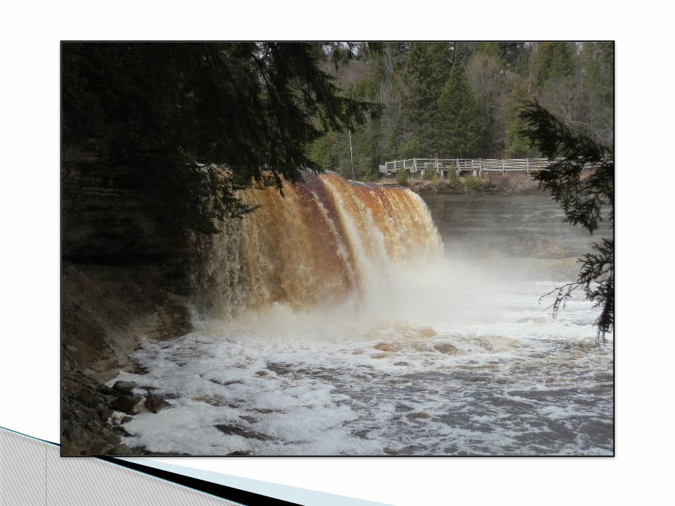
Up the Creek Appraising Inundated Properties
-
Upload
opal-butler -
Category
Documents
-
view
214 -
download
0
Transcript of Appraising Inundated Properties. How did we get there? 1. By Choice ◦ Sometimes we choose to...

Up the CreekAppraising Inundated Properties

How did we get there?
1. By Choice
◦Sometimes we choose to take on unusual or unique appraisal assignments.
Up the Creek


2. By Surprise
◦Sometimes the client doesn’t know (or doesn’t want to tell you!)
This can happen with award of multiple projects and the agency who has awarded them is busy or confused, or unclear about the properties.
As we become more insulated from our clients due to new lending regulations, we are receiving information that is lacking (in quantity and quality).

What do I need to complete the assignment competently?
◦“Do we have all the information available and required upon accepting the assignment to complete the appraisal correctly?”

Despite our best efforts, some projects (due to client ignorance or misinformation, or a lack of due diligence by the appraiser) leave us
“up $h!t creek without a paddle”.
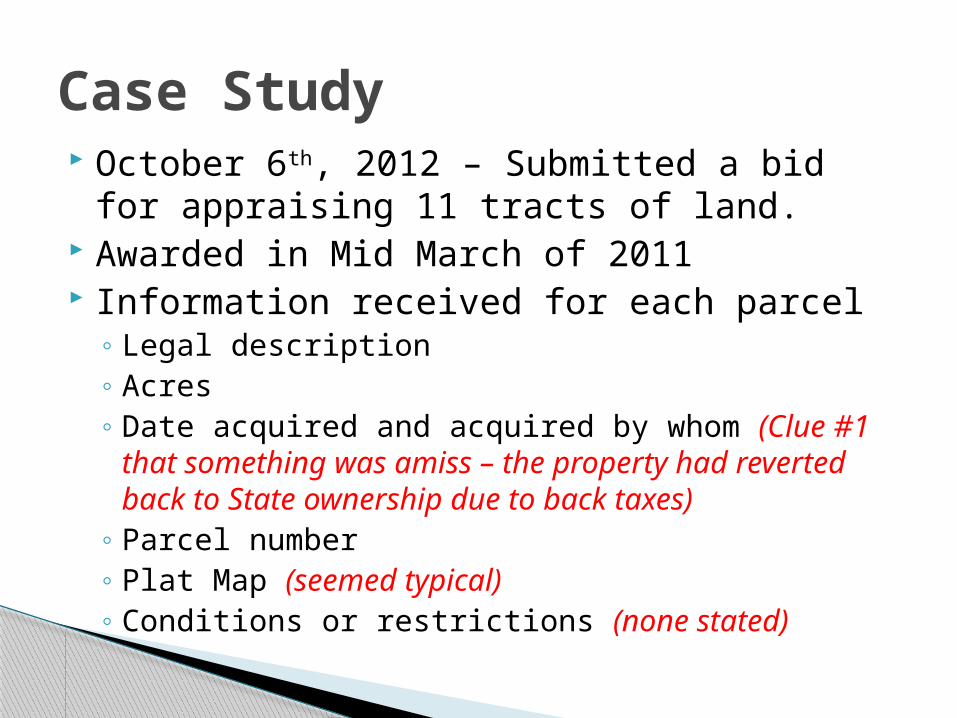
October 6th, 2012 – Submitted a bid for appraising 11 tracts of land.
Awarded in Mid March of 2011 Information received for each parcel
◦ Legal description◦ Acres◦ Date acquired and acquired by whom (Clue #1 that
something was amiss – the property had reverted back to State ownership due to back taxes)
◦ Parcel number◦ Plat Map (seemed typical)◦ Conditions or restrictions (none stated)
Case Study

Each consist of 1 parcel of land.
Located on the shore of Indian Lake, in Harrison Beach.
Harrison Beach consists of small summer cottages with a few year-round residences.
The Subject Properties

Plat provided by client
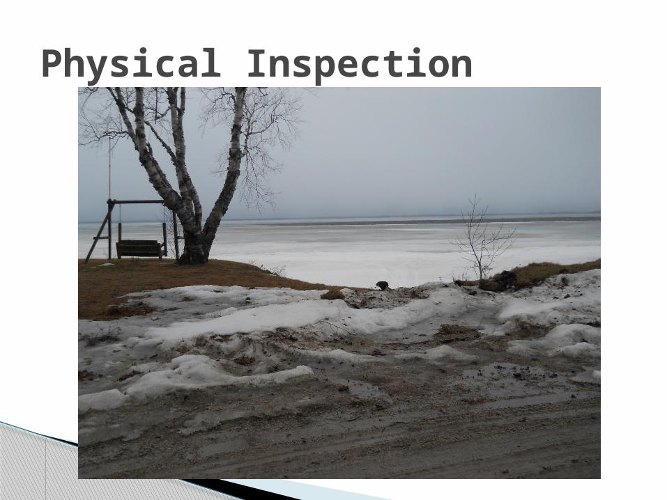
Physical Inspection

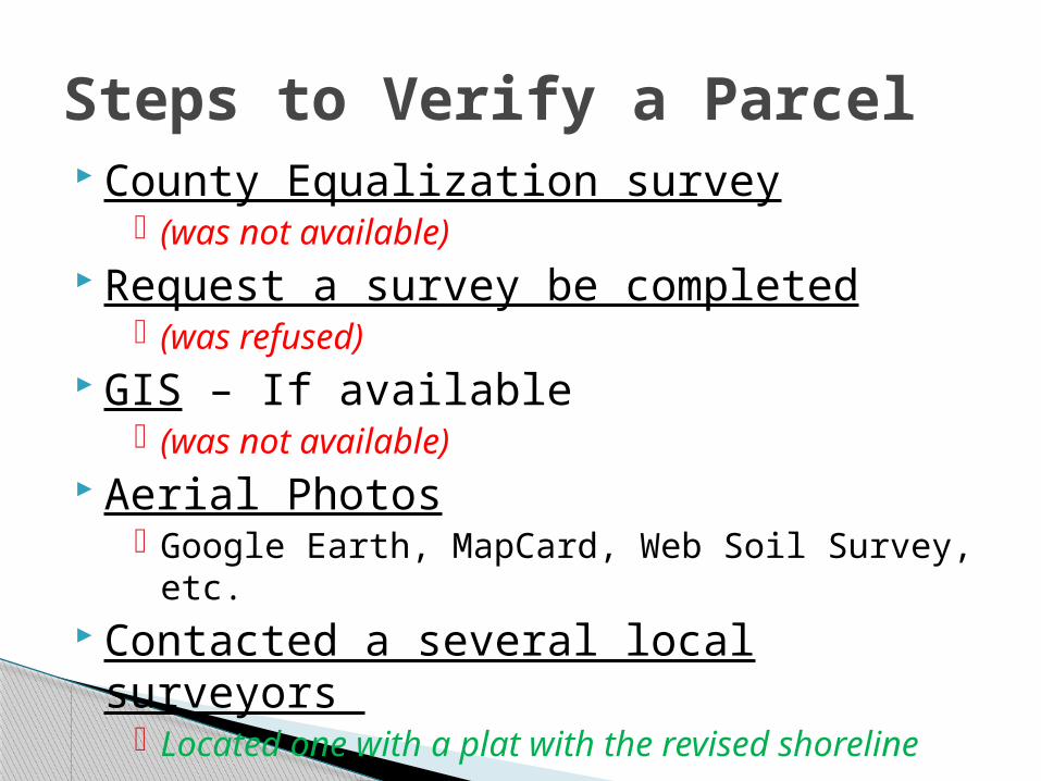
County Equalization survey (was not available)
Request a survey be completed (was refused)
GIS – If available (was not available)
Aerial Photos Google Earth, MapCard, Web Soil Survey, etc.
Contacted a several local surveyors Located one with a plat with the revised
shoreline
Steps to Verify a Parcel

Old Plat with revised Shoreline

Lake erosion has significantly impacted the integrity of the lots along the eastern side of the lake.
Visual inspection and a copy of a local survey of the tract indicated that the majority or the entire tract has eroded away and is inundated.
It is the appraiser’s recommendation that a survey be completed to determine the exact boundary of the subject property.


HBU Legal Permissibility
◦ Zoning states: Minimum Lot Size: 30,000 sq.ft. Minimum Lot Width: 100 ft Waterfront Setback: 50 ft
Physical Possibility◦ Underwater!
Financial Feasibility◦ Seasonal ice fishing?!
and Maximum Productivity◦ Excess or surplus land for adjacent lots
Appraising an Inundated Parcel
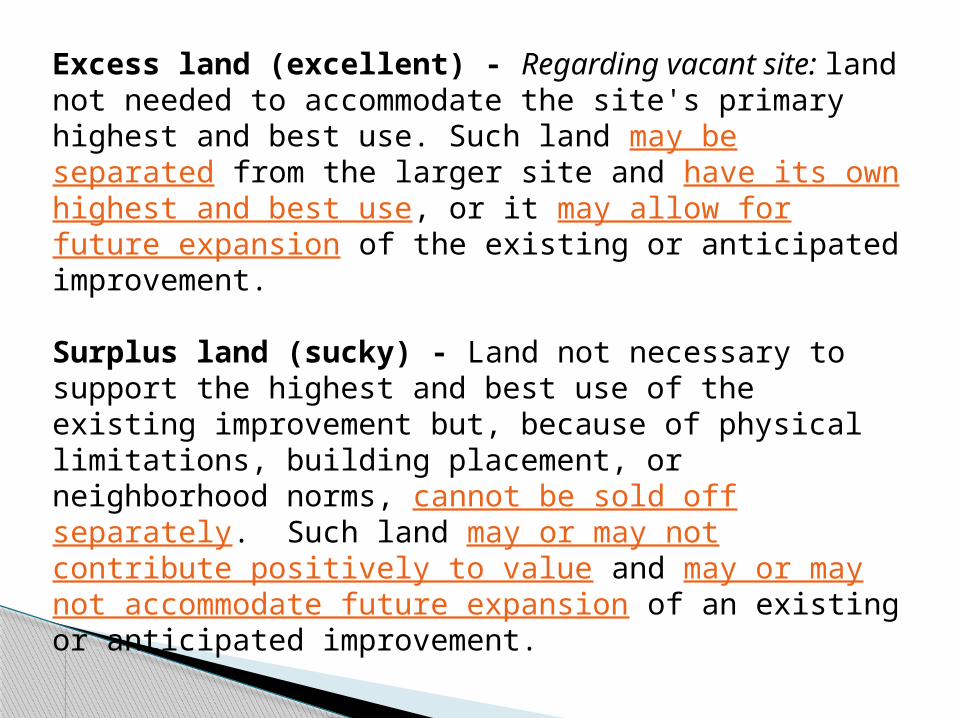
Excess land (excellent) - Regarding vacant site: land not needed to accommodate the site's primary highest and best use. Such land may be separated from the larger site and have its own highest and best use, or it may allow for future expansion of the existing or anticipated improvement.
Surplus land (sucky) - Land not necessary to support the highest and best use of the existing improvement but, because of physical limitations, building placement, or neighborhood norms, cannot be sold off separately. Such land may or may not contribute positively to value and may or may not accommodate future expansion of an existing or anticipated improvement.

Is it possible that the parcel will not be inundated in the future? The parcel is inundated due to erosion because of
strong westward winds, not because of rising water levels.
Due to waterfront improvement restrictions and zoning requirements it is unlikely that the erosion can be corrected or that the property can be improved to create a building site or useable land.
Consider this . . .
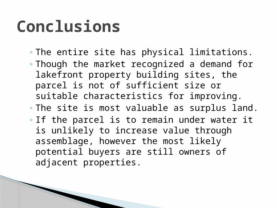
◦ The entire site has physical limitations.◦ Though the market recognized a demand for
lakefront property building sites, the parcel is not of sufficient size or suitable characteristics for improving.
◦ The site is most valuable as surplus land.◦ If the parcel is to remain under water it is unlikely
to increase value through assemblage, however the most likely potential buyers are still owners of adjacent properties.
Conclusions
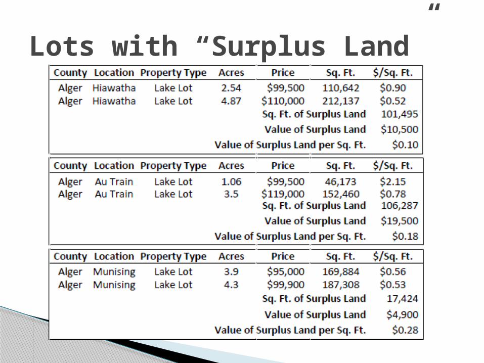
Lots with “Surplus Land”
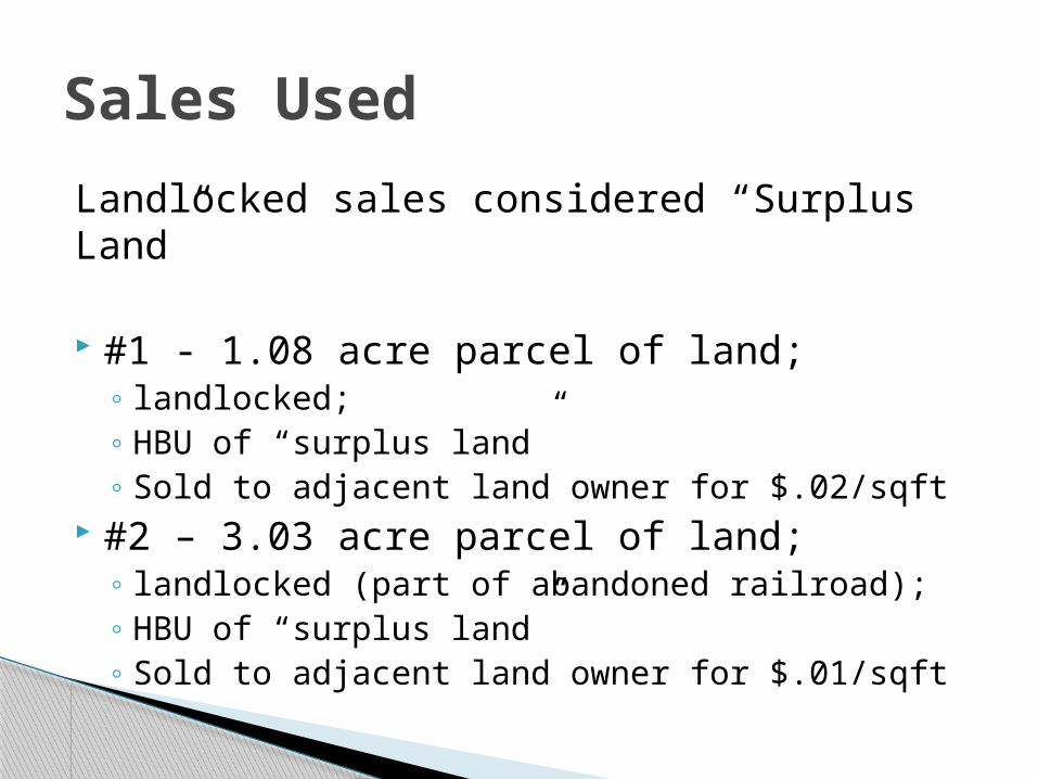
Landlocked sales considered “Surplus Land”
#1 - 1.08 acre parcel of land; ◦ landlocked; ◦ HBU of “surplus land”◦ Sold to adjacent land owner for $.02/sqft
#2 – 3.03 acre parcel of land; ◦ landlocked (part of abandoned railroad); ◦ HBU of “surplus land”◦ Sold to adjacent land owner for $.01/sqft
Sales Used
Comparative analysis provides value indications for the subject site ranging from a low of $.01/square foot to a high of $.28/square foot.
All, or the majority, of the subject property is inundated. Use is extremely limited, even to the adjacent landowner, as they already have lake frontage and assemblage to their current parcel would have minimal, if any economic benefit. It the parcel is totally inundated, they already would have benefit of the parcel. Therefore, a point near the lower end of the range is considered to be the best indication of value, ie, $.02 square foot supported by sales #1269 & #1268.
Consequently, I concluded a value of $.02 per square foot.
Any Questions?
Summary of Valuation Analysis