APPLICATION OF GIS AND REMOTE SENSING IN …iwtc.info/2006_pdf/01-2.pdf · APPLICATION OF GIS AND...
12
Tenth International Water Technology Conference, IWTC10 2006, Alexandria, Egypt 21 APPLICATION OF GIS AND REMOTE SENSING IN IRRIGATION NETWORKS MANAGEMENT Sherif M. El-Sayed Researcher, Hydraulics Research Institute, Egypt ABSTRACT A GIS application that manages all aspects of El-Zomor Canal irrigation network has been developed at the Hydraulics Research Institute GIS unit. The application aims to develop an integrated management system for the El-Zomor-canal and its irrigation network in order to overcome the network hydraulic problems, increase the main canal conveying capacity and to increase the water use efficiency of the whole network The application uses all the available data including remote sensed satellite images in representing the canal and its irrigation network. Field survey, maps, historical data and network design layouts were among the collected data in the application. Detailed analysis of the accumulated data leads to the determination of network characteristics and existing problems. Also the deviations of the existing conditions from the designed one were accurately determined through this analysis. ArcView GIS software was used to build the application. All the data were introduced into the software. A base map of the study area was built using the available satellite image which represents the area with a resolution of 1m. Canals network, drainage network, irrigated areas and domestic areas have been introduced in the application as a set of layers. Detailed comparison between the irrigation areas, up on which the irrigation network was designed, and the existing once has been done using the GIS application. This help in the determination of the current total served area. Based on that, a better network management system was introduced. The different components of this management system were based on the increase of the efficiency of the network. In addition, the management system guarantees the supply of the water requirement to the different irrigated area. In this paper, the different component of the developed GIS application and the use of this application in managing the El-Zomor canal and its irrigation network are presented. The proposed alternatives for overcoming the existing problems and in creasing the overall network efficiency are also discussed. Keywords: Hydraulics, GIS, management system, Irrigation
Transcript of APPLICATION OF GIS AND REMOTE SENSING IN …iwtc.info/2006_pdf/01-2.pdf · APPLICATION OF GIS AND...

Tenth International Water Technology Conference, IWTC10 2006, Alexandria, Egypt
21
APPLICATION OF GIS AND REMOTE SENSING IN IRRIGATION
NETWORKS MANAGEMENT
Sherif M. El-Sayed
Researcher, Hydraulics Research Institute, Egypt ABSTRACT A GIS application that manages all aspects of El-Zomor Canal irrigation network has been developed at the Hydraulics Research Institute GIS unit. The application aims to develop an integrated management system for the El-Zomor-canal and its irrigation network in order to overcome the network hydraulic problems, increase the main canal conveying capacity and to increase the water use efficiency of the whole network The application uses all the available data including remote sensed satellite images in representing the canal and its irrigation network. Field survey, maps, historical data and network design layouts were among the collected data in the application. Detailed analysis of the accumulated data leads to the determination of network characteristics and existing problems. Also the deviations of the existing conditions from the designed one were accurately determined through this analysis. ArcView GIS software was used to build the application. All the data were introduced into the software. A base map of the study area was built using the available satellite image which represents the area with a resolution of 1m. Canals network, drainage network, irrigated areas and domestic areas have been introduced in the application as a set of layers. Detailed comparison between the irrigation areas, up on which the irrigation network was designed, and the existing once has been done using the GIS application. This help in the determination of the current total served area. Based on that, a better network management system was introduced. The different components of this management system were based on the increase of the efficiency of the network. In addition, the management system guarantees the supply of the water requirement to the different irrigated area. In this paper, the different component of the developed GIS application and the use of this application in managing the El-Zomor canal and its irrigation network are presented. The proposed alternatives for overcoming the existing problems and in creasing the overall network efficiency are also discussed. Keywords: Hydraulics, GIS, management system, Irrigation
Tenth International Water Technology Conference, IWTC10 2006, Alexandria, Egypt 22
INTRODUCTION Based on the request of the irrigation sector of the ministry of water resources and irrigation, Hydraulics Research Institute (HRI) has the duty to study the existing conditions of the El-Zomor canal and its irrigation network. The purpose of the study was to find the proper integrated management system for the canal and its irrigation network in order to: • overcome the canal hydraulic problems • increase the main canal conveying capacity • increase the water use efficiency in order to serve the irrigated areas Most of irrigation networks with its main canals, branch canals and drains are always subjected to malfunctioning with time. Among others, causes of this could be: change of land use, improper network maintenance and lack of integrated management. El-Zomor canal and its network is an example of such networks. The main problem from which the network is suffering is the law conveying capacity of its main canal (El-Zomor canal) due to the reduction of its cross section area. Sedimentation problems lead to raised bed level and smaller cross section width compared to the design values. Moreover, due to the change in served land use from agriculture areas to urban areas, long reaches of the network canals were blocked by garbage. This leads to a significant reduction in the network efficiency in supplying the water requirements to different irrigated areas. To fulfill the study requirements the GIS unit of the HRI was requested to build an application which assist in identifying the existing network situation. The application optimum objective is to support taking the right decision regarding the proper management of the network. In order to establish such a GIS application, intensive amount of data were collected. A field survey was conducted through which data describing the hydraulic conditions of the network canals and structures were determined. Satellite image of 1 m resolution covering the network served area was also brought into the application to identify the existing condition of the land use at the study area. El-Zomor canal design cross section maps were made available from the irrigation sector and introduced as main canal basic geometrical information to the application. Maps of the network canals, drains and hydraulic structures were also collected and transfer to the application. Data were organized in a set of layers and detailed attributes were attached to each data element. The actual total area served by the canals network has been determined from the satellite image. A comparison with the original situation upon which the network was designed lead to the determination of the water requirement of the irrigated land and consequently an update design and management of the network was made possible.
Tenth International Water Technology Conference, IWTC10 2006, Alexandria, Egypt
23
On of the main finding of this application was that the irrigated land have been reduced by around 30%. Moreover it was found that some of the branch canals could be eliminated from the network, while all its served area were transforming into urban area. A number of alternatives to manage the network were proposed and a hydraulic study of these alternatives was recommended in order to find out the proper one. The following sections of this paper will present the following: • Detailed description of the study area and its problems • The methodology used in the GIS application development • The main elements of the application and its function • The management systems proposed for the network • The main conclusions and recommendations of this study
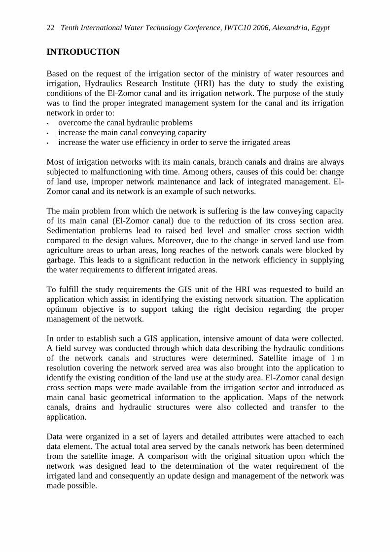
Study Area Figure 1 shows the location of the studied network. The studied irrigation network consists of the following: 1. El-Zomor main canal with a total length of about 26.01 KM and consists of 6 main
reaches connected through 5 main barrages listed as shown in Table 1: 2. 20 branched canals distributed along the main canal length as showed in the
following table 3. The designed total served area of the irrigation network is 42,260.00 Feddan.
Figure 1: Location of Study area

Tenth International Water Technology Conference, IWTC10 2006, Alexandria, Egypt 24
Table 1: Main canal different reaches
No. Barrage Name KM Reaches No. of branches 1 Abdel Aal 4.76 1 , 2 5 2 New Bolaak 7.96 2,3 1 3 El-Barageel 11.65 3,4 2 4 El-Kom El-Ahmar 14.58 4,5 3 5 El-Galatmah 25.08 5,6 4
Data Accumulation In order to develop a clear picture about the current situation of the studied irrigation network, a survey mission has been conducted which has been able to achieve the following measurements:
o Cross sections on the El-Zomor canal at equidistance of 500m apart starting from KM 11.00 till the end of the canal. The section includes the hydrographic and topographic conditions at the section location. Through the reach from the start of the canal till KM 11.00 it was not possible to measure any cross section because of the bad situation of the canal (full of garbage) and high walls surrounding it.
o Main barrages locations and bed level on the upstream and downstream of each. o Locations of Branches intake. Branch width and bed level has been also
measured. o It was not possible to conduct any velocity measurements because of the very
shallow depths on the canal at the time of the survey mission. Moreover the following data about the network and its design conditions has been collected:
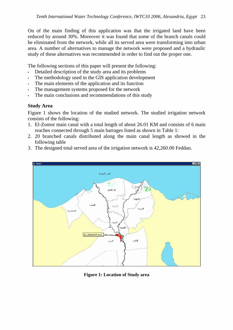
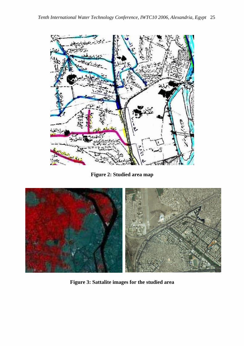
o Maps of scale 1:50000, year 1965 (Figure 2). o Longitudinal section of the main network canal. o Data about the barrages, canals and drainage of the network. o Served area of each reach at the design stage. o Satellite image of resolution 90 m (TM) for the whole study area including the
served area of the irrigation network (year 2003). o Satellite image of resolution 1 m (Iknos) covering about 65% of the study area.
Tenth International Water Technology Conference, IWTC10 2006, Alexandria, Egypt
25
Figure 2: Studied area map
Figure 3: Sattalite images for the studied area

Tenth International Water Technology Conference, IWTC10 2006, Alexandria, Egypt 26
GIS Application In order to build the complete picture about the studied network and being able to analyze the collected data, GIS application has been developed. First to incorporate the collected data into the GIS application the satellite images have been Geo-referenced and paper maps have been scanned and corrected through using the ikonos satellite image as shown in Figure 4. The GIS application includes the following data layers:
o Canals network: where all canals in the studied area have been coded according to the database coding system (Figure 5.)
o Drainage network: all information about each single drain in the network (name, length, current situation,...) have been included in the drains layers (Figure 6.)
o Designed served area of each canal: From both the canal network and drainage network layers the designed served area for each canal has been determined as the area enclosed by two drains and include the concerned canal. (Figure 7.)
o Land use: total area of the network has been identified according to its use. Two categories have been used: agricultural and urban. With the support of the satellite image each unit has given its category with its total area in square meter and Feddan.
o Barrages. o Cross sections at El-Zomor canal. o Bridges on El-Zomor canal.
For each GIS layers a database has been designed to include all available information related to each object in the application. For example, for a canals network layer the data base includes the following for each canal: • Canal length by meter • Canal name • Kilometrage from El-Zomor intake • Canal current situation (open or covered) • Served area Also for the barrages the database contains the following fields: • Barrage type and function • Kilometrage • Canal name on which the barrage located • Upstream water level • Downstream water level • Maximum upstream water level • Maximum downstream water level • Number of barrage gates

Tenth International Water Technology Conference, IWTC10 2006, Alexandria, Egypt
27
Figure 4:Development of the application GIS map
Figure 5:Canals network layer Figure 6: Drains network layer
Figure 7: Served area layer Figure 8: Land use layer
Tenth International Water Technology Conference, IWTC10 2006, Alexandria, Egypt 28
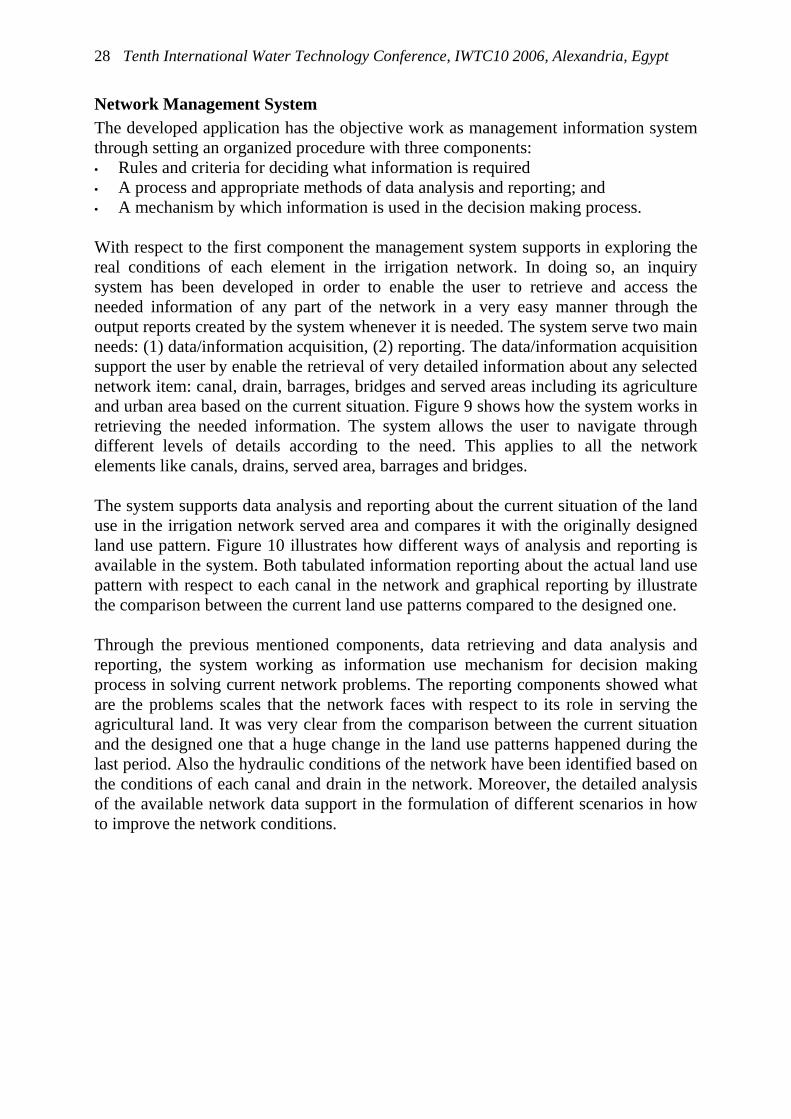
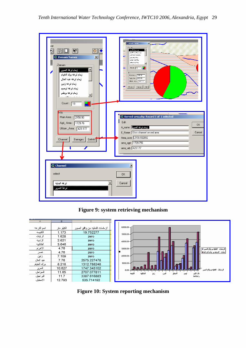
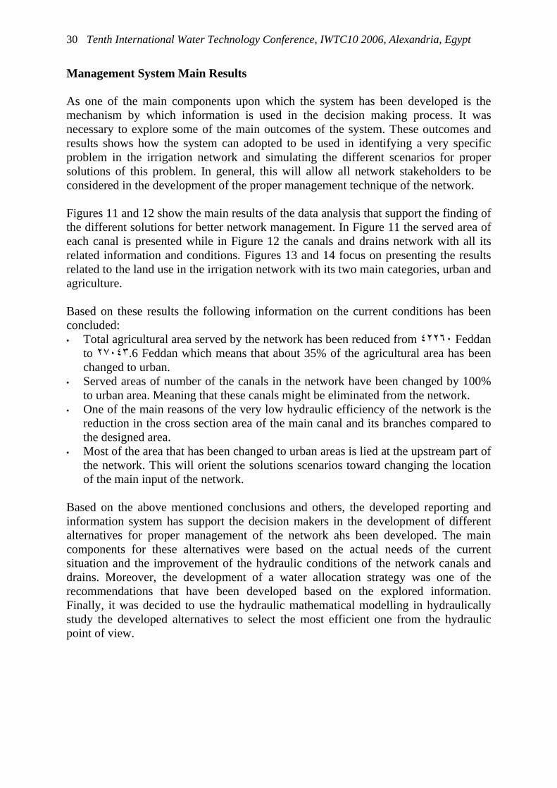
Network Management System The developed application has the objective work as management information system through setting an organized procedure with three components: • Rules and criteria for deciding what information is required • A process and appropriate methods of data analysis and reporting; and • A mechanism by which information is used in the decision making process. With respect to the first component the management system supports in exploring the real conditions of each element in the irrigation network. In doing so, an inquiry system has been developed in order to enable the user to retrieve and access the needed information of any part of the network in a very easy manner through the output reports created by the system whenever it is needed. The system serve two main needs: (1) data/information acquisition, (2) reporting. The data/information acquisition support the user by enable the retrieval of very detailed information about any selected network item: canal, drain, barrages, bridges and served areas including its agriculture and urban area based on the current situation. Figure 9 shows how the system works in retrieving the needed information. The system allows the user to navigate through different levels of details according to the need. This applies to all the network elements like canals, drains, served area, barrages and bridges. The system supports data analysis and reporting about the current situation of the land use in the irrigation network served area and compares it with the originally designed land use pattern. Figure 10 illustrates how different ways of analysis and reporting is available in the system. Both tabulated information reporting about the actual land use pattern with respect to each canal in the network and graphical reporting by illustrate the comparison between the current land use patterns compared to the designed one. Through the previous mentioned components, data retrieving and data analysis and reporting, the system working as information use mechanism for decision making process in solving current network problems. The reporting components showed what are the problems scales that the network faces with respect to its role in serving the agricultural land. It was very clear from the comparison between the current situation and the designed one that a huge change in the land use patterns happened during the last period. Also the hydraulic conditions of the network have been identified based on the conditions of each canal and drain in the network. Moreover, the detailed analysis of the available network data support in the formulation of different scenarios in how to improve the network conditions.
Tenth International Water Technology Conference, IWTC10 2006, Alexandria, Egypt
29
Figure 9: system retrieving mechanism
Figure 10: System reporting mechanism
Tenth International Water Technology Conference, IWTC10 2006, Alexandria, Egypt 30
Management System Main Results As one of the main components upon which the system has been developed is the mechanism by which information is used in the decision making process. It was necessary to explore some of the main outcomes of the system. These outcomes and results shows how the system can adopted to be used in identifying a very specific problem in the irrigation network and simulating the different scenarios for proper solutions of this problem. In general, this will allow all network stakeholders to be considered in the development of the proper management technique of the network. Figures 11 and 12 show the main results of the data analysis that support the finding of the different solutions for better network management. In Figure 11 the served area of each canal is presented while in Figure 12 the canals and drains network with all its related information and conditions. Figures 13 and 14 focus on presenting the results related to the land use in the irrigation network with its two main categories, urban and agriculture. Based on these results the following information on the current conditions has been concluded: • Total agricultural area served by the network has been reduced from ٤٢٢٦٠ Feddan
to ٢٧٠٤٣.6 Feddan which means that about 35% of the agricultural area has been changed to urban.
• Served areas of number of the canals in the network have been changed by 100% to urban area. Meaning that these canals might be eliminated from the network.
• One of the main reasons of the very low hydraulic efficiency of the network is the reduction in the cross section area of the main canal and its branches compared to the designed area.
• Most of the area that has been changed to urban areas is lied at the upstream part of the network. This will orient the solutions scenarios toward changing the location of the main input of the network.
Based on the above mentioned conclusions and others, the developed reporting and information system has support the decision makers in the development of different alternatives for proper management of the network ahs been developed. The main components for these alternatives were based on the actual needs of the current situation and the improvement of the hydraulic conditions of the network canals and drains. Moreover, the development of a water allocation strategy was one of the recommendations that have been developed based on the explored information. Finally, it was decided to use the hydraulic mathematical modelling in hydraulically study the developed alternatives to select the most efficient one from the hydraulic point of view.

Tenth International Water Technology Conference, IWTC10 2006, Alexandria, Egypt
31
Figure 11 : network served areas
Figure 12: canal network
Figure 13: land use change
Figure 14: details of land use per served area
CONCLUSIONS A system which converts data from internal and external sources into information and communicates that information, in an appropriate form, to managers at all levels in all functions to enable them to take timely and effective decisions for planning, managing and controlling activities for which they are responsible has been developed and applied to the irrigation network of El-Zomor canal.
Tenth International Water Technology Conference, IWTC10 2006, Alexandria, Egypt 32
From the presented study it was concluded that: • The use of different information management tools like database and GIS proved to
be of high efficiency in supporting the data analysis and reporting. Also it helps the integration of all types of data in a friendly usage environment.
• Remote sensed data although it is of high cost it was proved to be very effective as an accurate source of the current situations.
• Collecting and processing information requires the commitment of time and resources. It is therefore important to collect and record only that information which is going to be usefully used. Too much information can be as bad as too little.
• Management systems that based on information tools maximise the opportunities in proper identifications of the existing problems and consequently taking the right decisions to overcome the problems.
• Integrating approach in identifying the current situation of existing conditions such as the studied irrigation network is very efficient in compiling all aspects in one system. The system using this approach will be able to communicate the right information in a very appropriate manner.
• Based on the studied case it was concluded that the development of a management system will lead to prevent any future deterioration in the network conditions. This is due to the continuous access to proper information.
REFERENCES 1. El-Sayed, S.M. and Roushdy, M.T.; Study of El-Zomor Canal improvement using
geographical Information systems; Hydraulics Research Institute, report no. 172, 2005.
2. Schotanus, T.D. (Ed.). Geographic Information Systems & Remote Sensing,
UNESCO-IHE, Institute for Water Education, Delft, 2004.