Application of climatic guidelines to urban planning The ... · M.-J. Alcoforado et al. / Landscape...
10
Landscape and Urban Planning 90 (2009) 56–65 Contents lists available at ScienceDirect Landscape and Urban Planning journal homepage: www.elsevier.com/locate/landurbplan Application of climatic guidelines to urban planning The example of Lisbon (Portugal) Maria-João Alcoforado ∗ , Henrique Andrade, António Lopes, João Vasconcelos Centro de Estudos Geográficos, Universidade de Lisboa, Fac. Letras, Alameda da Universidade, 1600-214 Lisboa, Portugal article info Article history: Received 29 June 2007 Received in revised form 11 September 2008 Accepted 3 October 2008 Available online 20 November 2008 Keywords: Urban planning Urban climate Master Plans Urban sustainability GIS abstract In order to contribute to the sustainability of the urban environment, knowledge about the urban climate should be translated into climatic guidelines for planning. However, there are hardly any studies on applied urban climatology in areas with a Mediterranean type of climate. The study presented in this paper has several aims: to identify the climatic needs in a coastal city with Mediterranean climate; to describe the methodology, which can be adapted in order to be used in other cities; to discuss some of the problems that arise when applying climatic knowledge to urban planning, including the selection of the adequate scale of analysis, the required data and tools, the selection of the planning priorities, and the need to develop a shared language among planners and climatologists; and last to contribute to furthering the debate on the advantages of including climatic guidelines in Master Plans of urban municipalities in a systematic way. Lisbon’s case study is presented. As planners need spatialized guidelines, the mapping of Lisbon’s physical features was carried out using a Geographical Information System. Based on a Digital Terrain Model and on data of urban roughness a “ventilation map” was produced. A “building-density” map was also prepared based on the analysis of a Landsat image and field work. By crosstabulating these two layers, a final map depicting Lisbon’s “homogeneous climatic-response units” was prepared. Finally, a series of climatic guidelines for planning were put forth for the different units. © 2008 Elsevier B.V. All rights reserved. 1. Introduction The proportion of the world population that lives in urban areas is increasing at a growing pace. In order to ensure urban sustain- ability, it is necessary to increase quality of life of the citizens, and to reduce the cities’ impact upon the resources outside the urban space (Paccione, 2003; Steemers, 2003). Among the urban environmental problems, the climatic features are particularly significant. The most evident examples of “inadver- tent climate modification” (Oke, 1987) introduced by mankind are to be found in urban areas. In densely populated areas, changes in the wind flow, energy balance, temperature, humidity, precipi- tation, among others, are to be expected. In the context of global warming, particular attention has been given in the literature to the canopy layer urban heat island (UHI), i.e. the fact that the air in the urban canopy is usually warmer than that in the surrounding coun- tryside (Oke, 1987), even though the scales of the two phenomena obviously differ. Although some physical features of the cities are ∗ Corresponding author. Tel.: +351 21 792 00 87; fax: +351 21 796 00 63. E-mail addresses: mjalc@fl.ul.pt (M.-J. Alcoforado), handrade@fl.ul.pt (H. Andrade), antolopes@fl.ul.pt (A. Lopes), [email protected] (J. Vasconcelos). regulated by law (air quality, noise, etc.), there is no legal frame- work in place to ensure the achievement of a high-quality urban climate. Bitan (1992) has provided an example of a hypothetical city in which the air pollution levels never exceed the permitted thresh- olds, but where the quality of the climate is so low (too intense UHI, poor ventilation, etc.) that it affects the activities of the pop- ulation, the comfort level and even the health of the city dwellers. An indirect but very important consequence of the UHI and of poor ventilation conditions is the increase in energy consumption asso- ciated with the cooling of indoor air, especially whenever the urban design and architecture are not bioclimatically oriented (Szokolay, 1997; Givoni, 1998; Tzikopoulos et al., 2005). Although the characteristics of the urban climate have been known for a long time, there has been very little application of climate knowledge in urban planning (Oke, 1984, 2006; Eliasson, 2000; Mills, 2006). The first studies on applied urban climatol- ogy have been conducted in Germany in the 1960s and 1970s (Matzarakis, 2005), although non-applied research on local and urban climatology had been on-going since the first decades of the 20 th century (Kratzer, 1937). In the 1980s, the Municipality of the Ruhr Area, well-known for its urban conurbations, ordered a systematic investigation on urban climate, as populations grew and urban density kept increasing, in order to achieve sufficient air and climate quality for the inhabitants (Stock and Beckröge, 0169-2046/$ – see front matter © 2008 Elsevier B.V. All rights reserved. doi:10.1016/j.landurbplan.2008.10.006
Transcript of Application of climatic guidelines to urban planning The ... · M.-J. Alcoforado et al. / Landscape...

AT
MC
a
ARR1AA
KUUMUG
1
iats
attitwcuto
((
0d
Landscape and Urban Planning 90 (2009) 56–65
Contents lists available at ScienceDirect
Landscape and Urban Planning
journa l homepage: www.e lsev ier .com/ locate / landurbplan
pplication of climatic guidelines to urban planninghe example of Lisbon (Portugal)
aria-João Alcoforado ∗, Henrique Andrade, António Lopes, João Vasconcelosentro de Estudos Geográficos, Universidade de Lisboa, Fac. Letras, Alameda da Universidade, 1600-214 Lisboa, Portugal
r t i c l e i n f o
rticle history:eceived 29 June 2007eceived in revised form1 September 2008ccepted 3 October 2008vailable online 20 November 2008
eywords:rban planning
a b s t r a c t
In order to contribute to the sustainability of the urban environment, knowledge about the urban climateshould be translated into climatic guidelines for planning. However, there are hardly any studies on appliedurban climatology in areas with a Mediterranean type of climate. The study presented in this paper hasseveral aims: to identify the climatic needs in a coastal city with Mediterranean climate; to describe themethodology, which can be adapted in order to be used in other cities; to discuss some of the problemsthat arise when applying climatic knowledge to urban planning, including the selection of the adequatescale of analysis, the required data and tools, the selection of the planning priorities, and the need todevelop a shared language among planners and climatologists; and last to contribute to furthering the
rban climateaster Plansrban sustainabilityIS
debate on the advantages of including climatic guidelines in Master Plans of urban municipalities in asystematic way. Lisbon’s case study is presented. As planners need spatialized guidelines, the mappingof Lisbon’s physical features was carried out using a Geographical Information System. Based on a DigitalTerrain Model and on data of urban roughness a “ventilation map” was produced. A “building-density”map was also prepared based on the analysis of a Landsat image and field work. By crosstabulating thesetwo layers, a final map depicting Lisbon’s “homogeneous climatic-response units” was prepared. Finally,
nes f
rwcioUuAvcd1
k
a series of climatic guideli
. Introduction
The proportion of the world population that lives in urban areass increasing at a growing pace. In order to ensure urban sustain-bility, it is necessary to increase quality of life of the citizens, ando reduce the cities’ impact upon the resources outside the urbanpace (Paccione, 2003; Steemers, 2003).
Among the urban environmental problems, the climatic featuresre particularly significant. The most evident examples of “inadver-ent climate modification” (Oke, 1987) introduced by mankind areo be found in urban areas. In densely populated areas, changesn the wind flow, energy balance, temperature, humidity, precipi-ation, among others, are to be expected. In the context of globalarming, particular attention has been given in the literature to the
anopy layer urban heat island (UHI), i.e. the fact that the air in therban canopy is usually warmer than that in the surrounding coun-ryside (Oke, 1987), even though the scales of the two phenomenabviously differ. Although some physical features of the cities are
∗ Corresponding author. Tel.: +351 21 792 00 87; fax: +351 21 796 00 63.E-mail addresses: [email protected] (M.-J. Alcoforado), [email protected]
H. Andrade), [email protected] (A. Lopes), [email protected]. Vasconcelos).
c2o(utoaaa
169-2046/$ – see front matter © 2008 Elsevier B.V. All rights reserved.oi:10.1016/j.landurbplan.2008.10.006
or planning were put forth for the different units.© 2008 Elsevier B.V. All rights reserved.
egulated by law (air quality, noise, etc.), there is no legal frame-ork in place to ensure the achievement of a high-quality urban
limate. Bitan (1992) has provided an example of a hypothetical cityn which the air pollution levels never exceed the permitted thresh-lds, but where the quality of the climate is so low (too intenseHI, poor ventilation, etc.) that it affects the activities of the pop-lation, the comfort level and even the health of the city dwellers.n indirect but very important consequence of the UHI and of poorentilation conditions is the increase in energy consumption asso-iated with the cooling of indoor air, especially whenever the urbanesign and architecture are not bioclimatically oriented (Szokolay,997; Givoni, 1998; Tzikopoulos et al., 2005).
Although the characteristics of the urban climate have beennown for a long time, there has been very little application oflimate knowledge in urban planning (Oke, 1984, 2006; Eliasson,000; Mills, 2006). The first studies on applied urban climatol-gy have been conducted in Germany in the 1960s and 1970sMatzarakis, 2005), although non-applied research on local andrban climatology had been on-going since the first decades of
he 20th century (Kratzer, 1937). In the 1980s, the Municipalityf the Ruhr Area, well-known for its urban conurbations, orderedsystematic investigation on urban climate, as populations grewnd urban density kept increasing, in order to achieve sufficientir and climate quality for the inhabitants (Stock and Beckröge,

and U
1mrlaoteapE2e
PsirT“tawmmfkfctra2
iac
aftpiwcnlotdToo
2
2
lti
Fm
M.-J. Alcoforado et al. / Landscape
985; Stock, 1992). In the resulting documents “climate analysisaps” and “synthetic functions maps” were included as well as
eports with climatic guidelines for urban planning. In Switzer-and, similar research projects have been carried out (Scherer etl., 1999; Fehrenbach et al., 2001; Thommes et al., 2001). Latern, the Climate Booklet for Urban Development was published byhe German Interior Ministry of Baden – Württemberg (Baumüllert al., 2005). It proved to be a very useful tool for both scientistsnd planners, as it provides climatic guidelines for zoning andlanning. “Stuttgart21” (Baumüller, 2005) and the “Berlin Digitalnvironmental Atlas” (Berlin Department for Urban Development,004) are two other big research projects, that have been used asxamples.
Similar studies for southern Europe are almost inexistent. Inortugal, the analysis of 15 Master Plans of urban municipalitieshowed that although climatic or meteorological information wasncluded in 86% of the cases (Alcoforado and Vieira, 2004), theeliance on climatic information never proved particularly useful.he main reasons for this fact are: the meteorological data fromclassical” meteorological stations, such as those used in the Mas-er Plans, are by definition inappropriate for the study of the climatet the urban scale (meso and microscale); in 90% of the cases, dataith only mean values were included (total annual precipitation,ean temperature); the Master Plans hardly ever included any cli-ate maps and, whenever they did, their scale was inappropriate
or direct application. An additional reason seems to be the lack ofnowledge by the authors of the Master Plans with regard to theeatures of the urban climate and to the ways in which the latter
an be modified in order to improve the quality of life. Over the lastwo decades, research on the Lisbon urban climate has been car-ied out (Alcoforado, 1992; Andrade, 2003; Lopes, 2003; Alcoforadond Andrade, 2006; Alcoforado et al., 2006; Vasconcelos and Lopes,006). At the present stage, it has been considered necessary tootdtp
ig. 1. Location maps; 1– traditional centre, 2 – Avenidas Novas (new centrality area), 3easurement points.
rban Planning 90 (2009) 56–65 57
nform urban planners of the benefits of using climatic informationnd to translate the results of pre-existing studies into applicablelimatic guidelines for urban planning.
This research was initially carried out within the scope of anpplied urban climatology project, where one of the goals was tooresee the changes that would result from the process of urbanisa-ion. As the City Council became interested in the research, anotherroject was then set up with the aim of suggesting ways of reduc-
ng the negative local climatic effects of urbanisation. The resultsere translated into a series of guidelines for planning, which were
ompiled in a guide booklet and presented in cartographic form,ot only for the city as a whole (mesoscale), but also for a particu-
ar city district in northern Lisbon (microscale). This paper focusesn the research carried out at the city scale. In the next section,he study area is briefly depicted and the methodology used in theelimitation of climatic units for planning purposes is described.he guidelines are presented in Section 3, followed by a discussionf the main aspects that should be borne in mind when carryingut research on applied urban climatology.
. Materials and methods
.1. Study area
Lisbon is located near the western coast of Portugal, at 38◦43′
atitude N and 9◦ 9′ longitude W. The city lies 30 km to the east ofhe Atlantic shore and right on the bank of the Tagus estuary, whichs 15 km wide eastwards from Lisbon (Fig. 1). The city covers an area
f 84 km2 and has circa 600,000 inhabitants. In the urbanized area,he altitude is lower than 160 m, although the topography is highlyifferentiated (Fig. 5): four main valleys run from north to south inhe southernmost part of Lisbon; in the northern part of the city, alateau gently slopes to the south. To the west, the Monsanto hill– Monsanto hill, 4 –Lisboa/Geofísico Meteorological station; 5 – airport, 6 and 7 –

58 M.-J. Alcoforado et al. / Landscape and Urban Planning 90 (2009) 56–65
F urly av(
(2wn
vwbqoitbttec
ubov1tal
anwodaFbmttaemae
ddtvAvhatt2vtlowtaer
2p
amrm
tadcawTw
ig. 2. Comparison of breeze and non-breeze days: air temperature differences (hosite 7) (June, July and August 2004; Vasconcelos and Lopes, 2006).
a wood area identified by number 3 in Fig. 1) reaches a height of00 m. The traditional centre is located near the river (1, Fig. 1),hereas the new centrality area (Avenidas Novas) is expandingorthwards (2, Fig. 1).
Lisbon has a “Mediterranean” climate. N and NW winds pre-ail on a yearly basis, although there is large seasonal variability:inds blow mostly from the N, NE and SW (or W) in the winter,
ut from March onwards there is a significant increase in the fre-uency of NW and N winds. In the summer, N and NW winds occurn 40% of the days for 24 h a day and, on an additional 30%, onlyn the late afternoon (Alcoforado et al., 2006). This means thathe prevailing N and NW winds are so frequent that they muste taken into account in planning and building design. The impor-ance of considering ventilation conditions increases if we considerhat Lisbon has become a rather polluted city, and very high lev-ls of particulate matter have been recently recorded in the cityentre.
On the other hand, when weak regional winds occur (speednder 4 m/s, Vasconcelos and Lopes, 2006), ocean and estuaryreezes reach the neighbourhoods closer to the river Tagus on 30%f the late mornings and early summer afternoons, before the windeers to the North in late afternoons and evenings (Alcoforado,992; Lopes, 2003). Even though they do not travel very far inland,he estuarine breezes play an important role in cooling the urbanir near the river bank, where air temperature may be up to 4 ◦Cower than the city centre (Fig. 2).
The Lisbon UHI has an average intensity of 3 ◦C: the highestir temperatures occur mostly in the more densely built-up areasear the Tagus river bank and along the main circulation axishere urban development is under way. Under prevailing North
r Northwest wind conditions, the core of the UHI is situated in theowntown areas (1, Fig. 1). In the presence of weak regional windnd estuarine breezes, the core of the UHI moves to the North (2,ig. 1) and the downtown area remains relatively cooler. As humaneings perceive the combined influence of the atmospheric ele-ents, the bioclimatic conditions were assessed by computing a
hermophysiological index, the Physiological Equivalent Tempera-ure (PET–Höppe, 1999; Matzarakis et al., 1999), which took into
ccount measured air temperature, atmospheric moisture, mod-lled wind speed (based on altitude and urban roughness, using theesoscale simulation model WAsP, Mortensen et al., 1993), as wells mean radiant temperature (using Rayman program, Matzarakist al., 2007 – and subsequently following a procedure similar to that
tdos(
erage) between the Tagus Bank (site 6 in Fig. 1) and an inland measurement point
escribed by Andrade and Alcoforado, 2008 to calibrate and vali-ate the results). Discussion on the adequacy of the use of PET forhe study of the bioclimatic conditions of Lisbon and subsequentalidation of the model used there were made by Andrade andlcoforado (2008). Both in the winter and in the summer, mesoscaleariation of PET is similar to that of the air temperature, with theighest values occurring in the city core (associated with higherir temperature and lower wind speed) and the lowest values inhe outskirts. The mean difference in the PET between the down-own area (1, 2 and 4, Fig. 1) and the outskirts is of 3.6 ◦C (Andrade,003), with a 10th percentile value of 2.7 ◦C and a 90th percentilealue as high as 4.3 ◦C. In the peripheral areas, the wind speed con-ributes in a significant way to lowering the values of the PET. Theowest night time PET values in the winter (between 0 ◦C and 4 ◦C)ccur in the outskirts of the city. In the summer daytime, undereak regional wind, PET values above 41 ◦C may occur in the down-
own area, while the outskirts remain 3 ◦C cooler; as mentionedbove, the influence of the Tagus/Ocean breezes considerably low-rs the air temperature and the PET in the areas closest to theiver.
.2. Methodology for the delimitation of climatic units forlanning purposes
Feedback from city planners and the experience of differentuthors working on the same topics (quoted in the Introduction),ade it obvious that climatic guidelines can only be of use if they
efer to areas whose limits are very precisely drawn on a detailedap.A cartographical representation of Lisbon’s physical features had
o be carried out, as existing land-use categories were not suitable,s these are mainly based on functional criteria. As a consequence,ifferent types of land use may be included in the same functionallass. Two different types of residential areas, for example villasnd modern apartment towers, will interact in a very different wayith the atmosphere and will give rise to different urban climates.
herefore the cartography considered useful for climatic purposesas based on the parameters more important to the urban climate:
he topography and the land cover, considering mainly the builtensity. Our aim was to produce a final map that depicted a setf areas interacting in a homogeneous way with the urban atmo-phere. These were named homogeneous climate-response unitsHCR Units).

M.-J. Alcoforado et al. / Landscape and U
Fm
eosd
dtat
d
(r(Htra
2
md(cLafeicTpam
ig. 3. Procedure followed in preparing the homogeneous climate-response unitsap.
This is a concept similar to the “climatopes”, defined by Scherert al. (1999, p. 4187) as “areas of characteristic combinationf climatic factors and of similar relative significance for theirurroundings, operating on a spatial scale of several tenths to hun-redths of meters”.
The HCR units climatic significance is potential, that is they areefined and delimited according to “climatic factors” (i.e. features
hat influence climate, such as altitude or urban geometry) and notccording to the spatial variation of “climate elements”, such asemperature or humidity.This map was an indispensable tool in defining the limits of theifferent areas for which climatic guidelines were to be put forth
(ttga
Fig. 4. Built den
rban Planning 90 (2009) 56–65 59
Fig. 7). The procedure that was followed in pursuing this aim isepresented in Fig. 3. The built density and the ventilation mapsFigs. 4 and 5) were produced as an aid to draw the limits of theCR Units. The methodology to define these units is mainly objec-
ive, but there were several final subjective adjustments, such asoughness length (z0) thresholds, altitudinal limit for the low lyingreas, etc. (see below).
.2.1. Built-density mapThe first step involved the classification of land cover, having as
ain criteria the urban physical characteristics, particularly builtensity. Several kinds of automatic classifications were carried outminimum distance, maximum likelihood and the parallelepipedlassifiers). The classification algorithms were applied to threeandsat images (from February 1992, August 1994 and July 1997)nd one SPOT image from July 1991. Training sites were obtainedrom each roughness length class areas (see Section 2.2.2). Therrors associated to each classification algorithms were calculatedn order to choose the most accurate one: maximum likelihoodlassification of the Landsat image of February 1992 was selected.he resulting map was subsequently updated with informationrovided by the city authorities (mainly referring to green areas)nd simplified according to the planners’ needs. The following fourain groups were obtained (Fig. 4): (a) High density urban areas
where buildings occupy circa 50% of the total floor area). In the cen-ral part of the city, in between the downtown area (1, Fig. 1) andhe Avenidas Novas (2, Fig. 1), high density urban areas prevail andreen spaces are conspicuously absent; (b) Medium density urbanreas (where buildings cover between 15% and 30% of the total
sity map.

60 M.-J. Alcoforado et al. / Landscape and Urban Planning 90 (2009) 56–65
and a
a1aAgpt
2
tmscccv
t(ibaaownsh
tavmacwtcwbhtndbbhpatac
Fig. 5. Ventilation map, based on topography
rea); (c) Low density urban areas (where buildings cover less than0% of the total area). The northern periphery of the city is char-cterised by relatively low urban density, particularly around theirport area (5, Fig. 1), where the green spaces essentially consist ofrasslands; (d) Very low density urban areas (where green spacesrevail). The largest (mainly forested) green area corresponds tohe Monsanto hill, in the SW of the city.
.2.2. Ventilation mapIt is clear that in order to improve the air quality and to avoid
hermal stress, the wind circulation should not be hampered. Theain factors modifying wind circulation (topography and built den-
ity) are synthesised in the ventilation map (Fig. 5). Ventilationlasses can be defined as areas with “characteristic combinations oflimatic factors controlling local and regional wind fields and verti-al air mass exchange processes, resulting in typical and distinctiveentilation conditions” (Scherer et al., 1999).
As the scale of analysis is mesoclimatic, the topography washe main determinant factor in the elaboration of this mapFigs. 3 and 5). A Digital Terrain Model (DTM) was used, allow-ng for the identification of the large morphologic units: the valleyeds and the tops were limited by subtracting the values of thebsolute altitudes from the statistical trend of the relief. The neg-tive values indicate the areas at low levels, whereas the positive
nes correspond to tops. Slopes with inclinations greater than 4◦ere identified automatically using GIS techniques. The tops areearly always well ventilated areas. The flat areas, in which thelope is lower than 4◦, constitute the Plateau. Monsanto is a 200 mill, located to the west of the city’s main districts.
wnaa0
erodynamic limit (see text for explanation).
The low-lying areas are prone to be sheltered; however, whenhe frequent N winds are blowing these areas correspond to pathslong which the winds are channelled. The ventilation along thealley beds must absolutely not be hindered for air quality and ther-al comfort sake. The low-lying areas near the Tagus, particularly
ffected by river and ocean breezes, were included in a separatelass (Tagus bank), limited by the 20 m contour line. This thresholdas chosen based on the fact that the estuarine breeze progression
o the interior is limited by a topographic “step”, upwards fromirca 20 m altitude. As referred above, the prevailing N and NWind circulation is influenced by the topography, but the winds are
ecoming increasingly hindered by the densely built-up neighbour-oods. Using a numerical model (WAsP, Mortensen et al., 1993),he reduction in the summer wind speed due to surface rough-ess was simulated by Lopes (2002, 2003). It was found that theecrease in the wind speed is particularly important in the denselyuilt-up southern city districts. The significant differences betweenuilt density and building height in Northern and Southern Lisbonave clear consequences on surface roughness. To quantify thisarameter, z0 values were assigned to the different city districts,ccording to the Davenport-Wieringa roughness length classifica-ion (Stull, 2000), that was also used for the European Wind Atlasnd by the Danish Wind Industry Association. According to thisriteria, the city centre and the new centrality area (1, 2, Fig. 1),
ere assigned a z0 value of 1 m, and Monsanto hill of 0.7 m. In theorthern part of the city, open spaces with some houses and greenreas were assigned a z0 value of 0.03 m, ancient residual farmlandnd vacant spaces, 0.02 m, and the airport runways (5 in Fig. 1).01 m.
and U
daabid
2(
m((tna
wemccbsfti
s
M.-J. Alcoforado et al. / Landscape
In order to include this information, a line representing the aero-ynamic limit (Fig. 5) has been drawn: it separates the areas wheresignificant reduction of wind speed occurs, with z0 between 0.7 mnd 1.0 m (mainly in southern Lisbon) from the area with z0 valuesetween 0.01 m and 0.05 m in northern Lisbon, where wind speed
s hardly affected, since the topography is rather flat and the urbanensity not yet very high.
.2.3. Homogeneous climate-response units of the city of LisbonHCR Units)
The following step consisted in the creation of a co-occurrenceatrix of the land cover/urban density and ventilation classes
Fig. 3 and legend of Fig. 6). The total number of resulting classes24) was too high for planning purposes and, moreover, not allhe possible classes actually occurred or occurred with little sig-ificant extension. For these reasons, a decision was made toggregate some of the classes, taking into account the areas for
soca
Fig. 6. Homogeneous climate-re
rban Planning 90 (2009) 56–65 61
hich the guidelines would most likely be similar. Previous knowl-dge of Lisbon’s urban climate showed that this semi-quantitativeethodology generated better results than a merely quantitative
lassification. The classes thus obtained were named homogeneouslimate-response units (HCR Units), are presented in Fig. 6 and wille briefly described. For the ventilation units (tops, Plateau andlopes) the limits of the HCR units and, consequently, the guidelinesor planning were a function of the built density (Fig. 6). The otherwo ventilation units (Tagus bank and Valley beds) were consideredndependently of the built density.
Class 1 refers to areas of very high built density, on hill tops,lopes or the southern Plateau.
Class 2 aggregates areas of medium and low built density inouthern Lisbon. This aggregation was carried out because, on thene hand, the initial eight classes from the matrix (Fig. 6) were notontinuous in space and, on the other hand, the guidelines to bepplied were the same.
sponse units (HCR Units).

6 and U
ltvic
lsttmatpihder(bachd
tpt
3
aiofivilsbtdeigtsdwaU
-
-
-
-
-
-
2 M.-J. Alcoforado et al. / Landscape
The green areas (3, Fig. 6) were delimited based solely on theirand cover characteristics, i.e. regardless of their topographical posi-ion. In the northern Plateau the “green areas” include only arborealegetation. Low lying vegetation was excluded from class 3, becauset does not hinder wind circulation and was therefore included inlass 6.
In the case of the Plateau areas to the north of the aerodynamicimit, a decision was made to introduce a further and more detailedubdivision (numbers 4–6). This decision was based on the facthat the future densification of this area will influence not onlyhe microclimates of the newly created districts, but also the cli-
ate of the entire city (for example, if the density of the built-upreas in this part of the city was to increase in such a way thathe roughness length increased well beyond its current levels, therevailing northerly wind would be much less effective in remov-
ng pollutants in the southern districts). Classes 4 and 5 includeigh and medium built density areas, while in class 6, low builtensity areas and areas of low lying vegetation have been consid-red. As stated above, two low-lying areas were delimited withoutegard for their land cover characteristics. These are the Tagus bank7, Fig. 6), an HCR unit that comprises those areas in which thereezes are an important climate resource that must be preserved,nd the valley beds (8, Fig. 6), where wind channelling and theool air drainage are significant factors (most of the valley bedsave a North-South orientation, which is also the prevailing windirection)
It was now possible to put forth recommendations of land useransformations aimed at using the delimited areas in more appro-riate or efficient ways or at addressing the problems inherent toheir current usage (Scherer et al., 1999).
. Results: climatic guidelines for planning
The aim of our research was to put forth a series of measuresimed at minimising the two sets of climatic problems that weredentified: the UHI (that should be considered as a thermophysi-logical factor and not simply as a feature of the air temperatureeld) and poor ventilation. In areas with hot summers, UHI has aery negative effect, by increasing the level of discomfort and creat-ng health problems for the city dwellers; furthermore, it raises theevel of oxidant pollution and increases the energy and water con-umption. In global warming scenarios, the UHI will increasinglyecome a major consideration. In this context, it was decided thathe mitigation of the UHI should be a priority. Moreover, new urbanevelopments should not hinder ventilation to an even greaterxtent, because the poor air circulation contributes toward increas-ng the UHI and decreasing the air quality. The aim of the suggesteduidelines is that they are applicable at city scale and clear enougho be read by non-specialists; therefore, they must be simple andomewhat general in content; with more details supplied at a laterate (within the frame of urbanization plans). As guidelines varyith location within the city, urban density and roughness, as well
s with topography, they will be described separately for each HCRnit.
Areas of high urban density in the Southern Plateau (1,Figs. 6 and 7) – They include the old city centre and most of thecity that was built before the 1950s. There are hardly any openspaces. The main guidelines are: (i) to avoid increasing built den-sity in valley beds, without a detailed study of the consequences
on the ventilation in the valley; (ii) to make sure that the H/Wratio (i.e. the ratio between the height (H) of the buildings andthe width (W) of the streets) is kept under 1, in those cases whereurban development is currently under way; (iii) to maximize thevegetated surfaces, including roof gardens; (iv) when renovatingrban Planning 90 (2009) 56–65
buildings, opt for light colours and materials with low thermaladmittance (Oke et al., 1991; Doulos et al., 2004).Areas of low and medium urban density in the Southern Plateau(2, Figs. 6 and 7) – The main guidelines are: (i) to limit urbandevelopments in valley beds (ii) to make sure that the H/W ratiois kept under 1; and (iii) to create medium-sized green areas.Areas of low and medium urban density in the Northern Plateau (5and 6, Figs. 6 and 7) – The southern limit of this area correspondsto the aerodynamic limit, which means that the gradient windremains relatively unobstructed by urbanization. If this situationremains unchanged, positive consequences are to be expected interms of the prevention of overheating and of excessively highpollution levels not only for the northern city districts but alsofor central and southern Lisbon, in terms of the prevention ofoverheating and of excessively high pollution levels. As this isobviously an area subject to great pressure from urbanization,particularly in its NW sector, the guidelines are the following: (i)to avoid increasing the built density (H/W should be lower than1); (ii) to promote ventilation paths alongside large freeways orin between the city districts; and (iii) to create large green areasnext to each newly-built urbanised neighbourhood quarter. Theareas of high density in the northern Plateau (4, Fig. 6) are verysmall and have not been considered at the mesoscaleTagus Bank (7, Figs. 6 and 7) – In the S and SW Tagus Banks, thebuilt density is already relatively high, even though the heightof the buildings is on average less than 15 m. However, new citydistricts have been created in eastern Lisbon over the last decade.As urban development proceeds, planners should be aware thatbuildings whose larger side runs parallel to the river bank pre-vent the inland penetration of cool air. Thus, the creation of windcorridors with low roughness levels is recommended, in order toallow for the circulation of the estuarine breezes (for example,by keeping z0 under 0.5 m, so as to avoid reductions in the windspeed by more than 0.3 m/s).Ventilation paths (Fig. 7) – Besides the referred HCR Units, it wasconsidered necessary to indicate paths that should be kept freefor prevailing wind circulation towards the city core (ventilationpaths, Fig. 7). The ventilation paths were delimited based on acombination of three main factors: topography (in southern Lis-bon, it corresponds to the main valley beds, n.8 in Fig. 6), builtdensity (low density axes in northern Lisbon, part of unit 6 inFig. 6) and orientation (along a roughly N–S direction). In order toensure adequate ventilation in these paths, (i) no urban develop-ments (especially tall buildings with a E–W orientation) shouldbe allowed without a detailed study of future consequences onventilation leewards and (ii) the trees planted along these axesshould not form dense windbreaks. Compliance with these guide-lines will ensure that good ventilation leads to positive effects interms of temperature and air quality.Green areas (3, Figs. 6 and 7) – The positive (biophysical, social,cultural, etc.) influence of urban green areas is well known. Thediversification of the structure of the inner green areas (ponds,lawns, tall trees, shrubs) would give rise to several different typesof microclimates, which in turn would favour different types ofuses in different times of the year. Beside their influence withinthe green areas themselves, it is well known that medium andlarge-sized parks modify the atmospheric conditions in the sur-rounding neighbourhoods (Oke, 1989; Spronken-Smith and Oke,1998; Eliasson and Upmanis, 2000; Andrade and Vieira, 2007) andfilter some of the air pollutants (Kuttler and Strassburger, 1999;
Upmanis et al., 2001). Therefore, it is advisable to (i) preservethe existing green areas (ii) create new ones wherever there isenough available space. Furthermore, (iii) the new green spacesshould have a diversified inner structure and (iv) dense wind-breaks should be created windward from their leisure areas.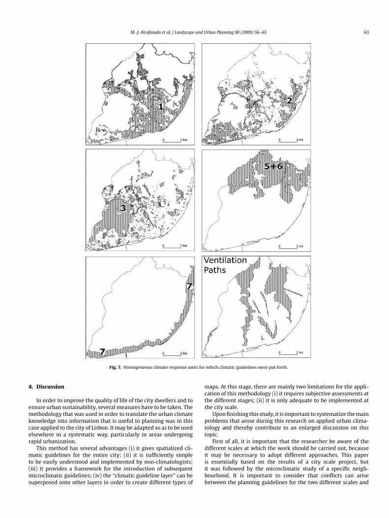
M.-J. Alcoforado et al. / Landscape and Urban Planning 90 (2009) 56–65 63
its for
4
emkcer
mt(ms
mctt
ptt
d
Fig. 7. Homogeneous climate response un
. Discussion
In order to improve the quality of life of the city dwellers and tonsure urban sustainability, several measures have to be taken. Theethodology that was used in order to translate the urban climate
nowledge into information that is useful to planning was in thisase applied to the city of Lisbon. It may be adapted so as to be usedlsewhere in a systematic way, particularly in areas undergoingapid urbanization.
This method has several advantages (i) it gives spatialized cli-
atic guidelines for the entire city; (ii) it is sufficiently simpleo be easily understood and implemented by non-climatologists;iii) it provides a framework for the introduction of subsequent
icroclimatic guidelines; (iv) the “climatic guideline layer” can beuperposed onto other layers in order to create different types of
iiibb
which climatic guidelines were put forth.
aps. At this stage, there are mainly two limitations for the appli-ation of this methodology (i) it requires subjective assessments athe different stages; (ii) it is only adequate to be implemented athe city scale.
Upon finishing this study, it is important to systematize the mainroblems that arose during this research on applied urban clima-ology and thereby contribute to an enlarged discussion on thisopic.
First of all, it is important that the researcher be aware of theifferent scales at which the work should be carried out, because
t may be necessary to adopt different approaches. This papers essentially based on the results of a city scale project, butt was followed by the microclimatic study of a specific neigh-ourhood. It is important to consider that conflicts can ariseetween the planning guidelines for the two different scales and

6 and U
twLpi
asucaGmoti
ppfsiwe12aaotwmactaao
apFcu
5
ntktoaHtpsho
camp
afowttaa
Bmrptppg
A
vpctfmfoo(tGL
R
A
A
A
A
A
A
A
A
B
B
B
4 M.-J. Alcoforado et al. / Landscape
hat have to be dealt with. For example, large ventilation pathsere recommended at the settlement scale, whereas in certain
isbon city districts, guidelines were put forth that included therovision of shelter in certain outdoor areas used for leisure activ-
ties.Secondly, adequate climatic and geographical databases and
ppropriate cartographical tools are indispensable. Data from “clas-ical” meteorological stations are not appropriate in the context ofrban studies. Over the last few decades, there have been signifi-ant developments in the field of the measurement methodologiesnd data collection techniques used in urban areas (Oke, 2004;rimmond, 2006). The advances in modelling and the improve-ent of the measurement devices have made it possible to carry
ut the present study. Obviously, it is also necessary to rely on up-o-date, detailed and accurate geographical data (including satellitemages), as well as on the use of GIS.
Third, at the beginning of each study, it is crucial that the mainlanning needs be identified and highlighted, in order to make itossible to mitigate the negative impacts and maximize the positive
eatures of the urban climate. In areas with contrasting thermal sea-ons, the UHI may be a positive feature in the winter, but negativen the summer. The energy saving that occurs in the winter in cities
ith a Mediterranean climate is less significant than the additionalxpenses incurred into in cooling the cities in the summer (Givoni,998; Hassid et al., 2000; Akbari et al., 2001; Santamouris et al.,001). Moreover, higher temperatures have a number of other neg-tive consequences, such as the increase in morbidity and mortalityssociated with heat waves (Kalkstein, 1997; Koppe et al., 2004),xidant pollution, bacteria proliferation, among other things. Allhese problems of urban areas are aggravated in a context of globalarming. This study adopts therefore the stand that UHI must beitigated. However, a case-by-case assessment must be carried out
nd accordingly, the solutions must always be tailored to the spe-ific circumstances of the areas under study. Similar decisions haveo be made with regard to other climatic elements, such as radi-tion, wind, driving rain, snow, etc. The climatic guidelines thatre put forth virtually always represent a compromise between theptimal measures to address each climatic aspect (Zrudlo, 1988).
Fourth, the interaction with the planners is obviously indispens-ble. The dialogue with Lisbon City planners grew easier as workrogressed and parts of some maps were in fact jointly drawn.urthermore, an effort is being made to disseminate the idea thatlimatic guidelines should be systematically included in planningrban municipalities.
. Concluding remarks
The metutopia, referred to by Landsberg in 1973, obviously can-ot be attained; however, it is possible to make headway towardshe high climatic quality city, as defined by Bitan in 1992. It is wellnown that planning involves quite complex procedures, and thathe climatic aspects are seldom considered as the most importantnes, as other environmental and socio-economic features are usu-lly afforded greater priority in the selection of planning measures.owever, both planners and the public should bear in mind that
aking the climate into account in the selection of the planningrocedures may also have a number of economic and social con-equences, namely with respect to energy consumption and theealth of the urban dwellers; this pays testimony to the importancef applied climatic urban studies.
It was not until the late 20th century that joint research wasarried out by a number of university departments (quoted above)longside city authorities, aimed at incorporating climatic infor-ation in urban planning. In the Portuguese case, this research
roved an excellent opportunity to move from theoretical consider-
B
D
rban Planning 90 (2009) 56–65
tions to applied research. Examples of simple climatic guidelinesor urban areas were provided because management plans usuallynly include general, and nearly always inadequate, considerationsith respect to the climate. The authors have also sought to con-
ribute to furthering the discussion with respect to the choice ofhe best methodology and to highlight the importance of system-tically carrying out these types of studies within the scope of citynd land use planning at a variety of scales.
Matzarakis (2005) states that “the impetus for the Climateooklet [for Urban Development (Baumüller, 2005)] was an amend-ent to Germany’s existing Federal Building Law with its new
equirements for consideration of climatic conditions in zoning andlanning”. There is still no legislation on this topic in Portugal, buthe fact that the present results are going to be published as a sup-lement to Lisbon’s Master Plan may contribute towards increasingublic awareness of the importance of the introduction of climateuidelines in urban planning.
cknowledgements
We would like to thank Prof. Wilfried Endlicher (Humboldt Uni-ersity of Berlin) and Prof. Heinz Wanner (University of Bern) forroviding us with several unpublished reports on urban appliedlimatic studies in Germany and Switzerland. Thanks are also dueo Professor Eberhard Parlow (University of Basel) for the fruit-ul discussions on this subject and for his advice concerning the
ethodology followed in this research. The authors are also grate-ul to the anonymous reviewers for providing valuable commentsn this study. This research work was carried out within the ambitf three projects: CLIMLIS (POCTI/34683/GEO/2000) and UrbKlimPOCI/GEO/61148/2004), both financed by FCT and FEDER (Opera-ional Programme for Science and Innovation 2010) and “Climaticuidelines for Planning in Lisbon”, financed by the Municipality ofisbon.
eferences
kbari, H., Pomerantz, M., Taha, H., 2001. Cool surfaces and shade trees to reduceenergy use and improve air quality in urban areas. Sol. Energ. 70 (3), 295–310,doi:10.1016/S0038-092X(00)00089-X.
lcoforado, M.J., 1992. Lisbon’s Climate. Contrasts and thermal rhythms (in Por-tuguese with abstract in English). Lisbon, Centro de Estudos Geográficos.
lcoforado, M.J., Vieira, H., 2004. Urban climate in Portuguese management plans.Sociedade e Território 37, 101–116 (in Portuguese with abstract in English).
lcoforado, M.J., Andrade, H., 2006. Nocturnal urban heat island in Lisbon (Portugal):Main features and modelling attempts. Theor. Appl. Climatol. 84 (1–3), 151–159,doi:10.1007/s00704-005-0152-1.
lcoforado, M.J., Andrade, H., Lopes, A., Vasconcelos, J., Vieira, R., 2006. Observationalstudies on summer winds in Lisbon (Portugal) and their influence on daytimeregional and urban thermal patterns. Merhavim 6, 88–112 (Special Issue: ClimateEnviron.).
ndrade, H., 2003. Human bioclimate and air temperature in Lisbon (in Portuguesewith abstract in English). PhD Thesis, University of Lisbon.
ndrade, H., Vieira, R., 2007. A climatic study of an urban green space: the Gul-benkian Park in Lisbon (Portugal). Finisterra XLII (84), 27–46 (http://www.ceg.ul.pt/finisterra/).
ndrade, H., Alcoforado, M.J., 2008. Microclimatic variation of thermal comfort in adistrict of Lisbon (Telheiras) at night. Theor. Appl. Climatol. 225 (3–4), 225–237,doi:10.1007/s00704-007-0321-5.
aumüller, J., 2005. Stuttgart21”, Amt für Umweltschutz, Stuttgart, version 4. [CD-Rom].
aumüller, J., Hoffman, U., Reuter, U., 2005. Climate booklet for urban develop-ment. References for zoning and planning. Retrieved October 15, 2005, fromBaden-Württemberg Innenministerium Website: http://www.staedtebauliche-klimafibel.de.
erlin Department for Urban Development, 2004. Environmental Atlas Berlin.Retrieved April 10, 2008 from Urban and Environmental Information System
(UEIS) Website http://www.stadtentwicklung.berlin.de/umwelt/umweltatlas/.itan, A., 1992. The high climatic quality city of the future. Atmos. Environ. 26 (3),313–329.
oulos, L., Santamouris, M., Livada, I., 2004. Passive cooling of outdoor urban spaces.The role of materials. Sol. Energ. 77 (2), 231–249, doi:10.1016/j.solener.2004.04.005.

and U
E
E
F
G
G
H
H
K
K
KK
L
L
L
M
M
M
M
M
O
OO
O
O
O
P
S
S
S
S
S
S
SS
T
T
U
M.-J. Alcoforado et al. / Landscape
liasson, I., 2000. The use of climate knowledge in urban planning. Landsc. Urban.Plann. 48 (1–2), 31–44, doi:10.1016/S0169-2046(00)00034-7.
liasson, I., Upmanis, H., 2000. Nocturnal outflow from urban parks – implicationsfor the city ventilation. Theor. Appl. Climatol. 66, 95–107.
ehrenbach, U., Scherer, D., Parlow, E., 2001. Automated classification of planningobjectives for the consideration of climate and air quality in urban and regionalplanning for the example of the region of Basel/Swizerland. Atmos. Environ. 35(32), 5605–5615, doi:10.1016/S1352-2310(01)00205-9.
ivoni, B., 1998. Climate Considerations in Building and Urban Design. John Wiley& Sons, New York.
rimmond, C.S.B., 2006. Progress in measuring and observing the urban atmosphere.Theor Appl Climatol 84 (1–3), 3–22, doi:10.1007/s00704-005-0140-5.
assid, S., Santamouris, M., Papanikolaou, N., Linardi, A., Klitsikas, N., Georgakis,C., Assimakopoulos, D., 2000. The effect of the Athens heat island on airconditioning load. Energ. Build. 32 (2), 131–141, doi:10.1016/S0378-7788(99)00045-6.
öppe, P., 1999. The physiological equivalent temperature – a universal index for thebiometeorological assessment of the thermal environment. Int. J. Biometeorol.43 (2), 71–75, doi:10.1007/s004840050118.
alkstein, L.S., 1997. Climate and human mortality: relationships and mitigatingmeasures. In: Auliciems, A. (Ed.), Advances in Bioclimatology – Human Biocli-matology. Springer, Berlin, pp. 161–177.
oppe, C., Kovats, S., Jendritzky, G., Menne, B., 2004. Heat-waves: risks and responses.Health and Global Environmental Change Series No. 3, Copenhagen: RegionalOffice for Europe.
ratzer, A., 1937. Das Stadtklima. Vieweg, Braunschweig.uttler, W., Strassburger, A., 1999. Air quality measurements in urban green areas
– a case study. Atmos. Environ. 33 (24–25), 4101–4108, doi:10.1016/S1352-2310(99)00151-X.
andsberg, H., 1973. The meteorologically utopian city. Bulletin of the AmericanMeteorological Society 54 (2), 86–89.
opes, A., 2002. The influence of the growth of Lisbon on summer wind fields andits environmental implications. In: Proceedings of the Tyndall/CIB InternationalConference on Climate Change and the Built Environment: Manchester.
opes, A., 2003. Changes in Lisbon’s urban climate as a consequence of urban growth.Wind, surface UHI and energy budget (in Portuguese, with abstract in English).PhD Thesis, University of Lisbon, Lisbon.
atzarakis, A., Mayer, H., Iziomon, M.G., 1999. Applications of a universal thermalindex: physiological equivalent temperature. Int. J. Biometeorol. 43 (2), 76–84,doi:10.1007/s004840050119.
atzarakis, A., 2005. Urban climate research in Germany. IAUC Newsletter 11,4–6.
atzarakis, A., Rutz, F., Mayer, H., 2007. Modelling radiation fluxes in simple andcomplex environments: application of the Rayman model. Int. J. Biometeorol.
51, 323–334.ills, G., 2006. Progress towards sustainable settlements: a role for urban cli-matology. Theor. Appl. Climatol. 84 (1–3), 69–76, doi:10.1007/s00704-005-0145-0.
ortensen, N., Landberg, L., Troen, I., Petersen, E., 1993. Wind Atlas Analysis andApplication Program (WAsP) (Vol. I and II). Roskilde: Risø National Laboratory.
V
Z
rban Planning 90 (2009) 56–65 65
ke, T.R., 1984. Towards a prescription for the greater use of climatic principles in set-tlement planning. Energ. Build. 7 (1), 1–10, doi:10.1016/0378-7788(84)90040-9,doi:10.1007/s00704-005-0153-0.
ke, T.R., 1987. Boundary Layer Climates. Routledge, London.ke, T.R., 1989. The micrometeorology of the urban forest. Philos. Trans. R. Soc.
London Ser. B, Biol. Sci. 324, 335–349.ke, T.R., 2004. Initial guidance to obtain representative meteorological observations
at urban sites. World Meteorological Organization Instruments and ObservingMethods, Report no. 81. Geneva: WMO.
ke, T.R., 2006. Towards better scientific communication in urban climate. Theor.Appl. Climatol. 84 (1–3), 179–190.
ke, T.R., Johnson, G.T.M., Steyn, D.G., Watson, I.D., 1991. Simulation of surface urbanheat islands under ‘ideal’ conditions at night. Part 2: Diagnosis of causation.Boundary-Layer Meteorol. 56 (4), 339–358, doi:10.1007/BF00119211.
accione, M., 2003. Urban environmental quality and human wellbeing – asocial geographical perspective. Landsc. Urban. Plann. 65 (1–2), 19–30,doi:10.1016/S0169-2046(02)00234-7.
antamouris, M., Papanikolaou, N., Livada, I., Koronakis, I., Georgakis, C., Argiriou,A., Assimakopoulos, D.N., 2001. On the impact of urban climate on the energyconsumption of buildings. Sol. Energ. 70 (3), 201–216.
cherer, D., Fehrenbach, U., Feigenwinter, C., Beha, H.D., Parlow, E., Vogt, R., 1999.Improved concepts and methods in analysis and evaluation of the urban cli-mate for optimising urban planning processes. Atmos. Environ. 33 (24–25),4185–4193, doi:10.1016/S1352-2310(99)00161-2.
pronken-Smith, R.A., Oke, T.R., 1998. The thermal regime of urban parks in twocities with different summer climates. Int. J. Remote. Sens. 19 (11), 2085–2104.
teemers, K., 2003. Cities, energy and comfort: a PLEA 2000 review. Energ. Build. 35(1), 1–2, doi:10.1016/S0378-7788(02)00074-9.
tock, P.; Beckröge, W., 1985. Klimaanalyse Stadt Essen. KVR, PO15, Essen: Planung-shefte Ruhrgebiet.
tock, P., 1992. Climatic classification of town areas. in K. Höschele (Ed.), Planningapplications of urban and building climatology. Karlsruhe: Institut für Meteo-rologie und Klimaforschung.
tull, R., 2000. Meteorology for Scientists and Engineers. Brooks-Cole, Pacific Grove.zokolay, S.V., 1997. Bioclimatic Architecture and Solar Energy. In: Auliciems, A.
(Ed.), Advances in Bioclimatology – Human Bioclimatology. Springer, Berlin, pp.111–132.
hommes, W., Parlow, E., Paul, P., Gossmann, H., Schaub, O., 2001. Klima und Raum-planung. Reklip Projekt Schlussbericht 4, Basel: Editions Coprur.
zikopoulos, A.F., Karatza, M.C., Paravantis, J.A.M.C., 2005. Modelling energy effi-ciency of bioclimatic buildings. Energ. Build. 37 (5), 529–544, doi:10.1016/j.enbuild.2004.09.002.
pmanis, H., Eliasson, I., Andersson-Sköld, Y., 2001. Case studies of the spatial varia-tion of benzene and toluene concentrations in parks and adjacent built-up areas.
Water. Air. Soil. Pollut. 129 (1–4), 61–81.asconcelos, J., Lopes, A., 2006. Recent urban development trends and its impli-cation on the estuarine breezes in Lisbon, Portugal. In: Proceedings of the 6thInternational Conference on Urban Climate, Göteborg, pp. 466–469.
rudlo, L.R., 1988. A climatic approach to town planning in the Arctic. Energ. Build.11 (1–3), 41–63, doi:10.1016/0378-7788(88)90022-9.