Application of Climate information in the management of ... · Training Opportunities At KEWI 6...
37
Application of Climate information in the management of water resources Christopher Oludhe (Ph.D) Department of Meteorology University of Nairobi And IGAD Climate Prediction and Applications Centre (ICPAC) Workshop on Multi-Country Support Programme to Strengthen Climate information systems in Africa 13 – 14 April 2014, UN Conference Centre, Addis Ababa, Ethiopia.
Transcript of Application of Climate information in the management of ... · Training Opportunities At KEWI 6...
Application of Climate information in the management of water resources
Christopher Oludhe (Ph.D)Department of Meteorology
University of NairobiAnd
IGAD Climate Prediction and Applications Centre (ICPAC)
Workshop on Multi-Country Support Programme to Strengthen Climate information systems in Africa
13 – 14 April 2014, UN Conference Centre, Addis Ababa, Ethiopia.

Background• Extreme climate events are very common within the
IGAD sub-region and whenever they occur, they are associated with loss of life and property, destruction of infrastructure resulting in large losses to the economy and sometimes retarding national economic grown backwards by several years.
• Climate monitoring, prediction and timely early warning of such extreme climate events is one of the best strategies for mitigating the negative impacts resulting from these events.
• Climate information can also be used to improve crucial decisions required in all the components of an integrated disaster management namely early warning, prevention, mitigation, preparedness, relief and rescue, rehabilitation and reconstruction.

El Niño
Hail&Lightning
Avalanches
Flash floods
Tornadoes
Wildland fires
& haze
Hot & cold spells
Heavy precipitations
(rain or snow)
Droughts
Storm surges
Storm (winds)
River basin flooding
Mud & landslides
Ice Storms
Tropical cyclones
Dust storms
La Niña
Climate Hazards

Climate Impacts

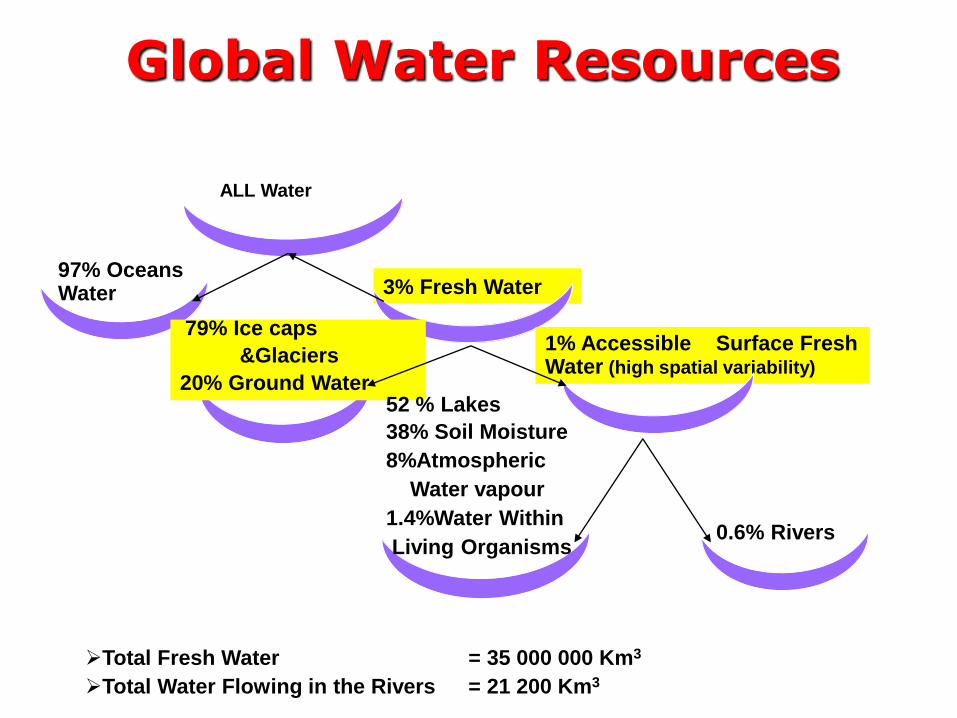
Water as a Resource• Water as a resource plays a major role in driving the
economy of a country and is practically used in all sectors and more so for domestic consumption in urban and rural areas, industries, energy generation, agriculture, livestock, fisheries among others.
• Rainfall is a major input into the hydrological cycle, hence surface water resources are greatly influenced by climatic factors.
• Climate variability and change strongly affects the spatial and temporal distribution of the water Resources
• Too much or too little water is a major concern to water managers and there is need to manage this resource for sustainable development of a country .
• Freshwater availability and access is a priority in many countries in Africa including the IGAD sub-region.
Training Opportunities At KEWI 6
0.6% Rivers
ALL Water
3% Fresh Water97% Oceans Water
1% Accessible Surface Fresh Water (high spatial variability)
Total Fresh Water = 35 000 000 Km3
Total Water Flowing in the Rivers = 21 200 Km3
79% Ice caps
&Glaciers
20% Ground Water52 % Lakes
38% Soil Moisture
8%Atmospheric
Water vapour
1.4%Water Within
Living Organisms
Global Water Resources

• The main factors contributing to water stress are population growth, irrigation, and livestock watering, droughts and deforestation, poor land management, and pollutionfrom human activities and industry.

Climate information needs in the Water Sector
• Efficient management of water resources.
• Reservoir (Dam) planning and operations
• Hydropower generation
• Development of appropriate water harvesting techniques
• Development of flood early warning systems
• Flood Hazard (risk) mapping and management
• Water conservation, regulation and allocation
• Ensuring water security for various socio economic activities

Role of ICPAC in the GHA
• The IGAD Climate Prediction and Applications Centre (ICPAC), formerly known as the Drought Monitoring Centre, Nairobi (DMCN), is a specialized regional centre of the Inter-Governmental Authority on Development (IGAD) charged with the responsibility of climate monitoring, prediction, early warning and applications for the reduction of climate related risks including those associated with climate variability and change.
• ICPAC serves 11 member countries within the GHA which include Kenya, Uganda, Tanzania, Rwanda, Burundi, Somalia, Ethiopia, South Sudan, Sudan, Eritrea and Djibouti.

Operational Activities
• Development and archiving of regional and national quality controlled climate databanks
• Data processing including development of basic climatologicalstatistics
• Timely acquisition of near real-timeclimate and remotely sensed data
• Monitoring space-time evolutions of weather and climate extremes over the region
• Generation of climate prediction and early warning products
• Timely dissemination of early warning products
• Climate change monitoring, detection and attribution including climate change modeling.
• Delineation of risk zones of the extreme climate related events
• Downscaling of global climate forecasts to regional and national levels
• Conduct capacity building activities in the generation and application of regional tailored climate products relevant to user needs
• Organization of Climate Outlook Forums (COFs) for the GHA countries
• Enhancement of interactions with users through users workshops and pilot application projects
• Enhanced networking with the NMHSs, regional and international centers for data and information exchange
• Promoting technical capacity building at NMHS level (e.g. acquisition of hardware, software, etc.), as required for implementation of climate services.

Climate Monitoring Indicators at ICPACThe frequently used indicators for monitoring,analyzing and predicting extreme climate events atICPAC include:
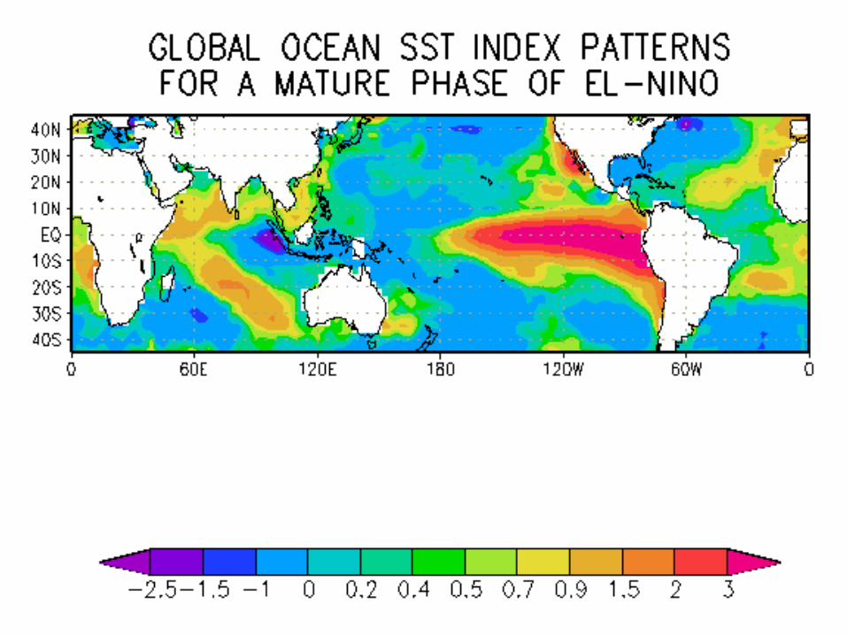
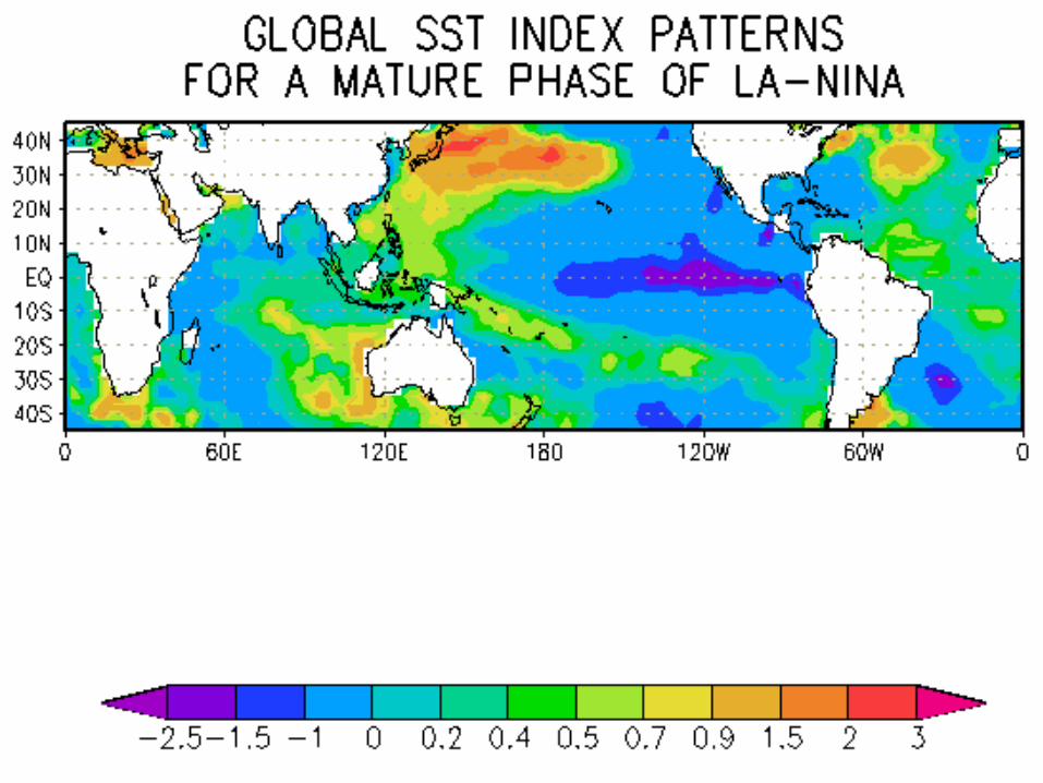
•Sea Surface Temperatures (SSTs)
•El-Niño Southern Oscillation (ENSO) Indices
•Indian Ocean Dipole (IOD)
•Tropical Cyclones (TC)
•Inter-Tropical Convergence Zone (ITCZ)
•Surface and Upper Air winds,
•Air Temperature
•Humidity among others

Niño Areas
Nino 3.4 Index

ENSO Impacts
ENSO - El Nino Southern Oscillation - Worldwide impacts

Indian Ocean Dipole (IOD)

IOD AND EL NINO LINKAGES
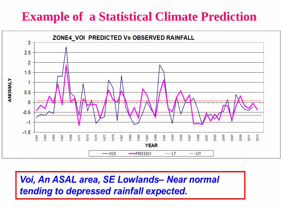
Example of a Statistical Climate Prediction
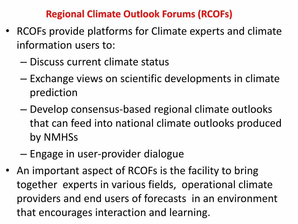
Regional Climate Outlook Forums (RCOFs)
• RCOFs provide platforms for Climate experts and climate information users to:
– Discuss current climate status
– Exchange views on scientific developments in climate prediction
– Develop consensus-based regional climate outlooks that can feed into national climate outlooks produced by NMHSs
– Engage in user-provider dialogue
• An important aspect of RCOFs is the facility to bring together experts in various fields, operational climate providers and end users of forecasts in an environment that encourages interaction and learning.

Regional Climate Outlook Forums Worldwide
NEBCOFNEBCOF
SASCOF
PRESANORD
EASCOF
ASEANCOF
NEACOF
CARICOF
SWIOCOF
MedCOF

A SECTION OF GHACOF35 PARTICIPANTS - (August 2013, Eldoret, Kenya)

Examples of ICPAC Tailored Products, Partnership and Community Service
Projects

Comparison between Observed and Predicted Thiba OND Inflow anomaly between 1982 - 2001
-1.5
-1
-0.5
0
0.5
1
1.5
2
2.5
3
3.5
1982
1983
1984
1985
1986
1987
1988
1989
1990
1991
1992
1993
1994
1995
1996
1997
1998
1999
2000
2001
Years
Infl
ow a
nom
aly
ThibaOND-OBS
ThibaOND-PRED
Comparison between Observed and Predicted Thiba OND Inflow anomaly between 1982 - 2001
-1.5
-1
-0.5
0
0.5
1
1.5
2
2.5
3
3.5
1982
1983
1984
1985
1986
1987
1988
1989
1990
1991
1992
1993
1994
1995
1996
1997
1998
1999
2000
2001
Years
Infl
ow a
nom
aly
ThibaOND-OBS
ThibaOND-PRED
Masinga Dam Tailored Forecasts during the 1999/2000 La-Nina Drought
KenGen

MOU between KRCS and ICPAC
ICPAC – Seasonal
predictions and early
warnings
KMD – 4 day, weekly,
bi-weekly, monthly forecasts.
Indigenous Knowledge
and partnership with
community
KRCS’ Strategic Partnership in Climate Information ( Forecast/ Prediction)

Example of Turning El Nino into an Opportunity• Kenya Red Cross used the downscaled COF 2009 SOND Forecasts (El-nino Year)
to distributes seeds worth Ksh. 30 Million (US$ 350,000) in a drought prone Ukambani area and reaped a bumper harvest estimated at a Ksh. 2.5 billion (US$ 30M).
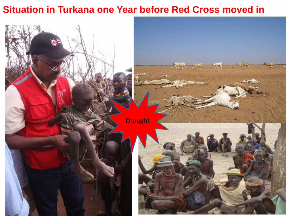
Situation in Turkana one Year before Red Cross moved in
Drought

Greenhouses and Water harvesting changing lives in Turkana
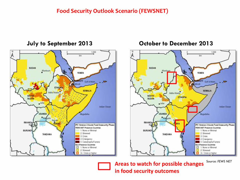
Source: FEWS NET
July to September 2013 October to December 2013
Areas to watch for possible changes in food security outcomes
Food Security Outlook Scenario (FEWSNET)

Forecast Translation (FEWSNET)
MAM 2014 Outlook MAM 2014 Rainfall Amounts
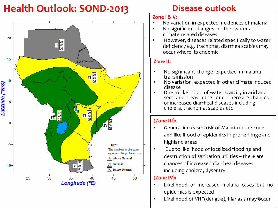
Health Outlook: SOND-2013Zone I & V:• No variation in expected incidences of malaria • No significant changes in other water and
climate related diseases • However, diseases related specifically to water
deficiency e.g. trachoma, diarrhea scabies may occur where its endemic
Disease outlook
30
Zone II:
• No significant change expected in malaria transmission
• No variation expected in other climate induced disease
• Due to likelihood of water scarcity in arid and semi-arid areas in the zone– there are chances of increased diarrheal diseases including cholera, trachoma, scabies etc
(Zone III):
• General increased risk of Malaria in the zone
and likelihood of epidemics in prone fringe and
highland areas
• Due to likelihood of localized flooding and
destruction of sanitation utilities – there are
chances of increased diarrheal diseases
including cholera, dysentry
(Zone IV):
• Likelihood of increased malaria cases but no
epidemics is expected
• Likelihood of VHF(dengue), filariasis may occur

SAFARICOM
ICPAC SMS
SERVER
RERU
OLOITOKITOK
NGANYI
NYAHERA
The Server is used to simultaneously and rapidly broadcast information through an SMS to selected registered users. It will be customized to allow receiving feedback from the users.
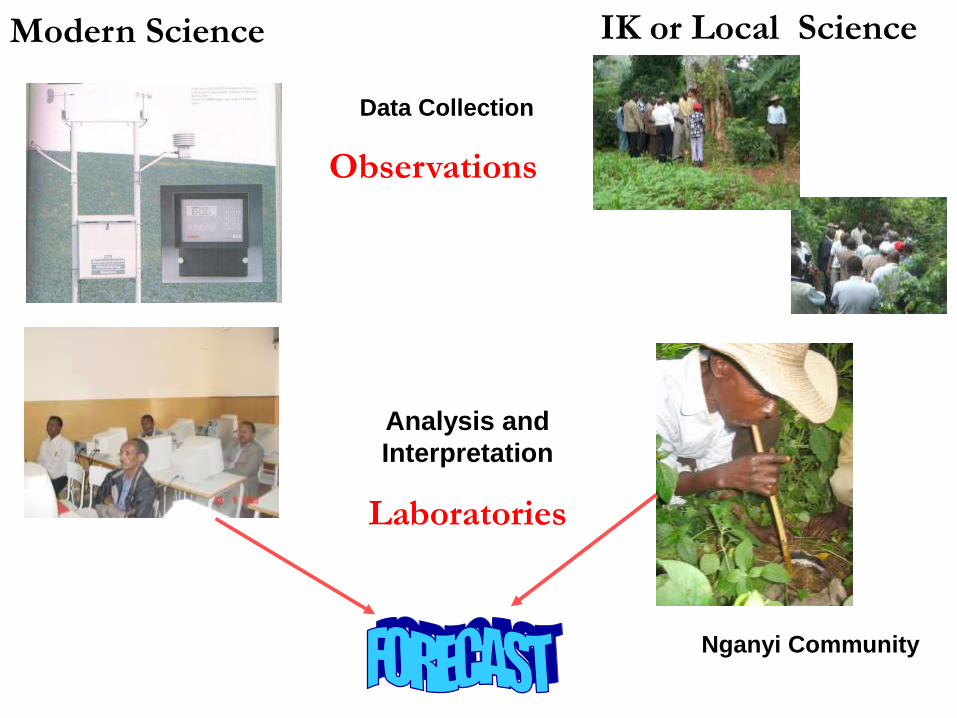
Data Collection
Observations
Analysis and
Interpretation
Laboratories
Modern Science IK or Local Science
Nganyi Community

ICPAC’s Regional
Climate Outlook
Forum
NHMS National
Forecast
NHMS Downscaling of
National Forecast
Local Forecasts Based on
Indigenous/Traditional
Knowledge
Consensus Meeting between
NHMS Scientists and the Local
Forecasters to Produce a
Merged Local Forecast
Meeting with District Government Line Ministry
Officers, Community Leaders, Local Seed
Company Representatives and others to
Develop Relevant Sectoral Advisories with
Respect to the Merged Forecast
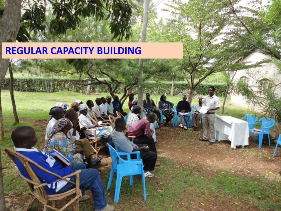
REGULAR CAPACITY BUILDING

FARMERS MAKE INFORMED DECISIONS ABOUT THE TECHNOLOGIES TO EMPLOY
CONCLUSIONS
• Weather/Climate monitoring and prediction is oneof the best strategies for mitigating the negativeimpacts of weather/climate related disasters.
• ICPAC plays an important role in providing the IGAD subregion with weather and climate advisories and more importantly, timely early warnings on extreme climate events
• The use of these predictions products can help countries put measures in place to mitigate against some of the adverse impacts of extreme climate events.

THANK YOU