Application No: Y16/0623/SH Location of Site: Little ... · The Galeri Victoria Dock Caernarfon...
47
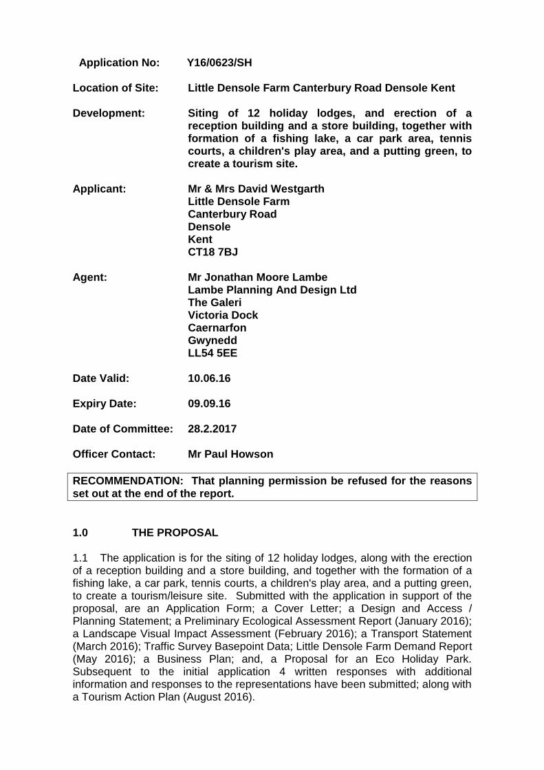
Application No: Y16/0623/SH Location of Site: Little Densole Farm Canterbury Road Densole Kent Development: Siting of 12 holiday lodges, and erection of a reception building and a store building, together with formation of a fishing lake, a car park area, tennis courts, a children's play area, and a putting green, to create a tourism site. Applicant: Mr & Mrs David Westgarth Little Densole Farm Canterbury Road Densole Kent CT18 7BJ Agent: Mr Jonathan Moore Lambe Lambe Planning And Design Ltd The Galeri Victoria Dock Caernarfon Gwynedd LL54 5EE Date Valid: 10.06.16 Expiry Date: 09.09.16 Date of Committee: 28.2.2017 Officer Contact: Mr Paul Howson RECOMMENDATION: That planning permission be refused for the reasons set out at the end of the report. 1.0 THE PROPOSAL 1.1 The application is for the siting of 12 holiday lodges, along with the erection of a reception building and a store building, and together with the formation of a fishing lake, a car park, tennis courts, a children's play area, and a putting green, to create a tourism/leisure site. Submitted with the application in support of the proposal, are an Application Form; a Cover Letter; a Design and Access / Planning Statement; a Preliminary Ecological Assessment Report (January 2016); a Landscape Visual Impact Assessment (February 2016); a Transport Statement (March 2016); Traffic Survey Basepoint Data; Little Densole Farm Demand Report (May 2016); a Business Plan; and, a Proposal for an Eco Holiday Park. Subsequent to the initial application 4 written responses with additional information and responses to the representations have been submitted; along with a Tourism Action Plan (August 2016).
Transcript of Application No: Y16/0623/SH Location of Site: Little ... · The Galeri Victoria Dock Caernarfon...
Application No: Y16/0623/SH
Location of Site: Little Densole Farm Canterbury Road Densole Kent Development: Siting of 12 holiday lodges, and erection of a
reception building and a store building, together with formation of a fishing lake, a car park area, tennis courts, a children's play area, and a putting green, to create a tourism site.
Applicant: Mr & Mrs David Westgarth Little Densole Farm Canterbury Road Densole Kent CT18 7BJ Agent: Mr Jonathan Moore Lambe Lambe Planning And Design Ltd The Galeri Victoria Dock Caernarfon Gwynedd LL54 5EE Date Valid: 10.06.16 Expiry Date: 09.09.16 Date of Committee: 28.2.2017 Officer Contact: Mr Paul Howson
RECOMMENDATION: That planning permission be refused for the reasons set out at the end of the report.
1.0 THE PROPOSAL 1.1 The application is for the siting of 12 holiday lodges, along with the erection of a reception building and a store building, and together with the formation of a fishing lake, a car park, tennis courts, a children's play area, and a putting green, to create a tourism/leisure site. Submitted with the application in support of the proposal, are an Application Form; a Cover Letter; a Design and Access / Planning Statement; a Preliminary Ecological Assessment Report (January 2016); a Landscape Visual Impact Assessment (February 2016); a Transport Statement (March 2016); Traffic Survey Basepoint Data; Little Densole Farm Demand Report (May 2016); a Business Plan; and, a Proposal for an Eco Holiday Park. Subsequent to the initial application 4 written responses with additional information and responses to the representations have been submitted; along with a Tourism Action Plan (August 2016).
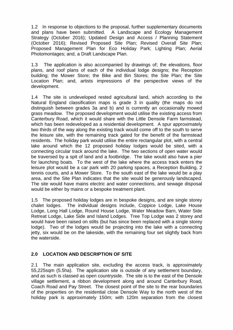
1.2 In response to objections to the proposal, further supplementary documents and plans have been submitted. A Landscape and Ecology Management Strategy (October 2016); Updated Design and Access / Planning Statement (October 2016); Revised Proposed Site Plan; Revised Overall Site Plan; Proposed Management Plan for Eco Holiday Park; Lighting Plan; Aerial Photomontages; and, a Draft Landscape Plan. 1.3 The application is also accompanied by drawings of; the elevations, floor plans, and roof plans of each of the individual lodge designs; the Reception building; the Mower Store; the Bike and Bin Stores; the Site Plan; the Site Location Plan; and, artists impressions of the perspective views of the development. 1.4 The site is undeveloped rested agricultural land, which according to the Natural England classification maps is grade 3 in quality (the maps do not distinguish between grades 3a and b) and is currently an occasionally mowed grass meadow. The proposed development would utilise the existing access from Canterbury Road, which it would share with the Little Densole Farm farmstead, which has been redeveloped as a residential development. A spur approximately two thirds of the way along the existing track would come off to the south to serve the leisure site, with the remaining track gated for the benefit of the farmstead residents. The holiday park would utilise the entire rectangular plot, with a central lake around which the 12 proposed holiday lodges would be sited, with a connecting circular track around the lake. The two sections of open water would be traversed by a spit of land and a footbridge. The lake would also have a pier for launching boats. To the west of the lake where the access track enters the leisure plot would be a car park with 20 parking spaces, a Reception Building, 2 tennis courts, and a Mower Store. To the south east of the lake would be a play area, and the Site Plan indicates that the site would be generously landscaped. The site would have mains electric and water connections, and sewage disposal would be either by mains or a bespoke treatment plant. 1.5 The proposed holiday lodges are in bespoke designs, and are single storey chalet lodges. The individual designs include, Coppice Lodge, Lake House Lodge, Long Hall Lodge, Round House Lodge, Water Meadow Barn, Water Side Retreat Lodge, Lake Side and Island Lodges. Tree Top Lodge was 2 storey and would have been raised on stilts (but has since been replaced with a single storey lodge). Two of the lodges would be projecting into the lake with a connecting jetty, six would be on the lakeside, with the remaining four set slightly back from the waterside. 2.0 LOCATION AND DESCRIPTION OF SITE 2.1 The main application site, excluding the access track, is approximately 55,225sqm (5.5ha). The application site is outside of any settlement boundary, and as such is classed as open countryside. The site is to the east of the Densole village settlement, a ribbon development along and around Canterbury Road, Coach Road and Pay Street. The closest point of the site to the rear boundaries of the properties on the residential close Densole Way to the north west of the holiday park is approximately 150m; with 120m separation from the closest

properties on Densole Lane; and to the south west there is approximately 190m from the rear perimeter of the properties on Canterbury Road, all of which form the settlement boundary. This space separation is agricultural land in the form of an existing grass meadow green buffer. The above mentioned Densole settlement boundary wraps around the leisure plot on its western side, separated by the aforementioned buffer. The green buffer also extends to the north of the site, separating the proposed development from the farmstead residential development which is made up of 6 large detached homes (approximately 170m from the proposed holiday park). The holiday park abuts Reinden Wood (Ancient Woodland) on its eastern flank (which is an MOD training area). Adjacent to the south west corner of the plot is Swingfield Radio Mast served by an ancillary brick building. These are the only man-made structures in the immediate vicinity of the plot, other than the post and wire / post and rail enclosing fence, and a small stable approximately 50m to the north. 2.2 The site is relatively level flat open countryside, afforded significant protection through its nationally designated status as part of the Kent Downs Area of Outstanding Natural Beauty, and local designation as a Special Landscape Area. Reinden Wood to the east of the site is classified as Ancient Woodland; and as a Local Wildlife Site. The eastern section of the site is in an Area of Archaeological Potential. The site is part of a wider parcel of unspoilt open countryside to the east of the Densole settlement boundary, which would have formed part of the Little Densole Farm agricultural unit, when it was a working farm. There are no public footpaths crossing the holiday park, but the new access road would cross a public footpath, and there is a bridleway that runs adjacent to the eastern boundary on the western perimeter of the woodland, from where the site would be visible. Views from the public domain to the west are restricted by the private residential properties.
3.0 RELEVANT PLANNING HISTORY
89/0659/SH - Outline application for the erection of 77 dwellings. Refused 02.08.89.
91/0658/SH - Change of use of redundant agricultural buildings
to class B1 use and B8 use. Approved with conditions 31.10.91.
Y02/0061/SH - Conversion of outbuilding to a residential annexe.
Approved with conditions 20.03.02. Y02/1128/SH - Outline application for the erection of five dwellings
following demolition of existing industrial and storage buildings. Approved with conditions 10.01.03.
Y07/0222/SH - Outline application for the erection of four detached
dwellings with garages together with erection of a detached garage for use in connection with existing dwelling, following demolition of existing workshop,
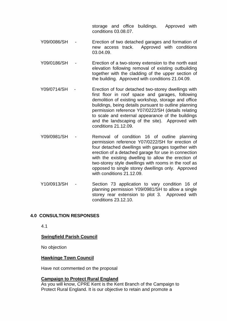
storage and office buildings. Approved with conditions 03.08.07.
Y09/0086/SH - Erection of two detached garages and formation of
new access track. Approved with conditions 03.04.09.
Y09/0186/SH - Erection of a two-storey extension to the north east
elevation following removal of existing outbuilding together with the cladding of the upper section of the building. Approved with conditions 21.04.09.
Y09/0714/SH - Erection of four detached two-storey dwellings with
first floor in roof space and garages, following demolition of existing workshop, storage and office buildings, being details pursuant to outline planning permission reference Y07/0222/SH (details relating to scale and external appearance of the buildings and the landscaping of the site). Approved with conditions 21.12.09.
Y09/0981/SH - Removal of condition 16 of outline planning
permission reference Y07/0222/SH for erection of four detached dwellings with garages together with erection of a detached garage for use in connection with the existing dwelling to allow the erection of two-storey style dwellings with rooms in the roof as opposed to single storey dwellings only. Approved with conditions 21.12.09.
Y10/0913/SH - Section 73 application to vary condition 16 of
planning permission Y09/0981/SH to allow a single storey rear extension to plot 3. Approved with conditions 23.12.10.
4.0 CONSULTION RESPONSES
4.1
Swingfield Parish Council No objection Hawkinge Town Council Have not commented on the proposal
Campaign to Protect Rural England As you will know, CPRE Kent is the Kent Branch of the Campaign to Protect Rural England. It is our objective to retain and promote a

beautiful and thriving countryside that is valued by everyone and we believe the planning system should protect and enhance the countryside in the public interest for the important contribution it makes to peoples' physical and mental wellbeing, as well as its vital role in feeding the nation. It is our position that local planning authorities should seek to ensure that the impact of development on the countryside, both directly and indirectly, is kept to a minimum and that development is sustainable in accordance with national planning policy. We have looked very closely at this application and the supporting documentation, and we are familiar with the site. We would like to make the following comments. General Points Section 38(6) of the Planning and Compulsory Purchase Act 2004 requires planning applications to be determined in accordance with the Development Plan unless other material planning considerations indicate that a different decision should be made. This plan-led approach to development is endorsed and enshrined in the National Planning Policy Framework (NPPF - e.g. as explained in paragraph 196). Consequently, the saved policies in the Shepway District Local Plan 2008 will comprise the primary consideration, though the NPPF, the emerging plan and other relevant guidance (including a range of SPD's) will be important material considerations. In this response CPRE will mention policies SD1, CO2, CO4 and C011 of the Shepway District Local Plan Review (2006) and policies SS1, SS3,CSD3 and CSD4 of the Shepway Core Strategy (2013). These policies are consistent with the aims and objectives of the NPPF which seek to ensure that planning takes account of the different roles and function of different areas. In this case, CPRE'S primary concerns are as follows: 1. The proposal harms the landscape and scenic beauty of the AONB 2. The proposal does not accord with the spatial strategy for future development of the district 3. The proposal does not demonstrate protection and enhancement of biodiversity. 4. The proposal does not deliver sustainable development. Harm to the landscape and scenic beauty of the AONB Policy CSD4 of the Core Strategy (2013) requires planning decisions to have close regard to conservation and enhancement of the AONB, which will take priority over other planning considerations. This is consistent with the aims and objectives of the NPPF. Paragraph 115 of the NPPF provides guidance on the treatment of high value environmental assets, stating that 'great weight should be given to conserving landscape and scenic beauty in AONBs which have the highest status of protection in relation to landscape and scenic beauty'. In turn, this responds to the statutory duty of regard in Section 85 of the Countryside and Rights of Way Act 2000 which makes the following statement:
"In exercising or performing any functions in relation to, or so as to affect, land in an area of outstanding natural beauty, a relevant authority shall have regard to the purpose of conserving or enhancing the natural beauty of the area of outstanding natural beauty." This duty of regard is therefore a statutory duty. Policies and guidance in the Kent Downs AONB Management Plan, which has been adopted by the Council, is an important element in demonstrating that the Council has had regard purposes of the designation. Planning Practice Guidance clarifies that (ID: 8-004-20140306) regard should be had to management plans, since they underpin partnership working and delivery of designation objectives. Sustainable Development Policies and policy VC6 are particularly relevant. Policy VC6 states: `The development of sustainable visitor and tourism facilities will be pursued where they enhance people's enjoyment and understanding of the AONB without detracting from the special characteristics and qualities'. This clearly explains that proposals for economic development and tourism facilities should not detract from the special characteristic and qualities of the AONB. It is the view of CPRE that while sustainable tourism, of an appropriate scale, design and location can be appropriate within an AONB, conserving landscape and scenic beauty is critical to meeting statutory requirements; meeting the requirements of the NPPF and satisfying the Council's development plan policies. This is an open arable site located within the East Kent Downs Character Area. The proposal represents an isolated development that would be an incongruous addition to this agricultural landscape. The scale of the development, together with its inappropriate location and the poor relationship to the existing settlement, would result in a notable harm to the intrinsic rural character and appearance of the area and detract from the natural beauty and appearance of the AONB. The buildings respond poorly to their sensitive location, and fail to promote local distinctiveness in terms of materials, design and layout. The landscaping, including the artificial lake, surface treatments and recreation provision will result in a cluttered and residential appearance to the site. Lighting and vehicle movements would result in harm to tranquillity of the area and characteristic dark skies. Furthermore, the proposal would interrupt the existing transition from the settlement to the wider countryside, to the detriment of the AONB and the enjoyment of it by nearby residents. Spatial strategy for future development of the district Policies SS1 and 5S3 of the Core Strategy (2013) set out the spatial strategy for future development of the district. The proposal site lies outside the designated settlement boundary of Densole defined by this plan and is within the Kent Downs AONB. Policy SS1 states that 'development in the open countryside ... will only be allowed exceptionally where a rural ... location is essential' and 'the future spatial priority for new development in the North Downs area is
on accommodating development outside of the AONB...'. Similarly Policy CO1 of the Local Plan Review (2006) seeks to protect the countryside for its own sake, subject to a number of criteria, including maintaining features of landscape, wildlife, historic, geological and agricultural and the particular character and quality of the countryside. Policy SS3 directs development towards sustainable settlements to protect the open countryside, with any development being proportionate to the settlements strategic role. The identified strategic role for Densole is as a Secondary Village where the purpose is to provide crucial rural facilities in line with 'local needs, their environment, and role as relatively small country settlements' Policy CSD3 of the Core Strategy defines exceptional circumstances in which development will be acceptable outside the settlement hierarchy. It encourages tourist uses to be allowed within defined settlements in the settlement network. Where sites are not available within settlements, the policy specifies appropriately scaled and accessible developments may be acceptable on the edge of Strategic Towns, and Services Centres and failing that Rural Centres and Primary Villages. The strategic role of Densole as a Secondary village is continued in the Council's LDF Issues and Options Document. It is in the public interest for the Council to select the most sustainable and suitable sites and the applicant has not demonstrated that they have sought sequentially preferable sites at locations specified in Policy CSD3. It is clear the proposal site would involve loss of countryside close to a secondary village, contrary to the spatial strategy of the Development Plan. In addition, the site comprises land that is in agricultural production. Food security and maintaining the ability to feed a growing population is an increasingly important national and social issue, meaning that giving up agricultural land for development should be robustly justified. It is not clear from the application whether the site is Best and Most Versatile Agricultural Land and this should be established. National planning policy seeks to protect such land and to steer development to land of lower quality. This is explicitly explained in paragraph 112 of the NPPF, which states: "Where significant development of agricultural land is demonstrated to be necessary, local planning authorities should seek to use areas of poorer quality land in preference to that of a higher quality." A proposal, such as this, that is not located to satisfy the spatial strategy for the District will inevitably be poorly located in terms of access to services and will result in large numbers of vehicle movements in a quiet rural location. This will have a detrimental impact on the amenities of nearby properties and would not satisfy the NPPF policy (para 34) to ensure developments are located where the need to travel will be minimised and the use of sustainable transport modes will be maximised. There will be an inevitable reliance on the private car to access services. Biodiversity The site is located adjacent to Reinden Wood LWS which is part of the East Kent Woodland and Downs Biodiversity Opportunity Area. It is also Ancient Woodland.
Policy CSD4 of the Core Strategy (2013) seeks to protect green infrastructure and it also promotes management of the GI network with a focus on a number of issues, including protection and enhancement of biodiversity, particularly in green corridors and other GI Strategic Opportunities. Policy C011 of the Local Plan Review (2006) seeks to protect protected species and habitats, priority species identified in the UK Biodiversity Action Plan as well other landscapes and habitats of importance for nature conservation. Paragraph 118 of the NPPF sets out requirements in more detail. It states that in determining planning applications, the aim should be to conserve and enhance biodiversity by applying certain principles, including that if significant harm resulting from a development cannot be avoided (through locating on an alternative site with less harmful impacts), adequately mitigated, or, as a last resort, compensated for, then planning permission should be refused. The planning application does not provide the information required to assess the impact of the proposed development on the woodland and the species associated with it. Recreational use of the site (off road cycling and dog walking in particular) is likely be a concern, as will woodland edge impacts associated with the development. Lighting proposals have a potentially significant effect on nocturnal navigation and feeding of numerous species, including bats. Although mitigation has been proposed, CPRE does not believe that the proposal has demonstrated that it will conserve and enhance biodiversity. Additional survey work and mitigation/enhancement measures are required. Broad habitat enhancements are necessary to mitigate the impacts of development, provide net gains in biodiversity, and contribute to the Government's commitment to halt the overall decline in biodiversity, including establishing coherent ecological networks. Sustainable development and the planning balance At paragraph 6-7, the NPPF sets out that the purpose of the planning system is to contribute to the achievement of sustainable development of which there are 3 dimensions; economic, social and environmental, and which should not be undertaken in isolation. Policy SD1 of the Local Plan Review requires development proposals to take account of the broad aim of sustainable development, and specifies numerous environmental criteria. These include shaping new development patterns to reduce the need to travel and protecting and enhancing the Kent Downs AONB and SLA. Although this scheme may have some limited employment and investment benefits consistent with the economic dimension of sustainable development, it is important give significant weight in the planning balance to the environmental harm: The site is in an unsustainable location that does not satisfy the spatial strategy of the development plan. The development would be harmful to the conservation and enhancement of the natural beauty of the AONB. There is insufficient information to demonstrate that the proposal would not be harmful to protected habitats and species. This considerable environmental impact is not sustainable and the presumption in favour of sustainable development should not be engaged.

The adverse impacts of the scheme and to the AONB in particular, clearly outweigh the benefits. Conclusion It is the view of CPRE that the proposal would not satisfy development plan policies, nor the NPPF. To permit the development proposed would not satisfy the statutory duty of regard to the purpose of conserving or enhancing the natural beauty of the Area of Outstanding Natural Beauty. Harm to the landscape and scenic beauty of this nationally important landscape would be significant and this should attract 'great weight' in the planning decision. The proposal is not consistent with the aims and objectives of the NPPF, nor the local plan spatial strategy that seek to ensure that planning takes account of the different roles and function of different areas. The limited economic and investment benefits certainly do not amount to the 'exceptional circumstances' required by para 116 of the NPPF. As such the proposal cannot be considered sustainable development and the application should be refused. Sites like this, close to settlements, are especially vulnerable to proposals such as these, and nothing in this application serves as a justification for a relaxation of the usual controls. East Kent Badger Group We strongly advise an ecological survey be carried out. We know of badgers in this area. No further comments received following further submission of information. Kent Downs AONB Unit Thank you for your consultation on the above application. The following comments are from the Kent Downs AONB Unit and as such are at an officer level and do not necessarily represent the comments of the whole AONB partnership. The legal context of our response and list of AONB guidance is set out as Appendix 1 below. Little Densole Farm is located in the Kent Downs AONB. The application should therefore be tested against the purpose of the designation, to conserve and enhance the natural beauty of the Kent Downs AONB and the way that this purpose is represented in local and national policy. We have visited the site and reviewed the application documentation. The application site lies within the East Kent Downs Landscape Character Area. The site lies outside of any built settlement in open countryside, being separated from the built confines of Densole village by fields. Despite the proximity of the site to Densole village, the landscape character of the site is of a rural arable field which is consistent with the immediate environs of the site which is of a rural landscape, predominantly made up of arable fields interspersed with wooded areas, typical of the East Kent Downs landscape character area within which the site is located. The application comprises the siting of twelve holiday lodges together with ancillary facilities including tennis courts, car parking and a fishing lake, along with the provision of a new access road. The holiday lodges are of varying

sizes and designs and include a two storey structure on stilts. It is considered by the AONB Unit that the introduction of the proposed facilities in this open countryside location would result in the introduction of incongruous features in this open rural landscape that would negatively impact on the open rural landscape character of this part of the Kent Downs AONB. The development would also introduce activity including evening and night time use which necessitates the introduction of lighting in an area that is currently unlit. Taking these factors into account, the findings of the LVIA and conclusions of the Design and Access Statement submitted in support of the application are not agreed with it and it is considered that the proposal would fail to conserve and enhance the local character, qualities and distinctiveness of the AONB. It is not considered that the impacts could be satisfactorily mitigated by landscaping. As such the application is considered to be contrary to policies SD1, SD2 SD3, SD8 and LLC1 of the Kent Downs AONB Management Plan. The Management Plan has been formally adopted by all local authorities in Kent in which the AONB occurs, including Shepway District Council. Management Plans are a material consideration in determining planning applications/appeals as confirmed in the national Planning Policy Guidance and set out in para 48 of the decision in respect of Appeal Ref: APP/U2235/W/15/3131945 Land WEST OF Ham lane, Lenham, Maidstone where the Inspector noted that The Kent Downs Management Plan 2014 is also a further significant material consideration". The application is also felt to be contrary to Policy CSD 4 of Shepway's Core Strategy - Green Infrastructure which requires planning decisions to have close regard to the need for conservation and enhancement of natural beauty in the AONB and its setting, which will take priority over other planning considerations. In addition to the harm to landscape character, in view of the countryside location of the application site, which is not contiguous with the settlement boundary of Densole, the application is also contrary to policy CSD3 - Rural and Tourism Development which requires new tourism uses to be located within or on the edge of existing settlements and to be accessible by a choice of means of transport and proportionate in scale/impact. Accordingly it is considered that there is strong policy justification to refuse this application. It is noted that an appeal decision at a very nearby site at Densole farm, Densole Lane for a housing development comprising three detached dwellings (APP/L2250/A/09/2098314) was dismissed with the Inspector concluding that the development would 'result in an unacceptable encroachment into the countryside and be harmful to the character and appearance of the area' and the findings of the Inspector at the 2004 Local Plan Inquiry that the site would represent 'unjustified salient development in the countryside of the AONB and SLA, detrimental to its natural beauty, rather than a logical rounding off of the settlement' were agreed with. The site the subject of the current application, is further removed from the village again. Notwithstanding the AONB Unit's objection in principle to a development of this nature in the open countryside location, we are also concerned that the submission fails to meet the stringent requirements for high quality design for new development in the AONB and while it is advised that the development will incorporate sustainable design, no specific details are given.
Furthermore, the application fails to provide sufficient details of either the proposed landscaping or lighting proposals, which given the particularly sensitive location of the site, should be provided at this stage, in order for a full assessment of the impacts to be made on this nationally protected landscape. In conclusion, it is considered that the proposed holiday park would have a detrimental impact on the East Kent Downs Landscape Character Area of the Kent Downs AONB. The application proposals would weaken the characteristics and qualities of natural beauty and landscape character and disregard the primary purpose of the AONB designation, namely the conservation and enhancement of its natural beauty. As such the proposal is contrary to policies SD1, SD2, SD3 and SD8 of the AONB Management Plan 2014-2019 as well as policies CSD3 and CSD4 of Shepway's Core Strategy. The Kent Downs AONB Unit therefore objects to this application. APPENDIX 1 Planning consultation with the Kent Downs AONB Unit Background and context: The Kent Downs Area of Outstanding Natural Beauty partnership (which includes all the local authorities within the AONB) has agreed to have a limited land use planning role. In summary this is to: Provide design guidance in partnership with the Local Authorities represented in the AONB. Comment on forward/strategic planning issues-for instance Local Development Frameworks. Involvement in development control (planning applications) only in exceptional circumstances. For example in terms of scale and precedence. Provide informal planning advice/comments on development control (planning applications) at the request of a Kent Downs AONB Joint Advisory member and /or Local Authority Planning Officer. National Local planning policies are very clear that highest priority should be given to the conservation and enhancement of Areas of Outstanding Natural Beauty. The NPPF confirms that AONBs are equivalent to National Parks in terms of their landscape quality, scenic beauty and their planning status. (Parks. 14 footnote 9, 115 and 116) The status of AONBs has been enhanced through measures introduced in the Countryside and Rights of Way (CROW) Act 2000, which gave greater support to their planning and management. The statutory duties state that in exercising or performing any functions in relation to, or so as to affect, land' in these areas, relevant authorities "shall have regard" to their purposes (Page 3 of DEFRA guidance). The Act requires a management plan to be produced, and accordingly the first Kent Downs AONB Management Plan was published in April 2004. The second revision management plan (20014-2019) has been formally adopted by all the local authorities of the Kent Downs. The management plan may be viewed on our web site: http://www.kentdowns.orq.uk/publications Relationship of the Management Plan with production of Local Authority LDPs and Development Management (control)

Under the CROW Act the AONB Management Plan must 'formulate the (Local Authority) policies for the management of the AONB and for carrying out their functions in relation to it'. The policies of the Kent Downs AONB Management Plan are therefore the adopted policies of all the Local Authorities in the Kent Downs. The relationship between the adopted Management Plan and the need for all LPAs to have regard to the purposes of the AONB should be clear in all Local Authority policies. And should reflect paragraph 113 of the NPPF indicating specific criteria for AONBs. Any KDAONB responses on consultations on LDF documents and planning applications under the agreed protocol will reflect the policies of the KD Management Plan and other Kent Downs AONB guidance as set out below. Other Kent Downs AONB Guidance Available on http://www.kentdowns.ora.uk/publications Kent Downs Landscape Design Handbook Design guidance based on the 13 landscape character areas in the Kent Downs. Guidance on fencing, hedges, planting, gateways etc. to help in the conservation and enhancement of all corners of the AONB Kent Downs Renewable Energy Position Statement The purpose of this statement is to provide a clearly articulated position for the Kent Downs AONB partnership with regards to renewable energy technologies. It recognises that each Local Planning Authority must balance the impact of proposals for renewables on the AONB with all the other material planning considerations. Kent Rural Advice Service Farm Diversification Toolkit Guidance on taking an integrated whole farm approach to farm developments leading to sound diversification projects that benefit the Kent Downs. Kent Downs Land Manager's Pack Detailed guidance on practical land management from how to plant a hedge to creating ponds and enhancing chalk grassland Rural Streets and Lanes A Design Handbook Guidance on the management and design of rural lanes and streets that takes the unique character of the Kent Downs into account. This document discusses the principle of shared space and uses examples from around the UK and Europe. The Rural Streets and Lanes Design Handbook has been adopted as policy by Kent County Council. Managing Land for Horses National guidance providing information on equine development covering grassland management, fencing, trees and hedges, waste management and basic planning information. Kent Farmstead Guidance and Kent Downs Farmstead Guidance Guidance on the conservation, enhancement and development change of heritage farmsteads in the Kent Downs based on English Heritage's Kent and National Character Area Farmstead Statements. Includes an Assessment method and Design Guidance. Kent Downs AONB Position Statement on Renewable Energy and The Companion Report

http://www.kentdowns.org.uk/guidance-management-and-advice/renewable-energy1 AONB Policies - the CROW Act 200, NPPF and NPPG Exercising "Duty of regard" (s85 of the CROW Act 2000). This can be demonstrated by testing proposals against the policies set out in the Kent Downs AONB Management Plan 2014- 2019 and supporting guidance. Under the Act, local authorities are also required to prepare an AONB Management Plan which must "formulate the policies for the management of the AONB and for carrying out their functions in relation to it": this plan for the Kent Downs has been formally adopted by all local authorities in Kent in which the AONB occurs. NPPF Para 109,115 and 116: These paragraphs of the NPPF emphasise the importance of protecting and enhancing valued landscapes. NPPF Para 113 calls for criteria based policies in Local Plans which reflect the highest protection afforded to AONBs. NPPF 13 &14 Sustainable development: At the heart of the Framework is the presumption in favour of sustainable development which, for decision-taking means approving development proposals that accord with the development plan or (where the development plan is absent, silent or relevant policies are out of date) grant permission (paragraph 14). However, there are specific exceptions to paragraph 14, namely where: " - any adverse impacts of doing so would significantly and demonstrably outweigh the benefits, when assessed against the policies in this Framework taken as a whole; or specific policies in this Framework indicate development should be restricted9" The protection of AONBs is one of a small number of interests identified as such a restriction (in footnote 9). This view has been upheld by the Hunting Butts appeal decision: Appeal Ref: AP P/B1605/A/11/2164597 `56. ............................. the final part of Paragraph 14 makes it clear that (again, unless material considerations indicate otherwise) where specific policies, including Green Belt policies, indicate that development should be restricted then the presumption in favour of granting permission does not apply. That is the case here.' "The inspector held that the green belt location meant the presumption in favour of sustainable development set out in the NPPF did not apply to the proposal. He cited paragraph 14 of the NPPF, which says that where the development plan is absent, silent or relevant policies are out of date, permission should be granted unless "specific policies in this framework indicate development should be restricted". Rodgers concluded that being in the green belt, "the site is subject to a specific framework policy indicating that development should be restricted". He added: In these circumstances, paragraph 14 is clear that, even if relevant development plan policies are out of date, the presumption to grant permission does not apply." No5 Chambers barrister Peter Goatley, who appeared for Cheltenham Borough Council at the inquiry in March, said: "Whether this outcome was intended by the authors of the NPPF, it clearly

represents a significant potential limitation on the operation of the presumption." Goatley pointed out that the examples of designated areas where a footnote to paragraph 14 suggests development should be restricted include sites of special scientific interest, areas of outstanding natural beauty and heritage coast, as well as green belt." (http://secure- web.cisco.com/auth=1185pIERwKhForH iZIalLurDkGbule&url= http% 3A % 2 F cro 2Fwww. planning resource.co. uk%2Fbullet in%2Fplanninqdailv%2Farticle%2F1137607%2Fcheltenham-green-belt-homes-fall-framework-presumption-test%2F): The 'presumption in favour of development' in the absence of an up-to-date plan does not therefore apply to AONBs. In all cases all applications impacting on the AONB and its setting need to be tested against the NPPF paragraphs that relate to AONBs and the AONB Management Plan. AONB – Additional Information 6.12.2016 AMENDED/ADDITIONAL PLANS Thank you for your consultation on the amended /additional plans in respect of the above application. The following comments are from the Kent Downs AONB Unit and as such are at an officer level and do not necessarily represent the comments of the whole AONB partnership. The legal context of our response and list of AONB guidance is set out as Appendix 1 below. We note that the additional information includes landscaping and lighting proposals along with measures to enhance biodiversity on the site. Notwithstanding this additional information, the AONB Unit remains opposed to the proposal for the reasons set out in our original letter dated 06 July 2016, attached for your information. While it is noted that tree planting is proposed around the perimeter of the site, it is considered that the proposal would result in an unacceptable change to landscape character with the proposal representing an isolated form of development, not related to settlement pattern and incongruous with its rural surroundings. The proposed tree screening would take years to be effective, would be largely ineffective in winter and would change the character of the local landscape. It is contended that that the proposals would fail to conserve landscape and scenic beauty in the Kent Downs AONB and the AONB Unit therefore maintains its previous objection. Kent Wildlife Trust – additional information 22.12.2016 I have re-considered my response to this application in the light of the recently-submitted `Landscape and Ecology Management Strategy'. I accept that the document addresses some of my concerns about the development. For example, it acknowledges that the recommendations of the Preliminary Ecological Assessment have been `incorporated' in the strategy. It confirms a potential for local biodiversity enrichment. However, the applicant has still to demonstrate the detail of the enhancement scheme and how some of it will be achieved. I am
particularly sceptical about the success of casting wildflower seeds onto an 'improved' grassland bed. I also remain concerned that local wildlife will be disturbed by illumination and human activity in an area that is noticeably quiet and dark at night. In these circumstances, I invite the Council to conclude that an exceptional case has not been made sufficient to justify introducing a recreational business operation onto a site immediately abutting an Ancient Woodland. Kent Wildlife Trust The application site adjoins Reinden Wood. Reinden Wood is included in the Kent schedule of Ancient Woodland and has been recognised by the Kent Nature Partnership as of at least county interest for its wildlife. Shepway Council is a member of this partnership. A citation, illustrating this interest, has been prepared under ref LWS—SH05. Paragraph 118 of the National Planning Policy Framework (NPPF) says that "when determining planning applications, local planning authorities should aim to conserve and enhance biodiversity by applying the following principles:••opportunities to incorporate biodiversity in and around developments should be encouraged; ••planning permission should be refused for development resulting in the loss or deterioration of irreplaceable habitats, including ancient woodland." Although I welcome the enhancement suggestions in the ecology report, I am concerned to find that the important NPPF considerations appear not to have been fully addressed. There is no indication from the applicant (in the planning report for example) that opportunities for biodiversity enrichment are going to be exploited in the landscaping of the site. There is no assessment of the impact on Reinden Wood in either the ecological or the planning report. There is no indication of any mitigation measures on the site layout plan. An assessment of the risk of harm from noise, illumination and increased public access to Reinden Wood would be a good starting point. Ancient Woodlands and the species they support are sensitive to many of these impacts and it might be appropriate to install boundary fences to avoid direct access to the Wood from the tourism complex; to apply special measures to control the intensity and alignment of external lighting; to use only of native species of local provenance for all new landscape plantings; and to set aside a landscaped buffer zone, of at least 15 metres in width, adjacent to the Ancient Woodland boundary (as required under Natural England standing advice). In the circumstances, I object to the grant of planning permission although I am prepared to reconsider this position in the event that the applicant submits the necessary assessment reports and commits to appropriate mitigation strategies. KENT LOCAL WILDLIFE SITE
Site Name: Reinden Wood, Densole
Site Ref. No: SHO5
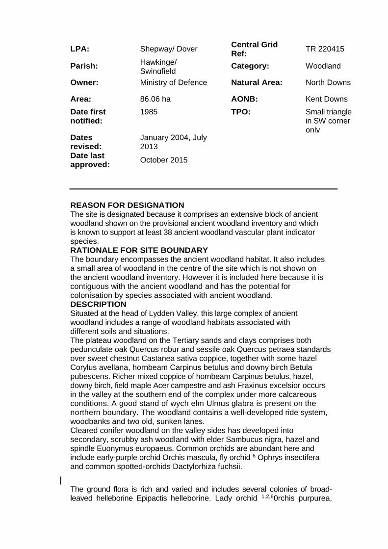
LPA: Shepway/ Dover Central Grid Ref:
TR 220415
Parish: Hawkinge/ Swingfield
Category: Woodland
Owner: Ministry of Defence Natural Area: North Downs
Area: 86.06 ha AONB: Kent Downs
Date first notified:
1985 TPO: Small triangle in SW corner only
Dates revised:
January 2004, July 2013
Date last approved:
October 2015
REASON FOR DESIGNATION The site is designated because it comprises an extensive block of ancient woodland shown on the provisional ancient woodland inventory and which is known to support at least 38 ancient woodland vascular plant indicator species. RATIONALE FOR SITE BOUNDARY The boundary encompasses the ancient woodland habitat. It also includes a small area of woodland in the centre of the site which is not shown on the ancient woodland inventory. However it is included here because it is contiguous with the ancient woodland and has the potential for colonisation by species associated with ancient woodland. DESCRIPTION Situated at the head of Lydden Valley, this large complex of ancient woodland includes a range of woodland habitats associated with different soils and situations. The plateau woodland on the Tertiary sands and clays comprises both pedunculate oak Quercus robur and sessile oak Quercus petraea standards over sweet chestnut Castanea sativa coppice, together with some hazel Corylus avellana, hornbeam Carpinus betulus and downy birch Betula pubescens. Richer mixed coppice of hornbeam Carpinus betulus, hazel, downy birch, field maple Acer campestre and ash Fraxinus excelsior occurs in the valley at the southern end of the complex under more calcareous conditions. A good stand of wych elm Ulmus glabra is present on the northern boundary. The woodland contains a well-developed ride system, woodbanks and two old, sunken lanes. Cleared conifer woodland on the valley sides has developed into secondary, scrubby ash woodland with elder Sambucus nigra, hazel and spindle Euonymus europaeus. Common orchids are abundant here and include early-purple orchid Orchis mascula, fly orchid 6 Ophrys insectifera and common spotted-orchids Dactylorhiza fuchsii.
The ground flora is rich and varied and includes several colonies of broad-leaved helleborine Epipactis helleborine. Lady orchid 1,2,60rchis purpurea,

herb paris Paris quadrifolia, which is locally abundant, and violet helleborine Epipactis purpurata occur in the base-rich broadleaved woodland. Nettle-leaved bellflower Campanula trachelium is abundant. A good diversity of other species includes wood anemone Anemone nemorosa, bluebell'Hyacinthoides non-scripta, cuckooflower Cardamine pratensis, pendulous sedge Carex pendula, enchanter's-nightshade Circaea lutetiana, early dog-violet Viola reichenbachiana, pignut Conopodium majus and primrose Primula vulgaris. The ground flora present on the valley floor reflects the much damper conditions found here, with dog's mercury Mercurialis perennis locally dominant, occurring with ramsons Allium ursinum and opposite-leaved golden-saxifrage Chrysosplenium oppositifolium. The wood supports a good variety of common fern species including soft shield-fern Polystichum setiferum and, on the more calcareous soils, hart's-tongue fern Asplenium scolopendrium. Large ash trees on the southern edge of the woodland have a good common lichen cover, and elm and oak trees on the northern boundary support a good cover of both lichens and bryophytes. At least 42 lichen species and 127 bryophytes have been recorded in the wood. The rich bryophyte flora reflects the range of soil types, from acid, to neutral, to base-rich on the chalk. A total of 23 butterfly species have been recorded in and around the wood, including reasonable numbers of purple hairstreak. White-letter hairstreak4 is also thought to be present. Open areas within the woodland are suitable for pearl-bordered fritillary1,3,4,5, a species which has been recorded here in the past. A previous survey confirmed the presence of a number of uncommon moth species. Species recorded include white-banded carpet, plumed prominent and white-line snout. Large numbers of common darter dragonflies were observed in a valley ride, together with southern hawker and migrant hawker. Kent Wildlife Trust - Additional Comments received 1.9.2016 Thank you for the opportunity to reconsider my views on this planning application in the light of the agent's letter dated 23 August 2016. I welcome the agent's assurance that the applicant would have "no objection to committing to any appropriate mitigation measures". I am reassured that external lighting is to achieved via low level bollard lights with ambient safety lighting only at key areas. I am reassured that there is to be no direct access to Reinden Wood, although I should have preferred also to read that the boundary will be secured with appropriate fencing. However, I remain unconvinced that the applicant has addressed the calls for biodiversity to be enriched in the NPPF. It is clear from the Planning Statement that the purpose of the "significant new woodland planting, landscape buffers and tree belts" is to mitigate the visual impact of the development on local views and the wider AONB/SLA (paragraphs 1.03; 1.04; 1.06; 1.12; 18.00; 20.05; 20.08 - 20.12). Any ecological benefits appear to be an incidental consideration. There is no mention of any assessment of the development against NPPF, paragraph 118, in the Policy Appraisal section (20.04). Indeed,

the only reference in that Statement to the Preliminary Ecological Assessment (paragraph 6.02) is to confirm that the site has "low ecological value" and that there are "no vulnerable or protected species at risk from these proposals". There is no confirmation that the ecologist's recommendations for mitigation and compensation are to be honoured and the words 'ecology' and `biodiversity' are not even considered worthy of a mention in the case summary (22.00). The focus of the applicant's case is clearly on landscape mitigation and the provision of recreational facilities ... a fishing lake; tennis courts; a putting green and an adventure playground. Even the "internal landscaping" is to consist of "broadly" indigenous species (paragraph 2.01). And so, whilst I accept that the scheme may offer the potential for local biodiversity enrichment, I am left with the impression from re-reading the applicant's submissions that the potential is largely unexplored and certainly not evaluated in any way. I remain opposed to the planning application in its present form. Southern Water The applicant is advised to consult the Environment Agency directly regarding the use of a sewerage treatment plant which disposes of effluent to sub-soil irrigation. The owner of the premises will need to maintain the works to ensure its long term effectiveness. It may be possible for the flows from the proposed development to be connected to a nearby public sewer, and the applicant may wish to investigate this option. Southern Water requires a formal application for a connection to the public sewer to be made by the applicant or developer. We request that should this application receive planning approval, the following informative is attached to the consent: "A formal application for connection to the public sewerage system is required in order to service this development. To initiate a sewer capacity check to identify the appropriate connection point for the development, please contact Southern Water, Sparrowgrove House Sparrowgrove, Otterbourne, Hampshire S021 2SW (Tel: 0330 303 0119) or www.southernwater.co.uk Our initial investigations indicate that there are no public surface water sewers in the area to serve this development. Alternative means of draining surface water from this development are required. This should not involve disposal to a public foul sewer. The application details for this development indicate that the proposed means of surface water drainage for the site is via a watercourse. The Council's technical staff and the relevant authority for land drainage

consent should comment on the adequacy of the proposals to discharge surface water to the local watercourse. We request that should this application receive planning approval, the following condition is attached to the consent: "Construction of the development shall not commence until details of the proposed means of foul sewerage disposal have been submitted to, and approved in writing by, the Local Planning Authority in consultation with Southern Water." The proposed development would lie within a Source Protection Zone around one of Southern Water's public water supply sources as defined under the Environment Agency's Groundwater Protection Policy. Southern Water will rely on your consultations with the Environment Agency to ensure the protection of the public water supply source. Due to changes in legislation that came in to force on 1st October 2011 regarding the future ownership of sewers it is possible that a sewer now deemed to be public could be crossing the above property. Therefore, should any sewer be found during construction works, an investigation of the sewer will be required to ascertain its condition, the number of properties served, and potential means of access before any further works commence on site. The applicant is advised to discuss the matter further with Southern Water, Sparrowgrove House, Sparrowgrove, Otterbourne, Hampshire S021 2SW (Tel: 0330 303 0119) or www.southernwater.co.uk". Visit England I write with support for the provision of accessible visitor accommodation at Densole Farm. New research by VisitEngland shows the overnight accessible tourism market was worth £3.5 billion to the England economy in 2015, with day visits bringing the figure up to £12 billion. These latest figures highlight the importance of considering people with access needs a market that is growing due to the ageing population. However, the potential market is even greater. We know from the 'Taking part' survey that nearly half of those with a limiting disability and over a third of those with a non-limiting disability did not take a holiday that lasted at least a week in 2007/08, and that when asked 15% and 23% respectively said that they would consider going on holiday in the UK if conditions were right. Accommodating this underserved market relies on supporting those businesses that are looking to offer suitable facilities and services. The efforts being made by Mr Westgarth to provide accessible accommodation are commendable. Mr Westgarth has informed us that he hopes to apply for Mobility, hearing and visualrating(s) under VisitEngland's National Accessible Scheme. No existing accommodation businesses in Kent are rated under the scheme as suitable for independent wheelchair users. Densole Farm would be a much needed new participant, giving disabled tourists (particularly wheelchair users) a wider choice of suitable holiday accommodation. VisitEngland's 'Purple Pound lnfographic' and 'At your service' booklet set out the business case for accessible tourism and the economic potential in providing

better services and encouraging more tourism from disabled people. Former Tourism Minister John Penrose endorses the booklet and says: "Improving accessibility is a real opportunity for many businesses. This booklet provides hard facts and figures outlining the potential benefits of catering to this market, together with clear steps for operators to improve their offer. Arboricultural Manager I can confirm that I have no objections to the proposed development on the basis that there are no appreciable arboricultural constraints present. However, as the application site sits immediately adjacent an ancient woodland site (Reinden Wood) the Forestry Commission will need to be notified. I can confirm that I have no objections to the proposed development and that the submitted landscape, ecological and management schemes all look robust and sustainable. Economic Development The Shepway Economic Development Strategy 2015-2020 supports the development of tourism and highlights that within Shepway the economy of the North Downs is largely based around a wealth of natural assets including tourism and leisure. The site is located within the Kent Downs AONB so landscape considerations will be very important and the holiday park would need to be developed to a very high environmental standard, but it is also noted that the two secondary purposes of AONB designation are to:
meet the need for quiet enjoyment of the countryside
have regard for the interests of those who live and work there The proposal will help to meet these two secondary purposes of AONB designation, as it is expected to create 11 full time equivalent jobs directly within the facility, and will enable visitors to quietly enjoy the countryside. The district also suffers to some extent from the "corridor effect" whereby visitors to and from continental Europe tend to travel through Shepway to get to destinations further afield, and this proposal will help to retain visitors locally. Taking these points into account the proposal is supported for its economic development benefits. If the planning application is approved the applicant may eligible for a range of business support including, for example, East Kent LEADER and Shepway Apprenticeship grants. We would be happy to provide further information. KCC Highways And Transportation I refer to the above planning application and having considered the development proposals and the effect on the highway network, I raise no objection on behalf of the local highway authority. The site has a suitable point of access and measured speeds have demonstrated adequate visibility splays can be provided. If permission is granted the following should be secured by condition: Provision of construction vehicle loading/unloading and turning facilities prior to commencement of work on site and for the duration of construction.
Provision of parking facilities for site personnel and visitors prior to commencement of work on site and for the duration of construction. Provision of wheel washing facilities prior to commencement of work on site and for the duration of construction. Provision and permanent retention of the vehicle parking spaces shown on the submitted plans prior to the use of the site commencing. Provision and maintenance of 115 metres (north) x 2.4 metres x 130 metres (south) visibility splays at the access with no obstructions over 1.05 metres above carriageway level within the splays, prior to use of the site commencing. INFORMATIVE: It is the responsibility of the applicant to ensure , before the development hereby approved is commenced, that all necessary highway approvals and consents where required are obtained and that the limits of highway boundary are clearly established in order to avoid any enforcement action being taken by the Highway Authority. The applicant must also ensure that the details shown on the approved plans agree in every aspect with those approved under such legislation and common law. It is therefore important for the applicant to contact KCC Highways and Transportation to progress this aspect of the works prior to commencement on site. Natural England Thank you for your consultation on the above dated 20 June 2016 which was received by Natural England on 20 June 2016. Natural England is a non-departmental public body. Our statutory purpose is to ensure that the natural environment is conserved, enhanced, and managed for the benefit of present and future generations, thereby contributing to sustainable development. The Wildlife and Countryside Act 1981 (as amended) The Conservation of Habitats and Species Regulations 2010 (as amended) The National Park and Access to the Countryside Act 1949 Natural England's comments in relation to this application are provided in the following sections. Statutory nature conservation sites — no objection Based upon the information provided, Natural England advises the Council that the proposal is unlikely to affect any statutorily protected sites Protected landscapes The proposed development is for a site within or close to a nationally designated landscape namely Kent Downs AONB. Natural England advises that the planning authority uses national and local policies, together with local landscape expertise and information to determine the proposal. The policy and statutory framework to guide your decision and the role of local advice are explained below. Your decision should be guided by paragraph 115 of the National Planning Policy Framework which gives the highest status of protection for the 'landscape and scenic beauty' of AONBs and National Parks. For major development proposals paragraph 116 sets out criteria to determine whether the development should exceptionally be permitted within the designated landscape.
Alongside national policy you should also apply landscape policies set out in your development plan, or appropriate saved policies. We also advise that you consult the relevant AONB Partnership or Conservation Board. Their knowledge of the site and its wider landscape setting, together with the aims and objectives of the AONB's statutory management plan, will be a valuable contribution to the planning decision. Where available, a local Landscape Character Assessment can also be a helpful guide to the landscape's sensitivity to this type of development and its capacity to accommodate the proposed development. The statutory purpose of the AONB is to conserve and enhance the area's natural beauty. You should assess the application carefully as to whether the proposed development would have a significant impact on or harm that statutory purpose. Relevant to this is the duty on public bodies to 'have regard' for that statutory purpose in carrying out their functions (S85 of the Countryside and Rights of Way Act, 2000). The Planning Practice Guidance confirms that this duty also applies to proposals-outside the designated area but impacting on its natural beauty. Protected species We have not assessed this application and associated documents for impacts on protected species. Natural England has published Standing Advice on protected species. You should apply our Standing Advice to this application as it is a material consideration in the determination of applications in the same way as any individual response received from Natural England following consultation. The Standing Advice should not be treated as giving any indication or providing any assurance in respect of European Protected Species (EPS) that the proposed development is unlikely to affect the EPS present on the site; nor should it be interpreted as meaning that Natural England has reached any views as to whether a licence is needed (which is the developer's responsibility) or may be granted. If you have any specific questions on aspects that are not covered by our Standing Advice for European Protected Species or have difficulty in applying it to this application please contact us with details at consultationsanaturalengland.org.uk. Biodiversity enhancements This application may provide opportunities to incorporate features into the design which are beneficial to wildlife, such as the incorporation of roosting opportunities for bats or the installation of bird nest boxes. The authority should consider securing measures to enhance the biodiversity of the site from the applicant, if it is minded to grant permission for this application. This is in accordance with Paragraph 118 of the National Planning Policy Framework. Additionally, we would draw your attention to Section 40 of the Natural Environment and Rural Communities Act (2006) which states that 'Every public authority must, in exercising its functions, have regard, so far as is consistent with the proper exercise of those functions, to the purpose of conserving biodiversity. Section 40(3) of the same Act also states that 'conserving biodiversity includes, in relation to a living organism or type of habitat, restoring or enhancing a population or habitat'. Sites of Special Scientific Interest Impact Risk Zones
The Town and Country Planning (Development Management Procedure) (England) Order 2015 requires local planning authorities to consult Natural England on "Development in or likely to affect a Site of Special Scientific Interest" (Schedule 4, w). Our SSSI Impact Risk Zones are a GIS dataset designed to be used during the planning application validation process to help local planning authorities decide when to consult Natural England on developments likely to affect a SSSI. The dataset and user guidance can be accessed from the data.gov.uk website We would be happy to comment further should the need arise but if in the meantime you have any queries please do not hesitate to contact us. For any queries regarding this letter, for new consultations, or to provide further information on this consultation please send your correspondences to [email protected]. We really value your feedback to help us improve the service we offer. We have attached a feedback form to this letter and welcome any comments you might have about our service Landscape And Urban Design Officer The proposal is for a tourism site consisting of 12 lodges with associated facilities in Densole. It is located within the North Kent Downs Area of Outstanding Natural Beauty and is an area that is also designated as a Special Landscape Area within local planning policy. The site, approximately 13.5 acres in size is currently agricultural land and forms part of a wider field system. Reinden Woods lies to the south east and is classified as ancient woodland. The design for the facility has been carefully considered. In itself the low density of buildings, suggested landscaping and choice of native species would provide for a pleasant environment. However the location of the facility is an issue in terms of the impact the development would have on the existing character. The site is part of a strip of open land that acts as a band running between Densole and Reinden Woods, the value of which should not be underestimated. This is especially important in the context of the AONB. If permission were granted this development would introduce a different element to the landscape, which would fragment the landscape through the introduction of solid form; mainly the landscaping. The scale of the site in the context of its surroundings in conjunction with the relatively geometric nature of the site boundary will make it stand out within the area despite the use of native species. This being the case the suggested location might not be the best in terms of protecting the character of the AONB. Another issue that is a product of the choice of the location is the relatively long entrance drive, which is shown as an avenue. The avenue would also fragment the open nature of the general area. The construction and operation of the site is also something that needs to be considered. The construction period will be temporary and will cause disturbance but the operation of the site will be the most significant issue. The introduction of vehicular traffic will impact on the site, as there is currently no vehicular traffic any increase will be significant. The movement
and noise generated by this traffic even at low levels will have a detrimental impact on the area / AONB. The length of the drive that is proposed will exacerbate this. One of the intrinsic qualities of this landscape is its tranquillity which is compatible with its scenic qualities. There benefits of this development need to be considered against its impact on the area / AONB. Environmental Health – 13/9/16 With reference to this application, should the application be granted permission, Environmental Health make the following recommendations: 1. Prior to commencement of the development a desk top study shall be undertaken and submitted to and approved in writing by the Local Planning Authority. The study shall include the identification of previous site uses, potential contaminants that might reasonably be expected given those uses and any other relevant information. Using this information, a diagrammatical representation (Conceptual Model) for the site of all potential contaminant sources, pathways and receptors shall also be included. 2. If a desk top study shows that further investigation is necessary, an investigation and risk assessment shall be undertaken by competent persons and a written report of the findings shall be submitted to and approved in writing by the Local Planning Authority prior to commencement of the development. It shall include an assessment of the nature and extent of any contamination on the site, whether or not it originates on the site. The report of the findings shall include: (i) A survey of the extent, scale and nature of contamination; (ii) An assessment of the potential risks to: ● Human health; ● Property (existing or proposed) including buildings, crops, livestock, pets, woodland and service lines and pipes, ● Adjoining land, ● Ground waters and surface waters, ● Ecological systems, ● Archaeological sites and ancient monuments; and (iii) An appraisal of remedial options and identification of the preferred option(s). All work pursuant to this Condition shall be conducted in accordance with the DEFRA and Environment Agency document Model Procedures for the Management of Land Contamination (Contamination Report 11).
3. If investigation and risk assessment shows that remediation is necessary, a detailed remediation scheme to bring the site to a condition suitable for the intended use by removing unacceptable risks to human health, buildings and other property and the natural and historical environment shall be submitted to and approved in writing by the Local Planning Authority prior to commencement of the development. The scheme shall include details of all works to be undertaken, proposed remediation objectives and remediation criteria, a timetable of works, site management procedures and a verification plan. The scheme shall ensure that the site will not qualify as contaminated land under Part 2A of the Environmental Protection Act 1990 in relation to the intended use of the land after remediation. The approved remediation scheme shall be carried out in accordance with the approved terms including the timetable, unless otherwise agreed in writing by the Local Planning Authority. The Local Planning Authority shall be given two weeks written notification of commencement of the remediation scheme works. 4. Prior to commencement of development, a verification report demonstrating completion of the works set out in the approved remediation scheme and the effectiveness of the remediation shall be submitted to and approved in writing by the Local Planning Authority. The report shall include results of sampling and monitoring carried out in accordance with the approved verification plan to demonstrate that the site remediation criteria have been met. It shall also include details of longer-term monitoring of pollutant linkages and maintenance and arrangements for contingency action, as identified in the verification plan, and for the reporting of this to the Local Planning Authority. 5. In the event that, at any time while the development is being carried out, contamination is found that was not previously identified, it shall be reported in writing immediately to the Local Planning Authority. An investigation and risk assessment shall be undertaken and where remediation is necessary a remediation scheme shall be prepared. The results shall be submitted to the Local Planning Authority. Following completion of measures identified in the approved remediation scheme a verification report shall be prepared and submitted to the Local Planning Authority. Reason: To ensure that risks from land contamination to the future users of the land and neighbouring land, together with those to controlled waters, property and ecological systems, are minimised and to ensure that the development can be carried out safely without unacceptable risks to workers, neighbours and other off-site receptors [Kent and Medway Structure Plan Policy NR5 and Dover District Local Plan Policy DD1]. Informative: Planning Policy Statement 23: Planning and Pollution Control states that: ‘in considering individual planning applications, the potential for contamination to be present must be considered in relation to the existing use and circumstances of the land, the proposed new use and the possibility of encountering contamination during development. The LPA should satisfy

itself that the potential for contamination and risks arising are properly assessed and that the development incorporates any necessary remediation and subsequent management measures to deal with unacceptable risks, including those covered by Part IIA of the Environmental Protection Act 1990.
Appropriate external lighting plans must be submitted to the Local Planning Agency for agreement before the commencement of any building works. Reason: To protect the amenities of occupiers of nearby residential premises. KCC Ecology This service provides advice to planning officers to inform Shepway District Council planning decisions with regard to the potential ecological impacts. Any additional information, queries or comments on this advice that the applicant or other interested parties may have must be directed to the Planning Officer who will seek further advice from us where appropriate and necessary. Under the Natural Environment and Rural Communities Act (2006), "Every public authority must, in exercising its functions, have regard, so far as is consistent with the proper exercise of those functions, to the purpose of conserving biodiversity". In order to comply with this Biodiversity Duty', planning decisions must ensure that they adequately consider the potential ecological impacts of a proposed development. The National Planning Policy Framework states that "the planning system should contribute to and enhance the natural and local environment by...minimising impacts on biodiversity and delivering net gains in biodiversity where possible." Paragraph 99 of Government Circular (ODPM 06/2005) Biodiversity and Geological Conservation - Statutory Obligations & Their Impact Within the Planning System states that "It is essential that the presence or otherwise of protected species, and the extent that they may be affected by the proposed development, is established before the planning permission is granted otherwise all relevant material considerations may not have been addressed in making the decision." Natural England has published Standing Advice on protected species and Ancient Woodland. When determining an application for development that is covered by the Standing Advice, Local Planning Authorities must take into account the Standing Advice. The Standing Advice is a material consideration in the determination of applications in the same way as a letter received from Natural England following consultation. We have reviewed the ecological information submitted in support of this application and we advise that additional information is required prior to determination of the planning application. Protected Species The submitted report has considered the possibility of protected species on site and recommends that there will be no detrimental effect on these species and no further surveys will be necessary. Whilst we agree with this assessment, it is important to ensure that the development
site remains mown to ensure that a grassland sward doesn't become established which could allow the colonisation of protected species (i.e. reptiles). Ancient Woodland The site is directly adjacent to Reinden Wood Ancient Woodland. The National Planning Policy Framework (NPPF) (2012) paragraph 118 states "planning permission should be refused for development resulting in the loss or deterioration of irreplaceable habitats, including ancient woodland and the loss of aged or veteran trees found outside ancient woodland, unless the need for, and benefits of the development in that location clearly outweigh the loss" Natural England Standing Advice on ancient woodland requires a minimum of 15 metres buffer zone between and the woods and any new development. As a result of reviewing the submitted site plan it appears that there is a 30 metre buffer zone between the housing/gardens and the Ancient woodlands. In terms of disturbance from lighting, the Design and Access Statement outlines that no street lighting is proposed and any external lighting would be low level bollard lights. We advise that these measures are secured as a condition of any planning application to ensure that the adjacent ancient woodland is not negatively affected by the proposed development. Enhancements One of the principles of the National Planning Policy Framework is that "opportunities to incorporate biodiversity in and around developments should be encouraged". The development includes many features that could provide exceptional ecological benefits of which include the creation of a large fishing pond, wildflower meadows, and extensive tree planting. No specific details have been provided in relation to species plantings or additional species specific ecological enhancements; however a telephone call to Lambe Planning and Design has informed us that an Ecological Enhancement Plan will be submitted in due course. We advise that this plan is submitted for comment prior to determination to ensure that biodiversity is incorporated alongside the development. We advise that this plan takes into considerat ion the ecological enhancement recommendations outlined in section 5 of the Preliminary Ecological Appraisal as well as a detailed management plan to ensure that any ecological features are managed appropriately in the future. KCC Ecology – additional information 21.11.2016 Thank you for requesting advice on this application from KCC's Ecological Advice Service. This service provides advice to planning officers to inform Shepway District Council planning decisions with regard to the potential ecological impacts. Any additional information, queries or comments on this advice that the applicant or other interested parties may have must be directed to the Planning Officer who will seek further advice from us where appropriate and necessary. We have reviewed the ecological information submitted in support of this application and advise that sufficient information has been provided to determine the planning application. Therefore, we require no additional information.

Lighting and Ancient Woodland/Bats The National Planning Policy Framework (NPPF) (2012), paragraph 125 states that "...planning policies and decisions should limit the impact of light pollution from artificial light on local amenity, intrinsically dark landscapes and nature conservation". The National Planning Policy Framework (NPPF) (2012), paragraph 118 states "planning permission should be refused for development resulting in the loss or deterioration of irreplaceable habitats, including ancient woodland and the loss of aged or veteran trees found outside ancient woodland " We have reviewed the submitted Lighting Plan, and we are satisfied that they are in line with recommendations provided by Bat Conservation Trust's Bats and Lighting in the UK. We welcome the inclusion of low level bollard lighting and the consideration of the adjacent ancient woodland. The applicant has demonstrated that there will be no detrimental impact to the ancient woodland through increases in lighting. These measures can be secured as a condition of any planning application. Ecological Enhancements We have reviewed the submitted Landscape and Ecology Management Strategy and welcome the inclusion of features to enhance biodiversity on site and help satisfy one of the policies of the National Planning Policy Framework of that "opportunities to incorporate biodiversity in and around developments should be encouraged". The report has taken into consideration a variety of species and incorporated species specific enhancements throughout the proposed site. We advise that the implementation of these enhancement measures, which include the details, locations, any necessary management are secured as a condition of any planning application. We suggest the following wording: "Prior to the use of the first building, details of how the development has enhanced biodiversity will be submitted to and approved in writing by the Local Planning Authority. The enhancement measures will include those outlined in the Landscape and Ecology Management Plan (Pure Ecology, 2016) and will include locations, details and any necessary management. The approved details will be retained and managed." Ecological Management We have reviewed the Proposed Management Plan and advise that if implemented will provide exceptional ecological benefits. All hedgerows and trees to be retained within the proposed development should be protected during construction in line with standard arboriculture best practice (8S5837:2012). These measures can be secured as a condition of any planning application. We are satisfied with the use of native species throughout the development and the outline of management regimes. We note Kent Wildlife Trusts concerns with the success of casting wildflower seeds onto an improved grassland sward, however if the sensitive cutting regime is implemented and carried out long term, a more diverse sward should establish naturally. Therefore, we advise that the long term ecological management plan is secured as a condition of any planning application which incorporates the regimes outlined in the submitted Landscape Management Plan.

Policy Have not commented on the proposal K.C.C. (Planning - Archaeology) Have not commented on the proposal Environment Agency – 24 November 2016
Thank you for consulting us on the above application, please see comments below from our specialists.
Groundwater and Hydrology
No comments other than if they intend to abstract water to fill the proposed lake/ pond an Abstraction Licence will be required, if the rates exceed 20m3/day. Should this be the case the applicant should contact the Area Groundwater & Hydrology team.
Based on the information provided this shouldn't be a necessity; the applicant should be able to fill and subsequently sustain lake/pond levels within the 20e/day exemption. If the option to abstract is preferred, and presumably from the Chalk aquifer, it would be preferable if the applicant installed a meter to demonstrate compliance In addition, the inclusion of a meter, which is not a statutory requirement, will aid measures employed to promote water efficiency, an approach encouraged given the finite nature of Water Resources. Groundwater and Contaminated land
We consider that planning permission could be granted to the proposed development as submitted if the following planning conditions are included as set out below. Without these conditions, the proposed development on this site poses an unacceptable risk to the environment and we would object to the application.
Condition No development approved by this planning permission shall take place until details of the construction and design of the proposed fishing lake submitted to and approved, in writing, by the local planning authority. Reasons
This site is located within a Source Protection Zone 3 for a groundwater abstraction used for drinking water supply. It is therefore in a sensitive setting from a groundwater protection point of view. National Planning Policy Framework (NPPF) paragraph 109 states that the planning system should contribute to and enhance the natural and local environment by preventing both new and existing development from
contributing to or being put at unacceptable risk from, or being adversely affected by unacceptable levels of water pollution. Government policy also states that planning policies and decisions should also ensure that adequate site investigation information, prepared by a competent person, is presented (NPPF, paragraph 121).
Condition If, during development, contamination not previously identified is found to be present at the site then no further development (unless otherwise agreed in writing with the local planning authority) shall be carried out until the developer has submitted a remediation strategy to the local planning authority detailing how this unsuspected contamination shall be dealt with and obtained written approval from the local planning authority. The remediation strategy shall be implemented as approved. Reasons To prevent pollution of controlled waters and comply with the NPPF.
Condition
No drainage systems for the infiltration of surface water drainage into the ground are permitted other than with the express written consent of the Local Planning Authority, which may be given for those parts of the site where it has been demonstrated that there is no resultant unacceptable risk to controlled waters. The development shall be carried out in accordance with the approved details.
Reasons To prevent pollution of controlled waters and comply with the NPPF.
Foul Drainage We understand that sewage from the development will be discharged to the public mains sewer. We are likely to object to any alternative options given the size of the development, the close proximity to the mains, and the sensitive setting from a groundwater protection point of view. This is in line with our Groundwater protection: Principles and practice (GP3) guidance document, which states: "Generally, we will only agree to developments involving sewage effluent, trade effluent or other contaminated discharges to ground if we are satisfied that it is not reasonable to make a connection to the public foul sewer."
Surface water Drainage The following points should be noted wherever infiltration drainage (such as soakaways) is proposed at a site: Appropriate pollution prevention methods (such as trapped gullies or interceptors) should be used to prevent hydrocarbons draining to ground from roads, hardstandings and car parks. Clean uncontaminated roof water should drain directly to the system entering after any pollution prevention methods.
No infiltration system should be sited in or allowed to discharge into made ground, land impacted by contamination or land previously identified as being contaminated.

There must be no direct discharge to groundwater, a controlled water. An unsaturated zone must be maintained throughout the year between the base of the system and the water table.
A series of shallow systems are preferable to systems such as deep bored soakaways, as deep bored soakaways can act as conduits for rapid transport of contaminants to groundwater.
Waste to be taken off site Contaminated soil that is, or must be disposed of, is waste. Therefore, its handling, transport, treatment and disposal is subject to waste management legislation, which includes:
Duty of Care Regulations 1991
Hazardous Waste (England and Wales) Regulations 2005
Environmental Permitting (England and Wales) Regulations 2010
The Waste (England and Wales) Regulations 2011
Developers should ensure that all contaminated materials are adequately characterised both chemically and physically in line with British Standard BS EN 14899:2005 'Characterization of Waste - Sampling of Waste Materials - Framework for the Preparation and Application of a Sampling Plan' and that the permitting status of any proposed treatment or disposal activity is clear. If in doubt, the Environment Agency should be contacted for advice at an early stage to avoid any delays. If the total quantity of waste material to be produced at or taken off site is hazardous waste and is 500kg or greater in any 12 month period the developer will need to register with us as a hazardous waste producer. Refer to our website at https://www.gov.uk/government/organisations/environment-agency for more information.
Above ground storage of oils, fuels or chemicals Any facilities for the storage of oils, fuels or chemicals shall be provided with secondary containment that is impermeable to both the oil, fuel or chemical and water, for example a bund, details of which shall be submitted to the local planning authority for approval. The minimum volume of the secondary containment should be at least equivalent to the capacity of the tank plus 10%. If there is more than one tank in the secondary containment the capacity of the containment should be at least the capacity of the largest tank plus 10% or 25% of the total tank capacity, whichever is greatest. All fill points, vents, gauges and sight gauge must be located within the secondary containment. The secondary containment shall have no opening used to drain the system. Associated above ground pipework should be protected from accidental damage. Below ground pipework should have no mechanical joints, except at inspection hatches and either leak detection equipment installed or regular leak checks. All fill points and tank vent pipe outlets should be detailed to discharge downwards into the bund. Affinity Water

Have not commented on the proposal East Kent PROW Thank you for your letter received concerning this planning application. The proposed development impacts upon Public Right of Way HE190, the location of which is indicated on the attached extract of the Network Map of Kent. The Network Map is a working copy of the Definitive Map. The existence of the right of way is a material consideration. The Definitive Map and Statement provide conclusive evidence at law of the existence and alignment of Public Rights of Way. While the Definitive Map is the legal record, it does not preclude the existence of higher rights, or rights of way not recorded on it. We have no objection to the application but as the development is directly adjacent to footpath H E190 we have concerns regarding how this will affect the surface of the footpath during the construction phase of the development. The applicant should be aware that 1. No furniture may be erected on or across Public Rights of Way without the express consent of the Highway Authority: 2. There must be no disturbance of the surface of the right of way, or obstruction of its use, either during or following any approved development: 3. There should be no Closeboard Fencing or similar structure over 1.2metres erected which will block out the views: 4. No hedging or shrubs should be planted within 1.0 metres of the edge of the Public Right of Way. The applicant should also be aware that any planning consent given confers no consent or right to close or divert the public right of way at any time without the express permission of the Highway Authority. If the applicant needs to apply for a temporary traffic regulation order whilst works are undertaken, I would need six weeks notice to process this. This response is made on behalf of Kent County Council Countryside Access Service. The views expressed should be considered only as the response of the County Council in respect of public rights of way and countryside access matters relating to the application. KCC Lead Flood Authority Have not commented on the proposal Forestry Commission Have not commented on the proposal Visit Kent Have not commented on the proposal NATS The proposed development has been examined from a technical safeguarding aspect and does not conflict with our safeguarding
criteria. Accordingly, NATS (En Route) Public Limited Company ("NERL") has no safeguarding objection to the proposal. However, please be aware that this response applies specifically to the above consultation and only reflects the position of NATS (that is responsible for the management of en route air traffic) based on the information supplied at the time of this application. This letter does not provide any indication of the position of any other party, whether they be an airport, airspace user or otherwise. It remains your responsibility to ensure that all the appropriate consultees are properly consulted. If any changes are proposed to the information supplied to NATS in regard to this application which become the basis of a revised, amended or further application for approval, then as a statutory consultee NERL requires that it be further consulted on any such changes prior to any planning permission or any consent being granted. MOD Have not commented on the proposal
5.0 PUBLICITY 5.1 Neighbours notified by letter. Expiry date 11th July 2016 Notification of receipt of additional details sent 9th and 16th November 2016 5.2 Site Notice (wider publicity). Expiry date 18th July 2016 5.3 Press Notice. Expiry date 21st July 2016 6.0 REPRESENTATIONS 6.1 34 letters/emails have been received objecting on the following grounds:
Traffic safety
Increased vehicular traffic
Damage to local roads
Neighbour amenity (loss of privacy)
Noise and disturbance from new access road
Noise and disturbance from car parks and playground
Noise and disturbance during construction
Insect problems for local residents from the lake
Impact on outlook from residential properties
Time landscaping will take to mature
Visual impact from public path
Impact on public rights of way
Impact on adjacent equine uses
Height and scale excessive for holiday lodges
Impact on character of AONB

Spoiling of landscape
Activity associated with the tourism occupancy will change the character of the AONB
Tourism should not be a reason to develop AONB
Designs not in local vernacular
Light pollution
Loss of tranquillity
Not proportionate to existing development in vicinity
Development of unspoilt land
Over intensive development
Adverse impact on Ancient Woodland
Concerns about loss of trees
Query whether there is genuine demand for the facility
Loss of local wildlife
Impact of MOD use on a tourism use
The area has existing tourism sites
The site is prone to water logging
Concerns regarding site drainage
Concerns regarding foul water disposal
Concerns regarding adequacy of services (electric/water etc)
Depth of lake
Loss of agricultural land
Concerns over further potential development creep
Concerns regarding pressure to develop adjoining land
Concerns of future residential use if tourism use is unsuccessful
Impact on Radio Mast
Parallels with refused McFarlanes application
There are other more suitable sites available for tourism use
The benefit would be for the applicant and not the wider community
Would not benefit the local community
Lack of community engagement
Letters of support are not from neighbouring properties
Contrary to planning policy
The additional landscape provision is insufficient and misleading
The proposed lighting will cause unacceptable light pollution
Concerns how long term management of the site would be monitored
Conflict with planning policy objectives to preserve AONB landscapes 6.3 21 letters/emails of support have been received:
Supporting the benefits to the local economy
Praising the design
Enhancement to the local employment
Counter to negative arguments about traffic safety/visual impact
The facility will provide inclusive accommodation
Relatively small scale development will not result in significant harm
7.0 RELEVANT POLICY GUIDANCE 7.1 The full headings for the policies are attached to the schedule of planning
matters at Appendix 1. 7.2 The following policies of the Shepway District Local Plan Review apply:
SD1, BE1, BE8, BE16, CO1, CO4, CO11, LR3, TM4, TM5, TR5, TR11, TR12, U1, U2, U3, U4, U15
7.3 The following policies of the Shepway Local Plan Core Strategy apply: DSD, SS1, SS3, CSD3, CSD4 7.4 The following Supplementary Planning Documents and Government
Guidance apply: National Planning Policy Framework - in particular paragraphs 28, 34, 109, 112, 115, 116, 118 National Planning Policy Guidance – guidance on the Natural Environment Kent Downs AONB Management Plan policies SD1, SD2, SD3, SD8 and LLC1 8.0 APPRAISAL Background 8.1 The proposal is to create a holiday park providing self catering accommodation, on existing agricultural land. The application states the site was selected for its good transport accessibility, due to being well screened, and due to the tourism demand for an AONB location. The aim is to bolster the existing tourism accommodation offer in the local area, for the benefit of the local economy. The lake is also intended to make the facility a destination for angling holidays. The adjacent land under the same ownership, between the site and the settlement boundary was submitted for consideration for housing, but was unsuccessful in the SHLAA process and has previously been rejected at appeal for 77 houses in 1989. Relevant Material Planning Considerations 8.2 The site is an undeveloped area of countryside separated from the built area by open fields, and is part of Little Densole Farm which is no longer a working agricultural unit. The land is currently set aside from production, and is maintained as grassland. The site has no history for non-agricultural uses. The principle considerations in determining the application are whether the proposal conserves the landscape and scenic beauty of the designated Kent Downs AONB the impact on the important nationally designated AONB landscapes and Ancient Woodland, and the impact on the ecology of a grassland site and the adjacent
woodland. Other issues to consider are the residential amenity impacts for neighbouring occupiers, highway considerations, archaeological considerations, impact on affected public rights of way, consideration of site drainage, and any other issues raised in the representation received in response to the publicity for the application. The impacts of all of these material considerations need to be balanced against the tourism and economic benefits case for the proposal. Policy 8.3 Policy considerations in determining this application include amongst others, saved local plan policy SD1 which seeks to protect and enhance areas of countryside that are of special quality, particularly the Kent Downs AONB and ancient woodlands; saved local plan policies CO1 and CO4 which seek to protect the nationally and locally designated rural landscape; saved local plan policy CO11 which seeks to protect against loss of or damage to habitats and landscape features of importance for nature conservation; saved local plan policy LR3 which sets the criteria for new recreational facilities in the countryside; saved local plan policy TR11 in relation to an intensification of the use of an existing access; saved local plan policy U15 which seeks to avoid light pollution; and saved local plan policies TM4 and TM5 which set the parameters for acceptability for new or expanded camping sites (including chalet sites). Further to this, Shepway Core Strategy policy CSD3 which supports sustainable rural diversification subject to caveats; Shepway Core Strategy policy CSD4 which seeks to ensure a high level of protection for Ancient Woodland, and to conserve and enhance the natural beauty of the AONB; and Shepway Core Strategy policy SS3 which seeks to direct development towards existing settlements to protect the open countryside; and national guidance contained in the National Planning Policy Framework (NPPF) (in particular paragraphs 109 and 115) which seek to protect and enhance valued landscapes, and conserve and enhance biodiversity. A further material consideration is the Kent Downs AONB Management Plan. The Kent Downs AONB management plan has been adopted by all district authorities within the designated AONB and includes policies SD1, SD2, SD3, SD8 and LLC1 which are relevant to this application. It is a material consideration in determining this application, as is the statutory designation of the AONB. Visual Amenity/Landscape 8.4 The application site is situated within open countryside within the AONB and SLA, and is a nationally protected landscape. The location proposed for the siting of the 12 holiday lodges around a lake setting, is currently agricultural land. The application site is within a wider plateau of farmland between the Alkham Valley and the Elham Valley. It is unspoilt grassland, set against the backdrop of ancient woodland. The built area of the Densole settlement and the large woodland substantially screen the development on both the west and east sides, and to a lesser extend to the south, with the farmstead providing some screening to the north. As such the application site is within a relatively enclosed part of the AONB, and would not therefore be visually prominent from the surrounding wider landscape, as the land is set slightly lower than the surrounding fields and built area. It would however, be viewable from a closer perspective from the local network of well used public paths, bridleways and farm tracks, and from the back of the private residential properties. The application is accompanied by a detailed
Landscape Visual Impact Assessment (LVIA), which concludes that the proposal would have negligible landscape effects within 15 years once a planting scheme has had time to establish and mature; however, it is considered that the scale of the proposed development and the associated recreational features including the lake, along with the related activity and lighting would have a significantly adverse impact on the landscape character, and the proposed landscaping would only partially mitigate this impact in the longer term, being ineffective in winter/early spring. Further to this, the scale of the landscaping once established would fragment the open character of the landscape still further, removing the openness between the woodland and settlement. 8.5 The site and the surrounding area is located in the Kent Downs AONB, a designation the purpose of which is to conserve and enhance the natural beauty of this nationally important landscape. More specifically the site is categorised as being within the East Kent Downs Landscape Character Area. The designation means the landscape quality is categorised as being of exceptional quality. As alluded to above, the site and its immediate surrounds are largely unaffected by built structures, other than the radio mast and ancillary building, fences, and a stable (which is a recent addition). The rural field character of the site is consistent with the surrounding environment of arable rural land interspersed with woodland, which is the characteristic for which the East Kent Downs Landscape Character Area is noted. 8.6 The intention is to excavate a lake with 12 holiday lodges clustered around it, with an extensive landscaping scheme of indigenous woodland and hedgerow species to help the development blend into its setting. Nevertheless, the proposal represents the construction of residential holiday accommodation, ancillary buildings/structures, a car park, tennis courts and play equipment, which are incongruous features within an unspoilt countryside setting, and which would permanently change the landscape character of the area. Cumulatively these features would result in a cluttered and residential appearance of the site. It is considered this would have a negative impact on the rural landscape character of this part of the AONB. As such, it is considered the proposal would harm the natural beauty of the AONB contrary to planning policies which seek to protect it, and disregarding the primary purpose of the AONB designation to conserve and enhance the natural beauty. Further to this, it is considered that the change of use would change the character of the countryside in this location and that the associated activity and vehicle movements it would generate would be harmful to the characteristic tranquillity, and would introduce evening and night time activity that necessitates lighting in an area that is currently unlit, which represents harm to the characteristic dark skies. Furthermore, the change of use once established could lead to pressure for gradual creep of further development, leading to further erosion of the natural beauty. Therefore, contrary to the findings of the submitted LVIA and Design and Access Statement, the proposal is considered to fail to conserve and enhance the local character, qualities and distinctiveness of the AONB, which could not be satisfactorily mitigated by landscaping, which would take many years to be effective. 8.7 As such, the proposal would be considered to conflict with: saved local plan policies SD1, CO1, CO4 and CO11 and Shepway Core Strategy Policy SS1 which seek to protect the rural landscape and wildlife features, and to promote

sustainable development, particularly as in this instance where the countryside has an AONB designation; saved local plan policy LR3, which seeks new recreational facilities are compatible with the AONB and is well located in relation to existing settlements; and, it would be contrary to Shepway Core Strategy Policy CSD4 which requires planning decisions to have close regard to the need for conservation and enhancement of the natural beauty of the AONB and its setting, which will take priority over other planning considerations; and is considered to be contrary to guidance contained within the NPPF which states that the planning system should aim to protect and enhance valued landscapes, and paragraph 115 of the NPPF in particular which seeks that great weight should be given to conserving landscape and scenic beauty in AONBs which have the highest status of protection in relation to landscape and scenic beauty, and the proposal is also contrary to the Kent Downs AONB Management Plan (which is a Council adopted document). Guidance contained in the NPPG requires local planning authorities to have regard to management plans for Areas of Outstanding Natural Beauty, as these documents underpin partnership working and delivery of designation objectives.
8.8 Furthermore, the proposal would represent an isolated development that would be out of place in the agricultural landscape, and the location and scale would not relate well to the existing settlement; contrary to Shepway Core Strategy Policy CSD3 due to the separation from the settlement boundary, as the policy requires new tourism uses to be within or on the edge of existing settlements. This illogical interruption of the separation of the built area from the wider landscape, which is clearly identifiable on the submitted aerial photomontages, would be considered detrimental to the AONB and would fail to conserve its landscape and scenic beauty. Overall, the proposal is unacceptable in principle from a visual impact point of view, due to being an unacceptable form of development for an open countryside location, and would be considered to represent significant detrimental harm to the intrinsic character and appearance of the East Kent Downs Landscape Character Area of the Kent Downs AONB, and would dilute the qualities of natural beauty and landscape character the AONB designation seeks to conserve and enhance. Consequently, this view is shared by both the Kent Downs AONB unit and the Campaign to Protect Rural England Kent Branch (CPRE), both maintain objections to the application and recommend the application should be refused, as the proposal would fail to conserve landscape and scenic beauty in the AONB. Design 8.9 The proposed lodges would be of timber construction with Decra roof types which are profile sheets bonded with a stone chip finish, which naturally attract lichen to give a natural appearance within a short period of time. However, it is considered the application fails to meet the rigorous requirements for high quality design for new development in the AONB, and does not reflect the local rural vernacular. The buildings whilst having some design merit in their own right, fail to respond to local distinctiveness in terms of materials, design and layout, which is crucial given the sensitive nature of this nationally, protected landscape.

Ecology 8.10 A Preliminary Ecological Assessment Report has been submitted with the application which concludes that the development would result in the loss of improved grassland which has little ecological value, and that the hedgerow on the north-west boundary which is a valuable ecological feature is being preserved. There would therefore be limited impact on individual species, and the report sets out recommendations for mitigation strategies, and habitat enhancement. The report also concludes that no statutorily protected sites would be affected by the proposed development, which is confirmed in the consultation response from Natural England, who deferred their comments to Kent Downs AONB, referred to above. Further supplementary information submitted in the form of a Landscape and Ecology Management Strategy, Proposed Management Plan for Eco Holiday Park, and a Lighting Plan sets out measures to enhance biodiversity with significant ecological benefits, and low level bollard lighting that would not be harmful to bats or the adjacent ancient woodland.
8.11 Notwithstanding the above Kent Wildlife Trust have stated that designated Ancient Woodland (Reinden Wood) is recognised at county interest level for its wildlife, and that the application initially did not properly assess the impact on the ecology of Reinden Wood, such as the risk of harm from noise, illumination and increased public access to the woodland. It may for example; be appropriate to install enhanced boundary fences to avoid access from the holiday site to the woodland as avoiding access would be difficult to manage, and to have a buffer zone preventing activity for at least 15m from the Ancient Woodland boundary, given the sensitivity of the woodland ecosystem to these kinds of impacts. The application also fails to establish the quality of the agricultural land so it is unclear whether the development should be directed to lower grade land in accordance with the NPPF (paragraph 112). However, the intensity and alignment of external lighting which can effect nocturnal navigation of many species has now been addressed in the application, and the use of appropriate local native species in the landscaping scheme has been incorporated into the development. Therefore, the application through the additional information submitted is considered to largely have addressed the ecological assessment of the developments potential biodiversity protection and enhancements, in accordance with paragraph 118 of the NPPF, which requires that opportunities to incorporate biodiversity in and around developments should be encouraged. The ecological mitigation measures, external lighting levels/details, and landscaping can be secured by planning condition. Therefore, whilst acknowledging the designation of the adjacent ancient woodland and the importance of it and the woodland edge in relation to the rich habitat of plant and animal communities they support, the application is now properly informed and is not now lacking from an ecological point of view. Nevertheless, Kent Wildlife Trust maintain an objection to the application despite reassurances provided by the applicant; and, the Campaign to Protect Rural England (Kent) also hold an objection, on the same basis that the application does not adequately assess the impact of the proposed development on the woodland and the species it supports. 8.12 Overall, the proposal is not considered to be contrary to guidance contained within the NPPF which states that planning permission should be refused for development resulting in the loss or deterioration of irreplaceable habitats,
including ancient woodland; or to saved local plan policy CO11, and Core Strategy Policy CSD4 (c) which seek to provide a high level of protection and enhancement for Ancient Woodland, biodiversity, important habitats and diverse landscapes especially where they support the setting of the AONB. Further details of enhancement measures to mitigate against the impacts of the development and provide net biodiversity gains can be secured by condition, but it is considered the applicant has provided sufficient information to not warrant a reason for refusal on ecological grounds. Tourism Development 8.13 From a tourism perspective, the development seeks to create a recreational holiday site providing facilities for angling, tennis and other leisure pursuits, with upmarket self catering lodges in an attractive landscaped lakeside setting. The development would be phased with six of the lodges provided in the first phase. The exclusive nature of the development is aimed to raise the tourism offer in the district, and to create an all year round facility as opposed to a seasonal one, generating year round employment and spending on local services in the district economy. However, the application is contradictory in this regard, as it refers in the Business Plan to a winter close season. 8.14 A Business Plan (confidential) has been submitted which sets out the estimated construction costs, set against the estimated rental revenue the development would be anticipated to generate, based on seasonally adjusted 40-80% occupancy. The report also refers to the potential private sale of lodges, however, due to pressure for these to become independent dwellings, planning permission would need to be accompanied by a condition/legal agreement restricting use to short term holiday lets, which would be controlled and monitored. Nevertheless, based on the rental income predictions, the report forecasts that the proposed holiday lodge site would produce a viable profit, allowing for a site manager and support staff. The Demand Report states that the estimated £320,000 - £555,000 of turnover into the local economy would generate 6-11 jobs (11 jobs based on a 52 week season would equate to 6 full time jobs and 10 part time). Furthermore, the visitor spend would benefit local shops, attractions, pubs and restaurants, with the holiday rental visitor generally spending more per trip than those who use traditional accommodation such as Hotels/B&Bs. Therefore, if the development achieves its predicted occupancy levels, there would be significant benefit to the local economy, and it would support direct employment with wider trickle down benefits to the Shepway economy. 8.15 The submitted Demand Report, concludes there is demand for quality holiday park accommodation, partly due to the rise in popularity of the ‘staycation’. The application sets out the trend for staycation holiday parks to become more focused on the higher end of the market, due to growing demand from older demographic groups with greater disposable income. Thus there is, it states growing demand for higher quality accommodation with all the modern home comforts and facilities, set in exceptional locations. Further to this, providing fully accessible accommodation broadens the appeal to disabled tourists. Whilst the application puts forward all of these generic facts, the question of whether the application site is the most suitable countryside location for this type of development is unclear from the application, as other sites are not put forward by

way of comparison. Sandwiched between suburban style dwellings and an active MOD training site, may not provide the most desirable destination, when the district has many natural countryside and coastal assets that could potentially better accommodate this kind of facility, and there is not robust enough justification submitted with the application to demonstrate why this is the ideal location for a new upmarket holiday lodge site. Also, the district already has a range of similarly upmarket lodges such as at Port Lympne Wild Animal Park, which have a more obvious draw for visitors. The application also suggests that the lake further widens the appeal; however, the lake would be unlikely to be of a scale capable of holding a big enough head of fish to appeal to most anglers. Overall, whilst not disputing the demand nationally for this type of facility, the application fails to robustly demonstrate that this particular site would be a sufficient draw for visitors to be viable and generate the predicted contribution to the local economy, and therefore it cannot be certain that the proposal does not represent unnecessary development in the countryside, or that an exceptional case has been made to justify construction on a virgin AONB site adjacent to Ancient Woodland.
8.16 Local plan tourism policies (pre-amble to saved policies TM4 and TM5) acknowledge the demand for higher grade accommodation, but seek to ensure they do not result in unacceptable visual intrusion in areas designated for landscape quality. For reasons set out above, the proposal would fail to meet this policy objective. Core Strategy policies SS1 and SS3 seek to direct development to existing settlements to protect the open countryside, and would only be allowed exceptionally where a rural location is essential. Whilst a rural location is required for this type of development a more logical extension of the existing built area would be more acceptable on a strategic planning level, rather than intruding into the open countryside and being isolated from the existing settlement, although in turn this would raise increased neighbour amenity issues, which again brings into question the suitability of the site for the development. Furthermore, sequentially it would be less harmful for development of this type to be directed to sites outside of the designated AONB. 8.17 Kent Downs AONB Management Plan does support sustainable tourism facilities where they enhance enjoyment of the AONB, but with a clear caveat that economic development such as visitor facilities should not detract from the special characteristic and qualities of the AONB. Given the harm to the AONB identified in this report, it is considered there is conflict with saved local plan policies CO1, CO4 and CO11 which seek to maintain or enhance features of landscape and wildlife importance, and the particular quality and character of the countryside. It is considered the proposal does not fully meet these objectives, and that the need for the development on this particular site is not adequately convincing to outweigh these considerations regarding the natural environment. The Core Strategy seeks to provide crucial rural facilities in line with local needs for Secondary Villages such as Densole, but the need for a holiday site is not specific to Densole and could from a district perspective be located elsewhere, and there is much local opposition to the scheme. It is also noted that there is support for the proposal from Shepway residents, Visit England, Visit Kent and the Shepway DC Economic Development Team. Shepway Core Strategy policy CSD3 sets out that tourism enterprise may be acceptable outside existing settlements on the edge of rural centres when the scale and accessibility is acceptable and sites
within the existing settlement are unavailable. The application fails this aspect of the policy by involving loss of open countryside away from the existing village envelope. Therefore, in this instance, in the light of the above, the proposal is not considered to meet the criteria of the local plan policies, or the ethos of the NPPF, most clearly set out in Core Strategy policy CSD4 which specifically states that planning decisions will have close regard to the need for conservation and enhancement of the natural beauty in the AONB and its setting, which will take priority over other planning considerations. 8.18 Overall, whilst the proposal has potential to provide a new tourism offer, and income and employment benefits to the local economy, it is not on balance in this instance not considered to outweigh the harm, of being a development in an unsustainable location which fails to conserve the landscape and scenic beauty of the AONB. It is considered there may be sites better suited to accommodate this type of development in the district, without the same level of harm, however, no examination of sequentially preferable sites has been provided in conflict with paragraph 118 of the NPPF which seeks to direct development to alternative sites with less harmful impacts. It has not been demonstrated that there would be no scope for the development outside of the AONB or on less sensitive sites. As such, whilst acknowledging there may be some wider economic benefits to the local economy; on balance in the light of the harm to AONB in conflict with paragraph 115 of the NPPF the proposal is unacceptable in planning terms. Further to this, officers have concerns that the proposal would not meet the requirement of paragraph 116 of the NPPF in terms of representing an exceptional circumstance for not refusing a major development in a designated area; or to be sufficiently demonstrated to be in the public interest given the level of local opposition; or failing to demonstrate the potential for other suitable sites being available within the district. Whilst the NPPF fails to define the phrase ‘major development’ in this regard, recent appeal decisions across the country have identified that developments of a scale of 20-30 homes within the AONB, in semi rural residential areas can fall foul of the presumption against major development in nationally designated landscapes as set out in paragraph 116. Whilst this proposal being considered is for a smaller quantum of development an inspector could reach the view that paragraph 116 of the NPPF applies to this site. On balance, in this instance officers consider that paragraph 116 of the NPPF could be considered to apply, however an Inspector could formulate a different view on this at appeal. Neighbour Amenity 8.19 The linear band of housing on Canterbury Road, Densole Way and Densole Lane to the west, north west, and south west of the application site, currently enjoy an outlook onto open countryside. The erosion of this transition from the settlement to the wider countryside is considered to represent harm to the enjoyment of occupiers of these properties, in relation to their residential amenity as such residents are considered receptors for Landscape Visual Impact Assessment (LVIA) purposes. Furthermore, the development would result in frequent vehicle movements, detrimentally impacting on nearby residents who currently enjoy a quiet rural location to the rear of their properties. Although it is acknowledged Canterbury Road is a busy carriageway, residents currently enjoy a peaceful setting at the rear of their properties and the introduction of an access
road and car park and their associated traffic movements results in the loss of the existing tranquillity, not to mention disturbance during construction over several years of the phased development. Nevertheless, this can be controlled through planning conditions to mitigate impact. Neighbours have also raised concerns about loss of privacy, however, given the degree of space separation from the site, this would not be a significant concern, and a management plan could be secured by condition to ensure visitors were kept away from residential garden boundaries. The erosion in transition from the settlement to wider landscape if this development were to be built out, in combination with the noise and disturbance from the activities that it would generate, given that one of the purposes of the AONB designation is to have regard to those who live and work there, are all impacts on neighbour amenity that need to be given consideration. Saved local plan policy LR3 seeks that new recreational facilities such as those provided by this development do not unacceptably impact on the amenity of local residents and users of PROW in terms of noise nuisance, and saved policy SD1 seeks to protect residential amenity. Whilst some mitigation from the proposals impacts can be secured by condition, harm to residential amenity, and neighbour opposition is a significant part of the mix in the balance when weighing up the proposed development. A loss of residential neighbour amenity is not considered a significant problem or reason for refusal by the Council’s Environmental Health team, therefore, on balance it is not considered to be a reason for refusal in its own right. However, the issues raised are sufficient to further question the suitability of the site for the proposed use.
Highways 8.20 A Transport Statement has been submitted with the application, along with Traffic Survey Data. The statement concludes that vehicle movements would be light given the nature of the proposed use, and that the vehicle movements would be outside peak periods. The access onto Canterbury Road is an existing established access point, with demonstrated good visibility, and consequently Highways and Transportation officers have no objection to the proposal from a highways perspective, and thus highways would not be a constraint to the proposed development. 8.21 Notwithstanding the above, paragraph 34 of the NPPF seeks to ensure developments are located where the need to travel will be minimised and use of sustainable transport modes are maximised. The sites relatively poor location in regard to access to services would lead to an inevitable reliance on the private car, which represents an unsustainable form of development, as well as disruption to the peace and tranquillity of the site for walkers on the public rights of way and for local residents. A condition requiring a travel plan, setting out measures to encourage visitors to use public transport, cycle and walk could partly mitigate concerns and help maximise more sustainable forms of transport. Trees 8.22 There are no significant constraints from trees on the site, and the Council’s Arboriculture Manager has no objection to the proposal from this point of view. However, the site is adjacent to Ancient Woodland which raises issues addressed
elsewhere in this report. The Forestry Commission have been added as an additional consultee, to seek further expert advice in this regard. Archaeology 8.23 The site is in an Area of Archaeological Potential. Comments from KCC Archaeology are still awaited, and appropriate measures can be secured by condition as necessary. Public rights of way 8.24 There is a bridleway along the western edge of the woodland adjacent to the application site, and a public footpath which the proposed access spur would cross. The activity and noise associated with the proposed development is considered to conflict with one of the purposes of the AONB designation, which is to enable quiet enjoyment of the countryside. The well used public rights of way adjacent to the site and across the access would be considered to be compromised in this regard, as well as the harm to visual impact from the routes as discussed in this report. The PROW officer has no objection to the proposal, but measures will need to be secured by condition to protect the public footpath during the construction period. Drainage 8.25 Further investigation is required to see whether the development can connect to the public sewer, the details of which or alternative drainage solutions can be secured by condition. Southern Water has stated an Abstraction Licence would be required for the ponds, and have set out recommended conditions for the construction of the lake and water drainage. Other Issues 8.26 There is a Radio Mast and Ministry of Defence (MOD) land immediately adjacent to the application site. National Traffic Air Services (NATS) has no safeguarding objection to the proposal, and views are awaited from the MOD with regard to how impactful the proposed development would be. Further to this, they and the Environmental Health team recommend contamination conditions. Human Rights 8.27 In reaching a decision on a planning application the European Convention on Human Rights must be considered. The Convention Rights that are relevant are Article 8 and Article 1 of the first protocol. The proposed course of action is in accordance with domestic law. As the rights in these two articles are qualified, the Council needs to balance the rights of the individual against the interests of society and must be satisfied that any interference with an individual’s rights is no more than necessary. Having regard to the previous paragraphs of this report, it is not considered that there is any infringement of the relevant Convention rights.

8.28 This application is reported to Committee at the request of Cllr Stuart Peall, on the grounds it is a major development within the AONB and due to the level of neighbour objection. 9.0 SUMMARY 9.1 Economic and tourism development is supported in principle as set out in local and national policies, and paragraph 28 of the NPPF seeks to support economic growth in rural areas in order to create jobs and prosperity. Whilst the application has demonstrated a generic demand for this kind of high end holiday facility, it is not robustly demonstrated that there is a specific need in this particular AONB countryside location, or that there are not better sites elsewhere in locations that are not designated. Given the rural location within the protected AONB, the impact of this major application on the wider environment is a significant consideration. The NPPF makes it clear that the planning system should carefully balance economic, social and environmental considerations in the decision making process, and this is discussed in detail throughout the report. 9.2 Paragraph 115 of the NPPF requires that great weight is given to conserving landscape and scenic beauty in the AONB, which has the highest status of protection, and Core Strategy CSD4 requires planning decisions to have close regard to the need for conserving and enhancement of natural beauty in the AONB, which will take priority over other planning considerations. On the basis of these key policy requirements and other local plan and national policy requirements set out in this report, and the significant harm to the landscape and scenic beauty of this nationally important landscape identified in this report, great weight should be attached to the statutory requirement to have regard to the purpose of conserving or enhancing the natural beauty of the AONB. The economic benefits do not in this instance amount to exceptional circumstances to warrant not refusing the application as required by paragraph 116 of the NPPF, and the application does not sufficiently justify an overriding need for this major development in this particular location, or why an exception to planning policies to protect the countryside and the AONB designation should be made in this instance. As such, on balance the officer assessment of this proposal, in accordance with national and local plan policy is required to give great weight for the protection of the designated AONB, which, in this instance, the harm to outweighs the clear economic/tourism benefits of the proposal.
9.3 In the light of the above, and the detailed case put forward in this report, it is considered the development does not comply with local plan policies or the NPPF, and therefore, in accordance with Section 38(6) of the Town and Country Planning Act 2004 the proposal is contrary to development plan policy and the planning application should therefore be refused. 10.0 BACKGROUND DOCUMENTS 10.1 The consultation responses set out at Section 4.0 and any representations at Section 6.0 are background documents for the purposes of the Local Government Act 1972 (as amended).

RECOMMENDATION – That planning permission be refused for the following reasons: 1. The site is located within the designated Kent Downs AONB and the proposed development would be harmful to the unspoilt character of this exceptional landscape setting, failing to conserve its landscape and scenic beauty. In addition activity associated with the use would be likely to lead to further erosion of the area’s special character of tranquillity and dark skies. Installation of lodges not of a design informed by the local vernacular, a lake, car parking and recreational facilities would detrimentally weaken the characteristics and qualities of the natural beauty and landscape character, disregarding the primary purpose of the AONB designation, namely the conservation and enhancement of its natural beauty. The application is therefore contrary to saved policies SD1, CO1, CO4, and CO11 of The Shepway District Local Plan Review; policies CSD3 and CSD4 of the Shepway Core Strategy Local Plan, advice in the National Planning Policy Framework, and Kent Downs AONB Management Plan policies SD1, SD2, SD3, SD8 and LLC1 which seeks to protect designated landscapes. In particular, Core Strategy policy CSD4 requires that planning decisions have close regard to the need for conservation and enhancement of natural beauty in the AONB and its setting, which will take priority over other planning considerations; and paragraph 115 of the NPPF which requires that great weight is given to conserving landscape and scenic beauty in the AONB and protect or enhance the natural beauty of the landscape and special rural setting which has the highest status of protection.
2. The site is located within the open countryside outside of the settlement hierarchy and within the Kent Downs AONB and Special Landscape Area which is awarded the highest status of national protection. In the absence of a convincing justification, the application fails to demonstrate a robust need for this development in this location and that it cannot be provided in or adjacent to an existing rural service centre elsewhere, or that it essentially requires an open countryside location, within the designated AONB. It is therefore considered that there remains significant uncertainty that this major proposal can create a sustainable visitor destination and not result in unnecessary development in the countryside that would be harmful to the character of the landscape and surrounding environment. As such, it is considered that the development is contrary to saved policies SD1, CO1, CO4 and LR3 of the Shepway District Local Plan Review, policies DSD, SS1, SS3, CSD3 and CSD4 of the Shepway Core Strategy Local Plan, and the National Planning Policy Framework paragraphs 28, 109 and 115 and is considered to be contrary to policies SD1, SD2 SD3, SD8 and LLC1 of the Kent Downs AONB Management Plan that advise that planning permission should be refused in these designated areas except in exceptional circumstances and where it can be demonstrated they are in the public interest and essentially require an AONB countryside location. Decision of Committee