Application No: 14/2204N Location: Land At, SCHOOL LANE...
22
Application No: 14/2204N Location: Land At, SCHOOL LANE, BUNBURY Proposal: Erection of 34No. Dwellings, a School Car Park with associated access road and new landscaping Applicant: Bloor Homes North West Expiry Date: 30-Jul-2014 SUMMARY RECOMMENDATION: Refuse MAIN ISSUES: - Main Issues; - Principle of development; - Location of the site; - Policy position; - Design standards; - Private amenity space/density; - Residential amenity; - Affordable housing; - Landscape; - Highways; - Public Open Space; - Ecology; - Drainage; - Flooding; - Education; and - Other Matters REFERRAL This application is referred to the Southern Planning Committee as it relates to a departure to the Crewe and Nantwich Borough Local Plan. SITE DESCRIPTION AND DETAILS OF PROPOSAL The site lies in Bunbury Heath within an area designated as Open Countryside. It is part of a parcel of land that is completely enclosed by housing to the north and west, Bunbury Aldersey primary school playing field the east and Saddlers Wells woodland to the south. This area provides a very pleasant rural setting for the surrounding properties but there is no public access to the land and public views towards the site are very limited. The proposed development site is
Transcript of Application No: 14/2204N Location: Land At, SCHOOL LANE...

Application No: 14/2204N
Location: Land At, SCHOOL LANE, BUNBURY
Proposal: Erection of 34No. Dwellings, a School Car Park with associated access
road and new landscaping
Applicant:
Bloor Homes North West
Expiry Date:
30-Jul-2014
SUMMARY RECOMMENDATION: Refuse MAIN ISSUES:
- Main Issues; - Principle of development; - Location of the site; - Policy position; - Design standards; - Private amenity space/density; - Residential amenity; - Affordable housing; - Landscape; - Highways; - Public Open Space; - Ecology; - Drainage; - Flooding; - Education; and - Other Matters
REFERRAL
This application is referred to the Southern Planning Committee as it relates to a departure to the Crewe and Nantwich Borough Local Plan. SITE DESCRIPTION AND DETAILS OF PROPOSAL
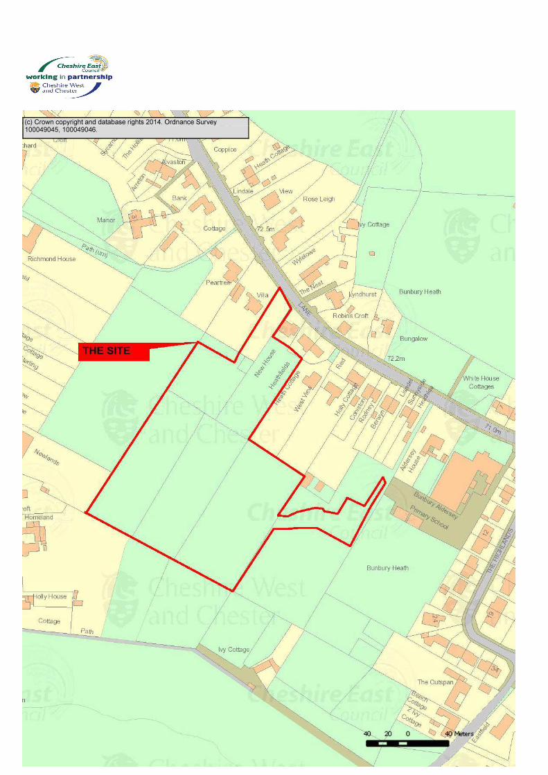
The site lies in Bunbury Heath within an area designated as Open Countryside. It is part of a parcel of land that is completely enclosed by housing to the north and west, Bunbury Aldersey primary school playing field the east and Saddlers Wells woodland to the south. This area provides a very pleasant rural setting for the surrounding properties but there is no public access to the land and public views towards the site are very limited. The proposed development site is

flat pasture land enclosed and subdivided by mature hedgerows. The proposed development is for 34 dwellings with a new access off School Lane through the garden of Heath Villa. The proposals also include a small 10 space car park for Aldersey Primary School located to the east of the proposed housing development.
PREVIOUS RELEVANT DECISIONS
P02/0266 - Conversion of Outbuilding Double Garage and Porch – Approved – 19th April 2002 P01/0705 - Outline Application for One Dwelling – Refused – 9th October 2001 P00/0633 - Demolition of Existing House and Outbuildings, Erection of 1 Detached and 3 Terraced Dwellings and Construction of Access Road – Refused – 12th October 2000 P99/0087 - Agricultural Store and Garage and vehicular access – Approved 24th June 1999 P99/0755 - O/A for 4 Dwellings – Refused – 11th November 1999 P98/0622 – Outline Application for a Dwelling – Refused – 17th September 1998 P97/0753 - O/A For residential Development – Refused – 16th October 1997 – Appeal Dismissed PLANNING POLICIES National Policy The application should be determined in accordance with national guidance set out in: National Planning Policy Framework Local Policy The principle issue surrounding the determination of this application is whether the development is in accordance with the following policies within the Borough of Crewe and Nantwich Replacement Local Plan 2011: BE.1 (Amenity) BE.2 (Design Standards) BE.3 (Access and Parking) BE.4 (Drainage, Utilities and Resources) BE.6 (Development on Potentially Contaminated Land) TRAN.9 (Car Parking Standards) NE.2 (Open Countryside) NE.5 (Nature Conservation and Habitats) NE.9 (Protected Species) RES.5 (Housing in the Open Countryside) RES.7 (Affordable Housing) RT.3 (Provision of Recreational Open Space and Children’s Playspace in New Housing Developments) TRAN.3 (Pedestrians) TRAN.5 (Cycling)
Other Considerations
The EC Habitats Directive 1992 Conservation of Habitats & Species Regulations 2010 Circular 6/2005 - Biodiversity and Geological Conservation Statutory Obligations and Their Impact within the Planning System Interim Planning Statement Affordable Housing Interim Planning Statement Release of Housing Land Cheshire East Development Strategy Cheshire East SHLAA SPD Development on Backland and Gardens
Cheshire East Local Plan Strategy – Submission Version
PG2 – Settlement Hierarchy PG5 - Open Countryside PG6 – Spatial Distribution of Development SC4 – Residential Mix SC5 – Affordable Homes SD1 - Sustainable Development in Cheshire East SD2 - Sustainable Development Principles SE3 – Biodiversity and Geodiversity SE5 – Trees, Hedgerows and Woodland SE 1 - Design SE 2 - Efficient Use of Land SE 4 - The Landscape SE 5 - Trees, Hedgerows and Woodland SE 3 - Biodiversity and Geodiversity SE 13 - Flood Risk and Water Management SE 6 – Green Infrastructure IN1 – Infrastructure IN2 – Developer Contributions OBSERVATIONS OF CONSULTEES Environment Agency: No objections subject to the following condition No development approved by this planning permission shall take place until such time as a scheme to limit the surface water run-off generated by the proposed development, has been submitted to and approved in writing by the local planning authority. The scheme shall confirm existing and proposed receptors and limit the surface water discharge rate so that it will not exceed the greenfield discharge rate from the existing site (estimated to be a practical minimum of 10l/s) and not increase the flood risk off-site. Natural England: No objection
Cheshire Fire and Rescue Service: No objections subject to the development being constructed in accordance with current building regulations
Sustrans: No objections subject to the following comments

1) Although some local journeys will be made on foot for the new site, this is essentially a car-based development as Bunbury is not on a regular public transport service. The Crewe - Chester railway line runs nearby but there are no stations between the two towns.
2) We prefer to see an additional entrance/exit for a site such as this for pedestrians and any cyclists.
3) A scheme such as this should contribute to traffic management measure in the village to create a slow speed area and enhance the public realm.
VIEWS OF THE PARISH / TOWN COUNCIL:
The Parish Council object to the proposed development for the following reasons
• The proposed development is in open countryside, on a Greenfield site and outside the Bunbury Settlement Boundary. Against Policy NE.2 ;
• In view of the infrastructure of School Lane the increased flow of traffic will have a detrimental effect. Against Highways Policy BE.3
• There is a significant Highways safety issue. The representation of the bend in School Lane, on the submitted plans, looks as if it has been minimised and does not show the parked cars that would usually be there. Concern that the highways issue makes the development unsustainable. Against Highways Policy BE.3 ;
• Access is inadequate. Against Highways Policy BE.3 ;
• Concerns that due to the absence of natural containment features on the site, there is the possibility of more extensive development in future. Against Policy BE.2;
• Concerns that the visual impact from School Lane is not clear from the submitted plans. A realistic view that enables the impact to be assessed is needed. Against Policy BE.2;
• The design is not in keeping with the local area. There are concerns about the scale, size and density of the development. Against Policy BE.2;
• The application is not in line with the adopted Bunbury Village Design Statement 2009. The development does not conform to the density in that part of the Village and to the building scale of the immediate area. In Bunbury Heath future developments should be small scale and not spread outside the existing built up area. Bunbury Village Design Statement 2009;
• The design of the houses does not fit with existing stock. They are not countryside houses. Against Policy BE.7 and Bunbury Village Design Statement 2009;
• The design does not reflect the fact that there are two large conservation areas in Bunbury. Against Bunbury Village Design Statement 2009;
• Concern that valuable hedge rows that are over 30 years old will be lost as a result of the development; and
• Concern that sewerage system cannot cope and that there will be increased flooding risk, with additional runoff caused by impermeable surfaces. There are currently two areas of surface water/flood risk on the site and a larger area in the field opposite.
OTHER REPRESENTATIONS:

Letter of objection from Stephen O’Brien MP, which raises the following points
- Bunbury has more than fulfilled its housing needs through previous developments. Instead, this application is an opportunistic and material degradation of this rural village. The development is cynically just outside the village settlement boundary, except crucially, the access from School Lane to the point where the housing development commences;
- It would be abominable for the village settlement boundary to be breached for access as the very nature of the village settlement plan is that it absolutely should be able to hold the development to ransom and impose a veto;
- The aerial photograph speaks volumes for how the rural lands between the A49-adjacent dwellings and the School Lane-adjacent dwellings are separated by continual agricultural fields, bounded to the south by the all-important Sadlers Well Meadow and woodland and close to the Bunbury Primary School; and
- This application is clearly a Trojan Horse (see point 4.8 in the Bunbury Residents Objection Report) for significant future development.
1 letter of objection has been received from White Young Green (Planning consultants acting on behalf of Macbryde Homes). The salient point raised is as follows:
- There are a number of waterbodies within the locality and no Great Crested Newt
survey has been submitted with the application and as such the application should be refused.
150 letters and a report from the residents association objecting to the proposed development have been received. The salient points raised are as follows:
- Bunbury is a small village and the proposed development is wholly out of keeping with
the village; - The application site is located wholly outside the settlement boundary and as such is
contrary to the Local Plan; - The existing infrastructure within the village will not be able to cope with this number of
additional houses; - The proposal will exacerbate highway safety problems in the locality and will result in
higher levels of pollution. The local road network cannot cope with the existing traffic levels and this proposal will make the situation even worse. The proposal may bring pedestrians and vehicles into conflict with each other and may result in more accidents;
- There are more appropriate sites within the village; - The proposal is out of keeping with the character and nature of the area and will lead
to a loss of an important Greenfield site; - The access into the site is very poor and visibility on this stretch of School Lane is very
poor; - The proposal will exacerbate congestion in the locality; - The design of the proposed properties is out of keeping and not reflective of the
properties on School lane; - The planting of trees will shield the daylight from the existing properties in the locality; - The recent development at Beeston Market will have a significant impact on the village
of Bunbury;

- There is inadequate car parking within the site for residents of the proposed dwellinghouses;
- The site is elevated and will cause demonstrable harm to the amenities of the neighbouring properties and the streetscene;
- The proposal is aimed at young families and this will mean that the school will need to expand, so where does it stop?;
- The proposal will result in the loss of an important views; - The proposed school car park is ludicrous it will lead to vehicles going through the
proposed residential estate causing conflict with pedestrians etc; - The proposal will exacerbate flooding in the locality; - The proposal will result in the removal of a number of mature hedgerows and trees and
other important features; - Previous applications have been refused on this site and this one should be; - The public consultation responses have not been taken into account by the developer; - The village of Bunbury has already had a number of new dwellings and does not
require any more properties; - More phased development should occur the size of this development is wholly out of
keeping with the locality; - The proposal will open the flood gates to other developers; - The houses will be too expensive for the majority of local people; - People dropping off their children block driveways and park inconsiderately; - The height, scale and design of the proposed dwellings are out of keeping; - The development will result in adverse impact on residential amenity; - The local school should not have commented on the application as they have a vested
interest in the development; - There are already sufficient numbers of these types of property within the village and
as such there is no requirement for them; - The density of properties is far too high;
1 letter has been received from Bunbury Aldersey CE Primary School raising the following points:
- The school is currently without a dedicated car park. School staff must contend with
the temporary and unsustainable solution of parking on what is officially a play area, which has safety implications for our pupils. In addition, some staff park on School Lane outside the school and visitors cannot be fully accommodated. They are forced to find a parking space along School Lane. This is highly problematic and causes congestion problems, especially during morning drop-off and afternoon collection times; and
- As part of their public consultation process the school has met with Bloor Homes on two occasions during July and November 2013, to provide feedback on the parking challenges faced by the school. The outcome of these meetings is the inclusion of vehicular access to the school site and a twelve space car park on school land for staff and visitors. A car park for the school would be a much needed addition to the school’s infrastructure. Ideally we would need more than twelve spaces. It would however solve our parking problems and improve safety within our school grounds.
1 letter of support from Nexus Planning (Agent acting on behalf of the developer), which raise the following points:

- The latest Appeal decision dealing with matters relating to the supply of new housing in
Cheshire East was issued this week and that the appeal was allowed. This appeal related to a residential development of up to 95 dwellings at a site off Dunnocksfold Road in Alsager;
- The conclusions reached by the Inspector are a relevant material consideration when considering the proposals submitted by Bloor Homes in Bunbury. The appeal site shares similar characteristics in that it is also located within the open countryside and is immediately adjacent to the settlement zone line of Alsager. It is acknowledged that the development plan policies referred to are the saved policies of the Congleton Borough Local Plan 2005, but the comparison with the Crewe and Nantwich Local Plan is almost identical as it was adopted in 2005 and also sets out a strategy for growth and investment up to 2011;
- The Inspector concluded that the Council has not demonstrated a five year supply of deliverable housing sites in the Borough. Framework paragraph 49 sets out that in such circumstance relevant policies for the supply of housing should not be considered up to date. Whilst a lack of five year land supply of deliverable housing land does not provide an automatic ‘green light’ to planning permission a balance must be struck. The deficiency in land supply would carry substantial weight in that decision;
- It is noted that the proposal would be contrary to LP policies PS8 and H6 (equivalent to CNLP policies NE.2 and RES.5) in respect of the resultant harm which would ensue from the development on the character and appearance of the countryside. However, in the circumstances of a lack of a readily available and practically deliverable supply of housing, when measured against established housing requirements, the appeal proposal would assist in the provision of much needed housing in the local area and Borough in general; and
- It would also have a social and economic role to play in achieving positive growth now and into the future. Its environmental role would be less weighty due to the impact of the proposal on the character and appearance of the countryside. Nonetheless, when the three dimensions to sustainable development are weighted together, as well as the other relevant elements of the Framework, I find that the appeal proposal would constitute sustainable development and I give this considerable weight in the overall balance of the decision;
- The outcome of this Appeal leaves little doubt that the principle of development is acceptable at the School Lane, Bunbury site.
APPLICANT’S SUPPORTING INFORMATION:
Design and Access Statement
A Design and Access statement has been submitted to accompany the application. This is available on the application file and provides an understanding of the proposal and why it is required.
Flood Risk Assessment (Produced by Lees Roxburgh Dated April 2014) Ecological Survey and Assessment (Produced by Ribble Ecology dated June 2013 to March 2014) Transport Statement (Produced by Cameron Rose Associates dated April 2014)

Statement of Community Involvement (Produced by Lexington Communications North dated January 2014) Tree Survey (Produced by Tree Solutions) Phase I Investigation (Produced by Terra Consult dated January 2014) Landscape and Visual Impact Assessment (Produced by TPM Landscapes dated March 2014) OFFICER APPRAISAL Main Issues The main issues in the consideration of this application are the suitability of the site, for residential development having regard to matters of planning policy and housing land supply, affordable housing, highway safety and traffic generation, contaminated land, air quality, noise impact, landscape impact, hedge and tree matters, design, ecology, amenity, open space, drainage and flooding, sustainability and education. Principle of Development The site lies largely in the Open Countryside as designated in the Borough of Crewe and Nantwich Replacement Local Plan 2011, where policies NE.2 and RES.5 state that only development which is essential for the purposes of agriculture, forestry, outdoor recreation, essential works undertaken by public service authorities or statutory undertakers, or for other uses appropriate to a rural area will be permitted. Residential development will be restricted to agricultural workers dwellings, affordable housing and limited infilling within built up frontages.
The proposed development would not fall within any of the categories of exception to the restrictive policy relating to development within the open countryside. As a result, it constitutes a “departure” from the development plan and there is a presumption against the proposal, under the provisions of sec.38(6) of the Planning and Compulsory Purchase Act 2004 which states that planning applications and appeals must be determined “in accordance with the plan unless material considerations indicate otherwise".
The issue in question is whether there are other material considerations associated with this proposal, which are a sufficient material consideration to outweigh the policy objection. Housing Land Supply
The National Planning Policy Framework (NPPF) confirms at paragraph 47 the requirement to maintain a 5 year rolling supply of housing and states that Local Planning Authorities should: “identify and update annually a supply of specific deliverable sites sufficient to provide five years worth of housing against their housing requirements with an additional buffer of 5% (moved forward from later in the plan period) to ensure choice and competition in the market for land. Where there has been a record of persistent under delivery of housing, local planning authorities should increase the buffer to 20% (moved forward from later in the plan period) to provide a realistic prospect of achieving the planned supply and to ensure choice and competition in the market for land”.

The NPPF clearly states at paragraph 49 that: “housing applications should be considered in the context of the presumption in favour of sustainable development. Relevant policies for the supply of housing should not be considered up-to-date if the local planning authority cannot demonstrate a five-year supply of deliverable housing sites.” This must be read in conjunction with the presumption in favour of sustainable development as set out in paragraph 14 of the NPPF which for decision taking means: “where the development plan is absent, silent or relevant policies are out-of-date, granting permission unless: - any adverse impacts of doing so would significantly and demonstrably outweigh the benefits, when assessed against the policies in the Framework taken as a whole; or - specific policies in the Framework indicate development should be restricted.” Appeal decisions in October 2013 concluded that the Council could not conclusively demonstrate a five year supply of deliverable housing land. This was founded on information with a base date of 31 March 2012 selectively updated to 31 March 2013. In response, in February 2014 the Council published a 5 Year Supply Position Statement which seeks to bring evidence up to date to 31 December 2013. The Position Statement set out that the Borough’s five year housing land requirement as 8,311. This is based on the former RSS housing target of 1150 homes pa – mindful that the latest ONS household projections currently stand at 1050 pa. This was also calculated using the ‘Sedgefield’ method of apportioning the past shortfall in housing supply across the first five years. It included a 5% buffer, which was considered appropriate in light of the Borough’s past housing delivery performance and the historic imposition of a moratorium. The current deliverable supply of housing was therefore assessed as being some 9,757 homes. With a total annual requirement of 1,662 based on the ‘Sedgefield’ methodology and a 5% ‘buffer’ the Five Year Housing Land Supply Position Statement demonstrated that the Council has a 5.87 year housing land supply. If a 20% ‘buffer’ was applied, this reduced to 5.14 years supply. Members will be aware that the Housing Supply Figure is the source of constant debate as different applicants seek to contend that the Council cannot demonstrate a five year supply. This has been the source of the many and on-going appeals as the Council’s defends it position against unplanned development. Despite the high number of appeals only a limited number of decisions have been determined at this time, but they in themselves demonstrate the apparent inconsistency of approach. Elworth Hall Farm, Sandbach (11 April 2014). It was determined that the Council had still not evidenced sufficiently the 5 year supply position, although the Inspector declined to indicate what he actually considered the actual supply figure to be. 1150 dwellings pa was the agreed target figure. The Inspector accepted the use of windfalls but considered a 20% buffer should be employed

Members should note, however, that the Elworth Hall Farm inquiry took place shortly after the publication of the Position Statement with only very limited time available to evidence the case. Since that time, the housing figures have been continuously refined as part of the preparation of evidence for further public inquiries which have taken place during the last few months and more are scheduled to take place within the coming months and against the RSS target, Cheshire East Council can now demonstrate a 6.11 year housing land supply with a 5% buffer or 5.35 year housing land supply with a 20% buffer. Dunnocksfold Road, Alsager (14 July 2014). Inspector considered that the RSS figure was now historic and that the SHMA, SHLAA and populations forecasts were more recent along with the emerging Pre-Submission Core Strategy which proposes a target of 1350 dwellings pa. 1350 should therefore be the target (6750 as a 5 year supply figure). The Inspector also accepted the appellants backlog figure but agreed that a 5% (not 20%) buffer should be applied. However the use of windfalls was rejected. This gave a five year requirement of 10146 dwellings or 2029 pa. This results in a supply figure of 3.62 years. Even using the Council’s assessed supply figure of 9897 this only provided 4.8 years of supply. Members should note that this Inquiry also took place just a few days after the introduction of the position statement when there was little or no time to prepare the full evidence case. Newcastle Road, Hough (14 July 2014). In the absence of evidence to the contrary the Inspector accepted that the position statement and that the Council could demonstrate a five year supply - 5.95 years with 5% and 5.21 with a 20% buffer. It was also considered that the RSS figures of 1150 pa represented the most recent objectively assessed consideration of housing need. There is hence little consistency over the treatment of key matters such as the Housing Requirement, the Buffer and use of windfalls. This state of affairs has drawn the attention of the Planning Minister Nick Boles MP who has taken the unusual step of writing to the Inspector for the Gresty Oaks appeal (14 July 2014) highlighting that the Planning Inspectorate have come to differing conclusions on whether Cheshire East can identify a five year supply. While he acknowledges that decisions have been issued over a period of time and based upon evidence put forward by the various parties he asked that “especial attention” to the evidence on five supply is given in the subsequent report to the Secretary of State. It is therefore apparent that the Planning Minister does not consider the matter of housing land supply to be properly settled. Taking account of the above views, the timing of appeals/decisions the Council remains of the view that it has and can demonstrate a five year supply based upon a target of 1150 dwellings per annum, which exceeds currently household projections. The objective of the framework to significantly boost the supply of housing is currently being met and accordingly there is no justification for a departure from Local Plan policies and policies within the Framework relating to housing land supply, settlement zone lines and open countryside in this area. Open Countryside Policy

Countryside policies in existing local plans can be considered as consistent with NPPF and are not housing land supply policies in so far as their primary purpose is to protect the intrinsic value of the countryside in accordance with paragraph 17 of the NPPF– and thus are not of date, even if a 5 year supply is not in evidence. However, it is acknowledged that where the Council cannot demonstrate a 5 year supply, they may be out of date in terms of their geographical extent, in that the effect of such policies is to restrict the supply of housing. They accordingly need to be played into the planning balance when decisions are made. Where appropriate, as at Sandbach Road North, conflict with countryside protection objectives may properly outweigh the benefit of boosting housing supply. Therefore, the proposal remains contrary to Open Countryside policy regardless of the 5 year housing land supply position in evidence at any particular time and a judgement must be made as to the value of the particular area of countryside in question and whether, in the event that a 5 year supply cannot be demonstrated, it is an area where the settlement boundary should be “flexed” in order to accommodate additional housing growth. Location of the Site The application site is located at the rear of residential properties which front onto School Lane, Bunbury. As previously stated the application is for 34no. dwellings and will also include a small car park to be used by the nearby school which will be directly accessed from the proposed development. The proposed housing development will be accessed directly off School Lane. The application site is located in close proximity to a number of facilities including local primary school, convenience store, public house and doctors surgery which are all readily accessible by foot. These sites on the whole can be accessed via well lit public footpaths. Given the factors above the village of Bunbury is designated as a local service centre. Policy Position The applicants agent goes to great pains to state that the Local Plan policies are out of date and no weight should be attached to them. However, the relevant policies have been saved and they are consistent with the provisions of the NPPF. Whilst is accepted that the proposal will generate employment for example construction jobs etc and the residents of the new dwellinghouses may well utilise local services, it is considered that the broad over arching principle of the protection of the open countryside and the environment has not been achieved. Overall, it is considered that the Local Plan policies still carry significant weight and are a material planning consideration, which cannot lightly be put aside. Design Standards The National Planning Policy Framework support a mix of housing types within areas. Policy BE.2 is broadly in accordance with this guidance but places greater emphasis on the impact to the streetscene and encouraging development which respects the character, pattern and form of development within the area. The design of new development should be of a high standard and wherever possible the built environment and surroundings should be enhanced. It is important that the relationship with

the existing street scene is considered and improved, and not harmed by new development. (SPD – Development on Backland and Gardens: paragraph 3.5)
Furthermore, the importance of securing high quality design is specified within the NPPF and paragraph 61 states that: “Although visual appearance and the architecture of individual buildings are very important factors, securing high quality and inclusive design goes beyond aesthetic considerations. Therefore, planning policies and decisions should address the connections between people and places and the integration of new development into the natural, built and historic environment.”
The application site is in the form of a cul-de-sac with the majority of proposed fronting onto the internal spine road. A number of the proposed houses are at a slight angle which helps to break up the mass of the built form. Located to the rear of the site is an area of public open space (POS) and there is another small road which will access a small car park, which will be utilised by the adjacent primary school. The development would have adequate separation distances to the surrounding dwellings and would not appear cramped. The proposed dwellings would have pitched roofs and include features such as projecting gables, canopies, header and sill detailing. The proposed dwellinghouses will be constructed out of a small palate of materials including facing brick, tiles and render. The proposal includes various types including bungalows, and 2 storey semi and detached dwellinghouses. It is consider that the detailed design of the dwellings would be appropriate and would not raise any design issues. It is considered that the development would comply with Policy BE.2 (Design Standards) and the NPPF. Private Amenity Space/Density According to the submitted plans the dwellinghouses would have a proportion of private amenity space located to the rear. The Supplementary Planning Document ‘Development on Backland and Gardens’ states at paragraph 3.35 ‘dwellinghouses should have adequate open space provided; as a general indication/guideline this should be no less than 50m2 per dwelling. The 50m2 garden area excludes any parking provision which may have been made for the dwelling. The amount of garden area provided should be proportional with the size of the dwelling proposed. There should be sufficient open space provided to enable general activities such as drying of washing, storage of dustbins, play space for small children and sitting outside to take place in a private area’. It is considered that the proposed layout would not represent an over intensive development of the site in relation to the prevailing pattern and scale of the residential development and due to the amount of provision of external amenity space for the potential occupiers of the site. The amount of private amenity would be in excess of 50m2 and would be commensurate with other properties in the immediate locality. Residential Amenity
Policy BE.1 (Amenity) states that development will be permitted provided that the development is compatible with surrounding land uses, does not prejudice the amenity of future or neighbouring occupiers, does not prejudice the safe movement of traffic and does not cause an increase in air, noise, water pollution which might have an adverse impact on the use of land for other purposes.
In terms of the surrounding residential properties, the main properties affected are those which front onto School Lane and Whitchurch Road, which are located to the north and south and west respectively.
The submitted plan shows that the proposed dwellings would have a rear garden depth of a minimum of 10 metres with a distance between principal elevations varying from 22 metres to 41 metres within the site. This distance exceeds the separation distance of 21 metres between principle elevation as set out in the SPD on Development on Backland and Gardens. The impact upon the properties which front Newcastle Road is therefore considered to be acceptable.
Located to the north of the application are the properties New House and Heathfields and according to the submitted plans there is a distance of approximately 14m separating the rear elevations of these two dwellinghouses from the side elevation of the nearest proposed dwellinghouse (plot no.1). It is noted that plot no. 1 is a bungalow and therefore, given the separation distances, scale and design of the proposed dwellinghouse and boundary treatment and landscaping (which would be condition) will all help to mitigate any negative externalities caused by the proposed development. Due to the separation distances involved, no other residential properties would be affected. The Environmental Health Officer has requested conditions in relation to pile foundations, construction management plan, hours of works, dust control, travel plan, external lighting, electric vehicle infrastructure, dust control and an informative relating to contaminated land. These conditions/informatives will be attached to the planning permission. Affordable Housing
The site falls within the Bunbury sub-area for the purposes of the Strategic Housing Market Assessment update (SHMA) 2013. This identified a net requirement for 18 affordable units per annum for the period 2013/14-2017/18. Broken down this is a requirement for 17 x 1 bed and 1 x 4+ bed units. The SHMA showed an over-supply of 2 bed units. In addition to information taken from the SHMA, Cheshire Homechoice shows there are currently 30 applicants who have selected the Bunbury lettings area as their first choice. These applicants require 12x 1bd, 14x 2bd and 4x 3bd units. There has also been a recent Rural Housing Needs Survey carried out in Bunbury completed in March 2013 which showed there were 27 households in housing need who would consider affordable housing, with the majority of these requiring housing within the next 2 years. The Interim Planning Statement: Affordable Housing (IPS) states that in areas with a population of less than 3,000 the Council will negotiate for the provision of an appropriate

element of the total dwelling provision to be for affordable housing on all unidentified ‘windfall’ sites of 3 dwellings or more than 0.2 hectare in size. The IPS also states the exact level of provision will be determined by local need, site characteristics, general location, site suitability, economics of provision, proximity to local services and facilities, and other planning objectives. However, the general minimum proportion of affordable housing for any site will normally be 30%, in accordance with the recommendation of the 2010 Strategic Housing Market Assessment. The preferred tenure split for affordable housing identified in the SHMA 2010 was 65% social rented and 35% intermediate tenure. The proposal is for 34 units, meaning there is a requirement for 10 dwellings to be provided as affordable housing, with 6 to be provided as affordable or social rent and 4 as intermediate tenure. The applicant has submitted details of the affordable housing on their site layout. The applicant has confirmed that 6 of the units will be provided as rented and 4 as intermediate and reference to their location on a plan. The affordable housing offered comprises 6x 3bd houses as rented and 4x 2bd bungalows as intermediate tenure. Correspondence between the applicant and colleagues in housing have outlined that a better residential mix to meet need would be
• 4x 2 bed bungalows and 2x 1 bed flats or 2 bed houses for Affordable Rent
• 4x 2 bed houses as Intermediate Tenure Colleagues in Housing had concerns over whether the current affordable housing offered as part of the scheme meets housing need. Therefore, they would rather see smaller family housing delivered as rented units with some delivered as intermediate due to recent developments in Bunbury being delivered as all affordable rent. They considered that older person’s accommodation would be better delivered as affordable rent. The IPS outlines that in order to ensure full integration with open-market homes the affordable units should not be segregated in discrete or peripheral areas and therefore should be pepper-potted within the development. The external design, comprising elevation, detail and materials should be compatible with open-market homes on the development. In order to ensure the proper integration of affordable housing with open market housing, particularly on larger schemes, conditions and/or legal agreements attached to a planning permission will require that the delivery of affordable units will be phased to ensure that they are delivered periodically throughout the construction period. The actual percentage will be decided on a site by site basis but the norm will be that affordable units will be provided not later than the sale or let of 50 % of the open market homes. However, in schemes that provide for a phased delivery and a high degree of 'pepper potting' of affordable homes, the maximum proportion of open market homes that may be completed before the provision of all affordable units may be increased to 80%. The site layout details the location of the affordable housing. This is sufficient pepper-potting, however does not constitute a high degree of pepper-potting and therefore all the affordable housing should be provided no later than the sale or let of 50% of the open market homes.
The IPS states that: - “The Council will require any provision of affordable housing and/or any control of occupancy in accordance with this statement to be secured by means of planning obligations pursuant to S106 of the Town and County Planning Act 1990 (as amended) The IPS goes on to state: - “In all cases where a Registered Social Landlord is to be involved in the provision of any element of affordable housing, then the Council will require that the Agreement contains an obligation that such housing is transferred to and managed by an RSL as set out in the Housing Act 1996. The application has been subject to extensive negotiations and the agent has revised the housing mix so that it encompasses the following
• 4 no. 2 bed bungalows Affordable Rent for Over 55’s • 4 no. 2 bed 3 person House Intermediate • 2 no. 2 bed 4 person House Affordable Rent
Additionally, all the Affordable homes should be constructed in accordance with the Homes and Communities Agency Design and Quality Standards (2007) and should achieve at least Level 3 of the Code for Sustainable Homes (2007). The supporting documentation does not confirm that the affordable units will be built to CFSH Level 3 or to HCA Design and Quality Standards, but this could be secured by condition.
Colleagues in Housing have stated they have no objections to the proposal in light of the above and as such the development accords with policy RES.7 (Affordable Housing).
Landscape
Policy NE.5 (Nature Conservation and Habitats) states that the LPA will protect, conserve and enhance the natural conservation resource. The policy goes on to stipulate in the justification ‘Landscape features can be important individually, as well as helping to enrich the character of the landscape. These features should be conserved wherever possible’.
TPM have carried out a detailed site-specific character appraisal for the site and the surrounding landscape. For the proposals site itself the landscape effect is assessed as moderate to moderate-substantial . By introducing landscape mitigation measures which will inform the overall design of the housing development the magnitude of change can be lessened and the effects reduced to slight to moderate. Over time the site would become an integrated part of the existing settlement. The landscape effect on the wider landscape is assessed as slight to negligible. The Councils Landscape Officer broadly agrees with the assertions made by the applicant.
The TPM’s appraisal does not refer to the Cheshire Landscape Character Assessment 2008. In this CLA most of the site is within the East Lowland Plain character type and the Ravensmoor character area with a small part of the site falling within the Bunbury Urban character type. The land is enclosed and isolated from the wider landscape and it’s

considered that the proposed development would not therefore have an adverse effect on the Ravensmoor character area. The development would result in the loss of approximately 250 metres of mature hedgerow and a few small trees within the site. The indicative landscape scheme shows that the site boundary hedgerows and one mature tree would be retained. New native hedges would be planted along property frontages and about 60 new trees would be planted. The proposed landscape scheme would, in the longer term, provide some mitigation for loss of the mature hedgerows.
It is considered that the proposed residential development would adversely affect the character of the site itself but would not affect the landscape character of the wider landscape.
The current entrance to Heath Villa is already fairly formal with walls and gates. The proposed site access would change the street scene to some extent but the proposed housing would generally be screened by the properties fronting School Lane. Most of the properties which back on to the site have very long rear gardens (34 metres to 75 metre in length) and many of the properties that front on to the A49 Whitchurch Road also have a 65 metre wide field between their garden boundaries and the development site. There would be scope to screen and filter views from these properties by allowing existing trees and hedges within gardens to increase in height and by planting additional trees and shrubs. In the longer term views would also be softened to some extent by the proposed landscape scheme The properties known as New House and Heathfields located to the east of the proposed site entrance have very short (6m long) gardens with open views of the site. The visual effect of the development on these properties would therefore be fairly substantial. In order to minimise the visual impact bungalows are proposed on plots 1 to 4. In addition, a five metre wide shrub bed with trees is proposed along the boundary with New House and a new hedgerow along the boundary with Heathfields. When mature this planting would provide a some softening and screening. The side elevation of Bunbury Heath Cottage is located 10 metres from the site boundary but the mature boundary hedge should provide screening. Footpath Bunbury FP12 passes through a small orchard about 65 metres to the north west of the site. Only the roofs and upper parts of the proposed houses would be visible above intervening mature trees and hedgerows. Footpath Bunbury FP13,which links School Lane to the A4, runs along the edge of Saddlers Wells Wood south of the site. Views towards the site from this path are through a tall, gappy hedge on top of a low sandstone wall and across a field at a distance of between 55 and 85 metres. Only the roofs and upper parts of the proposed houses would be visible above the mature site boundary hedgerow. From both public footpaths, views of the development would be seen in the village context and would not be incongruous. In the longer-term when the proposed landscape scheme has matured, particularly to the rear of Newhouse and Heathfield, the development would not have any significant residual visual impacts.
The Councils Landscape Officer has no objections to the proposal subject to the imposition of the following conditions Tree and hedgerow retention and protection scheme, a detailed landscape scheme, full hard and soft landscape details, details of boundary treatments, landscape implementation and 5 year replacement and a landscape management plan. These conditions will be attached to the decision notice in the event that planning permission is approved for the proposed development. Overall, it is considered that the development is in accord with policy NE.5 (Nature Conservation and Habitats).
Highways
No comments have been received at the time of writing this report from the Highways Officer. Members will be updated in the update report once these comments have been received.
Public Open Space
Policy RT.3 states that, where a development exceeds 20 dwellings, the Local Planning Authority will seek POS on site. The Policy does also state that where sufficient recreational open space is already available in close proximity, the LPA may require the developer to enhance that Open Space instead.
According to the submitted plans the POS will be located at rear of the site. Colleagues in Greenspaces have been consulted but no comments have been received at the time of writing this report to verify whether the location of the POS as shown on the layout plan is acceptable. Members will be updated in the update report once a response is received.
Ecology
The EC Habitats Directive 1992 requires the UK to maintain a system of strict protection for protected species and their habitats. The Directive only allows disturbance, or deterioration or destruction of breeding sites or resting places, - In the interests of public health and public safety, or for other imperative reasons of
overriding public interest, including those of a social or economic nature and beneficial consequences of primary importance for the environment
and provided that there is - no satisfactory alternative and - no detriment to the maintenance of the species population at favourable conservation
status in their natural range The UK implements the Directive in the Conservation of Habitats & Species Regulations 2010 which contain two layers of protection a requirement on Local Planning Authorities (“LPAs”) to have regard to the Directive`s requirements above, and
- a licensing system administered by Natural England.

Circular 6/2005 advises LPAs to give due weight to the presence of protected species on a development site to reflect EC requirements. “This may potentially justify a refusal of planning permission.”
Local Wildlife Sites (LWS)
Sadlers Wells Woodland Local Wildlife Site is located to the south of the proposed development. The presence of this LWS is not acknowledged by the submitted ecological assessment. However the Councils Ecologist advises that the proposed development is unlikely to have a significant adverse impact upon the LWS.
Hedgerows
Native species hedgerows are a UK Biodiversity Action Plan priority habitat and hence a material consideration. A number of hedgerows on site (numbered 1-9) have been identified as being of UK BAP habitat quality. The proposed development is likely to result in the loss of number of sections of hedgerow from the interior of the site. The Councils ecologist goes on to state that if planning consent is granted it must be ensured that any opportunities for hedgerow creation on site are maximised and that the retained hedgerows should be enhanced as part of the landscaping of the site to help to compensate for any losses.
Bats
The grassland habitats, hedgerows and trees around this site are likely to be used by at least small numbers of widespread species of bats for foraging and commuting. The site however is unlikely to be of particular importance for foraging /commuting bats. The enhancement of the retained hedgerows and the creation of new hedgerows would help to mitigate the adverse impact of the development upon foraging bats and the Councils Ecologist recommends that if consent is granted a condition be attached requiring the applicant to submit a lighting scheme for agreement with the LPA prior to the commencement of development.
Hedgehogs Hedgehogs are a biodiversity action plan priority species and hence a material consideration. There are records of hedgehogs in the broad locality of the proposed development, but the species has not been observed on the application site itself. There remains a chance that the species may occur on the application site and consequently if planning consent is granted the Councils Ecologist recommends the standard condition for Hedgehogs, which will be attached to the decision notice in the event that planning permission is granted.
Breeding birds The proposed site is likely to support breeding birds including a number of the more widespread Biodiversity Action Plan priority species which are a material consideration for planning. The removal of hedgerows from this site is likely to have an adverse impact on

breeding birds. Therefore if planning permission is granted the Councils ecologist recommends conditions relating to surveying the site for breeding birds and features to be incorporated into the development. Badgers The submitted ecological assessment refers to a standalone badger survey report. This report does not appear to have been submitted in support of this application. The Councils Ecologist advises that in order for the Council to make an informed assessment of the potential impacts of the proposed development upon this species the applicant should submit a copy of the badger survey report prior to the determination of the current planning application. It is considered that as the additional badger survey has not submitted this will form an additional reason for refusal. Great Crested Newts In respect of great crested newts the submitted ecological assessment concludes that the proposed development is not likely to have an adverse impact upon great crested newts. There is however a pond present on the OS plan located 240m to the south east of the proposed development. The presence of this pond has not been identified during by the submitted ecological assessment. Again this is a significant deficiency of the submitted ecological assessment. The pond is located on the cusp of the distance at which great crested newts would be expected to range from the breeding pond and it is also isolated from the development by an access track, a stream and in addition there is high quality amphibian terrestrial habitat located between the pond and the application site. Considering the above, the Councils ecologist advises that great crested newts are not reasonable likely to be present on the application site or affected by the proposed development. Drainage Development on sites such as this generally reduces the permeability of at least part of the site and changes the site’s response to rainfall. Advice advocated within the NPPF states that in order to satisfactorily manage flood risk in new development, appropriate surface water drainage arrangements are required. The guidance also states that surface water arising from a developed site should, as far as possible, be managed in a sustainable manner to mimic the surface water flows arising from the site prior to the proposed development. It is possible to condition the submission of a satisfactory drainage scheme in order to ensure that any surface water runoff generated by the development is sufficiently discharged. This will probably require the use of Sustainable Drainage Systems (SUDS) which include source control measures, infiltration devices as well as filter strips and swales which mimic natural drainage patterns. Overall, it is considered that the application is in accordance with policy BE.4 (Drainage, Utilities and Resources).
Flooding
The applicant as part of the application has submitted a Flood Risk Assessment (FRA). The FRA states ‘that the site lies in an area of Zone 1 Flood Risk and is not at risk of flooding from

external sources’. The FRA goes on to state that ‘It is proposed to connect surface water drainage from residential development into the combined sewer system in School Lane with flows limited to the rate set by United Utilities which is consistent with the greenfield runoff rates’. Colleagues in the Environment Agency have been consulted and subject to the condition previously cited no objections are raised. Therefore, whilst the concerns of the objectors are noted relating to flooding it is not considered a sufficient justification to warrant a refusal and sustain it at any future Appeal. Education No comments have been received at the time of writing this report from colleagues in the Education Department. Members will be updated in the update report once these comments have been received. Other Matters Whilst the concerns of residents are noted regarding Beeston Market, this site is not located with the boundary of Cheshire East and as such the weight that can be given to the potential impact that this site may have on the village is limited. Furthermore, the loss of a view is not a material planning consideration. Concerns have been raised about people parking their vehicles illegally; this is not a material planning consideration, if people are parking their vehicles in an unsafe manner this can be dealt with by the police under their legislation. CONCLUSIONS AND REASON(S) FOR THE DECISION The application seeks full planning permission for new dwellings within the Open Countryside. The proposal is not essential for the purposes of agriculture, forestry, outdoor recreation, works by statutory undertakers, or other uses appropriate to a rural area; and does not meet the exception of policy NE.2 (Open Countryside) which allows the infilling of a small gap with one or two dwellings in an otherwise built up frontage. The application site would amount to new dwellings within the open countryside. It is therefore considered that the proposed development would have a significantly adverse effect on the open countryside. The development is therefore contrary to Local Plan policies NE.2 (Open Countryside) and RES.5 (Housing in the Open Countryside) and the National Planning Policy Framework and is recommended for refusal accordingly. RECCOMMENDATION Refuse for the following reasons:
1. The proposed residential development is unsustainable because it is located within the Open Countryside, contrary to Policies NE.2 (Open Countryside) and RES.5 (Housing in Open Countryside) of the Borough of Crewe and Nantwich Replacement Local Plan, Policy PG 5 of the Cheshire East Local Plan Strategy – Submission Version and the principles of the National Planning Policy Framework and create harm to interests of acknowledged importance. The Local Planning Authority can demonstrate a 5 year supply of housing land supply in accordance with the National Planning Policy Framework. As such the

application is also contrary to the emerging Development Strategy. Consequently, there are no material circumstances to indicate that permission should be granted contrary to the development plan.
2. The submitted Ecological Report makes reference to a standalone Badger
Report which has not been submitted with this application. As a result there is insufficient information to assess the impact of this development upon Badgers and any mitigation measures to protect this species during the construction works. In the absence of this information, to allow, this development would be contrary to Policy NE.9 (Protected Species) of the Borough of Crewe and Nantwich Replacement Local Plan 2011 Circular 6/2005 and the NPPF.
In order to give proper effect to the Board`s/Committee’s intentions and without changing the substance of the decision, authority is delegated to the Head of Strategic & Economic Planning, in consultation with the Chair (or in her absence the Vice Chair) of Southern Planning Committee, to correct any technical slip or omission in the wording of the resolution, between approval of the minutes and issue of the decision notice. Should this application be the subject of an appeal, authority be delegated to the Principal Planning Manager in consultation with the Chair of the Southern Planning Committee to enter into a planning agreement in accordance with the S106 Town and Country Planning Act to secure the Heads of Terms for a S106 Agreement.
(c) Crown copyright and database rights 2014. Ordnance Survey 100049045, 100049046.