Application for the Establishment of the Katherine ... · Application for the Establishment of the...
28
Application for the Establishment of the Katherine Regional land Council Submission by the Northern Land Council to the Commission of Inquiry conducted by the Aboriginal Land Commissioner Howard Olney AM QC September 2011
Transcript of Application for the Establishment of the Katherine ... · Application for the Establishment of the...
Application for the Establishment of the Katherine Regional land Council
Submission by the Northern Land Council to the Commission of Inquiry conducted by the Aboriginal Land Commissioner Howard Olney AM QC
September 2011

APPLICATION TO ESTABLISH KATHERINE REGIONAL LAND COUNCIL
COMMISSION OF INQUIRY CONDUCTED BY THE ABORIGINAL LAND COMMISSIONER HOWARD OLNEY AM QC
NORTHERN LAND COUNCIL SUBMISSION
1. EXECUTIVE SUMMARY This submission responds to an application made by 15 persons on 25 January 20 II under s 21 A of the Aboriginal Land Rights (Northern Territory) Act 1976 for the establishment of a new Land Council within the present region of the Northern Land Council (NLC). Despite concerning almost 80% of the NLC's region, the applicants propose that the new entity have only 10 staff. The applicants submit that additional staff are not needed, because the new entity will delegate functions to traditional owner corporations (in most cases, yet to be established) with cost recovery being used to engage consultants and assistance for the performance of statutory functions. It is submitted that the application should be refused pursuant to s 21B(1)(b) because the Minister could not be satisfied that the qualifying area is an "appropriate" area under s 21B(2)(a), given that:
(i) The application does not fulfil the statutory purpose of s 21A, which is to enable separate Land Councils for regional cultural groupings, but only where capacity and good governance is demonstrated and where it is otherwise appropriate.
(ii) The boundary of the qualifying area bisects the Arnhem Land Aboriginal Land Trust, and is thus inconsistent with the statutory scheme which does not contemplate that two Land Councils will be responsible for administering and directing a single Land Trust.
(iii) The boundary of the qualifying area bisects land subject to applications for minerals exploration licences, and is thus inconsistent with the statutory scheme which does not contemplate that two Land Councils will be responsible in relation to those applications.
(iv) The boundary of the qualifying area bisects granted exploration licences and licences under s 19, despite the NLC retaining contractual rights under those agreements (regarding all land subject to the licence) if a new Land Council is established.
(v) The boundary of the qualifying area bisects the area covered by other agreements such as for the Alice Springs to Darwin Raihvay and Kakadu National Park (albeit that a specific lease or licence is not bisected), despite the NLC retaining contractual rights under those agreements (regarding all land) if a new Land Council is established.
(vi) The boundary bisects various unresolved land claims and native title applications, and concerns other claims and applications, despite existing solicitor/client relationships and there being no evidence that the applicants have consulted the claimants as to their proposal.
It is further submitted that the application should be refused pursuant to s 21 B(l)(b) because the Minister could not be satisfied that new entity could "satisfactorily" perform a Land Council's functions regarding the qualifying area as required by s 21 B(2)(b), clue to the proposal being unworkable.

Finally, it is submitted that the application should be refused because consultations demonstrate that there is considerable support for the NLC retaining its role regarding the qualifying area, and only minimal support for a new entity being established.
2. LEGISLATION
In its original form s 21 of the Aboriginal Land Rights (Northern Territory) Act 1976 empowered the Minister to establish a new Land Council for a proposed area of land provided that he or she was satisfied that:
(i) "a substantial majority of adult Aboriginals living in" the proposed area "is in favour" of the establishment;
(ii) the proposed area is an "appropriate area for the operation of a new Land Council".
Pursuant to that provision two new Land Councils were established, the Tiwi Land Council on 18 August 1978, and the Anindilyakwa Land Council on 1 July 1991. In both cases Aboriginal land within the regions of those Land Councils are vested in Aboriginal Land Trusts which operate solely under the auspices of one responsible Land Council. For the Tiwi Land Council, the Tiwi Aboriginal Land Trust received a separate title to Aboriginal land in 1980. For the Anindilyakwa Land Council, amending legislation in 2006 was required to achieve that outcome (s 12AAB). Hitherto Groote Eylandt and other islands were part of the Arnhem Land Aboriginal Land Trust and, where leases were executed, the NLC continued to perform that function since it retained possession of the Land Trust seal. This arguably dubious arrangement was implemented in circumstances where concerns as to stamp duty liability and legal doubt as to the process whereby part of a Land Trust's title may be transferred to a new Land Trust under s 19(4) were not removed until the 2006 amendments (ss 4(1AB) and 20A)1 In both cases, since the Aboriginal land comprised islands, mining and other development agreements or applications regarding that land did not overlap onto adjacent Aboriginal land. This meant that, in practice, no significant issue arose as to two Land Councils being responsible for administering and performing consultative or contractual functions regarding proposed or existing development on the same Land Trust. Further, both Land Councils represent traditional owners and residents from a small region who have a close cultural connection. These considerations direct attention to the size of the qualifying area specified in the application, which comprises almost 80% of the NLC's region and thus has increased potential for practical difficulties from overlapping responsibilities vis-a-vis existing or proposed developments. In 2006 an expanded three stage process was introduced through the insertion of ss 21A to 21D:
1 Section 4(1AB) ensures that a Land Trust may be established prior to, and for the purpose of, receiving a transfer of land under the former provision). Section 20A ensures that stamp duty and Northern Territory taxes do not apply.

(i) Upon receiving a valid application for the establishment of a new Land Council
the Minister must notify either support for, or refusal of, the application (s 21B(1)). (ii) If supported, a plebiscite must be conducted by the Australian Electoral
Commission of adult Aboriginals living in the proposed area (s 21C(1)). (iii) If greater than 55% of the votes cast in a plebiscite favour a new Land Council,
the Minister in his or her discretion may establish a new Land Council (s 21C(5)). If there is less than 55% support, the application lapses.
This three stage process includes criteria which are directed at sound administration and management (eg ss 21A(2)(d) and 21B(2)). These increased measures directed at good governance accord with other legislation in recent years to ensure transparency and accountability in the operation of the Land Rights Act. This includes various amendments to the Land Rights Act (most recently, in 2006), the Commonwealth Authorities and Companies Act 1997 (CAC Act), and the Corporations (Aboriginal and Torres Strait Islander Act 2006. Also in 2006 a new process (ss 28A to 28F) was introduced whereby a Land Council may be requested to delegate to an Aboriginal corporation all development agreement functions involving the grant of a lease or tenement.2 The delegation cannot be revoked except with the consent of the corporation (s 28B), and a Land Council cannot also perform these functions during the delegation (s 28D(l)). If a Land Council declines to delegate its functions, the corporation may request the Minister to override the Land Council's decision (s 28C). Certain functions cannot be delegated, particularly the payment of mining royalty equivalents and lease rentals to Aboriginal corporations or traditional owners under s 35, a Land Council's general power to direct a Land Trust under s 5(2)(a) (which includes to terminate a lease or enforce conditions thereunder, but not to direct the grant of a lease of Aboriginal land under s 19), and a Land Council's contractual obligations regarding proposed development (eg provisions known as mining principles in Part IV exploration agreements oblige the proponent to negotiate a mining agreement with the NLC if minerals are discovered and mining occurs). These constraints, it is submitted, raise significant questions as to whether a s 28A delegation will deliver inefficiency and duplication rather than workable, practical outcomes. As drafted , the delegation provisions do not appear to achieve the stated purpose in the explanatory memorandum of the 2006 amending Bill of allowing "all of a Land Council's powers and functions regarding land use to be delegated" (noting that achieving that outcome may raise drafting complexities). In terms the s 28A process does not include equivalent criteria directed at sound administration and management, however those considerations must be paramount regarding any decision which a Land Council or Minister may make. This is particularly so since the probity measures in the CAC Act do not apply where, under delegation, an Aboriginal corporation performs statutory functions ordinarily performed by a Land Council. The delegation process is pertinent since the applicants have made it clear that a new Land Council "will delegate substantial powers" to traditional owner corporations.3 Indeed the s 21A application was preceded by two apparently associated s 28A applications, the first 2 Including the grant of part IV mining tenements, and s 19 leases and licences (eg pastoral, extractive minerals). 3 Applicants' letter dated 26 July 2011 to the Aboriginal Land Commissioner p 8.

elated 4 August 2010 by the Mangarrayi Aboriginal Corporation regarding Elsey Station, and the second elated 31 August 20 l 0 by the Jawoyn Association Aboriginal Corporation (despite requests, the area of Aboriginal land for which this delegation is sought has not been identified).
3. "APPROPRIATE” AREA FOR PROPOSED LAND COUNCIL (s 21B(2)(a))
In its original form the application did not comply with s 21A(1) in that it specified a "qualifying area" which included submerged offshore land in the Gulf of Carpentaria which is not within the NLC's region. Subsequently the applicants restricted their application to land which is above the low water mark. Under s 21 8(2)(a) the Minister ca1mot support the application unless satisfied that "the qualifying area i s a n appropriate area for the establishment of a new Land Council". It is submitted, for the following reasons, that the Minister could not be satisfied that the area is "appropriate".
3.1 Statutory purpose The statutory purpose of s 21A is to enable separate Land Councils for regional cultural groupings, but only where capacity and good governance is demonstrated and where it is otherwise appropriate. This is also the purpose of the related s 28A delegation process. The qualifying area specified in the application comprises almost 80% of the NLC's region, and is evidently directed at replacing the NLC rather than being focused on a region associated with a cultural grouping as has hitherto been the case where new Land Councils have been proposed . It is plain, it is submitted, that the boundary is not directed at this purpose, noting for example that the north-eastern portion has been artificially defined by reference to the northern boundary of the Roper Gulf Shire. This view is fortified by the legal and practical difficulties regarding ex i sting or proposed developments, agreements, and land/native title claims which are detailed below. It follows, it is submitted, that the Minister could not be satisfied that the qualifying area is an "appropriate" area under s 21B(2)(a) such that the application should be refused (under s 21B(1)(b)).
3.2 Bisection of Arnhem Land Aboriginal Land Trust The north-eastern portion of the boundary of the qualifying area has been defined by reference to the northern boundary of the Roper Gulf Shire, a local government entity established under No1thern Territory legislation. That portion bisects the Arnhem Land Aboriginal Land Trust. It is submitted, ab initio, that a qualifying area which bisects a Land Trust can never be regarded as "appropriate" unless there is evidence capable of satisfying the Minister that the Land Trust is prepared to transfer relevant Aboriginal land under s 19(4) to a new Land Trust. This is because the statutory scheme does not contemplate that two Land Councils will be responsible for administering and directing a single Land Trust.
For example, s 5(2) provides that a Land Trust shall not exercise its functions except pursuant to "a direction given to it by the Land Council [singular] for the area in which land situated". Likewise moneys due and owing to a Land Trust may be paid to "the Land Council [singular'] for the area in which the Land Trust holds" Aboriginal land (s 6), and the members of a Land Trust are nominated by "the Land Council [singular] for the area in which the Land Trust is to hold land (s 7(3)). This statutory language is repeated throughout the Land Rights Act (see also Part IV below).4 The practical operation of these provisions would be subverted and rendered unworkable if the term "Land Council" may also refer to a plurality of "Land Councils", thus evincing a contrary intention which rebuts the presumption in s 23 of the Acts Interpretation Act 1901 that "words in the singular number include the plural". Under s 19(4) a Land Trust may only transfer its title (or part thereof) to another Land Trust at the direction of the responsible Land Council and with Ministerial consent. A Land Council may only give a direction if satisfied that the traditional Aboriginal owners "understand the nature and purpose" of the proposed transfer and (as a group) consent to the proposed transfer, such direction being preceded by consultations including with any affected Aboriginal community or group (s 19(5)). Even if satisfied as to the traditional Aboriginal owners' consent, separately the Land Council itself would need to supportive of and prepared to implement the transfer (as would the Minister regarding his or her consent). Further, the process whereby traditional Aboriginal owners (as a group) may consent to a proposed transfer under s 19(4) differs markedly from the plebiscite process under s 21C which is a precondition to the Minister's discretion to establish a new Land Council. For the former the decision of each group of traditional Aboriginal owners of Aboriginal land is ascertained by reference to their traditional or otherwise agreed or adopted decision making process (s 77A), and it is only traditional owners - not residents of Aboriginal land or non-Aboriginal land within a qualifying area - whose consent is required. For the latter all resident adult Aboriginals of a qualifying area may vote, with a 55% majority being a defined criterion which enlivens the Minister's discretion to establish a new Land Council. The applicants do not address this issue and, it i s submitted, there is no evidence capable of satisfying the Minister that the requirements of s 19(5) have or may be satisfied. In fact the NLC's consultations (see below), and its position that the application should not be supported, demonstrate that those requirements have not been fulfilled and that transfer under s 19(4) will not occur. It follows, it is submitted, that the Minister could not be satisfied that the qualifying area is an "appropriate" area under s 21 B(2)(a) such that the application should be refused (under s 21 B(1)(b)).
3.3 Bisection of exploration licence applications This legal issue as to the appropriateness of the qualifying area has additional practical moment where, as here, the boundary of the qualifying area not only bisects the Arnhem Land Aboriginal Land Trust but also bisects land subject to proposed or existing minerals exploration licences. That this is so is evident from the attached map of mining tenements and applications, particularly in Arnhem Land. The north-eastern boundary bisects various exploration licence applications which are subject to the process specified under Part I V of the Land Rights Act. 4 For example, ss 5(2); 6; 7(1A); 7(3); 7(6); 8; 10(2); 12; 19(2); 19(3); 19(3A); 19(3B); 19(10); 23(1)(h); 23(3) and 23(6).

That process commences with the NT Mining Minister giving consent to a proponent entering into negotiations with "a Land Council" (s 41(1)), and culminates either with "the Land Council for the area i n which the land [subject to an exploration licence application] is situated" (ss 40(a)(i)) giving or refusing consent "to the grant of an exploration licence" (s 42(1)(a)). In determining whether or not to consent the Land Council must consult the traditional Aboriginal owners of "the land to which the [exploration licence] application relates" (s 42(3)) - ie all of that land, not only a portion of it. It is submitted that this statutory language and the scheme in Part IV do not contemplate that two Land Councils will be responsible for giving or refusing consent to a single exploration licence application (meaning that the presumption in s 23 of the Acts Interpretation Act 1901 is rebutted).5 It follows, it is submitted, that the Minister could not be satisfied that the qualifying area is an "appropriate" area under s 21 8(2)(a) such that the application should be refused (under s 21B(1)(b)).
3.4 Bisection of granted exploration licences The north-eastern boundary bisects the following granted exploration licences (which ordinarily expire six years after grant, subject to any extensions), each being subject to an agreement between the NLC and the proponent:
• EL 3338 (North Australian Diamonds, granted 20 January 2005, and thus may have expired on 19 January 2011 after lodgement of the s 21A application);
• EL 330 (North Australian Diamonds Ltd, granted 30 March 2009); • EL 27237 (North Australian Diamonds, granted 30 March 2009); • EL 10233 (North Australian Diamonds Ltd, granted 18 April2011).
These agreements include important contractual rights for which the NLC is responsible, including:
• compensatory payments for disturbance to land; • sacred site protection, including (if damage occurs) remedial action and the
payment of compensation to the NLC; • environmental protection; • work programme approval; • employment and business contracting opportunities; • an obligation on the proponent to negotiate a mining agreement with the NLC
in accordance with defined principles if minerals are found and a mining lease applied for.
NLC agreements ordinarily include a standard clause to the effect that a reference to a party includes the party's successors. A successor is a person or entity which takes over and continues the role or position of another, where the latter's role has ceased whether through corporate merger, acquisition, or other means of succession. At least insofar as bisected tenements are concerned, this clause would not operate because the NLC would retain its statutory functions regarding part of the land subject to the exploration licence. That is, the NLC's role would not have ceased such that the successor clause would not operate. The NLC would thus retain responsibility in relation to contractual rights under the agreement including, it appears, all land subject to the exploration licence.
5 For example, ss 41(1); 41A; 42(2), (4), (6), (7), (8), (11), (13), 43, 44, 45, 46. 47(1), 48A, 48B and 48E(1).

It is noted that the statute does not include machinery regarding future responsibility for existing or proposed development applications where a new Land Council is established, such as is specified in relation to township leases and the Federal Intervention compulsory five year leases. For example, s 19A(10) and (11) provide as to the relationship between pre-existing interests and the Executive Director of Township Leasing, as does s 34 of the Northern Territory National Emergency Response Act 2007 in relation to five year leases. In the absence of such statutory machinery questions may also arise as to the precise effect and efficacy of a successor clause in pre-existing NLC agreements (which are not bisected) if a new Land Council is established. It follows, it i s submitted, that the Minister could not be satisfied that the qualifying area is an "appropriate" area under s 21B(2)(a) such that the application should be refused (under s 21B(l)(b)).
3.5 Bisection of granted leases or licences under s 19 The north-eastern boundary bisects the area of legal interests granted, or pending grant, under s 19 of the Land Rights Act, namely:
• the existing interim regime for commercial and recreational fishing which commenced on 2 March 2007 (the date of the Full Federal Court's judgement in the Blue Mud Bay case) and has been extended to 31 December 2011 pending the finalisation of negotiations (and may be further extended or otherwise implemented), which authorises commercial and recreational fishing in the intertidal zone and tidal rivers of the Blue Mud Bay area;
• a safari licence in the Blue Mud Bay area to Australian Big Game Safaris which has been approved by the NLC Full Council and will shortly be executed (see attached map).
The licences for the interim regime do not include a successor clause. The NLC would retain responsibility in relation to contractual rights under the agreement including, it appears, all land subject to the licence. The safari licence agreement does not include a successor clause. Accordingly, if a new Land Council is established, the NLC would retain responsibility in relation to contractual rights under the agreement including, it appears, all land subject to the exploration licence. It follows, it is submitted, that the Minister could not be satisfied that the qualifying area is an "appropriate" area under s 21B(2)(a) such that the application should be refused (under s 21B(1)(b)).
3.6 Bisection of other NLC agreements The boundary bisects the area covered by the following agreements (albeit that a specific interest granted under the Land Rights Act is not bisected):
• Alice Springs to Darwin Railway agreement (commenced 1998 for 198 years); • Nextgen Networks Pty Limited optical cable agreement (Muckaty Station to
Darwin, commenced 20 I 0 for 25 years); • Kakadu National Park.

The railway and optical cable agreements run the longitudinal length of the NLC region, and involve various grants under s 19 in relation to Aboriginal land with Indigenous Land Use Agreements or other arrangements under the Native Title Act 1993 (NTA) in relation to land subject to native title claim. These agreements include a successor clause. For the above reasons that clause would not operate if a new Land Council is established. The NLC's role would not have ceased, and it would thus retain responsibility in relation to contractual rights under the agreements including, it appears, all land subject to the agreements. Kakadu National Park is comprised by Aboriginal land subject to leases to the Director of National Parks (48%), with the remainder subject to Jabiru claim or native title application (Jabiru). As explained in a recent (undated) letter from Parks Australia to the Commissioner, the current Kakadu management plan provides for NLC roles which nonetheless would apparently continue regarding all of the Park if a new Land Council is established. It follows, it is submitted, that the Minister could not be satisfied that the qualifying area is an "appropriate" area under s 21B(2)(a) such that the application should be refused (under s 21B(1)(b)).
3.7 Bisection of land claims The boundary bisects (or appears to bisect) the areas of the following land claims under s 50(1)(a) of the Land Rights Act, namely:
• Alligator River III (Goodparla) Land Claim No 111 (lodged 26 June 1987) (see attached map);
• Daly River Region Land Claim No 172 (lodged 29 May 1997); • Fitzmaurice River Region Land Claim No 189.
Section 23(1)(f) of the Land Rights Act empowers a Land Council to facilitate "legal assistance" for claimants regarding "a traditional land claim to an area of land within the area of the Land Council". Contrary to the applicants' statement in their letter to the Aboriginal Land Commissioner dated 26 July 2011, a Land Council itself is not a solicitor and does not "practice [sic] as a legal adviser".6 Rather, under this provision, a Land Council provides legal aid either through employed or external solicitors who are in a solicitor/client relationship with the claimants. The statutory language of s 23(1)(f) appears to mean that, if a new Land Council is established, the NLC's provision of legal aid would be restricted to those parts of the above claims which remained in its area. Since employed NLC solicitors are retained regarding the above claims, the new Land Council would need to retain other solicitors (and counsel) regarding those parts of the above claims which would be within its area (unless an arrangement could lawfully be reached with the NLC). This outcome, from the perspective of public expenditure, would involve duplication of expense and be inefficient and impractical. From the perspective of the claimants, it would be unwieldy and unnecessary. It would also require the claimants to enter an additional solicitor/client relationship. The applicants have provided no evidence that the claimants would be prepared to do so, or that they have been consulted about this issue. The NLC understands that there have been no such consultations.
6 Applicants' letter dated 26 July 2011 to the Aboriginal Land Commissioner p 7.
A further concern is that the applicants' documentation does not refer to s 23(1)(f) or the conduct of land claims at all, suggesting that they are unaware that this function is extant and confirming the NLC's understanding that the applicants have not consulted with any claimants regarding existing land claims. It follows, it is submitted, that the Minister could not be satisfied that the qualifying area is an "appropriate" area under s 21B(2)(a) such that the application should be refused (under s 21B(1)(b)).
3.8 Other land claims The following unresolved land claims are located in the qualifying area (some have been heard and recommended for grant, some have been settled in principle and await execution, others await a hearing or other resolution):
• Lower Roper River Land Claim No 70 (recommended for grant); • Maria Island and Limmen Bight River Land Claim No 71 (recommended for
grant); • Anthony Lagoon Area Land Claim No 74; • Western Roper River (Beds and Banks) Land Claim No 141 (recommended
for grant); • Roper Valley Area No 164 (recommended for grant); • Gregory National Park/Victoria River Land Claim No167; • Part of Dry River Stock Route Land Claim No 176; • Garrwa (Wearyan and Robinson River Beds and Banks) Land Claim No 178
(recommended for grant); • McArthur River Region Land Claim No 184 (recommended for grant); • Manangoora Land Claim No 185 (recommended for grant); • Seven Emu Region Land Claim No 186 (recommended for grant); • Wollogorang Area II Land Claim No 187 (recommended for grant); • Legune Area Land Claim No 188; • Maria Island Region Land Claim No 198 (recommended for grant); • Lorella Region Land Claim No 199 (recommended for grant); • Katherh1e Region Land Claim No 240.
If a new Land Council is established, it would need to retain new solicitors (and counsel) regarding the above claims. This outcome, from the perspective of public expenditure, would involve additional expense and would be inefficient. This would also require the claimants to alter existing solicitor/client relationships. The applicants have provided no evidence that the claimants would be prepared to do so, or that they have been consulted about this issue. The NLC understands that there have been no such consultations. It follows, it is submitted, that the Minister could not be satisfied that the qualifying area is an "appropriate" area under s 21B(2)(a) such that the application should be refused (under s 21B(1)(b)).
3.9 Native title applications and agreements The future performance of functions by a native title representative body (presently the NLC) under the NTA is relevant, it is submitted, to the Minister's consideration of the s 21A application. This relevance appears to be recognised by the applicants' advice that that the

proposed new Land Council will apply for recognition as the native title representative body for the qualifying area. Experience shows that there is a significant overlap between the performance of statutory functions under both the Land Rights Act and the NTA, given overlapping traditional owner groups and developments such as the Alice Springs to Darwin Railway or the proposed iron ore mine south of Ngukurr which traverse both Aboriginal land and native title land. This overlap and commonality of functions means there is potential for economies of scale in the expenditure of public funds under both statutes. This is presently achieved by the NLC being responsible for performing functions under both statutes regarding all land comprised in the qualifying area (and other land). Inefficiency and increased expenditure would inevitably arise if Land Rights Act f1mctions for that area are performed by a different entity to that responsible for NTA functions. The total number of native title applications the NLC's region is 153, of which 120 are located in the qualifying area (see attached list). The boundary of the qualifying area bisects one of these applications, being NTD 6018/2000 (Mary River). Employed NLC solicitors are retained to represent the claimants regarding all of the 120 applications in the qualifying area, and are in a solicitor/client relationship with each group of claimants. If a new Land Council is established and also performed native title functions, it would need to retain new solicitors (and counsel) regarding the above claims. This outcome, from the perspective of public expenditure, would involve additional expense and would be inefficient. This would also require the claimants to alter existing solicitor/client relationships. The applicants have provided no evidence that the claimants would be prepared to do so, or that they have been consulted about this issue. The NLC understands that there have been no such consultations. The considerations above regarding the bisection of the railway and optical cable agreements also apply to the proposal that a new Land Council perform native title functions, since those agreements concern both Aboriginal land and native title land. That is, the successor clause in those agreements would not operate, because the NLC's role would not cease; the NLC would retain responsibility regarding contractual rights under the agreements including, it appears, all land subject to the agreements. These considerations as to related native title matters mean, it is submitted, that the Minister could not be satisfied that the qualifying area is an "appropriate" area under s 21B(2)(a) such that the application should be refused (under s 21B(1)(b)).
4. CAPACITY AND GOVERNANCE OF PROPOSED LAND COUNCIL (s 21B(2)(b))
Consistent with the focus on increased measures to ensure good governance the 2006 amendments inserted an additional requirement whereby, under s 21B(2)(b) the Minister cannot support the application unless satisfied that "the proposed new Land Council will be able to satisfactorily perform the functions of a Land Council." This requirement correlates with s 21A(2) which requires an application for a new Land Council to provide detailed information including by specifying "the proposed management structure for the proposed new Land Council", the "proposed arrangements for consulting
and representing Aboriginals living in the qualifying area on issues affecting the area", and details of any consultations that have occurred. It is submitted, for the following reasons, that the Minister could not be satisfied that the entity proposed by the applicants could "satisfactorily" perform a Land Council's functions regarding the qualifying area. In assessing the application it is convenient, since it concerns 80% of the NLC's region, to first consider the administrative arrangements and resourcing for the NLC itself, and then compare that experience with the model proposed for the new Land Council. The NLC commenced operations in its statutory form on 26 January 1977, initially as an interim arrangement with seven staff including departmental secondments (in its initial years the NLC received significant such departmental assistance). By 1978 the NLC's staffing levels had increased to around 20 officers including a solicitor, with a private law firm subsequently providing legal services (given the departure of the solicitor).7 This very small allocation of funds for staff and associated operations was quickly recognised as manifestly inadequate to perform complex statutory functions regarding significant matters over a large area of land. Many of these matters concerned - and continue to concern - the public interest or national interest, such as the negotiation of an agreement for the Ranger uranium mine in 1978 (and subsequent uranium prospects over the next few years) and the lodgement and prosecution of significant land claims. In turn the importance of such matters immediately generated litigation (requiring the allocation of financial resources), including in relation to the Ranger uranium mine in 1978 and the Kenbi land claim near Darwin. In the early 1980s the NLC responded by seeking a considerable increase in resources so that it could substantially increase its staff and operations capacity. The Department responded by instituting a review by [name removed] (a consultant), who recommended a substantial increase in staff and resources provided that the NLC (and the Central Land Council) adopted an accepted administrative structure with specialist branches. By 1985 the NLC employed around 60 staff including five solicitors and five anthropologists.8 This number increased to 76 staff by 1994 (reflecting, in part, cost recovery from mining companies),9 and increased to 110 full time positions in 200310 and 129 positions in 2011 (not including land and sea ranger positions). The latter increase derived from funds provided since 1994 for the NLC's performance of functions as a native title representative body under the NTA, and grant funding for specific matters, rather than additional funds for the performance of functions under the Land Rights Act. Of the present 129 positions, 106 are funded from the Aboriginals Benefit Account under the Land Rights Act, and 23 are funded in relation to native title under the NTA. Although regularly criticised as insufficient, present funding from the Aboriginals Benefit Account has not significantly changed since the I990s. Indeed in real terms that funding decreased between 1996 and 2005 due to a freeze imposed by the Minister. Despite the above practical experience as to resourcing and sound administration, it is proposed that the new Land Council - in relation to 80% of the NLC's area - employ only I0 staff, including a chief executive officer, one financial management officer, one legal officer, and one anthropologist. This approximates to the seven staff originally provided to the NLC
7 Personal advice from [name removed], who commenced employment with the NLC in 1978. 8 NLC annual reports (joint) 1983/84 and 1984/85 (estimate from information contained therein). 9 NLC annual report 1993/94 p 50. 10 Affidavit of [name removed] (branch manager) filed in Federal Court proceedings in 2003.

as an interim arrangement in 1977, which substantially increased after a review in the early 1980s - since that number was recognised as manifestly insufficient for the proper performance of complex statutory functions. In light of the above, on its face, the proposed new Land Council would be incapable of performing its statutory functions - and manifestly so. The applicants, however, claim that the new entity would "be able to satisfactorily perform the functions of a land council because of the wealth of relevant experience Aboriginals living in the qualifying area and their support for the new land council.”11 This response is not to the point. The performance of complex statutory functions requires administrative and professional expertise, and sufficient staff with appropriate expertise to handle the volume of work. The applicants do not address this issue. The applicants also indicate that increased staffing is not required due to expected "devolution of powers12 to traditional owner corporations (with the new Land Council maintaining "a facilitating and oversighting role", albeit that the statute does not so provide), with full cost recovery of professional and related consultant costs from proponents. (The application presumes wholesale delegation will necessarily occur, despite the significant constraints in the statutory process which are directed at good governance.) Again, the NLC's experience since instituting a cost recovery policy in 1985 demonstrates that this claim is unrealistic. Commonwealth policy now requires full recovery of costs except "where it is not cost effective, where it is inconsistent with government policy objectives or where it would unduly stifle competition or industry innovation."13 The purpose of the policy is to "improve equity" and efficiency by ensuring that users of Government services "bear the costs".14 In 2007/08 $665,000 of in-house costs for the NLC's minerals exploration program were recovered, being 44% of the NLC's total in-house costs for that program ($1.5 million), 25% of total fees recovered for that program ($1.3 million), and 5% of the total funds provided to the NLC from the ABA to perform its functions under the Land Rights Act ($13 million). Various factors mean that the NLC has never recovered even half of its in-house costs for the exploration program. The sum of $665,000 is significant, and does not support that an exception be made to Commonwealth policy. The NLC's recovery of costs for non-mining developments on Aboriginal land does not significantly add to the $1.3 million figure unless major projects occur. For example in the two financial years preceding 2007/08 the total recovery of costs for all developments was $2.4 million and $2.3 million respectively, due to the Bonaparte gas pipeline and Blacktip gas processing plant projects. Prior to those projects, in the 2005/2006 financial year, the costs recovered were $1.4 million, a sum primarily comprised by the exploration program. Insofar as non-major projects are concerned, consistent with Commonwealth policy, it is unrealistic to recover significant costs from a proponent (or in many cases any costs). It is manifest, applying the NLC's experience, that the new Land Council or traditional owner corporations exercising delegated power would not be able to recover sufficient costs from proponents to fund the performance of statutory functions. Realistically, cost recovery can make only a small contribution to a Land Council's performance of functions.
11 Section 21A application p 5. 12 Section 21A application p 6. 13 Finance circular 2005/09 cl 4. 14 Australian Government Cost Recovery Guidelines July 2005 p 11.
For the above reasons, it is submitted, the Minister could not be satisfied that the entity proposed by the applicants could "satisfactorily" perform a Land Council's functions regarding the qualifying area (under s 21B(1)(b)).
5. NORTHERN LAND COUNCIL CONSULTATIONS During 2011 the NLC has conducted comprehensive consultations with traditional owners and Aboriginal residents of the qualifying area in relation to the application. The Commissioner attended three of these meetings: Ngukurr 5 July 2011, Katherine 7 July 2011, and Yarralin 2 August 2011. Those consultations demonstrate, it is submitted, that there i s little support for the proposed new Land Council, such that it should be rejected pursuant to s 21B(1)(b). A summary of the NLC's consultations follows:
Meeting No. 1 - Katherine, 1st February 2011 This meeting was attended by NLC Executive members, Regional Council representatives and staff and more than 50 community members and local traditional owners from across the Katherine region. Information on the application was provided to the meeting. A senior Jawoyn traditional owner and member of the Jawoyn Association outlined recent serious divisions within the Jawoyn Association. The representative noted that two large groups of Jawoyn traditional owners from clan groups in the northern and southern Jawoyn lands had "broken away" from the Jawoyn Association to form their own Aboriginal Corporation to better represent their interests, which they considered were being ill-served by the current administration of the Jawoyn Association. Meeting No. 2 - Beswick (Wugularr) township - 3rd February 2011 This meeting was attended by NLC Executive members, Regional Council representatives, local traditional owners and community members. Information on the application was provided to the meeting. The meeting was attended by 40 co mm unity members and traditional owners, 25 of whom signed the petition to the Federal Parliament. The meeting overwhelmingly supported the NLC and opposed the proposed new land council. Meeting No. 3 - Timber Creek township -7th February 2011 This meeting was attended by NLC Executive members, Regional Council representatives, local traditional owners and community members. Information on the application was provided to the meeting. The meeting was attended by 28 community members and traditional owners, 21 of whom signed the petition to the Federal Parliament. Meeting No. 4 - Yarralin township -8th February 2011

This meeting was attended by NLC Executive members, Regional Council representatives, local traditional owners and community members. Information on the application was provided to the meeting. The meeting was attended by 40 community members and traditional owners, 38 of whom signed the petition to the Federal Parliament. Meeting No. 5 - Ngukurr township- 10th February 2011 This meeting was attended by NLC Executive members, Regional Council representatives, local traditional owners and community members. Information on the application was provided to the meeting. The meeting was attended by 20 community members and traditional owners, all of whom signed the petition to the Federal Parliament. In addition, a further 146 members of the Yugul Mangi Development Aboriginal Corporation (the YMDAC) - which provides representative and administrative services to the Ngukurr community - signed a separate petition that, under the letterhead of the YMDAC noted that: "The seven clans represented by the Yugal Mangi Development Aboriginal Corporation of the South East Arnhem region do not support the breakaway land council proposed by the Jawoyn Association of the Katherine area." Meeting No. 6 - Minyerri (Hodgson Downs) township – 11th February 2011 This meeting was attended by NLC Executive members, Regional Council representatives, local traditional owners and community members. Information on the application was provided to the meeting. This meeting was attended by 35 members of the Minyerri community and traditional owners, 32 of whom signed a petition to the Federal Parliament. Meeting No. 7 - Borroloola township – 14th February 2011 This meeting was attended by NLC Executive members, Regional Council representatives, local traditional owners and community members. Information on the application was provided to the meeting. 35 community members and traditional owners were present, 30 of whom signed the petition to the Federal Parliament. One week later a petition to the Federal Parliament with a further 46 members of the Borroloola and Robinson River communities was provided to the NLC. Meeting No. 8 - Elliott township - 15th February 2011 This meeting was attended by NLC Executive members, Regional Council representatives, local traditional owners and community members. Information on the application was provided to the meeting. A total of 42 community members and traditional owners attended, 20 of whom signed the petition to the Federal Parliament. This meeting was disrupted by an applicant for the new land council who used offensive language to the NLC representatives and disrupted the meeting.
The meeting was closed early and continued in private discussions with local community members and traditional owners who were overwhelmingly in favour of the NLC continuing to represent their interests in the region and opposed to the new land council proposal. Meeting No. 9 - Katherine community- 16th February 2011 NLC representatives were invited to attend a general meeting of the Ngalalek Aboriginal Corporation, a recently incorporated body that represents the members of seven clan groups from the northern part of the Jawoyn lands and of which the majority are traditional owners of Jawoyn lands and remain as members of the Jawoyn Association. Members and Directors of Ngalalek AC raised a number of concerns about the current administration of the Jawoyn Association and stated that they considered that they had no confidence in the Jawoyn Association to effectively represent their interests. This meeting was attended by 18 members of the Ngalalek AC, all of whom signed the petition to the Federal Parliament disendorsing any move for a breakaway land council. Meeting No. 10 - Barunga township - 16th February 2011 At the request of several members of the Barunga community NLC staff went to Barunga to provide information about the proposed new land council to local community members and traditional owners. One senior traditional owner stated that the first that person had heard of the proposal for a new land council was when it was read about it in the Katherine Times, a weekly newspaper in the region. That traditional owner said that Barunga was the "heartland" of the Jawoyn people and that only a very few local people had anything positive to say about the proposal for a new land council. All present at this meeting signed the petition to the Federal Parliament in support of the NLC continuing to represent their interests. Meeting No. 11 - Mataranka township 20th March 2011 Following a meeting of about 90 Mangarrayi traditional owners at the Roper Gulf Shire offices at Mataranka the NLC was invited to present information about the proposal for a new land council. The NLC provided copies of material related to the application and copies of the application. A total of 36 community members and traditional owners signed the petition to the Federal Parliament disendorsing any move for a breakaway land council. Meeting No. 12- Wardaman traditional owners - 18th March 2011 Following a request by a large number of Wardaman traditional Owners for the NLC to provide information about the proposal, NLC staff distributed NLC handouts and copies of the application and discussed a number of aspects of the application and the NLC's response to it.

Meeting No. 13 - Bulman community -13th April 2011 Traditional owners of the Bulman (Gullin-gullin) community invited the NLC to provide information about the proposal for a new land council. NLC Executive, Regional Council members and staff attended and provided handout material prepared by the NLC and copies of the application. A total of 20 members of the community signed the petition to the Federal Parliament. Meeting No. 14 -Numbulwar township- 14th April 2011 Community members and traditional owners of the Numbulwar region invited the NLC to provide information to them about the proposal for a new land council. Members of the NLC Executive and Regional Councils and staff attended a meeting of more than 40 local community members and traditional owners, 25 of whom signed the petition to the Federal Parliament. Meeting No. 15 - Ngukurr - 5th July 2011 The NLC was requested to provide logistical assistance to the members and traditional owners of Ngukurr and the adjoining region for a meeting with Commissioner Olney and his staff at Ngukurr and organised by the local resource agency the Yugal Mangi Development Aboriginal Corporation. The NLC assisted with transport from regional townships of Numbulwar, Borroloola, Minyerri and outlying homeland communities. Meeting No. 16 - Katherine- 7th July 2011 At the request of community members and traditional owners from across the Katherine region the NLC assisted with the conduct of a meeting at the Katherine Town Council's "Tick Market" area, organised by the Ngalalek Aboriginal Corporation and attended by approximately I00 people. Commissioner Olney attended the meeting and outlined his role and the conduct of the Inquiry and that he was happy to hear the views of those present. Meeting No. 17 - Yarralin – 2nd August 2011 This meeting was organised on behalf of regional traditional owners from across the Victoria River district many of whom had been unable to attend the earlier meeting at Yarralin on 8 February due to ceremonial commitments. Traditional owners were expressed strong support for the NLC and lack of any support for the proposed new land council from the six clan groups present (representing traditional owners and community members from across the Victoria River district).
6. OTHER DEFICIENCIES IN THE APPLICATION Section 21 A(2)(c) requires that the application "include an estimate of the number of Aboriginals living in the qualifying area". The applicants' estimate of the Aboriginal population, by reference to the population of various communities, was a total of 14,461 persons (application attachment B). The NLC's research establishes that the true figure s approximately 7,400 persons, about half that estimated by the applicants. Specifically:
(i) There is a double count of "Beswick - 450" and "Wugularr - 500". Wugularr and Beswick are alternate names for the same community located on the Central Amhem Highway.
(ii) There is a double count of "Eva Valley-80" and "Manyallaluk - 130". Eva Valley and Manyallaluk are alternate names for the same community located on the Manyallaluk Road, which runs off the Central Arnhem Highway just before the Maranboy Police Station.
(iii) There is a double count of "Rittarangu - I00" and "Urapunga - 60". Rittarangu and Urapunga are alternate names for the same small community located between the Roper and Wilton Rivers on the Roper Highway.
(iv) Amanbidji - Attachment B says "I00". NT Government figures indicate 80 people as the population of Amanbidji.
(v) Binjari - Attachment B states a population of 290. The 2006 Census gives a population of 226.
(vi) Bulla - Attachment B gives a population of 200. The NT Education Department data gives a population of 150.
(vii) Bulman - Attachment B gives a population of 450 people. The NT Education data indicates a population of 150 to 300.
(viii) Daly Waters - Attachment B gives a population of 790. Other sources show variously that Daly Waters has a population of between 8 and 23.
(ix) Katherine - Attachment B gives a population of 3,000. This is clearly an inaccurate number as Katherine has a total population of about 5,800. 29 per cent - or approximately 1,590 - identify as Aboriginal.
(x) Larrimah - Attachment B gives a population of 18 people for this small hamlet. Other sources indicate a population of 11 people, none of who identify as Aboriginal.
(xi) Mataranka - Attachment B gives a population of 631. The 2006 Census indicate a population of 461, an estimated 200 of whom are Aboriginal.
(xii) Minyerri - Attachment B gives a population of 500. The Remote Area Health Corps (the RAHC) (2010) gives a population of 400.
(xiii) Ngukurr - Attachment B gives a population of 1,500. The RAHC (2010) indicates a population of 1,000 for Ngukurr.
(xiv) Numbulwar - Attachment B gives a population of 1,500. ABS figures (2007) indicate a population of 672.
(xv) Pigeonhole - Attachment B says 163. NT Education sources indicate a population of 40 to 100.
(xvi) Pine Creek - Attachment A gives a population of 350. A conservative estimate of the Aboriginal population is 150.
(xvii) Rockhole - Attachment B gives a population of 250 people. A generous estimate is that this small hamlet has a population of 100 Aboriginal people.

(xviii) Timber Creek - Attachment B gives a population of 700. NT Education Department data give a population of 300. A conservatively estimated Aboriginal population of this "open town" would be around 150.
(xix) Victoria River District - Attachment B gives a population of 527 people but no reference or source can be located for this number. A conservative estimate of this population is 300 Aboriginal people.
(xx) Weemol - Attachment B gives a population of 90. NT education sources indicate a population of 50.

Map: Mining Tenements Please refer to Mining Tenements Map in Interim Report.
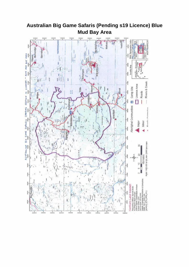
Australian Big Game Safaris (Pending s19 Licence) Blue Mud Bay Area

Map description: Australian Big Game Safaris (Pending s19 Licence) Blue Mud Bay Area
The Proposed Australian Big Game Safaris Boundary (Pending s19 Licence) sits within the Qualifying Area.
The eastern boundary runs along Blue Mud Bay from approximately Haddon Head to Bennet Bay. The southern boundary travels approximately 60 kilometres west towards Parsons Range. The western boundary runs approximately 120 kilometres north/south adjacent Parsons Range to approximately Mount Parsons. The northern boundary extends eastwards approximately from Mount Parsons to Haddon Head. The Proposed Australian Big Game Safaris Boundary includes the communities of Ngilipitji, Marrkalawa, Andanangki, Yilila, Waldnarr and Marraya.
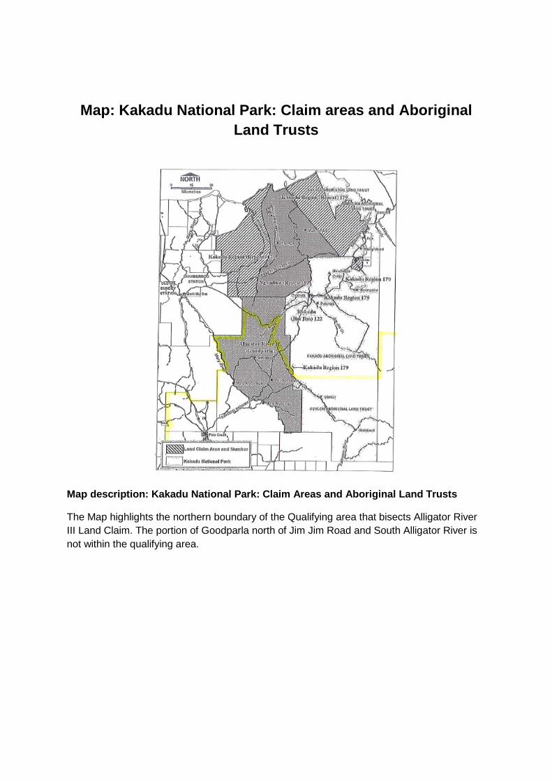
Map: Kakadu National Park: Claim areas and Aboriginal Land Trusts
Map description: Kakadu National Park: Claim Areas and Aboriginal Land Trusts
The Map highlights the northern boundary of the Qualifying area that bisects Alligator River III Land Claim. The portion of Goodparla north of Jim Jim Road and South Alligator River is not within the qualifying area.
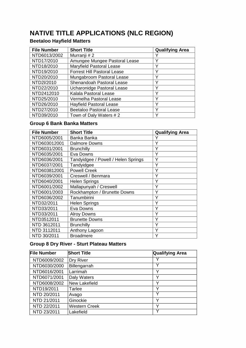
NATIVE TITLE APPLICATIONS (NLC REGION) Beetaloo Hayfield Matters
File Number Short Title Qualifying Area NTD6013/2002 Murranji # 2 Y NTD17/2010 Amungee Mungee Pastoral Lease Y NTD18/2010 Maryfield Pastoral Lease Y NTD19/2010 Forrest Hill Pastoral Lease Y NTD20/2010 Mungabroom Pastoral Lease Y NTD2l/2010 Shenandoah Pastoral Lease Y NTD22/2010 Ucharonidge Pastoral Lease Y NTD2412010 Kalala Pastoral Lease Y NTD25/2010 Vermelha Pastoral Lease Y NTD26/2010 Hayfield Pastoral Lease Y NTD27/2010 Beetaloo Pastoral Lease Y NTD39/2010 Town of Daly Waters # 2 Y
Group 6 Bank Banka Matters
File Number Short Title Qualifying Area NTD6005/2001 Banka Banka Y NTD603012001 Dalmore Downs Y NTD6031/2001 Brunchilly Y NTD6035/2001 Eva Downs Y NTD6036/2001 Tandyidgee / Powell / Helen Springs Y NTD6037/2001 Tandyidgee Y NTD603812001 Powell Creek Y NTD6039/2001 Creswell / Benmara Y NTD6040/2001 Helen Springs Y NTD6001/2002 Mallapunyah / Creswell Y NTD6001/2003 Rockhampton / Brunette Downs Y NTD6036/2002 Tanumbirini Y NTD32/2011 Helen Springs Y NTD33/2011 Eva Downs Y NTD33/2011 Alroy Downs Y NTD3512011 Brunette Downs Y NTD 3612011 Brunchilly Y NTD 3112011 Anthony Lagoon Y NTD 30/2011 Broadmere Y
Group 8 Dry River - Sturt Plateau Matters
File Number Short Title Qualifying Area NTD6009/2002 Dry River Y NTD6030/2000 Billengarrah Y NTD6016/2001 Larrimah Y NTD6071/2001 Daly Waters Y NTD6008/2002 New Lakefield Y NTD19/2011 Tarlee Y NTD 20/2011 Avago Y NTD 21/2011 Ginockie Y NTD 22/2011 Western Creek Y NTD 23/2011 Lakefield Y
File Number Short Title Qualifying Area NTD 24/2011 Cow Creek Y NTD 25/2011 Gorrie Y NTD 26/2011 Larrizona Y NTD 27/2011 Wyworrie Y NTD 28/2011 Sunday Creek Y NTD 29/2011 Bloodwood Downs Y
Group 1 Mallapunyah / Creswell Matters
File Number Short Title Qualifying Area NTD6001/2002 Mallapunyah / Creswell Y NTD6020/1998 BmToloola Region Y NTD6021/1998 Borroloola Gulf Region Y NTD6016/2000 Lorella Downs Y NTD6017/2000 Spring Creek # 2 Y NTD6019/2000 Wollogorang Y NTD6020/2000 Spring Creek # 1 Y NTD6023/2000 Kiana # 1 Y NTD6030/2000 Billengarah Y NTD6031/2000 McArthur River Y NTD6003/2001 Mallapunyah North Y NTD6004/2001 Calvert Hills Y NTD6020/2001 Calvert Hills # 2 Y NTD6024/2001 Kiana - Calvert Y NTD6032/2001 North Calvert Hills Y NTD6039/2001 Creswell Benmara Y NTD6051/2001 Spring Creek# 4 Y NTD6058/2001 Pungalinga Y NTD6068/2001 Kiana West Y NTD6012/2002 Wollogorang South Y NTD6015/2002 McArthur River # 2 Y NTD6001/2003 Rockhampton / Brunette Downs Y
Group 2 Dalmore Downs matters
File Number Short Title Qualifying Area NTD6030/2001 Dalmore Downs Y NTD6012/2001 Mt Drummond Y NTD600312002 Dalmore Downs South Y NTD601612002 Burramurra Y NTD6001/2003 Rockhampton I Brunette Downs Y
Group 3 Chattahoochie Matters
File Number Short Title Qualifying Area NTD6019/2001 Chattahoochie Y NTD602612000 Roper Valley Y NTD601112001 Mountain Valley Y NTD6013/2001 Urapunga #2 Y NTD6014/2001 Goondooloo / Moroak Y
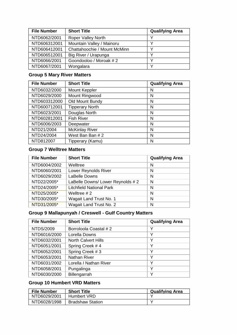
File Number Short Title Qualifying Area NTD6062/2001 Roper Valley North Y NTD606312001 Mountain Valley / Mainoru Y NTD606412001 Chattahoochie / Mount McMinn Y NTD606512001 Big River / Urapunga Y NTD6066/2001 Goondooloo / Moroak # 2 Y NTD6067/2001 Wongalara Y
Group 5 Mary River Matters
File Number Short Title Qualifying Area NTD6032/2000 Mount Keppler N NTD6029/2000 Mount Ringwood N NTD603312000 Old Mount Bundy N NTD600712001 Tipperary North N NTD6023/2001 Douglas North N NTD602812001 Fish River N NTD6006/2003 Deepwater N NTD21/2004 McKinlay River N NTD24/2004 West Ban Ban # 2 N NTD812007 Tipperary (Kamu) N
Group 7 Welltree Matters
File Number Short Title Qualifying Area NTD6004/2002 Welltree N NTD6060/2001 Lower Reynolds River N NTD6029/2002 LaBelle Downs N NTD22/2005* LaBelle Downs/ Lower Reynolds # 2 N NTD24/2005* Litchfield National Park N NTD25/2005* Welltree # 2 N NTD30/2005* Wagait Land Trust No. 1 N NTD31/2005* Wagait Land Trust No. 2 N
Group 9 Mallapunyah / Creswell - GuIf Country Matters
File Number Short Title Qualifying Area NTDS/2009 Borroloola Coastal # 2 Y NTD6016/2000 Lorella Downs Y NTD6032/2001 North Calvert Hills Y NTD6051/2001 Spring Creek # 4 Y NTD6052/2001 Spring Creek # 3 Y NTD6053/2001 Nathan River Y NTD6031/2002 Lorella I Nathan River Y NTD6058/2001 Pungalinga Y NTD6030/2000 Billengarrah Y
Group 10 Humbert VRD Matters
File Number Short Title Qualifying Area NTD6029/2001 Humbert VRD Y NTD6028/1998 Bradshaw Station Y

File Number Short Title Qualifying Area NTD6011/2002 Willeroo - Delamere Y
Group 11 Mary River- Litchfield / Daly Matters
File Number Short Title Qualifying Area NTD6018/2000 Mary River Y NTD6029/2000 Mt Ringwood (part only) N NTD6006/2001 Mary River West Y NTD6018/2001 Bonrook Y NTD6021/2001 Ban Ban Springs N NTD9/2004 Jindare Y NTD24/2004 West Ban Ban # 2 N NTD20/2004 Edith River Y
Group 12 Dry River - Katherine West Matters
File Number Short Title Qualifying Area NTD6049/2001 West Mathison Y NTD6009/2002 Dry River Y NTD6011/2002 Willeroo - Delamere Y
Group 13 Dry River- Daly Waters Maters
File Number Short Title Qualifying Area NTD6071/2001 Daly Waters Y NTD6008/2001 Newcastle Waters Y
Batchelor Matters
File Number Short Title Qualifying Area NTD6057/2001 Town of Batchelor N NTD21/2005* Town of Batchelor N NTD18/2006* Town of Batchelor N
Mataranka Matters
File Number Short Title Qualifying Area NTD6001/2001 Mataranka Y NTD6026/2002 Town of Mataranka Y
Borroloola Matters
File Number Short Title Qualifying Area NTD6014/2000 Lots 825 & 826 Borroloola Y NTD6003/2003 Town of Borroloola Y
Other Northern Towns Matters
File Number Short Title Qualifying Area NTD6002/1999 Town of Katherine Y NTD6001/2000 Lot 1348 Katherine Y

File Number Short Title Qualifying Area NTD6005/1999 Portion 4724 Adelaide River N NTD6027/2000 Adelaide River Lot 176 (A) N NTD6045/2001 Lot 160 Town of Adelaide River N NTD6005/2002 Town of Adelaide River N NTD6014/1999 Middle Arm N NTD6025/2000 Town of Weddell N NTD6015/1999 Part Lot 291 Pine Creek Y NTD6019/1999 Pine Creek # 2 Y NTD6020/2002 Town of Pine Creek Y NTD6015/2000 Mary River West Portion 4410 Y
Offshore Matters
File Number Short Title Qualifying Area NTD6024/1998 Edward Pellew Islands Y NTD6025/1998 West Arnhem Seas Y NTD6043/1998 Blue Mud Bay No. 1 N NTD6009/2001 Bonaparte Gulf Y
Miscellaneous
File Number Short Title Qualifying Area NTD6042/l998* Daly River N NTD23/2005* Bynoe # 2 N NTD28/2007* N NTD18/2009* N
The total number of applications is 153. Employed NLC solicitors are retained to represent the claimants regarding 142 of these applications, the exceptions being those marked with an asterisk (*). The number of applications in the s 21A qualifying area is 120. Employed NLC solicitors are retained to represent the claimants regarding all of these applications. One application is bisected by the qualifying area's boundary, being NTD 6018/2000 (Mary River).