
Appendix VIII Standard Operating Procedures – Road ... · 1991 1996, 1991 Forest Nutrition...
72
Appendix VIII Standard Operating Procedures – Road Deactivation
Transcript of Appendix VIII Standard Operating Procedures – Road ... · 1991 1996, 1991 Forest Nutrition...

Appendix VIII Standard Operating Procedures
– Road Deactivation

SOP – Road Deactivation Page 1

SOP – Road Deactivation Page 2

SOP – Road Deactivation Page 3

SOP – Road Deactivation Page 4

SOP – Road Deactivation Page 5
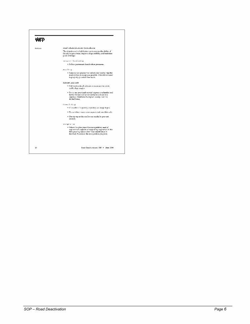
SOP – Road Deactivation Page 6

Appendix IX Forest Research Projects

TFL 19 – Forest Research Projects Page 1
TFL 19 FOREST RESEARCH PROJECTS WFP continues as a leader in silvicultural research in coastal BC. The Company has initiated numerous projects aimed at improving and supporting sustainable forestry practices. The following lists include projects that WFP is following at present. Trials and surveys within TFL 19 are included together with applicable projects from other sites on Vancouver Island.
Growth and Yield
Trial/Survey Year Established Measurements Reports Other G & Y Survey Plots
1991 1996, 1991
Forest Nutrition
Trial/Survey Year Established Measurements Reports Other Hemlock and Cedar Fertilization Screening Trial
1996 1997 1998
Amabilis Fir Fertilization Trial
1996 1996 1997
Cedar and Amabilis Fir Fertilization Screening Trial
1999 1999 1999
Miscellaneous Trials
Trial/Survey Year Established Measurements Reports Other Planting Technique Trial
1997 1998, 1997
FOREST RESEARCH PROJECTS Vancouver Island
Growth and Yield
Trial/Survey Year Established Measurements Reports Other Site Index Species Conversion Survey
1997 (Holberg, Port McNeill, Jeune Landing)
1997
Type III Growth & Yield Installations
1988 (Holberg, Port McNeill, Jordan River)
1995 1995 MOF Report Vegetation measures – 1997
G & Y Survey Plots
1994 (Port McNeill)
1994
G & Y Survey Plots
1993 (Port McNeill)
1993
G & Y Survey Plots
1992 (Port McNeill)
1992
G & Y Survey Plots
1991 (Port McNeill, Jeune Landing)
1991
G & Y Survey Plots
1989 (Port McNeill, Jeune Landing)
1989
G & Y Survey Plots
1988 (Port McNeill)
1988

TFL 19 – Forest Research Projects Page 2
Forest Nutrition
Trial/Survey Year Established Measurements Reports Other SCHIRP1 Establishment Trial
1988 (Port McNeill)
1997, 1994, 1990, 1988, 1987
1996 Field Guide 1996 Update 1994 Synthesis
Foliar Sampling 1997
Demonstration Trials
1984 & 1987 (Port McNeill)
1998, 1996, 1990, 1989, 1988, 1987, 1986, 1985, 1984
1994 Synthesis Foliar Sampling 1997
Salal Eradication Trial
1984 (Port McNeill)
1994 1996 Update
S1CH Scarification Trial
1996 (Port McNeill)
1997, 1995 Salal Measures 1998
S1CH Individual Tree Fertilization Trials
1996 (Holberg, Port McNeill)
1997, 1995
S1CH/S1HA Transitional Trials
1996 (Holberg, Port McNeill)
1997, 1995 Salal Measures 1998
Organic Fertilization Trials
1990, 1993, 1994, 1997 (Port McNeill)
Many 1996 Update
Operational Fertilization Monitoring Surveys
1986 - 1999 (Holberg, Port McNeill, Jeune Landing)
Many 1997 Interim Report
Genetics Trials
Trial/Survey Year Established Measurements Reports Other Yellow Cypress Clonal Trials
1991 – 1999 (Holberg, Port McNeill, Jeune Landing, Jordan River)
1991 – 1999 Interim Report
Douglas-fir Progeny Trial
1993 (Port McNeill)
1997
Hybrid Poplar Clonal Trial
1991 (Holberg) 1993, 1991
Miscellaneous Trials
Trial/Survey Year Established Measurements Reports Other Suquash Drainage Trial
1997 (Port McNeill)
1999, 1998, 1997
S4 Sitka Spruce Trial
1984 (Holberg) 1995, 1990, 1988, 1987, 1986, 1985, 1984
Interim Report
1 Salal Cedar Hemlock Integrated Research Program

Appendix X Public Review Plan MP 9

TFL 19 – Public Review Plan MP 9 Page 1
File: 194-9
August 2000 Revised
Tree Farm Licence 19 – Management Plan 9
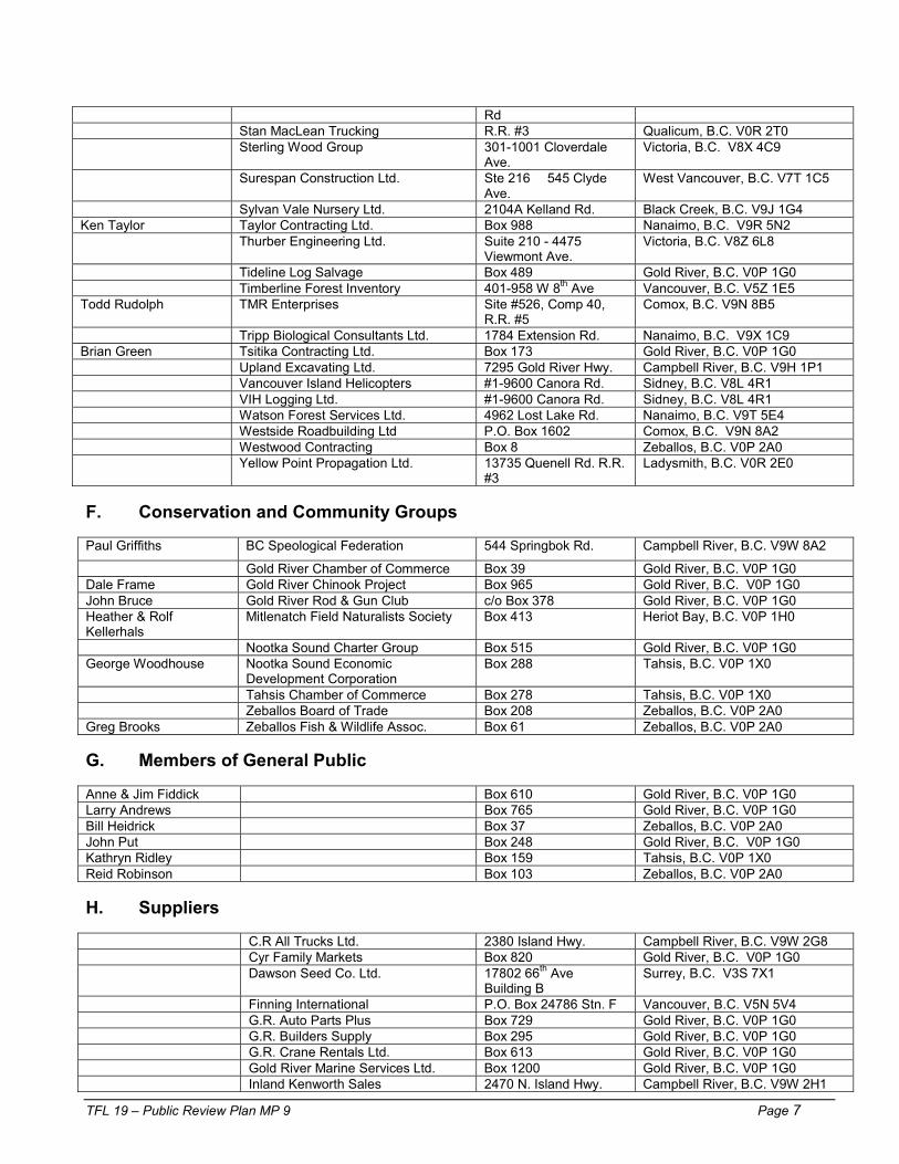
Stakeholder and Public Review Strategy Management Plan 9 (MP 9) for Tree Farm Licence 19 (TFL 19) is scheduled for approval and to be effective August 1, 2001 for a period of five years. As part of the preparation of Management Plan 9, this strategy has been developed to address legislation and policy requirements for the stakeholder and public review and involvement in the preparation of MP 9. There are 2 phases to the revised TFL 19 Public Review Strategy: Phase I Public review of the current Management Plan 8 for TFL 19 (completed) Phase II Review of the draft Management Plan 9 Phase 1 of the public review strategy was completed in March, 1999 after a 2 month period of extended public access to the currently approved Management Plan 8. A primary vehicle for TFL 19 reviews is the stakeholder contact list (attached) prepared from a number of sources. The 226 individuals and groups are categorized as follows:
A. Resource Agencies B. Trappers, Guide Outfitters and other licenced resource users C. First Nations D. Local Government/Resource Boards E. Employees, labor unions and contractors F. Conservation and Community groups G. General public H. Suppliers I. Other forest licensees J. Forest users and others
The following format and strategy is in agreement with that outlined in the guide for Tree Farm Licence Management Plans (20-month) (May 2000)
1. Advertisements, Public and Stakeholder Notification
Phase I – Public Viewing of Current Management Plan
• An invitation letter (A) and comment sheet (B) was sent to the 190 names on the TFL 19
stakeholder list outlining the process. • The attached advertisement (C) appeared twice in the weekly North Island Gazette, the
Gold River Record, the Campbell River Mirror and the Campbell River Courier/Islander in February 1998 to inform the public that the current Management Plan 8 was available for review in various WFP and Ministry of Forests offices, the Tahsis Recreation Centre and at WFP’s website.
• The advertisement was inserted for two weeks prior to the viewing opportunity.

TFL 19 – Public Review Plan MP 9 Page 2
• The area of distribution of the four newspapers used for advertising is the northern Vancouver Island communities of Port Alice, Coal Harbour, Winter Harbour, Quatsino, Woss, Beaver Cove, Alert Bay, Sointula, Port Hardy, Port McNeill, Jeune Landing and Holberg, Zeballos, Tahsis, Kyouquot, Gold River, Campbell River and Courtenay.
• A mailing was sent to the TFL 19 stakeholder list attached. • The public comment and review process for Management Plan 8 is focused on making
the existing plan available to the public in 7 convenient locations outlined in the advertisement and on WFP’s web site.
Phase II – Public viewing of Draft Management Plan
• The attached display advertisement (D) will appear twice in the Gold River Record,
Campbell River Mirror, Campbell River Courier/Islander and North Island Gazette to inform the public that the draft MP 9 is available at 4 open houses in Gold River, Campbell River and Tahsis on each of three days at varying times accessible to the public during and after working hours.
• The ad will be posted on WFP’s website and distributed to the TFL 19 stakeholder list. The draft itself will be on the website also.
2. Individual Notification Letters
Phase I This phase has been completed for MP 9. The attached letter (A) was distributed
to those reviewing MP 8. A comment response sheet (B) was provided to those reviewing MP 8. A summary report was provided to the Ministry of Forests on the results of Phase I.
Phase II The stakeholder list (now expanded to 226 as a result of Phase I responses) will
be contacted (letter E) to inform them of a series of 4 open houses in Tahsis, Zeballos, Gold River and Campbell River and an offer of special presentations if so desired. During Phase II WFP staff will meet with the 4 local Municipal Councils in Tahsis, Gold River , Zeballos and Campbell River and 4 First Nations groups to solicit comments on the draft plan. As well, WFP will meet with each of the Nootka Region Union/Management Committees (cooperative co design committees in the Gold River and Zeballos Operations respectively). Other meetings will be offered to any groups requesting further information on MP 9 to review the draft plan.
3. Public Reviews and Viewing Format and Reports
Phase I
• This phase is completed. WFP supplied a letter and comment form (A &B) to each person
who took the opportunity to review MP 8. • A summary report was prepared with the results of the review. Names of individuals
responding in Phase I were used to amend the list for Phase II distributions.
Phase II
• The strategy involves notification of the public using display advertising (E) in 4 Central and North Island newspapers and contacting the TFL 19 stakeholder list with the notice of public viewings and an executive summary of the draft MP
• The four open houses will be staffed by senior WFP foresters and planners to provide details on the draft plan.

TFL 19 – Public Review Plan MP 9 Page 3
• WFP has an excellent format for presenting complex technical information in a display that is easily understood by the public
• A guest list will be maintained (F) • All attendees will be interviewed and requested to complete a comment sheet on site or
to be mailed in. An award will be offered for return of comment sheets (See comment sheet (G)and summary sheet (H).
• Comments from the interviews of open house attendees will be posted on a flip chart for review by other visitors. These comments will be summarized and recorded.
• A summary report will be prepared on the public viewings re: · All activities in Phase II · Number of attendees · Verbal and written comments received · Changes to the draft MP 9 in response to the comments · Other pertinent information
4. Proposed Schedule of Public Reviews
Phase
Item
Proposed or Actual Dates
Public comment on MP 8
March, April 1999
1
Public review strategy prepared
March 1999
II
Public review of Draft MP
September 2000

TFL 19 – Public Review Plan MP 9 Page 4
TFL 19 Management Plan 9 Stakeholders List
File: 94-9
A. Resource Agencies District Manager, Don Sluggett Ministry of Forests 370 S. Dogwood St. Campbell River, B.C. V9W 6Y7
Regional Manager, Ken Collingwood Ministry of Forests 2100 Labieux Road Nanaimo, B.C.V9T 6E9
TFL Forester, Jacques Bousquet Ministry of Forests 3rd Floor, 1450 Gov.’t St. Victoria, B.C.V8W 3E7
Resource Planner, Bruce Whyte
Ministry of Small Business, Tourism & Culture
P.O. Box 9806, St. Prov. Gov’t Victoria, B.C.V8W 9W1
Regional Manager, Mike Whately MoELP BC Environment 2080-A Labieux Road Nanaimo, B.C.V9T 6J9
Habitat Officer, MoELP BC Environment 101-370 Dogwood St. Campbell River, B.C.V9W 6Y7 Forest Ecosystem Specialist, Ron Diederichs MoELP BC Environment 101-370 Dogwood St. Campbell River, B.C.V9W 6Y7
Area Supervisor - Nootka Brent Blackburn MoELP BC Parks 1812 Miracle Beach Dr. Black Creek, B.C.V9J 1K1
Habitat Technician, Frank Volsey Dept. of Fisheries & Oceans 315-940 Alder St. Campbell River, B.C.V9W 2P8
District Manager, Greg Carriere Ministry of Energy & Mines 2080-B Labieux Road Nanaimo, B.C.V9T 6J9
Paul S. Watson B.C. Assessment Authority 1537 Hillside Victoria, B.C. V8T 4Y2 B. Trappers, Guide Outfitters, other Licensed Resource Users Alban Michael General Delivery Zeballos, B.C. V0P 2A0 Aloysios Vincent General Delivery Kyuquot, B.C. V0P 1J0 Andrew L. Murphy c/o Box 905 Gold River, B.C. V0P 1G0 Arnold John Box 681 Tahsis, B.C. V0P 1X0 Cecil Smith 795 Brechin Rd. Nanaimo, B.C. V0S 2Z3 Earl J. Smith Box 716 Campbell River, B.C. V9W 6J3 Estate of Anthony John c/o H. Watts Box 1224 Port Alberni, B.C. V9Y 7M1 G. Brooks Box 61 Zeballos, B.C. V0P 2AO G. Lavoie Box 156 Merville, B.C. V0R 2M0 George Randall Chipps 4905 E. Sooke Rd. RR#1 Sooke, B.C. V0S 1N0 Herbert Jack General Delivery Kyuquot, B.C. V0P 1J0 Jack Johnson Box 701 Gold River, B.C. V0P 1G0 James Adam PO Box 459 Gold River, B.C. V0P 1G0 James Short, Sr. General Delivery Kyuquot, B.C. V0P 1J0 Joseph Jack Box 667 Tahsis, B.C. V0P 1X0 Larry Rose Box 794 Gold River, B.C. V0P 1G0 Estate of Maurus McLean Box 324 Gold River, B.C. V0P 1G0 S. Neufield Box 176 Dease Lake, B.C. V0C 1L0 Violet Johnson Box 747 Gold River, B.C. V0P 1G0 W. Wagner 3213 Lockwell Rd. RR#6 Courtenay, B.C. V9N 8H9 H. Birch R.R. #4, Site 412, C-16 Courtenay, B.C. V9N 7J3 W. Colbow Box 25 Merville, B.C. V0R 2M0 P.H. Birch R.R. #4, Site 412, C-16 Courtenay, B.C. V9N 7J3 Arnold James PO Box 553 Gold River, B.C., V0P 1G0 Tom Craig 523 Thulin Street Campbell River, B.C., V9W 2L1 Bill Heidrick PO Box 37 Zeballos, B.C., V0P 2A0

TFL 19 – Public Review Plan MP 9 Page 5
John Put PO Box 248 Gold River, B.C., V0P 1G0 Kathryn Ridley PO Box 159 Tahsis, B.C., V0P 1X0 Reid Robinson PO Box 103 Zeballos, B.C., V0P 2A0 Arien Gedlaman PO Box 124 Tahsis, B.C., V0P 1X0 Cindy Cullen 44 Alpine View Tahsis, B.C., V0P 1X0 Leslie Taylor PO Box 546 Tahsis, B.C., V0P 1X0 Grant Skinner PO Box 700 Tahsis, B.C., V0P 1X0 Faye Friesen PO Box 694 Tahsis, B.C., V0P 1X0 Virginia Mountan PO Box 659 Tahsis, B.C., V0P 1X0 Sean Jordan PO Box 248 Gold River, B.C., V0P 1G0 Kum Soo Chong PO Box 88 Tahsis, B.C., V0P 1X0 Arne Puggaard PO Box 69 Tahsis, B.C., V0P 1X0 Wayne Magill PO Box 715 Tahsis, B.C., V0P 1X0 David McIntosh PO Box 114 Tahsis, B.C., V0P 1X0 Don Stewart PO Box 1 Tahsis, B.C., V0P 1X0 Wayne Nicholson PO Box 48 Tahsis, B.C., V0P 1X0 Robert Spencer PO Box 213 Tahsis, B.C., V0P 1X0 Harold Harms PO Box 161 Tahsis, B.C., V0P 1X0 Dave & Elva John PO Box 424 Tahsis, B.C., V0P 1X0 D. Clemenson PO Box 191 Tahsis, B.C., V0P 1X0 Richard Lucas PO Box 113 Tahsis, B.C., V0P 1X0 Diane Fisher PO Box 422 Tahsis, B.C., V0P 1X0 Pierre Benoit PO Box 346 Tahsis, B.C., V0P 1X0 D. Beamix PO Box 673 Tahsis, B.C., V0P 1X0 Dennis Rogers PO Box 184 Tahsis, B.C., V0P 1X0 Sandra Naylor PO Box 282 Tahsis, B.C., V0P 1X0 Pat Finnegan PO Box 146 Tahsis, B.C., V0P 1X0 Randy Musfelt PO Box 396 Tahsis, B.C., V0P 1X0 Clayton Wills PO Box 472 Tahsis, B.C., V0P 1X0 Joseph Ganyo PO Box 57 Tahsis, B.C., V0P 1X0 Viv Yagabarum PO Box 713 Tahsis, B.C., V0P 1X0 John Vincent PO Box 17 Tahsis, B.C., V0P 1X0 Mike & Carol Dopelhamer PO Box 335 Tahsis, B.C., V0P 1X0 C. First Nations Chief Dawn Amos Ehattesaht First Nation Box 59 Zeballos, B.C. V0P 2A0 Chief Richard Leo Ka:'yu:'k't'h/Chek:k:tles 7et’h’
First Nation Box 218 Kyuquot, B.C. V0P 1J0
Chief Mike Maquinna Mowachaht/Muchalaht First Nation Box 459 Gold River, B.C. V0P 1G0 Chair Lillian Howard Northern Nuu-chah-hulth
Tribal Council Box 428 Gold River, B.C. V0P 1G0
Chief Walter Michael Nuchatlaht Tribe Box 40 Zeballos, B.C. V0P 2A0 D. Local Government and Resource Boards Chair Tom McCrae Comox-Strathcona
Regional District, West Coast Committee
R.R. #4-4795 Headquarters Rd.
Courtenay, B.C. V9N 7J3
Chair John Crowhurst Nootka Resource Board Box 760 Gold River, B.C. V0P 1G0 Mayor Dayle Crawford Village of Gold River Box 610 Gold River, B.C. V0P 1G0 Mayor Tom McCrae Village of Tahsis Box 519 Tahsis, B.C. V0P 1X0 Mayor Clifford Pederson Village of Zeballos Box 127 Zeballos, B.C. V0P 2A0 E. Employees, Labour Unions, Contractors
Ed McDonald 1901 Bay Street Nanaimo, B.C. V9T 3A6 Terry Lewis 1472 Valleyview Dr. Courtenay, B.C. V9N 8S7 Robin Williams 282 Finch Road Campbell River, B.C. V9W 7C2 Air Nootka Box 19 Gold River, B.C. V0P 1G0 Arcas Consulting Ltd. 55A Fawcett Rd. Coquitlam, B.C. V3K 6W9
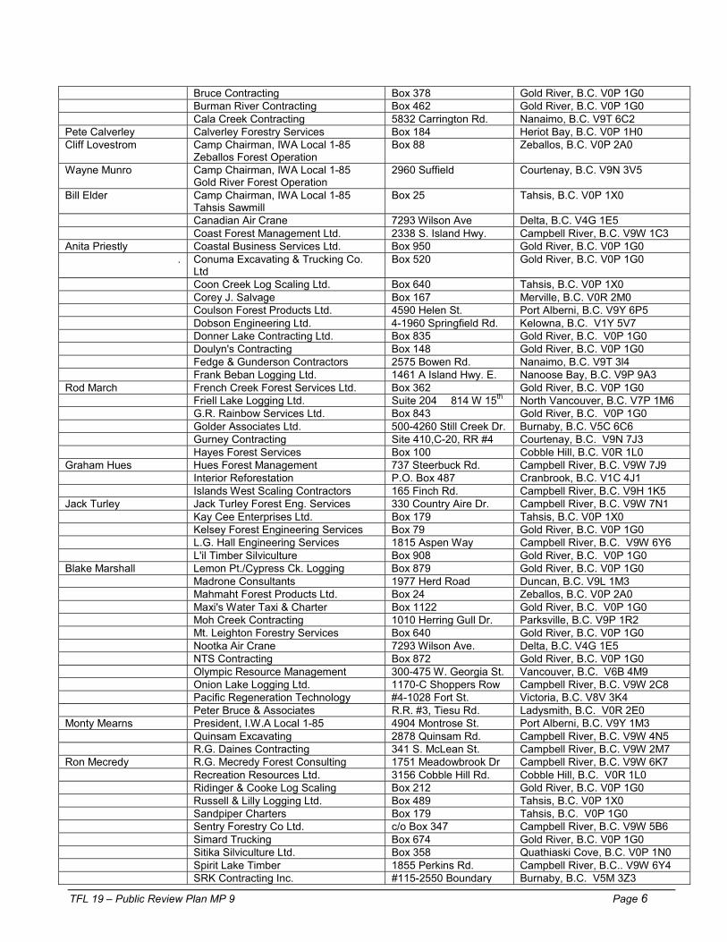
TFL 19 – Public Review Plan MP 9 Page 6
Bruce Contracting Box 378 Gold River, B.C. V0P 1G0 Burman River Contracting Box 462 Gold River, B.C. V0P 1G0 Cala Creek Contracting 5832 Carrington Rd. Nanaimo, B.C. V9T 6C2 Pete Calverley Calverley Forestry Services Box 184 Heriot Bay, B.C. V0P 1H0 Cliff Lovestrom Camp Chairman, IWA Local 1-85
Zeballos Forest Operation Box 88 Zeballos, B.C. V0P 2A0
Wayne Munro Camp Chairman, IWA Local 1-85 Gold River Forest Operation
2960 Suffield Courtenay, B.C. V9N 3V5
Bill Elder Camp Chairman, IWA Local 1-85 Tahsis Sawmill
Box 25 Tahsis, B.C. V0P 1X0
Canadian Air Crane 7293 Wilson Ave Delta, B.C. V4G 1E5 Coast Forest Management Ltd. 2338 S. Island Hwy. Campbell River, B.C. V9W 1C3 Anita Priestly Coastal Business Services Ltd. Box 950 Gold River, B.C. V0P 1G0
. Conuma Excavating & Trucking Co. Ltd
Box 520 Gold River, B.C. V0P 1G0
Coon Creek Log Scaling Ltd. Box 640 Tahsis, B.C. V0P 1X0 Corey J. Salvage Box 167 Merville, B.C. V0R 2M0 Coulson Forest Products Ltd. 4590 Helen St. Port Alberni, B.C. V9Y 6P5 Dobson Engineering Ltd. 4-1960 Springfield Rd. Kelowna, B.C. V1Y 5V7 Donner Lake Contracting Ltd. Box 835 Gold River, B.C. V0P 1G0 Doulyn's Contracting Box 148 Gold River, B.C. V0P 1G0 Fedge & Gunderson Contractors 2575 Bowen Rd. Nanaimo, B.C. V9T 3l4 Frank Beban Logging Ltd. 1461 A Island Hwy. E. Nanoose Bay, B.C. V9P 9A3 Rod March French Creek Forest Services Ltd. Box 362 Gold River, B.C. V0P 1G0 Friell Lake Logging Ltd. Suite 204 � 814 W 15th North Vancouver, B.C. V7P 1M6 G.R. Rainbow Services Ltd. Box 843 Gold River, B.C. V0P 1G0 Golder Associates Ltd. 500-4260 Still Creek Dr. Burnaby, B.C. V5C 6C6 Gurney Contracting Site 410,C-20, RR #4 Courtenay, B.C. V9N 7J3 Hayes Forest Services Box 100 Cobble Hill, B.C. V0R 1L0 Graham Hues Hues Forest Management 737 Steerbuck Rd. Campbell River, B.C. V9W 7J9 Interior Reforestation P.O. Box 487 Cranbrook, B.C. V1C 4J1 Islands West Scaling Contractors 165 Finch Rd. Campbell River, B.C. V9H 1K5 Jack Turley Jack Turley Forest Eng. Services 330 Country Aire Dr. Campbell River, B.C. V9W 7N1 Kay Cee Enterprises Ltd. Box 179 Tahsis, B.C. V0P 1X0 Kelsey Forest Engineering Services Box 79 Gold River, B.C. V0P 1G0 L.G. Hall Engineering Services 1815 Aspen Way Campbell River, B.C. V9W 6Y6 L'il Timber Silviculture Box 908 Gold River, B.C. V0P 1G0 Blake Marshall Lemon Pt./Cypress Ck. Logging Box 879 Gold River, B.C. V0P 1G0 Madrone Consultants 1977 Herd Road Duncan, B.C. V9L 1M3 Mahmaht Forest Products Ltd. Box 24 Zeballos, B.C. V0P 2A0 Maxi's Water Taxi & Charter Box 1122 Gold River, B.C. V0P 1G0 Moh Creek Contracting 1010 Herring Gull Dr. Parksville, B.C. V9P 1R2 Mt. Leighton Forestry Services Box 640 Gold River, B.C. V0P 1G0 Nootka Air Crane 7293 Wilson Ave. Delta, B.C. V4G 1E5 NTS Contracting Box 872 Gold River, B.C. V0P 1G0 Olympic Resource Management 300-475 W. Georgia St. Vancouver, B.C. V6B 4M9 Onion Lake Logging Ltd. 1170-C Shoppers Row Campbell River, B.C. V9W 2C8 Pacific Regeneration Technology #4-1028 Fort St. Victoria, B.C. V8V 3K4 Peter Bruce & Associates R.R. #3, Tiesu Rd. Ladysmith, B.C. V0R 2E0 Monty Mearns President, I.W.A Local 1-85 4904 Montrose St. Port Alberni, B.C. V9Y 1M3 Quinsam Excavating 2878 Quinsam Rd. Campbell River, B.C. V9W 4N5 R.G. Daines Contracting 341 S. McLean St. Campbell River, B.C. V9W 2M7 Ron Mecredy R.G. Mecredy Forest Consulting 1751 Meadowbrook Dr Campbell River, B.C. V9W 6K7 Recreation Resources Ltd. 3156 Cobble Hill Rd. Cobble Hill, B.C. V0R 1L0 Ridinger & Cooke Log Scaling Box 212 Gold River, B.C. V0P 1G0 Russell & Lilly Logging Ltd. Box 489 Tahsis, B.C. V0P 1X0 Sandpiper Charters Box 179 Tahsis, B.C. V0P 1G0 Sentry Forestry Co Ltd. c/o Box 347 Campbell River, B.C. V9W 5B6 Simard Trucking Box 674 Gold River, B.C. V0P 1G0 Sitika Silviculture Ltd. Box 358 Quathiaski Cove, B.C. V0P 1N0 Spirit Lake Timber 1855 Perkins Rd. Campbell River, B.C.. V9W 6Y4 SRK Contracting Inc. #115-2550 Boundary Burnaby, B.C. V5M 3Z3
TFL 19 – Public Review Plan MP 9 Page 7
Rd Stan MacLean Trucking R.R. #3 Qualicum, B.C. V0R 2T0 Sterling Wood Group 301-1001 Cloverdale
Ave. Victoria, B.C. V8X 4C9
Surespan Construction Ltd. Ste 216 � 545 Clyde Ave.
West Vancouver, B.C. V7T 1C5
Sylvan Vale Nursery Ltd. 2104A Kelland Rd. Black Creek, B.C. V9J 1G4 Ken Taylor Taylor Contracting Ltd. Box 988 Nanaimo, B.C. V9R 5N2 Thurber Engineering Ltd. Suite 210 - 4475
Viewmont Ave. Victoria, B.C. V8Z 6L8
Tideline Log Salvage Box 489 Gold River, B.C. V0P 1G0 Timberline Forest Inventory 401-958 W 8th Ave Vancouver, B.C. V5Z 1E5 Todd Rudolph TMR Enterprises Site #526, Comp 40,
R.R. #5 Comox, B.C. V9N 8B5
Tripp Biological Consultants Ltd. 1784 Extension Rd. Nanaimo, B.C. V9X 1C9 Brian Green Tsitika Contracting Ltd. Box 173 Gold River, B.C. V0P 1G0 Upland Excavating Ltd. 7295 Gold River Hwy. Campbell River, B.C. V9H 1P1 Vancouver Island Helicopters #1-9600 Canora Rd. Sidney, B.C. V8L 4R1 VIH Logging Ltd. #1-9600 Canora Rd. Sidney, B.C. V8L 4R1 Watson Forest Services Ltd. 4962 Lost Lake Rd. Nanaimo, B.C. V9T 5E4 Westside Roadbuilding Ltd P.O. Box 1602 Comox, B.C. V9N 8A2 Westwood Contracting Box 8 Zeballos, B.C. V0P 2A0 Yellow Point Propagation Ltd. 13735 Quenell Rd. R.R.
#3 Ladysmith, B.C. V0R 2E0
F. Conservation and Community Groups Paul Griffiths BC Speological Federation 544 Springbok Rd. Campbell River, B.C. V9W 8A2
Gold River Chamber of Commerce Box 39 Gold River, B.C. V0P 1G0 Dale Frame Gold River Chinook Project Box 965 Gold River, B.C. V0P 1G0 John Bruce Gold River Rod & Gun Club c/o Box 378 Gold River, B.C. V0P 1G0 Heather & Rolf Kellerhals
Mitlenatch Field Naturalists Society Box 413 Heriot Bay, B.C. V0P 1H0
Nootka Sound Charter Group Box 515 Gold River, B.C. V0P 1G0 George Woodhouse Nootka Sound Economic
Development Corporation Box 288 Tahsis, B.C. V0P 1X0
Tahsis Chamber of Commerce Box 278 Tahsis, B.C. V0P 1X0 Zeballos Board of Trade Box 208 Zeballos, B.C. V0P 2A0 Greg Brooks Zeballos Fish & Wildlife Assoc. Box 61 Zeballos, B.C. V0P 2A0 G. Members of General Public Anne & Jim Fiddick Box 610 Gold River, B.C. V0P 1G0 Larry Andrews Box 765 Gold River, B.C. V0P 1G0 Bill Heidrick Box 37 Zeballos, B.C. V0P 2A0 John Put Box 248 Gold River, B.C. V0P 1G0 Kathryn Ridley Box 159 Tahsis, B.C. V0P 1X0 Reid Robinson Box 103 Zeballos, B.C. V0P 2A0 H. Suppliers C.R All Trucks Ltd. 2380 Island Hwy. Campbell River, B.C. V9W 2G8 Cyr Family Markets Box 820 Gold River, B.C. V0P 1G0 Dawson Seed Co. Ltd. 17802 66th Ave
Building B Surrey, B.C. V3S 7X1
Finning International P.O. Box 24786 Stn. F Vancouver, B.C. V5N 5V4 G.R. Auto Parts Plus Box 729 Gold River, B.C. V0P 1G0 G.R. Builders Supply Box 295 Gold River, B.C. V0P 1G0 G.R. Crane Rentals Ltd. Box 613 Gold River, B.C. V0P 1G0 Gold River Marine Services Ltd. Box 1200 Gold River, B.C. V0P 1G0 Inland Kenworth Sales 2470 N. Island Hwy. Campbell River, B.C. V9W 2H1

TFL 19 – Public Review Plan MP 9 Page 8
Island Micro Systems 160-10th Ave Campbell River, B.C. V9W 4E3 Joe’s Hardware Ltd. Box 550 Gold River, B.C. V0P 1G0 Kal Tire 2215 Cliffe Ave. Courtenay, B.C. V9N 2L5 Loomis Courier Services Box 6670 Vancouver, B.C. V6B 4B5 Madill Equipment Canada P.O. Box 4300 Nanaimo, B.C. V9R 5M6 Nootka Sound Service Ltd. Box 57 Gold River, B.C. V0P 1G0 Overland Freight Lines 151 Spruce St. New Westminster, B.C. V3L 5E6 People’s Drug Mart Box 349 Gold River, B.C. V0P 1G0 Petro Canada Products P.O. Box 4038, Stn. A Toronto, Ont. M5W 1S5 Quinsam Radio Comm. 1437B � 16th Ave Campbell River, B.C. V9W 2E4 Steve Marshall Motors 1384 16th Ave Campbell River, B.C. V9W 2E1 The Record Box 279 Gold River, B.C. V0P 1G0 Titan Explosives Ltd. 7898 82nd St. Delta, B.C. V4C 1L6 T-Mar Industries 5791 Duncan Bay Rd. Campbell River, B.C. V9H 1N6 Wire Rope Industries Ltd. Unit B-12330 88th Ave Surrey, B.C. V3W 3J6 I. Other Forest Tenure Licensees Rob Woodside Canadian Forest Products Limited.,
Englewood Logging Division Woss, B.C. V0N 3P0
Paul Pashnik Hecate Logging 4590 Helen St. Port Alberni, B.C. V9Y 6P5 Otto Schulte International Forest Products Limited. Box 1800 Campbell River, B.C. V9W 5C5 Brad Rodway MacMillan Bloedel Limited.,
Franklin Woodlands Division Port Alberni, B.C. V9Y 7N3
Nootka First Nations Forest Prod. Ltd. Box 636 Gold River, B.C. V0P 1G0 Gary Lawson Timberwest Forest Limited Box 2500 Campbell River, B.C. V9W 5C5 J. Forest Users and Others Bowater Inc. Box 1000 Gold River, B.C. V0P 1G0 Cougar Creek Charters
(Chinootka Lodge) Box 752 Gold River, B.C. V0P 1G0
Critter Cove Marina Group Box 1118 Gold River, B.C. V0P 1G0 George Riley Galiano Bay Lodge Box 522 Gold River, B.C. V0P 1G0 Gerry Hunter Gold River Fish Camp Box 160 Gold River, B.C. V0P 1G0 Hoiss Point Lodge 639 Woodland Dr. Comox, B.C. V9M 3H3 Tim Cyr Nootka Island Fishing Camp 1322 Pintail Dr. Parksville, B.C. V9P 2A2 Nootka Sound Service Ltd. Box 57 Gold River, B.C. V0P 1G0 Nu-tka Landing Fishing Resorts 204-301 Dogwood St. Campbell River, B.C. Julius Kapitany TPI Phytogen Inc. 1527 Cliveden Ave. Delta, B.C. V3M 6P7 Westview Marina Box 481 Tahsis, B.C., V0P 1X0 Westview Towing Box 481 Tahsis, B.C. V0P 1X0

TFL 19 – Public Review Plan MP 9 Page 9
February 15, 1999 Dear Sir / Madam; Thank you for participating in this first step of the preparation for Management Plan 9 for Tree Farm Licence 19. There is a 30 month process that Western Forest Products will follow. The current Management Plan 8 expires on July 31, 2001 The first step involves an opportunity for the public to comment on our performance, offer ideas and identify issues that you feel are important to the management of Tree Farm Licence 19. From this information I will take your views and comments and prepare a Statement of Management Objectives Options and Procedures. This second step will also be available for public review and comment. As part of the public review, the existing Management Plan 8 is available in various offices as per the attached advertisement, to assist with preparation of your comments. I would very much appreciate if you would complete and return the attached questionnaire to me no later than March 15, 1999 so that your comments can be an important part of the Management Plan process for TFL 19. Yours truly WESTERN FOREST PRODUCTS LIMITED General Partner of Western Pulp Limited Partnership W.E. Dumont, R.P.F. Chief Forester WED/dg

Page 10
February 1999
TFL 19 Management Plan 9, Step 1 – Public Review of MP 8 We are seeking public input with respect to our performance under the current Management Plan 8. In addition we are inviting interested parties to identify issues, concerns and values that should be considered in the preparation of Management Plan 9 for TFL 19. The results of the public input will be compiled and forwarded to the Ministry of Forests. Please be as candid and constructive as possible.
Thank you for your participation in this process. Comments and suggestions forward to: Chief Forester, Western Forest Products
2300 – 1111 W. Georgia Street Vancouver, B.C., V6E 4M3
Optional: Your Name:
Address: Phone: Fax:
You can also access MP 8 on WFP’s Website at www.westernforest.com
Page 11
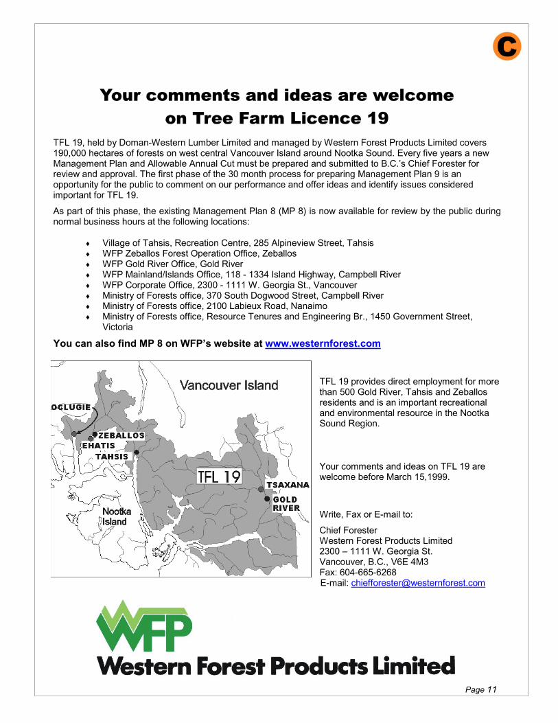
Your comments and ideas are welcome on Tree Farm Licence 19
TFL 19, held by Doman-Western Lumber Limited and managed by Western Forest Products Limited covers 190,000 hectares of forests on west central Vancouver Island around Nootka Sound. Every five years a new Management Plan and Allowable Annual Cut must be prepared and submitted to B.C.’s Chief Forester for review and approval. The first phase of the 30 month process for preparing Management Plan 9 is an opportunity for the public to comment on our performance and offer ideas and identify issues considered important for TFL 19.
As part of this phase, the existing Management Plan 8 (MP 8) is now available for review by the public during normal business hours at the following locations:
�� Village of Tahsis, Recreation Centre, 285 Alpineview Street, Tahsis �� WFP Zeballos Forest Operation Office, Zeballos �� WFP Gold River Office, Gold River �� WFP Mainland/Islands Office, 118 - 1334 Island Highway, Campbell River �� WFP Corporate Office, 2300 - 1111 W. Georgia St., Vancouver �� Ministry of Forests office, 370 South Dogwood Street, Campbell River �� Ministry of Forests office, 2100 Labieux Road, Nanaimo �� Ministry of Forests office, Resource Tenures and Engineering Br., 1450 Government Street,
Victoria
You can also find MP 8 on WFP’s website at www.westernforest.com
TFL 19 provides direct employment for more than 500 Gold River, Tahsis and Zeballos residents and is an important recreational and environmental resource in the Nootka Sound Region.
Your comments and ideas on TFL 19 are welcome before March 15,1999.
Write, Fax or E-mail to:
Chief Forester Western Forest Products Limited 2300 – 1111 W. Georgia St. Vancouver, B.C., V6E 4M3 Fax: 604-665-6268 E-mail: [email protected]

Page 12
Your comments and ideas are welcome on Tree Farm Licence 19
TFL 19, held by Doman-Western Lumber Limited and managed by Western Forest Products Limited covers 190,000 hectares of forests on west central Vancouver Island around Nootka Sound. Every five years a new Management Plan and Allowable Annual Cut must be prepared and submitted to B.C.’s Chief Forester for review and approval. The second phase of the 20 month process for preparing Management Plan 9 is an opportunity for the public to comment on our Draft Management Plan 9
As part of this phase, the Draft Management Plan 9 is now available until November 15, 2000 for review by the public during normal business hours at the following locations:
�� Village of Tahsis, Recreation Centre, 285 Alpineview Street, Tahsis �� WFP Zeballos Forest Operation Office, Zeballos �� WFP Gold River Office, Gold River �� WFP Mainland/Islands Office, 118 - 1334 Island Highway, Campbell River �� WFP Corporate Office, 2300 - 1111 W. Georgia St., Vancouver �� Ministry of Forests office, 370 South Dogwood Street, Campbell River �� Ministry of Forests office, 2100 Labieux Road, Nanaimo �� Ministry of Forests office, Resource Tenures and Engineering Br., 1450 Government Street,
Victoria
You can also find Draft MP 9 on WFP’s website at www.westernforest.com TFL 19 provides direct employment for more than 500 Gold River, Tahsis and Zeballos residents and is an important recreational and environmental resource in the Nootka Sound Region.
The Draft Plan and WFP’s staff will be available as follows for Open Houses to hear your concerns.
Campbell River, Ramada Hotel & Suites Sept. 19, 2000 - 1 pm - 8 pm
Gold River, Community Centre Lounge Sept. 20, 2000 – 1 pm - 8 pm
Tahsis Recreation Centre Sept. 21, 2000 – 1 pm - 8 pm
Zeballos Library Sept. 21, 2000 – 5 pm - 8 pm
Zeballos Community Hall Sept. 22, 2000 – 1 pm - 5 pm
Your comments are welcome before November 20, 2000
Write, Fax or E-mail to: Chief Forester Western Forest Products Limited 2300 – 1111 W. Georgia St. Vancouver, B.C., V6E 4M3 Fax: 604-665-6268 E-mail: [email protected]

TFL 19 – Public Review Plan MP 9 Page 13
File: 194-9
September 4, 2000 (Stakeholders) Dear FIELD (Salutation); Draft Management Plan 9 - TFL 19
In 1999, I wrote you regarding the first phase in the preparation of Management Plan 9 for Tree Farm Licence 19. I appreciated the input and information we received in that process. As the second and final phase in the preparation of draft Management Plan 9, I am pleased to inform you that the draft Plan is now available for public review at a series of open houses to be held as follows:
Location Time Date Place Campbell River
1:00 pm - 8:00 pm
September 19, 2000
Ramada Hotel & Suites
Gold River
1:00 pm - 8:00 pm
September 20, 2000
Community Centre Lounge
Tahsis
1:00 pm - 8:00 pm
September 21, 2000
Recreation Centre
Zeballos
5:00 pm - 8:00 pm
September 21, 2000
Library
Zeballos
1:00 pm - 5:00 pm
September 22, 2000
Community Hall
The draft plan is also available on Western Forest Products website at www.westernforest.com.
We welcome your involvement in the open houses. If you are unable to attend these open houses, we would appreciate receiving any written comments you have regarding our plans. If you or your organization would like to have WFP arrange a special presentation, please contact me at (604) 665-6224. I can best use your comments if we receive them no later than November 20, 2000. Thank you for your assistance.
Yours truly
WESTERN FOREST PRODUCTS LIMITED General Partner of Western Pulp Limited Partnership
W.E. Dumont, R.P.F. Chief Forester
WED/dg
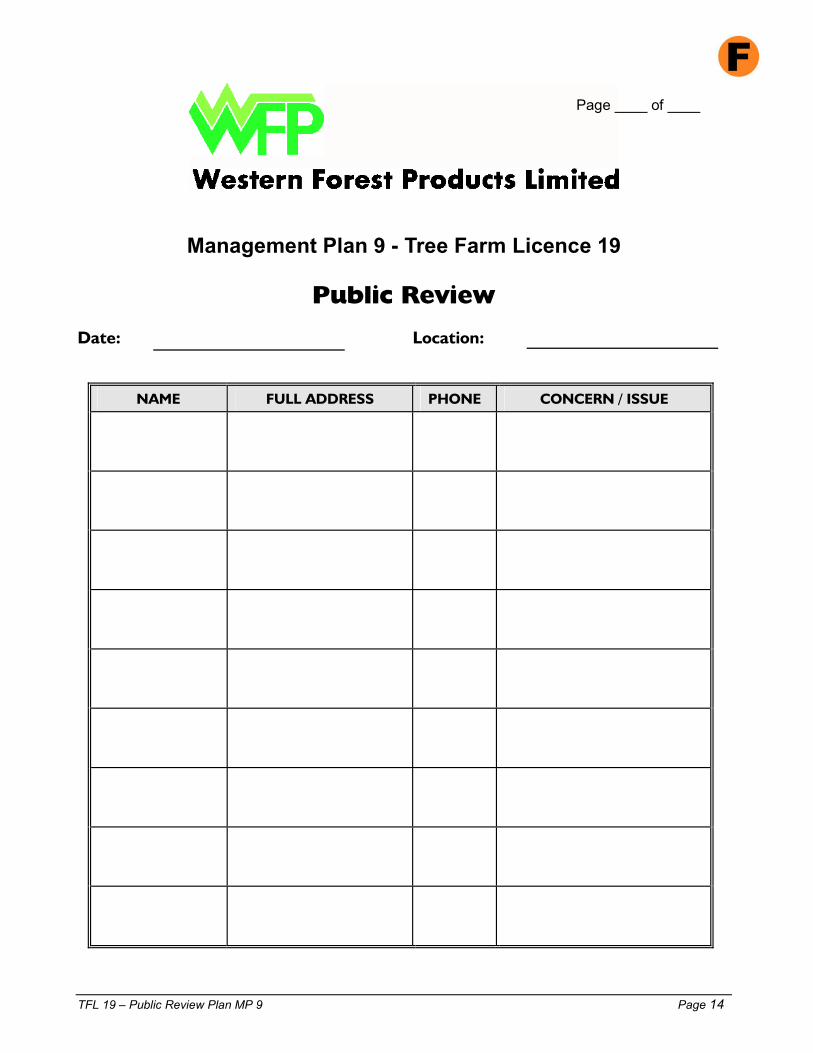
TFL 19 – Public Review Plan MP 9 Page 14
Page ____ of ____
Management Plan 9 - Tree Farm Licence 19
Public Review Date: Location:
NAME
FULL ADDRESS
PHONE
CONCERN / ISSUE

TFL 19 – Public Review Plan MP 9 Page 15
TREE FARM LICENCE 19 - DRAFT MANAGEMENT PLAN 9
PUBLIC REVIEW AND OPEN HOUSE COMMENTS DATE: LOCATION:
Thank you for taking an interest in the draft Management Plan 9 and our proposals for Employment and Economic Opportunities. We appreciate the completion of this questionnaire so that your ideas, views, comments and concerns can be part of the Management Plan process. Your answers and comments will also help us evaluate our performance at this viewing and improve future presentations.
Please be as candid and constructive as possible. If space is insufficient please use extra pages. 1. What do you consider to be the 3 most important values of Tree Farm Licence 19?
Important Value Why? 1. 2. 3.
2. Do you have any comments/concerns about logging and forestry programs in TFL 19?
� Yes � No If yes, these are:
3. What concerns were addressed in the review meeting?
4. Do you have any comments/concerns about Management Plan 9 that we could address to improve the Plan?

TFL 19 – Public Review Plan MP 9 Page 16
5 Are there any aspects of TFL 19 you would like to know more about? � Yes � No If yes, what are these?
6. Did you know anything about TFL 19 before this review? � Yes � No If yes, please
describe:
7. How did you hear about this review session? � Newspaper ad � Invitation � Other 8. How well did WFP staff on hand answer your questions?
Excellent Satisfactory poor � � � � �
9. Was the information presented in an understandable manner?
Very Easily Too complex � � � � �
10. How can we encourage more people to attend these sessions? Any ideas for improvement?
Please tell us about yourself:
� Male � Female Occupation
Age: � Under 14 � 14-19 � 19-25 � 26-40 � 41-55 � over 55
If you wish a written response to your comments please provide your:
Name: Address:
Postal Code: Phone: We can best use your comments if we receive them by November 20, 2000. WFP has a summer tour program in parts of TFL 19 and you are welcome to join us. Please call (250) 283-2221 to arrange your tour.
Please return this to the box provided or mail in the addressed, stamped envelope to:
Chief Forester Western Forest Products Limited 2300 - 1111 West Georgia Street Vancouver, B.C., V6E 4M3 Phone: 665-6224 FAX: 665-6268

TFL 19 – Public Review Plan MP 9 Page 17
Public and Stakeholder Response Summary TFL 19 Public Viewings
For Draft Management Plan 9
Date
Location No. of Participants
Response Sheets
Response Sheets
Letters
Received
Total
Appendix XI Trails and Recreation Sites

TFL 19 – Trails and Recreation Sites Page 1
Toilet
Toilet
0 100 m
Scale in meters
TFL 19
CEVALLOS PARK
Zeballo sTo wnsite
Toilets
Inlet
IMMATURE
FOREST
Village of Zeballos
ROCK
BLUFFS
TFL 19CONUMA RIVER RECREATION SITE
0 200m
Scale in metres
TFL 19CORAL CAVES
SIGN
Cora l Cave is the best known and m ost accessiblelimeston e cave in the area. It ha s a mapped len gth of 1 .5 km. The la rg e opening is loca te d close to anold log ging road and a sign at the site ind icates thetra il route and add resses sa fety issues.
0 100m
Scale in metres
EAST MAIN
E-31
E-30
CAVEENTRANCE
Trail
Immature Forest1989
Mature
Forest
To Tahsis - 5 km .
COUGAR CREEK RECREATION SITE
0 50m
S cale in m e te rs
TFL 19
P arking
Park ing
Cougar Creek
GA L
IAN
O M
AIN
LINE
DO CK
CobbleBeach
INFOSIGNS
40 km. toGold River
IMM
FOR ES T
1985
MATURE
FOREST
MATUREFOREST
Campsite NumbersPicnic Tables
Gol d
Ma
in LineR.
ScoutLa ke
Rd
E-5
0 8 00m
Scale in metres
Gold RiverTownsite
Pepper cor n Park
O ld Growth Forest
Old Growth Forest
Imm atu re
Forests
1960s-19 70s
Non - TF L
Non - TF L
Imm atu re Forest
1974
Imm atu re Forest
1950s-19 70s
Imm ature Forest
1 97 1
Imm ature Forest
196 3
Immature Forest
E-7
E- 1
East Road / Hwy 28
High
way
28
TFL 19GOLD RIVER FORESTRY TRAILS
Semi-deactiva ted Roads
Old
Growth
Fo rest
Old Growth Forest
0 1 00m
S cale in meters
1
23 4
56
7
Toilet
To ilet
PicnicTables
Leiner
RiverTahsis 2.5km.
Hea d Bay Road
PParking
Gravel Pit
Imma tu re
Forest
1 97 8
Imma tu re
Forest
1 95 0
Imma tu re
Forest
1 95 0
Imma ture
Fo rest
1 95 0
LEINER RIVER RECREATION SITETFL 19
LITTLE ESPINOSA PICNIC AREA
ImmatureForest1984
ImmatureFore st1984
Roa
dsid
e Pa
king
OverflowParking
Fair Harbo ur 26 km
Little Espinosa Inlet
GrassyMarsh Area
0 100m
Scale in meters
TFL 19
O ld
Growth
Forest
OldGrowthForest
OldGrowthForest
ImmForest1994Imm
Forest1 98 7
ImmForest1979
Q u atchka
Cr eekUndeveloped Trai l
U-29
To Gold River 20 km.
0 200 400
S ca le in m eters
TFL 19MATCHLEE TRAIL
Glacier
Rugged
Alpine
Terrain
Peak1806 m
MUCHALAT LAKE RECREATION AREATFL 19
ImmForest1970
ImmForest
(1968 fire)
Imm Forest
1 970
Trail
Trail
PicnicArea
Toilet
Toilet
Toilets
Campsite numbers
TolietsTrail
SANTIAGO CREEK RECREATION SITETFL 19
0 50m
Scale in metres
Stifflegfor Kayaking
Picn ic Sitejetty - 3 tables
mud flats
Santiago Creek
O ldAbandoned Santiago Main
Trail to riv er
(overg r own)
To Frie ndly Cove(Nootka Is.) 25 kms
To B lowhole Bay(Nootka Is.) 3 km.
To Tahsis12 kms
OLD
GROWTH
FO REST
OLD
GROWTH
FOREST
OLDGROW TH FOREST
196 6
SECOND
GROWTH
FOREST
SECOND
GROWTH
FOREST
Tahsis Inlet
TFL 19
ImmatureForest1981
ViewpointOld
GrowthForest
ACCESS TRAILSTARTS HERE
Gully 7InsectCave
89
To MainCave
Main Cave
10Siffon
11 TunnelCave
12 Waterfall
13CornerCave
14ImmatureForest1981
15
16
CanyonViewpoint
ResurgenceCave
Keyhole
Karsttopography
Stee
pC
l iffs
Steep Cliffs
to Gold River
18 kms.
Head Bay Forest Road
to Tahsis
47 kms.
Branch Road H-27
H-27A
ParkingArea
WaterfallWate rf all
MatureForest
UpanaCavesSign
Toi let
UPANA CAVES TRAIL
0 40m
Scale in metres
Upana Caves h as a combined leng th of 450 m etres and a vert ical depth of 35 metres. The self-guided tour takes approx. one h our.
Legend Cave Descripton
CAUTION - STEEP CLIFFSSTAY ON TRAIL
TOUR STOPS
CAVE ENTRANCE
SURFACE TRAIL
UNDERGROUND TRAIL
TFL 19VICTORIA PEAK TRAILS
0 1600 m
Scale in metre s
Peak1500 m
Old
Grow thForest
OldGrowthForest
ALPINE
TFL 19
T wadd le
West
Ro ad
W-79
W79K
W79
Immature Fores t1979
Planted1995
Immature
Forest
1972
9/98
Ma cMillan B loedelTFL 39
WFP
To Gold River35 km
P arkin g
Victoria Peak is accessed by travellingon active anddeactivated loggingroads. Conditions willvary and four wheel drive may berequired.
VICTORIA PEAK2163m
NoDesignated Trail
ToVictoriaPeak
Rive
r
Zeba
l los
To W.F.P. Camp
Zeballos Townsite
(back
chan
nel )
Trail Stops
N
0 100m
Scale in meters
TFL 19ZEBALLOS NATURE TRAIL
5/98
Immature
Forest
Zeballos Elementary and Secondary School
In conjunction with:
Village of Zeballos
Tree Farm Licence 19
Recreation Sitesand Trails
BC Ministry of Forests
TFL 19 – Trails and Recreation Sites Page 2
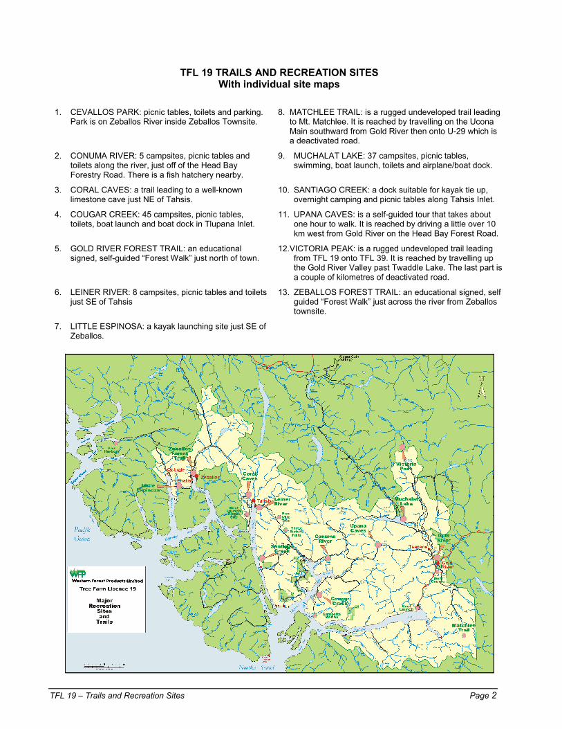
TFL 19 TRAILS AND RECREATION SITES With individual site maps
1. CEVALLOS PARK: picnic tables, toilets and parking.
Park is on Zeballos River inside Zeballos Townsite. 8. MATCHLEE TRAIL: is a rugged undeveloped trail leading
to Mt. Matchlee. It is reached by travelling on the Ucona Main southward from Gold River then onto U-29 which is a deactivated road.
2. CONUMA RIVER: 5 campsites, picnic tables and toilets along the river, just off of the Head Bay Forestry Road. There is a fish hatchery nearby.
9. MUCHALAT LAKE: 37 campsites, picnic tables, swimming, boat launch, toilets and airplane/boat dock.
3. CORAL CAVES: a trail leading to a well-known limestone cave just NE of Tahsis.
10. SANTIAGO CREEK: a dock suitable for kayak tie up, overnight camping and picnic tables along Tahsis Inlet.
4. COUGAR CREEK: 45 campsites, picnic tables, toilets, boat launch and boat dock in Tlupana Inlet.
11. UPANA CAVES: is a self-guided tour that takes about one hour to walk. It is reached by driving a little over 10 km west from Gold River on the Head Bay Forest Road.
5. GOLD RIVER FOREST TRAIL: an educational signed, self-guided “Forest Walk” just north of town.
12.VICTORIA PEAK: is a rugged undeveloped trail leading from TFL 19 onto TFL 39. It is reached by travelling up the Gold River Valley past Twaddle Lake. The last part is a couple of kilometres of deactivated road.
6. LEINER RIVER: 8 campsites, picnic tables and toilets just SE of Tahsis
13. ZEBALLOS FOREST TRAIL: an educational signed, self guided “Forest Walk” just across the river from Zeballos townsite.
7. LITTLE ESPINOSA: a kayak launching site just SE of Zeballos.

Appendix XII Nootka Region Visitors Guide

TFL
19 –
Tou
rist M
ap
Pa
ge 1
I.R.
7
I.R.
13a
I.R. 1
2I.R
.10
I.R. 1
0
I.R.
12
I.R.9
(Coo
pte
)
I.R.7
(His
nit)
I.R.
6
L.19
TO70
2
T08
53M
& B
TIM
BER
WE
ST
L 18
T01
82
L 3
6T0
259
TWS
L 36
T025
9
L 36
T02
59L 3
6T0
259
T086
6M
& B
Wey
mer
Cr.
Kars
tPr
ov.
Park
Rugg
ed P
oint
Mar
ine
Pro
v. Pa
rk
Nuc
hatli
tzPr
ovin
cial
Par
k
Sant
a G
ertru
dis-
Boca
Del
Infie
rno
Prov
inci
al P
ark
Cat
ala
Islan
dPr
ovin
cial
Par
k
Wos
s La
kePr
ovi
ncia
l Par
k
Gol
d/M
ucha
lat
Prov
. Pa
rk
Stra
thco
na
Prov
inci
al
Park
Scho
en L
ake
Prov
. Par
k
Can
adia
n Fo
rest
Pro
duct
sTF
L 37
Artli
sh C
aves
Prov
inci
alPa
rk
Whi
teRi
dge
Prov
.Pa
rk
Blig
h Is
land
Prov
inci
al P
ark
M-1
BU R
MAN
MAI
NLI
NE
M-16
JACKLAH MAIN
WILS
ON
ML
WIL
SON
A CCE
SSR
D
HOUSTON
ML
L-5
W-22
LILLIA
NML
PIER
CE
ML
SILV
ERAD
O
ML
ZUCIARTEML
MOOYAH
ML
ASTONML
McCURDY CK. ML
WEST
RD
HIGHWAY28
UCONA
ML
U-21
U-22
U-29
F U-29
U-7
220
140
E.R.T. UCONARD
130
HIGHWAY
28
SAUNDERS
SAUNDERS
ML
ML
30
15
SIWASH
RD
E-1
E-7
E-20B
WD
-7
WAR
D
RD
H-10
H-11
H-27
H-60M
H-60
NESO
OKML
N-48
NORTH FORKML
McC
URDY
CKRD
M-2
4
M-18
SYLV
IAC
KR
D
KLEE
PTEE
ML
K-9E
K-9
G-6
0
G-5
0G
-40
GALIANOML
G-2
5
G-2
0
T-15
NES
OO
KM
L N-30
N-30H5
N-36
N-39
HEAD
BAY
FORE
ST
RD
TLUPA
NA
RD
C-22
CONU
MA
ML
C-50
MUC
HAL
ATML
MU-
55
MU-80
MU
-80C
L-20
LAKE
RO
AD
OKTWANCHRoad
WESTROAD
EAST
EAST
W-7
9
ROAD
RO
AD
M-1
6M
-16I
M-16
L-15
38B
30
WEST
EAST
WA
RIN
G
WARING
RD
RD
HOLI
DAY
RD
SHE
ENA
RD K-
16D
K-20
K-24
OKTW
ANCH
MAIN
K-30
OKTWANCH
RD
WAR
ING
RD
ALST
ON
RD
LONESOME
RD
TOLN
AYRD
SURPRISE RD
VER
NO
NLA
KER
D
SEBALHALL
SEBALHALL
RD
RD
UPPER
McI
VER
RD
W.S.
RD
STUA
RTR
D
NIMPKISH
RD
CH
UCK
A NRD
WHI
TE
MAI
N
KOKUMMI
MAI
N
WH
ITE
WHITE
RIV
ER
RIVER
ML
ML
MC
MAI
N
GER
ALD
ML
MOA
KWA
CREE
KM
AIN
ST2 STEWART
MAI
N
SALM
ON
RIV
ER
MAIN
UKL
AK
RD
PLAT
EAU
RD
DAVI
E
ROAD
MT.
MT.
CAIN
CAIN
RD
RDPARK
CROMANRD
HIG
HW
AY
HIG
HW
AY
19
1 9
NAN
CY
RD
KATH
YRD
HARRY
ROAD
UPPEROLIV
ERRD
KIY
UR
D
JAMIE
RD
OLIVER
RD
RONA
ROAD
TOUCHER
RD
UPPER WOSS
WOSS
WOSS
RD
RD
WEST
WEV
ER
D
RAY
MO
NDR
D
EVE
EVERD
UPPE
R
LILY
CK
R D
KAIPITRD
CANNONCKRD
ELLIOTRD
PINDER
ZEBALLOS
ML
ML
Z-60
Z-60
P
ARTL
ISH
ML
NOMASH
ML
N-8
N-20
ALBER
TRO
AD
YOOKWA RD
GOLD
VALL
EY ML
LITT
LEZ E
B ALL
OS
ML
BARR
CRE
EK
ML
E-40
EXTRAVAGANT ML
UBEDAMML
HEAD
BAY
FORES
T
ROAD
LEIN
ERM
L
ML
P-13
M-6
P-15
M-6A
ST-10
W.CANTONML
EASTCANTONML
WC-1
SUCW
OA
ML
S-4
H-28
T-155
HISNITML
A-1
1
A-22A
ARGONAUT ML
T-5TSO
WW
IN
MAIN T-20T-4
0STOLT
ZE
ML
T-60
LUTE
SM
L
V-5
VAUGHAN CK ML
HECATE ML
BLOWHOLE
ML
DART
ML D-4
V-14
B-10
BASIN
ML
L-145B
LAUR
IE
ML
L-80
L-20
L-5
L-10
WESTEWART
EWART
ML
ML E.
W-2
K-27
38A
C-2
CRAWFISH
ML
C-24
KEND
RICK
ML
GUNPOW
DER
ML
K-2
P-2
P-1
MARVINAS ML
M-6
M-3
P-8
P-15
P-5
P-11
PLUM
PER
ML
P-32
P-49
P-44
P-29
D
P-29
B-9F
DIN
AH
LAKEML
ATLU
CK
RD
LARCHMTRD
WELCHRD
TA22
31
PAULRD
APPOLLO
RD
HELENCKRD
JIM
RD
TAH
SISHRD
ATLUCK CUTOFF
TA250
0
SALLYRD
ARTL
ISH
ROAD
CAR
DEN
AM
LBR
.40
S-13
0
FAIRHARBOUR
MAI
N
FAIR
HAR
BOU
RM
L
F-80
F-70
K-6 K-6C
KAO
UKM
L
K-20
K-20E
K-5
ROW
L AN
DC
REEK
ML
AMAI
ML
AM-20
AMAI
ML
F-30
F-20
F-40
ELIZ
AM
LE
-50
MAI
NLI
NE
FAIR
HAR
BOU
RM
L
ZEBALLOSML R-2
6
CIRI
ACO
ML
HUNT ML
EHATISAHTML
E-11
PORT
ELIZ
AML
P-3
P-8P-
8T
P-10
P-20
P-31
P-30
P-45
P-60
P-40
P-77P-
70
PORTELIZA
ML
BRODICK
ML
M-1000
M-2
000
M-11
00
NUCHATLITZ ML
ML
ADAM
UPPPER
K 35
C- 5
0D
LEAGH ML
C-15M
LM
cQU
ILL A
N
BOLT
ON
LA
KE
MAI
N
N-30H
H-14D
ZM-4
H-1
0
ML
BOUN
TY
AbelCr
eek
Scho
en L
ake
Ni sn
akCk
Gold La
ke
Een
aLa
ke Ju dso n
C k
Horseshoe
Ck
Gold
River
Twad
dle
Lak
e
Wari
ng
C k
Vern
on L
ake
Nam
eless
Ck
Nort
hFo
rkM
u ch a
l at
Mu c
hala t
R
R
South
For k
Mar
got L
ake
Leigh
ton L
Nor
g ate
Riv er
Upa
na L
U pa n
aRi
ver
Cypress
Ck
Ant
ler L
Saunders
Dru
mLa
kes
ElkRiver
Don
ner
Lak
e
Kunl
in L Han
ging
Pam e la
C r
Ck
Qu atchka
Ck
Matc
hlee
Ck B urm
an
Mat chlee
Ba y
Blac
kCk
Jacklah River
Wilson
Ck
Lilli
an L
ake
Si lvera do
C reek
Hou st on
R iv er
Cathe
rine
Lak
e
Moo
yah
Bay
King
sPa
s sage
Pas s a
ge
Will
iamso
n
AstonCk
Kleeptee
Creek
Sylvi
aCk
Bou ld er
C k
Ucon
a
River
Gold
River
Ind ia n
Ck
BigBe
ndCk
Siwash
Ck
Ward
Ck
McC
urdy
Creek
Magee
Creek
Frisc
o L
Nesook
River
Coug
arCk
Tlupana
River
Neso
ok B
ay
Bolto
n L
ake
Gali
ano
Ck
Hanna
Ck
H ead Bay
Moutcha Bay
Hi snit I n
let
Dese
rted
Lak
e
Hoiss
Tsowwin
R
Santi
ago
Ck
Mal
aspin
a L
ake
Su cwoa
R ive r
Canto
n
Ck
Conu
ma
Rive r
Peter
s L
ake
Alav
a L
Perry
River
L loy
d CkWeymer
CkGree
n
Ck
Lein
er
River
Tahsis
River
McK
elvie
Creek
Extra
vaga
ntC k
Ub edam
Ck
Maraude
Zeballos River
Ck
Nomash
Rive r
Mam at C k LittleEspinosa
Inlet
Ciria
coCk
McL
ean
Ck
E hatisaht Ck
Salte
ry B
ay
Mc Brid
eBa
y
Blow
hole
Bay
Craw
fish
Lak
e
Ewa
rt L
ake
CalvinCk
Bajo
Creek
Beano
Creek
Callicum
Ck
Dem
ikoss
e
G unpow
der
Musket Ck
Ck
Ck
Kendrick
Gal
iano
Bay
Three
Bay
Cove Han
na Ch
annel
ZuciarteChannel
Mar
vinas
Bay
Boca
Del
Infie
rno
Bay
Ke ndrickInlet
TahsisInlet
Tsowwin Narrows
PortEliza
Queen Cove
Tara
Ck
Perr
y L
River
Ck
Cle ar Passag
e
TatchuCk
Porrit
tCk
Rol l in
g R o
adst e
ad
Po rt LangfordEspinosa Inlet
Inne
rBa
sin
Mar
yBa
sin
Nuc
hatli
tz I
nlet Lo
uie
Bay
Tahs
is N
arrow
s
B lowho leC k
Woss
Lak
e
Pacif
icO
cean
Muc
halat
Inlet
Tlupana
Inlet
Tahsis Inlet
Esp
eranz
aIn
let
Hecate
Channel
Zeba
llos
Inlet
Zeba
llos
Lak
e
Muc
halat
Lak
e
Noo
tka
Sou
nd
Zeba
llos
Mtn
1576
Kaou
k M
tn 1
309
Mam
at M
tn
97
0
829 Fam
ily
852
Hum
ps
762
Har
old
Hill
Slat
e M
tn
Ston
eN
ippl
esSh
ip P
eak
1000
Ships Pk
1000
Rem
arka
ble
Con
e
Anvil
Pk
108
1
Eliz
aD
ome
Lead
ing
Hill
Mt E
spin
osa
9
18
Mt M
cKel
vie
16
31
Mal
aspi
na P
k
152
0
Con
uma
Peak
14
81U
pana
Mtn
133
4
Big
Bald
y M
tn
161
1
Uco
na M
tn 8
29
Mat
chle
e M
tn
180
6
CAMEL RIDGE
Puzz
le M
tn
Mt H
eber
Trio
Mtn
Cam
el R
ock
Mou
nt R
osa 768
Sant
a C
rux
De
Nuc
a M
tn
917 N
ootk
a C
one
Mt S
antia
go
129
1
Vict
oria
Pea
k
216
3
Mt C
ain
180
4
Zeba
llos
Ehat
is
Yuqu
ot(F
riend
lyCo
ve)
Ocl
ugje
Gol
dR
iver
Tsax
ana
Vern
on
Wos
s
GO
LFC
OU
RSE
Okt
wan
chC
hann
el
Old
Fire
and
fore
stre
gen.
Tuta
Mar
ina
The
Sum
mit
586
m
Old
Fire
and
rege
nera
ted
fore
st
Thre
eSi
ster
sFa
lls
Five
Mile
Tr
ee
Old
Rad
arSi
te
5
12
11
9
1
47
2
10
8
6
3
(250
)283
-222
1N
oo
tka
Re
gio
n h
as
free
pub
lic f
ore
stry
tour
s o
f op
era
tions
ava
ilab
le fr
om J
une
to A
ugus
t.
Plea
se b
e es
peci
ally
care
ful w
ith fi
re.
Obe
y al
l fire
regu
latio
ns d
urin
g ha
zard
ous
wea
ther
.Bu
ild fi
res
only
in th
e fir
e pi
ts p
rovid
ed a
nd e
xtin
guis
hth
em a
fter u
se.
Dous
e fir
e th
orou
ghly
- m
ake
sure
it is
out
!Ke
ep a
pai
l of w
ater
(8 lit
res)
and
a s
hove
l nea
r the
fire
at
all t
imes
. Ne
ver l
eave
a c
ampf
ire u
natte
nded
.Us
e ex
trem
e ca
utio
n w
ith p
ropa
ne s
tove
s an
d BB
Qs.
Wat
ch fo
r our
fore
st in
form
atio
n sig
ns a
long
the
high
way
.Th
ese
prov
ide
the
ages
of r
efor
este
d ar
eas
and
treat
men
tsco
mpl
eted
to p
rodu
ce h
ealth
y fo
rest
s.
Gol
d R
iver O
ffice
Tahs
is Sa
wm
illZe
ballo
s O
ffice
Phon
e: 2
83-2
221
Fa
x: 2
83-7
222
Phon
e: 9
34-6
331
Fa
x: 9
34-6
375
Phon
e: 7
61-2
200
Fa
x: 7
61-2
220
RO
AD S
AFE
TY
FIRE
SAF
ETY
LEG
END
REC
REAT
ION
AN
D S
ITES
OF
INTE
REST
FOR
EST
RY IN
FORM
ATIO
N
WF
P LO
CAL
OP
ERAT
ION
S(a
rea
code
250
)
IN C
ASE
OF
FIR
E D
IAL
- 1
800
663
5555
WFP
For
est L
and
Pav
ed R
oad
Mai
n Lo
ggin
g Ro
adB
ranc
h Lo
ggin
g R
oad
Roa
d Bl
ocka
geW
FP O
pera
tions
Offi
ceLo
g D
ump
Saw
mill
Trai
lD
eact
ivate
d R
oad
Maj
or R
ecre
atio
n S
ite
C
amps
ite (I
mpr
oved
)C
amps
ite (U
nim
prov
ed)
Pic
nic
Site
Boa
t Lau
nch
Can
oein
gS
wim
min
gS
alm
on H
atch
ery
View
poin
tS
ite o
f Int
eres
tC
ave
Floa
t Pla
ne D
ock
Pro
vinc
ial P
ark
(see
fore
st re
crea
tion
site
s lis
t)
Sca
le a
ppro
x 1
: 170
000
1
Scal
e in
kilo
met
res
010
98
76
43
21
5Sc
ale
in m
iles
04
32
15
Plea
se o
bey
all s
igns
and
use
onl
y th
ose
com
pany
road
s th
atha
ve b
een
dete
rmin
ed s
afe
for g
ener
al tr
avel
.
Rem
embe
r tha
t: Fo
r env
ironm
enta
l rea
sons
, man
y ro
ads
are
deac
tivat
ed.
Deac
tivat
ion
invo
lves
rem
ovin
g br
idge
s an
d cu
lverts
and
bu
ildin
g cr
oss-
ditc
hes.
Roa
ds id
entif
ied
on th
e m
ap le
gend
as
“Mai
n Lo
ggin
g Ro
ads”
are
per
man
ently
mai
ntai
ned
and
are
suita
ble
for 2
WD
veh
icle
s. D
eact
ivate
d ro
ads
are
to b
e us
edwi
th g
reat
cau
tion
and
may
be
suita
ble
for o
nly
4WD
, ATV
s or
foot
traf
fic.
Trav
el o
n ro
ads
lead
ing
from
ope
ratio
n ce
nter
s or
log
dum
ps to
act
ive
area
sis
not r
ecom
men
ded
from
Mon
day
to F
riday
6 a
m to
6 p
m.
For c
urre
nt ro
ad in
form
atio
n, v
isito
rs s
houl
d ch
eck
with
a lo
cal
oper
atio
n at
the
num
bers
liste
d.
LOG
GIN
G T
RUC
KS H
AVE
THE
RIG
HT O
F W
AY.
IF
YO
U M
EET
A LO
GG
ING
TRU
CK -
PULL
OVE
R A
ND S
TOP.
DO
NO
T PA
SS H
EAVY
EQ
UIPM
ENT
UNL
ESS
SIG
NAL
LED.
DR
IVE
WIT
H YO
UR
HEA
DLI
GH
TS O
N A
T A
LL T
IMES
.
DRIV
E SL
OW
LY O
N G
RAV
EL R
OA
DS.
DU
ST C
AN S
ERIO
USL
Y IM
PAIR
VIS
ION.
M
AXIM
UM
SPE
ED IS
60
KM O
N W
FP R
OA
DS.
PA
RK
YOU
R CA
R W
ELL
OFF
THE
RO
AD.
VISI
T O
UR W
EB S
ITE
http
:\\w
ww
.we
ste
rnfo
rest.
com
Mor
e de
taile
d W
FP
recr
eatio
n m
aps
are
Log
gin
g R
oa
ds
and
Rec
rea
tion
Are
as
2000
-200
1UIDE
g
West
Coa
stVancouver
Island
NO
OTK
A R
EGIO
NFO
RES
T R
ECR
EATI
ON
SIT
ES(r
efer
to n
umbe
rs o
n th
e m
ap)
MU
CH
ALA
T LA
KE
-
41 c
amps
ites,
pic
nic
tabl
es, s
wim
min
g, b
oat l
aunc
h, to
ilets
and
ai
rpla
ne/b
oat d
ock.
LEIN
ER
RIV
ER
-
8
cam
psite
s, p
icni
c ta
bles
and
toile
ts.
CO
UG
AR
CR
EEK
-
47 c
amps
ites,
pic
nic
tabl
es, t
oile
ts, b
oat l
aunc
h an
d bo
at d
ock.
CO
NU
MA
RIV
ER
-
5 c
amps
ites,
pic
nic
tabl
es a
nd a
toile
t.G
OLD
RIV
ER
FO
RE
ST
TRAI
L -
an
ed
ucat
iona
l, si
gned
, sel
f-gui
ded
"For
est
Wal
k".
ZEB
ALLO
S FO
RES
T T
RAI
L -
an
ed
ucat
iona
l, si
gned
, sel
f-gui
ded
"For
est
Wal
k".
SAN
TIAG
O C
RE
EK
- a
doc
k su
itabl
e fo
r ka
yak
tie u
p, o
vern
ight
cam
ping
and
pic
nic
tabl
es.
LITT
LE E
SPIN
OSA
-
a k
ayak
laun
chin
g si
te.
UPA
NA
CAV
ES
-
a fo
rest
and
cav
e to
ur.
Ther
e ar
e se
vera
l cav
es ta
king
app
rox.
one
ho
ur to
tour
.C
OR
AL
CAV
ES
-
a tr
ail l
eadi
ng to
a w
ell
1. 2. 3. 4. 5. 6. 7. 8. 9. 12.
10.
11.
Wes
tern
For
est P
rodu
cts
Lim
ited
is a
B.C
. ow
ned
and
oper
ated
com
pany
, par
t of t
he
Dom
an G
roup
res
pons
ible
for
man
agin
g th
e co
mpa
ny's
fo
rest
ry
and
logg
ing
activ
ities
in c
oast
al B
ritis
h C
olum
bia.
The
co
mpa
ny m
anag
es o
ver 8
85,0
00 h
ecta
res
of p
ublic
and
priv
ate
fore
st la
nds
in t
he
Que
en
Cha
rlotte
Is
land
s,
north
, w
est,
cent
ral
and
sout
hern
Van
couv
er I
slan
d an
d so
uth
coas
t, w
ith a
n an
nual
har
vest
of
4.2
mill
ion
cubi
c met
res.
The
hea
d of
fice
is
in V
anco
uver
.
WFP
is o
ne o
f Br
itish
Col
umbi
a's
olde
st
fore
st c
ompa
nies
, tra
cing
its
root
s ba
ck to
18
57. T
hird
gro
wth
fore
sts
are
alre
ady
in
plac
e an
d W
FP's
m
ore
than
60
Pr
ofes
sion
al F
ores
ters
and
eng
inee
ring
staf
f hav
e a
repu
tatio
n fo
r inn
ovat
ion
and
WFP
and
the
Min
istry
of F
ores
ts jo
intly
man
age
recr
eatio
n si
tes
on C
row
n La
nd.
The
MO
F ch
arge
s a
smal
l fee
for
cam
ping
. Cam
ping
pa
sses
are
ava
ilabl
e at
B.C
. Acc
ess
Cen
tres
and
desi
gnat
ed d
istri
buto
rs. T
here
is n
o fe
e fo
r ca
mpi
ng o
n W
FP p
rivat
e la
nd.
Ple
ase
cont
act
Wey
erha
user
TFL
39
Noo
tka
Isla
nd
Whi
tele
y Is
.
Lor
d Is
Strange Is.
Blig
h Is
land
Gore
I s.
TFL 3
9TF
L 37
TFL 3
7TFL 3
9
TF
L 19
Tou
rist M
ap

Appendix XIII Recreation Analysis and Management
Strategy Report
(This appendix contains only a portion of the full report)

TFL 19 – Recreation Analysis and Management Strategy Page 1
Recreation Analysis and Management Strategy Report RRL Recreation Resources Ltd.
March 2001
Summary This Recreation Analysis and Management Strategy Report (RAMS) has been prepared using the Ministry of Forests guidelines contained in Circular #VCR-98, dated November 30, 1998.
Information from the Recreation Features, Visual Landscape and Recreation Opportunity Spectrum inventories was reviewed, and combinations of features, patterns of travel, landscapes resources, probable forest development areas and options for enhancing recreation opportunities have been identified. Scenic landscapes, beaches and trails, rivers, camping areas, natural history, First Nations history, boat launches, freshwater fishing, nature study; all these resources are present in TFL 19.
Discussion with Charlie Cornfield, Recreation Specialist, Campbell River Forest District, with Western Forest Products Limited staff and with stakeholders served to identify key recreation management issues within TFL 19.
The analysis identifies gaps and issues related to the key recreation opportunities in the TFL. The recreation management options address the issues and gaps identified through the analysis and lists objectives and strategies designed to protect or enhance the recreation potential of the resources.
TFL 19 covers 191,990 ha on west central Vancouver Island. The extent of the TFL is from Espinosa Inlet in the west, east to the town of Gold River, south to the height-of-land between Muchalat Inlet and Clayoquot Sound, and north to Kaipit Lake.
The nearest major centre is Campbell River, 90 km to the east along Highway 28. Communities close to the TFL are Gold River, Tahsis, Zeballos, Oclugje and Tsaxana.
TFL 19 is bordered by TFLs 37, 39, 44 and 54. Strathcona Provincial Park, Weymer Creek Karst Provincial Park, Woss Lake Provincial Park, Artlish Caves Provincial Park, Gold/Muchalat Provincial Park, and the White Ridge Provincial Park all either border the TFL or are surrounded by it.
Three Special Management Zones (SMZs) are located within or border onto TFL 19: Woss-Zeballos, Schoen-Strathcona and Pinder-Atluck. The latter borders the TFL on its northernmost extent at the head of the Zeballos River.
Five out of the seven ROS classes are distributed within the TFL. The Roaded Modified ROS Class has the largest area. This is quite common because most roaded forestland falls in this category. The Roaded Natural class covers the second largest area. It is similar to the Roaded Modified but has little or no alteration. The dominant area of SPNM is located along the northwest side of the TFL where is adjoins Woss Lake Provincial Park. One area of SPM occurs in the extreme southeast corner of the TFL where it borders Strathcona Provincial park. Urban is for settled areas such as Gold River and Oclugje.
According to the public input survey that was completed as part of the inventory updates, the most popular recreation activities are picnicking, camping, angling, driving logging roads, beach activities, photography and wildlife viewing.
TFL 19 – Recreation Analysis and Management Strategy Page 2
The main recreation issue identified within the TFL through the public input survey was the deactivation of forestry roads. Other resource issues are discussed in Section 5.0 of the report.
One hundred and thirty seven commercial tourism businesses rely on the natural resources within and around this TFL. Most of these businesses use the road and marine travel corridors that go through or around the TFL while travelling to key recreation areas, (e.g. Cougar Creek) and to departure points (e.g. the boat launch at the head of Muchalat Inlet).
A high value is placed on natural resources by both residents of BC and visitors to BC. Opportunities for eco-tourism, adventure tourism, non-consumptive tourism and scenic viewing are in demand.
Proactive management involving community members and leadership by Western Forest Products in the area of landscape resources and recreation feature and activity management are seen as the foundations for successful use of all resources to promote stable communities.
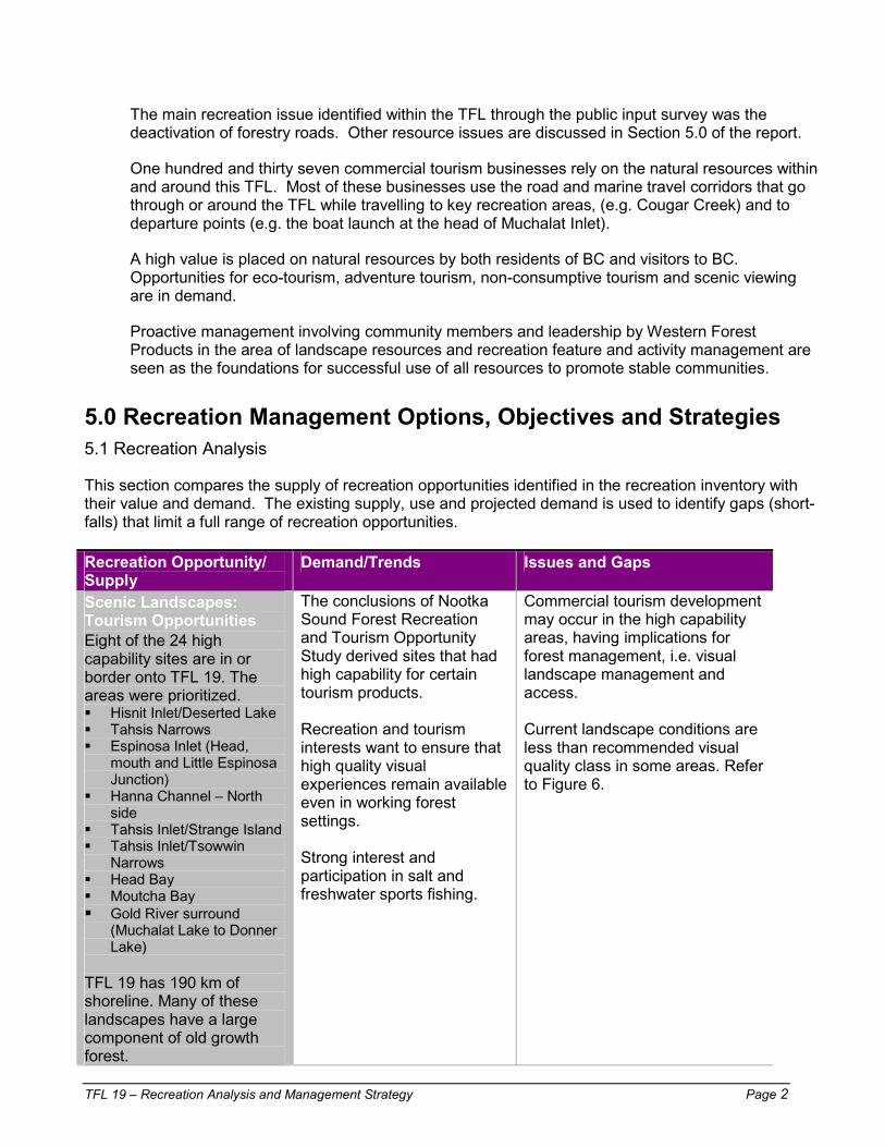
5.0 Recreation Management Options, Objectives and Strategies 5.1 Recreation Analysis
This section compares the supply of recreation opportunities identified in the recreation inventory with their value and demand. The existing supply, use and projected demand is used to identify gaps (short-falls) that limit a full range of recreation opportunities. Recreation Opportunity/ Supply
Demand/Trends Issues and Gaps
Scenic Landscapes: Tourism Opportunities Eight of the 24 high capability sites are in or border onto TFL 19. The areas were prioritized. �� Hisnit Inlet/Deserted Lake �� Tahsis Narrows �� Espinosa Inlet (Head,
mouth and Little Espinosa Junction)
�� Hanna Channel – North side
�� Tahsis Inlet/Strange Island �� Tahsis Inlet/Tsowwin
Narrows �� Head Bay �� Moutcha Bay ��Gold River surround
(Muchalat Lake to Donner Lake)
TFL 19 has 190 km of shoreline. Many of these landscapes have a large component of old growth forest.
The conclusions of Nootka Sound Forest Recreation and Tourism Opportunity Study derived sites that had high capability for certain tourism products. Recreation and tourism interests want to ensure that high quality visual experiences remain available even in working forest settings. Strong interest and participation in salt and freshwater sports fishing.
Commercial tourism development may occur in the high capability areas, having implications for forest management, i.e. visual landscape management and access. Current landscape conditions are less than recommended visual quality class in some areas. Refer to Figure 6.

TFL 19 – Recreation Analysis and Management Strategy Page 3
Recreation Opportunity/ Supply
Demand/Trends Issues and Gaps
Karst and caves Approximately 26% of the potential karst on VI is located in Nootka Sound. Extent of karst coverage and presence of caves in TFL is reasonably well known. Exploration continues and new caves are being discovered.
Interest in cave/karst features falls into two categories, general public and enthusiasts.
Standard operating procedures for proposed forest development in karst areas are in place. Commercial cave guiding/tours occurs on a limited basis in the TFL. There is high potential for greater commercial development of this resource. Access to much of the higher elevation karst ecosystems in the TFL is limited.
Mountain and Alpine/Subalpine Areas In addition to neighbouring Strathcona Park, there are many high quality mountain and alpine/subalpine areas in TFL 19. These areas overlap with wilderness areas and sometimes with karst areas. Refer to Figure 8.
Backcountry/wilderness areas are particularly attractive if close to population centres and if there is motorized access to the periphery of the area.
Proposed road development in Zeballos Lake and the upper Leiner River would reduce the size of the largest wilderness/mountainous area in the TFL. See also road access/deactivation
Lakes There are 15 lakes with significant recreation value in or nearby the TFL.
Continuing demand for lake based recreation, including swimming, boating, and camping, picnicking.
Need for trails at lakes, i.e. Bull Lake, Muchalat Lake through old growth, Zeballos Lake links to alpine, Twaddle Lake recreation site development. Visual quality in Muchalat Lake viewshed is below RVQCs in some areas. Refer to Figure 6. Demand for visual quality in lake viewsheds, i.e. Twaddle, Zeballos Lakes.
Rivers There are seven good fishing rivers in the TFL. River kayaking popular on Gold River. Potential for kayaking on Ucona.
High demand for quality river fishing settings
Pull outs needed at bridge crossings, i.e. where Head Bay Forest Road crosses the Conuma River.

TFL 19 – Recreation Analysis and Management Strategy Page 4
Recreation Opportunity/ Supply
Demand/Trends Issues and Gaps
Trails/Hiking Areas There are both formally managed and informally managed hiking trails that provide access to alpine areas. Trails conditions vary from near level and well surfaced to rough flagged routes. See 3.1 – Mountains and Alpine/Sub-alpine Areas. An abundance of deactivated logging roads which could be turned into a trail network. There is potential to enhance this activity through the creation of marked trails, annual races, rental facilities and appropriate marketing (Nicolson, 1998).
Day hiking is a popular activity. Broad demand for heritage tours.
Tahsis River valley trail to Woss Lake is an old, cross-island grease trail. Also has logging history. Trail to Matchlee Mtn. Trail is rough, may be difficult to find. The access road is semi-deactivated and some users find passage difficult. See also: road access/deactivation.
Nature Study – Land Large trees, forest ecosystems, karst ecosystems, rivers, lakes, fossils, intertidal zones, estuaries, marine landscapes Wildlife Continuum of settings, Terrestrial, marine, sea birds, land birds.
Nature study is the recreation activity with the highest demand provincially. Demand for high intensity tourism trips, i.e. trips offering sea, land, and alpine experiences all in a short time frame.
Demand for these settings impacts on forest management, i.e. demand to view wildlife in attractive settings, view marine life with natural appearing landscape backdrops.
Heritage Features Tahsis River Grease Trail.
Pandora Iron Mine, Spud Creek and Privateer Mines, Hisnit Quarry.
First Nations History, Yuquot, sites throughout Nootka Sound
Strond demand for heritage specific tours, and as part of multi-activity packages offered by resorts/lodges.
Tahsis Trail is undeveloped and there is community interest in its development. No formal development of heritage features other than at Yuquot.
Mushrooms Established demand for No formal structure for

TFL 19 – Recreation Analysis and Management Strategy Page 5
Recreation Opportunity/ Supply
Demand/Trends Issues and Gaps
Good growing and picking sites in some areas in TFL 19, e.g. around Star Lake, Gold River-Muchalat River junction just outside of the Park.
mushrooms for sale and for personal use.
management of impacts of forest development on mushroom habitat. Extent of mushroom resource not known.
Concerns over damage to mushroom areas by logging and by incorrect mushroom harvesting techniques.
Interagency Agreements Wildlife Habitat Area at Weymer Creek
Demand for nature/cave tours
Area may not be suitable for tours.
Recreation Sites 7 Camping and 14 day use areas. Road and water access. There are boat launches providing access to lakes and to Nootka Sound.
Well established demand for rustic camping opportunities as provided by Ministry of Forests/Forest Industry type recreation sites and boat launches Site user survey indicates steady increase in user numbers.
There are 137 Commercial Recreation/Tourism businesses based in or are using Nootka Sound, 34 of which provide only accommodation services. Informal sites: Gold River/Muchalat River junction, Hoiss Creek, McCurdy Creek, Zeballos river north of canyon (picnic site), Bull Lake (picnic site).
Maps/Signage A recreation map is available for TFL 19, as well as smaller, detailed maps for recreation sites and trails. Ministry of Forests maps and brochures available.
Self-guided tours are popular.
No issue or gaps. Maps are available.
Road Deactivation/Access Mainline and secondary logging roads provide access to high value recreation areas, i.e. subalpine and alpine settings. Opportunity for a road connecting Tahsis and Zeballos.
Strong demand for motorized recreation opportunities (2WD, 4x4, ATV and high clearance vehicles). Strong demand for access to or close to sub-alpine areas. Tahsis and Zeballos want a connection between them.
Deactivation of roads can limit recreation access.
Trails leading from secondary logging roads typically have no formal management or status, leading to variable access conditions, uncertainty regarding whether access is available.
Logging roads between Tahsis and Zeballos are close to connecting.
Tourism operator use of logging roads for business purposes.

TFL 19 – Recreation Analysis and Management Strategy Page 6
5.2 Recreation Management Options Options have been developed to address each of the issues or gaps identified in Section 5.1. Each option has a management objective(s) and strategies to meet those objectives. Issues Management
Options Management Objectives
Management Strategy
Scenic Landscapes: Current landscape conditions are less than desired in a limited number of areas. Refer to Figure 6.
1) Allow natural regrowth to repair 2) Apply intensive silviculture, road debuilding etc. to accelerate visual recovery
Allow normal recovery to occur Reduce recovery time of visual quality
Plan for normal recovery of landscape quality Identify potential candidate areas for rehabilitation, i.e. Hisnit Inlet.
Scenic Landscapes: tourism opportunities Recreation and tourism interests want to ensure that high quality visual experiences continue remain available even in working forest settings.
Develop methods for incorporating commercial tourism requirements for visual quality into visual landscape management
Improve awareness of co-existing visual resource inventories and analysis at operational planning level.
Include Tourism Opportunity Survey visual resources data from commercial tourism businesses in setting levels of landscape management
Karst and Caves Standard operating procedures for proposed forest development in karst areas is in place. Commercial cave guiding/tours occurs on a limited basis in the TFL. There is high potential for greater commercial development of this resource. Access to much of the higher elevation karst ecosystems in the TFL is limited.
Encourage responsible public and commercial development of karst resources. .
Protection of the public in the case of caves and cave entrances Protection of karst resources. Facilitate caving opportunities
In proposed forest development areas where karst is believed to occur, field check local geology as per standard operating procedures. Participate in karst development/planning processes. Facilitate access to karst areas. Refer also to Road deactivation/access Maintain current public caving recreation sites

TFL 19 – Recreation Analysis and Management Strategy Page 7
Issues Management Options
Management Objectives
Management Strategy
Mountain and Alpine/Sub-alpine Areas Proposed road development in Zeballos Lake and the upper Leiner River would reduce the size of the largest wilderness/mountainous area in the TFL. See also road access/deactivation
Zeballos Lake: proposed road development has potential to facilitate access to Rugged Mountain, Haithe Range and Woss Lake Provincial Park
Facilitate access to higher value alpine/sub-alpine areas
Refer to Road Access/Deactivation Improve trailhead to Victoria Peak Trail, i.e. sign and make level parking area. The road is steep road with no pullout area.
Lakes Need for trails at lakes, i.e. Bull Lake, Muchalat Lake through old growth, Zeballos Lake links to alpine, Twaddle Lake recreation site development. Visual quality in Muchalat Lake viewshed is below RVQCs in some areas. Demand for visual quality in lake viewsheds, i.e. Twaddle, Zeballos Lakes.
Set up trail building/ maintenance stewardship with local groups
Meet demand for lake based recreation. Meet demand for a range of trail types. Meet demand for nature study.
Bull Lake: consider pull-out/picnic area for vehicles. Build circle trail around the lake, connecting with Conuma Peak Trail. Muchalat Lake: build trails through old growth forest on south side of the lake opposite the recreation site and/or on the north side near the west end of the lake. Zeballos Lake: build campsite, picnic sites, interpretative trail, trail links to sub-alpine. Twaddle Lake: build day use recreation site. Build trail around the lake. Refer to Scenic Landscapes.
Rivers Pull outs needed at bridge crossings, i.e. where Head Bay Forest Road crosses the Conuma River.
Safe and environmentally sound access to rivers
Build and maintain pull-outs where safe to do so at creek and river crossing.
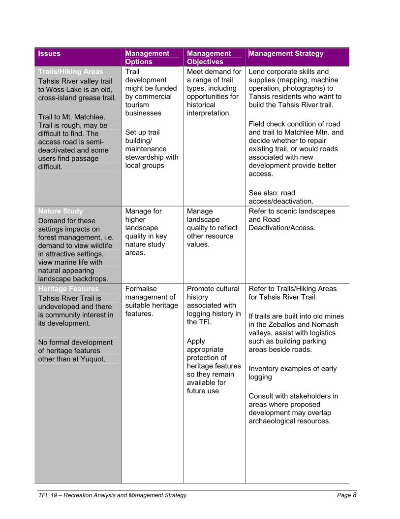
TFL 19 – Recreation Analysis and Management Strategy Page 8
Issues Management Options
Management Objectives
Management Strategy
Trails/Hiking Areas Tahsis River valley trail to Woss Lake is an old, cross-island grease trail. Trail to Mt. Matchlee. Trail is rough, may be difficult to find. The access road is semi-deactivated and some users find passage difficult.
Trail development might be funded by commercial tourism businesses Set up trail building/ maintenance stewardship with local groups
Meet demand for a range of trail types, including opportunities for historical interpretation.
Lend corporate skills and supplies (mapping, machine operation, photographs) to Tahsis residents who want to build the Tahsis River trail. Field check condition of road and trail to Matchlee Mtn. and decide whether to repair existing trail, or would roads associated with new development provide better access. See also: road access/deactivation.
Nature Study Demand for these settings impacts on forest management, i.e. demand to view wildlife in attractive settings, view marine life with natural appearing landscape backdrops.
Manage for higher landscape quality in key nature study areas.
Manage landscape quality to reflect other resource values.
Refer to scenic landscapes and Road Deactivation/Access.
Heritage Features Tahsis River Trail is undeveloped and there is community interest in its development. No formal development of heritage features other than at Yuquot.
Formalise management of suitable heritage features.
Promote cultural history associated with logging history in the TFL Apply appropriate protection of heritage features so they remain available for future use
Refer to Trails/Hiking Areas for Tahsis River Trail. If trails are built into old mines in the Zeballos and Nomash valleys, assist with logistics such as building parking areas beside roads. Inventory examples of early logging Consult with stakeholders in areas where proposed development may overlap archaeological resources.

TFL 19 – Recreation Analysis and Management Strategy Page 9
Issues Management Options
Management Objectives
Management Strategy
Mushrooms No formal structure for management of impacts of forest development on mushroom habitat. Extent of mushroom resource not known. Concerns over damage to mushroom areas by logging and by incorrect mushroom harvesting techniques. Exact conditions required for mushrooms not known Concern by pickers over damage to mushroom areas by logging
Inventory this resource to obtain a measure of its extent and temporal changes to location expected with forest succession.
Identification of mushroom resources in order to ensure appropriate protection and management Management of impact of pickers on the mushroom resource
During the prime mushroom maturation period, proposed forest development/harvest areas should be examined to assess the presence of mushrooms and to assess the quality of the area for mushroom production. Consult with the forest district to determine an assessment and appraisal format. Mushrooms are a known resource. Proposed forest harvesting plans should take into account the presence of this resource, modifying forestry and engineering practices as necessary. Develop inventory of mushrooms and other forest floor products
Interagency Agreements Wildlife habitat area at Weymer may not be suitable for tours.
Protection of the bat habitat
If caves are suitable for commercial or public tours, maintain road access. If caves are not suitable for tours, deactivate access.
Recreation Sites There are 137 Commercial Recreation/Tourism businesses based in or are using Nootka Sound, 34 of which provide only accommodation services. Informal sites at the Gold River/Muchalat River junction, Hoiss Creek, McCurdy Creek, Zeballos River north of canyon (picnic site), Bull Lake (picnic site)
Continue to upgrade or build recreation sites as required Encourage commercial development of new recreation sites
Meet public demand for rustic recreation facilities. Improved site maintenance through formal management of informal campsites
Further site development might be better done by commercial recreation and tourism businesses. WFP should review Commercial Recreation (CR) applications pertaining to TFL 19. Encourage formal management of informal sites See also Lakes and Trails/Hiking Areas

TFL 19 – Recreation Analysis and Management Strategy Page 10
Issues Management Options
Management Objectives
Management Strategy
Road Deactivation/Access Deactivation of roads can limit recreation access. Trails leading from secondary logging roads typically have no formal management or status, leading to variable access conditions, uncertainty regarding whether access is available. Logging roads between Tahsis and Zeballos are close to connecting. Tourism operator use of logging roads for business purposes
Maintain road access to key recreation areas Identify roads where commercial tourism businesses share responsibilities for maintenance
Provide opportunities for motorized recreation in a variety of settings Consistent mapping and signage of trail heads Inform visitors of road conditions
Keep certain roads in TFL 19 open to 4x4 level of access to access recreation areas, i.e. • Nomash Main and N-50 to
Rugged Mountain and Haithe Range,
• H-60M to Conuma Peak, • U-29 to Matchlee Mountain,
W-79 and W-79K to Victoria Peak,
• WD-7 to Big Baldy Mountain, Cala Creek road,
• C-60 to Alava and Peters Lakes,
• Conuma River roads to McNally Ridge,
• Nomash and Extravagant Creek roads to Nomash Meadows
• Z-60P to Zeballos Peak Vary degrees of road deactivation where possible to reflect recreation values Signpost levels of road deactivation at beginning of roads/spurs Encourage users to approach WFP for current information on road conditions. Where commercial tourism operators use roads for their business, define roles and responsibilities for maintenance, liability and cost sharing.
TFL 19 – Recreation Analysis and Management Strategy Page 11
6.0 Recommended Recreation Management Options (RMO’s) Recommended Management Options are identified in Section 5.2 - Recreation Management Options.
In most cases there is only one option. For example, in the case of mushrooms, which is a known resource, but not quantified, some form of survey is necessary in order to develop a management strategy.
This section discusses those resource issues having more than one management option.
Scenic Landscapes: Current Conditions
Recommended Management Option (RMO): Where possible, Option #2 should be pursued: Apply intensive silviculture, road debuilding, etc. to accelerate visual recovery.
There may be opportunities to coordinate with watershed restoration, road debuilding etc. to achieve visual resource management objectives.
Trails/Hiking Areas
RMO’s: Both options may apply. Consult with stakeholders and with commercial tourism operators to develop management approach.
Recreation Sites
RMO’s: Both options may apply. Consult with stakeholders and with commercial tourism operators to develop management approach.
Road Deactivation/Access
RMO’s: Both options may apply. Consult with stakeholders and with commercial tourism operators to develop management approach.

Appendix XIV Goshawk Inventory
Goshawk Inventory Page 1
Gold River “Queen Charlotte” Goshawk Inventory
1999
Erica McClaren, February 2000
Summary A two person crew conducted northern goshawk (Accipiter gentilis laingi) inventories for the second year in forests surrounding Gold River between May and August 1999 (Figure 1). Known nest territories were assessed for reoccupancy and new areas were inventoried to gain more information on the breeding distribution and breeding habitat of goshawks on Vancouver Island. Attempts were made to capture breeding adults and affix backpack radio-transmitters so that we can learn more about goshawk seasonal habitat use and movement patterns, survival and breeding dispersal. One-hundred and eighty-nine broadcast stations (2,457 ha) and 14.5 hours of stand-watch surveys resulted in three new alternate nest sites within known goshawk territories. As well, one new goshawk territory was reported by Western Forest Product employees and was confirmed by goshawk crew members to be active. Thus, goshawk breeding activity in the Gold River area was relatively low in 1999, with one of the three (33.3%) previously known territories being active (which failed in June) and only one new nest territory located. The one successful nest in the Gold River area fledged two young. The adult female at the newly found Bolton Lake territory was captured and radio-tagged and continues to be tracked throughout the winter months. Objectives for Gold River goshawk inventory:
1. To return to known goshawk territories in order to assess territory reoccupancy, nest site and mate fidelity and breeding dispersal movements for banded and tagged individuals, and to gather nest productivity data.
2. To survey for goshawks in Gold River for a second year and to survey new areas on Nootka Island and in Zeballos to increase our knowledge of goshawks breeding distribution and habitat associations. Forestry personnel prioritized survey areas, as there were a limited number of areas that could be inventoried during the breeding season. Within these prioritized areas, effort was distributed equally in three landscape types: 1) continuous old growth; 2) continuous second growth; and 3) fragmented forests, so that data collected may be compared among silvicultural treatments and to prevent survey bias. However, within Gold River, effort was mainly in continuous old-growth forests as this is the dominant landscape type within this area.
3. To provide additional data for the development of a nest habitat suitability model for goshawks so that this model will accurately represent the full range of habitat variables found around goshawk nest sites on Vancouver Island. The aim of this model is to streamline the process of surveying for goshawks, alleviating a potential bottleneck for forest harvesting.
4. To utilize reoccupancy and nest productivity data and the nest habitat suitability information from goshawk inventory to develop Wildlife Habitat Areas (WHAs) around specific goshawk nest territories as instructed by the Managing Identified Wildlife: Procedures and Measures. Volume I. (Ministry of Forests and BC Environment 1999).
5. To assess the effectiveness of the standardized Resource Inventory Committee (RIC) methodology for the inventory of goshawks (Ethier and McClaren 1997), modified from the original goshawk inventory protocol described by Kennedy and Stahlecker (1993).

Goshawk Inventory Page 2
6. To assist researchers on Vancouver Island with the capture of goshawks at active nest sites in order to band birds, collect blood and affix backpack radio transmitters. Radio telemetry data will provide information on home range size and habitat use, as well as on nest site and mate fidelity, breeding dispersal and other seasonal movements. Survivorship data may also be gathered through radio telemetry. Additionally, radio telemetry has proven to be an invaluable inventory tool for locating nesting pairs from year to year and for finding new nests and territories.
Study Areas Table 1. Description of study areas where goshawk inventory occurred near Gold River in 1999.
Study Area Forest Type Predominant Age Distribution Muchalat Lake fragmented old
growth old forest >250 yr., recent clearcuts and young second growth (<40 yrs.); little or no connectivity between forest patches
Gold/Muchalat Park
fragmented old growth
old forest >250 yr., recent clearcuts and young second growth (<40 yrs.); little or no connectivity between forest patches
Twaddle Lake continuous old growth
majority (>70%) >250 yr.; connectivity between forest patches
Leagh Creek continuous old growth
majority (>70%) >250 yr.; connectivity between forest patches
Conuma/Norgate Rivers
continuous old growth
majority (>70%) >250 yr.; connectivity between forest patches
Star Lake continuous old growth
majority (>70%) >250 yr.; connectivity between forest patches
Nootka Island fragmented old and second growth
old forest >250 yr., recent clearcuts and second growth forest (0-65 yr.)
GOLD RIVER AREAS
Curly Creek, Zeballos
continuous old growth
majority (>70%) >250 yr.; connectivity between forest patches
Results Goshawk Inventory Between May and August 1999, 189 broadcast stations (2,457 ha) resulted in two confirmed goshawk detections leading to one new territory and three new alternate nests within known territories (Table 2). Eighty-nine percent (2197 ha) of call stations occurred in continuous old-growth forests, none occurred in continuous second-growth forests and 10.6% (260 ha) were in fragmented forests. Both goshawk detections occurred in continuous old-growth forests. Although 14.5 hours of stand-watch surveys were conducted, no goshawks were detected using this technique (Table 2). Stand-watches were conducted within continuous and fragmented old-growth forests where there were good vantage points. One new goshawk territory was reported by Western Forest Product employees and one alternate nest was located in this territory. This brings the total number of confirmed goshawk nest territories currently known on Vancouver Island to 41.

Goshawk Inventory Page 3
Table 2. Survey effort, goshawk detections, and nest territories found in Gold River survey areas and forest types (OG=old-growth, SG= second-growth) on Vancouver Island, May-August 1999.
Call Stations Stand-watches Survey Areas
Forest Type no. area(ha) detections no. hours detections
No. New Nests
Continuous OG
169 2197 2 7 11 0 5ab
Continuous SG
0 0 _ 0 0 _ _
GOLD RIVER
Fragmented OG/SG
20 260 0 2 3.5 0 0
TOTAL All Forest Types
189 2457 2 9 14.5 0 5
aThree of these were new nests in known goshawk territories and the other two were new nests in a new territory. bThe new territory with one active and one alternate nest was reported by forest company employees.
Broadcast survey success, measured as the number of detections per 100 broadcast stations, was 0.8, 0.0, and 3.1 for all surveys on Vancouver Island in continuous old-growth, continuous second-growth and fragmented forests, respectively (Figure 2). Separated by survey area, broadcast surveys were most effective in fragmented forests on the north island with 3.7 detections/100 broadcast stations compared to continuous old-growth (0.5) and continuous second-growth (0.0) forests. In Gold River survey areas, all goshawk detections occurred in continuous old-growth forests resulting in a detection rate of 1.2 detections/100 broadcast stations. Broadcast survey success rates in 1999 for Vancouver Island translate to approximately one new goshawk nest (within an unknown or previously known territory) being located for every 1.4 goshawk detections. Territory Reoccupancy and Nest Productivity When the three previously known goshawk territories in the Gold River area were assessed for reoccupancy and activity in 1999, one (33.3%) was reoccupied by nesting adult goshawks, although the other two territories were occupied by transmittered females in April. As well as assessing known goshawk territories for reoccupancy, the number of young in each nest approximately one week prior to fledging (≈39 days of age) was documented. The Muchalat Lake
Figure 2. Broadcast survey success, May-August 1999.
0
0.5
1
1.5
2
2.5
3
3.5
4
North Island Gold River Vancouver Island
No.
det
ectio
ns/1
00 b
road
cast
stat
ions
Continuous OGContinuous SGFragmented

Goshawk Inventory Page 4
territory that was active in June failed to produce any young and the females that were in the other two territories in April, never initiated incubation. Productivity for the one successful nest was two young. Mean productivity over all years data have been collected at nests in the Gold River area is 1.75±0.63 (n=4).
Gold River: CONTINUOUS OLD GROWTH
0
0.05
0.1
0.15
0.2
0.25
0.3
0.35
0.4
0.45
Red Squirrel Jays Grouse Thrush Woodpeckers
Prey Species
Det
ectio
n Fr
eque
ncy
Gold River: FRAGMENTED
0
0.05
0.1
0.15
0.2
0.25
0.3
0.35
0.4
0.45
Red Squirrel Jays Grouse Thrush Woodpeckers
Prey Species
Det
ectio
n Fr
eque
ncy
FIGURE 3. GOSHAWK PREY DETECTION FREQUENCIES AT BROADCAST STATIONS IN TWO FOREST TYPES WITHIN GOLD RIVER INVENTORY AREAS ON VANCOUVER ISLAND, MAY TO AUGUST 1999.
LEGEND: Jays=Gray and Steller’s Grouse=Blue and Ruffed Thrush=Varied, Swainson’s, Hermit and American Robin Woodpeckers=Hairy, Downy, Pileated, Red-breasted Sapsucker and Northern Flicker
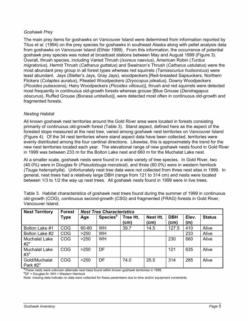
Goshawk Inventory Page 5
Goshawk Prey The main prey items for goshawks on Vancouver Island were determined from information reported by Titus et al. (1994) on the prey species for goshawks in southeast Alaska along with pellet analysis data from goshawks on Vancouver Island (Ethier 1999). From this information, the occurrence of potential goshawk prey species was noted at broadcast stations between May and August 1999 (Figure 3). Overall, thrush species, including Varied Thrush (Ixoreus naevius), American Robin (Turdus migratorius), Hermit Thrush (Catharus guttatus) and Swainson’s Thrush (Catharus ustulatus) were the most abundant prey group in all forest types whereas red squirrels (Tamiascurius hudsonicus) were least abundant. Jays (Steller’s Jays, Gray Jays), woodpeckers [Red-breasted Sapsuckers, Northern Flickers (Colaptes auratus), Pileated Woodpeckers (Dryocopus pileatus), Downy Woodpeckers (Picoides pubescens), Hairy Woodpeckers (Picoides villosus)], thrush and red squirrels were detected most frequently in continuous old-growth forests whereas grouse [Blue Grouse (Dendragapus obscurus), Ruffed Grouse (Bonasa umbellus)], were detected most often in continuous old-growth and fragmented forests. Nesting Habitat All known goshawk nest territories around the Gold River area were located in forests consisting primarily of continuous old-growth forest (Table 3). Stand aspect, defined here as the aspect of the forested slope measured at the nest tree, varied among goshawk nest territories on Vancouver Island (Figure 4). Of the 34 nest territories where stand aspect data have been collected, territories were evenly distributed among the four cardinal directions. Likewise, this is approximately the trend for the new nest territories located each year. The elevational range of new goshawk nests found in Gold River in 1999 was between 233 m for the Bolton Lake nest and 660 m for the Muchalat Lake nest. At a smaller scale, goshawk nests were found in a wide variety of tree species. In Gold River, two (40.0%) were in Douglas fir (Pseudotsuga menziesii), and three (60.0%) were in western hemlock (Tsuga heterophylla). Unfortunately nest tree data were not collected from three nest sites in 1999. In general, nest trees had a relatively large DBH (range from 121 to 314 cm) and nests were located between 1/3 to 1/2 the way up nest trees. All goshawk nests found in 1999 were in live trees. Table 3. Habitat characteristics of goshawk nest trees found during the summer of 1999 in continuous old-growth (COG), continuous second-growth (CSG) and fragmented (FRAG) forests in Gold River, Vancouver Island.
Nest Territory Forest Nest Tree Characteristics Type Age Speciesb Tree Ht.
(cm) Nest Ht. (cm)
DBH (cm)
Elev. (m)
Status
Bolton Lake #1 COG 60-80 WH 39.7 14.5 127.5 410 Alive Bolton Lake #2 COG >250 WH 233 Alive Muchalat Lake #2a
COG >250 WH 230 660 Alive
Muchalat Lake #3a
COG >250 DF 121 635 Alive
Gold/Muchalat Park #2a
COG >250 DF 74.0 25.5 314 285 Alive
aThese nests were unknown alternate nest trees found within known goshawk territories in 1999. bDF = Douglas-fir; WH = Western Hemlock Note: missing data indicate no data were collected for these parameters due to time and/or equipment constraints.

Goshawk Inventory Page 6
Trapping and Radio-telemetry From the one pair of goshawks known to be nesting in the Gold River area in 1999, the adult female was captured and radio-tagged (Table 4). In general, male goshawks are more difficult to capture because they spend more time away from the nest site foraging and are less aggressive due to their smaller body size. Thus, we were unable to catch the male at the Bolton Lake nest. During the summer of 1999, the Gold Park and Oktawanch females, that were radio-tagged in 1998 at Gold River nest sites, moved around throughout the Gold River area but did not settle down on nest territories to breed. Table 4. Goshawk trapping results from Gold River area nests in 1999 using a Great Horned Owl and mistnet (GHOW + mn).
Study Area Capture Location Date Sex (M/F)
Age (A/Imm.)
Capture Method
GOLD RIVER Bolton Lake #1 nest 99/06/23 F A GHOW+ mn Currently, the Gold Park male and female, both tagged in 1998, have died; the male died during the winter of 1998/99 and the female died this winter. The cause of death to these goshawks is unknown and may be from the weight of transmitters, winter weather, fluctuations in prey abundance and/or changes in habitat conditions. The Oktawanch and Bolton lake females continue to be located during winter telemetry flights on Vancouver Island. It remains difficult to maintain consistent contact with radio-tagged individuals because of poor weather and steep terrain complications. Literature Cited Ethier, T. and E. McClaren, eds. 1997. Standardized Inventory Methodologies for Components of
British Columbia’s Biodiversity: Raptors (Vs. 1.1). Resources Inventory Committee, Ministry of Environment, Lands and Parks, Victoria, BC. 23pp.
Ethier, T. 1999. Breeding habitat of northern goshawks (Accipiter gentilis laingi) on Vancouver Island: a
hierarchical approach. Master’s Thesis. University of Victoria, BC. Kennedy, P.L. and D.W. Stahlecker. 1993. Responsiveness of nesting northern goshawks to taped
broadcasts of 3 conspecific calls. Journal of Wildlife Management 57:249-257. Ministry of Forests and BC Environment. 1999. Managing Identified Wildlife: Procedures and
Measures. Volume 1. 1999. 180pp. Titus, K., C.J. Flatten and R.E. Lowell. 1994. Goshawk ecology and habitat relationships on the
Tongass National Forest - goshawk nest sites, food habits, morphology, home range and habitat data. First Annual Progress Report. Contract 43-0109-3-0272 with USDA Forest Service. Alaska Dept. of Fish and Game, Juneau, Alaska. 69 pp

Appendix XV WRP – Habitat Restoration Plans

WRP – Habitat Restoration Plans Page 1
WRP - HABITAT REHABILITATION PLAN
LOCATION DESCRIPTION Twaddle 41 km of road have been deactivated within the Twaddle River planning unit. Benefits
associated with this work include lower risk of slope instability and a reduced volume of sediment negatively impacting fish habitat through erosion.
Muchalat Lake 28 km of road have been deactivated within the Muchaat Lake planning unit. Benefits associated with this work include lower risk of slope instability and a reduced volume of sediment negatively impacting fish habitat through erosion.
Oktwanch River 3 km of side channel habitat has been developed off of the Oktwanch River to date. Future plans call for an additional 1 km of side channel development and bank stabilization structures to be installed along 1.5 km of the Oktwanch River itself.
Zeballos Estuary 0.9 km of side channel habitat is being developed at the Zeballos River estuary in the 2000 field season. An additional 0.4 km of possible side channel development has also been identified for future work.
Tsowwin 7.3 km of road have been deactivated within the Tsowwin River planning unit. Benefits associated with this work include lower risk of slope instability and a reduced volume of sediment negatively impacting fish habitat through erosion.
Conuma Currently the Conuma planning unit is under going overview assessments to identify what potential risks exist to fish habitat. Based on these findings, prescriptions will be drawn up and the work carried out in 2001 and 2002. Initial findings estimate approximately 15 km of road may need deactivating and there is likely little need for instream work.
Upana Currently the Upana planning unit is under going overview assessments to identify what potential risks exist to fish habitat. Based on these findings, prescriptions will be drawn up and the work carried out in 2001 and 2002. Initial findings estimate approximately 30 km of road may need deactivating and there may be need for instream work.
Ucona Currently the Ucona planning unit is under going overview assessments to identify what potential risks exist to fish habitat. Based on these findings, prescriptions will be drawn up and the work carried out in 2001 and 2002. Initial findings estimate approximately 5 km of road may need deactivating and there is likely little need for instream work.
Leiner/Perry Leiner/Perry planning unit will under going overview assessments in the near future to identify what potential risks exist to fish habitat. Based on these findings, prescriptions will be drawn up and the work carried out in 2001 and 2002.
Zeballos River 19 km of road have been deactivated within the Zeballos River planning unit. Benefits associated with this work include lower risk of slope instability and a reduced volume of sediment negatively impacting fish habitat through erosion.

Appendix XVI Twenty-Year Plan
TWENTY-YEAR PLAN
IN PREPARATION OF
MANAGEMENT PLAN 9
FOR
TREE FARM LICENCE 19
Submitted to the Campbell River Forest District, Ministry of Forests
May 2001
TFL 19 – Twenty-Year Plan Page i
TABLE OF CONTENTS Page 1 INTRODUCTION.........................................................................................................................................1
2 PROCEDURE..............................................................................................................................................1
3 RESULTS....................................................................................................................................................2
LIST OF TABLES TABLE 1. PROJECTED HARVEST RATES............................................................................................... 2 TABLE 2. AREAS, AGE, PIECE SIZE AND VOLUME................................................................................ 2 TABLE 3. HARVESTED AREA BY OPERABILITY (HA). .............................................................................. 3 TABLE 4. HARVEST AREA WITH OVERLAPPING NON-TIMBER VALUES ..................................................... 3
APPENDICES APPENDIX XV-A TERMS OF REFERENCE FOR 20 YEAR PLAN ............................................................... 4

TFL 19 – Twenty-Year Plan Page 1
1.0 INTRODUCTION
This report, together with the accompanying maps, demonstrates the spatial feasibility of initial harvest levels proposed in the associated Timber Supply Analysis (TSA). As the timber supply model used in the TSA is spatially explicit, spatial feasibility is automatic making the primary purpose of a twenty-year plan redundant. However, a manually developed hypothetical twenty-year harvest schedule was used within the model to emulate more operationally-based harvest blocks than normally occur with spatial models using computer generated aggregation and harvest controls (i.e. oldest first, closest to the mill and/or minimize growth loss). Note that this schedule is not a definitive operational plan.
2.0 Procedure
Harvest projections were developed manually to cover the twenty-year period from 2001 to 2020. Completed using the methodology outlined in the attached Terms of Reference harvest blocks were assigned planning periods based on:
2001 – 2005 Involves planning harvesting operations in previously undeveloped portions of watersheds, blocks adjacent to “greened-up” stands and satisfy Coastal Watershed Assessment Procedures (CWAP), Visual Quality Objectives (VQOs) etc. Blocks illustrated are generally within the approved 1999 – 2003 Forest Development Plan for operations within TFL 19.
2006 – 2010 Involves planning harvesting operations in previously undeveloped portions of watersheds, blocks adjacent to stands “greened-up” during the period and blocks satisfying CWAPs and VQOs during the period.
2011 – 2020 Involves second passes at watersheds previously developed and blocks satisfying CWAPs and VQOs during the period.
Harvest blocks defined manually were scheduled to meet the current AAC for the TFL. Assumed harvesting for the year 2000 was also projected and simulated as part of the manual process to bring the forest inventory in line with the planning horizon for this plan.
The completed manual twenty-year plan was then incorporated into the timber supply model to guide harvest aggregation and scheduling. As the timber supply model is set with current management assumptions10, such as VQOs, biodiversity and green-up, the twenty-year plan was readily evaluated for any harvest constraint violations.
To allow for some flexibility in how the manual twenty-year plan schedule was used within the timber supply model, set-up procedures were designed so that the block schedule was used only as a guide as to when blocks became available for harvest (i.e. the schedule was not forced within the model). In other words, if a block were scheduled for 2002, the
10 A complete listing of all assumptions used in the TSA can be found in the TFL 19 Information Package.

TFL 19 – Twenty-Year Plan Page 2
model was set up so that the block becomes available for harvest, but doesn’t necessarily get harvested unless it is actually needed to meet the harvest volume requested. By using this methodology, the model is able to alter the manual harvest schedule around to avoid constraints or to accommodate changes in volume requests by period.
3.0 Results
Results for the combined manual twenty-year plan and timber supply model are presented here. Harvest levels obtained for each of the five-year periods are presented in Table 1.
Table 2. Projected Harvest Rates Period Projected Annual Harvest
Rates (m3/year) Projected Total Harvest
(m3) 2001 – 2005 940,347 4,701,735 2006 – 2010 904,144 4,520,720 2011 – 2015 869,334 4,346,670 2016 – 2020 835,865 4,179,325 Total 3,549,690 17,748,450
Overall, the results show that the manual twenty-year plan schedule worked well in the first five-year period, but deviations occurred in the following periods. Analyses of model outputs indicate that the deviation from the manual schedule is due primarily to VQO constraints, which is not surprising given the difficult nature in accommodating this constraint manually. Other deviations were caused by the integration of new information since the completion date of the manual plan (i.e. recreation inventory) and challenges with “cutting-in” the manually identified harvest areas into the timber supply modelling dataset.
Although the manual twenty-year plan sequence varied in the timber supply model, the spatial feasibility of harvesting at the projected harvest rates was verified. Note however that other sequences would be feasible, just as other acceptable block layout configurations could be designed manually or using modelling procedures. This plan does not represent any operational commitment and should not guide or project actual forest development planning.
The following tables summarize harvest stats for the twenty-year period covered. Table 3. Areas, Age, Piece Size and Volume Period Area/yr Mean
Age Mean DBHq
Mean Vol/ha
2001 - 2005 1,584.4 278 49.7 618.2 2006 - 2010 1,546.3 304 49.5 609.1 2011 - 2015 1,444.2 253 49.4 627.0 2016 - 2020 1,490.6 258 46.2 584.1
Total 6,065.5

TFL 19 – Twenty-Year Plan Page 3
Table 4. Harvested area by operability (ha) Operable Conventional Operable Helicopter PERIOD (ha) % (ha) %
Total(ha)
2001 - 2005 1244.3 79% 340.1 21% 1584.4 2006 - 2010 1169.2 76% 377.1 24% 1546.3 2011 - 2015 1191.9 83% 252.3 17% 1444.2 2016 - 2020 1277.4 86% 213.2 14% 1490.6
Total 4882.7 80% 1182.8 20% 6065.5
No economic constrained operable areas (Oce or Ohe) are identified in the results as they are excluded in the Current Management Option used in the TSA. The manual twenty-year plan did include some of these areas, which further explain some deviations that occurred.
As the model uses all constraints defined in the Current Management Option of the TSA, the possibility of violating constraints designed to protect non-timber values is eliminated in this projection. The table below reports on areas identified as having both timber and non-timber values that are being harvested over the twenty-year projection.
Table 5. Harvest area with overlapping non-timber values VQO Recreation Wildlife Stability
PERIOD M PR R Karst
HM VHM PWA Class 4 Class 52001 - 2005 351.8 207.0 10.7 117.7 22.5 4.9 632.0 480.3 48.92006 - 2010 354.6 149.8 3.6 158.6 32.6 3.7 160.8 369.5 61.22011 - 2015 327.7 257.4 2.2 71.3 15.5 1.3 93.5 375.2 53.42016 - 2020 336.0 244.6 8.8 124.1 15.6 7.7 152.6 347.3 46.1
Total 1370.1 858.8 25.3 471.8 86.2 17.6 1038.9 1572.3 209.6

TFL 19 – 20 year plan projection Page 4
Appendix XV-A Terms of Reference for 20 Year Plan
For TFL 19 MANAGEMENT PLAN No.9 (2001-2005)
1.0 Objective
The twenty-year plan is a requirement of the TFL licence agreement. The plan will be prepared as a component of Management Plan No.9 for Tree Farm Licnece 19 (TFL 19). The twenty-year plan will be projected for the period 2001-2020. The plan confirms that harvest levels presented in the base case of the timber supply analysis are achievable given spatial constraints of the land base. This plan is to serve a link between the harvest level indicated from the timber supply analysis for TFL 19 and operational planning at the cutting permit and five-year Development Plan level. The twenty-year plan is due on September 30,2000.
2.0 Methodology
To spatially identify timber harvest blocks for a twenty-year period, based on the indicated AAC, consistent with the requirements of the Forest Practices Code of BC and Higher Level Plans.
The following criteria will apply:
A) Mapping Scale
The initial planning will be done on 1:5,000 scale maps. Final submission to the Ministry of Forests will be at 1:20,000 scale maps.
B) Planning Periods
1st Five Year Period - involves planning harvesting operations in previously undeveloped portions of watersheds, blocks adjacent to “greened-up” stands and satisfy Coastal Watershed Assessment Procedures (CWAP), Visual Quality Objectives (VQO’s) etc. Blocks illustrated are generally within the approved 1999-2003 Five Year Development Plans for operations within TFL 19.
2nd Five Year Period – involves planning harvesting operations in previously undeveloped portions of watersheds, blocks adjacent to stands “greened-up” during the period and blocks satisfying CWAP and VQOs during the period.
3rd and 4th Five Year Periods – involves second passes at watersheds previously developed and blocks satisfying CWAPs and VQOs during the period.

TFL 19 – 20 year plan projection Page 5
C) Operability
New 1:20,000 operability mapping has been completed for the TFL. The terms of reference were submitted to the Ministry of Forests in February 1999 and approved by the Regional Manager in June 1999. Operability will be segregated by yarding system as per the terms of reference:
1) Conventional Yarding Systems
Operable Conventional
Operable Conventional with Economic Constraints
2) Non-Conventional Yarding Systems
Operable Helicopter
Operable Helicopter with Economic Constraints
D) Harvest Block Size
Block size will vary depending on:
− Resource Management Zone (RMZ) objectives − Visual Quality Objectives − Watershed Assessments − Wildlife values − Biodiversity values
E) Leave Areas
FPC states that you can only harvest a cutblock that is adjacent to a previously harvested cutblock if the previously harvested cutblock is greened-up. No where does it state the size of leave block required to be left between the previously harvested cutblock and the proposed cutblock. The size of leave block will depend on:
− Economics − Sufficient volume for 2nd pass − Hydrology − Wildlife − Scenic and recreational values − Biodiversity
F) Block Design and Location
Each block must have a logical boundary that allows for the following: i. Road location; ii. Immature and logged areas; iii. Environmentally Sensitive Areas iv. Logging system. v. Profitability vi. Avoidance of isolated timber vii. Efficiency of subsequent operations

TFL 19 – 20 year plan projection Page 6
G) Watershed and Streamside Management
Watershed assessments are carried out in community watersheds, watersheds that have significant downstream fisheries values, licenced domestic water users or as otherwise determined necessary by the district manager. Within TFL 19 a majority of communities are on well water. Currently there is only one community watershed located at Tahsis. Forest development plans must be consistent with the results and recommendations of the watershed assessments. These same recommendations will be incorporated into the twenty-year plan.
The 1994 inventory of riparian areas in the TFL has been updated to Forest Practices Code standards. New riparian reserve and management zones have been used in the timber supply analysis for MP 9 and will be incorporated into the twenty-year plan.
H) Cutblock Scheduling
Harvest schedule guidelines for visual quality objectives will be incorporated:
VQO Maximum Portion of Landscape Unit Harvestable
Retention 5 % Partial Retention 15 % Modification 25 % Maximum Modification 40 %
Before scheduling of adjacent cutblocks the existing harvested blocks require to be meet visually effective green-up (VEG). For Nootka Region, VEG equates to 5-meter tall trees at 15 years old.
I) Harvestable Age
Site Minimum Harvest Age Good 60 Medium 80 Poor 100
J) Environmentally Sensitive Areas
Environmentally sensitive areas for soils, avalanches, wildlife, recreation, watersheds and fisheries have been updated and new areas have been incorporated into the timber supply analyses for MP 9. Generally class I (i.e. Ew1, Es1) will be reserved from harvest except where approved under the Forest Development Plan.
K) Road Design and Location
All mainline and branch roads that provide access to the cutblocks will be determined as per the operability plan. Locations of major crossings will also be shown.

TFL 19 – 20 year plan projection Page 7
3.0 20 Year Plan Report
The report will consist of a write-up explaining the underlying assumptions of the 20-year plan and if and how the plan deviates from the base case of the timber supply analysis. The report will include tabular information showing for each block:
- five year period - block name - area - volume - conventional or helicopter harvesting system
5 year Period
VQO (ha)
Recreation (ha)
Wildlife (ha)
Conventional Harvest
(ha)
Helicopter Harvest
(ha)
Total Area (ha)
Total Volume
(ha)
4.0 20 Year Maps
The maps will show the following features: - Licence boundaries - Municipal and community watershed boundaries - Cutblock boundaries on approved forest development plan - Broad timber types - Operability as defined by an approved operability plan - Years of harvestable timber by block, colour coded into 5-year periods - Harvest system for each block - Existing roads and river crossings - Future (next 20 years) roads and river crossings - Management zone boundaries - Land use planning boundaries - Sensitive sites - Existing recreation developments - Priority cutting areas - LU boundaries - VQOs - Other resources with timber supply implications
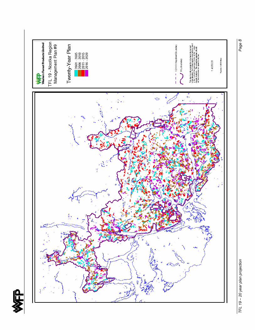
TF
L 19
– 2
0 ye
ar p
lan
proj
ectio
n
Page
8

Appendix XVII ISO 14001
Registered Environmental Management System

ISO 14001 – EMS Page 1
WFP Environmental Management System (EMS) registered to ISO 14001 Standard
Western Forest Products Limited (WFP) is registered effective April 12, 2000 to the international environmental standard ISO 14001 by independent auditor Quality Management Institute (QMI) following an audit of WFP’s forest operations, regional offices and corporate office. The overall aim of the ISO 14001 standard is to support environmental protection and prevention of pollution in balance with social and economic needs.
ISO 14001 is an international standard that specifies the requirements of an environmental management system (EMS). An EMS is established to achieve and demonstrate sound environmental performance by controlling the impact of our activities on the environment and taking into account our environmental policy and objectives. The EMS is a structured process for meeting all legislative requirements and measuring environmental protection.
Using the EMS framework, we set specific environmental objectives and targets that reflect our legislative requirements and information about the significant environmental impacts in our day-to-day forestry activities. We evaluated all environmental aspects of our forest operations such as road construction, yarding and loading, harvesting and silviculture for the potential risk they pose to the environment as the basis for establishing environmental programs.
The environmental programs are a key element of our EMS because they outline how WFP’s objectives and targets will be achieved, including timelines and personnel responsible for implementation. We have set measurable objectives and targets within our 8 environmental programs. These programs (attached) detail WFP’s targets for environmental performance that maintain air, soil and water quality. WFP has set parameters for maintaining these values that we will monitor over time. For instance, we will track the number of reportable spills in our operations to ensure we are meeting our target of reducing spills by 10% per year. WFP’s EMS brings environmental issues into the day to day activities of our forest operations so that we have a positive impact on the ground.
WFP conducts regular internal audits to measure our compliance with the environmental management system standard. The WFP Internal Audit Team visits all operations to monitor progress on our environmental programs and our overall environmental performance. The Internal Audit Team reports to WFP’s Management Environment Review Committee that meets annually to review the results of our environmental programs and assesses the effectiveness of our environmental objectives so that we can achieve continual improvement.
QMI awarded the registration on the company’s entire operations based on WFP’s commitment to the environmental management system (EMS) that applies to all of WFP’s forest activities including road construction, silviculture and fisheries protection.
The registration applies to WFP’s 41 forest operations and supporting facilities such as log sorts and the Saanich Forestry Centre and covers an annual harvest of 4.2 million cubic metres, making it one of the largest ISO 14001 registrations in North America.
The independent registration provides objective evidence to the public and customers that WFP’s EMS is clearly a tool for continual improvement and addresses “on the ground” forest practices by setting objectives and targets. The ISO 14001 registration process is part of WFP’s sustainable forest management strategy that includes ongoing certification projects such as Forest Stewardship Council (FSC), Canadian Standards Association (CSA) and other related initiatives.

ISO 14001 – EMS Page 2
ISO 14001 – EMS Page 3
Appendix XVIII Profiles of Main Communities
Profiles of Main Communities Page 1
NOOTKA SOUND REGION
In July 1776, aboard the Resolution, Captain James Cook, R.N. sailed from England on his third (and last) voyage of exploration around the world. In March 1778 he entered what is now known as Nootka Sound and anchored in the vicinity of Blight Island. He landed at Friendly Cove where he claimed the surrounding territory for Great Britain. He became the First European to set foot on what is now known as British Columbia. Ten years after setting foot in the Nootka Sound region the vessel “Northwest America” was built from local timber and used for the fur trade. The Captain, John Meares, also instructed his men to cut spars and saw planks for trade in China. This was the beginning of the forest industry in the province.
At Friendly Cove, Cook met the Mowachahts, which numbered several thousand. They were the greatest whaling people in North America at the time. Cook successfully traded otter skins and established a fur trade. This brought the First Nations people into extensive contact with Europeans.
In 1789 Spain took possession of Nootka Sound and established a settlement named Nootka at Friendly Cove. Spain captured some British vessels and war nearly broke out. Captain Vancouver, for Great Britain, and Captain Quadra, for Spain, met at Nootka in 1792 and supervised the return of the area to British rule. For many years during this period and many years after, Nootka was the most important seaport north of Mexico.
In 1954 the Tahsis Forest Management Licence was created and in 1957 it was changed to Tree Farm Licence 19. Tahsis Company was the holder of the licence. In 1985 Tahsis Company was taken over wholly by Canadian Pacific and in 1993 the company named was changed to Pacific Forest Products Limited. In 1998 Bowater became the owner of the pulp mill at Gold River. In 1998 Pacific Forest Products was purchased by Timberwest who then sold off the TFL 19 portion along with the Ladysmith Division to Doman Industries Limited. Western Forest Products Limited, the forest company entity of Doman Industries Limited became the steward of TFL 19.
ZEBALLOS
Zeballos Arm was named after Ciriaco Ceballos, who explored the region for the Spanish in 1971. It was at the head of Zeballos Arm, in 1935, that a spectacular gold rush occurred. Within a year, a prosperous town with a population of 1,500 had arisen, and by 1937 there were six producing mines. The gold mines shut down in 1945. In the 1960’s an iron mine operated. In 1969 the Tahsis Company moved a logging camp from Fair Harbour to Zeballos and today there are about 250 residents.
Zeballos is about 37 kilometres off of highway 19 (the Island Highway) over a gravel road. It is a logging town and the centre for Western Forest Products Limited Zeballos Operation.
The area is very popular for recreation. There is excellent caving, hiking and climbing in the vicinity. Being on the coast water sports are also popular. There is good fishing, diving and kayaking. There is a boat launch just south of Zeballos at a BC Forest Service campsite. There are campsites, RV sites and some hotels in or near the village. Boats can also be chartered and planes can land at the float plane dock.
Just across the bay is the Ehatis Indian Reserve where about 80 live. Approximately 10 kilometres east by road is the Oclugje Indian Reserve where about 50 live.

Profiles of Main Communities Page 2
TAHSIS
The community is located where Chief Maquinna entertained Captains Vancouver and Quadra in 1792. The Tahsis sawmill was a bold venture by the Gibson Brothers and critics said they were crazy. The Tahsis Mill was built in 1945 and deep sea freighters started showing up before the wharf was even finished. The mill burnt down in 1947 but a new mill with triple the capacity was built in its’ place.
Before 1972 Tahsis was a remote location. In 1972, the Head Bay Forest Road and BC Hydro power line was completed. Today Tahsis is the location of a modern mill and townsite which exports its’ lumber directly to world markets.
The community, a mill town, is home to approximately 950 residents. The mill employs 190 people. The area is also known for caves and there is the Coral Cave on the hillside above the townsite. There is also excellent fishing, boat charters and a boat launch near the village. Nearby are campsites and picnic areas. On the road into Tahsis are several points of interest including the Three Sisters waterfalls.
GOLD RIVER AND TSAXANA
The Gibson Brothers had a logging camp at the head of Muchalat Inlet in 1950. It was moved to the mouth of the Gold River in 1954. In 1966 the Tahsis Company decided to move the town about 12 kilometres upriver in order to build a pulp mill on the old townsite.
The pulp mill worked from 1966 to 1998. Bowater, the owner of the mill in its’ last years finally decided to close down the mill due to lack of profitability.
Currently, the town is home to approximately 1800 residents and just north of the townsite is the First Nations settlement of Tsaxana that has about 200 residents. The town is the main centre for the administration of TFL 19 and the Gold River and Nootka Contractor operations.
The area is also well known for its’ recreational aspects and there is a large provincial park right next to TFL 19. Nearby and within the TFL is Muchalat Provincial Park and Muchalat Lake; both areas have excellent recreational features. There are many nearby parks, trails, campsites, picnic areas and even a golf course. For water sports there is a boat launch at the mouth of the Gold River and there is excellent fishing in Muchalat Inlet. The M.V.Uchuck III plies the waters of the Nootka Sound region year round and is popular with tourists.


![“War of 1812” of 1812 [Compatibility Mode].pdfWar was declared 1n 1812.War was declared 1n 1812. IItt was U.S.A. against was U.S.A. against Britain.Britain. The reason was because](https://static.fdocuments.in/doc/165x107/5f36c85ceceee1082d7e401f/aoewar-of-1812a-of-1812-compatibility-modepdf-war-was-declared-1n-1812war.jpg)


![War of 1812 [Image source: gfeldmeth/lec.1812.html]](https://static.fdocuments.in/doc/165x107/56649dc55503460f94ab929b/war-of-1812-image-source-httphomeearthlinknetgfeldmethlec1812html.jpg)