Appendix L: Geo-Tech Report - Maine
10
REQUEST FOR PROPOSAL #2020-011 University of Southern Maine (USM) Public-Private Partnership for Portland Campus Student Housing and Student Center ADDENDUM #01 DATE: August 9, 2019 Appendix L: Geo-Tech Report Page 1 of 10
Transcript of Appendix L: Geo-Tech Report - Maine
REQUEST FOR PROPOSAL #2020-011
University of Southern Maine (USM) Public-Private Partnership for Portland Campus Student Housing and Student Center
ADDENDUM #01
DATE: August 9, 2019
Appendix L: Geo-Tech Report
Page 1 of 10
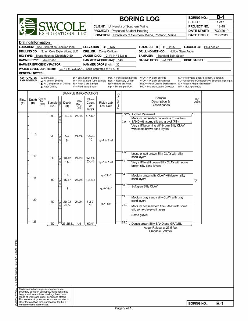
1D
2D
3D
4D
5D
6D
24/18
24/24
24/20
24/24
24/24
4/4
0.4-2.4
5-7
6-
10-12
11-
14-
15-17
17-
20-2220.5-
25-25.3
4-7-6-6
3-5-9-10
WOH-2-3-5
1-2-4-1
3-3-7-10
60/4"
Asphalt PavementMedium dense dark brown fine to mediumSAND with some silt and gravel (Fill)Very stiff becoming stiff brown Silty CLAYwith some brown sand layers
Loose or soft brown Silty CLAY with siltysand layers
Very stiff to stiff brown Silty CLAY with somebrown silty sand layers
Medium brown silty CLAY with brown siltysand layers
Soft gray Silty CLAY
Medium gray sandy silty CLAY with graysand layers
Medium dense brown fine SAND with somesilt, some clayey silt layers
Some gravel
Dense brown Silty SAND and GRAVELAuger Refusal at 25.5 feet
Probable Bedrock
qP=7 to 8 ksf
qP=5 to 7 ksf
qP=2 ksf
qP=0.3 ksf
qP=1 ksf
Pen. = Penetration LengthRec. = Recovery Length
LOGGED BY: Paul Kohler
CORE BARREL:
At time of DrillingAt Completion of DrillingAfter Drilling
D = Split Spoon Sample
CASING ID/OD: N/A /N/A
Water Level
AUGER ID/OD: 2 1/4 in / 5 5/8 in
ELEVATION (FT): N/A
bpf = Blows per Foot
TOTAL DEPTH (FT): 25.5
U = Thin Walled Tube Sample
LOCATION: See Exploration Location Plan
DRILLER: Corey Culligan
HAMMER EFFICIENCY FACTOR:
KEY TO NOTESAND SYMBOLS:
WATER LEVEL DEPTHS (ft): 16 ft 7/30/2019 Soils Saturated at 16 +/- ft
Sv = Field Vane Shear Strength, kips/sq.ft.
Drilling Information
RIG TYPE: Truck Mounted Diedrich D-50
HAMMER TYPE: Automatic
GENERAL NOTES:
HAMMER WEIGHT (lbs): 140
R = Rock Core SampleV = Field Vane Shear mpf = Minute per Foot
WOR = Weight of RodsWOH = Weight of HammerRQD = Rock Quality Designation
HAMMER DROP (inch): 30
DRILLING CO.: S. W. Cole Explorations, LLC
PID = Photoionization Detector N/A = Not Applicable
SAMPLER: Standard Split-Spoon
qU = Unconfined Compressive Strength, kips/sq.ft.
DRILLING METHOD: Hollow Stem Auger
Ø = Friction Angle (Estimated)
Gra
phic
Log
Elev.(ft) Sample
No. Typ
e
Depth(ft)
5
10
15
20
25
CasingPen.(bpf)
Stratification lines represent approximateboundary between soil types, transitions maybe gradual. Water level readings have beenmade at times and under conditions stated.Fluctuations of groundwater may occur due toother factors than those present at the timemeasurements were made.
Pen./Rec.(in)
SAMPLE INFORMATION
H20DepthDepth
(ft)
BlowCount
orRQD
SampleDescription &Classification
Field / LabTest Data
CLIENT: University of Southern MainePROJECT: Proposed Student HousingLOCATION: University of Southern Maine, Portland, Maine
BORING LOG
DATE START: 7/30/2019DATE FINISH: 7/30/2019
BORING NO.: B-1
BORING NO.: B-1
PROJECT NO. 19-49SHEET: 1 of 1
BO
RIN
G /
WE
LL 1
9-6.
GP
J S
WC
E T
EM
PLA
TE
.GD
T 8
/8/1
9
0.3
2.0
9.0
11.0
14.0
16.5
19.0
21.0
25.0
Page 2 of 10
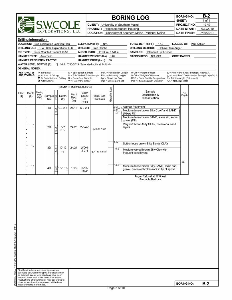
1D
2D
3D
4D
24/18
24/20
24/24
16/8
0.3-2.3
5-75.5-
10-12
11-
15-16.3
6-2-2-4
2-3-4-5
WOH-2-2-4
6-10-50/4"
Asphalt PavementMedium dense brown Silty CLAY and SAND(Mixed Fill)Medium dense brown SAND, some silt, somegravel (Fill)Very stiff brown Silty CLAY, occasional sandlayers
Soft or loose brown Silty Sandy CLAY
Medium varved brown Silty Clay withfrequent sand layers
Medium dense brown Silty SAND, some finegravel, pieces of broken rock in tip of spoon
Auger Refusal at 17.0 feetProbable Bedrock
qP=6 to 7 ksf
qP=1 to 1.5 ksf
Pen. = Penetration LengthRec. = Recovery Length
LOGGED BY: Paul Kohler
CORE BARREL:
At time of DrillingAt Completion of DrillingAfter Drilling
D = Split Spoon Sample
CASING ID/OD: N/A /N/A
Water Level
AUGER ID/OD: 2 1/4 in / 5 5/8 in
ELEVATION (FT): N/A
bpf = Blows per Foot
TOTAL DEPTH (FT): 17.0
U = Thin Walled Tube Sample
LOCATION: See Exploration Location Plan
DRILLER: Brett Raiche
HAMMER EFFICIENCY FACTOR:
KEY TO NOTESAND SYMBOLS:
WATER LEVEL DEPTHS (ft): 14 ft 7/30/2019 Saturated soils at 14 ft +/-
Sv = Field Vane Shear Strength, kips/sq.ft.
Drilling Information
RIG TYPE: Truck Mounted Diedrich D-50
HAMMER TYPE: Automatic
GENERAL NOTES:
HAMMER WEIGHT (lbs): 140
R = Rock Core SampleV = Field Vane Shear mpf = Minute per Foot
WOR = Weight of RodsWOH = Weight of HammerRQD = Rock Quality Designation
HAMMER DROP (inch): 30
DRILLING CO.: S. W. Cole Explorations, LLC
PID = Photoionization Detector N/A = Not Applicable
SAMPLER: Standard Split-Spoon
qU = Unconfined Compressive Strength, kips/sq.ft.
DRILLING METHOD: Hollow Stem Auger
Ø = Friction Angle (Estimated)
Gra
phic
Log
Elev.(ft) Sample
No. Typ
e
Depth(ft)
5
10
15
CasingPen.(bpf)
Stratification lines represent approximateboundary between soil types, transitions maybe gradual. Water level readings have beenmade at times and under conditions stated.Fluctuations of groundwater may occur due toother factors than those present at the timemeasurements were made.
Pen./Rec.(in)
SAMPLE INFORMATION
H20DepthDepth
(ft)
BlowCount
orRQD
SampleDescription &Classification
Field / LabTest Data
CLIENT: University of Southern MainePROJECT: Proposed Student HousingLOCATION: University of Southern Maine, Portland, Maine
BORING LOG
DATE START: 7/30/2019DATE FINISH: 7/30/2019
BORING NO.: B-2
BORING NO.: B-2
PROJECT NO. 19-49SHEET: 1 of 1
BO
RIN
G /
WE
LL 1
9-6.
GP
J S
WC
E T
EM
PLA
TE
.GD
T 8
/8/1
9
0.30.51.2
9.0
10.5
14.5
Page 3 of 10
1D
2D
3D
24/14
24/20
18/14
0.3-2.3
2-
5-7
6-
10-11.5
6-8-4-4
5-3-4-5
3-2-60
Asphalt PavementMedium dense brown Gravelly SAND, tracesilt (Fill)Very stiff brown Silty CLAY, some thin brownsand layers
Medium dense brown SAND, some silt
Probable weathered BedrockAuger Refusal at 11.5 feet
Probable Bedrock
qP=8 ksf
qP=4 to 7 ksf
Pen. = Penetration LengthRec. = Recovery Length
LOGGED BY: Paul Kohler
CORE BARREL:
At time of DrillingAt Completion of DrillingAfter Drilling
D = Split Spoon Sample
CASING ID/OD: N/A /N/A
Water Level
AUGER ID/OD: 2 1/4 in / 5 5/8 in
ELEVATION (FT): N/A
bpf = Blows per Foot
TOTAL DEPTH (FT): 11.5
U = Thin Walled Tube Sample
LOCATION: See Exploration Location Plan
DRILLER: Corey Culligan
HAMMER EFFICIENCY FACTOR:
KEY TO NOTESAND SYMBOLS:
WATER LEVEL DEPTHS (ft): 8 ft 7/30/2019 Sand seams wet at 8 +/- ft
Sv = Field Vane Shear Strength, kips/sq.ft.
Drilling Information
RIG TYPE: Truck Mounted Diedrich D-50
HAMMER TYPE: Automatic
GENERAL NOTES:
HAMMER WEIGHT (lbs): 140
R = Rock Core SampleV = Field Vane Shear mpf = Minute per Foot
WOR = Weight of RodsWOH = Weight of HammerRQD = Rock Quality Designation
HAMMER DROP (inch): 30
DRILLING CO.: S. W. Cole Explorations, LLC
PID = Photoionization Detector N/A = Not Applicable
SAMPLER: Standard Split-Spoon
qU = Unconfined Compressive Strength, kips/sq.ft.
DRILLING METHOD: Hollow Stem Auger
Ø = Friction Angle (Estimated)
Gra
phic
Log
Elev.(ft) Sample
No. Typ
e
Depth(ft)
5
10
CasingPen.(bpf)
Stratification lines represent approximateboundary between soil types, transitions maybe gradual. Water level readings have beenmade at times and under conditions stated.Fluctuations of groundwater may occur due toother factors than those present at the timemeasurements were made.
Pen./Rec.(in)
SAMPLE INFORMATION
H20DepthDepth
(ft)
BlowCount
orRQD
SampleDescription &Classification
Field / LabTest Data
CLIENT: University of Southern MainePROJECT: Proposed Student HousingLOCATION: University of Southern Maine, Portland, Maine
BORING LOG
DATE START: 7/30/2019DATE FINISH: 7/30/2019
BORING NO.: B-3
BORING NO.: B-3
PROJECT NO. 19-49SHEET: 1 of 1
BO
RIN
G /
WE
LL 1
9-6.
GP
J S
WC
E T
EM
PLA
TE
.GD
T 8
/8/1
9
0.31.0
8.0
11.0
Page 4 of 10
1D
2D
24/12
3/3
0-2
5-5.3
1-3-5-9
50/3"
Topsoil with organicsMedium dense light brown Silty SAND, tracefine gravel
Medium dense brown Silty SAND, somegravel, pieces of broken rock in tip of spoon
Probable weathered BedrockAuger Refusal at 5.3 feet
Probable Bedrock
Pen. = Penetration LengthRec. = Recovery Length
LOGGED BY: Paul Kohler
CORE BARREL:
At time of DrillingAt Completion of DrillingAfter Drilling
D = Split Spoon Sample
CASING ID/OD: N/A /N/A
Water Level
AUGER ID/OD: 2 1/4 in / 5 5/8 in
ELEVATION (FT): N/A
bpf = Blows per Foot
TOTAL DEPTH (FT): 5.3
U = Thin Walled Tube Sample
LOCATION: See Exploration Location Plan
DRILLER: Corey Culligan
HAMMER EFFICIENCY FACTOR:
KEY TO NOTESAND SYMBOLS:
WATER LEVEL DEPTHS (ft): 7/31/2019 No free water observed
Sv = Field Vane Shear Strength, kips/sq.ft.
Drilling Information
RIG TYPE: Truck Mounted Diedrich D-50
HAMMER TYPE: Automatic
GENERAL NOTES:
HAMMER WEIGHT (lbs): 140
R = Rock Core SampleV = Field Vane Shear mpf = Minute per Foot
WOR = Weight of RodsWOH = Weight of HammerRQD = Rock Quality Designation
HAMMER DROP (inch): 30
DRILLING CO.: S. W. Cole Explorations, LLC
PID = Photoionization Detector N/A = Not Applicable
SAMPLER: Standard Split-Spoon
qU = Unconfined Compressive Strength, kips/sq.ft.
DRILLING METHOD: Hollow Stem Auger
Ø = Friction Angle (Estimated)
Gra
phic
Log
Elev.(ft) Sample
No. Typ
e
Depth(ft)
5
CasingPen.(bpf)
Stratification lines represent approximateboundary between soil types, transitions maybe gradual. Water level readings have beenmade at times and under conditions stated.Fluctuations of groundwater may occur due toother factors than those present at the timemeasurements were made.
Pen./Rec.(in)
SAMPLE INFORMATION
H20DepthDepth
(ft)
BlowCount
orRQD
SampleDescription &Classification
Field / LabTest Data
CLIENT: University of Southern MainePROJECT: Proposed Student HousingLOCATION: University of Southern Maine, Portland, Maine
BORING LOG
DATE START: 7/31/2019DATE FINISH: 7/31/2019
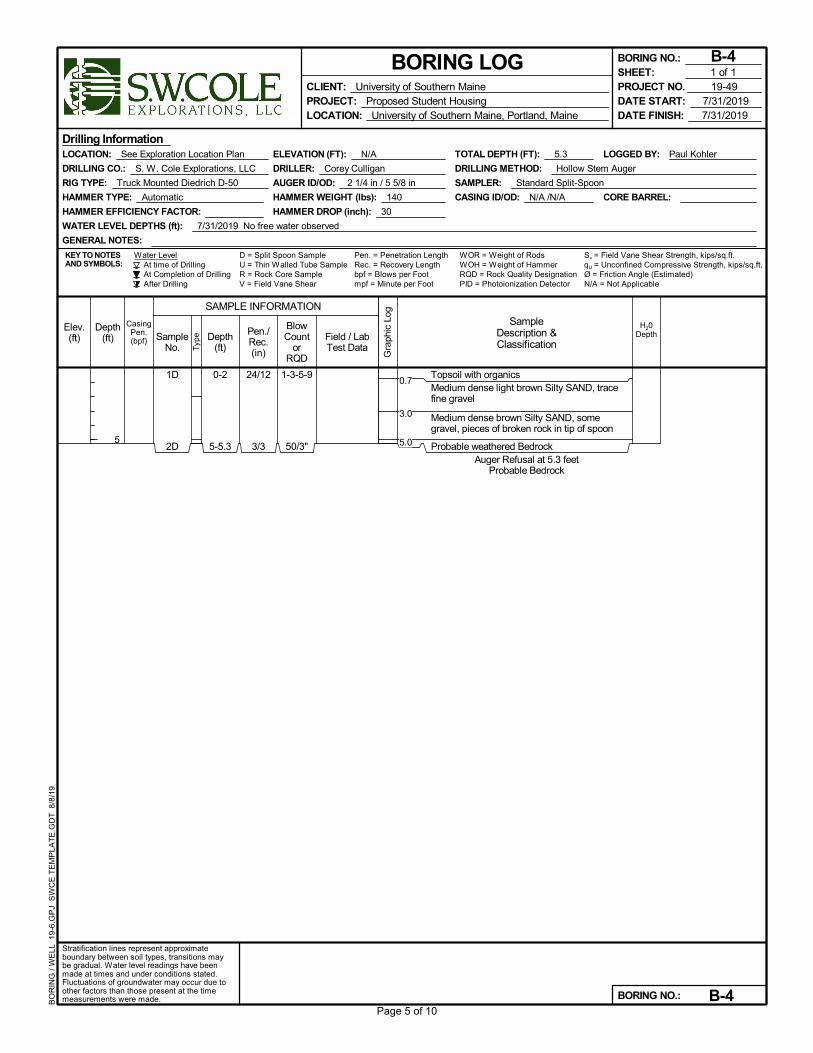
BORING NO.: B-4
BORING NO.: B-4
PROJECT NO. 19-49SHEET: 1 of 1
BO
RIN
G /
WE
LL 1
9-6.
GP
J S
WC
E T
EM
PLA
TE
.GD
T 8
/8/1
9
0.7
3.0
5.0
Page 5 of 10

1D
2D
24/14
24/16
0-2
2-4
1-1-4-12
12-18-18-30
Topsoil with organicsMedium dense light brown Silty SAND, tracefine gravelMedium dense to dense brown Silty SAND,some gravel, pieces of broken rock in tip ofspoonProbable weathered Bedrock
Auger Refusal at 5.0 feetProbable Bedrock
Pen. = Penetration LengthRec. = Recovery Length
LOGGED BY: Paul Kohler
CORE BARREL:
At time of DrillingAt Completion of DrillingAfter Drilling
D = Split Spoon Sample
CASING ID/OD: N/A /N/A
Water Level
AUGER ID/OD: 2 1/4 in / 5 5/8 in
ELEVATION (FT): N/A
bpf = Blows per Foot
TOTAL DEPTH (FT): 5.0
U = Thin Walled Tube Sample
LOCATION: See Exploration Location Plan
DRILLER: Corey Culligan
HAMMER EFFICIENCY FACTOR:
KEY TO NOTESAND SYMBOLS:
WATER LEVEL DEPTHS (ft):
Sv = Field Vane Shear Strength, kips/sq.ft.
Drilling Information
RIG TYPE: Truck Mounted Diedrich D-50
HAMMER TYPE: Automatic
GENERAL NOTES:
HAMMER WEIGHT (lbs): 140
R = Rock Core SampleV = Field Vane Shear mpf = Minute per Foot
WOR = Weight of RodsWOH = Weight of HammerRQD = Rock Quality Designation
HAMMER DROP (inch): 30
DRILLING CO.: S. W. Cole Explorations, LLC
PID = Photoionization Detector N/A = Not Applicable
SAMPLER: Standard Split-Spoon
qU = Unconfined Compressive Strength, kips/sq.ft.
DRILLING METHOD: Hollow Stem Auger
Ø = Friction Angle (Estimated)
Gra
phic
Log
Elev.(ft) Sample
No. Typ
e
Depth(ft)
5
CasingPen.(bpf)
Stratification lines represent approximateboundary between soil types, transitions maybe gradual. Water level readings have beenmade at times and under conditions stated.Fluctuations of groundwater may occur due toother factors than those present at the timemeasurements were made.
Pen./Rec.(in)
SAMPLE INFORMATION
H20DepthDepth
(ft)
BlowCount
orRQD
SampleDescription &Classification
Field / LabTest Data
CLIENT: University of Southern MainePROJECT: Proposed Student HousingLOCATION: University of Southern Maine, Portland, Maine
BORING LOG
DATE START: 7/31/2019DATE FINISH: 7/31/2019
BORING NO.: B-5
BORING NO.: B-5
PROJECT NO. 19-49SHEET: 1 of 1
BO
RIN
G /
WE
LL 1
9-6.
GP
J S
WC
E T
EM
PLA
TE
.GD
T 8
/8/1
9
0.30.8
4.0
Page 6 of 10
1D
2D
3D
4D
24/14
24/16
24/20
24/6
0-2
2-4
5-7
10-12
4-16-11-10
8-11-13-10
6-9-9-9
5-5-5-3
Topsoil with organicsMedium dense brown Silty SAND, somegravel (Probable Fill or disturbed soil)
Possible loose blast spoils Fill
Probable weathered BedrockAuger Refusal at 13.3 feet
Probable Bedrock
Pen. = Penetration LengthRec. = Recovery Length
LOGGED BY: Paul Kohler
CORE BARREL:
At time of DrillingAt Completion of DrillingAfter Drilling
D = Split Spoon Sample
CASING ID/OD: N/A /N/A
Water Level
AUGER ID/OD: 2 1/4 in / 5 5/8 in
ELEVATION (FT): N/A
bpf = Blows per Foot
TOTAL DEPTH (FT): 13.3
U = Thin Walled Tube Sample
LOCATION: See Exploration Location Plan
DRILLER: Corey Culligan
HAMMER EFFICIENCY FACTOR:
KEY TO NOTESAND SYMBOLS:
WATER LEVEL DEPTHS (ft): 11 ft 7/31/2019 Soils appear saturated at 11 ft +/-
Sv = Field Vane Shear Strength, kips/sq.ft.
Drilling Information
RIG TYPE: Truck Mounted Diedrich D-50
HAMMER TYPE: Automatic
GENERAL NOTES:
HAMMER WEIGHT (lbs): 140
R = Rock Core SampleV = Field Vane Shear mpf = Minute per Foot
WOR = Weight of RodsWOH = Weight of HammerRQD = Rock Quality Designation
HAMMER DROP (inch): 30
DRILLING CO.: S. W. Cole Explorations, LLC
PID = Photoionization Detector N/A = Not Applicable
SAMPLER: Standard Split-Spoon
qU = Unconfined Compressive Strength, kips/sq.ft.
DRILLING METHOD: Hollow Stem Auger
Ø = Friction Angle (Estimated)
Gra
phic
Log
Elev.(ft) Sample
No. Typ
e
Depth(ft)
5
10
CasingPen.(bpf)
Stratification lines represent approximateboundary between soil types, transitions maybe gradual. Water level readings have beenmade at times and under conditions stated.Fluctuations of groundwater may occur due toother factors than those present at the timemeasurements were made.
Pen./Rec.(in)
SAMPLE INFORMATION
H20DepthDepth
(ft)
BlowCount
orRQD
SampleDescription &Classification
Field / LabTest Data
CLIENT: University of Southern MainePROJECT: Proposed Student HousingLOCATION: University of Southern Maine, Portland, Maine
BORING LOG
DATE START: 7/31/2019DATE FINISH: 7/31/2019
BORING NO.: B-6
BORING NO.: B-6
PROJECT NO. 19-49SHEET: 1 of 1
BO
RIN
G /
WE
LL 1
9-6.
GP
J S
WC
E T
EM
PLA
TE
.GD
T 8
/8/1
9
0.3
13.0
Page 7 of 10

1D
2D
3D
24/15
24/20
20/16
0.5-2.5
5-7
10-11.7
20-16-12-9
9-11-12-16
11-28-38-
50/2"
Asphalt PavementDense brown SAND and GRAVEL, trace silt(Pavement Base Fill)Medium dense brown Gravelly SAND, tracesilt (Pavement Subbase Fill)Medium dense to dense brown silty SAND,some gravel
Dense brown SAND and SILT with pieces ofweathered rockVery dense, highly weathered Rock(Sapprolite)Probable weathered Bedrock
Auger Refusal at 12.3 feetProbable Bedrock
Pen. = Penetration LengthRec. = Recovery Length
LOGGED BY: Paul Kohler
CORE BARREL:
At time of DrillingAt Completion of DrillingAfter Drilling
D = Split Spoon Sample
CASING ID/OD: N/A /N/A
Water Level
AUGER ID/OD: 2 1/4 in / 5 5/8 in
ELEVATION (FT): N/A
bpf = Blows per Foot
TOTAL DEPTH (FT): 12.3
U = Thin Walled Tube Sample
LOCATION: See Exploration Location Plan
DRILLER: Corey Culligan
HAMMER EFFICIENCY FACTOR:
KEY TO NOTESAND SYMBOLS:
WATER LEVEL DEPTHS (ft): 7/31/2019 No free water observed
Sv = Field Vane Shear Strength, kips/sq.ft.
Drilling Information
RIG TYPE: Truck Mounted Diedrich D-50
HAMMER TYPE: Automatic
GENERAL NOTES:
HAMMER WEIGHT (lbs): 140
R = Rock Core SampleV = Field Vane Shear mpf = Minute per Foot
WOR = Weight of RodsWOH = Weight of HammerRQD = Rock Quality Designation
HAMMER DROP (inch): 30
DRILLING CO.: S. W. Cole Explorations, LLC
PID = Photoionization Detector N/A = Not Applicable
SAMPLER: Standard Split-Spoon
qU = Unconfined Compressive Strength, kips/sq.ft.
DRILLING METHOD: Hollow Stem Auger
Ø = Friction Angle (Estimated)
Gra
phic
Log
Elev.(ft) Sample
No. Typ
e
Depth(ft)
5
10
CasingPen.(bpf)
Stratification lines represent approximateboundary between soil types, transitions maybe gradual. Water level readings have beenmade at times and under conditions stated.Fluctuations of groundwater may occur due toother factors than those present at the timemeasurements were made.
Pen./Rec.(in)
SAMPLE INFORMATION
H20DepthDepth
(ft)
BlowCount
orRQD
SampleDescription &Classification
Field / LabTest Data
CLIENT: University of Southern MainePROJECT: Proposed Student HousingLOCATION: University of Southern Maine, Portland, Maine
BORING LOG
DATE START: 7/31/2019DATE FINISH: 7/31/2019
BORING NO.: B-7
BORING NO.: B-7
PROJECT NO. 19-49SHEET: 1 of 1
BO
RIN
G /
WE
LL 1
9-6.
GP
J S
WC
E T
EM
PLA
TE
.GD
T 8
/8/1
9
0.50.81.5
9.0
10.5
11.7
Page 8 of 10
1D
2D
3D
24/12
24/20
24/20
0.3-2.3
5-7
6-
10-12
11-
7-7-4-5
3-3-4-6
4-6-8-7
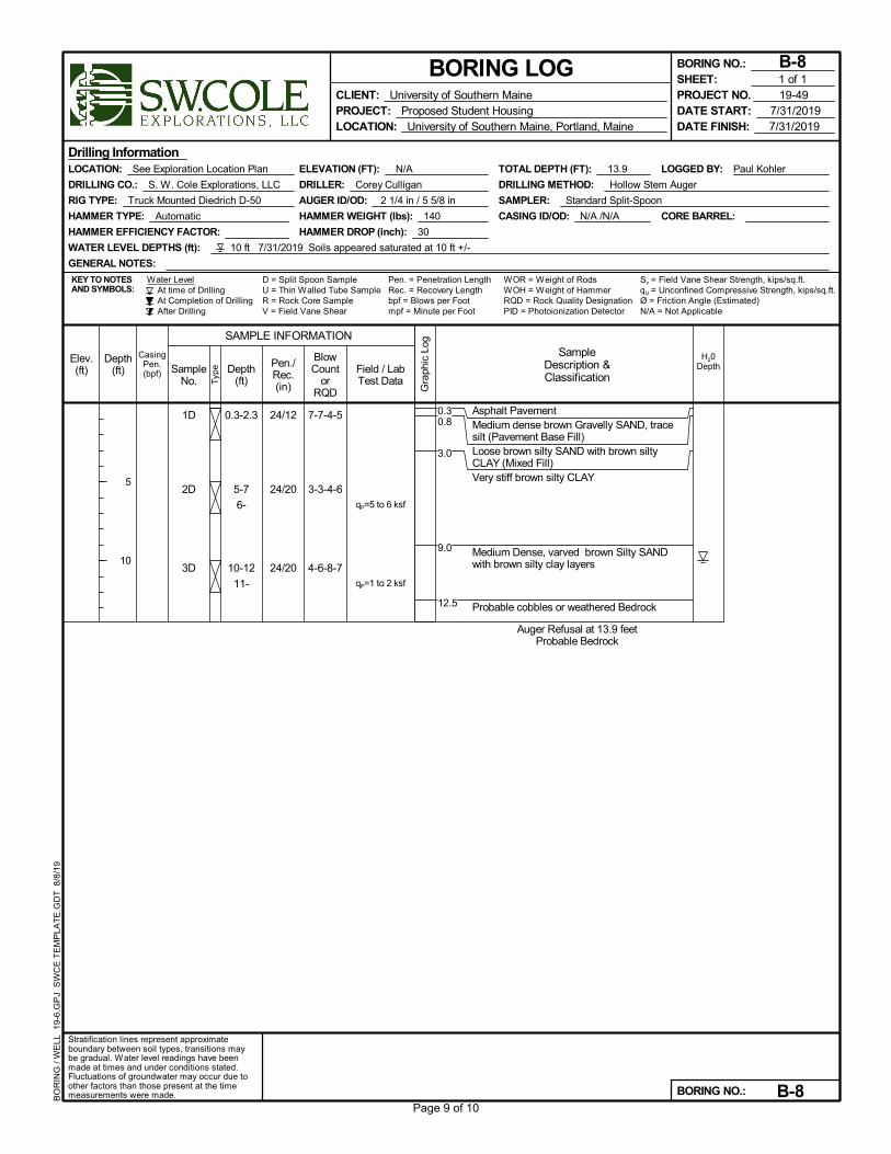
Asphalt PavementMedium dense brown Gravelly SAND, tracesilt (Pavement Base Fill)Loose brown silty SAND with brown siltyCLAY (Mixed Fill)Very stiff brown silty CLAY
Medium Dense, varved brown Silty SANDwith brown silty clay layers
Probable cobbles or weathered Bedrock
Auger Refusal at 13.9 feetProbable Bedrock
qP=5 to 6 ksf
qP=1 to 2 ksf
Pen. = Penetration LengthRec. = Recovery Length
LOGGED BY: Paul Kohler
CORE BARREL:
At time of DrillingAt Completion of DrillingAfter Drilling
D = Split Spoon Sample
CASING ID/OD: N/A /N/A
Water Level
AUGER ID/OD: 2 1/4 in / 5 5/8 in
ELEVATION (FT): N/A
bpf = Blows per Foot
TOTAL DEPTH (FT): 13.9
U = Thin Walled Tube Sample
LOCATION: See Exploration Location Plan
DRILLER: Corey Culligan
HAMMER EFFICIENCY FACTOR:
KEY TO NOTESAND SYMBOLS:
WATER LEVEL DEPTHS (ft): 10 ft 7/31/2019 Soils appeared saturated at 10 ft +/-
Sv = Field Vane Shear Strength, kips/sq.ft.
Drilling Information
RIG TYPE: Truck Mounted Diedrich D-50
HAMMER TYPE: Automatic
GENERAL NOTES:
HAMMER WEIGHT (lbs): 140
R = Rock Core SampleV = Field Vane Shear mpf = Minute per Foot
WOR = Weight of RodsWOH = Weight of HammerRQD = Rock Quality Designation
HAMMER DROP (inch): 30
DRILLING CO.: S. W. Cole Explorations, LLC
PID = Photoionization Detector N/A = Not Applicable
SAMPLER: Standard Split-Spoon
qU = Unconfined Compressive Strength, kips/sq.ft.
DRILLING METHOD: Hollow Stem Auger
Ø = Friction Angle (Estimated)
Gra
phic
Log
Elev.(ft) Sample
No. Typ
e
Depth(ft)
5
10
CasingPen.(bpf)
Stratification lines represent approximateboundary between soil types, transitions maybe gradual. Water level readings have beenmade at times and under conditions stated.Fluctuations of groundwater may occur due toother factors than those present at the timemeasurements were made.
Pen./Rec.(in)
SAMPLE INFORMATION
H20DepthDepth
(ft)
BlowCount
orRQD
SampleDescription &Classification
Field / LabTest Data
CLIENT: University of Southern MainePROJECT: Proposed Student HousingLOCATION: University of Southern Maine, Portland, Maine
BORING LOG
DATE START: 7/31/2019DATE FINISH: 7/31/2019
BORING NO.: B-8
BORING NO.: B-8
PROJECT NO. 19-49SHEET: 1 of 1
BO
RIN
G /
WE
LL 1
9-6.
GP
J S
WC
E T
EM
PLA
TE
.GD
T 8
/8/1
9
0.30.8
3.0
9.0
12.5
Page 9 of 10
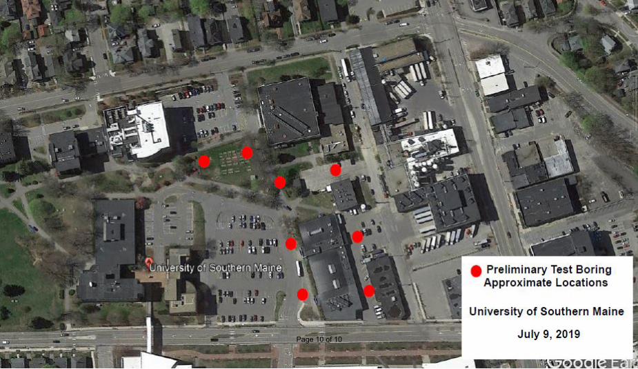
Page 10 of 10
pkohler
Typewritten Text
B-1
pkohler
Typewritten Text
B-2
pkohler
Typewritten Text
B-3
pkohler
Typewritten Text
B-4
pkohler
Typewritten Text
B-5
pkohler
Typewritten Text
B-6
pkohler
Typewritten Text
B-7
pkohler
Typewritten Text
B-8