APPENDIX F – ADDITIONAL RESOURCES - Indiana · Source: 33 CFR 328.3 (c) Adversely affect the...
22
APPENDIX F – ADDITIONAL RESOURCES i
-
Upload
duongnguyet -
Category
Documents
-
view
215 -
download
0
Transcript of APPENDIX F – ADDITIONAL RESOURCES - Indiana · Source: 33 CFR 328.3 (c) Adversely affect the...
APPENDIX F – ADDITIONAL RESOURCES
i
T A B LE O F C O N T E NT S
Appendix F – Additional Resources .............................................................................................. F Additional Resources ................................................................................................................................... 1 Calculating Upstream and Downstream Impacts ......................................................................................... 2 Acronyms ..................................................................................................................................................... 4 Definitions .................................................................................................................................................... 5
Intended Use of Manual for INDOT and Local Projects
This manual has been written to set expectations for waterway permitting deliverables and review paths for projects developed by the Indiana Department of Transportation (INDOT). Other projects may also benefit from the guidance in this manual. Specifically, preparers of permits for local projects that receive federal funds and which follow INDOT standard specifications are encouraged to use this manual; however, INDOT does not review permits or other related deliverables for local projects
Appendix F – Additional Resources
ADDITIONAL RESOURCES Environmental Law Institute, The Clean Water Act Jurisdictional Handbook, Second Edition, May 2012, Washington,
DC. http://www.eli.org/New_Books/cwa_handbook.cfm
U.S. Army Corps of Engineers, Regional Supplement to the Corps of Engineers Wetland Delineation Manual: Eastern Mountains and Piedmont Region (Version 2.0), April 2012, Washington, DC. ERDC/EL TR-12-9
U.S. Army Corps of Engineers, Regional Supplement to the Corps of Engineers Wetland Delineation Manual: Midwest Region (Version 2.0), August 2010, Washington, DC. ERDC/EL TR-10-16
U.S. Army Corps of Engineers, Regional Supplement to the Corps of Engineers Wetland Delineation Manual: Northcentral and Northeast Region (Version 2.0), January 2012, Washington, DC. ERDC/EL TR-12-1
http://www.usace.army.mil/Missions/CivilWorks/RegulatoryProgramandPermits/reg_supp.aspx
Indiana Department of Transportation Waterway Permitting Manual F 1
Appendix F – Additional Resources
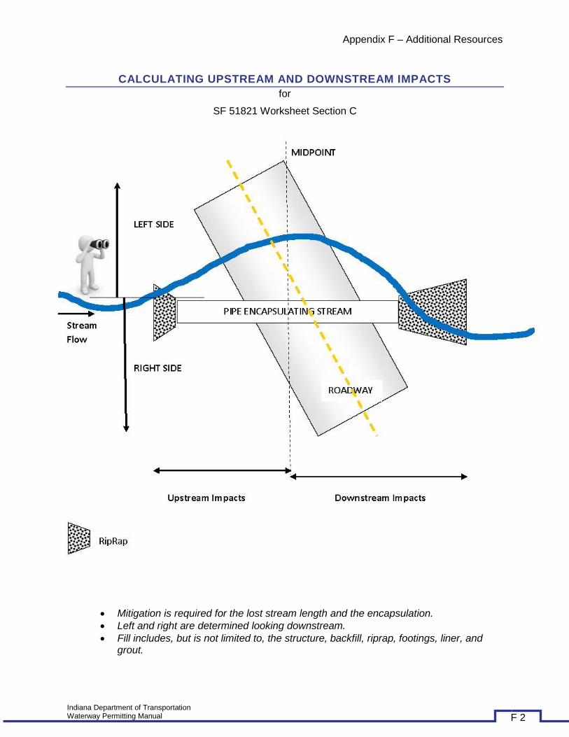
CALCULATING UPSTREAM AND DOWNSTREAM IMPACTS for
SF 51821 Worksheet Section C
• Mitigation is required for the lost stream length and the encapsulation. • Left and right are determined looking downstream. • Fill includes, but is not limited to, the structure, backfill, riprap, footings, liner, and
grout.
Indiana Department of Transportation Waterway Permitting Manual F 2
Appendix F – Additional Resources
Indiana Department of Transportation Waterway Permitting Manual F 3

Appendix F – Additional Resources
ACRONYMS BMP Best Management Practice C Coefficient of Conservatism CE Categorical Exclusion CIB Contract Information Book CWA Clean Water Act EA Environmental Assessment EIS Environmental Impact
Statement ERMS Electronic Records
Management System ES Environmental Services ESA Endangered Species Act ESC Erosion and Sediment Control ETR Endangered, Threatened and
Rare EUW Exceptional Use Water EWPO Ecology and Waterway
Permitting Office FAC Facultative FACU Facultative Upland FACW Facultative Wetland FHWA Federal Highway
Administration FONSI Finding of No Significant
Impact (FONSI) FTP File Transfer Protocol GWIA Ground Water Impact
Assessment HQW High Quality Water IDEM Indiana Department of
Environmental Management INDOT Indiana Department of
Transportation IC Indiana Code IDNR Indiana Department of Natural
Resources IP Individual Permit IWGP Isolated Wetland General
Permit IWIP Isolated Wetland Individual
Permit LCSS Large-Capacity Septic Systems LEDPA Least Environmentally
Damaging Practicable Alternative
MOU Memorandum of Understanding
MS4 Municipal Separate Storm
Sewer System NA No Agreement NEPA National Environmental Policy
Act NI No Indicator NO No Occurrence NOD Notice of Deficiency NOI Notice of Intent NOS Notice of Sufficiency NPDES National Pollution Discharge
Elimination System NWP Nationwide Permit OBL Obligate Wetland SRW State Regulated Wetland OHWM Ordinary High Water Mark PCN Preconstruction Notification PD Permit Determination PE Project Engineer PRECON Preconstruction PS Project Supervisor RGP Regional General Permit SDWA Safe Drinking Water Act SS Salmonid Stream SSA Sole Source Aquifer SWPPP Storm Water Pollution
Prevention Plan SWQMP Storm Water Quality
Management Plan UIC Underground Injection Control UNT Unnamed Tributary UPL Obligate Upland USACE United States Army Corps of
Engineers USCG United States Coast Guard USDA United States Department of
Agriculture USDW Underground Sources of
Drinking Water USEPA United States Environmental
Protection Agency USFWS United States Fish and Wildlife
Service USGS United States Geological Survey WQC Water Quality Certification
Indiana Department of Transportation Waterway Permitting Manual F 4
Appendix F – Additional Resources
DEFINITIONS Adjacent: Bordering, contiguous, or neighboring. Wetlands separated from other waters of the United
States by man-made dikes or barriers, natural river berms, beach dunes and the like are “adjacent wetlands. Source: 33 CFR 328.3 (c)
Adversely affect the efficiency of, or unduly restrict the capacity of, the floodway: An increase in the
elevation of the regulatory flood of at least fifteen-hundredths (0.15) of a foot as determined by comparing the regulatory flood elevation under the project condition to that under the base condition. This definition does not apply to a dam regulated under IC 14-27-7 and IC 14-28-1, a flood control project authorized under IC 14-28-1-29 or an area for which a flood easement is secured and recorded with the county recorder. Source: IDNR
Aquifer: An aquifer is a geological formation or group of formations or part of a formation that is
capable of yielding a significant amount of water to a drinking water well or spring. Source: USEPA
Bank: The ground that borders or slopes upward from the bed of a waterway and that confines water to
the channel during the normal course of flow. Source: 312 IAC 10-2-4 Base Flood: A flood having a one percent chance of being exceeded in any given year (commonly
known as a 100-year flood). Source: USCG Base Floodplain: The area adjacent to the waterway, which would be inundated by a base flood.
Source: USCG
Bed: The surface rock or soil underlying a waterway. Source: 312 IAC 10-2-6 Best Management Practices (BMPs): Policies, practices, procedures, or structures implemented to
mitigate the adverse environmental effects on surface water quality resulting from development. BMPs are categorized as structural or non-structural. Source: USACE NWP
Bridge:
A structure placed over a waterway or other topographically depressed area that is designed to carry pedestrian, vehicular, or other traffic. The term includes a culvert or a ford.
Source: 312 IAC 10-2-8
Any structure over, on, or in navigable waters of the United States used for transporting persons, vehicles, commodities or other physical matter and providing for the passage or flow of water through or under the structure. a. The term “bridge” includes all integral bridge elements: approaches and appurtenances, regardless of the materials used, whether natural or manufactured, or the construction methodology. b. Types of “bridges” include: highway bridges, railroad bridges, pedestrian bridges, aqueducts, aerial tramways and conveyors, overhead pipelines, and similar structures of the same function with their approaches, bridge protective systems, foundations, and appurtenances (integral features). c. The definition of “bridges” does not include: aerial power transmission lines, submerged pipelines, and other similar structures and works unless they are integral features of a bridge used in its construction, maintenance, operation or removal; or they are affixed to the bridge and affect the bridge clearances. Source: USCG
Indiana Department of Transportation Waterway Permitting Manual F 5
Appendix F – Additional Resources
Bridge Permit: An authorization issued by the Coast Guard, approving the location and plans of a bridge across a navigable waterway of the United States. A “bridge permit” includes the approved bridge project plans. a. A “bridge permit” expresses the assent of the Federal Government as far as the project affects the public right of navigation, giving due consideration to the impacts on the quality of the human environment. b. A “bridge permit” does not give any property rights, in either real estate or materials, or authorize any injury to private property or invasion of private rights. It does not remove the necessity of obtaining the assent of other agencies with cognizance of any aspect of the location, construction, or maintenance of a bridge. c. Permits for completed bridges remain valid indefinitely, unless otherwise conditioned or amended, as long as the bridge remains in place, continues to be used for transportation purposes, and conforms to the original approved plans. Source: USCG
Channel: The natural and artificial channel of a waterway. Source: 312 10-2-10 An artificial channel; or the improved channel of a natural watercourse; connecting to any river or stream in Indiana for the purpose of providing access by boat or otherwise to public or private industrial, commercial, housing, recreational, or other facilities. Source: IDNR The deeper, navigable portion of a waterway, usually marked and designated on the appropriate navigation chart with known widths and depths. Source: USCG
Class I Wetland: An isolated wetland described by one (1) or both of the following: (A) At least fifty percent (50%) of the wetland has been disturbed or affected by human activity
or development by one (1) or more of the following: (i) Removal or replacement of the natural vegetation. (ii) Modification of the natural hydrology. (B) The wetland supports only minimal wildlife or aquatic habitat or hydrologic function because
the wetland does not provide critical habitat for threatened or endangered species listed in accordance with the Endangered Species Act of 1973 (16 U.S.C. 1531 et seq.) and the wetland is characterized by at least one (1) of the following:
(i) The wetland is typified by low species diversity. (ii) The wetland contains greater than fifty percent (50%) areal coverage of nonnative invasive
species of vegetation. (iii) The wetland does not support significant wildlife or aquatic habitat. (iv) The wetland does not possess significant hydrologic function. Source: 327 IAC 17-1-3 (1)
Class II Wetland: Means either of the following: (A) An isolated wetland that is not a Class I or Class III wetland. (B) A type of wetland listed in subdivision (3)(B) that would meet the definition of Class I wetland if the wetland were not a rare or ecologically important type. Source: 327 IAC 17-1-3 (2)
Class III Wetland: An isolated wetland: (A) that: (i) is located in a setting undisturbed or minimally disturbed by human activity or development;
and (ii) supports more than minimal wildlife or aquatic habitat or hydrologic function; or (B) unless classified as a Class II wetland under subdivision (2)(B), that is of one (1) of the
following rare and ecologically important types:
Indiana Department of Transportation Waterway Permitting Manual F 6

Appendix F – Additional Resources
(i) Acid bog. (ii) Acid seep. (iii) Circumneutral bog. (iv) Circumneutral seep. (v) Cypress swamp. (vi) Dune and swale. (vii) Fen. (viii) Forested fen. (ix) Forested swamp. (x) Marl beach. (xi) Muck flat. (xii) Panne. (xiii) Sand flat. (xiv) Sedge meadow. (xv) Shrub swamp. (xvi) Sinkhole pond. (xvii) Sinkhole swamp. (xviii) Wet floodplain forest. (xix) Wet prairie. (xx) Wet sand prairie. Source: 327 IAC 17-1-3 (3)
Class V Wells: This is a term for all injection wells which are not explicitly identified as Class I, Class II, Class III or Class IV in the Code of Federal Regulations Sections 144.6 and 146.5. Classes I, II and III are different types of deep injection wells which inject fluids below underground sources of drinking water. Class IV wells inject hazardous waste into or above an underground source of drinking water and are generally banned. Class V wells include all other injection wells. They generally are shallow subsurface fluid disposal systems which are disposing of non-hazardous fluids into or above underground sources of drinking water. Source: USEPA
Cofferdam: An open box-like structure surrounding the area where an abutment, pier, retaining wall, or
other structure will be placed. Water is removed from the enclosure so the excavation for preparing a foundation and the abutment, pier, or other construction may be done in the open air. Source: USCG
Compensatory Mitigation: The (A) restoration; or (B) creation; of wetlands to offset or compensate for a loss of wetlands resulting from an authorized wetland activity. Wetlands enlargement, enhancement, and preservation may be considered compensatory mitigation on a case-by-case basis, particularly for Class III wetlands. Source: 327 IAC 17-1-3 (5)
The restoration (re-establishment or rehabilitation), establishment (creation), enhancement, and/or in certain circumstances preservation of aquatic resources for the purposes of offsetting unavoidable adverse impacts which remain after all appropriate and practicable avoidance and minimization has been achieved. Source: USACE NWP
Culvert: A closed conduit for the passage of run-off through an embankment. Source: 312 IAC 10-2-17 Cumulative Effects:
The impact that results from the incremental impact of the action when added to other past, present, and reasonably foreseeable future actions regardless of what person undertakes the other actions. Cumulative effects can result from individually minor but collectively significant actions
Indiana Department of Transportation Waterway Permitting Manual F 7
Appendix F – Additional Resources
taking place over a period of time. Each of the following elements is considered when assessing the impact of cumulative effects within a floodway: (1) adverse effects on the efficiency of, or undue restrictions on the capacity of, the floodway; (2) unreasonable hazards to the safety of life or property; (3) unreasonable detrimental effects upon fish, wildlife, or botanical resources.
Source: 312 IAC 10-2-18
The impact which results from the incremental impact of the action when added to other past, present, and reasonably foreseeable future actions regardless of what person undertakes the other actions. Cumulative effects can result from individually minor but cumulatively significant actions taking place over a period of time. Each of the following elements is considered when assessing the impact of cumulative effects within the floodway: (1) Adverse impacts on the efficiency of or undue restrictions upon the capacity of the floodway. (2) Unreasonable hazards to the safety of life or property. (3) Unreasonable detrimental effects upon fish, wildlife or botanical resources. Source: IDNR
Currently Serviceable: Useable as is or with some maintenance, but not so degraded as to essentially require reconstruction. Source: USACE NWP
Direct Effects: Effects that are caused by the activity and occur at the same time and place.
Source: USACE NWP Discharge: Any discharge of dredged or fill material. Source: USACE NWP Drainage Area: The total land area measured in a horizontal plane and enclosed by a topographic divide
from which surface run-off from precipitation normally drains by gravity into a waterway above a specified location. The term includes an area that is ineffective due to karst topography, subsurface drains, or diversions. Source: 312 IAC 10-2-20
Dredged Material: Material that is dredged or excavated from an isolated wetland.
Source: 327 IAC 17-1-3 (6)
Encroachment: Bridge construction or modification where any part of a bridge structure or approach roadway is located in the floodplain. An “encroachment” does not exist in replacement projects when only the piers, pilings, or pile bents are in the floodplain. Source: USCG
Enhancement: The manipulation of the physical, chemical, or biological characteristics of an aquatic
resource to heighten, intensify, or improve a specific aquatic resource function(s). Enhancement results in the gain of selected aquatic resource function(s), but may also lead to a decline in other aquatic resource function(s). Enhancement does not result in a gain in aquatic resource area.
Source: USACE NWP Ephemeral Stream: An ephemeral stream has flowing water only during, and for a short duration after,
precipitation events in a typical year. Ephemeral stream beds are located above the water table year-round. Groundwater is not a source of water for the stream. Runoff from rainfall is the primary source of water for stream flow. Source: USACE NWP
Establishment (creation): The manipulation of the physical, chemical, or biological characteristics present to develop an aquatic resource that did not previously exist at an upland site.
Indiana Department of Transportation Waterway Permitting Manual F 8
Appendix F – Additional Resources
Establishment results in a gain in aquatic resource area. Source: USACE NWP Exempt Isolated Wetland: (A) An isolated wetland that is a voluntarily created wetland unless:
(i) the wetland is: (AA) approved by the department for compensatory mitigation purposes in accordance with a permit issued under Section 404 of the Clean Water Act or IC 13-18-22; or (BB) reclassified as an SRW under IC 13-18-22-6(c); or (ii) the owner of the wetland declares, by a written instrument: (AA) recorded in the office of the recorder of the county or counties in which the wetland is located; and (BB) filed with the department; that the wetland is to be considered in all respects to be an SRW. (B) An isolated wetland that exists as an incidental feature in or on any of the following: (i) A residential lawn. (ii) A lawn or landscaped area of a commercial or governmental complex. (iii) Agricultural land. (iv) A roadside ditch. (v) An irrigation ditch. (vi) A manmade drainage control structure. (C) An isolated wetland that is a fringe wetland associated with a private pond. (D) An isolated wetland that is, or is associated with, a manmade body of surface water of any size created by: (i) excavating; (ii) diking; or (iii) excavating and diking; dry land to collect and retain water for or incidental to agricultural, commercial, industrial, or aesthetic purposes. (E) An isolated wetland that is a Class I wetland with an area, as delineated, of one-half (½) acre or less. (F) An isolated wetland that is a Class II wetland with an area, as delineated, of one-fourth (¼) acre or less. (G) An isolated wetland that is located on land: (i) subject to regulation under the United States Department of Agriculture wetland conservation rules, also known as Swampbuster (16 U.S.C. 3801-3862), because of voluntary enrollment in a federal farm program; and (ii) used for agricultural or associated purposes allowed under the rules referred to in this clause. (H) For purposes of clause (B), an isolated wetland exists as an incidental feature: (i) if: (AA) the owner or operator of the property or facility described in clause (B) does not intend the isolated wetland to be a wetland; (BB) the isolated wetland is not essential to the function or use of the property or facility; and (CC) the isolated wetland arises spontaneously as a result of damp soil conditions incidental to the function or use of the property or facility; and (ii) if the isolated wetland satisfies any other factors or criteria established in rules that are: (AA) adopted by the water pollution control board; and (BB) not inconsistent with the factors and criteria described in this clause. (I) The total acreage of Class I wetlands on a tract to which the exemption described in clause (E) may apply is limited to the larger of the following: (i) The acreage of the largest individual isolated wetland on the tract that qualifies for the exemption described in clause (E). (ii) Fifty percent (50%) of the cumulative acreage of all individual isolated wetlands on the tract that would qualify for the exemption described in clause (E) but for the limitation of this subdivision. (J) The total acreage of Class II wetlands on a tract to which the exemption described in clause (F) may apply is limited to the larger of the following: (i) The acreage of the largest individual isolated wetland on the tract that qualifies for the exemption described in clause (F).
Indiana Department of Transportation Waterway Permitting Manual F 9
Appendix F – Additional Resources
(ii) Thirty-three and one-third percent (33a%) of the cumulative acreage of all individual isolated wetlands on the tract that would qualify for the exemption described in clause (F) but for the limitation of this subdivision. (K) An isolated wetland described in clause (E) or (F) does not include an isolated wetland on a tract that contains more than one (1) of the same class of wetland until the owner of the tract notifies the department that the owner has selected the isolated wetland to be an exempt isolated wetland under clause (E) or (F) consistent with the applicable limitations described in clauses (I) and (J). Source: 327 IAC 17-1-3 (7)
Floodplain: The area adjoining a river or stream that has been or may be covered by flood water.
Source: 312 IAC 1-1-15
The lowland and relatively flat areas adjoining inland and coastal waters including, at a minimum, that area subject to a one percent or greater chance of flooding in any given year.
Source: 44 CFR Ch.1 § 9.4 Floodway:
The channel of a river or stream and the parts of the flood plain adjoining the channel that are reasonably required to efficiently carry and discharge the flood water or flood flow of a river or stream. Source: 312 IAC 1-1-16 That portion of the floodplain which is effective in carrying flow, within which this carrying capacity must be preserved and where the flood hazard is generally highest, i.e. where water depths and velocities are the greatest. It is that area which provides for the discharge of the base flood so the cumulative increase in water surface elevation is no more than one foot.
Source: 44 CFR Ch.1 § 9.4
The channel of a river or stream and those portions of the flood plains adjoining the channel which are reasonably required to efficiently carry and discharge the peak flow of the regulatory flood of any river or stream. Source: IDNR
Historic Property: Any prehistoric or historic district, site (including archaeological site), building, structure, or other object included in, or eligible for inclusion in, the National Register of Historic Places maintained by the Secretary of the Interior. This term includes artifacts, records, and remains that are related to and located within such properties. The term includes properties of traditional religious and cultural importance to an Indian tribe or Native Hawaiian organization and that meet the National Register criteria (36 CFR part 60). Source: USACE NWP
Independent Utility: A test to determine what constitutes a single and complete non-linear project in the
Corps regulatory program. A project is considered to have independent utility if it would be constructed absent the construction of other projects in the project area. Portions of a multi-phase project that depend upon other phases of the project do not have independent utility. Phases of a project that would be constructed even if the other phases were not built can be considered as separate single and complete projects with independent utility. Source: USACE NWP
Indirect Effects: Effects that are caused by the activity and are later in time or farther removed in
distance, but are still reasonably foreseeable. Source: USACE NWP Injection: The subsurface discharge of fluids through a well. Source: USEPA
Indiana Department of Transportation Waterway Permitting Manual F 10
Appendix F – Additional Resources
Injection Well: Injection wells are defined (in Title 40, Code of Federal Regulations, Section 144.3) as a
bored, drilled, or driven shaft whose depth is greater than the largest surface dimension; or, a dug hole whose depth is greater than the largest surface dimension; or, an improved sinkhole; or, a subsurface fluid distribution system into which fluids (any material or substance which flows or moves whether in a semisolid, liquid, sludge, gas or any other form or state) are emplaced.
Source: USEPA
Intermittent Stream: An intermittent stream has flowing water during certain times of the year, when groundwater provides water for stream flow. During dry periods, intermittent streams may not have flowing water. Runoff from rainfall is a supplemental source of water for stream flow.
Source USEPA Isolated Wetland: A wetland that is not subject to regulation under Section 404(a) of the Clean Water Act. Source: 327 IAC 17-1-3 (8) Lake: A reasonably permanent body of water that: (1) existed on March 12, 1947; (2) is substantially at
rest in a depression in the surface of the earth that is naturally created; (3) is of natural origin or is part of a watercourse, including a watercourse that has been dammed; and (4) covers an area of at least five (5) acres within the shoreline and water line, including bays and coves.
Source: IC 14-26-2-1.5
Large-Capacity Septic Systems: Class V wells that dispose of sanitary waste through a septic tank and are used by multiple dwellings, business establishments, communities, and regional business establishments for the injection of wastes. Systems serving single families and non-residential systems serving less than 20 persons are not included. Source: USEPA
Logjam: An accumulation of lodged trees, root wads, or other debris that impedes the ordinary flow of
water through a waterway. The term does not include the development of sandbars, sedimentation, or accumulation of stone or gravel. Logjams are evidenced by a blockage that does any of the following: (1) traverse the waterway; (2) causes upstream ponding; (3) results in significant bank erosion. Source: 312 IAC 10-2-26
Loss of Waters of the United States: Waters of the United States that are permanently adversely
affected by filling, flooding, excavation, or drainage because of the regulated activity. Permanent adverse effects include permanent discharges of dredged or fill material that change an aquatic area to dry land, increase the bottom elevation of a waterbody, or change the use of a waterbody. The acreage of loss of waters of the United States is a threshold measurement of the impact to jurisdictional waters for determining whether a project may qualify for an NWP; it is not a net threshold that is calculated after considering compensatory mitigation that may be used to offset losses of aquatic functions and services. The loss of stream bed includes the linear feet of stream bed that is filled or excavated. Waters of the United States temporarily filled, flooded, excavated, or drained, but restored to pre-construction contours and elevations after construction, are not included in the measurement of loss of waters of the United States. Impacts resulting from activities eligible for exemptions under Section 404(f) of the Clean Water Act are not considered when calculating the loss of waters of the United States. Source: USACE NWP
Indiana Department of Transportation Waterway Permitting Manual F 11

Appendix F – Additional Resources
Mitigation: All steps necessary to minimize potentially adverse effects of the proposed action, and to restore and preserve the natural and beneficial floodplain values and to preserve and enhance natural values of wetlands. Source: 44 CFR Ch.1 § 9.4
Modification: A bridge is modified when the configuration of the existing bridge is changed by adding
new parts or replacing some parts of the existing bridge, and some parts of the existing bridge remain intact. Source: USCG
Navigable: A waterway that has been declared to be navigable or a public highway by one (1) or more of
the following: (1) a court; (2) the Indiana general assembly; (3) the United States Army Corps of Engineers; (4) the Federal Energy Regulatory Commission; (5) a board of county commissioners under IC 14-29-1-2; (6) the commission following a completed proceeding under IC 4-21.4. See “Roster of Indiana Waterways Declared Navigable or Nonnavigable.”
Source: 312 IAC 1-1-24
Navigable Waters of the United States: For Bridge Program purposes: waters subject to tidal influence, waterways with a history of substantial commercial navigation, waterways that presently have commercial navigation, or waterways susceptible to commercial development. Source: USCG
Navigable Waterway: Defined in two parts: navigable - a waterway which has been declared to be
"navigable" or a "public highway" by one or more of the following: (1) A court. (2) The Indiana General Assembly. (3) The United States Army Corps of Engineers. (4) The Federal Energy Regulatory Commission. (5) A board of county commissioners under IC 14-29-1-1. (6) The commission following a completed proceeding under IC 4-21.5. Waterway - a river, stream, creek, run, canal, channel, ditch, lake, reservoir, or embayment. Source: IDNR
Open Drain: A natural or artificial open channel that: (1) carries surplus water; and (2) was established
under or made subject to any drainage statute. Source: IDNR Open Water: For purposes of the NWPs, an open water is any area that in a year with normal patterns of
precipitation has water flowing or standing above ground to the extent that an ordinary high water mark can be determined. Aquatic vegetation within the area of standing or flowing water is either non-emergent, sparse, or absent. Vegetated shallows are considered to be open waters. Examples of “open waters” include rivers, streams, lakes, and ponds. Source: USACE NWP
Ordinary High Water Mark:
The line on the shore of a waterway established by the fluctuations of water and indicated by physical characteristics. Examples of these physical characteristics include the following: (1) a clear and natural line impressed on the bank; (2) shelving; (3) changes in the character of the soil; (4) the destruction of terrestrial vegetation, and; (5) the presence of litter or debris.
Source: 312 IAC 1-1-26 (1)
That line on the shore established by the fluctuations of water and indicated by physical characteristics such as clear, natural line impressed on the bank, shelving, changes in the character of soil, destruction of terrestrial vegetation, the presence of litter and debris, or other appropriate means that consider the characteristics of the surrounding areas. 33 CFR 328.3 (e) The line on the shore of a waterway established by the fluctuations of water and indicated by physical characteristics. Examples of these physical characteristics include the following: (1) A clear and natural line impressed on the bank. (2) Shelving. (3) Changes in the character of the
Indiana Department of Transportation Waterway Permitting Manual F 12
Appendix F – Additional Resources
soil. (4) The destruction of terrestrial vegetation. (5) The presence of litter or debris. Source: IDNR A line on the shore established by the fluctuations of water and indicated by physical characteristics, or by other appropriate means that consider the characteristics of the surrounding areas (see 33 CFR 328.3(e)). Source: USACE NWP
Outfall Structure: A closed conduit facility used for the transport and discharge of surface run-off or treated effluent to a waterway or swale. The facility includes all appurtenant channels, supply lines, energy dissipation, and erosion control systems. The term does not include a system where the delivery conduit is placed beneath the bed. Source: 312 IAC 10-2-31
Outfall Swale: An excavated depression in the surficial topography used for the transport and discharge
of surface run-off or treated effluent to a waterway. The depression includes all appurtenant channels, swales, and energy dissipation or erosion control systems. Source: 312 IAC 10-2-32
Perennial Stream: A perennial stream has flowing water year-round during a typical year. The water
table is located above the stream bed for most of the year. Groundwater is the primary source of water for stream flow. Runoff from rainfall is a supplemental source of water for stream flow.
Source: USACE NWP Pile: A rod or shaft-like linear member of timber, steel, concrete, or composite materials driven into the
earth to carry structure loads through weak soil strata to soil strata capable of supporting such loads. Source: USCG
Practicable:
Capable of being done within existing constraints. The test of what is practicable depends upon the situation and includes consideration of all pertinent factors, such as environment, cost and technology. Source: 44 CFR Ch.1 § 9.4 Available and capable of being done after taking into consideration cost, existing technology, and logistics in light of overall project purposes. Source: USACE NWP
Pre-Construction Notification: A request submitted by the project proponent to the Corps for confirmation that a particular activity is authorized by nationwide permit. The request may be a permit application, letter, or similar document that includes information about the proposed work and its anticipated environmental effects. Pre-construction notification may be required by the terms and conditions of a nationwide permit, or by regional conditions. A pre-construction notification may be voluntarily submitted in cases where pre-construction notification is not required and the project proponent wants confirmation that the activity is authorized by nationwide permit. Source: USACE NWP
Preservation: The removal of a threat to, or preventing the decline of, aquatic resources by an action in
or near those aquatic resources. This term includes activities commonly associated with the protection and maintenance of aquatic resources through the implementation of appropriate legal and physical mechanisms. Preservation does not result in a gain of aquatic resource area or functions. Source: USACE NWP
Indiana Department of Transportation Waterway Permitting Manual F 13
Appendix F – Additional Resources
Public Freshwater Lake: A lake that has been used by the public with acquiescence of a riparian owner. Source: IC 14-26-2-3
Re-establishment: The manipulation of the physical, chemical, or biological characteristics of a site with
the goal of returning natural/historic functions to a former aquatic resource. Re-establishment results in rebuilding a former aquatic resource and results in a gain in aquatic resource area and functions. Source: USACE NWP
Regulated Drain: An open drain, a tiled drain, or a combination of the two. Source: IC 36-9-27-2 Regulatory Flood:
A flood having a one percent (1%) probability of being equaled or exceeded in a year as calculated by a method and an approved procedure. It is equivalent to the base food or the 100-year frequency flood. Source: 312 IAC 10-2-35 The flood having a peak discharge which can be expected to be equaled or exceeded on the average of once in a one hundred (100) year period, as calculated by a method and procedure which is acceptable to and approved by the commission. This flood is equivalent to a flood having a probability of occurrence of one percent (1%) in any given year. The term is also sometimes referred to as the one hundred (100) year frequency flood. "Commission" as used in the definition means the Natural Resources Commission, however, in practice the determination of acceptability is made by IDNR. Source: IDNR
Rehabilitation: The manipulation of the physical, chemical, or biological characteristics of a site with the goal of repairing natural/historic functions to a degraded aquatic resource. Rehabilitation results in a gain in aquatic resource function, but does not result in a gain in aquatic resource area. Source: USACE NWP
Restoration: The manipulation of the physical, chemical, or biological characteristics of a site with the
goal of returning natural/historic functions to a former or degraded aquatic resource. For the purpose of tracking net gains in aquatic resource area, restoration is divided into two categories: re-establishment and rehabilitation Source: USACE NWP
Riparian Areas: Riparian areas are lands adjacent to streams, lakes, and estuarine-marine shorelines.
Riparian areas are transitional between terrestrial and aquatic ecosystems, through which surface and subsurface hydrology connects riverine, lacustrine, estuarine, and marine waters with their adjacent wetlands, non-wetland waters, or uplands. Riparian areas provide a variety of ecological functions and services and help improve or maintain local water quality. (See general condition 23.) Source: USACE NWP
Riprap:
Angular, limestone rock that satisfies each of the following conditions: (1) No individual piece weighs more than 120 pounds. (2) At least ninety percent (90%) of the material passes through a twelve (12) inch sieve. (3) Not more than ten percent (10%) of the material passes through a six (6) inch sieve. Source: 312 IAC 11-2-20 Brick bats, stones, concrete blocks, or other protective covering material deposited on river and stream beds and banks, or lake, tidal or other shores to prevent erosion and scour. Source: USCG
Indiana Department of Transportation Waterway Permitting Manual F 14

Appendix F – Additional Resources
Rural Area:
An area where the flood protection grade of each residential, commercial, or industrial building impacted by the project is higher than the regulatory flood elevation under the project condition, and where the area lies outside … the corporate boundaries of a consolidated city or an incorporated town; and … the territorial authority for comprehensive planning established under IC 36-7-4-205(b). Source: 312 IAC 10-2-36 An area where the flood protection grade of each residential, commercial, or industrial building impacted by the project is higher than the regulatory flood elevation under the project condition, and where the area lies outside the corporate boundaries of a consolidated city or an incorporated town and outside the territorial authority for comprehensive planning established under IC 36-7-4-205 (b). Source: IDNR
Safe Drinking Water Act: The main federal law that ensures the quality of Americans' drinking water. The SDWA sets the framework for the UIC Program to control the injection of fluids. EPA and states implement the UIC Program, which sets standards for safe injection practices and bans certain types of injection. Source: USEPA
Shoreline or Water Line: The line formed on the bank or shore by the water surface at the legally
established average normal level or the line formed by the water surface at the average level determined by existing water level records or the action of the water that has marked upon the soil of the bed of the lake a character distinct from that of the bank with respect to vegetation as well as the nature of the soil. Source: IC 14-26-2-4
Significant Environmental Harm: Damage to natural or cultural resources, the individual or
cumulative effect of which is found by the Director of IDNR to be obvious and measurable (based upon the opinion of a professional qualified to assess the damage) and which: (1) creates a condition where recovery of affected resources is not likely to occur within an acceptable period; and (2) cannot be adequately mitigated through the implementation of a mitigation plan approved by the Director of IDNR. Source: IDNR
Single and Complete Linear Project: A linear project is a project constructed for the purpose of getting
people, goods, or services from a point of origin to a terminal point, which often involves multiple crossings of one or more waterbodies at separate and distant locations. The term “single and complete project” is defined as that portion of the total linear project proposed or accomplished by one owner/developer or partnership or other association of owners/developers that includes all crossings of a single water of the United States (i.e., a single waterbody) at a specific location. For linear projects crossing a single or multiple waterbodies several times at separate and distant locations, each crossing is considered a single and complete project for purposes of NWP authorization. However, individual channels in a braided stream or river, or individual arms of a large, irregularly shaped wetland or lake, etc., are not separate waterbodies, and crossings of such features cannot be considered separately. Source: USACE NWP
Single and Complete Non-Linear Project: For non-linear projects, the term “single and complete
project” is defined at 33 CFR 330.2(i) as the total project proposed or accomplished by one owner/developer or partnership or other association of owners/developers. A single and complete non-linear project must have independent utility (see definition of “independent utility”). Single and complete non-linear projects may not be “piecemealed” to avoid the limits in an NWP authorization. Source: USACE NWP
Indiana Department of Transportation Waterway Permitting Manual F 15
Appendix F – Additional Resources
Sole Source Aquifer: A sole or principal source aquifer as an aquifer that supplies at least 50 percent of
the drinking water consumed in the area overlying the aquifer. These areas may have no alternative drinking water source(s) that could physically, legally and economically supply all those who depend on the aquifer for drinking water. For convenience, all designated sole or principal source aquifers are referred to as "sole source aquifers" (SSAs). Source: USEPA
State Regulated Wetland: An isolated wetland located in Indiana that is not an exempt isolated wetland.
Source: 327 IAC 17-1-3 (8) Storm Water Drainage Wells: Shallow Class V wells that are designed for the disposal of rain water
and melted snow. These wells typically drain paved areas such as streets and parking lots as well as roofs. Improved sinkholes and abandoned drinking water wells that receive storm water runoff are considered storm water drainage wells. Source: USEPA
Storm Water Management: Storm water management is the mechanism for controlling storm water
runoff for the purposes of reducing downstream erosion, water quality degradation, and flooding and mitigating the adverse effects of changes in land use on the aquatic environment.
Source: USACE NWP Storm Water Management Facilities: Storm water management facilities are those facilities, including
but not limited to, storm water retention and detention ponds and best management practices, which retain water for a period of time to control runoff and/or improve the quality (i.e., by reducing the concentration of nutrients, sediments, hazardous substances and other pollutants) of storm water runoff. Source: USACE NWP
Stream Bed: The substrate of the stream channel between the ordinary high water marks. The substrate
may be bedrock or inorganic particles that range in size from clay to boulders. Wetlands contiguous to the stream bed, but outside of the ordinary high water marks, are not considered part of the stream bed. Source: USACE NWP
Stream Channelization: The manipulation of a stream’s course, condition, capacity, or location that
causes more than minimal interruption of normal stream processes. A channelized stream remains a water of the United States. Source: USACE NWP
Structure: An object that is arranged in a definite pattern of organization. Examples of structures
include, without limitation, any pier, boat dock, boat ramp, wharf, dolphin, weir, boom, breakwater, bulkhead, revetment, riprap, jetty, artificial island, artificial reef, permanent mooring structure, power transmission line, permanently moored floating vessel, piling, aid to navigation, or any other manmade obstacle or obstruction. Source: USACE NWP
Surface Water: All water occurring on the surface of the ground. The term includes the following: (1)
water in a stream; (2) natural and artificial lakes; (3) ponds; (4) swales; (5) marshes, and; (6) diffused surface water. Source: 312 IAC 1-1-28
Tiled Drain: A tiled channel that: (1) carries surplus water; and (2) was established under or made
subject to any drainage statute. Source: IC 36-9-27-2
Indiana Department of Transportation Waterway Permitting Manual F 16

Appendix F – Additional Resources
Total Length: The length of a stream, expressed in miles, from the confluence of the stream with the receiving stream to the upstream extremity of the stream, as indicated by the solid or dashed, blue or purple line depicting the stream on the most current edition of the seven and one-half (7½) minute topographic quadrangle map published by the United States Geological Survey, measured along the meanders of the stream as depicted on the map. Source: IDNR
Underground Source of Drinking Water: An aquifer or portion of an aquifer that supplies any public
water system or that contains a sufficient quantity of ground water to supply a public water system, and currently supplies drinking water for human consumption, or that contains fewer than 10,000 mg/l total dissolved solids and is not an exempted aquifer. Source: USEPA
Unreasonable Detrimental Effects Upon Fish, Wildlife, or Botanical Resources:
Damage to fish, wildlife, or botanical resources that is found likely to occur based upon the opinion of a professional qualified to assess the damage and: (1) creates a condition where recovery of the affected resources is not likely to occur within an acceptable period; and(2) cannot be mitigated through the implementation of an approved mitigation plan.
Source: 312 IAC 10-2-39a Damage to fish, wildlife, or botanical resources which is found likely to occur by the Director of IDNR based upon the opinion of a professional qualified to assess the damage and which creates a condition where recovery of the affected resources is not likely to occur within an acceptable period; and cannot be mitigated through the implementation of a mitigation plan approved by the Director of IDNR. Source: IDNR
Unreasonable Hazard to the Safety of Life or Property: A condition which is likely to be caused by
the design or construction of a project and which is likely to result during the regulatory flood in either of the following: the loss of human life or damage to public or private property to which the permit applicant has neither ownership nor flood easement. Source: IDNR
Vegetated Shallows: Special aquatic sites under the 404(b)(1) Guidelines. They are areas that are
permanently inundated and under normal circumstances have rooted aquatic vegetation, such as seagrasses in marine and estuarine systems and a variety of vascular rooted plants in freshwater systems. Source: USACE NWP
Voluntarily Created Wetland: An isolated wetland that:
(A) was restored or created in the absence of a governmental order, directive, or regulatory requirement concerning the restoration or creation of the wetland; and (B) has not been applied for or used as compensatory mitigation or another regulatory purpose that would have the effect of subjecting the wetland to regulation as waters by: (i) the department; or (ii) another governmental entity. Source: 327 IAC 17-1-3 (12)
Waterbody: A jurisdictional water of the United States. If a jurisdictional wetland is adjacent – meaning
bordering, contiguous, or neighboring – to a waterbody determined to be a water of the United States under 33 CFR 328.3(a)(1)-(6), that waterbody and its adjacent wetlands are considered together as a single aquatic unit (see 33 CFR 328.4(c)(2)). Examples of “waterbodies” include streams, rivers, lakes, ponds, and wetlands. Source: USACE NWP
Watercourse: A surface or subterranean water body at least a part of which is characterized by a current
or flow. A water body does not include diffused surface water.
Indiana Department of Transportation Waterway Permitting Manual F 17
Appendix F – Additional Resources
Source: NRC Information Bulletin #61 Waters: The accumulations of water, surface and underground, natural and artificial, public and private,
or a part of the accumulations of water that are wholly or partially within, flow through, or border upon Indiana. The term does not include any of the following: (A) An exempt isolated wetland. (B) A private pond. (C) An off-stream pond, reservoir, wetland, or other facility built for reduction or control of pollution or cooling of water before discharge. The term includes all waters of the United States, as defined in Section 502(7) of the federal Clean Water Act (33 U.S.C. 1362(7)), that are located in Indiana. Source: 327 IAC 17-1-3 (13)
Waterway: A river, stream, creek, run, channel, ditch, lake, reservoir or an embayment.
Source: 312 IAC 1-1-29.5 Waters of the United States:
(a) (1) All waters which are currently used, or were used in the past, or may be susceptible to use in interstate or foreign commerce, including all waters which are subject to the ebb and flow of the tide; (2) All interstate waters including interstate wetlands; (3) All other waters such as intrastate lakes, rivers, streams (including intermittent streams), mudflats, sandflats, wetlands, sloughs, prairie potholes, wet meadows, playa lakes, or natural ponds, the use, degradation or destruction of which could affect interstate or foreign commerce including any such waters: (i) Which are or could be used by interstate or foreign travelers for recreational or other purposes; or (ii) From which fish or shellfish are or could be taken and sold in interstate or foreign commerce; or (iii) Which are used or could be used for industrial purpose by industries in interstate commerce; (4) All impoundments of waters otherwise defined as waters of the United States under the definition; (5) Tributaries of waters identified in paragraphs (a) (1) through (4) of this section; (6) The territorial seas; (7) Wetlands adjacent to waters (other than waters that are themselves wetlands) identified in paragraphs (a) (1) through (6) of this section. (8) Waters of the United States do not include prior converted cropland. Notwithstanding the determination of an area's status as prior converted cropland by any other Federal agency, for the purposes of the Clean Water Act, the final authority regarding Clean Water Act jurisdiction remains with EPA. Waste treatment systems, including treatment ponds or lagoons designed to meet the requirements of CWA (other than cooling ponds as defined in 40 CFR 423.11(m) which also meet the criteria of this definition) are not waters of the United States. Source: 33 CFR 328.3 (a)
Watershed: An area of land from which all runoff water drains to a given point or that is affected
by a small lake. Source: IC 36-9-27-2 Well: A bored, drilled, or driven shaft or a dug hole whose depth is greater than the largest surface
dimension; an improved sinkhole; or a subsurface fluid distribution system. Source: USEPA
Indiana Department of Transportation Waterway Permitting Manual F 18

Appendix F – Additional Resources
Wetland: A transitional area between a terrestrial and deep water habitat (but not necessarily adjacent to a deep water habitat) where at most times the area is either covered by shallow water or the water table is at or near the surface and under normal circumstances any of the following conditions are met: (1) the area predominantly supports hydrophytes, at least periodically, or the substrate is predominantly undrained hydric soil, for example peat or muck. (2) The substrate is not a soil but is instead saturated with water or covered by shallow water some time during the growing season, for example, marl beaches or sand bars. Source: 312 IAC 10-2-24 Those areas that are inundated or saturated by surface or ground water at a frequency and duration sufficient to support, and that under normal circumstances do support, a prevalence of vegetation typically adapted for life in saturated soil conditions. Wetlands generally include swamps, marshes, bogs, and similar areas. Source: 33 CFR 328.3 (b) Areas that are inundated or saturated by surface or ground water at a frequency and duration sufficient to support and that, under normal circumstances, do support a prevalence of vegetation typically adapted for life in saturated soil conditions. The term generally includes the following: (A) Swamps. (B) Marshes. (C) Bogs. (D) Similar areas. Source: 327 IAC 17-1-3 (16)
Wetland Activity: The discharge of: (A) dredged; or (B) fill; material into an isolated wetland.
Source: 327 IAC 17-1-3 (15) Wetlands Delineation: A technical assessment of:
(A) whether a wetland exists on an area of land; and (B) if so, the type and quality of the wetland based on the presence or absence of wetlands characteristics, as determined consistently with the Wetlands Delineation Manual, Technical Report Y-87-1 of the United States Army Corps of Engineers. Source: 327 IAC 17-1-3 (17)
Wetland Restoration Measure: A practice or combination of practices to restore a degraded or filled
wetland. The conversion of an unaltered wetland to another aquatic use is not included within the definition. Source: 312 IAC 10-2-45
Indiana Department of Transportation Waterway Permitting Manual F 19

Notes