Appendix D5 - 2012 Spring Fisheries Investigations Data...
52
© Hatch 2012/10 Appendix D5 2012 Spring Fisheries Investigations - Data Report (Hatch, 2012d)
Transcript of Appendix D5 - 2012 Spring Fisheries Investigations Data...

© Hatch 2012/10
Appendix D5 2012 Spring Fisheries Investigations -
Data Report (Hatch, 2012d)

Horizon Hydro Inc.
2012 Spring Fisheries Investigations - Data Report
Trout Lake River Hydro Project
327203.201.17 Rev. 0
June 15, 2012

Horizon Hydro - Trout Lake River Hydro Project 2012 Spring Fisheries Investigations – Data Report
327203.201.17, Rev. 0 , Page i
© Hatch 2012/06
Project Report
June 15, 2012
Horizon Hydro
Trout Lake River Hydro Project
DISTRIBUTION K. McGhee, Horizon Hydro L. Barnes, MNR
2012 Spring Fisheries Investigations - Data Report
Table of Contents
1. Introduction ............................................................................................................................................ 1
2. Methodology ........................................................................................................................................... 5 2.1 Study Areas .................................................................................................................................... 5 2.2 Timing of Assessment ..................................................................................................................... 5 2.3 Fish Collection ............................................................................................................................... 5
2.3.1 Walleye ................................................................................................................................ 5 2.3.2 Other Species ....................................................................................................................... 6
2.4 Egg Mats ........................................................................................................................................ 6 2.5 Spawning Habitat Assessment ........................................................................................................ 7
3. Results ..................................................................................................................................................... 9 3.1 Water Temperature ........................................................................................................................ 9 3.2 Head Pond Rapids ....................................................................................................................... 10
3.2.1 General Description ........................................................................................................... 10 3.2.2 Fish Community ................................................................................................................. 12
3.2.2.1 Gill Net Results ........................................................................................................ 12 3.2.2.2 Angling Results ......................................................................................................... 14 3.2.2.3 Fish Catch Summary ................................................................................................. 14 3.2.2.4 Egg Mats ................................................................................................................... 17
3.2.3 Spawning Habitat ............................................................................................................... 27 3.3 The Chutes ................................................................................................................................... 28
3.3.1 General Description ........................................................................................................... 28 3.3.2 Fish Community ................................................................................................................. 29
3.3.2.1 Gill Net Results ........................................................................................................ 29 3.3.2.2 Angling Results ......................................................................................................... 33 3.3.2.3 Fish Catch Summary ................................................................................................. 34 3.3.2.4 Egg Mats ................................................................................................................... 34
3.3.3 Spawning Habitat ............................................................................................................... 36
4. Summary ............................................................................................................................................... 39 4.1 Fisheries ....................................................................................................................................... 39 4.2 Spawning Habitat Summary ......................................................................................................... 40
5. References ............................................................................................................................................. 47

Horizon Hydro - Trout Lake River Hydro Project 2012 Spring Fisheries Investigations – Data Report
327203.201.17, Rev. 0 , Page ii
© Hatch 2012/06
List of Tables
Table 3.1 Water Temperatures in the Trout Lake River – April 15, to May 1, 2012 .............................. 9Table 3.2 Head Pond Rapids Netting Effort and Results ...................................................................... 12Table 3.3 Head Pond Rapids Angling Effort and Results ..................................................................... 14Table 3.4 Head Pond Rapids Egg Mat Summary ................................................................................. 21Table 3.5 Chutes Netting Effort and Results ........................................................................................ 29Table 3.6 Chutes Angling Effort and Results ...................................................................................... 33Table 3.7 Gonad Condition of Captured Walleye from the Chutes Rapids ........................................ 34Table 3.8 Summary of Egg Mat Results for the Chutes Rapids ............................................................. 35Table 4.1 Fish Catch Summary For Trout Lake River Sites Spring Survey ............................................ 39Table 4.2 Summary of Walleye Spawning Observations and Activity ................................................. 39
List of Figures
Figure 1.1 Project and Study Area ......................................................................................................... 3Figure 2.1 Hatch Egg Mat (Note metal plates in upper right corner of photo) ......................................... 7Figure 3.1 Head Pond Rapids – Sampling Locations, Spring 2012 ....................................................... 15Figure 3.2 Head Pond Rapids – Egg Mat Locations, Spring 2012 ......................................................... 19Figure 3.3 Chutes – Sampling Locations, Spring 2012 ......................................................................... 31Figure 4.1 Upper Section of Head Pond Rapids – Confirmed Spawning Habitat, 2012 ....................... 41Figure 4.2 Lower Section of Head Pond Rapids – Confirmed Spawning Habitat, 2012 ........................ 43Figure 4.3 Chutes - Confirmed Spawning Habitat, 2012 ...................................................................... 45
Horizon Hydro - Trout Lake River Hydro Project 2012 Spring Fisheries Investigations – Data Report
327203.201.17, Rev. 0 Page 1
© Hatch 2012/06
1. Introduction Horizon Hydro (Horizon) is proposing to construct a 3-5 MW hydro project at Big Falls on the Trout Lake River within the unorganized Township of Gerry in northern Ontario. The closest communities to the project area are Ear Falls, located approximately 30 km to the south, and Red Lake, located approximately 50 km to the northwest. Whitefish Falls and Big Falls are the adjacent significant gradient changes in the river, being located downstream and upstream, respectively (Figure 1.1). Trout Lake River is approximately 47 km long, and flows from Little Trout Lake, through Bruce Lake and finally into Pakwash Lake. Pakwash Lake then flows into Lac Seul, which is part of the English River drainage basin. The catchment area upstream from Big Falls is approximately 2370 km2.
The overall objective of the spring 2012 walleye spawning study was to gather additional information on the walleye within and above the proposed Trout Lake River project head pond and the “Chutes” to respond to agency (MNR and DFO) comments pertaining to their distribution, abundance and spawning habitat. A radio tagging study was undertaken during the winter in an attempt to collect and tag walleye from the head pond reach and large upstream embayment (the “stomach”) to determine whether fish from upstream areas utilize the head pond rapids for spawning. Unfortunately, no walleye were collected, although a number of northern pike were captured, which were used to fill data gaps in fish flesh mercury content for that species. Specific objectives of the spring study were to determine the following:
• Where walleye that reside in the pool immediately above the falls spawn within the head pond rapids. Further to that determination, assess characteristics of spawning area in terms of substrate composition, flow velocity, depth and areal extent.
• Assess the current use of the “Chutes” as a walleye spawning area and undertake a detailed assessment of its suitability for walleye spawning (substrate composition, velocity, depth and areal extent of suitable habitat). Identify suitable areas in the vicinity of the Chutes for the construction of replacement spawning habitat (potential compensation for areas lost in head pond). Assess current characteristics of proposed area(s).
• Gather meristic information (lengths, weights, age) on spawning walleye.
• Collect additional fish flesh for Hg analysis to meet MOE requirements for sample size from any moribund walleye, northern pike and white sucker.
This report documents the methodologies utilized, and presents the results of the various investigations. Information from this report will be carried forward into an updated Class Environmental Assessment (Class EA) Environmental Report.

Horizon Hydro - Trout Lake River Hydro Project 2012 Spring Fisheries Investigations – Data Report
327203.201.17, Rev. 0 Page 2
© Hatch 2012/06
Blank back

Whitefish Falls
Big Falls
The Chutes
Sout
h Ba
y Ro
ad
Bruce Lake
Trout Lake River
Project Location
Red Lake
Project Site
Ear Falls
Trout Lake
Lac Seul
PakwashLake
Hwy
105
Hwy 17
CN Rail
CP Rail
Sout
h
Bay
Kenora Dryden
Legend
Road
Exisiting Transmission Line
Railway
Watercourse
Study Area
Waterbody
Wetland
Horizon Hydro Inc. Trout Lake River Hydroelectric Project
Project and Study Area
1:125,000
0 3 61.5Km
Figure 1.1

Horizon Hydro - Trout Lake River Hydro Project 2012 Spring Fisheries Investigations – Data Report
327203.201.17, Rev. 0 Page 4
© Hatch 2012/06
Blank back
Horizon Hydro - Trout Lake River Hydro Project 2012 Spring Fisheries Investigations – Data Report
327203.201.17, Rev. 0 Page 5
© Hatch 2012/06
2. Methodology Methodologies utilized during the 2012 spring spawning investigation included fish collection (by gill netting and angling), deployment of egg collection mats and preliminary habitat assessment. Water temperatures were recorded within the study areas daily. Each of these methodologies is discussed in the following sections.
2.1 Study Areas The two areas investigated on Trout Lake River during this study are identified and discussed in this report as the “Head Pond Rapids” and the “Chutes”. The Head Pond Rapids includes a reach approximately 1000 m in length that extends from the upstream limit of the pool above the crest of Big Falls to the upper limit of the proposed head pond (a distance of 1.7 km upstream from Big Falls). For the purposes of this study, the pool section of the head pond (first 700 m above Big Falls) was considered to be part of the Head Pond Rapids, as that area was sampled to determine whether fish were staging there prior to entering the rapids section. The Chutes is a set of rapids location within a narrow section of river located approximately 8.5 km upstream from Big Falls. The river turns right immediately below the rapids in response to a bedrock face along the south shore at that location.
2.2 Timing of Assessment The goal for the start of the investigation was to be on site netting and tagging prior to the commencement of spawning activities and remain for the duration of the walleye spawning period. Scott and Crossman (1998) note that walleye spawning may occur between 5.6°C and 11.1°C, with most spawning occurring between 6.7°C and 8.9°C.
Through local outfitters, contacts within the Trout Lake River system area, the Water Survey of Canada gauge station O5QC003 and contact with the Red Lake District Ministry of Natural Resources (MNR) office, information was obtained on water temperature, ice/snow melt conditions and water flow. With this knowledge Hatch proposed to deploy field crews to begin their work once the river water temperature was approximately 5°C.
The Hatch field crew mobilized to the Head Pond Rapids site on April, 15 2012. The daytime water temperature recorded was 7.0°C. Hatch reached the Chutes site on April, 16 2012 which had a daytime temperature of 6.2°C.
2.3 Fish Collection Fish collection was undertaken using a variety of techniques in order to document the presence/ absence and distribution of walleye and other fish species within the study areas during the spring period. Fish collections were undertaken under the authorization of a Licence to Collect Fish for Scientific Purposes issued by the MNR. Collection methodologies for walleye and other species of interest are noted in the following sections
2.3.1 Walleye Short/long set gill nets and angling were the primary sampling methods utilized for the collection of walleye. All netting and angling locations in the head pond area are shown in Figure 3.1 while sampling locations at the Chutes are shown in Figure 3.3. Short/long set gill netting was conducted using 15.24-m long by 1.82-m deep panels of 2.5-in. (64 mm) to 4-in. (102 mm) monofilament experimental gill net arranged in gangs comprised of two panels. Short duration net sets were

Horizon Hydro - Trout Lake River Hydro Project 2012 Spring Fisheries Investigations – Data Report
327203.201.17, Rev. 0 Page 6
© Hatch 2012/06
initially used to minimize fish stress and mortality, but longer-term sets were subsequently undertaken to increase capture rates. All gill net sets were given a unique net code and locations were recorded with a hand-held GPS.
Angling was conducted by boat (where accessible and safe to do so) and from shore where boat passage was unsafe and suitable angling sites could be found. Angling was conducted using rod and reel and a variety of artificial lures (jigs, spoons). Angler effort (i.e., angler hours) was recorded for each angling event. All general angling locations were marked with a hand-held GPS.
All walleye captured while netting and angling were measured for fork length, total length and round weight; aging structures (dorsal spines and scales) were taken, and the sex and gonad condition were determined (by attempting to extrude eggs or milt for live fish, or by internal examination for moribund fish ). Fish were identified as green (not ready to spawn, as evidenced by firm bellies and need for substantial abdominal pressure to extrude eggs or milt), ripe (as evidenced by free running eggs and milt with little abdominal pressure) or spent (flaccid bellies with few or no residual eggs or clear liquid or milt extruded when abdominal pressure applied). Identification of walleye was by external tagging with an individually numbered Floy tag. Tagged fish were live released.
Morbid fish were retained for tissue mercury content analysis to meet sampling requirements identified by the Ministry of Environment (MOE). Flesh samples were to be taken from 20 specimens comprising a wide range of sizes.
2.3.2 Other Species Other species of interest in the study area include: sucker species (Catostomus sp.), northern pike (Esox lucius), and potentially sauger (Sander Canadensis). White sucker (Catostomus commersonii) have similar spawning habitat requirements as walleye, but typically spawn later at higher water temperatures (around 10°C). During this study, white suckers were also captured during gill netting targeted toward walleye. Sucker captured were measured for fork and total length and round weight, and the sex and gonad condition were determined by abdominal pressure. As well, a total of 20 tissue samples were collected for analysis of mercury concentration (as per MOE guidance).
Captured northern pike were measured and weighed, sex and gonad condition were determined and scales were collected for aging purposes. Live pike were Floy tagged and/or fin clipped live-released. Adequate northern pike tissue samples had previously been collected during the winter radio tagging attempt, and no additional flesh samples were collected. All other live fish were released.
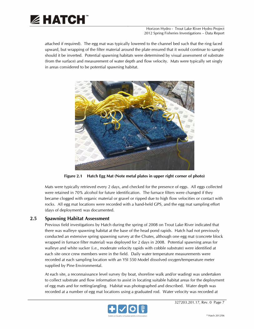
2.4 Egg Mats Egg mats were installed in potential walleye and white sucker spawning areas in an effort to collect eggs to confirm spawning. Egg mats consisted of furnace filter material (American Air Filter Model number 383-716-601 or equivalent) wrapped around a metal plate and secured with document clips (see Figure 2.1). The metal plate (214.3 mm by 381 mm by 7.93 mm thick) provided sufficient weight (~7 kg) to remain in place in high flow velocity locations. The sampling technique is an adaptation of one utilized by the United States Geological Service (USGS) to sample walleye eggs in the Detroit River, and utilizes the same exposed surface area. A rope attached to a ring in the centre of the upper surface of the plate allowed it to be deployed and retrieved (rope tied to shore or float
Horizon Hydro - Trout Lake River Hydro Project 2012 Spring Fisheries Investigations – Data Report
327203.201.17, Rev. 0 Page 7
© Hatch 2012/06
attached if required). The egg mat was typically lowered to the channel bed such that the ring faced upward, but wrapping of the filter material around the plate ensured that it would continue to sample should it be inverted. Potential spawning habitats were determined by visual assessment of substrate (from the surface) and measurement of water depth and flow velocity. Mats were typically set singly in areas considered to be potential spawning habitat.
Figure 2.1 Hatch Egg Mat (Note metal plates in upper right corner of photo)
Mats were typically retrieved every 2 days, and checked for the presence of eggs. All eggs collected were retained in 70% alcohol for future identification. The furnace filters were changed if they became clogged with organic material or gravel or ripped due to high flow velocities or contact with rocks. All egg mat locations were recorded with a hand-held GPS, and the egg mat sampling effort (days of deployment) was documented.
2.5 Spawning Habitat Assessment Previous field investigations by Hatch during the spring of 2008 on Trout Lake River indicated that there was walleye spawning habitat at the base of the head pond rapids. Hatch had not previously conducted an extensive spring spawning survey at the Chutes, although one egg mat (concrete block wrapped in furnace filter material) was deployed for 2 days in 2008. Potential spawning areas for walleye and white sucker (i.e., moderate velocity rapids with cobble substrate) were identified at each site once crew members were in the field. Daily water temperature measurements were recorded at each sampling location with an YSI 550 Model dissolved oxygen/temperature meter supplied by Pine Environmental.
At each site, a reconnaissance level survey (by boat, shoreline walk and/or wading) was undertaken to collect substrate and flow information to assist in locating suitable habitat areas for the deployment of egg mats and for netting/angling. Habitat was photographed and described. Water depth was recorded at a number of egg mat locations using a graduated rod. Water velocity was recorded at

Horizon Hydro - Trout Lake River Hydro Project 2012 Spring Fisheries Investigations – Data Report
327203.201.17, Rev. 0 Page 8
© Hatch 2012/06
the egg mat locations at the channel bed, midpoint and surface using a Marsh-McBirney Flow-Mate™ Portable Velocity Flow Meter, supplied by Pine Environmental. Substrate composition was determined by visual assessment from the surface in areas that were safe to do so. Photographs were also taken of the rapids and associated shoreline areas.

Horizon Hydro - Trout Lake River Hydro Project 2012 Spring Fisheries Investigations – Data Report
327203.201.17, Rev. 0 Page 9
© Hatch 2012/06
3. Results The following documents the results of the fish community, egg collection and spawning habitat assessment conducted at the Head Pond Rapids and the Chutes on Trout Lake River.
3.1 Water Temperature Water temperature in the study areas were taken at various times throughout the investigation and are summarized in Table 3.1. Water temperature was 7.0°C at the Head Pond Rapids upon commencement of the study on April 15. Following arrival on site, colder air temperature resulted in the water temperature declining to 5.2°C on the morning of April 17. Historical weather data was collected from Environment Canada to illustrate the range of air temperatures that occurred during the period of the investigation. Water temperatures remained below 7.0°C until April 21, when water temperatures steadily increased until the end of the study. The maximum water temperature recorded was 10.7°C on May 1, 2012.
Table 3.1 Water Temperatures in the Trout Lake River – April 15 to May 1, 2012
Date
Time
Trout Lake River Surface Water Temperature (°C)
Environment Canada Historical Daily Air Temperature (°C) - Ear Falls, ON
Head Pond Rapids
The Chutes
Daily Max
Daily Min
Daily Mean
15-Apr 18:00 7.0 6.2 -3.8 1.2 16-Apr 17:15 6.2 1.3 -7.8 -3.3
18:45 6.1 17-Apr 10:50 5.2 4.9 -6.3 -0.7
16:00 5.8 18:30 5.8
18-Apr 10:15 5.4 5.9 -1 2.5 14:30 5.4 18:30 5.8
19-Apr 9:45 5.3 7.9 -3.9 2 17:55 6.5 18:40 6.5
20-Apr 9:50 5.5 7.8 -3.7 2.1 15:45 7.2
21-Apr 12:20 6.8 10.3 -1.3 4.5 15:15 7.4
22-Apr 12:55 7.6 12.2 -2.2 5 16:50 8.2
23-Apr 8:50 7.7 15.4 -1.5 7 10:40 7.8 11:35 7.8 14:00 8.3 15:35 9.0

Horizon Hydro - Trout Lake River Hydro Project 2012 Spring Fisheries Investigations – Data Report
327203.201.17, Rev. 0 Page 10
© Hatch 2012/06
Date
Time
Trout Lake River Surface Water Temperature (°C)
Environment Canada Historical Daily Air Temperature (°C) - Ear Falls, ON
Head Pond Rapids
The Chutes
Daily Max
Daily Min
Daily Mean
24-Apr 9:25 8.6 12.6 3.8 8.2 11:30 8.8 15:25 9.2
25-Apr 9:20 8.7 10.2 -3.5 3.4 12:30 9.2 13:35 9.3 16:05 9.2
26-Apr 10:30 7.6 7.6 -7.5 0.1 11:25 7.8 15:00 8.4 16:05 8.6
27-Apr 9:20 7.9 9.7 -2.6 3.6 11:10 8.1 12:10 8.3 15:55 9 16:45 8.9
28-Apr 13:00 8.9 12.4 -0.2 6.1 13:55 9.2 15:00 9.3
29-Apr 12:20 9.3 17.7 -0.5 8.6 13:10 9.4 15:50 10.0 17:10 9.9
30-Apr 8:30 9.9 14 3.7 8.9 11:30 10.1 12:45 10.2 17:05 10.5
1-May 8:55 10.1 20.3 3.4 11.9 10:50 10.0 14:10 10.8 15:00 10.7
3.2 Head Pond Rapids
3.2.1 General Description The reach immediately upstream from Big Falls consists of an approximately 700-m long pool, that is deep (compared to the upstream section) and slow flowing. Immediately above this pool, the river consists of a series of rapids and deep runs for approximately 1 km to the narrow bedrock dominated constriction at the upstream end of the proposed head pond.
As you continue upstream before the river turns back toward the north there is a small constricting section of deep faster flowing water that contains areas of large bedrock and boulder outcrops in the main channel. At the crest of this small rapid prior to the constriction of bedrock banks a small
Horizon Hydro - Trout Lake River Hydro Project 2012 Spring Fisheries Investigations – Data Report
327203.201.17, Rev. 0 Page 11
© Hatch 2012/06
section along the north shoreline contained areas of boulder coble mixes. Substrate in this area was noted as ranging from boulder (20 to 70%) and coble (30 to 80%). As you move nearer the shoreline from the main flow an increase in cobble and decrease in bolder occurs. Two egg mats were used in this section to determine the area for spawning activity.
The first main rapids in the proposed head pond upstream of Big Falls consist of a shallow, fast-flowing riffle-like section at the lower end, with fast-flowing rapids that drop off bedrock ledges and constrictions at the upstream end of the section. Approximately 50 m farther upstream from this first area is a relatively deep (>2 m), slow-flowing pool with substrate that consists primarily of boulder (50 to 70%) and cobble (30 to 50%). Egg mats were deployed along the shorelines of these first rapids to assess the presence of spawning activity.
A long, deep and slow-flowing pool is located between the lower section of the head pond rapids and the upper portion of the head pond rapids. This area is mainly contained between bedrock shorelines and contains a number of very large boulders along shoreline. Substrate throughout the pool is that of bedrock with water depth during the survey being approximately 2 m. The area does not contain habitat that would be suitable for walleye spawning.
Farther upstream sections of the rapids in the proposed head pond (i.e., 700 to 1500 m upstream from the proposed dam location) may also provide suitable spawning habitat areas for walleye and white sucker. The three main rapid sections in the upper section are very constricted on the western shoreline causing high flow velocity over bedrock causing pockets of cobble bolder mixes along the eastern shoreline.
The first rapid section upstream of the large pool is where the bedrock shorelines narrow and water flows over bedrock substrate in main flow paths. A small section on the eastern shoreline as the wetted area widens near the base of the small drop contains substrate comprised of a cobble (20 to 70%) bedrock (10 to 60%) boulder (0 to 20%) and gravel (0 to 20%). Flow and water depth in this area out of the direct path of the main flow had maximum readings of 0.59 m/s at the surface flow velocity and a maxim depth of 0.61m. Due to the flow velocities, depth and substrate type two egg mats were deployed in the small area to confirm spawning activity.
The next section of rapids is approximately 60 m upstream where this rapids is a longer (approximately 40 m) wider (approximatley20 m) section of river. This section of rapids also contains the main flow along the western side of the river channel with a bedrock substrate. Areas along the eastern shoreline is comprised of bedrock, boulder and cobble mixes increases in cobble as it moved farther from the main flow path. Due to the length of the rapids a total of seven egg mats were use to asses this area from the crest of the rapids to the base were depth greatly increased to >1 m. The greatest flow velocities along the shoreline were recorded as 0.67m/s at the surface.
The very last rapid section within the Head Pond Rapids is at a very constricted area that a small bedrock island is developed with flow on either side. Like all the previous rapids in the upper section of the study area the main flow path is along the western side of the river channel with flows that are >2 m/s. This main flow is deep and contains substrate of 100% bedrock. The remaining flow is distributed over an approximate 0.5 m bedrock drop on the eastern side of the river where
Horizon Hydro - Trout Lake River Hydro Project 2012 Spring Fisheries Investigations – Data Report
327203.201.17, Rev. 0 Page 12
© Hatch 2012/06
the wetted width during the time of the investigation was approximately 2 m. At the base of this drop the substrate is bedrock with a depth of 0.57 m and surface flow velocity of 0.67 m/s.
As the water disperses around the island and downstream the substrate starts to become mixed with boulder and bedrock with 80% still remaining bedrock. As the main flow path and the secondary flow path begin to join the main flow around the island areas of cobble (10 to 30%) are present among the largely dominated bedrock boulder areas. Five egg mats were deployed in this area on the east end of the island to determine spawning activity.
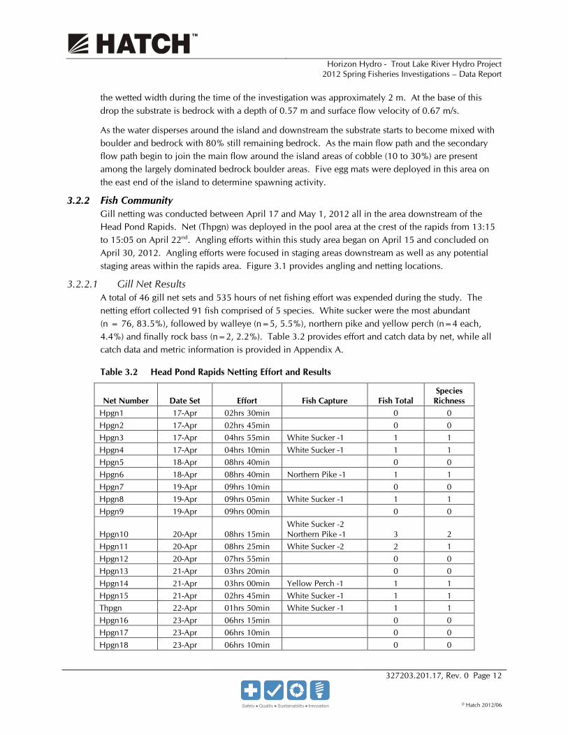
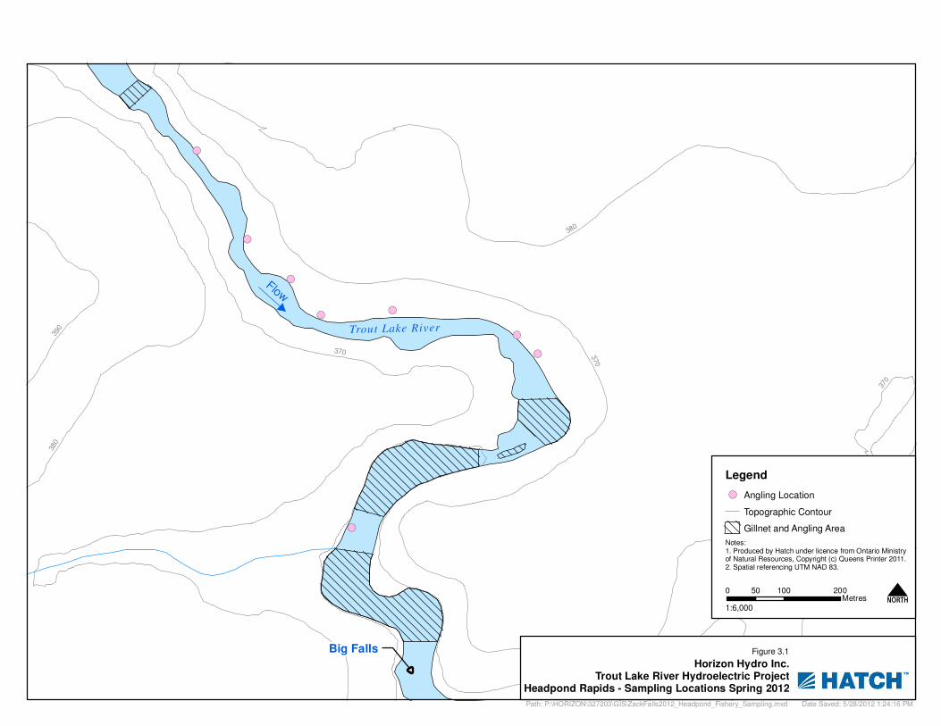
3.2.2 Fish Community Gill netting was conducted between April 17 and May 1, 2012 all in the area downstream of the Head Pond Rapids. Net (Thpgn) was deployed in the pool area at the crest of the rapids from 13:15 to 15:05 on April 22nd. Angling efforts within this study area began on April 15 and concluded on April 30, 2012. Angling efforts were focused in staging areas downstream as well as any potential staging areas within the rapids area. Figure 3.1 provides angling and netting locations.
3.2.2.1 Gill Net Results A total of 46 gill net sets and 535 hours of net fishing effort was expended during the study. The netting effort collected 91 fish comprised of 5 species. White sucker were the most abundant (n = 76, 83.5%), followed by walleye (n=5, 5.5%), northern pike and yellow perch (n=4 each, 4.4%) and finally rock bass (n=2, 2.2%). Table 3.2 provides effort and catch data by net, while all catch data and metric information is provided in Appendix A.
Table 3.2 Head Pond Rapids Netting Effort and Results
Net Number Date Set Effort Fish Capture Fish Total Species
Richness Hpgn1 17-Apr 02hrs 30min 0 0 Hpgn2 17-Apr 02hrs 45min 0 0 Hpgn3 17-Apr 04hrs 55min White Sucker -1 1 1 Hpgn4 17-Apr 04hrs 10min White Sucker -1 1 1 Hpgn5 18-Apr 08hrs 40min 0 0 Hpgn6 18-Apr 08hrs 40min Northern Pike -1 1 1 Hpgn7 19-Apr 09hrs 10min 0 0 Hpgn8 19-Apr 09hrs 05min White Sucker -1 1 1 Hpgn9 19-Apr 09hrs 00min 0 0
Hpgn10 20-Apr 08hrs 15min White Sucker -2 Northern Pike -1 3 2
Hpgn11 20-Apr 08hrs 25min White Sucker -2 2 1 Hpgn12 20-Apr 07hrs 55min 0 0 Hpgn13 21-Apr 03hrs 20min 0 0 Hpgn14 21-Apr 03hrs 00min Yellow Perch -1 1 1 Hpgn15 21-Apr 02hrs 45min White Sucker -1 1 1 Thpgn 22-Apr 01hrs 50min White Sucker -1 1 1 Hpgn16 23-Apr 06hrs 15min 0 0 Hpgn17 23-Apr 06hrs 10min 0 0 Hpgn18 23-Apr 06hrs 10min 0 0

Horizon Hydro - Trout Lake River Hydro Project 2012 Spring Fisheries Investigations – Data Report
327203.201.17, Rev. 0 Page 13
© Hatch 2012/06
Net Number Date Set Effort Fish Capture Fish Total Species
Richness Hpgn19 23-Apr 17hrs 25min White Sucker -1 1 1
Hpgn20 23-Apr 17hrs 25min Walleye -1 White Sucker -2 3 2
Hpgn21 23-Apr 17hrs 15min White Sucker -5 5 1 Hpgn22 24-Apr 24hrs 10min White Sucker -2 2 1 Hpgn23 24-Apr 23hrs 40min White Sucker -2 2 1 Hpgn24 24-Apr 23hrs 20min 0 0 Hpgn25 25-Apr 05hrs 35min 0 0
Hpgn26 25-Apr 05hrs 35min Northern Pike -1 White Sucker -3 4 2
Hpgn27 25-Apr 05hrs 20min Yellow Perch -2 2 1 Hpgn28 25-Apr 16hrs 25min White Sucker -11 11 1 Hpgn29 25-Apr 17hrs 25min White Sucker -21 21 1
Hpgn30 25-Apr 18hrs 05min
Walleye -1 Northern Pike -1 Rock bass -1 3 3
Hpgn31 26-Apr 24hrs 10min Yellow Perch -1 Rock bass -1 2 2
Hpgn32 26-Apr 05hrs 05min White Sucker-1 1 1 Hpgn33 26-Apr 05hrs 10min 0 0 Hpgn34 27-Apr 07hrs 15min 0 0 Hpgn35 27-Apr 06hrs 20min 0 0
Hpgn36 27-Apr 19hrs 20min Walleye -1 White Sucker -2 3 2
Hpgn37 27-Apr 20hrs 10min White Sucker -2 2 1 Hpgn38 28-Apr 24hrs 05min White Sucker -3 3 1 Hpgn39 28-Apr 24hrs 00min White Sucker -4 4 1 Hpgn40 29-Apr 23hrs 50min White Sucker -2 2 1 Hpgn41 29-Apr 21hrs 15min White Sucker -1 1 1
Hpgn42 30-Apr 22hrs 05min Walleye -1 White Sucker -2 3 2
Hpgn43 30-Apr 21hrs 25min Walleye -1 White Sucker -1 2 2
Hpgn44 1-May 4hrs 30min 0 0
Hpgn45 1-May 4hrs 30min White Sucker -2 2 1
Total 535hrs 00min
Walleye -5 White Sucker -76 Northern Pike -4 Yellow Perch -4 Rock Bass -2 91 5
Average/Net 1.98
Horizon Hydro - Trout Lake River Hydro Project 2012 Spring Fisheries Investigations – Data Report
327203.201.17, Rev. 0 Page 14
© Hatch 2012/06
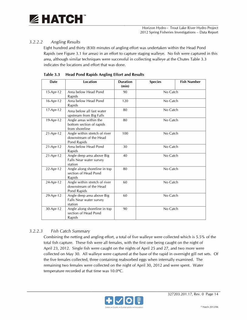
3.2.2.2 Angling Results Eight hundred and thirty (830) minutes of angling effort was undertaken within the Head Pond Rapids (see Figure 3.1 for areas) in an effort to capture staging walleye. No fish were captured in this area, although similar techniques were successful in collecting walleye at the Chutes Table 3.3 indicates the locations and effort that was done.
Table 3.3 Head Pond Rapids Angling Effort and Results
Date Location Duration (min)
Species Fish Number
15-Apr-12 Area below Head Pond Rapids
90 No Catch
16-Apr-12 Area below Head Pond Rapids
120 No Catch
17-Apr-12 Area below all fast water upstream from Big Falls
80 No Catch
19-Apr-12 Angle areas within the bottom section of rapids from shoreline
80 No Catch
21-Apr-12 Angle within stretch of river downstream of the Head Pond Rapids
100 No Catch
21-Apr-12 Area below Head Pond Rapids
30 No Catch
21-Apr-12 Angle deep area above Big Falls Near water survey station
40 No Catch
22-Apr-12 Angle along shoreline in top section of Head Pond Rapids
80 No Catch
24-Apr-12 Angle within stretch of river downstream of the Head Pond Rapids
60 No Catch
29-Apr-12 Angle deep area above Big Falls Near water survey station
60 No Catch
30-Apr-12 Angle along shoreline in top section of Head Pond Rapids
90 No Catch
3.2.2.3 Fish Catch Summary Combining the netting and angling effort, a total of five walleye were collected which is 5.5% of the total fish capture. These fish were all females, with the first one being caught on the night of April 23, 2012. Single fish were caught on the nights of April 25 and 27, and two more were collected on May 30. All walleye were captured at the base of the rapid in overnight gill net sets. Of the five females collected, three containing reabsorbed eggs when internally examined. The remaining two females were collected on the night of April 30, 2012 and were spent. Water temperature recorded at that time was 10.0ºC.
!(
!(
!(
!(
!(
!(
!(
!(
Big Falls
Trout Lake River
Flow
370
380
360
390
370
380
370
38
0Legend
!( Angling Location
Topographic Contour
Gillnet and Angling Area
Horizon Hydro Inc.Trout Lake River Hydroelectric Project
Headpond Rapids - Sampling Locations Spring 2012
Notes:1. Produced by Hatch under licence from Ontario Ministryof Natural Resources, Copyright (c) Queens Printer 2011.2. Spatial referencing UTM NAD 83.
0 100 20050Metres
1:6,000N
Date Saved: 5/28/2012 1:24:16 PMPath: P:\HORIZON\327203\GIS\ZackFalls2012_Headpond_Fishery_Sampling.mxd
Figure 3.1

Horizon Hydro - Trout Lake River Hydro Project 2012 Spring Fisheries Investigations – Data Report
327203.201.17, Rev. 0 Page 16
© Hatch 2012/06
Blank back

Horizon Hydro - Trout Lake River Hydro Project 2012 Spring Fisheries Investigations – Data Report
327203.201.17, Rev. 0 Page 17
© Hatch 2012/06
Two walleye and eleven white suckers were taken for mercury analysis to meet MOE requirements. The walleye were 485 mm and 675 mm total length, while the white suckers ranged from 309 mm to 527 mm in total length. Tissue samples will be sent to Flett Research for analysis and results will be carried forward to the EA document.
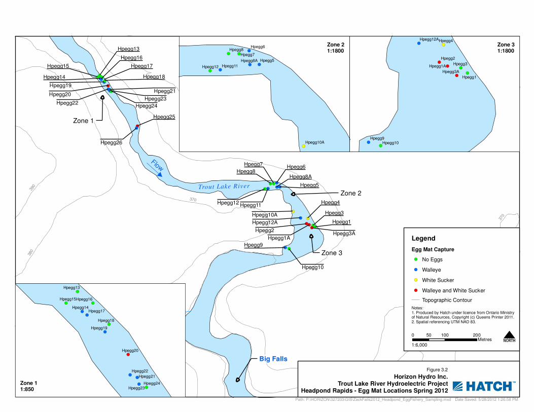
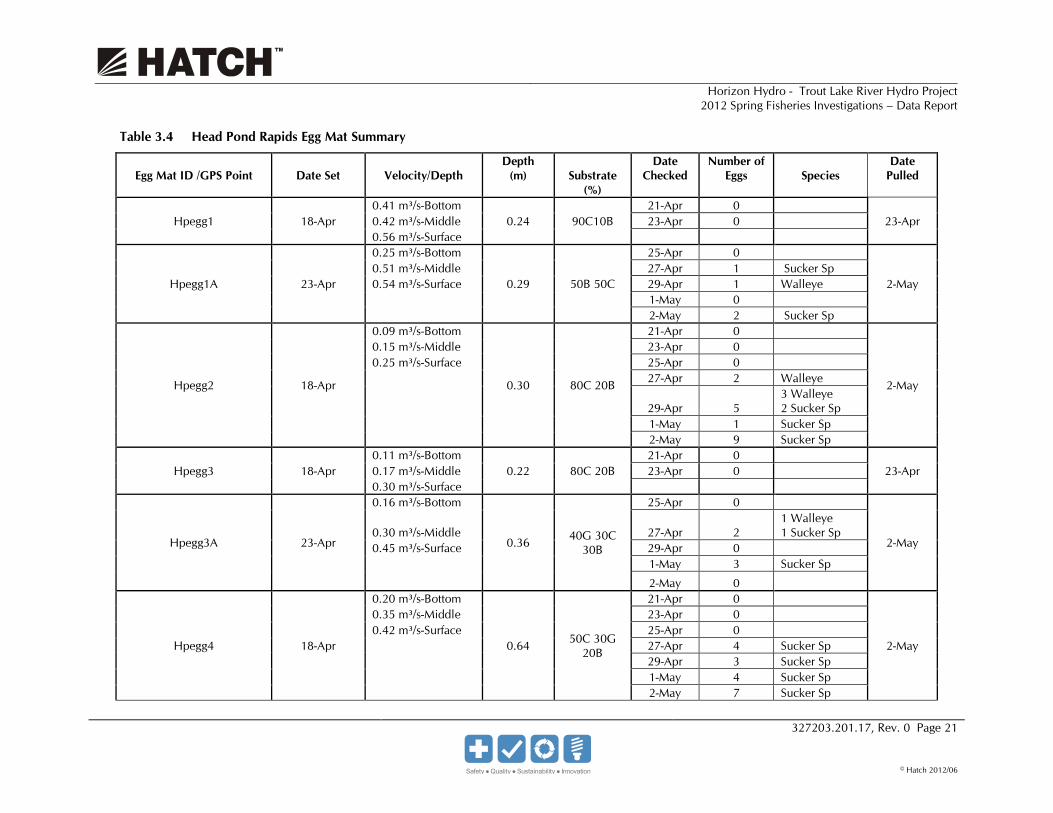
3.2.2.4 Egg Mats Egg mats were installed at 31 locations within the Head Pond Rapids as noted in Figure 3.2. Egg mats were deployed at locations that were deemed to provide suitable spawning habitat, with initial deployment beginning on April 18, 2012. Additional egg mats were deployed as site access along the rapids became available. Eggs mats were checked for the presence of eggs, beginning on April 21, 2012.
Walleye and white sucker eggs were first collected in the study area on April 26, and were present within the river reach through the spawning study until mats were removed. The number of walleye eggs collected was declining at the majority of egg mat sites during the last round of egg mat surveillance on May 2. This combined with the increase of sucker eggs appearing indicates that the sucker spawn had commenced and the walleye spawn was concluding. Table 3.4 indicates all of the egg mat results.
Egg mat collection captured a total of walleye (n=302+) and white sucker eggs (n=46) throughout Head Pond Rapids section. Many egg mats only captured a low number of walleye eggs throughout the study period. The eggs captured at a location ranged from 1 (mats Hpegg11, Hpegg12A and Hpegg19) to 120+ on Hpegg25.

Horizon Hydro - Trout Lake River Hydro Project 2012 Spring Fisheries Investigations – Data Report
327203.201.17, Rev. 0 Page 18
© Hatch 2012/06
Blank back
!(
!(
!(
!(!(
!(
!(!(!( !(!(!(
!(!(
!(!(!(!(
!(!(
!(!(
!(
!(
!(!(!(!(
!(
!(
!(
Big Falls
Trout Lake River
Flow
Zone 1
Zone 2
Zone 3
Hpegg9
Hpegg8Hpegg6
Hpegg5
Hpegg4
Hpegg3
Hpegg2
Hpegg1
Hpegg20
Hpegg8A
Hpegg26
Hpegg25
Hpegg24Hpegg22
Hpegg19
Hpegg17Hpegg15
Hpegg12
Hpegg10
Hpegg12A
Hpegg10A
Hpegg7
Hpegg18
Hpegg3A
Hpegg23
Hpegg21
Hpegg1A
Hpegg16
Hpegg14
Hpegg13
Hpegg11
370
380
360
390
370
380
370
38
0
Legend
Egg Mat Capture
!( No Eggs
!( Walleye
!( White Sucker
!( Walleye and White Sucker
Topographic Contour
Horizon Hydro Inc.Trout Lake River Hydroelectric Project
Headpond Rapids - Egg Mat Locations Spring 2012
Notes:1. Produced by Hatch under licence from Ontario Ministryof Natural Resources, Copyright (c) Queens Printer 2011.2. Spatial referencing UTM NAD 83.
0 100 20050Metres
1:6,000N
Date Saved: 5/28/2012 1:26:58 PMPath: P:\HORIZON\327203\GIS\ZackFalls2012_Headpond_EggFishery_Sampling.mxd
Figure 3.2
!(
!(
!(
!(!(
!(
!(
!(
!(
Hpegg9
Hpegg4
Hpegg3
Hpegg2
Hpegg1
Hpegg3A
Hpegg1A
Hpegg10
Hpegg12A
!(
!(
!( !(
!(
!(
!(!(
!(!(
!(
!(
Hpegg20
Hpegg18
Hpegg24Hpegg23
Hpegg22
Hpegg21
Hpegg19
Hpegg17
Hpegg16Hpegg15
Hpegg14
Hpegg13
!(
!(!(
!(
!(!(!(
!(
Hpegg8
Hpegg7
Hpegg6
Hpegg5Hpegg8A
Hpegg12 Hpegg11
Hpegg10A
Zone 11:850
Zone 21:1800
Zone 31:1800

Horizon Hydro - Trout Lake River Hydro Project 2012 Spring Fisheries Investigations – Data Report
327203.201.17, Rev. 0 Page 20
© Hatch 2012/06
Blank back
Horizon Hydro - Trout Lake River Hydro Project 2012 Spring Fisheries Investigations – Data Report
327203.201.17, Rev. 0 Page 21
© Hatch 2012/06
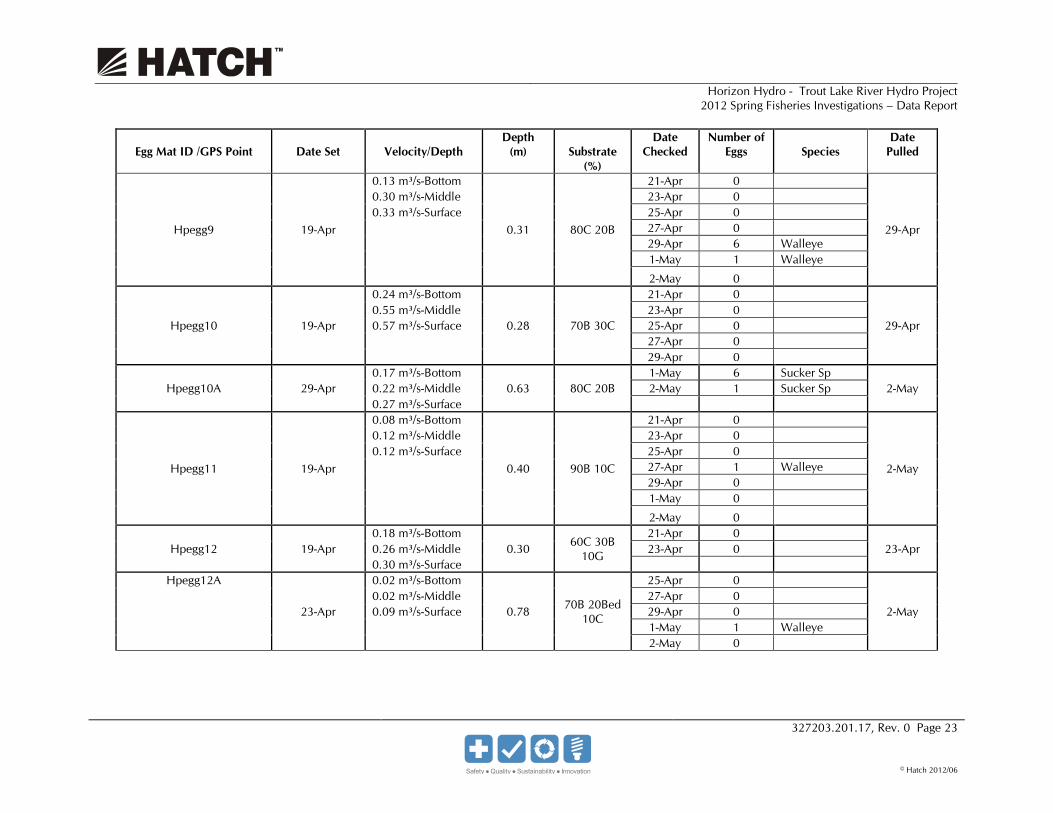
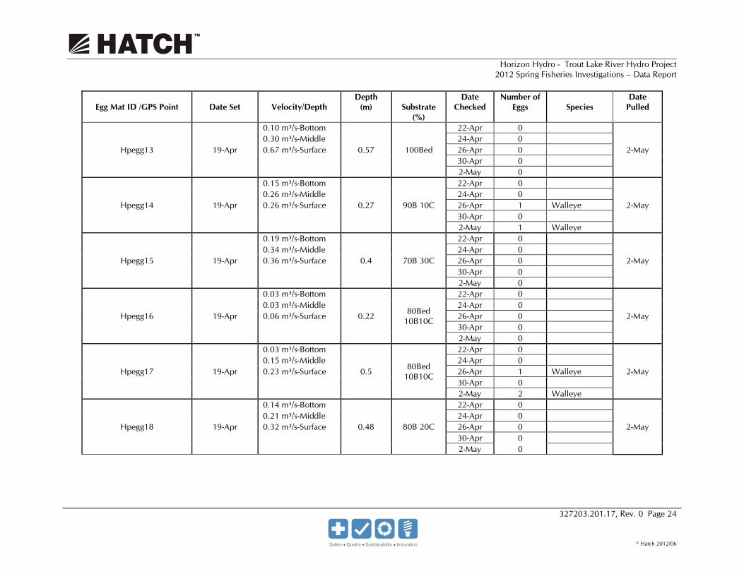
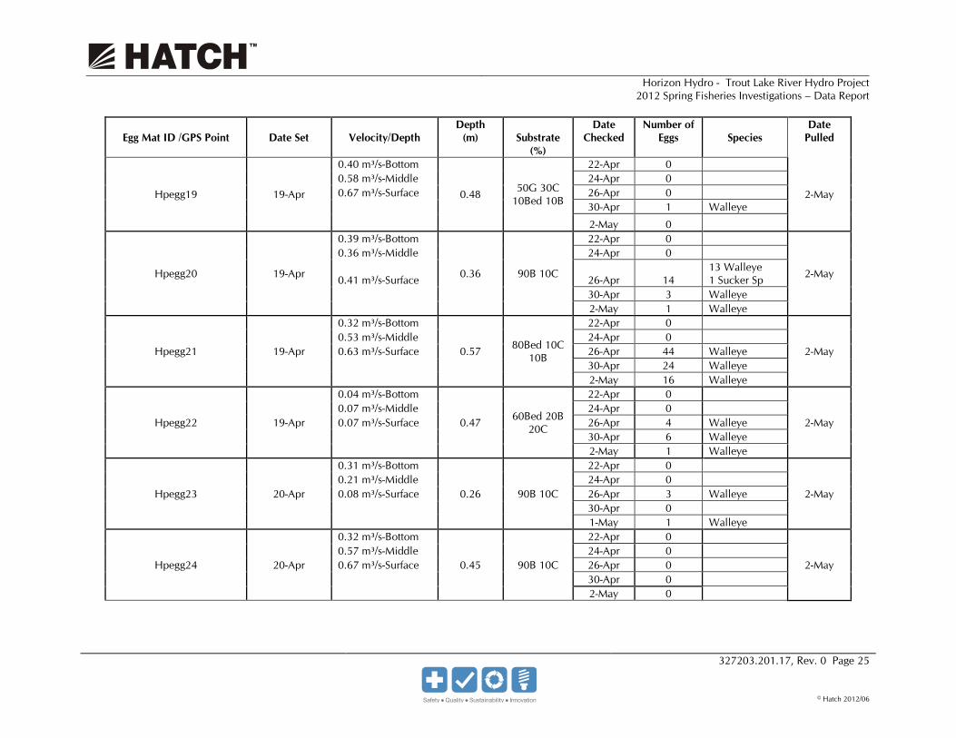
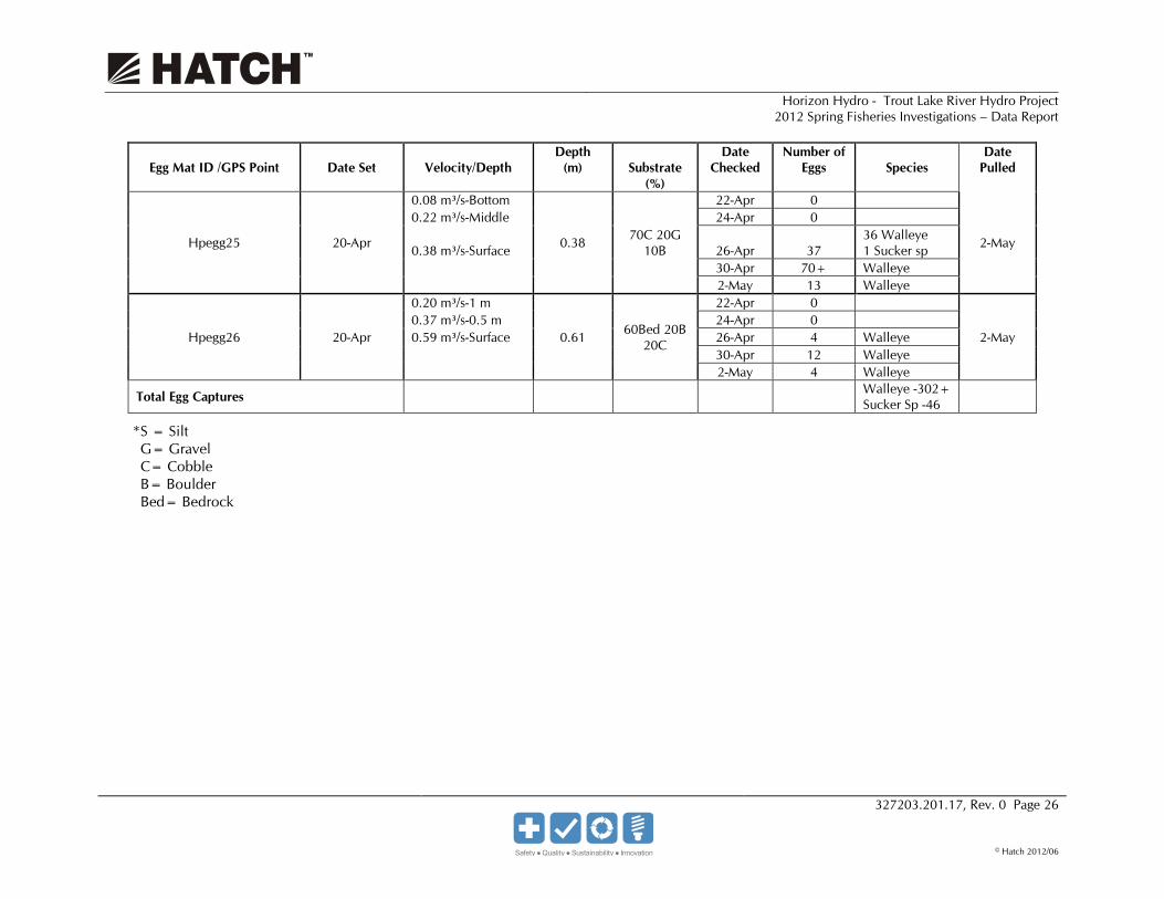
Table 3.4 Head Pond Rapids Egg Mat Summary
Egg Mat ID /GPS Point
Date Set
Velocity/Depth
Depth (m)
Substrate
(%)
Date Checked
Number of Eggs
Species
Date Pulled
Hpegg1 18-Apr 0.41 m³/s-Bottom
0.24 90C10B 21-Apr 0
23-Apr 0.42 m³/s-Middle 23-Apr 0 0.56 m³/s-Surface
Hpegg1A 23-Apr
0.25 m³/s-Bottom
0.29 50B 50C
25-Apr 0
2-May 0.51 m³/s-Middle 27-Apr 1 Sucker Sp 0.54 m³/s-Surface 29-Apr 1 Walleye 1-May 0
2-May 2 Sucker Sp
Hpegg2 18-Apr
0.09 m³/s-Bottom
0.30 80C 20B
21-Apr 0
2-May
0.15 m³/s-Middle 23-Apr 0 0.25 m³/s-Surface 25-Apr 0
27-Apr 2 Walleye
29-Apr 5 3 Walleye 2 Sucker Sp
1-May 1 Sucker Sp 2-May 9 Sucker Sp
Hpegg3 18-Apr 0.11 m³/s-Bottom
0.22 80C 20B 21-Apr 0
23-Apr 0.17 m³/s-Middle 23-Apr 0 0.30 m³/s-Surface
Hpegg3A 23-Apr
0.16 m³/s-Bottom
0.36 40G 30C 30B
25-Apr 0
2-May 0.30 m³/s-Middle 27-Apr 2
1 Walleye 1 Sucker Sp
0.45 m³/s-Surface 29-Apr 0 1-May 3 Sucker Sp
2-May 0
Hpegg4 18-Apr
0.20 m³/s-Bottom
0.64 50C 30G 20B
21-Apr 0
2-May
0.35 m³/s-Middle 23-Apr 0 0.42 m³/s-Surface 25-Apr 0 27-Apr 4 Sucker Sp 29-Apr 3 Sucker Sp 1-May 4 Sucker Sp
2-May 7 Sucker Sp

Horizon Hydro - Trout Lake River Hydro Project 2012 Spring Fisheries Investigations – Data Report
327203.201.17, Rev. 0 Page 22
© Hatch 2012/06
Egg Mat ID /GPS Point
Date Set
Velocity/Depth
Depth (m)
Substrate
(%)
Date Checked
Number of Eggs
Species
Date Pulled
Hpegg5 18-Apr
0.35 m³/s-Bottom
0.36 90C10B
21-Apr 0
2-May
0.39 m³/s-Middle 23-Apr 0 0.39 m³/s-Surface 25-Apr 0 27-Apr 0 29-Apr 9 Walleye 1-May 0
2-May 4 Walleye
Hpegg6 18-Apr
0.19 m³/s-Bottom
0.36 90C10B
21-Apr 0
2-May
0.32 m³/s-Middle 23-Apr 0 0.43 m³/s-Surface 25-Apr 0 27-Apr 2 Walleye 29-Apr 2 Walleye 1-May 6 Walleye
2-May 0
Hpegg7 18-Apr
0.10 m³/s-Bottom
0.4 40Bed 40C 20B
21-Apr 0
2-May
0.25 m³/s-Middle 23-Apr 0 0.25 m³/s-Surface 25-Apr 0 27-Apr 0 29-Apr 0 1-May 0
2-May 0
Hpegg8 18-Apr 0.11 m³/s-Bottom
0.62 70C 30B 21-Apr 0
23-Apr 0.20 m³/s-Middle 23-Apr 0 0.25 m³/s-Surface
Hpegg8A 23-Apr
0.27 m³/s-Bottom
0.44 50G 30C 10Bed 10B
25-Apr 0
18-May 0.63 m³/s-Middle 27-Apr 2 Walleye 0.70 m³/s-Surface 29-Apr 0 1-May 0
2-May 0
Horizon Hydro - Trout Lake River Hydro Project 2012 Spring Fisheries Investigations – Data Report
327203.201.17, Rev. 0 Page 23
© Hatch 2012/06
Egg Mat ID /GPS Point
Date Set
Velocity/Depth
Depth (m)
Substrate
(%)
Date Checked
Number of Eggs
Species
Date Pulled
Hpegg9 19-Apr
0.13 m³/s-Bottom
0.31 80C 20B
21-Apr 0
29-Apr
0.30 m³/s-Middle 23-Apr 0 0.33 m³/s-Surface 25-Apr 0 27-Apr 0 29-Apr 6 Walleye 1-May 1 Walleye
2-May 0
Hpegg10 19-Apr
0.24 m³/s-Bottom
0.28 70B 30C
21-Apr 0
29-Apr 0.55 m³/s-Middle 23-Apr 0 0.57 m³/s-Surface 25-Apr 0 27-Apr 0
29-Apr 0
Hpegg10A 29-Apr 0.17 m³/s-Bottom
0.63 80C 20B 1-May 6 Sucker Sp
2-May 0.22 m³/s-Middle 2-May 1 Sucker Sp 0.27 m³/s-Surface
Hpegg11 19-Apr
0.08 m³/s-Bottom
0.40 90B 10C
21-Apr 0
2-May
0.12 m³/s-Middle 23-Apr 0 0.12 m³/s-Surface 25-Apr 0 27-Apr 1 Walleye 29-Apr 0 1-May 0
2-May 0
Hpegg12 19-Apr 0.18 m³/s-Bottom
0.30 60C 30B 10G
21-Apr 0 23-Apr 0.26 m³/s-Middle 23-Apr 0
0.30 m³/s-Surface Hpegg12A
23-Apr
0.02 m³/s-Bottom
0.78 70B 20Bed 10C
25-Apr 0
2-May 0.02 m³/s-Middle 27-Apr 0 0.09 m³/s-Surface 29-Apr 0 1-May 1 Walleye 2-May 0
Horizon Hydro - Trout Lake River Hydro Project 2012 Spring Fisheries Investigations – Data Report
327203.201.17, Rev. 0 Page 24
© Hatch 2012/06
Egg Mat ID /GPS Point
Date Set
Velocity/Depth
Depth (m)
Substrate
(%)
Date Checked
Number of Eggs
Species
Date Pulled
Hpegg13 19-Apr
0.10 m³/s-Bottom
0.57 100Bed
22-Apr 0
2-May 0.30 m³/s-Middle 24-Apr 0 0.67 m³/s-Surface 26-Apr 0 30-Apr 0
2-May 0
Hpegg14 19-Apr
0.15 m³/s-Bottom
0.27 90B 10C
22-Apr 0
2-May 0.26 m³/s-Middle 24-Apr 0 0.26 m³/s-Surface 26-Apr 1 Walleye 30-Apr 0
2-May 1 Walleye
Hpegg15 19-Apr
0.19 m³/s-Bottom
0.4 70B 30C
22-Apr 0
2-May 0.34 m³/s-Middle 24-Apr 0 0.36 m³/s-Surface 26-Apr 0 30-Apr 0
2-May 0
Hpegg16 19-Apr
0.03 m³/s-Bottom
0.22 80Bed 10B10C
22-Apr 0
2-May 0.03 m³/s-Middle 24-Apr 0 0.06 m³/s-Surface 26-Apr 0 30-Apr 0
2-May 0
Hpegg17 19-Apr
0.03 m³/s-Bottom
0.5 80Bed 10B10C
22-Apr 0
2-May 0.15 m³/s-Middle 24-Apr 0 0.23 m³/s-Surface 26-Apr 1 Walleye 30-Apr 0
2-May 2 Walleye
Hpegg18 19-Apr
0.14 m³/s-Bottom
0.48 80B 20C
22-Apr 0
2-May 0.21 m³/s-Middle 24-Apr 0 0.32 m³/s-Surface 26-Apr 0 30-Apr 0
2-May 0
Horizon Hydro - Trout Lake River Hydro Project 2012 Spring Fisheries Investigations – Data Report
327203.201.17, Rev. 0 Page 25
© Hatch 2012/06
Egg Mat ID /GPS Point
Date Set
Velocity/Depth
Depth (m)
Substrate
(%)
Date Checked
Number of Eggs
Species
Date Pulled
Hpegg19 19-Apr
0.40 m³/s-Bottom
0.48 50G 30C 10Bed 10B
22-Apr 0
2-May 0.58 m³/s-Middle 24-Apr 0 0.67 m³/s-Surface 26-Apr 0 30-Apr 1 Walleye
2-May 0
Hpegg20 19-Apr
0.39 m³/s-Bottom
0.36 90B 10C
22-Apr 0
2-May
0.36 m³/s-Middle 24-Apr 0
0.41 m³/s-Surface 26-Apr 14 13 Walleye 1 Sucker Sp
30-Apr 3 Walleye 2-May 1 Walleye
Hpegg21 19-Apr
0.32 m³/s-Bottom
0.57 80Bed 10C 10B
22-Apr 0
2-May 0.53 m³/s-Middle 24-Apr 0 0.63 m³/s-Surface 26-Apr 44 Walleye 30-Apr 24 Walleye
2-May 16 Walleye
Hpegg22 19-Apr
0.04 m³/s-Bottom
0.47 60Bed 20B 20C
22-Apr 0
2-May 0.07 m³/s-Middle 24-Apr 0 0.07 m³/s-Surface 26-Apr 4 Walleye 30-Apr 6 Walleye
2-May 1 Walleye
Hpegg23 20-Apr
0.31 m³/s-Bottom
0.26 90B 10C
22-Apr 0
2-May 0.21 m³/s-Middle 24-Apr 0 0.08 m³/s-Surface 26-Apr 3 Walleye 30-Apr 0
1-May 1 Walleye
Hpegg24 20-Apr
0.32 m³/s-Bottom
0.45 90B 10C
22-Apr 0
2-May 0.57 m³/s-Middle 24-Apr 0 0.67 m³/s-Surface 26-Apr 0 30-Apr 0
2-May 0
Horizon Hydro - Trout Lake River Hydro Project 2012 Spring Fisheries Investigations – Data Report
327203.201.17, Rev. 0 Page 26
© Hatch 2012/06
Egg Mat ID /GPS Point
Date Set
Velocity/Depth
Depth (m)
Substrate
(%)
Date Checked
Number of Eggs
Species
Date Pulled
Hpegg25 20-Apr
0.08 m³/s-Bottom
0.38 70C 20G 10B
22-Apr 0
2-May
0.22 m³/s-Middle 24-Apr 0
0.38 m³/s-Surface 26-Apr 37 36 Walleye 1 Sucker sp
30-Apr 70+ Walleye 2-May 13 Walleye
Hpegg26 20-Apr
0.20 m³/s-1 m
0.61 60Bed 20B 20C
22-Apr 0
2-May 0.37 m³/s-0.5 m 24-Apr 0 0.59 m³/s-Surface 26-Apr 4 Walleye 30-Apr 12 Walleye
2-May 4 Walleye
Total Egg Captures
Walleye -302+ Sucker Sp -46
*S = Silt G= Gravel C= Cobble B= Boulder Bed= Bedrock

Horizon Hydro - Trout Lake River Hydro Project 2012 Spring Fisheries Investigations – Data Report
327203.201.17, Rev. 0 Page 27
© Hatch 2012/06
With more possible spawning habitat located on the east side of the main flow path the majority of the sampling locations were deployed along that side of the river. Only five egg mats were located along the west side (Hpegg9, Hpegg10, Hpegg10A, Hpegg11 and Hpegg12), and one egg mat was accessed by boat (Hpegg12A). Egg mats were generally deployed by wading, where safe to do so. Water depth ranged from 0.22 to 0.78 m at egg mat locations, while flow velocity at the substrate surface (Bottom in table above) ranged from 0.02 m³/s to 0.41 m³/s.
At the completion of the study (a 15-day sampling period), no eggs were collected at 11 egg mats, only walleye eggs were collected at 13 locations, sucker eggs were collected at two locations, and both walleye and sucker sp. eggs were collected at 5 locations. Figure 3.2 shows all of the egg mat locations and catch results.
3.2.3 Spawning Habitat Visual observations of aquatic habitat in the Head Pond Rapids were taken at each egg mat location in conjunction with measurements of depth and flow velocity (see Table 3.4). As noted in Section 3.2.1 above, the Head Pond Rapids consists of two series of rapids separated by a long (approximately500 m) pool.
At the upstream end of the reach, a long (270 m) section of intermittent rapids contains minimal small pockets of cobble bolder mixes in areas along the eastern shoreline. Different variations of substrate mixes, flow velocities and water depth were noted at each section of rapids.
At the upper most end of the Head Pond Rapids confirmed spawning habitat contained substrate material ranging from boulder (10 to 90%), bedrock 0 to 80% and cobble 10%. The substrate flow velocity at these locations ranged from 0.03 m/s to 0.15m/s where depths were between 0.27 m and 0.5 m. This was found to be a total area of 83 m² that would provide suitable spawning habitat for walleye in this area.
The longest rapid section within the upper end of the Head Pond Rapid also had confirmed spawning from walleye and white sucker species in certain sections. Spawning habitat of confirmed walleye and white sucker had substrate comprised of boulder (10 to 90%), bedrock (0 to 80%), cobble (10 to 30%) and gravel (0 to 50%). Water depths in these areas ranged from 0.36 m to 0.57 m were substrate flow velocity readings were from 0.04 m/s to 0.4 m/s. The total area of suitable spawning habitat at these rapids was 232 m².
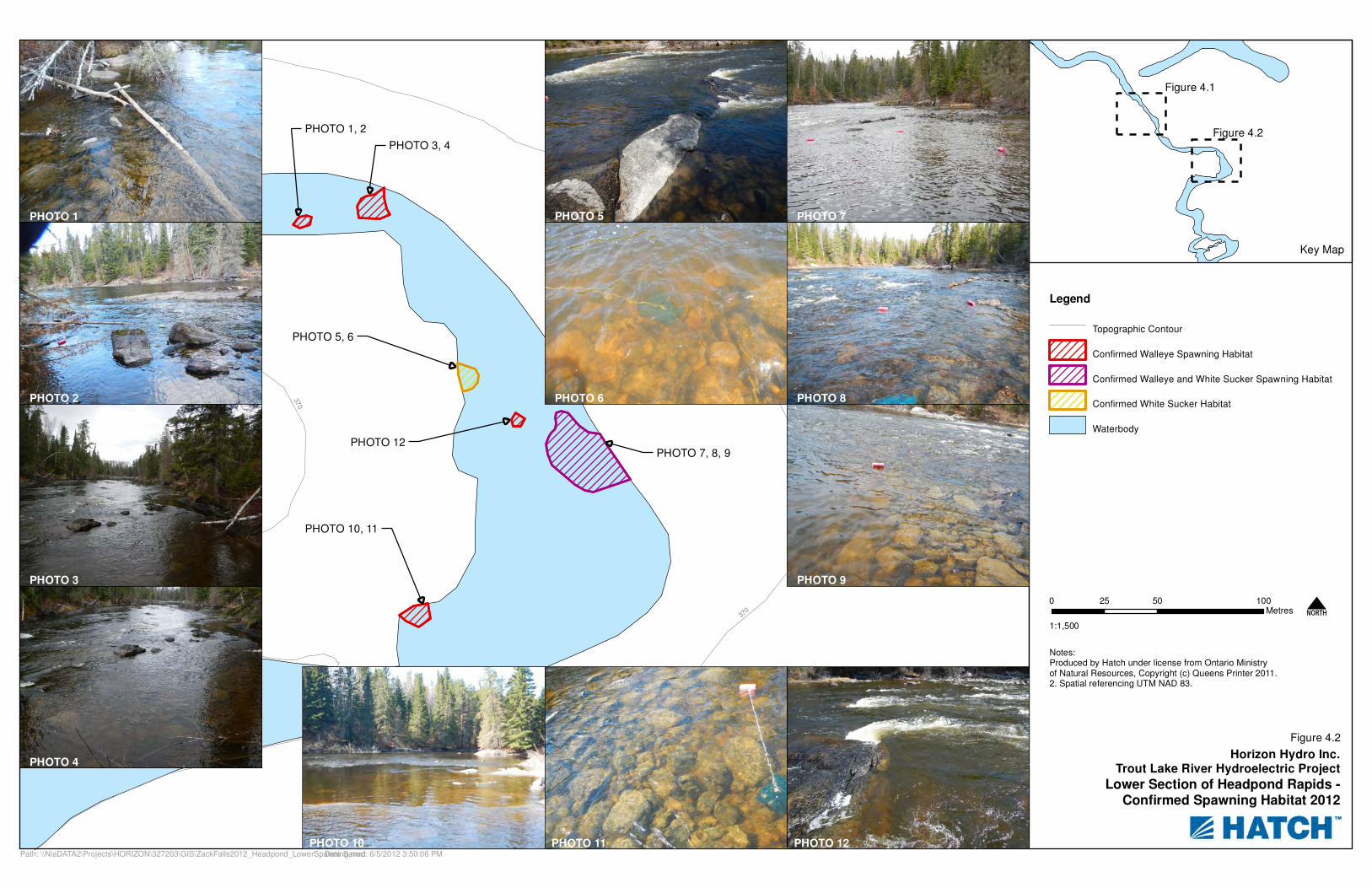
The last section of rapids as you head downstream before the large pool area contained a small area of suitable spawning habitat near the base of the rapids on the eastern shoreline. This area had confirmed spawning from both walleye and white sucker during the investigation. This area contained substrate ranges of cobble (20 to 70%), bedrock (0 to 60%), boulder (10 to 20%) and gravel (0 to 20%). The substrate flow velocity at these locations ranged from 0.08 m/s to 0.20 m/s where depths were between 0.38 m and 0.67 m. A total area of 90 m² was determined to be spawning habitat for walleye and white sucker. Figure 4.1 indicates all of the confirmed spawning locations for the upper portion of the Head Pond Rapids.
Continuing downstream past the large pool area, the next rapids contained spawning habitat on both the east and west shorelines. However, the western shoreline contained a smaller section due to larger areas of bedrock and high flows. On the western shore the area that contained substrate of
Horizon Hydro - Trout Lake River Hydro Project 2012 Spring Fisheries Investigations – Data Report
327203.201.17, Rev. 0 Page 28
© Hatch 2012/06
90% boulder and 10% cobble with a substrate flow velocity of 0.08 m/s in 0.4 m of water captured a single walleye egg. This small area of suitable walleye spawning habitat was 34 m².
The eastern shoreline of this area contained a more diverse and suitable substrate. The substrate ranged from (30 to 90%) cobble, (0 to 50%) gravel, (10 to 20%) boulder, and minimal (0 to 10%) bedrock. Substrate flows were recorded as ranging from 0.19 m/s to 0.35 m/s in water depths between 0.36 m and 0.44 m where walleye spawning was confirmed. The area was determined to be 151 m².
Farther downstream at the base of a bedrock drop area along the western shore an area was confirmed for white sucker spawning only. This area was recorded as being 80% cobble, 20% boulder with a bottom flow velocity of 0.17 m/s at a depth of 0.63 m. This area is was a total of 93 m².
At the base of the intermittent rapid along the eastern shoreline and within the main flow areas spawning habitat for walleye and white sucker were present. This area along the eastern shoreline was confirmed walleye spawning habitat from early investigations. Confirmation of habitat area was to be verified in this investigation. The area along the east had substrate ranging from cobble (30 to 80%), gravel (0 to 40%) and boulder (10 to 30%). Flow velocities along the substrate ranged from 0.09 m/s to 0.25 m/s in water depths of 0.29 m to 0.64 m. This spawning habitat area was determined during this investigation to be 831 m².
A small walleye spawning area within a back eddy of the main flow channel investigated by boat was comprised of 70% boulder, 20% bedrock and 10% cobble. The swirling water in this area indicated a substrate flow velocity of 0.02 m/s however in the flow channels on either side flow would be >1.0 m/s. Water depth at this location was 0.78 m. Within this 28 m² area only one walleye egg was collected.
Below the pooling area at the base of the head pond rapids, spawning habitat is located on the western edge of the river channel before the river constricts and enters the large pool above Big Falls. This spawning habitat is 80% cobble and 20% boulder with riverbed flow velocity of 0.13 m/s and a depth of 0.31 m. This is a total of 102 m² of walleye spawning habitat.
Figure 4.2 illustrates and delineates all of the confirmed spawning habitat areas within the lower section of the Head Pond Rapids.
3.3 The Chutes
3.3.1 General Description The Chutes is located approximately 8.5 km upstream from the proposed dam location on Trout Lake River and approximately 7 km upstream from the limit of the backwater effect from the proposed project head pond. It is the first rapids upstream from the proposed head pond. The area consists of a narrow set of bedrock-controlled rapids across the main channel, discharging to a deeper plunge pool. Outflow from the pool discharges at approximately 90 deg to the upstream flow path, creating a right hand-bend in the river that directs the downstream flow to the west. Below the rapids, flow passes through the pool and against the bedrock wall on the south side of the river valley. This disperses water in both directions; creating back eddies on each side of the main flow path, with the

Horizon Hydro - Trout Lake River Hydro Project 2012 Spring Fisheries Investigations – Data Report
327203.201.17, Rev. 0 Page 29
© Hatch 2012/06
main flow path continuing downstream. This back flow motion has created a sand/fine sediment bar to the west of the main flow channel.
3.3.2 Fish Community Gill netting was conducted between April 17 and May 1, 2012 in an area that extended approximately 350 m downstream below the Chutes. Angling efforts within this study area began on April 16 and concluded on May 1, 2012. Angling efforts were focused in possible staging areas below the rapids, although the entire area was subjected to angling and netting methods (see Figure 3.3).
3.3.2.1 Gill Net Results Thirty gillnets net sets and 101 hours and 5 minutes of fishing effort was used to sample this study area. The netting effort produced a total of 165 fish of 4 species. Yellow perch (n=60, 36.3%) were the most abundant, followed by white sucker (n=42, 25.5%), walleye (n=36, 21.8%) and finally, northern pike (n=27, 16.4%). A single walleye was recaptured (TAG# HA-01218), that had been captured by angling and tagged earlier in this study. Table 3.5 provides fishing effort and catch results by location. All catch data and fish metrics are provided in Appendix B.
Table 3.5 Chutes Netting Effort and Results
Net Number Date Set Effort Fish Capture Fish Total Species
Richness Cgn1 17-Apr 01hrs 30min Walleye -1 1 1 Cgn2 17-Apr 01hrs 25min 0 0 Cgn3 18-Apr 02hrs 35min Northern Pike -1
White Sucker -1 2 2
Cgn4 18-Apr 02hrs 30min Northern Pike-2 2 1 Cgn5 19-Apr 02hrs 45min Walleye -1
Northern Pike -2 White Sucker -1
4 3
Cgn6 19-Apr 03hrs 10min Walleye -2 Northern Pike -1
3 2
Cgn7 20-Apr 05hrs 40min Yellow Perch -1 White Sucker -1
2 2
Cgn8 20-Apr 05hrs 50min Walleye -1 White Sucker -1
2 2
Cgn9 22-Apr 03hrs 30min Northern Pike -1 White Sucker -2 Yellow Perch -8
11 3
Cgn10 23-Apr 02hrs 15min White Sucker -3 Yellow Perch -1
4 2
Cgn11 23-Apr 02hrs 30min 0 0 Cgn12 24-Apr 05hrs 25min Walleye -1
Northern Pike -5 White Sucker -4 Yellow Perch -2
12 4
Cgn13 24-Apr 04hrs 25min Walleye -6 Yellow Perch -15 White Sucker -4
25 3

Horizon Hydro - Trout Lake River Hydro Project 2012 Spring Fisheries Investigations – Data Report
327203.201.17, Rev. 0 Page 30
© Hatch 2012/06
Net Number Date Set Effort Fish Capture Fish Total Species
Richness Cgn14 25-Apr 01hrs 50min Walleye -2
Northern Pike -1 White Sucker -1
4 3
Cgn15 25-Apr 02hrs 10min Walleye -1 Northern Pike -2 Yellow Perch -2
5 3
Cgn16 26-Apr 03hrs 45min Walleye -1 1 1 Cgn16B 26-Apr 02hrs 15min Walleye -3
Northern Pike -3 Yellow Perch -1
7 3
Cgn17 27-Apr 03hrs 40min Walleye -1 White Sucker -2
3 2
Cgn18 27-Apr 02hrs 20min Walleye -2 Northern Pike -1
3 2
Cgn19 27-Apr 01hrs 15min Yellow Perch -2 2 1 Cgn20 28-Apr 03hrs 00min Walleye -1
Northern Pike -3 White Sucker -1
5 3
Cgn21 28-Apr 02hrs 35min Walleye -2 White Sucker -6 Yellow Perch -1
9 3
Cgn22 29-Apr 05hrs 00min Walleye -2 Northern Pike -2 Yellow Perch -3
7 3
Cgn23 29-Apr 05hrs 00mn Walleye -1 White Sucker -3
4 2
Cgn24 30-Apr 02hrs 15min Walleye -3 Yellow Perch -7 White Sucker -3
13 3
Cgn25 30-Apr 02hrs 45min Walleye -1 White Sucker -3 Yellow perch -2
6 3
Cgn26 30-Apr 05hrs 25min Walleye -2 Northern Pike -2 Yellow Perch -11
15 3
Cgn27 30-Apr 05hrs 30min Northern Pike -1 White Sucker -3 Yellow Perch -1
5 3
Cgn28 1-May 04hrs 25min Walleye -1 White Sucker -2
3 2
Cgn29 1-May 04hrs 25min Walleye - 1 White Sucker -1 Yellow Perch -3
5 3
Total 101hrs 05min Walleye -36 Yellow Perch -60 White Sucker -42 Northern Pike -27
165 4
Average/Net 5.50

!(
!(
!(
!(
!(
!(
!(
Trout Lake River
Flow
Cegg6
Cegg5
Cegg4
Cegg3
Cegg2
Cegg1
Cegg4A
370
380
390
380
380
370
390
Legend
Topographic Contour
!( Egg Mats - Walleye Eggs Captured
Gillnet and Angling Area
Horizon Hydro Inc.Trout Lake River Hydroelectric Project
Chutes - Sampling Locations Spring 2012
Notes:1. Produced by Hatch under licence from Ontario Ministryof Natural Resources, Copyright (c) Queens Printer 2011.2. Spatial referencing UTM NAD 83.
0 50 10025Metres
1:3,000N
Date Saved: 5/28/2012 1:28:58 PMPath: P:\HORIZON\327203\GIS\ZackFalls2012_Chute_Fishery_Sampling.mxd
Figure 3.3

Horizon Hydro - Trout Lake River Hydro Project 2012 Spring Fisheries Investigations – Data Report
327203.201.17, Rev. 0 Page 32
© Hatch 2012/06
Blank back

Horizon Hydro - Trout Lake River Hydro Project 2012 Spring Fisheries Investigations – Data Report
327203.201.17, Rev. 0 Page 33
© Hatch 2012/06
3.3.2.2 Angling Results A total angling effort of 1800 minutes was undertaken at the Chutes study area. Angling captured 44 fish, being walleye (n=15), northern pike (n=25) and yellow perch (n=4). Seven of the 25 pike were recaptures from earlier in the study. Table 3.6 provides sampling effort and catch results, while complete catch data and fish metrics are provided in Appendix B.
Table 3.6 Chutes Angling Effort and Results
Date
Location
Duration
(min)
Species
Fish Number
Sex
Maturity
16-Apr-12 Near end of Rapids 90 No Catch 17-Apr-12 Downstream from base of chutes rapids 110 Walleye C-WALL1 Male Ripe
Northern Pike C-NP1 Male Ripe Walleye C-WALL2 Male Ripe Walleye C-WALL3 Male Ripe
18-Apr-12 Downstream from base of chutes rapids 140 Northern Pike C-NP2 Male Ripe Northern Pike C-NP3 Unknown Spent Yellow Perch C-YP1 Female Green Yellow Perch C-YP2 Female Green Northern Pike C-NP4 Unknown Spent
20-Apr-12 Angle along rapid area on east side 30 No Catch 20-Apr-12 Downstream from base of chutes rapids 110 Northern Pike C-NP11 Unknown Spent
Walleye C-WALL8 Male Ripe Walleye C-WALL9 Male Ripe Walleye C-WALL10 Male Ripe Walleye C-WALL11 Male Ripe Northern Pike Recap Tag# HA-01222 Northern Pike Recap Tag# HA-01220
23-Apr-12 Downstream from base of chutes rapids 220 Walleye CWALL13 Male Ripe Northern Pike C-NP13 Unknown Immature Northern Pike C-NP14 Northern Pike Recap Tag# HA-01220
24-Apr-12 Angle along rapid area on east side 60 No Catch 24-Apr-12 Downstream from base of chutes rapids 50 Northern Pike C-NP15 Unknown Spent
Yellow Perch C-YP13 25-Apr-12 Downstream from base of chutes rapids 180 Walleye CWALL21 Female Ripe
Northern Pike Recap Tag# HA-01129 Walleye CWALL22 Female Green Walleye CWALL23 Male Ripe Walleye CWALL24 Female Immature Northern Pike Recap Tag# HA-01220 Northern Pike C-NP21 Unknown Spent
27-Apr-12 Downstream from base of chutes rapids 160 Northern Pike Recap Tag# HA-01136 Northern Pike C-NP27
27-Apr-12 Angle along rapid area on west side 40 Northern Pike C-NP28 Northern Pike C-NP29 Yellow Perch C-YP33 Northern Pike C-NP30 27-Apr-12 Downstream from base of chutes rapids 70 Walleye CWALL35 Male Ripe
Walleye CWALL36 Female Ripe Walleye CWALL37 Female Ripe

Horizon Hydro - Trout Lake River Hydro Project 2012 Spring Fisheries Investigations – Data Report
327203.201.17, Rev. 0 Page 34
© Hatch 2012/06
Date
Location
Duration
(min)
Species
Fish Number
Sex
Maturity
28-Apr-12 Downstream from base of chutes rapids 120 Northern Pike C-NP31 Male Ripe Northern Pike Recap Tag# HA-01224 28-Apr-12 Downstream from base of chutes rapids
near first bend 40 No Catch
29-Apr-12 Downstream from base of chutes rapids 40 No Catch 30-Apr-12 Downstream from base of chutes rapids 150 Northern Pike C-NP34 Unknown Immature 1-May-12 Downstream from base of chutes rapids 90 Northern Pike C-NP35
Northern Pike C-NP36 Northern Pike C-NP37 1-May-12 Near first bend and farther downstream 100 No Catch
Totals 1800 Walleye -15 Northern Pike -25 Yellow Perch -4
3.3.2.3 Fish Catch Summary When both capture techniques are combined, a total of 209 fish were collected at the Chutes location. These 209 fish were comprised of four species, in order of abundance being yellow perch (n=64), northern pike (n=52), walleye (n=51) and white sucker (n=42). The remains of female walleye (taken by other animals) were noted near egg mat location Cegg6 on April 24, 2012.
The gonad condition of these fish was documented and is presented in Table 3.7. Of the 51 walleye captured and assessed, ripe males (n=33) were the most abundant, followed by ripe females (n=10). Only one spent fish was captured (the recaptured male - HA-01218) on April 30, 2012. This fish was first captured by angling on April 17 and was determined to be a ripe at that time. The water temperature in the area on April 30 was 10.5°C.
Table 3.7 Gonad Condition of Captured Walleye from the Chutes Rapids
Capture Method
Green Males
Ripe Males
Spent Males
Immature Females
Reabsorbed Females
Green Females
Ripe Females
Spent Females Totals
Angling 0 10 0 1 0 1 3 0 15
Netting 0 23 1 1 1 3 7 0 36
Totals 0 33 1 2 1 4 10 0 51
Nineteen walleye and 9 white suckers were taken for mercury analysis to meet MOE requirements for fish flesh samples from the reach above Big Falls. Walleye ranged in size from 365 mm to 541 mm total length, while white suckers ranged from 410 mm to 471 mm in total length. Tissue samples will be sent to Flett Research for processing and analysis, with the findings carried forward to the EA document.
3.3.2.4 Egg Mats Seven egg mat locations were used at the Chutes study area (see Figure 3.3 for locations). Egg mats were placed alongside both the east and west sides of the main flow channel by wading or from the boat. The mats were placed in areas of suitable substrate and good spawning potential (i.e., cobble substrate and adequate flow levels). Egg mats were first deployed on April 18 (Cegg1, Cegg2 and
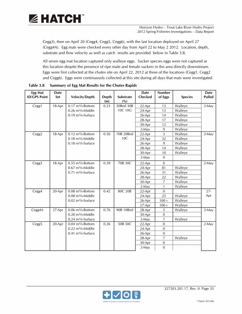
Horizon Hydro - Trout Lake River Hydro Project 2012 Spring Fisheries Investigations – Data Report
327203.201.17, Rev. 0 Page 35
© Hatch 2012/06
Cegg3), then on April 20 (Cegg4, Cegg5, Cegg6), with the last location deployed on April 27 (Cegg4A). Egg mats were checked every other day from April 22 to May 2 2012. Location, depth, substrate and flow velocity as well as catch results are provided below in Table 3.8.
All seven egg mat location captured only walleye eggs. Sucker species eggs were not captured at this location despite the presence of ripe male and female suckers in the area directly downstream. Eggs were first collected at the chutes site on April 22, 2012 at three of the locations (Cegg1, Cegg2 and Cegg6). Eggs were continuously collected at this site during all days that mats were investigated.
Table 3.8 Summary of Egg Mat Results for the Chutes Rapids
Egg Mat ID/GPS Point
Date Set
Velocity/Depth
Depth
(m)
Substrate
(%)
Date Checked
Number of Eggs
Species
Date Pulled
Cegg1 18-Apr 0.17 m³/s-Bottom 0.23 50Bed 30B 10C 10G
22-Apr 13 Walleye 2-May 0.26 m³/s-Middle 24-Apr 13 Walleye 0.19 m³/s-Surface 26-Apr 14 Walleye 28-Apr 17 Walleye 30-Apr 12 Walleye
2-May 9 Walleye Cegg2 18-Apr 0.12 m³/s-Bottom 0.50 70B 20Bed
10C 22-Apr 3 Walleye 2-May
0.18 m³/s-Middle 24-Apr 32 Walleye 0.18 m³/s-Surface 26-Apr 9 Walleye 28-Apr 14 Walleye 30-Apr 10 Walleye
2-May 0 Cegg3 18-Apr 0.55 m³/s-Bottom 0.39 70B 30C 22-Apr 0 2-May
0.67 m³/s-Middle 24-Apr 81 Walleye 0.71 m³/s-Surface 26-Apr 31 Walleye 28-Apr 22 Walleye 30-Apr 7 Walleye
2-May 1 Walleye Cegg4 20-Apr 0.08 m³/s-Bottom 0.42 80C 20B 22-Apr 0 27-
Apr 0.08 m³/s-Middle 24-Apr 25 Walleye 0.02 m³/s-Surface 26-Apr 100+ Walleye 27-Apr 100+ Walleye
Cegg4A 27-Apr 0.06 m³/s-Bottom 0.76 90B 10Bed 28-Apr 5 Walleye 2-May 0.20 m³/s-Middle 30-Apr 0 0.24 m³/s-Surface 2-May 7 Walleye
Cegg5 20-Apr 0.04 m³/s-Bottom 0.26 50B 50C 22-Apr 0 2-May 0.22 m³/s-Middle 24-Apr 0 0.41 m³/s-Surface 26-Apr 0 28-Apr 7 Walleye 30-Apr 0
2-May 0

Horizon Hydro - Trout Lake River Hydro Project 2012 Spring Fisheries Investigations – Data Report
327203.201.17, Rev. 0 Page 36
© Hatch 2012/06
Egg Mat ID/GPS Point
Date Set
Velocity/Depth
Depth
(m)
Substrate
(%)
Date Checked
Number of Eggs
Species
Date Pulled
Cegg6 20-Apr 0.06 m³/s-Bottom 0.39 90C10B 22-Apr 12 Walleye 2-May 0.11 m³/s-Middle 24-Apr 13 Walleye
0.20 m³/s-Surface 26-Apr 4 Walleye 28-Apr 5 Walleye 30-Apr 6 Walleye
2-May 3 Walleye Totals Walleye 575+ *S = Silt G = ravel C = Cobble B = Boulder Bed = Bedrock
After 15 days of sampling, egg collection ranged from 7 to 225+ eggs at an individual location. The egg mat that exhibited the lowest captures was Cegg5, while the mat with the highest captures was Cegg4.
Water depths at the chutes site ranged from 0.23 (Cegg1) to 0.76 m (Cegg4A). These locations had a substrate surface flow velocity range from 0.04 m³/s to 0.55 m³/s (Cegg3).
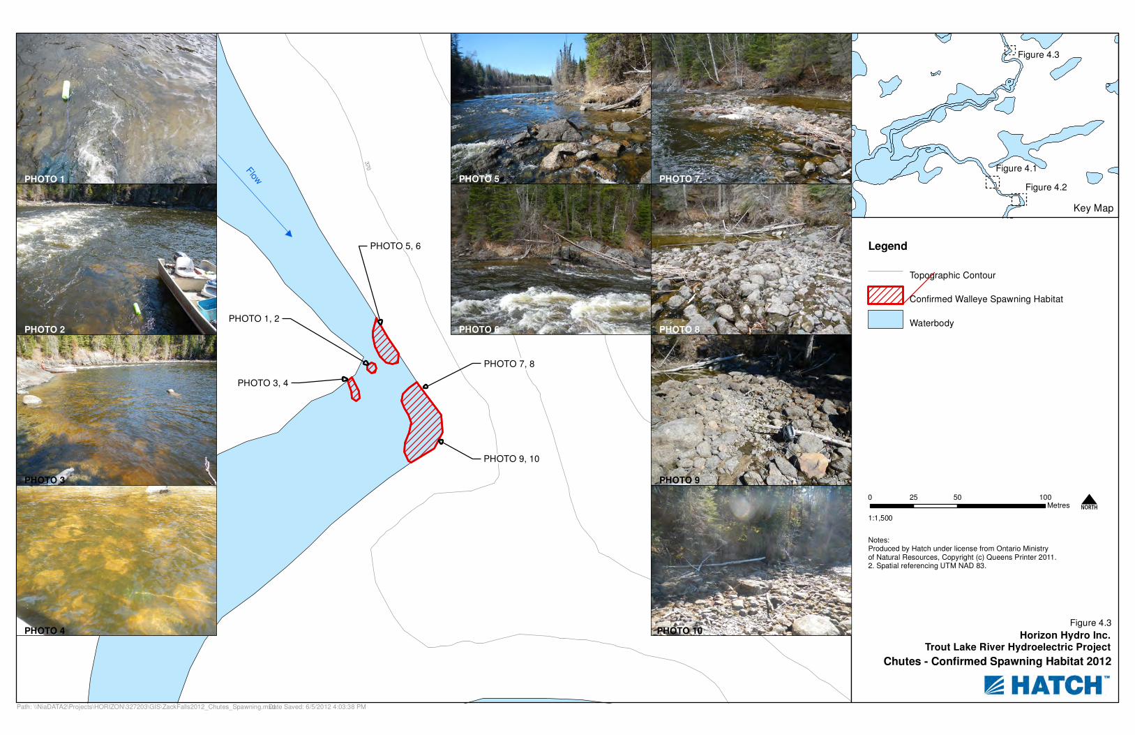
3.3.3 Spawning Habitat Four defined sections were found and confirmed for walleye spawning during the site investigation. Suitable spawning habitat was located on either side of the main flow channel through the Chutes area. Substrate characteristics, and habitat data for each egg mat location is noted in Table 3.8. Figure 4.3 indicates all of the areas located within the Chutes study site.
The majority of the suitable spawning habitat was located along the eastern shoreline against the bedrock wall in a large back eddy. Due to low water levels during the course of the investigation, portions of the east shoreline were not submerged, exposing a large cobble shoal near the bedrock wall at the end of the rapids. All egg mats placed along the edge of this location were successful in collecting walleye eggs throughout the entire duration of the study.
Substrates at these locations along the cobble shoal consisted of cobble (10-80%), boulder (20 to 70%) and bedrock (0 to 20%). Flow velocities along the substrate at these locations ranged from 0.08 m/s to 0.55 m/s in water depths of 0.39 m to 0.5 m. Egg collection was significantly higher at locations in this area. The total walleye spawning habitat in this area is 680 m², this includes the exposed shoal area as well. Due to the ideal cobble mixture combined with a higher water level an increase in suitable spawning habitat is anticipated.
The last section of spawning habitat located along the eastern side of the shore alongside the main flow path near the crest of the rapids. Two egg mats with walleye eggs captured and evidence of harvested ripe female walleye by a predator in this area confirm spawning. This area is 204 m² in size and contains substrate ranges of (50 to 90%) cobble and (10 to 50%) boulder. The substrate velocities in this area are 0.04 to 0.06 m at water depths of 0.26 m to 0.39 m.

Horizon Hydro - Trout Lake River Hydro Project 2012 Spring Fisheries Investigations – Data Report
327203.201.17, Rev. 0 Page 37
© Hatch 2012/06
The smallest area that was confirmed for walleye spawning at the chutes was directly west of the main flow at the base as the constricted area begins to widen. This area is 22m² and consists of 50% bedrock, 30% boulder, 10% cobble and 10% gravel. This area is protected by a bedrock outcrop with swirling flows around it. The flow velocity along the substrate was 0.17 m/s at a depth of 0.23 m.
The last section of suitable walleye spawning habitat that was observed at the Chutes was off of the bed rock wall to the north of the 90-deg bend in the river. This area was 90% Boulder and 10% bedrock. This area was in a back flow that was heading back to the main flow path. The substrate flow velocity reading was 0.06 m/s. Water depth at this location was 0.76 m. The total area of walleye spawning habitat was 43 m² for this location.

Horizon Hydro - Trout Lake River Hydro Project 2012 Spring Fisheries Investigations – Data Report
327203.201.17, Rev. 0 Page 38
© Hatch 2012/06
Blank back

Horizon Hydro - Trout Lake River Hydro Project 2012 Spring Fisheries Investigations – Data Report
327203.201.17, Rev. 0 Page 39
© Hatch 2012/06
4. Summary The following section summarizes the results obtained during the 2012 spring spawning survey.
4.1 Fisheries Table 4.1 summarizes the species and totals that were captured and processed at each site.
Table 4.1 Fish Catch Summary For Trout Lake River Sites Spring Survey
Species Head Pond Rapids Chutes Rapids Total
Number Percent
Composition Number Percent
Composition Number Percent
Composition Walleye 5 5.5 51 24.4 56 18.7 Northern Pike 4 4.4 52 24.9 56 18.7 White Sucker 76 83.5 42 20.1 118 39.3 Yellow Perch 4 4.4 64 30.6 68 22.7 Rock Bass 2 2.2 0 0.0 2 0.6 Totals 91 209 300
White sucker was the most abundant fish species overall, accounting for 39.3% of the total catch. White sucker was the most abundant species at the Head Pond Rapids, and the fourth most abundant species at the Chutes. Walleye and northern pike each comprised 18.7% of the total catch, and were both much more abundant at the Chutes than at the Head Pond Rapids. Ninety-one percent of the captured walleye were from the Chutes area, while only 9% (5 walleye) were collected at the Head Pond Rapids. Northern pike showed a similar pattern (93% at the Chutes, 7% at the Head Pond Rapids).
Table 4.2 provides a summary of spawning walleye observations at both sampling locations as well as walleye gonad condition. A total of 56 walleye were collected over the duration of the study with the majority of the captures coming from the Chutes study location (91.1%). Only one recaptured walleye was noted during this period. Based on information gathered during the study (water temperature, gonad conditions, egg collection) the spawning occurred over a long duration with no specific peak date. An early thaw and limited winter snow pack resulted in lower than normal river flows/water levels during the spring and may not have provided ideal spawning conditions for walleye. This combined to produce an earlier than normal spawning run, which may have been in factor for those females with reabsorbed eggs.
Table 4.2 Summary of Walleye Spawning Observations and Activity
Study Area Green Males
Ripe Males
Spent Males
Immature Females
Reabsorbed Females
Green Females
Ripe Females
Spent Females Totals
Head Pond Rapids
0 0 0 0 3 0 0 2 5
Chutes Rapids
0 33 1 2 1 4 10 0 51
Totals 0 33 1 2 4 4 10 2 56
Horizon Hydro - Trout Lake River Hydro Project 2012 Spring Fisheries Investigations – Data Report
327203.201.17, Rev. 0 Page 40
© Hatch 2012/06
Given the number of ripe and total walleye captured in the Chutes area indicates that this location the main spawning area between the Big Falls and the Chutes rapids. However minimal spawning did occur within the Head Pond rapids. The very low number of walleye captured downstream and within the Head Pond rapids indicates that this section of spawning area would be used most likely from resident fish within and downstream of the Head Pond rapids. Therefore, the chutes appears to be a critical spawning area for “the stomach area” populations of these species.
4.2 Spawning Habitat Summary Figures 3.2 and 3.3 illustrate the locations of egg collections at the Head Pond Rapids and the Chutes, while descriptions of spawning habitat are presented for each area. Factors taken into consideration in identifying spawning areas include the presence of ripe and/or spent males and females in close proximity to area with suitable habitat characteristics, direct observations of spawning behavior and/or the presence of eggs on egg mats.
Figures 4.1 and 4.2 present summaries of spawning habitat at the Head Pond Rapids, based on the factors noted above. At the Head Pond Rapids, there are 9 confirmed spawning locations that represent a total of 1551.6 m2 of walleye spawning habitat. White sucker spawning habitat was confirmed at 4 locations, and consists of a total of 1246 m2. A total of 1154 m2 of confirmed spawning habitat was overlapped between both walleye and white sucker in the Head Pond Rapids reach at three locations.
Figure 4.3 presents the summary of the spawning habitat for the Chutes Rapids reach. The chutes contained four areas that walleye spawning was confirmed representing a total of 1246 m2.
These results will be carried forward into an updated Class EA Environmental Report.

Flow
37
0
380
390
370
380
Upper Section of Headpond Rapids - Confirmed Spawning Habitat 2012
Date Saved: 6/15/2012 1:56:39 PMPath: P:\HORIZON\327203\GIS\ZackFalls2012_Headpond_UpperSpawning.mxd
Figure 4.1
PHOTO 1
PHOTO 1, 2
PHOTO 2
PHOTO 3
PHOTO 4
PHOTO 3
PHOTO 5
PHOTO 4, 5
PHOTO 6
Figure 4.1
Figure 4.2
Legend
Topographic Contour
Confirmed Walleye Spawning Habitat
Confirmed Walleye and White Sucker Spawning Habitat
Waterbody
0 50 10025Metres
1:1,500
N
Notes:Produced by Hatch under license from Ontario Ministryof Natural Resources, Copyright (c) Queens Printer 2011.2. Spatial referencing UTM NAD 83.
PHOTO 6
Horizon Hydro Inc.Trout Lake River Hydroelectric Project
Key Map

Horizon Hydro - Trout Lake River Hydro Project 2012 Spring Fisheries Investigations – Data Report
327203.201.17, Rev. 0 Page 42
© Hatch 2012/06
Blank back
370
360
370
Lower Section of Headpond Rapids -Confirmed Spawning Habitat 2012
Date Saved: 6/5/2012 3:50:06 PMPath: \\NiaDATA2\Projects\HORIZON\327203\GIS\ZackFalls2012_Headpond_LowerSpawning.mxd
Figure 4.2
PHOTO 1
PHOTO 2
PHOTO 3
PHOTO 4
PHOTO 12
Figure 4.1
Figure 4.2
Legend
Topographic Contour
Confirmed Walleye Spawning Habitat
Confirmed Walleye and White Sucker Spawning Habitat
Confirmed White Sucker Habitat
Waterbody
0 50 10025Metres
1:1,500
N
Notes:Produced by Hatch under license from Ontario Ministryof Natural Resources, Copyright (c) Queens Printer 2011.2. Spatial referencing UTM NAD 83.
PHOTO 5
PHOTO 6
PHOTO 7
PHOTO 8
PHOTO 9
PHOTO 10 PHOTO 11
PHOTO 1, 2
PHOTO 3, 4
PHOTO 5, 6
PHOTO 12PHOTO 7, 8, 9
PHOTO 10, 11
Horizon Hydro Inc.Trout Lake River Hydroelectric Project
Key Map

Horizon Hydro - Trout Lake River Hydro Project 2012 Spring Fisheries Investigations – Data Report
327203.201.17, Rev. 0 Page 44
© Hatch 2012/06
Blank back
Flow
380
37
0
390
380
370
Chutes - Confirmed Spawning Habitat 2012
Date Saved: 6/5/2012 4:03:38 PMPath: \\NiaDATA2\Projects\HORIZON\327203\GIS\ZackFalls2012_Chutes_Spawning.mxd
Figure 4.3
PHOTO 1
PHOTO 2
PHOTO 3
PHOTO 4 PHOTO 10
Legend
Topographic Contour
Confirmed Walleye Spawning Habitat
Waterbody
0 50 10025Metres
1:1,500
N
Notes:Produced by Hatch under license from Ontario Ministryof Natural Resources, Copyright (c) Queens Printer 2011.2. Spatial referencing UTM NAD 83.
PHOTO 5
PHOTO 6
PHOTO 7
PHOTO 8
PHOTO 9
PHOTO 1, 2
PHOTO 3, 4
PHOTO 5, 6
PHOTO 7, 8
PHOTO 9, 10
Key Map
Figure 4.3
Figure 4.2
Figure 4.1
Horizon Hydro Inc.Trout Lake River Hydroelectric Project

Horizon Hydro - Trout Lake River Hydro Project 2012 Spring Fisheries Investigations – Data Report
327203.201.17, Rev. 0 Page 46
© Hatch 2012/06
Blank back

Horizon Hydro - Trout Lake River Hydro Project 2012 Spring Fisheries Investigations – Data Report
327203.201.17, Rev. 0 Page 47
© Hatch 2012/06
5. References Environment Canada, 2012a. Canadian Climate Historical Daily Data (Ear Falls for April 2012). Accessed May 24, 2012. Available on-line at http://www.climate.weatheroffice.gc.ca/climateData/dailydata_e
O’Krafka, Z, 2012. Personal observations on the Trout Lake River in April 2012.
Ministry of Environment (MOE). 2009. Guide to Eating Ontario Sport Fish, 2009-2010. 25th Edition, Queen’s Printer for Ontario. ISBN-1712-8269 (on-line).
Scott, W.B. and E.J. Crossman. 1998. Freshwater Fishes of Canada. Galt House Publications Ltd. Oakville, Ontario.

Suite 500, 4342 Queen Street Niagara Falls, Ontario, Canada L2E 7J7 Tel 905 374 5200 Fax 905 374 1157