GEOTECHNICAL INVESTIGATION GEOTECHNICAL INVESTIGATION BUDA ...

Submissions Report Wellington Solar Farm
17-076 Final v1 E-I
APPENDIX D1 GEOTECHNICAL REPORT BY DOUGLAS PARTNERS

Report onGeotechnical Investigation
Proposed Solar FarmGoolma Road, Wellington, NSW
Prepared forFirst Solar (Australia) Pty Ltd
Project 91256.00 February 2018

Document History
Document details Project No. 91256.00 Document No. 91256.00.R.001.Rev0 Document title Report on Geotechnical Investigation
Proposed Solar Farm Site address Goolma Road, Wellington, NSW Report prepared for First Solar (Australia) Pty Ltd File name 91256.00.R.001.Rev0
Document status and review
Status Prepared by Reviewed by Date issued Revision 0 Michael Gawn John Harvey 22 February 2018
Distribution of copies
Status Electronic Paper Issued to Revision 0 1 0 Mirjam Tome, First Solar (Australia) Pty Ltd
The undersigned, on behalf of Douglas Partners Pty Ltd, confirm that this document and all attached drawings, logs and test results have been checked and reviewed for errors, omissions and inaccuracies.
Signature Date
Author 22 February 2018
Reviewer 22 February 2018
Douglas Partners Pty Ltd ABN 75 053 980 117
www.douglaspartners.com.au 15 Callistemon Close
Warabrook NSW 2304 PO Box 324
Hunter Region Mail Centre NSW 2310 Phone (02) 4960 9600
Fax (02) 4960 9601

Geotechnical Investigation, Proposed Solar Farm Project 91256.00Goolma Road, Wellington, NSW February 2018
Table of Contents
Page
1. Introduction .................................................................................................................................... 1
2. Site Description .............................................................................................................................. 2
3. Desktop Data Review ..................................................................................................................... 5
3.1 Regional Geology ................................................................................................................5
3.2 Soil Landscape Mapping .....................................................................................................6
3.3 Acid Sulfate Soil Risk Mapping ............................................................................................6
3.4 Previous Nearby DP Investigations .....................................................................................6
4. Field Work Methods ....................................................................................................................... 6
4.1 Overview ..............................................................................................................................6
4.2 Test Pits ...............................................................................................................................7
4.3 Test Bores ............................................................................................................................7
4.4 Soil Electrical Resistivity (ER) Testing .................................................................................8
5. Field Work Results ......................................................................................................................... 8
5.1 Bores and Pits ......................................................................................................................8
6. Laboratory Testing ....................................................................................................................... 11
6.1 Geotechnical Laboratory Testing .......................................................................................11
6.2 Geo-chemical .....................................................................................................................17
6.3 Electrical Resistivity ...........................................................................................................20
7. Proposed Development ................................................................................................................ 20
8. Comments .................................................................................................................................... 21
8.1 Appreciation of Site Conditions ..........................................................................................21
8.2 Soil and Rock Properties ...................................................................................................21
8.3 Soil Aggressiveness...........................................................................................................22
8.4 Soil Classification ...............................................................................................................22
8.5 Soil Erosion Dispersion Potential .......................................................................................23
8.6 Excavation Conditions .......................................................................................................24
8.7 Geotechnical Reuse of Excavated Materials .....................................................................25
8.8 Site Preparation and Earthworks Procedures ...................................................................25
8.9 Erosion Reduction Methods ...............................................................................................26
8.10 Site Trafficability .................................................................................................................27
8.11 Pavement ...........................................................................................................................27 8.11.1 Pavement Design Subgrade CBR ........................................................................27

Geotechnical Investigation, Proposed Solar Farm Project 91256.00Goolma Road, Wellington, NSW February 2018
8.11.2 Pavement Subgrade .............................................................................................28
8.12 Site Classification ...............................................................................................................29
8.13 High Level Footings ...........................................................................................................31
8.14 Reactive Soil Considerations .............................................................................................31 8.14.1 Seasonal Soil Cracking .........................................................................................31 8.14.2 Reactive Soil Movements .....................................................................................32 8.14.3 Ground Moisture Conditions .................................................................................33 8.14.4 Swelling Pressures ...............................................................................................36
8.15 Piles 36 8.15.1 Driven Piles ...........................................................................................................36 8.15.2 Lateral Capacity ....................................................................................................39
9. Recommended Additional Investigation ....................................................................................... 40
10. References ................................................................................................................................... 40
11. Limitations .................................................................................................................................... 41 Appendix A: CSIRO Sheet BTF 18 About This Report Sampling Methods Soil and Rock Descriptions Symbols and Abbreviations Appendix B: Test Pit Logs (Test Pits 1 to 20) Photoplates (Test Pits 1 to 20) Borehole Logs (Bores 21 to 34) Appendix C: eSpade Soil Technical Reports Appendix D: Results of Electrical Resistivity Testing (ER101 to ER110) Appendix E: Results of Laboratory Testing Appendix F: Drawing 1 - Test Location Plan

Page 1 of 42
Geotechnical Investigation, Proposed Solar Farm Project 91256.00Goolma Road, Wellington, NSW February 2018
Report on Geotechnical Investigation Proposed Solar Farm Goolma Road, Wellington, NSW 1. Introduction
This report presents the results of a geotechnical investigation undertaken for a proposed solar farm at Goolma Road, Wellington, NSW. The investigation was commissioned in an email by Mirjam Tome of First Solar (Australia) Pty Ltd and was undertaken in accordance with Douglas Partners Pty Ltd (DP) proposal NCL170734 (Rev 1) dated 20 December 2017. It is understood that the proposed development is to consist of a photovoltaic (PV) solar generating plant, including electricity generating equipment, in addition to access roads, service trenching, drainage works and a transmission line connecting with the existing Wellington Substation to the south of the site. The details of the development are further described in Section 7 of this report. The aim of the investigation was to assess the subsurface soil and groundwater conditions across the site, in order to provide comment on the following:
Site description, geology and site observations;
Subsurface and groundwater conditions at the field test locations;
Site classification for soil reactivity, based on the methods in AS 2870 – 2011 (Ref 1);
Subgrade design parameters, including California bearing ratio (CBR) values for pavement design by others;
Suitable pile footing options, including: o Ultimate unfactored end bearing and shaft adhesion pressures for the design of axially
loaded piles in compression and uplift; and o Lateral loading parameters for piles;
Recommendations for erosion control and prevention measures, including advice on erosion management during earthworks;
Results of soil electrical resistivity (ER) testing, for interpretation by others; and
Recommendations for additional investigation (if appropriate). The investigation included the drilling of fourteen boreholes, excavation of twenty test pits, soil ER testing at ten locations, and laboratory testing of selected samples. The details of the field work are presented in this report, together with comments and recommendations on the items listed above.

Page 2 of 42
Geotechnical Investigation, Proposed Solar Farm Project 91256.00Goolma Road, Wellington, NSW February 2018
2. Site Description
The site is located within two adjacent rural properties situated just outside the town of Wellington, NSW, and is bounded by Goolma Road to the south and east, Cobbora Road and neighbouring properties to the west, and further rural farmland to the north. The overall site area is approximately 492 hectares (Ha), and is currently used for agricultural purposes. The proposed solar arrays are understood to occupy approximately 256 Ha of the project area. The proposed transmission line will connect with the existing Wellington Substation, which is located to the immediate south of the project boundary along Goolma Road. The site topography is relatively level to slightly undulating across the majority of the site. Based on information provided by the client, the surface level at the site is about 360 m AHD. A summary of observed site features includes those described below:
Isolated rock outcrop areas;
Natural watercourses (Wuuluman Creek and tributaries), draining approximately east-west through the centre of the site (predominantly dry at the time of investigation);
Site vegetation typically comprised short grass and prickly weeds with sparse trees. The general features of the site are shown in Figures 1 to 6, below.
Figure 1: Overview of site’s southern portion (at Test Pit 10, facing approximately north-east)

Page 3 of 42
Geotechnical Investigation, Proposed Solar Farm Project 91256.00Goolma Road, Wellington, NSW February 2018
Figure 2: Overview of site’s far-western portion (at Test Pit 15, facing approximately north-east)
Figure 3: Overview of site’s western / central portion (at Bore 24, facing approximately south)

Page 4 of 42
Geotechnical Investigation, Proposed Solar Farm Project 91256.00Goolma Road, Wellington, NSW February 2018
Figure 4: Overview of site’s eastern / central portion (at Bore 26, facing approximately south)
Figure 5: Overview of site’s north-eastern portion (at Test Pit 16, facing approximately south)

Page 5 of 42
Geotechnical Investigation, Proposed Solar Farm Project 91256.00Goolma Road, Wellington, NSW February 2018
Figure 6: Overview of site’s south-eastern portion (at Test Pit 17, facing approximately north) 3. Desktop Data Review
A desktop review of available information was undertaken as part of the investigation. This included assessment of the following:
Regional geology;
Soil landscape mapping;
Acid sulfate soil mapping; and
Previous nearby investigations by DP. The results of the desktop data review are discussed in more detail in Sections 3.1 to 3.4. 3.1 Regional Geology
Reference to the Geological Survey of NSW State-wide Geodatabase, 1:250,000 scale geology map indicates that the site is predominantly underlain by the Oakdale Formation of the Cabonne Group, typically comprising volcanic sandstone and basalt. The far north-eastern portion of the site, however, is mapped as being underlain by the Mumbil Group, a sedimentary unit comprising siltstone and shale.

Page 6 of 42
Geotechnical Investigation, Proposed Solar Farm Project 91256.00Goolma Road, Wellington, NSW February 2018
3.2 Soil Landscape Mapping
Reference to the 1:250 000 soil landscapes map for Dubbo indicates that the site soils are Bodangora soils of the Euchrozems soil landscape group. Reference to the NSW Office of Water eSpade website indicates that several previous soil samples were taken either on site (including one just north of Wuuluman Creek and within the Aboriginal Heritage buffer zone) or in the immediate surrounding area. A review of the associated reports (Reports 1004444 [locations 64, 75 and 95], 1000224 and 1000349) indicate the following in relation to the near surface soils:
The soils have a slight to moderate erosion hazard;
They generally have a moderate to strong pedality;
pH levels ranging from around 6 to 9. A copy of these reports is included in Appendix C and the approximate location of the samples shown on Drawing 1. 3.3 Acid Sulfate Soil Risk Mapping
No acid sulfate soil risk mapping by the Department of Land Water Conservation (DLWC) is available for the site. However, given that the elevation of the site is around RL 300 m AHD and acid sulfate soils exist in some coastal areas where the elevation is below RL 10 AHD, but more generally below RL 5 AHD, DP does not consider ASS to be present at the site and they are not discussed further in this report. 3.4 Previous Nearby DP Investigations
Previous work undertaken by DP to the immediate east of the project boundary, in connection with the recently constructed correctional facility, indicated a predominately clayey profile to depths of up to approximately 10 m (limit of investigation). It is noted that, although the site lies in close proximity to the subject site, the subsurface conditions in each are characterised by different geological units. Laboratory testing undertaken during the previous investigation included shrink-swell testing and CBR testing on the clay soils. The two shrink-swell tests returned values of 1.1% and 2.0% whereas the two CBR tests returned values of 6%. 4. Field Work Methods
4.1 Overview
The field work was undertaken in the period 8 to 12 January 2018, and comprised the following:
Excavation of test pits;

Page 7 of 42
Geotechnical Investigation, Proposed Solar Farm Project 91256.00Goolma Road, Wellington, NSW February 2018
Drilling of test bores; and
Electrical resistivity testing. The test locations were set out by DP engineers to provide a geographic spread across the site and where access allowed. GPS coordinates (MGA) were recorded on the logs at all test locations, and were measured using a handheld receiver, which has a nominal accuracy of about ±10 m. The test locations are shown in Drawing 1, attached in Appendix F. The subsurface soil, rock and groundwater conditions were logged on site by DP personnel, who also recovered representative samples for identification purposes and laboratory testing. These investigation methods are discussed in more detail in Sections 4.2 to 4.4 below. 4.2 Test Pits
Excavation of twenty test pits (Pits 1 to 20). The pits were excavated to depths ranging between 1.75 m and 3.3 m depth, using a 14 tonne tracked excavator, equipped with a 450 mm wide bucket with rock teeth The pits were excavated to depths ranging from 1.7 m to 3.3 m but, more generally, to 3 m. Dynamic cone penetrometer (DCP) tests were undertaken at seventeen test locations to depths of up 0.9 m (based on a target depth of 1.2 m), to provide additional information on the near surface soil strength consistency / relative density. In situ testing comprising pocket penetration (pp) tests on cohesive materials were undertaken at selected depths within test pits, as appropriate. 4.3 Test Bores
Drilling of fourteen boreholes (Bores 21 to 34) using a purpose built geotechnical drilling rig. The bores were drilled to depths ranging from 1.8 m to 5.0 m using solid flight auger methods. Standard penetration tests (SPT) were undertaken at roughly 1.5 m depth intervals in the soil and weathered rock. Dynamic cone penetrometer (DCP) tests were carried out at in Bore 25 to 0.45 m depth to allow an assessment of the strength of near surface soils and potential indication of depth to rock. Standard penetration tests (SPTs) were carried out at regular intervals in most bores from 1 m depth.
Page 8 of 42
Geotechnical Investigation, Proposed Solar Farm Project 91256.00Goolma Road, Wellington, NSW February 2018
4.4 Soil Electrical Resistivity (ER) Testing
For the ER testing, an ABEM SAS3000C Terrameter transmitter/receiver was used to take vertical electrical soundings (VES), in accordance with the four point “Wenner” soil resistivity method, as summarised in Appendix D of AS/NZS 1768 – 2007 (Ref 11). Measurements were carried out at ten selected locations (defined as Arrays ER101 to ER110 as shown on Drawing 1), for which coordinates were obtained with a handheld GPS as outlined above. At each location, a centrally located and orthogonally oriented sounding was carried out to test for anisotropy in the results, which may indicate lateral variations in site conditions contrary to the assumptions of the sounding method (i.e. horizontal, homogeneous and isotropic layering) and as some measure of assessing interference (potentially services such as electricity). The field testing was carried out by a geotechnical engineer and the results are presented in Appendix D. 5. Field Work Results
5.1 Bores and Pits
The subsurface conditions encountered in the test locations are presented within the detailed borehole logs and test pit logs in Appendix B, together with notes explaining classification methods and descriptive terms used on the logs. The results of the DCP tests are presented graphically on the logs and are reported on the attached dynamic penetrometer test result sheet. Note that the test pits are presented at a different vertical scale to that of the borehole logs. The investigation yielded the presence of the following units:
UNIT 1: Predominantly silt topsoil to depths of 0.0 m to 0.25 m, but more typically 0.02 m;
UNIT 2.1: Gravelly clay / clayey gravel (hard / dense);
UNIT 2.2: Hard silty clays with trace to some sand and gravel; and
UNIT 3: Medium to high strength volcanic (meta) sandstone / siltstone, typically within a completely weathered matrix. Siltstone (sedimentary unit) was encountered atop a hill crest in the north-eastern portion of the site (Test Pit 16), with bedding plane orientated at approximately 20 degrees inclined towards the west.
The results of in situ testing and general site observations indicate that the clay units encountered were hard and residual (typical of completely weathered rock). A summary of the subsurface conditions encountered can be further summarised, categorised into the above units as shown in Table 1 and Table 2 below.

Page 9 of 42
Geotechnical Investigation, Proposed Solar Farm Project 91256.00Goolma Road, Wellington, NSW February 2018
Table 1: Summary of Subsurface Conditions (Test Pits)
Notes to Table 1 NE = Not encountered Ref = Refusal of excavator (1) Sandy clay from: a) 1.4m, b) 1.6m
(2) Sandy silt to 0.5m
(3) Sandy silty clay
Test Pit ID
Depth to Each Unit (m) Depth of
Investigation (m)
Unit 1 Topsoil
Unit 2.1 Gravelly Clay
Unit 2.2 Silty Clay
Unit 3 Bedrock
1 0.0 0.14 1.2 NE 3.0
2 0.0 0.25 0.75(1,a) NE 3.0
3 0.0 NE 0.1 1.8 3.0
4 0.0 0.1 0.35 0.9 2.65 (Ref)
5 0.0 NE 0.1 0.7 1.75 (Ref)
6 0.0 NE 0.03(2) NE 3.0
7 0.0 NE 0.12 1.9 3.0
8 0.0 NE 0.14 2.3 3.0
9 0.0 NE 0.18 1.0 3.0
10 0.0 NE 0.02 0.6 1.9 (Ref)
11 0.0 NE 0.2 NE 3.0
12 0.0 NE 0.25 0.8 3.0
13 0.0 NE 0.03 1.7 3.0
14 0.0 0.04 0.4 NE 3.0
15 0.0 NE 0.14(3) NE 3.3
16 0.0 NE NE 0.1 2.4 (Ref)
17 0.0 NE 0.1 0.7 3.0
18 0.0 NE 0.25 NE 3.0
19 0.0 0.12 0.45 NE 3.0
20 0.0 NE 0.03(1,b) NE 3.0

Page 10 of 42
Geotechnical Investigation, Proposed Solar Farm Project 91256.00Goolma Road, Wellington, NSW February 2018
Table 2: Summary of Subsurface Conditions (Boreholes)
Notes to Table 2 NE = Not encountered Ref = Refusal of drilling rig (TC-bit) (1) Topsoil not logged in some boreholes due to difficulty discerning between surface layer boundaries
(2) Siltstone (sedimentary unit)
(3) Clayey gravel (4) Rock structure evident from 2.5 m
Groundwater No free groundwater was observed in the test pits or the bores during the period they remained opened, except that slight seepage was observed within the base of Test Pit 14 (situated immediately adjacent to, and between, two tributaries of Wuuluman Creek). It should be noted that groundwater levels are affected by factors such as climatic conditions and soil permeability and will therefore vary with time.
Bore ID
Depth to Each Unit (m) Depth of
Investigation (m)
Unit 1 Topsoil
Unit 2.1 Gravelly Clay
Unit 2.2 Silty Clay
Unit 3 Bedrock
21 NE(1) NE 0.0 2.0(2) 5.0
22 0.0 0.02 NE 0.7 5.0
23 NE(1) NE 0.0 NE 5.0
24 NE(1) NE 0.0 2.8(2) 4.5 (Ref)
25 NE(1) NE 0.0 2.0 4.7 (Ref)
26 0.0 NE 0.02 1.2 2.0 (Ref)
27 NE(1) 3.5(3) 0.0 NE 5.0
28 NE(1) NE 0.0 NE(4) 3.82 (Ref)
29 NE(1) NE 0.0 NE 5.0
30 0.0 NE 0.15 1.15 1.8 (Ref)
31 0.0 NE 0.02 0.8 4.9 (Ref)
32 NE(1) NE 0.0 NE 3.1 (Ref)
33 NE(1) NE 0.0 4.0 4.2 (Ref)
34 NE(1) NE 0.0 NE 5.0

Page 11 of 42
Geotechnical Investigation, Proposed Solar Farm Project 91256.00Goolma Road, Wellington, NSW February 2018
6. Laboratory Testing
6.1 Geotechnical Laboratory Testing
Laboratory testing was carried out on samples retrieved from the pits and bores at DP’s NATA accredited laboratories. Each sample was submitted to the laboratory for one or more of the following:
Shrink-swell testing;
CBR / Standard Compaction;
Atterberg Limits;
Particle size distribution (grading) test; or
Emerson class number test. For the CBR testing each sample was compacted to approximately 100% Standard dry density ratio at the estimated optimum moisture content and then soaked for four (4) days under a surcharge loading of 4.5 kg prior to testing. The detailed results are presented in Appendix E and are further summarised in Table 3 to Table 7, as follows:
Table 3: Results of Laboratory Testing – Shrink-Swell Testing;
Table 4: Results of Laboratory Testing – California Bearing Ratio;
Table 5: Results of Laboratory Testing – Atterberg Limits;
Table 6: Results of Laboratory Testing – Gradings; and
Table 7: Results of Laboratory Testing - Emerson Testing .

Page 12 of 42
Geotechnical Investigation, Proposed Solar Farm 91256.00.R.001.Rev0Goolma Road, Wellington, NSW February 2018
Table 3: Results of Laboratory Testing – Shrink-Swell Testing
Pit / Bore
Depth (m)
Description FMC (%)
Iss (%)
Shrink(%)
Swell (%)
PP result prior to soaking
(kPa)
PP result after to soaking
(kPa) 2 0.85 – 1.3 Red brown mottled white SILTY CLAY 20.2 3.9 3.9 6.3 >600 200
6 0.55 – 0.82 Red brown SILTY CLAY with trace sand 14.7 0.6 1.1 -1.6 >600 85
7 0.55 – 0.95 Red brown SILTY CLAY with some gravel and trace sand 21.9 2.3 3.0 2.4 >600 350
11 0.45 – 0.9 Red brown SILTY CLAY with trace sand 19.7 1.7 2.6 0.8 >600 120
13 0.35 – 0.8 Red brown SILTY CLAY with trace sand 19.6 1.2 1.6 1.2 >600 115
14 0.95 – 1.25 Red brown SILTY CLAY with some sand 14.6 1.5 2.3 0.7 >600 470
15 0.65 – 0.91 Red brown SANDY SILTY CLAY with trace gravel 16.6 0.6 1.0 -0.9 >600 60
18 0.75 – 1.2 Red brown SILTY CLAY with trace sand 15.2 1.4 2.0 0.9 >600 160
21 0.4 – 0.69 Red brown SILTY CLAY with trace sand and gravel 17.6 0.8 1.4 0.2 >600 125
28 0.5 - 0.76 Red brown SILTY CLAY with trace sand 18.4 2.0 3.5 0.2 570 510
29 1.0 – 1.2 Red brown SILTY CLAY with trace sand 18.4 2.4 2.6 3.3 >600 220
32 0.5 – 0.73 Red brown SILTY CLAY with some sand 18.6 0.9 1.7 -0.2 >600 75
33 0.3 – 0.55 Red brown SILTY CLAY with trace sand 16.2 0.5 0.9 -1.2 >600 80 Notes to Table 3: FMC - Field moisture content Iss Shrink-swell index PP Pocket penetrometer

Page 13 of 42
Geotechnical Investigation, Proposed Solar Farm 91256.00.R.001.Rev0 Goolma Road, Wellington, NSW February 2018
Table 4: Results of Laboratory Testing – California Bearing Ratio
Pit/Bore
Depth (m)
Description FMC (%)
OMC (%)
MDD (t/m3)
CBR (%)
Swell (%)
From To
2 0.5 0.6 Red brown GRAVELLY CLAY with trace silty 10.8 14.5 1.86 10 1.5
3 0.3 0.4 Red brown SILTY CLAY with trace sand 18.9 25.0 1.6 13 0.5
6 0.3 0.4 Brown SANDY SILT with trace clay 10.3 16.0 1.77 10 0.5
8 0.3 0.4 Red brown SILTY CLAY with trace gravel 16.7 21.5 1.6 11 1.0
9 0.4 0.5 Red brown SILTY CLAY with trace sand 18.0 25.0 1.52 9 0.5
10 0.2 0.4 Red brown SILTY CLAY with trace sand and gravel 12.1 17.5 1.8 13 0.5
12 0.5 0.6 Red brown SANDY SILTY CLAY 8.4 14.5 1.88 11 -0.5
15 0.4 0.6 Red brown SILTY CLAY with trace sand 12.0 18.0 1.68 8 2.0
18 0.3 0.4 Red brown SANDY SILTY CLAY 8.7 14.5 1.85 10 0.5
19 0.3 0.4 Red brown GRAVELLY SILTY CLAY 8.6 14.0 1.89 10 0.0

Page 14 of 42
Geotechnical Investigation, Proposed Solar Farm 91256.00.R.001.Rev0 Goolma Road, Wellington, NSW February 2018
Table 5: Results of Laboratory Testing – Atterberg Limits
Pit/Bore Depth (m) Description FMC
(%) LL (%)
PL (%)
PI (%)
Linear Shrinkage
(%) 1 0.4 – 0.5 Red brown GRAVELLY CLAY with trace silt 8.0 35 13 22 -
7 0.4 – 0.5 Red brown SILTY CLAY with some gravel 19.0 53 14 39 -
8 1.5 Red brown SILTY CLAY with trace gravel 14.6 66 17 49 13
17 0.2 – 0.2 Extremely weathered meta-SILTSTONE 13.2 40 18 22 -
21 1 – 1.45 Red brown SILTY CLAY with trace sand 12.1 45 13 32 -
22 0.5 Red brown GRAVELLY SILTY CLAY 8.2 33 16 17 -
24 0.1 Red brown SILTY CLAY with some sand 15.7 36 15 21 -
24 0.5 Red brown SILTY CLAY with some sand 18.3 64 15 49 -
24 0.85 Pale brown SILTY CLAY with trace sand 10.3 40 10 30 13.5
25 0.5 Red brown SILTY CLAY with trace sand 16.6 55 14 41 -
25 1 – 1.45 Red brown SILTY CLAY with trace sand 16.6 61 21 40 -
26 0.1 Red brown SILTY CLAY with trace sand 4.1 23 19 4 -
27 0.5 Red brown SILTY CLAY with trace sand 18.3 66 13 53 17
27 1 – 1.45 Red brown SILTY CLAY with trace sand 15.3 60 13 47 -
28 2.5 – 2.95 Red brown SILTY CLAY with trace gravel 19.7 61 23 38 -
29 1.5 – 1.95 Red brown SILTY CLAY with trace sand 15.4 66 13 53 -
30 0.5 Pale brown SILTY CLAY with trace gravel 8.7 42 13 29 -
31 0.2 Red brown SILTY CLAY with some gravel 8.0 37 15 22 -
33 1 – 1.45 Red brown SILTY CLAY with trace sand 20.6 72 16 56 13
33 2.5 – 2.95 Red brown SILTY CLAY with trace sand 17.3 61 12 49 -
34 2.5 – 2.95 Red brown SILTY CLAY with trace sand 10.3 34 14 20 -

Page 15 of 42
Geotechnical Investigation, Proposed Solar Farm Project 91256.00Goolma Road, Wellington, NSW February 2018
Table 6: Results of Laboratory Testing – Gradings
Pit/Bore Depth (m) Description
Silt and clay (%)
Sand (%)
Gravel (%)
1 0.4 – 0.5 Clayey gravel with sand 29 16 55
3 0.3 – 0.4 Silty clay with trace sand and gravel 81 11 8
4 0.4 – 0.5 Silty clay with gravel and trace sand 73 11 16
6 0.3 – 0.4 Sandy silt with trace gravel 60 36 4
7 0.4 – 0.5 Silty clay with sand and trace gravel 72 17 11
9 0.4 – 0.5 Silty clay with sand and trace gravel 81 16 3
12 0.5 – 0.6 Sandy silty Clay with trace gravel 52 38 10
13 0.4 – 0.5 Silty clay with sand and trace gravel 78 19 3
14 0.5 – 0.6 Silty clay with sand and trace gravel 73 22 5
14 2.5 Clayey sand with trace gravel 45 53 2
17 0.2 – 0.4 Silty clay with sand and gravel 56 18 26
18 0.3 – 0.4 Sandy silty clay with trace gravel 64 34 2
19 0.3 – 0.4 Silty clay with gravel and trace sand 71 4 25
28 1 – 1.45 Silty clay with sand and trace gravel 77 20 3
32 1 – 1.45 Silty clay with trace sand 90 10 0

Page 16 of 42
Geotechnical Investigation, Proposed Solar Farm Project 91256.00Goolma Road, Wellington, NSW February 2018
Table 7: Results of Laboratory Testing - Emerson Testing
Pit / Bore Depth (m) Description Emerson Class
No 4 0.6 Red brown SILTY CLAY with some gravel 5
10 0.4 Red brown SILTY CLAY with trace sand 5
11 0.4 Red brown SILTY CLAY with trace sand 5
12 0.4 Red brown SANDY SILTY CLAY 5
17 0.5 Red brown SILTY CLAY with some gravel 5
18 0.2 Red brown SILY CLAY with trace sand 5
20 0.5 Red brown SILTY CLAY with trace sand 5
21 0.1 Red brown SILTY CLAY with trace sand 5
22 0.5 Red brown GRAVELLY SILTY CLAY with trace sand 5
24 0.1 Red brown SILTY CLAY with some sand 6
24 0.5 Red brown SILTY CLAY with some sand 5
24 0.85 Pale brown SILTY CLAY with trace sand 4
25 0.5 Red brown SILTY CLAY with trace sand and gravel 5
26 0.1 Red brown SILTY CLAY with trace sand 6
27 0.5 Red brown SILTY CLAY with trace sand 3
28 0.1 Red brown SILTY CLAY with trace sand 4
29 0.1 Red brown SILTY CLAY with trace sand 3
30 0.5 Pale brown SILTY CLAY with trace gravel 5
32 0.1 Red brown SILTY CLAY with some sand 5 Notes to Table 7
Emerson Class No (AS1289.3.8.1)

Page 17 of 42
Geotechnical Investigation, Proposed Solar Farm Project 91256.00Goolma Road, Wellington, NSW February 2018
6.2 Geo-chemical
Fifteen selected soil samples were submitted to Envirolab Service Pty Ltd for analysis of the following:
Soil aggressiveness / durability testing, comprising the following analytes:
o pH;
o Electrical conductivity (EC);
o Sulphates (SO4); and
o Chlorides (Cl).
Soil agronomy / agricultural tests on topsoil material, as follows:
o pH;
o EC;
o Exchangeable sodium percentage (ESP);
o Cation exchange capacity (CEC);
o Colwell phosphorus (Colwell P);
o Phosphorus buffering index (PBI);
o Calcium: magnesium ratio (Ca: Mg);
Soil agronomy / agricultural tests on deeper soils, as follows:
o pH;
o EC;
o Emerson aggregate (dispersion). Detailed laboratory report sheets are provided in Appendix E and are summarised in Table 8 to Table 10, below.

Page 18 of 42
Geotechnical Investigation, Proposed Solar Farm 91256.00.R.001.Rev0Goolma Road, Wellington, NSW February 2018
Table 8: Results of Aggressivity Testing
Pit Depth (m) Description Soil
Condition pH
(concrete) pH
(steel)
Resistivity(1) (Ω.cm) (steel)
SO4 (ppm)
(concrete)
Cl (ppm) (steel)
1 1.3 Red brown SILTY CLAY B 7.5 7.5 25000 <10 10
2 2 Pale brown SANDY CLAY B 6.9 6.9 2000 120 570
4 0.2 Brown GRAVELLY CLAY B 7 7 33333 <10 10
5 0.4 Red brown SILTY CLAY B 6.8 6.8 100000 <10 <10
6 2 Red brown SANDY SILTY CLAY B 9.2 9.2 5556 45 80
8 0.7 Red brown SILTY CLAY B 7.9 7.9 43478 <10 <10
8 2 Grey and brown SILTY CLAY B 9 9 19608 <10 20
9 0.6 Red brown SILTY CLAY B 8.1 8.1 10000 <10 <10
11 1.5 Red brown SILTY CLAY B 8.7 8.7 13889 <10 <10
12 1.2 Extremely low strength meta SILTSTONE B 8 8 66667 <10 <10
14 0.2 Grey GRAVELLY SILTY CLAY B 5.7 5.7 14925 22 79
15 1 Red brown SANDY SILTY CLAY B 7.5 7.5 12987 21 21
18 1.5 Red brown SILTY CLAY B 8.4 8.4 16129 <10 <10
19 2 Red brown SILTY CLAY B 8.3 8.3 8333 <10 <10
Notes to Table 8 Non‐aggressive
Mildly aggressive
Moderately aggressive
Severely Aggressive
Very Severe
NT 1 Resistivity calculated based on inverse of conductivity in aqueous solution results
Scale of aggressivity based on threshold values given in AS 2159 – 2009: Piling – Design and Installation.

Page 19 of 42
Geotechnical Investigation, Proposed Solar Farm 91256.00.R.001.Rev0Goolma Road, Wellington, NSW February 2018
Table 9: Results of Laboratory Testing – Agronomy Testing
Pit /
Bor
e
Dep
th
(m)
Des
crip
tion
Soil pH
Electrical Con
ductivity
(µS/cm
)
Phosph
orus (C
olwell)
(mg/kg)
Phosph
orus Buffer Ind
ex
(mg/kg)
Exchan
geab
le Ca
(meq
/100
g)
Exchan
geab
le K
(meq
/100
g)
Exchan
geab
le M
g (m
eq/100
g)
Exchan
geab
le Na
(meq
/100
g)
Catio
n Exchan
ge
Capa
city
(meq
/100
g)
ESP
(%)
Calcium
(mg/kg)
Magne
sium
(m
g/kg)
3 0.05 Brown clayey silt (topsoil) 7.2 100 25 760 15 3.1 3.7 <0.1 22 <1 3100 1900
8 0.05 Brown sandy silt (topsoil) 6.8 100 31 570 13 2.2 3.9 <0.1 19 <1 2900 2400
9 0.1 Brown slightly sandy silt (topsoil) 7 91 63 480 19 3.3 3.7 <0.1 26 <1 4000 1200
12 0.01 Brown slightly sandy silt (topsoil) 5.5 300 97 560 6.6 2.5 1.7 <0.1 11 <1 1900 3000
13 0.01 Brown sandy silt (topsoil) 5.9 160 30 600 10 2.3 3.4 <0.1 16 <1 2700 1900
17 0.05 Brown clayey silt (topsoil) 6.3 150 42 560 13 3.9 3.2 <0.1 20 <1 2900 1400
18 0.01 Brown sandy silt (topsoil) 5.5 340 58 350 7.5 2.4 2.1 <0.1 12 <1 1700 1800
22 0.05 Brown slightly sandy silt (topsoil) 6.1 110 58 1600 9.3 2.1 2.3 <0.1 14 <1 1400 1800
Notes to Table 9ESP = exchangeable sodium percentage

Page 20 of 42
Geotechnical Investigation, Proposed Solar Farm 91256.00.R.001.Rev0Goolma Road, Wellington, NSW February 2018
Table 10: Results of Laboratory Testing – Agronomy Testing (Continued)
Pit / Bore Depth (m) Description pH
Electrical Conductivity
(µS/cm) Emerson
Aggregate
1 0.5 Red brown GRAVELLY CLAY/CLAYEY GRAVEL 6.9 21 3b
3 0.5 Red brown SILTY CLAY 6.7 34 5
4 0.5 Red brown SILTY CLAY 7.1 38 5
7 0.5 Red brown SILTY CLAY 6.9 41 5
7 2 Extremely low strength meta-SILTSTONE 8.3 75 3b
9 0.9 Red brown SILTY CLAY 8.3 72 5
13 0.05 Red brown SILTY CLAY 7.9 64 7
13 1.2 Red brown SILTY CLAY 8.7 500 3b
14 0.6 Red brown SILTY CLAY 7.9 42 4
14 0.9 Red brown SILTY CLAY 8.4 120 3b
17 0.3 Red brown SILTY CLAY 7.6 28 5
18 2.2 Red brown SILTY CLAY 8.6 270 1
19 1 Red brown SILTY CLAY 8.1 24 3b
24 2.5 Pale brown SILTY CLAY 9.1 73 4
32 0.05 Red brown SILTY CLAY 7.5 15 5
32 2 Red brown SILTY CLAY 8.2 110 4
Notes to Table 10: 3b = moderate to slight dispersion of the remould 6.3 Electrical Resistivity
Electrical resistivity testing was undertaken at 10 locations across the site. The vertical electrical sounding sheets are provided in Appendix D. All field measurements were considered stable and repeatable. 7. Proposed Development
It is understood that the proposed development is to comprise a solar farm array over parts of the site. The farm will include photovoltaic solar generating plant, including electricity generating equipment, in addition to access roads, service trenching, drainage works and a transmission line connecting with the Wellington Substation. No information in relation to the loads on piles has been provided to DP.

Page 21 of 42
Geotechnical Investigation, Proposed Solar Farm 91256.00.R.001.Rev0Goolma Road, Wellington, NSW February 2018
8. Comments
8.1 Appreciation of Site Conditions
The pertinent characteristics of the site and subsurface conditions are further summarised as follows:
Variable depth to bedrock, ranging from 0.1 m (Pit 16) to greater than 3 m depth in the pits/bores. It is also noted that rock outcrops were observed throughout the site;
The strength of the bedrock was generally extremely low to very low strength, however, higher strength rock is exposed within the outcrops. Excavator refusal was encountered in a number of pits across the site as shown in Table 1;
Groundwater was not generally encountered in the pits or bores within the investigation depths. It is possible, however, that groundwater seepage may be encountered at the soil rock interface; and
Testing of the clay soils indicates that it is of intermediate to high plasticity, although only moderate shrink-swell indices were returned during testing. It is noted, however, that appreciable softening occurring in the majority of the samples during the soaking phase (in some instances softening from greater than 600 kPa to less than 80 kPa).
8.2 Soil and Rock Properties
Table 11, below, outlines the generalised material and strength properties for the different types of soil and rock that were encountered in the field investigation. Table 11: Suggested Material and Strength Parameters
Material Unit
Weight (kN/m3)
Drained Cohesion, c’
(kPa)
Drained Angle of Friction, ɸ' (degrees)
Undrained Shear Strength,
Cu (kPa)
Residual Clay and Sandy Clay
Unit 2.1 and 2.2 - Hard 19 – 22 3 – 6 25 – 29 50 – 100(3)
Bedrock
Unit 3 - Extremely low to very low strength or stronger
20 – 23 5 – 10 28 – 33 300 – 500
Engineered Level 1 filling(2) 19 - 21 2 - 3 25 - 28 75 – 100
Note to Table 11 (1) Lower bound properties should be used (with the exception of Unit Weight) unless higher values can be substantiated by
testing. (2) Filling compacted under Level 1 testing and inspection to at least 98% Standard maximum dry density ratio (3) The suggested undrained shear strength has been reduced owing to the appreciable softening during the soaking phase
of shrink-swell testing. It will be important to ensure that the foundation material is not allowed to be exposed to weather conditions prior to casting of footings

GeotecGoolm
8.3
The rindicaconcrReferconcrand t 8.4
The rto higexpecrespoFigur
Figur
chnical Investigma Road, Welling
Soil Aggr
results of pHate that, in grete piles anrence shouldrete cover tohe minimum
Soil Class
results of thegh plasticity cted to exhibonse to variare 1, below s
re 1: Result
ation, Proposedgton, NSW
ressivenes
H, chloride ageneral, the snd “non-aggd be made o reinforcem concrete str
sification
e laboratory tclay (CI to
bit a moderatations in moishows the res
ts of Atterbe
d Solar Farm
s
and sulphatesoils are clasressive to mto Tables 6.
ment requiredrength appro
testing indicao CH) soils, te to high posture contentsults of the A
erg limit det
e ion concenssed either amildly aggres.4.3 of AS 2d (for concreopriate for the
ate that the rin accordan
otential for vot. The clay s
Atterberg limi
terminations
ntration anaas a “non-agssive” for st
2159 – 2009 ete piles), bae indicated s
residual silty nce with theolumetric chasoils with lests testing.
s
lyses (refer ggressive” exteel piles wi(Ref 1) to d
ased on this ite condition
clay soils are USCS, whanges (i.e. shss sand conte
91256.
Table 8 of xposure clasith respect tdetermine th exposure cs.
re generally hich would ghrinkage andtent are of hi
Page 22 of 42
00.R.001.Rev0February 2018
Section 6.2)ssification forto resistivity.he minimum
classification,
intermediategenerally bed swelling) ingh plasticity.
2
) r .
m ,
e e n .

Page 23 of 42
Geotechnical Investigation, Proposed Solar Farm 91256.00.R.001.Rev0Goolma Road, Wellington, NSW February 2018
8.5 Soil Erosion Dispersion Potential
Testing was undertaken on soil samples retrieved from the bores and pits within the upper 1 m of the soil profile. The Emerson testing returned predominantly a value of 5, indicating a low risk of dispersion. A number of samples of the silty clay, however, returned values of 3 and 4, which is indicative of an increased propensity for dispersion. Figure 2 below shows the results of the Emerson testing with depth and Figure 3 shows a histogram of the results.
Figure 2: Graphical Representation of Emerson Class testing
Figure 3: Histogram of Emerson Class testing results The results of the electrical conductivity testing returned values ranging from 28 to 500 µS/cm, but generally below 300 µS/cm. Using a textural classification conversion factor of 8 for light to medium clays, this converts to an ECe in the range of around 0.1 to 4 dS/m, but generally less than 2.5 dS/m. Generally saline soils are defined as those having a ECe of greater than 4 dS/m. Therefore, the soils tested from the site are considered to be non-saline. All eight samples testing for exchangeable sodium percentage (ESP) returned results of less than 1, which is not indicative of dispersive soils. These soils are classified as non-sodic in nature.
0
0.5
1
1.5
2
2.5
3
0 1 2 3 4 5 6 7 8
Dep
th (m)
Emerson Class
Emerson Class
0
5
10
15
20
1 2 3 4 5 6 7 More
Freq
uency
Emerson Class
Histogram of Emerson Class Testing Results

Page 24 of 42
Geotechnical Investigation, Proposed Solar Farm 91256.00.R.001.Rev0Goolma Road, Wellington, NSW February 2018
The results of the chemical testing were also used to derive the Calcium:Magnesium ratio. The eight samples tested returned ratios ranging from 0.38 to 1.2. Reference to information provided on the Department of Agriculture website (Vegetable SOILpak) indicates that soils with a Ca:Mg ratio of less than 1 have a propensity to disperse. Therefore, based on the results of the investigation, it is considered that the soils have a slight to moderate propensity for erosion. In this regard, minor signs of erosion (rilling) were noted in areas across the site. The definitions in the eSpade website indicate that a slight hazard is defined as “the combination of slope, runoff / run-on and soil erodibility is such that no appreciable erosion damage is likely to take place”. Similarly, a moderate hazard is defined as “significant short-term soil erosion may occur as a result of the combination of steep gradient, high soil erodibility and adverse runoff/run-on factors. Control can be obtained with such management techniques as topsoiling, vegetative techniques, phasing development and the implementation of structural works”. Measures to further reduce the risk of erosion and dispersion of the site soils and any fill platforms are discussed in Section 8.9 of this report. 8.6 Excavation Conditions
Based on the results of the test pits (using a 14 tonne excavator) and the test bores, it is considered that excavation of the soils and the extremely low strength rock is expected to be generally achievable using conventional machinery such as a 20 tonne hydraulic excavator to depths of up to test pit refusal. Refusal was encountered in a number of the pits and bores at depths ranging from 1.6 to 2.0 m. It is noted, however, that penetration of up to 1.5 m into the bedrock was achieved using the excavator. The results of the bores indicated that the rock was initially low to very low strength but increased in strength to at least low / medium strength within about 0.5 m to 1.5 m depth. Standard penetration testing in the bedrock generally refused after about 0.3 m penetration into the bedrock. The refusal depths in the pits may correspond to depths at which light ripping methods would refuse and medium / heavy ripping may be required. It is important to note, however, that excavatability of rock is dependent not only on rock strength, but also on the presence, orientation and extent of discontinuities such as jointing / bedding and fracturing of the rock, the presence of favourable and adverse bedding planes, presence of groundwater and other factors. For example, low strength rock with few discontinuities may be more difficult to excavate than highly fractured, high strength rock. It is noted that isolated outcrops of bedrock are present throughout the site. Differential weathering within these outcrops may result in higher strength characteristics and hence greater difficulty during excavation. Additional investigation, including cored bores and seismic refraction surveys, should be undertaken if assessment of rock rippabilities is important to project costings.

Page 25 of 42
Geotechnical Investigation, Proposed Solar Farm 91256.00.R.001.Rev0Goolma Road, Wellington, NSW February 2018
8.7 Geotechnical Reuse of Excavated Materials
The investigation encountered topsoil, gravelly clay and silty clay, underlain by siltstone bedrock. It is recommended that the grass vegetation and topsoil be stripped from the surface and stockpiled for re-use in landscaping, where required. It is suggested that topsoil contain at least 20% (by volume) organic materials, and the use of fertilisers may be used to promote growth within topsoil. The gravelly clay and silty clay is considered geotechnically suitable for re-use as engineered filling; however, depending on soil moisture conditions during construction moisture conditioning, either wetting up or drying back should be allowed for. Due to potential reactive movements of this material and potential for poor trafficability when wet (i.e. exposed to moisture ingress) it is preferred that these materials be used at least 0.6 m below the finished site surface to reduce the surface heave movements of the fill platform and also due to poor trafficability when wet. The excavated rock is considered geotechnically suitable for re-use as engineered fill. Rock particles greater than 200 mm produced during excavation will require crushing to render them suitable for re-use within either bulk filling or unsealed pavements. Adding moisture to rock fill is likely to be required during construction. If excavated material is to be removed off the site, then a waste classification assessment will generally be required. The scope of the current geotechnical investigation did not include sampling and testing for waste classification or contamination assessment purposes, as it is expected that all excavated materials will be re-used on site. If required to be taken off site, all excavated materials will need to be disposed of in accordance with the current Waste Classification Guidelines (NSW EPA 2014). This includes any filling and natural materials, such as may be removed from site. Accordingly, environmental testing would need to be carried out to classify spoil to be taken off site. The type and extent of testing undertaken will depend on the final use or destination of the spoil, and requirements of the receiving site. No obvious signs of contamination were observed during the field work. 8.8 Site Preparation and Earthworks Procedures
The following site preparation and earthworks procedures are recommended for the placement of engineered filling across the site:
Strip all vegetation and topsoil which contains organic matter (generally less than 0.1 m encountered during this investigation) and grub out all significant roots;
The exposed material surface should be inspected by a geotechnical engineer to check for excessively wet areas or weak zones, which may require removal and replacement. There is a high risk that the upper clay material may soften in the event that they become wet;
Approved filling should be placed in near-level, loose layer thicknesses not exceeding 300 mm and compacted to a range of 100% to 103% Standard dry density ratio, at a moisture content within the range from -4% OMC to OMC where OMC is the Standard optimum moisture content;

Page 26 of 42
Geotechnical Investigation, Proposed Solar Farm 91256.00.R.001.Rev0Goolma Road, Wellington, NSW February 2018
Earthworks construction procedures should be subject to Level 1 geotechnical inspections and testing as detailed in AS 3798 – 2007 (Ref 2), which requires field density testing within each layer of filling, together with careful control of moisture content, layer thickness, compaction achieve and material constituents. At this site, it is important to recognise that the site-won material will comprise a combination of residual clays and excavated weathered bedrock. If upper bound strength parameters are to be attributed to the placed engineered filling, careful selection of filling materials (i.e. mixing of clays and excavated rock) should be undertaken to improve the filling characteristics; and
The success of the earthworks relies heavily upon the competency of the earthworks contractor and of the geotechnical testing and inspection authority (GITA).
Further comments on additional measures to reduce the risk of erosion across the site are provided in Section 8.9. Similarly, comments on site trafficability are provided in Section 8.10. Reference should also be made to Section 8.15.2 which provides additional measures in the event that lateral pile capacity design is to consider ignoring a lesser depth of the design crack for the site. 8.9 Erosion Reduction Methods
The laboratory testing indicated that the silty clay generally has a slight to moderate susceptibility to dispersion/erosion; however, a number of samples indicated a slightly higher risk (returning Emerson class results of 3 and 4). This risk of erosion can be reduced provided the following are undertaken:
Compaction of fill to at least 98% Standard compaction as outlined below:
Moisture conditions of the clay materials within the ‘borrow area’ to the moisture content range described in Section 8.8;
Fill material (i.e. gravelly clays and clays) are appropriately compacted, moisture conditioned and slopes battered at a maximum of 3H:1V;
Fill bench with batter slopes of 3H:1V which will allow ease of access for maintenance of batter vegetation and drainage;
Permanent batter slopes should be vegetated as soon as possible, to reduce the risk of significant soil erosion occurring;
Topsoil (with minimum thickness of 100 mm and a maximum of 200 mm thickness) and vegetation to be provided on exposed batters or cuts. Hydro-mulching should be considered to promote growth;
Adequate surface drainage is provided to reduce surface and seepage water flows;
Contour drains along the crest of both cut and filling batters should be provided to reduce the potential for erosion. Such drains should be vegetated or gravel-lined, as appropriate for the expected flows;
An upslope diversion bund or swale drain to divert overland away from the site;
Erosion protection such as rip-rap or concrete at high flow drainage points;
Short term erosion measures such as silt fencing, hay bales etc., where required during construction;

Page 27 of 42
Geotechnical Investigation, Proposed Solar Farm 91256.00.R.001.Rev0Goolma Road, Wellington, NSW February 2018
Such drains should be vegetated or concrete-lined, as appropriate for the expected flows. The use of rip-rap (rockfill) blankets or extensive re-vegetation may be required to dissipate stormwater flows at the location of drain outlets or previously eroded areas if encountered; and
Earthfill adjacent to pipes and other structures passing through embankments should be stabilised with hydrated lime or gypsum, to reduce the shrink-swell and soil erosion potential. Preliminary planning may be based on a dosage rate of 2-3% (by dry mass) with the final rate determined by a programme of laboratory stabilisation trials.
8.10 Site Trafficability
The use of site-won crushed rock filling (with particles less than two-thirds of the layer thickness) is expected to be suitable for a working platform during construction, if required, and also for a temporary surface layer for unformed roads and temporary access pavement for construction. An imported roadbase gravel material is expected to be more suited for long term use within the access roads. 8.11 Pavement
The layout of any proposed roads is not known at this stage. It is likely that a series of roads will be constructed across the site.
8.11.1 Pavement Design Subgrade CBR
The anticipated subgrade conditions are expected to comprise natural silty clay or sandy clay, or engineered fill. Depending on the final bulk earthworks, bedrock may also be exposed at nominal subgrade level. Figure 4, below, shows the results of the 4 day soaked CBR testing undertaken on samples across the site.
Figure 4: Histogram of Soaked CBR results Based on the investigation results and Douglas Partners’ experience with such soils and weathered rock, the design subgrade CBR value of 7% for the clayey soils and 10% for re-used rock as fill materials should be adopted.
0
1
2
3
4
5
6
0 2 4 6 8 10 12 14 More
Freq
uency
CBR (%)
Histogram of Soaked CBR
Frequency

Page 28 of 42
Geotechnical Investigation, Proposed Solar Farm 91256.00.R.001.Rev0Goolma Road, Wellington, NSW February 2018
If the subgrade moisture content becomes wet of optimum moisture content at the time of construction, drying back to near optimum moisture content or use of a select layer, to facilitate compaction of overlying pavement materials may be required, but, is dependent on soil moisture conditions at the time of construction. In this regard, the subgrade samples tested indicate field moisture contents ranging from 4% dry to 7% dry of optimum moisture content (OMC) at the time of investigation. Geotechnical inspection should be undertaken during construction to confirm the subgrade conditions and the requirements for subgrade improvements (such as select layers, moisture reconditioning, bridging layers, removal and replacement of localised areas, and or lime stabilisation etc.), if required. The subgrade parameters presented above are dependent on the provision and maintenance of adequate surface drainage for all pavements. Adequate surface drainage should be provided to avoid water ponding at the surface and minimise the ingress of water in to the pavement materials.
8.11.2 Pavement Subgrade
The following subgrade preparation measures are recommended for preparation of the pavement subgrade:
Excavate to design subgrade level. The surface should be sloped to ensure water does not pond over the materials;
Strip all vegetation and topsoil which contains organic matter (generally about 0.1 m encountered during this investigation) and grub out all significant roots;
The exposed subgrade material surface should be inspected by a geotechnical engineer to check for excessively wet areas or weak zones, and assess if pavement should be constructed over natural subgrade or of subgrade treatment such as drying back, removal and replacement, select and/or bridging layer if required. There is a risk that the silty sand may soften in the event that they become wet;
Where suitable subgrades are encountered, the subgrade should be compacted to at least 100% Standard dry density ratio, as measured by AS 1289.5.1.1, at a moisture content within the range from -4% OMC to -1% OMC, where OMC is the optimum moisture content as measured by AS 1289.5.1.1;
For new filling to raise the subgrade level, place and compact the engineered fill with a CBR of not less than the design subgrade CBR to 100% Standard dry density ratio, at a moisture content within the range from -3% (dry) of OMC to OMC;
Earthworks construction procedures should be subject to Level 2 geotechnical inspections and testing as detailed in AS 3798 – 2007 (Ref 2), which requires at least one field density test per layer of filling placed for each designed lot;
Placement and compaction of pavement gravels.

Page 29 of 42
Geotechnical Investigation, Proposed Solar Farm 91256.00.R.001.Rev0Goolma Road, Wellington, NSW February 2018
8.12 Site Classification
Site classification of foundation soil reactivity provides an indication of the propensity of the ground surface to move with seasonal variation in moisture. Based on procedures presented in AS 2870-2011 (Ref 5) and on results from this investigation comments on site classification for the proposed development is presented below. A total of 13 shrink-swell tests were undertaken across the solar farm site. Figure 5, below shows a distribution of the test results. The majority of the test results indicate that the site soils have a shrink-swell index of less than 2.5%, although they ranged from 0.5% to 3.9%. No clear correlation between geology or soil landscape across the site was noted. Figure 5, below, shows a histogram of the results of shrink-swell testing undertaken across the site. The average of the shrink-swell values is 1.5%. Using a 90% confidence interval, a design Iss value of 3.0% was adopted for the analysis.
Figure 5: Histogram of Shrink-swell testing results Reference to the plasticity index testing indicates that the majority of the clay soils are of intermediate to high plasticity. It should be noted that standard designs within AS 2870 for site classifications which are based on characteristic surface movements only apply to structures of similar size and flexibility to residential buildings and do not apply to industrial structures. Similar principles in design for reactivity / movement, however, should be incorporated into design, construction and maintenance.
0
0.5
1
1.5
2
2.5
3
3.5
4
4.5
0 0.5 1 1.5 2 2.5 3 3.5 4 More
Freq
uency
Iss Value (%)
Histogram of Shrink‐swell values
Frequency

Page 30 of 42
Geotechnical Investigation, Proposed Solar Farm 91256.00.R.001.Rev0Goolma Road, Wellington, NSW February 2018
The dominant factor for site classification at this site is the depth to bedrock. Table 12, below shows the estimated characteristic surface movement based on the depth to bedrock. These are based on the 90% confidence value of Iss from the site, methods outlined in AS2870 (Ref 5) and information provided by Barnett and Kingsland (Ref 6) which indicates that the site is located in a dry temperate zone and hence has a depth of design suction change (Hs) of 3.0 m. A design crack depth factor of 0.5 has been adopted. There are numerous rock outcrops across the site and hence the depth to rock is expected to vary considerably. Table 12: Estimated Characteristic Surface Movements
Depth to Bedrock (m)
Estimated Characteristic Surface Movement (ys) (mm)
0.5 20 to 25
1.0 30 to 35
1.5 40 to 45
2.0 50 to 55
2.5 or greater 55 to 60 It is noted that some areas of the site contain rock outcropping and negligible characteristic surface movement would be anticipated in these areas. Site classification, as above, is based on the information obtained from site observations, test locations and on the results of laboratory testing, and has involved some interpolation between data points. In the event that the conditions encountered during construction are different to those presented in this report, it is recommended that advice be obtained from this office. It is recommended that footing inspections should be carried out during construction to confirm suitable foundation materials for shallow footings. The above classifications should be revised following earthworks (filling or cutting) as required by AS 2870-2011. The classification would depend on the depth and type of material used as well as the level of compaction and level of quality control. Placement of reactive clay filling would be likely to have an adverse effect on site classification. It should be noted that the site classifications are dependent on proper site maintenance, which should be carried out in accordance with the attached CSIRO Sheet BTF-18, “Foundation Maintenance and Footing Performance: A Homeowners Guide” and with AS 2870- 2011. Masonry walls of any proposed buildings should be articulated in accordance with TN61 (Ref 7) to reduce the effects of differential movement.

Page 31 of 42
Geotechnical Investigation, Proposed Solar Farm 91256.00.R.001.Rev0Goolma Road, Wellington, NSW February 2018
8.13 High Level Footings
It is not known whether any structures, other than PV panels, are proposed for the site. Minor structures may be supported on high level footings. Strip and pad footings up to 1 m and 2 m wide respectively, founded at least 0.5 m deep below the finished ground surface may be sized using the allowable values indicated in Table 13. Table 13: High Level Footing Design Bearing Pressure (Allowable)
Material Maximum Allowable Bearing
Pressure (kPa)(1)
Hard silty clay or gravelly clay 100
Very low strength bedrock 500
Engineered Level 1 filling(2) 150
Notes to Table 13: (1) Bearing capacity based on conditions at time of field work and assuming no abnormal soil moisture conditions. (2) Filling compacted under Level 1 testing and inspection to at least 98% Standard maximum dry density ratio (3) The suggested allowable bearing pressure has been reduced owing to the appreciable softening during the soaking phase of
shrink-swell testing. It will be important to ensure that the foundation material is not allowed to be exposed to weather conditions prior to casting of footings
Where limit state methods are used to design the high level footings, the above maximum allowable bearing pressures should be multiplied by the adopted safety factor of 2.5 to obtain an ultimate unfactored geotechnical strength (Rd,ug). The Rd,ug is then multiplied by a suitable geotechnical strength reduction factor (g) to obtain the design geotechnical strength (Rd,g). For high level pad or strip footings founded in the materials as given in Table 13 above, it is considered that settlements under such applied loading will be less than about 1% of the footing width. Settlement is independent of, and possibly additional to, reactive clay movements. Masonry wall, if proposed, should be articulated in accordance with C&CAA TN61 (Ref 7). 8.14 Reactive Soil Considerations
8.14.1 Seasonal Soil Cracking
It is anticipated that shrink-swell related uplift pressures and movements could be more critical than the relatively light pile loads applied by the panels. Published information consistently indicates that the pile portions founded within the ‘active’ zone of soil (3 m depth for this site) will experience uplift force and displacements during clay swelling phases. Information on the converse effects of soil shrinkage during drying on pile performance is less clear, although it is logical to assume a lesser impact on vertical pressures as the soil potentially shrinks away from the pile.

Page 32 of 42
Geotechnical Investigation, Proposed Solar Farm 91256.00.R.001.Rev0Goolma Road, Wellington, NSW February 2018
The magnitude of shrink-swell induced vertical pile movement will be largely governed by the depth of pile penetration, with increased penetration (ideally as deep as practicable below the ‘active’ zone) correspondingly reducing the predicted pile head movements relative to the predicted surface movements. For shallower piles, the vertical movement is likely to increase (relative to the predicted surface movements), together with a corresponding increased risk/rate of progressive pile jacking. The relationship between pile penetration and reduction in vertical movement is difficult to predict, with limited information to develop relationships for predicting uplift forces and movement from soil swell, especially for piles founding entirely within the active zone. Variance in soil shear strength with depth as well as pile shape, weather patterns and hence seasonal soil moisture content variations also add to the complexity of predicting pile performance. Reference to Barnett and Kingsland (Ref 6) indicates that the site lies within a ‘dry temperate’ zone. The depth of design suction change (Hs) is 3 m and the crack depth factor is 0.5 (i.e. 1.5 m design crack depth for the purposes of AS 2870 (Ref 5)). Local variations in Thornthwaite Moisture Index (TMI) probably exist, and the mapping used by Barnett and Kingsland was broad scale. It is therefore possible that the depth of cracking at this site differs from the above value, but in the absence of more detailed monitoring, this value should be considered first and foremost for design purposes. The site is located in a dry temperate zone and is not anticipated to experience extreme seasonal fluctuations in climatic and soil moisture conditions which may occur in, for instance, the tropics. Therefore, considering the climatic conditions together with the presence of granitic-derived soils, it is suggested that separate design for “dry season” and “wet season” is not appropriate at this site. In a low redundancy piling scenario, it would usually be recommended that no contribution to vertical or lateral load carrying capacity be considered for this ‘design’ crack depth. It is anticipated that the piles for the PV trackers would be a relatively high redundancy piling system and as such a less conservative approach could be adopted, provided that further precautions are taken for the variation in soil strength with moisture. This is further discussed in Section 8.15.2. Elastic solutions are presented by Poulos and Davis (Ref 8) for “piles in swelling and shrinking soils”. The soil is treated as an overconsolidated clay and pile movement is estimated as a function of pile length, with respect to Hs, characteristic surface movement and of pile properties. It is recommended that analyses should be undertaken to predict pile movements in the reactive clay soils. Another method of mitigating cracking and shrink-swell movement effects is surface sealing to reduce seasonal moisture variations, however this may not be economically feasible. Therefore, careful attention should be given to positive site drainage to minimise the potential for water ponding that would exacerbate the soil swelling as well as subgrade softening, followed by excessive cracking in dry weather.
8.14.2 Reactive Soil Movements
Reactive soil movements, and the basis of their prediction, are described in Section 8.14 above and estimated shrink-swell movements are shown in Table 12. As indicated, the range of predicted movements at the site is largely a function of the variable depth to rock which is expected to be ‘stable’ with respect to shrink-swell movements.

GeotecGoolm
To asmoistplotte
Figur Field in Fig
chnical Investigma Road, Welling
8.14.3 Gr
ssess the vature content ed in Figure 6
re 6: Field m
moisture cogure 7 to ‘sm
ation, Proposedgton, NSW
round Mois
ariation in mat approxim
6 below.
moisture co
ntents, as a ooth’ out the
d Solar Farm
sture Cond
oisture at thately 0.5 m d
ontent versu
ratio of liquide effect of so
itions
he site, labordepth interva
us depth of s
d limit, are ail type.
ratory testingals. The me
sample
lso presente
g incorporateasured mois
ed as a norm
91256.
ed measuremsture content
malised plot a
Page 33 of 42
00.R.001.Rev0February 2018
ment of fieldts have been
against depth
2
d n
h

GeotecGoolm
Figur The pfrom of Att Figurvaluefollow
chnical Investigma Road, Welling
re 7: Field m
plot in Figure0.2 m to 0.5terberg limits
re 8 shows ae against dewing figures,
ation, Proposedgton, NSW
moisture co
e 7 indicates5 m, althoughs tests would
a plot of Iss aepth to asses
a clear trend
d Solar Farm
ontent norma
s a possible th the number be required
against FMC ss the possd is not appa
alised again
trend towardr of points is to examine
and Figure ibility of tren
arent.
nst liquid lim
d decreasing s relatively lothis trend in
9 shows a nnds in the c
mit with dept
soil moisturow and an ap
more detail.
ormalised plclay soil. As
91256.
pth
re within the ppreciably la
lot of the FMs can been
Page 34 of 42
00.R.001.Rev0February 2018
depth rangerger number
MC ratio to Iss
seen in the
2
e r
s e

GeotecGoolm
Figur
Figur
chnical Investigma Road, Welling
re 8: Moistu
re 9: Field m
ation, Proposedgton, NSW
ure content
moisture con
d Solar Farm
versus Iss v
ntent norma
value
alised with sshrink-swell index again
91256.
nst depth
Page 35 of 42
00.R.001.Rev0February 2018
2

Page 36 of 42
Geotechnical Investigation, Proposed Solar Farm 91256.00.R.001.Rev0Goolma Road, Wellington, NSW February 2018
8.14.4 Swelling Pressures
Soil jacking is a heave phenomenon that occurs in heavy clay profiles in areas with significant seasonal soil moisture variations. Uplift forces are generated on pile shafts in the upper soil profile due to swelling of the clay after soil cracks have closed and all volumetric strain is translated to vertical strain. When this occurs to piles that have been driven to insufficient depth, they can be ‘jacked’ upwards. The results of the thirteen tests undertaken returned Iss values ranging from 0.5% to 3.9% although all but one of the tests returned values of less than 2.5%. Swell pressure testing has not been carried out for this site and hence estimates of the likely swell pressures experienced by the piles is not able to be provided. It is noted that seasonal jacking is likely to be small, although over the design life of the project the cumulative movements could be significant. 8.15 Piles
It is understood that the foundations to support the solar panels will likely comprise driven UC steel piles. Where shallow rock is present and piles are unable to be driven to the required depth, it is understood that a pilot hole smaller than the pile will be drilled, backfilled with soil, and then the pile driven.
8.15.1 Driven Piles
Driven steel piles are understood to be proposed to support the solar panels. It is anticipated that the piles would be driven to refusal. The capacity of the piles should be verified using recognised pile driving formulae, such as Hiley. It is anticipated that the piles would be able to be driven through the residual soils and into the extremely low strength bedrock. Excavator refusal was encountered in a number of the pits and bores at depths ranging from 1.75 m to 4.9 m. It is noted, however, that penetration of up to 2 m into the bedrock was achieved using the excavator. The piles are likely to refusal on the very low strength or stronger bedrock generally where backhoe refusal was encountered but this would depend on the type and capacity of pile driving equipment. The depth to rock and the strength of the bedrock are anticipated to vary across the site. It is therefore strongly recommended that pile driving trials are undertaken at a number of locations across the site. It is understood that where shallow refusal is encountered during the driving of piles, the auger drilling of a small pilot bore may be undertaken to allow greater penetration for the driven piles. The ultimate parameters shown in Table 14 are suggested for the design of driven steel piles with length on diameter ratios of at least four, subject to vertical compressive and uplift loads. The shaft adhesion developed over the upper 1.5 m (estimated crack depth due to seasonal shrink-swell movement) should be ignored in compressive and tensile load capacity calculations due to seasonal soil cracking, unless the ground adjacent to the piles is paved and draining away from the structure (a fall of at least 2% for a distance of approximately 500 mm from the pile in all directions.

Page 37 of 42
Geotechnical Investigation, Proposed Solar Farm 91256.00.R.001.Rev0Goolma Road, Wellington, NSW February 2018
Table 14: Ultimate Unfactored Driven Steel Pile Design Parameters – Vertical Load
Material
Ultimate Unfactored Pressure, Rd,ug (kPa)
Shaft Adhesion End Bearing
Compression Tension
Controlled filling placed in accordance with this report 40 N/A
Hard silty and sandy clay 70 1800
Dense (or denser) sand 15H2# 8H2
# 1800#
Extremely low to very low strength bedrock 180* 2000*
Notes to Table 14: H1 – depth to pile toe (in metres), limiting value of 15 MPa
H2 – depth to centre of pile shaft within sand layer (in metres), limited to 15 times pile diameter # – values are based on effective stress condition. Values quoted are for fully submerged conditions, for conservative estimation of contribution. Roughly double these values would apply for dry conditions. * - the extent and condition of the weathered bedrock must be further investigated prior to design.
The pile parameters presented above are unfactored ultimate values. A factor of safety of 2.5 should be applied to all ultimate values for working stress analysis. Alternatively, a basic geotechnical strength reduction factor (gb) is recommended for limit state design of piles in accordance with AS 2159 – 2009 (Ref 1). The appropriate (g) should be derived by the designer based on the data presented in this report, the method of soil strength assessment used in this investigation and after assessing the overall design average risk rating (ARR) for the site, design, level of redundancy and installation risk factors anticipated for the proposed piling system. To assist with this process, individual risk ratings for the geotechnical components which affect the ARR for the site are shown in Table 15 below. The value of g for pile design should be assessed from the ARR by the pile designer, having due regard to the principal loading conditions that could affect the piles. The rationale for the suggested IRR values provided below for the geotechnical components is as follows:
Geological complexity of site The results of the investigation show that whilst two dominant geological units are present at the site, the depth to rock (which has a major influence of pile design). The pits and bores generally encountered rock at depths ranging from about 0.7 m to over 4 m, although bedrock was encountered in Pit 16 at 0.1 m depth. Therefore a moderate risk has been associated with this component;
Extent of ground investigation The investigation was limited to twenty pits and fourteen bores across the site which is in the order of 520 hectares, which equates to an equivalent grid of about 400 m. This is considered limited coverage for the broad scale investigation. Therefore a very low to moderate risk has been associated with this component; and
Amount and quality of geotechnical data The investigation programme included in-situ testing of strength (pocket penetrometer and dynamic penetrometer testing) together with about seventeen shrink-swell or linear shrinkage tests. Therefore, a moderate risk has been associated with this component.

Page 38 of 42
Geotechnical Investigation, Proposed Solar Farm 91256.00.R.001.Rev0Goolma Road, Wellington, NSW February 2018
Table 15: Derivation of geotechnical reduction factor and average risk rating Risk Weighting Typical description of risk circumstances for individual risk rating Assigned
Factor factor (IRR) Risk(wi) 1 3 5 Factor
(Very low risk) (Moderate) (Very high risk) (1 to 5) wi IRRi
Geological Horizontal strata, well-defined soil & rock Some variability over site, but without abrupt Highly variable profile or presence of karsticcomplexity of Characterstics changes in stratigraphy features or steeply dipping rock levels orsite faults present on site, or combinations of theseExtent of ground Extensive drilling investigation covering whole Some boreholes extending at least 5 pile Very limited investigation with few shallowinvestigation site to an adequate depth diameters below the base of the proposed boreholes
foundation levelAmount & quality Detailed information on strength & CPT probes over full depth of proposed piles or Limited amount of simple insitu testingof geotechnical data compressibility of the main strata boreholes confirming rock as proposed (eg SPT) or index tests only
founding level for piles
2
2
2
Site
3
6
6
63
3

Page 39 of 42
Geotechnical Investigation, Proposed Solar Farm 91256.00.R.001.Rev0Goolma Road, Wellington, NSW February 2018
8.15.2 Lateral Capacity
Lateral capacity of the piles could be assessed using Broms method. The suggested design parameters are provided in Table 16. Table 16: Soil / Rock Parameters for Pile Design (unfactored)
Soil Strata
Undrained Shear
Strength (kPa)(1)
Youngs Modulus E’
(MPa)
Ultimate Passive Pressure
(kPa)
Crack depth Ignore (see below for further comment) Unit 2.2 - Hard clays, sandy clays and
clayey sands 150 30 300
Unit 3 - Extremely low to low strength bedrock 300 - 500 60 400
Notes to Table 16 (1) The suggested undrained shear strength has been reduced owing to the appreciable softening during the soaking phase of
shrink-swell testing. It will be important to ensure that the foundation material is not allowed to be exposed to weather conditions prior to casting of footings
The values shown in Table 16 are sections of the pile which are in full contact with the soil. It should be recognised that there is a possibility that shrinkage cracking could coincide with the soil/pile interface. The depth of such cracks could approach the design crack depth of 1.5 m for this site. Therefore, it would be prudent to ignore the upper 1.5 m of the soil profile for lateral pile capacities. Some reduction in the design depth of cracking to be ignored in the design may be possible depending on the sensitivity and criticality of the specific componentry supported by the pile. For instance, it would be prudent to assume the full design depth of cracking (i.e. 1.5 m at this site) where the effects of potential uplift and lateral movements cannot be tolerated. Provided the following additional precautions are undertaken for the variation in soil strength with fluctuations in moisture content and a high level of redundancy is incorporated into the design (i.e. tolerance for potential movements), the ground from 1 m to 1.5 m (lower third of the design crack) could be included in the lateral loading calculations as the cracking would be minor and not sufficient to significantly impact soil performance:
Adequate and maintained surface drainage;
Careful backfill of service trenches (i.e. limited use of permeable backfill materials so as not to provide a conduit for groundwater or a high level of connectivity with surface water);
No planting of trees close to structures; and
No excessive or irregular watering close to structures. Further comments on site maintenance, vegetation and drainage measures for reactive sites are provided in CSIRO BTF 18 (Ref 10). These include measures which are possibly not relevant to this site given the proposed development but should be considered where relevant. This includes measures such as expedient repair of plumbing leaks.

Page 40 of 42
Geotechnical Investigation, Proposed Solar Farm 91256.00.R.001.Rev0Goolma Road, Wellington, NSW February 2018
If a lesser value is to be considered for such possible cracking it is recommended that measurement of seasonal cracking is undertaken to determine site specific crack depth values. The importance of this consideration is somewhat dependent on the aperture of the cracking and the tolerance of the piles to lateral displacement (i.e. if there is flexibility incorporated into the design of the system greater lateral deflections are likely to be readily accommodated). 9. Recommended Additional Investigation
Given the size of the site and the complexity of the ground conditions, it is considered that the investigation undertaken to date should be considered preliminary in nature. For detailed design, it is recommended that additional investigation is undertaken to provide a greater density of subsurface investigation across the site. The investigation should include additional test pits to establish the depth to bedrock, where encountered within the likely pile driving depths, reactive soil conditions and likely swell pressures. 10. References
1. Australian Standard AS 2159–2009, “Piling – design and installation”, Standards Australia.
2. Australian Standard AS 3798-2007 “Guidelines on Earthworks for Commercial and Residential Developments”, Standards Australia.
3. “Guide to Pavement Technology, Part 6: Unsealed Pavements, Austroads AGPT06/12 September 2009.
4. Australian Standards AS 1170.4-2007, Structural design actions, Part 4: Earthquake actions in Australia, October 2007, Standards Australia.
5. Australian Standard AS 2870-2011 ''Residential Slabs and Footings'', 2011, Standards Australia.
6. I.C.Barnett and R.I. Kingsland, “Assignment of AS2870 Soil Suction Change Profile Parameters to TMI Derived Climatic Zones for NSW”, 8th Australia New Zealand Conference on Geomechanics, Hobart.
7. Cement Concrete & Aggregates Australia, Technical Note 61, “Articulated Walling”.
8. Poulos H.G, and E.H. Davis, “Pile Foundation Analysis and Design”, John Wiley & Sons, 1980.
9. Nelson JD and Miller DJ, “Foundation Engineering for Expansive Soils”, John Wiley and Sons Inc, 2015.
10. BTF18, “Foundation Maintenance and Footing Performance: A Homeowner’s Guide”, CSIRO 2003.
11. Australian Standards AS/NZS 1768:2007, Lightning protection.
Page 41 of 42
Geotechnical Investigation, Proposed Solar Farm 91256.00.R.001.Rev0Goolma Road, Wellington, NSW February 2018
11. Limitations
Douglas Partners Pty Ltd (DP) has prepared this report for this project at Goolma Road, Wellington with reference to DP’s proposal NCL170734 dated 20 December 2017 and acceptance received from First Solar on 20 December 2017. The work was carried out under a consultancy agreement between DP and First Solar dated 2 January 2018. This report is provided for the exclusive use of First Solar for this project only and for the purposes as described in the report. It should not be used by or relied upon for other projects or purposes on the same or other site or by a third party. Any party so relying upon this report beyond its exclusive use and purpose as stated above, and without the express written consent of DP, does so entirely at its own risk and without recourse to DP for any loss or damage. In preparing this report DP has necessarily relied upon information provided by the client and/or their agents. The results provided in the report are indicative of the sub-surface conditions on the site only at the specific sampling and/or testing locations, and then only to the depths investigated and at the time the work was carried out. Sub-surface conditions can change abruptly due to variable geological processes and also as a result of human influences. Such changes may occur after DP’s field testing has been completed. DP’s advice is based upon the conditions encountered during this investigation. The accuracy of the advice provided by DP in this report may be affected by undetected variations in ground conditions across the site between and beyond the sampling and/or testing locations. The advice may also be limited by budget constraints imposed by others or by site accessibility. This report must be read in conjunction with all of the attached and should be kept in its entirety without separation of individual pages or sections. DP cannot be held responsible for interpretations or conclusions made by others unless they are supported by an expressed statement, interpretation, outcome or conclusion stated in this report. This report, or sections from this report, should not be used as part of a specification for a project, without review and agreement by DP. This is because this report has been written as advice and opinion rather than instructions for construction. The scope for work for this investigation/report did not include the assessment of surface or sub-surface materials or groundwater for contaminants, within or adjacent to the site. Should evidence of filling of unknown origin be noted in the report, and in particular the presence of building demolition materials, it should be recognised that there may be some risk that such filling may contain contaminants and hazardous building materials. The contents of this report do not constitute formal design components such as are required, by the Health and Safety Legislation and Regulations, to be included in a Safety Report specifying the hazards likely to be encountered during construction and the controls required to mitigate risk. This design process requires risk assessment to be undertaken, with such assessment being dependent upon factors relating to likelihood of occurrence and consequences of damage to property and to life.

Page 42 of 42
Geotechnical Investigation, Proposed Solar Farm 91256.00.R.001.Rev0Goolma Road, Wellington, NSW February 2018
This, in turn, requires project data and analysis presently beyond the knowledge and project role respectively of DP. DP may be able, however, to assist the client in carrying out a risk assessment of potential hazards contained in the Comments section of this report, as an extension to the current scope of works, if so requested, and provided that suitable additional information is made available to DP. Any such risk assessment would, however, be necessarily restricted to the (geotechnical / environmental / groundwater) components set out in this report and to their application by the project designers to project design, construction, maintenance and demolition.
Douglas Partners Pty Ltd

Appendix A
CSIRO Sheet BTF 18 About This Report Sampling Methods
Soil and Rock Descriptions Symbols and Abbreviations


July 2010
Introduction These notes have been provided to amplify DP's report in regard to classification methods, field procedures and the comments section. Not all are necessarily relevant to all reports. DP's reports are based on information gained from limited subsurface excavations and sampling, supplemented by knowledge of local geology and experience. For this reason, they must be regarded as interpretive rather than factual documents, limited to some extent by the scope of information on which they rely. Copyright This report is the property of Douglas Partners Pty Ltd. The report may only be used for the purpose for which it was commissioned and in accordance with the Conditions of Engagement for the commission supplied at the time of proposal. Unauthorised use of this report in any form whatsoever is prohibited. Borehole and Test Pit Logs The borehole and test pit logs presented in this report are an engineering and/or geological interpretation of the subsurface conditions, and their reliability will depend to some extent on frequency of sampling and the method of drilling or excavation. Ideally, continuous undisturbed sampling or core drilling will provide the most reliable assessment, but this is not always practicable or possible to justify on economic grounds. In any case the boreholes and test pits represent only a very small sample of the total subsurface profile. Interpretation of the information and its application to design and construction should therefore take into account the spacing of boreholes or pits, the frequency of sampling, and the possibility of other than 'straight line' variations between the test locations. Groundwater Where groundwater levels are measured in boreholes there are several potential problems, namely: • In low permeability soils groundwater may
enter the hole very slowly or perhaps not at all during the time the hole is left open;
• A localised, perched water table may lead to an erroneous indication of the true water table;
• Water table levels will vary from time to time with seasons or recent weather changes. They may not be the same at the time of construction as are indicated in the report; and
• The use of water or mud as a drilling fluid will mask any groundwater inflow. Water has to be blown out of the hole and drilling mud must first be washed out of the hole if water measurements are to be made.
More reliable measurements can be made by installing standpipes which are read at intervals over several days, or perhaps weeks for low permeability soils. Piezometers, sealed in a particular stratum, may be advisable in low permeability soils or where there may be interference from a perched water table. Reports The report has been prepared by qualified personnel, is based on the information obtained from field and laboratory testing, and has been undertaken to current engineering standards of interpretation and analysis. Where the report has been prepared for a specific design proposal, the information and interpretation may not be relevant if the design proposal is changed. If this happens, DP will be pleased to review the report and the sufficiency of the investigation work. Every care is taken with the report as it relates to interpretation of subsurface conditions, discussion of geotechnical and environmental aspects, and recommendations or suggestions for design and construction. However, DP cannot always anticipate or assume responsibility for: • Unexpected variations in ground conditions.
The potential for this will depend partly on borehole or pit spacing and sampling frequency;
• Changes in policy or interpretations of policy by statutory authorities; or
• The actions of contractors responding to commercial pressures.
If these occur, DP will be pleased to assist with investigations or advice to resolve the matter.

July 2010
Site Anomalies In the event that conditions encountered on site during construction appear to vary from those which were expected from the information contained in the report, DP requests that it be immediately notified. Most problems are much more readily resolved when conditions are exposed rather than at some later stage, well after the event. Information for Contractual Purposes Where information obtained from this report is provided for tendering purposes, it is recommended that all information, including the written report and discussion, be made available. In circumstances where the discussion or comments section is not relevant to the contractual situation, it may be appropriate to prepare a specially edited document. DP would be pleased to assist in this regard and/or to make additional report copies available for contract purposes at a nominal charge. Site Inspection The company will always be pleased to provide engineering inspection services for geotechnical and environmental aspects of work to which this report is related. This could range from a site visit to confirm that conditions exposed are as expected, to full time engineering presence on site.

July 2010
Sampling Sampling is carried out during drilling or test pitting to allow engineering examination (and laboratory testing where required) of the soil or rock. Disturbed samples taken during drilling provide information on colour, type, inclusions and, depending upon the degree of disturbance, some information on strength and structure. Undisturbed samples are taken by pushing a thin-walled sample tube into the soil and withdrawing it to obtain a sample of the soil in a relatively undisturbed state. Such samples yield information on structure and strength, and are necessary for laboratory determination of shear strength and compressibility. Undisturbed sampling is generally effective only in cohesive soils. Test Pits Test pits are usually excavated with a backhoe or an excavator, allowing close examination of the in-situ soil if it is safe to enter into the pit. The depth of excavation is limited to about 3 m for a backhoe and up to 6 m for a large excavator. A potential disadvantage of this investigation method is the larger area of disturbance to the site. Large Diameter Augers Boreholes can be drilled using a rotating plate or short spiral auger, generally 300 mm or larger in diameter commonly mounted on a standard piling rig. The cuttings are returned to the surface at intervals (generally not more than 0.5 m) and are disturbed but usually unchanged in moisture content. Identification of soil strata is generally much more reliable than with continuous spiral flight augers, and is usually supplemented by occasional undisturbed tube samples. Continuous Spiral Flight Augers The borehole is advanced using 90-115 mm diameter continuous spiral flight augers which are withdrawn at intervals to allow sampling or in-situ testing. This is a relatively economical means of drilling in clays and sands above the water table. Samples are returned to the surface, or may be collected after withdrawal of the auger flights, but they are disturbed and may be mixed with soils from the sides of the hole. Information from the drilling (as distinct from specific sampling by SPTs or undisturbed samples) is of relatively low
reliability, due to the remoulding, possible mixing or softening of samples by groundwater. Non-core Rotary Drilling The borehole is advanced using a rotary bit, with water or drilling mud being pumped down the drill rods and returned up the annulus, carrying the drill cuttings. Only major changes in stratification can be determined from the cuttings, together with some information from the rate of penetration. Where drilling mud is used this can mask the cuttings and reliable identification is only possible from separate sampling such as SPTs. Continuous Core Drilling A continuous core sample can be obtained using a diamond tipped core barrel, usually with a 50 mm internal diameter. Provided full core recovery is achieved (which is not always possible in weak rocks and granular soils), this technique provides a very reliable method of investigation. Standard Penetration Tests Standard penetration tests (SPT) are used as a means of estimating the density or strength of soils and also of obtaining a relatively undisturbed sample. The test procedure is described in Australian Standard 1289, Methods of Testing Soils for Engineering Purposes - Test 6.3.1. The test is carried out in a borehole by driving a 50 mm diameter split sample tube under the impact of a 63 kg hammer with a free fall of 760 mm. It is normal for the tube to be driven in three successive 150 mm increments and the 'N' value is taken as the number of blows for the last 300 mm. In dense sands, very hard clays or weak rock, the full 450 mm penetration may not be practicable and the test is discontinued. The test results are reported in the following form. • In the case where full penetration is obtained
with successive blow counts for each 150 mm of, say, 4, 6 and 7 as:
4,6,7 N=13
• In the case where the test is discontinued before the full penetration depth, say after 15 blows for the first 150 mm and 30 blows for the next 40 mm as:
15, 30/40 mm

July 2010
The results of the SPT tests can be related empirically to the engineering properties of the soils. Dynamic Cone Penetrometer Tests / Perth Sand Penetrometer Tests Dynamic penetrometer tests (DCP or PSP) are carried out by driving a steel rod into the ground using a standard weight of hammer falling a specified distance. As the rod penetrates the soil the number of blows required to penetrate each successive 150 mm depth are recorded. Normally there is a depth limitation of 1.2 m, but this may be extended in certain conditions by the use of extension rods. Two types of penetrometer are commonly used. • Perth sand penetrometer - a 16 mm diameter
flat ended rod is driven using a 9 kg hammer dropping 600 mm (AS 1289, Test 6.3.3). This test was developed for testing the density of sands and is mainly used in granular soils and filling.
• Cone penetrometer - a 16 mm diameter rod with a 20 mm diameter cone end is driven using a 9 kg hammer dropping 510 mm (AS 1289, Test 6.3.2). This test was developed initially for pavement subgrade investigations, and correlations of the test results with California Bearing Ratio have been published by various road authorities.

May 2017
Description and Classification Methods The methods of description and classification of
soils and rocks used in this report are based on
Australian Standard AS 1726-1993, Geotechnical
Site Investigations Code. In general, the
descriptions include strength or density, colour,
structure, soil or rock type and inclusions.
Soil Types Soil types are described according to the
predominant particle size, qualified by the grading
of other particles present:
Type Particle size (mm)
Boulder >200
Cobble 63 - 200
Gravel 2.36 - 63
Sand 0.075 - 2.36
Silt 0.002 - 0.075
Clay <0.002
The sand and gravel sizes can be further
subdivided as follows:
Type Particle size (mm)
Coarse gravel 20 - 63
Medium gravel 6 - 20
Fine gravel 2.36 - 6
Coarse sand 0.6 - 2.36
Medium sand 0.2 - 0.6
Fine sand 0.075 - 0.2
The proportions of secondary constituents of soils
are described as:
Term Proportion Example
And Specify Clay (60%) and
Sand (40%)
Adjective 20 - 35% Sandy Clay
Slightly 12 - 20% Slightly Sandy
Clay
With some 5 - 12% Clay with some
sand
With a trace of 0 - 5% Clay with a trace
of sand
Definitions of grading terms used are:
• Well graded - a good representation of all
particle sizes
• Poorly graded - an excess or deficiency of
particular sizes within the specified range
• Uniformly graded - an excess of a particular
particle size
• Gap graded - a deficiency of a particular
particle size with the range
Cohesive Soils Cohesive soils, such as clays, are classified on the
basis of undrained shear strength. The strength
may be measured by laboratory testing, or
estimated by field tests or engineering
examination. The strength terms are defined as
follows:
Description Abbreviation Undrained shear strength
(kPa)
Very soft vs <12
Soft s 12 - 25
Firm f 25 - 50
Stiff st 50 - 100
Very stiff vst 100 - 200
Hard h >200
Cohesionless Soils Cohesionless soils, such as clean sands, are
classified on the basis of relative density, generally
from the results of standard penetration tests
(SPT), cone penetration tests (CPT) or dynamic
penetrometers (PSP). The relative density terms
are given below:
Relative Density
Abbreviation SPT N value
CPT qc value (MPa)
Very loose vl <4 <2
Loose l 4 - 10 2 -5
Medium
dense
md 10 - 30 5 - 15
Dense d 30 - 50 15 - 25
Very
dense
vd >50 >25

May 2017
Soil Origin It is often difficult to accurately determine the origin
of a soil. Soils can generally be classified as:
• Residual soil - derived from in-situ weathering
of the underlying rock;
• Transported soils - formed somewhere else
and transported by nature to the site; or
• Filling - moved by man.
Transported soils may be further subdivided into:
• Alluvium - river deposits
• Lacustrine - lake deposits
• Aeolian - wind deposits
• Littoral - beach deposits
• Estuarine - tidal river deposits
• Talus - scree or coarse colluvium
• Slopewash or Colluvium - transported
downslope by gravity assisted by water.
Often includes angular rock fragments and
boulders.

May 2017
Introduction These notes summarise abbreviations commonly
used on borehole logs and test pit reports.
Drilling or Excavation Methods C Core drilling
R Rotary drilling
SFA Spiral flight augers
NMLC Diamond core - 52 mm dia
NQ Diamond core - 47 mm dia
HQ Diamond core - 63 mm dia
PQ Diamond core - 81 mm dia
Water Water seep
Water level
Sampling and Testing A Auger sample
B Bulk sample
D Disturbed sample
E Environmental sample
U50 Undisturbed tube sample (50mm)
W Water sample
pp Pocket penetrometer (kPa)
PID Photo ionisation detector
PL Point load strength Is(50) MPa
S Standard Penetration Test
V Shear vane (kPa)
Description of Defects in Rock The abbreviated descriptions of the defects should
be in the following order: Depth, Type, Orientation,
Coating, Shape, Roughness and Other. Drilling
and handling breaks are not usually included on
the logs.
Defect Type
B Bedding plane
Cs Clay seam
Cv Cleavage
Cz Crushed zone
Ds Decomposed seam
F Fault
J Joint
Lam Lamination
Pt Parting
Sz Sheared Zone
V Vein
Orientation
The inclination of defects is always measured from
the perpendicular to the core axis.
h horizontal
v vertical
sh sub-horizontal
sv sub-vertical
Coating or Infilling Term
cln clean
co coating
he healed
inf infilled
stn stained
ti tight
vn veneer
Coating Descriptor
ca calcite
cbs carbonaceous
cly clay
fe iron oxide
mn manganese
slt silty
Shape
cu curved
ir irregular
pl planar
st stepped
un undulating
Roughness
po polished
ro rough
sl slickensided
sm smooth
vr very rough
Other
fg fragmented
bnd band
qtz quartz
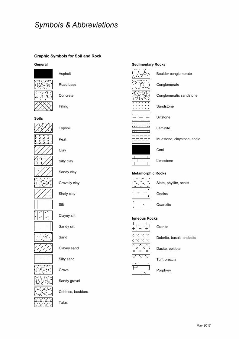
May 2017
Graphic Symbols for Soil and Rock General
Soils
Sedimentary Rocks
Metamorphic Rocks
Igneous Rocks
Road base
Filling
Concrete
Asphalt
Topsoil
Peat
Clay
Conglomeratic sandstone
Conglomerate
Boulder conglomerate
Sandstone
Slate, phyllite, schist
Siltstone
Mudstone, claystone, shale
Coal
Limestone
Porphyry
Cobbles, boulders
Sandy gravel
Laminite
Silty sand
Clayey sand
Silty clay
Sandy clay
Gravelly clay
Shaly clay
Silt
Clayey silt
Sandy silt
Sand
Gravel
Talus
Gneiss
Quartzite
Dolerite, basalt, andesite
Granite
Tuff, breccia
Dacite, epidote

Appendix B
Test Pit Logs (Test Pits 1 to 20) Photoplates (Test Pits 1 to 20)
Borehole Logs (Bores 21 to 34)

TOPSOIL - Brown gravelly silt topsoil, with trace tosome fine to coarse grained sand clay and rootlets
GRAVELLY CLAY / CLAYEY GRAVEL - (Hard / dense),red-brown gravelly clay / clayey gravel, gravel portionsubrounded up to 50mm in size, trace to some silt andfine to coarse grained sand, (M<Wp / humid)
SILTY CLAY - Hard, red/orange/brown mottled off-whitesilty clay, with trace to some fine to coarse grainedsand, trace subrounded gravel up to 15mm in size,M<Wp (possible tuffaceous zones)
Pit discontinued at 3.0m, limit of investigation
0.14
1.2
3.0
SAMPLING & IN SITU TESTING LEGEND
1
2
3
4
RL
TEST PIT LOG
Depth(m)
Goolma Road, Wellington
A Auger sample G Gas sample PID Photo ionisation detector (ppm)B Bulk sample P Piston sample PL(A) Point load axial test Is(50) (MPa)BLK Block sample Ux Tube sample (x mm dia.) PL(D) Point load diametral test Is(50) (MPa)C Core drilling W Water sample pp Pocket penetrometer (kPa)D Disturbed sample Water seep S Standard penetration testE Environmental sample Water level V Shear vane (kPa)
First Solar (Australia) Pty LtdProposed Solar Farm
Results &Comments
LOGGED: Ballinger SURVEY DATUM: MGA94
CLIENT:PROJECT:LOCATION:
PIT No: 1PROJECT No: 91256.00DATE: 10/1/2018SHEET 1 OF 1
Sampling & In Situ Testing
1
2
3
4
Wat
er
Dep
th
Sam
ple
Description
of
Strata Gra
phic
Log
Typ
e
REMARKS:
RIG: Hyundai 14 Tonne Excavator with 450mm wide toothed bucket
WATER OBSERVATIONS: No free groundwater observed while pit remained open
SURFACE LEVEL: --EASTING: 685150NORTHING: 6400915
Dynamic Penetrometer Test(blows per mm)
5 10 15 20
Cone Penetrometer AS1289.6.3.2Sand Penetrometer AS1289.6.3.3
D
D
B
D
D
D
0.05
0.3
0.4
0.5
1.3
2.0
3.0

TOPSOIL - Brown gravelly silt topsoil, with trace tosome fine to coarse grained sand and clay, abundantorganics
GRAVELLY CLAY / CLAYEY GRAVEL - (Hard),red-brown gravelly clay / clayey gravel, gravel portionsubrounded up to 50mm in size, trace to some silt andfine to coarse grained sand, (M<Wp)
SILTY CLAY - Hard, red-brown mottled off-white siltyclay, with trace to some fine to coarse grained sand andsubrounded gravel up to 15mm in size, M<Wp (possibletuffaceous zones)
SANDY CLAY - Hard, pale brown sandy clay, fine tocoarse grained, with trace silt and subrounded gravel upto 10mm in size, M Wp (completely weathered rock)
Pit discontinued at 3.0m, limit of investigation
0.25
0.75
1.4
3.0
SAMPLING & IN SITU TESTING LEGEND
1
2
3
4
RL
TEST PIT LOG
Depth(m)
Goolma Road, Wellington
A Auger sample G Gas sample PID Photo ionisation detector (ppm)B Bulk sample P Piston sample PL(A) Point load axial test Is(50) (MPa)BLK Block sample Ux Tube sample (x mm dia.) PL(D) Point load diametral test Is(50) (MPa)C Core drilling W Water sample pp Pocket penetrometer (kPa)D Disturbed sample Water seep S Standard penetration testE Environmental sample Water level V Shear vane (kPa)
First Solar (Australia) Pty LtdProposed Solar Farm
Results &Comments
LOGGED: Ballinger SURVEY DATUM: MGA94
CLIENT:PROJECT:LOCATION:
PIT No: 2PROJECT No: 91256.00DATE: 10/1/2018SHEET 1 OF 1
Sampling & In Situ Testing
1
2
3
4
Wat
er
Dep
th
Sam
ple
Description
of
Strata Gra
phic
Log
Typ
e
REMARKS:
RIG: Hyundai 14 Tonne Excavator with 450mm wide toothed bucket
WATER OBSERVATIONS: No free groundwater observed while pit remained open
SURFACE LEVEL: --EASTING: 684992NORTHING: 6401177
Dynamic Penetrometer Test(blows per mm)
5 10 15 20
Cone Penetrometer AS1289.6.3.2Sand Penetrometer AS1289.6.3.3
D
B
D
U50
D
D
0.05
0.5
0.6
0.80.85
1.3
2.0
3.0

TOPSOIL - Brown clayey silt topsoil, with some fine tocoarse grained sand and rootlets
SILTY CLAY - Hard, red-brown silty clay, with trace fineto coarse grained sand and subrounded gravel up to20mm in size, M<Wp
META SILTSTONE - (Very low strength, highlyweathered to moderately weathered), grey and brownmeta siltstone
From 2.4m, (low to medium and high strength,moderately weathered to slightly weathered), slowexcavation progress
Pit discontinued at 3.0m, limit of investigation
0.1
1.8
3.0
SAMPLING & IN SITU TESTING LEGEND
1
2
3
4
RL
TEST PIT LOG
Depth(m)
Goolma Road, Wellington
A Auger sample G Gas sample PID Photo ionisation detector (ppm)B Bulk sample P Piston sample PL(A) Point load axial test Is(50) (MPa)BLK Block sample Ux Tube sample (x mm dia.) PL(D) Point load diametral test Is(50) (MPa)C Core drilling W Water sample pp Pocket penetrometer (kPa)D Disturbed sample Water seep S Standard penetration testE Environmental sample Water level V Shear vane (kPa)
First Solar (Australia) Pty LtdProposed Solar Farm
Results &Comments
LOGGED: Ballinger SURVEY DATUM: MGA94
CLIENT:PROJECT:LOCATION:
PIT No: 3PROJECT No: 91256.00DATE: 10/1/2018SHEET 1 OF 1
Sampling & In Situ Testing
1
2
3
4
Wat
er
Dep
th
Sam
ple
Description
of
Strata Gra
phic
Log
Typ
e
REMARKS:
RIG: Hyundai 14 Tonne Excavator with 450mm wide toothed bucket
WATER OBSERVATIONS: No free groundwater observed while pit remained open
SURFACE LEVEL: --EASTING: 684728NORTHING: 6400751
Dynamic Penetrometer Test(blows per 150mm)
5 10 15 20
Cone Penetrometer AS1289.6.3.2Sand Penetrometer AS1289.6.3.3
D
B
U50
D
D
D
0.05
0.3
0.4
0.6
0.941.0
2.2
2.8

TOPSOIL - Brown slightly sandy silt, fine to coarsegrained, with some organics and subrounded gravel upto 20mm in size, trace to some clay
GRAVELLY CLAY - Hard, brown gravelly clay, gravelportion subrounded up to 30mm in size, trace organicsand fine to coarse grained sand, M<Wp
SILTY CLAY - Hard, red-brown silty clay, with somesubrounded gravel up to 30mm in size, M<Wp
META SILTSTONE - (Low to medium and highstrength), moderately weathered to slightly weathered),grey and brown meta siltstone, within extremely lowstrength matrix (soil like properties)
From 2.0m, slow excavation progress (matrix lessweathered)
Pit discontinued at 2.65m, refusal due to slowexcavation progress
0.1
0.35
0.9
2.65
SAMPLING & IN SITU TESTING LEGEND
1
2
3
4
RL
TEST PIT LOG
Depth(m)
Goolma Road, Wellington
A Auger sample G Gas sample PID Photo ionisation detector (ppm)B Bulk sample P Piston sample PL(A) Point load axial test Is(50) (MPa)BLK Block sample Ux Tube sample (x mm dia.) PL(D) Point load diametral test Is(50) (MPa)C Core drilling W Water sample pp Pocket penetrometer (kPa)D Disturbed sample Water seep S Standard penetration testE Environmental sample Water level V Shear vane (kPa)
First Solar (Australia) Pty LtdProposed Solar Farm
Results &Comments
LOGGED: Ballinger SURVEY DATUM: MGA94
CLIENT:PROJECT:LOCATION:
PIT No: 4PROJECT No: 91256.00DATE: 10/1/2018SHEET 1 OF 1
Sampling & In Situ Testing
1
2
3
4
Wat
er
Dep
th
Sam
ple
Description
of
Strata Gra
phic
Log
Typ
e
REMARKS:
RIG: Hyundai 14 Tonne Excavator with 450mm wide toothed bucket
WATER OBSERVATIONS: No free groundwater observed while pit remained open
SURFACE LEVEL: --EASTING: 684503NORTHING: 6401314
Dynamic Penetrometer Test(blows per 150mm)
5 10 15 20
Cone Penetrometer AS1289.6.3.2Sand Penetrometer AS1289.6.3.3
D
D
B
D
D
D
0.05
0.2
0.4
0.5
0.6
1.0
1.8

TOPSOIL - Brown sandy silt topsoil, fine to coarsegrained, with some clay and organics
SILTY CLAY - Hard, red-brown silty clay, with trace tosome fine to coarse grained sand and subroundedgravel up to 15mm in size, M<Wp
META SILTSTONE - (Low to medium strength, highlyweathered to moderately weathered), grey and brownmeta siltstone, within extremely low strength matrix (soillike properties)From 1.0m, (medium to high strength, moderatelyweathered to slightly weathered), slow excavationprogress (matrix less weathered)
Pit discontinued at 1.75m, refusal
0.1
0.7
1.75
SAMPLING & IN SITU TESTING LEGEND
1
2
3
4
RL
TEST PIT LOG
Depth(m)
Goolma Road, Wellington
A Auger sample G Gas sample PID Photo ionisation detector (ppm)B Bulk sample P Piston sample PL(A) Point load axial test Is(50) (MPa)BLK Block sample Ux Tube sample (x mm dia.) PL(D) Point load diametral test Is(50) (MPa)C Core drilling W Water sample pp Pocket penetrometer (kPa)D Disturbed sample Water seep S Standard penetration testE Environmental sample Water level V Shear vane (kPa)
First Solar (Australia) Pty LtdProposed Solar Farm
Results &Comments
LOGGED: Ballinger SURVEY DATUM: MGA94
CLIENT:PROJECT:LOCATION:
PIT No: 5PROJECT No: 91256.00DATE: 10/1/2018SHEET 1 OF 1
Sampling & In Situ Testing
1
2
3
4
Wat
er
Dep
th
Sam
ple
Description
of
Strata Gra
phic
Log
Typ
e
REMARKS:
RIG: Hyundai 14 Tonne Excavator with 450mm wide toothed bucket
WATER OBSERVATIONS: No free groundwater observed while pit remained open
SURFACE LEVEL: --EASTING: 684395NORTHING: 6401736
Dynamic Penetrometer Test(blows per 150mm)
5 10 15 20
Cone Penetrometer AS1289.6.3.2Sand Penetrometer AS1289.6.3.3
D
D
D
D
D
0.05
0.4
0.8
1.2
1.7

SILTY CLAY - Hard, red-brown silty clay, with trace tosome fine to coarse grained sand, trace organics,M<Wp
SANDY SILT - Hard, brown sandy silt, fine to coarsegrained, with trace to some clay, trace organics, M<Wp
SILTY CLAY - Hard, red-brown silty clay, with trace tosome fine to coarse grained sand, M<Wp
Pit discontinued at 3.0m, limit of investigation
0.03
0.5
3.0
SAMPLING & IN SITU TESTING LEGEND
1
2
3
4
RL
TEST PIT LOG
Depth(m)
Goolma Road, Wellington
A Auger sample G Gas sample PID Photo ionisation detector (ppm)B Bulk sample P Piston sample PL(A) Point load axial test Is(50) (MPa)BLK Block sample Ux Tube sample (x mm dia.) PL(D) Point load diametral test Is(50) (MPa)C Core drilling W Water sample pp Pocket penetrometer (kPa)D Disturbed sample Water seep S Standard penetration testE Environmental sample Water level V Shear vane (kPa)
First Solar (Australia) Pty LtdProposed Solar Farm
Results &Comments
LOGGED: Ballinger SURVEY DATUM: MGA94
CLIENT:PROJECT:LOCATION:
PIT No: 6PROJECT No: 91256.00DATE: 9/1/2018SHEET 1 OF 1
Sampling & In Situ Testing
1
2
3
4
Wat
er
Dep
th
Sam
ple
Description
of
Strata Gra
phic
Log
Typ
e
REMARKS:
RIG: Hyundai 14 Tonne Excavator with 450mm wide toothed bucket
WATER OBSERVATIONS: No free groundwater observed while pit remained open
SURFACE LEVEL: --EASTING: 682782NORTHING: 6401179
Dynamic Penetrometer Test(blows per mm)
5 10 15 20
Cone Penetrometer AS1289.6.3.2Sand Penetrometer AS1289.6.3.3
D
BD
U50
D
D
D
0.01
0.3
0.4
0.55
0.82
1.2
2.0
3.0

TOPSOIL - Red-brown clayey silt topsoil, with some fineto coarse grained sand and organics
SILTY CLAY - Hard, red-brown silty clay, with fine tocoarse grained sand, subrounded gravel (siltstonefragments) up to 20mm in size and organics, M<Wp
From 0.6m, with trace gravel and sand
META SILTSTONE - (Extremely low strength, extremelyweathered) grey and brown meta siltstone
From 2.4m, (low to medium strength, moderatelyweathered)
From 2.6m, slow excavation progress
Pit discontinued at 3.0m, limit of investigation
0.12
1.9
3.0
SAMPLING & IN SITU TESTING LEGEND
1
2
3
4
RL
TEST PIT LOG
Depth(m)
Goolma Road, Wellington
A Auger sample G Gas sample PID Photo ionisation detector (ppm)B Bulk sample P Piston sample PL(A) Point load axial test Is(50) (MPa)BLK Block sample Ux Tube sample (x mm dia.) PL(D) Point load diametral test Is(50) (MPa)C Core drilling W Water sample pp Pocket penetrometer (kPa)D Disturbed sample Water seep S Standard penetration testE Environmental sample Water level V Shear vane (kPa)
First Solar (Australia) Pty LtdProposed Solar Farm
Results &Comments
LOGGED: Ballinger SURVEY DATUM: MGA94
CLIENT:PROJECT:LOCATION:
PIT No: 7PROJECT No: 91256.00DATE: 9/1/2018SHEET 1 OF 1
Sampling & In Situ Testing
1
2
3
4
Wat
er
Dep
th
Sam
ple
Description
of
Strata Gra
phic
Log
Typ
e
REMARKS:
RIG: Hyundai 14 Tonne Excavator with 450mm wide toothed bucket
WATER OBSERVATIONS: No free groundwater observed while pit remained open
SURFACE LEVEL: --EASTING: 638020NORTHING: 6401757
Dynamic Penetrometer Test(blows per 150mm)
5 10 15 20
Cone Penetrometer AS1289.6.3.2Sand Penetrometer AS1289.6.3.3
D
D
B
U50
D
D
D
D
0.05
0.3
0.4
0.50.55
0.981.0
2.0
2.5
3.0

TOPSOIL - Brown sandy silt topsoil, with some clay andorganics, trace subrounded gravel up to 20mm in size
SILTY CLAY - Hard, red-brown silty clay, with trace tosome subrounded gravel up to 10mm in size, M<Wp
SILTY CLAY - Hard, grey and brown silty clay, withsome fine to coarse grained sand and subroundedgravel (siltstone fragments) up to 50mm in size, M<Wp(completely weathered rock)
META SILTSTONE - (Low to medium strength, highlyweathered to moderately weathered) grey and brownmeta siltstone
Pit discontinued at 3.0m, limit of investigation
0.14
1.4
2.3
3.0
SAMPLING & IN SITU TESTING LEGEND
1
2
3
4
RL
TEST PIT LOG
Depth(m)
Goolma Road, Wellington
A Auger sample G Gas sample PID Photo ionisation detector (ppm)B Bulk sample P Piston sample PL(A) Point load axial test Is(50) (MPa)BLK Block sample Ux Tube sample (x mm dia.) PL(D) Point load diametral test Is(50) (MPa)C Core drilling W Water sample pp Pocket penetrometer (kPa)D Disturbed sample Water seep S Standard penetration testE Environmental sample Water level V Shear vane (kPa)
First Solar (Australia) Pty LtdProposed Solar Farm
Results &Comments
LOGGED: Ballinger SURVEY DATUM: MGA94
CLIENT:PROJECT:LOCATION:
PIT No: 8PROJECT No: 91256.00DATE: 10/1/2018SHEET 1 OF 1
Sampling & In Situ Testing
1
2
3
4
Wat
er
Dep
th
Sam
ple
Description
of
Strata Gra
phic
Log
Typ
e
REMARKS:
RIG: Hyundai 14 Tonne Excavator with 450mm wide toothed bucket
WATER OBSERVATIONS: No free groundwater observed while pit remained open
SURFACE LEVEL: --EASTING: 684200NORTHING: 6400911
Dynamic Penetrometer Test(blows per mm)
5 10 15 20
Cone Penetrometer AS1289.6.3.2Sand Penetrometer AS1289.6.3.3
D
B
D
D
D
D
0.05
0.3
0.4
0.7
1.5
2.0
3.0

TOPSOIL - Brown slightly sandy silt topsoil, fine tomedium grained, with some clay and rootlets
SILTY CLAY - Hard, red-brown silty clay, with fine tomedium grained sand and trace subrounded gravel upto 20mm in size, M<Wp
META SILTSTONE - (Very low to low strength, highlyweathered), grey and brown meta siltstone
From 1.8m, (medium to high strength, moderatelyweathered to slightly weathered and fresh, withinextremely weathered matrix (soil like properties))
Pit discontinued at 3.0m, limit of investigation
0.18
1.0
3.0
SAMPLING & IN SITU TESTING LEGEND
1
2
3
4
RL
TEST PIT LOG
Depth(m)
Goolma Road, Wellington
A Auger sample G Gas sample PID Photo ionisation detector (ppm)B Bulk sample P Piston sample PL(A) Point load axial test Is(50) (MPa)BLK Block sample Ux Tube sample (x mm dia.) PL(D) Point load diametral test Is(50) (MPa)C Core drilling W Water sample pp Pocket penetrometer (kPa)D Disturbed sample Water seep S Standard penetration testE Environmental sample Water level V Shear vane (kPa)
First Solar (Australia) Pty LtdProposed Solar Farm
Results &Comments
LOGGED: Ballinger SURVEY DATUM: MGA94
CLIENT:PROJECT:LOCATION:
PIT No: 9PROJECT No: 91256.00DATE: 10/1/2018SHEET 1 OF 1
Sampling & In Situ Testing
1
2
3
4
Wat
er
Dep
th
Sam
ple
Description
of
Strata Gra
phic
Log
Typ
e
REMARKS:
RIG: Hyundai 14 Tonne Excavator with 450mm wide toothed bucket
WATER OBSERVATIONS: No free groundwater observed while pit remained open
SURFACE LEVEL: --EASTING: 684336NORTHING: 6399978
Dynamic Penetrometer Test(blows per 150mm)
5 10 15 20
Cone Penetrometer AS1289.6.3.2Sand Penetrometer AS1289.6.3.3
D
D
B
D
D
D
D
0.1
0.3
0.4
0.5
0.6
0.9
1.4
2.2

TOPSOIL - Red-brown sandy silt topsoil, fine to mediumgrained, with some organics, trace subrounded gravelup to 10mm in size
SILTY CLAY - Hard, red-brown silty clay, with trace tosome fine to coarse grained sand, trace organics andsubangular gravel up to 5mm in size, M<Wp
META SANDSTONE - (Low to medium strength, highlyweathered to moderately weathered) grey stainedred/orange/brown meta sandstone
From 1.7m, (medium to high strength, moderatelyweathered to slightly weathered)
Pit discontinued at 1.9m, refusal
0.02
0.6
1.9
SAMPLING & IN SITU TESTING LEGEND
1
2
3
4
RL
TEST PIT LOG
Depth(m)
Goolma Road, Wellington
A Auger sample G Gas sample PID Photo ionisation detector (ppm)B Bulk sample P Piston sample PL(A) Point load axial test Is(50) (MPa)BLK Block sample Ux Tube sample (x mm dia.) PL(D) Point load diametral test Is(50) (MPa)C Core drilling W Water sample pp Pocket penetrometer (kPa)D Disturbed sample Water seep S Standard penetration testE Environmental sample Water level V Shear vane (kPa)
First Solar (Australia) Pty LtdProposed Solar Farm
Results &Comments
LOGGED: Ballinger SURVEY DATUM: MGA94
CLIENT:PROJECT:LOCATION:
PIT No: 10PROJECT No: 91256.00DATE: 9/1/2018SHEET 1 OF 1
Sampling & In Situ Testing
1
2
3
4
Wat
er
Dep
th
Sam
ple
Description
of
Strata Gra
phic
Log
Typ
e
REMARKS:
RIG: Hyundai 14 Tonne Excavator with 450mm wide toothed bucket
WATER OBSERVATIONS: No free groundwater observed while pit remained open
SURFACE LEVEL: --EASTING: 683647NORTHING: 6399600
Dynamic Penetrometer Test(blows per 150mm)
5 10 15 20
Cone Penetrometer AS1289.6.3.2Sand Penetrometer AS1289.6.3.3
D
B
DU50
D
D
0.01
0.2
0.4
0.57
1.0
1.8

TOPSOIL - Brown sandy silt topsoil, fine to coarsegrained, with some organics and clay
SANDY SILT - Hard, brown sandy silt, fine to coarsegrained, with trace to some clay, trace organics, M<Wp
SILTY CLAY - Hard, red-brown silty clay, with trace fineto coarse grained sand, trace organics, M<Wp
From 2.0m, with trace to some sand, trace subroundedgravel up to 15mm in size
Pit discontinued at 3.0m, limit of investigation
0.04
0.2
3.0
SAMPLING & IN SITU TESTING LEGEND
1
2
3
4
RL
TEST PIT LOG
Depth(m)
Goolma Road, Wellington
A Auger sample G Gas sample PID Photo ionisation detector (ppm)B Bulk sample P Piston sample PL(A) Point load axial test Is(50) (MPa)BLK Block sample Ux Tube sample (x mm dia.) PL(D) Point load diametral test Is(50) (MPa)C Core drilling W Water sample pp Pocket penetrometer (kPa)D Disturbed sample Water seep S Standard penetration testE Environmental sample Water level V Shear vane (kPa)
First Solar (Australia) Pty LtdProposed Solar Farm
Results &Comments
LOGGED: Ballinger SURVEY DATUM: MGA94
CLIENT:PROJECT:LOCATION:
PIT No: 11PROJECT No: 91256.00DATE: 9/1/2018SHEET 1 OF 1
Sampling & In Situ Testing
1
2
3
4
Wat
er
Dep
th
Sam
ple
Description
of
Strata Gra
phic
Log
Typ
e
REMARKS:
RIG: Hyundai 14 Tonne Excavator with 450mm wide toothed bucket
WATER OBSERVATIONS: No free groundwater observed while pit remained open
SURFACE LEVEL: --EASTING: 683424NORTHING: 6400433
Dynamic Penetrometer Test(blows per 150mm)
5 10 15 20
Cone Penetrometer AS1289.6.3.2Sand Penetrometer AS1289.6.3.3
DD
D
D
U50
D
D
D
0.010.1
0.25
0.40.45
0.9
1.5
2.2
3.0
pp = 450
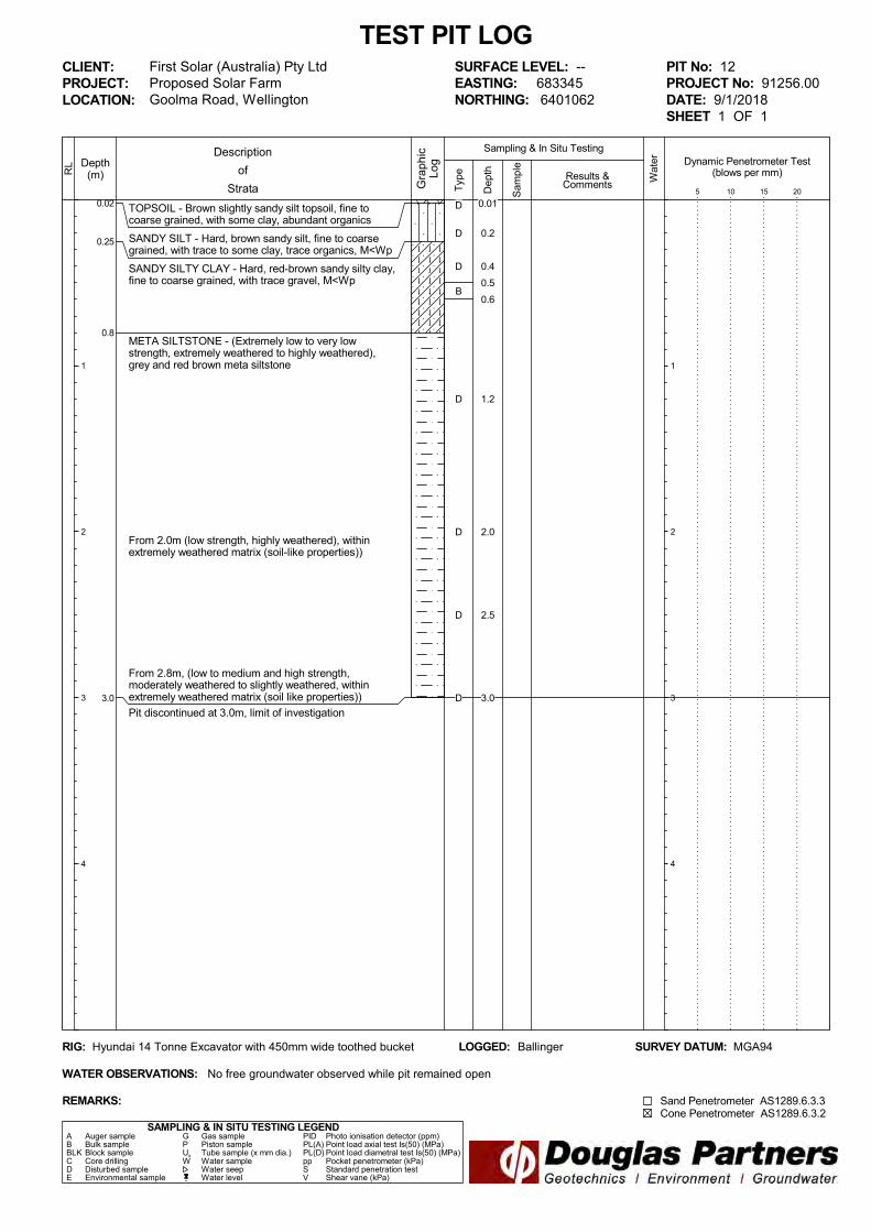
TOPSOIL - Brown slightly sandy silt topsoil, fine tocoarse grained, with some clay, abundant organics
SANDY SILT - Hard, brown sandy silt, fine to coarsegrained, with trace to some clay, trace organics, M<Wp
SANDY SILTY CLAY - Hard, red-brown sandy silty clay,fine to coarse grained, with trace gravel, M<Wp
META SILTSTONE - (Extremely low to very lowstrength, extremely weathered to highly weathered),grey and red brown meta siltstone
From 2.0m (low strength, highly weathered), withinextremely weathered matrix (soil-like properties))
From 2.8m, (low to medium and high strength,moderately weathered to slightly weathered, withinextremely weathered matrix (soil like properties))
Pit discontinued at 3.0m, limit of investigation
0.02
0.25
0.8
3.0
SAMPLING & IN SITU TESTING LEGEND
1
2
3
4
RL
TEST PIT LOG
Depth(m)
Goolma Road, Wellington
A Auger sample G Gas sample PID Photo ionisation detector (ppm)B Bulk sample P Piston sample PL(A) Point load axial test Is(50) (MPa)BLK Block sample Ux Tube sample (x mm dia.) PL(D) Point load diametral test Is(50) (MPa)C Core drilling W Water sample pp Pocket penetrometer (kPa)D Disturbed sample Water seep S Standard penetration testE Environmental sample Water level V Shear vane (kPa)
First Solar (Australia) Pty LtdProposed Solar Farm
Results &Comments
LOGGED: Ballinger SURVEY DATUM: MGA94
CLIENT:PROJECT:LOCATION:
PIT No: 12PROJECT No: 91256.00DATE: 9/1/2018SHEET 1 OF 1
Sampling & In Situ Testing
1
2
3
4
Wat
er
Dep
th
Sam
ple
Description
of
Strata Gra
phic
Log
Typ
e
REMARKS:
RIG: Hyundai 14 Tonne Excavator with 450mm wide toothed bucket
WATER OBSERVATIONS: No free groundwater observed while pit remained open
SURFACE LEVEL: --EASTING: 683345NORTHING: 6401062
Dynamic Penetrometer Test(blows per mm)
5 10 15 20
Cone Penetrometer AS1289.6.3.2Sand Penetrometer AS1289.6.3.3
D
D
D
B
D
D
D
D
0.01
0.2
0.4
0.5
0.6
1.2
2.0
2.5
3.0

TOPSOIL - Brown sandy silt topsoil, fine to coarsegrained, with some organics and clay
SILTY CLAY - Hard, red-brown silty clay, with fine tocoarse grained sand and trace gravel, trace organics,M<Wp
META SILTSTONE - (Very low to low and mediumstrength, highly weathered to moderately weatheredwithin extremely low strength matrix (soil likeproperties), grey and brown meta siltstone (rippedfragments typically up to 100mm in size)
From 2.5m, (extremely low to very low strength,extremely weathered to highly weathered)
Pit discontinued at 3.0m, limit of investigation
0.03
1.7
3.0
SAMPLING & IN SITU TESTING LEGEND
1
2
3
4
RL
TEST PIT LOG
Depth(m)
Goolma Road, Wellington
A Auger sample G Gas sample PID Photo ionisation detector (ppm)B Bulk sample P Piston sample PL(A) Point load axial test Is(50) (MPa)BLK Block sample Ux Tube sample (x mm dia.) PL(D) Point load diametral test Is(50) (MPa)C Core drilling W Water sample pp Pocket penetrometer (kPa)D Disturbed sample Water seep S Standard penetration testE Environmental sample Water level V Shear vane (kPa)
First Solar (Australia) Pty LtdProposed Solar Farm
Results &Comments
LOGGED: Ballinger SURVEY DATUM: MGA94
CLIENT:PROJECT:LOCATION:
PIT No: 13PROJECT No: 91256.00DATE: 9/1/2018SHEET 1 OF 1
Sampling & In Situ Testing
1
2
3
4
Wat
er
Dep
th
Sam
ple
Description
of
Strata Gra
phic
Log
Typ
e
REMARKS:
RIG: Hyundai 14 Tonne Excavator with 450mm wide toothed bucket
WATER OBSERVATIONS: No free groundwater observed while pit remained open
SURFACE LEVEL: --EASTING: 683230NORTHING: 6400716
Dynamic Penetrometer Test(blows per 150mm)
5 10 15 20
Cone Penetrometer AS1289.6.3.2Sand Penetrometer AS1289.6.3.3
D
BU50
D
D
D
D
0.01
0.350.4
0.6
0.8
1.2
2.0
2.5
3.0

TOPSOIL - Brown sandy silt topsoil, fine to coarsegrained, with some organics and clay
GRAVELLY SILTY CLAY - Hard, red-brown gravellysilty clay, gravel portion subrounded up to 15mm in size,trace fine to coarse grained sand, M<Wp
SILTY CLAY - Hard, red-brown, silty clay, with fine tocoarse grained sand and trace gravel, M<Wp
From 1.2m, M Wp
From 2.0m, M>WpFrom 2m depth, becoming clayey sand
Pit discontinued at 3.0m, limit of investigation
0.04
0.4
3.0
SAMPLING & IN SITU TESTING LEGEND
1
2
3
4
RL
TEST PIT LOG
Depth(m)
Goolma Road, Wellington
A Auger sample G Gas sample PID Photo ionisation detector (ppm)B Bulk sample P Piston sample PL(A) Point load axial test Is(50) (MPa)BLK Block sample Ux Tube sample (x mm dia.) PL(D) Point load diametral test Is(50) (MPa)C Core drilling W Water sample pp Pocket penetrometer (kPa)D Disturbed sample Water seep S Standard penetration testE Environmental sample Water level V Shear vane (kPa)
First Solar (Australia) Pty LtdProposed Solar Farm
Results &Comments
LOGGED: Ballinger SURVEY DATUM: MGA94
CLIENT:PROJECT:LOCATION:
PIT No: 14PROJECT No: 91256.00DATE: 9/1/2018SHEET 1 OF 1
Sampling & In Situ Testing
1
2
3
4
Wat
er
Dep
th
Sam
ple
Description
of
Strata Gra
phic
Log
Typ
e
REMARKS:
RIG: Hyundai 14 Tonne Excavator with 450mm wide toothed bucket
WATER OBSERVATIONS: Slight seepage observed in base (at 3.0m depth) while pit remained open
SURFACE LEVEL: --EASTING: 682402NORTHING: 6401110
Dynamic Penetrometer Test(blows per 150mm)
5 10 15 20
Cone Penetrometer AS1289.6.3.2Sand Penetrometer AS1289.6.3.3
D
D
B
D
U50
D
D
0.01
0.2
0.5
0.6
0.90.95
1.25
2.5
3.0

TOPSOIL - Red-brown silty clay topsoil, with trace tosome fine to coarse grained sand and subroundedgravel up to 10mm in size, abundant rootlets
SANDY SILTY CLAY - Hard, red-brown silty clay, withtrace to some fine to coarse grained sand, tracesubrounded gravel up to 10mm in size, M<Wp
From 2.0m, M Wp
Pit discontinued at 3.3m, limit of investigation
0.14
3.3
SAMPLING & IN SITU TESTING LEGEND
1
2
3
4
RL
TEST PIT LOG
Depth(m)
Goolma Road, Wellington
A Auger sample G Gas sample PID Photo ionisation detector (ppm)B Bulk sample P Piston sample PL(A) Point load axial test Is(50) (MPa)BLK Block sample Ux Tube sample (x mm dia.) PL(D) Point load diametral test Is(50) (MPa)C Core drilling W Water sample pp Pocket penetrometer (kPa)D Disturbed sample Water seep S Standard penetration testE Environmental sample Water level V Shear vane (kPa)
First Solar (Australia) Pty LtdProposed Solar Farm
Results &Comments
LOGGED: Ballinger SURVEY DATUM: MGA94
CLIENT:PROJECT:LOCATION:
PIT No: 15PROJECT No: 91256.00DATE: 9/1/2018SHEET 1 OF 1
Sampling & In Situ Testing
1
2
3
4
Wat
er
Dep
th
Sam
ple
Description
of
Strata Gra
phic
Log
Typ
e
REMARKS:
RIG: Hyundai 14 Tonne Excavator with 450mm wide toothed bucket
WATER OBSERVATIONS: Slight seepage observed in base (at 3.0m depth) while pit remained open
SURFACE LEVEL: --EASTING: 681973NORTHING: 6401048
Dynamic Penetrometer Test(blows per 150mm)
5 10 15 20
Cone Penetrometer AS1289.6.3.2Sand Penetrometer AS1289.6.3.3
D
D
B
U50
D
D
0.05
0.4
0.5
0.60.65
0.91
1.0
2.0

TOPSOIL - Brown clayey sandy silt topsoil, with somesubrounded gravel up to 30mm in size
META SILTSTONE - (Low to medium strength, highlyweathered to moderately weathered), grey stainedred/orange/brown meta siltstone
From 1.1m, (medium to highly strength, to slightlyweathered to fresh stained)
From 1.7m, (fresh stained to fresh)
Pit discontinued at 2.4m, practical refusal due to slowexcavation progress
0.1
2.4
SAMPLING & IN SITU TESTING LEGEND
1
2
3
4
RL
TEST PIT LOG
Depth(m)
Goolma Road, Wellington
A Auger sample G Gas sample PID Photo ionisation detector (ppm)B Bulk sample P Piston sample PL(A) Point load axial test Is(50) (MPa)BLK Block sample Ux Tube sample (x mm dia.) PL(D) Point load diametral test Is(50) (MPa)C Core drilling W Water sample pp Pocket penetrometer (kPa)D Disturbed sample Water seep S Standard penetration testE Environmental sample Water level V Shear vane (kPa)
First Solar (Australia) Pty LtdProposed Solar Farm
Results &Comments
LOGGED: Ballinger SURVEY DATUM: MGA94
CLIENT:PROJECT:LOCATION:
PIT No: 16PROJECT No: 91256.00DATE: 10/1/2018SHEET 1 OF 1
Sampling & In Situ Testing
1
2
3
4
Wat
er
Dep
th
Sam
ple
Description
of
Strata Gra
phic
Log
Typ
e
REMARKS:
RIG: Hyundai 14 Tonne Excavator with 450mm wide toothed bucket
WATER OBSERVATIONS: No free groundwater observed while pit remained open
SURFACE LEVEL: --EASTING: 684889NORTHING: 6401603
Dynamic Penetrometer Test(blows per mm)
5 10 15 20
Cone Penetrometer AS1289.6.3.2Sand Penetrometer AS1289.6.3.3
D
D
D
D
0.01
0.3
1.2
2.2

TOPSOIL - Brown clayey silt topsoil, with some fine tocoarse grained sand and rootlets
SILTY CLAY - Hard, red brown silty clay, with some toslightly gravelly, gravel portion subrounded up to 50mmin size, some fine to coarse grained sand, M<Wp
META SILTSTONE - (Low to medium strength, highlyweathered to moderately weathered), grey and brownmeta siltstone, within extremely weathered matrix(soil-like properties)
From 2.4m, (medium to high strength, slightlyweathered to fresh), slow excavation progress (matrixless weathered)
Pit discontinued at 3.0m, limit of investigation
0.1
0.7
3.0
SAMPLING & IN SITU TESTING LEGEND
1
2
3
4
RL
TEST PIT LOG
Depth(m)
Goolma Road, Wellington
A Auger sample G Gas sample PID Photo ionisation detector (ppm)B Bulk sample P Piston sample PL(A) Point load axial test Is(50) (MPa)BLK Block sample Ux Tube sample (x mm dia.) PL(D) Point load diametral test Is(50) (MPa)C Core drilling W Water sample pp Pocket penetrometer (kPa)D Disturbed sample Water seep S Standard penetration testE Environmental sample Water level V Shear vane (kPa)
First Solar (Australia) Pty LtdProposed Solar Farm
Results &Comments
LOGGED: Ballinger SURVEY DATUM: MGA94
CLIENT:PROJECT:LOCATION:
PIT No: 17PROJECT No: 91256.00DATE: 10/1/2018SHEET 1 OF 1
Sampling & In Situ Testing
1
2
3
4
Wat
er
Dep
th
Sam
ple
Description
of
Strata Gra
phic
Log
Typ
e
REMARKS:
RIG: Hyundai 14 Tonne Excavator with 450mm wide toothed bucket
WATER OBSERVATIONS: No free groundwater observed while pit remained open
SURFACE LEVEL: --EASTING: 684910NORTHING: 6400128
Dynamic Penetrometer Test(blows per 150mm)
5 10 15 20
Cone Penetrometer AS1289.6.3.2Sand Penetrometer AS1289.6.3.3
D
B
D
D
D
0.05
0.2
0.4
0.5
0.8
2.5

TOPSOIL - Brown sandy silt topsoil, fine to coarsegrained, with some organics and clay
SILTY CLAY - Hard, red-brown silty clay, with fine tocoarse grained sand, trace organics, M<Wp
SANDY SILTY CLAY - Hard, red-brown sandy silty clay,fine to coarse grained, M<Wp
SILTY CLAY - Hard, red-brown silty clay, with trace fineto coarse grained sand, trace organics, M<Wp
Pit discontinued at 3.0m, limit of investigation
0.03
0.25
0.6
3.0
SAMPLING & IN SITU TESTING LEGEND
1
2
3
4
RL
TEST PIT LOG
Depth(m)
Goolma Road, Wellington
A Auger sample G Gas sample PID Photo ionisation detector (ppm)B Bulk sample P Piston sample PL(A) Point load axial test Is(50) (MPa)BLK Block sample Ux Tube sample (x mm dia.) PL(D) Point load diametral test Is(50) (MPa)C Core drilling W Water sample pp Pocket penetrometer (kPa)D Disturbed sample Water seep S Standard penetration testE Environmental sample Water level V Shear vane (kPa)
First Solar (Australia) Pty LtdProposed Solar Farm
Results &Comments
LOGGED: Ballinger SURVEY DATUM: MGA94
CLIENT:PROJECT:LOCATION:
PIT No: 18PROJECT No: 91256.00DATE: 9/1/2018SHEET 1 OF 1
Sampling & In Situ Testing
1
2
3
4
Wat
er
Dep
th
Sam
ple
Description
of
Strata Gra
phic
Log
Typ
e
REMARKS:
RIG: Hyundai 14 Tonne Excavator with 450mm wide toothed bucket
WATER OBSERVATIONS: No free groundwater observed while pit remained open
SURFACE LEVEL: --EASTING: 682978NORTHING: 6400578
Dynamic Penetrometer Test(blows per 150mm)
5 10 15 20
Cone Penetrometer AS1289.6.3.2Sand Penetrometer AS1289.6.3.3
D
D
D
U50
D
D
D
0.01
0.2
0.5
0.75
1.2
1.5
2.2
3.0

TOPSOIL - Brown sandy silt topsoil, fine to coarsegrained, with some clay and organics
SILTY CLAY - Hard, red-brown silty clay with gravel,gravel portion comprising subrounded siltstonefragments up to 15mm in size, trace fine to coarsegrained sand and organics, M<Wp
SILTY CLAY - Hard, red-brown silty clay, with trace tosome fine to coarse grained sand and subroundedgravel (siltstone fragments) typically up to 10mm in size,M<Wp
Pit discontinued at 3.0m, limit of investigation
0.12
0.45
3.0
SAMPLING & IN SITU TESTING LEGEND
1
2
3
4
RL
TEST PIT LOG
Depth(m)
Goolma Road, Wellington
A Auger sample G Gas sample PID Photo ionisation detector (ppm)B Bulk sample P Piston sample PL(A) Point load axial test Is(50) (MPa)BLK Block sample Ux Tube sample (x mm dia.) PL(D) Point load diametral test Is(50) (MPa)C Core drilling W Water sample pp Pocket penetrometer (kPa)D Disturbed sample Water seep S Standard penetration testE Environmental sample Water level V Shear vane (kPa)
First Solar (Australia) Pty LtdProposed Solar Farm
Results &Comments
LOGGED: Ballinger SURVEY DATUM: MGA94
CLIENT:PROJECT:LOCATION:
PIT No: 19PROJECT No: 91256.00DATE: 10/1/2018SHEET 1 OF 1
Sampling & In Situ Testing
1
2
3
4
Wat
er
Dep
th
Sam
ple
Description
of
Strata Gra
phic
Log
Typ
e
REMARKS:
RIG: Hyundai 14 Tonne Excavator with 450mm wide toothed bucket
WATER OBSERVATIONS: No free groundwater observed while pit remained open
SURFACE LEVEL: --EASTING: 683765NORTHING: 6401490
Dynamic Penetrometer Test(blows per 150mm)
5 10 15 20
Cone Penetrometer AS1289.6.3.2Sand Penetrometer AS1289.6.3.3
D
D
D
D
D
D
0.05
0.250.3
0.4
1.0
2.0
3.0

TOPSOIL - Red-brown sandy silt topsoil, fine to mediumgrained, with some organics, trace subrounded gravelup to 10mm in size
SILTY CLAY - Hard, red-brown silty clay, with trace tosome fine to coarse grained sand and subroundedgravel (weathered rock fragments), M<Wp
SANDY CLAY - Hard, brown sandy clay, fine to coarsegrained, with trace to some silt and subrounded gravel /cobbles up to 150mm in size (completely weatheredrock), M<Wp
Pit discontinued at 3.0m, limit of investigation
0.03
1.6
3.0
SAMPLING & IN SITU TESTING LEGEND
1
2
3
4
RL
TEST PIT LOG
Depth(m)
Goolma Road, Wellington
A Auger sample G Gas sample PID Photo ionisation detector (ppm)B Bulk sample P Piston sample PL(A) Point load axial test Is(50) (MPa)BLK Block sample Ux Tube sample (x mm dia.) PL(D) Point load diametral test Is(50) (MPa)C Core drilling W Water sample pp Pocket penetrometer (kPa)D Disturbed sample Water seep S Standard penetration testE Environmental sample Water level V Shear vane (kPa)
First Solar (Australia) Pty LtdProposed Solar Farm
Results &Comments
LOGGED: Ballinger SURVEY DATUM: MGA94
CLIENT:PROJECT:LOCATION:
PIT No: 20PROJECT No: 91256.00DATE: 9/1/2018SHEET 1 OF 1
Sampling & In Situ Testing
1
2
3
4
Wat
er
Dep
th
Sam
ple
Description
of
Strata Gra
phic
Log
Typ
e
REMARKS:
RIG: Hyundai 14 Tonne Excavator with 450mm wide toothed bucket
WATER OBSERVATIONS: No free groundwater observed while pit remained open
SURFACE LEVEL: --EASTING: 683870NORTHING: 6400391
Dynamic Penetrometer Test(blows per 150mm)
5 10 15 20
Cone Penetrometer AS1289.6.3.2Sand Penetrometer AS1289.6.3.3
D
D
U50
D
D
D
D
0.01
0.2
0.450.5
0.9
1.0
1.5
2.2
3.0
pp >400

Pit 1
Geotechnical Investigation PROJECT: 91256.00
Proposed Solar Farm PLATE No: 1
Goolma Road, Wellington, NSW
REV: 0
CLIENT: First Solar (Australia) Pty Ltd DATE: 22-Feb-18

Pit 2
Geotechnical Investigation PROJECT: 91063.00
Proposed Solar Farm PLATE No: 2
Goolma Road, Wellington, NSW
REV: 0
CLIENT: First Solar (Australia) Pty Ltd DATE: 22-Feb-18

Pit 3
Geotechnical Investigation PROJECT: 91256.00
Proposed Solar Farm PLATE No: 3
Goolma Road, Wellington, NSW
REV: 0
CLIENT: First Solar (Australia) Pty Ltd DATE: 22-Feb-18

Pit 4
Geotechnical Investigation PROJECT: 91256.00
Proposed Solar Farm PLATE No: 4
Goolma Road, Wellington, NSW
REV: 0
CLIENT: First Solar (Australia) Pty Ltd DATE: 22-Feb-18

Pit 5
Geotechnical Investigation PROJECT: 91256.00
Proposed Solar Farm PLATE No: 5
Goolma Road, Wellington, NSW
REV: 0
CLIENT: First Solar (Australia) Pty Ltd DATE: 22-Feb-18

Pit 6
Geotechnical Investigation PROJECT: 91256.00
Proposed Solar Farm PLATE No: 6
Goolma Road, Wellington, NSW
REV: 0
CLIENT: First Solar (Australia) Pty Ltd DATE: 22-Feb-18

Pit 7
Geotechnical Investigation PROJECT: 91256.00
Proposed Solar Farm PLATE No: 7
Goolma Road, Wellington, NSW
REV: 0
CLIENT: First Solar (Australia) Pty Ltd DATE: 22-Feb-18

Pit 8
Geotechnical Investigation PROJECT: 91256.00
Proposed Solar Farm PLATE No: 8
Goolma Road, Wellington, NSW
REV: 0
CLIENT: First Solar (Australia) Pty Ltd DATE: 22-Feb-18

Pit 9
Geotechnical Investigation PROJECT: 91256.00
Proposed Solar Farm PLATE No: 9
Goolma Road, Wellington, NSW
REV: 0
CLIENT: First Solar (Australia) Pty Ltd DATE: 22-Feb-18

Pit 10
Geotechnical Investigation PROJECT: 91256.00
Proposed Solar Farm PLATE No: 10
Goolma Road, Wellington, NSW
REV: 0
CLIENT: First Solar (Australia) Pty Ltd DATE: 22-Feb-18

Pit 11
Geotechnical Investigation PROJECT: 91256.00
Proposed Solar Farm PLATE No: 11
Goolma Road, Wellington, NSW
REV: 0
CLIENT: First Solar (Australia) Pty Ltd DATE: 22-Feb-18

Pit 12
Geotechnical Investigation PROJECT: 91256.00
Proposed Solar Farm PLATE No: 12
Goolma Road, Wellington, NSW
REV: 0
CLIENT: First Solar (Australia) Pty Ltd DATE: 22-Feb-18

Pit 13
Geotechnical Investigation PROJECT: 91256.00
Proposed Solar Farm PLATE No: 13
Goolma Road, Wellington, NSW
REV: 0
CLIENT: First Solar (Australia) Pty Ltd DATE: 22-Feb-18

Pit 14
Geotechnical Investigation PROJECT: 91256.00
Proposed Solar Farm PLATE No: 14
Goolma Road, Wellington, NSW
REV: 0
CLIENT: First Solar (Australia) Pty Ltd DATE: 22-Feb-18

Pit 15
Geotechnical Investigation PROJECT: 91256.00
Proposed Solar Farm PLATE No: 15
Goolma Road, Wellington, NSW
REV: 0
CLIENT: First Solar (Australia) Pty Ltd DATE: 22-Feb-18

Pit 16
Geotechnical Investigation PROJECT: 91256.00
Proposed Solar Farm PLATE No: 16
Goolma Road, Wellington, NSW
REV: 0
CLIENT: First Solar (Australia) Pty Ltd DATE: 22-Feb-18

Pit 17
Geotechnical Investigation PROJECT: 91256.00
Proposed Solar Farm PLATE No: 17
Goolma Road, Wellington, NSW
REV: 0
CLIENT: First Solar (Australia) Pty Ltd DATE: 22-Feb-18
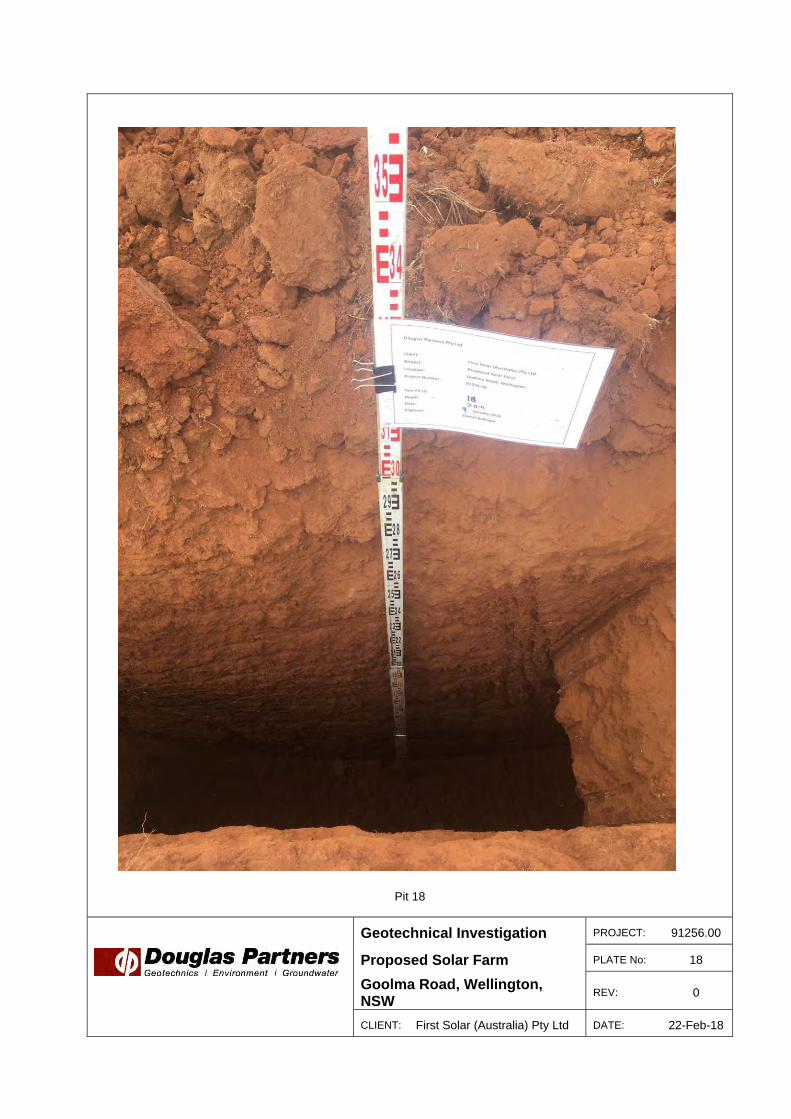
Pit 18
Geotechnical Investigation PROJECT: 91256.00
Proposed Solar Farm PLATE No: 18
Goolma Road, Wellington, NSW
REV: 0
CLIENT: First Solar (Australia) Pty Ltd DATE: 22-Feb-18

Pit 19
Geotechnical Investigation PROJECT: 91256.00
Proposed Solar Farm PLATE No: 19
Goolma Road, Wellington, NSW
REV: 0
CLIENT: First Solar (Australia) Pty Ltd DATE: 22-Feb-18

Pit 20
Geotechnical Investigation PROJECT: 91256.00
Proposed Solar Farm PLATE No: 20
Goolma Road, Wellington, NSW
REV: 0
CLIENT: First Solar (Australia) Pty Ltd DATE: 22-Feb-18

SILTY CLAY - Hard, red-brown silty clay, with trace fineto coarse grained sand and subrounded gravel (siltstonefragments) up to 10mm in size, M<Wp
From 0.9m, grading to rock
SILTSTONE - (Extremely low to very low strength,extremely weathered to highly weathered) red-brownmottled off-white siltstone
SILTSTONE - (Low to medium strength, moderatelyweathered to slightly weathered), grey and brownsiltstone
Bore discontinued at 5.0m, limit of investigation
2.0
3.5
5.0
Typ
e
Depth(m)
1
2
3
4
5
RL
Wat
er
Dep
th
Sam
ple
Description
of
Strata Gra
phic
Log
Results &Comments
Sampling & In Situ Testing
1
2
3
4
5
CLIENT:PROJECT:LOCATION: Goolma Road, Wellington
SAMPLING & IN SITU TESTING LEGENDA Auger sample G Gas sample PID Photo ionisation detector (ppm)B Bulk sample P Piston sample PL(A) Point load axial test Is(50) (MPa)BLK Block sample Ux Tube sample (x mm dia.) PL(D) Point load diametral test Is(50) (MPa)C Core drilling W Water sample pp Pocket penetrometer (kPa)D Disturbed sample Water seep S Standard penetration testE Environmental sample Water level V Shear vane (kPa)
BORE No: 21PROJECT No: 91256.00DATE: 11/1/2018SHEET 1 OF 1
DRILLER: Hennessey LOGGED: Ballinger CASING: Uncased
First Solar (Australia) Pty LtdProposed Solar Farm
REMARKS:
RIG: Douglas CMG Scout
WATER OBSERVATIONS:
TYPE OF BORING:
No free groundwater observed while bore remained open
Solid flight auger (TC-bit) to 5m
SURFACE LEVEL: --EASTING: 685248NORTHING: 6401373DIP/AZIMUTH: 90°/--
BOREHOLE LOG
Dynamic Penetrometer Test(blows per 0mm)
5 10 15 20
Sand Penetrometer AS1289.6.3.3Cone Penetrometer AS1289.6.3.2
pp >400
10,21,21N = 42
9,21,15/70refusal
12/50,-,-refusal
A
U50
S
S
S
0.1
0.4
0.69
1.0
1.45
2.5
2.87
4.04.05

TOPSOIL - Brown slightly sandy silt topsoil, fine tomedium grained, with trace clay and subrounded gravel,abundant organics
GRAVELLY SILTY CLAY - Hard, red-brown gravellysilty clay, gravel portion subrounded up to 30mm in size,trace fine to medium grained sand, M<Wp
META SILTSTONE - (Very low to low strength, highlyweathered to moderately weathered), grey and brownmeta siltstone
From 1.5m, (low to medium strength, moderatelyweathered to slightly weathered), increased drillingresistance
Bore discontinued at 5.0m, limit of investigation
0.02
0.7
5.0
Typ
e
Depth(m)
1
2
3
4
5
RL
Wat
er
Dep
th
Sam
ple
Description
of
Strata Gra
phic
Log
Results &Comments
Sampling & In Situ Testing
1
2
3
4
5
CLIENT:PROJECT:LOCATION: Goolma Road, Wellington
SAMPLING & IN SITU TESTING LEGENDA Auger sample G Gas sample PID Photo ionisation detector (ppm)B Bulk sample P Piston sample PL(A) Point load axial test Is(50) (MPa)BLK Block sample Ux Tube sample (x mm dia.) PL(D) Point load diametral test Is(50) (MPa)C Core drilling W Water sample pp Pocket penetrometer (kPa)D Disturbed sample Water seep S Standard penetration testE Environmental sample Water level V Shear vane (kPa)
BORE No: 22PROJECT No: 91256.00DATE: 11/1/2018SHEET 1 OF 1
DRILLER: Hennessey LOGGED: Ballinger CASING: Uncased
First Solar (Australia) Pty LtdProposed Solar Farm
REMARKS:
RIG: Douglas CMG Scout
WATER OBSERVATIONS:
TYPE OF BORING:
No free groundwater observed while bore remained open
Solid flight auger (TC-bit) to 5m
SURFACE LEVEL: --EASTING: 684577NORTHING: 6401685DIP/AZIMUTH: 90°/--
BOREHOLE LOG
Dynamic Penetrometer Test(blows per 0mm)
5 10 15 20
Sand Penetrometer AS1289.6.3.3Cone Penetrometer AS1289.6.3.2
15/50mm,-,-refusal
A
A
A
S
A
A
0.01
0.5
0.85
1.01.05
2.0
4.5

SILTY CLAY - (Hard), red-brown silty clay, with tracefine sized subangular gravel, M<Wp
From 1.0m, medium to coarse sized subangular gravel(meta-siltstone) (increased drilling resistance in parts)
From 4.0m, some rock structure evident
Bore discontinued at 5.0m, limit of investigation5.0
Typ
e
Depth(m)
1
2
3
4
5
RL
Wat
er
Dep
th
Sam
ple
Description
of
Strata Gra
phic
Log
Results &Comments
Sampling & In Situ Testing
1
2
3
4
5
CLIENT:PROJECT:LOCATION: Goolma Road, Wellington
SAMPLING & IN SITU TESTING LEGENDA Auger sample G Gas sample PID Photo ionisation detector (ppm)B Bulk sample P Piston sample PL(A) Point load axial test Is(50) (MPa)BLK Block sample Ux Tube sample (x mm dia.) PL(D) Point load diametral test Is(50) (MPa)C Core drilling W Water sample pp Pocket penetrometer (kPa)D Disturbed sample Water seep S Standard penetration testE Environmental sample Water level V Shear vane (kPa)
BORE No: 23PROJECT No: 91256.00DATE: 10/1/2018SHEET 1 OF 1
DRILLER: Hennessey LOGGED: Fulham CASING: Uncased
First Solar (Australia) Pty LtdProposed Solar Farm
REMARKS:
RIG: Douglas CMG Scout
WATER OBSERVATIONS:
TYPE OF BORING:
No free groundwater observed while bore remained open
Solid flight auger (TC-bit) to 5m
SURFACE LEVEL: --EASTING: 683937NORTHING: 6401781DIP/AZIMUTH: 90°/--
BOREHOLE LOG
Dynamic Penetrometer Test(blows per 0mm)
5 10 15 20
Sand Penetrometer AS1289.6.3.3Cone Penetrometer AS1289.6.3.2
25refusal
11,25,-refusal
10,25,10/40mmrefusal
A
A
S
S
S
A
0.1
0.5
1.0
1.15
2.5
2.8
4.0
4.34
4.95

SILTY CLAY - (Hard), red-brown silty clay, with somefine grained sand and trace fine to medium sizedsubangular gravel, M Wp
SILTY CLAY - Hard, pale brown silty clay, with trace finegrained sand (extremely weathered siltstone), M<Wp
SILTSTONE - Very low to low strength, highlyweathered, pale brown siltstone
Bore discontinued at 4.5m, TC-bit refusal
0.8
2.8
4.5
Typ
e
Depth(m)
1
2
3
4
5
RL
Wat
er
Dep
th
Sam
ple
Description
of
Strata Gra
phic
Log
Results &Comments
Sampling & In Situ Testing
1
2
3
4
5
CLIENT:PROJECT:LOCATION: Goolma Road, Wellington
SAMPLING & IN SITU TESTING LEGENDA Auger sample G Gas sample PID Photo ionisation detector (ppm)B Bulk sample P Piston sample PL(A) Point load axial test Is(50) (MPa)BLK Block sample Ux Tube sample (x mm dia.) PL(D) Point load diametral test Is(50) (MPa)C Core drilling W Water sample pp Pocket penetrometer (kPa)D Disturbed sample Water seep S Standard penetration testE Environmental sample Water level V Shear vane (kPa)
BORE No: 24PROJECT No: 91256.00DATE: 10/1/2018SHEET 1 OF 1
DRILLER: Hennessey LOGGED: Fulham CASING: Uncased
First Solar (Australia) Pty LtdProposed Solar Farm
REMARKS:
RIG: Douglas CMG Scout
WATER OBSERVATIONS:
TYPE OF BORING:
No free groundwater observed while bore remained open
Solid flight auger (TC-bit) to 4.5m
SURFACE LEVEL: --EASTING: 683091NORTHING: 6401472DIP/AZIMUTH: 90°/--
BOREHOLE LOG
Dynamic Penetrometer Test(blows per 0mm)
5 10 15 20
Sand Penetrometer AS1289.6.3.3Cone Penetrometer AS1289.6.3.2
9,13,15N = 28
16,24,5/20mmrefusal
(bouncing)
12/70mmrefusal
(bouncing)
A
A
A
S
S
S
A
0.1
0.5
0.85
1.0
1.45
2.5
2.82
4.04.07
4.45

SILTY CLAY - Hard, red-brown silty clay, with trace finegrained sand and fine sized subangular gravel, M<Wp
META SILTSTONE - (Very low to low strength, highlyweathered to moderately weathered), grey and brownmeta siltstone
From 3.5m, (low to medium strength, moderatelyweathered to slightly weathered)
Bore discontinued at 4.7m, TC-bit refusal
2.0
4.7
>>
Typ
e
Depth(m)
1
2
3
4
5
RL
Wat
er
Dep
th
Sam
ple
Description
of
Strata Gra
phic
Log
Results &Comments
Sampling & In Situ Testing
1
2
3
4
5
CLIENT:PROJECT:LOCATION: Goolma Road, Wellington
SAMPLING & IN SITU TESTING LEGENDA Auger sample G Gas sample PID Photo ionisation detector (ppm)B Bulk sample P Piston sample PL(A) Point load axial test Is(50) (MPa)BLK Block sample Ux Tube sample (x mm dia.) PL(D) Point load diametral test Is(50) (MPa)C Core drilling W Water sample pp Pocket penetrometer (kPa)D Disturbed sample Water seep S Standard penetration testE Environmental sample Water level V Shear vane (kPa)
BORE No: 25PROJECT No: 91256.00DATE: 11/1/2018SHEET 1 OF 1
DRILLER: Hennessey LOGGED: Ballinger CASING: Uncased
First Solar (Australia) Pty LtdProposed Solar Farm
REMARKS:
RIG: Douglas CMG Scout
WATER OBSERVATIONS:
TYPE OF BORING:
No free groundwater observed while bore remained open
Solid flight auger (TC-bit) to 4.7m
SURFACE LEVEL: --EASTING: 683990NORTHING: 6401289DIP/AZIMUTH: 90°/--
BOREHOLE LOG
Dynamic Penetrometer Test(blows per 150mm)
5 10 15 20
Sand Penetrometer AS1289.6.3.3Cone Penetrometer AS1289.6.3.2
10,14,15N = 29
35,-,-refusal
10/40mm,-,-refusal
(bouncing)
A
A
S
S
S
A
0.1
0.5
1.0
1.45
2.5
2.65
4.04.04
4.5
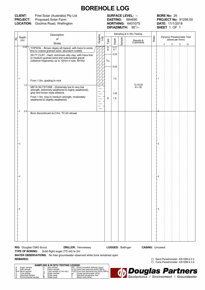
TOPSOIL - Brown clayey silt topsoil, with trace to somefine to coarse grained sand, abundant rootlets
SILTY CLAY - Hard, red-brown silty clay, with trace fineto medium grained sand and subrounded gravel(siltstone fragments) up to 10mm in size, M<Wp
From 1.0m, grading to rock
META SILTSTONE - (Extremely low to very lowstrength, extremely weathered to highly weathered),grey and brown meta siltstone
From 1.5m, (low to medium strength, moderatelyweathered to slightly weathered)
Bore discontinued at 2.0m, TC-bit refusal
0.02
1.2
2.0
Typ
e
Depth(m)
1
2
3
4
5
RL
Wat
er
Dep
th
Sam
ple
Description
of
Strata Gra
phic
Log
Results &Comments
Sampling & In Situ Testing
1
2
3
4
5
CLIENT:PROJECT:LOCATION: Goolma Road, Wellington
SAMPLING & IN SITU TESTING LEGENDA Auger sample G Gas sample PID Photo ionisation detector (ppm)B Bulk sample P Piston sample PL(A) Point load axial test Is(50) (MPa)BLK Block sample Ux Tube sample (x mm dia.) PL(D) Point load diametral test Is(50) (MPa)C Core drilling W Water sample pp Pocket penetrometer (kPa)D Disturbed sample Water seep S Standard penetration testE Environmental sample Water level V Shear vane (kPa)
BORE No: 26PROJECT No: 91256.00DATE: 11/1/2018SHEET 1 OF 1
DRILLER: Hennessey LOGGED: Ballinger CASING: Uncased
First Solar (Australia) Pty LtdProposed Solar Farm
REMARKS:
RIG: Douglas CMG Scout
WATER OBSERVATIONS:
TYPE OF BORING:
No free groundwater observed while bore remained open
Solid flight auger (TC-bit) to 2m
SURFACE LEVEL: --EASTING: 684690NORTHING: 6401075DIP/AZIMUTH: 90°/--
BOREHOLE LOG
Dynamic Penetrometer Test(blows per 0mm)
5 10 15 20
Sand Penetrometer AS1289.6.3.3Cone Penetrometer AS1289.6.3.2
13,19,20N = 39
DD
U50
D
0.010.1
0.25
0.63
1.0
1.45
1.6

SILTY CLAY - (Hard) red brown silty clay, with trace fineto medium grained sand, M Wp
From 1.3m, trace fine sized gravel
CLAYEY GRAVEL - Medium dense, red-brown, finesized subangular clayey gravel, moist to wet
Bore discontinued at 5.0m, limit of investigation
3.5
5.0
Typ
e
Depth(m)
1
2
3
4
5
RL
Wat
er
Dep
th
Sam
ple
Description
of
Strata Gra
phic
Log
Results &Comments
Sampling & In Situ Testing
1
2
3
4
5
CLIENT:PROJECT:LOCATION: Goolma Road, Wellington
SAMPLING & IN SITU TESTING LEGENDA Auger sample G Gas sample PID Photo ionisation detector (ppm)B Bulk sample P Piston sample PL(A) Point load axial test Is(50) (MPa)BLK Block sample Ux Tube sample (x mm dia.) PL(D) Point load diametral test Is(50) (MPa)C Core drilling W Water sample pp Pocket penetrometer (kPa)D Disturbed sample Water seep S Standard penetration testE Environmental sample Water level V Shear vane (kPa)
BORE No: 27PROJECT No: 91256.00DATE: 10/1/2018SHEET 1 OF 1
DRILLER: Hennessey LOGGED: Fulham CASING: Uncased
First Solar (Australia) Pty LtdProposed Solar Farm
REMARKS:
RIG: Douglas CMG Scout
WATER OBSERVATIONS:
TYPE OF BORING:
No free groundwater observed while bore remained open
Solid flight auger (TC-bit) to 5m
SURFACE LEVEL: --EASTING: 682026NORTHING: 6401320DIP/AZIMUTH: 90°/--
BOREHOLE LOG
Dynamic Penetrometer Test(blows per 0mm)
5 10 15 20
Sand Penetrometer AS1289.6.3.3Cone Penetrometer AS1289.6.3.2
6,8,13N = 21
pp >40015,21,26N = 47
6,8,5N = 13
A
A
S
S
S
A
0.1
0.5
1.0
1.45
2.5
2.95
4.0
4.45
4.95

SILTY CLAY - (Very stiff), red-brown silty clay, withtrace fine grained sand, M Wp
From 0.5m, hard
From 1m, very stiff to hard lenses of fine to mediumgrained sand and fine sized subrounded gravels
SILTY CLAY - Hard, red-brown silty clay, slightlygravelly, with fine to medium sized subangular /subrounded gravel, M<Wp
From 2.5m, some rock structure evident
Bore discontinued at 3.82m, TC-bit refusal (on possiblebedrock)
2.0
3.82
Typ
e
Depth(m)
1
2
3
4
5
RL
Wat
er
Dep
th
Sam
ple
Description
of
Strata Gra
phic
Log
Results &Comments
Sampling & In Situ Testing
1
2
3
4
5
CLIENT:PROJECT:LOCATION: Goolma Road, Wellington
SAMPLING & IN SITU TESTING LEGENDA Auger sample G Gas sample PID Photo ionisation detector (ppm)B Bulk sample P Piston sample PL(A) Point load axial test Is(50) (MPa)BLK Block sample Ux Tube sample (x mm dia.) PL(D) Point load diametral test Is(50) (MPa)C Core drilling W Water sample pp Pocket penetrometer (kPa)D Disturbed sample Water seep S Standard penetration testE Environmental sample Water level V Shear vane (kPa)
BORE No: 28PROJECT No: 91256.00DATE: 10/1/2018SHEET 1 OF 1
DRILLER: Hennessey LOGGED: Fulham CASING: Uncased
First Solar (Australia) Pty LtdProposed Solar Farm
REMARKS:
RIG: Douglas CMG Scout
WATER OBSERVATIONS:
TYPE OF BORING:
No free groundwater observed while bore remained open
Solid flight auger (TC-bit) to 3.4m, SPT sampler to 3.82m
SURFACE LEVEL: --EASTING: 682980NORTHING: 6400975DIP/AZIMUTH: 90°/--
BOREHOLE LOG
Dynamic Penetrometer Test(blows per 0mm)
5 10 15 20
Sand Penetrometer AS1289.6.3.3Cone Penetrometer AS1289.6.3.2
pp = 350
pp = 500-550
3,4,8N = 12
12,14,18N = 32
10,20,25/120refusal
A
A
S
A
S
A
S
0.1
0.5
0.73
1.0
1.45
2.0
2.5
2.95
3.4
3.82

SILTY CLAY - (Hard), red-brown silty clay, with tracefine grained sand, rootlets in top 500mm
From 2.0m, trace to some fine sized gravel
Bore discontinued at 5.0m, limit of investigation5.0
Typ
e
Depth(m)
1
2
3
4
5
RL
Wat
er
Dep
th
Sam
ple
Description
of
Strata Gra
phic
Log
Results &Comments
Sampling & In Situ Testing
1
2
3
4
5
CLIENT:PROJECT:LOCATION: Goolma Road, Wellington
SAMPLING & IN SITU TESTING LEGENDA Auger sample G Gas sample PID Photo ionisation detector (ppm)B Bulk sample P Piston sample PL(A) Point load axial test Is(50) (MPa)BLK Block sample Ux Tube sample (x mm dia.) PL(D) Point load diametral test Is(50) (MPa)C Core drilling W Water sample pp Pocket penetrometer (kPa)D Disturbed sample Water seep S Standard penetration testE Environmental sample Water level V Shear vane (kPa)
BORE No: 29PROJECT No: 91256.00DATE: 9 - 10/1/2018SHEET 1 OF 1
DRILLER: Hennessey LOGGED: Fulham CASING: Uncased
First Solar (Australia) Pty LtdProposed Solar Farm
REMARKS:
RIG: Douglas CMG Scout
WATER OBSERVATIONS:
TYPE OF BORING:
No free groundwater observed while bore remained open
Solid flight auger (TC-bit) to 5m
SURFACE LEVEL: --EASTING: 683315NORTHING: 6400844DIP/AZIMUTH: 90°/--
BOREHOLE LOG
Dynamic Penetrometer Test(blows per 0mm)
5 10 15 20
Sand Penetrometer AS1289.6.3.3Cone Penetrometer AS1289.6.3.2
pp >600
pp >4006,9,11N = 20
pp >5006,8,14N = 22
pp >6008,16,20N = 36
A
A
U50
S
S
S
A
0.1
0.5
1.0
1.2
1.5
1.95
2.5
2.95
4.0
4.45
4.95

TOPSOIL - Brown silty clay topsoil, with some rootlets,dry to humid
SILTY CLAY - (Hard), pale brown silty clay, with tracefine to medium sized gravel, M<Wp
META SANDSTONE - (Low strength, highly weathered),light brown, meta sandstone
Bore discontinued at 1.8m, slow progress with TC-bit
0.15
1.15
1.8T
ype
Depth(m)
1
2
3
4
5
RL
Wat
er
Dep
th
Sam
ple
Description
of
Strata Gra
phic
Log
Results &Comments
Sampling & In Situ Testing
1
2
3
4
5
CLIENT:PROJECT:LOCATION: Goolma Road, Wellington
SAMPLING & IN SITU TESTING LEGENDA Auger sample G Gas sample PID Photo ionisation detector (ppm)B Bulk sample P Piston sample PL(A) Point load axial test Is(50) (MPa)BLK Block sample Ux Tube sample (x mm dia.) PL(D) Point load diametral test Is(50) (MPa)C Core drilling W Water sample pp Pocket penetrometer (kPa)D Disturbed sample Water seep S Standard penetration testE Environmental sample Water level V Shear vane (kPa)
BORE No: 30PROJECT No: 91256.00DATE: 9/1/2018SHEET 1 OF 1
DRILLER: Hennessey LOGGED: Fulham CASING: Uncased
First Solar (Australia) Pty LtdProposed Solar Farm
REMARKS:
RIG: Douglas CMG Scout
WATER OBSERVATIONS:
TYPE OF BORING:
No free groundwater observed while bore remained open
Solid flight auger (TC-bit) to 1.8m
SURFACE LEVEL: --EASTING: 683659NORTHING: 6400545DIP/AZIMUTH: 90°/--
BOREHOLE LOG
Dynamic Penetrometer Test(blows per 0mm)
5 10 15 20
Sand Penetrometer AS1289.6.3.3Cone Penetrometer AS1289.6.3.2
29/140mmrefusal
A
A
S
A
A
0.1
0.5
1.0
1.15
1.5
1.8

TOPSOIL - Brown slightly sandy silt topsoil, fine tocoarse grained, with trace to some clay and subangulargravel / cobbles abundant organics
SILTY CLAY - Hard, red-brown silty clay, with somesubrounded gravel (siltstone fragments) up to 20mm insize, M<Wp
META SILTSTONE - (Extremely low to very lowstrength, extremely weathered to highly weathered),grey and brown meta siltstone
From 1.1m, (very low to low and medium strength,moderately weathered to slightly weathered)
From 4.3m, (low to medium strength, slightly weathered)
Bore discontinued at 4.9m, TC-bit refusal
0.02
0.8
4.9
Typ
e
Depth(m)
1
2
3
4
5
RL
Wat
er
Dep
th
Sam
ple
Description
of
Strata Gra
phic
Log
Results &Comments
Sampling & In Situ Testing
1
2
3
4
5
CLIENT:PROJECT:LOCATION: Goolma Road, Wellington
SAMPLING & IN SITU TESTING LEGENDA Auger sample G Gas sample PID Photo ionisation detector (ppm)B Bulk sample P Piston sample PL(A) Point load axial test Is(50) (MPa)BLK Block sample Ux Tube sample (x mm dia.) PL(D) Point load diametral test Is(50) (MPa)C Core drilling W Water sample pp Pocket penetrometer (kPa)D Disturbed sample Water seep S Standard penetration testE Environmental sample Water level V Shear vane (kPa)
BORE No: 31PROJECT No: 91256.00DATE: 11/1/2018SHEET 1 OF 1
DRILLER: Hennessey LOGGED: Ballinger CASING: Uncased
First Solar (Australia) Pty LtdProposed Solar Farm
REMARKS:
RIG: Douglas CMG Scout
WATER OBSERVATIONS:
TYPE OF BORING:
No free groundwater observed while bore remained open
Solid flight auger (TC-bit) to 4.9m
SURFACE LEVEL: --EASTING: 684164NORTHING: 6400640DIP/AZIMUTH: 90°/--
BOREHOLE LOG
Dynamic Penetrometer Test(blows per 0mm)
5 10 15 20
Sand Penetrometer AS1289.6.3.3Cone Penetrometer AS1289.6.3.2
27,-,-refusal
25,12/50mm,-refusal
D
U50
S
D
S
0.2
0.3
0.61
1.0
1.15
2.0
2.5
2.7

SILTY CLAY - (Hard), red-brown silty clay, with tracefine grained sand, M<Wp
From 2.0m, trace medium sized subangular gravel
Bore discontinued at 3.1m, TC-bit refusal (on possiblebedrock)
3.1
Typ
e
Depth(m)
1
2
3
4
5
RL
Wat
er
Dep
th
Sam
ple
Description
of
Strata Gra
phic
Log
Results &Comments
Sampling & In Situ Testing
1
2
3
4
5
CLIENT:PROJECT:LOCATION: Goolma Road, Wellington
SAMPLING & IN SITU TESTING LEGENDA Auger sample G Gas sample PID Photo ionisation detector (ppm)B Bulk sample P Piston sample PL(A) Point load axial test Is(50) (MPa)BLK Block sample Ux Tube sample (x mm dia.) PL(D) Point load diametral test Is(50) (MPa)C Core drilling W Water sample pp Pocket penetrometer (kPa)D Disturbed sample Water seep S Standard penetration testE Environmental sample Water level V Shear vane (kPa)
BORE No: 32PROJECT No: 91256.00DATE: 9/1/2018SHEET 1 OF 1
DRILLER: Hennessey LOGGED: Fulham CASING: Uncased
First Solar (Australia) Pty LtdProposed Solar Farm
REMARKS:
RIG: Douglas CMG Scout
WATER OBSERVATIONS:
TYPE OF BORING:
No free groundwater observed while bore remained open
Solid flight auger (TC-bit) to 3.1m
SURFACE LEVEL: --EASTING: 683672NORTHING: 6400107DIP/AZIMUTH: 90°/--
BOREHOLE LOG
Dynamic Penetrometer Test(blows per 0mm)
5 10 15 20
Sand Penetrometer AS1289.6.3.3Cone Penetrometer AS1289.6.3.2
pp >600
8,17,18N = 35
4,12,8/90mmrefusal
A
A
U50
S
A
S
0.1
0.5
0.73
1.0
1.45
2.0
2.5
2.89

SILTY CLAY - Hard, red-brown silty clay, with trace fineto medium grained sand and subrounded gravel up to10mm in size, M<Wp
From 1.4m, grey and brown, with trace to some sandand gravel / cobbles (medium to high strength metasiltstone)
From 3.4m, increased drilling resistance (probableincrease in gravel / cobble proportion)
META SILTSTONE - (Medium strength, slightlyweathered), grey and brown meta siltstone
Bore discontinued at 4.2m, TC-bit refusal
4.0
4.2
Typ
e
Depth(m)
1
2
3
4
5
RL
Wat
er
Dep
th
Sam
ple
Description
of
Strata Gra
phic
Log
Results &Comments
Sampling & In Situ Testing
1
2
3
4
5
CLIENT:PROJECT:LOCATION: Goolma Road, Wellington
SAMPLING & IN SITU TESTING LEGENDA Auger sample G Gas sample PID Photo ionisation detector (ppm)B Bulk sample P Piston sample PL(A) Point load axial test Is(50) (MPa)BLK Block sample Ux Tube sample (x mm dia.) PL(D) Point load diametral test Is(50) (MPa)C Core drilling W Water sample pp Pocket penetrometer (kPa)D Disturbed sample Water seep S Standard penetration testE Environmental sample Water level V Shear vane (kPa)
BORE No: 33PROJECT No: 91256.00DATE: 11/1/2018SHEET 1 OF 1
DRILLER: Ballinger LOGGED: Ballinger CASING: Uncased
First Solar (Australia) Pty LtdProposed Solar Farm
REMARKS:
RIG: Douglas CMG Scout
WATER OBSERVATIONS:
TYPE OF BORING:
No free groundwater observed while bore remained open
Solid flight auger (TC-bit) to 4.2m
SURFACE LEVEL: --EASTING: 684057NORTHING: 6399769DIP/AZIMUTH: 90°/--
BOREHOLE LOG
Dynamic Penetrometer Test(blows per 0mm)
5 10 15 20
Sand Penetrometer AS1289.6.3.3Cone Penetrometer AS1289.6.3.2
9,10,12N = 22
7,11,20N = 31
5/10mm,-,-refusal
D
U50
S
D
S
S
0.1
0.3
0.55
1.0
1.451.5
2.5
2.95
4.04.01

SILTY CLAY - Hard, red-brown silty clay, with trace tosome fine to coarse grained sand and subroundedgravel up to 10mm in size, M<Wp
From 0.7m to 1.2m, (high strength) meta siltstonecobbles
From 4.0m, brown and grey (completely weatheredrock)
Bore discontinued at 5.0m, limit of investigation5.0
Typ
e
Depth(m)
1
2
3
4
5
RL
Wat
er
Dep
th
Sam
ple
Description
of
Strata Gra
phic
Log
Results &Comments
Sampling & In Situ Testing
1
2
3
4
5
CLIENT:PROJECT:LOCATION: Goolma Road, Wellington
SAMPLING & IN SITU TESTING LEGENDA Auger sample G Gas sample PID Photo ionisation detector (ppm)B Bulk sample P Piston sample PL(A) Point load axial test Is(50) (MPa)BLK Block sample Ux Tube sample (x mm dia.) PL(D) Point load diametral test Is(50) (MPa)C Core drilling W Water sample pp Pocket penetrometer (kPa)D Disturbed sample Water seep S Standard penetration testE Environmental sample Water level V Shear vane (kPa)
BORE No: 34PROJECT No: 91256.00DATE: 11/1/2018SHEET 1 OF 1
DRILLER: Hennessey LOGGED: Ballinger CASING: Uncased
First Solar (Australia) Pty LtdProposed Solar Farm
REMARKS:
RIG: Douglas CMG Scout
WATER OBSERVATIONS:
TYPE OF BORING:
No free groundwater observed while bore remained open
Solid flight auger (TC-bit) to 5m
SURFACE LEVEL: --EASTING: 684878NORTHING: 6400346DIP/AZIMUTH: 90°/--
BOREHOLE LOG
Dynamic Penetrometer Test(blows per 0mm)
5 10 15 20
Sand Penetrometer AS1289.6.3.3Cone Penetrometer AS1289.6.3.2
12,15,21N = 36
16,21,15/50refusal
D
D
0.1
2.0
2.5
2.95
4.0
4.35

Appendix C
eSpade Soil Technical Reports
SITE DETAILS:
PROFILE MAP DETAILS:1:100,000 Mapsheet: WELLINGTON (8632)
MGA Easting:
MGA Zone:
682538
55
Locational Accuracy: Other
MGA Northing: 6401346
PROFILE DETAILS:Described by:
Nature of Exposure:
No of Layers:
Profile Date:
Photo Taken:
SOIL AND MAP CODES:Geology Map Code:
Aust. Soil Classification:
Soil Map Code:
TOPOGRAPHY:Slope:
Elevation: Aspect:
Great Soil Group:
Soil Taxonomy:
Atlas (A&M) Code:
Northcote PPF:
Atlas(Northcote)Code:
LANDFORM:Site Morphology:
SlopeMorphology:
Landform Pattern:
Site Process:
Microrelief:
Plan Curvature: Position in Landform Element:
Local Relief:
Landform Element:
lower slope
Mr Paul Smith Jan 23, 2004
core sample profile
6
Dermosol, Red, medium, non gravelly, loamy, clayey
Gn3.13
hills
Microrelief depth:
Base of observation: layer continues
Survey: Recharge Validation (1004444)
Profile: 64
Location: 64

LITHOLOGY:Solum PM:
Rock Outcrop:
Substrate Strength:
Substrate:
Weathering & Alteration:Discontinuities:
Outcrop Same As:
FragmentAmount:
VEGETATION:
VegetationCommunity:
Growth Form(s):
Crown Separation Ratio:
Upper Stratum Height:
SITE CONDITION:Ground Cover %:
Current Condition:
Site Disturbance:
Expected Dry Condition:
LAND USE:
Site: General Area:
HYDROLOGY:Presence of Free Water:Run-on:
Permeability:
Free Water Depth:
Free Water pH: Free Water EC:
Runoff:
Profile Drainage:
EROSION:
Microrelief extent:
Rock Outcrop (BSAL):
VegetationFormation:
improved pasture volun./native pasture, improved pasture, cropping
Wind exposure:
Expected Wet Condition:
EstimatedEffective Rooting Depth:
Land Use Vegetation Species:
Prior Land Use:

Salinity:
FIELD NOTES:
LAYER 0Depth: 0.00 - 0.00 m
Layer Notes:
Vesicles: Ped porosity:
LAYER 1Depth: 0.00 - 0.15 m
Layer Notes:
TEXTURE: sandy loam
COLOUR:Moist: dark yellowish brown (dark brown) (10YR 3/4)
FIELD CHEMICAL TESTS:pH: 5.5 (Not recorded) Field EC:
HCl: H2O2:
AgNO3:
STRUCTURE:Grade of Pedality: weak pedality Fabric:
Dominant Peds: 2 - 5 mm, crumb Subdominant Peds:
Artificial Aggregates: SOILpak score:
Vesicles: Ped porosity:
LAYER 2Depth: 0.15 - 0.40 m
Layer Notes:
Erosion Hazard:
Salt Outbreak Mapping:
Salt Outbreak Vegetation Species:
EM Measurement 1 Type:
EM Measurement 1 horizontal:
EM Measurement 1 vertical:EM Measurement 2 Type:
EM Measurement 2 horizontal:
EM Measurement 2 vertical:
SALINITY:

TEXTURE: clay loam
COLOUR:Moist: red (10R 4/6)
FIELD CHEMICAL TESTS:pH: 6.0 (Not recorded) Field EC:
HCl: H2O2:
AgNO3:
STRUCTURE:Grade of Pedality: moderate pedality Fabric:
Dominant Peds: 5 - 10 mm, platy Subdominant Peds:
Artificial Aggregates: SOILpak score:
Vesicles: Ped porosity:
LAYER 3Depth: 0.40 - 0.92 m
Layer Notes:
TEXTURE: light clay
COLOUR:Moist: red (10R 4/8)
FIELD CHEMICAL TESTS:pH: 8.0 (Not recorded) Field EC:
HCl: H2O2:
AgNO3:
STRUCTURE:Grade of Pedality: moderate pedality Fabric:
Dominant Peds: 5 - 10 mm, sub-angular blocky
Subdominant Peds:
Artificial Aggregates: SOILpak score:
Vesicles: Ped porosity:
LAYER 4Depth: 0.92 - 1.00 m
Layer Notes:
TEXTURE: light clay
COLOUR:Moist: red (reddish brown) (2.5YR 4/6)
FIELD CHEMICAL TESTS:

pH: 8.5 (Not recorded) Field EC:
HCl: H2O2:
AgNO3:
STRUCTURE:Grade of Pedality: moderate pedality Fabric:
Dominant Peds: 10 - 20 mm, sub-angular blocky
Subdominant Peds:
Artificial Aggregates: SOILpak score:
Vesicles: Ped porosity:
LAYER 99Layer Notes:
Vesicles: Ped porosity:
LABORATORY TESTSNone available
For information on laboratory test data and units of measure, please see: Soil survey standard test methods
Soil technical Report
Report generated on 2/12/2018 at 1:59 PM
To contact us, email: [email protected]
© Office of Environment and Heritage (OEH)

SITE DETAILS:
PROFILE MAP DETAILS:1:100,000 Mapsheet: DUBBO (8633)
MGA Easting:
MGA Zone:
684356
55
Locational Accuracy: Other
MGA Northing: 6402513
PROFILE DETAILS:Described by:
Nature of Exposure:
No of Layers:
Profile Date:
Photo Taken:
SOIL AND MAP CODES:Geology Map Code:
Aust. Soil Classification:
Soil Map Code:
TOPOGRAPHY:Slope:
Elevation: Aspect:
Great Soil Group:
Soil Taxonomy:
Atlas (A&M) Code:
Northcote PPF:
Atlas(Northcote)Code:
LANDFORM:Site Morphology:
SlopeMorphology:
Landform Pattern:
Site Process:
Microrelief:
Plan Curvature: Position in Landform Element:
Local Relief:
Landform Element:
mid-slope
Ms Helen Wheeler Jan 27, 2004
core sample
6
Chromosol, Brown, medium, non gravelly, loamy, clayey
Dr4.12
low hills
Microrelief depth:
Base of observation: equipment/auger refusal
Survey: Recharge Validation (1004444)
Profile: 75
Location: 75 Netta Lee

LITHOLOGY:Solum PM:
Rock Outcrop:
Substrate Strength:
Substrate:
Weathering & Alteration:Discontinuities:
Outcrop Same As:
FragmentAmount:
VEGETATION:
VegetationCommunity:
Growth Form(s):
Crown Separation Ratio:
Upper Stratum Height:
SITE CONDITION:Ground Cover %:
Current Condition:
Site Disturbance:
Expected Dry Condition:
LAND USE:
Site: General Area:
HYDROLOGY:Presence of Free Water:Run-on:
Permeability:
Free Water Depth:
Free Water pH: Free Water EC:
Runoff:
Profile Drainage:
EROSION:
soft
Microrelief extent:
Rock Outcrop (BSAL):
VegetationFormation:
improved pasture improved pasture, cropping
Wind exposure:
Erosion Hazard: moderate
Expected Wet Condition:
EstimatedEffective Rooting Depth:
firm
Land Use Vegetation Species:
Prior Land Use:

Salinity:
FIELD NOTES:
LAYER 0Depth: 0.00 - 0.00 m
Layer Notes:
Vesicles: Ped porosity:
LAYER 1 A horizon
Depth: 0.00 - 0.10 m
Layer Notes:
TEXTURE: loam
COLOUR:Moist: dark reddish brown (5YR 3/3)
FIELD CHEMICAL TESTS:pH: 5.5 (Raupach) Field EC:
HCl: H2O2:
AgNO3:
STRUCTURE:Grade of Pedality: weak pedality Fabric: rough-faced peds
Dominant Peds: Subdominant Peds:
Artificial Aggregates: SOILpak score:
Vesicles: Ped porosity:
LAYER 2 B21 horizon
Depth: 0.10 - 0.55 m
Layer Notes:
TEXTURE: light medium clay
Salt Outbreak Mapping:
Salt Outbreak Vegetation Species:
EM Measurement 1 Type:
EM Measurement 1 horizontal:
EM Measurement 1 vertical:EM Measurement 2 Type:
EM Measurement 2 horizontal:
EM Measurement 2 vertical:
SALINITY:

COLOUR:Moist: dark brown (7.5YR 3/4)
FIELD CHEMICAL TESTS:pH: 7.0 (Raupach) Field EC:
HCl: H2O2:
AgNO3:
STRUCTURE:Grade of Pedality: strong pedality Fabric: smooth-faced peds
Dominant Peds: , sub-angular blocky Subdominant Peds:
Artificial Aggregates: SOILpak score:
Vesicles: Ped porosity:
LAYER 3 B21 horizon
Depth: 0.55 - 0.80 m
Layer Notes:
TEXTURE: light medium clay
COLOUR:Moist: strong brown (brown) (7.5YR 4/6)
FIELD CHEMICAL TESTS:pH: 7.5 (Raupach) Field EC:
HCl: H2O2:
AgNO3:
STRUCTURE:Grade of Pedality: strong pedality Fabric: smooth-faced peds
Dominant Peds: 1 - 2 mm, polyhedral Subdominant Peds:
Artificial Aggregates: SOILpak score:
Vesicles: Ped porosity:
SEGREGATIONS:Type: manganiferous Amount: very few (< 2%)
Strength: Form: nodules
Size: fine (< 2 mm)
LAYER 4 B23 horizon
Depth: 0.80 - 1.00 m
Layer Notes:
TEXTURE: light medium clay

COLOUR:Moist: yellowish brown (10YR 5/6)
FIELD CHEMICAL TESTS:pH: 7.5 (Raupach) Field EC:
HCl: H2O2:
AgNO3:
STRUCTURE:Grade of Pedality: weak pedality Fabric: rough-faced peds
Dominant Peds: < 1 mm, granular Subdominant Peds:
Artificial Aggregates: SOILpak score:
Vesicles: Ped porosity:
COARSE FRAGMENTS:Type: sedimentary Amount: very few (< 2%)
Distribution: Orientation:
Weathering: Shape:
Size: fine gravel (2-6 mm)
SEGREGATIONS:Type: manganiferous Amount: few (2% - 10%)
Strength: Form: nodules
Size: fine (< 2 mm), medium (2-6 mm)
LAYER 99Layer Notes:
Vesicles: Ped porosity:
LABORATORY TESTSNone available
For information on laboratory test data and units of measure, please see: Soil survey standard test methods
Soil technical Report
Report generated on 2/12/2018 at 2:01 PM
To contact us, email: [email protected]
© Office of Environment and Heritage (OEH)

SITE DETAILS:
PROFILE MAP DETAILS:1:100,000 Mapsheet: WELLINGTON (8632)
MGA Easting:
MGA Zone:
683413
55
Locational Accuracy: Other
MGA Northing: 6401984
PROFILE DETAILS:Described by:
Nature of Exposure:
No of Layers:
Profile Date:
Photo Taken:
SOIL AND MAP CODES:Geology Map Code:
Aust. Soil Classification:
Soil Map Code:
TOPOGRAPHY:Slope:
Elevation: Aspect:
Great Soil Group:
Soil Taxonomy:
Atlas (A&M) Code:
Northcote PPF:
Atlas(Northcote)Code:
LANDFORM:Site Morphology:
SlopeMorphology:
Landform Pattern:
Site Process:
Microrelief:
Plan Curvature: Position in Landform Element:
Local Relief:
Landform Element:
Euchrozem
2% (measured)
mid-slope
Mr John Lawrie Sep 07, 1988
core sample
6
Ebz
Gn3.13
Microrelief depth:
Base of observation:
Survey: WELLINGTON RESEARCH CENTRE (1000349)
Profile: 2
Location: KURRAMON PADDOCK

LITHOLOGY:Solum PM:
Rock Outcrop:
Substrate Strength:
Substrate:
Weathering & Alteration:Discontinuities:
Outcrop Same As:
FragmentAmount:
VEGETATION:
VegetationCommunity:
Growth Form(s):
Crown Separation Ratio:
Upper Stratum Height:
SITE CONDITION:Ground Cover %:
Current Condition:
Site Disturbance:
Expected Dry Condition:
LAND USE:
Site: General Area:
HYDROLOGY:Presence of Free Water:Run-on:
Permeability:
Free Water Depth:
Free Water pH: Free Water EC:
Runoff:
Profile Drainage:
EROSION:
fine-basic
moderate
imperfectly drained
fine-basic
gravelly hard set
cleared, no cultivation
Microrelief extent:
Nil Rock Outcrop (BSAL):
VegetationFormation:
dry sclerophyll forest
cropping cropping
low
Wind Erosion: none
Sheet Erosion: moderate, stable
Expected Wet Condition:
EstimatedEffective Rooting Depth:
Land Use Vegetation Species:
Prior Land Use:

Salinity:
FIELD NOTES:
LAYER 0Depth: 0.00 - 0.00 m
Layer Notes:
Vesicles: Ped porosity:
COARSE FRAGMENTS:Type: metamorphic Amount: very few (< 2%)
Distribution: Orientation: reoriented
Weathering: non-weathered Shape: angular
Size: fine gravel (2-6 mm)
LAYER 1 A11 horizon
Depth: 0.00 - 0.10 m
Layer Notes: Fine sand present.
TEXTURE: silty clay
COLOUR:Moist: dark reddish brown (5YR 3/4)
FIELD CHEMICAL TESTS:pH: 5.5 (Raupach) Field EC:
HCl: H2O2:
AgNO3:
STRUCTURE:Grade of Pedality: moderate pedality Fabric: smooth-faced peds
Dominant Peds: 10 - 20 mm Subdominant Peds: 2 - 5 mm
no salting evident
Wind exposure:
Erosion Hazard: moderate
Plow pan at 7cm. Field pea crop.
Salt Outbreak Mapping:
Salt Outbreak Vegetation Species:
EM Measurement 1 Type:
EM Measurement 1 horizontal:
EM Measurement 1 vertical:EM Measurement 2 Type:
EM Measurement 2 horizontal:
EM Measurement 2 vertical:
SALINITY:

Artificial Aggregates: SOILpak score:
Vesicles: Ped porosity: porous
COARSE FRAGMENTS:Type: metamorphic Amount: few (2-10%)
Distribution: Orientation: reoriented
Weathering: non-weathered Shape: angular
Size: fine gravel (2-6 mm)
PANS:Type: not evident Cementation:
Continuity: Structure:
SEGREGATIONS:Type: not evident Amount:
Strength: Form:
Size:
CONSISTENCE:Degree of Plasticity: Stickiness: slightly sticky
Texture Modifier: no change Disruptive Test: moderately weak force
Shearing Test: crumbly Toughness:
SOIL WATER STATUS: wet
SAMPLE TAKEN: unspecified
BOUNDARY:Distinctiveness: gradual (50-100 mm) Shape: smooth
LAYER 2 A12 horizon
Depth: 0.10 - 0.35 m
Layer Notes: Fine sand present. Dominant peds 10-50mm.
TEXTURE: silty clay
COLOUR:Moist: (very dark reddish brown) (5YR 2/4)
FIELD CHEMICAL TESTS:pH: 7.0 (Raupach) Field EC:
HCl: H2O2:
AgNO3:
STRUCTURE:Grade of Pedality: moderate pedality Fabric: smooth-faced peds
Dominant Peds: 10 - 20 mm Subdominant Peds: 2 - 5 mm

Artificial Aggregates: SOILpak score:
Vesicles: Ped porosity: porous
COARSE FRAGMENTS:Type: metamorphic Amount: very few (< 2%)
Distribution: Orientation: reoriented
Weathering: weakly weathered Shape: sub-angular
Size: fine gravel (2-6 mm)
PANS:Type: not evident Cementation:
Continuity: Structure:
SEGREGATIONS:Type: not evident Amount:
Strength: Form:
Size:
CONSISTENCE:Degree of Plasticity: Stickiness: moderately sticky
Texture Modifier: no change Disruptive Test: moderately firm force
Shearing Test: crumbly Toughness:
SOIL WATER STATUS: moist
BOUNDARY:Distinctiveness: gradual (50-100 mm) Shape: smooth
LAYER 3 B1 horizon
Depth: 0.35 - 0.55 m
Layer Notes: Fine sand present.
TEXTURE: light clay
COLOUR:Moist: dark reddish brown (5YR 3/4)
FIELD CHEMICAL TESTS:pH: 8.0 (Raupach) Field EC:
HCl: H2O2:
AgNO3:
STRUCTURE:Grade of Pedality: moderate pedality Fabric: smooth-faced peds
Dominant Peds: 10 - 20 mm Subdominant Peds: 2 - 5 mm
Artificial Aggregates: SOILpak score:
Vesicles: Ped porosity: porous

COARSE FRAGMENTS:Type: metamorphic Amount: many (20-50%)
Distribution: Orientation: reoriented
Weathering: weakly weathered Shape: sub-angular
Size: gravel (6-20 mm)
PANS:Type: not evident Cementation:
Continuity: Structure:
SEGREGATIONS:Type: not evident Amount:
Strength: Form:
Size:
CONSISTENCE:Degree of Plasticity: Stickiness: moderately sticky
Texture Modifier: increase < 2 Grades Disruptive Test: moderately weak force
Shearing Test: crumbly Toughness:
SOIL WATER STATUS: moist
SAMPLE TAKEN: unspecified
BOUNDARY:Distinctiveness: gradual (50-100 mm) Shape: irregular
LAYER 4 B21 horizon
Depth: 0.55 - 0.90 m
Layer Notes: Fine sand present.
TEXTURE: light medium clay
COLOUR:Moist: (reddish brown) (5YR 4/8)
FIELD CHEMICAL TESTS:pH: 8.5 (Raupach) Field EC:
HCl: H2O2:
AgNO3:
STRUCTURE:Grade of Pedality: moderate pedality Fabric: smooth-faced peds
Dominant Peds: 10 - 20 mm Subdominant Peds: 2 - 5 mm
Artificial Aggregates: SOILpak score:
Vesicles: Ped porosity: porous

COARSE FRAGMENTS:Type: metamorphic Amount: abundant (50-90%)
Distribution: Orientation: reoriented
Weathering: weakly weathered Shape: sub-angular, angular
Size: gravel (6-20 mm)
PANS:Type: not evident Cementation:
Continuity: Structure:
SEGREGATIONS:Type: not evident Amount:
Strength: Form:
Size:
CONSISTENCE:Degree of Plasticity: Stickiness: very sticky
Texture Modifier: increase < 2 Grades Disruptive Test: moderately firm force
Shearing Test: crumbly Toughness:
SOIL WATER STATUS: moist
SAMPLE TAKEN: unspecified
BOUNDARY:Distinctiveness: clear (20-50 mm) Shape: wavy
LAYER 5 B22 horizon
Depth: 0.90 - 1.00 m
Layer Notes: Coarse sand present. Strongly weathered coarse fragments alsopresent. ***Lower depth recorded was same as upper depth for this layer, layer depth given is nominal***
TEXTURE: medium clay
COLOUR:Moist: strong brown (brown) (7.5YR 4/6)
MOTTLES:Dominant Mottles:
Type: unspecified Colour: yellow
Contrast: distinct Abundance: < 2%
FIELD CHEMICAL TESTS:pH: 9.0 (Raupach) Field EC:
HCl: H2O2:
AgNO3:

STRUCTURE:Grade of Pedality: strong pedality Fabric: smooth-faced peds
Dominant Peds: 20 - 50 mm Subdominant Peds: 2 - 5 mm
Artificial Aggregates: SOILpak score:
Vesicles: Ped porosity: porous
COARSE FRAGMENTS:Type: metamorphic Amount: common (10-20%)
Distribution: Orientation: reoriented
Weathering: weakly weathered Shape: angular
Size: gravel (6-20 mm)
PANS:Type: not evident Cementation:
Continuity: Structure:
SEGREGATIONS:Type: manganiferous Amount: very few (< 2%)
Strength: Form: nodules
Size: coarse (6-20 mm)
CONSISTENCE:Degree of Plasticity: Stickiness: very sticky
Texture Modifier: increase < 2 Grades Disruptive Test: moderately firm force
Shearing Test: crumbly Toughness:
SOIL WATER STATUS: moist
SAMPLE TAKEN: unspecified
LABORATORY TESTSNone available
For information on laboratory test data and units of measure, please see: Soil survey standard test methods
Soil technical Report
Report generated on 2/12/2018 at 2:03 PM
To contact us, email: [email protected]
© Office of Environment and Heritage (OEH)

SITE DETAILS:
PROFILE MAP DETAILS:1:100,000 Mapsheet: WELLINGTON (8632)
MGA Easting:
MGA Zone:
685363
55
Locational Accuracy: 1:50 000
MGA Northing: 6401684
PROFILE DETAILS:Described by:
Nature of Exposure:
No of Layers:
Profile Date:
Photo Taken:
SOIL AND MAP CODES:Geology Map Code:
Aust. Soil Classification:
Soil Map Code:
TOPOGRAPHY:Slope:
Elevation: Aspect:
Great Soil Group:
Soil Taxonomy:
Atlas (A&M) Code:
Northcote PPF:
Atlas(Northcote)Code:
LANDFORM:Site Morphology:
SlopeMorphology:
Landform Pattern:
Site Process:
Microrelief:
Plan Curvature: Position in Landform Element:
Local Relief:
Landform Element:
Su
Mo3
Euchrozem
3% (measured)
380.0 m east
lower slope
waning
residual
none
Mr Brian Murphy Jan 30, 1990
core sample
8
EBZ
Gn3.13
low hills hillslope
Microrelief depth:
Base of observation:
Survey: SOIL STRUCTURE & MANAGEMENT (1000224)
Profile: 5
Location: WELLINGTON SCS DRIVEWAY

LITHOLOGY:Solum PM:
Rock Outcrop:
Substrate Strength:
Substrate:
Weathering & Alteration:Discontinuities:
Outcrop Same As:
FragmentAmount:
VEGETATION:
VegetationCommunity:
Growth Form(s):
Crown Separation Ratio:
Upper Stratum Height:
SITE CONDITION:Ground Cover %:
Current Condition:
Site Disturbance:
Expected Dry Condition:
LAND USE:
Site: General Area:
HYDROLOGY:Presence of Free Water:Run-on:
Permeability:
Free Water Depth:
Free Water pH: Free Water EC:
Runoff:
Profile Drainage:
EROSION:
andesite, fine-intermediate
moderately strong
calcified
tussock grass, tree
sparse(0.25:1-20:1)
20.01 - 35.0 m
none
moderate
moderatelypermeable
well drained
andesite, fine-intermediate,colluvium
100.00
soft loose
limited clearing
Microrelief extent:
Nil Rock Outcrop (BSAL):
VegetationFormation:
woodland grass understorey
volun./native pasture improved pasture, cropping
moderate
Expected Wet Condition:
EstimatedEffective Rooting Depth:
Land Use Vegetation Species:
Prior Land Use:

Salinity:
FIELD NOTES:
LAYER -1Depth: -0.10 - 0.00 m
Layer Notes:
Vesicles: Ped porosity:
LAYER 0Depth: 0.00 - 0.00 m
Layer Notes:
Vesicles: Ped porosity:
COARSE FRAGMENTS:Type: not evident Amount:
Distribution: Orientation:
Weathering: Shape:
Size:
LAYER 1Depth: 0.00 - 0.10 m
Layer Notes:
TEXTURE: clay loam
COLOUR:
no salting evident
Wind Erosion: none
Sheet Erosion: minor, stable
Rill Erosion: none
Gully Erosion: none
Wind exposure:
Erosion Hazard: moderate
Salt Outbreak Mapping:
Salt Outbreak Vegetation Species:
EM Measurement 1 Type:
EM Measurement 1 horizontal:
EM Measurement 1 vertical:EM Measurement 2 Type:
EM Measurement 2 horizontal:
EM Measurement 2 vertical:
SALINITY:

Moist: dark reddish brown (5YR 3/4)
MOTTLES:Dominant Mottles:
Type: not evident Colour:
Contrast: Abundance:
FIELD CHEMICAL TESTS:pH: Field EC:
HCl: H2O2: no effervescence
AgNO3:
STRUCTURE:Grade of Pedality: moderate pedality Fabric: rough-faced peds
Dominant Peds: 10 - 20 mm, sub-angular blocky
Subdominant Peds: 5 - 10 mm, sub-angular blocky
Artificial Aggregates: SOILpak score:
Vesicles: Ped porosity:
PED COATING:Type: slickensides Amount: few (< 10%)
Distinctiveness: distinct
COARSE FRAGMENTS:Type: as parent material Amount: very few (< 2%)
Distribution: dispersed Orientation: reoriented
Weathering: strongly weathered Shape: angular
Size: fine gravel (2-6 mm)
PANS:Type: not evident Cementation:
Continuity: Structure:
SEGREGATIONS:Type: not evident Amount:
Strength: Form:
Size:
ROOTS:<1 mm size: common (10-
25/10x10cm)1-2 mm size: few (1-10/10x10cm)
2-5 mm size: none >5 mm size: none
SOIL FAUNA:Activity: none Type:
CRACKS AND MACROPORES:Cracks:

<5 mm width: none 5-10 mm width: none
10-20 mm width: none 20-50 mm width: none
>50 mm width: none Unspecified width:
Macropores:
<1 mm size: few (<1/10 x 10mm) 1-2 mm size: few (<1/10 x 10mm)
2-5 mm size: common (1-5/10 x 10mm)
>5 mm size: none
Unspecified size:
CONSISTENCE:Degree of Plasticity: slightly plastic Stickiness: slightly sticky
Texture Modifier: no change Disruptive Test: moderately weak force
Shearing Test: crumbly Toughness:
SOIL WATER STATUS: moderately moist
BOUNDARY:Distinctiveness: clear (20-50 mm) Shape: smooth
LAYER 2Depth: 0.10 - 0.20 m
Layer Notes:
TEXTURE: light clay
COLOUR:Moist: dark reddish brown (2.5YR 3/4)
MOTTLES:Dominant Mottles:
Type: not evident Colour:
Contrast: Abundance:
FIELD CHEMICAL TESTS:pH: Field EC:
HCl: H2O2: no effervescence
AgNO3:
STRUCTURE:Grade of Pedality: strong pedality Fabric: smooth-faced peds
Dominant Peds: 20 - 50 mm, sub-angular blocky
Subdominant Peds: 10 - 20 mm, polyhedral
Artificial Aggregates: SOILpak score:
Vesicles: Ped porosity:
PED COATING:Type: slickensides Amount: common (10-50%)
Distinctiveness: distinct

COARSE FRAGMENTS:Type: as parent material Amount: very few (< 2%)
Distribution: dispersed Orientation: reoriented
Weathering: strongly weathered Shape: sub-rounded
Size: gravel (6-20 mm)
PANS:Type: not evident Cementation:
Continuity: Structure:
SEGREGATIONS:Type: not evident Amount:
Strength: Form:
Size:
ROOTS:<1 mm size: few (1-10/10x10cm) 1-2 mm size: few (1-10/10x10cm)
2-5 mm size: few (1-10/10x10cm) >5 mm size: none
SOIL FAUNA:Activity: none Type:
CRACKS AND MACROPORES:Cracks:
<5 mm width: none 5-10 mm width: none
10-20 mm width: none 20-50 mm width: none
>50 mm width: none Unspecified width:
Macropores:
<1 mm size: few (<1/10 x 10mm) 1-2 mm size: few (<1/10 x 10mm)
2-5 mm size: none >5 mm size: none
Unspecified size:
CONSISTENCE:Degree of Plasticity: moderately plastic Stickiness: slightly sticky
Texture Modifier: no change Disruptive Test: very firm force
Shearing Test: crumbly Toughness:
SOIL WATER STATUS: dry
BOUNDARY:Distinctiveness: gradual (50-100 mm) Shape: smooth
LAYER 3Depth: 0.20 - 0.40 m
Layer Notes:
TEXTURE: light clay

COLOUR:Moist: dark reddish brown (2.5YR 3/4)
MOTTLES:Dominant Mottles:
Type: not evident Colour:
Contrast: Abundance:
FIELD CHEMICAL TESTS:pH: Field EC:
HCl: H2O2: no effervescence
AgNO3:
STRUCTURE:Grade of Pedality: strong pedality Fabric: smooth-faced peds
Dominant Peds: 50 - 100 mm, sub-angular blocky
Subdominant Peds: 10 - 20 mm, polyhedral
Artificial Aggregates: SOILpak score:
Vesicles: Ped porosity:
PED COATING:Type: slickensides Amount: many (> 50%)
Distinctiveness: distinct
COARSE FRAGMENTS:Type: as parent material Amount: very few (< 2%)
Distribution: dispersed Orientation: reoriented
Weathering: strongly weathered Shape: sub-rounded
Size: gravel (6-20 mm)
PANS:Type: not evident Cementation:
Continuity: Structure:
SEGREGATIONS:Type: not evident Amount:
Strength: Form:
Size:
ROOTS:<1 mm size: few (1-10/10x10cm) 1-2 mm size: few (1-10/10x10cm)
2-5 mm size: few (1-10/10x10cm) >5 mm size: none
SOIL FAUNA:Activity: none Type:
CRACKS AND MACROPORES:

Cracks:
<5 mm width: none 5-10 mm width: none
10-20 mm width: none 20-50 mm width: none
>50 mm width: none Unspecified width:
Macropores:
<1 mm size: common (1-5/10 x 10mm)
1-2 mm size: none
2-5 mm size: none >5 mm size: none
Unspecified size:
CONSISTENCE:Degree of Plasticity: moderately plastic Stickiness: slightly sticky
Texture Modifier: no change Disruptive Test: very firm force
Shearing Test: crumbly Toughness:
SOIL WATER STATUS: dry
BOUNDARY:Distinctiveness: gradual (50-100 mm) Shape: smooth
LAYER 4Depth: 0.40 - 0.61 m
Layer Notes:
TEXTURE: light clay
COLOUR:Moist: dark red (dark reddish brown) (2.5YR 3/6)
MOTTLES:Dominant Mottles:
Type: not evident Colour:
Contrast: Abundance:
FIELD CHEMICAL TESTS:pH: Field EC:
HCl: H2O2: effervescence
AgNO3:
STRUCTURE:Grade of Pedality: strong pedality Fabric: smooth-faced peds
Dominant Peds: 50 - 100 mm, sub-angular blocky
Subdominant Peds: 10 - 20 mm, polyhedral
Artificial Aggregates: SOILpak score:
Vesicles: Ped porosity:
PED COATING:Type: slickensides Amount: many (> 50%)

Distinctiveness: distinct
COARSE FRAGMENTS:Type: as parent material Amount: very few (< 2%)
Distribution: dispersed Orientation: reoriented
Weathering: strongly weathered Shape: sub-rounded
Size: gravel (6-20 mm)
PANS:Type: not evident Cementation:
Continuity: Structure:
SEGREGATIONS:Type: not evident Amount:
Strength: Form:
Size:
ROOTS:<1 mm size: few (1-10/10x10cm) 1-2 mm size: few (1-10/10x10cm)
2-5 mm size: few (1-10/10x10cm) >5 mm size: none
SOIL FAUNA:Activity: none Type:
CRACKS AND MACROPORES:Cracks:
<5 mm width: none 5-10 mm width: none
10-20 mm width: none 20-50 mm width: none
>50 mm width: none Unspecified width:
Macropores:
<1 mm size: few (<1/10 x 10mm) 1-2 mm size: none
2-5 mm size: none >5 mm size: none
Unspecified size:
CONSISTENCE:Degree of Plasticity: moderately plastic Stickiness: slightly sticky
Texture Modifier: no change Disruptive Test: very firm force
Shearing Test: crumbly Toughness:
SOIL WATER STATUS: dry
BOUNDARY:Distinctiveness: gradual (50-100 mm) Shape: smooth
LAYER 5Depth: 0.61 - 0.72 m
Layer Notes:
TEXTURE: light clay

COLOUR:Moist: dark red (dark reddish brown) (2.5YR 3/6)
MOTTLES:Dominant Mottles:
Type: not evident Colour:
Contrast: Abundance:
FIELD CHEMICAL TESTS:pH: Field EC:
HCl: H2O2: effervescence
AgNO3:
STRUCTURE:Grade of Pedality: strong pedality Fabric: smooth-faced peds
Dominant Peds: 50 - 100 mm, sub-angular blocky
Subdominant Peds: 10 - 20 mm, polyhedral
Artificial Aggregates: SOILpak score:
Vesicles: Ped porosity:
PED COATING:Type: slickensides Amount: many (> 50%)
Distinctiveness: distinct
COARSE FRAGMENTS:Type: as parent material Amount: few (2-10%)
Distribution: dispersed Orientation: reoriented
Weathering: Shape: sub-rounded
Size: gravel (6-20 mm)
PANS:Type: not evident Cementation:
Continuity: Structure:
SEGREGATIONS:Type: not evident Amount:
Strength: Form:
Size:
ROOTS:<1 mm size: few (1-10/10x10cm) 1-2 mm size: few (1-10/10x10cm)
2-5 mm size: few (1-10/10x10cm) >5 mm size: none
SOIL FAUNA:Activity: none Type:
CRACKS AND MACROPORES:

Cracks:
<5 mm width: none 5-10 mm width: none
10-20 mm width: none 20-50 mm width: none
>50 mm width: none Unspecified width:
Macropores:
<1 mm size: few (<1/10 x 10mm) 1-2 mm size: none
2-5 mm size: none >5 mm size: none
Unspecified size:
CONSISTENCE:Degree of Plasticity: moderately plastic Stickiness: slightly sticky
Texture Modifier: no change Disruptive Test: very firm force
Shearing Test: crumbly Toughness:
SOIL WATER STATUS: dry
BOUNDARY:Distinctiveness: clear (20-50 mm) Shape: smooth
LAYER 6Depth: 0.72 - 0.95 m
Layer Notes:
TEXTURE: light clay
COLOUR:Moist: red (reddish brown) (2.5YR 4/6)
MOTTLES:Dominant Mottles:
Type: weathered Colour: red
Contrast: Abundance: 2% - 10%
Subdominant Mottles:
Type: unspecified Colour: yellow
Contrast: Abundance: 2% - 10%
STRUCTURE:Grade of Pedality: strong pedality Fabric: smooth-faced peds
Dominant Peds: 50 - 100 mm, sub-angular blocky
Subdominant Peds: 10 - 20 mm, polyhedral
Artificial Aggregates: SOILpak score:
Vesicles: Ped porosity:
PED COATING:Type: slickensides Amount: common (10-50%)
Distinctiveness: distinct
COARSE FRAGMENTS:

Type: as parent material Amount: few (2-10%)
Distribution: dispersed Orientation: reoriented
Weathering: strongly weathered Shape: sub-rounded
Size: gravel (6-20 mm)
PANS:Type: not evident Cementation:
Continuity: Structure:
SEGREGATIONS:Type: not evident Amount:
Strength: Form:
Size:
ROOTS:<1 mm size: few (1-10/10x10cm) 1-2 mm size: few (1-10/10x10cm)
2-5 mm size: few (1-10/10x10cm) >5 mm size: none
SOIL FAUNA:Activity: none Type:
CRACKS AND MACROPORES:Cracks:
<5 mm width: none 5-10 mm width: none
10-20 mm width: none 20-50 mm width: none
>50 mm width: none Unspecified width:
Macropores:
<1 mm size: few (<1/10 x 10mm) 1-2 mm size: none
2-5 mm size: none >5 mm size: none
Unspecified size:
CONSISTENCE:Degree of Plasticity: moderately plastic Stickiness: slightly sticky
Texture Modifier: no change Disruptive Test: very firm force
Shearing Test: crumbly Toughness:
SOIL WATER STATUS: dry
LABORATORY TESTSNone available
For information on laboratory test data and units of measure, please see: Soil survey standard test methods
Report generated on 2/12/2018 at 2:04 PM
To contact us, email: [email protected]

Soil technical Report
© Office of Environment and Heritage (OEH)

SITE DETAILS:
PROFILE MAP DETAILS:1:100,000 Mapsheet: WELLINGTON (8632)
MGA Easting:
MGA Zone:
684084
55
Locational Accuracy: Other
MGA Northing: 6400184
PROFILE DETAILS:Described by:
Nature of Exposure:
No of Layers:
Profile Date:
Photo Taken:
SOIL AND MAP CODES:Geology Map Code:
Aust. Soil Classification:
Soil Map Code:
TOPOGRAPHY:Slope:
Elevation: Aspect:
Great Soil Group:
Soil Taxonomy:
Atlas (A&M) Code:
Northcote PPF:
Atlas(Northcote)Code:
LANDFORM:Site Morphology:
SlopeMorphology:
Landform Pattern:
Site Process:
Microrelief:
Plan Curvature: Position in Landform Element:
Local Relief:
Landform Element:
none
Ms Helen Wheeler Jan 28, 2004
core sample profile
6
Dermosol, Red, medium, non gravelly, clay loamy, clayey
Dr4.12
low hills
Microrelief depth:
Base of observation: layer continues
Survey: Recharge Validation (1004444)
Profile: 95
Location: 95

LITHOLOGY:Solum PM:
Rock Outcrop:
Substrate Strength:
Substrate:
Weathering & Alteration:Discontinuities:
Outcrop Same As:
FragmentAmount:
VEGETATION:
VegetationCommunity:
Growth Form(s):
Crown Separation Ratio:
Upper Stratum Height:
SITE CONDITION:Ground Cover %:
Current Condition:
Site Disturbance:
Expected Dry Condition:
LAND USE:
Site: General Area:
HYDROLOGY:Presence of Free Water:Run-on:
Permeability:
Free Water Depth:
Free Water pH: Free Water EC:
Runoff:
Profile Drainage:
EROSION:
rainfed cultivation
Microrelief extent:
Rock Outcrop (BSAL):
VegetationFormation:
cropping improved pasture, cropping
Wind exposure:
Erosion Hazard: slight
Expected Wet Condition:
EstimatedEffective Rooting Depth:
Land Use Vegetation Species:
Prior Land Use:

Salinity:
FIELD NOTES:
LAYER 0Depth: 0.00 - 0.00 m
Layer Notes:
Vesicles: Ped porosity:
LAYER 1 A horizon
Depth: 0.00 - 0.15 m
Layer Notes:
TEXTURE: clay loam
COLOUR:Moist: dark brown (7.5YR 3/3)
General Colour: brown
FIELD CHEMICAL TESTS:pH: 6.0 (Raupach) Field EC:
HCl: H2O2:
AgNO3:
STRUCTURE:Grade of Pedality: moderate pedality Fabric:
Dominant Peds: 2 - 5 mm, sub-angular blocky
Subdominant Peds:
Artificial Aggregates: SOILpak score:
Vesicles: Ped porosity:
COARSE FRAGMENTS:Type: not identified Amount: none
Distribution: Orientation:
no salting evident
Red Dermosol
Salt Outbreak Mapping:
Salt Outbreak Vegetation Species:
EM Measurement 1 Type:
EM Measurement 1 horizontal:
EM Measurement 1 vertical:EM Measurement 2 Type:
EM Measurement 2 horizontal:
EM Measurement 2 vertical:
SALINITY:
Weathering: Shape:
Size:
SAMPLE TAKEN: disturbed
LAYER 2 B21 horizon
Depth: 0.15 - 0.04 m
Layer Notes:
TEXTURE: light medium clay
COLOUR:Moist: dark brown (7.5YR 3/4)
General Colour: brown
FIELD CHEMICAL TESTS:pH: 6.0 (Raupach) Field EC:
HCl: H2O2:
AgNO3:
STRUCTURE:Grade of Pedality: strong pedality Fabric:
Dominant Peds: 5 - 10 mm, sub-angular blocky
Subdominant Peds:
Artificial Aggregates: SOILpak score:
Vesicles: Ped porosity:
COARSE FRAGMENTS:Type: not identified Amount: none
Distribution: Orientation:
Weathering: Shape:
Size:
SAMPLE TAKEN: disturbed
LAYER 3 B22 horizon
Depth: 0.04 - 1.03 m
Layer Notes:
TEXTURE: medium clay
COLOUR:Moist: dark red (dark reddish brown) (2.5YR 3/6)
General Colour: brown
FIELD CHEMICAL TESTS:

pH: 7.5 (Raupach) Field EC:
HCl: H2O2:
AgNO3:
STRUCTURE:Grade of Pedality: strong pedality Fabric:
Dominant Peds: , sub-angular blocky Subdominant Peds:
Artificial Aggregates: SOILpak score:
Vesicles: Ped porosity:
COARSE FRAGMENTS:Type: not identified Amount: none
Distribution: Orientation:
Weathering: Shape:
Size:
SEGREGATIONS:Type: manganiferous Amount: very few (< 2%)
Strength: Form: nodules
Size:
SAMPLE TAKEN: disturbed
LAYER 4Depth: 1.03 - 1.13 m
Layer Notes: < 1% sand <1 mm.Fragments appear to be sediments***Lower depth not recorded for this layer, depth given here is nominal.***
TEXTURE: coarse medium sandy clay
Vesicles: Ped porosity:
COARSE FRAGMENTS:Type: not identified Amount: very few (< 2%)
Distribution: Orientation:
Weathering: Shape:
Size: gravel (6-20 mm)
LAYER 99Layer Notes:
Vesicles: Ped porosity:
LABORATORY TESTSNone available

For information on laboratory test data and units of measure, please see: Soil survey standard test methods
Soil technical Report
Report generated on 2/12/2018 at 1:54 PM
To contact us, email: [email protected]
© Office of Environment and Heritage (OEH)

Appendix D
Results of Electrical Resistivity Testing (ER101 to ER110)

Electrodea-spacing VES 1 VES 2 Average VES 1 VES 2 Average
(m) (-m) (-m) -m)
0.5 42.40 38.70 40.55 133.20 121.58 127.391 19.02 17.08 18.05 119.51 107.32 113.412 8.06 8.46 8.26 101.28 106.31 103.803 5.74 5.22 5.48 108.20 98.39 103.305 3.24 3.51 3.38 101.79 110.27 106.037 2.33 2.70 2.52 102.48 118.75 110.62
10 1.63 1.91 1.77 102.63 119.70 111.1615 1.02 1.41 1.21 96.26 132.57 114.4120 0.70 0.99 0.85 88.39 124.57 106.48
Location: Centre E, N:Orientations: N - S E - W Equipment:
PROJECT: 91256.00
Plot No: 1
REV: 0
First Solar (Australia) Pty Ltd DATE: 11-Jan-18
Resistance (R) Apparent Resistivity ( ρa = 2πaR)
684 908 mE, 6 401 479 mN GDA94 Zone 56Fluke 1625 Advanced Earth / Ground Tester Geo
Vertical Electrical Sounding (VES)
Proposed Solar Farm
Goolma Road, Wellington
101
0
5
10
15
20
25
1 10 100 1000
App
roxi
mat
e D
epth
Mea
sure
men
t Ran
ge =
a-s
paci
ng (m
)
Apparent Resistivity (Ohm-m)measured using the Wenner Alpha Array
VES 1 VES 2 Average
CLIENT:

Electrodea-spacing VES 1 VES 2 Average VES 1 VES 2 Average
(m) (-m) (-m) -m)
0.5 23.25 24.87 24.06 73.04 78.13 75.591 10.21 10.83 10.52 64.15 68.05 66.102 2.86 3.01 2.94 35.94 37.82 36.883 1.72 1.81 1.76 32.36 34.13 33.245 0.55 0.58 0.56 17.17 18.09 17.637 0.29 0.34 0.32 12.97 15.09 14.03
10 0.19 0.21 0.20 11.92 13.12 12.5215 0.15 0.16 0.16 14.30 15.19 14.7520 0.14 0.14 0.14 17.87 17.87 17.87
Location: Centre E, N:Orientations: N - S E - W Equipment:
PROJECT: 91256.00
Plot No: 2
REV: 0
First Solar (Australia) Pty Ltd DATE: 11-Jan-18
Fluke 1625 Advanced Earth / Ground Tester Geo
Resistance (R) Apparent Resistivity ( ρa = 2πaR)
102 684 810 mE, 6 400 752 mN GDA94 Zone 56
Vertical Electrical Sounding (VES)
Proposed Solar Farm
Goolma Road, Wellington
0
5
10
15
20
25
1 10 100 1000
App
roxi
mat
e D
epth
Mea
sure
men
t Ran
ge =
a-s
paci
ng (m
)
Apparent Resistivity (Ohm-m)measured using the Wenner Alpha Array
VES 1 VES 2 Average
CLIENT:

Electrodea-spacing VES 1 VES 2 Average VES 1 VES 2 Average
(m) (-m) (-m) -m)
0.5 10.50 13.16 11.83 32.99 41.34 37.171 4.79 5.74 5.27 30.10 36.07 33.082 1.87 1.96 1.92 23.54 24.60 24.073 0.89 1.08 0.99 16.80 20.39 18.605 0.37 1.46 0.91 11.69 45.80 28.747 0.22 0.22 0.22 9.60 9.60 9.60
10 0.15 0.15 0.15 9.53 9.53 9.5315 0.12 0.13 0.13 11.62 12.51 12.0720 0.13 0.12 0.13 16.68 15.49 16.09
Location: Centre E, N:Orientations: E - W N - S Equipment:
PROJECT: 91256.00
Plot No: 3
REV: 0
First Solar (Australia) Pty Ltd DATE: 12-Jan-18
Fluke 1625 Advanced Earth / Ground Tester Geo
Resistance (R) Apparent Resistivity ( ρa = 2πaR)
103 684 429 mE, 6 399 929 mN GDA94 Zone 56
Vertical Electrical Sounding (VES)
Proposed Solar Farm
Goolma Road, Wellington
0
5
10
15
20
25
1 10 100 1000
App
roxi
mat
e D
epth
Mea
sure
men
t Ran
ge =
a-s
paci
ng (m
)
Apparent Resistivity (Ohm-m)measured using the Wenner Alpha Array
VES 1 VES 2 Average
CLIENT:

Electrodea-spacing VES 1 VES 2 Average VES 1 VES 2 Average
(m) (-m) (-m) -m)
0.5 13.78 14.21 14.00 43.29 44.64 43.971 4.96 4.98 4.97 31.16 31.29 31.232 2.56 2.64 2.60 32.17 33.18 32.673 1.81 1.92 1.86 34.13 36.11 35.125 1.48 1.51 1.49 46.45 47.42 46.937 1.39 1.40 1.39 60.96 61.41 61.19
10 1.29 1.30 1.30 81.32 81.96 81.6415 1.26 1.25 1.26 119.10 118.14 118.6220 1.19 1.20 1.20 149.87 151.14 150.51
Location: Centre E, N:Orientations: E - W N - S Equipment:
PROJECT: 91256.00
Plot No: 4
REV: 0
First Solar (Australia) Pty Ltd DATE: 9-Jan-18
Fluke 1625 Advanced Earth / Ground Tester Geo
Resistance (R) Apparent Resistivity ( ρa = 2πaR)
104 684 163 mE, 6 401 685 mN GDA94 Zone 56
Vertical Electrical Sounding (VES)
Proposed Solar Farm
Goolma Road, Wellington
0
5
10
15
20
25
1 10 100 1000
App
roxi
mat
e D
epth
Mea
sure
men
t Ran
ge =
a-s
paci
ng (m
)
Apparent Resistivity (Ohm-m)measured using the Wenner Alpha Array
VES 1 VES 2 Average
CLIENT:

Electrodea-spacing VES 1 VES 2 Average VES 1 VES 2 Average
(m) (-m) (-m) -m)
0.5 31.70 31.70 31.70 99.59 99.59 99.591 10.96 11.54 11.25 68.86 72.51 70.692 4.40 4.41 4.41 55.29 55.42 55.353 2.93 2.92 2.93 55.23 55.04 55.135 2.04 2.00 2.02 64.09 62.83 63.467 1.62 1.65 1.64 71.38 72.75 72.07
10 1.46 1.37 1.41 91.60 85.80 88.7015 1.16 1.24 1.20 109.54 117.18 113.3620 1.01 1.11 1.06 127.08 139.71 133.40
Location: Centre E, N:Orientations: N - S E - W Equipment:
PROJECT: 91256.00
Plot No: 5
REV: 0
First Solar (Australia) Pty Ltd DATE: 12-Jan-18
Fluke 1625 Advanced Earth / Ground Tester Geo
Resistance (R) Apparent Resistivity ( ρa = 2πaR)
105 684 103 mE, 6 400 778 mN GDA94 Zone 56
Vertical Electrical Sounding (VES)
Proposed Solar Farm
Goolma Road, Wellington
0
5
10
15
20
25
1 10 100 1000
App
roxi
mat
e D
epth
Mea
sure
men
t Ran
ge =
a-s
paci
ng (m
)
Apparent Resistivity (Ohm-m)measured using the Wenner Alpha Array
VES 1 VES 2 Average
CLIENT:

Electrodea-spacing VES 1 VES 2 Average VES 1 VES 2 Average
(m) (-m) (-m) -m)
0.5 13.69 14.16 13.93 43.01 44.48 43.751 4.37 5.52 4.95 27.46 34.68 31.072 1.36 1.29 1.32 17.03 16.26 16.653 0.95 0.75 0.85 17.93 14.19 16.065 0.51 0.43 0.47 15.95 13.51 14.737 0.40 0.30 0.35 17.63 13.39 15.51
10 0.32 0.21 0.27 20.34 13.12 16.7315 0.25 0.16 0.20 23.28 15.19 19.2420 0.21 0.16 0.18 26.23 20.26 23.24
Location: Centre E, N:Orientations: N - S E - W Equipment:
PROJECT: 91256.00
Plot No: 6
REV: 0
First Solar (Australia) Pty Ltd DATE: 9-Jan-18
Fluke 1625 Advanced Earth / Ground Tester Geo
Resistance (R) Apparent Resistivity ( ρa = 2πaR)
106 683 686 mE, 6 400 084 mN GDA94 Zone 56
Vertical Electrical Sounding (VES)
Proposed Solar Farm
Goolma Road, Wellington
0
5
10
15
20
25
1 10 100 1000
App
roxi
mat
e D
epth
Mea
sure
men
t Ran
ge =
a-s
paci
ng (m
)
Apparent Resistivity (Ohm-m)measured using the Wenner Alpha Array
VES 1 VES 2 Average
CLIENT:
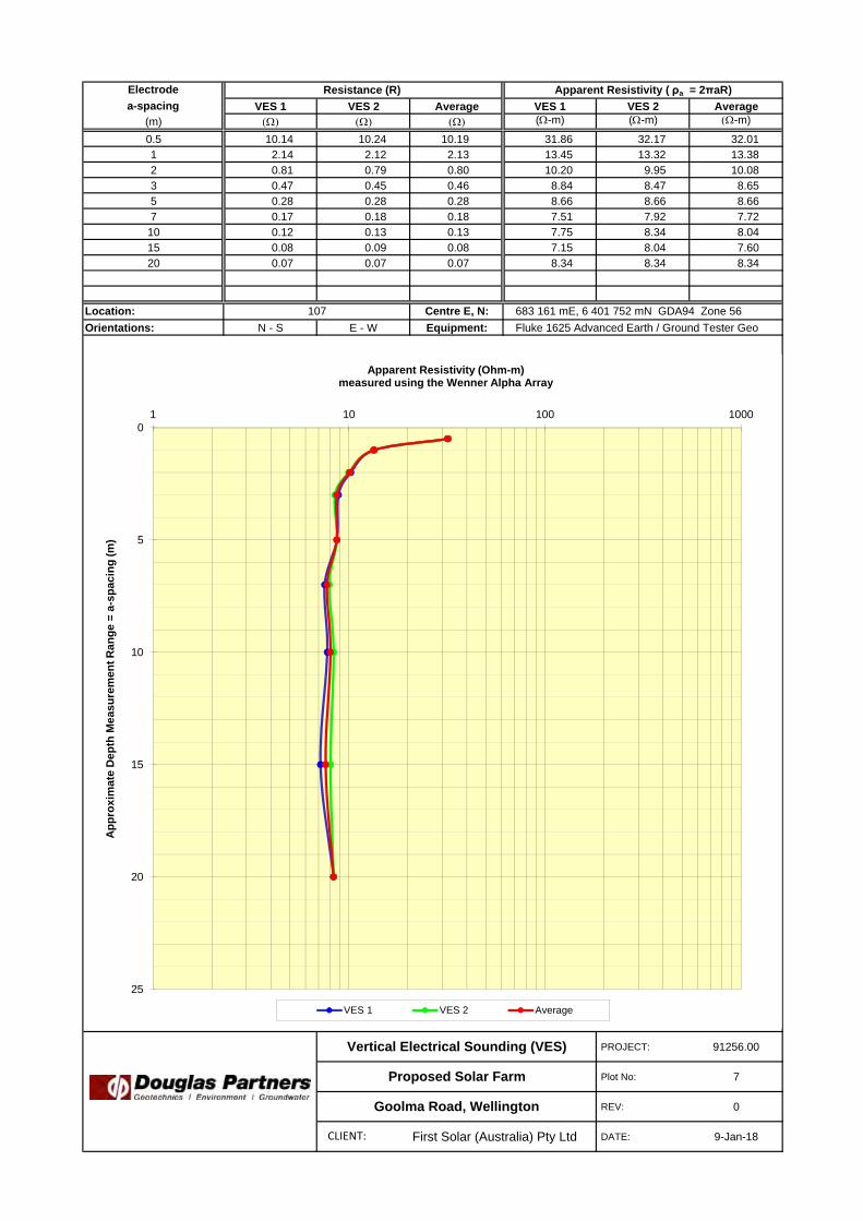
Electrodea-spacing VES 1 VES 2 Average VES 1 VES 2 Average
(m) (-m) (-m) -m)
0.5 10.14 10.24 10.19 31.86 32.17 32.011 2.14 2.12 2.13 13.45 13.32 13.382 0.81 0.79 0.80 10.20 9.95 10.083 0.47 0.45 0.46 8.84 8.47 8.655 0.28 0.28 0.28 8.66 8.66 8.667 0.17 0.18 0.18 7.51 7.92 7.72
10 0.12 0.13 0.13 7.75 8.34 8.0415 0.08 0.09 0.08 7.15 8.04 7.6020 0.07 0.07 0.07 8.34 8.34 8.34
Location: Centre E, N:Orientations: N - S E - W Equipment:
PROJECT: 91256.00
Plot No: 7
REV: 0
First Solar (Australia) Pty Ltd DATE: 9-Jan-18
Fluke 1625 Advanced Earth / Ground Tester Geo
Resistance (R) Apparent Resistivity ( ρa = 2πaR)
107 683 161 mE, 6 401 752 mN GDA94 Zone 56
Vertical Electrical Sounding (VES)
Proposed Solar Farm
Goolma Road, Wellington
0
5
10
15
20
25
1 10 100 1000
App
roxi
mat
e D
epth
Mea
sure
men
t Ran
ge =
a-s
paci
ng (m
)
Apparent Resistivity (Ohm-m)measured using the Wenner Alpha Array
VES 1 VES 2 Average
CLIENT:

Electrodea-spacing VES 1 VES 2 Average VES 1 VES 2 Average
(m) (-m) (-m) -m)
0.5 25.56 27.01 26.29 80.30 84.85 82.581 9.11 9.07 9.09 57.24 56.99 57.112 1.97 2.07 2.02 24.73 26.01 25.373 0.86 0.95 0.91 16.24 17.93 17.095 0.29 0.36 0.33 9.27 11.38 10.327 0.17 0.20 0.18 7.51 8.76 8.13
10 0.13 0.13 0.13 8.34 8.34 8.3415 0.11 0.10 0.11 10.72 9.83 10.2820 0.10 0.10 0.10 13.11 13.11 13.11
Location: Centre E, N:Orientations: N - S E - W Equipment:
PROJECT: 91256.00
Plot No: 8
REV: 0
First Solar (Australia) Pty Ltd DATE: 11-Jan-18
Fluke 1625 Advanced Earth / Ground Tester Geo
Resistance (R) Apparent Resistivity ( ρa = 2πaR)
108 683 227 mE, 6 400 882 mN GDA94 Zone 56
Vertical Electrical Sounding (VES)
Proposed Solar Farm
Goolma Road, Wellington
0
5
10
15
20
25
1 10 100 1000
App
roxi
mat
e D
epth
Mea
sure
men
t Ran
ge =
a-s
paci
ng (m
)
Apparent Resistivity (Ohm-m)measured using the Wenner Alpha Array
VES 1 VES 2 Average
CLIENT:

Electrodea-spacing VES 1 VES 2 Average VES 1 VES 2 Average
(m) (-m) (-m) -m)
0.5 24.70 24.84 24.77 77.60 78.04 77.821 7.52 5.51 6.52 47.25 34.62 40.932 1.67 1.45 1.56 21.05 18.19 19.623 0.83 0.87 0.85 15.68 16.43 16.055 0.48 0.56 0.52 15.03 17.48 16.257 0.42 0.47 0.44 18.48 20.62 19.55
10 0.37 0.39 0.38 23.37 24.58 23.9815 0.36 0.35 0.36 34.15 33.24 33.6920 0.33 0.33 0.33 41.90 41.90 41.90
Location: Centre E, N:Orientations: E - W N - S Equipment:
PROJECT: 91256.00
Plot No: 9
REV: 0
First Solar (Australia) Pty Ltd DATE: 11-Jan-18
Fluke 1625 Advanced Earth / Ground Tester Geo
Resistance (R) Apparent Resistivity ( ρa = 2πaR)
109 683 381 mE, 6 400 402 mN GDA94 Zone 56
Vertical Electrical Sounding (VES)
Proposed Solar Farm
Goolma Road, Wellington
0
5
10
15
20
25
1 10 100 1000
App
roxi
mat
e D
epth
Mea
sure
men
t Ran
ge =
a-s
paci
ng (m
)
Apparent Resistivity (Ohm-m)measured using the Wenner Alpha Array
VES 1 VES 2 Average
CLIENT:

Electrodea-spacing VES 1 VES 2 Average VES 1 VES 2 Average
(m) (-m) (-m) -m)
0.5 17.61 19.92 18.77 55.32 62.58 58.951 3.54 2.99 3.27 22.24 18.79 20.512 0.72 0.72 0.72 9.09 9.09 9.093 0.49 0.53 0.51 9.20 9.94 9.575 0.29 0.32 0.31 9.27 10.17 9.727 0.25 0.25 0.25 10.86 10.86 10.86
10 0.21 0.21 0.21 13.12 13.12 13.1215 0.16 0.14 0.15 15.19 13.41 14.3020 0.14 0.13 0.14 17.87 16.68 17.28
Location: Centre E, N:Orientations: E - W N - S Equipment:
PROJECT: 91256.00
Plot No: 10
REV: 0
First Solar (Australia) Pty Ltd DATE: 10-Jan-18
Fluke 1625 Advanced Earth / Ground Tester Geo
Resistance (R) Apparent Resistivity ( ρa = 2πaR)
110 682 432 mE, 6 401 096 mN GDA94 Zone 56
Vertical Electrical Sounding (VES)
Proposed Solar Farm
Goolma Road, Wellington
0
5
10
15
20
25
1 10 100 1000
App
roxi
mat
e D
epth
Mea
sure
men
t Ran
ge =
a-s
paci
ng (m
)
Apparent Resistivity (Ohm-m)measured using the Wenner Alpha Array
VES 1 VES 2 Average
CLIENT:

Appendix E
Results of Laboratory Testing

Material Test Report
Report Number: 91256.00-1
Issue Number: 1
Date Issued: 22/02/2018
Client: First Solar (Australia) Pty Ltd
Level 3, SYDNEY NSW 2000
Project Number: 91256.00
Project Name: Proposed Solar Farm
Project Location: Goolma Road, Wellington
Work Request: 1705
Sample Number: 18-1705A
Date Sampled: 11/01/2018
Sampling Method: Sampled by Engineering Department
Sample Location: 1 (0.4 - 0.5m)
Material: Gravelly Clay / Clayey Gravel
Douglas Partners Pty Ltd
Newcastle Laboratory
15 Callistemon Close Warabrook Newcastle NSW 2310
Phone: (02) 4960 9600
Fax: (02) 4960 9601
Email: [email protected]
Accredited for compliance with ISO/IEC 17025 - Testing
Approved Signatory: Peter Gorseski
Earthworks Manager
NATA Accredited Laboratory Number: 828
Particle Distribution (AS1289 3.6.1)
Sieve Passed % Passing Limits
37.5 mm 100
26.5 mm 98
19 mm 93
13.2 mm 80
9.5 mm 70
6.7 mm 62
4.75 mm 54
2.36 mm 45
1.18 mm 40
0.6 mm 37
0.425 mm 36
0.3 mm 35
0.15 mm 32
0.075 mm 29
Moisture Content (AS 1289 2.1.1)
Moisture Content (%) 8.0
Atterberg Limit (AS1289 3.1.2 & 3.2.1 & 3.3.1) Min Max
Preparation Method Dry Sieve
Sample History Oven Dried
Liquid Limit (%) 35
Plastic Limit (%) 13
Plasticity Index (%) 22
Particle Size Distribution
0 . 1 0 . 2 1 2 3 4 5 1 0 2 0 3 0 1 0 0 2 0 0
Particle Size (mm)
1 0
2 0
3 0
4 0
5 0
6 0
7 0
8 0
9 0
1 0 0
Pe
rce
nt
Pa
ssin
g
37
.5
26
.5
19
13
.2
9.5
6.7
4.7
5
2.3
6
1.1
8
0.6
0.4
25
0.3
0.1
5
0.0
75
Sieve( m m )
Clay Si l t Sand Gravel Cobbles
Report Number: 91256.00-1 Page 1 of 72

Material Test Report
Report Number: 91256.00-1
Issue Number: 1
Date Issued: 22/02/2018
Client: First Solar (Australia) Pty Ltd
Level 3, SYDNEY NSW 2000
Project Number: 91256.00
Project Name: Proposed Solar Farm
Project Location: Goolma Road, Wellington
Work Request: 1705
Sample Number: 18-1705B
Date Sampled: 11/01/2018
Sampling Method: Sampled by Engineering Department
Sample Location: 2 (0.5 - 0.6m)
Material: Gravelly Clay / Clayey Gravel
Douglas Partners Pty Ltd
Newcastle Laboratory
15 Callistemon Close Warabrook Newcastle NSW 2310
Phone: (02) 4960 9600
Fax: (02) 4960 9601
Email: [email protected]
Accredited for compliance with ISO/IEC 17025 - Testing
Approved Signatory: Peter Gorseski
Earthworks Manager
NATA Accredited Laboratory Number: 828
Moisture Content (AS 1289 2.1.1)
Moisture Content (%) 10.8
Dry Density - Moisture Relationship (AS 1289 5.1.1 & 2.1.1)
Mould Type 1 LITRE MOULD A
Compaction Standard
No. Layers 3
No. Blows / Layer 25
Maximum Dry Density (t/m3) 1.86
Optimum Moisture Content (%) 14.5
Oversize Sieve (mm) 19.0
Oversize Material (%) 4.2
California Bearing Ratio (AS 1289 6.1.1 & 2.1.1) Min Max
CBR taken at 2.5 mm
CBR % 10
Method of Compactive Effort Standard
Method used to Determine MDD AS 1289 5.1.1 & 2.1.1
Maximum Dry Density (t/m3) 1.86
Optimum Moisture Content (%) 14.5
Laboratory Density Ratio (%) 101.0
Laboratory Moisture Ratio (%) 98.5
Dry Density after Soaking (t/m3) 1.85
Field Moisture Content (%) 10.8
Moisture Content at Placement (%) 14.1
Moisture Content Top 30mm (%) 18.3
Moisture Content Rest of Sample (%) 15.1
Mass Surcharge (kg) 4.5
Soaking Period (days) 4
Swell (%) 1.5
Oversize Material (mm) 19
Oversize Material Included Excluded
Oversize Material (%) 4.2
Moisture Density Relationship
Points MDD OMC Zero Air Void
9 1 0 1 1 1 2 1 3 1 4 1 5 1 6 1 7 1 8
1.6
1.62
1.64
1.66
1.68
1.7
1.72
1.74
1.76
1.78
1.8
1.82
1.84
1.86
1.88
1.9
California Bearing Ratio
Results 2.5 5 Tangent Corrected
0 1 2 3 4 5 6 7 8 9 1 0 1 1 1 2 1 3
0
1
2
3
Report Number: 91256.00-1 Page 2 of 72

Material Test Report
Report Number: 91256.00-1
Issue Number: 1
Date Issued: 22/02/2018
Client: First Solar (Australia) Pty Ltd
Level 3, SYDNEY NSW 2000
Project Number: 91256.00
Project Name: Proposed Solar Farm
Project Location: Goolma Road, Wellington
Work Request: 1705
Sample Number: 18-1705C
Date Sampled: 11/01/2018
Sampling Method: Sampled by Engineering Department
Sample Location: 2 (0.85 - 1.3m)
Material: Silty Clay
Douglas Partners Pty Ltd
Newcastle Laboratory
15 Callistemon Close Warabrook Newcastle NSW 2310
Phone: (02) 4960 9600
Fax: (02) 4960 9601
Email: [email protected]
Accredited for compliance with ISO/IEC 17025 - Testing
Approved Signatory: Peter Gorseski
Earthworks Manager
NATA Accredited Laboratory Number: 828
Shrink Swell Index (AS 1289 7.1.1 & 2.1.1)
Iss (%) 3.9
Visual Description Silty Clay
* Shrink Swell Index (Iss) reported as the percentage vertical strain perpF change in suction.
Core Shrinkage Test
Shrinkage Strain - Oven Dried (%) 3.9
Estimated % by volume of significant inert inclusions 15
Cracking ModeratelyCracked
Crumbling No
Moisture Content (%) 20.3
Swell Test
Initial Pocket Penetrometer (kPa) >600
Final Pocket Penetrometer (kPa) 200
Initial Moisture Content (%) 20.2
Final Moisture Content (%) 31.6
Swell (%) 6.3
* NATA Accreditation does not cover the performance of pocketpenetrometer readings.
Shrink Swell
0 2 4 6 8 1 0 1 2 1 4 1 6 1 8 2 0 2 2 2 4 2 6 2 8 3 0 3 2
-7
-6.5
-6
-5.5
-5
-4.5
-4
-3.5
-3
-2.5
-2
-1.5
-1
-0.5
0
0.5
1
1.5
2
2.5
3
3.5
4
4.5
Report Number: 91256.00-1 Page 3 of 72

Material Test Report
Report Number: 91256.00-1
Issue Number: 1
Date Issued: 22/02/2018
Client: First Solar (Australia) Pty Ltd
Level 3, SYDNEY NSW 2000
Project Number: 91256.00
Project Name: Proposed Solar Farm
Project Location: Goolma Road, Wellington
Work Request: 1705
Sample Number: 18-1705D
Date Sampled: 11/01/2018
Sampling Method: Sampled by Engineering Department
Sample Location: 3 (0.3 - 0.4m)
Material: Silty Clay
Douglas Partners Pty Ltd
Newcastle Laboratory
15 Callistemon Close Warabrook Newcastle NSW 2310
Phone: (02) 4960 9600
Fax: (02) 4960 9601
Email: [email protected]
Accredited for compliance with ISO/IEC 17025 - Testing
Approved Signatory: Peter Gorseski
Earthworks Manager
NATA Accredited Laboratory Number: 828
Particle Distribution (AS1289 3.6.1)
Sieve Passed % Passing Limits
53 mm 100
37.5 mm 98
26.5 mm 96
19 mm 94
13.2 mm 94
9.5 mm 93
6.7 mm 93
4.75 mm 93
2.36 mm 92
1.18 mm 91
0.6 mm 90
0.425 mm 89
0.3 mm 88
0.15 mm 85
0.075 mm 81
Particle Size Distribution
0 . 1 0 . 2 1 2 3 4 5 1 0 2 0 3 0 1 0 0 2 0 0
Particle Size (mm)
1 0
2 0
3 0
4 0
5 0
6 0
7 0
8 0
9 0
1 0 0
Pe
rce
nt
Pa
ssin
g
53
37
.5
26
.5
19
13
.2
9.5
6.7
4.7
5
2.3
6
1.1
8
0.6
0.4
25
0.3
0.1
5
0.0
75
Sieve( m m )
Clay Si l t Sand Gravel Cobbles
Report Number: 91256.00-1 Page 4 of 72

Material Test Report
Report Number: 91256.00-1
Issue Number: 1
Date Issued: 22/02/2018
Client: First Solar (Australia) Pty Ltd
Level 3, SYDNEY NSW 2000
Project Number: 91256.00
Project Name: Proposed Solar Farm
Project Location: Goolma Road, Wellington
Work Request: 1705
Sample Number: 18-1705D
Date Sampled: 11/01/2018
Sampling Method: Sampled by Engineering Department
Sample Location: 3 (0.3 - 0.4m)
Material: Silty Clay
Douglas Partners Pty Ltd
Newcastle Laboratory
15 Callistemon Close Warabrook Newcastle NSW 2310
Phone: (02) 4960 9600
Fax: (02) 4960 9601
Email: [email protected]
Accredited for compliance with ISO/IEC 17025 - Testing
Approved Signatory: Peter Gorseski
Earthworks Manager
NATA Accredited Laboratory Number: 828
Moisture Content (AS 1289 2.1.1)
Moisture Content (%) 18.9
Dry Density - Moisture Relationship (AS 1289 5.1.1 & 2.1.1)
Mould Type 1 LITRE MOULD A
Compaction Standard
No. Layers 3
No. Blows / Layer 25
Maximum Dry Density (t/m3) 1.57
Optimum Moisture Content (%) 25.0
Oversize Sieve (mm) 19.0
Oversize Material (%) 4.7
California Bearing Ratio (AS 1289 6.1.1 & 2.1.1) Min Max
CBR taken at 2.5 mm
CBR % 13
Method of Compactive Effort Standard
Method used to Determine MDD AS 1289 5.1.1 & 2.1.1
Maximum Dry Density (t/m3) 1.57
Optimum Moisture Content (%) 25.0
Laboratory Density Ratio (%) 99.5
Laboratory Moisture Ratio (%) 98.5
Dry Density after Soaking (t/m3) 1.55
Field Moisture Content (%) 18.9
Moisture Content at Placement (%) 24.6
Moisture Content Top 30mm (%) 29.0
Moisture Content Rest of Sample (%) 25.3
Mass Surcharge (kg) 4.5
Soaking Period (days) 4
Swell (%) 0.5
Oversize Material (mm) 19
Oversize Material Included Excluded
Oversize Material (%) 4.7
Moisture Density Relationship
Points MDD OMC Zero Air Void
1 9 2 0 2 1 2 2 2 3 2 4 2 5 2 6 2 7 2 8 2 9 3 0
1.4
1.42
1.44
1.46
1.48
1.5
1.52
1.54
1.56
1.58
1.6
California Bearing Ratio
Results 2.5 5 Tangent Corrected
0 1 2 3 4 5 6 7 8 9 1 0 1 1 1 2 1 3
0
1
2
3
Report Number: 91256.00-1 Page 5 of 72

Material Test Report
Report Number: 91256.00-1
Issue Number: 1
Date Issued: 22/02/2018
Client: First Solar (Australia) Pty Ltd
Level 3, SYDNEY NSW 2000
Project Number: 91256.00
Project Name: Proposed Solar Farm
Project Location: Goolma Road, Wellington
Work Request: 1705
Sample Number: 18-1705F
Date Sampled: 11/01/2018
Sampling Method: Sampled by Engineering Department
Sample Location: 4 (0.4 - 0.5m)
Material: Silty Clay
Douglas Partners Pty Ltd
Newcastle Laboratory
15 Callistemon Close Warabrook Newcastle NSW 2310
Phone: (02) 4960 9600
Fax: (02) 4960 9601
Email: [email protected]
Accredited for compliance with ISO/IEC 17025 - Testing
Approved Signatory: Peter Gorseski
Earthworks Manager
NATA Accredited Laboratory Number: 828
Particle Distribution (AS1289 3.6.1)
Sieve Passed % Passing Limits
53 mm 100
37.5 mm 99
26.5 mm 97
19 mm 95
13.2 mm 92
9.5 mm 89
6.7 mm 88
4.75 mm 86
2.36 mm 84
1.18 mm 83
0.6 mm 81
0.425 mm 81
0.3 mm 79
0.15 mm 76
0.075 mm 73
Particle Size Distribution
0 . 1 0 . 2 1 2 3 4 5 1 0 2 0 3 0 1 0 0 2 0 0
Particle Size (mm)
1 0
2 0
3 0
4 0
5 0
6 0
7 0
8 0
9 0
1 0 0
Pe
rce
nt
Pa
ssin
g
53
37
.5
26
.5
19
13
.2
9.5
6.7
4.7
5
2.3
6
1.1
8
0.6
0.4
25
0.3
0.1
5
0.0
75
Sieve( m m )
Clay Si l t Sand Gravel Cobbles
Report Number: 91256.00-1 Page 6 of 72

Material Test Report
Report Number: 91256.00-1
Issue Number: 1
Date Issued: 22/02/2018
Client: First Solar (Australia) Pty Ltd
Level 3, SYDNEY NSW 2000
Project Number: 91256.00
Project Name: Proposed Solar Farm
Project Location: Goolma Road, Wellington
Work Request: 1705
Sample Number: 18-1705G
Date Sampled: 11/01/2018
Sampling Method: Sampled by Engineering Department
Sample Location: 6 (0.3 - 0.4m)
Material: Sandy Silt
Douglas Partners Pty Ltd
Newcastle Laboratory
15 Callistemon Close Warabrook Newcastle NSW 2310
Phone: (02) 4960 9600
Fax: (02) 4960 9601
Email: [email protected]
Accredited for compliance with ISO/IEC 17025 - Testing
Approved Signatory: Peter Gorseski
Earthworks Manager
NATA Accredited Laboratory Number: 828
Particle Distribution (AS1289 3.6.1)
Sieve Passed % Passing Limits
26.5 mm 100
19 mm 100
13.2 mm 100
9.5 mm 99
6.7 mm 99
4.75 mm 98
2.36 mm 96
1.18 mm 92
0.6 mm 85
0.425 mm 82
0.3 mm 77
0.15 mm 68
0.075 mm 60
Particle Size Distribution
0 . 1 0 . 2 1 2 3 4 5 1 0 2 0 3 0 1 0 0 2 0 0
Particle Size (mm)
1 0
2 0
3 0
4 0
5 0
6 0
7 0
8 0
9 0
1 0 0
Pe
rce
nt
Pa
ssin
g
26
.5
19
13
.2
9.5
6.7
4.7
5
2.3
6
1.1
8
0.6
0.4
25
0.3
0.1
5
0.0
75
Sieve( m m )
Clay Si l t Sand Gravel Cobbles
Report Number: 91256.00-1 Page 7 of 72

Material Test Report
Report Number: 91256.00-1
Issue Number: 1
Date Issued: 22/02/2018
Client: First Solar (Australia) Pty Ltd
Level 3, SYDNEY NSW 2000
Project Number: 91256.00
Project Name: Proposed Solar Farm
Project Location: Goolma Road, Wellington
Work Request: 1705
Sample Number: 18-1705G
Date Sampled: 11/01/2018
Sampling Method: Sampled by Engineering Department
Sample Location: 6 (0.3 - 0.4m)
Material: Sandy Silt
Douglas Partners Pty Ltd
Newcastle Laboratory
15 Callistemon Close Warabrook Newcastle NSW 2310
Phone: (02) 4960 9600
Fax: (02) 4960 9601
Email: [email protected]
Accredited for compliance with ISO/IEC 17025 - Testing
Approved Signatory: Peter Gorseski
Earthworks Manager
NATA Accredited Laboratory Number: 828
Moisture Content (AS 1289 2.1.1)
Moisture Content (%) 10.3
Dry Density - Moisture Relationship (AS 1289 5.1.1 & 2.1.1)
Mould Type 1 LITRE MOULD A
Compaction Standard
No. Layers 3
No. Blows / Layer 25
Maximum Dry Density (t/m3) 1.77
Optimum Moisture Content (%) 16.0
Oversize Sieve (mm) 19.0
Oversize Material (%) 0.1
California Bearing Ratio (AS 1289 6.1.1 & 2.1.1) Min Max
CBR taken at 5 mm
CBR % 10
Method of Compactive Effort Standard
Method used to Determine MDD AS 1289 5.1.1 & 2.1.1
Maximum Dry Density (t/m3) 1.77
Optimum Moisture Content (%) 16.0
Laboratory Density Ratio (%) 99.5
Laboratory Moisture Ratio (%) 99.5
Dry Density after Soaking (t/m3) 1.75
Field Moisture Content (%) 10.2
Moisture Content at Placement (%) 15.7
Moisture Content Top 30mm (%) 20.1
Moisture Content Rest of Sample (%) 16.4
Mass Surcharge (kg) 4.5
Soaking Period (days) 4
Swell (%) 0.5
Oversize Material (mm) 19
Oversize Material Included Excluded
Oversize Material (%) 0.1
Moisture Density Relationship
Points MDD OMC Zero Air Void
9 1 0 1 1 1 2 1 3 1 4 1 5 1 6 1 7 1 8 1 9 2 0
1.62
1.63
1.64
1.65
1.66
1.67
1.68
1.69
1.7
1.71
1.72
1.73
1.74
1.75
1.76
1.77
1.78
1.79
1.8
California Bearing Ratio
Results 2.5 5 Tangent Corrected
0 1 2 3 4 5 6 7 8 9 1 0 1 1 1 2 1 3
0
1
2
3
Report Number: 91256.00-1 Page 8 of 72

Material Test Report
Report Number: 91256.00-1
Issue Number: 1
Date Issued: 22/02/2018
Client: First Solar (Australia) Pty Ltd
Level 3, SYDNEY NSW 2000
Project Number: 91256.00
Project Name: Proposed Solar Farm
Project Location: Goolma Road, Wellington
Work Request: 1705
Sample Number: 18-1705H
Date Sampled: 11/01/2018
Sampling Method: Sampled by Engineering Department
Sample Location: 6 (0.55 - 0.82m)
Material: Silty Clay
Douglas Partners Pty Ltd
Newcastle Laboratory
15 Callistemon Close Warabrook Newcastle NSW 2310
Phone: (02) 4960 9600
Fax: (02) 4960 9601
Email: [email protected]
Accredited for compliance with ISO/IEC 17025 - Testing
Approved Signatory: Peter Gorseski
Earthworks Manager
NATA Accredited Laboratory Number: 828
Shrink Swell Index (AS 1289 7.1.1 & 2.1.1)
Iss (%) 0.6
Visual Description Silty Clay
* Shrink Swell Index (Iss) reported as the percentage vertical strain perpF change in suction.
Core Shrinkage Test
Shrinkage Strain - Oven Dried (%) 1.1
Estimated % by volume of significant inert inclusions 5
Cracking ModeratelyCracked
Crumbling No
Moisture Content (%) 13.5
Swell Test
Initial Pocket Penetrometer (kPa) >600
Final Pocket Penetrometer (kPa) 85
Initial Moisture Content (%) 14.7
Final Moisture Content (%) 28.7
Swell (%) -1.6
* NATA Accreditation does not cover the performance of pocketpenetrometer readings.
Shrink Swell
0 2 4 6 8 1 0 1 2 1 4 1 6 1 8 2 0 2 2 2 4 2 6 2 8
-1
-0.5
0
0.5
1
1.5
2
2.5
Report Number: 91256.00-1 Page 9 of 72

Material Test Report
Report Number: 91256.00-1
Issue Number: 1
Date Issued: 22/02/2018
Client: First Solar (Australia) Pty Ltd
Level 3, SYDNEY NSW 2000
Project Number: 91256.00
Project Name: Proposed Solar Farm
Project Location: Goolma Road, Wellington
Work Request: 1705
Sample Number: 18-1705I
Date Sampled: 11/01/2018
Sampling Method: Sampled by Engineering Department
Sample Location: 7 (0.4 - 0.5m)
Material: Silty Clay
Douglas Partners Pty Ltd
Newcastle Laboratory
15 Callistemon Close Warabrook Newcastle NSW 2310
Phone: (02) 4960 9600
Fax: (02) 4960 9601
Email: [email protected]
Accredited for compliance with ISO/IEC 17025 - Testing
Approved Signatory: Peter Gorseski
Earthworks Manager
NATA Accredited Laboratory Number: 828
Particle Distribution (AS1289 3.6.1)
Sieve Passed % Passing Limits
26.5 mm 100
19 mm 99
13.2 mm 97
9.5 mm 95
6.7 mm 94
4.75 mm 92
2.36 mm 89
1.18 mm 87
0.6 mm 84
0.425 mm 83
0.3 mm 81
0.15 mm 77
0.075 mm 72
Moisture Content (AS 1289 2.1.1)
Moisture Content (%) 19.0
Atterberg Limit (AS1289 3.1.2 & 3.2.1 & 3.3.1) Min Max
Preparation Method Dry Sieve
Sample History Oven Dried
Liquid Limit (%) 53
Plastic Limit (%) 14
Plasticity Index (%) 39
Particle Size Distribution
0 . 1 0 . 2 1 2 3 4 5 1 0 2 0 3 0 1 0 0 2 0 0
Particle Size (mm)
1 0
2 0
3 0
4 0
5 0
6 0
7 0
8 0
9 0
1 0 0
Pe
rce
nt
Pa
ssin
g
26
.5
19
13
.2
9.5
6.7
4.7
5
2.3
6
1.1
8
0.6
0.4
25
0.3
0.1
5
0.0
75
Sieve( m m )
Clay Si l t Sand Gravel Cobbles
Report Number: 91256.00-1 Page 10 of 72

Material Test Report
Report Number: 91256.00-1
Issue Number: 1
Date Issued: 22/02/2018
Client: First Solar (Australia) Pty Ltd
Level 3, SYDNEY NSW 2000
Project Number: 91256.00
Project Name: Proposed Solar Farm
Project Location: Goolma Road, Wellington
Work Request: 1705
Sample Number: 18-1705J
Date Sampled: 11/01/2018
Sampling Method: Sampled by Engineering Department
Sample Location: 7 (0.55 - 0.95m)
Material: Silty Clay
Douglas Partners Pty Ltd
Newcastle Laboratory
15 Callistemon Close Warabrook Newcastle NSW 2310
Phone: (02) 4960 9600
Fax: (02) 4960 9601
Email: [email protected]
Accredited for compliance with ISO/IEC 17025 - Testing
Approved Signatory: Peter Gorseski
Earthworks Manager
NATA Accredited Laboratory Number: 828
Shrink Swell Index (AS 1289 7.1.1 & 2.1.1)
Iss (%) 2.3
Visual Description Silty Clay
* Shrink Swell Index (Iss) reported as the percentage vertical strain perpF change in suction.
Core Shrinkage Test
Shrinkage Strain - Oven Dried (%) 3.0
Estimated % by volume of significant inert inclusions 10
Cracking ModeratelyCracked
Crumbling No
Moisture Content (%) 22.4
Swell Test
Initial Pocket Penetrometer (kPa) >600
Final Pocket Penetrometer (kPa) 350
Initial Moisture Content (%) 21.9
Final Moisture Content (%) 26.6
Swell (%) 2.4
* NATA Accreditation does not cover the performance of pocketpenetrometer readings.
Shrink Swell
0 2 4 6 8 1 0 1 2 1 4 1 6 1 8 2 0 2 2 2 4 2 6
-3
-2.5
-2
-1.5
-1
-0.5
0
0.5
1
1.5
2
2.5
3
3.5
4
Report Number: 91256.00-1 Page 11 of 72

Material Test Report
Report Number: 91256.00-1
Issue Number: 1
Date Issued: 22/02/2018
Client: First Solar (Australia) Pty Ltd
Level 3, SYDNEY NSW 2000
Project Number: 91256.00
Project Name: Proposed Solar Farm
Project Location: Goolma Road, Wellington
Work Request: 1705
Sample Number: 18-1705K
Date Sampled: 11/01/2018
Sampling Method: Sampled by Engineering Department
Sample Location: 8 (0.3 - 0.4m)
Material: Silty Clay
Douglas Partners Pty Ltd
Newcastle Laboratory
15 Callistemon Close Warabrook Newcastle NSW 2310
Phone: (02) 4960 9600
Fax: (02) 4960 9601
Email: [email protected]
Accredited for compliance with ISO/IEC 17025 - Testing
Approved Signatory: Peter Gorseski
Earthworks Manager
NATA Accredited Laboratory Number: 828
Moisture Content (AS 1289 2.1.1)
Moisture Content (%) 16.7
Dry Density - Moisture Relationship (AS 1289 5.1.1 & 2.1.1)
Mould Type 1 LITRE MOULD A
Compaction Standard
No. Layers 3
No. Blows / Layer 25
Maximum Dry Density (t/m3) 1.62
Optimum Moisture Content (%) 21.5
Oversize Sieve (mm) 19.0
Oversize Material (%) 3.1
California Bearing Ratio (AS 1289 6.1.1 & 2.1.1) Min Max
CBR taken at 2.5 mm
CBR % 11
Method of Compactive Effort Standard
Method used to Determine MDD AS 1289 5.1.1 & 2.1.1
Maximum Dry Density (t/m3) 1.62
Optimum Moisture Content (%) 21.5
Laboratory Density Ratio (%) 99.0
Laboratory Moisture Ratio (%) 100.5
Dry Density after Soaking (t/m3) 1.59
Field Moisture Content (%) 16.7
Moisture Content at Placement (%) 21.7
Moisture Content Top 30mm (%) 25.0
Moisture Content Rest of Sample (%) 22.4
Mass Surcharge (kg) 4.5
Soaking Period (days) 4
Swell (%) 1.0
Oversize Material (mm) 19
Oversize Material Included Excluded
Oversize Material (%) 3.1
Moisture Density Relationship
Points MDD OMC Zero Air Void
1 4 1 5 1 6 1 7 1 8 1 9 2 0 2 1 2 2 2 3 2 4 2 5 2 6
1.52
1.53
1.54
1.55
1.56
1.57
1.58
1.59
1.6
1.61
1.62
1.63
1.64
California Bearing Ratio
Results 2.5 5 Tangent Corrected
0 1 2 3 4 5 6 7 8 9 1 0 1 1 1 2 1 3
0
1
2
3
Report Number: 91256.00-1 Page 12 of 72

Material Test Report
Report Number: 91256.00-1
Issue Number: 1
Date Issued: 22/02/2018
Client: First Solar (Australia) Pty Ltd
Level 3, SYDNEY NSW 2000
Project Number: 91256.00
Project Name: Proposed Solar Farm
Project Location: Goolma Road, Wellington
Work Request: 1705
Sample Number: 18-1705L
Date Sampled: 11/01/2018
Sampling Method: Sampled by Engineering Department
Sample Location: 9 (0.4 - 0.5m)
Material: Silty Clay
Douglas Partners Pty Ltd
Newcastle Laboratory
15 Callistemon Close Warabrook Newcastle NSW 2310
Phone: (02) 4960 9600
Fax: (02) 4960 9601
Email: [email protected]
Accredited for compliance with ISO/IEC 17025 - Testing
Approved Signatory: Peter Gorseski
Earthworks Manager
NATA Accredited Laboratory Number: 828
Particle Distribution (AS1289 3.6.1)
Sieve Passed % Passing Limits
37.5 mm 100
26.5 mm 100
19 mm 100
13.2 mm 99
9.5 mm 99
6.7 mm 98
4.75 mm 97
2.36 mm 97
1.18 mm 95
0.6 mm 93
0.425 mm 92
0.3 mm 90
0.15 mm 86
0.075 mm 81
Particle Size Distribution
0 . 1 0 . 2 1 2 3 4 5 1 0 2 0 3 0 1 0 0 2 0 0
Particle Size (mm)
1 0
2 0
3 0
4 0
5 0
6 0
7 0
8 0
9 0
1 0 0
Pe
rce
nt
Pa
ssin
g
37
.5
26
.5
19
13
.2
9.5
6.7
4.7
5
2.3
6
1.1
8
0.6
0.4
25
0.3
0.1
5
0.0
75
Sieve( m m )
Clay Si l t Sand Gravel Cobbles
Report Number: 91256.00-1 Page 13 of 72

Material Test Report
Report Number: 91256.00-1
Issue Number: 1
Date Issued: 22/02/2018
Client: First Solar (Australia) Pty Ltd
Level 3, SYDNEY NSW 2000
Project Number: 91256.00
Project Name: Proposed Solar Farm
Project Location: Goolma Road, Wellington
Work Request: 1705
Sample Number: 18-1705L
Date Sampled: 11/01/2018
Sampling Method: Sampled by Engineering Department
Sample Location: 9 (0.4 - 0.5m)
Material: Silty Clay
Douglas Partners Pty Ltd
Newcastle Laboratory
15 Callistemon Close Warabrook Newcastle NSW 2310
Phone: (02) 4960 9600
Fax: (02) 4960 9601
Email: [email protected]
Accredited for compliance with ISO/IEC 17025 - Testing
Approved Signatory: Peter Gorseski
Earthworks Manager
NATA Accredited Laboratory Number: 828
Moisture Content (AS 1289 2.1.1)
Moisture Content (%) 18.0
Dry Density - Moisture Relationship (AS 1289 5.1.1 & 2.1.1)
Mould Type 1 LITRE MOULD A
Compaction Standard
No. Layers 3
No. Blows / Layer 25
Maximum Dry Density (t/m3) 1.52
Optimum Moisture Content (%) 25.0
Oversize Sieve (mm) 19.0
Oversize Material (%) 0.0
California Bearing Ratio (AS 1289 6.1.1 & 2.1.1) Min Max
CBR taken at 2.5 mm
CBR % 9
Method of Compactive Effort Standard
Method used to Determine MDD AS 1289 5.1.1 & 2.1.1
Maximum Dry Density (t/m3) 1.52
Optimum Moisture Content (%) 25.0
Laboratory Density Ratio (%) 99.5
Laboratory Moisture Ratio (%) 98.0
Dry Density after Soaking (t/m3) 1.50
Field Moisture Content (%) 18.0
Moisture Content at Placement (%) 24.4
Moisture Content Top 30mm (%) 28.3
Moisture Content Rest of Sample (%) 26.6
Mass Surcharge (kg) 4.5
Soaking Period (days) 4
Swell (%) 0.5
Oversize Material (mm) 19
Oversize Material Included Excluded
Oversize Material (%) 0.0
Moisture Density Relationship
Points MDD OMC Zero Air Void
1 9 2 0 2 1 2 2 2 3 2 4 2 5 2 6 2 7 2 8 2 9 3 0 3 1
1.44
1.45
1.46
1.47
1.48
1.49
1.5
1.51
1.52
1.53
California Bearing Ratio
Results 2.5 5 Tangent Corrected
0 1 2 3 4 5 6 7 8 9 1 0 1 1 1 2 1 3
0
0.2
0.4
0.6
0.8
1
1.2
1.4
1.6
1.8
2
2.2
Report Number: 91256.00-1 Page 14 of 72

Material Test Report
Report Number: 91256.00-1
Issue Number: 1
Date Issued: 22/02/2018
Client: First Solar (Australia) Pty Ltd
Level 3, SYDNEY NSW 2000
Project Number: 91256.00
Project Name: Proposed Solar Farm
Project Location: Goolma Road, Wellington
Work Request: 1705
Sample Number: 18-1705M
Date Sampled: 11/01/2018
Sampling Method: Sampled by Engineering Department
Sample Location: 10 (0.2 - 0.4m)
Material: Silty Clay
Douglas Partners Pty Ltd
Newcastle Laboratory
15 Callistemon Close Warabrook Newcastle NSW 2310
Phone: (02) 4960 9600
Fax: (02) 4960 9601
Email: [email protected]
Accredited for compliance with ISO/IEC 17025 - Testing
Approved Signatory: Peter Gorseski
Earthworks Manager
NATA Accredited Laboratory Number: 828
Moisture Content (AS 1289 2.1.1)
Moisture Content (%) 12.1
Dry Density - Moisture Relationship (AS 1289 5.1.1 & 2.1.1)
Mould Type 1 LITRE MOULD A
Compaction Standard
No. Layers 3
No. Blows / Layer 25
Maximum Dry Density (t/m3) 1.78
Optimum Moisture Content (%) 17.5
Oversize Sieve (mm) 19.0
Oversize Material (%) 6.8
California Bearing Ratio (AS 1289 6.1.1 & 2.1.1) Min Max
CBR taken at 2.5 mm
CBR % 13
Method of Compactive Effort Standard
Method used to Determine MDD AS 1289 5.1.1 & 2.1.1
Maximum Dry Density (t/m3) 1.78
Optimum Moisture Content (%) 17.5
Laboratory Density Ratio (%) 100.0
Laboratory Moisture Ratio (%) 98.5
Dry Density after Soaking (t/m3) 1.77
Field Moisture Content (%) 12.1
Moisture Content at Placement (%) 17.2
Moisture Content Top 30mm (%) 19.9
Moisture Content Rest of Sample (%) 18.7
Mass Surcharge (kg) 4.5
Soaking Period (days) 4
Swell (%) 0.5
Oversize Material (mm) 19
Oversize Material Included Excluded
Oversize Material (%) 6.8
Moisture Density Relationship
Points MDD OMC Zero Air Void
1 1 1 2 1 3 1 4 1 5 1 6 1 7 1 8 1 9 2 0 2 1 2 2 2 3
1.69
1.7
1.71
1.72
1.73
1.74
1.75
1.76
1.77
1.78
1.79
1.8
California Bearing Ratio
Results 2.5 5 Tangent Corrected
0 1 2 3 4 5 6 7 8 9 1 0 1 1 1 2 1 3
0
1
2
3
Report Number: 91256.00-1 Page 15 of 72

Material Test Report
Report Number: 91256.00-1
Issue Number: 1
Date Issued: 22/02/2018
Client: First Solar (Australia) Pty Ltd
Level 3, SYDNEY NSW 2000
Project Number: 91256.00
Project Name: Proposed Solar Farm
Project Location: Goolma Road, Wellington
Work Request: 1705
Sample Number: 18-1705O
Date Sampled: 11/01/2018
Sampling Method: Sampled by Engineering Department
Sample Location: 11 (0.45 - 0.9m)
Material: Silty Clay
Douglas Partners Pty Ltd
Newcastle Laboratory
15 Callistemon Close Warabrook Newcastle NSW 2310
Phone: (02) 4960 9600
Fax: (02) 4960 9601
Email: [email protected]
Accredited for compliance with ISO/IEC 17025 - Testing
Approved Signatory: Peter Gorseski
Earthworks Manager
NATA Accredited Laboratory Number: 828
Shrink Swell Index (AS 1289 7.1.1 & 2.1.1)
Iss (%) 1.7
Visual Description Silty Clay
* Shrink Swell Index (Iss) reported as the percentage vertical strain perpF change in suction.
Core Shrinkage Test
Shrinkage Strain - Oven Dried (%) 2.6
Estimated % by volume of significant inert inclusions 5
Cracking ModeratelyCracked
Crumbling No
Moisture Content (%) 19.7
Swell Test
Initial Pocket Penetrometer (kPa) >600
Final Pocket Penetrometer (kPa) 120
Initial Moisture Content (%) 18.2
Final Moisture Content (%) 30.0
Swell (%) 0.8
* NATA Accreditation does not cover the performance of pocketpenetrometer readings.
Shrink Swell
0 2 4 6 8 1 0 1 2 1 4 1 6 1 8 2 0 2 2 2 4 2 6 2 8 3 0
-1.5
-1
-0.5
0
0.5
1
1.5
2
2.5
3
3.5
Report Number: 91256.00-1 Page 16 of 72

Material Test Report
Report Number: 91256.00-1
Issue Number: 1
Date Issued: 22/02/2018
Client: First Solar (Australia) Pty Ltd
Level 3, SYDNEY NSW 2000
Project Number: 91256.00
Project Name: Proposed Solar Farm
Project Location: Goolma Road, Wellington
Work Request: 1705
Sample Number: 18-1705P
Date Sampled: 11/01/2018
Sampling Method: Sampled by Engineering Department
Sample Location: 12 (0.5 - 0.6m)
Material: Sandy Silty Clay
Douglas Partners Pty Ltd
Newcastle Laboratory
15 Callistemon Close Warabrook Newcastle NSW 2310
Phone: (02) 4960 9600
Fax: (02) 4960 9601
Email: [email protected]
Accredited for compliance with ISO/IEC 17025 - Testing
Approved Signatory: Peter Gorseski
Earthworks Manager
NATA Accredited Laboratory Number: 828
Particle Distribution (AS1289 3.6.1)
Sieve Passed % Passing Limits
26.5 mm 100
19 mm 100
13.2 mm 99
9.5 mm 98
6.7 mm 96
4.75 mm 95
2.36 mm 90
1.18 mm 83
0.6 mm 75
0.425 mm 71
0.3 mm 66
0.15 mm 59
0.075 mm 52
Particle Size Distribution
0 . 1 0 . 2 1 2 3 4 5 1 0 2 0 3 0 1 0 0 2 0 0
Particle Size (mm)
1 0
2 0
3 0
4 0
5 0
6 0
7 0
8 0
9 0
1 0 0
Pe
rce
nt
Pa
ssin
g
26
.5
19
13
.2
9.5
6.7
4.7
5
2.3
6
1.1
8
0.6
0.4
25
0.3
0.1
5
0.0
75
Sieve( m m )
Clay Si l t Sand Gravel Cobbles
Report Number: 91256.00-1 Page 17 of 72

Material Test Report
Report Number: 91256.00-1
Issue Number: 1
Date Issued: 22/02/2018
Client: First Solar (Australia) Pty Ltd
Level 3, SYDNEY NSW 2000
Project Number: 91256.00
Project Name: Proposed Solar Farm
Project Location: Goolma Road, Wellington
Work Request: 1705
Sample Number: 18-1705P
Date Sampled: 11/01/2018
Sampling Method: Sampled by Engineering Department
Sample Location: 12 (0.5 - 0.6m)
Material: Sandy Silty Clay
Douglas Partners Pty Ltd
Newcastle Laboratory
15 Callistemon Close Warabrook Newcastle NSW 2310
Phone: (02) 4960 9600
Fax: (02) 4960 9601
Email: [email protected]
Accredited for compliance with ISO/IEC 17025 - Testing
Approved Signatory: Peter Gorseski
Earthworks Manager
NATA Accredited Laboratory Number: 828
Moisture Content (AS 1289 2.1.1)
Moisture Content (%) 8.4
Dry Density - Moisture Relationship (AS 1289 5.1.1 & 2.1.1)
Mould Type 1 LITRE MOULD A
Compaction Standard
No. Layers 3
No. Blows / Layer 25
Maximum Dry Density (t/m3) 1.88
Optimum Moisture Content (%) 14.5
Oversize Sieve (mm) 19.0
Oversize Material (%) 0.0
California Bearing Ratio (AS 1289 6.1.1 & 2.1.1) Min Max
CBR taken at 5 mm
CBR % 11
Method of Compactive Effort Standard
Method used to Determine MDD AS 1289 5.1.1 & 2.1.1
Maximum Dry Density (t/m3) 1.88
Optimum Moisture Content (%) 14.5
Laboratory Density Ratio (%) 99.5
Laboratory Moisture Ratio (%) 100.0
Dry Density after Soaking (t/m3) 1.88
Field Moisture Content (%) 8.4
Moisture Content at Placement (%) 14.3
Moisture Content Top 30mm (%) 16.6
Moisture Content Rest of Sample (%) 14.8
Mass Surcharge (kg) 4.5
Soaking Period (days) 4
Swell (%) -0.5
Oversize Material (mm) 19
Oversize Material Included Excluded
Oversize Material (%) 0.0
Moisture Density Relationship
Points MDD OMC Zero Air Void
7 8 9 1 0 1 1 1 2 1 3 1 4 1 5 1 6 1 7 1 8 1 9
1.74
1.75
1.76
1.77
1.78
1.79
1.8
1.81
1.82
1.83
1.84
1.85
1.86
1.87
1.88
1.89
1.9
1.91
California Bearing Ratio
Results 2.5 5 Tangent Corrected
0 1 2 3 4 5 6 7 8 9 1 0 1 1 1 2 1 3
0
1
2
3
4
Report Number: 91256.00-1 Page 18 of 72

Material Test Report
Report Number: 91256.00-1
Issue Number: 1
Date Issued: 22/02/2018
Client: First Solar (Australia) Pty Ltd
Level 3, SYDNEY NSW 2000
Project Number: 91256.00
Project Name: Proposed Solar Farm
Project Location: Goolma Road, Wellington
Work Request: 1705
Sample Number: 18-1705Q
Date Sampled: 11/01/2018
Sampling Method: Sampled by Engineering Department
Sample Location: 13 (0.35 - 0.8m)
Material: Silty Clay
Douglas Partners Pty Ltd
Newcastle Laboratory
15 Callistemon Close Warabrook Newcastle NSW 2310
Phone: (02) 4960 9600
Fax: (02) 4960 9601
Email: [email protected]
Accredited for compliance with ISO/IEC 17025 - Testing
Approved Signatory: Peter Gorseski
Earthworks Manager
NATA Accredited Laboratory Number: 828
Shrink Swell Index (AS 1289 7.1.1 & 2.1.1)
Iss (%) 1.2
Visual Description Silty Clay
* Shrink Swell Index (Iss) reported as the percentage vertical strain perpF change in suction.
Core Shrinkage Test
Shrinkage Strain - Oven Dried (%) 1.6
Estimated % by volume of significant inert inclusions 0
Cracking Fragmented
Crumbling Yes
Moisture Content (%) 19.2
Swell Test
Initial Pocket Penetrometer (kPa) >600
Final Pocket Penetrometer (kPa) 115
Initial Moisture Content (%) 19.6
Final Moisture Content (%) 30.8
Swell (%) 1.2
* NATA Accreditation does not cover the performance of pocketpenetrometer readings.
Shrink Swell
0 2 4 6 8 1 0 1 2 1 4 1 6 1 8 2 0 2 2 2 4 2 6 2 8 3 0
-2
-1.5
-1
-0.5
0
0.5
1
1.5
2
2.5
Report Number: 91256.00-1 Page 19 of 72

Material Test Report
Report Number: 91256.00-1
Issue Number: 1
Date Issued: 22/02/2018
Client: First Solar (Australia) Pty Ltd
Level 3, SYDNEY NSW 2000
Project Number: 91256.00
Project Name: Proposed Solar Farm
Project Location: Goolma Road, Wellington
Work Request: 1705
Sample Number: 18-1705R
Date Sampled: 11/01/2018
Sampling Method: Sampled by Engineering Department
Sample Location: 13 (0.4 - 0.6m)
Material: Silty Clay
Douglas Partners Pty Ltd
Newcastle Laboratory
15 Callistemon Close Warabrook Newcastle NSW 2310
Phone: (02) 4960 9600
Fax: (02) 4960 9601
Email: [email protected]
Accredited for compliance with ISO/IEC 17025 - Testing
Approved Signatory: Peter Gorseski
Earthworks Manager
NATA Accredited Laboratory Number: 828
Particle Distribution (AS1289 3.6.1)
Sieve Passed % Passing Limits
19 mm 100
13.2 mm 100
9.5 mm 99
6.7 mm 99
4.75 mm 98
2.36 mm 97
1.18 mm 95
0.6 mm 93
0.425 mm 91
0.3 mm 89
0.15 mm 83
0.075 mm 78
Particle Size Distribution
0 . 1 0 . 2 1 2 3 4 5 1 0 2 0 3 0 1 0 0 2 0 0
Particle Size (mm)
1 0
2 0
3 0
4 0
5 0
6 0
7 0
8 0
9 0
1 0 0
Pe
rce
nt
Pa
ssin
g
19
13
.2
9.5
6.7
4.7
5
2.3
6
1.1
8
0.6
0.4
25
0.3
0.1
5
0.0
75
Sieve( m m )
Clay Si l t Sand Gravel Cobbles
Report Number: 91256.00-1 Page 20 of 72

Material Test Report
Report Number: 91256.00-1
Issue Number: 1
Date Issued: 22/02/2018
Client: First Solar (Australia) Pty Ltd
Level 3, SYDNEY NSW 2000
Project Number: 91256.00
Project Name: Proposed Solar Farm
Project Location: Goolma Road, Wellington
Work Request: 1705
Sample Number: 18-1705S
Date Sampled: 11/01/2018
Sampling Method: Sampled by Engineering Department
Sample Location: 14 (0.5 - 0.6m)
Material: Silty Clay
Douglas Partners Pty Ltd
Newcastle Laboratory
15 Callistemon Close Warabrook Newcastle NSW 2310
Phone: (02) 4960 9600
Fax: (02) 4960 9601
Email: [email protected]
Accredited for compliance with ISO/IEC 17025 - Testing
Approved Signatory: Peter Gorseski
Earthworks Manager
NATA Accredited Laboratory Number: 828
Particle Distribution (AS1289 3.6.1)
Sieve Passed % Passing Limits
26.5 mm 100
19 mm 100
13.2 mm 99
9.5 mm 97
6.7 mm 97
4.75 mm 96
2.36 mm 95
1.18 mm 93
0.6 mm 91
0.425 mm 89
0.3 mm 86
0.15 mm 80
0.075 mm 73
Particle Size Distribution
0 . 1 0 . 2 1 2 3 4 5 1 0 2 0 3 0 1 0 0 2 0 0
Particle Size (mm)
1 0
2 0
3 0
4 0
5 0
6 0
7 0
8 0
9 0
1 0 0
Pe
rce
nt
Pa
ssin
g
26
.5
19
13
.2
9.5
6.7
4.7
5
2.3
6
1.1
8
0.6
0.4
25
0.3
0.1
5
0.0
75
Sieve( m m )
Clay Si l t Sand Gravel Cobbles
Report Number: 91256.00-1 Page 21 of 72

Material Test Report
Report Number: 91256.00-1
Issue Number: 1
Date Issued: 22/02/2018
Client: First Solar (Australia) Pty Ltd
Level 3, SYDNEY NSW 2000
Project Number: 91256.00
Project Name: Proposed Solar Farm
Project Location: Goolma Road, Wellington
Work Request: 1705
Sample Number: 18-1705T
Date Sampled: 11/01/2018
Sampling Method: Sampled by Engineering Department
Sample Location: 14 (0.95 - 1.25m)
Material: Silty Clay
Douglas Partners Pty Ltd
Newcastle Laboratory
15 Callistemon Close Warabrook Newcastle NSW 2310
Phone: (02) 4960 9600
Fax: (02) 4960 9601
Email: [email protected]
Accredited for compliance with ISO/IEC 17025 - Testing
Approved Signatory: Peter Gorseski
Earthworks Manager
NATA Accredited Laboratory Number: 828
Shrink Swell Index (AS 1289 7.1.1 & 2.1.1)
Iss (%) 1.5
Visual Description Silty Clay
* Shrink Swell Index (Iss) reported as the percentage vertical strain perpF change in suction.
Core Shrinkage Test
Shrinkage Strain - Oven Dried (%) 2.3
Estimated % by volume of significant inert inclusions 30
Cracking HighlyCracked
Crumbling No
Moisture Content (%) 14.5
Swell Test
Initial Pocket Penetrometer (kPa) >600
Final Pocket Penetrometer (kPa) 470
Initial Moisture Content (%) 14.6
Final Moisture Content (%) 21.9
Swell (%) 0.7
* NATA Accreditation does not cover the performance of pocketpenetrometer readings.
Shrink Swell
0 2 4 6 8 1 0 1 2 1 4 1 6 1 8 2 0 2 2
-1.5
-1
-0.5
0
0.5
1
1.5
2
2.5
3
Report Number: 91256.00-1 Page 22 of 72

Material Test Report
Report Number: 91256.00-1
Issue Number: 1
Date Issued: 22/02/2018
Client: First Solar (Australia) Pty Ltd
Level 3, SYDNEY NSW 2000
Project Number: 91256.00
Project Name: Proposed Solar Farm
Project Location: Goolma Road, Wellington
Work Request: 1705
Sample Number: 18-1705U
Date Sampled: 11/01/2018
Sampling Method: Sampled by Engineering Department
Sample Location: 15 (0.4 - 0.6m)
Material: Sandy Silty Clay
Douglas Partners Pty Ltd
Newcastle Laboratory
15 Callistemon Close Warabrook Newcastle NSW 2310
Phone: (02) 4960 9600
Fax: (02) 4960 9601
Email: [email protected]
Accredited for compliance with ISO/IEC 17025 - Testing
Approved Signatory: Peter Gorseski
Earthworks Manager
NATA Accredited Laboratory Number: 828
Moisture Content (AS 1289 2.1.1)
Moisture Content (%) 12.0
Dry Density - Moisture Relationship (AS 1289 5.1.1 & 2.1.1)
Mould Type 1 LITRE MOULD A
Compaction Standard
No. Layers 3
No. Blows / Layer 25
Maximum Dry Density (t/m3) 1.68
Optimum Moisture Content (%) 18.0
Oversize Sieve (mm) 19.0
Oversize Material (%) 0.0
California Bearing Ratio (AS 1289 6.1.1 & 2.1.1) Min Max
CBR taken at 2.5 mm
CBR % 8
Method of Compactive Effort Standard
Method used to Determine MDD AS 1289 5.1.1 & 2.1.1
Maximum Dry Density (t/m3) 1.68
Optimum Moisture Content (%) 18.0
Laboratory Density Ratio (%) 99.5
Laboratory Moisture Ratio (%) 99.5
Dry Density after Soaking (t/m3) 1.64
Field Moisture Content (%) 12.0
Moisture Content at Placement (%) 18.1
Moisture Content Top 30mm (%) 23.7
Moisture Content Rest of Sample (%) 20.2
Mass Surcharge (kg) 4.5
Soaking Period (days) 4
Swell (%) 2.0
Oversize Material (mm) 19
Oversize Material Included Excluded
Oversize Material (%) 0.0
Moisture Density Relationship
Points MDD OMC Zero Air Void
1 1 1 2 1 3 1 4 1 5 1 6 1 7 1 8 1 9 2 0 2 1 2 2 2 3
1.46
1.48
1.5
1.52
1.54
1.56
1.58
1.6
1.62
1.64
1.66
1.68
1.7
1.72
California Bearing Ratio
Results 2.5 5 Tangent Corrected
0 1 2 3 4 5 6 7 8 9 1 0 1 1 1 2 1 3
0
1
2
Report Number: 91256.00-1 Page 23 of 72

Material Test Report
Report Number: 91256.00-1
Issue Number: 1
Date Issued: 22/02/2018
Client: First Solar (Australia) Pty Ltd
Level 3, SYDNEY NSW 2000
Project Number: 91256.00
Project Name: Proposed Solar Farm
Project Location: Goolma Road, Wellington
Work Request: 1705
Sample Number: 18-1705V
Date Sampled: 11/01/2018
Sampling Method: Sampled by Engineering Department
Sample Location: 15 (0.65 - 0.91m)
Material: Sandy Silty Clay
Douglas Partners Pty Ltd
Newcastle Laboratory
15 Callistemon Close Warabrook Newcastle NSW 2310
Phone: (02) 4960 9600
Fax: (02) 4960 9601
Email: [email protected]
Accredited for compliance with ISO/IEC 17025 - Testing
Approved Signatory: Peter Gorseski
Earthworks Manager
NATA Accredited Laboratory Number: 828
Shrink Swell Index (AS 1289 7.1.1 & 2.1.1)
Iss (%) 0.6
Visual Description Sandy Silty Clay
* Shrink Swell Index (Iss) reported as the percentage vertical strain perpF change in suction.
Core Shrinkage Test
Shrinkage Strain - Oven Dried (%) 1.0
Estimated % by volume of significant inert inclusions 5
Cracking ModeratelyCracked
Crumbling No
Moisture Content (%) 16.7
Swell Test
Initial Pocket Penetrometer (kPa) >600
Final Pocket Penetrometer (kPa) 60
Initial Moisture Content (%) 16.6
Final Moisture Content (%) 25.4
Swell (%) -0.9
* NATA Accreditation does not cover the performance of pocketpenetrometer readings.
Shrink Swell
0 2 4 6 8 1 0 1 2 1 4 1 6 1 8 2 0 2 2 2 4 2 6
-1
-0.5
0
0.5
1
1.5
2
Report Number: 91256.00-1 Page 24 of 72

Material Test Report
Report Number: 91256.00-1
Issue Number: 1
Date Issued: 22/02/2018
Client: First Solar (Australia) Pty Ltd
Level 3, SYDNEY NSW 2000
Project Number: 91256.00
Project Name: Proposed Solar Farm
Project Location: Goolma Road, Wellington
Work Request: 1705
Sample Number: 18-1705W
Date Sampled: 11/01/2018
Sampling Method: Sampled by Engineering Department
Sample Location: 17 (0.2 - 0.4m)
Material: Silty Clay
Douglas Partners Pty Ltd
Newcastle Laboratory
15 Callistemon Close Warabrook Newcastle NSW 2310
Phone: (02) 4960 9600
Fax: (02) 4960 9601
Email: [email protected]
Accredited for compliance with ISO/IEC 17025 - Testing
Approved Signatory: Peter Gorseski
Earthworks Manager
NATA Accredited Laboratory Number: 828
Particle Distribution (AS1289 3.6.1)
Sieve Passed % Passing Limits
53 mm 100
37.5 mm 98
26.5 mm 95
19 mm 92
13.2 mm 87
9.5 mm 83
6.7 mm 80
4.75 mm 77
2.36 mm 74
1.18 mm 71
0.6 mm 68
0.425 mm 66
0.3 mm 64
0.15 mm 60
0.075 mm 56
Moisture Content (AS 1289 2.1.1)
Moisture Content (%) 13.2
Atterberg Limit (AS1289 3.1.2 & 3.2.1 & 3.3.1) Min Max
Preparation Method Dry Sieve
Sample History Oven Dried
Liquid Limit (%) 40
Plastic Limit (%) 18
Plasticity Index (%) 22
Particle Size Distribution
0 . 1 0 . 2 1 2 3 4 5 1 0 2 0 3 0 1 0 0 2 0 0
Particle Size (mm)
1 0
2 0
3 0
4 0
5 0
6 0
7 0
8 0
9 0
1 0 0
Pe
rce
nt
Pa
ssin
g
53
37
.5
26
.5
19
13
.2
9.5
6.7
4.7
5
2.3
6
1.1
8
0.6
0.4
25
0.3
0.1
5
0.0
75
Sieve( m m )
Clay Si l t Sand Gravel Cobbles
Report Number: 91256.00-1 Page 25 of 72

Material Test Report
Report Number: 91256.00-1
Issue Number: 1
Date Issued: 22/02/2018
Client: First Solar (Australia) Pty Ltd
Level 3, SYDNEY NSW 2000
Project Number: 91256.00
Project Name: Proposed Solar Farm
Project Location: Goolma Road, Wellington
Work Request: 1705
Sample Number: 18-1705X
Date Sampled: 11/01/2018
Sampling Method: Sampled by Engineering Department
Sample Location: 18 (0.3 - 0.4m)
Material: Sandy Silty Clay
Douglas Partners Pty Ltd
Newcastle Laboratory
15 Callistemon Close Warabrook Newcastle NSW 2310
Phone: (02) 4960 9600
Fax: (02) 4960 9601
Email: [email protected]
Accredited for compliance with ISO/IEC 17025 - Testing
Approved Signatory: Peter Gorseski
Earthworks Manager
NATA Accredited Laboratory Number: 828
Particle Distribution (AS1289 3.6.1)
Sieve Passed % Passing Limits
19 mm 100
13.2 mm 100
9.5 mm 100
6.7 mm 100
4.75 mm 99
2.36 mm 98
1.18 mm 93
0.6 mm 85
0.425 mm 81
0.3 mm 77
0.15 mm 70
0.075 mm 64
Particle Size Distribution
0 . 1 0 . 2 1 2 3 4 5 1 0 2 0 3 0 1 0 0 2 0 0
Particle Size (mm)
1 0
2 0
3 0
4 0
5 0
6 0
7 0
8 0
9 0
1 0 0
Pe
rce
nt
Pa
ssin
g
19
13
.2
9.5
6.7
4.7
5
2.3
6
1.1
8
0.6
0.4
25
0.3
0.1
5
0.0
75
Sieve( m m )
Clay Si l t Sand Gravel Cobbles
Report Number: 91256.00-1 Page 26 of 72

Material Test Report
Report Number: 91256.00-1
Issue Number: 1
Date Issued: 22/02/2018
Client: First Solar (Australia) Pty Ltd
Level 3, SYDNEY NSW 2000
Project Number: 91256.00
Project Name: Proposed Solar Farm
Project Location: Goolma Road, Wellington
Work Request: 1705
Sample Number: 18-1705X
Date Sampled: 11/01/2018
Sampling Method: Sampled by Engineering Department
Sample Location: 18 (0.3 - 0.4m)
Material: Sandy Silty Clay
Douglas Partners Pty Ltd
Newcastle Laboratory
15 Callistemon Close Warabrook Newcastle NSW 2310
Phone: (02) 4960 9600
Fax: (02) 4960 9601
Email: [email protected]
Accredited for compliance with ISO/IEC 17025 - Testing
Approved Signatory: Peter Gorseski
Earthworks Manager
NATA Accredited Laboratory Number: 828
Moisture Content (AS 1289 2.1.1)
Moisture Content (%) 8.7
Dry Density - Moisture Relationship (AS 1289 5.1.1 & 2.1.1)
Mould Type 1 LITRE MOULD A
Compaction Standard
No. Layers 3
No. Blows / Layer 25
Maximum Dry Density (t/m3) 1.85
Optimum Moisture Content (%) 14.5
Oversize Sieve (mm) 19.0
Oversize Material (%) 0.0
California Bearing Ratio (AS 1289 6.1.1 & 2.1.1) Min Max
CBR taken at 5 mm
CBR % 10
Method of Compactive Effort Standard
Method used to Determine MDD AS 1289 5.1.1 & 2.1.1
Maximum Dry Density (t/m3) 1.85
Optimum Moisture Content (%) 14.5
Laboratory Density Ratio (%) 99.5
Laboratory Moisture Ratio (%) 100.5
Dry Density after Soaking (t/m3) 1.83
Field Moisture Content (%) 8.7
Moisture Content at Placement (%) 14.4
Moisture Content Top 30mm (%) 15.7
Moisture Content Rest of Sample (%) 14.6
Mass Surcharge (kg) 4.5
Soaking Period (days) 4
Swell (%) 0.5
Oversize Material (mm) 19
Oversize Material Included Excluded
Oversize Material (%) 0.0
Moisture Density Relationship
Points MDD OMC Zero Air Void
7 8 9 1 0 1 1 1 2 1 3 1 4 1 5 1 6 1 7 1 8 1 9
1.71
1.72
1.73
1.74
1.75
1.76
1.77
1.78
1.79
1.8
1.81
1.82
1.83
1.84
1.85
1.86
1.87
1.88
California Bearing Ratio
Results 2.5 5 Tangent Corrected
0 1 2 3 4 5 6 7 8 9 1 0 1 1 1 2 1 3
0
1
2
3
4
Report Number: 91256.00-1 Page 27 of 72

Material Test Report
Report Number: 91256.00-1
Issue Number: 1
Date Issued: 22/02/2018
Client: First Solar (Australia) Pty Ltd
Level 3, SYDNEY NSW 2000
Project Number: 91256.00
Project Name: Proposed Solar Farm
Project Location: Goolma Road, Wellington
Work Request: 1705
Sample Number: 18-1705Y
Date Sampled: 11/01/2018
Sampling Method: Sampled by Engineering Department
Sample Location: 18 (0.75 - 1.2m)
Material: Silty Clay
Douglas Partners Pty Ltd
Newcastle Laboratory
15 Callistemon Close Warabrook Newcastle NSW 2310
Phone: (02) 4960 9600
Fax: (02) 4960 9601
Email: [email protected]
Accredited for compliance with ISO/IEC 17025 - Testing
Approved Signatory: Peter Gorseski
Earthworks Manager
NATA Accredited Laboratory Number: 828
Shrink Swell Index (AS 1289 7.1.1 & 2.1.1)
Iss (%) 1.4
Visual Description Silty Clay
* Shrink Swell Index (Iss) reported as the percentage vertical strain perpF change in suction.
Core Shrinkage Test
Shrinkage Strain - Oven Dried (%) 2.0
Estimated % by volume of significant inert inclusions 5
Cracking SlightlyCracked
Crumbling No
Moisture Content (%) 15.1
Swell Test
Initial Pocket Penetrometer (kPa) >600
Final Pocket Penetrometer (kPa) 160
Initial Moisture Content (%) 15.2
Final Moisture Content (%) 24.6
Swell (%) 0.9
* NATA Accreditation does not cover the performance of pocketpenetrometer readings.
Shrink Swell
0 2 4 6 8 1 0 1 2 1 4 1 6 1 8 2 0 2 2 2 4
-1.5
-1
-0.5
0
0.5
1
1.5
2
2.5
3
Report Number: 91256.00-1 Page 28 of 72

Material Test Report
Report Number: 91256.00-1
Issue Number: 1
Date Issued: 22/02/2018
Client: First Solar (Australia) Pty Ltd
Level 3, SYDNEY NSW 2000
Project Number: 91256.00
Project Name: Proposed Solar Farm
Project Location: Goolma Road, Wellington
Work Request: 1705
Sample Number: 18-1705Z
Date Sampled: 11/01/2018
Sampling Method: Sampled by Engineering Department
Sample Location: 19 (0.3 - 0.4m)
Material: Gravelly Silty Clay
Douglas Partners Pty Ltd
Newcastle Laboratory
15 Callistemon Close Warabrook Newcastle NSW 2310
Phone: (02) 4960 9600
Fax: (02) 4960 9601
Email: [email protected]
Accredited for compliance with ISO/IEC 17025 - Testing
Approved Signatory: Peter Gorseski
Earthworks Manager
NATA Accredited Laboratory Number: 828
Particle Distribution (AS1289 3.6.1)
Sieve Passed % Passing Limits
37.5 mm 100
26.5 mm 99
19 mm 96
13.2 mm 91
9.5 mm 86
6.7 mm 82
4.75 mm 79
2.36 mm 75
1.18 mm 75
0.6 mm 74
0.425 mm 73
0.3 mm 73
0.15 mm 72
0.075 mm 71
Particle Size Distribution
0 . 1 0 . 2 1 2 3 4 5 1 0 2 0 3 0 1 0 0 2 0 0
Particle Size (mm)
1 0
2 0
3 0
4 0
5 0
6 0
7 0
8 0
9 0
1 0 0
Pe
rce
nt
Pa
ssin
g
37
.5
26
.5
19
13
.2
9.5
6.7
4.7
5
2.3
6
1.1
8
0.6
0.4
25
0.3
0.1
5
0.0
75
Sieve( m m )
Clay Si l t Sand Gravel Cobbles
Report Number: 91256.00-1 Page 29 of 72
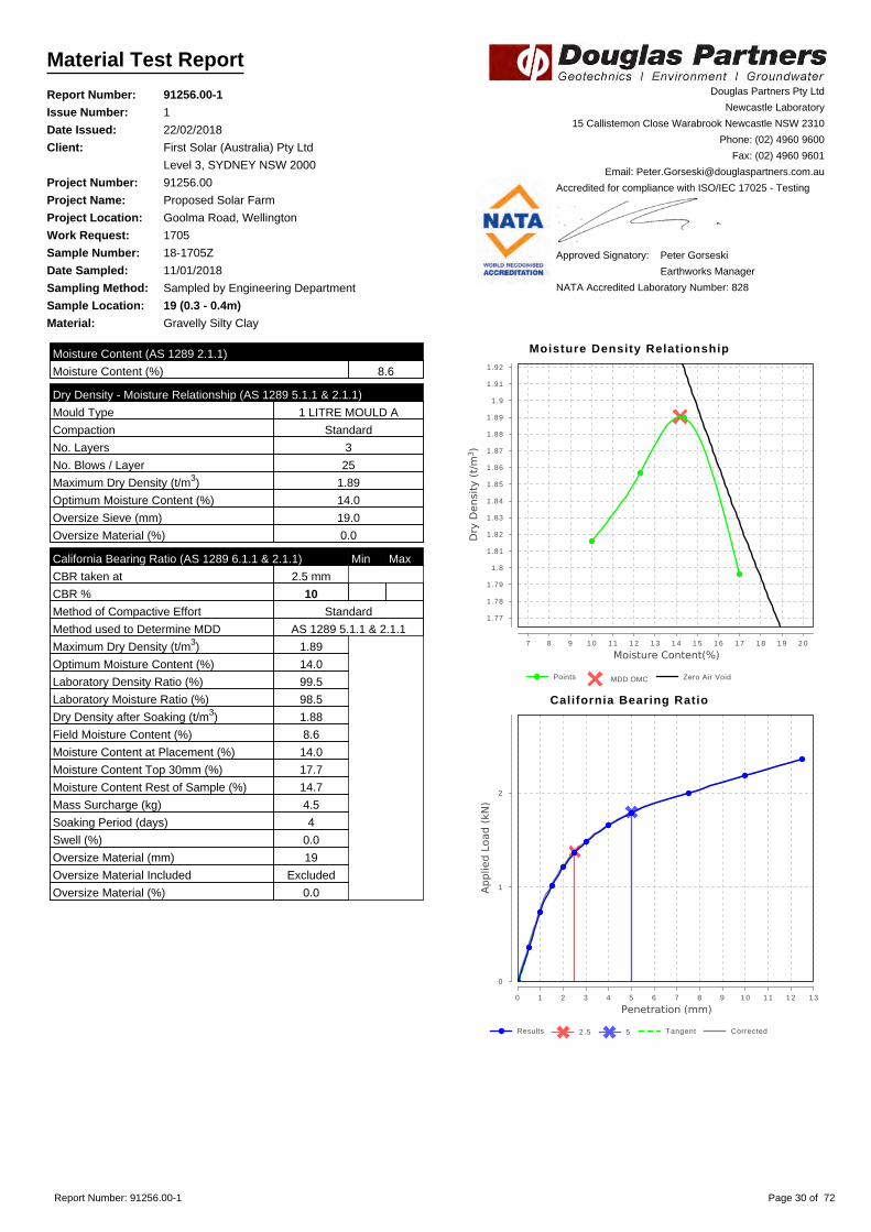
Material Test Report
Report Number: 91256.00-1
Issue Number: 1
Date Issued: 22/02/2018
Client: First Solar (Australia) Pty Ltd
Level 3, SYDNEY NSW 2000
Project Number: 91256.00
Project Name: Proposed Solar Farm
Project Location: Goolma Road, Wellington
Work Request: 1705
Sample Number: 18-1705Z
Date Sampled: 11/01/2018
Sampling Method: Sampled by Engineering Department
Sample Location: 19 (0.3 - 0.4m)
Material: Gravelly Silty Clay
Douglas Partners Pty Ltd
Newcastle Laboratory
15 Callistemon Close Warabrook Newcastle NSW 2310
Phone: (02) 4960 9600
Fax: (02) 4960 9601
Email: [email protected]
Accredited for compliance with ISO/IEC 17025 - Testing
Approved Signatory: Peter Gorseski
Earthworks Manager
NATA Accredited Laboratory Number: 828
Moisture Content (AS 1289 2.1.1)
Moisture Content (%) 8.6
Dry Density - Moisture Relationship (AS 1289 5.1.1 & 2.1.1)
Mould Type 1 LITRE MOULD A
Compaction Standard
No. Layers 3
No. Blows / Layer 25
Maximum Dry Density (t/m3) 1.89
Optimum Moisture Content (%) 14.0
Oversize Sieve (mm) 19.0
Oversize Material (%) 0.0
California Bearing Ratio (AS 1289 6.1.1 & 2.1.1) Min Max
CBR taken at 2.5 mm
CBR % 10
Method of Compactive Effort Standard
Method used to Determine MDD AS 1289 5.1.1 & 2.1.1
Maximum Dry Density (t/m3) 1.89
Optimum Moisture Content (%) 14.0
Laboratory Density Ratio (%) 99.5
Laboratory Moisture Ratio (%) 98.5
Dry Density after Soaking (t/m3) 1.88
Field Moisture Content (%) 8.6
Moisture Content at Placement (%) 14.0
Moisture Content Top 30mm (%) 17.7
Moisture Content Rest of Sample (%) 14.7
Mass Surcharge (kg) 4.5
Soaking Period (days) 4
Swell (%) 0.0
Oversize Material (mm) 19
Oversize Material Included Excluded
Oversize Material (%) 0.0
Moisture Density Relationship
Points MDD OMC Zero Air Void
7 8 9 1 0 1 1 1 2 1 3 1 4 1 5 1 6 1 7 1 8 1 9 2 0
1.77
1.78
1.79
1.8
1.81
1.82
1.83
1.84
1.85
1.86
1.87
1.88
1.89
1.9
1.91
1.92
California Bearing Ratio
Results 2.5 5 Tangent Corrected
0 1 2 3 4 5 6 7 8 9 1 0 1 1 1 2 1 3
0
1
2
Report Number: 91256.00-1 Page 30 of 72

Material Test Report
Report Number: 91256.00-1
Issue Number: 1
Date Issued: 22/02/2018
Client: First Solar (Australia) Pty Ltd
Level 3, SYDNEY NSW 2000
Project Number: 91256.00
Project Name: Proposed Solar Farm
Project Location: Goolma Road, Wellington
Work Request: 1705
Sample Number: 18-1705AB
Date Sampled: 11/01/2018
Sampling Method: Sampled by Engineering Department
Sample Location: 21 (0.4 - 0.69m)
Material: Silty Clay
Douglas Partners Pty Ltd
Newcastle Laboratory
15 Callistemon Close Warabrook Newcastle NSW 2310
Phone: (02) 4960 9600
Fax: (02) 4960 9601
Email: [email protected]
Accredited for compliance with ISO/IEC 17025 - Testing
Approved Signatory: Peter Gorseski
Earthworks Manager
NATA Accredited Laboratory Number: 828
Shrink Swell Index (AS 1289 7.1.1 & 2.1.1)
Iss (%) 0.8
Visual Description Silty Clay
* Shrink Swell Index (Iss) reported as the percentage vertical strain perpF change in suction.
Core Shrinkage Test
Shrinkage Strain - Oven Dried (%) 1.4
Estimated % by volume of significant inert inclusions 5
Cracking Fragmented
Crumbling Yes
Moisture Content (%) 16.8
Swell Test
Initial Pocket Penetrometer (kPa) >600
Final Pocket Penetrometer (kPa) 125
Initial Moisture Content (%) 17.6
Final Moisture Content (%) 24.3
Swell (%) 0.2
* NATA Accreditation does not cover the performance of pocketpenetrometer readings.
Shrink Swell
0 2 4 6 8 1 0 1 2 1 4 1 6 1 8 2 0 2 2 2 4
-1
-0.5
0
0.5
1
1.5
2
Report Number: 91256.00-1 Page 31 of 72

Material Test Report
Report Number: 91256.00-1
Issue Number: 1
Date Issued: 22/02/2018
Client: First Solar (Australia) Pty Ltd
Level 3, SYDNEY NSW 2000
Project Number: 91256.00
Project Name: Proposed Solar Farm
Project Location: Goolma Road, Wellington
Work Request: 1705
Sample Number: 18-1705AC
Date Sampled: 11/01/2018
Sampling Method: Sampled by Engineering Department
Sample Location: 26 (0.25 - 0.63m)
Material: Silty Clay
Douglas Partners Pty Ltd
Newcastle Laboratory
15 Callistemon Close Warabrook Newcastle NSW 2310
Phone: (02) 4960 9600
Fax: (02) 4960 9601
Email: [email protected]
Accredited for compliance with ISO/IEC 17025 - Testing
Approved Signatory: Peter Gorseski
Earthworks Manager
NATA Accredited Laboratory Number: 828
Atterberg Limit (AS1289 3.1.2 & 3.2.1 & 3.3.1) Min Max
Preparation Method Dry Sieve
Sample History Oven Dried
Liquid Limit (%) 33
Plastic Limit (%) 24
Plasticity Index (%) 9
Linear Shrinkage (AS1289 3.4.1) Min Max
Linear Shrinkage (%) 4.0
Cracking Crumbling Curling Cracking
Report Number: 91256.00-1 Page 32 of 72

Material Test Report
Report Number: 91256.00-1
Issue Number: 1
Date Issued: 22/02/2018
Client: First Solar (Australia) Pty Ltd
Level 3, SYDNEY NSW 2000
Project Number: 91256.00
Project Name: Proposed Solar Farm
Project Location: Goolma Road, Wellington
Work Request: 1705
Sample Number: 18-1705AD
Date Sampled: 11/01/2018
Sampling Method: Sampled by Engineering Department
Sample Location: 28 (0.5 - 0.73m)
Material: Silty Clay
Douglas Partners Pty Ltd
Newcastle Laboratory
15 Callistemon Close Warabrook Newcastle NSW 2310
Phone: (02) 4960 9600
Fax: (02) 4960 9601
Email: [email protected]
Accredited for compliance with ISO/IEC 17025 - Testing
Approved Signatory: Peter Gorseski
Earthworks Manager
NATA Accredited Laboratory Number: 828
Shrink Swell Index (AS 1289 7.1.1 & 2.1.1)
Iss (%) 2.0
Visual Description Silty Clay
* Shrink Swell Index (Iss) reported as the percentage vertical strain perpF change in suction.
Core Shrinkage Test
Shrinkage Strain - Oven Dried (%) 3.5
Estimated % by volume of significant inert inclusions 10
Cracking SlightlyCracked
Crumbling No
Moisture Content (%) 19.3
Swell Test
Initial Pocket Penetrometer (kPa) 570
Final Pocket Penetrometer (kPa) 510
Initial Moisture Content (%) 18.4
Final Moisture Content (%) 19.9
Swell (%) 0.2
* NATA Accreditation does not cover the performance of pocketpenetrometer readings.
Shrink Swell
0 2 4 6 8 1 0 1 2 1 4 1 6 1 8 2 0
-1
-0.5
0
0.5
1
1.5
2
2.5
3
3.5
4
4.5
Report Number: 91256.00-1 Page 33 of 72

Material Test Report
Report Number: 91256.00-1
Issue Number: 1
Date Issued: 22/02/2018
Client: First Solar (Australia) Pty Ltd
Level 3, SYDNEY NSW 2000
Project Number: 91256.00
Project Name: Proposed Solar Farm
Project Location: Goolma Road, Wellington
Work Request: 1705
Sample Number: 18-1705AE
Date Sampled: 11/01/2018
Sampling Method: Sampled by Engineering Department
Sample Location: 29 (1.0 - 1.2m)
Material: Silty Clay
Douglas Partners Pty Ltd
Newcastle Laboratory
15 Callistemon Close Warabrook Newcastle NSW 2310
Phone: (02) 4960 9600
Fax: (02) 4960 9601
Email: [email protected]
Accredited for compliance with ISO/IEC 17025 - Testing
Approved Signatory: Peter Gorseski
Earthworks Manager
NATA Accredited Laboratory Number: 828
Shrink Swell Index (AS 1289 7.1.1 & 2.1.1)
Iss (%) 2.4
Visual Description Silty Clay
* Shrink Swell Index (Iss) reported as the percentage vertical strain perpF change in suction.
Core Shrinkage Test
Shrinkage Strain - Oven Dried (%) 2.6
Estimated % by volume of significant inert inclusions 5
Cracking SlightlyCracked
Crumbling No
Moisture Content (%) 15.6
Swell Test
Initial Pocket Penetrometer (kPa) >600
Final Pocket Penetrometer (kPa) 220
Initial Moisture Content (%) 18.4
Final Moisture Content (%) 25.3
Swell (%) 3.3
* NATA Accreditation does not cover the performance of pocketpenetrometer readings.
Shrink Swell
0 2 4 6 8 1 0 1 2 1 4 1 6 1 8 2 0 2 2 2 4 2 6
-4
-3.5
-3
-2.5
-2
-1.5
-1
-0.5
0
0.5
1
1.5
2
2.5
3
3.5
Report Number: 91256.00-1 Page 34 of 72

Material Test Report
Report Number: 91256.00-1
Issue Number: 1
Date Issued: 22/02/2018
Client: First Solar (Australia) Pty Ltd
Level 3, SYDNEY NSW 2000
Project Number: 91256.00
Project Name: Proposed Solar Farm
Project Location: Goolma Road, Wellington
Work Request: 1705
Sample Number: 18-1705AF
Date Sampled: 11/01/2018
Sampling Method: Sampled by Engineering Department
Sample Location: 31 (0.3 - 0.61m)
Material: Silty Clay
Douglas Partners Pty Ltd
Newcastle Laboratory
15 Callistemon Close Warabrook Newcastle NSW 2310
Phone: (02) 4960 9600
Fax: (02) 4960 9601
Email: [email protected]
Accredited for compliance with ISO/IEC 17025 - Testing
Approved Signatory: Peter Gorseski
Earthworks Manager
NATA Accredited Laboratory Number: 828
Shrink Swell Index (AS 1289 7.1.1 & 2.1.1)
Iss (%) 2.9
Visual Description Silty Clay
* Shrink Swell Index (Iss) reported as the percentage vertical strain perpF change in suction.
Core Shrinkage Test
Shrinkage Strain - Oven Dried (%) 4.1
Estimated % by volume of significant inert inclusions 5
Cracking
Crumbling No
Moisture Content (%) 19.8
Swell Test
Initial Pocket Penetrometer (kPa) >600
Final Pocket Penetrometer (kPa) 75
Initial Moisture Content (%) 19.7
Final Moisture Content (%) 24.5
Swell (%) 2.1
* NATA Accreditation does not cover the performance of pocketpenetrometer readings.
Shrink Swell
0 2 4 6 8 1 0 1 2 1 4 1 6 1 8 2 0 2 2 2 4
-3
-2.5
-2
-1.5
-1
-0.5
0
0.5
1
1.5
2
2.5
3
3.5
4
4.5
5
Report Number: 91256.00-1 Page 35 of 72

Material Test Report
Report Number: 91256.00-1
Issue Number: 1
Date Issued: 22/02/2018
Client: First Solar (Australia) Pty Ltd
Level 3, SYDNEY NSW 2000
Project Number: 91256.00
Project Name: Proposed Solar Farm
Project Location: Goolma Road, Wellington
Work Request: 1705
Sample Number: 18-1705AG
Date Sampled: 11/01/2018
Sampling Method: Sampled by Engineering Department
Sample Location: 32 (0.5 - 0.73m)
Material: Silty Clay
Douglas Partners Pty Ltd
Newcastle Laboratory
15 Callistemon Close Warabrook Newcastle NSW 2310
Phone: (02) 4960 9600
Fax: (02) 4960 9601
Email: [email protected]
Accredited for compliance with ISO/IEC 17025 - Testing
Approved Signatory: Peter Gorseski
Earthworks Manager
NATA Accredited Laboratory Number: 828
Shrink Swell Index (AS 1289 7.1.1 & 2.1.1)
Iss (%) 0.9
Visual Description Silty Clay
* Shrink Swell Index (Iss) reported as the percentage vertical strain perpF change in suction.
Core Shrinkage Test
Shrinkage Strain - Oven Dried (%) 1.7
Estimated % by volume of significant inert inclusions 5
Cracking SlightlyCracked
Crumbling No
Moisture Content (%) 17.4
Swell Test
Initial Pocket Penetrometer (kPa) >600
Final Pocket Penetrometer (kPa) 80
Initial Moisture Content (%) 18.6
Final Moisture Content (%) 25.1
Swell (%) -0.2
* NATA Accreditation does not cover the performance of pocketpenetrometer readings.
Shrink Swell
0 2 4 6 8 1 0 1 2 1 4 1 6 1 8 2 0 2 2 2 4 2 6
-1
-0.5
0
0.5
1
1.5
2
2.5
Report Number: 91256.00-1 Page 36 of 72

Material Test Report
Report Number: 91256.00-1
Issue Number: 1
Date Issued: 22/02/2018
Client: First Solar (Australia) Pty Ltd
Level 3, SYDNEY NSW 2000
Project Number: 91256.00
Project Name: Proposed Solar Farm
Project Location: Goolma Road, Wellington
Work Request: 1705
Sample Number: 18-1705AH
Date Sampled: 11/01/2018
Sampling Method: Sampled by Engineering Department
Sample Location: 33 (0.3 - 0.55m)
Material: Silty Clay
Douglas Partners Pty Ltd
Newcastle Laboratory
15 Callistemon Close Warabrook Newcastle NSW 2310
Phone: (02) 4960 9600
Fax: (02) 4960 9601
Email: [email protected]
Accredited for compliance with ISO/IEC 17025 - Testing
Approved Signatory: Peter Gorseski
Earthworks Manager
NATA Accredited Laboratory Number: 828
Shrink Swell Index (AS 1289 7.1.1 & 2.1.1)
Iss (%) 0.5
Visual Description Silty Clay
* Shrink Swell Index (Iss) reported as the percentage vertical strain perpF change in suction.
Core Shrinkage Test
Shrinkage Strain - Oven Dried (%) 0.9
Estimated % by volume of significant inert inclusions 5
Cracking SlightlyCracked
Crumbling No
Moisture Content (%) 16.6
Swell Test
Initial Pocket Penetrometer (kPa) >600
Final Pocket Penetrometer (kPa) 50
Initial Moisture Content (%) 16.2
Final Moisture Content (%) 29.9
Swell (%) -1.2
* NATA Accreditation does not cover the performance of pocketpenetrometer readings.
Shrink Swell
0 2 4 6 8 1 0 1 2 1 4 1 6 1 8 2 0 2 2 2 4 2 6 2 8 3 0
-1
-0.5
0
0.5
1
1.5
2
Report Number: 91256.00-1 Page 37 of 72

Material Test Report
Report Number: 91256.00-1
Issue Number: 1
Date Issued: 22/02/2018
Client: First Solar (Australia) Pty Ltd
Level 3, SYDNEY NSW 2000
Project Number: 91256.00
Project Name: Proposed Solar Farm
Project Location: Goolma Road, Wellington
Work Request: 1705
Sample Number: 18-1705AI
Date Sampled: 11/01/2018
Sampling Method: Sampled by Engineering Department
Sample Location: 33 (1.0 - 1.45m)
Material: Silty Clay
Douglas Partners Pty Ltd
Newcastle Laboratory
15 Callistemon Close Warabrook Newcastle NSW 2310
Phone: (02) 4960 9600
Fax: (02) 4960 9601
Email: [email protected]
Accredited for compliance with ISO/IEC 17025 - Testing
Approved Signatory: Peter Gorseski
Earthworks Manager
NATA Accredited Laboratory Number: 828
Moisture Content (AS 1289 2.1.1)
Moisture Content (%) 20.6
Atterberg Limit (AS1289 3.1.2 & 3.2.1 & 3.3.1) Min Max
Preparation Method Dry Sieve
Sample History Oven Dried
Liquid Limit (%) 72
Plastic Limit (%) 16
Plasticity Index (%) 56
Linear Shrinkage (AS1289 3.4.1) Min Max
Linear Shrinkage (%) 13.0
Cracking Crumbling Curling Curling
Report Number: 91256.00-1 Page 38 of 72

Material Test Report
Report Number: 91256.00-1
Issue Number: 1
Date Issued: 22/02/2018
Client: First Solar (Australia) Pty Ltd
Level 3, SYDNEY NSW 2000
Project Number: 91256.00
Project Name: Proposed Solar Farm
Project Location: Goolma Road, Wellington
Work Request: 1705
Sample Number: 18-1705AJ
Date Sampled: 11/01/2018
Sampling Method: Sampled by Engineering Department
Sample Location: 33 (2.5 - 2.95m)
Material: Silty Clay
Douglas Partners Pty Ltd
Newcastle Laboratory
15 Callistemon Close Warabrook Newcastle NSW 2310
Phone: (02) 4960 9600
Fax: (02) 4960 9601
Email: [email protected]
Accredited for compliance with ISO/IEC 17025 - Testing
Approved Signatory: Peter Gorseski
Earthworks Manager
NATA Accredited Laboratory Number: 828
Moisture Content (AS 1289 2.1.1)
Moisture Content (%) 17.3
Atterberg Limit (AS1289 3.1.2 & 3.2.1 & 3.3.1) Min Max
Preparation Method Dry Sieve
Sample History Oven Dried
Liquid Limit (%) 61
Plastic Limit (%) 12
Plasticity Index (%) 49
Report Number: 91256.00-1 Page 39 of 72

Material Test Report
Report Number: 91256.00-1
Issue Number: 1
Date Issued: 22/02/2018
Client: First Solar (Australia) Pty Ltd
Level 3, SYDNEY NSW 2000
Project Number: 91256.00
Project Name: Proposed Solar Farm
Project Location: Goolma Road, Wellington
Work Request: 1705
Sample Number: 18-1705AK
Date Sampled: 11/01/2018
Sampling Method: Sampled by Engineering Department
Sample Location: 34 (2.5 - 2.95m)
Material: Silty Clay
Douglas Partners Pty Ltd
Newcastle Laboratory
15 Callistemon Close Warabrook Newcastle NSW 2310
Phone: (02) 4960 9600
Fax: (02) 4960 9601
Email: [email protected]
Accredited for compliance with ISO/IEC 17025 - Testing
Approved Signatory: Peter Gorseski
Earthworks Manager
NATA Accredited Laboratory Number: 828
Moisture Content (AS 1289 2.1.1)
Moisture Content (%) 10.3
Atterberg Limit (AS1289 3.1.2 & 3.2.1 & 3.3.1) Min Max
Preparation Method Dry Sieve
Sample History Oven Dried
Liquid Limit (%) 34
Plastic Limit (%) 14
Plasticity Index (%) 20
Report Number: 91256.00-1 Page 40 of 72

Material Test Report
Report Number: 91256.00-1
Issue Number: 1
Date Issued: 22/02/2018
Client: First Solar (Australia) Pty Ltd
Level 3, SYDNEY NSW 2000
Project Number: 91256.00
Project Name: Proposed Solar Farm
Project Location: Goolma Road, Wellington
Work Request: 1705
Sample Number: 18-1705AL
Date Sampled: 11/01/2018
Sampling Method: Sampled by Engineering Department
Sample Location: 31 (0.2m)
Material: Silty Clay
Douglas Partners Pty Ltd
Newcastle Laboratory
15 Callistemon Close Warabrook Newcastle NSW 2310
Phone: (02) 4960 9600
Fax: (02) 4960 9601
Email: [email protected]
Accredited for compliance with ISO/IEC 17025 - Testing
Approved Signatory: Peter Gorseski
Earthworks Manager
NATA Accredited Laboratory Number: 828
Moisture Content (AS 1289 2.1.1)
Moisture Content (%) 8.0
Atterberg Limit (AS1289 3.1.2 & 3.2.1 & 3.3.1) Min Max
Preparation Method Dry Sieve
Sample History Oven Dried
Liquid Limit (%) 37
Plastic Limit (%) 15
Plasticity Index (%) 22
Emerson Class Number of a Soil (AS 1289 3.8.1) Min Max
Emerson Class 5
Soil Description Silty Clay
Nature of Water Distilled
Temperature of Water (oC) 19
Report Number: 91256.00-1 Page 41 of 72

Material Test Report
Report Number: 91256.00-1
Issue Number: 1
Date Issued: 22/02/2018
Client: First Solar (Australia) Pty Ltd
Level 3, SYDNEY NSW 2000
Project Number: 91256.00
Project Name: Proposed Solar Farm
Project Location: Goolma Road, Wellington
Work Request: 1705
Sample Number: 18-1705AM
Date Sampled: 11/01/2018
Sampling Method: Sampled by Engineering Department
Sample Location: 26 (0.1m)
Material: Silty Clay
Douglas Partners Pty Ltd
Newcastle Laboratory
15 Callistemon Close Warabrook Newcastle NSW 2310
Phone: (02) 4960 9600
Fax: (02) 4960 9601
Email: [email protected]
Accredited for compliance with ISO/IEC 17025 - Testing
Approved Signatory: Peter Gorseski
Earthworks Manager
NATA Accredited Laboratory Number: 828
Moisture Content (AS 1289 2.1.1)
Moisture Content (%) 4.1
Atterberg Limit (AS1289 3.1.2 & 3.2.1 & 3.3.1) Min Max
Preparation Method Dry Sieve
Sample History Oven Dried
Liquid Limit (%) 23
Plastic Limit (%) 19
Plasticity Index (%) 4
Emerson Class Number of a Soil (AS 1289 3.8.1) Min Max
Emerson Class 6
Soil Description Silty CLay
Nature of Water Distilled
Temperature of Water (oC) 26
Report Number: 91256.00-1 Page 42 of 72

Material Test Report
Report Number: 91256.00-1
Issue Number: 1
Date Issued: 22/02/2018
Client: First Solar (Australia) Pty Ltd
Level 3, SYDNEY NSW 2000
Project Number: 91256.00
Project Name: Proposed Solar Farm
Project Location: Goolma Road, Wellington
Work Request: 1705
Sample Number: 18-1705AN
Date Sampled: 11/01/2018
Sampling Method: Sampled by Engineering Department
Sample Location: 21 (1.0 - 1.45m)
Material: Silty Clay
Douglas Partners Pty Ltd
Newcastle Laboratory
15 Callistemon Close Warabrook Newcastle NSW 2310
Phone: (02) 4960 9600
Fax: (02) 4960 9601
Email: [email protected]
Accredited for compliance with ISO/IEC 17025 - Testing
Approved Signatory: Peter Gorseski
Earthworks Manager
NATA Accredited Laboratory Number: 828
Moisture Content (AS 1289 2.1.1)
Moisture Content (%) 12.1
Atterberg Limit (AS1289 3.1.2 & 3.2.1 & 3.3.1) Min Max
Preparation Method Dry Sieve
Sample History Oven Dried
Liquid Limit (%) 45
Plastic Limit (%) 13
Plasticity Index (%) 32
Report Number: 91256.00-1 Page 43 of 72

Material Test Report
Report Number: 91256.00-1
Issue Number: 1
Date Issued: 22/02/2018
Client: First Solar (Australia) Pty Ltd
Level 3, SYDNEY NSW 2000
Project Number: 91256.00
Project Name: Proposed Solar Farm
Project Location: Goolma Road, Wellington
Work Request: 1705
Sample Number: 18-1705AO
Date Sampled: 11/01/2018
Sampling Method: Sampled by Engineering Department
Sample Location: 22 (0.5m)
Material: Gravelly Silty Clay
Douglas Partners Pty Ltd
Newcastle Laboratory
15 Callistemon Close Warabrook Newcastle NSW 2310
Phone: (02) 4960 9600
Fax: (02) 4960 9601
Email: [email protected]
Accredited for compliance with ISO/IEC 17025 - Testing
Approved Signatory: Peter Gorseski
Earthworks Manager
NATA Accredited Laboratory Number: 828
Moisture Content (AS 1289 2.1.1)
Moisture Content (%) 8.2
Atterberg Limit (AS1289 3.1.2 & 3.2.1 & 3.3.1) Min Max
Preparation Method Dry Sieve
Sample History Oven Dried
Liquid Limit (%) 33
Plastic Limit (%) 16
Plasticity Index (%) 17
Emerson Class Number of a Soil (AS 1289 3.8.1) Min Max
Emerson Class 5
Soil Description Gravelly Silty Clay
Nature of Water Distilled
Temperature of Water (oC) 26
Report Number: 91256.00-1 Page 44 of 72

Material Test Report
Report Number: 91256.00-1
Issue Number: 1
Date Issued: 22/02/2018
Client: First Solar (Australia) Pty Ltd
Level 3, SYDNEY NSW 2000
Project Number: 91256.00
Project Name: Proposed Solar Farm
Project Location: Goolma Road, Wellington
Work Request: 1705
Sample Number: 18-1705AP
Date Sampled: 11/01/2018
Sampling Method: Sampled by Engineering Department
Sample Location: 25 (1.0 - 1.45m)
Material: Silty Clay
Douglas Partners Pty Ltd
Newcastle Laboratory
15 Callistemon Close Warabrook Newcastle NSW 2310
Phone: (02) 4960 9600
Fax: (02) 4960 9601
Email: [email protected]
Accredited for compliance with ISO/IEC 17025 - Testing
Approved Signatory: Peter Gorseski
Earthworks Manager
NATA Accredited Laboratory Number: 828
Moisture Content (AS 1289 2.1.1)
Moisture Content (%) 16.6
Atterberg Limit (AS1289 3.1.2 & 3.2.1 & 3.3.1) Min Max
Preparation Method Dry Sieve
Sample History Oven Dried
Liquid Limit (%) 61
Plastic Limit (%) 21
Plasticity Index (%) 40
Report Number: 91256.00-1 Page 45 of 72

Material Test Report
Report Number: 91256.00-1
Issue Number: 1
Date Issued: 22/02/2018
Client: First Solar (Australia) Pty Ltd
Level 3, SYDNEY NSW 2000
Project Number: 91256.00
Project Name: Proposed Solar Farm
Project Location: Goolma Road, Wellington
Work Request: 1705
Sample Number: 18-1705AQ
Date Sampled: 11/01/2018
Sampling Method: Sampled by Engineering Department
Sample Location: 27 (1.0 - 1.45m)
Material: Silty Clay
Douglas Partners Pty Ltd
Newcastle Laboratory
15 Callistemon Close Warabrook Newcastle NSW 2310
Phone: (02) 4960 9600
Fax: (02) 4960 9601
Email: [email protected]
Accredited for compliance with ISO/IEC 17025 - Testing
Approved Signatory: Peter Gorseski
Earthworks Manager
NATA Accredited Laboratory Number: 828
Moisture Content (AS 1289 2.1.1)
Moisture Content (%) 15.3
Atterberg Limit (AS1289 3.1.2 & 3.2.1 & 3.3.1) Min Max
Preparation Method Dry Sieve
Sample History Oven Dried
Liquid Limit (%) 60
Plastic Limit (%) 13
Plasticity Index (%) 47
Report Number: 91256.00-1 Page 46 of 72

Material Test Report
Report Number: 91256.00-1
Issue Number: 1
Date Issued: 22/02/2018
Client: First Solar (Australia) Pty Ltd
Level 3, SYDNEY NSW 2000
Project Number: 91256.00
Project Name: Proposed Solar Farm
Project Location: Goolma Road, Wellington
Work Request: 1705
Sample Number: 18-1705AR
Date Sampled: 11/01/2018
Sampling Method: Sampled by Engineering Department
Sample Location: 24 (0.1m)
Material: Silty Clay
Douglas Partners Pty Ltd
Newcastle Laboratory
15 Callistemon Close Warabrook Newcastle NSW 2310
Phone: (02) 4960 9600
Fax: (02) 4960 9601
Email: [email protected]
Accredited for compliance with ISO/IEC 17025 - Testing
Approved Signatory: Peter Gorseski
Earthworks Manager
NATA Accredited Laboratory Number: 828
Moisture Content (AS 1289 2.1.1)
Moisture Content (%) 15.7
Atterberg Limit (AS1289 3.1.2 & 3.2.1 & 3.3.1) Min Max
Preparation Method Dry Sieve
Sample History Oven Dried
Liquid Limit (%) 36
Plastic Limit (%) 15
Plasticity Index (%) 21
Emerson Class Number of a Soil (AS 1289 3.8.1) Min Max
Emerson Class 6
Soil Description Silty Clay
Nature of Water Distilled
Temperature of Water (oC) 20
Report Number: 91256.00-1 Page 47 of 72

Material Test Report
Report Number: 91256.00-1
Issue Number: 1
Date Issued: 22/02/2018
Client: First Solar (Australia) Pty Ltd
Level 3, SYDNEY NSW 2000
Project Number: 91256.00
Project Name: Proposed Solar Farm
Project Location: Goolma Road, Wellington
Work Request: 1705
Sample Number: 18-1705AS
Date Sampled: 11/01/2018
Sampling Method: Sampled by Engineering Department
Sample Location: 24 (0.5m)
Material: Silty Clay
Douglas Partners Pty Ltd
Newcastle Laboratory
15 Callistemon Close Warabrook Newcastle NSW 2310
Phone: (02) 4960 9600
Fax: (02) 4960 9601
Email: [email protected]
Accredited for compliance with ISO/IEC 17025 - Testing
Approved Signatory: Peter Gorseski
Earthworks Manager
NATA Accredited Laboratory Number: 828
Moisture Content (AS 1289 2.1.1)
Moisture Content (%) 18.3
Atterberg Limit (AS1289 3.1.2 & 3.2.1 & 3.3.1) Min Max
Preparation Method Dry Sieve
Sample History Oven Dried
Liquid Limit (%) 64
Plastic Limit (%) 15
Plasticity Index (%) 49
Emerson Class Number of a Soil (AS 1289 3.8.1) Min Max
Emerson Class 5
Soil Description Silty Clay
Nature of Water Distilled
Temperature of Water (oC) 20
Report Number: 91256.00-1 Page 48 of 72

Material Test Report
Report Number: 91256.00-1
Issue Number: 1
Date Issued: 22/02/2018
Client: First Solar (Australia) Pty Ltd
Level 3, SYDNEY NSW 2000
Project Number: 91256.00
Project Name: Proposed Solar Farm
Project Location: Goolma Road, Wellington
Work Request: 1705
Sample Number: 18-1705AT
Date Sampled: 11/01/2018
Sampling Method: Sampled by Engineering Department
Sample Location: 30 (0.5m)
Material: Silty Clay
Douglas Partners Pty Ltd
Newcastle Laboratory
15 Callistemon Close Warabrook Newcastle NSW 2310
Phone: (02) 4960 9600
Fax: (02) 4960 9601
Email: [email protected]
Accredited for compliance with ISO/IEC 17025 - Testing
Approved Signatory: Peter Gorseski
Earthworks Manager
NATA Accredited Laboratory Number: 828
Moisture Content (AS 1289 2.1.1)
Moisture Content (%) 8.7
Atterberg Limit (AS1289 3.1.2 & 3.2.1 & 3.3.1) Min Max
Preparation Method Dry Sieve
Sample History Oven Dried
Liquid Limit (%) 42
Plastic Limit (%) 13
Plasticity Index (%) 29
Emerson Class Number of a Soil (AS 1289 3.8.1) Min Max
Emerson Class 5
Soil Description Silty Clay
Nature of Water Distilled
Temperature of Water (oC) 20
Report Number: 91256.00-1 Page 49 of 72
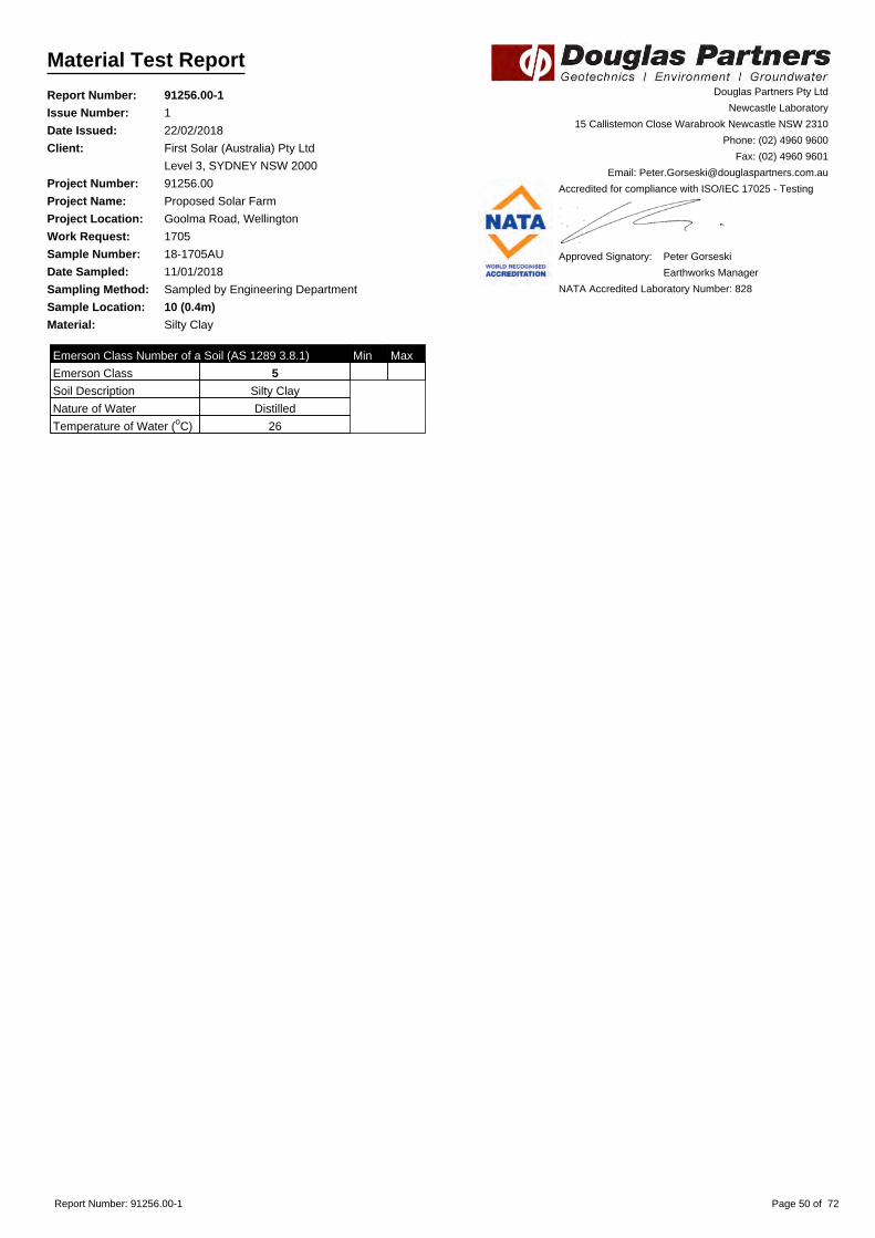
Material Test Report
Report Number: 91256.00-1
Issue Number: 1
Date Issued: 22/02/2018
Client: First Solar (Australia) Pty Ltd
Level 3, SYDNEY NSW 2000
Project Number: 91256.00
Project Name: Proposed Solar Farm
Project Location: Goolma Road, Wellington
Work Request: 1705
Sample Number: 18-1705AU
Date Sampled: 11/01/2018
Sampling Method: Sampled by Engineering Department
Sample Location: 10 (0.4m)
Material: Silty Clay
Douglas Partners Pty Ltd
Newcastle Laboratory
15 Callistemon Close Warabrook Newcastle NSW 2310
Phone: (02) 4960 9600
Fax: (02) 4960 9601
Email: [email protected]
Accredited for compliance with ISO/IEC 17025 - Testing
Approved Signatory: Peter Gorseski
Earthworks Manager
NATA Accredited Laboratory Number: 828
Emerson Class Number of a Soil (AS 1289 3.8.1) Min Max
Emerson Class 5
Soil Description Silty Clay
Nature of Water Distilled
Temperature of Water (oC) 26
Report Number: 91256.00-1 Page 50 of 72

Material Test Report
Report Number: 91256.00-1
Issue Number: 1
Date Issued: 22/02/2018
Client: First Solar (Australia) Pty Ltd
Level 3, SYDNEY NSW 2000
Project Number: 91256.00
Project Name: Proposed Solar Farm
Project Location: Goolma Road, Wellington
Work Request: 1705
Sample Number: 18-1705AV
Date Sampled: 11/01/2018
Sampling Method: Sampled by Engineering Department
Sample Location: 20 (0.5m)
Material: Silty Clay
Douglas Partners Pty Ltd
Newcastle Laboratory
15 Callistemon Close Warabrook Newcastle NSW 2310
Phone: (02) 4960 9600
Fax: (02) 4960 9601
Email: [email protected]
Accredited for compliance with ISO/IEC 17025 - Testing
Approved Signatory: Peter Gorseski
Earthworks Manager
NATA Accredited Laboratory Number: 828
Emerson Class Number of a Soil (AS 1289 3.8.1) Min Max
Emerson Class 5
Soil Description Silty Clay
Nature of Water Distilled
Temperature of Water (oC) 26
Report Number: 91256.00-1 Page 51 of 72

Material Test Report
Report Number: 91256.00-1
Issue Number: 1
Date Issued: 22/02/2018
Client: First Solar (Australia) Pty Ltd
Level 3, SYDNEY NSW 2000
Project Number: 91256.00
Project Name: Proposed Solar Farm
Project Location: Goolma Road, Wellington
Work Request: 1705
Sample Number: 18-1705AW
Date Sampled: 11/01/2018
Sampling Method: Sampled by Engineering Department
Sample Location: 11 (0.4m)
Material: Silty Clay
Douglas Partners Pty Ltd
Newcastle Laboratory
15 Callistemon Close Warabrook Newcastle NSW 2310
Phone: (02) 4960 9600
Fax: (02) 4960 9601
Email: [email protected]
Accredited for compliance with ISO/IEC 17025 - Testing
Approved Signatory: Peter Gorseski
Earthworks Manager
NATA Accredited Laboratory Number: 828
Emerson Class Number of a Soil (AS 1289 3.8.1) Min Max
Emerson Class 5
Soil Description Silty Clay
Nature of Water Distilled
Temperature of Water (oC) 26
Report Number: 91256.00-1 Page 52 of 72

Material Test Report
Report Number: 91256.00-1
Issue Number: 1
Date Issued: 22/02/2018
Client: First Solar (Australia) Pty Ltd
Level 3, SYDNEY NSW 2000
Project Number: 91256.00
Project Name: Proposed Solar Farm
Project Location: Goolma Road, Wellington
Work Request: 1705
Sample Number: 18-1705AX
Date Sampled: 11/01/2018
Sampling Method: Sampled by Engineering Department
Sample Location: 12 (0.4m)
Material: Sandy Silty Clay
Douglas Partners Pty Ltd
Newcastle Laboratory
15 Callistemon Close Warabrook Newcastle NSW 2310
Phone: (02) 4960 9600
Fax: (02) 4960 9601
Email: [email protected]
Accredited for compliance with ISO/IEC 17025 - Testing
Approved Signatory: Peter Gorseski
Earthworks Manager
NATA Accredited Laboratory Number: 828
Emerson Class Number of a Soil (AS 1289 3.8.1) Min Max
Emerson Class 5
Soil Description Sandy Silty Clay
Nature of Water Distilled
Temperature of Water (oC) 26
Report Number: 91256.00-1 Page 53 of 72

Material Test Report
Report Number: 91256.00-1
Issue Number: 1
Date Issued: 22/02/2018
Client: First Solar (Australia) Pty Ltd
Level 3, SYDNEY NSW 2000
Project Number: 91256.00
Project Name: Proposed Solar Farm
Project Location: Goolma Road, Wellington
Work Request: 1705
Sample Number: 18-1705AY
Date Sampled: 11/01/2018
Sampling Method: Sampled by Engineering Department
Sample Location: 14 (2.5m)
Material: Silty Clay
Douglas Partners Pty Ltd
Newcastle Laboratory
15 Callistemon Close Warabrook Newcastle NSW 2310
Phone: (02) 4960 9600
Fax: (02) 4960 9601
Email: [email protected]
Accredited for compliance with ISO/IEC 17025 - Testing
Approved Signatory: Peter Gorseski
Earthworks Manager
NATA Accredited Laboratory Number: 828
Particle Distribution (AS1289 3.6.1)
Sieve Passed % Passing Limits
13.2 mm 100
9.5 mm 99
6.7 mm 99
4.75 mm 99
2.36 mm 98
1.18 mm 93
0.6 mm 85
0.425 mm 79
0.3 mm 72
0.15 mm 57
0.075 mm 45
Particle Size Distribution
0 . 1 0 . 2 1 2 3 4 5 1 0 2 0 3 0 1 0 0 2 0 0
Particle Size (mm)
1 0
2 0
3 0
4 0
5 0
6 0
7 0
8 0
9 0
1 0 0
Pe
rce
nt
Pa
ssin
g
13
.2
9.5
6.7
4.7
5
2.3
6
1.1
8
0.6
0.4
25
0.3
0.1
5
0.0
75
Sieve( m m )
Clay Si l t Sand Gravel Cobbles
Report Number: 91256.00-1 Page 54 of 72

Material Test Report
Report Number: 91256.00-1
Issue Number: 1
Date Issued: 22/02/2018
Client: First Solar (Australia) Pty Ltd
Level 3, SYDNEY NSW 2000
Project Number: 91256.00
Project Name: Proposed Solar Farm
Project Location: Goolma Road, Wellington
Work Request: 1705
Sample Number: 18-1705BA
Date Sampled: 11/01/2018
Sampling Method: Sampled by Engineering Department
Sample Location: 19 (3.0m)
Material: Silty Clay
Douglas Partners Pty Ltd
Newcastle Laboratory
15 Callistemon Close Warabrook Newcastle NSW 2310
Phone: (02) 4960 9600
Fax: (02) 4960 9601
Email: [email protected]
Accredited for compliance with ISO/IEC 17025 - Testing
Approved Signatory: Peter Gorseski
Earthworks Manager
NATA Accredited Laboratory Number: 828
Moisture Content (AS 1289 2.1.1)
Moisture Content (%) 12.3
Report Number: 91256.00-1 Page 55 of 72

Material Test Report
Report Number: 91256.00-1
Issue Number: 1
Date Issued: 22/02/2018
Client: First Solar (Australia) Pty Ltd
Level 3, SYDNEY NSW 2000
Project Number: 91256.00
Project Name: Proposed Solar Farm
Project Location: Goolma Road, Wellington
Work Request: 1705
Sample Number: 18-1705BB
Date Sampled: 11/01/2018
Sampling Method: Sampled by Engineering Department
Sample Location: 1 (2.0m)
Material: Silty Clay
Douglas Partners Pty Ltd
Newcastle Laboratory
15 Callistemon Close Warabrook Newcastle NSW 2310
Phone: (02) 4960 9600
Fax: (02) 4960 9601
Email: [email protected]
Accredited for compliance with ISO/IEC 17025 - Testing
Approved Signatory: Peter Gorseski
Earthworks Manager
NATA Accredited Laboratory Number: 828
Moisture Content (AS 1289 2.1.1)
Moisture Content (%) 17.5
Report Number: 91256.00-1 Page 56 of 72

Material Test Report
Report Number: 91256.00-1
Issue Number: 1
Date Issued: 22/02/2018
Client: First Solar (Australia) Pty Ltd
Level 3, SYDNEY NSW 2000
Project Number: 91256.00
Project Name: Proposed Solar Farm
Project Location: Goolma Road, Wellington
Work Request: 1705
Sample Number: 18-1705BC
Date Sampled: 11/01/2018
Sampling Method: Sampled by Engineering Department
Sample Location: 2 (0.8m)
Material: Silty Clay
Douglas Partners Pty Ltd
Newcastle Laboratory
15 Callistemon Close Warabrook Newcastle NSW 2310
Phone: (02) 4960 9600
Fax: (02) 4960 9601
Email: [email protected]
Accredited for compliance with ISO/IEC 17025 - Testing
Approved Signatory: Peter Gorseski
Earthworks Manager
NATA Accredited Laboratory Number: 828
Moisture Content (AS 1289 2.1.1)
Moisture Content (%) 18.9
Report Number: 91256.00-1 Page 57 of 72

Material Test Report
Report Number: 91256.00-1
Issue Number: 1
Date Issued: 22/02/2018
Client: First Solar (Australia) Pty Ltd
Level 3, SYDNEY NSW 2000
Project Number: 91256.00
Project Name: Proposed Solar Farm
Project Location: Goolma Road, Wellington
Work Request: 1705
Sample Number: 18-1705BD
Date Sampled: 11/01/2018
Sampling Method: Sampled by Engineering Department
Sample Location: 4 (0.6m)
Material: Silty Clay
Douglas Partners Pty Ltd
Newcastle Laboratory
15 Callistemon Close Warabrook Newcastle NSW 2310
Phone: (02) 4960 9600
Fax: (02) 4960 9601
Email: [email protected]
Accredited for compliance with ISO/IEC 17025 - Testing
Approved Signatory: Peter Gorseski
Earthworks Manager
NATA Accredited Laboratory Number: 828
Emerson Class Number of a Soil (AS 1289 3.8.1) Min Max
Emerson Class 5
Soil Description Silty Clay
Nature of Water Distilled
Temperature of Water (oC) 20
Report Number: 91256.00-1 Page 58 of 72

Material Test Report
Report Number: 91256.00-1
Issue Number: 1
Date Issued: 22/02/2018
Client: First Solar (Australia) Pty Ltd
Level 3, SYDNEY NSW 2000
Project Number: 91256.00
Project Name: Proposed Solar Farm
Project Location: Goolma Road, Wellington
Work Request: 1705
Sample Number: 18-1705BE
Date Sampled: 11/01/2018
Sampling Method: Sampled by Engineering Department
Sample Location: 8 (1.5m)
Material: Silty Clay
Douglas Partners Pty Ltd
Newcastle Laboratory
15 Callistemon Close Warabrook Newcastle NSW 2310
Phone: (02) 4960 9600
Fax: (02) 4960 9601
Email: [email protected]
Accredited for compliance with ISO/IEC 17025 - Testing
Approved Signatory: Peter Gorseski
Earthworks Manager
NATA Accredited Laboratory Number: 828
Moisture Content (AS 1289 2.1.1)
Moisture Content (%) 14.6
Atterberg Limit (AS1289 3.1.2 & 3.2.1 & 3.3.1) Min Max
Preparation Method Dry Sieve
Sample History Oven Dried
Liquid Limit (%) 66
Plastic Limit (%) 17
Plasticity Index (%) 49
Linear Shrinkage (AS1289 3.4.1) Min Max
Linear Shrinkage (%) 13.0
Cracking Crumbling Curling Curling
Report Number: 91256.00-1 Page 59 of 72

Material Test Report
Report Number: 91256.00-1
Issue Number: 1
Date Issued: 22/02/2018
Client: First Solar (Australia) Pty Ltd
Level 3, SYDNEY NSW 2000
Project Number: 91256.00
Project Name: Proposed Solar Farm
Project Location: Goolma Road, Wellington
Work Request: 1705
Sample Number: 18-1705BF
Date Sampled: 11/01/2018
Sampling Method: Sampled by Engineering Department
Sample Location: 17 (0.5m)
Material: Silty Clay
Douglas Partners Pty Ltd
Newcastle Laboratory
15 Callistemon Close Warabrook Newcastle NSW 2310
Phone: (02) 4960 9600
Fax: (02) 4960 9601
Email: [email protected]
Accredited for compliance with ISO/IEC 17025 - Testing
Approved Signatory: Peter Gorseski
Earthworks Manager
NATA Accredited Laboratory Number: 828
Emerson Class Number of a Soil (AS 1289 3.8.1) Min Max
Emerson Class 5
Soil Description Silty Clay
Nature of Water Distilled
Temperature of Water (oC) 26
Report Number: 91256.00-1 Page 60 of 72

Material Test Report
Report Number: 91256.00-1
Issue Number: 1
Date Issued: 22/02/2018
Client: First Solar (Australia) Pty Ltd
Level 3, SYDNEY NSW 2000
Project Number: 91256.00
Project Name: Proposed Solar Farm
Project Location: Goolma Road, Wellington
Work Request: 1705
Sample Number: 18-1705BG
Date Sampled: 11/01/2018
Sampling Method: Sampled by Engineering Department
Sample Location: 18 (0.2m)
Material: Silty Clay
Douglas Partners Pty Ltd
Newcastle Laboratory
15 Callistemon Close Warabrook Newcastle NSW 2310
Phone: (02) 4960 9600
Fax: (02) 4960 9601
Email: [email protected]
Accredited for compliance with ISO/IEC 17025 - Testing
Approved Signatory: Peter Gorseski
Earthworks Manager
NATA Accredited Laboratory Number: 828
Emerson Class Number of a Soil (AS 1289 3.8.1) Min Max
Emerson Class 5
Soil Description Silty Clay
Nature of Water Distilled
Temperature of Water (oC) 26
Report Number: 91256.00-1 Page 61 of 72

Material Test Report
Report Number: 91256.00-1
Issue Number: 1
Date Issued: 22/02/2018
Client: First Solar (Australia) Pty Ltd
Level 3, SYDNEY NSW 2000
Project Number: 91256.00
Project Name: Proposed Solar Farm
Project Location: Goolma Road, Wellington
Work Request: 1705
Sample Number: 18-1705BH
Date Sampled: 11/01/2018
Sampling Method: Sampled by Engineering Department
Sample Location: 21 (0.1m)
Material: Silty Clay
Douglas Partners Pty Ltd
Newcastle Laboratory
15 Callistemon Close Warabrook Newcastle NSW 2310
Phone: (02) 4960 9600
Fax: (02) 4960 9601
Email: [email protected]
Accredited for compliance with ISO/IEC 17025 - Testing
Approved Signatory: Peter Gorseski
Earthworks Manager
NATA Accredited Laboratory Number: 828
Emerson Class Number of a Soil (AS 1289 3.8.1) Min Max
Emerson Class 5
Soil Description Silty Clay
Nature of Water Distilled
Temperature of Water (oC) 26
Report Number: 91256.00-1 Page 62 of 72

Material Test Report
Report Number: 91256.00-1
Issue Number: 1
Date Issued: 22/02/2018
Client: First Solar (Australia) Pty Ltd
Level 3, SYDNEY NSW 2000
Project Number: 91256.00
Project Name: Proposed Solar Farm
Project Location: Goolma Road, Wellington
Work Request: 1705
Sample Number: 18-1705BI
Date Sampled: 11/01/2018
Sampling Method: Sampled by Engineering Department
Sample Location: 25 (0.5m)
Material: Silty Clay
Douglas Partners Pty Ltd
Newcastle Laboratory
15 Callistemon Close Warabrook Newcastle NSW 2310
Phone: (02) 4960 9600
Fax: (02) 4960 9601
Email: [email protected]
Accredited for compliance with ISO/IEC 17025 - Testing
Approved Signatory: Peter Gorseski
Earthworks Manager
NATA Accredited Laboratory Number: 828
Moisture Content (AS 1289 2.1.1)
Moisture Content (%) 16.6
Atterberg Limit (AS1289 3.1.2 & 3.2.1 & 3.3.1) Min Max
Preparation Method Dry Sieve
Sample History Oven Dried
Liquid Limit (%) 55
Plastic Limit (%) 14
Plasticity Index (%) 41
Linear Shrinkage (AS1289 3.4.1) Min Max
Linear Shrinkage (%) 13.0
Cracking Crumbling Curling None
Emerson Class Number of a Soil (AS 1289 3.8.1) Min Max
Emerson Class 5
Soil Description Silty Clay
Nature of Water Distilled
Temperature of Water (oC) 20
Report Number: 91256.00-1 Page 63 of 72

Material Test Report
Report Number: 91256.00-1
Issue Number: 1
Date Issued: 22/02/2018
Client: First Solar (Australia) Pty Ltd
Level 3, SYDNEY NSW 2000
Project Number: 91256.00
Project Name: Proposed Solar Farm
Project Location: Goolma Road, Wellington
Work Request: 1705
Sample Number: 18-1705BJ
Date Sampled: 11/01/2018
Sampling Method: Sampled by Engineering Department
Sample Location: 27 (0.5m)
Material: Silty Clay
Douglas Partners Pty Ltd
Newcastle Laboratory
15 Callistemon Close Warabrook Newcastle NSW 2310
Phone: (02) 4960 9600
Fax: (02) 4960 9601
Email: [email protected]
Accredited for compliance with ISO/IEC 17025 - Testing
Approved Signatory: Peter Gorseski
Earthworks Manager
NATA Accredited Laboratory Number: 828
Moisture Content (AS 1289 2.1.1)
Moisture Content (%) 18.3
Atterberg Limit (AS1289 3.1.2 & 3.2.1 & 3.3.1) Min Max
Preparation Method Dry Sieve
Sample History Oven Dried
Liquid Limit (%) 66
Plastic Limit (%) 13
Plasticity Index (%) 53
Linear Shrinkage (AS1289 3.4.1) Min Max
Linear Shrinkage (%) 17.0
Cracking Crumbling Curling Cracking
Emerson Class Number of a Soil (AS 1289 3.8.1) Min Max
Emerson Class 3
Soil Description Silty Clay
Nature of Water Distilled
Temperature of Water (oC) 19
Report Number: 91256.00-1 Page 64 of 72

Material Test Report
Report Number: 91256.00-1
Issue Number: 1
Date Issued: 22/02/2018
Client: First Solar (Australia) Pty Ltd
Level 3, SYDNEY NSW 2000
Project Number: 91256.00
Project Name: Proposed Solar Farm
Project Location: Goolma Road, Wellington
Work Request: 1705
Sample Number: 18-1705BK
Date Sampled: 11/01/2018
Sampling Method: Sampled by Engineering Department
Sample Location: 24 (0.85m)
Material: Silty Clay
Douglas Partners Pty Ltd
Newcastle Laboratory
15 Callistemon Close Warabrook Newcastle NSW 2310
Phone: (02) 4960 9600
Fax: (02) 4960 9601
Email: [email protected]
Accredited for compliance with ISO/IEC 17025 - Testing
Approved Signatory: Peter Gorseski
Earthworks Manager
NATA Accredited Laboratory Number: 828
Moisture Content (AS 1289 2.1.1)
Moisture Content (%) 10.3
Atterberg Limit (AS1289 3.1.2 & 3.2.1 & 3.3.1) Min Max
Preparation Method Dry Sieve
Sample History Oven Dried
Liquid Limit (%) 40
Plastic Limit (%) 10
Plasticity Index (%) 30
Linear Shrinkage (AS1289 3.4.1) Min Max
Linear Shrinkage (%) 13.5
Cracking Crumbling Curling None
Emerson Class Number of a Soil (AS 1289 3.8.1) Min Max
Emerson Class 4 *
Soil Description Silty Clay
Nature of Water Distilled
Temperature of Water (oC) 19
* Mineral Present Carbonate
Report Number: 91256.00-1 Page 65 of 72

Material Test Report
Report Number: 91256.00-1
Issue Number: 1
Date Issued: 22/02/2018
Client: First Solar (Australia) Pty Ltd
Level 3, SYDNEY NSW 2000
Project Number: 91256.00
Project Name: Proposed Solar Farm
Project Location: Goolma Road, Wellington
Work Request: 1705
Sample Number: 18-1705BL
Date Sampled: 11/01/2018
Sampling Method: Sampled by Engineering Department
Sample Location: 32 (0.1m)
Material: Silty Clay
Douglas Partners Pty Ltd
Newcastle Laboratory
15 Callistemon Close Warabrook Newcastle NSW 2310
Phone: (02) 4960 9600
Fax: (02) 4960 9601
Email: [email protected]
Accredited for compliance with ISO/IEC 17025 - Testing
Approved Signatory: Peter Gorseski
Earthworks Manager
NATA Accredited Laboratory Number: 828
Emerson Class Number of a Soil (AS 1289 3.8.1) Min Max
Emerson Class 5
Soil Description Silty Clay
Nature of Water Distilled
Temperature of Water (oC) 20
Report Number: 91256.00-1 Page 66 of 72

Material Test Report
Report Number: 91256.00-1
Issue Number: 1
Date Issued: 22/02/2018
Client: First Solar (Australia) Pty Ltd
Level 3, SYDNEY NSW 2000
Project Number: 91256.00
Project Name: Proposed Solar Farm
Project Location: Goolma Road, Wellington
Work Request: 1705
Sample Number: 18-1705BM
Date Sampled: 11/01/2018
Sampling Method: Sampled by Engineering Department
Sample Location: 29 (0.1m)
Material: Silty Clay
Douglas Partners Pty Ltd
Newcastle Laboratory
15 Callistemon Close Warabrook Newcastle NSW 2310
Phone: (02) 4960 9600
Fax: (02) 4960 9601
Email: [email protected]
Accredited for compliance with ISO/IEC 17025 - Testing
Approved Signatory: Peter Gorseski
Earthworks Manager
NATA Accredited Laboratory Number: 828
Emerson Class Number of a Soil (AS 1289 3.8.1) Min Max
Emerson Class 3
Soil Description Silty Clay
Nature of Water Distilled
Temperature of Water (oC) 19
Report Number: 91256.00-1 Page 67 of 72

Material Test Report
Report Number: 91256.00-1
Issue Number: 1
Date Issued: 22/02/2018
Client: First Solar (Australia) Pty Ltd
Level 3, SYDNEY NSW 2000
Project Number: 91256.00
Project Name: Proposed Solar Farm
Project Location: Goolma Road, Wellington
Work Request: 1705
Sample Number: 18-1705BN
Date Sampled: 11/01/2018
Sampling Method: Sampled by Engineering Department
Sample Location: 28 (0.1m)
Material: Silty Clay
Douglas Partners Pty Ltd
Newcastle Laboratory
15 Callistemon Close Warabrook Newcastle NSW 2310
Phone: (02) 4960 9600
Fax: (02) 4960 9601
Email: [email protected]
Accredited for compliance with ISO/IEC 17025 - Testing
Approved Signatory: Peter Gorseski
Earthworks Manager
NATA Accredited Laboratory Number: 828
Emerson Class Number of a Soil (AS 1289 3.8.1) Min Max
Emerson Class 4 *
Soil Description Silty Clay
Nature of Water Distilled
Temperature of Water (oC) 26
* Mineral Present Carbonate
Report Number: 91256.00-1 Page 68 of 72

Material Test Report
Report Number: 91256.00-1
Issue Number: 1
Date Issued: 22/02/2018
Client: First Solar (Australia) Pty Ltd
Level 3, SYDNEY NSW 2000
Project Number: 91256.00
Project Name: Proposed Solar Farm
Project Location: Goolma Road, Wellington
Work Request: 1705
Sample Number: 18-1705BO
Date Sampled: 11/01/2018
Sampling Method: Sampled by Engineering Department
Sample Location: 32 (1.0 - 1.45m)
Material: Silty Clay
Douglas Partners Pty Ltd
Newcastle Laboratory
15 Callistemon Close Warabrook Newcastle NSW 2310
Phone: (02) 4960 9600
Fax: (02) 4960 9601
Email: [email protected]
Accredited for compliance with ISO/IEC 17025 - Testing
Approved Signatory: Peter Gorseski
Earthworks Manager
NATA Accredited Laboratory Number: 828
Particle Distribution (AS1289 3.6.1)
Sieve Passed % Passing Limits
4.75 mm 100
2.36 mm 100
1.18 mm 99
0.6 mm 98
0.425 mm 97
0.3 mm 96
0.15 mm 93
0.075 mm 90
Particle Size Distribution
0 . 1 0 . 2 1 2 3 4 5 1 0 2 0 3 0 1 0 0 2 0 0
Particle Size (mm)
1 0
2 0
3 0
4 0
5 0
6 0
7 0
8 0
9 0
1 0 0
Pe
rce
nt
Pa
ssin
g
4.7
5
2.3
6
1.1
8
0.6
0.4
25
0.3
0.1
5
0.0
75
Sieve( m m )
Clay Si l t Sand Gravel Cobbles
Report Number: 91256.00-1 Page 69 of 72

Material Test Report
Report Number: 91256.00-1
Issue Number: 1
Date Issued: 22/02/2018
Client: First Solar (Australia) Pty Ltd
Level 3, SYDNEY NSW 2000
Project Number: 91256.00
Project Name: Proposed Solar Farm
Project Location: Goolma Road, Wellington
Work Request: 1705
Sample Number: 18-1705BP
Date Sampled: 11/01/2018
Sampling Method: Sampled by Engineering Department
Sample Location: 29 (1.5 - 1.95m)
Material: Silty Clay
Douglas Partners Pty Ltd
Newcastle Laboratory
15 Callistemon Close Warabrook Newcastle NSW 2310
Phone: (02) 4960 9600
Fax: (02) 4960 9601
Email: [email protected]
Accredited for compliance with ISO/IEC 17025 - Testing
Approved Signatory: Peter Gorseski
Earthworks Manager
NATA Accredited Laboratory Number: 828
Moisture Content (AS 1289 2.1.1)
Moisture Content (%) 15.4
Atterberg Limit (AS1289 3.1.2 & 3.2.1 & 3.3.1) Min Max
Preparation Method Dry Sieve
Sample History Oven Dried
Liquid Limit (%) 66
Plastic Limit (%) 13
Plasticity Index (%) 53
Report Number: 91256.00-1 Page 70 of 72

Material Test Report
Report Number: 91256.00-1
Issue Number: 1
Date Issued: 22/02/2018
Client: First Solar (Australia) Pty Ltd
Level 3, SYDNEY NSW 2000
Project Number: 91256.00
Project Name: Proposed Solar Farm
Project Location: Goolma Road, Wellington
Work Request: 1705
Sample Number: 18-1705BQ
Date Sampled: 11/01/2018
Sampling Method: Sampled by Engineering Department
Sample Location: 28 (1.0 - 1.45m)
Material: Silty Clay
Douglas Partners Pty Ltd
Newcastle Laboratory
15 Callistemon Close Warabrook Newcastle NSW 2310
Phone: (02) 4960 9600
Fax: (02) 4960 9601
Email: [email protected]
Accredited for compliance with ISO/IEC 17025 - Testing
Approved Signatory: Peter Gorseski
Earthworks Manager
NATA Accredited Laboratory Number: 828
Particle Distribution (AS1289 3.6.1)
Sieve Passed % Passing Limits
9.5 mm 100
6.7 mm 100
4.75 mm 99
2.36 mm 97
1.18 mm 94
0.6 mm 91
0.425 mm 89
0.3 mm 86
0.15 mm 81
0.075 mm 77
Particle Size Distribution
0 . 1 0 . 2 1 2 3 4 5 1 0 2 0 3 0 1 0 0 2 0 0
Particle Size (mm)
1 0
2 0
3 0
4 0
5 0
6 0
7 0
8 0
9 0
1 0 0
Pe
rce
nt
Pa
ssin
g
9.5
6.7
4.7
5
2.3
6
1.1
8
0.6
0.4
25
0.3
0.1
5
0.0
75
Sieve( m m )
Clay Si l t Sand Gravel Cobbles
Report Number: 91256.00-1 Page 71 of 72

Material Test Report
Report Number: 91256.00-1
Issue Number: 1
Date Issued: 22/02/2018
Client: First Solar (Australia) Pty Ltd
Level 3, SYDNEY NSW 2000
Project Number: 91256.00
Project Name: Proposed Solar Farm
Project Location: Goolma Road, Wellington
Work Request: 1705
Sample Number: 18-1705BR
Date Sampled: 11/01/2018
Sampling Method: Sampled by Engineering Department
Sample Location: 28 (2.5 - 2.95m)
Material: Silty Clay
Douglas Partners Pty Ltd
Newcastle Laboratory
15 Callistemon Close Warabrook Newcastle NSW 2310
Phone: (02) 4960 9600
Fax: (02) 4960 9601
Email: [email protected]
Accredited for compliance with ISO/IEC 17025 - Testing
Approved Signatory: Peter Gorseski
Earthworks Manager
NATA Accredited Laboratory Number: 828
Moisture Content (AS 1289 2.1.1)
Moisture Content (%) 19.7
Atterberg Limit (AS1289 3.1.2 & 3.2.1 & 3.3.1) Min Max
Preparation Method Dry Sieve
Sample History Oven Dried
Liquid Limit (%) 61
Plastic Limit (%) 23
Plasticity Index (%) 38
Report Number: 91256.00-1 Page 72 of 72

Envirolab Services Pty Ltd
ABN 37 112 535 645
12 Ashley St Chatswood NSW 2067
ph 02 9910 6200 fax 02 9910 6201
www.envirolab.com.au
CERTIFICATE OF ANALYSIS 184415
Box 324 Hunter Region Mail Centre, Newcastle, NSW, 2310Address
Michael GawnAttention
Douglas Partners NewcastleClient
Client Details
02/02/2018Date completed instructions received
02/02/2018Date samples received
24 SoilNumber of Samples
91256.00Your Reference
Sample Details
Please refer to the last page of this report for any comments relating to the results.
Results are reported on a dry weight basis for solids and on an as received basis for other matrices.
Samples were analysed as received from the client. Results relate specifically to the samples as received.
Please refer to the following pages for results, methodology summary and quality control data.
Analysis Details
Tests not covered by NATA are denoted with *Accredited for compliance with ISO/IEC 17025 - Testing.
NATA Accreditation Number 2901. This document shall not be reproduced except in full.
15/02/2018Date of Issue
13/02/2018Date results requested by
Report Details
David Springer, General Manager
Authorised By
Nick Sarlamis, Inorganics Supervisor
Long Pham, Team Leader, Metals
Results Approved By
Revision No: R00
184415Envirolab Reference: Page | 1 of 13

Client Reference: 91256.00
7.05.03b5.05.0-Emerson Aggregate
6472754138µS/cmElectrical Conductivity 1:5 soil:water
7.98.38.36.97.1pH UnitspH 1:5 soil:water
05/02/201805/02/201805/02/201805/02/201805/02/2018-Date analysed
05/02/201805/02/201805/02/201805/02/201805/02/2018-Date prepared
SoilSoilSoilSoilSoilType of sample
09/01/201809/01/201809/01/201809/01/201809/01/2018Date Sampled
00.50.92.00.50.5Depth
139774UNITSYour Reference
184415-15184415-14184415-13184415-12184415-11Our Reference
Misc Inorg - Soil
[NA][NA]1,600350560mg/kgPhosphorus Buffer Index
[NA][NA]585842mg/kgPhosphorus (Colwell)
5.03b[NA][NA][NA]-Emerson Aggregate
3421110340150µS/cmElectrical Conductivity 1:5 soil:water
6.76.96.15.56.3pH UnitspH 1:5 soil:water
05/02/201805/02/201805/02/201805/02/201805/02/2018-Date analysed
05/02/201805/02/201805/02/201805/02/201805/02/2018-Date prepared
SoilSoilSoilSoilSoilType of sample
09/01/201809/01/201809/01/201809/01/201809/01/2018Date Sampled
0.50.50.050.010.05Depth
31221817UNITSYour Reference
184415-10184415-9184415-8184415-7184415-6Our Reference
Misc Inorg - Soil
600560480570760mg/kgPhosphorus Buffer Index
3097633125mg/kgPhosphorus (Colwell)
16030091100100µS/cmElectrical Conductivity 1:5 soil:water
5.95.57.06.87.2pH UnitspH 1:5 soil:water
05/02/201805/02/201805/02/201805/02/201805/02/2018-Date analysed
05/02/201805/02/201805/02/201805/02/201805/02/2018-Date prepared
SoilSoilSoilSoilSoilType of sample
09/01/201809/01/201809/01/201809/01/201809/01/2018Date Sampled
0.010.010.10.050.05Depth
1312983UNITSYour Reference
184415-5184415-4184415-3184415-2184415-1Our Reference
Misc Inorg - Soil
Envirolab Reference: 184415
R00Revision No:
Page | 2 of 13

Client Reference: 91256.00
4.05.04.03b-Emerson Aggregate
110157324µS/cmElectrical Conductivity 1:5 soil:water
8.27.59.18.1pH UnitspH 1:5 soil:water
05/02/201805/02/201805/02/201805/02/2018-Date analysed
05/02/201805/02/201805/02/201805/02/2018-Date prepared
SoilSoilSoilSoilType of sample
09/01/201809/01/201809/01/201809/01/2018Date Sampled
2.000.52.5-2.851.0Depth
32322419UNITSYour Reference
184415-24184415-23184415-22184415-21Our Reference
Misc Inorg - Soil
1.05.03b4.03b-Emerson Aggregate
2702812050042µS/cmElectrical Conductivity 1:5 soil:water
8.67.68.48.77.9pH UnitspH 1:5 soil:water
05/02/201805/02/201805/02/201805/02/201805/02/2018-Date analysed
05/02/201805/02/201805/02/201805/02/201805/02/2018-Date prepared
SoilSoilSoilSoilSoilType of sample
09/01/201809/01/201809/01/201809/01/201809/01/2018Date Sampled
2.20.30.91.20.6Depth
1817141314UNITSYour Reference
184415-20184415-19184415-18184415-17184415-16Our Reference
Misc Inorg - Soil
Envirolab Reference: 184415
R00Revision No:
Page | 3 of 13

Client Reference: 91256.00
1,8001,8001,400mg/kgMagnesium
1,4001,7002,900mg/kgCalcium
06/02/201806/02/201806/02/2018-Date analysed
06/02/201806/02/201806/02/2018-Date prepared
SoilSoilSoilType of sample
09/01/201809/01/201809/01/2018Date Sampled
0.050.010.05Depth
221817UNITSYour Reference
184415-8184415-7184415-6Our Reference
Acid Extractable Cations in Soil
1,9003,0001,2002,4001,900mg/kgMagnesium
2,7001,9004,0002,9003,100mg/kgCalcium
06/02/201806/02/201806/02/201806/02/201806/02/2018-Date analysed
06/02/201806/02/201806/02/201806/02/201806/02/2018-Date prepared
SoilSoilSoilSoilSoilType of sample
09/01/201809/01/201809/01/201809/01/201809/01/2018Date Sampled
0.010.010.10.050.05Depth
1312983UNITSYour Reference
184415-5184415-4184415-3184415-2184415-1Our Reference
Acid Extractable Cations in Soil
Envirolab Reference: 184415
R00Revision No:
Page | 4 of 13

Client Reference: 91256.00
<1<1<1%ESP
141220meq/100gCation Exchange Capacity
<0.1<0.1<0.1meq/100gExchangeable Na
2.32.13.2meq/100gExchangeable Mg
2.12.43.9meq/100gExchangeable K
9.37.513meq/100gExchangeable Ca
06/02/201806/02/201806/02/2018-Date analysed
05/02/201805/02/201805/02/2018-Date prepared
SoilSoilSoilType of sample
09/01/201809/01/201809/01/2018Date Sampled
0.050.010.05Depth
221817UNITSYour Reference
184415-8184415-7184415-6Our Reference
ESP/CEC
<1<1<1<1<1%ESP
1611261922meq/100gCation Exchange Capacity
<0.1<0.1<0.1<0.1<0.1meq/100gExchangeable Na
3.41.73.73.93.7meq/100gExchangeable Mg
2.32.53.32.23.1meq/100gExchangeable K
106.6191315meq/100gExchangeable Ca
06/02/201806/02/201806/02/201806/02/201806/02/2018-Date analysed
05/02/201805/02/201805/02/201805/02/201805/02/2018-Date prepared
SoilSoilSoilSoilSoilType of sample
09/01/201809/01/201809/01/201809/01/201809/01/2018Date Sampled
0.010.010.10.050.05Depth
1312983UNITSYour Reference
184415-5184415-4184415-3184415-2184415-1Our Reference
ESP/CEC
Envirolab Reference: 184415
R00Revision No:
Page | 5 of 13
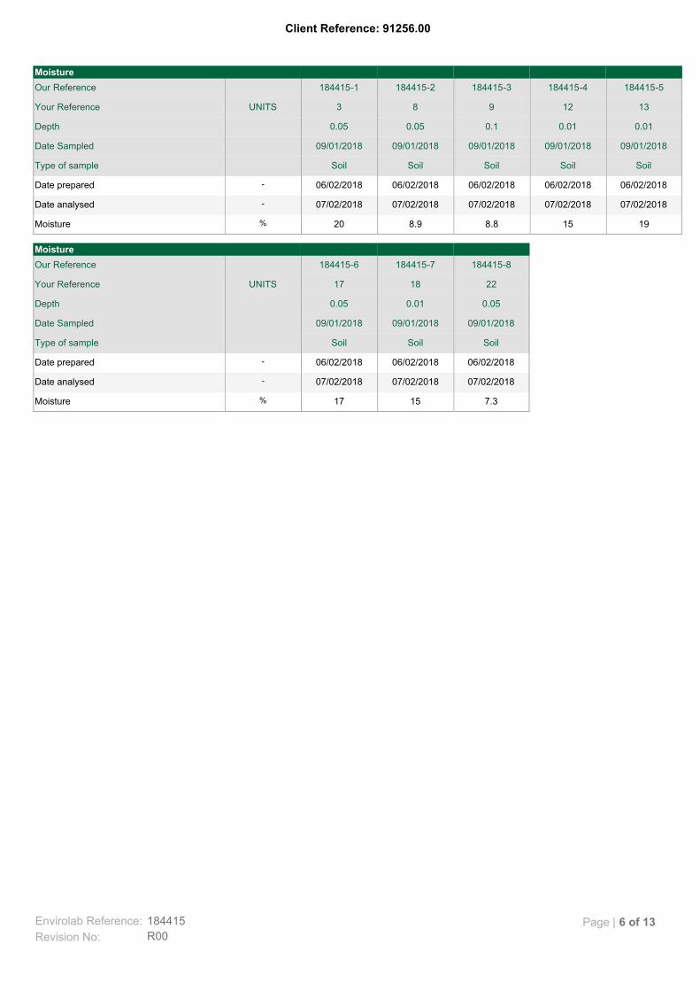
Client Reference: 91256.00
7.31517%Moisture
07/02/201807/02/201807/02/2018-Date analysed
06/02/201806/02/201806/02/2018-Date prepared
SoilSoilSoilType of sample
09/01/201809/01/201809/01/2018Date Sampled
0.050.010.05Depth
221817UNITSYour Reference
184415-8184415-7184415-6Our Reference
Moisture
19158.88.920%Moisture
07/02/201807/02/201807/02/201807/02/201807/02/2018-Date analysed
06/02/201806/02/201806/02/201806/02/201806/02/2018-Date prepared
SoilSoilSoilSoilSoilType of sample
09/01/201809/01/201809/01/201809/01/201809/01/2018Date Sampled
0.010.010.10.050.05Depth
1312983UNITSYour Reference
184415-5184415-4184415-3184415-2184415-1Our Reference
Moisture
Envirolab Reference: 184415
R00Revision No:
Page | 6 of 13

Client Reference: 91256.00
Determination of various metals by ICP-AES. Metals-020
Determination of exchangeable cations and cation exchange capacity in soils using 1M Ammonium Chloride exchange and ICP-AES analytical finish.
Metals-009
Moisture content determined by heating at 105+/-5 °C for a minimum of 12 hours.
Inorg-008
Conductivity and Salinity - measured using a conductivity cell at 25°C in accordance with APHA latest edition 2510 and Rayment & Lyons.
Inorg-002
pH - Measured using pH meter and electrode in accordance with APHA latest edition, 4500-H+. Please note that the results for water analyses are indicative only, as analysis outside of the APHA storage times.
Inorg-001
Analysed by East West EnviroagExt-062
Analysed by MPL Envirolab
Ext-054
Methodology SummaryMethod ID
Envirolab Reference: 184415
R00Revision No:
Page | 7 of 13

Client Reference: 91256.00
[NT][NT]0242421[NT]Inorg-0021µS/cmElectrical Conductivity 1:5 soil:water
[NT][NT]18.08.121[NT]Inorg-001pH UnitspH 1:5 soil:water
[NT][NT]05/02/201805/02/201821[NT]-Date analysed
[NT][NT]05/02/201805/02/201821[NT]-Date prepared
[NT][NT]RPDDup.Base#BlankMethodPQLUnitsTest Description
Spike Recovery %DuplicateQUALITY CONTROL: Misc Inorg - Soil
[NT][NT][NT]3b21[NT]Ext-0620-Emerson Aggregate
[NT]10211343811[NT]Inorg-0021µS/cmElectrical Conductivity 1:5 soil:water
[NT]10107.17.111[NT]Inorg-001pH UnitspH 1:5 soil:water
[NT]05/02/201805/02/201805/02/201811[NT]-Date analysed
[NT]05/02/201805/02/201805/02/201811[NT]-Date prepared
[NT]LCS-2RPDDup.Base#BlankMethodPQLUnitsTest Description
Spike Recovery %DuplicateQUALITY CONTROL: Misc Inorg - Soil
[NT]10237807601<2Ext-0542mg/kgPhosphorus Buffer Index
[NT]111424251<1Ext-0541mg/kgPhosphorus (Colwell)
[NT][NT][NT]5.011[NT]Ext-0620-Emerson Aggregate
[NT]10117841001<1Inorg-0021µS/cmElectrical Conductivity 1:5 soil:water
[NT]10117.17.21[NT]Inorg-001pH UnitspH 1:5 soil:water
[NT]05/02/201805/02/201805/02/2018105/02/2018-Date analysed
[NT]05/02/201805/02/201805/02/2018105/02/2018-Date prepared
[NT]LCS-1RPDDup.Base#BlankMethodPQLUnitsTest Description
Spike Recovery %DuplicateQUALITY CONTROL: Misc Inorg - Soil
Envirolab Reference: 184415
R00Revision No:
Page | 8 of 13

Client Reference: 91256.00
#9824150019001<5Metals-0205mg/kgMagnesium
#9710280031001<5Metals-0205mg/kgCalcium
06/02/201806/02/201806/02/201806/02/2018106/02/2018-Date analysed
06/02/201806/02/201806/02/201806/02/2018106/02/2018-Date prepared
184415-2LCS-9RPDDup.Base#BlankMethodPQLUnitsTest Description
Spike Recovery %DuplicateQUALITY CONTROL: Acid Extractable Cations in Soil
Envirolab Reference: 184415
R00Revision No:
Page | 9 of 13

Client Reference: 91256.00
[NT][NT]0<1<11[NT]Metals-0091%ESP
[NT]1000<0.1<0.11<0.1Metals-0090.1meq/100gExchangeable Na
[NT]10303.73.71<0.1Metals-0090.1meq/100gExchangeable Mg
[NT]10903.13.11<0.1Metals-0090.1meq/100gExchangeable K
[NT]103015151<0.1Metals-0090.1meq/100gExchangeable Ca
[NT]06/02/201806/02/201806/02/2018106/02/2018-Date analysed
[NT]05/02/201805/02/201805/02/2018105/02/2018-Date prepared
[NT]LCS-1RPDDup.Base#BlankMethodPQLUnitsTest Description
Spike Recovery %DuplicateQUALITY CONTROL: ESP/CEC
Envirolab Reference: 184415
R00Revision No:
Page | 10 of 13

Client Reference: 91256.00
Not ReportedNR
National Environmental Protection MeasureNEPM
Not specifiedNS
Laboratory Control SampleLCS
Relative Percent DifferenceRPD
Greater than>
Less than<
Practical Quantitation LimitPQL
Insufficient sample for this testINS
Test not requiredNA
Not testedNT
Result Definitions
Australian Drinking Water Guidelines recommend that Thermotolerant Coliform, Faecal Enterococci, & E.Coli levels are less than1cfu/100mL. The recommended maximums are taken from "Australian Drinking Water Guidelines", published by NHMRC & ARMC2011.
Surrogates are known additions to each sample, blank, matrix spike and LCS in a batch, of compounds whichare similar to the analyte of interest, however are not expected to be found in real samples.
Surrogate Spike
This comprises either a standard reference material or a control matrix (such as a blank sand or water) fortifiedwith analytes representative of the analyte class. It is simply a check sample.
LCS (LaboratoryControl Sample)
A portion of the sample is spiked with a known concentration of target analyte. The purpose of the matrix spikeis to monitor the performance of the analytical method used and to determine whether matrix interferencesexist.
Matrix Spike
This is the complete duplicate analysis of a sample from the process batch. If possible, the sample selectedshould be one where the analyte concentration is easily measurable.
Duplicate
This is the component of the analytical signal which is not derived from the sample but from reagents,glassware etc, can be determined by processing solvents and reagents in exactly the same manner as forsamples.
Blank
Quality Control Definitions
Envirolab Reference: 184415
R00Revision No:
Page | 11 of 13

Client Reference: 91256.00
Measurement Uncertainty estimates are available for most tests upon request.
Where sampling dates are not provided, Envirolab are not in a position to comment on the validity of the analysis whererecommended technical holding times may have been breached.
When samples are received where certain analytes are outside of recommended technical holding times (THTs), the analysis hasproceeded. Where analytes are on the verge of breaching THTs, every effort will be made to analyse within the THT or as soon aspracticable.
In circumstances where no duplicate and/or sample spike has been reported at 1 in 10 and/or 1 in 20 samples respectively, thesample volume submitted was insufficient in order to satisfy laboratory QA/QC protocols.
Matrix Spikes, LCS and Surrogate recoveries: Generally 70-130% for inorganics/metals; 60-140% for organics (+/-50% surrogates)and 10-140% for labile SVOCs (including labile surrogates), ultra trace organics and speciated phenols is acceptable.
Duplicates: <5xPQL - any RPD is acceptable; >5xPQL - 0-50% RPD is acceptable.
For VOCs in water samples, three vials are required for duplicate or spike analysis.
Spikes for Physical and Aggregate Tests are not applicable.
Filters, swabs, wipes, tubes and badges will not have duplicate data as the whole sample is generally extracted during sampleextraction.
Duplicate sample and matrix spike recoveries may not be reported on smaller jobs, however, were analysed at a frequency to meetor exceed NEPM requirements. All samples are tested in batches of 20. The duplicate sample RPD and matrix spike recoveries forthe batch were within the laboratory acceptance criteria.
Laboratory Acceptance Criteria
Envirolab Reference: 184415
R00Revision No:
Page | 12 of 13

Client Reference: 91256.00
Acid Extractable Metals in Soil: # Percent recovery is not possible to report due to the high concentration of the element/s in the sample/s. However an acceptable recovery was obtained for the LCS. Colwell Phosphorus & Phosphorus Buffer Index analysed by MPL Laboratories. Report No.206405. Emerson Aggregate analysed by East West. Report no. EW180592 3b = moderate to slight dispersion of the remould.
Report Comments
Envirolab Reference: 184415
R00Revision No:
Page | 13 of 13

Envirolab Services Pty Ltd
ABN 37 112 535 645
12 Ashley St Chatswood NSW 2067
ph 02 9910 6200 fax 02 9910 6201
www.envirolab.com.au
CERTIFICATE OF ANALYSIS 183838
Box 324 Hunter Region Mail Centre, Newcastle, NSW, 2310Address
Michael GawnAttention
Douglas Partners NewcastleClient
Client Details
24/01/2018Date completed instructions received
24/01/2018Date samples received
14 SoilNumber of Samples
91256.00, WellingtonYour Reference
Sample Details
Please refer to the last page of this report for any comments relating to the results.
Results are reported on a dry weight basis for solids and on an as received basis for other matrices.
Samples were analysed as received from the client. Results relate specifically to the samples as received.
Please refer to the following pages for results, methodology summary and quality control data.
Analysis Details
Tests not covered by NATA are denoted with *Accredited for compliance with ISO/IEC 17025 - Testing.
NATA Accreditation Number 2901. This document shall not be reproduced except in full.
31/01/2018Date of Issue
01/02/2018Date results requested by
Report Details
David Springer, General Manager
Authorised By
Priya Samarawickrama, Senior Chemist
Results Approved By
Revision No: R00
183838Envirolab Reference: Page | 1 of 7

Client Reference: 91256.00, Wellington
<10<102122mg/kgSulphate, SO4 1:5 soil:water
<10<102179mg/kgChloride, Cl 1:5 soil:water
120627767µS/cmElectrical Conductivity 1:5 soil:water
8.38.47.55.7pH UnitspH 1:5 soil:water
25/01/201825/01/201825/01/201825/01/2018-Date analysed
25/01/201825/01/201825/01/201825/01/2018-Date prepared
SoilSoilSoilSoilType of sample
09/01/201809/01/201809/01/201809/01/2018Date Sampled
2.01.51.00.2Depth
19181514UNITSYour Reference
183838-14183838-13183838-12183838-11Our Reference
Misc Inorg - Soil
<10<10<10<10<10mg/kgSulphate, SO4 1:5 soil:water
<10<10<1020<10mg/kgChloride, Cl 1:5 soil:water
15721005123µS/cmElectrical Conductivity 1:5 soil:water
8.08.78.19.07.9pH UnitspH 1:5 soil:water
25/01/201825/01/201825/01/201825/01/201825/01/2018-Date analysed
25/01/201825/01/201825/01/201825/01/201825/01/2018-Date prepared
SoilSoilSoilSoilSoilType of sample
09/01/201809/01/201809/01/201809/01/201809/01/2018Date Sampled
1.21.50.62.00.7Depth
1211988UNITSYour Reference
183838-10183838-9183838-8183838-7183838-6Our Reference
Misc Inorg - Soil
45<10<10120<10mg/kgSulphate, SO4 1:5 soil:water
80<101057010mg/kgChloride, Cl 1:5 soil:water
180103050040µS/cmElectrical Conductivity 1:5 soil:water
9.26.87.06.97.5pH UnitspH 1:5 soil:water
25/01/201825/01/201825/01/201825/01/201825/01/2018-Date analysed
25/01/201825/01/201825/01/201825/01/201825/01/2018-Date prepared
SoilSoilSoilSoilSoilType of sample
09/01/201809/01/201809/01/201809/01/201809/01/2018Date Sampled
2.00.40.22.01.3Depth
65421UNITSYour Reference
183838-5183838-4183838-3183838-2183838-1Our Reference
Misc Inorg - Soil
Envirolab Reference: 183838
R00Revision No:
Page | 2 of 7

Client Reference: 91256.00, Wellington
Anions - a range of Anions are determined by Ion Chromatography, in accordance with APHA latest edition, 4110-B. Alternatively determined by colourimetry/turbidity using Discrete Analyer.
Inorg-081
Conductivity and Salinity - measured using a conductivity cell at 25°C in accordance with APHA latest edition 2510 and Rayment & Lyons.
Inorg-002
pH - Measured using pH meter and electrode in accordance with APHA latest edition, 4500-H+. Please note that the results for water analyses are indicative only, as analysis outside of the APHA storage times.
Inorg-001
Methodology SummaryMethod ID
Envirolab Reference: 183838
R00Revision No:
Page | 3 of 7

Client Reference: 91256.00, Wellington
[NT][NT]0222211[NT]Inorg-08110mg/kgSulphate, SO4 1:5 soil:water
[NT][NT]23637911[NT]Inorg-08110mg/kgChloride, Cl 1:5 soil:water
[NT][NT]2666711[NT]Inorg-0021µS/cmElectrical Conductivity 1:5 soil:water
[NT][NT]25.85.711[NT]Inorg-001pH UnitspH 1:5 soil:water
[NT][NT]25/01/201825/01/201811[NT]-Date analysed
[NT][NT]25/01/201825/01/201811[NT]-Date prepared
[NT][NT]RPDDup.Base#BlankMethodPQLUnitsTest Description
Spike Recovery %DuplicateQUALITY CONTROL: Misc Inorg - Soil
#1030<10<101<10Inorg-08110mg/kgSulphate, SO4 1:5 soil:water
#109010101<10Inorg-08110mg/kgChloride, Cl 1:5 soil:water
[NT]102538401<1Inorg-0021µS/cmElectrical Conductivity 1:5 soil:water
[NT]10247.87.51[NT]Inorg-001pH UnitspH 1:5 soil:water
25/01/201825/01/201825/01/201825/01/2018125/01/2018-Date analysed
25/01/201825/01/201825/01/201825/01/2018125/01/2018-Date prepared
183838-2LCS-1RPDDup.Base#BlankMethodPQLUnitsTest Description
Spike Recovery %DuplicateQUALITY CONTROL: Misc Inorg - Soil
Envirolab Reference: 183838
R00Revision No:
Page | 4 of 7

Client Reference: 91256.00, Wellington
Not ReportedNR
National Environmental Protection MeasureNEPM
Not specifiedNS
Laboratory Control SampleLCS
Relative Percent DifferenceRPD
Greater than>
Less than<
Practical Quantitation LimitPQL
Insufficient sample for this testINS
Test not requiredNA
Not testedNT
Result Definitions
Australian Drinking Water Guidelines recommend that Thermotolerant Coliform, Faecal Enterococci, & E.Coli levels are less than1cfu/100mL. The recommended maximums are taken from "Australian Drinking Water Guidelines", published by NHMRC & ARMC2011.
Surrogates are known additions to each sample, blank, matrix spike and LCS in a batch, of compounds whichare similar to the analyte of interest, however are not expected to be found in real samples.
Surrogate Spike
This comprises either a standard reference material or a control matrix (such as a blank sand or water) fortifiedwith analytes representative of the analyte class. It is simply a check sample.
LCS (LaboratoryControl Sample)
A portion of the sample is spiked with a known concentration of target analyte. The purpose of the matrix spikeis to monitor the performance of the analytical method used and to determine whether matrix interferencesexist.
Matrix Spike
This is the complete duplicate analysis of a sample from the process batch. If possible, the sample selectedshould be one where the analyte concentration is easily measurable.
Duplicate
This is the component of the analytical signal which is not derived from the sample but from reagents,glassware etc, can be determined by processing solvents and reagents in exactly the same manner as forsamples.
Blank
Quality Control Definitions
Envirolab Reference: 183838
R00Revision No:
Page | 5 of 7

Client Reference: 91256.00, Wellington
Measurement Uncertainty estimates are available for most tests upon request.
Where sampling dates are not provided, Envirolab are not in a position to comment on the validity of the analysis whererecommended technical holding times may have been breached.
When samples are received where certain analytes are outside of recommended technical holding times (THTs), the analysis hasproceeded. Where analytes are on the verge of breaching THTs, every effort will be made to analyse within the THT or as soon aspracticable.
In circumstances where no duplicate and/or sample spike has been reported at 1 in 10 and/or 1 in 20 samples respectively, thesample volume submitted was insufficient in order to satisfy laboratory QA/QC protocols.
Matrix Spikes, LCS and Surrogate recoveries: Generally 70-130% for inorganics/metals; 60-140% for organics (+/-50% surrogates)and 10-140% for labile SVOCs (including labile surrogates), ultra trace organics and speciated phenols is acceptable.
Duplicates: <5xPQL - any RPD is acceptable; >5xPQL - 0-50% RPD is acceptable.
For VOCs in water samples, three vials are required for duplicate or spike analysis.
Spikes for Physical and Aggregate Tests are not applicable.
Filters, swabs, wipes, tubes and badges will not have duplicate data as the whole sample is generally extracted during sampleextraction.
Duplicate sample and matrix spike recoveries may not be reported on smaller jobs, however, were analysed at a frequency to meetor exceed NEPM requirements. All samples are tested in batches of 20. The duplicate sample RPD and matrix spike recoveries forthe batch were within the laboratory acceptance criteria.
Laboratory Acceptance Criteria
Envirolab Reference: 183838
R00Revision No:
Page | 6 of 7

Client Reference: 91256.00, Wellington
# Percent recovery is not possible to report due to the high concentration of the element/s in the sample/s. However an acceptable recovery was obtained for the LCS.
Report Comments
Envirolab Reference: 183838
R00Revision No:
Page | 7 of 7

Appendix F
Drawing 1 - Test Location Plan