Appendix d theme review final_dec2010a
189
Severn Estuary SMP2 - Appendix D - Theme Review Severn Estuary SMP Review 1 Appendix D: Theme Review
-
Upload
severn-estuary -
Category
Environment
-
view
113 -
download
1
Transcript of Appendix d theme review final_dec2010a

Severn Estuary SMP2 - Appendix D - Theme Review
Severn Estuary SMP Review
1
Appendix D: Theme Review

Severn Estuary SMP2 - Appendix D - Theme Review
Severn Estuary SMP Review
i
Severn Estuary Shoreline Management Plan Review (SMP2)
Appendix D: Theme Review
December 2010
Notice This report was produced by Atkins for the Severn Estuary Coastal Group for the specific purpose of the Severn Estuary Shoreline Management Plan Review (SMP2). This report may not be used by any person other than the Severn Estuary Coastal Group without The Severn Estuary Coastal Group's express permission. In any event, Atkins accepts no liability for any costs, liabilities or losses arising as a result of the use of or reliance upon the contents of this report by any person other than the Severn Estuary Coastal Group.
Document History
JOB NUMBER: 5078599 DOCUMENT REF: Draft Theme Review
01 Draft Theme Review SNB KW JMcC JM 12/3/09
02 For PMG review SNB KW JMcC RS 2/09/09
03 Final Draft for QRG Review SNB KW JMcC
04 Final KW PC PC RS Dec 2010
Revision Purpose Description Originated Checked Reviewed Authorised Date
Severn Estuary SMP2 - Appendix D - Theme Review
Severn Estuary SMP Review
ii
Contents Sec tion Page Supporting Appendices iv
Acronyms and Abbreviations vi
Compliance to the SMP2 Quality Review Group (QRG) Terms of Reference xi
Executive Summary xii
1. Introduction 1
1.1 Purpose of the Theme Review 1 1.2 Structure of the Theme Review 1 1.3 Theme Review Areas 2
2. Relevant Policies and Legislation 5
2.1 Overview 5 2.2 Local Development Framework 5 2.3 New Planning Policy on Development and Coastal Change 6 2.4 Making Space for Water 7 2.5 Regional and National Flood Risk Planning Policy 8 2.6 Welsh Assembly Government High Level Targets 10 2.7 Planning Policy Wales (PPW) 10 2.8 Wales a Better Country 10 2.9 People Places Futures: The Wales Spatial Plan 11 2.10 Sustainable Development Action Plan 2004-2007 11 2.11 Planning Policy Wales - TAN15 11 2.12 Welsh Assembly Government Environment Strategy 11 2.13 Water Framework Directive (WFD) - River Basin Management Plans (RBMP’s) 14 2.14 European Union Directive on the Assessment and Management of Flood Risks 16 2.15 Integrated Coastal Zone Management (ICZM) 16 2.16 Marine and Coastal Access Bill 17 2.17 Climate Change 18
3. Landscape and Nature Conservation 21
3.1 Study Area Overview 21 3.2 Landscape 21 3.3 Nature Conservation (Overview) 21 3.4 Designations of International, National and Local Importance 24
4. Historic Environment 28
4.1 Study Area Overview 28 4.2 Understanding the Asset 28 4.3 Designations 30 4.4 Shoreline Management and the Historic Environment 32
5. Current and Future Land-use 33
5.1 Study Area Overview 33 5.2 Residential Development 33 5.3 Commercial Activity, Industry, Ports and Harbours 33 5.4 Energy Generation 34

Severn Estuary SMP2 - Appendix D - Theme Review
Severn Estuary SMP Review
iii
5.5 Recreation, Tourism and Related Features 35 5.6 Future Land-use 36
6. Summary of the Shoreline: SMP2 Theme Areas 39
Overview to the Theme Area Summaries 39 6.1 Penarth Area 40 6.2 Cardiff 45 6.3 Wentlooge 50 6.4 Newport, the River Usk and surrounding area 55 6.5 Caldicot Levels 60 6.6 Chepstow and the River Wye 66 6.7 Tidenham and Surrounding Villages 71 6.8 Lydney 76 6.9 Lydney to Gloucester 81 6.10 Gloucester to Haw Bridge 86 6.11 Gloucester to Sharpness 92 6.12 Sharpness to Severn Crossing 97 6.13 Severnside, Bristol and Avon 102 6.14 Portishead and Clevedon 109 6.15 Kingston Seymour to Sand Bay 115 6.16 The Holms 120

Severn Estuary SMP2 - Appendix D - Theme Review
Severn Estuary SMP Review
iv
Supporting Appendices Information required to support the Severn Estuary Shoreline Management Plan Review (SMP2) is provided in the following appendices. These supporting documents offer transparency to the decision making process that is undertaken, leading to explanations and reasoning for the promoted policies.
A: SMP2 Development The history, structure and development of the SMP are detailed in this report. The investigation and decision making process are explained more fully to outline the procedure to setting policy.
B: Stakeholder Engagement and Consultation
Stakeholder communication is continuous through the SMP2 process, comments on the progress of the management plan are recorded within Appendix B.
C: Baseline Understanding of Coastal Behaviour and Dynamics, Coastal Defences and Baseline Scenario Report
This report includes detail of coastal dynamics, defence data and shoreline scenario assessments of NAI (No Active Intervention – defences are not maintained, repaired or replaced allowing the shoreline to evolve more naturally) and With Present Management (WPM) i.e.: SMP1 Policy.
D: Theme Review The identification and evaluation of the natural landscape and conservation, the historic environment and present and future land use of the shoreline.
E: Issues, Features and Objectives The features of the shoreline are listed within this report. A series of strategic objectives are then set along with commentary on the relative importance of each feature identified.
F: Policy Development and Appraisal
Presents the consideration of generic policy options for each frontage identifying possible acceptable policies and their combination into ‘Management Approaches’ for testing. Also presents the appraisal of impacts upon shoreline evolution and the appraisal of objective achievement.
G: Preferred Policy Scenario Testing Presents the policy assessment of appraisal of objective achievement towards definition of the Preferred Plan (as presented in the Shoreline Management Plan document).
H: Economic Appraisal and Sensitivity Testing
Presents the economic analysis undertaken in support of the Preferred Plan.
I: Strategic Environmental Assessment Report
Presents the various items undertaken in developing the Plan that specifically relate to the requirements of the EU Council Directive 2001/42/EC (the Strategic Environmental Assessment Directive), such that all of this information is readily accessible in one document. This includes work to help towards a Habitat Regulatory Assessment (HRA).
J: Water Framework Assessment Report
Provides a retrospective assessment of the policies defined under the Severn Estuary SMP2 highlighting future issues for consideration at policy implementation stage.
K: Bibliographic Database All supporting information used to develop the SMP is referenced for future examination and retrieval.
The information presented in each appendix is supported and guided by other appendices; the broad relationships between the appendices are illustrated overleaf.

Severn Estuary SMP2 - Appendix D - Theme Review
Severn Estuary SMP Review
v
SMP2 Development
(Appendix A)
Baseline Process Understanding and
Defences (Appendix C)
Theme Review
(Appendix D)
Stakeholder Engagement and
Consultation (Appendix B)
Issues, Features and Objectives
(Appendix E)
Policy Development and Appraisal
(Appendix F)
Preferred Policy Management Approach
Testing (Appendix G)
Economic Appraisal and Sensitivity Testing
(Appendix H)
Policy Statements
(SMP Main Report Annexe)
SEA Report
(Appendix I)
Bibliographic Database
(Appendix K)
WFD Assessment Report
(Appendix J)

Severn Estuary SMP2 - Appendix D - Theme Review
Severn Estuary SMP Review
vi
Acronyms and Abbreviations Term Definition
AA Appropriate Assessment.
ABP Association of British Ports
AONB Area of Outstanding Natural Beauty.
ASERA Association of Severn Estuary Relevant Authorities
ATL Advance the Line
BAP Biodiversity Action Plans
BCCPA Bristol Channel Counter Pollution Association
BMIF British Marine Federation
CAPE Community Adaptation Planning and Engagement
CCW Countryside Council for Wales
CD Chart Datum.
CFMP Catchment Flood Management Plan
CHaMP Coastal Habitat Management Plan
CPSE Coast Protection Survey England
CSG Client Steering Group, principal decision-making body for the Shoreline Management Plan = Severn Estuary Coastal Group (SECG)
CV Capital Value. The actual value of costs or benefits.
DCLG Department of Communities and Local Government
DECC Department of Energy and Climate Change
Defra Department for Food, Environment and Rural Affairs.
EA Environment Agency, may also be referred to as 'The Agency'
EH English Heritage
EiP Examination in Public
EMF Elected Members Forum (SMP2), comprising an Elected Member from each of the Local Authorities
FCA Flood Consequence Assessment

Severn Estuary SMP2 - Appendix D - Theme Review
Severn Estuary SMP Review
vii
Term Definition
FCDPAG3 Flood and Coastal Defences Project Appraisal Guidance
FCS Favourable Conservation Status
GCR Geological Conservation Review site
GES Good Ecological Status
GHT Gloucester Harbour Trustees
GIS Geographic Information System
HAT Highest Astronomical Tide
HER Historic Environment Record
HLT High Level Target
HMWB Heavily Modified Water Bodies
HRA Habitats Regulations Assessment
HTL Hold the Line
ICZM Integrated Coastal Zone Management
IFCA Integrated Flood Consequence Assessment
IROPI Imperative Reasons of Over-riding Public Interest
JAC Joint Advisory Committee (of the Severn Estuary Partnership)
KSG Key Stakeholder Group, which acts as a focal point for discussion and consultation through development of the SMP
KWS Key Wildlife Sites
LAT Lowest Astronomical Tide
LDP Local Development Plan
LPA Local Planning Authority
MAFF Ministry of Agriculture Fisheries and Food (now DEFRA)
MCZ Marine Conservation Zone
MHWN Mean High Water Neap tide
MHWS Mean High Water Spring tide
Severn Estuary SMP2 - Appendix D - Theme Review
Severn Estuary SMP Review
viii
Term Definition
MLWN Mean Low Water Neap tide
MLWS Mean Low Water Spring tide
MMO Marine Management Organisation
MoD Ministry of Defence
MR Managed Realignment
MSL Mean Sea Level
MU Management Unit
NAI No Active Intervention
NE Natural England
NEDS National Economic Development Strategy
NFDCC National Flood and Coastal Defence Database
NMR National Monuments Record
NNR National Nature Reserve
NT National Trust
ODPM Office of the Deputy Prime Minister
PCPA Planning and Compulsory Purchase Act
PMG Project Management Group
PPG Planning Policy Guidance
PPS Planning Policy Statement
PSA Public Service Agreement
PU Policy Unit
PPW Planning Policy Wales
QRG Quality Review Group
RBMP River Basin Management Plan
RCZAS Rapid Coastal Zone Assessment Survey
RDP Rural Development Plan

Severn Estuary SMP2 - Appendix D - Theme Review
Severn Estuary SMP Review
ix
Term Definition
RSS Regional Spatial Strategy
RYA Royal Yachting Association
SAC Special Area of Conservation
SAM Scheduled Ancient Monument
SDAP Sustainable Development Action Plan
SDS Sustainable Development Schemes
SEA Strategic Environmental Assessment
SECG Severn Estuary Coastal Group = Client Steering Group (CSG)
SEFRMS Severn Estuary Flood Risk Management Strategy
SEP Severn Estuary Partnership
SESMP2 Severn Estuary Shoreline Management Plan Review
SFC Sea Fisheries Committee
SFRA Strategic flood risk assessment
SMP Shoreline Management Plan
SMP1 A first-round Shoreline Management Plan
SMP2 A second-round Shoreline Management Plan
SMR Sites and Monuments Record
SoP Standard of Protection
SPA Special Protection Area
SRS Single Regional Strategy
SSSI Site of Special Scientific Interest
SuDs Sustainable Urban Drainage System
TAN Technical Advice Note
UKCiP United Kingdom Climate Impacts Programme
UKCP UK Climate Projections
WAG Welsh Assembly Government
Severn Estuary SMP2 - Appendix D - Theme Review
Severn Estuary SMP Review
x
Term Definition
WFD Water Framework Directive
WPM With Present Management
WSP Wales Spatial Plan
Severn Estuary SMP2 - Appendix D - Theme Review
Severn Estuary SMP Review
xi
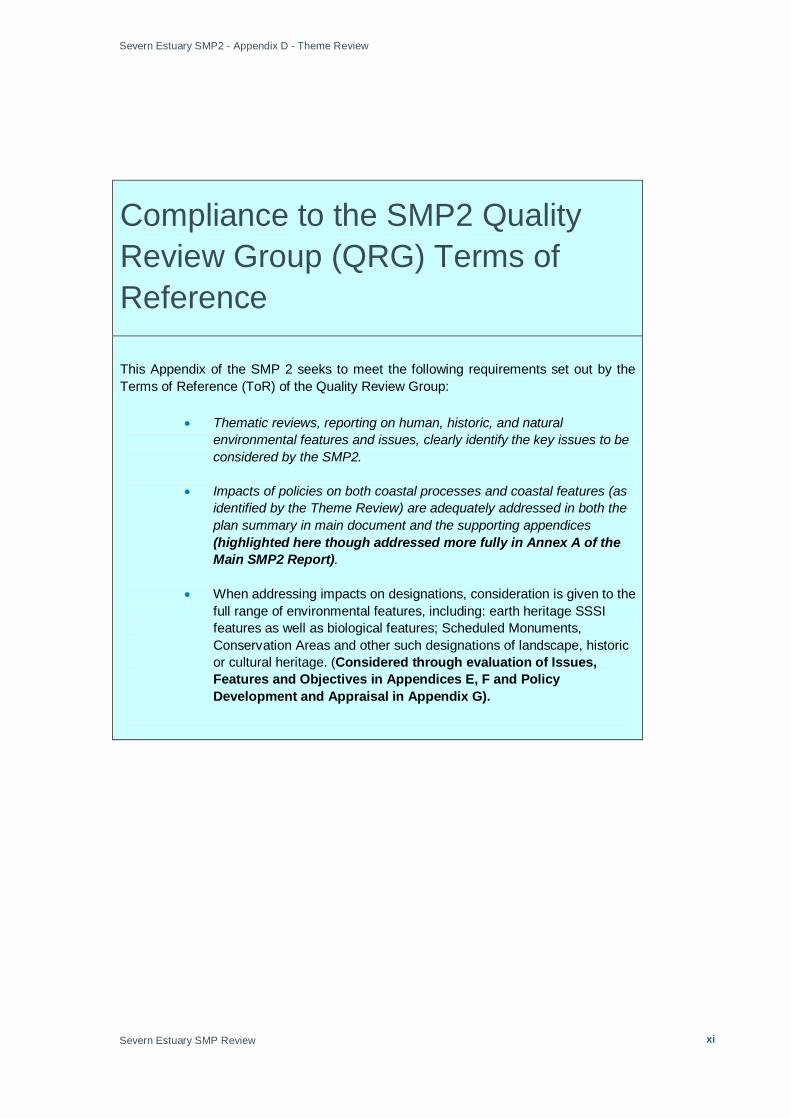
Compliance to the SMP2 Quality Review Group (QRG) Terms of Reference
This Appendix of the SMP 2 seeks to meet the following requirements set out by the Terms of Reference (ToR) of the Quality Review Group:
• Thematic reviews, reporting on human, historic, and natural environmental features and issues, clearly identify the key issues to be considered by the SMP2.
• Impacts of policies on both coastal processes and coastal features (as identified by the Theme Review) are adequately addressed in both the plan summary in main document and the supporting appendices (highlighted here though addressed more fully in Annex A of the Main SMP2 Report).
• When addressing impacts on designations, consideration is given to the full range of environmental features, including: earth heritage SSSI features as well as biological features; Scheduled Monuments, Conservation Areas and other such designations of landscape, historic or cultural heritage. (Considered through evaluation of Issues, Features and Objectives in Appendices E, F and Policy Development and Appraisal in Appendix G).

Severn Estuary SMP2 - Appendix D - Theme Review
Severn Estuary SMP Review
xii
Executive Summary A central element in the identification and assessment of objectives is a SMP2 specific report titled the “Theme Review”. The Theme Review identifies the key features along the coast and why they are important to stakeholders, this includes the benefits that the feature provides in terms of nature conservation, landscape character, human environment (including current and future land-use), and heritage sites.
The Theme Review evaluates data collected in Stage 1 of the Severn Estuary SMP2 and those particular issues identified through stakeholder engagement. The Theme Review reports on the following themes:
1. Landscape and nature conservation;
a. Landscape and visual features;
b. Current status of designated sites and wildlife/earth heritage interests;
c. Targets, as set by Local Plans, Biodiversity Plans etc.
2. Historic environment;
a. Current status of designated sites.
3. Current and future land-use;
a. Commercial/industrial land-use (including marine archaeology);
b. Residential developments;
c. Access to the shoreline;
d. Recreation, tourism and amenity interests;
e. Future land use/planning/targets, as set by regional spatial strategies/local developments frameworks.
The Theme Review has addressed each feature, stating why each is important, the scale of importance and who benefits (see Appendix E for Issues and Features report).
Information from the Theme Review is used as a basis for developing policy options and assessing the implications and thus suitability of these options.

Severn Estuary SMP2 - Appendix D - Theme Review
Severn Estuary SMP Review 1
1. Introduction
1.1 Purpose of the Theme Review This Appendix evaluates the following key topics:
• Landscape and nature conservation;
• Historic environment;
• Current and future land-use.
The purpose of the Theme Review is to inform stakeholders and to aid the development of objectives and allocation of policy options along the shoreline of the Severn Estuary. Development of objectives and policy options, and the assessment of their impact and suitability, will be developed through identification of key features and their importance to stakeholders along the estuary shoreline from Haw Bridge (north of Gloucester and set as the tidal limit for the SMP2), to Lavernock Point (on the Welsh shoreline) and Anchor Head (on the English shoreline) of the Severn Estuary. The features, grouped in the above topic areas will be considered in terms of their benefit to stakeholders.
1.2 Structure of the Theme Review The Theme Review is divided into six sections:
• Section 1 – Introduction;
• Section 2 – Policies and legislation;
• Section 3 – Landscape and nature conservation;
• Section 4 – Historic environment;
• Section 5 – Current and future land use;
• Section 6 – Summary of SMP2 Theme Areas.
• Annex A – Local Authority Policy Summaries
• Annex B – Water Assets
• Annex C – SSSI’s
• Annex D – Historic Parks and Gardens
Sections 2 – 5 deal with overarching issues that affect several or all Theme Areas. Some of the issues in these sections affect an area greater than that covered by the SMP2 alone e.g. national policies, international legislation, etc. The issues set out in sections 2 – 5 will need to be taken into account in each of the Theme Areas that are affected.
Section 6 looks at each Theme Area in turn and examines issues relating to policies, landscape & nature conservation, the historic environment and land use specific to the Theme Area in question.
Severn Estuary SMP2 - Appendix D - Theme Review
Severn Estuary SMP Review 2
There is often overlap between the various policies, plans, strategies and legislation. This often means that they could be considered under more than one of the topic headings (landscape & nature conservation, historic environment, land use). For example, information relating to the Habitats Directive is set out in section 3 on landscape and nature conservation. This could have been included in section 2 on policies and legislation. Similarly, information relating to land use planning is set out in section 5, but could also have been included within section 2.
Annex A includes all appropriate policies relating to activities or issues at the shoreline for each Local Authority within the study area.
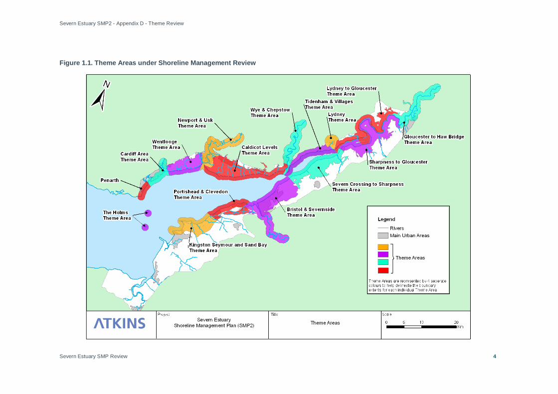
1.3 Theme Review Areas
The coast has been divided into Theme Areas (see Figure 1.1) based on their land-use and key human developments in order to discuss the identified features and varied themes of the shoreline. The Severn Estuary SMP2 Theme Areas:
• Penarth Area;
• Cardiff Area;
• Wentlooge Levels;
• Caldicot Levels;
• Newport, the River Usk and surrounding area;
• Chepstow and the River Wye;
• Tidenham and Surrounding Villages;
• Lydney;
• Lydney to Gloucester;
• Gloucester to Haw Bridge (including both banks of the Severn);
• Gloucester to Sharpness;
• Sharpness to Severn Crossings;
• Severnside, Bristol and Avon;
• Portishead and Clevedon;
• Kingston Seymour and Sand Bay;
• The Holms.
The colours adopted in Figure 1.1 are used for presentation purposes only to help differentiate areas. The colours have no significance.
For the purposes of data gathering and obtaining an indication of key issues a buffer zone has been agreed around the shoreline and tributaries of the Severn, this is formed from the SMP2 boundary of either 1km or the extent of a 1 in 1,000 year current day extreme floodplain, whichever is greater. The boundary being used in the Severn Estuary SMP2 is greater than that proposed in Defra SMP2 guidance but coincides with the Welsh Assembly Government TAN 15 guidance. The greater boundary has been selected as the Severn Estuary SMP2 covers both England and Wales and the resultant

Severn Estuary SMP2 - Appendix D - Theme Review
Severn Estuary SMP Review 3
policies in the SMP2 will need to be compatible with planning policies on both sides of the Estuary.
Severn Estuary SMP2 - Appendix D - Theme Review
Severn Estuary SMP Review
4
Figure 1.1. Theme Areas under Shoreline Management Review
Severn Estuary SMP2 - Appendix D - Theme Review
Severn Estuary SMP Review
5
2. Relevant Policies and Legislation 2.1 Overview
The SMP2 will support and influence the development of a whole range of regional, national and international policies, frameworks and strategies, not just those connected with shoreline management.
This section of the report sets out the overarching policies and legislation in place and in development that need to be taken into account in developing the SMP2. It includes policies and legislation that will affect all areas of the SMP2. More local plans and policies are considered for the relevant Theme Areas in Section 6. Only a brief overview of the Local Development Framework is provided along with the supporting documentation that is required for its delivery.
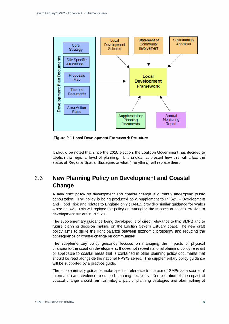
2.2 Local Development Framework The new Planning Act has made changes to the planning system at the national, regional and local level. Central Government will provide national guidance through Planning Policy Statements. These statements are gradually replacing the Planning Policy Guidance Notes produced under the old system. At a regional level the Regional Planning Guidance will be replaced with a Regional Spatial Strategy. As regional planning body, the South West Regional Assembly produces the Regional Spatial Strategy. The purpose of the Regional Spatial Strategy is to set out the level of development required to meet the needs of the southwest region, and broadly identify where development should be focussed. Under the new system the Structure Plan produced by County Councils will be abolished. At a local level, the local plan is being replaced with a plan known as a Local Development Framework (LDF). The Regional Spatial Strategy and elements of the Local Development Framework will replace the strategic content of the structure plan. The Local Development Framework is the name given to a portfolio of Local Development Documents that will set out future plans and proposals for each local District (see Figure 2.1). Within the portfolio, there are different types of document. Firstly, there are those that directly relate to planning policies and proposals. The second group of documents are those that relate to the process of preparing Local Development Framework documents, including this statement, the Local Development Scheme and the Annual Monitoring Report. With the exception of the last two, all of the Local Development Documents will be subject to community involvement and consultation. This latter issue is of direct relevance to the SMP2 process. It is important that local planners absorb the SMP2 process into future planning decision making and the various Development Plan Documents produced. The adoption of the SMP2 Action Plan will need to involve community involvement and wider consultation. This is addressed in more detail within the separately produced SMP2 Action Plan (Annex B of SMP2 Main Report).
Severn Estuary SMP2 - Appendix D - Theme Review
Severn Estuary SMP Review
6
Figure 2.1 Local Development Framework Structure
It should be noted that since the 2010 election, the coalition Government has decided to abolish the regional level of planning. It is unclear at present how this will affect the status of Regional Spatial Strategies or what (if anything) will replace them.
2.3 New Planning Policy on Development and Coastal Change A new draft policy on development and coastal change is currently undergoing public consultation. The policy is being produced as a supplement to PPS25 – Development and Flood Risk and relates to England only (TAN15 provides similar guidance for Wales – see below). This will replace the policy on managing the impacts of coastal erosion to development set out in PPG20.
The supplementary guidance being developed is of direct relevance to this SMP2 and to future planning decision making on the English Severn Estuary coast. The new draft policy aims to strike the right balance between economic prosperity and reducing the consequence of coastal change on communities.
The supplementary policy guidance focuses on managing the impacts of physical changes to the coast on development. It does not repeat national planning policy relevant or applicable to coastal areas that is contained in other planning policy documents that should be read alongside the national PPS/G series. The supplementary policy guidance will be supported by a practice guide.
The supplementary guidance make specific reference to the use of SMPs as a source of information and evidence to support planning decisions. Consideration of the impact of coastal change should form an integral part of planning strategies and plan making at
Severn Estuary SMP2 - Appendix D - Theme Review
Severn Estuary SMP Review
7
national, regional and local levels and of decision-making on all types of application for consent required for development in areas that might be vulnerable to coastal change.
The information in the SMP2 should help provide the evidence for designating in the Local Development Framework (LDF) the area likely to be affected by physical changes to the coast, namely the ‘coastal change management area’ (CCMA), upon which future development policies should be based. When planners have identified the impacts of coastal change and identified the area at risk in a CCMA (from information in this Appendix), and also identified the development needed in those areas set in the regional and local context, the next key part of the above process is the assessment of vulnerability of proposed developments in vulnerable coastal areas to ensure that they are appropriate and safe. Good practice principles of vulnerability assessment already exist for development and flood risk (PPS 25). This will recognise the fact that coastal flooding primarily is a risk to life and repeated damage to inundated properties and associated infrastructure. Developments will often recover from flooding (albeit at a cost). In the case of coastal erosion, what is lost is irrecoverably lost. Whilst coastal erosion is of lesser significance in this SMP2 than in others, reliance measures for individual properties are needed, even though the overall scale of the impact of erosion is smaller. A single flood event can, however, affect hundreds or thousands of properties. Also, a development which requires a coastal location in areas of coastal change (such as beach huts, cafes /tea rooms, shops, hotels and other tourist accommodation) can only be in these areas, and as well as supporting the economy of their communities, they require links to communities and infrastructure to support them.
It should be noted that the Supplementary Guidance and Practice Guide were published in March 2010. The new coalition Government in place since the 2010 election may result in this and other planning policies being revised.
2.4 Making Space for Water The Government released Making Space for Water in March 2005 (DEFRA, 2005) after a consultation period. Its intention is to inform the development of a new strategy on the management of issues surrounding flood risk and coastal erosion for the next 20 years. The report recognises the requirement for a holistic approach between the various responsible bodies, including flood defence operating authorities, sewerage undertakers and highways authorities, to achieve sustainable development. Making Space for Water does not state specific policies but provides the Governments objectives on:
• Land use planning – it strongly encourages Flood risk assessments to be prepared at all levels of the planning process;
• Rural issues – it promotes the environmental pillar of sustainable development through the use of wetlands and washlands, and managed realignment of coasts and rivers;
• Integrated urban drainage management – it is committed to ensuring that SuDS techniques are incorporated in new developments;
• Coastal issues – it seeks to develop a more strategic and integrated approach to managing coastal flooding and erosion risks; and
• Living with flood risk - it identifies that there is a need to raise awareness and preparation in local communities for the changing flood and erosion risks resulting

Severn Estuary SMP2 - Appendix D - Theme Review
Severn Estuary SMP Review
8
from climate change. The protection of the functional floodplain forms an integral aspiration of the strategy.
2.5 Regional and National Flood Risk Planning Policy In England, Defra has policy responsibility for flood and coastal erosion risk management, while in Wales this is the responsibility of the Welsh Assembly Government. Delivery and implementation of policy is the responsibility of operating authorities - the Environment Agency, local authorities and internal drainage boards (IDBs).
The EA is the principal flood risk management operating authority in England and Wales. It is empowered (but does not have a legal obligation) to manage flood risk from designated ‘main rivers’ and to provide coastal flood defence. In England the EA also provides a strategic overview role for coastal erosion and flooding but does not have this role in Wales.
Coastal local authorities have powers to carry out works to manage the risk from coastal erosion and flooding in Wales and some parts of England and Wales.
Local authorities and, in areas with special drainage needs, IDBs have powers to manage flood risk for ‘ordinary watercourses’ (that is those not designated as ‘main rivers’).
England
The Government’s Foresight Programme warns of increasing flood risk of between two and twenty per cent over the next 75 years. The report, produced by the Office of Science and Technology, provides a long-term vision for the future (2030 – 2100), helping to ensure we develop effective strategies now. Sir David King, the Chief Scientific Advisor to the Government concluded:
“Continuing with existing policies is not an option – in virtually every scenario considered (for climate change), the risks grow to unacceptable levels. Secondly, the risk needs to be tackled across a broad front. However, this is unlikely to be sufficient in itself. Hard choices need to be taken – we must either invest in more sustainable approaches to flood and coastal management or learn to live with increasing flooding”.
Making Space for Water sets out the Government strategy for flood and coastal erosion risk management for the next 20 years in England, which aims to:
• reduce the threat to people and their property; and
• deliver the greatest environmental, social and economic benefit, consistent with the Government’s sustainable development principles.
The SMP2 can influence or be influenced by Making Space for Water in a number of important areas:
• strengthened arrangements for development control on the floodplain;

Severn Estuary SMP2 - Appendix D - Theme Review
Severn Estuary SMP Review
9
• integrated urban drainage pilots launched & completed and recommendations published;
• revised Building Regulations addressing flood resilience published and implemented;
• models for taking forward enhanced stakeholder and community engagement published; and
• improvements in better resilience and emergency planning delivered.
Wales
Flood and water management is one of the ten priority areas for action set out in the Environment Strategy Action Plan (2008), as well as ongoing actions from the first Action Plan (2006). The Environment Strategy Action Plan is a cross cutting document that sets out long term policies for the environment in Wales. More detail on the Environment Strategy, including aims that the SMP2 may help to achieve, is in section 4.
The need for a new approach to flood risk management in Wales arose from the Environment Strategy consultation and action plan. The New Approaches Programme (NAP) was launched in July 2007 and is now being reviewed. Welsh Assembly Government plans to consult on the strategic direction for all flood risk management in summer 2009.
The Welsh Assembly Government supports the use of the Defra guidance on the development of SMPs and has produced additional guidance of relevance to SMP2s in Wales that reflects the greater emphasis being placed on risk management and increasing community resilience in flood and erosion management (see Annex B to Appendix A).
These changing policies will need to be taken into account in the development of objectives and final SMP2 policy choices.
Other SMP2s
The Severn Estuary SMP2 abuts with the North Devon and Somerset SMP2 and the Swansea and Carmarthen Bay SMP2. As of August 2009, the North Devon and Somerset SMP2 is at a similar stage of development, whilst the Swansea and Carmarthen Bay SMP2 will be available for public consultation later into 2010. It is important that the Severn Estuary SMP2 takes account of the policy options being developed as part of the other two SMP2s and vice versa.
Advising and overseeing the delivery of the SMP2s for the Severn Estuary, North Devon and Somerset and Swansea and Carmarthen Bay, is the Bristol Channel Strategic Coastal Group, which is concerned with the shoreline extending from St Anne’s Head (Pembrokeshire) to Hartland Point (Devon).
Within the Severn Estuary SMP2 area, Catchment Flood Management Plans (CFMPs) for the River Severn, Taff and Ely, Eastern Valleys, Wye and Usk, Bristol Avon, Severn Tidal Tributaries and Somerset catchments have been developed. CFMPs aim to understand the factors that contribute to flood risk within a catchment and recommend the best ways of managing the risk over the next 50 to 100 years. The CFMPs are

Severn Estuary SMP2 - Appendix D - Theme Review
Severn Estuary SMP Review
10
concerned with fluvial flooding; they do not specifically deal with erosion or tidal flood risk.
The SECG has ensured that the SMP2 area abuts or slightly overlaps with all the relevant CFMP areas to ensure strategic flood risk management plans cover all areas, whether riverbanks or shorelines.
Existing CFMP policies will need to be taken into account in developing SMP2 policies in areas that adjoin CFMPs to ensure that they do not conflict or cause unintended consequences.
2.6 Welsh Assembly Government High Level Targets WAG has responsibility for flood defence policy in Wales and is committed to playing its part in wider Government policies for the protection of the environment and biodiversity. In April 2001, WAG set out its High Level Targets for flood and coastal defence to facilitate a more certain delivery of the Government's national policy aim and strategy for flood and coastal defence in Wales. A Draft SMP2 Guidance Document has also been produced by WAG and this is being adhered to where appropriate within this SMP2.
2.7 Planning Policy Wales (PPW)
PPW provides the strategic land use planning policy framework for the effective preparation of Local Planning Authorities (LPAs) LDPs. PPW identifies the requirement for the planning system to move away from flood defence and the mitigation of the consequences of new development in areas of flood hazard, towards a more positive avoidance of development in areas defined as being of flood hazard. It also advocates that planning authorities adopt a precautionary approach when formulating policies on development and flood risk and when considering planning applications. The guidance also suggests that LPAs take a strategic approach to flood risk and consider the catchment or coastal cell as a whole. The SMP2 Action Plan is likely to have due reference to the PPW in future delivery actions presented.
2.8 Wales a Better Country “Wales: A Better Country” (WAG, 2003) is the strategic agenda of WAG. The document sets out:
• “WAG’s guiding vision of a fairer, more prosperous, healthier and better educated country, rooted in our commitment to social justice and to putting health and wealth creation that is sustainable at the heart of policymaking;
• The agenda WAG has for public services in Wales, with a programme for delivering the manifesto commitments;
• The priority issues which are broader than any one section of government and where smarter working and working together can make a bigger and longer lasting impact;
• The way WAG wants to deliver jointly with partners in local government, business, the trade unions and the voluntary sector.

Severn Estuary SMP2 - Appendix D - Theme Review
Severn Estuary SMP Review
11
The SMP2 Action Plan is likely to have due reference to the PPW in future delivery actions presented.
2.9 People Places Futures: The Wales Spatial Plan The Planning and Compulsory Purchase Act 2004 (PCPA) is a key element for reducing delays within the planning system. The provisions introduce powers that allow for the reform and speeding up of the planning system. The Act makes provision for WAG to prepare and publish a national spatial plan for Wales (the "Wales Spatial Plan") to which LPAs will be required to have regard when preparing their LDPs. The Wales Spatial Plan (WSP, WAG 2004b) provides a strategic context for the development necessary to allow Wales to fulfil its ambitions for economic success, social inclusion and a quality environment. The purpose of the plan is to support and influence spatial polices and programmes of WAG and others. Plans to date include the Sustainable Development Schemes (SDS), PPW, the National Economic Development Strategy (NEDS) and Rural Development Plans (RDP). WSP reflects the planning policies set out in PPW. The key issues identified within WSP are carried through to the relevant local plans and the opportunities and conflicts between these plans with the other strategies have been reviewed within the Strategic Environmental Assessment (SEA). The SMP2 Action Plan seeks to develop community adaptation on coastal risk areas, and the adoption of this policy into any future actions will need to be closely recognised.
2.10 Sustainable Development Action Plan 2004-2007
WAG is required by law to develop a scheme stating how it will promote sustainable development in the exercise of its functions. WAGs first scheme “Learning to Live Differently: The SDS was adopted in November 2000. In March 2004 WAG adopted a revised SDS: Starting to Live Differently. The Sustainable Development Action Plan (SDAP) 2004-2007 (WAG 2004c) presents how WAG will implement the commitments of this new scheme. This embeds a legal duty for sustainable development within activities, including sustainable procurement and minimising waste generation, energy, water and transport demands. A key objective, (No. 10) of the SEA, is that any flood risk management measures should seek to be sustainable, both in terms of maintenance requirements and in ensuring the reintroduction or continuation of natural processes.
2.11 Planning Policy Wales - TAN15 TAN15 was produced in 2004 and therefore has no direct requirements or advice for flood consequence assessments. However, the overarching aim of TAN15 is to steer development into the lowest flood risk zone without compromising an area’s social and economic growth.
2.12 Welsh Assembly Government Environment Strategy The Environment Strategy is the Welsh Assembly Government’s long term strategy for the environment of Wales, setting the strategic direction to 2026. The purpose of the Strategy is to provide the framework within which to achieve an environment which is clean, healthy, biologically diverse and valued by the people of Wales. By 2026 the
Severn Estuary SMP2 - Appendix D - Theme Review
Severn Estuary SMP Review
12
Welsh Assembly Government want to see a distinctive Welsh environment thriving and contributing to the economic and social wellbeing and health of all the people of Wales.
The Environment Strategy contains 39 distinct outcomes that will need to be taken into account in the development of the SMP2 and which the SMP2 could contribute towards achieving:
• Wales has improved resilience to the impacts of climate change. A clear flexible programme of measures is in place to enable Wales to respond and adapt to climate change (Outcome 8);
• Water resources are managed sustainably meeting the needs of society without causing damage to the environment (Outcome 13);
• The wider environment is more favourable to biodiversity through appropriate management, reduced habitat fragmentation and increased extent and interconnectivity of habitats (Outcome 20);
• Sites of international, Welsh and local importance are in favourable condition to support the species and habitats for which they have been identified (Outcome 21);
• Our seas will be clean and support healthy ecosystems that are biologically diverse and productive and managed sustainably (Outcome 22);
• The quality and diversity of the natural and historic character of our landscape and seascape is maintained and enhanced (Outcome 23);
• Appropriate measures are in place to manage the risk of flooding from rivers and the sea and help adapt to climate change impacts (Outcome 31);
• Everyone who lives in a flood risk area understands the flood risk they are subject to, the consequences of that risk and how to live with that risk (Outcome 32).
This strategy will be reviewed by WAG and the action plan updated annually. The link with the SMP2 Action Plan for Welsh aspects of the SMP2 will be needed at this time.
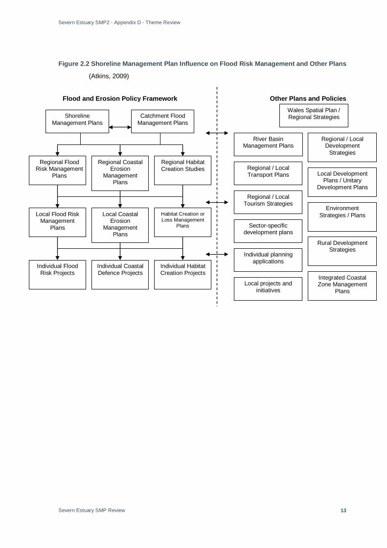
Figure 2.2 shows how SMP’s sit within the flood risk management planning systems. It also shows the range of other, non-flood related plans are influenced by and influence flood risk planning.
Severn Estuary SMP2 - Appendix D - Theme Review
Severn Estuary SMP Review
13
Figure 2.2 Shoreline Management Plan Influence on Flood Risk Management and Other Plans
(Atkins, 2009)
Regional Flood Risk Management
Plans
Catchment Flood Management Plans
Regional Coastal Erosion
Management Plans
Local Flood Risk Management
Plans
Wales Spatial Plan / Regional Strategies Shoreline
Management Plans
Regional Habitat Creation Studies
Local Coastal Erosion
Management Plans
Habitat Creation or Loss Management
Plans
Individual Flood Risk Projects
Individual Coastal Defence Projects
Individual Habitat Creation Projects
Regional / Local Development
Strategies
Local Development Plans / Unitary
Development Plans
Environment Strategies / Plans
Regional / Local Transport Plans
Regional / Local Tourism Strategies
Rural Development Strategies
River Basin Management Plans
Individual planning applications
Local projects and initiatives
Integrated Coastal Zone Management
Plans
Sector-specific development plans
Flood and Erosion Policy Framework Other Plans and Policies
Severn Estuary SMP2 - Appendix D - Theme Review
Severn Estuary SMP Review
14
Of particular relevance and importance to the management of the shore will be the introduction of marine planning and improved coastal access. The new system of marine planning will extend inland up to Mean High Water Springs (MHWS), including to the extent of MHWS in rivers and estuaries. It, therefore, overlaps with the land use planning system. As marine plans are developed, they will need to take account of existing plans that influence the way the coast and seas are used, including SMP2s, local authority plans, integrated coastal zone management plans, etc.
The changes being made by the Marine and Coastal Access Bill will not impact on the development of the SMP2, as it has not yet been made law. Preliminary work has, however, begun in many areas and the SMP2 will have to take account of any progress that has been made e.g. the development of an All Wales Coastal Path is well advanced in some areas and work has begun on determining how access to the coast will be improved in England.
2.13 Water Framework Directive (WFD) - River Basin Management Plans (RBMP’s) The Water Framework Directive (WFD) is designed to improve and integrate the way water bodies are managed throughout Europe. It came into force on 22 December 2000 and was transposed into UK law in 2003. Member States must aim to reach good chemical and ecological status in inland and coastal waters by 2015.
The WFD was transposed into law in England and Wales by the Water Environment (Water Framework Directive) (England and Wales) Regulations 2003. Many of the aims of the WFD are relevant to the preparation of SMP2s. Specifically, these include the objectives to:
• Prevent deterioration in status for water bodies1
• Aim to achieve good ecological status (GES) and good chemical status in water bodies by 2015;
;
• For water bodies that are designated as artificial or heavily modified, aim to achieve good ecological potential by 2015;
• Comply with objectives and standards for protected areas where relevant;
• Reduce pollution from priority substances and cease discharges, emissions and losses of priority hazardous substances.
SMP2s are essential plans to enable a strategic and proactive approach to flood risk management. The development of SMP2s, and other flood management plans, will allow us to plan flood risk management in a way that reduces flood risk and maximises opportunities to deliver multiple benefits, such as environmental objectives in River Basin Management Plans (RBMPs) under the WFD.
The Severn Draft RBMP was published for consultation in December 2008. The consultation runs until 22 June 2009, with the final plans programmed for completion in December 2009. The main remit of the Severn RBMP is to ensure the ongoing
1 Under the WFD, all inland and coastal waters in the EU are subdivided into ‘water bodies’. This is the basic management unit for the WFD.

Severn Estuary SMP2 - Appendix D - Theme Review
Severn Estuary SMP Review
15
improvement of water quality of all waters within the Severn RBD. However, the draft RBMP highlights the links between the WFD and other legislation and policy such as the Floods Directive and Environment Agency CFMPs and SMPs. In addition, the Severn RBMP outlines that the Severn Estuary and lower Usk can be designated as modified watercourses on account of the extensive flood protection structures present along these river reaches. In addition, the document identifies key contributions from various stakeholders to aid in ensuring all waters within the Severn RBD reach ‘good status’ by 2015 such as:
• Rural land managers: Ensure land management practices are undertaken so as to not exacerbate flood risks or can reduce flood risks;
• Environment Agency: Review redundant flood alleviation structures and identify appropriate mitigation, modification or removal; and
• Local and regional government: Improve management of surface water through the use of SuDS and develop Surface Water Management Plans, where appropriate.
There are 859 water bodies within ten catchments in the Severn RBMP. Five catchments contain shoreline within the SMP2 area – Bristol, Gloucester, Wye, Usk and South East Valleys.
The transitional (estuary) waters across the whole of the Severn Estuary have been provisionally designated as a Heavily Modified Water Body (HMWB)2
The Severn Estuary SMP2 is within the Severn River Basin Management Plan. All Wales CFMP boundaries are coincident with the River Basin Management Plan boundaries.
.
The SMP2 has the potential to help deliver some of the actions identified in the draft RBMP, including3
• Bring Natura 2000 sites into Favourable Conservation Status;
:
• EA Wales Catchment Initiatives;
• Identify appropriate opportunities for the modification, mitigation or removal of redundant flood defence structures;
• Where appropriate, allow natural river processes and functioning to occur e.g. erosion and deposition;
• Promote the use of soft engineering where appropriate to create bank stability;
• Embed WFD objectives into water body management and maintenance procedures;
2 A Heavily Modified Water Body (HMWB) is one that has been substantially physically altered by human activity. 3 Only Scenario A and B actions have been considered i.e. those actions that are already taking place, are planned or would occur if the draft RBMP is approved.
Severn Estuary SMP2 - Appendix D - Theme Review
Severn Estuary SMP Review
16
2.14 European Union Directive on the Assessment and Management of Flood Risks The European Directive on the Assessment and Management of Flood Risks (2007/60/EC of 23 October 2007), ‘the Floods Directive’ is designed to help Member States prevent and limit floods and their damaging effects on human health, the environment, infrastructure and property. The Floods Directive came into force on 26 November 2007 and Member States have 2 years in which to transpose the Directive into domestic law.
In essence the Flood Directive requires Member States to prepare the following;
• Preliminary flood risk assessments to identify areas that are at potentially significant flood risk;
• Flood hazard maps (showing the likelihood and flow of the potential flooding and flood risk maps (showing the impact);
• Flood Risk Management Plans (FRMPs) - showing measures to decrease the likelihood or impact of flooding; and,
• Updates every 6 years that take into account the impact of climate change.
SMP2s have the potential to contribute to the implementation of the Floods Directive as they include an assessment of coastal flood risk, map where these risks are and identify policies to manage these risks.
Defra and WAG are co-ordinating the transposition of the Directive into UK law and are ultimately responsible for its timely and compliant implementation. The transposition into domestic law in the UK is planned to be completed by September 2009. The proposed Flood and Water Management Bill, which is timetabled to become law in autumn 2009, will help to implement the Floods Directive. A draft Bill has not been published, so it is not yet clear exactly how SMP2s and other flood risk management plans and activities will be built into the Bill or into implementing the Floods Directive in the UK.
2.15 Integrated Coastal Zone Management (ICZM) Integrated Coastal Zone Management (ICZM) strategies have been developed for both England and Wales in response to an EU Recommendation (2002). These are entitled:
• Making the Most of Wales’ Coast: The Integrated Coastal Zone Management Strategy for Wales (2007);
• A Strategy for Promoting an Integrated Approach to the Management of Coastal Areas in England (2008).
Both have been developed based on the eight agreed principles of ICZM which recognise that ICZM is a process that should be integrated into all decisions made at or near the coast:
• take a long term view / perspective – plan for the long term (but flexible – see adaptive management);
Severn Estuary SMP2 - Appendix D - Theme Review
Severn Estuary SMP Review
17
• involve a broad, holistic approach – look at the big picture;
• adaptive management – to take account of uncertainty and increasing knowledge;
• work with natural processes – as in coastal defence planning / SMPs;
• support and involve the relevant administrative bodies – partnership working among decision making and management bodies;
• participatory planning – involve stakeholders;
• use a combination of instruments e.g. byelaws, voluntary agreements, incorporate coastal issues into existing planes, etc.;
• reflect local characteristics – one size does not fit all.
The principles of ICZM underpin the development of SMPs, working across local authority departmental boundaries, administrative boundaries and with stakeholders.
2.16 Marine and Coastal Access Bill The Marine and Coastal Access Bill (covering England and Wales) is a significant development in the way the seas and coasts around the UK are managed. The Bill will apply to all UK waters, but there will be differences in the different administrations with legislation being made for Scottish and Northern Irish coastal waters by the Scottish Government and Northern Ireland Assembly.
The Bill, when made law, will
• Introduce a system of Marine Planning – including the creation of a UK-wide Marine Policy Statement (MPS) and the ability to create marine plans covering all uses and users.
• Create the ability to designate Marine Conservation Zones (MCZs) to protect important areas of the marine environment.
• Make changes to the marine licensing system, streamlining the current consents process. Licensing decisions will have to be made in accordance with the MPS and any marine plan in the area.
• Reorganise and update inshore fisheries management. In England, Sea Fisheries Committees (SFCs) will be replaced by Inshore Fisheries and Conservation Authorities (IFCAs). In Wales, the Welsh Assembly Government will take on full responsibility for inshore fisheries management.
• Improve public access to the coast. In England the Bill will create a coastal access route around the coast. In Wales, the Bill will create additional powers for the National Assembly for Wales to pass legislation to improve coastal access in Wales and complement and complete the All Wales Coastal Path.
• Create a Marine Management Organisation (MMO) in England to implement and undertake many of the new duties and powers. In Wales, WAG will undertake the majority of the new functions in Wales, although the MMO will have some responsibilities in Wales.

Severn Estuary SMP2 - Appendix D - Theme Review
Severn Estuary SMP Review
18
Note –the Marine and Coastal Access Act received Royal Assent in November 2009.
2.17 Climate Change Climate change is a significant challenge that has particular focus at the coast. The UK Climate Impacts Programme scenarios (UKCIP02) suggest that by 2080 the sea level will rise by:
• between 20 and 80cm by the 2080s in the South West and;
• about 40cm around Wales.
An update of the UKCIP is now published. The UK Climate Projections 2009 (UKCP09) estimate sea level rises between 37cm and 53cm in England and Wales. Due to the timing of UKCP09 publications, the SMP2 uses UKCIP02 predictions only, however, these are considered comparable to the updated UKCP09 predictions.
Responses to the challenges of climate change can be divided into two types:
• Mitigation – trying to reduce the amount of climate change e.g. by reducing greenhouse gas emissions;
• Adaptation – accepting that some change will happen and responding to that change e.g. by building houses that are able to cope with flooding.
The SMP2 can help to contribute to ‘adaptation’ actions by considering what the future risks of flooding and erosion might be, taking account of climate change predictions, and identifying areas at risk e.g. due to rises in sea level. This is given particular consideration within the Action Plan (to be submitted after the public consultation event) through the assessment of the Defra Adaptation Toolkit and the newly published (Community Adaptation Planning and Engagement–CAPE) which has recently been published for review (Scott Wilson - July 2009).
The SMP2 policies will help to manage the shoreline and adapt to the changes that are expected. It is important that the long-term policies in the SMP2 influence planning, land use and management around the shoreline is a sustainable way that does not put future generations at risk or impose unmanageable financial burdens.
England
The South West Climate Change Impacts Partnership produced a scoping report (entitled “Warming to the Idea”) in 2002 setting out the key issues relating to climate change in the South West. Those of most relevance to the development of the SMP2 are:
• Rising sea levels, unpredictable coastal dynamics and possible increased storminess will increase coastal erosion and damage coastal amenities;
• Natural assets such as beaches, wetlands, mudflats, salt marshes and dunes may be lost and their flora and fauna will be affected;
• Protecting or relocating coastal assets may be too costly, therefore in some cases managed retreat may be the best option;
• Retreating from coastal areas in some locations, such as the Isles of Scilly, may not be viable, and protecting them will be very expensive;
Severn Estuary SMP2 - Appendix D - Theme Review
Severn Estuary SMP Review
19
• The planning system needs to work to prevent further unsustainable types of development on floodplains with increased flood risk, and some existing activities may need relocation;
• The need for substantial extra housing provides a challenge to ensure sustainable urban drainage in a changing climate;
• River managers need scientific information to predict accurately the impacts on river flows. These include changes to flow patterns and changes in flood magnitude, frequency, seasonality and duration;
• Increased flooding could impact on other catchment processes including soil erosion, sediment mobilisation and yield and land slipping. This requires investigation;
• Land use practices that can exacerbate flood risks need to be identified and managed to reduce impacts;
• Design standards need to be re-appraised for both new and existing engineering structures and drainage systems;
• Changes to natural landscapes of heritage sites, National Trust land etc from climate-driven vegetation shifts;
• Archaeology in uplands could deteriorate as they dry out in summer, but sites in coastal locations may be lost as sea levels rise;
• Severe flooding may again sever the rail link near Exeter where flooding cut off the South West from the national rail network in autumn 2000;
• Railways along the coast are vulnerable to storm surges, high tides and cliff instability while tunnels are vulnerable to flooding.
These issues are acknowledged in the South West RSS, which recognises the importance of adapting to climate change by recognising that it is important to identify areas and infrastructure vulnerable to change and to adapt and mitigate the effects of change. Policy SD2 focuses on climate change and the need to adapt to and mitigate the effects. The SMP2 will need to ensure that it does not conflict with the RSS policies.
Wales
In Wales, the Welsh Assembly Government has established a Climate Change Commission for Wales that is chaired by the Minister for Environment, Sustainability and Housing and includes members from all four political parties, businesses, local government and voluntary sector groups. The Commission assists with the development of new policies and the creation of a consensus on climate change and works in partnership with Wales’ representative on the UK Sustainable Development Commission.
The Commission is the main driver for action, provides strategic leadership, direction and a cross-Wales consensus. It is supported by four sub groups, which began their work during 2008:
• Adaptation Sub Group;
• Baseline, methodology and economics Sub Group;

Severn Estuary SMP2 - Appendix D - Theme Review
Severn Estuary SMP Review
20
• Communication Sub Group; and
• Emission reduction Sub Group.
WAG is developing a Climate Change Strategy. The consultation on first phase in the development of the strategy closed on 22 February 2009. The Climate Change Commission for Wales will have a key role in implementing the Strategy when it is finalised. The Adaptation Sub Group and Climate Change Strategy aims to reduce the impact of climate change at the coast will be of most relevance to the SMP2.
The lack of a specific Climate Change Strategy in Wales does not mean there is a lack of measures or policies relating to climate change. The cross-cutting nature of climate change means that relevant policies are contained in a number of different policy documents:
• One Wales (2008);
• The Wales Environment Strategy (2006) and Action Plans (2006 & 2008);
• Climate Change Adaptation Action Plan for Wales (2007);
• Wales Spatial Plan (2004) and Update (2008);
• Sustainable Development Scheme.
Many of these documents also contain goals and objectives in relation to flood risk management and have cross cutting themes with the developing New Approaches Programme. The SMP2 may be able to help deliver some of these aims.
Severn Estuary SMP2 - Appendix D - Theme Review
Severn Estuary SMP Review
21
3. Landscape and Nature Conservation 3.1 Study Area Overview
The way we manage our shorelines has the potential to impact on the landscape and visual appeal of an area and the species and habitats there. The character of a landscape gives locations an identity, creating a sense of place that people can recognise and identify with. The term ‘landscape’ focuses on the visual aspects of an area and incorporates elements such as the geology, natural environment, historic and cultural landmarks, land use and settlement patterns. Landscape considerations overlap significantly with other themes presented in this Appendix, such as the historic environment (section 4), current and future land use (section 5) and nature conservation (see below).
3.2 Landscape The landscape of the Severn Estuary is an important national and local resource subject to natural evolution and change. Much of the Estuary has an open, flat character. Undeveloped areas have a natural, ‘unspoilt’ appearance, although it should be noted that this ‘natural’ landscape has been carefully shaped by generations of human communities. The character of the Estuary has evolved over time as a result of changes in both natural systems and human activity. Current changes are being driven by changing practices and advancing technology relating to industry, settlement, agriculture and recreation.
Are as o f Ou ts tand ing Natu ral Beau ty (AONBs )
There is one AONB in the SMP2 study area, the Wye Valley extending down to north of Chepstow. Management plans for an AONB set out local authority policies for the AONB. They will be used to assess how the responsible organisations fulfil their management duty to have regard for the conservation and enhancement of the area. There are opportunities within the SMP2 to help meet the objectives of these management plans and achieve sustainable flood risk management.
3.3 Nature Conservation (Overview) The Severn Estuary SMP2 study area supports a variety of habitats and a diverse flora and fauna protected under nature conservation designations of international, national and local importance.
Many habitats and species of the Severn Estuary are dependent on the interaction of freshwater and seawater and are vulnerable to changes in river flows, sedimentation and sea level. Habitats have been lost in the past and continue to be threatened by increased urbanisation, draining of land, climate change and intensification of agriculture as well as coastal erosion. Many of the strategies and plans covering some or all of the study area highlight the importance of reversing decline in habitats, particularly for wetlands. Current initiatives and partnerships include the Severn and Avon Vales Wetland Partnership and areas within Environmentally Sensitive Areas where land owners are provided with targeted agri-environmental support to maintain landscape and

Severn Estuary SMP2 - Appendix D - Theme Review
Severn Estuary SMP Review
22
biodiversity features. A key initiative currently in development is the Environment Agency’s Severn Estuary Flood Risk Management Strategy (SEFRMS), which aims to manage flood risk and develop policies to help counter ‘coastal squeeze’ within the Estuary (Atkins, 2008).
Sites and species are protected by a number of national and international designations. Since the publication of the first SMP for the Severn Estuary there have been significant changes in the designations and underpinning legislation and therefore requirements in respect of the SMP outcomes.
Biodivers ity Action P lans (BAPs )
In response to the Convention on Biological Diversity held in 1992 and again in 1995, the UK Government produced ‘The UK Biodiversity Steering Group Report, Meeting the Rio Challenge’ and subsequently the UK Biodiversity Action Plan (UKBAP). The UKBAP outlines the action needed to sustain and enhance the UK’s biodiversity at the national level. Following on from the UKBAP, Local Biodiversity Action Plans (LBAPs) have been produced. The existing BAPs relevant to the Severn Estuary SMP2 study area are:
• Wild About Cardiff, March 2002; • A Local Biodiversity Action Plan for Newport, 2003 – 2008 (currently under
review); • Monmouthshire Local Biodiversity Action Plan, Development and Biodiversity
Supplementary Planning Guidance, July 2005; • Vale of Glamorgan Local Biodiversity Action Plan, Vale of Glamorgan Council
May 2002; • South West Biodiversity Action Plan; • Biodiversity Action Plan for Gloucestershire, 2000; • South Gloucestershire Local Biodiversity Action Plan, March 2008; • Bristol Biodiversity Action Plan, 2008; • North Somerset Biodiversity Action Plan – Action for Nature, 2005; • Sedgemoor Local Biodiversity Action Plan, 2008; • West Somerset Biodiversity Action Plan, May 2008.
The Severn Estuary and its hinterland support a number of important BAP habitats and species. The main priority habitats and species relevant to the study area are:
BAP priority habitats BAP priority species
Ancient and/or species-rich hedgerows Allis and twaite shad
Coastal saltmarsh Bats
Estuarine rocky habitats Bittern
Floodplain and coastal grazing marsh Dormouse
Grasslands Great crested newt and other amphibians
Mudflats Lapwing
Old Meadows and Pastures (encompassing lowland calcareous grassland, lowland meadows and lowland dry-acid grassland)
Otter

Severn Estuary SMP2 - Appendix D - Theme Review
Severn Estuary SMP Review
23
BAP priority habitats BAP priority species
Ponds, Rhynes, Rivers and Water Bodies (chalk rivers) Water Vole
Peat and clay exposures
Reedbeds
Sabellaria alveolata reefs
Seagrass beds
Subtidal sands and gravels
Orchards
Some stretches of the River Severn are designated under the EU Fisheries Directive for their salmon, trout or carp fisheries.
Severn Es tuary Coas ta l Habita t Management Plan (CHaMP)
Coastal Habitat Management Plans (CHaMPs) aim to predict the long term changes to Natura 2000 and Ramsar sites (both losses and gains) to enable the Environment Agency to take action in order to manage such change and prevent future habitat loss to help ensure that international obligations concerning these sites are met.
The Predicted Morphological Form of the Estuary (2009) quotes the Severn Estuary CHaMP to predict the following changes of the whole Estuary in habitat extent in 20, 50 and 100 years (as compared to 2005 levels):
Estimate of area in 2005 (hectares)
2025 20 year change (%)
2055 50 year change (%)
2105 100 year change (%)
Intertidal mudflat & sandflat
20,216 -3 -6 -13
Saltmarsh 1,654 -2 -13 -63
Transitional grassland 1,606 -32 -42 -69
The CHaMP also assesses the potential for habitat creation to counter the losses set out above. These assessments of habitat loss and possible areas to counter loss will need to be taken into account in developing SMP2 policies and will link, in particular, to the EA Flood Risk Management Strategy, as managing and working with natural processes can have significant benefits to flood risk management.

Severn Estuary SMP2 - Appendix D - Theme Review
Severn Estuary SMP Review
24
3.4 Designations of International, National and Local Importance
3.4.1 International
Special Areas of Conservation (SAC) are designated under the EC Habitats Directive, 1992. Special Protection Areas (SPA) are designated under the EC Birds Directive 1979. Together these designations form part of the Natura 2000 network of sites. The aim for all Natura 2000 sites is to achieve ‘favourable condition’ for all of the features of the site and thus, the site overall. Favourable condition is described by a number of conservation objectives for each of the features within the site. Across the EU, the aim of the Natura 2000 network is to help halt the loss of biodiversity by 2010.
Since the first SMP, the Habitats Regulations have been amended to more closely transpose the European Directives into UK law, increasing the level of protection to species covered by the Directive4. The extent of the Habitats Directive has also been extended beyond 12 nautical miles to cover all UK waters, both inshore and offshore.5 Early in 2009, further amendments were made, following the European Commission issuing an ‘Additional Reasoned Opinion’, indicating that it was not fully satisfied with the changes made by the earlier amendments6
Of significance since the first SMP is the designation of the Severn Estuary as an SAC. This designation covers the whole coastline to which the SMP2 relates and will be a significant new consideration in developing policies relating to the management of the coast around the Estuary.
.
There are 2 SPAs and 7 SACs within the SMP2 study area:
• Severn Estuary SAC & SPA; • River Usk SAC; • River Wye SAC; • Wye Valley & Forest of Dean SAC; • Wye Valley Woodlands SAC; • Avon Gorge Woodlands SAC; • Mendip Limestone Grasslands SAC; • Walmore Common SPA.
Severn Es tuary SPA
The designation encompasses the SMP2 shoreline up to Frampton on Severn, Gloucestershire. The site qualifies under Article 4.1 of the Directive (79/409/EEC) by supporting populations of European importance of the following species listed on Annex I of the Directive:Over winter
Bewick's Swan Cygnus columbianus bewickii, 280 individuals representing at least 4.0% of the wintering population in Great Britain (5 year peak mean 1991/2 - 1995/6)
4 The Conservation (Natural Habitats, &c.) (Amendment) Regulations 2007 (SI 2007/1843) 5 The Offshore Marine Conservation (Natural Habitats, &c.) Regulations 2007 (SI 2007/1842) 6 The Conservation (Natural Habitats, &c.) (Amendment) England and Wales) Regulations 2009 (SI 2009/6) and The Offshore Marine Conservation (Natural Habitats, &c.) (Amendment) Regulations 2009 (SI 2009/7)
Severn Estuary SMP2 - Appendix D - Theme Review
Severn Estuary SMP Review
25
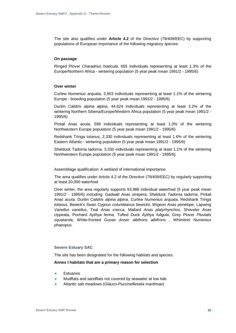
The site also qualifies under Article 4.2 of the Directive (79/409/EEC) by supporting populations of European importance of the following migratory species:
On passage
Ringed Plover Charadrius hiaticula, 655 individuals representing at least 1.3% of the Europe/Northern Africa - wintering population (5 year peak mean 1991/2 - 1995/6)
Over winter
Curlew Numenius arquata, 3,903 individuals representing at least 1.1% of the wintering Europe - breeding population (5 year peak mean 1991/2 - 1995/6)
Dunlin Calidris alpina alpina, 44,624 individuals representing at least 3.2% of the wintering Northern Siberia/Europe/Western Africa population (5 year peak mean 1991/2 - 1995/6)
Pintail Anas acuta, 599 individuals representing at least 1.0% of the wintering Northwestern Europe population (5 year peak mean 1991/2 - 1995/6)
Redshank Tringa totanus, 2,330 individuals representing at least 1.6% of the wintering Eastern Atlantic - wintering population (5 year peak mean 1991/2 - 1995/6)
Shelduck Tadorna tadorna, 3,330 individuals representing at least 1.1% of the wintering Northwestern Europe population (5 year peak mean 1991/2 - 1995/6)
Assemblage qualification: A wetland of international importance.
The area qualifies under Article 4.2 of the Directive (79/409/EEC) by regularly supporting at least 20,000 waterfowl
Over winter, the area regularly supports 93,986 individual waterfowl (5 year peak mean 1991/2 - 1995/6) including: Gadwall Anas strepera, Shelduck Tadorna tadorna, Pintail Anas acuta, Dunlin Calidris alpina alpina, Curlew Numenius arquata, Redshank Tringa totanus, Bewick's Swan Cygnus columbianus bewickii, Wigeon Anas penelope, Lapwing Vanellus vanellus, Teal Anas crecca, Mallard Anas platyrhynchos, Shoveler Anas clypeata, Pochard Aythya ferina, Tufted Duck Aythya fuligula, Grey Plover Pluvialis squatarola, White-fronted Goose Anser albifrons albifrons , Whimbrel Numenius phaeopus.
Severn Estuary SAC
The site has been designated for the following habitats and species:
Annex I habitats that are a primary reason for selection
• Estuaries • Mudflats and sandflats not covered by seawater at low tide • Atlantic salt meadows (Glauco-Puccinellietalia maritimae)

Severn Estuary SMP2 - Appendix D - Theme Review
Severn Estuary SMP Review
26
Annex I habitats present as a qualifying feature, but not a primary reason for selection
• Sandbanks which are slightly covered by seawater all the time • Reefs
Annex II species that are a primary reason for selection
• Sea lamprey (Petromyzon marinus) • River lamprey (Lampetra fluviatilis) • Twaite shad (Alosa fallax)
Severn Estuary Ramsar Site
Ramsar Sites are designated under the Convention on Wetlands of International Importance, signed at Ramsar in 1971. The Severn Estuary is recognised as a Wetland of International Importance under the Ramsar Convention for meeting the following criteria:
• Supporting four Habitats Directive Annex I features present on the SAC (including sandbanks (covered by seawater all the time), estuaries, mudflats/sandflats not covered by seawater at low tide and Atlantic salt meadows (Glauco-Puccinellietalia maritimae) (Criteria 1);
• Due to unusual estuarine communities, reduced diversity and high productivity (Criteria 3);
• Unusual estuarine communities, reduced species diversity and high productivity; • Important for the run of migratory fish between the sea and rivers via the estuary
(Criteria 4) this site is important for the run of migratory fish between sea and river via estuary. Species include Salmon Salmo salar, sea trout S. trutta, sea lamprey Petromyzon marinus, river lamprey Lampetra fluviatilis, allis shad Alosa alosa, twaite shad A. fallax, and eel Anguilla anguilla.
• Important site for migratory birds during spring and autumn; • Assemblages of waterfowl of international importance (Criteria 6); • A rich assemblage of breeding birds of international importance (Criteria 5); • A diverse range of fish species (including Salmon, Sea Trout, Sea Lamprey, Allis
Shad). The estuary is an important feeding and nursery ground for many fish species (Criteria 8).
3.4.2 National
Sites of Special Scientific Interest (SSSIs)
Sites of Special Scientific Interest (SSSIs) are of national importance for nature conservation and designated under the Wildlife and Countryside Act (WCA) 1981, as substituted by the Countryside and Rights of Way (CROW) Act 2000. A list of ‘operations likely to damage’ is associated with each SSSI. These operations need to be taken into consideration in undertaking any activity in a SSSI.
The UK target applying to England only in relation to SSSIs is to have 95 per cent of all sites in ‘favourable’ or ‘recovering’ condition by 2010. The Wales Environment Strategy

Severn Estuary SMP2 - Appendix D - Theme Review
Severn Estuary SMP Review
27
contains a target for all sites of international, Welsh and local importance to be in ‘favourable’ condition (Wales Environment Strategy Outcome 21). This Outcome is to be achieved through a suite of measures aimed at delivering more sympathetic management (wales Environment Strategy Action 32).
There are 52 SSSIs (Annex C of this Appendix) in the Severn Estuary SMP area across England and Wales, the largest of which is the estuary itself in total (15950 hectares).
National Nature Reserves (NNR)
A total of 4 NNRs are designated within the Severn Estuary SMP2 study area:
• Leigh Woods, at Severnside, Bristol and Avon; • The Hudnalls, at Wye and Chepstow; • Gordano Valley, at Portishead and Clevedon; • Newport Wetlands, at Newport and the River Usk.
3.4.3 Local
Key Wildlife Sites (KWS)
Other natural areas in the Severn Estuary that support special wildlife have no legal protection and rely on the goodwill of the owners for their conservation management. These sites are called Key Wildlife Sites (KWS) and are often referred to as non-statutory sites to distinguish them from SSSIs. In Gloucestershire, for example, there are over 700 identified Key Wildlife Sites with many more awaiting survey and assessment.

Severn Estuary SMP2 - Appendix D - Theme Review
Severn Estuary SMP Review
28
4. Historic Environment 4.1 Study Area Overview
The historic environment comprises of all past traces of human existence. It includes evidence for past environments, archaeological sites, historic buildings, designed landscapes and the historic aspects of the wider landscape. These assets are unique and, once damaged or destroyed, cannot be recovered or be re-created. They are valuable as repositories of evidence for human activity over millennia, for their contribution to landscape character, sense of place and community identity, and as an economic asset which underpins leisure and tourism (English Heritage, 2006).
The most recent coastal heritage assessment in Wales was undertaken in 1999 and contributed to the production of the CADW publication Caring for Coastal Heritage7
English Heritage is currently undertaking a series of Rapid Coastal Zone Assessments (RCZAs) around the English coast to update the previous surveys. The RCZA in the English areas of the Severn Estuary has produced a Phase 1 report, which has informed the entire Severn Estuary SMPE2 process in identifying areas of historic importanceThe Glamorgan Gwent Archaeological Trust (GGAT) in Wales and the local authorities’ archaeological services in England hold a great deal of information relating to non-designated sites around the Estuary. Their input will be important in helping to interpret data they hold and determine the relative importance of different areas for their heritage features.
. The survey identified principle areas where coastal heritage was at threat from a variety of pressures, including coastal erosion but recognised that modern engineering solutions can also radically change the coastline. This information is, however, out of date.
There are extensive deposits of buried palaeo-environmental and archaeological material throughout the Estuary that have no form of designation. In addition, it is recognised that understanding of the historic environment is not complete and there remain areas that have not been fully that are not fully assessedassessed.
Details of all key historic assets are presented in Appendix E “Issues, Features and Objectives” to assess their importance and value for this SMP2.
4.2 Understanding the Asset The Severn Estuary is a rich and varied archaeological and historic landscape. There is evidence that the area of the Severn Estuary has been inhabited by people for over 8,000 years. The current coast has been occupied by human settlement since the relative stabilisation of the shoreline approximately 4,500 BP that followed rapid sea level rise fuelled by glacial melt water and thermal expansion of the seas 10,000 to 8,000 BP. Since then the area has been continuously settled and developed to an extent that there are very few areas within the estuary that have not been occupied, developed or exploited by people. The historic environment of the Severn Estuary is therefore more
7 Caring for Coastal Heritage, (1999), CADW, http://www.cadw.wales.gov.uk/upload/resourcepool/Coastal%20Heritage9557.pdf

Severn Estuary SMP2 - Appendix D - Theme Review
Severn Estuary SMP Review
29
than a list of buildings, sites and monuments; rather it is a historic and cultural landscape of immense scale and significance.
Archaeo logy & palaeo-environmental evidence
Wet and waterlogged conditions, notably within the rich peat deposits buried under later alluvium of the Severn Estuary, have led to the preservation of extensive palaeo-environmental and archaeological material. Dating back to the Mesolithic, this includes evidence of submerged forests inundated by sea-level rises in c6000 BC, along with human and animal footprints preserved in the mud below peat deposits, known to be some c6500 years old. Peat and alluvial deposits within the area are particularly significant for the survival of palaeo-environmental deposits.
Other prehistoric assets include Bronze Age settlements and trackways, Iron Age villages, houses and trackways, Romano-British farmsteads and land drainage, medieval fishtraps, rhynes(drainage ditches) and sea walls, post-medieval drainage and land reclamation, enclosure landscapes and farm settlements. Roman activity is represented by settlement and military establishments at Caerleon and Gloucester.
The medieval and post-medieval periods saw the increased exploitation of the land and shoreline, notably land drainage, sea defences and the expansion of agriculture and small scale settlement within previously marginal areas. The coastal fringe bears evidence of fish traps, landing quays and small scale industries. The major settlements at Gloucester and Bristol began their development in the medieval period, growing to become some of the most important trading ports in the country. Later industrialisation also saw the growth of urban centres at Cardiff, Newport, Penarth and Portishead.
Activity throughout the late 19th and 20th century transformed the estuary, increasing communications (rail and road) and leading to the eventual decline of shipping and maritime trade. This period also saw the expansion of agriculture, industry and power generation, urban development, communications, tourism and defence.
Marine / maritime heritage
The River Severn meanders over a course that has altered over time – areas that are now well inland may once have been inter-tidal with huge potential for archaeological deposits – much of this land has been reclaimed from the River.
Maritime areas also contain archaeological remains, including shipwrecks, artefacts, submerged landscapes and World War II aircraft crash sites. The Severn has a rich maritime heritage, including the remains of boats at Newport (medieval), ‘Barland’s Farm’ (Roman) and Caldicot (Bronze Age), and a significant collection of hulks at Purton in Gloucestershire. It is not simply the route and former course of the river that is significant – the adjacent Levels are an essential element of the Severn landscape that contain archaeological remains arising from the activities that took place along the river – industry, farming, transportation, settlement, and the way of life of the people living on its shores.
The Severn has a long history of commercial and subsistence fishing and the estuary contains the remains of a number of historic fishing engines or fish traps (putts, putchers, traps and associated hurdles / fences), dating back as far as medieval times. Traditional fishing methods are still used in some parts of the river (particularly lave net fishing at Black Rock in Monmouthshire) and the importance of these heritage fisheries is
Severn Estuary SMP2 - Appendix D - Theme Review
Severn Estuary SMP Review
30
recognised in the Wales Fisheries Strategy (2008)8
Large scale industries developed along shore close to the major port at Avonmouth having a considerable impact on the estuary. The two islands in the estuary – Flat Holm and Steep Holm – also reflect the importance of the waterways for safe shipping, communication and defence in first the 19th and later 20th centuries.
. Understanding the location and pattern of landing bays, quays and jetties is central to appreciating communication throughout the estuary.
Built Heritage
The built heritage of the Severn Estuary is defined predominantly by the history, function and development of its major urban centres and use of vernacular traditions and materials in more rural areas.
The development of Severnside, Clevedon and Weston super Mare reflects the growth of tourism and the popularity of sea-side resorts, characterised by villas, piers and promenades. There are also thousands of other smaller historic houses and buildings – many of which are designated Listed Buildings – within the more rural areas of the Study Area. These reflect the development of housing and settlement in both England and Wales, illustrating the use of vernacular materials and styles and the later influence of imported materials.
The 20th century influence on the Severn Estuary was considerable. Mass communication by train and car replaced shipping as the predominant form of transport. Prominent aspects of the landscape were appropriated for defence during World War II. Industrial development and power generation, in particular around and along the coast from Avonmouth, has had a particular influence on the character of the landscape.
4.3 Designations Schedu led Monuments
There are 113 Scheduled Monuments within the Severn Estuary SMP2 study area. Scheduled Monuments are those historic features best conserved, most significant and prominent on the landscape, they represent only a small proportion of the entire archaeological record of the Severn Estuary (nationally, only 6% of all archaeological features and deposits are protected through scheduling). These include earthworks or masonry remains, including Neolithic and Bronze Age barrows, Iron Age hillforts, Roman sites, a short length of Offa’s Dyke, Norman and later motte and baileys and castles, medieval moated settlements and religious sites.
Regis tered Parks and Gardens and His to ric Lands cape
There are 8 registered Historic Parks and Gardens within the study area. This is a non-statutory designation, but a material planning consideration under Planning Policy Guidance 15 (Planning and the Historic Environment). Historic Parks and Gardens within the SMP2 study area are:
• Clevedon Court, Grade II*, at Portishead and Clevedon;
• King Weston House, Grade II, at Severnside, Bristol and Avon;
8 Wales Fisheries Strategy, (2008), Welsh Assembly Government, http://new.wales.gov.uk/strategy/strategies/walesfisheriesstrategy/walesfisheriesstratjuly08.pdf?lang=en

Severn Estuary SMP2 - Appendix D - Theme Review
Severn Estuary SMP Review
31
• Ashton Court, Grade II*, at Severnside, Bristol and Avon;
• Bristol University Botanic Gardens and Rayne Thatch, Grade II;
• Leigh Court, Grade II, at Severnside, Bristol and Avon;
• Goldney House, Grade II*, at Severnside, Bristol and Avon;
• Arnos Vale Cemetery, Grade II*, at Severnside, Bristol and Avon;
• Westbury Court, Grade II*, between Lydney and Gloucester.
The Historic Parks and Gardens within the Severn Estuary SMP2 study area cover over 750 hectares.
Lis ted Build ings
Large towns within the study area (Gloucester, Clevedon and Portishead on the English shoreline, and Newport, Cardiff and Penarth on the Welsh coast) contain the greatest concentrations of Listed Buildings. All Listed Buildings (Grades I, II* and II) are of national importance.
The type and grade of listed buildings is largely determined by their origin, Gloucester, Berkeley, Thornbury and Newport have medieval or earlier origins, as a result many of the Listed Buildings date to the medieval and early post-medieval periods (i.e. dating from the 13th/14th centuries through to the 18th/19th centuries). Clevedon largely owes its development to the growth of sea-side tourism in the 19th century. Cardiff Bay and Penarth developed as a result of industrial expansion in the 19th and 20th centuries. Newport is also significant for its industrial heritage, largely developed around port based industry.
There are many other single Listed Buildings or clusters of Listed Buildings within the Study Area. These relate to individual houses, smaller villages and hamlets within predominately rural settings, and are mostly domestic in origin and purpose, reflecting the vernacular traditions and materials of different areas (i.e. stone, timber framing, brick, thatch) as well as the influence of imported materials and styles (i.e. slate, engineered brick, dressed stonework, etc).
Cons ervation Areas
A Conservation Area is an area of 'special architectural or historic interest, the character or appearance of which it is desirable to preserve or enhance’ The designation can cover a wide range of the built heritage, usually the historic centres of towns or villages or distinctive settlements. A wide rage of features can contribute to the ‘special character’ such as architecture, open spaces, hedges and trees historic, associations, landmark features, walls and fences. It is often the mixture of all these elements that makes a place worthy of conservation area status. There are also a number of Conservation Areas in villages along the estuary. Most notably, these include Alvington, Aylburton, Blakeney, Awre, Brockwier, Lydney, Newnham on Severn and Westbury on Severn.

Severn Estuary SMP2 - Appendix D - Theme Review
Severn Estuary SMP Review
32
4.4 Shoreline Management and the Historic Environment Coastal change creates opportunities and threats for heritage sites – for example, cliff erosion could reveal new artefacts but will also result in loss of historic environmentassets,historic landscape, and deposits of palaeoenvironmental importance. .
While many monuments and historic features are at risk, it might be unwise, impractical or impossible to protect them indefinitely and choices need to be made regarding how sites can be protected and preserved, and how recording the importance of sites may need to change over time e.g. the creation of photographic records or removal of artefacts if the site itself cannot be protected from coastal change.
English Heritage’s Conservation Policies, Principles and Guidance9
recognises that conserving heritage needs to be integrated into other public needs and that changes to an historic place need to take account of potentially over-riding public policy objectives, the comparative significance of the place and the sustainability of maintaining the place. The historic environment of the Severn Estuary, as included in this document, was discussed with all historic environment stakeholders in the area at a specific Workshop event held in April 2009. Details on this event are presented in Appendix B.
9 Conservation Policies, Principles and Guidance for the Sustainable Management of the Historic Environment (2008), English Heritage, http://www.english-heritage.org.uk/upload/pdf/Conservation_Principles_Policies_and_Guidance_April08_Web.pdf?1235487343

Severn Estuary SMP2 - Appendix D - Theme Review
Severn Estuary SMP Review
33
5. Current and Future Land-use 5.1 Study Area Overview
The study area of the Severn Estuary SMP2 has varied land-use, with commercial and residential centres of Cardiff, Gloucester and Bristol, against recreational and conservation areas such as the Gwent and Caldicot Levels.
5.2 Residential Development Development along the Severn Estuary is around ports, which are centres of maritime industry, including heavy industry and transport, commercial fisheries and mineral extraction. Significant conurbations within the study area include Cardiff, Newport, Chepstow, Gloucester, Bristol, Portishead and Clevedon.
Table 5.1 includes those residential areas with populations in excess of 10,000 inhabitants.
Table 5.1 - Main SMP2 residential areas
• Bristol
• Caldicot / Portskewett
• Cardiff
• Chepstow
• Clevedon
• Gloucester
• Lydney / Allaston
• Magor / Undy
• Newport
• Penarth
• Portishead
• St. Mellons
• Quedgely
• Yatton / Congresbury
5.3 Commercial Activity, Industry, Ports and Harbours
Gloucester Harbour Trustees (GHT) are the competent harbour authority for the tidal waters of the River Severn from a point seaward of the Second Severn Crossing to Gloucester Port. Other key ports in the SMP2 study area include ports of Cardiff, Newport, Avonmouth, and Sharpness.
The key activities associated with the above ports are set out below:
5.3.1 Port of Cardiff
Located on the north side of the Severn Estuary, within easy reach of the M4, Cardiff is highly experienced in the handling of containers, steel, forest products and dry and liquid bulks, and has comprehensive port facilities to support these trades. Cardiff’s award-winning Cold Store provides customers with the very best in fresh produce-storage facilities, making the port an ideal UK entry point for perishables requiring storage prior to onward transportation.
Severn Estuary SMP2 - Appendix D - Theme Review
Severn Estuary SMP Review
34
5.3.2 Port of Newport
Newport’s prime location, deep-water berths and diverse handling capabilities continue to attract new business across a range of trades. Recent improvements to transport links offer dual-carriageway access to both Junctions 24 and 28 of the M4. Associated British Ports (ABP) has made significant investments to develop the port, such as in steel facilities to enable growth in both import and export volumes, as well as in new warehousing facilities, open storage areas and a new rail link. Sims Group has invested heavily in its Newport facilities, creating the UK’s most modern metals recycling and export plant and recently announcing the construction of one of the world’s largest waste electrical and electronic equipment recycling plants at the port.
5.3.3 Port of Avonmouth
Avonmouth is a river tide gate harbour that is afforded with excellent shelter. The key activities at the port include the area being one of the major fertiliser producers/import areas, importing c100,000 tonnes of bulk product from Europe for bagging/processing/distribution. In addition to the 500,000 tonnes of coal that E.ON UK import through Portbury Dock in 2007, 150,000 tonnes of coal is also imported at Avonmouth. The coal generator, International Power, is also utilising Avonmouth for the storage of coal. Grain importers have taken advantage of new storage at Avonmouth, some of which is now being utilised for the storage of milling wheat for Rank Hovis. Export grain is also able to be handled at Avonmouth, utilising a twin hopper elevator, Market leader, Arkady Feed, utilises Avonmouth for the discharge and storage of its European coaster traffic. Various grades of aggregate/pumice are handled for a number of customers, including Conexpo, which imports c100,000 tonnes per year from Ireland and Tarmac Topblock, which discharges shipments of pumice. Coaster shipments of bark are received for Melcourt Industries from Northern Spain whilst peat, in bales and bulk, is imported from Ireland and the Baltic.
5.3.4 MOD Sites
There are Ministry of Defence (MoD) sites within the Severn Estuary. GIS data mapping the location and extent of these sites is not currently available.
5.4 Energy Generation A large portion of the power for South Wales comes in across the Severn Estuary, the Levels and areas affected by the SMP2. The location and risk to such infrastructure will need to be integrated into the development of the SMP2.
The Estuary is home to several power stations, in various stages of operation. Each one is considered as part of the relevant Theme Review Area in section 6.
The extreme tidal range of the Severn Estuary offers the potential for a significant amount of renewable energy generation from wave and tidal power technologies. The Department for Energy and Climate Change (DECC) and the Welsh Assembly Government are currently part way through funding a feasibility study of potential wave and tidal power generation technologies within the Severn Estuary. The study aims to gather and assess evidence to enable Government to decide if it could / should support a tidal power scheme(s) in the Severn. No decision will be made until 2010.

Severn Estuary SMP2 - Appendix D - Theme Review
Severn Estuary SMP Review
35
The SMP2 does not take into account the impacts of any of the possible schemes, as the range of potential impacts on coastal erosion and flooding (if any) are far from certain and potentially vary widely depending on the option in question. The feasibility study will, however, have to take potential impacts on coastal flooding and erosion into account.
5.5 Recreation, Tourism and Related Features 5.5.1 Coastal Tourism
Tourism is recognised by both the Welsh and English Governments as a key wealth creator and it is already an integral part of the economy and way of life around the Estuary. Spatial plans and strategies for the area recognise the importance of tourism and seek to encourage its growth as it brings economic environmental and social benefits and supports local services. Tourism can however, have negative effects, including difficulties of visitor management, traffic congestion, coastal access and environmental degradation, eventually leading to damage to the features that the tourists come to enjoy.
Angling from the shore and from boats on the Estuary is a popular leisure activity, with private and charter boats operating from ports and harbours in the area. Leisure fishing for sea fish makes a significant contribution to the economy as well as providing recreation. Although it has declined in recent years, there are many plans to try to restore this trend. The Severn Estuary in particular, is one of the most important elver fisheries in Europe bringing benefits to the local economy. However, there have been concerns recently regarding declining stocks due to over exploitation and loss of habitat.
The ‘Wales Coastal Tourism Strategy’ and ‘Towards 2015’, the South West Tourism Strategy, both aim to improve the tourist experience, smooth out issues caused by seasonality and deliver sustainable tourism. ‘Towards 2015 ‘is a tourism strategy for the whole region and does not make specific mention of coastal or climate change issues. The ‘Wales Coastal Tourism Strategy’ also seeks to achieve the same general aims as ‘Towards 2015’ but is, as would be expected, more focussed and highlights specific areas for particular types of tourism development (e.g. marinas). The Severn is not highlighted in particular but coastal erosion, climate change and managing conflicts between different activities are all recognised as challenges to the successful development of coastal tourism.
5.5.2 Recreational Marinas
British Marine Industries Federation (BMIF) is the trade body to which marinas may be affiliated. Yacht clubs in the Severn Estuary also affiliate to the Royal Yachting Association (RYA) and are members of a forum known as the Bristol Channel Yachting Conference. Members of BMIF and the RYA are therefore amongst the recreational groups who have interests in the management of the Severn Estuary. Other craft, from sailing dinghies and speedboats to personal watercraft, are able to launch at public slipways and may travel from far afield to use the Estuary. Some ports have developed codes of practice for leisure users.
5.5.3 Coastal Access
Increasing access to the coast for tourism and recreation (and associated economic and health benefits, etc.) is a key policy aim in both England and Wales. Achieving this aim in England will be aided by the creation of the Marine and Coastal Access Bill, currently in Parliament, which will provide a statutory right of access to the coast in a coastal access strip. The goal of creating an All Wales Coastal Path has been progressing

Severn Estuary SMP2 - Appendix D - Theme Review
Severn Estuary SMP Review
36
through the creation of a physical path with circular and in-land routes. The Marine and Coastal Access Bill will also enable the National Assembly for Wales to create Wales-specific legislation that might be needed to achieve the One Wales coastal access goal.
5.6 Future Land-use Wales
The Wales Spatial Plan (WSP) People, Places, Futures was published in 2004 and an update has been published. A consultation process was carried out between 31st January and 24th April 2008. The WSP is more than a development plan of planning policy document; it sets a vision for how each part of Wales should develop economically, socially and environmentally over the next 20 years (i.e. to 2028) and will guide the way the Assembly Government will focus support and financial spending over the coming years. The WSP links to more traditional planning guidance documents, reinforcing existing policies and providing a steer for new and developing guidance.
The Spatial Plan identifies six distinctive areas of Wales. The area impacted by the SMP2 is ‘South East Wales – The Capital Network’.
Present and future flood risk and the risk management responses are clearly linked to the economic, social and environmental well being of Wales. The SMP2 policies and actions will provide both opportunities and constraints to the investment decisions cascading from the Wales Spatial Plan. Key policies and visions in this area that should influence the SMP2 and may be impacted by SMP2 policies are:
• Strengthen and re-integrate the system of towns and cities in the area • Integrated and improved transport system and links to Bristol, London and Europe –
bus, rail, park & ride, reduce car-dependency, improved links to Cardiff International Airport
• Development opportunities in the Gwent Valleys – taking account of flood risks • Better balance of development – avoid over development in the coastal zone –
defence and environmental / aesthetic issues
England
There is no direct equivalent to the Wales Spatial Plan in England. Regional Spatial Strategies (RSSs) are the most similar strategic planning documents on the English side of the Estuary, seeking to go beyond simple land use planning and integrate policies to provide a strategic overview for development.
A final South West RSS has not yet been published, although a draft and proposed changes following public consultation, an Examination in Public (EiP) and comments from the Secretary of State are publicly available. It is not clear if a final RSS will be published as the role of the Regional Planning Body is to be phased out and the RSS replaced by a Single Regional Strategy (SRS) to be developed from 2010.
The draft RSS covers a very large area, much greater than that covered by the SMP2. Two of the strategic areas identified in the South West RSS are relevant to the SMP2 – Gloucester & Cheltenham (includes, Tewkesbury, Lydney and Forest of Dean area) and West of England (Bath, Bristol, Weston-super-Mare and associated towns).
Key goals and policies within the RSS of relevance to the SMP2 are:

Severn Estuary SMP2 - Appendix D - Theme Review
Severn Estuary SMP Review
37
• Bristol becomes a major European city;
• Rural areas fulfil their potential – with vibrant market towns at their core;
• Cheltenham / Gloucester develops as an important focal point for economic growth;
• Regeneration of the Forest of Dean and other priority areas continues;
• Growth is supported by necessary infrastructure;
• Coastal defences are expected to be necessary to enable the economic potential of Avonmouth and Severnside to be realised;
• Bristol Port is a key transport and freight link within the area, capable of accommodating modern vessels (policy TR7);
• Coastal local authorities will define the coastal zone as part of their LDD, identifying developed and undeveloped coast. There will be a presumption against development in undeveloped coastal areas. (Policy CO1).
The RSS makes specific mention of flood risk and increased risk due to climate change, recognising that there will be high costs in maintaining defences in critical areas. Development proposals should not prejudice future coastal management, the capacity of the coast to form a natural sea defence, or to adjust to changes without endangering life or property. The flood risk (policy F1) sets out the priorities in the area, taking account of climate change and the increasing risk of coastal and river flooding, as:
• Defend existing properties and, where possible, locate new development in places with little or no risk of flooding;
• Protect flood plains and land liable to tidal or coastal flooding from development;
• Follow a sequential approach to development in flood risk areas;
• Use development to reduce the risk of flooding through location, layout and design;
• Relocate existing development from areas of the coast at risk, which cannot be realistically defended;
• Identify areas of opportunity for managed realignment to reduce the risk of flooding and create new wildlife areas.
Local Authority Planning
Local planning authorities are required to consider the guidance set out by the Welsh Assembly Government in Wales and the Department for Communities and Local Government (DCLG) in England.
Planning Policy Wales (2002) sets out the land use planning policies of the Welsh Assembly Government and is supplemented by 21 Technical Advice Notes (TANs). Planning Policy Statements (PPSs) and Planning Policy Guidance Notes (PPGs) set out the guidance for local planning authorities in England. PPGs are in the process of being replaced by PPSs, so at present there is a mix of both types of guidance relating to different aspects of planning.
Local planning authorities must take account of all the guidance documents in developing their plans and making planning decisions. All are, therefore, relevant to the development of the SMP2, however, those that most specifically deal with coastal planning and flood risk are:
Severn Estuary SMP2 - Appendix D - Theme Review
Severn Estuary SMP Review
38
• TAN 15 - Development and Flood Risk (2004);
• TAN 14 – Coastal Planning (1998);
• TAN 5 – Nature Conservation and Planning (1996);
• PPS 25 – Development and Flood Risk (2006);
• Supplement to PPS1 – Planning and Climate Change (2007);
• PPG 20 – Coastal Planning (1992).
The SMP2 study area covers the following authorities (county and local). Those which have produced flood risk assessments or amalgamated to be part of a Strategic Flood Risk Assessment (SFRA) have an “F” next to them. Some SFRAs include the partnering role of the IDB (e.g. Lower Severn IDB) in their completion.
• Cardiff County Council;
• Newport City Council;
• Vale of Glamorgan County Council;
• Monmouthshire County Council (F);
• Forest of Dean District Council (F);
• Gloucester City Council (F);
• Gloucestershire County Council (F);
• Tewkesbury Borough Council (F):
• Stroud District Council (F);
• South Gloucestershire Council (F);
• Bristol City Council (F);
• North Somerset Council (F);
• Somerset County Council.
A separate review of local development plans, regional policies relating to development, development targets and proposed locations for development across the study area has been undertaken and is documented within the SEA Scoping Study.
The Local Authorities have all prepared development plans which outline national and regional planning frameworks, a vision for future development, key strategic growth areas and options, and includes the key trends and issues that have informed the selected policies. These Local Authorities are however at different stages in the development of their LDP’s. Further details concerning these planning documents are contained in the SEA Scoping Report and relevant policies are given in Annex A of that report (see SECG website link below):
http://www.severnestuary.net/secg/publications.html

Severn Estuary SMP2 - Appendix D - Theme Review
Severn Estuary SMP Review
39
6. Summary of the Shoreline: SMP2 Theme Areas Overview to the Theme Area Summaries The following summary documents are produced to help communicate the key aspects of the theme Areas in terms of their:
• Landscape and Nature Conservation;
• Historic Environment;
• Current and Future Land Use (updated from SMP1 where information has been made available by Local Authority planners);
It is important to note that each Theme Area has been reviewed to ensure that the land use changes provided by the UDP are reflected in the text. Changes have only been made, however, where information on land use has been made available by planners. Any significant changes to land use since the original SMP process may consequently have an impact on the future stages and overall development of the SMP2.
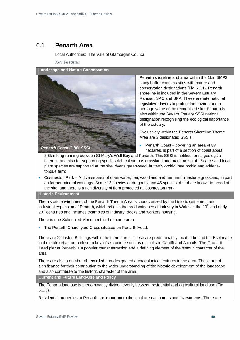
Severn Estuary SMP2 - Appendix D - Theme Review
Severn Estuary SMP Review
40
6.1 Penarth Area
Local Authorities: The Vale of Glamorgan Council
Key Featu res
Landscape and Nature Conservation
Penarth shoreline and area within the 1km SMP2 study buffer contains sites with nature and conservation designations (Fig 6.1.1). Penarth shoreline is included in the Severn Estuary Ramsar, SAC and SPA. These are international legislative drivers to protect the environmental heritage value of the recognised site. Penarth is also within the Severn Estuary SSSI national designation recognising the ecological importance of the estuary.
Exclusively within the Penarth Shoreline Theme Area are 2 designated SSSIs:
• Penarth Coast – covering an area of 88 hectares, is part of a section of coast about
3.5km long running between St Mary’s Well Bay and Penarth. This SSSI is notified for its geological interest, and also for supporting species-rich calcareous grassland and maritime scrub. Scarce and local plant species are supported at the site: dyer’s greenweed, butterfly orchid, bee orchid and adder’s-tongue fern;
• Cosmeston Park – A diverse area of open water, fen, woodland and remnant limestone grassland, in part on former mineral workings. Some 13 species of dragonfly and 45 species of bird are known to breed at the site, and there is a rich diversity of flora protected at Cosmeston Park.
Historic Environment
The historic environment of the Penarth Theme Area is characterised by the historic settlement and industrial expansion of Penarth, which reflects the predominance of industry in Wales in the 19th and early 20th centuries and includes examples of industry, docks and workers housing.
There is one Scheduled Monument in the theme area:
• The Penarth Churchyard Cross situated on Penarth Head.
There are 22 Listed Buildings within the theme area. These are predominately located behind the Esplanade in the main urban area close to key infrastructure such as rail links to Cardiff and A roads. The Grade II listed pier at Penarth is a popular tourist attraction and a defining element of the historic character of the area.
There are also a number of recorded non-designated archaeological features in the area. These are of significance for their contribution to the wider understanding of the historic development of the landscape and also contribute to the historic character of the area. Current and Future Land-Use and Policy
The Penarth land use is predominantly divided evenly between residential and agricultural land use (Fig 6.1.3).
Residential properties at Penarth are important to the local area as homes and investments. There are
Penarth Coast Cliffs SSSI

Severn Estuary SMP2 - Appendix D - Theme Review
Severn Estuary SMP Review
41
potential detrimental health implications to owners/residents presented by the risk of flooding and erosion.
Alongside residential developments are commercial properties, particularly concentrated along the esplanade. Commercial properties support the local economy. The Penarth Lifeboat Station is part of the national lifeboat service framework – an important asset for the safety of the regional community.
Rail and road links to the north of the Theme Area connect Penarth to Cardiff. Key infrastructure also includes drainage outfalls which support water supply to residential and commercial properties (Appendix B). The maintenance of drainage outfalls is essential to ensure continued standards of water quality and environmental conservation.
The southern half of the Theme Area is dominated by agricultural land, but is interspersed with recreational areas and sites devoted to tourism, particularly at Lavernock Point, a well favoured site for bird watching. A coastal path links Lavernock Point to Penarth Esplanade; it is a key feature of the shoreline under WAG designations and Marine & Coastal Access Bill (2009). The coastal path is a recreational asset and tourist attraction, ensuring public access to the shore.
The current immediate shoreline is overwhelmingly semi-natural, only the Penarth Esplanade interrupts the natural shoreline with residential shoreline developments.
Policy
The management objectives for the Penarth shoreline will meet the objectives for each land-use outlined in the Vale of Glamorgan Unitary Development Plan (See summary, Annex A).
The plan provides a sustainable land use framework to guide the growth and ensure the environmental protection for the Vale of Glamorgan well into the future.
Penarth

Severn Estuary SMP2 - Appendix D - Theme Review
Severn Estuary SMP2 Review
42
Figure 6.1.1 Penarth Landscape and Nature Conservation
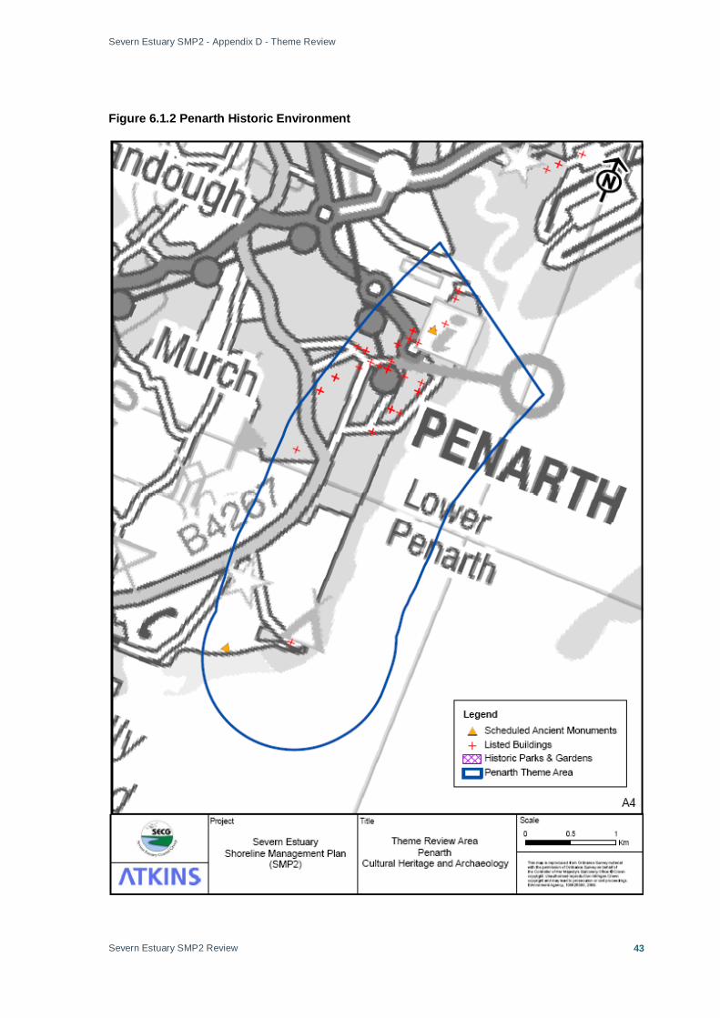
Severn Estuary SMP2 - Appendix D - Theme Review
Severn Estuary SMP2 Review
43
Figure 6.1.2 Penarth Historic Environment

Severn Estuary SMP2 - Appendix D - Theme Review
Severn Estuary SMP2 Review
44
Figure 6.1.3 Penarth Present Land Use

Severn Estuary SMP2 - Appendix D - Theme Review
Severn Estuary SMP2 Review
45
6.2 Cardiff Local Authorities: Cardiff County Council
Key Featu res
Landscape and Nature Conservation
The shoreline fronting Cardiff has nature and conservation designations (Fig 6.2.1); the Severn Estuary Ramsar, SAC and SPA. These are international legislative drivers to protect the environmental heritage value of the recognised site. Cardiff shoreline is also within the Severn Estuary SSSI national designation, recognising the ecological importance of the estuary.
Scattered pockets of nature conservation at the shoreline and 148hectares of land allocated to public parks/green spaces.
The designated SSSIs within the Cardiff Area Theme Area are:
• Penylan Quarry – of national geological importance and some fossil significance (CCW, 2005); • Rumney Quarry – Disused quarry with important geological exposure and fossils; • Rhymney River Section – Geological SSSI: The most complete exposure of Silurian strata. There is
some fossil significance (CCW, 2005) • Rumney and Peterstone, Gwent Levels – Supports a number of important plant species. The aquatic
invertebrate fauna is very diverse and contains many rare notable species (CCW, 2005). The objective for this site is to maintain the ecological value of the site through minimal disturbance to habitats.
Howardian Local Nature Reserve in the lower Rhymney valley is squeezed into a compact urban setting, it is home to a surprising variety of wildlife. Over 500 individual species have been recorded, reflecting the contrasting habitats contained within the site. Stakeholders have expressed it desirable not to threaten the presence bird species, particularly Cormorants, in Cardiff Bay with developments at the coastline. Historic Environment
The historic environment of the Cardiff Theme Area (Fig 6.2.2) is characterised predominantly by the major industrial developments located within the dockland area of the city. Away from the docks, the city is characterised by 19th and 20th century urban development overlying evidence of earlier periods of occupation. Cardiff Castle, which has origins in the Roman period, lies within the Theme Area.
There is one Scheduled Monument in the theme area:
• Pen y Lan Roman Fort
Many of the 20 Listed Buildings arerelated to the 19th and 20th century industrial development and expansion of the town. The coastal fringes of the city are characterised by predominately 19th century docks, wharfs, offices and related maritime infrastructure.
Undesignated sites that hold heritage value are recognised for their regional value in creating a sense of place and adding to the attraction of the region.
Current and Future Land-Use and Policy
The city of Cardiff is an important commercial activity and residential centre, alongside port related and other industrial zones (Fig 6.2.3).
Residential developments on the bay frontage are homes for local residents and personal investments. The threat of flooding and/erosion of property threatening stability poses potential health impacts to residents/
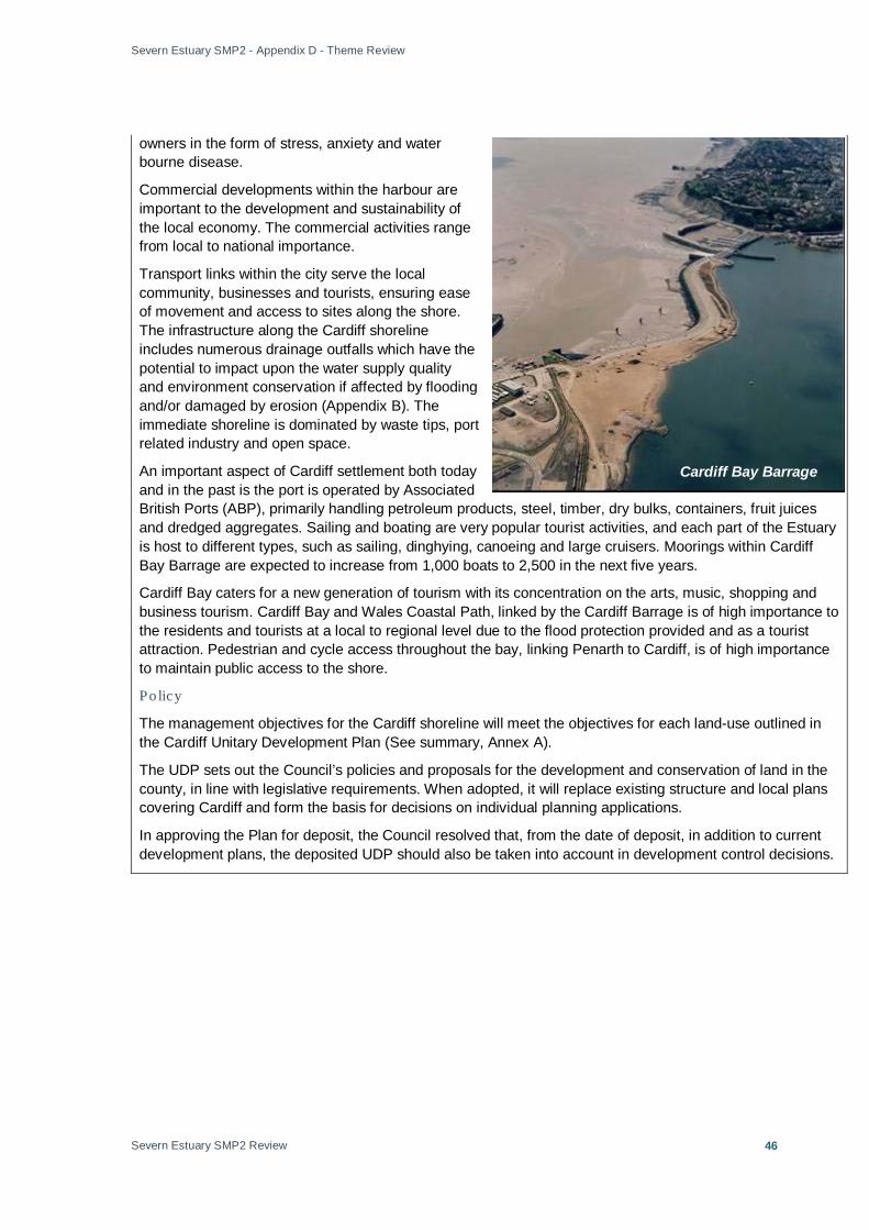
Severn Estuary SMP2 - Appendix D - Theme Review
Severn Estuary SMP2 Review
46
owners in the form of stress, anxiety and water bourne disease.
Commercial developments within the harbour are important to the development and sustainability of the local economy. The commercial activities range from local to national importance.
Transport links within the city serve the local community, businesses and tourists, ensuring ease of movement and access to sites along the shore. The infrastructure along the Cardiff shoreline includes numerous drainage outfalls which have the potential to impact upon the water supply quality and environment conservation if affected by flooding and/or damaged by erosion (Appendix B). The immediate shoreline is dominated by waste tips, port related industry and open space.
An important aspect of Cardiff settlement both today and in the past is the port is operated by Associated British Ports (ABP), primarily handling petroleum products, steel, timber, dry bulks, containers, fruit juices and dredged aggregates. Sailing and boating are very popular tourist activities, and each part of the Estuary is host to different types, such as sailing, dinghying, canoeing and large cruisers. Moorings within Cardiff Bay Barrage are expected to increase from 1,000 boats to 2,500 in the next five years.
Cardiff Bay caters for a new generation of tourism with its concentration on the arts, music, shopping and business tourism. Cardiff Bay and Wales Coastal Path, linked by the Cardiff Barrage is of high importance to the residents and tourists at a local to regional level due to the flood protection provided and as a tourist attraction. Pedestrian and cycle access throughout the bay, linking Penarth to Cardiff, is of high importance to maintain public access to the shore.
Policy
The management objectives for the Cardiff shoreline will meet the objectives for each land-use outlined in the Cardiff Unitary Development Plan (See summary, Annex A).
The UDP sets out the Council’s policies and proposals for the development and conservation of land in the county, in line with legislative requirements. When adopted, it will replace existing structure and local plans covering Cardiff and form the basis for decisions on individual planning applications.
In approving the Plan for deposit, the Council resolved that, from the date of deposit, in addition to current development plans, the deposited UDP should also be taken into account in development control decisions.
Cardiff Bay Barrage
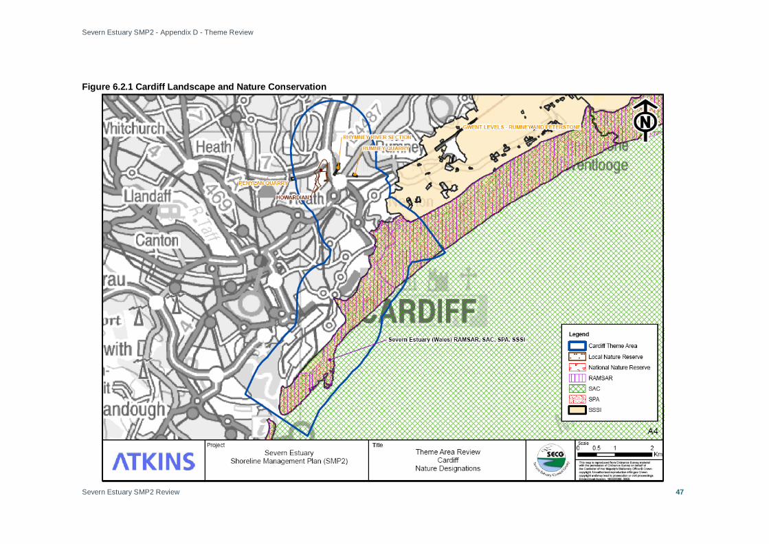
Severn Estuary SMP2 - Appendix D - Theme Review
Severn Estuary SMP2 Review
47
Figure 6.2.1 Cardiff Landscape and Nature Conservation
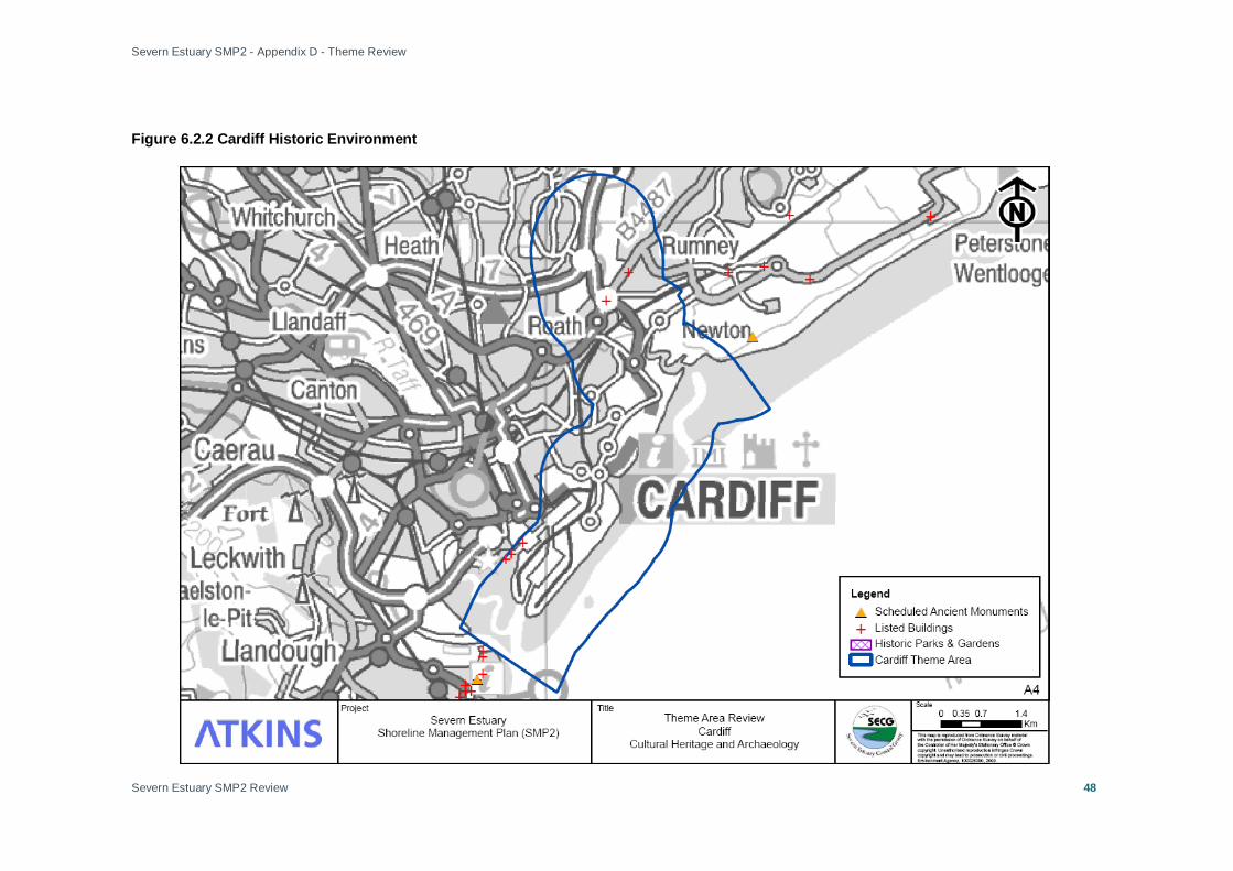
Severn Estuary SMP2 - Appendix D - Theme Review
Severn Estuary SMP2 Review
48
Figure 6.2.2 Cardiff Historic Environment
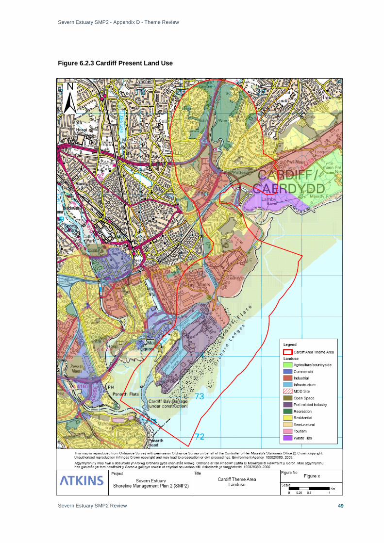
Severn Estuary SMP2 - Appendix D - Theme Review
Severn Estuary SMP2 Review
49
Figure 6.2.3 Cardiff Present Land Use

Severn Estuary SMP2 - Appendix D - Theme Review
Severn Estuary SMP2 Review
50
6.3 Wentlooge Local Authorities: Newport City Council
Key Featu res
Landscape and Nature Conservation
The Wentlooge Levels are primarily low-lying, with foreshore composed of muddy Holocene marine and estuarine alluvium covering relatively wide intertidal flats. The Levels are subject to numerous nature and conservation designations (Fig 6.3.1), they are included in the Severn Estuary Ramsar, SAC and SPA. These are international legislative drivers to protect the environmental heritage value of the recognised site. Wentlooge is also within the Severn Estuary SSSI national designation recognising the ecological importance of the estuary. The Wentlooge Levels are an important site for coastal species, containing a number of birds roosting and nesting sites.
Extensive saltmarshes are an important feature of the Levels. They are confined to low energy, sheltered environments such as on the Wentlooge and Caldicot Levels and inner estuary. Areas of saltmarsh are dwindling in the UK as a whole, therefore the Severn Estuary saltmarsh (over 1100 hectares in total) is increasing in value as a wildlife habitat. It is an important component of the Severn Estuary SSSI, SPA and possible SAC.
At Wentlooge there are large expanses of area under a national designation of SSSIs under 2 areas: • St. Brides: Covering 1322 hectares the site is important for the presence of scarce invertebrate
populations and relict meadow plants (Caldicot and Wentlooge IDB, 2008); • Rumney and Peterstone (See 6.2) – Supports a number of important plant species. The aquatic
invertebrate fauna is very diverse and contains many rare notable species (CCW, 2005). The objective for this site is to maintain the ecological value of the site through minimal disturbance to habitats.
Historic Environment
The historic environment of the Wentlooge Theme Area (Fig 6.3.2) is characterised by the evidence of historic land use, coastal defence, drainage and reclamation.
Register of Landscapes, Parks and Gardens of Outstanding Historic Interest in Wales: Wentlooge forms part of the wider Gwent Levels Historic Landscape (No. 17), which recognises the historic character of St. Brides, Peterstone, Rumney and Marshfield. The area comprises of three discrete and extensive areas of alluvial wetlands and intertidal mudflats situated on the north side of the Severn Estuary represent the largest and most significant example in Wales of a 'hand-crafted' landscape. They are entirely the work of past human activity, having been recurrently inundated and reclaimed from the sea from the Roman period onwards. The areas have distinctive patterns of settlement, enclosure and drainage systems belonging to successive periods of use, and a proven and possibly quite vast potential for extensive, well-preserved, buried, waterlogged, archaeological and palaeoenvironmental deposits surviving from earlier landscapes.
There are two Scheduled Monuments within the area:
The River Severn at Peterstone

Severn Estuary SMP2 - Appendix D - Theme Review
Severn Estuary SMP2 Review
51
• A Medieval sea wall at Rumney Great Wharf
• St. Mary’s Churchyard Cross at Marshfield.
There are seven Listed Buildings within the area.
The area includes several recorded non-designated archaeological sites and monuments as well as records of palaeo-environmental deposits.
Current and Future Land-Use and Policy
Agriculture is a major land use at the Wentlooge Levels (Fig 6.3.3). The levels are of high grade agricultural land which is of importance for the locally produced food and employment opportunities supplied to local residents. The Caldicot and Wentlooge Internal Drainage Board (IDB) are key stakeholders in this area in relation to current drainage related issues.
There is limited development on the Wentlooge Levels, with small settlements and port-related industry at the west and local businesses.
Key infrastructure includes the local railway linking the major cities of Newport and Cardiff that runs along the Wentlooge Levels. This is an essential transport link for local communities and regional businesses. Part of the electricity supply network is also located at Wentlooge, and its maintenance is essential to support the local communities and businesses. Roads along the shoreline at present are maintaining access to the shoreline for locals and tourists. At the shoreline, St. Brides lighthouse is an important feature for the successful navigation of the Severn Estuary, its presence can be argued of national importance for the preservation of trade links supporting the economy.
Tourist sites are located in close proximity to the shoreline associated with the landscape value and nature conservation of the locality. There are also recreational assets, such as a rifle range, used by tourists and locals alike, and the Peterstone Golf and Country Club. The leisure facilities are important to locals, as a business in supporting the economy, and also as a tourist attraction.
Policy
Wentlooge shoreline, west to Peterstone, is governed under the Newport Unitary Development Plan. Therefore, the management objectives for the Wentlooge shoreline will meet the objectives for each land-use outlined in the Newport Unitary Development Plan (See summary, Annex A).
The plan has a major theme of regeneration and renewal that will assist in the Council's social inclusion agenda, which is part of overall sustainability plan. The development that is going on should provide much needed employment both in the short and longer term. Improved shopping facilities in the city centre will also not only benefit the shopping public but provide employment for locals.
Intertidal Zone at Newton

Severn Estuary SMP2 - Appendix D - Theme Review
Severn Estuary SMP2 Review
52
Figure 6.3.1 Wentlooge Landscape and Nature Conservation
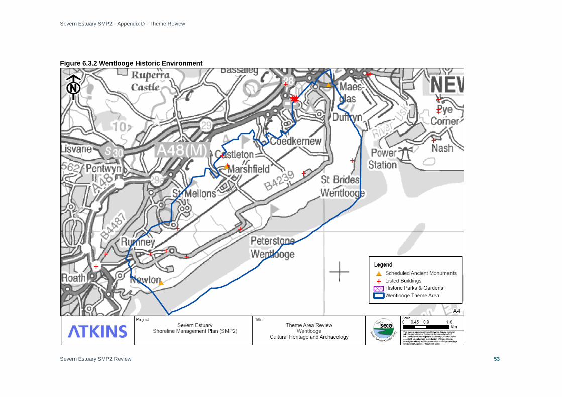
Severn Estuary SMP2 - Appendix D - Theme Review
Severn Estuary SMP2 Review
53
Figure 6.3.2 Wentlooge Historic Environment

Severn Estuary SMP2 - Appendix D - Theme Review
Severn Estuary SMP2 Review
54
Figure 6.3.3 Wentlooge Present Land Use
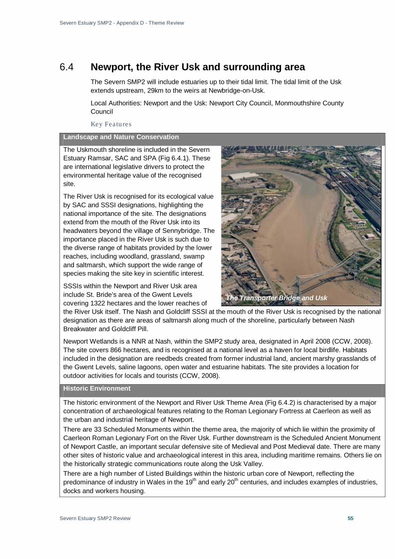
Severn Estuary SMP2 - Appendix D - Theme Review
Severn Estuary SMP2 Review
55
6.4 Newport, the River Usk and surrounding area The Severn SMP2 will include estuaries up to their tidal limit. The tidal limit of the Usk extends upstream, 29km to the weirs at Newbridge-on-Usk.
Local Authorities: Newport and the Usk: Newport City Council, Monmouthshire County Council
Key Featu res
Landscape and Nature Conservation
The Uskmouth shoreline is included in the Severn Estuary Ramsar, SAC and SPA (Fig 6.4.1). These are international legislative drivers to protect the environmental heritage value of the recognised site.
The River Usk is recognised for its ecological value by SAC and SSSI designations, highlighting the national importance of the site. The designations extend from the mouth of the River Usk into its headwaters beyond the village of Sennybridge. The importance placed in the River Usk is such due to the diverse range of habitats provided by the lower reaches, including woodland, grassland, swamp and saltmarsh, which support the wide range of species making the site key in scientific interest.
SSSIs within the Newport and River Usk area include St. Bride’s area of the Gwent Levels covering 1322 hectares and the lower reaches of the River Usk itself. The Nash and Goldcliff SSSI at the mouth of the River Usk is recognised by the national designation as there are areas of saltmarsh along much of the shoreline, particularly between Nash Breakwater and Goldcliff Pill.
Newport Wetlands is a NNR at Nash, within the SMP2 study area, designated in April 2008 (CCW, 2008). The site covers 866 hectares, and is recognised at a national level as a haven for local birdlife. Habitats included in the designation are reedbeds created from former industrial land, ancient marshy grasslands of the Gwent Levels, saline lagoons, open water and estuarine habitats. The site provides a location for outdoor activities for locals and tourists (CCW, 2008).
Historic Environment
The historic environment of the Newport and River Usk Theme Area (Fig 6.4.2) is characterised by a major concentration of archaeological features relating to the Roman Legionary Fortress at Caerleon as well as the urban and industrial heritage of Newport. There are 33 Scheduled Monuments within the theme area, the majority of which lie within the proximity of Caerleon Roman Legionary Fort on the River Usk. Further downstream is the Scheduled Ancient Monument of Newport Castle, an important secular defensive site of Medieval and Post Medieval date. There are many other sites of historic value and archaeological interest in this area, including maritime remains. Others lie on the historically strategic communications route along the Usk Valley. There are a high number of Listed Buildings within the historic urban core of Newport, reflecting the predominance of industry in Wales in the 19th and early 20th centuries, and includes examples of industries, docks and workers housing.
The Transporter Bridge and Usk

Severn Estuary SMP2 - Appendix D - Theme Review
Severn Estuary SMP2 Review
56
There are extensive non-designated archaeological sites and monuments within the theme area.
Current and Future Land-Use and Policy
Along the tidally influenced banks of the Usk the river is bounded by the extensively developed land of Newport and Caerleon and open spaces with flood protection (Fig 6.4.3). Large areas along the banks of the River Usk lie within the flood risk area. An extensive area of agriculture and countryside occupies the shoreline of the upstream tidal limit of the River Usk.
Residential properties are concentrated in the city of Newport and found along the shoreline of the River Usk. Residential developments are particularly concentrated from downstream at Pillgwenlly (right bank – looking downstream) and Somerton (left bank), to the upstream reaches at Caerleon (right bank) and Longstone (left bank). The properties provide homes for local residents and many are individual investments. They are regionally important.
At Uskmouth, port-related industry can found alongside waste tips and commercial development. The Uskmouth power station is located on the banks of the Severn and Usk at Newport. There is a dredged navigation channel into Newport Docks. The Llanwern Steelworks which lie inland are dependent on the primary sea defences.
Newport Port is operated by Associated British Ports (ABP), primarily handling steel imports and exports, agri-bulks, solid fuels, timber, plywood, glass and dredged aggregates. Dredging takes place at several ports in the Severn Estuary area, including Newport Docks.
Further key infrastructure includes the intricate road network of Newport, the rail crossing and network, and drainage outfalls (Appendix B). Each aspect of infrastructure has the potential to disrupt the lives of local people and the day to day business of local and regional companies in the event of damage from flooding and/or erosion.
Minimal segments of land along the shoreline of the River Usk are open space, these can be found upstream alongside the primary residential developments of the city, recreational grounds, and land set aside for agriculture.
Policy
The management objectives for the Usk and Uskmouth shoreline will meet the objectives for each land-use outlined in the Newport Unitary Development Plan (See summary, Annex A).
The plan has a major theme of regeneration and renewal, which should also assist in the Council's social inclusion agenda, which is part of overall sustainability. The current development should provide much needed employment both in the short and longer term. Improved shopping facilities in the city centre will also not only benefit the shopping public but also provide employment.

Severn Estuary SMP2 - Appendix D - Theme Review
Severn Estuary SMP2 Review
57
Figure 6.4.1 Newport, the River Usk and Surrounding Area Landscape and Nature Conservation

Severn Estuary SMP2 - Appendix D - Theme Review
Severn Estuary SMP2 Review
58
Figure 6.4.2 Newport, the River Usk and Surrounding Area Historic Environment

Severn Estuary SMP2 - Appendix D - Theme Review
Severn Estuary SMP2 Review
59
Figure 6.4.3 Newport, the River Usk and Surrounding Area Present Land Use

Severn Estuary SMP2 - Appendix D - Theme Review
Severn Estuary SMP Review
60
6.5 Caldicot Levels Local Authorities: Newport, Monmouthshire
Key Featu res
Landscape and Nature Conservation
The Caldicot Levels are primarily low-lying, with a foreshore composing of muddy Holocene marine and estuarine alluvium covering relatively wide intertidal flats. The levels are recognised by a number of international conservation designations: the area is part of the possible SAC, the SPA and Ramsar allocation to the Severn Estuary (Fig 6.5.1). The location is an important site for coastal species, containing a number of bird roosting and nesting sites. The Caldicot Levels shoreline is also within the nationally recognised SSSI designation which recognises the ecological importance of the estuary.
Extensive saltmarshes are an important feature of the Levels. They are confined to low energy, sheltered environments such as on the Wentlooge, Gwent and Caldicot Levels and inner estuary. Areas of saltmarsh are dwindling in the UK as a whole, therefore the Severn Estuary saltmarsh (over 1100 hectares in total) is increasing in value as a
wildlife habitat. It is an important component of the Severn Estuary SSSI, SPA and possible SAC.
The intertidal Sabellaria (honeycomb worm) reef systems are formed on hard strata at Goldcliff. The reefs are of national importance as an aspect of the Severn Estuary SSSI and SAC designations.
At Caldicot there are large expanses of area under a national designation of SSSIs, these include:
• Bushy Close – a relic oak and hazelwoodland on clay soils; • Gwent Levels – Magor and Undy– the most easterly of the Gwent Levels SSSIs. Rare and notable
invertebrate species (Caldicot and Wentlooge IDB, 2008); • Gwent Levels – Redwick and Llandevenny– Rich assemblage of invertebrates and rare plant species
(Caldicot and Wentlooge IDB, 2008). • Gwent Levels – Whitson– intertidal and sub-tidal habitats (reens and marshy grasslands) supporting a
range of species; • Gwent Levels – Nash and Goldcliff– intertidal and sub-tidal habitats (reens and marshy grasslands)
supporting a range of species. The only welsh site for Least duckweed (Caldicot and Wentlooge IDB, 2008);
• Magor Marsh – one of the few remaining peat fen areas of the Gwent Levels resembling pre-agricultural landscape. Significant invertebrate populations (Caldicot and Wentlooge IDB, 2008);
• Nedern Brook Wetlands, Caldicot. The SSSIs at Caldicot are recognised under national conservation designations. They secure environmental heritage and support complex ecological systems to benefit the national community. The NNR of Newport Wetlands is located East of Uskmouth. It has national importance as a site of diverse habitats (lowland grassland, reedbeds, saltmarsh and saline lagoons) supporting a wide variety of species.
Caldicot Levels, East
Severn Estuary SMP2 - Appendix D - Theme Review
Severn Estuary SMP Review
61
Historic Environment
The historic environment of the Caldicot Levels Theme Area (Fig 6.5.2) is characterised by features and assets relating to the historic development and use of the coastal resources. Register of Landscapes, Parks and Gardens of Outstanding Historic Interest in Wales: The Caldicot Levels form part of the wider Gwent Levels Outstanding Historic Landscape (No 17) (non-statutory), recognising the historic character value of Mathern, Caldicot Moor, Whitson, Goldcliff and Redwick. The area comprises three discrete and extensive areas of alluvial wetlands and intertidal mudflats situated on the north side of the Severn Estuary representing the largest and most significant example in Wales of a 'hand-crafted' landscape. They are entirely the work of past human activity, having been recurrently inundated and reclaimed from the sea from the Roman period onwards. The areas have distinctive patterns of settlement, enclosure and drainage systems belonging to successive periods of use, and a proven and possibly quite vast potential for extensive, well-preserved, buried, waterlogged, archaeological and palaeo-environmental deposits surviving from earlier landscapes. Of particular note is evidence for early human occupation which lies in the preserved mud-flats and inter-tidal zones of the Levels, including the footprints of Mesolithic children. There are six Scheduled Monuments in the theme area: • St Mary Magdalene’s Medieval Churchyard Cross, Goldcliff; • Moated Medieval House Site, Goldcliff; • Sudbrook Camp and Chapel, a prehistoric domestic remain; • Roman enclosure; • Medieval site of “Harold’s House”, Portskewett; • St. Mary’s Medieval Churchyard Cross, Portskewett. There are 20 Listed Buildings recorded within the theme area (Appendix E). There are numerous other non-designated sites of archaeological interest on the Caldicot Levels, including the possible site of St. Ewen’s Chapel and St. John’s Church. Current and Future Land-Use and Policy
Agriculture is the major land use of the Caldicot Levels supported by the high grade farmland (Fig 6.5.3). For the Caldicot Levels, the NFU propose an objective of a maintaining, improving if possible, the current level of defence and internal drainage system, sluice gates are currently maintained at the shoreline allowing for agricultural practices to continue.
There is limited development on the majority of the Caldicot Levels, with small settlements near the coast shoreline. Inland there are larger urban areas where local businesses can be found supporting the economy thus benefiting the local and regional community. To the west of the Theme Area are the industrial and commercial developments of Newport.
At Magor and Undy the UK’s largest lager brewery is situated, although the brewery premises is not within the 1 in 1000 year flood risk zone the fresh water source supplied to the brewery is at risk of saline intrusion in the event of a large flood. The brewery has national importance to the economy and supply of produce.
On the Caldicot Levels there is important infrastructure, including a main railway line, power lines and the M4 and M48 motorways. The western industrial area of Newport lies at the south-western end of the Theme Area. The Second Severn Crossing approach road and the Severn Tunnel viaduct and abutment are backed by the residential and industrial zones of Caldicot and Sudbrook. The Severn Road Bridge is at the upstream end of the area. At the shoreline, Newport Wetlands Lighthouse is an important feature for the successful navigation of the Severn Estuary; its presence can be argued to be of national importance for the preservation of trade links supporting the economy. Key infrastructure also includes drainage outfalls which

Severn Estuary SMP2 - Appendix D - Theme Review
Severn Estuary SMP Review
62
support water supply to residential and commercial properties (Appendix B). The maintenance of drainage outfalls is essential to ensure continued standards of water quality and environmental conservation. The infrastructure of the Levels is considered of high importance in the present and over foreseeable future.
Policy
The management objectives for the Caldicot Levels shoreline will meet the objectives for each land-use outlined in the Monmouthshire County Council Unitary Development Plan (See summary, Annex A).
The UDP covers the 15-year period January 1st 1996 to January 1st 2011. The UDP is effectively a five year roll forward of the current Gwent Structure Plan and Monmouth Borough Local Plan, of which many of the policies and the greater majority of the development site allocations have been integrated. However, as part of this process, all polices and proposals of these Plans were evaluated and reviewed in the light of both recent guidance and local social, economic & environmental objectives, whilst also being subjected to a sustainability appraisal before being included in the UDP.
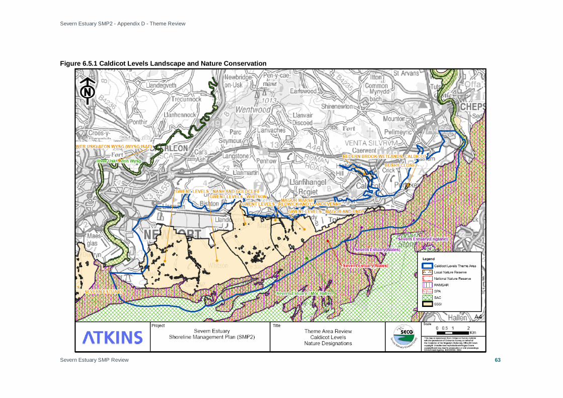
Severn Estuary SMP2 - Appendix D - Theme Review
Severn Estuary SMP Review
63
Figure 6.5.1 Caldicot Levels Landscape and Nature Conservation

Severn Estuary SMP2 - Appendix D - Theme Review
Severn Estuary SMP Review
64
Figure 6.5.2 Caldicot Levels Historic Environment
Severn Estuary SMP2 - Appendix D - Theme Review
Severn Estuary SMP Review
65
Figure 6.5.3 Caldicot Levels Present Land Use
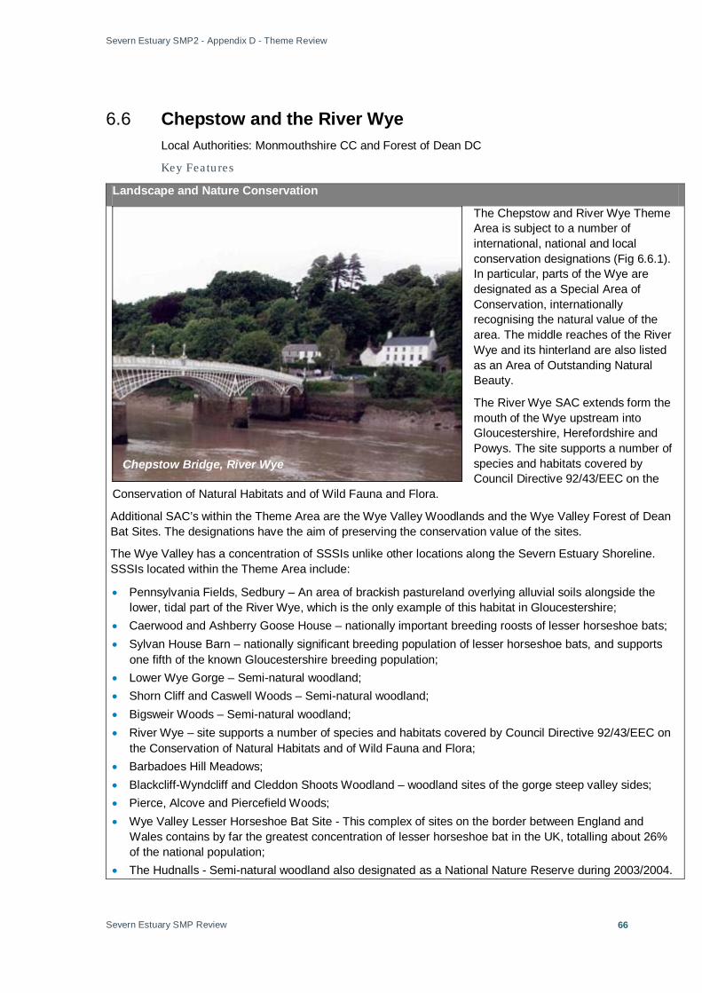
Severn Estuary SMP2 - Appendix D - Theme Review
Severn Estuary SMP Review
66
6.6 Chepstow and the River Wye Local Authorities: Monmouthshire CC and Forest of Dean DC
Key Featu res
Landscape and Nature Conservation
The Chepstow and River Wye Theme Area is subject to a number of international, national and local conservation designations (Fig 6.6.1). In particular, parts of the Wye are designated as a Special Area of Conservation, internationally recognising the natural value of the area. The middle reaches of the River Wye and its hinterland are also listed as an Area of Outstanding Natural Beauty.
The River Wye SAC extends form the mouth of the Wye upstream into Gloucestershire, Herefordshire and Powys. The site supports a number of species and habitats covered by Council Directive 92/43/EEC on the
Conservation of Natural Habitats and of Wild Fauna and Flora.
Additional SAC’s within the Theme Area are the Wye Valley Woodlands and the Wye Valley Forest of Dean Bat Sites. The designations have the aim of preserving the conservation value of the sites.
The Wye Valley has a concentration of SSSIs unlike other locations along the Severn Estuary Shoreline. SSSIs located within the Theme Area include:
• Pennsylvania Fields, Sedbury – An area of brackish pastureland overlying alluvial soils alongside the lower, tidal part of the River Wye, which is the only example of this habitat in Gloucestershire;
• Caerwood and Ashberry Goose House – nationally important breeding roosts of lesser horseshoe bats; • Sylvan House Barn – nationally significant breeding population of lesser horseshoe bats, and supports
one fifth of the known Gloucestershire breeding population; • Lower Wye Gorge – Semi-natural woodland; • Shorn Cliff and Caswell Woods – Semi-natural woodland; • Bigsweir Woods – Semi-natural woodland; • River Wye – site supports a number of species and habitats covered by Council Directive 92/43/EEC on
the Conservation of Natural Habitats and of Wild Fauna and Flora; • Barbadoes Hill Meadows; • Blackcliff-Wyndcliff and Cleddon Shoots Woodland – woodland sites of the gorge steep valley sides; • Pierce, Alcove and Piercefield Woods; • Wye Valley Lesser Horseshoe Bat Site - This complex of sites on the border between England and
Wales contains by far the greatest concentration of lesser horseshoe bat in the UK, totalling about 26% of the national population;
• The Hudnalls - Semi-natural woodland also designated as a National Nature Reserve during 2003/2004.
Chepstow Bridge, River Wye
Severn Estuary SMP2 - Appendix D - Theme Review
Severn Estuary SMP Review
67
The woodlands of the lower Wye Valley form one of the most important areas for woodland conservation in Britain.
Historic Environment
The historic environment of the Chepstow and the River Wye Theme Area (Fig 6.6.2) is characterised by the strategically important medieval and post medieval settlement at Chepstow and navigable stretches of the River Wye, which was historically important for small scale industry, monastic settlement (notably Tintern Abbey) and the early history of tourism and Romanticism.
The area of the Lower Wye Valley (No. 18) is included in the Register of Landscapes of Historical Interest in Wales and is of international importance. The historic environment includes sites from the Bronze Age and Iron Age, to Romano-British sites and Norman castles.
There are 24 Scheduled Monuments within the theme area. These relate in part to the historic town of Chepstow which developed from the 11th century as a strategically important defensive and trading port, and which is dominated by the Norman castle and town walls. There is a further concentration of Scheduled Monuments within the vicinity of Tintern Abbey. The route of Offa’s Dyke is also designated a Scheduled Monument.
There is a high number of Listed Buildings within the historic core of Chepstow reflecting the historic development of the town. The majority are post-medieval in date. There are many other Listed Buildings within the Wye Valley. Non-designated assets: Chepstow and the Wye Valley include extensive evidence of archaeological sites and monuments associated with settlement, historic land use / forestry and extractive industries. Current and Future Land-Use and Policy
Towards the tidal limit of the Wye tributary of the River Severn the land use is primarily agricultural/countryside (Fig 6.6.3).
There is development and infrastructure within the area, in particular the town of Chepstow. There is a small area of residential development at the tidal limit of the Severn Estuary. Residential developments are homes for people and personal investments.
Beside residential developments recreational sites are found, including Chepstow race course. Such sites are important to local and regional communities for the benefits to well being and health they offer.
Sedbury Sewage Works are part of the essential infrastructure of the region, maintaining water quality standards. The maintenance of numerous drainage outfalls (Appendix B) is also essential for the appropriate movement of water and maintaining water quality standards.
At the confluence of the River Wye and Severn is land used by the MoD and semi-natural sites.
Policy
The management objectives for the tidally influenced shoreline of the River Wye, Severn Estuary Tributary will meet the objectives for each land-use outlined in the Monmouthshire County Council Unitary Development Plan (See summary, Annex A).
The UDP covers the 15-year period January 1st 1996 to January 1st 2011. The UDP is effectively a five year roll forward of the current Gwent Structure Plan and Monmouth Borough Local Plan, many of the policies of which and the greater majority of the development site allocations have been integrated into this UDP. However, as part of this process, all polices and proposals of these Plans were evaluated and reviewed in the light of recent guidance and local social, economic & environmental objectives, whilst being subjected to a sustainability appraisal before being included in the UDP.

Severn Estuary SMP2 - Appendix D - Theme Review
Severn Estuary SMP Review
68
Figure 6.6.1 Chepstow and the River Wye Landscape and Nature Conservation

Severn Estuary SMP2 - Appendix D - Theme Review
Severn Estuary SMP Review
69
Figure 6.6.2 Chepstow and the River Wye Historic Environment

Severn Estuary SMP2 - Appendix D - Theme Review
Severn Estuary SMP Review
70
Figure 6.6.3 Chepstow and the River Wye Present Land Use

Severn Estuary SMP2 - Appendix D - Theme Review
Severn Estuary SMP Review
71
6.7 Tidenham and Surrounding Villages Landscape and Nature Conservation
Tidenham and Surrounding Villages is included with the Severn Estuary SPA, SAC, SSSI and Ramsar internationally recognised designations. There are no additional nature conservation designations within the Theme Area exclusive to the site (Fig 6.7.1).
Historic Environment
The historic environment of the Tidenham and Surrounding Villages Theme Area (Fig 6.7.2) is characterised largely by evidence of historic rural land use, small scale industry and minor maritime activity.
There are two Scheduled Monuments in the theme area:
• Broad Stone • Remnants of a Roman Villa south west of Woolaston Station. Several Listed Buildings can be found scattered across the site, predominately away from the immediate shoreline.
There are several non-designated assets of archaeological interest within the theme area with a particular concentration in the vicinity of Woolaston (Grange Pill, Grange Roman iron works (possibly associated with the scheduled Roman villa), areas of medieval ridge and furrow and the workings at Woolaston Mill).
Current and Future Land-Use and Policy
From Tidenham and Surrounding Villages the land use is predominantly agricultural (Fig 6.7.3).
Small residential sites are scattered across the agricultural land, these structures are important individual investments for locals and provide homes.
There is little infrastructure on the low lying land from Tidenham and Surrounding Villages, an A road links the larger settlements set back from the shoreline. The railway line close to the shore is of high importance to the locals to maintain communications between the settlements of the north bank of the Severn Estuary. The railway line will continue to be of high strategic importance in the future.
The River Severn at Woolaston
Rail at Tidenham

Severn Estuary SMP2 - Appendix D - Theme Review
Severn Estuary SMP Review
72
Policy
The management objectives for the Beachley Head to south Lydney shoreline will meet the objectives for each land-use outlined in the Forest of Dean Core Strategy (See summary, Annex A).
The Core Strategy is the principal document in the new Local Development Framework for the Forest of Dean. It contains the following key elements:
• A spatial vision for the area in 2026;
• Strategic objectives for this vision;
• Spatial strategy;
• Principal spatial policies to achieve the vision, and the objectives;
• How the process will be implemented and monitored.
This version of the Core Strategy expresses the Council's preferred option. It is a consultation document and will be expected to change further. The information that is used as a basis for this document includes draft papers and other studies that are subject to change.

Severn Estuary SMP2 - Appendix D - Theme Review
Severn Estuary SMP Review
73
Figure 6.7.1 Tidenham and Surrounding Villages Nature Conservation
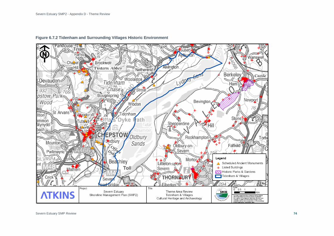
Severn Estuary SMP2 - Appendix D - Theme Review
Severn Estuary SMP Review
74
Figure 6.7.2 Tidenham and Surrounding Villages Historic Environment
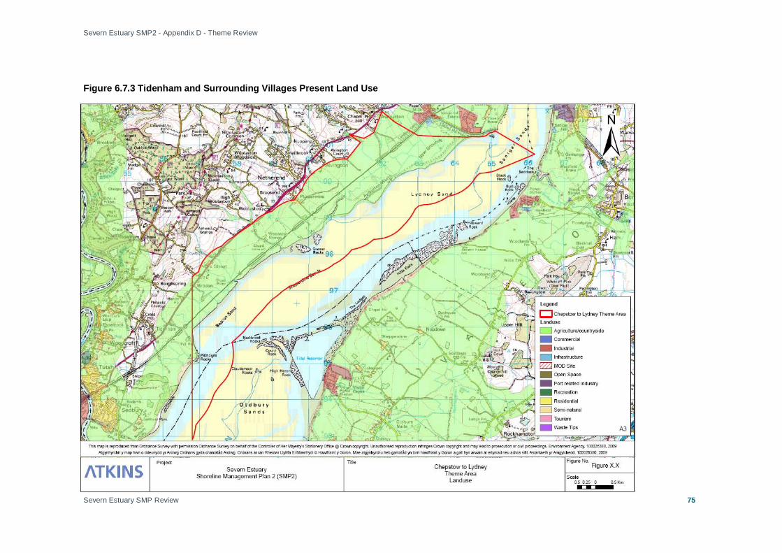
Severn Estuary SMP2 - Appendix D - Theme Review
Severn Estuary SMP Review
75
Figure 6.7.3 Tidenham and Surrounding Villages Present Land Use
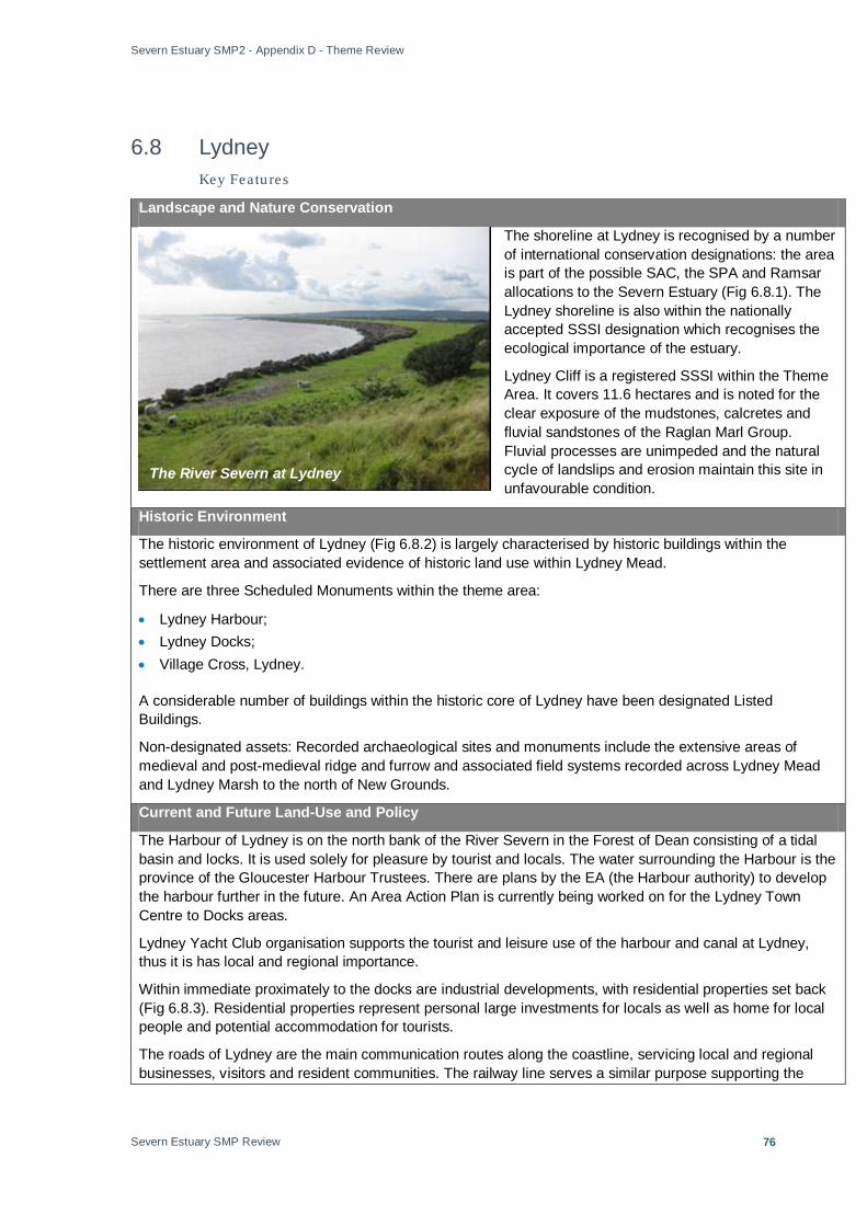
Severn Estuary SMP2 - Appendix D - Theme Review
Severn Estuary SMP Review
76
6.8 Lydney Key Featu res
Landscape and Nature Conservation
The shoreline at Lydney is recognised by a number of international conservation designations: the area is part of the possible SAC, the SPA and Ramsar allocations to the Severn Estuary (Fig 6.8.1). The Lydney shoreline is also within the nationally accepted SSSI designation which recognises the ecological importance of the estuary.
Lydney Cliff is a registered SSSI within the Theme Area. It covers 11.6 hectares and is noted for the clear exposure of the mudstones, calcretes and fluvial sandstones of the Raglan Marl Group. Fluvial processes are unimpeded and the natural cycle of landslips and erosion maintain this site in unfavourable condition.
Historic Environment
The historic environment of Lydney (Fig 6.8.2) is largely characterised by historic buildings within the settlement area and associated evidence of historic land use within Lydney Mead.
There are three Scheduled Monuments within the theme area:
• Lydney Harbour; • Lydney Docks; • Village Cross, Lydney.
A considerable number of buildings within the historic core of Lydney have been designated Listed Buildings.
Non-designated assets: Recorded archaeological sites and monuments include the extensive areas of medieval and post-medieval ridge and furrow and associated field systems recorded across Lydney Mead and Lydney Marsh to the north of New Grounds.
Current and Future Land-Use and Policy
The Harbour of Lydney is on the north bank of the River Severn in the Forest of Dean consisting of a tidal basin and locks. It is used solely for pleasure by tourist and locals. The water surrounding the Harbour is the province of the Gloucester Harbour Trustees. There are plans by the EA (the Harbour authority) to develop the harbour further in the future. An Area Action Plan is currently being worked on for the Lydney Town Centre to Docks areas.
Lydney Yacht Club organisation supports the tourist and leisure use of the harbour and canal at Lydney, thus it is has local and regional importance.
Within immediate proximately to the docks are industrial developments, with residential properties set back (Fig 6.8.3). Residential properties represent personal large investments for locals as well as home for local people and potential accommodation for tourists.
The roads of Lydney are the main communication routes along the coastline, servicing local and regional businesses, visitors and resident communities. The railway line serves a similar purpose supporting the
The River Severn at Lydney

Severn Estuary SMP2 - Appendix D - Theme Review
Severn Estuary SMP Review
77
same range of people.
Drainage outfalls (Alvington and East Marsh) are important parts of the infrastructure of Lydney, maintaining flow and water, water quality and environmental conservation. The water treatment works at Harbour Road, Lydney, is an important asset to the local and regional community. Its preservation is also important to ecological conservation. Lydney Harbour Sluice gates afford local protection to agricultural land and properties, preventing saline intrusion whilst in operation.
Agricultural land flanks the other land-use developments aside Lydney Harbour and Docks.
Policy
The management objectives for the Lydney shoreline will meet the objectives for each land-use outlined in the Forest of Dean Core Strategy (See summary, Annex A).
The Core Strategy is the principal document in the new Local Development Framework for the Forest of Dean. It contains the following key elements:
• A spatial vision for the area in 2026;
• Strategic objectives for this vision;
• Spatial strategy;
• Principal spatial policies to achieve the vision, and the objectives;
• How the process will be implemented and monitored.
This version of the Core Strategy expresses the Council's preferred option. It is a consultation document and will be expected to change further. The information that is used as a basis for this document includes draft papers and other studies that are subject to change.
Lydney Docks

Severn Estuary SMP2 - Appendix D - Theme Review
Severn Estuary SMP Review
78
Figure 6.8.1 Lydney Landscape and Nature Designations

Severn Estuary SMP2 - Appendix D - Theme Review
Severn Estuary SMP Review
79
Figure 6.8.2 Lydney Historic Environment

Severn Estuary SMP2 - Appendix D - Theme Review
Severn Estuary SMP Review
80
Figure 6.8.3 Lydney Present Land Use

Severn Estuary SMP2 - Appendix D - Theme Review
Severn Estuary SMP Review
81
6.9 Lydney to Gloucester Landscape and Nature Conservation
The area is partially subject to international and national conservation designations in place, up to the Noose the estuary from Lydney to Gloucester is partially within the Severn Estuary possible Special Area for Conservation, the SPA, the SSSI and Ramsar site (Fig 6.9.1). These designations recognise the ecological value of estuary.
Walmore Common SPA, Ramsar Site and SSSI are a relatively small area of improved grassland and ditches primarily designated for the internationally important numbers Tundra swan. Walmore Common occupies a low-lying area in the Severn Vale, which is subject to winter flooding. The site is a wetland overlying peat providing a variety of habitats including improved neutral grassland, unimproved marshy grassland and open water ditches. The common is part of a series of sites within the Severn Vale which, in winter, form an important refuge and feeding area for wildfowl.
Garden Cliff SSSI is an historic site in studies of the Triassic period in Britain. The animal remains and the sedimentary make-up of Garden Cliff show appreciable differences from other sections in the region, making it an important site for comparative studies. Historic Environment
The historic environment of the Lydney to Gloucester Theme Area (Fig 6.9.2) is characterised by small scale historic settlement and evidence of historic (predominately agricultural) land use.
There are two Scheduled Monuments within the theme area:
• Westbury Court Gardens, restored early 18th century water garden in the ownership of the National Trust; • The socket of a wayside cross at the crossroads near Six Bells Farm; There is one Registered Park and Garden within the theme area: Westbury Court Garden (Grade II*), owned by the National Trust, is an internationally important example of a Dutch water garden. It is also the site of the National Trust’s first large-scale garden restoration. Flooding has long been a problem in the garden. The primary cause of flooding is high tide levels in the River Severn preventing flow from Westbury Brook discharging through the storm flap in the flood defences. This trapped water then backs-up into the surrounding floodplain, and towards the garden, raising water levels in the brook and causing flooding by stopping water flowing out of the garden’s lakes. If water levels are high enough in the brook and the water level exceeds the height of the road, direct flooding may occur. There are a number of groupings of Listed Buildings within the Theme Area, notably within the historic settlements at Newnham-on-Severn, Awre and Etloe.
Non-designated assets: A considerable number of significant archaeological sites and monuments have been recorded along the shoreline between Lydney and Gloucester.
Intertidal Zone at Awre

Severn Estuary SMP2 - Appendix D - Theme Review
Severn Estuary SMP Review
82
Current and Future Land-Use and Policy
The land use from Lydney to Gloucester is dominated by agriculture, with small scattered residential developments, most notably Newnham on Severn (Fig 6.9.3). Residential properties are in many cases individual large investments for local people; they also represent homes for locals and potential accommodation for tourists. Newnham on Severn is recognised as one of the best access points from which to view the upper estuary in the region, making the site particularly important for tourism in the region.
Westbury on Severn landscape is primarily grazing land. Residential developments are homes for local residents and potential accommodation for tourists, as well as being personal financial investments.
Key infrastructure is located immediately adjacent to the shoreline from Lydney to Gloucester in the form of the rail line connecting the city of Gloucester with the north coast of the Severn Estuary. Also the A48/A40 is a vital strategic route along the estuary shoreline, servicing local and regional businesses, visitors and resident communities. Along the rail line at Blakeney and at Westbury-on-Severn are a water treatment works, these assets are important to the local and regional community for the supply of clean water and preservation of the local ecology.
Policy
The management objectives for the Lydney to Gloucester shoreline will meet the objectives for each land-use outlined in the Forest of Dean Core Strategy (See summary, Annex A).
The Core Strategy is the principal document in the new Local Development Framework for the Forest of Dean. It contains the following key elements:
• A spatial vision for the area in 2026;
• Strategic objectives for this vision;
• Spatial strategy;
• Principal spatial policies to achieve the vision, and the objectives;
• How the process will be implemented and monitored.
This version of the Core Strategy expresses the Council's preferred option. It is a consultation document and will be expected to change further. The information that is used as a basis for this document includes draft papers and other studies that are subject to change.
Newnham on Severn

Severn Estuary SMP2 - Appendix D - Theme Review
Severn Estuary SMP Review
83
Figure 6.9.1 Lydney to Gloucester Landscape and Nature Conservation

Severn Estuary SMP2 - Appendix D - Theme Review
Severn Estuary SMP Review
84
Figure 6.9.2 Lydney to Gloucester Historic

Severn Estuary SMP2 - Appendix D - Theme Review
Severn Estuary SMP Review
85
Figure 6.9.3 Lydney to Gloucester Present Land Use

Severn Estuary SMP2 - Appendix D - Theme Review
Severn Estuary SMP Review
86
6.10 Gloucester to Haw Bridge
Local Authorities: Gloucester District and Tewkesbury District
Key Featu res
Landscape and Nature Conservation
The Gloucester to Haw Bridge Theme Area has specific areas with national (SSSIs) and local conservation designations (Local Nature Reserves and county Strategic Nature Areas) (Fig 6.10.1).
SSSIs within the Gloucester to Haw Bridge Theme Area are:
• Ashleworth Ham SSSI – an important fen, marsh and grassland for bird species present. Currently in an unfavourable condition.
• Wainlode Cliff – geological exposures – favourable condition. • Coombe Hill Canal SSSI – an important freshwater fen, marsh and grassland for the variety of plant
species. SSSIs are important educational resources within the Severn Estuary and provide landscape and, in some cases, historic value. Two Local Nature Reserves are located within the Theme Area – Alney Island and Quedgeley Arboretum Local Nature Reserve. Quedgeley Arboretum Local Nature Reserve is a local nature reserve on the banks of the Severn composed of wet grassland, meadows and mature trees. The reserve is 2 hectares; it consists of three main areas: the Old Manor Barn, an open area and an old arboretum. Alney Island is a short distance from Gloucester City Centre, as well as providing a habitat for a range of species it also serves as a recreational site for regional residents. Alney Island is a site of wet grassland and flood meadows with associated broadleaf trees. The land is managed through hay cutting and grazing with cattle.
Gloucester Wildlife Trust Strategic Nature Areas Project is adjacent to the Severn and helps reduce the severity of flood events by reducing lag time. The site is primarily one of nature conservation and habitat diversity. The features discussed as important in the Gloucester area were described as consistently of high importance to the region over the next 100 years.
Historic Environment
The historic environment of the Gloucester to Haw Bridge Theme Area (Fig 6.10.2) is characterised in part by the historic urban settlement of Gloucester and surrounding areas of historic settlement and land use. Gloucester is an urban settlement of considerable historic interest. It includes a high number of designated assets and features that strongly define the character of the city.
There are 18 scheduled Monuments within the theme area. Large parts of the urban core of Gloucester are scheduled due to the extensive survival of Roman and Medieval deposits and structures: Hempstead village cross; Lady’s Well; Llanthony secunda priory; Remains of roman wall; Grey friars’ church; Glevum roman colonia; Blackfriars; Over bridge; Tower of St. Michael’s Church; Infirmary Arcade; Little Cloister; Wall north of Bishop’s Palace; Kingsholm Palace (site of); St. Mary’s gateway; St. Oswald’s Priory (St. Catherine’s
The River Severn at Gloucester

Severn Estuary SMP2 - Appendix D - Theme Review
Severn Estuary SMP Review
87
Church); Eastgate and city wall; Ashleworth tithe barn and Tanners’ Hall.
There is an extensive number of Listed Buildings within the theme area, including medieval, post medieval and industrial buildings and structures (including canals) reflecting the strategic position of Gloucester at the head of the estuary.
Registered Parks and Gardens: There is one Registered Park and Garden in the theme area:
• Highnam Court (Grade II*) Non-designated assets: The Theme Area is particularly rich in archaeological evidence relating to the Roman and medieval settlement of Gloucester, later post-medieval development and the expansion of the town as a major industrial port on the River Severn. Current and Future Land-Use and Policy
The Gloucester area is a large residential, commercial and industrial hub of human activity situated toward the tidal limit of the Severn Estuary. The primary land uses of Gloucester area are industrial at the shoreline and residential immediately behind (Fig 6.10.3). There are many smaller residential concentrations within the Theme Area including Minsterworth, Ashleworth, Hemsted and Sandhurst. Residential properties are homes for local people and represent investment in the area. Businesses amongst the residential properties are important for the local, and in some cases regional, economy.
Residential and commercial properties are developed alongside key infrastructure of national and regional importance. Waste tips, motorways, A roads, railway links, water treatment works and electricity sub-stations are important to the operation of businesses and the movement of people. The Gloucester to Haw Bridge Theme Area is additionally an important point for water abstraction that serves Bristol, and therefore of regional importance. Also of regional importance is Netheridge sewage works which serves over 100,000 people. All the flow into this site (including all storm water) has to be pumped by the on-site inlet pumping station, as the invert level of the incoming sewer is below sea level.
The Gloucester to Sharpness Canal is an important feature of the area as a recreational asset, tourist attraction, part of the transport and communications infrastructure and for its role played in water management. It is important to local communities, businesses and tourists.
The regeneration of Gloucester Docks is turning Gloucester into a future important centre for cultural tourism. The essential infrastructure that currently servers the city and surrounding developments will come under increasing pressure as regeneration attracts greater numbers to the city.
The Severn Way traces the route of the Severn, from its source at Plynlimon to the sea at Bristol, it runs along nearly the entire eastern bank of the Severn Estuary and intermittently along parts of the western bank. Within the SMP2 study area the Severn Way is included from Haw Bridge to Bristol. It is important to maintain the Severn Way as it maintains public access to the shoreline and is an important route for tourists and encouraging physical activity.
Policy
The Theme Area of Gloucester to Haw Bridge crosses several local authority boundaries, the management
The River Severn at Haw Bridge

Severn Estuary SMP2 - Appendix D - Theme Review
Severn Estuary SMP Review
88
objectives for each stretch of shoreline will meet the objectives of the development plans for the appropriate local council. The following documents outline the management objectives for the locations within the Gloucester to Haw Bridge area:
The Forest of Dean Core Strategy;
Gloucestershire Structure Plan;
And the Tewkesbury Borough Local Plan.
(See summaries, Annex A).
The Forest of Dean Core Strategy is the principal document in the new Local Development Framework for the Forest of Dean. It contains the following key elements: A spatial vision for the area in 2026, strategic objectives for this vision, spatial strategy, principal spatial policies to achieve the vision, and the objectives, and how the process will be implemented and monitored.
The Gloucestershire Structure Plan sets out the strategic framework for the use and development of land in Gloucestershire during the Plan Period mid 1991 - 2011. It was adopted and became operative on 17 November 1999. It ensures that the provision for development is realistic and consistent with national and regional policy, and secures consistency between local plans of neighbouring areas.
The Tewkesbury Borough Local Plan is a statutory local plan prepared under the provisions of the Town and Country Planning Act 1990. It covers the 49 parishes which comprise the Tewkesbury Borough administrative area, and covers some 160 sq miles of north Gloucestershire stretching from the Cotswolds in the east to Severnside parishes in the west, and the gap which separates Gloucester and Cheltenham.

Severn Estuary SMP2 - Appendix D - Theme Review
Severn Estuary SMP Review
89
Figure 6.10.1 Gloucester to Haw Bridge Landscape and Nature Designations

Severn Estuary SMP2 - Appendix D - Theme Review
Severn Estuary SMP Review
90
Figure 6.10.2 Gloucester to Haw Bridge Historic Environment
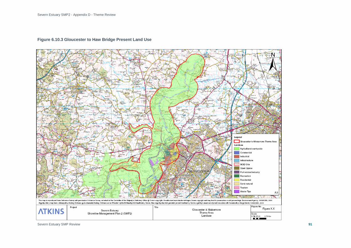
Severn Estuary SMP2 - Appendix D - Theme Review
Severn Estuary SMP Review
91
Figure 6.10.3 Gloucester to Haw Bridge Present Land Use

Severn Estuary SMP2 - Appendix D - Theme Review
Severn Estuary SMP Review
92
6.11 Gloucester to Sharpness Local Authorities: Stroud District, South Gloucestershire
Landscape and Nature Conservation
The Gloucester to Sharpness Theme Area partially includes the Upper Severn Estuary SSSI designations, possible SPA, the SAC and Ramsar designation (Fig 6.11.1). These international and national legislative designations recognise the ecological value of the estuary. The Severn Estuary SSSI extends up to Hock Cliff within the Severn Vale. SSSIs are important educational resources within the Severn Estuary and provide landscape and in some cases historic value.
Additionally Frampton Pools SSSI and Purton Passage SSSI are included in the Theme Area. Purton Passage is an important site for vertebrate palaeontology. The remains of the primitive extinct invertebrate are abundant here but found rarely elsewhere.
Frampton Pools SSSI is presently in an unfavourable condition; there are concerns over water quality and biological disturbance from an introduced species. Further data is required on existing aquatic plant community.
The Theme Area includes the Slimbridge Wildfowl Trust Reserve between Tites Point and Hock Cliff Geological Site. The abundance of rare waterfowl and over-wintering birds along the Severn Estuary SPA and Ramsar site attracts many ornithologists, particularly to the RSPB sanctuary at Slimbridge.
The area of the Dumbles is specifically important in the provision of habitat for the Bewick’s Swan.
Historic Environment
The historic environment of the Gloucester to Sharpness Theme Area (Fig 6.11.2) is characterised by a number of small historic settlements, individual historic buildings and archaeological sites recorded along the banks and floodplain of the Severn,
There are no Scheduled Monuments within this area.
There is one Registered Park and Garden within the theme area:
• Frampton Court Estate (Grade I ) There are concentrations of Listed Buildings within the historic settlements at Frampton on Severn, Saul and Arlingham.
Non-designated assets: A number of non-designated archaeological features have been recorded within this area, in particular along the banks of the Severn. Notable are the Purton Hulks, a group of abandoned Severn barges.
Current and Future Land-Use and Policy
The rural economy and linked residential developments are of utmost importance in the region due to the high quality of land, large employer and linked businesses (Fig 6.11.3). Larger residential developments within the Gloucester to Sharpness Theme Area include Elmore Back, Longney, Waterend, Upper Framilode, Arlingham and Frampton.
Infrastructure sites include Purton Water Treatment Works, Stroud Sewerage treatment works and
Pill Box at Arlingham
Severn Estuary SMP2 - Appendix D - Theme Review
Severn Estuary SMP Review
93
Frampton Sewerage Treatment Works and Frampton Landfill. Purton water treatment works supplies the water for Bristol residents; as such it is of utmost importance to the region over the next 100 years. The management of each site in terms of flood and erosion risk is important in the preservation of environment and water quality.
Transport infrastructure includes the road network on the shoreline of Gloucester to Sharpness. The network is composed of A and B roads, they serve the local community, businesses and tourists in movement through and within the region.
The Gloucester to Sharpness Canal is an important feature of the area as a recreational asset, tourist attraction, part of the transport and communications infrastructure and for its role played in water management. The shoreline footpath – The Severn Way – follows the canal intermittently from Gloucester to Sharpness, heightening the value of the canal as a tourist attraction and recreational site.
Policy
The management objectives for the shoreline of Gloucester to Sharpness will meet the objectives for each land-use outlined in the Stroud District Council Local Development Plan 2005 – 2011 (See summary, Annex A).
This Local Plan sets out Stroud District Council’s policies and proposals for future development and land use in the District to 30 June 2011.

Severn Estuary SMP2 - Appendix D - Theme Review
Severn Estuary SMP Review
94
Figure 6.11.1 Gloucester to Sharpness Landscape and Nature Conservation
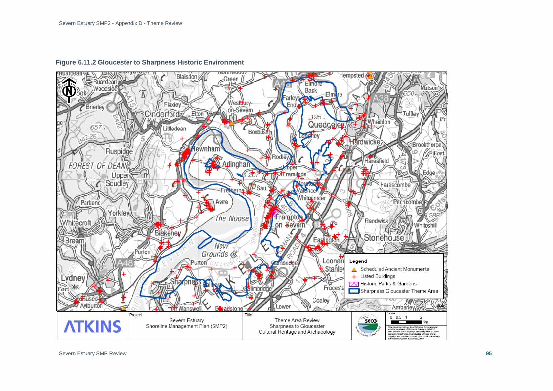
Severn Estuary SMP2 - Appendix D - Theme Review
Severn Estuary SMP Review
95
Figure 6.11.2 Gloucester to Sharpness Historic Environment

Severn Estuary SMP2 - Appendix D - Theme Review
Severn Estuary SMP Review
96
Figure 6.11.3 Gloucester to Sharpness Present Land Use

Severn Estuary SMP2 - Appendix D - Theme Review
Severn Estuary SMP Review
97
6.12 Sharpness to Severn Crossing Local Authorities: South Gloucestershire DC, Stoud DC
Landscape and Nature Conservation
The shoreline from Sharpness to Severn Crossings is subject to numerous nature and conservation designations, these include the Severn Estuary Ramsar, possible SAC and SPA designations (Fig 6.12.1). The aforementioned designations are international legislative drivers to protect the environmental heritage value of the recognised sites. Sharpness to Severn Crossings is also within the Severn Estuary SSSI national designation recognising the ecological importance of the estuary.
Along the shoreline there are significant stretches of semi-natural environments.
Historic Environment
The historic environment of the Sharpness to Severn Crossing Theme Area (Fig 6.12.2) is characterised by the historic settlement at Berkeley, which is dominated by the 12th century castle and surrounding designed landscape, as well as extensive evidence of archaeological features along the coast, foreshore and immediate hinterland.
There is one Scheduled Monument within the theme area:
• Oldbury Iron Age Hill Fort Berkeley Castle is a Grade I Listed Building. There are a high number of other Grade II Listed Buildings within the historic settlement at Berkeley as well as other individual Listed Buildings in the wider landscape.
There is one Registered Park and Garden within the theme area:
• Berkeley Castle (Grade II*) There are an extensive number of non-designated archaeological features along the coastal strip, foreshore and immediate coastal hinterland, identified in the RCZA Phase I Survey. A high number of features lie within the channel of the estuary itself.
Current and Future Land-Use and Policy
Sites of essential infrastructure are key characteristics of the Sharpness to Severn Crossing Theme Area, although land use is predominantly agricultural with associated small residential settlements (Fig 6.12.3) including Sharpness, Berkeley, Oldbury-on-Severn and Littleton-upon-Severn.
Sharpness is a key site for marine and industrial operations within the Severn Vale area. British Waterways are the port authority for Sharpness Dock where cargo operations are carried out by private companies. The dock handles dry bulk, grain, foodstuff, fertiliser, scrap and other goods. Leisure facilities at Sharpness
Berkeley Power Station

Severn Estuary SMP2 - Appendix D - Theme Review
Severn Estuary SMP Review
98
include a small marina and a dry dock for ship repairs is in regular use. Dredging takes place at several ports in the Severn Estuary area, including Sharpness Port and Harbour.
In addition to the industrial operations at Sharpness Dock, it is a key area for residential properties and employment, thus its continued operations is in the best interest of the region. Sharpness Port is also used as a marina for private boats used for leisure purposes, attracting tourists to the region. The lifeboat station, also located at Sharpness, is important for regional safety.
There are two nuclear power stations within the Theme Area of Sharpness to Severn Crossings, at Oldbury and Berkeley. These sites are important employers for the region, and the preservation of either site is essential to preserve the ecological value of the shoreline. Adjacent to Berkeley Power Station the Engineering Centre is an additional important site for employment within the region.
A key employer for the region is agriculture. The land on the shoreline of the Severn Estuary between Sharpness and the Severn Crossings is high grade farmland producing local goods.
The Severn Way traces the route of the Severn, from its source at Plynlimon to the sea at Bristol, it runs along nearly the entire eastern bank of the Severn Estuary and intermittently along parts of the western bank. Within the SMP2 study area the Severn Way is included from Haw Bridge to Bristol. It is important to maintain the Severn Way as it maintains public access to the shoreline and is an important route for tourists and encouraging physical activity.
Policy
The management objectives for the stretches of shoreline from Sharpness to Severn Crossings will meet the objectives of the relevant local authority. The stretches of shoreline fall into either of two council development plans:
• Stroud District Council Local Development Plan 2005 – 2011;
• Or South Gloucestershire Local Plan (See summary, Annex A).
The Stroud District Local Plan sets out Stroud District Council’s policies and proposals for future development and land use in the District to 30 June 2011.
The South Gloucestershire Local Plan (Adopted January 2006) represents the culmination of much work and effort over the past ten years to shape the future of South Gloucestershire. It has been drawn up in consultation with residents, businesses, interest groups and stakeholders, many of whom have influenced its final content. The Plan is an important document which will be the basis upon which development decisions will be taken.
The Council is currently working on the South Gloucestershire Core Strategy, which when adopted in 2011/2012 will replace many of the policies of the Local Plan. The Core Strategy went out to its first round of public engagement in June 2008 with the publication of the Issues and Options document.
Sharpness Docks

Severn Estuary SMP2 - Appendix D - Theme Review
Severn Estuary SMP Review
99
Figure 6.12.1 Sharpness to Severn Crossings Landscape and Nature Conservation

Severn Estuary SMP2 - Appendix D - Theme Review
Severn Estuary SMP Review
100
Figure 6.12.2 Sharpness to Severn Crossings Historic Environment

Severn Estuary SMP2 - Appendix D - Theme Review
Severn Estuary SMP Review
101
Figure 6.12.3 Sharpness to Severn Crossings Present Land Use
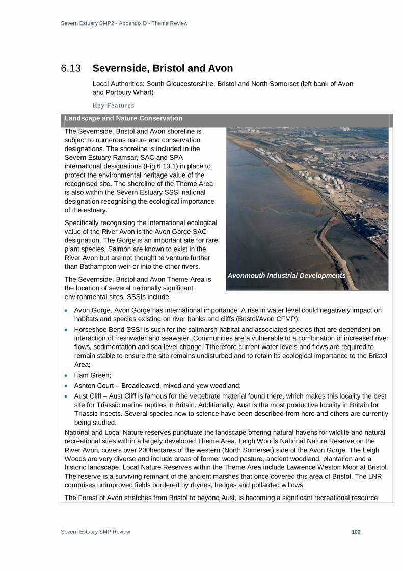
Severn Estuary SMP2 - Appendix D - Theme Review
Severn Estuary SMP Review
102
6.13 Severnside, Bristol and Avon Local Authorities: South Gloucestershire, Bristol and North Somerset (left bank of Avon and Portbury Wharf)
Key Featu res
Landscape and Nature Conservation
The Severnside, Bristol and Avon shoreline is subject to numerous nature and conservation designations. The shoreline is included in the Severn Estuary Ramsar, SAC and SPA international designations (Fig 6.13.1) in place to protect the environmental heritage value of the recognised site. The shoreline of the Theme Area is also within the Severn Estuary SSSI national designation recognising the ecological importance of the estuary.
Specifically recognising the international ecological value of the River Avon is the Avon Gorge SAC designation. The Gorge is an important site for rare plant species. Salmon a re known to exist in the River Avon but are not thought to venture further than Bathampton weir or into the other rivers.
The Severnside, Bristol and Avon Theme Area is the location of several nationally significant environmental sites, SSSIs include:
• Avon Gorge. Avon Gorge has international importance: A rise in water level could negatively impact on habitats and species existing on river banks and cliffs (Bristol/Avon CFMP);
• Horseshoe Bend SSSI is such for the saltmarsh habitat and associated species that are dependent on interaction of freshwater and seawater. Communities are a vulnerable to a combination of increased river flows, sedimentation and sea level change. Ttherefore current water levels and flows are required to remain stable to ensure the site remains undisturbed and to retain its ecological importance to the Bristol Area;
• Ham Green; • Ashton Court – Broadleaved, mixed and yew woodland; • Aust Cliff – Aust Cliff is famous for the vertebrate material found there, which makes this locality the best
site for Triassic marine reptiles in Britain. Additionally, Aust is the most productive locality in Britain for Triassic insects. Several species new to science have been described from here and others are currently being studied.
National and Local Nature reserves punctuate the landscape offering natural havens for wildlife and natural recreational sites within a largely developed Theme Area. Leigh Woods National Nature Reserve on the River Avon, covers over 200hectares of the western (North Somerset) side of the Avon Gorge. The Leigh Woods are very diverse and include areas of former wood pasture, ancient woodland, plantation and a historic landscape. Local Nature Reserves within the Theme Area include Lawrence Weston Moor at Bristol. The reserve is a surviving remnant of the ancient marshes that once covered this area of Bristol. The LNR comprises unimproved fields bordered by rhynes, hedges and pollarded willows.
The Forest of Avon stretches from Bristol to beyond Aust, is becoming a significant recreational resource.
Avonmouth Industrial Developments

Severn Estuary SMP2 - Appendix D - Theme Review
Severn Estuary SMP Review
103
The area comprises forest paths, long distance paths and nature reserves, including the long distance paths such as the Severn Way.
An additional site has been reserved for nature and environmental conservation in the future of the area. A new 39hectares nature reserve has recently been granted planning permission on Northwick Wharf near to Severn Beach. The location will promote conservation and act as a recreation site for locals and tourists.
Historic Environment
The historic environment of the Severnside, Bristol and Avon Theme Area (Fig 6.13.2) is of considerable historic and archaeological importance, characterised by evidence of historic settlement, 19th and 20th century industry, historic engineering features, military installations, historic seaside tourism development, maritime heritage, commerce and trade, high status domestic housing and designed landscapes. The area also includes extensive palaeo-environmental deposits known to lie below post-medieval alluvial deposits associated with the prehistoric and Roman exploitation of the North Avon Levels.
There are seven Scheduled Monuments within the Theme Area:
• Heavy Anti-Aircraft Battery 520m East Of Holes Mouth • The Mere Bank And Flanking Ditches • Civil War Earthworks On Brandon Hill • Roman Buildings At Long Cross • Clifton Down Camp, Clifton • Stokeleigh Camp: A Promontory Fort In Leigh Woods • Underfall Yard, Bristol Docks There is an exceptionally high number of Listed Buildings within the Theme Area, mostly within the urban core of Bristol but also within smaller settlements and individual sites.
There are six Registered Parks and Gardens within the Theme Area:
• Amos Vale Cemetery (Grade II) • King Weston House (Grade II) • Ashton Court (Grade II*) • Bristol University Botanic Gardens and Rayne Thatch (Grade II) • Leigh Court (Grade II) • Goldney House (Grade II*) (note: although within the Theme Area, they are not necessarily at risk of flooding) There are a high number of non-designated archaeological and historic features and assets within the Theme Area found mostly along the shoreline between Avonmouth and the Severn Crossing. Some of these lie within the foreshore and channel. The North Avon levels are particularly significant for the survival of buried archaeological and palaeo-environmental deposits dating to between the prehistoric and Roman periods. The area is also significant for evidence of historic land use, communications, maritime history, industry and tidal defence. Current and Future Land-Use and Policy
There is important infrastructure within this area of the Severn Estuary. The old Severn Bridge (M48), the Second Severn Crossing (M4) and the Severn Rail Tunnel are at the upstream end of the unit. The essential transport links within this Theme Area are of national strategic importance. The M5 crosses the Avon at Avonmouth. All crossings are of national importance. Lighthouses along the shoreline are additional

Severn Estuary SMP2 - Appendix D - Theme Review
Severn Estuary SMP Review
104
important infrastructure for the maintenance of current trade routes and for safety along the shoreline within the region.
Avonmouth is a heavily developed site with port related industry on the left bank and industrial developments on the right bank. Sea Bank Power Station at Hallen, Avonmouth is of national strategic importance.
The Bristol Ports – Bristol Royal Portbury and Avonmouth Port and Docks – are privately owned and have undergone significant expansion over the last ten years handling cars (import and export), timber and forest products, coal and coke, animal foodstuffs, petroleum products (including Liquid Petroleum Gas), raw materials for manufacturing, container traffic and marine dredged aggregates. Dredging takes place at several ports in the Severn Estuary area, including Bristol.
In the future the Port is expected to expand, land at Avonmouth on the right bank of the Avon is not fully utilised at present but there are proposals to develop a Deep Sea Container Terminal extending into the Severn. Consent for the development of this land is currently being sought. Construction of the terminal is expected to result in the more intensive use of currently underused land within the Port boundary as associated infrastructure and business activity grows. There are also plans to regenerate brown-field sites with both industrial and residential developments.
At the Severn Crossings land use is mainly agricultural with small settlements (Fig 6.13.3).
The tidal limit of the Severn Estuary extends up to Netham Weir, through the City of Bristol. Bristol is a regional focus for the South West of England, this role will be in the future reflected in a sustained process of renewal and intensification of business, leisure, housing and other development activity. There are new residential developments at Portbury Wharf inclusive of upgrades to the shoreline defences.
The banks of the tidally influenced Avon are occupied by important developments in the city, including the Floating Harbour, Bristol Temple Meads and Bristol City Football Club.
Wessex Water have a range of strategic and smaller scale assets along the shoreline between Porlock in the south and Berkeley in the North this includes the shoreline of Severnside, Bristol and Avon (Appendix B). The drainage outfalls are important for water distribution and discharge and maintaining water quality and environment standards.
Policy
The management objectives for the stretches of shoreline of Severnside and the River Avon will meet the objectives of the relevant local authority. The stretches of shoreline fall into either of two council development plans:
• South Gloucestershire Local Plan;
• Bristol Local Plan, (See summary, Annex A).
South Gloucestershire Local Plan (Adopted January 2006) represents the culmination of much work and effort over the past ten years to shape the future of South Gloucestershire. It has been drawn up in consultation with residents, businesses, interest groups and stakeholders, many of whom have influenced its final content. The Plan is an important document which will be the basis upon which development
Portbury Dock at Avonmouth

Severn Estuary SMP2 - Appendix D - Theme Review
Severn Estuary SMP Review
105
decisions will be taken.
The Council is currently working on the South Gloucestershire Core Strategy, which when adopted in 2011/2012 will replace many of the policies of the Local Plan. The Core Strategy went out to its first round of public engagement in June 2008 with the publication of the Issues and Options document.
The Bristol Local Plan was formally adopted in December 1997. It provides statutory planning policies covering the whole city and will guide development for this area until replaced by new Development Plan Documents over the next few years. The City Council is preparing a Core Strategy for Bristol, as required by new planning legislation and, as at April 2009, is consulting on a Preferred Options Review document. This document has no legal status at this stage.

Severn Estuary SMP2 - Appendix D - Theme Review
Severn Estuary SMP Review
106
Figure 6.13.1 Severnside, Bristol and Avon Landscape and Nature Conservation

Severn Estuary SMP2 - Appendix D - Theme Review
Severn Estuary SMP Review
107
Figure 6.13.2 Severnside, Bristol and Avon Historic Environment
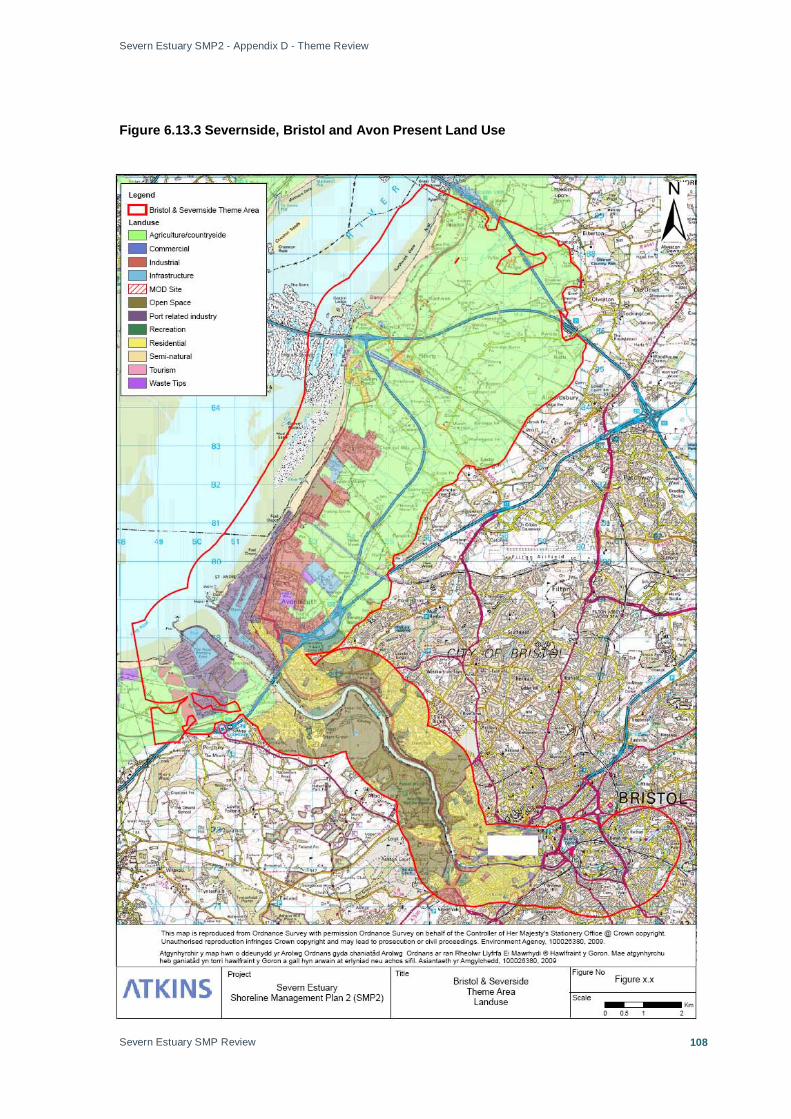
Severn Estuary SMP2 - Appendix D - Theme Review
Severn Estuary SMP Review
108
Figure 6.13.3 Severnside, Bristol and Avon Present Land Use
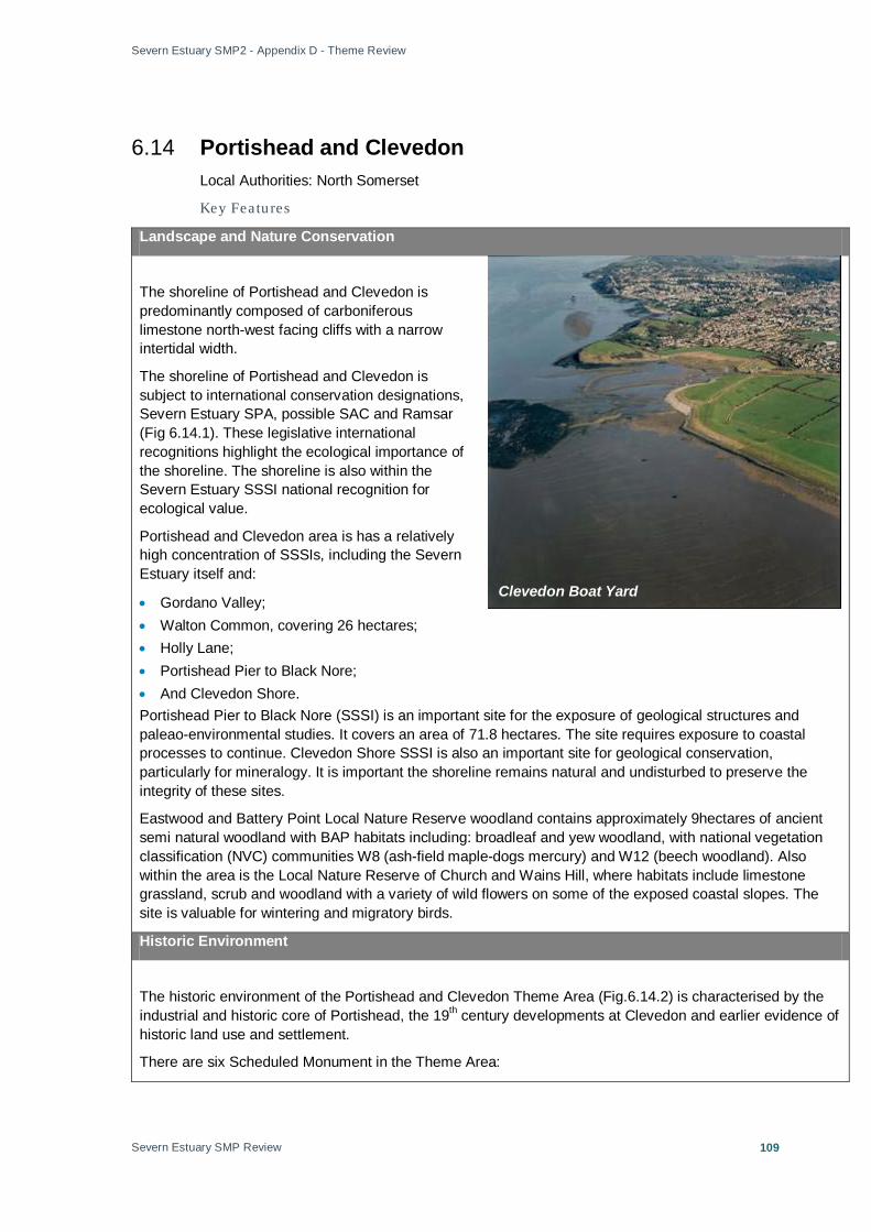
Severn Estuary SMP2 - Appendix D - Theme Review
Severn Estuary SMP Review
109
6.14 Portishead and Clevedon Local Authorities: North Somerset
Key Featu res
Landscape and Nature Conservation
The shoreline of Portishead and Clevedon is predominantly composed of carboniferous limestone north-west facing cliffs with a narrow intertidal width.
The shoreline of Portishead and Clevedon is subject to international conservation designations, Severn Estuary SPA, possible SAC and Ramsar (Fig 6.14.1). These legislative international recognitions highlight the ecological importance of the shoreline. The shoreline is also within the Severn Estuary SSSI national recognition for ecological value.
Portishead and Clevedon area is has a relatively high concentration of SSSIs, including the Severn Estuary itself and:
• Gordano Valley; • Walton Common, covering 26 hectares; • Holly Lane; • Portishead Pier to Black Nore; • And Clevedon Shore. Portishead Pier to Black Nore (SSSI) is an important site for the exposure of geological structures and paleao-environmental studies. It covers an area of 71.8 hectares. The site requires exposure to coastal processes to continue. Clevedon Shore SSSI is also an important site for geological conservation, particularly for mineralogy. It is important the shoreline remains natural and undisturbed to preserve the integrity of these sites.
Eastwood and Battery Point Local Nature Reserve woodland contains approximately 9hectares of ancient semi natural woodland with BAP habitats including: broadleaf and yew woodland, with national vegetation classification (NVC) communities W8 (ash-field maple-dogs mercury) and W12 (beech woodland). Also within the area is the Local Nature Reserve of Church and Wains Hill, where habitats include limestone grassland, scrub and woodland with a variety of wild flowers on some of the exposed coastal slopes. The site is valuable for wintering and migratory birds.
Historic Environment
The historic environment of the Portishead and Clevedon Theme Area (Fig.6.14.2) is characterised by the industrial and historic core of Portishead, the 19th century developments at Clevedon and earlier evidence of historic land use and settlement.
There are six Scheduled Monument in the Theme Area:
Clevedon Boat Yard

Severn Estuary SMP2 - Appendix D - Theme Review
Severn Estuary SMP Review
110
• Slight Univallate Hillfort at Wain's Hill • Roman Building S of St Mary's Lane • Duck Decoy, 250m South of Black Rock Villas • Moated Site 230m South East of St Peter And St Paul's Church • Manorial Settlement at Weston Manor • Slight Univallate Hillfort, Two Avenues, Saucer Barrow, Regular Aggregate Field System And Associated
Earthworks on Walton Common There is a high number of Listed Buildings within Clevedon representing its historic development and later significance as a seaside resort. There are fewer Listed Buildings within Portishead, reflecting its later industrial development.
There is one Registered Park and Garden within the theme area (partial):
• Clevedon Court (Grade II*)
A high number of non-designated archaeological features and built structures have been recorded within Clevedon and along the coastline between there and Portishead.
Current and Future Land-Use and Policy
Clevedon and Portishead have high urban densities. Residential properties provide homes for local residents and are important individual investments.
The two urban areas include tourist, commercial and industrial land use (Fig 6.14.3). Additionally the north of the unit has port related land use next to the mouth of the Avon.
Between Portishead and Clevedon there are extensive areas of agricultural land. Farming practices provide employment for locals and income to the region.
Roads connecting residential and commercial development through Clevedon and Portishead are important assets ensuring the free movement within these locations. Drainage outfalls and the pumping station flood defences are key infrastructure for maintenance of water supply and water quality (Appendix B).
Portishead Lifeboat Station is part of national lifeboat service important for regional safety. Lighthouses, including Portishead Black Nore lighthouse, located on the shoreline of Portishead and Clevedon, are important to maintain trade links that support the national economy.
Portishead Approach Golf Club and the marine lake at Clevedon are key leisure facilities within the Theme Area, benefiting the local community and tourists, their use will improve the health and well being of individuals.
Policy
The management objectives for the shoreline of Portishead and Clevedon will meet the objectives for each land-use outlined in the North Somerset Replacement Local Plan (See summary, Annex A).
Clevedon Marine Lake and Wains Hill
Severn Estuary SMP2 - Appendix D - Theme Review
Severn Estuary SMP Review
111
Under the Town and Country Planning Act 1990, North Somerset Council is required to prepare and keep up to date a local plan covering the whole of its area. The form and content of local plans and the procedures for preparing them are prescribed through the Town and Country Planning (Development Plan) (England) Regulations 1999 (‘the Development Plan Regulations’).

Severn Estuary SMP2 - Appendix D - Theme Review
Severn Estuary SMP Review
112
Figure 6.14.1 Portishead and Clevedon Landscape and Nature Conservation

Severn Estuary SMP2 - Appendix D - Theme Review
Severn Estuary SMP Review
113
Figure 6.14.2 Portishead and Clevedon Historic Environment

Severn Estuary SMP2 - Appendix D - Theme Review
Severn Estuary SMP Review
114
Figure 6.14.3 Portishead and Clevedon Present Land Use
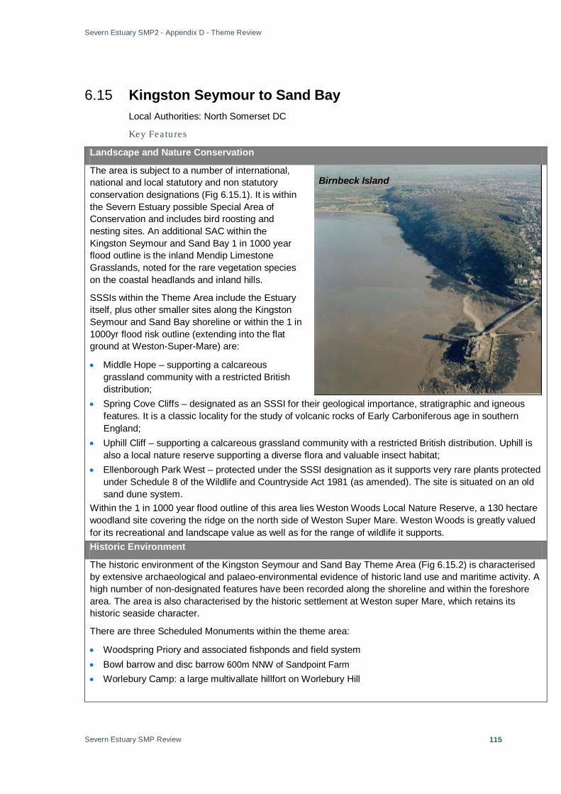
Severn Estuary SMP2 - Appendix D - Theme Review
Severn Estuary SMP Review
115
6.15 Kingston Seymour to Sand Bay Local Authorities: North Somerset DC
Key Featu res
Landscape and Nature Conservation
The area is subject to a number of international, national and local statutory and non statutory conservation designations (Fig 6.15.1). It is within the Severn Estuary possible Special Area of Conservation and includes bird roosting and nesting sites. An additional SAC within the Kingston Seymour and Sand Bay 1 in 1000 year flood outline is the inland Mendip Limestone Grasslands, noted for the rare vegetation species on the coastal headlands and inland hills.
SSSIs within the Theme Area include the Estuary itself, plus other smaller sites along the Kingston Seymour and Sand Bay shoreline or within the 1 in 1000yr flood risk outline (extending into the flat ground at Weston-Super-Mare) are:
• Middle Hope – supporting a calcareous grassland community with a restricted British distribution;
• Spring Cove Cliffs – designated as an SSSI for their geological importance, stratigraphic and igneous features. It is a classic locality for the study of volcanic rocks of Early Carboniferous age in southern England;
• Uphill Cliff – supporting a calcareous grassland community with a restricted British distribution. Uphill is also a local nature reserve supporting a diverse flora and valuable insect habitat;
• Ellenborough Park West – protected under the SSSI designation as it supports very rare plants protected under Schedule 8 of the Wildlife and Countryside Act 1981 (as amended). The site is situated on an old sand dune system.
Within the 1 in 1000 year flood outline of this area lies Weston Woods Local Nature Reserve, a 130 hectare woodland site covering the ridge on the north side of Weston Super Mare. Weston Woods is greatly valued for its recreational and landscape value as well as for the range of wildlife it supports. Historic Environment
The historic environment of the Kingston Seymour and Sand Bay Theme Area (Fig 6.15.2) is characterised by extensive archaeological and palaeo-environmental evidence of historic land use and maritime activity. A high number of non-designated features have been recorded along the shoreline and within the foreshore area. The area is also characterised by the historic settlement at Weston super Mare, which retains its historic seaside character.
There are three Scheduled Monuments within the theme area:
• Woodspring Priory and associated fishponds and field system • Bowl barrow and disc barrow 600m NNW of Sandpoint Farm • Worlebury Camp: a large multivallate hillfort on Worlebury Hill
Birnbeck Island
Severn Estuary SMP2 - Appendix D - Theme Review
Severn Estuary SMP Review
116
The core of Weston super Mare is characterised by a strong grouping of Listed Buildings relating to the historic development of tourism along the Severn.
There is one Register Park and Garden within the theme area:
• Grove House and Park (Grade II) The shoreline and foreshore in this theme area is characterised by extensive records of non-designated archaeological features dating from the prehistoric to the modern period reflecting historic land use, fishing, communications, maritime activity and coastal defence.
Current and Future Land-Use
The land use is characterised by scattered small residential developments (Wick St. Laurence, Kingston Seymour), associated infrastructure and agriculture with open countryside (Fig 6.15.3). Agricultural land dominates the north facing coastline, at Sand Bay (west facing) the land use varies from semi-natural, tourism to residential.
Residential developments at Sand Bay provide homes for a large number of people and represent personal investment for many locals.
Birnbeck Pier is unique place among British piers, being the only one in the country that links to an island.
Policy
The management objectives for the shoreline Kingston Seymour to Sand Bay will meet the objectives for each land-use outlined in the North Somerset Replacement Local Plan (See summary, Annex A).
Under the Town and Country Planning Act 1990, North Somerset Council is required to prepare and keep up to date a local plan covering the whole of its area. The form and content of local plans and the procedures for preparing them are prescribed through the Town and Country Planning (Development Plan) (England) Regulations 1999 (‘the Development Plan Regulations’).

Severn Estuary SMP2 - Appendix D - Theme Review
Severn Estuary SMP Review
117
Figure 6.15.1 Kingston Seymour to Sand Bay Landscape and Nature Conservation

Severn Estuary SMP2 - Appendix D - Theme Review
Severn Estuary SMP Review
118
Figure 6.15.2 Kingston Seymour to Sand Bay Historic Environment
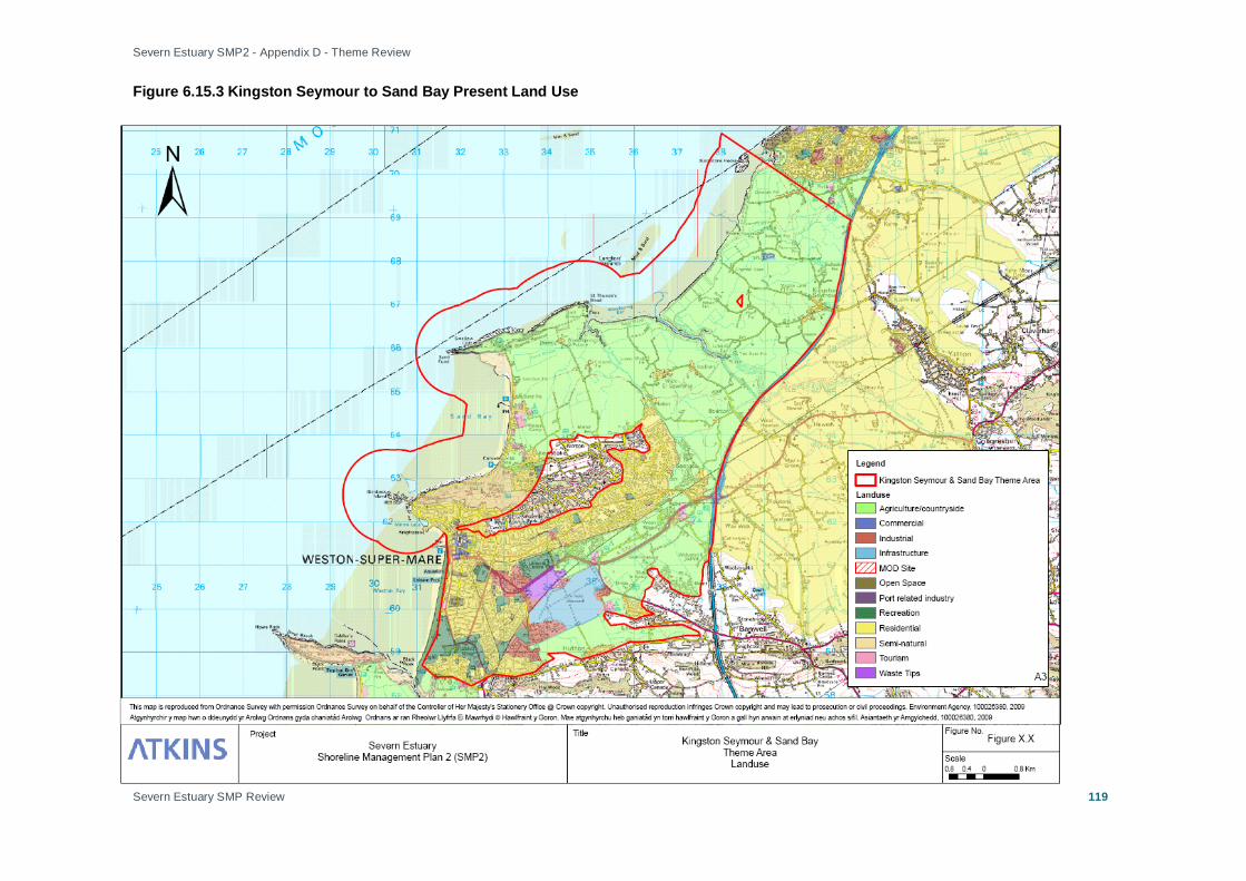
Severn Estuary SMP2 - Appendix D - Theme Review
Severn Estuary SMP Review
119
Figure 6.15.3 Kingston Seymour to Sand Bay Present Land Use

Severn Estuary SMP2 - Appendix D - Theme Review
Severn Estuary SMP Review
120
6.16 The Holms Key Featu res
Landscape and Nature Conservation
The Holms are two small islands of Flat Holm (Wales) and Steep Holm (England).
The Holms have important landscape value within the Severn Estuary; they are iconic, undeveloped outpost of nature conservation important for flora and fauna (Fig 6.16.1).
Both islands are subject to international and national statutory conservation designations, they are included in the Severn Estuary Ramsar, SAC and SPA; international legislative drivers to protect the environmental heritage value of the recognised site. The Holms are also within the Severn Estuary SSSI national designation recognising the ecological importance of the estuary.
Each island is individually nationally recognised for their ecological heritage value under SSSIs. Steep Holm is characterised by vegetated limestone cliffs, rare and unique flora can be found on the island. Steep Holm is also an important bird breeding site and migrant station. Flat Holm cliff top grassland is also the location of rare plants and breeding birds, it is especially noted for the lesser black backed gulls that breed there. Flat Holm is additionally recognised as a Local Nature Reserve.
Specific details adding to the natural value of the Holms is the presence of intertidal honeycomb worm reef systems that are formed on hard strata at Flat Holm. The reefs are of national importance as an aspect of the Severn Estuary SSSI and SAC designations.
Historic Environment
The historic environment of Steep Holm and Flat Holm (Fig 6.16.2) is characterised by evidence of early Christian and later Medieval settlement, Victorian naval defences (the 1860s Palmerstonian forts), communications, and WWII defensive structures, reflecting the strategic position of these two islands within the Estuary. The islands were historically highly important for shipping and a number of ship wrecks are known in the area.
There are three Scheduled Monuments within the theme area:
• Two Palmerstonian Gun Batteries on Steep Holm; • Three Palmerstonian Gun Batteries on Flat Holm; • WWII coastal and anti-aircraft batteries, Flat Holm. There are six Grade II Listed Buildings on Steep Holm, comprising the tombstone battery, the barracks, the
Flat Holm
Steep Holm

Severn Estuary SMP2 - Appendix D - Theme Review
Severn Estuary SMP Review
121
summit battery, a limekiln, laboratory battery and garden battery. There are a further three Listed Buildings on Flat Holm, namely the batteries, isolation hospital and lighthouse.
There are a number of non-designated archaeological and historic features and find spots on both island.
Current and Future Land-Use and Policy
The Holms are mainly undeveloped, with only a Nature Research Centre on Steep Holm, amongst the semi-natural environment and agriculture/countryside (Fig 6.16.3). Flat Holm includes a fog horn station and navigational facilities, important features to maintain trade links essential for the development of the national as well as regional economy. Visitors to the Holms are primarily via tourist boat trips to the islands as well as fishing and pleasure trips from most Severn Estuary resorts. The maritime grassland benefits tourists and local environmental heritage. The islands are also important as educational resources. The site is of national high importance over the next 100 years.
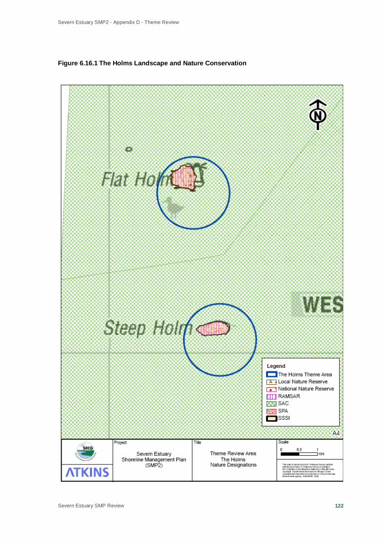
Severn Estuary SMP2 - Appendix D - Theme Review
Severn Estuary SMP Review
122
Figure 6.16.1 The Holms Landscape and Nature Conservation

Severn Estuary SMP2 - Appendix D - Theme Review
Severn Estuary SMP Review
123
Figure 6.16.2 The Holms Historic Environment

Severn Estuary SMP2 - Appendix D - Theme Review
Severn Estuary SMP Review
124
Figure 6.16.3 The Holms Present Land Use
Severn Estuary SMP2 - Appendix D - Theme Review
Severn Estuary SMP Review
125
Annex A: Local Authority Policy Summaries VALE OF GLAMORGAN COUNCIL VALE OF GLAMORGAN ADOPTED UNITARY DEVELOPMENT PLAN 1996 - 2011 The plan provides a sustainable land use framework to guide the growth and ensure the environmental protection for the Vale of Glamorgan well into the future. THE ENVIRONMENT Policy 1 The Vale of Glamorgan’s distinctive rural, urban and coastal character will be protected and enhance. Particular emphasis will be given to conserving areas of importance for landscape, ecology and wildlife, the best and most versatile agricultural land and important features of the built heritage. Proposals which enhance these areas will be favoured. Policy 2 Proposals which encourage sustainable practices will be favoured including: • Proposals which contribute to energy conservation or efficiency, waste reduction or recycling;
pollution control; biodiversity and the conservation of natural resources. • Proposals which are located to minimise the need to travel, especially by car and help to reduce
vehicle movements or which encourage cycling, walking and the use of public transport • The reclamation of derelict or degraded land for appropriate beneficial use, and • Proposals which improve the quality of the environment through the utilisation of high standards
of design. HOUSING Policy 3 Land will be made available for an additional 6079 Dwellings between 1998-2011, this provision will be met by: • The provision of infrastructure an services for the development of sites with planning permission
for housing • The redevelopment of suitable sites in the urban area of Barry, Penarth and Rhoose • The replacement of unfit and substandard housing • The development of a range of sites in the south eastern part of the Vale of Glamorgan within
and adjoining Barry, Penarth and Rhoose • The development of minor sites • The maintenance, rehabilitation and improvement of existing housing stick, the conversion of
suitable existing dwellings and the change of use of suitable structures to provide additional modern units, and
• Affordable housing favoured at appropriate locations and in additional, the provision of affordable housing on appropriate small sites outside of the generally housing allocation.
ECONOMIC DEVELOPMENT AND TOURISM Policy 4 An additional 160 Ha of land will be made available for employment uses from 1996-2011, this land will; • Match the existing and forecast demand from inward investors, and • Assist the appropriate expansion of local businesses and facilitate new start-ups Policy 5 A range and choice of sites for business and industrial purposes identified will be protected from alternative uses, these sites will;
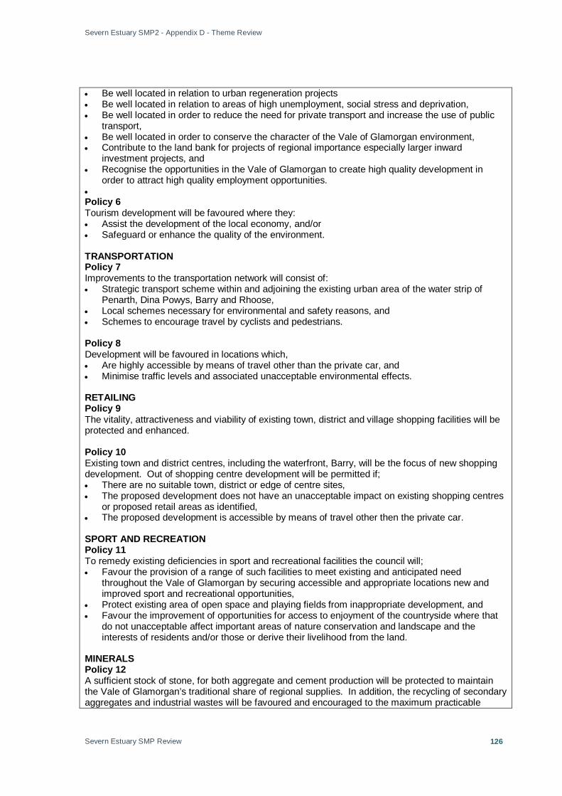
Severn Estuary SMP2 - Appendix D - Theme Review
Severn Estuary SMP Review
126
• Be well located in relation to urban regeneration projects • Be well located in relation to areas of high unemployment, social stress and deprivation, • Be well located in order to reduce the need for private transport and increase the use of public
transport, • Be well located in order to conserve the character of the Vale of Glamorgan environment, • Contribute to the land bank for projects of regional importance especially larger inward
investment projects, and • Recognise the opportunities in the Vale of Glamorgan to create high quality development in
order to attract high quality employment opportunities. • Policy 6 Tourism development will be favoured where they: • Assist the development of the local economy, and/or • Safeguard or enhance the quality of the environment. TRANSPORTATION Policy 7 Improvements to the transportation network will consist of: • Strategic transport scheme within and adjoining the existing urban area of the water strip of
Penarth, Dina Powys, Barry and Rhoose, • Local schemes necessary for environmental and safety reasons, and • Schemes to encourage travel by cyclists and pedestrians. Policy 8 Development will be favoured in locations which, • Are highly accessible by means of travel other than the private car, and • Minimise traffic levels and associated unacceptable environmental effects. RETAILING Policy 9 The vitality, attractiveness and viability of existing town, district and village shopping facilities will be protected and enhanced. Policy 10 Existing town and district centres, including the waterfront, Barry, will be the focus of new shopping development. Out of shopping centre development will be permitted if; • There are no suitable town, district or edge of centre sites, • The proposed development does not have an unacceptable impact on existing shopping centres
or proposed retail areas as identified, • The proposed development is accessible by means of travel other then the private car. SPORT AND RECREATION Policy 11 To remedy existing deficiencies in sport and recreational facilities the council will; • Favour the provision of a range of such facilities to meet existing and anticipated need
throughout the Vale of Glamorgan by securing accessible and appropriate locations new and improved sport and recreational opportunities,
• Protect existing area of open space and playing fields from inappropriate development, and • Favour the improvement of opportunities for access to enjoyment of the countryside where that
do not unacceptable affect important areas of nature conservation and landscape and the interests of residents and/or those or derive their livelihood from the land.
MINERALS Policy 12 A sufficient stock of stone, for both aggregate and cement production will be protected to maintain the Vale of Glamorgan’s traditional share of regional supplies. In addition, the recycling of secondary aggregates and industrial wastes will be favoured and encouraged to the maximum practicable

Severn Estuary SMP2 - Appendix D - Theme Review
Severn Estuary SMP Review
127
extent as substitutes for naturally occurring materials. COMMUNITY AND UTILITY SERVICES Policy 14 Development associated with community and utility services will be permitted if there is no unacceptable impact on the interest of agriculture, conservation, listed buildings, archaeological features, areas of ecological, wildlife and landscape importance and residential amenity.

Severn Estuary SMP2 - Appendix D - Theme Review
Severn Estuary SMP Review
128
Cardiff City Council CARDIFF UNITARY DEVELOPMENT PLAN (TO 2016) The UDP sets out the Council’s policies and proposals for the development and conservation of land in the county, in line with legislative requirements. When adopted, it will replace existing structure and local plans covering Cardiff and form the basis for decisions on individual planning applications. In approving the Plan for deposit, the Council resolved that, from the date of deposit, in addition to current development plans, the deposited UDP should also be taken into account in development control decisions. POLICY 1.A: GENERAL PRINCIPLES FOR THE LOCATION OF DEVELOPMENT Development proposals should be located: • so as to enhance the environment where possible or, otherwise, to minimise harm to it; • to make best use of redundant previously-developed land and buildings, and minimise the
requirement to develop undeveloped land; • to minimise travel demand and dependence on the car, facilitate walking, cycling and use of
public transport and, where appropriate, support the movement of freight by rail or water; • to minimise risk to people or property from flooding, ground conditions or pollution; • where adequate community and utility services and infrastructure exist, are reasonably
accessible, or can readily and economically be provided; and • Where neighbouring uses are compatible. POLICY 1.C: PLANNING OBLIGATIONS Planning obligations will be sought to secure: • improvements in infrastructure, facilities or services; and/or • Other requirements necessary to make development acceptable. POLICY 1.D: HOMES AND COMMUNITY FACILITIES The requirement for new homes and associated community facilities in Cardiff between 2001 and 2016 will be met by: • making provision for 16,800 additional dwellings of which at least 60% will be accommodated on
previously developed land; • allocating land for new housing, including land at North East Cardiff for the development of
approximately 4,000 new homes, linked to improvements in public transport and other necessary community infrastructure;
• Promoting the development of sustainable communities with a mix of dwelling sizes, types and affordability and, where necessary, incorporating local employment and service uses, transport provision, schools, recreation and other community facilities.
POLICY 1.E: THE ECONOMY AND EMPLOYMENT The economy and employment base of Cardiff will be enhanced by: • promoting the provision of new offices within the Central and Waterfront Business Areas and
district centres; • providing 220 hectares of land for industry and warehousing, including new allocations in South
Cardiff, Wentlooge and St Mellons and safeguarding existing industrial and warehousing land for which there remains a need or demand and which remains well located for such use;
• promoting the provision of new and improved retail facilities of an appropriate scale within the Central Shopping Area and district and local centres in accordance with the retail hierarchy and retail strategy;
• Promoting the provision of major sports and visitor facilities within the Central and Waterfront Business Areas and around the Bay waterfront.
POLICY 1.F: THE COUNTRYSIDE The countryside of Cardiff will be protected and, where appropriate, enhanced for its landscape and amenity value and natural resources. Priority will be given to supporting agriculture, forestry and other uses that need to be located within the countryside and support its management, including
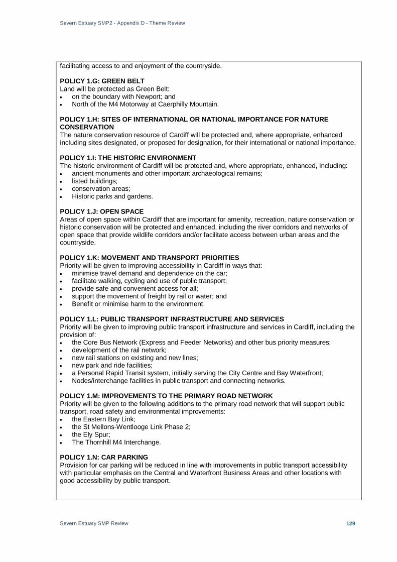
Severn Estuary SMP2 - Appendix D - Theme Review
Severn Estuary SMP Review
129
facilitating access to and enjoyment of the countryside. POLICY 1.G: GREEN BELT Land will be protected as Green Belt: • on the boundary with Newport; and • North of the M4 Motorway at Caerphilly Mountain. POLICY 1.H: SITES OF INTERNATIONAL OR NATIONAL IMPORTANCE FOR NATURE CONSERVATION The nature conservation resource of Cardiff will be protected and, where appropriate, enhanced including sites designated, or proposed for designation, for their international or national importance. POLICY 1.I: THE HISTORIC ENVIRONMENT The historic environment of Cardiff will be protected and, where appropriate, enhanced, including: • ancient monuments and other important archaeological remains; • listed buildings; • conservation areas; • Historic parks and gardens. POLICY 1.J: OPEN SPACE Areas of open space within Cardiff that are important for amenity, recreation, nature conservation or historic conservation will be protected and enhanced, including the river corridors and networks of open space that provide wildlife corridors and/or facilitate access between urban areas and the countryside. POLICY 1.K: MOVEMENT AND TRANSPORT PRIORITIES Priority will be given to improving accessibility in Cardiff in ways that: • minimise travel demand and dependence on the car; • facilitate walking, cycling and use of public transport; • provide safe and convenient access for all; • support the movement of freight by rail or water; and • Benefit or minimise harm to the environment. POLICY 1.L: PUBLIC TRANSPORT INFRASTRUCTURE AND SERVICES Priority will be given to improving public transport infrastructure and services in Cardiff, including the provision of: • the Core Bus Network (Express and Feeder Networks) and other bus priority measures; • development of the rail network; • new rail stations on existing and new lines; • new park and ride facilities; • a Personal Rapid Transit system, initially serving the City Centre and Bay Waterfront; • Nodes/interchange facilities in public transport and connecting networks. POLICY 1.M: IMPROVEMENTS TO THE PRIMARY ROAD NETWORK Priority will be given to the following additions to the primary road network that will support public transport, road safety and environmental improvements: • the Eastern Bay Link; • the St Mellons-Wentlooge Link Phase 2; • the Ely Spur; • The Thornhill M4 Interchange. POLICY 1.N: CAR PARKING Provision for car parking will be reduced in line with improvements in public transport accessibility with particular emphasis on the Central and Waterfront Business Areas and other locations with good accessibility by public transport.

Severn Estuary SMP2 - Appendix D - Theme Review
Severn Estuary SMP Review
130
POLICY 1.O: MINERALS PROVISION Cardiff will continue to contribute its traditional share to regional aggregate supplies by: • promoting and supporting the efficient use of minerals and use of alternatives to natural
minerals; • protecting existing mineral reserves and potential mineral resources from development that
would preclude their future extraction; and • Ensuring an adequate supply of permitted reserves of aggregates. POLICY 1.P: WASTE MANAGEMENT Waste arisings from Cardiff will be managed within the county by: • promoting and supporting additional treatment facilities, measures and strategies that represent
the best practicable environmental option, having regard to the waste hierarchy and the proximity principle;
• supporting a continued but reducing rate of landfill at Lamby Way, together with recycling and civic amenity facilities;
• encouraging facilities for the re-use and management of other waste by its producer as close as environmentally practicable to its point of origin;
• supporting the provision and maintenance of sustainable waste management facilities in all appropriate new developments; and
• Supporting waste minimisation and the provision of facilities that use recycled or composted products.
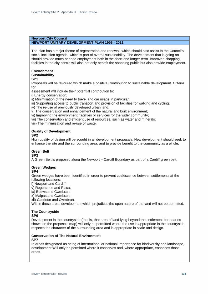
Severn Estuary SMP2 - Appendix D - Theme Review
Severn Estuary SMP Review
131
Newport City Council NEWPORT UNITARY DEVELOPMENT PLAN 1996 - 2011 The plan has a major theme of regeneration and renewal, which should also assist in the Council's social inclusion agenda, which is part of overall sustainability. The development that is going on should provide much needed employment both in the short and longer term. Improved shopping facilities in the city centre will also not only benefit the shopping public but also provide employment. Environment Sustainability SP1 Proposals will be favoured which make a positive Contribution to sustainable development. Criteria for assessment will include their potential contribution to: i) Energy conservation; ii) Minimisation of the need to travel and car usage in particular; iii) Supporting access to public transport and provision of facilities for walking and cycling; iv) The re-use of previously developed urban land; v) The conservation and enhancement of the natural and built environment; vi) Improving the environment, facilities or services for the wider community; vii) The conservation and efficient use of resources, such as water and minerals; viii) The minimisation and re-use of waste. Quality of Development SP2 High quality of design will be sought in all development proposals. New development should seek to enhance the site and the surrounding area, and to provide benefit to the community as a whole. Green Belt SP3 A Green Belt is proposed along the Newport – Cardiff Boundary as part of a Cardiff green belt. Green Wedges SP4 Green wedges have been identified in order to prevent coalescence between settlements at the following locations: i) Newport and Cardiff; v) Rogerstone and Risca; ix) Bettws and Cwmbran; x) Malpas and Cwmbran; xii) Caerleon and Cwmbran. Within these areas development which prejudices the open nature of the land will not be permitted. The Countryside SP6 Development in the countryside (that is, that area of land lying beyond the settlement boundaries shown on the proposals map) will only be permitted where the use is appropriate in the countryside, respects the character of the surrounding area and is appropriate in scale and design. Conservation of The Natural Environment SP7 In areas designated as being of international or national Importance for biodiversity and landscape, development Will only be permitted where it conserves and, where appropriate, enhances those areas.
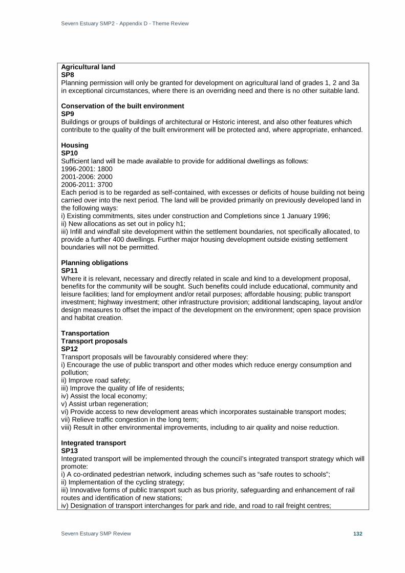
Severn Estuary SMP2 - Appendix D - Theme Review
Severn Estuary SMP Review
132
Agricultural land SP8 Planning permission will only be granted for development on agricultural land of grades 1, 2 and 3a in exceptional circumstances, where there is an overriding need and there is no other suitable land. Conservation of the built environment SP9 Buildings or groups of buildings of architectural or Historic interest, and also other features which contribute to the quality of the built environment will be protected and, where appropriate, enhanced. Housing SP10 Sufficient land will be made available to provide for additional dwellings as follows: 1996-2001: 1800 2001-2006: 2000 2006-2011: 3700 Each period is to be regarded as self-contained, with excesses or deficits of house building not being carried over into the next period. The land will be provided primarily on previously developed land in the following ways: i) Existing commitments, sites under construction and Completions since 1 January 1996; ii) New allocations as set out in policy h1; iii) Infill and windfall site development within the settlement boundaries, not specifically allocated, to provide a further 400 dwellings. Further major housing development outside existing settlement boundaries will not be permitted. Planning obligations SP11 Where it is relevant, necessary and directly related in scale and kind to a development proposal, benefits for the community will be sought. Such benefits could include educational, community and leisure facilities; land for employment and/or retail purposes; affordable housing; public transport investment; highway investment; other infrastructure provision; additional landscaping, layout and/or design measures to offset the impact of the development on the environment; open space provision and habitat creation. Transportation Transport proposals SP12 Transport proposals will be favourably considered where they: i) Encourage the use of public transport and other modes which reduce energy consumption and pollution; ii) Improve road safety; iii) Improve the quality of life of residents; iv) Assist the local economy; v) Assist urban regeneration; vi) Provide access to new development areas which incorporates sustainable transport modes; vii) Relieve traffic congestion in the long term; viii) Result in other environmental improvements, including to air quality and noise reduction. Integrated transport SP13 Integrated transport will be implemented through the council’s integrated transport strategy which will promote: i) A co-ordinated pedestrian network, including schemes such as “safe routes to schools”; ii) Implementation of the cycling strategy; iii) Innovative forms of public transport such as bus priority, safeguarding and enhancement of rail routes and identification of new stations; iv) Designation of transport interchanges for park and ride, and road to rail freight centres;
Severn Estuary SMP2 - Appendix D - Theme Review
Severn Estuary SMP Review
133
v) A central area parking strategy co-ordinated with and in co-operation with adjoining local authorities; vi) Appropriate provision for public transport operation at the planning stage of new developments; vii) Urban villages and neighbourhoods in the built-up area supported by sustainable forms of transport and traffic management; viii) Facilities for public transport, walking and cycling in major new development; ix) Interchange between bus, bicycle and car to enable sustainable use of the countryside; x) Transport development areas (tdas). Major road schemes SP14 Land will be safeguarded for the following strategic highway schemes: i) M4 relief road; ii) Eastern extension of the southern distributor road along Queensway through the Llanwern steelworks site. Economic development and urban regeneration. Employment land requirement SP15 Provision will be made for about 200 hectares of employment land for the period 1996-2011. Employment sites SP16 New industrial and business development will be located mainly in the following areas: i) Duffryn/cleppa park; ii) South-east Newport; iii) Riverside, dock and urban areas. Urban regeneration SP17 Proposals will be favoured which assist the regeneration of the urban area, and in particular their potential contribution to: i) The vitality, viability and quality of environment of the city centre; ii) The provision of residential and business opportunities within the urban area; iii) The reuse of vacant, underused or derelict land. Eastern expansion area SP26 An expansion area is allocated to the east of the city, to include the redundant part of the Llanwern steelworks and land to the north between the steelworks and the M4 motorway, to provide for 1,700 dwellings and a mix of business, commercial, leisure and community uses in accordance with a masterplan. Peripheral expansion elsewhere will not be permitted. The development of Greenfield sites must not be allowed to do harm to the regeneration of inner urban sites. Retailing SP18 Retail proposals in or adjoining the city centre or district centres will be permitted where they enhance the retail function of that centre, and are at an appropriate scale for the relevant centre. Proposals elsewhere will be subject to an assessment of need and phasing considerations. A strict application of the sequential test will be applied to all retail applications. Recreation, education and community facilities. Recreation, leisure and tourism SP19 Existing recreation and tourism facilities will be safeguarded with proposals for major new leisure developments being subject to the sequential test. Improved access to the countryside and informal countryside recreation will be encouraged where appropriate.
Severn Estuary SMP2 - Appendix D - Theme Review
Severn Estuary SMP Review
134
Minerals SP21 In considering proposals for the winning and working of minerals, the regional context of the proposal will be considered as well as local factors. The use of secondary aggregates and industrial wastes will be encouraged where appropriate. Waste Disposal SP22 A hierarchical approach to waste management is favoured as follows: Waste reduction, Re-use, Recycling, Composting of organic waste, Incineration with energy recovery & Safe disposal. The environmental impact of landfill, land-raising, incineration and other treatment should be minimised in terms of the best practicable environmental option and the proximity principle. Utilities, flood risk, energy and pollution. Public utilities SP23 Utility services provision should seek to minimise impact on the natural and built environment consistent with the siting requirements of utility companies. Flood risk SP24 Development, including the raising of land, which would result in an unacceptable risk of flooding, either on or off site, or which would adversely affect flood management or maintenance schemes, will not be permitted. Flood consequence assessments SP27 Where flood risk is identified as a constraint, development will only be permitted where a detailed technical assessment is provided to ensure that: i) The nature of the proposed development is acceptable in terms of flood risk; ii) The development is designed to cope with the consequences of flooding; iii) The funding and maintenance provision is appropriate for the lifetime of the development. Polluting development SP25 Development will not be permitted which would have an unacceptable effect in terms of risk to health or safety, or which would be unacceptably harmful to or have an unacceptably adverse effect on communities or the environment by way of atmospheric, water, noise or other forms of pollution.

Severn Estuary SMP2 - Appendix D - Theme Review
Severn Estuary SMP Review
135
MONMOUTHSHIRE COUNTY COUNCIL MONMOUTHSHIRE COUNTY COUNCIL UNITARY DEVELOPMENT PLAN 1996 - 2011 The UDP covers the 15-year period January 1st 1996 to January 1st 2011. The UDP is effectively a five year roll forward of the current Gwent Structure Plan and Monmouth Borough Local Plan, many of the policies of which and the greater majority of the development site allocations have been integrated into this UDP. However, as part of this process, all polices and proposals of these Plans were evaluated and reviewed in the light of recent guidance and local social, economic & environmental objectives, whilst being subjected to a sustainability appraisal before being included in the UDP. SP1: DESIGN The Plan will favour the protection or enhancement of the best qualities of Monmouthshire’s built environment through good design in all development proposals. Design should promote sustainable development, reflect the topography, natural setting and any existing built form of quality in the vicinity of proposals and provide benefit to the community as a whole. SP2: HOUSING Provision is made to meet a need for about 5000 residential units within the County in the period 1996 - 2011. (‘About’ will be interpreted as plus or minus 150 and does not include a ‘flexibility allowance’) SP3: INDUSTRY AND EMPLOYMENT Land is identified for employment development in all main areas of the County that is sufficient, at recent rates of take-up, to cater for the anticipated needs within the plan period and provide a degree of choice. SP4: SHOPPING The vitality, attractiveness and viability of existing County, Local and Neighbourhood Centres will be protected and enhanced. SP5: MOVEMENT The Plan will promote the efficient and safe movement of people and goods, and` protect the environment by promoting land use policies that: • reduce growth in the length and number of motorised journeys and reliance on the motorcar; • promote land uses and layouts that reduce the need to travel; • seek to ensure the most effective use of the existing and future transport network and target
resources to best effect; and • encourage alternative means of travel that have less environmental impact. SP6: TRANSPORT PROPOSALS Safeguard the following proposed highway schemes from development that would prejudice their implementation: • M4 - Relief Road (Magor to Castleton); • A465T - Heads of the Valleys Dualling (Abergavenny to Hirwaun); • B4293 - New Monnow Bridge and Approach Roads; and • B4245 - Magor Undy Bypass. SP7: CONSERVATION OF THE HISTORIC ENVIRONMENT The Plan will promote the preservation or enhancement of Monmouthshire's historic environment. Development that would harm the special character of the historic environment will not be permitted. SP8: COUNTRYSIDE AND NATURE CONSERVATION The Plan will promote the enhancement of Monmouthshire’s natural environment, and will seek to protect from inappropriate development species and land designated for: - • international, national and local nature conservation value; • its landscape character, including the coast;
Severn Estuary SMP2 - Appendix D - Theme Review
Severn Estuary SMP Review
136
• its value as green space between and within settlements; or • high agricultural quality. SP9: RECREATION AND LEISURE The Plan will protect or enhance leisure and recreation facilities by the retention of open spaces and the development of new facilities, including play and sports provision in accessible and appropriate locations. SP10: TOURISM Tourism Developments will be favoured where they: - • assist the development of the local economy; and • safeguard or enhance the quality of the environment and the interests of local communities. SP11: COMMUNITY FACILITIES The provision of community facilities, which are readily available to all Monmouthshire’s residents, will be promoted in accessible and appropriate locations. SP12: MINERALS The Plan will: • safeguard mineral resources the extraction of which is or may become economic and
environmentally acceptable; • provide for the County to make a fair and sustainable contribution towards meeting the regional
need for aggregate minerals; • ensure that the environmental impacts caused by mineral operations are kept to an acceptable
minimum; and • ensure that sites are restored to a beneficial after-use. SP13: WASTE PLANNING MANAGEMENT A sustainable approach to waste management based on a hierarchy of reduction, reuse, recovery and safe disposal will be promoted and an adequate network of waste management facilities provided that meets the requirements of the EU Waste Directives. SP14: ENERGY The Plan will promote the generation of energy from renewable sources where that is consistent with other polices and will encourage appropriate energy conservation measures in the design of development.
Severn Estuary SMP2 - Appendix D - Theme Review
Severn Estuary SMP Review
137
FOREST OF DEAN DISTRICT COUNCIL FOREST OF DEAN DISTRICT COUNCIL – CORE STRATEGY, 2008. The Core Strategy is the principal document in the new Local Development Framework for the Forest of Dean. It contains the following key elements: • A spatial vision for the area in 2026 • Strategic objectives for this vision • Spatial strategy • Principal spatial policies to achieve the vision, and the objectives • How the process will be implemented and monitored This version of the Core Strategy expresses the Council's preferred option. It is a consultation document and will be expected to change further. The information that is used as a basis for this document includes draft papers and other studies that may also change. Policy 1 General development principles (strategic objective: to promote thriving sustainable communities). New development will take place in a manner that helps to secure a more sustainable structure in the Forest of Dean and makes a positive contribution to the Regional Spatial Strategy. This will be achieved by selective development of the three towns in the south and Newent in the north in a manner which uses their characteristics to increase their self containment and attractiveness. Development proposals must be sustainable. They will be assessed in respect of their use of resources during construction and use, and in terms of their overall location, access to services, their use of them, and their contribution to the spatial vision for the area. Policy 2 Design and environmental protection (strategic objective: providing quality environments) In order to improve or retain the quality of the environment, new development should be designed to enhance or be compatible with its surroundings. Development Proposals will be expected to be supported by design statements which fully explain the impact of what is proposed. It should be located to avoid the loss of protected habitats, be well related to the landscape, and safeguard and enhance the historic environment. Where some loss of natural or historic environment is justified, mitigation will be necessary. New development should comply with the prevailing national guidance on flood risk. Policy 3 Development at Settlements (strategic objectives: to promote thriving sustainable communities, facilitate regeneration) New development must contribute to reinforcing the existing settlement pattern in a manner which emphasises the importance of the towns, especially Lydney and Cinderford where most change will take place. The following principles will be applied: Most changes in towns and villages will be expected to take place within the existing settlement boundaries currently saved in the Local Plan, unless they are replaced by other LDF documents (for example an Area Action plan). Exceptions to this may include affordable housing for local persons and building conversions and (rarely) new buildings for employment uses on the edge of settlements. Areas outside settlement boundaries will be treated as part of the open countryside. New development will be concentrated on the towns in a manner that relates closely to the intended role of each, taking advantage of the individual characteristics of each as defined in the settlement policies below. Proposals will be expected to improve the quality of their environment with special regard being paid to the quality of the town centres, and any protected environments such as Conservation Areas.

Severn Estuary SMP2 - Appendix D - Theme Review
Severn Estuary SMP Review
138
The south forest with its well defined network of three towns and other villages will be encouraged to diversify its range of employment with new sites being made available mainly in the towns. New housing will be concentrated where there is already good access to employment and where additional employment can be provided. Development and the provision of services will be supported which leads to the regeneration, maintenance and enhancement of the functions of the towns and larger villages. Particular support will be given through assistance to the implementation of community-led regeneration plans. Within town centres, new development will be encouraged that reinforces the role of the towns and provides a more diverse and better quality service or retail offer. Policy 4 Development of rural areas (strategic objectives: to promote thriving sustainable communities, developing the local economy including tourism, facilitating regeneration) In order to protect the countryside through support for the rural economy, the following will be encouraged in villages and in suitable locations in the countryside: i. retention or expansion of businesses generating uses including tourist accommodation; ii. re-use or replacement of suitably located rural buildings for employment generating uses including tourist accommodation; iv. diversification of the agricultural economy; v. tourism related initiatives which have an affinity for the location in which they are proposed, especially those which improve the quality of sustainable tourist assets within the District; vi. recreation uses appropriate to a countryside location; vii. locally based renewable energy projects and businesses to serve the area; viii. arts and crafts based industries; ix. technological developments needed to facilitate employment development in rural areas; x. improvement of public transport links. Policy 7 Economy (strategic objective: develop the local economy including tourism) A variety of employment will be promoted throughout the district in accordance with the spatial strategy. This will allow new and more diverse types of employment to be established by making land and premises available. Particular priority will be given to sustaining the development of key economic sectors or clusters; providing the conditions and support for Small and Medium Sized Enterprises to become established and grow; developing the District’s skills base; supporting the development of growth sectors; supporting further education and skills training and facilities to provide it and supporting transport investment that will aid economic development. Additional land will be made available at Lydney, Cinderford, Coleford and Newent, generally in accordance with the Local Plan and as modified by the Area Action Plans for Lydney and Cinderford. Policy 9 Infrastructure, travel and sustainability (Strategic objective: to promote thriving sustainable communities) New development should be located so as to make the optimum use of available infrastructure and be able to secure necessary improvements to ensure adequate provision. It should be located so as to minimise the need to travel, taking into account the need to balance this against the advantages of the development to the area in which it is proposed. Convenient access to footways and public transport should be available where possible. Policy 11 Retention of community facilities (Strategic objective: to promote thriving sustainable communities) Development proposals which involve the loss of community facilities, including schools, shops, post offices, public houses, halls, places of worship, health services, and land used for recreation will not be supported, unless an alternative suitable and convenient facility is available or will be made available as part of the proposal except where it can be demonstrated that the facilities concerned are no longer viable and cannot be made so. Policy 12 Loss of recreational land (Strategic objective: Providing quality environments)
Severn Estuary SMP2 - Appendix D - Theme Review
Severn Estuary SMP Review
139
Development of existing recreational land and buildings and amenity open space will not be supported, unless the asset is no longer required or development secures satisfactory replacement or improvement of the use or amenity of existing spaces that outweighs its loss. Where appropriate, all development will be expected to make provision, or a contribution towards provision, of open space.

Severn Estuary SMP2 - Appendix D - Theme Review
Severn Estuary SMP Review
140
GLOUCESTERSHIRE COUNTY COUNCIL GLOUCESTERSHIRE STRUCTURE PLAN ADOPTED SECOND REVIEW (NOVEMBER 1999) The Structure Plan sets out the strategic framework for the use and development of land in Gloucestershire during the Plan Period mid 1991 - 2011. It was adopted and became operative on 17 November 1999. It ensures that the provision for development is realistic and consistent with national and regional policy, and secures consistency between local plans of neighbouring areas. STRATEGY Policy S.1 The bulk of new development should be accommodated within and adjacent to the County’s larger towns at scales and locations that: • maintain and enhance the predominance of Gloucester and Cheltenham as the focus for new
development in the County, • maintain and make them more attractive places in which to live and work, • meet transport demands in safe and energy efficient ways primarily aiming at reducing the need
to travel, • conserve natural resources of minerals, best and most versatile agricultural land, biodiversity
and high quality landscape, • promote the regeneration of appropriate town centres, • avoid the coalescence of existing settlements, • conserve the historic and built environment. Policy S.2 Principal settlements should be identified in local plans which would form the focal points for a scale of development which was consistent with the character and function of the settlement, and supports local services and the social and economic well-being of local communities. They should therefore be: • accessible to the community they serve and well related to public transport and the highway
network; and • defined to ensure that the social and economic needs of all rural areas can be met, taking into
account their location relative to other centres and environmental considerations, including those in adjoining Districts.
Policy S.3 Priority should be given to the development of land within existing built-up areas, particularly land available for redevelopment, where this would not be detrimental to the urban environment, and where it would be accessible by public transport and accessible to jobs, schools, shopping, leisure and other services. These areas should be utilised to their maximum efficiency, consistent with the character and appearance of the wider location and the quality of life of those living and working in the locality. In rural areas previously developed land may exist but it may be in locations where development could be intrusive in the countryside or highly unsustainable. Policy S.4 Development in rural settlements should be limited in scale, and sustain and enhance the character and appearance and the social and economic well-being of local communities. Development within the open countryside will be strictly controlled. Policy S.5 In providing for development, local authorities will have regard to the need for community facilities and services, including education, health, and cultural facilities, local shopping facilities, sport and leisure facilities, transport services and infrastructure, housing including affordable housing and public utilities. In determining the type, scale and location of development, the adequacy of infrastructure and community services will be taken into account. Provision for development will be made where related infrastructure and community services are in place or will be provided in appropriate phases in an environmentally acceptable way. In providing for development the following aspects of the environment which contribute to local
Severn Estuary SMP2 - Appendix D - Theme Review
Severn Estuary SMP Review
141
character and distinctiveness should be safeguarded and wherever possible enhanced: • the quality of the landscape, • the setting of the settlements and buildings within the landscape, • the quality of the built and historic environment, • the sites and landscapes of archaeological and historic value, • the distinctive wildlife and habitats, • the special qualities of rivers, canals and other water courses and features. Policy S.7 In providing for development the quality of the County’s environment should be maintained and enhanced by the following:
• high standards of design, • urban regeneration, conservation and townscape enhancement, • traffic management, and • the retention and provision of open space.
RECREATION Policy RE.1 The retention and provision of a wide range of recreational facilities in urban areas and all principal settlements, to meet local and sub-regional needs, will be supported. Local Plans will give special consideration to:
• Areas which are deficient in recreational facilities; • Facilities which provide for as wide a range of the population as possible; • Increased accessibility for all potential users particularly by public transport, cycling
and walking; and • Local scale of provision of a non-specialist nature, for example local halls capable of
some recreational uses, will be encouraged provided they are well related to the communities they serve.
Policy RE.2 A high standard of open space provision in new residential development will be required. Existing playing fields and recreational areas will be retained. Policy RE.3 Improved public access to the countryside will be encouraged subject to there being no adverse impact on the natural and historic environment or on agriculture. Policy RE.4 The use of water for sport, recreation and tourism will be permitted except where:
• There would be an unacceptable conflict with water supply or commercial use; • There would be an unacceptable level of environmental impact particularly on
landscape, the local ecology or to local settlements; • Problems of recreational over-use or conflicting uses could not be resolved; • There would be overriding problems of public safety; • There would be significant local traffic problems; • The proposal would create or result in unacceptable pollution including noise
pollution. Policy RE.5 Restoration of the Stroudwater, Thames and Severn Canal, and the Herefordshire and Gloucestershire Canal, as navigable waterways will be encouraged and their routes protected where compatible with other policies. TOURISM Policy TSM.1 Proposals for all tourism developments will be judged against principles of sustainable tourism. Particular attention will be given to:

Severn Estuary SMP2 - Appendix D - Theme Review
Severn Estuary SMP Review
142
• conserving the urban and rural environments; • providing facilities of appropriate scale, standards and design; • managing tourism pressures in popular areas or at sites of special attraction; • promoting access by public transport, cycling and walking; and • encouraging the re-use of existing buildings so as to maintain or enhance the
character and appearance of the surroundings. Policy TSM.4 Encouragement will be given to the development of tourist attractions, which have a special affinity with the physical and historic heritage of an area and no adverse impact on the local environment. WATER RESOURCES Policy W.1 Provision will only be made for development where: • adequate water resources exist or can be provided without causing unacceptable adverse
environmental effects, and • it will not lead to an unacceptable reduction in the quantity of surface and groundwater; and • there is not an unacceptable risk to existing or future supplies, residential amenity, nature
conservation or fisheries. Proposals for new water resource schemes will be assessed in the context of the demand management and leakage control measures. FLOODING AND FLOOD RISK Policy F.1 Provision will not be made for development where it would be at direct risk from flooding and/or would increase the risk of flooding elsewhere.

Severn Estuary SMP2 - Appendix D - Theme Review
Severn Estuary SMP Review
143
TEWKESBURY BOROUGH COUNCIL Tewkesbury Borough Local Plan to 2011 The Tewkesbury Borough Local Plan is a statutory local plan prepared under the provisions of the Town and Country Planning Act 1990. It covers the 49 parishes which comprise the Tewkesbury Borough administrative area, and covers some 160 sq miles of north Gloucestershire stretching from the Cotswolds in the east to Severnside parishes in the west, and the gap which separates Gloucester and Cheltenham.
The council will liaise with the utility companies and other organisations in order to encourage appropriate siting and design of necessary services so that they respect the character of the surrounding area and landscape.
POLICY GNL10
Proposals for the change of use or redevelopment of existing employment sites in rural areas will be encouraged where they reduce the adverse environmental impact caused by the existing use on the amenity of users of the surrounding land. Proposals which create or exacerbate adverse environmental impact will be resisted.
POLICY EMP5
The borough council will seek to secure the implementation of the following schemes for the enhancement of the cycleway network within the borough:
POLICY TPT5
• • the completion of inter-urban cycle routes between Gloucester and Cheltenham along the
b4063, and Tewkesbury to Brockworth via bishops Cleeve and Cheltenham
• • the provision of the national cycle network links between Tewkesbury and Gloucester, Tewkesbury and Evesham and Gloucester to Evesham via Churchdown, Cheltenham and bishops Cleeve; also the Gloucester to forest of dean link.
The design of all development, including associated highway works, should make appropriate provision for cyclists by the introduction of, for example: cycleways, secure cycle parking facilities and cycle-friendly junction layouts.
The borough council will support in principle the provision of increased passenger access to the rail network. In furtherance of this aim a site is identified as shown on the proposals map at Churchdown for a main line railway station. The borough council will encourage proposals to implement such a facility.
POLICY TPT10
Within conservation areas special attention will be paid to the desirability of preserving or enhancing their character and appearance. Proposals which preserve or enhance the character or appearance of conservation areas will be supported. In appropriate cases environmental enhancement schemes within conservation areas will be implemented.
POLICY HEN1
Special attention will be given to the protection and enhancement of historic features which contribute to the townscape and historic character. Particular importance will be attached to the retention of traditional materials in the repair and refurbishment of existing buildings, and in the construction of new buildings and other works.
In proposals for development within or in close proximity to a conservation area particular attention should be paid to the development’s impact on the conservation area and its setting including any existing trees. Full details of design and materials to be used will normally be required in such cases. Thus planning applications in outline form will only be accepted in exceptional circumstances.
POLICY HEN2
Severn Estuary SMP2 - Appendix D - Theme Review
Severn Estuary SMP Review
144
Where new development or re-development is proposed within a conservation area, it must be of a high standard of design and preserve or enhance the character or the appearance of the conservation area in terms of scale, form, materials and quality. Proposals retaining traditional building lines within designated conservation areas will be favoured. Special attention should be given to the protection and enhancement of historic features which contribute to the townscape and historic character. Particular importance will be attached to the retention of traditional materials in the repair and refurbishment of existing buildings and in the construction of new buildings and other works. Approved policies and standards will be relaxed where this would be in the interests of preserving or enhancing the character or the appearance of the conservation area.
Planning permission will not be granted for development which adversely affects important open spaces, water features, hedgerows and trees within designated conservation areas.
POLICY HEN5
The council will encourage the repair of buildings listed as being of special architectural or historic interest by encouraging schemes through design and planning advice which lead to their repair and restoration.
POLICY HEN10
Where development involving works to a listed building is proposed which will, remove or alter historic features or, exceptionally, will demolish it, detailed survey drawings and photographs of the fabric to be affected must be submitted. .
POLICY HEN12
Development will not be permitted which will adversely affect the setting of a listed building. POLICY HEN13
There is a general presumption in favour of retaining listed buildings; their demolition will only be permitted in very exceptional circumstances.
POLICY HEN14
Before consent is granted for the demolition of a listed building applicants will be required to submit convincing evidence to show that: every possible effort has been made to repair and restore the building and continue the present use; it has been impossible to find a suitable alternative use for the building; that there is clear evidence that redevelopment would produce substantial planning benefits for the community which would decisively outweigh the loss resulting from the building demolition. Where consent for the demolition of a listed building is granted, it will be conditional on the appropriate archaeological recording of the building prior to demolition.
The design and materials of boundary walls and fences should be sympathetic to the design and materials of the listed buildings to which they relate.
POLICY HEN15
The borough council will encourage proposals which retain buildings and features of local historic or architectural interest.
POLICY HEN16
The borough council will seek to protect historically important groups of farm buildings from destructive development proposals or demolition.
Development proposals which enable the suitable re-use, conservation and interpretation of buildings and features of industrial archaeological significance will be encouraged.
POLICY HEN19
Development which would adversely affect a scheduled ancient monument or other site of national archaeological importance or its setting will not be permitted.
POLICY HEN20

Severn Estuary SMP2 - Appendix D - Theme Review
Severn Estuary SMP Review
145
Where archaeological remains may be affected by a development, applicants should submit an assessment of the archaeological implications of their proposals as part of a planning application together with an indication of how the impact of the proposals on the archaeological remains will be mitigated.
POLICY HEN21
Where the preservation of archaeological remains is not justified, development will not normally be permitted until adequate provision has been made, and secured through planning conditions or legal agreements under section 106 of the town and country planning act 1990, for an appropriate programme of archaeological investigation and recording.
POLICY HEN22
The proper maintenance and sympathetic management of important archaeological sites will be encouraged, including where appropriate the provision of suitable on site interpretative displays.
POLICY HEN23
Within areas with a high flood risk, and low to medium flood risk, as identified on the proposals map, and outside these areas if required by the environment agency, proposals for development must be accompanied by a flood risk assessment (FRA) in accordance with ppg25, annex f. Development will be permitted provided that the proposed development has been demonstrated to meet all of the following criteria in respect of flood protection:
POLICY EVT5
1. There are no other appropriate sites for the development in a lower risk zone, 2. It will not itself be at unacceptable risk from flooding, 3. It will not increase the risk of flooding to third parties within the floodplain or in adjoining areas by reducing flood storage capacity, increasing the depth of flood flows, adversely affecting flow velocities or diverting flood flows, 4. The risk to human life and property is acceptable, 5. A minimum access strip of 8m on the banks of main rivers and on ordinary watercourses is provided, 6. Any existing flood defences and other existing or potential flood alleviation measures are adequately safeguarded, 7. It would not result in extensive culverting, 8. Where additional flood defences, other mitigation works or warning measures are required they must be fully funded by the developer including adequate provision for ongoing maintenance through a dedicated commuted sum for 30 years, 9. The proposal does not involve significant and unsustainable additional flood defences in undeveloped or sparsely developed areas or within the functional floodplain.
New development will not be permitted which could damage groundwater resources or prevent use of these resources.
POLICY EVT6
Planning permission will not be granted for development which would damage the quality and ecology of rivers, watercourses and other bodies of water. New development must be accompanied by adequate sewage disposal infrastructure including separation of surface and foul water systems in order to avoid water pollution by sewage, sewerage effluent, industrial wastes or contaminated surface water. Proposals must demonstrate that where hazardous, toxic or pollutant materials are used, or wastes produced, that these will be stored, handled or disposed of in ways that avoid the risk of pollution.
POLICY EVT7
Development will not be permitted which would be adversely affected by odour pollution within the “cordons sanitaires” around the sewage treatment works indicated on the proposals map at Hayden (Boddington and Staverton parishes), Innsworth, Tewkesbury, Winchcombe and Brockhampton (Bishops Cleeve parish).
POLICY EVT8
Severn Estuary SMP2 - Appendix D - Theme Review
Severn Estuary SMP Review
146
The extent of the area of outstanding natural beauty is shown on the proposals map. In the assessment of proposals for development within the AONB, overriding priority will be accorded to the conservation of the natural beauty of the landscape.
POLICY LND1
Development proposals should not adversely affect the quality of the natural environment, or its visual attractiveness. The borough council will also have regard to the needs of agriculture, forestry, other rural industries and to the economic and social well-being of local communities. Small-scale development may be acceptable within the AONB where it is essential to meet local community needs and where it would be within or adjacent to existing towns and villages and in sympathy with the landscape character of the area. Major development proposals will only be permitted in the AONB in exceptional circumstances where there is a proven national interest and an absence of suitable alternative sites.
The extent of the special landscape area is shown on the proposals map. In the assessment of proposals for development special attention will be accorded to the protection and enhancement of the landscape character of the special landscape area which are of local significance. Within this area proposals must demonstrate that they do not adversely affect the quality of the natural and built environment, its visual attractiveness, wildlife and ecology, or detract from the quiet enjoyment of the countryside.
POLICY LND2
A landscape protection zone is identified on the proposals map. Within the LPZ special protection is given to the ecology and visual amenity of the river environment. Development will not be permitted which:
POLICY LND3
A. Has a detrimental visual or ecological effect on the character of the river banks or associated landscape setting of the Severn vale. B. Has an adverse impact on the water environment. Within the LPZ the local planning authority will seek to protect or enhance the environment and where possible, provision will be made for improved public access. Important landscape features within the landscape protection zone will be retained and where appropriate enhanced to ensure their long term retention.
In considering proposals for development in rural areas other than the area of outstanding natural beauty, special landscape area, and landscape protection zone, regard will be given to the need to protect the character and appearance of the rural landscape.
POLICY LND4
Important open spaces are identified on the proposals map. Proposals which would adversely affect their character and appearance will not be permitted.
POLICY LND5
Within the historic parks and gardens as defined on the proposals map the following will apply: - POLICY LND6
(a) development that would destroy, damage or otherwise adversely affect the character appearance or setting of historic parks and gardens (including those identified as being of special historic interest), or any of their features will not normally be permitted. (b) planting schemes which enhance, manage or re-create features of historic parkland and gardens and associated landscape will be encouraged.
In assessing proposals for development the local authority will ensure that where possible and practicable proposed schemes retain trees/woodlands and hedgerows of good quality and of amenity and nature conservation value. Where protected trees are lost the council will require appropriate replacements.
POLICY LND8

Severn Estuary SMP2 - Appendix D - Theme Review
Severn Estuary SMP Review
147
The borough will support proposals for tourism related development provided that, where appropriate: POLICY TOR1
1. The priority is given to the re-use of existing buildings in accordance with council policy 2 there is good access including access for walkers, cyclists and those with special needs 3 the proposal supports the local plan’s wider objectives, particularly in relation to conservation, transport, recreation, economic development, the environment and nature conservation. 4 the siting, design and scale is in keeping with the landscape and wherever possible and practicable seeks to enhance it 5 the proposal aims to interpret the physical and historic heritage of the area 6 a proposal that would attract substantial numbers of visitors it should be accessible by public transport as well as by car And subject to there being no unacceptable impact on the safety or satisfactory operation of the highway network.
The development of new marinas/ moorings in or adjacent to urban areas will be encouraged where they are allied to existing facilities and subject to no significant conflict with landscape or nature conservation policies and having regard to their impact on the landscape protection zone.
POLICY TOR8
The borough council supports in principle the restoration of the Herefordshire and Gloucestershire canal. The line of the Herefordshire and Gloucestershire canal is identified on the proposals map. The borough council will safeguard the line of the Herefordshire and Gloucestershire canal, including Basehor lock, from development which would prejudice its restoration to fully navigable condition.
POLICY TOR9
Development which is likely to have a significant adverse effect on the integrity of a site of international importance (i.e. potential and classified special protection areas, candidate and designated special areas for nature conservation and Ramsar sites) will not be permitted.
POLICY NCN1
Sites of special scientific interest are identified on the proposals map. Development will not be permitted which is likely to adversely affect a designated or proposed site of special scientific interest, either directly or indirectly, unless:
POLICY NCN2
A) the development can be subject to conditions that will prevent damaging impacts on wildlife habitats or important physical features, or B) if other material factors are sufficient to override nature conservation considerations.
Key wildlife sites and regionally important geological / geomorphological sites are identified on the proposals map. Planning permission will not be granted for development which has an adverse effect on these regional or local nature conservation or geological / geomorphological interests unless the importance of the development outweighs the value of the substantive interests present.
POLICY NCN3
Development proposals which would adversely affect species protected by the wildlife and countryside act 1981 as amended, the badgers act 1992 and the EC habitat and species directive, will not be permitted unless proper provision is made to safeguard both them and their habitat through the use of appropriate planning conditions and/or legal agreements.
POLICY NCN4
The borough council will seek to protect and enhance biodiversity when considering development proposals. In particular, the following natural habitats and features will be protected, where possible, from loss or significant detrimental alteration: ancient semi-natural woodlands, semi-natural grasslands, marshes, water courses, orchards, ponds, parklands, hedgerows, linear tree/shelter belts and trees. Where development unavoidably necessitates the removal of such features, replacement features of equivalent value should be provided.
POLICY NCN5
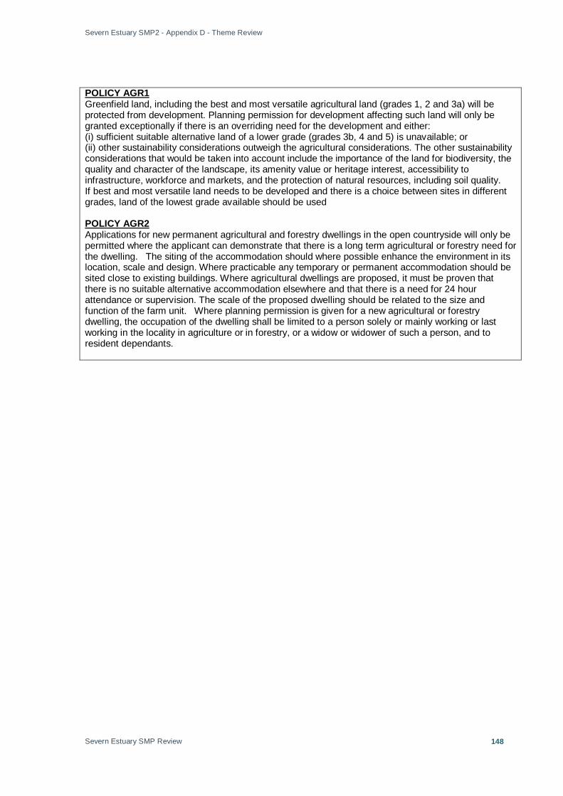
Severn Estuary SMP2 - Appendix D - Theme Review
Severn Estuary SMP Review
148
Greenfield land, including the best and most versatile agricultural land (grades 1, 2 and 3a) will be protected from development. Planning permission for development affecting such land will only be granted exceptionally if there is an overriding need for the development and either:
POLICY AGR1
(i) sufficient suitable alternative land of a lower grade (grades 3b, 4 and 5) is unavailable; or (ii) other sustainability considerations outweigh the agricultural considerations. The other sustainability considerations that would be taken into account include the importance of the land for biodiversity, the quality and character of the landscape, its amenity value or heritage interest, accessibility to infrastructure, workforce and markets, and the protection of natural resources, including soil quality. If best and most versatile land needs to be developed and there is a choice between sites in different grades, land of the lowest grade available should be used
Applications for new permanent agricultural and forestry dwellings in the open countryside will only be permitted where the applicant can demonstrate that there is a long term agricultural or forestry need for the dwelling. The siting of the accommodation should where possible enhance the environment in its location, scale and design. Where practicable any temporary or permanent accommodation should be sited close to existing buildings. Where agricultural dwellings are proposed, it must be proven that there is no suitable alternative accommodation elsewhere and that there is a need for 24 hour attendance or supervision. The scale of the proposed dwelling should be related to the size and function of the farm unit. Where planning permission is given for a new agricultural or forestry dwelling, the occupation of the dwelling shall be limited to a person solely or mainly working or last working in the locality in agriculture or in forestry, or a widow or widower of such a person, and to resident dependants.
POLICY AGR2

Severn Estuary SMP2 - Appendix D - Theme Review
Severn Estuary SMP Review
149
STROUD DISTRICT COUNCIL STROUD DISTRICT COUNCIL LOCAL DEVELOPMENT PLAN 2005 - 2011 This Local Plan sets out Stroud District Council’s policies and proposals for future development and land use in the District to 30 June 2011. GENERAL POLICIES POLICY GE1 Permission will not be granted to any development that would be likely to lead to an unacceptable level of noise, general disturbance, smell, fumes, loss of daylight or sunlight, loss of privacy or have an overbearing effect. POLICY GE2 Permission will not be granted for any development that is likely to create unacceptable atmospheric or environmental pollution to water, land or air. POLICY GE3 Permission will not be granted for noise sensitive development in locations where it would be subject to unacceptable noise levels. POLICY GE4 Planning applications within areas at risk of flooding must be accompanied by a flood risk assessment in accordance with PPG25, Annex F. Development will be permitted where an appropriate flood risk assessment has been carried out and the proposed development meets all the following criteria: 1. There are no other reasonable options available in a lower risk zone. 2. It will not itself be at unacceptable risk from flooding and will not increase the risk of flooding to third parties within the floodplain or in adjoining areas, so that the risk to human life and property is acceptable. 3. Provision is made for a minimum access strip of 8m on main rivers and 5m on ordinary watercourses. 4. Existing flood defences and other existing or potential flood alleviation measures are adequately safeguarded. 5. It would not result in extensive culverting. 6. Where additional flood defences, other mitigation works or warning measures are required, provision is made for them to be fully funded, including adequate provision for ongoing maintenance through an appropriate dedicated commuted sum. 7. The proposal does not involve significant and unsustainable additional flood defences in undeveloped or sparsely developed areas or within the functional floodplain. POLICY GE5 Permission will not be granted for any development that would be likely to be detrimental to the highway safety of any user of any highway or public right of way. POLICY GE6 Development proposals affecting contaminated land will be permitted provided that appropriate remedial measures are taken to ensure that there is no unacceptable risk of harm to human health and the environment. POLICY GE7 Where development is acceptable in principle under the policies of this plan, development proposals will be expected to have regard to existing levels of infrastructure, services and amenities. Where development gives rise to the need for the provision of new or extended public and community services, the Council will assess the nature and extent of planning obligations required as a result of new development in accordance with National Planning Guidance. Planning Permission will not be granted until the Planning Authority is satisfied, by imposing conditions, or where these are not appropriate or adequate, by seeking a legal agreement, that an appropriate level of infrastructure,
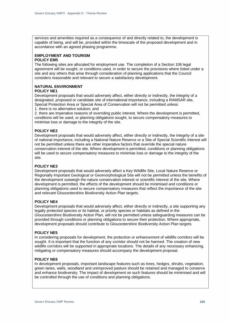
Severn Estuary SMP2 - Appendix D - Theme Review
Severn Estuary SMP Review
150
services and amenities required as a consequence of and directly related to, the development is capable of being, and will be, provided within the timescale of the proposed development and in accordance with an agreed phasing programme. EMPLOYMENT AND TOURISM POLICY EM5 The following sites are allocated for employment use. The completion of a Section 106 legal agreement will be sought, or conditions used, in order to secure the provisions where listed under a site and any others that arise through consideration of planning applications that the Council considers reasonable and relevant to secure a satisfactory development. NATURAL ENVIRONMENT POLICY NE1 Development proposals that would adversely affect, either directly or indirectly, the integrity of a designated, proposed or candidate site of international importance, including a RAMSAR site, Special Protection Area or Special Area of Conservation will not be permitted unless: 1. there is no alternative solution; and 2. there are imperative reasons of overriding public interest. Where the development is permitted, conditions will be used, or planning obligations sought, to secure compensatory measures to minimise loss or damage to the integrity of the site. POLICY NE2 Development proposals that would adversely affect, either directly or indirectly, the integrity of a site of national importance, including a National Nature Reserve or a Site of Special Scientific Interest will not be permitted unless there are other imperative factors that override the special nature conservation interest of the site. Where development is permitted, conditions or planning obligations will be used to secure compensatory measures to minimise loss or damage to the integrity of the site. POLICY NE3 Development proposals that would adversely affect a Key Wildlife Site, Local Nature Reserve or Regionally Important Geological or Geomorphological Site will not be permitted unless the benefits of the development outweigh the nature conservation interest or scientific interest of the site. Where development is permitted, the effects of the development should be minimised and conditions or planning obligations used to secure compensatory measures that reflect the importance of the site and relevant Gloucestershire Biodiversity Action Plan targets. POLICY NE4 Development proposals that would adversely affect, either directly or indirectly, a site supporting any legally protected species or its habitat, or priority species or habitats as defined in the Gloucestershire Biodiversity Action Plan, will not be permitted unless safeguarding measures can be provided through conditions or planning obligations to secure their protection. Where appropriate, development proposals should contribute to Gloucestershire Biodiversity Action Plan targets. POLICY NE5 In considering proposals for development, the protection or enhancement of wildlife corridors will be sought. It is important that the function of any corridor should not be harmed. The creation of new wildlife corridors will be supported in appropriate locations. The details of any necessary enhancing, mitigating or compensatory measures should accompany the development proposal. POLICY NE6 In development proposals, important landscape features such as trees, hedges, shrubs, vegetation, green lanes, walls, woodland and unimproved pasture should be retained and managed to conserve and enhance biodiversity. The impact of development on such features should be minimised and will be controlled through the use of conditions and planning obligations.

Severn Estuary SMP2 - Appendix D - Theme Review
Severn Estuary SMP Review
151
POLICY NE7 Development proposals that would adversely affect the nature conservation interest of natural watercourses, canals, ponds and other water features will not be permitted unless either: 1. the benefits of the development outweigh the nature conservation interest of the water feature; or 2. the effects of the development on the nature conservation interest of the water feature can be compensated by conditions or planning obligations. POLICY NE9 When considering development proposals in the Special Landscape Area, priority will be given to the conservation and where possible enhancement of the landscape character. Permission will not be granted to development that would harm the character, appearance or special landscape qualities of the Special Landscape Area. POLICY NE10 Development proposals should conserve or enhance the special features and diversity of the different landscape character types found within the District as identified in the Stroud District Landscape Assessment. Priority will be given to the protection of the quality and diversity of the landscape character. Development will only be permitted if all the following criteria are met: 1. natural features and water features that contribute to the landscape setting are retained and managed; 2. there is no unacceptable impact on long distance views; and 3. the benefits of the proposed development outweigh any harmful effects on the landscape. POLICY NE11 Development will not be permitted if it would damage or destroy trees protected by a Tree Preservation Order, or identified as Ancient Woodland, or in a Conservation Area unless either: 1. the removal of one or more trees would be in the interests of good arboricultural practice; or 2. the benefits of the proposed development outweighs the amenity or landscape value of the protected trees. POLICY NE15 Permission will not be granted to any development proposal that would unacceptably affect the water environment, including surface waters, groundwater levels and resources. Development proposals should incorporate the principles of ‘Sustainable Drainage Systems’ into the scheme. TRANSPORT POLICY TR11 Proposals for development within the boundary of the docks at Sharpness which would harm the viability of the docks for handling freight and shipping repairs will not be permitted.

Severn Estuary SMP2 - Appendix D - Theme Review
Severn Estuary SMP Review
152
SOUTH GLOUCESTERSHIRE COUNTY COUNCIL SOUTH GLOUCESTERSHIRE LOCAL PLAN (ADOPTED JANUARY 2006) This Plan represents the culmination of much work and effort over the past ten years to shape the future of South Gloucestershire. It has been drawn up in consultation with residents, businesses, interest groups and stakeholders, many of whom have influenced its final content. The Plan is an important document which will be the basis upon which development decisions will be taken. The Council is currently working on the South Gloucestershire Core Strategy, which when adopted in 2011/2012 will replace many of the policies of the Local Plan. The Core Strategy went out to its first round of public engagement in June 2008 with the publication of the Issues and Options document. Landscape L1 In order that the character, distinctiveness, quality and amenity of the landscapes of south Gloucestershire are Conserved and enhanced, new development will be Permitted only where: A. Those attributes of the landscape which make a significant contribution to the character of the Landscape are conserved and where possible enhanced; and B. Those features in or of the landscape which make a significant contribution to the character or Distinctiveness of the locality are retained, protected and managed in a manner which ensures Their long-term viability; and C. The amenity of the landscape is conserved and where possible enhanced. The council will seek to negotiate the provision of works to restore, maintain and where possible enhance the landscape in a manner which contributes to the character, quality, distinctiveness and amenity of the Locality within which the development is located. In the context of a degraded landscape, or where the character has been eroded, the council will expect development to contribute to regeneration and restoration of landscape character and distinctiveness as well as visual amenity. Coastal Zone L3 Development within the undeveloped coastal zone will only be permitted where the proposal requires a coastal location and cannot be accommodated elsewhere. Forest of Avon L4 Development that is permitted within the community forest area as defined on the proposals map should: A. Respect the developing woodland setting; and B. Not conflict with the community forest objectives; and C. Not prejudice community forest projects. In its consideration of applications within the Forest of Avon the council will take account of the forest plan’s strategies and the council will seek to negotiate a contribution towards the implementation of community forest objectives. Sites of International Nature Conservation Interest L6 Development which would directly or indirectly adversely affect the integrity of, or which would conflict with the conservation objectives of, a potential, candidate or designated special protection area, special area of conservation, or Ramsar site, will not be permitted. Where, in exceptional circumstances, the development is permitted, conditions will be used, or planning obligations sought, to secure compensatory measures to minimise loss or damage to the integrity of the site.

Severn Estuary SMP2 - Appendix D - Theme Review
Severn Estuary SMP Review
153
Sites of National Nature Conservation Interest L7 Development which would directly or indirectly have an adverse effect on the nature conservation or geological interests of a national nature reserve or a site of special scientific interest will not be permitted unless there are material factors sufficient to outweigh the nature conservation value and there is no reasonable alternative. In such circumstances, mitigation or compensatory measures will be required to minimise and offset the damage. Sites of Regional and Local Nature Conservation Interest L8 Development that would cause damage to local nature conservation or geological interests will not be permitted unless the importance of the development outweighs the value of the substantive interests affected. Where development is to proceed, measures will be required to minimise and offset the impact of the development on the nature conservation interest. Species Protection L9 Development which would directly or indirectly have an adverse effect on nationally or internationally protected species of flora or fauna, or species or habitats listed in national, regional or local biodiversity action plans, will not be permitted unless any damaging effects are capable of being avoided, overcome or offset by mitigation measures. Historic Parks and Gardens and Battlefields L10 Development likely to affect historic parks and gardens or registered battlefields, or their settings, will only be permitted where: A. The historic character and appearance of the site would not be unacceptably harmed; and B. The development enables features, landscaping or planting schemes of historic interest to be conserved, enhanced or restored. In determining proposals, the weight given to the conservation of the site will depend on the intrinsic historic importance of the park, garden or battlefield. Archaeology L11 Development which would not physically preserve sites of national archaeological importance, whether scheduled or not, or would have a significant impact on the setting of visible remains, will not be permitted. Planning permission will not be granted for development on sites or landscapes of archaeological interest or of high archaeological potential without an archaeological assessment and if necessary a field evaluation. Where the assessment indicates that the proposed development would harm a site, structure or landscape of archaeological or historic importance or its setting, development will not be permitted unless applicants can demonstrate a satisfactory scheme indicating how the impact of the proposal on the archaeological resource can be mitigated. The council will negotiate agreements to preserve and manage archaeological remains. Protecting the Best Agricultural Land L16 Development on the best and most versatile agricultural land (grades 1, 2 or 3a) will only be permitted where: A. The development cannot be accommodated on previously developed sites, or on land within a defined settlement boundary, or on poorer quality farmland (grades 3b, 4 or 5); or B. Development of poorer quality farmland would be inconsistent with other sustainability considerations. If best and most versatile land needs to be developed, and there is a choice between sites in different grades, land of the lowest grade available should be used.

Severn Estuary SMP2 - Appendix D - Theme Review
Severn Estuary SMP Review
154
The Water Environment L17 Development which would have an unacceptable effect on the water environment, including surface water and groundwater quality and quantity, river corridors and associated wetlands, will not be permitted. Flood Risk and Development EP2 Development, including the extension and intensification of existing uses or land raising, which generates surface water run-off or water discharge will not be permitted where the development could: A. Itself be at risk from flooding; or B. Require protection from flooding; or C. Reduce the capacity of the flood plain; or D. Increase the risk of flooding elsewhere; or E. Impede the flow of flood waters; or F. Affect the integrity of tidal or fluvial defences; or G. Alter the water table; or H. Increase river channel instability; or I. Cause unacceptable silt deposition; or J. Prevent maintenance of the watercourse; or K. Preclude the solution to existing flooding problems; Unless adequate environmentally acceptable measures are incorporated which provide suitable protection, attenuation or mitigation. Coastal Defences EP3 New coastal defence works, or improvements to existing coastal defences, will be permitted where the proposals would not have an unacceptable effect on: A. The Severn estuary special protection area; or B. Sites, structures or landscapes of archaeological Importance; and would not involve: C Land raising activities or other disturbance on existing coastal marshlands; or D. Structures or engineering works so close to the coast as to render soft engineering options unviable. Where new coastal defences are permitted, these should be designed to minimise impact on the landscape. Where new flood defences or improvements to existing flood defences are permitted, these will need to meet the minimum standards of 1 in 200 year event with provision for sea level rise over the lifetime of the development. Severnside The Joint Replacement Structure Plan acknowledges the role of land at Severnside in providing development opportunities for economic expansion in the short and long term. The council recognises the area as a key strategic location of regional importance for a range of employment uses which require extensive areas of land and good links to the motorways, the rail network and dock facilities at Avonmouth. The JRSP also acknowledges, at Policy 14, the possible scope for residential or other uses on previously committed land at Severnside in accordance with the locational strategy, if a series of planning constraints affecting the area can be resolved. However, given the availability of alternative opportunities for meeting the housing requirement in accordance with the search sequence established by PPG3 ‘Housing’, and the concerns in respect of flooding, this plan makes no provision for housing development in the Severnside area over the plan period to 2011. As far as possible within the limits imposed by the extent of development which has already been committed, the Council will seek to: • Safeguard sensitive areas of nature conservation importance in the estuary; • Protect the amenities of local communities; and

Severn Estuary SMP2 - Appendix D - Theme Review
Severn Estuary SMP Review
155
• Control the phasing of development and require the introduction of public transport measures to ensure that traffic generated by development does not significantly exceed the capacity of the existing and improved road network and that alternative to the private car are available.

Severn Estuary SMP2 - Appendix D - Theme Review
Severn Estuary SMP Review
156
BRISTOL CITY COUNCIL Bristol Local Plan - Written Statement - Adopted 1997 The Bristol Local Plan was formally adopted in December 1997 after a long and lively debate involving many thousands of local people and numerous organisations with a stake in the city’s future. Bristol now has up to date statutory planning policies covering the whole city. This Plan will guide development up to 2001 and form the basis for a review taking Bristol into the 21st Century. The Council is currently in the process of preparing a Core Strategy for the City, as required by new planning legislation, and will be consulting on a Preferred Options Review document with effect from 27th February 2009. Whilst this has no legal status at this time it may help to provide an indication of the direction of our thinking as regards development at Avonmouth ME2 Development which has an unacceptable impact on the environmental amenity or wildlife of the surrounding area by reason of fumes, odour, dust or other forms of air, land or water pollution will not be permitted. In determining planning applications account will be taken of:– (i) Provision of adequate facilities for the safe storage and disposal from the site of waste materials. (ii) Measures to stop unacceptable levels of run off and emissions. (iii) Hours of operation. (iv) Location, design and layout. (v) Measures that reduce existing levels of pollution. ME4 (I) Development which has an unacceptable impact of the environmental amenity or wildlife of the surrounding area by reason of noise will not be permitted. (II) In determining planning applications in areas of existing noise such as roads, aerodromes, railway lines, industrial/commercial developments and sporting, recreational and leisure facilities, account will be taken of the provision of adequate sound insulation measures. ME5 The location and design of development will be required to incorporate appropriate remedial measures to avoid harm to groundwater supplies which may otherwise result from the development. ME7 (I) It is proposed to safeguard a land allocation for the extension of the existing sewage treatment works in Avonmouth, as defined on the Proposals Map, in order to meet EC directives on sewage treatment and disposal (II) In assessing planning applications for proposals aimed at improving water quality and supply and reducing water pollution, account will be taken of the following factors:– (i) Minimising any visual intrusion and impact on local amenity due to noise, smell or other disturbance. (ii) Protecting wildlife habitats (iii) Protecting the visual quality of important landscape designations. ME8 Development within the coastal zone defined on the Proposals Map, will only be permitted where the proposal requires a coastal location ME9 (i) development will not be Permitted where:
• it causes a net loss of flood Storage capacity; or • run-off from development Would result in, or increase the risk of flooding of Watercourses,
ditches, land Or property; or • land drainage systems Serving the development site Are adversely affected or the

Severn Estuary SMP2 - Appendix D - Theme Review
Severn Estuary SMP Review
157
• Land drainage of the site will Be inadequate after development (ii) development will not be Permitted within high risk flood zones, except:
• within the substantially Developed area of Avonmouth shown on the Proposals map. In this area, Development of industrial, Warehousing and storage, Essential transport and Utilities infrastructure and Docks related uses will be Permitted, subject to the use Of flood resistant forms of Construction and Appropriate contributions to Improvement of flood Defences and to arrangements for warning And evacuation
• within other substantially Developed areas shown on The proposals map. In these Areas, development will be Permitted subject to the use Of flood resistant forms of Construction and Appropriate contributions to Improvement of flood Defences and to Arrangements for warning And evacuation
(iii) where new drainage Infrastructure is necessary as part of a development, Sustainable drainage systems Will be sought, subject to Their ability to meet technical Performance requirements (iv) proposals should provide And/or retain access for Relevant bodies to maintain drainage infrastructure (I) Development subject to flood risk will be required to provide the appropriate defence works at the same time as the development itself. (II) Development which would increase the risk of flooding, or which is likely to cause unacceptable effects arising from surface water run-off, will be required to provide for the appropriate drainage infrastructure works and retention works at the same time as the development itself. ME10 Development adjacent to existing rivers and watercourses will be required to provide access and working strips along the banks affected by the development. ME13 On land which has been identified as unstable, appropriate remedial measures to overcome instability will be required. Where instability could not be satisfactorily overcome to render the site suitable for the proposed development without causing harm to interests of acknowledged importance, planning permission will not be granted. ME14 In determining planning applications for public utility developments, account will be taken of the technical and locational needs of operators and the visual, environmental and health and safety impacts of the development, with particular regard to the following:– (i) The efficient use of existing equipment and services. (ii) The use of appropriate materials and colours, and the sympathetic use of screening. (iii) The character and appearance of the locality in which it is proposed. NE1 (I) The distribution, variety, quality and accessibility of open spaces throughout the city will be maintained and, where possible, enhanced. (II) Sites which are important for nature conservation, recreation, historic landscape interest, landscape quality, visual amenity, community or outdoor leisure-related use, or providing setting or relief to the built environment, defined on the Proposals Map, will be protected as open space. (III) Development involving a loss of important open space (designated in section II and defined on the Proposals Map), or which would have a significant adverse effect on the interest, use, amenity, character or accessibility of such open space, will not be permitted. (IV)Where sites are not defined as open space on the Proposals Map, and are not subject to any other designation or proposal, account will be taken of the need to protect open space interests and uses in determining planning applications. Particular attention will be paid to the amenity and nature conservation value of undefined open space sites. NE2 Prominent or strategically important landscape features which make a significant contribution to the landscape character of the city, including green hillsides, promontories, ridges, valleys, gorges and

Severn Estuary SMP2 - Appendix D - Theme Review
Severn Estuary SMP Review
158
man-made landscapes will be protected. Development which would have a significant adverse effect on identified features of importance as defined on the Proposals Map will not be permitted. NE3 Development involving the loss of or damage to trees or woodlands which are of landscape, amenity or nature conservation value will not be permitted, unless harmful effects of the development can be overcome and replacement or additional tree planting of appropriate scale and species, which is sufficient to compensate for the loss, can be achieved within the same site or on an equivalent site nearby. NE4 Sustainable new tree planting will be sought in association with new development. The city council will promote and support new planting in urban areas that currently lack trees, and in other locations that would benefit from trees NE5 (I) Sites of Nature Conservation Interest, set out in the Schedule and defined on the Proposals Map will be protected, having regard to the relative significance of their designation. (II) Development which is likely to have an adverse effect on the nature conservation objectives or the integrity of a potential or classified Special Protection Area, a candidate or designated Special Area for Conservation or a Ramsar Site will not be permitted. (III) Development affecting a site of Special Scientific Interest will not be permitted unless it can be made subject to conditions that will prevent damaging impacts on wildlife habitats or important physical features, or if other material factors outweigh the national nature conservation considerations. (IV) Development which would harm the substantive nature conservation value of sites of citywide importance will not be permitted, except where the significance of the site for nature conservation is outweighed by the importance of the development. NE6 (I) The city’s wildlife network will be protected and, where possible, enhanced. (II) Development on wildlife network sites, as defined on the Proposals Map, will not be permitted unless:– (i) An open corridor is retained which maintains an effective link in the network; (ii) An open buffer zone which gives effective added protection to any adjoining site of nature conservation interest is retained; (iii) Habitats or features of identified importance to wildlife are retained and protected from any significant adverse effect. (iv) The site is shown not to serve or support any substantive wildlife interest, including the necessary function of the wildlife network, as a result of further detailed site assessment. (III) Development which maintains the integrity of the wildlife network and includes measures to enhance the nature conservation value of remaining open land will be permitted. NE8 Development which would cause unacceptable harm to a species protected under national legislation, or its habitat, will not be permitted unless the adverse effect is capable of being overcome by measures to be carried out prior to or during development, as identified in a thorough site survey. NE9 Historic parks and gardens and other designed landscapes of national and local importance shown on the proposals map and described in the schedule will be protected. Development which would adversely affect the character or appearance of historic landscapes and their settings, will not be permitted. NE11 In determining planning applications, account will be taken of the retention and protection of existing natural features and habitats, and, where appropriate, the benefits of new landscape treatment

Severn Estuary SMP2 - Appendix D - Theme Review
Severn Estuary SMP Review
159
which:– (i) Compensates for any unavoidable loss of existing features or habitats; (ii) Incorporates the greatest possible proportion of appropriate native vegetation (unless special circumstances dictate otherwise); (iii) Incorporates the maximum possible area of permeable ground surface; (iv) Includes habitat features attractive to local wildlife species, (both in the design of the buildings and the landscape elements); (v) Respects the local landscape character; (vi) Enhances the landscape quality of the site; (vii) Is included in management plans for the whole site; (viii) Is well integrated with the buildings and existing landscape features on and surrounding the site. NE12 In determining planning applications, account will be taken of the benefits of creating new or enhancing existing open spaces, particularly areas lacking publicly accessible open space of high amenity, landscape or recreational value, or nature conservation interest. M16 In determining planning applications account will be taken of opportunities to enhance the pedestrian and cycle networks. Development will be permitted when it incorporates measures to take advantage of such opportunities. H1 Development involving the change of use of existing residential accommodation will only be permitted when:– (i) It would not unacceptably erode the city’s housing stock; or (ii) it consists of a community service use which provides benefits for the residents of the immediate locality; or (iii) the accommodation is unsuitable for residential use. L1 Development resulting in the loss of playing fields and recreational open space will not be permitted unless:– (i) Loss of the land/property forms part of a larger scheme for the development of improved recreational open space serving the needs of the local community; or (ii) compensatory open space of an equivalent community benefit is to be provided in the same locality; (iii) In the case of the partial development of an existing site, those facilities are accommodated and/or enhanced by such proposals. L5 Subject to other policies within the Plan, the establishment of water recreation facilities such as marinas, boat hire and dinghy centres will be permitted between Cumberland Basin and St Anne’s footbridge. A1 Avonmouth is identified as a priority area for major development opportunities, particularly focusing on economic regeneration within an improved and managed environment. Where necessary, new development will be expected to pay a contribution, fairly and reasonably related in scale and kind, to the costs of providing both the strategic and local infrastructure to service the development, and to improve the natural and man-made environment. A3 Proposals for industrial development in close proximity to housing will be permitted provided that there is no unacceptable loss of local residential amenity as a result of environmental pollution, visual appearance or traffic generation.
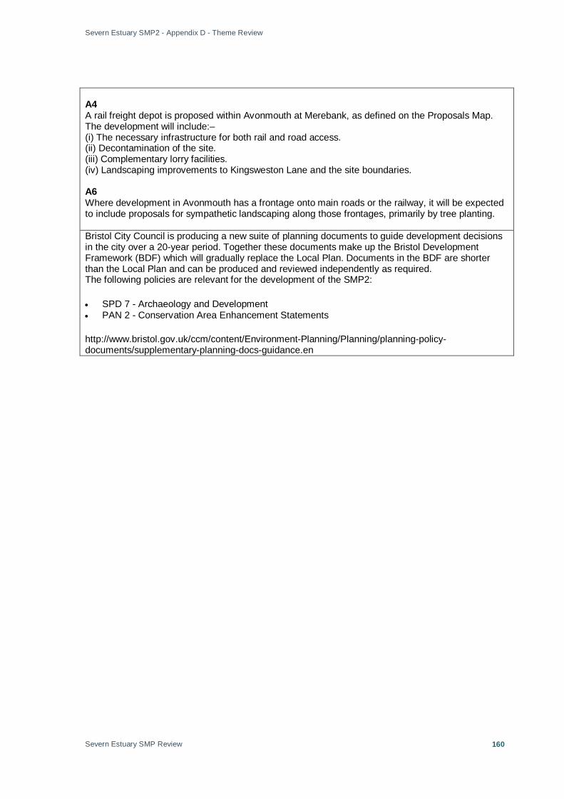
Severn Estuary SMP2 - Appendix D - Theme Review
Severn Estuary SMP Review
160
A4 A rail freight depot is proposed within Avonmouth at Merebank, as defined on the Proposals Map. The development will include:– (i) The necessary infrastructure for both rail and road access. (ii) Decontamination of the site. (iii) Complementary lorry facilities. (iv) Landscaping improvements to Kingsweston Lane and the site boundaries. A6 Where development in Avonmouth has a frontage onto main roads or the railway, it will be expected to include proposals for sympathetic landscaping along those frontages, primarily by tree planting. Bristol City Council is producing a new suite of planning documents to guide development decisions in the city over a 20-year period. Together these documents make up the Bristol Development Framework (BDF) which will gradually replace the Local Plan. Documents in the BDF are shorter than the Local Plan and can be produced and reviewed independently as required. The following policies are relevant for the development of the SMP2:
• SPD 7 - Archaeology and Development • PAN 2 - Conservation Area Enhancement Statements
http://www.bristol.gov.uk/ccm/content/Environment-Planning/Planning/planning-policy-documents/supplementary-planning-docs-guidance.en

Severn Estuary SMP2 - Appendix D - Theme Review
Severn Estuary SMP Review
161
North Somerset Council North Somerset Replacement Local Plan Written Statement –Adopted March 2007 Under the Town and Country Planning Act 1990, North Somerset Council is required to prepare and keep up to date a local plan covering the whole of its area. The form and content of local plans and the procedures for preparing them are prescribed through the Town and Country Planning (Development Plan) (England) Regulations 1999 (‘the Development Plan Regulations’) (S.I.1999:3280). GENERAL DEVELOPMENT PRINCIPALS
The preferred location for major developments is Weston-super-Mare, including regeneration sites in the Weston area. Major developments within Clevedon, Nailsea and Portishead will also be
Policy GDP/1 – Preferred locations for development
permitted if: • They facilitate the completion of a scheme for the redevelopment of previously developed land
allocated in this plan; or • They will primarily meet employment or community needs arising from within the town; or • They meet other needs in ways appropriate to the scale of the settlement, in particular that they
do not result in high levels of additional out-commuting. Development of any kind within other defined settlements will only be permitted where appropriate to the scale of the settlement in terms of its character and physical identity, local employment opportunities and access to retail, cultural and community facilities. Except where provided for by other policies, built development in the countryside will not be permitted. Where built development in the countryside is proposed, the maintenance of the character and appearance of the countryside and the avoidance of coalescence of settlements will be objectives of any decision on the proposal. Priority will be given to meeting development needs through regeneration, utilising previously developed land or vacant buildings within existing built up areas, and through proposals that reduce the need to travel, especially by car, where infrastructure is available or can be efficiently provided. A sequential assessment of alternative sites will be required for all proposals likely to result in significant trip generation.
Development that, on its own or cumulatively, would result in air, water or other environmental pollution or harm to amenity, health or safety will only be permitted if the potential adverse effects could be mitigated to an acceptable level by other control regimes, or by measures included in the proposals, by the imposition of planning conditions or through a planning obligation.
Policy GDP/2 – Environmental and public protection
Poorly designed development proposals will be rejected. In determining proposals, where appropriate and relevant, account will be taken of:
Policy GDP/3 – Promoting good design and sustainable construction
• Whether the proposal safeguards and integrates important features such as areas of ecological, amenity or heritage value, views of public importance across the site and rights of way;
• Whether the siting, levels, density, form, scale, height, massing, detailing, colour and materials respect the characteristics of the site and its surroundings and avoids adverse effects within the site and upon adjoining areas through overlooking or overshadowing or overbearing impact;
• Whether the external areas form an integral part of the design, provide permeability and are of a scale and character appropriate to the development proposed and the surrounding area;
• whether hard and soft landscaping forms an integral part of he design and incorporates important existing features;
• Whether the proposal includes elements to reduce opportunities for crime through design and ensuring clear distinctions between private and public spaces;
• Whether the proposal enables private and emergency vehicular access having regard to the nature of the site, visibility, loading, turning and parking requirements in accordance with the adopted standards;
• Whether the proposal makes provision for convenient, safe and attractive access for pedestrians (including those with physical and sensory disabilities), cyclists and where appropriate for public
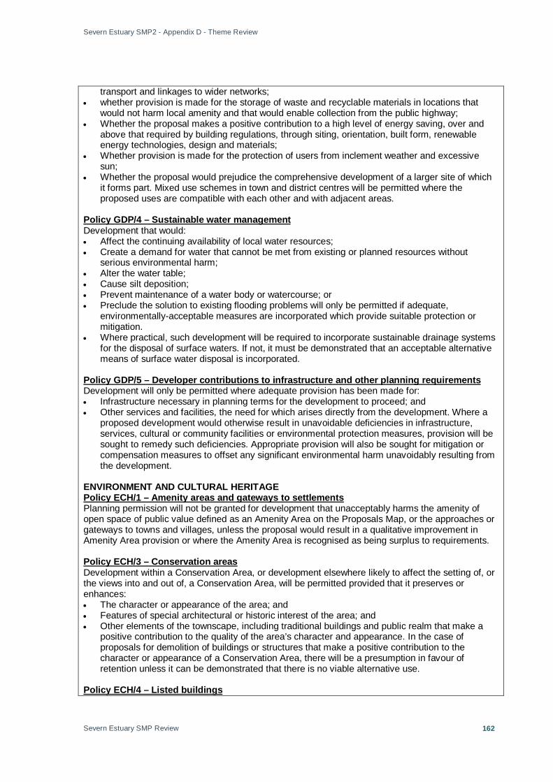
Severn Estuary SMP2 - Appendix D - Theme Review
Severn Estuary SMP Review
162
transport and linkages to wider networks; • whether provision is made for the storage of waste and recyclable materials in locations that
would not harm local amenity and that would enable collection from the public highway; • Whether the proposal makes a positive contribution to a high level of energy saving, over and
above that required by building regulations, through siting, orientation, built form, renewable energy technologies, design and materials;
• Whether provision is made for the protection of users from inclement weather and excessive sun;
• Whether the proposal would prejudice the comprehensive development of a larger site of which it forms part. Mixed use schemes in town and district centres will be permitted where the proposed uses are compatible with each other and with adjacent areas.
Development that would: Policy GDP/4 – Sustainable water management
• Affect the continuing availability of local water resources; • Create a demand for water that cannot be met from existing or planned resources without
serious environmental harm; • Alter the water table; • Cause silt deposition; • Prevent maintenance of a water body or watercourse; or • Preclude the solution to existing flooding problems will only be permitted if adequate,
environmentally-acceptable measures are incorporated which provide suitable protection or mitigation.
• Where practical, such development will be required to incorporate sustainable drainage systems for the disposal of surface waters. If not, it must be demonstrated that an acceptable alternative means of surface water disposal is incorporated.
Development will only be permitted where adequate provision has been made for: Policy GDP/5 – Developer contributions to infrastructure and other planning requirements
• Infrastructure necessary in planning terms for the development to proceed; and • Other services and facilities, the need for which arises directly from the development. Where a
proposed development would otherwise result in unavoidable deficiencies in infrastructure, services, cultural or community facilities or environmental protection measures, provision will be sought to remedy such deficiencies. Appropriate provision will also be sought for mitigation or compensation measures to offset any significant environmental harm unavoidably resulting from the development.
ENVIRONMENT AND CULTURAL HERITAGE
Planning permission will not be granted for development that unacceptably harms the amenity of open space of public value defined as an Amenity Area on the Proposals Map, or the approaches or gateways to towns and villages, unless the proposal would result in a qualitative improvement in Amenity Area provision or where the Amenity Area is recognised as being surplus to requirements.
Policy ECH/1 – Amenity areas and gateways to settlements
Development within a Conservation Area, or development elsewhere likely to affect the setting of, or the views into and out of, a Conservation Area, will be permitted provided that it preserves or enhances:
Policy ECH/3 – Conservation areas
• The character or appearance of the area; and • Features of special architectural or historic interest of the area; and • Other elements of the townscape, including traditional buildings and public realm that make a
positive contribution to the quality of the area’s character and appearance. In the case of proposals for demolition of buildings or structures that make a positive contribution to the character or appearance of a Conservation Area, there will be a presumption in favour of retention unless it can be demonstrated that there is no viable alternative use.
Policy ECH/4 – Listed buildings
Severn Estuary SMP2 - Appendix D - Theme Review
Severn Estuary SMP Review
163
Development proposals requiring planning permission affecting a Listed Building and / or its setting only will be approved where the following criteria can be satisfied: • The architectural and historic interest of the building and its setting is preserved; and • The style, design, plan and other features of special architectural or historic interest are
preserved; and • Any conversion or proposed new use would be compatible with the preservation of the building.
When considering planning applications that would result in the demolition or substantial demolition of Listed Buildings there will be a strong presumption in favour of preservation.
Development likely to affect a Historic Park or Garden identified on the Proposals Map, or it’s setting, will only be permitted where:
Policy ECH/5 – Historic parks and gardens
• Its historic character and appearance will not be unacceptably harmed: and • Its historic importance will not be unacceptably harmed; and • The development enables features, landscaping and planting schemes of historic interest to be
conserved, enhanced or restored.
Development will not be permitted where it would involve significant alteration or cause damage to nationally-important archaeological remains (whether Scheduled or not), or would have a significant impact on the setting of such remains.
Policy ECH/6 – Archaeology
Within the Landscape Character Areas, development will be permitted if it will not adversely affect the particular character of the landscape.
Policy ECH/7 – Landscape Character Areas
Development that is likely to have a significant impact upon biodiversity will not be permitted unless there is an overriding need for the development in the proposed location or measures can be introduced to mitigate such an impact.
Policy ECH/10 – Biodiversity
Development which could harm, directly or indirectly, nationally or internationally protected species of flora or fauna or the habitats used by such species will not be permitted unless that particular harm could be avoided or mitigated and the species protected by the use of planning conditions or planning obligations.
Policy ECH/11 – Protected species and their habitats
Development which would be likely to have a direct or indirect adverse effect or which conflicts with the conservation objectives of a potential, candidate or designated Special Protection Area, Special Area of Conservation, or Ramsar Site will not be permitted.
Policy ECH/12 – Wildlife sites of international importance
Development within or near a Site of Special Scientific Interest (SSSI) or National Nature Reserve that is likely to have a direct or indirect adverse effect on its biodiversity or geological interest will not be permitted unless other material considerations outweigh the loss of biodiversity or geological value of the site concerned and any broader impact upon the national network of SSSIs.
Policy ECH/13 – Sites of special scientific interest and national nature reserves
Planning permission will not be granted for development that would have a significant adverse effect on local biodiversity or geological interests, unless the importance of the development outweighs the value of the substantive interest present.
Policy ECH/14 – Wildlife and geological sites and local nature reserves
Development within the defined Coastal Zone will be permitted only for uses and activities appropriate to and requiring a coastal location that cannot be accommodated elsewhere. When considering such proposals, account will be taken of the likely impact on the coastal environment,
Policy ECH/15 – Coastal zone

Severn Estuary SMP2 - Appendix D - Theme Review
Severn Estuary SMP Review
164
the proposal’s scale, the degree of risk from flooding, erosion and instability, the effect of any works necessary to remove or minimise those risks, and the provision of public access to the coast. RURAL DEVELOPMENT
Planning permission will be granted for agricultural or forestry development, or development for the purposes of farm-based diversification, provided that:
Policy RD/1 – Agricultural and forestry development and farm-based diversification
• The proposals are reasonably necessary for and ancillary to the use of land for agricultural or forestry purposes or essential for the diversification proposed; and
• The re-use of existing buildings on the holding is given priority over new buildings, only where no suitable buildings are available will new development be acceptable; and
• In the case of diversification proposals, there is sufficient certainty of long-term benefit to the farm business as an agricultural operation and that other rural businesses are not adversely affected. Proposals involving the development of a farm shop will be determined according to Policy RT/7.
ECONOMY
The Vision aims to rejuvenate all of Weston and to establish the town as a dynamic and diverse modern economy which has a positive and distinctive profile. To achieve this step change, the Vision for Weston includes three distinct but related sub-areas, as defined on the proposals Map. These comprise:
Policy E1 – Weston-super-Mare Vision
• Weston Seafront & Town centre (Policy E/1A) • Town Centre Gateway and Outer Commercial Area (Policy E/1B); • Weston Regeneration Area (Policy E/1C) • Area Action Plans will provide the basis for guiding future development up to and beyond 2011,
complemented by a series of detailed and integrated master plans. An area development framework, brought forward as Area Action Plans and Supplementary Planning Documents, will provide the basis for guiding future development of Weston up to, and beyond, 2011.
Within the Weston Seafront and Town Centre areas as defined on the Proposals Map, development proposals will be required to:
Policy E/1A – Revitalisation of Weston seafront and town centre
• Make a positive and distinctive contribution to the existing built environment; • Promote more efficient use and re-use of land and premises including the intensification of land-
use activities; • Increase the diversity of land use activities; • Provide investment opportunities; • Contribute to improving the environmental quality and strengthen transport and other linkages in
and around the Town Centre and Seafront; and • Capitalise on the coastal setting and promote sub-regional role and function of the Town Centre.
The priority locations for regeneration and redevelopment are: the Town Centre, Birnbeck Pier, Knightstone Island, the Tropicana and Dolphin Square environs.
Within existing B1–B8 business employment areas, as well as land identified on the Proposals Map for business employment development, proposals for unrelated non B1–B8 development will be permitted where it can be demonstrated that:
Policy E/5 – Safeguarded Employment Areas
• The proposal would not harm the range or quality of land and premises available for business use development within existing employment areas or expressly identified in the Local Plan to meet economic development or local business employment needs and the number of job opportunities provided; or
• There is a specific requirement associated with neighbouring business uses. Any retail or other town centre uses would also be assessed against the recognised sequential tests; or
• The site is no longer capable of offering accommodation for business se development, or that the proposals would lead to the removal of incompatible development, resulting in greater potential benefits to the community in terms of environmental benefits, significant improvements

Severn Estuary SMP2 - Appendix D - Theme Review
Severn Estuary SMP Review
165
in the amenities of existing neighbouring residents or contribute to a more sustainable pattern of development that would
• outweigh the loss of employment capacity in the locality.
House Farm Land as shown on the Proposals Map south of Royal Portbury Dock, at Court House Farm is identified as land safeguarded for port uses subject to:
Policy E/6 – Proposals for development on safeguarded land at Court
• Demonstrable need for those uses that cannot be accommodated within the existing developed area;
• Satisfactory environmental safeguards; • There being no significant demonstrable harm to the amenities of residents of Easton-in-
Gordano and • Demonstrating that development would not prejudice proposals for a station and associated
parking facilities off Royal Portbury Dock Road in accordance with Policy T/3ii. • The land to remain open and safeguarded against any permanent form of development until
such time as the need for port uses is clearly demonstrated. HOUSING
To achieve more sustainable patterns of development and to comply with RPG 10 and the JRSP, development will be located within the boundaries of Weston-super-Mare, Portishead, Nailsea and Clevedon, with only limited development elsewhere. The following order of preference when considering new residential proposals will be applied:
Policy H/1 – Residential Development Strategy
• Previously-developed land and buildings within the towns of Weston -Super-Mare, Portishead, Nailsea and Clevedon; then
• Other suitable land within the four main towns; followed by • Extensions to the four towns, where access to existing local employment opportunities,
infrastructure, services and facilities, by means other than the private car, can be demonstrated to be good or, alternatively, based on sustainable development objectives; and/or
• Previously-developed land or other suitable land within other settlements, where access to employment opportunities, services and facilities by means other than the private car can be demonstrated to be satisfactory. Housing development in excess of ten dwellings in Weston-super-Mare will have regard to the over-riding principle that this will be limited until more closely in balance with employment development. Planning permission will not be granted where the proposed development would lead to greater imbalance. Residential development outside the four towns identified above, on its own, or with other development, will not be permitted where it would be poorly related to centres of employment, place unacceptable pressure on infrastructure, including the highway network, and other local community facilities, or where development would simply add to or contribute to creating a dormitory settlement with high levels of out-commuting.
Policy H/2 – Proposed sites for new residential developmentIncorporating target for previously-developed land and phasing policy in accordance with the findings from the Council’s 2002 Urban Housing Capacity Study, land is identified or an allowance threshold made to accommodate and phase the residual additional dwellings (net) to meet the needs of the area over the remaining Plan period up to 2011 in accordance with Policy 33 of the JRSP. Of this total, 55% of all dwellings are targeted to be completed on previously developed land including conversions. Incorporated into this strategic total is the threshold allowance that 40 dwellings per annum will come forward from unidentified previously-developed windfall sites and 161 dwellings per annum from the other small sites incorporating the intensification of existing housing, over the Plan period. As set out in the schedule below and shown on the Proposals Map, between April 2006 and March 2011, excluding allowances for unidentified windfall sites and small sites over the Plan period, sufficient provision will be made for 5,024 additional dwellings (net).
TRANSPORT
A corridor extending 10 metres either side of the existing tracks of the Taunton-Bristol railway line is Policy T/1 – Existing and proposed railway lines

Severn Estuary SMP2 - Appendix D - Theme Review
Severn Estuary SMP Review
166
safeguarded for the provision of additional tracks. Development within this corridor will only be permitted if it would not prejudice proposals for the line promoted by national rail policies or by the relevant network operator. The following alignments, defined on the Proposals Map, are safeguarded for rail use: • Weston southern chord; • Portishead – Portbury (Station Road Bridge). Development will only be permitted if it would not
prejudice the use of these alignments for rail traffic.
Development at and around existing passenger railway stations will only be permitted if it would not prejudice the station’s function, including the ability to provide for projected growth in rail traffic. The land designated for the purposes of this policy, defined on the Proposals Map, includes land adjoining the following stations that is safeguarded for park-and-ride schemes:
Policy T/2 – Existing railway stations
• Worle; • Yatton; • Nailsea and Backwell.
Stations and associated parking facilities in conjunction with the reopening of the Portishead to Bristol line are proposed on the following sites, defined on the Proposals Map:
Policy T/3 – Proposed railway stations
• Harbour Road, Portishead; • Off Royal Portbury Dock Road, Portbury (area of search); • Severn Road, Pill. Development on, adjacent to or in the vicinity of the safeguarded sites will
only be permitted if it would not prejudice the implementation and/or function of the proposed uses.
Development that would result in the reduction of publicly available off-street car parking spaces will only be permitted if:
Policy T/4 – Existing public car parks
• The location has good access to other means of travel than the private car; and • Any resulting increase in on-street parking would not unacceptably harm the character of the
area or increase traffic congestion in the vicinity.
Development that would reduce, sever, or adversely affect the use, amenity or safety of public rights of way and other forms of public access, or prejudice the planned development of the network will only be permitted if acceptable provision is made to mitigate those effects, or
Policy T/7 – Protection, development and improvement of the Rights of Way Network and other forms of public access
divert or replace the right of way or other form of access, before the development commences.
Proposed strategic cycle routes are identified in the schedule forming part of this policy and defined on the Proposals Map. Development will only be permitted if it would not prejudice the implementation of these routes.
Policy T/8 – Strategic cycle routes
Major highway schemes, defined on the Proposals Map, are proposed as follows: Policy T/9 – Highway schemes
• Herluin Way to Locking Road Link, Weston-super-Mare; • Cross – Airfield Link, Weston-super-Mare; • A38 – A370 Link Road; • South Bristol Ring Road; • Banwell Bypass (subject to implementation, monitoring and evaluation of traffic management
measures and outcome of hydrogeological studies). Development will only be permitted if it would not prejudice the implementation of these schemes.
Planning permission will be granted for cultural and community facilities within settlement Policy CF/2 – Cultural and Community Facilities within settlement boundaries

Severn Estuary SMP2 - Appendix D - Theme Review
Severn Estuary SMP Review
167
boundaries, provided that the following criteria are met. • The possibility of sharing the use of existing facilities has been considered and shown to be
impractical. • The site is in a sustainable location, well-related to the community it is intended to serve. • The proposed facilities will be genuinely accessible by a choice of transport modes and to those
with impaired mobility. • The layout and design include features to facilitate combining other community needs within the
same site, unless this is agreed to be inappropriate. Additionally, in the case of proposals for major developments that will attract a large number of users, applicants must demonstrate that a sequential test has been applied, giving priority to sites within town or district centres, or, failing this, sites at the edge of these centres. Proposals for out-of-centre sites will only be acceptable here:
• There is a need for the proposed development; and • There are no alternative sites within or adjacent to the relevant centres; and • There is no adverse effect on the vitality and viability of the relevant centres.
Planning permission will be granted for cultural and community facilities outside settlement boundaries if the following criteria are met.
Policy CF/3 – Cultural and Community Facilities in the countryside
• The need for the proposal cannot be met within a settlement; • The site is adjacent to a settlement boundary; • The facility is well-related to the community it is intended to serve; • The facility will be accessible by a choice of transport modes and to those with impaired mobility; • The proposal does not conflict with other pre-existing outdoor activities; • The layout and design include features to facilitate combining other community needs within the
same site, unless this is agreed to be inappropriate; In the case of proposals for major developments that will attract a large number of users, applicants must demonstrate that there is a need for the proposed development and that a sequential test has been applied, giving priority to sites within town or district centres, or, failing this, sites at the edge of these centres. Proposals for out-of-centre sites will only be acceptable where the above criteria are met and there is no adverse effect on the vitality and viability of the relevant centres.
This policy applies as follows: Policy CF/4 – Safeguarding of existing and proposed sites and buildings
• To safeguard for its existing use the land and buildings shown on the Proposals Map as existing cultural and community facilities;
• To safeguard for the purpose identified in the schedule forming part of this policy the land shown on the Proposals Map as proposed cultural and community facilities;
• To safeguard for community use other land or buildings used or last used for cultural or community facilities (unless the site is allocated for another purpose in this Plan). The development of these sites/buildings for other uses will be permitted only if one of the following circumstances applies:
• Where acceptable alternative provision of at least equivalent community benefit is made available in the same vicinity and capable of serving the same catchment area. In such cases, all of the following criteria must be met:
• The new site is at least as accessible to pedestrians, cyclists and motor vehicles; • The replacement facility is at least equivalent in terms of size, usefulness, attractiveness and
quality to the facility it replaces; and • In the case of a replacement for an existing facility, the replacement will be available for use
before use of the existing facility is lost. Where the site or building is genuinely redundant/surplus to requirements for cultural/community uses and does not comprise open space or undeveloped land with recreational or amenity value. A site will be deemed genuinely redundant/surplus for community uses if any of the following circumstances apply: • The site is in an unsuitable location for alternative community use by reason of its distance from
the local population or poor accessibility for non-car users;

Severn Estuary SMP2 - Appendix D - Theme Review
Severn Estuary SMP Review
168
• The space is unsuitable for appropriate alternative community use, bearing in mind the possibilities for subdividing vertically and horizontally and opportunities for shared and mixed uses, and it is not feasible or appropriate to redevelop the site for community use;
• Evidence is submitted that demonstrates, to the satisfaction of the local planning authority, that attempts to rent/dispose of the property for community uses have failed (attempts being for at least 6 months, at normal market value for such uses). In addition, if the local planning authority considers it appropriate, a business plan shall be produced identifying the extent and combination of usage and charges necessary to make the facility profitable.
• The local planning authority, through consultation with relevant Council departments, town/parish councils, service providers and voluntary groups, etc. is satisfied that there is no demand for any form of community facility in the vicinity.
• Where the development of a small area will secure the retention and improvement of the remainder of the site for community use;
• Where proposals relate to the intensification of community use; • In the case of school playing fields, where the development is for education purposes or the
Department for Education and Skills is satisfied that the land is no longer required for school use and its loss would not result in a continuing shortfall in recreational open space for the local community.

Severn Estuary SMP2 - Appendix D - Theme Review
Severn Estuary SMP Review
169
Annex B: Water Assets [Additional details are available in a tabular format with specific asset details where mapped information is not sufficient]
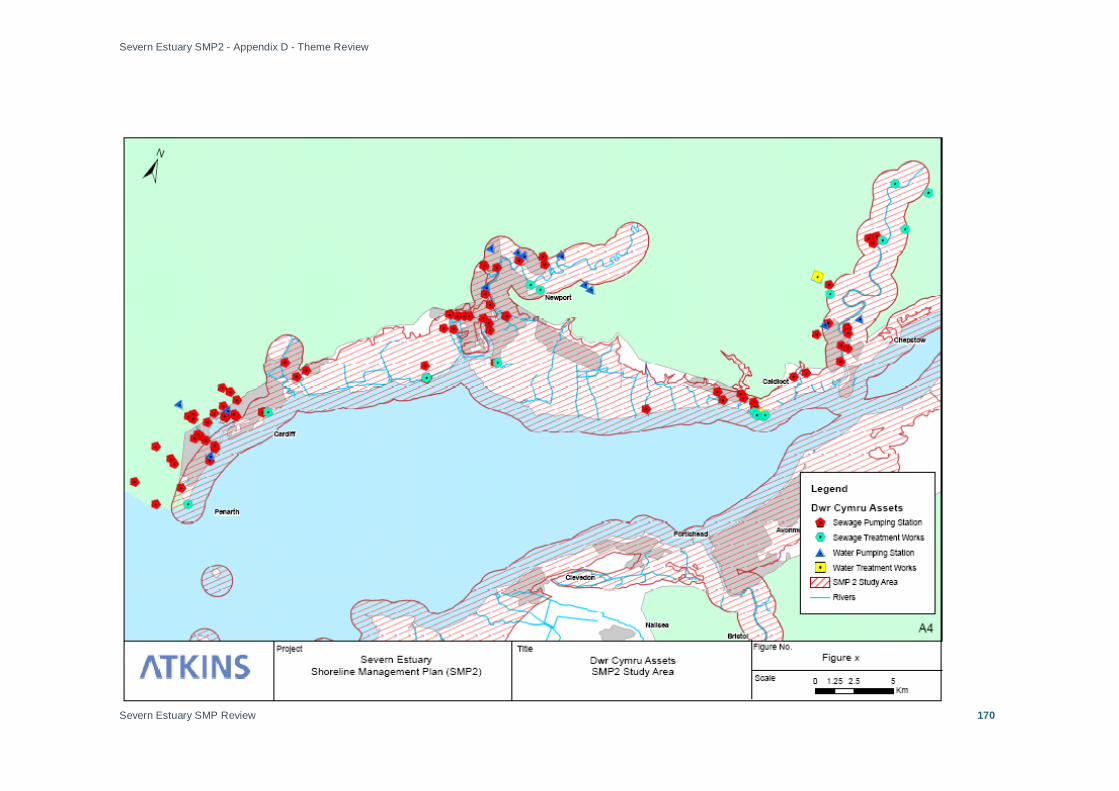
Severn Estuary SMP2 - Appendix D - Theme Review
Severn Estuary SMP Review
170
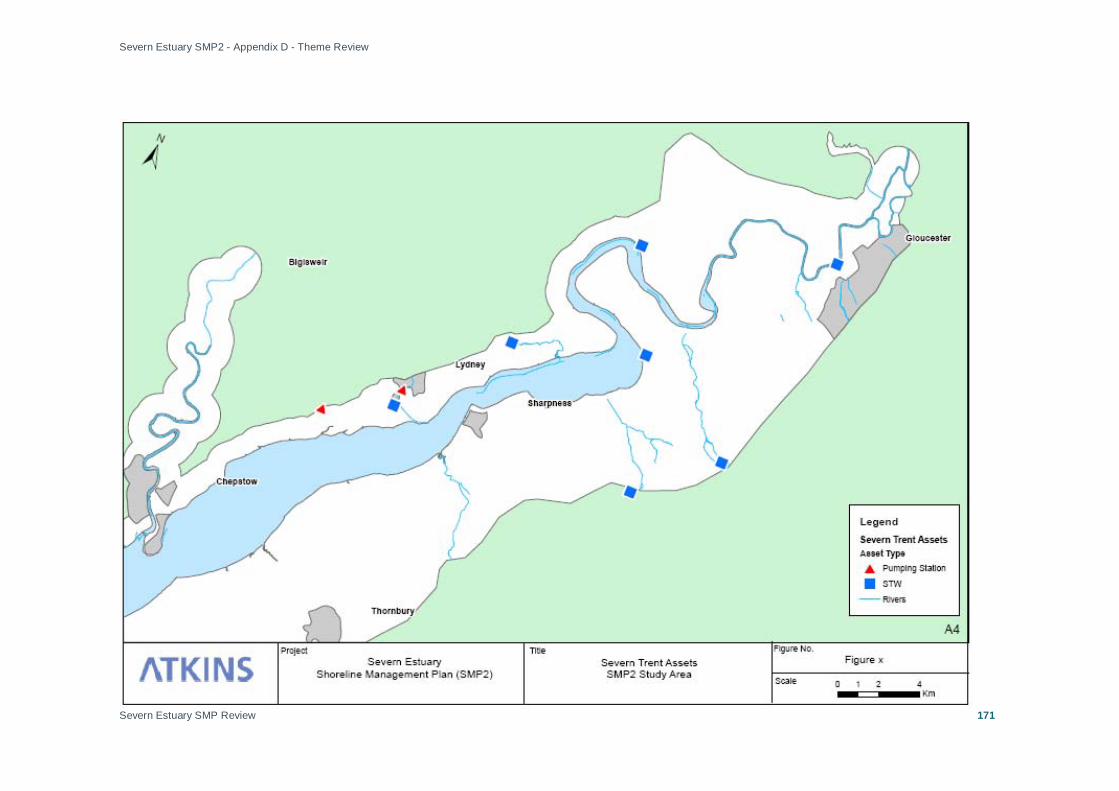
Severn Estuary SMP2 - Appendix D - Theme Review
Severn Estuary SMP Review
171

Severn Estuary SMP2 - Appendix D - Theme Review
Severn Estuary SMP Review
172

Severn Estuary SMP2 - Appendix D - Theme Review
Severn Estuary SMP Review
173
Annex C: SSSIs SSSI Site Name Easting Northing Theme Area
Ashton Court 355438 172069 Bristol & Severnside
Ashleworth Ham 383253 226293 Gloucester To Haw Bridge
Aust Cliff 356852 189885 Bristol & Severnside, Sharpness To Severn Crossings
Avon Gorge 355464 174540 Bristol & Severnside
Barbadoes Hill Meadows 352701 200903 Wye & Chepstow
Bigsweir Woods 354677 206344 Wye & Chepstow
Blackcliff-Wyndcliff 353173 198163 Wye & Chepstow
Bushy Close 350972 188868 Caldicot Levels
Caerwood & Ashberry Goose House 354704 196559 Wye & Chepstow
Cleddon Shoots Woodland 352206 204056 Wye & Chepstow
Clevedon Shore 340175 171876 Portishead & Clevedon
Coombe Hill Canal 387143 226961 Gloucester To Haw Bridge
Cosmeston Park 317275 169339 Penarth
Ellenborough Park West 331899 160811 Kingston Seymour And Sand Bay
Flat Holm 322038 164875 The Holms
Frampton Pools 375331 207370 Sharpness To Gloucester
Garden Cliff 371833 212779 Lydney To Tewkesbury
Gordano Valley 343900 173229 Portishead & Clevedon
Gwent Levels - Magor And Undy 342737 185924 Caldicot Levels
Gwent Levels - Nash And Goldcliff 335821 184407 Caldicot Levels, Newport & Usk
Gwent Levels - Redwick And Llandevenny 341130 185553 Caldicot Levels
Gwent Levels - Rumney And Peterstone 325045 179985 Cardiff Area, Wentlooge
Gwent Levels - St. Brides 328645 182908 Wentlooge, Newport & Usk
Gwent Levels - Whitson 338706 183986 Caldicot Levels
Gwent Levels - Whitson 338706 183986 Caldicot Levels

Severn Estuary SMP2 - Appendix D - Theme Review
Severn Estuary SMP Review
174
SSSI Site Name Easting Northing Theme Area
Ham Green 353891 175814 Bristol & Severnside
Holly Lane 341903 172693 Portishead & Clevedon
Horseshoe Bend, Shirehampton 354321 176647 Bristol & Severnside
Lower Wye Gorge 354789 197338 Wye & Chepstow
Lydney Cliff 365349 201703 Lydney, Tidenham and Surrounding Villages
Magor Marsh 342618 186615 Caldicot Levels
Middle Hope 333462 166417 Kingston Seymour And Sand Bay
Nedern Brook Wetlands, Caldicot 348607 189455 Caldicot Levels
Penarth Coast 318715 168690 Penarth
Pennsylvania Fields, Sedbury 354159 192926 Wye & Chepstow
Penylan Quarry 319808 178719 Cardiff Area
Pierce, Alcove And Piercefield Woods 353364 195465 Wye & Chepstow
Portishead Pier To Black Nore 344410 176505 Portishead & Clevedon
Purton Passage 368681 204466 Sharpness To Gloucester
Rhymney River Section 321007 178977 Cardiff Area
River Usk (Lower Usk)/Afon Wysg (Wysg Isaf) 338885 198830 Newport & Usk
River Usk (Lower Usk)/Afon Wysg (Wysg Isaf) 338885 198830 Newport & Usk
River Wye 357760 230984 Wye & Chepstow, Caldicot Levels
River Wye (Lower Wye) / Afon Gwy (Gwy Isaf) 358273 219367 Wye & Chepstow, Caldicot Levels
Rumney Quarry 321475 178820 Cardiff Area
Severn Estuary 354136 189148 Penarth, Cardiff, Wentlooge, Caldicot, N&U, W&Ch, Po&Cl, Br&Sev, King&Sand
Shorn Cliff & Caswell Woods 353920 198967 Wye & Chepstow
Spring Cove Cliffs 330947 162565 Kingston Seymour And Sand Bay
Steep Holm 322856 160671 The Holms
Sylvan House Barn 353468 202384 Wye & Chepstow
The Hudnalls 353890 204058 Wye & Chepstow
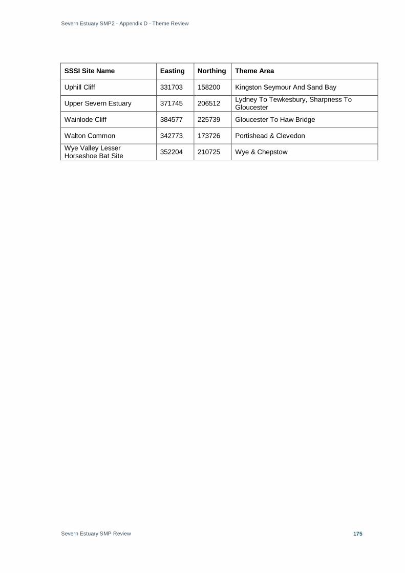
Severn Estuary SMP2 - Appendix D - Theme Review
Severn Estuary SMP Review
175
SSSI Site Name Easting Northing Theme Area
Uphill Cliff 331703 158200 Kingston Seymour And Sand Bay
Upper Severn Estuary 371745 206512 Lydney To Tewkesbury, Sharpness To Gloucester
Wainlode Cliff 384577 225739 Gloucester To Haw Bridge
Walton Common 342773 173726 Portishead & Clevedon
Wye Valley Lesser Horseshoe Bat Site 352204 210725 Wye & Chepstow

Severn Estuary SMP2 - Appendix D - Theme Review
Severn Estuary SMP Review
176
Annex D: Historic Parks and Gardens Historic Park And Garden Grade Easting Northing Area (Ha) Theme Area
Arnos Vale Cemetery II* 360690 171497 10.9 Severnside, Bristol And Avon
Kings Weston House II 354271 177310 126.0 Severnside, Bristol And Avon
Ashton Court II* 355185 172001 352.1 Severnside, Bristol And Avon
Bristol University Botanic Gardens And Rayne Thatch II 355807 173006 2.5 Severnside, Bristol And Avon
Leigh Court II 354294 174756 222.7 Severnside, Bristol And Avon
Goldney House II* 357407 172733 4.2 Severnside, Bristol And Avon
Westbury Court Gardens II* 371829 213856 1.7 Lydney To Gloucester
Clevedon Court II* 342276 171849 60.4 Portishead And Clevedon