APPENDIX C - pland.gov.hk C.pdf · The LP outlines general land use planning intentions for the...
12
Hung Hom District Study Final Report – Appendix C 1 APPENDIX C: EXPLANATORY STATEMENT KOWLOON PLANNING AREA NO. 9 (PART) HUNG HOM WATERFRONT (COMPREHENSIVE DEVELOPMENT AREA AND VICINITY) - LAYOUT PLAN ‘B’ Contents Page 1. Background 2 2. Objectives of the Plan 2 3. The Planning Scheme Area 2 4. Land Use Zoning 2 5. Population and Employment 5 6. Urban Design 5 7. Communications 8 8. Environment 10 9. Air Ventilation 10 10. Utility Services 10 11. Implementation 10
Transcript of APPENDIX C - pland.gov.hk C.pdf · The LP outlines general land use planning intentions for the...
Hung Hom District Study Final Report – Appendix C
1
APPENDIX C:
EXPLANATORY STATEMENT KOWLOON PLANNING AREA NO. 9 (PART)
HUNG HOM WATERFRONT (COMPREHENSIVE DEVELOPMENT AREA AND VICINITY) - LAYOUT PLAN ‘B’
Contents Page
1. Background 2
2. Objectives of the Plan 2
3. The Planning Scheme Area 2
4. Land Use Zoning 2
5. Population and Employment 5
6. Urban Design 5
7. Communications 8
8. Environment 10
9. Air Ventilation 10
10. Utility Services 10
11. Implementation 10
Hung Hom District Study Final Report – Appendix C
2
EXPLANATORY STATEMENT KOWLOON PLANNING AREAS NO. 9 (PART)
HUNG HOM WATERFRONT (COMPREHENSIVE DEVELOPMENT AREA AND VICINITY) - LAYOUT PLAN ‘B’
1. Background
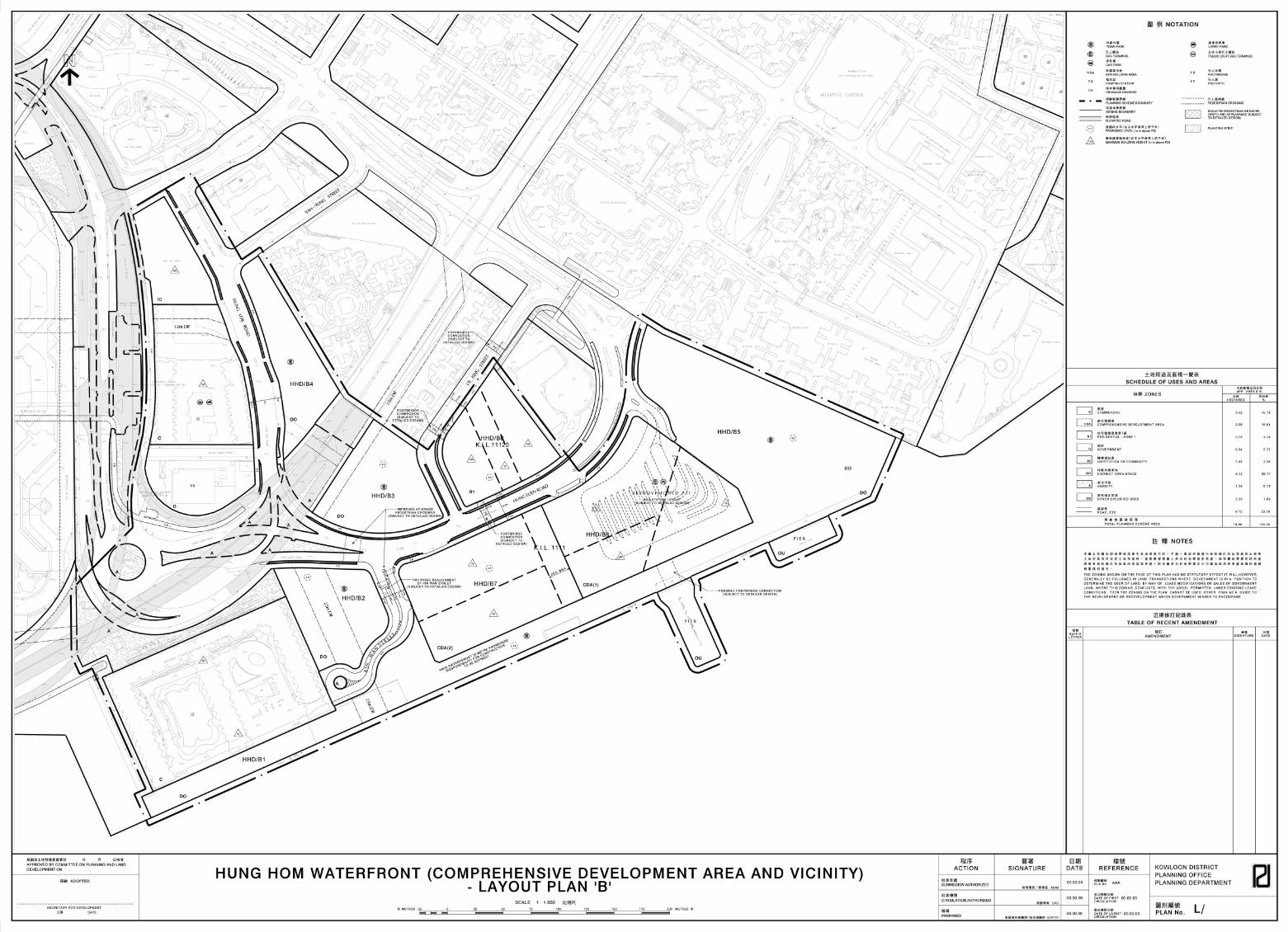
1.1. This explanatory statement is intended to assist in understanding the planning proposals contained in the Layout Plan for the Hung Hom Waterfront (Comprehensive Development Area and Vicinity). This Layout Plan covers a sub-area of the Outline Zoning Plan (OZP) Planning Scheme Area of the Kowloon Planning Area No. 9 (Hung Hom). The explanatory statement sets out the planning and urban design intention and the objectives for the various land use zonings and site parameters.
1.2. The planning proposals for the Hung Hom waterfront are presented in two Layout Plans (LP), each accompanied by a separate Explanatory Statement. This statement provides written elaboration of the planning proposals for the eastern portion of the Hung Hom Waterfront and is to be read in conjunction with the Hung Hom Waterfront (Comprehensive Development Area and Vicinity) Layout Plan ‘B’.
1.3. The LP provides a framework for future development of vacant sites and integration with existing sites within the Planning Area. A large “Comprehensive Development Area” (“CDA”) site will be fronted by a waterfront promenade and adjoined by district open space areas on its sides. A vacant residential site will be developed to the north of the “CDA” site. Objectives for the area focus on the creation of a new waterfront activity node, establishment of appropriate parameters for new developments, integration with adjoining sections of waterfront promenade/open space and implementation of new and improved pedestrian connections with the hinterland.
2. Objectives of the Plan
2.1. The LP outlines general land use planning intentions for the Planning Scheme Area. It offers a general framework for administering detailed planning and engineering works and in exercising development control.
3. The Planning Scheme Area
3.1. The Planning Scheme Area covered by this LP is demarcated to the west by the boundary of the MTRC Freight Yard site adjacent to the Harbourfront Horizon and the eastern boundary of the Cheong Tung Road South reserve. It is demarcated to the north (running to from west to east) by Hung Lai Road, Hung Lok Road, Yan Yung Street, the western boundary of the Harbour Place development, Oi King Street, the western boundary of the Mau Tau Chung Government School, Hung Luen Road and the western boundary of Whampoa Garden. It is demarcated to the south by Victoria Harbour. Areas west of the Harbourfront Horizon and Cheong Tung Road South are addressed by the Hung Hom Waterfront (Station Area) Layout Plan ‘A’. The total site of the Layout Plan Area measures 19.88 ha.
4. Land Use Zoning
4.1. Commercial (“C”): Total Area 3.02 ha.
4.1.1. Existing commercial sites include the Harbourview Horizon and Harbourfront Horizon hotel developments.
Hung Hom District Study Final Report – Appendix C
3
4.2. Comprehensive Development Area (“CDA”): Total Area 2.99 ha.
4.2.1. The “CDA” zoning comprises two commercial development parcels “CDA(1)” and “CDA(2)” within K.I.L. 1111, which is currently vacant. The overall intention is to create a waterfront commercial destination that is attractive, vibrant and compatible with the scale of adjacent medium rise waterfront development. A planning brief setting out the planning parameters and special design requirements to integrate development with adjoining areas has been prepared by PlanD and endorsed by the Town Planning Board. It will be revised to reflect the latest proposals for the sites which are described below.
4.2.2. The designated “CDA(1)” site, (HHD/B6) at the junction of Hung Luen Road and Wa Shun Street is proposed to be developed for commercial uses and will include the reprovisioned Public Transport Interchange (PTI), which is currently located adjacent to Whampoa Garden. The existing PTI by the Ferry Pier will be reprovisioned within the site.
4.2.2.1. Future development will be subject to a stepped building profile with a maximum building height restriction ranging from 40mPD in the south to 75mPD in the northern part of the site. The height of development above the south-eastern corner of the PTI should be limited to 15mPD to preserve views across the site from Whampoa Garden. The height bands shown on the Layout Plan are intended to be indicative of the approximate building locations, providing flexibility for the footprints of the tower blocks within these envelopes. The development will incorporate open-air corridors and spaces along its border with the waterfront promenade. Building massing above the podium will maximise visual porosity through the site.
4.2.2.2. Future development will be subject to a maximum plot ratio of 4.0 and maximum permissible GFA is approximately 64,000 sq.m. Possible uses within the site include retail and hotel. Based on the recommendations for development massing and design, the following GFAs are intended to be broadly indicative of a possible development scheme which could be accommodated within the site:
• Retail = approximately 7,850 sq.m
• PTI = = approximately 10,750 sq.m
• Hotel = approximately 45,400 sq.m (730 rooms)
4.2.2.3. A significant portion of the site should be reserved as publicly accessible open space. Approximately 10% of the site or approximately 1,600 sq.m should be retained as non-building area that is publicly accessible open space.
4.2.3. The designated “CDA(2)” site, (HHD/B7) at the junction of Hung Luen Road and Kin Wan Street, will be reserved for office, retail and leisure uses. It includes a 20m non-building area corridor that will be managed as 24-hour publicly accessible open space.
4.2.3.1. Future development is subject to a stepped building profile with a maximum building height restriction ranging from 40mPD in the south to 75mPD in the northern part of the site. The height bands shown on the Layout Plan are intended to be indicative of the approximate building locations, providing flexibility for the footprints of the tower blocks within these envelopes. The development will incorporate publicly-accessible open-air plazas and
Hung Hom District Study Final Report – Appendix C
4
corridors, and building massing will maximise visual porosity through the site.
4.2.3.2. Future development will be subject to a maximum plot ratio of 4.0 and maximum permissible GFA is approximately 56,000 sq.m. Possible uses within the site include retail and office as well as publicly accessible open space. Based on the recommendations for development massing and design, the following GFAs are intended to be broadly indicative of a possible development scheme which could be accommodated within the site:
• Retail = approximately 14,000 sq.m
• Office = approximately 42,000 sq.m
4.2.3.3. A significant portion of the site should be reserved as publicly accessible open space. Approximately 40% of the site or approximately 5,600 sq.m should be retained as non-building area that is publicly accessible open space.
4.3. Residential - Zone 1 (“R1”): Total Area 0.75 ha.
4.3.1. The “R1” site, K.I.L. 11120, (HHD/B8) at the junction of Oi King Street and Hung Luen Road (adjacent to Mau Tau Chung Government School) is zoned “R1” and is reserved for residential development with commercial uses on the lower floors. It will be developed with a maximum plot ratio of 4.5 (4.0 domestic and 0.5 non-domestic). Assuming an average residential flat size of 85sq.m, the development will accommodate approximately 352 flats. To allow for a two-tower building form, the site is subject to a maximum building height of 100mPD on either side of a 15mPD height restriction zone across the site. The height bands shown on the Layout Plan are intended to be indicative of the approximate building locations, providing flexibility for the footprints of the tower blocks within these envelopes.
4.4. Government (“G”): Total Area 0.54 ha.
4.4.1. The existing pumping station on Ching Shan Street is zoned for Government use and will be retained.
4.5. Institution or Community (“IC”): Total Area 0.45 ha.
4.5.1. The “IC” zone includes the institution and community facilities which are not operated by the Government. Existing IC facilities within the Planning Area comprise the Hong Kong Polytechnic University Community College development.
4.6. District Open Space (“DO”): Total Area 5.72 ha.
4.6.1. The “DO” zone is intended for recreational open space to meet the needs of the district. There are several designated, but currently undeveloped, open space areas (HHD/B1-B5). These sites should be designed in harmony with their surroundings, providing pedestrian circulation routes and district greening. They will include appropriate park facilities to meet district needs. These sites include:
4.6.1.1. The designated open space reserve for the waterfront promenade in front of the Harbourview Horizon and “CDA” sites (HHD/B1).
4.6.1.2. Designated open space site adjacent to Kin Wan Street (HHD/B2).
Hung Hom District Study Final Report – Appendix C
5
4.6.1.3. Designated open space site at the junction of Hung Luen Road and Oi King Street (HHD/B3).
4.6.1.4. Designated open space site on Hung Lok Road (HHD/B4).
4.6.1.5. Designated open space site adjacent to Whampoa Garden and currently occupied by the PTI (HHD/B5).
4.7. Other Specified Uses (“OU”): Total Area 0.33 ha.
4.7.1. Existing “OU” sites include the two ferry piers. It is proposed to upgrade the pier facilities in conjunction with improvement of the waterfront promenade and development of the “CDA”. The manner in which this is done and the means of funding is subject to discussion by the relevant government departments.
4.8. Amenity Area: Total Area 1.35 ha.
4.8.1. Existing amenity sites comprise roadside landscaped or planted area along Hung Luen Road, Hung Lok Road, Kin Wan Street and Oi King Street.
5. Population and Employment
5.1. The “R1” site is expected to generate a residential population of 800 persons. New commercial development on the “CDA” and “R1” sites is expected to generate an additional working (and guest) population of approximately 5,500 persons.
6. Urban Design
6.1. The urban design framework seeks to reinforce the structure and quality of development. It aims to optimise opportunities for commercial, tourism, leisure and open space development along the waterfront.
6.2. “CDA(1)” and “CDA(2)” Sites:
6.2.1. The “CDA” sites comprise some of the few remaining development sites along the Hung Hom waterfront and they will form a key node for waterfront related leisure activities. The sites will include hotel, office and retail uses as well as the reprovisioned PTI. It is thus important that the development is connected to adjoining facilities and areas by convenient and attractive pedestrian linkages with landscape treatments. The design should cater for footbridges to new residential developments north of Hung Luen Road, internal linkages to the reprovisioned PTI and ferry pier, and at-grade connections to Whampoa Garden and adjoining open space areas.
6.2.2. “CDA(1)” Site:
6.2.2.1. A podium block will be needed to cover the reprovisioned PTI. Car parking and service areas will be located underground. The PTI will be located in the “CDA” within an enclosed podium structure. This will minimise adverse impacts on the adjoining urban park and waterfront promenade. The waterfront side will have a retail edge to provide an attractive and active interface with the promenade. The Hung Luen Road edge will have hotel lobby functions. The PTI ingress/egress will be located on the park side (screen walls and planting will mitigate the impact on the park), so that Hung Luen Road remains an attractive entrance to the hotel and “CDA” retail complex.
Hung Hom District Study Final Report – Appendix C
6
6.2.2.2. The podium roof above the PTI will have an amenity and recreation area for the adjoining hotel blocks. The massing of the hotel blocks will be oriented to maintain the harbour views from Whampoa Garden as much as feasible. Hotel blocks should also have sufficiently wide gaps between them to allow for visual porosity and airflow, avoiding a ‘wall-like’ effect between the harbour and the residential blocks to the north.
6.2.2.3. An elevated pedestrian connection between the Ferry Pier and the adjacent commercial block may be feasible depending on development design. This should be investigated at design stage.
6.2.2.4. The development will adjoin the new waterfront promenade so it should contain uses such as retail that help to activate the waterfront edge and create a destination space. The development edge should be articulated and reserve spaces for alfresco dining and other activities along the promenade. Landscape treatments should likewise be coordinated with those of the promenade, adjacent open spaces and streetscapes.
6.2.2.5. Public access should be required for key open space areas within the site. Internal ground level open-air corridors should be publicly accessible during daytime and evening, with possible closure during late night hours (after closure of food and beverage outlets, Ferry Piers, etc.) at the discretion of the management. Open areas along the waterfront edge of the building edge will be mostly utilised for alfresco dining, such areas will be publicly accessible at the discretion of the owner. Thus, a minimum of 10% of the “CDA(1)” site area should consist of publicly-accessible open space, some of which may be closed to the public during late night hours as described above. The podium-level amenity space will be part of the hotel development and is not required to be publicly-accessible.
6.2.3. “CDA(2)” Site:
6.2.3.1. The development form should avoid incorporating a standard podium across the majority of the site. Car parking and service areas will be located underground. Open air corridors and plazas will separate development blocks to create outdoor retail streets and plazas within the development and to enhance visual porosity through the development.
6.2.3.2. A central 20m-wide non-building area reserve will create an open space corridor, with landscape treatment, through the eastern edge of the site. This should be developed as a public plaza that links the activity between the “CDA(1)” and “CDA(2)” developments by providing a public amenity and gathering space. Design of the plaza and adjacent development edges on either side should be coordinated to give the feel of an integrated development and circulation network with landscape treatments.
6.2.3.3. The site will adjoin the new waterfront promenade so it should contain uses that help to activate the waterfront edge and create a destination space. Internal plazas and open air dining areas should open out towards the promenade. The development edge should be articulated and reserve spaces for alfresco dining and other activities along the promenade. Landscape treatments should likewise be coordinated with those of the promenade, adjacent open spaces and streetscapes.
Hung Hom District Study Final Report – Appendix C
7
6.2.3.4. Building site coverage should be limited to ensure that the urban design objectives for building form, open space and visual porosity are maintained. Public access should be required for key open space areas within the site. Specifically, the central open space corridor (approximately 2,800sq.m) should be 24-hours publicly accessible. Internal ground level open-air corridors should be publicly accessible during daytime and evening, with possible closure during late night hours (after closure of food and beverage outlets, Ferry Piers, etc.) at the discretion of the management. Open areas along the waterfront edge of the building edge will be mostly utilised for alfresco dining, such areas will be publicly accessible at the discretion of the owner. Thus, a minimum of 40% of the non-building area of the “CDA(2)” site should consist of publicly-accessible open space, some of which may be closed to the public during late night hours as described above.
6.3. Waterfront promenade:
6.3.1. Design of the new waterfront promenade should provide a vibrant interface with adjacent development and at-grade continuity with the existing promenade to the east.
6.3.2. The existing section of promenade between Whampoa Garden and the Ferry Piers will be upgraded and enlarged in accordance with the design of the new promenade section in front of the “CDA” and Harbourfront Horizon. This section will also be integrated with the new urban park on the former PTI site.
6.3.3. The responsibility for construction and maintenance of the promenade remains to be defined.
6.4. “R1” Site:
6.4.1. A development form of two tower blocks (as opposed to three or four blocks) is recommended to maximise visual porosity through the site. The blocks should be aligned and have adequate separation to maximise views from the existing Harbour Place development towards the harbour. As described above, the site includes height restriction bands to foster a two-tower block development form with maximum height of 100mPD with a podium level (approximately 15mPD) view corridor through the site.
6.4.2. Footbridge connections will connect the development with the adjacent “CDA(1)” and Harbour Place developments. Basement car parking is encouraged to minimise the development height.
6.5. Kin Wan Street:
6.5.1. Realignment of Kin Wan Street is proposed to allow creation of an open space activity node along the waterfront that will serve as an entrance space to the promenade and the “CDA(1)” development.
6.6. Hung Luen Road:
6.6.1. Streetscape improvement of Hung Luen Road is proposed with street furniture and additional roadside tree planting that ties into a new pattern of landscaped open space on the waterfront sites.
Hung Hom District Study Final Report – Appendix C
8
6.7. Ching Shan Street Pumping Station:
6.7.1. The Ching Shan Street pumping station site is located along a key pedestrian route between the Planning Area and Hung Hom Station. Improvement of the site by means of soft landscape treatments is recommended.
6.8. Development Height Strategy:
6.8.1. A development height strategy has been proposed which:
• depicts a general declination in development heights from the existing urban area to the waterfront;
• promotes low- to medium-rise developments along the waterfront which are in keeping with the pedestrian character of the proposed waterfront areas;
• promotes variation in the height profile of developments from east to west; and
• encourages building orientation and massing which optimise visual porosity and maintain important existing view corridors.
6.8.2. The proposed maximum allowable development heights are shown on the LP.
6.8.3. Height parameters within the Planning Scheme Area seek to achieve an overall graduation in development heights from high rise development within the existing urban area down to a scale appropriate to the predominantly pedestrian environment along the waterfront. The declination in development height is a general principle and there may be exceptions that are preferred in terms of their urban design.
7. Communications
7.1. Existing Vehicular Circulation and Access:
7.1.1. Existing roadways include Cheong Tung Road South, Hung Lai Road, Hung Lok Road, Yan Yung Street, Hung Luen Road, Ching Shan Street, Kin Wan Street, Oi King Street, and Wa Shun Street. Elevated roadways include the Princess Margaret Road Link and the Hung Hom By-pass.
7.1.2. As mentioned above, Kin Wan Street is proposed to be realigned to allow creation of an open space plaza along the waterfront promenade.
7.1.3. Wa Shun Street will become part of the “CDA” site and new urban park. Part of it may be retained to serve as the entrance to the reprovisioned PTI from Hung Luen Road.
7.2. Planned Vehicular Access:
7.2.1. The “CDA(1)” will have vehicular access from Hung Luen Road. Access to the PTI will be from a separate driveway entrance on the east side of the site.
7.2.2. The “CDA(2)” will have vehicular access from Kin Wan Street as well as a taxi layby on Hung Luen Road.
7.2.3. The “R1” site will have vehicular access from Oi King Street.
Hung Hom District Study Final Report – Appendix C
9
7.3. Provision of Public Transport:
7.3.1. The existing PTI will be reprovisioned within the “CDA” site.
7.3.2. Existing ferry piers will be retained. Upgrading of the piers is recommended to be compatible with the design of the new “CDA” development and improved promenade. As described above, an elevated pedestrian connection between the Ferry Pier and the adjacent commercial block should be investigated at design stage.
7.4. Provision of Public Car Parking Spaces:
7.4.1. Existing private car park facilities are located within the associated developments.
7.4.2. Car parking to serve the “CDA” and “R1” developments will be located within the sites. Basement parking is proposed for the “CDA” sites to avoid a continuous podium-type development.
7.5. Pedestrian Circulation:
7.5.1. Pedestrian accessibility in the Planning Area will be enhanced by a continuous waterfront promenade along the shoreline, improved connections to the waterfront and improved connections to adjacent areas of Hung Hom.
7.5.2. Waterfront Promenade:
7.5.2.1. A 20m-wide strip is reserved as open space along the waterfront edge of the “CDA” site and the Harbourfront Horizon for development of a public promenade. In the short term, this section of promenade will connect to the landing of the existing footbridge at the Harbourfront Horizon, providing an elevated connection to the Tsim Sha Tsui East promenade. In the long term, this section of promenade will connect to the new at-grade promenade within the redeveloped International Mail Centre and MTRC Freight Yard sites.
7.5.2.2. The existing section of promenade between Whampoa Garden and the Ferry Piers will be upgraded and enlarged in accordance with the design of the new promenade section.
7.5.3. Links from the Hinterland to the Waterfront:
7.5.3.1. Improvement of at-grade pedestrian crossings at the Hung Luen Road/Kin Wan Street intersection.
7.5.3.2. Footbridge between the “CDA” and “R1” developments, providing 24-hour access through the “CDA” site to the waterfront, reprovisioned PTI and Ferry Pier.
7.5.3.3. Footbridge between the “R1” development and the Harbour Place residential development.
7.5.3.4. Footbridge between the “R1” development and the Mau Tau Chung School, connecting to the existing footbridge over Hung Hom South Road.
7.5.3.5. At-grade pedestrian route through the new open space area on the former PTI site to waterfront, reprovisioned PTI and Ferry Pier.
Hung Hom District Study Final Report – Appendix C
10
8. Environment
8.1. Future development is not expected to create unacceptable environmental impacts. The waterfront “CDA” and “R1” sites will be developed at intensities lower than those initially planned on the OZP. In the design and implementation of these sites, proponents should make reference to Chapter 9 of The Hong Kong Planning Standards and Guidelines (HKPSG) to avoid any possible adverse environmental impacts from the proposed developments. In particular, attention should be given to the design of the PTI and its location of ingress/egress to minimize the noise nuisance to adjacent sensitive receivers.
9. Air Ventilation
9.1. An Air Ventilation Assessment – Expert Evaluation has been undertaken to assess the implications of the proposals of the Layout Plan. No significant adverse impact on air circulation to the hinterland is anticipated.
10. Utility Services
10.1. The Planning Scheme Area is well serviced with piped water supply, drainage and sewerage as well as electricity, gas and telephone services. No major new utility infrastructure is needed to serve new development.
10.2. The Planning Area contains several drainage reserves:
10.2.1. A 13m-wide drainage reserve crosses the Harbourview Horizon site.
10.2.2. A 15m-wide drainage reserve runs along the south side of Hung Hom Road through the “DO” site adjacent to the Harbour Place development.
10.2.3. From Hung Luen Road, a 25m-wide drainage reserve crosses the “DO” at Kin Wan Street, continuing to the harbour.
11. Implementation
11.1. Implementation Staging:
11.1.1. Implementation staging will depend on the schedule for disposal of the “R1” and “CDA” sites to private developers.
11.1.2. Implementation staging of open space areas will vary, depending on different implementation agents.
11.2. Implementation Agents:
11.2.1. Implementation agents for development of the “CDA” and “R1” will be the private sector.
11.2.2. There are opportunities for private sector involvement in provision of public facilities/amenities (e.g. construction/maintenance of waterfront promenade sections, parks and streetscapes adjacent to private development sites) by incorporating them as part of the adjacent private property development packages. However, this approach involves policy support and requires the concerned bureaux/departments to initiate the proposal and obtain the necessary approval at policy level.
11.2.3. For public facilities/amenities that do not have private sector participation, implementation will be the responsibility of the concerned government departments. Implementation of open space areas will be the responsibility of the Leisure and
Hung Hom District Study Final Report – Appendix C
11
Cultural Services Department. Streetscape enhancements will be implemented under Highways Department. Landscape enhancement of the Ching Shan Street Pumping Station will be under the purview of Drainage Services Department.