APPENDIX C - Kentucky Transportation Cabinet Studies and Reports... · CULTURAL RESOURCES OVERVIEW...
83
APPENDIX C
-
Upload
truongphuc -
Category
Documents
-
view
219 -
download
0
Transcript of APPENDIX C - Kentucky Transportation Cabinet Studies and Reports... · CULTURAL RESOURCES OVERVIEW...

APPENDIX C
CULTURAL RESOURCES OVERVIEW FOR THE KY 107/I-24 INTERCHANGE
JUSTIFICATION STUDY (ITEM NO. 2-8702.00), CHRISTIAN COUNTY, KENTUCKY
OSA Project No. FY14-7756 KHC Project No. FY14-1545
Submitted to:
Annette Coffey, P. E. Senior Transportation Engineer
Qk4, Inc. Engineering Planning
2225 Lawrenceburg Road, Building C, 2nd Floor Frankfort, KY 40601
Phone (502) 352-2197
LEAD AGENCY: Federal Highways Administration KYTC Item No. 2-8702.00
Prepared By:
William G. Hill, MA, RPA Corn Island Archaeology, LLC
P.O. Box 991259 Louisville, Kentucky 40269
Phone (502) 614-8828 FAX (502) 614-8940
Project No. PR13011 Cultural Resources Report No. TR13017
(Signature)
William G. Hill Principal Investigator
August 30, 2013

Cultural Resources Overview for the 107/I-24 Interchange Justification Study, Christian County, Kentucky
ii
Abstract Corn Island Archaeology LLC prepared this archaeological cultural resources overview of the study area for the Kentucky 107/Interstate 24 Interchange Justification Study in Christian County, Kentucky (KYTC Item No. 2-8702.00). As part of this effort, Corn Island Archaeology assisted Qk4, Inc. of Louisville, Kentucky in documenting existing conditions within a 1073-acre (435-hectare) environmental study area relative to prehistoric and historic archaeological resources, assessing the potential for undiscovered archaeological remains to be present, and preparing an archaeological overview of the findings. Specifically, CIA prepared an inventory of known (recorded) cultural resources within the proposed undertaking; assessed the potential for intact, unknown archaeological sites to be present; and developed archaeological and historical contexts to allow informed interpretation of these resources. This overview is the result of background research and field observations conducted by CIA archaeologists on August 15 through August 30, 2013 with the field portion of the survey being completed on August 15 and August 16, 2013. A review of data on file at the Kentucky Office of State Archaeology, including reports of previous archaeological investigations and archaeological site files submitted for the study area, as well as historic maps of the area and other relevant documents, indicated that the potential for previously undocumented historic and prehistoric sites to be located within the area in question is high. One archaeological survey has been conducted within the environmental study area resulting in the discovery of one prehistoric archaeological site that has subsequently been destroyed by the construction of I-24. Three additional prehistoric sites have been previously identified within the study area. Outside the environmental study area but within a two-kilometer buffer, twenty-six archaeological sites have been identified. Five historic properties are recorded by the Kentucky Heritage Council within the environmental study area. Two of these are listed in the National Register of Historic Places: the Bradshaw House and the Beverly School. Properties recorded as Historic Survey Resources include the Willis/Word House and Beverly Store. The remaining property is unnamed and recorded as a Historic Coded Property. Field inspection observed that it is a residential house/farmstead. One cemetery exists within the environmental study area. Known as the Adams Cemetery, the cemetery contains at least seven individual interments. The potential for discovery of additional prehistoric sites is considered to be relatively high along many sections of the environmental study area, particularly near natural springs and the low ridges and knolls within the agricultural fields in the surrounding uplands near the Little River. Historic archaeological sites may be encountered in similar areas, although the potential for such resources are particularly within the study area in localities where formerly existing buildings stood.

Cultural Resources Overview for the 107/I-24 Interchange Justification Study, Christian County, Kentucky
iii
Contents
ABSTRACT .............................................................................................................................................................. II
CONTENTS ............................................................................................................................................................ III
FIGURES ................................................................................................................................................................. V
TABLES ................................................................................................................................................................. VII
INTRODUCTION ..................................................................................................................................................... 1
PROJECT DESCRIPTION .............................................................................................................................................. 1 COMPLIANCE REQUIREMENTS .................................................................................................................................. 1 PROJECT STATEMENT OF WORK ................................................................................................................................ 3
Site Visit ................................................................................................................................................................ 4 Records Check and Literature Review ................................................................................................................... 6 Environmental Conditions ..................................................................................................................................... 6 Archival Records Research and Historic Map Review ........................................................................................... 6 Technical Report ................................................................................................................................................... 7
PROJECT SCHEDULING AND STAFFING ...................................................................................................................... 7
ENVIRONMENTAL AND CULTURAL BACKGROUND ................................................................................................. 8
ENVIRONMENTAL CONTEXT ...................................................................................................................................... 8 Physiography ......................................................................................................................................................... 8 Geological Resources ............................................................................................................................................ 9 Soils ..................................................................................................................................................................... 11 Climate ................................................................................................................................................................ 15 Biological Resources ............................................................................................................................................ 16
PREHISTORIC CULTURAL CONTEXT .......................................................................................................................... 18 Paleoindian Period (ca. 9500 to 8000 B.C.) ......................................................................................................... 18 Archaic Period (ca. 8000 B.C. to 1000 B.C.) ......................................................................................................... 20 Woodland Period (ca. 1000 B.C. to A.D. 1200) ................................................................................................... 24 Mississippi Period (ca. A.D. 900 to A.D. 1700) .................................................................................................... 30
HISTORIC CULTURALCONTEXT (A.D. 1750 TO PRESENT) .......................................................................................... 33 Historic Native Americans ................................................................................................................................... 33 Christian County, Kentucky ................................................................................................................................. 35
BACKGROUND RESEARCH AND EXISTING CONDITIONS........................................................................................ 36
RECORDS CHECK AND LITERATURE REVIEW ............................................................................................................ 36 Previous Archaeological Investigations ............................................................................................................... 36 Previous Archaeological Surveys within the Environmental Study Area ............................................................. 37 Previously Reported Archaeological Sites within Environmental Study Area ...................................................... 37
HISTORIC MAP REVIEW ........................................................................................................................................... 40 HISTORIC RESOURCES WITHIN ENVIRONMENTAL STUDY AREA .............................................................................. 43
Previously Recorded Historic Resources .............................................................................................................. 44 Additional Historic Resource of Interest near the Survey Area ........................................................................... 52
DRIVE-THROUGH SURVEY .................................................................................................................................... 53
Unrecorded Historic Resources ........................................................................................................................... 56 Cemeteries .......................................................................................................................................................... 66 Historic Farms ..................................................................................................................................................... 67
SUMMARY AND CONCLUSIONS ........................................................................................................................... 68

Cultural Resources Overview for the 107/I-24 Interchange Justification Study, Christian County, Kentucky
iv
REFERENCES CITED ............................................................................................................................................... 69

Cultural Resources Overview for the 107/I-24 Interchange Justification Study, Christian County, Kentucky
v
Figures FIGURE 1. ENVIRONMENTAL STUDY AREA DISPLAYED ON PORTIONS OF CHURCH HILL AND HERNDON USGS TOPOGRAPHIC MAPS
(U.S.GEOLOGICAL SURVEY 1981; U.S.GEOLOGICAL SURVEY 1982). .................................................................................. 2 FIGURE 2. AERIAL VIEW OF ENVIRONMENTAL STUDY AREA. ......................................................................................................... 3 FIGURE 3. VIEW OF SOUTHERN SECTION OF STUDY AREA ALONG KY 107, FACING SOUTH. ................................................................. 4 FIGURE 4. VIEW OF THE NORTHERN SECTION OF STUDY AREA ALONG KY 107, FACING SOUTH. ........................................................... 5 FIGURE 5. TYPICAL VIEW OF AGRICULTURAL FARMLAND IN STUDY AREA, FACING WEST. .................................................................... 5 FIGURE 6. PHYSIOGRAPHIC REGIONS OF KENTUCKY. .................................................................................................................. 9 FIGURE 7. GEOLOGIC MAP OF ENVIRONMENTAL STUDY AREA (KENTUCKY GEOLOGICAL SURVEY 2013). ............................................ 10 FIGURE 8. MAP SHOWING LOCATIONS OF SINKHOLES AND NATURAL SPRINGS WITHIN ENVIRONMENTAL STUDY AREA. ........................... 10 FIGURE 9. SOILS MAPPED FOR THE STUDY AREA (USDA-NRCS 2013A)...................................................................................... 13 FIGURE 10. LOCATION OF MLRA 122 (USDA-NRCS 2006). .................................................................................................. 16 FIGURE 11. THE TRANSYLVANIA PURCHASE AND COURSE OF THE WILDERNESS ROAD BY 1785 (NIKATER 2007). ............................... 33 FIGURE 12. CHEROKEE TERRITORIAL LIMITS AND LAND CESSIONS. NUMBER 7 MARKS THE LANDS CEDED BY THE TREATY OF WATAUGA IN
1775 (ROYCE 1984). .............................................................................................................................................. 34 FIGURE 13. ARCHAEOLOGICAL SITES AND SURVEYS REPORTED WITHIN ENVIRONMENTAL STUDY AREA. ............................................... 38 FIGURE 14. AERIAL VIEW OF ARCHAEOLOGICAL SITES AND SURVEYS REPORTED WITHIN ENVIRONMENTAL STUDY AREA. ......................... 39 FIGURE 15. 1928 KGS MAP OF STUDY AREA (JILLSON 1928). .................................................................................................. 41 FIGURE 16. 1951 7.5-MINUTE CHURCH HILL USGS TOPOGRAPHIC MAP OF NORTHERN SECTION OF STUDY AREA (U.S.GEOLOGICAL
SURVEY 1951A). ..................................................................................................................................................... 42 FIGURE 17. 1951 7.5-MINUTE HERNDON USGS TOPOGRAPHIC MAP OF SOUTHERN SECTION OF SURVEY AREA (U.S.GEOLOGICAL SURVEY
1951B). ................................................................................................................................................................ 42 FIGURE 18. HISTORIC RESOURCES DEPICTED ON 1951 TOPOGRAPHIC MAP (U.S.GEOLOGICAL SURVEY 1951) AND FIELD INSPECTION
FINDINGS. ............................................................................................................................................................... 43 FIGURE 19. HISTORIC RESOURCES IDENTIFIED DURING FIELD INSPECTION, INCLUDING PREVIOUSLY RECORDED HISTORIC PROPERTIES AND
STATUS. ................................................................................................................................................................. 44 FIGURE 20. AERIAL VIEW OF HISTORIC BUILDINGS ON TURNER PROPERTY (GOOGLE MAPS 2013). ................................................... 45 FIGURE 21. THE CARTER L. BRADSHAW HOUSE, FACING NORTH. ............................................................................................... 46 FIGURE 22. THE CARTER L. BRADSHAW HOUSE, FACING WEST. ................................................................................................. 46 FIGURE 23. PHOTO OF BEVERLY SCHOOL PRIOR TO RELOCATION (NATIONAL PARKS SERVICE 2013). ................................................ 47 FIGURE 24. BEVERLY SCHOOL PRIOR TO RELOCATION (NATIONAL PARKS SERVICE 2013). ............................................................... 48 FIGURE 25. BEVERLY SCHOOL, NOVEMBER 15, 1890. EDGAR CAYCE IS FOURTH FROM LEFT BACK ROW (UNKNOWN 1890)................. 48 FIGURE 26. BEVERLY SCHOOL AS IT APPEARS TODAY AFTER RELOCATION AND RESTORATION, FACING SOUTHEAST. ............................... 49 FIGURE 27. BEVERLY SCHOOL AND WELL AS IT APPEARS TODAY, FACING SOUTHWEST. .................................................................... 49 FIGURE 28. FRONT INTERIOR OF RENOVATED BEVERLY SCHOOL. ................................................................................................ 50 FIGURE 29. REAR INTERIOR OF RENOVATED BEVERLY SCHOOL. .................................................................................................. 50 FIGURE 30. BEVERLY STORE (R3) BUILT IN 1915 WITHIN STUDY AREA ALONG PALMYRA ROAD (OLD KY 345). ................................. 51 FIGURE 31. S-ID 02400038, FACING WEST. ......................................................................................................................... 52 FIGURE 32. IMAGE OF I-24 AND KY107/KY345 OVERPASS AND WESTERN HALF OF ENVIRONMENTAL STUDY AREA (GOOGLE MAPS
2013). .................................................................................................................................................................. 54 FIGURE 33. KY 107/KY 345 OVERPASS OF I-24, AND KY 107 INTERSECTION WITH KY 345 (UPPER RIGHT), FACING NORTH. ............... 54 FIGURE 34. RECENT RESIDENTIAL DEVELOPMENT ALONG KY 345, FACING SOUTHEAST FROM OLD KY 345 (BEVERLY ROAD). ................ 55 FIGURE 35. REMNANT OF OLD SR 345 (BEVERLY SOUTH RD) NEAR INTERSECTION OF SR 345 (PALMYRA), FACING SOUTH.................. 55 FIGURE 36. R-5, A HISTORIC BARN IN PROXIMITY OF BEVERLY SCHOOL........................................................................................ 56 FIGURE 37. PRIVY (OUTHOUSE) ASSOCIATED WITH BEVERLY SCHOOL, FACING SOUTHWEST. ............................................................ 57 FIGURE 38. BEVERLY SCHOOL PRIOR TO RELOCATION, FACING SOUTHEAST, WITH WELL AND HISTORIC BARN OBSERVABLE IN BACKGROUND.
............................................................................................................................................................................ 57 FIGURE 39. R-6, FACING NORTHEAST FROM KY 107. .............................................................................................................. 58 FIGURE 40. R-7, FACING SOUTHWEST FROM KY 107. ............................................................................................................. 58 FIGURE 41. R-8, FACING SOUTH. ......................................................................................................................................... 59 FIGURE 42. R-9, FACING NORTH.......................................................................................................................................... 59

Cultural Resources Overview for the 107/I-24 Interchange Justification Study, Christian County, Kentucky
vi
FIGURE 43. R-10, FACING WEST.......................................................................................................................................... 60 FIGURE 44. R-11, FACING NORTH. ...................................................................................................................................... 60 FIGURE 45. R-12, FACING EAST........................................................................................................................................... 61 FIGURE 46. R-13, FACING SOUTHWEST. ............................................................................................................................... 61 FIGURE 47. R-14, FACING WEST.......................................................................................................................................... 62 FIGURE 48. R-15, FACING NORTH. ...................................................................................................................................... 62 FIGURE 49. R-16, FACING NORTHEAST. ................................................................................................................................ 63 FIGURE 50. R-17, FACING SOUTHEAST. ................................................................................................................................ 63 FIGURE 51. R-18, FACING WEST.......................................................................................................................................... 64 FIGURE 52. R-19, FACING EAST........................................................................................................................................... 64 FIGURE 53. R-20, FACING SOUTHEAST. ................................................................................................................................ 65 FIGURE 54. R-21, FACING SOUTHWEST. ............................................................................................................................... 66 FIGURE 55. ADAMS CEMETERY, FACING WEST FROM KY 107. .................................................................................................. 67

Cultural Resources Overview for the 107/I-24 Interchange Justification Study, Christian County, Kentucky
vii
Tables TABLE 1. GEOLOGIC UNITS WITHIN ENVIRONMENTAL STUDY AREA .............................................................................................. 9 TABLE 2. SOILS WITHIN THE ENVIRONMENTAL STUDY AREA ...................................................................................................... 14 TABLE 3. ABBREVIATED LIST OF MAJOR CLIMATE FLUCTUATIONS OVER THE PAST 10,000 YEARS .................................................... 15 TABLE 4. INDIGENOUS PLANTS THAT BECAME DOMESTICATED BY NATIVE AMERICANS ................................................................... 17 TABLE 5. CHARACTERISTICS OF PALEOINDIAN CULTURES .......................................................................................................... 19 TABLE 6. CHARACTERISTICS OF THE EARLY ARCHAIC PERIOD ...................................................................................................... 21 TABLE 7. SITES WITH EARLY ARCHAIC COMPONENTS IN THE REGION ........................................................................................... 22 TABLE 8. CHARACTERISTICS OF THE MIDDLE ARCHAIC PERIOD ................................................................................................... 23 TABLE 9. CHARACTERISTICS OF THE LATE ARCHAIC PERIOD ....................................................................................................... 23 TABLE 10. CHARACTERISTICS OF THE EARLY WOODLAND PERIOD IN SURROUNDING REGIONS ......................................................... 26 TABLE 11. CHARACTERISTICS OF THE MIDDLE WOODLAND PERIOD IN SURROUNDING REGIONS ....................................................... 27 TABLE 12. CHARACTERISTICS OF THE LATE WOODLAND PERIOD IN SURROUNDING REGIONS ........................................................... 29 TABLE 13. CHARACTERISTICS OF THE MISSISSIPPI PERIOD IN THE REGION .................................................................................... 31 TABLE 14. ARCHAEOLOGICAL SURVEYS CONDUCTED WITHIN ENVIRONMENTAL STUDY AREA .......................................................... 37 TABLE 15. PREVIOUSLY RECORDED SITES WITHIN ENVIRONMENTAL STUDY AREA .......................................................................... 38 TABLE 16. HISTORIC MAPS REVIEWED.................................................................................................................................. 40 TABLE 17. PREVIOUSLY RECORDED CULTURAL HISTORIC RESOURCE S ......................................................................................... 44 TABLE 18. CEMETERIES WITHIN THE PROJECT AREA................................................................................................................. 66

Cultural Resources Overview for the 107/I-24 Interchange Justification Study, Christian County, Kentucky
1
1 INTRODUCTION
Corn Island Archaeology LLC (CIA) prepared this archaeological overview of the environmental study area for the Kentucky 107/Interstate 24 Interchange Justification Study, Christian County, Kentucky (KYTC Item No. 2-8702.00) at the request of Ms. Annette Coffee of Qk4, Inc. of Louisville Kentucky in support of the Kentucky Transportation Cabinet (KYTC). Archaeological site and survey information at the Kentucky Office of State Archaeology (OSA) was reviewed, indicating that two archaeological sites have been previously documented and that one archaeological survey has been conducted within the environmental study area. Information regarding previously recorded historic resources was provided by the Kentucky Heritage Council (KHC). Two historic buildings are listed on the National Register of Historic Places (NRHP), and three additional previously recorded historic resources are located within the study area. Historic maps and documents pertaining to the environmental study area were reviewed, followed by a field inspection and drive-through survey of the area. The findings of this review and survey indicate a moderate to high probability of encountering additional archaeological sites in most of the environmental study area; exceptions are along stream courses and wetlands, areas of slope exceeding 15 degrees, areas of urban/residential development that have occurred within the past 50 years, and those portions of the study area that have been disturbed by infrastructural development.
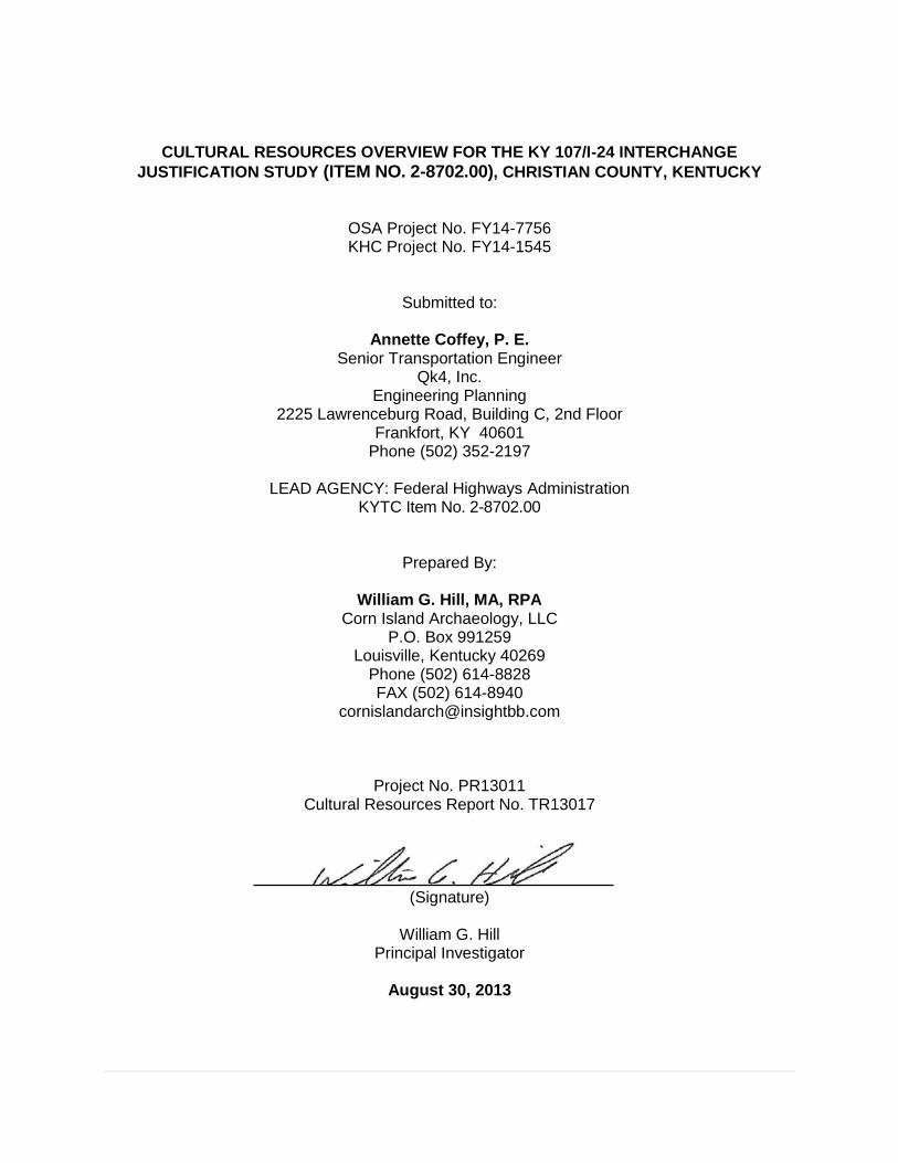
PROJECT DESCRIPTION The Christian County KY 107/I-24 environmental study area consists of an approximate 1073-acre or 435-hectare (ha) environmental footprint approximately 3 kilometers (km) northeast of the town of Herndon and 12 km southwest of the city of Hopkinsville in Christian County, Kentucky (Figure 1 and Figure 2). Within this area, the KYTC is considering the feasibility of an interchange at the intersection of Interstate 24 (I-24) with Lafayette Road (KY 107) (Item No. 2-8702) south of the city of Hopkinsville and northwest of Fort Campbell. The project area is approximately 1073 acres (435 ha).
COMPLIANCE REQUIREMENTS The archaeological overview is a planning document to assist the KYTC and Qk4 in project design. It is not a compliance document per Section 106 of the National Historic Preservation Act (NHPA). The overall project implementation will, however, be required to meet compliance requirements relative to 36 CFR 800 and Section 106 of the NHPA of 1966, as amended (16 U.S.C. 470 f). Section 106 requires that federal agencies or federally funded projects take into consideration the direct and indirect effects of planned undertakings on historic properties listed or eligible for listing in the NRHP prior to the issuance of a federal permit or license or the expenditure of any funds for construction. The project took into consideration specifications for field investigations and for NRHP assessment as set forth in the Secretary of the Interior’s
Christian County, Kentucky.
Cultural Resources Overview for the 107/I-24 Interchange Justification Study, Christian County, Kentucky
2
Standards and Guidelines for Archaeology and Historic Preservation (U.S.Department of the Interior 1983). The project staff meets the requirements for professional archaeologists as detailed in the Secretary of the Interior standards. The Principal Investigator is a Registered Professional Archaeologist (RPA) and abides by the code of ethics of this organization.
Figure 1. Environmental study area displayed on portions of Church Hill and Herndon USGS topographic maps (U.S.Geological Survey 1981; U.S.Geological Survey 1982).

Cultural Resources Overview for the 107/I-24 Interchange Justification Study, Christian County, Kentucky
3
Figure 2. Aerial view of environmental study area.
PROJECT STATEMENT OF WORK CIA assisted Qk4 in the area of prehistoric and historic archaeology and cultural historic assessment by researching the existing conditions within the environmental study area, assessing the potential for undiscovered archaeological remains to be present, and a preparing cultural resources overview of the findings. The archaeological investigation entailed the following tasks:
site visit to visually examine the environmental study area;
archaeological/cultural historic records checks and literature review;
review of environmental conditions, including soils, terrain, stream drainages, etc.;
limited archival research;
historic map review; and
technical report of findings (including photographs and maps), per the requirements of the KYTC.
Specific components to this investigation are summarized below.

Cultural Resources Overview for the 107/I-24 Interchange Justification Study, Christian County, Kentucky
4
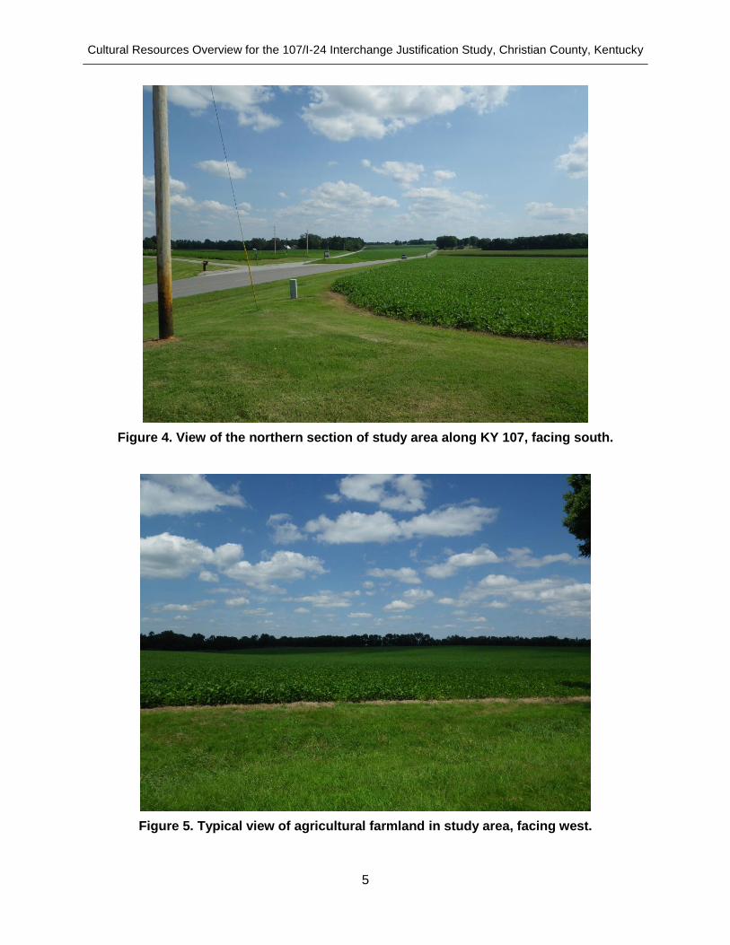
Site Visit A site visit was made on August 15 and August 16, 2013 to the environmental study area to conduct a visual or drive-through survey. Within accessible areas, the survey documented the following:
obvious areas of ground disturbance;
older buildings and structures that may be surrounded by archaeological materials;
areas of slope;
floodplains and stream crossings; and
landuse.
The environmental study area was documented with digital photography. Representative views of this largely rural area are presented in Figure 3, Figure 4, and Figure 5.
Figure 3. View of southern section of study area along KY 107, facing south.
Cultural Resources Overview for the 107/I-24 Interchange Justification Study, Christian County, Kentucky
5
Figure 4. View of the northern section of study area along KY 107, facing south.
Figure 5. Typical view of agricultural farmland in study area, facing west.

Cultural Resources Overview for the 107/I-24 Interchange Justification Study, Christian County, Kentucky
6
Records Check and Literature Review The archaeological site records housed at the OSA were researched to identify the presence of recorded archaeological sites within the environmental study area as defined. Archaeological reports detailing previous studies in Christian County were reviewed to ascertain those areas within the environmental study area that may have been previously examined by professional archaeologists and to determine those that may yet require field survey in relation to the proposed project. The site and environmental data from these sources was studied to make an informed assessment of the potential for additional archaeological sites to be discovered in the area and to determine, to the degree possible, those areas that are likely to be archaeologically sensitive. The database housed at the KHC was also searched to identify resources (e.g. buildings and structures) that have been inventoried within the study area. Properties listed on the NRHP were identified. The purpose of this records check was to identify potentially significant above-ground resources within the study area; to provide background and historic context; and to identify locations in which archaeological remains may be present around historic buildings and structures.
Environmental Conditions The soil survey data for the environmental study area was examined to identify conditions that may signal suitable soils for prehistoric/historic occupation. This review also sought data that might indicate locations that would be unsuitable for discovering intact archaeological sites: including eroded soils, wetlands, or urban lands. The soil review also explored locations in which flooding may occur, suggesting the potential for buried archaeological sites. Topographic mapping and Geographic Information Systems (GIS) data was reviewed to estimate the acreages of the environmental study area that lie on slopes in excess of 15 percent; and to explore the possibility for rockshelters, caves, springs, and sinkholes that may have attracted prehistoric occupation.
Archival Records Research and Historic Map Review CIA conducted archival research in the local area to contextualize the historic cultural development of the environmental study area. Specifically, the research was directed at determining the presence and ages of historic buildings that may contain associated archaeological deposits, their uses (residence/commercial) over time, and other relevant ethnic, social, and economic aspects of the occupants. In particular, the corridors along existing roadways were examined for now extinct communities that developed along the routes in the past. The following sources were researched, among others:
the National Register of Historic Places; historic structure files at the KHC; Kentucky Historic Farms documentation; and historic maps. local libraries/historical and genealogical societies; and volumes housed at the Corn Island Archaeology Library.
This background research was informative in ascertaining the potential for significant historic archaeological remains to be present in the vicinity of the proposed project. It is also, however, a

Cultural Resources Overview for the 107/I-24 Interchange Justification Study, Christian County, Kentucky
7
preliminary step towards developing an expanded context that could be useful for interpreting the significance of archaeological resources discovered within the environmental study area.
Technical Report CIA prepared this technical report of findings in accordance with the guidelines of the KYTC. The report provides photographic documentation of the study area; complete mapping of all known archaeological sites, previously surveyed areas, historic properties, and potentially sensitive archaeological areas.
PROJECT SCHEDULING AND STAFFING The project staff meets the requirements for professional archaeologists as detailed in the Secretary of the Interior standards. William Hill, MA, RPA served as the Principal Investigator for the project. Mr. Hill and Mr. Travis Fisher performed the drive-through survey. Mr. Hill, supported by Ms. Anna Maas, MUEP of CIA, prepared the report of findings. Report graphics and mapping were prepared by Dr. Timothy D. Sullivan. The field portion of the survey required a total of 24 manhours to complete over a total of two work days on August 15 and August 16, 2013. Some access restrictions were encountered during the field investigation.

Cultural Resources Overview for the 107/I-24 Interchange Justification Study, Christian County, Kentucky
8
ENVIRONMENTAL AND CULTURAL BACKGROUND The study of prehistoric and historic cultures should extend beyond the review of the physical material remains of a society; it should seek an understanding of the ways in which that society interacted with its environment. Throughout time, the natural landscape has influenced human use, and was in turn affected by that use. This interrelationship is reflected in both the natural and cultural (standing structures, cemeteries, and archaeological sites) resources of the area. The cultural landscape approach provides a framework for understanding the entire landuse history of a property. It is the foundation for establishing a broader context for evaluating the significance of cultural resources, because the significance of any given cultural resource is not determined in isolation. Rather, it is achieved by examining the entire context of the landscape and interrelationships among its constituent components. These patterns can then provide for more efficient management of cultural resources by better predicting where such resources are likely to occur.
ENVIRONMENTAL CONTEXT The physical environment is one of many factors that influenced the cultural development of an area. An awareness of the natural setting and available resources of an area allows informed interpretations of cultural issues such as settlement patterns and sedentism, as well as resource utilization and exploitation. The following environmental context provides data on regional ecological patterns such as floral distributions and communities, regional geomorphology, soils, and hydrology. An understanding of the natural setting of an area allows informed interpretations on such cultural issues as prehistoric and historic settlement patterns, resource availability and exploitation, and more. The discussion is aimed at identifying those aspects of the natural environment that may have influenced the cultural development of the study area.
Physiography Christian County is situated immediately south of the Dripping Springs Escarpment within the Mississippian Plateau (also known as the Pennyroyal or Pennyrile) physiographic region of Kentucky (Figure 6). Elevations in Christian County range from 390 to 966 feet (ft) above mean sea level (AMSL) (University of Kentucky 2013). The topology of this southern section, or Limestone Area, of the Western Pennyrile is a maturely dissected and gently rolling plain that is characterized by numerous limestone sinkholes due to its karstic nature. The principal drainage near the environmental study area is the Little River, which is a tributary of the Cumberland River. The Little River originates in Christian County southwest of Hopkinsville. The North and South forks of the river confluence 5 km northeast of the environmental study area to form the Little River. An unnamed permanent drainage passes east-west through the central portion of the environmental study area and has been modified by the construction of I-24 near its confluence with the Little River along the western boundary of the environmental study area. The streambed of the Little River is composed primarily of mud and clay along with some bedrock, gravel, and limestone boulders.
2

Cultural Resources Overview for the 107/I-24 Interchange Justification Study, Christian County, Kentucky
9
Figure 6. Physiographic regions of Kentucky.
(http://www.uky.edu/KentuckyAtlas/kentucky-atlasp.html)
Geological Resources The environmental study area is located in the Pennyrile region of southwestern Kentucky and is part of the Mississippian Plateau region of Kentucky. The geology of all of Christian County primarily consists mainly of thick deposits of Mississippian limestones. The environmental study area is no exception and is underlain by Mississippian Ste. Genevieve Limestone (Table 1 and Figure 7), although Quaternary alluvial deposits occur along the Little River (Kentucky Geological Survey 2013). The Mississippian Plateau is a limestone karstic plain characterized by numerous sinkholes, springs, sinking streams, and caverns. Sinkholes and springs within and near the environmental study area are depicted in Figure 8. One spring named “Interstate Spring” is a bluehole (rising) perennial spring (Kentucky Geological Survey 2013) located immediately north of I-24 along the western boundary of the environmental study area.
Table 1. Geologic Units within Environmental Study Area
Map Unit Landscape Position
(MsG) St. Genevieve Limestone
(Upper Mississippian)
dissected uplands
Project Area

Cultural Resources Overview for the 107/I-24 Interchange Justification Study, Christian County, Kentucky
10
Figure 7. Geologic map of environmental study area (Kentucky Geological Survey 2013).
Figure 8. Map showing locations of sinkholes and natural springs within environmental study area.

Cultural Resources Overview for the 107/I-24 Interchange Justification Study, Christian County, Kentucky
11
Chert Types Chert types included in the potential archaeological deposits of the study area include exotic high-quality materials brought to the area during the Paleoindian period (10,000 B.C. to 8000 B.C.), more local cherts quarried from the surrounding Mississippian Plateau, to exotic Mill Creek chert brought in as hoes during the Mississippi period (A.D. 1000 to A.D. 1700). Source areas for Dover chert are located south in the Nashville Basin of Tennessee. Dover quarries of Stewart County, Tennessee are the type locality for this chert. The chert is also locally available throughout the Lower Tennessee and Cumberland River valleys where it is recovered primarily as either residuum or streambed alluvium (Nance 2000:84-85). The main chert-bearing formations in the Lower Tennessee valley are the St. Louis, Warsaw, and Fort Payne limestones of the Mississippian System. Dover chert is located on top of the Warsaw and at the base of the St. Louis and is residuum of the St. Louis Formation (Parish 2009). Hoes dating to the Mississippi period may be made from Dover chert. During studies along the valleys of the Lower Tennessee and Cumberland rivers, Nance (1988) found that cherts from the Lower St. Louis formation might be identified as Dover. Analysis of trace elements using neutron activation may be necessary to discern the types. During a survey of chert resources of the Lower Cumberland and Tennessee River valleys, Nance (1984) documented changes in the preferred chert material from the Archaic to the Woodland period. During the Archaic period (8000 B.C. to 900 B.C.), higher percentages of Upper St. Louis cherts were documented in assemblages. In contrast, Woodland period (900 B.C. to A.D. 900) assemblages included higher percentages of Lower St. Louis, Ste. Genevieve, and Fort Payne cherts in addition to the Upper St. Louis majority. During the Mississippi period (A.D. 1000 to A.D. 1700), the percentage of Upper St. Louis again rose. Ste. Genevieve chert was a heavily, and almost exclusively utilized lithic resource recovered from prehistoric sites in the immediate area, such as the Adams Site (15CH90) 1.5 km to the northwest. Thomas Sanders (1988:27), during his study of the Adams Site, located additional chert resources that outcrop in Christian County; these included: “Kinkaid (from the vicinity of Appex on the Haleys Mill quadrangle), Clore (from the Haleys Mill quadrangle), Vienna (from the vicinity of Buck Fork of Pond River, on the Honey Grove quadrangle), Ste. Genevieve (from the bed of the Little River adjacent to the Adams Site), and St. Louis (from the Caledonia quadgrangle at Binn’s Mill).” Sanders noted that a bed of Ste. Genevieve chert is well exposed in the limestone cliffs along the Little River less than 300 meters (m) west of the Adams Site, thus 1.7 km from the current environmental study area. Closer Ste. Genevieve chert outcrops or gravels may lie along the river, which is approximately 50 m from the western boundary of the environmental study area.
Soils Soils in the project area are developed from loess and limestone residuum that are all well drained. Table 2 summarizes the soil types that are located within the project study area. A map showing the spatial extent of these soil types, generated by the United States Department of Agriculture-Natural Resources Conservation Service (USDA-NRCS), is provided in Figure 9. As can be seen, the environmental study area contains a large variety of soil types. The dominant series is the Pemboke series that makes up approximately 67 percent of the study area. These soils are predominantly from limestone residuum and loess on gentle sloping uplands (USDA-NRCS 2013a).

Cultural Resources Overview for the 107/I-24 Interchange Justification Study, Christian County, Kentucky
12
Relief within the study area varies little, with elevations ranging between 145 m and 168 m or 476 feet (ft) and 551 ft AMSL. The soil map units indicate that 99 percent of those developed on 0 to 12 percent slopes. As a result of the well-drained soil and gentle slope, much of the land in the surrounding area is used for agriculture or pasture. Pembroke soils are the most agriculturally productive of the upland soils in the area (Bailey and Winsor 1964).

Cultural Resources Overview for the 107/I-24 Interchange Justification Study, Christian County, Kentucky
13
Figure 9. Soils mapped for the study area (USDA-NRCS 2013a).

Cultural Resources Overview for the 107/I-24 Interchange Justification Study, Christian County, Kentucky
14
Table 2. Soils within the Environmental Study Area
Landform Parent Material Soil Series Name Slope Drainage
Class Frequency of
Flooding
Area Percent in Environmental study
area Acres Ha
hills clayey residuum weathered from
cherty limestone
Baxter cherty silt loam
(BaD)
12-20%
well drained none 10.9 4.4 1.0%
ridges
thin fine-silty noncalcareous loess over clayey residuum weathered from
limestone
Pembroke silt loam (PmB)
2-6% well drained none 601.9 243.6 56.1%
thin fine-silty noncalcareous loess over clayey residuum weathered from
limestone
Pembroke silt loam (PmC)
6-12% well drained none 112.2 45.4 10.5%
clayey residuum weathered from limestone
Vertrees silty clay loam (VeC)
6-12% well drained none 50.2 20.3 4.7%
thin fine-silty noncalcareous loess over clayey residuum weathered from
chert limestone
Hammack-Baxter complex (HbC)
6-12% well drained none 30.3 12.3 2.8%
thin fine-silty noncalcareous loess over clayey residuum weathered from
limestone Crider silt Loam (CrA) 0-2% well drained none 23.7 9.6 2.2%
thin fine-silty noncalcareous loess over clayey residuum weathered from
limestone Crider silt Loam (CrB) 2-6% well drained none 3.5 1.4 0.3%
thin fine-silty noncalcareous loess over clayey residuum weathered from
limestone
Nicholson silt loam (NhB)
2-6% moderately well
drained none 2.7 1.1 0.2%
stream terraces mixed fine-silty alluvium Elk silt loam (EIB) 2-6% well drained rare, none 87.6 35.5 8.2%
Elk silt loam (EIA) 0-2% well drained rare, none 23.0 9.3 2.1%
flood plains, closed depressions
mixed fine-silty alluvium
Nolin silt loam (No) 0-3% well drained occasional,
none 110.9 44.9 10.3%
Lindside silt loam (Ln) 0-2% moderately well
drained occasional,
none 16.5 6.7 1.5%
Total 1073.4 434.5 100.0%

Cultural Resources Overview for the 107/I-24 Interchange Justification Study, Christian County, Kentucky
15
Climate Most broadly, Christian County lies within a Udic moisture regime, defined as 90 consecutive days of moist conditions within the soil moisture control section (Buol et al. 1989). This moisture regime extends between the wetter Aquic regime and the drier Ustic regime. In contrast to the Ustic moisture regime, the Udic moisture regime of the eastern United States has a well-distributed supply of water available to plants. The Udic moisture regime, therefore, can support drought-intolerant flora such as corn whereas the Ustic regime to the west cannot. Mapping by the USDA-NRCS documents the Udic moisture regime within the study area and the Cumberland River valley (USDA-NRCS 2013b). Christian County has a generally temperate climate. Moderately cold winters are typical and the summers are humid and warm. According to the USDA-NRCS, the mean annual precipitation for the region is between 43 and 58 inches. The mean annual air temperature ranges between 45 and 68 Fahrenheit and experiences a frost-free period between 164 and 194 days (USDA-NRCS 2006; USDA-NRCS 2013a). Climate fluctuations, however, have varied from these ranges throughout the Earth’s history (Buol et al. 1989; Fagan 1991). According to a model developed by Milankovich, these periodic fluctuations are caused by changes in the Earth’s elliptical orbit every 100,000 years, its quivering spin on its axis every 21,000 years, and its tilt on its axis every 41,000 years (Selby 1985:510). The pollen record shows that relatively mild temperature fluctuations have occurred since the end of the Pleistocene Epoch. After about 12,000 B.C., there was a gradual warming trend that resulted in generally higher temperatures than are present today. The highest temperatures appear to have occurred around 7000 B.C. This warming trend continued until the beginning of the Little Ice Age (A.D. 1500 to A.D. 1850) during which a significant drop in temperature occurred. After the Little Ice Age, temperatures became more moderate (Davis 1983:176; Fagan 2000; Mann 2002). A few of the fluctuations that have occurred over the past 10,000 years are summarized in Table 3.
Table 3. Abbreviated List of Major Climate Fluctuations over the Past 10,000 Years
Dates Fluctuation Event Source
8200-4500 B.C. 1-2.5°C warmer;
drier; prairie expansion
Hypsithermal, Altithermal, Climatic
Optimum
Buol et al. 1989:180; Selby 1985
3000-1200 B.C. 1-2°C cooler; wetter Buol et al. 1989:180;
Selby 1985
A.D.900-1200 warmer; droughts Medieval Warm period Buol et al. 1989;
Fagan 2000
A.D.1500-1850 cooler Little Ice Age Mann 2002
A.D.1600 warmer variation within the
Little Age Buol et al. 1989
A.D.1700 cooler variation within the
Little Ice Age Buol et al. 1989

Cultural Resources Overview for the 107/I-24 Interchange Justification Study, Christian County, Kentucky
16
Biological Resources
Biological resources consist of both floral and faunal resources. The availability of these resources varies according to location, habitat, microclimate, season, and human influence. Floral Resources
Christian County is located within a region mapped as Western Mesophytic Forest Region (Braun 1950 in Delcourt 2002). This area is a transitional zone, changing from the eastern mixed mesophytic communities to the western oak and oak-hickory forests (Braun 1950 in Sanders 1988). Due to drastic climatic changes over the past 18,000 years, however, botanical resources in the area have changed considerably. At the fullest extent of the Laurentide Ice Sheet around 18,000 B.P., tundra, loess semi-deserts, and boreal forests would have existed (Overpeck et al. 1992; Selby 1985). Boreal forests (taiga) are characterized by coniferous species such as pine, spruce, and fir as well as lichens. Tamarack may also have been present. As the climate warmed, the boreal forests slowly changed to sub-boreal then to deciduous. The environmental study area lies within the Major Land Resource Area (MLRA) designated as 122 or the “Highland Rim and Pennyroyal” by the NRCS (Figure 10). Flora within the nearby MLRA 122 consists of oak-hickory forests, while yellow-popular is common on deeper soils. Within the understories of such forests are found a variety of grasses, vines, forbs, and shrubs. Broomsedge and little bluestem are the most prevalent grasses (USDA-NRCS 2006).
Figure 10. Location of MLRA 122 (USDA-NRCS 2006).
As the glaciers retreated further north, average temperatures rose, and the mixed hardwood forests in south central Kentucky were gradually replaced by Oak-Hickory forests. By 5,000 years ago, the transition was complete (Delcourt and Delcourt 1981). Oak-Hickory Forests would have been found in warm exposed areas, and Beech-Maple Forests would have occurred in cool, moist shaded areas, and along streams and river valleys (Kricher 1988:72). Oak-Hickory Forests commonly contain a wide variety of flora. The trees that may have been present prehistorically include oaks, hickories, American chestnut, dogwood, sassafras, hop hornbeam, and hackberry. Tulip trees, elm, sweetgum, shagbark hickory, and red maple also

Cultural Resources Overview for the 107/I-24 Interchange Justification Study, Christian County, Kentucky
17
may have been present, especially in moist areas. The understory may have contained mountain laurel, a variety of blueberries, and deer berry among other plants. Herbs may have included wintergreen, wild sarsaparilla, wood-sorrel, mayapple, rue-anemone, jack-in-the-pulpit, and trout lilies to name a few (Kricher 1988:57). Today, stands of cottonwood, sycamore, soft maple, black willow, gum, and elm would be typical along tributaries. On inland terraces, white oak, black oak, yellow poplar, hickory, beech, and hard maple would predominate. On the drier portions of the area; maple, oak, sweetgum tupelo, sassafras, black locust, and ash would occur. The American chestnut, a common species during prehistoric times as a canopy tree, has been reduced to an understory tree by a blight introduced into North America in historic times (Kricher 1988:58). Numerous grasses and perennials such as smartweed, goosefoot, and amaranth are found in areas that are not farmed. Many of these species were present prehistorically and were utilized to various degrees as food, construction and material, fuel, and fiber. Other botanical materials important to native populations were weedy plants that grew in the disturbed soil surrounding their camps. These were gathered for many years and, as a result, became domesticated. They are summarized in Table 4.
Table 4. Indigenous Plants that Became Domesticated by Native Americans
Plant Early Date Site Source
marshelder/sumpweed (Iva annua)
4000 BP Napoleon Hollow, IL
(Smith 1989)
Sunflower (Helianthus annuus)
3500 BP Higgs, TN (Smith 1989)
Chenopodium (Chenopodium
berlandieri) 3500 BP
Cloudsplitter, KY
(Riley et al. 1990)
Squash (Cucurbita pepo ssp
ovifera) 2850 BP
Cloudsplitter, KY
(Smith 1989)
Other species important to native groups were species that were domesticated elsewhere—such as Mexico or Peru. These include bottle gourds (Lagenaria siceraria), pumpkins (Cucurbita pepo ssp pepo), maize (Zea mays), and beans (Phaseolus vulgaris).
During the historic period, much of the Limestone Area of the Pennyroyal in Christian County was referred to as the “Barrens.” These were areas absent of trees that consisted of tall, open grass prairie. In addition to the Barrens, McGaughey Swamp, located near the Trigg County line, was a former extensive swamp. The diversity of faunal and floral resources associated with the swamp were highly attractive to human groups as is attested to by the numerous archaeological sites in its vicinity (Sanders and Maynard 1979).
Faunal Resources During glacial periods of Quaternary times, the mammoth and mastodon were residents of the region. Other types of large and now-extinct animals such as the giant peccary, ground sloth, as well as the bison, horse, elk, deer and beaver would also have been available to the Paleoindians (Shelford 1963; Wayne and Zumberge 1965). By approximately 12,000 B.C., mixed deciduous forests had developed in the region. The primary vegetation cover was

Cultural Resources Overview for the 107/I-24 Interchange Justification Study, Christian County, Kentucky
18
consistent with a mesic upland forest. Hickories, oaks, elms, maple, ash, and tulip trees would have been common. Between 10,000 and 6000 B.C., during the Hypsithermal Interval, the climate was somewhat warmer and drier than at the present time. Post-Hypsithermal, the flora and fauna of the area were probably typical of the Carolinian province biotic assemblage.
These diverse habitats would have produced numerous species available to native populations for food and materials. Archaeological data has demonstrated that the species most important to native populations as food sources included mastodonts during the early Paleoindian period; fish and shellfish during the Archaic period; white-tailed deer and wild turkey during numerous periods; and raccoon during the later periods. All of these resources could have been found within the present study area. The floral and faunal species present in the region remained relatively constant until modern times when Europeans began to severely modify the regional ecology (Delcourt and Delcourt 1981). A wide variety of fauna would also have been present from the early Holocene to early historic times. Mammals that thrived in the forested environment may have included the gray squirrel, fox squirrel, whitetail deer, raccoon, beaver, woodchuck, and a variety of mice, striped skunks, mink, otter, fox, black bear, and bobcats. Bird species would likely have included red-tailed hawks, ruffed grouse, great horned and eastern screech owl, pileated woodpecker, wild turkeys, and blue jay among others (Kricher 1988:12). A variety of ducks and geese also could have been present during the Fall and Spring migrations. Within MLRA 122, additional species recorded by the USDA-NRCS (2006) include opossum, cottontail, bobwhite quail, and mourning dove. Fish species that are typical of MLRA 122 include carp, largemouth bass, bluegill, and bullhead.
PREHISTORIC CULTURAL CONTEXT The sections below review the cultural groups that may have been present in Christian County when prehistoric peoples first migrated to the Cumberland River valley and the surrounding region around 12,000 years ago setting the basis for a rich cultural history. The area has been occupied from the Late Pleistocene epoch to the present and follows the same general trends as those found in other parts of the Eastern Woodlands. Researchers typically break the prehistoric occupation span of 10,000 or so years into four relatively distinct and definable periods: the Paleoindian period (ca. 12,000 B.C. to 8000 B.C.), the Archaic period (ca. 8000 B.C. to 700 B.C.), the Woodland period (ca. 1000 B.C. to A.D. 1200), and the Mississippi period (ca. A.D. 1000 to A.D. 1700). The latter is followed by, or overlaps with, the Pre-Settlement Exploration or Contact subdivisions of the Historic period, marking the arrival of European explorers in the seventeenth century and initiating a dramatic shift in the demography of the region.
Paleoindian Period (ca. 9500 to 8000 B.C.) Although the lithic material associated with Paleoindians is the earliest dated material recovered from humans in North America, it is also one of the most impressive. As with many cultural responses to the environment, the technology and the Paleoindians themselves had a long historical trajectory in the Old World before migrating to the New World. Artifacts found in both Old World and New World assemblages include fluted projectile point/knives (ppk), polyhedral cores, prismatic blades, and the piéces esquillèe. Additional artifacts associated with Paleoindians include an extensive unifacial tool kit that included scrapers, gravers, and limacés (slug-shaped unifaces) (Dragoo 1973).

Cultural Resources Overview for the 107/I-24 Interchange Justification Study, Christian County, Kentucky
19
As the wealth of data from Paleoindian sites have accumulated, it has become apparent that groups prior to Clovis lived in North America. From Cactus Hill in Virginia, to Meadowcroft Rockshelter in Pennsylvania, to Pendejo Cave in the Southwest, dates prior to 10,000 B.C. have been documented. With regard to Kentucky, however, no conclusive evidence for pre-Clovis populations has been documented. New developments since Tankersley’s (1990) overview of Kentucky’s Paleoindian period have resulted in a paradigm shift that now recognizes that the colonization of the Americas occurred earlier than previously considered (Adovasio et al. 1999; Adovasio and Pedler 2004; Dillehay 1989; Dillehay 1997; Lepper and Bonnichsen 2004; McAvoy and McAvoy Lynn D. 1997). In Kentucky and much of North America, researchers refer to three Paleoindian phases: Early, Middle, and Late (Maggard and Stackelbeck 2008; Tankersley 1996)(Table 5).
Table 5. Characteristics of Paleoindian Cultures
Period Diagnostics Settlement Subsistence
Early Paleoindian
Clovis blades with bulb of percussion removal
possible association with karst topography
mastodonts as well as other
resources
Middle Paleoindian
Cumberland, Beaver Lake, Quad, Suwannee, limacés,
Late Paleoindian
Dalton, socketed scraper rockshelters
As of the 2008 preservation plan, 133 Paleoindian sites had been documented for the Green River Management Area; 54 of these were reported in the Pennyroyal Section (Maggard and Stackelbeck 2008). This comprises (41 percent) of all Paleoindian sites within the management area and an approximate 50 percent increase over the section within the next highest number of sites. Early Paleoindian (? to 8000 B.C.) To date no pre-Clovis sites (?-9500 B.C.) have been identified in Kentucky. However, sites identified in surrounding states such as Meadowcroft and Cactus Hill (Adovasio et al. 1999; McAvoy and McAvoy Lynn D. 1997) provide clues as to what such sites in Kentucky could resemble. At Cactus Hill small bifaces, retouched flakes, quartzite flakes, blades, and blade cores were recovered below a well-defined Clovis stratum containing Clovis fluted points. At present, the Clovis culture or complex (ca. 9500-8000 B.C.) is the earliest documented occupation in Kentucky (Maggard and Stackelbeck 2008). The Clovis culture (ca. 9500-8000 B.C.) is represented by magnificent Clovis spear points, polyhedral cores, and prismatic blades usually manufactured from high-quality lithic materials. Subsistence included megafauna such as the mammoth within prairie habitats and mastodons within forested habitats. Although there is scant archaeological evidence of Paleoindian social complexity, following arguments by Wright (2000), subsistence strategies that included the procurement of large quantities of meat for more than one or two families that could be use quickly suggest higher levels of group cohesion and social complexity. Few Early Paleoindian sites from Kentucky other than isolated finds of Clovis ppks have been identified or studied. Gatus and Maynard (1978) have identified an association between settlement locations with karst topography. In the region, data on the Early Paleoindian cultures have been
Cultural Resources Overview for the 107/I-24 Interchange Justification Study, Christian County, Kentucky
20
provided by the Adams site (15CH90). This 1.2 ha site was a single component base camp located around a sinkhole and low hill in Christian County, Kentucky. Data provided by the assemblage at the Adams Site include choices regarding site location, techniques of raw material acquisition, and techniques of Clovis manufacture (Sanders 1988).
Middle Paleoindian (ca. 9000 B.C. to 8500 B.C.) The Middle Paleoindian period is represented in the Southeast by Cumberland, Beaver Lake, Quad, and Suwannee ppks. During this sub-period, local raw materials were chosen more often. Perhaps related to this expanded use of material type, reduction strategies included bipolar reduction. Artifact types associated with the Middle Paleoindian include limacés, and scrapers and gravers exhibiting a spur or protrusion (Tankersley 1996). Late Paleoindian (ca. 8500 B.C. to 8000 B.C.) The Late Paleoindian period is represented by side-notched points such as Dalton. It is during this sub-period that the greatest change in mobility and diet occurred. During this sub-period, diet appears to have become even more varied as the climate became more temperate. The Dalton culture is often reported to be the first to routinely take advantage of rockshelters (Walthall 1998). The characterization of Paleoindians, however, is incomplete. Many items that were found in later prehistoric periods have not been recovered from Paleoindian contexts due to preservation, and the cultural traits represented by that material culture were assumed to be absent from the Paleoindian repertoire. Artifacts of botanical remains and bone or ivory ornamentation are some examples. Paleoindian material recovered from sites with better preservation such as rockshelters, bogs, and springs, however, changed the picture of Paleoindian cultural adaptations. Early Paleoindian groups exploited megafauna such as the mastodonts; evidence comes from blood residue analysis provided by Loy and Dixon (Loy and Dixon 1998). Cut marks on mastodon bones was documented at the Adams Mastodon Site (15HR18) (Walters 1988). Data from sites with optimal preservation, however, reveals a more complex story. From the earliest sites such as Cactus Hill, the exploitation of game such as rabbit, bear, deer, and elk was documented by blood residue analysis. Data from Meadowcroft Rockshelter suggest possible botanical resources used by Paleoindians included hickory, walnut, and hackberry (Carr et al. 2001). As noted previously, rockshelters were chosen as habitation sites more often during the Late Paleoindian time. This has resulted in better preservation and recovery of material such as floral and faunal remains—revealing that a greater variety of patch resources were exploited than previously realized, particularly non-migratory forest-dwelling species such as squirrel and turkey or edge-dwelling deer (Walthall 1998).
Archaic Period (ca. 8000 B.C. to 1000 B.C.) A warming climate following the Ice Age resulted in the grasslands and coniferous forests becoming replaced by mixed, deciduous forests. This caused the fauna of the environment to change as well, and consequently, human adaptation followed. The Archaic period is marked by an increase in population and a decrease in mobility as well as specialized adaptation to local resources. A wider range of resources was utilized for food and supplies became more stable, allowing for localization and regionalization of Archaic cultures. The Archaic period is generally divided into three subdivisions: Early (8000 B.C. to 6000 B.C), Middle (6000 B.C. to 3500 B.C.), and Late (3500 B.C. to 1000 B.C.). As of the 2008 preservation

Cultural Resources Overview for the 107/I-24 Interchange Justification Study, Christian County, Kentucky
21
plan, 1,132 Archaic sites had been documented for the Green River Management Area; 298 of these were located in the Pennyroyal Section. The majority of Archaic sites within the management area had been recorded for the Western Coalfields Section. Archaic sites not assigned to a temporal subdivision account for 50.8 percent of the recorded Archaic sites in the Green River Management Area. Comparison between subperiods may indicate a population exodus during the Middle Archaic, as the Late Archaic and Early Archaic subperiods each comprise between 20 and 22 percent of all Archaic sites within the management area while Middle Archaic sites constitute a mere 6 percent (Jefferies 2008). Early Archaic (ca. 8000 B.C. to 6000 B.C.) Early Archaic cultures were quite similar to those of the Paleoindian period, consisting of small groups of hunter-gatherers exploiting the abundant natural resources of the area. The difference is marked by innovative technological and social responses to changing environmental conditions that prevailed at the cessation of the Pleistocene glacial activity. The changing environment resulted in a dryer, warmer climate, the advance of deciduous forests, and the extinction of Pleistocene fauna such as the mammoth and mastodon. A marked difference is the disappearance of fluted points from the lithic tool kit and the diversification of other stone tools. Characteristics of the manifestation of the Early Archaic period in the lower Ohio River valley are presented in Table 6. A number of new styles of projectile points suggest regional cultural growth during the Early Archaic. Beveling along blade edges, grinding along basal edges, and serrations along margins are common. Diagnostic Early Archaic artifacts typical of this region include Kirk and Stanly ppks. At the Whalen site, the stratum containing these points was dated to about 6150 B.C. (Nance 1988). In the Wabash valley, Winters (1967:20) attributes Barbee Corner-notched and Thebes points to the Early Archaic.
Table 6. Characteristics of the Early Archaic Period
Diagnostic Lithics Settlement Subsistence
Kirk Corner Notched, Stanly, Thebes, Barbee Corner-notched
mobility greater than Middle Archaic
hunting and gathering
Hunting gear included the atlatl. Although the portions made of antler and wood deteriorate too rapidly to recover from most archaeological deposits, the lithic bannerstones do not. Having had much labor and energy put into their manufacture, these items also were often items of trade or tribute. Other tools such as awls, drills, and gouges appear, along with tools indicating utilization of plant resources such as axes and adzes. Groundstone mortars and pestles (Chapman 1975; Jennings 1968) were used for processing nuts and seeds. It is generally thought that the Early Archaic peoples were highly mobile, opportunistic hunters and gatherers with little specialization in resource procurement (Muller 1986:57). Additional material types have been recovered from sites such as Windover, Florida where preservation was exceptional. The Early Archaic assemblage at Windover also included bone projectile points, antler atlatl hooks, and wooden canoes. Sites in the region that can provide comparative data for Early Archaic movements near the project APE are summarized in Table 8. Although Morrisroe contained a shallow midden, the location was revisited many times during the Archaic period. Cultural horizons dating to the Early, Middle, and Late Archaic were identified. Archaeological evidence contained in the deepest stratum (Stratum 4) reflected occupations from 6500 B.C. to 6000 B.C. that were of short duration (Nance 1988). Another example of an Early Archaic occupation was encountered

Cultural Resources Overview for the 107/I-24 Interchange Justification Study, Christian County, Kentucky
22
at the Lawrence Site east of the Cumberland River in Trigg County, Kentucky. This upland site contained a midden, features, and burials containing Kirk points. Although attributed to the Early Archaic, these were serrated Kirk points and should be attributed to the Middle Archaic. A radiocarbon date of 5,400 B.C. was obtained (Jefferies 1990:164). It has also been noted that the earlier Kirk Corner Notched points are rare in western Kentucky (Nance 1988).
Table 7. Sites with Early Archaic components in the Region
Site Site Type Diagnostics Reference
Morrisroe (15LV156)
open habitation Stanly Kirk
Nance 1988
Whalen (15LY48)
open habitation Kirk Nance 1988
Lawrence (15TR33)
open habitation Kirk Mocas 1977 in Jefferies
1990
11HA503 open habitation Ahler et al. 1980
Middle Archaic (ca. 6000 B.C. to 3000 B.C.) During the Middle Archaic period, the climate became warmer and drier than today. Known as the Hypsithermal, this climate change led to vast changes in ecological conditions. Pleistocene species that may have persisted since glaciation or that had expanded into riskier eco-zones would have died out in all except a few unique locations (Delcourt 2002). In contrast, during the Hypsithermal, prairie ecosystems would have expanded eastward into a larger portion of Kentucky. Some of these resources also may have persisted in unique microhabitats.
Due to these environmental changes, the natural resources available to the Middle Archaic people also shifted, leading to a marked change in residency and subsistence from the Early Archaic. A summary of characteristics of the Middle Archaic period is presented in Table 8. This period of restricted natural resources gave rise to more permanent settlements, one indication of which is the presence of storage pits. As examined in Andrefsky (Andrefsky 2005), Parry and Kelly (1987) propose other clues in the lithic assemblage that indicate increased sedentism: less reliance on formal tools, and greater use of retouch and expedient-use tools. Middle Archaic lithic assemblages fit this model.
Data regarding the settlement systems of cultural groups in the lower Ohio River valley have been reviewed by Nance (1988). Using data from Morrisroe and Whalen, Nance documents a switch from sporadic occupations of the Lower Tennessee and Cumberland River valleys during the Early Archaic to longer occupations of sites during the Middle Archaic. Subsistence patterns also changed during this period of climate change. Across the Eastern North American Woodlands, Middle Archaic populations can be identified by their extensive exploitation of shellfish. Shell mounds and shell-laden horizons, in addition to the appearance of net sinkers and fishhooks in the Middle Archaic tool kit, document this change to riverine resources. In addition, mortars and pestles document the processing of mast resources such as walnuts and hickory. At Carrier Mills, a Middle Archaic site in Illinois, subsistence data includes deer, elk, wild turkey, wild bean (Strophostyles helvola), fruits, hackberry, and marsh resources including reptiles, amphibians, and birds (Muller 1986:61-62). Plant resources that were being domesticated in other regions of the Eastern Woodlands, however, were not being developed at Carrier Mills.

Cultural Resources Overview for the 107/I-24 Interchange Justification Study, Christian County, Kentucky
23
Table 8. Characteristics of the Middle Archaic Period
Diagnostic Artifacts Settlement Subsistence
Kirk Stemmed, Kirk Serrated, Cypress Creek, Eva, Faulkner (Big Sandy), side-
notched points, fishhooks and net sinkers
more sedentary—greater use of river valleys
logistical mobility pattern
deer mast resources plant resources
shellfish
Diagnostic projectile point types of the Middle Archaic period include Kirk Stemmed, Kirk Serrated, Cypress Creek, Eva/Morrow Mountain, and Faulkner/Big Sandy (Justice, N. 1987; MacNeish 1948; Muller 1986; Nance 1988). Evidence from Morrisroe (15LV156) documents a Cypress Creek occupation transitioning into an Eva occupation around 5890+/- 100 B.C. Later side-notched and stemmed Middle Archaic diagnostics were recovered from higher deposits and dated to around 3630+/-100 B.C. (Nance 1986). In the lower Ohio River valley, large side-notched points are known as Faulkner points and are diagnostic of a Faulkner Phase first defined at the Massac County, Illinois Faulkner Site. The site lies on a ridge beside swamplands. The assemblage contains no ceramic material, but includes a wide assortment of lithic tools, including scrapers, drills, groundstone tools, and bannerstones (Cole et al. 1951). Eleven burials also were encountered. Faulkner components have been identified at Kincaid (Cole et al. 1951) and in the Wabash River valley (Winters 1967:18-22). Following analysis of the assemblage from Kincaid, Cole et al. (1951) proposed the Faulkner culture was most related to later Black Sand ceramic groups to the north in Illinois rather than the succeeding Baumer culture. Additional items in a Middle Archaic assemblage might include woven fabrics, atlatls, bone and antler tools, awls, red ocher, marine shell, and copper. Burials of canine companions have been documented (Lewis and Kneberg 1958). Late Archaic (3000 B.C. to 1000 B.C.) During this period, populations increased, maintained even more permanent settlements, and developed new technologies. Characteristics of Late Archaic assemblages are presented in Table 9. In the Southeastern United States, the first evidence of pottery, a fiber-tempered ware, can be attributed to Late Archaic groups. Forms generally mimicked cumbersome vessels they had previously made from steatite. In the Mississippi River valley, the first artifacts of fired clay are clay balls presumably used as “boiling stones”—objects heated over a fire then dropped into vessels of liquid to heat the liquid (Sassaman 1993). A number of these artifacts were recovered from the Late Archaic Poverty Point site in Louisiana (Webb 1977).
Table 9. Characteristics of the Late Archaic Period
Regional Phases Diagnostic Lithics Settlement Subsistence
general Late Archaic traits stemmed points
McWhinney, Ledbetter, Pickwick
less sedentary than Middle Archaic
mast resources, shellfish, plant experimentation
Riverton Wabash Valley
1500-1000 B.C (Winters 1967)
Merom Expanding Stemmed
Trimble Side-notched
village on bluff camps on sand or clay
knoll
deer, raccoon, mussels, turkey, fish, turtle
Diagnostic projectile points (ppks) include McWhinney, Karnak, Merom, Bottleneck, and Ledbetter-Pickwick (Jefferies 1990; Justice, N. 1987) as well as some Adena-like points (Winters 1967). Saratoga and Trimble Side-notched points are also diagnostic of the Late
Cultural Resources Overview for the 107/I-24 Interchange Justification Study, Christian County, Kentucky
24
Archaic in the area (Muller 1986:69; Winters 1967). Raw materials used for these are usually poor-quality, local materials. A variety of groundstone tools have been recovered from Late Archaic contexts, including three-quarter grooved axes. Bone and antler tools are well represented on Late Archaic sites, and include atlatl hooks, fishhooks, awls, pins, and antler projectile points. The extensive trade/tribute networks that were maintained as evidenced by the recovery of steatite, copper, and marine shell at Late Archaic sites suggest stronger leadership. Social stratification is also suggested by more extensive mortuary practices, such as those found at Indian Knoll along the Green River (Boisvert et al. 1979). Subsistence during the Late Archaic included oily and starchy seed crops such as lambsquarters (Chenopodium berlandieri), sunflower (Helianthus annuus), and ragweed (Ambrosia trifida) (Smith 1989). Squash (Cucurbita pepo ssp ovifera) also became domesticated. Although the earliest evidence for the domestication of these plants comes from other areas, pollen and phytoliths in area alluvial deposits and starch residues within ceramic vessels may provide new data. In addition to a greater use of botanical resources, a marked increase in the amount of riverine resources exploited is evident at sites along the Green River. Shell middens—refuse piles of leftover mussel shells—are diagnostic of the Late Archaic period. Upriver at the Falls of the Ohio River near Louisville, numerous Late Archaic sites, especially those associated with shell middens, have been tested and excavated (Bader and Granger 1989; Boisvert et al. 1979; Janzen 1977; Mocas 1976). Janzen (1977) proposed a Late Archaic settlement pattern for the Falls area based upon exploitation of multiple environmental and physiographic zones. The Terminal Archaic period is known primarily from excavations at the Villier Site along the Southwest Jefferson County Floodwall (Robinson and Smith 1979) of Louisville, and from the Townsend Site in the Caesars Archaeological Project area in Harrison County, Indiana (Mocas 2006) that have produced Riverton-like projectiles. In central Kentucky, site 15TA6, the Dudgeon Site, is a significant Archaic period manifestation. The site was located in what is now the Green River Lake, and may be considered largely destroyed. Salvage excavations were carried out at this important site in the 1960s (Duffield 1966). This is the type site for the Rowlett projectile point, which is a long, narrow-bladed point type with a short, stubby stem. This point type is likely related to the McWhinney point of the Ohio Valley, also of the Late Archaic period. Rogers Cave in Adair County (15AD70) represents the largest and earliest concentration of glyphs drawn in soft mud by prehistoric peoples. A radiocarbon assay dating to the Late Archaic (1610 + 110 B.C.) was obtained from burned torch fragments. Cane torch fragments and aboriginal footprints have also been observed in this cave. As summarized in the Kentucky State Plan, populations and sedentism increased during the Late Archaic (Jefferies 2008). According to GIS data, the Late Archaic populations appear to have increased by 28 percent over Middle Archaic population levels. This data, however, may have resulted from the diagnostic ppk assignations (Stafford and Cantin 2009).
Woodland Period (ca. 1000 B.C. to A.D. 1200) The Woodland period is traditionally considered to be distinctive from the Late Archaic by the introduction of pottery. In truth, the transition between the two time periods is not so clear cut, since pottery has now been discovered at a number of sites with pre-1000 B.C. contexts. Pottery series such as the fiber-tempered Stallings and Orange series date from approximately 2500 B.C (Sassaman 2002). These have been defined in the Southeast and Florida, respectively. To the southwest, un-tempered St. Johns pottery has been dated from between 1735 and 1020 B.C. (Russo and Heide 2004).

Cultural Resources Overview for the 107/I-24 Interchange Justification Study, Christian County, Kentucky
25
One of the earliest pottery types dated within Kentucky was recovered associated with mortuary-related contexts from Rockmaker (15BC138), a site within the Ohio River II Section. One C-14 sample produced a calibrated date between 1258 B.C. and 829 B.C. (Bader 1993). Similarly, early pottery dates have been obtained from contexts within the adjoining Western Coalfields section of the Green River Management Area. A Crab Orchard pottery type has been recovered in association with shell middens and dated as early as 1004 B.C. (Applegate 2008:399-400; Webb 1950). These dates are only slightly later than dates documented for pottery recovered from Florida shell mounds where dates of approximately 1400 B.C. have been obtained (Russo and Heide 2004). Tempering agents documented within these ceramics have included sand, fiber, and spiculates. Some technological innovations, however, serve to differentiate the Woodland from the Archaic as a developmental stage. The un-grooved celt replaced the Archaic grooved axe, and bone beamers took the place of endscrapers (Railey 1990:248). In regards to pottery, Early Woodland pottery is generally thick, and vessels are grit-tempered with cordmarked, plain, or fabric-impressed surfaces. Early Woodland projectile points include a variety of stemmed and notched types, including Kramer, Wade, Adena, Gary, and Turkeytail. Subsistence practices during this period varied little from the Late Archaic, with the emphasis remaining on hunting and gathering. The development of horticulture of weedy annuals marks a divergence from the earlier period (Railey 1990:250). Woodland houses were varied, with oval, circular, square, and rectangular examples known. The period is also marked by the appearance of social or ritual spaces aside from the domestic dwellings, including earthen enclosures and burial mounds. The Adena "culture" of this time period refers more to established mortuary practices and the exchange of exotic goods than to a group of people (Muller 1986:96). Like the Archaic period, the Woodland period is further divided into Early Woodland (1000 B.C. to 200 B.C), Middle Woodland (200 B.C. to A.D. 600), and Late Woodland (A.D. 500 to A.D. 1200) subperiods. According to the Kentucky State Plan, 748 sites with Woodland components have been recorded within the Green River Management Area with 182 (24.3 percent) having been documented within the Pennyroyal Section (Applegate 2008:365). The highest percentage was documented within the Ohio River II Section, which, as this varies from the Archaic site distributions, may indicate population movement. Of the Woodland sites within the Pennyroyal Section, 108 are classified as unassigned, 60 as Early Woodland, 37 as Middle Woodland, and 7 as Late Woodland. Early Woodland (1000 B.C. to 200 B.C.) Differences between Woodland subperiods are largely distinguished by changes in ceramic styles. Early Woodland pottery is generally thick and grit- or limestone-tempered; vessel exteriors exhibit cordmarking, fabric impressions, or are plain (Muller 1986). The Early Woodland phase defined for the region is the Baumer phase, first interpreted at the Kincaid site in southern Illinois by Cole et al. (1951). Temper was identified as limestone, but a sandy texture was noted for some sherds. Vessel forms generally included conical jars with a constriction just above the flat base. The surfaces of sherds often exhibited fabric-impression, but these may also have been smoothed over or cord-wrapped dowel-impressed. Plain varieties and cordmarked varieties of Baumer were also identified. Although Baumer materials overlie the Archaic Faulkner deposits at Kincaid, MacNeish (1948), Cole et al. (1951:225), and Muller (1986) suspect the Baumer culture was not a local development. They propose the influence came from the south and east along the Tennessee River valley. Cole et al. (1951:225) suggest a relationship between Baumer and the Tennessee Watts Bar Basin.

Cultural Resources Overview for the 107/I-24 Interchange Justification Study, Christian County, Kentucky
26
Early Woodland projectile points include a variety of stemmed and notched types, including Kramer, Wade, Adena, Gary, Turkey-tail and Cogswell Stemmed (Justice, N. D. 1987; Railey 1990). In contrast to the Archaic periods of the Lower Tennessee-Cumberland River valleys, material types chosen during the Woodland period included higher percentages of Lower St. Louis/Salem Fort Payne cherts in addition to the Upper St. Louis majority (Nance 1984). At Kincaid, the Baumer assemblage included cannel coal, galena, and hematite (Cole et al. 1951:208). Characteristics of the regionally-defined phases for the Early Woodland period are summarized in Table 10. Information was derived from (Cole et al. 1951; Kreisa and Stout 1991; Muller 1986; Winters 1967).
Table 10. Characteristics of the Early Woodland Period in Surrounding Regions
Area Regional
Phase Diagnostic
Lithics Diagnostic Ceramics
Settlement
Ohio River valley Tennessee-Cumberland
valleys
Baumer Adena ppk Baumer
(600 B.C. to A.D. 300)
square house structures, no interior hearth
Wabash Valley early Crab Orchard
(to 500 B.C.) Adena ppk
grit-tempered cordmarked interior/
fabric-marked exterior or reverse
population decline
Jackson Purchase
Crab Orchard
Late Archaic stemmed
ppks continue
Crab Orchard ceramics by 400 B.C. Sussenbach and Lewis 1987
small sites (<2 ha) dispersed pattern
Although the emphasis of subsistence practices during this period remained on hunting and gathering, the continued development of horticulture of weedy annuals marks a divergence from the earlier period (Railey 1990:250a). Plant species in the EAC tended for their seeds included goosefoot (Chenopodium berlandieri var. jonesianum), erect knotweed (Polygonum erectum), little barley (Hordeum pusillum), maygrass (Phalaris caroliniana), sumpweed (Iva annua var. macrocarpa), and sunflower (Helianthus annuus). Species propagated for their fruits included squash and gourds (Cucurbita sp.). In addition, maize has been reported from a few Early Woodland sites in Ohio and West Virginia (Wymer 1992) as well as Kentucky at the Hornung Site (15JF60). Middle Woodland (200 B.C. to A.D. 500)
The Middle Woodland period is largely marked by changes in ceramic style. While Early Woodland pottery was thick and crude, some Middle Woodland ceramics were designed for ritual or ceremonial use and exhibit thin walls and elaborate decorations (Muller 1986:84-85). Middle Woodland ceramics include conoidal and barrel-shaped jars with flat, rounded, or pointed bottoms, with plain, cordmarked, dowel-impressed, or fabric-impressed surfaces. In the lower Ohio River valley, grit- and limestone-tempered ceramics of the Baumer/Crab Orchard types gradually became replaced by sherd- and grog-tempered types (Muller 1986:95). Decoration in the form of nodes, zoned incised punctuation, or incised dentate stamping have been recovered from sites of this period (Railey 1990:251, 1996:89). In the Wabash valley of eastern Illinois, this type is known as Havana Ware (Winters 1967). Later Middle Woodland Crab Orchard assemblages also display more Hopewellian traits than do Middle Woodland Baumer sherds, suggesting these two groups adapted in different ways to the Hopewell

Cultural Resources Overview for the 107/I-24 Interchange Justification Study, Christian County, Kentucky
27
Interaction Sphere (Winters 1967:51). Characteristics of the regionally defined phases for the Middle Woodland period are presented in Table 11. Information is based on Ahler et al. (1980), Kreisa and Stout (1991), Muller (1986), and Winters (1967).
Table 11. Characteristics of the Middle Woodland Period in Surrounding Regions
Area Regional Phases Diagnostic Lithics Diagnostic Ceramics
Settlement
Wabash
middle Middle Crab Orchard
(A.D.1-500)
Snyders CN Affinis Snyder
thinning walls, grog-tempering,
Hopewellian influences
more limited choice-stream valleys
Allison (A.D. 1-400)
Lowe Flared Base ppk, lamellar flakes,
mica present
Stoner cordmarked
first terrace 2-4 ha, cluster of sites,
mounds
early middle Crab Orchard
(B.C.500-A.D. 1)
Snyders CN Affinis Snyder
Havana Ware trade sherds
dispersed settlement
Illinois: Havana Tradition (500 B.C.-A.D. 1)
Snyders CN Affinis Snyder
Havana Ware includes zoned
dentate stamping and nodes
T-0 and T-1 of major streams
S. Illinois
Crab Orchard Snyders CN
Affinis Snyder
paddle-edge marked
grog temper smaller upland sites
Baumer Snyders CN
Affinis Snyder
fabric- or cordmarked,
limestone temper large lowland sites
Jackson Purchase
Belmont (A.D. 200-400)
Cordmarked and Plain grog-
tempered pottery
larger ceremonial sites w/mounds, small sites, and resource-extraction
camps; on floodplains and backwater lakes
Unnamed (200 B.C.-A.D. 200)
Projectile points typical of the period include expanded-stem points and shallow-notched points, especially the Snyders and Affinis Snyders (Winters 1967). Steuben, Lowe Flared Base, Chesser, and Bakers Creek ppks are also diagnostic of the Middle Woodland period (Railey 1990:252), although Lowe Flared Base becomes more dominant during the Late Woodland period (see, for example, Ahler et al. 1980). Middle Woodland groups continued to rely on hunting, gathering, and an intensified form of horticulture that emphasized native plant species. In the Lower Ohio Valley, resources included deer, catfish, turkey, turtles, hickory, domesticated squash, knotweed, and chenopod (Muller 1986:114). Wymer (1992) found that the Middle Woodland populations relied more on these seed crops than later groups. In addition, maize has been recovered from some sites in the Eastern Woodlands (Wymer 1992). These botanical resources and the associated horticultural behaviors appear to have had repercussion throughout the social, political, and economic spheres. These changes are discussed below.

Cultural Resources Overview for the 107/I-24 Interchange Justification Study, Christian County, Kentucky
28
Settlement patterns appear to change through time, with small, scattered settlements occurring early in the period and a later increase in nucleation associated with larger base camps. Ritual spaces, including Adena tradition burial mounds and later Hopewell tradition earthen enclosures are associated with Middle Woodland sites in Kentucky (Railey 1990:251-252, 1996). Large-scale mound construction is indicative of significant community effort and politically complex, ranked societies. Social stratification also is evident by burials, which became increasingly more elaborate. Late Woodland (A.D. 400 to A.D. 900) The transition between the Middle and Late Woodland periods is poorly understood. In the Midwest, the Late Woodland period is generally perceived to be a period of decline in the importance of the ritual that characterized the Middle Woodland period. Earthwork construction stopped and long-distance exchange collapsed dramatically (Railey 1996:110). However, this is primarily a Midwestern phenomenon and did not occur in all areas of the southeast. In nearby Arkansas, earthwork construction continued as evidenced at the Toltec Mounds site and Plum Bayou Culture near Little Rock (Rolingson 2002). Thus, Late Woodland societies apparently developed along different lines regionally, but all seem to have depended upon the exploitation of local wild resources and domesticated plants of earlier times initially, and the cultivation of maize during the latter portion of the period (Table 12). Unlike the nucleated villages of the Newtown phase in Ohio (Railey 1991), Late Woodland societies in the Lower Ohio River valley were small and dispersed and located in a variety of environmental settings. Late Woodland artifact assemblages do not differ significantly from those of the Middle Woodland, with the exception that there is a lack of ceramics decorated with Hopewellian motifs and other ceremonial or exotic objects (Railey 1990:256). Late Woodland ceramics are generally plain or cordmarked jars with little decoration. Temper is generally grog, crushed sherd, or clay. The clay- or grog-tempered Baytown pottery commonly occurs during both the Berkley and Cane Hills phases, although shell tempering begins to occur during the later Cane Hill phase. Vessel walls are thinner than in previous periods, and the lip of Late Woodland vessels may be crenulated or incised (Ahler et al. 1980). The Mulberry Creek/Baytown ceramic tradition (Phillips et al. 1951) continued downstream from the Falls of the Ohio, and, later in the period, the Baytown replaced the Mulberry Creek Cordmarked type. In addition, Larto Red becomes a common ceramic type later in the period (Pollack and Henderson 2000). Subsistence continued to rely predominantly on hunting and generalized gathering, but the plants comprising the EAC continued to be important. For some regional cultures such as Yankeetown phase groups, it is during this period that maize becomes more important in the diet, as does cucurbits (squash) over most of the seed crops of the EAC (Wymer 1992). For the Kincaid site, however, the Late Woodland Lewis culture did not practice maize agriculture (Cole et al. 1951). In the Purchase region, during the Late Woodland Cane Hill phase (A.D. 600-900) (Sussenbach and Lewis 1987) corn is present in minimal amounts (Kreisa 1987), although by the early Mississippian James Bayou phase (A.D. 900-1100) (Lewis 1986; Sussenbach and Lewis 1987) a reliance on corn, supplemented by other indigenous cultigens, nuts, and wild plant species becomes predominant (Pollack and Henderson 2000). Artifacts indicating the elevation of agriculture during the time period include hoes and more refined ceramics that included the thinner, grit-tempered vessels for storage and processing of foods.

Cultural Resources Overview for the 107/I-24 Interchange Justification Study, Christian County, Kentucky
29
Table 12. Characteristics of the Late Woodland Period in Surrounding Regions
Area Regional Phases
Diagnostic Lithics
Diagnostic Ceramics Settlement Subsistence
Ohio River valley
Lewis (A.D. 600-900)
expanding base ppks
cordmarked conical form, grit-tempered,
crenulated lip
hilltop stone enclosures or small sites, rectangular
houses, wattle and daub, individual
posts
no maize faunal
remains shellfish
Douglas (A.D. 900-950)
Kincaid Site
“Mississippianized” plain
grog-tempered similar to Baytown
wares in Mississippi valley
houses built with individually-set
posts and post-in-trench
Yankeetown (A.D. 700-1000)
cannel coal cordmarked
incising and filleting possible
bluffs or on Ohio River floodplain, small scattered
pattern, bell-shaped pits
“maize, domesticated
goosefoot, maygrass, little barley,
and wild plant foods”
S. Illinois
Lewis/Raymond (A.D. 600-900)
Lowe Flared Base early
Madison
later
Lewis Cordmarked (crushed rock temper)
Lewis Plain
(grog temper)
uplands near intermittent
streams, includes hilltop forts,
rectangular houses
Dillinger-develops from
Raymond (A.D. 800-1000)
centered around Big
Muddy Drainage
clay and grit temper, but effigy lugs and other Mississippian
elements
river bottoms fewer in uplands
Wabash
LaMotte A.D. 400-1000
Lowe Flared Base
simple stamping
T-1 terrace of the Wabash, central plaza w/ring of houses, conical
mounds
Duffy Complex (around A.D. 1)
Mounds stemless
incising, simple stamping, bar
stamping, punctuates grog-tempered
more maize dependence; greater use of
salt
Jackson Purchase
Berkely (A.D. 400-600)
small sites mostly, a few larger sites
scattered
many nutshells and
some Chenopodium
present
Cane Hills Phase
(A.D. 600-900) new vessel forms
small sites surround larger site, located on
bluffs and floodplains
mound and plaza structure
maize present, deer
most important

Cultural Resources Overview for the 107/I-24 Interchange Justification Study, Christian County, Kentucky
30
Projectile points during the period initially consisted of expanded-stemmed points such as Lowe Flared Base and Jack’s Reef Pentagonal. With the technological development of the bow and arrow, however, small triangular arrow points appeared. Odell (1988) proposes that experimentation with the new technology began much earlier—around A.D. 1—and that many of the first arrows were flakes. Seeman (Seeman 1992), on the other hand, suggests the first culture to use the bow and arrow was the Jack’s Reef Horizon around A.D. 700. Site 15CH20 and Crumps Cave (15WA6) are examples of Late Woodland sites in the Pennyroyal region. No Middle Woodland sites have been reported within the current study area boundaries.
Mississippi Period (ca. A.D. 900 to A.D. 1700) As population densities across North America reached threshold levels and inter- and intra-village social structures became more complex, societies indicative of what have been termed chiefdoms developed. A chiefdom is a political economy that organizes regional populations hierarchically, and is characterized by inequality and a centralization of authority. In such societies only a select few individuals could maintain a privileged status and their leadership roles and positions may have been inherited. Chiefdoms are relatively unstable forms of social organization and are prone to cycles of collapse and renewal. The Mississippi period between A.D. 900 and A.D. 1700 saw the development of a variety of regional cultural expressions that have been subsumed under the name Mississippian (Table 13). Archaeologists typically view the Mississippian societies that developed during the late prehistoric period across North America as containing characteristics typical of chiefdoms (Knight 1990; Service 1971). During this time, population levels increased, and agriculture became a means of intensifying production (Muller 1986:169). Population in villages was generally large and residence was year-round and permanent. This was made possible by full scale agricultural practices supported by hunting and fishing. Maize, beans, and squash constituted the agricultural base, which was supplemented by hunting and gathering. The settlement system of this period included a hierarchy of habitation sites, the most striking of which were palisaded towns believed to be ceremonial centers. The ceremonial centers included large, central plazas with pyramidal, platform mounds. The political organization of the period correlated to that of a chiefdom level, and the economy supported an elite class. Burials provide evidence of social stratification or status rank in the numbers of grave goods, retainer sacrifice and even effigy figurines of those of high status. Other individuals were interred without goods, extended in shallow stone box graves or within the floors of the houses, usually below the hearth. Mississippian settlements were either nucleated or dispersed farmsteads, with the nucleated consisting of a fortified concentration of homesteads. Defense and cooperation were likely responsible for the nucleation of settlements (Muller 1986:173-174). Houses were rectangular, with wattle and daub construction, wall trenches, log foundations, and thatched roofs. Settlement was favored in the areas of the highest soil fertility, commonly along the bottomlands of streams and rivers. Several Mississippi period subdivisions have been defined for western Kentucky and southern Illinois. Table 13 summarizes some of these.

Cultural Resources Overview for the 107/I-24 Interchange Justification Study, Christian County, Kentucky
31
Table 13. Characteristics of the Mississippi Period in the Region
Area Regional Phases Diagnostic Artifacts
Diagnostic Ceramics Settlement
Ohio River valley
Kincaid (A.D. 1300-1600)
Middle Mississippian points, fluorite,
cannel coal
generally undecorated shell-tempered, pottery
trowels forms include bottles, plates, pans, and jars
stockade then depopulation
Angelly (A.D. 1100-1300
negative painting (A.D. 1250-1350)
nucleation
Wabash
Caborn-Welborn (A.D. 1400-1700)
Nodena (late) incising and punctuations
more common more dispersed than
Angel
Kincaid-Angel (A.D. 900-1400)
Cahokia point (early)
generally undecorated shell-tempered
Lower Tennessee-Cumberland
valleys
Tinsley Hill (A.D. 1300-1450)
astragalus dice
incising houses constructed in
shallow basin
Angelly (A.D. 1200-1300
generally plain, but red film and negative painting poss.
Jonathan Creek (A.D. 1000-1100)
Old Town Red stockade, central plaza w/ platform
mounds
Jackson Purchase
Jackson (A.D. 1500-1700)
Adams Site
Nodena ppk disc pipes astragalus
dice
river terraces, central
plaza w/ platform mounds
Medley (A.D. 1300-1500)
Adams Site hoe fragments
Mississippi Plain, Bell Plain, more decoration than
previous periods, pottery earspools and pins
river terraces, central plaza w/ platform
mounds
Dorena (A.D. 1100-1300)
Turk Site hoe fragments
similar to James Bayou, but less grog-tempered wares
bluffs and river terraces
James Bayou (A.D. 900-1100)
Marshall Site hoe fragments
grog-tempered Mulberry Creek cordmarked and
Baytown Plain, red-filmed wares, fabric-impressed
saltpans, funnels
floodplain or bluff settlements
Artifacts diagnostic of the Mississippian culture include new lithic agricultural implements, new exotic materials, and new forms of ceramic vessels. Craft specialization was probably practiced, as shown by burial caches of tools and effigies of almost perfect duplication on preselected materials procured from specific sources. New lithic tools developed included notched hoes that exhibit bright polishes from their use in maize agriculture. The raw material chosen for these hoes are usually either Mill Creek chert from Illinois or Dover chert from Tennessee; other materials used include Kaolin or Burlington chert, shells, or deer or bison scapulae (Cobb 2000:53). In the Purchase region, there was a general decrease in the use of Mounds Gravel chert (a.k.a. Purchase Gravel), and an increase in Mill Creek and Dover cherts during the James Bayou and Dorena phases. Mill Cheek and Dover chert artifacts were imported often as blanks or finished tools, and hoe flakes are common. There is a general lack of formal tools during these phases

Cultural Resources Overview for the 107/I-24 Interchange Justification Study, Christian County, Kentucky
32
accompanied with an increase in tool recycling (Kriesa 1987). Nance (1984), however, considers much of the material called Dover chert in Western Kentucky as being a local Lower St. Louis chert. Ceramics of the period are largely plain, simple, and shell-tempered, with the decorated forms representing only a fraction of the total ceramics manufactured during the period (Muller 1986:235). Decorated sherds of the Angel Phase, centered in the lower Ohio River valley, include those with red filming, negative painting, and incising, but these may occur in minor amounts (Pollack, D. 2008a:641). Mississippian vessel forms include jars, bowls, and saltpans, bottles, and plates. Exchange of goods undoubtedly occurred between groups, and exotic items are recovered from Mississippian sites, but local exchange was probably more important than that on a regional scale (Muller 1986:244). Other materials found in Mississippian assemblages include coal, fluorite, and, less frequently, copper (Muller 1986). The principal weapon was the bow and arrows tipped with small triangular points. Projectile point/knives diagnostic of the period include Madison, Nodena, and Cahokia (Justice 1987). Pottery vessels were made in many specialized forms of a fine shell-tempered paste. Bottles, dishes, bowls, cups, plates, and other forms were decorated by painting, incising or molding. Elbow pipes were used for smoking the tobacco that was also regularly grown. The finely shell-tempered pottery also indicates craft specialization in the clear distinction between ceremonial and utilitarian wares. The Mississippian people used many forms of ornamentation such as gorgets, bracelets and necklaces of various types of beads and pendants. The Jackson phase (A.D. 1500-1700) along the Mississippi Valley is the period when many native groups in eastern North America were negatively affected by direct or indirect interaction with Europeans (Lewis 1996). In western Kentucky, northwestern Tennessee, southern Illinois and eastern Missouri; the demise of the Mississippian culture came to an end more abruptly than surrounding regions in the Mississippi Valley. Stephen Williams (1980; 1983) proposed a “Vacant Quarter” hypothesis—that former powerful Mississippian centers were abandoned abruptly prior to the explorations of Europeans ca. A.D. 1450-1550. The sudden collapse of Mississippian culture in this region has been attributed to political instability, changing climatic conditions known as the Little Ice Age, and the introduction of European diseases (Cobb and Butler 2002). However, in light of a more recent investigation of radiocarbon evidence (i.e. Cobb and Butler 2002), much of the abandonment seems to have occurred ca. A.D. 1450 and appears to be less likely a result of European diseases. The Angel Site near Evansville, Indiana is the most easterly of the major Mississippian centers in the Ohio River valley that has survived into the twentieth century. There was also once a significant concentration of Mississippian villages upriver at the Falls of the Ohio near Louisville, Kentucky as seen by recent excavations at the Newcomb Site (12CL2) in Clark County, Indiana and the Shippingport Site (15JF702) near Louisville, Kentucky. The Eva Bandman Site (15JF668), also in Louisville, is another investigated Mississippian site that shows evidence of interaction with the Fort Ancient peoples to the north and east. The Angel Site near Evansville, Indiana is the most easterly of the major Mississippian centers in the Ohio Valley that has survived into the twentieth century. Notable archaeological sites with Mississippian components in the Pennyroyal Section include the Williams Site (15CH2), the Glover Site (15CH3), the McRay Site (15CH139), the Page Site (15LO1), the Hadden Site (15TO1), and the Dunklau Site (15WA374, 15WA380). No other Mississippian sites have been reported within the study area boundaries.

Cultural Resources Overview for the 107/I-24 Interchange Justification Study, Christian County, Kentucky
33
HISTORIC CULTURALCONTEXT (A.D. 1750 TO PRESENT)
Historic Native Americans
It has been nearly impossible to establish links between late prehistoric groups and historically known Native American entities in the Ohio Valley (Muller 1986:264). Although most of the Kentucky region was devoid of major settlements by the time of the earliest European incursions into the area; the Cherokee, Shawnee, and Iroquois Confederacy (Haudenosaunee) all had land claims in what became eastern and central Kentucky, while the westernmost portion of Kentucky was claimed by the Chickasaw. In addition, hunting bands of Illinois, Miami, and Delaware at times visited Kentucky.
With the Treaty of Fort Stanwix in 1768, the Iroquois Confederacy ceded its claims to the hunting grounds between the Ohio and Cumberland rivers to the British government. The Shawnee ceded their claims to most of Kentucky after their defeat in the brief Lord Dunmore's War (1774). The Cherokee had land claims to the region in which the study area is located until 1775. Richard Henderson’s purchase by the Treaty of Watauga (1775) (also known as the Treaty of Sycamore Shoals) was one of several treaties that disenfranchised the Cherokee from their lands. The treaty had two deeds that purchased land from the Cherokee under the name of the Colony of Transylvania. The first deed acquired all the lands between the Kentucky and Cumberland rivers, and the second deed known as the “Great Grant” included all the territory watered by the Cumberland River and its branches. Henderson then hired Daniel Boone to establish the Wilderness Road into present day Kentucky from Virginia. Over 20 million acres (81,000 km²) of land was acquired by the Transylvania Company through this treaty encompassing almost two-thirds the area of present-day Kentucky (Figure 11 and Figure 12).
Figure 11. The Transylvania Purchase and course of the Wilderness Road by 1785 (Nikater 2007).

Cultural Resources Overview for the 107/I-24 Interchange Justification Study, Christian County, Kentucky
34
Figure 12. Cherokee territorial limits and land cessions. Number 7 marks the lands ceded by the Treaty of Watauga in 1775 (Royce 1984).
Not all Cherokee leaders were happy with the Treaty of Watauga, and some refused to sign it. Nor were many Colonial officials in the East happy with Henderson’s actions, arguing that it was illegal on several counts. First, it was in violation of Virginia and North Carolina law; second, it was in violation of the Royal Proclamation of 1763 that prohibited the private purchase of American Indian land; and finally, it was illegal to establish any non-Crown-sanctioned colony. Dragging Canoe, the Cherokee chief Attakullakulla’s nephew, warned the colonists that they would find the settlement of the ceded lands “dark and bloody” (Evans 1977:179). Shortly after, several Creek and Cherokee warriors formed the Chickamauga confederation and led attacks on white settlements (Sawyer 2002). The Chickamauga Wars (1776-1794) extended to settlers along the Cumberland River in Middle Tennessee and in Kentucky. In general, after the outbreak of the American Revolution in 1775 both Shawnee and Cherokee raids on Kentucky settlements increased as most Indian nations allied with the British during the conflict.
In 1786, the members of the Chickamauga confederation joined the Western Confederacy, organized by the Shawnee chief Tecumseh, as an attempt to repulse European American settlers whom they regarded as trespassers from the area west of the Appalachian Mountains. After the defeat of the Western Confederacy at the Battle of Fallen Timbers near Maumee, Ohio and the destruction of several Cherokee Towns, the Cherokee chief John Watts, one of the leaders during the Chickamauga Wars, sought for peace. With the Treaty of Tellico Blockhouse (1794) the hostilities between the Euro-American colonists and the Cherokee ended. The treaty clarified that there would be no more land cessions by the Cherokee, but that the Cherokee were required to recognize the cessions of the Treaty of Holston (1791) which established
Cultural Resources Overview for the 107/I-24 Interchange Justification Study, Christian County, Kentucky
35
boundaries between the United States and the Cherokee Tribe. This led to a period of relative peace until most of the Cherokee were forcibly removed from their remaining lands between 1836 and 1839.
Today, there are no federally recognized Indian Nations in Kentucky, although the Southern Cherokee of Kentucky are a group of Cherokee whose ancestors had been removed to Indian Territory on the Trail of Tears in 1838. Around 1871, they report to have fled from Indian Territory to Kentucky in order to escape post-Civil War Reconstruction Era violence. Today their tribal lands are located in Henderson, Kentucky and they have been recognized and paid tribute to by Governor John Young Brown John on December 26, 1893 and Governor Ernie Fletcher in 2006 (The Southern Cherokee Nation of Kentucky 2012).
Christian County, Kentucky Christian County encompasses 722 square miles, but the county had originally encompassed a much larger area. Formed in 1796 from Logan County, Christian County had once extended from the Tennessee state line to the Ohio River and from the Green River and present Logan County to the Tennessee River (Rennick 1984; Turner 1992). At the time of the county’s formation, revered heroes included frontiersmen and large landowners, particularly one that was seen as securing the state from Native American incursions. Namesake Colonel William Christian had died a decade earlier while in such a battle in Indiana. Thereafter, the large county underwent many subdivisions between 1798 and 1860. The Native American presence within the county was strong during the winter of 1838-1839 when 13,000 Cherokee passed through the county on the Trail of Tears. The deaths of two chiefs, Fly Smith and White Path occurred while in Hopkinsville (Turner 1992). The county seat of Hopkinsville began as Christian Court House in 1797 (Rennick 1984). This was also the name of the first post office, which was established in 1804. The wife of Bartholomew T. Wood, Elizabeth, became the namesake by 1798, but this name was changed in 1804 to reduce confusion with Elizabethtown. The name Hopkinsville honored Revolutionary war veteran General Samuel Hopkins (1753-1819) (Rennick 1984). During the late nineteenth to early twentieth centuries, agriculture and infrastructure played large roles in the progress of the county. Burley tobacco was promoted and grown during this period, although twentieth century agriculture experienced pricing fixing and a subsequent revolt (Turner 1992). During the latter half of the twentieth century, soybean supplanted tobacco as the major crop. In 2010 the county population was 73,955 in a land area of 717.50 square miles, an average of 103.1 people per square mile.

Cultural Resources Overview for the 107/I-24 Interchange Justification Study, Christian County, Kentucky
36
BACKGROUND RESEARCH and EXISTING CONDITIONS
Christian County lies within the Plain section of the Pennyrile Cultural Landscape and the Pennyroyal section of the Green River Management Area (Pollack, D. 2008b). This management area has been subdivided into four sections in order to assess the distribution of archaeological resources (Ohio River II, Western Coalfield, Pennyroyal, and Upper Green River) and is the largest in the state at 30,308 square kilometers (km2). It included 5,834 archaeological sites by 2008. Twenty-six percent of these (n=1519) were located within the Pennyroyal section, which was the second highest percent after the Western Coalfield. Compared with other sections of the management area, the Pennyroyal section has the greatest number of mound-related site types recorded to date (n=37), although the most common site type in this section is open habitation without mounds at 77 percent (Stackelbeck and Mink 2008).
The results of the background research conducted at the Kentucky OSA are presented below. The background research consisted of a records check and a review of gray literature documenting previous cultural resources management investigations in the project vicinity.
RECORDS CHECK AND LITERATURE REVIEW
The results of a records search request were received from the Kentucky OSA on August 19, 2013. A literature review was then performed to determine the presence, density, and environmental settings of recorded archaeological sites in and nearby the current environmental study area as well as archaeological surveys that have been conducted within a 2-km radius.
One archaeological investigation reported by the OSA has been conducted within 2 km of the current study area and is discussed below. Four prehistoric archaeological sites have been identified within the project area itself.
3
INFORMATION REGARDING SPECIFIC ARCHAEOLOGY SITES HAS BEEN REDACTED. DETAILED INFORMATION IS AVAILABLE AT THE KYTC DIVISION OF PLANNING

Cultural Resources Overview for the 107/I-24 Interchange Justification Study, Christian County, Kentucky
40
HISTORIC MAP REVIEW Several historic maps depicting portions of the environmental study area were reviewed and are listed in Table 16. The research was directed at determining the presence and ages of historic buildings that may contain associated archaeological deposits, their uses over time (e.g. residence or commercial), and other relevant ethnic, social, and economic aspects of the occupants. From the earliest map examined, the study area has been a predominantly rural area containing woodlots, clearings and agricultural fields. However, there has been some changes in landuse from 1927 to the present.
Table 16. Historic Maps Reviewed
Reference Map
Kentucky Geological Survey (Jillson 1928)
Preliminary Map of Areal and Structural Geology of Christian County Kentucky
U.S.Geological Survey (1951a)
Topographic Map of the Church Hill 7.5-minute Quadrangle
U.S.Geological Survey (1951b)
Topographic Map of the Herndon 7.5-minute Quadrangle
U.S.Geological Survey (1956)
Topographic Map of the Church Hill 7.5-minute Quadrangle
U.S.Geological Survey (1957)
Topographic Map of the Herndon 7.5-minute Quadrangle
U.S.Geological Survey (1981)
Topographic Map of the Church Hill 7.5-minute Quadrangle
U.S.Geological Survey (1982)
Topographic Map of the Herndon 7.5-minute Quadrangle
The 1927 geologic map was difficult to interpret (Figure 15). Corresponding the depicted buildings and roadways with the later USGS 1950s topographic maps (Figure 16 and Figure 17) are made difficult by seemingly inaccurate or greatly divergent mapping of the courses of streams and drainages. In addition, no cemeteries were depicted on the 1927 or 1951 maps, although one is known to have existed and is discussed in the following sections. However, many buildings still extant appear to be the same as those present in 1951, although some of the roads have been altered or no longer exist. A field inspection of the locations of the buildings depicted on the 1951 map was conducted, and the results are presented in the following section.

Cultural Resources Overview for the 107/I-24 Interchange Justification Study, Christian County, Kentucky
41
Figure 15. 1928 KGS map of study area (Jillson 1928).

Cultural Resources Overview for the 107/I-24 Interchange Justification Study, Christian County, Kentucky
42
Figure 16. 1951 7.5-minute Church Hill USGS topographic map of northern section of
study area (U.S.Geological Survey 1951a).
Figure 17. 1951 7.5-minute Herndon USGS topographic map of southern section of
survey area (U.S.Geological Survey 1951b).

Cultural Resources Overview for the 107/I-24 Interchange Justification Study, Christian County, Kentucky
43
HISTORIC RESOURCES WITHIN ENVIRONMENTAL STUDY AREA A historic records check and map review of the environmental study area was conducted with the KHC. Several historic resources within the study area were found to be listed on the NRHP or previously recorded with the KHC. Five recorded historic properties, including two listed on the NRHP, are located within the project study area. In addition, one identified cemetery lies within the environmental study area. Also, one historic building, a historic farm and associated cemetery lie within a 1000-ft buffer of the environmental study area, and any undertaking should determine the impact that it may have to these resources. The 1951 and 1956 USGS Church Hill topographic maps, and 1951 and 1957 USGS Herndon topographic maps of the environmental study area were consulted prior to the drive-through survey of the area. A field inspection of all of the locations of the buildings depicted on the 1951 map was conducted. Each resource depicted on the 1951 topographic map was given a resource number (R) (Figure 18 and Figure 19). Several buildings that are apparent on these maps are still standing within the study area, while some are no longer extant. Structures depicted in Figure 18 that are not assigned resource numbers are no longer extant; however, these could be the locations of potential intact archaeological resources. Each of these, including previously recorded historic sites on file with the KHC, are discussed in detail below.
Figure 18. Historic resources depicted on 1951 topographic map (U.S.Geological Survey 1951) and field inspection findings.

Cultural Resources Overview for the 107/I-24 Interchange Justification Study, Christian County, Kentucky
44
Figure 19. Historic resources identified during field inspection, including previously recorded historic properties and status.
Previously Recorded Historic Resources
Six cultural historic resources are recorded in the environmental study area by the KHC. Two are listed to the NRHP, three have been assigned KHC numbers and remain unassessed in significance, and one was recorded but has not received a KHC survey number or form but rather a typology code because it was old but not considered significant at the time (Table 17).
Table 17. Previously Recorded Cultural Historic Resource S
KHC Number Name KHC Status
CH122 Bradshaw House NRHP property
CH123 Beverly School NRHP property
CH124 Willis/Word House historic survey resource
CH125 Beverly Store historic survey resource
CH126 Cedar Grove Presbyterian historic survey resource
S-ID 02400038 unknown historic coded property

Cultural Resources Overview for the 107/I-24 Interchange Justification Study, Christian County, Kentucky
45
Several historic resources are located east of Palmyra Road on the property of William T. Turner as depicted on a 1995 plat map (Future Farmers of America.Christain County High Chapter (Ky.) et al. 1995). William Turner is a Christian County historian who has written a book on the history of the county and Edgar Cayce (see Turner and Gilkey 2010). Located on the Turner property is the Beverly School, listed on the NRHP, with an associated well and outhouse; the Carter L. Bradshaw House; and a historic barn. These buildings are depicted in Figure 20 and discussed below.
Figure 20. Aerial view of historic buildings on Turner property (Google Maps 2013).
The Carter L. Bradshaw House (R-1, CH122) The Carter L. Bradshaw house is located approximately 286 m (940 ft) east of Palmyra Road (Old KY 345). The building is a classic Greek Revival I-house (Figure 21 and Figure 22). The house was built by William S. Pratt for Carter L. Bradshaw in 1850 (Gibbs and Torma 1982:89).
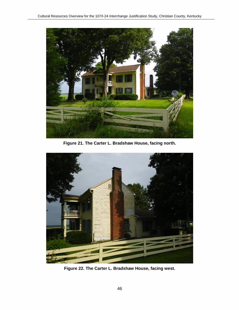
Cultural Resources Overview for the 107/I-24 Interchange Justification Study, Christian County, Kentucky
46
Figure 21. The Carter L. Bradshaw House, facing north.
Figure 22. The Carter L. Bradshaw House, facing west.

Cultural Resources Overview for the 107/I-24 Interchange Justification Study, Christian County, Kentucky
47
The Beverly School (R-2, CH123)
The Beverly School is a privately owned building located within the study area and is listed on the NRHP (Item # 79003624). Known as the Beverly School (or Beverly Academy), the building is located off of Old Palmyra Road (Old KY 345), 0.5 km south of its intersection with SR 107 and 0.6 km north of its intersection with Memory Lane in Beverly, Kentucky. This one-room school house (Figure 23 and Figure 24) was built in one week in 1889 and served as a private institution (Beverly Academy) until 1904, after which its last use was as a public school until 1909. The school was attended by the nationally prominent clairvoyant Edgar Cayce (Figure 25). The building is of one-story frame construction, with a gable end and double door front. In 1910 the building was moved a short distance from the intersection of Palmyra Road and the lane that approaches the Carter L. Bradshaw House (Gibbs and Torma 1982; National Parks Service 2013). The building was placed on the NRHP on April 30, 1979 (National Parks Service 2013).
Today the school has been renovated and is located 85 m (281 ft) from Palmyra Road (Old KY 345) (Figure 26, Figure 27, Figure 28, and Figure 29). Judging from photographs and a review of relevant literature, it is estimated that the original location of the building was approximately 40 to 60 m west of its current location. There is a moderate to high probability that there are intact cultural deposits associated with the NRHP building in this location. Avoidance or additional archaeological investigations of this general area are advised.
Figure 23. Photo of Beverly School prior to relocation (National Parks Service 2013).

Cultural Resources Overview for the 107/I-24 Interchange Justification Study, Christian County, Kentucky
48
Figure 24. Beverly School prior to relocation (National Parks Service 2013).
Figure 25. Beverly School, November 15, 1890. Edgar Cayce is fourth from left back row (Unknown 1890).

Cultural Resources Overview for the 107/I-24 Interchange Justification Study, Christian County, Kentucky
49
Figure 26. Beverly School as it appears today after relocation and restoration, facing southeast.
Figure 27. Beverly School and well as it appears today, facing southwest.

Cultural Resources Overview for the 107/I-24 Interchange Justification Study, Christian County, Kentucky
50
Figure 28. Front interior of renovated Beverly School.
Figure 29. Rear interior of renovated Beverly School.

Cultural Resources Overview for the 107/I-24 Interchange Justification Study, Christian County, Kentucky
51
Willis-Ward House (CH124) The location of the Willis-Ward house was located in a heavily forested privately owned property, and its existence could not be visually confirmed. It is possibly no longer standing. The house was built in the 1860s and was a cottage-type building once popular throughout southern Christian County. This building is no longer extant. The owners of the house, initially R. B. Willis and later E. H. Word operated the store (Gibbs and Torma 1982: 88-89). Beverly Store (R-3, CH125) The Beverly Store (Figure 30) was constructed in 1915 and replaced a similar store that once served as the post office between 1854 and 1902.
Figure 30. Beverly Store (R3) built in 1915 within study area along Palmyra Road (Old KY 345).
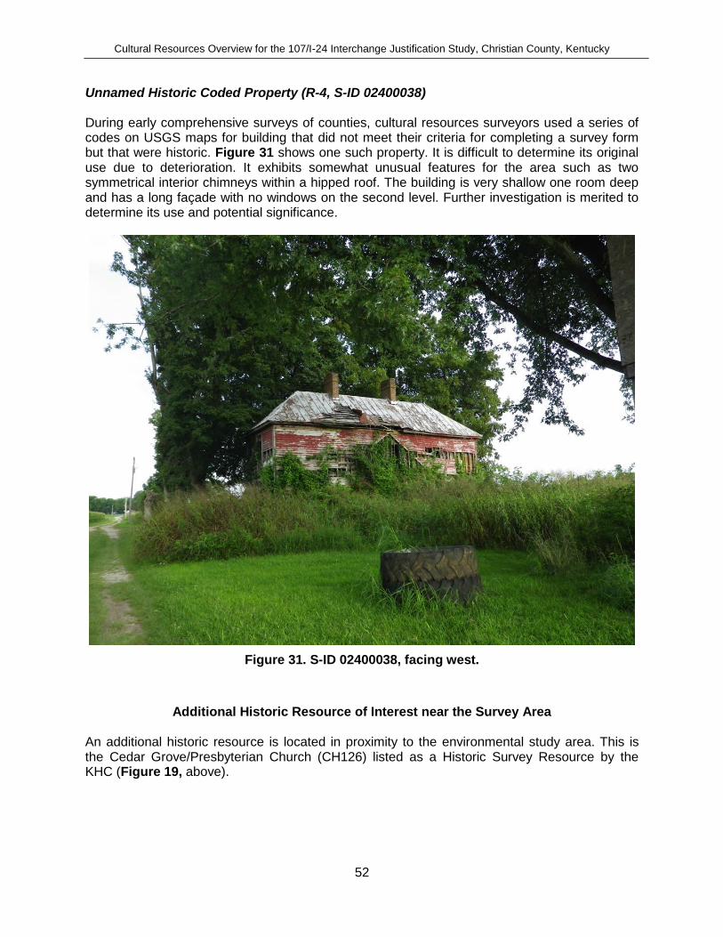
Cultural Resources Overview for the 107/I-24 Interchange Justification Study, Christian County, Kentucky
52
Unnamed Historic Coded Property (R-4, S-ID 02400038) During early comprehensive surveys of counties, cultural resources surveyors used a series of codes on USGS maps for building that did not meet their criteria for completing a survey form but that were historic. Figure 31 shows one such property. It is difficult to determine its original use due to deterioration. It exhibits somewhat unusual features for the area such as two symmetrical interior chimneys within a hipped roof. The building is very shallow one room deep and has a long façade with no windows on the second level. Further investigation is merited to determine its use and potential significance.
Figure 31. S-ID 02400038, facing west.
Additional Historic Resource of Interest near the Survey Area An additional historic resource is located in proximity to the environmental study area. This is the Cedar Grove/Presbyterian Church (CH126) listed as a Historic Survey Resource by the KHC (Figure 19, above).

Cultural Resources Overview for the 107/I-24 Interchange Justification Study, Christian County, Kentucky
53
4 DRIVE-THROUGH SURVEY
On August 15 and August 16, 2013, a drive-through survey was conducted by CIA. The intent of the survey was to preliminarily assess the archaeological potential of the environmental study area. Many areas within the environmental study area were accessible for visual examination via public roads; other areas that cut across undeveloped tracts of private land were not accessed during this survey but could be viewed at a distance. Among the indicators sought were:
extant historic buildings that could be surrounded by archaeological materials;
built environment (pavement, buildings, etc.) that eliminated potential for intact sites;
other forms of disturbance (quarries, borrow pits, etc);
stream crossings and floodplains that might contain buried cultural deposits;
ridgetops;
slope;
broad, level expanses of undeveloped lands;
rockshelters and caves; and
springs and other fresh water sources.
The probability for prehistoric archaeological sites within the environmental study area varies to some degree depending upon the terrain and the amount of modern historic disturbance that has occurred. Prehistoric resources would be expected to be located within the environmental study area on relatively level terrain (less than 15 degree slope) that infrequently flood, particularly along low ridge tops and knolls. All of the soils within the environmental study area, with the exception of Baxter chert silt loam, are well drained, possess little to no potential to pond or flood, and are on relatively level terrain. These soils are considered to have a moderate to high potential to contain prehistoric cultural deposits based on their location and general slope. Freshwater springs and rivers would also have attracted early inhabitants, both Native and European. When considering the landforms present; the close proximity the Little River, chert resources, freshwater springs; the potential for the discovery of additional prehistoric sites is considered to be relatively high throughout the environmental study area. This conclusion is supported by the abundance of previously recorded prehistoric sites within the immediate vicinity of the environmental study area. A percentage of the environmental study area, particularly along the main corridor of I-24 (Figure 32) and the I-24 overpass of KY 107 and at its intersection with KY 345, has been highly disturbed based on visual inspection (Figure 33). In addition, some areas along the west and east of KY 107 and KY 345 have recent residential development which has disturbed these areas (Figure 34), along with the recent modification of KY 345 to the south of I-24 (Figure 35).

Cultural Resources Overview for the 107/I-24 Interchange Justification Study, Christian County, Kentucky
54
Figure 32. Image of I-24 and KY107/KY345 overpass and western half of environmental study area (Google Maps 2013).
Figure 33. KY 107/KY 345 overpass of I-24, and KY 107 intersection with KY 345 (upper right), facing north.
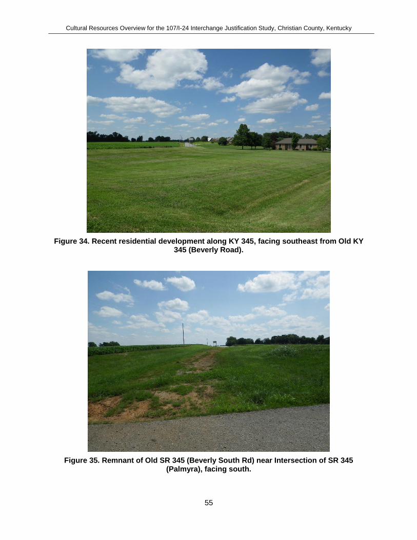
Cultural Resources Overview for the 107/I-24 Interchange Justification Study, Christian County, Kentucky
55
Figure 34. Recent residential development along KY 345, facing southeast from Old KY 345 (Beverly Road).
Figure 35. Remnant of Old SR 345 (Beverly South Rd) near Intersection of SR 345 (Palmyra), facing south.

Cultural Resources Overview for the 107/I-24 Interchange Justification Study, Christian County, Kentucky
56
Unrecorded Historic Resources Historic archaeological sites are often encountered along old roads and settlement or “string communities” often occurred along the length of such roads. Unrecorded resources noted during the drive-through survey primarily consisted of historic barns, some of which are in excellent condition while others are severely deteriorated. The remaining unrecorded historic resources consisted of historic houses dating from the 1920s to 1960s. These would not have been 50 years old when previous surveys were conducted. Outbuildings were usually not included in earlier surveys of counties. A number of unrecorded buildings indicated on historic mapping appear to have survived to the present, and archaeological remains may still exist at these locations. An archaeological survey should target these places for evidence of historic occupation within the proposed environmental study area. Beverly School Outbuildings (R-5) A multi-purpose barn and a well (or cistern) (Figure 36) and outhouse (Figure 37) are currently in proximity to the Beverly School and are depicted on an early photograph of the school taken prior to its relocation (Figure 38). The photograph depicts the school prior to relocation with the well and barn in the background. This would place the construction of the barn prior to 1910. It is unknown whether the outhouse is in its original location.
Figure 36. R-5, a historic barn in proximity of Beverly School.

Cultural Resources Overview for the 107/I-24 Interchange Justification Study, Christian County, Kentucky
57
Figure 37. Privy (outhouse) associated with Beverly School, facing southwest.
Figure 38. Beverly School prior to relocation, facing southeast, with well and historic barn observable in background.

Cultural Resources Overview for the 107/I-24 Interchange Justification Study, Christian County, Kentucky
58
House (R-6) R-6 is a Colonial Revival-influenced Ranch house circa 1940 to 1955 (Figure 39).
Figure 39. R-6, facing northeast from KY 107.
House (R-7) R-7 is a hipped-roof, one-story, Ranch-style house with Colonial Revival elements, dating to circa 1950 to 1974 (Figure 40).
Figure 40. R-7, facing southwest from KY 107.

Cultural Resources Overview for the 107/I-24 Interchange Justification Study, Christian County, Kentucky
59
House (R-8) R-8 is a front-gabled, one-and-a-half-story, bungalow-plan house with very little stylistic influences. Significant changes have been made to the fenestration pattern and siding. It dates to circa 1920 to 1940 (Figure 41).
Figure 41. R-8, facing south.
Multipurpose Barn (R-9) R-9 is a tranverse crib barn with central aisle and hayloft, dating to the early twentieth century. It has an earthen floor, vertical board lapped siding, and metal roof (Figure 42).
Figure 42. R-9, facing north.

Cultural Resources Overview for the 107/I-24 Interchange Justification Study, Christian County, Kentucky
60
House (R-10) R-10 is a cross-gabled, story-and-a-half, bungalow-plan house with integral porch in excellent condition. It dates to circa 1920 to 1940 (Figure 43).
Figure 43. R-10, facing west.
Multipurpose Barn (R-11) R-11 a frame barn with vertical-board-lapped siding and metal roof. It likely dates to the early to mid-twentieth century (Figure 44).
Figure 44. R-11, facing north.

Cultural Resources Overview for the 107/I-24 Interchange Justification Study, Christian County, Kentucky
61
House (R-12) R-12 is a side-gabled, story-and-a-half, central-hall passage house with Colonial Revival influences. It likely dates circa 1940 to 1960 (Figure 45).
Figure 45. R-12, facing east.
House (R-13) R-13 is a Colonial Revival-influenced, Ranch-plan house with an interior end chimney. It likely dates to circa 1940 to 1950 (Figure 46).
Figure 46. R-13, facing southwest.

Cultural Resources Overview for the 107/I-24 Interchange Justification Study, Christian County, Kentucky
62
House (R-14) R-14 is a one-story, side-gabled, Ranch-plan house with little stylistic influence, dating to circa 1950 to 1974 (Figure 47).
Figure 47. R-14, facing west.
Tobacco Barn (R-15) R-15 is a tobacco barn with earthen floor, vertical board siding, and a standing seam metal roof. Narrow windows serve as ventilation for air curing. It likely dates to the early to mid-twentieth century (Figure 48).
Figure 48. R-15, facing north.

Cultural Resources Overview for the 107/I-24 Interchange Justification Study, Christian County, Kentucky
63
Barn Ruins (R-16) R-16 is the ruins of a barn, which likely served multiple functions when built circa 1900 to 1925 (Figure 49).
Figure 49. R-16, facing northeast.
Barn Ruins (R-17) R-17 is the ruins of a barn likely built circa 1900 to 1925. Greater access to the building is needed to determine its former function (Figure 50).
Figure 50. R-17, facing southeast.

Cultural Resources Overview for the 107/I-24 Interchange Justification Study, Christian County, Kentucky
64
Barn (R-18) R-18 is a barn with two flanking passageways. This likely houses farm equipment and minimal livestock. It dates to circa 1900 (Figure 51).
Figure 51. R-18, facing west.
Barn (R-19) R-19 is a barn and likely dates to the early to mid-twentieth century. Greater access to the building is needed to determine its function (Figure 52).
Figure 52. R-19, facing east.
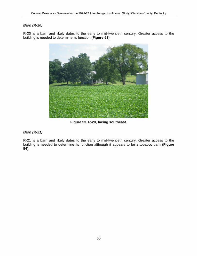
Cultural Resources Overview for the 107/I-24 Interchange Justification Study, Christian County, Kentucky
65
Barn (R-20) R-20 is a barn and likely dates to the early to mid-twentieth century. Greater access to the building is needed to determine its function (Figure 53).
Figure 53. R-20, facing southeast.
Barn (R-21) R-21 is a barn and likely dates to the early to mid-twentieth century. Greater access to the building is needed to determine its function although it appears to be a tobacco barn (Figure 54).

Cultural Resources Overview for the 107/I-24 Interchange Justification Study, Christian County, Kentucky
66
Figure 54. R-21, facing southwest.
Cemeteries All acquired cemetery information was obtained from the combined use of USGS topographic quadrangles, internet-available resources including www.findagrave.com, and field reconnaissance. No attempt was made to access private property, however. Therefore, this assessment also does not preclude the possibility that other cemeteries and burials may occur within the study area. Adams Cemetery Based on the information gathered, there is one cemetery located within the environmental study area (Figure 55). Known as the Adams Cemetery, the cemetery contains at least eight individual interments (Table 18).
Table 18. Cemeteries within the Project Area
Cemetery Name Location Estimated Interments
Within Project
APE
Adams Cemetery
Located approximately 240 m (551 ft)
southwest of the intersection of I-24 and KY 107 overpass
8 Yes

Cultural Resources Overview for the 107/I-24 Interchange Justification Study, Christian County, Kentucky
67
Figure 55. Adams Cemetery, facing west from KY 107.
Major Cemetery #3 An additional cemetery known as Major Cemetery #3 (Figure 19, above) was documented within 600 m of the area on the “Major Place” historic farm discussed below. A search of cemeteries on the web site www.findagrave.com has the cemetery named as Major Cemetery #3 and indicates that several members of the Major family are interred at the cemetery. As indicated by the online resource, the cemetery contains 43 interments.
Historic Farms
While no historic farms are located within the proposed interchange study area, the western boundary of one Sesquicentennial Historic Farm known as “The Major Place” is located approximately 130 m east of the environmental study area. The farm is listed in the volume of Kentucky’s Historic Farms (Clark et al. 1994:155-156) and is located at the end of Memory Lane immediately southeast of the environmental study area. The farm was originally purchased in 1829 and is owned by J. Brooks and Martha Major. An apparent family cemetery is located on the farm.

Cultural Resources Overview for the 107/I-24 Interchange Justification Study, Christian County, Kentucky
68
5 SUMMARY AND CONCLUSIONS
This cultural resources overview was prepared in connection with the I-24 and KY 107 Interchange Justification Study, Christian County, Kentucky (KYTC Item No.2-8702). CIA assisted Qk4, Inc. in support of the KYTC in their planning efforts by researching the existing cultural and environmental conditions within the environmental study area, especially as related to prehistoric and historic archaeological and cultural historic resources, namely historic structures and buildings, recorded archaeological sites, and cemeteries. More specifically, CIA prepared an inventory of recorded or otherwise known cultural resources within the environmental study area; assessed the potential for intact, unknown archaeological sites to be present; conducted a drive-through survey for standing historic buildings around which intact archaeological deposits may be present, and developed preliminary archaeological and historical contexts to allow informed interpretation of these resources. A review of data on file at the KY OSA included reports of previous archaeological investigations and archaeological site files submitted for the environmental study area, as well as historic maps of the area and other relevant documents. The review indicated that the potential for unrecorded historic and prehistoric sites to be located within the area in question is high. One archaeological survey has occurred within the environmental study area resulting in the discovery of one prehistoric archaeological site that has subsequently been destroyed by the construction of I-24. Three additional prehistoric sites have been previously identified within the study area. Outside the environmental study area, but within a 2-kilometer buffer, twenty-six archaeological sites have been identified. A records check with the KHC revealed that five historic properties have been recorded within the environmental study area. Two of these are listed in the NRHP: the Bradshaw House and the Beverly School. Properties recorded as Historic Survey Resources include the Willis/Word House and Beverly Store. The remaining property is unnamed and recorded as a Historic Coded Property. Field inspection observed that it is a residential house/farmstead. One cemetery exists within the environmental study area. Known as the Adams Cemetery, the cemetery contains at least seven individual interments. The potential for discovery of additional prehistoric sites is considered to be relatively high along many sections of the environmental study area, particularly near natural springs and the low ridges and knolls within the agricultural fields in the surrounding uplands near the Little River. Historic archaeological sites may be encountered in similar areas, although the potential for such resources are particularly within the study area in localities where buildings once stood.

Cultural Resources Overview for the 107/I-24 Interchange Justification Study, Christian County, Kentucky
69
6 REFERENCES CITED
Adovasio, J. M. and D. R. Pedler. 2004 Pre-Clovis Sites and Thier Implications for Human Occupation befor the Last Glacial
Maximum. In Entering America: Northeast Asia and Beringia Before the Last Glacial Maximum, D. B. Madsen, ed. Pages 139-158. University of Utah Press, Salt Lake City.
Adovasio, J. M., D. R. Pedler, T. Donham, and R. Struckenrath. 1999 No Vestige of a Beginning nor Prospect for an End: Tow Decades of Debate on
Medowcroft. In Ice Age peoples of North America: Environments, Origins, and Adaptations, R. F. Boszhardt and K. L. Turnmire, eds. Pages 416-431. Center for the Study of the First Americans, Department of Anthropology, Texas A&M University Press, College Station.
Ahler, Steven R., J. D. Muller, and J. Rabinowitz 1980 Archaeological Testing for the Smithland Pool, Illinois. Research Paper 13: Report
submitted to the U.S. Army Corps of Engineers, Louisville, District. Southern Illinois University at Carbondale Center for Archaeological Investigations, Carbondale, Illinois.
Andrefsky, W. J. 2005 Lithics: Macroscopic Approaches to Analysis. Second Edition. Cambridge, Cambridge
University Press. Cambridge Manuals in Archaeology.
Applegate, D. 2008 Woodland Period. In The Archaeology of Kentucky: An Update. Volume 1, Kentucky
Heritage Council State Historic Preservation Comprehensive Plan Report No. 3, D. Pollack, ed. Pages 339-603. Kentucky Heritage Council, Frankfort, Kentucky.
Bader, Anne Tobbe 1993 A Phase III Archaeological Data Recovery at the Rockmaker Site, 165Bc138,
Breckingridge County, Kentucky. MAAR Associates, Inc., Newark, Delaware.
Bader, Anne Tobbe and Joseph E. Granger 1989 Recent Archaeological Investigations on the Kentucky Air National Guard Site
(15JF267), Jefferson County, Kentucky. Report submitted to the Kentucky Air National Guard Air Technician Department. Granger Consultants, Louisville.
Bailey, H. H. and K. H. Winsor 1964 Kentucky Soils. Misc. 308: University of Kentucky Agriculture Experimental Station,
Lexington, Kentucky.
Boisvert, R. A., B. N. Driskell, K. W. Robinson, S. D. Smith, and L. F. Duffield. 1979 Materials Recovered. Collins, Michael B. [1], 60-418. Lexington, Department of
Anthropology, University of Kentucky. Occasional Papers in Anthropology.

Cultural Resources Overview for the 107/I-24 Interchange Justification Study, Christian County, Kentucky
70
Braun, E. L. 1950 Deciduous Forest of Eastern North America. Hafner, New York.
Buol, S. W., F. D. Hole, and R. J. McCracken. 1989 Soil Genesis and Classification. Iowa State University Press, Ames, Iowa.
Carr, K. W., J. M. Adovasio, and D. R. Pedler. 2001 Paleoindian Populations in Trans-Appalachia: The View from Pennsylvania. In
Archaeology of the Appalachian Highlands, L. P. Sullivan and S. C. Prezzano, eds. Pages 67-102. University of Tennessee, Knoxville.
Chapman, J. R. 1975 The Rose Island Site. IV: University of Tennessee Department of Anthropology,
Knoxville.
Clark, T. D., D. W. Beatty, C. A. Jarratt, C. Amos, and K. E. Hudson. 1994 Kentucky's Historic Farms, 200 Years of Kentucky Agriculture. Turner Publishing
Company, Paducah, Kentucky.
Cobb, C. R. 2000 From Quarry to Cornfield: The Political Economy of Mississippian Hoe Production. The
University of Alabama Press, Tuscaloosa.
Cobb, C. R. and B. M. Butler. 2002 The Vacant Quarter Revisited: Late Mississippian Abandonment of the Lower Ohio
Valley. American Antiquity 67(4):625-641.
Cole, F.-C., R. Bell, J. Bennett, J. Caldwell, N. Emerson, R. MacNeish, K. Orr, and R. Willis. 1951 Kincaid: a Prehistoric Illinois Metropolis. University of Chicago Press, Chicago.
Davis, M. B. 1983 Holocene Vegetational History of the Eastern United States. In Late Quaternary
Environments of the United States: Volume 2, The Holocene,University of Minnesota Press, Minneapolis.
Delcourt, H. R. 2002 Forests in Peril: Tracking Deciduous Trees from Ice-Age Refuges into the Greenhouse
World. McDonald & Woodward Publishing Company, Blacksburg, Virginia.
Delcourt, H. R. and P. A. Delcourt. 1981 Vegetation Maps for Eastern North America: 40,000 YR B.P. to the Present. Geobotany
II123-165.Romans, R. C., ed.
Dillehay, T. D. 1989 Monte verde: A Late Pleistocene Settlement in Chile, Volume I: Paleoenvironment and
Site Context. Smithsonian Instituation Press, Washington, D.C.
1997 Monte Verde: A Late Pleistocene Settlement in Chile, Volume II: The Archaeological Context. Smithsonian Institution Press, Washington D.C.

Cultural Resources Overview for the 107/I-24 Interchange Justification Study, Christian County, Kentucky
71
Dragoo, D. W. 1973 Wells Creek-An Early Mann Site in Stewart County, Tennessee. Archaeology of Eastern
North America 1(1):1-56.
Duffield, L. F. 1966 The Robert Dudgeon Site: A Stratified Archaic Site in the Green River Reservoir, South
Central Kentucky.
Evans, E. R. 1977 Notable Persons in Cherokee History: Dragging Canoe. Journal of Cherokee Studies
2(2):176-189.
Fagan, B. 1991 Ancient North America. Thames and Hudson, New York, New York.
2000 The Little Ice Age. Basic Books, New York, New York.
Future Farmers of America.Christain County High Chapter (Ky.), Furture farmers of America.Hopkinsville High Chapter (Ky.), and I. Cardinal Publishing.
1995 Christian County, Kentucky, 1995 Plat Book. Page 11. Cardinal Publishing, Inc., Owensboro, Kentucky.
Gatus, T. W. and D. R. Maynard. 1978 Karst Topography: A Factor Associated with Paleo-Indian Settlement in Certain Areas
of Kentucky. Tennessee Anthropologist 3(2):203-210.
Gibbs, K. T. and C. Torma. 1982 Hopkinsville and Christian County Historic Sites. Pages 88-89. Kentucky Heritage
Commission.
Google Maps 2013 Lafayette Rd, Christian County, Ky.
https://maps.google.com/maps?q=lafayette+rd+hopkinsville+ky&ie=UTF-8&hq=&hnear=0x887ad27ceb6f91d7:0x2bcd8907f4b42c2b,Lafayette+Rd,+Hopkinsville,+KY+42240&gl=us&ei=H9EUUoutKuTL2QWky4GwBA&ved=0CCoQ8gEwAA
Janzen, D. E. 1977 An Examination of Late Archaic Development in the Falls of the Ohio River Area. In For
the Director: Research Essays in Honor of James B. Griffin,Pages 123-143. Museum of Anthropology University of Michigan, Michigan.
Jefferies, R. W. 1990 Archaic Period. In The Archaeology of Kentucky: Past Accomplishments, Future
Directions Volume One State Historic Preservation Comprehensive Plan Report No. 1, D. Pollack, ed. Pages 143-246. Kentucky Heritage Council, Lexington, Kentucky.
Jefferies, R. W. 2008 Archaic Period. In The Archaeology of Kentucky: An Update, D. Pollack, ed. Pages
193-338. Kentucky Heritage Council, Lexington, Kentucky.

Cultural Resources Overview for the 107/I-24 Interchange Justification Study, Christian County, Kentucky
72
Jennings, J. D. 1968 Prehistory of North America. McGraw-Hill, New York, New York.
Jillson, W. R. 1928 Preliminary Map of Areal and Structural Geology of Christian County Kentucky.
Frankfort, Kentucky, Kentucky Geological Survey. VI.
Justice, N. 1987 Stone Age Spear and Arrow Points of the Midcontinental and Eastern UNited States: A
Modern Survey and Reference. Indiana University Press, Bloomington, Indiana.
Kentucky Geological Survey 2013 Kentucky Geologic Map Information Service. KGS. Accessed 6-14-0012
www.kgs.uky.edu/kgsmap/kgsgeoserver/viewer.asp
Knight, V. J. Jr. 1990 Social Organization and the Evoluation of Hierarchy in Southeastern Chiefdoms.
Journal pf Anthropological Research 46(1):1-23.
Kreisa, P. and C. Stout. 1991 Trends and Trajectory in Western Kentucky Woodland Period Settlement Patterning.
The Human Landscape in Kentucky's Past: Site Structure and Settlement Patterns98-104.Stout, C. and Hensley, C. K., ed.
Kreisa, P. 1987 Late Prehistoric Settlement Patterns in the Big Bottoms of Fulton County, Kentucky. In
Current Archaeological Research in Kentucky,Pages 78-99. Kentucky Heritage Council, Frankfort.
Kricher, J. C. 1988 A Field Guide to Eastern Forests: North America. Houghton Mifflin Company, Boston,
Massachusetts.
Lepper, B. T. and R. Bonnichsen. 2004 New Perspectives on the First Americans: Introductory Remarks. In New perspectives
on the First Americans, B. T. Lepper and R. Bonnichsen, eds. Pages 1-11. Center for the Study of the First Americans, Department of Anthropology, Texas A&M University Press, College Station.
Lewis, R. B. 1986 Mississippian Towns of the Western Kentucky Border: The Adams, Wickliffe, and
Sassafras Ridge Sites. Champaign-Urbana, Department of Anthropology, University of Illinois.
1996 Kentucky Archaeology. Lewis, R. Barry Kentucky Archaeology. 21-38. Lexington, University of Kentucky Press.
Lewis, T. and M. Kneberg. 1958 Tribes that Slumber: Indians of the Tennessee Region. Knoxville, University of
Tennessee.
Cultural Resources Overview for the 107/I-24 Interchange Justification Study, Christian County, Kentucky
73
Loy, T. H. and E. J. Dixon. 1998 Blood Residues on Fluted Points from Eastern Beringia. American Antiquity 62(1):21-
46.
MacNeish, R. 1948 The Pre-Pottery Faulkner Site of Southern Illinois. American Antiquity 13(3):232-243.
Maggard, G. and K. Stackelbeck. 2008 Chapter 3: Paleoindian Period. In The Archaeology of Kentucky: An Update,Pages 109-
192. Kentucky Heritage Council State Historic Preservation Comprehensive Plan Report No. 3.Kentucky Heritage Council, Frankfort.
Mann, Michael E. 2002 Little Ice Age. John Wiley & Sons, Ltd. Accessed 2-17-2012
http://holocene.meteo.psu.edu/shared/articles/littleiceage.pdf
McAvoy, J. M. and McAvoy Lynn D. 1997 Archaeological Investigations of Site 44SX202, Cactus Hill, Sussex County, Virginia.
Virginia Department of Historic Resources, Nottoway River Survey Archaeological Research, Sandston, Virginia.
Mocas, Stephen T. 1976 Excavations at Arrowhead Farm (15JF237). University of Louisville Archaeological
Survey, Louisville.
2006 Early Woodland and Middle Woodland Occupations at the Knob Creek Site (12HR484), Caesars Archaeological Project, Harrison County, Indiana. Report submitted to U.S. Army Corps of Engineers. Indiana State University Anthropology Laboratory Technical Report 37, Louisville.
Muller, J. D. 1986 Archaeology of the Lower Ohio River Valley. Academic Press, New York, New York.
Nance, J. D. 1984 Lithic Exploitation Studies in the Lower Tennessee-Cumberland Valleys, Western
Kentucky. Prehistoric Chert Exploitation: Studies from the Midcontinent Occasional Paper Number 2101-127.Butler, Brian M. and May, Ernest E., ed.
1986 The Morrisroe Site: Projectile Point Types and Readiocarbon Dates from the Lower Tennessee River Valley. Midcontinental Journal of Archaeology 1111-50.
1988 The Archaic Prehistory of the Lower Tennessee-Cumberland Valleys. In Paleoindian and Archaic Research in Kentucky, C. D. Hockensmith, D. Pollack, and T. N. Sanders, eds. Pages 127-152. Kentucky Heritage Council, Frankfort.
2000 Elemental Composition Studies of Lithic Materials from Western Kentucky and Tennessee. Midcontinental Journal of Archaeology 25(1):84-100.
National Parks Service, U. S. Department of the Interior 2013 Beverly School. National Parks Service, Department of the Interior. Accessed 8-30-
2013 http://nrhp.focus.nps.gov/natreghome.do?searchtype=natreghome

Cultural Resources Overview for the 107/I-24 Interchange Justification Study, Christian County, Kentucky
74
Nikater 2007 Course of the Wilderness Road in Kentucky by 1785. Own work by Nikater, submitted to
the public domain. Accessed 5-25-0012 http://en.wikipedia.org/wiki/File:Wilderness_road_en.png
Odell, G. H. 1988 Addressing Prehistoric Hunting Practices Through Stone Tool Analysis. American
Anthropologist 90335-356.
Overpeck, J. T., R.S.Ebb, and T.Ebb III 1992 Vegetation Mapping: Analog Vegetation Maps for Eastern North America.
http://www.ncdc.noaa.gov/paleo/vegmap.html
Parish, R. 2009 A Chert Sourcing Study using Visible\Near-Infrared Reflectance Spectroscopy at the
Dover Quarry Sites, Tennessee. Murray, Kentucky, Department of Geosciences, Murray State University. 4-27-2011.
Parry, W. J. and R. L. Kelly. 1987 Expedient core Technology and Functional Variability in Chipped Stone Debitage. In
The Organization of Core Technology, J. K. Johnson and C. A. Morrow, eds. Pages 285-304. Westview Press, Boulder.
Phillips, P., J. A. Ford, and J. B. Griffin. 1951 Archaeological Survey in the Lower Mississippi Alluvial Valley, 1940-1947. 25.
Cambridge, Massachusetts, Harvard University Peabody Museum of Anthropology and Ethnology.
Pollack, D. 2008a Chapter 6: Mississippi Period. In The Archaeology of Kentucky: An Update,Pages 605-
738. Kentucky Heritage Council State Historic Preservation Comprehensive Plan Report No. 3.Kentucky Heritage Council, Frankfort.
2008b Chapter 1: Introduction. In The Archaeology of Kentucky: An Update Kentucky Heritage Council State Historic Preservation Comprehensive Plan Report No. 3, D. Pollack, ed. Kentucky Heritage Council, Frankfort, Kentucky.
Pollack, D. ed. 1990 The Archaeology of Kentucky: Past Accomplishments and Future Directions. Kentucky
Heritage Council State Historic Preservation Comprehensive Plan Report No. 1. Kentucky Heritage Council, Frankfort, Kentucky.
Pollack, D. and A. G. Henderson. 2000 Late Woodland Cultures in Kentucky. In Late Woodland Societies: Tradition and
Transformation across the Midcontinent,Pages 613-642. University of Nebraska Press, Lincoln.
Railey, J. A. 1990 The Woodland Period. In The Archaeology of Kentucky: Past Accomplishments and
Future Directions Volume 1 State Historic Preservation Comprehensive Plan Report No. 1, D. Pollack, ed. Pages 247-374. Kentucky Heritage Council, Lexington, Kentucky.

Cultural Resources Overview for the 107/I-24 Interchange Justification Study, Christian County, Kentucky
75
1991 The Conley-Greene Rockshelter (15EL4): An Early Woodland Occupation in the Cumberland Plateau of Northeastern Kentucky. In Studies in Kentucky Archaeology, C. D. Hockensmith, ed. Pages 66-101. Kentucky Heritage Council, Frankfort.
1996 Woodland Cultivators. In Kentucky Archaeology, R. B. Lewis, ed. Pages 79-125. University of Kentucky Press, Lexington.
Rennick, R. M. 1984 Kentucky Place Names. The University Press of Kentucky, Lexington.
Riley, T. J. R. E. a. J. R., R. Edging, and J. Rossen. 1990 Cultigens in Prehistoric Eastern North America: Changing Paradigms. Current
Anthropology 31(5).
Robinson, K. W. and S. D. Smith. 1979 The Villier Site (15JF110 Complex). Collins, Michael B. [1], 590-696. Lexington,
Department of Anthropology, University of Kentucky. Occasional Papers in Anthropology.
Rolingson, M. A. 2002 Plum Bayou Culture of the Arkansas-White River Basin. In The Woodland Southeast, D.
G. Anderson and R. C. Jr. Mainfort, eds. Pages 44-65. University of Alabama Press, Tuscaloosa.
Royce, C. C. 1984 Fifth Annual Report of the Bureau of Ethnology to the Secretary of the Smithsonian
Institute. Accessed 5-25-0012 http://www.tngenweb.org/cessions/cherokee.html
Russo, M. and G. Heide. 2004 The Emergence of Pottery in South Florida. In Early Pottery: Technology, Function,
Style, and Interaction int he Lower Southeast, R. Saunders and C. T. Hays, eds. Pages 105-128. The University of Alabama Press, Tuscaloosa.
Sanders, T. N. 1988 The Adams Site: A Paleoindian Manufacturing and Habitation Site in Christian County,
Kentucky. Paleoindian and Archaic Research in Kentucky1-24.Hockensmith, Charles, Pollack, D., and Sanders, Thomas N., ed.
Sanders, Thomas N. and David R. Maynard 1979 A Reconnaissance and Evaluation of Archaeological Sites in Christian County,
Kentucky. 12: Kentucky Heritage Council, Frankfort, Kentucky.
Sassaman, K. E. 1993 Early Pottery in the Southeast. University of Alabama Press, Tuscaloosa.
2002 Woodland Ceramic Beginnings. In The Woodland Southeast, D. G. Anderson and R. C. Jr. Mainfort, eds. Pages 398-420. The University of Alabama Press, Tuscaloosa.
Sawyer, S. 2002 It Happened in Tennessee. Globe Pequot Press, Guilford, Connecticut.
Cultural Resources Overview for the 107/I-24 Interchange Justification Study, Christian County, Kentucky
76
Schock, J. M., W. Howell, M. L. Bowman, R. Alvey, D. Beasley, and J. Stoner. 1977 A Report on the Excavations of Two Archaic Sites (CH302 and CH307) in Christian
County, Kentucky. [Bulletins 6 and 7], i-99. Scottville, Kentucky, Kentucky Archaeological Association, Inc. Bulletin of the Kentucky Archaeological Association.
Schock, Jack M. and Jamed D. Wyss 1970 Archaeological Survey and Testing of Section 3 Interstate Highway 24, Kentucky.
Occasional Papers in Anthropology, No. 1: Department of Sociology and Anthropology, Western kentucky University.
Seeman, M. F. 1992 The Bow and Arrow, The Intrusive Mound Complex, and a Late Woodland Jack's Reef
Horizon in the Mid-Ohio Valley. Seeman, M. F. Cultural Variability in Context: Woodland Settlements of the Mid-Ohio Valley . Kent, Ohio, Kent State University Press. MCJA Special Papers.
Selby, M. J. 1985 Earth's Changing Surface: An Introduction to Geomorphology. Clarendon Press, Oxford.
Service, E. R. 1971 Primitive Social Organization. Random House, New York.
Shelford, V. E. 1963 The Ecology of North America. University of Illinois Press, Urbana, Illinois.
Smith, Bruce D. 1989 Origins of Agriculture in Eastern North America. Science 246.
Stackelbeck, K. and P. B. Mink. 2008 Chapter 2: Overview of Prehistoric Archaeological Research in Kentucky. In The
Archaeology of Kentucky: An Update, D. Pollack, ed. Pages 27-108. Kentucky Heritage Council, Frankfort.
Stafford, C. R. and M. Cantin. 2009 Archaic Period Chronology in the Hill Country of Southern Indiana. In Archaic Societies:
Diversity and Complexity across the Midcontinent, T. E. Emerson, D. L. McElrath, and A. C. Fortier, eds. Pages 287-313. State University of New York Press, Albany.
Sussenbach, Tom and R. Barry Lewis 1987 Archaeological Investigations in Carlisle, Hickman, and Fulton Counties, Kentucky: Site
Survey and Excavations. Western Kentucky Project Report 4: Report submitted to the Kentucky Heritage Council. University of Illinois, Urbana-Champaign, Illinois.
Tankersley, Kenneth B. 1990 Chapter 3: Paleoindian Period. In The Archaeology of Kentucky: Past
Accomplishments, Future Directions Volume 1, D. Pollack, ed. Pages 73-142. Kentucky Heritage Council, Lexington, Kentucky.
1996 Ice Age Hunters and Gatherers. In Kentucky Archaeology, R. B. Lewis, ed. Pages 21-38. University of Kentucky Press, Lexington.

Cultural Resources Overview for the 107/I-24 Interchange Justification Study, Christian County, Kentucky
77
The Southern Cherokee Nation of Kentucky 2012 Letter from Governorn Ernie Fletcher. Accessed 5-25-0012
http://www.southerncherokeenation.net/
Turner, W. T. 1992 Christian County. In J. E. Kleber, ed. The University Press of Kentucky, Lexington.
Turner, W. T. and C. Gilkey. 2010 Edgar Cayce's Hometown. McClanahan Publishing House, Inc, Hopkinsville, Kentucky.
U.S.Department of the Interior, N. P. S. 1983 Archeology and Historic Preservation: Secretary of the Interior's Standards and
Guidelines. Federal Register 48(190):44716-44742.
U.S.Geological Survey. 1951a Topographic Map of the Church Hill 7.5-minute Quadrangle. Washington, D.C., USGS.
1951b Topographic Map of the Herndon 7.5-minute Quadrangle. Washington, D.C, USGS.
1956 Topographic Map of the Church Hill 7.5-minute Quadrangle. Washington D.C., USGS.
1957 Topographic Map of the Herndon 7.5-minute Quadrangle. Washington, D.C., USGS.
1981 Topographic Map of the Church Hill 7.5-minute Quadrangle. Reston, Virginia, USGS.
1982 Topographic Map of the Herdon 7.5-minute Quadrangle. Reston, Virginia, USGS.
University of Kentucky 2013 Kentucky Atlas and Gazeteer. Accessed 1-16-0013 http://www.uky.edu/KentuckyAtlas/
Unknown. 1890 Beverly School.
USDA-NRCS 2006 Land Resource Regions and Major Land Resource Areas of the United States, the
Caribbean, and the Pacific Basin. U.S. Department of Agriculture Handbook 296.
2013a Soil Map - Christian County, Kentucky. USDA-NRCS. Accessed 8-20-2013 http://websoilsurvey.nrcs.usda.gov/app/HomePage.htm
2013b Soil Moisture Regimes of the Contiguous United States. USDA-NRCS National Soil Survey Center. Accessed 1-17-2013 http://soils.usda.gov/use/thematic/moist_regimes.html
Walters, M. M. 1988 The Adams Mastodon Site, Harrison County, Kentucky. Paleoindian and Archaic
Research in Kentucky43-46.Hockensmith, Charles, Pollack, D., and Sanders, Thomas N., ed.
Walthall, J. 1998 Rockshelters and Hunter-Gatherer Adaptations to the Pleistocene/Holocene Transition.
American Antiquity 63(2):223-238.

Cultural Resources Overview for the 107/I-24 Interchange Justification Study, Christian County, Kentucky
78
Wayne, W. J. and J. H. Zumberge 1965 Pleistocene Geology of Indiana and Michigan. Princeton University Press, Princeton,
New Jersey.
Webb, C. H. 1977 The Poverty Point Culture. Geoscience and Man XVII.
Webb, W. S. 1950 The Carlton [sic] Annis Mound. 7[4], 267-354. Lexington, University of Kentucky.
Webb, W. S. and W. D. Funkhouser. 1932 Archaeological Survey of Kentucky. University of Kentucky, Lexington, Kentucky.
Williams, S. 1980 The Amorel Phase: A Very Late Complex in the Lower Mississippi Valley. Southeastern
Archaeological Conference, Bulletin(22):72-81.
1983 Some Ruminations on the Current Strategy of Research in the Southeast. Southeastern Archaeological Conference, Bulletin(25):72-81.
Winters, H. D. 1967 An Archaeological Survey of Wabash Valley in Illinois. Reports of Investigations No. 10:
Illinois State Museum, Springfield, Illinois.
Wright, R. 2000 Nonzero: The Logic of Human Destiny. Pantheon Books, New York.
Wymer, D. A. 1992 Trends and Disparities: The Woodland Paleoethnobotanical Record of the Mid-Ohio
Valley. Cultural Variability in Context: Woodland Settlements of the Mid-Ohio Valley65-76.Seeman, M. F., ed.