Appendix C –Flora and Fauna Assessment River... · 61/27189/117144 Margaret River Bypass i Flora...
155
GHD | Report for Main Roads Western Australia - Margaret River Perimeter Road, 61/27189 Appendix C –Flora and Fauna Assessment 2012 Site visit results 2012 Naturemap and PMST database results Likelihood of occurrence
Transcript of Appendix C –Flora and Fauna Assessment River... · 61/27189/117144 Margaret River Bypass i Flora...

GHD | Report for Main Roads Western Australia - Margaret River Perimeter Road, 61/27189
Appendix C –Flora and Fauna Assessment
2012 Site visit results
2012 Naturemap and PMST database results
Likelihood of occurrence
GHD | Report for Main Roads Western Australia - Margaret River Perimeter Road, 61/27189 |
Margaret River Bypass – Flora and Fauna Assessment

Main Roads WesternAustralia
Report for Margaret RiverBypass
Flora and Fauna Assessment
March 2012

61/27189/117144 Margaret River BypassFlora and Fauna Assessment
This Proposed Margaret River Outer Ring Road Flora and Fauna Assessment Report (“Report”):
1. has been prepared by GHD Pty Ltd (“GHD”) for Main Roads Western Australia (MainRoads);
2. may only be used and relied on by Main Roads;
3. must not be copied to, used by, or relied on by any person other than Main Roadswithout the prior written consent of GHD;
GHD and its servants, employees and officers otherwise expressly disclaim responsibility to anyperson other than Main Roads arising from or in connection with this Report.
To the maximum extent permitted by law, all implied warranties and conditions in relation to theservices provided by GHD and the Report are excluded unless they are expressly stated toapply in this Report.
The services undertaken by GHD in connection with preparing this Report:
were limited to those specifically detailed in section 1.4 of this Report;
GHD expressly disclaims responsibility for any error in, or omission from, this Report arising fromor in connection with any of the Assumptions being incorrect.
Subject to the paragraphs in this section of the Report, the opinions, conclusions and anyrecommendations in this Report are based on conditions encountered and information reviewedat the time of preparation and may be relied on until 12 months, after which time, GHD expresslydisclaims responsibility for any error in, or omission from, this Report arising from or inconnection with those opinions, conclusions and any recommendations.

61/27189/117144 Margaret River BypassFlora and Fauna Assessment
Contents
Executive Summary i
1. Introduction 1
1.1 Background 1
1.2 Study Area 1
1.3 Scope of Works 1
1.4 Limitations 2
2. Methodology 3
2.1 Desktop Assessment 3
2.2 Field Survey 3
2.3 Survey Limitations 6
3. Existing Environment 8
3.1 Climate 8
3.2 Adjoining Land Use 8
3.3 Wetlands, Rivers and other Surface Water Drainage 8
3.4 Likelihood of Acid Sulphate Soils (ASS) 9
3.5 Vegetation 9
3.6 Flora Diversity 12
3.7 Terrestrial Fauna 15
4. Field Survey Results 20
4.1 Flora and Vegetation 20
4.2 Fauna 26
4.3 Potential Offset Lot 2150 30
5. Assessment against the 10 Clearing Principles 32
6. Environmental Impacts and Approvals 39
7. References 43
Table IndexTable 1 Information recorded at each quadrat and relévé 4Table 2 Vegetation Condition Rating 5

61/27189/117144 Margaret River BypassFlora and Fauna Assessment
Table 3 Margaret River Climate Data 8Table 4 Vegetation type, extent and status of pre-European
vegetation based on Beard (1975) and Mattiske avegetation mapping 11
Table 5 Conservation significant flora identified from thedesktop assessment 13
Table 6 Threatened and Priority fauna identified from thedesktop assessment 17
Table 7 Vegetation types recorded within the study area 21Table 8 Significant fauna habitats types within the
alignment 30Table 9 Assessment against the Ten Clearing Principles 33Table 10 Assessment of the proposal against Matters of
National Environmental Significance 39Table 11 Flora species recorded within the study area 56Table 12 Fauna Species Identified From Desktop and Field
Assessment 72Table 13 Likelihood of occurrence assessment for
Threatened and Priority Flora species with potentialto occur within the study area. 85
Table 14 Likelihood of occurrence assessment forconservation significant fauna species. 92
Figure IndexFigure 1 Locality and Environmental Constraints 45Figure 2 Vegetation Communities 45Figure 3 Vegetation Condition 45Figure 4 Significant fauna Habitat 45Figure 5 Potential Cockatoo Breeding Trees 45
AppendicesA FiguresB Conservation CodesC Desktop Search ResultsD Field Survey ResultsE Likelihood of Occurrence

i61/27189/117144 Margaret River BypassFlora and Fauna Assessment
Executive Summary
Main Roads Western Australia (Main Roads) proposes to construct a bypass, east ofthe Margaret River town site, adjoining the Bussell Highway. GHD Pty Ltd (GHD) hasbeen commissioned by Main Roads to undertake environmental investigations alongthis preliminary alignment. The study area includes two partial alignment optionsimmediately north of the Margaret River, referred to as the eastern and westernalignments.
The Environmental investigations included a desktop review and field survey to identifyany potential constraints and to identify and map flora, vegetation, fauna and faunahabitat. These will provide information for advice on environmental approvals requiredand the feasibility of developing the Margaret River bypass. The study area isapproximately 7.13 km long and 100 m wide and comprises an area of 71.3 ha.
The following is a summary of the findings of the flora and fauna assessment:
The proposed alignment options north of the Margaret River crossing traversethrough the Keenan State Forest and timber reserve. The western alignment optionalso traverses the Bramley National Park. The eastern alignment option wasexcluded from the National Park by request of Main Roads and the Shire ofAugusta-Margaret River. The proposal may potentially seek to excise a section ofthe National Park dependent on the final road design and defined impact area.
Margaret River and its tributaries are a proclaimed waterway under the WA Rightsin Water and Irrigation Act 1914 (RIWI Act). The proposed alignment options willtraverse Margaret River and two of its tributaries, including Darch Brook.
Six vegetation types were identified within the study area, including previouslycleared/highly disturbed vegetation. Remnant vegetation remaining within the studyarea consisted predominantly of Jarrah/Marri Forest with emergent Pepperminttrees in gullies and along the river and creek lines. These forests have a longhistory of logging. The majority of the study area however, was considered to becompletely degraded, traversing through cleared agricultural land, pine plantations,roads/tracks, private properties and grape vines. No TECs or PECs were identifiedwithin the study area.
A total of 168 plant taxa, representing 52 plant families and 116 genera, wererecorded from the study area. This total is comprised of 134 native species and 34introduced (exotic) species. No Threatened flora was recorded from the study area.One Priority Flora species was recorded from the study area, Gastrolobiumformosum (Priority 3). A small population of G. formosum of approximately 20individuals was recorded along the northern bank of Margaret River within thewestern alignment option.
During the survey, 82 species comprised of 56 birds, 9 reptiles, 3 amphibians and14 mammals were recorded within the study area. Four Threatened fauna specieslisted as Vulnerable under the Commonwealth Environment Protection andBiodiversity Conservation Act 1999 (EPBC Act) and Schedule 1 under the WA

ii61/27189/117144 Margaret River BypassFlora and Fauna Assessment
Wildlife Conservation Act 1950 (WC Act) were observed during the fieldinvestigation. These species were the Baudin’s Black Cockatoo, Forest Red-tailedBlack Cockatoo, Western Ringtail Possum and Southern Brush-tailed Phascogale.The Southern Brush-tailed Phascogale was only recorded from Lot 2150 (potentialoffset area), which will not be impacted by the proposed project. Several otherspecies identified from desktop assessment that have the potential or are likely tooccur in the area are Chuditch, Carnaby’s Black Cockatoo, Australasian Bittern,Peregrine Falcon and Hairy Marron. A number of Priority species listed by the DECwhich are either found in, or are potentially in the area, are the Pouched Lamprey,Water Rat, Southern Brown Bandicoot, Black Bittern, Western Brush Wallaby andthe Australian Masked Owl (SW population).
Within the study area there are 123 potential Black Cockatoo breeding trees.These trees are Jarrah, Marri or stag Eucalyptus trees and contain nesting hollowssuitable for Black Cockatoo breeding. A further 445 trees were identified as a sizesuitable for the development of nesting hollows (>500 mm at DBH) within the next100 years. The total area of Black Cockatoo feeding habitat within the study area isapproximately 14.6 ha.
During the field survey three Western Ringtail Possums were observed active atnight along riparian vegetation in the northern section of the alignment. Two dreys(resting platforms in trees) were also recorded in this area. Droppings were alsorecorded along Margaret River in the riparian vegetation and in the valley of Lot2150. One hundred and twenty-three large Eucalypts were recorded within thealignment which had hollows suitable for this species. The area of core habitat thatWestern Ringtail Possums may utilise is approximately 1.71 ha.
Offset Area - Lot 2150
Lot 2150 is 36 ha in size and primarily consists of Marri/Jarrah Woodland withemergent Peppermint trees in the gully. The lot appears to have some edge effectsfrom weeds due to historical grazing activities and the lack of fencing. Habitatwithin the Lot appears intact and some threatened fauna species were identifiedfrom an initial assessment. To gather a true reflection of the site’s potential,additional assessments should be undertaken. Assessments could include a smalltrapping program or additional spotlighting and camera trap monitoring. Thesewould be beneficial in establishing use by other threatened fauna.

161/27189/117144 Margaret River BypassFlora and Fauna Assessment
1. Introduction
1.1 BackgroundMain Roads Western Australia (Main Roads) proposes to construct a bypass, east ofthe Margaret River town site, as part of the Bussell Highway. A PreliminaryEnvironmental Assessment was undertaken in 2007 on two alignments east ofMargaret River. The currently proposed alignment sits in between the previouslysurveyed areas and requires additional assessment. It is recognised that some minormodifications to the alignment may still be required to best fit the new road into theenvironment. These areas are included into this survey.
GHD Pty Ltd (GHD) has been commissioned by Main Roads to undertakeenvironmental investigations along this preliminary alignment. This includedundertaking a desktop review and field survey to identify any potential constraints andto identify and map flora, vegetation, fauna and fauna habitat.
These assessments will provide information for advice on environmental approvalsrequired and on the feasibility of developing the Margaret River bypass in relation toenvironmental approvals.
1.2 Study AreaThe study area is along the preliminary alignment for the Margaret River bypass, northof the Margaret River town site and approximately 270 km from the Perth CBD. Thestudy area is approximately 7.13 km long and 100 m wide and comprises an area of71.3 ha (Figure 1). The majority of the alignment runs through cleared, agriculturalareas, with a portion going through State Forest No. 56.
The study area includes two partial alignment options immediately north of theMargaret River, referred to as the eastern and western alignments.
1.3 Scope of WorksThe scope of works included:
A desktop assessment of the study area including searches of relevant databases;
Flora field survey to identify flora, vegetation units and vegetation condition;
Fauna habitat assessment to obtain opportunistic records of fauna species;determine the likelihood that significant fauna that may utilise the study area; thevalue of fauna habitat present; and to determine any fauna linkage corridors;
A report on the findings of the field survey;
Assessment of the Project against the Environmental Protection Act’s 10 ClearingPrinciples (Schedule 5);
Consultation and liaison with relevant statutory authorities or specialists; and

261/27189/117144 Margaret River BypassFlora and Fauna Assessment
Indication and discussion of the requirement for referral to statutory authorities orfor other clearances for the Project.
1.4 LimitationsAny changes to the Project, outside the description provided in Section 1.3 are outsidethe scope of this assessment.
GHD has, in part, relied upon external data, namely publicly available databases andhistorical reports.This information was ground-truthed during the GHD (2011)vegetation and flora assessment. However, the accuracy of this data lies with theprovider, not with GHD.
This Report has been prepared by GHD for Main Roads and may only be used andrelied on by Main Roads for the purpose agreed between GHD and Main Roads as setout in section 1.3 of this Report.
GHD otherwise disclaims responsibility to any person other than Main Roads arising inconnection with this Report. GHD also excludes implied warranties and conditions, tothe extent legally permissible.
The services undertaken by GHD in connection with preparing this Report were limitedto those specifically detailed in the Report and are subject to the scope limitations setout in the Report.
The opinions, conclusions and any recommendations in this Report are based onconditions encountered and information reviewed at the date of preparation of theReport. GHD has no responsibility or obligation to update this Report to account forevents or changes occurring subsequent to the date that the Report was prepared.
The opinions, conclusions and any recommendations in this Report are based onassumptions made by GHD described in this Report. GHD disclaims liability arisingfrom any of the assumptions being incorrect.
361/27189/117144 Margaret River BypassFlora and Fauna Assessment
2. Methodology
2.1 Desktop AssessmentPrior to the commencement of field surveys, a comprehensive desktop review wasundertaken. The desktop review included:
Adjoining land uses including conservation reserves and other listed areas;
Broad vegetation types in existing mapping;
Presence of Threatened Ecological Communities (TECs) and Priority EcologicalCommunities (PECs);
Presence or likely occurrence of Declared Rare and Priority Flora;
Presence or likely occurrence of Threatened and Priority Fauna;
Remnant vegetation clearing in relation to EPA guidelines;
Presence of wetlands and public drinking water catchment areas; and
Other lists of significant areas.
2.2 Field SurveyA field survey was undertaken to verify the desktop study and provide a detailedassessment of the existing environment in the study area and its relationship toadjoining areas.
Survey work was conducted by two experienced GHD ecologists; Glen Gaikhorst andErin Lynch. The survey consisted of a flora, vegetation and fauna survey designed tocomplement previous works conducted within the area and was undertaken on 16 - 18November 2011. In the three month period leading up to the site survey the Witchcliffe(Margaret River District) Bureau of Meteorology Station (station: 009746) recorded310.8 mm of rainfall.
During the field investigation maximum day-time temperatures ranged from 180 C to210 C, with 11.6 mm (from the Witchcliffe Station) of rainfall recorded.
The survey was carried out during the Spring season to target the optimal floweringtime for the plant species in the area.
2.2.1 Flora and Vegetation
The flora and vegetation survey was undertaken to provide a description of thedominant vegetation types present, vegetation condition and flora species present atthe time of the survey. In particular, the survey was undertaken to identify the presenceof any Threatened and Priority flora within the study area and map these if they werepresent. The survey was also undertaken to describe and map landform, floristiccommunity types and vegetation condition.
The survey methodology GHD employed was consistent with the EnvironmentalProtection Authority (EPA) guidelines for flora surveys as outlined in Guidance

461/27189/117144 Margaret River BypassFlora and Fauna Assessment
Statement No. 51 Terrestrial Flora and Vegetation Surveys for Environmental ImpactAssessment in Western Australia (EPA, 2004a) and Terrestrial Biological Surveys asan Element of Biodiversity Protection, Position Statement No. 3 (EPA, 2002).
Field assessment methodology involved sampling three quadrats (10 x 10 m) and tworelévés (unbounded search areas) within representative vegetation types. Sections ofthe alignment were also traversed on foot to record plant species present (visible)particularly targeting areas with habitat for conservation significant species. Thelocation of the sampling sites is shown on Figure 2, Appendix A.
The information recorded at each quadrat and relévé is provided in Table 1.
Table 1 Information recorded at each quadrat and relévé
Location Coordinates recorded in GDA94 datum using a hand-heldGlobal Positioning System (GPS), to an accuracy usuallywithin 5 m; reading taken for the north-east corner of thequadrat
Physical Features Aspect, Soil Attributes
Percentage surface cover by: rocks, logs and branches,leaf litter, bare open soil
VegetationClassification
Broad vegetation description
Vegetation Condition As per Bush Forever Vegetation Condition Rating Scale(Keighery, 1994)
Disturbance Level and nature of disturbances (e.g. weed presence, fire– and time since last fire, grazing)
Flora List of flora within quadrat;
Measure of plant heights and percentage foliar cover. %Cover classed into ranges (<2%, 2-10%, 10-30%, 30-70%,70-100%)
2.2.2 Species Identification
Species that were well known to the survey botanists were identified in the field, whilespecies that were unknown were collected and assigned a unique number to facilitatetracking. Plant species were identified by the use of local and regional flora keys andby comparison with the named species held at the Western Australian Herbarium.Plant taxonomists who are considered to be an authority on a particular plant groupwere consulted, when necessary.
The conservation status of all recorded flora was compared against the current listsavailable on FloraBase and the Environment Protection and Biodiversity Act 1999(EPBC Act) Threatened species database provided by the Department ofSustainability, Environment, Water, Population and Communities (DSEWPaC).
561/27189/117144 Margaret River BypassFlora and Fauna Assessment
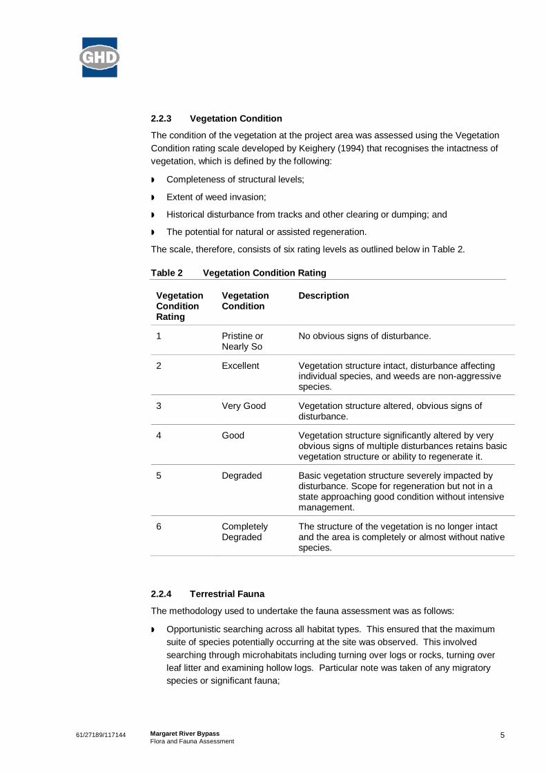
2.2.3 Vegetation Condition
The condition of the vegetation at the project area was assessed using the VegetationCondition rating scale developed by Keighery (1994) that recognises the intactness ofvegetation, which is defined by the following:
Completeness of structural levels;
Extent of weed invasion;
Historical disturbance from tracks and other clearing or dumping; and
The potential for natural or assisted regeneration.
The scale, therefore, consists of six rating levels as outlined below in Table 2.
Table 2 Vegetation Condition Rating
VegetationConditionRating
VegetationCondition
Description
1 Pristine orNearly So
No obvious signs of disturbance.
2 Excellent Vegetation structure intact, disturbance affectingindividual species, and weeds are non-aggressivespecies.
3 Very Good Vegetation structure altered, obvious signs ofdisturbance.
4 Good Vegetation structure significantly altered by veryobvious signs of multiple disturbances retains basicvegetation structure or ability to regenerate it.
5 Degraded Basic vegetation structure severely impacted bydisturbance. Scope for regeneration but not in astate approaching good condition without intensivemanagement.
6 CompletelyDegraded
The structure of the vegetation is no longer intactand the area is completely or almost without nativespecies.
2.2.4 Terrestrial Fauna
The methodology used to undertake the fauna assessment was as follows:
Opportunistic searching across all habitat types. This ensured that the maximumsuite of species potentially occurring at the site was observed. This involvedsearching through microhabitats including turning over logs or rocks, turning overleaf litter and examining hollow logs. Particular note was taken of any migratoryspecies or significant fauna;

661/27189/117144 Margaret River BypassFlora and Fauna Assessment
A night search for significant fauna such as Chuditch, Phascogale, Quokka,Bandicoot, Water Rat, Western Ringtail Possum and Masked Owl;
Undertaking two nights of Anabat assessment recording micro-bat species in thearea;
Opportunistic visual and aural surveys. This accounted for any bird speciespotentially utilising the site;
The site was searched for tracks, scats, bones, diggings and feeding areas for bothnative and feral fauna;
Particular note was taken of the presence of any habitats of significance andpotential fauna habitat trees;
An assessment of the value of the roadside in providing habitat and facilitatingmovement between conservation areas;
A review of the presence and abundance of pest, declared or feral animals; and
An inventory species list of all fauna observed.
The survey methodology GHD employed was consistent with the EPA Guidance Notefor the Assessment of Environmental Factors for Terrestrial Fauna Surveys forEnvironmental Impact Assessment in Western Australia (Guidance Statement No. 56)(EPA, 2004b).
2.3 Survey LimitationsComplete flora and vegetation surveys can require multiple surveys, at different timesof year, and over a period of a number of years, to enable observation of all speciespresent.
Some flora species, such as annuals, are only available for collection at certain timesof the year, and others are only identifiable at certain times (such as when they areflowering). Additionally, climatic and stochastic events (such as fire) may affect thepresence of plant species. Species that have a very low abundance in the area aremore difficult to locate, due to above factors.
Flora composition changes over time, with flora species having specific growingperiods, especially annuals and ephemerals (some plants lasting for a markedly brieftime, some only a day or two). The composition is also likely to alter as a result of fire.The results of future botanical surveys in this location may differ from the results of thissurvey. As the survey was conducted during one calendar year as opposed to over atime period of several years, abundance and/or the presence of some annual,ephemeral condition specific species within the study area may vary over time.
The fauna assessment undertaken was a reconnaissance survey only and thus onlysampled those species that can be easily seen, heard or have distinctive signs, suchas tracks, scats, diggings etc. Many cryptic and nocturnal species would not have beenidentified during a reconnaissance survey.
The fauna assessment was aimed at identifying habitat types within the study area. Inaddition, terrestrial vertebrate fauna using the study area were identified. No sampling

761/27189/117144 Margaret River BypassFlora and Fauna Assessment
for invertebrates or aquatic species occurred. The information available on theidentification, distribution and conservation status of invertebrates is generally lessextensive than that of vertebrate species.
This survey was carried out during only one season, and in one year. Complete faunalsurveys often require multiple surveys, at different times of year, and over a period of anumber of years, to enable full survey of all species present.
This assessment considered terrestrial fauna only, freshwater aquatic fauna (fish,freshwater macroinvertebrates, etc.) and marine fauna (cetaceans, marine birds, etc.)were not considered.

861/27189/117144 Margaret River BypassFlora and Fauna Assessment
3. Existing Environment
3.1 ClimateThe Project area experiences a Mediterranean climate, with cool winters and hotsummers. The nearest meteorological station is located at Margaret River. A summaryof the recorded climatic data from Margaret River is presented in Table 3.
Table 3 Margaret River Climate Data
Mean Annual Maximum TemperatureRange:
30.6°C (Feb) and 16.7°C (Jul) (1970-1975)
Mean Annual Minimum TemperatureRange:
14.0°C (Feb) and 6.7°C (Sept) (1970-1975)
Mean Annual Rainfall: 1133.0 mm (1929-2011)
(Bureau of Meteorology Climate Statistics for Australian Locations, 2011)
3.2 Adjoining Land UseThe majority of the proposed alignment traverses cleared agricultural land used forpredominantly crops, sheep and cattle grazing and viticulture. The alignment alsotraverses pine plantations, native bushland, conservation reserve, and existing roadsand private properties.
3.2.1 Conservation Estates, Reserves and Environmentally Sensitive Areas
North of the Margaret River crossing, the western alignment traverses the BramleyNational Park, Keenan State Forest and a small section of timber reserve. The easternalignment traverses the Keenan State Forest and a timber reserve and lies adjacent tothe Bramley National Park (Figure 1). This section of the alignment was excluded fromthe National Park by request of Main Roads and the Shire of Augusta-Margaret River.
The proposal may potentially seek to excise a section of the National Park dependenton the final road design and defined impact area.
There are no Environmentally Sensitive Areas (ESAs) within or in close proximity to thestudy area.
3.3 Wetlands, Rivers and other Surface Water DrainageThere are no Wetlands of International Significance (Ramsar Wetlands) or otherimportant wetlands within or in close proximity to the study area.
Margaret River and its tributaries are a proclaimed waterway under the WA Rights inWater and Irrigation Act 1914 (RIWI Act). The proposed alignment options willtraverse Margaret River and two of its tributaries, including Darch Brook.

961/27189/117144 Margaret River BypassFlora and Fauna Assessment
3.3.1 Public Drinking Water Catchment Areas
Public Drinking Water Source Areas (PDWSAs) is a collective term used for thedescription of Water Reserves, Catchment Areas and Underground Pollution ControlAreas declared (gazetted) under the provisions of the Metropolitan Water Supply,Sewage and Drainage Act 1909 (MWSSD Act) or the Country Area Water Supply Act1947 (CAWS Act). The Department of Water (DoW) Geographic Data Atlas indicatesthat there are no PDWSAs within the vicinity of the study area.
3.4 Likelihood of Acid Sulphate Soils (ASS)The DEC (2011) describes Acid Sulphate Soils (ASS) as naturally occurring soils andsediments containing sulphide minerals, predominantly pyrite (an iron sulphide). In anundisturbed state below the water table, these soils are benign and not acidic.However, if the soils are drained, excavated or exposed by lowering of the water table,the sulphides will react with oxygen to form sulphuric acid.
Mapping of ASS by the Western Australian Planning Commission has been preparedfor areas of the state, particularly where the impact of ASS has been assessed asbeing more significant. A review of DEC ASS risk mapping, available through theLandgate Shared Land Information Portal (SLIP), indicates that the majority of theproposed alignment overlies an area of ‘no known risk of ASS occurring within 3 m ofnatural soil surface’ with pockets of ‘moderate to low risk of ASS occurring within 3 mof the natural soil surface’. If the soil surface is to be disturbed it is recommended thatan ASS investigation is undertaken prior to construction to ensure the risk of ASSimpacts is understood.
3.5 Vegetation
3.5.1 Bioregion
The study area is located predominantly within the Warren (WAR) bioregion of theInterim Biogeographic Regionalisation for Australia (IBRA) (Department ofConservation and Land Management, 2002). A small section of the alignment is alsosituated within the Southern Jarrah Forest (JF2) subregion.
The Warren region comprises of dissected undulating country of the Leeuwin Complex,Southern Perth Basin (Blackwood Plateau), South West intrusions of the YilgarnCraton and western parts of the Albany Orogen. Loamy soils support Karri forest,laterites support Jarrah-Marri forest, leached sandy soils in depressions and as plainssupport low Jarrah woodlands and paperbark/sedge swamps, and Holocene marinedunes support Agonis flexuosa thickets, Banksia woodlands and heaths (Hearn et al.,2002a).
The Southern Jarrah Forest subregion comprises of duricrusted plateau of YilgarnCraton characterised by Jarrah-Marri forest on laterite gravels and, in the easterm part,by Wandoo-Marri woodlands on clayey soils. Eluvial and alluvial deposits supportAgonis shrublands. In areas of Mesozoic sediments, Jarrah forests occur in a mosaicwith a variety of species-rich shrublands (Hearn et al., 2002b).

1061/27189/117144 Margaret River BypassFlora and Fauna Assessment
3.5.2 Vegetation Associations
Broadscale vegetation mapping of the study area previously undertaken by Beard(1975) indicates two vegetation associations present within the study area, including:
Boranup_1: Tall Forest; karri (Eucalyptus diversicolor)
Boranup_3: Medium Forest; jarrah-marri
The study area is situated predominantly within the Boranup_3 vegetation association,with a small section in the north of the alignment occurring within Boranup_1.
The study area is located within the Cowaramup Uplands and Wilyabrup ValleySystems of the Margaret River Plateau. According to vegetation mapping conductedby Mattiske and Havel (1998) the vegetation complexes occurring within the study areaare summarised as follows:
Cowaramup (C1) is comprised of an open to tall open forest of Eucalyptusmarginata subsp. marginata (Jarrah) – Corymbia calophylla (Marri) – Banksiagrandis on lateritic uplands in the hyperhumid zone.
Wilyabrup (W1) is comprised of tall open forest of Eucalyptus diversicolor (Karri) –Corymbia calophylla – Allocasuarina decussata – Agonis flexuosa (Peppermint) ondeeply incised valleys in the hyperhumid zone.
Cowaramup (Cw1) is comprised of a mixture of open forest to woodland ofEucalyptus diversicolor – Corymbia calophylla and woodland of Eucalyptusmarginata subsp. marginata – Corymbia calophylla on slopes and low woodland ofMelaleuca preissiana – Banksia littoralis on depressions in the hyperhumid zone.
3.5.3 Native Vegetation Extent and Status
A vegetation type is considered under represented if there is less than 30 percent of itsoriginal distribution remaining. From a purely biodiversity perspective and not takinginto account any other land degradation issues, there are several key criteria nowbeing applied to vegetation clearing (EPA, 2000):
The “threshold level” below which species loss appears to accelerate exponentiallyat an ecosystem level is regarded as being at a level of 30% of the pre-European/pre-1750 extent of the vegetation type;
A level of 10% of the original extent is regarded as being a level representingEndangered; and clearing which would put the threat level into the class below itscurrent level should be avoided.
Such status can be delineated into five (5) classes, where:
Presumed Extinct: Probably no longer present in the bioregion
Endangered*: <10% of pre-European extent remains
Vulnerable*: 10-30% of pre-European extent exists
Depleted*: >30% and up to 50% of pre-European extent exists

1161/27189/117144 Margaret River BypassFlora and Fauna Assessment
Least Concern: >50% pre-European extent exists and subject to little or nodegradation over a majority of this area.
* Or a combination of depletion, loss of quality, current threats and rarity gives acomparable status.
The extent of remnant native vegetation has been assessed by the Government ofWestern Australia (2010) and Molloy et al. (2007) based on vegetation associationmapping undertaken by Beard (1975) and vegetation complexes mapped by Mattiskeand Havel (1998), respectively.
The remaining extent of the vegetation associations within the study area based onGovernment of Western Australia (2010) and Molloy et al. (2007) for the LocalGovernment Area (LGA), and Bioregion, is detailed in Table 4.
Table 4 Vegetation type, extent and status of pre-European vegetation basedon Beard (1975) and Mattiske a vegetation mapping
Vegetation Type Region Pre-Europeanextent (ha)
Currentextent (ha)
%remaining
IBRA BioregionWarren*
833,982 667,165 80%
Shire of Augusta-Margaret River*
233,619 150,535 67.32%
Boranup_1* Warren Bioregion 69,117 55,534 80.35%
Shire of Augusta-Margaret River
12,555 7,032 56%
Boranup_3* Warren Bioregion 250,262 200,890 80.27%
Shire of Augusta-Margaret River
169,669 114,082 67.24%
Cowaramup (C1)** Shire of Augusta-Margaret River
18,982 7,903 42
Wilyabrub (W1)** Shire of Augusta-Margaret River
7,296 4,420 61
Cowaramup (CW1)** Shire of Augusta-Margaret River
6,144 2,062 34
* Government of Western Australia (2010)
** Molloy et al. (2007)
The extent of the vegetation complexes Cowaramup (C1) and Cowaramup (CW1) areconsidered to be Depleted, i.e. between 30% to 50% of pre-European extentremaining. The extent of the vegetation complex Wilyabrub (W1) and the two Beardvegetation associations within the study area are considered of Least Concern, i.e.intact, with over 50% of the pre-European extents remaining.

1261/27189/117144 Margaret River BypassFlora and Fauna Assessment
The Beard and Mattiske vegetation associations and complexes present in the studyarea all retain more than the threshold level (30%) recommended in the NationalObjectives Targets for Biodiversity Conservation, below which species loss appears toaccelerate exponentially at an ecosystem level (Commonwealth of Australia, 2001).Furthermore, the study area does not occur within an extensively cleared landscape asapproximately 67% of pre-European vegetation extent remains in the Shire of Augusta-Margaret River.
3.5.4 Threatened Ecological Communities
Ecological communities are defined as ‘naturally occurring biological assemblages thatoccur in a particular type of habitat’ (English and Blythe, 1997). Threatened EcologicalCommunities (TECs) are ecological communities that have been assessed andassigned to one of four categories related to the status of the threat to the community,i.e. Presumed Totally Destroyed, Critically Endangered, Endangered, Endangered andVulnerable.
The DEC maintains a list of TECs which have been endorsed by the Minister for theEnvironment (August 2010). Some of these TECs are protected under the EnvironmentProtection and Biodiversity Conservation Act 1999 (EPBC Act). DEC listed ecologicalcommunities are given special consideration in environmental impact assessments andhave special status under the land clearing regulations of the Environmental ProtectionAct 1986 (EP Act). The EPA’s position on TECs states that proposals that result in thedirect loss of TECs are likely to require formal assessment.
Possible TECs that do not meet survey criteria are added to the DEC’s PriorityEcological Community (PEC) Lists under Priorities 1, 2 and 3. These are ecologicalcommunities that are adequately known; are rare but not threatened, not meet criteriafor Near Threatened. PECs that have been recently removed from the threatened listare placed in Priority 4. These ecological communities require regular monitoring.Conservation Dependent ecological communities are placed in Priority 5.
A search of the EPBC Act Protected Matters Search Tool database revealed no knownTECs to occur within 5 km of the study area.
No State or Federally listed TECs or PECs were identified within 5 km of the studyarea.
3.6 Flora DiversityA NatureMap search identified 379 flora taxa collected within 5 km of the study area;95 of which are naturalised (introduced) taxa. Results of this search are provided inAppendix C. Given that large parts of the study area are cleared and used for croppingand grazing, it is very unlikely all species recorded in the general area are present.
3.6.1 Threatened and Priority Flora
Threatened flora species are protected under both State and Commonwealth Acts.Any activities that are deemed to have a significant impact on species that are

1361/27189/117144 Margaret River BypassFlora and Fauna Assessment
recognised by the EPBC Act and/or the State Wildlife Conservation Act 1950 (WC Act)can trigger referral to DSEWPaC and/or the EPA.
Also in Western Australia, DEC produces a supplementary list of Priority Flora, thesebeing species that are not considered Threatened under the WC Act but for which theDepartment feels there is a cause for concern. These species have no speciallegislative protection, but their presence would normally be considered relevant to anassessment of the conservation status of an area. Such taxa need further survey andevaluation of conservation status before consideration can be given to declaration asthreatened flora.
Relevant Commonwealth and State conservation codes are provided in further detail inAppendix B and results of desktop searches provided in Appendix C.
The EPBC Act Protection Matters search tool identified five Endangered flora speciesas potentially occurring within 5 km of the study area. The DEC database queryidentified the potential presence of six Threatened and 32 Priority species within 3 kmof the project area. Of these Priority flora, four species have been recorded within500 m of the alignment, including Hemigenia rigida (P1), Franklandia triaristata (P4),Gastrolobium formosum (P3) and Gahnia sclerioides (P3).
However it has been advised by Mrs Melanie Smith, Senior Botanist at DEC, that thereare some taxonomic issues associated with the records of the Priority 1 Hemigeniarigida. The name H. rigida was mis-applied to H. pritzelii (in the absence ofreference/type material of either species at the WA Herbarium), which is a verycommon species in the south-west. The true H. rigida is only known from twocollections near Wagin, hence warranting Priority 1 status. Therefore the records of H.rigida in the Margaret River region should be deemed to be the common species, H.pritzelii, and not the one which is of conservation significance (M. Smith pers comm.,March 2012).
Conservation significant flora identified in the database searches are listed in Table 5.
Table 5 Conservation significant flora identified from the desktopassessment
Species Listing underWC Act orDEC PriorityList
ListingunderEPBC Act
Source of Information
EPBC ActProtectedMattersSearch
DECDatabasesearch
Caladenia excelsa Threatened Endangered + +
Caladenia lodgeana Threatened +
Caladenia hoffmanii Threatened Endangered +
Caladenia winfieldii Threatened Endangered +
Centrolepis caespitosa Priority 4 Endangered +

1461/27189/117144 Margaret River BypassFlora and Fauna Assessment
Species Listing underWC Act orDEC PriorityList
ListingunderEPBC Act
Source of Information
EPBC ActProtectedMattersSearch
DECDatabasesearch
Sphenotoma drummondii Threatened Endangered +
Drakaea micrantha Threatened Vulnerable +
Acacia inops Priority 3 +
Acacia lateriticola(Glabrous variant)
Priority 3 +
Acacia subracemosa Priority 3 +
Acacia tayloriana Priority 4 +
Astroloma sp. Nannup Priority 4 +
Franklandia triaristata Priority 4 +
Boronia anceps Priority 3 +
Boronia capitata gracilis Priority 3 +
Boronia tetragona Priority 3 +
Bossiaea disticha Priority 3 +
Caladenia abbreviata Priority 3 +
Conospermumpaniculatum
Priority 3 +
Dampiera heteroptera Priority 3 +
Franklandia triaristata Priority 4 +
Gahnia sclerioides Priority 3 +
Galium leptogonium Priority 3 +
Gastrolobium formosum Priority 3 +
Grevillea brachystylisbrachystylis
Priority 3 +
Grevillea bronwenae Priority 3 +
Hemigenia rigida Priority 1 +
Hybanthus volubilis Priority 2 +
Hypocalymma cordifoliumminus
Priority 4 +
Juncus meianthus Priority 2 +

1561/27189/117144 Margaret River BypassFlora and Fauna Assessment
Species Listing underWC Act orDEC PriorityList
ListingunderEPBC Act
Source of Information
EPBC ActProtectedMattersSearch
DECDatabasesearch
Lambertia rariflora rariflora Priority 4 +
Leptomeria furtiva Priority 2 +
Meeboldina thysanantha Priority 3 +
Pimelea ciliate longituba Priority 3 +
Pultenaea pinifolia Priority 3 +
Thomasia laxiflora Priority 3 +
Tripterococcusbrachylobus
Priority 4 +
Xyris maxima Priority 2 +
An assessment of the likelihood of occurrence of the threatened and priority listedspecies listed has been prepared and is provided in Appendix E. The likelihood ofoccurrence has been assessed based on the known locations and distributions of thespecies and habitat requirements. This assessment has identified 23 taxa that maypossibly occur within the study area and 15 taxa that are unlikely to occur in the studyarea due to the absence of suitable habitat.
3.7 Terrestrial Fauna
3.7.1 Fauna Diversity
A NatureMap search identified 178 fauna species recorded from within 5 km of thestudy area. This includes 120 birds, 19 reptiles, 7 amphibians, 17 mammals, 1 fish, 1crustacean and 13 invertebrates. Nine naturalised (introduced) species have beenpreviously recorded in the area. Results of this search are shown in Appendix C.
3.7.2 Pest Species
Nine introduced species were identified from desktop assessment and includeLaughing Turtle Dove, Laughing Kookaburra, Sulphur-crested Cockatoo, Mallard, Fox,Cat, European Rabbit, Black Rat and Common Furniture Beetle.
3.7.3 Threatened and Priority Fauna
Threatened fauna species are protected under both State and Commonwealth Acts.Any activities that are deemed to have a significant impact on species that are

1661/27189/117144 Margaret River BypassFlora and Fauna Assessment
recognised by the EPBC Act and/or the WC Act can trigger referral to the DSEWPaCand/or the EPA.
Also in Western Australia, the DEC produces a supplementary list of Priority Fauna,these being species that are not considered Threatened under the WC Act but forwhich the Department feels there is a cause for concern. These species have nospecial legislative protection, but their presence would normally be considered relevantto an assessment of the conservation status of an area. Such taxa need further surveyand evaluation of conservation status before consideration can be given to declarationas threatened fauna.
Relevant Commonwealth and State conservation codes are provided in further detail inAppendix B and results of desktop searches provided in Appendix C.
The desktop queries identified twelve EPBC Act and WC Act threatened species and afurther five marine and/or migratory bird species. Six additional DEC listed Priorityfauna species have been recorded within 5 km of the study area. Conservationsignificant fauna identified in the database searches are listed Table 6.

1761/27189/117144 Margaret River BypassFlora and Fauna Assessment
Table 6 Threatened and Priority fauna identified from the desktop assessment
Species Common Name Listing underWC Act orDEC PriorityList
Listing underEPBC Act
Source of Information
EPBC Act ProtectedMatters Search
NatureMap
Birds
Calyptorhynchus banksii naso Forest Red-tailed BlackCockatoo
Schedule 1 Vulnerable + +
Calyptorhynchus baudinii Baudin's Black Cockatoo Schedule 1 Vulnerable + +
Calyptorhynchus latirostris Carnaby's BlackCockatoo
Schedule 1 Endangered + +
Botaurus poiciloptilus Australasian Bittern Schedule 1 Endangered +
Falco peregrinus macropus Peregrine Falcon Schedule 4 +
Tyto novaehollandiaenovaehollandiae
Masked Owl (SW pop.) Priority 3 +
Ixobrychus flavicollis australis Black Bittern Priority 3 +
Mammals
Dasyurus geoffroii Chuditch Schedule 1 Vulnerable + +
Setonix brachyurus Quokka Schedule 1 Vulnerable +
Pseudocheirus occidentalis Western RingtailPossum
Schedule 1 Vulnerable + +
Phascogale tapoatafatapoatafa
Southern Brush-tailedPhascogale
Schedule 1 Vulnerable +

1861/27189/117144 Margaret River BypassFlora and Fauna Assessment
Species Common Name Listing underWC Act orDEC PriorityList
Listing underEPBC Act
Source of Information
EPBC Act ProtectedMatters Search
NatureMap
Isoodon obesulus fusciventer Southern BrownBandicoot
Priority 5 +
Hydromys chrysogaster Water Rat Priority 4 +
Macropus irma Western Brush Wallaby Priority 4 +
Amphibia
Geocrinia alba White bellied Frog Schedule 1 Endangered +
Crustaceans
Cherax tenuimanus Margaret River (Hairy)Marron
Schedule 1 CriticallyEndangered
+ +
Fishes
Geotria australis Pouched Lamprey Priority 1 +
Nannatherina balstoni Balston’s Pygmy Perch Schedule 1 Vulnerable +
Migratory Birds
Haliaeetus leucogaster White-bellied Sea-Eagle Migratory +
Apus pacificus Fork-tailed Swift Migratory +
Merops ornatus Rainbow Bee-eater Migratory + +
Ardea alba Great Egret Migratory + +
Ardea ibis Cattle Egret Migratory +

1961/27189/117144 Margaret River BypassFlora and Fauna Assessment
Given that large parts of the study area have been cleared for agriculture and grazing,with a minimal amount of habitat suitable for native fauna, it is unlikely that all of thesespecies would be present within the study area. An assessment of the likelihood ofoccurrence of the threatened and priority listed species listed has been prepared and isprovided in Appendix E. The likelihood of occurrence has been assessed based onthe known locations and distributions of the species, habitat requirements andobservations made during the field assessment.

2061/27189/117144 Margaret River BypassFlora and Fauna Assessment
4. Field Survey Results
4.1 Flora and Vegetation
4.1.1 Vegetation Types
Six vegetation types were identified within the study area, including cleared farmland,pine plantations, and previously cleared/highly degraded or planted vegetation.Remnant vegetation remaining within the study area consisted predominantly ofJarrah/Marri Forest with emergent Peppermint trees in gullies and along the river andcreek lines.
The vegetation types identified within the study area are described in detail in Table 7and mapped on Figure 2, Appendix A.

2161/27189/117144 Margaret River BypassFlora and Fauna Assessment
Table 7 Vegetation types recorded within the study area
BroadVegetation Type
Vegetation Description VegetationCondition
RepresentativeSurvey Sites
Photograph
Jarrah-MarriOpen Forest
Open Forest of Eucalyptus marginata(Jarrah) and Corymbia calophylla (Marri)over Scattered Banksia grandis overShrubland of Hovea trisperma, Xanthorrhoeapreissii and Acacia saligna over Open LowHeath of Hibbertia hypericoides, Hakea spp.,and Leucopogon spp. over Open Herbland ofPatersonia umbrosa var. xanthina,Opercularia hispidula and Lindsaea linearisand Very Open Sedgeland of Desmocladusflexuosus, and Lepidosperma gracile onundulating slopes with granite basementrock.
Very Good (3)
History of logging
Q1, Q2, Q3
Jarrah-Marri-PeppermintForest
Open Forest of Eucalyptus marginata(Jarrah) and Corymbia calophylla (Marri)over Low Open Forest of Agonis flexuosa(Peppermint), Callistachys lanceolata andTaxandria linearifolia over Mixed Shrublandover Open Herbland of Pteridiumesculentum, Johnsonia lupulina andAgrostocrinum hirsutum over Sedgeland ofLepidosperma tetraquetrum, L. gracile and L.effusum in valleys, river banks andcreeklines.
Very Good (3) toGood (4)
Disturbancesinclude introducedspecies/weeds,clearing andlogging.
R2, walkingtransects

2261/27189/117144 Margaret River BypassFlora and Fauna Assessment
BroadVegetation Type
Vegetation Description VegetationCondition
RepresentativeSurvey Sites
Photograph
Closed Scrub Closed Tall Scrub of Melaleuca incanasubsp. incana, Taxandria linearifolia andAgonis flexuosa over Herbland of Pteridiumesculentum over Sedgeland of Juncus spp.,Gahnia decomposita and Lepidospermasquamatum along winter-wetdepressions/minor creek lines.
Very Good (3)
Disturbancesinclude weedsand pedestriantracks.
R1, walkingtransect
Cleared Farmland Area is generally ‘parkland cleared’ with floracomprising of weed or crop species withsome isolated stands or larger patches ofnative trees (Jarrah and Marri).
CompletelyDegraded (6)
Predominantlycleared,vegetationstructure nolonger intact.
-
2361/27189/117144 Margaret River BypassFlora and Fauna Assessment
BroadVegetation Type
Vegetation Description VegetationCondition
RepresentativeSurvey Sites
Photograph
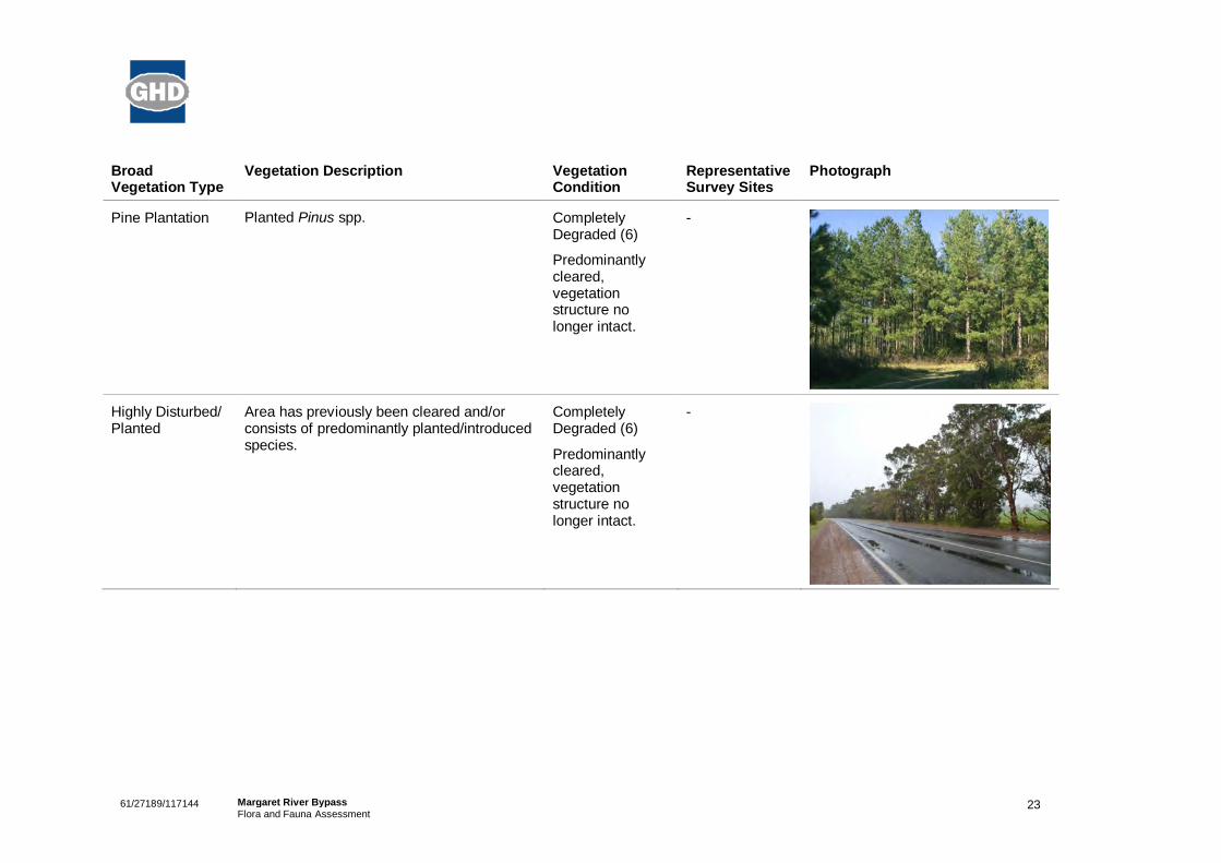
Pine Plantation Planted Pinus spp. CompletelyDegraded (6)
Predominantlycleared,vegetationstructure nolonger intact.
-
Highly Disturbed/Planted
Area has previously been cleared and/orconsists of predominantly planted/introducedspecies.
CompletelyDegraded (6)
Predominantlycleared,vegetationstructure nolonger intact.
-
2461/27189/117144 Margaret River BypassFlora and Fauna Assessment
4.1.2 Threatened and Priority Ecological Communities
The field survey did not identify any potential TECs or PECs within the study area.
4.1.3 Vegetation Condition
The condition of the vegetation within the study area ranged from Very Good (3) toCompletely Degraded (6). The majority of the study area was considered to beCompletely Degraded. Some two thirds of the study area traverses cleared agriculturalland used for predominantly crops, sheep and cattle grazing and viticulture. Thealignment also traverses pine plantations, native bushland, conservation reserve, andexisting roads and private properties. The remaining one third of the study areaconsists of native vegetation of predominantly Jarrah/Marri Forest and riparianvegetation. The Jarrah/Marri Forest has been historically logged
The area of remnant vegetation between the pine plantations and Margaret River isgenerally in very good condition however it has been historically logged and has had afire within the last 10-15 years. This vegetation is considered to be in Very Goodcondition.
The vegetation condition of the study area is mapped in Figure 3, Appendix A.
4.1.4 Flora Diversity
A total of 168 plant taxa (including subspecies and varieties), representing 52 plantfamilies and 116 genera, was recorded from the study area. This total is comprised of134 native species and 34 introduced (exotic) species.
Dominant families recorded from the study area included:
Fabaceae 27 taxa;
Poaceae 14 taxa;
Myrtaceae 13 taxa; and
Proteaceae 9 taxa.
Nine of the collections could not be identified to species level, and two species togenus due to the absence of adequate material including flowering parts and/or fruitingbodies.
A full list of flora species present in the study area is provided in Table 11, Appendix D.
4.1.5 Introduced Flora
Remaining areas of native vegetation within the study area are generally in very goodcondition and contained minimal, non-aggressive, weed species. However a largeproportion of the study area has been cleared and/or disturbed and is dominated byintroduced pasture grasses and herb species. A number of introduced trees andshrubs have also been planted along road verges and private properties. Not all ofthese species were collected and recorded from the study area.

2561/27189/117144 Margaret River BypassFlora and Fauna Assessment
A total of 34 introduced/weed species were recorded within the study area. Of these,two species, *Lantana camara (Lantana) and *Hypericum perforatum (St. John’s wort)are listed as Declared Plants under Section 37 of the Agricultural and RelatedResources Protection Act 1976.
Lantana is listed as a P1; for the whole of the State which prohibits movement of plantsor their seeds within the State. Lanatana is also listed as a Weed of NationalSignificance (WONS) by the Australian Government. In WA, lantana invades areasalong rivers and near wetlands, usually when birds spread the seeds. One plant(which appeared planted) was recorded in a disturbed area adjacent to the MargaretRiver DEC office.
St John’s wort is a perennial plant that reproduces from seed and from creepingunderground rhizomes. The plants do not flower in their first year, but flower and seedprolifically in later years. Seeds may survive in the soil for up to six years beforegermination (DAFWA, 2011). This species can densely infest grazing land, particularlywhen pastures get denuded. This species was recorded along a track near the DECoffice. St John’s wort is not listed Declared within the Shire of Augusta-Margaret River.
4.1.6 Threatened and Priority Flora
No Threatened flora was recorded from the study area during the field survey. OnePriority Flora species was recorded from the study area:
Gastrolobium formosum (Priority 3)
Gastrolobium formosum is a small, trailing shrub, to 1 m high. Flowers are red,flowering in November. This species occurs in clay loam along river banks or inswamps. A population of approximately 20 individuals of G. formosum was recordedalong the northern bank of Margaret River within the western alignment option.
Plate 1 Gastrolobium formosum
The locations of the Priority flora recorded within the study area are mapped on Figure2, Appendix A.

2661/27189/117144 Margaret River BypassFlora and Fauna Assessment
It is recommended that a targeted search G. formosum be undertaken once the roaddesign has been finalised and the known impact area is defined. This would includerecording the location and population size of G. formosum within the alignment for thepurpose of identifying the extent of impact the proposal may have on this species.
4.2 Fauna
4.2.1 Fauna Diversity
During the survey, 82 species comprised of 56 birds, 9 reptiles, 3 amphibians and 14mammals were recorded within the project area. Of these, four introduced/pestspecies were recorded.
Fauna recorded during the survey area listed in Appendix D.
4.2.2 Conservation Significant Fauna
Four fauna species listed as Vulnerable under the EPBC Act and Schedule 1 under theWC Act were recorded during the field survey. The following conservation significantspecies were observed during the field assessment.
Baudin’s Black Cockatoo (Calyptorhynchus baudinii) Schedule 1, Vulnerable
Baudin’s Black Cockatoo, also known as the Long-billed Black-Cockatoo, is found inthe south-west of Western Australia in the forest and woodlands of Jarrah (Eucalyptusmarginata), Karri (E. diversicolor) and Marri (Corymbia calophylla) (DSEWPaC, 2011).The primary food source of this cockatoo is the seeds of the Marri (Garnett andCrowley, 2000). This species has been impacted by the removal of large Marri treesthroughout its range as this species is its principal food source. Baudin’s BlackCockatoo has been listed as Vulnerable under the EPBC Act and as Schedule 1 underthe WC Act.
Observations: A pair of Baudin’s Black Cockatoo’s was observed feeding (onMarri) in Lot 2150 and had one juvenile present. This individual was observed beggingfor food, suggesting it was this season’s young and that the pair had bred in the area.Several individual birds were feeding close by, also on Marri. Due to the amount offeeding trees (and feeding observations) available in the remnant vegetation areas andtreed areas within paddocks this species is considered to be endemic and to utilise thearea opportunistically for feeding. The same areas had trees suitable for breeding andcombined with the above observations it is likely that the area is potentially used forbreeding.
Within the study area there are 123 potential Black Cockatoo breeding trees. Thelocations of these trees are mapped in blue on Figure 5, Appendix A. These trees areJarrah, Marri or eucalyptus stags and contain nesting hollows suitable for BlackCockatoo breeding. A further 445 trees were identified as a size suitable for thedevelopment of nesting hollows (>500 mm at DBH) within the next 100 years. Thesetrees are mapped in yellow on Figure 5, Appendix A. The total area of Black Cockatoo

2761/27189/117144 Margaret River BypassFlora and Fauna Assessment
feeding habitat within the study area is approximately 14.6 ha. Cockatoo feedinghabitat is mapped on Figure 4, Appendix A.
Forest Red-tailed Black Cockatoo (Calyptorhynchus banksii naso) Schedule 1,Vulnerable
The Forest Red-tailed Black Cockatoo species is essentially a cockatoo of the Jarrahforest (Eucalyptus marginata) but also uses Marri (Corymbia calophylla) andwoodlands for foraging, with Marri seeds (along with Jarrah) being its principal foodsource (DSEWPaC, 2011). This species is also known to feed on Allocasuarina spp.and introduced species (DSEWPaC, 2011). The Forest Red-tailed Black Cockatoohas reduced in range due to habitat loss and now persists in the Jarrah forest of theSouth West.
Observations: This species was observed and heard several times during the fieldassessment. In remnant vegetation and stands of trees in paddocks observations offeeding on Jarrah and Marri nuts were made. Like the Baudin’s Black Cockatoo theForest Red-tailed Black Cockatoo would utilise the area for both feeding and breedingas required. Areas calculated are the same as for the Baudin’s Black Cockatoo.
Western Ringtail Possum (Pseudocheirus occidentalis) Schedule 1, Vulnerable
Western Ringtail Possums occur only in the south west region of Western Australiawhere they feed upon Peppermint (Agonis flexuosa) and Eucalyptus trees. Aroundurban environments the species is known to feed on introduced species favouring fruittrees, roses and Ficus species. The species is now restricted to wetter coastal areasof the south west; with smaller populations occurring inland in Jarrah, Wandoo andMarri forests (Menkhorst, 2004).
Observations: During the field survey three active individuals were observed atnight along riparian vegetation in the northern section of the alignment. Two dreys(resting platforms in trees) were also recorded in this area and their locations arepresented in Figure 4, Appendix A. Droppings were also recorded along MargaretRiver in the riparian vegetation and in the valley of Lot 2150. One hundred and twenty-three large Eucalypts were recorded within the alignment which had hollows suitablefor this species. The area of core habitat that Western Ringtail Possums may utilise isapproximately 1.71 ha.
Note: Common Brush-tailed Possums were also recorded throughout the alignment viasightings and droppings. This is a common species and can live along-side WesternRingtail Possums.

2861/27189/117144 Margaret River BypassFlora and Fauna Assessment
Plate 2 Western Ringtail Possum in riparian vegetation
Plate 3 Droppings of both Common Brushtail Possum (large ones) andWestern Ringtail Possum on a large log.
Southern Brush-tailed Phascogale (Phascogale tapoatafa tapoatafa) Schedule 1,Vulnerable
The Southern Brush-tailed Phascogale (SBTP) is observed in dry sclerophyll forestsand open woodlands with a generally sparse understorey. This species’ habitatrequirements also include hollow-bearing trees, rotted stumps or tree cavities whichthey use as nest sites (Van Dyck and Strahan, 2008). Tree hollows that have a smalland secure entrance with a large internal cavity are highly favoured by breedingSBTPs. Southern Brush-tailed Phascogale will also use existing bird’s nests as theirsmall size and weight allows them to use such existing nests successfully (Van Dyckand Strahan, 2008).
Habitat clearing and fragmentation as a result of agriculture and land development;and habitat alteration from logging and mining have reduced the availability of treeswith hollows required for this species to nest and breed. Another cause for decline of

2961/27189/117144 Margaret River BypassFlora and Fauna Assessment
this species is predation by foxes and cats. What suitable habitat remains is oftenfragmented, isolating populations and impeding genetic exchange.
Observations: No sightings of the species were recorded during the field survey;however a dropping was recorded on a log in Lot 2150 that is thought to be of a SBTP.The remnant areas of habitat in the project area including Lot 2150 have suitable treeswith hollows and excellent ground coverage of logs. It is likely that SBTP would be inthe project area within the remnant areas of vegetation.
Plate 4 SBTP dropping from Lot 2150.
4.2.3 Fauna Habitats
The project area contains three broad fauna habitat types based on predominantlandforms, soil and vegetation structure in the area. Habitat types within the projectarea closely correspond with the broad vegetation types described previously. Thesehabitat types are described as follows:
Riparian
Riverine
Jarrah/Marri Forest
The location of these habitat types is the same as mapped for the Vegetation Types(Figure 2), described in section 4.1.1 and listed in Table 8.

3061/27189/117144 Margaret River BypassFlora and Fauna Assessment
Table 8 Significant fauna habitats types within the alignment
HabitatType
VegetationCommunity
Potential SpeciesUse
Image of Typical Habitat
Riparian Jarrah-Marri-Peppermint OpenForest with denseunderstorey ofsedges with logs.Some sections haveMelaleuca spp.present.
Western RingtailPossum
Quokka
Chuditch
Southern Brush-tailed Phascogale
Southern BrownBandicoot
Western BrushWallaby
Riverine No vegetationcommunity butassociated riparianvegetation and fallenlogs and branches inthe water all providehabitat.
Hairy Marron
Water Rat
Both Bitterns
Pouched Lamprey
Great Egret
White-breastedSea Eagle
Peregrine Falcon
Jarrah/MarriForest
Marri/Jarrah Forestwith logs and graniteoutcropping.
All BlackCockatoos
Chuditch
Southern Brush-tailed Phascogale
Brush Wallaby
Australian MaskedOwl
Peregrine Falcon
The majority of the project area was disturbed and contained minimal native vegetationwhich would offer suitable habitat for native fauna. However, all of the habitat typeslisted above would offer value as habitat for native fauna including some conservationsignificant species. These species are discussed further in the Likelihood ofOccurrence table in Appendix E.
4.3 Potential Offset Lot 2150Lot 2150 is approximately 36 ha in size and is positioned on the eastern side ofMargaret River, west of the proposed alignment. The Lot is not fenced and is divided

3161/27189/117144 Margaret River BypassFlora and Fauna Assessment
into two by a transmission line corridor. The vegetation of the Lot is primarilyMarri/Jarrah Forest but does get some emergent Peppermint in the valley, close toDarch Brook. Historically the area has been logged, but does contain some largestags and mature Marri and Jarrah with hollows. The ground has good cover of litterand in particular large logs for species to hide in. There are some weed effects on theedges of the block due to grazing on the site and lack of fencing for livestock, howeverthe vegetation condition improves from around 10-20 m in from the edge. Threethreatened fauna species were observed on the site, including Baudin’s BlackCockatoo, Southern Brush-tailed Phascogale and Western Ringtail Possum.
The Lot could be considered as a good site to use as an offset for threatened fauna ofthe area. The Lot can also be considered significant as an area of remnantvegetation/fauna refuge adjacent to the existing north-south habitat corridor alongDarch Brook.

3261/27189/117144 Margaret River BypassFlora and Fauna Assessment
5. Assessment against the 10 Clearing Principles
Any clearing of native vegetation will require a permit under Part V Division 2 of theEnvironmental Protection Act 1986 (EP Act), except where an exemption applies underSchedule 6 of the Act or is prescribed by regulation in the Environmental Protection(Clearing of Native Vegetation) Regulations 2004, and it is not in an EnvironmentallySensitive Area (ESA).
Table 9 provides an assessment of the proposed project against the “10 ClearingPrinciples” as outlined in Schedule 5 of the Environmental Protection Amendment Act2003 to determine whether it is at variance to the Principles. These Principles aim toensure that all potential impacts resulting from removal of native vegetation can beassessed in an integrated way.
An assessment of the proposed project has identified that the project is at variancewith Principles (b) and (f), may be at variance with Principles (a), (g), (h), and (i) and isunlikely to be at variance with Principles (c), (d), (e), and (j).
3361/27189/117144 Margaret River BypassFlora and Fauna Assessment
Table 9 Assessment against the Ten Clearing Principles
PrincipleNumber
Principle Assessment Outcome
(a) Native vegetation shouldnot be cleared if itcomprises a high levelof biological diversity.
The majority of the proposed alignment traverses through cleared agricultural landwhich contains some individual stands and patches of mature Jarrah and Marritrees. The alignment also traverses through pine plantations, native bushland,conservation reserve, and existing roads and private properties. Only a smallsection of the alignment adjacent to the Margaret River contains remnant vegetationin very good condition. The dominant vegetation community within the project areais Jarrah (Eucalyptus marginata) and Marri (Corymbia calophylla) Open Forest withPeppermint (Agonis flexuosa) dominant along rivers and drainage lines. No PriorityEcological Communities (PECs) have been recorded within the project area. NoPriority listed fauna were recorded in the study area during the field survey.However five Priority fauna species have previously been recorded within 5 km ofthe project area (NatureMap, 2011).
One Priority flora species Gastrolobium formosum (P3) was recorded within theproject area. A population of G. formosum (approximately 20 individuals) wasrecorded along the northern bank of the Margaret River within the westernalignment option. It is recommended that a targeted search for G. formosum beundertaken once the road design has been finalised and the known impact area isdefined. This would include recording the location and population size of G.formosum within the alignment for the purpose of identifying the extent of impact theproposal may have on this species.
Vegetation within the project area is considered to represent moderate speciesdiversity, with a total of 168 taxa from 52 families recorded, of which 34 areintroduced species. The vegetation has had a combination of previous disturbancesincluding large-scale clearing, roads/tracks and logging. Given the relatively smallsize of the project area and the availability of similar vegetation in the surroundingarea, the loss of vegetation within the project area is unlikely to significantly reducethe biodiversity of the local area.
The proposal maybe at variance tothe principle.

3461/27189/117144 Margaret River BypassFlora and Fauna Assessment
PrincipleNumber
Principle Assessment Outcome
(b) Native vegetation shouldnot be cleared if itcomprises the whole orpart of, or is necessaryfor the maintenance of,a significant habitat forfauna indigenousWestern Australia.
The desktop queries identified twelve EPBC Act and WC Act threatened speciesand a further five marine and/or migratory bird species as potentially occurringwithin the study area. Six additional DEC listed Priority fauna species have beenrecorded within 5 km of the study area.
Three fauna species listed as Vulnerable under the EPBC Act and Schedule 1under the WC Act were recorded within the project area during the field survey,including Baudin’s Black Cockatoo, Western Ringtail Possum and Forest Red-tailedBlack Cockatoo. Additionally, the Southern Brush-tailed Phascogale which is alsolisted as Vulnerable and Schedule 1 was recorded in the nearby Lot 2150 (potentialoffset area). There is potential that this species also occurs within remnantvegetation within the alignment.
Potential feeding and breeding habitat for Black Cockatoos within the project areaincludes Jarrah, Marri and Banksia grandis. Within the project area there is a total of14.6 ha of Black Cockatoo feeding habitat (includes both alignment options). Thereare 123 trees (Jarrah/Marri/eucalypt stags) within the study area which containnesting hollows suitable for Black Cockatoo breeding. A further 445 trees wereidentified as a size suitable for the development of nesting hollows (>500 mm DBH)within the next 100 years.
During the field survey three Western Ringtail Possums were observed active atnight along riparian vegetation in the northern section of the alignment. Two dreys(resting platforms in trees) were also recorded in this area. Droppings were alsorecorded along Margaret River in the riparian vegetation and in the valley of Lot2150. One hundred and twenty-three large Eucalypts were recorded within thealignment with hollows suitable for this species. The area of core habitat thatWestern Ringtail Possums may utilise is approximately 1.7 ha.
The proposal is atvariance to theprinciple.
(c) Native vegetation shouldnot be cleared if itincludes, or is necessaryfor the continuedexistence of, rare flora.
No Threatened flora species listed under the WC Act or EPBC Act have beenrecorded within the project area.
The proposal isunlikely to be atvariance with theprinciple.

3561/27189/117144 Margaret River BypassFlora and Fauna Assessment
PrincipleNumber
Principle Assessment Outcome
(d) Native vegetation shouldnot be cleared if itcomprises the whole ora part of, or is necessaryfor the maintenance of,a threatened ecologicalcommunity.
There are no known Threatened Ecological Communities (TECs) within 10 km ofthe project area.
No TECs were recorded within the project area during the field survey.
The proposal isunlikely to be atvariance with theprinciple.
(e) Native vegetation shouldnot be cleared if it issignificant as a remnantof native vegetation inan area that has beenextensively cleared.
The vegetation within the study area is described as Beard vegetation association 1and 3 and Mattiske vegetation complexes Cowaramup (C1), Cowaramup (CW1)and Wilyabrub (W1).
The extent of the vegetation complexes C1 and CW1 are considered to beDepleted, i.e. between 30% and 50% of pre-European extent remaining. The extentof the vegetation complex W1 and Beard vegetation associations 1 and 3 areconsidered of Least Concern, i.e. intact, with over 50% of the pre-European extentsremaining.
The Beard and Mattiske vegetation associations and complexes present in thestudy area all retain more than the threshold level (30%) recommended in theNational Objectives Targets for Biodiveristy Conservation, below which species lossappears to accelerate exponentially at an ecosystem level (Commonwealth ofWestern Australia, 2001). Furthermore, the study area does not occur within anextensively cleared landscape as approximately 67% of pre-European vegetationextent remains in the Shire of Augusta-Margaret River.
The vegetation within the project area is described as predominantly Beardvegetation association 3, with a small section in the north of the project areadescribed as Beard vegetation association 1.
Main Roads have proposed to offset the loss of vegetation as a result of theproposed project.
The proposal isunlikely to be atvariance with thePrinciple.

3661/27189/117144 Margaret River BypassFlora and Fauna Assessment
PrincipleNumber
Principle Assessment Outcome
(f) Native vegetation shouldnot be cleared if it isgrowing in or inassociation with awatercourse or wetland.
There are no listed significant wetlands or watercourses within the project area.However, the proposed project area traverses a section of the Margaret River andtwo of its tributaries (including Darch Brook). Vegetation associated with thesewaterways includes Jarrah-Marri-Peppermint Forest and Closed Scrub of Melaleucaspp. over mixed Sedgeland.
Water flow within these waterways should be maintained and where possible nodiversion of watercourses be carried out. Direct impact on riparian vegetation andassociated habitat should be avoided wherever possible. Vegetation retention withindrainage lines will help prevent erosion and flooding and prevent potentialdeleterious impacts on downstream areas.
The proposal is atvariance with thePrinciple.
(g) Native vegetation shouldnot be cleared if theclearing of thevegetation is likely tocause appreciable landdegradation.
The soils within the project area consist of loamy gravels, duplex sandy gravels,semi-wet soils and grey deep sand duplexes with some granite outcropping. Soilerosion and water erosion may occur on these soils, particularly along the river andcreeklines. The clearing of native vegetation may cause some alterations to thehealth of adjacent lands including the introduction/spread of dieback, soil erosionand runoff and weed dispersal.
To reduce the potential impacts of clearing within the project area, in particular thearea within and/or adjacent to the National Park, specific management plans will berequired for the management of dieback, runoff and erosion, invasive species(weeds) and fire.
The proposal maybe at variancewith the Principle.

3761/27189/117144 Margaret River BypassFlora and Fauna Assessment
PrincipleNumber
Principle Assessment Outcome
(h) Native vegetation shouldnot be cleared if theclearing of thevegetation is likely tohave an impact on theenvironmental values ofany adjacent or nearbyconservation area.
There are no Environmentally Sensitive Areas (ESAs) within or in close proximity tothe study area.
North of the Margaret River crossing, the western alignment traverses through theBramley National Park, Keenan State Forest and a small section of timber reserve.The eastern alignment only traverses through the Keenan State Forest and timberreserve and lies adjacent to the Bramley National Park. This section of thealignment was excluded from the National Park by request from Main Roads andthe Shire of Augusta-Margaret River. The proposal may potentially seek to excise asection of the National Park dependent on the final road design and defined impactarea.
The proposed road will create a barrier for fauna movement between the westernand eastern boundaries of the alignment within the National Park. However MainRoads have proposed to create wildlife corridors along the alignment to facilitate themovement of fauna between conservation areas.
To reduce potential impacts, clearing within the section of remnant vegetation withinand/or adjacent to the Bramley National Park, will require specific plans for themanagement of flora and fauna, dieback, erosion and invasive species (weeds) andfire. The extent of potential impacts to the National Park is dependent on which ofthe two road alignments is selected.
The proposal maybe at variancewith the Principle
(i) Native vegetation shouldnot be cleared if theclearing of thevegetation is likely tocause deterioration inthe quality of surface orunderground water.
The proposed project area traverses the Margaret River and two of its tributaries(including Darch Brook). There is a risk of runoff with additional sediment enteringthese waterways during the clearing and construction of the proposed project. Amanagement plan will be required to assess and manage these potential impacts.
The groundwater salinity in the area is low and given the scale of the proposedclearing, it is unlikely deterioration of underground water quality will result.
The proposal maybe at variancewith the Principle

3861/27189/117144 Margaret River BypassFlora and Fauna Assessment
PrincipleNumber
Principle Assessment Outcome
(j) Native vegetation shouldnot be cleared if theclearing of thevegetation is likely tocause, or exacerbate,the intensity of flooding.
A large proportion of the project area is presently cleared for agricultural purposesor consists of planted/introduced species. Given the nature of the soil within theproject area and the scale and linear nature of the proposed clearing, it is notconsidered likely to cause, or exacerbate, the intensity of flooding.
Any potential impacts can be mitigated through the use of appropriate managementactions/plans.
The proposal isunlikely to be atvariance with thePrinciple.

3961/27189/117144 Margaret River BypassFlora and Fauna Assessment
6. Environmental Impacts and Approvals
6.1 Commonwealth Approvals
6.1.1 Referral to the Department of Sustainability, Environment, Water,Populations and Communities (DSEWPaC)
Referral to DSEWPaC under the EPBC Act is triggered if a proposed action has/orpotentially has a significant impact on Matters of National Environmental Significance(MNES). An assessment against each of these issues is shown in Table 10.
Table 10 Assessment of the proposal against Matters of NationalEnvironmental Significance
Matters of NationalEnvironmentalSignificance
Present Impact
World Heritage Places No None
National Heritage Places No None
Ramsar Wetlands No None
Threatened species andecological communities
Yes – Potential blackcockatoo feeding andbreeding habitat andWestern RingtailPossum habitat.
Removal of up to 14.6 haof potential black cockatoofeeding/breeding habitat(includes both alignmentoptions).
Removal of up to 1.7 ha ofcore Western Ringtailhabitat.
Listed Migratory Species May be present No significant impacts
Commonwealth marineareas
No None
Nuclear Actions No None
DSEWPaC considers that an action is likely to have a significant impact on one ormore of the three black cockatoo species if there is a real chance or possibility that itwill result in one or more of the following:
Any clearing of breeding habitat in woodland stands of 0.5 ha or more that contains3 or more breeding trees of suitable size (i.e. a DBH greater than 500 mm);
Any clearing of known breeding trees of suitable size (i.e. a DBH greater than 500mm);
Clearing of more than 1 ha of foraging habitat;

4061/27189/117144 Margaret River BypassFlora and Fauna Assessment
Creation of a new gap of more than 4 km between patches of black cockatoohabitat;
Clearing of a known roosting site (including individual trees used for roosting);
Shooting of birds or taking of eggs or chicks from the wild;
Introduction of invasive species such as honey bees that creates competition forhollows;
Spreading of known plant diseases such as Phytophthora; or
Altering hydrology or fire regimes so that black cockatoo habitat of more than 1 hawould become degraded or destroyed.
The field survey recorded 123 potential Black Cockatoo breeding trees (Jarrah, Marriand eucalypt stags) with suitable nesting hollows. A further 445 trees were identifiedas a size suitable for the development of nesting hollows (>500 mm at DBH) within thenext 100 years. The total area of Black Cockatoo feeding habitat within the study areais approximately 14.6 ha. However these calculations are based on the current studyarea which includes two alignment options north of the Margaret River. The proposedproject is considered likely to result in a number of criteria listed above and as such,referral of the project under the EPBC Act is likely to be required.
Western Ringtail Possums were also assessed by habitat usage. Within thealignment, approximately 1.7 ha was identified as being core habitat for the WesternRingtail Possum. Referral may be required based on the loss of habitat and impactson this species.
The clearing area required for the proposed project is currently unknown as the designof the alignment is only at the preliminary stages and is not yet finalised. A furtherassessment will be necessary of the potential impacts to significant fauna habitat oncethe alignment has been finalised and a clearing boundary identified.
6.2 State Approvals
6.2.1 Referral to the Environmental Protection Agency (EPA)
Projects may require referral to the EPA under Part IV of the EP Act, if the project willhave significant impacts on any of the following matters:
Native remnant vegetation;
Rare flora and fauna species and threatened communities;
Wetlands;
Watercourses and rivers;
Estuaries and inlets;
Coastlines and near shore marine areas;
Catchments with special requirements;
Contaminated soils;
4161/27189/117144 Margaret River BypassFlora and Fauna Assessment
Noise and vibration;
Public Drinking Water Source Areas – groundwater and surface water;
Aboriginal heritage;
European heritage; or
Adjacent land uses.
The proposed project is likely to have an impact on two of the above matters, rarefauna species and rivers and watercourses. However the significance level of theseimpacts cannot be assessed accurately until the alignment has been finalised and aclearing boundary identified.
The proposed project may require referral to the EPA.
6.2.2 Department of Environment and Conservation
The clearing of vegetation in Western Australia is governed under the EP Act.
Main Roads has been granted a statewide vegetation clearing permit (Purpose PermitCPS 818-5), granted under section 51E of the EP Act, from the DEC. The PurposePermit allows Main Roads to clear native vegetation for road realignment projects andassociated construction activities (including preconstruction activities). Any clearing ofnative vegetation must be assessed against the “Ten Clearing Principles” outlined inthe permit. The Permit does not authorise the clearance of native vegetation forproject activities where:
– The clearing may be seriously at variance with the clearing principles; or
– Those project activities are incorporated in any proposal that is referred to andassessed under Part IV of the EP Act by the EPA.
On the basis of this assessment, the project is considered to be at variance toPrinciples (b) and (f), may be at variance to Principles (a), (g), (h), and (i) and isunlikely to be at variance to Principles (c), (d), (e), and (j) of the Ten ClearingPrinciples.
Should the proposal be formally assessed under s38 of the EP Act, Main Roads wouldnot be required to obtain a clearing permit to undertake clearing activities associatedwith the proposal. However, exemptions under Schedule 6 of the EP Act do not applyin the case that the EPA decides not to assess a proposal. As such, if the proposalwas ‘not assessed’ under Part IV of the EP Act, Main Roads would be required toobtain a permit to clear native vegetation.
If the proposal is not formally assessed, clearing may be considered possible inaccordance with Main Roads State-wide purpose “Clearing Permit” (CPS 818-5).
The main conditions of the Permit are:
avoiding and minimising clearing impacts;
not exceeding any of the annual regional clearing limits;
4261/27189/117144 Margaret River BypassFlora and Fauna Assessment
preparing a Preliminary Environmental Impact Assessment (PEIA) (assessingclearing impacts against the Ten Clearing Principles);
undertaking stakeholder consultation (where variance with the Ten ClearingPrinciples occurs);
provision of offsets (where variance with the Ten Clearing Principles occurs);
preparing an Environmental Impact Assessment (EIA) (may be done instead ofPEIA) (where variance occurs);
preparing an Environmental Management Plan (EMP) (where variance occurs);
preparing a revegetation plan for temporary clearing (and submit to DEC iftemporary clearing is >0.5 ha);
implementing weed and dieback management;
recording;
auditing and/or reporting; and/or
upholding regional limits on the amount of clearing.
6.2.3 Department of Water
The Rights in Water and Irrigation Act 1914 covers the regulation, management, useand protection of water resources and irrigation in Western Australia. A Permit toInterfere with Bed and Banks will be required for this project to licence the constructionworks on the bridge over the Margaret River and its associated tributaries.
.

4361/27189/117144 Margaret River BypassFlora and Fauna Assessment
7. References
Bureau of Meteorology (BoM) (2011) Climate statistics for Australian Locations;Witchcliffe (Margaret River District).http://www.bom.gov.au/climate/dwo/201111/html/IDCJDW6081.201111.shtml
Beard, J.S. (1975) Vegetation Survey of Western Australia, 1:1,000,000 Series.University of Western Australia Press, Nedlands.
Commonwealth of Australia (2001) National Objectives and targets for BiodiversityConservation 2001-2005. Department of Environment and Heritage, Canberra.
Department of Conservation and Land Management (2002) Bioregional Summary ofthe 2002 Biodiversity Audit for Western Australia. CALM, Western Australia.
Department of Sustainability, Environment, Water, Population and Communities(DSEWPaC) (2011) Environment Protection and Biodiversity Act 1999 Draft ReferralGuidelines for three Threatened Black Cockatoo species; Carnaby’s Black Cockatoo(Endangered) Calyptorhynchus latirostris, Baudin’s Black Cockatoo (Vulnerable)Calyptorhynchus baudinii, Forest Red-tailed Black Cockatoo (Vulnerable)Calyptorhynchus banksia naso. Canberra, Australia.
English, V and Blythe, J. (1997) Identifying and Conserving Threatened EcologicalCommunities in the South West Botanical Province. Unpublished report for theDepartment of Conservation and Land Management to Environment Australia.
Environmental Protection Authority (2000) Environmental Protection of NativeVegetation in Western Australia. Clearing of native vegetation, with particular referenceto the agricultural area. Position Statement No. 2. Environmental Protection Authority,Perth.
Environmental Protection Authority (2004a) Guidance Statement No. 51: Vegetationand Flora Surveys for Environmental Impact Assessment in Western Australia. EPA,Perth.
Environmental Protection Authority (2004b) Guidance Statement No. 56: TerrestrialFauna Surveys for Impact Assessment in Western Australia. EPA, Perth.
Garnett, S.T. and Crowley, G.M. (2000) The Action Plan for Australian Birds 2000.Environment Australia, Canberra, ACT.
Government of Western Australia (2010) CAR Analysis Report 2009. WA Departmentof Environment and Conservation, Perth.
Hearn, R. Williams, K. and Comer, S. (2002a) Warren (WAR – Warren) Region. DEC,Western Australia.
Hearn, R. Williams, K. Comer, S. and Beecham, B. (2002b) Jarrah Forest 2 (JF2 –Southern Jarrah Forest subregion). DEC, Western Australia.
Keighery, B.J. (1994) Bushland Plant Survey: a Guide to Plant Community Survey forthe Community. Wildflower Society of WA (Inc.), Nedlands.

4461/27189/117144 Margaret River BypassFlora and Fauna Assessment
Mattiske, E.M.and Havel, J.J. (1998) Vegetation Mapping in the South West ofWestern Australia. Department of Conservation and Land Management, WesternAustralia.
Menkhorst, P. and Knight, F. (2004) A Field Guide to the Mammals of Australia.Second Edition, Oxford University Press, Melbourne Australia.
Molloy, S., O’Connor, T., Wood, J. and Wallrodt, S. (2007) Addendum for the SouthWest Biodiversity Project Area. South West Biodiversity Project and WesternAustralian Local Government Association.
Van Dyke, S. and Strahan, R. (2008) The Mammals of Australia. Third Edition. ReedNew Holland Publishing, Sydney.

61/27189/117144 Margaret River BypassFlora and Fauna Assessment
Appendix A
Figures
Figure 1 Locality and Environmental Constraints
Figure 2 Vegetation Communities
Figure 3 Vegetation Condition
Figure 4 Significant fauna Habitat
Figure 5 Potential Cockatoo Breeding Trees

#*
#*
#*
#*
#*
#*
#*
#*
#*#*#*
#*
#*#*#*
#*
#*
#*
#*
#*
#*
NOZZLE RD
BACK R
D
OLD ROSA BROOK RD
322,000
322,000
324,000
324,000
326,000
326,000
6,238,
000
6,238,
000
6,240,
000
6,240,
000
6,242,
000
6,242,
000
6,244,
000
6,244,
000
G:\61\27189\GIS\Maps\MXD\6127189_G006_Rev0.mxd
LEGEND
Map Projection: Transverse MercatorHorizontal Datum: Geocentric Datum of Australia
Grid: Map Grid of Australia 1994, Zone 50
© 2011. Whilst every care has been taken to prepare this map, GHD, MRWA, GA, DEC and Landgate make no representations or warranties about its accuracy, reliability, completeness or suitability for any particular purpose and cannot accept liabil ity and responsibility of any kind (whether in contract, tort or otherwise) for any expenses, losses, damages and/or costs (including indirect or consequential damage) which are or may be incurred by any party as a result of the map being inaccurate, incomplete or unsuitable in any way and for any reason.
Main Roads Western AustraliaMargaret River Bypass
Locality and Environmental Constraints Figure 1
Job NumberRevision 0
61-27189
08 Dec 2011Date
Data source: MRWA: Roads - 20091028; GHD; Study Area - 20111207; Landgate: Bussleton 2010 Mosaic -20111206, Hydrology - 20111207; DEC: DEC Estate - 20111207, Threatened Flora - 20111104; GA: 250K Topographic Series - 2006. Created by: cagilbert
239 Adelaide Terrace Perth WA 6004 Australia T 61 8 6222 8222 F 61 8 6222 8555 E [email protected] W www.ghd.com.au
BORANUP
TREETONGRACETOWN
Locality Map
1: 20,000 (at A3)
o0 200 400 600 800 1,000100
Metres
Threatened Flora#* (T) Threatened Flora - Extant Taxa
#* Priority 1 - Poorly Known Taxa
#* Priority 2 - Poorly Known Taxa
#* Priority 3 - Poorly Known Taxa
#* Priority 4 - Rare Taxa
Roads
Hydrology
Study Area
DEC EstateNational Park
State Forest
Timber Reserve
Indian Ocean

#*
"
"
"
!
!
NOZZLE RD
BACK R
D
OLD R
OSA BROOK RD
Gastrolobium formosum
Q3
Q2
Q1
R2
R1
322,000
322,000
324,000
324,000
326,000
326,000
6,238,
000
6,238,
000
6,240,
000
6,240,
000
6,242,
000
6,242,
000
6,244,
000
6,244,
000
G:\61\27189\GIS\Maps\MXD\6127189_G002_Rev0.mxd
LEGEND
Map Projection: Transverse MercatorHorizontal Datum: Geocentric Datum of Australia
Grid: Map Grid of Australia 1994, Zone 50
© 2011. Whilst every care has been taken to prepare this map, GHD, MRWA, GA and Landgate make no representations or warranties about its accuracy, reliability, completeness or suitability for any particular purpose and cannot accept liability and responsibility of any kind (whether in contract, tort or otherwise) for any expenses, losses, damages and/or costs (including indirect or consequential damage) which are or may be incurred by any party as a result of the map being inaccurate, incomplete or unsuitable in any way and for any reason.
Main Roads Western AustraliaMargaret River Bypass
Vegetation Communities Figure 2
Job NumberRevision 0
61-27189
09 Mar 2012Date
Data source: MRWA: Roads - 20091028; GHD; Study Area - 20111207, Vegetation Type - 20111207, GHD Declared Rare & Priority Species - 20111207, Quadrat - 20111207, Releve - 20111207; Landgate: Bussleton 2010 Mosaic -20111206; GA: 250K Topographic Series - 2006. Created by: cagilbert
239 Adelaide Terrace Perth WA 6004 Australia T 61 8 6222 8222 F 61 8 6222 8555 E [email protected] W www.ghd.com.au
DALEEP
BRAMLEY
MARGARET RIVER
Locality Map
1: 20,000 (at A3)
o0 200 400 600 800 1,000100
Metres
" Quadrat
! ReleveGHD Declared Rare & Priority Species
#*
(T) Threatened Flora - Extant Taxa
#*
Priority 1 - Poorly Known Taxa
#*
Priority 2 - Poorly Known Taxa
#*
Priority 3 - Poorly Known Taxa
#*
Priority 4 - Rare Taxa
RoadsStudy Area
Vegetation TypeCleared FarmlandClosed ScrubHighly Disturbed/Planted
Jarrah Marri ForestJarrah Marri Peppermint ForestPine PlantationWater Body

NOZZLE RD
BACK R
D
OLD ROSA BROOK RD
6
6
6
3
3
6 54
4
6
5
5
4
6
6
4
6
5
3
5
6
322,000
322,000
324,000
324,000
326,000
326,000
6,238,
000
6,238,
000
6,240,
000
6,240,
000
6,242,
000
6,242,
000
6,244,
000
6,244,
000
G:\61\27189\GIS\Maps\MXD\6127189_G001_Rev0.mxd
LEGEND
Map Projection: Transverse MercatorHorizontal Datum: Geocentric Datum of Australia
Grid: Map Grid of Australia 1994, Zone 50
© 2011. Whilst every care has been taken to prepare this map, GHD, GA, MRWA, and Landgate make no representations or warranties about its accuracy, reliabil ity, completeness or suitabil ity for any particular purpose and cannot accept liabil ity and responsibility of any kind (whether in contract, tort or otherwise) for any expenses, losses, damages and/or costs (including indirect or consequential damage) which are or may be incurred by any party as a result of the map being inaccurate, incomplete or unsuitable in any way and for any reason.
Main Roads Western AustraliaMargaret River Bypass
Vegetation Condition Figure 3
Job NumberRevision 0
61-27189
08 Dec 2011Date
Data source: MRWA: Roads - 20091028; GHD; Study Area - 20111206, Vegetation Condition - 20111206; Landgate: Bussleton 2010 Mosaic -20111206; GA: 250K Topographic Series - 2006. Created by: cagilbert
239 Adelaide Terrace Perth WA 6004 Australia T 61 8 6222 8222 F 61 8 6222 8555 E [email protected] W www.ghd.com.au
DALEEP
BRAMLEY
MARGARET RIVER
Locality Map
1: 20,000 (at A3)
o0 200 400 600 800 1,000100
Metres
Roads
Study Area
Vegetation Condition1. Pristine or Nearly So
2. Excellent
3. Very Good
4. Good
5. Degraded
6. Completely Degraded

NOZZLE RD
BACK R
D
OLD ROSA BROOK RD
322,000
322,000
324,000
324,000
326,000
326,000
6,238,
000
6,238,
000
6,240,
000
6,240,
000
6,242,
000
6,242,
000
6,244,
000
6,244,
000
G:\61\27189\GIS\Maps\MXD\6127189_G004_Rev0.mxd
LEGEND
Map Projection: Transverse MercatorHorizontal Datum: Geocentric Datum of Australia
Grid: Map Grid of Australia 1994, Zone 50
© 2011. Whilst every care has been taken to prepare this map, GHD, GA, MRWA, and Landgate make no representations or warranties about its accuracy, reliabil ity, completeness or suitabil ity for any particular purpose and cannot accept liabil ity and responsibility of any kind (whether in contract, tort or otherwise) for any expenses, losses, damages and/or costs (including indirect or consequential damage) which are or may be incurred by any party as a result of the map being inaccurate, incomplete or unsuitable in any way and for any reason.
Main Roads Western AustraliaMargaret River Bypass
Significant Fauna Habitat Figure 4
Job NumberRevision 0
61-27189
08 Dec 2011Date
Data source: MRWA: Roads - 20091028; GHD; Study Area - 20111207, Significant Fauna Habitat - 20111207; Landgate: Bussleton 2010 Mosaic -20111206;GA: 250K Topographic Series - 2006. Created by: cagilbert
239 Adelaide Terrace Perth WA 6004 Australia T 61 8 6222 8222 F 61 8 6222 8555 E [email protected] W www.ghd.com.au
DALEEP
BRAMLEY
MARGARET RIVER
Locality Map
1: 20,000 (at A3)
o0 200 400 600 800 1,000100
Metres
Roads
Study Area
Significant Fauna HabitatBlack Cockatoo Feeding Habitat
Western Ringtail Possum Habitat
Western Ringtail Possum and Cockatoo Habitat

!!!!!!!!!!!!!!!!!!! !!!! !!!! !!!!!!!!!!!!!!! !!!!!!!!!!!!!!!!! !!!!!! !!!!!!!!
!!!!!!!!!!!!
!!!!!
!!!!!!!!!!!!!
!
!!!!!!!!!!!!!!!!!!!!!!!!!!!!!!!!!!!!
!!!!!!! ! !!!!!!!! !!!! !!! !!!
!!!!!!!!!!!!!!!!
!!!!!!!!!!!!!!!!!!!!!!!!!!!!!!!!!!!!!!!!!!!!!!!!!!!!!!!!!!!!!!!!!!!!!!!!
!
!!
!!!
!!
!!!!!!!!!!!!!!!!!!!!!!!!!!!!!!! !!!!!!!!!!!! !!! !!!!!!! !!!!!!!!!!!!!!!!! !!!!!!!!! !!! !!! !!!!!!! !!! !!!!!! !!!! !! !!!! !!!! !!!! !!!!!!!!! !!!!!!!!!!!!!!!! !! !!!!!!!!!!!!! ! !!!!!! !!!! !!!!!!!!!! !!!! !!!! !!! !!!! !! !!! !!!!!! ! !!!!!!!! !! !!!!! !!!!!!!!!!!!!!!!!!!!!!! !!!! !!!!! !!!! !!!!!!
!!!!!!!!!!
!!!
!!!!!!!!!!!! !!!!!!!!!!!!!
!!!
!
NOZZLE RD
BACK R
D
OLD ROSA BROOK RD
322,000
322,000
324,000
324,000
326,000
326,000
6,238,
000
6,238,
000
6,240,
000
6,240,
000
6,242,
000
6,242,
000
6,244,
000
6,244,
000
G:\61\27189\GIS\Maps\MXD\6127189_G005_Rev0.mxd
LEGEND
Map Projection: Transverse MercatorHorizontal Datum: Geocentric Datum of Australia
Grid: Map Grid of Australia 1994, Zone 50
© 2011. Whilst every care has been taken to prepare this map, GHD, GA, MRWA, and Landgate make no representations or warranties about its accuracy, reliabil ity, completeness or suitabil ity for any particular purpose and cannot accept liabil ity and responsibility of any kind (whether in contract, tort or otherwise) for any expenses, losses, damages and/or costs (including indirect or consequential damage) which are or may be incurred by any party as a result of the map being inaccurate, incomplete or unsuitable in any way and for any reason.
Main Roads Western AustraliaMargaret River Bypass
Potential Cockatoo Breeding Trees Figure 5
Job NumberRevision 0
61-27189
08 Dec 2011Date
Data source: MRWA: Roads - 20091028; GHD; Study Area - 20111207, Potential Cockatoo Breeding Habitat- 20111207; Landgate: Bussleton 2010 Mosaic -20111206; GA: 250K Topographic Series - 2006. Created by: cagilbert
239 Adelaide Terrace Perth WA 6004 Australia T 61 8 6222 8222 F 61 8 6222 8555 E [email protected] W www.ghd.com.au
DALEEP
BRAMLEY
MARGARET RIVER
Locality Map
1: 20,000 (at A3)
o0 200 400 600 800 1,000100
Metres
Potential Cockatoo Breeding Trees! Trees > 500mm DBH
!Possible Black Cockatoo Breeding Areas (Large tree with Hollows)
Roads
Study Area

61/27189/117144 Margaret River BypassFlora and Fauna Assessment
Appendix B
Conservation Codes

61/27189/117144 Margaret River BypassFlora and Fauna Assessment
EPBC Act Fauna Conservation Categories
Listed threatened species and ecological communities
An action will require approval from the Environment Minister if the action has, willhave, or is likely to have a significant impact on a species listed in any of the followingcategories:
extinct in the wild,
critically endangered,
endangered, or
vulnerable.
Critically endangered and endangered speciesAn action has, will have, or is likely to have a significant impact on a criticallyendangered or endangered species if it does, will, or is likely to:
lead to a long-term decrease in the size of a population, or
reduce the area of occupancy of the species, or
fragment an existing population into two or more populations, or
adversely affect habitat critical to the survival of a species, or
disrupt the breeding cycle of a population, or
modify, destroy, remove, isolate or decrease the availability or quality of habitat tothe extent that the species is likely to decline, or
result in invasive species that are harmful to a critically endangered or endangeredspecies becoming established in the endangered or critically endangered species'habitat*, or
interfere with the recovery of the species.
*Introducing an invasive species into the habitat may result in that species becomingestablished. An invasive species may harm a critically endangered or endangeredspecies by direct competition, modification of habitat, or predation.
Vulnerable species
An action has, will have, or is likely to have a significant impact on a vulnerable speciesif it does, will, or is likely to:
lead to a long-term decrease in the size of an important population of a species, or
reduce the area of occupancy of an important population, or
fragment an existing important population into two or more populations, or
adversely affect habitat critical to the survival of a species, or
disrupt the breeding cycle of an important population, or
modify, destroy, remove or isolate or decrease the availability or quality of habitatto the extent that the species is likely to decline, or

61/27189/117144 Margaret River BypassFlora and Fauna Assessment
result in invasive species that are harmful a vulnerable species becomingestablished in the vulnerable species' habitat*, or
interferes substantially with the recovery of the species.
An important population is one that is necessary for a species' long-term survival andrecovery. This may include populations that are:
key source populations either for breeding or dispersal,
populations that are necessary for maintaining genetic diversity, and/or
populations that are near the limit of the species range.
*Introducing an invasive species into the habitat may result in that species becomingestablished. An invasive species may harm a vulnerable species by direct competition,modification of habitat, or predation.
Listed migratory speciesThe EPBC Act protects lands and migratory species that are listed under InternationalAgreements.
Appendices to the Bonn Convention (Convention on the Conservation of MigratorySpecies of Wild Animals) for which Australia is a Range State under theConvention;
The Agreement between the Government of Australia and the Government of thePeoples Republic of China for the Protection of Migratory Birds and theirEnvironment (CAMBA);
The Agreement between the Government of Japan and the Government ofAustralia for the Protection of Migratory Birds and Birds in Danger of Extinction andtheir Environment (JAMBA); and
The Agreement between the Government of Australia and the Government of theRepublic of Korea on the Protection of Migratory Birds (ROKAMBA).
other international agreements approved by the Commonwealth EnvironmentMinister.
An action will require approval from the Environment Minister if the action has, willhave, or is likely to have a significant impact on a listed migratory species. Note thatsome migratory species are also listed as threatened species.
The criteria below are relevant to migratory species that are not threatened.
An action has, will have, or is likely to have a significant impact on a migratory speciesif it does, will, or is likely to:
substantially modify (including by fragmenting, altering fire regimes, alteringnutrient cycles or altering hydrological cycles), destroy or isolate an area ofimportant habitat of the migratory species, or
result in invasive species that is harmful to the migratory species becomingestablished* in an area of important habitat of the migratory species, or
61/27189/117144 Margaret River BypassFlora and Fauna Assessment
seriously disrupt the lifecycle (breeding, feeding, migration or resting behaviour) ofan ecologically significant proportion of the population of the species.
An area of important habitat is:
habitat utilized by a migratory species occasionally or periodically within a regionthat supports an ecologically significant proportion of the population of the species,or
habitat utilized by a migratory species which is at the limit of the species range, or
habitat within an area where the species is declining.
Listed migratory species cover a broad range of species with different life cycles andpopulation sizes. Therefore, what is an ecologically significant proportion of thepopulation varies with the species (each circumstance will need to be evaluated).
*Introducing an invasive species into the habitat may result in that species becoming established. An
invasive species may harm a migratory species by direct competition, modification of habitat, or predation.

61/27189/117144 Margaret River BypassFlora and Fauna Assessment
Conservation categories and definitions for Environment Protection andBiodiversity Conservation Act 1999 listed flora and fauna species
Conservation Category Definition
Extinct Taxa not definitely located in the wild during the past50 years
Extinct in the Wild Taxa known to survive only in captivity
Critically Endangered Taxa facing an extremely high risk of extinction in thewild in the immediate future
Endangered Taxa facing a very high risk of extinction in the wild inthe near future
Vulnerable Taxa facing a high risk of extinction in the wild in themedium-term
Near Threatened Taxa that risk becoming Vulnerable in the wild
Conservation Dependent Taxa whose survival depends upon ongoingconservation measures. Without these measures, aconservation dependent taxon would be classified asVulnerable or more severely threatened.
Data Deficient(Insufficiently Known)
Taxa suspected of being Rare, Vulnerable orEndangered, but whose true status cannot bedetermined without more information.
Least Concern Taxa that are not considered Threatened

61/27189/117144 Margaret River BypassFlora and Fauna Assessment
Conservation codes for Western Australian Flora and Fauna listed under theWildlife Conservation Act 1950 and the DEC.
Code ConservationCategory
Description
T Schedule 1 under theWC Act
Threatened Fauna (Fauna that is rare or is likelyto become extinct
Threatened Flora (Declared Rare Flora – Extant)
Taxa that have been adequately searched for andare deemed to be in the wild either rare, indanger of extinction, or otherwise in need ofspecial protection, and have been gazetted assuch.
CR: Critically Endangered – considered to befacing an extremely high risk of extinction in thewild.
EN: Endangered – considered to be facing a veryhigh risk of extinction in the wild.
VU: Vulnerable – considered to be facing a highrisk of extinction in the wild.
X Schedule 2 under theWC Act
Presumed Extinct Fauna
Presumed Extinct Flora (Declared rare Flora –Extinct)
Taxa which have been adequately searched forand there is no reasonable doubt that the lastindividual has died, and have been gazetted assuch.
IA Schedule 3 under theWC Act
Birds protected under an internationalagreement
Birds that are subject to an agreement betweengovernments of Australia and Japan relating tothe protection of migratory birds and birds indanger of extinction.
S Schedule 4 under theWC Act
Other specially protected fauna
Fauna that is in need of special protection,otherwise than for the reasons mentioned in theabove schedules.
1 Priority One: Poorly-known taxa
Taxa that are known from one or a few collectionsor sight records (generally less than five), all on

61/27189/117144 Margaret River BypassFlora and Fauna Assessment
Code ConservationCategory
Description
lands not managed for conservation, e.g.agricultural or pastoral lands, urban areas, Shire,Westrail and Main Roads WA road, gravel andsoil reserves, and active mineral leases andunder threat of habitat destruction or degradation.Taxa may be included if they are comparativelywell known from one or more localities but do notmeet adequacy of survey requirements andappear to be under immediate threat from knownthreatening processes.
2 Priority Two: Poorly-known taxa
Taxa that are known from one or a few collectionsor sight records, some of which are on lands notunder imminent threat of habitat destruction ordegradation, e.g. national parks, conservationparks, nature reserves, State forest, vacantCrown land, water reserves, etc. Taxa may beincluded if they are comparatively well knownfrom one or more localities but do not meetadequacy of survey requirements and appear tobe under threat from known threateningprocesses.
3 Priority Three: Poorly-known taxa
Taxa that are known from collections or sightrecords from several localities not under imminentthreat, or from few but widespread localities witheither large population size or significantremaining areas of apparently suitable habitat,much of it not under imminent threat. Taxa maybe included if they are comparatively well knownfrom several localities but do not meet adequacyof survey requirements and known threateningprocesses exist that could affect them.
4 Priority Four: Rare, NearThreatened and othertaxa in need ofmonitoring
(a) Rare. Taxa that are considered to have beenadequately surveyed, or for which sufficientknowledge is available, and that are considerednot currently threatened or in need of specialprotection, but could be if present circumstanceschange. These taxa are usually represented onconservation lands.
(b) Near Threatened. Taxa that are consideredto have been adequately surveyed and that do
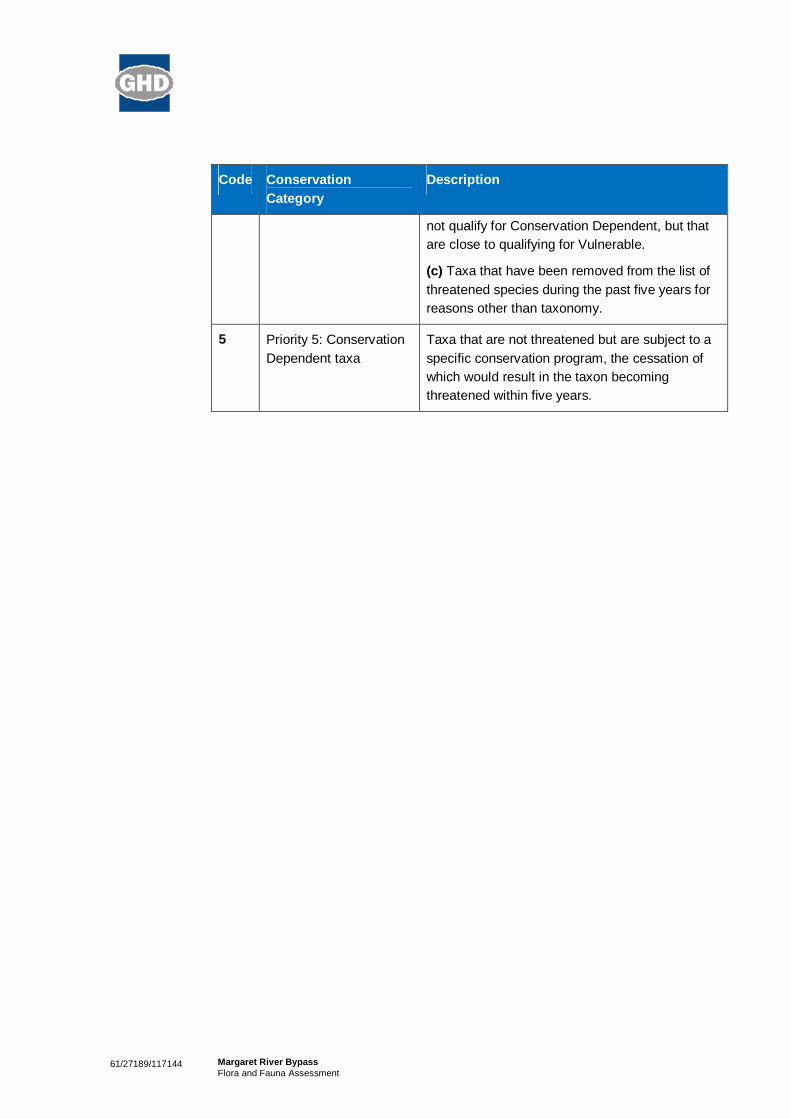
61/27189/117144 Margaret River BypassFlora and Fauna Assessment
Code ConservationCategory
Description
not qualify for Conservation Dependent, but thatare close to qualifying for Vulnerable.
(c) Taxa that have been removed from the list ofthreatened species during the past five years forreasons other than taxonomy.
5 Priority 5: ConservationDependent taxa
Taxa that are not threatened but are subject to aspecific conservation program, the cessation ofwhich would result in the taxon becomingthreatened within five years.

61/27189/117144 Margaret River BypassFlora and Fauna Assessment
Appendix C
Desktop Search Results

EPBC Act Protected Matters Report: CoordinatesThis report provides general guidance on matters of national environmental significance and other mattersprotected by the EPBC Act in the area you have selected.
Information on the coverage of this report and qualifications on data supporting this report are containedin the caveat at the end of the report.
Information about the EPBC Act including significance guidelines, forms and application process detailscan be found at http://www.environment.gov.au/epbc/assessmentsapprovals/index.html
This map may contain data which are©Commonwealth of Australia (GeoscienceAustralia), ©PSMA 2010
CoordinatesBuffer: 5.0Km
Report created: 30/08/11 12:01:17
Summary
DetailsMatters of NESOther matters protected bythe EPBC ActExtra Information
Caveat
Acknowledgements

SummaryMatters of National Environmental Significance
This part of the report summarises the matters of national environmental significance that may occur in,or may relate to, the area you nominated. Further information is available in the detail part of the report,which can be accessed by scrolling or following the links below. If you are proposing to undertake anactivity that may have a significant impact on one or more matters of national environmental significancethen you should consider the Administrative Guidelines on Significance - seehttp://www.environment.gov.au/epbc/assessmentsapprovals/guidelines/index.html.
World Heritage Properties: None
National Heritage Places: None
Wetlands of InternationalSignificance (RamsarWetlands):
None
Great Barrier Reef MarinePark:
None
Commonwealth Marine Areas: None
Threatened EcologicalCommunitites:
None
Threatened Species: 14
Migratory Species: 7
Other Matters Protected by the EPBC Act
This part of the report summarises other matters protected under the Act that may relate to the area younominated. Approval may be required for a proposed activity that significantly affects the environment onCommonwealth land, when the action is outside the Commonwealth land, or the environment anywherewhen the action is taken on Commonwealth land. Approval may also be required for the Commonwealthor Commonwealth agencies proposing to take an action that is likely to have a significant impact on theenvironment anywhere.
The EPBC Act protects the environment on Commonwealth land, the environment from the actions takenon Commonwealth land, and the environment from actions taken by Commonwealth agencies. Asheritage values of a place are part of the 'environment', these aspects of the EPBC Act protect theCommonwealth Heritage values of a Commonwealth Heritage place and the heritage values of a place onthe Register of the National Estate. Information on the new heritage laws can be found athttp://www.environment.gov.au/heritage/index.html
Please note that the current dataset on Commonwealth land is not complete. Further information onCommonwealth land would need to be obtained from relevant sources including Commonwealthagencies, local agencies, and land tenure maps.
A permit may be required for activities in or on a Commonwealth area that may affect a member of alisted threatened species or ecological community, a member of a listed migratory species, whales andother cetaceans, or a member of a listed marine species. Information on EPBC Act permit requirementsand application forms can be found at http://www.environment.gov.au/epbc/permits/index.html.
Commonwealth Lands: 1
Commonwealth HeritagePlaces:
None
Listed Marine Species: 5
Whales and Other Cetaceans: None
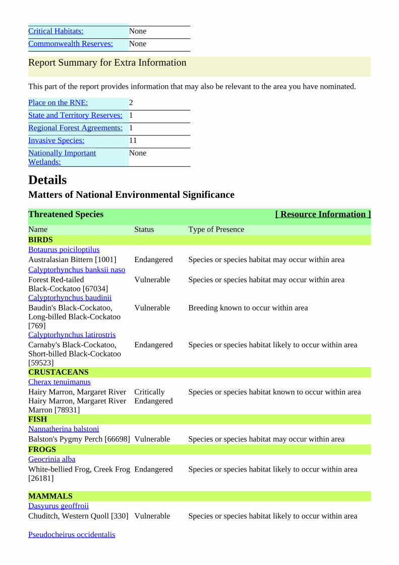
Critical Habitats: None
Commonwealth Reserves: None
Report Summary for Extra Information
This part of the report provides information that may also be relevant to the area you have nominated.
Place on the RNE: 2
State and Territory Reserves: 1
Regional Forest Agreements: 1
Invasive Species: 11
Nationally ImportantWetlands:
None
DetailsMatters of National Environmental Significance
Threatened Species [ Resource Information ]
Name Status Type of PresenceBIRDSBotaurus poiciloptilusAustralasian Bittern [1001] Endangered Species or species habitat may occur within areaCalyptorhynchus banksii nasoForest Red-tailedBlack-Cockatoo [67034]
Vulnerable Species or species habitat may occur within area
Calyptorhynchus baudiniiBaudin's Black-Cockatoo,Long-billed Black-Cockatoo[769]
Vulnerable Breeding known to occur within area
Calyptorhynchus latirostrisCarnaby's Black-Cockatoo,Short-billed Black-Cockatoo[59523]
Endangered Species or species habitat likely to occur within area
CRUSTACEANSCherax tenuimanusHairy Marron, Margaret RiverHairy Marron, Margaret RiverMarron [78931]
CriticallyEndangered
Species or species habitat known to occur within area
FISHNannatherina balstoniBalston's Pygmy Perch [66698] Vulnerable Species or species habitat may occur within areaFROGSGeocrinia albaWhite-bellied Frog, Creek Frog[26181]
Endangered Species or species habitat likely to occur within area
MAMMALSDasyurus geoffroiiChuditch, Western Quoll [330] Vulnerable Species or species habitat likely to occur within area
Pseudocheirus occidentalis

Western Ringtail Possum[25911]
Vulnerable Species or species habitat likely to occur within area
PLANTSCaladenia excelsaGiant Spider-orchid [56717] Endangered Species or species habitat likely to occur within area
Caladenia hoffmaniiHoffman's Spider-orchid[56719]
Endangered Species or species habitat may occur within area
Caladenia winfieldiiMajestic Spider-orchid [64504] Endangered Species or species habitat may occur within areaCentrolepis caespitosa [6393] Endangered Species or species habitat likely to occur within area
Sphenotoma drummondii [21160] Endangered Species or species habitat may occur within area
Migratory Species [ Resource Information ]
Name Status Type of PresenceMigratory Marine BirdsApus pacificusFork-tailed Swift [678] Species or species habitat may occur within areaArdea albaGreat Egret, White Egret[59541]
Species or species habitat may occur within area
Ardea ibisCattle Egret [59542] Species or species habitat may occur within areaMigratory Terrestrial SpeciesHaliaeetus leucogasterWhite-bellied Sea-Eagle [943] Species or species habitat likely to occur within area
Merops ornatusRainbow Bee-eater [670] Species or species habitat may occur within areaMigratory Wetlands SpeciesArdea albaGreat Egret, White Egret[59541]
Species or species habitat may occur within area
Ardea ibisCattle Egret [59542] Species or species habitat may occur within area
Other Matters Protected by the EPBC Act
Commonwealth Lands [ Resource Information ]
The Commonwealth area listed below may indicate the presence of Commonwealth land in this vicinity.Due to the unreliability of the data source, all proposals should be checked as to whether it impacts on aCommonwealth area, before making a definitive decision. Contact the State or Territory government landdepartment for further information.Commonwealth Land -
Listed Marine Species [ Resource Information ]
Name Status Type of PresenceBirdsApus pacificus

Fork-tailed Swift [678] Species or species habitat may occur within areaArdea albaGreat Egret, White Egret[59541]
Species or species habitat may occur within area
Ardea ibisCattle Egret [59542] Species or species habitat may occur within areaHaliaeetus leucogasterWhite-bellied Sea-Eagle [943] Species or species habitat likely to occur within area
Merops ornatusRainbow Bee-eater [670] Species or species habitat may occur within area
Extra Information
Places on the RNE [ Resource Information ]
Note that not all Indigenous sites may be listed.
Name StatusHistoricSt Thomas More Catholic Church WA Indicative PlaceBasildene Farmhouse (former) WA Registered
State and Territory Reserves [ Resource Information ]
Bramley, WA
Regional Forest Agreements [ Resource Information ]
Note that all areas with completed RFAs have been included.South West WA RFA, Western Australia
Invasive Species [ Resource Information ]
Weeds reported here are the 20 species of national significance (WoNS), along with other introducedplants that are considered by the States and Territories to pose a particularly significant threat tobiodiversity. The following feral animals are reported: Goat, Red Fox, Cat, Rabbit, Pig, Water Buffaloand Cane Toad. Maps from Landscape Health Project, National Land and Water Resouces Audit, 2001.Name Status Type of PresenceMammalsFelis catusCat, House Cat, Domestic Cat[19]
Species or species habitat likely to occur within area
Oryctolagus cuniculusRabbit, European Rabbit [128] Species or species habitat likely to occur within area
Sus scrofaPig [6] Species or species habitat likely to occur within area
Vulpes vulpesRed Fox, Fox [18] Species or species habitat likely to occur within area
PlantsAsparagus asparagoidesBridal Creeper, Bridal VeilCreeper, Smilax, Florist'sSmilax, Smilax Asparagus[22473]
Species or species habitat likely to occur within area
Cenchrus ciliarisBuffel-grass, Black Buffel-grass[20213]
Species or species habitat may occur within area
Genista sp. X Genista monspessulanaBroom [67538] Species or species habitat may occur within areaLycium ferocissimumAfrican Boxthorn, Boxthorn[19235]
Species or species habitat may occur within area
Pinus radiataRadiata Pine Monterey Pine,Insignis Pine, Wilding Pine[20780]
Species or species habitat may occur within area
Rubus fruticosus aggregateBlackberry, EuropeanBlackberry [68406]
Species or species habitat likely to occur within area
Tamarix aphyllaAthel Pine, Athel Tree,Tamarisk, Athel Tamarisk,Athel Tamarix, DesertTamarisk, Flowering Cypress,Salt Cedar [16018]
Species or species habitat likely to occur within area
CaveatThe information presented in this report has been provided by a range of data sources as acknowledged atthe end of the report.
This report is designed to assist in identifying the locations of places which may be relevant indetermining obligations under the Environment Protection and Biodiversity Conservation Act 1999. Itholds mapped locations of World Heritage and Register of National Estate properties, Wetlands ofInternational Importance, Commonwealth and State/Territory reserves, listed threatened, migratory andmarine species and listed threatened ecological communities. Mapping of Commonwealth land is notcomplete at this stage. Maps have been collated from a range of sources at various resolutions.
Not all species listed under the EPBC Act have been mapped (see below) and therefore a report is ageneral guide only. Where available data supports mapping, the type of presence that can be determinedfrom the data is indicated in general terms. People using this information in making a referral may need toconsider the qualifications below and may need to seek and consider other information sources.
For threatened ecological communities where the distribution is well known, maps are derived fromrecovery plans, State vegetation maps, remote sensing imagery and other sources. Where threatenedecological community distributions are less well known, existing vegetation maps and point location dataare used to produce indicative distribution maps.
For species where the distributions are well known, maps are digitised from sources such as recoveryplans and detailed habitat studies. Where appropriate, core breeding, foraging and roosting areas areindicated under 'type of presence'. For species whose distributions are less well known, point locations arecollated from government wildlife authorities, museums, and non-government organisations; bioclimaticdistribution models are generated and these validated by experts. In some cases, the distribution maps arebased solely on expert knowledge.
Only selected species covered by the following provisions of the EPBC Act have been mapped:- migratory and- marine
The following species and ecological communities have not been mapped and do not appear in reports

produced from this database:- threatened species listed as extinct or considered as vagrants- some species and ecological communities that have only recently been listed- some terrestrial species that overfly the Commonwealth marine area- migratory species that are very widespread, vagrant, or only occur in small numbers.
The following groups have been mapped, but may not cover the complete distribution of the species:- non-threatened seabirds which have only been mapped for recorded breeding sites;- seals which have only been mapped for breeding sites near the Australian continent.
Such breeding sites may be important for the protection of the Commonwealth Marine environment.
Coordinates
-33.9531 115.08059
AcknowledgementsThis database has been compiled from a range of data sources. The department acknowledges thefollowing custodians who have contributed valuable data and advice:
-Department of Environment, Climate Change and Water, New South Wales-Department of Sustainability and Environment, Victoria-Department of Primary Industries, Parks, Water and Environment, Tasmania-Department of Environment and Natural Resources, South Australia-Parks and Wildlife Service NT, NT Dept of Natural Resources, Environment and the Arts-Environmental and Resource Management, Queensland-Department of Environment and Conservation, Western Australia-Department of the Environment, Climate Change, Energy and Water-Birds Australia-Australian Bird and Bat Banding Scheme-Australian National Wildlife Collection-Natural history museums of Australia-Museum Victoria-Australian Museum-SA Museum-Queensland Museum-Online Zoological Collections of Australian Museums-Queensland Herbarium-National Herbarium of NSW-Royal Botanic Gardens and National Herbarium of Victoria-Tasmanian Herbarium-State Herbarium of South Australia-Northern Territory Herbarium-Western Australian Herbarium-Australian National Herbarium, Atherton and Canberra-University of New England-Ocean Biogeographic Information System-Australian Government, Department of Defence-State Forests of NSW-Other groups and individuals
The Department is extremely grateful to the many organisations and individuals who provided expertadvice and information on numerous draft distributions.

Please feel free to provide feedback via the page.Contact Us
Accessibility | | | | Disclaimer Privacy © Commonwealth of Australia HelpLast updated: Thursday, 16-Sep-2010 09:13:25 EST
Department of Sustainability, Environment, Water, Population and CommunitiesGPO Box 787Canberra ACT 2601 Australia+61 2 6274 1111 ABN
| |Australian Government
Page 1
NatureMap Species Report
Created By Guest user on 30/08/2011
Kingdom Method Centre Buffer
Animalia 'By Circle' 115°04' 46'' E,33°57' 07'' S 5km
Name ID Species Name Naturalised Conservation Code 1Endemic To QueryArea
1. 24260 Acanthiza apicalis (Broad-tailed Thornbill)
2. 24261 Acanthiza chrysorrhoa (Yellow-rumped Thornbill)
3. 24262 Acanthiza inornata (Western Thornbill)
4. 24560 Acanthorhynchus superciliosus (Western Spinebill)
5. 25536 Accipiter fasciatus (Brown Goshawk)
6. 24312 Anas gracilis (Grey Teal)
7. 24313 Anas platyrhynchos (Mallard)
8. -450 Anas sp.
9. 24316 Anas superciliosa (Pacific Black Duck)
10. -375 Anhinga novaehollandiae
11. Anisynta sphenosema
12. Anobium punctatum
13. 24561 Anthochaera carunculata (Red Wattlebird)
14. 24562 Anthochaera lunulata (Western Little Wattlebird)
15. -396 Anthus novaeseelandiae
16. 24285 Aquila audax (Wedge-tailed Eagle)
17. 24341 Ardea pacifica (White-necked Heron)
18. 25566 Artamus cinereus (Black-faced Woodswallow)
19. 24353 Artamus cyanopterus (Dusky Woodswallow)
20. 24357 Artamus superciliosus (White-browed Woodswallow)
21. Atractocerus kreuslerae
22. Austrogomphus lateralis
23. Austronysius sericus Y
24. -326 Barnardius zonarius
25. 24319 Biziura lobata (Musk Duck)
26. 25713 Cacatua galerita (Sulphur-crested Cockatoo)
27. 25598 Cacomantis flabelliformis (Fan-tailed Cuckoo)
28. 24427 Cacomantis flabelliformis subsp. flabelliformis
29. -374 Cacomantis pallidus
30. 24788 Calidris ruficollis (Red-necked Stint)
31. 25717 Calyptorhynchus banksii (Red-tailed Black-Cockatoo)
32. 24733 Calyptorhynchus baudinii (Baudin's Cockatoo) T
33. 24734 Calyptorhynchus latirostris (Carnaby's Cockatoo) T
34. -453 Calyptorhynchus sp.
35. 24086 Cercartetus concinnus (Western Pygmy-possum)
36. -365 Chalcites lucidus
37. 24377 Charadrius ruficapillus (Red-capped Plover)
38. 24321 Chenonetta jubata (Australian Wood Duck)
39. 33940 Cherax tenuimanus (Margaret River Marron) T
40. Chloromerus maculifemur Y
41. 24980 Christinus marmoratus (Marbled Gecko)
42. -330 Chroicocephalus novaehollandiae
43. 24432 Chrysococcyx lucidus subsp. plagosus
44. 24288 Circus approximans (Swamp Harrier)
45. 24396 Climacteris rufa (Rufous Treecreeper)
46. 25675 Colluricincla harmonica (Grey Shrike-thrush)
47. 25568 Coracina novaehollandiae (Black-faced Cuckoo-shrike)
48. 25592 Corvus coronoides (Australian Raven)
49. 24417 Corvus coronoides subsp. perplexus
50. 24671 Coturnix pectoralis (Stubble Quail)
51. 25701 Coturnix ypsilophora (Brown Quail)
52. 25595 Cracticus tibicen (Australian Magpie)
53. 25596 Cracticus torquatus (Grey Butcherbird)
54. 25398 Crinia georgiana (Quacking Frog)
Page 2
Name ID Species Name Naturalised Conservation Code 1Endemic To QueryArea
55. 25399 Crinia glauerti (Clicking Frog)
56. 25401 Crinia pseudinsignifera (Bleating Froglet)
57. 30893 Cryptoblepharus buchananii
58. 25047 Ctenotus impar
59. 25049 Ctenotus labillardieri
60. 24322 Cygnus atratus (Black Swan)
61. 30901 Dacelo novaeguineae (Laughing Kookaburra)
62. 25673 Daphoenositta chrysoptera (Varied Sittella)
63. 24092 Dasyurus geoffroii (Western Quoll) T
64. 25607 Dicaeum hirundinaceum (Mistletoebird)
65. 24470 Dromaius novaehollandiae (Emu)
66. 25251 Echiopsis curta (Bardick)
67. 25096 Egernia kingii (King's Skink)
68. 25100 Egernia napoleonis
69. -361 Egretta novaehollandiae
70. -384 Elanus axillaris
71. -357 Elseyornis melanops
72. -353 Eolophus roseicapillus
73. 24651 Eopsaltria australis subsp. griseogularis (Western Yellow Robin)
74. 24652 Eopsaltria georgiana (White-breasted Robin)
75. -322 Eopsaltria griseogularis
76. Ephydrella acrostichalis Y
77. 24567 Epthianura albifrons (White-fronted Chat)
78. Euomus insculptus Y
79. 25621 Falco berigora (Brown Falcon)
80. 25622 Falco cenchroides (Australian Kestrel)
81. 25624 Falco peregrinus (Peregrine Falcon) S
82. 24475 Falco peregrinus subsp. macropus S
83. 25677 Falcunculus frontatus (Crested Shrike-tit)
84. 25727 Fulica atra (Eurasian Coot)
85. 25729 Gallinula tenebrosa (Dusky Moorhen)
86. 25730 Gallirallus philippensis (Buff-banded Rail)
87. 25404 Geocrinia leai (Ticking Frog)
88. 34030 Geotria australis (Pouched Lamprey) P1
89. 25530 Gerygone fusca (Western Gerygone)
90. 24735 Glossopsitta porphyrocephala (Purple-crowned Lorikeet)
91. -380 Glyciphila melanops
92. 24443 Grallina cyanoleuca (Magpie-lark)
93. 25627 Haematopus fuliginosus (Sooty Oystercatcher)
94. 24295 Haliastur sphenurus (Whistling Kite)
95. 25410 Heleioporus eyrei (Moaning Frog)
96. 25118 Hemiergis peronii subsp. tridactyla
97. Hensaussurea sheardi
98. -385 Hieraaetus morphnoides
99. 25734 Himantopus himantopus (Black-winged Stilt)
100. 24491 Hirundo neoxena (Welcome Swallow)
101. Homalictus urbanus Y
102. 24215 Hydromys chrysogaster (Water-rat) P4
103. -335 Hydroprogne caspia
104. 24153 Isoodon obesulus subsp. fusciventer (Southern Brown Bandicoot) P5
105. 24347 Ixobrychus flavicollis subsp. australis P3
106. -334 Lalage sueurii
107. 24511 Larus novaehollandiae subsp. novaehollandiae
108. Lectrides parilis
109. 25131 Lerista distinguenda
110. 25133 Lerista elegans
111. 25154 Lerista microtis subsp. microtis
112. 25005 Lialis burtonis
113. 24581 Lichenostomus virescens (Singing Honeyeater)
114. 25661 Lichmera indistincta (Brown Honeyeater)
115. 25415 Limnodynastes dorsalis (Western Banjo Frog)
116. 25388 Litoria moorei (Motorbike Frog)
117. -400 Lophoictinia isura
118. Lophyrotoma analis Y
119. 24133 Macropus irma (Western Brush Wallaby) P4
120. 25650 Malurus elegans (Red-winged Fairy-wren)
121. 25654 Malurus splendens (Splendid Fairy-wren)
122. -354 Melanodryas cucullata
123. 25663 Melithreptus brevirostris (Brown-headed Honeyeater)
124. -342 Melithreptus lunatus
Page 3
Name ID Species Name Naturalised Conservation Code 1Endemic To QueryArea
125. 25184 Menetia greyii
126. 24598 Merops ornatus (Rainbow Bee-eater)
127. -329 Microcarbo melanoleucos
128. 25693 Microeca fascinans (Jacky Winter)
129. 25191 Morethia lineoocellata
130. 25192 Morethia obscura
131. 25610 Myiagra inquieta (Restless Flycatcher)
132. 24738 Neophema elegans (Elegant Parrot)
133. Neotemnopteryx fulva
134. 25748 Ninox novaeseelandiae (Boobook Owl)
135. 24820 Ninox novaeseelandiae subsp. boobook
136. 24196 Nyctophilus timoriensis subsp. timoriensis (Greater Long-eared Bat)
137. 24407 Ocyphaps lophotes (Crested Pigeon)
138. Opilo congruus
139. 25679 Pachycephala pectoralis (Golden Whistler)
140. 25680 Pachycephala rufiventris (Rufous Whistler)
141. Paleonura rosacea Y
142. 24299 Pandion haliaetus subsp. cristatus
143. 25681 Pardalotus punctatus (Spotted Pardalote)
144. 25682 Pardalotus striatus (Striated Pardalote)
145. 24648 Pelecanus conspicillatus (Australian Pelican)
146. Perga sp.
147. -333 Petrochelidon nigricans
148. -343 Petroica boodang
149. 25697 Phalacrocorax carbo (Great Cormorant)
150. 24667 Phalacrocorax sulcirostris (Little Black Cormorant)
151. 25699 Phalacrocorax varius (Pied Cormorant)
152. 24409 Phaps chalcoptera (Common Bronzewing)
153. 25587 Phaps elegans (Brush Bronzewing)
154. 34045 Phascogale tapoatafa subsp. ssp. (WAM M434) (Brush-tailed Phascogale) T
155. 24099 Phascogale tapoatafa subsp. tapoatafa (Southern Brush-tailed Phascogale)
156. 24596 Phylidonyris novaehollandiae (New Holland Honeyeater)
157. 25720 Platycercus icterotis (Western Rosella)
158. 24681 Poliocephalus poliocephalus (Hoary-headed Grebe)
159. 25731 Porphyrio porphyrio (Purple Swamphen)
160. 24771 Porzana tabuensis (Spotless Crake)
161. 24164 Potorous platyops (Broad-faced Potoroo) X
162. 24166 Pseudocheirus occidentalis (Western Ringtail Possum) T
163. 25259 Pseudonaja affinis subsp. affinis (Dugite)
164. -364 Purpureicephalus spurius
165. 25008 Pygopus lepidopodus (Common Scaly Foot)
166. 25271 Ramphotyphlops australis
167. 24243 Rattus fuscipes (Western Bush Rat)
168. 24245 Rattus rattus (Black Rat)
169. -347 Rhipidura albiscapa
170. 25614 Rhipidura leucophrys (Willie Wagtail)
171. 25534 Sericornis frontalis (White-browed Scrubwren)
172. 24279 Sericornis frontalis subsp. maculatus
173. 24145 Setonix brachyurus (Quokka) T
174. 24109 Sminthopsis dolichura (Little long-tailed Dunnart)
175. 24111 Sminthopsis gilberti (Gilbert's Dunnart)
176. 24113 Sminthopsis griseoventer subsp. griseoventer (Grey-bellied Dunnart)
177. Spathoptila cyclophora Y
178. 24645 Stagonopleura oculata (Red-eared Firetail)
179. Stenoderus suturalis
180. 24522 Sterna bergii (Crested Tern)
181. -383 Sternula nereis
182. 24329 Stictonetta naevosa (Freckled Duck)
183. Stigmodera cancellata
184. 24554 Stipiturus malachurus subsp. westernensis
185. 25597 Strepera versicolor (Grey Currawong)
186. 25590 Streptopelia senegalensis (Laughing Turtle-Dove)
187. 25705 Tachybaptus novaehollandiae (Australasian Grebe)
188. 24331 Tadorna tadornoides (Australian Shelduck)
189. Techimorphus westraliensis Y
190. -406 Thalasseus bergii
191. -405 Thinornis rubricollis
192. Thoracolopha pissonephra Y
193. 24845 Threskiornis spinicollis (Straw-necked Ibis)
194. 25549 Todiramphus sanctus (Sacred Kingfisher)

Page 4
Name ID Species Name Naturalised Conservation Code 1Endemic To QueryArea
195. 24158 Trichosurus vulpecula subsp. vulpecula (Common Brushtail Possum)
196. -410 Tyto javanica
197. 24855 Tyto novaehollandiae subsp. novaehollandiae P3
198. 24386 Vanellus tricolor (Banded Lapwing)
199. 25225 Varanus rosenbergi (Heath Monitor)
200. 24206 Vespadelus regulus (Southern Forest Bat)
201. Xylopsocus rubidus
202. Xylopsocus sp.
203. 25765 Zosterops lateralis (Grey-breasted White-eye)
Conservation CodesT - Rare or likely to become extinctX - Presumed extinctIA - Protected under international agreementS - Other specially protected fauna1 - Priority 12 - Priority 23 - Priority 34 - Priority 45 - Priority 5
1 For NatureMap's purposes, species flagged as endemic are those whose records are wholely contained within the search area. Note that only those records complying with the search criterion are included in the
calculation. For example, if you limit records to those from a specific datasource, only records from that datasource are used to determine if a species is restricted to the query area.

Page 1
NatureMap Species Report
Created By Guest user on 30/08/2011
Kingdom Method Centre Buffer
Plantae 'By Circle' 115°04' 51'' E,33°56' 59'' S 5km
Name ID Species Name Naturalised Conservation Code 1Endemic To QueryArea
1. 18285 Acacia baileyana Y
2. 3233 Acacia barbinervis
3. 3247 Acacia browniana
4. 11731 Acacia browniana var. browniana
5. 3307 Acacia divergens
6. 3347 Acacia gilbertii
7. 3386 Acacia inops P3
8. 3410 Acacia lateriticola
9. 3424 Acacia littorea
10. 3448 Acacia mooreana
11. 3453 Acacia myrtifolia
12. 3454 Acacia nervosa (Rib Wattle)
13. 15481 Acacia pulchella var. glaberrima
14. 30036 Acacia saligna subsp. stolonifera
15. 3591 Acacia urophylla
16. 15487 Acacia varia var. varia
17. 17774 Acetosella vulgaris Y
18. 1573 Acianthus reniformis (Mosquito Orchid)
19. 25 Adiantum aethiopicum (Common Maidenhair)
20. 5316 Agonis flexuosa (Peppermint)
21. 17202 Agonis flexuosa var. flexuosa
22. 23474 Agrostocrinum hirsutum
23. 184 Aira caryophyllea (Silvery Hairgrass) Y
24. 1489 Amaryllis belladonna (Belladonna Lily) Y
25. 13101 Amperea simulans
26. 1063 Anarthria scabra
27. 6317 Andersonia micrantha
28. 1407 Anigozanthos flavidus (Tall Kangaroo Paw)
29. 1409 Anigozanthos humilis (Catspaw)
30. 202 Anthoxanthum odoratum (Sweet Vernal Grass) Y
31. 3686 Aotus cordifolia
32. 11399 Apium prostratum var. filiforme
33. 8779 Asparagus asparagoides (Bridal Creeper) Y
34. 20249 Astartea leptophylla
35. 7851 Asteridea pulverulenta (Common Bristle Daisy)
36. 17950 Austrodanthonia caespitosa
37. 17949 Austrodanthonia occidentalis
38. 18279 Babiana angustifolia Y
39. 32616 Banksia dallanneyi subsp. sylvestris
40. 1819 Banksia grandis (Bull Banksia)
41. 1837 Banksia occidentalis (Red Swamp Banksia)
42. 1848 Banksia seminuda (River Banksia)
43. 743 Baumea juncea (Bare Twigrush)
44. 3157 Billardiera floribunda (White-flowered Billardiera)
45. 25798 Billardiera fusiformis (Australian Bluebell)
46. 3159 Billardiera laxiflora
47. 3165 Billardiera variifolia
48. 4403 Boronia alata (Winged Boronia)
49. 29274 Boronia crenulata subsp. crenulata
50. 17653 Boronia crenulata subsp. pubescens
51. 11503 Boronia crenulata var. crenulata
52. 4415 Boronia defoliata
53. 4417 Boronia dichotoma
54. 4422 Boronia gracilipes (Karri Boronia)

Page 2
Name ID Species Name Naturalised Conservation Code 1Endemic To QueryArea
55. 4428 Boronia megastigma (Scented Boronia)
56. 4429 Boronia molloyae (Tall Boronia)
57. 20392 Boronia tenuior
58. 1267 Borya constricta
59. 3708 Bossiaea disticha P3
60. 3713 Bossiaea linophylla
61. 3714 Bossiaea ornata (Broad Leaved Brown Pea)
62. 244 Briza maxima (Blowfly Grass) Y
63. 245 Briza minor (Shivery Grass) Y
64. 249 Bromus diandrus (Great Brome) Y
65. 12770 Burchardia congesta
66. 1385 Burchardia multiflora (Dwarf Burchardia)
67. 1276 Caesia micrantha (Pale Grass-lily)
68. 1277 Caesia occidentalis
69. 13853 Caladenia arrecta
70. 15332 Caladenia attingens subsp. attingens
71. 15341 Caladenia citrina
72. 1581 Caladenia corynephora
73. 13619 Caladenia excelsa T
74. 1590 Caladenia ferruginea (Rusty Spider Orchid)
75. 1592 Caladenia flava (Cowslip Orchid)
76. 15348 Caladenia flava subsp. flava
77. 1596 Caladenia huegelii (Grand Spider Orchid) T
78. 1597 Caladenia infundibularis
79. 18037 Caladenia lodgeana T
80. 15365 Caladenia longicauda subsp. longicauda
81. 15366 Caladenia longicauda subsp. merrittii
82. 1604 Caladenia macrostylis (Leaping Spider Orchid)
83. 1608 Caladenia nana (Pink Fan Orchid)
84. -12183 Caladenia paludosa x serotina
85. 18033 Caladenia pholcoidea subsp. pholcoidea
86. 1613 Caladenia reptans (Little Pink Fairy Orchid)
87. 1616 Caladenia sericea (Silky Blue Orchid)
88. 10861 Callistachys lanceolata (Wonnich)
89. 757 Carex preissii
90. 2952 Cassytha glabella (Tangled Dodder Laurel)
91. 11799 Cassytha racemosa forma racemosa
92. 18156 Chamaecytisus palmensis (Tagasaste) Y
93. 1513 Chasmanthe floribunda (African Cornflag) Y
94. 31 Cheilanthes austrotenuifolia
95. 4448 Chorilaena quercifolia (Chorilaena)
96. 3754 Chorizema diversifolium
97. 12765 Chorizema nanum
98. 3761 Chorizema rhombeum
99. 2929 Clematis pubescens (Common Clematis)
100. 4550 Comesperma calymega (Blue-spike Milkwort)
101. 4552 Comesperma confertum
102. 4564 Comesperma virgatum (Milkwort)
103. 1862 Conospermum caeruleum (Blue Brother)
104. 16854 Conospermum capitatum subsp. capitatum
105. 1418 Conostylis aculeata (Prickly Conostylis)
106. 11826 Conostylis aculeata subsp. aculeata
107. 20074 Conyza sumatrensis Y
108. 277 Cortaderia selloana (Pampas Grass) Y
109. 17104 Corymbia calophylla (Marri)
110. 18319 Cotoneaster glaucophyllus Y
111. 7952 Crepis capillaris (Smooth Hawksbeard) Y
112. 13484 Cryptandra arbutiflora var. tubulosa
113. 15404 Cyanicula sericea
114. 51 Cyathea cooperi Y
115. 783 Cyperus congestus (Dense Flat-sedge) Y
116. 792 Cyperus eragrostis (Umbrella Sedge) Y
117. 10964 Cyrtostylis robusta
118. 287 Dactylis glomerata (Cocksfoot) Y
119. 7420 Dampiera alata (Winged-stem Dampiera)
120. 7444 Dampiera hederacea (Karri Dampiera)
121. 7454 Dampiera linearis (Common Dampiera)
122. 7484 Dampiera trigona (Angled-stem Dampiera)
123. 1219 Dasypogon hookeri (Pineapple Bush)
124. 6964 Datura stramonium (Common Thornapple) Y
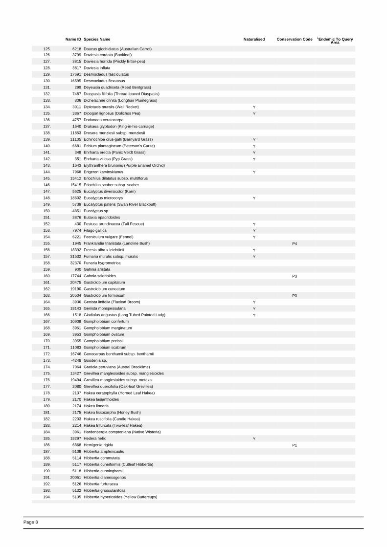
Page 3
Name ID Species Name Naturalised Conservation Code 1Endemic To QueryArea
125. 6218 Daucus glochidiatus (Australian Carrot)
126. 3799 Daviesia cordata (Bookleaf)
127. 3815 Daviesia horrida (Prickly Bitter-pea)
128. 3817 Daviesia inflata
129. 17691 Desmocladus fasciculatus
130. 16595 Desmocladus flexuosus
131. 299 Deyeuxia quadriseta (Reed Bentgrass)
132. 7487 Diaspasis filifolia (Thread-leaved Diaspasis)
133. 306 Dichelachne crinita (Longhair Plumegrass)
134. 3011 Diplotaxis muralis (Wall Rocket) Y
135. 3867 Dipogon lignosus (Dolichos Pea) Y
136. 4757 Dodonaea ceratocarpa
137. 1640 Drakaea glyptodon (King-in-his-carriage)
138. 11853 Drosera menziesii subsp. menziesii
139. 11105 Echinochloa crus-galli (Barnyard Grass) Y
140. 6681 Echium plantagineum (Paterson's Curse) Y
141. 348 Ehrharta erecta (Panic Veldt Grass) Y
142. 351 Ehrharta villosa (Pyp Grass) Y
143. 1643 Elythranthera brunonis (Purple Enamel Orchid)
144. 7968 Erigeron karvinskianus Y
145. 15412 Eriochilus dilatatus subsp. multiflorus
146. 15415 Eriochilus scaber subsp. scaber
147. 5625 Eucalyptus diversicolor (Karri)
148. 18602 Eucalyptus microcorys Y
149. 5739 Eucalyptus patens (Swan River Blackbutt)
150. -4851 Eucalyptus sp.
151. 3876 Eutaxia epacridoides
152. 430 Festuca arundinacea (Tall Fescue) Y
153. 7974 Filago gallica Y
154. 6221 Foeniculum vulgare (Fennel) Y
155. 1945 Franklandia triaristata (Lanoline Bush) P4
156. 18392 Freesia alba x leichtlinii Y
157. 31532 Fumaria muralis subsp. muralis Y
158. 32370 Funaria hygrometrica
159. 900 Gahnia aristata
160. 17744 Gahnia sclerioides P3
161. 20475 Gastrolobium capitatum
162. 19190 Gastrolobium cuneatum
163. 20504 Gastrolobium formosum P3
164. 3936 Genista linifolia (Flaxleaf Broom) Y
165. 18143 Genista monspessulana Y
166. 1518 Gladiolus angustus (Long Tubed Painted Lady) Y
167. 10909 Gompholobium confertum
168. 3951 Gompholobium marginatum
169. 3953 Gompholobium ovatum
170. 3955 Gompholobium preissii
171. 11083 Gompholobium scabrum
172. 16746 Gonocarpus benthamii subsp. benthamii
173. -4248 Goodenia sp.
174. 7064 Gratiola peruviana (Austral Brooklime)
175. 13427 Grevillea manglesioides subsp. manglesioides
176. 19494 Grevillea manglesioides subsp. metaxa
177. 2080 Grevillea quercifolia (Oak-leaf Grevillea)
178. 2137 Hakea ceratophylla (Horned Leaf Hakea)
179. 2170 Hakea lasianthoides
180. 2174 Hakea linearis
181. 2175 Hakea lissocarpha (Honey Bush)
182. 2203 Hakea ruscifolia (Candle Hakea)
183. 2214 Hakea trifurcata (Two-leaf Hakea)
184. 3961 Hardenbergia comptoniana (Native Wisteria)
185. 18297 Hedera helix Y
186. 6868 Hemigenia rigida P1
187. 5109 Hibbertia amplexicaulis
188. 5114 Hibbertia commutata
189. 5117 Hibbertia cuneiformis (Cutleaf Hibbertia)
190. 5118 Hibbertia cunninghamii
191. 20051 Hibbertia diamesogenos
192. 5126 Hibbertia furfuracea
193. 5132 Hibbertia grossulariifolia
194. 5135 Hibbertia hypericoides (Yellow Buttercups)

Page 4
Name ID Species Name Naturalised Conservation Code 1Endemic To QueryArea
195. 444 Holcus lanatus (Yorkshire Fog) Y
196. 3965 Hovea elliptica (Tree Hovea)
197. 3968 Hovea trisperma (Common Hovea)
198. 5218 Hybanthus debilissimus
199. 6231 Hydrocotyle hirta (Hairy Pennywort)
200. 452 Hyparrhenia hirta (Tambookie Grass) Y
201. 31234 Hypericum perforatum subsp. veronense (St John's Wort) Y
202. 8086 Hypochaeris glabra (Smooth Catsear) Y
203. 9352 Hypochaeris radicata (Flat Weed) Y
204. 1532 Ixia maculata (Yellow Ixia) Y
205. 1297 Johnsonia lupulina (Hooded Lily)
206. 1177 Juncus articulatus (Jointed Rush) Y
207. 1185 Juncus kraussii (Sea Rush)
208. 14631 Juncus meianthus P2
209. 1186 Juncus microcephalus Y
210. 1188 Juncus pallidus (Pale Rush)
211. 1189 Juncus pauciflorus (Loose Flower Rush)
212. 4037 Kennedia coccinea (Coral Vine)
213. 15674 Kunzea ciliata
214. 18585 Lagenophora huegelii
215. 5033 Lasiopetalum floribundum (Free Flowering Lasiopetalum)
216. 4047 Lathyrus tingitanus (Tangier Pea) Y
217. 932 Lepidosperma effusum (Spreading Sword-sedge)
218. 937 Lepidosperma longitudinale (Pithy Sword-sedge)
219. -11263 Lepidosperma sp.
220. 945 Lepidosperma squamatum
221. 1653 Leporella fimbriata (Hare Orchid)
222. 2342 Leptomeria cunninghamii
223. 2355 Leptomeria squarrulosa
224. 6358 Leucopogon assimilis
225. 6360 Leucopogon australis (Spiked Beard-heath)
226. 6367 Leucopogon capitellatus
227. 6428 Leucopogon pendulus
228. 6454 Leucopogon verticillatus (Tassel Flower)
229. 36180 Liparophyllum latifolium
230. 9289 Lobelia anceps (Angled Lobelia)
231. 7408 Lobelia tenuior (Slender Lobelia)
232. 14551 Logania serpyllifolia subsp. serpyllifolia
233. 6515 Logania vaginalis (White Spray)
234. 11073 Lolium x hybridum Y
235. 1223 Lomandra caespitosa (Tufted Mat Rush)
236. 1234 Lomandra nigricans
237. 1238 Lomandra pauciflora
238. 7365 Lonicera japonica (Japanese Honeysuckle) Y
239. 35321 Lonicera x italica Y
240. 4059 Lotus angustissimus (Narrowleaf Trefoil) Y
241. 8564 Lotus subbiflorus Y
242. 1655 Lyperanthus nigricans (Red Beak Orchid)
243. 36375 Lysimachia arvensis (Pimpernel) Y
244. 6456 Lysinema ciliatum (Curry Flower)
245. 6457 Lysinema conspicuum
246. 17637 Marianthus candidus (White Marianthus)
247. 17694 Meeboldina scariosa
248. 20297 Melaleuca osullivanii
249. 6883 Mentha pulegium (Pennyroyal) Y
250. 957 Mesomelaena tetragona (Semaphore Sedge)
251. 4090 Mirbelia dilatata (Holly-leaved Mirbelia)
252. 4963 Modiola caroliniana Y
253. 6185 Myriophyllum aquaticum (Brazilian Water Milfoil) Y
254. 492 Neurachne alopecuroidea (Foxtail Mulga Grass)
255. 6970 Nicandra physalodes (Apple of Peru) Y
256. 2923 Nymphaea odorata (Fragrant Waterlily) Y
257. -6755 Nymphaea sp.
258. 8143 Olearia paucidentata (Autumn Scrub Daisy)
259. 8149 Olearia rudis (Rough Daisybush)
260. 7346 Opercularia echinocephala (Bristly Headed Stink Weed)
261. 7354 Opercularia volubilis (Twining Stinkweed)
262. 1537 Orthrosanthus laxus (Morning Iris)
263. 1540 Orthrosanthus polystachyus (Many Spike Orthrosanthus)
264. 4349 Oxalis corniculata (Yellow Wood Sorrel) Y
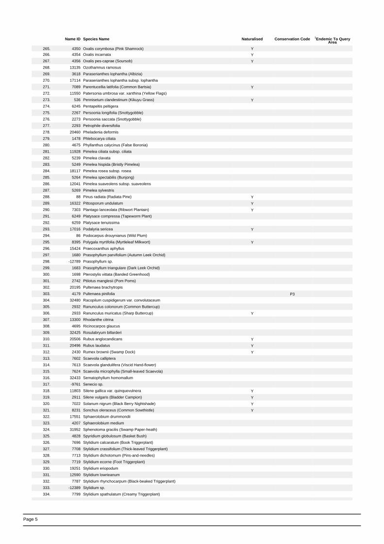
Page 5
Name ID Species Name Naturalised Conservation Code 1Endemic To QueryArea
265. 4350 Oxalis corymbosa (Pink Shamrock) Y
266. 4354 Oxalis incarnata Y
267. 4356 Oxalis pes-caprae (Soursob) Y
268. 13135 Ozothamnus ramosus
269. 3618 Paraserianthes lophantha (Albizia)
270. 17114 Paraserianthes lophantha subsp. lophantha
271. 7089 Parentucellia latifolia (Common Bartsia) Y
272. 11550 Patersonia umbrosa var. xanthina (Yellow Flags)
273. 536 Pennisetum clandestinum (Kikuyu Grass) Y
274. 6245 Pentapeltis peltigera
275. 2267 Persoonia longifolia (Snottygobble)
276. 2273 Persoonia saccata (Snottygobble)
277. 2293 Petrophile diversifolia
278. 20460 Pheladenia deformis
279. 1478 Phlebocarya ciliata
280. 4675 Phyllanthus calycinus (False Boronia)
281. 11928 Pimelea ciliata subsp. ciliata
282. 5239 Pimelea clavata
283. 5249 Pimelea hispida (Bristly Pimelea)
284. 18117 Pimelea rosea subsp. rosea
285. 5264 Pimelea spectabilis (Bunjong)
286. 12041 Pimelea suaveolens subsp. suaveolens
287. 5269 Pimelea sylvestris
288. 88 Pinus radiata (Radiata Pine) Y
289. 16322 Pittosporum undulatum Y
290. 7303 Plantago lanceolata (Ribwort Plantain) Y
291. 6249 Platysace compressa (Tapeworm Plant)
292. 6259 Platysace tenuissima
293. 17016 Podalyria sericea Y
294. 86 Podocarpus drouynianus (Wild Plum)
295. 8395 Polygala myrtifolia (Myrtleleaf Milkwort) Y
296. 15424 Praecoxanthus aphyllus
297. 1680 Prasophyllum parvifolium (Autumn Leek Orchid)
298. -12789 Prasophyllum sp.
299. 1683 Prasophyllum triangulare (Dark Leek Orchid)
300. 1698 Pterostylis vittata (Banded Greenhood)
301. 2742 Ptilotus manglesii (Pom Poms)
302. 20195 Pultenaea brachytropis
303. 4179 Pultenaea pinifolia P3
304. 32480 Racopilum cuspidigerum var. convolutaceum
305. 2932 Ranunculus colonorum (Common Buttercup)
306. 2933 Ranunculus muricatus (Sharp Buttercup) Y
307. 13300 Rhodanthe citrina
308. 4695 Ricinocarpos glaucus
309. 32425 Rosulabryum billarderi
310. 20506 Rubus anglocandicans Y
311. 20496 Rubus laudatus Y
312. 2430 Rumex brownii (Swamp Dock) Y
313. 7602 Scaevola calliptera
314. 7613 Scaevola glandulifera (Viscid Hand-flower)
315. 7624 Scaevola microphylla (Small-leaved Scaevola)
316. 32433 Sematophyllum homomallum
317. -9761 Senecio sp.
318. 11803 Silene gallica var. quinquevulnera Y
319. 2911 Silene vulgaris (Bladder Campion) Y
320. 7022 Solanum nigrum (Black Berry Nightshade) Y
321. 8231 Sonchus oleraceus (Common Sowthistle) Y
322. 17551 Sphaerolobium drummondii
323. 4207 Sphaerolobium medium
324. 31952 Sphenotoma gracilis (Swamp Paper-heath)
325. 4828 Spyridium globulosum (Basket Bush)
326. 7696 Stylidium calcaratum (Book Triggerplant)
327. 7708 Stylidium crassifolium (Thick-leaved Triggerplant)
328. 7713 Stylidium dichotomum (Pins-and-needles)
329. 7719 Stylidium ecorne (Foot Triggerplant)
330. 19251 Stylidium eriopodum
331. 12590 Stylidium lowrieanum
332. 7787 Stylidium rhynchocarpum (Black-beaked Triggerplant)
333. -12389 Stylidium sp.
334. 7799 Stylidium spathulatum (Creamy Triggerplant)

Page 6
Name ID Species Name Naturalised Conservation Code 1Endemic To QueryArea
335. 7802 Stylidium squamosotuberosum (Fleshy-rhizomed Trigger Plant)
336. 1260 Stypandra glauca (Blind Grass)
337. 15827 Taraxis grossa
338. 667 Tetrarrhena laevis (Forrest Ricegrass)
339. 1704 Thelymitra cornicina (Lilac Sun Orchid)
340. 1705 Thelymitra crinita (Blue Lady Orchid)
341. 1708 Thelymitra fuscolutea (Leopard Orchid)
342. 1711 Thelymitra nuda (Scented Sun Orchid)
343. 5080 Thomasia foliosa
344. 32486 Thuidium sparsum var. hastatum
345. 1319 Thysanotus arenarius
346. 8248 Tolpis barbata (Yellow Hawkweed) Y
347. 6280 Trachymene pilosa (Native Parsnip)
348. 4547 Tremandra diffusa
349. 4548 Tremandra stelligera
350. 4302 Trifolium ligusticum (Ligurian Clover) Y
351. 35016 Trihaloragis hexandra subsp. integrifolia
352. 34965 Trihaloragis hexandra subsp. serrata
353. 1561 Tritonia crocata Y
354. 38401 Tritonia gladiolaris (Lined Tritonia) Y
355. 4360 Tropaeolum majus (Garden Nasturtium) Y
356. 13479 Trymalium ledifolium var. rosmarinifolium
357. 33438 Trymalium odoratissimum subsp. trifidum
358. 17680 Tyrbastes glaucescens
359. 33537 Vallisneria australis Y
360. 7665 Velleia trinervis
361. 7108 Veronica arvensis (Wall Speedwell) Y
362. 4322 Vicia sativa (Common Vetch) Y
363. 4325 Viminaria juncea (Swishbush)
364. 6575 Vinca major (Blue Periwinkle) Y
365. 5223 Viola odorata (Common Violet) Y
366. 7388 Wahlenbergia multicaulis
367. 13103 Watsonia borbonica Y
368. 1565 Watsonia leipoldtii (Watsonia) Y Y
369. 18108 Watsonia meriana var. bulbillifera Y
370. 18118 Watsonia meriana var. meriana Y
371. 1569 Watsonia versfeldii Y
372. 11712 Watsonia versfeldii var. alba Y
373. 1570 Watsonia wordsworthiana Y
374. 20737 X Cyanthera glossodioides
375. 6283 Xanthosia atkinsoniana
376. 19330 Xanthosia tasmanica
377. 1149 Xyris lacera
378. 1049 Zantedeschia aethiopica (Arum Lily) Y
379. 36218 Zygodon menziesii
Conservation CodesT - Rare or likely to become extinctX - Presumed extinctIA - Protected under international agreementS - Other specially protected fauna1 - Priority 12 - Priority 23 - Priority 34 - Priority 45 - Priority 5
1 For NatureMap's purposes, species flagged as endemic are those whose records are wholely contained within the search area. Note that only those records complying with the search criterion are included in the
calculation. For example, if you limit records to those from a specific datasource, only records from that datasource are used to determine if a species is restricted to the query area.

61/27189/117144 Margaret River BypassFlora and Fauna Assessment
Appendix D
Field Survey Results

61/27189/117144 Margaret River BypassFlora and Fauna Assessment
Table 11 Flora species recorded within the study area
Family Genus Species Status
Anarthriaceae Anarthria laevis
Anarthriaceae Anarthria prolifera
Apiaceae Pentapeltis peltigera
Apiaceae Platysace tenuissima
Apocynaceae Vinca major *
Araliaceae Hedera helix *
Asparagaceae Lomandra pauciflora
Asparagaceae Lomandra purpurea
Asparagaceae Lomandra sp.
Asparagaceae Thysanotus manglesianus
Asparagaceae Thysanotus multiflorus
Asteraceae Arctotheca calendula *
Asteraceae Hypochaeris glabra *
Asteraceae Hypochaeris radicata *
Asteraceae Lagenophora huegellii
Asteraceae Rhodanthe citrina
Asteraceae Sonchus asper *
Asteraceae Taraxacum officinale *
Asteraceae Ursinia anthemoides *
Caryophyllaceae Petrorhagia dubia *
Celastraceae Tripterococcus brunonis
Colchicaceae Burchardia congesta
Crassulaceae Crassula alata *
Crassulaceae Crassula glomerata *
Cyperaceae Cyathochaeta avenacea
Cyperaceae Gahnia decomposita
Cyperaceae Lepidosperma effusum
Cyperaceae Lepidosperma gracile
Cyperaceae Lepidosperma squamatum

61/27189/117144 Margaret River BypassFlora and Fauna Assessment
Family Genus Species Status
Cyperaceae Lepidosperma tetraquetrum
Cyperaceae Mesomelaena graciliceps
Cyperaceae Mesomelaena tetragona
Dennstaedtiaceae Pteridium esculentum
Dilleniaceae Hibbertia cunninghamii
Dilleniaceae Hibbertia furfuracea
Dilleniaceae Hibbertia hypericoides
Droseraceae Drosera glanduligera
Droseraceae Drosera pallida
Droseraceae Drosera sp.
Elaeocarpaceae Tremandra stelligera
Ericaceae Astroloma ciliatum
Ericaceae Astroloma pallidum
Ericaceae Leucopogon propinquus
Ericaceae Leucopogon verticillatus
Ericaceae Sphenotoma gracilis
Euphorbiaceae Amperea ericoides
Fabaceae Acacia alata var. alata
Fabaceae Acacia decurrens *
Fabaceae Acacia divergens
Fabaceae Acacia gilbertii
Fabaceae Acacia melanoxylon *
Fabaceae Acacia pulchella
Fabaceae Acacia saligna
Fabaceae Bossiaea eriocarpa
Fabaceae Bossiaea linophylla
Fabaceae Bossiaea ornata
Fabaceae Callistachys lanceolata
Fabaceae Chorizema rhombeum
Fabaceae Daviesia decurrens

61/27189/117144 Margaret River BypassFlora and Fauna Assessment
Family Genus Species Status
Fabaceae Gastrolobium bilobum
Fabaceae Gastrolobium formosum Priority 3
Fabaceae Gompholobium knightianum
Fabaceae Gompholobium polymorphum
Fabaceae Gompholobium preissii
Fabaceae Hovea chorizemifolia
Fabaceae Hovea elliptica
Fabaceae Hovea trisperma
Fabaceae Kennedia coccinea
Fabaceae Mirbelia dilatata
Fabaceae sp.
Fabaceae Sphaerolobium medium
Fabaceae Trifolium sp.
Fabaceae Viminaria juncea
Goodeniaceae Dampiera hederacea
Goodeniaceae Dampiera linearis
Goodeniaceae Dampiera trigona
Goodeniaceae Scaevola calliptera
Goodeniaceae Scaevola microphylla
Haemodoraceae Anigonzanthos flavidus
Haemodoraceae Conostylis aculeata
Haemodoraceae Conostylis aculeata subsp. aculeata
Haemodoraceae Haemodorum sp.
Haemodoraceae Haemodorum spicatum
Hemerocallidaceae Agrostocrinum hirsutum
Hemerocallidaceae Dianella revoluta
Hemerocallidaceae Johnsonia lupulina
Hemerocallidaceae Stypandra glauca
Hypericaceae Hypericum perforatum *DP
Iridaceae Patersonia occidentalis

61/27189/117144 Margaret River BypassFlora and Fauna Assessment
Family Genus Species Status
Iridaceae Patersonia umbrosa var. xanthina
Iridaceae Watsonia meriana var. bulbillifera *
Iridaceae Watsonia sp. *
Juncaceae Juncus pallidus
Juncaceae Juncus pauciflorus
Juncaceae Juncus planifolius
Lamiaceae Hemigenia pritzelii
Lauraceae Cassytha racemosa
Lindsaeaceae Lindsaea linearis
Loganiaceae Logania serpyllifolia subsp. angustifolia
Loganiaceae Logania vaginalis
Menyanthaceae Liparophyllum latifolium
Myrtaceae Agonis flexuosa
Myrtaceae Astartea leptophylla
Myrtaceae Corymbia calophylla
Myrtaceae Eucalyptus diversicolor
Myrtaceae Eucalyptus lehmannii *Planted
Myrtaceae Eucalyptus globulus *Planted
Myrtaceae Eucalyptus marginata
Myrtaceae Eucalyptus sp. *Planted
Myrtaceae Kunzea ciliata
Myrtaceae Leptospermum laevigatum *
Myrtaceae Melaleuca incana subsp. incana
Myrtaceae Melaleuca sp. *Planted
Myrtaceae Taxandra linearifolia
Orchidaceae Caladenia flava
Orchidaceae Disa bracteata *
Orchidaceae Lyperanthus serratus
Orchidaceae Thelymitra crinita
Oxalidaceae Oxalis sp.

61/27189/117144 Margaret River BypassFlora and Fauna Assessment
Family Genus Species Status
Phyllanthaceae Phyllanthus calycinus
Pinaceae Pinus sp.
Pittosporaceae Billardiera variifolia
Pittosporaceae sp.
Plantaginaceae Plantago lanceolata
Poaceae Aira caryophyllea *
Poaceae Austrodanthonia setacea
Poaceae Austrostipa tenuifolia
Poaceae Avena barbata *
Poaceae Briza maxima *
Poaceae Briza minor *
Poaceae Ehrharta calycina *
Poaceae Eragrostis curvula *
Poaceae Hordeum leporinum *
Poaceae Hordeum leporinum *
Poaceae Hyparrhenia hirta *
Poaceae Lolium rigidum *
Poaceae Neurachne alopecuroidea
Poaceae Phalaris paradoxa *
Podocarpaceae Podocarpus drouynianus
Polygalaceae Comesperma virgatum
Proteaceae Banksia grandis
Proteaceae Grevillea quercifolia
Proteaceae Hakea amplexicaulis
Proteaceae Hakea lasianthoides
Proteaceae Hakea lissocarpha
Proteaceae Hakea ruscifolia
Proteaceae Persoonia longifolia
Proteaceae Petrophile diversifolia
Proteaceae Synaphea ?petiolaris

61/27189/117144 Margaret River BypassFlora and Fauna Assessment
Family Genus Species Status
Ranunculaceae Clematis pubescens
Restionaceae Desmocladus fasciculatus
Restionaceae Desmocladus flexuosus
Restionaceae Loxocarya cinerea
Restionaceae Meeboldina ?coangustata
Restionaceae Meeboldina scariosa
Restionaceae Taraxis grossa
Rhamnaceae Trymalium odoratissimum subsp. trifidum
Rubiaceae Opercularia hispidula
Rutaceae Philotheca spicata
Santalaceae Leptomeria squarrulosa
Solanaceae Solanum nigrum *
Stylidiaceae Stylidium amoenum
Stylidiaceae Stylidium calcaratum
Thymeleaceae Pimelea spectablis
Verbenaceae Lantana camara *DP,WONS
Xanthorrhoeaceae Xanthorrhoea gracillis
Xanthorrhoeaceae Xanthorrhoea preissii
Zamiaceae Macrozamia riedlei
* Introduced / weed species
DP Declared Plant
WONS Weeds of National Significance

61/27189/117144 Margaret River BypassFlora and Fauna Assessment
Quadrat Data
Quadrat 1Location E: 323976 N: 6242018Habitat Jarrah/Marri ForestTopography/Aspect SW Slope Gentle-moderateGeology GraniteSoil Dark brown sand%Bare Ground 0 %Logs 10-30 %Twigs 30-70 %Leaves >70Hydrology Good drainageLandform Mid-slopeVegetation Condition Very Good (3)Disturbance Selective loggingAge Since Fire Old (5-20 yr)
Layer Cover Class Family Genus SpeciesTrees 10-30 m 10-30% Myrtaceae Corymbia calophylla
Myrtaceae Eucalyptus marginataShrubs >2 m 10-30% Fabaceae Hovea trisperma
Fabaceae Acacia salignaXanthorrhoeaceae Xanthorrhoea preissii
Shrubs <1m 30-70% Dilleniaceae Hibbertia hypericoidesProteaceae Hakea lissocarphaProteaceae Hakea amplexicaulisZamiaceae Macrozamia riedleiEricaceae Leucopogon propinquusProteaceae Hakea ruscifoliaFabaceae Gompholobium polymorphum
Grasses <2% Poaceae *Lolium rigidumHerbs 10-30% Pittosporaceae sp.
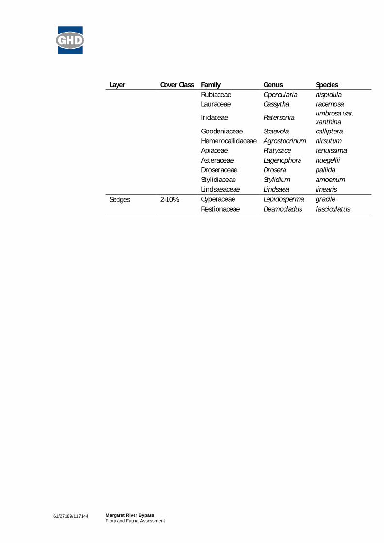
61/27189/117144 Margaret River BypassFlora and Fauna Assessment
Layer Cover Class Family Genus SpeciesRubiaceae Opercularia hispidulaLauraceae Cassytha racemosa
Iridaceae Patersonia umbrosa var.xanthina
Goodeniaceae Scaevola callipteraHemerocallidaceae Agrostocrinum hirsutumApiaceae Platysace tenuissimaAsteraceae Lagenophora huegelliiDroseraceae Drosera pallidaStylidiaceae Stylidium amoenumLindsaeaceae Lindsaea linearis
Sedges 2-10% Cyperaceae Lepidosperma gracileRestionaceae Desmocladus fasciculatus

61/27189/117144 Margaret River BypassFlora and Fauna Assessment
Quadrat 2Location E: 324055 N: 6241911Habitat Jarrah/Marri ForestTopography/Aspect SE Slope ModerateGeology GraniteSoil Dark brown sand%Bare Ground <2 %Logs 2-10 %Twigs 30-70 %Leaves >70Hydrology Good drainageLandform Lower slopeVegetation Condition Very Good (3)Disturbance Selective loggingAge Since Fire Old (5-20 yr)
Layer Cover Class Family Genus SpeciesTrees <10 m 30-70 Myrtaceae Corymbia calophylla
Myrtaceae Eucalyptus marginataShrubs 1-2 m 30-70 Fabaceae Hovea trisperma
Fabaceae Acacia salignaXanthorrhoeaceae Xanthorrhoea preissiiProteaceae Hakea amplexicaulisProteaceae Petrophile diversifolia
Shrubs <1 m 30-70 Elaeocarpaceae Tremandra stelligeraEricaceae Leucopogon verticillatusZamiaceae Macrozamia riedleiDilleniaceae Hibbertia hypericoidesRutaceae Philotheca spicataDilleniaceae Hibbertia furfuraceaFabaceae Bossiaea ornataProteaceae Persoonia longifoliaEricaceae Leucopogon propinquusFabaceae Hovea elliptica

61/27189/117144 Margaret River BypassFlora and Fauna Assessment
Layer Cover Class Family Genus SpeciesGrasses <2 Poaceae Neurachne alopecuroideaHerbs 10-30 Thymeleaceae Pimelea spectablis
Hemerocallidaceae Agrostocrinum hirsutumApiaceae Platysace tenuissima
Iridaceae Patersonia umbrosa var.xanthina
Dilleniaceae Hibbertia cunninghamiiRubiaceae Opercularia hispidulaStylidiaceae Stylidium amoenumPittosporaceae sp.Asteraceae Lagenophora huegelliiAsparagaceae Lomandra sp.Orchidaceae Lyperanthus serratusOrchidaceae Thelymitra crinitaLindsaeaceae Lindsaea linearisHaemodoraceae Haemodorum sp.Anarthriaceae Anarthria proliferaProteaceae Synaphea ?petiolarisAsparagaceae Lomandra paucifloraHemerocallidaceae Johnsonia lupulinaApiaceae Platysace tenuissima
Sedges 10-30 Cyperaceae Lepidosperma gracileRestionaceae Desmocladus fasciculatusCyperaceae Mesomelaena graciliceps
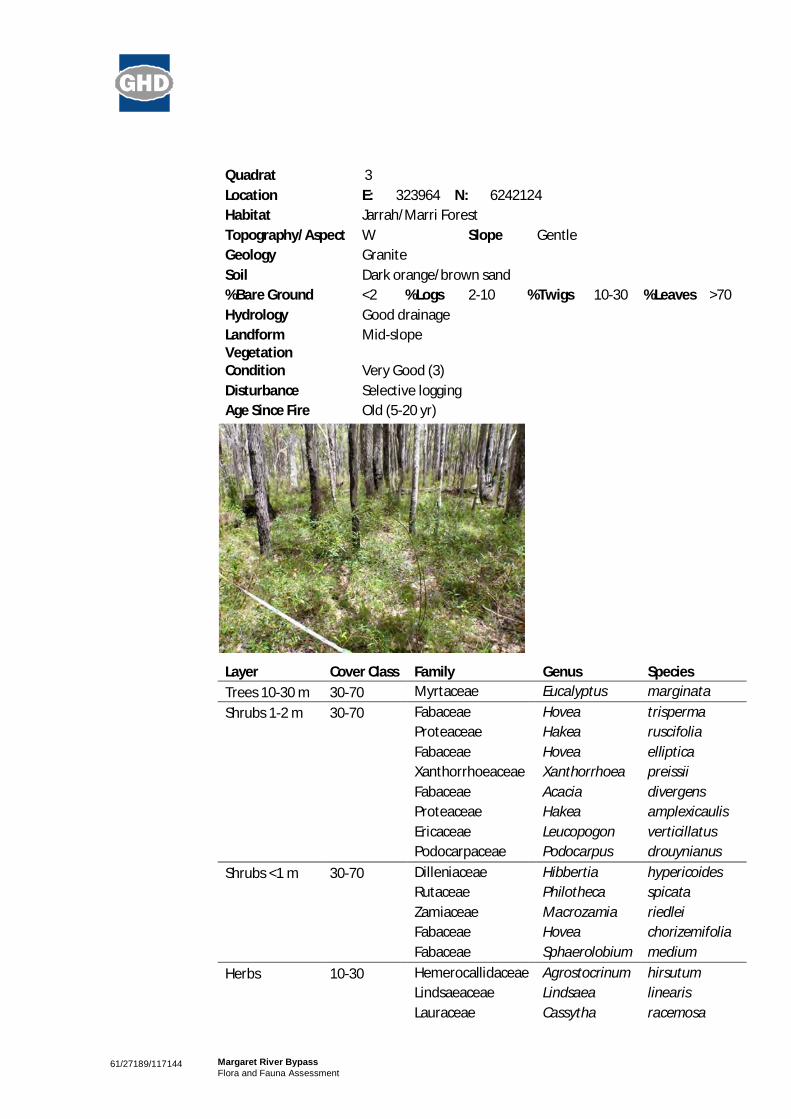
61/27189/117144 Margaret River BypassFlora and Fauna Assessment
Quadrat 3Location E: 323964 N: 6242124Habitat Jarrah/Marri ForestTopography/Aspect W Slope GentleGeology GraniteSoil Dark orange/brown sand%Bare Ground <2 %Logs 2-10 %Twigs 10-30 %Leaves >70Hydrology Good drainageLandform Mid-slopeVegetationCondition Very Good (3)Disturbance Selective loggingAge Since Fire Old (5-20 yr)
Layer Cover Class Family Genus SpeciesTrees 10-30 m 30-70 Myrtaceae Eucalyptus marginataShrubs 1-2 m 30-70 Fabaceae Hovea trisperma
Proteaceae Hakea ruscifoliaFabaceae Hovea ellipticaXanthorrhoeaceae Xanthorrhoea preissiiFabaceae Acacia divergensProteaceae Hakea amplexicaulisEricaceae Leucopogon verticillatusPodocarpaceae Podocarpus drouynianus
Shrubs <1 m 30-70 Dilleniaceae Hibbertia hypericoidesRutaceae Philotheca spicataZamiaceae Macrozamia riedleiFabaceae Hovea chorizemifoliaFabaceae Sphaerolobium medium
Herbs 10-30 Hemerocallidaceae Agrostocrinum hirsutumLindsaeaceae Lindsaea linearisLauraceae Cassytha racemosa

61/27189/117144 Margaret River BypassFlora and Fauna Assessment
Layer Cover Class Family Genus Species
Iridaceae Patersonia umbrosa var.xanthina
Apiaceae Pentapeltis peltigeraApiaceae Platysace tenuissimaStylidiaceae Stylidium amoenum
Sedges <2 Cyperaceae Lepidosperma gracile

61/27189/117144 Margaret River BypassFlora and Fauna Assessment
Releve 1Location E: 323485 N: 6240564Habitat Jarrah-Marri Forest/Drainage lineTopography/Aspect East Slope GentleSoil Dark brown loam/sand%Bare Ground <2 %Logs 10-30 %Twigs 30-70 %Leaves >70Hydrology Good drainageLandform Bank of drainage lineVegetationCondition Very Good (3)Disturbance Weeds and tracksAge Since Fire Old (5-20 yr)
Layer Cover Class Family Genus SpeciesTrees 10-30 m 30-70 Myrtaceae Eucalyptus marginata
Myrtaceae Corymbia calophyllaTrees <10 m 10-30 Myrtaceae Agonis flexuosaShrubs >2 m 10-30 Proteaceae Banksia grandis
Myrtaceae Melaleuca incana subsp.incana
Myrtaceae Taxandra linearifoliaShrubs 1-2 m 10-30 Fabaceae Mirbelia dilatata
Fabaceae Hovea trispermaFabaceae Hovea elliptica
Shrubs <1 m 30-70 Dilleniaceae Hibbertia hypericoidesFabaceae Acacia alata var. alata
Haemodoraceae Conostylis aculeata subsp.aculeata
Grasses 2-10 Poaceae Hordeum leporinumPoaceae *Phalaris paradoxaPoaceae Briza maximaPoaceae Avena barbata

61/27189/117144 Margaret River BypassFlora and Fauna Assessment
Layer Cover Class Family Genus SpeciesHerbs 10-30 Dennstaedtiaceae Pteridium esculentum
Restionaceae Loxocarya cinereaHemerocallidaceae Agrostocrinum hirsutumFabaceae *Trifolium sp.Oxalidaceae Oxalis sp.Droseraceae Drosera sp.Asteraceae *Hypochaeris radicataAsparagaceae Thysanotus manglesianusJuncaceae Juncus pauciflorusGoodeniaceae Dampiera trigona
Sedges 10-30 Restionaceae Desmocladus flexuosusCyperaceae Lepidosperma squamatumCyperaceae Gahnia decompositaRestionaceae Meeboldina ?coangustataJuncaceae Juncus planifoliusJuncaceae Juncus pallidus

61/27189/117144 Margaret River BypassFlora and Fauna Assessment
Releve 2Location E: 323817 N: 6242116Habitat Jarrah-Marri-Peppermint ForestTopography/Aspect n/aSoil Dark brown loamy/sandy%Bare Ground 0 %Logs 2-10 %Twigs 30-70 %Leaves >70Hydrology Seasonally wetLandform Drainage depressionVegetationCondition Very Good (3)Disturbance Weeds and tracksAge Since Fire Old (5-20 yr)
Layer CoverClass Family Genus Species
Trees 10-30 m 10-30 Myrtaceae Eucalyptus marginataMyrtaceae Corymbia calophylla
Trees <10 m 30-70 Myrtaceae Agonis flexuosaFabaceae Callistachys lanceolataMyrtaceae Taxandria linearifolia
Shrubs 1-2 m 10-30 Fabaceae Hovea trispermaXanthorrhoeaceae Xanthorrhoea preissiiProteaceae Hakea amplexicaulisEricaceae Leucopogon verticillatusFabaceae Mirbelia dilatata
Rhamnaceae Trymalium odoratissimumsubsp. trifidum
Loganiaceae Logania vaginalisThymeleaceae Pimelea spectablisFabaceae Bossiaea linophylla
Shrubs <1 m 10-30 Elaeocarpaceae Tremandra stelligeraDilleniaceae Hibbertia hypericoides
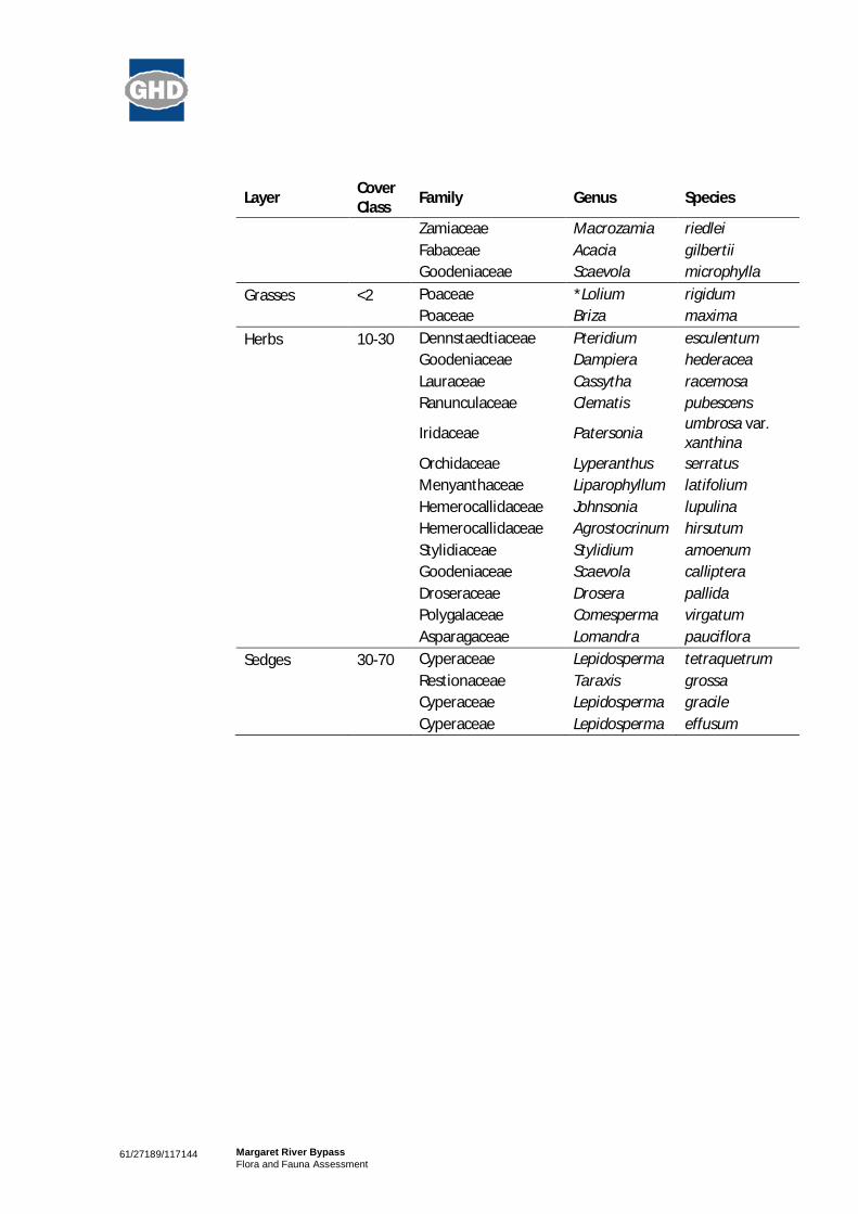
61/27189/117144 Margaret River BypassFlora and Fauna Assessment
Layer CoverClass Family Genus Species
Zamiaceae Macrozamia riedleiFabaceae Acacia gilbertiiGoodeniaceae Scaevola microphylla
Grasses <2 Poaceae *Lolium rigidumPoaceae Briza maxima
Herbs 10-30 Dennstaedtiaceae Pteridium esculentumGoodeniaceae Dampiera hederaceaLauraceae Cassytha racemosaRanunculaceae Clematis pubescens
Iridaceae Patersonia umbrosa var.xanthina
Orchidaceae Lyperanthus serratusMenyanthaceae Liparophyllum latifoliumHemerocallidaceae Johnsonia lupulinaHemerocallidaceae Agrostocrinum hirsutumStylidiaceae Stylidium amoenumGoodeniaceae Scaevola callipteraDroseraceae Drosera pallidaPolygalaceae Comesperma virgatumAsparagaceae Lomandra pauciflora
Sedges 30-70 Cyperaceae Lepidosperma tetraquetrumRestionaceae Taraxis grossaCyperaceae Lepidosperma gracileCyperaceae Lepidosperma effusum

61/27189/117144 Margaret River BypassFlora and Fauna Assessment
Table 12 Fauna Species Identified From Desktop and Field Assessment
Family Genus Species Common Name NatureMaps datasearch
EPBCdatasearch
GHD(2011)
SpeciesListing orintroduced
Birds
Acanthizidae Acanthiza apicalis Inland Thornbill X
Acanthizidae Acanthiza chrysorrhoa Yellow-rumped Thornbill X X
Acanthizidae Acanthiza inornata Western Thornbill X
Acanthizidae Sericornis frontalis maculatus White-browed Scrubwren X X
Acanthizidae Smicrornis brevirostris occidentalis Weebill X
Acanthizidae Gerygone fusca Western Gerygone X X
Accipitridae Aquila audax Wedge-tailed Eagle X
Accipitridae Accipiter cirrocephalus cirrocephalus Collared Sparrowhawk X
Accipitridae Accipiter fasciatus fasciatus Brown Goshawk X
Accipitridae Circus approximans Swamp Harrier X
Accipitridae Elanus axillaris Black-shouldered Kite X
Accipitridae Haliastur sphenurus Whistling Kite X
Accipitridae Haliaeetus leucogaster White-bellied Sea-eagle X Mi
Accipitridae Hieraaetus morphnoides Little Eagle X
Accipitridae Lophoictinia isura Square-tailed Kite X
Accipitridae Pandion haliaetus cristatus Osprey X

61/27189/117144 Margaret River BypassFlora and Fauna Assessment
Family Genus Species Common Name NatureMaps datasearch
EPBCdatasearch
GHD(2011)
SpeciesListing orintroduced
Anatidae Anas gracilis Grey Teal X X
Anatidae Anas platyrhynchos Mallard X #
Anatidae Anas superciliosa Pacific Black Duck X X
Anatidae Biziura lobata Musk Duck X
Anatidae Chenonetta jubata Australian Wood Duck X X
Anatidae Cygnus atratus Black Swan X
Anatidae Strictonetta naevosa Freckled Duck X
Anatidae Tadorna tadornoides Australian Shelduck X X
Ardeidae Apus pacificus Fork-tailed Swift X Ma,Mi
Ardeidae Ardea modesta Great Egret X Ma,Mi
Ardeidae Ardea ibis Cattle Egret X Ma,Mi
Ardeidae Ardea pacifica White-necked Heron X
Ardeidae Botaurus poiciloptilus Australasian Bittern X En,S1
Ardeidae Egretta novaehollandiae White-faced Heron X X
Ardeidae Ixobrychus flavicollis australis Black Bittern X P3
Anhingidae Anhinga novaehollandiae Australasian Darter X
Artamidae Artamus cinereus Black-faced Woodswallow X X
Artamidae Artamus cyanopterus Dusky Woodswallow X X
Artamidae Artamus superciliosus White-browed Woodswallow X
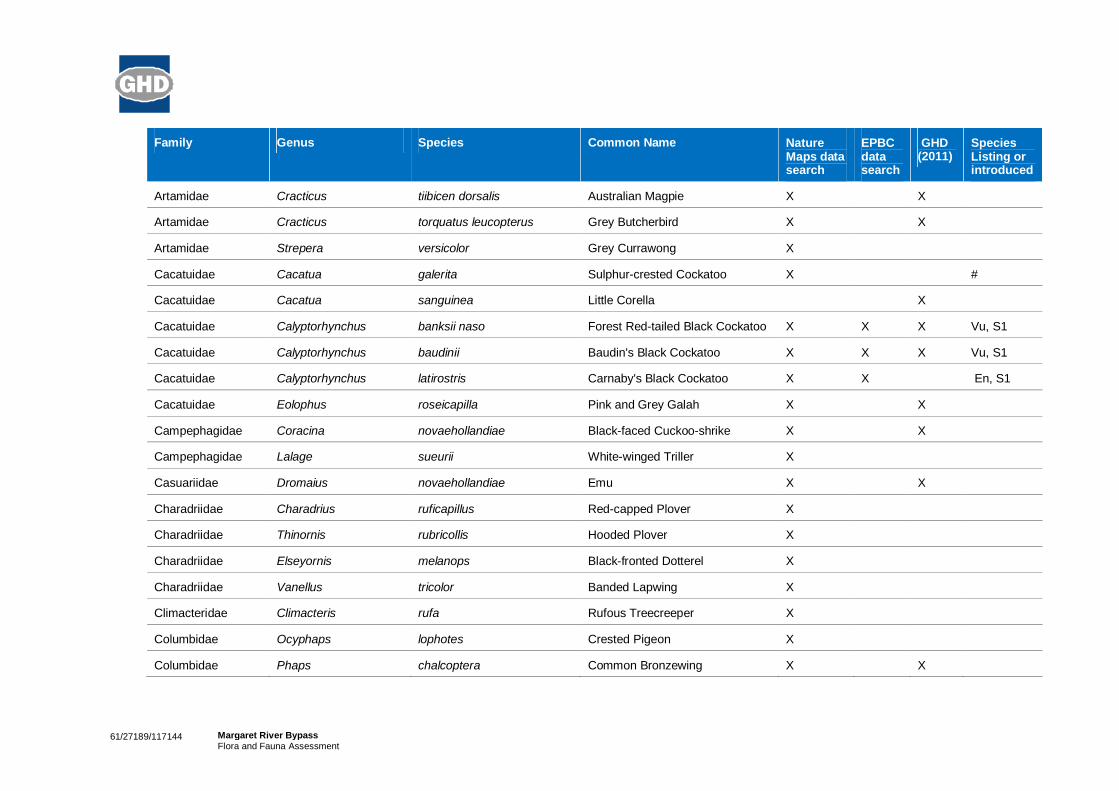
61/27189/117144 Margaret River BypassFlora and Fauna Assessment
Family Genus Species Common Name NatureMaps datasearch
EPBCdatasearch
GHD(2011)
SpeciesListing orintroduced
Artamidae Cracticus tiibicen dorsalis Australian Magpie X X
Artamidae Cracticus torquatus leucopterus Grey Butcherbird X X
Artamidae Strepera versicolor Grey Currawong X
Cacatuidae Cacatua galerita Sulphur-crested Cockatoo X #
Cacatuidae Cacatua sanguinea Little Corella X
Cacatuidae Calyptorhynchus banksii naso Forest Red-tailed Black Cockatoo X X X Vu, S1
Cacatuidae Calyptorhynchus baudinii Baudin's Black Cockatoo X X X Vu, S1
Cacatuidae Calyptorhynchus latirostris Carnaby's Black Cockatoo X X En, S1
Cacatuidae Eolophus roseicapilla Pink and Grey Galah X X
Campephagidae Coracina novaehollandiae Black-faced Cuckoo-shrike X X
Campephagidae Lalage sueurii White-winged Triller X
Casuariidae Dromaius novaehollandiae Emu X X
Charadriidae Charadrius ruficapillus Red-capped Plover X
Charadriidae Thinornis rubricollis Hooded Plover X
Charadriidae Elseyornis melanops Black-fronted Dotterel X
Charadriidae Vanellus tricolor Banded Lapwing X
Climacteridae Climacteris rufa Rufous Treecreeper X
Columbidae Ocyphaps lophotes Crested Pigeon X
Columbidae Phaps chalcoptera Common Bronzewing X X

61/27189/117144 Margaret River BypassFlora and Fauna Assessment
Family Genus Species Common Name NatureMaps datasearch
EPBCdatasearch
GHD(2011)
SpeciesListing orintroduced
Columbidae Phaps elegans Brush Bronzewing X
Columbidae Streptopelia senegalensis Laughing Turtle Dove X #
Corvidae Corvus coronoides perplexus Australian Raven X X
Cuculidae Cacomantis pallidus Pallid Cuckoo X
Cuculidae Cacomantis flabelliformis Fan-tailed Cuckoo X
Cuculidae Chalcites lucidus plagosus Shining-bronze Cuckoo X
Estrildidae Stagonopleura oculata Red-eared Firetail X
Falconidae Falco berigora Brown Falcon X
Falconidae Falco cenchroides cenchroides Nankeen Kestrel X X
Falconidae Falco peregrinus macropus Peregrine Falcon X S4
Haematopodidae Haematopus fuliginosus Sooty Oystercatcher X
Halcyonidae Dacelo novaeguineae Laughing Kookaburra X X #
Hirundinidae Hirundo neoxena Welcome Swallow X X
Hirundinidae Petrochelidon nigricans Tree Martin X X
Hirundinidae Petrochelidon ariel Fairy Martin X
Laridae Hydroprogne caspia Caspian Tern X
Laridae Chroicocephalus novaehollandiae Silver Gull X
Laridae Sternula nereis Fairy Tern X
Laridae Thalasseus bergii Crested Tern X

61/27189/117144 Margaret River BypassFlora and Fauna Assessment
Family Genus Species Common Name NatureMaps datasearch
EPBCdatasearch
GHD(2011)
SpeciesListing orintroduced
Maluridae Malurus elegans Red-winged Fairy-wren X X
Maluridae Malurus splendens Splendid Fairy-wren X X
Maluridae Stipiturus malachurus westernensis Southern Emu-wren X
Meliphagidae Acanthorhynchus superciliosus Western Spinebill X
Meliphagidae Anthochaera lunulata Western Wattlebird X X
Meliphagidae Anthochaera carunculata Red Wattlebird X X
Meliphagidae Epthianura albifrons White-fronted Chat X
Meliphagidae Glyciphila melanops Tawny-crowned Honeyeater X
Meliphagidae Lichenostomus virescens virescens Singing Honeyeater X X
Meliphagidae Lichmera indistincta Brown Honeyeater X X
Meliphagidae Melithreptus brevirostris Brown-headed Honeyeater X
Meliphagidae Phylidonyris novaehollandiae New Holland Honeyeater X X
Meropidae Merops ornatus Rainbow Bee-eater X X Ma,Mi
Monarchidae Grallina cyanoleuca Magpie-lark X X
Monarchidae Myiagra inquieta Restless Flycatcher X
Motacillidae Anthus novaeseelandiae Australian Pipit X
Nectariniidae Dicaeum hirundinaceum Mistletoebird X
Neosittidae Daphoenositta chrysoptera Varied Sittella X X
Pachycephalidae Colluricincla harmonica rufiventris Grey Shrike-thrush X X

61/27189/117144 Margaret River BypassFlora and Fauna Assessment
Family Genus Species Common Name NatureMaps datasearch
EPBCdatasearch
GHD(2011)
SpeciesListing orintroduced
Pachycephalidae Falcunculus frontatus Crested Shrike-tit X
Pachycephalidae Pachycephala pectoralis Golden Whistler X X
Pachycephalidae Pachycephala rufiventris rufiventris Rufous Whistler X X
Pardalotidae Pardalotus punctatus Spotted Pardalote X
Pardalotidae Pardalotus striatus Striated Pardalote X X
Pelecanidae Pelecanus conspicillatus Australian Pelican X
Petroicidae Petroica boodang Scarlet Robin X X
Petroicidae Eopsaltria griseogularis Western Yellow Robin X X
Petroicidae Eopsaltria georgiana White-breasted Robin X
Petroicidae Melanodryas cucullata Hooded Robin X
Petroicidae Microeca fascinans Jacky Winter X X
Phalacrocoracidae Microcarbo melanoleucos Little Pied Cormorant X
Phalacrocoracidae Phalacrocorax carbo Great Cormorant X
Phalacrocoracidae Phalacrocorax sulcirostris Little Black Cormorant X X
Phalacrocoracidae Phalacrocorax varius Pied Cormorant X
Phasianidae Coturnix pectoralis Stubble Quail X
Phasianidae Coturnix ypsilophora Brown Quail X
Podicipedidae Poliocephalus poliocephalus Hoary-headed Grebe X
Podicipedidae Tachybaptus novarhollandiae Australasian Grebe X X
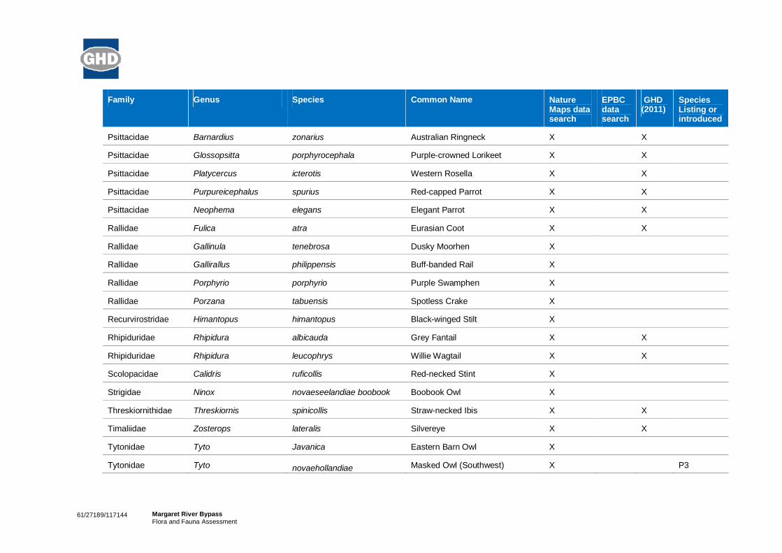
61/27189/117144 Margaret River BypassFlora and Fauna Assessment
Family Genus Species Common Name NatureMaps datasearch
EPBCdatasearch
GHD(2011)
SpeciesListing orintroduced
Psittacidae Barnardius zonarius Australian Ringneck X X
Psittacidae Glossopsitta porphyrocephala Purple-crowned Lorikeet X X
Psittacidae Platycercus icterotis Western Rosella X X
Psittacidae Purpureicephalus spurius Red-capped Parrot X X
Psittacidae Neophema elegans Elegant Parrot X X
Rallidae Fulica atra Eurasian Coot X X
Rallidae Gallinula tenebrosa Dusky Moorhen X
Rallidae Gallirallus philippensis Buff-banded Rail X
Rallidae Porphyrio porphyrio Purple Swamphen X
Rallidae Porzana tabuensis Spotless Crake X
Recurvirostridae Himantopus himantopus Black-winged Stilt X
Rhipiduridae Rhipidura albicauda Grey Fantail X X
Rhipiduridae Rhipidura leucophrys Willie Wagtail X X
Scolopacidae Calidris ruficollis Red-necked Stint X
Strigidae Ninox novaeseelandiae boobook Boobook Owl X
Threskiornithidae Threskiornis spinicollis Straw-necked Ibis X X
Timaliidae Zosterops lateralis Silvereye X X
Tytonidae Tyto Javanica Eastern Barn Owl X
Tytonidae Tyto novaehollandiae Masked Owl (Southwest) X P3

61/27189/117144 Margaret River BypassFlora and Fauna Assessment
Family Genus Species Common Name NatureMaps datasearch
EPBCdatasearch
GHD(2011)
SpeciesListing orintroduced
novaehollandiae
Reptiles
Elapidae Echiopsis curta Bardick X
Elapidae Notechis scutatus Tiger Snake X
Elapidae Pseudonaja affinis affinis Dugite X
Gekkonidae Christinus marmoratus Marbled Gecko X
Scincidae Acritoscincus trilineatum Cool Skink X
Scincidae Ctenotus impar Odd-striped Ctenotus X
Scincidae Ctenotus labillardieri Red-legged skink X
Scincidae Cryptoblephorus buchanani Buchanan's Snake-eyed Skink X X
Scincidae Egernia kingii King Skink X X
Scincidae Egernia napoleonis Napoleon Skink X
Scincidae Hemiergis peronii tridactyla Three-toed Earless Skink X X
Scincidae Lerista distinguenda South-west Four-toed Lerista X
Scincidae Lerista elegans West Coast Four-toed Lerista X
Scincidae Lerista microtis microtis Micro Lerista X
Scincidae Menetia greyii Common Dwarf Skink X X
Scincidae Morethia lineocellata Western Pale-flecked Skink X
Scincidae Morethia obscura Southern Pale-flecked Morethia X X

61/27189/117144 Margaret River BypassFlora and Fauna Assessment
Family Genus Species Common Name NatureMaps datasearch
EPBCdatasearch
GHD(2011)
SpeciesListing orintroduced
Scincidae Tiliqua rugosa rugosa Bobtail X
Pygopodidae Lialis burtonis Burton's Legless Lizard X
Pygopodidae Pygopus lepidopodus Common Scaly Foot X
Typhlopidae Ramphotyphlops australis Common Blindsnake X
Varanidae Varanus rosenbergi Heath Monitor X X
Amphibians
Hylidae Litoria adelaidensis Slender Tree Frog X
Hylidae Litoria moorei Motorbike Frog X X
Limnodynastidae Heleioporus eyrei Moaning Frog X
Limnodynastidae Limnodynastes dorsalis Pobblebonk X
Myobatrachidae Crinia georgiana Quacking Frog X
Myobatrachidae Crinia glauerti Gleuert's Froglet X X
Myobatrachidae Crinia pseudinsignifera Bleating Froglet X
Myobatrachidae Geocrinia alba White-bellied Frog X En, CR, S1
Myobatrachidae Geocrinia leai Ticking Frog X
Mammals
Burramyidae Cercartetus concinnus Western Pigmy Possum X
Canidae Vulpes vulpes Fox X #
Dasyuridae Dasyurus geoffroii Chuditch X X Vu,S1

61/27189/117144 Margaret River BypassFlora and Fauna Assessment
Family Genus Species Common Name NatureMaps datasearch
EPBCdatasearch
GHD(2011)
SpeciesListing orintroduced
Dasyuridae Phascogale tapoatafa tapoatafa Southern Brush-tailed Phascogale X X Vu,S1
Dasyuridae Sminthopsis dolichura Little Long-tailed Dunnart X
Dasyuridae Sminthopsis gilberti Gilbert's Dunnart X
Dasyuridae Sminthopsis griseoventer griseoventer Grey-bellied Dunnart X
Felidae Felis catus Cat X #
Leporidae Oryctolagus cuniculus European Rabbit X #
Macropodidae Macropus fuliginosus Western Grey Kangaroo X
Macropodidae Macropus irma Western Brush Wallaby X P4
Macropodidae Setonix brachyurus Quokka X Vu, S1
Molossidae Mormopterus sp. 4 (ex M. planiceps, SWform)
X
Molossidae Tadarida australis White-striped Freetail Bat X
Muridae Hydromys chrysogaster Water-rat X P4
Muridae Rattus fuscipes Western Bush Rat X
Muridae Rattus rattus Black Rat X #
Peremelidae Isoodon obesulus Southern Brown Bandicoot X X P5
Phalangeridae Trichosaurus vulpecula vulpecula Common Brushtail Possum X X
Potoroidae Potorous platyops Broad-faced Potoroo X Extinct
Pseudocheiridae Pseudocheirus occidentalis Western Ringtail Possum X X Vu, S1

61/27189/117144 Margaret River BypassFlora and Fauna Assessment
Family Genus Species Common Name NatureMaps datasearch
EPBCdatasearch
GHD(2011)
SpeciesListing orintroduced
Tachyglossidae Tachyglossus aculeatus Echidna X
Vespertilionidae Chalinolobus gouldii Gould's Wattle Bat X
Vespertilionidae Chalinolobus morio Chocolate Wattled Bat X
Vespertilionidae Nyctophilus timoriensis timoriensis Greater Long-eared Bat X
Vespertilionidae Vespadelus regulus Southern Forest Bat X X
Fish
Percichthyidae Nannatherina balstoni Balston's Pygmy Perch X Vu, S1
Petromyzontidae Geotria australis Pouched Lamprey X P1
Crustaceans
Parastacidae Cherax tenuimanus Margaret River Marron X X Cr, En, S1
Invertebrates
Chloropidae Chloromerus maculifemur X
Hesperiidae Anisynta sphenosema Wedge Grass-skipper X
Anobiidae Anobium punctatum Common Furniture Beetle X #
Lymexylidae Atractocerus kreuslerae Eucalypt Pinworm X
Gomphidae Austrogomphus lateralis Lilac Hunter (Dragonfly) X
Lygaeidae Austronysius sericus X
Bostrichidae Xylopsocus rubidus Powderpost Beetle X
Ephydridae Ephydrella acrostichalis X

61/27189/117144 Margaret River BypassFlora and Fauna Assessment
Family Genus Species Common Name NatureMaps datasearch
EPBCdatasearch
GHD(2011)
SpeciesListing orintroduced
Curculionidae Euomus insculptus X
Blattellidae Hensaussurea sheardi X
Pentatomidae Homalictus urbanus Emerald Homalictus Bee X
Leptoceridae Lectrides parilis Long-horn Caddisflies X
Pergidae Lophyrotoma analis Ironbark Sawfly X
X Species observed or identified
# Introduced Species
Cr Critically Endangered – EPBC Act
En Endangered– EPBC Act
Vu Vulnerable– EPBC Act
S1 Schedule 1 – WC Act
S4 Schedule 4 – WC Act
P1 to 5 Priority Fauna Species – DEC

61/27189/117144 Margaret River BypassFlora and Fauna Assessment
Appendix E
Likelihood of Occurrence

61/27189/117144 Margaret River BypassFlora and Fauna Assessment
Table 13 Likelihood of occurrence assessment for Threatened and Priority Flora species with potential to occur within the studyarea.
Species Details and Habitat EPBCConservation Code
DECConservationCode
Likelihood
Caladenia excelsa
Giant Spider-orchid
Giant Spider-orchid is distributed along the Leeuwin NaturalisteRidge between Yallingup and Karridale, Western Australia. Thespecies occurs within the South West Natural ResourceManagement Region. The total known population size is 257plants across 26 small fragmented sub-populations.
Grows on hilltops, slopes, swales and low plains in deep paleyellow, white, grey sandy soils and is found among low shrubs inBanksia, Jarrah and Marri woodlands.
Endangered Threatened May Occur
Suitable habitatpresent
Caladenia lodgeana Tuberous, perennial, herb. Fl. white, Oct. Black loam.Distribution: South-west. WAR.
Endangered Threatened May Occur
Suitable habitatand previouslyrecorded in theregion
Caladenia hoffmanii
Hoffman’s Spider-orchid
Hoffman’s Spider-orchid is endemic to Western Australia and isknown from 10 populations within the Narrogin District and theGeraldton–Kalbarri District.
There is also a disjunct occurrence of this species some 600 kmto the south-east where it occurs in the Pingaring area, growingaround large granite outcrops under tall shrubs with low heathand in woodlands. Associated species included Jam (Acaciaacuminata), Large-flowered Melaleuca (Melaleucamegacephala), Pine Grevillea (Grevillea pinaster) and
Endangered Threatened Unlikely
No suitable habitatand not known tooccur in the region

61/27189/117144 Margaret River BypassFlora and Fauna Assessment
Species Details and Habitat EPBCConservation Code
DECConservationCode
Likelihood
thryptomenes (Thryptomene spp.)
This species occurs within the Northern Agricultural (WesternAustralia) Natural Resource Management Region.
Caladenia winfieldii
Majestic Spider-orchid
Caladenia winfieldii grows in grey sandy loam, rich in humus,along seasonal creeks. The associated vegetation is lowwoodland, comprising Eucalyptus rudis, Melaleuca preissianaand Banksia littoralis over scrub and herbs. The species is oftenfound growing at the base of and in the skirts of Xanthorrhoeapreissii.
Caladenia winfieldii is known from just one population (twosubpopulations) south-east of Manjimup in DEC’s DonnellyDistrict.
Endangered Threatened Unlikely
No suitable habitatand not known tooccur in the region
Centrolepis caespitosa
Matted Centrolepis
Centrolepis caespitosa occurs in winter-wet clay pans dominatedby low shrubs and sedges. Very little is known about it as it isvery small and inconspicuous and, being an annual herb, diesover summer. Eight populations are known over a largegeographical range from the South Coast near Denmark, northto the Swan Coastal Plain and east to Meckering. Due to itsinconspicuous nature, the taxon is difficult to locate and thepossibility of finding more populations is highly unlikely unlessthe species is specifically targeted for survey.
Endangered Priority 4 Unlikely
Not known to occurwithin 5 km of thestudy area
Sphenotomadrummondii
Mountain paper-heath
Known from scattered populations in WA’s Albany District.Grows on skeletal peat soil and on shallow soil over schistquartzite and granite. It is frequently found in pockets of soil oncliff faces or under cliff overhangs, and is associated withMountain Kunzea (Kunzea montana) and Thick-stemmedBottlebrush (Calothamnus crassus). This species occurs within
Endangered Threatened Unlikely
Not known to occurwithin 5 km of thestudy area
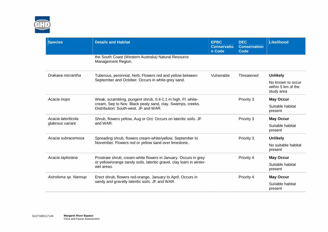
61/27189/117144 Margaret River BypassFlora and Fauna Assessment
Species Details and Habitat EPBCConservation Code
DECConservationCode
Likelihood
the South Coast (Western Australia) Natural ResourceManagement Region.
Drakaea micrantha Tuberous, perennial, herb. Flowers red and yellow betweenSeptember and October. Occurs in white-grey sand.
Vulnerable Threatened Unlikely
No known to occurwithin 5 km of thestudy area
Acacia inops Weak, scrambling, pungent shrub, 0.4-1.1 m high. Fl. white-cream, Sep to Nov. Black peaty sand, clay. Swamps, creeks.Distribution: South-west. JF and WAR.
Priority 3 May Occur
Suitable habitatpresent
Acacia lateriticolaglabrous variant
Shrub, flowers yellow, Aug or Oct. Occurs on lateritic soils. JFand WAR.
Priority 3 May Occur
Suitable habitatpresent
Acacia subracemosa Spreading shrub, flowers cream-white/yellow, September toNovember. Flowers red or yellow sand over limestone.
Priority 3 Unlikely
No suitable habitatpresent
Acacia tayloriana Prostrate shrub, cream-white flowers in January. Occurs in greyor yellow/orange sandy soils, lateritic gravel, clay loam in winter-wet areas.
Priority 4 May Occur
Suitable habitatpresent
Astroloma sp. Nannup Erect shrub, flowers red-orange, January to April. Occurs insandy and gravelly lateritic soils. JF and WAR.
Priority 4 May Occur
Suitable habitatpresent

61/27189/117144 Margaret River BypassFlora and Fauna Assessment
Species Details and Habitat EPBCConservation Code
DECConservationCode
Likelihood
Boronia anceps Perennial herb, lacking lignotuber, stem flattened and ancipitouswhen young. Flowers pink/pink-purple, September to Decemberor January. Occurs on white sand, gravelly laterite on seasonallyswampy heaths. JF and WAR.
Priority 3 Unlikely
Suitable habitatlimited
Boronia capitata gracilis Slender shrub, branches pilose. Flowers pink between June toNovember. Occurs in white/grey or black sand in winter-wetswamps, hillslopes.
Priority 3 May Occur
Suitable habitatpresent
Boronia tetragona Perennial, herb, leaves sessile, entire, with papillate margins,branches quadrangular, sepals ciliate. Flowers pink and red,October to December. Occurs in black/white sand, laterite,brown sandy loam in winter-wet flats, swamps and openwoodland. JF and SWA.
Priority 3 May Occur
Suitable habitatpresent
Bossiaea disticha Erect or straggly to spreading shrub, 0.1-1.5 m high. Fl. yellow &brown/red, Sep to Nov. Sandy soils over limestone. Distribution:South-west. WAR.
Priority 3 Unlikely
No suitable habitatpresent
Caladenia abbreviata Tuberous, perennial, herb. Flowers yellow and brown Novemberto December. Occurs in sand on sand dunes.
Priority 3 Unlikely
No suitable habitatpresent
Conospermumpaniculatum
Spreading, open shrub, flowers blue-white in July-November.Occurs in sandy or clayey soils in swampy areas, plains andslopes. JF, SWA and WAR.
Priority 3 May Occur
Suitable habitatpresent
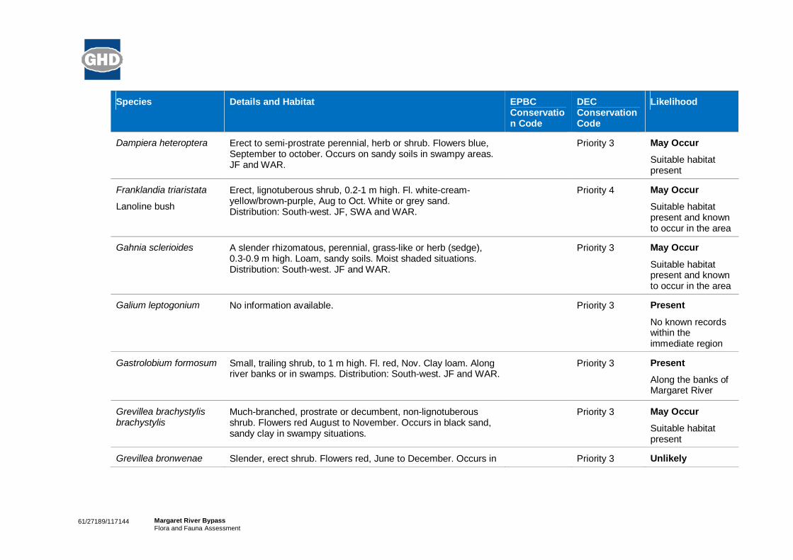
61/27189/117144 Margaret River BypassFlora and Fauna Assessment
Species Details and Habitat EPBCConservation Code
DECConservationCode
Likelihood
Dampiera heteroptera Erect to semi-prostrate perennial, herb or shrub. Flowers blue,September to october. Occurs on sandy soils in swampy areas.JF and WAR.
Priority 3 May Occur
Suitable habitatpresent
Franklandia triaristata
Lanoline bush
Erect, lignotuberous shrub, 0.2-1 m high. Fl. white-cream-yellow/brown-purple, Aug to Oct. White or grey sand.Distribution: South-west. JF, SWA and WAR.
Priority 4 May Occur
Suitable habitatpresent and knownto occur in the area
Gahnia sclerioides A slender rhizomatous, perennial, grass-like or herb (sedge),0.3-0.9 m high. Loam, sandy soils. Moist shaded situations.Distribution: South-west. JF and WAR.
Priority 3 May Occur
Suitable habitatpresent and knownto occur in the area
Galium leptogonium No information available. Priority 3 Present
No known recordswithin theimmediate region
Gastrolobium formosum Small, trailing shrub, to 1 m high. Fl. red, Nov. Clay loam. Alongriver banks or in swamps. Distribution: South-west. JF and WAR.
Priority 3 Present
Along the banks ofMargaret River
Grevillea brachystylisbrachystylis
Much-branched, prostrate or decumbent, non-lignotuberousshrub. Flowers red August to November. Occurs in black sand,sandy clay in swampy situations.
Priority 3 May Occur
Suitable habitatpresent
Grevillea bronwenae Slender, erect shrub. Flowers red, June to December. Occurs in Priority 3 Unlikely

61/27189/117144 Margaret River BypassFlora and Fauna Assessment
Species Details and Habitat EPBCConservation Code
DECConservationCode
Likelihood
grey sand over laterite, lateritic loam on hillslopes amongst tall(sclerophyll) shrubland, or low (sclerophyll) shrubland; in sand;occupying heathlands. SWA and JF.
No suitable habitatpresent
Hemigenia rigida Very poorly known. Prostrate shrub, leaves flat/open, pedicleslonger then in H. pritzelii (10 mm or more), bracyeoles large,lanceolate and wrapping around calyx, calyx relatively large andstrongly 2-lipped but lobes relatively long and acute. Only knownfrom two collections near Wagin.
Priority 1 Unlikely
Not known from theregion
Hybanthus volubilis Twining perennial, herb. Flowers blue-purple-white, Septemberto December. Occurs in clay or sand clay on river banks. JF andWAR.
Priority 2 May Occur
Suitable habitatpresent
Hypocalymmacordifolium minus
Slender, decumbent shrub forming entangled masses. Flowerswhite/pink from September to December. Occurs in peaty sand,grey sand, damp sites and swamps. JF and WAR.
Priority 4 May Occur
Suitable habitatpresent
Juncus meianthus Tufted perennial, herb, 0.05-0.2 m high, to 0.4 m wide. Fl.brown, Nov to Dec or Jan. Black sand, sandy clay. Creeks,seepage areas. Distribution: South-west. JF and WAR.
Priority 2 May Occur
Suitable habitatpresent
Lambertia rariflorarariflora
Small tree or shrub to 7 m tall. Flowers green/yellow-greenFebruary to March or May. Occurs in red-brown clay soils, blackorganic loam, laterite, near intermittent streams. JF and WAR.
Priority 4 May Occur
Suitable habitatpresent
Leptomeria furtiva Lax, sprawling shrub, flowers orange/brown, Agust to october.Occurs in grey or black peaty sand in winter-wet flats. JF, SWAand WAR.
Priority 2 May Occur
Suitable habitatpresent

61/27189/117144 Margaret River BypassFlora and Fauna Assessment
Species Details and Habitat EPBCConservation Code
DECConservationCode
Likelihood
Meeboldina thysanantha Rhizomatous, perennial, herb (rush-like), 0.4-1 m high. Flowersbrown, December. Occurs in sand in swamps. JF, SWA, WAR.
Priority 3 May Occur
Suitable habitatpresent
Pimelea cilata longituba Erect shrub, flowers pink October to December. Occurs in greysand over clay, loam. JF, SWA and WAR.
Priority 3 May Occur
Suitable habitatpresent
Pultenaea pinifolia Erect, slender shrub, 1-3 m high. Fl. yellow-orange, Oct to Nov.Loam or clay. Floodplains, swampy areas. Distribution: South-west. JF, SWA and WAR.
Priority 3 May Occur
Suitable habitatpresent
Thomasia laxiflora Shrub, flowers pink-purple in October to November. Occurs ongravelly soils. JF and SWA.
Priority 3 May Occur
Suitable habitatpresent
Tripteroccusbrachylobus
Perennial herb to 1 m. Flowers yellow/yellow-green, Novemberto December or February. Occurs in grey sand, red clay, laterite,often moist in low-lying flats. JF, SWA and WAR
Priority 4 Unlikely
No known recordswithin 5 km of thestudy area.
Xyris maxima Robust, erect, tufted perennial, herb. Flowers yellow inNovember to December or January. Occurs in black peaty sandin drainage flats. JF.
Priority 2 Unlikely
Suitable habitatlimited

61/27189/117144 Margaret River BypassFlora and Fauna Assessment
Table 14 Likelihood of occurrence assessment for conservation significant fauna species.
Species Details and Habitat EPBCConservationCode
DECConservationCode
Likelihood
Botaurus poiciloptilus
Australasian Bittern
Favours permanent freshwater wetlands with tall, densevegetation, particularly bullrushes (Typha spp.) andspikerushes (Eleoacharis spp.). The species hides during theday amongst dense reeds or rushes and feed mainly at nighton frogs, fish, yabbies, spiders, insects and snails.
Feeding platforms may be constructed over deeper water fromreeds trampled by the bird; platforms are often littered withprey remains.
Endangered Schedule 1 Potential
This species hasbeen recorded in theregion.
Calyptorhynchusbanksii naso
Forest Red-tailedBlack Cockatoo
Inhabits the dense Eucalyptus marginata (Jarrah), E.diversicolor (Karri) and Corymbia calophylla (Marri) forestsreceiving more than 600 mm of annual average rainfall. Nestsin the large hollows of Marri, Jarrah and Karri.
Vulnerable Schedule Known
Species observed inthe project area
Calyptorhynchusbaudinii
Baudin’s BlackCockatoo
Nests in the hollows of mature Marri Corymbia calophylla,Karri Eucalyptus diversicolour and Jarrah E. marginata in thelower south-west. Mainly feeds on the seeds and flowers ofMarri in the forested regions of the south-west, the seeds ofthe Proteaceous Banksia grandis, B. littoralis, B. ilicifolia,Hakea undulata, H. prostrata, H. trifurcata, and Dryandra spp.,as well as Erodium botrys, Jarrah and insect larvae. Also feedson apple and pear seeds in orchards.
Vulnerable Schedule 1 Known
Species observed inthe project area
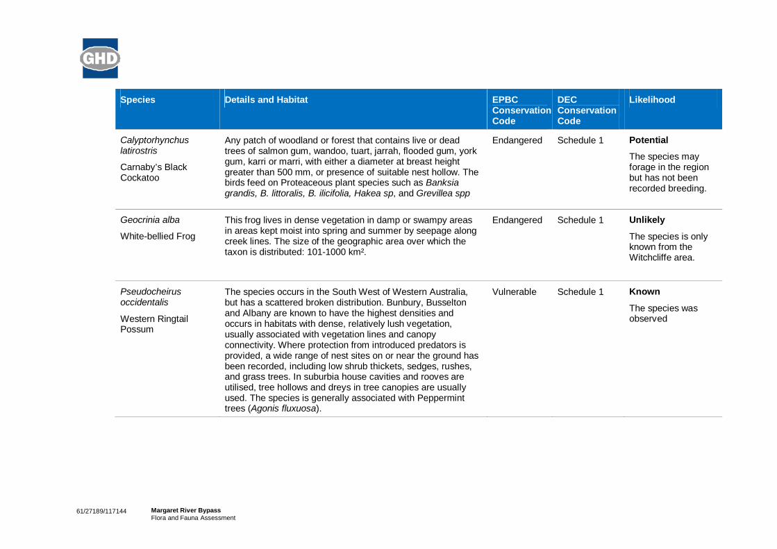
61/27189/117144 Margaret River BypassFlora and Fauna Assessment
Species Details and Habitat EPBCConservationCode
DECConservationCode
Likelihood
Calyptorhynchuslatirostris
Carnaby’s BlackCockatoo
Any patch of woodland or forest that contains live or deadtrees of salmon gum, wandoo, tuart, jarrah, flooded gum, yorkgum, karri or marri, with either a diameter at breast heightgreater than 500 mm, or presence of suitable nest hollow. Thebirds feed on Proteaceous plant species such as Banksiagrandis, B. littoralis, B. ilicifolia, Hakea sp, and Grevillea spp
Endangered Schedule 1 Potential
The species mayforage in the regionbut has not beenrecorded breeding.
Geocrinia alba
White-bellied Frog
This frog lives in dense vegetation in damp or swampy areasin areas kept moist into spring and summer by seepage alongcreek lines. The size of the geographic area over which thetaxon is distributed: 101-1000 km².
Endangered Schedule 1 Unlikely
The species is onlyknown from theWitchcliffe area.
Pseudocheirusoccidentalis
Western RingtailPossum
The species occurs in the South West of Western Australia,but has a scattered broken distribution. Bunbury, Busseltonand Albany are known to have the highest densities andoccurs in habitats with dense, relatively lush vegetation,usually associated with vegetation lines and canopyconnectivity. Where protection from introduced predators isprovided, a wide range of nest sites on or near the ground hasbeen recorded, including low shrub thickets, sedges, rushes,and grass trees. In suburbia house cavities and rooves areutilised, tree hollows and dreys in tree canopies are usuallyused. The species is generally associated with Pepperminttrees (Agonis fluxuosa).
Vulnerable Schedule 1 Known
The species wasobserved

61/27189/117144 Margaret River BypassFlora and Fauna Assessment
Species Details and Habitat EPBCConservationCode
DECConservationCode
Likelihood
Dasyurus geoffroii
Chuditch, WesternQuoll
Chuditch previously occupied habitat in a variety of climaticzones across Australia. Chuditch are now restricted to thesouth-west of Western Australia.The former range of Chuditch suggests that the speciesutilised a wide variety of habitats including dry schlerophyllforests, beaches and deserts. Chuditch currently inhabit mostkinds of wooded habitat within its current range includingeucalypt forest (especially Jarrah, Eucalyptus marginata), drywoodland and mallee shrublands. In Jarrah forest, Chuditchpopulations occur in both moist, densely vegetated, steeplysloping forest and drier, open, gently sloping forest. Thedensest populations of Chuditch have been found in riparianforest. Chuditch have never been recorded in pure Karri(Eucalyptus diversicolor) forest. Prior to the initiation of theEuropean Red Fox (Vulpes vulpes) control program, highestdensities of Chuditch were found in riparian (areas adjacent tolakes, rivers and wetlands) vegetation where food supply isbetter or more reliable, and the dense undergrowth mayprovide protection from predators. With the implementation ofthe Western Sheild (baiting), some Chuditch populations haverecovered.
Vulnerable Schedule 1 Potential
Habitat is present inthe area to support apopulation ofChuditch
Cherax tenuimanus
Margaret River Marron
Only occurs in the Margaret River in the south west of WesternAustralia. The species requires relatively good quality waterand a diversity of habitat structure (e.g. they generally prefersandy areas, particularly where organic matter accumulatesand access to shelter and refuge sites) and may struggle topersist in disturbed habitats.
CriticallyEndangered
Schedule 1 Unlikely
Although the speciesis found in MargaretRiver, recordsindicate it is onlyfound in inlandreaches beyondCane Break Pool.
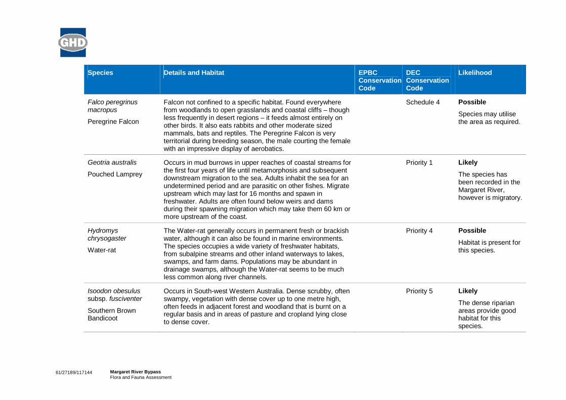
61/27189/117144 Margaret River BypassFlora and Fauna Assessment
Species Details and Habitat EPBCConservationCode
DECConservationCode
Likelihood
Falco peregrinusmacropus
Peregrine Falcon
Falcon not confined to a specific habitat. Found everywherefrom woodlands to open grasslands and coastal cliffs – thoughless frequently in desert regions – it feeds almost entirely onother birds. It also eats rabbits and other moderate sizedmammals, bats and reptiles. The Peregrine Falcon is veryterritorial during breeding season, the male courting the femalewith an impressive display of aerobatics.
Schedule 4 Possible
Species may utilisethe area as required.
Geotria australis
Pouched Lamprey
Occurs in mud burrows in upper reaches of coastal streams forthe first four years of life until metamorphosis and subsequentdownstream migration to the sea. Adults inhabit the sea for anundetermined period and are parasitic on other fishes. Migrateupstream which may last for 16 months and spawn infreshwater. Adults are often found below weirs and damsduring their spawning migration which may take them 60 km ormore upstream of the coast.
Priority 1 Likely
The species hasbeen recorded in theMargaret River,however is migratory.
Hydromyschrysogaster
Water-rat
The Water-rat generally occurs in permanent fresh or brackishwater, although it can also be found in marine environments.The species occupies a wide variety of freshwater habitats,from subalpine streams and other inland waterways to lakes,swamps, and farm dams. Populations may be abundant indrainage swamps, although the Water-rat seems to be muchless common along river channels.
Priority 4 Possible
Habitat is present forthis species.
Isoodon obesulussubsp. fusciventer
Southern BrownBandicoot
Occurs in South-west Western Australia. Dense scrubby, oftenswampy, vegetation with dense cover up to one metre high,often feeds in adjacent forest and woodland that is burnt on aregular basis and in areas of pasture and cropland lying closeto dense cover.
Priority 5 Likely
The dense riparianareas provide goodhabitat for thisspecies.
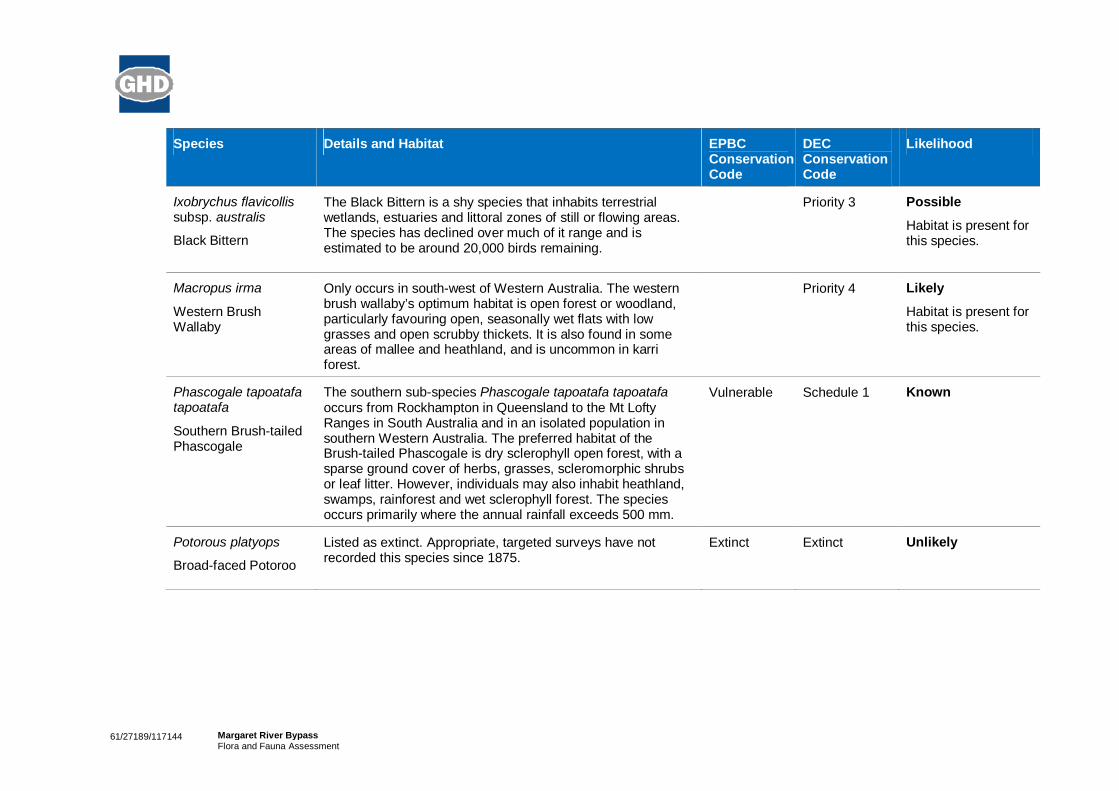
61/27189/117144 Margaret River BypassFlora and Fauna Assessment
Species Details and Habitat EPBCConservationCode
DECConservationCode
Likelihood
Ixobrychus flavicollissubsp. australis
Black Bittern
The Black Bittern is a shy species that inhabits terrestrialwetlands, estuaries and littoral zones of still or flowing areas.The species has declined over much of it range and isestimated to be around 20,000 birds remaining.
Priority 3 Possible
Habitat is present forthis species.
Macropus irma
Western BrushWallaby
Only occurs in south-west of Western Australia. The westernbrush wallaby’s optimum habitat is open forest or woodland,particularly favouring open, seasonally wet flats with lowgrasses and open scrubby thickets. It is also found in someareas of mallee and heathland, and is uncommon in karriforest.
Priority 4 Likely
Habitat is present forthis species.
Phascogale tapoatafatapoatafa
Southern Brush-tailedPhascogale
The southern sub-species Phascogale tapoatafa tapoatafaoccurs from Rockhampton in Queensland to the Mt LoftyRanges in South Australia and in an isolated population insouthern Western Australia. The preferred habitat of theBrush-tailed Phascogale is dry sclerophyll open forest, with asparse ground cover of herbs, grasses, scleromorphic shrubsor leaf litter. However, individuals may also inhabit heathland,swamps, rainforest and wet sclerophyll forest. The speciesoccurs primarily where the annual rainfall exceeds 500 mm.
Vulnerable Schedule 1 Known
Potorous platyops
Broad-faced Potoroo
Listed as extinct. Appropriate, targeted surveys have notrecorded this species since 1875.
Extinct Extinct Unlikely

61/27189/117144 Margaret River BypassFlora and Fauna Assessment
Species Details and Habitat EPBCConservationCode
DECConservationCode
Likelihood
Setonix brachyurus
Quokka
The mainland quokka lives in the Darling Range and south-west regions of Western Australia, mostly inhabiting denselyvegetated swamps and sometimes tea-tree thickets on sandysoils along creek systems and dense heath on slopes.
Vulnerable Schedule 1 Unlikely
Although somehabitat is present it isnot extensive
Tyto novaehollandiaenovaehollandiae
Australian MaskedOwl
The Masked Owl inhabits forests, woodlands, timberedwaterways and open country on the fringe of these areas. Themain requirements are tall trees with suitable hollows fornesting and roosting and adjacent areas for foraging. MaskedOwls are territorial, and pairs remain in or near the territory allyear round.
Priority 3 Possible
Habitat is present forthis species.
Nannatherina balstoni
Balston’s PygmyPerch
Balston's Pygmy Perch is known from a small area of coastalpeat flats in south-western Western Australia that extends fromMargaret River to Two Peoples Bay. Two additionalpopulations have recently been found to the north of this areain the Collie River and the Moore River. In winter and springBalston’s Pygmy Perch is typically found among inundatedriparian vegetation where it presumably feeds and spawns.Larvae of Balston’s Pygmy Perch feed predominantly oncladocerans, while terrestrial fauna (arachnids, adulthymenopterans, coleopterans and dipterans) are the mainprey item of adult fish. In summer, Balston’s Pygmy Perch hasbeen found to be moderately abundant in pools and creeksthat often dry up, such as those found between Windy Harbourand Walpole.
Vulnerable Schedule 1 Unlikely
The species isknown to persist inMargaret River but inthe upper reaches


56 | GHD | Report for Main Roads Western Australia - Margaret River Perimeter Road, 61/27189
Site visit results


GHD | Report for Main Roads Western Australia - Margaret River Perimeter Road, 61/27189 |
2012 Naturemap and PMST database results

Page 1
NatureMap Species Report
Created By Guest user on 13/11/2012
Kingdom Method Centre Buffer
Plantae 'By Circle' 115°04' 50'' E,33°56' 58'' S 5km
Name ID Species Name Naturalised Conservation Code 1Endemic To QueryArea
1. 18285 Acacia baileyana Y
2. 3233 Acacia barbinervis
3. 3247 Acacia browniana
4. 11731 Acacia browniana var. browniana
5. 3307 Acacia divergens
6. 3347 Acacia gilbertii
7. 3386 Acacia inops P3
8. 3410 Acacia lateriticola
9. 3424 Acacia littorea
10. 3448 Acacia mooreana
11. 3453 Acacia myrtifolia
12. 3454 Acacia nervosa (Rib Wattle)
13. 15481 Acacia pulchella var. glaberrima
14. 30036 Acacia saligna subsp. stolonifera
15. 3591 Acacia urophylla
16. 15487 Acacia varia var. varia
17. 17774 Acetosella vulgaris Y
18. 1573 Acianthus reniformis (Mosquito Orchid)
19. 25 Adiantum aethiopicum (Common Maidenhair)
20. 5316 Agonis flexuosa (Peppermint)
21. 17202 Agonis flexuosa var. flexuosa
22. 23474 Agrostocrinum hirsutum
23. 184 Aira caryophyllea (Silvery Hairgrass) Y
24. 1489 Amaryllis belladonna (Belladonna Lily) Y
25. 13101 Amperea simulans
26. 1063 Anarthria scabra
27. 6317 Andersonia micrantha
28. 1407 Anigozanthos flavidus (Tall Kangaroo Paw)
29. 1409 Anigozanthos humilis (Catspaw)
30. 202 Anthoxanthum odoratum (Sweet Vernal Grass) Y
31. 3686 Aotus cordifolia
32. 11399 Apium prostratum var. filiforme
33. 8779 Asparagus asparagoides (Bridal Creeper) Y
34. 20249 Astartea leptophylla
35. 7851 Asteridea pulverulenta (Common Bristle Daisy)
36. 18279 Babiana angustifolia Y
37. 32616 Banksia dallanneyi subsp. sylvestris
38. 1819 Banksia grandis (Bull Banksia)
39. 1837 Banksia occidentalis (Red Swamp Banksia)
40. 1848 Banksia seminuda (River Banksia)
41. 743 Baumea juncea (Bare Twigrush)
42. 3157 Billardiera floribunda (White-flowered Billardiera)
43. 25798 Billardiera fusiformis (Australian Bluebell)
44. 3159 Billardiera laxiflora
45. 3165 Billardiera variifolia
46. 4403 Boronia alata (Winged Boronia)
47. 29274 Boronia crenulata subsp. crenulata
48. 17653 Boronia crenulata subsp. pubescens
49. 11503 Boronia crenulata var. crenulata
50. 4415 Boronia defoliata
51. 4417 Boronia dichotoma
52. 4422 Boronia gracilipes (Karri Boronia)
53. 4428 Boronia megastigma (Scented Boronia)
54. 4429 Boronia molloyae (Tall Boronia)
NatureMap is a collaborative project of the Department of Environment and Conservation, Western Australia, and the Western Australian Museum.

Page 2
Name ID Species Name Naturalised Conservation Code 1Endemic To QueryArea
55. 20392 Boronia tenuior
56. 1267 Borya constricta
57. 3708 Bossiaea disticha P4
58. 3713 Bossiaea linophylla
59. 3714 Bossiaea ornata (Broad Leaved Brown Pea)
60. 244 Briza maxima (Blowfly Grass) Y
61. 245 Briza minor (Shivery Grass) Y
62. 249 Bromus diandrus (Great Brome) Y
63. 12770 Burchardia congesta
64. 1385 Burchardia multiflora (Dwarf Burchardia)
65. 1276 Caesia micrantha (Pale Grass-lily)
66. 1277 Caesia occidentalis
67. 13853 Caladenia arrecta
68. 15332 Caladenia attingens subsp. attingens
69. 15341 Caladenia citrina
70. 1581 Caladenia corynephora
71. 13619 Caladenia excelsa T
72. 1590 Caladenia ferruginea (Rusty Spider Orchid)
73. 1592 Caladenia flava (Cowslip Orchid)
74. 15348 Caladenia flava subsp. flava
75. 1596 Caladenia huegelii (Grand Spider Orchid) T
76. 1597 Caladenia infundibularis
77. 18037 Caladenia lodgeana T
78. 15365 Caladenia longicauda subsp. longicauda
79. 15366 Caladenia longicauda subsp. merrittii
80. 1604 Caladenia macrostylis (Leaping Spider Orchid)
81. 1608 Caladenia nana (Pink Fan Orchid)
82. -6944 Caladenia paludosa x serotina
83. 18033 Caladenia pholcoidea subsp. pholcoidea
84. 1613 Caladenia reptans (Little Pink Fairy Orchid)
85. 1616 Caladenia sericea (Silky Blue Orchid)
86. 10861 Callistachys lanceolata (Wonnich)
87. 757 Carex preissii
88. 2952 Cassytha glabella (Tangled Dodder Laurel)
89. 11799 Cassytha racemosa forma racemosa
90. 41564 Cenchrus clandestinus (Kikuyu Grass) Y
91. 18156 Chamaecytisus palmensis (Tagasaste) Y
92. 1513 Chasmanthe floribunda (African Cornflag) Y
93. 31 Cheilanthes austrotenuifolia
94. 4448 Chorilaena quercifolia (Chorilaena)
95. 3754 Chorizema diversifolium
96. 12765 Chorizema nanum
97. 3761 Chorizema rhombeum
98. 2929 Clematis pubescens (Common Clematis)
99. 4550 Comesperma calymega (Blue-spike Milkwort)
100. 4552 Comesperma confertum
101. 4564 Comesperma virgatum (Milkwort)
102. 1862 Conospermum caeruleum (Blue Brother)
103. 16854 Conospermum capitatum subsp. capitatum
104. 1418 Conostylis aculeata (Prickly Conostylis)
105. 11826 Conostylis aculeata subsp. aculeata
106. 20074 Conyza sumatrensis Y
107. 277 Cortaderia selloana (Pampas Grass) Y
108. 17104 Corymbia calophylla (Marri)
109. 18319 Cotoneaster glaucophyllus Y
110. 7952 Crepis capillaris (Smooth Hawksbeard) Y
111. 13484 Cryptandra arbutiflora var. tubulosa
112. 15404 Cyanicula sericea
113. 51 Cyathea cooperi Y
114. 783 Cyperus congestus (Dense Flat-sedge) Y
115. 792 Cyperus eragrostis (Umbrella Sedge) Y
116. 10964 Cyrtostylis robusta
117. 287 Dactylis glomerata (Cocksfoot) Y
118. 7420 Dampiera alata (Winged-stem Dampiera)
119. 7444 Dampiera hederacea (Karri Dampiera)
120. 7454 Dampiera linearis (Common Dampiera)
121. 7484 Dampiera trigona (Angled-stem Dampiera)
122. 1219 Dasypogon hookeri (Pineapple Bush)
123. 6964 Datura stramonium (Common Thornapple) Y
124. 6218 Daucus glochidiatus (Australian Carrot)
NatureMap is a collaborative project of the Department of Environment and Conservation, Western Australia, and the Western Australian Museum.
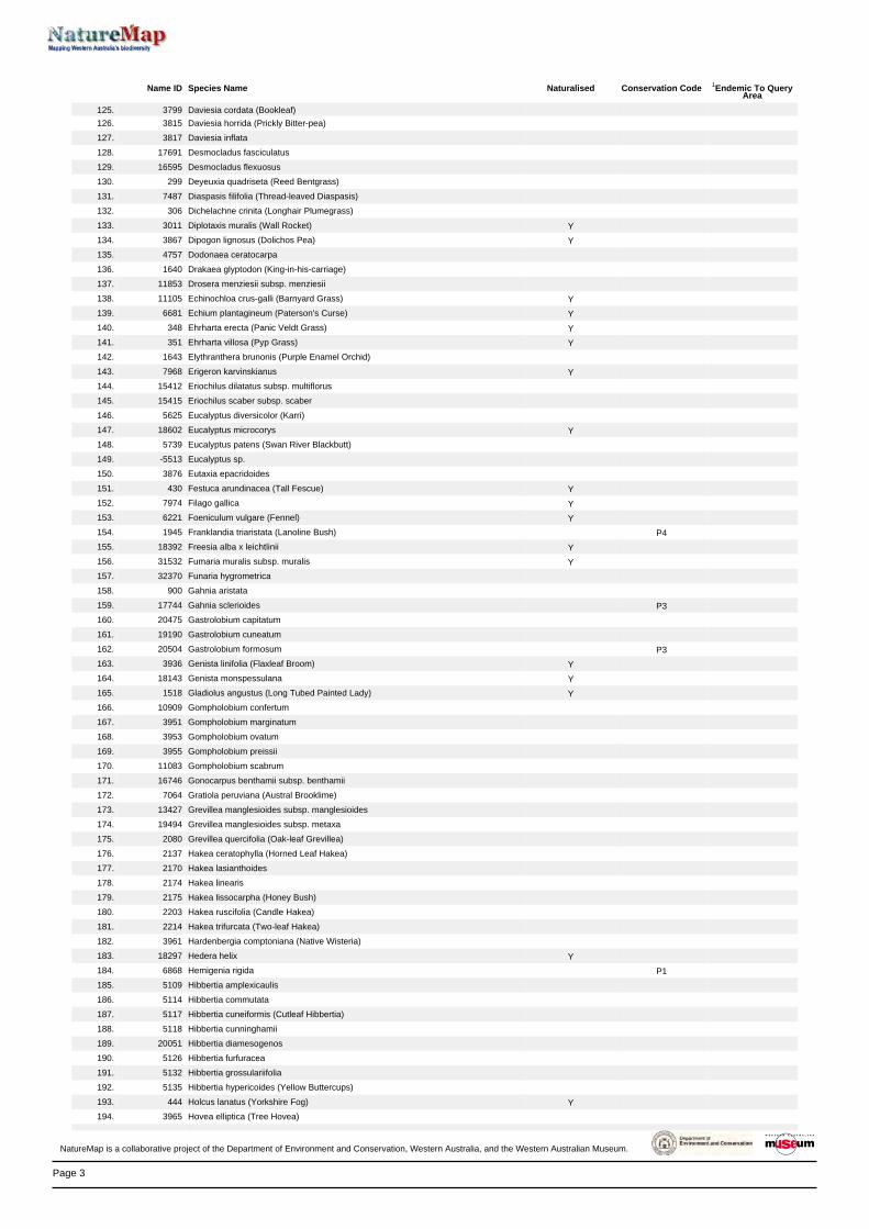
Page 3
Name ID Species Name Naturalised Conservation Code 1Endemic To QueryArea
125. 3799 Daviesia cordata (Bookleaf)
126. 3815 Daviesia horrida (Prickly Bitter-pea)
127. 3817 Daviesia inflata
128. 17691 Desmocladus fasciculatus
129. 16595 Desmocladus flexuosus
130. 299 Deyeuxia quadriseta (Reed Bentgrass)
131. 7487 Diaspasis filifolia (Thread-leaved Diaspasis)
132. 306 Dichelachne crinita (Longhair Plumegrass)
133. 3011 Diplotaxis muralis (Wall Rocket) Y
134. 3867 Dipogon lignosus (Dolichos Pea) Y
135. 4757 Dodonaea ceratocarpa
136. 1640 Drakaea glyptodon (King-in-his-carriage)
137. 11853 Drosera menziesii subsp. menziesii
138. 11105 Echinochloa crus-galli (Barnyard Grass) Y
139. 6681 Echium plantagineum (Paterson's Curse) Y
140. 348 Ehrharta erecta (Panic Veldt Grass) Y
141. 351 Ehrharta villosa (Pyp Grass) Y
142. 1643 Elythranthera brunonis (Purple Enamel Orchid)
143. 7968 Erigeron karvinskianus Y
144. 15412 Eriochilus dilatatus subsp. multiflorus
145. 15415 Eriochilus scaber subsp. scaber
146. 5625 Eucalyptus diversicolor (Karri)
147. 18602 Eucalyptus microcorys Y
148. 5739 Eucalyptus patens (Swan River Blackbutt)
149. -5513 Eucalyptus sp.
150. 3876 Eutaxia epacridoides
151. 430 Festuca arundinacea (Tall Fescue) Y
152. 7974 Filago gallica Y
153. 6221 Foeniculum vulgare (Fennel) Y
154. 1945 Franklandia triaristata (Lanoline Bush) P4
155. 18392 Freesia alba x leichtlinii Y
156. 31532 Fumaria muralis subsp. muralis Y
157. 32370 Funaria hygrometrica
158. 900 Gahnia aristata
159. 17744 Gahnia sclerioides P3
160. 20475 Gastrolobium capitatum
161. 19190 Gastrolobium cuneatum
162. 20504 Gastrolobium formosum P3
163. 3936 Genista linifolia (Flaxleaf Broom) Y
164. 18143 Genista monspessulana Y
165. 1518 Gladiolus angustus (Long Tubed Painted Lady) Y
166. 10909 Gompholobium confertum
167. 3951 Gompholobium marginatum
168. 3953 Gompholobium ovatum
169. 3955 Gompholobium preissii
170. 11083 Gompholobium scabrum
171. 16746 Gonocarpus benthamii subsp. benthamii
172. 7064 Gratiola peruviana (Austral Brooklime)
173. 13427 Grevillea manglesioides subsp. manglesioides
174. 19494 Grevillea manglesioides subsp. metaxa
175. 2080 Grevillea quercifolia (Oak-leaf Grevillea)
176. 2137 Hakea ceratophylla (Horned Leaf Hakea)
177. 2170 Hakea lasianthoides
178. 2174 Hakea linearis
179. 2175 Hakea lissocarpha (Honey Bush)
180. 2203 Hakea ruscifolia (Candle Hakea)
181. 2214 Hakea trifurcata (Two-leaf Hakea)
182. 3961 Hardenbergia comptoniana (Native Wisteria)
183. 18297 Hedera helix Y
184. 6868 Hemigenia rigida P1
185. 5109 Hibbertia amplexicaulis
186. 5114 Hibbertia commutata
187. 5117 Hibbertia cuneiformis (Cutleaf Hibbertia)
188. 5118 Hibbertia cunninghamii
189. 20051 Hibbertia diamesogenos
190. 5126 Hibbertia furfuracea
191. 5132 Hibbertia grossulariifolia
192. 5135 Hibbertia hypericoides (Yellow Buttercups)
193. 444 Holcus lanatus (Yorkshire Fog) Y
194. 3965 Hovea elliptica (Tree Hovea)
NatureMap is a collaborative project of the Department of Environment and Conservation, Western Australia, and the Western Australian Museum.
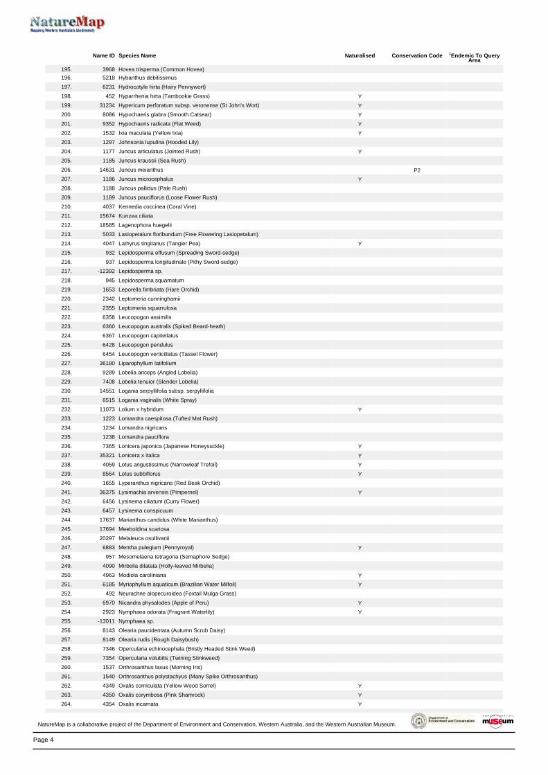
Page 4
Name ID Species Name Naturalised Conservation Code 1Endemic To QueryArea
195. 3968 Hovea trisperma (Common Hovea)
196. 5218 Hybanthus debilissimus
197. 6231 Hydrocotyle hirta (Hairy Pennywort)
198. 452 Hyparrhenia hirta (Tambookie Grass) Y
199. 31234 Hypericum perforatum subsp. veronense (St John's Wort) Y
200. 8086 Hypochaeris glabra (Smooth Catsear) Y
201. 9352 Hypochaeris radicata (Flat Weed) Y
202. 1532 Ixia maculata (Yellow Ixia) Y
203. 1297 Johnsonia lupulina (Hooded Lily)
204. 1177 Juncus articulatus (Jointed Rush) Y
205. 1185 Juncus kraussii (Sea Rush)
206. 14631 Juncus meianthus P2
207. 1186 Juncus microcephalus Y
208. 1188 Juncus pallidus (Pale Rush)
209. 1189 Juncus pauciflorus (Loose Flower Rush)
210. 4037 Kennedia coccinea (Coral Vine)
211. 15674 Kunzea ciliata
212. 18585 Lagenophora huegelii
213. 5033 Lasiopetalum floribundum (Free Flowering Lasiopetalum)
214. 4047 Lathyrus tingitanus (Tangier Pea) Y
215. 932 Lepidosperma effusum (Spreading Sword-sedge)
216. 937 Lepidosperma longitudinale (Pithy Sword-sedge)
217. -12392 Lepidosperma sp.
218. 945 Lepidosperma squamatum
219. 1653 Leporella fimbriata (Hare Orchid)
220. 2342 Leptomeria cunninghamii
221. 2355 Leptomeria squarrulosa
222. 6358 Leucopogon assimilis
223. 6360 Leucopogon australis (Spiked Beard-heath)
224. 6367 Leucopogon capitellatus
225. 6428 Leucopogon pendulus
226. 6454 Leucopogon verticillatus (Tassel Flower)
227. 36180 Liparophyllum latifolium
228. 9289 Lobelia anceps (Angled Lobelia)
229. 7408 Lobelia tenuior (Slender Lobelia)
230. 14551 Logania serpyllifolia subsp. serpyllifolia
231. 6515 Logania vaginalis (White Spray)
232. 11073 Lolium x hybridum Y
233. 1223 Lomandra caespitosa (Tufted Mat Rush)
234. 1234 Lomandra nigricans
235. 1238 Lomandra pauciflora
236. 7365 Lonicera japonica (Japanese Honeysuckle) Y
237. 35321 Lonicera x italica Y
238. 4059 Lotus angustissimus (Narrowleaf Trefoil) Y
239. 8564 Lotus subbiflorus Y
240. 1655 Lyperanthus nigricans (Red Beak Orchid)
241. 36375 Lysimachia arvensis (Pimpernel) Y
242. 6456 Lysinema ciliatum (Curry Flower)
243. 6457 Lysinema conspicuum
244. 17637 Marianthus candidus (White Marianthus)
245. 17694 Meeboldina scariosa
246. 20297 Melaleuca osullivanii
247. 6883 Mentha pulegium (Pennyroyal) Y
248. 957 Mesomelaena tetragona (Semaphore Sedge)
249. 4090 Mirbelia dilatata (Holly-leaved Mirbelia)
250. 4963 Modiola caroliniana Y
251. 6185 Myriophyllum aquaticum (Brazilian Water Milfoil) Y
252. 492 Neurachne alopecuroidea (Foxtail Mulga Grass)
253. 6970 Nicandra physalodes (Apple of Peru) Y
254. 2923 Nymphaea odorata (Fragrant Waterlily) Y
255. -13011 Nymphaea sp.
256. 8143 Olearia paucidentata (Autumn Scrub Daisy)
257. 8149 Olearia rudis (Rough Daisybush)
258. 7346 Opercularia echinocephala (Bristly Headed Stink Weed)
259. 7354 Opercularia volubilis (Twining Stinkweed)
260. 1537 Orthrosanthus laxus (Morning Iris)
261. 1540 Orthrosanthus polystachyus (Many Spike Orthrosanthus)
262. 4349 Oxalis corniculata (Yellow Wood Sorrel) Y
263. 4350 Oxalis corymbosa (Pink Shamrock) Y
264. 4354 Oxalis incarnata Y
NatureMap is a collaborative project of the Department of Environment and Conservation, Western Australia, and the Western Australian Museum.

Page 5
Name ID Species Name Naturalised Conservation Code 1Endemic To QueryArea
265. 4356 Oxalis pes-caprae (Soursob) Y
266. 13135 Ozothamnus ramosus
267. 3618 Paraserianthes lophantha (Albizia)
268. 17114 Paraserianthes lophantha subsp. lophantha
269. 7089 Parentucellia latifolia (Common Bartsia) Y
270. 11550 Patersonia umbrosa var. xanthina (Yellow Flags)
271. 6245 Pentapeltis peltigera
272. 2267 Persoonia longifolia (Snottygobble)
273. 2273 Persoonia saccata (Snottygobble)
274. 2293 Petrophile diversifolia
275. 20460 Pheladenia deformis
276. 1478 Phlebocarya ciliata
277. 4675 Phyllanthus calycinus (False Boronia)
278. 11928 Pimelea ciliata subsp. ciliata
279. 5239 Pimelea clavata
280. 5249 Pimelea hispida (Bristly Pimelea)
281. 18117 Pimelea rosea subsp. rosea
282. 5264 Pimelea spectabilis (Bunjong)
283. 12041 Pimelea suaveolens subsp. suaveolens (Tall Mulla Mulla)
284. 5269 Pimelea sylvestris
285. 88 Pinus radiata (Radiata Pine) Y
286. 16322 Pittosporum undulatum Y
287. 7303 Plantago lanceolata (Ribwort Plantain) Y
288. 6249 Platysace compressa (Tapeworm Plant)
289. 6259 Platysace tenuissima
290. 17016 Podalyria sericea Y
291. 86 Podocarpus drouynianus (Wild Plum)
292. 8395 Polygala myrtifolia (Myrtleleaf Milkwort) Y
293. 15424 Praecoxanthus aphyllus
294. 1680 Prasophyllum parvifolium (Autumn Leek Orchid)
295. -7537 Prasophyllum sp.
296. 1683 Prasophyllum triangulare (Dark Leek Orchid)
297. 1694 Pterostylis rogersii (Curled-tongue Shell Orchid)
298. 1698 Pterostylis vittata (Banded Greenhood)
299. 2742 Ptilotus manglesii (Pom Poms)
300. 20195 Pultenaea brachytropis
301. 4179 Pultenaea pinifolia P3
302. 32480 Racopilum cuspidigerum var. convolutaceum
303. 2932 Ranunculus colonorum (Common Buttercup)
304. 2933 Ranunculus muricatus (Sharp Buttercup) Y
305. 13300 Rhodanthe citrina
306. 4695 Ricinocarpos glaucus
307. 32425 Rosulabryum billarderi
308. 20506 Rubus anglocandicans Y
309. 20496 Rubus laudatus Y
310. 2430 Rumex brownii (Swamp Dock) Y
311. 40425 Rytidosperma caespitosum
312. 40426 Rytidosperma occidentale
313. 7602 Scaevola calliptera
314. 7613 Scaevola glandulifera (Viscid Hand-flower)
315. 7624 Scaevola microphylla (Small-leaved Scaevola)
316. 32433 Sematophyllum homomallum
317. -10902 Senecio sp.
318. 11803 Silene gallica var. quinquevulnera Y
319. 2911 Silene vulgaris (Bladder Campion) Y
320. 7022 Solanum nigrum (Black Berry Nightshade) Y
321. 8231 Sonchus oleraceus (Common Sowthistle) Y
322. 17551 Sphaerolobium drummondii
323. 4207 Sphaerolobium medium
324. 31952 Sphenotoma gracilis (Swamp Paper-heath)
325. 4828 Spyridium globulosum (Basket Bush)
326. 7696 Stylidium calcaratum (Book Triggerplant)
327. 7708 Stylidium crassifolium (Thick-leaved Triggerplant)
328. 7713 Stylidium dichotomum (Pins-and-needles)
329. 7719 Stylidium ecorne (Foot Triggerplant)
330. 19251 Stylidium eriopodum
331. 12590 Stylidium lowrieanum
332. 7787 Stylidium rhynchocarpum (Black-beaked Triggerplant)
333. -7839 Stylidium sp.
334. 7799 Stylidium spathulatum (Creamy Triggerplant)
NatureMap is a collaborative project of the Department of Environment and Conservation, Western Australia, and the Western Australian Museum.
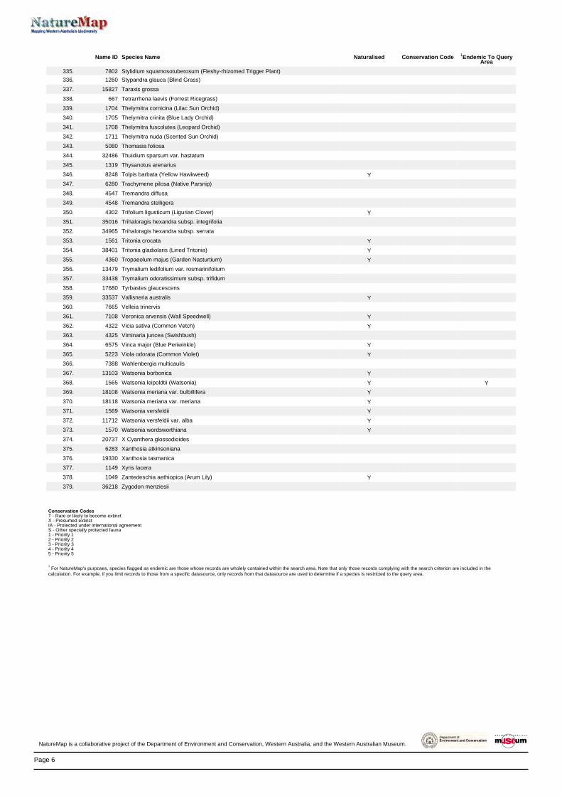
Page 6
Name ID Species Name Naturalised Conservation Code 1Endemic To QueryArea
335. 7802 Stylidium squamosotuberosum (Fleshy-rhizomed Trigger Plant)
336. 1260 Stypandra glauca (Blind Grass)
337. 15827 Taraxis grossa
338. 667 Tetrarrhena laevis (Forrest Ricegrass)
339. 1704 Thelymitra cornicina (Lilac Sun Orchid)
340. 1705 Thelymitra crinita (Blue Lady Orchid)
341. 1708 Thelymitra fuscolutea (Leopard Orchid)
342. 1711 Thelymitra nuda (Scented Sun Orchid)
343. 5080 Thomasia foliosa
344. 32486 Thuidium sparsum var. hastatum
345. 1319 Thysanotus arenarius
346. 8248 Tolpis barbata (Yellow Hawkweed) Y
347. 6280 Trachymene pilosa (Native Parsnip)
348. 4547 Tremandra diffusa
349. 4548 Tremandra stelligera
350. 4302 Trifolium ligusticum (Ligurian Clover) Y
351. 35016 Trihaloragis hexandra subsp. integrifolia
352. 34965 Trihaloragis hexandra subsp. serrata
353. 1561 Tritonia crocata Y
354. 38401 Tritonia gladiolaris (Lined Tritonia) Y
355. 4360 Tropaeolum majus (Garden Nasturtium) Y
356. 13479 Trymalium ledifolium var. rosmarinifolium
357. 33438 Trymalium odoratissimum subsp. trifidum
358. 17680 Tyrbastes glaucescens
359. 33537 Vallisneria australis Y
360. 7665 Velleia trinervis
361. 7108 Veronica arvensis (Wall Speedwell) Y
362. 4322 Vicia sativa (Common Vetch) Y
363. 4325 Viminaria juncea (Swishbush)
364. 6575 Vinca major (Blue Periwinkle) Y
365. 5223 Viola odorata (Common Violet) Y
366. 7388 Wahlenbergia multicaulis
367. 13103 Watsonia borbonica Y
368. 1565 Watsonia leipoldtii (Watsonia) Y Y
369. 18108 Watsonia meriana var. bulbillifera Y
370. 18118 Watsonia meriana var. meriana Y
371. 1569 Watsonia versfeldii Y
372. 11712 Watsonia versfeldii var. alba Y
373. 1570 Watsonia wordsworthiana Y
374. 20737 X Cyanthera glossodioides
375. 6283 Xanthosia atkinsoniana
376. 19330 Xanthosia tasmanica
377. 1149 Xyris lacera
378. 1049 Zantedeschia aethiopica (Arum Lily) Y
379. 36218 Zygodon menziesii
Conservation CodesT - Rare or likely to become extinctX - Presumed extinctIA - Protected under international agreementS - Other specially protected fauna1 - Priority 12 - Priority 23 - Priority 34 - Priority 45 - Priority 5
1 For NatureMap's purposes, species flagged as endemic are those whose records are wholely contained within the search area. Note that only those records complying with the search criterion are included in the
calculation. For example, if you limit records to those from a specific datasource, only records from that datasource are used to determine if a species is restricted to the query area.
NatureMap is a collaborative project of the Department of Environment and Conservation, Western Australia, and the Western Australian Museum.

Page 1
NatureMap Species Report
Created By Guest user on 14/11/2012
Kingdom Current Names Only
Method Centre Buffer
Group By
Animalia Yes 'By Circle' 115°04' 50'' E,33°56' 57'' S 5km Species Group
Species Group Species Records Amphibian 8 27 Bird 105 1475 Fish 1 3 Invertebrate 24 26 Mammal 15 50 Reptile 19 66 TOTAL 172 1647
Name ID Species Name Naturalised Conservation Code 1Endemic To QueryArea
Amphibian1. 25398 Crinia georgiana (Quacking Frog)
2. 25399 Crinia glauerti (Clicking Frog)
3. 25401 Crinia pseudinsignifera (Bleating Froglet)
4. 25404 Geocrinia leai (Ticking Frog)
5. 25410 Heleioporus eyrei (Moaning Frog)
6. 25415 Limnodynastes dorsalis (Western Banjo Frog)
7. 25378 Litoria adelaidensis (Slender Tree Frog)
8. 25388 Litoria moorei (Motorbike Frog)
Bird9. 24260 Acanthiza apicalis (Broad-tailed Thornbill)
10. 24261 Acanthiza chrysorrhoa (Yellow-rumped Thornbill)
11. 24262 Acanthiza inornata (Western Thornbill)
12. 24560 Acanthorhynchus superciliosus (Western Spinebill)
13. 25536 Accipiter fasciatus (Brown Goshawk)
14. 41323 Actitis hypoleucos (Common Sandpiper) IA
15. 24312 Anas gracilis (Grey Teal)
16. 24313 Anas platyrhynchos (Mallard)
17. 24316 Anas superciliosa (Pacific Black Duck)
18. 24561 Anthochaera carunculata (Red Wattlebird)
19. 24562 Anthochaera lunulata (Western Little Wattlebird)
20. 24285 Aquila audax (Wedge-tailed Eagle)
21. 24341 Ardea pacifica (White-necked Heron)
22. 25566 Artamus cinereus (Black-faced Woodswallow)
23. 24353 Artamus cyanopterus (Dusky Woodswallow)
24. 24357 Artamus superciliosus (White-browed Woodswallow)
25. 24319 Biziura lobata (Musk Duck)
26. 25713 Cacatua galerita (Sulphur-crested Cockatoo)
27. 25598 Cacomantis flabelliformis (Fan-tailed Cuckoo)
28. 24427 Cacomantis flabelliformis subsp. flabelliformis
29. 24788 Calidris ruficollis (Red-necked Stint) IA
30. 25717 Calyptorhynchus banksii (Red-tailed Black-Cockatoo)
31. 24733 Calyptorhynchus baudinii (Baudin's Cockatoo (long-billed black-cockatoo)) T
32. 24734 Calyptorhynchus latirostris (Carnaby's Cockatoo (short-billed black-cockatoo)) T
33. 24377 Charadrius ruficapillus (Red-capped Plover)
34. 24321 Chenonetta jubata (Australian Wood Duck)
35. 24432 Chrysococcyx lucidus subsp. plagosus
36. 24288 Circus approximans (Swamp Harrier)
37. 24396 Climacteris rufa (Rufous Treecreeper)
38. 25675 Colluricincla harmonica (Grey Shrike-thrush)
39. 25568 Coracina novaehollandiae (Black-faced Cuckoo-shrike)
40. 25592 Corvus coronoides (Australian Raven)
NatureMap is a collaborative project of the Department of Environment and Conservation, Western Australia, and the Western Australian Museum.

Page 2
Name ID Species Name Naturalised Conservation Code 1Endemic To QueryArea
41. 24417 Corvus coronoides subsp. perplexus
42. 24671 Coturnix pectoralis (Stubble Quail)
43. 25701 Coturnix ypsilophora (Brown Quail)
44. 25595 Cracticus tibicen (Australian Magpie)
45. 25596 Cracticus torquatus (Grey Butcherbird)
46. 24322 Cygnus atratus (Black Swan)
47. 30901 Dacelo novaeguineae (Laughing Kookaburra)
48. 25673 Daphoenositta chrysoptera (Varied Sittella)
49. 25607 Dicaeum hirundinaceum (Mistletoebird)
50. 24470 Dromaius novaehollandiae (Emu)
51. 24651 Eopsaltria australis subsp. griseogularis (Western Yellow Robin)
52. 24652 Eopsaltria georgiana (White-breasted Robin)
53. 24567 Epthianura albifrons (White-fronted Chat)
54. 25621 Falco berigora (Brown Falcon)
55. 25622 Falco cenchroides (Australian Kestrel)
56. 25624 Falco peregrinus (Peregrine Falcon) S
57. 24475 Falco peregrinus subsp. macropus (Australian Peregrine Falcon) S
58. 25677 Falcunculus frontatus (Crested Shrike-tit)
59. 25727 Fulica atra (Eurasian Coot)
60. 25729 Gallinula tenebrosa (Dusky Moorhen)
61. 25730 Gallirallus philippensis (Buff-banded Rail)
62. 25530 Gerygone fusca (Western Gerygone)
63. 24735 Glossopsitta porphyrocephala (Purple-crowned Lorikeet)
64. 24443 Grallina cyanoleuca (Magpie-lark)
65. 25627 Haematopus fuliginosus (Sooty Oystercatcher)
66. 24295 Haliastur sphenurus (Whistling Kite)
67. 25734 Himantopus himantopus (Black-winged Stilt)
68. 24491 Hirundo neoxena (Welcome Swallow)
69. 24347 Ixobrychus flavicollis subsp. australis (Australian Black Bittern) P3
70. 24511 Larus novaehollandiae subsp. novaehollandiae
71. 24581 Lichenostomus virescens (Singing Honeyeater)
72. 25661 Lichmera indistincta (Brown Honeyeater)
73. 25650 Malurus elegans (Red-winged Fairy-wren)
74. 25654 Malurus splendens (Splendid Fairy-wren)
75. 25663 Melithreptus brevirostris (Brown-headed Honeyeater)
76. 24598 Merops ornatus (Rainbow Bee-eater) IA
77. 25693 Microeca fascinans (Jacky Winter)
78. 25610 Myiagra inquieta (Restless Flycatcher)
79. 24738 Neophema elegans (Elegant Parrot)
80. 25748 Ninox novaeseelandiae (Boobook Owl)
81. 24820 Ninox novaeseelandiae subsp. boobook (Boobook Owl)
82. 24407 Ocyphaps lophotes (Crested Pigeon)
83. 25679 Pachycephala pectoralis (Golden Whistler)
84. 25680 Pachycephala rufiventris (Rufous Whistler)
85. 24299 Pandion haliaetus subsp. cristatus
86. 25681 Pardalotus punctatus (Spotted Pardalote)
87. 25682 Pardalotus striatus (Striated Pardalote)
88. 24648 Pelecanus conspicillatus (Australian Pelican)
89. 25697 Phalacrocorax carbo (Great Cormorant)
90. 24667 Phalacrocorax sulcirostris (Little Black Cormorant)
91. 25699 Phalacrocorax varius (Pied Cormorant)
92. 24409 Phaps chalcoptera (Common Bronzewing)
93. 25587 Phaps elegans (Brush Bronzewing)
94. 24596 Phylidonyris novaehollandiae (New Holland Honeyeater)
95. 25720 Platycercus icterotis (Western Rosella)
96. 24681 Poliocephalus poliocephalus (Hoary-headed Grebe)
97. 25731 Porphyrio porphyrio (Purple Swamphen)
98. 24771 Porzana tabuensis (Spotless Crake)
99. 25614 Rhipidura leucophrys (Willie Wagtail)
100. 25534 Sericornis frontalis (White-browed Scrubwren)
101. 24279 Sericornis frontalis subsp. maculatus
102. 24645 Stagonopleura oculata (Red-eared Firetail)
103. 24522 Sterna bergii (Crested Tern)
104. 24554 Stipiturus malachurus subsp. westernensis
105. 25597 Strepera versicolor (Grey Currawong)
106. 25590 Streptopelia senegalensis (Laughing Turtle-Dove)
107. 25705 Tachybaptus novaehollandiae (Australasian Grebe)
108. 24331 Tadorna tadornoides (Australian Shelduck)
109. 24845 Threskiornis spinicollis (Straw-necked Ibis)
110. 25549 Todiramphus sanctus (Sacred Kingfisher)
NatureMap is a collaborative project of the Department of Environment and Conservation, Western Australia, and the Western Australian Museum.

Page 3
Name ID Species Name Naturalised Conservation Code 1Endemic To QueryArea
111. 24855 Tyto novaehollandiae subsp. novaehollandiae (Masked Owl (southern subsp)) P3
112. 24386 Vanellus tricolor (Banded Lapwing)
113. 25765 Zosterops lateralis (Grey-breasted White-eye)
Fish114. 34030 Geotria australis (Pouched Lamprey) P1
Invertebrate115. Anisynta sphenosema
116. Anobium punctatum
117. Atractocerus kreuslerae
118. Austrogomphus lateralis
119. Austronysius sericus Y
120. 33940 Cherax tenuimanus (Margaret River Marron, Hairy Marron) T
121. Chloromerus maculifemur Y
122. Ephydrella acrostichalis Y
123. Euomus insculptus Y
124. Hensaussurea sheardi
125. Homalictus urbanus Y
126. Lectrides parilis
127. Lophyrotoma analis Y
128. Neotemnopteryx fulva
129. Opilo congruus
130. Paleonura rosacea Y
131. Perga sp.
132. Spathoptila cyclophora Y
133. Stenoderus suturalis
134. Stigmodera cancellata
135. Techimorphus westraliensis Y
136. Thoracolopha pissonephra Y
137. Xylopsocus rubidus
138. Xylopsocus sp.
Mammal139. 24086 Cercartetus concinnus (Western Pygmy-possum)
140. 24092 Dasyurus geoffroii (Chuditch, Western Quoll) T
141. 24215 Hydromys chrysogaster (Water-rat) P4
142. 24153 Isoodon obesulus subsp. fusciventer (Quenda, Southern Brown Bandicoot) P5
143. 24133 Macropus irma (Western Brush Wallaby) P4
144. 24099 Phascogale tapoatafa subsp. tapoatafa (Southern Brush-tailed Phascogale,
Wambenger)T
145. 24164 Potorous platyops (Broad-faced Potoroo) X
146. 24166 Pseudocheirus occidentalis (Western Ringtail Possum) T
147. 24243 Rattus fuscipes (Western Bush Rat)
148. 24245 Rattus rattus (Black Rat)
149. 24145 Setonix brachyurus (Quokka) T
150. 24109 Sminthopsis dolichura (Little long-tailed Dunnart)
151. 24111 Sminthopsis gilberti (Gilbert's Dunnart)
152. 24158 Trichosurus vulpecula subsp. vulpecula (Common Brushtail Possum)
153. 24206 Vespadelus regulus (Southern Forest Bat)
Reptile154. 24980 Christinus marmoratus (Marbled Gecko)
155. 30893 Cryptoblepharus buchananii
156. 25047 Ctenotus impar
157. 25049 Ctenotus labillardieri
158. 25251 Echiopsis curta (Bardick)
159. 25096 Egernia kingii (King's Skink)
160. 25100 Egernia napoleonis
161. 25118 Hemiergis peronii subsp. tridactyla
162. 25131 Lerista distinguenda
163. 25133 Lerista elegans
164. 25154 Lerista microtis subsp. microtis
165. 25005 Lialis burtonis
166. 25184 Menetia greyii
167. 25191 Morethia lineoocellata
168. 25192 Morethia obscura
169. 25259 Pseudonaja affinis subsp. affinis (Dugite)
170. 25008 Pygopus lepidopodus (Common Scaly Foot)
171. 25271 Ramphotyphlops australis
172. 25225 Varanus rosenbergi (Heath Monitor)
NatureMap is a collaborative project of the Department of Environment and Conservation, Western Australia, and the Western Australian Museum.

Page 4
Name ID Species Name Naturalised Conservation Code 1Endemic To QueryArea
Conservation CodesT - Rare or likely to become extinctX - Presumed extinctIA - Protected under international agreementS - Other specially protected fauna1 - Priority 12 - Priority 23 - Priority 34 - Priority 45 - Priority 5
1 For NatureMap's purposes, species flagged as endemic are those whose records are wholely contained within the search area. Note that only those records complying with the search criterion are included in the
calculation. For example, if you limit records to those from a specific datasource, only records from that datasource are used to determine if a species is restricted to the query area.
NatureMap is a collaborative project of the Department of Environment and Conservation, Western Australia, and the Western Australian Museum.

None
8
None
None
None
None
None
19
Matters of National Environment Significance
This part of the report summarises the matters of national environmental significance that may occurin, or may relate to, the area you nominated. Further information is available in the detail part of thereport, which can be accessed by scrolling or following the links below. If you are proposing toundertake an activity that may have a significant impact on one or more matters of nationalenvironmental significance then you should consider the Administrative Guidelines on Significance -see http://www.environment.gov.au/epbc/assessmentsapprovals/guidelines/index.html
World Heritage Properties:
National Heritage Places:
Wetlands of International
Great Barrier Reef Marine Park:
Commonwealth Marine Areas:
Threatened Ecological Communities:
Threatened Species:
Migratory Species:
Summary
EPBC Act Protected Matters Report
Coordinates
Summary
Matters of NES
This map may contain data which are©Commonwealth of Australia(Geoscience Australia), ©PSMA 2010
Extra Information
Buffer: 5.0Km
Report created: 13/11/12 19:11:47
This report provides general guidance on matters of national environmental significance and othermatters protected by the EPBC Act in the area you have selected.
Information on the coverage of this report and qualifications on data supporting this report arecontained in the caveat at the end of the report.
Information about the EPBC Act including significance guidelines, forms and application processdetails can be found at http://www.environment.gov.au/epbc/assessmentsapprovals/index.html
Other Matters Protected by the EPBC Act
CaveatAcknowledgements
Details
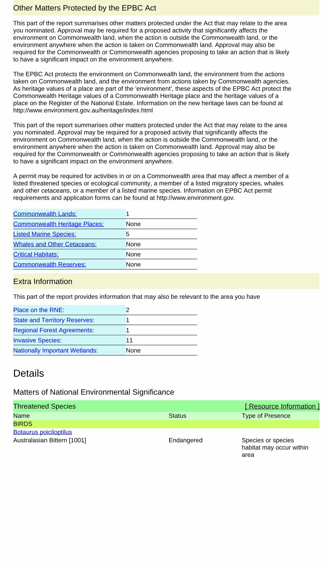
Details
Matters of National Environmental Significance
Threatened Species [ Resource Information ]Name Status Type of PresenceBIRDS
Australasian Bittern [1001] Endangered Species or specieshabitat may occur withinarea
Botaurus poiciloptilus
1
None
None
5
None
None
None
1
1
2
11
Other Matters Protected by the EPBC Act
Critical Habitats:
Whales and Other Cetaceans:
Commonwealth Heritage Places:
Listed Marine Species:
Commonwealth Reserves:
Commonwealth Lands:
This part of the report summarises other matters protected under the Act that may relate to the areayou nominated. Approval may be required for a proposed activity that significantly affects theenvironment on Commonwealth land, when the action is outside the Commonwealth land, or theenvironment anywhere when the action is taken on Commonwealth land. Approval may also berequired for the Commonwealth or Commonwealth agencies proposing to take an action that is likelyto have a significant impact on the environment anywhere.
This part of the report summarises other matters protected under the Act that may relate to the areayou nominated. Approval may be required for a proposed activity that significantly affects theenvironment on Commonwealth land, when the action is outside the Commonwealth land, or theenvironment anywhere when the action is taken on Commonwealth land. Approval may also berequired for the Commonwealth or Commonwealth agencies proposing to take an action that is likelyto have a significant impact on the environment anywhere.
The EPBC Act protects the environment on Commonwealth land, the environment from the actionstaken on Commonwealth land, and the environment from actions taken by Commonwealth agencies.As heritage values of a place are part of the 'environment', these aspects of the EPBC Act protect theCommonwealth Heritage values of a Commonwealth Heritage place and the heritage values of aplace on the Register of the National Estate. Information on the new heritage laws can be found athttp://www.environment.gov.au/heritage/index.html
A permit may be required for activities in or on a Commonwealth area that may affect a member of alisted threatened species or ecological community, a member of a listed migratory species, whalesand other cetaceans, or a member of a listed marine species. Information on EPBC Act permitrequirements and application forms can be found at http://www.environment.gov.
Extra Information
This part of the report provides information that may also be relevant to the area you have
State and Territory Reserves:
Nationally Important Wetlands:
Place on the RNE:
Regional Forest Agreements:
Invasive Species:

Name Status Type of Presence
Forest Red-tailed Black-Cockatoo [67034] Vulnerable Species or specieshabitat may occur withinarea
Calyptorhynchus banksii naso
Baudin's Black-Cockatoo, Long-billed Black-Cockatoo [769]
Vulnerable Breeding known to occurwithin area
Calyptorhynchus baudinii
Carnaby's Black-Cockatoo, Short-billed Black-Cockatoo [59523]
Endangered Breeding likely to occurwithin area
Calyptorhynchus latirostris
Malleefowl [934] Vulnerable Species or specieshabitat may occur withinarea
Leipoa ocellata
CRUSTACEANS
Hairy Marron, Margaret River Hairy Marron,Margaret River Marron [78931]
Critically Endangered Species or specieshabitat known to occurwithin area
Cherax tenuimanus
FISH
Balston's Pygmy Perch [66698] Vulnerable Species or specieshabitat may occur withinarea
Nannatherina balstoni
FROGS
White-bellied Frog, Creek Frog [26181] Endangered Species or specieshabitat likely to occurwithin area
Geocrinia alba
MAMMALS
Chuditch, Western Quoll [330] Vulnerable Species or specieshabitat likely to occurwithin area
Dasyurus geoffroii
Western Ringtail Possum [25911] Vulnerable Species or specieshabitat likely to occurwithin area
Pseudocheirus occidentalis
PLANTS
Swamp Honeypot [82766] Endangered Species or specieshabitat may occur withinarea
Banksia nivea subsp. uliginosa
Whicher Range Dryandra [82769] Vulnerable Species or specieshabitat may occur withinarea
Banksia squarrosa subsp. argillacea
Hoffman's Spider-orchid [56719] Endangered Species or specieshabitat may occur withinarea
Caladenia hoffmanii
Majestic Spider-orchid [64504] Endangered Species or specieshabitat may occur withinarea
Caladenia winfieldii
[6393] Endangered Species or specieshabitat likely to occurwithin area
Centrolepis caespitosa
Manypeaks Sundew [18749] Vulnerable Species or specieshabitat known to occurwithin area
Drosera fimbriata
Butterfly-leaved Gastrolobium [78415] Endangered Species or specieshabitat may occur withinarea
Gastrolobium papilio
Western Prickly Honeysuckle [64528] Endangered Species or specieshabitat may occur withinarea
Lambertia echinata subsp. occidentalis

Name Status Type of Presence
[21160] Endangered Species or specieshabitat may occur withinarea
Sphenotoma drummondii
Migratory Species [ Resource Information ]* Species is listed under a different scientific name on the EPBC Act - Threatened Species list.Name Threatened Type of PresenceMigratory Marine Birds
Fork-tailed Swift [678] Species or specieshabitat likely to occurwithin area
Apus pacificus
Great Egret, White Egret [59541] Species or specieshabitat may occur withinarea
Ardea alba
Cattle Egret [59542] Species or specieshabitat may occur withinarea
Ardea ibis
Migratory Terrestrial Species
White-bellied Sea-Eagle [943] Species or specieshabitat likely to occurwithin area
Haliaeetus leucogaster
Malleefowl [934] Vulnerable Species or specieshabitat may occur withinarea
Leipoa ocellata
Rainbow Bee-eater [670] Species or specieshabitat may occur withinarea
Merops ornatus
Migratory Wetlands Species
Great Egret, White Egret [59541] Species or specieshabitat may occur withinarea
Ardea alba
Cattle Egret [59542] Species or specieshabitat may occur withinarea
Ardea ibis
Other Matters Protected by the EPBC Act
Commonwealth Lands [ Resource Information ]The Commonwealth area listed below may indicate the presence of Commonwealth land in thisvicinity. Due to the unreliability of the data source, all proposals should be checked as to whether itimpacts on a Commonwealth area, before making a definitive decision. Contact the State or Territorygovernment land department for further information.
NameCommonwealth Land -
Listed Marine Species [ Resource Information ]* Species is listed under a different scientific name on the EPBC Act - Threatened Species list.Name Threatened Type of PresenceBirds
Fork-tailed Swift [678] Species or specieshabitat likely to occurwithin area
Apus pacificus
Great Egret, White Egret [59541] Species or specieshabitat may occur withinarea
Ardea alba
Cattle Egret [59542] Species or specieshabitat may occur within
Ardea ibis

Name Threatened Type of Presencearea
White-bellied Sea-Eagle [943] Species or specieshabitat likely to occurwithin area
Haliaeetus leucogaster
Rainbow Bee-eater [670] Species or specieshabitat may occur withinarea
Merops ornatus
Extra Information
Places on the RNE [ Resource Information ]
Note that not all Indigenous sites may be listed.
Name StatusStateHistoric
Indicative PlaceSt Thomas More Catholic Church WARegisteredBasildene Farmhouse (former) WA
State and Territory Reserves [ Resource Information ]Name StateBramley WA
Regional Forest Agreements [ Resource Information ]
Note that all areas with completed RFAs have been included.
Name StateSouth West WA RFA Western Australia
Invasive Species [ Resource Information ]Weeds reported here are the 20 species of national significance (WoNS), along with other introducedplants that are considered by the States and Territories to pose a particularly significant threat tobiodiversity. The following feral animals are reported: Goat, Red Fox, Cat, Rabbit, Pig, Water Buffaloand Cane Toad. Maps from Landscape Health Project, National Land and Water Resouces Audit,
Name Status Type of PresenceMammals
Cat, House Cat, Domestic Cat [19] Species or specieshabitat likely to occurwithin area
Felis catus
Rabbit, European Rabbit [128] Species or specieshabitat likely to occurwithin area
Oryctolagus cuniculus
Pig [6] Species or specieshabitat likely to occurwithin area
Sus scrofa
Red Fox, Fox [18] Species or specieshabitat likely to occurwithin area
Vulpes vulpes
Plants
Bridal Creeper, Bridal Veil Creeper, Smilax,Florist's Smilax, Smilax Asparagus [22473]
Species or specieshabitat likely to occurwithin area
Asparagus asparagoides
Buffel-grass, Black Buffel-grass [20213] Species or specieshabitat may occur withinarea
Cenchrus ciliaris
Broom [67538] Species or specieshabitat may occur within
Genista sp. X Genista monspessulana

Name Status Type of Presencearea
African Boxthorn, Boxthorn [19235] Species or specieshabitat may occur withinarea
Lycium ferocissimum
Radiata Pine Monterey Pine, Insignis Pine, WildingPine [20780]
Species or specieshabitat may occur withinarea
Pinus radiata
Blackberry, European Blackberry [68406] Species or specieshabitat likely to occurwithin area
Rubus fruticosus aggregate
Athel Pine, Athel Tree, Tamarisk, Athel Tamarisk,Athel Tamarix, Desert Tamarisk, FloweringCypress, Salt Cedar [16018]
Species or specieshabitat likely to occurwithin area
Tamarix aphylla
Caveat
Acknowledgements
-33.930965 115.081297,-33.931421 115.084799,-33.933858 115.087845,-33.949086115.096373,-33.956092 115.099114,-33.976041 115.099876,-33.980762 115.0982,-33.983046115.095764,-33.985026 115.091804,-33.985178 115.088606
Coordinates
For threatened ecological communities where the distribution is well known, maps are derived fromrecovery plans, State vegetation maps, remote sensing imagery and other sources. Where threatenedecological community distributions are less well known, existing vegetation maps and point locationdata are used to produce indicative distribution maps.
The information presented in this report has been provided by a range of data sources asacknowledged at the end of the report.
- migratory species that are very widespread, vagrant, or only occur in small numbers
Only selected species covered by the following provisions of the EPBC Act have been mapped:
The following groups have been mapped, but may not cover the complete distribution of the species:
Such breeding sites may be important for the protection of the Commonwealth Marine environment.- seals which have only been mapped for breeding sites near the Australian continent
The following species and ecological communities have not been mapped and do not appear inreports produced from this database:
Not all species listed under the EPBC Act have been mapped (see below) and therefore a report is ageneral guide only. Where available data supports mapping, the type of presence that can bedetermined from the data is indicated in general terms. People using this information in making areferral may need to consider the qualifications below and may need to seek and consider other
- migratory and
This report is designed to assist in identifying the locations of places which may be relevant indetermining obligations under the Environment Protection and Biodiversity Conservation Act 1999. Itholds mapped locations of World Heritage and Register of National Estate properties, Wetlands ofInternational Importance, Commonwealth and State/Territory reserves, listed threatened, migratoryand marine species and listed threatened ecological communities. Mapping of Commonwealth landis not complete at this stage. Maps have been collated from a range of sources at various
- some species and ecological communities that have only recently been listed
- marine
For species where the distributions are well known, maps are digitised from sources such asrecovery plans and detailed habitat studies. Where appropriate, core breeding, foraging and roostingareas are indicated under 'type of presence'. For species whose distributions are less well known,point locations are collated from government wildlife authorities, museums, and non-governmentorganisations; bioclimatic distribution models are generated and these validated by experts. In somecases, the distribution maps are based solely on expert knowledge.
- non-threatened seabirds which have only been mapped for recorded breeding sites
- some terrestrial species that overfly the Commonwealth marine area
- threatened species listed as extinct or considered as vagrants
This database has been compiled from a range of data sources. The department acknowledges thefollowing custodians who have contributed valuable data and advice:
-Department of Environment, Climate Change and Water, New South Wales

Please feel free to provide feedback via the Contact Us page.
GPO Box 787
Canberra ACT 2601 Australia
Department of Sustainability, Environment, Water, Population and Communities
© Commonwealth of Australia
+61 2 6274 1111
-National Herbarium of NSW
-Parks and Wildlife Service NT, NT Dept of Natural Resources, Environment and the Arts
-Queensland Museum-Online Zoological Collections of Australian Museums
-Birds Australia
-State Forests of NSW
-University of New England
-Queensland Herbarium
-Environmental and Resource Management, Queensland
-Royal Botanic Gardens and National Herbarium of Victoria-Tasmanian Herbarium
-Australian National Herbarium, Atherton and Canberra
-Department of Environment and Conservation, Western Australia
-Australian Government, Department of Defence
-SA Museum
-State Herbarium of South Australia
-Department of Primary Industries, Parks, Water and Environment, Tasmania
-Australian National Wildlife Collection
-Department of Environment and Natural Resources, South Australia
-Western Australian Herbarium
The Department is extremely grateful to the many organisations and individuals who providedexpert advice and information on numerous draft distributions.
-Department of the Environment, Climate Change, Energy and Water
-Australian Museum
-Other groups and individuals
-Natural history museums of Australia-Museum Victoria
-Department of Sustainability and Environment, Victoria
-Australian Bird and Bat Banding Scheme
-Northern Territory Herbarium
-Ocean Biogeographic Information System

58 | GHD | Report for Main Roads Western Australia - Margaret River Perimeter Road, 61/27189
Likelihood of occurrence

GHD | Report for Main Roads Western Australia - Margaret River Perimeter Road, 61/27189
Likelihood of occurrence assessment for Threatened and Priority species identified in 2012 database searches that were not identified in Margaret River Bypass: Flora and Fauna Assessment (GHD 2012).
Fauna
Species Details and Habitat EPBC Conservation Code
DEC Conservation Code
Likelihood
Leipoa ocellata
Malleefowl
The shrublands and low woodlands communities where Malleefowl occur are dominated by eucalypts (such as Eucalyptus socialis, E. dumosa or E. incrassata) and occur on sandy or loamy soils that receive 200 to 450 mm of rainfall each year (Frith 1959, 1962a; Marchant & Higgins 1993; Priddel & Wheeler 1995).
Vulnerable Schedule 1 Unlikely
Within the Margaret River region there are large intact forested areas that may still be suitable for the species. However there is no suitable habitat for the species within the study area.
Flora
Species Details and Habitat EPBC Conservation Code
DEC Conservation Code
Likelihood
Banksia nivea subsp. uliginosa
Swamp Honeypot
Giant Spider-orchid is distributed along the Leeuwin Naturaliste Ridge between Yallingup and Karridale, Western Australia. The species occurs within the South West Natural Resource Management Region. The total known population size is 257 plants across 26 small fragmented sub-populations.
Grows on hilltops, slopes, swales and low plains in deep pale yellow, white, grey sandy soils and is found among low shrubs in Banksia, Jarrah and Marri woodlands.
Endangered Threatened Unlikely –
limited suitable habitat and not previously recorded within 5 km of the area.

60 | GHD | Report for Main Roads Western Australia - Margaret River Perimeter Road, 61/27189
Banksia squarrosa subsp. argillacea
Whicher Range Dryandra
Occurs at the base of the Whicher Range, east of Busselton and on the Scott River Plain.
Erect, open, non-lignotuberous shrub, 1.2-4 m high. Fl. yellow, Jun to Nov. White/grey sand, gravelly clay or loam. Winter-wet flats, clay flats.
Vulnerable Threatened Unlikely –
limited suitable habitat and not previously recorded within 5 km of the area.
Drosera fimbriata
Manypeaks Sundew
Erect tuberous, perennial, herb, 0.05-0.15 m high. Fl. white, Sep to Oct. White sand, granite.
Vulnerable P4 Unlikely –
limited suitable habitat and not previously recorded within 5 km of the area.
Gastrolobium papilio
Butterfly-leaved Gastrolobium
Tangled, clumped shrub, to 1.5 m high. Fl. cream-red, Oct to Dec. Sandy clay over ironstone and laterite. Flat plains.
Endangered Threatened Unlikely –
limited suitable habitat and not previously recorded within 5 km.
Lambertia echinata subsp. Occidentalis
Western Prickly Honeysuckle
Prickly, much-branched, non-lignotuberous shrub, to 3 m high. Fl. yellow, Feb or Apr or Dec. White sandy soils over laterite, orange/brown-red clay over ironstone. Flats to foothills, winter-wet sites.
Endangered Threatened Possible – some suitable habitat present.
Caladenai huegelii
Grand Spider Orchid
Tuberous, perennial, herb, 0.25-0.6 m high. Fl. green & cream & red, Sep to Oct. Grey or brown sand, clay loam.
Endangered Threatened Unlikely – this species occurs in the Swan Coastal Plain. There is limited habitat available.
Gastrolobium modestum
Prostrate to clumped shrub, to 0.5 m high. Fl. cream-green-pink, Sep to Nov. Shallow red clay-loam or grey sand, ironstone. Gullies and edges of flats.
Vulnerable Threatened Likely –suitable habitat present and previously recorded within 5 km.

GHD | Report for Main Roads Western Australia - Margaret River Perimeter Road, 61/27189 |
Hakea oldfieldii Open, straggling shrub, up to 2.5 m high. Fl. white-cream/yellow, Aug to Oct. Red clay or sand over laterite. Seasonally wet flats.
P4 Possible – limited suitable habitat present, but previously recorded within 5 km.
Loxocarya magna Rhizomatous, perennial, herb (sedge-like), 0.5-1.5 m high. Fl. Sep or Nov. Sand, loam, clay, ironstone. Seasonally inundated or damp habitats.
Seasonal wet areas, only a small amount in study area.
P3 Possible – limited suitable habitat present, but previously recorded within 5 km.
Trichocline sp. Treeton (B.J. Keighery & N. Gibson 564)
Tuberous, perennial, herb, to 1.6 m high. Sand over limestone, sandy clay over ironstone. Seasonally wet flats.
P2 Possible – limited suitable habitat present, but previously recorded within 5 km.