Appendix B Region 7 Country and regional profiles of...
29
This profile and the data therein should not be used in place of focussed assessments and information provided by local monitoring and research institutions. Appendix B – Region 7 Country and regional profiles of volcanic hazard and risk: Philippines and SE Asia S.K. Brown 1 , R.S.J. Sparks 1 , K. Mee 2 , C. Vye-Brown 2 , E.Ilyinskaya 2 , S.F. Jenkins 1 , S.C. Loughlin 2* 1 University of Bristol, UK; 2 British Geological Survey, UK, * Full contributor list available in Appendix B Full Download This download comprises the profiles for Region 7: Philippines and SE Asia only. For the full report and all regions see Appendix B Full Download. Page numbers reflect position in the full report. The following countries are profiled here: Region 7 Philippines and SE Asia 371 Myanmar (Burma) 378 Philippines 384 Vietnam 393 Brown, S.K., Sparks, R.S.J., Mee, K., Vye-Brown, C., Ilyinskaya, E., Jenkins, S.F., and Loughlin, S.C. (2015) Country and regional profiles of volcanic hazard and risk. In: S.C. Loughlin, R.S.J. Sparks, S.K. Brown, S.F. Jenkins & C. Vye-Brown (eds) Global Volcanic Hazards and Risk, Cambridge: Cambridge University Press.
Transcript of Appendix B Region 7 Country and regional profiles of...

This profile and the data therein should not be used in place of focussed assessments and information provided by local monitoring and research institutions.
Appendix B – Region 7
Country and regional profiles of volcanic hazard and risk:
Philippines and SE Asia
S.K. Brown1, R.S.J. Sparks1, K. Mee2, C. Vye-Brown2, E.Ilyinskaya2, S.F. Jenkins1, S.C. Loughlin2*
1University of Bristol, UK; 2British Geological Survey, UK, * Full contributor list available in Appendix B Full Download
This download comprises the profiles for Region 7: Philippines and SE Asia only. For the full report
and all regions see Appendix B Full Download. Page numbers reflect position in the full report. The
following countries are profiled here:
Region 7 Philippines and SE Asia 371
Myanmar (Burma) 378
Philippines 384
Vietnam 393
Brown, S.K., Sparks, R.S.J., Mee, K., Vye-Brown, C., Ilyinskaya, E., Jenkins, S.F., and Loughlin, S.C. (2015) Country and regional profiles of volcanic hazard and risk. In: S.C. Loughlin, R.S.J. Sparks, S.K. Brown, S.F. Jenkins & C. Vye-Brown (eds) Global Volcanic Hazards and Risk, Cambridge: Cambridge University Press.

This profile and the data therein should not be used in place of focussed assessments and information provided by local monitoring and research institutions.
Region 7: Philippines and SE Asia
The Philippines and SE Asia region comprises volcanoes throughout Myanmar, the Philippines,
Vietnam and southern China (Table 7.1). Country profiles are provided for all, however see Region
10 (Kamchatka and Mainland Asia) for a country profile for China.
Country Number of volcanoes
Myanmar (Burma) 3 China (See Region 10) 3 Philippines 47 Vietnam 6
Table 7.1 The countries represented in this region and the number of volcanoes. Volcanoes located on the borders between countries are included in the profiles of all countries involved. Note that countries may be represented in more than one region, as overseas territories may be widespread.
Figure 7.1 The distribution of Holocene volcanoes through the Philippines and SE Asia region. The capital cities of the constituent countries are shown.

372
Description
Fifty-nine Holocene volcanoes are located in Region 7: Philippines and SE Asia. Volcanism here is
broadly due to the subduction of the Philippine Sea Plate beneath the Eurasian Plate. This has
generated magmas of largely andesitic composition and dominantly (~75%) stratovolcanoes.
Of the 59 volcanoes, only 27 have confirmed Holocene eruptions recorded, with the remaining
volcanoes having had activity of suspected Holocene age. This uncertainty in events complicates
hazard assessment. Most (~88%) eruptions are recorded historically, post-1500 AD, and the
Philippines dominates activity here.
Eruptions in this region have ranged from VEI 0 to 6 in size, indicating a range of activity styles,
however about 9% of eruptions are classed at VEI ≥4. About 19% of historical eruptions have
produced pyroclastic flows, and 20% have resulted in lahars. These mudflows remain a hazard for
years after eruptions, with examples of secondary lahars at Pinatubo following the 1991 eruption
burying thousands of homes years after the event. Tsunamis are associated with about 5% of
historical eruptions here, making this region second only to the West Indies for proportion of
tsunami-generating events.
The population density in this region is high, and about 2.9 million people throughout the region live
within 10 km of one or more active volcanoes, rising to about 116 million within 100 km. Most
volcanoes have a very high proximal population. The number of eruptions resulting in loss of life
reflects the high local populations. About 17% of historical eruptions have resulted in fatalities; the
largest proportion of any region. About a quarter of historical eruptions have resulted in property
damage. This historical record extends to before the development of monitoring institutions and
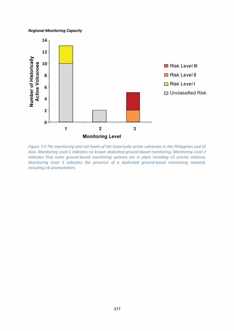
monitoring networks (PHIVOLCS, see Philippines). Monitoring is now dominantly focussed at Risk
Level II and III volcanoes, with about 36% of historically active volcanoes monitored by regular
dedicated ground-based systems.
Volcano Facts
Number of Holocene volcanoes 59
Number of Pleistocene volcanoes with M≥4 eruptions 4
Number of volcanoes generating pyroclastic flows 44
Number of volcanoes generating lahars 42
Number of volcanoes generating lava flows 35
Number of eruptions with fatalities 31
Number of fatalities attributed to eruptions 7,934
Largest recorded Pleistocene eruption The 37.5 ka eruption of the Irosin Ignimbrites at Bulusan in the Philippines was the largest Quaternary explosive event in this region at M7.1.

373
Largest recorded Holocene eruption Three eruptions of Pinatubo, including the 1991 eruption, are the largest recorded in the Holocene in LaMEVE at M6.1.
Number of Holocene eruptions 203 confirmed Holocene eruptions.
Recorded Holocene VEI range 0 – 6 and unknown
Number of historically active volcanoes 20
Number of historical eruptions 178
Number of volcanoes
Primary volcano type Dominant rock type
2 Caldera(s) Andesitic (2)
42 Large cone(s) Andesitic (32), Basaltic (8), Dacitic (2)
2 Lava dome(s) Andesitic (2)
7 Small cone(s) Andesitic (1), Basaltic (6)
3 Submarine Basaltic (1), Unknown (2)
Table 7.2 The volcano types and dominant rock types of the volcanoes of this region according to VOTW4.0.
Eruption Frequency
VEI Recurrence Interval (Years)
Small (< VEI 4) 1 Large (> VEI 3) 60
Table 7.3 Average recurrence interval (years between eruptions) for small and large eruptions in the Philippines and SE Asia.
The eruption record indicates that on average small to moderate sized eruptions of VEI <4 occur in
this region with an average recurrence interval (ARI) of about a year, whilst the ARI for large
eruptions is longer, at about 60 years.
Eruption Size
Eruptions are recorded through the Philippines and SE Asia region of VEI 0 to 6, representing a range
of eruption styles from gentle effusive events to large explosive eruptions (Figure 7.2). VEI 2 events
dominate the record, with nearly 60% of all Holocene eruptions classed as such. 9% of eruptions
here are explosive at VEI ≥4.

374
Figure 7.2 Percentage of eruptions in this region recorded at each VEI level; the number of eruptions is also shown. The percentage is of total eruptions with recorded VEI. A further 25 eruptions were recorded with unknown VEI.
Socio-Economic Facts
Total population (2011) 246,383,132
Gross Domestic Product (GDP) per capita (2005 PPP $) 3,013 – 3,631
(Mean 3,322)
Gross National Income (GNI) per capita (2005 PPP $) 1,817 – 3,752
(Mean 2,846)
Human Development Index (HDI) (2012) 0.498 – 0.654 (Low to Medium, Mean 0.590 Medium)
Population Exposure
Number (percentage) of people living within 10 km of a Holocene volcano
2,976,701 (1.21 %)
Number (percentage) of people living within 30 km of a Holocene volcano
34,041,940 (13.82 %)
Number (percentage) of people living within 100 km of a Holocene volcano
116,383,251 (47.24 %)

375
Hazard, Uncertainty and Exposure Assessments C
LASS
IFIE
D Hazard
III Camiguin Mayon Taal
Hazard II
Babuyan Claro Bulusan
Hazard I Didicas Ragang Kanlaon
UN
CLA
SSIF
IED
U – HHR
Camiguin de Babuyanes; Unnamed; Cendres, Ile des
Cagua Parker Makaturing; Cabalían; Biliran; Pinatubo
Jolo; Musuan Hainan Dao
U- HR Iraya Leonard Range Matutum; Popa Mariveles; Tengchong
San Pablo Volcanic Field
U- NHHR
Veteran Balut; Mahagnao; Cù-Lao Ré Group; Toroeng Prong
Latukan; Balatukan; Ambalatungan Group
Apo; Kalatungan; Malindang; Paco; Cuernos de Negros; Mandalagan; Silay; Isarog; Malindig; Natib; Patoc
Pocdol Mountains; Masaraga; Iriga; Banahaw; Amorong; Santo Tomas; Haut Dong Nai; Singu Plateau
Laguna Caldera; Arayat; Leizhou Bandao; Bas Dong Nai; Lower Chindwin
PEI 1 PEI 2 PEI 3 PEI 4 PEI 5 PEI 6 PEI 7 Table 7.4 Identity of the volcanoes in this region in each Hazard-PEI group. Those volcanoes with a sufficient record for determining a hazard score are deemed ‘Classified’ (top). Those without sufficient data are ‘Unclassified’ (bottom). The unclassified volcanoes are divided into groups: U-NHHR is Unclassified No Historic or Holocene Record: that is there are no confirmed eruptions recorded in the Holocene. U-HR is Unclassified with Holocene Record: that is there are confirmed eruptions recorded during the Holocene, but no historical (post-1500) events. U-HHR is Unclassified with Historic and Holocene record. The unclassified volcanoes in bold have experienced unrest or eruptions since 1900 AD, and those in red have records of at least one Holocene VEI ≥4 eruption.

376
Population Exposure Index
Number of Volcanoes Population Exposure Index
8 7 13 6 20 5 6 4 6 3 6 2 0 1
Table 7.5 The number of volcanoes in the Philippines and SE Asia classed in each PEI category.
Risk Levels
Number of Volcanoes Risk Level
3 III 2 II 3 I
51 Unclassified
Table 7.6 The number of volcanoes in the Philippines and SE Asia region classified at each Risk Level.
Figure 7.3 Distribution of the classified volcanoes of this region across Hazard and Population Exposure Index levels. The warming of the background colours illustrates increasing Risk levels from Risk Level I - III.
377
Regional Monitoring Capacity
Figure 7.4 The monitoring and risk levels of the historically active volcanoes in the Philippines and SE Asia. Monitoring Level 1 indicates no known dedicated ground-based monitoring; Monitoring Level 2 indicates that some ground-based monitoring systems are in place including ≤3 seismic stations; Monitoring Level 3 indicates the presence of a dedicated ground-based monitoring network, including ≥4 seismometers.

This profile and the data therein should not be used in place of focussed assessments and information provided by local monitoring and research institutions.
Myanmar
Description
Figure 7.5 Location of Myanmar’s volcanoes, the capital and largest cities. A zone extending 200 km beyond the country's borders shows other volcanoes whose eruptions may directly affect Myanmar.

379
Three Holocene volcanoes are located in central Myanmar. Of these, only Popa has a confirmed
Holocene eruption. Lower Chindwin and Singu Plateau have suspected, but unconfirmed Holocene
activity. These volcanoes are related to the subduction of the Indian plate under the Eurasian plate.
No volcanoes here have records of historical eruptions. The only recorded Holocene eruption
occurred in 442 BC, and is of unknown VEI. The volcanoes here are basaltic to andesitic and comprise
stratovolcanoes, small cones in a volcanic field and a fissure vent system. A range of activity could be
expected from such features, from effusive to explosive, though the most recent activity appears to
be largely effusive to Strombolian. The stratovolcano, Popa, has evidence of past flank collapse and
debris avalanche, with a crater breached to the northwest.
The capital city, Naypyidaw, lies at about 160 km from Popa, however three of the largest cities in
Myanmar lie within 100 km of the volcanoes and as such, all three volcanoes have large proximal
populations of over 4 million within the individual 100 km radii. Nearly 23,000 people live within 10
km of Popa and a large proportion of this population live on the plain at the foot of the large channel
from the crater. Hazardous flows of any kind originating at or around the summit vent here could be
expected to be channelled through this topographic feature. The largest proximal population is
found at Lower Chindwin volcanic field.
Tengchong volcano in southern China lies within 50 km of the border with Myanmar, and hence has
the potential to affect the population and infrastructure here.
No regular ground-based monitoring is undertaken at the volcanoes in Myanmar.
The Asian Disaster Reduction Center (ADRC) produced a report on disaster risk reduction in
Myanmar in 2013, in which they do not consider volcanic hazards. They describe how the
Government of Myanmar established the National Disaster Preparedness Central Committees
(NDPCC) and has Disaster Risk Management systems and plans on multiple levels including State,
District and Local levels. Although volcanic hazards are not currently considered, it is likely these
groups who would form the first response to activity. See the ADRC report for full details on DRR in
Myanmar.
See also:
ADRC: Myanmar profile:
www.adrc.asia/nationinformation.php?NationCode=104&Lang=en&NationNum=17
Volcano Facts
Number of Holocene volcanoes 3
Number of Pleistocene volcanoes with M≥4 eruptions -
Number of volcanoes generating pyroclastic flows -
Number of volcanoes generating lahars -
Number of volcanoes generating lava flows -
380
Number of fatalities caused by volcanic eruptions -
Tectonic setting Intra-plate
Largest recorded Pleistocene eruption -
Largest recorded Holocene eruption Eruption was of unknown VEI
Number of Holocene eruptions 1 confirmed eruption
Recorded Holocene VEI range Unknown
Number of historically active volcanoes -
Number of historical eruptions -
Number of
volcanoes
Primary volcano type Dominant rock type
1 Large cone(s) Basaltic (1)
2 Small cone(s) Andesitic (1), Basaltic (1)
Table 7.7 The number of volcanoes in Myanmar, their volcano type classification and dominant rock type according to VOTW4.0.
Socio-Economic Facts
Total population (2012) 52,865,000
Gross Domestic Product (GDP) per capita (2005 PPP $)
Gross National Income (GNI) per capita (2005 PPP $) 1,817
Human Development Index (HDI) (2012) 0.498 (Low)
Population Exposure
Capital city Naypyidaw
Distance from capital city to nearest Holocene volcano 158.6 km
Total population (2011) 53,999,804
Number (percentage) of people living within 10 km of a Holocene volcano
124,041 (<1%)
Number (percentage) of people living within 30 km of a Holocene volcano
1,583,171 (2.9%)
Number (percentage) of people living within 100 km of a Holocene volcano
12,950,553 (24%)
Ten largest cities, as measured by population and their population size:

381
Rangoon (Yangon) 4,477,638
Mandalay 1,208,099
Moulmein 438,861
Pegu 244,376
Bassein 237,089
Sittwe 177,743
Taunggyi 160,115
Tavoy 136,783
Magway 96,954
Myitkyina 90,894
Infrastructure Exposure
Number of airports within 100 km of a volcano 0
Number of ports within 100 km of a volcano 0
Total length of roads within 100 km of a volcano (km) 2,905
Total length of railroads within 100 km of a volcano (km) 500
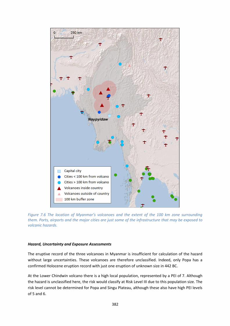
The volcanoes in Myanmar are situated in the centre of the country. Being inland volcanoes, no
ports are located within 100 km. Whilst the capital, Naypyidaw, lies at nearly 160 km from Popa
volcano, three of the largest cities in Myanmar lie within 100 km of the volcanoes placing significant
infrastructure including an extensive road and rail network under threat.
382
Figure 7.6 The location of Myanmar’s volcanoes and the extent of the 100 km zone surrounding them. Ports, airports and the major cities are just some of the infrastructure that may be exposed to volcanic hazards.
Hazard, Uncertainty and Exposure Assessments
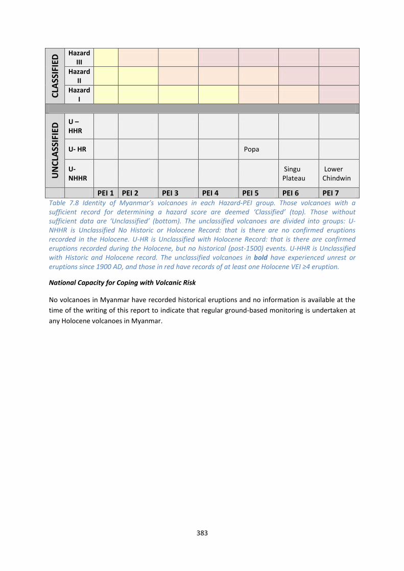
The eruptive record of the three volcanoes in Myanmar is insufficient for calculation of the hazard
without large uncertainties. These volcanoes are therefore unclassified. Indeed, only Popa has a
confirmed Holocene eruption record with just one eruption of unknown size in 442 BC.
At the Lower Chindwin volcano there is a high local population, represented by a PEI of 7. Although
the hazard is unclassified here, the risk would classify at Risk Level III due to this population size. The
risk level cannot be determined for Popa and Singu Plateau, although these also have high PEI levels
of 5 and 6.
383
CLA
SSIF
IED
Hazard III
Hazard II
Hazard I
UN
CLA
SSIF
IED
U – HHR
U- HR Popa
U- NHHR
Singu Plateau
Lower Chindwin
PEI 1 PEI 2 PEI 3 PEI 4 PEI 5 PEI 6 PEI 7 Table 7.8 Identity of Myanmar’s volcanoes in each Hazard-PEI group. Those volcanoes with a sufficient record for determining a hazard score are deemed ‘Classified’ (top). Those without sufficient data are ‘Unclassified’ (bottom). The unclassified volcanoes are divided into groups: U-NHHR is Unclassified No Historic or Holocene Record: that is there are no confirmed eruptions recorded in the Holocene. U-HR is Unclassified with Holocene Record: that is there are confirmed eruptions recorded during the Holocene, but no historical (post-1500) events. U-HHR is Unclassified with Historic and Holocene record. The unclassified volcanoes in bold have experienced unrest or eruptions since 1900 AD, and those in red have records of at least one Holocene VEI ≥4 eruption.
National Capacity for Coping with Volcanic Risk
No volcanoes in Myanmar have recorded historical eruptions and no information is available at the
time of the writing of this report to indicate that regular ground-based monitoring is undertaken at
any Holocene volcanoes in Myanmar.

This profile and the data therein should not be used in place of focussed assessments and information provided by local monitoring and research institutions.
Philippines
Description
Figure 7.7 Location of the Philippines’ volcanoes, the capital and largest cities. A zone extending 200 km beyond the country's borders shows other volcanoes whose eruptions may directly affect the Philippines.
Forty-seven Holocene volcanoes are located throughout the Philippines. These volcanoes are located
primarily across four of the largest Philippine islands and off the coast of Luzon in the north.
Volcanism here is due to a complex interaction between multiple tectonic plates and micro-plates,

385
with the Philippine and Eurasian Plates converging and undergoing subduction. There are two main
volcanic arcs – the Luzon and Mindanao arcs, which roughly trend north-south.
The volcanoes in the Philippines are dominantly large cones, being principally stratovolcanoes and
compound or complex volcanoes. Calderas and lava domes are also present. These volcano types
along with the dominance of andesitic magmas illustrates that most of the volcanoes can be
characterised by explosive activity. Indeed, the Holocene record includes 16 large explosive VEI ≥4
eruptions, including nine such historical eruptions. Five VEI 6 Holocene eruptions are recorded at
Pinatubo and Taal, including the 1991 eruption of Pinatubo. The record of large explosive events in
the Philippines continues into the Pleistocene with four recorded M≥4 eruptions, including the M7.1
eruption of Bulusan over 37,000 years ago. Such records of large explosive events indicate that
similar sized eruptions could occur in the future.
VOTW4.22 lists 175 historical eruptions in the Philippines from 18 volcanoes. Eight volcanoes have
produced pyroclastic flows, and lahars have occurred at six. Heavy rainfall and typhoons frequently
produces lahars and secondary lahars due to the remobilisation of tephra. This remobilisation can
occur for years following eruptions. With a record of explosive eruptions, the historical record of the
human impact of volcanism in the Philippines is quite extensive. Between 1640 and 2013 AD 33
eruptions from Parker, Camiguin, Kanlaon, Bulusan, Mayon, Taal, Pinatubo, Didicas, Ragang and
Ambalatungan Group resulted in fatalities. Fatalities are recorded in 18% of historical eruptions.
Multiple evacuations are recorded and property damage is recorded in 24% of historical eruptions.
The volcanoes in the Philippines can be expected to have considerable impacts on the population, as
around 80% of the population live within 100 km of one or more Holocene volcanoes. The capital,
Manila, and many other major cities lie within these radii and thus much of the critical infrastructure
of the country is exposed to volcanic hazards. A high local population is present at 37 volcanoes, as
demonstrated by the classification of these at PEI≥5. Taal and Mayon have some of the highest
hazard scores in the country, both with an extensive historical record of moderate to large
eruptions, and also have a very large population within 10 km.
Nearly 250,000 people live within 10 km of Mayon and pyroclastic flows and lahars are commonly
produced in eruptions here, many of which have devastated areas at the base of the cone. 1,200
fatalities occurred during the 1814 VEI 4 eruption here.
The 1991 VEI 6 eruption of Pinatubo was one of the largest in the 20th century in the world. Though
the damage caused by the eruption led to huge socio-economic impacts, the number of fatalities
was low relative to the eruption size as a result of successful monitoring and evacuation. An
estimated 800 lives were lost, though up to half of these are attributable to disease in evacuation
camps. In general, the emergency response to the eruption was widely viewed as a major success
with many tens of thousands of people having been evacuated in time.
Two Indonesian volcanoes and one volcano in Taiwan lie within 200 km of the Philippines, indicating
that eruptions from these could impact on the Philippines.
The Philippine Institute of Volcanology and Seismology (PHIVOLCS) is the institute responsible for
the country’s volcanoes. PHIVOLCS continuously monitors about 40% of the historically active
volcanoes, including five Risk Level III volcanoes. Multiple monitoring methods are utilised at these
386
volcanoes. PHIVOLCS has responded to unrest at volcanoes in the past, increasing monitoring to
better understand activity. PHIVOLCS assigns one of six alert levels for volcanic activity. ‘No alert’ is
assigned to volcanoes in quiescence, and alert levels increase through ‘1. Abnormal’, ‘2. Alarming’,
‘3. Critical’, ‘4. Eruption imminent’ to ‘5. Eruption’. These levels are based on the level of unrest and
trends in unrest. These alert levels are made available to the public as well as descriptors of activity
and exclusion zones.
See also:
PHIVOLCS: www.phivolcs.dost.gov.ph/
Volcano Facts
Number of Holocene volcanoes 47
Number of Pleistocene volcanoes with M≥4 eruptions 4
Number of volcanoes generating pyroclastic flows 8
Number of volcanoes generating lahars 6
Number of volcanoes generating lava flows 6
Number of fatalities caused by volcanic eruptions ?>7,919
Tectonic setting 47 subduction zone
Largest recorded Pleistocene eruption The M7.1 Irosin Ignimbrite eruption of Bulusan at 37.5 ka.
Largest recorded Holocene eruption Three eruptions of Pinatubo are recorded at M6.1 – the Crow Valley eruptive period (5.5 ka), the Maraunot eruptive period (3 ka) and the 1991 AD eruption.
Number of Holocene eruptions 198 confirmed eruptions. 19 uncertain eruptions and 5 discredited eruptions.
Recorded Holocene VEI range 0 – 6 and unknown
Number of historically active volcanoes 18
Number of historical eruptions 175

387
Number of
volcanoes
Primary volcano type Dominant rock type
2 Caldera(s) Andesitic (2)
41 Large cone(s) Andesitic (32), Basaltic (7), Dacitic (2)
2 Lava dome(s) Andesitic (2)
1 Small cone(s) Basaltic (1)
1 Submarine Unknown (1)
Table 7.9 The number of volcanoes in the Philippines, their volcano type classification and dominant rock type according to VOTW4.0.
Socio-Economic Facts
Total population (2012) 96,899,000
Gross Domestic Product (GDP) per capita (2005 PPP $) 3,631
Gross National Income (GNI) per capita (2005 PPP $) 3,752
Human Development Index (HDI) (2012) 0.654 (Medium)
Population Exposure
Capital city Manila
Distance from capital city to nearest Holocene volcano 34.1 km
Total population (2011) 101,833,938
Number (percentage) of people living within 10 km of a Holocene volcano
2,708,394 (2.7%)
Number (percentage) of people living within 30 km of a Holocene volcano
30,511,866 (30%)
Number (percentage) of people living within 100 km of a Holocene volcano
80,918,982 (79.5%)
Largest cities, as measured by population and their population size:
Davao 1,212,504
Infrastructure Exposure
Number of airports within 100 km of a volcano 7
Number of ports within 100 km of a volcano 60

388
Total length of roads within 100 km of a volcano (km) 9,424
Total length of railroads within 100 km of a volcano (km) 768
The volcanoes of the Philippines are distributed throughout the country, across the many islands.
With the number of volcanoes and the distribution of the islands, almost all of the Philippines are
located within 100 km of a volcano. This places almost all critical infrastructure within the country
under threat, including the capital, Manila, and other major cities. An extensive road and rail
network lies within 100 km of the volcanoes, as do 60 ports and 7 airports.
Figure 7.8 The location of the Philippines’ volcanoes and the extent of the 100 km zone surrounding them. Ports, airports and the major cities are just some of the infrastructure that may be exposed to volcanic hazards.

389
Hazard, Uncertainty and Exposure Assessments
There are varying levels of data availability in the eruption records for the volcanoes of the
Philippines. Less than 20% of volcanoes here have appropriate eruptive histories to define the
hazard. These volcanoes are classified at Hazard Levels I, II and III, with just Camiguin, Mayon and
Taal at Hazard Level III largely due to their history of explosive eruptions coupled with pyroclastic
flow production.
Of the unclassified volcanoes, 24 have no confirmed Holocene eruptions. Though of these,
Malindang and Ambalatungan Group have both shown unrest suspected to have been above
background levels since 1900 AD. The remaining unclassified volcanoes have Holocene eruption
records, including ten with historical eruptions. Biliran and Pinatubo both have erupted since 1900.
Pinatubo is unclassified, but has eight Holocene eruptions including five of VEI 5 and 6 indicating that
this volcano is highly explosive and hazardous. Parker is also unclassified, though has a Holocene
record of three eruptions of VEI 4 and 5.
PEI ranges from low to very high in the Philippines, with most volcanoes having high local
populations - 35 volcanoes are classed at PEI ≥5. This tendency towards higher populations in
combination with the hazard levels classes over 60% of the classified volcanoes of the Philippines at
Risk Levels II and III. Taal and Mayon, two of the volcanoes classified with the highest Hazard in the
Philippines, have very large populations within 10 km at >700,000 and nearly 250,000 respectively.

390
CLA
SSIF
IED
Hazard III Camiguin Mayon Taal
Hazard II Babuyan Claro Bulusan
Hazard I Didicas Ragang Kanlaon
UN
CLA
SSIF
IED
U – HHR Camiguin de Babuyanes; Unnamed
Cagua Parker Makaturing; Cabalían; Biliran; Pinatubo
Jolo; Musuan
U- HR Iraya Leonard Range Matutum Mariveles San Pablo Volcanic Field
U- NHHR Balut; Mahagnao
Latukan; Balatukan; Ambalatungan Group
Apo; Kalatungan; Malindang; Paco; Cuernos de Negros; Mandalagan; Silay; Isarog; Malindig; Natib; Patoc
Pocdol Mountains; Masaraga; Iriga; Banahaw; Amorong; Santo Tomas
Laguna Caldera; Arayat
PEI 1
PEI 2 PEI 3 PEI 4 PEI 5 PEI 6 PEI 7
Table 7.10 Identity of the Philippines’ volcanoes in each Hazard-PEI group. Those volcanoes with a sufficient record for determining a hazard score are deemed ‘Classified’ (top). Those without sufficient data are ‘Unclassified’ (bottom). The unclassified volcanoes are divided into groups: U-NHHR is Unclassified No Historic or Holocene Record: that is there are no confirmed eruptions recorded in the Holocene. U-HR is Unclassified with Holocene Record: that is there are confirmed eruptions recorded during the Holocene, but no historical (post-1500) events. U-HHR is Unclassified with Historic and Holocene record. The unclassified volcanoes in bold have experienced unrest or eruptions since 1900 AD, and those in red have records of at least one Holocene VEI ≥4 eruption.

391
Volcano Population Exposure Index Risk Level
Taal 7 III Mayon 6 III Camiguin 5 III Bulusan 5 II Kanlaon 5 II Ragang 4 I Babuyan Claro 2 I Didicas 2 I
Table 7.11 Classified volcanoes of the Philippines ordered by descending Population Exposure Index (PEI). Risk levels determined through the combination of the Hazard Level and PEI are given. Risk Level I – 3 volcanoes; Risk Level II – 2 volcanoes; Risk Level III – 3 volcanoes.
Figure 7.9 Distribution of the Philippines’ classified volcanoes across Hazard and Population Exposure Index levels. The warming of the background colours illustrates increasing Risk levels from Risk Level I - III.
National Capacity for Coping with Volcanic Risk
The Philippine Institute of Volcanology and Seismology (PHIVOLCS) is responsible for the volcanoes
in the Philippines, 18 of which have a historical eruption record. No information is available at the
time of the writing of this report to indicate that regular ground-based monitoring is undertaken at
11 of these volcanoes.
Seven volcanoes are continuously monitored. Parker and Pinatubo are classed at Monitoring Level 2,
with seismic networks in place and additional gas monitoring at Pinatubo. Gen. Santos Seismic and
Volcano Observatory and Pinatubo Volcano Observatory are responsible for monitoring these
respectively. Multi-system monitoring, including seismic and deformation surveillance, is undertaken
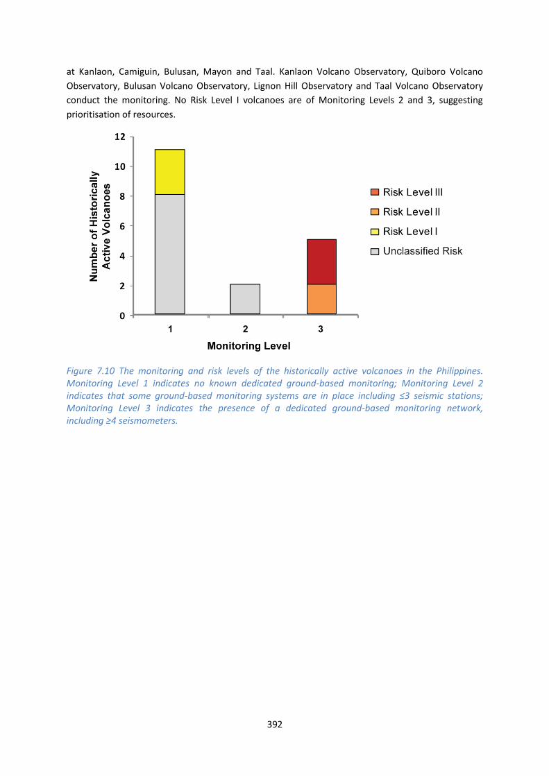
392
at Kanlaon, Camiguin, Bulusan, Mayon and Taal. Kanlaon Volcano Observatory, Quiboro Volcano
Observatory, Bulusan Volcano Observatory, Lignon Hill Observatory and Taal Volcano Observatory
conduct the monitoring. No Risk Level I volcanoes are of Monitoring Levels 2 and 3, suggesting
prioritisation of resources.
Figure 7.10 The monitoring and risk levels of the historically active volcanoes in the Philippines. Monitoring Level 1 indicates no known dedicated ground-based monitoring; Monitoring Level 2 indicates that some ground-based monitoring systems are in place including ≤3 seismic stations; Monitoring Level 3 indicates the presence of a dedicated ground-based monitoring network, including ≥4 seismometers.
This profile and the data therein should not be used in place of focussed assessments and information provided by local monitoring and research institutions.
Vietnam
Description
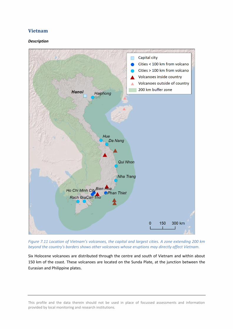
Figure 7.11 Location of Vietnam’s volcanoes, the capital and largest cities. A zone extending 200 km beyond the country's borders shows other volcanoes whose eruptions may directly affect Vietnam.
Six Holocene volcanoes are distributed through the centre and south of Vietnam and within about
150 km of the coast. These volcanoes are located on the Sunda Plate, at the junction between the
Eurasian and Philippine plates.

394
All volcanoes in Vietnam are dominantly basaltic, with the largest recorded eruption being a VEI 2.
These volcanoes are dominantly effusive to moderately explosive forming cinder cones and volcanic
fields.
Only one volcano in Vietnam has a record of historical activity. A confirmed VEI 2 eruption occurred
at the submarine Ile des Cendres volcano in 1923, creating a new island. Two uncertain eruptions
occurred at Veteran volcano in 1880 and 1928. Only the Ile des Cendres has a record of producing
lava flows. No historic or Holocene records of explosive activity are present in Vietnam. Based on
the volcano and rock types, effusive activity and the production of lavas can be expected to be the
most frequent form of activity at these volcanoes, with potential for minor localised explosive
activity.
No volcanoes lie within the 200 km buffer zone surrounding the country, though the capital of
Vietnam, Hanoi, lies closer to Hainan Dao and Leizhou Bandao volcanoes in China than any
Vietnamese volcano. Ho Chi Minh is the largest city in Vietnam, and Bas Dong Nai lies within 70 km
of this city. This volcano thus has a very high local population. Most volcanoes here have a low to
moderate PEI. Several of the largest cities in the south of Vietnam are located within 100 km of Haut
Dong Nai and Bas Dong Nai and hence considerable infrastructure is exposed, and a very large
population is located within 10 km of these volcanoes. The 100 km radius of Toroeng Prong extends
beyond the Vietnam border and into Laos and Cambodia. No historical record of fatalities or
property damage exists for eruptions in Vietnam.
No information is available at the time of the writing of this report to indicate that ground-based
monitoring is undertaken at any of the volcanoes in Vietnam. The Institute of Geological Sciences
and Geophysics at the Vietnam Academy of Science and Technology is responsible for undertaking
research in geological hazards and for the prediction of geological hazards and mitigation of their
effects. A network of seismometers is present through the country, with four broadband
seismographs along the coast and two further inland in the north, which can be accessed through
the Ocean Hemisphere Project Data Management Center at University of Tokyo.
See also:
Institute of Geological Sciences: www.vast.ac.vn/en/about-vast/organization-
chart/institutes/institutes-established-by-the-government/1011-institute-of-geological-sciences
Volcano Facts
Number of Holocene volcanoes 6
Number of Pleistocene volcanoes with M≥4 eruptions -
Number of volcanoes generating pyroclastic flows -
Number of volcanoes generating lahars -
Number of volcanoes generating lava flows 1
395
Number of fatalities caused by volcanic eruptions -
Tectonic setting Intra-plate
Largest recorded Pleistocene eruption -
Largest recorded Holocene eruption The VEI 2 eruption of the Ile des Cendres in 1923 AD.
Number of Holocene eruptions 1 confirmed eruption. 2 uncertain eruptions.
Recorded Holocene VEI range 2
Number of historically active volcanoes 1
Number of historical eruptions 1
Number of
volcanoes
Primary volcano type Dominant rock type
4 Small cone(s) Basaltic (4)
2 Submarine Basaltic (1), Unknown (1)
Table 7.12 The number of volcanoes in Vietnam, their volcano type classification and dominant rock type according to VOTW4.0.
Socio-Economic Facts
Total population (2012) 90,951,000
Gross Domestic Product (GDP) per capita (2005 PPP $) 3,013
Gross National Income (GNI) per capita (2005 PPP $) 2,970
Human Development Index (HDI) (2012) 0.617 (Medium)
Population Exposure
Capital city Hanoi
Distance from capital city to nearest Holocene volcano 448.4 km
Total population (2011) 90,549,390
Number (percentage) of people living within 10 km of a Holocene volcano
144,266 (<1%)
Number (percentage) of people living within 30 km of a Holocene volcano
1,946,903 (2.2%)
Number (percentage) of people living within 100 km of a Holocene volcano
22,513,716 (24.9%)
Ten largest cities, as measured by population and their population size:
Ho Chi Minh City 3,467,331
Hanoi 1,431,270

396
Da Nang 752,493
Haiphong 602,695
Bien Hoa 407,208
Hue 287,217
Can Tho 259,598
Rach Gia 228,356
Phan Thiet 160,652
Long Xuyen 158,153
Infrastructure Exposure
Figure 7.12 The location of Vietnam’s volcanoes and the extent of the 100 km zone surrounding them. Ports, airports and the major cities are just some of the infrastructure that may be exposed to volcanic hazards.
397
Number of airports within 100 km of a volcano 1
Number of ports within 100 km of a volcano 6
Total length of roads within 100 km of a volcano (km) 2,271
Total length of railroads within 100 km of a volcano (km) 549
The Vietnamese volcanoes are situated in the south of the country and off the coast. Hanoi, the
capital of Vietnam, is distal at over 400 km to the nearest volcano – Leizhou Bandao in China. Several
of the largest cities in Vietnam are located within 100 km of Haut Dong Nai and Bas Dong Nai
volcanoes, including Ho Chi Minh City, the largest city here. Significant infrastructure is located
within 100 km of the volcanoes, including ports and airports, and an extensive road and rail network.
The 100 km radius of Toroeng Prong extends beyond the Vietnam border and into Laos and
Cambodia.
Hazard, Uncertainty and Exposure Assessments
The eruption record for Vietnam’s volcanoes is too sparse to undertake calculation of the hazard
without large associated uncertainties. Indeed, of the six volcanoes here, only Ile des Cendres has a
confirmed Holocene record, with an eruption in 1923.
The PEI in Vietnam ranges from low to very high, with most volcanoes having a low to moderate PEI.
Just one volcano, Bas Dong Nai located close to Ho Chi Minh, has a very high local population.
Though the hazard level is unclassified here, the risk would be high due to this large population.
CLA
SSIF
IED
Hazard III
Hazard II
Hazard I
UN
CLA
SSIF
IED
U – HHR
Ile des Cendres
U- HR
U- NHHR
Veteran
Cù-Lao Ré Group; Toroeng Prong
Haut Dong Nai
Bas Dong Nai
PEI 1 PEI 2 PEI 3 PEI 4 PEI 5 PEI 6 PEI 7 Table 7.13 Identity of Vietnam’s volcanoes in each Hazard-PEI group. Those volcanoes with a sufficient record for determining a hazard score are deemed ‘Classified’ (top). Those without sufficient data are ‘Unclassified’ (bottom). The unclassified volcanoes are divided into groups: U-NHHR is Unclassified No Historic or Holocene Record: that is there are no confirmed eruptions recorded in the Holocene. U-HR is Unclassified with Holocene Record: that is there are confirmed
398
eruptions recorded during the Holocene, but no historical (post-1500) events. U-HHR is Unclassified with Historic and Holocene record. The unclassified volcanoes in bold have experienced unrest or eruptions since 1900 AD, and those in red have records of at least one Holocene VEI ≥4 eruption.
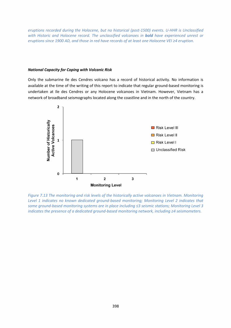
National Capacity for Coping with Volcanic Risk
Only the submarine Ile des Cendres volcano has a record of historical activity. No information is
available at the time of the writing of this report to indicate that regular ground-based monitoring is
undertaken at Ile des Cendres or any Holocene volcanoes in Vietnam. However, Vietnam has a
network of broadband seismographs located along the coastline and in the north of the country.
Figure 7.13 The monitoring and risk levels of the historically active volcanoes in Vietnam. Monitoring Level 1 indicates no known dedicated ground-based monitoring; Monitoring Level 2 indicates that some ground-based monitoring systems are in place including ≤3 seismic stations; Monitoring Level 3 indicates the presence of a dedicated ground-based monitoring network, including ≥4 seismometers.