APPENDIX B Proposed Project...
273
State of California, Coastal Impact Assistance Program, Final Plan 2009 State of California Coastal Impact Assistance Program FINAL PLAN 2009 APPENDIX B Proposed Project Descriptions State of California Projects San Francisco Bay Conservation and Development Commission Department of Boating and Waterways Department of Fish and Game Coastal Commission State Coastal Conservancy Ocean Protection Council Natural Resources Agency State Lands Commission Department of Parks and Recreation (State Parks) Coastal Political Subdivision Projects Alameda County Contra Costa County Los Angeles County Marin County Monterey County Napa County Orange County San Diego County City and County of San Francisco San Luis Obispo County San Mateo County Santa Barbara County Santa Clara County Santa Cruz County Solano County Sonoma County Ventura County California Natural Resources Agency March 2009 Page 200
Transcript of APPENDIX B Proposed Project...

State of California, Coastal Impact Assistance Program, Final Plan 2009
State of California Coastal Impact Assistance Program
FINAL PLAN 2009
APPENDIX B Proposed Project Descriptions
State of California Projects
San Francisco Bay Conservation and Development Commission Department of Boating and Waterways Department of Fish and Game Coastal Commission State Coastal Conservancy Ocean Protection Council Natural Resources Agency State Lands Commission Department of Parks and Recreation (State Parks)
Coastal Political Subdivision Projects
Alameda County Contra Costa County Los Angeles County Marin County Monterey County Napa County Orange County San Diego County City and County of San Francisco San Luis Obispo County San Mateo County Santa Barbara County Santa Clara County Santa Cruz County Solano County Sonoma County Ventura County
California Natural Resources Agency
March 2009 Page 200
State of California, Coastal Impact Assistance Program, Final Plan 2009
State of California Coastal Impact Assistance Program
Project Descriptions proposed by
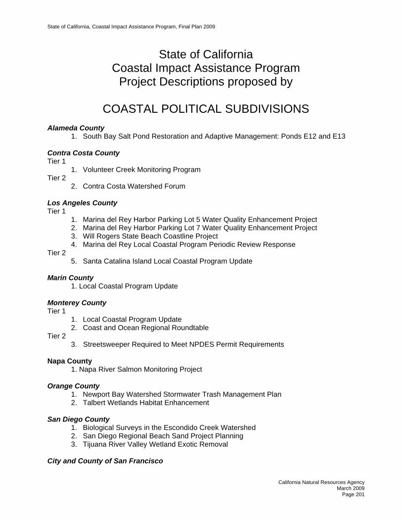
COASTAL POLITICAL SUBDIVISIONS Alameda County
1. South Bay Salt Pond Restoration and Adaptive Management: Ponds E12 and E13 Contra Costa County Tier 1
1. Volunteer Creek Monitoring Program Tier 2
2. Contra Costa Watershed Forum Los Angeles County Tier 1
1. Marina del Rey Harbor Parking Lot 5 Water Quality Enhancement Project 2. Marina del Rey Harbor Parking Lot 7 Water Quality Enhancement Project 3. Will Rogers State Beach Coastline Project 4. Marina del Rey Local Coastal Program Periodic Review Response
Tier 2 5. Santa Catalina Island Local Coastal Program Update
Marin County 1. Local Coastal Program Update Monterey County Tier 1
1. Local Coastal Program Update 2. Coast and Ocean Regional Roundtable
Tier 2 3. Streetsweeper Required to Meet NPDES Permit Requirements
Napa County 1. Napa River Salmon Monitoring Project Orange County
1. Newport Bay Watershed Stormwater Trash Management Plan 2. Talbert Wetlands Habitat Enhancement
San Diego County
1. Biological Surveys in the Escondido Creek Watershed 2. San Diego Regional Beach Sand Project Planning 3. Tijuana River Valley Wetland Exotic Removal
City and County of San Francisco
California Natural Resources Agency
March 2009 Page 201

State of California, Coastal Impact Assistance Program, Final Plan 2009
1. Port of San Francisco Pier, Wharf and Apron Removal, Repair, and Maintenance Program
San Luis Obispo County Tier 1
1. Invasive Species Removal in the Guadalupe-Nipomo Dunes 2. Los Osos Habitat Conservation Plan 3. Elfin Forest Restoration 4. Pismo Creek Estuary Enhancement and Dune Stabilization 5. Administrative Costs for CIAP
Tier 2 6. Community Wildland Fire Safety Improvement Project 7. Fiscalani Ranch Preserve, Miscellaneous Projects 8. Low Impact Development Standards Implementation 9. Oso Flaco Lakes Water Quality and Sedimentation 10. Strategic Plan Implementation Project
San Mateo County 1. Fitzgerald Marine Reserve Vegetation Management Plan
Santa Barbara County Tier 1
1. Point Sal Reserve Public Access Project Report 2. Goleta Beach Park Coastal Access and Recreational Enhancement 3. Santa Ynez River Tamarisk and Arundo Project 4. Program to Reduce Water Pollution from Targeted Businesses 5. Education to Reduce Water Pollution in Coastal Areas 6. Creekside Resident Water Pollution Education 7. Public Opinion Survey
Tier 2 8. Santa Claus Lane Beach Access 9. Jalama Beach Improvements 10. Gobernador Debris Basin Modification 11. Dog and Equestrian Use Program at Rancho Guadalupe Dunes County Park 12. Carpinteria Creek Arundo Removal Project 13. Arroyo Burro Creek Arundo Removal Project 14. Goleta Slough Protection 15. Gaviota Coast Acquisition(s) 16. Camino Majorca Beach Access Stairway Improvements 17. Ocean Beach County Park Estuary Boardwalk 18. Walter Capps Park
Santa Clara County 1. Mercury Remediation at Almaden Quicksilver County Park Santa Cruz County Tier 1
1. Shingle Mill Gulch Project 2. Gold Gulch Culvert Replacement 3. County Culvert Replacement Program
California Natural Resources Agency March 2009
Page 202

State of California, Coastal Impact Assistance Program, Final Plan 2009
Tier 2 4. Corralitos Creek at Post Mile 2.95 5. Kings Creek Road Culvert Retrofit 6. Blue Trail Dam 7. Disc Golf Course
Solano County 1. Lynch Reservoir Wetland Resources Planning Sonoma County 1. Bodega Bay Trail Ventura County Tier 1
1. Coastal Biological Resource Impact Mitigation Program 2. Local Coastal Program Amendments 3. Watercourse Buffer Ordinance
Tier 2 4. Climate Change Mitigation and Preparation Program 5. BEACON Beach Nourishment Assistance 6. Local Coastal Program Map Amendments
California Natural Resources Agency
March 2009 Page 203

State of California, Coastal Impact Assistance Program, Final Plan 2009
STATE OF CALIFORNIA COASTAL IMPACT ASSISTANCE PLAN
ALAMEDA COUNTY
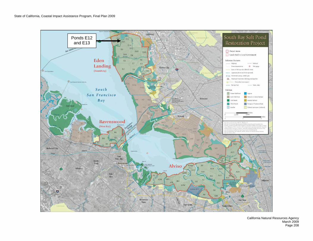
NAME OF AGENCY/DEPARTMENT Alameda County Flood Control and Water Conservation District PROJECT TITLE South Bay Salt Pond Restoration and Adaptive Management: Ponds E12 and 13 PROJECT CONTACT INFORMATION Primary Staff Contact: Hank Ackerman Address: 399 Elmhurst Street, Hayward, CA 94544 Telephone: (510) 670-5553 Fax: (510) 670-5247 E-mail: [email protected] PROJECT SUMMARY Project Location: Eden Landing Ecological Reserve, Hayward, CA Project Duration: July 2009 - October 2012 Total Estimated Project Cost: $5,447,936 Total CIAP Funding Requested: $147,936 Amount and Source: Design: $300,000 (Coastal Conservancy, Prop. 40) of Non-Federal Match Construction: $5,000,000 (WCB, Prop. 84) Spending Estimate 2009 - $15,000 Per Calendar Year 2010 - $55,000 of CIAP Funds 2011 - $60,000 2012 - $17,936 Project Background and Desription The purpose of the overall South Bay Salt Pond (SBSP) Restoration Project is to restore a mosaic of habitats in South San Francisco Bay while providing for flood protection and wildlife-oriented public access. Within that context, the purpose of this proposed project is the monitoring and adaptive management of the restoration of Ponds E12 and E13 within the 5,500-acre Eden Landing Ecological Reserve (Eden Landing) in Alameda County. In 2003, Cargill sold 15,100 acres of South Bay salt ponds to the California Department of Fish and Game (DFG) and the U.S. Fish and Wildlife Service (USFWS) (Figure 1). The long-term restoration plan for these ponds is being developed through the South Bay Salt Pond (SBSP) Restoration Project, a habitat restoration and enhancement plan that will be implemented over the next 30+ years. An essential component of the SBSP Restoration Project is adaptive management. This is the ability to observe and learn from habitat restoration and enhancement actions resulting in improvements to those actions while informing future actions.
California Natural Resources Agency
March 2009 Page 204

State of California, Coastal Impact Assistance Program, Final Plan 2009
The SBSP Restoration Project has been planned by a collaborative team of resource managers and land owners and has included extensive education and outreach efforts for, and contributions by, the people in the surrounding communities. The key partners on the SBSP Restoration Project’s Management Team are the Coastal Conservancy, DFG, USFWS, the Alameda County Flood Control and Water Conservation District (ACFCWCD), the Santa Clara Valley Water District, and the U.S. Army Corps of Engineers. Complete information on the SBSP Restoration Project is available at www.southbayrestoration.org. The primary objective of the SBSP Restoration Project is to:
Create, restore, or enhance habitats of sufficient size, function, and appropriate structure to: • Promote restoration of native special-status plants and animals that depend on South San
Francisco Bay habitat for all or part of their life cycles. • Maintain current migratory bird species that utilize existing salt ponds and associated
structures such as levees. • Support increased abundance and diversity of native species in various South San
Francisco Bay aquatic and terrestrial ecosystem components, including plants, invertebrates, fish, mammals, birds, reptiles and amphibians.
Achieving this objective requires the restoration of tidal wetlands and the enhancement of former salt ponds to provide improved habitat for migratory birds and waterfowl. The SBSP Restoration Project including the Project’s Phase 1 actions is the subject of a Final EIS/R that was released in December 2007. Design of the Phase 1 actions including the restoration of Ponds E12 and E13 is proceeding with funding from the Coastal Conservancy. Collectively, the construction and adaptive management of the Phase 1 actions is estimated to cost about $35,000,000 with funding anticipated to be provided by the USFWS, the Coastal Conservancy, the Wildlife Conservation Board, the US Geological Survey, and various grants (NAWCA, Coastal Wetlands, NFWF, etc.). The purpose of this proposed project is the monitoring and adaptive management of the restoration of Ponds E12 and E13 at Eden Landing to establish ponds of varying salinities that are expected to support bird species that have come to rely on salt ponds. These ponds total 230 acres and are owned by DFG. DFG is working collaboratively with the ACFCWCD and the other agencies on this restoration activity. Implementation of the first phase of SBSP restoration actions will span from 2008 to 2012 and will include the restoration of Ponds E12 and E13. Restoration of Ponds E12 and E13 is scheduled for 2010. Ponds E12 and E13 will be reconfigured to create shallow water foraging habitat for migratory shorebirds, with a range of salinities, and a limited number of islands for nesting bird habitat. As specified in the SBSP Restoration Project’s Adaptive Management Plan, the E12 and E13 restoration will test the extent to which focused management of shallow water habitats can increase migratory shorebird densities, the importance of salinity on the density of foraging shorebirds and their prey, and techniques for vegetation management, predator management, and water and salinity management. This project will provide funding for the shorebird applied study of the E12 and E13 restoration. The results will be used to improve management of Ponds E12 and E13 so that the SBSP Restoration Project’s objectives can be achieved. It will also inform managers if additional ponds should be restored and managed in similar ways.
California Natural Resources Agency
March 2009 Page 205

State of California, Coastal Impact Assistance Program, Final Plan 2009
Measurable Goals and Objectives The goal of this project is to provide information for managers to act on observations of shorebird populations and behavior in a well-defined environment. Objectives Objective 1: Determine to what extent focused management of shallow-water habitats increases
the densities of foraging shorebirds. Objective 2: Determine the importance of salinity to the density of foraging shorebirds and their
prey. Objective 3: Identify specific pond management changes to improve habitat for foraging
shorebirds. Objective 4: Identify additional applied studies that may be useful in adaptive management of
habitat for foraging shorebirds. Timetable and Deliverables Expected deliverables for this project are applied study results annually by May 1 of the calendar year following each year’s work. The applied study results will include analysis of shorebird usage of the reconfigured habitat in Ponds E12 and 13, observations on vegetation and predator management, and recommendations for adaptive management actions regarding these and other ponds. It is anticipated that the adaptive management recommendations will become more explicit as the Project progresses over time.
COMPLETED BY
DELIVERABLES
October 2009 Detailed workplan for E12/13 Applied Study May 2011 Progress Report on 2010 data collection and workplan for
2011 field data collection. May 2012 Progress Report on 2011 data collection.
October 2012 Final report on E12/13 Applied Study including complete data analysis, recommendations for management changes for E12/13, and recommendations for additional Applied Studies
CALIFORNIA OCEAN PROTECTION COUNCIL This project will advance the state toward meeting three of the California Ocean Protection Council’s Strategic Plan goals and objectives:
• Research and Monitoring: This project will provide key information regarding the behavior of shorebirds in response to habitat modifications aimed at increasing their densities in specific managed environments.
• Physical Processes and Habitat: This project will provide for the enhancement of critical habitats for shorebirds in South San Francisco Bay.
California Natural Resources Agency
March 2009 Page 206

State of California, Coastal Impact Assistance Program, Final Plan 2009
• Ocean and Coastal Ecosystems: The enhancement of critical shorebird habitat in South San Francisco Bay is an essential element of the Pacific Flyway.
In particular, the 2006 Strategic Plan states on page 48 (Appendix A, Goal D, Objective 1, Action 1d): “Complete planning and begin implementation for restoration of at least 30,000 acres of coastal or San Francisco Bay wetlands. Complete planning and begin ecosystem-scale wetlands restoration projects (e.g., South Bay Salt Ponds), including adaptive management and monitoring.” COORDINATION WITH OTHER FEDERAL RESOURCES AND PROGRAMS: The U.S. Fish and Wildlife Service and the U.S. Army Corps of Engineers are members of the South Bay Salt Pond (SBSP) Restoration Project’s Management Team. CONSISTENCY WITH CIAP AUTHORIZED USES This project is consistent with CIAP authorized use #1: Projects and activities for the conservation, protection, or restoration of coastal areas, including wetlands. The purpose of the overall SBSP Restoration Project is to restore a mosaic of habitats, including wetlands, in South San Francisco Bay while providing for flood protection and wildlife-oriented public access.
California Natural Resources Agency
March 2009 Page 207
State of California, Coastal Impact Assistance Program, Final Plan 2009
California Natural Resources Agency
March 2009 Page 208
Ponds E12 and E13

State of California, Coastal Impact Assistance Program, Final Plan 2009
California Natural Resources Agency
March 2009 Page 209
STATE OF CALIFORNIA COASTAL IMPACT ASSISTANCE PLAN
CONTRA COSTA COUNTY
NAME OF AGENCY/DEPARTMENT Community Development PROJECT TITLE Contra Costa County Volunteer Creek Monitoring Program – Tier 1 PROJECT CONTACT INFORMATION Name of Primary Staff Contact: Abigail Fateman Address: Contra Costa County Community Development
651 Pine Street, 4th Floor, North Wing Martinez, CA 94553
Phone: (925) 335-1272 Fax: (925) 335-1299 E-mail: [email protected] PROJECT SUMMARY Location: Watersheds/Creeks in Contra Costa County Project Duration: This is an on-going program that works with community
volunteers to collect scientifically sound base line data on the health of creek and watersheds in the County.
Total Estimated Project Cost: $600,000 ($200,000 per year for three years) Total CIAP Funding Requested: $70,211 Amount and Source of Non-Federal Match: Contra Costa Clean Water Program: $65,000 (funding) $25,000 (in-kind support) Contra Costa County Community Development Department: ~ $65,000 (funding) $25,000 (in-kind support) CIAP Spending Estimate Per Year of Project Duration: We anticipate spending the money evenly throughout the 3-year time period. The overall reduction in CIAP funding for Contra Costa County Programs does not jeopardize the successful implementation of the proposed programs. It increase the local fundraising effort needed to support this program. There are many local and state funding opportunities that staff will pursue. 2009 - $23,403.81 2010 - $23,403.81 2011 - $23,403.81 Project Background and Description The Contra Costa County Community Development Department (CDD) is submitting this proposal requesting CIAP funds to support the Volunteer Creek Monitoring Program (Volunteer Program). There are three components to the Volunteer Creek Monitoring Program 1) GPS (Global Positioning
State of California, Coastal Impact Assistance Program, Final Plan 2009
California Natural Resources Agency
March 2009 Page 210
System) Surveys of physical features of creeks, 2) Bioassessment Surveys using benthic macroinvertebrates (BMIs) and 3) Resource and Monitoring Assistance Center. The data collected will document baseline conditions of creeks in Contra Costa County that drain the San Joaquin Delta and San Francisco Bay. The data will assist local jurisdictions in making management decisions and supply local creek groups with information need to design restoration, apply for grant funding and target education efforts Monitoring Program History The volunteer GPS creek survey program was initiated in 2001 to ensure that volunteers’ interests in conducting monitoring could be directed toward collecting useful, comparable, high-quality data countywide. The CCCWP initiated professional bioassessment surveys in 2001 and also conducted some pilot volunteer bioassessment programs. In 2003, CCWF and CCCWP jointly submitted a request to the State Water Resources Control Board for $250K to hire a volunteer coordinator to administer the GPS creek survey program and to initiate a comprehensive volunteer bioassessment program. The grant request also proposed to establish a volunteer monitoring assistance center composed of a lending library of reference documents, monitoring equipment, and some staff guidance and support. The grant request was approved and a volunteer coordinator was hired in 2004. The grant was completed in late 2006. Fiscal year 06-07 was the first year that the Volunteer Program was supported entirely on local funds from a combination of sources. Contra Costa Clean Water Program and Community Development Department staff has overseen the monitoring program for FY06-07. In the first half of FY 06-07 the Volunteer Program: refined GPS protocols, expanded bioassessments for the spring of 2007 to include more watersheds (55 bioassessment sites), and continued to engage the public in collecting data on creeks in the county (90 volunteers were involved with the GPS Surveys and 55 volunteers are anticipated to participate in this spring’s bioassessment surveys). We hope to continue this important monitoring program and continue supporting volunteer creek monitoring activities in over 15 watersheds in Contra Costa County. Volunteer Creek Monitoring Program Activities The proposed monitoring activities directly impact the community, environment and resource managers in Contra Costa County (CCC). More detailed information on the three components of the Volunteer Program is provided below. 1) GPS Habitat/Physical Feature Mapping (Fall annually). The Volunteer Creek Monitoring Coordinator will manage the GPS data collection program. Each volunteer data collection group (nine person minimum) will be trained in the mapping protocol. The group, with supervision from the Coordinator and other trained staff, will map creek corridors and conditions. Geographically-explicit data are collected both in-stream and along channel banks and include information on the following conditions: bank composition, bank slope, shade cover, substrate composition, vegetation characteristics, invasive plants and constructed features such as outfalls, bridges, dumping areas, retaining walls, and drop structures. The collected data can be queried to screen for fish habitat and barriers, prioritize areas for restoration efforts, identify erosion sites that contribute to sedimentation, map common trash dumping areas as well as address many other questions that are asked by resource managers and community groups. 2) Bioassessment Surveys (Spring annually). The Volunteer Creek Monitoring Coordinator will manage the Bioassessment Survey program. Staff will supervise volunteers trained in the California Rapid Bioassessment Protocol (benthic macroinvertebrate sampling and physical habitat assessment) as they survey approximately 55 sites in 11 representative watersheds across Contra Costa County.

State of California, Coastal Impact Assistance Program, Final Plan 2009
California Natural Resources Agency
March 2009 Page 211
Selected sampling sites coincide with previously monitored sites under the State of California’s Surface Water Ambient Monitoring Program (SWAMP) and the Contra Costa Monitoring and Assessment Program (CCMAP). Collected data is compatible with and submitted to statewide databases. Spring 2007 sites include 14 sites selected expressly for CCMAP. Working with the CCCWP, efforts will be made to select CCMAP sites in 2008 in watersheds with active volunteer groups. If the situation arises that no volunteers can be recruited in watersheds selected under CCMAP, the attached budget provides for a 15% contingency to cover the cost of hiring an assistant to complete bioassessment surveys in unrepresented watersheds.
3) Resource Center (annually). The substantial array of equipment, manuals, and other resources acquired by the Volunteer Creek Monitoring Program have been catalogued and will continue to be available for lending to people conducting creek and watershed monitoring in the County. The Volunteer Creek Monitoring Coordinator will be available to provide hands-on assistance to groups borrowing the equipment. In the first half of FY’06 – ’07 approximately 20 groups or individuals took advantage of the Resource Center to borrow equipment, request technical support or interpret data. Benefits of the Monitoring Program Monitoring programs educate and involve community members while also providing important data to resource managers. As water quality, physical conditions, and in-stream resources are tracked, resource managers can better prioritize restoration and water quality management efforts. By instituting a countywide monitoring system and protocols, the monitoring program ensures compatible, consistent and reliable data that may assist with meeting stormwater permit monitoring requirements. Additional benefits include: Increased recruitment for local community groups. The opportunity to participate in the CCWF
Creek Monitoring Program attracts new volunteers to their groups. Local creek activities beyond ‘creek clean-ups’ that teach scientific survey skills, use new technology and collect data that informs resource management decisions is a powerful volunteer recruitment and education tool.
More comparable data about creeks. The Bioassessment surveys conducted by volunteers are coordinated with the bioassessment efforts conducted by the State of California’s Surface Water Ambient Monitoring Program (SWAMP). The collected data is contributing the development of a SF Bay Area wide biological index (IBI) that will be used to evaluate creek biological health and inform landuse and land management decisions.
Cultivation of citizen scientists and stewards. Past volunteers with the monitoring program have taken leadership roles with local creek organizations and have used their personal and professional networks to be active stewards of watersheds. For example past (and current) participants have organized neighbors along creeks to collaborate to apply for restoration funding (Alhambra Creek Watershed), have integrated the data collection protocols and events in to community college curriculum (Los Medanos College), have started new Friends of Creeks groups that work to educate the public on ways to protect creeks and improve water quality. These volunteers evolve into citizen scientists that can understand the data, communicate information about the status of creeks and watersheds to other community members, resource managers and decision-makers.
Measurable Goals and Objectives Miles of creek mapped: Goal – 4 miles a year Number of Bioassessment sites monitored: Goal - 25 sites a year Expanded use of volunteers in implementing other assessment protocols: Goal – Pilot programs using volunteers to implement Trash Protocols, Maintenance and Monitoring of Restoration Sites

State of California, Coastal Impact Assistance Program, Final Plan 2009
California Natural Resources Agency
March 2009 Page 212
Number of participants in programs: Continue to expand the core of volunteers by at least 20 new volunteers a year. Timeline and Deliverables July – November: Train volunteers in GPS Creek and Habitat Mapping Protocol and map creeks with
volunteers. November – March: Analyze bioassessment data collected in spring 2007 (using funds provided in
this proposal). Process and review GPS data collected in fall 2007. Present GPS and Bioassessment data to community groups, volunteers, resource managers, Watershed Assessment and Monitoring Committee representatives, and other interested stakeholders.
March – June: Acquire Bioassessment supplies, train volunteers in the California Rapid Bioassessment Protocol and collect BMI samples at over 50 sites countywide.
Completed By Deliverables
January 2010 Bioassessment: Preliminary Analysis of 2008 BMI data
January 2010 GPS Survey: Summary of number of volunteers, hours donated, creek miles surveyed
March 2009 1/4ly report of all program activities June 2009 Bioassessment: List of data collection sites sampled June 2009 1/4ly report of all program activites July 2009 Bioassessment: Complete analysis of 2008 BMI data - produce annual report September 2009 1/4ly report of all program activites December 2009 GPS Survey:List of organizations and watersheds surveyed December 2009 1/4ly report of all program activites This cycle will repeat annually
CONSISTENCY WITH THE CALIFORNIA OCEAN PROTECTION COUNCIL: This proposed project is consistent with the California Ocean Protection Council’s Strategic Plan in relation to the themes of research and Monitoring as well as Education and Outreach.
COORDINATION WITH OTHER FEDERAL RESOURCES AND PROGRAMS: The nature of this program does not require coordination with Federal Resources or Programs. CONSISTENCY WITH CIAP AUTHORIZED USES This project is consistent with the CIAP authorized use #1: Projects and activities for the conservation, protection, or restoration of coastal areas, including wetlands. The volunteer creek monitoring program educates and involvev community members while also providing important data to resource managers. As water quality, physical conditions, and in-stream resources are tracked, resource managers can better prioritize restoration and water quality management efforts. By instituting a countywide monitoring system and protocols, the monitoring program ensures compatible, consistent and reliable data that may assist with meeting stormwater permit monitoring requirements.

State of California, Coastal Impact Assistance Program, Final Plan 2009
California Natural Resources Agency
March 2009 Page 213
STATE OF CALIFORNIA COASTAL IMPACT ASSISTANCE PLAN
CONTRA COSTA COUNTY
NAME OF AGENCY/DEPARTMENT Community Development PROJECT TITLE Contra Costa Watershed Forum – Tier 2 PROJECT CONTACT INFORMATION Name of Primary Staff Contact: Abigail Fateman Address: Contra Costa County Community Development
651 Pine Street, 4th Floor, North Wing Martinez, CA 94553
Phone: (925) 335-1272 Fax: (925) 335-1299 E-mail: [email protected] PROJECT SUMMARY Location: Contra Costa County Project Duration: This is an on-going effort to coordinate activities among
concerned creek and watershed stakeholders in Contra Costa County
Total Estimated Project Cost: $240,000 ($80,000 per year for three years) Total CIAP Funding Requested: $70,211 Amount and Source of Non- Federal Match: Contra Costa County: $45,000 (staff time) Various small local grants: $10,000 CIAP Spending Estimate per Year of Project Duration: We anticipate spending the money evenly throughout a 3-year time period (FY 2008, 2009 and 2010). The overall reduction in CIAP funding for Contra Costa County Programs does not jeopardize the successful implementation of the proposed programs. It increase the local fundraising effort needed to support this program. There are many local and state funding opportunities that staff will pursue. 2009 - $23,403.81 2010 - $23,403.81 2011 - $23,403.82 Project Background and Description The Contra Costa County Community Development Department (CDD) is submitting this proposal requesting CIAP funds to support the staffing and activities of the Contra Costa Watershed Forum.

State of California, Coastal Impact Assistance Program, Final Plan 2009
California Natural Resources Agency
March 2009 Page 214
Contra Costa Watershed Forum History The Contra Costa Watershed Forum (CCWF) is an outgrowth of the first countywide Creek and Watershed Symposium held in 1999 (attended by approximately 300 people). The Forum is an open committee of some fifty organizations, including state and local agencies, local non-profit environmental and education organizations, community volunteer groups, and private citizens. The work of CCWF participants is premised on the notion that actions in a watershed are inter-related and, therefore, that broad participation and cooperation is needed to affect change. Members of the CCWF work together to find common approaches to making water resources healthy, functional, attractive, and safe for communities. The activities of the Contra Costa Watershed Forum directly impact the community, environment and decision makers in Contra Costa County (CCC). Concerned with an urban, suburban, and rural county in the San Francisco - Bay Delta area, the Contra Costa Watershed Forum provides a model for local agency and citizen collaboration; innovative strategies for stewardship and protection of watershed resources; and regional capacity building for stakeholders in CCC and neighboring areas. Neighboring regions look to the CCWF to find ways to approach challenges in local watershed planning, resource allocation and community education and engagement. The Contra Costa Watershed Forum’s effectiveness in coordinating activities, creating and sponsoring innovative programs that address water quality and watershed awareness among the community, resource managers and decision-makers has been recognized in the SF Bay Delta region and is identified in the SF Bay Regional Water Quality Control Board’s Watershed Initiative Chapter:
“Since the inception of the CCWF, there has been a marked increase in watershed restoration and preservation activities, activism, and awareness. New volunteer groups have formed, and programs to educate, research, and document the health of creeks and watersheds are more widely available. The CCWF also is an example to other counties and has shared their experience and expertise with other local agencies and watershed groups in the region.”
The document continues to identify high priority projects for funding in Contra Costa County, including:
“Planning activities at county-wide as well as local watershed levels (through the Contra Costa Watershed Forum); fostering creek groups and encouraging restoration projects; long-term planning for new development mitigation issues (now under the auspices of the CCWF). Support for citizen monitoring, ongoing support for CCWF, land acquisitions, eradication of exotic plants, and restoring and protecting streams, with a priority focus on fish-bearing creeks.”
http://www.waterboards.ca.gov/sanfranciscobay/watershedmanagement.htm (updated document provided by Dale Hopkins at SFRWQCB) Contra Costa Watershed Forum Activities Since 1999, the Watershed Forum successfully hosted another countywide symposium (2003); launched an innovative Global Positioning System (GPS) mapping and data collection program that has engaged over 250 participants in more than 5,000 hours of data collection; collaborated with other county agencies to develop and implement a benthic macroinvertebrate (BMI) monitoring program; housed a lending library of resources and equipment related to creek and watershed monitoring; produced Data From the Creeks (2006) – a presentation and analysis of the volunteer collected data;

State of California, Coastal Impact Assistance Program, Final Plan 2009
California Natural Resources Agency
March 2009 Page 215
and published the award winning Contra Costa County Watershed Atlas (2003). The 3rd Quadrennial Symposium is scheduled for November 15, 2007 and will highlight initial findings in the Watershed Forum’s Historical Ecology Assessment of the Contra Costa County (funded in part by the CA Coastal Conservancy and the CA Dept. of Fish and Game). Staff from the Contra Costa County Community Development Department coordinate and facilitate the Contra Costa Watershed Forum activities. Funding is needed to provide on-going staff support for Forum activities. Measurable Goals and Objectives: Continue to have regular bimonthly meetings Host Quadrennial Contra Costa County Creek and Watershed Symposium Timeline and Deliverables
Completed By Deliverables July 2009 CCWF meeting agenda (1/09 - 7/09) December 2009 CCWF meeting agenda (7/09 - 11/09) July 2010 CCWF meeting agenda (1/09 - 7/09) December 2010 CCWF meeting agenda (7/09 - 11/09) July 2011 CCWF meeting agenda (1/09 - 7/09)
November 2011 Contra Costa County Creek and Watershed Symposium - conference materials
December 2011 CCWF meeting agenda (7/09 - 11/09)
CONSISTENCY WITH THE CALIFORNIA OCEAN PROTECTION COUNCIL This proposed project is consistent with the California Ocean Protection Council’s Strategic Plan in relation to the theme of Education and Outreach.
COORDINATION WITH OTHER FEDERAL RESOURCES AND PROGRAMS The nature of this program does not require coordination with Federal Resources or Programs. CONSISTENCY WITH CIAP AUTHORIZED USES This project is consistent with the CIAP authorized use #1: Project and activities for the conservation, protection, or restoration of coastal areas, including wetlands. The CCWF helps organize, coordinate and educate stakeholders in Contra Costa County about the creeks and watersheds that drain Contra Costa County and feed San Francisco Bay and the San Joaquin Delta.

State of California, Coastal Impact Assistance Program, Final Plan 2009
California Natural Resources Agency
March 2009 Page 216
STATE OF CALIFORNIA COASTAL IMPACT ASSISTANCE PLAN
PROJECT PROPOSAL
LOS ANGELES COUNTY NAME OF AGENCY/DEPARTMENT Department of Public Works PROJECT TITLE Marina del Rey Harbor Parking Lot 5 Water Quality Enhancement Project – Tier 1 PROJECT CONTACT INFORMATION Name of Primary Staff Contact: Angela George, Senior Civil Engineer Watershed Management Division Address: 900 South Fremont Avenue
Alhambra, CA 91803 Telephone No.: (626) 458-4341 Fax No.: (626) 457-1526 E-mail Address: [email protected] PROJECT SUMMARY Location: Marina del Rey, CA Duration: 2009-2012 (Note: project has been initiated) Total Estimated Project Cost: $287,600 Total CIAP Funding Requested: $114,497 Amount/Source of Match: $173,103 Los Angeles County General Fund CIAP Spending Estimate Per Year: 2009 – $10,500
2010 – $17,250 2011 – $37,177 2012 – $49,570
Project Background and Description The purpose of the proposed project is to assist with complying with the Marina del Rey Harbor Mothers’ Beach and Back Basins Bacteria Total Maximum Daily Load (TMDL). This project will directly improve the current impairment of Basin F in the Back Basins of the Marina del Rey Harbor. In 1998 and again in 2002, the Marina del Rey Harbor Mothers’ Beach and Back Basins D, E, and F were designated as impaired water bodies by the Los Angeles Regional Water Quality Control Board for disease-causing pathogens such as total coliform, fecal coliform, and enterococcus.
In 2003, the Regional Board adopted the Marina del Rey Harbor Mothers’ Beach and Back Basins Bacteria TMDL and named the County of Los Angeles (County), Cities of Los Angeles and Culver City, and the California Department of Transportation (Caltrans) as the responsible jurisdictions and
State of California, Coastal Impact Assistance Program, Final Plan 2009
California Natural Resources Agency
March 2009 Page 217
agencies for meeting compliance with the Bacteria TMDL and the County the primary jurisdiction since Marina del Rey Harbor is located in an unincorporated area of the Los Angeles County.
Between 2005 and 2007, a Non-Point Source Study identified runoff from parking lots as a source of bacteria contributing to these water quality impairments at Mothers’ Beach and the Back Basins. Water quality monitoring data has shown that Basin F periodically exceeds water quality standard for enterococcus bacteria. Bacteria and other pollutants of concern, such as heavy metals, nutrients, sediments, trash and debris, as well as oil and grease, are known to originate from parking lots and other similar land uses. To meet compliance with the Bacteria TMDL, the responsible jurisdictions and agencies developed an Implementation Plan, which includes structural and nonstructural Best Management Practices (BMPs). The Marina del Rey Harbor Parking Lot 5 Water Quality Enhancement Project is a structural BMP that will help meet compliance with the Bacteria TMDL in Basin F. Runoff from Parking Lot 5 discharges directly into Basin F through two small storm drains that are underneath the sidewalk adjacent to the basin. The two storm drains are approximately 60 feet apart. The proposed project consists of installing four bioretention filter BMPs along the sidewalk adjacent to the basin, one on each side of both storm drain inlets to capture the runoff from the parking lot, filter out the bacteria, and then redirect the filtered runoff to the storm drains for discharge into Basin F.Bioretention filter BMPs have been studied by numerous public agencies, including Caltrans, for their effectiveness in removing typical pollutants formed in stormwater runoff. These BMPs are known to be effective in reducing bacteria from urban and stormwater runoff. This project will result in the following benefits:
• Conservation, protection, and restoration of the Marina del Rey coastal area;
• Reduction of bacteria in Basin F by retaining and filtering runoff from the parking lot before it drains into the basin;
• Improvement of water quality to help meet compliance with the Bacteria TMDL; and
• Reduction of other pollutants of concern such as heavy metals, nutrients, sediments, trash and
debris, as well as oil and grease, from discharging into Basin F. CIAP funds will be used toward various project elements based on the funding allocations for each year. A detailed breakdown of CIAP contributions for each project element is included at the end of this proposal. Funds will be used for the following project elements:
• Project Concept Report – An assessment of the feasibility of the project, detailing cost estimates, alternatives considered, and possible BMPs.
• Project Design Concept – An assessment of the existing conditions, environmental needs
and constraints, hydrology analysis, right of way and utilities searches, traffic controls determination, permits, project schedule, and cost estimate.
• Final Design and Permitting – Complete construction plans and technical specifications
following approval of project design concept. Acquisition of any necessary permits for the construction of the project.

State of California, Coastal Impact Assistance Program, Final Plan 2009
California Natural Resources Agency
March 2009 Page 218
• Construction – Physical construction of all components of the approved Final Design. • Bio-retention filter BMPs – Devices used for treatment and retention of runoff from parking
lot. Cost Estimate and Deliverables
Description Qty Unit Cost Total Total CIAP Contribution
Feasibility Study 1 Lump Sum $ 15,000 $ 15,000 $ 10,500
Project Design Concept 1 Lump Sum $ 15,000 $ 15,000 $ 7,250
Final Design and Permitting
1 Lump Sum $ 20,000
$ 20,000 $ 10,000
Construction 1
Lump Sum $100,000
$ 100,000 $ 37,177
Project management 4 Each $ 15,000 $ 15,000 $ 0Bio-retention filter BMPs
4 Each $ 24,000
$ 96,000 $ 49,570
Piping connections to storm drains
1
Lump Sum $ 150
$ 600 $ 0
Implementation of temporary BMPs to ensure public safety and prevent contamination for Basin F
1
Lump Sum $ 5,000
$ 5,000 $ 0Traffic control 1 Lump Sum $ 1,000 $ 1,000 $ 0Mobilization of equipment
1 Lump Sum $ 10,000
$ 10,000 $ 0
Groundwater monitoring 1 Lump Sum $ 10,000 $ 10,000 $ 0
Total $ 287,600 $ 114,497 Measurable Goals and Objectives The goal of this project is to reduce the amount of bacteria that enters Basin F. This goal will be reached by installing bioretention filter BMPs in order to achieve the objectives described below. These objectives, which will ensure that the final product is completed in a timely manner, will address the bacteria runoff into Basin F. Objective 1: To develop a report detailing the proposed scope of the project, including cost
estimates, alternatives considered, and possible BMPs. Objective 2: To develop a project scope consisting of an assessment of existing conditions,
environmental needs and constraints, hydrology analysis, right of way and utilities

State of California, Coastal Impact Assistance Program, Final Plan 2009
California Natural Resources Agency
March 2009 Page 219
searches, traffic controls determination, permits, project schedule, and cost estimates.
Objective 3: To complete the final design and construction plans and technical specifications
following approval of the project design concept. Objective 4: To successfully complete construction of the project and produce a Final
Performance Report, which will include a description of the work completed, as-build drawings, and construction photos.
Timeline for Deliverables
COMPLETED BY DELIVERABLE March 2009
Project Concept Report
December 2009
Final construction plans and technical specifications
December 2010
Contract documents for construction of project
December 2012
Final Performance Report
COORDINATION WITH OTHER FEDERAL RESOURCES AND PROGRAMS No additional Federal funds will be used for this project. CALIFORNIA OCEAN PROTECTION COUNCIL The proposed project will advance the State toward meeting the goals and objectives of the California Ocean Protection Council’s Strategic Plan in the following areas:
Governance Goal
Objective 2: Interagency Collaboration – Since project costs will be shared by the jurisdictions and agencies responsible for complying with the Bacteria TMDL, including the County, Cities of Los Angeles and Culver City, and Caltrans, interagency collaboration will be essential for the success of the project and will occur through the execution of Memorandum of Agreements among the participating agencies, as well as through meetings and electronic and telephone communications.
Ocean and Coastal Water Quality Goal
Objective 2: Innovation – This project will conserve, protect, and restore the Marina del Rey coastal area and improve water quality in Marina del Rey Harbor by filtering bacteria and other pollutants of concern from the runoff from the parking lot before it discharges into Basin F of the Marina del Rey.
Physical Processes and Habitat Goal
Objective 1: Habitat Restoration – The bioretention filter BMPs will filter bacteria from the runoff from the parking lot through physical processes. These physical processes will not harm the coastal habitat of the Marina del Rey.
State of California, Coastal Impact Assistance Program, Final Plan 2009
California Natural Resources Agency
March 2009 Page 220
CONSISTENCY WITH CIAP AUTHORIZED USES This project will be consistent with CIAP Authorized Use No. 1, which is the use of CIAP funds for projects and activities for the conservation, protection, or restoration of coastal areas, including wetlands. This authorized use will be achieved by installing the Bio-Retention filter BMPs to accomplish the Authorized Use mentioned above.

State of California, Coastal Impact Assistance Program, Final Plan 2009
California Natural Resources Agency
March 2009 Page 221
STATE OF CALIFORNIA COASTAL IMPACT ASSISTANCE PLAN
LOS ANGELES COUNTY
NAME OF AGENCY/DEPARTMENT Department of Public Works PROJECT TITLE Marina del Rey Harbor Parking Lot 7 Water Quality Enhancement Project – Tier 1 PROJECT CONTACT INFORMATION Name of Primary Staff Contact: Angela George, Senior Civil Engineer Watershed Management Division Address: 900 South Fremont Avenue
Alhambra, CA 91803 Telephone No.: (626) 458-4341 Fax No.: (626) 457-1526 E-mail Address: [email protected] PROJECT SUMMARY Location: Marina del Rey, CA Duration: 2008-2011 (Note: project has been initiated) Total Estimated Project Cost: $328,000 Total CIAP Funding Requested: $122,496 Amount/Source of Match: $205,504 Los Angeles County General Fund CIAP Spending Estimate Per Year: 2008 – $13,500
2009 – $22,250 2010 – $37,177 2011 – $49,569
Project Background and Description The purpose of the proposed project is to assist with complying with the Marina del Rey Harbor Mothers’ Beach and Back Basins Bacteria Total Maximum Daily Load (TMDL). This project will directly improve the current impairment of Basin E in the Back Basins of the Marina del Rey Harbor. In 1998 and again in 2002, the Marina del Rey Harbor Mothers’ Beach and Back Basins D, E, and F were designated as impaired water bodies by the Los Angeles Regional Water Quality Control Board for disease-causing pathogens such as total coliform, fecal coliform, and enterococcus.
In 2003, the Regional Board adopted the Marina del Rey Harbor Mothers’ Beach and Back Basins Bacteria TMDL and named the County of Los Angeles (County), Cities of Los Angeles and Culver City, and the California Department of Transportation (Caltrans) as the responsible jurisdictions and agencies for meeting compliance with the Bacteria TMDL and the County the primary jurisdiction since Marina del Rey Harbor is located in an unincorporated area of the Los Angeles County.
State of California, Coastal Impact Assistance Program, Final Plan 2009
California Natural Resources Agency
March 2009 Page 222
Between 2005 and 2007, a Non-Point Source Study identified runoff from parking lots as a source of bacteria contributing to these water quality impairments at Mothers’ Beach and the Back Basins. Water quality monitoring data has shown that Basin E periodically exceeds water quality standard for enterococcus bacteria. Bacteria and other pollutants of concern, such as heavy metals, nutrients, sediments, trash, debris, oil, and grease are known to originate from parking lots and other similar land uses.
To meet compliance with the Bacteria TMDL, the responsible jurisdictions and agencies developed an Implementation Plan, which includes structural and nonstructural Best Management Practices (BMPs). The Marina del Rey Harbor Parking Lot 7 Water Quality Enhancement Project is a structural BMP that will help meet compliance with the Bacteria TMDL in Basin E. Runoff from Parking Lot 7 discharges directly into Basin E of the Marina del Rey Harbor. The proposed project consists of diverting the stormwater runoff from the parking lot into an underground storage tank BMP, which will have several compartments to settle out sediments, trash, and debris, remove oil and grease, and filter out bacteria, heavy metals, and nutrients before the water is used to irrigate Admiralty Park. The parking lot may need to be regraded to obtain the desired slope needed to direct urban and stormwater runoff to the underground storage tank. Underground storage tank BMPs have been studied by numerous public agencies, including Caltrans, for their effectiveness to remove typical pollutants formed in stormwater runoff. These BMPs are known to be effective in reducing bacteria and other pollutants of concern mentioned above from urban and stormwater runoff in order to provide water suitable for irrigation reuse. This project will result in the following benefits:
• Conservation, protection, and restoration of the Marina del Rey coastal area;
• Collection and treatment of stormwater runoff from the parking lot and reuse of that water for irrigation at Admiralty Park.
• Conservation of water by storing and reusing stormwater runoff;
• Improvement of water quality to help meet compliance with the Bacteria TMDL; and
• Reduction of other pollutants of concern such as heavy metals, nutrients, sediments, trash,
debris, oil, and grease from discharging into Basin E. CIAP funds will be used toward various project elements based on the funding allocations for each year. A detailed breakdown of CIAP contributions for each project element is included at the end of this proposal. Funds will be used for the following project elements:
• Project Concept Report – An assessment of the feasibility of the project, detailing cost estimates, alternatives considered, and possible BMPs.
• Project Design Concept – An assessment of the existing conditions, environmental needs
and constraints, hydrology analysis, right of way and utilities searches, traffic controls determination, permits, project schedule, and cost estimates.
State of California, Coastal Impact Assistance Program, Final Plan 2009
California Natural Resources Agency
March 2009 Page 223
• Final Design and Permitting – Complete construction plans and technical specifications following approval of project design concept. Acquisition of any necessary permits for the construction of the project.
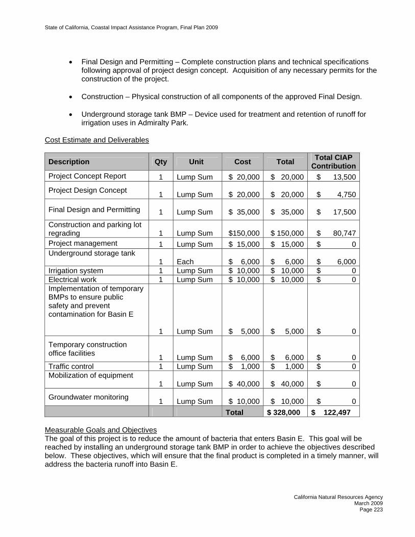
• Construction – Physical construction of all components of the approved Final Design. • Underground storage tank BMP – Device used for treatment and retention of runoff for
irrigation uses in Admiralty Park. Cost Estimate and Deliverables
Description Qty Unit Cost Total Total CIAP Contribution
Project Concept Report 1 Lump Sum $ 20,000 $ 20,000 $ 13,500
Project Design Concept 1 Lump Sum $ 20,000 $ 20,000 $ 4,750
Final Design and Permitting
1 Lump Sum $ 35,000
$ 35,000 $ 17,500
Construction and parking lot regrading
1
Lump Sum $150,000
$ 150,000 $ 80,747
Project management 1 Lump Sum $ 15,000 $ 15,000 $ 0Underground storage tank
1 Each $ 6,000
$ 6,000 $ 6,000
Irrigation system 1 Lump Sum $ 10,000 $ 10,000 $ 0Electrical work 1 Lump Sum $ 10,000 $ 10,000 $ 0Implementation of temporary BMPs to ensure public safety and prevent contamination for Basin E
1
Lump Sum $ 5,000
$ 5,000 $ 0
Temporary construction office facilities
1
Lump Sum $ 6,000
$ 6,000 $ 0Traffic control 1 Lump Sum $ 1,000 $ 1,000 $ 0Mobilization of equipment
1 Lump Sum $ 40,000
$ 40,000 $ 0
Groundwater monitoring 1 Lump Sum $ 10,000 $ 10,000 $ 0
Total $ 328,000 $ 122,497 Measurable Goals and Objectives The goal of this project is to reduce the amount of bacteria that enters Basin E. This goal will be reached by installing an underground storage tank BMP in order to achieve the objectives described below. These objectives, which will ensure that the final product is completed in a timely manner, will address the bacteria runoff into Basin E.
State of California, Coastal Impact Assistance Program, Final Plan 2009
California Natural Resources Agency
March 2009 Page 224
Objective 1: To develop a report detailing the proposed scope of the project, including cost estimates, alternatives considered, and possible BMPs.
Objective 2: To develop a project scope consisting of an assessment of existing conditions,
environmental needs and constraints, hydrology analysis, right of way and utilities searches, traffic controls determination, permits, project schedule, and cost estimates.
Objective 3: To complete the final design and construction plans and technical specifications
following approval of the project design concept. Objective 4: To successfully complete construction of the project and produce a Final
Performance Report, which will include a description of the work completed, as-built drawings, and construction photos.
Timeline for Deliverables
COMPLETED BY DELIVERABLE March 2009 Project Concept Report December 2009 Final construction plans and technical specifications December 2010 Contract documents for construction of project December 2011 Final Performance Report
COORDINATION WITH OTHER FEDERAL RESOURCES AND PROGRAMS No additional Federal funds will be used for this proje CALIFORNIA OCEAN PROTECTION COUNCIL The proposed project will advance the State toward meeting the goals and objectives of the California Ocean Protection Council’s Strategic Plan in the following areas: Governance Goal
Objective 2: Interagency Collaboration – Since project costs will be shared by the jurisdictions and agencies responsible for complying with the Bacteria TMDL, including the County, Cities of Los Angeles and Culver City, and Caltrans, interagency collaboration will be essential for the success of the project and will occur through the execution of Memorandum of Agreements among the participating agencies, as well as through meetings and electronic and telephone communications.
Ocean and Coastal Water Quality Goal
Objective 2: Innovation – This project will conserve, protect, and restore the Marina del Rey coastal area and improve water quality in Marina del Rey Harbor by filtering bacteria and other pollutants of concern from the runoff from the parking lot before it discharges into Basin E of the Marina del Rey.
Physical Processes and Habitat Goal
Objective 1: Habitat Restoration – The bio-retention filter BMPs will filter bacteria from the runoff from the parking lot through physical processes. These physical processes will not harm the coastal habitat of the Marina del Rey.

State of California, Coastal Impact Assistance Program, Final Plan 2009
California Natural Resources Agency
March 2009 Page 225
CONSISTENCY WITH CIAP AUTHORIZED USES This project will be consistent with CIAP Authorized Use No.1, which is the use of CIAP funds for projects and activities for the conservation, protection, or restoration of coastal areas, including wetlands. This authorized use will be achieved by installing the underground storage tank BMP to accomplish the Authorized Use mentioned above.

State of California, Coastal Impact Assistance Program, Final Plan 2009
California Natural Resources Agency
March 2009 Page 226
STATE OF CALIFORNIA COASTAL IMPACT ASSISTANCE PLAN
LOS ANGELES COUNTY
NAME OF AGENCY/DEPARTMENT Department of Beaches and Harbors PROJECT TITLE Will Rogers State Beach Coastline Project – Tier 1 PROJECT CONTACT INFORMATION Name of Primary Staff Contact: Gregory Woodell, Planning Specialist L. A. County Dept. of Beaches & Harbors Address: 13837 Fiji Way Marina del Rey, CA 90292 Telephone: (310) 305-9537 Fax: (310) 822-3827 E-mail: [email protected] PROJECT SUMMARY Location: Los Angeles County Duration: 2009 – 2011 (Note: project has been initiated) Total Estimated Project Cost: $6,725,852 Total CIAP Funds Requested: $836,288 Amount/Source of Match $3,887,564 County of Los Angeles General Fund $2,002,000 County of Los Angeles Regional Park and
Open Space District CIAP Spending Estimate per Year: 2009 - $278,763
2010 - $278,763 2011 - $278,762
Project Background and Description The Will Rogers State Beach (WRSB) Coastline Project consist of reconstruction and reinforcement of the existing beach slope with a sea wall to protect against erosion; reconstruction of the parking lot; construction of a new view deck with an accessible pedestrian walkway to the beach; and landscaping, irrigation, and security lighting improvements. This project is necessary to provide shoreline protection along the coastal bluff and access to the beach, and to stabilize the parking lot and Pacific Coast Highway. Landscaping the coastal bluffs with native vegetation will restore and conserve the natural ecosystem native to this area.
The County of Los Angeles’s (County) 72 miles of shoreline includes approximately 27 miles of public beaches that draw an annual attendance of more than 45 million visitors. Continued public enjoyment of these coastal resources includes the provision of appropriate amenities and adequate access for the public.

State of California, Coastal Impact Assistance Program, Final Plan 2009
California Natural Resources Agency
March 2009 Page 227
The WRSB Coastline Project furthers the goal of providing adequate access for the public and protecting recreational resources. WRSB, located in the City of Los Angeles near the intersection of Coastline Drive and Pacific Coast Highway, extends one and three-quarter miles along the shore. The beach features swimming and skin diving and provides several other amenities for public recreation.
The WRSB Coastline Project addresses an immediate need to ensure public access and enjoyment of the beach and protect the long-term integrity of recreational resources, which are enjoyed by millions of the County’s residents and tourists who are attracted to Southern California in large part because of its coastal resources.
The CIAP funding will be used for the construction costs related to building the sea wall, restoring the slopes, providing public access to the beach and stabilizing the parking lot and Pacific Coast highway. The total estimated cost of the WRSB Coastline Project is $6,725,852. The WRSB Coastline Project will utilize $836,288 of CIAP funding at an average of $278,763 per year for three years.
Cost Estimate and Deliverables
Item Estimated Project
Cost CIAP
Contribution Non- Federal
Match
Project Cost Estimate (36 month period)
Plans and Specifications $ 337,880 $ 337,880
Consultant Services $ 333,000 $ 333,000
Miscellaneous Expenses $ 16,000 $ 16,000
Jurisdictional Review and Plan Check $ 32,000 $ 32,000
County Services:
Architectural Engineering Services $ 271,000 $ 271,000
Project Management $ 577,072 $ 577,072
Other $700 $ 700
Construction $ 5,158,200 $ 836,288 $ 4,321,912
Total $ 6,725,852 $ 836,288 $ 5,889,564
Measurable Goals and Objectives Goal 1: The goal of this project is to complete the plans and the construction.
Objective 1: Develop the scope of work for the project. Completed.
Objective 2: Finalize the design for this project by finalizing the plans and obtaining the required permits.
Objective 3: Award a construction contract after a competitive bidding process.
Objective 4: Start construction.

State of California, Coastal Impact Assistance Program, Final Plan 2009
California Natural Resources Agency
March 2009 Page 228
Objective 5: Substantial completion of the project. Timeline for Deliverables
COMPLETED BY
DELIVERABLES
2001 (Completed) Develop a scope of work for the project. May 2009 Finalize the design for the project. August 2009 Award a construction contract. August 2009 Start construction March 2011 Substantial completion of the project.
COORDINATION WITH OTHER FEDERAL RESOURCES AND PROGRAMS This project does not coordinate funding with other federal programs. Cost Sharing or Matching Purposes: CIAP funds will not be used for cost sharing or matching purposes.
Other Project Funding Sources: This project is also being partially funded by the Los Angeles County Regional Park and Open Space District through the Safe Neighborhood Parks Proposition of 1992 and 1996 (Proposition A). Total funds from this source amount to $2,002,000. The County will contribute the remaining $3,887,564 from the County of Los Angeles general fund.
CALIFORNIA OCEAN PROTECTION COUNCIL The proposed project will advance the State toward meeting the goals and objectives of the Strategic Plan in the following area:
Ocean and Coastal Ecosystems Goal
Objective 5 – Encourage Sustainable Economic Activity – The WRSB Coastline Project furthers the State of California’s goal in the area of Ocean and Coastal Ecosystems dealing specifically with encouraging sustainable economic activity. The County’s beaches and coastal amenities are significant assets in attracting tourists which, in turn, provide a substantial economic benefit to the County and to the State of California. The WRSB Coastline Project will help maintain coastal tourism by ensuring continued access to WRSB and its amenities and encouraging sustainable economic activity without degrading, diminishing, or destroying the existing coastal resources.
CONSISTENCY WITH AUTHORIZED CIAP USES The WRSB Coastline Project is consistent with the CIAP Use No. 1, Projects and activities for the conservation, protection, or restoration of coastal areas, including wetland, and further with the Coastal Habitat Protection and Public Access funding activity, as it will achieve the goal to protect and restore Los Angeles County’s coastal area by restoring the slopes to provide shoreline protection along the coast, stabilizing the Pacific Coast Highway, and providing public access to this well-used County beach for both current and future visitors. Without this project, the deteriorating conditions will continue to limit public use and access of the beach, and threaten the stability of Pacific Coast Highway.

State of California, Coastal Impact Assistance Program, Final Plan 2009
California Natural Resources Agency
March 2009 Page 229
STATE OF CALIFORNIA COASTAL IMPACT ASSISTANCE PLAN
LOS ANGELES COUNTY
NAME OF AGENCY/DEPARTMENT Department of Regional Planning PROJECT TITLE Marina del Rey Local Coastal Program Periodic Review Response – Tier 1 PROJECT CONTACT INFORMATION Name of Primary Staff Contact: Gina M. Natoli, AICP Address: Department of Regional Planning
320 West Temple Street 13th Floor Los Angeles CA 90012
Telephone: 213/974-6422 Fax: 213/626-0434 E-mail: [email protected] PROJECT SUMMARY: Location: Marina del Rey, Los Angeles County Duration: 2009-2010 (Note; project has been initiated) Total Estimated Project Cost: $485,314 Total CIAP Funds Requested: $37,177 Amount/Source of Match: $448,137 County of Los Angeles general fund (in-kind services) CIAP Spending Estimate Per Year: 2009 - $100,000 2010 - $37,177 Project Background and Description The Marina del Rey Local Coastal Program (LCP), consisting of a land use plan and local implementation program, were last re-certified by the California Coastal Commission in 1996 and 1995, respectively. In 2005, the Coastal Commission began a Periodic Review of the Marina del Rey LCP. Through a Periodic Review, the Coastal Commission evaluates whether a certified LCP is being implemented in accordance with the California Coastal Act. A Periodic Review often contains recommendations for more effectively implementing an LCP. It is expected that the Coastal Commission will issue its Marina del Rey Periodic Review in late 2008. The County is required to respond to the Periodic Review with amendments to the LCP and/or an explanation as to why the recommendations will not be incorporated into the LCP. This project will prepare a response to the Periodic Review and analyze the potential of amending the LCP to implement Coastal Commission recommendations. The unincorporated area of Marina del Rey covers 807 acres and 11.25 miles of the California shoreline. The central feature and main attraction, the marina, is surrounded by marine commercial
State of California, Coastal Impact Assistance Program, Final Plan 2009
California Natural Resources Agency
March 2009 Page 230
land use and a resident population of approximately 9,000 people. The marina also receives many visitors that frequent the shore for marine recreational activities. The County of Los Angeles Department of Regional Planning is responsible for maintaining and enforcing land use policies and regulations that serve the residents and visitors of Marina del Rey, while ensuring the protection, maintenance, and enhancement of the area’s natural resources and marine wildlife. These policies and regulations are found in the Marina’s land use plan and local implementation program. Together these documents constitute the Marina del Rey LCP. A local coastal program establishes and regulates standards for current and future development in coastal areas. It consists of two parts: a land use plan and a local implementation program, which are drafted with input from the public. The land use plan provides a framework of goals and policies that shape a community’s vision of their future. The land use plan takes into account the area’s unique marine character and delineates how the coastal resources will be maintained and enhanced. The second part of the LCP (i.e., implementation measures) ensures that the policies in the plan are implemented and regulated. The scope of work for preparing the response and analyzing the possibility of proposing amendments will include: Survey and Research Conduct community workshops and meet with community groups, leaseholders and stakeholders
to determine responses to the Periodic Review recommendations and identify additional issues that need to be addressed
LCP Revisions Revise appropriate Marina del Rey land use plan policies based on the Periodic Review
recommendations Revise appropriate local implementation program provisions to implement the land use plan
policies that were revised based on Periodic Review recommendations Prepare public review documents
Adoption and Certification Hold a community meeting to present draft LCP amendments Hold a Regional Planning Commission public hearing on the draft LCP amendments Hold a Board of Supervisors public hearing on the draft LCP amendments; and Present the draft LCP amendments to the California Coastal Commission during a public hearing
It is estimated that the total cost for amending the Marina del Rey LCP will be $485,314. Regional Planning will utilize $137,177 of CIAP funding, at $100,000 for the first year of the project and $37,177 for the second year, for staff salaries to prepare the amendments. The remainder of the total cost estimated at $448,137 will come from County of Los Angeles general funds and will be used primarily for staff salaries. Measurable Goals and Objectives The goals of this project are for Regional Planning, in cooperation with the public and other County departments and agencies, to evaluate and analyze the recommendations contained in the Periodic Review; to prepare a response to the recommendations; to determine which amendments to propose to the certified LCP; to obtain approval from the Regional Planning Commission for the amendments; to obtain approval from the Board of Supervisors for.

State of California, Coastal Impact Assistance Program, Final Plan 2009
California Natural Resources Agency
March 2009 Page 231
Objective 1: Organize outreach to the public and ensure they are engaged in reviewing the Periodic Review recommendations.
Objective 2: Organize County departments and agencies to evaluate and analyze the Periodic
Review recommendations so that they may provide expertise on specific topics. Objective 3: Develop a draft response based on input from the public and from County
departments and agencies. Objective 4: Obtain approval from the County Board of Supervisors for the response. O
bjective 5: Identify possible amendments to the certified Marina del Rey Local Coastal Program.
Objective 6: Transmit our response to the Coastal Commission within the time period specified by the California Coastal Act.
Objective 7: Draft amendments to the Marina del Rey LCP that implement certain
recommendations of the Periodic Review. Objective 8: Conduct community meetings to take input on draft amendments. Objective 9: Obtain approval from the Regional Planning Commission for the draft amendments. Objective 10: Obtain approval from the Board of Supervisors for the draft amendments. Objective 11: Transmit the amendments to the Coastal Commission for their consideration and
certification. Timetable and Deliverables
COMPLETED BY DELIVERABLES March 2009 Comments and recommended changes received from the public,
County departments and agencies on the Periodic Review recommendations.
April 2009 Draft response is ready to release for public review and discussion at the County's Regional Planning Commission.
May 2009 Community meeting is held to gather input on the draft response. June 2009 Revised draft response is completed.
September 2009 Board of Supervisors approves the draft response and may direct that changes be made.
October 2009 Response to the Periodic Review is transmitted to the California Coastal Commission.
February 2010 Draft amendments are prepared. May 2010 Community meeting is held to gather input on the draft amendments. June 2010 Regional Planning Commission approves the draft amendments.
September 2010 Board of Supervisors approves the draft amendments and may direct that changes be made.
December 2010 LCP amendments are transmitted to the Coastal Commission for their consideration and certification.

State of California, Coastal Impact Assistance Program, Final Plan 2009
California Natural Resources Agency
March 2009 Page 232
COORDINATION WITH OTHER FEDERAL RESOURCES AND PROGRAMS No additional federal funds will be sought to complete this project. CIAP funds will not be used for cost sharing or matching purposes. CALIFORNIA OCEAN PROTECTION COUNCIL The proposed project will advance the state toward meeting the goals and objectives of the Council’s Strategic Plan in the following areas: Governance Goal Objective 2 – Interagency Collaboration – The proposed project encourages interagency collaboration with the following groups: L.A. County Public Works, L.A. County Department of Beaches and Harbors, the California Coastal Commission, and the California Department of Fish and Game. Interaction between these groups will occur via meetings and electronic/telephone correspondence to plan and discuss respective roles and issues throughout the amendment process. Objective 3 – Enforcement – Amendments to the implementation program advance enforcement efforts to maintain and enhance the Marina’s coastal resources by clarifying development standards
nd other development-related provisions. a Ocean and Coastal Water Quality Goal Objective 2 – Innovation – The LCP amendments will foster innovation by engaging a “think tank” of cooperating agencies to brainstorm sustainable mitigation techniques to reduce and eliminate
onpoint source pollution. n Physical Processes and Habitat Structure Goal Objective 2 – Regional Sediment Management – Best management practices (BMP) in runoff prevention will be applied to reduce and prevent erosion and sediment deposition. Again, multi-
dustry expertise will be utilized through interagency collaboration to inform this approach. in Education and Outreach Goal Objective 1 – Public Awareness – Through outreach methods such as announcements at community meetings, direct mailings and newspaper advertisements, the Department of Regional Planning will invite the public to workshops, meetings and hearings and encourage community involvement and education on issues and policies to protect coastal resources and guide development. CONSISTENCY WITH CIAP AUTHORIZED USES Local coastal programs are comprehensive planning and regulatory programs required by law under the California Coastal Act for all areas within the coastal zone. The Coastal Act was developed and implemented under the federal Coastal Zone Management Act of 1972. Revising the Marina del Rey LCP to ensure better implementation as recommended under the Periodic Review qualifies as a coastal conservation management plan (Authorized Use 4) because the LCP has both a comprehensive planning component and a regulatory program. The program contains policies and regulations that assess and protect coastal resources as well as implementation measures that ensure the enforcement of the policies.

State of California, Coastal Impact Assistance Program, Final Plan 2009
California Natural Resources Agency
March 2009 Page 233
STATE OF CALIFORNIA COASTAL IMPACT ASSISTANCE PLAN
LOS ANGELES COUNTY
NAME OF AGENCY/DEPARTMENT Department of Regional Planning PROJECT TITLE Santa Catalina Island Local Coastal Program Update – Tier 2 PROJECT CONTACT INFORMATION Name of Primary Staff Contact: Gina M. Natoli, AICP Address: Department of Regional Planning
320 West Temple Street 13th Floor Los Angeles CA 90012
Telephone: 213/974-6422 Fax: 213/626-0434 E-mail: [email protected] PROJECT SUMMARY Location: Santa Catalina Island, Los Angeles County Duration: 24 months Total Estimated Project Cost: $478,899 Total CIAP Funds Requested: $200,000 Amount/Source of Match: $278,889 from County of Los Angeles general fund (in-kind services) CIAP Spending Estimate Per Year: 2010 – $100,000
2011 – $100,000 Project Background and Description The Santa Catalina Island Local Coastal Program (LCP), consisting of a land use plan and a local implementation program, were certified by the California Coastal Commission in 1983 and 1989, respectively. The island’s permanent population, now approximately 3,700 people, has increased by almost 55 percent from the 2,400 recorded in 1980. This significant population increase, in addition to changes in housing conditions, infrastructure needs, the economy and environmental concerns have highlighted the need to revise the LCP. Under the proposed project, the Los Angeles County Department of Regional Planning will update the Santa Catalina Island Local Coastal Program. Santa Catalina Island is located approximately 22 miles south of the Palos Verdes Peninsula and 27 miles southwest of the Orange County coastline. It is the only significantly inhabited island near the California coast, with most development occurring in the incorporated City of Avalon and the unincorporated area of Two Harbors. Of the Island’s 76 square miles of land, over 90 percent has been set aside to remain as open space, dedicated to programs of conservation, recreation, education and research. In addition to the resident population, the island receives many visitors that are

State of California, Coastal Impact Assistance Program, Final Plan 2009
California Natural Resources Agency
March 2009 Page 234
attracted to the Island’s educational opportunities and recreational activities that include boating, camping, snorkeling and scuba diving, and hiking. The County of Los Angeles Department of Regional Planning is responsible for maintaining and enforcing land use policies and regulations that serve the residents and visitors of Santa Catalina Island, while ensuring the protection, maintenance, and enhancement of the area’s natural resources and marine wildlife. These policies and regulations are found in the Island’s land use plan and local implementation program. A Local Coastal Program (LCP) establishes and regulates standards for current and future development in coastal areas. It consists of two parts: a land use plan and a local implementation program, which are drafted with input from the public. The land use plan provides a framework of goals and policies that shape a community’s vision of their future. The land use plan takes into account the area’s unique marine character and delineates how the coastal resources will be maintained and enhanced. The second part of the LCP (i.e., the implementation measures) ensures that the policies in the plan are implemented and regulated. Tasks necessary to complete the project are listed below: Survey and Research
• Conduct a study to identify environmentally sensitive habitats as well as measure the environmental impact of development and increased human presence on the Island over the past two decades.
• Conduct community workshops and meet with landowners and stakeholders to determine additional issues that need to be addressed.
LCP Updates
• Revise the Catalina Island land use policy map. • Revise zoning to be consistent with land use (maps). • Revise the local implementation program to be consistent with the land use plan and to
incorporate changed conditions for housing, infrastructure needs, etc. Public Outreach and Hearings
• Hold a community meeting to present a Draft LCP. • Hold a Regional Planning Commission public hearing on the Draft LCP. • Hold a Board of Supervisors public hearing on the Draft LCP; and • Present the Draft LCP to the California Coastal Commission during a public hearing.
It is estimated that the total cost for updating the Santa Catalina Island LCP will be $478,899. Regional Planning will utilize $200,000 of CIAP funding, at $100,000 per year for two years to produce an updated LCP for Santa Catalina Island. CIAP funds will be used for staff salaries to produce the updated LCP. The remainder of the total cost estimated at $278,899 will come from County of Los Angeles general funds and will be used primarily for staff salaries. Measurable Goals and Objectives The goals of this project are for Regional Planning to complete an analysis of the LCP’s consistency with the California Coastal Act; to work with the public, stakeholders and other County departments to update the Santa Catalina Island Local Coastal Program (LCP); to develop options to address land use and development issues on Catalina; to prepare a draft LCP that can be reviewed by the public

State of California, Coastal Impact Assistance Program, Final Plan 2009
California Natural Resources Agency
March 2009 Page 235
and revised based on their input; to complete public hearings at both the Regional Planning Commission and the Board of Supervisors; to have the California Coastal Commission certify updates to the Santa Catalina Island LCP. Objective 1: Complete an analysis of the LCP to determine its consistency with the California
oastal Act. C Objective 2: Gather input on land use and development issues from property owners, stakeholders
nd other County departments. a Objective 3: Develop options that will address issues and revise the LCP so that it is consistent with the Coastal Act. O
bjective 4: Prepare a draft of the LCP for public review.
O
bjective 5: Hold a community meeting to take input on the draft LCP.
Objective 6: Obtain approval from the Regional Planning Commission for the draft LCP.
O
bjective 7: Obtain approval from the Board of Supervisors for the draft LCP.
Objective 8: Transmit the draft LCP to the California Coastal Commission for their consideration and certification. Timetable and Deliverables
COMPLETED BY DELIVERABLES March 2010 Santa Catalina Island Local Coastal Program (LCP) is reviewed for
consistency with the California Coastal Act. July 2010 Input on Catalina land use and development issues is gathered from
property owners, residents and stakeholders. September 2010 Options to address issues are developed, and their consistency with
the California Coastal Act is evaluated. December 2010 Draft LCP is prepared. January 2011 Draft LCP is released for public review. February 2011 A community meeting is held to take input on the Draft LCP.
April 2011 A Draft LCP, revised as necessary based on public comment, is presented to the Regional Planning Commission for consideration.
July 2011 A Draft LCP, revised as necessary based on direction from the Regional Planning Commission, is presented to the Board of Supervisors for public hearing.
November 2011 A Draft LCP, revised as necessary based on direction from the Board of Supervisors, is presented to the California Coastal Commission for their consideration and certification.
COORDINATION WITH OTHER FEDERAL RESOURCES AND PROGRAMS No additional federal funds will be sought to complete this project. CIAP funds will not be used for cost sharing or matching purposes. CALIFORNIA OCEAN PROTECTION COUNCIL The proposed project will advance the state toward meeting the goals and objectives of the Strategic Plan in the following areas:
State of California, Coastal Impact Assistance Program, Final Plan 2009
California Natural Resources Agency
March 2009 Page 236
Governance Goal Objective 2 – Interagency Collaboration – The proposed project encourages interagency collaboration with the following groups: Santa Catalina Island Conservancy, Los Angeles County Department of Parks and Recreation, Center for Natural Areas (CNA), Catalina Island Citizens Advisory Committee CICAC), and the California Coastal Commission. (
Objective 3 – Enforcement – Updates to the implementation program advance enforcement efforts to maintain and enhance the island’s coastal resources by clarifying development standards and other
evelopment-related provisions. d Objective 4 – Ecosystem-based Management – The project will utilize an ecosystem-based management approach to ensure that human needs are met in a sustainable manner while protecting oastal resources. c
Ocean and Coastal Water Quality Goal Objective 2 – Innovation – The LCP update will foster innovation by engaging a “think tank” of cooperating agencies to brainstorm sustainable mitigation techniques to reduce and eliminate
onpoint source pollution. n Physical Processes and Habitat Structure Goal Objective 2 – Regional Sediment Management – Best management practices (BMP) in runoff prevention will be applied to reduce and prevent erosion and sediment deposition. Again, multi-
dustry expertise will be utilized through interagency collaboration to inform this approach. in Ocean and Coastal Ecosystems Objective 2 – Control of Invasive Species – The project will ensure the control of invasive species hrough landscaping standards that require the use of locally-indigenous species. t
Objective 5 – Encourage Sustainable Economic Activity – The updated LCP will also encourage sustainable economic activity through plans to build new types of port and harbor infrastructure that can boost the California economy in a sustainable manner, which is the preferred development alternative. Education and Outreach Goal Objective 1 – Public Awareness – Through outreach methods such as direct mailings and newspaper advertisements, the Department of Regional Planning will invite the public to workshops, meetings and hearings and encourage community involvement and education on issues and policies to protect coastal resources and guide development. CONSISTENCY WITH CIAP AUTHORIZED USES Local coastal programs are comprehensive planning and regulatory programs required by law under the California Coastal Act for all areas within the coastal zone. The Coastal Act was developed and implemented under the federal Coastal Zone Management Act of 1972. The Santa Catalina Island LCP update qualifies as a coastal conservation management plan (Authorized Use 4) because it has both a comprehensive planning component and a regulatory program. The program contains policies and regulations that assess and protect coastal resources as well as implementation measures that ensure the enforcement of the policies.

State of California, Coastal Impact Assistance Program, Final Plan 2009
California Natural Resources Agency
March 2009 Page 237
STATE OF CALIFORNIA COASTAL IMPACT ASSISTANCE PLAN
MARIN COUNTY
NAME OF AGENCY/DEPARTMENT Community Development Agency PROJECT TITLE Local Coastal Program Update PROJECT CONTACT INFORMATION Name of Primary Staff Contact: Jack Liebster, Principal Planner Address: Marin County Community Development Agency
3501 Civic Center Drive, Room 308 San Rafael, CA 94903
Phone: (415) 473-4331 Fax: (415) 499-7880 E-mail: [email protected] PROJECT SUMMARY Location: Marin County coastal zone Duration: 2007 – 2011 (Note: project has been initiated) Total Estimated Project Cost: $124,578 Total CIAP Funds Requested $124,578 Amount/Source of Match: $12,458 (In kind, County general fund)
CIAP Spending Estimate Per Year: 2007 – $5,000.00 2008 – $32,894.50 2009 – $50,789.00 2010 – $25,894.50 2011 – $10,000 Project Background and Description Marin County is requesting funding from the Coastal Impact Assistance Program to prepare a comprehensive update to the Marin County Local Coastal Program (LCP). The California Coastal Act of 1976 requires every coastal city and county to prepare a local coastal program that establishes the kind, location, and intensity of land and water uses appropriate to each area of the coastal zone. A local coastal program (LCP) consists of a local government’s land use plans, zoning ordinances, zoning district maps, and other implementing measures which accomplish this purpose. The proposed project consists of updating Marin County’s LCP, which was originally adopted in 1980-81. The LCP consists of two separate documents (i.e., Unit I and Unit II) that address the southern and northern portions of the County’s coastal zone. In the years since the LCP was adopted, significant changes have occurred in Marin County’s coastal environment, including physical changes in the amount and location of development, regulatory changes, improved science and forecasting,

State of California, Coastal Impact Assistance Program, Final Plan 2009
California Natural Resources Agency
March 2009 Page 238
and increased demand for limited coastal resources. A growing population of Marin County residents and coastal visitors places increasing pressure on water resources, wildlife habitat, parks and trails, and other coastal zone resources. Agricultural lands in Marin County continue to experience pressure for conversion from dairies and grazing land to residential uses. Since 1980, the understanding of long-term trends that affect the coastal environment, including global warming and sea level rise, has dramatically improved. More information is available concerning the impacts of stormwater runoff and of management techniques that can be implemented to protect and enhance the quality of coastal waters. There is a continuing appreciation for the importance to the well-being of Marin County’s residents and visitors of coastal resources that include agriculture, open space, wildlife habitats, recreational opportunities, and outstanding coastal scenery. An overarching concern of the people of Marin County, as reflected in the updated Countywide Plan adopted by the Marin County Board of Supervisors on November 6, 2008, is to ensure that development decisions are made so as to ensure a sustainable future. This proposed LCP update project will apply the same theme of sustainability to the conservation and protection of coastal resources through the County’s review of proposed coastal development projects. The proposed Local Coastal Program update project will build upon initial steps taken in 2003-2004 to revise the LCP. By 2003, background studies were completed in the areas of biology and wetland protection, coastal cliff and bluff erosion, and scenic and visual resources. A report was prepared on best management practices for stormwater management, and an initial review of policy gaps in the existing LCP was undertaken. This proposed LCP update project will build upon those components already prepared and complete the update process. Additional background studies will be prepared as necessary. The LCP land use plan policies contained in the two existing documents will be consolidated into one plan that addresses the entire coastal zone of the County. The zoning and implementation portion of the LCP will be revised to be consistent with and adequate to carry out the land plan policies. This update project will also include preparation of LCP documents for public review and comment, hearings before the Planning Commission and Board of Supervisors, and submittal of the updated LCP to the California Coastal Commission for review and certification. Measurable Goals and Objectives Project Goal: Improve the protection of coastal resources and enhance implementation of the
goals of the Coastal Act. Project Objective: Amend and update the Marin County Local Coastal Program and submit to the
California Coastal Commission for review and certification by 2010. Timetable and Deliverables
COMPLETED BY
DELIVERABLES
September 2008 Detailed work program and schedule
September 2008 Prepare policy matrices comparing the existing LCP, proposed LCP policies, Countywide Plan, proposed studies, and draft changes to the Marin County Development Code

State of California, Coastal Impact Assistance Program, Final Plan 2009
California Natural Resources Agency
March 2009 Page 239
October 2008 Prepare White Paper or similar document summarizing the key issues obtained from previous public outreach efforts to update the LCP in 2003
October 2008 Update and improve the County’s website on the Local Coastal Program. Develop an email distribution and notification list for public outreach.
September 2008 Consult with Costal Commission staff
October 2008 Conduct a workshop with the Planning Commission to identify issues and strategies
Oct. 2008 – Feb. 2009 Conduct first round of up to four community meetings to identify key issues and initial strategies
Mar. 2009 – Jan. 2010 Conduct Planning Commission workshops on Topical Issues. Periodic status reports and check in to the Board of Supervisors
June 2009 – Aug 2009 Did we hear you right? Conduct second round of up to four community meetings to report on issues and preliminary strategies, and obtain additional feedback
June 2009 (ongoing)
Review of Administrative Draft of the LCP by County staff, departments, and other outside agencies. Comments incorporated into LCP Public Review Draft.
January 2010 Update natural resource and other maps as necessary and incorporate into the County’s GIS
April 2010 Circulate LCP Public Review Draft for comment
June 2010 – Dec. 2010 Conduct Planning Commission Hearings on the LCP Public Review Draft
July 2010 Incorporate comments obtained from Planning Commission Hearings into a Revised LCP Public Review Draft
Feb. 2011 – May. 2011 Conduct hearings with the Board of Supervisors to review the Revised LCP Public Review Draft and adopt a resolution to submit LCP package to the California Coastal Commission
July 2011 Submit LCP package to the California Coastal Commission for review and certification.

State of California, Coastal Impact Assistance Program, Final Plan 2009
California Natural Resources Agency
March 2009 Page 240
COORDINATION WITH OTHER FEDERAL RESOURCES AND PROGRAMS Community Development Agency staff will coordinate and consult with California Coastal Commission staff during the initial phase of the proposed project, and send public review drafts of the updated LCP throughout the update process to ensure the project is consistent with the State’s Coastal Management Program under the Coastal Zone Management Act. Through the California Coastal Commission’s Local Assistance Program, the Community Development Agency (CDA) received grant funding in the amount of $37,500 in 2002 for financial and planning assistance for the comprehensive update of Marin County’s certified LCP. The funding was used to evaluate the County’s thirty-three (33) outstanding offers to dedicate for public accessways, and resulted in draft policies and programs establishing their prioritization for acceptance, construction, and operation. Furthermore, new policies were drafted to implement best management practices and measures to identify, prevent, and control nonpoint source pollution in the coastal zone. No federal funds have been secured to carry out any component of this project. The County has investigated Federal funding programs and has not identified any programs which would be applicable for the project. CALIFORNIA OCEAN PROTECTION COUNCIL The following discussion includes how the update of Marin County’s LCP will advance the state toward meeting the goals and objectives of the California Ocean Protection Council’s Strategic Plan (COPC). The proposed project will address four of the goals as well as associated objectives of the Strategic Plan, as follows:
Goal C: Ocean and Coastal Water Quality—Significantly improve ocean and coastal water quality. Objective 2: Innovation—Support the development of new technologies and approaches to reduce nonpoint source pollution. Discussion The proposed LCP update project will amplify the procedural and substantive requirements of the Local Coastal Program with respect to the water quality impacts of proposed new development. Although the existing LCP contains certain water quality-related requirements, such as those requiring that grading undertaken as part of certain new developments be minimized in specific areas, the existing LCP does not require a thorough review of all types of development in all zone districts for potential water quality impacts, nor does the LCP contain comprehensive measures to address all types of development, both public and private, large and small. The update will ensure that best management practices are incorporated in all appropriate developments.
Goal D: Physical Processes and Habitat Structure—Significantly improve the quantity and quality of ocean and coastal habitat in California. Objective 1: Habitat Restoration—Restore and maintain valuable ocean and coastal habitats and resources. Objective 3: Understand Impacts of Climate Change—Support state efforts to detect the impacts of climate change and to develop strategies to respond to them.

State of California, Coastal Impact Assistance Program, Final Plan 2009
California Natural Resources Agency
March 2009 Page 241
Discussion Since the Local Coastal Program was adopted in 1980-81, information and knowledge about coastal biological resources has grown, and there have been changes in the status of state and federally listed threatened and endangered species. There is more information available about techniques of habitat protection and restoration. The LCP update project will apply that improved information to the land use plan that guides new development in the Marin County coastal zone and thus help to protect and restore coastal habitats. The LCP update will also afford an opportunity to apply increased knowledge about climate change and sea level rise to the particular circumstances of Marin County’s ocean coastline, consistent with the Ocean Protection Council’s goal to develop strategies to address climate change.
Goal E: Ocean and Coastal Ecosystems—Significantly increase healthy ocean and coastal wildlife populations and communities in California. Objective 3: Control Invasive Species—Significantly increase the capacity of public agencies and the private sector to respond to and reduce invasive species.
Discussion Coastal wildlife populations and plant communities in Marin County’s coastal zone are threatened by various species of invasive plants and animals on grazing lands, open space lands, and in residential areas. The proposed LCP update project will address the control of invasive species by promoting the use of native landscaping materials, supporting habitat restoration efforts that include removal of invasive plants, and through other measures such as public education. The LCP update will enhance the ability of the County of Marin to respond to the problems caused by invasive plants and animals and to reduce invasive species through the development review process and by other means.
Goal F: Education and Outreach—Promote ocean and coastal awareness and stewardship. Objective 1: Public Awareness—Increase public awareness of ocean and coastal issues and encourage individual stewardship.
Discussion The preparation, review, and adoption of Marin County’s existing Local Coastal Program in 1980-81 reflected a high level of public involvement. The residents of the county’s coastal and inland communities continue to share a high level of concern for the resources of the coast. A high degree of public involvement in the proposed LCP update is anticipated, and the public hearings, public comment opportunities, and plan drafts that will be circulated will afford an opportunity to engage the community in heightening awareness about issues facing coastal and ocean resources. The process of adopting the updated LCP and then implementing it will increase public awareness of coastal issues and of the LCP’s measures to address those issues, including individual stewardship measures that can be taken by individuals who propose new development projects in the coastal zone.
CONSISTENCY WITH CIAP AUTHORIZED USES The Local Coastal Program update project is consistent with CIAP Authorized Use #4: Implementation of a federally-approved marine, coastal, or comprehensive conservation management plan.

State of California, Coastal Impact Assistance Program, Final Plan 2009
California Natural Resources Agency
March 2009 Page 242
Local coastal programs are comprehensive planning and regulatory programs required by law under the California Coastal Act for all areas within the coastal zone. The Coastal Act was developed and implemented under the federal Coastal Zone Management Act of 1972, and mandates that each coastal county and city prepare a Local Coastal Program that addresses that goal. The Marin County Local Coastal Program update qualifies as a coastal conservation management plan because it has both a comprehensive planning component and a regulatory program. The program contains policies and regulations that assess and protect coastal resources as well as implementation measures that ensure the enforcement of the policies. This project would substantially improve implementation of the County’s Local Coastal Program and supports the implementation of the federally-approved California Coastal Management Program in Authorized Use 4. The Local Coastal Program update project will address the following issue areas: Public Access to the Coast A key aspect of the coastal environment is the ability of the public to gain access to the shoreline, to beaches, and to public tidelands. The LCP update will assess the status of public access to the coast in Marin County’s coastal zone and will bring policies into conformance with changes in law that have occurred since 1980-81. Public Recreation and Visitor-Serving Facilities The ability of the public to use and enjoy the coastal environment depends in part on the provision of parks and commercial visitor-serving facilities. The LCP update will take a fresh look at the provision of visitor facilities in Marin County’s coastal zone and address any policy changes necessary to ensure their continued availability. Environmentally Sensitive Habitat Areas, including Wetlands The LCP update project will enhance protection of wetlands, stream corridors, and other sensitive habitat areas by clarifying standards for development in or near habitat areas, improving definition of terms, and assuring that standards are consistent throughout the County’s coastal zone. Agriculture The LCP update will address the continuing pressure on Marin County’s generally modest-sized, family-run agricultural operations by new residential development proposals. The LCP update will include policies to promote the protection of agriculture in the coastal area. Hazards and Shoreline Protection The LCP update will address policies that apply to new development proposed in hazardous areas, including locations subject to future sea level rise, and to the construction of new shoreline protective devices. Visual Resources LCP policies that address the height and scale of proposed new development will be clarified and strengthened, and the impacts of new development on coastal visual resources will be taken into account. New Development LCP policies will incorporate appropriate best management practices to reduce polluted stormwater runoff and to protect the quality of coastal waters. The relationship of the LCP to community plans in

State of California, Coastal Impact Assistance Program, Final Plan 2009
California Natural Resources Agency
March 2009 Page 243
the coastal villages of Marin County’s coast will be clarified and strengthened. Policies that protect archaeological and paleontological resources will be reviewed and revised as necessary to ensure that impacts of new development on such resources will be minimized. Improved and clarified definitions of terms will be included in the updated LCP. In sum, the LCP update will strengthen the County’s ability to ensure that new private and public development is consistent with the goal of protecting and restoring the coastal environment. The County of Marin does not intend to use CIAP funds to cost share or meet another Federal program’s cost sharing or matching requirements.

State of California, Coastal Impact Assistance Program, Final Plan 2009
California Natural Resources Agency
March 2009 Page 244

State of California, Coastal Impact Assistance Program, Final Plan 2009
California Natural Resources Agency
March 2009 Page 245
STATE OF CALIFORNIA COASTAL IMPACT ASSISTANCE PLAN
MONTEREY COUNTY
NAME OF AGENCY/DEPARTMENT Resource Management Agency
PROJECT TITLE Local Coastal Program Update – Tier 1 PROJECT CONTACT INFORMATION Name of Primary Staff Contact: Alana Knaster Address: Monterey County Resource Management Agency 168 East Alisal Street, 2nd Floor
Salinas, CA 93902 Phone: (831) 755 - 5322 Fax: (831) 757 - 9516 E-mail [email protected] PROJECT SUMMARY Project Location: Monterey County – Coastal Zone Project Duration: August 2008 to August 2011 (Note: project has been initiated) Estimated Cost of Project: The estimated budget for this project is $1,200,357.50 Total CIAP funds requested: $299,810 Amount and Source of Non-Federal Match:
A non-federal match estimated in the amount of $900,547 will be provided from the Monterey County general fund over the 3 year period.
CIAP Spending Estimate per Year: 2008 - $60,220.00 2009 - $95,820.00 2010 - $95,820.00 2011 - $47,950.00 Project Purpose The purpose of this project is to update County land use plans for the sixty miles of coast in the unincorporated area of Monterey County. Because the primary purpose of these plans is to regulate development and access in coastal areas, these updated land use plans will provide for current policies and regulations that protect, restore, and enhance coastal resources and provide for public access to these areas and resources. Project Background and Description The project involves the update of the Monterey County Local Coastal Program which implements the California Coastal Act. The California Coastal Commission certified the Monterey County Local
State of California, Coastal Impact Assistance Program, Final Plan 2009
California Natural Resources Agency
March 2009 Page 246
Coastal Program in the mid 1980s which includes four land use plans, four related implementing ordinances, and one development zoning ordinance that covers approximately 60 miles of coastline watershed in the unincorporated area of Monterey County. This project includes phase 1 of 2 phases: environmental review and updating the four land use plans over three years and an interim zoning ordinance. Preparation of related implementing ordinances (Phase 2) and the permanent zoning ordinance will occur after phase 1 for two to three more years. State regulations recommend that the program be updated every five years as part of the Coastal Commission’s periodic review process. The land use plans cover the North Monterey County area near and surrounding Moss Landing, Elkhorn Slough and the Pajaro Valley; the Del Monte Forest area near the City of Monterey and the City of Carmel; the Carmel area near the City of Carmel and the Carmel River south to Carmel Highlands; and the Big Sur area to include the 35 mile coastline south of the Carmel area to the San Luis Obispo County line (see Attachment 1). Monterey County and Coastal Commission staff had agreed to formally start the update process in late 2007 and early 2008. This has since been extended to late 2008. Coastal Commission staff has already submitted preliminary analysis and direction regarding concerns and issues related to meeting requirements of the Coastal Act in the update process. The Monterey County Local Coastal Program provides policy direction and regulatory standards for land use development in the coastal zone in Monterey County. The plans and regulations primarily focus on the protection and enhancement of coastal dependent environmental and agricultural resources and the provision of public access to enjoy those resources. Coastal resources generally include environmentally sensitive plant and animal habitats; forest, river and wetland resources; water quality and quantity; cultural and visual resources; and geologic and geotechnical hazards. The four plans and related regulations primarily address development standards for the various types of land uses and related infrastructure to ensure that during construction and after completion the physical changes do not measurably impact coastal resources and maintain or enhance their long term sustainability. Updating the Local Coastal Program will involve collecting new data related to the subject coastal resources to include identifying issues that have surfaced during the intervening years since the program was first adopted. A priority of the Coastal Act is to ensure broad public participation which requires extensive public outreach during this initial phase to ensure the scope of review and update is comprehensive and responsive to the community. The update will involve the formulation of new, amended, or existing policies and regulations based on the data collection, analysis and public input. This will ensure that future implementation is responsive to current conditions and scientific and professional understanding of coastal resources, and that the appropriate protections and enhancements are guaranteed. Measurable Goals and Objectives The primary goal of the project is to have the four land use plans with an interim development ordinance adopted by the middle of 2011 (Phase 1). This adoption will ensure that development applications will comply with plans that will be found to meet the current requirements of the California Coastal Act and provide for the highest protection of coastal resources and ensure the highest level of public access. Proposed Staffing, Work Schedule, Products The breadth and complexity of the project to include public outreach as well as the volume of documents that will need to be prepared requires at a minimum an additional planning team in the
State of California, Coastal Impact Assistance Program, Final Plan 2009
California Natural Resources Agency
March 2009 Page 247
Monterey County Planning Department. This team shall be comprised of two senior planners, an associate planner, a land use technician and an office assistant to be added to the existing Special Projects Team in the department. There currently is a manager position to manage the LCP Update on the Special Projects Team. Objectives and Timeline for Completion - Deliverables Objective: 1 10/08 – 3/09: Work Plan Development – Report to the Planning Commission and Board of
Supervisors – Report Delivered Objective: 2 2/09 –10/09: Issue Identification and Public Outreach to include public workshops in the Community –
Data Collection and Resource Studies as Needed. Work Program implemented – Data Collection and Resource Studies produced.
Objective: 3 10/09–11/10:Completion of data collection and resource studies. Identification of Priority Policy
Issues and Drafting of Policy for Presentation to the Planning Commission – Update to the Board of Supervisors. Meeting with California Coastal Commission on Results. Report Delivered.
Objective: 4 11/10–3/11: Refinement and final Draft of 4 Land Use Plans with Environmental Analysis –
preparation of Interim Ordinance - Presentation to the Planning Commission. Report Delivered
Objective: 5 3/11 –8/11: Planning Commission Recommendation with Changes Forwarded to Board of
Supervisors – Board of Supervisors Hearings With Submission of Four Land Use Plans to California Coastal Commission for Certification and adoption of Interim Ordinance. Report Delivered.
COORDINATION WITH OTHER FEDERAL PROGRAMS Local Federal agencies involving resource protection will be invited to comment during public outreach and for review of draft documents during public comment periods. These comments will be incorporated into the public review process. Federal Agencies that the Monterey County Planning Department interacts with on a regular basis regarding coastal land use issues includes the U.S. Department of Fish and Wildlife Service, NOAA’s Office of Ocean and Coastal Resource Management related to the Monterey Bay National Marine Sanctuary and the Elkhorn Slough Foundation. In addition, local regulations are responsive and include input from the Federal Emergency Management Agency (floodplain) and the Federal Highway Administration (transportation). CALIFORNIA OCEAN PROTECTION COUNCIL Processing, adoption and implementation of the Monterey County Local Coastal Program Update will primarily further three of the six themes contained in the strategic plan to include Ocean and Coastal Water Quality, Ocean and Coastal Ecosystems, and Physical Processes and Habitat. Ocean and Coastal Water Quality: Update of the coastal plans and regulations involves specific planning policies and regulations that govern the use of potable water in the coastal zone for development purposes and the control of sediment and runoff and chemical hazards that could affect

State of California, Coastal Impact Assistance Program, Final Plan 2009
California Natural Resources Agency
March 2009 Page 248
surface and subsurface water quality and ultimately impacts to ocean resources. Updated scientific information incorporated into related policies and regulations to include an environmental assessment will provide protections that include the latest data and planning techniques. Ocean and Coastal Ecosystems and Physical Processes and Habitats: Monterey County is rich in coastal environmental resources to include the sensitive pine forests in Del Monte forest, the recognized Elkhorn Slough Estuary adjacent at Moss Landing in North County, the extensive and diverse maritime chaparral throughout Carmel Highlands and Big Sur, as well as numerous forest and riparian habitats with rare fish populations. All of these areas and more throughout the Coastal Zone contain a myriad of state and federal rare, threatened and endangered species all susceptible to impacts from ongoing development pressures. Update of the coastal plans and regulations involves specific planning policies and regulations that will protect environmentally sensitive habitat to include terrestrial plant and animal species adjacent to the ocean and that govern indirect impacts to ocean environments. The project will involve the identification and location of these resources and the latest scientific review, recommendations and planning techniques for their protection to be translated into updated policies, regulations, and development standards. The update will also cover cultural and historic resources, and the identification of geologic and geotechnical hazards. The Coastal Zone is rich in Native American as well as Spanish, Mexican and subsequent immigrant cultural resources. These resources as well as related historic structures need to be identified and protected pursuant to state and federal law as incorporated into the LCP policies and regulations. The LCP update will allow for better standards for reporting and identification and mitigation techniques for these resources. In addition, the plan update includes a current review of area geologic and geotechnical hazards to include updated mapping and identification pursuant to new state and federal information and standards. This information is translated into updated policies and regulations that provide avoidance of hazards or the proper siting and construction techniques to protect new construction. Public/Professional Input: As part of the update process, review of the collected information and proposed policies and regulations by the public, local decision-makers, and the California Coastal Commission at workshops and public hearings will provide for increased scrutiny and the allowance for additional information and feedback leading to adoption of the LCP. Further, the LCP will need to be certified by the California Coastal Commission requiring an additional level of review and input after adoption by Monterey County. CONSISTENCY WITH CIAP AUTHORIZED USES Funding for the project will be specifically for CIAP Authorized Use #4 “the implementation of a federally-approved marine, coastal, or comprehensive conservation management plan” pursuant to Section 4.1.4 (Authorized Uses of Funds) in the Coastal Impact Assistance Guidelines. The project is the update of the Monterey County Local Coastal Program which implements the California Coastal Act of 1976 as certified by the California Coastal Commission consistent with Division 20 of the California Public Resources Code. Section 30008 of Division 20 provides that the division constitutes California’s Coastal Zone Management Program with in the Coastal Zone consistent with the requirements of the Federal Coastal Zone Management Act of 1972 (16 U.S.C 1451, et seq.) Update of the Monterey County Local Coastal Program (LCP) also will directly implement CIAP Authorized Use #1 to “conserve and protect…….coastal areas, including wetlands” and implement CIAP Authorized Use #2 to provide “mitigation of damage to fish, wildlife, or natural resources.” Consistent with the requirements of the California Coastal Act and the related regulations, the Monterey Local Coastal Program policies and regulations must demonstrate the identification and

State of California, Coastal Impact Assistance Program, Final Plan 2009
California Natural Resources Agency
March 2009 Page 249
protection of coastal environmental resources as part of the development application review process. All riparian areas and wetlands are identified as Environmentally Sensitive Habitat Areas (ESHA) and receive the highest protections including avoiding impacts and providing for mitigation and enhancement in areas adjacent to ESHA. Update of the LCP will provide for identification and prioritization of the ESHA consistent with current scientific knowledge and identify the latest techniques for protection and enhancement in the form of new regulations and standards. The LCP Update will also provide for the identification of development impacts related to water quality in the context of erosion and pollution from development entering waterways and wetlands and ultimately the ocean. As with ESHA, the LCP update will identify and provide the best scientific knowledge to be translated into regulations and standards to avoid development impacts to these resources. Long Term Protection and Enhancement of Coastal Resources: Over the longer term, implementation of the updated policies and regulations will provide for cumulative protection and improvements of coastal resources and the ocean as regulations are implemented on a project by project basis. Given the popularity of residence in and visitation to the California coast, it is expected that coastal properties and governmental properties will be continually improved and updated. These updates will require development permits from the County. Each new permit application for improvement will be required to be consistent with the updated LCP therefore affording the coast the highest protection of resources over the long term. Implementation of the policies, regulations, and standards will incrementally and cumulative protect and improve coastal resources which will be measured in future updates.

State of California, Coastal Impact Assistance Program, Final Plan 2009
California Natural Resources Agency
March 2009 Page 250
STATE OF CALIFORNIA COASTAL IMPACT ASSISTANCE PLAN
MONTEREY COUNTY
NAME OF AGENCY/DEPARTMENT Resource Management Agency
PROJECT TITLE Coast and Ocean Regional Roundtable (CORRT) Update – Tier 1 PROJECT CONTACT INFORMATION Name of Primary Staff Contact: Dr. Monica Hunter, Central Coast Watersheds Project Manager Address: Planning and Conservation League Foundation 225 Crossroads Blvd., Suite 115
Carmel, CA 93923 Phone: (831) 320-2384 Fax: (805) 528-3400 E-mail [email protected] PROJECT SUMMARY Project Location: Monterey County – Coastal Zone Project Duration: January 2009 to June 2009 (Note: project has been initiated) Estimated Cost of Project: The estimated budget for this project is $51,707 Total CIAP funds requested: $10,054 Amount and Source of Non-Federal Match
A non-federal match estimated in the amount of $41,653 will be provided from the Resources Legacy Fund Foundation ($32,953) and in-kind ($8,400) from the county.
CIAP Spending Estimate per Year 2009 - $10,054 Project Background and Description Monterey is a coastal county and comprises the northern area of the Marine Life Protection Act (MLPA) Initiative for the South Central Coast. The MLPA program recently established a new network of 29 MARINE PROTECTED AREAS in state waters of the marine central coast region. MPAs have been designated at 16 locations in state waters adjacent to the Monterey County region. The MPAs of the South Central Coast are the first in the state to be designated for implementation and provide the opportunity to identify local and regional resource management priorities that are consistent with new directions in marine policy and statewide goals for marine and coastal resource management in ways that can also benefit the county. The Planning and Conservation League Foundation (PCLF) is requesting a grant award in the amount of $10,054 to conduct the Coast and Ocean Regional Roundtable (CORRT) 2009 for Monterey County. The CORRT project will provide a regional forum to consider the land-sea nexus of coastal
State of California, Coastal Impact Assistance Program, Final Plan 2009
California Natural Resources Agency
March 2009 Page 251
resource management for those actively engaged in conservation, protection and restoration of coastal resources within Monterey County. PCLF will build on the first year of the program to initiate a collaborative process with Monterey-based nonprofit organizations and resource management agencies to identify regional priorities for marine and coastal resource management in a process modeled after California and the World Ocean Forum held in 2006. The Coast and Ocean Regional Roundtable (CORRT) Project will target participation of local and regional decision-makers and others engaged in coastal resource management in the Monterey County area. The purpose is to devise a local MLPA implementation strategy for Monterey County that focuses on the MLPA newly designated MPA sites that will benefit the residents of Monterey in meeting local goals and objectives for coastal and marine resource protection. Project outcomes will be evaluated in terms of attendance and participation of the Planning Group process representing a diverse range of organizations including those active in marine conservation, and coastal resource management. Additionally, CORRT will target participation of at least 35 participants at its second Regional Roundtable event including (15) local and regional agency resource managers with responsibility for planning and management of coastal areas, and at least 20 local community-based organization program directors. The main objective of the CORRT 2008 meeting was to develop recommended actions that will be developed as a Regional Strategy for Coast and Ocean Policy for the Monterey Region in 2009 (see Attachment A: Proposed Goals for the Coast and Ocean Regional Roundtable (CORRT) for Monterey County (MC): Recommended Actions; and, Table 1: CORRT 2008 Monterey County Participants March 2008). Recommended actions will be circulated in 2009 to all 2008 participants to guide future action for local level decision-making that addresses coast and ocean resource management priorities identified through the CORRT process. During 2009, the CORRT Project will develop issue-focused Working Groups to identify opportunities to establish a local strategy for implementing priority actions defined at the CORRT 08 meeting. Summary This proposal responds to criteria set forth in the Coastal Impact Assistance Program (CIAP). CORRT’s primary purpose is to initiate a regional planning process to support implementation of the Marine Life Protection Act (MLPA) Initiative for the South Central Coast of California. The goals of this effort are consistent with the Five-Year Strategic Plan of the Ocean Protection Council (OPC), charged with ensuring that California “maintains healthy, resilient, and productive ocean and coastal ecosystems for the benefit of current and future generations.” CORRT will target nonprofit organizations actively engaged in coastal watershed restoration and management, marine conservation, and other stakeholder groups with an interest in developing regionally-coordinated marine conservation, protection and restoration of coastal areas in Monterey County. The Regional Roundtables will be modeled on the California and World Ocean Forum and will help to bring new perspectives and identify gaps in current county programs where innovative solutions will be needed in order to fully implement California’s MLPA and specific elements of the OPC Strategic Action Plan. These issues concern improving and protecting water quality in coastal confluence streams, reducing nonpoint source pollution, and protecting coastal wildlife habitat. Roundtables will harness existing expertise from both marine and land-based conservation groups to generate a new perspective on ocean protection that is strategic, collaborative, and regionally specific. This process will maximize the effectiveness of existing efforts, identify new and emerging technical assets for conserving and enhancing marine resources, and serve as an example for other counties seeking regional coordination of ocean protection policies at the local scale. For the past 40 years, PCLF’s mission has focused on action to protect the California environment and to ensure that California continues to be an attractive, livable, and equitable state by engaging in

State of California, Coastal Impact Assistance Program, Final Plan 2009
California Natural Resources Agency
March 2009 Page 252
cutting-edge environmental public policy research, and educating and empowering local communities to participate in local and state environmental decision-making processes. PCLF’s Central Coast staff is currently working to implement the Marine Life Protection Act through its Coastal Zone Watersheds Initiative (CZWI) Program. The focus of the CZWI is to increase critical understanding of the direct connection between land use practices and associated impacts to newly designated Marine Protected Areas (MPAs) in two coastal counties, Monterey and San Luis Obispo. In this effort, PCLF is working with resource agencies, and other locally knowledgeable groups and individuals, to engage them in action to develop broad-based public awareness and support for the MLPA Initiative for the Central Coast Region.
Project Goals CORRT will be conducted for a second year to continue focus on local land use and coastal water quality issues as they relate to recent changes in marine policy established by the California Ocean Protection Act (COPA), and specific goals of the Marine Life Protection Act (MLPA) Initiative. This effort will provide the initial platform on which to establish a strategic nexus between land-based resource programs and conservation organizations, and marine conservation programs and organizations. These relationships have until now been lacking, and through its first year of the project, CORRT 08 initiated a forum for discussion among land-based and marine conservation groups. CORRT has provided a distinct mechanism to create an innovative dialogue on the interrelationships of land-use and water quality policy decisions and the newly defined goals of COPA and the MLPA among groups that have not in the past worked jointly on these issues. CORRT can continue to lead action to meet that need, effectively supporting a strong land use and marine policy context in which to consider opportunities for coordinated action in the county.
CORRT will target participation from among staff of local and regional resource agencies and local nonprofit conservation organizations, as well as key individuals from among community-based groups, business and professional groups, academic programs, and elected officials. CORRT will support development of a new regional perspective that will build an understanding of the broader context in which land-based planning and management policy directly links with coastal and ocean resource management goals.
Project Objectives • CORRT will be conducted by a professional facilitator with expertise in watershed
and/or coastal policy issues. The CORRT one-day meeting will be attended by at least 30 individuals, including representatives of local coastal and land-based conservation groups, elected officials, business and professional groups, and state and federal agency staff
• CORRT will access leading technical experts working with the Central Coast Regional Water Quality Control Board, the Monterey Bay National Marine Sanctuary (MBNMS), and the Ocean Protection Council on existing water quality programs and current plans to design water quality monitoring pertaining to coastal watersheds, intertidal zones and nearshore marine environments led by MBNMS
• CORRT participants will contribute to a preliminary inventory of programs and resources for marine protection within the county, identify priority regional problems for future action, and lay the groundwork for future collaboration and public/private partnerships
• CORRT participants will be linked in with future action coordinated by PCLF and by the MBNMS to continue efforts for successful implementation of the MLPA Initiative
CORRT will also direct efforts toward developing future action in ways that can increase public

State of California, Coastal Impact Assistance Program, Final Plan 2009
California Natural Resources Agency
March 2009 Page 253
awareness of the importance of protecting marine resources through ongoing public outreach and education efforts actively conducted by each of the participating organizations. We will explore ideas to encourage new stewardship values that espouse the importance of care for the entire watershed and the dangers to sea life posed by human impacts caused by urban and rural nonpoint source pollution, stormwater runoff, and marine debris. We will also lay groundwork for assessment of educational opportunities to inform the public about the newly designated marine protected areas for Monterey County in a variety of ways including promoting participation in broad-based educational activities developed by the Monterey Bay National Marine Sanctuary Foundation.
Measureable Goals and Objectives CORRT 2009 will focus on development of an implementation strategy for the CORRT 2008 Recommended Actions (see attachment A) that will:
1) Build on local capacity and leadership in establishing coastal and marine stewardship priorities 2) Identify key decision-makers and opportunities to incorporate marine resource management
issues into the county and municipal framework 3) Identify opportunities for partnering and collaboration among leading established community
and regional nonprofit organizations to improve coastal and marine resource management The key outcome for 2009 will be a summary report characterizing the specific challenges, opportunities and assets, as well as action taken to support implementation of specific Recommendations defined in the CORRT 2008 Project. The summary will provide guidance for CORRT participants following the end of the CORRT Project (June 2009) to continue to incorporate the identified issues, and to pursue different approaches to implementing newly defined goals for protection of marine and coastal resources through existing and continuing resource programs. The summary report will be circulated broadly to all agencies and resource programs in Monterey County responsible for coastal resource management. The summary report will also be distributed to state level agencies, including the OPC, to inform state program managers of specific needs, challenges and capacities to implement statewide goals for marine resource management as defined by key stakeholders in Monterey County representing diverse goals and perspectives. The tasks and timeline for completing this effort are as follows: January – April: Conduct at least 6 Issue Working Group 2-hour sessions May: Conduct a day-long Regional Roundtable (35 attendees) June: Produce the Summary Report, circulate for review and comment; Final
Electronic Distribution to all project participants, agencies, community and regional programs.
COORDINATION WITH OTHER FEDERAL RESOURCES AND PROGRAMS CORRT will be implemented in coordination with the Monterey Bay National Marine Sanctuary’s Synthesis, Assessment, and Management (SAM) Project initiated in May of 2006 to access extant data for understanding ocean water quality of the intertidal and nearshore environments. The objectives of the SAM program have been developed to support a watershed-based approach to address questions about nonpoint source pollution that facilitate a high level of coordination between monitoring organizations, and uses water quality data in conjunction with information on land use practice changes that result from implementation of Best Management Practices to reduce nonpoint source pollution. Priority objectives include integration of existing water quality and geographic data sets to address the sources, status, and trends of water pollutants; and, development of a model for ongoing integration, analysis, and reporting with input from stakeholders.

State of California, Coastal Impact Assistance Program, Final Plan 2009
California Natural Resources Agency
March 2009 Page 254
The SAM Technical Advisory Committee has completed an initial assessment of existing water quality data for the South Central Coast region and is currently developing a strategy for recommended actions. The SAM TAC members will continue their efforts to consider effectiveness of existing data quality evaluation tools and data formats, and determine gaps and priorities for future effort during the CORRT Project period. Members of the TAC include: United States Environmental Protection Agency, Central Coast Regional Water Quality Control Board (Region 3), California Coastal Commission, University of California at Davis, and California State University, Monterey Bay.
In March 2008, CORRT provided a first-annual forum for stakeholders including community-based nonprofit organizations, marine and land-based conservation groups, watershed groups and other local coastal resource agencies to engage in the SAM Project assessment process. The CORRT Project is currently forming the CORRT 09 Issue Working Groups. CORRT objectives for 2009 will continue the process initiated in 2008 as outlined in this proposal to work collaboratively with SAM goals to incorporate stakeholder input regarding priority issues and goals for future efforts to integrate, manage, and utilize data concerning ocean and coastal water quality for the South Central Coast. CALIFORNIA OCEAN PROTECTION COUNCIL’S STRATEGIC PLAN CORRT for Monterey County aligns with four of the five themes of The Ocean Protection Council’s Five-Year Strategic Plan. Theme #1 – Governance CORRT will bring together academic, programmatic, governmental and NGO decision-makers to consider multi-layer efforts to protect and conserve coastal resources in Monterey County. Consistent with Governance Objectives 1, 2 and 3, this project aims to maximize effectiveness of existing funds and efforts and improve enforcement concerning ocean protection laws at the local level.
Theme #2 – Ocean and Coastal Water Quality and Theme #4 – Physical Processes and Habitat Structure CORRT can help to increase awareness in ways that improve land use decisions and policy in Monterey County coastal watersheds that also support the OPC Strategic Plan’s Ocean and Coastal Water Quality Objectives 1 and 2, and Physical Processes and Habitat Structure Objective 1. CORRT will draw on the expertise of Monterey County’s thriving local programs in watershed restoration, land use conservation, and coastal stream and wildlife habitat protection to promote a coordinated effort to improve water quality and habitat value in watersheds draining to the ocean lead by local stakeholders.
Theme #5 – Education and Outreach CORRT will implement the OPC’s Education and Outreach objective by working with leading nonprofit organizations with the potential to raise public awareness of ocean and coastal issues and encouraging individual stewardship. CORRT will assemble decision-makers to participate in a process similar to the California and the World Ocean Forum, to create a regional dialogue on local goals and solutions to improve marine resource conservation and protection.
CONSISTENCY WITH CIAP AUTHORIZED USES CORRT is consistent with CIAP Authorized Use 1: Projects and activities for conservation, protection, or restoration of coastal areas, including wetlands. CORRT’s primary purpose is to foster productive dialogue focused on regional implementation of the Five-Year Strategic Plan of the Ocean Protection Council, charged with ensuring that California “maintains healthy, resilient, and productive ocean and
State of California, Coastal Impact Assistance Program, Final Plan 2009
California Natural Resources Agency
March 2009 Page 255
coastal ecosystems for the benefit of current and future generations.” CORRT will also support regionally-focused strategy to achieve marine conservation, protection and restoration of coastal areas in Monterey County consistent with the MLPA Initiative.

State of California, Coastal Impact Assistance Program, Final Plan 2009
California Natural Resources Agency March 2008
Page 256
STATE OF CALIFORNIA COASTAL IMPACT ASSISTANCE PLAN
MONTEREY COUNTY
NAME OF AGENCY/DEPARTMENT Resource Management Agency
PROJECT TITLE Streetsweeper Required to Meet NPDES Permit Requirements – Tier 2 PROJECT CONTACT INFORMATION Name of Primary Staff Contact: Alana Knaster Address: Monterey County Resource Management Agency 168 East Alisal Street, 2nd Floor
Salinas, CA 93902 Phone: (831) 755 - 5322 Fax: (831) 757 - 9516 E-mail [email protected] PROJECT SUMMARY Project Location: Monterey County Coastal and Inland Roadways Project Duration: January 2009 thereafter annually through the 2012
NPDES Permit period. (Note: project has been initiated)
Estimated Cost of Project: The estimated budget for this project is $468,656
costs to include purchase of 5.5 Yard replacement street sweeper with ongoing operation and maintenance over a 4 year period for the 1 street sweeper.
Total CIAP funds requested: $301,864 Amount and Source of Non-Federal Match
A non-federal match estimated in the amount of $158,792 will be provided from the Monterey County general fund over the 4 year period.
CIAP Spending Estimate per Year: 2009 - $220,000
2010 - $27,288 2011 - $27,288 2012 - $27,288
Project Purpose The purpose of the project is to provide for the collection of sediments and other pollutants off of County roads and streets by replacement and operation of one street

State of California, Coastal Impact Assistance Program, Final Plan 2009
sweeper which will better protect coastal areas and wetlands and reduce damage to fish, wildlife and natural resources by reducing polluted storm water run off into the habitats of streams and coastal waters. In addition, the project will help meet the requirements of the state and federal storm water pollution permits which also have the purpose of protecting streams and coastal resources. The replacement street sweeper and maintenance and operation of the program will help to better meet these requirements. Project Background and Description The project involves the purchase and yearly operation of a replacement street sweeper to clean County roadways in order to remove pollutants that enter local waterways consistent with the requirements of the 5 year National Pollution Discharge Elimination System (NPDES) storm water permit under the jurisdiction of the Central Coast Regional Water Quality Control Board dated September 2006. Monterey County is a regulated entity under the Phase II NPDES storm water program. A storm water management plan using best management practices (BMPs) that effectively reduces or prevents the discharge of pollutants into receiving waters was submitted and approved by the Regional Board. The storm water management plan includes a BMP that requires Monterey County to perform street sweeping activities on a prescribed basis on priority roadways (See Exhibit for locations). Purchase of the replacement street sweeper to include ongoing maintenance and operation will fulfill the requirements of this BMP. Measurable Goals and Objectives The overall goal of the project is to implement a street sweeping program that is consistent with the existing Monterey County streetsweeping program and continues compliance with NPDES BMP criteria that improves stormwater quality. This will be achieved by continuing to remove sediment and pollutants off of roadways so that it doesn’t enter local waterways and ultimately the ocean and thereby reduces impacts to fish and wildlife that reside in these areas. Proposed Purchase Schedule and Street Sweeping Schedule/Cost to including Objectives of the Project Objective 1: Purchase New Replacement Street sweeper – Spring of 2009 - $240,000.00. The existing streetsweeper is old and requires enhanced maintenance and needs replacement.
Annual Street sweeping Schedule per NPDES BMP criteria:
High priority areas (heavy use) – sweep all streets weekly (No county Streets meet this criteria at this time) Medium priority areas (medium use) – twice per month (No County Streets meet this criteria at this time) Low Priority areas (low use) – twice per year (County Urbanized Streets meet this priority and are the streets in the program – see attached map) In addition, streets are swept before the first rains and after the last rains, and as required and in some areas for special events. All roads included in the National Pollution Discharge Elimination System Storm Drain Permit receive special emphasis prior to the first rains.
California Natural Resources Agency March 2009
Page 257

State of California, Coastal Impact Assistance Program, Final Plan 2009
Monterey County meets the NPDES LOW Standard (Bi-annually) – meets less than three (3) of the listed criteria below. NPDES Listed Criteria:
1. High commercial usage
2. High agricultural traffic usage
3. Tourist usage
4. Proximity of drainage structures
5. High Average Annual Daily Traffic Objective 2: Perform Sweeping on an annual basis. There are a number of urbanized/suburbanized areas throughout the unincorporated area of Monterey County. It is estimated that there are approximately 75 miles of roadway to be swept on a bi-annual basis with two extra sweepings as outlined above for a total 4 sweepings annually. Currently the county uses one street sweeper to sweep streets on a bi-annual basis requiring 250 hours of operation plus the extra 2 sweepings ahead of rains or for special events for a total of 500 hours. The average cost for one complete street sweeping is $14,291 including maintenance and operation of the street sweeper as shown in the Public Works Department Cost Accounting Management System. The total annual cost for operation and maintenance is estimated to be $57,164 for the four sweepings. The replacement street sweeper will help to better maintain the streetsweeping operations and allow for the existing streetsweeper to be a backup to the new replacement streetsweeper. Funding of maintenance and operation will help to augment existing funding sources for streetsweeping activities and other clean up activities. COORDINATION WITH OTHER FEDERAL RESOURCES AND PROGRAMS The Monterey County Water Resources Agency is coordinating and monitoring compliance with the NPDES 5 year permit with the State Central Coast Regional Water Quality Control Board and overseeing compliance with Monterey County Departments to include the Public Works Department. The State Board will coordinate with the Water Permits Division (WPD) within the U.S. Environmental Protection Agency's Office of Wastewater Management to assess ultimate compliance with their requirements. CALIFORNIA OCEAN PROTECTION COUNCIL’S STRATEGIC PLAN Ocean and Coastal Water Quality: The replacement street sweeper would be used to sweep and collect pollutants off of low priority roadways twice annually given that no county streets meet the high or medium priority designation per NPDES criteria. These low priority streets include those streets served by drains from curb and gutter adjacent to drainage ditches and waterways leading to either the Salinas River or other tributaries that lead into the Monterey Bay. Many of the roads carry traffic and agricultural machinery that drop liquid pollutants associated with these vehicles and related dust ant soil. Street sweeping these roadways removes large amounts of these pollutants that would ordinarily make their way into ditches and waterways that lead directly into the Monterey Bay thereby directly enhancing water quality of the bay and the ocean as well as coastal waterways leading
California Natural Resources Agency March 2009
Page 258

State of California, Coastal Impact Assistance Program, Final Plan 2009
to the bay. By implementing the street sweeping program it is estimated that up to 1600 cubic yards of sediment containing pollutants are removed from county streets before being saturated with rainwater either on or adjacent to streets and entering drainages and waterways. CONSISTENCY WITH CIAP AUTHORIZED USES As outlined below, the project meets the Authorized Use of Funds in the Federal Guidelines Section 4.1 specifically the primary authorized use of the project is contained in Section 4.1.1, using funds for projects and activities for the conservation, protection, or restoration of coastal areas, including wetlands and Section 4.1.2, using funds for the mitigation of damage to fish, wildlife, or natural resources. The project also specifically meets the requirements of Section 4.1.4 by using funds for implementation of a federally approved marine, coastal, or comprehensive conservation management plan by helping to comply with the NPDES storm water permit. Section 4.4.1 and Section 4.1.2-: Purchase, operation, and maintenance of the replacement street sweeper to sweep low prority priority streets on an ongoing basis also will primarily and directly “conserve and protect…….coastal areas, including wetlands” and secondarily provide “mitigation of damage to fish, wildlife, or natural resources” by reducing the amount and toxicity of sediments that would normally enter sensitive environments. Based on current Public Works Department street sweeping logs, the current bi-annual street sweeping efforts yield approximate 26 cubic yards of sediment during an eight hour period. Based on 125 hours for each complete sweeping of priority roads it is estimated that 406 cubic yards of sediment are collected for an annual estimate of 1600 cubic yards. This is sediment with pollutants that if not removed, is expected to enter waterways through stormdrains to the Salinas River, Pajaro River, Elkhorn Slough and other tributaries to the Monterey Bay. Removal of sediment and pollutants directly benefits fish habitat within coastal streams and related ocean habitats are benefited by a reduction in sediment and pollution that reaches the bay. Over the longer term, implementation of the street sweeping activities will provide for cumulative protection and improvements of coastal resources and the ocean as removal of pollutants and sediment occur continually over a period of time. Section 4.1.4: Also in a secondary capacity, funding for the project will be specifically for “the implementation of a federally-approved marine, coastal, or comprehensive conservation management plan.” The project includes the purchase, operation and maintenance of a replacement street sweeper and the operation and maintenance of an existing street sweeper to be a back up to the existing street sweeper to be compliant with the requirements of the National Pollution Discharge Elimination System (NPDES) storm water permit under the jurisdiction of the Central Coast Regional Water Quality Control Board dated September 2006. The storm water management plan includes a BMP that requires Monterey County to perform street sweeping activities on a prescribed basis. Purchase of the replacement street sweeper to include ongoing maintenance and operation will fulfill the requirements of this BMP.
California Natural Resources Agency March 2009
Page 259

State of California, Coastal Impact Assistance Program, Final Plan 2009
STATE OF CALIFORNIA COASTAL IMPACT ASSISTANCE PLAN
NAPA COUNTY
NAME OF AGENCY/DEPARTMENT Development and Planning Department PROJECT TITLE Napa River Salmon Monitoring Project PROJECT CONTACT INFORMATION Name of Primary Staff Contact: Jeff Sharp, Principal Planner County Department or Division: Conservation Division, Conservation,
Development and Planning Dept. Address: 1195 Third St., Suite 210, Napa CA 94559 Telephone Number: 707-259-5936 Fax Number: 707-299-4029 E-mail Address: [email protected] PROJECT SUMMARY Location: Napa River (Napa County) Duration: 2009-2012 Total Estimated Project Cost: $38,930 Total CIAP Funds Requested: $8,930 Amount and Source of Match: $20,000 from Napa County Conservation
Div., Conservation, Development & Planning Dept. $10,000 from the City of Napa
CIAP Spending Estimate Per Year 2009 - $2,232.50 2010 - $2,232.50 2011 - $2,232.50 2012 - $2,232.50 Project Background and Description The Napa River historically supported three salmonid species: steelhead (Oncorhynchus mykiss), Chinook salmon (Oncorhynchus tshawytscha), and coho salmon (Oncorhynchus kisutch). There has been a significant decline in the distribution and abundance of steelhead and coho salmon in the Napa River and its tributaries since the late 1940s. The U.S. Fish and Wildlife Service estimates that the Napa River watershed once supported runs of 6,000–8,000 steelhead, and 2,000–4,000 coho salmon, and that by the late 1960s, coho salmon were extinct in the watershed, and the steelhead run had reduced to about 1,000 adults.
California Natural Resources Agency March 2009
Page 260

State of California, Coastal Impact Assistance Program, Final Plan 2009
Little is known about the historical abundance or distribution of Chinook salmon in tributaries to the San Francisco Estuary. Chinook salmon have been regularly reported in the Napa River since the 1980’s, and since 2001, an estimated 400-600 fall-run Chinook have spawned each year in the mainstem Napa River and several tributary streams. The Napa County Resource Conservation District (RCD) began a salmon monitoring program in 2003 to track Chinook abundance and distribution within a five-mile reach of the Napa River near Rutherford. There are approximately 25 miles of suitable Chinook spawning habitat in the mainstem Napa River and an additional 15 miles within low gradient reaches of several large tributaries. Successful reproduction has been documented via the capture of juvenile Chinook salmon in the spring of 2005 and 2006. Based on these initial efforts, it is evident that continued annual monitoring is needed to effectively assess spawning distribution, reproductive success, and achieve a population index for Chinook salmon within the basin to assess the effectiveness of watershed management actions. Funding awarded through the CIAP in support of the monitoring project will leverage locally initiated efforts and resources and strengthen local watershed planning and management to protect and conserve Napa County’s coastal fisheries resources.
The Napa River has been identified as one of the most important anchor watersheds within the San Francisco Bay Estuary for the protection and recovery of regional salmon and steelhead populations. In such priority watersheds, it is recognized that frequent monitoring is needed to assess fish population status and for trend analysis. The need for this type of population monitoring is broadly accepted, and it is a priority recovery action listed by both the National Marine Fisheries Service (NMFS) and the California Department of Fish and Game (DFG). This type of monitoring program also directly addresses recommendations from the Napa River Sediment TMDL to collect current, statistically valid data on steelhead and salmon populations and is a priority action item identified in the County’s Watershed Information Center and Conservancy (WICC) Strategic Plan.
The number of adult salmon that return to spawn (known as escapement) in the Napa River is also not currently well known. Since habitat conditions in freshwater and the ocean influence survival, estimates of escapement are often considered the ultimate measure of population response to restoration actions.
This monitoring program estimates escapement using carcass mark-recapture techniques developed by DFG. Chinook surveys are conducted primarily in the mainstem Napa River between Oakville Crossroad and Zinfandel Lane and includes counts of live fish, salmon carcasses, and spawning nests (called redds). Surveys are conducted weekly during the spawning period, which typically ranges from November through January.
It is not known whether the recent surge in Chinook salmon represent a self-sustaining population or a constant stream of opportunistic strays from state and federal hatcheries, which release millions of young Chinook salmon into the upper San Francisco Estuary each year. A comparative genetic study by NMFS and the RCD was initiated in spawning year 2006 to determine the relationship between Napa River Chinook and other known stocks.
Tissue samples are collected from salmon carcasses during spawner surveys for genetic analysis. This analysis identifies unique genetic markers for the Napa River Chinook
California Natural Resources Agency March 2009
Page 261

State of California, Coastal Impact Assistance Program, Final Plan 2009
population to determine whether future generations are successfully reproducing and returning to the basin. It is also useful to elucidate relationships between Napa stocks and other regional populations. Samples are handled and preserved in accordance with procedures developed by NMFS and DFG and analyzed by the NMFS Lab in Santa Cruz, California. Over 100 tissue samples have been analyzed to date. Funding from the CIAP will help to continue the comparative genetic study.
Measurable Goals and Objectives The goals of this project are to collect annual data on salmon spawning locations and densities in the Napa River. Specific annual objectives include the following:
Objective 1: Conduct 5-10 annual spawner surveys for Chinook salmon and steelhead
in the Napa River watershed to cover the potential spawning period for each target species.
Objective 2: Collect specific spatial data on the location of spawning locations and carcass recovery sites within the survey and generate a GIS layer from these data.
Objective 3: Collect tissue samples from all recovered carcasses and submit them to the NMFS Santa Cruz lab for genetic analysis.
Objective 4: Compile all data into an annual summary report describing spawning number estimates, locations, and comparative figures and statistics.
Objective 5: Distribute annual report to state, federal, and local agencies and local stakeholder groups as well as make available via the WICC website or other appropriate online source.
Timeline for Deliverables
COMPLETED BY
DELIVERABLE
July 2009
Annual report with summarized results of the 2008 spawning year is completed and distributed to agencies and local stakeholder groups. A GIS layer of spawning redds and carcass locations is generated and available for download. All data are uploaded to the WICC.
July 2010
Annual report with summarized results of the 2009 spawning year is completed and distributed to agencies and local stakeholder groups. A GIS layer of spawning redds and carcass locations is generated and available for download. All data are uploaded to the WICC.
July 2011
Annual report with summarized results of the 2010 spawning year is completed and distributed to agencies and local stakeholder groups. A GIS layer of spawning redds and carcass locations is generated and available for download. All data are uploaded to the WICC.
California Natural Resources Agency March 2009
Page 262

State of California, Coastal Impact Assistance Program, Final Plan 2009
July 2012
Annual report with summarized results of the 2011 spawning year is completed and distributed to agencies and local stakeholder groups. A GIS layer of spawning redds and carcass locations is generated and available for download. All data are uploaded to the WICC.
Project Cost Tables Due to relatively small amount of funding allocated to Napa County through the CIAP, a basic project cost tables (Table 1 and 2) are provided for inclusion of one Tier 1 project (the proposed Napa River Salmon Monitoring Project). If funded, the annual program allocation of $2,360 will be used to match and offset county and city funding commitments associated with the proposed project. The direct financial benefit of the CIAP funding will be the additional leverage of limited local resources to further expand and ensure continuance of the proposed project goals and objectives. Consultation with the California Coastal Commission No changes and/or updates to local coastal programs and general coastal zone land use planning with the California Coastal Commission is anticipated as a part of the proposed project. Work products associated with this project will be made publicly available via Napa County’s Watershed Information Center and Conservancy (WICC) online WebCenter (www.napawatersheds.org). COORDINATION WITH OTHER FEDERAL RESOURCES AND PROGRAMS Results from the past three study years have been reviewed by and shared with NMFS staff. Future study and analysis made possible through the CIAP funding will continue this relationship and transfer of technical data/information. Initial genetic analysis has been coordinated with NMFS Santa Cruz lab since 2005 and will continue if funded. To date, no federal funding has been sought to support the monitoring project. CALIFORNIA OCEAN PROTECTION COUNCIL The proposed Napa River Salmon Monitoring project supports the mission of the California Ocean Protection Council (OPC) to maintain a healthy, resilient and productive coastal ecosystem for current and future generations by providing science based information on the states coastal fisheries resources. The research and monitoring components of the project advances the state towards meeting the goal of improved understanding of ocean and coastal ecosystems. Over time, data from the monitoring project will support coastal habitat improvements by focusing future restoration efforts in an effective and efficient manner for salmon species protection and survival. Additionally, the development and dissemination of the project’s deliverables (GIS mapping, quantitative data, reports and subsequent presentations, etc.) support the OPC’s education and outreach objectives by promoting ocean and coastal awareness and stewardship on both local and regional levels. CONSISTENCY WITH CIAP AUTHORIZED USES Napa River Salmon Monitoring Project is a project or activity that informs and supports the conservation, protection and restoration of coastal areas and wetlands (Sec. 1356a. CIAP (d)(1)(A)). Project funding provided under the CIAP will directly benefit the collection and assimilation of habitat and species data to more effectively manage, conserve and protect a sensitive coastal resource (Chinook salmon) within areas that flow to California’s costal zones.
California Natural Resources Agency March 2009
Page 263
State of California, Coastal Impact Assistance Program, Final Plan 2009
Funding provided through the CIAP will be use in combination with local funding to complete the proposed project. At this time, no federal agency money is being considered for match. As a result, no determination from another federal agency is needed to meet cost sharing or matching requirements.
California Natural Resources Agency March 2009
Page 264

State of California, Coastal Impact Assistance Program, Final Plan 2009
STATE OF CALIFORNIA COASTAL IMPACT ASSISTANCE PLAN
ORANGE COUNTY
NAME OF AGENCY/DEPARTMENT Department of Public Works PROJECT TITLE Newport Bay Watershed Stormwater Trash Management Plan PROJECT CONTACT INFORMATION Primary Staff Contact: Susan Brodeur Address Orange County Public Works – Watershed and
Coastal Resources Division 300 N. Flower Street Santa Ana, CA 92702-4048
Telephone Number: (714) 834-5486 Fax Number: (714) 834-5106 E-mail Address: [email protected] PROJECT SUMMARY Location: Newport Bay Watershed Duration 8 months Total Estimated Project Cost: $250,000 Total CIAP Funds Requested: $225,000 Amount and Source of $25,000 (Orange County Stormwater Program) Non-Federal Match CIAP Spending Estimate per 2009 - $225,000 Per Calendar Year of Project Duration
Project Background and Description Storm water pollution is the greatest danger to water quality in Southern California and poses significant threats to public and environmental health and safety, natural resources and economic vitality. With a high density of population, there is an overwhelming volume of storm water pollution. The purpose of this project is to develop a Newport Bay Watershed Stormwater Trash Management Plan (Plan) to decrease debris entering coastal waters. The plan will be developed in coordination with the Orange County Stormwater Program; the Trash and Debris Task Force; the Cities of Newport Beach, Tustin, Santa Ana, Costa Mesa, Irvine, and Lake Forest; Orange County Public Works Division; the Irvine Ranch Water District; The Irvine Company; the Orange County Coastkeeper; the California Department of Transportation; the University of California Irvine; and other interested parties. The Plan is intended to establish a proactive program at the watershed management area scale that could be used as a county-wide model.
California Natural Resources Agency March 2009
Page 265
State of California, Coastal Impact Assistance Program, Final Plan 2009
Measurable Goals and Objectives The goals of this project are to evaluate the current trash management programs, recommend monitoring activities, and recommend a suite of trash BMPs to be considered for implementation within the watershed. A consultant will be hired to provide technical and project management support for the development of a Newport Bay Watershed Stormwater Trash Management Plan. The plan will be developed as a collaborative effort of the Orange County Stormwater Program, the Trash and Debris Task Force, OCPW, the Cities, IRWD, TIC, the Orange County Coastkeeper, IUSD, UCI, and California Department of Transportation (the Workgroup). The scope of work involves initial steps in developing the model plan, including coordinating with and collecting background data on existing trash management program elements being implemented by the Workgroup members in an effort to build consensus toward supporting implementation of a regional program. The objectives to develop a draft Newport Bay Watershed Trash Management Plan (TMP) are described below. Objective 1: Source Identification. The consultant will solicit information from the
Workgroup members regarding existing trash management programs (non-structural BMPs such as street sweeping, trash collection from residential and public areas, educations efforts, enforcement efforts etc), existing structural BMPs, trash sources noted by these agencies, and other trash and debris related data. The Orange County Stormwater Program January 2006 Report “Trash and Debris Task Force, A Review of Current Trash Pollution and Mitigation Efforts in Orange County” will be reviewed for its information and applicability for this effort. In addition, information and available data will also be obtained from the City of Los Angeles, the County of Los Angeles, the California Department of Transportation, the Integrated Waste Management Board, and others regarding the ongoing efforts to implement monitoring and BMP implementation for the Los Angeles River and Ballona Creek Trash TMDLs, as well as, trash management information and data from other areas both within and outside of Southern California.
Objective 2: Trash Survey. The second step in preparing this plan will be to conduct a
trash survey to fill data gaps identified in Objective 1. GIS based maps will be generated to assist with the trash survey that will show receiving waters, streets and other general watershed features, and drainage systems and then to add noted trash locations for display. Photo/video surveys of the stream channels and potential hot spots identified by the Workgroup members will be conducted as part of this task, with photo locations noted on the GIS maps.
Objective 3: Conduct Workgroup Milestone Meetings. Workgroup meetings will be
held at specific milestones during development of the plan. These milestones will include, at a minimum:
• After the initial data collection effort has been conducted, present the
findings and discuss remaining data gaps to be filled in the field reconnaissance task.
California Natural Resources Agency March 2009
Page 266

State of California, Coastal Impact Assistance Program, Final Plan 2009
• After the field work has been conducted, present the findings and brainstorm trash management BMPs for inclusion in the draft plan.
• Present the draft plan for Workgroup discussion. Objective 4: Draft Newport Bay Watershed Stormwater Trash Management Plan. A
draft Newport Bay Watershed TMP will be developed summarizing field survey information, existing trash management program elements, recommended monitoring activities, recommended initial and longer-term BMPs, and estimated costs for program implementation. The plan will recommend a suite of trash BMPs to be considered for implementation within the watershed. The plan will also present a monitoring strategy to assist in measuring trash generation and implementation effectiveness in reducing trash generation. It is anticipated that the plan will address five main components: 1) behavioral BMPs, 2) operation and maintenance BMPs, 3) structural BMPs, 4) inspection and enforcement strategies, and 5) monitoring and effectiveness assessment. Structural BMP recommendations will include consideration of accessibility for construction and operation and maintenance. The plan will also include planning level cost estimates for implementation.
Objective 5: Finalize Newport Bay Watershed Stormwater Trash Management Plan.
Based on comments received from the Workgroup, the consultant will finalize the draft Newport Bay Watershed TMP and cost estimate. It is assumed that two drafts and one final plan will be prepared.
Timetable and Deliverables
COMPLETED BY
DELIVERABLES
June 2009 A database of relevant information is compiled July 2009 Internal draft outline of the Plan is completed and ready to
circulate to the Workgroup September 2009 The draft Plan is available for review. November 2009 Comments on the draft Plan have been received and
analyzed. A final draft is available for review. December 2009 Newport Bay Watershed Stormwater Trash Management
Plan is finalized. COORDINATION WITH OTHER FEDERAL RESOURCES AND PROGRAMS Implementation of the program will require cooperation of all the public agency organizations having an impact on water quality in Newport Bay. Under the National Pollutant Discharge Elimination System (NPDES) program promulgated by the United States Environmental Protection Agency (EPA), Orange County is required to control pollutants in storm water discharge. Pollution prevention techniques, appropriate planning processes and early identification of potential water quality impacts and mitigation measures can significantly reduce storm water pollution problems. The County will coordinate its efforts closely with the U.S. Army Corps of Engineers, U.S. Fish and Wildlife Service and NOAA’s National Marine Fisheries Service. These
California Natural Resources Agency March 2009
Page 267

State of California, Coastal Impact Assistance Program, Final Plan 2009
agencies are partners on many projects in the watershed including preparation of a Watershed Management Plan as well as construction of an Ecosystem Restoration Project. CALIFORNIA OCEAN PROTECTION COUNCIL The State of California has made reducing storm water pollution a top priority. Storm water pollution is the greatest danger to water quality in Southern California and poses significant threats to public and environmental health and safety, natural resources and economic vitality. With a high density of population, there is an overwhelming volume of storm water pollution. This project will make advances toward the state’s goal in nearly all areas of the California Ocean Protection Council’s (OPC) Strategic Plan. Governance – This project will take a watershed-based approach for developing a model plan toward supporting implementation of a regional program on reducing trash. The watershed approach is based on partnerships in government, industry, academia, and non-governmental organizations to carry out ocean and coastal management objectives. Research and Monitoring – One of the goals of the Ocean Protection Council is to improve the understanding of ocean and coastal ecosystems. This project involves collecting data that will be used to help identify the sources of trash in the system. The data will help resource managers and the public to more effectively address the pollution problem. The plan will also present a monitoring strategy to assist in measuring trash generation and implementation effectiveness in reducing trash generation. Ocean and Coastal Water Quality – The ocean is typically the end point of land-based pollutants that flow from coastal watersheds. The common goal of the OPC and this project is to decrease the debris along the coastline and coastal waters. The Trash Management Plan will be the first step in evaluating the reduction efforts to date and be able to recommend strategies for a suite of trash BMPs to be considered for implementation within the watershed. The plan will also present a monitoring strategy to assist in measuring trash generation and implementation effectiveness in reducing trash generation. Physical Processes and Habitat Structure – Habitats are affected by human induced factors such as litter, pesticides, pet waste and other debris left to wash down the storm drains and out into the waterways. The goal of this project is to significantly improve the quality of ocean and coastal habitat in California. Ocean and Coastal Ecosystems – The goal of the project is to reduce and prevent storm water pollution. The reduction of trash will lead to an increase in healthy wildlife populations and communities in California. Education and Outreach – The Trash Management Plan will further the goal of education and outreach by identifying problems and practices and developing strategies to change negative behaviors. Information will be used to inform residents and identify preventative tasks to reduce storm water pollution. CONSISTENCY WITH CIAP AUTHORIZED USES This project is consistent with the CIAP AUTHORIZED USES OF FUNDS: 1. projects and activities for the conservation, protection, or restoration of coastal areas including wetlands. Trash and litter in the environment is a significant problem in Orange County,
California Natural Resources Agency March 2009
Page 268
State of California, Coastal Impact Assistance Program, Final Plan 2009
especially as it collects in our waterways. It has significant impacts on water quality, environmental resources, plants, wildlife, and public health and safety. It also has significant economic impacts, as clean up measures are extremely costly and poor water quality and unsafe beach conditions affect local revenues. The proposed Newport Bay Watershed Stormwater Trash Management Plan will further advance the on-going efforts to restore and protect the coastal area.
California Natural Resources Agency March 2009
Page 269

State of California, Coastal Impact Assistance Program, Final Plan 2009
STATE OF CALIFORNIA
COASTAL IMPACT ASSISTANCE PLAN
ORANGE COUNTY
NAME OF AGENCY/DEPARTMENT Department of Public Works PROJECT TITLE Talbert Wetlands Habitat Enhancement PROJECT CONTACT INFORMATION Primary Staff Contact: Susan Brodeur Address Orange County Public Works – Watershed and
Coastal Resources Division 300 N. Flower Street Santa Ana, CA 92702-4048
Telephone Number: (714) 834-5486 Fax Number: (714) 834-5106 E-mail Address: [email protected] PROJECT SUMMARY Location: Talbert Nature Preserve Duration 4 months Total Estimated Project Cost: $219,100 Total CIAP Funds Requested: $197,174 Amount and Source of $21,926 (Orange County Parks Budget) Non-Federal Match CIAP Spending Estimate per 2009 - $46,720 Per Calendar Year of Project 2010 - $46,720 Duration 2011 - $51,867 2012 - $51,867 Project Background and Description The project consists of removal of invasive exotic plants to allow native habitat to reappear naturally, for overall enhancement to wetlands habitat in South Talbert Nature Preserve. Invasive exotics removal will be done by a combination of mechanical removal and herbicide treatments. South Talbert is an approximately 88.5 acre portion of Talbert Nature Preserve located near the mouth of the Santa Ana, and adjacent to the eastern boundary of the Santa Ana River and its parallel Greenville-Banning Channel. It is approximately 1-1/2 miles from the coast. The Preserve includes a Corps of Engineers easement covering 11.4 acres at Victoria Pond (a significant wetland habitat resource), and is within the
California Natural Resources Agency March 2009
Page 270

State of California, Coastal Impact Assistance Program, Final Plan 2009
California Coastal Zone. Additionally, the North Talbert Nature Preserve consists of restored upland grassland habitat, and a small portion of wetlands. According to the Fairview & Talbert Regional Park Enhancement Plan, South Talbert is "a mosaic of several habitat types and plant communities including pond, mule fat scrub, willow forest, and areas dominated by a mixture of exotic annual forbs and grasses, including pampas grass (Cortaderia atacamensis). Several areas are dominated by pampas grass, an exotic perennial that forms large wood/fibrous tussocks several feet tall and several feet in diameter. These large tussocks are persistent and exclude other species, including natives." The proposed wetlands enhancement project will target those areas most impacted by invasive exotics as identified within the Fairview & Talbert Regional Park Enhancement Plan and by field inspection. The Plan specifically identifies areas within the Park for removal of exotic invasives. It states that an "eradication program to remove invasive weeds would need to be completed before any planting is initiated in this habitat . . . “ Target invasives include: pampas grass, tree tobacco, castor bean, arundo donax, and other non-natives. Both pampas grass and arundo donax are species listed by the California Exotic Pest Plant Council as "List A-1: Most Invasive Wildland Pest Plants." Measurable Goals and Objectives The goal of this project is to eradicate invasive plants that threaten riparian habitat. Controlling the invasive plants and re-vegetating with native plants will also help prevent erosion, reduce fire risk, save water, as well as enhance habitat. The program will track areal extent of removal, monitor areas for long-term re-treatment and assure that infestations are controlled. COORDINATION WITH OTHER FEDERAL RESOURCES AND PROGRAMS The County of Orange will coordinate with Federal agencies to secure permits for this project, including the U.S. Army Corps of Engineers. CALIFORNIA OCEAN PROTECTION COUNCIL This project will make advances toward the state’s goal in the California Ocean Protection Council’s Strategic Plan specifically in Ocean and Coastal Ecosystems Objective 3: Control Invasive Species. If invasive plants are not controlled or removed, they often out-compete native plants and displace native wildlife. Invasive plants also contribute to soil erosion, fuel wildfires and clog out our rivers and streams. Enhancement will protect against further degradation of this coastal wetlands resource. CONSISTENCY WITH CIAP AUTHORIZED USES The Wetlands Enhancement project is an allowable use as provided in AUTHORIZED USES OF FUNDS: 1 projects and activities for the conservation, protection, or restoration of coastal or marine areas including wetlands. The "Fairview and Talbert Regional Park Enhancement Plan, was jointly funded by the State Coastal Conservancy and the County of Orange, was prepared to manage and protect valuable coastal wetlands within South Talbert Nature Preserve. Its goal is to ensure coordinated management, protection, and enhancement of a valuable coastal resource for current and future generations. The Plan identifies the surrounding habitat areas, responsible agencies, and calls for coordinated implementation.
California Natural Resources Agency March 2009
Page 271

State of California, Coastal Impact Assistance Program, Final Plan 2009
The proposed wetlands enhancement project for Talbert Nature Preserve will provide quality management for this wetland through removal of invasive non-native plants. The need for wetlands habitat enhancements within South Talbert has also been identified in documents produced by the Nature Reserve of Orange County. This project protects valuable habitat for important coastal wildlife species affected by OCS gas & oil production. The Park Plan identifies: 1) Three state and federally listed endangered species… (brown pelican, least tern, Peregrine falcon); 2) An additional 13 species observed in the area are listed by the California Department of Fish & Game as species of special concern; and, 3) Two species found on the project site, the white-faced ibis and willow flycatcher, are species of special concern on the first priority list. The Park is located along the Pacific Flyway. Further, the Plan acknowledges the importance of this Preserve for interpretive/educational purposes. "Interpretive nature trail which would serve primarily for bird watching, and environmental education…" An enhanced wetlands at this site will provide a passive recreational area, and interpretive/educational wetlands habitat for millions of Southern California residents. Park access is provided by riding & hiking trails through the Preserve, a major bikeway along the Santa Ana River, and from the City's adjacent Fairview (bluff top) Park. This type of access provides interpretive/education opportunities for millions of nearby urban residents.
California Natural Resources Agency March 2009
Page 272

State of California, Coastal Impact Assistance Program, Final Plan 2009
STATE OF CALIFORNIA COASTAL IMPACT ASSISTANCE PLAN
SAN DIEGO COUNTY
NAME OF AGENCY/DEPARTMENT Department of Parks and Recreation PROJECT TITLE Biological Surveys in the Escondido Creek Watershed PROJECT CONTACT INFORMATION Name of Primary Staff Contact: Trish Boaz
County of San Diego Address: Department of Parks and Recreation
9150 Chesapeake Drive, Suite 200 San Diego CA 92123
Telephone Number: 858-966-1370 Fax Number: 858-495-5841 E-mail Address: [email protected] PROJECT SUMMARY Location: San Diego Duration: 2012 Total Estimated Project Cost: $58,024 Total CIAP Funds Requested: $52,724 Amount and Source of Match: $5,300 In Kind (County of San Diego) CIAP Spending Estimate Per Year 2012 - $52,724 Project Background and Description Escondido Creek is a critically important part of the proposed San Diego North County Multiple Species Conservation Program (NCMSCP) Plan, which is currently being prepared by the County of San Diego. The MSCP is a cooperative effort that maintains and enhances biological diversity, reduces the need to list species and streamlines the development permit process. The County has acquired several parcels that contain valuable wildlife habitat land along the Escondido Creek Riparian Corridor which will be included as baseline preserve within the NCMSCP Plan.
The purpose of this project is to perform baseline biological surveys over a one-year period (encompassing one spring/summer survey season) for land owned by the County in Escondido Creek. These surveys (both plant and animal) will be performed using scientifically repeatable methodologies that are acceptable to the County of San Diego and state and federal wildlife agencies. The locations of all data location points will be recorded with GPS units as the survey stations may be used in the ongoing monitoring of particular species.
California Natural Resources Agency March 2009
Page 273

State of California, Coastal Impact Assistance Program, Final Plan 2009
Measurable Goals and Objectives The goal of this project is to perform baseline biological surveys on County properties within the Escondido Creek watershed. These surveys will include an inventory of vegetation and animal species found within the properties. This goal will be achieved through the following objectives: Objective 1: Enter into contract with Consultant to perform baseline biological surveys
on County properties within the Escondido Creek watershed. Objective 2: Implement baseline biological surveys within the properties. Objective 3: Consultant will complete a draft Baseline Biological Resources Report for
the properties. Department of Parks and Recreation will review internally. Objective 4: Consultant will complete a final Baseline Biological Resources Report.
The final report will be delivered to the Commission. Timeline for Deliverables COMPLETED BY DELIVERABLE
January 2011 Contract with Consultant completed and baseline biological surveys implemented
November 2011 Draft Baseline Biological Resources Report completed
December 2011 Final Baseline Biological Resources Report completed
COORDINATION WITH OTHER FEDERAL RESOURCES AND PROGRAMS The San Diego NCMSCP Plan is being formed and will be implemented in accordance with the Natural Community Conservation Planning (NCCP) Act and Section 10 of the Federal Endangered Species Act. The County is coordinating this effort very closely with the U.S. Fish and Wildlife Service as well as the California Department of Fish and Game. In 1992, the State of California enacted the NCCP. This voluntary program allows the State Government to enter into planning agreements with landowners, local governments, and other stakeholders to prepare plans that identify the most important areas for a threatened or endangered species, and the areas that are not so important. These NCCP plans can become the basis for a state permit to take endangered species in exchange for conserving their habitat. The Federal Government has a similar program under Section 10A of the Federal Endangered Species Act that provides for the preparation of Habitat Conservation Plans (HCPs). In California, the U.S Fish & Wildlife Service has worked with the State in combining the NCCP program with the Federal HCP and thus provide for permits for species listed as rare, threatened, and/or endangered. Local governments, such as the County, can take the lead in developing these plans and become the recipient of the State and Federal permit.
California Natural Resources Agency March 2009
Page 274

State of California, Coastal Impact Assistance Program, Final Plan 2009
CALIFORNIA OCEAN PROTECTION COUNCIL The proposed project will advance the state toward meeting the following goals and objectives of the California Ocean Protection Council’s Strategic Plan: • Research and Monitoring • Physical Processes and Habitat • Ocean and Coastal Ecosystems
Escondido Creek includes Diegan coastal sage scrub, coast live oak riparian forest, southern willow scrub, coastal and valley freshwater marsh, disturbed wetland, freshwater seep, native grassland and southern mixed chaparral. Important animal and bird species have been known to be in the area including the federally threatened California gnatcatcher, red-tailed hawk, Cooper’s hawk and other bird species, reptiles, and mammals.
The information gathered as a result of the baseline biological surveys will assist the County in determining the types of wildlife habitat in need of conservation and protection in Escondido Creek which is a direct tributary to the San Elijo Lagoon, which is a Section 303(d) impaired water body. The lagoon empties onto popular beaches, whose coliform content, particularly after storm events, often forces beach closures. In addition, the data collected from the baseline biological surveys will assist the County and its partners in their future restoration efforts as part of the implementation of the San Diego NCMSCP Plan. CONSISTENCY WITH CIAP AUTHORIZED USES This project falls under Coastal Impact Assistance Program (CIAP) Authorized Use 1 “projects and activities for the conservation, protection, or restoration of coastal areas, including wetland.” As mentioned above, the information gathered as a result of the baseline biological surveys will assist the County in determining the types of wildlife habitat in need of conservation and protection in Escondido Creek which is a direct tributary to the San Elijo Lagoon, which is a Section 303(d) impaired water body. The lagoon empties onto popular beaches, whose coliform content, particularly after storm events, often forces beach closures. In addition, the data collected from the baseline biological surveys will assist the County and its partners in their future restoration efforts as part of the implementation of the San Diego NCMSCP Plan.
The management objectives for the NCMSCP Preserve are as follows:
• To ensure the long-term viability and sustainability of native ecosystem function and
natural processes throughout the NCMSCP Preserve. • To protect the existing and restored biological resources from activities causing
disturbance or incompatible within and adjacent to the NCMSCP Preserve while accommodating compatible public recreational uses.
• To enhance and restore, where feasible, the full range of native plant associations in
strategic locations and functional wildlife connections to adjoining habitat in order to provide viable wildlife and sensitive species habitat.
California Natural Resources Agency March 2009
Page 275

State of California, Coastal Impact Assistance Program, Final Plan 2009
• To facilitate monitoring of selected target species, habitats, and linkages in order to
ensure long-term persistence of viable populations of priority plant and animal species and to ensure functional habitats and linkages.
• To provide for flexible management of the NCMSCP Preserve that can adapt to
changing circumstances to achieve the above objectives.
California Natural Resources Agency March 2009
Page 276

State of California, Coastal Impact Assistance Program, Final Plan 2009
STATE OF CALIFORNIA COASTAL IMPACT ASSISTANCE PLAN
SAN DIEGO COUNTY
NAME OF AGENCY/DEPARTMENT San Diego Association of Governments (SANDAG) PROJECT TITLE San Diego Regional Beach Sand Project Planning PROJECT CONTACT INFORMATION Name of Primary Staff Contact: Shelby Tucker Address: SANDAG
401 B Street, Suite 800 San Diego, CA 92101
Phone: (619) 699-1916 Fax: (619) 699-1905 E-mail: [email protected] Name County Staff Contact: Trish Boaz, Chief Address: County of San Diego
Department of Parks and Recreation Resource Management Division 9150 Chesapeake Dr, Suite 200 San Diego, CA 92123
Phone: 858-966-1370 E-mail: [email protected] PROJECT SUMMARY Location: San Diego County, CA Duration: March 2009 – July 2009 (Note: project has
been initiated) Total Estimated Project Cost: $200,000 Total CIAP Funds Requested $161,848.79 Amount/Source of Match: $38,150 (19%) SANDAG through coastal cities assessment CIAP Spending Estimate Per Year: 2009 – $161,848.79 Project Background and Desription The purpose of the San Diego Regional Beach Sand Project Planning effort is to complete the preliminary analysis of offshore sand borrow sites, including sand quality, quantity, and location in preparation of replenishing sand on the region’s eroding beaches.
California Natural Resources Agency March 2009
Page 277

State of California, Coastal Impact Assistance Program, Final Plan 2009
The San Diego County coastline consists primarily of narrow beaches backed by steep sea cliffs. It is erosional, with notable exceptions being localized and short-lived accretion due to nourishment activities. The beaches and cliffs have eroded for thousands of years by ocean waves and rising sea levels. Episodic and site-specific coastal retreat, such as bluff collapse, is inevitable, although some coastal areas have remained stable for many years. In recent times, this erosion has been accelerated by urban development. The natural supply of sand to the region’s beaches has been significantly diminished by flood control structures, dams, water quality control devices, removal of sand and gravel through extraction operations, and the creation of impervious surfaces. With more development, the region’s beaches will continue to suffer increased erosion, thereby reducing, and possibly eliminating their physical and economic benefits. In July 1993, the San Diego Association of Governments (SANDAG) adopted a long-term vision for restoring the region’s beaches known as the “Shoreline Preservation Strategy for the San Diego Region” (Strategy). The Strategy proposes an extensive beach building and maintenance program for the critical shoreline erosion areas in the region that includes sand nourishment. Also, the Strategy sets out regional objectives, policies, and recommendations for implementing a coordinated list of solutions for each of the region’s shoreline problem areas. In 2001, the Strategy and the efforts of the residents and community leaders from the San Diego region guided the activities of the Regional Beach Sand Project (RBSP). The RBSP was a first-of-its-kind regional pilot sand restoration project for the west coast of the United States. More than two million cubic yards of sand was dredged from a half-dozen ocean floor sand borrow sites located up to a mile offshore. This clean, beach quality sand was pumped onto 12 beaches, and moved into place with bulldozers and other heavy equipment. Six miles of beaches were restored throughout the region SANDAG’s Regional Shoreline Monitoring Program evaluates regional beach widths associated with the RBSP on a monthly basis. The 2006 data found that the sand from the RBSP still exists in the system but is primarily offshore. Overall, the region’s sediment budget continues to operate with a deficit and beach widths are returning to pre-RBSP levels. Therefore, continued replenishment of the region’s beaches is necessary to restore and maintain them. SANDAG has recently completed a feasibility study for the development of a regional beach sand replenishment project similar to the RBSP completed in 2001. The feasibility study found that the placement of an additional 2 million cubic yards (mcy) of sand on area beaches is feasible and would help implement the region’s long-term objectives as outlined in the Strategy. SANDAG is committed to continuing the implementation of the Strategy through regional beach sand replenishment, which will preserve and enhance the region’s beaches and nearshore areas as valuable resources providing environmental, economic and recreational benefits to the region. San Diego County is requesting $161,849.79 in Coastal Impact Assistance Funds on behalf of SANDAG and its member agencies. Funds will be used to cover a portion of the preliminary planning costs for a regional beach sand replenishment project. The preliminary planning activities include approximately $200,000 in preliminary engineering and design tasks. These tasks will include:
• Preliminary analysis of sand borrow sites ($25,000)
California Natural Resources Agency March 2009
Page 278

State of California, Coastal Impact Assistance Program, Final Plan 2009
• Analysis of dredging technologies ($20,000) • Borrow site environmental constraints ($20,000) • Update designs of dredge sites ($35,000) • Estimation of borrow site quantities ($30,000) • Update designs of receiver sites ($25,000) • Refinement of construction cost estimates ($25,000) • Reporting and presentations ($20,000)
Measurable Goals and Objectives Measurable outcomes of the project will include:
Objective 1 - identification of adequate sand sources/borrow sites; Objective 2 - selection of an appropriate dredging technology; Objective 3 – preparation of engineering and design drawings for the updated receiver sites, including dike and pump placement, identification of equipment staging areas, and other details; and Objective 4 – preparation of reports and presentations
This planning work is a component of the larger project and will allow for an accurate refinement of construction cost estimates. The project’s environmental impacts can be analyzed based on the certified Environmental Impact Report/Environmental Assessment (EIR/EA) from the RBSP (SCH No.1999041104). An updated EIR/EA will be prepared at such time that the proposed project is refined and the preliminary design and engineering is completed. The remainder of the $24 million project will be funded through a combination of local and state funds. Planning is expected to be completed no later than spring 2009 with sand placement anticipated to be completed between 2010 and 2012. Timetable and Deliverables
COMPLETED BY
DELIVERABLE
March 2009
Identification of alternative dredging technologies and a recommendation for the appropriate technology to be used for this project
March 2009 Identification of sand sources and borrow sites
April 2009
Engineering and design drawings
July 2009
Reports and Presentations
California Natural Resources Agency March 2009
Page 279

State of California, Coastal Impact Assistance Program, Final Plan 2009
Consultation with the California Coastal Commission The California Coastal Commission participates in Working Group meetings. And, although these planning activities do not involve changes or updates to Local Coastal Programs or general coastal zone land use planning, SANDAG will continue to work with the California Coastal Commission as we work to implement the regional beach sand replenishment project. Specifically, SANDAG will need to seek permits for project implementation and will consult with them early on in the process and continue to meet with them as we design and refine the project. COORDINATION WITH OTHER FEDERAL RESOURCES AND PROGRAMS During the course of completing this project, SANDAG staff will be consulting with representatives from the Army Corps of Engineers, U.S. Fish and Wildlife Service, and the National Marine Fisheries Service. SANDAG also will encourage the participation of other federal programs, U.S. EPA Region 9 and others, as appropriate. CALIFORNIA OCEAN PROTECTION COUNCIL The San Diego region is known for its beaches and the recreational opportunities they provide. Residents and government entities share the Ocean Protection Council’s concern for our coastal areas. This commitment has been demonstrated through the work of SANDAG and its Shoreline Preservation Working Group (Working Group). Since the 1980’s, the Working Group has brought together regional stakeholders to develop innovative strategies to protect the region’s coastline. Cooperation and coordination among the region’s jurisdictions has been instrumental to implement of the Strategy. SANDAG realizes that stewardship of the shoreline will involve a number of coordinated actions taking place over years, if not decades and relies on the experts who participate in the Working Group to provide the necessary guidance for regional decision-making. Specifically, planning activities for the implementation of a regional beach sand replenishment project will help to meet the goals of the OPC’s Strategic plan under the theme D, “Physical Processes and Habit Structure” Objective 2: Support the implementation of regional sediment management throughout California as a means of protecting, restoring, and enhancing California’s coastal sediment and beach resources. This regional beach sand replenishment project will place more than 2.1 mcy of sand on area beaches to combat the effects of erosion. The planning activities will support not only this project but future projects in the region and the State of California (State). For example, beach sand replenishment is a tool used by the State as part of their sediment management efforts under the California Department of Boating and Waterways (DBW). SANDAG has been chosen for grant funding from DBW for pilot regional sediment management programs that can be used to implement sediment management programs throughout the State. SANDAG has been working on the Sand Compatibility and Opportunistic Use Program (SCOUP), which is a mechanism for coastal jurisdictions to place small quantities of suitable sand material on beaches when it becomes available from sources such as development projects and detention basins. Additionally, SANDAG is working on the Regional Coastal Sediment Management Plan (Management Plan). The Management Plan will outline how management of sediment targeted at coastal erosion can be implemented in an expeditious, cost-effective, and resource-protective manner through the San Diego region. These efforts are focused on managing sediment regionally and placing all suitable materials on regional beaches in need as a means of protecting, restoring, and enhancing our coastal resources.
California Natural Resources Agency March 2009
Page 280

State of California, Coastal Impact Assistance Program, Final Plan 2009
This beach sand replenishment project also will meet Objective 1: Restore and maintain valuable ocean and coastal habitats and resources. The region’s beaches are a valuable recreational resource for residents and visitors and a valuable economic resource for the region. They help protect public and private property and they also provide essential habitat for sand-dwelling invertebrates, fish and nesting and foraging shorebirds. During the RBSP it was found through work done by the City of Encinitas that beach sand replenishment actually has positive biological impacts by providing additional sandy beach habitat for numerous species. Increased sand depths provide additional spawning habit for the California Grunion and support more than 20 different species of invertebrates like bean clams, sand crabs, and polychaete worms. These invertebrates serve as a food source for gulls, terns, and other shorebirds like the threatened Western Snowy Plover, all of which were seen on beaches in greater numbers after replenishment. Overall, beach replenishment seems to be a viable way to protect and maintain the beaches as a valuable resource.
CONSISTENCY WITH CIAP AUTHORIZED USES The proposed project, Planning Activities for the Regional Beach Sand Project, is consistent with authorized use one of the Coastal Impact Assistance Program: “projects and activities for the conservation, protection, or restoration of coastal areas, including wetland.” As mentioned above, the region’s coastline is eroding. Regional beach sand replenishment will help mitigate the erosion by placing more than 2 mcy of sand on the region’s beaches, restoring and enhancing the coastline in a number of key areas: enhancing recreational opportunities and access at the receiver sites; enhancing the tourism potential of the San Diego region; increasing protection of property and infrastructure; enhancing shoreline habitat. The planning activities will support both the upcoming regional beach sand project and future projects through its study of borrow sites and engineering of receiver sites. Again, future projects may include the placement of opportunistic sand on regional beaches as part of the SCOUP. Additionally, the analysis of dredging technologies and techniques will benefit both this region and other regions throughout the State and west coast to develop appropriate strategies for restoring coastal resources.
California Natural Resources Agency March 2009
Page 281

State of California, Coastal Impact Assistance Program, Final Plan 2009
STATE OF CALIFORNIA COASTAL IMPACT ASSISTANCE PLAN
SAN DIEGO COUNTY
NAME OF AGENCY/DEPARTMENT Department of Parks and Recreation PROJECT TITLE: Tijuana River Valley Wetland Exotic Removal PROJECT CONTACT INFORMATION Name of Primary Staff Contact: Trish Boaz
County of San Diego Address: Department of Parks and Recreation
9150 Chesapeake Drive, Suite 200 San Diego CA 92123
Telephone Number: 858-966-1370 Fax Number: 858-495-5841 E-mail Address: [email protected] PROJECT SUMMARY Location: San Diego Duration: 2010-2011 Total Estimated Project Cost: $236,029 Total CIAP Funds Requested: $214,572.79 Amount and Source of Match: $21,485 In Kind (County of San Diego) CIAP Spending Estimate Per Year 2010 - $161,848.79
2011 - $52,724 Project Background and Description Restoration efforts will involve the removal of noxious invasive plants such as giant reed, tamarisk, garland chrysanthemum and crystalline iceplant that provide minimal functional habitat for wildlife species and potential replanting of native riparian plants. The proposed 60.2-acre wetland habitat restoration site is located on parkland owned by the County of San Diego within the Tijuana River Valley in the City of San Diego. This project will implement the City of San Diego Multiple Species Conservation Program (MSCP) which specifically calls for the restoration of the riparian corridor in Tijuana River Valley by removing exotic plant species. One of the goals for the MSCP’s Multiple Habitat Planning Area (MHPA) is to enhance and restore native habitat in strategic locations to provide habitat linkages and functional wildlife movement corridors, thereby reducing the negative effects of habitat fragmentation. At least four invasive plant species are present and represent a significant threat to the Valley ecology and hydrology. These include giant reed, tamarisk, garland chrysanthemum, and crystalline iceplant (Mesembryanthemum crystallinum). The non-
California Natural Resources Agency March 2009
Page 282

State of California, Coastal Impact Assistance Program, Final Plan 2009
native vegetative community has the lowest habitat value of all vegetative cover types in the TRVRP. A total of 207.83 acres (6.77% of cover within TRVRP) of disturbed habitat occurs in the study area. Approximately 95.83 acres of garland chrysanthemum monoculture has been mapped in the TRVRP, as well as 112.0 acres of iceplant. The most prevalent invasive exotic species are described below. Giant reed is an exotic species that can wholly displace large areas of riparian forest and can significantly alter drainage patterns within a watershed. This bamboo-like plant can grow as tall as 30 feet and spreads by rhizomes and fragments that can survive and replant themselves after being exposed to extreme conditions. As determined by the California Invasive Plant Council, giant reed is rated as “High” (these species have severe ecological impacts on physical processes, plant and animal communities, and vegetation structure). Currently, giant reed is restricted to a series of dense patches along the edges of and within the southern willow-cottonwood riparian forest and southern willow scrub communities, as well as three stands within a former dump area in the northwestern portion of the TRVRP. Tamarisk, a Eurasian native, was introduced into Southern California and Arizona in the early 1880’s as a stream bank stabilizer and ornamental shrub. It had no predators or diseases and it spread rapidly – more than 12 miles a year by one estimate – into virtually every river system in the arid West. Tamarisk (and giant reed) can out-compete native riparian vegetation such as cottonwoods and willow, while providing a significantly inferior resource for wildlife (Larmer 1998). As the native plants disappear so do the animals that depend on them, such as the grosbeak and least Bell’s vireo. As determined by the California Invasive Plant Council, tamarisk is rated as “High” (these species have severe ecological impacts on physical processes, plant and animal communities, and vegetation structure). Stands of tamarisk are commonly found throughout the TRVRP mixed into the mule fat scrub community or bordering the mule fat scrub and southern willow scrub and cottonwood-willow riparian communities. Garland chrysanthemum, a non-native garden escapee, occurs in fallow agricultural fields on the top of Spooner Mesa. In some areas, garland chrysanthemum is nearly 100 percent of the vegetative cover immediately adjacent to high quality coastal sage scrub and riparian habitats. In addition to chrysanthemum, non-native weedy herbs including wild radish (Raphanus sativus), black mustard (Brassica nigra) Russian thistle (Salsola tragus), fennel (Foeniculum vulgare), and cocklebur (Xanthium strumarium) are present. As determined by the California Invasive Plant Council, garland chrysanthemum is rated as “Moderate” (these species have substantial and apparent—but generally not severe—ecological impacts on physical processes, plant and animal communities, and vegetation structure). The areas dominated by garland chrysanthemum are highly disturbed and will require significant restoration efforts. Crystalline iceplant, originally from South Africa, has colonized many areas of coastal habitat in North America at the expense of native plants. Within TRVRP, it occurs in large patches in the central western portion of the site, adjacent to riparian habitats. Because iceplant has an exceptional ability to absorb moisture from the soil, it can outcompete many native species for water. Additionally, the accumulation of released salts can retard the growth or establishment of native species. As determined by the California Invasive Plant Council, crystalline iceplant is rated as “Moderate” (these species have substantial and apparent—but generally not severe—ecological impacts on physical processes, plant and animal communities, and vegetation structure).
California Natural Resources Agency March 2009
Page 283

State of California, Coastal Impact Assistance Program, Final Plan 2009
The County, through the MSCP, is responsible for meeting the conditions of species coverage as well as also being responsible for biological monitoring and management requirements of the plan. The final documents will be submitted for review by the County, U.S. Fish and Wildlife Service and California Department of Fish and Game. This project was considered as part of the TIJUANA RIVER VALLEY REGIONAL PARK TRAILS AND ENHANCEMENT PROJECT RECIRCULATED DRAFT ENVIRONMENTAL IMPACT REPORT certified by the San Diego County Board of Supervisors on December 13, 2006 (State Clearinghouse No. 2004091159). Removal Methods Giant reed and tamarisk are proposed to be treated by a “cut stump” technique. The giant reed and tamarisk will be cut with loppers, chainsaw, or handsaw, then a concentrated herbicide (e.g., Transline) will be applied to the cut stump within one minute of cutting. Areas with garland chrysanthemum and crystalline iceplant will be sprayed with herbicides (e.g., Roundup) and hand removal where necessary. Measurable Goals and Objectives The goal of this project is to remove exotic plant species within Tijuana River Valley which have been shown to rapidly outcompete native plant species and provide poor foraging and nesting habitat for native wildlife. These exotic plant species include giant reed, tamarisk, garland chrysanthemum and crystalline iceplant. The exotics will be treated over a two year period (2010 – 2011) and will assist in restoring the riparian corridor in Tijuana River Valley. This goal will be achieved through the following objectives: Objective 1: Invasive plant species (and their locations) to be treated were previously
identified under the Tijuana River Valley Regional Park Trails and Enhancement Project Recirculated Draft Environmental Impact Report. A scope of work will be developed to determine the timing and amount of exotic species removal effort to occur in 2010.
Objective 2: Implement exotic species removal efforts in 2010. Complete a summary
of work performed including exotic species treated and quantity, type of treatment used on each exotic species, and map areas treated.
Objective 3: A scope of work will be developed to determine the timing and amount of
exotic species removal effort to occur in 2011. Objective 4: Implement exotic species removal efforts in 2011 where necessary.
Complete a summary of work performed including exotic species treated and quantity, type of treatment used on each exotic species, and map areas treated.
Objective 5: Complete a draft report summarizing exotic species removal efforts
performed in 2010 and 2011 and review internally. Objective 6: Complete final project report and deliver to Commission.
California Natural Resources Agency March 2009
Page 284
State of California, Coastal Impact Assistance Program, Final Plan 2009
Timeline for Deliverables COMPLETED BY DELIVERABLE January 2010 Scope of work is completed
December 2010 Summary of work performed in 2010 completed
January 2011 Scope of work is completed
December 2011 Summary of work performed in 2011 completed and draft and final project report completed
COORDINATION WITH OTHER FEDERAL RESOURCES AND PROGRAMS The San Diego MSCP Plan is being implemented in accordance with the Natural Community Conservation Planning (NCCP) Act and Section 10 of the Federal Endangered Species Act. The County is coordinating this project very closely with the U.S. Fish and Wildlife Service as well as the California Department of Fish and Game and State Coastal Conservancy. The Federal Government has a similar program under Section 10A of the Federal Endangered Species Act that provides for the preparation of Habitat Conservation Plans (HCPs). In California, the U.S Fish & Wildlife Service has worked with the State in combining the NCCP program with the Federal HCP and thus provide for permits for species listed as rare, threatened, and/or endangered. Local governments, such as the County, can take the lead in developing these plans and become the recipient of the State and Federal permit. In 1992, the State of California enacted the NCCP. This voluntary program allows the State Government to enter into planning agreements with landowners, local governments, and other stakeholders to prepare plans that identify the most important areas for a threatened or endangered species, and the areas that are not so important. These NCCP plans can become the basis for a state permit to take endangered species in exchange for conserving their habitat. The State Coastal Conservancy funded the Habitat Restoration Conceptual Plan for the Tijuana River Valley Regional Park Habitat Restoration and Trails Planning project which included the recommendations for exotic removal in this area. CALIFORNIA OCEAN PROTECTION COUNCIL The proposed project will advance the state toward meeting the following goals and objectives of the California Ocean Protection Council’s Strategic Plan: • Physical Processes and Habitat • Ocean and Coastal Ecosystems The proposed 60.2-acre habitat restoration site west of the Dairy Mart Ponds is consistent with the MSCP, which specifically calls for the restoration and widening of the riparian corridor in Tijuana River Valley. One of the goals for the MHPA management areas is to enhance and restore native habitat in strategic locations to provide habitat linkages and functional wildlife movement corridors, thereby reducing the negative
California Natural Resources Agency March 2009
Page 285

State of California, Coastal Impact Assistance Program, Final Plan 2009
effects of habitat fragmentation. Riparian habitat is home to several sensitive species of plants and animals such as the federally-endangered least Bell’s vireo, and therefore, the restoration efforts will also support MSCP goals of protecting sensitive species and their associated habitat. CONSISTENCY WITH CIAP AUTHORIZED USES This project falls under Coastal Impact Assistance Program (CIAP) Authorized Use 1 “projects and activities for the conservation, protection, or restoration of coastal areas, including wetlands.” Restoration efforts will involve the removal of noxious invasive plants such as giant reed, tamarisk, garland chrysanthemum and crystalline iceplant that provide minimal functional habitat for wildlife species and potential replanting of native riparian plants. Successful implementation of this project will: • Ensure the long-term viability and sustainability of native ecosystem function and
natural processes at TRVRP; • Protect the existing and restored biological resources from activities causing
disturbance or incompatible within and adjacent to TRVRP while accommodating compatible public recreational uses.
• Enhance and restore, where feasible, the full range of native plant associations in
strategic locations and functional wildlife connections to adjoining habitat in order to provide viable wildlife and sensitive species habitat.
• Provide for flexible management of the TRVRP Preserve that can adapt to changing
circumstances to achieve the above objectives.
California Natural Resources Agency March 2009
Page 286

State of California, Coastal Impact Assistance Program, Final Plan 2009
STATE OF CALIFORNIA COASTAL IMPACT ASSISTANCE PLAN
CITY AND COUNTY OF SAN FRANCISCO
NAME OF AGENCY/DEPARTMENT Port of San Francisco PROJECT TITLE Port of San Francisco Pier, Wharf and Apron Removal, Repair, and Maintenance Program PROJECT CONTACT INFORMATION Name of Primary Staff Contact: Diane Oshima County Department or Division: Port of San Francisco Address: Pier 1, San Francisco, CA 94111 Telephone Number: 415-274-0553 Fax Number:: 415-274-0543 E-mail Address: [email protected] PROJECT SUMMARY Location: Port of San Francisco piers, wharves, pier
aprons and decks and substructures, along the Port’s 7.5 miles of San Francisco Bay waterfront, from Fisherman’s Wharf to India Basin
Duration: 2009-2011 Total Estimated Project Cost: $1.1 million Total CIAP Funds Requested: $77,815 Amount and Source of $1.0 million for FY 08-09, Port of Non-Federal Match: San Francisco Capital Fund Spending Estimate of CIAP Funds per 2009 - $29,351 Calendar Year of Project Duration 2010 - $29,351 2011 - $19,114 Project Summary The Port of San Francisco is responsible for maintaining 7.5 miles of San Francisco Bay waterfront facilities, from Fisherman’s Wharf to India Basin, in trust for the State of California, pursuant to the Burton Act. Under this act, the Port must manage these tidelands and former tidesland properties for public trust purposes, which include navigation, maritime commerce, public recreation and enjoyment, and environmental restoration and appreciation. The Port submits this CIAP proposal to seek funds to supplement Port funding resources to repair failing pier infrastructure, to protect navigational safety, and to replace creosote-treated piles and materials which were installed as part of original construction of the Port’s historic piers, which currently pose environmental and water quality hazards to San Francisco Bay.
California Natural Resources Agency March 2009
Page 287
State of California, Coastal Impact Assistance Program, Final Plan 2009
The Port’s portfolio of properties includes scores of pile-supported piers, pier decks, pier aprons (at the perimeter of piers, which are used for vessel berthing and/or public access), and wharves (pile-supported platform connections between the piers). Most of these are historic structures, built from the early 1900s up to about 1940. Many of these piers and supporting piles are of reinforced concrete construction. However, some piers and most pier aprons are of wood frame construction supported over wood piles treated with creosote wood preservative. Pier aprons supported with wooden piles are best suited for supporting vessel berthing use. With the exception of fender piles, most of the wooden piles have protective polyethylene wrap or concrete jackets. The repair and maintenance needs of these piers has accelerated and are constant, given their advanced age. Thus, the Port’s Engineering and Maintenance Divisions have developed a program for inspecting the condition of pier substructures, decks, and aprons, and prioritizes repairs and maintenance to address public safety and environmental quality standards. The primary funding source of these repairs are revenues generated from Port leases, which falls far short of the need. As the Port has implemented these repairs, it has also focused on improving water quality and the bay environment, and navigational safety. Creosote piles have been replaced with metal, fiberglass or new wooden piles that are not treated with chemical preservatives harmful to water quality. The replacement of failing piles, decks and pier substructure elements also removes deteriorated materials that, left unaddressed, would become dislodged or fall into the Bay, and pose public safety hazards for navigation and recreational water use. Creosote has been found to be a major hazardous substance which damages the marine ecosystem and contaminates Bay water quality. The Port has been implementing an ongoing program to remove as many of these creosote piles as possible, and replace them with new piles made of fiberglass, concrete, metal or other inert materials. Every year, the Port implements pier repairs jobs either through its maintenance staff or by bidding them to private contractors, each with defined schedule and deliverables. Within last five years, the Port and its tenants have undertaken several pier/substructure repair jobs. Some of these projects include repairs of Wharves J1, J3, J6, Fisherman’s Wharf Memorial Chapel, Pier 43.5, Franciscan Restaurant, Pier 0.5, Pier 23 Café, Pier 33.5 Marginal wharf, Historic Façade at Pier 35 and aprons at Pier 45, 50, Pier 35, and Pier 43.5 Most of these projects have recently been completed. In so doing, the Port has been able to uphold its Port Building Code responsibilities, improve public appearance and enjoyment of the waterfront, and improve Bay water quality. Measurable Goals, Objectives, Deliverables and Schedule 1) Identify full program of pier, deck and apron repair needs prioritized for the given fiscal year. 2) Of those program needs, identify those repair jobs that pose significant threat to Bay water quality or navigational safety:
a) pile-supported structures with creosote piles which will be replaced with piles made of non-toxic materials
California Natural Resources Agency March 2009
Page 288

State of California, Coastal Impact Assistance Program, Final Plan 2009
b) pile-supported structures which are in dangerous structural condition and threaten the release of debris or structural elements that could create a navigational safety problem.
3) Develop job repair description and bid documents, specifying Port vs. CIAP funding sources and implementation schedule, and confirm compliance with CIAP funding ratio requirements. 4) Document completion of repair job to monitor program implementation and reimbursement of outside funds. 5) Prepare report of repair jobs completed using CIAP funds for the subject fiscal year. COORDINATION WITH OTHER FEDERAL RESOURCES AND PROGRAMS Pier, pile, substructure and apron repairs and maintenance also respond to San Francisco Bay Conservation and Development Commission standards, to improve shoreline appearance, protect and improve the bay ecosystem, and promote maximum feasible public access and water-related uses. All repairs to pile-supported facilities are reported to and/or permitted by BCDC, and the San Francisco Bay Area Regional Water Quality Control Board. CALIFORNIA OCEAN PROTECTION COUNCIL As indicated previously, one major benefit of the Port’s pier/pile/wharf/apron repair and maintenance program is to improve San Francisco Bay water quality (which also benefits the ocean ecosystem), and navigational safety. This is accomplished by removing piles that have been treated with creosote and other preservatives that have been determined hazardous to the bay ecosystem, and removing structural members before they fall into the Bay. By reducing detritus through these pre-emptive actions, benefits also accrue to wetlands areas, some of which also are located in the Port’s Southern Waterfront area. CONSISTENCY WITH CIAP AUTHORIZED USES The CIAP funds would be use to supplement Port funding for these pier/pile/wharf/apron replacement and repair projects, which would comply with CIAP authorized use #1 (conservation and protection of coastal resources) and authorized use #2 (mitigation of damage to fish, wildlife and natural resources). These repairs also would enable the facilities to continue useful life, consistent with public trust requirements under the Burton Act, in the interests of the State of California. The Port understands that it will work with the California State Resources Agency, the local administrator of the CIAP grants for California, to provide the required documentation to describe the pertinent pier/pile/wharf/apron replacement and repair work conducted for the specified Port facilities.
California Natural Resources Agency March 2009
Page 289

State of California, Coastal Impact Assistance Program, Final Plan 2009
STATE OF CALIFORNIA COASTAL IMPACT ASSISTANCE PLAN
SAN LUIS OBISPO COUNTY
NAME OF COUNTY AGENCY/DEPARTMENT Department of Planning and Building PROJECT TITLE Invasive Species Removal in the Guadalupe-Nipomo Dunes – Tier 1 PROJECT CONTACT INFORMATION Name of Primary Staff contact: Brian Stark, Executive Director Address: Land Conservancy of San Luis Obispo
County 743 Pacific Street
San Luis Obispo, CA 93401 Telephone Number: (805) 544-9096 ext. 12 Fax Number: (805) 544-5122 E-mail Address: [email protected] PROJECT SUMMARY Location: The project will be implemented in priority
locations within the Dunes Complex. The Dunes Complex is located along the Central Coast of California, in both Santa Barbara and San Luis Obispo counties, and near the cities of Santa Maria, Guadalupe, and Pismo Beach and the communities of Nipomo and Oceano.
Duration: 2009 – 2010 Total Estimated Project Cost: $417,893.00 (see Table 1 below) Total CIAP Funds Requested: $20,000.00 Amount and Source of Non-Federal Match: $397,893.00 (see Table 2 below) CIAP Spending Estimate Per Year: 2009 - $10,000
2010 - $10,000
Funds are being requested to augment and bolster and ongoing effort to eradicate invasive plant species in the Guadalupe-Nipomo Dunes Complex (Dunes Complex). Project Background and Description The purpose of this project is to remove Veldt grass (Ehrharta calycina) and Beach grass (Ammophila arenaria), which are identified as the priority target species for control. These species are aggressive invaders and prolific reproducers and could cause a major ecological shift in the Dunes Complex. Invasive species removal guidelines, priorities, and techniques are established through the Restoration Task Force, a group of local
California Natural Resources Agency March 2009
Page 290

State of California, Coastal Impact Assistance Program, Final Plan 2009
experts in the field of dunes restoration. Removal of invasive species, the recruitment of native seedlings, and the monitoring of rare plant species in the Dunes Complex will provide long lasting benefit to the local ecosystem. The Dunes Complex is home to many rare and sensitive plants, some endemic, as well as an abundance of faunal species that rely on this unique marine/terrestrial transition zone during their life cycle. At 22,000 acres, the Dunes Complex is one of the largest intact dunes systems on the West Coast. The Dunes Complex is a destination for many visitors each year and serves as a living laboratory for researchers, an outdoor classroom for children, and a haven for artists and outdoor enthusiasts. The Dunes Complex has been heavily impacted and degraded by land use practices and pollution including a significant dilulent spill in the Guadalupe oil field. Perhaps the single most threatening impact still occurring in the Dunes Complex is invasion by non-native plant species that inappropriately stabilize the foredunes and supplant native species throughout the complex. Currently invasive species removal is performed with funding from the Guadalupe-Nipomo Dunes Endowment. The Dunes Endowment is funded from the Settlement Decree entered in 1999 between Unocal and state resources agencies. For calendar year 2007 and 2008 the Land Conservancy received a larger sum of funding than previously awarded from the Dunes Endowment. The size and scope of the Invasive Species Removal program has allowed a massive control effort to occur during 2007 and continue through 2008, thus getting ahead of the advancing invasives, providing opportunities for restoration to take place, and decreasing maintenance needs for the long term. That said, long lasting benefits will only be realized if continued on an annual basis. Since the existing level of funding will decrease at the end of 2008, the Land Conservancy is requesting funding through the CIAP to provide additional funding to extend the current level of work being performed. The Land Conservancy has a proven track record of success over the last seven years in removing invasive species such as Veldt grass and Beach grass. Project monitoring has shown that headway has been made in the effort to control invasive species in portions of the Dunes Complex. Restoration Specialists on staff at the Land Conservancy are well trained in weed abatement and native species identification, making them highly qualified for minimizing collateral damage and effectively targeting invasive species. Invasive species control will be performed mechanically (weedwhacking and mowing) and chemically (a monocot-specific herbicide). Locally collected seed will be dispersed following treatments to help promote native recruitment. As done over the last several years, all treatments will be supervised and tracked by the licensed herbicide applicator on staff. All treatments will be logged and reported to County Ag Commissioner and application limits per acre will be strictly adhered to. The Dunes Complex is divided into Land Management Units for purposes of prioritization and permanent transects have been monitored annually to track the progress in the Dunes Complex. Detailed project maps are available upon request. The Land Conservancy coordinates and collaborates on invasive species removal with landowners in the Dunes Complex including the US Fish and Wildlife Service, California State Parks (San Luis Obispo Coast District and the Oceano Dunes District), the Center for Natural Lands Management, and private individuals. The Land Conservancy is also
California Natural Resources Agency March 2009
Page 291

State of California, Coastal Impact Assistance Program, Final Plan 2009
a member and co-chair of the Dunes Collaborative, a coalition of agencies, non-profit organizations, businesses, and landowners involved in various restoration, education, and management activities in the Dunes Complex. Table 1. Invasive Species Removal Proposed Budget for SLO County CIAP
Item Quantity Unit Unit Cost Total CostDirect LaborRestoration Program Manager 32 Hours 75.00$ 2,400.00$ Restoration Ecologist 24 Hours 60.00$ 1,440.00$ Licensed Applicator/Field Crew Manager 64 Hours 65.00$ 4,160.00$ Field Crew 1 64 Hours 40.00$ 2,560.00$ Field Crew 2 64 Hours 40.00$ 2,560.00$ Field Crew 3 64 Hours 40.00$ 2,560.00$ Clerical 8 Hours 40.00$ 320.00$ Subtotal 16,000.00$
ExpensesFleet Mileage* 16 Trips 29.25$ 468.00$ Herbicide** 8 Gallons 100.00$ 800.00$ Dye 4 Gallons 50.00$ 200.00$ Surfactant 4 Gallons 45.00$ 180.00$ Misc. Supplies (Gloves, masks, flags, etc.) 1 Lump 2,352.00$ 2,352.00$ Subtotal 4,000.00$
PROJECT TOTAL 20,000.00$ Project Total per Year 10,000.00$
* Average Fleet Mileage Trip: $0.585 x 50 miles = $29.25** Assume 1 gallon per day Table 2. Summary of Matching Funds for the Invasive Species Removal Program
Source of Funds Funding Amount Percent of Total
Guadalupe-Nipomo Dunes Restoration Trust* 350,000.00$ 84.0%Proposed CIAP Project 20,000.00$ 4.8%In-kind from the Land Conservancy 44,893.00$ 10.7%Volunteer Scientific Peer Review 3,000.00$ 0.5%
PROJECT TOTAL 417,893.00$ 100.0%
California Natural Resources Agency March 2009
Page 292
State of California, Coastal Impact Assistance Program, Final Plan 2009
• Exact funding levels for 2010 are not yet known; however, this project has
been consistently funded since 2001 at similar of higher levels. •
Measurable Goals and Objectives The goals of this project are to restore and protect sensitive coastal resources. These goals will be achieved through the following objectives: Objective 1: The project works towards protecting and restoring native species and
their habitat within the Dunes Complex by physically removing invasive weeds and promoting recruitment of native plant species.
Objective 2: Reduction of stabilizing vegetation in the fore dunes, which enables the
Dunes Complex to maintain sand transport and dune function. Timetable and Deliverables
COMPLETED BY DELIVERABLES Ongoing in 2009 Removal of Invasive species Ongoing in 2010 Seed dispersal of native dune plant
species COORDINATION WITH OTHER FEDERAL RESOURCES AND PROGRAMS This project will be implemented in close communication and cooperation with the Guadalupe-Nipomo Dunes National Wildlife Refuge (Wildlife Refuge). Part of the invasive species control effort will be implemented on the Wildlife Refuge and demands cooperation with and assistance from the Wildlife Refuge Manager and his superiors at the US Fish and Wildlife Service (USFWS) office in Ventura. This project will improve habitat and facilitate the recovery of flora and fauna on the Wildlife Refuge, thus directly benefiting the National Refuge System. Permits will be secured to allow passage of Land Conservancy staff onto the Wildlife Refuge. The Wildlife Refuge Manager will be notified of upcoming activities and will be consulted regarding acceptable practices used during restoration activities. The Land Conservancy has secured funding for rare plant species recovery in the Guadalupe-Nipomo Dunes Complex (Dunes Complex) from the Guadalupe Endowment. These funds are matched with federal funds from USFWS. The invasive species removal activities will directly benefit recovery of rare plant species. The Ecologist at the Land Conservancy works closely with botanical experts at the USFWS to move towards the recovery of the two highly imperiled species that are endemic to the Dunes (marsh sandwort (Arenaria paludicola) and Gambell’s watercress (Nasturtium gambelii)). The projects currently being implemented by the Land Conservancy for the benefit of the Dunes Complex are selected through an extremely open process that includes input from experts at the Wildlife Refuge and the USFWS. Federal ecologists, botanists, and managers play a pivotal role in shaping how projects are conceived and executed. The proposed CIAP project is equally supported by this diverse team of experts.
California Natural Resources Agency March 2009
Page 293

State of California, Coastal Impact Assistance Program, Final Plan 2009
The Land Conservancy is also the sponsor of the Dunes Collaborative Endowment Rare Plant Recovery Project. The funding for this project in 2007 and 2008 was $34,490.50. Funding levels for 2009-2010 are not yet know; however, as a part of this ongoing project, the US Fish and Wildlife Service has committed to providing $10,000 in matching funds towards recovery of the marsh sandwort (Arenaria paludicola) and Gambell’s watercress (Nasturtium gambelii), two of the three most highly imperiled species in the Dunes Complex. These funds will provide resources for seed collection, nursery growing, and outplanting trials for the two species. CALIFORNIA OCEAN PROTECTION COUNCIL This project meets many of the objectives outlined within the goals of the Strategic Plan and directly or indirectly contributes to five of the six areas/themes identified.
Governance Goal The Land Conservancy works closely with Federal, State, and Local government, specifically landowners charged with protecting property held in the public trust. The restoration of these lands directly benefits the entire ecosystem and assists agencies in implementing management activities on areas they protect. This project uses ecosystem-based management principles and aims to benefit the entire Dunes Complex.
Research and Monitoring Goal The project is informed by ongoing annual monitoring using sound protocol that focuses on the success of the invasive species removal activities by collecting vegetation data and developing GIS databases that guide restoration activities. This data is made available to local agencies, organizations, private firms, and the public. Presentations of the data are made at the annual Dunes Quest symposium. The extensive data that has been collected over the last seven years is extremely valuable since information and guidance for the restoration of dunes ecosystems in general is not abundant.
Physical Processes and Habitat Goal This project directly benefits the Dunes Complex in two primary ways. The first is the protection and restoration of unique habitats and maintenance of biodiversity in the Dunes Complex. Native fauna have adapted to the habitat in the Dunes Complex and the invasion of noxious weeds reduces the food supply, cover, and protection required by the species of mammals, birds, reptiles, insects and amphibians that rely on the Dunes Complex for survival. The second benefit is the reduction of stabilizing vegetation in the fore dunes, which enables the Dunes Complex to maintain sand transport and dune function.
Ocean and Coastal Ecosystems Goal The proposed project directly addresses Objective 3 titled Control Invasive Species. The project works towards protecting and restoring native species and their habitat within the Dunes Complex by physically removing invasive weeds and promoting recruitment of native plant species. The project will benefit multiple publicly owned properties and will compliment and expand existing efforts currently being implemented by agencies such as California State Parks and the US Fish and Wildlife Service.
California Natural Resources Agency March 2009
Page 294
State of California, Coastal Impact Assistance Program, Final Plan 2009
Education and Outreach Goal The project provides data for academic research and indirectly supports education and outreach activities that are undertaken with direction from the Dunes Collaborative. The Land Conservancy’s involvement in this group is important and the work ensures that the Dunes Complex will retain its uniqueness as an exceptionally beautiful destination for recreational users and educational activities. CONSISTENCY WITH CIAP AUTHORIZED USES This project directly provides protection and restoration of a unique coastal area, including wetland areas, as identified in Authorized Use #1. Therefore, the project is consistent with the purposes authorized by the Coastal Impact Assistance Program. The project benefits both wildlife and plant species and compliments other restoration efforts in the Guadalupe-Nipomo Dunes Complex.
California Natural Resources Agency March 2009
Page 295

State of California, Coastal Impact Assistance Program, Final Plan 2009
STATE OF CALIFORNIA COASTAL IMPACT ASSISTANCE PLAN
SAN LUIS OBISPO COUNTY
NAME OF AGENCY/DEPARTMENT Department of Planning and Building Department PROJECT TITLE Los Osos Habitat Conservation Plan – Tier 1 PROJECT CONTACT INFORMATION Name of Primary Staff Contact: Trevor Keith Address: San Luis Obispo County
Department of Planning and Building Environmental and Resource Management Division 976 Osos Street, Room 300 San Luis Obispo, CA 93408
Telephone Number: (805) 781-1431 Fax Number: (805) 788-2413 E-mail Address: [email protected] PROJECT SUMMARY Location: Los Osos, San Luis Obispo County Duration: 2009-2012 Total Estimated Project Cost: $226,325 Total CIAP Funds Requested: $220,125 Amount and Source of Non-federal Match: $6,200 from the County, California
Department of Fish and Game, and Coastal Commission staff time of $6,200 (62 hours staff hours @ average of $100 per hour), plus the County has applied for other grants.
CIAP Spending Estimate Per Year: 2009 - $115,000
2010 - $43,587 2011 - $20,769 2012 - $40,769
Project Background and Description The proposed project is to complete a regional multi-species Habitat Conservation Plan (HCP) for the coastal community of Los Osos. The Los Osos HCP is a community-wide endangered species protection program that would balance the preservation of threatened and endangered species and sensitive habitat with planned development in Los Osos. The HCP is intended to ensure compliance with the federal and state endangered species acts and the California Coastal Act while permitting hookups to a
California Natural Resources Agency March 2009
Page 296

State of California, Coastal Impact Assistance Program, Final Plan 2009
new wastewater treatment facility for a new development within the Los Osos area. The HCP addresses the impacts of new development on the species covered by the plan (e.g. Covered Species) by protecting and enhancing habitats used by the Covered Species within the HCP Plan Area and by mitigating for the impacts of development on those habitats. The project is a cooperative effort between the County, the U.S. Fish and Wildlife Service (USFWS), California Department of Fish and Game (CDFG), and California Coastal Commission (CCC). As identified above under the project duration, it will take 4-5 years to finalize the HCP and the necessary NEPA and CEQA documents. The County has previously received grant money to work on the LOHCP. With these additional funds, the County will be able to complete the environmental review including the necessary NEPA and CEQA documents. If the County does not receive any additional funds, the environmental review of the LOHCP may not able to be completed. Measurable Goals and Objectives Goal 1 Identify a conservation strategy for the Plan Area that identifies acquisition,
habitat enhancement, mitigation, and other conservation methods to be employed.
Objective Areas acquired through the HCP would become part of a preserve system
that would be managed to permanently conserve habitat and protect species.
Currently, private landowners must prepare individual HCPs for their development projects, sometimes taking years to complete. After the regional HCP is completed, private landowners can voluntarily take part in the regional HCP as third party beneficiaries to obtain the required federal and state endangered species authorizations for their projects.
The County and the Los Osos Community Services District (CSD) requested and received funding from the Coastal Impact Assistance Program (CIAP) in 2003 to assist in developing an HCP for Los Osos. The funding was used to hire an HCP consultant to prepare a draft HCP that was submitted to the USFWS and Coastal Commission for their review. Work on the Los Osos HCP stopped when the CSD stopped working on the wastewater project. With the passage of AB2701 on Septemebr 18, 2006 which allowed transfer of wastewater authority from the CSD to the County, the County has begun to plan for a new wastewater treatment facility and completion of the HCP.
Tasks Completed as of July 17, 2007: • Draft Los Osos HCP was prepared by Los Osos CSD consultant • Los Osos HCP Management Plan was completed and reviewed by a
Scientific Advisory Committee • Draft Los Osos HCP was submitted to the USFWS and Coastal
Commission for review • Comments from USFWS and Coastal Commission were received
Goal 2 Revise the HCP Objective To include the new wastewater treatment facility project and complete the
remaining tasks necessary to obtain an Incidental Take Permit.
California Natural Resources Agency March 2009
Page 297

State of California, Coastal Impact Assistance Program, Final Plan 2009
Specifically, the steps needed to complete the HCP process are described as the Deliverables list below.
Timeline for Deliverables The multi-year project involves the completion of numerous work products, according to the schedule detailed below:
Tasks Remaining to be completed • Prepare Request for Proposals to hire HCP consultant • Hire HCP consultant • Incorporate USFWS comments • Revise the Los Osos HCP including the following sections: Project description Tasks and responsibilities of the Permittee The HCP mitigation process Plan implementation section (include more details, include internal processes
and mechanisms for the Permittee to implement the HCP, define date specific tasks, prioritize implementation tasks, and phase the implementation of the HCP over years to match expected revenue so that the conservation achieved equals or exceeds the level of take which has occurred)
• Prepare Cultural Resources Report • Complete the Implementing Agreement • Hire an HCP attorney to review the Implementing Agreement • Submit revised HCP and Cultural Resources Report to USFWS • Complete the CEQA and NEPA review • Finalize Implementing Agreement, and Cultural Resources Report • County and USFWS approve Implementing Agreement • Coordinate with Coastal Commission regarding Coastal Development Permit
California Natural Resources Agency March 2009
Page 298

State of California, Coastal Impact Assistance Program, Final Plan 2009
Table 1 - Los Osos Habitat Conservation Plan Project Completion Schedule and Quarterly Expenditure Plan
FY
2009 Task Grant
Amount Apr.-Jun 2009
Jul-Sep 2009
Oct-Dec 2009
Prepare RFP for consultant
$1,000
$1,000
HCP $85,000
$50,000
40,000
Cultural Resources Report
$5,000
$5,000
Implementing Agreement
$5,000
$5,000
Start NEPA/CEQA review
$19,000
$19,000
Total $115,000 $1,000 60,000 $59,000 FY
2010 Task Grant
Amount Jan-Mar 2010
Apr-Jun 2010
Jul-Sep 2010
Oct-Dec 2010
Continue HCP $13,587
$13,587
Continue NEPA/CEQA review
$20,000
$20,000
Finalize IA & Cultural Resources Report
$10,000
$10,000
Total $43,587
$13,587
$10,000
$20,000
FY
2011 Task Grant
Amount Jan-Mar
2011 Apr-Jun 2011
Jul-Sep 2011
Oct-Dec 2011
HCP $10,000 $10,000 NEPA/CEQA review $10,769 $10,769 Total $20,769 $20,769 FY
2012 Task Grant
Amount Jan-Mar
2012 Apr-Jun 2012
Jul-Sep 2012
Oct-Dec 2012
Continue NEPA/CEQA review
$40,769 $40,769
Total $40,769 $40,769 COORDINATION WITH OTHER FEDERAL RESOURCES AND PROGRAMS As stated in this application, this HCP has been partially completed with previous CIAP-approved funding (2003). The program preparation has been and will continue to use a
California Natural Resources Agency March 2009
Page 299

State of California, Coastal Impact Assistance Program, Final Plan 2009
team approach, which includes the following agencies: San Luis Obispo County, CDFG, CCC, USFWS, and potentially the National Marine Fisheries Service. The HCP team has submitted a Section 6 grant funding request via CDFG, but no determination has yet been made on this request. CALIFORNIA OCEAN PROTECTION COUNCIL Governance Goal The San Luis Obispo General Plan, Estero Area Plan, and Local Coastal Plan will be modified to include policies, implementing ordinances, and zoning changes that are consistent with the provisions of the HCP. The updated plans will be used to guide future development within the Los Osos community. Research and Monitoring Goal A GIS-based data management system will be developed and maintained, serving as a repository for information on natural resources within the plan area, as well as planning designations, parcel information, mitigation lands, conservation lands, management options employed, and compliance with the program. A preserve manager would be responsible for managing the areas set aside through the HCP, for collecting data, and monitoring the implementation and success of mitigation measures required by the HCP. Ocean and Coastal Water Quality Goal The construction of a wastewater treatment facility will reduce contamination of Morro Bay and ground water resulting from the many septic systems currently in use in Los Osos. At this time there is a building moratorium in Los Osos that was issued by the Regional Water Quality Control Board to prevent further ground water contamination. Once the wastewater treatment facility is completed, the building moratorium will be lifted and it is expected the community will experience rapid growth from new development. The regional HCP is needed to authorize the take of endangered species from the resulting new development that will be allowed after the wastewater treatment facility is completed and to create a regional conservation strategy for listed species and their habitat. Physical Processes and Habitat Goal The non-developed vegetation types present in the HCP plan area include coastal sage scrub, maritime chaparral, oak woodland, riparian, wetland, grassland, eucalyptus, and agriculture. Prior to instatement of the building moratorium, the Los Osos community had experienced a great deal of development pressure, resulting in a loss of a significant portion of coastal dune habitat. Consequently, the area has been designated as Environmentally Sensitive Habitat (ESHA) in the Local Coastal Plan. Much of the area encompassing these habitat types is privately-owned and a large amount is planned for development when the building moratorium is lifted. The preserve established through the HCP will ensure that areas of costal age scrub and maritime chaparral are protected. Ocean and Coastal Ecosystems Goal The HCP analyzes the environmental resources within the community of Los Osos as an ecological system and uses a "habitat-based" approach to protect and conserve the sensitive, threatened, and endangered species in the community. The HCP’s conservation program was developed to be consistent with the principles of conservation biology, ensuring that functioning ecosystems are conserved, providing a greater opportunity for the survival of the Covered Species.
California Natural Resources Agency March 2009
Page 300

State of California, Coastal Impact Assistance Program, Final Plan 2009
Although Los Osos is a relatively small geographic area, it is has a great diversity of plant and wildlife species. The HCP area is known habitat for 14 special status wildlife species, 12 special status plant species, and four special status lichen species. In addition, four species are endemic to the area: Morro shoulderband snail, Morro kangaroo rat, Morro manzanita, and splitting yarn lichen. Development of a regional HCP would be consistent with the recovery strategies for the area’s sensitive species for which recovery plans have been completed. Recovery goals for these species rely on securing populations of each of the species through set-aside and management of habitat areas. The HCP would assist in protecting habitat for these species, possibly resulting in the down-listing or delisting of the species.
Education and Outreach Goal The HCP process includes public outreach to inform the public about the need for an HCP, the goals of the HCP, and the benefits to landowners, habitats, species, and ecosystems. Once the HCP is implemented, public outreach and education will continue to inform the public about the measures required for participation in the HCP and the activities being undertaken to purchase, manage, and restore preserve areas. Partners involved in the HCP planning process include the Trust for Public Land, California Native Plant Society, Morro Coast Audubon Society, Morro Estuary Greenbelt Alliance, and other agencies and organizations that have an interest in conservation of biological resources. CONSISTENCY WITH CIAP AUTHORIZED USES The Los Osos HCP project is consistent with the following CIAP authorized uses (please refer to project description for more details):
1. Projects and activities for the conservation, protection, or restoration of coastal areas, including wetland. Habitats and sensitive species within the coastal community of Los Osos will be protected and conserved through acquisition, establishment of a preserve system, and habitat management and enhancement through the HCP.
2. Mitigation of damage to fish, wildlife, or natural resources.
The HCP seeks to mitigate impacts of development on the Covered Species by protecting and enhancing significant habitat for the species. Participants in the HCP must agree to implement mitigation measures that would reduce the likelihood of take.
Use of CIAP funds are not intended for cost-sharing purposes. Additional funding is being sought through the Endangered Species Act Section 6 HCP Non-traditional Planning Assistance Program, which is also a federal grant program. The Section 6 grant program does not allow other federal funds to be used as part of the required cost share.
California Natural Resources Agency March 2009
Page 301
State of California, Coastal Impact Assistance Program, Final Plan 2009
STATE OF CALIFORNIA COASTAL IMPACT ASSISTANCE PLAN
SAN LUIS OBISPO COUNTY
PROJECT TITLE Elfin Forest Restoration – Tier 1 PROJECT CONTACT INFORMATION Name of Primary Staff Contact: Jan Di Leo Address: San Luis Obispo County Parks Department of General Services 1087 Santa Rosa Street
San Luis Obispo, CA 93408 Telephone Number: (805) 781-4089 Fax Number: (805) 781-1074 E-mail Address: [email protected] PROJECT SUMMARY Location: Los Osos, San Luis Obispo County Duration: 2009-2010 Total Estimated Project Cost: $25,000 Total CIAP Funds Requested: $20,000 Amount and Source of Non-Federal Match: $5,000 CIAP Spending Estimate Per Year: 2009 - $18,516
2010 - $6,484 Project Background and Description This is an effort to remove invasive plants and plant native vegetation in phases. New native vegetation would be planted after invasive plants are removed, primarily during the rainy season. Weeding and watering of new vegetation would occur, at a minimum, during the spring and summer months for a minimum of two years. The California Conservation Corps (CCC) would be hired by the County to plant native vegetation, and water and weed revegetated areas. The Elfin Forest is a natural area (open space) owned by San Luis Obispo County, the California Department of Parks and Recreation (CDPR), and State Lands Commission. SLO County manages the State Lands Commission portion of the Elfin Forest through a lease agreement. The Elfin Forest is located within the coastal community of Los Osos directly adjacent to the Morro Bay Estuary and Morro Bay State Park. Roughly 30 acres of the Elfin Forest is owned and managed by San Luis Obispo County Parks Division with the help of Small Wilderness Area Preservation (SWAP). Measurable Goals and Objectives The goals of this project are to restore and protect sensitive coastal resources. These goals will be achieved through the following objectives:
California Natural Resources Agency March 2009
Page 302

State of California, Coastal Impact Assistance Program, Final Plan 2009
Objective 1: Removing invasive plant species that are adversely impacting the native habitat,
Objective 2: Planting native vegetation in areas that have been impacted by spur trails and invasive plant species,
Objective 3: Installing erosion control to reduce sedimentation in the Morro Bay Estuary,
Objective 4: Fencing sensitive areas of the forest to keep visitors on the existing boardwalk and designated trails,
Objective 5: Data collection and monitoring the forest’s health with qualified professionals, and
Objective 6: Repairing and improving public access within the forest. This would include repairing portions of the over one mile existing boardwalk and viewing platforms.
Timeline for Deliverables
Completed By Deliverables April 2009 Purchase materials April 2009 Remove invasive plants April 2009 Erosion control April 2009 Monitor July 2009 Repair Existing Boardwalk
October 2009 Plant native vegetation April 2010 Weed & Water New Plants
COORDINATION WITH OTHER FEDERAL RESOURCES AND PROGRAMS The Elfin Forest contains sensitive habitat listed by the California Department of Fish and Game (CDFG) and the United States Fish and Wildlife Service (USFWS). In addition, the forest is located on County, California State Lands Commission, and California State Parks property. The National Estuary Program (NEP) has provided funding to SWAP and County Parks for resource protection and erosion control efforts at the Elfin Forest. County Parks and SWAP would continue to work with these agencies to improve resources and habitat within the Elfin Forest. The County would continue to seek grant assistance from these agencies as it becomes available. The Elfin Forest Boardwalk was built because of the County obtaining an Environmental Enhancement and Mitigation Grant (EEMG) back in the late 1990s. The approximately one-mile boardwalk was built with California Conservation Corps (CCC) labor and was completed by the CCC in September 1999. The Boardwalk Project was funded by the EEMG grant (~$168,000), County funds (~$30,000), and funds from SWAP (~$30,000). CALIFORNIA OCEAN PROTECTION COUNCIL The proposed project would advance the goals of objectives of the California Ocean Protection Council’s Strategic Plan in the following areas: Governance Goal
Maximize the effectiveness of funding spent to protect and conserve coastal resources. The project would use federal and local funds to protect and restore the Elfin Forest. In addition, the Recovery Plan is multi-jurisdictional and long-term thereby increasing effectiveness and saving each agency money.
California Natural Resources Agency March 2009
Page 303

State of California, Coastal Impact Assistance Program, Final Plan 2009
Maximize the efforts of state agency efforts to protect and conserve ocean and coastal resources. The proposed grant would enable the County to adequately protect a valuable coastal resource.
Develop practical approaches to implementing ecosystem-based management. The Recovery Action Plan is consistent with Federal law and provides a practical approach to restoring the Elfin Forest.
Engage federal government support for California’s priorities. The Elfin Forest contains habitat found in few other places in the United States. This project would provide federal funds to support federal, state and local coastal priorities including improved access to coastal resources.
Research & Monitoring. Monitor and map the ocean environment to provide data about conditions and trends.
This information would be provided by qualified professionals as part of the project’s implementation and monitoring.
Ocean & Coastal Water Quality.
Coordinate and support the personnel and programs needed to enforce existing water quality standards. A major problem within San Luis Obispo County is the sedimentation flowing into the Morro Bay Estuary from various sources. The proposed project would include erosion control thereby helping to reduce sediment flowing from the Elfin Forest into Morro Bay Estuary.
Physical Processes & Habitat.
Restore and maintain valuable ocean and coastal habitats and resources. As noted below, the Elfin Forest contains coastal dune habitat. This habitat is one of the most endangered habitats in the state of California. In addition, the Elfin Forest contains other important resources such as cultural resources. The proposed project would preserve, restore and augment the Elfin Forest and its valuable resources.
Support the implementation of regional sediment management throughout California. Various programs have been initiated by the Morro Bay National Estuary Program (NEP) to reduce sedimentation within the Morro Bay Estuary. Erosion control proposed under this project would be consistent with the NEP guidelines.
Ocean & Coastal Ecosystems.
Help complete and implement a statewide network of Marine Protected Areas (MPAs). The project site is protected as a Natural Area and could serve as a part of the statewide network.
Help establish ecologically and economically sustainable fisheries. Los Osos and El Chorro Creeks flow into the Morro Bay Estuary. Both creeks support steelhead populations. The National Marine Fisheries Service has listed the steelhead as a federally threatened species because of declining habitat quality throughout the steelhead’s range. Water diversion projects, migration barriers, drought and siltation upstream have greatly reduced the viability of local steelhead populations in these two streams. Historically, the southern steelhead trout populations once numbered in the ten thousands. Presently the population has declined to less than one percent
California Natural Resources Agency March 2009
Page 304

State of California, Coastal Impact Assistance Program, Final Plan 2009
of their 1850 level. Although perhaps playing a small role, restoring places such as the Elfin Forest assist in sustaining local fisheries.
Significantly increase the capacity of government agencies and private sector to reduce and respond to invasive species. The Elfin Forest Recovery Action Plan is a long-term plan that involves multiple agencies. It identifies the invasive plant species in the forest, suggests methods for removal, and restoration. If the invasive plant species are not removed in a timely manner, the health of the forest is jeopardized. Eventually these species eradicate the native habitat. The loss of native habitat then results in the loss of native wildlife. The proposed project would remove and serve to control invasive species such as smilax, veldt grass, etc.
In addition to tourism, the Elfin Forest serves a local need. According to the California Outdoor Recreation Plan 1993, prepared by the California Department of Parks and Recreation, the demand for public and private outdoor recreation opportunities and open space will continue to grow with California’s population. As daily commute times and distances increase, Californians are less willing to drive long hours to remote recreation sites, instead favoring recreation closer to home. Lands that require minimal travel are growing in popularity. Surveys indicate a strong preference for using undeveloped areas and nature- oriented parks.
The Elfin Forest receives numerous visitors throughout the day. Since the boardwalk provides disabled access along its entire 4,700 linear-foot loop, it is used by people in wheelchairs as well as people using strollers or walking devices. In addition, the loop is used for jogging, daily walks, nature study, bird watching, and for nature/scenic appreciation. The proposed project would support sustainable economic activity (i.e., tourism and local use), recreation, and a safe place to walk off extra pounds. The proposed project would: • Benefit the County’s tourist industry. • Increase local property values. • Provide scenic quality. • Protect resources for existing and future populations. • Help maintain the County’s quality of life.
Education and Outreach.
Increase public awareness of ocean and coastal issues and encourage individual stewardship. Additional boardwalk connections will provide more public access to the Elfin Forest. Docent lead walks, the Trail Guide and other education will continue to be provided within the forest. The County and SWAP will continue to encourage volunteer stewardship. Restoring the Elfin Forest will also increase public awareness. Projects such as these educate the public. They allow the public to see the CCC and volunteers in action. Write-ups by SWAP’s newsletter and local newspapers also help the community understand how such actions are necessary to improve the habitat.
Intent to Use CIAP Funds for Cost Sharing or Matching Purposes
The match for this project would be provided by County Parks and SWAP. SWAP has indicated they will raise funds and provide volunteer hours to help complete this project.
California Natural Resources Agency March 2009
Page 305

State of California, Coastal Impact Assistance Program, Final Plan 2009
CONSISTENCY WITH CIAP AUTHORIZED USES 1. Projects and activities for the conservation, protection, or restoration of coastal
areas, including wetland. The Elfin Forest provides significant natural resources, and is located contiguous to a valuable wetland resource, i.e., the Morro Bay Estuary. Sensitive plant and animal resources within the forest are indicated in Table 4 below.
Vegetation communities within the Elfin Forest include coastal dune scrub, maritime chaparral, and oak woodland habitat. These coastal habitats are dependent upon a cool, moist coastal climate. In addition to being impacted by coastal development and coastal use, many of these habitats have limited range within California and the United States.
Although most of Los Osos is situated on coastal dune scrub habitat, only a few quality remnants of this habitat, such as the Elfin Forest, are preserved. Coastal dune scrub habitat is one of the most endangered habitats in the state of California. This habitat supports several endangered and threatened plant and animal species as indicated in Table 4. In addition to federal listings, several dune plants located in this habitat are considered to be Species of Special Concern by the California Native Plant Society.
Table 4
Elfin Forest Sensitive Species
Plant Species Scientific Name Common Name
Listing
Arctostaphylos morroensis Morro Manzanita CNPS List 1B Federal Threatened List
Erysimum insulare ssp. Suffrutescens
Suffrutescent Wallflower CNPS List 4
Mucronea California California Spineflower CNPS List 4 Prunus fasciulata var. punctata
Dune Almond CNPS List 4
Quercus agrifolia var. frutescens
Coast Live Oak (pygmy oak) Local species of concern – County SLO
Sulcaria isidiifera Splitting Yarn Lichen USFWS – Endangered Animal Species – Common Name Morro Shoulderbanded Dune Snail USFWS – Endangered Morro Bay Kangaroo Rat USFWS – Endangered Source: V.L. Holland.
The Elfin Forest also supports maritime chaparral and pygmy oak woodland. Within the Elfin Forest, marine terrace plant communities are found just south of Los Osos Creek. This plant community occurs on highly erosive, sandy soils. Located within the maritime chaparral and coastal dune scrub plant communities are pygmy oak woodlands. This many stemmed and gnarled variety of coast live oak is known as pygmy oak because of its stunted size. Pygmy oaks woodland has a very limited range in California. They are known to occur in only two other areas in California, i.e., Burton Mesa in Santa Barbara County and the Presidio area on the San Francisco peninsula.
2. Mitigation of damage to fish, wildlife, or natural resources.
California Natural Resources Agency March 2009
Page 306

State of California, Coastal Impact Assistance Program, Final Plan 2009
A. Fish. Los Osos and El Chorro Creeks, which both flow into the Morro Bay Estuary, support steelhead populations. The National Marine Fisheries Service has listed the steelhead as a federally threatened species because of declining habitat quality throughout the steelhead’s range. Water diversion projects, migration barriers, drought and siltation upstream have greatly reduced the viability of local steelhead populations in these two streams. Historically, the southern steelhead trout populations once numbered in the ten thousands. Presently the population has declined to less than one percent of their 1850 level. The proposed project would reduce sedimentation and improve a natural habitat.
B. Wildlife. This Elfin Forest habitat supports several endangered and threatened plant
and animal species including the Morro Shoulderband Dune Snail, the Morro Bay Kangaroo Rat, Splitting Yarn Lichen, and Morro Manzanita. In addition to federal listings, several dune plants located in this habitat are considered to be Species of Special Concern by the California Native Plant Society. The proposed project would augment wildlife within the forest by restoring native habitat and removing invasive plant species.
C. Natural Resources. Coastal dune scrub habitat is one of the most endangered
habitats in the state of California. Dune scrub habitat has limited locations throughout the United States. Within San Luis Obispo County, this type of habitat is protected within the Morro Bay Estuary, the Elfin Forest, and the Nipomo Dunes. Removing invasive plants, restoring the forest with native vegetation, and improving public access will help mitigate:
• A coastal habitat that has a limited range in California and the United States. • A coastal habitat that has been severely impacted statewide. • Resources that are listed by the California Department of Fish and Game and the
United States Fish and Wildlife Service. • Statewide impacts to recreation by providing areas for bird watching and nature
walks.
California Natural Resources Agency March 2009
Page 307

State of California, Coastal Impact Assistance Program, Final Plan 2009
STATE OF CALIFORNIA COASTAL IMPACT ASSISTANCE PLAN
SAN LUIS OBISPO COUNTY
NAME OF AGENCY/DEPARTMENT Department of Planning and Building PROJECT TITLE Pismo Creek Estuary Enhancement and Dune Stabilization - Tier 1 PROJECT CONTACT INFORMATION Name of Primary Staff Contact: Stephnie Wald, Watershed Projects
Manager Address: Central Coast Salmon Enhancement
592 S. 13th Street Grover Beach, CA 93433 Telephone Number: (805) 473-8221 Fax Number: (805) 473-8167 E-mail Address: [email protected] PROJECT SUMMARY Location: Pismo Beach Duration: 2008 – 2009 Total Estimated Project Cost $132,981 Total CIAP Funds Requested: $118,981 Amount/Source of Match: $14,000 CIAP Spending Estimate Per Year: 2009 - $21,284
2010 – $97,697 Project Background and Description The proposed project will bring a group of landowners and interested parties together to create a restoration plan for the Pismo Creek estuary. The Pismo Creek Watershed has been the subject of a multi-year watershed planning effort. A group of interested landowners, agencies, non-governmental organizations, and members of the public are completing a Watershed Management Plan for Pismo Creek watershed that focuses on protecting the beneficial land and water uses while enhancing the quality of natural resources. This plan emphasizes protecting water quality and quantity; flood management; erosion control; and enhancing fish and wildlife habitat through voluntary and collaborative measures; community education; outreach; and restoration projects. The Pismo Creek Watershed covers approximately 47 square miles in southern San Luis Obispo County. The drainage attains an elevation of 2,865 feet above mean sea level. It consists of 54 percent mountainous and foothill area and 46 percent valley area. Pismo Creek measures about 13 miles from its headwaters in the Santa Lucia Mountains to its confluence with the Pacific Ocean. The estuary has been modified by
California Natural Resources Agency March 2009
Page 308

State of California, Coastal Impact Assistance Program, Final Plan 2009
residential and private development in the City of Pismo Beach. The estuary extends approximately 0.75 miles upstream of the Pacific Ocean to the U.S. Highway 101 Bridge. There are numerous owners and managers associated with the Pismo Estuary including State Parks, the Pismo Beach RV Resort, the City of Pismo Beach, CalTrans, and other private landowners. This project will include a plan for stabilizing sand dunes in the southern portion of the estuary by estuary migration during recent low rainfall years. The estuary extends approximately 0.75 miles from the Pacific Ocean to the U.S. Highway 101 Bridge. Previous research on the estuary has recorded a saltwater prism extending inland to the Highway 101 Bridge. However, saltwater intrusion is infrequent. Regularly, the estuary impounds up to the Highway 1 Bridge, approximately 0.5 miles from the Pacific. California State Parks owns and manages approximately 1/3 of the estuary acreage as part of Pismo State Beach. State Parks cannot restore estuary functions without the cooperation of other landowners and agencies. The proposed project is the best approach to restoring the portions of the estuary owned and managed by State Parks, CalTrans, and the City of Pismo Beach. The Pismo Creek Estuary supports tidewater goby (Eucyclogobius newberryi) and has been proposed as critical habitat for this species by the United States Fish and Wildlife Service. Pismo Creek also supports a run of steelhead trout and various life stages of this species have been documented in the estuary. The benefits of addressing multiple properties together at one time rather than separately in piecemeal fashion at different times include: • Consideration of opposite bank conditions • Ability to assess and address the estuary as an ecological unit and factor in
dune habitat, existing infrastructure and estuary dynamics • Leverage in-kind contributions across several landowners for eventual
implementation of the plan The inclusion of the stakeholders is critical to the success of the plan as it will determine the likelihood of success of implementing the plan. A skilled and experienced facilitator will be utilized who is familiar with the watershed and its stakeholders. A shared restoration vision will be generated through an understanding of common critical issues facing the estuary. A set of potential restoration strategies will emerge from the vision with recommended actions for implementation. Central Coast Salmon Enhancement has worked in the watershed for four years and has established relationships with many of the key stakeholders in the watershed. Staff includes Watershed Project Manager, who is a biologist and manages all watershed restoration projects and who has facilitated the completion of the Arroyo Grande Creek Watershed Management Plan and the Nipomo Creek Watershed Management Plan. Salmon Enhancement is also the Plan Writer for the Nacimiento/San Antonio Watersheds Management Plan. The Watershed Project Manager has extensive experience in facilitating groups dealing with complex resource issues requiring stakeholder input and holds a Master’s Degree in Biology with an emphasis on restoration.
California Natural Resources Agency March 2009
Page 309

State of California, Coastal Impact Assistance Program, Final Plan 2009
Project Budget
Table 1 Budget by Task and Fiscal Year Expenditure Schedule
Task Grant
Amount FY 08/09 FY 09/10
Review existing information $10,500 $10,500 Convene public meetings $11,000 $2,850 $8,150 Conduct site investigations $50,000 $7,934 $42,066 Prepare draft restoration plan
$19,000 $19,000
Solicit public input on draft plan
$6,500 $6,500
Prepare final restoration plan
$9,000 $9,000
Prepare CEQA document $12,981 TOTALS $118,981 $21,284 $97,697
Measurable Goals and Objectives Work on this project will be broken into the following tasks: Goal 1 – Review Existing Information Objective: Review the existing data on estuary health, past estuary modifications, and
estuary water quality to understand the opportunities and constraints of the restoration project. This task will involve reviewing existing reports, ongoing studies on water quality and watershed characteristics, historic aerial photographs, soils and geology maps, and any other information available that could be important for the restoration plan.
Goal 2 – Convene Public Meetings Objective: A significant amount of work may be required to bring the estimated 10
landowners and numerous interested parties together to arrive at a shared vision for restoration of the estuary. Initially, a meeting of all interested parties will be convened and input will be solicited on important issues facing the estuary and constraints to restoring the estuary. Depending on the feedback from the initial meeting, smaller working groups may be identified to work out some of the constraints and competing visions and report findings to a larger working group. It is anticipated that public meetings and visioning for the estuary restoration will take up to 9 months that can run concurrently with other tasks.
Goal 3 – Conduct Site Investigation Objective: Depending on the results of Task 1, additional studies and site
investigations may be required to finalize the restoration plan. Studies will be required in:
• Estuary geology; • Estuary and floodplain soils; • Existing structures and bank protections;
California Natural Resources Agency March 2009
Page 310

State of California, Coastal Impact Assistance Program, Final Plan 2009
• Bathometry to map estuary conditions and elevations; • Water conditions (quality and salt water prism); and • Stormwater discharge locations.
Storm water sampling in the estuary may be required to document sources of pollution in the estuary and opportunities for improvements to the storm water system. Most of the estuary has some form of bank protection, some detailed analysis of these bank structures will be required in the event that the restoration plan includes the repair or alteration of existing structures.
Goal 4 – Prepare Draft Restoration Plan Objective: Compile the results from the public workshops and the field investigations
into a draft restoration plan. The draft plan will identify the range of options for restoring the estuary that could be considered by the community and affected landowners. Some of the alternatives may include alterations to existing bank protection structures, alterations or improvements to storm drains, vegetation planting plans, buffers and setbacks, interpretive trails and wildlife viewing areas, and other items critical to restore the estuary and associated dune habitats. This plan will also include a budget to implement the project, suggested funding sources, permits required, and other issues that need to be addressed prior to implementing the restoration.
Goal 5 – Solicit Public Input on Draft Plan Objective: Provide community and landowner forums to give the public and affected
landowners the opportunity to review and comment on the restoration plan and the full range of options
Goal 6 – Prepare Final Restoration Plan Objective: Incorporate the comments from the public and affected landowners into a
Final Restoration Plan with a preferred option. Goal 7 – Prepare Appropriate California Environmental Quality Act Document Objective: Prepare and circulate the appropriate CEQA document for the Final
Restoration Plan. It is anticipated that the majority of this work will be conducted by Central Coast Salmon Enhancement except for tasks 5 and 7 which would be performed by a qualified consultant. Timetable and Deliverables
COMPLETED BY DELIVERABLES FY 2008/09 Review existing information
FY 2008/09 and 2009/10 Convene public meetings FY 2008/09 and 2009/10 Conduct site investigations
FY 2009/10 Prepare draft restoration plan FY 2009/10 Solicit public input on draft plan FY 2009/10 Prepare final restoration plan FY 2009/10 Prepare CEQA document
California Natural Resources Agency March 2009
Page 311

State of California, Coastal Impact Assistance Program, Final Plan 2009
COORDINATION WITH OTHER FEDERAL RESOURCES AND PROGRAMS The following federal agencies will be invited to participate as Technical Advisors to the project to solicit feedback on recommended actions and to initiate networking on funding sources and technical assistance. • USDA Natural Resource Conservation Service • NOAA Fisheries • NOAA OCRM • NOAA NOS (National Ocean Service) • U.S. Fish and Wildlife Service There have been no actions to secure funding for the planning phase from other federal agencies at this point. CALIFORNIA OCEAN PROTECTION COUNCIL Governance Goal The City of Pismo Beach and the County of San Luis Obispo will be receiving policy, implementing ordinance, and zoning recommendations resulting from the Pismo Creek Watershed Management Plan that address watershed health. The recommendations will further the objective of considering the coastal nexus with upper watershed development activities. We will be bringing these recommendations to each entity’s elected bodies for consideration. Research and Monitoring Goal Water quality sampling arising from the CBI grant will be used for this project. In addition, the Central Coast Regional Water Quality Control Ambient Water Monitoring program’s data will be used to establish existing conditions and baselines to perform post-project monitoring. This project will make use of the rapid bacteria sampling device being developed using the aforementioned CBI grant to the City of Pismo. Ocean and Coastal Water Quality Goal In concert with on-going efforts of the Pismo Creek Watershed Forum and the Pismo Ocean Water Quality Task Force, the restoration of the Pismo Estuary will improve water quality and lead to a reduction in beach advisories. Restoration planning will also provide better understanding of geomorphic and flow regimes to be able to improve water quality in the coastal and near shore environment. Physical Processes and Habitat Goal This project will plan for the restoration of coastal habitats and resources. The Pismo Estuary was once part of a much larger estuary that was contiguous with the Arroyo Grande Creek watershed (Pismo and Meadow Creeks of today were the most downstream tributaries of Arroyo Grande Creek). This restoration project will also address migratory corridor health for Steelhead trout and habitat for Tidewater goby, as well as riparian corridor just upstream of the estuary. The Watershed Management Plan initiated measuring and monitoring of stream flows. This will be continued with the installation of the system’s first stream gage with implementation funding from the City’s SEP which will be a valuable asset for this project. Ocean and Coastal Ecosystems Goal Objective 5 is addressed by this project by contributing to a coastal asset that the City and region uses for tourism. The City is motivated to restore and enhance the estuary due to its proximity to the down town area. The project will analyze resources within the estuary using an ecosystem approach compiling previous research data and using
California Natural Resources Agency March 2009
Page 312

State of California, Coastal Impact Assistance Program, Final Plan 2009
recovery plans for Steelhead trout and Tidewater goby in establishing restoration goals and objectives. Education and Outreach Goal The nature of a stakeholder driven process promotes ocean and coastal awareness and stewardship. Through public meetings we will share the restoration vision and solicit comments thereby raising awareness of the estuary’s value to the watershed and to the local and regional human community. CONSISTENCY WITH CIAP AUTHORIZED USES This project is consistent with authorized use #1: projects and activities for conservation, protection, or restoration of coastal areas in the following ways: • Involves the restoration of a significant coastal wetland; • Generates a collaborative approach for conservation and protection of a coastal
estuary; • Establishes a long-term plan to address cooperative management of critical issues
facing the estuary; • Includes affected public and private land managers and landowners.
California Natural Resources Agency March 2009
Page 313

State of California, Coastal Impact Assistance Program, Final Plan 2009
STATE OF CALIFORNIA COASTAL IMPACT ASSISTANCE PLAN
SAN LUIS OBISPO COUNTY
NAME OF AGENCY/DEPARTMENT Department of Planning and Building PROJECT TITLE Administrative Costs for CIAP – Tier 1 PROJECT CONTACT INFORMATION Name of Primary Staff Contact: Tony Navarro, Planner III Address: San Luis Obispo County
Department of Planning and Building 976 Osos Street San Luis Obispo, CA 93408
Phone : (805) 781-5787 FAX : (805) 781-5624 E-mail: [email protected] PROJECT SUMMARY Location: San Luis Obispo, County of San Luis
Obispo Duration: 2009 – 2012 Total Estimated Project Cost: $102,402 Total CIAP Funds Requested: $102,402 Amount/Source of Match: $0 CIAP Spending Estimate Per Year: 2009 - $42,201
2010 - $42,201 2011 - $9,000 2012 - $9,000
Project Description The purpose of this project is to provide for planning and administration of the County of San Luis Obispo CIAP. The County Department of Planning and Building (Planning) has the authority to manage, implement and monitor the County’s CIAP. All contact with the Mineral Management Service (MMS) will be through Planning. Planning will manage the grants for the distribution of $486,508 allocated annually to the County in 2007, 2008, 2009 and 2010. Planning will submit all grant applications for County project to MMS via the California State Resources Agency (Resource Agency) and all CIAP funds will be issued to Planning from the Resource Agency via MMS. Planning will execute agreements with the Resources Agency and MMS as required. Planning will provide assistance, as needed, to local agencies and the Resources Agency upon request.
California Natural Resources Agency March 2009
Page 314

State of California, Coastal Impact Assistance Program, Final Plan 2009
Planning will regularly communicate with state contacts and monitor project progress. Planning will provide a template for project updates that will focus the updates on achievement of milestones, progress on measurable objectives, unexpected challenges, and expenditures. At a project’s conclusion, Planning will verify and document the successful completion of the measurable outcomes. If a project does not meet its outcomes, Planning will work with the project contact to determine what steps and budget is necessary to complete the project. Should a project change course or fall short of projected outcomes, Planning will work as a liaison between the project agency, the Resource Agency and MMS in order to keep MMS apprised of project revisions or to amend the grant, as needed. Planning intends to review the County’s CIAP plan annually to evaluate whether or not it still reflects the state’s and local priorities. Should priorities shift, Planning will consult and submit a revision to the state’s plan. The revised project will go out for public review and will be submitted to the state and MMS for approval. Measurable Goals and Objectives Planning will provide the following products, which will demonstrate its successful management, implementation and monitoring of the local projects: All required state grant reports to be submitted to MMS Documentation of project completion for each CIAP grant issued to the County of San Luis Obispo Amendments or revisions for state plan to be submitted to MMS as needed Annual balance sheet accounting for expenditures of CIAP funds PROJECT CONSISTENCY WITH CIAP AUTHORIZED USES This project is consistent with CIAP Authorized Use Number 3: Planning assistance and the administrative costs of complying with CIAP This project will cover Planning’s costs of administering the County’s CIAP. COORDINATION WITH FEDERAL RESOURCES OR PROGRAMS Under this grant program, the primary function of Planning is to implement and administer the County’s CIAP, a federally approved program consistent with the Federal Coastal Zone Management Act. As the administrator of the CIAP funding, Planning can ensure project coordination and can assist the grantees in developing their projects.
California Natural Resources Agency March 2009
Page 315
State of California, Coastal Impact Assistance Program, Final Plan 2009
STATE OF CALIFORNIA COASTAL IMPACT ASSISTANCE PLAN
SAN LUIS OBISPO COUNTY
NAME OF AGENCY/DEPARTMENT Cambria Community Services District PROJECT TITLE Community Wildland Fire Safety Improvement Project – Tier 2 PROJECT CONTACT INFORMATION Name of Primary Staff contact: Connie Davidson, Project Manager Address: Cambria Community Services District 1316 Tamson Drive, Suite 201 P.O. Box 65 Cambria, CA 93428 Telephone Number: 805-927-6223 Fax Number: Not provided E-mail Address: [email protected] Additional contact information: Ben Boer, Manager - Fiscalini Ranch
Preserve Cambria Community Services District 1316 Tamson Drive, Suite 201 P.O. Box 65 Cambria, CA 93428 805-909-1234 - [email protected]
PROJECT SUMMARY Location: Cambria Duration: 2009 – 2010 Total Estimated Project Cost: $125,000 Total CIAP funds Requested: $125,000 Amount of Source of Match: 185 hours in-kind services Amount and Source of Non-Federal Match: 185 hours in-kind services CIAP Spending Estimate Per Year: 2009 - $75,000
2010 - $50,000
Project Background and Description Removing dead vegetation, downed wood, and accumulated debris from around homes and the many vacant lots in Cambria is a critical fire protection measure for the community. The Cambria Community Services District (CCSD) Fire Department is making every effort to reduce Cambria's fire vulnerability including an aggressive Fire Hazard Fuel Reduction and several Vegetation Management projects. Cambria is
California Natural Resources Agency March 2009
Page 316

State of California, Coastal Impact Assistance Program, Final Plan 2009
served by the Cambria Community Services District which delivers administrative, billing, water, wastewater, finance, engineering, fire protection and emergency medical services, facilities, as well as limited parks, recreation and open space services. Note: This project proposal parallels the Fiscalini Ranch Preserve, Miscellaneous Projects to remove invasive species at the Fiscalini Ranch. The reason for this is that the Cambria Community Services District’s (CCSD) geographic area of concern includes the Fiscalini Ranch. As two separate applicants, both the CCSD and the Fiscalini Ranch Preserve applied for CIAP funds in hopes of obtaining funding for the project. The CCSD holds the fee title and management responsibilities for the Fiscalini Ranch Preserve. Measurable Goals and Objectives Following are a number of projects that would assist the CCSD in improving fire safety for the community.
Goal 1: Fire-Wise Field Worker Training Program.
Objective: This program would allow funding to create and produce a DVD training program, which would demonstrate best management practices for residents and contractors to utilize and implement when complying with the annual Cambria Fire Hazard Fuel Reduction parcel clearing. It would also include print materials in both English and Spanish. This program is essential toward the continued public safety of the Cambria area, and to preserve the plant and other species by providing a means to educate the public and insure that they reduce parcel fuel loads while using the best management practices available. Once completed (in English and Spanish) the resulting program and training/educational materials would be used to insure that the continued health of the sensitive Monterey Pine (pinus radiata) forest is preserved as well as native and other fire resistant plants. Our goal is to produce the training materials in the first year and conduct public workshops in the second year to educate the community and contractors on how to most effectively reduce Fire Hazard fuels. The CCSD’s web site would also be utilized to deliver this Fire Wise Field Worker training program.
Goal 2. Provide a Fuel Reduction Demonstration Area on the Fiscalini Ranch Preserve.
Objective: In 2001, this 430-acre property was purchased as public open space in perpetuity through a unique coalition of land trusts, government agencies, businesses and Cambria citizens. The CCSD holds fee title and management responsibility for this property. This program would allow the CCSD Fire Department to hire a crew to perform fire hazard fuel reduction on a 100' by 100' foot section of the Fiscalini Ranch Preserve in order to give residents a real view of how the forest understory and the Monterey Pine Forest should be fuel reduced. Residents would then be able to better understand the goal and intent of Defensible Space and what it would look like on a forested parcel. This would encourage residents and parcel owners to utilize best management practices in modifying the wildland accumulated fuel load in the understory, and prevent unnecessary removal of ground cover, shrub and bushes. It would also demonstrate proper
California Natural Resources Agency March 2009
Page 317

State of California, Coastal Impact Assistance Program, Final Plan 2009
limbing in order to prevent crown fires and to reduce pathogens from entering the tree through the conifer needle system.
Goal 3. Provide Wildland Fuel Reduction and Modification on Fiscalini Ranch Preserve.
Objective: This project would involve reducing understory and heavy accumulated wildland fuels on the western edge of the Monterey Pine forest adjacent where the public routinely walks. This project is essential for the continued public safety of Cambria from wildland fire and the preservation of the Monterey Pine forest and Fiscalini Ranch Preserve. There is a significant amount of accumulated downed and dead fuel under the forest canopy, which would accelerate the intensity of a wildland fire and cause significant environmental damage as well as loss of habitat. Serious erosion would result along with landslides, which would pollute the Pacific Ocean/ Monterey Bay National Marine Sanctuary. This project would utilize previously implemented wildland fuel reduction techniques that have resulted in areas of the Preserve being better prepared for a wildland fire. Downed wood and trees would be chipped and blown back onto the areas under the forest and onto trails to prevent erosion, encourage new growth and fertilize and improve the soil conditions. Two 7-person crews with a chipper would conduct this project for a five-week period for two years.
Goal 4. Invasive Plant Species Removal on Fiscalini Ranch Preserve. Objective: Managing the diverse vegetation of this 430-acre open space property is a
challenging task for the CCSD, requiring an understanding not only of the natural functions of the different ecosystems, but also the functions of different management methods available. There are numerous noxious invasive plants, including Scotch Broom, Pampas Grass and Thistles that threaten to dominate the entire ecosystem unless there is intervention. To allow the rich mix of native plants to flourish on the Fiscalini Ranch Preserve, these invasives as well as others such as German or Cape Ivy, Periwinkle, Fennel, Poison Hemlock, Curly Dock, Milk Thistle, Stinging Nettle and Italian Thistle, that needs to be removed. This project would entail hiring a crew of workers to remove invasives throughout the Fiscalini Ranch Preserve at various intervals for two years. Following a survey of native plants by the Friends of the Fiscalini Ranch Preserve, the CCSD would coordinate and supervise removal.
Timeline and Deliverables COMPLETED BY DELIVERABLE April 2010 Fire-Wise Field Worker Training Program April 2010 Fuel Reduction Demonstration Area on the
Fiscalini Ranch Preserve April 2010 Provide Wildland Fuel Reduction and
Modification on Fiscalini Ranch preserve October 2010 Invasive Plant Species Removal on
Fiscalini Ranch preserve COORDINATION WITH OTHER FEDERAL RESOURCES AND PROGRAMS
California Natural Resources Agency March 2009
Page 318

State of California, Coastal Impact Assistance Program, Final Plan 2009
As stated in this application, these projects are directed at improving the fire safety of the Cambria community. The goal of the above projects is to comply with the existing and applicable California laws, regulations and codes. These projects have been assembled in cooperation with the Cambria Fire Safe focus group, which is a sub-section of the CA State Fire Safe Council. These proposed projects meet the goals and direction of the Fire-Wise Communities USA, which are supported and endorsed by the U.S. Forest Service, the U.S. Dept. of Agriculture, as well as the Federal Emergency management Agency. In addition the Healthy Forest Restoration Act (HFRA) describes collaborative efforts such as those listed above as a means to insuring a healthy forest. The National Oceanographic and Atmospheric Administration (NOAA) is also supportive of measures to protect the ocean environment as well as the Monterey Bay National Marine Sanctuary (MBNMS) from invasive plants and vegetation, as well as preventative measures that will reduce the damage experienced from a large-scale wildland fire. Mudslides, sedimentation, and run-off, which would threaten endangered species, located in and around Environmental Sensitive Habitat Areas (ESHA) would be one of many effects after a wildland fire. These could be mitigated by pre-emptive education and implementing the projects listed above. NOAA has already supported several projects in Cambria where non-native vegetation has been removed. NOAA as well as the U.S. Fish and Wildlife Service (USFWS) also support efforts to reduce the effects to Santa Rosa creek and the adjacent watershed areas that would occur as a result of a wildland fire. Santa Rosa Creek is inhabited by local migratory steelhead and other fish and aquatic as well as animal species. In working to maintain the water quality in the creek and reduce the severe impacts that would result post-wildland fire, we would be working to attain a mutually shared goal and vision. These public education requests and projects would be coordinated with these and other federal agencies, to insure we utilized and delivered the best management practices, which are also cost effective. CALIFORNIA OCEAN PROTECTION COUNCIL We believe all of the projects described above meet the guidelines for projects and activities relating to conservation, protection, or restoration of coastal areas. These projects also mitigate damage to fish, wildlife and natural resources either directly or indirectly through resource protection and educational programs and materials. The projects will enhance ocean and nearby stream water quality, as well as enhance the habitat for plant, animal and aquatic species to name a few. The removal of non-native plant species will enhance the areas subject to the project funding and slow the spread of non-native species to the creek and other adjacent open space and riparian areas. The educational component has the potential of improving existing vacant parcels in and around the Cambria area including the ocean and riparian environment. Educating local property owners as to how best manage vegetation growth and be environmentally responsible directly meets the CA Ocean Protection Council’s goals, objectives and strategic plan. CONSISTENCY WITH CIAP AUTHORIZED USES We believe all of the projects described above meet the guidelines for projects and activities relating to conservation, protection, or restoration of coastal areas. These projects also mitigate damage to fish, wildlife and natural resources either directly or indirectly through resource protection and educational programs and materials.
California Natural Resources Agency March 2009
Page 319

State of California, Coastal Impact Assistance Program, Final Plan 2009
The Cambria Community Wildland Fire Safety Improvement Projects is consistent with the following CIAP authorized uses (please refer to project description for more details):
1. Projects and activities for the conservation, protection, or maintenance of coastal areas, including riparian areas. Habitats and sensitive species within the coastal community of Cambria will be protected and conserved through establishment and maintenance of the Cambria Pine forest and the Fiscalini Ranch preserve.
2. Mitigation of damage to fish, wildlife, or natural resources.
The Cambria Wildland Fire Safety Improvement projects seek to mitigate impacts of development, non-native plant species and improving private property owners’ management practices on the Covered Species by protecting and enhancing significant habitat for the species. All proposed projects would include mitigation measures that would reduce the likelihood of take.
California Natural Resources Agency March 2009
Page 320
State of California, Coastal Impact Assistance Program, Final Plan 2009
STATE OF CALIFORNIA COASTAL IMPACT ASSISTANCE PLAN
SAN LUIS OBISPO COUNTY
NAME OF AGENCY/DEPARTMENT Department of Planning and Building PROJECT TITLE Fiscalini Ranch Preserve, Miscellaneous Projects – Tier 2 PROJECT CONTACT INFORMATION Name of Primary Staff contact: JoEllen Butler, Director Address: Friends of the Fiscalini Ranch Preserve 329 Cambridge Cambria, CA 93428 Telephone Number: 805-927-2856
Fax Number: None provided E-mail Address: [email protected] PROJECT SUMMARY Location: Fiscalini Ranch Preserve, Cambria, CA Duration: 2009 – 2010 Total Estimated Project Cost: $109,120 Total CIAP funds Requested: $109,120 Amount and Source of Match: 455 hours of in-kind costs CIAP Spending Estimate Per Year: 2009 - $54,560
2010 - $54,560 Project Background and Description The purpose of the Fiscalini Ranch Preserve, Miscellaneous Projects (Miscellaneous Projects) is to provide funds to continue and improve ongoing projects on the Fiscalini Ranch Preserve resulting in continued protection and enhancement of natural resources and continuation of public education. This proposal to implement a variety of projects that include: 1) Docent Walk Program; 2) Annual Wildflower show; 3) Increase annual issues of the Friends of Fiscalini Ranch Preserve Newsletter; 4) Native Plant Survey; 5) annual conservation easement report; 6) invasive plant species removal; and 7) Pet-waste removal bags (installation of doggie bag dispensers). The Fiscalini Ranch Preserve contains unique cultural and biological resources, including a rare stand of Monterey Pine trees, rare and endangered flora and fauna, Chumash Indian sites, and artifacts from ranching history. Multipurpose public trails abound on the Fiscalini Ranch Preserve, including the recently improved ADA Bluff Trail, which is part of the California Coastal Trail. The Friends of the Fiscalini Ranch Preserve
California Natural Resources Agency March 2009
Page 321
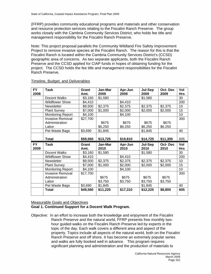
State of California, Coastal Impact Assistance Program, Final Plan 2009
(FFRP) provides community educational programs and materials and other conservation and resource protection services relating to the Fiscalini Ranch Preserve. The group works closely with the Cambria Community Services District, who holds fee title and management responsibility for the Fiscalini Ranch Preserve. Note: This project proposal parallels the Community Wildland Fire Safety Improvement Project to remove invasive species at the Fiscalini Ranch. The reason for this is that the Fiscalini Ranch is located within the Cambria Community Services District’s (CCSD) geographic area of concerns. As two separate applicants, both the Fiscalini Ranch Preserve and the CCSD applied for CIAP funds in hopes of obtaining funding for the project. The CCSD holds the fee title and management responsibilities for the Fiscalini Ranch Preserve. Timeline, Budget, and Deliverables FY 2008
Task Grant Amt.
Jan-Mar 2009
Apr-Jun 2009
Jul-Sep 2009
Oct- Dec 2009
Vol Hrs
Docent Walks $3,160 $1,580 $1,580 30 Wildflower Show $4,410 $4,410 200 Newsletter $9,500 $2,375 $2,375 $2,375 $2,375 10 Plant Survey $7,000 $1,000 $2,000 $2,000 $2,000 15 Monitoring Report $4,100 $4,100 10 Invasive Removal
Administration Labor
$27,700 $675 $6,250
$675 $6,250
$675 $6,250
$675 $6,250
300
Pet Waste Bags $3,690 $1,845 $1,845 40
Total $59,560
$13,725
$19,810
$14,725
$11,300
605
FY 2009
Task Grant Amt.
Jan-Mar 2010
Apr-Jun 2010
Jul-Sep 2010
Oct- Dec 2010
Vol Hrs
Docent Walks $3,160 $1,580 $1,580 30 Wildflower Show $4,410 $4,410 200 Newsletter $9,500 $2,375 $2,375 $2,375 $2,375 10 Plant Survey $7,000 $1,000 $2,000 $2,000 $2,000 15 Monitoring Report $4,100 $4,100 10 Invasive Removal
Administration Labor
$17,700 $675 $3,750
$675 $3,750
$675 $3,750
$675 $3,750
300
Pet Waste Bags $3,690 $1,845 $1,845 40 Total $49,560
$11,225 $17,310 $12,225 $8,800 605
Measurable Goals and Objectives Goal 1. Continued Support for a Docent Walk Program.
Objective: In an effort to increase both the knowledge and enjoyment of the Fiscalini Ranch Preserve and the natural world, FFRP presents free monthly two-hour guided walks on the Fiscalini Ranch Preserve led by experts in the topic of the day. Each walk covers a different area and aspect of the property. Topics include all aspects of the natural world, both on the Fiscalini Ranch Preserve and off shore. It has become an extremely popular series and walks are fully booked well in advance. This program requires significant planning and administration and the production of materials to
California Natural Resources Agency March 2009
Page 322

State of California, Coastal Impact Assistance Program, Final Plan 2009
promote the events. The objective is to educate both locals and visitors on the unique resources and their relationships.
Goal 2 - Sponsor Annual Wildflower Show. Objective: Each spring, FFRP produces a two-day exhibit of the wildflowers, grasses
and native trees that grow from the Monterey County line to the Morro Bay Estuary and from the ocean to the ridge of the Santa Lucia range. We do this as an educational event in order to increase knowledge and appreciation of nature and its diversity in the coastal zone. FFRP is also working with local schools to bring students to the show and to get them interested in its production too. Each year attendance has increased at this event and it is a source for much of our volunteer recruitment efforts. The California Native Plant Society is involved with education at this show and we hope to add the San Luis Obispo Botanical Gardens next year.
Goal 3 - Increase Issues of Newsletter. Objective: The FFRP newsletter is published three times a year, with a goal to increase
to four times per year. We include articles about plants and animals found on the Fiscalini Ranch Preserve as well as information about ongoing projects, upcoming events, volunteer information and other topics of interest. It keeps our members, other agencies and community groups connected to and updated on Fiscalini Ranch Preserve issues and activities.
Goal 4 – Complete a Native Plant Survey. Objective: FFRP proposes to complete a survey of the native plants on the Fiscalini
Ranch Preserve to provide invaluable information for maintaining the integrity of the unique plant communities found on the property and could be used in educational outreach programs. The Fiscalini Ranch Preserve is composed principally of four environmentally sensitive areas: Monterey Pine Forest, Santa Rosa Creek riparian corridor, Coastal Prairie and Coastal Bluffs. The information would be added to the Public Planning documents such as the Environmental Impact Report and the Annual Conservation Easement Survey since the botanical information for both of these documents is fractional and outdated. The survey would be conducted by a qualified Botanist who would visit the Fiscalini Ranch Preserve at least three different times during the year for a period of two years. The information gathered would include scientific and common names, GPS locations, approximate plant densities and ranges and would also locate and document any flora that was rare, endangered, or of limited distribution.
Goal 5 - Annual Conservation Easement Monitoring Report. Objective: This annual plan provides for ongoing monitoring and inspection to
determine and document compliance with the terms of the conservation easement, as well as for comprehensive physical resource surveys of the Fiscalini Ranch Preserve. Reports are to be used for comparison to prior year’s surveys to help assess any significant changes to the environmental/physical status of the Fiscalini Ranch Preserve, including past and current invasive plant removal efforts.
California Natural Resources Agency March 2009
Page 323

State of California, Coastal Impact Assistance Program, Final Plan 2009
Goal 6 - Invasive Plant Species Removal. Objective: Managing the diverse vegetation of the Fiscalini Ranch Preserve is a
challenging task for the Cambria Community Services District (CCSD) as property manager. FFRP has worked closely with CCSD identifying some problem areas and managing volunteers for hand removal of invasive plants. We raised private donations to hire work crews for hand removal of wild mustard encroaching on the Bluff Trail, resulting in a revival of Bush Lupine and Coastal Fiddlehead. We have accomplished a great deal, but more hand removal is needed to protect and encourage native vegetation. There are a number of noxious invasive plants, including French broom, jubata grass, various thistles, wild mustard and radish, periwinkle, cape ivy and various plantains that threaten to take over the property without intervention. This project would entail surveying and mapping invasive species then hiring a crew of workers to hand remove invasives throughout the Fiscalini Ranch Preserve at various intervals for two years. FFRP would coordinate and supervise removal, and coordinate volunteers to assist in follow up monitoring and removal. Seeing concentrated progress by hired work crews encourages volunteers to do follow up maintenance.
Goal 7 - Pet-waste Removal Bags. Objective: Cambria is a dog friendly community and the Fiscalini Ranch Preserve has
become a favorite place for visitors and locals to enjoy a walk with their canine friends. FFRP encourages pet owners to be responsible and environmentally friendly by using dog waste bags at each of six entrances to the Fiscalini Ranch Preserve. FFRP personnel work with volunteers to order, deliver and coordinate their installation on a regular basis. This service keeps pet waste contamination from infecting wildlife and contaminating water resources.
COORDINATION WITH OTHER FEDERAL RESOURCES AND PROGRAMS The U.S. Department of Agriculture, Upper Salinas – Las Tablas Resource Conservation District (RCD) has provided consultation with us on invasive weed removal and erosion problems on the Fiscalini Ranch Preserve. RCD, CCSD and FFRP recently received a grant, based on California Weed Management Areas, from the State Department of Food and Agriculture. The grant provided funds to survey, target, and remove arundo, jubata (pampas) grass, and French broom on most of the preserve. Volunteer hours were managed by FFRP for a part of the funding match.
No actions have been taken to secure funding for these projects from Federal Agencies. All but the plant survey have been funded out of operating expenses using cell facility lease funds from the proposed site on the preserve. These funds will not be available to FFRP as the California Coastal Commission, in a recent decision, has disallowed this land use on the property. CALIFORNIA OCEAN PROTECTION COUNCIL Implementation of project component 4 will allow us to better comply with County Planning guidelines and Coastal Commission requirements for future projects by giving a clear picture of the plant resources in the preserve. It will impact all future relevant land use plans for the Fiscalini Ranch Preserve.
California Natural Resources Agency March 2009
Page 324

State of California, Coastal Impact Assistance Program, Final Plan 2009
Research and Monitoring Goal Project components 4, 5, and 6 will work together. Researching what is currently exists on the preserve will lead to more efficient invasive species removal. The invasive species removal project will be monitored to ensure its effectiveness. Both will allow our yearly conservation easement monitoring reports to better reflect the conservation resources on the Fiscalini Ranch Preserve. Ocean and Coastal Water Quality Goal Our current monitoring identifies erosion on the ocean bluffs and in the gullies that drain into the ocean. Component 5 will pinpoint areas with silty runoff problems and enable us to plan for restoration of these areas. Removing invasives to encourage existing native plants will be helpful in the restoration of these areas as well. Component 7 will help keep any runoff from carrying pet feces contamination into the ocean or Santa Rosa Creek, habitat for the Red-legged frog, Tidewater Goby and Steelhead. Physical Processes and Habitat Goal The Fiscalini Ranch Preserve has been designated as Environmentally Sensitive Habitat Area (ESHA) in the Local Coastal Plan. It contains a wide variety of habitats including coastal bluff, coastal prairie, riparian, coastal wetland, mixed woodlands and Monterey pine forest. A native plant survey, invasive plant removal and monitoring will ensure that these areas are protected. Ocean and Coastal Ecosystems Goal The native plant survey, invasive plant removal and monitoring components of this proposal will promote protection of these ecosystems on the Fiscalini Ranch Preserve and provide a greater opportunity for the survival of associated species. Along with the educational portion of the proposal, this will ensure that these areas are protected in the future. Education and Outreach Goal Components 1, 2 and 3 are vehicles for education and outreach about the need for the continued resource protection and enhancement, stressing the benefits to the public and the environment. The native plant survey will help in the educational process as well by informing FFRP, agencies and the public about the diversity contained in the preserve. Partnering with the California Native Plant Society and San Luis Obispo Botanical Gardens also helps us fulfill this goal. CONSISTENCY WITH CIAP AUTHORIZED USES The Miscellaneous Projects are consistent with the following CIAP authorized uses (please refer to projects descriptions for more detail: 1. Projects and Activities for the conservation, protection, or restoration of coastal areas, including wetland. Projects 1, 2 and 3 in the Educational component of the proposal will help with public awareness of the projects in projects 3, 4 and 5 in the Preservation and Restoration component of the planned projects which are focused on restoration of the native flora in the coastal area. 2. Mitigation of damage to fish, wildlife, or natural resources. Project 7 mitigates damage to fish and wildlife by helping to remove pet waste pollutants in runoff waters and removing pathogens that might spread from pets to wildlife on the Fiscalini Ranch Preserve.
California Natural Resources Agency March 2009
Page 325

State of California, Coastal Impact Assistance Program, Final Plan 2009
Restoration of the native plant habitats in projects 3, 4 and 5 will in turn provide enhance habitat for wildlife.
California Natural Resources Agency March 2009
Page 326
State of California, Coastal Impact Assistance Program, Final Plan 2009
STATE OF CALIFORNIA
COASTAL IMPACT ASSISTANCE PLAN
SAN LUIS OBISPO COUNTY
NAME OF AGENCY/DEPARTMENT Department of Planning and Building PROJECT TITLE Low Impact Development (LID) Standards Implementation – Tier 2 PROJECT CONTACT INFORMATION Name of Primary Staff Contact: Gordon Hensley Address: San Luis Obispo Coastkeeper 1013 Monterey Street San Luis Obispo CA 93401 Telephone Number: 805-781-9932 Fax Number: 805-781-9384 E-mail Address: [email protected] PROJECT SUMMARY Location: Throughout San Luis Obispo County Duration: 2009 – 2010 Total Estimated Project Cost: $75,000 Total CIAP Funding Request: $50,000 Amount and Source of Non-Federal Match: $25,000 SLO Coastkeepers staff to
work with local jurisdictions on LID projects and in-kind legal consultation for the development of policy statement draft and review.
CIAP Spending Estimate Per Year: 2009 - $25,000 2010 - $25,000 Project Background and Description San Luis Obispo Coastkeeper was one of two San Luis Obispo County environmental representatives to the Central Coast Stakeholder Group for the State effort to establish a network of Marine Protected Areas. In addition, SLO Coastkeeper has been involved in the process to establish the County Storm Water Management Program as well as the RWQCB Agricultural Waiver Program implementation which we believe uniquely positions SLO Coastkeeper to increase both individual responsibility for water quality and advocate for effective policy at the local government level. Because the proposed SLO Coastkeeper CIAP project targets San Luis Obispo County communities currently experiencing high development pressure, it will be necessary to
California Natural Resources Agency March 2009
Page 327

State of California, Coastal Impact Assistance Program, Final Plan 2009
coordinate with many of the federal agency program contacts developed during our work on the Central Coast MPA effort; development of the County SWMP; the RWQCB regional Ag Waiver program; and many other projects SLO Coastkeeper has conducted. Project Budget
FY 09 FY 10 Event Expenses $3,000.00/event x 2 events = $ 6,000 $ 6,000
Insurance 100.00 Site Rental 1,000.00 Publicity 1,500.00 Supplies & Misc. 400.00
Print Materials $1,500.00/Community x 2 = $ 3,000 $ 3,000 Policy Advocacy .20 FTE $21,250 $21,250 Legal $ 6,250 $ 6,250 Transportation $1,000.00 = $ 1,000 $ 1,000
TOTAL $37,500 $37,500 Total Project Budget: $75,000
Measurable Goals and Objectives Goal 1 - Expand education and outreach to increase awareness of the quality of local waters. Objective: This goal would be completed through educational presentations targeting
individuals, schools, and local agencies about local water quality issues. Advocacy with local government agencies would be for the specific purpose of initiating new policies and coordinate local and County policies and ordinances that improve protection and cleaning of central coast waters (storm water plans, agricultural runoff, low impact development (LID) standards, etc.) This effort would include education and outreach to increase understanding of the economic benefits to the business community (Chambers of Commerce, service groups, etc.) in coastal San Luis Obispo County.
Benefit: Overall, the proposed SLO Coastkeeper CIAP project relies on education of
citizens and policy makers about the source activities affecting ocean and coastal water quality as the most cost effective means to prevent water pollution. As awareness of personal responsibility and the availability of practical techniques and products, water quality in the coastal zone will improve consistent with CIAP mission of ensuring conservation and enhancement of California’s coastal and ocean resources.
Goal 2 - Establish a series of practical pollution reduction events. Objective: Two events would be provided annually:
Fall Focus – 1) Practical application of LIDs in landscape and property management. Highlighting specific actions that can prevent/reduce pollutants entering storm water, the watershed, and marine environment. 2) Individual responsibility to implement and maintain LIDs. Practical
California Natural Resources Agency March 2009
Page 328

State of California, Coastal Impact Assistance Program, Final Plan 2009
techniques, actions, and products that individual citizens can do to reduce their impact to coast and marine water resources. Spring Focus – 1) The affect of LID Standards implementation on coastal waters. A significant part of this effort will be a cooperative event with the Morro Bay National Estuary Program. 2) LID benefits and incentives. Practical techniques and products available to reduce storm water pollutants at the source.
Benefit: LID techniques have been employed by various municipalities nationwide and have been shown to be effective and feasible methods of preventing impacts of urban development to receiving waters. Coastal and near shore water quality will be improved through the application of Low Impact Development knowledge, and the application of practical techniques by residential owners, commercial business, and the construction/development community. This goal is consistent with the CIAP mission established by the Resources Agency for the use of CIAP funds, achieving the Agency’s goals of promoting environmental stewardship through effective management, conservation, and assessment of projects and environmental impacts.
Timeline for Deliverables COMPLETED BY DELIVERABLE Ongoing educational program through FFY 2010
Expand education and outreach to increase awareness of the quality of local waters.
Fall 2009 and Spring 2010 Establish a series of practical pollution reduction events
COORDINATION WITH OTHER FEDERAL RESOURCES AND PROGRAMS Our project will be coordinated with the following Federal programs: National Oceanic and Atmospheric Administration (NOAA): We will coordinate with the NOAA Centers for Coastal Ocean Science and the NOAA Coastal Zone Management Program. These programs provide information regarding coastal ecology, pollution impacts, and coastal development. Monterey Bay National Marine Sanctuary: Technical assistance and educational resources will be coordinated with MBNMS. Environmental Protection Administration (EPA): EPA will be an important resource for cooling water intake issues and current marine impact data. Morro Bay National Estuary Program (MBNEP): Mr. Hensley has been a member of MBNEP committees and SLO Coastkeeper enjoys a working relationship with MBNEP staff. Technical assistance, as well as data regarding impacts of pollution, water quality, and watershed management issues. US Army Corps of Engineers (USACE): Technical assistance and information will be coordinated with USACE Coastal Sediment Management Working Group.
California Natural Resources Agency March 2009
Page 329

State of California, Coastal Impact Assistance Program, Final Plan 2009
US Fish and Wildlife Service: SLO Coastkeeper maintains a working relationship with USFWS personnel and will coordinate with the Service regarding endangered species and marine mammal programs. CALIFORNIA OCEAN PROTECTION COUNCIL 3. Ocean and Coastal Water Quality 6. Education and Outreach CONSISTENCY WITH CIAP AUTHORIZED USES We believe this project is consistent with CIAP authorized use #1: Projects and activities for the conservation, protection, or restoration of coastal areas, including wetlands. We are proposing to 1) expand our ongoing program of education and outreach to increase awareness of the quality of local waters through educational presentations targeting individuals, schools, and local agencies about the source activities affecting ocean and coastal water quality as the most effective means to prevent water pollution.. Advocacy with local government agencies would be for the specific purpose of initiating new policies and coordinate local and County policies and ordinances that improve protection and cleaning of central coast waters (storm water plans, agricultural runoff, low impact development (LID) standards, etc.) This effort would include education and outreach to increase understanding of the economic benefits to the business community (Chambers of Commerce, service groups, etc.) in coastal San Luis Obispo County; and 2) establish a series of practical pollution reduction events that we foresee will be repeated annually.
a. Fall Focus – 1) Practical application of LIDs in landscape and property
management. Highlighting specific actions that can prevent/reduce pollutants entering storm water, the watershed, and marine environment. 2) Individual responsibility to implement and maintain LIDs. Practical techniques, actions, and products that individual citizens can do to reduce their impact to coast and marine water resources.
b. Spring Focus – 1) The affect of LID Standards implementation on coastal
waters. A significant part of this effort will be a cooperative event with the Morro Bay National Estuary Program. 2) LID benefits and incentives. Practical techniques and products available to reduce storm water pollutants at the source.
This project proposal is to develop a grass roots, citizen committee based effort with the following two objectives: 1) to provide Low Impact Development information, materials, and activities in targeted coastal San Luis Obispo County communities currently experiencing both high development pressure and impaired coastal and near shore water quality. Target audience include: Residential owners, Commercial business, Construction/Development, and school age students. 2) To work with the County of San Luis Obispo, the coastal zone cities, and Community Service Districts to develop uniform LID standards and advocate the creation of consistent policies to adopt LID techniques in the local permitting process.
California Natural Resources Agency March 2009
Page 330

State of California, Coastal Impact Assistance Program, Final Plan 2009
The population of San Luis Obispo County is approximately 250,000. According to 2000 Census data projections estimate, the County will exceed 390,000 by 2020, a growth of 58%! In the face of intense pressure to serve this growth, coastal communities in SLO County are experiencing increasing challenges to water quality as many seek housing and work close to the Pacific Ocean. County and local governments struggle with increasing water quality and quantity challenges including impaired beneficial uses. This is compounded by a lack of continuity between local government agencies for public water quality education programs and practical help regarding what individuals and small business can do to protect coastal waters, the newly created marine protected areas, and preserving healthy waters from being degraded. The County of San Luis Obispo, in compliance with NPDES Phase II requirements, has recently submitted their Storm Water Management Program (MS4 General Permit). The Central Coast Regional Water Quality Control Board approved the County plan. This SLO Coastkeeper project proposal will advocate and promote implementation of the Low Impact Design Standards and techniques already included in the County SWMP to help restore coastal watersheds and near shore marine environments to pre-development conditions.
California Natural Resources Agency March 2009
Page 331

State of California, Coastal Impact Assistance Program, Final Plan 2009
STATE OF CALIFORNIA COASTAL IMPACT ASSISTANCE PLAN
SAN LUIS OBISPO COUNTY
NAME OF AGENCY/DEPARTMENT Coastal San Luis Resource Conservation District PROJECT TITLE Oso Flaco Lakes Water Quality and Sedimentation Assessment – Tier 2 PROJECT CONTACT INFORMATION: Name of Primary Staff Contact: Julie Thomas, South County Watershed
Coordinator Address: Coastal San Luis Resource Conservation
District 545 Main Street, Suite B-1 Morro Bay CA 93443 Phone: 805-772-4391 Fax: 805-772-4398 Email: [email protected] PROJECT SUMMARY Location: Oso Flaco Lake, west of Nipomo, CA Duration: 2009-2010 Total Estimated Project Cost: $246,147 Total CIAP Funds Requested: $124,500 Amount and Source of Non-Federal Match: $121,647 CIAP Spending Estimate Per Year: 2009 - $100,000
2010 - $146,147 Project Background and Description The proposed project will continue the two-year, $210,000 Oso Flaco Lakes Water Quality and Sedimentation Assessment project that the California State Department of Parks and Recreation and the Coastal San Luis Resource Conservation District implemented in the watershed starting April 2008, and continuing through August 2009. Phase II of the Oso Flaco Lakes project will expand the water quality monitoring program to provide important data to determine trends and impacts of upstream activities and effectiveness of implemented best management practices. The following tasks will be completed in Phase II:
1. Continue necessary field studies to quantify a water, nutrient (including nitrates), and sediment budget for the lake.
California Natural Resources Agency March 2009
Page 332

State of California, Coastal Impact Assistance Program, Final Plan 2009
2. Continue topographic and bathymetric survey of the lake cross-sections for planning purposes and to evaluate the effectiveness of management measures.
3. Continue to evaluate new water quality and sediment data, both collected as part of this study and by others, to identify critical threats to beneficial uses of the lake.
Oso Flaco and Little Oso Flaco Lakes are located in the western portion of the Santa Maria Valley in San Luis Obispo County, within the Guadalupe-Nipomo dunes complex. The Oso Flaco Creek watershed covers 10,370 acres, nearly all of which are prime agricultural land. The western terminus of the watershed, Oso Flaco Lake, is the largest of the freshwater lakes and is located in the active sand dunes about ¼ mile from the Pacific Ocean coastline.
Figure 1. The Oso Flaco Lakes are nestled in the midst of sand dunes, only ¼ mile inland from the Pacific Ocean coastline. Extensive agricultural fields lie to the east. The total surface area of the Oso Flaco Lakes, which are classified as palustrine emergent wetlands, covers approximately 82 acres. The lakes and surrounding open space are owned and managed by the California Department of Parks and Recreation. This area is home to a number of federally listed and California State species of concerns, including the horned lark, vireo, California red-legged frog, the western pond turtle, the California least tern, Gambell’s watercress, beach spectacle pod, monardella, giant coreopsis (including the northernmost endemic stand of giant coreopsis), and species of buckwheat.
California Natural Resources Agency March 2009
Page 333

State of California, Coastal Impact Assistance Program, Final Plan 2009
Figure 2. Location of Oso Flaco Lakes relative to Highway 1 and the City of Guadalupe. Amount and Source of Non-Federal Match
Match Source Amount Guadalupe-Nipomo Dunes Center (in-kind) Contact: Kathie Matsuyama 805-458-1604
$11,647
State Department of Parks and Recreation (in-kind) Contact: Ronnie Glick 805-773-7180
$10,000
State Department of Parks and Recreation (cash) Contact: Ronnie Glick 805-773-7180
$100,000
TOTAL NON-FEDERAL MATCH: $121,647 Spending Estimates
Calendar Year Amount Fiscal Year Amount 2009 $ 25,000 2009-10 $100,000 2010 $150,000 2010-11 $146,147 2011 $ 71,147
Measurable Goals and Objectives The goal of the project is to continue a project that State Parks and the Coastal San Luis RCD initiated in 2008 to develop recommendations for management measures to protect and enhance the water quality in Oso Flaco and Little Oso Flaco Lakes, with a focus on reducing concentrations of nitrates and other agricultural chemicals in the lakes’ water column, and preserving the longevity of the lakes by slowing the rate of sedimentation. We plan to partner in this project with other major stakeholders in the Oso Flaco Lakes, including the California Department of Parks and Recreation (Oceano Dunes District), the Cachuma Resource Conservation District, and the Dunes Collaborative. Oso Flaco Lake is on the Regional Water Quality Control Board’s (RWQCB) 303(d) list as an impaired water body due to nitrate from agricultural nonpoint sources. Recent studies by the RWQCB’s Central Coast Ambient Monitoring Program (CCAMP) showed nitrate levels in all samples collected throughout the watershed exceeding acceptable levels (150 to 325 ppm-NO3
-). New water quality sampling in the watershed by the
California Natural Resources Agency March 2009
Page 334
State of California, Coastal Impact Assistance Program, Final Plan 2009
RWQCB CCAMP is currently underway. Results are expected to be available by the end of 2007.
The Cachuma Resource Conservation District and the Guadalupe-Nipomo Dunes Center have completed work with the Oso Flaco Watershed Farmer’s Working Group to address some of the impacts from farming practices to lake water quality. Results of this coordination indicated a need to reduce erosion by 50% and reduce nitrate loads by 50% by changing agricultural practices in the watershed. Recent discussions within the agricultural industry and food safety groups regarding the relationships between food safety, agricultural best management practices and adjacent open space and environmentally sensitive areas will undoubtedly lead to further changes in agricultural practices in the watershed. In order to determine the effectiveness of recently implemented agricultural management practices, and to identify areas needing additional attention, this project proposes to gather data to identify trends in nonpoint source pollutant loadings to the Oso Flaco Lakes. The results of this assessment will strengthen the development of effective management measures that will be ultimately incorporated into a larger Oso Flaco Lake Management Plan, as recommended in the recently completed Habitat Conservation Plan (HCP) developed by State Parks for the lakes and nearby park properties. Project Objectives
Objective 1: Project Management and Administration. The CSLRCD and its project partners will provide administrative services associated with performing and completing the work for this project.
Objective 2: Public Participation. A Technical Advisory Team (TAT) will continue to provide advice and guidance throughout the project. The TAT will contain representatives of California Department of Parks and Recreation, Cachuma Resource Conservation District, U.S. Fish and Wildlife Service, Oso Flaco Watershed Farmer’s Working Group, California Department of Fish and Game, Regional Water Quality Control Board, Natural Resources Conservation Service, San Luis Obispo County, Dunes Collaborative, and other interested landowners and members of the public. At least two public meetings will be held to discuss the project with the community.
Objective 3: Quality Assurance Plan. A Quality Assurance Plan (QA Plan) will be prepared for water quality sampling to be undertaken.
Objective 4: Gather and summarize existing information. Continue to compile, review, and summarize existing data regarding physical, biological and land use factors in the watershed that may affect nitrates, sediment, and agricultural chemicals. Identify information gaps and potential sources.
Objective 5: Refine nitrate, water, and sediment budget for the lakes. The following data will be collected over the course of the project: • Topographic and bathymetric data for the lakes and environs. • Flow rates into and out of the lakes, as well as lake water levels. • Groundwater elevations in the shallow aquifer adjacent to lakes.
California Natural Resources Agency March 2009
Page 335
State of California, Coastal Impact Assistance Program, Final Plan 2009
• Nitrate concentrations and other related water quality parameters (pH, temperature, salinity) in lake influents, effluents, water columns within the lakes, and in the adjacent aquifer. • Sediment concentrations in lake influents and in lake effluent. • Lake bed sediment particle size distribution. • Air temperature and relative humidity.
This field data will be used to refine nitrate, water and sediment budgets for the lakes, estimating the following: • Annual sediment load into the lakes from Oso Flaco Creek, from active dune migration and other sources. • Annual rate of sedimentation within the lakes. • Annual nitrate load into the lakes. • Fate of nitrate load (uptake, nitrification/denitrification, harvest, percolation, outflow, etc.) • Annual water budget for lakes, e.g., agricultural drainage, groundwater sources, storm flows, etc.
Objective 6: Identify new critical threats and assess trends to existing known critical threats to beneficial uses of the lake. In conjunction with the TAT, analyze the data to identify threats to beneficial uses of the lake. Determine if and how nitrates, chemicals, and sediment affect the physical and biological factors in the lake. Assess the potential that toxins could be coming from non-agricultural uses (i.e. nearby industrial and urban land uses).
Objective 7: Develop Recommendations. In conjunction with the TAT and other interested parties, propose a prioritized list of actions that will protect the threatened beneficial uses in the lakes.
Objective 8: Prepare Final Report. Prepare a Draft Final Report for TAT and public review and comment. Prepare the Final Report.
Timeline for Deliverables # Deliverable (Objective) Completed Funding 1 Project management and administration 2009 – 2010 $15,0002 Public participation 2009 $2,0003 Quality Assurance Plan 2009 $4,1474 Gather and summarize existing information 2009 $5,0005 Refine nitrate, water, sediment budgets 2009 $210,0006 Identify critical threats to beneficial uses of the
lakes 2010 $3,000
7 Develop recommendations 2010 $4,0008 Prepare final report 2010 $3,000
California Natural Resources Agency March 2009
Page 336

State of California, Coastal Impact Assistance Program, Final Plan 2009
Project Budget
Task Total Budget Match Share CIAP Share Objective 1. Project management &
administration (includes staff costs and overhead)
$ 15,000 $ 5,000 $ 10,000
Objective 2. Public participation $ 2,000 $ 2,000 --Objective 3. Quality assurance plan $ 4,147 $ 4,147 --Objective 4. Gather and summarize
existing information $ 5,000 $ 4,000 $ 1,000
Objective 5. Refine nitrate, water, sediment budgets
$210,000 $105,000 $105,000
Objective 6. Identify critical threats to beneficial uses of the lakes
$ 3,000 $ 500 $ 2,500
Objective 7. Develop recommendations $ 4,000 $ 500 $ 3,500
Objective 8. Prepare final report $ 3,000 $ 500 $ 2,500 TOTAL BUDGET $246,147 $121,647 $124,500
COORDINATION WITH OTHER FEDERAL RESOURCES AND PROGRAMS This project does not currently involve coordination with federal agencies, and no matching federal funds are currently being sought. CALIFORNIA OCEAN PROTECTION COUNCIL The project is consistent with advancing the following goals and objectives of the California Ocean Protection Council’s Strategic Plan:
• Ocean and Coastal Water Quality: Water quality testing will obtain impairment data for the Oso Flaco Lakes, and lead to practical, ecosystem-based management measures to improve water quality.
• Physical Processes and Habitat: This project would add to knowledge about function of coastal ecosystems, and assist with development of restoration and improvement strategies, including sediment and nutrient management.
CONSISTENCY WITH CIAP AUTHORIZED USES We believe this project is consistent with CIAP authorized use #1: Projects and activities for the conservation, protection, or restoration of coastal areas, including wetlands. The goal of the project is to continue a project that State Parks and the Coastal San Luis RCD initiated in 2008 to develop recommendations for management measures to protect and enhance the water quality in Oso Flaco and Little Oso Flaco Lakes, with a focus on reducing concentrations of nitrates and other agricultural chemicals in the lakes’ water column, and preserving the longevity of the lakes by slowing the rate of sedimentation. This project proposes to gather data to identify trends in nonpoint source pollutant loadings to the Oso Flaco Lakes, primarily from surrounding agricultural uses. This assessment will strengthen the development of management measures that will be ultimately incorporated into a larger Oso Flaco Lake Management Plan, as
California Natural Resources Agency March 2009
Page 337

State of California, Coastal Impact Assistance Program, Final Plan 2009
recommended in the recently completed Habitat Conservation Plan (HCP) developed by State Parks for the lakes and nearby park properties.
California Natural Resources Agency March 2009
Page 338

State of California, Coastal Impact Assistance Program, Final Plan 2009
STATE OF CALIFORNIA COASTAL IMPACT ASSISTANCE PLAN
SAN LUIS OBISPO COUNTY
NAME OF AGENCY/DEPARTMENT Department of Planning and Building
PROJECT TITLE Strategic Plan Implementation Project – Tier 2 PROJECT CONTACT INFORMATION Name of Primary Staff contact: Morgan Rafferty, Executive Director Address: Environmental Center of San Luis Obispo
P.O. Box 1014 San Luis Obispo, CA 93406
Telephone Number: 805-544-1777 Fax Number: 805-544-1871 E-mail Address: [email protected] PROJECT SUMMARY Location: County of San Luis Obispo Duration: 2009 – 2011 (Note: project has been
initiated) Total Estimated Project Cost: $484,950 Total CIAP funds Requested: $366,970 Amount and Source of Non-Federal Match: $117,980 CIAP Spending Estimate Per Year 2009 - $258,315
2010 - $226,635. Project Background and Description On June 8, 2006 the California Ocean Protection Council (OPC) adopted a five-year Strategic Plan, A Vision for our Ocean and Coast, noting, “California has an impressive record of taking bold and innovative actions to protect our coastal natural resources and cultural heritage.” The OPC Strategic Plan provides guidance for action to assess the state’s current coastal and ocean management programs and agencies in order more effectively to utilize the resources of the state to improve and protect the marine environment. The County of San Luis Obispo, with nearly 100 miles of coastline – 10% of the state’s coastline - has an important role to play in this statewide effort. With support of the Coastal Impact Assistance Program (CIAP), the County and its project partners, the Environmental Center of San Luis Obispo County (ECOSLO) and the Planning and Conservation League Foundation (PCLF) will conduct a two-year Strategic Plan Implementation Project (SPIP). The SPIP will effectively mobilize the county’s institutional and local non-profit organizational capacity to further the Ocean Protection Council’s coastal and ocean management goals in south Central California.
California Natural Resources Agency March 2009
Page 339

State of California, Coastal Impact Assistance Program, Final Plan 2009
Measurable Goals and Objectives ECOSLO and PCLF will conduct a series of four Regional Roundtables (RRT) that will focus on: (1) land use policy and related ocean protection and water quality issues; (2) identify key institutional resources and existing programs; and (3) bring technical experts together with local citizens from a broad spectrum of interests to devise a coordinated plan for implementing the OPC Strategic Plan. This process will focus on local land use and coastal water quality issues as they relate to recent changes in marine policy established by the California Ocean Protection Act (COPA). This two-year effort will effectively establish a strategic nexus between land-based resource programs and conservation organizations, and marine conservation programs and organizations. The SPIP will target staff of local and regional resource agencies and local nonprofit conservation organizations, as well as key individuals from among community-based groups, business and professional groups, academic programs, and elected officials for participation in four RRTs. The process will support a coordinated and comprehensive effort to assess local coastal goals and priorities that are consistent with the OPC Strategic Plan. Each RRT will focus on a theme as follows: 1. Regional Roundtable 1 – Water Quality Monitoring of Coastal and Marine Areas 2. Regional Roundtable 2– Assessment of Local Coast and Ocean Mgmnt. Resources 3. Regional Roundtable 3 – Initial Policy and Program Recommendations for County,
State and Federal Programs including WQ Monitoring Priorities 4. Regional Roundtable 4 – Final Action Strategy for the SPIP The SPIP will support development of a new regional perspective that will build an understanding of the broader context in which land-based planning and management policy directly links with coastal and ocean resource management goals. Through this process, county institutional resources including academic and research centers, interpretive coastal wildlife and resource areas, and other marine-related recreational and special use areas can be effectively linked in their common mission to improve coastal resource protection. In bringing traditional land-based and marine conservation organizations together with academic, state and regional resource management expertise, the process will also lead to identifying potential gaps where new perspectives and understanding can be developed that currently do not exist. These actions can lead to coordination between land use decisions and goals to improve coastal and ocean resources, awareness by local decision-makers of land use impacts to marine resources, and support changes in local policy that will implement OPC Strategic Plan goals. Project Objectives The San Luis Obispo County Strategic Plan Implementation Project will effectively lead action that will foster collaboration among local coastal watershed groups, marine conservation groups, and local and regional resource agencies. The process will build upon the County’s existing institutional programs and resources, to identify key goals of the OPC Strategic Plan that also meet local priorities and goals, and to identify gaps where new action must be initiated. This will occur through a process that will identify critical links among land use decisions and Strategic Plan objectives. San Luis Obispo County SPIP will be developed in order to: Objective 1: Improve decisions on land use practices and policy that potentially impact
marine resources;
California Natural Resources Agency March 2009
Page 340
State of California, Coastal Impact Assistance Program, Final Plan 2009
Objective 2: Foster collaboration among traditional land-based organizations with marine conservation groups to identify common issues and to develop new partnerships to achieve common goals;
Objective 3: Align goals of coastal resource groups with specific goals of the Strategic Plan identified in the SPIP Regional Planning Process;
Objective 4: Develop targeted outreach and substantive information to address issues of concern for elected officials and community members concerning current land use policy and mandates to improve coastal water quality;
Objective 5: Establish a pilot program and model for Regional Planning to occur in other regions of the state;
Objective 6: Identify potential funding sources that will support programs and projects that directly implement the OPC Strategic Plan; and
Objective 7: Increase public awareness to protect marine resources through events and activities geared toward community building.
Specific tasks and program deliverables for each of the Regional Roundtables are outlined in the Proposal Budget Narrative. Timeline for Deliverables The Strategic Plan Implementation Project (SPIP) will begin in January 2009, and will continue through December 2010. The work will be organized to occur through targeted involvement in four Regional Roundtables (RRT) (two/year) that will focus on the following themes:
Completed By Deliverables March 2009 Roundtable 1 September 2009 Roundtable 2 March 2010 Roundtable 3 September 2010 Roundtable 4
Project Budget The budget that follows presents costs, including CIAP grant funds requested, match amount, and a brief summary of project deliverables associated with each RRT. Below is a summary of project costs for Year 1 and for Year 2. SPIP Budget Summary YEAR 1 YEAR 2 TOTAL Amount of this grant request $183,495 $183,495 $366,970 Proposed Match in non-federal dollars $74,830 $43,150 $117,980 Total Project Budget $258,315 $226,635 $484,950
COORDINATION WITH OTHER FEDERAL RESOURCES AND PROGRAMS SPIP will be implemented in coordination with the Monterey Bay National Marine Sanctuary’s Synthesis, Assessment, and Management (SAM) Project initiated in May of 2006. The objectives of the SAM program have been developed to support a watershed-based approach to address questions about nonpoint source pollution that facilitate a high level of coordination between monitoring organizations, and uses water quality data in conjunction with information on land use practice changes. Priority objectives include integration of existing water quality and geographic data sets to
California Natural Resources Agency March 2009
Page 341

State of California, Coastal Impact Assistance Program, Final Plan 2009
address the sources, status, and trends of water pollutants; and, development of a model for ongoing integration, analysis, and reporting with input from stakeholders. In November 2007, members of the SAM Technical Advisory Committee will meet to present summary findings of the Project’s initial assessment of existing water quality data for the South Central Coast region. The TAC members will consider effectiveness of existing data quality evaluation tools and data formats, and determine gaps and priorities for future effort. Members of the TAC include: United States Environmental Protection Agency, Central Coast Regional Water Quality Control Board (Region 3), State Water Resources Control Board, California Coastal Commission, University of California at Davis, and California State University, Monterey Bay. The proposed work outlined in this proposal for the SPIP has not been submitted to any other federal program for funding. However, PCLF and ECOSLO will continue to develop a joint funding strategy that will coincide with a two-year period targeted for the South Central Coast MLPA regional implementation. CALIFORNIA OCEAN PROTECTION COUNCIL The San Luis Obispo County SPIP aligns with four of the five themes of The Ocean Protection Council’s Five-Year Strategic Plan. Governance Goal The SPIP seeks to implement Governance guidelines established in the OPC Strategic Plan at the County and local levels. The Regional Planning pilot program will bring together academic, programmatic, governmental and NGO decision-makers to inventory and coordinate multi-layer efforts to protect and conserve coastal resources in San Luis Obispo County. Consistent with Governance Objectives 1, 2 and 3, this project aims to maximize effectiveness of existing funds and efforts and improve enforcement concerning ocean protection laws. Ocean and Coastal Water Quality Goal, and Physical Processes and Habitat Structure Goal The SPIP’s efforts to improve land use decisions and policy in SLO County coastal watersheds will support the OPC Strategic Plan’s Ocean and Coastal Water Quality Objectives 1 and 2, and Physical Processes and Habitat Structure Objective 1. Through the collaborative planning process, the SPIP will draw on the expertise of SLO County’s thriving local programs in watershed restoration, land use conservation, and coastal stream and wildlife habitat protection to promote a coordinated effort to improve water quality and habitat value in watersheds draining to the ocean. Education and Outreach Goal The SPIP will implement the OPC’s Education and Outreach objective by raising public awareness of ocean and coastal issues and encouraging individual stewardship. SPIP includes a general public outreach campaign through educational events and interpretive elements about marine conservation and protection, as well as a targeted outreach for elected officials and community members concerning land use policy and mandates to improve coastal water quality. The Regional Roundtables will assemble decision-makers to participate in a process similar to the OPC Oceans Forum, to create a regional dialogue on local goals and solutions to improve marine resource conservation and protection.
California Natural Resources Agency March 2009
Page 342

State of California, Coastal Impact Assistance Program, Final Plan 2009
CONSISTENCY WITH CIAP AUTHORIZED USES The SPIP is consistent with CIAP Authorized Use 1: Projects and activities for conservation, protection, or restoration of coastal areas, including wetlands. The SPIP’s primary purpose is to begin regional implementation of the Five-Year Strategic Plan of the Ocean Protection Council, charged with ensuring that California “maintains healthy, resilient, and productive ocean and coastal ecosystems for the benefit of current and future generations.” The SPIP will initiate and support regionally-coordinated marine conservation, protection and restoration of coastal areas in San Luis Obispo County. The Regional Roundtables will be modeled on the OPC’s annual Oceans Forum and will help to bring new perspectives and identify gaps in current programs where innovative solutions will be needed in order to fully implement the OPC Strategic Action Plan. Roundtables will harness existing expertise in both marine and land-based conservation groups to generate a new perspective on ocean protection that is strategic, collaborative, and regionally specific. This process will maximize the effectiveness of existing efforts, identify new and emerging resources for conserving and enhancing marine resources, and serve as a model for other counties seeking regional coordination of ocean protection.
California Natural Resources Agency March 2009
Page 343

State of California, Coastal Impact Assistance Program, Final Plan 2009
STATE OF CALIFORNIA COASTAL IMPACT ASSISTANCE PLAN
SAN MATEO COUNTY
NAME OF AGENCY/DEPARTMENT Department of Parks PROJECT TITLE: Fitzgerald Marine Reserve Vegetation Management Plan PROJECT CONTACT INFORMATION Name of Primary Staff Contact: Cecily Harris, Financial Services Manager San Mateo County Department of Parks Address: 455 County Center, 4th Floor, Redwood
City, CA 94063 Telephone Number: (650) 363-4027 Fax Number: (650) 599-1721 E-mail Address: [email protected] PROJECT SUMMARY Location: The James V. Fitzgerald Marine Reserve is a 402-acre natural resource area on the north coast of San Mateo County. The Reserve is under joint custodianship of San Mateo County Department of Parks and California Department of Fish and Game. It is adjacent to the town of Moss Beach, seven miles north of Half Moon Bay and fifteen miles south of San Francisco via Highway 1. The Reserve extends three miles south from Point Montara to the south end of Pillar Point and 1,000 feet west into the Pacific Ocean from the mean high tide line. The Reserve includes 370 acres of intertidal and subtidal marine habitat below the high tide line and 32 acres of upland coastal bluffs.
Duration: Year One: 07/01/09 – 08/30/10 Development of Vegetation Management
Plan for specific projects at Fitzgerald Marine Reserve Uplands Areas, and San Vicente Creek.
Year Two: 10/01/10 – 09/30/11 San Vicente Creek Channel Restoration Year Three: 10/01/10 – 09/30/11 Cypress Grove/Uplands Habitat Restoration (Year One) Year Four: 10/01/11 – 09/30/12 Cypress Grove/Uplands Habitat Restoration (Year Two) Total Estimated Project Cost: $202,992.55 Total CIAP Funds Requested: $184,538.69 Amount and Source of Non-Federal $18,453.86 (County General Fund) Match
California Natural Resources Agency March 2009
Page 344

State of California, Coastal Impact Assistance Program, Final Plan 2009
Spending Estimate of CIAP Funds per Calendar Year (CY) of Project Duration (2008 to
2013): CY CIAP Funds 2008 $45,000 2009 $52,269.34 2010 $52,269.34 2011 $45,953.86 Project Background The purpose of the proposed project is to prepare and implement a Vegetation Management Program for the Fitzgerald Marine Reserve uplands area and to prepare and implement a Revegetation Plan for San Vicente Creek. The Reserve is 402 acres in size and is located on the north coast of San Mateo County. It is under joint custodianship of the San Mateo County Department of Parks and the California Department of Fish and Game and is part of the Monterey Bay National Marine Sanctuary. Itemized Timeline, Budget and Cost Estimates TASK ESTIMATED
START DATE1
ESTIMATED COMPLETION2
OTHER FUNDS
CIAP GRANT
TOTAL FUNDS
1. Plans, Permits and Environmental Review Finalize the scope for the Fitzgerald Marine Reserv Vegetation Management Program
10/08 10/08
for specified projects. Issue a request for proposals for 11/08 11/08 Consulting Firm Hire Consultant 01/09 01/09 Prepare Vegetation Management 02/09 08/09 Plan for specified projects. Biological Reports and Permits 01/09 08/09 On-going Project Monitoring 09/12
Subtotal—Task 1 10/08 09/12 $5,000 $40,000 $45,000
2. San Vicente Creek Channel Restoration Finalize scope for San Vicente 10/09 Creek Channel Restoration Issue a request for proposals for Contractor Hire Contractor Remove non native vegetation Prepare site for planting Plant native vegetation 09/11 Subtotal—Task 2 10/09 09/11 $7,500 $104,538.69 $112,038.69 1 Assumes an October 1, 2008 Start Date 2 Total Project time is based on 48 months.
California Natural Resources Agency March 2009
Page 345

State of California, Coastal Impact Assistance Program, Final Plan 2009
3. Uplands Habitat Restoration Finalize work scope for Uplands Habitat Restoration
10/10 10/10
Issue a request for proposals for Contractor
11/10 12/10
Hire Contractor 01/11 01/11 Remove non native vegetation 02/11 05/11 Plant native vegetation 06/11 09/12 Subtotal—Task 3 10/10 09/12 $5,953.86 $40,000 $45,953.86 TOTAL $18,453.86 $184,538.69 $202,992.55 Measurable Goals and Objectives I) Prepare and implement a Vegetation Management Program for the Fitzgerald Marine Reserve uplands area.
A) Maintain forest health of the grove of Monterey Cypress trees by thinning the numbers of trees and removing understory plants, eucalyptus and young cypress trees invading adjacent native habitat. B) Maintain public safety for Reserve visitors by removing tree limbs to eliminate fire fuel build up and other public safety hazards within the Cypress Grove.
II) Prepare and implement a Revegetation Plan for San Vicente Creek.
A) Remove nonnative vegetation such as English ivy, Pampas grass, broom, Cape ivy, bristly ox- tongue, radish and hemlock in the San Vicente Creek channel. B) Prepare San Vicente Creek channel banks for replanting. C) Plant site appropriate native riparian vegetation in the San Vicente Creek channel.
Deliverables and Schedule Deliverable: Fitzgerald Marine Reserve Vegetation Management Plan for specific projects at Fitzgerald Marine Reserve Uplands Areas, and San Vicente Creek. Due Date: September 30, 2009 Deliverable: Biological Assessment and all necessary permits and consultations Due Date: September 30, 2009 Deliverable: Annual Reports Due Date: September 30, 2009, September 30, 2010, September 30, 2011, and September 30, 2012
California Natural Resources Agency March 2009
Page 346

State of California, Coastal Impact Assistance Program, Final Plan 2009
Actions to Secure other Federal Funding
In coordination with the San Mateo County Parks and Recreation Foundation, the County Parks Department is building an Interpretive Center. To date, a conceptual plan for Interpretation at Fitzgerald Marine Reserve, Geotechnical Study, Addendum to the EIR and Coastal Development Plan have been secured and completed. We have started raising capital funds. To date, we have commitments for funding from the California Coastal Conservancy and San Mateo Countywide Water Pollution Prevention Program. In addition, the Gulf of the Farallones National Marine Sanctuary has made a large request on our behalf.
California State Coastal Conservancy and Department of Parks and Recreation funding is being used to design, plan, permit and construct a section of California Coastal Trail between Cypress and California Avenues, a San Vicente Bridge over San Vicente Creek to link the Coastal Trail to Fitzgerald Marine Reserve parking lot, native plantings in San Vicente Creek, and a Moss Beach Ramp between Fitzgerald Marine Reserve parking lot and the Moss Beach reef. For plans, specifications and the construction of a Fitzgerald Marine Resource Education Center, funds are being sought through National Oceanic and Atmospheric Administration / Gulf of the Farallones National Marine Sanctuary as well as through local, regional and state agencies. COORDINATION WITH OTHER FEDERAL RESOURCES AND PROGRAMS Prior to implementing the San Vicente Creek Channel Restoration, we will consult with the U.S. Army Corps of Engineers (Nationwide Permit) and U.S. Fish and Wildlife Service (NEPA), and National Oceanic and Atmospheric Administration / National Marine Fisheries Service (Steelhead trout). We will also consult with the National Oceanic and Atmospheric Administration / Gulf of the Farallones National Marine Sanctuary about restoration of the uplands habitats as they are our partners with the future Fitzgerald Marine Reserve Visitor Center and interpretation program. CALIFORNIA OCEAN PROTECTION COUNCIL 1) Governance The Fitzgerald Marine Reserve is an excellent example of federal and state agencies working together to conserve coastal resources. The Reserve is under joint custodianship of San Mateo County Department of Parks and California Department of Fish and Game. The Reserve extends three miles south from Point Montara to the south end of Pigeon Point and 1000 feet west into the Pacific Ocean from the mean high tide line. The Reserve is part of the Monterey Bay National Marine Sanctuary, an area which is managed by the Gulf of the Farallones National Marine Sanctuary. Funding, interagency collaboration, enforcement, ecosystem-based management and regional coordination are part of the planning and implementation for education and interpretation programs, visitor services, and resource management of the reef, wetlands and uplands habitats.
California Natural Resources Agency March 2009
Page 347

State of California, Coastal Impact Assistance Program, Final Plan 2009
2) Physical Processes and Habitat Structure The project incorporates the development and implementation of a restoration plan that includes two specific habitat restoration projects: San Vicente Creek Channel Improvements (riparian corridor and preliminary action for fish barrier removal), Cypress Grove Uplands Habitat Restoration (forest). These restoration projects will improve the quality of the coastal habitat within the Fitzgerald Marine Reserve for the plants and amphibians, insects, and wildlife that depend on them. 3) Ocean and Coastal Ecosystems The project will increase our ability to restore native habitats through the elimination of non-native invasive plants and planting with suitable native species. 4) Education and Outreach Over 100,000 individuals visit Fitzgerald Marine Reserve annually. At present, access to the tidal areas is unrestricted for groups of less than twenty, and on low tides that occur on weekend days, more than 2000 visitors per day may visit the reefs. The area has long been recognized for its extensive reef systems and for being one of the most biologically diverse habitats in California. The Reserve remains a popular area for school groups, tourists and the general public and offers a variety of opportunities for education, scientific research, relaxation and recreation. Our primary goal of visitor use of the Reserve is education but visitor use must be managed and limited to the number of persons that can be accommodated to avoid overuse that damages the natural resources. The Friends of Fitzgerald Marine Reserve offer two-hour guided tours led by trained volunteer naturalists. San Mateo County Parks Department has two park rangers dedicated to managing the Fitzgerald Marine Reserve. A significant portion of their duties involves visitor contact in the form of education. Our education program is intended to increase public awareness of the San Mateo County coast, encourage volunteerism and stewardship of County Parks. CONSISTENCY WITH CIAP AUTHORIZED USES Authorized Use #1: Projects and activities for the conservation, protection, or restoration of coastal areas, including wetland.
San Mateo County Department of Parks will use CIAP funds for an authorized use. (Authorized Use #1: Projects and activities for the conservation, protection, or restoration of coastal areas, including wetland.) The mission of the Fitzgerald Marine Reserve is to preserve, protect, and interpret the resources within the Reserve for the people of the State of California. The Reserve is a State-designated “State Marine Park” below high tide and has been designated as an “Area of Special Biological Significance.” San Mateo County Parks Department is responsible for park management above mean high tide. The California Department of Fish and Game is responsible for site management below mean high tide, and National Oceanic and Atmospheric Administration regulates all aquatic areas. The Reserve is also part of the Gulf of the Farallones National Marine Sanctuary. In May 2002, the Fitzgerald Marine Reserve Master Plan was developed with the goals, policies and actions necessary to accomplish the Master Plan. The County Parks Department has been strategically implementing projects related to the goals as funding becomes available. Within the Master Plan is a natural resource management program with twelve desired policies and associated activities. This project, the Fitzgerald Marine
California Natural Resources Agency March 2009
Page 348
State of California, Coastal Impact Assistance Program, Final Plan 2009
Reserve Vegetation Management Plan, focuses on Policy 8 which is defined as “A vegetation management program will be developed to restore and protect native plant communities.” In addition, we will focus on Policy 9 defined as “Maintain the historic character and health of the plant community at the Smith-Dolger historic site.” A third focus is the revegetation of the San Vicente Creek corridor within the Reserve for natural resource and safety purposes. The Reserve contains 32 acres of terrestrial area along the coastline. The vegetation management program will focus on the uplands area of the Reserve. The majority of the upland part of the Reserve is comprised of non-native vegetation, weedy species, ornamental plantings and garden escapes. However, three sensitive plant communities are also present: northern coastal bluff scrub, central coast arroyo willow riparian forest, and freshwater marsh. Currently there is a large dense even-aged stand of Monterey cypress. A program will be developed to thin the cypress grove to improve the health of the forest and understory plants, but also to remove eucalyptus and other nonnative plants and trees that are invading the adjacent natural habitats such as wetlands. Hazardous limbs and trees will be moved to support a safer visitor experience on the nature trails that intersect through the Reserve. San Vicente Creek drains a watershed area of approximately four square miles directly into the intertidal reefs at the Fitzgerald Marine Reserve. The lower San Vicente Creek corridor and mouth is located within the primary fault trace of the San Gregorio fault, adjacent to the Reserve’s visitor center and parking lot. The Moss Beach Reef ramp that is adjacent to the creek corridor and nearby California Coastal Trail, serves as a gateway to the popular tidepools and reef habitats. Historically, the lowermost portion of the creek was filled, culverted and spanned by a 23-foot long lumber pedestrian bridge on concrete abutments. During the 1998 El Nino winter, the 36” culvert collapsed and caused massive amounts of erosion on both sides of the drainage and significant slope instability. The remaining culvert is perched and serves as a passage barrier to anadromous steelhead trout. Each year the headcut continues to undermine the existing concrete culvert inlet structure, which serves as grade control for the upstream channel. Although not currently a viable steelhead stream, long term residents recall winter steelhead runs prior to culvert installation. In addition, emergent marsh habitat has developed below the outfall of the perched culvert, above the intertidal zone, and recently was found to be home to California red-legged frogs. The San Vicente Creek Watershed is within the boundary of the Red-legged Frog Habitat Recovery Plan. A separate planning document, “Decision-making Guidelines for Vegetation Management” contains park-specific vegetation and natural resource management policies, goals and management objectives. Preparation of a San Vicente Creek Restoration Plan is prominently mentioned. Specific mention is made about the weed infestation of San Vicente Creek with Pampas grass, broom, cape ivy, bristly ox-tongue, hemlock, English ivy, and eucalyptus. Due to wetlands permitting issues, San Vicente Creek has not been actively managed for invasive weed species that require herbicide application. However, hand pulling of radish, hemlock, and Pampas grass is on-going.
California Natural Resources Agency March 2009
Page 349

State of California, Coastal Impact Assistance Program, Final Plan 2009
STATE OF CALIFORNIA COASTAL IMPACT ASSISTANCE PLAN
SANTA BARBARA COUNTY
NAME OF AGENCY/DEPARTMENT Parks Department PROJECT TITLE Point Sal Reserve Public Access - Project Report - Tier 1 PROJECT CONTACT INFORMATION Name of Primary Staff Contact: Juan M. Beltranena Address: Santa Barbara County Parks
610 Mission Canyon Road Santa Barbara, CA 93105
Phone: (805) 568-2470 Fax: (805) 568-2459 E-mail: [email protected] PROJECT SUMMARY Location: Point Sal Reserve, along the Pacific Ocean,
about 6 miles southwest of the City of Guadalupe, and immediately northwest of Vandenberg Air Force Base (VAFB)
Duration: 48 months Total Estimated Project Cost: $5,085,807 Total CIAP Funds Requested: $ 464,827 Amount/Source of Remaining Funds: $1,620,980 for acquisition component (complete):
$1,087,565; California Prop. 70 $500,000; State Coastal Conservancy $33,415; Santa Barbara County Coastal Resource Enhancement Fund $3,000,000 for design & construction (unsecured)
Estimated CIAP Spending per Year: 2009 - $50,000 2010 - $117,000 2011 - $166,500 2012 - $131,327 Project Background and Description: The purpose of this project is to identify and implement the best option for providing public access to the Point Sal Reserve that the County recently acquired from private ownership. Presently there is a locked gate and no public road or trail access to Point Sal Reserve because of storm damage to Point Sal Road and because of prohibition of
California Natural Resources Agency March 2009
Page 350
State of California, Coastal Impact Assistance Program, Final Plan 2009
public access across Vandenberg Air Force Base (VAFB). This project would reopen access to coastal lands and beaches that have been used and enjoyed by the public for over a century. Only recently has the access been compromised by lack of funding to address the stability, safety, drainage, and security concerns on the northerly portion of Point Sal Road. With this project, researchers and the public will have access to resources of this rich coastline. The proposed access would consist of a road and multi-purpose trails for vehicles, equestrians, mountain bicyclists, and pedestrians to get from the terminus of Brown Road to Point Sal Reserve. The County of Santa Barbara is currently studying alternatives to restore year round public access to Point Sal Reserve and to Point Sal State Beach. The proposed project design includes construction of a 20 foot wide aggregate base roadway that would go from the intersection of Brown Road and Corralitos Creek, along Point Sal Road alignment about 2 ½ miles to the crest of the Casmalia Hills at the VAFB boundary. The motor vehicle roadway would end at that point. From the crest of the Casmalia Hills, a 2 ½ mile long multi-access trail for equestrians, mountain bicycles, and pedestrians would be constructed along the current alignment of Point Sal Road, to Point Sal State Beach. Drainage improvements and gully repairs would be constructed along the road and the multi-access trail. A second hiking trail would be constructed from the crest of the Casmalia Hills, going westerly about 2 miles along a ridgeline into Point Sal Reserve. Required regulatory permitting requirements will be determined upon finalization of preliminary project design. The scope of work includes the following components: Component 1 – Maps This component entails the preparation of a topographic and right-of-way survey map, including evaluation of right-of-way issues. Component 2 – Preliminary plans This component encompasses preparation of preliminary plans of sufficient detail to conduct appropriate environmental review and estimate construction costs. Component 3 – Environmental Review Biological assessments and archeological and historic studies would be conducted and a California Environmental Quality Act (CEQA) document would be prepared. Component 4 – Project Report A Project Report would be prepared regarding the project design, cost, environmental impacts, right of way issues, and anticipated permits needed. Subsequently, the Project Report would be used to prepare final Plans, Specifications, and Estimate to construct for Point Sal Reserve Public Access. Point Sal Reserve and adjacent Point Sal State Beach are currently inaccessible by land, due to large-scale landslides along Point Sal Road, and due to VAFB access restrictions on Point Sal Road within the Base. There are no alternative public roads or trails to access Point Sal Reserve.
California Natural Resources Agency March 2009
Page 351

State of California, Coastal Impact Assistance Program, Final Plan 2009
In the past, there was northerly vehicle and pedestrian public access to Point Sal Reserve and Beach along Brown Road and the north part of Point Sal Road (also called Guadalupe-Point Sal Road). There was also southerly vehicle public access to Point Sal Reserve and Beach along the south part of Point Sal Road (also called Casmalia-Point Sal Road). Casmalia-Point Sal Road is a 7 mile long County Road in VAFB, that was closed to the public in 1958 for military security reasons. Guadalupe-Point Sal Road is a 5 mile long County Road. The eastern half of the road is on ranch lands, and the western half is on Vandenberg Air Force Base. In 1997 this road was closed to motor vehicle traffic because winter storms rendered the road nearly impassable. Part of the road has asphalt paving and part of the road is unimproved dirt. Pedestrian, mountain bicycle, and equestrian access was still available after 1997. More recently in 2006 VAFB placed barriers and armed military police to prohibit all public access on Guadalupe-Point Sal Road within the Base. The reason for VAFB prohibiting public access is stated to be military security concerns regarding the launch facilities on the base, as well as concerns about vehicle and pedestrian safety on this narrow, mountainous, storm damaged road. The public can no longer get to Point Sal Reserve or to Point Sal State Beach. Timeline for Deliverables
• Component one – completed topographic and ROW survey map – end of year 2 • Component two – completed preliminary plans – end of year 2 ½ • Component three – completed environmental review document – end of year 3 ½ • Component four – completed project report – end of year 4
Measurable Goals and Objectives: 2013 – Complete a Project Report that includes the project design, cost, environmental impacts, right of way issues, and anticipated permits needed. Subsequently, the Project Report would be used to prepare final Plans, Specifications, and costs to construct public access. Subsequently – Complete construct the public access. The principal objective is to restore coastal access to Point Sal Reserve and to Point Sal State Beach. COORDINATION WITH OTHER FEDERAL RESOURCES AND PROGRAMS Coordination with Vandenberg Air Force Base is ongoing, to determine which route will best address the needs for security of the Base and the need of the public for access to these remote beaches. CALIFORNIA OCEAN PROTECTION COUNCIL The proposed project will help the State of California toward meeting the “Priority Goals and Objectives” of the California Ocean Protection Council’s Strategic Plan in the following areas. Theme 3 “Research and Monitoring”, with the goal to “Improve Ocean and Coastal Ecosystems”. Point Sal Reserve Public Access project would further Objective 1 “Research” and Objective 2 “Monitoring” by allowing researchers and public agency staff to get to the area.
California Natural Resources Agency March 2009
Page 352

State of California, Coastal Impact Assistance Program, Final Plan 2009
The project would also help in the area of Theme 4 “Physical Processes and Habitat Structure” with the goal to “Significantly improve the quantity and quality of ocean and coastal habitat in California”, and with Objective 1 “Habitat Restoration”. Restoring and replanting erosional gullies along Point Sal Road, and controlling off-road vehicles, would improve habitat. CONSISTENCY WITH CIAP AUTHORIZED USES This project is consistent with CIAP Authorized Use #1, projects and activities for the conservation, protection, or restoration of coastal areas. Restoring public access to Point Sal Reserve would allow biologists, marine biologists, archeologists, geologists, and historians to access these lands to perform research. This research of vegetation, wildlife, marine life, archeology, geology, and history would further conservation and protection of coastal lands. Restoring public access to Point Sal Reserve would allow County, State Beach, and Bureau of Land Management employees to patrol the land to control poaching activity, control encroachment by cattle, and control off-road vehicle use. Providing public access to Point Sal Reserve would also restore coastal areas, by restoring and replanting the erosion gullies that exist along Point Sal Road.
California Natural Resources Agency March 2009
Page 353
State of California, Coastal Impact Assistance Program, Final Plan 2009
STATE OF CALIFORNIA COASTAL IMPACT ASSISTANCE PLAN
SANTA BARBARA COUNTY
NAME OF AGENCY/DEPARTMENT Parks Department PROJECT TITLE Goleta Beach Park Coastal Access and Recreational Enhancement - Tier 1 PROJECT CONTACT INFORMATION Name of Primary Staff Contact: Juan Beltranena Address: Santa Barbara County Parks
610 Mission Canyon Road Santa Barbara, CA 93105
Phone: (805) 568-2470 Fax: (805) 568-2459 E-mail: [email protected] PROJECT SUMMARY Location: Sandspit Road, Santa Barbara, CA Duration: 48-60 months Total Estimated Project Cost: $9,732,000 Total CIAP Funds Requested: $1,501,322 (construction & post-
construction phases) Amount/Source of Remaining Funds: $1,600,000; FEMA (secured)
$615,000; US Army Corp of Engineers (secured)
$6,015,678; currently unsecured Estimated CIAP Spending per Year: 2010 - $659,492 2011 - $563,492 2012 - $99,082 2013 - $179,256 Project Background and Description The purpose of this project is to place a permeable-pier, beach-stabilization system in order to provide environmentally sound, long-term protection of the park and sandy beach area. Over the last 15 years, Goleta Beach County Park has experienced incremental loss of facilities and infrastructure due to the loss of sandy beach area from El Niño type storm and wave activity. Since 1998, the park has suffered severe damage involving loss of sandy beach area, critical beach access parking and park facilities and infrastructure. Parking on the west end of the park has been lost and underground utilities have been threatened. In response to the storms, emergency rock revetments have been constructed and beach nourishment has occurred to protect the park.
California Natural Resources Agency March 2009
Page 354
State of California, Coastal Impact Assistance Program, Final Plan 2009
Goleta Beach County Park, visited by more that 1.5 million visitors each year, is the most heavily used County park within Santa Barbara County. This 29 acre park is a full service facility similar to other beach parks along the Santa Barbara County coastline, and includes group and family picnic facilities, children’s play ground, restrooms, ranger residences, the Goleta Beach fishing pier, horse shoe pits, food and beverage service provided by the Beachside Bar & Café and parking to accommodate visitation for approximately 590 cars. The Atascadero Bikeway, an important part of the De Anza Coastal trail which travels through Goleta Beach Park, also provides access to the park. A permeable pier is typically located perpendicular to the shoreline, adjacent to and immediately down coast of a pier. It consists of several rows of surface-piercing timber piles driven into the seabed extending upwards of 500 ft from the landward end of the pier. The density of the maze of piles is greater than that of the existing pier. In order to create and maintain the desired salient, or shoreline bulge of sand, it is usually necessary to adjust the number of piles and their arrangement over time. Following the adjustment period, a wooden deck is typically built over the piles as an extension/ widening of the existing pier. The permeable pier forms a salient in its lee and, in turn, this creates a new small hook-shaped bay up coast of the pier. Beaches up- and down coast of the permeable pier are typically pre-filled with sand to the estimated equilibrium configuration to avoid down coast impacts as sand accumulates over time. Permeable pier systems are somewhat unique and generally found more in Florida and Europe than on the west coast of the United States. However, the permeable pier proposed at Goleta Beach is modeled on the Huntington Beach Pier and is designed by the engineering firm of Moffatt & Nichol, one of the few engineering firms with specialized expertise in coastal engineering and solving complex issues that drive coastal, estuarine and riverine environments. The former oil piers at Seacliff in Ventura County also featured a permeable pier system. The advantages of a permeable pier system is by-design its adaptability, allowing for the fine tuning necessary to address shoreline sand movement. Additionally, the structure itself increases coastal pier recreation and ensures beach access is maintained, all within the existing aesthetics of the beach park and preservation of the surrounding coastal habitats. The CARE project is designed to implement the state Coastal Act and the County’s Local Coastal Program with goals to protect natural resource areas and sensitive habitats while promoting public access and enhancing and maintaining coastal dependent and coastal related recreational uses. Specifically, the park facility is surrounded by sensitive habitats with associated buffer setback areas of the Goleta Slough wetlands, inter-tidal zone and native vegetation located to the north, west and east. Each of these sensitive habitats represent significant constraints to relocation or reorientation of park facilities associated under any beach sand stabilization scenario, including a managed retreat option where rock revetment is removed and no sand nourishment is replaced when erosion occurs. Additionally, the existing utility lines and infrastructure bisecting and immediately northward of the park (high pressure gas line, sewer, water, reclaimed water and Caltrans Highway 217 right-of-way easement) represent legal and jurisdictional impediments and liability to any design options that present risk of loss from strong winter storm event erosion and thereby threatening public health, safety and welfare. Further, an important segment of the California Coastal Trail connecting Western Goleta Valley with the South Coast, serving recreational users as well as alternative transportation to the UCSB and Isla vista communities, is in jeopardy if significant erosion at the beach park continues.
California Natural Resources Agency March 2009
Page 355

State of California, Coastal Impact Assistance Program, Final Plan 2009
The project entails the following components: Component 1 – Environmental review and permitting In December 2007, Coastal Commission staff and representatives from the County Parks and Planning and Development departments met to discuss the status of County's Goleta Beach Park soon to expire emergency permit, the beach sand stabilization options, and the merits of a permeable pier system. The meeting was fruitful in that both staffs were able to clarify technical questions regarding the components of a permeable pier design and discuss the importance of the existing beach park facilities to provide public access and recreational opportunities consistent with the County's LCP and the Coastal Act. County staff and Coastal Commission staff also discussed the appropriate permit path based upon 1) scope of the beach sand stabilization system within the Commission's original jurisdiction; and, 2) a timely permit application submittal to preclude enforcement action on the expiring emergency permit. Commission staff clarified that the County could apply directly to the Commission for permit action. This permit path is beneficial since it provides Commission involvement in the sand stabilization design, predominately within original jurisdiction, and any necessary balancing of Coastal Act policies to stabilize the sand and protect the beach park. Based upon Commission concurrence, the County completed the local process to define the project and submitted the application for a Coastal Development Permit on January 31, 2008. Coastal Commission action on the sand stabilization does not require the preparation of an Environmental Impact Report or other California Environmental Quality Act (CEQA) document. (Public Resources Code (PRC) Section 21080.5; CEQA Guidelines Sections 15250, 15251(c).) Further, the County’s action to submit an application to the Coastal Commission is not subject to CEQA because this activity is preempted by state law and is not a project for purposes of CEQA. (PRC Section 21080.5, CEQA Guidelines section 15060.) The permit application, however, includes an environmental analysis based on the beach sand stabilization environmental analysis to date; that analysis would enable the Commission to comply with their own environmental review requirements under their Certified Regulatory Program (CEQA Guidelines Sections 15250, 15251(c). Once the Commission takes action on the permit application, the necessary County permit actions would then be subject to review and approval and the appropriate CEQA document would be considered and certified as part of the County’s discretionary permit action. The required County permits include a Conditional Use Permit and Development Plan, both due to the Recreation Zone designation of the site. The environmental analysis submitted to the Commission would be part of any subsequent CEQA document prepared for future County approvals. The County does not propose to use CIAP to fund this phase of the project. Component 2: -- Solicitation of bids Upon approval, public bid solicitation will occur in a manner consistent with Public Contract Law for a period of time sufficient to allow multiple contractors to competitively bid the project. Bidding will be widely advertised in plan rooms and local news papers to increase the amount of prospective bidders for this type of specialized project. In addition to ensure a free and open competition, we will notify all contractors, subcontractors, and vendors to take all reasonable steps to assure that DBE have
California Natural Resources Agency March 2009
Page 356

State of California, Coastal Impact Assistance Program, Final Plan 2009
equitable opportunity to compete for and perform contracts. Questions from contractors and prospective bidders will be processed and responded to through the RFI process. Component 3 – Initial placement of pilings A permeable pier is typically located perpendicular to the shoreline, adjacent to and immediately down coast of a pier. It consists of several rows of surface-piercing timber piles driven into the seabed extending upwards of 500 ft from the landward end of the pier. The density of the maze of piles is greater than that of the existing pier. As proposed, the permeable pier would be subject to further engineering modeling prior as part of preconstruction stage of the project. Component 4 – Adjustment of piling placements The advantages of a permeable pier system is by-design its adaptability, allowing for the fine tuning necessary to address shoreline sand movement. In order to create and maintain the desired salient, or shoreline bulge of sand, it is usually necessary to adjust the number of piles and their arrangement over time. This stage is expected to conclude between years 3 to 5, after sufficient time has occurred to model the results of the beach reaching equilibrium and the sand transport down coast. Component 5 – Install wooden decking Following the adjustment period, a wooden deck is typically built over the piles as an extension/widening of the existing pier. The structure itself increases coastal pier recreation and ensures beach access is maintained, all within the existing aesthetics of Goleta Beach Park. Measureable Goals and Objectives Performance criteria for success of the permeable pile structure include: 1) the beach advances at least 100 feet in the central portion of the Beach Park and stabilizes in position, with fluctuations within of 50% of the fillet width over time; 2) the fillet extends west of the Pier to at least the west Park boundary; and 3) downcoast erosion east of the Slough mouth is not increased by the structure. Measurements of the performance are beach profiles. Beach profiles should be measured bi-annually for at 3 to 5 years, depending on how long it takes for the shoreline to reach an equilibrium state according to the results of profile data analyses. An Adaptive Management Plan shall be prepared that clearly indicates how the permeable pier structure can be modified by removing, reconfiguring, and/or adding piles within the established footprint area (as verified by physical modeling) to optimize its function and reduce or eliminate impacts to downcoast beaches. The plan shall be developed through physical modeling in a suitable laboratory to occur as part of final project design for construction. The advantage of this type of sand retention structure is that it can be “tuned” by modifying the arrangement and density of the pile maze based on monitoring data to achieve the desired effect of retaining sand while minimizing downcoast effects. Tuning the permeable pier would also completely offset impacts. Tuning the structure, coupled with nourishing the beach, would generate discernible benefits to the downcoast shoreline over the very short-term (weeks or months). The adaptive management is an important component of the Project COORDINATION WITH OTHER FEDERAL RESOURCES AND PROGRAMS On-going coordination of this project with other Federal Agencies includes coordination with US Army Corps of Engineers (USACE) for a potential 404 permit (USACE has not yet determined if one is necessary); coordination with US Fish and Wildlife Service
California Natural Resources Agency March 2009
Page 357

State of California, Coastal Impact Assistance Program, Final Plan 2009
(USFWS) because of the sensitive habitat areas surrounding the Park; coordination with FEMA has also been on-going to address the impacts of storm damage from successive EL Niño storm events. Funding form FEMA for the project is on stand-by pending the approval of a CDP from the California Coastal Commission. CALIFORNIA OCEAN PROTECTION COUNCIL This project meets the intent of the “Guiding Principles of the California Ocean Protection Act” identified within the Five Year Strategic Plan 2006; more specifically “Making aesthetic, educational, and recreational uses of the coast and ocean a priority and D. Physical Processes and Habitat Structure; Objective 2 Regional Sediment Management as a key element of the project includes the placement of beach sand within the project area to create a larger sandy beach area. It also meets objective 5.d. by implementing strategies to balance beach access with resource protection. CONSISTENCY WITH CIAP AUTHORIZED USES This project is consistent with CIAP Authorized Use #1, projects and activities for the conservation, protection, or restoration of coastal areas. In addition to allowing an existing recreation use to be retained, a primary component of the long term protection project is the restoration and sustainability of a wide sandy beach area, coastal strand community and other associated beach habitat. Goleta Beach Park is adjacent to the tidal wetlands area of Goleta Slough. This project would occur within a developed, highly used beach area and would not increase activities in sensitive wetland habitats. Installation of the permeable pier to protect the beach park facility and public parking access will continue nature study, bird watching and education uses that currently exist to the east and north of the beach park. The permeable pier would be located immediately adjacent to Goleta Pier in front of the eastern parking lot. The permeable pier project would not involve new development that would affect Goleta Slough or encroach into buffer areas for the slough. Existing beach sand nourishment is authorized under permit to BEACON and Goleta Slough mouth dredging is currently permitted to the County Flood Control District where ongoing maintenance of tidal flow ensures continued biological productivity of the wetland. The maintenance of a wider beach at Goleta would enhance the environment for many species including intertidal invertebrates, shorebirds including the Federal threatened western snowy plover, and grunion, which spawn on sand beaches. No long-term adverse effects to biological resources and productivity or marine water quality would occur. The Coastal Act specifically contemplates that in order to provide for coastal recreation, the installation of piers in open waters shall be permitted where mitigation measures have been established. Section 30233(a)(4) of the Coastal Act allows dredging "[i]n open coastal waters, other than wetlands … [for] the placement of structural pilings for public recreational piers that provide public access and recreational opportunities.” The permeable pier project makes use of and expands the pilings of the Goleta Pier Beach Pier precisely to allow for the reason stated in Section 30233(a)(4) - to provide for public access and recreational opportunities. Further, Coastal Act provision, 30235 directs that protective shoreline devices “…shall be permitted when required to serve coastal-dependent uses or to project existing structures or public beaches in danger of erosion, and when designed to eliminate or mitigate adverse impacts…” The permeable pier is consistent with this policy because the device satisfies both criteria by protecting the public beach and coastal-dependent and coastal-related
California Natural Resources Agency March 2009
Page 358

State of California, Coastal Impact Assistance Program, Final Plan 2009
uses with structural design features that accommodate shoreline sand movement while limited impacts to the surrounding sensitive habitats.
California Natural Resources Agency March 2009
Page 359

State of California, Coastal Impact Assistance Program, Final Plan 2009
STATE OF CALIFORNIA COASTAL IMPACT ASSISTANCE PLAN
SANTA BARBARA COUNTY
NAME OF AGENCY/DEPARTMENT Agricultural Commissioner’s Office PROJECT TITLE Santa Ynez River Tamarisk and Arundo Project - Tier 1 PROJECT CONTACT INFORMATION Name of Primary Staff Contact: David Chang, Santa Barbara County
Agricultural Commissioner Address: County of Santa Barbara
263 Camino del Remedio Santa Barbara CA 93110 Phone: (805) 681-5600 Fax: (805) 681-5603 E-mail: [email protected] PROJECT SUMMARY Location: Santa Ynez River at (1) headwaters near
Cachuma Saddle (latitude 34.49, longtitude -119.45); (2) rough mid-point near Solvang (latitude 34.59, longtitude -120.00); (3) coastal estuary (on Vandenberg AFB (latitude 34.69, longtitude -120.60)
Duration: 2009 - 2016 Total Estimated Project Cost: $203,300 Total CIAP Funds Requested: $100,000 Amount/Source of Remaining Funds: $3,300; local mitigation funds via California
Dept of Fish and Game $100,000; a component of the Integrated
Regional Water Management Plan (funded by Proposition 50 through the California Dept of Water Resources and the Water Resources Control Board)
Estimated CIAP Spending per Year: 2009 - $25,000 2010 - $40,000 2011 - $20,000 2012 - $15,000 Project Summary and Description
California Natural Resources Agency March 2009
Page 360

State of California, Coastal Impact Assistance Program, Final Plan 2009
This project aims to eradicate the noxious3 weeds arundo (Arundo donax) and tamarisk (Tamarix spp.) from the bed, banks, and overbanks of the Santa Ynez River. Arundo and tamarisk are fast growing invasive and noxious weeds that can dominate a riparian corridor thereby increasing the fire risk from the increased biomass and flood risk from errant stalks that can pile up behind bridges and obstructions. Arundo and tamarisk can exclude native vegetation and reduce biodiversity and habitat quality. Arundo and tamarisk use more water than native plants, thus reducing the water available for native habitat. Additionally, tamarisk plants exude salt creating a water quality problem and competitive disadvantage for native plants. Intervention, now, will prevent further establishment of arundo and tamarisk and protect wildlife habitat and human resources.
Status of the infestations: Comprehensive mapping of arundo and tamarisk is incomplete on 80% of the river. However based on a preliminary survey, the per cent coverage along the Santa Ynez River by arundo and tamarisk has historically been low, but is increasing. Baseline observations and mapping, in 2002, indicated that arundo was uncommon on the banks of the River. More recent mapping, by SRS Technologies for Vandenberg Air Force Base (VAFB) and the Agricultural Commissioner, indicates that arundo occurrence has increased, but known individual patch sizes have not yet exceeded 400 square meters. The Los Padres National Forest Service has found scattered infestations of tamarisk east of Lake Cachuma.
The County of Santa Barbara Agricultural Commissioner's Office will coordinate the survey, control, and monitoring of arundo and tamarisk, and restoration of project sites, through the following five components: Component 1 – Mapping Some mapping of arundo and tamarisk on the Santa Ynez River has been conducted by VAFB, the Agricultural Commissioner, and the Los Padres National Forest. More complete mapping is needed to define the distribution of arundo and tamarisk to allow for control and monitoring of weed populations. The Agricultural Commissioner will consolidate available maps and coordinate the production of additional data. Mapping would use an estimated $10,500 of CIAP funds. Component 2 – Management Plan The Agricultural Commissioner will consult with regulatory agencies to determine permit requirements. The project is anticipated to be exempt from CEQA/NEPA, but will likely require 1601 permits. The Agricultural Commissioner will identify landowners and obtain their permission to conduct work. Management Plan (which includes permitting) would use an estimated $3,000 of CIAP funds Component 3 – Arundo and Tamarisk Control Arundo is controlled by the application of glyphosate herbicides to the cut-stump or foliage. Foliar spraying with 6 – 8% glyphosate solution will be used, where feasible. Tamarisk is controlled by the application of a mix of imazapyr and glyphosate to the foliage or triclopyr to the cut stump or trunk base. A new biocontrol agent, Diorhabda elongata, has been released in Nevada that is showing promise for the control of tamarisk. The Agricultural Commissioner will investigate bringing Diorhabda elongata to
3 “Noxious” as used in this document refers to the specific regulatory definition of the term. Arundo donax and Tamarix spp. are
weeds specifically listed in the California Code of Regulations, as being non-native to California, particularly detrimental to agriculture or natural habits, and subject to regulatory restrictions or control.
California Natural Resources Agency March 2009
Page 361

State of California, Coastal Impact Assistance Program, Final Plan 2009
the Santa Ynez River. Contract labor will be used to cut, treat, and/or dispose of arundo and tamarisk. The cut stump method of control involves cutting the arundo or tamarisk plant close to the base of the plant, and applying undiluted glyphosate or triclopyr4 directly to the cut stumps, within five minutes of cutting. Cut arundo culms will be chipped and hauled out of the creek bed for disposal in a transitional or upland zone area. Disposal methods for cut tamarisk need to be investigated. Monitoring and retreatment of control sites will need to be repeated annually for a number of years. Arundo and Tamarisk Control would use an estimated $86,500 of CIAP funds Component 4 – Site Restoration Some, but not all, areas will need to be replanted with native vegetation to prevent erosion or restore native habitat. The Agricultural Commissioner will coordinate the revegetation of project sites. Component 5 – Monitoring and Evaluation The Agricultural Commissioner's Office will coordinate the survey for regrowth and missed arundo and tamarisk patches for ten years subsequent from the beginning of this project or until the declaration of successful control, whichever comes first. Successful control of arundo from the project areas will be declared upon not finding individual or regrown arundo or tamarisk plants within the project areas for three consecutive years. A CEQA category 6 exemption was filed, on June 13, 2008, with the County of Santa Barbara Clerk of the Board for the survey and mapping (Task 1) portion of the project. Section 15306, Information Collection, exempts information gathering activities that will not result in disturbance to an environmental resource. The survey will help serve as a preliminary analysis of CEQA permitting requirements. Measurable Goals and Objectives:
2009 Survey and Mapping is complete. Environmental permitting needs are determined. Permits are completed Landowner permissions are obtained 1st year treatments are started 2010 2nd year treatments conducted 2011 3rd year treatments conducted 2012 4th year treatments conducted 2013 5th year monitoring and retreat if necessary 2014 6th year monitoring 2015 7th year monitoring and retreat if necessary
COORDINATION WITH OTHER FEDERAL RESOURCES AND PROGRAMS Coordination is occurring with the U.S. Air Force on Vandenberg Air Force Base and with the U.S. Forest Service in Los Padres National Forest, the two largest landowners within the project's footprint. Both agencies are conducting invasive weed removal projects on their properties and would benefit from the assistance provided by this project. VAFB needs clearly defined plans for security purposes and habitat and wildlife protection coordination. The USFS needs coordination for habitat and wildlife protection. The project will be operating under the USFS's Environmental Assessment for the use of glyphosate in the Los Padres National Forest.
4 Toxicity and environmental effects data of pesticides intended for use are available on request.
California Natural Resources Agency March 2009
Page 362

State of California, Coastal Impact Assistance Program, Final Plan 2009
Both agencies have responded and are ready to cooperate.
CALIFORNIA OCEAN PROTECTION COUNCIL This project furthers the objective of restoring and maintaining valuable ocean and coastal habitats and resources, and meets the intent of objective 3 – control invasive species. CONSISTENCY WITH CIAP AUTHORIZED USES This project conserves, protects, and restores coastal areas, including wetlands (authorized use #1), and it mitigates damage to fish, wildlife, and natural resources (authorized use #2). Arundo and tamarisk can form dense massive stands that displace native plants, reduce navigability, reduce biodiversity, reduce wildlife food and forage, reduce habitat quality, reduce groundwater resources, increase erosion, increase flood hazard, increase fire hazard, increase beach maintenance, threaten infrastructure and alter stream hydrology. Additionally, tamarisk is blamed for increased soil salinity, hence its alternative common name of saltcedar.
Consistent with authorized use # 1, this project's nexus to coastal areas is that the Santa Ynez River flows to the coast at Vandenberg Air Force Base. VAFB is actively mapping and controlling arundo, tamarisk, and other invasive weeds on their property.
Consistent with authorized use # 2, this project intends to control arundo and tamarisk before they become widespread on the river, thus making the project more feasible, and less expensive, than if we waited
California Natural Resources Agency March 2009
Page 363

State of California, Coastal Impact Assistance Program, Final Plan 2009
STATE OF CALIFORNIA COASTAL IMPACT ASSISTANCE PLAN
SANTA BARBARA COUNTY
NAME OF AGENCY/DEPARTMENT Public Works/Water Resources PROJECT TITLE Program to Reduce Water Pollution from Targeted Businesses - Tier 1 PROJECT CONTACT INFORMATION Name of Primary Staff Contact: Fray Crease Address: Santa Barbara County Public Works/Water
Resources 123 E. Anapamu St. Santa Barbara, CA 93101
Phone: (805)568-3546 Fax: (805)568-3434 E-mail: [email protected] PROJECT SUMMARY Location: Unincorporated Santa Barbara County Duration: 2009 - 2012 Total Estimated Project Cost: $120,000 Total CIAP Funds Requested: $100,000 Amount/Source of Remaining Funds: $20,000: in-kind services Estimated CIAP Spending per Year: 2009 - $25,000 2010 - $25,000 2011 - $25,000 2012 - $25,000 Project Background and Description This project seeks to reduce water pollution from businesses through the development and implementation of a pilot program. Businesses have the potential to significantly contribute to storm water pollution through incorrect handling of wastes, generation of runoff from parking lots, inadequate maintenance of fleet vehicles, and other practices. Many of the business practices that adversely affect water quality can be corrected through education and training. Commercial and industrial business practices may result in pollutants entering the storm water system leading to the ocean. Pollutants are generated from improper business practices such as washing of equipment, washing paved surfaces, or disposal of liquid wastes (solvents, cleaners, process water). Pollutants are also discharged in storm water runoff from outside storage of contaminated materials and equipment, spilled
California Natural Resources Agency March 2009
Page 364
State of California, Coastal Impact Assistance Program, Final Plan 2009
materials in parking and loading areas, or improper disposal of wastes. Both storm and non-storm water discharges can cause health and safety concerns as well as other receiving water impacts. Pollutants of concern from businesses include heavy metals s, nutrients, organic enrichment (low dissolved oxygen levels), prioroty organics, sedimentation/siltation, fecal coliform, total coliform and pathogen, harming fish and wildlife and contaminating recreational sites and drinking water supplies. The proposed pilot program will target various business practices, including restaurants, automotive facilities, mobile cleaners, and commercial businesses in the unincorporated urban areas of Santa Barbara County. The program will be implemented in combination with existing business inspection programs.. The proposed program will include multiple approaches to business education and outreach on storm water pollution prevention. Project Clean Water has already developed industry-specific brochures that describe BMPs for preventing storm water pollution. These brochures and information regarding storm water pollution laws will be mailed to targeted businesses. Additional brochures will be developed as needed. Project Clean Water will offer BMP training as well as suggestions, if appropriate, for onsite improvements to prevent pollution from occurring from to businesses and employees and will develop the materials for these trainings. As a part of the program, Project Clean Water will work with business owners to clearly mark any storm drain inlets located on their property. Project Clean Water will also work with business owners to install alternative trash receptacles (i.e. cigarette butt collection bins) outside business entrances, using CIAP funds to purchase the containers. The project would be implemented by County staff, consultant, and supporting business contractors. The following tasks would be performed; Component 1 – Evaluation of Business Programs Contract with consultant to evaluate overall business programs and provide ongoing technical support to accomplish the minimum tasks identified below. The evaluation will include a detailed scope for implementing or modifying Components 2-6 below. Component 2 – Development Outreach Material Evaluate, update, print and distribute outreach material and methods of communication with the business community (media, website, brochures, etc.). Print additional material and produce additional as necessary. Component 3 – Equipment Purchase Purchase equipment or provide incentives for purchase of equipment which increase awareness of water pollution, demonstrate safe business practices, and improve proper waste recovery/disposal. Provide demonstrations and training to business community. Component 4 – Certified Green Business Contribute toward implementation of the Certified Green Business Program of Santa Barbara County through staff time and resources.
California Natural Resources Agency March 2009
Page 365

State of California, Coastal Impact Assistance Program, Final Plan 2009
Component 5 – Workshops Participate in workshops targeting specific business categories and other business oriented events. Component 6 – Integrate Programs Integrate existing County business programs where possible (i.e. inspections, certifications, regulatory, reporting, record keeping, licensing, etc.) to provide consistent approach addressing storm water pollution prevention. Timeline for Deliverables
• Component 1 – Evaluation of business programs. Deliverables will include an evaluation report at the end of year 2.
• Component 2 – Development of Outreach Materials. Deliverables will include a report on outreach projects at the end of year 4, including outreach materials.
• Component 3 – Equipment Purchase. Deliverables will include a report on business incentives implemented at end of year 4.
• Component 4 – Certified Green Business. Deliverables will include receipts of contribution at end of years 2, 3, and 4.
• Component 5 – Workshops. Deliverables will include a report of workshops conducted by end of year 4.
• Component 6 – Integrate Programs. Deliverables will include a summary report on business programs at end of year 4.
Measurable Goals and Objectives: 2012 - The effectiveness of the program will be measured by compiling the number of
businesses reached each year through site visits and mailings. PCW will also compile the number of businesses and employees reached through best management practices (BMP) training and the number of improvements, such as storm drain markers and waste receptacles installed for each fiscal year of implementation.
COORDINATION WITH OTHER FEDERAL RESOURCES AND PROGRAMS No coordination has occurred or is anticipated to occur in order to complete this project. CALIFORNIA OCEAN PROTECTION COUNCIL The proposed project will advance the state toward meeting the goals and objectives of the California Ocean Protection Council’s Strategic Plan in the areas of Research and Monitoring and Education and Outreach. Under Research and Monitoring, the state lists the goal of improving ocean and coastal water quality. Specific to this goal, the proposed project assists in meeting the objective of innovation through the development of new approaches to reduce nonpoint source pollution. Currently, no comprehensive program exists for conducting storm water quality outreach to businesses in the unincorporated areas of Santa Barbara County. Project Clean Water expects that outreach in conjunction with business inspection will be particularly effective in addressing problems specific to a certain business and communicating appropriate BMPs. This program represents a new attempt to address the issue of increased litter accumulation near businesses. In particular, the program will work to reduce cigarette butt litter, which is composed of non-biodegradable plastic and contains numerous
California Natural Resources Agency March 2009
Page 366

State of California, Coastal Impact Assistance Program, Final Plan 2009
toxins. Cigarette butts are present in streets and on sidewalks in large numbers and are washed into local creeks and the ocean with every rainstorm. The proposed project also advances the state toward meeting the goal of promoting ocean and coastal awareness and stewardship under Education and Outreach. The program will build public awareness through education and outreach to businesses and employees and will encourage environmental stewardship by businesses and individuals. CONSISTENCY WITH CIAP AUTHORIZED USES This project is consistent with CIAP authorized use (AU1) - projects and activities for the conservation, protection or restoration of coastal areas. This project will reduce pollution from storm-water runoff. Protecting and improving water quality in creeks and coastal waters enhances biological habitat for fish, wildlife, and other environmental resources.
California Natural Resources Agency March 2009
Page 367

State of California, Coastal Impact Assistance Program, Final Plan 2009
STATE OF CALIFORNIA COASTAL IMPACT ASSISTANCE PLAN
SANTA BARBARA COUNTY
NAME OF AGENCY/DEPARTMENT Public Works/Water Resources PROJECT TITLE Education to Reduce Water Pollution in Coastal Areas - Tier 1 PROJECT CONTACT INFORMATION Name of Primary Staff Contact: Fray Crease Address: Santa Barbara County Public Works/Water
Resources 123 E. Anapamu St. Santa Barbara, CA 93101
Phone: (805)568-3546 Fax: (805)568-3434 E-mail: [email protected] PROJECT SUMMARY Location: Unincorporated Santa Barbara County Duration: 2009 -2012 Total Estimated Project Cost: $80,000 Total CIAP Funds Requested: $72,000 Amount/Source of Remaining Funds: $8,000: in-kind services Estimated CIAP Spending per Year: 2009 - $18,000 2010 - $18,000 2011 - $18,000 2012 - $18,000 Project Background and Description The County of Santa Barbara, through Project Clean Water, will implement a broad-based education program for residents of beachside communities. This proposed project would expand that education program to targeted groups and campaigns to maximize effectiveness, such as displays at the Watershed Resource Center (Arroyo Burro Beach). The campaign messages would address water quality impacts using posters, radio, bus, print material, and theater ads. Community events unique to targeted groups would be included. Funds would be used for media time to increase exposure, as well as ad design and promotion efforts. Public education is essential to achieving behavioral changes that can protect water quality. Outreach efforts teach the public the importance of protecting storm water quality, both for the benefit of the environment and human health. Non-point source pollutants are incorporated into storm and non-storm water runoff entering the storm
California Natural Resources Agency March 2009
Page 368

State of California, Coastal Impact Assistance Program, Final Plan 2009
water system leading to local creeks and the ocean. Pollutants of concern impacting coastal areas of Santa Barbara County include pathogens, nutrients, toxicity, fecal coliform, total coliform, bacteria, organic enrichment (low dissolved oxygen) and priority organics. The project would be implemented by County staff and contractors. The project contains the following components: Component 1 – Outreach Materials Contract with graphic design service to update existing and develop new outreach materials and methods of communication with the coastal community (media, brochures, etc.). Component 2 – Translation into Spanish Contract with translation service to translate any new outreach material. Component 3 – Incentive Program Develop and fund an incentive program for retrofits to existing development to reduce polluted runoff. Examples of retrofits include redirecting downspouts, installing rain gardens and rain barrels, and replacing impermeable surfaces with permeable surfaces. Incentives could include consultation with trained staff and reduced costs for material. Component 4 – Website Update Contract with web design service to evaluate and implement design improvements to the current Project Clean Water website. Component 5 – Digital Displays Update existing and develop and install new digital displays at the South Coast Watershed Resource Center. Digital displays are excellent teaching tools because unlike static media, they can use and combine text, graphics, sounds and animation to introduce and illustrate concepts more effectively than traditional signs or displays. Another advantage to utilizing digital displays is the content can be changed or updated easily as frequently as necessary. Timeline for Deliverables
• Component 1 – Outreach materials. Deliverables will include contract of design service by end of year 2.
• Component 2 – Translation into Spanish. Deliverables will include contract or agreement of translation service by end of year 2.
• Component 3 – Incentive Program. Deliverables will include summary report of redevelopment incentives by end of year 4.
• Component 4 – Website Update. Deliverables will include contract for design service by end of year 3 and electronic access to website updates by end of year 4.
• Component 5 – Digital Displays. Deliverables will include report on digital display installation by end of year 4.
Measurable Goals and Objectives The effectiveness of the program will be measured by compiling the number of brochures distributed each year through events and mailings, and the number of website hits, events attended, media campaigns, and change in the use of the Watershed
California Natural Resources Agency March 2009
Page 369

State of California, Coastal Impact Assistance Program, Final Plan 2009
Resource Center. Measurable Goals and Objectives will be compiled for each fiscal year of implementation. COORDINATION WITH OTHER FEDERAL RESOURCES AND PROGRAMS No coordination has occurred or is anticipated to occur in order to complete this project. CALIFORNIA OCEAN PROTECTION COUNCIL The proposed project will advance the state toward meeting the goals and objectives of the California Ocean Protection Council’s Strategic Plan in the areas of Education and Outreach. As noted above, the program will build public awareness through education and outreach to college students who reside in coastal areas such as Isla Vista. CONSISTENCY WITH CIAP AUTHORIZED USES This project is consistent with CIAP authorized use (AU1) - projects and activities for the conservation, protection or restoration of coastal areas. This project will reduce pollution from storm-water runoff. Protecting and improving water quality in creeks and coastal waters enhances biological habitat for fish, wildlife, and other environmental resources.
California Natural Resources Agency March 2009
Page 370

State of California, Coastal Impact Assistance Program, Final Plan 2009
STATE OF CALIFORNIA COASTAL IMPACT ASSISTANCE PLAN
SANTA BARBARA COUNTY
NAME OF AGENCY/DEPARTMENT Public Works/Water Resources PROJECT TITLE Creekside Resident Water Pollution Education – Tier 1 PROJECT CONTACT INFORMATION: Name of Primary Staff Contact: Fray Crease Address: Santa Barbara County Public Works/Water
Resources 123 E. Anapamu St. Santa Barbara, CA 93101
Phone: (805)568-3546 Fax: (805)568-3434 E-mail: [email protected] PROJECT SUMMARY: Location: Unincorporated Santa Barbara County Duration: 2010-2012 Total Estimated Project Cost: $20,000 Total CIAP Funds Requested: $12,000 Amount/Source of Remaining Funds: $8,000: in-kind services Estimated CIAP Spending per Year: 2010 - $4,000 2011 - $4,000 2012 - $4,000 Project Background and Description: This is two-part education effort targeted at creekside concerns. The first part is to install signs at approximately 40 bridge crossings (over first-order streams and where traffic allows) to develop heightened awareness of their connection to the watershed by naming the creek. Much of the illegal dumping occurs at bridge crossings. The second part is to target residents living adjacent to creeks through educational mailings. The information provided would provide 1) awareness of their location sensitivity, 2) ways to protect and improve water quality through their property management practices, and 3) reasons why it’s important to prevent pollutants from entering the creek, including what is an illegal discharge. Public education is essential to achieving behavioral changes that can protect water quality. Outreach efforts teach the public the importance of protecting storm water quality, both for the benefit of the environment and human health. Contaminants such as paints, green waste, oils, trash, and other materials are often discharged into creeks
California Natural Resources Agency March 2009
Page 371

State of California, Coastal Impact Assistance Program, Final Plan 2009
and the storm drain system illegally by the general public in areas of easy access. Pollutants of concern originating from dumping include sedimentation/siltation, nutrients, bacteria, and toxicity harming fish and wildlife and contaminating recreational sites and drinking water supplies. The project would be implemented by County staff and contractor. The project contains the following components: Part 1: Creek Signage Component 1A – Bridge Idendification Identify and map bridge crossings at approximately 40 bridge crossings over first-order streams and where traffic allows to obtain the highest possible visibility for pedestrian and vehicle traffic. Component 1B – Permits & Easements Obtain and necessary permits and/or easements to install the signs. Component 1C – Signage Contract with vendor to design, manufacture, and install the signs at the designated locations. Part 2: Creekside Resident Outreach Component 2A – Target Population Identify creekside residents in the urban unincorporated areas of the County based on address and proximity to creeks. Develop database of names and addresses. Component 2B – Outreach Material Evaluate existing outreach material, update as necessary to focus on current creekside concerns. Targeted material should increase awareness, provide ways to protect and improve water quality, and define what is and is not a legal discharge. Print and distribute outreach material to creekside residents. Produce and print additional materials as necessary. Component 2C – Outreach Integrate existing education and outreach programs where possible (i.e. workshops, community events, website, media campaigns, etc.) Timeline for Deliverables
• Component 1A – Bridge Identification. Deliverables will include a list of bridge crossings identified for sign installation at end of year 1.
• Component 1B – Permits & easements. Deliverables will include a summary report of permits and approvals obtained, along with copies of permits and approvals, by end of year 3
• Component 1C – Signage. Deliverables will include a report of signage installed, along with photos, by end of year 4.
• Component 2A – Target Population. Deliverables will include a list of creekside residents by end of year 1.
• Component 2B – Outreach Materials. Deliverables will include a report on outreach materials at end of year 4.
• Component 2C – Outreach. Deliverables will include a report on outreach efforts at end of year 4.
California Natural Resources Agency March 2009
Page 372

State of California, Coastal Impact Assistance Program, Final Plan 2009
Measurable Goals and Objectives 2012- The effectiveness of the program will be measured by producing a report of installed signs and by reporting on the number of brochures mailed to creekside residents. Measurable Goals and Objectives will be compiled for each fiscal year of implementation. COORDINATION WITH OTHER FEDERAL RESOURCES AND PROGRAMS No coordination has occurred or is anticipated to occur in order to complete this project. CALIFORNIA OCEAN PROTECTION COUNCIL The proposed project will advance the state toward meeting the goals and objectives of the California Ocean Protection Council’s Strategic Plan in the areas of Education and Outreach. As noted above, the program will build public awareness through education and outreach to those who reside adjacent to creeks and those who transit across bridges over creeks. CONSISTENCY WITH CIAP AUTHORIZED USES This project is consistent with CIAP authorized use (AU1) - projects and activities for the conservation, protection or restoration of coastal areas. This project will reduce pollution from storm-water runoff. Protecting and improving water quality in creeks and coastal waters enhances biological habitat for fish, wildlife, and other environmental resources.
California Natural Resources Agency March 2009
Page 373

State of California, Coastal Impact Assistance Program, Final Plan 2009
STATE OF CALIFORNIA COASTAL IMPACT ASSISTANCE PLAN
SANTA BARBARA COUNTY
NAME OF AGENCY/DEPARTMENT Public Works/Water Resources PROJECT TITLE Public Opinion Survey - Tier 1 PROJECT CONTACT INFORMATION Name of Primary Staff Contact: Fray Crease Address: Santa Barbara County Public Works/Water
Resources 123 E. Anapamu St. Santa Barbara, CA 93101
Phone: (805)568-3546 Fax: (805)568-3434 E-mail: [email protected] PROJECT SUMMARY Location: Unincorporated Santa Barbara County Duration: 2011-2012 Total Estimated Project Cost: $55,000 Total CIAP Funds Requested: $50,000 Amount/Source of Remaining Funds: $5,000: in-kind services Estimated CIAP Spending per Year: 2011 - $35,000 2012 - $15,000 Project Background and Description Prior to the year 2000, a countywide survey was conducted to assess the level of awareness of water quality / urban runoff problems and willingness for residents to pay for programs to address water quality. The information was used to better target education efforts and also to determine whether a tax could be assessed to cover the costs to implement a Storm Water Management Program. One of the major results at that time showed that City of Santa Barbara residents were willing to be taxed, albeit through a tourist based tax on hotels, and that incorporated County residents were not. A bed tax was instituted within the City of Santa Barbara, providing up to $2M/year to fund their storm water program. The purpose of another follow-up survey would be to 1) assess effectiveness of the County’s Storm Water Management Program’s efforts to date on education and outreach, and 2) determine whether funding to support this program could be approved. The results will be used to develop, modify, and improve outreach programs so that they better focus educational funding and determine whether voters would be willing to
California Natural Resources Agency March 2009
Page 374

State of California, Coastal Impact Assistance Program, Final Plan 2009
approve a tax or find another funding mechanism to fund the storm water program. CIAP funds would be used to hire a consultant to develop and implement survey, and report results. The project would be implemented by County staff and contractor. The project comprises the following components: Component 1 – Survey Development and Execution Contract with consultant to design, conduct and report on the results of a public opinion survey to assess the level of awareness of water quality and urban runoff issues. Review and consider 2000 survey results in preparation for new survey. Component 2 – Evaluation of Results Summarize and assess results for program improvement and evaluate if alternative funding could be approved. Modify, develop and improve outreach programs to better focus educational funding. Evaluate if alternative funding could be approved. Timeline for Deliverables
• Component 1 – Survey Development and Execution. Deliverables will include a consultant report on survey reports, with survey instrument attached, by end of year 1.
• Component 2 – Evaluation of Results. Deliverables will include an assessment report by end of year 4.
Measurable Goals and Objectives 2012 –The effectiveness of the program will be measured by producing a final survey report. Measurable Goals and Objectives will be compiled for each fiscal year of implementation. COORDINATION WITH OTHER FEDERAL RESOURCES AND PROGRAMS No coordination has occurred or is anticipated to occur in order to complete this project. CALIFORNIA OCEAN PROTECTION COUNCIL The proposed project will advance the state toward meeting the goals and objectives of the California Ocean Protection Council’s Strategic Plan in the areas of Education and Outreach. As noted above, the survey will help the County to better target its future educational efforts aimed at reducing water pollution. CONSISTENCY WITH CIAP AUTHORIZED USES This project is consistent with CIAP authorized use (AU1) - projects and activities for the conservation, protection or restoration of coastal areas. This project will reduce pollution from storm-water runoff. Protecting and improving water quality in creeks and coastal waters enhances biological habitat for fish, wildlife, and other environmental resources.
California Natural Resources Agency March 2009
Page 375

State of California, Coastal Impact Assistance Program, Final Plan 2009
STATE OF CALIFORNIA COASTAL IMPACT ASSISTANCE PLAN
SANTA BARBARA COUNTY
NAME OF AGENCY/DEPARTMENT Parks Department PROJECT TITLE Santa Claus Lane Public Beach Access - Tier 2 PROJECT CONTACT INFORMATION Name of Primary Staff Contact: Juan Beltranena Address: Santa Barbara County Parks
610 Mission Canyon Road Santa Barbara, CA 93105
Phone: (805) 568-2470 Fax: (805) 568-2459 E-mail: [email protected] PROJECT SUMMARY Location: Santa Claus Lane, Carpinteria, CA Duration: 48 months (design through construction) Total Estimated Project Cost: $2,750,000 Total CIAP Funds Requested: $450,000 Amount/Source of Remaining Funds: $2,300,000 (Uncertain at this time) Project Background and Description The project would facilitate safe pedestrian access across the tracks, install public restrooms, and construct an off-road beach parking area and other ancillary facilities (fencing, landscaping, and irrigation). In addition, the crossing will provide vehicular access to the beach for emergency vehicles and (once a year) for maintenance vehicles that are needed for sand nourishment. Beachgoers commonly park just inland of the Union Pacific railroad right-of-way and walk across the tracks to gain access to a popular local beach located along Santa Claus Lane in the Carpinteria area. The crossing would consist of an at-grade roadway across the railroad tracks, crossing gates and a signal house, removal and re –installation of protective riprap, as well as install fencing along the railroad right-of-way. Acquisition of beach parcel is in process in order to begin permit process with Public Utilities Commission (for railroad crossing). Preliminary design is complete as well as an Initial Study for environmental review. The project includes the following components: Component 1 – Acquisition No. 1 Acquisition of a paper lot on the south side of the railroad tracks. Component 2 – Acquisition No. 2
California Natural Resources Agency March 2009
Page 376

State of California, Coastal Impact Assistance Program, Final Plan 2009
The agreement for lease or acquisition of the CalTrans staging yard on the north side of the tracks, the design and construction of a parking lot in the northern site. Component 3 – Crossing Design & Construction Design and construct the at-grade-crossing over the railroad tracks. Timeline for Deliverables
• Acquisition 1 – end of year 1 • Acquisition 2 – end of year 1 • Design of crossing – end of year 3 • Photos of completed crossing – end of year 4
Measurable Goals and Objectives The goal of the project is to acquire parcels on both sides of the tracks to meet the conditions of the railroad (Union Pacific) to authorize the installation of an at-grade-crossing for the public to access the beach, and the construction of the at-grade-crossing. The objective is to increase public safety at this location for people crossing the tracks to gain access to the beach at Santa Claus Lane. COORDINATION WITH OTHER FEDERAL RESOURCES AND PROGRAMS No coordination has occurred or is anticipated to occur in order to complete this project. CALIFORNIA OCEAN PROTECTION COUNCIL The proposed project will help the State of California toward meeting the “Priority Goals and Objectives” of the California Ocean Protection Council’s Strategic Plan in the following two areas: D. Physical Processes and Habitat Structure, Objective 2 Regional Sediment Management; and E. Ocean and Coastal Ecosystems; Objective 5 Encourage Sustainable Economic Activity. The design of the railroad crossing involves re alignment of an existing rock revetment, installed to protect the railroad tracks from unseasonably high storm tides. The re alignment is necessary to provide safe pedestrian access through the revetment, provide continued protection of the railroad tracks and provide a wide enough access for sediment transportation for beach nourishment to this beach. Santa Claus Lane beach has been identified as a receiver beach under a local opportunistic beach nourishment program set up through BEACON (Beach Erosion Authority for Clean Oceans and Nourishment). BEACON is a California Joint Powers agency established to deal with coastal erosion and beach problems on the Central Coast of California. The agencies making up BEACON are Santa Barbara and Ventura Counties and the cities of Port Hueneme, Oxnard, San Buenaventura, Carpinteria and Santa Barbara. Accordingly, the project enhances management of sediment and balances recreational beach access with protection of resources. CONSISTENCY WITH CIAP AUTHORIZED USES This project is consistent with CIAP Authorized Use #1, projects and activities for the conservation, protection, or restoration of coastal areas. This project will provide coastal access for ongoing beach nourishment efforts; it will protect public coastal access use converting an existing private beach to public use. Public agency authority over this area would then include the ability to monitor the area for waste, trash, and marine mammal rescue and/or removal.
California Natural Resources Agency March 2009
Page 377

State of California, Coastal Impact Assistance Program, Final Plan 2009
STATE OF CALIFORNIA COASTAL IMPACT ASSISTANCE PLAN
SANTA BARBARA COUNTY
NAME OF AGENCY/DEPARTMENT Parks Department PROJECT TITLE Jalama Beach Improvements - Tier 2 PROJECT CONTACT INFORMATION Name of Primary Staff Contact: Juan M. Beltranena Address: Santa Barbara County Parks
610 Mission Canyon Road Santa Barbara, CA 93105
Phone: (805) 568-2470 Fax: (805) 568-2459 Email: [email protected] PROJECT SUMMARY Location: Jalama Beach County Park Duration: Project Permitting – Construction – 48
months Total Estimated Project Cost: $350,000 Total CIAP Funds Requested: $296,319 Amount/Source of Remaining Funds: $53,681; in-kind services for project
management and construction inspection Project Background and Description This project will replace seven existing septic tanks along with an associated grease trap at the concession / store area and associated misc. sewer pipe, all located within Jalama Beach County Park. Installation will increase wastewater retention time in tanks reducing the amount of solids entering the leach field system, particularly during peak use season. Jalama Beach County Park is located in one of the most isolated and unique locations on the California coastline, and has been a local favorite camping area for over fifty years. With its 1,700 lineal feet of beach and ocean frontage, Jalama Beach has also become a popular regional park because it offers easy access to the beach and shoreline for a variety of camping and recreational enthusiasts. The peak season at the park is April through September. As the park has gained in its popularity, it has also become a popular spot for winter camping amongst RV users. Annual visitation to the park is 200,000. Existing leach fields risk becoming saturated under current conditions, causing park restrooms to close to preclude leach field overuse and contamination from surfacing wastewater. The project will reduce the potential of effluent entering nearby Jalama Creek and Pacific Ocean. The project is exempt from CEQA – it involves the replacement of existing structures. The project is exempt from Coastal Development Permit. The project will require review
California Natural Resources Agency March 2009
Page 378
State of California, Coastal Impact Assistance Program, Final Plan 2009
and approval from County Environmental Health Services and possibly Regional Water Quality Control Board. The project includes the following components: Component 1 – Regulatory Approval Obtain necessary approvals from County Environmental Health Services and Regional Water Quality Control Board, necessary. Component 2 – Bid Solicitation Competitively bid project and select contractor. Component 3 – Structure Replacement Replace the septic tanks and accessory structures. Timeline for Deliverables
• Component 1 – Regulatory approvals. Deliver copies of County and RWQCB permits at end of year 1
• Component 2 – Bid solicitation. Deliver RFP and final contract at end of year 2 • Component 3 – Structure replacement. Deliver photos of final improvements at
end of year 4 Measurable Goals and Objectives Reduce or eliminate the number of times restrooms and bathrooms have to close to prevent overuse of leach-fields saturation events for the restrooms and camping grounds for park facilities. Continue to ensure water quality protection of nearby Jalama Creek. COORDINATION WITH OTHER FEDERAL RESOURCES AND PROGRAMS No coordination has occurred with any Federal agency, nor is any anticipated in order to complete this project. CALIFORNIA OCEAN PROTECTION COUNCIL The proposed project will help the State of California toward meeting the “Priority Goals and Objectives” of the California Ocean Protection Council’s Strategic Plan in compliance with “C. Ocean and Coastal Water Quality.” Jalama County Beach is located 60 miles west of Santa Barbara, between Point Conception and Point Arguello. The 20-acre facility offers day use and camping year round in a remote setting. Ocean testing by the County Public Health Department has resulted in beach warning postings. Fecal coliform and enterococcus are responsible for the water quality problems. Potential sources include the parks septic system and “nuisance” water (minor surface flow) from various sources within the park as well as unidentified upstream causes (livestock). The park has developed modifications to the septic system to address known capacity problems to help address the sources and treat contaminated water. CONSISTENCY WITH CIAP AUTHORIZED USES This project is consistent with CIAP Authorized Use #1, projects and activities for the conservation, protection, or restoration of coastal areas. Ocean testing by the County Public Health Department has resulted in beach warning postings. Fecal coliform and enterococcus are responsible for the water quality problems. Potential sources include the parks septic system and “nuisance” water (minor surface flow) from various sources within the park as well as unidentified upstream causes (livestock). The park has
California Natural Resources Agency March 2009
Page 379
State of California, Coastal Impact Assistance Program, Final Plan 2009
developed modifications to the septic system to address known capacity problems to help address the sources and treat contaminated water. Jalama Beach County Park is currently maintained by the County Park Department and has been operated by the County since 1943. Jalama Beach County Park is one of five beach parks owned by the County which are accessible to the public along the County’s coastline.
California Natural Resources Agency March 2009
Page 380

State of California, Coastal Impact Assistance Program, Final Plan 2009
STATE OF CALIFORNIA COASTAL IMPACT ASSISTANCE PLAN
SANTA BARBARA COUNTY
NAME OF AGENCY/DEPARTMENT Public Works/Water Resources PROJECT TITLE Gobernador Debris Basin Modification - Tier 2 PROJECT CONTACT INFORMATION Name of Primary Staff Contact: Matt Griffin Address: Santa Barbara County Public Works/Water
Resources 123 E. Anapamu St. Santa Barbara, CA 93101
Phone: (805)568-3440 Fax: (805)568-3434 E-mail: [email protected] PROJECT SUMMARY Location: Gobernador Canyon Creek, approximately 4
miles upstream of the Pacific Ocean in the Carpinteria foothills and 1.5 miles upstream of the confluence with Carpinteria Creek.
Duration: 4 months (construction) Total Estimated Project Cost: $1,626,990 Total CIAP Funds Requested: $ 300,000 Amount/Source of Remaining Funds: $1,326,990 as follows:
California Department of Fish & Game - $988,990; State Coastal Conservancy - $88,000; Santa Barbara County Flood Control - $250,000
Project Background and Description The Santa Barbara County Flood Control District (SBCFCD) is currently designing a treatment for the Gobernador Debris Basin to enable fish passage and seeks funding to construct the project. The debris basin as it is currently constructed is an impassable barrier to migrating fish, preventing the use of 5.4 miles of upstream spawning habitat. Modification of the debris basin for fish passage was chosen as a top priority project within the Santa Barbara County Fish Passage Project Development Program, because of the potential benefits for the endangered Southern California steelhead, Currently, the Gobernador Debris Basin dam is composed of boulder and concrete riprap and conveys low to moderate stream flows through the dam in a 4-foot diameter
California Natural Resources Agency March 2009
Page 381

State of California, Coastal Impact Assistance Program, Final Plan 2009
smooth concrete culvert that measures 97 feet in length. Water discharges from the culvert onto a 25-foot long apron composed of boulder and concrete riprap with a varying slope of approximately 4%. On the downstream side of this apron, water falls vertically 30 inches off the apron into a pool with a maximum depth of 2 feet. This dam is regularly maintained and cleared of debris by the SBCFCD and is in fair condition with minor concrete damage and wear inside the culvert associated with bedload sediment scour during high stream flows. Low and moderate flows pass through the culvert when it is conveying water. Storm flows pass over the top of the structure when the debris basin has been filled and the culvert is blocked. During migration flows, the jump onto the apron and passage among the large embedded boulders would be moderately difficult for adult steelhead. The long, smooth culvert through the debris dam is impassable to upstream migrating steelhead due to the shallow water depth during low flows and the excessive water velocities during moderate and high flows. The proposed Gobernador Debris Basin Project is a modification of the debris basin dam to include an open channel with pools and a natural boulder bed. The design will allow the debris basin to pass sediment, sand and gravel while maintaining its intended function of capturing larger debris. The effectiveness of this project will be measured by monitoring the debris basin during and after rain events to determine the extent of maintenance required and also surveying for the presence of steelhead in the upper reaches of Gobernador Creek. The SBCFD prepared a Debris Basin Maintenance Plan in July 1996. The 1996 Plan contained addenda to the 1991 Program EIR for Routine Maintenance Activities (90-EIR-7). The District then completed the Updated Program EIR for Routine Maintenance Activities (01-EIR-01) and then decided to update the Debris Basin Maintenance Plan. The Final Updated Debris Basin Maintenance Plan was completed in September 2003. The SBCFD has regulatory permits from the U.S. Army Corps of Engineers ( File # 200301473-MWV), the California Coastal Commission (No Effects Determination # NE-67-03), California Regional Water Quality Control Board (Technically-Conditioned Water Quality Certification for 5-year Debris Basin Maintenance Project, Santa Barbara County), County of Santa Barbara, Planning & Development Department Coastal Development Permit Department of Fish and Game Streambed Alteration Agreement (#1600-2003-5029-R5), National Oceanic and Atmospheric Administration (NOAA) National Marine Fisheries Service’s (NMFS) Biological Opinion for steelhead (Oncorhynchus mykiss). Project components and deliverables include: Component 1 – Detailed Design Prepare detailed design of debris basin modifications. Component 2 – Project Execution Construct (primary tasks include removal of existing rock dam, grading new open channel and placement of rock for fish passage, constructing a reinforced concrete outlet structure, construction surveying and inspection.) Photos of completed project elements would be provided.
California Natural Resources Agency March 2009
Page 382

State of California, Coastal Impact Assistance Program, Final Plan 2009
Component 3 – Post construction monitoring Monitor effectiveness in both rainy and non-rainy seasons to ensure effective functioning of debris basin, effective stabilization of open channel, and effectiveness of any fish passage. A monitoring report would be provided at the end of each year for the term of the grant agreement. Measurable Goals and Objectives The overarching goal of the project is to provide fish passage to upstream habitat while maintaining the functionality of the debris basin. This goal has been broken down into three measurable objectives: 1) fish passage, 2) long-term integrity and functionality of the modified debris dam, and 3) long-term stability of the newly constructed open channel. The main project components are design, construction and project management. Construction includes surveying, inspection, construction of the modified debris dam structure, and construction of the open channel downstream. COORDINATION WITH OTHER FEDERAL RESOURCES AND PROGRAMS The SBCFCD has coordinated with both the U.S. Army Corps of Engineers and the National Oceanic and Atmospheric Administration (NOAA) National Marine Fisheries Service (NMFS) in order to obtain the appropriate regulatory permits for debris basin maintenance. CALIFORNIA OCEAN PROTECTION COUNCIL The proposed project will help advance the state toward meeting the goals and objectives of the California Ocean Protection Council’s Strategic Plan in the area of Physical Processes and Habitat Structure. Specifically, the project will improve the quantity and quality of coastal habitat in California and address the OPC’s objective of habitat restoration and its aim to implement actions to remove barriers to fish passage. Removal of the barrier on Gobernador Creek will allow Southern California Steelhead to access 5.4 miles of high quality spawning and rearing habitat. In addition, the barrier modification has been designed to enhance the habitat quality of the stream channel in the project area. CONSISTENCY WITH CIAP AUTHORIZED USES This project is consistent with the first CIAP authorized use of projects and activities for the conservation, protection or restoration of coastal areas. Removing the barrier at Gobernador Debris Basin will restore spawning habitat to Southern California steelhead. CIAP funds will be used for toward construction costs for this project as a cost share.
California Natural Resources Agency March 2009
Page 383

State of California, Coastal Impact Assistance Program, Final Plan 2009
STATE OF CALIFORNIA COASTAL IMPACT ASSISTANCE PLAN
SANTA BARBARA COUNTY
NAME OF AGENCY/DEPARTMENT Parks Department PROJECT TITLE Dog and Equestrian Use Program at Rancho Guadalupe Dunes County Park - Tier 2 PROJECT CONTACT INFORMATION Name of Primary Staff Contact: Juan M. Beltranena Address: Santa Barbara County Parks
610 Mission Canyon Road Santa Barbara, CA 93105
Phone: (805) 568-2470 Fax: (805) 568-2459 E-mail: [email protected] PROJECT SUMMARY Location: Rancho Guadalupe Dunes County Park,
West Main Street Guadalupe, CA
Duration: 60 months (program design & implementation)
Total Estimated Project Cost: $230,000 Total CIAP Funds Requested: $200,000 Amount/Source of Remaining Funds: $30,000; In-kind services Project Background and Description The purpose of the project is to create the necessary conditions and rules that would allow Dog and Equestrian use of the park within the limitations of the Rancho Guadalupe Habitat Conservation Plan. The project includes information brochures, as well as monitoring and the preparation of a use report to evaluate the trial programs implemented to allow dog and equestrian uses in the park. Rancho Guadalupe Dunes County Park is located in the northwest corner of Santa Barbara County. It encompasses 592 acres of the southern portion of the Guadalupe-Nipomo Dunes Complex. The Park is owned by the County of Santa Barbara and managed, under an agreement with the County, by the Center for Natural Lands Management. The Pacific Ocean abuts the western boundary of the Park, the Santa Maria River and a former Unocal Guadalupe Oilfield are to the north of the Park. Privately owned agricultural land lies to the east and undeveloped privately owned parcels lie to the south. The park consists of a 55 space parking area, restroom facility, day use picnic facility and beach access boardwalk.
California Natural Resources Agency March 2009
Page 384

State of California, Coastal Impact Assistance Program, Final Plan 2009
Component 1 – Habitat Conservation Plan A Habitat Conservation Plan (HCP) for Incidental take of State and Federal Listed species is currently in the approval process with US Fish & Wildlife Service. Specific protected species include the California Least Tern and Western Snowy Plover. An important element of the monitoring at the park site is the allowed use, under the HCP, for access by dog and equestrian users. Development and implementation of a plan to allow and monitor this use is important in identification and the adaptation of this use at the park through implementation of a dog and equestrian monitoring program. Component 2 – Coastal Development Permit A Coastal Development Permit from the California Coastal Commission is required. Component 3 – Trial Program The trial equestrian program will be conducted between October 1st and February 28th. Monitoring results and recommendations will be reviewed by the Service and an Equestrian Task Force, made up of members from the biological and equestrian communities. Equestrian users will be required to remove all manure from the parking lot and beach access area. Manure removal from the beach will be voluntary. The effects of manure on the beach will be part of the monitoring program during the five month trial period and based on the findings, this policy may be modified to require removal of all manure from anywhere in the Park. Educational brochures will be developed and provided to both dog and equestrian users of the park. Component 4 – Broader Program Subject to approval following the trial program, long-term equestrian use will be limited to a maximum of ten horses at any given time during a day and will only be permitted from October 1st to February 28th, outside the breeding season of the tern and plover. The first five years of equestrian use will be subject to the same monitoring and reporting requirements as the trial program. All horseback riding will be confined to a specific beach corridor area with the intent to avoid disturbance of the Santa Maria River mouth and estuary and avoid impacts to most or all vegetation. Component 5 – Five-Year Study Based on the results of the five year study, equestrian use will be reviewed for continued approval. Timeline for Deliverables
• Component 1 – Habitat Conservation Plan. Provide copy of completed plan at end of year 2.
• Component 2 – Coastal Development Permit. Provide copy of final permit at end of year 3.
• Component 3 – Trial Program. Provide copies of outreach materials, and an evaluation of the trial program at end of year 4.
• Component 4 – Broader program. Provide an evaluation at end of grant term. Measurable Goals and Objectives The goal of the program is to monitor and evaluate the impacts of allowing dog and equestrian uses in the park. The principal objective of the project is to increase access to these areas, to include equestrian access as well as to allow the public to bring dogs on to the Preserve in a manner consistent with the HCP.
California Natural Resources Agency March 2009
Page 385

State of California, Coastal Impact Assistance Program, Final Plan 2009
COORDINATION WITH OTHER FEDERAL RESOURCES AND PROGRAMS: Coordination with the US Fish and Wildlife Service is required. CALIFORNIA OCEAN PROTECTION COUNCIL The proposed project will help the State of California toward meeting the “Priority Goals and Objectives” of the California Ocean Protection Council’s Strategic Plan in the following areas. Theme 3 “Research and Monitoring”, with the goal to “Improve Ocean and Coastal Ecosystems”. Implementation of the monitoring program and subsequent adaptive management measures as a result of the monitoring will further ensure the protection of endangered species at the park site. CONSISTENCY WITH CIAP AUTHORIZED USES This project is consistent with CIAP Authorized Use #1, projects and activities for the conservation, protection, or restoration of coastal areas. Implementation of the monitoring program and subsequent adaptive management measures as a result of the monitoring will protection of the California Least Tern and Western Snowy Plover, while allowing reasonable public use of the dunes. Absent such measures, access would be denied by the US Fish and Wildlife Service under current law. Programs to reconcile protection of endangered species conventional public access uses, such as walking dogs unleashed and riding horses on the beach, stand to gain greater public acceptance as more and more public lands become affected by protections of endangered or threatened species.
California Natural Resources Agency March 2009
Page 386

State of California, Coastal Impact Assistance Program, Final Plan 2009
STATE OF CALIFORNIA COASTAL IMPACT ASSISTANCE PLAN
SANTA BARBARA COUNTY
NAME OF AGENCY/DEPARTMENT Agricultural Commissioner’s Office PROJECT TITLE Carpinteria Creek Arundo Removal Project - Tier 2 PROJECT CONTACT INFORMATION Name of Primary Staff Contact: David Chang, Santa Barbara County
Agricultural Commissioner Address: County of Santa Barbara
263 Camino del Remedio Santa Barbara CA 93110 Phone: (805) 681-5600 Fax: (805) 681-5603 E-mail: [email protected] PROJECT SUMMARY Location: Carpinteria Creek Duration: 2009 - 2016 Total Estimated Project Cost: $233,000 Total CIAP Funds Requested: $25,000 Amount/Source of Remaining Funds: $208,000. Funds provided via the Coastal
Impact Assistance Program will be used to match against any future grant applications or funding programs, including for federal assistance where allowed and documented by a letter. This project has been funded by the California Dept of Fish & Game's Adaptive Watershed Improvement Program, by the North American Wildlife Conservation Act, and by the Wildlife Conservation Board. This project currently has $7,295 remaining in the budget from the Wildlife Conservation Board. The project was recently awarded $20,000 by the California Department of Food and Agriculture. That money will be spent during calendar years 2008 and 2009.
Over the four years of this grant request the Agricultural Commissioner's Office expects to spend time planning, administering, and
California Natural Resources Agency March 2009
Page 387

State of California, Coastal Impact Assistance Program, Final Plan 2009
monitoring the project and the effectiveness of control efforts. The anticipated cost of this project administration is of $48,000 (5 weeks X 40 hrs/wk X $60/hr X 4 years). Ninety percent of this project administration will be provided in-kind.
Project Background and Description This project aims to eradicate the noxious5 weed arundo (Arundo donax) from the bed, banks, and overbanks of Carpinteria Creek. Arundo is an extremely fast growing invasive and noxious weed that can out-compete and exclude native plants, thus reducing biodiversity. While strong, it is brittle and can break off during flood events creating a flood hazard if errant stalks should pile up behind bridges and along banks. Arundo is highly flammable and an increase in biomass from arundo growth transforms a normally fire-resistant riparian buffer into a fire carrying corridor. Intervention, now, will prevent further establishment of arundo and protect wildlife habitat and human resources.
Status of the infestations: The Carpinteria Creek Arundo Removal Project started in 2005. The Agricultural Commissioner's Office has conducted the primary removal of arundo on the infestation that formerly existed on the last two miles of Carpinteria Creek. To date, the project has spent $152,000; and the budget remaining is $29,000 which is expected to be spent in 2008 and 2009. In 2008, the project is shifting into retreatment, maintenance and restoration mode.
The County of Santa Barbara Agricultural Commissioner's Office will coordinate the control, and monitoring of arundo, and restoration of project sites, as follows. Component 1 – Survey The Agricultural Commissioner and contract staff will be used to survey and map arundo that survived the primary treatment and for any missed patches. Component 2 – Retreat Contractors will be used to retreat arundo that survived the primary treatment and for any missed patches. Retreatment of project sites will require foliar treatment of resprouting arundo with glyphosate herbicide. Monitoring and retreatment of control sites will need to be repeated annually for a number of years. Component 3 – Site restoration Some, but not all, areas will need to be replanted with native vegetation or receive other erosion control treatment to prevent erosion and restore native habitat. The Agricultural Commissioner will coordinate the revegetation of project sites. Component 4 – Monitoring and Evaluation The Agricultural Commissioner's Office will coordinate the survey for regrowth and missed arundo and tamarisk patches for ten years subsequent from the beginning of this project or until the declaration of successful control, whichever comes first. Successful
5 “Noxious” as used in this document refers to the specific regulatory definition of the term. Arundo donax and Tamarix spp. are weeds specifically listed in the California Code of Regulations, as being non-native to California, particularly detrimental to agriculture or natural habits, and subject to regulatory restrictions or control.
California Natural Resources Agency March 2009
Page 388

State of California, Coastal Impact Assistance Program, Final Plan 2009
control of arundo from the project areas will be declared upon not finding individual or regrown arundo or tamarisk plants within the project areas for three consecutive years. This project has been placed on the County of Santa Barbara Flood Control Annual Maintenance Plan and falls under the environmental documentation that the plan provides. Timeline for Deliverables
• Vegetation survey at startup. • Retreatment report (including maps and pictures) at startup and annually
thereafter for term of grant. • Restoration report (including maps and pictures) at startup and annually
thereafter for term of grant. Measurable Goals and Objectives: Year 1 Monitor, retreat resprouted arundo, and replant native plants where needed. Year 2 Monitor, retreat resprouted arundo, and replant native plants where needed. COORDINATION WITH OTHER FEDERAL RESOURCES AND PROGRAMS The project is not working on federal lands and will not be moving soil in any amounts that would require an Army Corps of Engineers General or Section 404 Permit. CALIFORNIA OCEAN PROTECTION COUNCIL This project furthers the objective of restoring and maintaining valuable ocean and coastal habitats and resources and meets the intent of objective 3 – control of invasive species. CONSISTENCY WITH CIAP AUTHORIZED USES This project conserves, protects, and restores coastal areas, including wetlands, and it mitigates damage to fish, wildlife, and natural resources. This project's nexus to coastal areas is that Carpinteria Creek flows to the ocean at Carpinteria Beach State Park. The entire project is within the Coastal Zone. This project intends to control arundo and restore degraded sites by replanting with native vegetation.
Arundo can form dense massive stands that displace native plants, reduce navigability, reduce biodiversity, reduce wildlife food and forage, reduce habitat quality, reduce groundwater resources, increase erosion, increase flood hazard, increase fire hazard, increase beach maintenance, threaten infrastructure and alter stream hydrology.
Carpinteria Creek provides significant habitat for birds as it is one of the few natural riparian corridors between Santa Barbara and the Ventura County line. The restoration of sites formerly occupied by arundo will benefit birds by increasing nesting opportunities for both ground nesting and tree nesting species, by increasing food sources as arundo has no insects that graze it and no seeds to offer as food, and by freeing up travel through the riparian corridor.
Carpinteria Creek, located in southern coastal Santa Barbara County, offers the best opportunity among all southern coastal Santa Barbara County urban streams for restoring significant steelhead runs in the next few years. The South Coast Steelhead Assessment found that of all the local watersheds analyzed in the study, Carpinteria Creek offered the highest potential for steelhead recovery, both because of its biological value and the relative impact of fish passage barriers on the creek. For more information on the South Coast Steelhead Assessment, visit http://conceptioncoast.org.
California Natural Resources Agency March 2009
Page 389
State of California, Coastal Impact Assistance Program, Final Plan 2009
STATE OF CALIFORNIA COASTAL IMPACT ASSISTANCE PLAN
SANTA BARBARA COUNTY
NAME OF AGENCY/DEPARTMENT Agricultural Commissioner’s Office PROJECT TITLE Arroyo Burro Creek Arundo Removal Project - Tier 2 PROJECT CONTACT INFORMATION Name of Primary Staff Contact: David Chang, Santa Barbara County
Agricultural Commissioner Address: County of Santa Barbara
263 Camino del Remedio Santa Barbara CA 93110 Phone: (805) 681-5600 Fax: (805) 681-5603 E-mail: [email protected] PROJECT SUMMARY Location: Arroyo Burro Creek Duration: 2009 - 2016 Total Estimated Project Cost: $178,000 Total CIAP Funds Requested: $50,000 Amount/Source of Remaining Funds: $128,000; the Wildlife Conservation Board
has earmarked $80,000 to conduct arundo removal on Arroyo Burro Creek, primarily in the area of Stonecreek Condominiums. Final Board approval to release those funds will be sought in 2008.
Over the four years of this project the Agricultural Commissioner's Office expects to spend time planning, administering, and monitoring the project and the effectiveness of control efforts. The anticipated cost of this project administration is of $48,000 (5 weeks X 40 hrs/wk X $60/hr X 4 years). This project administration will be provided in-kind.
California Natural Resources Agency March 2009
Page 390

State of California, Coastal Impact Assistance Program, Final Plan 2009
Project Background and Description This project aims to eradicate the noxious6 weed arundo (Arundo donax) from the bed, banks, and overbanks of Arroyo Burro Creek. Arundo is an extremely fast growing invasive and noxious weed that can out-compete and exclude native plants, thus reducing biodiversity. While strong, it is brittle and can break off during flood events creating a flood hazard if errant stalks should pile up behind bridges and along banks. Arundo is highly flammable and an increase in biomass from arundo growth transforms a normally fire-resistant riparian buffer into a fire carrying corridor. Intervention, now, will prevent further establishment of arundo and tamarisk and protect wildlife habitat and human resources. Status of the infestations: The Arroyo Burro Creek Arundo Removal Project started in 2001. The Agricultural Commissioner's Office has conducted the primary (1st year) removal of arundo on the infestation that formerly existed on Arroyo Burro Creek in the vicinity of Hidden Valley Park and State St. To date, the project has spent $52,000. The project is on the Southern California Wetlands Recovery Project's Work Plan. The Wildlife Conservation Board has earmarked $80,000 to continue this project, but the project still needs to get final approval to receive those funds. The County of Santa Barbara Agricultural Commissioner's Office will coordinate the control, and monitoring of arundo, and restoration of project sites, as follows. The project intends to obtain the Wildlife Conservation Board funds for use in 2008 through 2011 for primary removal of arundo that exists on Arroyo Burro Creek from Torino Rd to behind Stonecreek Condominiums. Coastal Impact Assistance Funds will be used to supplement the project's funds. Component 1 – Survey Agricultural commissioner and contract staff will be used to survey and map arundo that survived the primary treatment and for any missed patches. Component 2 – Treat and Retreat Contractors will be used for primary arundo treatments and to retreat arundo that survived the primary treatment and for any missed patches. Primary removal of arundo is conducted primarily by cut stump treatments which involve cutting the arundo down and immediately applying undiluted glyphosate to the cut stumps. Retreatment of project sites will require foliar treatment of resprouting arundo with glyphosate herbicide. Monitoring and retreatment of control sites will need to be repeated annually for a number of years. Component 3 – Site restoration Some, but not all, areas will need to be replanted with native vegetation or receive other erosion control treatment to prevent erosion and restore native habitat. The Agricultural Commissioner will coordinate the revegetation of project sites. Component 4 – Monitoring and Evaluation
6 “Noxious” as used in this document refers to the specific regulatory definition of the term. Arundo donax and Tamarix spp. are
weeds specifically listed in the California Code of Regulations, as being non-native to California, particularly detrimental to agriculture or natural habits, and subject to regulatory restrictions or control.
California Natural Resources Agency March 2009
Page 391

State of California, Coastal Impact Assistance Program, Final Plan 2009
The Agricultural Commissioner's Office will coordinate the survey for regrowth and missed arundo and tamarisk patches for ten years subsequent from the beginning of this project or until the declaration of successful control, whichever comes first. Successful control of arundo from the project areas will be declared upon not finding individual or regrown arundo or tamarisk plants within the project areas for three consecutive years. This project is categorically exempt from CEQA, under Section 15308 as it is an action taken by a regulatory agency to assure the protection of the environment; and Section 15333 as it is a small habitat enhancement project of less than 5 acres. This project will require a 1601 permit, lake and streambed alteration permit, from the California Department of Fish and Game. Timeline for Deliverables
1. Vegetation survey at startup. 2. Retreatment report (including maps and pictures) at startup and annually
thereafter for term of grant. 3. Restoration report (including maps and pictures) at startup and annually
thereafter for term of grant. Measurable Goals and Objectives: Year 1 Obtain 1601 CDFG permit Year 1 Conduct first year treatment Year 2 Retreat resprouts Year 3 Retreat resprouts, replant native plants Year 4 Retreat resprouts, replant native plants Year 5 Monitor and retreat resprouts if necessary Year 5 Monitor and retreat resprouts if necessary Year 6 Monitor and retreat resprouts if necessary COORDINATION WITH OTHER FEDERAL RESOURCES AND PROGRAMS Coordination is occurring with the U.S. Air Force on Vandenberg Air Force Base and with the U.S. Agricultural Service in Los Padres National Forest. CALIFORNIA OCEAN PROTECTION COUNCIL This project furthers the objective of restoring and maintaining valuable ocean and coastal habitats and resources, and meets the intent of objective 3 – control invasive species. CONSISTENCY WITH CIAP AUTHORIZED USES This project conserves, protects, and restores coastal areas, including wetlands, and it mitigates damage to fish, wildlife, and natural resources.
This project's nexus to coastal areas is that Arroyo Burro Creek flows to the ocean at Arroyo Burro Beach County Park. This project is within one mile of the beach. The City of Santa Barbara has conducted restoration work at the creek mouth, and a developer is being required to restore portions of the creek between the creek mouth and Stonecreek condominiums.
This project intends to control arundo and restore degraded sites by replanting with native vegetation. A City of Santa Barbara study of creek conditions determined that of the city's creeks, Arroyo Burro Creek has the highest percentage of native plant cover. Control of arundo will help preserve and allow the return of native plant cover.
California Natural Resources Agency March 2009
Page 392
State of California, Coastal Impact Assistance Program, Final Plan 2009
Arundo can form dense massive stands that displace native plants, reduce navigability, reduce biodiversity, reduce wildlife food and forage, reduce habitat quality, reduce groundwater resources, increase erosion, increase flood hazard, increase fire hazard, increase beach maintenance, threaten infrastructure and alter stream hydrology.
California Natural Resources Agency March 2009
Page 393

State of California, Coastal Impact Assistance Program, Final Plan 2009
STATE OF CALIFORNIA COASTAL IMPACT ASSISTANCE PLAN
SANTA BARBARA COUNTY
NAME OF AGENCY/DEPARTMENT Agricultural Commissioner’s Office PROJECT TITLE Goleta Slough Protection – Tier 2 PROJECT CONTACT INFORMATION Name of Primary Staff Contact: David Chang, Santa Barbara County
Agricultural Commissioner Address: County of Santa Barbara
263 Camino del Remedio Santa Barbara CA 93110 Phone: (805) 681-5600 Fax: (805) 681-5603 E-mail: [email protected] PROJECT SUMMARY
Location: Goleta Slough
Duration: 2009 - 2011
Total Estimated Project Cost: $98,000
Total CIAP Funds Requested: $50,000
Amount/Source of Remaining Funds: $48,000 of in-kind services to cover project administration: paid out of the County Agricultural Commissioner's budget.
Project Background and Description The project’s goal is to control four patches of pampas grass and any isolated plants along the Highway 101 right-of-way. Pampas grass is an invasive weed, with prolific wind-borne seed, that can crowd out native plants especially in dune and riparian areas. It prevents native plant recruitment and reduces biodiversity where it occurs. It creates a fire hazard with excessive buildup of dry leaves and when it blocks access by fire equipment and personnel. Its sharp leaves are hazards on their own. Plants that are accessible will be dug out with a backhoe. A backhoe operator and pest control company will be contracted to assist agricultural commissioner staff with the removal and treatment of pampas grass. Pampas grass exists in four concentrated patches and as single isolated plants along the Highway 101 corridor on the South Coast of Santa Barbara County. Three of four of these patches are mostly within the Union Pacific Railroad right of way and control here would reduce a significant seed source for pampas grass on the South Coast of Santa
California Natural Resources Agency March 2009
Page 394
State of California, Coastal Impact Assistance Program, Final Plan 2009
Barbara County and especially on the Goleta Slough Management Area. The fourth patch is located on a steep hillside near Summerland. This Tier 2 project entails two components: Component 1 -- Abatement The agricultural commissioner will use staff and contractors to apply herbicides to, and manually and mechanically dig out the Cortaderia species along the south coast Highway 101. A detailed analysis of land ownership in the area will be needed to develop an intensified, cooperative control plan. The agricultural commissioner will evaluate and develop an integrated pest management protocol for the area. Component 2 -- Monitoring The agricultural commissioner will increase detection and survey work over the entire area including additional surveys in cooperation with private land owners and managers. Detection and mapping will be conducted by agricultural commissioner permanent staff. All mapping will be conducted utilizing Global Positioning System (GPS) data collection and Geographical Information Systems (GIS) for data management and map production. This project is categorically exempt from CEQA, under Section 15308 as it is an action taken by a regulatory agency to assure the protection of the environment; and Section 15333 as it is a small habitat enhancement project of less than 5 acres. Timeline for Deliverables
1. Before abatement maps and pictures at end of year one. 2. After abatement maps and pictures at end of year two. 3. Monitoring report with maps and pictures at end of year three.
Measurable Goals and Objectives: Year 1 Survey and map infestations Confirm permit requirements Obtain landowner permissions Begin first year treatments Year 2 Monitor and conduct follow-up treatments Year 3 Monitor and conduct follow-up treatments COORDINATION WITH OTHER FEDERAL RESOURCES AND PROGRAMS No coordination has occurred or is anticipated to occur in order to complete this project. CALIFORNIA OCEAN PROTECTION COUNCIL This project furthers the objective of restoring and maintaining valuable ocean and coastal habitats and resources and meets the intent of objective 3 – control of invasive species. CONSISTENCY WITH CIAP AUTHORIZED USES This project conserves, protects, and restores coastal areas, including wetlands, and it mitigates damage to fish, wildlife, and natural resources. This project is a component of a larger plan for pampas grass control in Santa Barbara County. The Agricultural Commissioner's Office coordinates the Santa Barbara County Weed Management Area
California Natural Resources Agency March 2009
Page 395

State of California, Coastal Impact Assistance Program, Final Plan 2009
which is assisting the Santa Barbara Audubon and the Goleta Slough Management Committee in protecting the Goleta Slough from invasion by pampas grass. The SB Audubon has been systematically controlling pampas grass within the Goleta Slough and immediate neighborhood. The SBCWMA successfully completed its Patterson Ag Block Pampas Grass under funds provided by SB1740. In 2004, the SBCWMA successfully controlled pampas grass along Las Positas Road in the Arroyo Burro Watershed Enhancement Program which was funded by the Coastal Resource Enhancement Fund. In 2005, the Santa Barbara County Flood Control District removed pampas grass from Lake Los Carneros County Park as part of a mitigation requirement. The California Dept of Transportation has treated pampas grass at the SBCWMA’s request, within their jurisdiction continuously since 2001. The City of Santa Barbara has been controlling pampas grass on Santa Barbara Airport within the Goleta Slough – only a few scattered plants remain. Coal Oil Point Reserve has conducted a major eradication project. The remaining plants in the Devereux/Elwood area next to the Coal Oil Point Reserve are targeted for eradication under the Devereux/Ellwood Open Space Management Plan. The Union Pacific Railroad infestation is the last major infestation in the Goleta Slough area.
The Goleta Slough provides vital habitat for estuarine invertebrates and fish, migratory birds and rare and endangered species of plants and animals. The Goleta Slough is the northernmost example of a large southern California estuary and represents the northern limit of distribution for several plant and animal species. Considerable restoration activity is scheduled for the slough to enhance its value for fish, animal, and plant habitat.
The pampas grass infestations targeted by this proposal are immediately north of the Goleta Slough Management Area. Control of these populations will reduce the wind-dispersed seed source for a susceptible environmentally sensitive habitat. Santa Barbara County is blessed with a considerable amount of scenic coastal landscape that is undeveloped. Control of pampas grass infestations serve to protect that coastal landscape from degradation, and protect the habitat for native plants, livestock, and wildlife.
The eradication of noxious, non-native weeds is an action item in support of the Goleta Slough Management Committee's Management Plan's policy to protect and maintain wetland habitat types.
California Natural Resources Agency March 2009
Page 396

State of California, Coastal Impact Assistance Program, Final Plan 2009
STATE OF CALIFORNIA COASTAL IMPACT ASSISTANCE PLAN
SANTA BARBARA COUNTY
NAME OF AGENCY/DEPARTMENT County Executive Office PROJECT TITLE Gaviota Coast Acquisition(s) - Tier 2 PROJECT CONTACT INFORMATION Name of Primary Staff Contact: John Baker, Deputy County Executive Address: Santa Barbara County Executive Office 105 E. Anapamu St. Santa Barbara CA 93101 Phone: (805) 568-2085 Fax: (805) 568-2030 E-mail: [email protected] PROJECT SUMMARY Location: Ellwood – Point Arguello Duration: Estimate 6-12 month escrow Total Estimated Project Cost: Unknown (no specific property is identified
yet) Total CIAP Funds Requested: $1,000,000 Amount/Source of Remaining Funds: Unknown at this time Project Background and Description: The purpose of this project is to preserve sensitive coastal habitat along the Gaviota coast by acquiring land or conservation easements. The Gaviota coast provides panoramic coastal views from the slopes of the Santa Ynez Mountains on the north to the coastal bluffs, beaches, ocean and Channel Islands on the south. This area also represents 50% of the remaining rural coastline in Southern California. It is rich in history, cultural resources, recreational resources, and biological diversity, including numerous rare and endangered species. Since 1994, the County has worked with the Land Trust for Santa Barbara County, Trust for Public Lands, and other interested parties to acquire land and conservation easements on the Gaviota Coast. A few potential opportunities to obtain land and conservation easements remain. This project contains the following components: Component 1 – Identification of Candidates Many potential candidate properties exist. Identification of prospects will depend upon consent of property-owners to entertain sale of land or development rights (conservation easement).
California Natural Resources Agency March 2009
Page 397

State of California, Coastal Impact Assistance Program, Final Plan 2009
Component 2 – Appraisal Contract with entity to prepare appraisal. Component 3 – Funding Raise necessary funds to acquire land in-fee or conservation easement. Component 4 – Negotiation Negotiate acquisition with terms that satisfy County and other funders. Component 5 – Escrow Complete acquisition. Timeline for Deliverables
• Appraisal (6 months from startup) • Board of Supervisors approval of acquisition (or approval of grant to non-profit
land trust) along with any restrictions on use (12 months from startup • Copy of title
Measurable Goals and Objectives: This project seeks the successful preservation of valuable coastal habitat and pristine views through acquisition of land or a conservation easement at or below fair market value. COORDINATION WITH OTHER FEDERAL RESOURCES AND PROGRAMS No coordination with any federal agency is contemplated, except perhaps in cases where CIAP may be leveraged and legally matched with other federal grants to acquire property or a conservation easement. CALIFORNIA OCEAN PROTECTION COUNCIL This project furthers the objective of maintaining valuable coastal habitats and resources. CONSISTENCY WITH CIAP AUTHORIZED USES This project would be consistent with authorized use #1 – conserves, protects, and restores coastal areas, by either purchasing land in-fee or a conservation easement to achieve such purposes.
California Natural Resources Agency March 2009
Page 398

State of California, Coastal Impact Assistance Program, Final Plan 2009
STATE OF CALIFORNIA COASTAL IMPACT ASSISTANCE PLAN
SANTA BARBARA COUNTY
NAME OF AGENCY/DEPARTMENT Parks Department PROJECT TITLE Camino Majorca Beach Access Stairway Improvements - Tier 2 PROJECT CONTACT INFORMATION Name of Primary Staff Contact: Juan Beltranena Address: Santa Barbara County Parks
610 Mission Canyon Road Santa Barbara, CA 93105
Phone: (805) 568-2470 Fax: (805) 568-2459 E-mail: [email protected] PROJECT SUMMARY Location: Del Playa Dr., Isla Vista Duration: Design through construction 30 months Total Estimated Project Cost: $230,000 Total CIAP Funds Requested: $200,000 Amount/Source of Remaining Funds: $20,000; Santa Barbara County Coastal
Resource Enhancement Fund
$10,000; In-kind Matching Project Background and Description This project will provide structural upgrades and improvements to an existing coastal access stairway, located in the community of Isla Vista. This beach access stairway has been in place for over 20 years. Structural upgrades and improvements include: inspection of structure support steel, replacement or capping of existing support caissons and installation of corrosion resistance stair treads and handrail system. The project is categorically exempt under CEQA (Section 15301) Existing Facilities, as the project is for the repair of existing facilities. Component 1 – Design Complete designs for upgrades and improvements. Component 2 – Coastal Development Permit Obtain permit, as necessary. Component 3 – Construction
California Natural Resources Agency March 2009
Page 399

State of California, Coastal Impact Assistance Program, Final Plan 2009
Implement upgrades. Timeline for Deliverables
• Component 1 – Design. Submit copy of final design at end of year 1. • Component 2 – Coastal Development Permit. Submit copy of approved permit at
end of year 1 1/2. • Component 3 – Construction. Submit photos of completed stairway at end of
grant term. Measurable Goals and Objectives: The goal is to repair the existing stairway to a safe and structurally sound condition. The principal objective is to provide vertical access to the beach and ocean from Del Playa Drive in Isla Vista. COORDINATION WITH OTHER FEDERAL RESOURCES AND PROGRAMS No coordination with federal agencies has occurred or is anticipated to occur in order to complete this project. CALIFORNIA OCEAN PROTECTION COUNCIL The proposed project will help the State of California toward meeting the “Priority Goals and Objectives” of the California Ocean Protection Council’s Strategic Plan. This project best fits with Objective 1 –“Habitat Restoration,” for the conservation, protection, or restoration of coastal areas. CONSISTENCY WITH CIAP AUTHORIZED USES This project is consistent with CIAP Authorized Use #1 – Habitat Restoration, projects and activities for the conservation, protection, or restoration of coastal areas, including wetland. The repaired stairway will encourage beach goers to use the stairway rather than use other pathways to the beach. This would protect coastal bluffs and sensitive plants, species, and habitat by eliminating or reducing foot traffic in areas where these resources exist.
California Natural Resources Agency March 2009
Page 400

State of California, Coastal Impact Assistance Program, Final Plan 2009
STATE OF CALIFORNIA COASTAL IMPACT ASSISTANCE PLAN
SANTA BARBARA COUNTY
NAME OF AGENCY/DEPARTMENT Parks Department PROJECT TITLE Ocean Beach County Park Estuary Boardwalk - Tier 2 PROJECT CONTACT INFORMATION Name of Primary Staff Contact: Juan Beltranena Address: Santa Barbara County Parks
610 Mission Canyon Road Santa Barbara, CA 93105
Phone: (805) 568-2470 Fax: (805) 568-2459 E-mail: [email protected] PROJECT SUMMARY: Location: Ocean Park, Lompoc CA Duration: 30 months (permitting through construction) Total Estimated Project Cost: $400,000 Total CIAP Funds Requested: $150,000 Amount/Source of Remaining Funds: $250,000: Coastal Resource Enhance
Fund, Quimby and Development Mitigation Funds, In-kind services
Project Background and Description The project involves construction of a wooden boardwalk at low elevation extending for approximately 215 feet northeast from the Ocean Beach parking lot into the estuary of the Santa Ynez River, all located within Ocean Beach County Park to facilitate ADA access. A viewing platform with seating and low interpretive panels would be constructed at the far end of the boardwalk, to encourage visitors to enjoy the view. And an interpretive/educational kiosk would be constructed at the parking lot end of the boardwalk to provide information relating to environmental concerns, seabird identification, and natural habitats. Care would be taken to assure that construction design and materials would focus on minimizing any adverse impacts to the wetland habitats. Ocean Beach County Park is located within the Coastal Zone where the mouth of the Santa Ynez River reaches the Pacific Ocean. Oil and gas companies have leased numerous tracts off the northern coastline of Santa Barbara County for purposes of recovery oil and gas reserves. Future proposals from operators to develop these leases will cause both short-term (construction) and long-term impacts to the high quality visual and recreation experiences along this portion of the coastline.
California Natural Resources Agency March 2009
Page 401

State of California, Coastal Impact Assistance Program, Final Plan 2009
Application for a construction permit has been submitted to Santa Barbara County Planning and Development. The project is exempt from CEQA under Section 15303 (e) New Construction or Accessory Structures, and under Section 15311 Accessory Structures. Project components include: Component 1 – Permits Obtain necessary permits. Component 2 – Construction – Phase 1 Construct boardwalk within existing parking lot and kiosk. Component 3 – Construction – Phase 2 Construct extension of boardwalk into estuary. Timeline for Deliverables
• Component 1 – Permits. Provide copy of approved permits at end of year 1. • Component 2 – Construction Phase 1. Provide photos of construction at end of
year 2. • Component 3 – Construction Phase 2. Provide photos of construction at end of
grant term. Measurable Goals and Objectives The goal is to provide suitable facilities for handicapped individuals, as well as others to view and enjoy the coastal and estuarine habitats around Ocean Park. The principal objective is to increase ADA accessibility, education and recreation opportunities at Ocean Park, and to protect the habitats by defining the area from which these resources will be viewed. COORDINATION WITH OTHER FEDERAL RESOURCES AND PROGRAMS No coordination has occurred or is anticipated to occur in order to complete this project. CALIFORNIA OCEAN PROTECTION COUNCIL The proposed project will help the State of California toward meeting the “Priority Goals and Objectives” of the California Ocean Protection Council’s Strategic Plan specifically E. Ocean and Coastal Ecosystems, Objective 5d, “Development and implement strategies to balance increasing recreational beach access with resource protection” and F. Education and Outreach, Objective 1 Public Awareness, and Objective . The benefit of this project will be to provide access and opportunity for viewing estuarine wildlife and habitat, and allowing the public to learn first hand about the importance of maintaining this invaluable natural resource and critical habitat in a pristine condition. The project should increase visitor appreciation and awareness of their natural resources and stress the importance of environmental stewardship. The boardwalk also provides an alternative, ADA-accessible high quality recreational experience to park visitors. CONSISTENCY WITH CIAP AUTHORIZED USES This project is consistent with CIAP Authorized Use #1, projects and activities for the conservation, protection, or restoration of coastal areas, including wetland, as is it will serve the purpose of promoting the importance of preserving, protecting, and restoring
California Natural Resources Agency March 2009
Page 402

State of California, Coastal Impact Assistance Program, Final Plan 2009
coastal areas through educating the public and providing handicap access to disabled individuals for education and enjoyment of the coastal estuary habitats.
California Natural Resources Agency March 2009
Page 403

State of California, Coastal Impact Assistance Program, Final Plan 2009
STATE OF CALIFORNIA COASTAL IMPACT ASSISTANCE PLAN
SANTA BARBARA COUNTY
NAME OF AGENCY/DEPARTMENT Parks Department PROJECT TITLE Walter Capps Park - Tier 2 PROJECT CONTACT INFORMATION Name of Primary Staff Contact: Juan Beltranena Address: Santa Barbara County Parks
610 Mission Canyon Road Santa Barbara, CA 93105
Phone: (805) 568-2470 Fax: (805) 568-2459 E-mail: [email protected] PROJECT SUMMARY Location: Del Playa Road, Isla Vista Duration: 36 months for design, permitting,
construction Total Estimated Project Cost: $800,000 Total CIAP Funds Requested: $148,822 Amount/Source of Remaining Funds: $651,178: General Fund, In-kind match,
Santa Barbara County Coastal Resource Enhancement Fund.
Project Background and Description: Combined with adjacent County parcels, this small community park is proposed to be developed into a passive park facility with walks, benches, public restroom, turf play area and a natural native coastal species habitat restoration area. A memorial to the late Walter Capps is also proposed for the site. The project consists of the development of a 2-acre open-space park in the community of Isla Vista. In March 2006, final acquisition was completed on 5 private parcels along Del Playa Drive in Isla Vista. The County and community now know this park as the future Walter Capps Memorial Park. Facilities on this bluff top park will be designed to be relocated as anticipated bluff erosion retreats into the open space area. Engineering design is complete for the project. The park design has a variety of gathering spaces and native plant associations. The park includes large open spaces for social gatherings and recreation activities, as well as smaller intimate, private spaces for meditation and contemplation. Components of the park include a Donor Circle, a Wave Labyrinth, a Boardwalk, a Plaza and a Lookout Labyrinth.
California Natural Resources Agency March 2009
Page 404

State of California, Coastal Impact Assistance Program, Final Plan 2009
A permit application has been submitted to the County for a Coastal Development Permit, and the project has been “Conceptually” reviewed by the Board of Architectural Review. Upon permit approval, a Notice must be filed with the California Coastal Commission. The Board of Supervisors has approved the project to go to the bidding stage. This project has three basic components: Component 1 – Approval Obtain necessary permit approvals, including Board of Architectural Review approval of final design. Component 2 – Solicitation of Bids Solicit bids from potential contractors. Component 3 – Construction Hire a contractor and develop the park. Timeline for Deliverables
1. Component 1 – Approval. Provide copies of approved permits and plans at end of year 1.
2. Component 2 – Solicitation of Bids. Provide copy of RFP and final contract for services at end of year 1 ½.
3. Component 3 – Construction. Provide final report with photos, before, during, and after at end of grant term.
Measurable Goals and Objectives: The goal of the project is to convert these vacant parcels into a Park with passive and active uses, and to memorialize the contributions of the late Congressman Walter Capps towards building community unity and strength. The principal objective of the project is to increase recreation opportunities for the public along the coast. COORDINATION WITH OTHER FEDERAL RESOURCES AND PROGRAMS No coordination has occurred or is anticipated to occur in order to complete this project. CALIFORNIA OCEAN PROTECTION COUNCIL The proposed project will help the State of California toward meeting the “Priority Goals and Objectives” of the California Ocean Protection Council’s Strategic Plan. This project best fits with Objective 1 –“Habitat Restoration,” for the conservation, protection, or restoration of coastal areas. CONSISTENCY WITH CIAP AUTHORIZED USES This project is consistent with CIAP Authorized Use #1 –“Habitat Restoration,” for the conservation, protection, or restoration of coastal areas, by planting this coastal bluff area with native meadow vegetation and by defending the park against further erosion of the bluff top through the use of bioswales an erosion control plantings. The project will also contribute to this goal by restoring these empty lands into a useful park. The project will also promote importance of restoration because the project will educate people about their natural environment.
California Natural Resources Agency March 2009
Page 405

State of California, Coastal Impact Assistance Program, Final Plan 2009
STATE OF CALIFORNIA COASTAL IMPACT ASSISTANCE PLAN
SANTA CLARA COUNTY
NAME OF AGENCY/DEPARTMENT Parks and Recreation Department PROJECT TITLE Mercury Remediation at Almaden Quicksilver County Park PROJECT CONTACT INFORMATION Name of Primary Staff Contact: Christian Elliott Address: County of Santa Clara Parks and
Recreation Department 298 Garden Hill Drive Los Gatos, CA 95032 Phone: (408) 355-2291 Fax: (408) 355-2290 E-mail: [email protected] PROJECT SUMMARY Location: Almaden Quicksilver County Park, San
Jose, CA Duration: 2007 - 2010 (Note: project has been
initiated) Total Estimated Project Cost: Design costs: $500,000 / Construction: $2M
to $3M Total CIAP Funds Requested: $183,086 Amount/Source of Match: $3,316,913
Santa Clara County Park Charter funds
CIAP Spending Estimate Per Year: 2008 – $69,051 2009 – $69,051 2010 – $44984
No Federal funds have been secured to carry out any component of this project. The County has investigated Federal funding programs and has not identified any programs which would be applicable for our project.
Project Background and Description The primary goal of the project is to minimize the discharge of mercury-laden sediment into the Guadalupe River and/or Guadalupe watershed from areas within Almaden Quicksilver County Park.
California Natural Resources Agency March 2009
Page 406

State of California, Coastal Impact Assistance Program, Final Plan 2009
From 1845 through the early 1970’s, mercury sulfide (also known as cinnabar) was mined along the Los Capitancillos ridge, which traverses Almaden Quicksilver County Park. Mining activities at New Almaden became particularly intensive after gold was discovered in California, and increased during the early 1860’s until the turn of the century. Mining re-intensified during World War II when the New Almaden mines supplied one-third of the total U.S. production of mercury. By 1970, the decline in the price of mercury and the realization of mercury’s environmental toxicity caused the mines to close. All mines were closed after the County purchased the property in 1975 and converted the land into the Almaden Quicksilver County Park. This transfer into a public park involved some clean up of the area from 1998-2000 in accordance with a Remedial Action Plan developed by the County of Santa Clara Parks and Recreation Department and approved by the California Department of Toxic Substances Control, which was the lead agency responsible for overseeing efforts by the County to investigate and remediate mercury-containing waste materials which remained at the Park. Some Calcine waste still exists at Deep Gulch, Lower and Upper Hacienda sites. These sites were not accessible when the Hacienda furnace yard was remediated. The waste is transported by erosion and runoff in various chemical forms, attached to particles, and as droplets of the metal. Metals such as mercury often travel hundreds of miles downstream and end up in the San Francisco Bay, interacting with the environment the entire way.
This remediation project will reduce mercury levels in the creeks and waterways. The methods used to accomplish this goal will be erosion control and establishment of vegetative cover. This requires the removal of mining wastes (calcines) from three locations at the former Hacienda furnace yard and Deep Gulch areas for disposal at a site within the Park, with enhancement of riparian habitat at the same locations after calcines removal. The landscape design of the remediation areas will incorporate native plants that are indigenous to the area.
The following project scope is taken from the Request for Proposal (RFP) for Environmental Engineering Services for the Hacienda & Deep Gulch Remediation Project at Almaden Quicksilver County Park, San Jose, issued by the Santa Clara County Parks and Recreation Department on May 14, 2007. The RFP closed June 14, 2007 and the selection process completed thereafter.
(1) performance of site investigation and environmental engineering services needed for delineation of limits and estimating quantities of calcines deposits at areas of concern;
(2) preparation of a professional Engineering Report that summarizes findings, provides suggested alternatives of calcines removal and site remediation with cost analysis between suggested alternatives and identifying agencies with jurisdiction over the project;
(3) providing all documentation and coordination with regulatory agencies to obtain all needed permits from local, state, and federal regulatory agencies with jurisdiction over the Project;
(4) development of the selected alternative and production of contract documents of plans, specifications and cost estimates suitable for bidding and construction for calcines deposit removal from the Hacienda and Deep Gulch areas, for proper
California Natural Resources Agency March 2009
Page 407

State of California, Coastal Impact Assistance Program, Final Plan 2009
disposal of this material at San Francisco Open Cut area within the Park, and for the remediation of the impacted areas.
The U.S. Fish and Wildlife Service, on behalf of the Secretary of the Interior, and the California Department of Fish and Game, on behalf of the State of California, issued a Restoration Plan and Environmental Assessment (RP/EA) May 31, 2005. The RP/EA presented information regarding the affected environment, the determination of natural resource injuries, and proposed restoration actions to compensate for natural resource injuries caused by the release of mercury within the Guadalupe River Watershed, including releases from the historic New Almaden Mining District (a portion of which is now Almaden Quicksilver County Park), to the Guadalupe River Watershed and south San Francisco Bay. Regulatory and technical feasibility are considered high for this project, indicating a high probability of overall success. In addition to NEPA/CEQA review, permits or other appropriate approvals will be requested from the following regulatory agencies, as needed:
1. U.S. Corps of Engineers for Sec. 404 permit. 2. California Regional Water Quality Control Board Clean Water Act
certification. 3. Endangered Species Section 7 consultation with U.S. Fish and Wildlife
Service for California red-legged frog and with National Marine Fisheries Service for steelhead trout.
4. California Regional Water Quality Control Board storm water and waste discharge permits.
5. Streambed alteration agreement with California Department of Fish and Game.
6. Santa Clara Valley Water District encroachment permit. 7. County Roads and Airports Department permit. 8. Approvals from California Department of Toxic Substances Control may
be required for transportation of the calcine materials and their consolidation.
Because of a consent decree agreement amongst the County and other parties (including U.S. Department of the Interior Environment and Natural Resources Division, California Department of Fish and Game, California State Lands Commission, California Department of Transportation Division of Environmental Analysis, Santa Clara Valley Water District, City of San Jose, Midpeninsula Regional Open Space District), this project must take place. To that end the County is committed to the following schedule:
The proposed yearly CIAP allocation to Santa Clara County would be used in conjunction with County-provided matching funds to pay for the costs of this project as follows:
• Engineering Report in years 2007, 2008, and part of 2009; • Construction in 2009 and 2010
California Natural Resources Agency March 2009
Page 408
State of California, Coastal Impact Assistance Program, Final Plan 2009
Measurable Goals and Objectives
COMPLETED BY
DELIVERABLES
June 2009 The initial deliverable is the completion of the Engineering Report, which will be completed during years 2007, 2008, and part of 2009. The Report will provide the ‘roadmap’ for all remediation work in this project and is therefore a critical component to the project. This part of the project is anticipated to cost approximately $500,000. The County has earmarked funds for the required CIAP match.
December 2010 Completion of construction to implement the Engineering Report recommendations. This portion of the project will occur during 2009 and 2010. Construction costs are anticipated to be between $2 million and $3 million. The County currently has matching funds in its Capital Improvement Plan for this project.
COORDINATION WITH OTHER FEDERAL RESOURCES AND PROGRAMS The U.S. Fish and Wildlife Service, on behalf of the Secretary of the Interior, and the California Department of Fish and Game, on behalf of the State of California, issued a Restoration Plan and Environmental Assessment (RP/EA) May 31, 2005. Because of a consent decree agreement amongst the County and other parties (including U.S. Department of the Interior Environment and Natural Resources Division, California Department of Fish and Game, California State Lands Commission, California Department of Transportation Division of Environmental Analysis, Santa Clara Valley Water District, City of San Jose, Midpeninsula Regional Open Space District), ongoing coordination will occur. No Federal funds have been secured to carry out any component of this project. The County has investigated Federal funding programs and has not identified any programs which would be applicable for our project.
CALIFORNIA OCEAN PROTECTION COUNCIL Our project will advance the California Ocean Protection Council’s (OPC) Strategic Plan area of Ocean and Coastal Water Quality. Specifically, one of the OPC’s goals is “significantly improve ocean and coastal water quality.” By completing the remediation project, Santa Clara County will significantly reduce mercury contamination in creeks and waterways that flow to San Francisco Bay. California’s diverse array of coastal ecosystems have been affected by many human-caused factors. The mining activities in the area now known as Almaden Quicksilver County Park have caused the Guadalupe River Watershed to be one of the most mercury-polluted watersheds in California and the single largest contributor of mercury loading into the San
California Natural Resources Agency March 2009
Page 409

State of California, Coastal Impact Assistance Program, Final Plan 2009
Francisco Bay. Mercury pollution in watersheds has become an urgent problem and within the last thirty years, has been identified as a serious risk for human health. Remediation of elemental and methyl mercury within watersheds will be addressed in Santa Clara County’s project, and a significant improvement in water quality will be realized as a result of this project.
CONSISTENCY WITH CIAP AUTHORIZED USES This project is consistent with the CIAP authorized use #2 under Section 31 (d) (1) (b) “mitigation of damage to fish, wildlife, or natural resources.”
This remediation project will reduce mercury levels in the creeks and waterways. The methods used to accomplish this goal will be erosion control and establishment of vegetative cover. This requires the removal of mining wastes (calcines) from three locations at the former Hacienda furnace yard and Deep Gulch areas for disposal at a site within the Park, with enhancement of riparian habitat at the same locations after calcines removal.
California Natural Resources Agency March 2009
Page 410

State of California, Coastal Impact Assistance Program, Final Plan 2009
STATE OF CALIFORNIA COASTAL IMPACT ASSISTANCE PLAN
SANTA CRUZ COUNTY
NAME OF AGENCY/DEPARTMENT Water Resources Program PROJECT TITLE Shingle Mill Gulch Project – Tier 1 PROJECT CONTACT INFORMATION Name of Primary Staff Contact: Chris Coburn Address: Water Resources Program 701 Ocean Street, Room 312 Santa Cruz, CA 95060 Phone: (831) 454-2763 Fax: (831) 454-3128 E-mail: [email protected] PROJECT SUMMARY Location: Corralitos Creek Watershed Duration: July – October 2009 Total Estimated Project Cost: $517,020 Total CIAP Funds Requested: $49,520 Location: Corralitos Creek Watershed, Santa Cruz
County Duration: 2009 – 2011 Total Estimated Project Cost: $517,020 Total CIAP Funds Requested: $49,520 Amount/Source of Match: $467,500 ($200,000 – Prop. 40, $5,000 -
Santa Cruz County, $262,500 – State Coastal Conservancy)
CIAP Spending Estimate Per Year: 2009 – $49,520
Project Description The purpose of the project is to improve fish passage at two culvert crossings along Shingle Mill Gulch, a tributary to Corralitos Creek in Santa Cruz County, CA. The Corralitos Creek watershed has been identified as key spawning and rearing fisheries habitat. The project is needed to aid in the recovery of S-CCC steelhead, which are listed as threatened under the federal Endangered Species Act (ESA) (71 FR 834). Reduced access to historic spawning and rearing habitat is consider a principle cause
California Natural Resources Agency March 2009
Page 411

State of California, Coastal Impact Assistance Program, Final Plan 2009
for decline of S-CCC steelhead, and reestablishing fish passage by the removal, replacement or retrofit of fish barriers is considered a high priority action for recovery of the species (NMFS, 2007). Implementation of the proposed project would improve access to over 5,000 feet of potential spawning and rearing habitat upstream of the culvert crossings (Ross Taylor & Associates, 2004). The project includes fish passage improvements on Shingle Mill Gulch at two crossings of Eureka Canyon Road. At the Post Mile (PM) 4.8 crossing the existing culvert would be retrofitted to improve fish passage. A county-wide stream crossing inventory and evaluation conducted in 2004 determined that the PM 4.8 culvert failed to meet passage criteria for all species of adult salmonids and all age classes of juveniles (Ross Taylor & Associates, 2004). The PM 5.24 culvert is extremely undersized (i.e., overtops in less than a 10-year storm flow) and is in poor condition. The PM 5.24 culvert meets adult fish passage criteria but fails to pass juveniles, primarily because of high velocities (Ross Taylor & Associates, 2004). The County proposes to retrofit the PM 4.8 culvert and replace the PM 5.24 culvert to improve fish passage at the crossing under all expected flow conditions. Construction would be completed between August 1 and October 15 during the low-flow season and outside of the salmonid spawning period. During construction, flow will be diverted in order to maintain aquatic life movement. Culvert Retrofit at Post Mile 4.8 The existing culvert at PM 4.8 consists of a corrugated metal arch on concrete footings with a 36-inch high drop at the outlet of the culvert. The culvert slopes at 1% and is partly filled with coarse sediment. Flow exiting the culvert spills over a 36-inch high drop, onto a concrete pad poured in the channel, and then drops 2 feet into a small pool. The concrete pad was poured to protect the culvert outlet from scour and undercutting. A rock riffle downstream of the culvert controls the water levels in the pool. The slope from the culvert outlet to the downstream riffle crest is about 10%. Fish passage is limited by the drops at the culvert outlet and at the end of the concrete apron approximately 25 feet downstream of the culvert. Improved fish passage at the culvert would be achieved by constructing a series of rock vortex weirs downstream of the culvert and notching the concrete sill at the outlet. The rock weirs are designed as grade control structures that would act as a series of step pools. A total of three weirs would be constructed with approximately 10-15 feet of horizontal run between their crests and a vertical drop of 1 foot to the downstream crest. Pool depths would be approximately 2 to 2.5 feet. The concrete apron near the culvert outlet would be removed and replaced with a rock weir. A small concrete sill (12 feet across the channel and 1 foot high) would be constructed downstream of the culvert outlet on top of an existing boulder. Implementing the proposed project would require demolition of portions of the existing culvert; excavation of concrete fill, bed and bank material; placement of rock and concrete in the channel; and temporary dewatering during construction. A temporary access point would be established along the right bank of Shingle Mill Gulch immediately downstream of the culvert.
Culvert Replacement at Post Mile 5.24 The existing culvert at PM 5.24 consists of a 6-foot diameter corrugated metal pipe (CMP) with a mortared stone wingwall and an unmortared stone retaining wall on the upstream side, and a board-molded concrete headwall on the downstream end. The culvert is 33 feet long and set at a slope of approximately 3.5%. There is a concrete
California Natural Resources Agency March 2009
Page 412

State of California, Coastal Impact Assistance Program, Final Plan 2009
extension at the downstream end that drops about 1 foot into the channel bottom. The bottom of the culvert is punctured and the culvert is set at a poor angle, discharging directly into the right bank of the creek downstream of the crossing. The banks upstream and downstream of the culvert show obvious signs of erosion. Tailwater levels at the culvert outlet are maintained by a boulder riffle approximately 25 feet downstream of the outlet. The channel slopes at approximately 5% for a distance of about 70 feet downstream of the riffle crest. Downstream of this point the stream steepens and slopes range from 7 to 10%. For a distance of 100 feet upstream of the culvert the channel slopes at about 4%. Improved fish passage at the PM 5.24 crossing would be achieved by replacing the existing culvert. The new culvert would be significantly longer than the existing one because it would be oriented inline with the open channel, as opposed to the existing condition where the culvert crosses under the road nearly perpendicular to the natural flow line. Two wingwalls, one upstream and one downstream, would transition the culvert to the steep channel banks. The upstream wingwall would extend 18 feet along the right bank and the downstream wingwall would extend 9 feet along the left bank. Large rock that ranges from 2 to 3 feet in diameter would be placed at the culvert inlet and outlet and along the wingwalls to prevent scour. Soil fill would be placed between the culvert and roadway. The soil fill areas would be revegetated with locally appropriate native species. The culvert replacement would require removal of existing pavement for approximately 60 feet along Eureka Canyon Road.
Measurable Goals and Objectives The goal of this project is to remove barriers to fish migration along Shingle Mill Gulch in Santa Cruz County by retrofitting or replacing existing culverts. Objective 1: Prepare all necessary designs and environmental studies Objective 2: Obtain all necessary permits and approval to proceed by the Integrated Watershed Restoration Program’s Technical Advisory Committee consisting representative from State and Federal resources agencies – including NOAA and CDFG. Objective 3: Construct the project Objective 4: Document project implementation and monitor effectiveness according to the project’s monitoring plan.
Deliverables June 2009 – Finalize designs and obtain all necessary permits for 5.24 July 2009 – Begin construction on 5.24 October 2009 – Finish construction on 5.24 January 2010 – Conduct 1st year project monitoring July – October 2010 – Conduct adaptive management on 4.8 January 2011 – Conduct 2nd year project monitoring
COORDINATIION WITH OTHER FEDERAL PROGRAMS This project will be implemented through the Integrated Watershed Restoration Program (IWRP) for Santa Cruz County – a partnership of local, state, and federal agencies and stakeholders. At IWRP’s core is the Design and Permit Technical Advisory Committee that evaluates projects and reviews and provides feedback on project designs. Members of the IWRP TAC include National Oceanic and Atmospheric Administrations National Marine Fisheries Services (NMFS), California Department of Fish and Game, and the U.S. Army Corps of Engineers, among others. In addition to this process being
California Natural Resources Agency March 2009
Page 413

State of California, Coastal Impact Assistance Program, Final Plan 2009
coordinated through the IWRP TAC, it is also in accordance with the developing NMFS recovery plan for the S-CCC steelhead.
CALIFORNIA OCEAN PROTECTION COUNCIL This project will advance the Ocean Protection Council’s (OPC) area of Physical Processes and Habitat Structure by improving the quality of coastal habitat. Specifically, these projects will improve passage for adult and juvenile steelhead. The project will benefit the S-CCC steelhead (Oncorhynchus mykiss) – a NOAA trust Resource. Shingle Mill Gulch is designated critical habitat (70 FR 52488) for this species, and this project is needed to aid in its recovery. Reduced access to historic spawning and rearing habitat is considered a principle cause for decline of S-CCC steelhead, and reestablishing fish passage by the removal, replacement or retro-fit of fish barriers is considered a high priority action for recovery of the species (NMFS. Federal Recovery Outline for the Distinct Population Segment of South-Central California Coast Steelhead. Southwest Regional Office, September 2007). This project targets key limiting factors identified in watershed plans and Total Maximum Daily Loads and work toward restoring the natural hydrologic function and geomorphic processes (erosion, transport and deposition) essential to maintaining dynamic coastal drainages. For example, roads, culverts, and other hardened structures in the upper and middle reaches of coastal watersheds play a major role in the production and deposition of fine sediments in areas naturally dominated by coarse sediments. These in-stream or near stream structures can reset the natural geomorphic processes, creating massive sediment wedges, reducing bank stability, and inhibiting the movement of woody debris. This cycle of geomorphic disruption can lead to impacts to aquatic habitat such as high levels of substrate embeddedness, excess turbidity, and a lack of channel complexity. These changes, in turn, impact water quality, limit spawning success and increase mortality of juvenile salmonids. Many of these same structures also create migration barriers for both adult and juvenile salmoinds.
CONSISTENCY WITH CIAP AUTHORIZED USES The following projects are consistent with authorized use #2 – mitigation of damage to fish, wildlife, or other natural resources (see discussion above). They will mitigate road crossings that have acted as barriers to fish migration and / or will address chronic sources of sedimentation.
California Natural Resources Agency March 2009
Page 414

State of California, Coastal Impact Assistance Program, Final Plan 2009
STATE OF CALIFORNIA COASTAL IMPACT ASSISTANCE PLAN
SANTA CRUZ COUNTY
NAME OF AGENCY/DEPARTMENT Water Resources Program PROJECT TITLE Gold Gulch Culvert Replacement – Tier 1 PROJECT CONTACT INFORMATION Name of Primary Staff Contact: Chris Coburn Address: Water Resources Program 701 Ocean Street, Room 312 Santa Cruz, CA 95060 Phone: (831) 454-2763 Fax: (831) 454-3128 E-mail: [email protected] PROJECT SUMMARY Location: San Lorenzo River Watershed Duration: 2008 - 2010 (Note: project has been
initiated) Total Estimated Project Cost: $1,227,792 Total CIAP Funds Requested: $49,520 Location: San Lorenzo River Watershed, Santa Cruz,
County Amount/Source of Match: $1,178,272 ($839,272 – Prop. 40, $155,000
- Santa Cruz County, $184,000 – State Coastal Conservancy)
CIAP Spending Estimate Per Year: 2008 – $49,520 Project Description The Gold Gulch culvert replacement project is located in the San Lorenzo River Watershed, which is one of the more productive and restorable anadromous fish streams within Santa Cruz County and it currently supports native populations of steelhead trout. The San Lorenzo River is underlain by erodible and potentially unstable geologic substrate, and field observations indicate that roads have been, and continue to be, a significant source of accelerated sediment production and delivery in the watershed. The proposed project would replace an existing undersized, poor-condition culvert with a properly sized open-bottom arch set on concrete footings. This action will improve fish passage year round and large woody debris movement. The existing culvert is in extremely poor condition and its steep slope creates excessive velocities that serve as a
California Natural Resources Agency March 2009
Page 415

State of California, Coastal Impact Assistance Program, Final Plan 2009
barrier to migration. There are also four breaks in slope within the culvert where sections of pipe had slumped and separated (low-flow was seeping underneath the culvert through these breaks) jeopardizing the culvert’s structural integrity. If the culvert were to fail, an estimated 1,800 cubic yards of sediment would be introduced into the river system. This crossing was noted as a probable migration barrier in 1986 (Hope, unpublished field notes). A FishXing survey has determined this crossing meets the 8-16-16 ft/sec passage criteria for adult steelhead on only 35% of the range of estimated migration flows and fails to meet passage criteria for all age classes of juvenile salmonids. This site was identified as a high priority project in the County of Santa Cruz Stream Crossing Inventory and Fish Passage Evaluation. The habitat quality was rated as “fair” (only a handful of streams ranked higher in the County as “good”). This site was ranked high as a combination of the passage, poor culvert condition, and length of habitat upstream. In addition, Gold Gulch is in a unique position within the San Lorenzo watershed – it is a fish-bearing tributary to the San Lorenzo River downstream of the major tributaries of Zayante and Fall Creek. This project is important because approximately 3,700’ of potential fish-bearing habitat exists upstream of the site. The fish-passage survey crew described the habitat as “good” and noted a moderately dense riparian canopy of conifers and several small pools within the vicinity of the culvert. There was continuous flow in the channel at time of the survey and a moderate abundance of young-of-year salmonids were observed in the channel adjacent to the crossing.
Measurable Goals and Objectives The goal of this project is to remove barriers to fish migration along Gold Gulch in Santa Cruz County by replacing an existing culvert. Objective 1: Prepare all necessary designs and environmental studies Objective 2: Obtain all necessary permits and approval to proceed by the Integrated Watershed Restoration Program’s Technical Advisory Committee consisting representative from State and Federal resources agencies – including NOAA and CDFG. Objective 3: Construct the project Objective 4: Document project implementation and monitor effectiveness according to the project’s monitoring plan.
Deliverables June 2008 – Finalize designs and obtain all necessary permits July 2008 – Begin construction October 2008 – Finish construction March 2009 – Complete 1st year project monitoring March 2010 – Complete 2nd year project monitoring
COORDINATION WITH OTHER FEDERAL PROGRAMS This project will be implemented through the Integrated Watershed Restoration Program (IWRP) for Santa Cruz County – a partnership of local, state, and federal agencies and stakeholders. At IWRP’s core is the Design and Permit Technical Advisory Committee that evaluates projects and reviews and provides feedback on project designs. Members of the IWRP TAC include National Oceanic and Atmospheric Administrations National Marine Fisheries Services (NMFS), California Department of Fish and Game, and the
California Natural Resources Agency March 2009
Page 416

State of California, Coastal Impact Assistance Program, Final Plan 2009
U.S. Army Corps of Engineers, among others. In addition to this process being coordinated through the IWRP TAC, it is also in accordance with the developing NMFS recovery plan for the S-CCC steelhead.
CALIFORNIA OCEAN PROTECTION COUNCIL This project will advance the Ocean Protection Council’s (OPC) area of Physical Processes and Habitat Structure by improving the quality of coastal habitat. Specifically, these projects will improve passage for adult and juvenile steelhead. The project will benefit the S-CCC steelhead (Oncorhynchus mykiss) – a NOAA trust Resource. The San Lorenzo River watershed is designated critical habitat for this species, and this project is needed to aid in its recovery. Reduced access to historic spawning and rearing habitat is considered a principle cause for decline of steelhead, and reestablishing fish passage by the removal, replacement or retro-fit of fish barriers is considered a high priority action for recovery of the species (NMFS. Federal Recovery Outline for the Distinct Population Segment of South-Central California Coast Steelhead. Southwest Regional Office, September 2007). This project targets key limiting factors identified in watershed plans and Total Maximum Daily Loads and work toward restoring the natural hydrologic function and geomorphic processes (erosion, transport and deposition) essential to maintaining dynamic coastal drainages. For example, roads, culverts, and other hardened structures in the upper and middle reaches of coastal watersheds play a major role in the production and deposition of fine sediments in areas naturally dominated by coarse sediments. These in-stream or near stream structures can reset the natural geomorphic processes, creating massive sediment wedges, reducing bank stability, and inhibiting the movement of woody debris. This cycle of geomorphic disruption can lead to impacts to aquatic habitat such as high levels of substrate embeddedness, excess turbidity, and a lack of channel complexity. These changes, in turn, impact water quality, limit spawning success and increase mortality of juvenile salmonids. Many of these same structures also create migration barriers for both adult and juvenile salmoinds.
CONSISTENCY WITH CIAP AUTHORIZED USES The following projects are consistent with authorized use #2 – mitigation of damage to fish, wildlife, or other natural resources (see discussion above). They will mitigate road crossings that have acted as barriers to fish migration and / or will address chronic sources of sedimentation.
California Natural Resources Agency March 2009
Page 417

State of California, Coastal Impact Assistance Program, Final Plan 2009
STATE OF CALIFORNIA COASTAL IMPACT ASSISTANCE PLAN
SANTA CRUZ COUNTY
NAME OF AGENCY/DEPARTMENT Water Resources Program PROJECT TITLE County Culvert Replacement Program – Tier 1 PROJECT CONTACT INFORMATION Name of Primary Staff Contact: Chris Coburn Address: Water Resources Program 701 Ocean Street, Room 312 Santa Cruz, CA 95060 Phone: (831) 454-2763 Fax: (831) 454-3128 E-mail: [email protected] PROJECT SUMMARY Location: Santa Cruz County, various watersheds Duration: 2009 -2011 (2 to 3 years) Total Estimated Project Cost: $1,700,000 Total CIAP Funds Requested : $32,268 CIAP Spending Per Year: 2009 - $16,134 2010 - $16,134 Matching Funds: Ongoing cash match from County
Department of Public Works and various grants sources; amounts to be determined
Project Description The San Lorenzo River, Lompico Creek, Soquel Lagoon, and Aptos Creek are all classified as not supporting of beneficial uses because of excess sediment and roads has been identified as the primary source of sedimentation in these watersheds. In fact, the Aptos TMDL found that roads in the Valencia Creek subwatershed alone deliver almost 11,000 tons sediment/year. This project is a Culvert Replacement and Sediment Control Program for the San Lorenzo, Soquel, and Aptos Creek watersheds that will be carried out by the Santa Cruz County Department of Public Works. The road erosion control measures implemented through this project will reduce sediment load by as much as an estimated 120 to 360 tons. The overall program has been broken into three phases. Phase 1 has identified 28 high priority cross culverts that will reduce sedimentation in the impaired watersheds and 13
California Natural Resources Agency March 2009
Page 418

State of California, Coastal Impact Assistance Program, Final Plan 2009
of the 28 culverts already have preliminary specifications. CIAP funds will be used for the implementation of designed and permitted projects that will occur under Phase II. Each of the projects will obtain all necessary permits and approvals prior to implementation. CIAP funds will be requested for specific projects that fall under this program, and requests will include copies of project designs and permits.
Figure 1 – Preliminary Count Road Culvert Project Locations
Measurable Goals and Objectives The goal of this project is reduce erosion and sedimentation caused by county road culverts in Santa Cruz County by retrofitting or replacing existing culverts. Objective 1: Prepare all necessary designs and environmental studies Objective 2: Obtain all necessary permits Objective 3: Construct projects Objective 4: Document project implementation
Deliverables June 2010 – Identification of problematic culverts July 2010 – All necessary permits
California Natural Resources Agency March 2009
Page 419

State of California, Coastal Impact Assistance Program, Final Plan 2009
March 2011 – As-built designs
COORDINATION WITH OTHER FEDERAL RESOURCES AND PROGRAMS This project will collaborate with the Monterey Bay National Marine Sanctuary, the Resource Conservation District of Santa Cruz County, and the Natural Resources Conservation Service in the various rural roads programs. We will also seek to work with the National Oceanic and Atmospheric Administration’s National Marine Fisheries Services (NMFS), California Department of Fish and Game, and the U.S. Army Corps of Engineers, among others. This project is in accordance with several Total Maximum Daily Load plans, approved by the U.S. EPA for Santa Cruz County.
CALIFORNIA OCEAN PROTECTION COUNCIL This project will advance the Ocean Protection Council’s (OPC) area of Physical Processes and Habitat Structure by improving the quality of coastal habitat. Specifically, these projects will improve passage for adult and juvenile steelhead. The project will benefit the S-CCC steelhead (Oncorhynchus mykiss) – a NOAA trust Resource. Most county watersheds are designated critical habitat for this species, and this project is needed to aid in its recovery. Reduced access to historic spawning and rearing habitat is considered a principle cause for decline of S-CCC steelhead, and reestablishing fish passage by the removal, replacement or retro-fit of fish barriers is considered a high priority action for recovery of the species (NMFS. Federal Recovery Outline for the Distinct Population Segment of South-Central California Coast Steelhead. Southwest Regional Office, September 2007). This project targets key limiting factors identified in watershed plans and Total Maximum Daily Loads and work toward restoring the natural hydrologic function and geomorphic processes (erosion, transport and deposition) essential to maintaining dynamic coastal drainages. For example, roads, culverts, and other hardened structures in the upper and middle reaches of coastal watersheds play a major role in the production and deposition of fine sediments in areas naturally dominated by coarse sediments. These in-stream or near stream structures can reset the natural geomorphic processes, creating massive sediment wedges, reducing bank stability, and inhibiting the movement of woody debris. This cycle of geomorphic disruption can lead to impacts to aquatic habitat such as high levels of substrate embeddedness, excess turbidity, and a lack of channel complexity. These changes, in turn, impact water quality, limit spawning success and increase mortality of juvenile salmonids. Many of these same structures also create migration barriers for both adult and juvenile salmoinds.
CONSISTENCY WITH CIAP AUTHORIZED USES The following projects are consistent with authorized use #2 – mitigation of damage to fish, wildlife, or other natural resources (see discussion above). They will mitigate road crossings that have acted as barriers to fish migration and / or will address chronic sources of sedimentation.
California Natural Resources Agency March 2009
Page 420

State of California, Coastal Impact Assistance Program, Final Plan 2009
STATE OF CALIFORNIA COASTAL IMPACT ASSISTANCE PLAN
SANTA CRUZ COUNTY
NAME OF AGENCY/DEPARTMENT Water Resources Program PROJECT TITLE Corralitos Creek at Post Mile 2.95 – Tier 2 PROJECT CONTACT INFORMATION Name of Primary Staff Contact: Chris Coburn Address: Water Resources Program 701 Ocean Street, Room 312 Santa Cruz, CA 95060 Phone: (831) 454-2763 Fax: (831) 454-3128 E-mail: [email protected] PROJECT SUMMARY Location: Corralitos Creek Watershed, Santa Cruz
County Duration: 2008 - 2010 (Note: project has been
initiated) Total Estimated Project Cost: $248,520 Total CIAP Funds Requested : $44,520 CIAP Spending Per Year: 2008 - $44,520 Matching Funds: $204,000 ($198,000 - Prop. 40, $6,000 –
Santa Cruz County) Project Description The County of Santa Cruz, in conjunction with the Santa Cruz County RCD and the California Coastal Conservancy, proposes to modify the existing box culvert at the County Eureka Canyon Road crossing on Corralitos Creek at post mile 2.95 to be consistent with current fish passage design criteria from the National Marine Fisheries Service (NMFS) and the California Department of Fish and Game (CDFG). The culvert retrofit and associated channel grade control work will provide fish passage to meet these standards while maintaining the function of the facility and addressing environmental, channel stability, land ownership and other constraints. The proposed plan consists of rebuilding the failed culvert baffles on the existing box culvert floor, constructing a new downstream concrete grade control weir to backwater the culvert outlet and installing a new rock-fill weir downstream of the new concrete grade control structure. Upstream work is limited to re-configuring the gravel bar for about 50 feet upstream to improve passage and create a smooth transition across the gravel bar at the inlet. Material from the upstream gravel bar will be used for a rock toe trench, or
California Natural Resources Agency March 2009
Page 421

State of California, Coastal Impact Assistance Program, Final Plan 2009
berm, buried along the toe of the left wing wall at the upstream end of the culvert, at a location subject to regular, ongoing scour. As proposed, the existing culvert and wing wall structures will not be altered, with the exception of re-surfacing the badly scoured culvert floor as a part of the baffle reconstruction. Approximately 3” of concrete will be added to the floor to cover the currently exposed rebar. Downstream of the culvert, existing, rock and log weir structures installed by Santa Cruz County in the mid 1980’s will be left in place. Approximately 290 linear feet of freshwater stream habitat will be dewatered with a coffer dam and pipe stream bypass for a period of up to two months to construct the new concrete baffles, concrete grade control weir and rock weir.
Measurable Goals and Objectives The goal of this project is to remove barriers to fish migration along Corralitos Creek in Santa Cruz County by replacing an existing culvert. Objective 1: Prepare all necessary designs and environmental studies Objective 2: Obtain all necessary permits and approval to proceed by the Integrated Watershed Restoration Program’s Technical Advisory Committee consisting representative from State and Federal resources agencies – including NOAA and CDFG. Objective 3: Construct the project Objective 4: Document project implementation and monitor effectiveness according to the project’s monitoring plan.
Deliverables June 2008 – Finalize designs and obtain all necessary permits July 2008 – Begin construction October 2008 – Finish construction March 2009 – Complete 1st year project monitoring March 2010 – Complete 2nd year project monitoring
COORDINATION WITH OTHER FEDERAL RESOURCES AND PROGRAMS This project will be implemented through the Integrated Watershed Restoration Program (IWRP) for Santa Cruz County – a partnership of local, state, and federal agencies and stakeholders. At IWRP’s core is the Design and Permit Technical Advisory Committee that evaluates projects and reviews and provides feedback on project designs. Members of the IWRP TAC include National Oceanic and Atmospheric Administrations National Marine Fisheries Services (NMFS), California Department of Fish and Game, and the U.S. Army Corps of Engineers, among others. In addition to this process being coordinated through the IWRP TAC, it is also in accordance with the developing NMFS recovery plan for the S-CCC steelhead. CALIFORNIA OCEAN PROTECTION COUNCIL This project will advance the Ocean Protection Council’s (OPC) area of Physical Processes and Habitat Structure by improving the quality of coastal habitat. Specifically, these projects will improve passage for adult and juvenile steelhead. The project will benefit the S-CCC steelhead (Oncorhynchus mykiss) – a NOAA Trust Resource. Corralitos Creek is designated critical habitat (70 FR 52488) for this species, and this project is needed to aid in its recovery. Reduced access to historic spawning and rearing habitat is considered a principle cause for decline of S-CCC steelhead, and reestablishing fish passage by the removal, replacement or retro-fit of fish barriers is
California Natural Resources Agency March 2009
Page 422

State of California, Coastal Impact Assistance Program, Final Plan 2009
considered a high priority action for recovery of the species (NMFS. Federal Recovery Outline for the Distinct Population Segment of South-Central California Coast Steelhead. Southwest Regional Office, September 2007). This project targets key limiting factors identified in watershed plans and Total Maximum Daily Loads (TMDLs) and work toward restoring the natural hydrologic function and geomorphic processes (erosion, transport and deposition) essential to maintaining dynamic coastal drainages. For example, roads, culverts, and other hardened structures in the upper and middle reaches of coastal watersheds play a major role in the production and deposition of fine sediments in areas naturally dominated by coarse sediments. These in-stream or near stream structures can reset the natural geomorphic processes, creating massive sediment wedges, reducing bank stability, and inhibiting the movement of woody debris. This cycle of geomorphic disruption can lead to impacts to aquatic habitat such as high levels of substrate embeddedness, excess turbidity, and a lack of channel complexity. These changes, in turn, impact water quality, limit spawning success and increase mortality of juvenile salmonids. Many of these same structures also create migration barriers for both adult and juvenile salmoinds.
CONSISTENCY WITH CIAP AUTHORIZED USES The following projects are consistent with authorized use #2 – mitigation of damage to fish, wildlife, or other natural resources (see discussion above). They will mitigate road crossings that have acted as barriers to fish migration and / or will address chronic sources of sedimentation.
California Natural Resources Agency March 2009
Page 423

State of California, Coastal Impact Assistance Program, Final Plan 2009
STATE OF CALIFORNIA COASTAL IMPACT ASSISTANCE PLAN
SANTA CRUZ COUNTY
NAME OF AGENCY/DEPARTMENT Water Resources Program PROJECT TITLE Kings Creek Road Culvert Retrofit – Tier 2 PROJECT CONTACT INFORMATION Name of Primary Staff Contact: Chris Coburn Address: Water Resources Program 701 Ocean Street, Room 312 Santa Cruz, CA 95060 Phone: (831) 454-2763 Fax: (831) 454-3128 E-mail: [email protected] PROJECT SUMMARY Location: San Lorenzo River Watershed Duration: 2009 - 2010 Total Estimated Project Cost: $199,020 Total CIAP Funds Requested: $42,020 Matching Funds: $157,000 ($5,000 - County; $152,000 -
Prop. 50)
Project Description Perhaps the most important element needed for long-term restoration of salmon habitat, and the eventual recovery of salmonid populations, is the reduction of accelerated erosion and sediment delivery to stream channel systems. Road systems are perhaps the most significant and most easily controlled sources of sediment production and delivery to stream channels. In 2003 the County of Santa Cruz Public Works Department and the California Department of Fish & Game (CDFG), with assistance from Pacific Watershed Associates, completed a sediment source assessment and prepared a prioritized erosion prevention plan for selected high priority county roads within the San Lorenzo River Watershed. The San Lorenzo River is one of the more productive and restorable anadromous fish streams within Santa Cruz County and it currently supports native populations of steelhead trout. The San Lorenzo River is underlain by erodible and potentially unstable geologic substrate, and field observations indicate that roads have been, and continue to be a significant source of accelerated sediment production and delivery in the watershed. The project was specifically aimed at identifying future erosion sources that are impacting, or could impact, fish bearing streams and to develop prescriptions aimed at reducing sediment input to the watershed.
California Natural Resources Agency March 2009
Page 424

State of California, Coastal Impact Assistance Program, Final Plan 2009
Through this project twenty-eight miles of road were surveyed from which over 7,490 cubic yds of sediment could be delivered to stream channels in the San Lorenzo River Watershed over the period of ten years. Unlike many watershed improvement and restoration activities, erosion prevention and "storm-proofing" of road systems has an immediate benefit to the streams and aquatic habitat of the basin. It helps ensure that the biological productivity of the watershed's streams is not impacted by future human-caused erosion (or that such impacts are minimized), and that future storm runoff can cleanse the streams of accumulated coarse and fine sediment, rather than depositing additional sediment from managed areas. Sites targeted as high or moderate treatment immediacy in the San Lorenzo River Watershed have been identified as priority sites for implementation so that fill failures, undersized stream crossing culverts, washouts, ditch relief gully erosion, stream diversions and chronic sediment delivery do not degrade the stream system. The Kings Creek Post Mile 0.75 project was identified through this analysis of having the potential to deliver 160 cubic yards of sediment to Kings Creek, a tributary of the San Lorenzo River. The culvert was observed to be 50% clogged with debris, indicating an undersized culvert, and the slope below the culver outfall was deeply incised. This project will seek to replace the existing undersized culvert and provide adequate energy dissipation to eliminate incision and headcutting below the culvert’s outfall.
Measurable Goals and Objectives The goal of this project is to reduce erosion and sedimentation in the San Lorenzo River Watershed in Santa Cruz County by retrofitting the culvert at Kings Creek Road PM 0.75. Objective 1: Prepare all necessary designs and environmental studies Objective 2: Obtain all necessary permits and approval to proceed by the Integrated Watershed Restoration Program’s Technical Advisory Committee consisting representative from State and Federal resources agencies – including NOAA and CDFG. Objective 3: Construct the project Objective 4: Document project implementation and monitor effectiveness according to the project’s monitoring plan.
Deliverables June 2009 – Finalize designs and obtain all necessary permits July 2009 – Begin construction October 2009 – Finish construction March 2010 – As-built designs
COORDINATION WITH OTHER FEDERAL RESOURCES AND PROGRAMS This project will be implemented through the Integrated Watershed Restoration Program (IWRP) for Santa Cruz County – a partnership of local, state, and federal agencies and stakeholders. At IWRP’s core is the Design and Permit Technical Advisory Committee that evaluates projects and reviews and provides feedback on project designs. Members of the IWRP TAC include National Oceanic and Atmospheric Administrations National Marine Fisheries Services (NMFS), California Department of Fish and Game, and the U.S. Army Corps of Engineers, among others. In addition to this process being coordinated through the IWRP TAC, it is also in accordance with the developing NMFS recovery plan for the S-CCC steelhead.
California Natural Resources Agency March 2009
Page 425

State of California, Coastal Impact Assistance Program, Final Plan 2009
CALIFORNIA OCEAN PROTECTION COUNCIL This project will advance the Ocean Protection Council’s (OPC) area of Physical Processes and Habitat Structure by improving the quality of coastal habitat. Specifically, these projects will improve passage for adult and juvenile steelhead. The project will benefit the S-CCC steelhead (Oncorhynchus mykiss) – a NOAA trust Resource. The San Lorenzo River Watershed is designated critical habitat (70 FR 52488) for this species, and this project is needed to aid in its recovery. Reduced access to historic spawning and rearing habitat is considered a principle cause for decline of S-CCC steelhead, and reestablishing fish passage by the removal, replacement or retro-fit of fish barriers is considered a high priority action for recovery of the species (NMFS. Federal Recovery Outline for the Distinct Population Segment of South-Central California Coast Steelhead. Southwest Regional Office, September 2007). This project will advance the Ocean Protection Council’s (OPC) area of Physical Processes and Habitat Structure by improving the quality of coastal habitat. Specifically, these projects will improve passage for adult and juvenile steelhead. The project will benefit the S-CCC steelhead (Oncorhynchus mykiss) – a NOAA trust Resource. Shingle Mill Gulch is designated critical habitat (70 FR 52488) for this species, and this project is needed to aid in its recovery. Reduced access to historic spawning and rearing habitat is considered a principle cause for decline of S-CCC steelhead, and reestablishing fish passage by the removal, replacement or retro-fit of fish barriers is considered a high priority action for recovery of the species (NMFS. Federal Recovery Outline for the Distinct Population Segment of South-Central California Coast Steelhead. Southwest Regional Office, September 2007). This project targets key limiting factors identified in watershed plans and Total Maximum Daily Loads and work toward restoring the natural hydrologic function and geomorphic processes (erosion, transport and deposition) essential to maintaining dynamic coastal drainages. For example, roads, culverts, and other hardened structures in the upper and middle reaches of coastal watersheds play a major role in the production and deposition of fine sediments in areas naturally dominated by coarse sediments. These in-stream or near stream structures can reset the natural geomorphic processes, creating massive sediment wedges, reducing bank stability, and inhibiting the movement of woody debris. This cycle of geomorphic disruption can lead to impacts to aquatic habitat such as high levels of substrate embeddedness, excess turbidity, and a lack of channel complexity. These changes, in turn, impact water quality, limit spawning success and increase mortality of juvenile salmonids. Many of these same structures also create migration barriers for both adult and juvenile salmoinds.
CONSISTENCY WITH CIAP AUTHORIZED USES The following projects are consistent with authorized use #2 – mitigation of damage to fish, wildlife, or other natural resources (see discussion above). They will mitigate road crossings that have acted as barriers to fish migration and / or will address chronic sources of sedimentation.
California Natural Resources Agency March 2009
Page 426

State of California, Coastal Impact Assistance Program, Final Plan 2009
STATE OF CALIFORNIA COASTAL IMPACT ASSISTANCE PLAN
SANTA CRUZ COUNTY
NAME OF AGENCY/DEPARTMENT Water Resources Program PROJECT TITLE Blue Trail Dam – Tier 2 PROJECT CONTACT INFORMATION Name of Primary Staff Contact: Chris Coburn Address: Water Resources Program 701 Ocean Street, Room 312 Santa Cruz, CA 95060 Phone: (831) 454-2763 Fax: (831) 454-3128 E-mail: [email protected] PROJECT SUMMARY Location: Arana Gulch Watershed Project Duration: 2009 - 2010 Total Estimated Project Cost: $200,000 Total CIAP Funds Requested: $16,134 CIAP Spending Per Year: 2009 - $16,134 Matching Funds: Non-Federal Cash and in-kind amounts and
sources to be determined
Project Description The proposed project would focus on developing design alternatives and implementing one of the alternative to reduce erosion and sedimentation in Arana Gulch in Santa Cruz County. The could involve either a) notching the dam completely to the elevation of the channel bed immediately downstream or b) notching the dam halfway relative to the downstream channel bed elevation. An outside alternative may be to seal the breached lower valve. All three alternatives would imply that a majority of the dam structure would remain in place following implementation of the project. This is important to point out from a design perspective because designs will not include any structurally related measures for the dam itself.
Measurable Goals and Objectives The goal of this project is to reduce erosion and sedimentation in Arana Gulch in Santa Cruz County by retrofitting the Blue Trail dam. Objective 1: Prepare all necessary designs and environmental studies
California Natural Resources Agency March 2009
Page 427

State of California, Coastal Impact Assistance Program, Final Plan 2009
Objective 2: Obtain all necessary permits and approval to proceed by the Integrated Watershed Restoration Program’s Technical Advisory Committee consisting representative from State and Federal resources agencies – including NOAA and CDFG. Objective 3: Construct the project Objective 4: Document project implementation and monitor effectiveness according to the project’s monitoring plan.
Deliverables June 2009 – Finalize designs and obtain all necessary permits July 2009 – Begin construction October 2009 – Finish construction March 2010 – As-built designs
COORDINATION WITH OTHER FEDERAL RESOURCES AND PROGRAMS This project will be implemented through the Integrated Watershed Restoration Program (IWRP) for Santa Cruz County – a partnership of local, state, and federal agencies and stakeholders. At IWRP’s core is the Design and Permit Technical Advisory Committee that evaluates projects and reviews and provides feedback on project designs. Members of the IWRP TAC include National Oceanic and Atmospheric Administrations National Marine Fisheries Services (NMFS), California Department of Fish and Game, and the U.S. Army Corps of Engineers, among others. In addition to this process being coordinated through the IWRP TAC, it is also in accordance with the developing NMFS recovery plan for the S-CCC steelhead.
CALIFORNIA OCEAN PROTECTION COUNCIL This project will advance the Ocean Protection Council’s (OPC) area of Physical Processes and Habitat Structure by improving the quality of coastal habitat. Specifically, these projects will improve passage for adult and juvenile steelhead. Arana Gulch is a small watershed that lies within the City of Santa Cruz and the unincorporated area of Santa Cruz County and drains into the Santa Cruz Small Craft Harbor. Arana Gulch supports an important, highly valued riparian community and creek corridor. It is one of the smaller streams on the Central Coast of California that has historically sustained steelhead spawning and rearing. Currently available salmonid habitat in the watershed is poor in quality due to a number of limiting factors, primarily sedimentation. Arana Gulch has experienced problems of increased runoff, erosion and siltation, with adverse impacts on watershed properties, steelhead habitat and the downstream Harbor. The Arana Gulch Watershed Alliance (AGWA) was formed to organize and coordinate stakeholder efforts to address those issues. Participants in AGWA include the County, the City of Santa Cruz, the Santa Cruz Port District, the Resource Conservation District of Santa Cruz County, and the USDA Natural Resource Conservation Service. In order to address the source of the problems in the watershed, the California Coastal Conservancy provided grant funding to prepare the Arana Gulch Enhancement Plan, which was completed in 2002. The Enhancement Plan identified at least ten significant sources of sediment that should be addressed (see Tier 2 Project 1). Funding has already been obtained for design and permitting of the five highest priority projects and implementation funding is now being
California Natural Resources Agency March 2009
Page 428

State of California, Coastal Impact Assistance Program, Final Plan 2009
sought from a variety of sources. Property owners completed one project in 2002 and another significant gully was previously repaired with funding and assistance from the Natural Resource Conservation Service. Some of these projects are included in the recently approved Proposition 50 Integrated Regional Water Management grant from the state, which is expected to provide funds sometime in 2008.
CONSISTENCY WITH CIAP AUTHORIZED USES The following projects are consistent with authorized use #2 – mitigation of damage to fish, wildlife, or other natural resources (see discussion above). They will mitigate road crossings that have acted as barriers to fish migration and / or will address chronic sources of sedimentation.
California Natural Resources Agency March 2009
Page 429

State of California, Coastal Impact Assistance Program, Final Plan 2009
STATE OF CALIFORNIA COASTAL IMPACT ASSISTANCE PLAN
SANTA CRUZ COUNTY
NAME OF AGENCY/DEPARTMENT Water Resources Program PROJECT TITLE Disc Golf Course – Tier 2 PROJECT CONTACT INFORMATION Name of Primary Staff Contact: Chris Coburn Address: Water Resources Program 701 Ocean Street, Room 312 Santa Cruz, CA 95060 Phone: (831) 454-2763 Fax: (831) 454-3128 E-mail: [email protected] PROJECT SUMMARY Location: Arana Gulch Watershed Project Duration: 2009 - 2010 Total Estimated Project Cost: TBD Total CIAP Funds Requested: $16,134 CIAP Spending Per Year: 2009 - $16,134 Matching Funds: Non-Federal Cash and in-kind amounts and
sources to be determined
Project Description Two culvert crossings from tributaries that drain the DeLaveaga Disc Golf Course will be retrofitted or replaced. The primary purpose of the work program is to address non-functioning road culverts and a severely degraded reach of tributary channel, which drains to the West Branch of Arana Gulch.
Measurable Goals and Objectives The goal of this project is to reduce erosion and sedimentation in Arana Gulch in Santa Cruz County by retrofitting the Blue Trail dam. Objective 1: Prepare all necessary designs and environmental studies Objective 2: Obtain all necessary permits and approval to proceed by the Integrated Watershed Restoration Program’s Technical Advisory Committee consisting representative from State and Federal resources agencies – including NOAA and CDFG. Objective 3: Construct the project Objective 4: Document project implementation and monitor effectiveness according to the project’s monitoring plan.
California Natural Resources Agency March 2009
Page 430

State of California, Coastal Impact Assistance Program, Final Plan 2009
Deliverables June 2009 – Finalize designs and obtain all necessary permits July 2009 – Begin construction October 2009 – Finish construction March 2010 – As-built designs
COORDINATION WITH OTHER FEDERAL RESOURCES AND PROGRAMS This project will be implemented through the Integrated Watershed Restoration Program (IWRP) for Santa Cruz County – a partnership of local, state, and federal agencies and stakeholders. At IWRP’s core is the Design and Permit Technical Advisory Committee that evaluates projects and reviews and provides feedback on project designs. Members of the IWRP TAC include National Oceanic and Atmospheric Administrations National Marine Fisheries Services (NMFS), California Department of Fish and Game, and the U.S. Army Corps of Engineers, among others. In addition to this process being coordinated through the IWRP TAC, it is also in accordance with the developing NMFS recovery plan for the S-CCC steelhead.
CALIFORNIA OCEAN PROTECTION COUNCIL This project will advance the Ocean Protection Council’s (OPC) area of Physical Processes and Habitat Structure by improving the quality of coastal habitat. Specifically, these projects will improve passage for adult and juvenile steelhead. Arana Gulch is a small watershed that lies within the City of Santa Cruz and the unincorporated area of Santa Cruz County and drains into the Santa Cruz Small Craft Harbor. Arana Gulch supports an important, highly valued riparian community and creek corridor. It is one of the smaller streams on the Central Coast of California that has historically sustained steelhead spawning and rearing. Currently available salmonid habitat in the watershed is poor in quality due to a number of limiting factors, primarily sedimentation. Arana Gulch has experienced problems of increased runoff, erosion and siltation, with adverse impacts on watershed properties, steelhead habitat and the downstream Harbor. The Arana Gulch Watershed Alliance (AGWA) was formed to organize and coordinate stakeholder efforts to address those issues. Participants in AGWA include the County, the City of Santa Cruz, the Santa Cruz Port District, the Resource Conservation District of Santa Cruz County, and the USDA Natural Resource Conservation Service. In order to address the source of the problems in the watershed, the California Coastal Conservancy provided grant funding to prepare the Arana Gulch Enhancement Plan, which was completed in 2002. The Enhancement Plan identified at least ten significant sources of sediment that should be addressed (see Tier 2 Project 1). Funding has already been obtained for design and permitting of the five highest priority projects and implementation funding is now being sought from a variety of sources. Property owners completed one project in 2002 and another significant gully was previously repaired with funding and assistance from the Natural Resource Conservation Service. Some of these projects are included in the recently approved Proposition 50 Integrated Regional Water Management grant from the state, which is expected to provide funds sometime in 2008.
California Natural Resources Agency March 2009
Page 431

State of California, Coastal Impact Assistance Program, Final Plan 2009
CONSISTENCY WITH CIAP AUTHORIZED USES The following projects are consistent with authorized use #2 – mitigation of damage to fish, wildlife, or other natural resources (see discussion above). They will mitigate road crossings that have acted as barriers to fish migration and / or will address chronic sources of sedimentation.
California Natural Resources Agency March 2009
Page 432

State of California, Coastal Impact Assistance Program, Final Plan 2009
STATE OF CALIFORNIA COASTAL IMPACT ASSISTANCE PLAN
SOLANO COUNTY
NAME OF AGENCY/DEPARTMENT General Services Department, Parks and Recreation Division PROJECT TITLE Lynch Reservoir Wetland Resource Planning PROJECT CONTACT: Primary Staff contact: Dan Sykes, Parks Services Manager Address: Solano County Parks and Recreation Division
675 Texas Street, Suite 2500 Fairfield, CA 94533-6336
Phone: (707) 784-3118 Fax:: (707) 784-7912 Email: [email protected] PROJECT SUMMARY Location: Lynch Canyon Open Space, Solano County Duration: 2007 - 2011 (Note; project has been initiated) Total Estimated Cost: $195,492 Total CIAP Funds Requested: $ 28,375.75 Amount and Source of Non-Federal Match:
$ 24,617 – Phase I -Solano Land Trust $142,500 – Phase II – To be determined
$166,742 Total Match CIAP Spending Per Year:
2008 $10,699.51 2009 $10,699.51 2010 $3,488.36 2011 $3,488.36
Project Background and Description Purpose: The purpose of this project is to complete reservoir related projects and habitat enhancements at the newly opened Lynch Canyon Open space to allow safe public access. The project will prepare environmental documents for the purpose of obtaining water rights for and completing reservoir improvements and wetland restoration at an existing reservoir at the Lynch Canyon Open Space. Background: Lynch Canyon Open Space is a 1,039-acre public open space in the western hills of Solano County. Lynch Canyon is owned by the Solano Land Trust, a 501c3 organization, and public access is operated by Solano County Parks and Recreation Division (Solano County Parks) through a cooperative management
California Natural Resources Agency March 2009
Page 433

State of California, Coastal Impact Assistance Program, Final Plan 2009
agreement. Lynch Creek, a seasonal creek, has two tributaries on the property. The north fork of Lynch Canyon has an in-stream 79- acre-foot reservoir which is the specific location of the project. The 13-acre reservoir and 3.5-acre downstream wetland restoration area is contiguous with riparian habitat up and down stream from the project site. Lynch Creek runs into American Canyon Creek. This project is proposed in two phases with a portion of the first phase funded by CIAP. The primary project is preparation of environmental documents for the purpose of obtaining water rights, reservoir improvements and wetland restoration for the existing Lynch Reservoir. This reservoir was built prior to purchase by the Solano Land Trust in 1996 and is currently used for habitat and stock water. Phase II of the project will implement the Phase I plans and construct a lower spillway within the earthen dam in order to bring the total size of the reservoir below the California Department of Water Resources Division of Dam Safety requirements for their regulation and meet diversion requirements of the California Department of Fish and Game. Phase II also includes the restoration of the wetland areas around the reservoir and between the reservoir and an adjacent, fenced downstream riparian area. These proposed actions are a dam safety requirement due to the opening of Lynch Canyon Open Space to the public for low-intensity recreational use. Both of these actions require preliminary work to survey the biological resources in the area and prepare required environmental documents. Specifically this first phase includes a hydrologic analysis including a water availability survey, a biological resources evaluation, and an initial study document. A portion of the first phase of the project, the impact evaluation and initial study is proposed to be funded by the CIAP. The second phase of this project will be funded in a small part of the CIAP, but mostly by others and will include construction and implementation of measures to lower the spillway and complete required mitigation measures such as connecting the spillway drainage to the downstream creek channel, restoring this channel and wetlands/riparian vegetation, and restricting cattle from this area seasonally. Measurable Goals and Objectives
Goal 1) Perform a wetland delineation for the Lynch Canyon Reservoir Objective 1a) Survey the edge of the 13-acre reservoir and 3.5 acre downstream wetland Objective 1b) Compile a plant list of native wetland species Objective 1c) Compile a list of sensitive species observations
Goal 2) Prepare a Biological Resources Evaluation
Objective 2a) Characterize habitat for the approximate 20-acre wetland area (including immediate upstream wetlands) and associated uplands Objective 2b) Characterize the hydrology of this area Objective 2c) Assess the biologically sensitive features Objective 2d) Evaluate the site specific and cumulative impacts to anadromous fish resource for water rights determination and for future reservoir improvements Objective 2e) Evaluate the potential site specific and cumulative impacts to amphibians for water rights determination and from future reservoir improvements
California Natural Resources Agency March 2009
Page 434

State of California, Coastal Impact Assistance Program, Final Plan 2009
Objective 2f) Evaluate the potential site specific and cumulative impacts to wetlands for water rights determination and from future reservoir improvements.
Goal 3) Prepare a draft Initial Study in conformance with CEQA requirements Objective 3a) Prepare the checklist that explains that nature of any environmental impact identified and a discussion explaining the classification of each impact. Objective 3b) Identify issues with potential impact and discuss potential mitigation rationale of how the impact will be rendered less than significant. Objective 3c) Identify mitigation measures and monitoring
Deliverables and Schedule of Deliverables Completed by Deliverable
October 2008 Report of Wetland Delineation Survey for Lynch Canyon reservoir and surrounding wetlands
August 2009 Biological Evaluation Report
June 2010 Draft Initial Study for Lynch Canyon reservoir water rights and reservoir improvements
Compatibility of the project to other current and other proposed projects in the project area.
• Public Access is available at Lynch Canyon through a cooperative management agreement between the Solano Land Trust (as land owner) and Solano County Parks (to manage public access). The reservoir and its aquatic habitat are highlights of the property.
• Riparian area restoration efforts within Lynch Canyon Open Space include about 35 acres of fenced riparian areas that have been the subject of volunteer restoration projects over the past six years. These volunteer projects continue monthly and are supervised cooperatively by Solano Land Trust and Solano County Parks staff.
• Solano Land Trust and Solano County Parks staffs provide educational opportunities for local watershed and environmental education programs, and interpretive tours for the public. In FY 2007/08 we had over 500 students in school programs and over 4,000 other public visitors to utilize Lynch Canyon.
State Coastal Zone Management Program
• Prior to implementing the reservoir improvements (Phase II) we will consult with the DFG regarding stream alteration permits, FWS for any federally listed species impacts, USCOE for wetland permits and local jurisdictions if any grading permits are required.
• This project is a good example of consistency with State Coastal Zone
Management Program in the areas as detailed below. CALIFORNIA OCEAN PROTECTION COUNCIL This project will advance the state toward meeting four of the California Ocean Protection Council's Strategic Plan goals and objectives:
California Natural Resources Agency March 2009
Page 435
State of California, Coastal Impact Assistance Program, Final Plan 2009
1) Governance Lynch Canyon is a good example of how County and local non-profits work together to conserve coastal watershed resources. Lynch Canyon is owned by Solano Land Trust and the public access is operated by Solano County Parks Department. This collaboration between public and private enterprises allows for ecosystem based management of uplands, riparian and wetland ecosystems, and regional coordination of watershed activities as well as education and interpretive programs and a daily presence of rangers to enforce rules and minimize impacts. 2) Physical Processes and Habitat Structure This project will improve the quantity and quality of coastal zone habitat through the Phase II restoration project. The documents to be prepared in Phase 1 provide a sound basis for understanding the impacts of the projects and restoring hydrologic connections in the habitats. 3) Ocean and Coastal Ecosystems This project will increase our ability to restore native habitats through the elimination of non-native invasive plants and planting with suitable native species. 4) Education and Outreach The project is within a public open space with existing education programs. Programs include Solano Land Trust and Solano County Parks interpretive hikes, docent-led hikes, school education for elementary and middle school students, and special events. Monthly stewardship outings have been a part of the structure of Lynch Canyon’s outreach program for the past 6 years and will continue to be an integral part of site activities. For this project, we are proposing to allow our volunteers to perform a large part of the restoration planting, follow up monitoring and maintenance. These types of programs have been successful at Lynch Canyon in past projects where students visit the site several times during the school year to prepare, plant, and monitor their plot. They then are able to work at the site during future monthly stewardship opportunities on weekends and visit during regular open space hours of operation. The general public is also invited to stewardship outings and we frequently get regular participants year after year. Corporations occasionally participate in these types of activities for team-building and provide time off for their employees. With Lynch Canyon Open Space situated between two major cities in Solano County (Vallejo and Fairfield), the site is accessible and a short drive for users. RELATIONSHIP TO OTHER FEDERAL RESOURCES AND PROGRAMS The National Oceanic and Atmospheric Administration (NOAA) Fisheries Service, the State Water Resource Control Board’s Water Rights Division and the California Department of Fish and Game’s (DFG) Fisheries Department are being consulted in the current phase of work for this project. A water availability study was completed in December 2008 and is currently in agency review. CONSISTENCY WITH CIAP AUTHORIZED USES Authorized Use #1: Projects and activities for the conservation, protection, or restoration of coastal areas, including wetland.
California Natural Resources Agency March 2009
Page 436

State of California, Coastal Impact Assistance Program, Final Plan 2009
Solano County Parks will use CIAP funds for an authorized use. (Authorized Use #1: Projects and activities for the conservation, protection, or restoration of coastal areas, including wetland). The proposed project is consistent with the missions of Solano County Parks and the landowner, Solano Land Trust. As outlined below site improvements and restoration projects that benefit the watershed and the biological resources of the property are the primary goals of the property. The mission of Solano County Parks is: “As Stewards of Solano County’s natural and cultural resources, we create safe environments and showcase our Facilities in order for our visitors to enjoy diverse recreational experiences.” Solano Land Trust is a private, nonprofit organization whose mission is the preservation of agricultural lands, open space, and resources through acquisition of land and conservation easements, education, and land management. Ecological objectives of Lynch Canyon’s management plan (1999) are:
• Maintain productive grazing land for the existing livestock operation. • Restore and enhance riparian habitat for resident and migratory wildlife,
migratory birds, raptors, and CRLF. • Reduce erosion and sediment sources within the Lynch Canyon watershed which
significantly contribute to downstream sedimentation in American Canyon Creek and Suisun Marsh.
• Enhance nesting and rearing habitat for waterfowl and raptors, and • Promote public education relative to watershed management, riparian and
wetland restoration, and preservation of existing agricultural values and uses of the land.
The plan also recommends recreational use that does not conflict with the existing agricultural operation and biological resources. Low impact uses are recommended. Lynch Canyon Open Space is a dedicated open space owned by Solano Land Trust and preserved in perpetuity for habitat, agriculture, and open space. Through a contractual management agreement, Solano County Parks manages public access on the property as part of the County Park system. This partnership allows the public to enjoy low-impact recreation such as hiking, bird watching, horseback riding, and mountain biking five days a week 8 am until dusk. Solano Land Trust is responsible for the resources on the property and will implement this proposed project. Land Trust staff will work with consultants to obtain the necessary environmental documents for water rights and assure that the project proceeds in accordance with the proposed timeline. Solano County Parks will administer the grant and oversee the Solano Land Trust. This partnership meets monthly to discuss public access issues and property maintenance. Coordination of this project will be incorporated into these regular monthly meetings.
California Natural Resources Agency March 2009
Page 437
State of California, Coastal Impact Assistance Program, Final Plan 2009
STATE OF CALIFORNIA COASTAL IMPACT ASSISTANCE PLAN
SONOMA COUNTY
NAME OF AGENCY/DEPARTMENT Regional Parks PROJECT TITLE Bodega Bay Trail PROJECT CONTACT INFORMATION Name of Primary Staff Contact Elizabeth Tyree, Department Analyst County Department Sonoma County Regional Parks Address 2300 County Center Drive Ste. 120A
Santa Rosa, CA 945403 Telephone Number (707) 565-2575 Fax Number (707) 579-8247 E-mail Address [email protected] Location: Bodega Bay, Sonoma County Duration: 2009 – 2012 (Note: project has been
initiated) Total Estimated Project Cost: $5.2 million Total CIAP Funds Requested: $114,004
Amount and Source $1,450,000 (local funding, state grants) of Non-Federal Match: CIAP Spending Estimate Per Year:
2009 - $42,998 2010 - $42,998 2011 - $14,004 2012 - $14,004
Project Description The purpose of the Bodega Bay Bicycle and Pedestrian Trail project is to construct up to 2.8 miles of the California Coastal Trail by completing programmatic environmental review and implementing up to six segments of boardwalk, trail and access improvements in the town of Bodega Bay in western Sonoma County. Coastal Impact Assistance funding will be requested for specific segments of the project through the project duration outlined above. This project protects coastal areas by focusing where trail use will occur. Associated interpretive information will educate users about coastal wildlife and habitat. Each construction project would be evaluated for potential environmental impacts and mitigation measures would be considered as conditions of approval of the proposed projects.
California Natural Resources Agency March 2009
Page 438

State of California, Coastal Impact Assistance Program, Final Plan 2009
From 2002-2005, Sonoma County conducted an extensive outreach and planning process, supported by the Coastal Conservancy, for the Bodega Bay Bicycle and Pedestrian Trails Study. A Conceptual Improvement Plan (CIP) was completed in September 2005. With programmatic environmental review, the Sonoma County Board of Supervisors can adopt the plan. The Conceptual Improvement Plan portrays 7.74 miles of access from Salmon Creek to the north of Bodega Bay, down through the coastal town and to the south, connecting with Doran Beach Regional Park (see CIP Segment Maps below). The proposed project will support construction of up to 2.8 miles of trail and boardwalk from the Bird Walk Coastal Access Park, along the edge of Bodega Bay through town, and connecting to Sonoma Coast State Park at Salmon Creek. The overall goal of the project is to complete priority trail segments for the objective of providing safe bicycle and pedestrian coastal access along the multi-use trail proposed in the CIP for Bodega Bay (see table below). The outcome of the project will be measured in terms of plan adoption, the total feet of trail constructed, and other improvements made to public access along the waterfront area of Bodega Bay. Project implementation will be in partnership with the State Coastal Conservancy; Caltrans; State Parks; and Sonoma County Regional Parks, Transportation & Public Works, and Permit and Resource Management departments. Sonoma County Permit and Resource Management Department will be the Lead Agency in preparation of the programmatic environmental review pursuant to the California Environmental Quality Act (CEQA). Regional Parks will be the Lead Agency in preparation of specific project CEQA environmental review. The Coastal Prairie Trail project (segments1B and 1C) will connect the Salmon Creek neighborhood at the north end of Bodega Bay, through Sonoma Coast State Park and the Bodega Dunes campground entry, with a County park site. The project includes construction of 1.1 miles of multi-use pedestrian and bicycle trail including 950 feet boardwalk and/or bridge over wetland areas, two parking areas for 10 vehicles each, striping and signage. The trail will end near the existing Nicolas Green Memorial Bell Tower. Environmental review and planning work is underway. Final plans are proposed to be complete in early 2010, with construction completed late 2010. $43,000 in CIAP funds are proposed for 2009. The Harbor Coastal Trail project (segments 6B and 3D-2) will connect Bird Walk Coastal Access Park along Smith Brothers Road to the town center. This project includes 0.8 miles of multi-use trail including 1,015 of elevated boardwalk. This will connect to the recently completed Cheney Creek Bridge and Trail project, which now connects Bird Walk Coastal Access to Doran Beach Regional Park. With construction of this Harbor Coastal Trail project, pedestrians and bicyclists will be able to travel off highway from Doran Beach through Bird Walk and up the inside edge of the Bay where tail will connect with the town center boardwalk. Planning, easement acquisition, and environmental review are proposed for 2009 – 2011. Construction is proposed for 2011. $43,000 in CIAP funds are proposed for 2010. The North Harbor Coastal Trail project (segments 3D-1 and 2B) continues the multi-use trail connection north from the town center north to Bay Flat Road, and crossing into Sonoma Coast State Beach and to the County park site. This project includes 0.9 miles
California Natural Resources Agency March 2009
Page 439

State of California, Coastal Impact Assistance Program, Final Plan 2009
of multi-use trail including 3,120 linear feet of boardwalk. The project ends near the existing Nicolas Green Memorial Bell Tower monument, connecting with the Coastal Prairie Trail project. CIAP funding would support planning, easement acquisition, and environmental review proposed for 2011 to 2013 for later project construction. $14,000 in CIAP funds are proposed for 2011 with another $14,000 in 2012. Together, these three sections will provide 2.8 miles of trail including a potential for a mile of boardwalk or bridges. Some aspects will be determined depending on efforts to negotiate trail easements over private property and possible acquisition of fee title interest in property. The Bodega Bay Trail, including the boardwalk along the town center, will enable bird and wildlife viewing and coastal access in a location with limited room for trails. The passage parallel to but separate from State Highway 1 will make a large improvement for the safety of bicyclists and pedestrians moving through the community of Bodega Bay. The project will provide Americans with Disabilities Act access platforms and ramps and the trail will be accessible to people with disabilities. Measurable Goals and Objectives The goal of this project is to construct up to 2.8 miles of the California Coastal Trail in the town of Bodega Bay in western Sonoma County. Objective 1: Complete up to 4 segments and plan for 2 additional segments of trail as
discussed above; i.e., 2.8 miles of trail including a potential for mile of boardwalk.
Objective 2: Install interpretive signs. Objective 3: Complete Americans with Disabilities Act access platforms and ramps. Description of Matching Funds The total budget for the proposed project is $5.2 million. Sonoma County has earmarked $1,450,000 in non-federal match funds for Bodega Bay Trail projects including completing the programmatic environmental review and implementing the four segments in the proposed project. The following is a breakdown of the anticipated non-federal match funds to date:
Non-Federal Funding Source TOTAL County Park Mitigation Fees $280,000 County Measure M $570,000 State Local Partnership Pgm $500,000 Coastal Conservancy $100,000 TOTAL $1,450,000
The County will be seeking additional funds from the Coastal Conservancy and other state partners. The Coastal Conservancy is requesting $750,000 in CIAP funding to support the implementation of the Bodega Bay Trail (see table). The County is also pursuing other sources of federal funding and has secured $535,000 for the Bodega Bay Trail from the Transportation for Livable Communities Initiative.
California Natural Resources Agency March 2009
Page 440

State of California, Coastal Impact Assistance Program, Final Plan 2009
COORDINATION WITH OTHER FEDERAL RESOURCES AND PROGRAMS Several federal, state, and local agencies may have jurisdiction regarding the development of the proposed project. The County would comply with all regulations applicable to the proposed project. Federal regulatory programs include the following:
• Unites States Army Corps of Engineers, regulating activities of the waters of the United States, generally including surface waters such as navigable waters and their tributaries, all interstate waters and their tributaries, all wetlands adjacent to these waters and impoundments of these waters
• United States Environmental Protection Agency, overseeing the analysis of the Corps regarding the issuance of permits for filling wetlands under section 404 permits and issues permits for point source discharges to waterways
• United States Fish and Wildlife Service, administering the Federal Endangered Species Act and the Marine Mammal Protection Act
• National Oceanic and Atmospheric Administration Fisheries, administering the Federal Endangered Species Act and Marine Mammal Protection Act as they pertain to marine species
The County will seek additional federal funding for development of the Bodega Bay Trail project. The County has received a ”Transportation for Livable Communities” grant for a section of the Bodega Bay Trail. This project is listed in the federally required Transportation Improvement Program for Bay Area transportation projects. CALIFORNIA OCEAN PROTECTION COUNCIL The proposed project is consistent with the Ocean Protection Council’s Goal E, “Ocean and Coastal Ecosystems - To significantly increase healthy ocean and coastal wildlife populations and communities in California.” The project will provide a link between areas of wetland and coastal habitat that support populations of shorebirds, waterfowl and marine life. By increasing land utilized for non-motorized access along the shore, the health of the ocean and coastal wildlife as well as the community will be enhanced. Consistent with Goal E, Objective 5, “Encourage Sustainable Economic Activity,” the project will support activities that provide economic opportunities for the state in a sustainable manner. An estimated 2 million visitors per year travel along the Sonoma Coast and tourism comprises a large part of the local economy in Bodega Bay. The proposed project will provide safe pedestrian and bicycle access to tourists and residents visiting the harbor town of Bodega Bay. Consistent with Goal E, Objective 5.d, “Develop and implement strategies to balance increasing recreational beach access with resource protection,” the potential for increased use of the resources by visitors will be balanced by the use of designated trail and boardwalks along the waterfront. The proposed California Coastal Trail project will direct visitors along the coast in a trail system that minimizes impact to wetlands and shoreline through the use of boardwalks and the preferred trail alignment from the Bodega Bay Pedestrian and Bicycle Trail Study Conceptual Improvement Plan (2005). CONSISTENCY WITH CIAP AUTHORIZED USES The proposed Bodega Bay Bicycle and Pedestrian trail project is consistent with the authorized use of Coastal Impact Assistance Program funds Category 1, “projects and activities for the conservation, protection, or restoration of coastal areas, including wetlands,” and Category 2, “mitigation of damage to fish, wildlife, or natural resources.”
California Natural Resources Agency March 2009
Page 441

State of California, Coastal Impact Assistance Program, Final Plan 2009
Consistent with Category 1, the project will construct trails linking wetland view areas of Bird Walk Coastal Access Park and provide a boardwalk along the edge of Bodega Bay to allow viewing while protecting the area’s natural resources. The wetland and shoreline areas will be protected through the proposed project by limiting trail corridor use to foot and bicycle access. The planning and design of the trail segments completed through the Bodega Bay CIP minimize impacts of the public by directing access along boardwalks above habitat areas. The project links pedestrian bridges, boardwalks and trail segments that are designed to connect open space and coastal park resources and guide public access along publicly protected, well-functioning marsh, wetland, creeks and coastal shoreline. The existing park facilities at Doran Beach and Bird Walk parks include protected fresh and salt water marsh. The proposed project will increase the use of these parks through the construction of California Coastal Trail segments. Interpretive signs educating users on area habitat and wildlife will further project the area’s natural resources. Consistent with Category 2, the project will provide mitigation for any impacts to fish, wildlife, or natural resources. Sonoma County will be the lead agency for proposed Bodega Bay Trail projects in accordance with California Environmental Quality Act (CEQA). The County will prepare an Initial Study of each proposed projects and evaluate for environmental impacts with recommendations for mitigation measures. Several federal, state, and local agencies may have jurisdiction regarding the development of the proposed projects. The County would comply with all regulations applicable to the proposed projects.
California Natural Resources Agency March 2009
Page 442

State of California, Coastal Impact Assistance Program, Final Plan 2009
California Natural Resources Agency March 2009
Page 443
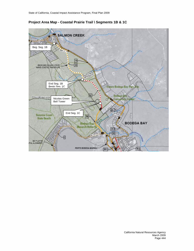
State of California, Coastal Impact Assistance Program, Final Plan 2009
Project Area Map - Coastal Prairie Trail \ Segments 1B & 1C
Nicolas Green Bell Tower
End Seg. 1B Begin Seg. 1C
End Seg. 1C
Beg. Seg. 1B
California Natural Resources Agency March 2009
Page 444

State of California, Coastal Impact Assistance Program, Final Plan 2009
Project Map: Harbor Coastal Trail Project \ Segments 3D-2 & 6B
Beg. Seg. 3D-2
End Seg. 6B
Beg. Seg. 6B
End Seg. 3D-2
California Natural Resources Agency March 2009
Page 445

State of California, Coastal Impact Assistance Program, Final Plan 2009
Project Area Map: North Harbor Coastal Trail \ Segments 3D-1 & 2B
Nicolas Green Bell Tower
Beg. Seg. 3D-1 Bay Flat Rd.
End Seg. 3D-1
Beg. Seg. 2B
California Natural Resources Agency March 2009
Page 446

State of California, Coastal Impact Assistance Program, Final Plan 2009
STATE OF CALIFORNIA COASTAL IMPACT ASSISTANCE PLAN
VENTURA COUNTY
NAME OFAGENCY/DEPARTMENT: Resource Management Agency, Planning Division PROJECT TITLE Coastal Biological Resource Impact Mitigation Program - Tier 1 PROJECT CONTACT INFORMATION Name of Primary Staff Contact: Nancy Settle Address: Resource Management Agency Planning Division 800 S. Victoria Ave Ventura, CA 93003 Phone: 805-654-2465 Fax: 805-654-2509 E-Mail Address: [email protected] PROJECT SUMMARY Location: Santa Monica Mountains in
Unincorporated Ventura County Duration: 2009 - 2012 Total Estimated Project Cost: $212,300 Total CIAP Funds Requested: $193,000 Amount/Source of Match: $19,300 (Ventura County Planning
Division budget for project supervision and administrative overhead)
CIAP Spending Estimate Per Calendar Year: 2009 - $9,000 2010 - $72,000 2011 - $72,000 2012 - $40,000 Project Background and Description A significant part of Ventura County’s coastal zone consists of Mediterranean habitat. The Nature Conservancy reported in 2006 that Mediterranean habitat is the second most threatened ecosystem in the world. There are numerous policies in place to protect sensitive biological resources such as this, including the Coastal Act’s protections of Environmentally Sensitive Habitat Areas (ESHA) and the California Environmental Quality Act (CEQA); however specific definitions and guidelines that would help implement these policies—which apply to very complex and dynamic biological resources—are lacking. This project will fund research to develop empirically-derived guidelines for implementing biological resource protection mitigation strategies in the coastal zone.
California Natural Resources Agency March 2009
Page 447

State of California, Coastal Impact Assistance Program, Final Plan 2009
This will approached through the following steps: 1. Prepare a Coastal Zone Master Environmental Assessment (MEA) that inventories
biological resources, their functions and values. The MEA will provide a central source of current information for use in determining impact significance in CEQA Initial Studies and in preparing EIRs or Negative Declarations. The MEA will identify issues and impacts adversely affecting ecosystem functions and biological diversity. The MEA will recommend a methodology for ESHA designation by major habitat types (coastal sage, wetland, riparian, oak woodland) in Ventura County.
2. Based on the data in the MEA, develop impact significance thresholds—both project-level and cumulative— for wetlands and key vegetation communities. Significance thresholds will be based on such factors as:
• Extent and quality of the natural habitat present, including degree of fragmentation and projected pressure for further fragmentation, based on General Plan and zoning regulations;
• Presence of sensitive species or their habitats; • Presence of special geomorphic features or biologic functions and values;
and • Vulnerability to invasive exotic species.
3. Develop recommendations for a coastal zone Biological Resources Impact Mitigation Program. This program will outline empirically-derived mitigation options, in order of priority. The program will outline the required components of mitigation plans, recommend offsite mitigation programs, mitigation ratios by vegetation type, and outline development standards and strategies that minimize site-specific and cumulative impacts on biological resources. Development of standard mitigation measures for projects in sensitive habitat will also be included. These measures will address such things as setback distances from the different resource types, revegetation protocols, fencing, impervious surface coverage, etc.
The data developed in the MEA will also assist the County in its update to its Local Coastal Plan by identifying biological characteristics and constraints that need to be addressed in the Plan. Through a series of previous grants, the County has laid the groundwork for this project. Accomplishments include mapping aquatic, wetland, and sensitive habitat resources, identifying and mapping critical animal passageways and landscape linkages, removing barriers to acquisition of land by conservation agencies, securing biological spatial data; developing an online viewer to allow resource managers to view the data; drafting biological assessment standards and biologist qualification standards; creating wetlands guides that assist the public and resource managers with permitting and restoring sensitive coastal wetlands; and developing guidelines for planners and biologists to better design projects and mitigate impacts to fish and wildlife migration. This project will use these tools and resources in the development of a comprehensive program for mitigating impacts to sensitive biological resources in the coastal zone. Measurable Goals and Objectives The goals of this project are several: • Improve protection of sensitive biological resources in Ventura County’s coastal
areas;
California Natural Resources Agency March 2009
Page 448

State of California, Coastal Impact Assistance Program, Final Plan 2009
• Streamline and standardize the environmental review process; • Avoid project delays by identifying appropriate mitigation/conservation options early
in the process; • Avoid a piece-meal approach to impact mitigation; and • Provide a common database for reference on biological issues in the coastal zone. The objective of this project is to perform the research necessary to develop and justify a biological impact mitigation program that can be applied consistently from project to project, and that effectively mitigates impacts to sensitive coastal biological resources. Timeline for Deliverables
COMPLETED BY * DELIVERABLES September, 2010 A Coastal Zone Master Environmental Assessment for the
Santa Monica Mountains. February, 2011 New, expanded impact significance thresholds for wetlands and
key vegetation communities in the Santa Monica Mountains. July, 2011 Recommendations for a coastal zone Biological Resources
Impact Mitigation Program. September, 2011 Board of Supervisors decision on recommendations.
March, 2012 Biological Resource Mitigation Guidelines in the Santa Monica Mountains document.
June, 2012 Updated Ventura County Initial Study Assessment Guidelines document.
August, 2012 Updated staff procedures. Any needed agreements with conservation agencies established. Other needed implementation tools developed.
September, 2012 Staff training. October, 2012 Applicant education handout.
* Completion dates presume a July 1, 2009 start date. COORDINATION WITH OTHER FEDERAL RESOURCES AND PROGRAMS Part of the objective of the Biological Conservation Program is to better implement regulations—including federal regulations—which protect biological resources. Such federal regulations include those that protect wetlands, endangered and threatened species, migratory birds and coastal zone resources. Therefore implementation of this program will support these federal regulatory programs. No other actions have been taken to secure funding for this specific project from other federal agencies. CALIFORNIA OCEAN PROTECTION COUNCIL Ocean and Coastal Water Quality Goal
Objective 1 – Enforce Pollution Controls: The effective mitigation of impacts to streams and wetlands will be a key element of the Coastal Biological Resource Impact Mitigation Program. Protected streams would have reduced pollutant loads and the natural water cleansing functions of riparian habitats would be preserved.
Physical Processes and Habitat Structure Goal
Objective 1 - Habitat Restoration: The central goal of this program is to maintain the quality of natural habitats in the coastal zone.
California Natural Resources Agency March 2009
Page 449

State of California, Coastal Impact Assistance Program, Final Plan 2009
Ocean and Coastal Ecosystems Goal
Objective 3 - Control Invasive Species: One of the impacts this Coastal Biological Resource Impact Mitigation Program would be directly addressing is the impact from invasive species to natural habitats.
CONSISTENCY WITH CIAP AUTHORIZED USES The Coastal Biological Resource Impact Mitigation Program project would meet three of the authorized uses:
Authorized Use 1: Projects and activities for the conservation, protection, or restoration of coastal areas, including wetlands. This project would significantly improve the ability of the County to conserve, protect, and restore coastal areas, including wetlands, by developing an effective program for mitigating impacts to biological resources, including wetlands.
Authorized Use 2: Mitigation of damage to fish, wildlife, or natural resources. This project would significantly improve the ability of the County to prevent and mitigate damage to fish, wildlife and natural resources, by developing an effective program for mitigating impacts to these biological resources.
Authorized Use 4: Implementation of a federally-approved marine, coastal, or comprehensive conservation management plan. The California Coastal Act is the foundation of the federally-approved California Coastal Management Program for the Pacific Ocean coast segment of the California coastal zone. This project would substantially improve implementation of the County’s Local Coastal Program, which includes protection of Environmentally Sensitive Habitat Areas.
.
California Natural Resources Agency March 2009
Page 450

State of California, Coastal Impact Assistance Program, Final Plan 2009
STATE OF CALIFORNIA COASTAL IMPACT ASSISTANCE PLAN
VENTURA COUNTY
NAME OF AGENCY/DEPARTMENT Resource Management Agency, Planning Division PROJECT TITLE Local Coastal Program Amendments - Tier 1 PROJECT CONTACT INFORMATION Name of Primary Staff Contact: Deborah Millais Resource Management Agency – Planning
Division Address: 800 S. Victoria Ave. Ventura, CA 93009 Telephone Number: 805-654-5037 Fax Number: 805-654-2509 E-Mail Address: [email protected]
PROJECT SUMMARY Location: Coastal Zone – Unincorporated Area Duration: 2009 - 2013 Total Estimated Project Cost: $387,640 Total CIAP Funding Requested: $352,400 Amount and Source of Non-Federal Match: $35,240 (Ventura County Planning
Division budget for project supervision and administrative overhead)
CIAP Spending Estimate Per Calendar Year: 2009 - $8,400 2010 - $92,000 2011 - $92,000 2012 - $90,000 2013 - $70,000
Project Background and Description The Coastal Zoning Ordinance and the Coastal Area Plan, the documents which make up Ventura County’s Local Coastal Program (LCP), were written in the early 1980’s and have seen only minor revisions since that time. There is an urgent need to update these documents to secure in the coastal zone a commensurate level of resource protection as is now practiced in the County’s non-coastal zone. Much of the background work—both the research and drafting the regulatory language—has already been accomplished in
California Natural Resources Agency March 2009
Page 451
State of California, Coastal Impact Assistance Program, Final Plan 2009
connection with non-Coastal resources. Therefore, much of this effort will be focused on identifying those sections of the Coastal Area Plan and the Coastal Zoning Ordinance that require revision, and adapting the non-coastal policies, programs, and regulations to coastal circumstances and needs. The scope of the amendments and updates will likely include the following:
Biological and Environmentally Sensitive Habitat Protection. Update the sections of the documents that address protection of biological resources to add greater specificity and guidance on identifying Environmentally Sensitive Habitat Areas (ESHA).
Enforcement. Amend and update the LCP to include enforcement and implementation measures now available in the non-coastal areas, including zoning violation abatement, notice to property owner regarding resource protection, consistent development standards and the like.
Integrate Non-Coastal Zone Resource Protections. A number of resource protection policies, such as the County’s Tree Protection Ordinance, have been adopted in the Non-Coastal Zoning Ordinance or General Plan and need to be integrated into the coastal zone policy documents. Other new policies being developed through this CIAP funding, such as the watercourse buffer ordinance, would also be included in this LCP update so they become applicable countywide.
Climate Change. This is an extension of one of the California Coastal Commission’s CIAP funded projects. The Commission will prepare a “Climate Change and the California Coastal Act – A Guide to Addressing Coastal Act Issues.” The purpose of the Guide is to assist local governments in amending their LCPs to address Climate Change issues. Once the Guide has been made public, the County will amend its LCP as suggested. According to the Coastal Commission’s Timetable and Deliverables, the Guide will be available by June 2011. While it will be possible to begin work on this task before the Guide is finalized, most of the effort will occur after this time.
For all of these projects, guidance documents will be utilized such as the California Coastal Commission’s, Updating the LCP – A Place to Start and Overview of Sea Level Rise and Some Implications for Coastal California for identified target issues. The LCP update will be coordinated with Coastal Commission staff and programs.
Measurable Goals and Objectives The goal of this project is to improve the protection of coastal resources and better implement the goals of the Coastal Act. The objective of this project is to amend and update targeted sections of the Ventura County Local Coastal Program (LCP)—which includes the Coastal Zoning Ordinance and the Coastal Area Plan.
Objective 1: Identify sections of the Coastal Area Plan and the Coastal Zoning Ordinance that require revision.
Objective 2: Identify appropriate language for the first three topics (Biological and
Environmentally Sensitive Habitat Protection, Enforcement, and Resource Protection) from the General Plan, Non-Coastal Zoning Ordinance, and other regulations, that can be modified to address Coastal circumstances and needs.
Objective 3: Draft revisions to the Coastal Area Plan and the Coastal Zoning
Ordinance.
California Natural Resources Agency March 2009
Page 452

State of California, Coastal Impact Assistance Program, Final Plan 2009
Objective 4: Meet with affected groups and agencies, primarily the Coastal Commission staff, to obtain input and comments.
Objective 5: Complete draft revised Coastal Area Plan and Coastal Zoning Ordinance. Objective 6: Complete draft appropriate environmental documents. Objective 7 Present revised Coastal Plan and Coastal Zoning Ordinance to the
Planning Commission and Board of Supervisors for adoption. Objective 8: Present the draft ordinance to the Coastal Commission. Timeline for Deliverables It is difficult to establish a timetable without knowing when the project will start. The schedule below assumes a July 1, 2009 starting date.
COMPLETED BY
DELIVERABLE
October 2009 List of Coastal Plan and Coastal Ordinance sections to be revised.
December 2009 List of policies, programs, and regulations from the General Plan and the Non-Coastal Zoning Ordinance suitable for adaption for the Coastal Area Plan and the Coastal Zoning Ordinance.
March 2011 Draft revised language for the Coastal Area Plan and the Coastal Zoning Ordinance.
December 2011 Completion of public review.
June 2012 Draft revised Coastal Area Plan and Coastal Zoning Ordinance.
September 2012 Draft environmental documents.
March 2013 Planning Commission and Board of Supervisors decision on revised Coastal Area Plan and Coastal Zoning Ordinance.
December 2013 Coastal Commission decision on revised Coastal Area Plan and Coastal Zoning Ordinance.
COORDINATION WITH OTHER FEDERAL RESOURCES AND PROGRAMS The Coastal Commission—which has federal consistency review authority over all federal activities and federally licensed, permitted or assisted activities if the activity affects coastal resources—is the agency that approves local coastal plans. Thus through the Coastal Commission’s review and approval of Ventura County’s updated LCP, this project will be coordinated with other federal resources and programs.
No other actions have been taken to secure funding for the project from other federal agencies. CALIFORNIA OCEAN PROTECTION COUNCIL The proposed updated LCP would advance the goals and objectives of the California Ocean Protection Council’s Strategic Plan in the following ways.
Governance Goal
California Natural Resources Agency March 2009
Page 453

State of California, Coastal Impact Assistance Program, Final Plan 2009
Objective 3 – Enforcement: Local jurisdictions’ Local Coastal Programs establish the regulatory framework within which the Coastal Commission carries out its mission of protection coastal resources. This mission cannot be effective if it is based on LCPs that do not include the most current policies and programs to protect coastal resources. An updated LCP will enable both the County and the Coastal Commission to provide effective protection to the ocean and coast.
Ocean and Coastal Water Quality Goal Objective 1 – Enforce Pollution Controls: The LCP update will specifically address current weaknesses with regard to enforcement policies. By strengthening these policies, violations, which often involve pollution, can be more effectively addressed.
Physical Processes and Habitat Structure Goal Objective 1 – Habitat Restoration: Updates to the biological resource sections of the LCP will result in better protections of habitat as well as more effective mitigation of impacts to these habitats.
Ocean and Coastal Ecosystems Goal Objective 3 – Control Invasive Species. Updates to the biological resource sections of the LCP will include policies addressing the problem of invasive species. CONSISTENCY WITH CIAP AUTHORIZED USES The Local Coastal Program Amendments project would meet Authorized Use 4:
Authorized Use 4: Implementation of a federally-approved marine, coastal, or comprehensive conservation management plan. The California Coastal Act is the foundation of the federally-approved California Coastal Management Program for the Pacific Ocean coast segment of the California coastal zone. This project would substantially improve implementation of the County’s Local Coastal Program.
California Natural Resources Agency March 2009
Page 454

State of California, Coastal Impact Assistance Program, Final Plan 2009
STATE OF CALIFORNIA COASTAL IMPACT ASSISTANCE PLAN
VENTURA COUNTY
NAME OF AGENCY/DEPARTMENT County Resource Management Agency, Planning Division PROJECT TITLE Watercourse Buffer Ordinance - Tier 1 PROJECT CONTACT INFORMATION Name of Primary Staff Contact: Deborah Millais Resource Management Agency – Planning
Division Address: 800 S. Victoria Ave. Ventura, CA 93009 Telephone Number: 805-654-5037 Fax Number: 805-654-2509 E-Mail Address: [email protected] PROJECT SUMMARY Location: Unincorporated County Duration: 2009-2011 Total Estimated Project Cost: $147,400 Total CIAP Funding Requested: $134,000 Amount and Source of Non-Federal Match: $13,400 (Ventura County Planning Division
budget for project supervision and administrative overhead)
CIAP Spending Estimate Per Year: 2009 - $37,000
2010 - $97,000 Project Background and Description The health of streams and rivers depends to a great extent on the lands that surround them. Research has shown that buffers along streams, especially naturally vegetated buffers, can protect streams from the degrading effects of nonpoint source pollution while reducing the impact of floods, and providing habitat for wildlife. Watercourse setback regulations are now widely advocated for protecting water quality. This project will prepare a proposal, for Ventura County Board of Supervisors consideration, for a watercourse buffer ordinance. The ordinance would establish setback buffers around watercourses. Within these buffers, development activity such as
California Natural Resources Agency March 2009
Page 455

State of California, Coastal Impact Assistance Program, Final Plan 2009
land clearing, building of structures, grading, paving, deposition of refuse or debris, and planting of invasive species would be restricted. Further, the ordinance would promote the maintenance of riparian buffers in their natural state, with native plants and species. Measurable Goals and Objectives The goal of the project is to better protect the water quality, habitats, natural structure, and ecosystem functions of Ventura County’s watercourses, all of which drain to the ocean. The project’s objective is to implement regulations that require a buffer between watercourses and development in the County in order to protect water quality, limit sedimentation and erosion, and protect natural habitat. Objective 1: Prepare a research paper that will:
• Describe the purpose, nature, and benefits of watercourse buffers. • Recommend the types of watercourses to which the buffer will apply. • Recommend an approach to establishing buffer setback distances for
different watercourse types. • Recommend prohibited and restricted activities within buffers. • Recommend the applicability of the ordinance to agricultural land uses.
Ventura County has a large and thriving agricultural economy. Much of the activity occurs near watercourses. The relationship between farming activities and the creation and maintenance of watercourse buffers will require careful consideration.
• Recommend alternatives to buffers when their implementation is infeasible. • Identify key issues in the context of Ventura County, together with possible
solutions. • Include samples of model ordinances, and ordinances adopted by other
jurisdictions.
Objective 2: Obtain stakeholder input. It is anticipated that this will be accomplished through the existing Watershed Coalition of Ventura County (WCVC). The Coalition, formed to prepare applications for Proposition 50 funding, includes representatives of most of the agencies/individuals interested in water management; additional representatives will be included if needed. It is probable that the WCVC will appoint a subcommittee to work on this project.
Objective 3: Prepare a draft watercourse buffer ordinance in coordination with
stakeholders’ subcommittee. In the course of developing the draft ordinance, it is likely that periodic presentations would be made to the Board of Supervisors, and possibly to the Planning Commission, to obtain their input before a final draft is presented to them.
Objective 4: Complete environmental documents. Objective 5: Present the draft ordinance to the Planning Commission and Board of Supervisors for adoption.
California Natural Resources Agency March 2009
Page 456
State of California, Coastal Impact Assistance Program, Final Plan 2009
Timeline for Deliverables It is difficult to establish a timetable without knowing when the project will start. The schedule below assumes a July 1, 2009 starting date.
COMPLETED BY
DELIVERABLE
December 2009 Completed Research Paper.
January 2010 Comments from stakeholders as to structure and criteria of Watercourse Buffer Ordinance received.
February 2010 Complete Draft Watercourse Buffer Ordinance. May 2010 Complete environmental documents.
September 2010 Complete presentation of Watercourse Buffer Ordinance to Planning Commission and Board of Supervisors for adoption.
COORDINATION WITH OTHER FEDERAL RESOURCES AND PROGRAMS Implementation of this project will not require coordination with other federal resources or programs, though implementation will better protect federally-protected wetlands. No other actions have been taken by the Resource Management Agency to secure funding for the project from other federal agencies. CALIFORNIA OCEAN PROTECTION COUNCIL This project advances the following Ocean Protection Council Goals and objectives: Ocean and Coastal Water Quality Goal
Objective 1 – Enforce pollution controls: Watercourse buffers are an important pollution control practice in that they offer the opportunity for sediment to settle out before entering streams and for pollutants to be naturally filtered by soil and plants.
Physical Processes and Habitat Structure Goal
Objective 1 – Habitat Restoration: The watercourse buffer ordinance would promote the natural protection and restoration of riparian habitat simply by disallowing its destruction and controlling the types of land uses that can occur adjacent to watercourses.
Ocean and Coastal Ecosystems Goal Objective 3 – Control invasive species: The watercourse buffer ordinance would reduce opportunities for invasive species to spread into ocean and coastal ecosystems by regulating the use of invasive species within the buffer area.
CONSISTENCY WITH CIAP AUTHORIZED USES The watercourse buffer ordinance project would meet two of the authorized uses: Authorized Use 1: Projects and activities for the conservation, protection, or restoration of coastal areas, including wetlands. This project would contribute significantly to the conservation, protection, and restoration of coastal areas. It would require buffers around watercourses, in which development activity would be extremely limited and
California Natural Resources Agency March 2009
Page 457

State of California, Coastal Impact Assistance Program, Final Plan 2009
natural vegetation would be protected. The buffers would apply to all watercourses in the unincorporated County, most all of which drain to the coast. Many of the problems affecting coastal areas originate in the upland areas. Specifically, upstream development near watercourses creates such downstream problems as sedimentation from upstream erosion, pollution from herbicides, pesticides, fertilizers, and urban runoff, and introduction of invasive species. Preventing these problems at their source is more effective than mitigating the problems once they have migrated downstream. In addition, by pushing development away from streambeds, buffers decrease the need for straightening, deepening, and hardening watercourses. Authorized Use 2: Mitigation of damage to fish, wildlife, or natural resources. As noted above, the establishment of buffers around watercourses would substantially mitigate the effects of development on fish, wildlife, and natural resources, by reducing erosion, sedimentation, pollution, channelization of watercourses, and the spread of invasive species. Further, preservation of riparian areas in their natural state will provide crucial habitat for fish and wildlife.
California Natural Resources Agency March 2009
Page 458

State of California, Coastal Impact Assistance Program, Final Plan 2009
STATE OF CALIFORNIA COASTAL IMPACT ASSISTANCE PLAN
VENTURA COUNTY
PROJECT TITLE Climate Change Mitigation and Preparation Program - Tier 2 NAME OF AGENCY/DEPARTMENT Resource Management Agency, Planning Division PROJECT CONTACT INFORMATION Name of Primary Staff Contact: Lorraine Rubin Address: Resource Management Agency Planning Division 800 S. Victoria Ave Ventura, CA 93003 Phone: 805-654-2466 Fax: 805-654-2509 E-Mail: [email protected] PROJECT SUMMARY Location: Countywide Duration: 2009-2013 Total Estimated Project Cost: $406,340 Total CIAP Funds Requested: $369,400 Amount/Source of Non-Federal Match: $36,940 (Ventura County Planning
Division budget for project supervision and administrative overhead)
CIAP Spending Estimate Per Year: 2009 - $29,400 2010 - $98,000 2011 - $98,000 2012 - $98,000 2013 - $46,000 Project Background and Description Climate Change Mitigation Plan On December 5, 2006, the Ventura County Board of Supervisors directed the County’s Executive Officer (CEO) to report back to the Board on the costs, timeline, and funding opportunities for preparing a 2007 Climate Change Action Plan. Climate Action Plans, which have already been prepared by a number of California cities and counties, outline a strategy for a local government to most efficiently and effectively reduce its greenhouse gas emissions. These plans generally start with an emissions inventory in order to establish a baseline emissions number. An emissions reduction goal is then established, and an action plan is developed which outlines specific strategies to
California Natural Resources Agency March 2009
Page 459

State of California, Coastal Impact Assistance Program, Final Plan 2009
achieve that goal. Once these strategies are implemented, emissions are monitored to determine effectiveness. This project will allow the County to develop a Climate Change Action Plan (which we are here calling a Climate Change Mitigation Plan), based on the findings of the emissions inventory and reduction targets. The Climate Change Mitigation Plan (CCMP) will quantify the emission reductions of projects already implemented and will identify new measures to be undertaken to meet adopted target reductions. In addition, the plan will include a timeline identifying major project milestones and project phasing, potential financing mechanisms, and an assignment of staffing resources for project implementation.
According to the California Energy Commission, California's water infrastructure accounts for nearly 20 percent of the state's electricity consumption. The State Water Project, which moves large quantities of water great distances and over steep terrain, is the largest single user of electrical energy in the State. The County of Ventura relies on the State Water Project for 25% of its water supply. Because of the direct connection between water consumption and energy consumption—which results in greenhouse gas emissions—any effective decreases in water consumption simultaneously help mitigate climate change. Therefore, the strategies that are developed for the Uncertain Water Supplies section of the Climate Change Preparedness Plan, discussed below, will also be important mitigation strategies and will be integrated into the Climate Change Mitigation Plan.
Climate Change Preparedness Plan, Part I-Uncertain Water Supplies This project will also develop a Climate Change Preparedness Plan, which takes on the urgent task of identifying and preparing for risks to County residents. This plan will eventually include many issue areas, but the initial focus of this effort will be on preparing for uncertain water supplies. According to the California Department of Water Resources (DWR), “Climate change is already impacting California’s water resources. In the future, warmer temperatures, different patterns of precipitation and runoff, and rising sea levels will profoundly affect the ability to manage water supplies and other natural resources. Adapting California’s water management systems to climate change presents one of the most significant challenges for the 21st century.” DWR documents also state: • By 2050 scientists project a loss of at least 25 percent of the Sierra snowpack, an
important source of urban, agricultural and environmental water. Weather patterns are becoming more variable, causing more severe winter and spring flooding and longer, drier droughts.
• In the past century, sea level has risen over one-half foot at the Golden Gate. Projected, continued sea level rise will threaten many coastal communities as well as the sustainability of the Sacramento-San Joaquin Delta which supplies 25 million Californians with drinking water.
• Rising sea level increases the potential for sea water intrusion into coastal groundwater aquifers and other coastal groundwater resources by increasing the pressure of ocean water exerted against water-bearing deposits extending inland from the coast. Rising sea level can also increase the potential for intrusion of sea water into coastal groundwater basins through the inundation of areas that were formerly above sea level.
California Natural Resources Agency March 2009
Page 460

State of California, Coastal Impact Assistance Program, Final Plan 2009
• Most global climate models predict that climate change will be a continuous and somewhat gradual process through the end of this century. With proper foresight, planning and action, water managers will likely be able to help California adapt to many of the water supply challenges posed by climate change, even at some of the higher projections for change. However, sudden and unexpected changes in climate could leave water managers unprepared and could, in their extreme, have serious implications for California and its water supplies. Sudden climate change could occur if progressive changes in the earth's climate cause a physical threshold or "trigger point" to be reached where one of the earth's major atmospheric or oceanic systems changes significantly, or ceases to function. One possible example of this that has received a significant amount of attention is a possible change in the global thermohaline circulation system.
In addition to being one section of a larger Climate Change Preparedness Plan, the section on Uncertain Water Supplies could also serve as information regarding climate change that will likely be an element of Ventura County’s updated Integrated Regional Water Management Plan (IRWMP). The IRWMP was developed by the Watersheds Coalition of Ventura County (WCVC). The WCVC is a countywide group with over 56 participants including water districts, cities, resource management agencies, businesses, nonprofits, and other organizations with a vested interest in improving water quality, flood control, and habitat within the County’s three major watersheds. The Uncertain Water Supplies Plan will be developed by the WCVC, which has had great success at developing regional plans and programs cooperatively and effectively among a broad coalition of participants. The success of such a plan will depend upon its efficient and integrated implementation throughout the region, allowing existing infrastructure to be leveraged, and developing a more diversified portfolio of water supply alternatives. While most water purveyors have developed a water shortage contingency plan as part of their state-mandated Urban Water Management Plans, their mitigation strategies are limited to the scope of their authority and are not integrated with each other or local governments into a regional strategy. In addition, these plans do not adequately address the magnitude of the threat that various climate change scenarios present; for example, increased sea water intrusion into groundwater aquifers, coupled with contaminated or decreasingly available State Water Project water, coupled with extensive fires, coupled with extended drought. By working cooperatively with other agencies in the region, additional integrated strategies can be included in a regional plan. One example would be a land use planning strategy that would require all new land use development projects to “create” their own ongoing water supply through an offset program whereby they fund the retrofit of existing, water-consumptive equipment (such as older toilets or irrigation systems) and through implementation of intensive and innovative water use efficiency measures. Countywide Climate Change Education Program This project will also develop a countywide education program focusing on climate change and the findings of the projects planning efforts. This program will include development of web-based resources, community forums and presentations, press releases, and support of community-based outreach and mobilization efforts.
California Natural Resources Agency March 2009
Page 461
State of California, Coastal Impact Assistance Program, Final Plan 2009
Measurable Goals and Objectives The goal of the project is to reduce our vulnerability to the impacts of climate change, which is a result of burning fossil fuels. The project has two objectives: • The first objective is to address climate change in terms of mitigation, or emissions
reduction. We will develop a Climate Change Mitigation Plan that prioritizes the most effective strategies for reducing greenhouse gas emissions within the County’s jurisdiction.
• The second objective is to address climate change in terms of adaptation, or preparing for anticipated impacts. Disruptions to reliable municipal water supplies will be the primary focus. We will develop, in partnership with the established Ventura County Watersheds Coalition, a Climate Change Preparedness Plan that outlines both emergency responses and long-term strategies to deal with drought and other disruptions to the water supplies available to Ventura County.
Timeline for Deliverables
COMPLETED BY * DELIVERABLES September, 2009 Emissions inventory. Emissions reduction targets developed. February, 2010 A County Climate Change Mitigation Plan for reducing GHG
emissions. A County Climate Change Preparedness Plan August, 2010 A Scenarios Analysis on water supply disruptions. January, 2011 Emergency responses and long term strategies to deal with
drought/disruptions to water supply. July, 2011 Presentations of findings to decision makers countywide. March, 2012 Incorporate into the IRWMP April, 2012 Initiation of a Countywide Climate Change Education Program July, 2012 Mechanisms developed to increase institutional flexibility to
adapt to climate change scenarios, especially water supply disruptions.
November, 2012 Implementation of priority projects (as funding permits). * Completion dates presume a July 1, 2009 start date. COORDINATION WITH OTHER FEDERAL RESOURCES AND PROGRAMS This program would be implemented in coordination with the California Coastal Commission, a federally-approved Coastal Management Program, which has requested CIAP funding to prepare an online guide entitled “Climate Change and the California Coastal Act – A Guide to Addressing Coastal Act Issues.” It is hoped that our work as a local government entity to directly address climate change impacts would help inform the development of the Commission’s online guide. No other actions have been taken to secure funding for the project from other federal agencies. CALIFORNIA OCEAN PROTECTION COUNCIL Burning fossil fuels is now understood to trap heat in the atmosphere, causing a greenhouse effect and a resultant rise in global temperatures. Sea level rise, increased storm activity, and extreme weather events are just some of the anticipated impacts of climate change, all of which will affect biota, habitat, public access and shoreline development. Changes to ocean water pH, temperature, salinity, and even the ocean’s
California Natural Resources Agency March 2009
Page 462
State of California, Coastal Impact Assistance Program, Final Plan 2009
core circulation patterns are other possible impacts. The importance and urgency of responding to climate change was recently acknowledged in a June 14, 2007 resolution entitled Resolution of the California Ocean Protection Council on Climate Change. In that resolution, the Ocean Protection Council (OPC) resolved, among other things, to: • Promote climate change mitigation or adaptation measures in OPC-funded projects. • Work with the California Climate Action Team’s Subcommittee to coordinate the
efforts of the state and regional entities on Scenario Analysis. • Support the development of methods and tools for studying climate change impacts
and erosion on coastal communities and integrating this information into state, regional, and local adaptation planning efforts; and
• Fund climate change impact research. In addition, the OPC’s five year strategic plan, A Vision for Our Ocean and Coast, contains the following objectives:
Physical Processes and Habitat Structure Goal Objective 3 – Understanding Impacts of Climate Change: This project aligns with the objectives of the OPC in the following ways: • By taking actions to both reduce the County’s emissions of GHG and prepare for
ecosystem disruptions (such as lack of snow pack or rainfall) this project will pursue both mitigation and adaptation responses to climate change.
• The project team will work with the state’s Climate Action Team Subcommittee to obtain the most reliable scenario data related to water supply disruptions. This information will be graphically provided to local decision makers to aid them in their analysis of the situation and in taking appropriate actions.
• One of the anticipated impacts of climate change is extreme weather events, such as heat waves and droughts. Rising sea levels could also cause sea water intrusion into groundwater supplies and could damage the fragile Delta levee system that feeds water to southern California. Increased fires are already occurring worldwide due to dry conditions, which further taxes water supplies. By focusing in on this one impact, disruptions to water supplies, this project will allow Ventura County to more effectively address the issue—from research into the most productive responses of local government, to development of mechanisms to integrate “adaptive flexibility” into government processes. Ventura County can then provide leadership on this important issue to other local governments throughout the state.
Objective 5 – Encourage Sustainable Economic Activity - The project’s focus on the impacts of climate change and land use decisions will help to effectively incorporate that information to inform decision makers about whether the long-term sustainability of certain coastal development and activities.
Education and Outreach Goal
Objective 1 – Public Awareness: The public education campaign will contribute to greater public awareness of coastal issues and public support for OPC’s priorities, which now includes promotion of climate change mitigation or adaptation measures.
California Natural Resources Agency March 2009
Page 463
State of California, Coastal Impact Assistance Program, Final Plan 2009
CONSISTENCY WITH CIAP AUTHORIZED USES The Climate Change Mitigation and Preparation Program would meet two of the authorized uses:
Authorized Use 1: Projects and activities for the conservation, protection, or restoration of coastal areas, including wetlands.
Authorized Use 2: Mitigation of damage to fish, wildlife, or natural resources.
This project aims to address climate change, which is a threat to ocean and coastal habitat health like none other. The following are some of the recognized threats:
• Changes to ocean and coastal circulation patterns, which can disrupt the hydrological cycle on a global scale and bring shifts in marine ecosystems and fisheries. The El Niño phenomenon is but a hint of how oceanic changes can dramatically affect where and how much precipitation falls throughout the planet.
• Changes to the ocean thermohaline circulation system, or the Ocean Conveyor. These currents distribute vast quantities of heat around our planet, and thus play a fundamental role in governing Earth’s climate. Subpolar seas bordering the North Atlantic have become noticeably less salty since the mid-1960s, especially in the last decade. This is the largest and most dramatic oceanic change ever measured in the era of modern instruments. This has resulted in a freshening of the deep ocean in the North Atlantic, which in the past disrupted the Ocean Conveyor and caused abrupt climate changes.
• Increase in sea level and coastal erosion. Sea level rise has strong and direct impacts on low-lying areas through increased coastal flooding and erosion, contamination of groundwater supplies, and increased vulnerability to storm surges.
• Increases in natural hazards, such as hurricanes. Predictions of future climate change suggest that on average, hurricane intensity will grow. Such storms and their associated coastal storm surges are the major ocean-related natural hazard that will vary with the changing climate.
• Changes to the ocean’s ability to act as a “carbon sink.” • Potential massive releases of methane hydrates under continental shelf sediments,
which could trigger undersea landslides and tsunamis. • Acidification of ocean waters. As a result of ocean uptake of anthropogenic CO2, the
pH of the oceans is decreasing. As a result of a more acidic ocean, marine calcification rates will decrease, affecting growth and reproduction rates of organisms that use calcium carbonate to construct their shells and skeletons (including calcareous phytoplankton and corals).
• Changes to fisheries. Marine organisms will be influenced by changes in circulation, ventilation, and stratification through changes in temperature, light, and nutrient supply. Alterations of any of these drivers may lead to changes in species abundance and composition, possibly leading to large-scale regime shifts and species migrations. Habitat loss, resulting from sea level rise, and invasion by non-native species will also perturb marine ecosystems, including marine mammals and sea birds, affecting the health and biodiversity of marine ecosystems.
It is clear that climate change is by far the largest threat facing the health of our ocean and coastal habitats. Any effort to protect coastal habitats must be considered in the context of this unprecedented crisis. This project responsibly addresses the highest priority threat to coastal habitats.
California Natural Resources Agency March 2009
Page 464

State of California, Coastal Impact Assistance Program, Final Plan 2009
STATE OF CALIFORNIA COASTAL IMPACT ASSISTANCE PLAN
VENTURA COUNTY
NAME OF AGENCY/DEPARTMENT Resource Management Agency, Planning Division PROJECT TITLE BEACON Beach Nourishment Assistance - Tier 2 PROJECT CONTACT INFORMATION Name of Primary Staff Contact: Rick Raives County Department or Division: BEACON (City of San Buenaventura) Address: Rick Raives
City Engineer City of San Buenaventura 501 Poli Street Ventura, CA 93001
Telephone Number: 805-654-7870 Fax Number: 805-641-2775 E-Mail Address: [email protected]
PROJECT SUMMARY Project Location: Ventura County coastline between
Point and Point Mugu Project Duration: 2010 - 2012 Estimated Cost of Project: $176,000 Total CIAP Funds Requested: $160,000 Amount and Source of $16,000 (California Department of Boating Non-Federal Match and Waterways - tentative) CIAP Spending Estimate Per Year: 2010 - $60,000 2011 - $50,000 2012 - $50,000 Project Background and Description The Beach Erosion Authority for Clean Oceans and Nourishment (BEACON) is a California joint powers agency established to protect and enhance beaches within Ventura and Santa Barbara Counties. It is composed of the Counties of Ventura and Santa Barbara and the Cities of Port Hueneme, Oxnard, San Buenaventura, Carpinteria, Santa Barbara and Goleta. A few years ago, BEACON created the South Central Coast Beach Enhancement Program (SCCBEP) using grant funds from the Coastal Resources Grant Program (CRGP). The goal of SCCBEP is to improve the quality of local beaches by augmenting natural coastal sand supplies. These supplies have been greatly
California Natural Resources Agency March 2009
Page 465

State of California, Coastal Impact Assistance Program, Final Plan 2009
diminished over the past 70 years by the construction of local harbors, debris basins, and dams, as well as the general armoring of coastal bluffs and backshores. As a result, local beaches have eroded, decreasing the available area for recreational beach use, wildlife habitat and coastal storm protection. SCCBEP seeks to reverse this trend by placing sediment of opportunity on five pre-approved beaches within the two counties. SCCBEP identified a number of sources of sediment of opportunity included debris basins on local streams and construction projects within the coastal zone. Often, these sediments are compatible for beach nourishment use, but making use of them is difficult due to the lengthy permitting process. As a result, sediment sources of opportunity typically end up as land fill instead of nourishing local beaches. SCCBEP established a series of five pre-approved beach nourishment sites within the two counties including: Port Hueneme Beach, Surfers Point, Oil Piers Beach, Carpinteria Beach and Goleta Beach. Standing permits were obtained authorizing the placement of beach-compatible sediment using pre-approved methodologies. Although the costs of sediment and its beach placement are typically free to BEACON, the cost of monitoring the nourishment project (a permit condition) is not. Monitoring tasks include measuring turbidity release during the sediment placement process and carrying out periodic beach profile measurements before and after placement. The proposed project will cover the cost of monitoring for two separate beach nourishment projects. Measureable Goals and Objectives The goal of the project is to augment natural coastal sand supplies through implementation of the South Central Coast Beach Enhancement Program (SCCBEP). SCCBEP provides standing permits and approved methodologies for placing sediment of opportunity on selected beaches within Ventura and Santa Barbara Counties. In spite of the availability of opportunistic sediment sources, implementation of SCCBEP has been hampered by a lack of funds for carrying out mandated monitoring of the beach nourishment projects. The proposed project would provide monitoring funds thereby allowing beach nourishment projects to proceed. The objective of the project is to carry out the monitoring of two opportunistic beach nourishment projects within the four-year project time-frame. Potential projects sites include any of three designated SCCBEP nourishment sites within Ventura County including: Oil Piers Beach, Surfers Point, and Port Hueneme Beach. Objective 1: Plan and coordinate two opportunistic beach nourishment projects at SCCBEP project sites. Objective 2: Prepare Project Notification Reports as required by regulatory agencies. Objective 3: Coordinate placements of opportunistic sediment on project beaches. Objective 4: Monitor surf zone turbidity levels during sediment placement. Objective 5: Monitor sediment movements via periodic beach profile measurements.
California Natural Resources Agency March 2009
Page 466

State of California, Coastal Impact Assistance Program, Final Plan 2009
Timeline for Deliverables: Two beach nourishment projects will be carried out during the four-year grant period. Coordination and planning for the first project will take place in Year 1 followed by monitoring in Year 2. Similar tasks for the second project will take place in Years 3 and 4. COMPLETED BY DELIVERABLE January 2010 Coordinate beach nourishment project #1 November 2010 Monitor beach nourishment project #1 January 2011 Coordinate beach nourishment project #2 January 2012 Monitor beach nourishment project #2
COORDINATION WITH OTHER FEDERAL RESOURCES AND PROGRAMS This program would be coordinated with a variety of agencies that have regulatory authority over the coast and coastal waters including the California Coastal Commission, the U.S. Army Corps of Engineers, EPA, U.S. Fish and Wildlife, the State Lands Commission, and the State Regional Water Quality Control Board.
BEACON is actively pursuing other federal funding opportunities for this project but none have been secured at this time. CONFORMANCE WITH CALIFORNIA OCEAN PROTECTION COUNCIL’S STRATEGIC PLAN The proposed project would advance the goals and objectives of the California Ocean Protection Council’s Strategic Plan in the following ways. Governance Goal Objective 1 – Maximize the effectiveness of funds spent to protect & conserve coastal resources: Project funds will enable the carrying out two beach nourishment projects. The primary cost of the nourishment projects will be borne by others (e.g., the Ventura County Flood Control District, or construction project applicants) while project funds will be used for monitoring.
Research and Monitoring Goal Objective 1 – Improve scientific understanding of our ocean & coastal ecosystems: Beach nourishment using sediment sources of opportunity is a concept that has been of interest to coastal cities and counties throughout southern California. Creation of SCCBEP initiated the process of turning this concept into reality; this project will complete the process and provide strong scientific evidence of the benefits and impacts of the program. Objective 2 – Monitoring: Periodic beach profiles will be carried out as part of the monitoring process. These profiles will tie into a regional beach profile measurement program carried out by BEACON over the past 20 years. The entire data set helps to provide local government and regulatory agencies with a better understanding of coastal sediment transport processes throughout the region.
California Natural Resources Agency March 2009
Page 467
State of California, Coastal Impact Assistance Program, Final Plan 2009
Physical Processes and Habitat Structure Goal Objective 1 – Habitat Restoration: The two beach nourishment projects will help to widen local beaches increasing recreational and coastal habitat areas. Objective 2 – Regional Sediment Management: BEACON has been a leader in promoting regional approaches to coastal sediment management. The SCCBEP program is an excellent example of this approach. Over time, the two beach nourishment projects will benefit all beaches located down-drift of the two project sites. AUTHORIZED USES OF CIAP FUNDING The Beach Nourishment Assistance project would meet two of the authorized uses:
Authorized Use 1: Projects and activities for the conservation, protection, or restoration of coastal areas, including wetlands. This project would provide the foundation, sand, for the reestablishment of coastal beach habitat.
Authorized Use 2: Mitigation of damage to fish, wildlife, or natural resources. Replacing beach sand mitigates the impacts from various projects, such as dams, which prevent sediment from reaching the beach or from migrating and settling in a natural pattern.
California Natural Resources Agency March 2009
Page 468

State of California, Coastal Impact Assistance Program, Final Plan 2009
STATE OF CALIFORNIA COASTAL IMPACT ASSISTANCE PLAN
VENTURA COUNTY
NAME OF AGENCY/DEPARTMENT Resource Management Agency, Planning Division PROJECT TITLE Local Coastal Program Map Amendments -Tier 2 PROJECT CONTACT INFORMATION Name of Primary Staff Contact: Deborah Millais Resource Management Agency – Planning
Division Address: 800 S. Victoria Ave. Ventura, CA 93009 Telephone Number: 805-654-5037 Fax Number: 805-654-2509 E-Mail Address: [email protected] PROJECT SUMMARY Location: Unincorporated County Duration: 2010 - 2012 Total Estimated Project Cost: $165,000 Total CIAP Funds Requested $150,000 Amount/Source of Match: $15,000 (Planning Division project supervision and administrative overhead) CIAP Spending Estimate Per Year: 2010 – $60,000 2011 – $60,000 2012 – $30,000 Project Background and Desription The County’s Local Coastal Plan (LCP) was originally adopted in 1980. A Tier 1 project will fund a targeted update/revision of the LCP. The 1980 paper maps are at coarse scale. This project will identify those maps for which updated information is most important (and available). The updated information will be converted to GIS shapefile format. This will allow the County to 1) print out fine-scale maps for whatever local area is under review; and 2) query, summarize, and cross-tabulate the data as needed to address specific issues. Since the number of maps in the LCP is too great to allow for all of them to be updated and converted to GIS format within the financial constraints of this project, the first step will be to identify the most critically needed maps, including mapped information which is not in the current LCP. It is anticipated that this will be done with the other CIAP-funded LCP projects in mind; if gaps in the mapping are found which would improve
California Natural Resources Agency March 2009
Page 469

State of California, Coastal Impact Assistance Program, Final Plan 2009
implementation of these projects, such maps would be assigned high priority. In addition, some high-priority maps have already been identified. For example, the agencies managing the Santa Monica Mountains Natural Recreation Area have updated their maps, and created new maps to delineate, among others, future trails. This information should be made available to case planners through the County’s GIS system. It should be noted that in the past few years the County has significantly improved mapping of its geologic hazards, natural resources, wetlands, and vegetation, among others. In addition, other valuable sources of data, such as the California Natural Diversity Database (CNDDB), have been created and are constantly being improved. This project would build on these new resources, reformatting and reorganizing the data to make it more usable for LCP purposes. The second step is to input and organize the data into GIS format. This will be a combination of inputting new data, such as the future Santa Monica Mountains trails discussed above, and re-organizing data which already exists in the County’s GIS system, such as the improved wetland mapping. Case planners will be consulted prior to creating the shapefiles, to ensure that they are structured to provide maximum functionality. Measurable Goals and Objectives The goal of the project is to provide improved information to project applicants, case planners, the Planning Commission, the Board of Supervisors, and the Coastal Commission, through updating the most important of the County’s Local Coastal Plan maps. Objective 1: Identify high priority mapping needs, including both gaps in the available
information, and newly available information which is not mapped in the current LCP.
Objective 2: Collect information necessary to fill identified gaps in mapped data. Objective 3: Organize data into GIS shapefile format, being careful to ensure that the
data is structured for maximum usefulness to permit planners and other users. Metadata shall be prepared for all new and reformatted shapefiles.
Objective 4: Quality check new/reformatted shapefiles. Objective 5: Prepare maps for updated LCP. Maps shall be at a readable, usable
scale. Objective 6: Load new and reformatted shapefiles onto the County’s PlanningGIS
interface, for use by permit planners evaluating development projects in the Coastal Zone.
Timetable and Deliverables It is difficult to establish a timetable without knowing when the project will start. The schedule below assumes a January 1, 2010 starting date.
California Natural Resources Agency March 2009
Page 470

State of California, Coastal Impact Assistance Program, Final Plan 2009
COMPLETED BY
DELIVERABLES
March 2010 List of prioritized mapping needs.
June 2011 Draft set of GIS shapefiles encompassing new and reformatted data, including metadata.
September 2011 Final set of GIS shapefiles encompassing new and reformatted data, including metadata.
December 2011 Paper maps suitable for inclusion in LCP. March 2012 Planning GIS interface with new shapefiles loaded.
COORDINATION WITH OTHER FEDERAL RESOURCES AND PROGRAMS The Coastal Commission—which has federal consistency review authority over all federal activities and federally licensed, permitted or assisted activities if the activity affects coastal resources—is the agency that approves local coastal plans. Thus through the Coastal Commission’s review and approval of Ventura County’s updated LCP, this project will be coordinated with other federal resources and programs.
No other actions have been taken to secure funding for the project from other federal agencies.
CALIFORNIA OCEAN PROTECTION COUNCIL The proposed updated LCP would advance the goals and objectives of the California Ocean Protection Council’s Strategic Plan in the following ways.
Governance Goal Objective 1: Funding: Up-to-date maps will help maximize the effectiveness of efforts to protect and conserve coastal resources.
Objective 3 – Enforcement: Accurate mapping is a crucial basis for implementation of regulations aimed at preservation of coastal resources. This project would provide up-to-date information to regulators.
Research and Monitoring Goal Objective 3 – Monitoring: Accurate mapping would contribute crucial information for improved understanding of ocean and coastal ecosystems.
Physical Processes and Habitat Structure Goal Objective 1 - Habitat Restoration: Ocean and coastal habitats cannot be improved unless decision-makers know their location and characteristics. This mapping effort would contribute substantially to such knowledge.
CONSISTENCY WITH CIAP AUTHORIZED USES The Local Coastal Program Amendments project would meet three of the authorized uses:
The Local Coastal Program Map Amendments project would meet Authorized Use 4:
Authorized Use 4: Implementation of a federally-approved marine, coastal, or comprehensive conservation management plan. The California Coastal Act is the foundation of the federally-approved California Coastal Management Program for the
California Natural Resources Agency March 2009
Page 471

State of California, Coastal Impact Assistance Program, Final Plan 2009
California Natural Resources Agency
March 2009 Page 472
Pacific Ocean coast segment of the California coastal zone. This project would substantially improve implementation of the County’s Local Coastal Program.