Investigate Evaluate Analyse Performance Develop Performance

Glen Canyon Dam Long-Term Experimental and Management Plan October 2016 Final Environmental Impact Statement
B-1
APPENDIX B:
PERFORMANCE METRICS USED TO EVALUATE ALTERNATIVES

Glen Canyon Dam Long-Term Experimental and Management Plan October 2016 Final Environmental Impact Statement
B-2
This page intentionally left blank

Glen Canyon Dam Long-Term Experimental and Management Plan October 2016 Final Environmental Impact Statement
B-3
APPENDIX B:
PERFORMANCE METRICS USED TO EVALUATE ALTERNATIVES This appendix describes a set of scientifically based performance metrics that were used by the Environmental Impact Statement (EIS) team to evaluate the impacts of alternatives on key resources in the Glen Canyon Dam Long-Term Experimental and Management Plan (LTEMP) EIS. The metrics were also used in a structured decision analysis process to objectively evaluate how alternatives perform relative to stakeholder values and in the face of critical uncertainties (Appendix C). The metrics were developed in a series of workshops among subject matter experts working on the LTEMP EIS and were revised to incorporate feedback from Cooperating Agencies and other stakeholders. The performance metrics are intended to be objective measures of the performance of alternatives relative to goals for each affected resource evaluated in the EIS. Evaluation of these metrics represents only a component of the impact analysis performed for the EIS. Other sources of both quantitative and qualitative information, in addition to the metrics described below, were used to assess the overall and relative performance of alternatives and their constituent elements. The affected resources, associated goals, and performance metrics are described below. B.1 AQUATIC ECOLOGY B.1.1 Humpback Chub Resource Goal: Meet humpback chub recovery goals, including maintaining a self-sustaining population, spawning habitat, and aggregations in its natural range in the Colorado River and its tributaries below the Glen Canyon Dam. Performance Metrics
• Number of Adult Humpback Chub. This metric provides the estimated number of adult (200 mm+) humpback chub in the Little Colorado River population over the LTEMP period relative to the estimated adult population size in September 2011.
The modeled number of humpback chub adults was calculated using a size-structured model that considers both the Little Colorado River and mainstem components of the Little Colorado River aggregation and used empirically derived estimates of growth and survival that differ for these two areas. In addition, the size structure of the modeled humpback chub population at the end of the 20-year traces was compared to evaluate possible differences
Glen Canyon Dam Long-Term Experimental and Management Plan October 2016 Final Environmental Impact Statement
B-4
among alternatives. Growth and survival rates in the mainstem are based on inputs related to monthly water temperature for each of the Colorado River Simulation System (CRSS) traces (modeled using the Wright et al. 2008 model) and estimated annual trout abundance in the Little Colorado River reach occupied by humpback chub. Trout abundance was estimated using a trout emigration submodel that models the numbers of trout that leave the Glen Canyon reach (see description of trout fishery metrics below) and subsequently pass through Marble Canyon to the Little Colorado River reach.
• Potential for Self-Sustaining Aggregations of Humpback Chub. The
potential for a self-sustaining aggregation of humpback chub to be supported at each of eight locations (river mile [RM] 30, 61 [Little Colorado River], 88, 108, 119, 125–128, 157, and 213) was based on the output of a temperature suitability model that considers how well water temperatures under a particular alternative meet temperature requirements for important humpback chub life history aspects (spawning, egg incubation, and growth) at each aggregation area. It was assumed that mainstem spawning and egg incubation would be required to support self-sustaining aggregations at each location except for the aggregation at the confluence of the mainstem and the Little Colorado River (RM 61), where successful tributary spawning is known to occur. At each location, the potential for successful spawning, egg incubation, and rearing for juvenile humpback chub at various temperatures was calculated using triangular probability functions based on the reported ranges of suitable temperatures and the reported optimal temperatures for each life history need as presented in Valdez and Speas (2007). A temperature suitability score for each life history need was generated for each day of the modeled LTEMP period using modeled predictions of water temperatures for the aggregation location (modeled using the Wright et al. 2008 model).
Annual mean temperature suitability scores for each life history need were calculated by averaging daily suitability scores that occur during the appropriate portion of each water year (i.e., April–June for spawning and egg incubation and year-round for growth). The annual potential for an aggregation to be self-sustaining at a particular location was calculated as the geometric mean of the annual temperature suitability scores for each life history event within a particular water year (a value between 0 and 1), and the overall means of the annual scores for each hydrologic trace were used to statistically compare the potential for self-sustaining aggregations to be supported by the various alternatives.
For each hydrologic trace, the number of aggregation locations where the estimated annual temperature suitability score is >0.5 was determined for each alternative. The mean number of aggregations with temperature suitability values >0.5 for all traces was used as an indicator of overall humpback chub temperature suitability for each alternative.

Glen Canyon Dam Long-Term Experimental and Management Plan October 2016 Final Environmental Impact Statement
B-5
B.1.2 Other Native Fish Resource Goal: Maintain self-sustaining native fish species populations and their habitats in their natural ranges on the Colorado River and its tributaries. Performance Metrics
• Temperature Suitability for Warmwater Native Fish. The potential for self-sustaining populations of native warmwater fish (other than humpback chub) to be supported at each of five locations (RM 15, 0, 61, 157, and 225) was based upon the output of a temperature suitability model (similar to the modeling approach for humpback chub aggregation evaluations) that evaluates the suitability of water temperatures under a particular long-term (e.g., 20 years) operational regime for meeting identified needs for major life history aspects (spawning, egg incubation, and growth) of a group of native fish species. The model generates individual temperature suitability scores for four species of native fish (flannelmouth sucker, bluehead sucker, razorback sucker, and speckled dace) at each location. Modeled monthly temperatures at different locations under different alternatives (modeled using the Wright et al. 2008 model) were the primary input needed to generate the temperature suitability scores for this metric.
The relative suitability of conditions under each alternative to support native fish was represented by the mean of the temperature suitability scores for these four species, calculated for each location, and also by an overall metric for each alternative that combined the temperature suitability scores for the four species at all locations.
B.1.3 Trout Fishery Resource Goal: Achieve a healthy high-quality recreational trout fishery in Glen Canyon National Recreation Area and reduce or eliminate downstream trout migration consistent with National Park Service (NPS) fish management and Endangered Species Act (ESA) compliance. Performance Metrics
• Lees Ferry Trout Abundance Index. For age 1+ fish.
• Catch Rate Index (number/hr). For age 2+ fish.
• Emigration Estimate. Number of age-0 trout moving into Marble Canyon from Glen Canyon.
• Number of Trout >16 in. Total Length. These metrics were estimated using
a trout-humpback chub model developed specifically for the LTEMP EIS by

Glen Canyon Dam Long-Term Experimental and Management Plan October 2016 Final Environmental Impact Statement
B-6
Lew Coggins (U.S. Fish and Wildlife Service), Josh Korman (Ecometrics), and Charles Yackulic (Grand Canyon Monitoring and Research Center [GCMRC]). The model uses inputs related to annual water volumes, water temperatures, and specifics of the release patterns (e.g., occurrence of high-flow experiments [HFEs], implementation of trout management flows, amount of daily flow fluctuation) to estimate recruitment and survival of trout within the Glen Canyon reach. Emigration of trout into Marble Canyon was based on statistical relationships to the abundance of trout in Glen Canyon. Size structure of trout within the Glen Canyon reach was modeled for age 1+ trout and the calculated number of trout that exceed 16 in. total length was calculated as an estimate of the quality of the fishery. Angling catch rate was calculated for age 2+ trout based on estimated vulnerability of different age classes.
B.1.4 Nonnative Aquatic Species Resource Goal: Minimize or reduce presence and expansion of aquatic nonnative invasive species. Performance Metrics
• Potential for Establishment and Expansion of Nonnative Fish. The potential for self-sustaining populations of nonnative warmwater and coldwater fish to be supported at each of five locations (RM –15, 0, 61, 157, and 225) was based upon the output of a temperature suitability model that considers how well water temperatures under a particular alternative meet identified needs for required life history aspects (spawning, egg incubation, and growth) of warmwater and coldwater groups of nonnative fish species. The model generates individual temperature suitability scores for four species of warmwater nonnative fish (channel catfish, green sunfish, smallmouth bass, and striped bass) and two species of coldwater fish (brown trout and rainbow trout) at each location.
The relative suitability of temperature conditions under each alternative to support the two groups of nonnative fish was represented by the mean of the temperature suitability scores for the species within the groups, calculated for each location, and also by an overall metric composed of the temperature suitability scores for the groups at all locations. Modeled monthly temperatures at different locations under different alternatives (modeled using the Wright et al. 2008 model) were the primary input needed to generate the temperature suitability scores for this metric.
• Potential for Establishment and Expansion of Aquatic Parasites. A similar
temperature suitability model was used to evaluate temperature suitability for the selected fish parasite species (Asian tapeworm, anchor worm, trout

Glen Canyon Dam Long-Term Experimental and Management Plan October 2016 Final Environmental Impact Statement
B-7
nematode, and whirling disease) based on the suitability of specific temperatures to meet the requirements for host species activity and the development of infestations at each of five locations (RM 15, 0, 61, 157, and 225). As with the nonnative fish modeling, temperature suitability for the parasite species under each alternative was evaluated for the five identified locations using modeled water temperature regimes.
The relative suitability of temperature conditions under each alternative to support the parasite species was represented by the mean of the temperature suitability scores for the species group, calculated for each location, and also by an overall metric composed of the temperature suitability scores for the group at all locations.
B.2 ARCHAEOLOGICAL AND CULTURAL RESOURCES Resource Goal: Maintain the integrity of potentially affected National Register of Historic Places (NRHP) eligible or listed historic properties in place, where possible, with preservation methods employed on a site-specific basis. Performance Metrics
• Wind Transport of Sediment Index. This metric evaluated the availability of fine sediment for wind transport and potential deposition on historic properties at higher elevations (i.e., those properties located at stages above 45,000 cfs). Deposited sediment would serve to protect those resources from erosion. Optimal conditions for wind transport of sediment occur when (1) there is deposition of fine sediment by flows above the stage of normal operations, which represents the availability of sand at higher elevations, and (2) there are low flows which expose more sand during the windy season, which would make more dry sand available for redistribution by the wind. This criterion accounts for the two processes using the equation:
where FF is the flow factor and SLI is the Sand Load Index produced by the Sand Budget Model.
The flow factor represents the relative amount of exposure of sand deposits on a 0–1 scale that occurs for each day of the windy period (March–June). The daily flow factor was calculated as follows:
FF = 1 for maximum daily flows less than or equal to 8,000 cfs, indicating maximum exposure of sand to wind transport;

Glen Canyon Dam Long-Term Experimental and Management Plan October 2016 Final Environmental Impact Statement
B-8
FF = 0 for maximum daily flows greater than 31,500 cfs, indicating minimum exposure of sand to wind transport;
FF = 1.34 – (0.00004255 × maximum daily flow), for flows between 8,000 and 31,500 cfs. This equation represents the linear decrease in flow factor from 1 at flows of 8,000 cfs to 0 for flows of 31,500 cfs.
The yearly flow factor was calculated by averaging the daily flow factors for the March–June period.
The SLI is the ratio of the cumulative sand load transported by high flows (i.e., flows >31,500 cfs) to total cumulative sand load transported by all flows for the alternative (range 0–1; higher index indicates greater likelihood of sediment deposition for wind transport).
Wind Transport Index is a value of 0–1, where a value of 1 has the most exposure to possible movement of sediment by the wind and is therefore the most desirable.
The mean annual Wind Transport Index value for the 20-year modeling period was used as the performance metric for each alternative.
The metric reflects when alternatives create the conditions for movement of sediment by wind, and therefore the potential for cultural resources to be protected, under each alternative. Although windblown sand deposited from sandbars created by dam operations may provide some benefit to archaeological site preservation in Grand Canyon, both the extent to which this occurs and the extent to which wind-deposited sand provides long-term preservation of archaeological sites are not known.
• Flow Effects on Historic Properties in Glen Canyon Index. Within Glen Canyon, there is concern that significant archeological sites could be negatively affected by flow levels of certain magnitudes.
Ninemile Terrace, which is considered representative of other archeological sites situated on terraces within Glen Canyon, is potentially affected by higher flows, which inundate and could erode the slope of the terrace. The toe of the slope begins to be inundated at flows above 23,200 cfs. Consequently, the flow metric is calculated as the mean number of days/year the maximum daily flow is greater than 23,200 cfs.

Glen Canyon Dam Long-Term Experimental and Management Plan October 2016 Final Environmental Impact Statement
B-9
• Time Off River Index. In the Grand Canyon, higher flow levels increase the potential for discretionary time off the river for visitors. There is concern that there may be a greater potential for archaeological sites to be visited and possibly affected, if visitors have more time to explore during the day because of increased travel rates at higher flows.
The calculated index is a yearly value ranging from 0 to 1, where 1 indicates the most potential for discretionary time for visitors (and the highest potential for increased visitation of archaeological sites).
Calculation of the index involved computing mean daily flow from the hourly flow data and using this value to calculate an off river flow factor. The off river flow factor (ORFF) was calculated as follows:
ORFF = 0 for mean daily flows less than or equal to 10,000 cfs, indicating
the increased time visitors would spend on the river.
ORFF = 1 for mean daily flows greater than 31,500 cfs, indicating faster river travel times and potentially increased time spent off the river.
ORFF = (0.0000465 × mean daily flow) – 0.465, for flows between
10,000 and 31,500 cfs. This equation represents the linear increase in the metric from 0 at flows of 10,000 cfs (lease negative effect) to 1 for flows of 31,500 cfs (greatest negative effect). Flows greater than 31,500 cfs are assigned flow metric values of 1 because of the increased potential for visitation of cultural sites that occur at elevations above normal operating flows.
ORFF values for each season were summed and weighted to reflect the uneven use of the river throughout the year; 0.15 for winter months (Nov., Dec., Jan., Feb.), 0.31 for spring and fall months (March, April, Sept., Oct.), and 0.54 for summer months (May, June, July, Aug.) and normalized by the number of days in each season as shown in the following equation.
0.15∑∑
0.31
∑
∑0.54
∑∑
B.3 HYDROPOWER AND ENERGY Resource Goal: Maintain or increase Glen Canyon Dam electric energy generation, load following capability and ramp rate capability, and minimize emissions and costs to the greatest extent practicable consistent with improvement and long-term sustainability of downstream resources.

Glen Canyon Dam Long-Term Experimental and Management Plan October 2016 Final Environmental Impact Statement
B-10
Performance Metrics1
• Combined Value of Hydropower ($). This composite performance metric combined (1) the value of energy production, (2) the value of capacity, and (3) the value of operational flexibility, to provide a mean annual and total value estimate for Glen Canyon Dam hydropower under each of the alternatives. Performance metrics were developed that quantify the potential value of hydropower production under the limitations imposed by each alternative. These components were estimated using the GTMax-Lite power systems modeling and post-processing analysis, based on monthly and hourly release estimates for the LTEMP period:
Value of Energy Production ($). Results show mean annual and total
quantities of energy production (MWh) and corresponding energy values ($), based on market price estimates ($/MWh) for the time periods generated. (Market price estimates were used to characterize the economic value of energy delivered to the grid.) This metric was obtained directly from GTMax-Lite hourly results and market price estimates.
Value of Capacity ($). Results show mean annual and total quantities of
capacity available (MW) and corresponding capacity values ($), based on market price estimates ($/MW) for the relevant time periods. This metric, derived from GTMax-Lite results and market price estimates, represents an initial proxy for detailed capacity replacement analyses completed in other stages of the LTEMP analysis.
B.4 NATURAL PROCESSES Resource Goal: Restore, to the extent practicable, ecological patterns and processes within their range of natural variability, including the natural abundance, diversity, and genetic and ecological integrity of the plant and animal species native to those ecosystems. This resource goal incorporates many different physical and biological processes and ecological components of the river system. As a consequence, the goal does not lend itself to expression in a quantitative metric. Instead of a quantitative metric, alternatives were compared in the EIS by qualitatively evaluating each alternative’s performance relative to this goal, considering impacts on various natural processes such as flow, sediment transport, water temperature, riparian vegetation, aquatic organisms, and terrestrial wildlife. This resource goal was not included in the structured decision analysis process.
1 Hydropower performance metrics presented here were used for structured decision analysis and calculating the
costs of experiments. Additional hydropower modeling was performed using the AURORA model to project economic impacts of alternatives on electric utilities in the Western Interconnection power grid (see Figure 4-1 in the EIS).

Glen Canyon Dam Long-Term Experimental and Management Plan October 2016 Final Environmental Impact Statement
B-11
B.5 RECREATIONAL EXPERIENCE Resource Goal: Maintain and improve the quality of recreational experiences for the users of the Colorado River ecosystem. Recreation includes, but is not limited to, flatwater and whitewater boating, river corridor camping, and angling in Glen Canyon. B.5.1 Grand Canyon Metrics
• Camping Area Index. It is important to develop and retain adequate medium (16–25 people) and large (>25 people) campsites to meet the visitor capacities established in the NPS Colorado River Management Plan. The availability of camping area above the stage of normal operations (25,000 cfs) is considered as part of the index.
Camping area and campsite size are a function of the amount of sand deposited and retained. The output from the Sand Load Index, which simulates sediment conditions between RM 0 and 61 provides a proxy for indicating whether the alternatives are likely to create the conditions conducive to creating/retaining adequate campsite area.
Camping area and campsite size also are a function of flow level. Lower flows provide more camping area (i.e., there is more camping area at 8,000 cfs than at 25,000 cfs).
The index was calculated as follows:
where SLI is the Sand Load Index and SWFF is the seasonally weighted flow factor.
SLI is a ratio of the cumulative sand load transported by high flows (i.e., flows >31,500 cfs) to the total cumulative sand load transported by all flows for an alternative (range 0–1; higher index indicates greater likelihood of sediment deposition for campsites).
SWFF consists of a seasonal weighting (SW) and a flow factor (FF) component.
SW is as follows: 0.15 for winter months (Nov., Dec., Jan., Feb.); 0.31 for spring and fall months (March, April, Sept., Oct.), and 0.54 for summer months (May, June, July, Aug.).

Glen Canyon Dam Long-Term Experimental and Management Plan October 2016 Final Environmental Impact Statement
B-12
FF is as follows: 1 for daily maximum flows that are less than or equal to 8,000 cfs, 0 for daily maximum flows greater than 31,500 cfs, and 1.34 – (0.00004255 × maximum daily flow), for flows between 8,000 and 31,500 cfs. This equation represents the linear decrease in flow factor from 1 at flows of 8,000 cfs to 0 for flows of 31,500 cfs.
The computation of the SWFF involved taking hourly flow data and computing daily maximum flows resulting in a time series of daily maximum flows. The next step was to assign these daily maximum flows into seasonal compartments defined by SW for each year. FF values for each season were summed and normalized by the number of days in each season. The SWFF was then calculated as:
0.15∑∑
0.31∑ /
∑ /0.54
∑∑
SWFF is a yearly value ranging from 0 to 1, where 1 is better for camping.
The Camping Area Index (CAI) is a yearly value that ranges from 0 to 1, where 1 is better for camping area.
• Visitor Experience Indices. Visitor experience in Grand Canyon is related to
navigational safety, the magnitude of within-day flow fluctuations, and the amount of time visitors can spend off river. These factors are affected by flow levels and fluctuation regimes. This relationship is based on studies documenting difficulties of motor rigs navigating rapids at lower flows, and with oar boats having their travel time and time for off-river activities affected at lower flows. The highest level of recreational impacts occurs when flows are low.
Navigational Risk Index. The Navigational Risk Index (NRI) was
calculated in a similar fashion to the SWFF component of the camping area index. The NRI was a yearly value ranging from 0 to 1, where 1 indicates the least risk, and 0 the most.
The seasonal weighting for NRI was the same as the SW component of the CAI, specifically: 0.15 for winter months (Nov., Dec., Jan., Feb.); 0.31 for spring and fall months (March, April, Sept., Oct.), and 0.54 for summer months (May, June, July, Aug.).
The main parameter involved with the calculation of the NRI was the number of days where the daily minimum flow was less than 8,000 cfs.
The computation of the NRI involved taking hourly flow data and computing daily minimum flow resulting in a time series of daily minimum flows. The next step was to assign these daily minimum flows
Glen Canyon Dam Long-Term Experimental and Management Plan October 2016 Final Environmental Impact Statement
B-13
into seasonal compartments defined by SW for each year. Then days where daily minimum flow was less than 8,000 cfs (Daysmin) were identified for each season and the NRI was then calculated as:
1 0.15∑
∑0.31
∑ /
∑ /0.54
∑
∑
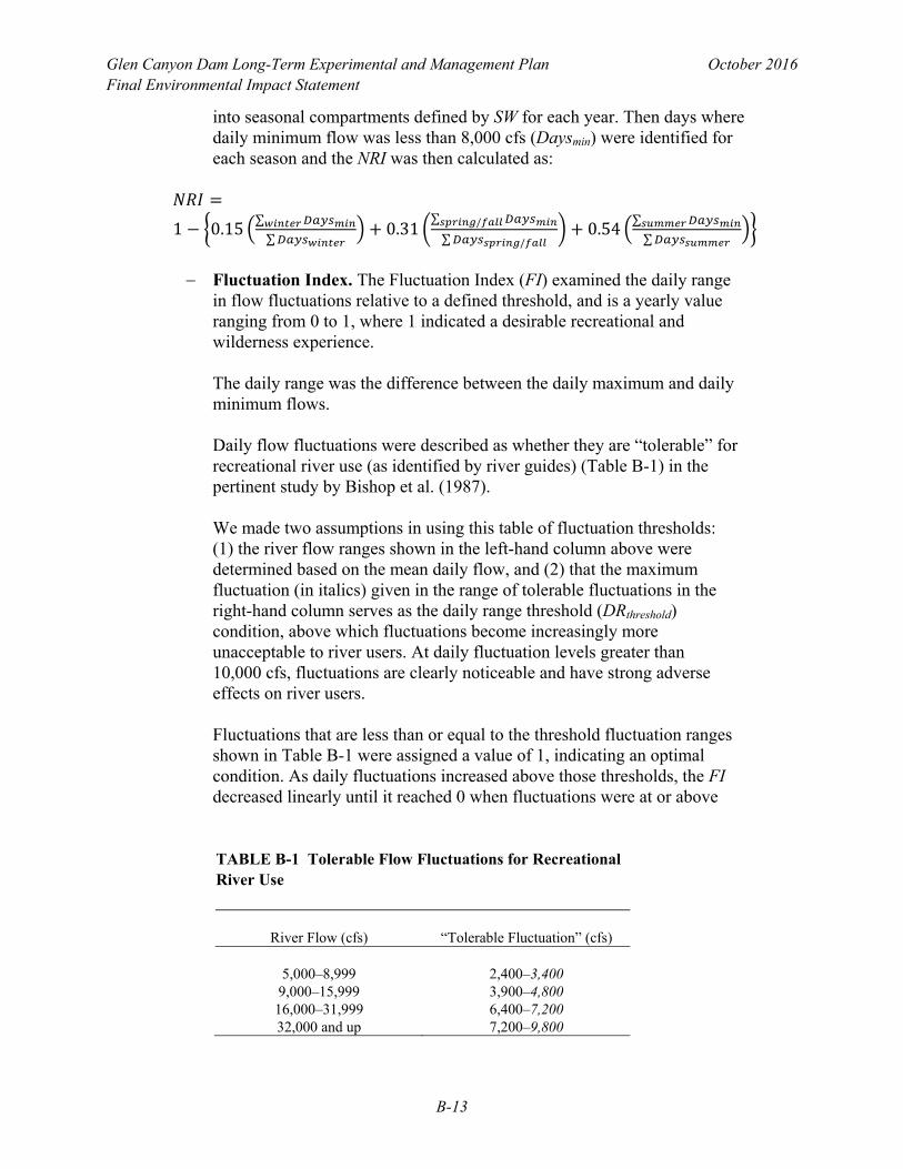
Fluctuation Index. The Fluctuation Index (FI) examined the daily range
in flow fluctuations relative to a defined threshold, and is a yearly value ranging from 0 to 1, where 1 indicated a desirable recreational and wilderness experience.
The daily range was the difference between the daily maximum and daily minimum flows.
Daily flow fluctuations were described as whether they are “tolerable” for recreational river use (as identified by river guides) (Table B-1) in the pertinent study by Bishop et al. (1987). We made two assumptions in using this table of fluctuation thresholds: (1) the river flow ranges shown in the left-hand column above were determined based on the mean daily flow, and (2) that the maximum fluctuation (in italics) given in the range of tolerable fluctuations in the right-hand column serves as the daily range threshold (DRthreshold) condition, above which fluctuations become increasingly more unacceptable to river users. At daily fluctuation levels greater than 10,000 cfs, fluctuations are clearly noticeable and have strong adverse effects on river users.
Fluctuations that are less than or equal to the threshold fluctuation ranges shown in Table B-1 were assigned a value of 1, indicating an optimal condition. As daily fluctuations increased above those thresholds, the FI decreased linearly until it reached 0 when fluctuations were at or above
TABLE B-1 Tolerable Flow Fluctuations for Recreational River Use
River Flow (cfs) “Tolerable Fluctuation” (cfs)
5,000–8,999 2,400–3,400
9,000–15,999 3,900–4,800 16,000–31,999 6,400–7,200 32,000 and up 7,200–9,800

Glen Canyon Dam Long-Term Experimental and Management Plan October 2016 Final Environmental Impact Statement
B-14
10,000 cfs. The equations used to calculate the FI when daily fluctuations exceeded the threshold flows shown in Table B-1 were as follows:
o For mean daily flows between 5,000 cfs and 8,999 cfs: (–0.00015 ×
daily fluctuation) + 1.5151)
o For mean daily flows between 9,000 cfs and 15,999 cfs: (–0.00019 × daily fluctuation) + 1.923)
o For mean daily flows between 16,000 cfs and 31,999 cfs: (–0.00036 ×
daily fluctuation) + 3.5714)
o For mean daily flows at or above 32,000 cfs: (–0.005 × daily fluctuation) + 50.000)
Calculation of the FI involved computing mean daily flow, minimum daily flow, maximum daily flow, and daily range from the hourly flow data.
The seasonal weighting for FI was the same as the SW component of the CAI, specifically: 0.15 for winter months (Nov., Dec., Jan., Feb.), 0.31 for spring and fall months (March, April, Sept. Oct.), and 0.54 for summer months (May, June, July, Aug.).
The daily flow values and daily ranges were defined by seasonal use. Then for each day, mean daily flow was examined to set the value of DRthreshold (italicized flow values in the table). The FI then identified days that DRthreshold was exceeded (Daysexceed) according to:
0.15∑∑
0.31∑ /
∑ /
0.54∑∑
Time Off River Index. The Time Off River Index examined the amount
of time visitors were able to engage in onshore activities such as hiking or visiting attractions, and was a yearly value ranging from 0 to 1, where 1 indicated the most available time off river for visitors. Calculation of the Time Off River Index involved computing mean daily flow from the hourly flow data and using this value to calculate an off river flow factor (ORFF).
The ORFF was determined as follows: 1 for mean daily flows that are greater than 31,500 cfs, 0 for flows less than 10,000 cfs, and a linear

Glen Canyon Dam Long-Term Experimental and Management Plan October 2016 Final Environmental Impact Statement
B-15
function for flows between 10,000 and 31,500 cfs ([0.0000465 × mean daily flow] – 0.465).
The seasonal weighting for TOR was the same as the SW component of the CAI, specifically: 0.15 for winter months (Nov., Dec., Jan., Feb.), 0.31 for spring and fall months (March, April, Sept., Oct.), and 0.54 for summer months (May, June, July, Aug.).
ORFF values for each season were summed and normalized by the number of days in each season. The Time Off River Index was then calculated as:
0.15∑∑
0.31∑ /
∑ /0.54
∑∑
B.5.2 Glen Canyon Metrics
• Glen Canyon Rafting Use Metric. This metric represents the amount of recreational use lost in average number of visitors affected by HFEs. The metric is a single value for the 20-year analysis period (note that the range is not 0–1, but some value that is larger than 1 representing the number of lost visitor-days), where a higher value means greater adverse impact. The Glen Canyon rafting use metric uses an estimate of the average daily visitor (ADV) use for the months in which HFEs occur (March, April, May, Oct., Nov.). The number and duration of individual HFEs (THFE) are modeled as a part of the Sand Budget Model.
The number of days lost for rafting because of an HFE (Dlost) is the duration of the HFE plus 2 days prior and 2 days post HFE (Dlost = THFE + 2 days + 2 days) that represent the amount of time required to de-mobilize and re-mobilize rafting operations.
The Glen Canyon rafting use metric is calculated as follows:
The units of the Glen Canyon rafting use metric are in number of visitor-rafting days lost.
• Glen Canyon Inundation Metric. The Glen Canyon inundation metric
represents the percentage of time that flow is above critical flow elevations that affect recreational experiences. The Glen Canyon inundation metric is a

Glen Canyon Dam Long-Term Experimental and Management Plan October 2016 Final Environmental Impact Statement
B-16
yearly value ranging from 0 to 1, where 1 indicates an optimal recreational experience.
The flow metric is calculated daily such that:
Flow metric = 0 for daily maximum flows less than 3,000 cfs, indicating
flows below 3,000 cfs are poor for boating and fishing.
The flow metric between 3,000 cfs and 8,000 cfs was calculated using the linear function, (0.0002 × maximum daily flow) – 0.60, and flow metric values between 0 and 1. Fishing is better above 5,000 cfs, and flows for boating get progressively better up to 8,000 cfs.
Flow metric = 1 for daily maximum flows between 8,000 and 20,000 cfs,
indicating optimal conditions for boating, fishing, and shoreline access.
The flow metric between 20,000 cfs and 31,500 cfs was calculated using the linear function, 2.739 – (0.00008695 × maximum daily flow), and flow metric values between 1 and 0. Flows above 20,000 cfs get progressively worse for boating, fishing, and shoreline access.
Flow metric = 0 for daily maximum flows greater than 31,500 cfs. Flows
above 31,500 cfs are poor for rafting, campable area, shoreline access, and fishing, and can adversely impact onshore recreational facilities.
B.6 RIPARIAN VEGETATION Resource Goal: Maintain native vegetation and wildlife habitat, in various stages of maturity that is diverse, healthy, productive, self-sustaining, and ecologically appropriate. Performance Metrics
• Riparian Native States and Diversity Index. The Riparian Native States and Diversity Index considers predicted changes over the 20-year LTEMP period in the relative cover of native vegetation community types and the relative diversity of community types. This metric was developed using a state-and-transition model developed by the GCMRC (Ralston et al. 2014), which uses characteristics of annual operations to predict transitions from one vegetation type to another on different geomorphic features of the riparian zone. The model evaluates the effects of five operations (extended low flow, extended high flow, HFE, pre-dam flow, and default operation) on transitions among seven vegetation states (bare sand, common reed/cattail, horsetail/coyote willow, tamarisk, Baccharis/coyote willow, arrowweed, and mesquite). The model divides operations into growing (April–September) and non-growing

Glen Canyon Dam Long-Term Experimental and Management Plan October 2016 Final Environmental Impact Statement
B-17
seasons (October–March) and incorporates upper and lower bar submodels, using stage elevation as a division.
Operational characteristics of each alternative were used as input to the riparian model. Output from the model was used to calculate the following component indices, which together were used to develop the overall Riparian Native States and Diversity Index:
Relative change in cover of native vegetation community types (PM1)
(other than arrowweed) on sandbars and channel margins using the total % increase in native states predicted by an existing state and transition model for riparian vegetation communities.
PM1 = coverfinal/coverinitial
Relative change in diversity of native vegetation community types (PM2)
(other than arrowweed) on sandbars and channel margins using the Shannon Weiner Index for richness/evenness using the results of the state and transition model.
PM2 = diversityfinal/diversityinitial
Relative change in the ratio of native (other than arrowweed)/nonnative
dominated vegetation community types (PM3) on sandbars and channel margins using the ratio of native/nonnative communities predicted by the state and transition model.
PM3 = ratiofinal/ratioinitial
Relative change in the arrowweed state (PM4) on sandbars and channel
margins using the total % decrease in arrowweed states predicted by the state and transition model.
PM4 = arrowweedinitial/arrowweedfinal
These individual components were combined as follows:
PMn = wiPMi
Where: PMn = the performance score for Alternative n PMi = the score for Performance Metric i
Therefore:
PMn = (PM1 + PM2 + PM3 + PM4)

Glen Canyon Dam Long-Term Experimental and Management Plan October 2016 Final Environmental Impact Statement
B-18
B.7 SEDIMENT Resource Goal: Increase and retain fine sediment volume, area, and distribution in the Glen, Marble and Grand Canyon reaches above the elevation of the average base flow for ecological, cultural, and recreational purposes. Performance Metrics Two metrics were used to reflect sandbar area in Marble and Grand Canyons above 8,000 and 25,000 cfs using existing sediment modeling tools:
• Sand Load Index. The Sand Load Index was defined as the cumulative sand load transported by high flows (flows > 31,500 cfs) divided by cumulative sand load for entire alternative (range 0–1; higher index means a greater likelihood of larger sandbars).
• Sand Mass Balance Index. The Sand Mass Balance Index was defined as the
mean annual sand mass balance between RM 0 and RM 61 (sand mass value, thousand metric tons; higher index means larger mass of sand in the river on average).
B.8 TRIBAL RESOURCES A large number of resource goals have been identified in discussions with stakeholder Tribes. Although all of these goals are important to the Tribes, not all of the resources were affected by the alternatives being considered in the LTEMP EIS. In the discussion below, resource goals that are likely to differ across LTEMP alternatives (and so matter in the selection of a preferred alternative) are listed separately from resource goals that are not likely to differ across LTEMP alternatives. For those resource goals that are likely to distinguish LTEMP alternatives, performance metrics are identified. Performance metrics are ways that the achievement of the resource goal might be measured; these were the metrics used to evaluate the alternatives in the EIS. For some of these resource goals, specific metrics that were amendable to quantifying differences among alternatives were not identified. Instead, the Tribes developed narrative evaluations of alternatives that were included in the EIS. Resource goals that would be evaluated in this way in the EIS are identified below.
1. Increase the health of the ecosystem in Grand, Marble, and Glen Canyons. The ecosystems in the Canyons is more than the sum of its parts, and should be healthy as a whole. Historically, in the Glen Canyon Dam Adaptive Management Program (GCDAMP), the overall health of the ecosystem has been determined by evaluating the status of each part, but this reductionist approach might possibly miss some important aspects. There are a variety of indicators of ecosystem health, including, but not limited to: the health of the

Glen Canyon Dam Long-Term Experimental and Management Plan October 2016 Final Environmental Impact Statement
B-19
river and its ability to sustain life; the color of the water; the absence of contaminants, pollutants, and disease in the water; the potability of the water; the quality of the water that reaches Lake Mead; and the viability and health of wildlife and plants in the Canyons. It is important to understand that for many Tribes, the Colorado River is a sentient being and the spiritual center of the ecosystem, as it has the capability of giving and taking life, and it is prone to anger if mistreated; the health of the ecosystem depends on the health of the River.
This resource goal requires consideration of traditional ecological knowledge (TEK), and an evaluation of alternatives applying TEK was included in the narrative EIS analysis, but not the structured decision analysis.
2. Protect and preserve sites of cultural importance. There are specific sites
within the Canyons that are important for cultural reasons and for preservation of Tribal/religious society/kiva group/clan history (e.g., shrines, sacred sites, ancient burial sites, springs, plant collection areas, mineral collection areas, offering places, and other elements). These sites can be threatened by erosion, loss of sediment inputs, and intrusive human use (especially, non-Tribal, outside visitors). Both flow and non-flow actions (e.g., education, permitting, research/monitoring, and interpretation) may affect these sites.
a. Performance metric: Wind Transport of Sediment Index (see Section B.2).
This index focuses on the availability of fine sediment for wind transfer to protect NRHP eligible or listed sites (see Archaeological and Cultural Resources).
It should be noted that the sites and resources that are individually NRHP eligible or listed do not represent a full set of Tribal concerns. Tribal input was necessary to identify impacts to other culturally important sites or resources, and to develop an appropriate measure of their protection and preservation.
b. Performance Metric: Flow Effects on Historic Properties in Glen Canyon
Index (see Section B.2). In Glen Canyon, flow levels could affect resources through inundation (see Archaeological and Cultural Resources).
c. Performance Metric: Time Off River Index (see Section B.2). In Grand
Canyon, flow levels could increase the potential for discretionary time off the river for visitors, which could in turn result in an increased potential for archaeological sites to be visited and possibly adversely affected (see Archaeological and Cultural Resources).
Glen Canyon Dam Long-Term Experimental and Management Plan October 2016 Final Environmental Impact Statement
B-20
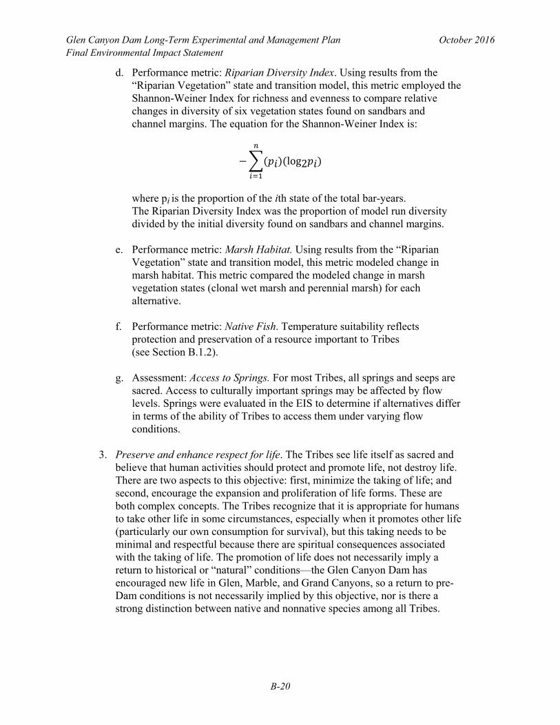
d. Performance metric: Riparian Diversity Index. Using results from the “Riparian Vegetation” state and transition model, this metric employed the Shannon-Weiner Index for richness and evenness to compare relative changes in diversity of six vegetation states found on sandbars and channel margins. The equation for the Shannon-Weiner Index is:
log2
where pi is the proportion of the ith state of the total bar-years. The Riparian Diversity Index was the proportion of model run diversity divided by the initial diversity found on sandbars and channel margins.
e. Performance metric: Marsh Habitat. Using results from the “Riparian
Vegetation” state and transition model, this metric modeled change in marsh habitat. This metric compared the modeled change in marsh vegetation states (clonal wet marsh and perennial marsh) for each alternative.
f. Performance metric: Native Fish. Temperature suitability reflects
protection and preservation of a resource important to Tribes (see Section B.1.2).
g. Assessment: Access to Springs. For most Tribes, all springs and seeps are
sacred. Access to culturally important springs may be affected by flow levels. Springs were evaluated in the EIS to determine if alternatives differ in terms of the ability of Tribes to access them under varying flow conditions.
3. Preserve and enhance respect for life. The Tribes see life itself as sacred and
believe that human activities should protect and promote life, not destroy life. There are two aspects to this objective: first, minimize the taking of life; and second, encourage the expansion and proliferation of life forms. These are both complex concepts. The Tribes recognize that it is appropriate for humans to take other life in some circumstances, especially when it promotes other life (particularly our own consumption for survival), but this taking needs to be minimal and respectful because there are spiritual consequences associated with the taking of life. The promotion of life does not necessarily imply a return to historical or “natural” conditions—the Glen Canyon Dam has encouraged new life in Glen, Marble, and Grand Canyons, so a return to pre-Dam conditions is not necessarily implied by this objective, nor is there a strong distinction between native and nonnative species among all Tribes.
Glen Canyon Dam Long-Term Experimental and Management Plan October 2016 Final Environmental Impact Statement
B-21
a. Performance metric: The average number of years in which trout mechanical removal trips occur. As a coarse measure of the impact of killing trout, this allows a distinction between alternatives that minimize mechanical removal. But the nature of the take, the purpose behind it, the methods of take, the disposition of the trout taken, and the mindset of those killing the fish also affect the sacred treatment of living beings. This performance metric was calculated from the coupled trout-humpback chub models.
b. Performance metric: The average number of years in which trout
management flows occur. Trout management flows, designed to reduce reproduction or survival of juvenile trout, are considered to be killing by some Tribes, and should be minimized. Alternatives that include trout management flows are likely to differ in how often the flows are triggered, so this performance metric might ultimately help to distinguish the alternatives. This performance metric was calculated from the coupled trout-humpback chub models.
4. Preserve and enhance the sacred integrity of Grand, Marble, and Glen
Canyons. Grand, Marble, and Glen Canyons are sacred to many Tribes, and the preservation of their sacred integrity is important. The sanctity of the Canyons may be threatened by human impacts and behaviors, development, and the presence of artificial structures and activities. An important aspect of the sanctity is the intentionality of visitors: when outsiders enter the Canyons (on boat or hiking trips), the respect they show to the Canyons and Colorado River can affect the spiritual integrity. There are many consequences of the disturbance of this sanctity, including, but not limited to, a reduction of the spiritual strength of plants gathered and used by the Navajo for medicinal and cultural purposes; an inability to retire Navajo sacred objects into the Colorado River when they have become too old for continued use; weakening of the sacred role the Canyons play as a final resting place for Hopi; and an overall disruption of the state of mind and spirit of Zuni religious leaders and their experience of being within a very sacred place that embodies the Zuni emergence, migrations, creation of medicine bundles, and the communion with the spirits of Zuni ancestors.
a. Assessment: This resource goal, while of profound importance to the
Tribes, is not thought to differ measurably across the alternatives under consideration in the LTEMP EIS, because it is not driven by flow operations from the dam or currently envisioned attendant activities. Future science plans could include activities that are objectionable to the Tribes. Future science planning should include meaningful consultation with the Tribes. This goal was evaluated in the narrative EIS analysis, but not the structured decision analysis.

Glen Canyon Dam Long-Term Experimental and Management Plan October 2016 Final Environmental Impact Statement
B-22
5. Maintain and enhance healthy stewardship opportunities. Several of the Tribes have been given a sacred stewardship responsibility for the preservation and harmony of the world. For example, the Hopi have a covenant with Ma’saw to be stewards of the earth; other Tribes have similar stewardship ethics grounded in spiritual traditions. To maintain these stewardship responsibilities, the Tribes need to be an active part of stewardship of the Canyons. This stewardship includes ceremonial activities, whether performed in the Canyons or in the villages; participation in management of the Canyons, including water management, both through traditional practices and Western management activities; and education, to maintain cultural knowledge and connection with the Canyons. The Tribes note that the federal government also has stewardship responsibilities that arise out of federal legislation; because this federal involvement has sometimes taken stewardship responsibility from the Tribes, it is critical that the federal government be accountable for its stewardship. At times, the colonial presence of the federal government has made it more difficult for Tribes to carry out their stewardship responsibilities; the Tribes need the autonomy to undertake their responsibilities. Successful development of joint stewardship among the Tribes and federal government will require continued building of mutual respect and trust between those entities.
a. Assessment: Tribal stewardship opportunities are not tied to individual
alternatives being considered in the LTEMP EIS, but could be crafted to apply to any of the alternatives. Thus, this resource goal, while of critical importance to the Tribes individually, as well as to the ongoing relationship between the Tribes and the federal government, may not help distinguish among the alternatives. This goal was evaluated in the narrative EIS analysis, but not the structured decision analysis.
6. Maintain and enhance the Tribal connections to the Canyons. The spiritual,
historical, and cultural connections that Tribes have to the Canyons require the protection of sacred sites and the integrity of the Canyons as a whole, but protection alone is not enough. The Tribes also need opportunities for access, education, and stewardship to keep their connections vibrant. Access can be undermined by physical barriers, by the requirement of permits from a colonial authority, and by the effects of human activity that decrease the power of those sites and the experience when at them (e.g., lack of privacy, disturbance of the soundscape and viewshed).
a. Assessment: Like the sacred integrity and stewardship resource goals, this
resource goal is not thought to differ across the alternatives. The flow operations of Glen Canyon Dam are not likely to affect Tribal access, education, spiritual ceremonies, or other connections to the Canyons. This resource goal may be more appropriately addressed through government-to-government consultation in other forums. This goal was evaluated in the EIS, but not the structured decision analysis.

Glen Canyon Dam Long-Term Experimental and Management Plan October 2016 Final Environmental Impact Statement
B-23
7. Increase economic opportunity. The Canyons, the Colorado River, and the dam are sources of economic benefit for the Tribes in the area. The Canyons provides tourism and other opportunities that enhance the economic well-being of Tribes. (As an important note, tourism can also undermine the well-being of Tribes in aspects other than economic; see the other Tribal resource goals.). Glen Canyon Dam provides affordable electricity for Tribal needs, as well as for development projects.
a. Assessment: projected annual economic benefit for the Hualapai Tribe
associated with river-running tourism. During discussions with Tribal representatives, one particular economic concern was raised by Hualapai river runners, namely, the effect on tourism operations of extensive sediment deposition downstream of Diamond Creek. There is a narrative analysis of the effect of dam operations on Hualapai River running in the EIS.
b. Assessment: Note that the economic benefit directly associated with
hydroelectric power is measured through the hydroelectric performance metrics. A recreation economics model was used to determine the value of recreational use of Lake Powell, Lake Mead, and the Colorado River downstream of Glen Canyon Dam.
8. Maintain Tribal water rights and supply. Tribes in the area depend on the
Colorado River for many of their water needs, so the preservation of established, traditional, and desired water rights, both now and into the future, is important. There are a number of claims to water rights that have been asserted by the Tribes, but for which there are not yet quantified rights through decree or negotiated settlement; these water rights are as important as the established water rights.
a. Sidebar for LTEMP EIS alternatives: based on its purpose and need, the
LTEMP EIS is not intended to include any alternatives that violate agreed-upon Tribal water rights.
b. Performance metric: Lake Powell water elevation. This metric evaluates
the frequency with which Lake Powell elevations drop below critical levels where existing or proposed intakes are.
9. Process objectives. There are several important process objectives—
objectives that govern how the LTEMP decision is made, rather than what decision is made. The first of these is the genuine incorporation of Tribal input to the LTEMP process, as a reflection of Federal trust responsibilities. The second is the importance of incorporating learning, to improve management over time; in this spirit, an experimental approach that can result in adaptive management is favored.

Glen Canyon Dam Long-Term Experimental and Management Plan October 2016 Final Environmental Impact Statement
B-24
a. Assessment: (a) It is the intention of the U.S. Department of the Interior and the joint-lead federal agencies to genuinely incorporate Tribal input into the LTEMP process, and this has been undertaken through face-to-face meetings with individual Tribes who have requested such meetings, as well as regular conference calls with Tribal representatives. The Tribes are included in all Cooperating Agency and stakeholder meetings. Continued involvement of Tribes in the LTEMP process will occur. (b) The evaluation of experimental alternatives and the development of a long-term monitoring program associated with the LTEMP EIS will occur in a later stage of analysis. The purpose and need for the EIS include the appropriate incorporation of learning. Thus, this resource goal is an important part of how the process was designed for LTEMP, but it does not help distinguish among the alternatives (because the alternatives do not differ in this regard).
B.9 WATER DELIVERY Resource Goal: Ensure that water delivery continues in a manner that is fully consistent with and subject to the Colorado River Compact, the Upper Colorado River Basin Compact, the Water Treaty of 1944 with Mexico, the decree of the Supreme Court in Arizona v. California, and the provisions of the Colorado River Storage Project Act of 1956 and the Colorado River Basin Project Act of 1968 that govern allocation, appropriation, development, and exportation of the waters of the Colorado River Basin. Calculated Metrics (not used in the structured decision analysis process)
• Frequency of deviation from Alternative A (No Action Alternative) to Lake Powell Annual Operating Tier as specified by the 2007 Interim Guidelines (Reclamation 2007). The Operating Tier was predicted using the CRSS RiverWare model.
• Probability over time of Lake Powell being in each Operating Tier as
specified in the 2007 Interim Guidelines (Reclamation 2007). The Operating Tier was predicted using the CRSS RiverWare model.
• Frequency and volume of exceptions to meeting the annual release target
volumes specified by the 2007 Interim Guidelines (Reclamation 2007). The target and actual annual release volumes were predicted using the CRSS RiverWare model.

Glen Canyon Dam Long-Term Experimental and Management Plan October 2016 Final Environmental Impact Statement
B-25
B.10 REFERENCES Bishop, R.C., K.J. Boyle, M.P. Welsh, R.M. Baumgartner, and P.R. Rathbun, 1987, Glen Canyon Dam Releases and Downstream Recreation: An Analysis of User Preferences and Economic Values, Glen Canyon Environmental Studies, Flagstaff, Ariz., Jan. Ralston, B.E., A.M. Starfield, R.S. Black, and R.A. Van Lonkhuyzen, 2014, State-and-Transition Prototype Model of Riparian Vegetation Downstream of Glen Canyon Dam, Arizona, Open-File Report 2014-1095, U.S. Geological Survey, U.S. Department of the Interior. Reclamation (Bureau of Reclamation), 2007, Environmental Impact Statement—Colorado River Interim Guidelines for Lower Basin Shortages and Coordinated Operations for Lake Powell and Lake Mead, Bureau of Reclamation, Upper and Lower Colorado Region, October. Available at http://www.usbr.gov/lc/region/programs/strategies.html. Accessed May 2013. Valdez, R.A., and D.W. Speas, 2007, A Risk Assessment Model to Evaluate Risks and Benefits to Aquatic Resources from a Selective Withdrawal Structure on Glen Canyon Dam, Bureau of Reclamation, Salt Lake City, Utah. Wright, S.A., C.R. Anderson, and N. Voichick, 2008, “A Simplified Water Temperature Model for the Colorado River below Glen Canyon Dam,” River Research and Applications 25(6):675–686. Available at http://dx.doi.org/10.1002/rra.1179. Accessed Aug. 19, 2011.
Glen Canyon Dam Long-Term Experimental and Management Plan October 2016 Final Environmental Impact Statement
B-26
This page intentionally left blank