Appendix B GPS HISTORY, CHRONOLOGY, AND...
34
237 Appendix B GPS HISTORY, CHRONOLOGY, AND BUDGETS This appendix provides an overview of the programmatic and institutional evolution of the Global Positioning System (GPS), including a history of its growing use in the military and civilian world, a chronology of important events in its development, and a summary of its costs to the government. THE HISTORY OF GPS Throughout time people have developed a variety of ways to figure out their position on earth and to navigate from one place to another. Early mariners re- lied on angular measurements to celestial bodies like the sun and stars to calcu- late their location. The 1920s witnessed the introduction of a more advanced technique—radionavigation—based at first on radios that allowed navigators to locate the direction of shore-based transmitters when in range. 1 Later, the de- velopment of artificial satellites made possible the transmission of more-pre- cise, line-of-sight radionavigation signals and sparked a new era in navigation technology. Satellites were first used in position-finding in a simple but reliable two-dimensional Navy system called Transit. This laid the groundwork for a system that would later revolutionize navigation forever—the Global Positioning System. The Military Evolution of GPS The Global Positioning System is a 24-satellite constellation that can tell you where you are in three dimensions. GPS navigation and position determination is based on measuring the distance from the user position to the precise loca- tions of the GPS satellites as they orbit. By measuring the distance to four GPS satellites, it is possible to establish three coordinates of a user’s position ______________ 1 The marine radionavigation aid LORAN (Long Range Aid to Navigation) was important to the de- velopment of GPS because it was the first system to employ time difference of arrival of radio sig- nals in a navigation system, a technique later extended to the NAVSTAR satellite navigation system.
-
Upload
nguyencong -
Category
Documents
-
view
218 -
download
1
Transcript of Appendix B GPS HISTORY, CHRONOLOGY, AND...

237
Appendix B
GPS HISTORY, CHRONOLOGY, AND BUDGETS
This appendix provides an overview of the programmatic and institutionalevolution of the Global Positioning System (GPS), including a history of itsgrowing use in the military and civilian world, a chronology of important eventsin its development, and a summary of its costs to the government.
THE HISTORY OF GPS
Throughout time people have developed a variety of ways to figure out theirposition on earth and to navigate from one place to another. Early mariners re-lied on angular measurements to celestial bodies like the sun and stars to calcu-late their location. The 1920s witnessed the introduction of a more advancedtechnique—radionavigation—based at first on radios that allowed navigators tolocate the direction of shore-based transmitters when in range.1 Later, the de-velopment of artificial satellites made possible the transmission of more-pre-cise, line-of-sight radionavigation signals and sparked a new era in navigationtechnology. Satellites were first used in position-finding in a simple but reliabletwo-dimensional Navy system called Transit. This laid the groundwork for asystem that would later revolutionize navigation forever—the GlobalPositioning System.
The Military Evolution of GPS
The Global Positioning System is a 24-satellite constellation that can tell youwhere you are in three dimensions. GPS navigation and position determinationis based on measuring the distance from the user position to the precise loca-tions of the GPS satellites as they orbit. By measuring the distance to four GPSsatellites, it is possible to establish three coordinates of a user’s position
______________ 1The marine radionavigation aid LORAN (Long Range Aid to Navigation) was important to the de-velopment of GPS because it was the first system to employ time difference of arrival of radio sig-nals in a navigation system, a technique later extended to the NAVSTAR satellite navigation system.

238 The Global Positioning System
(latitude, longitude, and altitude) as well as GPS time. (See Appendix A for atechnical explanation of how GPS works.)
Originally developed by the Department of Defense (DoD) to meet military re-quirements, GPS was quickly adopted by the civilian world even before thesystem was operational. This section describes the evolution of GPS, from itsconceptualization to the present day, tracing its military development and itsemergence in the civilian world.
The Forerunners of GPS. DoD’s primary purposes in developing GPS were touse it in precision weapon delivery and to provide a capability that would re-verse the proliferation of navigation systems in the military.2 Beginning in theearly 1960s, the U.S. Department of Defense began pursuing the idea of devel-oping a global, all-weather, continuously available, highly accurate positioningand navigation system that could address the needs of a broad spectrum ofusers and at the same time save the DoD money by limiting the proliferation ofspecialized equipment that supported only particular mission requirements. Asa result, the U.S. Navy and Air Force began studying the concept of using radiosignals transmitted from satellites for positioning and navigation purposes.These studies developed concepts and experimental satellite programs, whichbecame the building blocks for the Global Positioning System.
The Navy sponsored two programs which were predecessors to GPS: Transitand Timation. Transit was the first operational satellite-based navigation sys-tem.3 Developed by the Johns Hopkins Applied Physics Laboratory under Dr.Richard Kirschner in the 1960s, Transit consists of 7 low-altitude polar-orbitingsatellites that broadcast very stable radio signals; several ground-based monitorstations to track the satellites; and facilities to update satellite orbital parame-ters. Transit users determine their position on earth by measuring the Dopplershift of signals transmitted by the satellites.
Originally designed to meet the Navy’s requirement for locating ballistic missilesubmarines and other ships at the ocean’s surface, Transit was made availableto civilian users in 1967. It was quickly adopted by a large number of commer-cial marine navigators and owners of small pleasure craft and is still operatedby the Navy today.4 Although it has proved its utility for most ship navigation,
______________ 2Bradford W. Parkinson, “GPS Eyewitness: The Early Years,” GPS World, September 1994, p. 42.3The concept for Transit evolved from observations of the Russian satellite Sputnik in 1957.Researchers at the Applied Physics Laboratory (APL) discovered that measurements of the Dopplershift as the satellite passed by were adequate to determine the entire satellite orbit. Dr. Frank T.McClure of APL noted that conversely, if the satellite orbit were known, position on the earth couldbe determined using these same Doppler measurements.4The Navy plans to terminate operation of the system by the end of 1996 according to the 1994Federal Radionavigation Plan (Draft).

GPS History, Chronology, and Budgets 239
the system has a number of drawbacks. It is slow, requiring a long observationtime, provides only two-dimensional positioning capability, has limited cover-age due to the intermittent access/availability of its signals (with periods of un-availability measured in hours), and requires users to correct for their veloci-ties—all of which make Transit impractical for use on aircraft or other rapidlymoving platforms. Nonetheless, Transit was important to GPS because it re-sulted in a number of technologies5 that were extremely useful to GPS anddemonstrated that a space system could offer excellent reliability.
Timation, a second forerunner of GPS, was a space-based navigation systemtechnology program the Navy had worked on since 1964.6 This program incor-porated two experimental satellites that were used to advance the developmentof high-stability clocks, time-transfer, and two-dimensional navigation. Thefirst Timation satellite launched in 1967 carried very stable quartz-crystaloscillators; later models orbited the first atomic frequency standards (rubidiumand cesium). The atomic clocks had better frequency stability than earlierclocks, which greatly improved the prediction of satellite orbits (ephemerides)and would eventually extend the time required between control segment up-dates to GPS satellites. This pioneering work on space-qualified time standardswas an important contribution to GPS.7 In fact, the last two Timation satelliteswere used as prototype GPS satellites.
In the meantime, the Air Force was working on a similar technology programthat resulted in a design concept called System 621B; it provided three-dimensional (latitude, longitude, and altitude) navigation with continuousservice.8 By 1972, the system had already demonstrated the operation of a newtype of satellite ranging signal based on pseudorandom noise (PRN).9 To verifythe PRN technique, the Air Force ran a series of aircraft tests at White SandsProving Ground in New Mexico using ground- and balloon-carried transmittersto simulate satellites. The technique pinpointed the positions of aircraft towithin a hundredth of a mile.
______________ 5The satellite prediction algorithms developed for Transit were a significant contribution to GPS.6Timation was developed by the Naval Research Laboratory (NRL) under the direction of RogerEaston.7Parkinson, p. 34.8The studies that led to System 621B originated at the Aerospace Corporation in 1963. Aerospacehad begun looking at potential applications of space capabilities to meet critical military needs, oneof which was the need for precise positioning of aircraft. In October 1963, the Air Force formally re-quested that Aerospace continue these studies, which later evolved into System 621B.9The PRN technique had distinct advantages over other techniques, among them the ability to re-ject noise, which implies a strong ability to reject most forms of jamming or deliberate interference.With this technique, all satellites could transmit on the same frequency without interference. Also,a communication channel could be added which allowed the user to receiver ephemeris (satellitelocation) and clock information.
240 The Global Positioning System
At that time, the Air Force concept envisioned a global system consisting of 16satellites in geosynchronous orbits whose ground tracks formed four oval-shaped clusters extending 30 degrees north and south of the equator. This par-ticular geometry allowed for the gradual evolution of the system because it re-quired only four satellites to demonstrate its operation capabilities. That is, onecluster could provide 24-hour coverage of a particular geographic region (forexample, North and South America).
However, no real progress was made toward full-scale development of System621B until 1973. Part of the reason for this was that the Air Force work hadstimulated additional work on satellite navigation, giving rise to a number ofcompeting initiatives from the other services. By the late 1960s, the U.S. Navy,Air Force, and Army were each working independently on radionavigation sys-tems that would provide all-weather, 24-hour coverage and accuracies thatwould enhance the military capabilities of their respective forces.10 The APLhad made technical improvements to Transit and wanted to upgrade the sys-tem, while the Naval Research Laboratory was pushing an expanded Timationsystem and the Army had proposed using its own system, SECOR (SequentialCorrelation of Range). To coordinate the effort of the various satellite naviga-tion groups, DoD established a joint tri-service steering committee in 1968called the NAVSEG (Navigation Satellite Executive Group). The NAVSEG spentthe next several years deciding what the specifics of a satellite navigationsystem should be—how many satellites, at what altitude, signal codes, andmodulation techniques—and what they would cost.
Finally, in April 1973, the Deputy Secretary of Defense designated the Air Forceas the lead agency to consolidate the various satellite navigation concepts into asingle comprehensive DoD system to be known as the Defense NavigationSatellite System (DNSS). The new system was to be developed by a JointProgram Office (JPO) located at the Air Force’s Space and Missile Organization,with participation by all military services. Colonel Brad Parkinson, program di-rector of the JPO, was directed to negotiate between the services to develop aDNSS concept that embraced the views and needs of all services.
By September 1973, a compromise system was evolving which combined thebest features of earlier Navy and Air Force programs. The signal structure andfrequencies were taken from the Air Force’s 621B. Satellite orbits were based onthose proposed for the Navy’s Timation system, but higher in altitude, givingtwelve-hour instead of eight-hour periods. While both systems had proposedthe use of atomic clocks in satellites, only the Navy had tested this idea. The
______________ 10Ivan A. Getting, “The Global Positioning System,” IEEE Spectrum, Vol. 30, No. 12, December 1993,pp. 36–47.

GPS History, Chronology, and Budgets 241
system concept that emerged is what is known today as the NAVSTAR GlobalPositioning System. In December 1973, DoD granted the JPO approval toproceed with the first phase of a three-phase development of the NAVSTARGPS.11
Testing the GPS Idea (1974–1979). The first phase of the GPS program was in-tended to confirm the concept of a space-based navigation system, demon-strate its potential for operational utility, and establish the preferred design.12
The original program was funded at about $100 million and was supposed tocover four satellites, the launch vehicles, three types of user equipment, asatellite control facility, and an extensive test program.13
The very first NAVSTAR satellites were actually two refurbished Timationsatellites built by the NRL. Known as Navigation Technology Satellite (NTS)numbers 1 and 2, they carried the first atomic clocks ever launched into space.Although these experimental satellites functioned for only short periodsfollowing their launches in 1974 and 1977, they proved the concept of time-based ranging using spread-spectrum radio signals and precise time derivedfrom orbiting atomic clocks.
Soon after, the first developmental GPS satellites, known as Block Is, werelaunched and tested. This series of satellites supported most of the system’stesting program. Between 1978 and 1985, a total of eleven Block I satellites builtby Rockwell International were launched on the Atlas-F booster; one satellitewas lost due to a launch failure. Others eventually failed due to deterioration oftheir atomic clocks or failures of their attitude control system. However, manyof the Block I satellites continued to operate much longer than their design lifeof three years—in several cases more than 10 years longer.
Even before the first Block Is were launched, the military had begun planning adual role for the GPS satellites. In addition to carrying the navigation and tim-ing payload, GPS satellites would carry nuclear detonation (NUDET) sensorsdesigned to detect nuclear weapon explosions, assess nuclear attack, and helpin evaluating strike damage.14 The system would also contribute to monitoring
______________ 11An earlier attempt to gain approval for the system was made in August 1973, but failed becausethe program presented to DoD at that time was not representative of a joint program, but rather arepackaged version of the Air Force’s System 621B.12The second phase of GPS was devoted to full-scale engineering development, and the third toproduction and deployment of the GPS segments.13This funding was apparently just enough to cover the satellites but not enough for the other el-ements of the first phase of the program. Jeffrey A. Drezner and Giles K. Smith, An Analysis ofWeapon System Acquisition Schedules, RAND, R-3937-ACQ, December 1990, p. 181.14“GPS to Test Nuclear Detonation Sensor,” Aviation Week & Space Technology, August 27, 1979, p.51.
242 The Global Positioning System
compliance with the nuclear test ban treaty. The first GPS satellite to carry anuclear explosion detection sensor was the sixth Block I satellite, launched onApril 26, 1980.15 The use of satellites for detecting nuclear explosions datesback to the 1963 Limited Test Ban Treaty between the United States and theSoviet Union, which prohibited nuclear testing in the atmosphere, underwater,and in space. To monitor the ban, the U.S. Air Force and the Atomic EnergyCommission (predecessor to the Department of Energy) jointly developed aseries of nuclear detection satellites known as Vela. Since then, nucleardetection sensors have been orbited on a number of other DoD satellites, in-cluding the NAVSTAR satellites, in an effort to increase the number of detectionsatellites in space and to improve the existing detection network.16 The sensorsflown on GPS satellites are similar to those initially used on the Vela satellites.The satellites which currently make up the GPS constellation all have thecapability to detect nuclear detonations and are presently an important com-ponent in the United States’ capability to monitor compliance with the NuclearNon-Proliferation Treaty of 1968.17 According to DoD plans, future GPS satel-lites will continue to serve the nuclear detection mission.
Testing of GPS user equipment began in March 1977 before any satellites werein place. A system of solar-powered ground transmitters was set up on thedesert floor at the Army’s Yuma Proving Ground in Arizona to simulate GPSsatellites. These transmitters, known as pseudolites (taken from the term pseu-dosatellites), broadcast a signal that has a structure similar to that of a GPSsatellite.18 Although the signals were coming from the ground rather than fromspace, they provided a geometry that approximated that of the satellites. By thetime four Block I satellites were in orbit (1978), the JPO was running tests onseveral types of user equipment carried on aircraft, helicopter, ships, trucks,jeeps, and even by men using 25-pound backpacks.
The final segment of GPS—a prototype ground control system—was located atVandenberg AFB, CA, during this period. With all the basic components of the
______________ 15The sensor carried on this satellite was called the Integrated Operational Nuclear DetonationDetection System (IONDS); later GPS satellites were fitted with a new sensor known as NuclearDetonation Detection System (NDS).16Other DoD satellites that have carried nuclear detection sensors include the Defense SupportProgram satellites used for early warning of missile launch and the Defense Meteorological SatelliteProgram. For further information, see Bhupendra Jasani, Verification of a Comprehensive Test BanTreaty from Space: A Preliminary Study, United Nations, New York, Research Paper No. 32, 1994.17The GPS Nuclear Detonation Detection System is managed as a joint program between the U.S.Air Force and the Department of Energy (DoE). The Air Force provides the “platform”—the GPSsatellites—and operates the system; DoE provides the sensors through its national laboratories,Sandia and Los Alamos.18The pseudolite concept has since become an important technique for improving accuracy andintegrity for civil landing of aircraft.
GPS History, Chronology, and Budgets 243
system in place, the JPO was given the go-ahead to proceed with full-scale de-velopment of GPS in August 1979.
GPS Grows Up (1980–1989). Efforts to expand the fledgling GPS program suf-fered some growing pains during the development phase.
The first setback was brought on by a 1979 decision by the Office of theSecretary of Defense (OSD) to cut $500 million (approximately 30 percent) fromthe budget over the period FY81–FY86.19 As a result, the GPS program was re-structured and the scope of the program reduced. The final satellite constella-tion was cut from 24 to 18 satellites (plus three satellites serving as on-orbitspares); Block II development satellites were dropped; and the design wasscaled down in terms of weight, power, and nuclear and laser hardening.20
Plans for attainment of an early limited two-dimensional capability in 1981were also dropped.
Funding for GPS was somewhat unstable during the early stages of the programeven though it received support from many elements of the services. BecauseGPS is a support system and not a standard weapon system with a clear missionand a history of well-defined operational concepts, early understanding of thevalue of the system was less straightforward than with tanks or aircraft. This in-creased the need to sell the program, particularly to potential users. The JPOaddressed this problem, especially during Phase I, by emphasizing one of themore tangible capabilities of the system: increased bombing accuracy. The factthat GPS was a joint program also increased the need to sell the program tomultiple services. No one service was anxious to bear the entire financial loadfor a support system that was to be used by all services. As a result, GPS hadservice support difficulties. For example, the program was zeroed out in 1980through 1982, but was reinstated by OSD.21 It appears that OSD support con-tributed to the survival of the program.
GPS suffered another setback as a result of the Space Shuttle Challenger acci-dent in 1986. As the only planned launch vehicle for GPS satellites at that time,the loss of the shuttle caused a 24-month delay in the scheduled launch of thesecond generation of GPS satellites, the Block IIs. Originally, the JPO planned tolaunch the first 12 satellites (Phase I) on refurbished Atlas F boosters and to usethe McDonnell-Douglas Delta for the next series of launches (Phase II). Around1979, the JPO had responded to DoD decisions which designated the SpaceShuttle as the principal launch vehicle for Air Force missions. Although the
______________ 19Drezner, p. 184.20The GPS constellation was later restored in 1988 to its original configuration of 24 satellites, in-cluding three spares, because the performance by 18 satellites was found inadequate.21Drezner, p. 188.

244 The Global Positioning System
Block IIs were built to be compatible with shuttle deployment, the JPO decidedto switch back to the Delta II as the GPS launch vehicle following the Challengerdisaster.
The first Block II satellite was eventually launched in February 1989 from CapeCanaveral AFS, and became operational for global use in April 1989. Since then,there have been 23 more Block II satellite launches. Like the Block I satellites,the Block IIs were produced by Rockwell International. The Block II satellitesdiffer from the Block Is in shape and weight and incorporate design differencesthat affect security and integrity.22 Significant Block II satellite enhancementsinclude:
• Radiation-hardened electronics to improve reliability and survivability
• Full selective availability (SA) and anti-spoofing (AS) capabilities to providesystem security
• Automatic detection of certain error conditions and switching to nonstan-dard code transmission or default navigation message data to protect usersfrom tracking a faulty satellite and to maximize system integrity.
Block II satellites launched after 1989 have the additional capability of operat-ing for up to 180 days without contact from the control segment. They arecalled Block IIAs. This represents a significant improvement over the earlierBlock I and II satellites, which required updating from the control segment afteronly 3.5 days.
Further progress was made on the control and user equipment segments of GPSduring this period. As part of the transition to an operational and sustainablesystem, the control segment was transferred to a new master control station lo-cated at Falcon AFB, CO. System testing was completed, and successful inter-operability was demonstrated between the ground control stations, the satel-lites, and the “user” navigation equipment. Rockwell-Collins was chosen as thecontractor for the production GPS user equipment. By the turn of the century,an estimated 17,000 U.S. military aircraft will be equipped with GPS, and 60,000portable receivers will be in use by U.S. ground forces and on militaryvehicles.23
______________ 22Security refers to features built into GPS that can deny accurate service to unauthorized users,prevent spoofing, and reduce receiver susceptibility to jamming. These security measures, de-signed only with the military in mind, can cause difficulties for unauthorized users, i.e., anyonewithout a specific military need and/or mission. Integrity refers to the ability of the system to pro-vide timely warnings to users when the system should not be used for navigation.23The Aerospace Corporation, The Global Positioning System: A Record of Achievement, 1994.

GPS History, Chronology, and Budgets 245
Recent Military Use of GPS (1990–present). The 1990–1991 crisis in the PersianGulf, the first major test24 of GPS in a combat situation, proved beyond a doubtthe importance and utility of the NAVSTAR. Some say that GPS revolutionizedcombat operations on the ground and in the air during Operation Desert Stormand was—as one Allied commander noted—one of two particular pieces ofequipment that were potential war winners (the other was night-vision de-vices).25
Among the many uses of GPS in Operation Desert Storm, navigation proved tobe a crucial technique for desert warfare.26 GPS satellites enabled coalitionforces to navigate, maneuver, and fire with unprecedented accuracy in the vastdesert terrain almost 24 hours a day27 despite difficult conditions—frequentsandstorms, few paved roads, no vegetative cover, and few natural landmarks.Although on average, each U.S. Army maneuver company (e.g., tank, mecha-nized infantry, or armored cavalry) had at least one GPS receiver, the demandfor receivers was so great that more than 10,000 commercial units were hastilyordered during the crisis so that more coalition forces could benefit from thesystem.
Other operations made possible or greatly enhanced by GPS include precision-bombing, artillery fire support, the precise positioning of maneuvering troopformations, and certain special forces operations such as combat search-and-rescue missions. As well as being carried by foot soldiers, GPS receivers wereattached, in some cases with tape, to vehicles and helicopter instrument panelsand were also used in F-16 fighters, KC-135 tankers, and B-52 bombers.
Since the Persian Gulf War, the United States has employed GPS in severalpeacekeeping and military operations. During Operation Restore Hope in 1993,GPS was used to air drop food and supplies to remote areas of Somalia becauseof lack of accurate maps and ground-based navigation facilities. U.S. forces en-tering Haiti in 1994 also relied on GPS. During the present Balkan crisis, GPShas assisted in delivery of aid to the Bosnians by guiding U.S. Air Force trans-
______________ 24GPS played only a minor role in military operations of the 1980s. For example, the U.S. Navy usedGPS to determine the position of minefields in the Persian Gulf in 1987–1988, and the U.S. Air Forceused GPS during the intervention in Panama in December 1989 (Operation Just Cause) to overcomeinaccuracies in maps that showed key bridges in the wrong position.25Michael Russel Rip and David P. Lusch, “The Precision Revolution: The Navstar GlobalPositioning System in the Second Gulf War,” Intelligence and National Security, Vol. 9, No. 2, April1994, pp. 167–241.26Rip, p. 171.27Sixteen GPS satellites were active during the crisis. Block II satellites launched during OperationDesert Storm were adjusted to place them in an optimal position to provide maximum GPS cover-age over the region.
246 The Global Positioning System
port planes at night to their drop zones where food and medicine is thenparachuted close to towns and villages.
Current Status of NAVSTAR GPS. The launch of the 24th Block II28 satellite inMarch 1994 completed the GPS constellation. The NAVSTAR system currentlyconsists of 25 satellites, including one Block I satellite.29 Initial OperationalCapability (IOC) was formally declared December 8, 1993, in a joint announce-ment by the DoD and the Department of Transportation (DoT).30 The IOC no-tification means that the NAVSTAR GPS is capable of sustaining the StandardPositioning Service (SPS), the 100-meter positioning accuracy available to civil-ian users of the system on a continuous, worldwide basis.31 Unlike IOC forother DoD systems, IOC for GPS has purely civil connotations.
In 1995, the U.S. Air Force Space Command formally declared tha GPS met therequirements for Full Operational Capability (FOC),32 meaning that the con-stellation of 24 operational (Block II/IIA) satellites now in orbit has successfullycompleted testing for military functionality. While the FOC declaration is sig-nificant to DoD because it defines a system as being able to provide full andsupportable military capability, it does not have any significant impact on civilusers.
An additional 21 satellites called Block IIRs are being developed by MartinMarietta (formerly General Electric Astro Space division) as replacements forthe current GPS satellites.33 The Block IIR satellites will provide enhancedperformance over the previous generation of GPS satellites, including the ca-pability to autonomously navigate (AUTONAV) themselves and generate theirown navigation message data. This means that if the control segment cannotcontact the Block IIR satellites, the AUTONAV capabilities will enable these
______________ 28A total of 28 Block II satellites were built by Rockwell. There are four remaining Block II satellitesin reserve, two of which are scheduled to be launched “on need” in 1995 and the other two during1996. Glen Gibbons, “AF Says GPS Fully Operational,” GPS World Newsletter, May 22, 1995, p. 5.29The sole Block I spacecraft was taken off-line in June 1995 after nearly 11 years of service, due todeclining performance.30IOC requires a combination of at least 24 operating Block I and Block II satellites in orbit.31Prior to IOC, GPS was considered a developmental system whose operation, including signalavailability and accuracy, was subject to change at the discretion of DoD. Subsequent to IOC, anyplanned disruption of the SPS in peacetime will be preceded by a 48-hour advance notice to usersthrough the Coast Guard GPS Information Center (GPSIC) and the FAA’s Notice to Airmen(NOTAM) system. Unplanned system outages will be announced by the GPSIC and NOTAM sys-tems as they become known.32U.S. Air Force Space Command Public Affairs Office, “Global Positioning System FullyOperational,” news release, July 17, 1995.33The contract for the Block IIR satellites was awarded in June 1989.

GPS History, Chronology, and Budgets 247
satellites to maintain full system accuracy for at least 180 days.34 The Block IIRsatellites will be available for launch as necessary beginning in late 1996.
A follow-on set of replenishment satellites, known as Block IIFs, is planned toreplace the Block IIR satellites at the end of their useful life. The Air Force in-tends to buy 33 Block IIF satellites35 to sustain the quality of the GPS signal as aworldwide utility for the foreseeable future.36 These satellites will have to meeteven higher levels of performance than previous generations of GPS satellites,including a longer life cycle of 6.5 to 10 years. The IIF satellite will be launchedon an Evolved Expandable Launch Vehicle (EELV).37 The Air Force issued adraft request for proposals (RFP) on June 20, 1995, and plans to award a con-tract for the development and procurement of the Block IIF satellites in spring1996.38
The Evolution of GPS in the Civilian World
This section examines the U.S. government’s public responses to the growingnumber of civil users, the role of government agencies and other private-sectoragents in fostering commercial GPS markets, and present GPS governance andmanagement. With the proliferation of civil government and private-sectorusers and the widening array of commercial GPS applications, the U.S.government is having to juggle a growing set of civilian demands on the systemalong with the military demands.39 This has given rise to a number of issuesdiscussed here and in Chapter Two.
The United States Opens GPS Up to Civilians. The first U.S. pronouncementregarding civil use of GPS came in 1983 following the downing of Korean
______________ 34If the control segment lost contact with the Block I and Block II satellites, the satellites wouldcontinue transmitting the stored navigation message data previously uploaded by the control seg-ment for 3.5 and 180 days, respectively. However, the system accuracy would degrade over time.35Originally, the Air Force planned to buy 51 satellites. However, concerns over the legal and polit-ical ramifications of issuing such a large contract caused the service to scale back its planned buy to33 satellites. “House Appropriators Cut GPS Block IIF, Add $100 Million For SBIRS,” AerospaceDaily, Vol. 175, No. 17, July 27, 1995, pp. 129–130.36The JPO also plans to procure six follow-on satellites as eventual replacements for the Block IIFsatellites.37EELV is a U.S. Air Force effort to develop by 2000 a new family of space boosters based on existingsystems. The goal of this program is to lower the cost of launching medium and heavy U.S. gov-ernment payloads into orbit. Warren Ferster, “Russian Rocket Engines Vie for Role in EELV Effort,”Space News, May 8–14, 1995, p. 12.38The value of the IIF contract is estimated to be in excess of $2 billion. Three teams are interestedin bidding: Lockheed Martin, Loral Federal Systems, ITT; Rockwell International, ComputerSciences Corp., Rockwell Anaheim; and Hughes Space and Communications, National Systems &Research and Stanford Telecommunications and Space Applications. “Air Force Set To Release RFPon $2 Billion GPS Block IIF Contract,” C4I via NewsPage, May 11, 1995.39Parkinson, p. 44. Civil GPS receivers currently outnumber military receivers by more than 10 to 1.

248 The Global Positioning System
Airlines Flight 007 after it strayed over territory belonging to the Soviet Union.At this time, President Reagan announced that the Global Positioning Systemwould be made available for international civil use once the system became op-erational. In 1987 DoD formally requested the Department of Transportation toestablish and provide an office to respond to civil users’ needs and to workclosely with the DoD to ensure proper implementation of GPS for civil use. Twoyears later, the U.S. Coast Guard became the lead agency for this project.
The Reagan announcement was followed by a U.S. offer to make available theStandard Positioning Service of GPS, which was announced at the InternationalCivil Aviation Organization’s (ICAO) Tenth Air Navigation Conference,September 5, 1991. The Federal Aviation Administration’s (FAA) Administrator,James Busey, promised that GPS would be available free of charge to the inter-national community beginning in 1993 on a continuous, worldwide basis for atleast 10 years. This offer was extended the following year at the 29th ICAOAssembly, when the United States offered SPS to the world for the foreseeablefuture and pledged to provide at least six years notice prior to termination ofGPS operations or elimination of the GPS SPS.
Both offers were formally reiterated in a 1994 letter from the FAA’s chief, DavidHinson, to ICAO, reaffirming the U.S. government’s intention to provide GPSSPS free of charge for at least 10 years.40 In 1995, President Clinton once againconfirmed the government’s commitment to provide GPS signals to interna-tional civil users in a statement that was released at an ICAO meeting inMontreal in March.41
The U.S. Government’s Role in Fostering Commercial GPS Markets. The birthof one of the first GPS markets—surveying—was influenced by a 1984 decisionby the Department of Commerce’s National Oceanic and AtmosphericAdministration (NOAA)42 to publish the first draft standards in the FederalRegister that allowed for the use of GPS data. This seal of approval of GPS databy a civil government agency helped jump start the expansion of the surveyingmarket even while the GPS system was still in development.
By the mid-1980s, commercial GPS equipment aimed at the surveyingprofession appeared on the market even though only a small number of operat-ing GPS satellites were in orbit. Surveying and time transfer were logical entry
______________ 40David Hinson, FAA Administrator, letter to Dr. Assad Kotaite, President of the Council,International Civil Aviation Organization, October 14, 1994.41Bill Clinton, President of the United States, letter to the International Civil Aviation Organization,March 16, 1995.42NOAA has historically chaired the Federal Geodetic Control Committee, which sets standards formapping and geodesy.

GPS History, Chronology, and Budgets 249
points into the market because their applications could accept the limitedavailability of satellite signals.43 Surveyors did not need to use their data in realtime, but could make observations whenever sufficient satellite signals wereavailable, day or night. GPS surveying offered greater productivity and costsavings over traditional survey methods. Tasks that normally required severalweeks or months to finish could now be completed in a fraction of the timeusing GPS—at one-fifth to one-tenth of the cost of conventional surveying.44
Satellite surveying also helped sustain the commercial market for GPSequipment after the Challenger disaster shut down operations and delayedsatellite launches for several years.
The money generated by the survey market boom was also important to theoverall development of GPS applications because it enabled U.S. manufacturersto invest in research and development (R&D) on GPS technology. The addedR&D investment helped accelerate the development of GPS applications fasterthan would have been possible had the DoD been left to carry out this task onits own. In fact, surveyors were the first to employ some of the more advanceddifferential GPS techniques being used today, such as kinematic surveying andreal-time carrier phase tracking. Now, ten years after the first standards werepublished, almost all geodetic standards are based on GPS data.
The growth in the GPS survey market opened the way for a number of GPSniche markets such as aviation. Even in these smaller markets, governmentagencies have contributed to their expansion. For example, the FAA issuedperformance standards for GPS receivers (Technical Standard Order C129) in1992. This action allowed manufacturers to build GPS receivers as supplemen-tal navigation aids for aircraft, thereby broadening the range of market oppor-tunities for GPS suppliers. As evidence of this, Trimble, the first company to beawarded the GPS Technical Standard Order certification, signed an agreementwith Honeywell in 1995 to cooperate in developing GPS products for the com-mercial, space, and military aviation markets. This alliance will allow bothcompanies to tap into new GPS markets.
Government export controls have also affected GPS markets. Prior to 1991,most GPS user equipment shipped abroad required individual validated li-censes to ensure compliance with various Department of Commerce (DoC)Bureau of Export Administration export control programs. On September 1,1991, the DoC revised its export list of electronic equipment requiring licensesfor shipment abroad. What the DoC essentially did was to make a clear delin-
______________ 43Frank Kuznik, “You Are Here: GPS Satellites Can Tell You Where You Are—Within Inches,” Air &Space, June/July 1992, pp. 34–40.44Cost estimates provided by the U.S. GPS Industry Council.

250 The Global Positioning System
eation between military and civil GPS user equipment. Under the revised regu-lations, civilian GPS receivers, other satellite equipment, and telecommunica-tions systems were freed of restrictions and were allowed to be shipped as“general destination items,” although military receivers, GPS null steerable an-tennas, encryption devices, and certain other components were still treated as“munitions” with strict export restrictions.45 This liberalization of export con-trols helped speed up the U.S. industry’s entry into foreign markets. Today, ex-port markets are important to U.S. GPS manufacturers, making up an averageof 45 to 50 percent of overall sales.46
The export controls issue also served as a catalyst for the U.S. commercial GPSindustry to organize itself. Prior to the 1991 revision of export controls, U.S.manufacturers were concerned that foreign competitors were gaining an unfairadvantage because of fewer restrictions. Fearing that the United States wouldlose control over an American-made space technology, a group of GPS manu-facturers began working together to tackle export problems and in the processformed the U.S. GPS Industry Council (USGIC). The USGIC now has a perma-nent office in Washington, D.C., and has incorporated as a nonprofit entity.The council monitors and addresses emerging regulatory, political, and globalissues affecting the GPS industry and serves as an information resource for keypolicymakers.
By the time the GPS constellation neared completion in the early 1990s, do-mestic manufacturers were well aware of the commercial potential of GPS.Ironically, it was the military, through its involvement in the Persian Gulf con-flict, that gave the commercial GPS market its biggest boost. The success of GPSin Operation Desert Storm sparked a surge in a growing multi-million-dollarmarket that had barely existed just a few years prior to the war. Desert Stormprovided the setting for showing off all the military uses of GPS—from helpingsoldiers navigate across a featureless desert to enabling artillery and bomberunits to target the enemy with unprecedented accuracy.
When the war broke out, there were a limited number of military receivers inthe DoD inventory. This led the DoD to purchase thousands of GPS civilian re-ceivers and the National Command Authority (NCA)47 to turn off selective
______________ 45Prior to revision of export controls, approximately 50 to 60 percent of all exports by U.S. GPSmanufacturers required validated export licenses in advance. Following changes in the export list,the percentage of GPS receivers and products shipped without a validated license rose to 80 per-cent.46United States GPS Industry Council (USGIC), “GPS: A Dual-Use Technology Success,”Washington, D.C., 1994, p. 3.47The NCA is the President or the Secretary of Defense, with the approval of the President. Theterm NCA is used to signify constitutional authority to direct the Armed Forces in their execution ofmilitary action.

GPS History, Chronology, and Budgets 251
availability (SA) so that the troops could get better accuracy using the civilianreceivers. The Pentagon bought most of the GPS receivers used in the PersianGulf from Trimble Navigation and Magellan Systems. These two companiesbecame emergency suppliers, selling the Pentagon 10,000 and 3,000 receiversrespectively.48 Close to 90 percent of the GPS receivers used in the war were ofthe commercial sort.49
In addition to precipitating a rise in demand for GPS commercial receivers, thewar provided GPS technology and the suppliers of GPS receivers broad ex-posure. News coverage of the conflict served as free publicity for the two mainwartime suppliers. Following the war, Trimble Navigation’s sales to non-DoDcustomers went from a fraction of overall sales to a majority.50 Desert Stormwas also instrumental in helping manufacturers ramp up operations.5 1
However, the war was also disruptive because manufacturing lines were turnedto support DoD demand, and commercial GPS marketing efforts were slowedfor the duration of the war. Nevertheless, in peacetime, the U.S. commercialGPS manufacturers continue to produce new and cheaper receivers.
While GPS markets have benefited from government policies and initiatives, thedevelopment in commercial markets has also contributed to the national se-curity mission of GPS. The demand by civilian commercial users of GPS forsmaller, better, cheaper receivers has directly benefited systems designedspecifically for military use. For example, the precision lightweight GPS re-ceiver (PLGR) used by U.S. military forces and designated a “non-developmental item” was built at a low cost and delivered on time in large partdue to technical benefits derived from research and development beingconducted for civilian commercial applications.52
GPS Management Today. The Global Positioning System management struc-ture is currently undergoing a transition. Until recently, DoD was solelyresponsible for the management and operations of GPS as well as for policy for-mulation regarding the system and its uses. Although DoD and the Departmentof Transportation cooperated on those aspects of GPS policy affecting civilaccess to the system, much of the decision authority rested with DoD, and ulti-mately with the National Command Authority. However, now the civil govern-
______________ 48Kuznik, p. 39.49Rip, p. 173.50Andrew Jenks, “Bursting into Bloom After Desert Storm,” Washington Technology, October 8,1992, p. 17.51Jenks, p. 18.52USGIC, p. 1.

252 The Global Positioning System
ment sector—primarily DoT—has been given a more active role in GPS man-agement.
Many changes occurring are a result of recommendations made by a joint taskforce of the Departments of Defense and Transportation in 1993. The JointDoD/DoT Task Force (JTF) was established after the Secretaries of Defense andTransportation agreed to examine the operational, technical, and institutionalimplications of increased civil use of GPS. The JTF was directed to (1) evaluateservices derived from GPS signals; (2) evaluate the ability of GPS, as managedand operated by the DoD, to meet the needs of civil users; (3) assess the impor-tance of GPS services to civil, commercial, and national security objectives; and(4) assess the long-term U.S. government sustainment of GPS as a national re-source. The JTF recommendations, released in a report in December 1993,53
point to seven core areas where GPS is not meeting civil user expectations orwhere alternate management strategies have been recommended. The GPSmanagement structure was one of the core areas where the JTF saw room forimprovement.54 The JTF recommended that steps be taken to enhance civilparticipation in developing GPS policy and in managing the basic system andplanned augmentations.55 Thus the U.S. government is now involved instriking a balance between military and civil requirements and providing chan-nels for both sectors to offer input to GPS management and policymaking.
The Domestic Military–Civil GPS Balance. The following overview of the cur-rent GPS management structure is intended to show how the United Statesbalances the military and civilian roles domestically as well as in the interna-tional arena.
National Security. The Department of Defense is responsible for the day-to-day management and operation of GPS. Within DoD, the U.S. Air Force is incharge of carrying out these responsibilities. Research and development ismanaged by the GPS Joint Program Office (JPO), which is part of the Air ForceMateriel Command in Los Angeles. Personnel from other military services,DoT, NATO, and other allied nations are also involved. Testing and evaluationare conducted jointly by the Air Force Operational Test and Evaluation Centerand Air Force Space Command (AFSPACECOM), which also manages theoperation and maintenance of the system.
______________ 53Joint Department of Defense/Department of Transportation Task Force, The Global PositioningSystem: Management and Operation of a Dual Use System, A Report to the Secretaries of Defense andTransportation, Washington, D.C., December 1993.54The other core issues examined in the report are funding, accuracy, availability and integrity,regulation of GPS augmentations, international acceptance, and spoofing and jamming.55Joint Department of Defense/Department of Transportation Task Force, p. 20.

GPS History, Chronology, and Budgets 253
Funding to support the basic GPS is appropriated in the DoD budget. TheAssistant Secretary of the Air Force for Acquisition has budgetary oversight forall funding for procurement and launch of the GPS satellites and for the controlsegment. The Department of Energy provides additional funding to procureNuclear Detection Detonation System (NDS) payloads. Federal civil agenciesare responsible for providing their own resources to modify or enhance the ca-pabilities of GPS to meet unique civil requirements.56 Each agency is respon-sible for procuring user equipment to meet its mission needs.
Responsibility for policy formulation for GPS is now divided between DoD andDoT as a result of the JTF recommendations. The DoD is responsible for themilitary policy, the DoT for U.S. civil government policy. There is no singlecoordination of international policy on GPS; the international process isfragmented among several agencies described later.
DoD retains policy and decisionmaking authority for management of the basicGPS, the Precise Positioning Service (PPS), military uses of GPS, and funding re-quirements. Within DoD, GPS policy is set by the Office of the Secretary ofDefense, with assistance from the DoD Positioning/Navigation (Pos/Nav)Executive Committee. The DoD Pos/Nav Executive Committee, chaired by theUnder Secretary for Acquisition Technology, is supported by a Pos/NavWorking Group, which carries out the committee’s decisions, identifiesproblem areas, assists in revising the Federal Radionavigation Plan (FRP), andprovides recommendations to the committee. The Executive Committee alsoreceives input from all the commands, departments, and agencies within DoD.
Civil Management. DoT is responsible for overseeing the civil uses of GPS. Asthe lead DoT agency for civil GPS service operations and the government pointof contact for civil users of GPS, the Coast Guard manages and operates theCivil GPS Service (CGS) program, which consists of four main elements:
• The Civil GPS Service Interface Committee (CGSIC) serves as a forum forexchanging technical information and collecting information on the needsof the civil GPS user community. The committee, comprised of representa-tives from private, government, and industry user groups, both U.S. andinternational, meets semiannually.
• The Navigation Information Service (NIS) (formerly the GPS InformationCenter) provides GPS status information to all users of the system 24 hoursa day.
______________ 56An example of this is the Coast Guard Differential GPS network currently being installed to meet apreviously unsatisfied 8–20 meter harbor and harbor approach navigation requirement.
254 The Global Positioning System
• The Precise Positioning Service Program Office (PPSPO) administers theprogram allowing qualified civil users access to the PPS signal.
• A differential GPS (DGPS) being developed by the Coast Guard augmentsthe GPS Standard Positioning Service and will provide accuracies of 10meters or better for civil users in the maritime regions of the United Statesonce it becomes operational in 1996.
Oversight responsibility for GPS policymaking in DoT was recently assigned tothe DoT Pos/Nav Executive Committee, established in 1994 as part of a DoT re-organization and in response to a JTF recommendation. Thus GPS responsibil-ities were consolidated within the office of the Assistant Secretary forTransportation Policy, who is also the designated chair of the DoT Pos/NavExecutive Committee. DoT was assigned responsibility for GPS policy relativeto GPS augmentations, the SPS, all civil uses, and implementation of cost-recovery mechanisms. The committee, composed of policy-levelrepresentatives from 16 DoT offices and modal administrations including theFAA and Coast Guard, formulates coordinated policy recommendations for theSecretary of Transportation, provides policy and planning guidance to DoT’soperating administrations on navigation and positioning issues, coordinateswith similar committees in other government agencies, and provides unifieddepartmental comments on the proposed rulemaking of other governmentalagencies regarding navigation and positioning issues.
Two organizations provide input on civilian GPS activities to the DoT Pos/NavExecutive Committee:
• A GPS Interagency Advisory Council (GIAC) was recently established toidentify and coordinate civil GPS positioning and timing issues for federalcivil agencies.57 GIAC serves as a policy arm to the DoT Pos/Nav ExecutiveCommittee, reporting policy issues relative to these GPS applications onbehalf of federal agencies.
• The Civil GPS Service Interface Committee (CGSIC) (described above) has amore information-gathering and dissemination role. The CGSIC providesthe DoT Pos/Nav Executive Committee information on GPS requirementsfrom relevant private industry, government, and GPS civil user groups inthe United States and overseas. Both the CGSIC chair and GIAC chair aremembers of the DoT Pos/Nav Executive Committee.
______________ 57Formed in response to a JTF recommendation, the GIAC is housed within the Federal GeographicData Committee (FGDC) and is chaired by the FGDC’s Federal Geodetic Control Subcommittee(FGCS). The FGCS is responsible for federal surveying, geodesy, and related spatial activities.
GPS History, Chronology, and Budgets 255
Although the Joint DoD/DoT Task Force anticipated that the DoD and DoTPos/Nav Executive Committees would work closely together to facilitate routinecoordination and management decisions, it is too soon to judge whether thejoint management structure has been effective. The Task Force also recom-mended creation of a top-level GPS Executive Board, composed of an assistantsecretary from each department, to resolve those conflicts about joint civil andmilitary use of GPS that could be resolved between the Executive Committees.An Executive Board has been formed, but it has not held any meetings to date.
Other Civil Government Agencies. Several civil government agencies areleading initiatives which rely on GPS. They have no direct involvement inDoD’s management of GPS, but their role in managing GPS applications isworth noting:
• The FAA is responsible for planning and managing the civil aviation usageof GPS and for implementing GPS in the National Airspace System (NAS).This entails publishing the FAA Satellite Navigation Program Master Plan58
and developing requirements for the use of GPS in NAS, including a set ofappropriate standards for GPS aviation receivers and methods for air trafficcontrol handling of GPS aircraft operations. A recent example of this wasthe 1993 FAA approval of GPS for use as a supplemental navigation for enroute through nonprecision approach phases of flight.59 The FAA also leadsthe initiative to augment the GPS SPS with a Wide-Area AugmentationSystem (WAAS), intended to be the primary means of navigation for allphases of flight from en route to Category I approaches once the system isoperational.
• The National Geodetic Survey (NGS), housed within the Department ofCommerce’s National Oceanic and Atmospheric Administration, leads aninitiative to develop a high-accuracy GPS-based National Spatial ReferenceSystem (NSRS) to replace the existing National Geodetic Reference System(NGRS), a U.S. coordinate system established by classical survey methods.This effort should eventually result in a single, seamless, NSRS-based spa-tial data infrastructure that can be accessed by U.S. mapping, surveying,
______________ 58This plan presents the needs, scope, objectives, and other requisite planning information for theFAA’s Satellite Navigation Program, including schedules for civil augmentation and operational im-plementation of GPS in the NAS. See U.S. Department of Transportation, Federal AviationAdministration, Satellite Program Office, FAA Satellite Navigation Program Master Plan FY 94–99,June 15, 1994.59Supplemental use means that another navigation source such as a ground-based radio aid mustbe monitored while GPS is being used as the primary system. In 1994, the FAA authorized GPS as asole means of navigation provided the GPS equipment meets the criteria of Technical StandardsOrder C129 and is capable of Receiver Autonomous Integrity Monitoring (RAIM). RAIM is a form ofGPS integrity monitoring based on the principle that a GPS receiver can detect and isolate a failedsatellite by calculating multiple position solutions.

256 The Global Positioning System
transportation, geodetic studies, and geographic information systemsusers.
• The Federal Geographic Data Committee (FGDC) was assigned byExecutive Order60 the responsibility of coordinating the federal govern-ment’s development of a National Spatial Data Infrastructure (NSDI), anelectronic index to spatial data collected across the United States, includingGPS-based data. The NSDI is intended to provide a pool of current and re-liable data, partnerships among data producers and users, and standardsfor sharing data. Rather than centralize all the information in one place, thegovernment will link all the sites across the country where data are pro-duced or maintained in computers using the Internet. This approach en-ables users to access this network of information using the Internet and findout what data exist, the quality and condition of the data, and the terms forobtaining them. The FGDC will attempt to put together a comprehensiveset of core geospatial data by 2000.
The Federal Radionavigation Plan—A Joint DoD/DoT Effort. The FederalRadionavigation Plan (FRP) is the official planning and policy document for allpresent and future federally operated common-use radionavigation systems(i.e., systems used by both the military and civil sectors), including GPS. TheFRP, jointly drafted and issued biennially by DoD and DoT,61 describes areas ofauthority and responsibility and provides a management structure by which theindividual operating agencies can define and meet radionavigation require-ments in a cost-effective manner.
The first edition of the FRP was released in 1980 in response to Congressionaldirection in the International Maritime Satellite (INMARSAT) Act of 1978 (P.L.95-564), which instructed DoT and DoD to review their navigation needs and toselect a mix of common-use systems that would meet requirements for accu-racy, reliability, coverage, and cost while minimizing duplication of services.Since then, the FRP has served as a top-level plan for the joint coordination,implementation, and operation of all federally provided military and civil ra-dionavigation systems used in air, space, land, and marine navigation. Theprimary objective of the FRP is to ensure that the DoD and the DoT work to-gether to meet their needs and avoid unnecessary overlaps or gaps betweenmilitary and civil radionavigation systems and services.
______________ 60On April 11, 1994, President Clinton signed Executive Order 12906, “Coordinating GeographicData Acquisition and Access: The National Spatial Data Infrastructure.” Published in the FederalRegister, Vol. 59, No. 71, April 13, 1994, pp. 17671–17674.61The federal government holds open radionavigation user conferences every two years to providethe public user community with the opportunity to comment on and provide input to the FRP.

GPS History, Chronology, and Budgets 257
Several formal structures within the DoD and DoT participate in the publicationof the FRP. The DoD and DoT Pos/Nav Executive Committees handle theofficial staffing and coordination of the FRP, which is signed by bothDepartment Secretaries. The latest edition of the FRP (the eighth) was pub-lished in May 1995.62
The Military–Civil GPS Balance in the International Arena. The Military Side.Since 1978, ten NATO nations and Australia have participated in GPS develop-ment, working with the U.S. military through cooperative development agree-ments signed with the nations to establish a flow of information among theparticipating nations in all GPS program activities. To this end, personnel fromthese countries were assigned to the GPS Joint Program Office to advise on andcoordinate NATO applications, development, and testing. Additional NATOcountries have since become involved, and the scope of international partici-pation is being expanded to include nations such as Israel, Korea, and Japan.Recent agreements have tended to be more operationally oriented agreementsfor PPS security, availability, and access. Nevertheless, none of these countriesparticipates directly in the DoD’s management of GPS.
The Civil Side. International civil users are represented by severalorganizations that have a vested interest in global positioning, navigation,and/or timing. A focal issue for these organizations is the future GlobalNavigation Satellite System (GNSS), intended to be a worldwide position,velocity, and time determination system.63 GPS will likely be the primarysatellite constellation during early GNSS implementation.
The traditional major users of radionavigation aids—aviators and mariners64—are represented internationally on radionavigation matters through the follow-ing organizations:
• The International Civil Aviation Organization (ICAO), a specialized agencyof the United Nations made up of 160 member countries, represents theworld’s aviation community. ICAO aims to develop the principles andtechniques of international air navigation and to foster planning and devel-oping international air transport. Although it serves as a mechanism forspecifying and setting standards for the international use of aviation ra-dionavigation aids, it has no authority for direct regulation. In recent years,
______________ 62The Department of Defense and Department of Transportation, 1994 Federal RadionavigationPlan, National Technical Information Service: Springfield, VA, DOT-VNTSC-RSPA-95-1 or DOD-4650.5, May 1995.63The GNSS will consist of one or more satellite constellations, end-user receiver equipment, and asystem integrity monitoring function.64There is no comparable international organization for land users.

258 The Global Positioning System
ICAO’s Future Air Navigation Systems (FANS) committee has been evaluat-ing medium- and long-term options for a civil GNSS. ICAO’s GNSS Panelcontinues to work on FANS findings, including institutional and legal mat-ters, which should result in a set of recommendations for GNSS. The FAArepresents the United States at ICAO.
• The International Maritime Organization (IMO) is the maritime counterpartto ICAO. Also a specialized agency of the UN, IMO now has 136 memberstates. While the IMO usually refers radionavigation questions to IALA, itrecently became involved in GNSS issues and set up an IntersessionalWorking Group of the Maritime Safety Committee to study the require-ments and implementation of GNSS.
• The International Association of Lighthouse Authorities (IALA), set up in1865 by international agreements, has 78 members and is responsible forstandardizing navigation facilities, including radionavigation, in the world’scoastal waters. IALA has consultative status with IMO and also has acommittee studying GNSS.
Another group involved in setting standards for GNSS is the U.S.-based RadioTechnical Commission for Aeronautics, Inc. (RTCA), an association of aeronau-tical organizations from both government and industry. RTCA operates as aFederal Advisory Committee and develops consensus recommendations onmajor aviation-related issues, although it has no authority in and of itself. RTCAserves as the advisory arm to the FAA on GNSS and GPS matters. In 1991, theFAA asked RTCA to form a task force to develop a consensus strategy with rec-ommendations regarding early implementation of an operational GNSS capa-bility in the United States. A RTCA report outlining the transition and imple-mentation strategy for accomplishing this task was issued the following year.65
In addition, RTCA Special Committee 159 has been meeting for several years todevelop minimum operational performance standards (MOPS) for GPS equip-ment, which will guide the FAA in adopting appropriate regulations.
Another forum available to international users for providing input to the U.S.government regarding GPS is the CGSIC’s International InformationSubcommittee. Because of the importance of international GPS issues to DoT,an international representative is assigned as the vice-chair of the CGSIC. TheCGSIC reports civil GPS requirements and any concerns it identifies to theOffice of the Assistant Secretary of Transportation Policy.
______________ 65RTCA, Inc., RTCA Task Force Report on the Global Navigation Satellite System (GNSS) Transitionand Implementation Strategy, Washington, D.C., September 18, 1992.

GPS History, Chronology, and Budgets 259
Although the CGSIC is one avenue for GPS manufacturers to voice their con-cerns, in recent years the GPS industry in the United States and abroad hasbeen organizing itself, forming associations to address its specific needs. In1991, a group of U.S. GPS manufacturers established the USGIC initially tostreamline export licensing requirements for GPS products in place at the time.Since then, the USGIC has placed emphasis on representing the industry beforelegislative and regulatory bodies, serving as a technical information resource topolicymakers in government, and monitoring political and global issues affect-ing the GPS industry. USGIC membership consists of both private companiesand government agencies.
A Japanese counterpart to the USGIC, the Japan GPS Council (JGPSC), wasformed in 1992 primarily to avoid trade disputes between the United States andJapan.66 Its membership is made up of private companies, associations, non-profit corporations, and universities. Its purpose is to provide Japanese com-panies with a forum for exchanging information with each other and with U.S.counterparts. The council provides input to Japanese government agencies,works on standardization issues, and attempts to develop the market by orga-nizing conferences and increasing public awareness of GPS applications.
European manufacturers and public agencies have expressed an interest in cre-ating a counterpart to the U.S. GPS Industry Council and the Japan GPSCouncil, although currently there is no Europe-wide organization that specif-ically represents the GPS industry. However, the Norwegian GNSS IndustryFoundation (NGIF), formed in 1995, shares aims and objectives similar to thoseof USGIC and JGPSC and plans to work closely with these two organizations.Efforts are also under way to establish a European GPS user forum.67 TheTripartite Group, which intends to develop a European GeostationaryNavigation Overlay Service (EGNOS) similar to the FAA’s Wide-AreaAugmentation System (WAAS),68 is forming an ad hoc group to study the pos-sible structure for this user forum and plans to survey the private sector regard-ing its user requirements.
______________ 66Kate Pound Dawson, “Japan Forms GPS Council to Avoid Tension with U.S. Firms,” Space News,November 30–December 6, 1992, p. 6.67Interview with Christopher Ross, Transportation Representative for the European Union,Delegation of the European Commission, June 16, 1995.68The Tripartite Group consists of the European Space Agency, EUROCONTROL, and theCommission of the European Communities.

260 The Global Positioning System
CHRONOLOGY OF GPS HISTORICAL EVENTS
Date Event
1920s Origins of radionavigation
Early WW II LORAN, the first navigation system to employ time-difference-of-arrival of radio signals, is developed bythe MIT Radiation Laboratory. LORAN was also thefirst true all-weather position-finding system, but isonly two-dimensional (latitude and longitude).
1959 TRANSIT, the first operational satellite-basednavigation system, is developed by the Johns HopkinsApplied Physics Laboratory (APL) under Dr. RichardKirschner. Although Transit was originally intendedto support the U.S. Navy’s submarine fleet, thetechnologies developed for it proved useful to theGlobal Positioning System (GPS). The first Transitsatellite is launched in 1959.
1960 The first three-dimensional (longitude, latitude,altitude) time-difference-of-arrival navigation systemis suggested by Raytheon Corporation in response toan Air Force requirement for a guidance system to beused with a proposed ICBM that would achievemobility by traveling on a railroad system. Thenavigation system presented is called MOSAIC(Mobile System for Accurate ICBM Control). The ideais dropped when the Mobile Minuteman program iscanceled in 1961.
1963 The Aerospace Corporation launches a study on usinga space system as the basis for a navigation system forvehicles moving rapidly in three dimensions; this leddirectly to the concept of GPS. The concept involvesmeasuring the times of arrival of radio signalstransmitted from satellites whose positions areprecisely known. This gives the distances to theknown satellite positions—which, in turn, establishesthe user’s position.

GPS History, Chronology, and Budgets 261
1963 The Air Force begins its support of the Aerospacestudy, designating it System 621B. By 1972, theprogram has already demonstrated operation of a newtype of satellite-ranging signal based on pseudo-random noise (PRN).
1964 Timation, a Navy satellite system, is developed underRoger Easton at the Naval Research Lab (NRL) foradvancing the development of high-stability clocks,time-transfer capability, and 2-D navigation.Timation’s work on space-qualified time standardsprovided an important foundation for GPS. The firstTimation satellite is launched in May 1967.
1968 DoD establishes a tri-service steering committeecalled NAVSEG (Navigation Satellite ExecutiveCommittee) to coordinate the efforts of the varioussatellite navigation groups (Navy’s Transit andTimation programs, the Army’s SECOR or SequentialCorrelation of Range system). NAVSEG contracted anumber of studies to fine-tune the basic satellitenavigation concept. The studies dealt with some ofthe major issues surrounding the concept, includingthe choice of carrier frequency (L-Band versus C-Band), the design of the signal structure, and theselection of the satellite orbital configuration (a 24-hour figure 8s constellation versus “Rotating Y” and“Rotating X” constellation).
1969–1972 NAVSEG manages concept debates between thevarious satellite navigation groups. The Navy APLsupported an expanded Transit while the Navy NRLpushed for an expanded Timation and the Air Forcepushed for an expanded synchronous constellation“System 621B.”
1971 L2 frequency is added to the 621B concept toaccommodate corrections for ionospheric changes.
1971–1972 User equipment for the Air Force 621B is tested atWhite Sands Proving Ground in New Mexico. Groundand balloon-carried transmitters simulating satelliteswere used, and accuracies of a hundredth of a miledemonstrated.

262 The Global Positioning System
April 1973 The Deputy Secretary of Defense determines that ajoint tri-service program be established to consolidatethe various proposed positioning/navigation conceptsinto a single comprehensive DoD system known as theDefense Navigation Satellite System (DNSS). The AirForce is designated the program manager. The newsystem is to be developed by a joint program office(JPO), with participation by all military services.Colonel Brad Parkinson is named program director ofthe JPO and is put in charge of jointly developing theinitial concept for a space-based navigation system.
August 1973 The first system presented to the Defense SystemAcquisition and Review Council (DSARC) is deniedapproval. The system presented to DSARC waspackaged as the Air Force’s 621B system and thereforenot representative of a joint program. Although thereis support for the idea of a new satellite-basednavigation system, the JPO is urged to broaden theconcept to include the views and requirements of allthe services.
December 17, 1973 A new concept is presented to DSARC and approval toproceed with what is now known as the NAVSTARGPS is granted, marking the start of concept vali-dation (Phase I of the GPS program). The new conceptwas really a compromise system negotiated by Col.Parkinson that incorporated the best of all availablesatellite navigation system concepts and technology.The approved system configuration consists of 24satellites placed in 12-hour inclined orbits.
June 1974 Rockwell International is chosen as the satellitecontractor for GPS.
July 14, 1974 The very first NAVSTAR satellite is launched.Designated as Navigation Technology Satellite (NTS)number 1, it is basically a refurbished Timationsatellite built by the NRL. The second (and last) of theNTS series was launched in 1977. These satelliteswere used for concept validation purposes and carriedthe first atomic clocks ever launched into space.

GPS History, Chronology, and Budgets 263
1977 Testing of user equipment is carried out at Yuma,Arizona.
February 22, 1978 The first Block I satellite is launched. A total of 11Block I satellites were launched between 1978 and1985 on the Atlas-Centaur. Built by RockwellInternational as developmental prototypes, the BlockIs were used for system testing purposes. One satellitewas lost as a result of a launch failure.
April 26, 1980 The first GPS satellite to carry Integrated OperationalNuclear Detonation Detection System (IONDS)sensors is launched.
1982 A decision to reduce the GPS satellite constellationfrom 24 to 18 satellites is approved by DoD following amajor program restructure brought on by a 1979decision by the Office of the Secretary of Defense tocut $500 million (approximately 30 percent) from thebudget over the period FY81–FY86.
July 14, 1983 The first GPS satellite to carry the newer NuclearDetonation Detection System (NDS) is launched.
September 16, 1983 Following the Soviet downing of Korean Air flight 007,President Reagan offers to make GPS available for useby civilian aircraft, free of charge, when the systembecomes operational. This marks the beginning of thespread of GPS technology from military to civilianaircraft.
April 1985 The first major user equipment contract is awarded bythe JPO. The contract includes research anddevelopment as well as production options for 1-, 2-,and 5-channel GPS airborne, shipboard, andmanpack (portable) receivers.
1987 DoD formally requests that the Department ofTransportation (DoT) assume responsibility forestablishing and providing an office that will respondto civil user needs for GPS information, data, andassistance. In February 1989, the Coast Guardassumes responsibility as the lead agency for the CivilGPS Service.

264 The Global Positioning System
1984 Surveying becomes the first commercial GPS marketto take off. To compensate for the limited number ofsatellites available to them early in the constellation’sdevelopment, surveyors turned to a number of GPSaccuracy enhancement techniques includingdifferential GPS and carrier phase tracking.
March 1988 The Secretary of the Air Force announces theexpansion of the GPS constellation to 21 satellites plus3 operational spares.
February 14, 1989 The first of 28 Block II satellites is launched from CapeCanaveral AFS, Florida, on a Delta II booster. TheSpace Shuttle had been the planned launch vehicle forthe Block II satellites built by Rockwell. Following the1986 Challenger disaster, the JPO reconsidered andhas since used the Delta II as the GPS launch vehicle.Selective availability (SA) and anti-spoofing (AS)become possible for the first time with the Block IIdesign.
June 21, 1989 Martin Marietta (after buying out the General ElectricAstro Space division in 1992) is awarded a contract tobuild 20 additional “replenishment” satellites (BlockIIR). The first Block IIR satellite will be ready forlaunch as needed at the end of 1996.
1990 Trimble Navigation, the world leader in commercialsales of GPS receivers, founded in 1978, completes itsinitial public stock offering.
March 25, 1990 DoD, in accordance with the Federal RadionavigationPlan, activates SA—the purposeful degradation in GPSnavigation accuracy—for the first time.
August 1990 SA is deactivated during the Persian Gulf War. Factorsthat contributed to the decision to turn SA off includethe limited three-dimensional coverage provided bythe NAVSTAR constellation in orbit at that time andthe small number of Precision (P)-code receivers inthe DoD inventory at the time. DoD purchasedthousands of civilian GPS receivers shortly thereafterto be used by the Allied forces during the war.
GPS History, Chronology, and Budgets 265
1990–1991 GPS is used for the first time under combat conditionsduring the Persian Gulf War by Allied forces. The useof GPS for Operation Desert Storm proves to be thefirst successful tactical use of a space-basedtechnology within an operational setting.
August 29, 1991 The U.S. government revises export regulations,making a clear delineation between military and civilGPS receivers. Under the revised regulations, militaryreceivers continue to be treated as “munitions” withstrict export restrictions, while civilian receivers aredesignated “general destination items” available forexport without restrictions.
July 1, 1991 SA is reactivated after the Persian Gulf War.
September 5, 1991 The United States offers to make GPS standardpositioning service (SPS) available beginning in 1993to the international community on a continuous,worldwide basis with no direct user charges for aminimum of ten years. The offer was announced atthe Tenth Air Navigation Conference of theInternational Civil Aviation Organization (ICAO).
September 1992 The United States extends the 1991 offer at the 29thICAO Assembly by offering SPS to the world for theforeseeable future and, subject to the availability offunds, to provide a minimum of six years advancenotice of termination of GPS operations orelimination of the SPS.
December 8, 1993 The Secretary of Defense formally declares InitialOperational Capability of GPS, signifying that with 24satellites in orbit, GPS is no longer a developmentalsystem and is capable of sustaining the 100-meteraccuracy and continuous worldwide availabilitypromised SPS users.
February 17, 1994 FAA Administrator David Hinson announces GPS asthe first navigation system approved for use as astand-alone navigation aid for all phases of flightthrough nonprecision approach.

266 The Global Positioning System
June 2, 1994 FAA Administrator David Hinson announcestermination of the development of the MicrowaveLanding Systems (MLS) for Category II and IIIlandings.
November 1994 Orbital Sciences Corp., a leading maker of rockets andsatellites, agrees to purchase Magellan Corp., aCalifornia-based manufacturer of hand-held GPS re-ceivers, in a stock swap worth as much as $60 million,bringing Orbital closer to its goal of becoming asatellite-based two-way communications company.
June 8, 1994 FAA Administrator David Hinson announcesimplementation of the Wide-Area AugmentationSystem (WAAS) for the improvement of GPS integrityand availability for civil users in all phases of flight.Projected cost of program is $400–500 million; it isscheduled to be implemented by 1997.
October 11, 1994 The Department of Transportation Positioning/Navigation Executive Committee is created to providea cross-agency forum for making GPS policy.
October 14, 1994 FAA Administrator David Hinson reiterates the UnitedStates’ offer to make GPS-SPS available for theforeseeable future, on a continuous, worldwide basisand free of direct user fees in a letter to ICAO.
March 16, 1995 President Bill Clinton reaffirms the United States’commitment to provide GPS signals to theinternational civilian community of users in a letter toICAO.
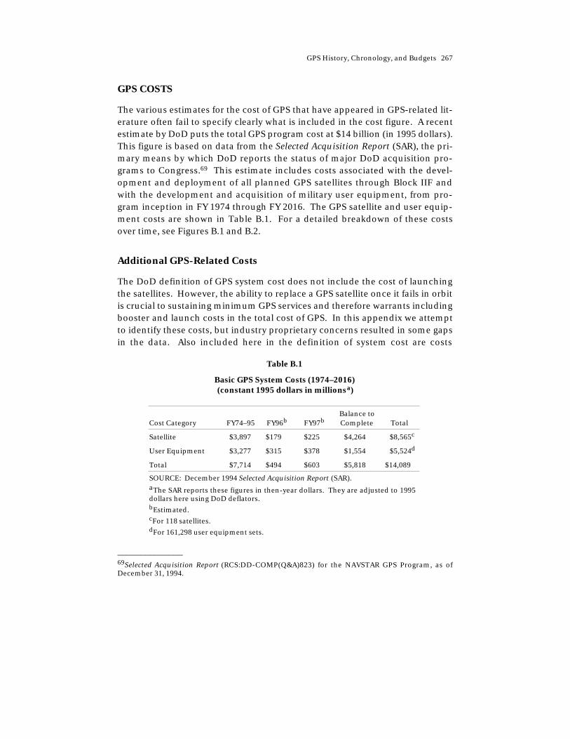
GPS History, Chronology, and Budgets 267
GPS COSTS
The various estimates for the cost of GPS that have appeared in GPS-related lit-erature often fail to specify clearly what is included in the cost figure. A recentestimate by DoD puts the total GPS program cost at $14 billion (in 1995 dollars).This figure is based on data from the Selected Acquisition Report (SAR), the pri-mary means by which DoD reports the status of major DoD acquisition pro-grams to Congress.69 This estimate includes costs associated with the devel-opment and deployment of all planned GPS satellites through Block IIF andwith the development and acquisition of military user equipment, from pro-gram inception in FY 1974 through FY 2016. The GPS satellite and user equip-ment costs are shown in Table B.1. For a detailed breakdown of these costsover time, see Figures B.1 and B.2.
Additional GPS-Related Costs
The DoD definition of GPS system cost does not include the cost of launchingthe satellites. However, the ability to replace a GPS satellite once it fails in orbitis crucial to sustaining minimum GPS services and therefore warrants includingbooster and launch costs in the total cost of GPS. In this appendix we attemptto identify these costs, but industry proprietary concerns resulted in some gapsin the data. Also included here in the definition of system cost are costs
Table B.1
Basic GPS System Costs (1974–2016)(constant 1995 dollars in millionsa)
Cost Category FY74–95 FY96b FY97bBalance toComplete Total
Satellite $3,897 $179 $225 $4,264 $8,565c
User Equipment $3,277 $315 $378 $1,554 $5,524d
Total $7,714 $494 $603 $5,818 $14,089
SOURCE: December 1994 Selected Acquisition Report (SAR).aThe SAR reports these figures in then-year dollars. They are adjusted to 1995dollars here using DoD deflators.bEstimated.cFor 118 satellites.dFor 161,298 user equipment sets.
______________ 69Selected Acquisition Report (RCS:DD-COMP(Q&A)823) for the NAVSTAR GPS Program, as ofDecember 31, 1994.

268 The Global Positioning System
RANDMR614-B.1
Mill
ions
of F
Y95
dol
lars
0
50
100
350
500
1974 1980 1986
Fiscal year
SOURCE: December 1994 Selected Acquisition Report (SAR).
300
250
200
150
1992 1998 2004 2010 2016
450
400
Procurement
RDT&E
Figure B.1—GPS Satellite Costs over Time
associated with nuclear detonation detection system sensors (often referred toas NDS or NUDET), which are carried on board GPS satellites as a secondarypayload. Both costs were not included in the data presented in Table B.1. Byincluding launcher and NDS costs, the total cost of the GPS program rises toalmost $22 billion through 2016. As shown in Table B.2, more than $8 billion ofthis total has already been spent.
Launch Costs
Data on the cost of launching GPS satellites are not maintained separately.Nevertheless, the GPS Joint Program Office (JPO) provided approximated costfigures for launching GPS satellites, which are included in Table B.2 and arebroken down by the type of launch vehicle that have been used for GPS.70 Thefirst GPS satellites (Block Is) were launched on Atlas boosters between 1977 and
______________ 70Cost figures for the Delta II launches are approximations provided by the JPO. Precise data onDelta II costs are not available at this time. A court injunction against the Air Force by the contrac-tor (McDonnell-Douglas) prohibits public disclosure of this information.
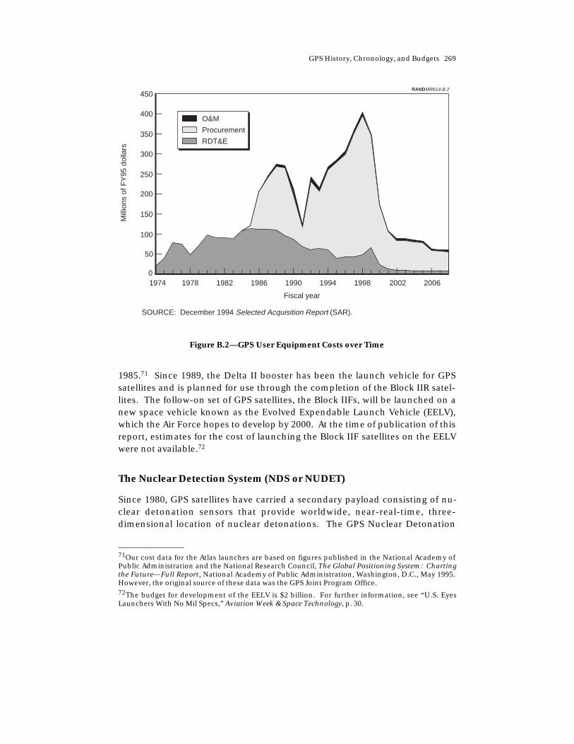
GPS History, Chronology, and Budgets 269
RANDMR614-B.2
Mill
ions
of F
Y95
dol
lars
0
50
100
350
450
1974 1978 1982
Fiscal year
SOURCE: December 1994 Selected Acquisition Report (SAR).
O&M
Procurement
RDT&E
300
250
200
150
1986 1990 1994 1998 2002 2006
400
Figure B.2—GPS User Equipment Costs over Time
1985.71 Since 1989, the Delta II booster has been the launch vehicle for GPSsatellites and is planned for use through the completion of the Block IIR satel-lites. The follow-on set of GPS satellites, the Block IIFs, will be launched on anew space vehicle known as the Evolved Expendable Launch Vehicle (EELV),which the Air Force hopes to develop by 2000. At the time of publication of thisreport, estimates for the cost of launching the Block IIF satellites on the EELVwere not available.72
The Nuclear Detection System (NDS or NUDET)
Since 1980, GPS satellites have carried a secondary payload consisting of nu-clear detonation sensors that provide worldwide, near-real-time, three-dimensional location of nuclear detonations. The GPS Nuclear Detonation
______________ 71Our cost data for the Atlas launches are based on figures published in the National Academy ofPublic Administration and the National Research Council, The Global Positioning System: Chartingthe Future—Full Report, National Academy of Public Administration, Washington, D.C., May 1995.However, the original source of these data was the GPS Joint Program Office.72The budget for development of the EELV is $2 billion. For further information, see “U.S. EyesLaunchers With No Mil Specs,” Aviation Week & Space Technology, p. 30.
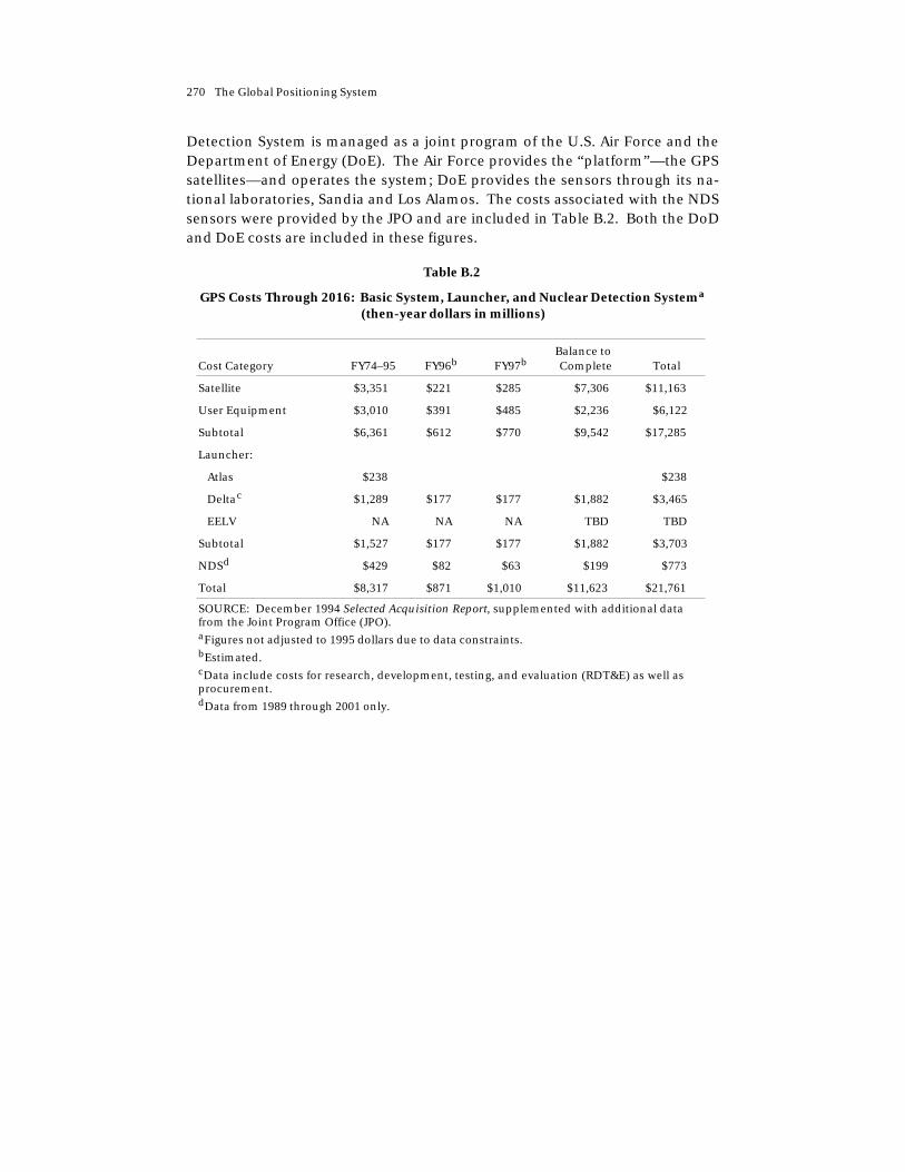
270 The Global Positioning System
Detection System is managed as a joint program of the U.S. Air Force and theDepartment of Energy (DoE). The Air Force provides the “platform”—the GPSsatellites—and operates the system; DoE provides the sensors through its na-tional laboratories, Sandia and Los Alamos. The costs associated with the NDSsensors were provided by the JPO and are included in Table B.2. Both the DoDand DoE costs are included in these figures.
Table B.2
GPS Costs Through 2016: Basic System, Launcher, and Nuclear Detection Systema
(then-year dollars in millions)
Cost Category FY74–95 FY96b FY97bBalance toComplete Total
Satellite $3,351 $221 $285 $7,306 $11,163
User Equipment $3,010 $391 $485 $2,236 $6,122
Subtotal $6,361 $612 $770 $9,542 $17,285
Launcher:
Atlas $238 $238
Deltac $1,289 $177 $177 $1,882 $3,465
EELV NA NA NA TBD TBD
Subtotal $1,527 $177 $177 $1,882 $3,703
NDSd $429 $82 $63 $199 $773
Total $8,317 $871 $1,010 $11,623 $21,761
SOURCE: December 1994 Selected Acquisition Report, supplemented with additional datafrom the Joint Program Office (JPO).aFigures not adjusted to 1995 dollars due to data constraints.bEstimated.cData include costs for research, development, testing, and evaluation (RDT&E) as well asprocurement.dData from 1989 through 2001 only.