APPENDIX B Draft - SHIM B_Draft.pdf · brown Leathesia sp. Bleached red algae, coralline algae and...
25
Gulf Islands NP Summary Report B-1 22 March 2005 APPENDIX B Bioband Descriptions, Biological Exposure Definitions, Selected Maps of Bioband Distributions Appendix B Table of Contents Illustrated Definitions of Biobands ..................................................................... B-2 Illustrated Biological Exposure Definitions ....................................................... B-16 Mapped distributions of Selected Biobands ....................................................... B-21 Appendix B List of Tables B-1 The Supratidal Zone Bioband: Splashzone (VER) .................................... B-2 B-2 The Supratidal Zone Wetland Biobands: Dune Grass (GRA), Sedge (SED), Marsh Grasses & Herbs (SAL) ...................................................... B-3 B-3 The Upper Intertidal Bioband: Barnacle (BAR) ........................................ B-4 B-4 The Upper Intertidal Zone Bioband: Rockweed (FUC) ............................ B-5 B-5 The Intertidal Zone Bioband: Green Algae (ULV) ................................... B-6 B-6 The Intertidal Zone Bioband: Blue Mussel (BMU) ................................... B-7 B-7 The Intertidal Zone Bioband: Bleached Red Algae (HAL2) ..................... B-8 B-8 The Intertidal Zone Bioband: Red Algae (RED2) ..................................... B-9 B-9 The Lower Intertidal and Nearshore Zone Bioband: Surfgrass (SUR) ..... B-10 B-10 The Lower Intertidal and Nearshore Zone Bioband: Alaria (ALA) .......... B-11 B-11 The Lower Intertidal and Nearshore Zone Bioband: Soft Brown Kelps (SBR2) ............................................................................................. B-12 B-12 The Lower Intertidal and Nearshore Zone Bioband: Dark Brown Kelps (CHB2) B-13 B-13 The Lower Intertidal and Nearshore Zone Bioband: Eelgrass (ZOS) ....... B-14 B-14 The Nearshore Subtidal Zone Bioband: Bull Kelp (NER) ........................ B-15 B-15 Summary Table of Indicator and Associated Species and their Typical Biobands, for the Gulf Island Biological Exposure Categories ................ B-16 B-16 Examples of SEMI-EXPOSED ShoreZone Units ..................................... B-17 B-17 Examples of SEMI-PROTECTED ShoreZone Units ................................ B-18 B-18 Examples of PROTECTED ShoreZone Units ........................................... B-19 B-19 Examples of VERY PROTECTED ShoreZone Units ............................... B-20 Appendix B List of Figures B-1 Blue Mussel (BMU) bioband in the Gulf Islands mapping area ............... B-21 B-2 Bull Kelp (NER) bioband in the Gulf Islands mapping area ..................... B-22 B-3 Lower intertidal bioband combinations in the Gulf Islands mapping area B-23 B-4 Seagrass biobands in the Gulf Islands mapping area ................................. B-24 B-5 Wetland biobands in the Gulf Islands mapping area ................................. B-25
Transcript of APPENDIX B Draft - SHIM B_Draft.pdf · brown Leathesia sp. Bleached red algae, coralline algae and...
Gulf Islands NP Summary Report B-1 22 March 2005
APPENDIX B
Bioband Descriptions, Biological Exposure Definitions, Selected Maps of Bioband Distributions
Appendix B Table of Contents
Illustrated Definitions of Biobands..................................................................... B-2 Illustrated Biological Exposure Definitions ....................................................... B-16 Mapped distributions of Selected Biobands ....................................................... B-21
Appendix B List of Tables
B-1 The Supratidal Zone Bioband: Splashzone (VER) .................................... B-2 B-2 The Supratidal Zone Wetland Biobands: Dune Grass (GRA), Sedge (SED), Marsh Grasses & Herbs (SAL) ...................................................... B-3 B-3 The Upper Intertidal Bioband: Barnacle (BAR) ........................................ B-4 B-4 The Upper Intertidal Zone Bioband: Rockweed (FUC) ............................ B-5 B-5 The Intertidal Zone Bioband: Green Algae (ULV) ................................... B-6 B-6 The Intertidal Zone Bioband: Blue Mussel (BMU) ................................... B-7 B-7 The Intertidal Zone Bioband: Bleached Red Algae (HAL2)..................... B-8 B-8 The Intertidal Zone Bioband: Red Algae (RED2) ..................................... B-9 B-9 The Lower Intertidal and Nearshore Zone Bioband: Surfgrass (SUR) ..... B-10 B-10 The Lower Intertidal and Nearshore Zone Bioband: Alaria (ALA) .......... B-11 B-11 The Lower Intertidal and Nearshore Zone Bioband: Soft Brown Kelps (SBR2)............................................................................................. B-12 B-12 The Lower Intertidal and Nearshore Zone Bioband: Dark Brown Kelps (CHB2) B-13 B-13 The Lower Intertidal and Nearshore Zone Bioband: Eelgrass (ZOS) ....... B-14 B-14 The Nearshore Subtidal Zone Bioband: Bull Kelp (NER) ........................ B-15 B-15 Summary Table of Indicator and Associated Species and their Typical
Biobands, for the Gulf Island Biological Exposure Categories ................ B-16 B-16 Examples of SEMI-EXPOSED ShoreZone Units ..................................... B-17
B-17 Examples of SEMI-PROTECTED ShoreZone Units ................................ B-18 B-18 Examples of PROTECTED ShoreZone Units ........................................... B-19 B-19 Examples of VERY PROTECTED ShoreZone Units ............................... B-20
Appendix B List of Figures
B-1 Blue Mussel (BMU) bioband in the Gulf Islands mapping area ............... B-21 B-2 Bull Kelp (NER) bioband in the Gulf Islands mapping area..................... B-22 B-3 Lower intertidal bioband combinations in the Gulf Islands mapping area B-23 B-4 Seagrass biobands in the Gulf Islands mapping area................................. B-24 B-5 Wetland biobands in the Gulf Islands mapping area ................................. B-25
Gulf Islands NP Summary Report B-2 22 March 2005
Illustrated Definitions of BIOBANDS
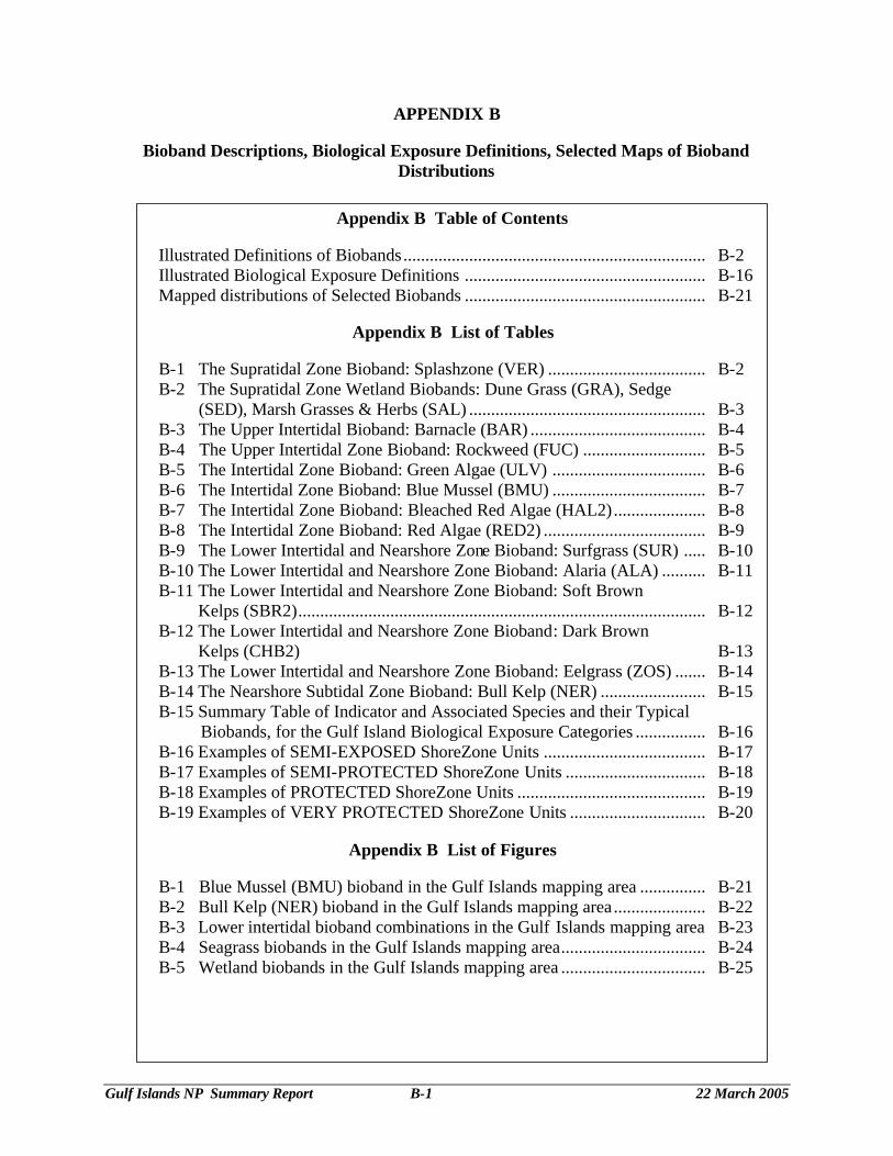
Table B-1 The Supratidal Zone Bioband: Splashzone (VER)
Zone Bio-band Name
Database Label Colour Indicator Species Physical Description Exposure Associate
Species
A Splash Zone VER Black or bare rock
Verrucaria sp. Encrusting black lichens
Visible as a dark stripe, on bare rock, marking the upper limit of the intertidal zone. This band is observed on bedrock, or on low energy boulder/cobble shorelines. Note: This band is recorded by width
• Narrow (N) = less than 1m • Medium (M) = 1m to 5m • Wide (W) = more than 5m
Width varies with exposure. N=VP-SP M=SP-SE W=SE-VE
Littorina sp.
At the southern end of Moresby Island, the dark black splash zone shows as a medium-width in the supratidal zone of this semi-protected rock platform.
The narrow splashzone VER band in the splash zone is visible here, above a thick barnacle (BAR) band on Reay Island.
GIAV04_Jul30_CD4\ GIAVI04_1619JPG GIAV04_Jul30_CD4\ GIAVI04_1612JPG
Gulf Islands NP Summary Report B-3 22 March 2005
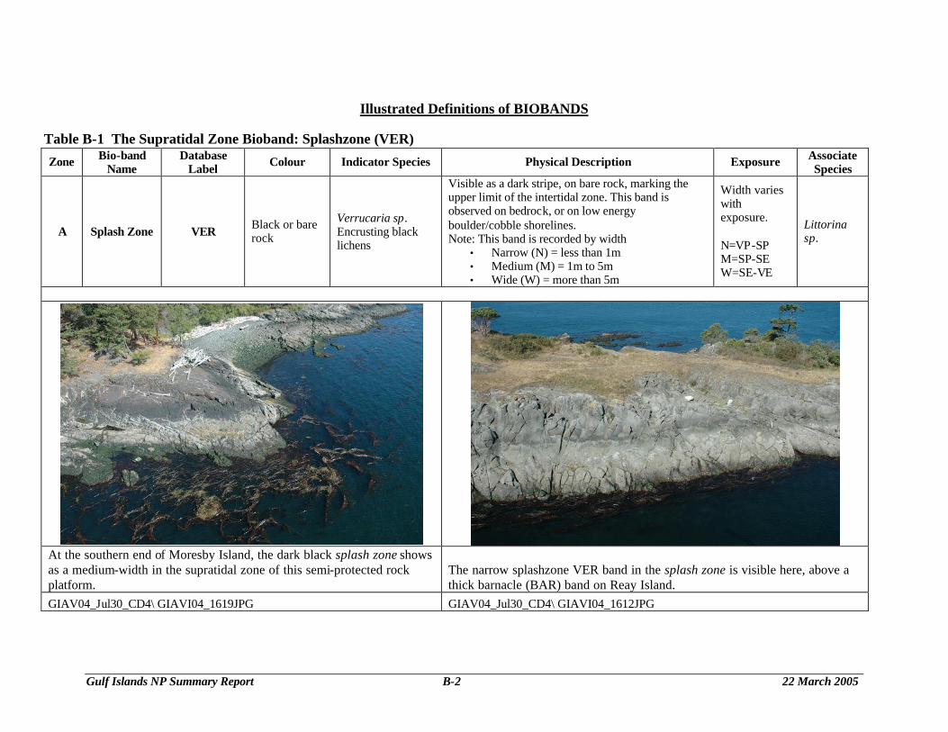
Table B-2 The Supratidal Zone Wetland Biobands: Dune Grass (GRA), Sedges (SED), Marsh Grasses & Herbs (SAL) Zone Bio-band
Name Database
Label Colour Indicator Species Physical Description Exposur
e Associate Species
A Dune Grass GRA Pale blue-green Leymus mollis
Found in the upper intertidal zone, on dunes or beach berms. This band is often the only band present on high-energy beaches. Terrestrial herb band will be found above this band depending on elevation.
VP-SE
A Sedges SED
Bright green, yellow-green to red-brown. Often appears as a mosaic of greens.
Carex sp.
Appears in wetlands around lagoons and estuaries and sometimes as a fringing band below GRA along more protected shoreline. Usually associated with freshwater. This band can exist as a wide flat pure stand, commonly bordered by a PUC band.
VP-SP
A
Marsh grasses,
herbs and sedges
SAL Light/ bright, green Salicornia virginica
Appears in wetlands around lagoons, marshes, and estuaries. Salt-tolerant herbaceous plants, Salicornia, marsh grasses, dune grasses – mix of salt-tolerant vascular plants This band is distinguished from the dune grass band by its colour.
VP-SP
Carex sp. salt-tolerant grasses other salt-tolerant herbs
A view of the ‘Salicornia’ (SAL) band in a protected area The browner areas are SAL, which is mixed with some brighter green SED type grasses that show up as more textured areas further to the right in a protected area of Sidney Island.
Inside the re-curved spit at Sidney Island, all three wetland biobands were observed, with Dune Grass (GRA) in the uppermost loglines, the mixed salt-tolerant herbs (SAL) and the sedge-dominated (SED) biobands. .
GIAV04_Jul30_CD4\ GIAVI04_1513.JPG GIAV04_Jul30_CD4\ GIAVI04_1509JPG
Gulf Islands NP Summary Report B-4 22 March 2005
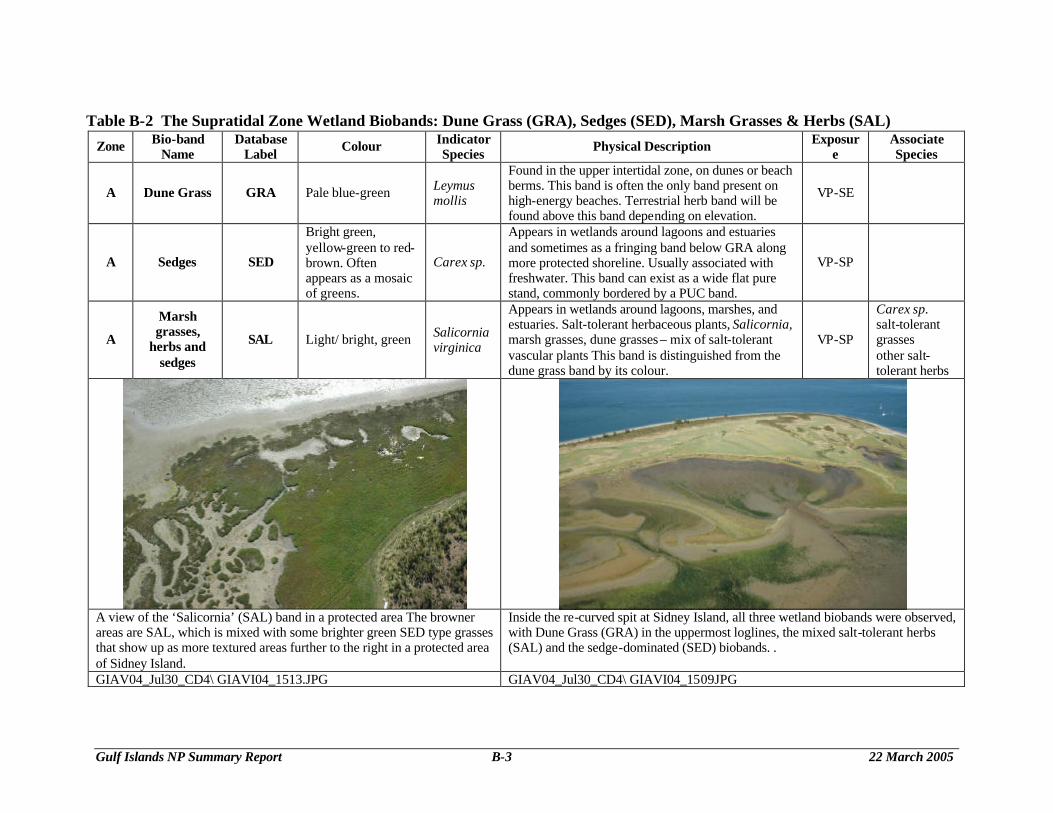
Table B-3 The Upper Intertidal Bioand: Barnacle (BAR) Zone Bio-band
Name Database
Label Colour Indicator Species Physical Description Exposure Associate Species
upper B Barnacle BAR Grey-white Balanus sp. Semibalanus sp.
Visible on bedrock or large boulders. Can form an extensive band in higher exposures where algae have been grazed away.
P-SE Endocladia muricata Porphyra sp. Fucus sp.
This smooth, wide rock platform on the east side of Domville Island has a wide Barnacle (BAR) band above thin Green Algae and Red Algae (ULV and RED2) bands. Nearshore is a Bull Kelp band (NER).
There is a frosting of barnacles (BAR) on the upper portion of this cobble/pebble/boulder beach above the band of Green Algae (ULV) on Brackman Island off Portland Island in Shute Passage.
GIAV04_Jul30_CD4\ GIAVI04_1593.JPG GIAV04_Jul31_CD5\ GIAVI04_2665.JPG
Gulf Islands NP Summary Report B-5 22 March 2005
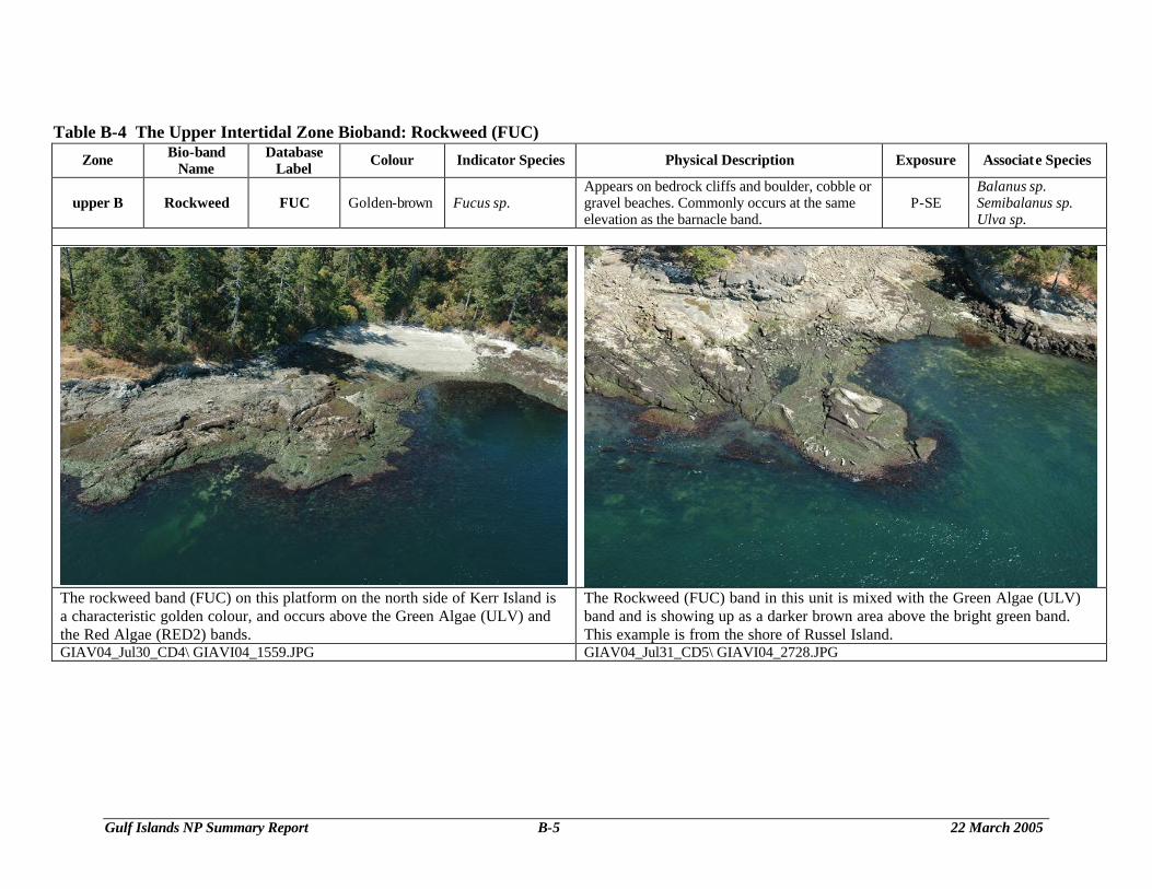
Table B-4 The Upper Intertidal Zone Bioband: Rockweed (FUC) Zone Bio-band
Name Database
Label Colour Indicator Species Physical Description Exposure Associate Species
upper B Rockweed FUC Golden-brown Fucus sp. Appears on bedrock cliffs and boulder, cobble or gravel beaches. Commonly occurs at the same elevation as the barnacle band.
P-SE Balanus sp. Semibalanus sp. Ulva sp.
The rockweed band (FUC) on this platform on the north side of Kerr Island is a characteristic golden colour, and occurs above the Green Algae (ULV) and the Red Algae (RED2) bands.
The Rockweed (FUC) band in this unit is mixed with the Green Algae (ULV) band and is showing up as a darker brown area above the bright green band. This example is from the shore of Russel Island.
GIAV04_Jul30_CD4\ GIAVI04_1559.JPG GIAV04_Jul31_CD5\ GIAVI04_2728.JPG
Gulf Islands NP Summary Report B-6 22 March 2005
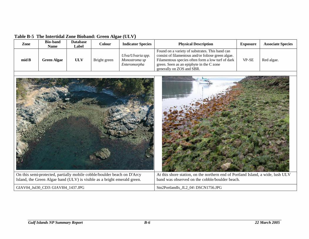
Table B-5 The Intertidal Zone Bioband: Green Algae (ULV) Zone Bio-band
Name Database
Label Colour Indicator Species Physical Description Exposure Associate Species
mid B Green Algae ULV Bright green Ulva/Ulvaria spp. Monostroma sp Enteromorpha
Found on a variety of substrates. This band can consist of filamentous and/or foliose green algae. Filamentous species often form a low turf of dark green. Seen as an epiphyte in the C zone generally on ZOS and SBR.
VP-SE Red algae.
On this semi-protected, partially mobile cobble/boulder beach on D'Arcy Island, the Green Algae band (ULV) is visible as a bright emerald green.
At this shore station, on the northern end of Portland Island, a wide, lush ULV band was observed on the cobble/boulder beach.
GIAV04_Jul30_CD3\ GIAVI04_1437.JPG Stn2PortlandIs_JL2_04\ DSCN1756.JPG
Gulf Islands NP Summary Report B-7 22 March 2005
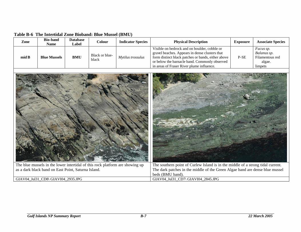
Table B-6 The Intertidal Zone Bioband: Blue Mussel (BMU)
Zone Bio-band Name
Database Label Colour Indicator Species Physical Description Exposure Associate Species
mid B Blue Mussels BMU Black or blue-black Mytilus trossulus
Visible on bedrock and on boulder, cobble or gravel beaches. Appears in dense clusters that form distinct black patches or bands, either above or below the barnacle band. Commonly observed in areas of Fraser River plume influence.
P-SE
Fucus sp. Balanus sp. Filamentous red
algae. limpets
The blue mussels in the lower intertidal of this rock platform are showing up as a dark black band on East Point, Saturna Island.
The southern point of Curlew Island is in the middle of a strong tidal current. The dark patches in the middle of the Green Algae band are dense blue mussel beds (BMU band).
GIAV04_Jul31_CD8\ GIAVI04_2935.JPG GIAV04_Jul31_CD7\ GIAVI04_2845.JPG
Gulf Islands NP Summary Report B-8 22 March 2005
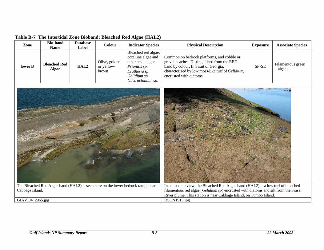
Table B-7 The Intertidal Zone Bioband: Bleached Red Algae (HAL2) Zone Bio-band
Name Database
Label Colour Indicator Species Physical Description Exposure Associate Species
lower B Bleached Red Algae HAL2
Olive, golden or yellow-brown
Bleached red algae, coralline algae and other small algae Prionitis sp. Leathesia sp. Gelidium sp. Gastroclonium sp.
Common on bedrock platforms, and cobble or gravel beaches. Distinguished from the RED band by colour. In Strait of Georgia, characterized by low moss-like turf of Gelidium, encrusted with diatoms.
SP-SE Filamentous green algae
The Bleached Red Algae band (HAL2) is seen here on the lower bedrock ramp, near Cabbage Island.
In a close-up view, the Bleached Red Algae band (HAL2) is a low turf of bleached filamentous red algae (Gelidium sp) encrusted with diatoms and silt from the Fraser River plume. This station is near Cabbage Island, on Tumbo Island.
GIAVI04_2965.jpg DSCN1915.jpg
Gulf Islands NP Summary Report B-9 22 March 2005
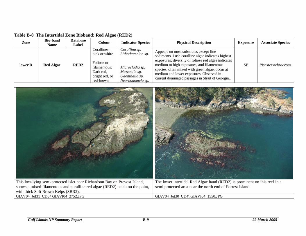
Table B-8 The Intertidal Zone Bioband: Red Algae (RED2)
Zone Bio-band Name
Database Label Colour Indicator Species Physical Description Exposure Associate Species
lower B Red Algae RED2
Corallines: pink or white Foliose or filamentous: Dark red, bright red, or red-brown.
Corallina sp. Lithothamnion sp. Microcladia sp. Mazzaella sp. Odonthalia sp. Neorhodomela sp.
Appears on most substrates except fine sediments. Lush coralline algae indicates highest exposures; diversity of foliose red algae indicates medium to high exposures, and filamentous species, often mixed with green algae, occur at medium and lower exposures. Observed in current dominated passages in Strait of Georgia..
SE Pisaster ochraceous
This low-lying semi-protected islet near Richardson Bay on Prevost Island, shows a mixed filamentous and coralline red algae (RED2) patch on the point, with thick Soft Brown Kelps (SBR2).
The lower intertidal Red Algae band (RED2) is prominent on this reef in a semi-protected area near the north end of Forrest Island.
GIAV04_Jul31_CD6 \ GIAVI04_2752.JPG GIAV04_Jul30_CD4\ GIAVI04_1550.JPG
Gulf Islands NP Summary Report B-10 22 March 2005
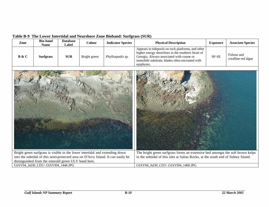
Table B-9 The Lower Intertidal and Nearshore Zone Bioband: Surfgrass (SUR)
Zone Bio-band Name
Database Label Colour Indicator Species Physical Description Exposure Associate Species
B & C Surfgrass SUR Bright green Phyllospadix sp.
Appears in tidepools on rock platforms, and other higher energy shorelines in the southern Strait of Georgia. Always associated with coarse or immobile substrate, blades often encrusted with epiphytes.
SP-SE Foliose and coralline red algae
Bright green surfgrass is visible in the lower intertidal and extending down into the subtidal of this semi-protected area on D'Arcy Island. It can easily be distinguished from the emerald green ULV band here.
The bright green surfgrass forms an extensive bed amongst the soft brown kelps in the subtidal of this islet at Salias Rocks, at the south end of Sidney Island.
GIAV04_Jul30_CD3 \ GIAVI04_1444.JPG GIAV04_Jul30_CD3 \ GIAVI04_1460.JPG
Gulf Islands NP Summary Report B-11 22 March 2005
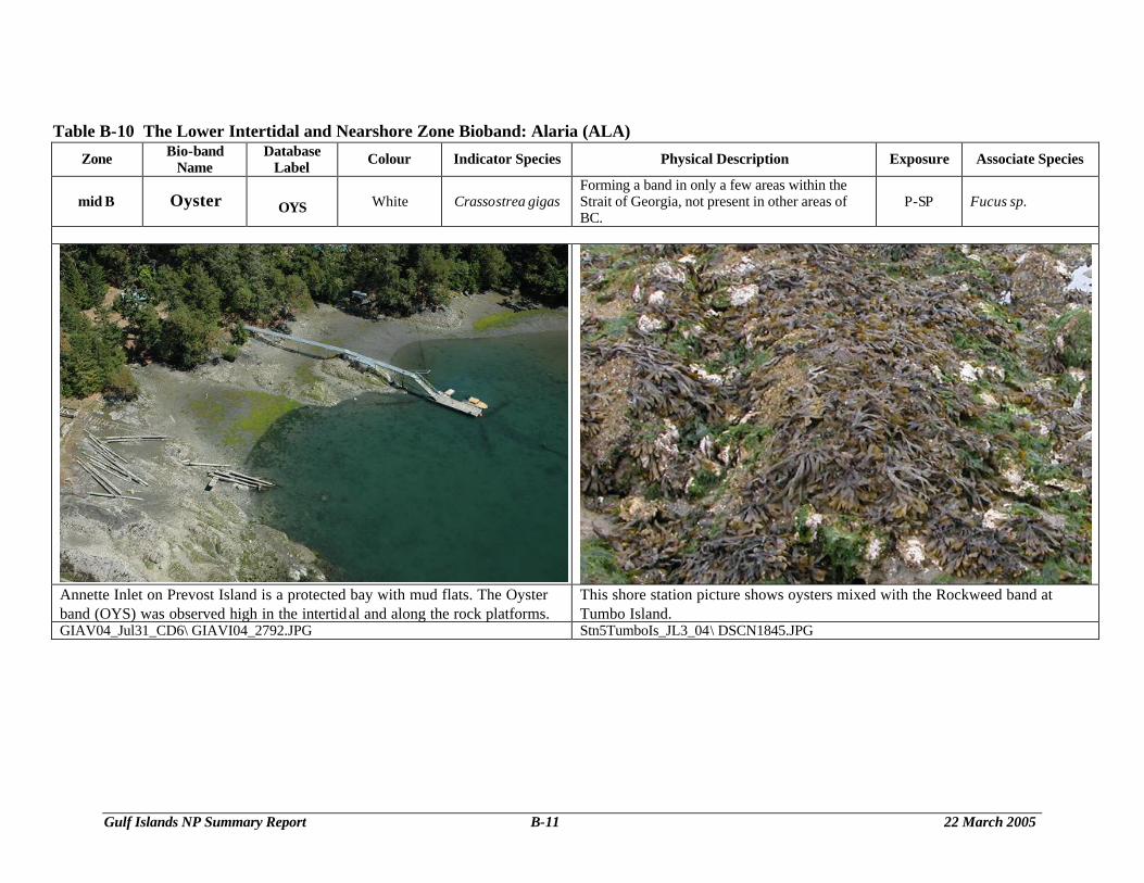
Table B-10 The Lower Intertidal and Nearshore Zone Bioband: Alaria (ALA) Zone Bio-band
Name Database
Label Colour Indicator Species Physical Description Exposure Associate Species
mid B Oyster OYS White Crassostrea gigas Forming a band in only a few areas within the Strait of Georgia, not present in other areas of BC.
P-SP Fucus sp.
Annette Inlet on Prevost Island is a protected bay with mud flats. The Oyster band (OYS) was observed high in the intertidal and along the rock platforms.
This shore station picture shows oysters mixed with the Rockweed band at Tumbo Island.
GIAV04_Jul31_CD6\ GIAVI04_2792.JPG Stn5TumboIs_JL3_04\ DSCN1845.JPG
Gulf Islands NP Summary Report B-12 22 March 2005
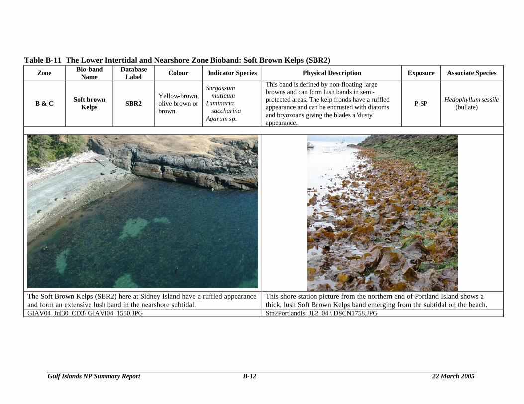
Table B-11 The Lower Intertidal and Nearshore Zone Bioband: Soft Brown Kelps (SBR2) Zone Bio-band
Name Database
Label Colour Indicator Species Physical Description Exposure Associate Species
B & C Soft brown Kelps SBR2
Yellow-brown, olive brown or brown.
Sargassum muticum
Laminaria saccharina
Agarum sp.
This band is defined by non-floating large browns and can form lush bands in semi-protected areas. The kelp fronds have a ruffled appearance and can be encrusted with diatoms and bryozoans giving the blades a 'dusty' appearance.
P-SP Hedophyllum sessile (bullate)
The Soft Brown Kelps (SBR2) here at Sidney Island have a ruffled appearance and form an extensive lush band in the nearshore subtidal.
This shore station picture from the northern end of Portland Island shows a thick, lush Soft Brown Kelps band emerging from the subtidal on the beach.
GIAV04_Jul30_CD3\ GIAVI04_1550.JPG Stn2PortlandIs_JL2_04 \ DSCN1758.JPG
Gulf Islands NP Summary Report B-13 22 March 2005
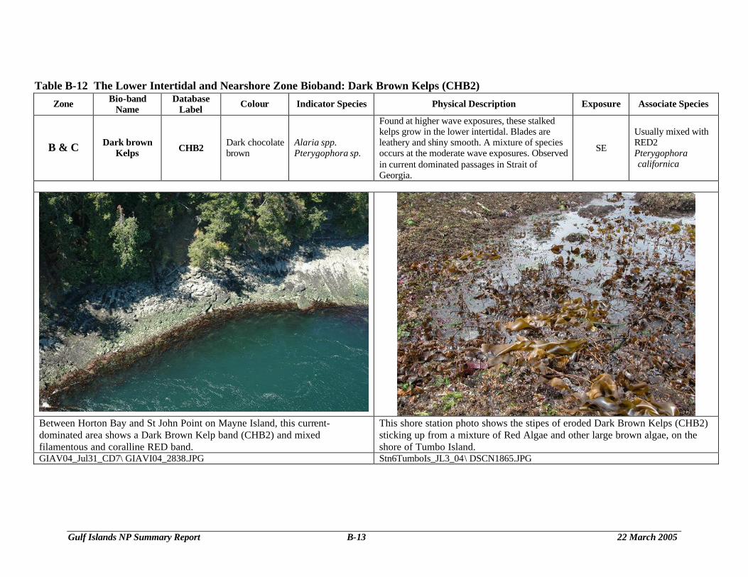
Table B-12 The Lower Intertidal and Nearshore Zone Bioband: Dark Brown Kelps (CHB2)
Zone Bio-band Name
Database Label Colour Indicator Species Physical Description Exposure Associate Species
B & C Dark brown Kelps CHB2 Dark chocolate
brown Alaria spp. Pterygophora sp.
Found at higher wave exposures, these stalked kelps grow in the lower intertidal. Blades are leathery and shiny smooth. A mixture of species occurs at the moderate wave exposures. Observed in current dominated passages in Strait of Georgia.
SE
Usually mixed with RED2 Pterygophora californica
Between Horton Bay and St John Point on Mayne Island, this current-dominated area shows a Dark Brown Kelp band (CHB2) and mixed filamentous and coralline RED band.
This shore station photo shows the stipes of eroded Dark Brown Kelps (CHB2) sticking up from a mixture of Red Algae and other large brown algae, on the shore of Tumbo Island.
GIAV04_Jul31_CD7\ GIAVI04_2838.JPG Stn6TumboIs_JL3_04\ DSCN1865.JPG
Gulf Islands NP Summary Report B-14 22 March 2005
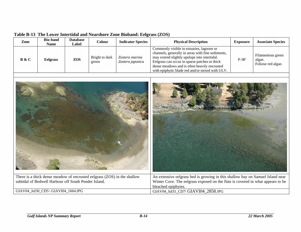
Table B-13 The Lower Intertidal and Nearshore Zone Bioband: Eelgrass (ZOS)
Zone Bio-band Name
Database Label Colour Indicator Species Physical Description Exposure Associate Species
B & C Eelgrass ZOS Bright to dark green
Zostera marina Zostera japonica
Commonly visible in estuaries, lagoons or channels, generally in areas with fine sediments, may extend slightly upslope into intertidal. Eelgrass can occur in sparse patches or thick dense meadows and is often heavily encrusted with epiphytic blade red and/or mixed with ULV.
P-SP Filamentous green algae. Foliose red algae.
There is a thick dense meadow of encrusted eelgrass (ZOS) in the shallow subtidal of Bedwell Harbour off South Pender Island.
An extensive eelgrass bed is growing in this shallow bay on Samuel Island near Winter Cove. The eelgrass exposed on the flats is covered in what appears to be bleached epiphytes.
GIAV04_Jul30_CD5 \ GIAVI04_1664.JPG GIAV04_Jul31_CD7\ GIAVI04_2858.JPG
Gulf Islands NP Summary Report B-15 22 March 2005
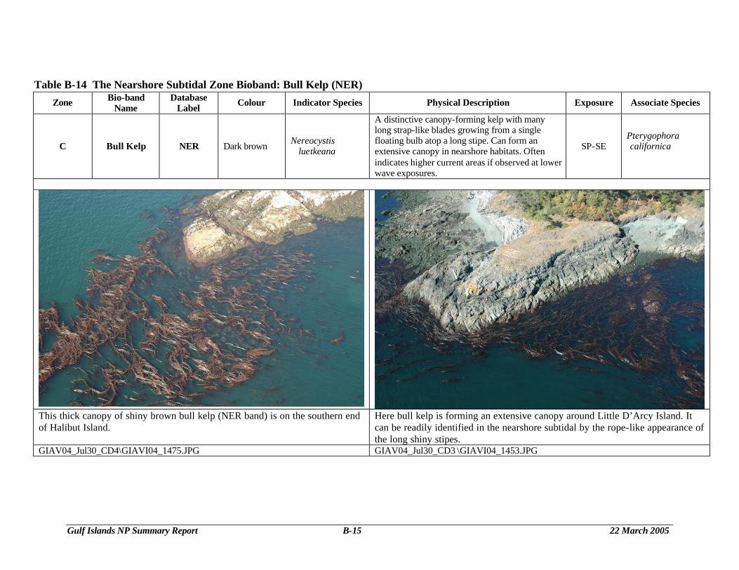
Table B-14 The Nearshore Subtidal Zone Bioband: Bull Kelp (NER) Zone Bio-band
Name Database
Label Colour Indicator Species Physical Description Exposure Associate Species
C Bull Kelp NER Dark brown Nereocystis luetkeana
A distinctive canopy-forming kelp with many long strap-like blades growing from a single floating bulb atop a long stipe. Can form an extensive canopy in nearshore habitats. Often indicates higher current areas if observed at lower wave exposures.
SP-SE Pterygophora californica
This thick canopy of shiny brown bull kelp (NER band) is on the southern end of Halibut Island.
Here bull kelp is forming an extensive canopy around Little D’Arcy Island. It can be readily identified in the nearshore subtidal by the rope-like appearance of the long shiny stipes.
GIAV04_Jul30_CD4\GIAVI04_1475.JPG GIAV04_Jul30_CD3 \GIAVI04_1453.JPG
Gulf Islands NP Summary Report B-16 22 March 2005
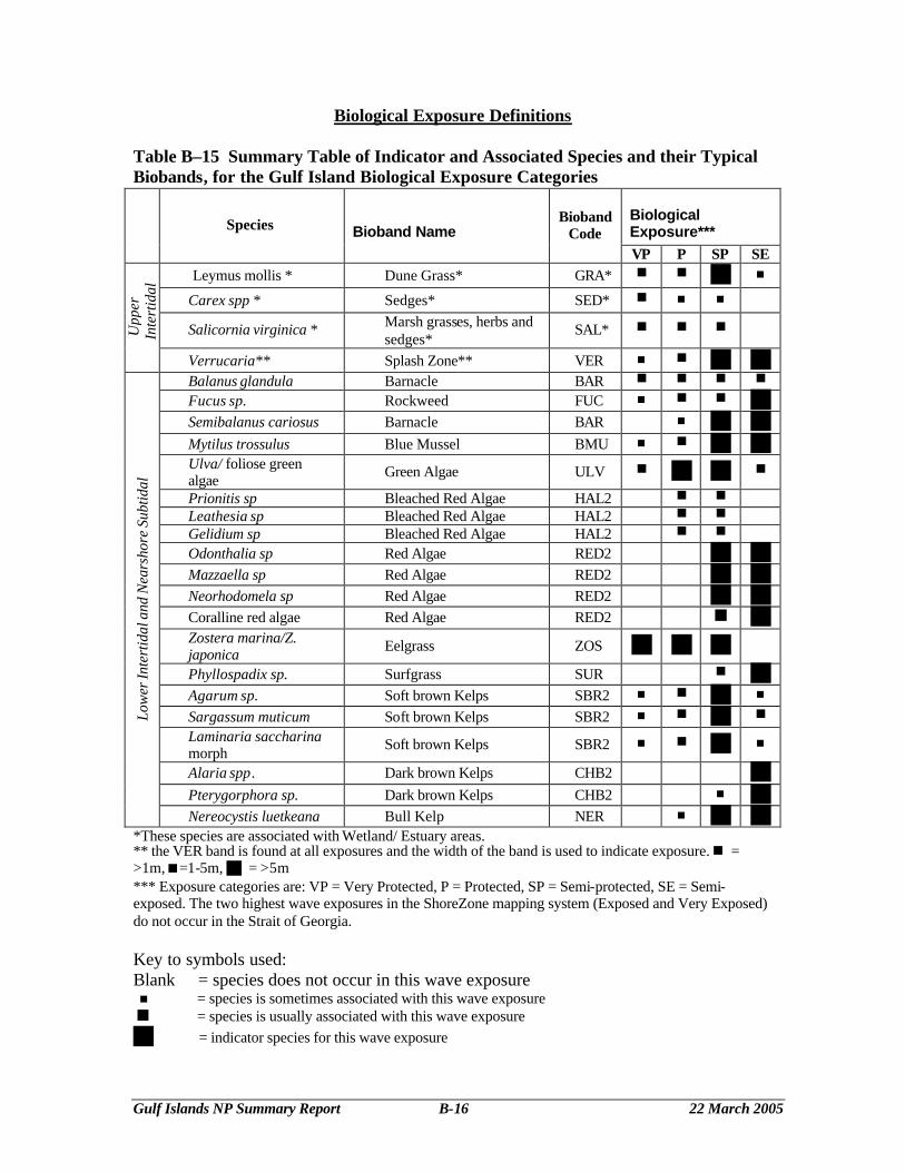
Biological Exposure Definitions Table B–15 Summary Table of Indicator and Associated Species and their Typical Biobands, for the Gulf Island Biological Exposure Categories
Biological Exposure*** Species Bioband Name
Bioband Code
VP P SP SE Leymus mollis * Dune Grass* GRA* < < g n
Carex spp * Sedges* SED* < n n
Salicornia virginica * Marsh grasses, herbs and sedges*
SAL* < < < Upp
er
Inte
rtid
al
Verrucaria** Splash Zone** VER n < g g Balanus glandula Barnacle BAR < < < <
Fucus sp. Rockweed FUC n < < g Semibalanus cariosus Barnacle BAR n g g Mytilus trossulus Blue Mussel BMU n < g g Ulva/ foliose green algae Green Algae ULV < g g <
Prionitis sp Bleached Red Algae HAL2 < < Leathesia sp Bleached Red Algae HAL2 < < Gelidium sp Bleached Red Algae HAL2 < < Odonthalia sp Red Algae RED2 g g Mazzaella sp Red Algae RED2 g g Neorhodomela sp Red Algae RED2 g g Coralline red algae Red Algae RED2 g g Zostera marina/Z. japonica Eelgrass ZOS g g g
Phyllospadix sp. Surfgrass SUR < g Agarum sp. Soft brown Kelps SBR2 n < g n
Sargassum muticum Soft brown Kelps SBR2 n < g <
Laminaria saccharina morph Soft brown Kelps SBR2 n < g n
Alaria spp. Dark brown Kelps CHB2 g Pterygorphora sp. Dark brown Kelps CHB2 n g
Low
er In
tert
idal
and
Nea
rsho
re S
ubtid
al
Nereocystis luetkeana Bull Kelp NER n g g *These species are associated with Wetland/ Estuary areas. ** the VER band is found at all exposures and the width of the band is used to indicate exposure. n = >1m,<=1-5m, g = >5m *** Exposure categories are: VP = Very Protected, P = Protected, SP = Semi-protected, SE = Semi-exposed. The two highest wave exposures in the ShoreZone mapping system (Exposed and Very Exposed) do not occur in the Strait of Georgia. Key to symbols used: Blank = species does not occur in this wave exposure n = species is sometimes associated with this wave exposure < = species is usually associated with this wave exposure g = indicator species for this wave exposure
Gulf Islands NP Summary Report B-17 22 March 2005
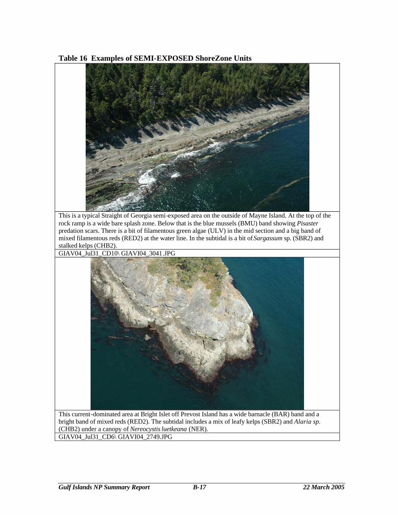
Table 16 Examples of SEMI-EXPOSED ShoreZone Units
This is a typical Straight of Georgia semi-exposed area on the outside of Mayne Island. At the top of the rock ramp is a wide bare splash zone. Below that is the blue mussels (BMU) band showing Pisaster predation scars. There is a bit of filamentous green algae (ULV) in the mid section and a big band of mixed filamentous reds (RED2) at the water line. In the subtidal is a bit of Sargassum sp. (SBR2) and stalked kelps (CHB2). GIAV04_Jul31_CD10\ GIAVI04_3041.JPG
This current-dominated area at Bright Islet off Prevost Island has a wide barnacle (BAR) band and a bright band of mixed reds (RED2). The subtidal includes a mix of leafy kelps (SBR2) and Alaria sp. (CHB2) under a canopy of Nereocystis luetkeana (NER). GIAV04_Jul31_CD6\ GIAVI04_2749.JPG
Gulf Islands NP Summary Report B-18 22 March 2005
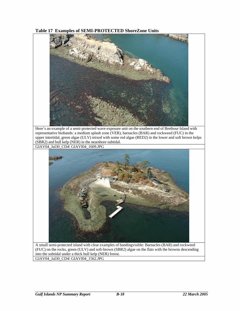
Table 17 Examples of SEMI-PROTECTED ShoreZone Units
Here’s an example of a semi-protected wave exposure unit on the southern end of Brethour Island with representative biobands: a medium splash zone (VER), barnacles (BAR) and rockweed (FUC) in the upper intertidal, green algae (ULV) mixed with some red algae (RED2) in the lower and soft brown kelps (SBR2) and bull kelp (NER) in the nearshore subtidal. GIAV04_Jul30_CD4\ GIAVI04_1609.JPG
A small semi-protected island with clear examples of bandingvisible: Barnacles (BAR) and rockweed (FUC) on the rocks, green (ULV) and soft-brown (SBR2) algae on the flats with the browns descending into the subtidal under a thick bull kelp (NER) forest. GIAV04_Jul30_CD4\ GIAVI04_1562.JPG
Gulf Islands NP Summary Report B-19 22 March 2005
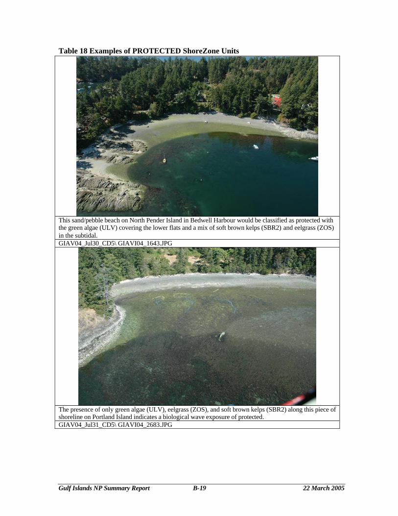
Table 18 Examples of PROTECTED ShoreZone Units
This sand/pebble beach on North Pender Island in Bedwell Harbour would be classified as protected with the green algae (ULV) covering the lower flats and a mix of soft brown kelps (SBR2) and eelgrass (ZOS) in the subtidal. GIAV04_Jul30_CD5\ GIAVI04_1643.JPG
The presence of only green algae (ULV), eelgrass (ZOS), and soft brown kelps (SBR2) along this piece of shoreline on Portland Island indicates a biological wave exposure of protected. GIAV04_Jul31_CD5\ GIAVI04_2683.JPG
Gulf Islands NP Summary Report B-20 22 March 2005
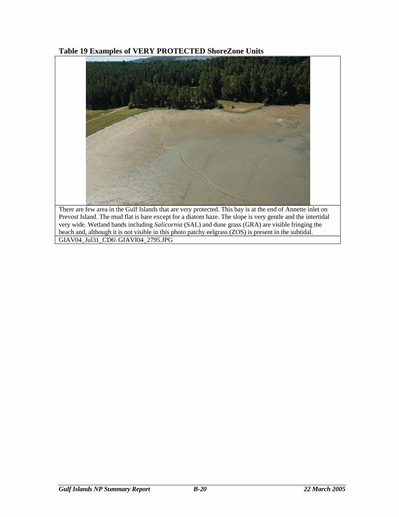
Table 19 Examples of VERY PROTECTED ShoreZone Units
There are few area in the Gulf Islands that are very protected. This bay is at the end of Annette inlet on Prevost Island. The mud flat is bare except for a diatom haze. The slope is very gentle and the intertidal very wide. Wetland bands including Salicornia (SAL) and dune grass (GRA) are visible fringing the beach and, although it is not visible in this photo patchy eelgrass (ZOS) is present in the subtidal. GIAV04_Jul31_CD6\ GIAVI04_2795.JPG
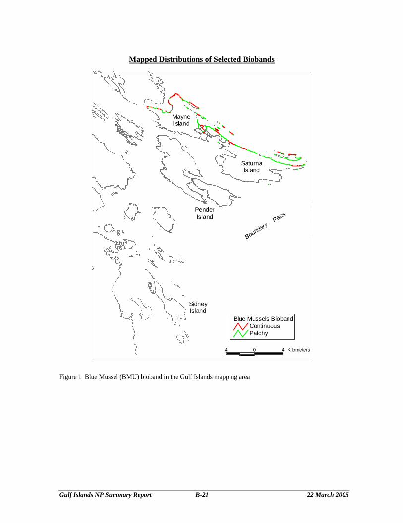
Gulf Islands NP Summary Report B-21 22 March 2005
Mapped Distributions of Selected Biobands
Blue Mussels BiobandContinuousPatchy
4 0 4 Kilometers
SaturnaIsland
MayneIsland
PenderIsland
SidneyIsland
Boundary P
ass
Figure 1 Blue Mussel (BMU) bioband in the Gulf Islands mapping area
Gulf Islands NP Summary Report B-22 22 March 2005
SidneyIsland
PenderIsland
MayneIsland
SaturnaIsland
4 0 4 Kilometers
Bull Kelp BiobandContinuousPatchy
Boundary Pass
Figure 2 Bull Kelp (NER) bioband in the Gulf Islands mapping area
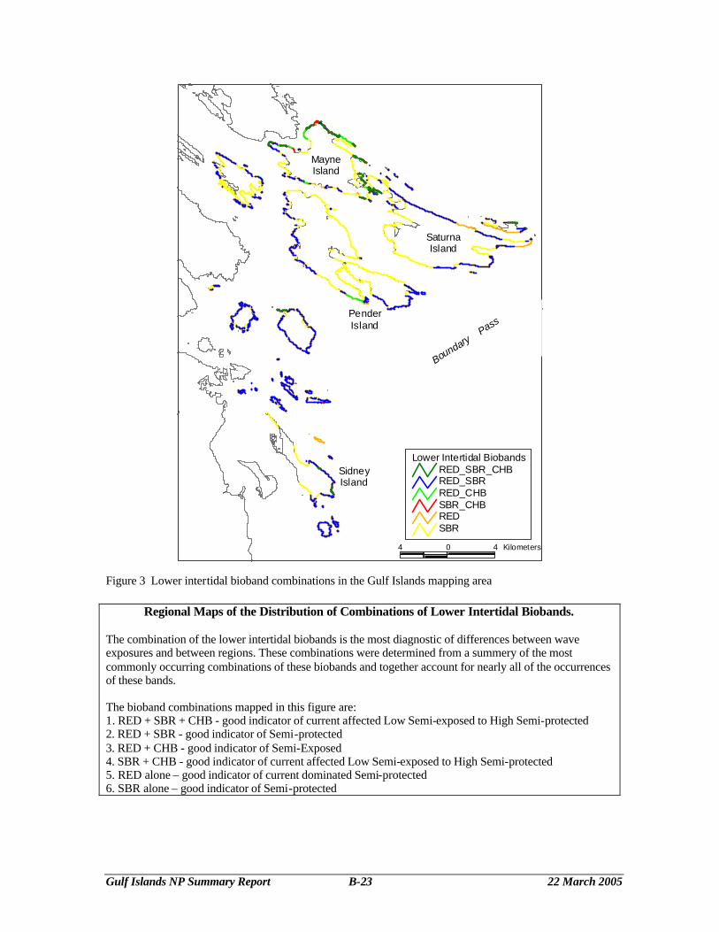
Gulf Islands NP Summary Report B-23 22 March 2005
SidneyIsland
PenderIsland
MayneIsland
SaturnaIsland
4 0 4 Kilometers
Lower Intertidal BiobandsRED_SBR_CHBRED_SBRRED_CHBSBR_CHBREDSBR
Boundary Pass
Figure 3 Lower intertidal bioband combinations in the Gulf Islands mapping area
Regional Maps of the Distribution of Combinations of Lower Intertidal Biobands. The combination of the lower intertidal biobands is the most diagnostic of differences between wave exposures and between regions. These combinations were determined from a summery of the most commonly occurring combinations of these biobands and together account for nearly all of the occurrences of these bands. The bioband combinations mapped in this figure are: 1. RED + SBR + CHB - good indicator of current affected Low Semi-exposed to High Semi-protected 2. RED + SBR - good indicator of Semi-protected 3. RED + CHB - good indicator of Semi-Exposed 4. SBR + CHB - good indicator of current affected Low Semi-exposed to High Semi-protected 5. RED alone – good indicator of current dominated Semi-protected 6. SBR alone – good indicator of Semi-protected
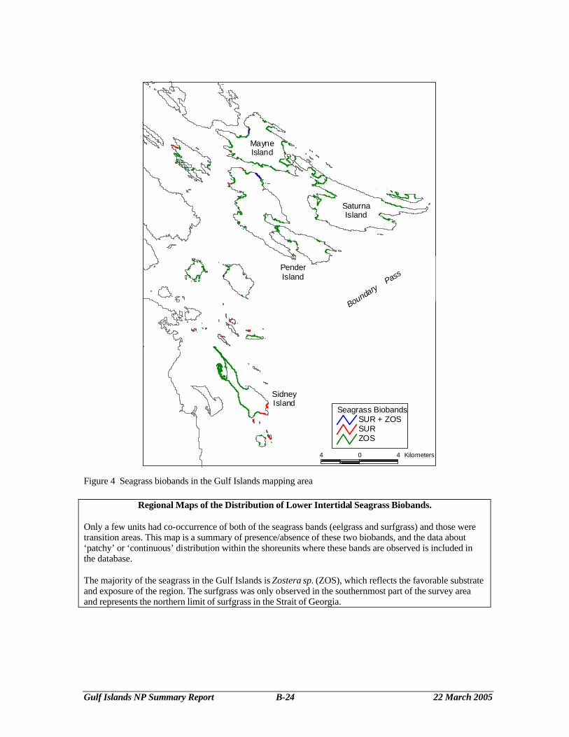
Gulf Islands NP Summary Report B-24 22 March 2005
Figure 4 Seagrass biobands in the Gulf Islands mapping area
Regional Maps of the Distribution of Lower Intertidal Seagrass Biobands. Only a few units had co-occurrence of both of the seagrass bands (eelgrass and surfgrass) and those were transition areas. This map is a summary of presence/absence of these two biobands, and the data about ‘patchy’ or ‘continuous’ distribution within the shoreunits where these bands are observed is included in the database. The majority of the seagrass in the Gulf Islands is Zostera sp. (ZOS), which reflects the favorable substrate and exposure of the region. The surfgrass was only observed in the southernmost part of the survey area and represents the northern limit of surfgrass in the Strait of Georgia.
SidneyIsland
PenderIsland
MayneIsland
SaturnaIsland
4 0 4 Kilometers
Seagrass BiobandsSUR + ZOSSURZOS
Boundary
Pass
Gulf Islands NP Summary Report B-25 22 March 2005
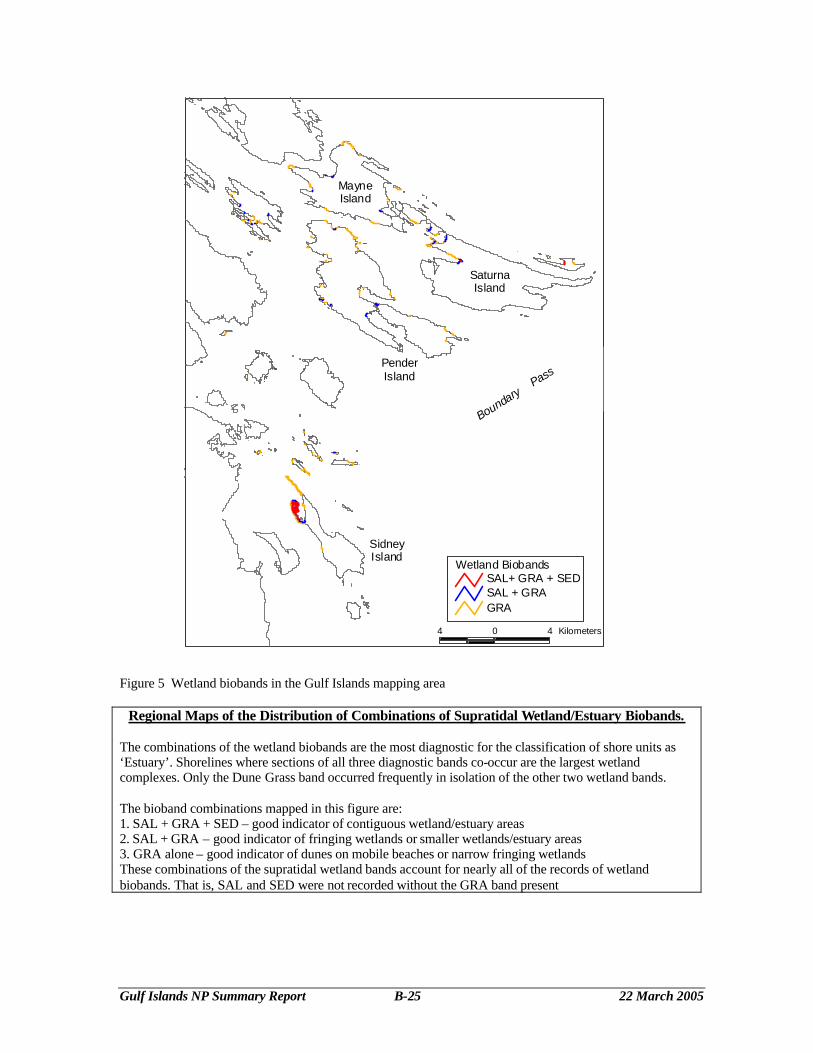
Figure 5 Wetland biobands in the Gulf Islands mapping area
Regional Maps of the Distribution of Combinations of Supratidal Wetland/Estuary Biobands. The combinations of the wetland biobands are the most diagnostic for the classification of shore units as ‘Estuary’. Shorelines where sections of all three diagnostic bands co-occur are the largest wetland complexes. Only the Dune Grass band occurred frequently in isolation of the other two wetland bands. The bioband combinations mapped in this figure are: 1. SAL + GRA + SED – good indicator of contiguous wetland/estuary areas 2. SAL + GRA – good indicator of fringing wetlands or smaller wetlands/estuary areas 3. GRA alone – good indicator of dunes on mobile beaches or narrow fringing wetlands These combinations of the supratidal wetland bands account for nearly all of the records of wetland biobands. That is, SAL and SED were not recorded without the GRA band present
SidneyIsland
PenderIsland
MayneIsland
SaturnaIsland
4 0 4 Kilometers
Wetland BiobandsSAL+ GRA + SEDSAL + GRAGRA
Boundary
Pass