Appendix A—Case Study 14 Case Study 14. Rocky Creek · PDF fileAppendix A—117...
14
Appendix A—117 Appendix A—Case Study Case Study 14. Rocky Creek Vented Box Culvert Ford Location West Central Arkansas. Ouachita National Forest; Oden Ranger District. Rocky Creek crossing on Forest Road 887 (Muddy Gibbs Road). Crossing Description This is a concrete vented ford on a perennial stream that provides habitat for several fish and mussel species. The structure consists of three 6- by 3-foot concrete box culverts, with a splash apron extending downstream of the roadway (figure A86). Six-inch curbs focus water into the center culvert for low-flow passage for weak-swimming fish, and boulders embedded in the concrete provide resting areas for them . Figure A86. Looking upstream at the concrete vented ford and splash apron. Setting Ouachita Mountain Section (M231-A), elevation 740 feet. Parallel ridges and valleys on sandstone and shale are drained by a trellis-patterned drainage network (McDougal et al 2001). Drainage density is high and there are frequent bedrock outcrops. Predominant vegetation includes shortleaf pine, red and white oak, hickory, dogwood, and willow. 14
Transcript of Appendix A—Case Study 14 Case Study 14. Rocky Creek · PDF fileAppendix A—117...

Appendix A—117
Appendix A—Case Study
Case Study 14. Rocky Creek Vented Box Culvert Ford
Location West Central Arkansas. Ouachita National Forest; Oden Ranger District. Rocky Creek crossing on Forest Road 887 (Muddy Gibbs Road).
Crossing Description This is a concrete vented ford on a perennial stream that provides habitat for several fish and mussel species. The structure consists of three 6- by 3-foot concrete box culverts, with a splash apron extending downstream of the roadway (figure A86). Six-inch curbs focus water into the center culvert for low-flow passage for weak-swimming fish, and boulders embedded in the concrete provide resting areas for them .
Figure A86. Looking upstream at the concrete vented ford and splash apron.
Setting Ouachita Mountain Section (M231-A), elevation 740 feet. Parallel ridges and valleys on sandstone and shale are drained by a trellis-patterned drainage network (McDougal et al 2001). Drainage density is high and there are frequent bedrock outcrops. Predominant vegetation includes shortleaf pine, red and white oak, hickory, dogwood, and willow.
14

Appendix A—118
Appendix A—Case Study
Why Was This
Structure Selected? This structure design was chosen to achieve the following objectives.
• Provide safe and reliable vehicle access during most flows without the expense of a bridge.
• Avoid plugging by woody debris during floods. (Previous structures were a constant maintenance headache because of plugging. Just before the crossing was reconstructed, the area had experienced a major ice storm, and trees falling into streams were plugging culverts and causing them to fail.)
• Provide passage for several endemic aquatic species. (The site is part of a research project into what kind of structures local fish can pass.)
Crossing Site History In 1964, an unvented ford was installed at this site with 39-inch gabions supporting the downstream edge of a gravel roadbed. The gabion structure was frequently damaged when high flows outflanked the approaches. By 1979, two 24-inch pipes had been placed under the roadbed, and the road was surfaced with concrete (figure A87). The pipes plugged frequently, and many repairs were needed. In 2000, when the existing structure was built, there were several generations of concrete to be removed along with the gabions and pipes.
Figure A87. The previous crossing on road 887 at Rocky Creek was a gabion-culvert structure that was frequently damaged during high flows.
14

Appendix A—119
Appendix A—Case Study
Road Management
Objectives The Muddy Gibbs road is a school bus route maintained by the county, and is designed for passenger vehicle use. Average daily traffic is 20 to 30 vehicles.
Stream Environment Hydrology: Rocky Creek is a perennial stream draining about 1,700 acres of timbered land above the ford. Although rain occurs throughout the year, the two main rainy seasons are winter and spring. Average precipitation is 48 to 56 inches per year. Floods occur during sustained intense rainfall on already saturated soils or during summer thunderstorms. High flows generally do not last more than several hours.
Channel Description: Rocky Creek at the site is moderately entrenched between terraces about 5 to 6 feet above the streambed. Stream substrate is small boulders and large cobbles, with some larger boulders and bedrock outcrops. Channel slope is approximately 2.5 percent, bankfull width is about 15 to 20 feet, and depth at bankfull is 2 feet. The flood plain is narrow, about 2 feet wide. Banks are rocky and well-vegetated upstream of the structure (figure A88). Downstream, banks are scoured and the stream is wider, but the effects of the crossing on channel stability appear to be restricted to the immediate vicinity of the crossing.
Figure A88. Looking downstream at the crossing on Rocky Creek.
14

Appendix A—120
Appendix A—Case Study
Aquatic Organisms: Two State endemic fish species are found in this watershed: the orangebelly darter and the Caddo madtom. A threatened mussel that occurs downstream depends on several of the native species—including darters—to disperse. Several species of turtles and crayfish; Ouachita dusky; spotted, tiger, and marbled salamanders; as well as frogs and toads also use the stream. A study done for the Ouachita National Forest showed that traditional concrete pipe vented fords (see case study 11) are associated with significant reductions in the number of fish species and individual fishes upstream as compared to downstream of the fords (Gagen and Rajput 2002). Passage is required not only for spawning but also for thermal refuge, as fish seek out deep pools with cooler water in the heat of the summer. Aquatic species must also be able to recolonize areas after local extinctions due to droughts. The need for fish passage was one of the primary drivers for this replacement structure.
Structure Details Structure: The structure consists of three 6- by 3-foot concrete box culverts set at streambed elevation (figure A89). A 10-foot long splash apron protects the structure against scour during overtopping flows, and a 6-inch curb at the apron’s downstream edge is intended to prevent formation of a plunge there by creating a reverse eddy. Curbs under the roadway backwater flows in the side culverts and concentrate water toward the center box (figure A90) for low flow fish passage. The curbs help to retain some bed material in the floor of the culverts, which is also expected to help aquatic species passage through the culvert. Four- to 6-inch boulders embedded in the concrete floor further assist fish passage by providing resting areas.
Figure A90. Looking upstream at the splash apron and backwater curbs.
14

Appendix A—121
Appendix A—Case Study 14
Fig
ure
A89
a—P
lan
and
profi
le d
raw
ings
of t
he c
oncr
ete
box
culv
ert v
ente
d fo
rd a
t Roc
ky C
reek
. A fu
ll si
ze d
raw
ing
may
be
foun
d on
the
CD
in
clud
ed in
the
back
of t
his
publ
icat
ion.
��
���
���
���
���
���
���
���
���
���
���
���
���
���
���
���
���
���
���
�
���
���
����
��
��
����
���
���
��
��
��
��
�
�
��
�
�
��
��
��
��
��
��
��
��
��
��
��
��
��
�
�
�
��
�
�
��
��
��
��
��
��
��
��
��
��
��
��
��
�
������������������������
�������������������������
���
������������
���������
��������
��������
����������
����������������
�������������������
������������������������������
�����������������������������������
���������������
��������������
��������������
��������������
�����������������������
����������������������
�����������������
�����������������
�����������������
�����������������������
����������
���������������
����������
�������������
������������������
�����������������
���������
��������������
����������
�������������
��������������
�������������
���������
�����������������������
����������
�������������
���������
�������������������������
����������
����������������������
����������������������
������
����������������������������������������������������������������������������������������������������������������������������������������������������������������������������������������������������������������������������������������������������������������������������������������
��������������������������������������������������������������������������������������������������������������������������������������������������
����������������������������������������������������������������������������������������������������������������������������������������
���������������������������������������������������������������������������������������������������������
�����������������������������������������������������������������������������������
�������������������������������������������������������������������������������������������������������
���������������������������
������������������
�����������������
�����������������
����������������
PR
OF
ILE
VIE
W
PL
AN
VIE
W
�����������������������
����
����
����
��������������
��������
�����������������������������������������������������������������������������������������������
������������������������������������������������������������
��������������������������������������������������������������
��������������������������������������������������������������������
������
����������������������������������������
�����������������������
�������������������������
���
���
���
���
����
���������
�������������������
�����������������������
�������������
��������
�������������
��������
������������������������
��������������������
������������������������
�������������������������
����������������������
�������������������������
� �
��
PL
AN
AN
D P
RO
FIL
E V
IEW
�
���������
��������������������������
��
����������������������
������������������������
����������������������������
�����������������
������������
��������������
����������
��������������
�������������
���������
������������
���������
������������������������

Appendix A—122
Appendix A—Case Study 14
Fig
ure
A89
b—P
lan
draw
ing
of th
e co
ncre
te b
ox c
ulve
rt v
ente
d fo
rd a
t Roc
ky C
reek
. A fu
ll si
ze d
raw
ing
may
be
foun
d on
the
CD
incl
uded
in th
e ba
ck o
f thi
s pu
blic
atio
n.
������������
���������
��������
���
�����������
���������������������
���������
�����������
���������
���������
���������
������������
���
����
��������������
��������
����������������������������
��������������������
�����������������
���
�����������������������
������������������������������������������������������
�����������������������������������������������������������������
�������������������
����������������������������������������������������
��������������������������������������������������������������������������������������������������������
������
������������������������������������������������������������������������������������������������������������������������������������������
����������������������������������������������������������������������������������������������������
����������������������������������������������������������������������������������������������������������������������������������������������������������������������������������������������������������������������������������
�������������������������������������������������������������������������������������������������������������������������������������������������������������������������������������������������������������������������
���������������������������������������������������������������������������������������������������������������������������������������
����������������������������������������������������������������������������������������������������������������������������������������������
������������������������������������������������������������������������������������������������������������������������������������������
��������������������������������������������������������������������������
�����������������������������������������������
� �
��
��
��
�����������������������������
���������������������������������������
�������������
��������
������������
�
�
�
�
�
�
��
�
��������������������������������
��������������������������������
������������������������
�������������������������
��������
����
��
��
�
�
�
����������

Appendix A—123
Appendix A—Case Study
This structure was designed to fit the landform. It comes close to matching channel width and the boxes slightly exceed bankfull depth. Although the forest has not monitored flows, they believe the structure overtops several times per year for no longer than several hours at a time.
Bank Stabilization and approaches: The driving surface and approaches are concrete. The structure is protected during overflow by concrete armored wings with ditches both above and below the crossing (figure A90). The approaches slope at 8 percent into the ford and the ditches on the downstream side empty onto the concrete apron below the structure, protecting the streambed from scour by high velocity ditch flows.
There is an overflow channel about 300 feet from the main channel that receives flow during most floods and takes some of the stress off the main structure. Before the replacement, water from the overflow channel would run down the road to the ford. Figure A89 (profile view) shows how the road alignment was modified to prevent diversion and protect both the road and water quality. The two pipes in the overflow channel were replaced by a concrete slab ford at stream grade that cannot plug and that greatly increases the volume of flow the overflow channel can accommodate.
Figure A91. Looking downstream from ford. Note local channel widening.
14

Appendix A—124
Appendix A—Case Study
Figure A91 looks downstream of the main crossing showing the locally widened channel. Although the channel is rocky and quite stable, flows that overtopped and spread out over and around the previous structure likely caused the bank erosion there. The road’s skew relative to the channel may have contributed too.
Cost: Constructed in 2000 for approximately $70,000.
Safety: Like most of the low-water crossings on roads maintained by the county, this crossing is not signed. Interrupted curbs on the roadway edges provide vehicle protection during overflow conditions, figure A92).
Flood and
Maintenance History The box culvert vented ford has sustained numerous overtopping floods without requiring any maintenance.
Summary and
Recommendations The splash apron, curbs, concrete fillslope armoring, and ditches are working well to keep this structure and the roadway stable. There is no channel bed scour, and the bank scour visible in figure A91 appears to be very limited. The boxes are high enough to prevent plugging so far (5 years after construction).Traffic interruptions are brief enough to be tolerable even on this school bus route.
Fish are often observed in the crossing when it is wet. This particular crossing has been the subject of two fish passage studies but the stream is susceptible to drying and is quite remote so that fish passage detection has been difficult. Nonetheless, 4 of the 8 to 13 species found above and below the crossing have been documented as passing the structure: grass pickerel, central stoneroller, orangebelly darter, and green sunfish. There is a thin veneer of fines on the floor of the box and many embedded boulders (figure A92), but the bed lacks areas with different water velocities and depths, and may not provide passage for the non-fish species present in the stream.
14

Appendix A—125
Appendix A—Case Study
Figure A92. The floor of the central box has a thin veneer of sediment at low flow.
Recognizing that a natural streambed is preferable where aquatic species passage is a goal, the forest is moving to embed more recent box culverts below streambed elevation (see Long Creek vented ford, below). Current practice is to embed the floor below the best estimate of final channel grade, keep the deck as low as possible so that overflows are not much wider than in the natural channel, and provide openings equivalent to the full channel width.
Richard Standage, forest fisheries biologist, and Jim Getchell, engineer, both of the Ouachita National Forest, provided information and photos about the Rocky Creek and Long Creek vented fords.
Similar Structures at
Other Locations Forest Road 512 crosses Long Creek about 30 miles southwest of the Rocky Creek crossing described above. The stream types and road issues and constraints are similar. Figure A93 shows a ford similar to the old unvented ford at the Long Creek crossing. The new 2004 replacement has five 4-foot-high box culverts that were allowed to self-embed to a planned depth of 1 to 2 feet (figures A94 and A95). The crossing’s total open width is now just under bankfull width.
14

Appendix A—126
Appendix A—Case Study
Figure A93. Unvented ford similar to the one replaced at FR 512 crossing on Long Creek, Ouachita National Forest.
Figure A94. Looking upstream at the embedded box culverts that replaced the unvented ford in 2004.
14

Appendix A—127
Appendix A—Case Study 14
Fig
ure
A95
�-
tinuo
us a
cros
s th
e ch
anne
l. A
full
size
dra
win
g m
ay b
e fo
und
on th
e C
D in
clud
ed in
the
back
of t
his
publ
icat
ion.
Appendix A—128
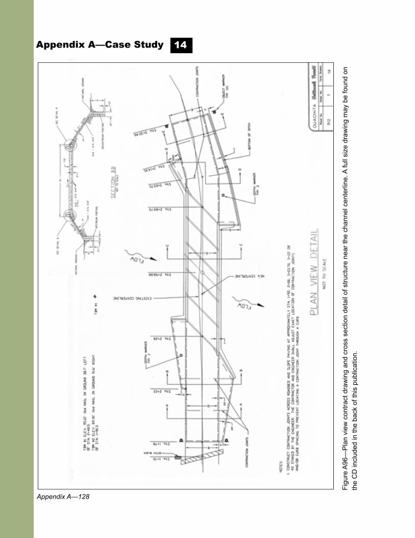
Appendix A—Case Study 14
Fig
ure
A96
—P
lan
view
con
trac
t dra
win
g an
d cr
oss
sect
ion
deta
il of
str
uctu
re n
ear
the
chan
nel c
ente
rline
. A fu
ll si
ze d
raw
ing
may
be
foun
d on
th
e C
D in
clud
ed in
the
back
of t
his
publ
icat
ion.

Appendix A—129
Appendix A—Case Study
Figure A95a is a contract drawing showing the longitudinal profile of the stream. The plan was to allow the embedded boxes to fill in with streambed material naturally over time. However, a large storm during construction overtopped the structure and completely plugged the boxes with construction-generated material and natural bedload. The structure was partially cleaned out, leaving substrate at grade and the streambed has maintained itself. In gravel-bed streams, not filling the embedded culverts during construction could produce a headcut. However, in this case there was no headcutting risk because bedrock is intermittently exposed along and across the channel above and below the crossing.
Given the near-surface bedrock, open-bottom arches might appear to be feasible in these streams; however, they are rarely used, not only because bedrock locations are unpredictable with available technology, but also because the intent is to keep the deck as low as possible to give woody debris the best chance of going over the structure rather than plugging it. Also, even with the occasional need to blast to embed the boxes (as was done here), boxes are generally cheaper. They are strong, reliable structures that survive the worst of storms.
The cost of the replacement in 2004 was $110,000. Note that the curbs on this ford are continuous. Since the ford is the low spot on the road, it retains water on its surface and the curbs do not allow it to drain. In future, the forest plans to add drainholes in the road surface.
14