APPENDIX A HISTORICAL COMPONENT
23
Hickory Bluff Historical Component Appendix A A - 1 Final 2005 APPENDIX A HISTORICAL COMPONENT The historical component of Hickory Bluff was not eligible for the National Register of Historic Places (NRHP) because it lacked intact historical features and cultural material that would contribute to research questions. Archival records of land use and the resultant material record were valuable, however, for aiding in the interpretation of the impacts to the Native American components of the site. The level of effort for archival research was considerably less for Hickory Bluff than for eligible historical sites, but a record of land ownership from the late 1680s to the present was compiled to provide background information for the evaluation of the historical artifact assemblage. Records at the Delaware Public Archives, Kent County Courthouse, the Historical Society of Delaware, and the Kent County Soil Conservation Service, Department of Agriculture Kent County Extension Office, were utilized. Aerial photographs from 1937, 1971, and 1995 were compared to historical maps from 1859, 1868, 1881, and 1893, for correlation to the archival record. The archaeological investigations conducted by Hunter Research on the Puncheon Run Connector were also reviewed and integrated into the current section. ARCHIVAL RESEARCH The parcel that includes Hickory Bluff is located in East Dover Hundred. Isaac and St. Jones River bound East Dover Hundred on the south, by Little Creek on the north, the Delaware River on the east, and by West Dover Hundred on the west. Dover Hundred, created from St. Jones Hundred in 1823, was divided into East and West Dover Hundred in 1859 (Doherty 1997:5). Historically, the St. Jones River has also been referred to as the St. Jones Creek and the Dover River, but the former title has been the most widely accepted and used nomenclature. The St. Jones River drainage was an important waterway in the development of early colonial Delaware. Without the navigational potential of this river, Dover may not have developed into a thriving colonial town or the State Capital. The lands adjacent to the waterways in Delaware were the first land tracts patented in the late 1600s, as well as the first regions that became populated by colonial settlers and European immigrants. Only by the mid- 1700s were the roadways able to support organized overland transportation routes. By then, the road to the east of the Hickory Bluff, now referred to as Route 113, was already established (Kent County Records [KCR] 1711). The first land tract defined in the area of Hickory Bluff was granted to Robert Porter in 1680, along St. Jones Creek (River) (Table A.1). The parcel, known as Porter’s Lodge, was a 400-acre tract surveyed by Ephram Hermann two years before William Penn defined the lower three counties of Pennsylvania that would become known as Delaware (KCR 1680b). A few weeks later, William Berry was granted a 1,000 acre tract named Berry’s Range, which abutted the north side of Porter’s (KCR 1680a) (Figure A.1). The two parcels were two of the earliest tracts surveyed in the Dover area. Porter died in 1693, and Porter’s Lodge was willed to his wife Elizabeth, as well as all of the household “goods and chattels” with the exception of 3 cows, 1 heifer and 1 mare that he devised to his two sons (KCR 1693b). Porter’s estate paid £6 in 1693 (KCR 1693a). Although Elizabeth was supposed to make an inventory of his estate, nothing was included in the public record. Robert French, a Scotchman from upper New Castle County, acquired a portion or all of Porter’s Lodge sometime between 1693, when Robert Porter died, and 1704 (Scharf 1888:1080). In 1704, French transferred 110 acres to the Christ Church, listed as “Curatoribus Ecclesiae” (Scharf 1888:1052; KCR 1870). The provisions of the deed transaction have been, as the original deed was not transcribed in the deed books when they were rewritten in 1812. Scharf (1888:1052) specifically noted in the 1880s that the deed record had been misplaced. Robert French married Mary Sandelands, daughter of James and Ann (Keen) Sandelands. Sandelands had been previously married to Maurice Trent, a mariner in Pennsylvania who died in 1697 (Pennsylvania Magazine 1879). French was a merchant and prominent in the Government of the Lower Delaware Counties. He was a member of the Provincial Council of New Castle County (1699-1700 and 1707); Associate Justice of the Provincial Court (1701); Representative of New Castle County in the General Assembly of the Province (1700); a leader in the
Transcript of APPENDIX A HISTORICAL COMPONENT

Hickory Bluff Historical Component
Appendix A A - 1 Final 2005
APPENDIX A HISTORICAL COMPONENT
The historical component of Hickory Bluff was not eligible for the National Register of Historic Places (NRHP) because it lacked intact historical features and cultural material that would contribute to research questions. Archival records of land use and the resultant material record were valuable, however, for aiding in the interpretation of the impacts to the Native American components of the site. The level of effort for archival research was considerably less for Hickory Bluff than for eligible historical sites, but a record of land ownership from the late 1680s to the present was compiled to provide background information for the evaluation of the historical artifact assemblage. Records at the Delaware Public Archives, Kent County Courthouse, the Historical Society of Delaware, and the Kent County Soil Conservation Service, Department of Agriculture Kent County Extension Office, were utilized. Aerial photographs from 1937, 1971, and 1995 were compared to historical maps from 1859, 1868, 1881, and 1893, for correlation to the archival record. The archaeological investigations conducted by Hunter Research on the Puncheon Run Connector were also reviewed and integrated into the current section.
ARCHIVAL RESEARCH
The parcel that includes Hickory Bluff is located in East Dover Hundred. Isaac and St. Jones River bound East Dover Hundred on the south, by Little Creek on the north, the Delaware River on the east, and by West Dover Hundred on the west. Dover Hundred, created from St. Jones Hundred in 1823, was divided into East and West Dover Hundred in 1859 (Doherty 1997:5). Historically, the St. Jones River has also been referred to as the St. Jones Creek and the Dover River, but the former title has been the most widely accepted and used nomenclature.
The St. Jones River drainage was an important waterway in the development of early colonial Delaware. Without the navigational potential of this river, Dover may not have developed into a thriving colonial town or the State Capital. The lands adjacent to the waterways in Delaware were the first land tracts patented in the late 1600s, as well as the first regions that became populated by colonial settlers and European immigrants. Only by the mid-1700s were the roadways able to support organized overland transportation routes. By then, the road to the east of the Hickory Bluff, now referred to as Route 113, was already established (Kent County Records [KCR] 1711).
The first land tract defined in the area of Hickory Bluff was granted to Robert Porter in 1680, along St. Jones Creek (River) (Table A.1). The parcel, known as Porter’s Lodge, was a 400-acre tract surveyed by Ephram Hermann two years before William Penn defined the lower three counties of Pennsylvania that would become known as Delaware (KCR 1680b). A few weeks later, William Berry was granted a 1,000 acre tract named Berry’s Range, which abutted the north side of Porter’s (KCR 1680a) (Figure A.1). The two parcels were two of the earliest tracts surveyed in the Dover area.
Porter died in 1693, and Porter’s Lodge was willed to his wife Elizabeth, as well as all of the household “goods and chattels” with the exception of 3 cows, 1 heifer and 1 mare that he devised to his two sons (KCR 1693b). Porter’s estate paid £6 in 1693 (KCR 1693a). Although Elizabeth was supposed to make an inventory of his estate, nothing was included in the public record.
Robert French, a Scotchman from upper New Castle County, acquired a portion or all of Porter’s Lodge sometime between 1693, when Robert Porter died, and 1704 (Scharf 1888:1080). In 1704, French transferred 110 acres to the Christ Church, listed as “Curatoribus Ecclesiae” (Scharf 1888:1052; KCR 1870). The provisions of the deed transaction have been, as the original deed was not transcribed in the deed books when they were rewritten in 1812. Scharf (1888:1052) specifically noted in the 1880s that the deed record had been misplaced.
Robert French married Mary Sandelands, daughter of James and Ann (Keen) Sandelands. Sandelands had been previously married to Maurice Trent, a mariner in Pennsylvania who died in 1697 (Pennsylvania Magazine 1879). French was a merchant and prominent in the Government of the Lower Delaware Counties. He was a member of the Provincial Council of New Castle County (1699-1700 and 1707); Associate Justice of the Provincial Court (1701); Representative of New Castle County in the General Assembly of the Province (1700); a leader in the

Hickory Bluff Historical Component
Appendix A A - 2 Final 2005
endeavor to achieve independency of the Provincial Government which culminated in an 1709 appeal to Great Britain; and was one of the founders of the Immanuel church in New Castle (Pennsylvania Magazine 1879:217-220).
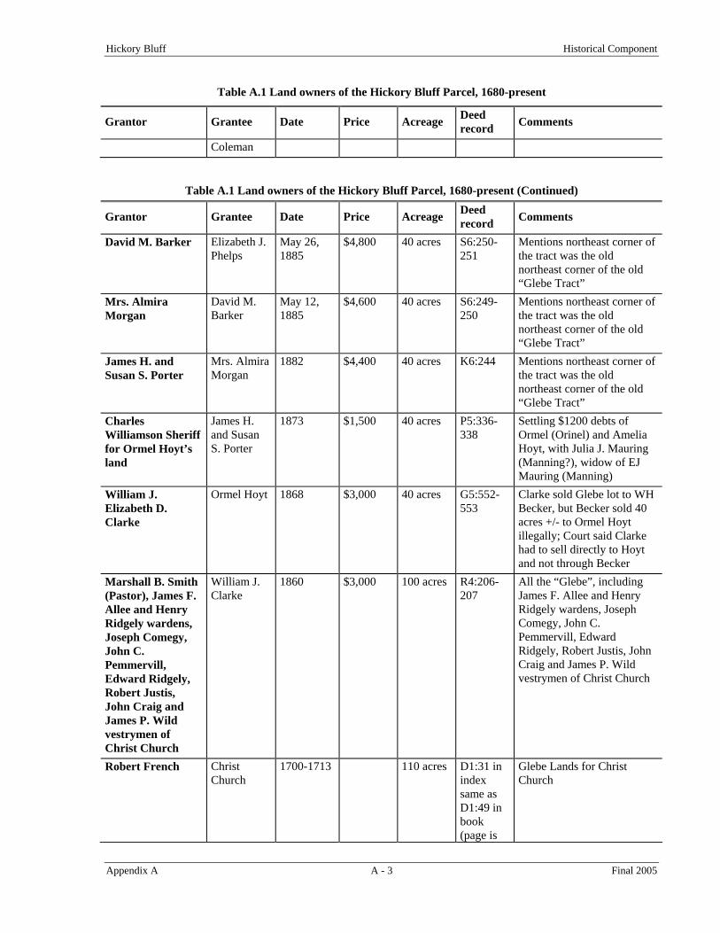
Table A.1 Land owners of the Hickory Bluff Parcel, 1680-present
Grantor Grantee Date Price Acreage Deed record Comments
John G. Wharton, Joshua M. Twilley, David E. Shapiro
State of Delaware
1989 $600,000 40 acres Q46:248 Grantors were trustees under a Liquidating Trust Agreement by Wm Richter et al. as shareholders in Dover Fruit Farms, Inc.; Savitz had died and was replaced by Shapiro
DOVER FRUIT FARMS, INC.
John G. Wharton, Joshua M. Twilley, Joseph H. Savitz
1976 $5.00 40 acres C31:198
William H Richter and wife
DOVER FRUIT FARMS, INC.
1946 $1 for four tracts
40 acres M17:173
Clarence C. Ward and wife
William H. Richter et ux.
1927 $7,000 40 acres H13:314-316
Roy A. Failing and wife
Clarence C. Ward et ux.
1923 $8,000 40 acres K12:422-424
$4600 mortgage, $1200 purchase money mortgage, and $2200 cash
Joseph Smerbeck and wife
Roy A. Failing et ux.
1915 $6,500 40 acres X10:336-338
Danner Brothers bounding on the north
Charles H. Conghenour and wife
Joseph Smerbeck
1912 $6,500 40 acres H10:412-414
Danner Brothers bounding on the north
Gardner P. Thompson and wife
Charles H. Conghenour and wife
1910 $6,000 40 acres Z9:62-64 Danner Brothers bounding on the north
George G. Turner Gardner P. Thompson and wife
1909 $6,000 40 acres I9:220-222
Charles B. Prettyman and wife
George G. Turner
1892 $2,000 40 acres K7:327-328
Henry Marquardt and wife
Charles B. Prettyman
December 7, 1891
$6,500 40 acres I7:214-215
William and Harriet Coleman
Henry Marquardt
May 25, 1891
$5,600 40 acres H7:423-424
Stephen Phelps and wife
William and Harriet
November 24, 1885
$5,050 40 acres U6:218-219
Hickory Bluff Historical Component
Appendix A A - 3 Final 2005
Table A.1 Land owners of the Hickory Bluff Parcel, 1680-present
Grantor Grantee Date Price Acreage Deed record Comments
Coleman
Table A.1 Land owners of the Hickory Bluff Parcel, 1680-present (Continued)
Grantor Grantee Date Price Acreage Deed record Comments
David M. Barker Elizabeth J. Phelps
May 26, 1885
$4,800 40 acres S6:250-251
Mentions northeast corner of the tract was the old northeast corner of the old “Glebe Tract”
Mrs. Almira Morgan
David M. Barker
May 12, 1885
$4,600 40 acres S6:249-250
Mentions northeast corner of the tract was the old northeast corner of the old “Glebe Tract”
James H. and Susan S. Porter
Mrs. Almira Morgan
1882 $4,400 40 acres K6:244 Mentions northeast corner of the tract was the old northeast corner of the old “Glebe Tract”
Charles Williamson Sheriff for Ormel Hoyt’s land
James H. and Susan S. Porter
1873 $1,500 40 acres P5:336-338
Settling $1200 debts of Ormel (Orinel) and Amelia Hoyt, with Julia J. Mauring (Manning?), widow of EJ Mauring (Manning)
William J. Elizabeth D. Clarke
Ormel Hoyt 1868 $3,000 40 acres G5:552-553
Clarke sold Glebe lot to WH Becker, but Becker sold 40 acres +/- to Ormel Hoyt illegally; Court said Clarke had to sell directly to Hoyt and not through Becker
Marshall B. Smith (Pastor), James F. Allee and Henry Ridgely wardens, Joseph Comegy, John C. Pemmervill, Edward Ridgely, Robert Justis, John Craig and James P. Wild vestrymen of Christ Church
William J. Clarke
1860 $3,000 100 acres R4:206-207
All the “Glebe”, including James F. Allee and Henry Ridgely wardens, Joseph Comegy, John C. Pemmervill, Edward Ridgely, Robert Justis, John Craig and James P. Wild vestrymen of Christ Church
Robert French Christ Church
1700-1713 110 acres D1:31 in index same as D1:49 in book (page is
Glebe Lands for Christ Church


Hickory Bluff Historical Component
Appendix A A - 5 Final 2005
Christ Church retained the lands for over 100 years. A new church was constructed in Dover, beginning in 1734 and finished by 1740 (Scharf 1888:1053). The purpose of the glebe lands from 1704 to the eve of the Civil War was to provide money for the church, but no records exist to describe the activities that actually occurred on the tract. More than likely the land was farmed and a portion of the profits given to the Church. An 1859 map illustrated the lands were still in possession of the Church, labeled "glebe" (Figure A.3).
The 1730s brick church in Dover was in great need of repair by 1859. Many of the years between 1704 and 1859, Christ’s Church had been without a minister and the congregation had dwindled, and a rebirth of the Church was needed. In 1860, the minister, wards, and vestrymen of Christ Church sold the entire glebe to William J. Clarke for $3,000, and $1,800 went for the repairs on the church in Dover (Figure A.4; KCR 1860:206-207; Baynard n.d.:8).
Figure A.2 Location of the Glebe Lands and Christ Church,
Given by Robert French from Porter's Lodge Tract

Hickory Bluff Historical Component
Appendix A A - 6 Final 2005
HickoryBluff Site
Figure A.3 Portion of the 1859 Byles Map of Dover showing the location of the Glebe Lands
The 1860 Agricultural Census for Dover Hundred (Page 1, line 10) listed William J Clarke as having 100 acres valued at $3,000, with $75 for farming implements, two horses, two milk cows, four swine ($300 for all livestock), 1,000 bushels of Indian corn, 300 bushels of oats, 50 bushels of Irish potatoes, $50 for slaughtered animals, and no orchard products. Clarke sold the 100- acre tract to William H. Becker in 1868 (KCR1873:552-555). However, before the deed record had been drawn and signed, Becker sold almost 40 acres to Orimel (Ormel) Hoyt. The court said that was illegal and Clarke had to sell the 40 acres directly to Hoyt, with Becker getting the remainder of the "glebe" lands (KCR 1873:552-553). The basic configuration of the parcel that Hoyt received remained the same until the State of Delaware bought the land in 1989 (Figure A.5).
Figure A.4 William J. Clarke Lands Purchased in 1860 from the Christ Church Glebe

Hickory Bluff Historical Component
Appendix A A - 7 Final 2005
Figure A.5 The Hoyt Tract Purchased from William J. Clarke in 1868
The 1868 Beers Atlas reflected that William Becker owned or lived just to the south of the tract that Hoyt bought from Clarke (Figure A.5). James P. Wild owned the tract to the north, which presently contains the DelDOT Headquarters and other state office buildings (Figure A.6).
The 1870 Federal Agricultural Census for Kent County (Page 22, Line 26) listed Orimel Hoyt as having 40 acres valued at $3,000, with $165 for farm implements, one horse, one milk cow, two swine ($110 value for all livestock), 100 bushels of Indian corn, 40 bushels of oats, 40 bushels of Irish potatoes ($150 for produce of market gardens), six gallons of molasses, and a value of $276 for all betterments and improvements. No mention of any orchard products was recorded in the census for the Hoyt tract.
The farm could not be located on the 1880 Federal Agricultural Census, after Hoyt lost the land to tax debt. Subsequent agricultural censuses have periodically been destroyed by decree of the U.S. Congress (U.S. Congress 1912). From 1873 to 1912, the tract changed ownership ten times, until Joseph Smerbeck purchased the land (KCR 1912:412-414). During that time frame, a fruit orchard, more specifically an apple orchard, was established at Hickory Bluff and Route 113. Kent County tax assessment records did not yield information on the historical activities on the land tract, and therefore, do not aid in providing a specific date for the origin of the apple orchard. However, statistics indicate that almost 90 percent of Delaware apple trees were planted between 1905 and 1924 (Gabriel 1953:9-10). Therefore, the earliest date the orchard was planted was probably not much earlier than 1905. The Farm Journal of 1913 listed the farm, owned then by Joseph and Margaret Smerbeck, as containing 45 acres and producing fruits and grapes, narrowing the date of origin from 1905 to 1913 (Atkinson 1913:55).
Hickory Bluff Historical Component
Appendix A A - 8 Final 2005
Figure A.6 The 1868 Beers Atlas Map for Dover Hundred Showing Hoyt and Wild tracts
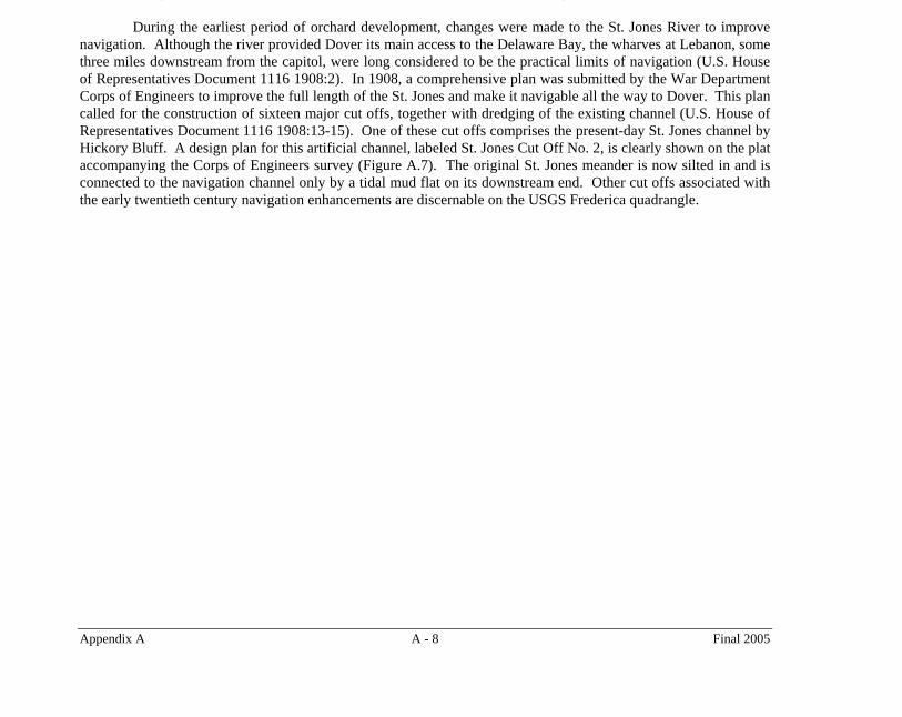
During the earliest period of orchard development, changes were made to the St. Jones River to improve navigation. Although the river provided Dover its main access to the Delaware Bay, the wharves at Lebanon, some three miles downstream from the capitol, were long considered to be the practical limits of navigation (U.S. House of Representatives Document 1116 1908:2). In 1908, a comprehensive plan was submitted by the War Department Corps of Engineers to improve the full length of the St. Jones and make it navigable all the way to Dover. This plan called for the construction of sixteen major cut offs, together with dredging of the existing channel (U.S. House of Representatives Document 1116 1908:13-15). One of these cut offs comprises the present-day St. Jones channel by Hickory Bluff. A design plan for this artificial channel, labeled St. Jones Cut Off No. 2, is clearly shown on the plat accompanying the Corps of Engineers survey (Figure A.7). The original St. Jones meander is now silted in and is connected to the navigation channel only by a tidal mud flat on its downstream end. Other cut offs associated with the early twentieth century navigation enhancements are discernable on the USGS Frederica quadrangle.
Hickory Bluff Historical Component
Appendix A A - 9 Final 2005
Figure A.7 1907 Plan of the St. Jones River Survey
In 1927, William H. Richter and his wife purchased the tract when part of the orchard would have been fully mature, as were many of the fruit orchards of Delaware. The apple orchards of Kent County were concentrated in the Wyoming and Camden regions, only a few miles to the southwest of the site (Figure A.8; Hancock 1976:35; Bausman 1936:24). Richter became a large fruit producer, one of the five or six largest in the immediate vicinity around Dover by 1936.

Hickory Bluff Historical Component
Appendix A A - 12 Final 2005
plowzone was defined to extend from that spot, east towards Route 113 (Liebeknecht et al. 1997). The main house on the survey tract, designated the William Richter House Site 1 (K-1003), burned to the ground in the late 1980s, and the rubble was pushed into the basement area. A nearby structure, William Richter House Site 2, was probably constructed after the 1930s and razed at the same time as the main farmhouse. Neither of the two Richter house complexes was recommended for further archaeological evaluation (Liebeknecht et al. 1997).
During the initial stages of archaeological excavations by Parsons, all prehistoric, historical and modern artifacts were collected. As fieldwork progressed during the Parsons investigations, historical artifacts were sampled. Obviously modern material, such as plastic items, shotgun shells, beer bottles, plastic fence insulators, television tubes, 1960s vintage pennies, and cigarette butts, were no longer noted on field forms/records and were discarded. Architectural materials associated with the surface trash dumps were noted and a sample was collected. Unrecognizable ferrous objects, such as farm implements and parts, were noted and not collected.
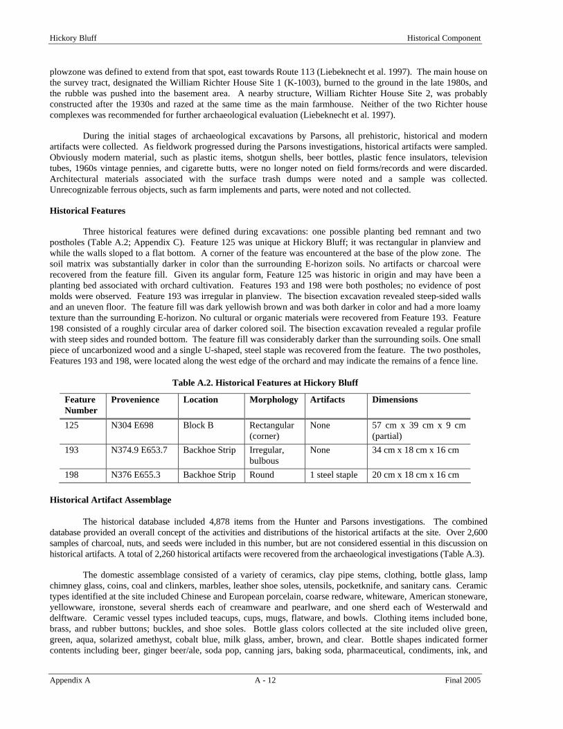
Historical Features
Three historical features were defined during excavations: one possible planting bed remnant and two postholes (Table A.2; Appendix C). Feature 125 was unique at Hickory Bluff; it was rectangular in planview and while the walls sloped to a flat bottom. A corner of the feature was encountered at the base of the plow zone. The soil matrix was substantially darker in color than the surrounding E-horizon soils. No artifacts or charcoal were recovered from the feature fill. Given its angular form, Feature 125 was historic in origin and may have been a planting bed associated with orchard cultivation. Features 193 and 198 were both postholes; no evidence of post molds were observed. Feature 193 was irregular in planview. The bisection excavation revealed steep-sided walls and an uneven floor. The feature fill was dark yellowish brown and was both darker in color and had a more loamy texture than the surrounding E-horizon. No cultural or organic materials were recovered from Feature 193. Feature 198 consisted of a roughly circular area of darker colored soil. The bisection excavation revealed a regular profile with steep sides and rounded bottom. The feature fill was considerably darker than the surrounding soils. One small piece of uncarbonized wood and a single U-shaped, steel staple was recovered from the feature. The two postholes, Features 193 and 198, were located along the west edge of the orchard and may indicate the remains of a fence line.
Table A.2. Historical Features at Hickory Bluff
Feature Number
Provenience Location Morphology Artifacts Dimensions
125 N304 E698 Block B Rectangular (corner)
None 57 cm x 39 cm x 9 cm (partial)
193 N374.9 E653.7 Backhoe Strip Irregular, bulbous
None 34 cm x 18 cm x 16 cm
198 N376 E655.3 Backhoe Strip Round 1 steel staple 20 cm x 18 cm x 16 cm
Historical Artifact Assemblage
The historical database included 4,878 items from the Hunter and Parsons investigations. The combined database provided an overall concept of the activities and distributions of the historical artifacts at the site. Over 2,600 samples of charcoal, nuts, and seeds were included in this number, but are not considered essential in this discussion on historical artifacts. A total of 2,260 historical artifacts were recovered from the archaeological investigations (Table A.3).
The domestic assemblage consisted of a variety of ceramics, clay pipe stems, clothing, bottle glass, lamp chimney glass, coins, coal and clinkers, marbles, leather shoe soles, utensils, pocketknife, and sanitary cans. Ceramic types identified at the site included Chinese and European porcelain, coarse redware, whiteware, American stoneware, yellowware, ironstone, several sherds each of creamware and pearlware, and one sherd each of Westerwald and delftware. Ceramic vessel types included teacups, cups, mugs, flatware, and bowls. Clothing items included bone, brass, and rubber buttons; buckles, and shoe soles. Bottle glass colors collected at the site included olive green, green, aqua, solarized amethyst, cobalt blue, milk glass, amber, brown, and clear. Bottle shapes indicated former contents including beer, ginger beer/ale, soda pop, canning jars, baking soda, pharmaceutical, condiments, ink, and
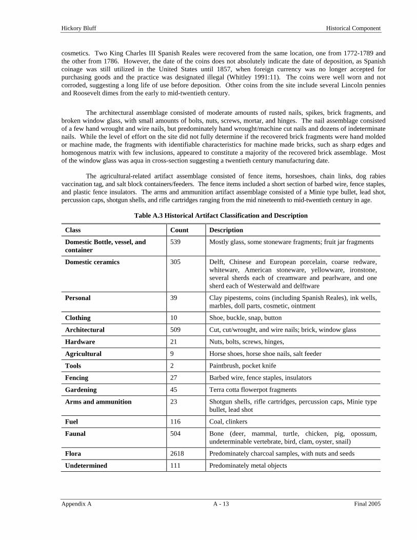
Hickory Bluff Historical Component
Appendix A A - 13 Final 2005
cosmetics. Two King Charles III Spanish Reales were recovered from the same location, one from 1772-1789 and the other from 1786. However, the date of the coins does not absolutely indicate the date of deposition, as Spanish coinage was still utilized in the United States until 1857, when foreign currency was no longer accepted for purchasing goods and the practice was designated illegal (Whitley 1991:11). The coins were well worn and not corroded, suggesting a long life of use before deposition. Other coins from the site include several Lincoln pennies and Roosevelt dimes from the early to mid-twentieth century.
The architectural assemblage consisted of moderate amounts of rusted nails, spikes, brick fragments, and broken window glass, with small amounts of bolts, nuts, screws, mortar, and hinges. The nail assemblage consisted of a few hand wrought and wire nails, but predominately hand wrought/machine cut nails and dozens of indeterminate nails. While the level of effort on the site did not fully determine if the recovered brick fragments were hand molded or machine made, the fragments with identifiable characteristics for machine made bricks, such as sharp edges and homogenous matrix with few inclusions, appeared to constitute a majority of the recovered brick assemblage. Most of the window glass was aqua in cross-section suggesting a twentieth century manufacturing date.
The agricultural-related artifact assemblage consisted of fence items, horseshoes, chain links, dog rabies vaccination tag, and salt block containers/feeders. The fence items included a short section of barbed wire, fence staples, and plastic fence insulators. The arms and ammunition artifact assemblage consisted of a Minie type bullet, lead shot, percussion caps, shotgun shells, and rifle cartridges ranging from the mid nineteenth to mid-twentieth century in age.
Table A.3 Historical Artifact Classification and Description
Class Count Description
Domestic Bottle, vessel, and container
539 Mostly glass, some stoneware fragments; fruit jar fragments
Domestic ceramics 305 Delft, Chinese and European porcelain, coarse redware, whiteware, American stoneware, yellowware, ironstone, several sherds each of creamware and pearlware, and one sherd each of Westerwald and delftware
Personal 39 Clay pipestems, coins (including Spanish Reales), ink wells, marbles, doll parts, cosmetic, ointment
Clothing 10 Shoe, buckle, snap, button
Architectural 509 Cut, cut/wrought, and wire nails; brick, window glass
Hardware 21 Nuts, bolts, screws, hinges,
Agricultural 9 Horse shoes, horse shoe nails, salt feeder
Tools 2 Paintbrush, pocket knife
Fencing 27 Barbed wire, fence staples, insulators
Gardening 45 Terra cotta flowerpot fragments
Arms and ammunition 23 Shotgun shells, rifle cartridges, percussion caps, Minie type bullet, lead shot
Fuel 116 Coal, clinkers
Faunal 504 Bone (deer, mammal, turtle, chicken, pig, opossum, undeterminable vertebrate, bird, clam, oyster, snail)
Flora 2618 Predominately charcoal samples, with nuts and seeds
Undetermined 111 Predominately metal objects
Hickory Bluff Historical Component
Appendix A A - 14 Final 2005
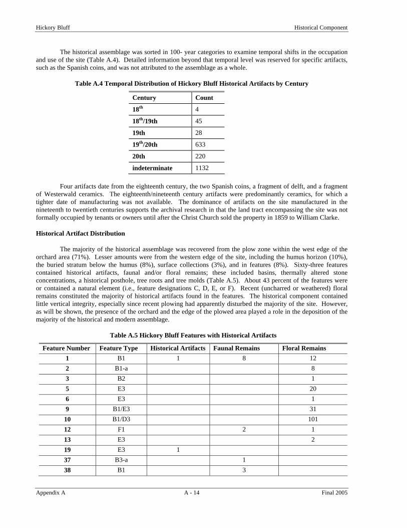
The historical assemblage was sorted in 100- year categories to examine temporal shifts in the occupation and use of the site (Table A.4). Detailed information beyond that temporal level was reserved for specific artifacts, such as the Spanish coins, and was not attributed to the assemblage as a whole.
Table A.4 Temporal Distribution of Hickory Bluff Historical Artifacts by Century
Century Count
18th 4
18th/19th 45
19th 28
19th/20th 633
20th 220
indeterminate 1132
Four artifacts date from the eighteenth century, the two Spanish coins, a fragment of delft, and a fragment of Westerwald ceramics. The eighteenth/nineteenth century artifacts were predominantly ceramics, for which a tighter date of manufacturing was not available. The dominance of artifacts on the site manufactured in the nineteenth to twentieth centuries supports the archival research in that the land tract encompassing the site was not formally occupied by tenants or owners until after the Christ Church sold the property in 1859 to William Clarke.
Historical Artifact Distribution
The majority of the historical assemblage was recovered from the plow zone within the west edge of the orchard area (71%). Lesser amounts were from the western edge of the site, including the humus horizon (10%), the buried stratum below the humus (8%), surface collections (3%), and in features (8%). Sixty-three features contained historical artifacts, faunal and/or floral remains; these included basins, thermally altered stone concentrations, a historical posthole, tree roots and tree molds (Table A.5). About 43 percent of the features were or contained a natural element (i.e., feature designations C, D, E, or F). Recent (uncharred or weathered) floral remains constituted the majority of historical artifacts found in the features. The historical component contained little vertical integrity, especially since recent plowing had apparently disturbed the majority of the site. However, as will be shown, the presence of the orchard and the edge of the plowed area played a role in the deposition of the majority of the historical and modern assemblage.
Table A.5 Hickory Bluff Features with Historical Artifacts
Feature Number Feature Type Historical Artifacts Faunal Remains Floral Remains 1 B1 1 8 12 2 B1-a 8 3 B2 1 5 E3 20 6 E3 1 9 B1/E3 31
10 B1/D3 101 12 F1 2 1 13 E3 2 19 E3 1 37 B3-a 1 38 B1 3

Hickory Bluff Historical Component
Appendix A A - 15 Final 2005
Table A.5 Hickory Bluff Features with Historical Artifacts (Continued)
Feature Number Feature Type Historical Artifacts Faunal Remains Floral Remains 47 D2 1 60 B1 1 63 D2 1 66 D2 1 67 B2 2 77 B1-a 1 5 78 B1-b 1 88 D1 1 90 B1-a 6 93 F1 1
106 D1 2 120 B3-a 1 1 127 D1 1 129 B1-d 2 24 12 134 D1 1 137 B3-a 12 1 139 B2 2 3 169 B1-a 8 172 A1-b 1 173 A1-a 1 180 B2 5 184 B1-a 30 188 E1 2
198 (historical posthole)
B3-b 1
232 B1-c/D3 6 4 233 B2 2 249 A1-a 6 253 B1/D3 2 257 F1/B 10 3 265 B1-c 1 1 267 B3-b/D1 2 273 B1 2 1 275 B1-d 5 3 279 B1 1 288 B1 2 297 A1-a 1 310 D1 2 1 313 B1/D2/D3 1

Hickory Bluff Historical Component
Appendix A A - 16 Final 2005
Table A.5 Hickory Bluff Features with Historical Artifacts (Continued)
Feature Number Feature Type Historical Artifacts Faunal Remains Floral Remains 400 B3-a 1 1 402 B1/D2 50 403 A1-a 6 404 B1-a 202 405 B2 40 406 B1-a/D3 2 55 149 407 B1-a/D3 1 7 214 408 B1-a/F1 9 297 409 B1-a 5 89 410 B1-a 173 411 B1-a 5 32 416 C1 55 419 D2 6
The architectural and domestic artifact classes, artifacts generally associated directly or indirectly with a structure and occupation, constitute 82 percent of the total historical artifacts. However, no historical structural features were encountered during the archaeological investigations, suggesting the artifacts could be the result of a field scatter or several trash dumping episodes, which can be determined from the artifact distributions across the site. A 1937 aerial photograph was used to correlate the archaeological information with landmarks and land use information to help define the site functions (Figure A.11). The access road through the middle of the orchard to the bluff edge was also plotted onto a site map, as well as the western edge of the orchard; both derived from the 1937 aerial photograph (Figure A.12).
Figure A.11 Aerial Photograph from 1937 (DelDOT) with Landmark Features Around the Site
Hickory Bluff Historical Component
Appendix A A - 17 Final 2005
Figure A.12 Hickory Bluff Site Map with the Edge of the Orchard and Orchard/Pasture Road
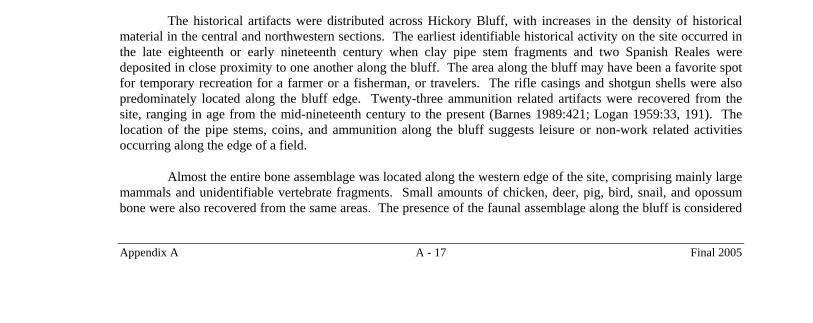
The historical artifacts were distributed across Hickory Bluff, with increases in the density of historical material in the central and northwestern sections. The earliest identifiable historical activity on the site occurred in the late eighteenth or early nineteenth century when clay pipe stem fragments and two Spanish Reales were deposited in close proximity to one another along the bluff. The area along the bluff may have been a favorite spot for temporary recreation for a farmer or a fisherman, or travelers. The rifle casings and shotgun shells were also predominately located along the bluff edge. Twenty-three ammunition related artifacts were recovered from the site, ranging in age from the mid-nineteenth century to the present (Barnes 1989:421; Logan 1959:33, 191). The location of the pipe stems, coins, and ammunition along the bluff suggests leisure or non-work related activities occurring along the edge of a field.
Almost the entire bone assemblage was located along the western edge of the site, comprising mainly large mammals and unidentifiable vertebrate fragments. Small amounts of chicken, deer, pig, bird, snail, and opossum bone were also recovered from the same areas. The presence of the faunal assemblage along the bluff is considered

Hickory Bluff Historical Component
Appendix A A - 18 Final 2005
to be partially natural, from animals dying in the area, and partially cultural, from discarded bone dumped with the trash. The presence of deer bone along the bluff edge combined with the arms and ammunition located in the same region suggests hunting activities. The few fence related artifacts were found closer to the west end of the site, probably to keep people and/or animals out of the orchard.
The remainder of the artifact assemblage is difficult to separate and define by spatial distributions. The architectural and domestic artifacts were located across the entire site, with increases and decreases in both classes in the same areas (Figure A.12). The distributions of the nineteenth and twentieth century artifacts, constituting the majority of the assemblage, correlate with the distributions of almost all other artifact categories, except the faunal, arms and ammunition, clay pipe stems, and coin assemblages. Cut and cut/wrought nails, brick, window glass, coal and clinkers were scattered across the site. Modern architectural debris was also found in the same distribution patterns as the nineteenth-twentieth century artifacts, including small numbers of hinges and Teflon roller door parts and in the same spatial distribution as the other architectural artifacts, suggesting dumping episodes from a razing or remodeling of a nearby structure.
The distribution of historical and modern artifacts appears to relate directly to the presence of the central orchard/pasture road. The terminus of the orchard/pasture road was situated near the higher concentrations of artifacts, particularly the architectural and domestic classes (Figure A.12). Since no evidence in the archival or archaeological record has suggested that a historical structure ever existed on this portion of the land tract, the site artifact distribution most likely relates to utilization as a dump or trash scatter. A wagon or truck could easily have taken a load of trash to what the landowner or tenant probably viewed as the “backside” of the orchard and dumped it directly on the ground without going too far off the established path.
Archival information has indicated that the only historical structures on the parcel were probably constructed no earlier than the 1860s, when William Clarke bought the tract from Christ Church. These buildings were constructed adjacent to Route 113, near the area of the two Richter house sites to the east of Hickory Bluff. After the orchard was constructed in the early 1900s, the potential for a structure being built on that part of the tract is minimal. Therefore, the historical artifact assemblage at Hickory Bluff were situated on what could be referred to as the “backside” of the property from the building complexes, probably accumulated from random dumping from the main building complex to the east. The farmer probably hauled the trash to the bluff edge to remove the trash away from the buildings behind the apple orchard.
HISTORICAL LAND USE
The 1860 and 1870 Federal Agricultural Census returns indicated the tract was largely utilized for grain crops such as oats, Indian corn, and potatoes during the third quarter of the nineteenth century. The first direct evidence of the presence of the orchard was in a 1913 farm directory for Kent County, illustrating the farm was used for fruits and grapes (Atkinson 1913:55). Archival research has indicated the orchard was probably planted sometime between 1905 and 1910. A review of statistics from the region yields data that can aid in further isolating the date of origin for the orchard. Gabriel (1953:9-10) gave the following historical statistics on the apple industry in Delaware and Kent County: 90 percent of Delaware apple trees were planted between 1905-1924; 64 percent of Kent County apple trees were on 20-100 acre farms; and 64 percent of Kent County apple orchards had 1,000-5,000 trees. The data indicates that more than likely the orchard was less than 10 years old in 1913, when it first appeared in the Kent County farm journal. The land tract was almost 40 acres, and contained around 2,000 to 2,200 trees, based on computations of tree spacing from aerial photographs, which would place the orchard within the average acreage and number of fruit trees on apple orchard farms in Kent County during that time period.
The preparation and planting of a fruit orchard was sometimes a lengthy process. Sears (1927:44a) suggested that “an orchard will usually stand from 10 to 100 years” and it was worth the farmer’s time and effort to put some thought into the planning and planting of the orchard. The land was recommended to be cultivated the year before planting an orchard, with a crop that would leave the soils in good condition, such as beans, corn, or potatoes (Sears 1927:45). Few farmers, it is further noted, would agree to planting a crop and waiting a full year to gain a small advantage over just forging ahead and planting (Sears 1927:46). Therefore, plowing the field the fall before planting the orchard was recommended to allow the organics to decay under the surface over the winter (Sears 1927:46-47).

Hickory Bluff Historical Component
Appendix A A - 19 Final 2005
After the soils had weathered a good hard winter, the following spring the surface was smoothed out with a planker, or platform dragged across the surface to level the furrows and high spots (Paddock and Whipple 1913:30-31). The land containing the orchard east of Hickory Bluff is fairly flat and was probably sufficiently level prior to the establishment of the orchard without too much need of a leveling operation. Once leveled, the orchard could be planned with great precision.
The cornerstone to a successful operating orchard was the spacing between the trees. The capital needed to start an orchard greatly depended upon the number of saplings to be planted and the more trees the farmer could crowd into his field, the better. However, there was a certain spacing that had to be maintained to allow for the trees to mature and produce high yields. A.J. Downing (1855:60) stated that fruit trees should be placed approximately 40 feet apart, but a few years later, in 1869, it was suggested that maximum placement was at 12 feet apart between trees in a row, and 16 feet apart between rows (Quinn 1869:26).
Rectangular and hexagonal orchard planting configurations were both available to farmers. Both patterns were present in the orchard in the 1937 aerial photograph of the Hickory Bluff vicinity. Trees planted in a square or rectangular pattern at a 30-foot spacing could accommodate up to 48 trees to the acre. Hexagonal planting could incorporate up to 15 percent more trees per acre (up to 55 trees) than the rectangular system (Paddock and Whipple 1913:42; Figure A.13). The square or rectangular method of planting was apparently the most satisfactory method of planting an orchard (Paddock and Whipple 1913:42). The hexagonal method did not have wide middle areas and could not accommodate large, modern, orchard machinery (Paddock and Whipple 1913:42). To get a maximum of 55 trees to an acre, and still use the square or rectangular system, journals suggested a distance of 26 feet between trees and 30 feet between rows, although some journals recommended spacing as wide as 50 feet for apples (Paddock and Whipple 1913:46).
Farmers were discouraged from planting filler trees, or trees planted within the larger pattern sequence, to be pulled and replanted as the other trees matured. Most farmers, it was suggested, “lacked the courage” to pull a filler tree if it was able to still produce a crop, damaging the shape of the permanent tree in the process (Paddock and Whipple 1913:46). Apples could be kept on site longer without immediate shipping, which relaxed the time frame between picking and shipping.
A 1926 Army Air Corp aerial photograph for the site indicated that only the eastern part was contained within a fruit orchard, which extended only halfway between the St. Jones River and Highway 113 (Figure A.14). Only a rectangular planting scheme was utilized on the Richter farm at that time. The fruit trees in the photograph probably represent the trees mentioned in the 1913 farm journal. The eastern part of the property has been plowed for an unidentifiable crop. The bluff edge above the St. Jones River contained few trees and some brush, and was apparently not utilized by the farmer.
A 1937 DelDOT aerial photograph for the site indicated the eastern part of the site was contained within an orchard, which extended the entire length of the tract from the rim above St. Jones Creek to Route 113 (Figure A.15). The patterning of the trees shows both rectangular and hexagonal planting was utilized on the Richter farm. The growth of the trees suggests that the portion of the orchard covering the site was several years old in 1937.
An aerial photograph taken just prior to the construction of SR 1 and the complete destruction of the orchard in 1995 (from Terraserver) illustrated that the orchard was very old by that time and in disrepair (Figure A.16). The fruit stand was still present by the highway but the two Richter houses had been razed. The eastern half of the tract was cultivated and used to grow vegetables to help supplement the farmer’s income since the condition of the orchard was obviously in steep decline. The owner probably tried to get as much out of the fruit farm as possible with as little upkeep as necessary before the impending highway construction.

Hickory Bluff Historical Component
Appendix A A - 20 Final 2005
Figure A.13 Schematic of the Hexagonal Tree Planting Pattern for an Orchard Circa 1913
Figure A.14 The Richter Orchard in a Rare 1926 Army Air Corp Aerial Photograph

Hickory Bluff Historical Component
Appendix A A - 21 Final 2005
Figure A.15 1937 Aerial Photograph (DelDOT) Showing Extent of Orchard West of Highway 113
The major land use for the land tract containing Hickory Bluff was for orchard and vegetable production since the early 1900s. While the land was probably cultivated prior to that time, the archival records do not differentiate between that tract and other acreage encompassed by the owners described in the tax and census records. The historical artifacts from the site probably originated at the main house complex and were discarded along the bluff or the “backside” of the property, with the exception of the clay pipe stems and Spanish coins. The latter artifacts predated the orchard and probably predated the earliest cultivation of the property when the Christ Church group owned the land.
Hickory Bluff
Figure A.16 1995 Aerial Photograph of the Orchard, Just Prior to Demolition

Hickory Bluff Historical Component
Appendix A A - 22 Final 2005
REFERENCES CITED
Atkinson, W. 1913 The Farm Journal, Farm Directory of Kent County, Delaware, 1913. Wilmer Atkinson Company,
Philadelphia, Pennsylvania.
Barnes, Frank C. 1989 Cartridges of the World, 6th edition. DBI Books, Inc., Northbrook, Illinois.
Bausman, R.O. 1936 Economic Study of Land Utilization in Kent County, Delaware. University of Delaware, Agricultural
Experiment Station, Newark, Delaware.
Baynard, P.G. n.d. Christ Church Rectory: A History. Privately published.
Beers, D.G. 1868 Atlas of the State of Delaware. Pomeroy & Beers, Philadelphia. Available on microfiche at the Delaware
State Archives, Dover.
Byles, A. D. 1859 Map of Kent County, Delaware. Philadelphia.
De Valinger, L., Jr. and V.E. Shaw 1948 A Calendar of Ridgely Family Letters 1742-1899 in the Delaware State Archives. Published by the
Ridgely Family for the Public Archives Commission.
Delaware Department of Transportation (DelDOT) 1937 Aerial photograph of the Blackbird, Delaware area. Photograph no. AHQ-31-11.
Doherty, Thomas P. 1997 Delaware Genealogical Research Guide. Delaware Geneaological Society, Dover, Delaware.
Downing, A.J. 1855 The Fruits and Fruit Trees of America. John Wiley, New York.
Federal Agricultural Census for Kent County 1870 Orimel Hoyt. Page 22, Line 26. Kent County Agricultural Census Records. On microfilm at the Delaware
Public Archives, Dover, Delaware.
Gabriel, H.S. 1953 The Marketing of Delaware Early Apples. Bulletin No. 185, University of Delaware Agricultural Station,
Newark, Delaware.
Hancock, H. 1976 A History of Kent County Delaware. Dover Litho Printing Company, Dover, Delaware.
Kent County Records (KCR) 1680a Deed Book A-1:29, on file at the Delaware Public Archives, Dover, Delaware.
1680b Warranty Book A, entry 33, on file at the Delaware Public Archives, Dover, Delaware.
1693a Tax Assessment of Robert Porter. Tax Assessment Book, on file at the Delaware Public Archives, Dover, Delaware.

Hickory Bluff Historical Component
Appendix A A - 23 Final 2005
1693b Will of Robert Porter. Will Book A1:5, on file at the Delaware Public Archives, Dover, Delaware.
1700-1713 Deed Book D1:49, on file at the Delaware Public Archives, Dover, Delaware.
1711 Deed Book D1:87-88, on file at the Delaware Public Archives, Dover, Delaware.
1860 Deed Book R4:206-207, on file at the Delaware Public Archives, Dover, Delaware.
1870 Deed Book Index 1673-1870, on file at the Delaware Public Archives, Dover, Delaware.
1873 Deed Book G5:552-555, on file at the Delaware Public Archives, Dover, Delaware.
1882 Deed Book K6:244, on file at the Delaware Public Archives, Dover, Delaware.
1885a Deed Book S6:249-250, on file at the Delaware Public Archives, Dover, Delaware.
1885b Deed Book S6:250-251, on file at the Delaware Public Archives, Dover, Delaware.
1885c Deed Book U6:218-219, on file at the Delaware Public Archives, Dover, Delaware.
1891a Deed Book H7:423-424, on file at the Delaware Public Archives, Dover, Delaware.
1891b Deed Book I7:214-215, on file at the Delaware Public Archives, Dover, Delaware.
1892 Deed Book K7:327-328, on file at the Delaware Public Archives, Dover, Delaware.
1909 Deed Book I9:220-222, on file at the Delaware Public Archives, Dover, Delaware.
1910 Deed Book Z9:62-64, on file at the Delaware Public Archives, Dover, Delaware.
1912 Deed Book H10:412-414, on file at the Delaware Public Archives, Dover, Delaware.
1915 Deed Book X10:336-338, on file at the Delaware Public Archives, Dover, Delaware.
1923 Deed Book K12:422-424, on file at the Delaware Public Archives, Dover, Delaware.
1946 Deed Book M17:173, on file at the Delaware Public Archives, Dover, Delaware.
1976 Deed Book C31:198, on file at the Delaware Public Archives, Dover, Delaware.
1989 Deed Book Q46:248, on file at the Delaware Public Archives, Dover, Delaware.
Liebekneckt, W., R. Hunter, I. Burrow, M. Tompkins, P. Madrigal, B. Blades, G. Mellin, F. Dunsmore, S. Fehrenbach, B. Seidel, and J. Schuldenrein
1997 Puncheon Run Connector, Dover, Kent County, Delaware, Phase I and II Archaeological Data Recovery (First Phase), The Puncheon Run Site (7K-C-51), The Hickory Bluff Prehistoric Site (7K-C-411), The Dawson House Site (7K-C-414), the Nixon Mill Site (7K-C-413). Report prepared for the Delaware Department of Transportation.
Logan, H.C. 1959 Cartridges – A Pictorial Digest of Small Arms Ammunitions. Bonanza Books, New York.
New Advent 1999 Catholic Encyclopedia at website www.newadvent.org.

Hickory Bluff Historical Component
Appendix A A - 24 Final 2005
New Castle County Will Book 1713 Will of Robert French. Will Book C1:1-9, on file at the Delaware Public Archives, Dover, Delaware.
Paddock, Wendell and Orville B. Whipple 1913 Fruit-growing in Arid Regions. The Macmillan Company, New York.
Pennsylvania Magazine 1879 Robert French. Volume III: 217-220. Pennsylvania Magazine of History and Biography. Published by the
Historical Society of Pennsylvania, Philadelphia, Pennsylvania. 1877-1951.
Quinn, P.T. 1869 Pear Culture for Profit. The Tribune Associates, New York.
Scharf, J. T. 1888 History of Delaware, 1609-1888. Kennikat Press, New York.
Sears, Fred C. 1927 Lippincott’s Farm Manuals, Productive Orcharding – Modern Methods of Growing and Marketing Fruit.
J.B. Lippincott Company, Philadelphia, Pennsylvania.
United States Congress 1912 Federal House Document 460. Passed by the 67th U.S. Congress on January 17, 1912.
United States House of Representatives 1908 Letter from the Secretary of War Transmitting with a Letter From the Chief of Engineers, Reports of
Examination and Survey of the Saint Jones River, Delaware, From its Mouth to Dover. 60th Congress, second session, Document Number 1116. Copy on file at the Delaware State Archives, Dover.
Whitley, C.A. 1991 The Monetary Material Culture of Plantation Life: A Study of Coins at Monticello. Unpublished Thesis
for Master of Arts in the Department of Anthropology, College of William and Mary, Williamsburg, Virginia.