APPENDIX A DETAILED PROJECT LISTS AND COSTS · Appendix A: Detailed Project Lists and Costs Final...
96
Appendix A: Detailed Project Lists and Costs Final Draft Berkeley Pedestrian Master Plan A-1 January 2010 APPENDIX A DETAILED PROJECT LISTS AND COSTS Table 1: 100 High Priority Intersections ................................................................................................................ 2 Table 2: Methodology Used to Rank Intersections.............................................................................................. 6 Table 3: Major Sidewalk Gaps ................................................................................................................................. 9 Table 4: Installation of Truncated Domes........................................................................................................... 12 Table 5: Installation of Perpendicular Curb Ramps ........................................................................................... 15 Table 6: Priority Intersections for Signal Timing ............................................................................................... 16 Table 7: Countdown Signal Heads........................................................................................................................ 17 Table 8: Installation of Audible Signals Along Corridors ................................................................................. 18 Table 9: High Visibility Crosswalk Installation at Uncontrolled Locations ................................................... 19 Table 10: Standard Crosswalk and Advance Warning ....................................................................................... 20 Table 11: Painted Red Curb Installation at Crosswalks on Arterials ............................................................... 21 Table 12: Speed Feedback Sign Installation ........................................................................................................ 21 Table 13: Safe Routes to School Priorities .......................................................................................................... 22 Table 14: Pathway and Stairway Improvements ................................................................................................. 25 Table 15: Multi-Use Path Projects ........................................................................................................................ 26 Table 16: Signalized Intersections with the Highest Pedestrian Collision Rate ............................................. 27 Table 17: Signals Proposed in Berkeley Bicycle Master Plan Appendix F ..................................................... 30 Table 18: Related Improvements Proposed in Berkeley Bicycle Master Plan Appendix F ......................... 31
Transcript of APPENDIX A DETAILED PROJECT LISTS AND COSTS · Appendix A: Detailed Project Lists and Costs Final...
Appendix A: Detailed Project Lists and Costs
Final Draft Berkeley Pedestrian Master Plan A-1 January 2010
APPEND IX A DETAILED PROJECT LISTS AND COSTS
Table 1: 100 High Priority Intersections ................................................................................................................ 2 Table 2: Methodology Used to Rank Intersections .............................................................................................. 6 Table 3: Major Sidewalk Gaps ................................................................................................................................. 9 Table 4: Installation of Truncated Domes........................................................................................................... 12 Table 5: Installation of Perpendicular Curb Ramps ........................................................................................... 15 Table 6: Priority Intersections for Signal Timing ............................................................................................... 16 Table 7: Countdown Signal Heads ........................................................................................................................ 17 Table 8: Installation of Audible Signals Along Corridors ................................................................................. 18 Table 9: High Visibility Crosswalk Installation at Uncontrolled Locations ................................................... 19 Table 10: Standard Crosswalk and Advance Warning ....................................................................................... 20 Table 11: Painted Red Curb Installation at Crosswalks on Arterials ............................................................... 21 Table 12: Speed Feedback Sign Installation ........................................................................................................ 21 Table 13: Safe Routes to School Priorities .......................................................................................................... 22 Table 14: Pathway and Stairway Improvements ................................................................................................. 25 Table 15: Multi-Use Path Projects ........................................................................................................................ 26 Table 16: Signalized Intersections with the Highest Pedestrian Collision Rate ............................................. 27 Table 17: Signals Proposed in Berkeley Bicycle Master Plan Appendix F ..................................................... 30 Table 18: Related Improvements Proposed in Berkeley Bicycle Master Plan Appendix F ......................... 31

Appendix A: Detailed Project Lists and Costs
A-2 Final Draft Berkeley Pedestrian Master Plan January 2010
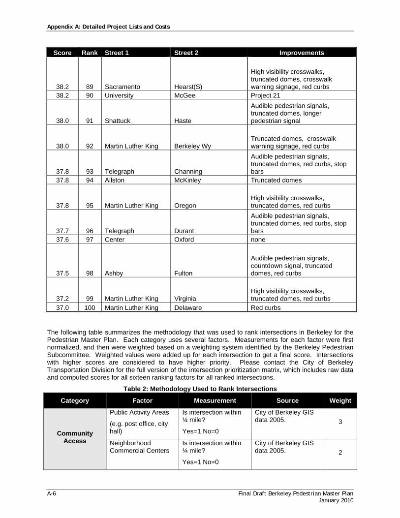
Table 1: 100 High Priority Intersections The following table lists the top 100 highest priority intersections for pedestrian amenities in the City of Berkeley. This list was developed based on five categories: community access, transit connectivity, usage and demand, safety, and support and need. In general, an intersection ranks higher on the list if it is close to community amenities and transit stops, if it has high numbers of pedestrians, if it has a high number of pedestrian collisions, and if it was identified by the public or in adopted city plans as a location in need of pedestrian improvements. Only intersections along arterial streets were included in the analysis. Details on how the five categories were measured are provided after the table of top 100 intersections. Please contact the City of Berkeley Transportation Division for the full version of the intersection prioritization matrix, which includes raw data and computed scores for all ranked intersections. The recommended improvements column lists improvements recommended in this plan for each intersection. In some cases, there are few additional improvements that can be made to an intersection to improve the pedestrian environment.
Score Rank Street 1 Street 2 Improvements 57.0 1 University 10th Project 1 55.4 2 University Shattuck(W) Project 2 54.3 3 Ashby Otis Project 3
53.1 4 Shattuck Allston Truncated domes, stop bars 52.9 5 University 6th Project 1 52.6 6 Sacramento University Project 4 52.2 7 University Acton Project 5 51.7 8 San Pablo University Project 1
51.6 9 Shattuck Bancroft Truncated domes, stop bars 51.3 10 University 9th Project 1
51.1 11 Shattuck Kittredge Truncated domes, stop bars 49.7 12 University Martin Luther King Project 6 49.4 13 University Milvia Project 7 48.9 14 Ashby California Project 8 48.7 15 Adeline Alcatraz Project 9
48.0 16 Shattuck Durant Truncated domes, perpendicular curb ramps, stop bars
47.5 17 Shattuck Channing Longer pedestrian signal, truncated domes, stop bars
47.3 18 University 7th Project 1
47.2 19 Shattuck Hearst Project 10 47.1 20 Shattuck Stuart Project 11
47.1 21 San Pablo Allston Project 12 47.1 22 Shattuck Russell Project 11

Appendix A: Detailed Project Lists and Costs
Final Draft Berkeley Pedestrian Master Plan A-3 January 2010
Score Rank Street 1 Street 2 Improvements 47.1 23 Ashby Martin Luther King Project 3 46.9 24 Bancroft Oxford/Fulton Project 13 46.8 25 Martin Luther King Addison Project 6 46.7 26 The Alameda Solano Project 14 46.6 27 Oxford Hearst None
46.1 28 Shattuck Vine Project 10 46.0 29 University 8th Project 1 45.5 30 San Pablo Addison(N) Project 12 45.5 31 Martin Luther King Allston Project 6 45.3 32 Ashby Adeline Project 3
45.1 33 Shattuck Center Truncated domes, stop bars
45.1 34 Shattuck Addison(E) Truncated domes, stop bars
45.1 35 Shattuck Addison(W) Truncated domes, stop bars
45.1 36 Martin Luther King Center
Audible pedestrian signals, truncated domes, red curbs, stop bars
45.0 37 Shattuck Oregon Truncated domes
44.8 38 San Pablo Addison(S) Project 12
44.5 39 Martin Luther King Russell
Speed feedback sign, audible pedestrian signals, truncated domes, red curbs, stop bars
44.4 40 Ashby Shattuck Truncated domes, perpendicular curb ramps, red curbs
44.2 41 San Pablo Delaware Project 15
44.1 42 University Chestnut
High visibility crosswalks, truncated domes, crosswalk warning signage, red curbs
44.1 43 University Curtis
High visibility crosswalks, truncated domes, crosswalk warning signage, red curbs
44.0 44 Sacramento Addison Project 4
43.9 45 Martin Luther King Haste
Audible pedestrian signals, countdown signal, truncated domes, red curbs, stop bars
43.8 46 Dwight Milvia Truncated domes, red curbs 43.8 47 Shattuck Berkeley Wy Project 16 43.5 48 University Grant Project 17

Appendix A: Detailed Project Lists and Costs
A-4 Final Draft Berkeley Pedestrian Master Plan January 2010
Score Rank Street 1 Street 2 Improvements
43.5 49 Shattuck Virginia Project 10
43.3 50 Bancroft Dana
Sidewalk gap fill, truncated domes, crosswalk warning signage, red curbs
43.2 51 University Bonita Truncated domes, crosswalk warning signage, red curbs
43.2 52 San Pablo Ashby Project 8 43.1 53 Addison Milvia Red curbs
43.0 54 Ashby Colby Truncated domes, stop bars 42.6 55 College Russell Project 18
42.4 56 Shattuck Lincoln Project 10
42.1 57 Ashby Deakin
High visibility crosswalks, truncated domes, crosswalk warning signage, red curbs
42.0 58 Martin Luther King Bancroft
Longer pedestrian signal, countdown signal, audible pedestrian signals, truncated domes, red curbs, stop bars
42.0 59 Shattuck Delaware Project 10
41.5 60 University Shattuck(E) High visibility crosswalks, truncated domes, red curbs
41.4 61 Bancroft Ellsworth
High visibility crosswalks, truncated domes, crosswalk warning signage, red curbs
41.4 62 Dwight Shattuck Audible pedestrian signals, countdown signal, stop bars
41.3 63 Adeline Oregon Longer pedestrian signal, red curbs
41.0 64 San Pablo Hearst
High visibility crosswalks, crosswalk warning signage, red curbs
40.9 65 San Pablo Bancroft Project 12
40.8 66 University Bonar Audible pedestrian signal, red curbs
40.8 67 Ashby Sacramento Project 8
Appendix A: Detailed Project Lists and Costs
Final Draft Berkeley Pedestrian Master Plan A-5 January 2010
Score Rank Street 1 Street 2 Improvements
40.8 68 Shattuck Francisco Project 10 40.7 69 Shattuck Ward Project 11 40.6 70 Martin Luther King Hopkins Project 19
40.4 71 Martin Luther King Channing
Longer pedestrian signal, truncated domes, red curbs, stop bars
40.3 72 Adeline Stuart Truncated domes, red curbs 40.1 73 Milvia Berkeley None 40.0 74 Adeline Woolsey Project 3
40.0 75 University Oxford Audible pedestrian signals, red curbs, stop bars
39.8 76 College Ashby Project 18
39.7 77 Adeline Harmon Truncated domes, crosswalk warning signage, red curbs
39.6 78 Shattuck Woolsey Project 20
39.6 79 University Jefferson
High visibility crosswalks, truncated domes, crosswalk warning signage, red curbs
39.6 80 Dwight Piedmont Perpendicular curb ramps, stop bars
39.3 81 Ashby Mabel Project 8
39.2 82 Shattuck Cedar Project 10
39.2 83 Alcatraz King Truncated domes, longer pedestrian signal
39.1 84 Addison Browning None
38.9 85 Dwight Telegraph
Audible pedestrian signals, perpendicular curb ramps, truncated domes, red curbs
38.5 86 Adeline Essex Project 3
38.4 87 Ashby King
Longer pedestrian signals, countdown signal, audible pedestrian signals, truncated domes, perpendicular curb ramps, red curbs
38.2 88 Sacramento Hearst(N)
High visibility crosswalks, truncated domes, crosswalk warning signage, red curbs
Appendix A: Detailed Project Lists and Costs
A-6 Final Draft Berkeley Pedestrian Master Plan January 2010
Score Rank Street 1 Street 2 Improvements
38.2 89 Sacramento Hearst(S)
High visibility crosswalks, truncated domes, crosswalk warning signage, red curbs
38.2 90 University McGee Project 21
38.0 91 Shattuck Haste
Audible pedestrian signals, truncated domes, longer pedestrian signal
38.0 92 Martin Luther King Berkeley Wy Truncated domes, crosswalk warning signage, red curbs
37.8 93 Telegraph Channing
Audible pedestrian signals, truncated domes, red curbs, stop bars
37.8 94 Allston McKinley Truncated domes
37.8 95 Martin Luther King Oregon High visibility crosswalks, truncated domes, red curbs
37.7 96 Telegraph Durant
Audible pedestrian signals, truncated domes, red curbs, stop bars
37.6 97 Center Oxford none
37.5 98 Ashby Fulton
Audible pedestrian signals, countdown signal, truncated domes, red curbs
37.2 99 Martin Luther King Virginia High visibility crosswalks, truncated domes, red curbs
37.0 100 Martin Luther King Delaware Red curbs
The following table summarizes the methodology that was used to rank intersections in Berkeley for the Pedestrian Master Plan. Each category uses several factors. Measurements for each factor were first normalized, and then were weighted based on a weighting system identified by the Berkeley Pedestrian Subcommittee. Weighted values were added up for each intersection to get a final score. Intersections with higher scores are considered to have higher priority. Please contact the City of Berkeley Transportation Division for the full version of the intersection prioritization matrix, which includes raw data and computed scores for all sixteen ranking factors for all ranked intersections.
Table 2: Methodology Used to Rank Intersections
Category Factor Measurement Source Weight
Community Access
Public Activity Areas
(e.g. post office, city hall)
Is intersection within ¼ mile?
Yes=1 No=0
City of Berkeley GIS data 2005. 3
Neighborhood Commercial Centers
Is intersection within ¼ mile?
Yes=1 No=0
City of Berkeley GIS data 2005. 2

Appendix A: Detailed Project Lists and Costs
Final Draft Berkeley Pedestrian Master Plan A-7 January 2010
Category Factor Measurement Source Weight
Parks Is intersection within ¼ mile?
Yes=1 No-0
City of Berkeley GIS data 2005. 3
Senior Centers and Disabled Community Resources
Is intersection within ¼ mile?
Yes=1 No-0
City of Berkeley GIS data 2005. 6
Schools Number of schools within ¼ mile.
City of Berkeley GIS data 2005. 6
Transit Connectivity
Multi-Modal BART/ Amtrak Stations
Number of stations within ½ mile.
City of Berkeley GIS data 2005. 9
Multi-Modal AC Transit Trunk Stops
Number of stops within ¼ mile.
City of Berkeley GIS data 2005. 6
Multi-Modal AC Transit Local Stops
Number of stops within 1/8 mile.
City of Berkeley GIS data 2005. 4
Usage and Demand
Journey to Work Percent of people living within 1/8 mile who walk to work.
Census 2000 3
Estimated Pedestrian Flows
Estimated number of pedestrians per hour during weekday mid-day.
Space Syntax Model (See Appendix D) 6
Population Density Number of people living within 1/8 mile.
Census 2000 6
Safety
Number of Collisions Number of police-reported collisions within 400 feet of intersection.
Statewide Integrated Traffic Records System 2000-2005 collision data.
12
Ped Exposure/ Ped Flows
Number of collisions divided by the estimated pedestrian volumes.
Statewide Integrated Traffic Records System, Space Syntax
15
Traffic Volumes Estimated average peak hour traffic volumes on one leg of intersection.
City of Berkeley Pavement Management System Traffic Counts (1983-2003)
6
Support and Need
Existing Plan Is the intersection identified as part of an existing plan adopted by the City of Berkeley?
Yes = 1 No=2
Review of plans
7

Appendix A: Detailed Project Lists and Costs
A-8 Final Draft Berkeley Pedestrian Master Plan January 2010
Category Factor Measurement Source Weight
Public Comment Was the intersection identified by the public as one that should be considered for pedestrian improvements?
1 point for every mention
Public comments received during plan development (2005-2008)
6

Appendix A: Detailed Project Lists and Costs
Final Draft Berkeley Pedestrian Master Plan A-9 January 2010
Table 3: Major Sidewalk Gaps
5’ Sidewalk $45 Total Cost $1,660,968
Street Cross Street 1 Cross Street 2 Length (FT) Cost
2ND CAMELIA CAMELIA 64.7 $2,9122ND CAMELIA GILMAN 602.7 $27,1232ND CAMELIA GILMAN 576.5 $25,9412ND CAMELIA PAGE 401.4 $18,0622ND CEDAR JONES 387.9 $17,4562ND CEDAR VIRGINIA 628.6 $28,2892ND HARISSON HARRISON 60.6 $2,7252ND HEARST VIRGINIA 1090.0 $49,0512ND JONES PAGE 410.9 $18,4882ND PAGE JONES 391.5 $17,6162ND UNIVERSITY ADDISON 433.8 $19,5212ND UNIVERSITY ADDISON 426.5 $19,1942ND VIRGINIA CEDAR 622.2 $27,9972ND VIRGINIA HEARST 1083.5 $48,7558TH CAMELIA GILMAN 170.0 $7,6498TH GILMAN CAMELIA 204.4 $9,1968TH GILMAN CAMELIA 233.2 $10,4958TH HARRISON CITY OF ALBANY 135.0 $6,0778TH HARRISON CITY OF ALBANY 37.3 $1,6769TH FOLGER MURRAY 258.9 $11,6499TH FOLGER MURRAY 245.6 $11,0539TH POTTER ASHBY 94.1 $4,236ADELINE 62ND 62ND 21.4 $962ADELINE ASHBY EMERSON 23.2 $1,043ARLINGTON INDIAN ROCK MENDOCINO 16.3 $732ARLINGTON INDIAN ROCK MENDOCINO 16.3 $734ARLINGTON SAN LUIS SANTA BARBARA 10.3 $464ARLINGTON SANTA BARBARA BOYNTON 17.7 $796ARLINGTON SANTA BARBARA SANTA BARBARA 17.3 $779ASHBY ELMWOOD ASHBY 332.7 $14,972BAKER FAIRVIEW 66TH 226.1 $10,174BATEMAN WOOLSEY PRINCE 197.0 $8,863BAY AHSBY POTTER 445.5 $20,049BAY I 80 OFF RAMP COEMERYVILLE 41.1 $1,851BROOKSIDE CLAREMONT CLAREMONT 196.6 $8,849BROOKSIDE CLAREMONT CLAREMONT 215.7 $9,708BURNETT MABEL PARK 220.0 $9,901CEDAR EASTSHORE 2ND 293.7 $13,215CEDARWOOD HARRISON PARK 297.5 $13,387CEDARWOOD HARRISON PARK 330.8 $14,888COLUSA MONTEREY LOS ANGELES 43.3 $1,950CONTRA COSTA LOS ANGELES SOLANO 120.3 $5,415CURTIS ROSE HOPKINS 21.9 $985

Appendix A: Detailed Project Lists and Costs
A-10 Final Draft Berkeley Pedestrian Master Plan January 2010
Street Cross Street 1 Cross Street 2 Length (FT) Cost EAST APPROACH TO I 80 BIKE PED BRIDGE I 80 BOLIVAR 457.0 $20,563EASTSHORE CEDAR JONES 57.0 $2,564EASTSHORE CEDAR JONES 387.4 $17,431EASTSHORE GILMAN HARRISON 143.8 $6,469EASTSHORE GILMAN HARRISON 447.3 $20,126EASTSHORE GILMAN PAGE 197.3 $8,877EASTSHORE GILMAN PAGE 846.7 $38,101EASTSHORE HARRISON CITY OF ALBANY 617.5 $27,789EASTSHORE HARRISON CITY OF ALBANY 629.8 $28,340EASTSHORE HARRISON HARRISON 53.8 $2,423EASTSHORE JONES JONES 39.2 $1,766EASTSHORE JONES PAGE 394.9 $17,770EASTSHORE PAGE PAGE 54.1 $2,433EASTSHORE VIRGINIA CEDAR 617.4 $27,783EASTSHORE VIRGINIA VIRGINIA 59.7 $2,687HARRISON 6TH 7TH 252.8 $11,378HARRISON 6TH 7TH 308.8 $13,896HARRISON 7TH 7TH 56.6 $2,548HARRISON 7TH 8TH 293.3 $13,200HARRISON CEDARWOOD 3RD 129.4 $5,822HOPKINS CURTIS ROSE 34.5 $1,551HOPKINS HOPKINS CURTIS 23.9 $1,077I 80 BIKE PED BRIDGE I 80 I 80 229.5 $10,325I80 EAST (OFF RAMP) UNIVERSITY HEARST VIRGINIA 1055.6 $47,504I80 WEST (OFF RAMP) UNIVERSITY FRONTAGE INTERSTATE 80 192.9 $8,680JONES 4TH 3RD 277.3 $12,479JONES 4TH 3RD 272.4 $12,256LAUREL SAN PEDRO TACOMA 240.5 $10,824LAUREL SAN PEDRO TACOMA 227.1 $10,218LAUREL TACOMA CAPISTRANO 227.1 $10,220LAUREL TACOMA CAPISTRANO 212.6 $9,565MARTIN LUTHER KING JR 62ND 63RD 275.6 $12,402MENDOCINO SOLANO ARLINGTON 340.7 $15,333OFF REGENTS ASHBY RUSSELL 443.7 $19,965PAGE 2ND EASTSHORE 263.6 $11,861PAGE 3RD 2ND 304.3 $13,692PALM STUART KELSEY 40.5 $1,822PALM STUART KELSEY 114.9 $5,169PALM STUART KELSEY 150.2 $6,757PARK 4TH CEDARWOOD 188.1 $8,464PARK 4TH CEDARWOOD 246.2 $11,078PERALTA SOLANO CAPISTRANO 79.6 $3,584PERALTA THOUSAND OAKS COLUSA 107.8 $4,850POTTER BAY ON RAMP 731.7 $32,928POTTER BAY ON RAMP 745.4 $33,545ROSE CURTIS HOPKINS 17.5 $787SACRAMENTO HEARST N HEARST S 16.6 $747SAN ANTONIO ARLINGTON AVIS 206.8 $9,304

Appendix A: Detailed Project Lists and Costs
Final Draft Berkeley Pedestrian Master Plan A-11 January 2010
Street Cross Street 1 Cross Street 2 Length (FT) Cost SAN FERNANDO THOSUAND OAKS CONTRA COSTA 200.7 $9,031SAN LUIS ARLINGTON AVIS 213.4 $9,602SAN LUIS AVIS SAN ANTONIO 396.1 $17,826SAN LUIS SAN ANTONIO AVIS 731.3 $32,910SAN MATEO INDIAN ROCK SAN MATEO END 57.0 $2,567SOJOURNER TRUTH WARD SJ TRUTH END 412.8 $18,577SOJOURNER TRUTH WARD SJ TRUTH END 437.8 $19,701SOLANO PERALTA PERALTA 8.9 $402SOLANO PERALTA TACOMA 127.4 $5,732SOLANO TULARE ALBANY 1.5 $68SOMERSET SOUTHAMPTON DEVON 98.7 $4,439SOMERSET SOUTHAMPTON DEVON 153.7 $6,918SOUTHERN PACIFIC GRAYSON GRAYSON 191.8 $8,631STANNAGE CITY OF ALBANY HARRISON 40.1 $1,803STANNAGE CITY OF ALBANY HARRISON 7.6 $342TEVLIN GILMAN TEVLIN END 132.9 $5,979TEVLIN GILMAN TEVLIN END 129.8 $5,839TEVLIN GILMAN WATKINS 241.0 $10,847THE ALAMEDA YOSEMTIE YOSEMITE 44.2 $1,990THOUSAND OAKS PERALTA COLUSA 38.3 $1,721UNIVERSITY 2ND 3RD 613.0 $27,585UNIVERSITY 2ND 3RD 633.5 $28,506UNIVERSITY 8TH 9TH 278.4 $12,529UNIVERSITY FRONTAGE BERKELEY MARINA 1308.4 $58,878UNIVERSITY FRONTAGE BERKELEY MARINA 1212.0 $54,539UNIVERSITY INTERSTATE 80 EASTSHORE 26.5 $1,194UNIVERSITY INTERSTATE 80 EASTSHORE 99.4 $4,474UNIVERSITY INTERSTATE 80 FRONTAGE ROAD 89.7 $4,035UNIVERSITY INTERSTATE 80 177.5 $7,989UNIVERSITY INTERSTATE 80 84.1 $3,785UNIVERSITY MARINA MARINA 178.7 $8,042UNIVERSITY MARINA MARINA 102.6 $4,616UNIVERSITY MARINA MARINA 252.1 $11,344UNIVERSITY MARINA MARINA 58.8 $2,647UNIVERSITY MARINA MARINA 246.0 $11,069VIRGINIA 2ND 3RD 276.2 $12,427VIRGINIA 2ND 3RD 276.3 $12,435VIRGINIA EASTSHORE 2ND 246.0 $11,072WEST ADDISON ALLSTON 637.8 $28,700WEST DELAWARE HEARST 330.6 $14,879WEST APPROACH TO I 80 BIKE PED BRIDGE FRONTAGE I 80 754.8 $33,966YOSEMITE SAN FERNANDO CONTRA COSTA 388.9 $17,502 Total 36,910 $1,660,968

Appendix A: Detailed Project Lists and Costs
A-12 Final Draft Berkeley Pedestrian Master Plan January 2010
Table 4: Installation of Truncated Domes
INSTALLATION OF TRUNCATED DOMES (PAGE 1 OF 3)
Main Street Side Street Domes Needed Main Street Side Street Domes
Needed Adeline Woolsey 2 Cedar Kains 3
Fairview 2 Cornell 4 BART mid-block 2 Sacramento 4 Essex 2 Stannage 4 Oregon 4 Bonita 4 Stuart 4 Spruce 4 Russell 6 Walnut 4 Alcatraz 8 Milvia 4 Harmon 8 Oxford 4 Cost $30,400 Chestnut 4 Belvedere 4
Alcatraz Ellis 2 4th 4 Dover 2 Curtis 4 Baker 2 McGee 4 California 4 Grant 4 King 4 California 4 Cost $11,200 5th 4 Acton 4
Allston McKinley 1 10th 4 Cost $800 Martin Luther King 4 Arch 4
Ashby King 3 9th 4
Colby 3 Ohlone Crossing (mid-block) 4
Deakin 4 Cost $72,800 Mabel 4 California 4 Claremont Claremont Crest 2 Benvenue 4 Brookside 2 Fulton 4 Eton 2 Hillegass 4 Hillcrest 2 Regent 4 Prince 2 Domingo 4 The Uplands 4 Claremont 8 Cost $11,200 Adeline 12 Cost $46,400 College Garber 2 Webster (N) 2
Bancroft Mid-Block 2 Webster (S) 2 Ellsworth 2 Prince 2 Barrows 2 Stuart (N) 2
Dana 4 Mid-Block bwtn Ashby/Russell 2
Bowditch 4 Derby (S) 3 Piedmont 6 Derby (N) 3 Oxford/Fulton 7 Parker (N) 3 Cost $21,600 Haste 4 Alcatraz 4 Dwight 4 Channing 4 Durant 4 Woolsey 4 Cost $36,000

Appendix A: Detailed Project Lists and Costs
Final Draft Berkeley Pedestrian Master Plan A-13 January 2010
INSTALLATION OF TRUNCATED DOMES (PAGE 2 OF 3)
Main Street Side Street Domes Needed Main Street Side Street Domes
Needed
Dwight Curtis 1 Martin Luther King Jr BART entry mid-block 2
Waring 2 Russell 2 Bowditch 2 Prince 2 Hillegass 2 Stuart 2 Benvenue 2 Ward 2 8th 2 Blake 2 Valley 2 Carleton 2 Acton 2 Center 3 Browning 2 Haste 3 Grant 3 Bancroft 3 Fulton 3 Berkeley Wy 3 Dana 3 University 4 7th 3 Ashby 4 Martin Luther King 4 Hearst 4 Sacramento 4 Dwight 4 Milvia 4 Rose 4 Ellsworth 4 Cedar 4 College 4 Allston 4 9th 4 Channing 4 McGee 4 Oregon 4 6th 4 Delaware 4 4th 4 Virginia 4 Mid- Block (Alta Bates) 2 Francisco 4 Cost $53,600 Derby 4 Parker 4
Gilman Stannage 1 Berryman 4 Cornell 1 Vine 4 Hopkins 2 Adeline 5 Acton 2 Cost $76,000 Ordway 2 Northside 2 Rose Edith 3 Kains 2 California 3 Talbot 2 Grant 4 Evelyn 2 Cost $8,000 Peralta 4 Neilson 4 Sacramento Prince 1 10th 4 Blake 1 Cost $22,400 Tyler 2 Woolsey 2
Henry Eunice 3 Fairview 2 Berryman 4 Berkeley Wy 2 Cost $5,600 Carleton 2 Parker 2 Russell 4 Hearst (N) 4 Hearst (S) 4 Cedar 4 Channing 4 Bancroft 4 Ward 4 Hopkins 5 Cost $37,600

Appendix A: Detailed Project Lists and Costs
A-14 Final Draft Berkeley Pedestrian Master Plan January 2010
INSTALLATION OF TRUNCATED DOMES (PAGE 3 OF 3)
Main Street Side Street Domes Needed Main Street Side Street Domes
Needed Shattuck Channing 1 Telegraph Prince (S) 2
Carleton 1 Ward 3 Derby 1 Channing 4 Parker 1 Durant 4 Emerson 2 Haste 4 Delaware 2 Stuart 4 Lincoln 2 Oregon 4 Essex 2 Blake 4 Prince 2 Bancroft 4 French Hotel Mid-Block 2 Howe 4 Safeway Mid-Block 2 Dowling 4 Francisco 3 Russell 4 Hearst 4 Carleton 4 Ashby 4 Webster 4 Cedar 4 Derby 4 Berkeley Wy 4 Woolsey 4 Oregon 4 Dwight 6 Russell 4 Cost $53,600 Virginia 4 Vine 4 The Alameda Monterey 4 Woolsey 4 Marin 5 Durant 8 Cost $7,200 Allston 8 Kittredge 8 University Jefferson 2 Bancroft 8 Curtis 2 Addison (E) 8 Chestnut 2 Addison (W) 8 Shattuck(E) 3 Center 8 10th 4 Haste 8 6th 4 Cost $96,800 9th 4 Milvia 4
Shattuck Place Rose 8 7th 4
Cost $6,400 Bonita 4 8th 4
Solano Modoc 1 Oxford 4 Ensenada 4 Cost $32,800 Cost $4,000 Virginia California 4
Sutter Yolo 2 Cost $3,200 Cost $1,600 Total Domes 799 Cost per dome $800 Total Cost $639,200

Appendix A: Detailed Project Lists and Costs
Final Draft Berkeley Pedestrian Master Plan A-15 January 2010
Table 5: Installation of Perpendicular Curb Ramps Main Street Side Street Ramps
Needed Main Street Side Street Ramps Needed
Addison Jefferson 1 Sacramento Tyler 1 Cost $5,000 Woolsey 1 Fairview 2 Ashby Piedmont 2 Rose 2 Pine 2 Prince 3
Martin Luther King 4 University 4
Shattuck 4 Allston 4 Sacramento 4 Harmon 4 Cost $80,000 Ashby 4 Russell 4 Bancroft Piedmont 1 Dwight 4 Cost $5,000 Alcatraz 4 Cost $185,000 Cedar 6th 4 Cost $20,000 San Pablo University 4 Addison (S) 4 College Haste 4 Cedar 4 Ashby 4 Allston 4 Alcatraz 4 Delaware 4 Cost $60,000 Dwight 4 Ashby 4 Dwight Piedmont 1 Gilman 4 Warring 2 Cost $160,000
Martin Luther King 4
Sacramento 4 Shattuck Durant 2 Cost $55,000 Hearst 4 Ashby 4 Gilman Santa Fe 2 Cedar 4 8th 4 Cost $70,000 6th 4 Cost $50,000 Telegraph Dwight 4 Cost $20,000 Henry Eunice 1 Cost $5,000 University Shattuck(W) 4
Martin Luther King 4
Martin Luther King Jr
University 4 Cost $40,000
Ashby 4 Hearst 4 Total Ramps 179 Dwight 4 Cost per corner $5,000 Hopkins 4 Total Cost $895,000 Rose 4 Cedar 4 Cost $140,000

Appendix A: Detailed Project Lists and Costs
A-16 Final Draft Berkeley Pedestrian Master Plan January 2010
Table 6: Priority Intersections for Signal Timing
Intersections Adjacent to Senior Centers Street 1 Street 2 Martin Luther King, Jr. Hearst 6th Hearst Adeline Oregon Shattuck Channing Sacramento Ashby Shattuck Hearst Sacramento Dwight Sacramento Alcatraz 9th University Acton University Shattuck Haste Martin Luther King, Jr. Dwight Claremont Derby Adeline Ward
Intersections Adjacent to Elementary Schools Street 1 Street 2 King Ashby 6th University Martin Luther King, Jr. Channing Claremont Ashby Domingo Ashby Martin Luther King, Jr. Bancroft Colusa Solano Colusa Tacoma Sacramento Rose Eunice Henry/Sutter

Appendix A: Detailed Project Lists and Costs
Final Draft Berkeley Pedestrian Master Plan A-17 January 2010
Table 7: Countdown Signal Heads
COUNTDOWN SIGNAL HEADS Signal Heads Cost $800
Ranking Main Street Cross Street Number of Heads Cost 1 University 6th 8 $6,400 2 University 9th 8 $6,400 3 Shattuck Ward 2 $1,600 4 Martin Luther King Jr Haste 4 $3,200 5 Martin Luther King Jr Bancroft 8 $6,400 6 Dwight Shattuck 8 $6,400 7 Dwight Fulton 4 $3,200 8 Shattuck Vine 8 $6,400 9 Dwight Ellsworth 6 $4,800 10 Martin Luther King Jr Derby 8 $6,400 11 Ashby Fulton 6 $4,800 12 Dwight San Pablo 8 $6,400 13 Telegraph Blake 8 $6,400 14 Dwight Dana 4 $3,200 15 Martin Luther King Jr Adeline 6 $4,800 16 College Channing 8 $6,400 17 Telegraph Webster 8 $6,400 18 College Durant 8 $6,400 19 Ashby Domingo 8 $6,400 20 Ashby 7th 6 $4,800 21 Claremont The Uplands 6 $4,800
Total Cost $112,000

Appendix A: Detailed Project Lists and Costs
A-18 Final Draft Berkeley Pedestrian Master Plan January 2010
Table 8: Installation of Audible Signals Along Corridors
Adeline San Pablo Martin Luther King, Jr Gilman
Cedar Ashby Delaware
Domingo Addison Fulton Allston Mabel Dwight
Grayson Claremont Ashby
Uplands Ashby Shattuck
Rose College Vine Ashby Cedar Dwight Hearst Haste Haste
Channing Dwight Durant Ward
Dwight Solano Fulton Colusa
Ellsworth Dana Telegraph
Woolsey Martin Luther King, Jr Ashby
Hopkins Derby Rose Dwight Cedar Haste Center Channing Allston Durant
Bancroft Bancroft Haste Dwight The Alameda Derby Solano
Russell Marin Ashby
University Sacramento 9th
Hopkins Bonar Rose Acton Cedar California
Delaware Oxford Dwight Ashby Audible Signal Cost/Corner $1,000
Alcatraz Total Corners 63 Total Cost $63,000
Appendix A: Detailed Project Lists and Costs
Final Draft Berkeley Pedestrian Master Plan A-19 January 2010
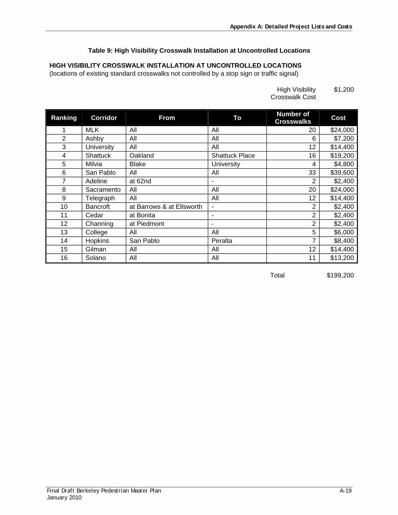
Table 9: High Visibility Crosswalk Installation at Uncontrolled Locations
HIGH VISIBILITY CROSSWALK INSTALLATION AT UNCONTROLLED LOCATIONS (locations of existing standard crosswalks not controlled by a stop sign or traffic signal)
High Visibility
Crosswalk Cost $1,200
Ranking Corridor From To Number of Crosswalks Cost
1 MLK All All 20 $24,000 2 Ashby All All 6 $7,200 3 University All All 12 $14,400 4 Shattuck Oakland Shattuck Place 16 $19,200 5 Milvia Blake University 4 $4,800 6 San Pablo All All 33 $39,600 7 Adeline at 62nd - 2 $2,400 8 Sacramento All All 20 $24,000 9 Telegraph All All 12 $14,400 10 Bancroft at Barrows & at Ellsworth - 2 $2,400 11 Cedar at Bonita - 2 $2,400 12 Channing at Piedmont - 2 $2,400 13 College All All 5 $6,000 14 Hopkins San Pablo Peralta 7 $8,400 15 Gilman All All 12 $14,400 16 Solano All All 11 $13,200
Total $199,200

Appendix A: Detailed Project Lists and Costs
A-20 Final Draft Berkeley Pedestrian Master Plan January 2010
Table 10: Standard Crosswalk and Advance Warning STANDARD CROSSWALK AND ADVANCE WARNING SIGNAGE IMPROVEMENTS ON CORRIDORS
Rank Arterial Corridor From To
Corridor Intersections needing signage
Corridor Sign Costs at $200 X 2 per Intersection
1 Martin Luther King, Jr All All 8 $3,200 2 Ashby All All 5 $2,000 3 University All All 12 $4,800 4 Shattuck Oakland Shattuck Place 11 $4,400 5 Milvia Blake University 5 $2,000 6 San Pablo All All 10 $3800 7 Adeline All All 5 $2,000 8 Sacramento All All 8 $3,200 9 Telegraph All All 1 $400 10 Bancroft Oxford Piedmont 5 $2,000 11 Cedar Walnut Martin Luther King, Jr 2 $800 12 Channing Oxford Piedmont 4 $1,600 13 College All All 4 $1,600 14 Durant Oxford Piedmont 4 $1,600 15 Hopkins San Pablo Peralta 3 $1,200 16 Claremont Ashby Oakland limits 2 $800 17 Gilman All All 6 $2,400 18 Solano All All 3 $1,200 Total 107 $39,000

Appendix A: Detailed Project Lists and Costs
Final Draft Berkeley Pedestrian Master Plan A-21 January 2010
Table 11: Painted Red Curb Installation at Crosswalks on Arterials
PAINTED RED CURB INSTALLATION AT CROSSWALKS ON ARTERIALS Red Stripe Cost $2
Ranking Arterial Corridor From To Total Crosswalks Cost
1 Martin Luther King, Jr All All 57 $9,1202 Ashby All All 82 $13,1203 University All All 68 $10,8804 Shattuck Oakland limits Shattuck Place 68 $10,8805 Milvia Blake University 20 $3,2006 San Pablo All All 71 $11,3607 Adeline All All 17 $2,7208 Sacramento All All 66 $10,5609 Telegraph All All 37 $5,92010 Bancroft Oxford Piedmont 16 $2,56011 Cedar Walnut Martin Luther King, Jr 11 $1,76012 Channing Oxford Piedmont 15 $2,40013 College All All 39 $6,24014 Durant Oxford Piedmont 13 $2,08015 Hopkins San Pablo Peralta 13 $2,08016 Claremont Ashby Oakland limits 24 $3,84017 Gilman All All 52 $8,32018 Solano All All 15 $2,400
Total $109,440
Table 12: Speed Feedback Sign Installation
Sacramento (northbound) south of Harmon cost per sign $10,000 Arlington (southbound) north of Mendocino total signs 7 Dwight Way (eastbound) west of California total cost $70,000 Telegraph (northbound) south of Stuart Alcatraz (eastbound) west of California MLK (northbound) south of Russell Claremont (northbound) south of Hazel source: City of Berkeley Transportation Department. Pending Council Approval Feb 2008. Additional Locations to Consider Adeline Corridor Ashby Corridor Cedar Street MLK south of Dwight Sacramento Corridor University Corridor Virginia and Shattuck Virginia and Oxford Henry and Berryman

Appendix A: Detailed Project Lists and Costs
A-22 Final Draft Berkeley Pedestrian Master Plan January 2010
Table 13: Safe Routes to School Priorities
The following table lists the Safe Routes to School Priorities in the City of Berkeley. This list was developed based on the 100 highest priority intersections listed in Table 1 of this Appendix. Intersections listed in the 100 highest priorities which are within 500 feet of a school are listed below as candidates for Safe Routes to School Priorities.
SAFE ROUTES TO SCHOOL PRIORITIES Street 1 Street 2 Improvements Note
1 University 6th Signal timing Project 1
2 University 7th
Truncated domes, curb ramps, pedestrian refuges, ladder crosswalks, lighting Project 1
3 University 8th
Truncated domes, curb ramps, pedestrian refuges, ladder crosswalks, lighting Project 1
4 Martin Luther King Allston Audible pedestrian signals Project 6
5 Shattuck Virginia
Bulbouts, MUTCD Assembly B signage, pedestrian activated flashers Project 10
6 Shattuck Lincoln Bulbouts, MUTCD Assembly B signage Project 10
7 Shattuck Francisco Restripe crosswalk, median nose, consider bulbout Project 10
8 Shattuck Cedar Yield signage, restrict right turns on red Project 10
9 Shattuck Ward Bulbouts Project 11
10 San Pablo Delaware
Bulbouts, Cross on (Pedestrian Symbol) Signal signage, median noses, pedestrian scaled luminaries, pedestrian scaled lighting, street trees Project 15
11 Martin Luther King Hopkins
Pedestrian refuge, bulbouts, pedestrian push buttons and actuated walk phase Project 19
12 University McGee
Bulbouts, perpendicular curb ramps, truncated domes, in-roadway yield to pedestrian signs Project 21
13 Martin Luther King Center
Audible pedestrian signals, truncated domes, red curbs, stop bars
14 University Chestnut
High visibility crosswalks, truncated domes, crosswalk warning signage, red curbs
15 University Curtis
High visibility crosswalks, truncated domes, crosswalk warning signage, red curbs
16 Martin Luther King Haste
Audible pedestrian signals, countdown signal, truncated domes, red curbs, stop bars

Appendix A: Detailed Project Lists and Costs
Final Draft Berkeley Pedestrian Master Plan A-23 January 2010
SAFE ROUTES TO SCHOOL PRIORITIES Street 1 Street 2 Improvements Note
17 Bancroft Dana
Sidewalk gap fill, truncated domes, crosswalk warning signage, red curbs
18 Ashby Deakin
High visibility crosswalks, truncated domes, crosswalk warning signage, red curbs
19 Martin Luther King Bancroft
Longer pedestrian signal, countdown signal, audible pedestrian signals, truncated domes, red curbs, stop bars
20 Bancroft Ellsworth
High visibility crosswalks, truncated domes, crosswalk warning signage, red curbs
21 University Bonar Audible pedestrian signal, red curbs
22 Martin Luther King Channing
Longer pedestrian signal, truncated domes, red curbs, stop bars
23 Adeline Stuart Truncated domes, red curbs
24 University Jefferson
High visibility crosswalks, truncated domes, crosswalk warning signage, red curbs
25 Ashby King
Longer pedestrian signals, countdown signal, audible pedestrian signals, truncated domes, perpendicular curb ramps, red curbs
27 Allston McKinley Truncated domes
Appendix A: Detailed Project Lists and Costs
A-24 Final Draft Berkeley Pedestrian Master Plan January 2010

Appendix A: Detailed Project Lists and Costs
Final Draft Berkeley Pedestrian Master Plan January 2010
Table 14: Pathway and Stairway Improvements
Name From To Status Priority Est. Cost Halkin Walk Cragmont Euclid Unbuilt High 30,000Halkin Walk Euclid Hilldale Unbuilt High 30,000Keeler Walk Grizzly Peak Creston Unbuilt High 5,000Shasta Walk Keeler Shasta Unbuilt High 1,000Tilden Path Shasta Grizzly Peak Unbuilt High 1,000Parnassus Path Buena Vista Parnassus Ct. Unbuilt High 10,000Columbia Path Queens Columbia Circle Unbuilt High 10,000Columbia Path Campus Queens Unbuilt High 10,000Harding Path Campus Harding Circle Unbuilt High 1,000Wilson Path Campus Olympus Unbuilt High 5,000Northgate Path Shasta Quail Unbuilt High 20,000Devon Lane San Diego Southampton Unbuilt Medium 1,000Miller Path West Miller Grizzly Peak Unbuilt Medium 10,000Miller Path East Grizzly Peak Creston Unbuilt Medium 10,000Cragmont Path Cragmont Keeler Unbuilt Medium 1,000Hill Path Grizzly Peak Hill Unbuilt Medium 5,000Twain Path Sterling/Twain Whitaker Unbuilt Medium 1,000Path 71 Sterling Miller Unbuilt Medium 30,000Path 80 Hillview Wildcat Canyon Unbuilt Medium 1,000Delmar Path Delmar Glendale Unbuilt Medium 1,000Grizzly Path Grizzly Peak Summit Unbuilt Medium 1,000Summit Path Grizzly Peak Summit Unbuilt Medium 1,000Avenida Path Avenida Grizzly Peak Unbuilt Medium 5,000Hilgard Path End of Hilgard La Vereda Unbuilt Medium 10,000Twain Way Cragmont Keeler Unbuilt Lower 30,000Path 74 Woodside Wildcat Canyon Unbuilt Lower 1,000Rose Glen Alley Rose Glen Part-built Lower 1,000 Total $232,000

Appendix A: Detailed Project Lists and Costs
A-26 Final Draft Berkeley Pedestrian Master Plan January 2010
Table 15: Multi-Use Path Projects MULTI-USE PATH PROJECTS
Name From To Cost 9th Street Connector Path Heinz Ashby $550,000Santa Fe Right of Way Path Virginia Ohlone Greenway $875,000Bay Trail Gilman N. City Limit $150,000 Total $1,575,000

Appendix A: Detailed Project Lists and Costs
Final Draft Berkeley Pedestrian Master Plan A-27 January 2010
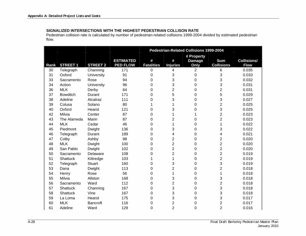
Table 16: Signalized Intersections with the Highest Pedestrian Collision Rate
Section 6.3.1 Signage and Striping recommends the following improvements to these intersections: Stop Bars 5 feet back from crosswalk: 87 intersections x 4 bars per intersection x $300 per bar = $104,400
SIGNALIZED INTERSECTIONS WITH THE HIGHEST PEDESTRIAN COLLISON RATE Pedestrian collision rate is calculated by number of pedestrian-related collisions 1999-2004 divided by estimated pedestrian flow.
Pedestrian-Related Collisions 1999-2004
Rank STREET 1 STREET 2 ESTIMATED PED FLOW
# Fatalities
# Injuries
# Property Damage
Only Sum
Collisions Collisions/
Flow 1 MLK Allston 38 0 10 0 10 0.263 2 College Ashby 42 0 7 0 7 0.167 3 Shattuck Cedar 59 0 7 0 7 0.119 4 San Pablo Ashby 34 0 4 0 4 0.118 5 Telegraph Ashby 39 0 4 0 4 0.103 6 Fulton Cedar 20 0 2 0 2 0.100 7 San Pablo University 20 0 2 0 2 0.100 9 Sacramento University 52 0 4 0 4 0.077 11 College Alcatraz 27 0 1 1 2 0.074 12 7th Dwight 46 0 3 0 3 0.065 13 Shattuck University 92 0 6 0 6 0.065 14 San Pablo Allston 48 0 2 1 3 0.063 15 Fulton Bancroft 34 0 2 0 2 0.059 16 San Pablo Delaware 38 0 2 0 2 0.053 17 MLK Rose 42 0 2 0 2 0.048 18 Milvia University 88 0 3 1 4 0.045 20 6th University 96 0 4 0 4 0.042 21 MLK Ashby 120 0 5 0 5 0.042 22 MLK Hopkins 72 0 3 0 3 0.042 23 MLK Russell 103 0 4 0 4 0.039 24 Shattuck Allston 155 0 6 0 6 0.039 25 MLK Channing 26 0 0 1 1 0.038 26 MLK University 104 0 4 0 4 0.038 28 San Pablo Cedar 107 0 4 0 4 0.037 29 San Pablo Gilman 55 0 1 1 2 0.036
Appendix A: Detailed Project Lists and Costs
A-28 Final Draft Berkeley Pedestrian Master Plan January 2010
SIGNALIZED INTERSECTIONS WITH THE HIGHEST PEDESTRIAN COLLISON RATE Pedestrian collision rate is calculated by number of pedestrian-related collisions 1999-2004 divided by estimated pedestrian flow.
Pedestrian-Related Collisions 1999-2004
Rank STREET 1 STREET 2 ESTIMATED PED FLOW
# Fatalities
# Injuries
# Property Damage
Only Sum
Collisions Collisions/
Flow 30 Telegraph Channing 171 0 4 2 6 0.035 31 Oxford University 91 0 3 0 3 0.033 33 Sacramento Rose 94 0 3 0 3 0.032 34 Action University 96 0 3 0 3 0.031 36 MLK Derby 64 0 2 0 2 0.031 37 Bowditch Durant 171 0 5 0 5 0.029 38 Adeline Alcatraz 111 0 3 0 3 0.027 39 Colusa Solano 80 1 1 0 2 0.025 40 Oxford Hearst 121 0 3 0 3 0.025 42 Milvia Center 87 0 1 1 2 0.023 43 The Alameda Marin 87 0 2 0 2 0.023 44 MLK Cedar 46 0 1 0 1 0.022 45 Piedmont Dwight 136 0 3 0 3 0.022 46 Telegraph Durant 189 0 4 0 4 0.021 47 Colby Ashby 98 0 2 0 2 0.020 48 MLK Dwight 100 0 2 0 2 0.020 49 San Pablo Dwight 102 0 2 0 2 0.020 50 Sacramento Delaware 108 0 2 0 2 0.019 51 Shattuck Kittredge 103 1 1 0 2 0.019 52 Telegraph Stuart 160 0 3 0 3 0.019 53 Dana Dwight 113 0 2 0 2 0.018 54 Henry Rose 56 0 1 0 1 0.018 55 Milvia Allston 168 0 3 0 3 0.018 56 Sacramento Ward 112 0 2 0 2 0.018 57 Shattuck Channing 167 0 3 0 3 0.018 58 Shattuck Vine 167 0 3 0 3 0.018 59 La Loma Hearst 175 0 3 0 3 0.017 60 MLK Bancroft 116 0 2 0 2 0.017 61 Adeline Ward 129 0 2 0 2 0.016

Appendix A: Detailed Project Lists and Costs
Final Draft Berkeley Pedestrian Master Plan A-29 January 2010
SIGNALIZED INTERSECTIONS WITH THE HIGHEST PEDESTRIAN COLLISON RATE Pedestrian collision rate is calculated by number of pedestrian-related collisions 1999-2004 divided by estimated pedestrian flow.
Pedestrian-Related Collisions 1999-2004
Rank STREET 1 STREET 2 ESTIMATED PED FLOW
# Fatalities
# Injuries
# Property Damage
Only Sum
Collisions Collisions/
Flow 62 Sacramento Dwight 127 0 2 0 2 0.016 63 Telegraph Haste 124 0 2 0 2 0.016 64 College Dwight 131 0 2 0 2 0.015 65 Shattuck Hearst 136 1 1 0 2 0.015 66 Telegraph Derby 67 0 1 0 1 0.015 67 Ellsworth Durant 70 0 1 0 1 0.014 68 Shattuck Bancroft 70 0 1 0 1 0.014 70 Domingo Ashby 76 0 1 0 1 0.013 71 Sacramento Ashby 155 0 2 0 2 0.013 72 Telegraph Russell 76 0 1 0 1 0.013 73 Shattuck Center 163 0 2 0 2 0.012 74 Telegraph Dwight 170 0 2 0 2 0.012 75 Telegraph Blake 87 0 1 0 1 0.011 76 MLK Haste 99 0 1 0 1 0.010 77 Sacramento Alcatraz 101 0 1 0 1 0.010 78 Shattuck Addison 97 0 1 0 1 0.010 79 Telegraph Webster 111 0 1 0 1 0.009 80 Claremont Ashby 126 0 1 0 1 0.008 81 Fulton Haste 122 0 1 0 1 0.008 82 Adeline Woolsey 145 0 1 0 1 0.007 83 College Channing 136 0 1 0 1 0.007 84 Mabel Ashby 139 0 1 0 1 0.007 85 Shattuck Durant 152 0 1 0 1 0.007 86 Center MLK 163 0 1 0 1 0.006 87 Shattuck Dwight 160 0 1 0 1 0.006

Appendix A: Detailed Project Lists and Costs
A-30 Final Draft Berkeley Pedestrian Master Plan January 2010
Need for and type of additional signals and traffic controls is subject to further planning evaluation and traffic engineering review.
Table 17: Potential Signals Proposed in Berkeley Bicycle Master Plan Appendix F
Route Street From To Proposal
7a Virginia Fifth La Loma Need stop signals at major intersections
13b Bancroft at Dana Stop sign or signals
14b Channing 9th MLK Need signals at major intersections
15a Parker 9th Warring Need signals at major intersections
17c Russell San Pablo Claremont 5 signals at major streets 58b California Dwight Signal 58c King Alcatraz Signal
67a Oxford Hearst Kittredge
Signal or caution sign at Allston. Remove free right turn at Hearst.
69a Dana Bancroft Signal or stop sign 71b Hillegass Ashby Signal or stop sign 71b Hillegass Alcatraz Signal or stop sign

Appendix A: Detailed Project Lists and Costs
Final Draft Berkeley Pedestrian Master Plan A-31 January 2010
Table 18: Related Improvements Proposed in Berkeley Bicycle Master Plan Appendix F
Route Street From To Proposal
6a Rose Ohlone Greenway Stop sign
8c Hearst California Shattuck Improve lighting
12a Addison Aquatic Park Fourth Distinctive signage to bicycle/pedestrian bridge
17a Heinz 9th San Pablo Improve lighting 17b San Pablo Heinz Russell Improve lighting 17c Russell San Pablo Claremont Improve lighting 21c Seawall Drive North South Class1 Path
23a Ashby Overcrossing Bay Street Bay Trail Reconfigured freeway interchange
24a Virginia Street Extension Bay Trail
Marina Boulevard
Class 1 Path - note since constructed (verify)
50a Bay Trail Albany Gilman Class1 Path - note, since constructed
50c Bay Trail City of Emeryville University Class1 Path - note, since constructed
52b 5th Street Virginia Hearst Distinctive signage to bicycle/pedestrian bridge
52c Hearst Fifth Fourth Distinctive signage to bicycle/pedestrian bridge
52d Fourth Hearst Channing Distinctive signage to bicycle/pedestrian bridge
53e 9th Street Heinz City of Emeryville
Long-term route. Abandoned RR right of way, no through traffic.
56a Ohlone Greenway City of Albany California
Widen to 8-10 ft; pave north of Gilman; straighten near Cedar-Rose Park; stop signs on Cedar, Rose, Hopkins/Peralta, Gilman, Santa Fe; raised intersections at street crossings; cross-street signing for path users
62b Milvia Allston Dwight Remove free right turn at Allston
Appendix A: Detailed Project Lists and Costs
A-32 Final Draft Berkeley Pedestrian Master Plan January 2010
This page intentionally left blank.

Final Draft Berkeley Pedestrian Master Plan B-1 January 2010
APPEND IX B
PEDESTRIAN DESIGN GUIDELINES
TABLE OF CONTENTS
1. Introduction ................................................................................................................................. 3 2. Existing Guidelines and Plans ..................................................................................................... 3
2.1. California Manual of Uniform Traffic Control Devices ......................................................................... 3 2.2. Americans with Disabilities Act .................................................................................................................. 4 2.3. Local Guidelines and Plans .......................................................................................................................... 4
3. Principals of Good Pedestrian Design ......................................................................................... 5 4. Sidewalk Corridor Guidelines ...................................................................................................... 6
4.1. Sidewalk Widths ............................................................................................................................................. 6 4.2. Curb Zone ...................................................................................................................................................... 7 4.3. Furnishings Zone .......................................................................................................................................... 7 4.4. Through Passage Zone ................................................................................................................................. 7 4.5. Frontage Zone ............................................................................................................................................... 7 4.6. Design of the Furnishings Zone ................................................................................................................. 8 4.7. Design of the Through Passage Zone ...................................................................................................... 10 4.8. Design of the Frontage Zone .................................................................................................................... 12 4.9. Bicycle Parking ............................................................................................................................................. 12 4.10. Driveways ................................................................................................................................................... 14 4.11. Corners ........................................................................................................................................................ 14 4.12. Curb Ramps ............................................................................................................................................... 15
5. Crosswalks ................................................................................................................................. 16 5.1. Definition ...................................................................................................................................................... 16 5.2. Crosswalk Markings .................................................................................................................................... 17 5.3. Crosswalk Markings in School Zones ...................................................................................................... 19 5.4. Crosswalk Warning Signage and Pavement Markings ........................................................................... 20 5.5. High Visibility Signage ................................................................................................................................ 20 5.6. Parking Restrictions .................................................................................................................................... 21 5.7. Stop and Yield Lines ................................................................................................................................... 22 5.8. Pedestrian Warning Signage for Signalized Intersections ..................................................................... 23 5.9. In-Street Yield to Pedestrian Signs ........................................................................................................... 23 5.10. Flashing Beacons ....................................................................................................................................... 23 5.11. Special Crosswalk Pavement Treatments .............................................................................................. 24 5.12. In-Roadway Warning Lights .................................................................................................................... 24 5.13. Pedestrian Signals ...................................................................................................................................... 24 5.14. Pedestrian Crosswalk Enhancement Hierarchy .................................................................................... 25 5.15. High-Priority Ladder Crosswalk Marking Corridors ........................................................................... 25
6. Other Engineering Treatments For Crossings .......................................................................... 26 6.1. Bulbouts ........................................................................................................................................................ 26 6.2. Median Refuge Islands ................................................................................................................................ 26 6.3. Channelized Right-Turn Slip Lanes .......................................................................................................... 28 6.4. Roundabouts ................................................................................................................................................ 28 6.5. Safety Barrels And Bollards ....................................................................................................................... 29

Appendix B: Pedestrian Design Guidelines
B-2 Final Draft Berkeley Pedestrian Master Plan January 2010
6.6. Multi-Use Path Intersections ..................................................................................................................... 29 6.7. Rail Crossings ............................................................................................................................................... 29
7. Traffic Signal Enhancements .................................................................................................... 30 7.1. Countdown Pedestrian Signals .................................................................................................................. 30 7.2. Signal Timing ................................................................................................................................................ 30 7.3. Signal Activation .......................................................................................................................................... 31 7.4. Pedestrian Pushbutton ................................................................................................................................ 31
8. Traffic Calming .......................................................................................................................... 31 9. Access to Transit Stops .............................................................................................................. 35
9.1. Access to Bus Service ................................................................................................................................. 35 9.2. Access to BART Stations ........................................................................................................................... 36
10. Guidelines for Private Development ........................................................................................ 37 10.1. Pedestrian-Scale Design ........................................................................................................................... 37 10.2. Building Orientation ................................................................................................................................. 37 10.3. Building Heights ........................................................................................................................................ 38 10.4. Building Facades ........................................................................................................................................ 38 10.5. Building Entrances .................................................................................................................................... 38 10.6. Parking Facilities ........................................................................................................................................ 38
11. Pedestrian Pathways and Stairs ................................................................................................ 40 12. Accessibility Recommendations .............................................................................................. 40
12.1. Berkeley ADA Transition Plan ................................................................................................................ 40 12.2. Guidelines for Accessible Sidewalks and Pathways ............................................................................. 41 12.3. Grade ........................................................................................................................................................... 41 12.4. Cross-Slope ................................................................................................................................................. 41 12.5. Width ........................................................................................................................................................... 42 12.6. Vertical Clearance ...................................................................................................................................... 42 12.7. Changes in Level ........................................................................................................................................ 43 12.8. Grates and Hatch Covers ......................................................................................................................... 43 12.9. Driveway Crossings ................................................................................................................................... 44 12.10. Curb Ramps ............................................................................................................................................. 44 12.11. Guidelines for Accessible Street Crosswalks ...................................................................................... 46 12.12. Crossing Times ........................................................................................................................................ 46 12.13. Pedestrian-Activated Traffic Control Signals ...................................................................................... 47 12.14. Audible and Vibrotactile Pedestrian Signals ....................................................................................... 48 12.15. Accommodating People with Visual Impairments ............................................................................ 49

Appendix B: Pedestrian Design Guidelines
Final Draft Berkeley Pedestrian Master Plan B-3 January 2010
1. INTRODUCTION
Good street design can make the City of Berkeley’s streets more vibrant and active, encouraging people to walk by providing an experience that is safe, comfortable and attractive. The City of Berkeley’s strong commitment to pedestrian safety and access is reflected in its existing design standards, policies and specific plans. The purpose of the Pedestrian Design Guidelines is to integrate existing resources and innovative best practice ideas into one coherent set of guidelines aimed at further improving the pedestrian experience in Berkeley. These guidelines can be used by policy makers, planners and the public to guide decisions related to new construction as well as retrofitting existing infrastructure.
The guidelines are built upon the City of Berkeley’s existing pedestrian-related planning, zoning and engineering policies. In the cases where the City did not have an adopted policy, recommendations were made based on widely recognized best-practice guidelines and state and federal regulations. Because they are largely based on the City’s adopted policies and plans, this document can serve as a comprehensive resource for pedestrian improvements throughout the City. However, in all cases, engineering judgment is required in implementing specific projects.
This document is divided into several sections. The first two sections provide an overview of the guidelines, plans and principles that informed the development of the Pedestrian Design Guidelines. Next, the document provides guidelines for three major components of the pedestrian realm: sidewalks, street corners and crossings. These three elements are important building blocks to a street system where pedestrians feel comfortable, safe and encouraged to walk. Next, the document describes recommendations related to traffic calming, which has been widely used in the City of Berkeley, and access to transit, which is an important issue for the City’s many bus and BART riders.
Creating a truly pedestrian-oriented streetscape also requires that development along street corridors support pedestrian movement and create an active street environment. Therefore, these guidelines conclude by describing considerations for private development that support pedestrian activity and comfort.
Many sections in the Pedestrian Design Guidelines address accessibility needs for pedestrians with limited mobility or assistance devices. A set of separate accessibility recommendations are also presented in Section 12 of this Appendix, which can be used as a stand-alone document.
2. EXISTING GUIDELINES AND PLANS
The design of many pedestrian elements is regulated by state and federal law. Traffic control devices must follow the standards set forth in the California Manual of Uniform Traffic Control Devices (MUTCD), while elements such as sidewalks and curb cuts must comply with guidelines implementing the Americans with Disabilities Act (ADA). The City of Berkeley also has a variety of adopted planning documents that contain specific pedestrian and streetscape design guidance.
2.1. CALIFORNIA MANUAL OF UNIFORM TRAFFIC CONTROL DEVICES
When installing traffic control devices, the City of Berkeley follows the procedures and policies set out in the California Manual of Uniform Traffic Control Devices (MUTCD), which provides uniform standards and specifications for the placement, construction, and maintenance of all traffic control

Appendix B: Pedestrian Design Guidelines
B-4 Final Draft Berkeley Pedestrian Master Plan January 2010
devices including traffic signals, traffic signs and street markings. The California MUTCD emphasizes uniformity of traffic control devices to protect the clarity of their message and provide a sense of what to expect for both drivers and pedestrians. “Uniformity” means devices that conform to regulations for dimensions, color, wording, and graphics and means treating similar situations in the same way. Sections of the California MUTCD that are most applicable to pedestrian planning include Part 2: Signs (which covers devices such as pedestrian warning signs), Part 3: Markings (which covers pavement markings including crosswalks), and Part 7: Traffic Controls for School Areas (which covers a variety of specific signs and markings for use in school zones). These Berkeley Pedestrian Design Guidelines refer frequently to the California MUTCD standards for signage and markings.
The California MUTCD is available at the following website: http://www.dot.ca.gov/hq/traffops/signtech/mutcdsupp/ca_mutcd.htm
2.2. AMERICANS WITH DISABILITIES ACT
Title II of the Americans with Disabilities Act (ADA), signed into law in 1990, is a civil rights act that prohibits public entities from discrimination on the basis of disability. Newly constructed public facilities must be free of architectural barriers that restrict access or use by individuals with disabilities. Cities in California use two technical standards for accessible design: the Americans with Disabilities Act Accessibility Guidelines (ADAAG), adopted by the Department of Justice for places of public accommodation and commercial facilities covered by Title 3 of the ADA, and the State Architectural Regulations for Accommodation of the Physically Handicapped in Public Facilities, found in Title 24 of the California Code of Regulations, also known as the California Standards Building Code. More detailed information on specific ADA standards for pedestrian facilities is discussed in Section 12, Accessibility Recommendations.
The ADAAG accessibility guidelines can be accessed at the following website: http://www.access-board.gov/adaag/html/adaag.htm
2.3. LOCAL GUIDELINES AND PLANS
The City of Berkeley Municipal Code includes regulations that apply to sidewalk engineering and use. These design guidelines incorporate existing municipal code standards, which are available on the City of Berkeley’s website: www.ci.berkeley.ca.us/bmc/.
The City of Berkeley Municipal Code includes regulations that apply to designated landmarks. Projects that affect historic landmarks must have a design review conducted by the Landmarks Preservation Committee.
The City of Berkeley Standard Details provide detailed specifications for the design and construction of street elements such as sidewalks, curb ramps, driveways, and curbs and gutters. Any project involving construction or reconstruction of these street elements within the public right-of-way must conform to the standard detail drawings. Standard details for pedestrian-related elements have been referenced and diagramed where applicable throughout this design guidelines document.
The Transportation Element of the General Plan includes recommendations for some specific design interventions, which are included in the recommendations below. The General Plan is available on the

Appendix B: Pedestrian Design Guidelines
Final Draft Berkeley Pedestrian Master Plan B-5 January 2010
City of Berkeley’s website: www.ci.berkeley.ca.us/planning/landuse/plans/generalPlan/Intro.html. Key policies of the General Plan are discussed in Chapter 2 and Chapter 3 of the Pedestrian Master Plan.
The City of Berkeley has nine Area Plans as well as a number of other guidelines and reports that affect the pedestrian realm. When applicable, recommendations from Area Plan documents are referenced in the following guidelines. These Area Plans are summarized in Chapter 3 of the Pedestrian Master Plan. Copies of many of these plans are available on the City’s Planning Department website at: http://www.ci.berkeley.ca.us/planning/landuse/adopted.html
The City of Berkeley’s Americans with Disabilities Act Transition Plan contains a plan to remove barriers to accessibility across the city. The plan is currently being updated. Information on the status of the Transition Plan and other information about the City’s ADA compliance efforts can be obtained via the City’s disability compliance website at: http://www.ci.berkeley.ca.us/pw/disability/disabilitycp.htm
3. PRINCIPLES OF GOOD PEDESTRIAN DESIGN
The following design principles represent a set of ideals which should be incorporated, to some degree, into every pedestrian improvement. They are ordered roughly in terms of relative importance.
1. The pedestrian environment should be safe.
Sidewalks, walkways and crossings should be designed and built to be free of hazards, offer a sense of security and minimize conflicts with external factors such as noise, vehicular traffic and protruding architectural elements.
2. The pedestrian network should be accessible to all.
Sidewalks, walkways and crosswalks should ensure the mobility of all users by accommodating the needs of people regardless of age or ability.
3. The pedestrian network should connect to places people want to go.
The pedestrian network should provide continuous direct routes and convenient connections between destinations, including homes, schools, shopping areas, public services, recreational opportunities, and transit.
4. The pedestrian environment should be easy to use.
Sidewalks, walkways and crossings should be designed so people can easily find a direct route to a destination and will experience minimal delay.
5. The pedestrian environment should provide a sense of place.
Good design should enhance the look and feel of the pedestrian environment. The pedestrian environment includes open spaces such as plazas, courtyards, and squares, as well as the building facades that give shape to the space of the street. Amenities such as seating, street furniture, banners, art, trees, plantings, shading, and special paving, along with historical elements and cultural references, should promote a sense of place.
6. The pedestrian environment should be used for many things.
The pedestrian environment should be a place where public activities are encouraged. Commercial activities such as dining, vending and advertising may be permitted when they do not interfere with safety and accessibility.

Appendix B: Pedestrian Design Guidelines
B-6 Final Draft Berkeley Pedestrian Master Plan January 2010
7. Pedestrian improvements should preserve or enhance the historical qualities of a place and the city.
Berkeley’s history must be preserved in the public space. Where applicable, pedestrian improvements should restore and accentuate historical elements of the public right-of-way. Good design will allow pedestrians to experience a sense of Berkeley’s history.
8. Pedestrian improvements should be economical.
Pedestrian improvements should be designed to achieve the maximum benefit for their cost, including initial cost and maintenance cost as well as reduced reliance on more expensive modes of transportation. Where possible, improvements in the right-of-way should stimulate, reinforce and connect with adjacent private improvements.
4. SIDEWALK CORRIDOR GUIDELINES
Sidewalks are the most fundamental element of Berkeley’s pedestrian network. The sidewalk corridor provides an environment for walking that is separated from vehicle movement. Successful sidewalks not only provide safe passage for pedestrians, but are integral in providing public gathering space, supporting vibrant commercial corridors and providing the means for an active and healthy community. Because most trips start and end on foot, sidewalks also provide critical connections between other modes of transport.
The City of Berkeley Municipal Code defines “sidewalk” as the portion of a street between the curb line and the adjacent property line intended for the use of pedestrians.1 The term “pedestrian” includes persons using wheelchairs.2 There are approximately 340 miles of concrete sidewalks in Berkeley.3
4.1. SIDEWALK WIDTHS
The sidewalk corridor is typically located within the public right-of-way between the curb or roadway edge and the property line. Sidewalks should have adequate width for the level of anticipated user, but at a minimum should permit two users to walk comfortably side-by-side and allow ease of passage by people using canes, wheelchairs, or other mobility assistance devices. The City of Berkeley requires a minimum of 6 feet of pedestrian clear space on all sidewalks.4 This is interpreted to mean that for new construction, the minimum allowable through passage zone width is 6 feet. In many parts of the city, sidewalks are 5 feet or less and do not meet this clearance width requirement. For sidewalks wider than 6 feet, the minimum clearance requirement mandates that there be no encroachment into the sidewalk (e.g., of tables or chairs at a sidewalk café) unless the minimum 6-foot clearance is maintained. In high-pedestrian use areas such as downtown, sidewalks wider than 6 feet are recommended due to the high pedestrian volumes. Specific guidelines for sidewalk widths, building frontage setbacks and streetscape elements for many high-pedestrian use areas of Berkeley are provided in the appropriate area plans for those locations.
For design purposes, the sidewalk corridor is broken up into four distinct zones: the Curb Zone, the Furnishings Zone, the Through Passage Zone, and the Frontage Zone. Descriptions of each zone 1 Berkeley Municipal Code, Section 1.04.101 2 Berkeley Municipal Code, Section 16.40.020 3 Berkeley Pedestrian Master Plan GIS centerline file for sidewalk network. 4 Berkeley Municipal Code, Section 16.18.080: “No major or minor encroachment into a sidewalk may be granted unless a minimum clear space of six feet remains open for public use in the sidewalk area.”

Appendix B: Pedestrian Design Guidelines
Final Draft Berkeley Pedestrian Master Plan B-7 January 2010
are included in this section, with recommendations for minimum widths shown in Table 1. Design guidelines for each of the zones are presented in the following section.
4.2. CURB ZONE
Curbs prevent water in the street gutters from entering the pedestrian space, discourage vehicles from driving over the pedestrian area, and make it easy to sweep the streets. The curb helps to define the pedestrian environment of a streetscape. At the corner, the curb is an important tactile element for pedestrians who are finding their way with the use of a cane.
4.3. FURNISHINGS ZONE
The furnishings zone is the area between the curb zone and the through passage zone, where pedestrians pass. The furnishings zone creates an important buffer between pedestrians and vehicle travel lanes by providing horizontal separation. On sidewalks of ten feet or greater, the furnishings zone width should be a minimum of four feet. A wider zone should be provided in areas with large planters and/or seating areas, like those on Shattuck Avenue in downtown Berkeley.
4.4. THROUGH PASSAGE ZONE
The through passage zone is the area dedicated for pedestrian travel and can also serve as public gathering space. In order for two people to walk comfortably side-by-side, a six-foot minimum through passage zone is recommended. Areas with higher pedestrian volumes warrant a wider through passage zone.
4.5. FRONTAGE ZONE
The frontage zone is the space between the through zone and the adjacent property line. Pedestrians tend to avoid walking close to barriers at the property line, such as buildings, storefronts, walls or fences, in the same way that they tend to avoid walking close to the roadway. In most cases the frontage zone should be at least 12 inches.
Figure 1Sidewalk Zones

Appendix B: Pedestrian Design Guidelines
B-8 Final Draft Berkeley Pedestrian Master Plan January 2010
Table 1
Recommended Minimum Zone Widths By Street Type
Street Type Curb Zone
Furnishings Zone
Through Passage Zone
Frontage Zone
Total Sidewalk Width
Major Street, Pedestrian District
0’ - 6” 4’ 8’ 6” - 2’ 15’
Collector Street 0’ - 6” 4’ 6’ 6” - 1’ 12’
Local Street 0’ - 6” 4’ 6’ 0’ - 6” 11’
4.6. DESIGN OF THE FURNISHINGS ZONE
Sidewalk furnishings are located in the furnishings zone to buffer pedestrians from the adjacent roadway and to keep the through passage zone clear for passage. Sidewalk furnishings provide an important buffer and should be designed to pedestrian scale. The furnishings zone is also the area where people alight from parked cars.
Elements in the furnishings zone include:
Separating pedestrians from vehicular travel lanes greatly increases their comfort as they use the sidewalk corridor. This buffer function of the furnishings zone is especially important on streets where traffic is heavy. Where possible, additional width should be given to this zone on streets with posted traffic speeds over 30 mph.
4.6.1. Street Trees and Plantings Street trees are a vital element of Berkeley’s pedestrian landscape, providing visual interest, shade and a feeling of protection to pedestrians. Wherever the sidewalk is wide enough, the furnishings zone should include street trees. In commercial areas, this zone may be paved, with tree wells and planting pockets for trees, flowers, and shrubs. In other areas, this zone generally is not paved except for access walkways, but is landscaped with some combination of street trees, shrubs, ground cover, lawn, or other landscaping treatments.
In order to maintain line of sight to stop signs or other traffic control devices at intersections, when planning for new trees, care should be taken not to plant street trees within 25 feet of corners of any
Figure 2 Furnishing Zone
The Furnishings Zone buffers pedestrians from the roadway and is the place for elements such as street trees, poles, parking meters, and street furniture.
- Bus shelters - Benches - Trees, planters & landscaping - Trash & recycling receptacles - Bicycle racks - Public art - Consolidated news racks - Telephone poles
- Banners & flags- Information kiosks - Fountains - Wayfinding/signage - Street lights - Fire hydrants - Utility boxes

Appendix B: Pedestrian Design Guidelines
Final Draft Berkeley Pedestrian Master Plan B-9 January 2010
intersection. Care should be taken to choose street trees that are appropriate. Trees should be easy to maintain and require little water after established. Trees with a shrubby habit, trees with thorns or sharp seed pods, and those with lots of fruit drop should be avoided.
4.6.2. Street Furniture and Amenities Street furniture and amenities, such as benches, artwork and information boards, humanizes the scale of a street and encourages pedestrian activity. Street furniture should be placed in the furnishings zone to maintain through passage zones for pedestrians and to provide a buffer between the sidewalk and the street.
4.6.3. Newsracks Although newsracks provide a pedestrian amenity, their proliferation has led to specific regulations that control their placement. The Berkeley Municipal Code prohibits placement of newsracks, as well as sandwich boards, in any location that would reduce the clear path for a pedestrian to less than eight feet. Newsracks are also prohibited within specific distances from bus stops, curbs, corners, tree wells and planters, wheelchair ramps, and bike racks.5 Design standards for newsracks are contained in the Berkeley Municipal Code.6
5 Berkeley Municipal Code, Section 16.40.080 6 Berkeley Municipal Code, Section 16.44.070
Figure 3Examples of Street Furniture in Berkeley

Appendix B: Pedestrian Design Guidelines
B-10 Final Draft Berkeley Pedestrian Master Plan January 2010
4.6.4. Lighting Pedestrian scale lighting improves visibility and can provide a vertical buffer between the sidewalk and the street, defining pedestrian areas. Pedestrian scale lighting should be used in areas of high pedestrian activity and where feasible based on available right of way, utilities and cost. A guideline for a pedestrian way is illumination of between 0.5 foot-candle to 1 foot-candle. Pedestrian scale lighting is a significant capital improvement and should be provided only where it will have a maximum benefit, such as public safety. When installing pedestrian scaled lighting, the following details should also be considered:
• Need for strong structures to withstand vandalism • Materials should fit with City standards and areas’ character • Glare to adjacent residents • Color of light
o High pressure sodium lamps have the longest life and lowest maintenance cost with a yellow light quality.
o Metal halide lights produce a white light quality but have shorter lamp life.
4.6.5. Public Art Public art adds visual interest to enhance the pedestrian environment of sidewalks, plazas or other pedestrian spaces. Art can act as a gateway or focal point, signaling arrival to a special place. Or, it can be used to define a “district” by creating a unified sense of design. Art can take the form of stand-alone pieces, or can be incorporated into functional features such as bicycle racks, benches or planters. As with all pedestrian amenities, public art should not infringe on the through passage zone. The City of Berkeley has an extensive Public Art program, which includes “gateway” art at main access points into the city, a set of downtown public art installations, and a series of sidewalk art pieces along Addison Street. More information on Berkeley’s Public Art Program can be found on the City’s website: http://www.ci.berkeley.ca.us/civicarts/publicart.htm
4.7. DESIGN OF THE THROUGH PASSAGE ZONE
The through passage zone is the area intended for pedestrian travel. This zone should be entirely free of permanent and temporary objects. As noted earlier, the City of Berkley requires a 6-foot minimum clearance for through passage travel on the sidewalk. Eight feet of clearance is required in front of newspaper racks.
4.7.1. Surfaces Sidewalks should be firm and stable, and resistant to slipping. Sidewalks are normally constructed out of Portland cement concrete. According to the Berkeley Municipal Code, “sidewalks should be constructed
Figure 5 Public Art Installation in
Downtown Berkeley
Figure 6 Through Passage Zone
The Through Passage Zone is the area of the Sidewalk Corridor intended for pedestrian travel.
Figure 4 Pedestrian Scale Lighting

Appendix B: Pedestrian Design Guidelines
Final Draft Berkeley Pedestrian Master Plan B-11 January 2010
using wood-float-finished concrete, heavy-broom-finished concrete or paving bricks embedded in concrete. Other materials must be approved by the Director of Public Works.”7 The municipal code also allows concrete sidewalk to be colored where a specific aesthetic is desired. Where stamped concrete patterns are used, care should be taken to provide a surface that does not reduce mobility for wheelchair users or create vibrations.
Berkeley has recently implemented several sections of experimental rubber sidewalk, which provide a softer walking surface and help to prevent cracked or uplifted sidewalks where tree roots are present. The rubber sidewalks are installed using interlocking rubber pavers that allow for easy maintenance and replacement and allow water to pass through, so tree roots are less likely to surface in search of water. Several other cities in the U.S. have installed sections of rubber sidewalk including Santa Monica, Seattle, and Washington, DC, and are reporting good results in terms of reduced uplifting.
Although multi-use pathways may be constructed out of asphalt, asphalt is not suitable for sidewalk construction due to its shorter lifespan and higher maintenance costs.
Table 2 presents a summary of sidewalk materials and considerations for their use.
Table 2: Sidewalk Material Comparison Concrete Where to Use Preferred material for use on standard city sidewalks. Maintenance Life 75 years plus (with no tree root damage)Comparative Cost (2007) $29.25/sq yd 20 Year Cost $7.80/sq yd Concrete Pavers Where to Use Acceptable material for use where aesthetic treatment is desired, at the discretion of the
Director of Public Works. May be best suited for the Furnishings Zone as streetscape accent where pedestrian through travel is not expected. Not allowed to be used on sidewalk through-zone.
Maintenance Life 20 years plus (with no tree root damage)Comparative Cost (2007) $50.00/sq yd 20 Year Cost $50.00/sq yd Rubber Sidewalk Where to Use Experimental sidewalk material being applied in select locations in Berkeley where
cracking and tree root uplifting are problems. Maintenance Life 15-20 years (must reset after 7-10 years)Comparative Cost (2007) $80.00/sq yd 20 Year Cost $80.00/sq yd Asphalt Where to Use Preferred material for use on any widened shoulder alternative pathway. Acceptable but
not preferred as a material for separated alternative pathways or connector paths. Unacceptable for use for city standard sidewalk.
Maintenance Life 40 years plus (with no tree root damage)Comparative Cost (2007) $25.00/sq yd 20 Year Cost $12.50/sq yd
7 Berkeley Municipal Code, Section 16.040.070

Appendix B: Pedestrian Design Guidelines
B-12 Final Draft Berkeley Pedestrian Master Plan January 2010
4.8. DESIGN OF THE FRONTAGE ZONE
The frontage zone is the area between the through passage zone and the property line. This zone allows pedestrians a comfortable shy distance from the building fronts in areas where buildings are at the lot line or from elements such as fences and hedges on private property. In commercial areas, the frontage
zone becomes an important public amenity. Pedestrians use the space for window shopping, or to gather with friends. The frontage zone can also be used for café seating or for selling merchandise as long as these activities do not encroach on the through passage zone.
Where no furnishings zone exists, elements that would normally be sited in that zone, such as transit shelters and benches, telephone kiosks, signal and street lighting poles and controller boxes, traffic and parking signs, and utility poles, may occupy the frontage zone. In some cases, easements from private property owners or additional right-of-way may be required to allow for these items. These elements should not be sited in front of residential and mixed-use buildings built to the right-of-way line as they could block access to an existing or future building.
4.8.1. Encroachments Elements in the frontage zone, including seating and signage, may not encroach into the through passage zone. Berkeley requires any encroachment to maintain a minimum 6 feet of clearance on the sidewalk for a pedestrian through zone. Any encroachment of more than two feet requires a permit from the Department of Public Works.8 Encroachments into the sidewalk are not permitted at all in locations where the existing sidewalk corridor is less than the recommended 6-foot width.
Elements such as standpipe systems for fire safety may project into the frontage zone, but not more than 4 inches if they project in the area between 2 ft 3 inches and 6 ft 8 inches above the sidewalk, per the ADA.
4.9. BICYCLE PARKING
Creating convenient linkages between walking and bicycling in Berkeley will help the City encourage non-motorized trips. Placing bicycle parking adjacent to store fronts, shopping centers or municipal buildings will make it more convenient for people to bicycle to their destination.
The City has specific standards for the dimensions and installation of bike racks within city right-of-way. Racks should be an inverted U style, with a capacity of two bicycles locked parallel to the rack. Additional standards include the following:
8 Berkeley Municipal Code, Section 16.18.020
Temporary uses such as sidewalk cafes may occupy the Frontage Zone, providing the Through Passage Zone remains clear.
Elements such as standpipe systems may project into the Frontage Zone. Care must be taken to assure compliance with the ADA.

Appendix B: Pedestrian Design Guidelines
Final Draft Berkeley Pedestrian Master Plan B-13 January 2010
• Generally, racks should be installed parallel to the curb so as to minimize needlessly taking up sidewalk space.
• Racks must be oriented such that they do not interfere with pedestrian path of travel on the sidewalk, yet are not so close to the curb that the rack can be inadvertently hit by the overhang of a car as it parks.
• There should be a minimum of 5½’ clear for pedestrian right-of-way outside the footprint; 7’ in areas of heavy pedestrian traffic.
• Rack should be located a minimum of:
o 24” from: the curb o 3’ from: newspaper racks, US mailbox, light pole, sign pole, bus shelter, driveway,
surface hardware (PG&E, cable grates, etc.), street furniture, standpipes, bus benches, trash cans, other sidewalk obstructions
o 4’ from: AC transit red zone, loading zone, blue zone (disabled parking), curb/curb ramps, crosswalk, BART entrance
Figure 7Berkeley Bike Parking Standards

Appendix B: Pedestrian Design Guidelines
B-14 Final Draft Berkeley Pedestrian Master Plan January 2010
4.10. DRIVEWAYS
Driveway crossings permit cars to cross the sidewalk and enter the street. Driveway crossings can be both dangerous and inconvenient for pedestrians. Driveway curb cuts that extend into the through passage zone may pose a tripping hazard to people on foot or obstruct wheelchairs.
As a general guideline, minimizing the number of driveways improves pedestrian safety. As development allows, a goal should be reducing driveway widths and frequencies to the minimum required by the City of Berkeley’s standards.
Driveway designs without level landings that force sidewalk users to travel over the sidewalk flare are not allowed under ADA guidelines (maximum allowable cross slope is 2 percent). Such a design creates a rapid change in cross slope, which compromises balance and stability for people in wheelchairs and can also present a trip hazard for pedestrians.
The City of Berkeley Standard Driveway Approach Detail requires the ramp portion of driveways to be located in the furnishing zone, with a maximum 2 percent cross slope through the sidewalk area. The Standard Detail for driveways in commercial areas without a furnishing zone places the driveway ramp within the sidewalk area, but requires a minimum 48-inch clear area with a cross slope of no greater than 2 percent be maintained, as shown in Figure 9.
Devices such as humps and signs can improve commercial driveway crossings. These devices are considered appropriate at crossings where there is heavy pedestrian and traffic volume.
4.11. CORNERS
Street corners are hubs of pedestrian activity. These are the places where sidewalks converge, where pedestrians wait for crossing opportunities, and where people may to stop and converse with one another. Street corners provide the transition between raised sidewalks and the crosswalk at street grade. The design of corners affects the speed of turning traffic and
Figure 8 Driveway Design
Unacceptable Driveway Design
Recommended Driveway Design
Figure 9 City of Berkeley Driveway Standards

Appendix B: Pedestrian Design Guidelines
Final Draft Berkeley Pedestrian Master Plan B-15 January 2010
Figure 10 Curb Radius Comparison
Tight curb radius means a shorter crosswalk.
Wide curb radius means a longer crosswalk.
determines how visible pedestrians are to drivers. Street corners are also the logical location for providing information to pedestrians, including street signs and other wayfinding tools.
4.11.1. Adequate Space at Street Corners Street corners should be large enough to serve their multiple public functions. The greater the pedestrian volume, the greater the area needed at each corner. Corners in pedestrian-oriented commercial corridors and corners with transit stops require the greatest area. Ideally, a corner should provide at least five square feet for each pedestrian expected to wait in a given period.9 One particular element to be considered is the proper placement of street furnishings within this area to allow for unobstructed viewing of pedestrians at corners as they are preparing to enter the crosswalk. Bulbouts, discussed later in this document, are one way to provide additional area at a street corner.
4.11.2. Curb Radius The curb radius of a street corner affects traffic speed and crosswalk length. In general, a smaller (narrow) curb radius is better for pedestrians. A larger (wide) curb radius creates a greater crosswalk length and allows vehicles to move faster around the turn. Reducing the curb radius, especially across busy multi-lane arterials, can increase pedestrian safety by slowing vehicles and minimizing pedestrian crossing distances.
The Berkeley Municipal Code Section 21.40.150 stipulates corner radii of residential blocks be no less than 15 feet, and in commercial districts or on major streets no less than 20 feet. For standard curb heights of 6 inches, a 14’ curb radius is needed for a single curb ramp, and a minimum of 32’ is needed for two ramps using the standard crosswalk width and placement.
4.12. CURB RAMPS
Curb ramps create a transition between the raised sidewalk and the crosswalk at street grade. Curb ramps are necessary for people who use wheelchairs or scooters, as well as people with strollers and rolling carts, but they benefit all pedestrians.
Two common curb ramp types for corners – diagonal and perpendicular curb ramps – are shown in Figure 11 below. The City of Berkeley’s Street Design Standards require the use of two perpendicular curb ramps on all new streets, and where feasible elsewhere.10 Perpendicular curb ramps are preferred for pedestrian safety because they align directly with the crosswalk. Perpendicular ramps take up more space, and in some cases due to site conditions, drainage or utilities, installing two perpendicular ramps may not be feasible at a corner. In those cases a single diagonal curb ramp at the apex of the corner may be the only option. Diagonal ramps are less expensive to install, because they require one ramp per corner compared with two perpendicular ramps. However, diagonal ramps are not aligned directly with the crosswalk path of travel, and force wheelchair users and other pedestrians to travel a more circuitous 9 Methodology outlined in the Highway Capacity Manual, Chapter 13, Pedestrians. 10 City of Berkeley Department of Public Works Standard Detail, Wheelchair Ramp

Appendix B: Pedestrian Design Guidelines
B-16 Final Draft Berkeley Pedestrian Master Plan January 2010
Figure 11Common Curb Ramp Types in Use in Berkeley
Min 5’ clear space
route into the crosswalk. The Berkeley Standard Detail for diagonal wheelchair ramps requires a minimum 5-foot wide clear space be provided within the marked crosswalk at the bottom of any diagonal ramp.
The Americans with Disabilities Act (ADA) recommends ADA-compliant curb ramps at all intersections. ADA Section II-5.3000 states that public entities must give priority to walkways serving State and local government offices and facilities, transportation, places of public accommodation and employees. More detailed curb ramp design recommendations and the City’s curb ramp standard drawings are discussed below in the Accessibility Recommendations section.
5. CROSSWALKS
5.1. DEFINITION
The California Vehicle Code Section 275 defines a crosswalk as either:
(a) That portion of a roadway included within the prolongation or connection of the boundary lines of sidewalks at intersections where the intersecting roadways meet at approximately right angles, except the prolongation of such lines from an alley across a street.
(b) Any portion of a roadway distinctly indicated for pedestrian crossing by lines or other markings on the surface.
Notwithstanding the foregoing provisions of this section, there shall not be a crosswalk where local authorities have placed signs indicating no crossing.

Appendix B: Pedestrian Design Guidelines
Final Draft Berkeley Pedestrian Master Plan B-17 January 2010
At intersections, a crosswalk is effectively a legal extension of the sidewalk across the roadway. Crosswalks are present at all intersections, whether marked or unmarked, unless the pedestrian crossing is specifically prohibited by the local jurisdiction. At mid-block locations, crosswalks only exist if they are marked. At these non-intersection locations, it is the crosswalk markings that legally establish the crosswalk. According to the California MUTCD, crosswalk markings provide guidance for pedestrians who are crossing roadways by defining and delineating paths on approaches to and within signalized intersections, and on approaches to other intersections where traffic stops. Crosswalk markings also serve to alert road users of a pedestrian crossing point across roadways not controlled by highway traffic signals or STOP signs.
As noted in the FHWA report “Safety Effects of Marked Versus Unmarked Crosswalks at Uncontrolled Locations,” the California MUTCD does not provide specific guidance relative to the site condition (e.g., traffic volume, pedestrian volume, number of lanes, presence or type of median) where marked crosswalks should or should not be used at uncontrolled locations. Nor does the MUTCD give specific guidance on the application of crosswalk enhancement features such as high-visibility striping, advanced warning signage, or flashing beacons. While the California MUTCD allows the use of these devices, decisions on their specific applicability to a given location have historically been left to the judgment of the local traffic engineers. This section summarizes the various types of crosswalk-related markings, signage and enhancement treatments available for use in the City of Berkeley, discusses policies and procedures already in use for implementation of some of these devices, and provides more specific guidance and recommendations to assist city traffic engineers with future implementation.
5.2. CROSSWALK MARKINGS
Marked crosswalks serve to alert road users to expect crossing pedestrians and to direct pedestrians to desirable crossing locations. The City of Berkeley utilizes two different marking styles for pedestrian crosswalks: the standard “transverse” style, consisting of two parallel lines; and the “ladder” style consisting of the two parallel lines with perpendicular ladder bars striped across the width of the crosswalk.
In addition to the standard and ladder pedestrian crosswalk styles, the City of Berkeley also utilizes a third crosswalk marking style for multi-use trail intersections. These markings are currently only striped along the West Street path corridor in Berkeley, between University Avenue and Delaware Street. This additional multi-use trail marking was developed in order to provide a separation between the pedestrian crosswalk areas and the bicycle crossing areas of the crosswalk. The West Street style is considered a special multi-use path crossing and discussed later in this document under trail crossings.

Appendix B: Pedestrian Design Guidelines
B-18 Final Draft Berkeley Pedestrian Master Plan January 2010
Table 3 Crosswalk Markings Used in Berkeley
Style Sample
Standard – Two solid white lines, 12 to 24 inches wide, spaced at least 6 feet apart (refer to CA MUTCD Sec. 3B.17). Also called “transverse.”
Ladder – Adds cross bar “rungs” to the standard crosswalk marking described above. Width of ladder lines should be 1 foot, with minimum spacing between ladder lines of 1.5 feet.
School Crosswalks. Crosswalks within the designated school zone must be painted yellow, per California MUTCD. Can be marked either standard or ladder. The school zone can be set a distance up to 500 feet from the school boundary.
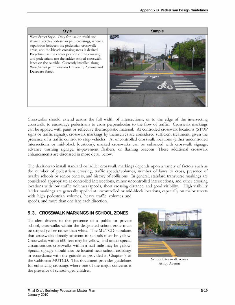
Appendix B: Pedestrian Design Guidelines
Final Draft Berkeley Pedestrian Master Plan B-19 January 2010
Style Sample West Street Style. Only for use on multi-use shared bicycle/pedestrian path crossings, where a separation between the pedestrian crosswalk areas, and the bicycle crossing areas is desired. Bicyclists use the center portion of the crossing, and pedestrians use the ladder-striped crosswalk lanes on the outside. Currently installed along West Street path between University Avenue and Delaware Street.
Crosswalks should extend across the full width of intersections, or to the edge of the intersecting crosswalk, to encourage pedestrians to cross perpendicular to the flow of traffic. Crosswalk markings can be applied with paint or reflective thermoplastic material. At controlled crosswalk locations (STOP signs or traffic signals), crosswalk markings by themselves are considered sufficient treatment, given the presence of a traffic control to stop vehicles. At uncontrolled crosswalk locations (either uncontrolled intersections or mid-block locations), marked crosswalks can be enhanced with crosswalk signage, advance warning signage, in-pavement flashers, or flashing beacons. These additional crosswalk enhancements are discussed in more detail below.
The decision to install standard or ladder crosswalk markings depends upon a variety of factors such as the number of pedestrians crossing, traffic speeds/volumes, number of lanes to cross, presence of nearby schools or senior centers, and history of collisions. In general, standard transverse markings are considered appropriate at controlled intersections, minor uncontrolled intersections, and other crossing locations with low traffic volumes/speeds, short crossing distance, and good visibility. High visibility ladder markings are generally applied at uncontrolled or mid-block locations, especially on major streets with high pedestrian volumes, heavy traffic volumes and speeds, and more than one lane each direction.
5.3. CROSSWALK MARKINGS IN SCHOOL ZONES
To alert drivers to the presence of a public or private school, crosswalks within the designated school zone must be striped yellow rather than white. The MUTCD stipulates that crosswalks directly adjacent to schools must be yellow. Crosswalks within 600 feet may be yellow, and under special circumstances crosswalks within a half mile may be yellow. Special signage should also be located near school crossings in accordance with the guidelines provided in Chapter 7 of the California MUTCD. This document provides guidelines for enhancing crossings where one of the major concerns is the presence of school-aged children
School Crosswalk across
Ashby Avenue

Appendix B: Pedestrian Design Guidelines
B-20 Final Draft Berkeley Pedestrian Master Plan January 2010
5.4. CROSSWALK WARNING SIGNAGE AND PAVEMENT MARKINGS
The California MUTCD provides guidance on the installation of warning signage and pavement stencils at and in advance of uncontrolled crosswalks. These signs are only for use at uncontrolled locations, because at STOP, YIELD, or signalized locations the presence of the traffic control serves to regulate the crosswalk at those intersections. Signage and pavement markings to supplement crosswalks are not required, and in fact the California MUTCD notes that such signs should be installed in locations where crossing activity is unexpected or not readily apparent. On some major street corridors in Berkeley that have marked uncontrolled crosswalks nearly every block, installing signage at each crosswalk would create signage clutter on the corridor and would reduce the effectiveness of the signs.
In advance of the crosswalk, if used, the Pedestrian Crossing sign plate W11-2 is installed. At the crosswalk location itself, the Pedestrian Crossing sign plate plus a downward arrow are installed to show the exact location of the crosswalk. White “PED XING” pavement markings may be placed in each approach lane to a marked crosswalk, except at intersections controlled by traffic signals or STOP or YIELD signs.
Special signage is required at and in advance of school crosswalks, also described in the California MUTCD. Unlike the crosswalk warning signage for a normal (white) crosswalk, school crosswalk signage is mandatory. At each yellow school crosswalk, the School Crosswalk Warning Assembly B shall be installed, consisting of a School Warning plate (S1-1) plus downward arrow. In advance of each yellow school crossing, a School Advance Warning Assembly D shall be used, consisting of a school crossing plate plus “AHEAD.” Yellow “SLOW SCHOOL XING” markings can be used in advance of uncontrolled school crosswalks, placed at least 100 feet in advance of the crosswalks.
5.5. HIGH VISIBILITY SIGNAGE
One way of increasing the visibility of pedestrian-related signage is through the use of a fluorescent yellow-green (FYG) background. Use of this FYG signage is approved by the California MUTCD for use on pedestrian, bicycle and school signs. When the FYG background is used for corridor or school-area signing, a systematic approach should be used, so that the mixing of standard yellow and fluorescent yellow-green is avoided. It is recommended that the City of Berkeley use FYG signs for all new pedestrian and school signage installations and as old signs are replaced.
MUTCD Crosswalk Warning Signage
Fluorescent Yellow-Green
School Sign

Appendix B: Pedestrian Design Guidelines
Final Draft Berkeley Pedestrian Master Plan B-21 January 2010
5.6. PARKING RESTRICTIONS
Painting red curb zones (NO PARKING) adjacent to marked crosswalks can greatly improve safety at crosswalk locations. Particularly at mid-block locations, if vehicles park too close to a crosswalk, they can screen pedestrians from the view of oncoming motorists. Red zone areas adjacent to crosswalks help to improve visibility, allowing pedestrians stepping out into the roadway to check for oncoming vehicle, and allowing drivers to better see pedestrians about to step off the curb. Providing adequate length of red zones adjacent to crosswalks also helps to prevent parked vehicle encroachment into the crosswalk, as can sometimes occur if a legal parking space is situated very close to a crosswalk.
As a standard, the City should apply red curb of at least 20’ (approximately 1 parking stall length) adjacent to both sides of all marked crosswalks, citywide. This standard is provided in the MUTCD Section 3-18 in reference to establishment of parking meter stalls and the application of clearance at intersections:
“The desirable dimensions of parking meter stalls are 2.4 m (8 ft) by 7.3 m (24 ft) with a minimum length of 6.1 m (20 ft).
Guidance: At all intersections, one stall length on each side measured from the crosswalk or end of curb return should have parking prohibited. A clearance of 1.8 m (6 ft) measured from the curb return should be provided at alleys and driveways. At signalized intersections parking should be prohibited for a minimum of two stall lengths on the near side and one stall length on the far side. See Figure 3B-18(CA).”
Figure 12
Parking Restriction Specifications (MUTCD Figure 3B-18)

Appendix B: Pedestrian Design Guidelines
B-22 Final Draft Berkeley Pedestrian Master Plan January 2010
Figure 13Yield Line Specifications
5.7. STOP AND YIELD LINES
The use of stop lines (commonly referred to as limit lines or stop bars) and yield lines is guided by California MUTCD Sec. 3B.16. Stop lines are solid white lines 12 inches to 24 inches wide that indicate where traffic must stop at STOP-controlled or signalized locations. Stop lines are only required at controlled locations where no marked crosswalk exists; where a crosswalk is present, the crosswalk itself can function as the stop line. Jurisdictions are permitted by the MUTCD to install a stop line in advance of a marked crosswalk if they desire. Installing stop lines in advance of crosswalks can help to discourage vehicle encroachment into the marked crosswalk, particularly in right-turn-on-red situations where vehicles often creep forward to get better visibility. One solution to this problem is to stripe a stop line on the left lanes farther back than the right lanes, allowing better visibility to the left for right-turning vehicles. This also allows more clearance for vehicles turning from perpendicular streets. A supplement to Stop Lines is “STOP HERE ON RED” signage with a down arrow indicating the stop line as the proper location for vehicles to stop in advance of the intersection.
Yield lines (also called yield teeth or shark’s teeth) indicate the point at which traffic should yield at uncontrolled locations, and are composed of white triangles 3 feet long by 2 feet wide, spaced 1 foot apart, as shown in Figure 13. In California, vehicles are required to “YIELD” to pedestrians in uncontrolled crosswalks, and yield lines can be used to indicate the appropriate location for vehicles to stop in advance of an uncontrolled crossing location. These markings are most effective in mid-block locations, where there is no intersection to give a motorist cues on the location to wait for a crossing pedestrian. The California MUTCD notes that yield line placement should be 20 to 50 feet back of uncontrolled mid-block intersections. On multi-lane roadways, yield lines can be used to counter the “multiple-threat” collision, which refers to the situation where a car in one lane stops and screens the pedestrian from the view of the adjacent lane. Installing yield lines 40-50 feet back (two car lengths) gives both pedestrians and motorists a better view of each other during the crossing. “YIELD HERE FOR PEDESTRIANS” signs with a down arrow can be used at the yield lines to indicate the proper location for vehicles to yield in advance of the crosswalk.
The City of Berkeley currently does not install stop lines or yield lines at locations that have a marked crosswalk. It is recommended that the City evaluate signalized intersections on a case-by-case basis, and consider installing stop lines at least 4 feet back from the crosswalk at locations that have a history of vehicle encroachment into the crosswalk or vehicles failing to stop for pedestrians on right-turn-on-red. At signalized mid-block pedestrian crosswalks, the City should install stop lines at least 40 feet in advance of the signal indication. At uncontrolled mid-block crosswalk locations the City should install yield lines at least 40 feet in advance of the crosswalk.
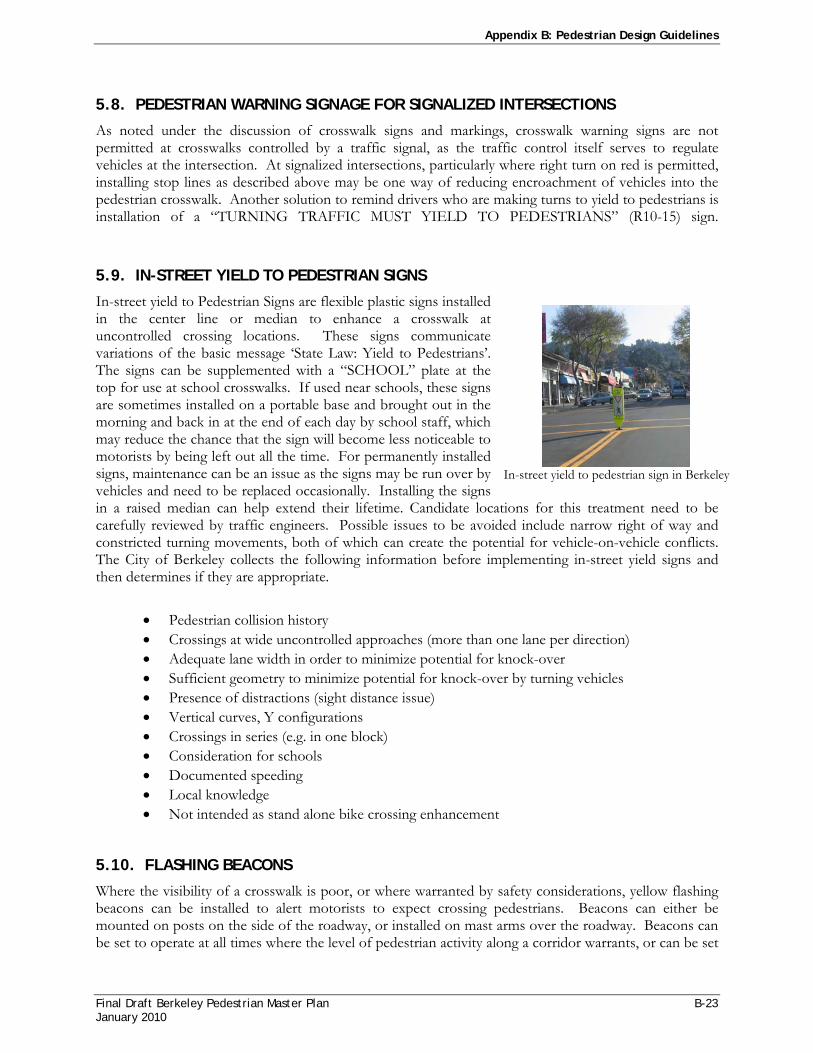
Appendix B: Pedestrian Design Guidelines
Final Draft Berkeley Pedestrian Master Plan B-23 January 2010
5.8. PEDESTRIAN WARNING SIGNAGE FOR SIGNALIZED INTERSECTIONS
As noted under the discussion of crosswalk signs and markings, crosswalk warning signs are not permitted at crosswalks controlled by a traffic signal, as the traffic control itself serves to regulate vehicles at the intersection. At signalized intersections, particularly where right turn on red is permitted, installing stop lines as described above may be one way of reducing encroachment of vehicles into the pedestrian crosswalk. Another solution to remind drivers who are making turns to yield to pedestrians is installation of a “TURNING TRAFFIC MUST YIELD TO PEDESTRIANS” (R10-15) sign.
5.9. IN-STREET YIELD TO PEDESTRIAN SIGNS
In-street yield to Pedestrian Signs are flexible plastic signs installed in the center line or median to enhance a crosswalk at uncontrolled crossing locations. These signs communicate variations of the basic message ‘State Law: Yield to Pedestrians’. The signs can be supplemented with a “SCHOOL” plate at the top for use at school crosswalks. If used near schools, these signs are sometimes installed on a portable base and brought out in the morning and back in at the end of each day by school staff, which may reduce the chance that the sign will become less noticeable to motorists by being left out all the time. For permanently installed signs, maintenance can be an issue as the signs may be run over by vehicles and need to be replaced occasionally. Installing the signs in a raised median can help extend their lifetime. Candidate locations for this treatment need to be carefully reviewed by traffic engineers. Possible issues to be avoided include narrow right of way and constricted turning movements, both of which can create the potential for vehicle-on-vehicle conflicts. The City of Berkeley collects the following information before implementing in-street yield signs and then determines if they are appropriate.
• Pedestrian collision history • Crossings at wide uncontrolled approaches (more than one lane per direction) • Adequate lane width in order to minimize potential for knock-over • Sufficient geometry to minimize potential for knock-over by turning vehicles • Presence of distractions (sight distance issue) • Vertical curves, Y configurations • Crossings in series (e.g. in one block) • Consideration for schools • Documented speeding • Local knowledge • Not intended as stand alone bike crossing enhancement
5.10. FLASHING BEACONS
Where the visibility of a crosswalk is poor, or where warranted by safety considerations, yellow flashing beacons can be installed to alert motorists to expect crossing pedestrians. Beacons can either be mounted on posts on the side of the roadway, or installed on mast arms over the roadway. Beacons can be set to operate at all times where the level of pedestrian activity along a corridor warrants, or can be set
In-street yield to pedestrian sign in Berkeley
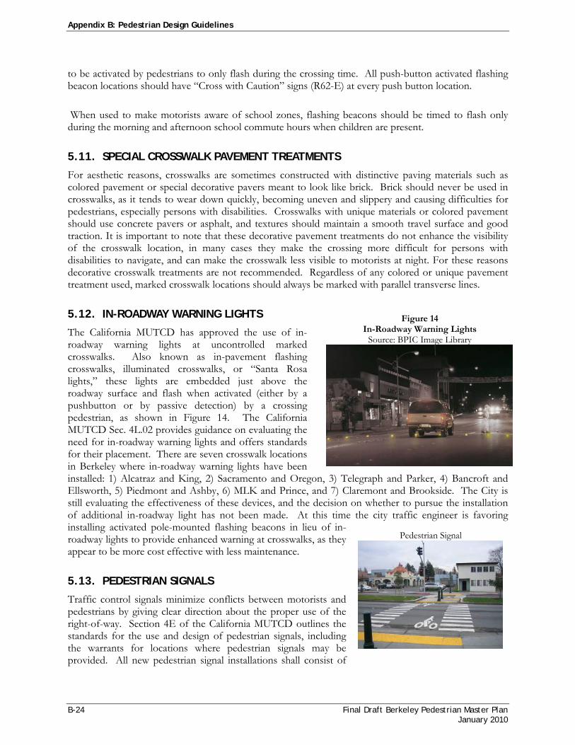
Appendix B: Pedestrian Design Guidelines
B-24 Final Draft Berkeley Pedestrian Master Plan January 2010
to be activated by pedestrians to only flash during the crossing time. All push-button activated flashing beacon locations should have “Cross with Caution” signs (R62-E) at every push button location.
When used to make motorists aware of school zones, flashing beacons should be timed to flash only during the morning and afternoon school commute hours when children are present.
5.11. SPECIAL CROSSWALK PAVEMENT TREATMENTS
For aesthetic reasons, crosswalks are sometimes constructed with distinctive paving materials such as colored pavement or special decorative pavers meant to look like brick. Brick should never be used in crosswalks, as it tends to wear down quickly, becoming uneven and slippery and causing difficulties for pedestrians, especially persons with disabilities. Crosswalks with unique materials or colored pavement should use concrete pavers or asphalt, and textures should maintain a smooth travel surface and good traction. It is important to note that these decorative pavement treatments do not enhance the visibility of the crosswalk location, in many cases they make the crossing more difficult for persons with disabilities to navigate, and can make the crosswalk less visible to motorists at night. For these reasons decorative crosswalk treatments are not recommended. Regardless of any colored or unique pavement treatment used, marked crosswalk locations should always be marked with parallel transverse lines.
5.12. IN-ROADWAY WARNING LIGHTS
The California MUTCD has approved the use of in-roadway warning lights at uncontrolled marked crosswalks. Also known as in-pavement flashing crosswalks, illuminated crosswalks, or “Santa Rosa lights,” these lights are embedded just above the roadway surface and flash when activated (either by a pushbutton or by passive detection) by a crossing pedestrian, as shown in Figure 14. The California MUTCD Sec. 4L.02 provides guidance on evaluating the need for in-roadway warning lights and offers standards for their placement. There are seven crosswalk locations in Berkeley where in-roadway warning lights have been installed: 1) Alcatraz and King, 2) Sacramento and Oregon, 3) Telegraph and Parker, 4) Bancroft and Ellsworth, 5) Piedmont and Ashby, 6) MLK and Prince, and 7) Claremont and Brookside. The City is still evaluating the effectiveness of these devices, and the decision on whether to pursue the installation of additional in-roadway light has not been made. At this time the city traffic engineer is favoring installing activated pole-mounted flashing beacons in lieu of in-roadway lights to provide enhanced warning at crosswalks, as they appear to be more cost effective with less maintenance.
5.13. PEDESTRIAN SIGNALS
Traffic control signals minimize conflicts between motorists and pedestrians by giving clear direction about the proper use of the right-of-way. Section 4E of the California MUTCD outlines the standards for the use and design of pedestrian signals, including the warrants for locations where pedestrian signals may be provided. All new pedestrian signal installations shall consist of
Figure 14 In-Roadway Warning Lights
Source: BPIC Image Library
Pedestrian Signal

Appendix B: Pedestrian Design Guidelines
Final Draft Berkeley Pedestrian Master Plan B-25 January 2010
pedestrian signal heads with international symbols, rather than textual “walk” and “don’t walk” messages. Engineering judgment should be used in determining the specifics of pedestrian signal design at different crossing locations. Currently there is a combined bicycle/pedestrian signal with both pedestrian and bicycle signal heads at University Avenue/West Street path.
5.14. PEDESTRIAN CROSSWALK ENHANCEMENT HIERARCHY
The City of Berkeley applies crosswalk markings and other enhancements described above according to the following hierarchy of improvements:
1. Provide standard transverse painted pedestrian markings 2. Add ladder stripes 3. Add pedestrian warning sign (W11-2) with down arrow at crosswalk 4. Add advance pedestrian warning signs on approaches to crosswalk (W11-2 ) 5. Add advance pavement legend (or alternate marking) 6. Add standard white stanchions OR pedestrian stanchions (R1-6a) 7. Add flashing beacon OR in-pavement flashing crosswalk 8. Install pedestrian signal
These enhancements are done on a case-by-case basis. If one level of enhancement does not appear to be adequate for a particular crosswalk location, the City will move to apply the next level of enhancement. By incrementally making crosswalk improvements, the City can evaluate each treatment independently for its ability to improve pedestrian safety at that location.
5.15. HIGH-PRIORITY LADDER CROSSWALK MARKING CORRIDORS
The following roadways have been determined by the City to be high priority corridors that warrant the installation of ladder crosswalk markings at all uncontrolled marked crosswalk locations:
o San Pablo o Milvia between Blake & University o University o Bancroft from Oxford to Piedmont o Sacramento o Durant from Oxford to Piedmont o Ashby o Channing from Oxford to Piedmont o Adeline o Claremont, south of Ashby o MLK o College o Telegraph o Cedar from Walnut to Martin Luther King, Jr. Way o Gilman o Hopkins from San Pablo to Peralta o Shattuck o Solano

Appendix B: Pedestrian Design Guidelines
B-26 Final Draft Berkeley Pedestrian Master Plan January 2010
6. OTHER ENGINEERING TREATMENTS FOR CROSSINGS
6.1. BULBOUTS
Bulbouts, also called curb extensions, are engineering improvements intended to reduce pedestrian crossing distance and increase visibility. Bulbouts can either be placed at corners or at mid-block crosswalk locations, and extend out to about 8 feet to align with the edge of the parking lane, as shown in Figure 15. In addition to shortening the crosswalk distance, bulb-outs serve to increase pedestrian visibility by allowing pedestrians to safely step out to the edge of the parking lane where they can see into the street, also making them more visible to oncoming drivers. At corners, bulb-outs serve to reduce the turning radius, and provide space for perpendicularly-aligned curb ramps. Where bus stops are located, bulb-outs can provide additional space for passenger queuing and loading.
Despite their advantages, bulb-outs can require major re-engineering of the street and are not appropriate for all situations. Installing bulb-outs can require costly drainage modifications, regardless whether drainage facilities exist at a curb or not. Bulbouts may not be possible in some locations due to existing driveways or bus pull-out areas. Bulbouts need to be designed to avoid conflict with bicycle facilities, and should never extend into a bicycle lane. Additionally, pedestrians using wheelchairs may find it difficult to access bulb-outs when exiting the driver’s side of a parked vehicle. Given their relatively high cost and challenges of implementation, bulb-outs are not recommended as a tool for widespread implementation along every street in the city. Each potential bulb-out location must be evaluated on a case-by-case basis, taking into account factors such as crossing volumes, parking lane widths, infrastructure challenges such as drainage or driveways, and locations of bus stops.
6.2. MEDIAN REFUGE ISLANDS
On wide, multi-lane roadways, pedestrians can benefit from median refuge islands, which offer a place to wait after crossing only half of the street. Berkeley has several major roadways with median refuge islands, including San Pablo, Sacramento, Shattuck, and University. Refuge islands increase the visibility of pedestrian crossings, and decrease pedestrian collisions by reducing pedestrian/vehicle conflicts,

Appendix B: Pedestrian Design Guidelines
Final Draft Berkeley Pedestrian Master Plan B-27 January 2010
motor vehicle speeds, and exposure time for pedestrians.11 They also allow pedestrians to consider cross traffic from one direction at time, making it easier to find a gap and simplifying crossing. In Berkeley, accessible pedestrian medians or islands are encouraged on wide two-way streets where pedestrians have to cross more than two lanes.12 The MUTCD defines an island as an area between traffic lanes for control of vehicular movements or for pedestrian refuge. Under the MUTCD definition, a refuge island can be delineated by curbs (raised), pavement markings (painted), or other devices. The MUTCD does not give any specific guidance on minimum dimensions of a refuge island The FHWA document “Pedestrian Accommodations at Intersections” advises that a refuge island should be a minimum of 4 feet wide and 12 feet long (or the width of the crosswalk, whichever is greater).13 The Metropolitan Transportation Commission’s Pedestrian Toolkit states that refuge islands should be a minimum of 4 feet wide and 8 feet long.14
The recently revised ADA Access Board Guidelines on Accessible Public Rights of Way has a section on median islands.15 The following guidelines are applicable:
• Medians and pedestrian refuge islands in crosswalks shall contain a pedestrian access route, including passing space connecting to each crosswalk.
• Regarding a minimum width for refuge islands, the guidelines state that medians and pedestrian refuge islands shall be 1.8 m (6.0 ft) minimum in length in the direction of pedestrian travel.
• The guidelines permit both ramped up and cut-through design of refuge island, and advise that there are many factors to consider when deciding whether to ramp or cut-through a median or island. Those factors may include slope and cross slope of road, drainage, and width of median or island. They note that “curb ramps in medians and islands can add difficulty to the crossing for some users.”
• Medians and refuge islands are also required to have detectable warnings, with detectable warnings at cut-through islands separated by a 2-foot minimum length of walkway without detectable warnings.
The City of Berkeley should implement accessible median refuges whenever feasible. For pedestrian refuge islands at intersections, installing a median “nose” (a small rounded area of median built to the intersection side of the crosswalk, so that the crosswalk passes through the median) can help to provide additional protection for pedestrians. Median noses can also prevent vehicles from encroaching into the refuge area when making left turns. However, median noses may not be feasible to install due potential to turning movement restrictions. Neither the MUTCD nor the ADA Access Board Guidelines have any requirement for median noses to be installed at intersection refuge islands. The City of Berkeley should consider median nose installation on a case-by-case basis.
11 FHWA 2002b, p. 72 12 City of Berkeley General Plan, Transportation Element, p. T-28 13 Pedestrian Accommodation and Intersections, FHWA, http://safety.fhwa.dot.gov/ped_bike/univcourse/swless15.htm 14 MTC Safety Toolbox http://www.mtc.ca.gov/planning/bicyclespedestrians/tools/pedRefugeIsland/index.htm 15 http://www.access-board.gov/PROWAC/draft.htm#305

Appendix B: Pedestrian Design Guidelines
B-28 Final Draft Berkeley Pedestrian Master Plan January 2010
6.3. CHANNELIZED RIGHT-TURN SLIP LANES
A right-turn slip lane, often delineated by paint or a concrete island, separates the right-turn movement from through and left-turning vehicles, as shown in Figure 16.
Slip turn lanes can be dangerous to pedestrians because drivers tend to concentrate on merging with oncoming traffic and may not see pedestrians entering the crosswalk. In high-traffic areas, inadequate gaps in right-turning traffic may exist, making crossing a slip turn lane difficult for pedestrians. The non-standard corner geometry introduced by slip lanes is extremely difficult for the blind to negotiate. Uncontrolled slip turn lanes should be discouraged where conflicts with pedestrians are anticipated. Reclaimed space from slip lane removal can be made into an attractive area for pedestrians through the use of street furniture, benches and small-scale plantings.
Where slip lanes cannot be removed due to traffic capacity considerations, several options exist for enhancing pedestrian safety. Signalizing the right-turn movement creates gaps for pedestrians and may be the safest alternative. Passive crossing treatments, such as warning signage, or a raised crosswalk connecting the sidewalk with a refuge island, may also improve conditions for pedestrians.
Slip lanes that turn into a dedicated traffic lane can be safely provided if the turning movement is controlled by a signal or a stop sign.
6.4. ROUNDABOUTS
Roundabouts are circular intersections used to slow traffic and control the flow of traffic entering the intersection. In North America, roundabouts are typically larger than the more common neighborhood traffic calming circle. The Marin Circle and Channing Circle (at the intersection of Piedmont Avenue and Channing Way) are two roundabouts in Berkeley. Traffic outside the intersection must yield before entering. Roundabouts slow traffic by requiring vehicles to travel in a counter-clockwise circle rather than following a straight path through the intersection. Twin roundabouts are planned for the intersection of Gilman Avenue & I-80.
Although roundabouts slow traffic and in general, reduce the number and severity of motor vehicle collision, special consideration should be given to pedestrians in their design. Of particular concern is the ability of visually impaired pedestrians to cross the street safely at roundabouts. The visually-impaired need to be properly oriented to the crosswalk and able to use audible cues from traffic movements to judge when it is safe to cross. Design treatments that can be applied in these situations are: limiting the number of lanes that flow into the roundabouts to help with audible identification of vehicles and inclusion of tactile domes and highly visible crosswalks to indicate to motorists and pedestrians the
Figure 16 Slip Turn Crossing Treatment
Source: Improving Pedestrian Access to Transit:
An Advocacy Handbook

Appendix B: Pedestrian Design Guidelines
Final Draft Berkeley Pedestrian Master Plan B-29 January 2010
correct pedestrian crossing location. In general, single-lane roundabouts are safer and more convenient for pedestrians than multi-lane roundabouts.
6.5. SAFETY BARRELS AND BOLLARDS
Safety barrels and bollards can be effective in preventing vehicles from entering the pedestrian right-of-way. They are also an inexpensive way to test more permanent intersection improvements such as curb bulbs. The placement of these vertical elements must ensure that they do not block the travel path of pedestrians, particularly those who are sight or mobility impaired. The creative use of bollards to create combination curb bulbs/bicycle parking areas can be effective in improving pedestrian safety while enhancing the aesthetic quality of an intersection and providing bicycle parking.
6.6. MULTI-USE PATH INTERSECTIONS
Multi-use paths provide pedestrian and bicycle travel ways that are separated from automobile traffic. Path crossings must be safe for pedestrians and bicyclists alike, and should also provide convenient connections to the City’s street network. In general, path crossings should be treated just like other intersection types, oriented at 90 degree angles whenever possible ensuring safety for all path and road users. In addition to typical intersection lighting, signage, and traffic control features, path crossings should include design features that warn both path and roadway users of the crossing. Restricting parking near path crossings, as at typical intersections, enhances sight distance. As noted earlier, the City of Berkeley has developed a unique multi-use path crosswalk marking, currently used at crossings along the West Street Trail between University Avenue and Delaware Street, as shown in Figure 17.
6.7. RAIL CROSSINGS
Rail crossings can be hazardous for pedestrians, particularly for those who rely on who rely on wheeled devices for mobility. One way to improve safety is design rail crossings to have the pedestrian path at a 90 degree angle to the tracks. This minimizes potential for wheelchair and stroller wheels to catch in the track gap. The crossing surface should be a smooth transition from the sidewalk and over the rails. Other design elements include the use of detectable warnings such as truncated domes, flashing light signals, signs, and audible sounds.
Figure 17City of Berkeley Standard Multi-Use Path Crossing Marking

Appendix B: Pedestrian Design Guidelines
B-30 Final Draft Berkeley Pedestrian Master Plan January 2010
7. TRAFFIC SIGNAL ENHANCEMENTS
This section discusses specific pedestrian enhancements for use at signalized intersection locations.
7.1. COUNTDOWN PEDESTRIAN SIGNALS
Countdown pedestrian signals provide information on the amount of time remaining in the pedestrian change interval, which can assist pedestrians in making safe crossing judgments. Guidance on the use of these devices is now included in the California MUTCD. It is recommended that the City of Berkeley install these devices on all new pedestrian signal installations, and continue their program of retrofitting them at existing signals. Recommendations for audible pedestrian signals and other signal head accessibility considerations are included in the Accessibility Recommendations below.
7.2. SIGNAL TIMING
Traffic signal timing can have an effect on the ability of slower-moving pedestrians to safely cross the street. The length of the pedestrian clearance phase is determined by calculating a clearance interval, which is the length of time it takes a person to walk from the curb on one side to the center of the farthest travel lane on the other using a standard walking speed and distance. The standard walking speed used to calculate pedestrian clearance intervals recommended by the California MUTCD and used in Berkeley, is 4 feet per second. However, where there are populations of pedestrians who walk more slowly, a lower walking speed should be considered in determining the pedestrian clearance time. Particularly where there are seniors or persons with disabilities, the MUTCD recommends a walking speed of 2.8 ft/sec. This recommendation may also be applied to locations near elementary schools, because young children commonly walk more slowly. Where signalized crossings are in close proximity to locations such as senior centers, senior housing, elementary schools, or centers generating significant volume of pedestrians with disabilities, the City of Berkeley should utilize a walking speed of 2.8 ft/sec to allow for longer crossing times.
Special pedestrian phases can also be used to provide more crossing time for pedestrians at certain intersections. These include:
• Leading Pedestrian Interval (LPI) – At intersections where there are conflicts between turning vehicles and pedestrians, pedestrians are given a “walk” designation a few seconds before the associated green phase for the intersection begins.
• Pedestrian Scramble Phase – In areas with very heavy pedestrian traffic, an all-pedestrian signal phase gives pedestrians free passage in the intersection while no vehicle traffic is allowed. The intersection of Telegraph/Bancroft has a pedestrian scramble phase. Pedestrian scramble phases are only recommend where pedestrian volumes are very high and should be used sparingly, given that the additional phase increases wait times for all modes.
Pedestrian Countdown Signal

Appendix B: Pedestrian Design Guidelines
Final Draft Berkeley Pedestrian Master Plan B-31 January 2010
7.3. SIGNAL ACTIVATION
Traffic signals in Berkeley operate in one of three ways: Fixed-time signals have a regular cycle of phases with a fixed amount of green time for each movement. There is a regular WALK phase in each direction for each cycle, and pedestrians are not required to push a button to actuate the WALK phase. Fully-actuated signals are highly responsive to local traffic variations because they detect vehicles and pedestrians as they arrive in the intersection on any approach. On fully-actuated signals, pedestrians are required to push the button to actuate the WALK phase in any direction. Semi-actuated signals employ vehicle and pedestrian detection only on the side or local street. A green light and WALK phase is on for the major street unless the presence of a pedestrian or car is detected on the local street. Pedestrians must push a button to actuate the side street signal.
7.4. PEDESTRIAN PUSHBUTTON
Pedestrian pushbuttons allow for actuation of pedestrian signals, and should be located at all intersection corners where pedestrian actuation is used. As required by the California MUTCD, pedestrian pushbuttons must be accompanied by signs explaining their use. Pedestrian pushbuttons should be easily accessible for those in wheelchairs and for the sight-impaired. This can be accomplished by locating them located approximately 3.5 ft. off the ground and provide a level surface to the push button. Pedestrian pushbuttons should not be used in locations where the pedestrian phase is set on a fixed cycle and cannot be actuated. One exception to this is the use of pushbuttons to activate audible pedestrian signals at non-actuated locations. More details on push button requirements are discussed in Section 12 on Accessibility.
8. TRAFFIC CALMING
Traffic calming interventions slow traffic by modifying the physical environment of a street. The City of Berkeley has employed a variety of traffic calming measures, including speed humps, chokers, traffic circles and both full and partial street closures.
Research into the efficacy of traffic calming devices to improve pedestrian safety has shown that traffic calming can reduce the number of automobile collisions. A Vancouver study published in 1997 showed an average collision reduction of 40 percent in four neighborhoods that used a combination of the traffic calming types described below.16
Currently the city of Berkeley is developing a formalized Traffic Calming Request procedure to evaluate and prioritize resident requests, utilizing the traffic calming requirements detailed in Policy T-20 of the General Plan. All traffic calming improvements will be based on demonstrable problems or issues raised by a resident or identified by City staff. City engineering staff will determine the appropriate countermeasures for the safety issues which residents have identified.
16 Zein, S. R.; Geddes, E.; Hemsing, S.; Johnson, M., “Safety Benefits of Traffic Calming,” Transportation Research Record Vol: #1578 pp. 3-10.

Appendix B: Pedestrian Design Guidelines
B-32 Final Draft Berkeley Pedestrian Master Plan January 2010
Table 4 Traffic Calming Descriptions and Considerations for Use
Traffic Calming Measure Description Considerations for Use
Street Trees In addition to their aesthetic value, street trees can slow traffic and improve safety for pedestrians. Trees add visual interest to streets and narrow the street’s visual corridor, which may cause drivers to slow down.
- If the sidewalk corridor is not wide enough to accommodate street trees, adding tree plantings in the parking lane is possible. These trees will have shortened life spans. - The placement of plantings should consider potential for conflict with street sweeping and drainage.
Raised Crosswalks Raised crosswalks are similar to speed humps, but are installed at intersections to elevate crosswalks. Raised sidewalks eliminate grade changes from the pedestrian path and give pedestrians greater prominence as they cross the street.
- Use detectable warnings at the curb edges to alert vision-impaired pedestrians that they are entering the roadway. - May be designed so they do not have a slowing effect (for example, on emergency response routes).

Appendix B: Pedestrian Design Guidelines
Final Draft Berkeley Pedestrian Master Plan B-33 January 2010
Traffic Calming Measure Description Considerations for Use
Speed Humps
Speed humps are elevated, sloped sections of pavement that require drivers to slow down as they pass over. Berkeley has 156 speed humps on 99 streets.17 Speed humps are generally 12-22 feet long and 3-4 inches high. There are four speed hump shapes – sinusoidal, circular, parabolic and flat-topped – which differ in the shape of their slope. The sinusoidal shaped are much smoother to drive over at the intended speed, and are also friendlier to bicyclists. (Many of the older speed humps installed in Berkeley were of the parabolic shape, which provides a more pronounced bump when driving over them.)
- Not for use on emergency response routes or transit corridors. - In July 1995, the Berkeley City Council approved a one-year moratorium on construction of any new speed humps until completion of an evaluation of the City’s speed hump program. In 1997, a draft evaluation was prepared by the Advance Planning Division. The evaluation, which included a recommendation to lift the speed hump moratorium, was not reviewed by City Council and no new speed humps have been installed since 1995.
Chicanes Chicanes are a series of bulb-outs or narrowings that create an S-shaped route, causing traffic to slow down. An example of chicanes can be found on Milvia Street in North Berkeley, pictured at left.
With no major pedestrian issues, chicanes can provide additional landscaping and street buffer area. Care should be taken to ensure that chicanes do not affect bicycle mobility.
17 City of Berkeley, Office of Transportation, http://www.ci.berkeley.ca.us/transportation/TrafficCalming/TCinBerkeley.html#SpeedHumps

Appendix B: Pedestrian Design Guidelines
B-34 Final Draft Berkeley Pedestrian Master Plan January 2010
Traffic Calming Measure Description Considerations for Use
Traffic Calming Circles Traffic calming circles are circular islands in the middle of an intersection. At the end of 2006, Berkeley had 62 traffic circles on its residential streets, and at least 4 more were added in 2007. Traffic circles slow traffic by altering the route of vehicles and by reducing the distance a driver can see down the street, which also causes traffic to slow. The City is currently maintaining existing STOP controls at traffic circle intersections. In the future the City may remove the STOP signs and convert the intersections to all-way yields.
- Unlike full roundabouts, traffic circles maintain the crosswalks at the intersection corners. - However, in some cases it is necessary to move the crosswalks back to accommodate the turning radius of larger vehicles around the circle. In these cases the crosswalks are no longer aligned directly perpendicular with the corner, which could cause difficulty for persons with visual impairments Care should be taken to ensure that any landscaping in the circles uses low-growing shrubs that maintain visibility for pedestrians, particularly those in wheelchairs. The City maintains a list of acceptable plant species for traffic calming circle plantings. - Traffic circles are accepted by the Berkeley Fire Department, provided the department has approval over the design.
Street Closures/Diverters
Berkeley has employed street closures to minimize the amount of through-traffic on residential streets. There are three types of street closures, all of which have been used in Berkeley. Diverters force traffic to turn right or left. Half roadway closures are constructed at intersections to allow only one-way traffic to continue through an intersection on one side of the street. Full roadway closures completely close a street segment to motor vehicle traffic from an intersection.
All three types of street closures benefit pedestrians and residents by diverting traffic away from residential streets. However, diverted traffic flows may cause problems on other streets. On streets with closures, emergency vehicle access may be limited. Berkeley’s General Plan now discourages the use of diverters because traffic can be diverted onto neighboring streets, which is a disbenefit to those people impacted.

Appendix B: Pedestrian Design Guidelines
Final Draft Berkeley Pedestrian Master Plan B-35 January 2010
9. ACCESS TO TRANSIT STOPS
Enhancing connections between walking and transit service is an important opportunity for Berkeley to support both modes of transport. Improved pedestrian access to AC Transit bus stops, BART stations, and the Berkeley Amtrak station will better serve passengers who walk to their transit connections. Making walking to transit safer and more accessible may also attract new transit passengers and reduce the number of people who currently drive to transit stations.
In the City of Berkeley, every residence lies within one-quarter mile of a transit line. In 1993, based on the transit service measure of “seat miles per capita” Berkeley had nearly double the transit service of the average metropolitan area in the United States, placing it in the top 10 metropolitan areas nationwide.18
Although a large number of Berkeley residents walk to the City’s three BART stations, a large portion of people accessing Ashby & North Berkeley BART drive (see Table 5 below). Across the East Bay, a large majority (75 percent) of AC Transit riders access their bus stop by walking.19
Table 5 Method of BART Station Access by Customers Traveling from Home, 1998
Walk Only Car Bus/Transit Bicycle Ashby 46% 42% 5% 7% Downtown Berkeley 57% 14% 23% 6% North Berkeley 30% 62% 3% 5%
Source: BART Station Profile Survey, 1998 (Section IV, pages 6, 15, and 28)
9.1. ACCESS TO BUS SERVICE
AC Transit’s “Designing with Transit” Manual provides the following recommendations for making bus transit more accessible to pedestrians of all abilities:
- Sidewalk widths are at least 6 feet on all streets leading to bus stops - Where bus shelters are installed, sidewalks should be wide enough to accommodate bus shelter
while maintaining a minimum of 6 feet for through passage traffic; - Provide direct access from activity centers to bus stops; - Site stops in the best operational locations, usually on the far side of an intersection; - Site stops where passengers are less likely to become victims of crime; - Install bus bulbs where they facilitate bus operation and pedestrian capacity - Provide adequate lighting and clear sight lines on all sidewalks and pathways;
18 City of Berkeley General Plan, Transportation Element, page T-5 19 Designing with Transit, page 2-11
Figure 18 North Berkeley BART Access

Appendix B: Pedestrian Design Guidelines
B-36 Final Draft Berkeley Pedestrian Master Plan January 2010
- Make sidewalks and paths visually interesting and active; - Provide ADA compliant bus boarding and alighting areas of at least eight feet by five feet;
measured from the bus outwards; - Provide pedestrians with safe crossings of major streets, installing traffic signals where necessary
for pedestrian safety; - Minimize roadway crossing distances without compromising bus operations; - Limit vehicle turning movements across active sidewalks and walkways; and - Locate parking to minimize interference with people walking to building entrances.
For bus shelters on crowded sidewalks, bus bulb-outs are recommended for providing additional space. Bus shelters should also have clearly displayed bus schedules and city maps for way-finding.
9.2. ACCESS TO BART STATIONS
In 2003, BART published a set of guidelines for transit-oriented development. These guidelines include a number of recommendations related to enhancing pedestrian access to BART Stations. BART’s Access Guidelines prioritize pedestrian access over all other modes, including transit and shuttles, bicycle, carpools and cabs, and single occupancy vehicles (shown in Figure 19).20 In order to prioritize pedestrian access at BART stations, the Access Guidelines recommend eight ways to improve pedestrian safety and comfort:21
- Sidewalks connecting the station fare gates to key intersections and destinations in the station area should be as short, direct and visually unobstructed as possible.
- Sidewalks linking the fare gates to the surrounding community should be wide and smooth enough for wheelchairs and strollers, and lined with trees, lights and wayfinding signs to improve orientation and safety.
- The size and layout of blocks near the station should anticipate the need for direct pedestrian paths.
- Pedestrians should be encouraged to cross major streets and intersections at street level.
- Buildings along the sidewalks serving the fare gates should open directly on the path, with transparent ground floors and good views of the path from the upper floors.
- Continuous building frontages along sidewalks should be maintained by avoiding front and side setback, blank walls and surface parking lots that face the sidewalk.
20 BART Transit-Oriented Development Guidelines, June 2003, available at www.bart.gov 21 BART Transit-Oriented Development Guidelines, June 2003, available at www.bart.gov
Figure 19 BART Station Access Priorities by Mode
Appendix B: Pedestrian Design Guidelines
Final Draft Berkeley Pedestrian Master Plan B-37 January 2010
10. GUIDELINES FOR PRIVATE DEVELOPMENT
The provision of pedestrian infrastructure alone may not be sufficient to increase non-motorized transportation mode share. Land use and urban design patterns that encourage walking as a safe, attractive and convenient choice are also important. People are motivated to walk and bicycle for transportation when their destinations are close by, routes of travel are interesting, safe and comfortable, and a mix of uses allows for the combination of trips for maximum convenience. Berkeley has a mix of development patterns; some that encourage walking and some that are more supportive of automobile traffic. Berkeley faces a particular challenge on some of its major corridors, including University Avenue, Shattuck Avenue and San Pablo Avenue. These wide thoroughfares, originally built for streetcar lines, traditionally supported a variety of transportation modes, including walking. In the 1950s, however, many streets in Berkeley were re-oriented to better accommodate automobiles. Sidewalks were narrowed to make room for more cars. Lighting, signage and other amenities were provided at a scale that supports automobile, rather than pedestrian, travel. In recent years, Berkeley has developed area plans that focus on restoring pedestrian infrastructure to these corridors. The City is encouraging land use types that support pedestrian activity, such as mixed-use development, commercial nodes and transit-oriented development. In addition to these policies, good building and streetscape design is crucial to improving conditions for pedestrians. A number of Berkeley’s existing area plans include design guidelines that encourage or require pedestrian-supportive urban design for new developments. The following sections define the types of urban design elements included in Berkeley’s existing area plans, for use in future projects and planning efforts. The general design elements contained in the specific area plans are meant to guide design decisions in the early phases of a project, in order to provide design direction and expedite the development review process. Approval of specific design plans for a given project is done through the Planning Department’s site plan review process, which may involve a hearing before the City’s Design Review Committee depending on the scope of the project. As part of a project approval, specific conditions of approval may be attached to a project to ensure that it complies with design requirements.
10.1. PEDESTRIAN-SCALE DESIGN
To create streetscapes that are attractive to pedestrians, it is important that buildings, pedestrian amenities and street furniture reflect a pedestrian scale. For vertical elements such as street lighting, the appropriate height is 8-12 feet above the sidewalk level. Vertical elements should not exceed 20 feet. For design elements, such as awnings on building façades, the appropriate scale is 12-20 feet above ground level. Including streetscape elements at this scale creates a sense that the environment is properly suited for pedestrian use.
10.2. BUILDING ORIENTATION
Buildings on corridors where pedestrian travel is encouraged should address the street and reinforce the pedestrian experience. Buildings in commercial and high-density residential areas should not be set back from the property line but should be flush with the public right-of-way. In order to prevent building frontages from presenting as a monolithic wall, setbacks can be infrequently used to provide variety.

Appendix B: Pedestrian Design Guidelines
B-38 Final Draft Berkeley Pedestrian Master Plan January 2010
10.3. BUILDING HEIGHTS
On wide corridors, appropriately scaled building heights create a sense of enclosure for pedestrians. Buildings that are as tall as the width of the street are appropriate for creating this sense of enclosure. Although many areas of Berkeley traditionally have buildings that are much lower than the width of the adjacent street, Downtown Berkeley has several buildings that are 65-85 feet tall, in some instances taller than the width of the streets they line. On pedestrian-oriented corridors, building heights that are too low can discourage pedestrian travel, creating a more auto-oriented street atmosphere. For this reason, one and two-story buildings should be discouraged on wide commercial corridors.
10.4. BUILDING FACADES
The design of building façades, particularly on the ground level, can encourage pedestrian activity by providing visual interest and a sense of safety. In commercial and mixed-use areas, retail or other activity should be encouraged in the ground floor. In areas where ground floor retail is not economically viable, flexible space on the ground floor is an appropriate option. Flexible space can be used for office, residential or retail uses. Flexible ground-floor space is particularly appropriate for areas where new mixed-use development is encouraged. In these developments, requiring ground-floor retail in all new developments can lead to significant portions of the space being vacant. Flexible space, in contrast, can transition to commercial uses as the market for local businesses grows. In commercial areas, transparent ground-floor design helps to activate the street corridor for pedestrians. Transparent windows at the ground floor should be encouraged, while long stretches of blank walls should be avoided. In all new developments, building façades should be articulated with elements that add visual variety and interest. Windows, awnings, front porches, and other design elements achieve this purpose. Specific area plans recommend façade improvements that reflect the existing character of buildings in Berkeley’s diverse neighborhoods.
10.5. BUILDING ENTRANCES
In commercial areas, building entrances should be placed every 15-30 feet. In residential areas, building entrances can be farther apart. To create the same sense of articulation, porches or balconies should be located where they complement building entrances.
10.6. PARKING FACILITIES
Surface parking lots create a disruption in the pedestrian experience because they are wide, open areas oriented toward automobiles. When passing open parking lots, pedestrians lose a sense of enclosure offered by buildings with flush frontages, and lose the sense of interest provided by active ground-floor uses. In pedestrian-oriented corridors, surface parking lots abutting the public right-of-way should be discouraged. Existing surface parking lots can be retrofitted with trellises or other pedestrian-scale design elements to minimize the impact of an open lot. Structured parking facilities can negatively impact the pedestrian experience by creating large, blank walls. As a result, some cities have required that structured parking facilities be set back from the street frontage, behind an active ground-floor use, such as retail. In other cities, structured parking lots are situated above an active ground-floor use, to maintain pedestrian orientation at the street level.

Appendix B: Pedestrian Design Guidelines
Final Draft Berkeley Pedestrian Master Plan B-39 January 2010
Table 6 Example Pedestrian-Related Design Guidelines from Berkeley Area Plans
Downtown Berkeley Design
Guidelines22 University Avenue Strategic
Plan23 West Berkeley Plan24 Pedestrian-Scale Design
Many of the features desirable for a pedestrian-oriented Downtown … which include inviting entranceways, continuous display windows, obvious locations for signs, and sensitively scaled proportions, should be incorporated into new as well as remodeled storefronts.
Large-scale projects should employ variations in floor level, roof shapes and materials, architectural details, and finishes. Elements of human scale should be incorporated into the building’s design.
Design street facades and ground level doors and windows to include elements of pedestrian scale and three-dimensional interest.
Building Orientation and Frontage
- Buildings should frame and define the street as an active public space. - All buildings should maintain a continuous zero setback.
Buildings should address and reinforce streets, pedestrian paths, parks and plazas by locating the building along the street property line, unless usable street amenity space is created.
Ensure that new construction along the corridors maintains and strengthens the urban character of the street by locating new buildings at the front property line to reinforce the streetwall.
Building Heights
- New development should be scaled down to the periphery of Downtown and adjacent neighborhoods. - Along Shattuck Avenue, maintain the historic 3-5 story streetwall at the property line.
Building height and massing guidelines are presented for four node types.
Develop incentives to encourage new construction to be 2-4 stories in height (and to incorporate residential and office uses above the ground floor) along these corridors, especially at nodes.
Building Entrances
Storefronts should continue the rhythm of 15-30 foot enframed storefront openings at ground level, in order to reinforce visual continuity and pedestrian scale.
- Mixed use, multi-family residential buildings and office buildings: entries every 50-60 feet and bays, balconies and upper façade projections every 25-30 feet. - Single-family homes, town homes and ground floor retail uses should provide entries every 25-30 feet.
Parking Facilities
- Downtown is first and foremost a place for pedestrians and every effort should be taken to ensure their comfort, safety and continued patronage. - Parking for new projects in the Downtown Area should be provided in the buffer area, as recommended in the Downtown Plan. - Locate parking behind buildings, underground or behind ground floor storefronts.
Parking garages and parking lots must not dominate the frontage of a street or inhibit pedestrian movement. In most cases, parking should be placed behind, below, or to the side of buildings.
Locate parking at the side or rear of the lot.
22 Downtown Berkeley Design Guidelines are available at: http://www.ci.berkeley.ca.us/Planning/landuse/plans/dt_design.htm. Note: May be amended by the new Downtown Area Plan 23 University Avenue Strategic Plan is available at: http://www.ci.berkeley.ca.us/planning/landuse/plans/uagoals.htm 24 West Berkeley Plan: http://www.ci.berkeley.ca.us/planning/landuse/plans/westberkeley/wbtoc.htm

Appendix B: Pedestrian Design Guidelines
B-40 Final Draft Berkeley Pedestrian Master Plan January 2010
11. PEDESTRIAN PATHWAYS AND STAIRS
A unique network of over 130 historic pedestrian pathways and stairways exists in the Berkeley Hills. The pathways offer quiet resting places, panoramic viewpoints and critical pedestrian routes down from the hill neighborhoods linking between the narrow and winding streets. The Department of Public Works maintains a detailed database of public pathways and publicly dedicated rights-of-way.25 Some of the dedicated path alignments are currently unbuilt and impassable. An organization called the Berkeley Path Wanderers Association works to improve these pathways by installing simple wooden steps. These pathways and stairs are steep and not ADA-compliant. The City of Berkeley should seek to improve the remaining unbuilt pathways, and continue to cooperate with the Path Wanderers Association on this effort. The City should ensure that existing pathways are well maintained, kept clear of vegetation overgrowth, and well-signed so that residents can access them. In the event of an emergency, these pathways could serve as critical evacuation routes for getting large numbers of pedestrians out of the hill area.
12. ACCESSIBILITY RECOMMENDATIONS
The City of Berkeley has a history of pioneering in the area of pedestrian accessibility, and is committed to providing access for all pedestrians, including those who have disabilities. The purpose of this section is to summarize street design standards that will make Berkeley more accessible to all pedestrians, paying special attention to accommodate special mobility needs.
The Federal Americans with Disabilities Act of 1990 (ADA) created civil rights protections for people with disabilities. Legally enforceable standards for sidewalks, curb ramps, crosswalks, and bus stops are included in the Americans with Disabilities Act Accessibility Guidelines (ADAAG). The U.S. Access Board creates and modifies these guidelines, which are applied by the U.S. Department of Transportation and enforced by the U.S. Department of Justice.
The State of California also has required accessibility standards, included in Title 24 of the California Code of Regulations, also known as the California Building Standards Code. The Division of State Architecture develops these standards, which generally follow ADAAG standards but include higher standards for some facilities. The U.S. Access Board has also developed guidelines for communities to voluntarily improve accessibility beyond the mandatory requirements of ADAAG.
12.1. BERKELEY ADA TRANSITION PLAN
The City of Berkeley has taken many successful steps to improve accessibility on its street network, even before the passage of Federal and State regulations. Since the early 1970’s, the City of Berkeley has installed more than 2,700 curb ramps, nearly 300 blue zones for disabled parking and numerous audible
25 City of Berkeley General Plan, Transportation Element
Stairs in the Berkeley Hills

Appendix B: Pedestrian Design Guidelines
Final Draft Berkeley Pedestrian Master Plan B-41 January 2010
pedestrian signals. The City adopted its first nondiscrimination policy about disability in 1985.26 Since 1986, the City’s Commission on Disability has advised the City Council and staff on accessibility issues.
In 1996, the City adopted the “ADA Initial Transition Plan” which guided the City’s efforts to improve facility access in accordance with ADA Accessibility Guidelines. The City is currently updating its Transition Plan which will include a year-by-year schedule of capital improvements to make Berkeley more accessible for all pedestrians.
12.2. GUIDELINES FOR ACCESSIBLE SIDEWALKS AND PATHWAYS
ADAAG issues standards for “accessible routes,” which include sidewalks and other pedestrian paths. The State of California Title 24 defines the term “sidewalk” as a surfaced pedestrian way contiguous to a street used by the public. Title 24 defines “walkway” as a surfaced pedestrian way not located contiguous to a street used by the public. The following guidelines apply to all three definitions.
12.3. GRADE
The grade of a sidewalk affects the issues of control, stability and endurance. Gentle grades are preferred to steep grades, allowing more people to go uphill, providing more control on the downhill and minimizing loss of footing. The maximum grade of a sidewalk should be no more than 14 percent in any 2-foot section, while the running grade for a sidewalk should not exceed 5 percent, as shown in Figure 20.
The following terms apply to standards for grades: - Grade is the slope parallel to the
direction of travel. - Running grade is the average grade
along an entire continuous path. - Maximum grade covers a section of the sidewalk that is larger than the running grade. It is measured
over a two-foot section. - Rate of change is the change of the grade over a distance of two feet. - Counter slope is the grade running opposite to the running grade.
12.4. CROSS-SLOPE
Cross-slope describes the angle of the sidewalk from the building line to the street, perpendicular to the direction of travel. All sidewalks require some cross-slope for drainage, but a cross-slope that is too great will present problems for people who use wheelchairs, walking aids, or who have difficulty walking
26 City of Berkeley Administrative Regulation 1.90
Figure 20: Maximum Allowable Grade

Appendix B: Pedestrian Design Guidelines
B-42 Final Draft Berkeley Pedestrian Master Plan January 2010
but do not use aids. The maximum cross-slope should be no more than 2 percent (1:50) for compliance with ADAGG, as shown in Figure 21.27 If a greater slope is anticipated because of unusual topographic or existing conditions, the designer should maintain the preferred slope of 1:50 within the entire through passage zone, if possible. This can be accomplished either by raising the curb so that the cross-slope of the entire sidewalk can be 1:50, or by placing the more steeply angled slope within the Furnishings Zone and/or the Frontage Zone, as shown in Figure 21.
If the above measures are not sufficient and additional slope is required to match grades, the cross slope within the Through Passage Zone may be as much as 1:25, provided that a 3-ft wide portion within the Through Passage Zone remains at 1:50 cross slope, as shown in Figure 21.
12.5. WIDTH
For newly constructed sidewalks, current standards generally accommodate the space needed for pedestrians in wheelchairs or using other assistance devices. The City of Berkeley requires a minimum 6-foot clear space be maintained on sidewalks. A through passage zone of six feet provides adequate space for two wheelchairs, or for a person to walk comfortably next to a person in a wheelchair.
12.6. VERTICAL CLEARANCE
Vertical clearance is the minimum unobstructed vertical passage space along a sidewalk. The minimum vertical clearance for a sidewalk is 80” high. It is limited by such impediments as tree branches, signs, awning, and building overhangs. Vertical clearance must not present hazards to pedestrians, especially those with visual impairments.
27 ADA Accessibility Guidelines, 4.3.7
Figure 21 Cross Slope
Raising the curb is one approach to maintaining the preferred cross slope.
The Furnishings Zone and the Frontage Zone may be sloped more steeply, provided the preferred cross slope is maintained in the Through Passage Zone.
If necessary, the Through Passage Zone may contain slopes up to 1:25, provided a 3’-0” wide area with a cross slope of no more than 1:50 is maintained within the zone.

Appendix B: Pedestrian Design Guidelines
Final Draft Berkeley Pedestrian Master Plan B-43 January 2010
12.7. CHANGES IN LEVEL
Changes in level are the vertical height transitions between adjacent surfaces. Changes in level can trip walkers and catch the casters of wheelchairs. These changes can be cause by such conditions as:
- Sidewalk cracks - Curbs without ramps - Drainage gates - Buckled bricks - Grooves in the surface - Heaving due to tree roots - Lips at the edges of curb ramps & driveways - Railroad tracks - Steps - Tree grates - Transitions between streets, gutters and ramps
Changes in level up to 1/4 inch do not require an edge treatment. Changes in level between 1/4 inch and 1/2 inch should be beveled with a slope no greater than 1:2, as shown in Figure 22. Any change in level greater than 1/2 inch requires maintenance to reduce the change in level. If a change in level is greater than ½ inch where a passage of travel passes over a curb, a curb ramp is required. See the curb ramp section, below.
12.8. GRATES AND HATCH COVERS
Grates and hatch covers should be located in the furnishings zone of a sidewalk, outside of the through passage zone (see sidewalk zones, above). Grates are frameworks of latticed or parallel bars, such as tree wells or drainage inlets, that permit water and small debris to fall through. Grates can cause people to trip, and can catch wheelchair casters, crutches and canes.
All grates within the sidewalk should be flush with the level of the surrounding sidewalk surface, and should be located outside the through passage zone. Ventilation grates and tree well grates should have openings no greater than 1/2 inch in width. If gratings have elongated openings, they should be placed so that the long dimension is perpendicular to the dominant direction of travel.28
28 ADA Accessibility Guidelines, 4.5.4
Figure 22Changes in Level

Appendix B: Pedestrian Design Guidelines
B-44 Final Draft Berkeley Pedestrian Master Plan January 2010
Hatch covers must have a surface texture that is rough, with a slightly raised pattern. The surface should be slip-resistant even when wet. The cover should be flush with the surrounding sidewalk surface.
12.9. DRIVEWAY CROSSINGS
Driveway crossings present constant challenges for disabled pedestrians. Driveway crossings on sidewalks should be minimized. Where necessary, driveways should be designed to ramp down on the street side of the sidewalk while maintaining all guidelines for sidewalk slopes. Where driveways have been built with ramps in the sidewalk path, reconstruction to maintain the proper slope of the sidewalk is preferred. Short of this, driveways can be designed like parallel curb ramps, where the entire driveway slopes before it crosses the sidewalk and the sidewalk is then ramped down to the street level.
12.10. CURB RAMPS
ADA-compliant curb ramps are required at all newly constructed intersections, and must be retrofitted when streets are repaved. Curb ramps are required to be at least 48 inches wide, excluding flared sides. Ramps should have a detectible warning system (truncated domes), which extend the full width of the curb ramp and 3’ depth. The smallest possible slope should be used for ramps, and the transition from ramps to streets should be flush and free of abrupt changes.
Curb ramps consist of the following basic components, described in Table 7 and depicted in Figure 23.
Table 7
Curb Ramp Components
Landing The level area at the top of a curb ramp facing the ramp path. Landings allow people using wheelchairs to enter and exit a curb ramp, as well as travel along with sidewalk without tipping or tilting.
Approach The portion of the sidewalk on either side of the landing. Approaches provide space for people using wheelchairs to prepare to enter landings.
Flare The sloped transition between the curb and sidewalk. Flares help to prevent pedestrians from tripping over an abrupt change in level.
Ramp The sloped transition between the sidewalk and street where the grade is constant and cross slope at a minimum. Ramps are the main pathway between the sidewalk and street.
Gutter The trough that runs between the curb or curb ramp and the street, designed to serve as a conduit for storm water flow or other drainage.
Figure 23 Curb Ramp Components

Appendix B: Pedestrian Design Guidelines
Final Draft Berkeley Pedestrian Master Plan B-45 January 2010
12.10.1. Recommended City Curb Ramp Guidelines The three most common curb ramp designs, perpendicular, parallel, and diagonal, and the situations in which each should be used, are described below. Other curb ramp types, including built-up ramps and depressed corners, are also addressed.
12.10.2. Perpendicular Curb Ramps Perpendicular curb ramps allow for a convenient, direct path of travel with a 90-degree angle to the curb. Perpendicular curb ramps are oriented so that users enter the street traveling perpendicular to vehicular traffic. Perpendicular curb ramps maximize access for pedestrians at intersections. They reduce the overall distance required to cross the street when compared with diagonal ramps. However, perpendicular curb ramps require more space than single diagonal ramps. Perpendicular curb ramps without level landings are difficult for wheelchairs to negotiate, and should not be installed. Where sidewalks are narrow, there may not be space for two perpendicular curb ramps and their landings. Adding bulb-outs can create additional space to accommodate two perpendicular ramps and landing areas. Using vertical curb returns instead of flares is a space-saving option that can make room for two ramps. The City of Berkeley requires that all newly constructed sidewalks include two perpendicular ramps at each corner, unless precluded by either extreme cost or operational issues. Retrofitted ramps in multi-family neighborhoods and commercial areas should include perpendicular ramps, except where space is inadequate.
Figure 24 Berkeley Standard Perpendicular Curb Ramp Design
(required where feasible)

Appendix B: Pedestrian Design Guidelines
B-46 Final Draft Berkeley Pedestrian Master Plan January 2010
12.10.3. Diagonal Curb Ramps Diagonal curb ramps are usually similar in design to perpendicular curb ramps, but are placed at the apex of the corner and oriented such that users enter the street traveling diagonally to the path of vehicle travel. Diagonal curb ramps require less space than dual perpendicular curb ramps, but also require users to take a longer, circuitous travel path to cross the street. The diagonal orientation causes a user to travel towards the center of the intersection before maneuvering left or right to cross the street. This is undesirable, particularly at locations with tight turning radii and no on-street parking, because users are exposed to turning vehicles at the base of the ramp. Being in the intersection longer exposes the user to greater risk of being hit by vehicles. In Berkeley, diagonal curb ramps are only used if extreme cost or operational conditions preclude the use of perpendicular ramps.
12.10.4. Parallel Curb Ramps Parallel curb ramps are two opposing ramps that slope down parallel to the direction of pedestrian travel. They are generally used on narrow sidewalks where inadequate space exists to install other ramp types. Parallel curb ramps can be useful in location with high curbs, as the ramps can be extended to ensure a gentle ramp grade without concern for right-of-way limitations. However, parallel curb ramps require pedestrians who are continuing along the sidewalk to ramp down and up.
12.11. GUIDELINES FOR ACCESSIBLE STREET CROSSWALKS
The design guidelines for accessibility at crosswalks are much the same as for crosswalks in general. Crosswalks, whether marked or unmarked, exist at all roadway intersections except where pedestrian crossing is specifically prohibited. Mid-block crosswalks must be marked. For detailed design guidance on crosswalk markings and other enhancements, see Section 5 above.
12.12. CROSSING TIMES
As discussed earlier, the City of Berkeley follows the California MUTCD in using a 4 feet per second normal walking speed in order to calculate the pedestrian clearance time needed at signalized intersections. For intersections used by seniors or persons with disabilities, it is recommended that the City re-time the pedestrian clearance interval using a slower walking rate of 2.8 feet per second, consistent with MUTCD recommendations.
Figure 25 Berkeley Standard Diagonal Curb Ramp Design (allowed where perpendicular ramps infeasible)
Figure 26 Parallel Curb Ramp Design

Appendix B: Pedestrian Design Guidelines
Final Draft Berkeley Pedestrian Master Plan B-47 January 2010
12.13. PEDESTRIAN-ACTIVATED TRAFFIC CONTROL SIGNALS
Pedestrian-activated traffic control signals require pedestrians to push a button to activate a walk signal. Pedestrian-activated signals are appropriate at mid-block crosswalks and at intersections with low pedestrian volumes. In areas of high pedestrian volumes, automatic (timed) actuation of pedestrian walk signals is preferred.
Pushbuttons for pedestrian-activated traffic control signals should be located as close as possible to curb ramps without reducing the width of the path. Recommended locations for accessible pedestrian pushbuttons are presented in Figure 27.
The buttons should be at a level that is easily reached by people in wheelchairs. The California MUTCD and the US Access Board recommend a height of 42 inches for pedestrian control signals.29 The City of Berkeley uses a pressure-activated push button called “the BullDog” as standard. The button is non-moving, and when pressed provides both a two tone audible beep and visible momentary or latched LED light to notify the user the switch was activated. It only takes 1-3 lbs. of force to activate so small children, seniors, persons with disabilities, and all pedestrians can easily activate it.
The US Access Board recommends a 30” x 48” level ground surface centered on each control. This ensures that wheelchair users can access the buttons on a level surface.30 The US Access Board recommends the buttons be raised above or flush with their housing, and large enough for people with visual impairments to see, a minimum of 2 inches.
29 MUCTD, Section 4E.08; “Accessible Rights-of-Way, A Design Guide,” US Access Board, 3.5.4 30 “Accessible Rights-of-Way, A Design Guide,” US Access Board, 3.5.4

Appendix B: Pedestrian Design Guidelines
B-48 Final Draft Berkeley Pedestrian Master Plan January 2010
12.14. AUDIBLE AND VIBROTACTILE PEDESTRIAN SIGNALS
A variety of devices can be used to provide audible, visual and touch cues at pedestrian crossings. The most common is the audible pedestrian signal (APS) which emits audible tones to guide blind or visually impaired pedestrians. Some signals equipped with APS use different tones to indicate the direction of the crossing, using one sound for East-West crossings and another sound for North-South crossings. Other devices offer verbal information instructing the user when to cross or which direction to go.
Visually impaired pedestrians often have difficulty knowing about or locating pedestrian-activated control buttons. Some audible devices emit sound to help pedestrians locate the control buttons. Visual indicators also help partially sighted people find the control buttons. Some tactile devices use dots and lines to indicate how many lanes there are to cross, the direction of travel and the presence of a median. Vibrotactile devices also help people with visual impairments locate control buttons and vibrate to indicate the proper time to cross. New receiver-based systems provide audible information when triggered by a receiver carried by the pedestrian.
No national guidelines have been established regarding the type of audible or vibrotactile devices to use. The best place to start using APS signals is at complex and wide intersections, followed by intersections with high pedestrian volumes.
Following are Berkeley’s Guidelines to assess intersections for the installation of APS:
The City of Berkeley will consider the installation of audible pedestrian traffic signals to provide crossing assistance at signalized intersections, when warranted. To be considered for audible signals, the location must first meet the following basic criteria:
• The intersection must already be signalized. • The location must be suitable to the installation of audible
signals, in terms of safety, noise levels and related environmental considerations. • There must be a demonstrated need for an audible signal device. An individual or an
organization demonstrates the need through a request. • The location should not have unique characteristics (i.e.: a complex intersection configuration).
Figure 27 Recommended location for accessible pedestrian
push-button signals
Pedestrian Push Button
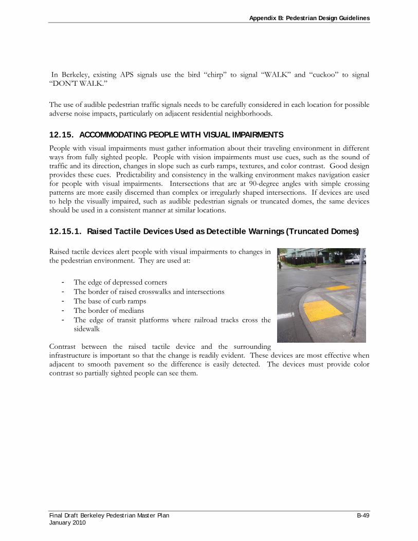
Appendix B: Pedestrian Design Guidelines
Final Draft Berkeley Pedestrian Master Plan B-49 January 2010
In Berkeley, existing APS signals use the bird “chirp” to signal “WALK” and “cuckoo” to signal “DON’T WALK.”
The use of audible pedestrian traffic signals needs to be carefully considered in each location for possible adverse noise impacts, particularly on adjacent residential neighborhoods.
12.15. ACCOMMODATING PEOPLE WITH VISUAL IMPAIRMENTS
People with visual impairments must gather information about their traveling environment in different ways from fully sighted people. People with vision impairments must use cues, such as the sound of traffic and its direction, changes in slope such as curb ramps, textures, and color contrast. Good design provides these cues. Predictability and consistency in the walking environment makes navigation easier for people with visual impairments. Intersections that are at 90-degree angles with simple crossing patterns are more easily discerned than complex or irregularly shaped intersections. If devices are used to help the visually impaired, such as audible pedestrian signals or truncated domes, the same devices should be used in a consistent manner at similar locations.
12.15.1. Raised Tactile Devices Used as Detectible Warnings (Truncated Domes) Raised tactile devices alert people with visual impairments to changes in the pedestrian environment. They are used at:
- The edge of depressed corners - The border of raised crosswalks and intersections - The base of curb ramps - The border of medians - The edge of transit platforms where railroad tracks cross the
sidewalk Contrast between the raised tactile device and the surrounding infrastructure is important so that the change is readily evident. These devices are most effective when adjacent to smooth pavement so the difference is easily detected. The devices must provide color contrast so partially sighted people can see them.

Appendix B: Pedestrian Design Guidelines
B-50 Final Draft Berkeley Pedestrian Master Plan January 2010
The ADAAG standards for detectable warnings are:
- Bottom diameter: 23mm (0.9 in)
- Top diameter: 10 mm (0.4 in)
- Height: 5 mm (0.2 in) - Center-to-center spacing:
60 mm (2.35 in) - Visual contrast: not
specified The US Access Board recommends:
- Visual contrast of at least 70 percent
- Width: 610 mm (24 in) - Location: 152 mm to 200
mm (6 in to 8 in) from the bottom of the ramp
12.15.2. Grooves Grooves are indentations at the top of curb ramps that can be detected by canes in contact with the sidewalk. Curbs along Caltrans facilities in California are required to include 12-inch grooves to form a border at the level surface of the sidewalk.
12.15.3. Raised Tactile Devices Used for Wayfinding In addition to use at curbs, raised tactile devices can be used for wayfinding along a pathway or across a road. This is particularly useful to visually impaired pedestrians in areas where the pedestrian environment is unpredictable. Complex intersections, roundabouts, wide intersections and open plazas are areas where raised tactile devices could be considered. No standards or guidelines for these devices have been adopted nationally. Raised devices with bar patterns can indicate the proper walking direction. Textured pavement that provides enough material and color contrast can be used to mark the outside of crosswalks, in addition to white paint or thermoplastic. Currently the state of California is developing an evaluation and approval process which would result in specific standards for quality, colorfastness, and adhesion for detectable warning devices. Once adopted, this process would require that manufacturers of detectable warning products meet these standards in order to be certified.
Figure 28Berkeley Standard Design Detail for Truncated Domes

Final Draft Berkeley Pedestrian Master Plan C-1 November 2008
APPEND IX C
GENERAL PLAN PEDESTRIAN POLICIES
This Appendix contains a summary of all pedestrian-related policies found in the Berkeley General Plan. For the most up-to-date policies, please refer to the General Plan.
1. TRANSPORTATION ELEMENT: “CORE” PEDESTRIAN POLICIES
POLICY T-48 PEDESTRIAN PLAN
Create a Pedestrian Plan for the purpose of developing additional strategies and policies to make Berkeley safer for pedestrians and to make Berkeley a more pedestrian-friendly city.
Actions Create a Pedestrian Plan for the purpose of developing additional strategies and policies to make Berkeley safer for pedestrians and to make Berkeley a more pedestrian-friendly city.
POLICY T-49 DISABLED ACCESS
Improve pedestrian access for the entire disabled community.
Actions A. Fund sidewalk, crosswalk, curb, signalization and signage, and talking signal improvements.
B. Use regulation and incentives to require or encourage accessibility upgrades for private businesses.
C. Encourage businesses to exceed the minimum standards set by the ADA "readily achievable barrier removal" requirement.
POLICY T-50 SIDEWALKS
Maintain and improve sidewalks in residential and commercial pedestrian areas throughout Berkeley and in the vicinity of public transportation facilities so that they are safe, accessible, clean, attractive, and appropriately lighted.
Actions A. Prioritize pedestrian-serving public improvements, such as sidewalk repair and widening, bus
shelters, street trees and lighting, public art, fountains, and directional signs.
B. Establish safe, attractive pedestrian connections between residential areas, transit, shopping areas, and schools and other community facilities.
C. Ensure that sidewalks are kept in good repair and are level, with a suitable grade for pedestrians and wheelchairs. Discourage, and when possible prevent, new developments from creating uncomfortably steep grades.
D. Ensure adequate unobstructed sidewalk passage by appropriate placement of street furniture and amenities and prevention of obstruction of travel ways by such items as advertisement signs, merchandise, and utility boxes.

Appendix C: General Plan Pedestrian Policies
C-2 Final Draft Berkeley Pedestrian Master Plan November 2008
POLICY T-51 PEDESTRIAN PRIORITY
When addressing competing demands for sidewalk space, the needs of the pedestrian shall be the highest priority.
POLICY T-52 PEDESTRIAN SAFETY AND ACCESSIBILITY
Provide safe and convenient pedestrian crossings throughout the city.
Actions: A. Seek to ensure that the distance between signal-controlled intersections, "smart crosswalks," or
stop signs is never more than one-quarter mile on major and collector streets. At intersections with severe or high pedestrian/automobile collision rates and at heavily used pedestrian crossings, consider all-way stop signals that allow the free flow of pedestrians through the intersection, "smart" signals to calm traffic and improve intersection safety, and pedestrian/bicycle-activated signals that allow bikes and pedestrians to cross busy streets without inviting traffic onto cross streets.
B. Consider pedestrian crosswalk "runway" lights in the pavement at intersections with severe or higher than average pedestrian collision rates.
C. Encourage and educate the public on the use of painted and unpainted crosswalks; enforce jaywalking regulations on main arterials.
D. Encourage the creation of accessible pedestrian medians or islands in wide streets where people have to cross more than two lanes.
E. Enforce pedestrian right-of-way laws.
POLICY T-53 INTERSECTIONS WITH SEVERE OR HIGH COLLISION RATES
Reduce pedestrian and bicycle collisions, injuries, and fatalities.
Action: A. Undertake a review of intersections or street locations with a high number of collisions and/or a
high percentage of fatal or permanently disabling collisions and develop programs with appropriate mix of education, enforcement, and engineering changes to improve the safety of these intersections and locations. Consider:
1. Adding signage at intersections, warning the public that the intersection has been the site of several traffic collisions or fatalities.
2. Moving bus stops to the far side of the intersection so that buses do not block visibility at the intersection when stopping to pick up passengers.
3. Providing an all-red, pedestrian phase to especially congested intersections, giving pedestrians the ability to cross the intersection in any direction before vehicles are given a green light.
4. Lighted crosswalks.
5. Maintaining a minimum 50-foot red, no-parking zone adjacent to the intersection to increase visibility.
6. Re-timing pedestrian crossing signals to allow more time for pedestrian crossing.
7. Other actions recommended by the Bicycle and Pedestrian Safety Report.

Appendix C: General Plan Pedestrian Policies
Final Draft Berkeley Pedestrian Master Plan C-3 November 2008
POLICY T-54 PATHWAYS
Develop and improve the public pedestrian pathway system.
Action: A. Allocate resources to identify and improve unimproved pathways.
B. Maintain a complete and accurate inventory and database of Berkeley's Pathway Network, to include all known public paths, dedicated easements, and rights-of-way.
C. Work with residents and interest groups adjacent to pathways to prepare a "Top Priority Improvement List" for pathway restoration. Give highest priority for public investment to paths that: 1) include neighbor support and a clear title, 2) provide an evacuation route, 3) continue existing paths, and 4) improve neighborhood circulation and provide access to community services and facilities.
D. Continue to make repairs and safety improvements on public paths and restore unimproved paths.
2. GENERAL PLAN TRANSPORTATION ELEMENT: OTHER PEDESTRIAN RELATED POLICIES
POLICY T-12 EDUCATION AND ENFORCEMENT
Support, and when possible require, education and enforcement programs to encourage carpooling and alternatives to single-occupant automobile use, reduce speeding, and increase pedestrian, bicyclist, and automobile safety.
Actions: A. Consider developing a program that rewards households, block groups, or neighborhood
organizations that can document their reduction in automobile use. Consider discounts on electric bicycles to reward automobile use reduction.
B. Encourage hotels, motels, and other visitor destinations to provide visitors with information on public transportation and bicycle services and facilities.
POLICY T-13 MAJOR PUBLIC INSTITUTIONS
Work with other agencies and institutions, such as the University of California, the Berkeley Unified School District, Lawrence Berkeley Laboratory, Vista Community College, the Alameda County Court, and neighboring cities to promote Eco-Pass and to pursue other efforts to reduce automobile trips. (Also see Land Use Policy LU-39.)
Actions: A. Encourage other agencies and institutions to match or exceed the City of Berkeley's trip
reduction and emission reduction programs for their employees.
B. Encourage other agencies, institutions, and cities to use market-pricing mechanisms to reduce automotive use and discourage all-day parking.
C. Encourage the University of California:

Appendix C: General Plan Pedestrian Policies
C-4 Final Draft Berkeley Pedestrian Master Plan November 2008
1. To maintain and improve its facilities and programs that support and encourage pedestrians, bicyclists, and transit riders.
2. To provide bicycle facilities, “all hour” bicycle paths, and timely pavement maintenance.
3. To locate non-student-serving offices and additional staff and student housing at or near BART stations outside Berkeley.
D. Encourage the Berkeley Unified School District to establish programs and facilities to reduce automobile use among staff, faculty, and students, including:
1. Training in safe and competent bicycle use.
2. Providing safe and convenient bicycle facilities.
3. Working with parents to establish carpools, “bicycle to school groups,” and “bus to school groups.”
4. Create programs that offer incentives to use public transportation such as Eco-Pass.
E. Obtain “Safe Routes to School” grants and other funds for programs to make it safer for students to travel to school.
F. Continue limiting the number of residential parking permits given to BUSD faculty and staff.
G. Assist the University of California and the Berkeley Unified School District in developing satellite parking lots with shuttle service for students and staff.
H. Encourage the University of California, the Berkeley Unified School District, and other major institutions to cap parking at current levels while seeking to reduce automobile use.
I. Encourage institutions to create incentives for their employees and students to live locally.
J. Encourage all public and private institutions, including schools, health clubs, recreation centers and other community destinations to organize carpools and shuttles.
POLICY T-16 ACCESS BY PROXIMITY
Improve access by increasing proximity of residents to services, goods, and employment centers. (Also see Land Use Policies LU-13 and LU-23, Housing Policy H-16, and Environmental Management Policy EM-41 Action B.)
Actions: A. Locate essential commercial and other services in transit-oriented locations to reduce the need
for cars and enable people living near transit and services to reduce auto trips.
B. Encourage higher density housing and commercial infill development that is consistent with General Plan and zoning standards in areas adjacent to existing public transportation services.
C. Encourage the University of California to provide additional housing within walking distance of campus to reduce University-related traffic.
D. Encourage siting of child-care facilities and other services in large residential or commercial facilities to reduce traffic impacts associated with child-care drop-off and pick-up.
E. In locations served by transit, consider reduction or elimination of parking requirements for residential development.

Appendix C: General Plan Pedestrian Policies
Final Draft Berkeley Pedestrian Master Plan C-5 November 2008
POLICY T-18 LEVEL OF SERVICE
When considering transportation impacts under the California Environmental Quality Act, the City shall consider how a plan or project affects all modes of transportation, including transit riders, bicyclists, pedestrians, and motorists, to determine the transportation impacts of a plan or project. Significant beneficial pedestrian, bicycle, or transit impacts, or significant beneficial impacts on air quality, noise, visual quality, or safety in residential areas, may offset or mitigate a significant adverse impact on vehicle Level of Service (LOS) to a level of insignificance. The number of transit riders, pedestrians, and bicyclists potentially affected will be considered when evaluating a degradation of LOS for motorists.
Action: A. Establish new multi-modal levels of service (LOS) City standards that consider all modes of
transportation, including transit, bicycles, and pedestrians in addition to automobiles.
POLICY T-20 NEIGHBORHOOD PROTECTION AND TRAFFIC CALMING
Take actions to prevent traffic and parking generated by residential, commercial, industrial or institutional activities from being detrimental to residential areas. (Also see Land Use Policies LU-9, LU- 10, and LU-11.)
Actions: A. Continue to support and actively move forward neighborhood strategies to slow and “calm”
traffic.
B. Endorse strategies to reduce shortcutting and speeding and minimize the use of neighborhood streets by through traffic.
C. Endorse traffic calming strategies that primarily slow traffic.
D. Discourage strategies that divert traffic from one residential street to another residential street.
E. Require that strategies provide for the movement of emergency vehicles to and through the neighborhoods and recognize the needs of the disabled, pedestrians, transit riders, and bicyclists.
F. Make use of street modifications, including sidewalk bulb-outs, and appropriate traffic calming measures to slow traffic on neighborhood streets to 15 or 20 miles per hour and limit 24-hour volumes to less than 1500 cars per day.
G. Support and encourage neighborhood traffic watch associations to work with local enforcement to report and prosecute traffic violations in neighborhood areas.
H. Establish a Residential Traffic Calming Program that includes objective criteria for evaluating neighborhood traffic problems such as traffic volume, pedestrian and bicycle accident rates, and vehicle speeds, especially in areas where children and seniors are concentrated. Include processes to ensure neighborhood participation in the development and evaluation of potential traffic calming solutions.
I. Implement strategies that slow and calm traffic on residential streets including both local streets and residential segments of collector and major streets.
J. Develop engineering, education, and enforcement strategies to discourage speeding on local, collector and major streets. Prioritize speed limit enforcement on local streets and on residential segments of collector and major streets.
K. Evaluate effectiveness of enforcement efforts to prevent speeding and consider increasing the number of traffic enforcement officers if necessary to reduce and control speeding.
Appendix C: General Plan Pedestrian Policies
C-6 Final Draft Berkeley Pedestrian Master Plan November 2008
L. Establish levels of service standards for residential areas on collector and major streets.
M. In residential areas, restrict the use of large buses to Primary and Secondary Routes shown on the Transit Network map, whenever feasible.
POLICY T-24 ASHBY AVENUE
Take actions necessary to reduce congestion, improve pedestrian and bicycle crossings, and improve the quality of life for residents on Ashby Avenue.
Action: A. Ensure safe pedestrian crossing of Ashby Avenue along its entire route, but particularly to City
facilities such as schools, senior citizen centers, and libraries.
POLICY T-25 STREET MAINTENANCE
Maintain streets, sidewalks, and other public infrastructure to reduce long-term replacement costs.
Actions: A. Coordinate pedestrian and transit public improvements with street repairs and repaving.
B. Ensure that street repairs and repaving are completed without negatively affecting the disabled or bicyclists (e.g., ensure that all repaving and patching provides a smooth surface for bicyclists and wheelchairs).
C. Coordinate the work of agencies such as EBMUD and others to minimize the digging up of City streets.
POLICY T-28 EMERGENCY ACCESS
Provide for emergency access to all parts of the city and safe evacuation routes. (Also see Disaster Preparedness and Safety Policy S-22.)
Actions: A. Do not install new full diverters or speed humps on streets identified on the Emergency Access
and Evacuation Network map unless it is determined by the Fire and Police Departments that the installation will not significantly reduce emergency access or evacuation speeds. The Fire Department should be able to access all Berkeley locations within four minutes (see Disaster Preparedness and Safety Element). All other proposed traffic calming devices or obstructions to the free flow of traffic on these streets should be reviewed by the Fire and Police Departments to ensure that the proposed change will not significantly increase emergency response times or hinder effective evacuation of adjacent neighborhoods.
B. Maintain and improve pedestrian pathways throughout the city that are dedicated for public use and provide an alternative to the streets in case of an emergency evacuation.
C. Maintain and make available to the public up-to-date maps of all emergency access and evacuation routes.
D. Where necessary, consider parking restrictions to ensure adequate access for emergency vehicle access and evacuation in hill area neighborhoods with narrow streets.
E. Prioritize evacuation routes for under grounding of overhead utilities.

Appendix C: General Plan Pedestrian Policies
Final Draft Berkeley Pedestrian Master Plan C-7 November 2008
POLICY T-30 TRAFFIC SIGNALS
Continue to pursue better signal devices and systems to facilitate movement on Berkeley’s limited road network. Consider:
1. Signals that provide separate phases for through (straight) traffic, pedestrians and cyclists, and turning traffic.
2. Bus-activated signals.
3. All-way stop signals that allow the free flow of pedestrians through the intersection.
4. “Smart” signals to calm traffic and improve intersection safety.
5. Timed traffic signals to give priority to and speed movement of transit and emergency vehicles.
6. Pedestrian /bicycle-activated signals that allow bikes and pedestrians to cross busy streets.
POLICY T-33 DISABLED PARKING AND PASSENGER ZONES
Ensure adequate disabled parking and passenger drop-off zones.
Actions: A. Require access to adequate disabled parking and passenger drop-off zones in all new commercial
and residential developments.
B. Improve enforcement of disabled "blue zone" parking.
POLICY T-38 INTER-JURISDICTIONAL COORDINATION
Establish partnerships with adjacent jurisdictions and agencies, such as the University of California and the Berkeley Unified School District, to reduce parking demand and encourage alternative modes of transportation.
Actions: A. Promote bicycle and pedestrian travel through training, education, incentive programs, and
physical improvements such as path improvements and signage, bicycle lockers, and shower facilities.
POLICY T-40 PARKING IMPACTS
When considering parking impacts under the California Environmental Quality Act for residential projects with more than two units located in the Avenue Commercial, Downtown, or High Density Residential land use classifications, any significant parking impacts identified that result from the project should be mitigated by improving alternatives to automobile travel and thereby reducing the need for parking. Examples include improvements to public transportation, pedestrian access, car sharing programs, and bicycle facility improvements. Parking impacts for these projects should not be mitigated through the provision of additional parking on the site. The City finds that:
A. Parking supply and demand may easily be adjusted by changing local pricing policies and by changing how the supply is managed.
B. As the parking supply increases or parking costs decrease, automobile use becomes a more attractive transportation alternative and demand for parking increases. As parking supply decreases and its price increases, demand decreases.

Appendix C: General Plan Pedestrian Policies
C-8 Final Draft Berkeley Pedestrian Master Plan November 2008
C. Increasing the parking supply increases automobile use, which causes a measurably negative impact on the environment.
POLICY T-41 STRUCTURED PARKING
Encourage consolidation of surface parking lots into structured parking facilities and redevelopment of surface lots with residential or commercial development where allowed by zoning.
Actions: A. Whenever feasible, orient automobile access to parking lots and garages away from designated
bicycle ways and boulevards and avoid blank walls along pedestrian ways.
3. GENERAL PLAN URBAN DESIGN ELEMENT: PEDESTRIAN RELATED POLICIES
POLICY UD-8 PUBLIC WORKS PROJECTS
In public works projects, seek to preserve desirable historic elements such as ornamental sidewalk features, lampposts, and benches.
Actions: A. Carefully review planned utility undergrounding, sidewalk repair, and other public works projects
to avoid unnecessary removal of light fixtures, planting, and other features with historic or aesthetic value.
B. Establish procedures for the review of work by PG&E, EBMUD, and other agencies responsible for work in the public right-of-way.
C. Provide for review by the Landmarks Preservation Commission of public works projects involving potential change to desirable historic elements.
POLICY UD-26 PEDESTRIAN-FRIENDLY DESIGN
Architecture and site design should give special emphasis to enjoyment by, and convenience and safety for, pedestrians.
Actions: A. Use regulatory review to promote pedestrian-friendly design.
B. Ensure proper placement of elements such as doors and windows, in relation to the sidewalk and streetscape, to ensure pedestrian-friendly design and increase public safety.
POLICY UD-27 RELATION TO SIDEWALK
Projects generally should be designed to orient the main entrance toward the public sidewalk, not a parking lot, and avoid confronting the sidewalk with a large windowless wall or tall solid fence.

Appendix C: General Plan Pedestrian Policies
Final Draft Berkeley Pedestrian Master Plan C-9 November 2008
POLICY UD-28 COMMERCIAL FRONTAGE
Commercial buildings on streets with public transit generally should have no appreciable setback from that street’s sidewalk, except in the case of occasional plazas or sitting areas that enhance the area’s pedestrian environment.
POLICY UD-35 PUBLIC IMPROVEMENTS
Undertake, and/or participate in, major improvement projects aimed at making the streetscape more enjoyable, clarifying and strengthening the urban pattern, and generally enhancing Berkeley’s physical character. Public works projects should be designed to make it easier for people to orient themselves within Berkeley and understand and appreciate the city’s various districts and neighborhoods, as well as to generally enhance the urban environment
Actions: A. Continue to use interdepartmental review to help achieve suitable design of City improvement
projects.
B. Remove existing features that detract from the cityscape, such as unsightly signs and overhead utilities.
C. Emphasize the special characteristics of each district and neighborhood through distinctive public landscaping, street lighting, and pedestrian amenities.
D. Recognize and identify district centers, boundaries, and gateways with distinctive landscaping and physical design improvements.
E. Use pedestrian-scale lighting, wide sidewalks, street trees, gateway features, and other public improvements to reinforce and enhance residential and commercial area character and identity, and improve conditions for pedestrians, bicyclists, and transit riders.
4. GENERAL PLAN ECONOMIC DEVELOPMENT AND EMPLOYMENT ELEMENT: PEDESTRIAN RELATED POLICIES
POLICY ED-4 NEIGHBORHOOD AND AVENUE COMMERCIAL DISTRICTS
Provide programs and services to assist neighborhood and avenue commercial districts.
Actions: A. City efforts in neighborhood and avenue commercial zones should:
1. Assist with the retention and development of existing businesses or attract new businesses that serve local neighborhood needs.
2. Implement capital improvements and expand façade grants to restore original and historic facades.
3. Maintain adequate levels of police presence.
4. Maintain adequate street and sidewalk cleaning for all commercial districts.
5. Enhance the pedestrian orientation of all shopping districts.

Appendix C: General Plan Pedestrian Policies
C-10 Final Draft Berkeley Pedestrian Master Plan November 2008
B. Maintain a diverse mix of commercial goods and services in the shopping districts. Use needs assessments to determine what basic goods and services are lacking, and establish criteria of appropriateness for neighborhood businesses that address the following issues:
1. Availability of basic goods and services that are affordable to local residents.
2. Local ownership.
3. Employment for local residents at living wages.
4. Environmental impact on adjacent neighborhoods and businesses, for example, traffic, noise, and air pollution.
5. Impact on the viability of other business districts and quality of life in other neighborhoods in the city.
5. GENERAL PLAN LAND USE ELEMENT: PEDESTRIAN RELATED POLICIES
POLICY LU-11 PEDESTRIAN- AND BICYCLE-FRIENDLY NEIGHBORHOODS
Ensure that neighborhoods are pedestrian- and bicycle-friendly with well-maintained streets, street trees, sidewalks, and pathways.
Action: Ensure that any City-owned pathways or dedicated easements adjacent to, abutting, or through private property are preserved when reviewing new development proposals.
POLICY LU-16 DOWNTOWN PLAN
Implement the Downtown Plan and take actions to achieve the three goals of the Plan:
1. Express and enhance Berkeley's unique social and cultural character in the Downtown.
2. Create an appealing and safe Downtown environment, with a comfortable pedestrian orientation.
3. Diversify, revitalize, and promote the Downtown economy.
POLICY LU-20 DOWNTOWN PEDESTRIAN AND TRANSIT ORIENTATION
Reinforce the pedestrian orientation of the Downtown.
Actions: A. Continue to explore options for the partial or complete closure of Center Street, Addison Street,
or Allston Way to automobiles to promote the pedestrian and commercial vitality and enhance Civic Center Park use and appearance. When exploring options, carefully consider the experiences of other cities where closures have proven to be successful and where closures have proven to be unsuccessful or detrimental.
B. Implement capital improvement projects that reinforce the pedestrian, transit, commercial, arts, and entertainment orientation of the Downtown and improve the quality of life for visitors and residents of the area.

Appendix C: General Plan Pedestrian Policies
Final Draft Berkeley Pedestrian Master Plan C-11 November 2008
C. Reconstruct the Downtown BART Station and Plaza to be more pedestrian-friendly and visually attractive.
D. Encourage development of public spaces, plazas, and restoration of natural areas in the Downtown and other areas of the city where appropriate to enhance the pedestrian environment.
POLICY LU-26 NEIGHBORHOOD COMMERCIAL AREAS
Maintain and improve Neighborhood Commercial areas, such as Elmwood, Solano, and North Shattuck, as pedestrian-friendly, visually attractive areas and ensure that Neighborhood Commercial areas fully serve neighborhood needs.
Actions: A. Require ground-floor commercial uses to be oriented to the street and sidewalks to encourage a
vital and appealing pedestrian experience.
B. Ensure safe, well-lighted, wide walkways that are appropriately shaded for compatibility with upper-story residential units and adequate traffic signals for pedestrian street-crossings in commercial areas.
C. Provide street trees, bus shelters, and benches for pedestrians in commercial areas.
D. Maintain and encourage a wide range of community and commercial services, including basic goods and services.
E. Use design review and careful land use decisions to preserve the historic character of Neighborhood Commercial areas.
POLICY LU-27 AVENUE COMMERCIAL AREAS
Maintain and improve Avenue Commercial areas, such as University, San Pablo, Telegraph, and South Shattuck, as pedestrian-friendly, visually attractive areas of pedestrian scale and ensure that Avenue areas fully serve neighborhood needs as well as a broader spectrum of needs.
Actions: A. Require ground-floor commercial uses to be oriented to the street and sidewalks to encourage a
vital and appealing pedestrian experience.
B. Ensure safe, well-lighted, wide walkways that are appropriately shaded for compatibility with upper-story residential units and adequate traffic signals for pedestrian street-crossings in commercial areas.
C. Provide street trees, bus shelters, and benches for pedestrians in commercial areas.
D. Maintain and encourage a wide range of community and commercial services, including basic goods and services.
E. Encourage sensitive infill development of vacant or underutilized property that is compatible with existing development patterns.
F. Maintain and improve the historic character of Avenue Commercial areas with design review and careful land use decisions.

Appendix C: General Plan Pedestrian Policies
C-12 Final Draft Berkeley Pedestrian Master Plan November 2008
6. GENERAL PLAN OPEN SPACE ELEMENT: PEDESTRIAN RELATED POLICIES
POLICY OS-2 MAINTENANCE, REPAIR, AND ENHANCEMENTS
Within the context of open space resource allocations, give highest priority to maintaining and improving the City’s existing network of open space and recreation facilities.
The City’s extensive open space network requires ongoing maintenance. Due to funding constraints, required maintenance has often been deferred, which results in higher maintenance and replacement costs. Maintenance of existing resources consists of; ongoing maintenance (upkeep), restoration of resources (repair), and improvements to maximize or improve utilization of existing facilities (improvements).
Actions: A. Restore the network of public paths and historic street features, such as gateways, lighting, and
stairways.
B. Improve access for the disabled to park and open space facilities.
POLICY OS-6 NEW OPEN SPACE AND RECREATIONAL RESOURCES
Create new open space and recreational resources throughout Berkeley.
Actions: A. Convene a community planning process to determine the final use of the remaining 14 blocks of
City-owned land on the Santa Fe Right-of-Way. The community planning process shall consider public open space use (i.e., neighborhood parks, community gardens, and/or bicycle and pedestrian paths) as the highest priority use for the remaining vacant land and new affordable housing development as the next highest priority use.
B. Develop joint-use agreements with other agencies such as the University of California, the Berkeley Unified School District, the Bay Area Rapid Transit District, and regional open space agencies to increase public access to public lands.
POLICY OS-9 AQUATIC PARK
Make Aquatic Park more accessible and usable as a neighborhood park.
Actions: A. Install an effective and attractive noise and visual freeway barrier with landscaping for Aquatic
Park.
B. Provide new safe pedestrian and bicycle railroad crossings, particularly at the southern end of the site, for improved access and circulation from nearby neighborhoods to Aquatic Park.
C. Improve the bicycle path around the park.
POLICY OS-10 ACCESS IMPROVEMENTS
Improve transit, bicycle, disabled, and pedestrian access to and between open space and recreation facilities, including regional facilities such as the Berkeley Marina, University of California open space, East Bay Regional Park District lands, the Eastshore State Park, and recreational facilities in other cities.
Appendix C: General Plan Pedestrian Policies
Final Draft Berkeley Pedestrian Master Plan C-13 November 2008
Actions: A. Develop and maintain a citywide pedestrian and bicycle network that links open space and
recreation facilities with bicycle and walking paths along tree-lined streets, publicly owned pathways, creeks, and other greenways.
B. Maintain opportunities to eventually complete a Cordornices Creek Greenway from the Bay to the hills.
C. Increase shuttle and weekend transit service and weekend street closures to improve access to recreational and open space.
D. Continue to improve pedestrian and bicycle access to the waterfront and Berkeley Marina.
POLICY OS-11 PUBLIC SPACES
Encourage innovative use of public plazas, sidewalks, and temporary street closures as open space or for recreational or cultural events.
Action: A. Design and improve public streets, parking lots, and plazas to provide public spaces for street
fairs, festivals and other gatherings.
7. GENERAL PLAN ENVIRONMENTAL MANAGEMENT ELEMENT: PEDESTRIAN RELATED POLICIES
POLICY EM-33 CITIZEN EFFORTS
Encourage citizen efforts to restore ecological resources and open space areas, such as pathways and stairways.
Action: Work with citizens and businesses to maintain clean streets, sidewalks, and building exteriors.
8. GENERAL PLAN HOUSING ELEMENT: PEDESTRIAN RELATED POLICIES
POLICY H-24 THE ELDERLY AND THE DISABLED
Support housing program activities that increase the ability of elderly and disabled households to remain in their homes or neighborhoods, and if necessary, to locate other suitable affordable housing to rent or purchase.

Appendix C: General Plan Pedestrian Policies
C-14 Final Draft Berkeley Pedestrian Master Plan November 2008
This Page Intentionally Left Blank