APPENDIX 6.6-H – RESULTS OF ARROYO TOAD … · orange grove project application for certification...
15
ORANGE GROVE PROJECT APPLICATION FOR CERTIFICATION APPENDIX 6.6-H – RESULTS OF ARROYO TOAD HABITAT ASSESSMENT FOR THE ORANGE GROVE PROJECT, SAN DIEGO COUNTY, CALIFORNIA
Transcript of APPENDIX 6.6-H – RESULTS OF ARROYO TOAD … · orange grove project application for certification...

ORANGE GROVE PROJECT APPLICATION FOR CERTIFICATION
APPENDIX 6.6-H – RESULTS OF ARROYO TOAD HABITAT ASSESSMENT FOR THE ORANGE GROVE PROJECT, SAN DIEGO
COUNTY, CALIFORNIA
701 Palomar Airport Road, Suite 300, Carlsbad, California 92011 Tel (949) 300-0212 Fax (760) 758-3844, [email protected]
May 15th, 2008 Ms. Elisha Back TRC Companies, Inc. 21 Technology Drive Irvine, CA 92618 Subject: Results of Arroyo Toad Habitat Assessment for the Orange Grove Project, San
Diego County, California Dear Ms. Back: This letter presents the results of a breeding and upland habitat assessment for the federally endangered arroyo toad (Bufo californicus) within the Orange Grove Project study area (Study Area) located approximately two to four miles west of Pala, San Diego County, California. STUDY AREA LOCATION/DESCRIPTION The Orange Grove Project (project) is a proposed 96-megawatt power plant with ancillary facilities including an approximately 2.4-mile natural gas pipeline and an offsite water truck loading station. The Study Area encompasses the power plant site, a 250-foot radius bordering the power plant site, and the proposed natural gas pipeline alignment extending from Pala Del Norte Road in a southwest direction to Rice Canyon Road as shown in Attachment A, Arroyo Toad Habitat Assessment. The Study Area also includes the proposed water truck loading site located adjacent to Rice Canyon Road approximately one mile north of the SR-76 intersection. The Study Area is characterized as abandoned orchards (proposed facilities location), disturbed/developed (existing Pala substation, and former dairy farm facilities), coast live oaks/woodlands, coastal sage scrub, non-native grassland, ruderal, southern mixed chaparral, southern cactus scrub, sumac scrub, and agricultural lands. The Study Area also extends into the vegetated portion of the San Luis Rey River flood prone area at two locations. These two locations are dominated by southern cottonwood willow riparian forest as shown in Attachment A, Arroyo Toad Habitat Assessment. BACKGROUND The arroyo toad was listed as an endangered species by the U.S. Fish and Wildlife Service (USFWS) on December 16, 1994 (59 FR 241: 64859-64866) (USFWS 1994), and is considered a species of special concern by the California Department of Fish and Game. This rather uniformly warty, stocky toad has a light-colored stripe across the head that includes the eyelids. The parotoid glands are oval-shaped, widely separated, and pale toward the front. The underside of the arroyo toad is usually buff-colored and unspotted, and the cranial crests are absent or weak. Early descriptions of the habitat requirements for the arroyo toad are based on detailed life history studies conducted over a period of years by Sweet (1992, 1993). Much of that work was conducted in the Los Padres National Forest in Santa Barbara County. Subsequent to this work, additional studies of populations in other portions of the range have resulted in a somewhat broader habitat description (e.g., Griffin et al. 1999, Ramirez et al. 1999, 2000, 2001, 2002). It can generally be said that the arroyo toad frequents third order or larger washes, streams, and arroyos in semiarid parts of the southwest. Stream substrates range from sands to small cobble, with sandy banks supporting mule fat (Baccharis salicifolia), willows (Salix spp.), cottonwoods (Populus spp.), or

Ms. Elisha Back May 15th, 2008 Page 2
sycamores (Platanus racemosa). The arroyo toad breeds both within streams and in small backwater pools that form along the stream margins, usually in relatively shallow water (four inches). METHODS Ruben S. Ramirez, Jr., research biologist, conducted a review of literature pertaining to the life history, habitat requirements, and distribution of the arroyo toad within and adjacent to the Study Area. Prior to initiating the site survey, the Study Area boundary was mapped onto a recent digitally orthorectified aerial photograph for the purpose of accurately surveying all areas within and adjacent to the potential direct/indirect impact area. A reconnaissance survey of the Study Area was conducted by Mr. Ramirez on April 7th, 2008 to qualitatively assess potential breeding and upland habitat for the arroyo toad. The survey included an assessment of all habitats and culverts (potential movement routes) present within and adjacent to the Study Area. RESULTS Arroyo Toad Distribution within Vicinity of Study Area The arroyo toad has been documented within the San Luis Rey River flood prone area throughout the reach located adjacent to and partially within the Study Area (USFWS 2007, CNDDB 2008). Suitable breeding and high quality upland habitat occurs within those portions of the San Luis Rey River flood prone area located immediately adjacent to the Study Area. Characteristics of Suitable Arroyo Toad Breeding and Upland Habitat Arroyo toads have very specific habitat requirements (Jennings and Hayes 1994). Suitable habitat includes rivers and streams with the following primary constituent elements (i.e., physical and biological features that are essential to the conservation of the species) based on studies completed by Sweet (1992, 1993), Griffin (1999), and Ramirez (1999, 2000, 2001, 2002) and summarized by the USFWS (2000): 1. A hydrologic regime that supplies sufficient flowing water of suitable quality for breeding
followed by complete metamorphosis (i.e., hatching from eggs into tadpoles and completed development from tadpoles into juvenile toads) must be present. In the northern portion of the range, surface water, either as stream flow or persisting pools, must last into at least July.
2. Low gradient stream segments with shallow breeding pools for mating and egg laying, sandy or
fine gravel beds where egg masses are deposited and tadpoles develop, and sparsely vegetated sand and gravel bars that are sufficiently wet, at least temporarily, for juvenile toads to forage and burrow must be present.
3. A natural flooding regime, which reworks sand and gravel bars, scours dense streamside
vegetation, and deposits streamside sand bars and upland sand terraces such that breeding pools, terraces, and vegetation requirements are maintained for all life stages of the toad must be present.
4. Upland sandy terrace habitats of sufficient width and quality with areas of loose sandy soil
where adult toads can burrow outside the breeding season must be present. Non-breeding estivation sites generally posses an associated canopy cover (mule fat, willow spp.) and layer of detritus.

Ms. Elisha Back May 15th, 2008 Page 3
5. Few or no non-native wildlife species (e.g., crustaceans, gamefish, and bullfrogs) which may
compete with or prey on adult or juvenile toads and/or tadpoles and plants (e.g., giant reed which chokes out native vegetation and may alter flood patterns) should be present.
6. Streams and upland areas absent of artificial barriers which interfere with natural flooding
regimes and toad movement (e.g., migration to and from breeding pools, dispersal between populations, or recolonization of previously occupied areas) should be present.
7. Habitats undisturbed by grading, agriculture, or other human-associated land use conversions
should be present. This suite of conditions is vital to the persistence of viable arroyo toad populations, yet occur in dynamic stream systems that are inherently unstable and can change within the lifetime of an individual, for example by a flood event. Arroyo toad habitat is generally produced and maintained by narrow drainages of intermediate size (Sweet 1992), typically third to sixth order streams or larger, generally where the stream is still bordered by ridges of moderate relief and the stream gradient is low. In headwater areas above these stream segments, the higher stream gradient, lack of sediment build up, and smaller amount of available water result in sections that dry too soon. Downstream of these areas, the broader canyons and increased streambed width result in early loss of surface flows or increased stream gradients drain available water too quickly. Characteristics of Suitable Arroyo Toad Breeding and Upland Habitat within and Adjacent to the Study Area To evaluate the presence of potentially suitable breeding and upland habitat within and adjacent to the Study Area, habitat conditions observed during the site survey were compared with the primary constituent elements identified above. Breeding Habitat Habitats located within the Study Area do not represent suitable breeding habitat for the arroyo toad. The two channels that occur in the southwestern-most portion of the Study Area which drain in a southward direction through culverts (1) and (2) have scattered regions of inundation as shown in Attachment B, Culvert (1) Photographs, Attachment C, Culvert (2) Photographs. Based on the lack of suitable substrate conditions and degraded adjacent vegetation (due to active agriculture), the arroyo toad is not expected to breed in these channels. Also, no suitable arroyo toad breeding habitat was documented within the two portions of the San Luis Rey River flood prone area characterized as southern cottonwood willow riparian forest (Area 1 and 2) located within the Study Area. The isolated inundated areas documented within Area 2 as noted in Attachment A, Arroyo Toad Habitat Assessment, were characterized as freshwater marsh habitat and did not possess suitable substrates and an open canopy representative of arroyo toad breeding habitat. No arroyo toad larvae or clutches were documented or are expected to occur at this location. However, as discussed below, Areas 1 and 2 represent high quality arroyo toad foraging, movement, and estivation habitat. Upland Habitat The following upland habitat assessment is based on the presence and/or absence of suitable estivation habitat located onsite and within the vicinity of potential movement routes between the San Luis Rey River flood prone area and Study Area. The majority of the Study Area is expected to have been utilized historically as upland habitat by the arroyo toad. However, traffic flows on SR-76 are expected to significantly reduce the likelihood of

Ms. Elisha Back May 15th, 2008 Page 4
successful movement between the San Luis Rey River flood prone area and those habitats located north and west of SR-76. Although SR-76 in the absence of traffic does not represent a barrier to potential arroyo toad movement, based on current conditions and traffic flow generated by the Pala and Pauma Indian Casinos during all hours of the day, large culverts are expected to represent the primary routes for successful arroyo toads movements between the San Luis Rey River and upland resources located north of SR-76. Arroyo toads were documented utilizing a large culvert near Gird Road to move between upland aestivation habitat and the San Luis Rey River during previous studies within the watershed (Personal Observation). A portion of the northern Study Area extends into the San Luis Rey River flood prone area and is characterized as southern cottonwood willow riparian forest (Area 1) as shown in Attachment A, Arroyo Toad Habitat Assessment. This region represents high quality arroyo toad estivation habitat. However, project initiation would not result in either a direct and/or indirect impact to the arroyo toad in this portion of the Study Area. All construction activities near Area 1 would occur west of SR-76. A portion of the central Study Area also extends into the San Luis Rey River flood prone area and is characterized as southern cottonwood willow riparian forest (Area 2) as shown in Attachment A, Arroyo Toad Habitat Assessment and Attachment D, Study Area Photographs. Portions of this area represent high quality arroyo toad upland habitat. However, project initiation is not expected to result in either a direct and/or indirect impact to the arroyo toad in this portion of the Study Area if standard avoidance measures are implemented. All construction activities in this area would occur along an existing dirt road and would not result in any direct impact to riparian vegetation (potential arroyo toad upland habitat). Although arroyo toads may occasionally utilize the dirt road for foraging and movement, the rip/rap slope located between the dirt road and riparian canopy would prevent direct access by arroyo toads. The balance of the vegetation communities within the San Luis Rey River flood prone area located south and east of SR-76 and within the Study Area are disturbed, developed, or agricultural lands. None of these areas represent suitable arroyo toad estivation habitat. However, arroyo toads may utilize portions of these lands for movement, foraging, and temporary burrowing during the breeding season. Nonetheless, project initiation is not expected to result in either a direct and/or indirect impact to the arroyo toad in this portion of the Study Area if standard avoidance measures are implemented. Based on the known movement capacity of the arroyo toad within drainages (>1.0 mile) and within upland terraces outside of flood prone areas(0.8 mile), two (2) channels/culverts represent potential movement routes between the San Luis Rey River flood prone area and Study Area. The two channels/culverts which represent potential movement routes are approximately 1 foot in diameter as shown in Attachments B and C. Channel/Culvert 1 is accessible to the arroyo toad as a potential movement route between the Study Area and San Luis Rey flood prone area. Culvert 1 is located near the intersection of SR-76 and Rice Canyon Road. As the channel extends south of Culvert 1, a small reach of this drainage/bench habitat, which occurs within the Study Area, represents marginal arroyo toad upland habitat. The parcel located between this reach and Couser Canyon Road is characterized as agricultural lands. Although this habitat is not characteristic of quality upland arroyo toad estivation habitat, based on the lack of obstructions which would preclude the arroyo toad from moving between this area and the San Luis Rey River flood prone area and presence of suitable soils, the species may infrequently utilize this area when foraging or searching for upland estivation habitat. Arroyo toads have been documented to use similar habitat types when no obstructions exist between breeding and upland aestivation sites (San Mateo Creek, Griffin 1999). As the channel extends 4,000 feet north of Pala Road from Culvert 1, the conditions both within and adjacent to the channel are extensively disturbed (concrete channelized, agricultural terraces) and

Ms. Elisha Back May 15th, 2008 Page 5
do not represent suitable upland estivation habitat. The channel finally extends upstream to coast live oak woodland habitat located within the Study Area surrounding the proposed water truck loading station as shown in Attachment E, Rice Canyon Photographs and Attachment F, Study Area Photographs. Although I would characterize this woodland as suitable arroyo toad upland habitat, it remains unlikely that the species is moving over existing obstacles and disturbed conditions to this habitat. No direct or indirect impacts to the arroyo toad would be expected from project initiation at this location given that all construction activities would be conducted outside of the channel. Culvert 2 is accessible to the arroyo toad as a potential movement route between the Study Area and San Luis Rey flood prone area. The lands located immediately east and west of this reach and Couser Canyon Road are characterized as agricultural lands as shown in Attachment F, Study Area Photographs. This habitat is not characteristic of quality upland estivation habitat. However, based on the lack of obstructions which would preclude the arroyo toad from moving between this area and the San Luis Rey River flood prone area and the presence of suitable soils, the species may infrequently utilize this area when foraging or searching for upland estivation habitat. All project-related activities in the vicinity of Channels/Culverts 1 and 2 are proposed north of SR-76 and no direct impacts to the arroyo toad are expected in this area. In addition, no indirect impacts to arroyo toad breeding habitat in the San Luis Rey River associated with inadvertent discharges into Rice and Couser stream channels are expected given implementation of the Storm Water Pollution Prevention Plan (SWPPP) associated with the project. RECOMMENDATIONS No potential arroyo toad breeding habitat is present within the Study Area. Therefore, USFWS protocol surveys are not warranted. The USFWS protocol surveys were developed to determine presence/absence at potential arroyo toad breeding sites and are not intended or adequate for assessing potential upland habitat utilization. Breeding Season Conservation Measures For construction activities that occur between March 1st and August 31st (breeding season for this region), implementation of the following conservation measures would likely avoid adverse impacts to the arroyo toad. 1 Exclusionary fencing should be installed between the southern cottonwood willow riparian
forest (Area 2 as shown in Attachment A) and the impact area. Specifically, the fencing would be installed on the southwest side of the dirt road where the pipeline would be installed. Such fencing would consist of woven nylon netting approximately 3 feet in height attached to wooden stakes. Prior to installing the fencing, a narrow trench approximately 3 to 6 inches in depth would be excavated and the fence buried, to prevent burrowing beneath the fence. All fencing materials (i.e., mesh, stakes, etc.) would be removed following construction. Ingress and egress of construction equipment and personnel would be kept to a minimum, but when necessary, equipment and personnel would use a single access point to each of the project areas. Toad exclusionary fencing should be checked daily by the contractor before and after each day’s construction activities for damage and all necessary repairs should be made immediately. All fencing would be removed following completion of all project related activities.
2 Project-related vehicle travel should be limited to daylight hours, as potential roadway
mortality of arroyo toads would be expected to be greatest at night. 3 A monitoring biologist should be onsite during initial clearing and grubbing activities to
ensure compliance with all proposed conservation measures. The monitoring biologist

Ms. Elisha Back May 15th, 2008 Page 6
would prepare reports for the project proponent and permitting agency (if required) that document compliance with these measures. The biologist should perform the following duties:
a. Submit weekly reports (including photographs of impact areas) to the project
proponent during: a) initial clearing and grubbing activities; and b) installation of exclusionary fencing. The weekly reports should document that authorized impacts were not exceeded and general compliance with all conservation measures were met.
b. The biologist should prepare a final report for the project proponent within 60 days
of project completion that includes: as-built construction drawings with an overlay of habitat that was impacted, photographs of the project areas, and other relevant summary information documenting general compliance with all avoidance measures.
4 The applicant should ensure that the following conditions are implemented during project
construction:
a. Employees should strictly limit their activities, vehicles, equipment, and construction materials to predetermined staging areas or existing roads.
b. To avoid attracting predators, project areas should be kept as clean of debris as
possible. All food-related trash items should be enclosed in sealed containers and regularly removed from the project areas.
c. No pets should be allowed in the project areas.
d. Brush and other debris should be properly managed.
e. All equipment maintenance, staging, and dispensing of fuel, oil, or coolant should
occur within a predetermined staging area. Contractor equipment should be checked for leaks prior to operation and repaired as necessary. “No-fueling zones” should be designated on gas pipeline construction plans, if fueling will occur outside of the designated pipeline construction staging areas.
f. A qualified biologist should conduct an endangered species awareness training
session for all project personnel prior to the start of the proposed construction activities. The training would include a description of the arroyo toad and its habitats, general provisions of the ESA, need to adhere to the provisions of the ESA, penalties associated with violating the ESA, general measures that are being implemented to conserve the arroyo toad (as they relate to the project), and construction site boundaries.
Non-Breeding Season Conservation Measures For construction activities that occur between August 1st and February 28th (non-breeding season for this region), implementation of conservation measures 3 and 4 above would likely avoid adverse impacts to the arroyo toad. If you have any comments or questions, please contact me at 949.300.0212 or e-mail me at [email protected].

Ms. Elisha Back May 15th, 2008 Page 7
Sincerely, Cadre Environmental
Ruben S. Ramirez, Jr. Research Biologist ATTACHMENT A - Arroyo Toad Habitat Assessment ATTACHMENT B - Culvert (1) Photograph ATTACHMENT C - Culvert (2) Photographs ATTACHMENT D - Study Area Photographs ATTACHMENT E – Rice Canyon Photographs ATTACHMENT F - Study Area Photographs REFERENCES Campbell, L., Graham, T., Thibault, L. and P. Stine. 1996. The arroyo toad (Bufo microscaphus
californicus), ecology, threats, recovery actions, and research needs. Technical Report NBS/CSC-96-01 for the U.S. Fish and Wildlife Service, Ventura Field Office. 46 pp.
Griffin, P.C., T. Case, and R. Fisher. 1999. Radio telemetry study of Bufo californicus, arroyo toad
movement patterns and habitat preferences. Contract Report to the California Department of Transportation Southern Biology Pool. 66 pp.
Holland, D.C, N.R. Sisk, and R.H. Goodman. 2001. Linear Transect Censusing of the Arroyo Toad (Bufo californicus) from 1996-2000 on MCB Camp Pendleton, San Diego County, California. Unpublished report 56 pp.
Holland, D.C, and N.R. Sisk. 2001. Habitat Use and Population Demographics of the Arroyo Toad
(Bufo californicus) on MCB Camp Pendleton, San Diego County, California 1998-2000. Unpublished report 43 pp.
Jennings, M. and M. Hayes. 1994. Amphibian and Reptile Species of Special Concern in
California. California Department of Fish and Game, Inland Fisheries Division, Contract No. 8023. 255 pp.
Pacific Southwest Biological Services. 2004. The Groves of San Luis Rey Downs – A Residential
Subdivision on 281-acres in the Bonsall Area, San Diego County California – Delineation of Jurisdictional Drainages and Wetlands. Unpublished report 14 pp.
Ramirez, Jr. R.S. 2002. Arroyo toad (Bufo californicus) radio telemetry study, Little Rock Creek, Los Angeles County, California. Final Report for the USDA Forest Service, Angeles National Forest, Arcadia, California. Unpublished report. 62 pp.
Ramirez, Jr. R.S. 2002. Arroyo toad (Bufo californicus) radio telemetry, San Juan Creek,
Orange/Riverside Counties, California. Interim Report for the USDA Forest Service, Cleveland National Forest, Rancho Bernardo, California. Unpublished report 53 pp.
Ramirez, Jr. R.S. 2002. Arroyo toad (Bufo californicus) radio telemetry & pitfall trapping studies,
Little Horsethief Canyon, Summit Valley Ranch, San Bernardino County, California. Final Report for Caltrans, District 8, San Bernardino County, California. Unpublished report 92 pp.

Ms. Elisha Back May 15th, 2008 Page 8
State of California Resources Agency. 2008. Department of Fish and Game. Natural Diversity
Database (CNDDB). Database Record Search for Information on Threatened, Endangered, Rare, or Otherwise Sensitive Species and Communities, Pala Quadrangle.
Stebbins, R. 1985. A Field Guide to Western Reptiles and Amphibians. Houghton Mifflin
Company, Boston, MA. 336 pp. Sweet, S.S. 1992. Initial report on the ecology and status of the arroyo toad (Bufo microscaphus
californicus) on the Los Padres National Forest of Southern California with management recommendations. Contract report to USDA, Forest Service, Los Padres National Forest, Goleta, California. 198 pp.
Sweet, S.S. 1993. Second report on the ecology and status of the arroyo toad (Bufo microscaphus
californicus) on the Los Padres National Forest of Southern California. Contract report to USDA, Forest Service, Los Padres National Forest, Goleta, California. 73 pp.
U.S. Fish and Wildlife Service (USFWS). 1994. Endangered and threatened wildlife and plants;
determination of endangered status for the arroyo southwestern toad. Federal Register 59:64859-64866.
U. S. Fish and Wildlife Service (USFWS). 1999. Arroyo southwestern toad (Bufo microscaphus
californicus) recovery plan. U. S. Fish and Wildlife Service, Portland, Oregon. vi. + 119 pp. U.S. Fish and Wildlife Service (USFWS). 2007. Biological Opinion Concerning the Proposed
Rosemary’s Mountain Quarry and Associated State Route 76 Expansion, San Diego County, California.
U.S. Fish and Wildlife Service (USFWS). 2007. GIS Species Database.
CADREEnvironmental
1 inch = 1,000 feet
State Route - 76State Route - 76
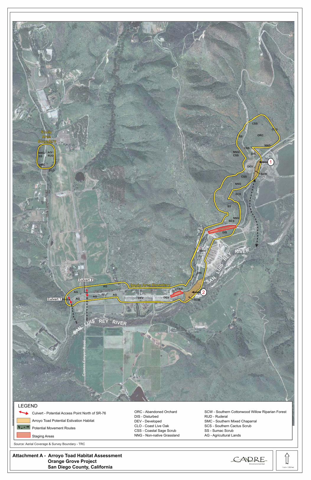
Attachment A - Arroyo Toad Habitat Assessment
Orange Grove Project
San Diego County, California
LEGEND
Culvert - Potential Access Point North of SR-76
Arroyo Toad Potential Estivation Habitat
Potential Movement Routes
Staging Areas
SAN
LUIS REY RIVER
1
2
Ric
e C
an
yo
n R
oad
Ric
e C
an
yo
n R
oad
Study Area BoundaryStudy Area Boundary
Source: Aerial Coverage & Survey Boundary - TRC
ORC
CLO
NNG
DIS
CSS
SS
DEV
CSS
NNG/
CSS
CSS
SCS
NNG
SS
SCW
SCSNNG
DEV DEV
DEV
DIS
DIS
AG
AG
AG
AGAG
SCW
CLO
AG/
RUD
SMC
NNG/
SS
ORC - Abandoned Orchard
DIS - Disturbed
DEV - Developed
CLO - Coast Live Oak
CSS - Coastal Sage Scrub
NNG - Non-native Grassland
SCW - Southern Cottonwood Willow Riparian Forest
RUD - Ruderal
SMC - Southern Mixed Chaparral
SCS - Southern Cactus Scrub
SS - Sumac Scrub
AG - Agricultural Lands
SAN
LU
ISRE
YRIVE R
Pala
Del
No
rte
Roa
d
Culvert 1
Culvert 2
CLO
Study Study
Area Area
BoundaryBoundary
Co
us
er
Ca
nyo
nR
oad

Attachment B - Culvert (1) Photographs
Orange Grove Project
San Diego County, California
CADREEnvironmental
Top: This culvert (1) (approx. 1ft diameter) is accessible to the arroyo toad
as a potential movement route from the San Luis Rey River flood prone
area north of SR-76. However based on the disturbed conditions of the
creek for approx 4,000 feet including rip/rap, concrete channelization and
lack of adjacent upland habitat, it is unlikely that the arroyo toad is utilizing
these areas extensively.
Bottom: Downstream of culvert (1) located within the study area and south
of SR-76. The narrow floodprone area represents marginal upland habitat
for the arroyo toad.
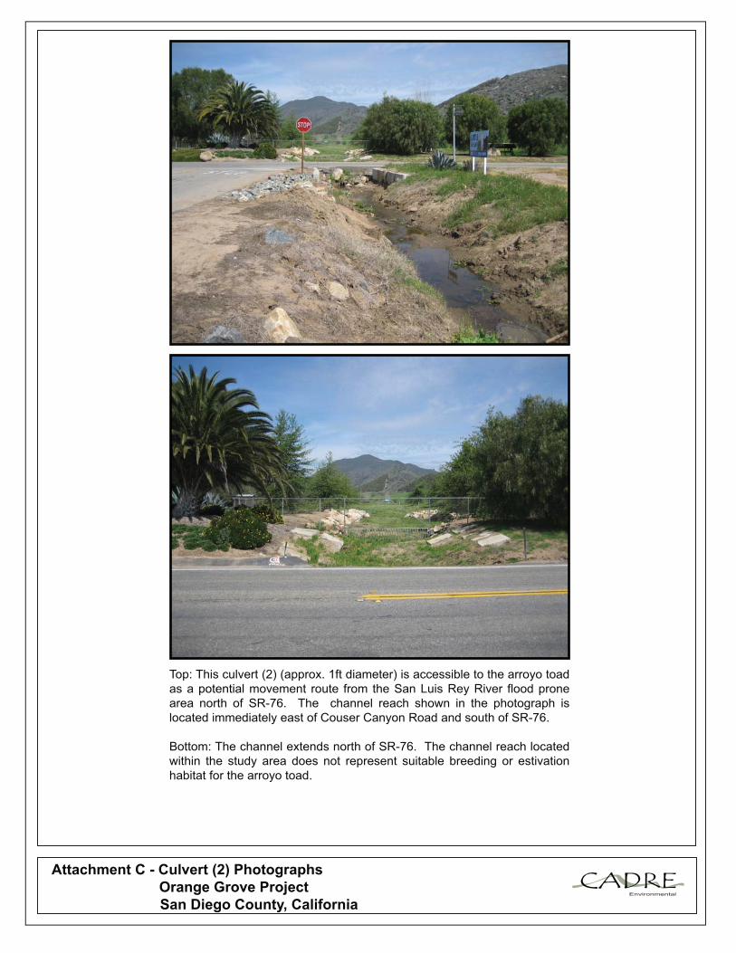
Attachment C - Culvert (2) Photographs
Orange Grove Project
San Diego County, California
CADREEnvironmental
Top: This culvert (2) (approx. 1ft diameter) is accessible to the arroyo toad
as a potential movement route from the San Luis Rey River flood prone
area north of SR-76. The channel reach shown in the photograph is
located immediately east of Couser Canyon Road and south of SR-76.
Bottom: The channel extends north of SR-76. The channel reach located
within the study area does not represent suitable breeding or estivation
habitat for the arroyo toad.

Attachment D - Study Area Photographs
Orange Grove Project
San Diego County, California
CADREEnvironmental
Top: Former dairy farm located within the survey area south of SR-76.
Although this region does not represent suitable arroyo toad estivation
habitat, individuals may utilize this area for foraging and movement.
Bottom: Two regions of the study area are characterized as southern
cottonwood willow riparian forest and represent high quality arroyo toad
estivation habitat. The proposed project impacts would occur within the
existing dirt road illustrated in the photograph and no direct impacts to
potential estivation habitat would occur as a result of project initiation and
implementation of standard avoidance measures.

Attachment E - Rice Canyon Photographs
Orange Grove Project
San Diego County, California
CADREEnvironmental
Top: The cement channelized reach of this channel (adjacent to Rice
Canyon Road) is approximately 1,000ft upstream from Culvert (1). There
is also small sized rip/rap located on the downstream edge of the channel.
Bottom: The channel is unvegetated for approximately 3,000 feet
upstream from the cement channelized reach. Adjacent habitats to this
reach are disturbed/agriculture. The channel finally extends upstream to
coast live oak woodland habitat located within the study area. Although
under different circumstances I would characterize this woodland region
as suitable arroyo toad upland habitat, it remains unlikely that the species
is moving over the existing obstacles and disturbed conditions to this
resource.

Attachment F - Study Area Photographs
Orange Grove Project
San Diego County, California
CADREEnvironmental
Top: Southwestern region of study area where the dominant vegetation
community is agricultural lands. Although the arroyo toad may
occasionally forage and burrow in this region during the breeding season,
this habitat does not represent suitable estivation habitat.
Bottom: Proposed water truck loading station study area located adjacent
to Rice Canyon Road. Dominant vegetation communities located within
the study area include agricultural lands/ruderal, non-native
grassland/sumac scrub, and southern mixed chaparral. This region is not
expected to be utilized by the arroyo toad for breeding or upland
estivation.