Appendix 6.2 Natura Impact Statement The Final...Laois – Kilkenny Reinforcement Project Natura...
149
Environmental Report Appendices for Laois-Kilkenny Reinforcement Project Appendix 6.2 Natura Impact Statement
Transcript of Appendix 6.2 Natura Impact Statement The Final...Laois – Kilkenny Reinforcement Project Natura...

Environmental Report Appendices for Laois-Kilkenny Reinforcement Project
Appendix 6.2 Natura Impact Statement
Laois Kilkenny Reinforcement Project
Environmental Reports
Natura Impact Statement
Submission to: EirGrid
160 The Oval
Shelbourne Road
Dublin 4
By: AOS Planning Limited
2nd Floor The Courtyard
25 Great Strand Street
Dublin 1
Tel 01 874 7704
E-mail: [email protected]
December 2012
Laois Kilkenny Reinforcement Project Natura Impact Statement December 2012
Table of Contents
Executive Summary 1
1 Introduction 2
1.1 Statutory Context 2
2 Methodology 3
3 Description of European Site 4
3.1 River Barrow and Nore cSAC (NPWS Site Code: 2162) 4
4 Potential Impacts 9
4.2 Cumulative Impacts 15
4.3 Mitigation Measures 16
5 Residual Impacts 25
6 Conclusion 28
7 References 29
List of Appendices
Appendix 1: Laois Kilkenny Reinforcement Project: Appropriate Assessment Screening Report
Appendix 2: Map showing the known distribution of the Nore
Freshwater Pearl Mussel in relation to the proposed development.
Appendix 3: Report on Ecological Mitigation Measures at
Specified Sensitive Locations prepared by ESB International.

Laois – Kilkenny Reinforcement Project Natura Impact Statement December 2012
Page 1
Executive Summary
This Natura Impact Statement has been prepared to assess the potential impacts of
the Laois - Kilkenny Reinforcement Project on the River Barrow and River Nore cSAC,
a designated European site as required under Article 6 of the EU Habitats Directive.
Stage 1 Appropriate Assessment Screening previously concluded that the proposed
development has the potential to adversely impact the River Barrow and River Nore
cSAC during the construction phase (See Appendix 1 of this report).
The potential impacts that were identified during the screening stage relate to
possible deterioration in water quality within the cSAC due to sediment run-off from
construction sites, and a risk posed by other harmful substances (such as fuel and
cement).
Potential significant adverse impacts on the cSAC that have been identified relate the
works associated with the following elements of the project:
Coolnabacky substation site – construction phase
Ballyragget substation site – construction phase
Transmission structure (Poleset and Angle Mast) locations in close proximity
to watercourses which feed into the River Barrow and River Nore cSAC –
construction phase
Conifer plantations that require felling along the new Ballyragget to
Coolnabacky 110 kV line route – construction phase
A series of detailed mitigation measures have been developed to address the
potential impacts that have been identified. Proposals are also made with regards
monitoring the effectiveness of these measures.
The correct implementation of all mitigation measures detailed in this report will
ensure that the conservation objectives for the cSAC will not be compromised by the
proposed development, nor by any cumulative effects and no significant impact is
anticipated on any of the species and habitats for which the site is designated.
In conclusion, through the process of Appropriate Assessment, it is the considered
view of the author that the proposed development will have no adverse impact on
the integrity of the designated site as a whole or on any other designated site.

Laois – Kilkenny Reinforcement Project Natura Impact Statement December 2012
Page 2
1 Introduction
Appropriate Assessment screening that was undertaken on the proposed Laois -
Kilkenny Reinforcement project concluded that the proposed development has the
potential to adversely impact the River Barrow and River Nore cSAC during the
construction phase (See Appendix 1 of this report).
This report further describes and assesses the potential impacts of the proposed
work on the conservation objectives of the European site. Mitigation measures are
proposed to address any identified impacts and the likely effectiveness of the
mitigation and any potential residual impacts are reported.
1.1 Statutory Context
This Natura Impact Statement has been prepared in accordance with the European
Commission Methodological Guidance on the provision of Article 6(3) and 6(4) of the
Habitats Directive 92/43/EEC (European Commission 2002), the European
Commission Guidance ‘Managing Natura 2000 Sites’ (European Commission 2000)
and with reference to the Department of the Environment and Heritage and Local
Government guidance on ‘Appropriate Assessment of plans and projects in Ireland’
(DEHLG 2009).
The EU Habitats Directive (92/43/EEC) provides the framework for legal protection
for habitats and species of European importance. The directive provides the
legislative means to establish a network of sites (known as the Natura 2000 network)
throughout the EU with the objective of conserving habitats and species deemed to
be of Community interest. These sites include candidate Special Areas of
Conservation (cSACs) designated under the Habitats Directive and Special Protection
Areas (SPAs) designated under the Birds Directive (formally known as the
Conservation of Wild Birds Directive 79/409/EEC). Both directives have been
transposed into Irish law by the recently enacted European Communities (Birds and
Natural Habitats) Regulations 2011 (SI 477/11).
Article 6 (3) and 6(4) of the habitats directive lays down the procedure to be
followed when planning new developments that might affect a European site. This
stepwise procedure requires that a plan or project having a likely significant negative
effect on a European site undergoes an Appropriate Assessment of its implications
for the site in view of that site’s conservation objectives.
Depending on the findings of the Appropriate Assessment the competent authority
shall agree to the proposed development only if the competent authority has
ascertained that the proposed development will not adversely affect the integrity of
the site concerned.

Laois – Kilkenny Reinforcement Project Natura Impact Statement December 2012
Page 3
However, should this assessment have ascertained that there will be an adverse
effect it may require one or more of the following, depending on the degree of
impact:
specific mitigation measures are introduced to remove the negative effects;
certain conditions are respected during the construction, operational or
decommissioning phases of the project, again to remove the likelihood of
negative effects or to reduce them to an insignificant level where they no
longer affect the integrity of the site;
feasible alternatives are explored instead.
In exceptional circumstances, a plan or project may still be allowed to go ahead
under certain conditions, in spite of being assessed as having negative effects on the
site provided the procedural safeguards laid down in the Habitats Directive are
followed (Article 6(4)). This may be possible, for instance, if the plan or project is
considered to be of overriding public interest and there are no less damaging
alternatives available. In such cases, compensation measures will need to be
implemented to ensure that the overall coherence of Natura 2000 is protected.
2 Methodology
There are up to four successive stages involved in the Appropriate Assessment
process (European Commission 2002). The outcome at each stage determines
whether the next stage in the process is required. Stage 1 Screening is the first stage
in the process and is carried out to determine the necessity for a more detailed Stage
2 Appropriate Assessment where potential impacts are deemed to be of significance.
The outcome of screening for the Laois - Kilkenny Reinforcement project is presented
in a standalone Appropriate Assessment Screening Statement presented as Appendix
1 to this report. Screening concluded that Appropriate Assessment of the potential
impacts on the River Barrow and River Nore cSAC was necessary.
Stage 2 Appropriate Assessment which is presented in this report involves the
following steps:
Description of Natura site where significant impacts are foreseen
Description of impacts on conservation objectives of the site
Mitigation and recommendations
Conclusion
A number of ecological surveys and reports have been carried out on the project in
order to inform the ecological impact assessment. These have been primarily
concerned with the 'new build' elements of the project, for example the proposed

Laois – Kilkenny Reinforcement Project Natura Impact Statement December 2012
Page 4
new overhead line from Ballyragget to Coolnabacky and the Coolnabacky substation.
These reports, which have helped inform the assessment, include the following:
Ecological constraints report October 2010 (Stage 1 Report Appendices, D1-
D6)1
Coolnabacky substation site selection report (Stage 1 Appendix G)1
Winter bird surveys undertaken over two seasons (March – April 2010 and
October 2010 - April 2011) (Stage 1 Report Appendices D7, D8 and D9; and
Stage 2 Report Appendix D)1, 2
Ecological assessment of potential route corridors and route corridor selection
March 2011 (Stage 1 Report, Appendices I1-I6)1
Ecological assessment of proposed project which included multidisciplinary
walkover surveys (to inform Chapter 6 of the Environmental Report)
A precautionary approach was taken throughout the route and site selection process
with the aim of avoiding, where possible, potential impacts on the ecological
constraints identified. The main ecological constraints (including European sites in
the surroundings) were identified at the earliest stage in the project. Consultation
was undertaken with both National Parks and Wildlife Service (NPWS) of the
Department of Arts Heritage and Local Government and Inland Fisheries Ireland (IFI)
during the preparation of this report.
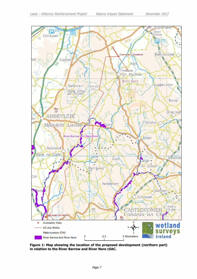
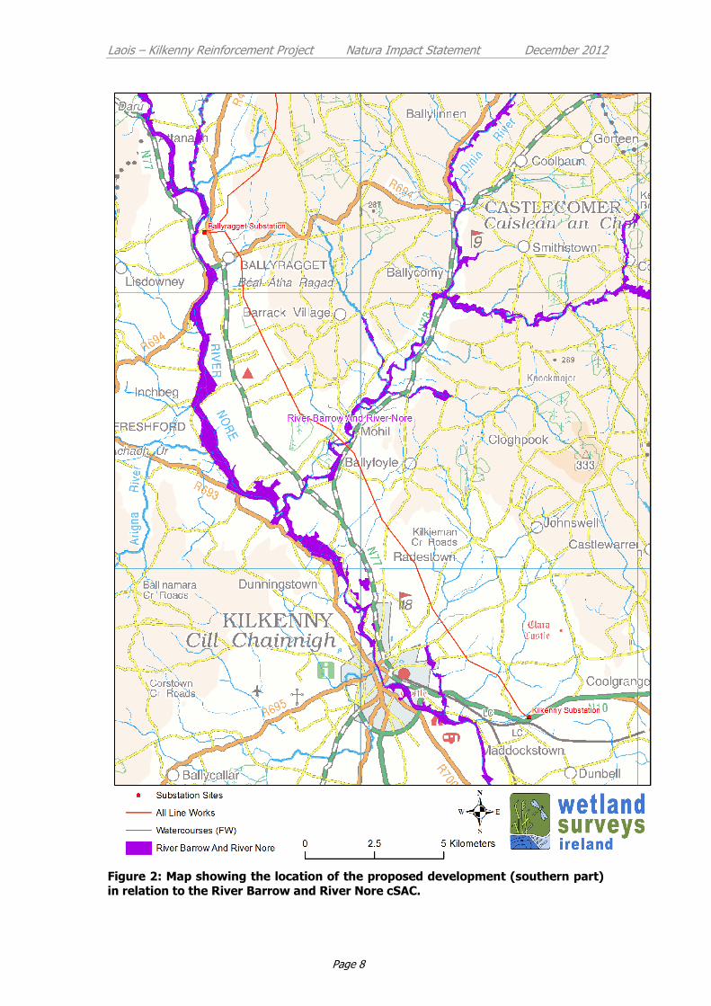
3 Description of European Site
The single European site identified for Stage 2 Appropriate Assessment is the River
Barrow and River Nore cSAC (NPWS Site Code: 2162). Maps showing the location of
the proposed development in relation to the European site is presented in Figure 1
(northern part Coolnabacky to Ballyragget) and Figure 2 (southern part, Ballyragget
to Kilkenny).
3.1 River Barrow and Nore cSAC (NPWS Site Code: 2162)
The qualifying interests of the River Barrow and River Nore cSAC include those
species and habitats presented in Table 1. The conservation objectives for the site
have recently been published together with the attributes and targets which define
the favourable conservation condition for each qualifying species and habitat for
which the site is designated (NPWS 2011)3. In summary the Conservation objectives
for the River Nore and Barrow cSAC are to maintain or restore the favourable
1 Phase 1 Lead Consultants Report May 2011 – and detailed in the planning application documents 2 Phase 2 Lead Consultants Report March 2012 – and detailed in the planning application documents
3http://www.npws.ie/media/npwsie/content/images/protectedsites/conservationobjectives/
CO002162.pdf
Laois – Kilkenny Reinforcement Project Natura Impact Statement December 2012
Page 5
conservation condition of the Annex I habitat(s) and/or the Annex II species for
which the cSAC has been selected as presented in Table 1 below (NPWS 2011). The
distribution of Annex I habitats and Annex II species throughout the cSAC is
reviewed in the Conservation Objectives report for the site (NPWS 2011).
There are two types of freshwater pearl mussels in Ireland, one called Margaritifera
margaritifera and the other is the very rare Margaritifera durrovensis, which is only
known from the Nore Catchment. Populations of the Nore Freshwater Pearl-mussel
(Margaritifera durrovensis) were only ever known from the Barrow, Nore and Suir
main channels. It is now thought to be restricted to a short section of approximately
10km of the main Nore channel with most of the population found between
Poorman’s Bridge and the Avonmore Creamery above Ballyragget (S 440 722). The
species is in very serious decline and is listed as critically endangered in Ireland as
outlined in the Freshwater Pearl Mussel Nore Sub-Basin Management Plan (North
South 2 Project 2010). The known distribution of the Nore freshwater Pearl-mussel in
relation to the proposed development is shown in Appendix 2.
A number of the Annex II aquatic species of the cSAC occur in watercourses in
proximity to the proposed development including River and Brook Lamprey, Atlantic
Salmon, Freshwater White-clawed Crayfish (NPWS 2011). These species would all be
sensitive to deterioration in water quality or habitat alteration due to the effects of
siltation.
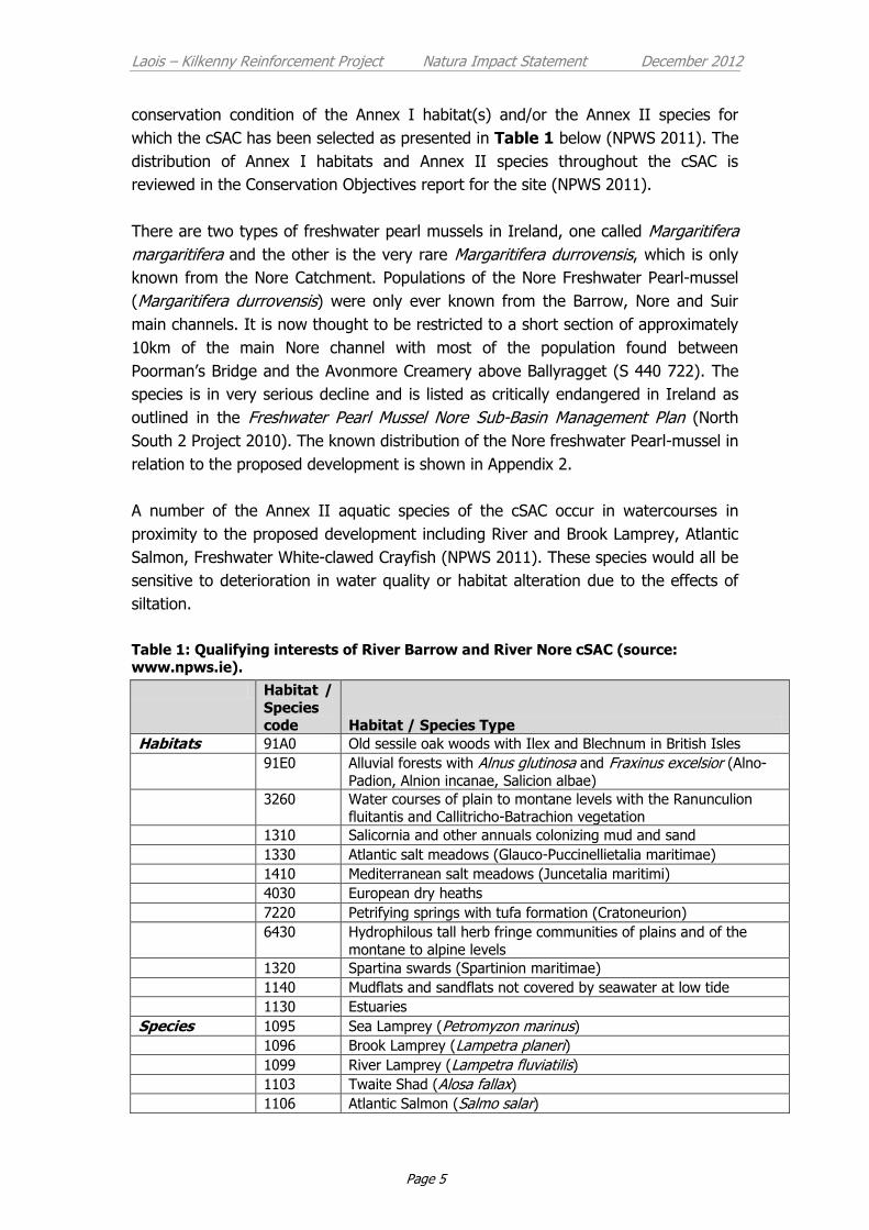
Table 1: Qualifying interests of River Barrow and River Nore cSAC (source: www.npws.ie).
Habitat /
Species code Habitat / Species Type
Habitats 91A0 Old sessile oak woods with Ilex and Blechnum in British Isles
91E0 Alluvial forests with Alnus glutinosa and Fraxinus excelsior (Alno-
Padion, Alnion incanae, Salicion albae)
3260 Water courses of plain to montane levels with the Ranunculion fluitantis and Callitricho-Batrachion vegetation
1310 Salicornia and other annuals colonizing mud and sand
1330 Atlantic salt meadows (Glauco-Puccinellietalia maritimae)
1410 Mediterranean salt meadows (Juncetalia maritimi)
4030 European dry heaths
7220 Petrifying springs with tufa formation (Cratoneurion)
6430 Hydrophilous tall herb fringe communities of plains and of the
montane to alpine levels
1320 Spartina swards (Spartinion maritimae)
1140 Mudflats and sandflats not covered by seawater at low tide
1130 Estuaries
Species 1095 Sea Lamprey (Petromyzon marinus)
1096 Brook Lamprey (Lampetra planeri)
1099 River Lamprey (Lampetra fluviatilis)
1103 Twaite Shad (Alosa fallax)
1106 Atlantic Salmon (Salmo salar)

Laois – Kilkenny Reinforcement Project Natura Impact Statement December 2012
Page 6
Habitat /
Species code Habitat / Species Type
1102 Allis Shad (Alosa alosa)
1355 Otter (Lutra lutra)
1092 Freshwater White-clawed Crayfish (Austropotamobius pallipes)
1029 Freshwater Pearl-mussel (Margaritifera margaritifera)1
1990 Nore Freshwater Pearl-mussel (Margaritifera durrovensis)
1016 Whorl Snail (Vertigo moulinsiana)
1421 Killarney Fern (Trichomanes speciosum) 1The status of the Freshwater Pearl-mussel (Margaritifera margaritifera) as a qualifying Annex
II species for the River Barrow and River Nore cSAC is currently under review (NPWS 2011).
Laois – Kilkenny Reinforcement Project Natura Impact Statement December 2012
Page 7
Figure 1: Map showing the location of the proposed development (northern part)
in relation to the River Barrow and River Nore cSAC.
Laois – Kilkenny Reinforcement Project Natura Impact Statement December 2012
Page 8
Figure 2: Map showing the location of the proposed development (southern part)
in relation to the River Barrow and River Nore cSAC.

Laois – Kilkenny Reinforcement Project Natura Impact Statement December 2012
Page 9
4 Potential Impacts
In summary the main impacts identified during the Appropriate Assessment
Screening relate to possible temporary deterioration in water quality within
watercourses of the cSAC during the construction phase of the project. There are a
number of qualifying species of the cSAC that are sensitive to any deterioration in
water quality including: Salmon, Freshwater White-clawed Crayfish, and the Nore
Freshwater Pearl-mussel. Any significant deterioration in water quality could
negatively impact on populations of these species within the site.
During the construction phase of the project there is potential for sediment run-off
(due to excavations and works associated with tree felling) via the surface water
drainage system into the River Barrow and River Nore cSAC. In addition, potential
impacts due to contamination of surface water by concrete, fuel or other harmful
substances are possible. Best practice construction techniques that will be adhered to
during the construction of the project should minimise the potential for these impacts
to occur. However, additional mitigation will be required at a number of especially
sensitive locations where significant works are being proposed. The following
locations where construction works are being undertaken have been identified as
possible sources of impacts during the construction phase:
Coolnabacky substation site
Ballyragget substation site
Transmission structure (Poleset and Angle Mast) locations in close proximity
to watercourses which feed into the River Barrow and River Nore cSAC
Conifer plantations that require felling along the new Ballyragget to
Coolnabacky 110 kV line route
The potential impacts of the proposed development at these locations are described
in more detail in the following paragraphs along with the requirements of mitigation
measures to prevent such impacts from occurring.
4.1.1 Coolnabacky substation site
A summary of potential adverse impacts of works during the construction and
operation phase of the development at the Coolnabacky substation site are
presented in Table 2.
The main sensitive ecological receptor in proximity to the substation site constitutes
a spring fed watercourse which occurs along the north-western boundary of the site.
This watercourse provides suitable habitat to Annex II species and feeds into the
cSAC ca 4.5 km downstream to the north-east. Drainage ditches that occur along
both the western and north-eastern boundary of the substation site also feed into
this watercourse.
Laois – Kilkenny Reinforcement Project Natura Impact Statement December 2012
Page 10
Works that are to be undertaken during the construction of the substation that could
give rise to impacts on the watercourse and the downstream cSAC include:
The excavation and subsequent management of top-soil and subsoil. It is
estimated that ca 8000m3 of material will be excavated during the
construction phase of the project. Following excavation, it is proposed to
store the material in berms at pre-determined locations within the site.
Should significant quantities of excavated material become entrained by rain
water and transported to surrounding watercourses then this could impact on
the habitat of Annex II species downstream of the substation site.
The use of concrete and fuels during the construction phase of the project.
Should any of this concrete enter the surrounding watercourses then it could
potentially impact on habitat of Annex II species downstream.
It is considered that the impacts above are unlikely to occur based on best practice
construction methods being adopted. However, additional measures specific to the
substation site are presented in 4.3.1 below to further reduce the likelihood of
these impacts occurring.
Table 2. Summary of potential adverse impacts on River Barrow and River Nore cSAC identified at proposed Coolnabacky substation sites.
Location Possible source of impact identified Requirements of mitigation
Proposed Coolnabacky substation site
Requirement for considerable ground works and operation of machinery during construction phase. Any possible release of sediment or other harmful substances to watercourses surrounding the substation site. The watercourse that borders the site provides habitat for aquatic Annex II species and feeds into the cSAC downstream.
Protection of surrounding surface waters which are likely to support Annex II species and feed into cSAC downstream.
4.1.2 Ballyragget Substation Site
Potential adverse impacts of works during the construction and operation phase of
the development at the Ballyragget substation site are presented in Table 3.
The Ballyragget substation site is located approximately 300 metres East of the main
channel of the River Nore. The main channel in this area supports a population of the
Nore Freshwater Pearl-mussel which would be highly sensitive to any deterioration in
water quality. There are no watercourses in close proximity to the proposed works
area at the Ballyragget substation site that could provide a direct pathway to the
main channel of the River Nore. Drainage at the substation site has been shown to
go directly to ground water, which may in turn discharge to the main channel of the
River Nore (see Hydrology Chapter of the Environmental Report) providing a
potential pathway for adverse impacts should contaminated water discharge from
the proposed development site.
Laois – Kilkenny Reinforcement Project Natura Impact Statement December 2012
Page 11
Table 3. Summary of potential adverse impacts on River Barrow and River Nore cSAC identified at proposed Ballyragget substation sites.
Location Possible source of impact identified Requirements of mitigation
Proposed Ballyragget substation site
Possible pollution of groundwater at Ballyragget substations site. Site investigations have shown that drainage at the site is to ground water which may discharge into River Nore.
Reduce / eliminate any risk to groundwater during construction / operation.
4.1.3 Transmission structure (Poleset and Angle Mast) locations in close proximity to watercourses which feed into the River Barrow and River Nore cSAC
Potential adverse impacts of works during the construction phase of the development
at particularly sensitive structure locations are presented in Table 4. These locations
have been determined owing to the close proximity of watercourses (which discharge
into the cSAC) to the proposed structure location. No potential impacts are foreseen
throughout the operation phase at these locations.
Works that could give rise to impacts would be associated with sediment release
during the erection of polesets and angle masts or potential contamination of surface
water from concrete and / or fuels used during construction.
The erection of pole sets generally requires minimal disturbance to the ground. A
foundation hole will be excavated, the pole erected and backfilled and with good
construction practice there should be little risk of sediment loss. Duration on site is
expected to be no more than a single day for each pole set. No concrete is required
during the erection of polesets.
The construction of Angle Masts requires larger excavations and involves the
construction concrete foundations. The duration of works at each Angle Mast location
is ca 2.5 weeks, with the majority of this time due to concrete setting time.
Those structures along the Ballyragget to Coolnabacky section of line (labeled BC)
are new structures whereas those located along the Ballyragget to Kilkenny line are
replacement structures.

Laois – Kilkenny Reinforcement Project Natura Impact Statement December 2012
Page 12
Table 4. Summary of potential adverse impacts on River Barrow and River Nore cSAC identified at particular structure locations.
Location Possible source of impact identified Requirements of mitigation
BC 149 (New Poleset)
Adjacent watercourse within 10 metres of structure. Any release of sediment or harmful substances during construction could impact on cSAC.
Protection of surrounding surface waters which are likely to support Annex II species and feed into cSAC.
BC 124 (New Poleset)
Watercourse at structure location. Any release of sediment or harmful substances during construction could impact on cSAC.
Protection of surrounding surface waters which are likely to support Annex II species and feed into cSAC.
BC 91 (New Poleset)
Adjacent watercourse within 10 metres of structure. Any release of sediment or harmful substances during construction could impact on cSAC.
Protection of surrounding surface waters which are likely to support Annex II species and feed into cSAC.
BC 72 (New Angle Mast)
Adjacent watercourse within ca 20 metres of angle mast. Any release of sediment or harmful substances during construction could impact on cSAC.
Protection of surrounding surface waters which are likely to support Annex II species and feed into cSAC.
BC 21 (New Poleset)
Adjacent watercourse within 10 metres of structure. Any release of sediment or harmful substances during construction could impact on cSAC.
Protection of surrounding surface waters which are likely to support Annex II species and feed into cSAC.
BK 4 (Replacement Angle Mast)
Adjacent watercourse within 10 metres of new angle mast structure. Any release of sediment or harmful substances during construction could impact on cSAC.
Protection of surrounding surface waters which are likely to support Annex II species and feed into cSAC.
BK 5 (Replacement Poleset)
Adjacent watercourse within 10 metres of structure. Any release of sediment or harmful substances during construction could impact on cSAC.
Protection of surrounding surface waters which are likely to support Annex II species and feed into cSAC.
BK 16 (Replacement Poleset)
Adjacent watercourse within 10 metres of structure. Any release of sediment or harmful substances during construction could impact on cSAC.
Protection of surrounding surface waters which are likely to support Annex II species and feed into cSAC.
BK 49 (Replacement Poleset)
Structure located on boundary of cSAC. Any release of sediment or harmful substances during construction could impact on cSAC.
Protection of surrounding surface waters which are likely to support Annex II species and designated cSAC.
BK 67 (Replacement Poleset)
Adjacent watercourse within 10 metres of structure. Any release of sediment or harmful substances during construction could impact on cSAC.
Protection of surrounding surface waters which are likely to support Annex II species and feed into cSAC.
BK 81 (Replacement Poleset)
Adjacent watercourse within 10 metres of structure. Any release of sediment or harmful substances during construction could impact on cSAC.
Protection of surrounding surface waters which are likely to support Annex II species and feed into cSAC.
BK 82 (Replacement Poleset)
Adjacent watercourse within 10 metres of structure. Any release of sediment or harmful substances during construction could impact on cSAC.
Protection of surrounding surface waters which are likely to support Annex II species and feed into cSAC.
BK94 (Replacement Poleset)
Adjacent watercourse within 10 metres of structure. Any release of sediment or harmful substances during construction
Protection of surrounding surface waters which are likely to support Annex II species and feed into cSAC.

Laois – Kilkenny Reinforcement Project Natura Impact Statement December 2012
Page 13
Location Possible source of impact identified Requirements of mitigation
could impact on cSAC.
BK 103 (Replacement Poleset)
Adjacent watercourse within 10 metres of structure. Any release of sediment or harmful substances during construction could impact on cSAC.
Protection of surrounding surface waters which are likely to support Annex II species and feed into cSAC.
4.1.4 Conifer plantations that require felling along the new Ballyragget to Coolnabacky 110 kV line route.
Potential for adverse impacts arises for the requirement to fell a corridor of 61.5 m
width where the line passes through conifer plantation. The proposed Ballyragget to
Coolnabacky line passes through two areas of Conifer plantation within the Nore
catchment (see Table 5), upstream of the Owenbeg River at Knockardagur (corridor
of ca 890m length to be felled between Structures BC77-82) and at Garryglass
(corridor of 930m length to be felled between Structures BC103-109).
At Knockardagar, the proposed line route is located ca 80 m to the East (upstream)
of the nearest mapped (un-named) watercourse which discharges to the designated
section of the Owenbeg River ca 1.5 km downstream. Drainage from the forested
area is likely to be via a network of forestry drains towards this unnamed
watercourse.
At Garryglass, the proposed line route is located ca 130 m to the West (upstream) of
the nearest mapped (un-named) watercourse which discharges to the designated
section of the Owenbeg River ca 1.5 km downstream. Drainage from the forested
area is via a network of forestry drains towards this un-named watercourse.
Potential impacts at forest locations can arise from the following activities:
Clear felling of the forest corridor: Clearfelling of the forest corridor can give
rise to both siltation risk from ground disturbance and nutrient enrichment
from the release of phosphorous and nitrogen from brash decay. The main
sources of siltation risk during forestry operations (such as clear felling) arise
from disruption of the soil surface, which can cause soils to be exposed to
erosion and the transportation of finer particles by overland flow, and the
transportation of looser decaying organic particles. Decaying brash resulting
from the clearfell can generate nutrients which could potentially lead to
nutrient enrichment of the small first order streams entering the Owenbeg
River.
Removal of tree stumps to facilitate overhead line construction: Construction
of the overhead line in clear felled forest areas can also give rise to sediment

Laois – Kilkenny Reinforcement Project Natura Impact Statement December 2012
Page 14
release. Wooden poles (weighing approximately 3 tonnes each) will be
transported to the construction location by wide tracked machinery
generating low ground pressure. In general tree stumps along the immediate
line route would be removed in a 10m wide corridor to allow machinery
tracking and avoid tracks coming off the vehicle. Uprooting of tree stumps
can contribute significantly to ground disturbance and sediment release.
Construction of pole sets: The erection of pole sets generally requires minimal
disturbance to the ground. A foundation hole will be excavated, the pole
erected and backfilled and with good construction practice there should be
little risk of sediment loss. Construction activity is also spread out along the
line route with a small footprint at each location. Duration on site is expected
to be no more than half a day for each pole set.
Potential windthrow arising from exposed forest edges post corridor
clearance: The felling of a linear corridor will leave exposed forest stand
edges devoid of foliage along the corridor. There is some risk of wind throw
when these tress reach maturity (an additional 20 years) however this is very
limited at present given the age and height of trees.
The main potential effects from ground disturbance are the risk of silt generation
with silt entering the Owenbeg River via its tributaries. The potential adverse impacts
on freshwater ecology due to release of silt include:
Sedimentation - impacts include smothering of gravel beds with consequent
loss of fish habitat and spawning and potential juvenile Freshwater Pearl
Mussel habitat.
Sediment deposition can also provide a base for growth of filamentous algae
on gravel beds leading to a build up of sediment and loss of both fish
spawning areas area and potential freshwater pearl mussel areas.
Sedimentation impacts include smothering fish eggs and causing mortalities
in fish of all ages, reducing abundance of food and impeding movement of
fish.
Sedimentation impacts also include smothering of macroinvertebrates.
Loss of water quality of surface and groundwater along the line route by silt.
Nutrient enrichment of the receiving waters can also occur due to decay of brash left
through the tree harvesting process. However the forest stands are located on
mineral soils and adsorption of phosphorous on this material is likely to occur
reducing the risk of nutrient phosphorous loss to the small streams running to the
Owenbeg River. Should nutrients reach the small first order streams this could give
rise to the following:

Laois – Kilkenny Reinforcement Project Natura Impact Statement December 2012
Page 15
Increased algal growth in the rivers leading to increased potential for
sediment entrapment and build up with de-oxygenation of the river during
the nocturnal cycle.
Increased algal growth will lead to reduced habitat for fish spawning,
macroinvertebrates and reduced potential habitat for freshwater pearl
mussel.
Accidental leakage of oil and fuels from construction vehicles can have a direct
impact on fish, fish food and fish habitats and other aquatic species.
Table 5. Potential adverse impacts on River Barrow and River Nore cSAC identified at areas where felling of conifer plantation is required to facilitate the
development.
Location Possible source of impact identified Requirements of mitigation
BC 103 - 106 (Poleset)
Conifer plantation - likely to be direct drainage to tributary stream of Owenbeg River to South. Possibility of impacting on surrounding surface water quality during and post-felling of conifers.
Protection of surrounding surface waters which are likely to support Annex II species and feed into cSAC.
BC 77 - 82 (Poleset)
Conifer plantation - likely to be direct drainage to tributary stream to East. Possibility of impacting on surrounding surface water quality during and post-felling of conifers.
Protection of surrounding surface waters which are likely to support Annex II species and feed into cSAC.
4.2 Cumulative Impacts
It is a requirement of Appropriate Assessment that the combined effects of the
proposed development together with other plans or projects be assessed. To the
best knowledge of the author, there are no other major infrastructural projects
proposed in close proximity to the proposed development that could potentially
contribute to significant cumulative or in-combination impacts. The existing electricity
network within the study area has been considered in this assessment. Other
activities within the study area that could contribute to cumulative impacts include
active quarries, farming and forestry operations. These operations have been
identified as sources of potential adverse impacts on the conservation status of the
cSAC (Nore Freshwater Pearl Mussel Catchment Management Plan, North South
Project 2)4.
Based on the nature and scale of the potential impacts associated with the proposed
Laois-Kilkenny Reinforcement Project in isolation and the known impacts caused by
4http://www.wfdireland.ie/docs/5_FreshwaterPearlMusselPlans/Freshwater%20Pearl%20Mussel%20Plans%20March%202010/Sec
ond%20Draft%20of%20Nore%20Sub-Plan%20March.2010.pdf

Laois – Kilkenny Reinforcement Project Natura Impact Statement December 2012
Page 16
the above operations, significant cumulative impacts on the conservation interest of
the River Barrow and Nore cSAC are possible.
The proposed development extends over a considerable area within the catchment of
the River Barrow and Nore cSAC and the potential impacts associated with the
different elements as described in Section 4 above could in the absence of
appropriate mitigation each contribute to a significant adverse cumulative impact on
the conservation interest of the cSAC.
4.3 Mitigation Measures
Following the identification of potential adverse impacts at particular locations within
the study area on the River Barrow and River Nore cSAC, a report was prepared to
devise measures that could be implemented to mitigate against the possible impacts
at each location. The report, which is presented as Appendix 3, was prepared by ESB
International with input from a Civil Engineer, a Hydrologist and the project
Ecologist.
The proposed mitigation measures were forwarded to both Inland Fisheries Ireland
(IFI) and National Parks and Wildlife Service (NPWS) for comment. Correspondence
received from IFI indicated their agreement with the mitigation measures being
proposed. No subsequent correspondence was received from NPWS in relation to
this.
It is intended that the client will issue this report as part of the tender and
construction package of specifications to prompt the contractor to act on the
mitigation measures contained therein and to make these mitigation measures
contractually enforceable. The measures proposed are in-line with environmental
best practice and should augment any statutory responsibilities on either the
contractor or operator of the elements singled out for their location in, or close to,
environmentally sensitive areas or water bodies.
Those mitigation measures proposed in Appendix 3 are presented under the four
elements of the project where potential impacts have been identified:
Coolnabacky substation site.
Ballyragget substation site.
Structure (Poleset and Angle Mast) locations in close proximity to
watercourses which feed into the River Barrow and River Nore cSAC.
Conifer plantations that require felling along the new Ballyragget to
Coolnabacky 110 kV line route.

Laois – Kilkenny Reinforcement Project Natura Impact Statement December 2012
Page 17
4.3.1 Coolnabacky substation site
4.3.1.1 Surface Water Protection
Drainage and runoff controls will be installed prior to starting site clearance and
earthworks.
Erosion Control
Erosion control (preventing runoff) is much more effective than sediment control in
preventing water pollution. Erosion control is less subject to failure from high rainfall
and requires less maintenance.
Erosion control measures to prevent runoff flowing across exposed or excavated
ground and becoming polluted with sediments are provided for in the design. This is
primarily the use of existing site drains to channel runoff from up slope portions of a
catchment around any construction areas or areas disturbed as a result of
construction works.
Other inherent erosion control measures in the design include the design of
roadways with minimum falls which do not exceed 15%.
Additional erosion control measures will be provided for in the construction
management proposals. These measures will include the following:
Minimise the area of exposed ground. Backfilling and construction will occur
in conjunction with excavation and excavation will not proceed faster than the
rate of construction. Re-vegetating of disturbed area to take place as soon as
possible.
Monitoring of the weather forecast prior to planning excavation works.
Providing impermeable mats (plastic sheeting) as covers to mounded
excavated material and open excavations during periods of heavy rainfall.
Silt fences to be provided at the toe of any significant areas where excavated material is stored.
Sediment Control
The Settlement Ponds are an integral part of the sediment control and containment
measures on site and the protection of watercourses. Settlement ponds will be
provided adjacent to the areas of the site where the most excavation or earthworks
are planned.
The settlement ponds on the site have been sized to provide an adequate treatment
volume for the first flush from the developed station and the ponds will ultimately
have an attenuation volume so that surface water runoff can be limited to Greenfield
runoff rates. This attenuation volume can be utilised as additional treatment volume
in the construction phase when sediment generation is greatest.
Laois – Kilkenny Reinforcement Project Natura Impact Statement December 2012
Page 18
The stone check dams which divide the pond into primary, secondary and final
settlement compartments will further reduce turbulence which will aid settlement
and provide filtering of water.
Surface water from the site will be discharged to existing vegetated drainage ditches
within the site where further settlement of solids and filtering of surface water will
occur prior to ultimate discharge to the adjacent watercourse.
Risk Management
The best way to manage pollution incidents is to prevent them. The contractor will
identify and quantify risks associated with erosion and sediment for each work practice.
Risks such as an unplanned bank collapse, mud slide and unforeseen rainfall event can
be constantly assessed through geotechnical risk management and monitoring of
weather forecasts.
Emergency Plans and Procedures
The contractor will prepare an emergency response plan and set of procedures for
events likely to cause pollution including the pollution of watercourses with silt or
sediment. There will be a contingency plan in place during construction and
displayed at appropriate locations.
Equipment, Training and Corrective Action
Equipment required in responding to an emergency event with the capability of
generating additional erosion and sediment laden runoff will be stored on site. Staff will
be trained in the use and application of these temporary emergency measures which
may involve the following:
Impermeable matting (plastic sheeting);
Silt fences (posts & geotextile material);
Mulching capability (organic materials, straw, wood chip, bark or other wood
fibres and gravel) to stabilise or protect cleared areas;
Settlement Tanks (portable propriety settlement tanks that can be transported to
required areas).
Staff will be trained and made aware of procedures for notification of emergency events
with the potential for pollution of watercourses.
Monitoring
Ongoing water monitoring at the discharge points and the receiving waters will be a
key indicator of the effectiveness of the erosion and settlement control measures and
the requirement for corrective action or the deployment of additional measures as
outlined above. Methods, frequency and parameters to be monitored will be
Laois – Kilkenny Reinforcement Project Natura Impact Statement December 2012
Page 19
discussed and agreement sought with Inland Fisheries Ireland and National Parks
and Wildlife Service prior to construction commencing.
4.3.1.2 Water Table and Groundwater Water Protection
Dewatering and Groundwater Level
Deep excavations below the water table encountered in the Site Investigation will be
kept to a minimum in the foundation design. It is not envisaged that there will be
extensive deep excavations requiring dewatering or for any extended period of time
to cause a material difference in the local groundwater table level.
It is envisaged that there will, therefore be no impact on the spring fed watercourses
in the area.
Continuous monitoring or the local water table will be employed where the
contractor proposes any dewatering during the construction phase and proposals for
dewatering and monitoring will be approved by the designers and ecologist for the
project.
Groundwater Quality Protection
The contractor will store all chemicals, hydrocarbon based fuels and oil filled
equipment when not in use in bunded areas of the site.
The contractor will have emergency spill kits comprising oil absorbent materials on
site and staff trained in the use of these. Emergency response measures to oil/ fuel
leaks will be displayed prominently on the site.
Sustainable Drainage Systems (SuDS) in the drainage network design will be put in
place early in the construction phase to filter and biodegrade hydrocarbons in the
unlikely event that any enter the water on the site.
In the operational phase, all oil filled equipment will be stored in impermeable
concrete bunds. Surface water generated in the bunded areas will be pumped out of
the bunds by an oil sensitive pump. There will also be an oil separator on the
drainage network. Surface water will be routed through ponds and vegetated
drainage ditches before discharge to the watercourse.
There will be no large scale batching of concrete on the site. All concrete will come
from a licensed supplier with environmental certification. No washing out of concrete
supply trucks will be allowed on the site. No cementitious material will be allowed
enter the water or groundwater on the site. Monitoring and emergency response
measures for any escape of cementitious material will be put in place by the
contractor.
Laois – Kilkenny Reinforcement Project Natura Impact Statement December 2012
Page 20
Any foul waste generated in the construction and operational phase of the project
will be collected and disposed off site by a licensed contractor. No contamination of
groundwater will occur from foul waste.
4.3.2 Ballyragget substation site
4.3.2.1 Groundwater Quality Protection
The contractor will store all chemicals, hydrocarbon based fuels and oil filled
equipment when not in use in bunded areas of the site.
The contractor will have emergency spill kits comprising oil absorbent materials on
site and staff trained in the use of these. Emergency response measures to oil/ fuel
leaks will be displayed prominently on the site.
In the operational phase, all oil filled equipment will be stored in impermeable
concrete bunds. Surface water generated in the bunded areas will be pumped out of
the bunds by an oil sensitive pump. There will also be an oil separator on the
drainage network. Only after these measures will surface water then be recharged to
groundwater through source control techniques (soakaways) in line with SuDS best
management practices.
There will be no large scale batching of concrete on the site. All concrete will come
from a licensed supplier with environmental certification. No washing out of concrete
supply trucks will be allowed on the site. No cementitious material will be allowed
enter the water or groundwater on the site. Monitoring and emergency response
measures for any escape of cementitious material will be put in place by the
contractor.
Foul waste generated in the construction of the project will be collected and disposed
off site by a licensed contractor. Foul Waste generated in the unmanned station
during the operational phase will be treated on site before being further treated and
disposed of to ground water in a designed percolation area. A suitably qualified
professional has carried out a site assessment and designed the percolation area in
accordance with EPA guidelines.
4.3.3 Structure locations in close proximity to watercourses
4.3.3.1 Poleset Construction - Erosion & Sedimentation Control
Polesets are constructed over the short duration of 1 day per poleset. The main
mitigation measure in this case will be to not carry out construction on days when
there is rain or rain forecast (for the sensitive polesets noted above which are in the
proximity of a watercourse). The contractor will monitor the weather forecast as part
of the construction planning for the polesets.

Laois – Kilkenny Reinforcement Project Natura Impact Statement December 2012
Page 21
It should be noted that, should groundwater seepage be encountered in excavations
for the polesets, there is no requirement for de-watering. The top vegetated layer
will be excavated carefully to keep the vegetation and root system intact. This layer
will be placed carefully to one side and protected for the short duration of the
construction. This layer will be reinstated following backfill around the polesets which
will limit the potential for sediment runoff immediately after the construction of each
poleset.
Excavated material will be stored safely so that the distance from the watercourse is
maximised within the confines of the construction area and to ensure that there is a
natural filter strip of vegetation between the excavated material and any water
course. It should be noted that the entire volume of spoil per poleset will not exceed
40m3 and the associated spoil heap will not occupy an area exceeding 20m2.
Sediment laden runoff from this small area during predominantly dry conditions is
unlikely.
In the unlikely event of significant non forecasted rainfall the contractor will have
access to emergency sediment control measures in a site compound that can be
transported to the poleset construction location within a short time period. These
measures would include the following:
Impermeable matting (plastic sheeting);
Silt fences (posts & geotextile material);
Mulching capability (organic materials, straw, wood chip, bark or other wood
fibres and gravel) to stabilise or protect cleared areas;
Settlement Tanks (portable propriety settlement tanks that can be
transported to required areas).
4.3.3.2 Polesets Construction - Pollution Control
The risk of non sediment related pollution during the construction for the polesets is
minimal and may only be associated with oil leaks from the plant and machinery
used in the construction. The following measures will be in place to mitigate the risk
of and to respond in the event of an oil leak:
All vehicles will be regularly serviced and kept in good condition;
Vehicles will be checked daily for indications of leaking oil;
No refuelling operations will take place at the construction site of the
polesets;
Spill kits will be readily available to drivers/ operators of plant and machinery;
and
Drivers/ operators of plant and machinery will be trained in the use of spill
kits and aware of the contractor’s emergency procedures for dealing with and
reporting oil and fuel spills.

Laois – Kilkenny Reinforcement Project Natura Impact Statement December 2012
Page 22
4.3.3.3 Angle Mast Construction - Erosion & Sedimentation Control
Angle Masts foundations are constructed over a period of less than 2.5 weeks per
Angle Mast with the majority of this time required due to concrete setting time. Once
the foundation is constructed and backfilled, the foundation is generally left for
approximately 28 days before the mast is assembled. The mast assembly will cause
no ground disturbance and takes place over a very short duration of time. The major
mitigation measure in this case will be to not carry out construction at sensitive
Angle Mast locations noted above which are in the proximity of a watercourse when
there is a significant amount of rainfall forecast. The contractor will monitor the
weather forecast as part of the construction planning for these Angle Masts.
Should the excavations for the Angle Mast foundations require dewatering due to
groundwater seepage this water will be pumped through a portable settlement tank
before discharge to the nearest drainage ditch. Existing vegetation as a filter strip
prior to discharge to the drainage ditch will also be utilised where conditions allow.
The top vegetated layer will be excavated carefully to keep the vegetation and root
system intact. This layer will be placed carefully to one side and protected for the
short duration of the construction. This layer will be reinstated over the foundations
following backfill around the Angle Mast foundations which will limit the potential for
sediment runoff immediately after the construction of each Angle Mast foundation.
Excavated material will be stored safely so that the distance from the watercourse is
maximised within the confines of the construction area and to ensure that there is a
natural filter strip of vegetation between the excavated material and any water
course. It should be noted that the entire volume of spoil per Angle Mast will not
exceed 140 m3. Much of this excavated material will be removed from site
immediately as it will not be required for backfilling and landscaping around the
Angle Mast foundations. The excavated material stored adjacent to the Angle Mast
construction area for the short duration of the works is therefore unlikely to exceed
50-66 m3. The associated spoil heap will not occupy an area exceeding 36-46m2.
Sediment laden runoff from this small area during predominantly dry conditions is
unlikely.
In the unlikely event of significant non forecasted rainfall during the construction
period, the contractor will have access to emergency sediment control measures in a
site compound that can be transported to the Angle Mast construction location within
a short time period. These measures would include the following:
Impermeable matting (plastic sheeting);
Silt fences (posts & geotextile material);
Mulching capability (organic materials, straw, wood chip, bark or other wood
fibres and gravel) to stabilise or protect cleared areas;
Laois – Kilkenny Reinforcement Project Natura Impact Statement December 2012
Page 23
Settlement Tanks (portable propriety settlement tanks that can be
transported to required areas).
4.3.3.4 Angle Mast Construction - Pollution Control
The risk of non sediment related pollution during the construction for the Angle
Masts is minimal and may only be associated with oil leaks from the plant and
machinery used in the construction or from the escape of cementitious material
during the foundation construction. No chemicals will be stored at the construction
site.
The following measures will be in place to mitigate the risk of and to respond in the
event of an oil leak:
There will be no fuel or oil stored at the Angle Mast construction location;
All vehicles will be regularly serviced and kept in good condition;
Vehicles will be checked daily for indications of leaking oil or fuel;
No refuelling operations will take place at the construction site of the Angle
Masts;
Spill kits will be readily available to drivers/ operators of plant and machinery;
and
Drivers/ operators of plant and machinery will be trained in the use of spill
kits and aware of the contractor’s emergency procedures for dealing with and
reporting oil and fuel spills.
The following measures will be in place to mitigate the risk of and to respond to the
escape of cementitious material during foundation construction for Angle Masts:
There will be no on site batching of concrete, grout or cement mortar at the
Angle Mast construction locations;
No washing out of concrete delivery vehicles or dumping of excess concrete
will be permitted at the Angle Mast construction sites;
Concrete skips, concrete pumps and machine buckets will be positioned so as
not to allow slewing over water while placing concrete (the use of skips and
pumps not envisaged);
Freshly placed Concrete is to be covered to avoid surface washing away in
heavy rain; and
Clean up any spillages of cementitious materials immediately and disposed of
correctly.
If temporary welfare facilities are required at the sensitive Angle Mast construction
locations following investigation of alternative arrangements, these will be self
contained units and foul waste generated will be collected and disposed of by an
approved licensed contractor.
Laois – Kilkenny Reinforcement Project Natura Impact Statement December 2012
Page 24
4.3.4 Conifer plantations that require felling along the new Ballyragget to Coolnabacky 110 kV line route.
The following mitigation measures will be implemented.
4.3.4.1 General Mitigation Measures
Forestry Operations within the Freshwater Pearl Mussel Catchment areas,
including at the forest stands within the Owenbeg river catchment will be
carried out strictly in accordance with the Forestry and Freshwater Pearl
Mussel Requirements Site Assessment and Mitigation Measures published by
the Forest Service.
The Forestry and Freshwater Pearl Mussel Site Assessment Forms A and B
which have been revised by Coillte and NPWS shall be used for all forestry
operations within the Freshwater Pearl Mussel Catchments associated with
the overhead line construction.
The contractor appointed to harvest the timber will be fully briefed on the
ecological sensitivity of the site and will work in collaboration with an
ecologist to set out the proposed method and delineate working areas.
Construction will adhere to the guidance document issued by Inland Fisheries
Ireland South-eastern River Basin District Maintenance and Protection of the
Inland Fisheries resource during road construction and improvement works
published by the South-eastern Regional Fisheries Board. (Note that a new
Guidance document is expected to be published shortly by Inland Fisheries
Ireland entitled “Guidelines on Protection of Fisheries During Construction
Works in and adjacent to Waters”. Construction will adhere to this guidance
once published).
Should the need for any in stream crossings by construction vehicles be
identified the Inland Fisheries Ireland shall be consulted and the approach to
the crossing agreed with them. Any and all watercourses which have to be
traversed during site development and associated track/road construction
works should be effectively bridged prior to commencement.
Work method statements should be developed and implemented by
construction contractors for pole set construction.
Access to construction areas should utilise existing field tracks to the extent
possible to minimise the need for additional track construction.
Proposed access tracks should be assessed by a qualified geotechnical
engineer and ecologist to ensure the route minimises surface disturbance and
silt generation.
Re-fuelling of vehicles should not take place on site but in a secure bunded
area well away from any watercourse.
All oils and fuels should be stored in secure bunded areas, and particular care
and attention should be taken during refuelling and maintenance operations
on plant and equipment

Laois – Kilkenny Reinforcement Project Natura Impact Statement December 2012
Page 25
4.3.4.2 Sediment Impact Mitigation
Brash from the clearfell should be utilised as roading material for pole
construction tracked vehicles to reduce impact on ground thereby minimising
ground disturbance
Existing forest drainage shall be reinstated where damaged to allow use to be
made of vegetated ground areas to reduce the flow of silt overland.
Silt traps and silt fences, such as geotextile membrane and straw bales,
should be placed in the forest drainage network to minimise silt loss. These
should be inspected and cleaned regularly. A series of stepped silt traps
fences to trap any silt/debris will be installed. Their purpose will be to slow
water flow and allow settlement of solids to occur. These will be regularly
inspected and cleared out to ensure they are functioning properly.
Traps should not be constructed immediately adjacent to natural water
courses. A buffer zone should remain between the silt trap and the
watercourse with natural vegetation left intact so as to assist in silt
interception. They should be installed on forest drains.
Pesticide if used for suppression of growth beneath the established overhead
line should be minimised and used strictly in accordance with Forest Service
Guidelines. Any plants used for the re-establishment of the site should be
pre-dipped if required.
Brash arising from forest felling should be used as roading for poling
contractor tracked vehicles to the extent possible to avoid ground
disturbance.
4.3.4.3 Nutrient Impact Mitigation
Potential nutrient release, particularly phosphorous will be limited by the fact that the
trees are not at maturity and the quantities of brash generated will be relatively
small compared to mature forest felling hence nutrient generation from brash decay
will be low. In addition the forest stands are located on mineral soil types which
generally adsorb phosphorous further reducing potential release to the aquatic
environment. To further reduce the potential from nutrient impact:
Brash should be windrowed at a distance of 20m from any main drain
identified on site when the corridors through the forest stands have been
clearfelled.
4.3.4.4 Monitoring
An ecologist will be present during the construction phase to ensure that all
mitigation measures are adhered to, and to monitor the effectiveness of mitigation.
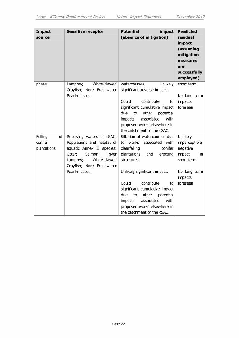
5 Residual Impacts
By taking into account of the mitigation measures outlined above the potential
significant adverse indirect and cumulative impacts identified during the Screening

Laois – Kilkenny Reinforcement Project Natura Impact Statement December 2012
Page 26
stage are reduced from being possible albeit unlikely significant to becoming
extremely unlikely short term imperceptible negative impacts. No long term impacts
are foreseen. A summary of the residual impacts foreseen as a result of the
proposed development on the cSAC are summarised in Table 6.
Table 6: Predicted residual impacts after mitigation measures are adopted.
Impact
source
Sensitive receptor Potential impact
(absence of mitigation)
Predicted
residual
impact
(assuming
mitigation
measures
are
successfully
employed)
Coolnabacky
substation –
construction
phase
Watercourse that occurs
along north-western
boundary of site and
receiving waters of cSAC
downstream. Populations
and habitat of aquatic
Annex II species: Otter;
Salmon; River Lamprey;
White-clawed Crayfish.
Unlikely significant impact on
Annex II species due to
siltation and risk of
contaminants entering the
surrounding surface waters.
Could contribute to
significant cumulative impact
due to other potential
impacts associated with
proposed works elsewhere in
the catchment of the cSAC.
Extremely
unlikely
imperceptible
negative
impact in
short term
No long term
impacts
foreseen
Ballyragget
substation –
construction
phase
Receiving waters of cSAC.
Populations and habitat of
aquatic Annex II species:
Otter; Salmon; River
Lamprey; White-clawed
Crayfish; Nore Freshwater
Pearl-mussel.
Possible deterioration of
water quality in main River
Nore channel due to
transport of contaminated
substances (e.g. fuel /
concrete) via groundwater.
Extremely unlikely significant
adverse impact.
Could contribute to
significant cumulative impact
due to other potential
impacts associated with
proposed works elsewhere in
the catchment of the cSAC.
Unlikely
imperceptible
negative
impact in
short term
No long term
impacts
foreseen
Structures at
sensitive
locations –
construction
Receiving waters of cSAC.
Populations and habitat of
aquatic Annex II species:
Otter; Salmon; River
Short term siltation of
watercourses and possibility
of other contaminents (fuel
and concrete) entering
Unlikely
imperceptible
negative
impact in
Laois – Kilkenny Reinforcement Project Natura Impact Statement December 2012
Page 27
Impact
source
Sensitive receptor Potential impact
(absence of mitigation)
Predicted
residual
impact
(assuming
mitigation
measures
are
successfully
employed)
phase Lamprey; White-clawed
Crayfish; Nore Freshwater
Pearl-mussel.
watercourses. Unlikely
significant adverse impact.
Could contribute to
significant cumulative impact
due to other potential
impacts associated with
proposed works elsewhere in
the catchment of the cSAC.
short term
No long term
impacts
foreseen
Felling of
conifer
plantations
Receiving waters of cSAC.
Populations and habitat of
aquatic Annex II species:
Otter; Salmon; River
Lamprey; White-clawed
Crayfish; Nore Freshwater
Pearl-mussel.
Siltation of watercourses due
to works associated with
clearfelling conifer
plantations and erecting
structures.
Unlikely significant impact.
Could contribute to
significant cumulative impact
due to other potential
impacts associated with
proposed works elsewhere in
the catchment of the cSAC.
Unlikely
imperceptible
negative
impact in
short term
No long term
impacts
foreseen

Laois – Kilkenny Reinforcement Project Natura Impact Statement December 2012
Page 28
6 Conclusion
In order to determine the potential impacts of the proposed development on the
River Barrow and Nore cSAC, this Natural Impact Statement (Statement of
Appropriate Assessment) was prepared.
Measures to mitigate potential adverse impacts on the conservation interest of the
European site are presented in 4.3 above. The correct implementation of all
mitigation measures detailed in this report will ensure that the conservation
objectives for the cSAC will not be compromised by the proposed development, nor
by any cumulative effects and no significant impact is anticipated on any of the
species and habitats for which the site is designated.
In conclusion, through the process of Appropriate Assessment, it is the considered
view of the author that the proposed development will have no adverse impact on
the integrity of the designated site as a whole or on any other designated site.
Laois – Kilkenny Reinforcement Project Natura Impact Statement December 2012
Page 29
7 References
CIRIA, (2001), Control of Water Pollution from Construction Sites, Guidance for
Consultants and Contractors.
Department of the Environment, Heritage and Local Government (2009). Appropriate
Assessment of Plans and Projects in Ireland: Guidance for Planning Authorities.
European Commission (2000) Managing Natura 2000 sites: the provisions of Articles 6 of
the habitats directive 92/43/EEC. Luxembourg: Office for official publications of
the European Communities.
European Commission (2002). Assessment of plans and projects significantly affecting
Natura 2000 sites. Methodological guidance on the provisions of articles 6(3) and
(4) of the Habitats Directive 92/43/EEC. Luxembourg: Office for official
publications of the European Communities.
Moorkens, E. A. (1999). Conservation management of the freshwater pearl mussel
Margaritifera margaritifera. Part 1: Biology of the species and its present
situation in Ireland. Irish Wildlife Manuals No. 8. National Parks and Wildlife
Service, Dublin.
North South 2 Project (2010). Freshwater Pearl Mussel Nore Sub-Basin Management
Plan - Second Draft.
NPWS (2011) Conservation Objectives: River Barrow and River Nore SAC 002162.
Version 1.0. National Parks and Wildlife Service, Department of Arts, Heritage
and the Gaeltacht.
www.npws.ie (2011). National Parks and Wildlife Service web site synopses for Special
Areas of Conservation (SACs) and Natural Heritage Areas (NHAs).

Laois – Kilkenny Reinforcement Project Natura Impact Statement December 2012
Page 29
APPENDIX 1
Laois Kilkenny Reinforcement Project: Appropriate Assessment
Screening Report

Laois Kilkenny Reinforcement Project
Environmental Reports
Appendix 1
Appropriate Assessment Screening Statement
Submission to: EirGrid
160 The Oval
Shelbourne Road
Dublin 4
By: AOS Planning Limited
2nd Floor The Courtyard
25 Great Strand Street
Dublin 1
Tel 01 874 7704
E-mail: [email protected]
November 2012

Laois Kilkenny Reinforcement Project Appropriate Assessment Screening November 2012
Table of Contents
Executive Summary 1
1 Introduction 2
1.1 Statutory Context 2
1.2 Methodology 3
2 Screening 4
2.1 Project Description 4
2.1.1 Characteristics of each phase of the project 6 2.1.2 Drainage design of substation sites 8
2.2 Identification and description of European sites 8
2.2.1 River Barrow and Nore cSAC (NPWS Site Code: 2162) 10 2.2.2 River Nore SPA (NPWS Site Code: 4233) 11 2.2.3 Lisbigney Bog cSAC (NPWS Site Code: 0869) 12 2.2.4 Ballyprior Grassland cSAC (NPWS Site Code: 2162) 12
2.3 Identification and Description of Potential Impacts 12
2.4 Assessment of Significance 16
2.5 Conclusion 22
2.6 Screening Matrix 23
3 References 26
List of Appendices
Appendix 1.1: NPWS site description for River Barrow and River Nore cSAC
Appendix 1.2: NPWS site description for River Nore SPA Appendix 1.3: NPWS site description for Lisbigney Bog cSAC Appendix 1.4: NPWS site description for Ballyprior Grassland
cSAC Appendix 1.5: Map showing the known distribution of the Nore
Freshwater Pearl Mussel in relation to the proposed development.
Appendix 1.6: Desktop Hydrogeological Assessment, Proposed
Coolnabacky 400 / 110 kV GIS Substation, Co Laois

Laois – Kilkenny Reinforcement Project Appropriate Assessment Screening November 2012
Page 1
Executive Summary
This Appropriate Assessment Screening Statement has been prepared to identify the
potential impacts of the Laois Kilkenny Reinforcement Project on sites designated as
European conservation areas known as European sites as required under Article 6 of
the EU Habitats Directive.
There are up to four successive stages involved in the Appropriate Assessment
process, the first stage of which is known as the Screening Stage. Screening is
carried out to determine the necessity for a more detailed Stage 2 Appropriate
Assessment where potential impacts are deemed to be of significance.
Four European sites were identified as occurring within five kilometres of the various
elements of the project. It was determined that three of these sites (River Nore SPA,
Lisbigney Bog cSAC and Ballyprior Grassland cSAC) will not be impacted upon either
directly or indirectly as a result of the proposed development and therefore can be
excluded from appropriate assessment.
Based on the precautionary approach adopted during the assessment it was shown
that the proposed development has the potential to adversely impact the River
Barrow and River Nore cSAC during the construction phase.
A Natura Impact Statement for stage 2 appropriate assessment will therefore be
prepared to further examine the risk posed by the proposed project on the
conservation interests of this European site.
Laois – Kilkenny Reinforcement Project Appropriate Assessment Screening November 2012
Page 2
1 Introduction
This report has been prepared by Dr Patrick Crushell on behalf of AOS Planning to
determine the potential impacts of the Laois-Kilkenny Reinforcement Project on sites
designated as Natura 2000 conservation areas known as European sites.
In brief, the main elements to the proposed new transmission infrastructure include:
A new 400/110 kV substation, ‘Coolnabacky’, near Portlaoise, Co. Laois. The
existing Athy-Portlaoise 110 kV and Moneypoint-Dunstown 400 kV overhead
lines will connect to this new substation.
A new 110 kV / 38 kV / MV substation at Ballyragget, Co.Kilkenny. This will
replace the existing 38 kV / MV substation.
A new 110 kV overhead line between Coolnabacky and Ballyragget
An uprate to the existing Ballyragget-Kilkenny 110 kV overhead line with
associated works in Kilkenny substation
The aim of this assessment is to determine the potential direct, indirect and
cumulative impacts of the proposed development on the conservation status of
European sites in the surroundings.
1.1 Statutory Context
This Appropriate Assessment Screening Statement has been prepared in accordance
with the European Commission Methodological Guidance on the provision of Article
6(3) and 6(4) of the Habitats Directive 92/43/EEC (European Commission 2002), the
European Commission Guidance ‘Managing Natura 2000 Sites’ (European
Commission 2000) and with reference to the Department of the Environment and
Heritage and Local Government guidance on ‘Appropriate Assessment of plans and
projects in Ireland’ (DEHLG 2009).
The EU Habitats Directive (92/43/EEC) provides the framework for legal protection
for habitats and species of European importance. The directive provides the
legislative means to establish a network of sites (known as the Natura 2000 network)
throughout the EU with the objective of conserving habitats and species deemed to
be of Community interest. These sites include candidate Special Areas of
Conservation (cSACs) designated under the Habitats Directive and Special Protection
Areas (SPAs) designated under the Birds Directive (formally known as the
Conservation of Wild Birds Directive 79/409/EEC). Both directives have been
transposed into Irish law by the recently enacted European Communities (Birds and
Natural Habitats) Regulations 2011 (SI 477/11).
Article 6 (3) and 6(4) of the habitats directive lays down the procedure to be
followed when planning new developments that might affect a European site. This
Laois – Kilkenny Reinforcement Project Appropriate Assessment Screening November 2012
Page 3
stepwise procedure requires that a plan or project having a likely significant negative
effect on a European site undergoes an Appropriate Assessment of its implications
for the site in view of that site’s conservation objectives.
Depending on the findings of the Appropriate Assessment the competent authority
shall agree to the proposed development only if the competent authority has
ascertained that the proposed development will not adversely affect the integrity of
the site concerned.
However, should this assessment have ascertained that there will be an adverse
effect it may require one or more of the following, depending on the degree of
impact:
specific mitigation measures are introduced to remove the negative effects;
certain conditions are respected during the construction, operational or
decommissioning phases of the project, again to remove the likelihood of
negative effects or to reduce them to an insignificant level where they no
longer affect the integrity of the site;
feasible alternatives are explored instead.
In exceptional circumstances, a plan or project may still be allowed to go ahead
under certain conditions, in spite of being assessed as having negative effects on the
site provided the procedural safeguards laid down in the Habitats Directive are
followed (Article 6(4)). This may be possible, for instance, if the plan or project is
considered to be of overriding public interest and there are no less damaging
alternatives available. In such cases, compensation measures will need to be
implemented to ensure that the overall coherence of Natura 2000 is protected.
1.2 Methodology
There are up to four successive stages involved in the Appropriate Assessment
process (European Commission 2002). The outcome at each stage determines
whether the next stage in the process is required. Stage 1 Screening is the first stage
in the process and is carried out to determine the necessity for a more detailed Stage
2 Appropriate Assessment where potential impacts are deemed to be of significance.
The steps involved in the screening stage are outlined below:
Stage 1: Screening
Description of the project and site characteristics (existing environment)
Identification and description of European sites that could potentially be
affected
Identification and description of potential impacts
Assessment of potential impacts
Exclusion of sites where no significant impacts are foreseen
Laois – Kilkenny Reinforcement Project Appropriate Assessment Screening November 2012
Page 4
A number of ecological surveys and reports have been carried out on the project.
These have been primarily concerned with the 'new build' elements of the project,
for example the proposed new overhead line from Ballyragget to Coolnabacky and
the Coolnabacky substation. These reports, which have helped inform the
assessment, include the following:
Ecological constraints report October 2010 (Stage 1 Report Appendices, D1-D6)1
Coolnabacky substation site selection report (Stage 1 Appendix G)1
Winter bird surveys undertaken over two seasons (March – April 2010 and
October 2010 - April 2011) (Stage 1 Report Appendices D7, D8 and D9; and
Stage 2 Report Appendix D)1, 2
Ecological assessment of potential route corridors and route corridor selection
March 2011 (Stage 1 Report, Appendices I1-I6)1
Ecological assessment of proposed project which included multidisciplinary
walkover surveys (to inform Chapter 6 of the Environmental Report)
A precautionary approach was taken throughout the route and site selection process
with the aim of avoiding, where possible, potential impacts on the ecological
constraints identified. The main ecological constraints (including European sites in
the surroundings) were identified at the earliest stage in the project. The content of
this report has been revised from earlier versions (Jan 2012, June 2012 and October
2012) to take account of small changes to the design of the project and to consider
more details of the design as they have emerged. Consultation was undertaken with
both National Parks and Wildlife Service of the Department of Arts Heritage and
Local Government and Inland Fisheries Ireland during the preparation of this report.
2 Screening
2.1 Project Description
EirGrid is proposing to reinforce the electricity network in the general Laois-Kilkenny
region. The new transmission infrastructure will include the following eight distinct
units:
No. Description Detail Comment
1 New 400/110 kV GIS
substation, ‘Coolnabacky’
near Portlaoise Co.
Laois.
2 New connection to This connection will be made by Approximately
1 http://www.eirgridprojects.com/projects/laoiskilkenny/phaseonereports/
2 http://www.eirgridprojects.com/projects/laoiskilkenny/stagetworeports/
Laois – Kilkenny Reinforcement Project Appropriate Assessment Screening November 2012
Page 5
No. Description Detail Comment
Coolnabacky from the
existing Moneypoint-
Dunstown 400 kV line.
approximately 1.4km of 400 kV
overhead line which will be mostly
supported by 5 double circuit
structures, with two single circuit
structures required under the
existing line.
150 m of the
existing 400 kV
overhead line
will also be
removed to
facilitate this
connection
3 New connection to
Coolnabacky from the
existing Athy-Portlaoise
110 kV line
The proposed Coolnabacky
substation is situated beside the
Athy – Portlaoise 110 kV line. It is
proposed to replace intermediate
polesets AP98 and AP99 with
lattice steel line/cable interface
masts approximately 21.5m in
height (both these structures
contained on the Coolnabacky
site). Short lengths of cable will
connect the new line/cable
interface masts AP98 (100m) and
AP99 (190m) into the 110 kV
building within the Coolnabacky
compound.
Approximately
140 m of the
existing 110 kV
overhead line
will be removed
to facilitate this
connection.
4 A new 110 kV / 38 kV /
MV substation in
Ballyragget, Kilkenny
adjacent to the existing
38 kV /MV substation.
The existing 38 kV / MV
Ballyragget substation
will then be
decommissioned and
replaced.
The existing 38 kV / MV substation
will be decommissioned following
completion of the replacement
substation.
5 A new 110 kV overhead
line between Ballyragget
and Coolnabacky
This line will be approximately
26km long with the connections at
each station end being made by
short lengths (exact lengths to be
determined but could be in the
region of 100-200m) of
underground cable. A new line
cable interface mast will be
required at either end to facilitate
these connections.
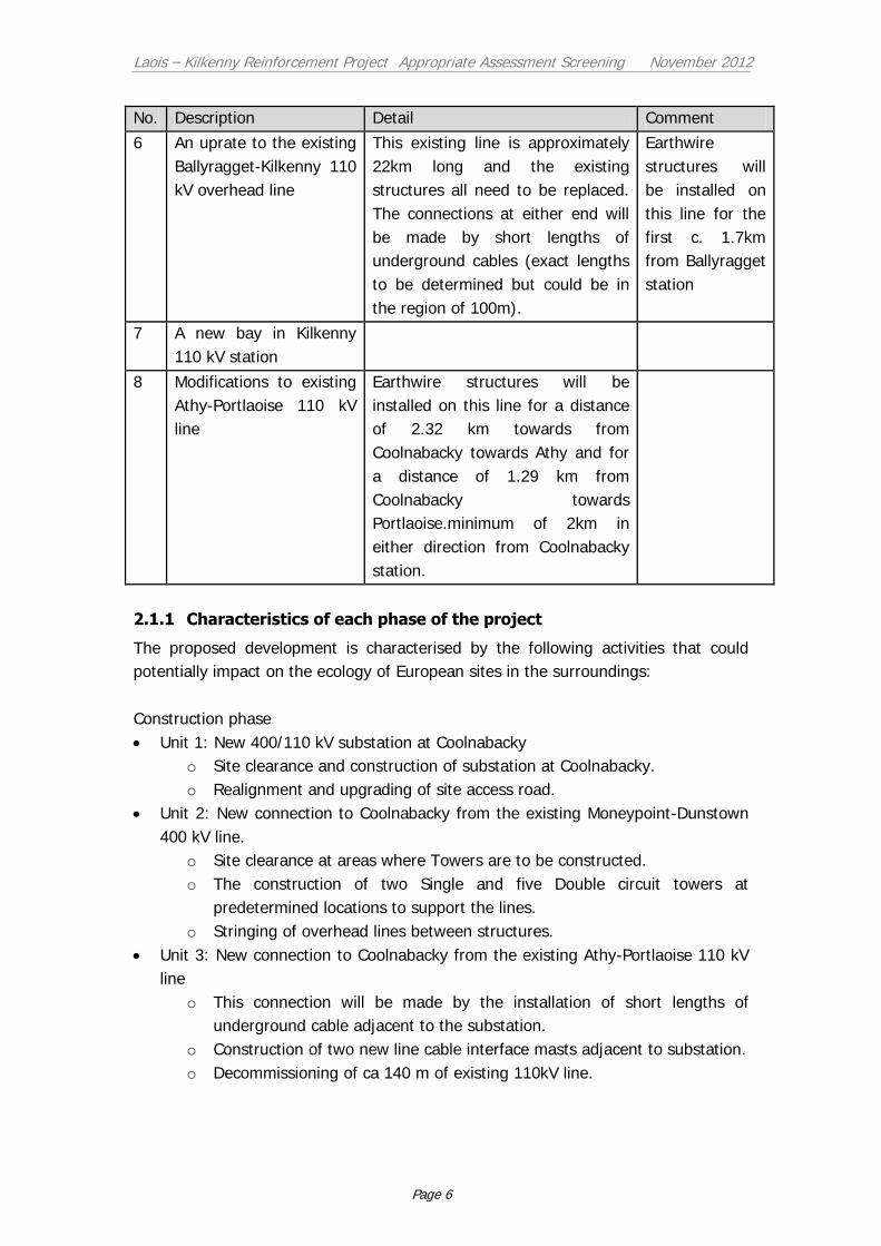
Laois – Kilkenny Reinforcement Project Appropriate Assessment Screening November 2012
Page 6
No. Description Detail Comment
6 An uprate to the existing
Ballyragget-Kilkenny 110
kV overhead line
This existing line is approximately
22km long and the existing
structures all need to be replaced.
The connections at either end will
be made by short lengths of
underground cables (exact lengths
to be determined but could be in
the region of 100m).
Earthwire
structures will
be installed on
this line for the
first c. 1.7km
from Ballyragget
station
7 A new bay in Kilkenny
110 kV station
8 Modifications to existing
Athy-Portlaoise 110 kV
line
Earthwire structures will be
installed on this line for a distance
of 2.32 km towards from
Coolnabacky towards Athy and for
a distance of 1.29 km from
Coolnabacky towards
Portlaoise.minimum of 2km in
either direction from Coolnabacky
station.
2.1.1 Characteristics of each phase of the project
The proposed development is characterised by the following activities that could
potentially impact on the ecology of European sites in the surroundings:
Construction phase
Unit 1: New 400/110 kV substation at Coolnabacky
o Site clearance and construction of substation at Coolnabacky.
o Realignment and upgrading of site access road.
Unit 2: New connection to Coolnabacky from the existing Moneypoint-Dunstown
400 kV line.
o Site clearance at areas where Towers are to be constructed.
o The construction of two Single and five Double circuit towers at
predetermined locations to support the lines.
o Stringing of overhead lines between structures.
Unit 3: New connection to Coolnabacky from the existing Athy-Portlaoise 110 kV
line
o This connection will be made by the installation of short lengths of
underground cable adjacent to the substation.
o Construction of two new line cable interface masts adjacent to substation.
o Decommissioning of ca 140 m of existing 110kV line.

Laois – Kilkenny Reinforcement Project Appropriate Assessment Screening November 2012
Page 7
Unit 4: A new 110 kV / 38 kV / MV substation in Ballyragget, Kilkenny adjacent to
the existing 38 kV /MV substation. The existing 38 kV / MV Ballyragget substation
will then be decommissioned and replaced.
o Site clearance and Construction of new 110 kV / 38 kV / MV substation
adjacent to existing 38 kV substation at Ballyragget
o Decommissioning of 38 kV / MV Ballyragget substation
Unit 5: A new 110 kV overhead line between Ballyragget and Coolnabacky
o Site clearance at areas where angle towers are to be constructed. Felling
of forestry / woodland stands where required at certain along the line
route.
o Construction of angle masts at pre-determined locations along the line
route.
o Erection of double wooden polesets to support the 110 kV overhead line
at pre-determined locations between angle masts.
o Stringing of overhead lines between structures.
o Connection to substations will be made by the installation of very short
lengths of underground cable adjacent to the substations.
Unit 6: An uprate to the existing Ballyragget-Kilkenny 110 kV overhead line.
o Replacement of existing structures along the length (22km) of the line.
o The first 1.7km out of Ballyragget station will be changed to earthwire
structures.
o Replacement of existing conductors with new conductor.
o Connection to substations will be made by the installation of very short
lengths of underground cable adjacent to the substations.
Unit 7: A new bay in Kilkenny 110 kV station.
o Construction works within the substation site will include concrete plinths
and steelwork
o Dismantling and decommissioning of equipment will be undertaken
Unit 8: Modifications to existing Athy-Portlaoise 110 kV line.
Existing structures will be replaced with earthwire structures on this line for a
distance of 2.32 km from Coolnabacky towards Athy and for a distance of 1.29 km
from Coolnabacky towards Portlaoise.
Operational phase
It is foreseen that routine maintenance works will be carried out during the
operational phase of the project to ensure the substations and overhead lines
continue to function properly throughout their operational life.
Decommissioning phase
At the end of its operational phase, the various components of the reinforcement
project will be dismantled and removed off site.
Laois – Kilkenny Reinforcement Project Appropriate Assessment Screening November 2012
Page 8
Further more detailed information on the proposed project will be presented in the
relevant chapters of the Environmental Assessment Report.
2.1.2 Drainage design of substation sites
Detailed drainage designs have been drafted for each of the newly proposed
substation sites in consultation with the local authorities and in compliance with
SuDS (Sustainable Drainage Systems) guidelines (CIRIA 697, The SUDS Manual,
2007. This design has taken into consideration the hydro-geological characteristics of
each site and the sensitivity of surface and ground water resources in the
surroundings. The final drainage designs will be submitted as part of the planning
application.
2.2 Identification and description of European sites
There are four European sites within 5 km of the proposed development as listed in
Table 1 below and illustrated in Figure 1. The qualifying interests and conservation
objectives of these sites are presented below while further more detailed descriptions
of these four sites prepared by National Parks and Wildlife Service (NPWS) are
presented in Appendix 1.1 – 1.4. It is considered that the proposed development will
not have an effect on sites located further than 5 km. This evaluation is made taking
into consideration the scale and characteristics of the proposed project as described
in section 2.1 above.

Laois – Kilkenny Reinforcement Project Appropriate Assessment Screening November 2012
Page 9
Figure 1: European sites that occur within 5 km of the proposed development.

Laois – Kilkenny Reinforcement Project Appropriate Assessment Screening November 2012
Page 10
Table 1: Designated European sites within 5km of Laois – Kilkenny Reinforcement Project
(Source: GIS section, National Parks and Wildlife Service).
Name Site
Code
Distance from proposed Laois - Kilkenny
Reinforcement Project
River Barrow and River Nore cSAC 2162 Coolnabacky – Ballyragget 110 kV Line crosses cSAC at Boleybeg
Existing Ballyragget – Kilkenny 110 kV Line crosses cSAC at Jenkinstown (just upstream
of New Dinin Bridge)
Entire project is located within the catchment of the cSAC
River Nore SPA 4233 0.6 km West of Coolnabacky – Ballyragget
110 kV line at Moatpark
Lisbigney Bog cSAC 0869 1.7 km West of Coolnabacky – Ballyragget
110 kV line at Loughill
Ballyprior Grassland cSAC 2256 4 km East of proposed Coolnabacky Sub-
station site
2.2.1 River Barrow and Nore cSAC (NPWS Site Code: 2162)
The qualifying interests of the River Barrow and Nore cSAC include those species and
habitats presented in Table 2. The conservation objectives for the site have recently
been published together with the attributes and targets which define the favourable
conservation condition for each qualifying species and habitat for which the site is
designated (NPWS 2011a)3. In summary the Conservation objectives for the River
Nore and Barrow cSAC are to maintain or restore the favourable conservation
condition of the Annex I habitat(s) and/or the Annex II species for which the cSAC
has been selected as presented in Table 2 below (NPWS 2011a). The distribution of
Annex I habitats and Annex II species throughout the cSAC is reviewed in the
Conservation Objectives report for the site (NPWS 2011a).
There are two types of freshwater pearl mussels in Ireland, one called Margaritifera
margaritifera and the other is the very rare Margaritifera durrovensis, which is only
known from the Nore Catchment. Populations of the Nore Freshwater Pearl-mussel
(Margaritifera durrovensis) were only ever known from the Barrow, Nore and Suir
main channels. It is now thought to be restricted to a short section of approximately
10km of the main Nore channel with most of the population found between
Poorman’s Bridge and the Avonmore Creamery above Ballyragget (S 440 722). The
species is in very serious decline and is listed as critically endangered in Ireland as
outlined in the Freshwater Pearl Mussel Nore Sub-Basin Management Plan (North
South 2 Project 2010). The known distribution of the Nore freshwater Pearl-mussel in
relation to the proposed development is shown in Appendix 1.5.
3 http://www.npws.ie/media/npwsie/content/images/protectedsites/conservationobjectives/CO002162.pdf

Laois – Kilkenny Reinforcement Project Appropriate Assessment Screening November 2012
Page 11
A number of the Annex II aquatic species of the cSAC occur in watercourses in
proximity to the proposed development including River and Brook Lamprey, Atlantic
Salmon, Freshwater White-clawed Crayfish (NPWS 2011a). These species would all
be sensitive to deterioration in water quality or habitat alteration due the effects of
siltation.
Table 2: Qualifying interests of River Barrow and River Nore cSAC (source: www.npws.ie).
Habitat /
Species code Habitat / Species Type
Habitats 91A0 Old sessile oak woods with Ilex and Blechnum in British Isles
91E0 Alluvial forests with Alnus glutinosa and Fraxinus excelsior (Alno-Padion, Alnion incanae, Salicion albae)
3260 Water courses of plain to montane levels with the Ranunculion fluitantis and Callitricho-Batrachion vegetation
1310 Salicornia and other annuals colonizing mud and sand
1330 Atlantic salt meadows (Glauco-Puccinellietalia maritimae)
1410 Mediterranean salt meadows (Juncetalia maritimi)
4030 European dry heaths
7220 Petrifying springs with tufa formation (Cratoneurion)
6430 Hydrophilous tall herb fringe communities of plains and of the
montane to alpine levels
1320 Spartina swards (Spartinion maritimae)
1140 Mudflats and sandflats not covered by seawater at low tide
1130 Estuaries
Species 1095 Sea Lamprey (Petromyzon marinus)
1096 Brook Lamprey (Lampetra planeri)
1099 River Lamprey (Lampetra fluviatilis)
1103 Twaite Shad (Alosa fallax)
1106 Atlantic Salmon (Salmo salar)
1102 Allis Shad (Alosa alosa)
1355 Otter (Lutra lutra)
1092 Freshwater White-clawed Crayfish (Austropotamobius pallipes)
1029 Freshwater Pearl-mussel (Margaritifera margaritifera)1
1990 Nore Freshwater Pearl-mussel (Margaritifera durrovensis)
1016 Whorl Snail (Vertigo moulinsiana)
1421 Killarney Fern (Trichomanes speciosum) 1The status of the Freshwater Pearl-mussel (Margaritifera margaritifera) as a
qualifying Annex II species for the River Barrow and River Nore cSAC is currently
under review (NPWS 2011a).
2.2.2 River Nore SPA (NPWS Site Code: 4233)
Conservation Objective (NPWS 2011b): To maintain or restore the favourable
conservation condition of the bird species listed as Special Conservation Interests for
this SPA:
[breeding] Kingfisher (Alcedo atthis)

Laois – Kilkenny Reinforcement Project Appropriate Assessment Screening November 2012
Page 12
2.2.3 Lisbigney Bog cSAC (NPWS Site Code: 0869)
Conservation Objective (NPWS 2011c): To maintain or restore the favourable
conservation condition of the Annex I habitat(s) and/or the Annex II species for
which the cSAC has been selected:
[1016] Vertigo moulinsiana
[7210] * Calcareous fens with Cladium mariscus and species of the Caricion
davallianae
2.2.4 Ballyprior Grassland cSAC (NPWS Site Code: 2162)
Conservation Objective (NPWS 2011d): To maintain or restore the favourable
conservation condition of the Annex I habitat(s) and/or the Annex II species for
which the cSAC has been selected:
[6210] Semi‐natural dry grasslands and scrubland facies on calcareous
substrates (Festuco Brometalia)(* important orchid sites)
2.3 Identification and Description of Potential Impacts
Taking into consideration the ecological characteristics of the European sites together
with the nature of the proposed development, the following potential impacts have
been identified:
Habitat loss and disturbance (construction phase): Both the Coolnabacky and the
Ballyragget substations are located outside of designated sites and therefore there is
no potential for direct habitat loss within European sites due to their construction.
The construction of overhead lines would cause local disturbance and short term loss
of habitat in the immediate vicinity of towers and polesets. This habitat loss and
disturbance would in most cases be expected to be short term as following re-
instatement and natural regeneration, vegetation would re-establish around the
structure bases.
With reference to the proposed project, the Coolnabacky to Ballyragget 110 kV line
traverses the River Barrow and Nore cSAC at Boleybeg. However all structures are
located in improved agricultural grassland habitat outside of the designated site (see
Section 2.4 and Figure 3). There are two existing structures on the Ballyragget to
Kilkenny 110kV line due for replacement that are located within or adjacent to the
River Barrow and Nore cSAC (see Section 2.4 and Figure 4). Both these structures
are located within improved grassland habitat that is of low ecological importance. All
other structures associated with the proposed development are located outside of
and removed from designated European sites.
Pollution of watercourses with consequent impacts on aquatic species and
ecosystems (construction phase): There is potential risk to water quality during the
construction phase should concrete or other harmful substances become entrained in
surface water run-off and enter watercourses. Deteriorating water quality resulting
Laois – Kilkenny Reinforcement Project Appropriate Assessment Screening November 2012
Page 13
from contamination events could have negative impacts on the qualifying aquatic
Annex II species of the River Barrow and Nore cSAC.
In addition, mobilization and transport of sediment due to excavation of soil could
potentially impact on freshwater ecology of water-courses downstream of
construction works. The proposed development will also require felling of conifer
plantations along parts of the Coolnabacky to Ballyragget 110 kV line route. Such
tree felling may pose a risk to water quality in downstream watercourses by
releasing sediment and nutrients. The risk to water quality varies according to soil
type and topography.
The release of sediment may result in a buildup of silt in the river system leading to
reduction in available, suitable freshwater pearl mussel habitat, crayfish habitat and
spawning habitat for lamprey and salmon (a species that is intrinsically linked to the
complex lifecycle of the Freshwater Pearl-mussel).
The proposed 400 / 110 kV Coolnabacky substation, the section of the Athy to
Portlaoise line and the northern part of the Coolnabacky to Ballyragget 110kV line
route is situated within the catchment of the River Barrow (see Figure 2). The
Ballyragget Substation, the Southern part of the Coolnabacky to Ballyragget 110kV
line route and the Ballyragget to Kilkenny line are located within the River Nore
catchment (see Figure 2). The main watercourses within both catchments, and
downstream of the proposed development areas, are designated within the extensive
River Barrow and Nore cSAC (see Figure 1). The main population of the rare Nore
Freshwater Pearl-mussel occurs within the main channel of the Nore from
Ballyragget to Poorman’s Bridge (See Appendix 1.5) (North South 2 Project 2010)4.
Water quality (operation phase)
Adverse impacts on water quality during the operational phase of the project are not
predicted due to standard best practice measures being employed during any
maintenance operations. Furthermore, the drainage design for each of the new
substation sites has been developed to ensure that there is no risk to surrounding
surface waters (see Section 2.1.2; the substation drainage designs are to be
submitted with the planning application). In addition, based on the characteristics of
the operational phase of the project, few sources of potential impact on water quality
have been identified.
4http://www.wfdireland.ie/docs/5_FreshwaterPearlMusselPlans/Freshwater%20Pearl%20Mussel%20Plans%20March%202010/Sec
ond%20Draft%20of%20Nore%20Sub-Plan%20March.2010.pdf

Laois – Kilkenny Reinforcement Project Appropriate Assessment Screening November 2012
Page 14
Figure 2: Proposed development in relation to sub-catchments of the River Barrow
and River Nore cSAC and the main watercourses.

Laois – Kilkenny Reinforcement Project Appropriate Assessment Screening November 2012
Page 15
Changes in flow regime of watercourses: Any significant changes in the flow regime
of watercourses within the River Barrow and Nore cSAC due to the proposed
development could have adverse effects on qualifying habitats and species of the
cSAC.
The creation of hard surface areas within the sub-station sites have potential to alter
the hydrological conditions of the particular sites and may have a knock-on effect on
the flow rates of surrounding watercourses. However, the drainage design for each
of the substation sites has taken account of this by providing sufficient on-site
attenuation (the ESBI substation drainage infrastructure report that is in preparation
will provide information and calculations to show that the substation sites will be
designed to green-field runoff rates as agreed with both Laois and Kilkenny Councils
in the pre planning meetings).
Temporary changes in the hydrology at the substation sites could also occur during
the construction phase. This may transpire in situations where there is a high water
table and de-watering is necessary to facilitate the construction of foundations,
installation of underground cables and associated works. In the case of the
Ballyragget Substation no potential for such impacts are foreseen as the water table
is sufficiently low. On-site trial pit results have shown that ground water was not
encountered at 3m below ground level. The foundations will not exceed 2m and
therefore no dewatering will be required here (Chapter 8, Environmental Report).
Based on field observations it appears that the watercourses surrounding the
Coolnabacky substation site are fed by a constant supply of calcium carbonate rich
groundwater. These spring-fed watercourses are the headwaters of the Bauteogue
River which flows into the River Barrow and Nore cSAC ca 4.5 km to the North-east.
Borehole and trial pit results from this site indicate a high water table (< 2 metres
below ground level), therefore temporary dewatering may be required at this site. In
relation to the potential impact on the groundwater-fed water courses in the
surroundings, a hydrogeological review of the site that was undertaken (presented
as Appendix 1.6 to this report) concluded that there would be limited dewatering
required during excavation. This is based on site investigations which indicated that
the sand and gravel deposits at the site are not saturated and ground water inflow is
not significant. Any dewatering can therefore be confined to the areas immediately
surrounding the excavation and will not impact on springs or watercourses in the
surroundings (see Appendix 1.6).
Disturbance to birds and mammals: During construction works there is potential for
direct short term disturbance to birds and mammals in the vicinity of the proposed
works. Such disturbance would be caused by increased human activity and noise
from construction machinery. These impacts could be of significance if they were to
cause disturbance to mammal and bird species listed as qualifying species of the
Laois – Kilkenny Reinforcement Project Appropriate Assessment Screening November 2012
Page 16
relevant European sites (Otter in the case of the River Barrow and Nore cSAC and
Kingfisher in the case of the River Nore SPA).
Bird collision (operational phase): New overhead lines may adversely impact on
sensitive bird species. During the operational phase there is a potential risk of
collision with birds of conservation concern. However, there are no European sites in
the surroundings that have been designated for the protection of bird species that
would be prone to collision. Furthermore recent surveys of winter bird populations
and their movements within the wider study area indicate that there is low collision
risk to any bird species of conservation interest (see winter bird reports submitted as
part of Phase I Lead Consultants Report). This impact is therefore not considered
further.
2.4 Assessment of Significance
The potential impacts on the conservation interest of each European site identified in
Section 2.3 above are dealt with in the following sections:
River Barrow and Nore cSAC: The site is designated for a range of habitats and
species listed on Annex I and Annex II of the EU Habitats Directive respectively (see
Section 2.3 above).
There is potential for small scale direct habitat disturbance where the proposed
Coolnabacky to Ballyragget 110 kV line crosses the cSAC at Boleybeg. The design of
the project has avoided placing structures within the cSAC (see Figure 3). Some tree
topping may be required at the river crossing. Improved Agricultural Grassland (GA1)
surrounds the narrow riparian zone at this location. The river banks are defined by
non-continuous lines of trees and shrubs that include Alder (Alnus glutinosa) and Ash
(Fraxinus excelsior). The terrestrial habitats present at this location do not
correspond with qualifying habitats for which the cSAC is designated. Based on the
habitats recorded in the vicinity of the cSAC, it is concluded that this potential impact
will not adversely affect the conservation interest of the cSAC.
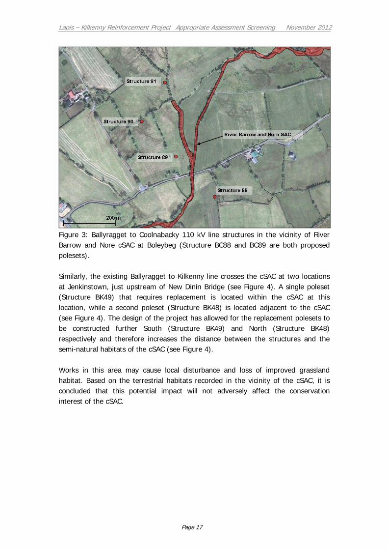
Laois – Kilkenny Reinforcement Project Appropriate Assessment Screening November 2012
Page 17
Figure 3: Ballyragget to Coolnabacky 110 kV line structures in the vicinity of River
Barrow and Nore cSAC at Boleybeg (Structure BC88 and BC89 are both proposed
polesets).
Similarly, the existing Ballyragget to Kilkenny line crosses the cSAC at two locations
at Jenkinstown, just upstream of New Dinin Bridge (see Figure 4). A single poleset
(Structure BK49) that requires replacement is located within the cSAC at this
location, while a second poleset (Structure BK48) is located adjacent to the cSAC
(see Figure 4). The design of the project has allowed for the replacement polesets to
be constructed further South (Structure BK49) and North (Structure BK48)
respectively and therefore increases the distance between the structures and the
semi-natural habitats of the cSAC (see Figure 4).
Works in this area may cause local disturbance and loss of improved grassland
habitat. Based on the terrestrial habitats recorded in the vicinity of the cSAC, it is
concluded that this potential impact will not adversely affect the conservation
interest of the cSAC.
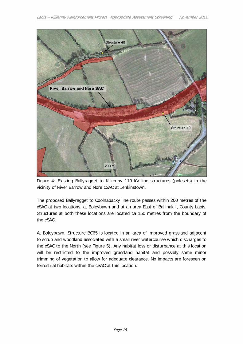
Laois – Kilkenny Reinforcement Project Appropriate Assessment Screening November 2012
Page 18
Figure 4: Existing Ballyragget to Kilkenny 110 kV line structures (polesets) in the
vicinity of River Barrow and Nore cSAC at Jenkinstown.
The proposed Ballyragget to Coolnabacky line route passes within 200 metres of the
cSAC at two locations, at Boleybawn and at an area East of Ballinakill, County Laois.
Structures at both these locations are located ca 150 metres from the boundary of
the cSAC.
At Boleybawn, Structure BC65 is located in an area of improved grassland adjacent
to scrub and woodland associated with a small river watercourse which discharges to
the cSAC to the North (see Figure 5). Any habitat loss or disturbance at this location
will be restricted to the improved grassland habitat and possibly some minor
trimming of vegetation to allow for adequate clearance. No impacts are foreseen on
terrestrial habitats within the cSAC at this location.

Laois – Kilkenny Reinforcement Project Appropriate Assessment Screening November 2012
Page 19
Figure 5: Ballyragget to Coolnabacky 110 kV line structures in the vicinity of River
Barrow and Nore cSAC at Boleybawn.
East of Ballinakill, Structure BC53 (Angle Mast) is located in an area of improved
grassland (see Figure 6). Any habitat loss or disturbance at this location will be
restricted to the improved grassland habitat. Laois County Council, have listed a
woodland area in the vicinity of this location as a ‘Significant Tree Group’. Following
consultation with Laois County Council, this tree group is understood to refer to a
mature demesne plantation woodland in the vicinity of Mass Lough (see Figure 6).
The woodland has been surveyed as part of the National Survey of Native Woodland
(Perrin et al. 2008) and at that time was deemed to be of low ecological importance
being dominated by mostly non-native plantation woodland. The cSAC which occurs
between the proposed line route and the plantation woodland at this location
comprises the main Owenbeg River channel and associated semi-natural habitats
which include scrub and ash – alder dominated woodland (see Figure 6). The
terrestrial habitats within the cSAC at this location do not correspond with Annex I
habitats for which the site is designated (see Table 2). It is concluded that no
impacts are foreseen on the significant tree group as listed by Laois County Council
(2011) or on terrestrial habitats within the cSAC at this location.
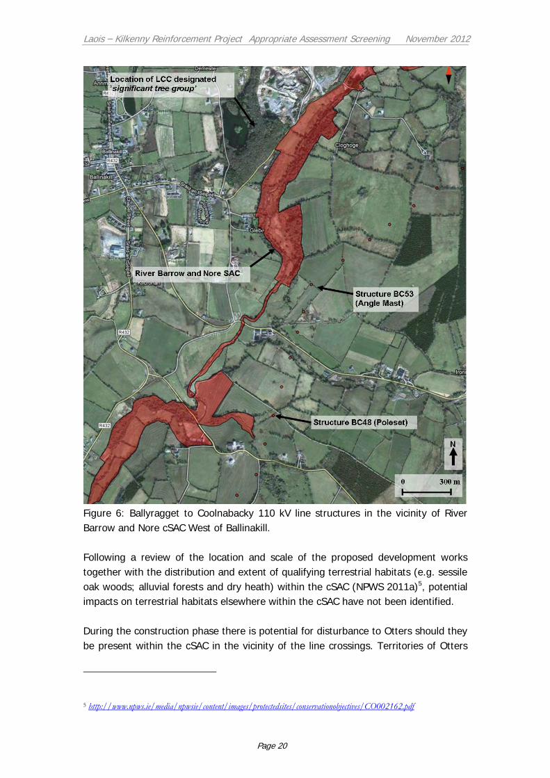
Laois – Kilkenny Reinforcement Project Appropriate Assessment Screening November 2012
Page 20
Figure 6: Ballyragget to Coolnabacky 110 kV line structures in the vicinity of River
Barrow and Nore cSAC West of Ballinakill.
Following a review of the location and scale of the proposed development works
together with the distribution and extent of qualifying terrestrial habitats (e.g. sessile
oak woods; alluvial forests and dry heath) within the cSAC (NPWS 2011a)5, potential
impacts on terrestrial habitats elsewhere within the cSAC have not been identified.
During the construction phase there is potential for disturbance to Otters should they
be present within the cSAC in the vicinity of the line crossings. Territories of Otters
5 http://www.npws.ie/media/npwsie/content/images/protectedsites/conservationobjectives/CO002162.pdf

Laois – Kilkenny Reinforcement Project Appropriate Assessment Screening November 2012
Page 21
that occur within the cSAC may also include undesignated sections of rivers further
upstream. Based on the small scale of construction works proposed in the vicinity of
the cSAC (see Figure 3 and 4) and the fact that all construction works will take place
in areas outside of the riparian habitats of the cSAC this impact is unlikely to be of
significance. Otters are afforded protection throughout the wider countryside by their
inclusion on Annex IV of the EU Habitats Directive, making it an offence to
deliberately disturb the species or damage or destroy its breeding or resting place
wherever it occurs. Measures are proposed in the Environmental Report to ensure
that Otters are not impacted upon during the construction phase of the project.
As outlined above, the proposed development occurs within the catchment of the
River Barrow and River Nore cSAC. A number of aquatic species and their habitats
would be sensitive to any deterioration in surface water quality within the cSAC,
including Floating river vegetation, Salmon, White-clawed Crayfish and most notably
the Nore Freshwater Pearl-mussel (NPWS 2011a).
During the construction phase of the project there is potential for sediment run-off
(due to excavations and works associated with tree felling) via the surface water
drainage system into the River Barrow and River Nore cSAC. In addition, potential
impacts due to contamination of surface water by concrete, fuel or other harmful
substances are possible. Best practice construction techniques that will be adhered to
during the construction of the project should minimise the potential for these impacts
to occur. However, additional mitigation will be required at a number of especially
sensitive locations where significant works are being proposed.
In the case of the Coolnabacky substation site, a hydrogeological review of the site
has concluded that there is no risk to the flow regime in surrounding watercourses
that feed into the River Barrow and Nore cSAC (see Appendix 1.6).
Based on the scale and location of the proposed development there is potential for
significant adverse impacts on the conservation interest of the River Barrow and
River Nore cSAC. These potential impacts require further evaluation by way of
Appropriate Assessment.
River Nore SPA: This site has been recently designated for the protection of
Kingfisher which is listed on Annex I of the EU Birds Directive. The SPA is designated
due to the presence of a nationally significant population of Kingfishers (twenty two
pairs recorded during a recent survey of the site (Cummins et al. 2010)). Kingfishers
are restricted in their distribution to riparian habitats; they nest in burrows along
sandy river banks and feed on small fish. They tend to partake in low flight and
spend most of the time within the river corridor.
Laois – Kilkenny Reinforcement Project Appropriate Assessment Screening November 2012
Page 22
The proposed development avoids traversing the SPA. No direct impacts on the
conservation interest (the Kingfisher population) of the site are foreseen during the
construction phase. Indirect impacts could result from any major deterioration in
water quality and subsequent effects on the bird’s food source (aquatic fauna
species), however, considering the nearest works associated with the proposed
development occur ca 0.6 km upstream of the SPA, and that no in-stream works are
proposed, this potential impact is considered extremely un-likely. The use of best
practice construction management techniques should prevent any deterioration of
water quality within the SPA and therefore it is concluded that no significant adverse
impacts on the SPA are foreseen.
Based on the flight behaviour and habitat preferences of kingfisher and the location
of the proposed Coolnabacky to Ballyragget line route in relation to the SPA it is
considered that the proposed overhead line would not pose any significant collision
risk during the operation phase.
Lisbigney Bog cSAC: This site is designated for the protection of the EU priority
habitat ‘Calcareous Fen with Cladium mariscus’ and the snail ‘Vertigo moulinsiana’,
which are listed on Annex I and Annex II respectively. The proposed Coolnabacky to
Ballyragget overhead line route corridor is located a minimum of 1.7 km from this
European site. The works associated with the construction of the line route in this
area will be of such a local scale that any hydrological impacts will be temporary and
restricted to those areas immediately surrounding the structure locations. It is
concluded that based on the local hydrology and topography of the area, the
conservation interest of the cSAC, the characteristics of the proposed development
and its distance removed from the cSAC, no potential adverse impacts on the
conservation interest of the site are foreseen.
Ballyprior Grassland cSAC: This site is designated for the protection of the EU priority
habitat ‘Semi-natural dry grasslands and scrubland facies on calcareous substrates
(Festuco Brometalia) (*important orchid sites)’. The proposed development is located
ca 4 km from this European site. The habitat requirements of the grassland habitat
for which the cSAC is designated are such that it would not be sensitive to any
potential indirect impacts of the proposed development. Therefore based on the
conservation interest of the cSAC, the characteristics of the proposed development
and its distance removed from the cSAC no potential adverse impacts on the site are
foreseen.
2.5 Conclusion
In order to determine the potential impacts of the proposed Laois – Kilkenny
reinforcement project on nearby European sites, appropriate assessment screening
was undertaken. Four European sites were identified as occurring within 5 km of the
proposed development.

Laois – Kilkenny Reinforcement Project Appropriate Assessment Screening November 2012
Page 23
It has been determined that three of these sites (River Nore SPA, Lisbigney Bog
cSAC and Ballyprior Grassland cSAC) will not be impacted upon either directly or
indirectly as a result of the proposed development and therefore are excluded from
appropriate assessment.
Based on the precautionary approach adopted it has been shown that the proposed
development has the potential to adversely impact the River Barrow and River Nore
cSAC during the construction phase and significant impacts on water quality cannot
be ruled out. It should be noted that mitigation measures have not been considered
in the screening process presented above.
A stage 2 appropriate assessment is therefore required to be carried out by An Bord
Pleanála in order to assess the significance of the potential impacts.
2.6 Screening Matrix
A screening matrix (EU Commission 2002) is presented below for the River Barrow
and Nore cSAC:
Screening Matrix
Brief description of the project or the plan The following are the main elements of the project:
A new 400/110 kV substation, ‘Coolnabacky’, near
Portlaoise, Co. Laois. The existing Athy-Portlaoise
110 kV and Moneypoint-Dunstown 400 kV overhead
lines will connect to this new substation.
A new 110 kV / 38 kV / MV substation at Ballyragget,
Co.Kilkenny. This will replace the existing 38 kV / MV
substation.
A new 110 kV overhead line between Coolnabacky
and Ballyragget
An uprate to the existing Ballyragget-Kilkenny 110 kV
overhead line with associated works in Kilkenny
substation
Brief description of the European site River Barrow and River Nore cSAC – see section 2.3.1 of this report for the qualifying features of the cSAC
Describe the individual elements of the
plan or project (either alone or in-combination with other plans or projects)
likely to give rise to impacts on the European site
1. Works associated with the construction of the substation
at Coolnabacky 2. Works associated with the construction of the substation
at Ballyragget 3. Works associated with the construction of the new 110 kV
line from Coolnabacky to Ballyragget including:
The felling of forestry within the sensitive Nore
catchment Construction works at structure locations in especially
sensitive areas
4. Construction work associated with the uprating of the existing Ballyragget to Kilkenny at particularly sensitive
locations
Describe any likely direct, indirect or A possible indirect impact of the project on the European site
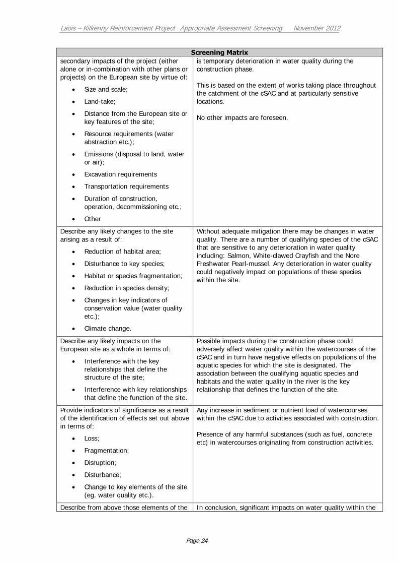
Laois – Kilkenny Reinforcement Project Appropriate Assessment Screening November 2012
Page 24
Screening Matrix
secondary impacts of the project (either
alone or in-combination with other plans or projects) on the European site by virtue of:
Size and scale;
Land-take;
Distance from the European site or
key features of the site;
Resource requirements (water
abstraction etc.);
Emissions (disposal to land, water
or air);
Excavation requirements
Transportation requirements
Duration of construction,
operation, decommissioning etc.;
Other
is temporary deterioration in water quality during the
construction phase.
This is based on the extent of works taking place throughout the catchment of the cSAC and at particularly sensitive
locations.
No other impacts are foreseen.
Describe any likely changes to the site
arising as a result of:
Reduction of habitat area;
Disturbance to key species;
Habitat or species fragmentation;
Reduction in species density;
Changes in key indicators of
conservation value (water quality
etc.);
Climate change.
Without adequate mitigation there may be changes in water
quality. There are a number of qualifying species of the cSAC that are sensitive to any deterioration in water quality
including: Salmon, White-clawed Crayfish and the Nore Freshwater Pearl-mussel. Any deterioration in water quality
could negatively impact on populations of these species
within the site.
Describe any likely impacts on the European site as a whole in terms of:
Interference with the key
relationships that define the structure of the site;
Interference with key relationships
that define the function of the site.
Possible impacts during the construction phase could adversely affect water quality within the watercourses of the
cSAC and in turn have negative effects on populations of the aquatic species for which the site is designated. The
association between the qualifying aquatic species and
habitats and the water quality in the river is the key relationship that defines the function of the site.
Provide indicators of significance as a result of the identification of effects set out above
in terms of:
Loss;
Fragmentation;
Disruption;
Disturbance;
Change to key elements of the site
(eg. water quality etc.).
Any increase in sediment or nutrient load of watercourses within the cSAC due to activities associated with construction.
Presence of any harmful substances (such as fuel, concrete
etc) in watercourses originating from construction activities.
Describe from above those elements of the In conclusion, significant impacts on water quality within the

Laois – Kilkenny Reinforcement Project Appropriate Assessment Screening November 2012
Page 25
Screening Matrix
project or plan, or combination of
elements, where the above impacts are likely to be significant or where the scale or
magnitude of impacts is not known.
River Barrow and Nore cSAC due to the construction of the
proposed development cannot be ruled out. Therefore a Stage 2 Appropriate Assessment (AA) is required to
determine the significance of the potential impacts.
Mitigation measures have not been considered in the screening process and can only be taken into account in the
Stage 2 AA. It is anticipated that suitable construction site
management plans, method statements and mitigation can eliminate the impacts identified.
Laois – Kilkenny Reinforcement Project Appropriate Assessment Screening November 2012
Page 26
3 References
CIRIA, (2001), Control of Water Pollution from Construction Sites, Guidance for
Consultants and Contractors.
Cummins, S., Fisher, J., McKeever, R.G., McNaghten, L., and O. Crowe (2010).
Assessment of the distribution and abundance of Kingfisher Alcedo atthis and
other riparian birds on six SAC river systems in Ireland. A report commissioned
by the National Parks and Wildlife Service and prepared by BirdWatch Ireland.
Department of the Environment, Heritage and Local Government (2009). Appropriate
Assessment of Plans and Projects in Ireland: Guidance for Planning Authorities.
European Commission (2000) Managing Natura 2000 sites: the provisions of Articles 6 of
the habitats directive 92/43/EEC. Luxembourg: Office for official publications of
the European Communities.
European Commission (2002). Assessment of plans and projects significantly affecting
Natura 2000 sites. Methodological guidance on the provisions of articles 6(3) and
(4) of the Habitats Directive 92/43/EEC. Luxembourg: Office for official
publications of the European Communities.
Laois County Council (2011). Laois County Development Plan (2011 – 2017). Laois
County Council, Portlaoise
Moorkens, E. A. (1999). Conservation management of the freshwater pearl mussel
Margaritifera margaritifera. Part 1: Biology of the species and its present
situation in Ireland. Irish Wildlife Manuals No. 8. National Parks and Wildlife
Service, Dublin.
North South 2 Project (2010). Freshwater Pearl Mussel Nore Sub-Basin Management
Plan - Second Draft.
NPWS (2011a) Conservation Objectives: River Barrow and River Nore SAC 002162.
Version 1.0. National Parks and Wildlife Service, Department of Arts, Heritage
and the Gaeltacht.
NPWS (2011b) Conservation objectives for River Nore SPA [004233]. Generic Version
3.0. Department of Arts, Heritage & the Gaeltacht.
NPWS (2011c) Conservation objectives for Lisbigney Bog SAC [000869]. Generic Version
3.0. Department of Arts,Heritage & the Gaeltacht.
NPWS (2011d) Conservation objectives for Ballyprior Grassland SAC [002256]. Generic
Version 3.0. Department of Arts, Heritage & the Gaeltacht.
www.npws.ie (2011). National Parks and Wildlife Service web site synopses for Special
Areas of Conservation (SACs) and Natural Heritage Areas (NHAs).
Perrin, P., Martin, J., Barron, S., O'Neill, F., McNutt, K. & Delaney, A. (2008). National
Survey of Native Woodlands - Volume 1 Main Report . Unpublished Report to the
National Parks & Wildlife Service.
Laois – Kilkenny Reinforcement Project Appropriate Assessment Screening November 2012
Page 27
APPENDIX 1.1
River Barrow and Nore SAC - NPWS Site Description
River Barrow & Nore SAC
NPWS site code 0002162
This site consists of the freshwater stretches of the Barrow/Nore River catchments as
far upstream as the Slieve Bloom Mountains and it also includes the tidal elements
and estuary as far downstream as Creadun Head in Waterford. The site passes
through eight counties – Offaly, Kildare, Laois, Carlow, Kilkenny, Tipperary, Wexford
and Waterford. Major towns along the edge of the site include Mountmellick,
Portarlington, Monasterevin, Stradbally, Athy, Carlow, Leighlinbridge,
Graiguenamanagh, New Ross, Inistioge, Thomastown, Callan, Bennettsbridge,
Kilkenny and Durrow. The larger of the many tributaries include the Lerr, Fushoge,
Mountain, Aughavaud, Owenass, Boherbaun and Stradbally Rivers of the Barrow and
the Delour, Dinin, Erkina, Owveg, Munster, Arrigle and King’s Rivers on the Nore.
Both rivers rise in the Old Red Sandstone of the Slieve Bloom Mountains before
passing through a band of Carboniferous shales and sandstones. The Nore, for a
large part of its course, traverses limestone plains and then Old Red Sandstone for a
short stretch below Thomastown. Before joining the Barrow it runs over intrusive
rocks poor in silica. The upper reaches of the Barrow also runs through limestone.
The middle reaches and many of the eastern tributaries, sourced in the Blackstairs
Mountains, run through Leinster Granite. The southern end, like the Nore runs over
intrusive rocks poor in silica. Waterford Harbour is a deep valley excavated by glacial
floodwaters when the sea level was lower than today. The coast shelves quite
rapidly along much of the shore.
The site is a candidate SAC selected for alluvial wet woodlands and petrifying
springs, priority habitats on Annex I of the E.U. Habitats Directive. The site is also
selected as a candidate SAC for old oak woodlands, floating river vegetation, estuary,
tidal mudflats, Salicornia mudflats, Atlantic salt meadows, Mediterranean salt
meadows, dry heath and eutrophic tall herbs, all habitats listed on Annex I of the
E.U. Habitats Directive. The site is also selected for the following species listed on
Annex II of the same directive - Sea Lamprey, River Lamprey, Brook Lamprey,
Freshwater Pearl Mussel, Nore Freshwater Pearl Mussel, Crayfish, Twaite Shad,
Atlantic Salmon, Otter, Vertigo moulinsiana and the plant Killarney Fern.
Good examples of Alluvial Forest are seen at Rathsnagadan, Murphy’s of the River, in
Abbeyleix estate and along other shorter stretches of both the tidal and freshwater
elements of the site. Typical species seen include Almond Willow (Salix triandra),

Laois – Kilkenny Reinforcement Project Appropriate Assessment Screening November 2012
Page 28
White Willow (S. alba), Grey Willow (S. cinerea), Crack Willow (S. fragilis), Osier (S.
viminalis), with Iris (Iris pseudacorus), Hemlock Water-dropwort (Oenanthe crocata),
Angelica (Angelica sylvestris), Thin-spiked Wood-sedge (Carex strigosa), Pendulous
Sedge (C. pendula), Meadowsweet (Filipendula ulmaria), Valerian (Valeriana
officinalis) and the Red Data Book species Nettle-leaved Bellflower (Campanula
trachelium). Three rare invertebrates have been recorded in this habitat at Murphy’s
of the River. These are: Neoascia obliqua (Diptera: Syrphidae), Tetanocera freyi
(Diptera: Sciomyzidae) and Dictya umbrarum (Diptera: Sciomyzidae).
A good example of petrifying springs with tufa formations occurs at Dysart Wood
along the Nore. This is a rare habitat in Ireland and one listed with priority status on
Annex I of the EU Habitats Directive. These hard water springs are characterised by
lime encrustations, often associated with small waterfalls. A rich bryophyte flora is
typical of the habitat and two diagnostic species, Cratoneuron commutatum var.
commutatum and Eucladium verticillatum, have been recorded.
The best examples of old Oak woodlands are seen in the ancient Park Hill woodland
in the estate at Abbeyleix; at Kyleadohir, on the Delour, Forest Wood House,
Kylecorragh and Brownstown Woods on the Nore; and at Cloghristic Wood,
Drummond Wood and Borris Demesne on the Barrow, though other patches occur
throughout the site. Abbeyleix Woods is a large tract of mixed deciduous woodland
which is one of the only remaining true ancient woodlands in Ireland. Historical
records show that Park Hill has been continuously wooded since the sixteenth
century and has the most complete written record of any woodland in the country.
It supports a variety of woodland habitats and an exceptional diversity of species
including 22 native trees, 44 bryophytes and 92 lichens. It also contains eight
indicator species of ancient woodlands. Park Hill is also the site of two rare plants,
Nettle-leaved Bellflower and the moss Leucodon sciuroides. It has a typical bird
fauna including Jay, Long-eared Owl and Raven. A rare invertebrate, Mitostoma
chrysomelas, occurs in Abbeyleix and only two other sites in the country. Two flies
Chrysogaster virescens and Hybomitra muhlfeldi also occur. The rare Myxomycete
fungus, Licea minima has been recorded from woodland at Abbeyleix.
Oak woodland covers parts of the valley side south of Woodstock and is well
developed at Brownsford where the Nore takes several sharp bends. The steep
valley side is covered by Oak (Quercus spp.), Holly (Ilex aquifolium), Hazel (Corylus
avellana) and Birch (Betula pubescens) with some Beech (Fagus sylvatica) and Ash
(Fraxinus excelsior). All the trees are regenerating through a cover of Bramble
(Rubus fruticosus agg.), Foxglove (Digitalis purpurea) Wood Rush (Luzula sylvatica)
and Broad Buckler-fern (Dryopteris dilatata).
On the steeply sloping banks of the River Nore about 5 km west of New Ross, in
County Kilkenny, Kylecorragh Woods form a prominent feature in the landscape.
Laois – Kilkenny Reinforcement Project Appropriate Assessment Screening November 2012
Page 29
This is an excellent example of a relatively undisturbed, relict Oak woodland with a
very good tree canopy. The wood is quite damp and there is a rich and varied
ground flora. At Brownstown a small, mature Oak-dominant woodland occurs on a
steep slope. There is younger woodland to the north and east of it. Regeneration
throughout is evident. The understorey is similar to the woods at Brownsford. The
ground flora of this woodland is developed on acidic, brown earth type soil and
comprises a thick carpet of Bilberry (Vaccinium myrtillus), Heather (Calluna vulgaris),
Hard Fern (Blechnum spicant), Cow-wheat (Melampyrum spp.) and Bracken
(Pteridium aquilinum).
Borris Demesne contains a very good example of a semi-natural broad-leaved
woodland in very good condition. There is quite a high degree of natural re-
generation of Oak and Ash through the woodland. At the northern end of the estate
Oak species predominate. Drummond Wood, also on the Barrow, consists of three
blocks of deciduous woods situated on steep slopes above the river. The deciduous
trees are mostly Oak species. The woods have a well established understorey of
Holly (Ilex aquifolium), and the herb layer is varied, with Brambles abundant.
Whitebeam (Sorbus devoniensis) has also been recorded.
Eutrophic tall herb vegetation occurs in association with the various areas of alluvial
forest and elsewhere where the flood-plain of the river is intact. Characteristic
species of the habitat include Meadowsweet (Filipendula ulmaria), Purple Loosestrife
(Lythrum salicaria), Marsh Ragwort (Senecio aquaticus), Ground Ivy (Glechoma
hederacea) and Hedge Bindweed (Calystegia sepium). Indian Balsam (Impatiens
glandulifera), an introduced and invasive species, is abundant in places.
Floating River Vegetation is well represented in the Barrow and in the many
tributaries of the site. In the Barrow the species found include Water Starworts
(Callitriche spp.), Canadian Pondweed (Elodea canadensis), Bulbous Rush (Juncus
bulbosus), Milfoil (Myriophyllum spp.), Potamogeton x nitens, Broad-leaved
Pondweed (P. natans), Fennel Pondweed (P. pectinatus), Perfoliated Pondweed (P.
perfoliatus) and Crowfoots (Ranunculus spp.). The water quality of the Barrow has
improved since the vegetation survey was carried out (EPA, 1996).
Dry Heath at the site occurs in pockets along the steep valley sides of the rivers
especially in the Barrow Valley and along the Barrow tributaries where they occur in
the foothills of the Blackstairs Mountains. The dry heath vegetation along the slopes
of the river bank consists of Bracken (Pteridium aquilinum) and Gorse (Ulex
europaeus) species with patches of acidic grassland vegetation. Additional typical
species include Heath Bedstraw (Galium saxatile), Foxglove (Digitalis purpurea),
Common Sorrel (Rumex acetosa) and Bent Grass (Agrostis stolonifera). On the
steep slopes above New Ross the Red Data Book species Greater Broomrape
(Orobanche rapum-genistae) has been recorded. Where rocky outcrops are shown

Laois – Kilkenny Reinforcement Project Appropriate Assessment Screening November 2012
Page 30
on the maps Bilberry (Vaccinium myrtillus) and Wood Rush (Luzula sylvatica) are
present. At Ballyhack a small area of dry heath is interspersed with patches of
lowland dry grassland. These support a number of Clover species including the
legally protected Clustered Clover (Trifolium glomeratum) - a species known from
only one other site in Ireland. This grassland community is especially well developed
on the west side of the mud-capped walls by the road. On the east of the cliffs a
group of rock-dwelling species occur, i.e. English Stonecrop (Sedum anglicum),
Sheep's-bit (Jasione montana) and Wild Madder (Rubia peregrina). These rocks also
support good lichen and moss assemblages with Ramalina subfarinacea and
Hedwigia ciliata.
Dry Heath at the site generally grades into wet woodland or wet swamp vegetation
lower down the slopes on the river bank. Close to the Blackstairs Mountains, in the
foothills associated with the Aughnabrisky, Aughavaud and Mountain Rivers there are
small patches of wet heath dominated by Purple Moor-grass (Molinia caerulea) with
Heather (Calluna vulgaris), Tormentil (Potentilla erecta), Carnation Sedge (Carex
panicea) and Bell Heather (Erica cinerea).
Saltmeadows occur at the southern section of the site in old meadows where the
embankment has been breached, along the tidal stretches of in-flowing rivers below
Stokestown House, in a narrow band on the channel side of Common Reed
(Phragmites) beds and in narrow fragmented strips along the open shoreline. In the
larger areas of salt meadow, notably at Carrickcloney, Ballinlaw Ferry and
Rochestown on the west bank; Fisherstown, Alderton and Great Island to Dunbrody
on the east bank, the Atlantic and Mediterranean sub types are generally intermixed.
At the upper edge of the salt meadow in the narrow ecotonal areas bordering the
grasslands where there is significant percolation of salt water, the legally protected
species Borrer’s Saltmarsh-grass (Puccinellia fasciculata) and Meadow Barley
(Hordeum secalinum) (Flora Protection Order, 1987) are found. The very rare
Divided Sedge (Carex divisa) is also found. Sea Rush (Juncus maritimus) is also
present. Other plants recorded and associated with salt meadows include Sea Aster
(Aster tripolium), Sea Thrift (Armeria maritima), Sea Couch (Elymus pycnanthus),
Spear-leaved Orache (Atriplex prostrata), Lesser Sea-spurrey (Spergularia marina),
Sea Arrowgrass (Triglochin maritima) and Sea Plantain (Plantago maritima).
Salicornia and other annuals colonising mud and sand are found in the creeks of the
saltmarshes and at the seaward edges of them. The habitat also occurs in small
amounts on some stretches of the shore free of stones.
The estuary and the other Habitats Directive Annex I habitats within it form a large
component of the site. Extensive areas of intertidal flats, comprised of substrates
ranging from fine, silty mud to coarse sand with pebbles/stones are present. Good
quality intertidal sand and mudflats have developed on a linear shelf on the western
Laois – Kilkenny Reinforcement Project Appropriate Assessment Screening November 2012
Page 31
side of Waterford Harbour, extending for over 6 km from north to south between
Passage East and Creadaun Head, and in places are over 1 km wide. The sediments
are mostly firm sands, though grade into muddy sands towards the upper shore.
They have a typical macro-invertebrate fauna, characterised by polychaetes and
bivalves. Common species include Arenicola marina, Nephtys hombergii, Scoloplos
armiger, Lanice conchilega and Cerastoderma edule.
The western shore of the harbour is generally stony and backed by low cliffs of
glacial drift. At Woodstown there is a sandy beach, now much influenced by
recreation pressure and erosion. Behind it a lagoonal marsh has been impounded
which runs westwards from Gaultiere Lodge along the course of a slow stream. An
extensive reedbed occurs here. At the edges is a tall fen dominated by sedges
(Carex spp.), Meadowsweet, Willowherb (Epilobium spp.) and rushes (Juncus spp.).
Wet woodland also occurs. This area supports populations of typical waterbirds
including Mallard, Snipe, Sedge Warbler and Water Rail.
The dunes which fringe the strand at Duncannon are dominated by Marram grass
(Ammophila arenaria) towards the sea. Other species present include Wild Sage
(Salvia verbenaca), a rare Red Data Book species. The rocks around Duncannon ford
have a rich flora of seaweeds typical of a moderately exposed shore and the cliffs
themselves support a number of coastal species on ledges, including Thrift (Armeria
maritima), Rock Samphire (Crithmum maritimum) and Buck's-horn Plantain (Plantago
coronopus).
Other habitats which occur throughout the site include wet grassland, marsh, reed
swamp, improved grassland, arable land, quarries, coniferous plantations, deciduous
woodland, scrub and ponds.
Seventeen Red Data Book plant species have been recorded within the site, most in
the recent past. These are Killarney Fern (Trichomanes speciosum), Divided Sedge
(Carex divisa), Clustered Clover (Trifolium glomeratum), Basil Thyme (Acinos
arvensis), Hemp nettle (Galeopsis angustifolia), Borrer’s Saltmarsh Grass (Puccinellia
fasiculata), Meadow Barley (Hordeum secalinum), Opposite-leaved Pondweed
(Groenlandia densa), Autumn Crocus (Colchicum autumnale), Wild Sage (Salvia
verbenaca), Nettle-leaved Bellflower (Campanula trachelium), Saw-wort (Serratula
tinctoria), Bird Cherry (Prunus padus), Blue Fleabane (Erigeron acer), Fly Orchid
(Ophrys insectifera), Broomrape (Orobanche hederae) and Greater Broomrape
(Orobanche rapum-genistae). Of these the first nine are protected under the Flora
Protection Order 1999. Divided Sedge (Carex divisa) was thought to be extinct but
has been found in a few locations in the site since 1990. In addition plants which do
not have a very wide distribution in the country are found in the site including Thin-
spiked Wood-sedge (Carex strigosa), Field Garlic (Allium oleraceum) and Summer
Snowflake (Leucojum aestivum). Six rare lichens, indicators of ancient woodland, are
Laois – Kilkenny Reinforcement Project Appropriate Assessment Screening November 2012
Page 32
found including Lobaria laetevirens and L. pulmonaria. The rare moss Leucodon
sciuroides also occurs.
The site is very important for the presence of a number of EU Habitats Directive
Annex II animal species including Freshwater Pearl Mussel (Margaritifera
margaritifera and M. m. durrovensis), Freshwater Crayfish (Austropotamobius
pallipes), Salmon (Salmo salar), Twaite Shad (Alosa fallax fallax), three Lamprey
species - Sea (Petromyzon marinus), Brook (Lampetra planeri) and River (Lampetra
fluviatilis), the marsh snail Vertigo moulinsiana and Otter (Lutra lutra). This is the
only site in the world for the hard water form of the Pearl Mussel M. m. durrovensis
and one of only a handful of spawning grounds in the country for Twaite Shad. The
freshwater stretches of the River Nore main channel is a designated salmonid river.
The Barrow/Nore is mainly a grilse fishery though spring salmon fishing is good in
the vicinity of Thomastown and Inistioge on the Nore. The upper stretches of the
Barrow and Nore, particularly the Owenass River, are very important for spawning.
The site supports many other important animal species. Those which are listed in
the Irish Red Data Book include Daubenton’s Bat (Myotis daubentoni), Badger (Meles
meles), Irish Hare (Lepus timidus hibernicus) and Frog (Rana temporaria). The rare
Red Data Book fish species Smelt (Osmerus eperlanus) occurs in estuarine stretches
of the site. In addition to the Freshwater Pearl Mussel, the site also supports two
other freshwater Mussel species, Anodonta anatina and A. cygnea.
The site is of ornithological importance for a number of E.U. Birds Directive Annex I
species including Greenland White-fronted Goose, Whooper Swan, Bewick’s Swan,
Bar-tailed Godwit, Peregrine and Kingfisher. Nationally important numbers of Golden
Plover and Bar-tailed Godwit are found during the winter. Wintering flocks of
migratory birds are seen in Shanahoe Marsh and the Curragh and Goul Marsh, both
in Co. Laois and also along the Barrow Estuary in Waterford Harbour. There is also
an extensive autumnal roosting site in the reedbeds of the Barrow Estuary used by
Swallows before they leave the country.
Landuse at the site consists mainly of agricultural activities – many intensive,
principally grazing and silage production. Slurry is spread over much of this area.
Arable crops are also grown. The spreading of slurry and fertiliser poses a threat to
the water quality of the salmonid river and to the populations of Habitats Directive
Annex II animal species within the site. Many of the woodlands along the rivers
belong to old estates and support many non-native species. Little active woodland
management occurs. Fishing is a main tourist attraction along stretches of the main
rivers and their tributaries and there are a number of Angler Associations, some with
a number of beats. Fishing stands and styles have been erected in places. Both
commercial and leisure fishing takes place on the rivers. There is net fishing in the
estuary and a mussel bed also. Other recreational activities such as boating, golfing

Laois – Kilkenny Reinforcement Project Appropriate Assessment Screening November 2012
Page 33
and walking, particularly along the Barrow towpath are also popular. There is a golf
course on the banks of the Nore at Mount Juliet and GAA pitches on the banks at
Inistioge and Thomastown. There are active and disused sand and gravel pits
throughout the site. Several industrial developments, which discharge into the river,
border the site. New Ross is an important shipping port. Shipping to and from
Waterford and Belview ports also passes through the estuary.
The main threats to the site and current damaging activities include high inputs of
nutrients into the river system from agricultural run-off and several sewage plants,
overgrazing within the woodland areas, and invasion by non-native species, for
example Cherry Laurel and Rhododendron (Rhododendron ponticum). The water
quality of the site remains vulnerable. Good quality water is necessary to maintain
the populations of the Annex II animal species listed above. Good quality is
dependent on controlling fertilisation of the grasslands, particularly along the Nore.
It also requires that sewage be properly treated before discharge. Drainage
activities in the catchment can lead to flash floods which can damage the many
Annex II species present. Capital and maintenance dredging within the lower
reaches of the system pose a threat to migrating fish species such as lamprey and
shad. Land reclamation also poses a threat to the salt meadows and the populations
of legally protected species therein.
Overall, the site is of considerable conservation significance for the occurrence of
good examples of habitats and of populations of plant and animal species that are
listed on Annexes I and II of the E.U. Habitats Directive respectively. Furthermore it
is of high conservation value for the populations of bird species that use it. The
occurrence of several Red Data Book plant species including three rare plants in the
salt meadows and the population of the hard water form of the Pearl Mussel which is
limited to a 10 km stretch of the Nore, add further interest to this site.
Laois – Kilkenny Reinforcement Project Appropriate Assessment Screening November 2012
Page 34
APPENDIX 1.2
River Nore SPA - NPWS Site Description
River Nore SPA
NPWS Site Code: 004233
The River Nore SPA is a long, linear site that includes the following river sections: the
River Nore from the bridge at Townparks, (north-west of Borris in Ossory) to
Coolnamuck approximately 3 km south of Inistioge) in Co. Kilkenny; the Delour River
from its junction with the River Nore to Derrynaseera bridge (west of Castletown) in
Co. Laois; the Erkina River from its junction with the River Nore at Durrow Mills to
Boston Bridge in Co. Laois; a 1.5 km stretch of the River Goul upstream of its
junction with the Erkina River; the Kings River from its junction with the River Nore
to a bridge at Mill Island, Co. Kilkenny. The site includes the river channel and
marginal vegetation. For a large part of its course the River Nore traverses
Carboniferous limestone plains; it passes over a narrow band of Old Red Sandstone
rocks below Thomastown. The site is a Special Protection Area (SPA) under the E.U.
Birds Directive of special conservation interest for the following species: Kingfisher.
A survey in 2010 recorded 22 pairs of Kingfisher (based on 16 probable and 6
possible territories) within the SPA. Other species which occur within the site include
Mute Swan (35), Mallard (267), Cormorant (14), Grey Heron (45), Moorhen (14),
Snipe (17) and Sand Martin (1,029) – all figures are peak counts recorded during the
2010 survey.
The River Nore SPA is of high ornithological importance as it supports a nationally
important population of Kingfisher, a species that is listed on Annex I of the E.U.
Birds Directive.
25.11.2010

Laois – Kilkenny Reinforcement Project Appropriate Assessment Screening November 2012
Page 35
APPENDIX 1.3
Lisbigney Bog SAC - NPWS Site Description
Lisbigney Bog SAC
NPWS site code 000869
This former lake basin, now criss-crossed by streams, is situated about 5 km north-
east of Durrow.
Although referred to as a bog, this site is in reality a wetland dominated by fen
vegetation. Areas of sedge-dominated communities with Meadowsweet (Filipendula
ulmaria), Lesser Spearwort (Ranunculus flammula) and Bog-myrtle (Myrica gale)
divide dense stands of Common Reed (Phragmites australis) in the south-west from
areas of Great Fen-sedge (Cladium mariscus) towards the north-east. In the centre
of the stand of reeds is a small area of standing water with an abundance of Marsh
Cinquefoil (Potentilla palustris), accompanied by a variety of bryophyte species,
including Marchantia polymorpha, Calliergon giganteum and Bryum
pseudotriquetrum. Scrub and areas of grassland dominated by Purple Moor-grass
(Molinia caerulea) surround the fen.
The rare snail Vertigo moulinsiana was recorded at the site in 1998. This species is a
glacial relict with a disjunct European population that is considered to be vulnerable
due to loss of habitat, in particular, drainage to wetlands. For this reason it is listed
on Annex II of the E.U. Habitats Directive. In Ireland, the species is sparsely
distributed in the central lowlands, where it mostly occurs in calcareous
wetlands/fens.
Birdlife recorded at the site includes Jays, Blackcaps and Snipe.
Lisbigney Bog is of considerable conservation significance for the good example of
Cladium fen, a priority habitat that is listed on Annex I of the E.U. Habitats Directive,
and for the population of Vertigo moulinsiana that it supports.

Laois – Kilkenny Reinforcement Project Appropriate Assessment Screening November 2012
Page 36
APPENDIX 1.4
Ballyprior Grassland - NPWS Site Description
Ballyprior Grassland SAC
NPWS site code: 0002256
Ballyprior Grassland, 4 km south of the village of Stradbally in Co. Laois, is located at
the north end of the Castlecomer Plateau on largely limestone bedrock. The soils of
the area are generally thin and well drained, varying from a deeper sandy loam in
lower places (10-20 cm depth), to thin or stony soil over local drift (5-10 cm depth)
on the elevated plateau.
The site contains orchid-rich calcareous grassland, a priority habitat listed on Annex I
of the EU Habitats Directive. The old grassland habitat is of high quality and the site
is important due to the loss of similar habitat in surrounding areas. The site has an
exceptionally rich mycoflora which is a good indication of grassland quality (in terms
of continuity, lack of disturbance and low nutrient status).
There is abundant cover of grasses and herbs with a high level of species diversity,
but low bryophyte cover. Quaking-grass (Briza media) is an abundant species,
reflecting the calcareous conditions, in association with abundant Sheep’s-fescue
(Festuca ovina), Sweet Vernal-grass (Anthoxanthun odoratum), Crested Dog’s-tail
(Cynosurus cristatus) and Common Bent (Agrostis capillaris). Other grass, sedge and
rush species present include Danthonia decumbens, Carex caryophyllea, C. flacca, C.
pulicaris and Luzula campestris. The herb-rich, calcicole flora is characterised by
Early-purple Orchid (Orchis mascula), Common Bird’s-foot-trefoil (Lotus
corniculatus), Yarrow (Achillea millefolium), Lady’s Bedstraw (Galium verum),
Mouse-ear Hawkweed (Hieracium pilosella), Thyme (Thymus praecox), Fairy Flax
(Linum catharticum), Oxeye Daisy (Leucanthemum vulgare), Rough Hawkbit
(Leontodon hispidus), Carline Thistle (Carlina vulgaris) and Autumn Gentian
(Gentianella amarella), with Heath Dog-violet (Viola canina), Mountain Everlasting
(Antennaria dioica) and Maidenhair Spleenwort (Asplenium trichomanes) prevalent
around rock out-crops. On deeper soils, Wild Carrot (Daucus carota) and Pignut
(Conopodium majus) are frequent.
The presence in certain places of species such as Carnation Sedge (Carex panicea),
Devil’s-bit Scabious (Succisa pratensis), Tormentil (Potentilla erecta) and Heath
Bedstraw (Galium saxatile) indicates variation in conditions with paucity of minerals,
and adds to the species diversity. Hazel (Corylus avellana) scrub, with a well
developed ground flora, occurs on the extreme west margins of the grassland.
There are also several ponds within the site adding further habitat diversity.
Laois – Kilkenny Reinforcement Project Appropriate Assessment Screening November 2012
Page 37
The Irish Hare (Lepus timidus hibernicus) occurs in the site. This endemic sub-
species is listed in the Red Data Book and is legally protected under the Wildlife Act
(1976).
Ballyprior Grassland was traditionally managed as a commonage for grazing of cattle
and horses. But the recent division of the lands into private holdings has led to a
drive to improve the agricultural quality and output of these lands. Much of the
farmland in surrounding areas is improved. Recent damage has occurred to parts of
the site and some damaged habitat has been excluded. Semi-improved grassland has
developed from enrichment and fertilising in the west of the site, with persistent
Common Sorrel (Rumex acetosa) in places. South of the site, recent afforestation
has resulted in loss of contiguous grassland habitat.
In conclusion, Ballyprior Grassland is an important example of orchid-rich calcareous
grassland, a habitat listed on Annex I of the EU Habitats Directive. The site contains
a diverse flora and an exceptionally rich mycoflora.

Laois – Kilkenny Reinforcement Project Appropriate Assessment Screening November 2012
Page 38
APPENDIX 1.5
Map showing the known distribution of the Nore Freshwater Pearl Mussel in relation to the proposed development.

!)
98
76
54321
15
14131211
10
9
8
76
54
321
42414039383736353433323130
292827
2625
2423
2221
2019
1817
1615
1413
1211
10
Ballyragget Substation
241000 242000 243000 244000 245000 246000 247000 248000 249000 250000 251000 252000
1710
0017
2000
1730
0017
4000
1750
0017
6000
1770
0017
8000
Legend!) Substation Sites
Dunstown-Moneypoint-Coolnabacky 400kV StructuresBallyragget-Kilkenny 110kV StructuresBallyragget Coolnabacky 110kV StructuresAthy Portlaoise 110 kV StructuresAllLinesSubstation Site50 m BufferFreshwater Pearl Mussel Distribution 2011
.0 500 1,000 Meters
1:30,000Scale:
www.Wetland Surveys Ireland.com
Drawn by: Patrick CrushellWetland Surveys IrelandBell HeightKenmareCo [email protected]: 23 August 2012

Laois – Kilkenny Reinforcement Project Appropriate Assessment Screening November 2012
Page 39
APPENDIX 1.6
Desktop Hydrogeological Assessment, Proposed Coolnabacky 400 / 110 kV GIS Substation, Co Laois Prepared by Awn Consulting

_____________________________________
Technical Report Prepared For
AOS Planning, 2nd Floor, The Courtyard
25 Great Strand St. Dublin 1
_____________________________________
Technical Report Prepared By
Dominica Baird BSc MSc CGeol EurGeol
Senior Hydrogeologist _____________________________________
Our Reference
DB/09/4848HR01
____________________________________ Date Of Issue
2 July 20012
_____________________________________
DESKTOP HYDROGEOLOGICAL
ASSESSMENT, PROPOSED COOLNABACKY 400/110 kV
GIS SUBSTATION, CO.
LAOIS

DB/09/4848HR01 AWN Consulting Limited _____________________________________________________________________________________________________
_____________________________________________________________________________________________________
Page 2
EXECUTIVE SUMMARY
AWN Consulting was requested by AOS Planning to prepare an assessment of the hydrogeology at the proposed 400/110 kV substation in the town land of Coolnabacky’ near Portlaoise Co. Laois. A number of tufa deposits and springs on historical maps have been identified in the vicinity of the site. The tufa deposits identified are associated with field drains and based on field observations it appears the deposits are fed by a constant supply of calcium carbonate rich groundwater. These spring-fed watercourses are the headwaters of the Timahoe River which flows into the River Barrow and Nore Special Areas of Conservation (SAC) ca 4.5 km to the South-West. The Timahoe River is designated as part of the SAC. The proposed works consists of a 400110 kV substation and compound area (98m x 117m). Building foundations will be at between 1-2m.
The bedrock geology underlying the site consists of the Ballyadams Formation of crinoidal wackestone/packstone limestone and is classified as a Regionally Important Aquifer (RKd). Gravel deposits are also present in the area which will also act as an aquifer when sufficiently thick, permeable, saturated and extensive. The site is located on the boundary of a defined Locally Important sand and gravel aquifer. The aquifers beneath the proposed Coolnabacky substation are classified as having a moderate vulnerability, indicating the presence of 5-10m of clayey subsoil beneath the site. Site investigations show that Sand and Gravel deposits were encountered to between 0.9m to 1.9m bgl. Clay deposits were encountered from 0.9m bgl and proved to a maximum depth of 8.5m bgl. Where groundwater was encountered, the strikes were recorded at depths of between 0.8m bgl and 5.2m bgl. Groundwater was encountered in the Sand and Gravel deposits at one borehole location only, indicating that the Sand and Gravel is not saturated. The Water Environment receptors include groundwater beneath the site, tufa deposits, field drains and watercourses and the Timahoe River. The potential impact from any dewatering required during excavation is expected to be limited. This is because the site investigation results indicate that the Sand and Gravel deposits are not saturated and groundwater inflow is not significant. Any dewatering can therefore be confined to the area immediately surrounding the excavation and will not impact on the tufa deposits or springs. Additionally, the sand and gravel deposits at the site are not expected to be in hydraulic continuity with the bedrock aquifer due to the presence of low permeability clay. Mitigation measures recommended include isolating any groundwater in the more permeable Sand and Gravel deposits during dewatering if necessary, provision of a 25m buffer zone around the tufa deposits and ensuring that mitigation measures from the final environmental report are implemented.
Report Prepared By: Report Checked By:
Dominica Baird Brian Tiernan Senior Hydrogeologist Senior Environmental Consultant

DB/09/4848HR01 AWN Consulting Limited _____________________________________________________________________________________________________
_____________________________________________________________________________________________________
Page 3
CONTENTS Page
1.0 Introduction 4
1.1 Site Description 4
1.2 Surrounding Land Uses 4
1.3 Proposed Works 4
1.4 Disclaimer 5
2.0 Receiving Environment 6
2.1 Soils 6
2.2 Bedrock Geology 7
2.3 GSI Boreholes 8
2.4 Aquifer Classification 9
2.5 Groundwater Vulnerability 10
2.6 Groundwater Flow Direction 12
2.7 Groundwater Body 12
3.0 Site Investigations 13
3.1 Topsoil 13
3.2 Sand and Gravel Deposits 13
3.3 Clay Deposits 13
3.4 Groundwater 13
4.0 Identification of Water Environment Receptors 14
4.1 Conceptual Site Model 17
4.2 Impact of Proposed Works on Hydrogeology 19
5.0 Conclusions & Recommendations 20
5.1 Mitigation Measures 20
References 21
List of Figures
Figure 2.1 – Soils 6
Figure 2.2 - Subsoils 7
Figure 2.3 - Bedrock Geology 8
Figure 2.4 - Bedrock Aquifers 9
Figure 2.5 - Gravel Aquifers 10
Figure 2.6 - Groundwater Vulnerability 11
Figure 4.1 – Water Environment Receptors (vicinity of site) 15
Figure 4.2 – Water Environment Receptors (wider area) 16
Figure 4.3 – Conceptual Site Model 18
List of Tables
Table 2.1 – Vulnerability Mapping Guidelines 12
DB/09/4848HR01 AWN Consulting Limited _____________________________________________________________________________________________________
_____________________________________________________________________________________________________
Page 4
1.0 INTRODUCTION AWN Consulting was requested by AOS Planning to prepare an assessment of the underlying hydrogeology at the proposed 400/110 kV GIS substation in the townland of Coolnabacky’ near Portlaoise Co. Laois. The following list of maps and publications, together with databases, were reviewed as part of the assessment:
Geological Survey of Ireland (GSI)/Teagasc Soils Map, Online Map Database1
GSI, Geology of Kildare-Wicklow, Sheet 162
Karst Database, GSI1
Quaternary (Subsoils) Database, GSI1
Groundwater Well Database, GSI1
Draft Ground Investigation Report, Coolnabacky 400kV Substation3
GSI, Bagnelstown Groundwater Body Characterisation4.
1.1 Site Description The proposed Coolnabacky substation is situated approximately 2.5km north of Timahoe, Co. Laois. The site consists of a large roughly rectangular field where the proposed substation is planned and another field through which the proposed site access route is planned. The site area is level and is presently being used as agricultural land. The access route rises towards the south west over its length by circa 15m. The field where the substation is planned was short grass while the proposed access route was through a newly ploughed arable field. The fields were separated by deep ditches containing water and mature trees. A number of tufa deposits and springs on historical maps have been identified in the vicinity of the site. The tufa deposits identified are associated with field drains. Based on field observations it appears that the watercourses and field drains surrounding the Coolnabacky substation site are fed by a constant supply of calcium carbonate rich groundwater. These spring-fed watercourses are the headwaters of the Timahoe River which flows into the River Barrow and Nore SAC ca 4.5 km to the South-West. The Timahoe River is designated as part of the SAC.
1.2 Surrounding Land Uses The site is bordered by a disused quarry to the south and agricultural land in all other directions.
1.3 Proposed Works The proposed works consists of a 400kV substation and compound area (98m x 117m). Building foundations will be at between 1-2m. The footprint size of the proposed buildings will be:
400 kV Building - 15.5m x 63.5m
110 kV Building - 11.3m x 50m
Trafo bunds - 10.7m x 79m The proposed development will also seek modifications to the existing access road approximately (1.2km), connection to 400 kV line via overhead line to gantry in

DB/09/4848HR01 AWN Consulting Limited _____________________________________________________________________________________________________
_____________________________________________________________________________________________________
Page 5
compound to double circuit end mast and connection of 110 kV lines via cable from the 110 kV building in compound to the line/cable interface masts.
1.4 Disclaimer The findings and opinions expressed in this report are based on the information available at the time the report was prepared and interpretation is based on design details available such as foundation depths. If additional information becomes available, which might alter AWN’s conclusions, we reserve the right to review such information, reassess potential concerns and modify our opinions, if warranted. Please note that where we refer to information in reports from others, it must be recognised that AWN has no responsibility for the accuracy of the information contained therein. This report has been prepared by AWN for AOS Planning on behalf of ESBi. Any third party using this Report does so entirely at their own risk. AWN makes no warranty or representation whatsoever, express or implied, with respect to the use by a third party of any information contained in this Report or its suitability for any purpose. AWN assumes no responsibility for any costs, claims, damages or expenses (including any consequential damages) resulting from the use of this Report or any information contained in this Report by a third party.
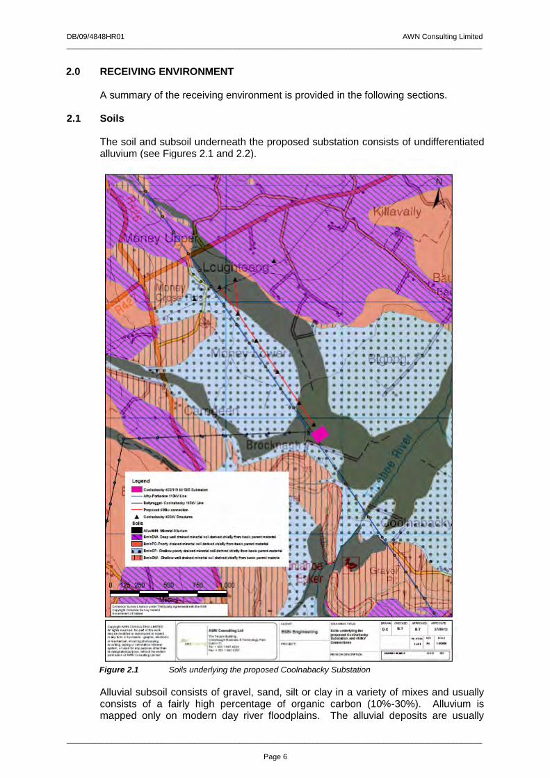
DB/09/4848HR01 AWN Consulting Limited _____________________________________________________________________________________________________
_____________________________________________________________________________________________________
Page 6
2.0 RECEIVING ENVIRONMENT A summary of the receiving environment is provided in the following sections. 2.1 Soils
The soil and subsoil underneath the proposed substation consists of undifferentiated alluvium (see Figures 2.1 and 2.2).
Figure 2.1 Soils underlying the proposed Coolnabacky Substation
Alluvial subsoil consists of gravel, sand, silt or clay in a variety of mixes and usually consists of a fairly high percentage of organic carbon (10%-30%). Alluvium is mapped only on modern day river floodplains. The alluvial deposits are usually
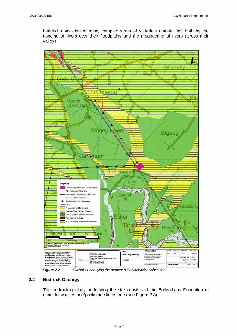
DB/09/4848HR01 AWN Consulting Limited _____________________________________________________________________________________________________
_____________________________________________________________________________________________________
Page 7
bedded, consisting of many complex strata of waterlain material left both by the flooding of rivers over their floodplains and the meandering of rivers across their valleys.
Figure 2.2 Subsoils underlying the proposed Coolnabacky Substation
2.2 Bedrock Geology
The bedrock geology underlying the site consists of the Ballyadams Formation of crinoidal wackestone/packstone limestone (see Figure 2.3).
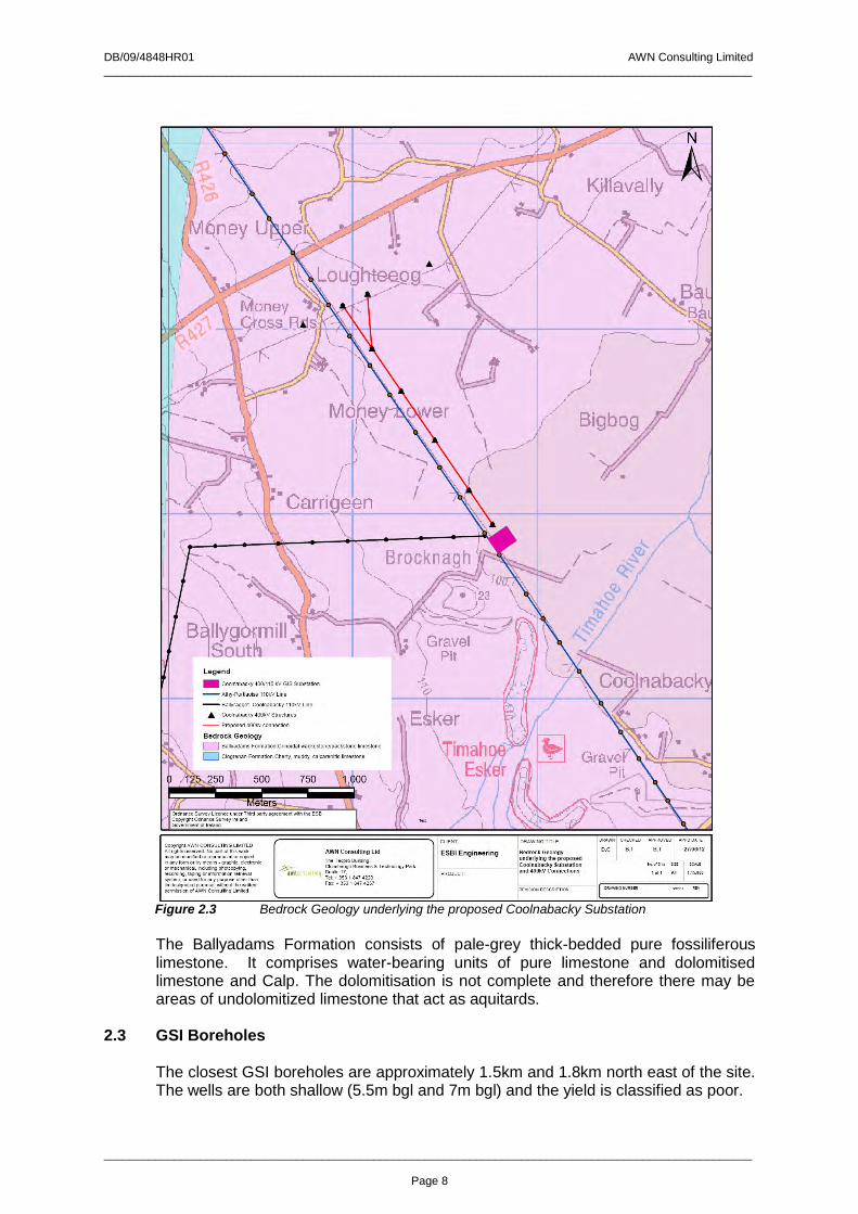
DB/09/4848HR01 AWN Consulting Limited _____________________________________________________________________________________________________
_____________________________________________________________________________________________________
Page 8
Figure 2.3 Bedrock Geology underlying the proposed Coolnabacky Substation The Ballyadams Formation consists of pale-grey thick-bedded pure fossiliferous limestone. It comprises water-bearing units of pure limestone and dolomitised limestone and Calp. The dolomitisation is not complete and therefore there may be areas of undolomitized limestone that act as aquitards.
2.3 GSI Boreholes The closest GSI boreholes are approximately 1.5km and 1.8km north east of the site. The wells are both shallow (5.5m bgl and 7m bgl) and the yield is classified as poor.
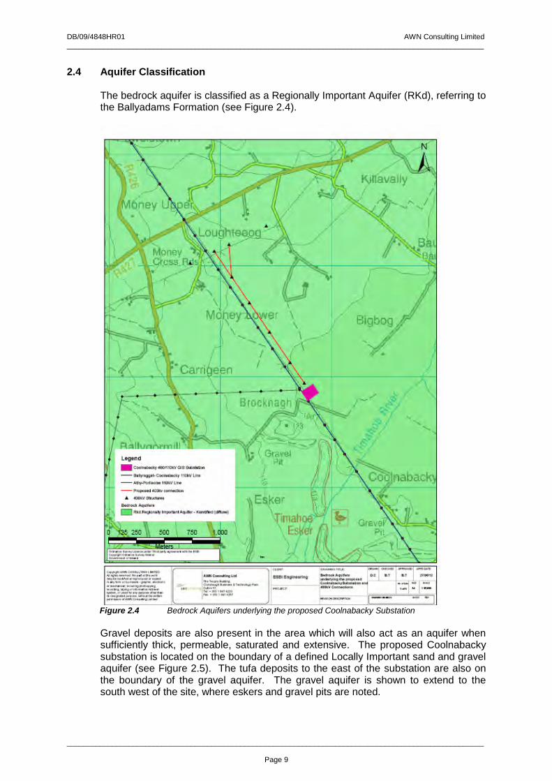
DB/09/4848HR01 AWN Consulting Limited _____________________________________________________________________________________________________
_____________________________________________________________________________________________________
Page 9
2.4 Aquifer Classification The bedrock aquifer is classified as a Regionally Important Aquifer (RKd), referring to the Ballyadams Formation (see Figure 2.4).
Figure 2.4 Bedrock Aquifers underlying the proposed Coolnabacky Substation Gravel deposits are also present in the area which will also act as an aquifer when sufficiently thick, permeable, saturated and extensive. The proposed Coolnabacky substation is located on the boundary of a defined Locally Important sand and gravel aquifer (see Figure 2.5). The tufa deposits to the east of the substation are also on the boundary of the gravel aquifer. The gravel aquifer is shown to extend to the south west of the site, where eskers and gravel pits are noted.
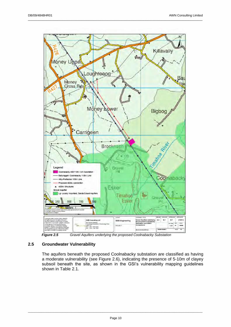
DB/09/4848HR01 AWN Consulting Limited _____________________________________________________________________________________________________
_____________________________________________________________________________________________________
Page 10
Figure 2.5 Gravel Aquifers underlying the proposed Coolnabacky Substation
2.5 Groundwater Vulnerability The aquifers beneath the proposed Coolnabacky substation are classified as having a moderate vulnerability (see Figure 2.6), indicating the presence of 5-10m of clayey subsoil beneath the site, as shown in the GSI’s vulnerability mapping guidelines shown in Table 2.1.
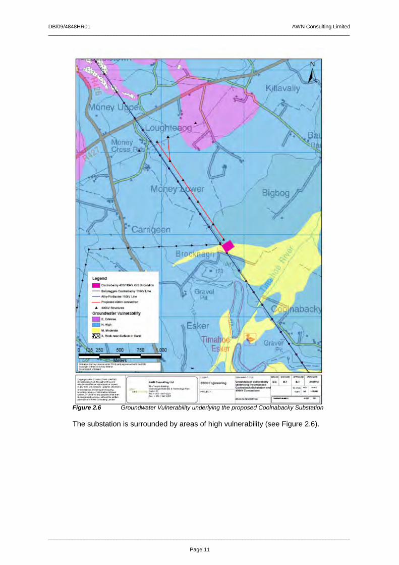
DB/09/4848HR01 AWN Consulting Limited _____________________________________________________________________________________________________
_____________________________________________________________________________________________________
Page 11
Figure 2.6 Groundwater Vulnerability underlying the proposed Coolnabacky Substation The substation is surrounded by areas of high vulnerability (see Figure 2.6).
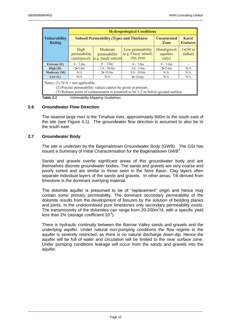
DB/09/4848HR01 AWN Consulting Limited _____________________________________________________________________________________________________
_____________________________________________________________________________________________________
Page 12
Table 2.1 Vulnerability Mapping Guidelines
2.6 Groundwater Flow Direction
The nearest large river is the Timahoe river, approximately 600m to the south east of the site (see Figure 4.1). The groundwater flow direction is assumed to also be to the south east.
2.7 Groundwater Body The site is underlain by the Bagenalstown Groundwater Body (GWB). The GSI has issued a Summary of Initial Characterisation for the Bagenalstown GWB4. Sands and gravels overlie significant areas of this groundwater body and are themselves discrete groundwater bodies. The sands and gravels are very coarse and poorly sorted and are similar to those seen in the Nore Basin. Clay layers often separate individual layers of the sands and gravels. In other areas, Till derived from limestone is the dominant overlying material. The dolomite aquifer is presumed to be of “replacement” origin and hence may contain some primary permeability. The dominant secondary permeability of the dolomite results from the development of fissures by the solution of bedding planes and joints. In the undolomitised pure limestones only secondary permeability exists. The transmissivity of the dolomites can range from 20-200m2/d, with a specific yield less than 2% (storage coefficient 10-4). There is hydraulic continuity between the Barrow Valley sands and gravels and the underlying aquifer. Under natural non-pumping conditions the flow regime in the aquifer is severely restricted, as there is no natural discharge down-dip. Hence the aquifer will be full of water and circulation will be limited to the near surface zone. Under pumping conditions leakage will occur from the sands and gravels into the aquifer.

DB/09/4848HR01 AWN Consulting Limited _____________________________________________________________________________________________________
_____________________________________________________________________________________________________
Page 13
3.0 SITE INVESTIGATIONS Site investigations carried out at the site include a series of boreholes (BH1 – BH8) located at the substation compound area3. The following ground conditions were encountered:
3.1 Topsoil Topsoil was encountered from ground level to a maximum depth of 0.3m below ground level (bgl). Topsoil was encountered at all locations.
3.2 Sand and Gravel Deposits Sand and Gravel deposits were encountered beneath the topsoil to between 0.9m to 1.9m bgl. The sand and gravel deposits are typically described as brown to orange brown with sub rounded cobbles of limestone. Sand and Gravel deposits were encountered at all locations.
3.3 Clay Deposits Clay deposits were encountered from 0.9m bgl and proved to a maximum depth of 8.5m bgl (BH2). Between 2.7m to 6.8m of clay was proved in the boreholes. The clay consisted of grey to brown grey firm to stiff clay with sub rounded gravel and cobbles of limestone. The clay became very stiff in some locations with depth. Clay deposits were encountered at all locations. Bedrock was not encountered at the site.
3.4 Groundwater Groundwater strikes were encountered in all boreholes other than BH1 and BH10. The groundwater strikes were encountered in both the Sand and Gravel and Clay deposits. Where groundwater was encountered, the strikes were recorded at depths of between 0.8m bgl (BH3) and 5.2m bgl (BH7). No groundwater inflows were noted in BH2, BH3 and BH5. It is noted that groundwater was encountered in the Sand and Gravel deposits at boreholes BH3 only, indicating that the Sand and Gravel is not saturated.
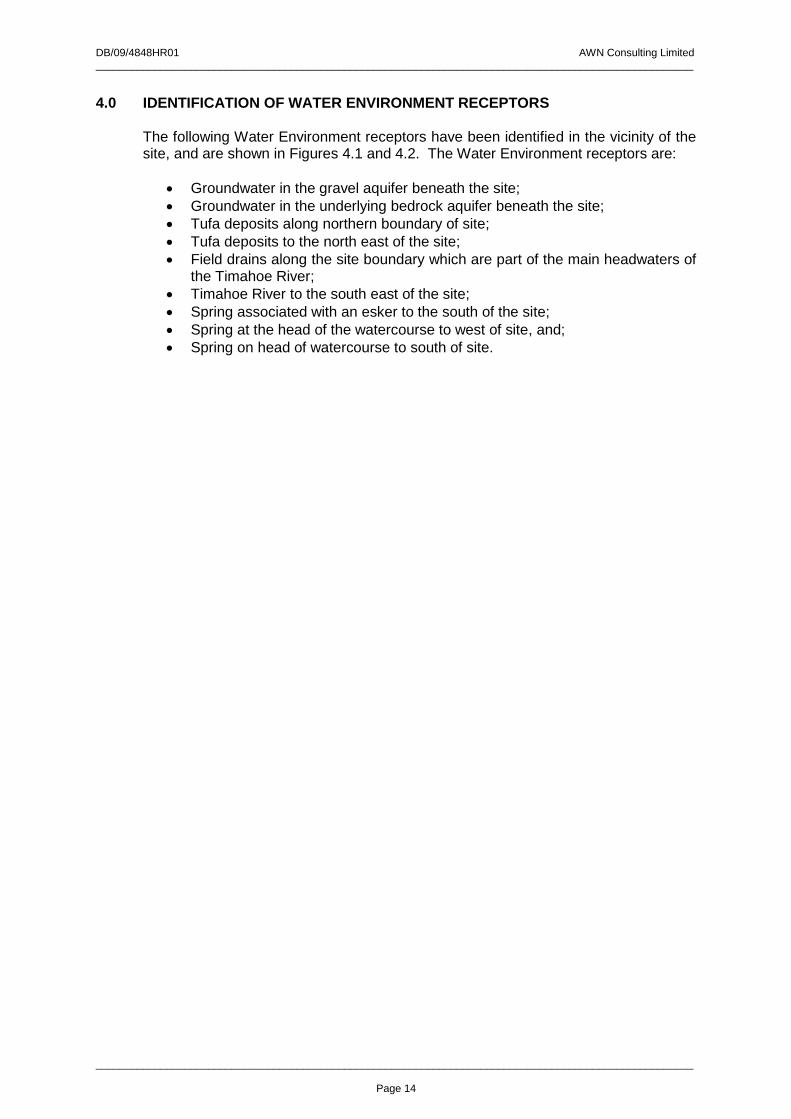
DB/09/4848HR01 AWN Consulting Limited _____________________________________________________________________________________________________
_____________________________________________________________________________________________________
Page 14
4.0 IDENTIFICATION OF WATER ENVIRONMENT RECEPTORS The following Water Environment receptors have been identified in the vicinity of the site, and are shown in Figures 4.1 and 4.2. The Water Environment receptors are:
Groundwater in the gravel aquifer beneath the site;
Groundwater in the underlying bedrock aquifer beneath the site;
Tufa deposits along northern boundary of site;
Tufa deposits to the north east of the site;
Field drains along the site boundary which are part of the main headwaters of the Timahoe River;
Timahoe River to the south east of the site;
Spring associated with an esker to the south of the site;
Spring at the head of the watercourse to west of site, and;
Spring on head of watercourse to south of site.

Groundwater Flow Direction
Coolnabacky 400kV Substation
Assumed depth to Bedrock
D
D
Timahoe River
Esker
Tufa Deposit
Tufa Deposit
DSpring
Quarry
ProposedSubstation Location
D
Spring
Discharge toSAC
Copyright AWN CONSULTING LIMITEDAll rights reserved. No part of this workmay be modified or reproduced or copiedin any form or by means - graphic, electronicor mechanical, including photcopying,recording, taping or information retrieval system, or used for any purpose other thanits designated purpose, without the written permission of AWN Consulting Limited
AWN Consulting Ltd
The Tecpro Building,Clonshaugh Business & Technology ParkDublin 17,Tel: + 353 1 847 4220Fax: + 353 1 847 4257
CLIENT:
PROJECT:
DRAWING TITLE:
REVISION DESCRIPTION
DRAWN CHECKED APPROVED APPD DATE
No. of Shts SIZE SCALE
DRAWING NUMBER SHEET REV
ESBI Engineering Receiving EnvironmentReceptors (vicinity of site)
D.C D.B D.B 02/07/2012
1 A4
Legend
Redline Boundary
Substation Footprint
Watercourses
Discharge
D Spring
D Tufa DepositsOrdnance Survey Ireland Licence No. EN 0007505 ©Copyright Ordnance Survey IrelandGovernment of Ireland
Figure 4.1

D
D
Tufa Deposits
Tufa Deposits
Spring
Spring
Coolnabacky Substation
SpringD
D
D
Copyright AWN CONSULTING LIMITEDAll rights reserved. No part of this workmay be modified or reproduced or copied
in any form or by means - graphic, electronicor mechanical, including photcopying,recording, taping or information retrieval system, or used for any purpose other than
its designated purpose, without the written permission of AWN Consulting Limited
AWN Consulting Ltd
The Tecpro Building,Clonshaugh Business & Technology ParkDublin 17,Tel: + 353 1 847 4220Fax: + 353 1 847 4257
CLIENT:
PROJECT:
DRAWING TITLE:
REVISION DESCRIPTION
DRAWN CHECKED APPROVED APPD DATE
No. of Shts SIZE SCALE
DRAWING NUMBER SHEET REV
±
0 250 500 750 1,000125
Meters
Water EnvironmentReceptors (Wider area)
1 of 1 1:10,000A4
TextText
Ordnance Survey Licence under Third party agreement with the ESBCopyright Odnance Survey IrelandGovernment of Ireland
ESBI EngineeringD.C D.B D.B 02/07/12
Legend
D Tufa Deposits
D Spring
Coolnabacky 400/110kV GIS Substation
Redline Boundary
Figure 4.2

DB/09/4848HR01 AWN Consulting Limited _____________________________________________________________________________________________________
_____________________________________________________________________________________________________
Page 17
4.1 Conceptual Site Model
The Conceptual Site Model (CSM) (Figure 4.3) is presented as a schematic cross section between the site of the proposed Coolnabacky 400Kv substation and the tufa deposits closest to the site shown in Figures 4.1 and 4.2.
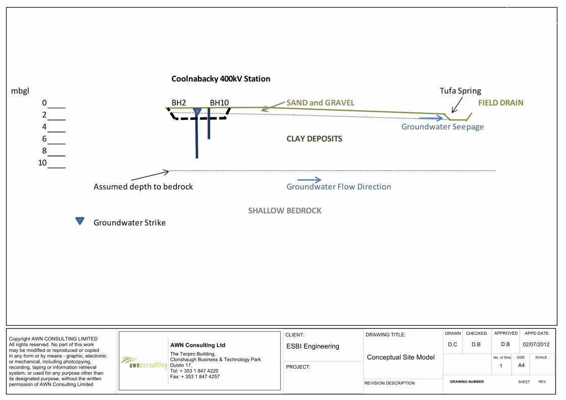
Groundwater Flow Direction
Coolnabacky 400kV Substation
Assumed depth to Bedrock
Copyright AWN CONSULTING LIMITEDAll rights reserved. No part of this workmay be modified or reproduced or copiedin any form or by means - graphic, electronicor mechanical, including photcopying,recording, taping or information retrieval system, or used for any purpose other thanits designated purpose, without the written permission of AWN Consulting Limited
AWN Consulting Ltd
The Tecpro Building,Clonshaugh Business & Technology ParkDublin 17,Tel: + 353 1 847 4220Fax: + 353 1 847 4257
CLIENT:
PROJECT:
DRAWING TITLE:
REVISION DESCRIPTION
DRAWN CHECKED APPROVED APPD DATE
No. of Shts SIZE SCALE
DRAWING NUMBER SHEET REV
ESBI Engineering
Conceptual Site Model
D.C D.B D.B 02/07/2012
1 A4
Coolnabacky 400kV Station
mbgl Tufa Spring
0 BH2 BH10 SAND and GRAVEL FIELD DRAIN
2
4 Groundwater Seepage
6 CLAY DEPOSITS
8
10
Assumed depth to bedrock Groundwater Flow Direction
SHALLOW BEDROCK
Groundwater Strike
DB/09/4848HR01 AWN Consulting Limited _____________________________________________________________________________________________________
_____________________________________________________________________________________________________
Page 19
The closest tufa deposit to the site is located over 100m from the boundary of the proposed excavation. Given the ground conditions at the site, the tufa deposits are expected to be fed from seepages from the gravel aquifer. The thickness of the sand and gravel deposits is variable, and across the site ranges from 0.9 to 1.9m. The gravel aquifer is shown to extend to the south west of the site. The presence of eskers and gravel pits to the south west of the site further indicates that a greater thickness of Sand and Gravel deposits is expected in this area. Both tufa deposits are located at or near the boundary of the gravel aquifer and are thus associated with discharge zones at the gravel aquifer boundary. However, the sand and gravel deposits at the site were not found to be saturated during the site investigation. In most cases, groundwater strikes were not recorded in the Sand and Gravel deposits. It is noted that, due to the presence of low permeability Clay deposits beneath the sand and gravel, the inflow volumes of groundwater encountered during drilling was minimal. As the sand and gravel was not saturated, this indicates that the quantities of groundwater present are not significant. Although for the wider groundwater body hydraulic continuity exists between the Sand and Gravel deposits and the bedrock aquifer, within the localised site area any groundwater in the sand and gravel deposits is not expected to be in hydraulic continuity with the bedrock aquifer underlying the site. This is due to the presence of a proved significant thickness of low permeability Clay deposits, with between 2.7m to 6.8m of clay proved beneath the Sand and Gravel deposits. The clay encountered during the site investigations is described as stiff to very stiff at depth, and this stiff clay will impede any vertical groundwater flow. The groundwater flow direction in the Sand and Gravel deposits is expected to be in the direction of the closest watercourse, i.e. to the south east. The CSM assumes that the tufa deposits are directly down gradient of the site.
4.2 Impact of Proposed Works on Hydrogeology The proposed works include excavations of 1-2m bgl at the building locations. An excavation of 2m is shown on the CSM and is located over 100m from the closest tufa deposit. The excavations will extend through the sand and gravel deposits into the underlying clay deposits. However, as discussed above the borehole logs indicate that the sand and gravel deposits are not saturated. Therefore, groundwater inflow from the sand and gravel deposits is expected to be limited. Groundwater was encountered in the underlying clay deposits. As the permeability of these deposits is low, this will also impede the groundwater flow into the excavations. Due to the presence of low permeability clay at the base of the excavations, any groundwater in the more permeable Sand and Gravel deposits can be isolated during dewatering if necessary. As the groundwater flow into the excavations is expected to be limited, extensive dewatering is not anticipated during excavation and any impact on the Water Environment receptors is expected to be minimal. Isolation of any groundwater in the sand and gravels can be undertaken to ensure that the impact of dewatering is localised to the area immediately surrounding the excavation.

DB/09/4848HR01 AWN Consulting Limited _____________________________________________________________________________________________________
_____________________________________________________________________________________________________
Page 20
5.0 CONCLUSIONS AND RECOMMENDATIONS A number of Water Environment receptors have been identified in the vicinity of the site, including tufa deposits located at field drains on the boundary of the site and associated with the boundary of the gravel aquifer. The proposed excavation works at the Coolnabacky substation will extend for a maximum of 2m bgl and will intercept the Sand and Gravel deposits into the underlying Clay deposits. The impact on the Water Environment from any dewatering required during excavation is expected to be limited due to the following:
Site investigation results indicate that the Sand and Gravel deposits are not saturated;
Most groundwater strikes were in the underlying low permeability clay deposits and during dewatering the inflow is expected to be limited;
As the excavations extend into the low permeability clay, any groundwater in the more permeable Sand and Gravel deposits can be isolated during dewatering if necessary;
Any dewatering can therefore be confined to the area immediately surrounding the excavation and will not impact on the tufa deposits or springs;
The Sand and Gravel deposits at the site are not expected to be in hydraulic continuity with the bedrock aquifer.
5.1 Mitigation Measures The following mitigation measures are recommended to protect Water Environment
receptors during construction: Isolation of Groundwater Seepages Borehole logs indicate that the Sand and Gravel deposits are not saturated and
groundwater flow into the excavation during construction is expected to be limited. However, should on-going dewatering be required during excavations it is recommended that a low-permeability barrier be installed around the excavation walls. This will ensure that any potential for drawdown that could affect the Water Environment including the watercourses and tufa deposits will be minimised.
Protection of Water Environment Receptors
The mitigation measures outlined in the final environmental report accompanying the planning application will ensure that no sediment contamination, contaminated runoff or untreated wastewater will enter any watercourses during the construction of the proposed line route. Given the presence of sensitive Water Environment receptors at the site, it is imperative that these mitigation measures are adhered to.
Provision of Buffer Zone It is recommended that a 25m buffer zone is applied around the tufa deposits to
ensure protection of the deposits. No works during construction and operation will occur within this area, including re-fuelling, batching of concrete or storage of fuels and soil stockpiles.

DB/09/4848HR01 AWN Consulting Limited ____________________________________________________________________________________________________
_____________________________________________________________________________________________________
Page 21
REFERENCES
1. Geological Survey of Ireland (2012) Databases in relation to karst, quaternary (subsoils), groundwater wells, bedrock geology – www.gsi.ie
2. B.McConnell, M.E. Philcox, (1994), Geology of Kildare-Wicklow, Sheet 16. Geological
Survey of Ireland.
3. Soil Mechanics, (2012), Laois – Kilkenny Reinforcement Project, Coolnabacky 400kV Substation – DRAFT Factual Report on Ground Investigation
4. GSI, Bagnelstown Groundwater Body – Summary of Initial Characterisation

Laois – Kilkenny Reinforcement Project Natura Impact Statement December 2012
Page 30
APPENDIX 2
Map showing the known distribution of the Nore Freshwater Pearl Mussel in relation to the proposed development.

!)
98
76
54321
15
14131211
10
9
8
76
54
321
42414039383736353433323130
292827
2625
2423
2221
2019
1817
1615
1413
1211
10
Ballyragget Substation
241000 242000 243000 244000 245000 246000 247000 248000 249000 250000 251000 252000
1710
0017
2000
1730
0017
4000
1750
0017
6000
1770
0017
8000
Legend!) Substation Sites
Dunstown-Moneypoint-Coolnabacky 400kV StructuresBallyragget-Kilkenny 110kV StructuresBallyragget Coolnabacky 110kV StructuresAthy Portlaoise 110 kV StructuresAllLinesSubstation Site50 m BufferFreshwater Pearl Mussel Distribution 2011
.0 500 1,000 Meters
1:30,000Scale:
www.Wetland Surveys Ireland.com
Drawn by: Patrick CrushellWetland Surveys IrelandBell HeightKenmareCo [email protected]: 23 August 2012

Laois – Kilkenny Reinforcement Project Natura Impact Statement December 2012
Page 31
APPENDIX 3
Report on Ecological Mitigation Measures at Specified Sensitive Locations prepared by ESB International.
Report on Ecological Mitigation Measures at Specified Sensitive Locations
Laois - Kilkenny Reinforcement Project
PE687-F0261-R261-020
ESBI Engineering
Stephen Court,
18/21 St Stephen’s Green,
Dublin 2 Ireland Tel: +353 (0)1 703 8000
Web: www.esbi.ie
August 2012
Report on Ecological Mitigation Measures at Specified Sensitive Locations
File Reference: PE687-F0261-R261-020
Client / Recipient: EirGrid
Project Title: Laois - Kilkenny Reinforcement Project
Report Title: Report on Ecological Mitigation Measures at Specified Sensitive Locations
Report No.: 001
Rev. No.: 000
Volume 1 of 1
Prepared by: Title
John MacCarthy BE CEng
Civil Engineer
APPROVED: Paddy Kavanagh TITLE: CBE Team Leader
DATE: 15/08/12
Latest Revision Summary:
COPYRIGHT © ESB INTERNATIONAL LIMITED ALL RIGHTS RESERVED, NO PART OF THIS WORK MAY BE MODIFIED OR REPRODUCED OR COPIES IN ANY FORM OR BY ANY MEANS - GRAPHIC, ELECTRONIC OR MECHANICAL, INCLUDING PHOTOCOPYING, RECORDING, TAPING OR INFORMATION AND RETRIEVAL SYSTEM, OR USED FOR ANY PURPOSE OTHER THAN ITS DESIGNATED PURPOSE, WITHOUT THE WRITTEN PERMISSION OF ESB INTERNATIONAL LIMITED.
Template Used: bf-rep-001-002-003

PE687-F0261-R261-020
bf-rep-001-002-002 i 21/08/2012
Executive Summary
This report has been prepared in response to queries submitted by the
Ecologist in relation to the following:
• Protection of surface water and ground water for elements of the
Laois Kilkenny Reinforcement Project; and
• Ecological mitigation measures at specific forestry locations subject to
works as part of the Laois Kilkenny Reinforcement Project.
The report looks at the construction and operational phases at particular
locations as set out by the Ecologist. The queries raised by the Ecologist are
set out at the start of each section, in the tabular format they were received
in, for clarity and the mitigation measures included in the design or to be
employed by the contractor are set out under the section sub headings.
It is intended that the client will issue this report as part of the tender and
construction package of specifications to prompt the contractor to act on the
mitigation measures contained herein and to make these mitigation
measures contractually enforceable.
The measures proposed are inline with environmental best practice and
should augment any statutory responsibilities on either the contractor or
operator of the elements singled out for their location in, or close to,
environmentally sensitive areas or water bodies.
It is the conclusion of this report that if the proposals of this report are
adhered to, there will be minimal negative environmental impact on surface
water, ground water, Special Area of Conservation or habitat arising from the
proposed development.

PE687-F0261-R261-020
bf-rep-001-002-002 i 21/08/2012
Contents
1 Coolnabacky Surface Water & Groundwater 2
1.1 Surface Water Protection Mitigation Measures 2
1.1.1 Erosion Control 2
1.1.2 Sediment Control: 3
1.1.3 Risk Management 3
1.1.4 Emergency Plans and Procedures 4
1.1.5 Equipment, Training & Corrective Action 4
1.1.6 Monitoring 4
1.2 Water Table & Groundwater Protection Mitigation Measures 5
1.2.1 Dewatering and Groundwater level 5
1.2.2 Groundwater Quality Protection 5
2 Ballyragget Groundwater 7
2.1 Groundwater Quality Protection 7
3 Polesets & Angle Masts Surface Water & Watercourse Protection 8
3.1 Surface Water Protection 9
3.1.1 Polesets Construction - Erosion & Sedimentation Control 9
3.1.2 Polesets Construction - Pollution Control 10
3.1.3 Angle Mast Construction - Erosion & Sedimentation Control 10
3.1.4 Angle Mast Construction - Erosion & Sedimentation Control 11
4 Specific Forest Locations Surface Water Quality Protection 13
4.1 Potential Impacts from Specific Forest Locations 14
4.2 Mitigation Measures 16
4.2.1 General Mitigation Measures 16
4.2.2 Sediment Impact Mitigation 17
4.2.3 Nutrient Impact Mitigation 17
4.3 Conclusion on Forestry Impacts 18
Appendix A
Figures - Forestry Drawings
Appendix B
Forestry and Freshwater Pearl Mussel Requirements Site Assessment
Procedure

PE687-F0261-R261-020
bf-rep-001-002-002 2 21/08/2012
1 Coolnabacky Surface Water & Groundwater
1.1 Surface Water Protection Mitigation MSurface Water Protection Mitigation MSurface Water Protection Mitigation MSurface Water Protection Mitigation Measureseasureseasureseasures
Drainage and runoff controls will be installed prior to starting site clearance and
earthworks.
1.1.1 Erosion CErosion CErosion CErosion Controlontrolontrolontrol
Erosion control (preventing runoff) is much more effective than sediment control in
preventing water pollution. Erosion control is less subject to failure from high rainfall
and requires less maintenance.
Erosion control measures to prevent runoff flowing across exposed or excavated
ground and becoming polluted with sediments are provided for in the design. This is
primarily the use of existing site drains to channel runoff from up slope portions of a
catchment around any construction areas or areas disturbed as a result of
construction works.
Other inherent erosion control measures in the design include the design of
roadways with minimum falls which do not exceed 15%.
Additional erosion control measures will be provided for in the construction
management proposals. These measures will include the following:
• Minimise the area of exposed ground. Backfilling and construction will occur
in conjunction with excavation and excavation will not proceed faster than
Location Issues
Proposed Coolnabacky
substation site
Protection of surrounding surface waters which are likley
to support Annex II species and feed into SAC.
Proposed Coolnabacky
substation site
Possible effects on surrounding spring fed watercourses by
any drawdown in water table.
Proposed Coolnabacky
substation site
Reduce / eliminate any risk to groundwater during
construction / operation.
PE687-F0261-R261-020
bf-rep-001-002-002 3 21/08/2012
rate of construction. Re-vegetating of disturbed area to take place as soon
as possible.
• Monitoring of the weather forecast prior to planning excavation works.
• Providing impermeable mats (plastic sheeting) as covers to mounded
excavated material and open excavations during periods of heavy rainfall.
Silt fences to be provided at the toe of any significant areas where excavated
material is stored.
1.1.2 Sediment CSediment CSediment CSediment Control:ontrol:ontrol:ontrol:
The Settlement Ponds are an integral part of the sediment control and containment
measures on site and the protection of watercourses. Settlement ponds will be
provided adjacent to the areas of the site where the most excavation or earthworks
are planned.
The settlement ponds on the site have been sized to provide an adequate
treatment volume for the first flush from the developed station and the ponds will
ultimately have an attenuation volume so that surface water runoff can be limited to
Greenfield runoff rates. This attenuation volume can be utilised as additional
treatment volume in the construction phase when sediment generation is greatest.
The stone check dams which divide the pond into primary, secondary and final
settlement compartments will further reduce turbulence which will aid settlement
and provide filtering of water.
Surface water from the site will be discharged to existing vegetated drainage
ditches within the site where further settlement of solids and filtering of surface
water will occur prior to ultimate discharge to the adjacent watercourse.
1.1.3 Risk ManagementRisk ManagementRisk ManagementRisk Management
The best way to manage pollution incidents is to prevent them. The contractor will
identify and quantify risks associated with erosion and sediment for each work
practice. Risks such as an unplanned bank collapse, mud slide and unforeseen
rainfall event can be constantly assessed through geotechnical risk management
and monitoring of weather forecasts.

PE687-F0261-R261-020
bf-rep-001-002-002 4 21/08/2012
1.1.4 Emergency Plans and ProceduresEmergency Plans and ProceduresEmergency Plans and ProceduresEmergency Plans and Procedures
The contractor will prepare an emergency response plan and set of procedures for
events likely to cause pollution including the pollution of watercourses with silt or
sediment. There will be a contingency plan in place during construction and
displayed at appropriate locations.
1.1.5 EquipmentEquipmentEquipmentEquipment, Training & Corrective Action, Training & Corrective Action, Training & Corrective Action, Training & Corrective Action
Equipment required in responding to an emergency event with the capability of
generating additional erosion and sediment laden runoff will be stored on site. Staff
will be trained in the use and application of these temporary emergency measures
which may involve the following:
• Impermeable matting (plastic sheeting);
• Silt fences (posts & geotextile material);
• Mulching capability (organic materials, straw, wood chip, bark or other wood
fibres and gravel) to stabilise or protect cleared areas;
• Settlement Tanks (portable propriety settlement tanks that can be
transported to required areas).
Staff will be trained and made aware of procedures for notification of emergency
events with the potential for pollution of watercourses.
1.1.6 MonitoringMonitoringMonitoringMonitoring
Ongoing water monitoring at the discharge points and the receiving waters will be a
key indicator of the effectiveness of the erosion and settlement control measures
and the requirement for corrective action or the deployment of additional measures
as outlined above.
PE687-F0261-R261-020
bf-rep-001-002-002 5 21/08/2012
1.2 Water Table & GWater Table & GWater Table & GWater Table & Groundwroundwroundwroundwater Protection Mitigation Mater Protection Mitigation Mater Protection Mitigation Mater Protection Mitigation Measureseasureseasureseasures
1.2.1 Dewatering and Groundwater levelDewatering and Groundwater levelDewatering and Groundwater levelDewatering and Groundwater level
Deep excavations below the water table encountered in the Site Investigation will
be kept to a minimum in the foundation design. It is not envisaged that there will be
extensive deep excavations requiring dewatering or for any extended period of time
to cause a material difference in the local groundwater table level.
It is envisaged that there will, therefore be no impact on the spring fed
watercourses in the area.
Continuous monitoring will be employed where the contractor proposes any
dewatering during the construction phase and proposals for dewatering and
monitoring will be approved by the designers and ecologist for the project.
1.2.2 Groundwater Quality PGroundwater Quality PGroundwater Quality PGroundwater Quality Protectionrotectionrotectionrotection
The contractor will store all chemicals, hydrocarbon based fuels and oil filled
equipment when not in use in bunded areas of the site.
The contractor will have emergency spill kits comprising oil absorbent materials on
site and staff trained in the use of these. Emergency response measures to oil/ fuel
leaks will be displayed prominently on the site.
Sustainable Drainage Systems (SuDS) in the drainage network design will be put in
place early in the construction phase to filter and biodegrade hydrocarbons in the
unlikely event that any enter the water on the site.
In the operational phase, all oil filled equipment will be stored in impermeable
concrete bunds. Surface water generated in the bunded areas will be pumped out
of the bunds by an oil sensitive pump. There will also be an oil separator on the
drainage network. Surface water will be routed through ponds and vegetated
drainage ditches before discharge to the watercourse.

PE687-F0261-R261-020
bf-rep-001-002-002 6 21/08/2012
There will be no large scale batching of concrete on the site. All concrete will come
from a licensed supplier with environmental certification. No washing out of
concrete supply trucks will be allowed on the site. No cementitious material will be
allowed enter the water or groundwater on the site. Monitoring and emergency
response measures for any escape of cementitious material will be put in place by
the contractor.
Any foul waste generated in the construction and operational phase of the project
will be collected and disposed off site by a licensed contractor. No contamination of
groundwater will occur from foul waste.

PE687-F0261-R261-020
bf-rep-001-002-002 7 21/08/2012
2 Ballyragget Groundwater
Proposed Ballyragget
substation site
Reduce / eliminate any risk to groundwater during
construction / operation.
2.1 Groundwater Quality PGroundwater Quality PGroundwater Quality PGroundwater Quality Protectionrotectionrotectionrotection
The contractor will store all chemicals, hydrocarbon based fuels and oil filled
equipment when not in use in bunded areas of the site.
The contractor will have emergency spill kits comprising oil absorbent materials on
site and staff trained in the use of these. Emergency response measures to oil/ fuel
leaks will be displayed prominently on the site.
In the operational phase, all oil filled equipment will be stored in impermeable
concrete bunds. Surface water generated in the bunded areas will be pumped out
of the bunds by an oil sensitive pump. There will also be an oil separator on the
drainage network. Only after these measures will surface water then be recharged
to groundwater through source control techniques (soakaways) in line with SuDS
best management practices.
There will be no large scale batching of concrete on the site. All concrete will come
from a licensed supplier with environmental certification. No washing out of
concrete supply trucks will be allowed on the site. No cementitious material will be
allowed enter the water or groundwater on the site. Monitoring and emergency
response measures for any escape of cementitious material will be put in place by
the contractor.
Foul waste generated in the construction of the project will be collected and
disposed off site by a licensed contractor. Foul Waste generated in the unmanned
station during the operational phase will be treated on site before being further
treated and disposed of to ground water in a designed percolation area. A suitably
qualified professional has carried out a site assessment and designed the
percolation area in accordance with EPA guidelines.

PE687-F0261-R261-020
bf-rep-001-002-002 8 21/08/2012
3 Polesets & Angle Masts Surface Water &
Watercourse Protection
BC 149 (Poleset)
Adjacent watercourse within 10 metres of structure. Protection of
surrounding surface waters which are likley to support Annex II
species and feed into SAC.
BC 124 (Poleset)
Watercourse at structure location. Protection of surrounding
surface waters which are likley to support Annex II species and feed
into SAC.
BC 91 (Poleset)
Adjacent watercourse within 10 metres of structure. Protection of
surrounding surface waters which are likley to support Annex II
species and feed into SAC.
BC 72 (Angle mast)
Adjacent watercourse within ca 20 metres of angle mast. Protection
of surrounding surface waters which are likley to support Annex II
species and feed into SAC.
BC 21 (Poleset)
Adjacent watercourse within 10 metres of structure. Protection of
surrounding surface waters which are likley to support Annex II
species and feed into SAC.
BK 4 (Angle Mast)
Adjacent watercourse within 10 metres of new angle mast
structure. Protection of surrounding surface waters which are likley
to support Annex II species and feed into SAC.
BK 5 (Poleset)
Adjacent watercourse within 10 metres of structure. Protection of
surrounding surface waters which are likley to support Annex II
species and feed into SAC.
BK 16 (Poleset)
Adjacent watercourse within 10 metres of structure. Protection of
surrounding surface waters which are likley to support Annex II
species and feed into SAC.
BK 49 (Poleset)
Structure located on boundary of SAC. Minimise extent of felling of
adjacent hedgerow. Protection of surrounding surface waters which
are likley to support Annex II species and designated SAC.
BK 82 (Poleset)
Adjacent watercourse within 10 metres of structure. Protection of
surrounding surface waters which are likley to support Annex II
species and feed into SAC.
BK 103 (Poleset)
Adjacent watercourse within 10 metres of structure. Protection of
surrounding surface waters which are likley to support Annex II
species and feed into SAC.
PE687-F0261-R261-020
bf-rep-001-002-002 9 21/08/2012
3.1 SurfacSurfacSurfacSurface Water Pe Water Pe Water Pe Water Protectionrotectionrotectionrotection
3.1.1 Polesets Polesets Polesets Polesets ConstructionConstructionConstructionConstruction ---- Erosion & Sedimentation C Erosion & Sedimentation C Erosion & Sedimentation C Erosion & Sedimentation Controlontrolontrolontrol
Polesets are constructed over the short duration of 1 day per poleset. The major
mitigation measure in this case will be to not carry out construction for the sensitive
polesets noted above which are in the proximity of a watercourse on days when
there is rain or rain forecast. The contractor will monitor the weather forecast as
part of the construction planning for the polesets.
The excavations for the polesets will not require any access into the excavation so
no dewatering of the excavations is required if groundwater seepage encountered.
The top vegetated layer will be excavated carefully to keep the vegetation and root
system intact. This layer will be placed carefully to one side and protected for the
short duration of the construction. This layer will be reinstated following backfill
around the polesets which will limit the potential for sediment runoff immediately
after the construction of each poleset.
Excavated material will be stored safely so that the distance from the watercourse
is maximised within the confines of the construction area and to ensure that there is
a natural filter strip of vegetation between the excavated material and any water
course. It should be noted that the entire volume of spoil per poleset will not exceed
40m3 and the associated spoil heap will not occupy an area exceeding 20m2.
Sediment laden runoff from this small area during predominantly dry conditions is
unlikely.
In the unlikely event of significant non forecasted rainfall the contractor will have
access to emergency sediment control measures in a site compound that can be
transported to the poleset construction location within a short time period. These
measures would include the following:
• Impermeable matting (plastic sheeting);
• Silt fences (posts & geotextile material);
• Mulching capability (organic materials, straw, wood chip, bark or other wood
fibres and gravel) to stabilise or protect cleared areas;

PE687-F0261-R261-020
bf-rep-001-002-002 10 21/08/2012
• Settlement Tanks (portable propriety settlement tanks that can be
transported to required areas).
3.1.2 Polesets Polesets Polesets Polesets CCCConstruconstruconstruconstructiontiontiontion ---- PPPPollution ollution ollution ollution CCCControlontrolontrolontrol
The risk of non sediment related pollution during the construction for the polesets is
minimal and may only be associated with oil leaks from the plant and machinery
used in the construction. The following measures will be in place to mitigate the risk
of and to respond in the event of an oil leak:
• All vehicles will be regularly serviced and kept in good condition;
• Vehicles will be checked daily for indications of leaking oil;
• No refuelling operations will take place at the construction site of the
polesets;
• Spill kits will be readily available to drivers/ operators of plant and
machinery; and
• Drivers/ operators of plant and machinery will be trained in the use of spill
kits and aware of the contractor’s emergency procedures for dealing with
and reporting oil and fuel spills.
3.1.3 Angle Mast CAngle Mast CAngle Mast CAngle Mast Cononononsssstructiontructiontructiontruction ---- Erosion & Sedimentation C Erosion & Sedimentation C Erosion & Sedimentation C Erosion & Sedimentation Controlontrolontrolontrol
Angle Masts foundations are constructed over the short duration of less than 2.5
weeks per Angle Mast with the majority of this time required due to concrete setting
time. Once the foundation is constructed and backfilled, the foundation is generally
left for approximately 28 days before the mast is assembled. The mast assembly
will cause no ground disturbance and takes place over a very short duration of time.
The major mitigation measure in this case will be to not carry out construction at
sensitive Angle Mast locations noted above which are in the proximity of a
watercourse when there is a significant amount of rainfall forecast. The contractor
will monitor the weather forecast as part of the construction planning for these
Angle Masts.
Should the excavations for the Angle Mast foundations require dewatering due to
groundwater seepage this water will be pumped through a portable settlement tank
before discharge to the nearest drainage ditch. Existing vegetation as a filter strip
prior to discharge to the drainage ditch will also be utilised where conditions allow.

PE687-F0261-R261-020
bf-rep-001-002-002 11 21/08/2012
The top vegetated layer will be excavated carefully to keep the vegetation and root
system intact. This layer will be placed carefully to one side and protected for the
short duration of the construction. This layer will be reinstated over the foundations
following backfill around the Angle Mast foundations which will limit the potential for
sediment runoff immediately after the construction of each Angle Mast foundation.
Excavated material will be stored safely so that the distance from the watercourse
is maximised within the confines of the construction area and to ensure that there is
a natural filter strip of vegetation between the excavated material and any water
course. It should be noted that the entire volume of spoil per Angle Mast will not
exceed 140m3. Much of this excavated material will be removed from site
immediately as it will not be required for backfilling and landscaping around the
Angle Mast foundations. The excavated material stored adjacent to the Angle Mast
construction area for the short duration of the works is therefore unlikely to exceed
50-66m3. The associated spoil heap will not occupy an area exceeding 36-46m2.
Sediment laden runoff from this small area during predominantly dry conditions is
unlikely.
In the unlikely event of significant non forecasted rainfall during the construction
period, the contractor will have access to emergency sediment control measures in
a site compound that can be transported to the Angle Mast construction location
within a short time period. These measures would include the following:
• Impermeable matting (plastic sheeting);
• Silt fences (posts & geotextile material);
• Mulching capability (organic materials, straw, wood chip, bark or other wood
fibres and gravel) to stabilise or protect cleared areas;
• Settlement Tanks (portable propriety settlement tanks that can be
transported to required areas).
3.1.4 Angle Mast Angle Mast Angle Mast Angle Mast ConstructionConstructionConstructionConstruction ---- Erosion & Sedimentation C Erosion & Sedimentation C Erosion & Sedimentation C Erosion & Sedimentation Controlontrolontrolontrol
The risk of non sediment related pollution during the construction for the Angle
Masts is minimal and may only be associated with oil leaks from the plant and
machinery used in the construction or from the escape of cementitious material
during the foundation construction. No chemicals will be stored at the construction
site.
PE687-F0261-R261-020
bf-rep-001-002-002 12 21/08/2012
The following measures will be in place to mitigate the risk of and to respond in the
event of an oil leak:
• There will be no fuel or oil stored at the Angle Mast construction location;
• All vehicles will be regularly serviced and kept in good condition;
• Vehicles will be checked daily for indications of leaking oil or fuel;
• No refuelling operations will take place at the construction site of the Angle
Masts;
• Spill kits will be readily available to drivers/ operators of plant and
machinery; and
• Drivers/ operators of plant and machinery will be trained in the use of spill
kits and aware of the contractor’s emergency procedures for dealing with
and reporting oil and fuel spills.
The following measures will be in place to mitigate the risk of and to respond to the
escape of cementitious material during foundation construction for Angle Masts:
• There will be no on site batching of concrete, grout or cement mortar at the
Angle Mast construction locations;
• No washing out of concrete delivery vehicles or dumping of excess concrete
will be permitted at the Angle Mast construction sites;
• Concrete skips, concrete pumps and machine buckets will be positioned so
as not to allow slewing over water while placing concrete (the use of skips
and pumps not envisaged);
• Freshly placed Concrete is to be covered to avoid surface washing away in
heavy rain; and
• Clean up any spillages of cementitious materials immediately and dispose
of correctly.
If temporary welfare facilities are required at the sensitive Angle Mast construction
locations following investigation of alternative arrangements, these will be self
contained units and foul waste generated will be collected and disposed of by an
approved licensed contractor.
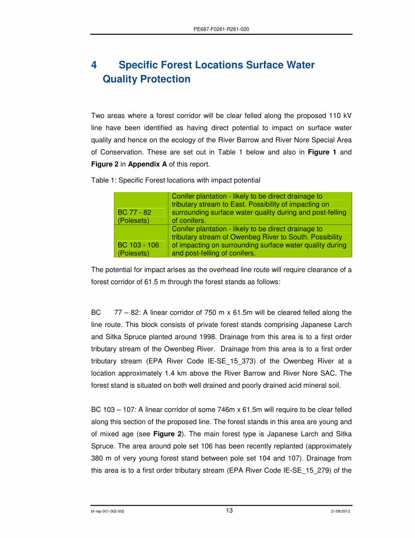
PE687-F0261-R261-020
bf-rep-001-002-002 13 21/08/2012
4 Specific Forest Locations Surface Water
Quality Protection
Two areas where a forest corridor will be clear felled along the proposed 110 kV
line have been identified as having direct potential to impact on surface water
quality and hence on the ecology of the River Barrow and River Nore Special Area
of Conservation. These are set out in Table 1 below and also in Figure 1 and
Figure 2 in Appendix A of this report.
Table 1: Specific Forest locations with impact potential
BC 77 - 82 (Polesets)
Conifer plantation - likely to be direct drainage to tributary stream to East. Possibility of impacting on surrounding surface water quality during and post-felling of conifers.
BC 103 - 106 (Polesets)
Conifer plantation - likely to be direct drainage to tributary stream of Owenbeg River to South. Possibility of impacting on surrounding surface water quality during and post-felling of conifers.
The potential for impact arises as the overhead line route will require clearance of a
forest corridor of 61.5 m through the forest stands as follows:
BC 77 – 82: A linear corridor of 750 m x 61.5m will be cleared felled along the
line route. This block consists of private forest stands comprising Japanese Larch
and Sitka Spruce planted around 1998. Drainage from this area is to a first order
tributary stream of the Owenbeg River. Drainage from this area is to a first order
tributary stream (EPA River Code IE-SE_15_373) of the Owenbeg River at a
location approximately 1.4 km above the River Barrow and River Nore SAC. The
forest stand is situated on both well drained and poorly drained acid mineral soil.
BC 103 – 107: A linear corridor of some 746m x 61.5m will require to be clear felled
along this section of the proposed line. The forest stands in this area are young and
of mixed age (see Figure 2). The main forest type is Japanese Larch and Sitka
Spruce. The area around pole set 106 has been recently replanted (approximately
380 m of very young forest stand between pole set 104 and 107). Drainage from
this area is to a first order tributary stream (EPA River Code IE-SE_15_279) of the
PE687-F0261-R261-020
bf-rep-001-002-002 14 21/08/2012
Owenbeg River at a location approximately 1.6 km above the River Barrow and
River Nore SAC. The forest stand is situated on poorly drained acid mineral soil.
4.1 Potential Impacts from Specific Forest LocationsPotential Impacts from Specific Forest LocationsPotential Impacts from Specific Forest LocationsPotential Impacts from Specific Forest Locations
Potential impacts at these forest locations can arise from the following activities:
• Clear felling of the forest corridor: Clearfelling of the forest corridor can
give rise to both siltation risk from ground disturbance and nutrient enrichment from
the release of phosphorous and nitrogen from brash decay. The main sources of
siltation risk during forestry operations (such as clear felling) arise from disruption of
the soil surface, which can cause soils to be exposed to erosion and the
transportation of finer particles by overland flow, and the transportation of looser
decaying organic particles. Decaying brash resulting from the clearfell can generate
nutrients which could potentially lead to nutrient enrichment of the small first order
streams entering the Owenbeg River.
• Removal of tree stumps to facilitate overhead line construction:
Construction of the overhead line in clear felled forest areas can also give rise to
sediment release. Wooden poles (weighing approximately 3 tonnes each) will be
transported to the construction location by wide tracked machinery generating low
ground pressure. In general tree stumps along the immediate line route would be
removed in a 10m wide corridor to allow machinery tracking and avoid tracks
coming off the vehicle. Uprooting of tree stumps can contribute significantly to
ground disturbance and sediment release.
• Construction of pole sets: The erection of pole sets generally requires
minimal disturbance to the ground. A foundation hole will be excavated, the pole
erected and backfilled and with good construction practice there should be little risk
of sediment loss. Construction activity is also spread out along the line route with a
small footprint at each location. Duration on site is expected to be no more than half
a day for each pole set.

PE687-F0261-R261-020
bf-rep-001-002-002 15 21/08/2012
• Potential windthrow arising from exposed forest edges post corridor
clearance: The felling of a linear corridor will leave exposed forest stand edges
devoid of foliage along the corridor. There is some risk of wind throw when these
tress reach maturity (an additional 20 years) however this is very limited at present
given the age and height of trees.
The main potential effects from ground disturbance are the risk of silt generation
with silt entering the Owenbeg River via its tributaries. The potential impacts are:
• Sedimentation - impacts include smothering of gravel beds with consequent
loss of fish habitat and spawning and potential juvenile Freshwater Pearl
Mussel habitat.
• Sediment deposition can also provide a base for growth of filamentous
algae on gravel beds leading to a build up of sediment and loss of both fish
spawning areas area and potential freshwater pearl mussel areas
• Sedimentation impacts include smothering fish eggs and causing mortalities
in fish of all ages, reducing abundance of food and impeding movement of
fish.
• Sedimentation impacts also include smothering of macroinvertebrates
• Loss of water quality of surface and groundwater along the line route by silt.
Nutrient enrichment of the receiving waters can also occur due to decay of brash
left through the tree harvesting process. However the forest stands are located on
mineral soils and adsorption of phosphorous on this material is likely to occur
reducing the risk of nutrient phosphorous loss to the small streams running to the
Owenbeg River. Should nutrients reach the small first order streams this could give
rise to the following:
• Increased algal growth in the rivers leading to increased potential for
sediment entrapment and build up with de-oxygenation of the river during
the nocturnal cycle.
• Increased algal growth will lead to reduced habitat for fish spawning.
macroinvertebrates and reduced potential habitat for freshwater pearl
mussel
Accidental leakage of oil and fuels from construction vehicles can have a direct
impact on fish, fish food and fish habitats and other aquatic species.

PE687-F0261-R261-020
bf-rep-001-002-002 16 21/08/2012
4.2 Mitigation MeasuresMitigation MeasuresMitigation MeasuresMitigation Measures
The following mitigation measures will be implemented.
4.2.1 General Mitigation MeasuresGeneral Mitigation MeasuresGeneral Mitigation MeasuresGeneral Mitigation Measures
• Forestry Operations within the Freshwater Pearl Mussel Catchment areas,
including at the forest stands within the Owenbeg river will be carried out
strictly in accordance with the Forestry and Freshwater Pearl Mussel
Requirements Site Assessment and Mitigation Measures published by the
Forest Service.
• The Forestry and Freshwater Pearl Mussel Site Assessment Forms A and B
which have been revised by Coillte and NPWS shall be used for all forestry
operations within the Freshwater Pearl Mussel Catchments associated with
the overhead line construction. (Appendix 1 Nore Catchment).
• The contractor appointed to harvest the timber will be fully briefed on the
ecological sensitivity of the site and will work in collaboration with an
ecologist to set out the proposed method and delineate working areas.
• Construction will adhere to the guidance document issued by Inland
Fisheries Ireland South-eastern River Basin District (Maintenance and
Protection of the Inland Fisheries resource during road construction and
improvement works published by the South-eastern Regional Fisheries
Board. (Note that a new Guidance document is expected to be published
shortly by Inland Fisheries Ireland entitled “Guidelines on Protection of
Fisheries During Construction Works in and adjacent to Waters”.
Construction will adhere to this guidance once published).
• Should the need for any in stream crossings by construction vehicles be
identified the Inland Fisheries Ireland shall be consulted and the approach
to the crossing agreed with them. Any and all watercourses which have to
be traversed during site development and associated track/road
construction works should be effectively bridged prior to commencement.
• Work method statements should be developed and implemented by
construction contractors for pole set construction.
• Access to construction areas should utilise existing field tracks to the extent
possible to minimise the need for additional track construction.
PE687-F0261-R261-020
bf-rep-001-002-002 17 21/08/2012
• Proposed access tracks should be assessed by a qualified geotechnical
engineer and ecologist to ensure the route minimises surface disturbance
and silt generation.
• Re-fuelling of vehicles should not take place on site but in a secure bunded
area well away from any watercourse.
• All oils and fuels should be stored in secure bunded areas, and particular
care and attention should be taken during refuelling and maintenance
operations on plant and equipment
4.2.2 Sediment Impact MitigationSediment Impact MitigationSediment Impact MitigationSediment Impact Mitigation
• Brash from the clearfell should be utilised as roading material for pole
construction tracked vehicles to reduce impact on ground thereby
minimising ground disturbance
• Existing forest drainage shall be reinstated where damaged to allow use to
be made of vegetated ground areas to reduce the flow of silt overland.
• Silt traps and silt fences, such as geotextile membrane and straw bales,
should be placed in the forest drainage network to minimise silt loss. These
should be inspected and cleaned regularly. A series of stepped silt traps
fences to trap any silt/debris will be installed. Their purpose will be to slow
water flow and allow settlement of solids to occur. These will be regularly
inspected and cleared out to ensure they are functioning properly.
• Traps should not be constructed immediately adjacent to natural water
courses. A buffer zone should remain between the silt trap and the
watercourse with natural vegetation left intact so as to assist in silt
interception. They should be installed on forest drains.
• Pesticide if used for suppression of growth beneath the established
overhead line should be minimised and used strictly in accordance with
Forest Service Guidelines. Any plants used for the re-establishment of the
site should be pre-dipped if required.
• Brash arising from forest felling should be used as roading for poling
contractor tracked vehicles to the extent possible to avoid ground
disturbance.
4.2.3 Nutrient Impact MitigationNutrient Impact MitigationNutrient Impact MitigationNutrient Impact Mitigation
PE687-F0261-R261-020
bf-rep-001-002-002 18 21/08/2012
Potential nutrient release, particularly phosphorous will be limited by the fact that
the trees are not at maturity and the quantities of brash generated will be relatively
small compared to mature forest felling hence nutrient generation from brash decay
will be low. In addition the forest stands are located on mineral soil types which
generally adsorb phosphorous further reducing potential release to the aquatic
environment. To further reduce the potential from nutrient impact:
• Brash should be windrowed at a distance of 20m from any main drain
identified on site when the corridors through the forest stands have been
clearfelled.
4.3 ConclusiConclusiConclusiConclusion on Forestry Impactson on Forestry Impactson on Forestry Impactson on Forestry Impacts
The key threat to the aquatic ecology, fish, fish habitat, macroinvertebrates and
potential freshwater pearl mussel habitat will arise from ground disturbance giving
rise to potential silt generation leading to sedimentation in streams. This would
primarily impact on the small first order streams of the Owenbeg river which are
important spawning and nursery streams for the Nore system. The implementation
of good construction practice based on good work method statements which
incorporate the mitigation measures described above will minimise the potential for
impact on water and hence on the aquatic ecology also. Although some nutrient is
expected to be generated through brash decay arising from the corridor felling
operations the level of brash and hence nutrient will be low. Nutrient is also likely to
be adsorbed by the mineral soil in the area and hence there will be little potential to
impact on water quality and aquatic ecology.
The anticipated resulting impact from the clearfelling of the forest stands and the
overhead line construction will be very low.

PE687-F0261-R261-020
bf-rep-001-002-002 19 21/08/2012
Appendix A
Figures - Forestry Drawings

PE687-F0261-R261-020
bf-rep-001-002-002 20 21/08/2012
Figure 1: Forest stands at Pole sets 77 – 82

PE687-F0261-R261-020
bf-rep-001-002-002 21 21/08/2012
Figure 2: Forest Stands at Pole sets 103 - 106

DRAFT Form 2 09/11/10 - 1 -
Appendix B
Forestry and Freshwater Pearl Mussel Requirements Site
Assessment Procedure

DRAFT Form 2 09/11/10 - 2 -
Forestry and Freshwater Pearl Mussel Requirements Site Assessment Procedure
The Forestry and Freshwater Pearl Mussel Requirements Forms A and B have been revised and the
new forms are operation based. The Table below identifies what form must be filled out for each
operation.
Table 1. Forms that must be completed for submission with application/licence.
Operation Forms Required
Afforestation Form 1
Form 2
Form
Aerial fertilisation Form 1
Form
Thinning Form 1
Form
Clearfell Form 1
Form 2
Form 3
Replanting Form 1
Form 2
Form 4
Roading Form 1
Form 2
Form
Clearfelling
The following outlines the steps required to complete Forms 2, 3 and 4.
1. Walk site boundary
2. Determine if any watercourses are exiting the site. A watercourse is either:

DRAFT Form 2 09/11/10 - 3 -
a. an aquatic zone (permanent or seasonal river, stream or lake shown on an OS 6 inch
map) or
b. a relevant watercourse (any channel/drain that can potentially carry water in extreme
rain events).
3. Classify the relevant watercourses into Type A, B, C or D. Use Figure 2 and Table 2.
4. Walk up along and map the channel of Type B and C watercourses.
5. Assess each watercourse and adjoining land either side (unless one side is outside application
area). Fill in Table 6 (Form 2) taking into account:
a. 25 m either side of aquatic zones and
b. 10m either side of Type B and C relevant watercourses.
6. Using the information in Note 3, rank the watercourses according to the highest potential risk.
7. Identify and map any hotspots present on the site. Fill in Table 7 (Form 2).
8. Identify appropriate mitigation measures (Form 3).
9. Identify the restock option and mitigation measures, if required (Form 4).

DRAFT Form 2 09/11/10 - 4 -
Figure 1. Site Assessment Procedure
Low risk site – little/no
potential to impact FPM
Aquatic zone
Create buffer zone
along compartment
boundary
Walk up along channel
Fill in Table 3 (Form 2) and map location
Walk site boundary
Watercourses exiting from the site Watercourses absent (none
emerging from site)
Classify relevant watercourses
Use Fig. 2 and Table 2.
Determine risk associated with aquatic zone/Type B &/or C
relevant watercourse
Type B Type A Type C Type D
Locate hotspots. Fill in Table 4 (Form 2) and map.
Appropriate mitigation measures (Form 3)
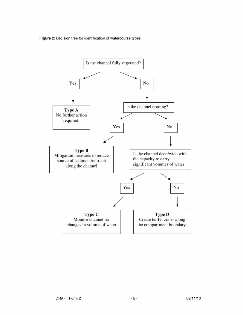
DRAFT Form 2 09/11/10 - 5 -
Figure 2: Decision tree for identification of watercourse types
Is the channel fully vegetated?
Yes No
Type A No further action
required.
Is the channel eroding?
Yes No
Type B Mitigation measures to reduce
source of sediment/nutrient
along the channel
Is the channel deep/wide with
the capacity to carry
significant volumes of water
Yes No
Type C
Monitor channel for
changes in volume of water
Type D
Create buffer zones along
the compartment boundary.

DRAFT Form 2 09/11/10 - 6 -
Table 2: Watercourse type and description
Type A Type B Type C Type D
Vegetated Non-vegetated Non-vegetated Non-vegetated
Non-eroding Eroding Non-eroding Non- eroding
No channel
disturbance
No channel
disturbance
Deep/wide natural or
manmade channel
Possible build up
of sediment
Some sediment
build up
Scouring of either
bed or banks
This channel is likely to
have carried significant
volumes of water
previously and may be re-
activated following
harvesting
No channel
disturbance
No scouring Vertical or collapsing
banks
No scouring No scouring of
bed/banks
No distortion of
emergent
vegetation
Deep/wide (natural or
manmade channel)
No channel disturbance Stable banks
Low risk
watercourse
High risk watercourse High risk watercourse if
water present
Low risk
watercourse
Note: Watercourses have not been separated into the Aquatic zones or Relevant Watercourses for the
identification of watercourse types.
Table 3: Soil erodability and nutrient loss risk categories for major soil groupings.
Soil Group Erodability Nutrient Loss Risk
Well drained mineral Moderate Low
Gleys (mineral) Low Moderate
Peaty gleys High Moderate*
Podzol (mineral) Moderate Moderate
Podzol (peaty High Moderate*
Lithosol Moderate High
Peat High High
Note: Slope, cultivation (e.g. drainage) and rainfall have not been incorporated into the risk categories
for the above soil groups.
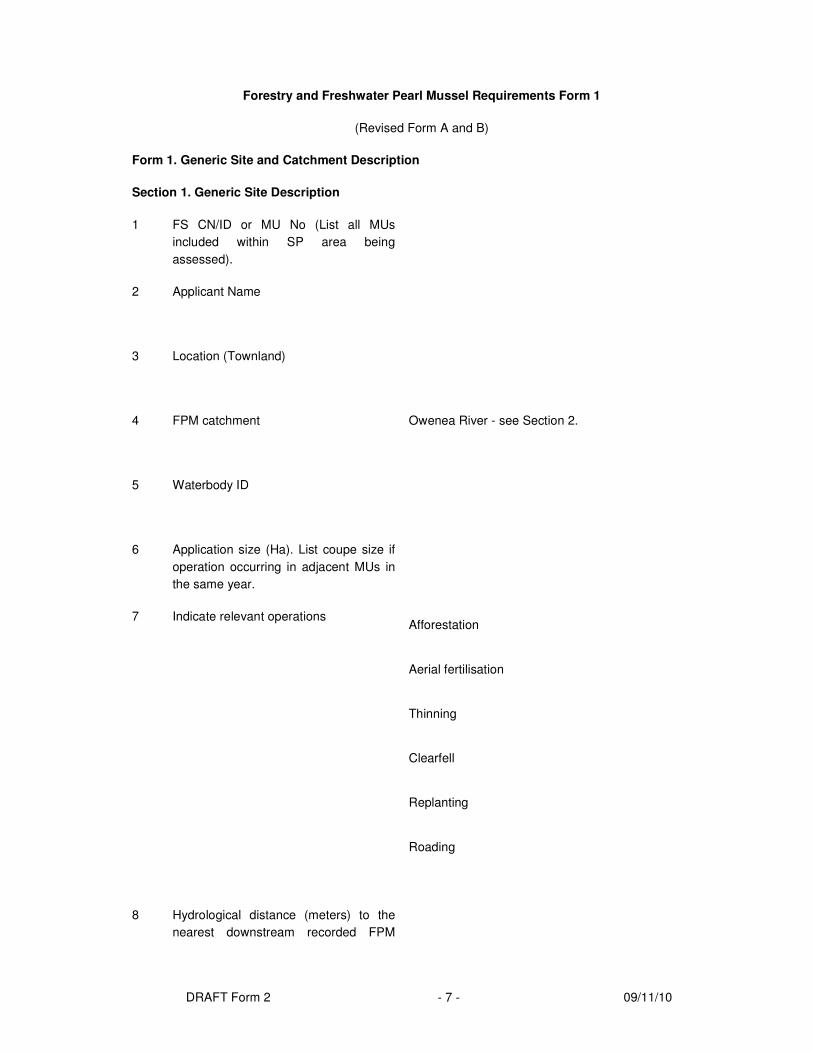
DRAFT Form 2 09/11/10 - 7 -
Forestry and Freshwater Pearl Mussel Requirements Form 1
(Revised Form A and B)
Form 1. Generic Site and Catchment Description
Section 1. Generic Site Description
1 FS CN/ID or MU No (List all MUs
included within SP area being
assessed).
2 Applicant Name
3 Location (Townland)
4 FPM catchment Owenea River - see Section 2.
5 Waterbody ID
6 Application size (Ha). List coupe size if
operation occurring in adjacent MUs in
the same year.
7 Indicate relevant operations Afforestation �
Aerial fertilisation �
Thinning �
Clearfell �
Replanting �
Roading �
8 Hydrological distance (meters) to the
nearest downstream recorded FPM

DRAFT Form 2 09/11/10 - 8 -
Section 1. Generic Site Description
population?
9 Overall slope Moderate (Even to 1 in 7/<15%) �
Steep (1 in 7 to 1 in 3/15-30%) �
Very Steep (1 in 3 or greater/>30%) �
10 Overall soil type Well drained mineral �
Gleys (mineral) �
Peaty gleys �
Podzol (mineral) �
Podzol (peat) �
Lithosol �
Peat �
11 Risk of sediment loss (see Table 4) High �
Medium �
Low �
Risk of nutrient loss (Table 5) High �
Medium �
Low �

DRAFT Form 2 09/11/10 - 9 -
Table 4. Risk of sediment loss
Slope Class
Soil type Even to 1 in 7
(<15%)
1 in 7 to 1 in 3
(15–30%)
1 in 3 or greater
(>30%)
Well drained mineral Moderate Moderate Moderate
Gleys (mineral) Low Low Low
Peaty gley High High High
Podzol (mineral) Moderate Moderate to High Moderate
Podzol (peaty)) High High High
Lithosol Moderate Moderate Moderate
Peat
High High High
Table 5: Soil erodability and nutrient loss risk categories for major soil groupings.
Soil Group Nutrient Loss Risk
Well drained mineral Low
Gleys (mineral) Moderate
Peaty gleys Moderate*
Podzol (mineral) Moderate
Podzol (peaty Moderate*
Lithosol High
Peat High
Note: Slope, cultivation (e.g. drainage) and rainfall have not been incorporated into the risk categories
for the above soil groups.

DRAFT Form 2 09/11/10 - 10 -
Section 2.Nore River FPM Catchment
Physical Description and Overview of land use in catchment
The Nore catchment is located in the south east of the country crossing counties, North Tipperary, Laois, Kilkenny and Offaly in the South Eastern River Basin District. At 1058.90 km2 the Nore catchment is the second largest pearl mussel catchment, after the Munster Blackwater. The River Nore rises on the eastern slopes of the Devil’s Bit Mountain in Co Tipperary and, at first, flows east through Borris in Ossory and then turns south passing through Durrow, and Ballyragget in Co Carlow, and then Kilkenny City, Bennettsbridge, and Thomastown in Co. Kilkenny before meeting the tide at the village of Inistioge. It is 87 miles long and drains a total catchment of 977 square miles. It rises on a sandstone base but the catchment soon turns to limestone and remains so to the sea. The countryside is one of mixed farming, with some tillage, quite a bit of pasture and dairying and some bloodstock. The river has a fairly steep gradient but the flow is checked by innumerable weirs and it is probably true to say that shallow glides are the predominant feature. The catchment incorporates parts of the Slieve Bloom Mountains, River Barrow and River Nore, Coolrain, Knockacoller, Galmoy Fen, Cullahill Mountain, Spahill and Clomantagh Hill and The Loughans SACs. The most common Corine land use type within the Nore catchment is “pastures” (70.51%). “Coniferous forests account for (7.12%) and “peat bogs” (5.04%).
Overview of pearl mussel in catchment
The Nore pearl mussel Margaritifera durrovensis has a relatively short history, being known to science
for less than 100 years. In 1926, B.B. Woodward found an unusual shell in the P.B. Mason collection,
which was labelled from the river Nore at Durrow (Phillips 1928). He wrote to R.A. Phillips, who went to
look for further specimens in the river. In October 1926, Phillips, along with A.W. Stelfox, R.J. Welch and
C. Oldham found the population and was subsequently followed by Phillips naming M. durrovensis as a
species new to science. The taxonomic status of M. durrovensis remains inconclusive but is probably
best described as a rare ecophenotype of M. margaritifera. M. durrovensis was known from the Barrow
and Nore main channels, but living specimens have not been found outside the Nore since 1993. During
1993 one living specimen was found in the River Barrow. Surveys of the River Suir from 1991-1993 led
to the discovery of dead shells only (Moorkens 1996).
The unique feature of the Nore pearl mussel Margaritifera durrovensis is that it does not live in acid
waters like M. margaritifera. It is living in a section of river that is highly calcareous, with over 330 mg/l
CaCO3. Although there are parts of the main channel and tributaries that have much lower levels of
calcium, the mussel has never been found within levels areas of the catchment that would seem much
better suited to it, and it is currently only known from the most lime-rich waters of the River Nore.
The Nore pearl mussel has not reproduced successfully in the River Nore since 1970. Evidence for the
decline of reproduction of M. durrovensis comes from Ross (1984) and from the detailed survey work
carried out from 1991 to 2009. Ross found mussels aged from 12 to 80 years, and a wide range of age
classes suggesting that mussels successfully bred almost every year between 1905 and 1971. Detailed
surveys have failed to find evidence of successful recruitment thereafter. The population continues to
age, and as older mussels die, they are not replaced. Based on the dead shells collected, the size
profile is very aged and close to death for this shorter lived species
Forestry overview in catchment
Forest stands in the Nore Catchment are located principally in the upper catchment in the tributary rivers
of the Delour (Gorteen, Kileen) on the Tonet and Mountrath rivers (Figure 3.14). Forest stands comprise

DRAFT Form 2 09/11/10 - 11 -
both State and private forest stands. The main forest areas are located well above the pearl mussel
populations.
Proposed forestry operation in the catchment (insert short description of operations to be carried out,
why operation need to be carried out and where possible relate to other forest activities within the
catchment).
A line corridor is required to clearfelled through 2 sections of forest stands between pole sets 77 – 82,
(750M X 61.5M) and pole sets 102 – 107 (746M X 61.5M) .
GIS Table listing all the waterbodies in the FPM catchment plus operations within the same year (i.e.
within proposed fell year).
Year Waterbody
ID
Waterbody
Area (ha)
MU ID MU Area (as %
of waterbody
area)
Clearfell
or Thinning

DRAFT Form 2 09/11/10 - 12 -
Forestry and Freshwater Pearl Mussel Requirements Form 2
(Revised Form A and B)
Table 6. This form is to be completed for aquatic zones (AZ) and for Types B and C relevant watercourses (RW) exiting the site. Assess 25m either side of
aquatic zones and 10m either side of Types B or C relevant watercourse. This form should be accompanied by a site map.
Watercourse Assessment Bank Side Zone Assessment Effective
buffer
Note 4
Risk
Note 5
ID Water-
course
Slope Note 1
Dimensions
of
channelNote
2
Vegetation
in
watercourse
Risk Slope Note 1
Soil Planted
with
conifer
s
Width
unplant
ed (m)
Dominant
ground
vegetation
Feeder
channels
(into AX
or ERW)
Risk Note 3
1 AZ �
RW �
Moderate
�
Steep
�
Very steep
�
Small
�
Medium
�
Large
�
None
�
Filamentous
algae
�
Macrophytes
�
High
�
Moderate
�
Low
�
Moderate
�
Steep
�
Very steep
�
Peat �
Mineral �
Gley �
Podzol �
Lithosol �
Yes �
No �
Bare soil /
litterfall /
mosses �
Grass/herb
cover �
Scrub �
Yes �
No �
High �
Moderate
�
Low �
Yes �
No �
High
�
Low
�
2 AZ �
RW �
Moderate�
Steep �
Small �
Medium �
None
�
Filamentous
algae
High �
Moderate
�
Moderate�
Steep �
Peat �
Mineral �
Yes �
No �
Bare soil /
litterfall /
mosses �
Grass/herb
Yes �
No �
High �
Moderate
�
Yes �
No �
High
�
Low

DRAFT Form 2 09/11/10 - 13 -
Very steep� Large � �
Macrophytes
�
Low � Very steep� Gley �
Podzol �
Lithosol �
cover �
Scrub �
Low � �
3 AZ �
RW �
Moderate�
Steep �
Very steep�
Small �
Medium �
Large �
None
�
Filamentous
algae
�
Macrophytes
�
High �
Moderate
�
Low �
Moderate�
Steep �
Very steep�
Peat �
Mineral �
Gley �
Podzol �
Lithosol �
Yes �
No �
Bare soil /
litterfall /
mosses �
Grass/herb
cover �
Scrub �
Yes �
No �
High �
Moderate
�
Low �
Yes �
No �
High
�
Low
�

DRAFT Form 2 09/11/10 - 14 -
Note 1. Slope categories
Slope category Slope
Moderate Even to 1 in 7 (<15%)
Steep 1 in 7 to 1 in 3 (15-30%)
Very steep 1 in 3 or greater (>30%)
Note 2. Dimensions of channel
Channel Category Approximate Dimensions
Small < 0.3m
Medium > 0.3m but < 1m
Large > 1m
Note 3. Soil erodibility and nutrient loss risk categories for major soil groupings.
Soil Group Erodability (Sediment Loss
Risk
Nutrient Loss Risk
Well drained mineral Moderate Low
Gleys (mineral) Low Moderate
Peaty gleys High Moderate*
Podzol (mineral) Moderate Moderate
Podzol (peaty) High Moderate*
Lithosol Moderate High
Peat High High
Slope, cultivation (e.g. drainage) and rainfall have not been incorporated into the risk categories for the
above soil groups.

DRAFT Form 2 09/11/10 - 15 -
Note 4. Characteristics of effective and non-effective buffer.
Effective Buffer Non-effective buffer
No feeder channels crossing the buffer zone and
flowing into the water course.
Feeder channels crossing the
buffer zone
Unplanted buffer zone or buffer zone with
scrub/broadleaf species (to be retained during
operation) or vegetated with grasses/ground flora.
Planted with conifers or bare
of vegetation
Slope moderate or steep Very steep slope
Mineral soil or if peat must be unplanted vegetated
buffer zone present.
Note 5. Assessment of risk associated with aquatic zones and eroding relevant watercourses.
Description Associate
d Risk
Mitigation
Aquatic zone with effective buffer between it and the
operation
Low Not Required
Aquatic zone with no effective buffer between it and
the operation
High Required
Type B or C relevant watercourse with effective
buffer between it and the operation
Low Not Required
Type B or C relevant watercourse with no effective
buffer between it and the operation
High Required

DRAFT Form 2 09/11/10 - 16 -
Table 7. Assessment of hotspots i.e. potential source areas for sediment/nutrient loss within the
proposed forest operations site. Mark all ‘hotspots’ on site map and on the ground.
ID Hotspot Type
(use Note 6)
Hydrological pathway Risk
HS1 Yes �
No �
High �
Low �
HS2 Yes �
No �
High �
Low �
HS3 Yes �
No �
High �
Low �
HS4 Yes �
No �
High �
Low �
HS5 Yes �
No �
High �
Low �

DRAFT Form 2 09/11/10 - 17 -
Note 6. Classification of Hotspots
Type Description
A Soft wet ground (including wet, deep peat)
B Flushes and springs
C Wind-blown areas/stands
D Areas where ground traffic access is difficult due to slope or
ground bearing capacity
E Area likely to be intensively trafficked
F Floodplains – floodprone areas
G Portions of site with complex matrix of drainage channels
H Other (specify)

DRAFT Form 2 09/11/10 - 18 -
Forestry and Freshwater Pearl Mussel Requirements Form 4
Form 4. Restock option and mitigation measures.
Mitigation
Measures
Options Option to
be used
(tick where
appropriate)
Mandatory Comments – describe
briefly actions to be taken,
especially where there’s a
combination of methods
Not be replanted
Replanted commercially
Site management
(Refer to Table 8)
Replanted non-
commercially
Native scrub/woodland
establishment
No planting
Buffer zone
management
options:
Expand existing buffer
zones
Leave extraction racks in
place post-felling and plant
in between.
If windrowing, use least
impacting machinery e.g.
brash grabs.
Site preparation –
handling of
extraction racks
post-felling
Standard windrowing of
extraction racks.
Conventional mounding
Inverted/scrap mounding
Pit planting
Natural regeneration
Cultivation and
planting methods
to be used.
Buffer zones wider than
guidelines
Manual planting Machinery and
equipment
selection If machinery required (e.g.
stump removal) use least
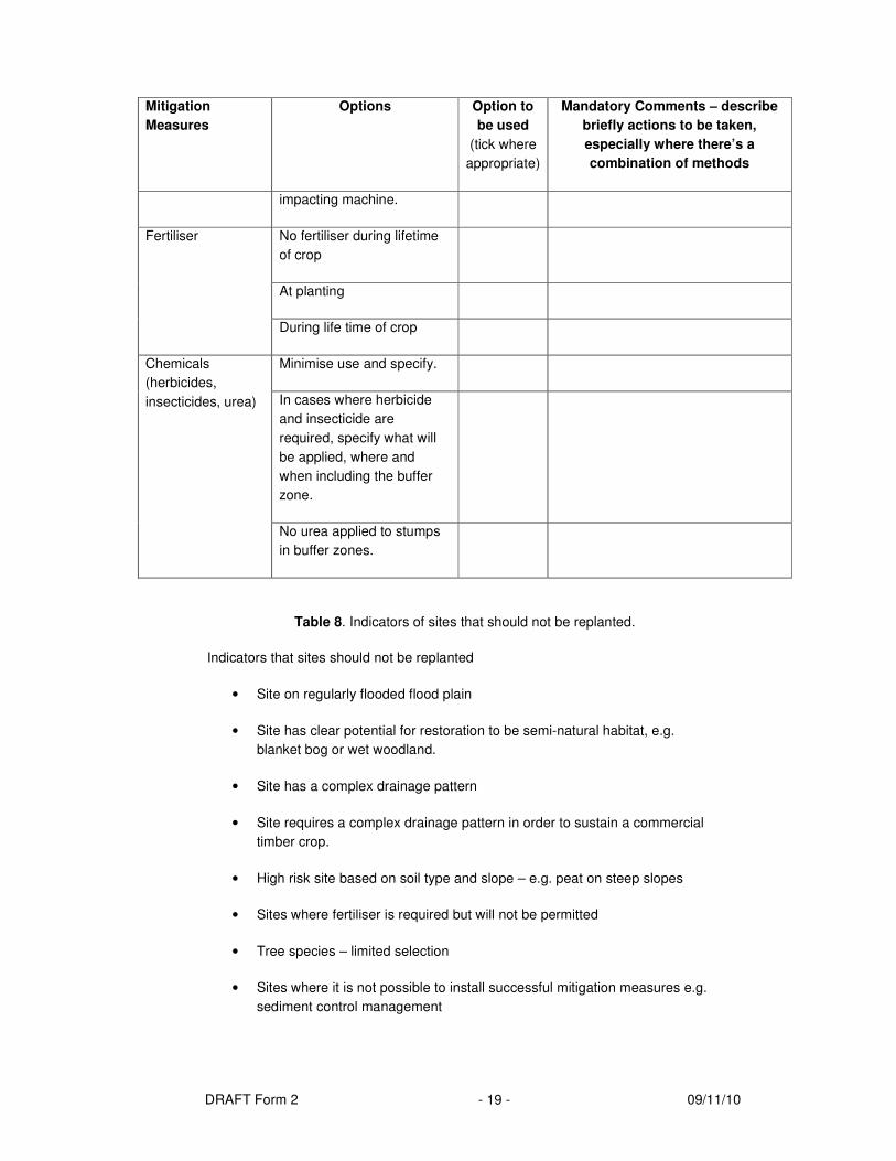
DRAFT Form 2 09/11/10 - 19 -
Mitigation
Measures
Options Option to
be used
(tick where
appropriate)
Mandatory Comments – describe
briefly actions to be taken,
especially where there’s a
combination of methods
impacting machine.
No fertiliser during lifetime
of crop
At planting
Fertiliser
During life time of crop
Minimise use and specify.
In cases where herbicide
and insecticide are
required, specify what will
be applied, where and
when including the buffer
zone.
Chemicals
(herbicides,
insecticides, urea)
No urea applied to stumps
in buffer zones.
Table 8. Indicators of sites that should not be replanted.
Indicators that sites should not be replanted
• Site on regularly flooded flood plain
• Site has clear potential for restoration to be semi-natural habitat, e.g.
blanket bog or wet woodland.
• Site has a complex drainage pattern
• Site requires a complex drainage pattern in order to sustain a commercial
timber crop.
• High risk site based on soil type and slope – e.g. peat on steep slopes
• Sites where fertiliser is required but will not be permitted
• Tree species – limited selection
• Sites where it is not possible to install successful mitigation measures e.g.
sediment control management

DRAFT Form 2 09/11/10 - 20 -
Forestry and Freshwater Pearl Mussel Requirements Form 3 Mitigation Clearfelling
(Revised Form A and B)
Form 3. Indicate Mitigation Measures to be taken from the options presented below
Mitigation Measures
Options Option to
be used
(tick where
appropriate)
Mandatory Comments – describe briefly actions to be
taken, especially where there’s a combination of methods
e.g. % of area to be harvested in this way, timber extracted
using a selected option.
Specify aquatic zones, relevant watercourses and hotspots
to which mitigation measures apply.
OPERATIONAL
Harvesting head and forwarder (as per
recommended guidelines)
Other
Cable system, roadside processing
Chainsaw felling
Skidder
Horse extraction
Harvesting machinery and
equipment selection – use least
impacting option
Mini forwarder, quads, tractor trailer
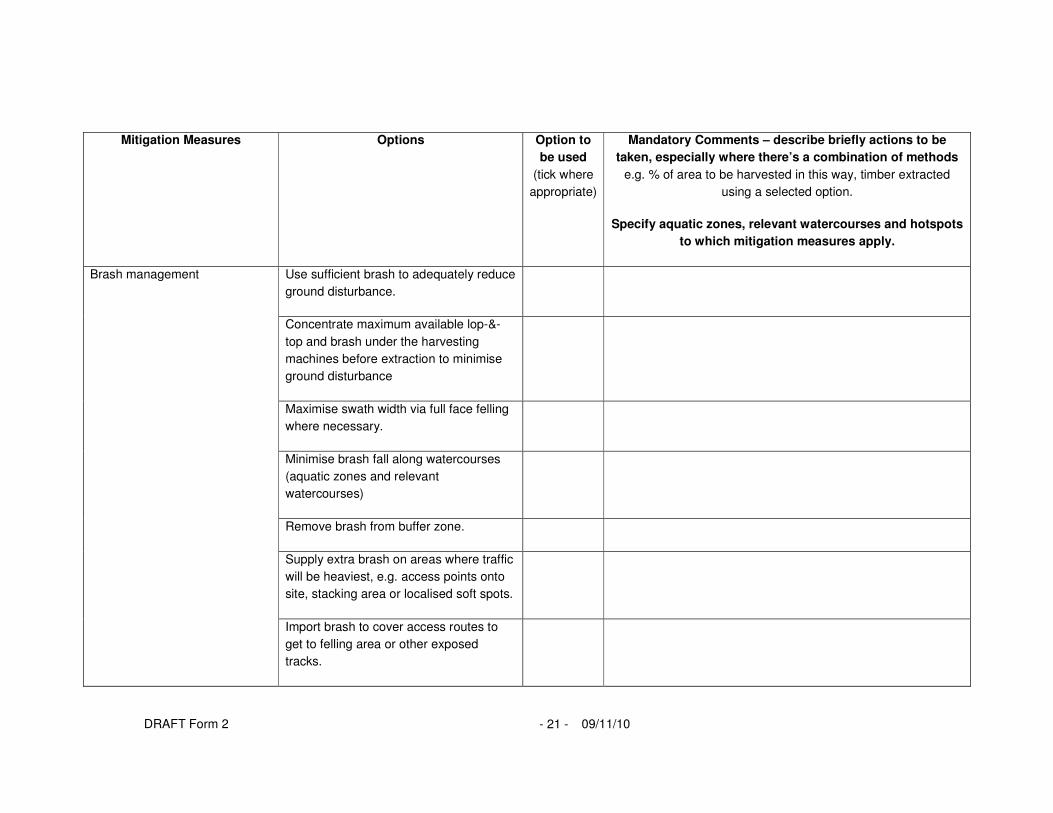
DRAFT Form 2 09/11/10 - 21 -
Mitigation Measures
Options Option to
be used
(tick where
appropriate)
Mandatory Comments – describe briefly actions to be
taken, especially where there’s a combination of methods
e.g. % of area to be harvested in this way, timber extracted
using a selected option.
Specify aquatic zones, relevant watercourses and hotspots
to which mitigation measures apply.
Use sufficient brash to adequately reduce
ground disturbance.
Concentrate maximum available lop-&-
top and brash under the harvesting
machines before extraction to minimise
ground disturbance
Maximise swath width via full face felling
where necessary.
Minimise brash fall along watercourses
(aquatic zones and relevant
watercourses)
Remove brash from buffer zone.
Supply extra brash on areas where traffic
will be heaviest, e.g. access points onto
site, stacking area or localised soft spots.
Brash management
Import brash to cover access routes to
get to felling area or other exposed
tracks.

DRAFT Form 2 09/11/10 - 22 -
Mitigation Measures
Options Option to
be used
(tick where
appropriate)
Mandatory Comments – describe briefly actions to be
taken, especially where there’s a combination of methods
e.g. % of area to be harvested in this way, timber extracted
using a selected option.
Specify aquatic zones, relevant watercourses and hotspots
to which mitigation measures apply.
Aim for shortest route from timber felled
to stacking area taking note on
availability of suitable stacking areas,
road design and road density.
Avoid locating stacking areas near drains
or on wet ground.
Place silt traps below stacking area
where necessary (e.g. if close to a drain).
Timber stacking, location &
duration
Prompt extraction of felled timber
Fuel/materials storage area Comply with FS Guidelines
Where ground conditions are soft, reduce
load sizes being extracted.
Timber extraction
On gentler slopes it may be desirable to

DRAFT Form 2 09/11/10 - 23 -
Mitigation Measures
Options Option to
be used
(tick where
appropriate)
Mandatory Comments – describe briefly actions to be
taken, especially where there’s a combination of methods
e.g. % of area to be harvested in this way, timber extracted
using a selected option.
Specify aquatic zones, relevant watercourses and hotspots
to which mitigation measures apply.
plan harvesting racks along contour lines
.
Roading – is a road in place? Build new road or road extension a year
in advance of harvesting operations.
WATERCOURSES AND
HOTSPOTS
Directional felling by harvester to prevent
trees falling into watercourse.
Directional felling manually to prevent
trees falling into watercourse.
Fell trees manually and remove by
machine.
Felling in buffer zones
Fell and remove whole trees from buffer
zone for processing.

DRAFT Form 2 09/11/10 - 24 -
Mitigation Measures
Options Option to
be used
(tick where
appropriate)
Mandatory Comments – describe briefly actions to be
taken, especially where there’s a combination of methods
e.g. % of area to be harvested in this way, timber extracted
using a selected option.
Specify aquatic zones, relevant watercourses and hotspots
to which mitigation measures apply.
Avoid all operations in existing buffer
zones/strips
Protection of existing buffer
zones/strips
Use heavy brash mat and remove
immediately after operation is complete
Identify which relevant watercourses will
have silt traps and show on map.
Creation of sediment traps
Install silt traps as deemed necessary on
roadside drains and indicate on a map.
Block feeder drains
Block or divert existing drains to create
temporary surface ponding or to filter
through vegetated overland flow areas.
Geotextile (teram) dams.
Creation of other sediment
control measures
Corrugated plastic dams.

DRAFT Form 2 09/11/10 - 25 -
Mitigation Measures
Options Option to
be used
(tick where
appropriate)
Mandatory Comments – describe briefly actions to be
taken, especially where there’s a combination of methods
e.g. % of area to be harvested in this way, timber extracted
using a selected option.
Specify aquatic zones, relevant watercourses and hotspots
to which mitigation measures apply.
Straw bales.
Other (specify)
Use routes with minimum stream/drain
crossings, where possible
Minimise stream/drain crossings
Mark locations of water crossings on map
Water Crossings Mark locations of water crossings on
map.
Logs
Pipes
Construction of temporary water
crossings
Frames

DRAFT Form 2 09/11/10 - 26 -
Mitigation Measures
Options Option to
be used
(tick where
appropriate)
Mandatory Comments – describe briefly actions to be
taken, especially where there’s a combination of methods
e.g. % of area to be harvested in this way, timber extracted
using a selected option.
Specify aquatic zones, relevant watercourses and hotspots
to which mitigation measures apply.
Temporary water crossings
removal
Timing
Permanent water crossings Install bridge
Creation of effective buffer strip
OTHER