Appendix 3 NOISE AUDIT FEBRUARY 2017 Atkins Acoustic Report 2017 Part 2.pdf · Attention: Steve...
75
DRAFT DRAFT Grants Road Sand Quarry – Annual Report Reporting period 1 January to 31 December 2017 Peter Andrews + Associates Pty Ltd March 2017 paa.design.architecture.planning.urban design.landscape architecture Appendix 3 NOISE AUDIT FEBRUARY 2017 Atkins Acoustic
Transcript of Appendix 3 NOISE AUDIT FEBRUARY 2017 Atkins Acoustic Report 2017 Part 2.pdf · Attention: Steve...

DRAFTDRAFT
Grants Road Sand Quarry – Annual Report Reporting period 1 January to 31 December 2017
Peter Andrews + Associates Pty Ltd March 2017
paa.design.architecture.planning.urban design.landscape architecture
Appendix 3 NOISE AUDIT FEBRUARY 2017
Atkins Acoustic

47.7027.R3:GA/DT/2017
Grants Road Sand Pty Ltd.Grants RoadSOMERSBY NSW 2250
Attention: Steve Jones
6 February 2017
Postal AddressP.O. Box 432GladesvilleN.S.W. 1675AUSTRALIAA.C.N. 068 727 195A.B.N. 19 068 727 195Telephone: 02 9879 4544Fax: 02 9879 4810Email: [email protected]
Atkins Acoustics and Associates Pty Ltd.Consulting Acoustical & Vibration Engineers
P.O. Box 432. GLADESVILLE NSW 2111 Tel: (02) 9879 4544 Email: [email protected]
ENVIRONMENTAL NOISE AUDITGRANTS ROAD SAND QUARRYSOMERSBY
1.0 INTRODUCTION
Atkins Acoustics was retained by Grants Road Sand Pty Ltd to conduct anenvironmental noise audit of the Grants Road Sand Quarry operations. The audit wasconducted by Graham Atkins. Grahams qualifications and membership include BE,MAAS, MIEAust and CPEng. Graham is employed by Atkins Acoustics andAssociates Pty Ltd a Member Firm of the AAAC.
The quarry currently operates under approval from DoPE dated 25 July 2014(08_0099). Specific noise conditions (Schedule 3 - Conditions 5, 6, 7, 8 & 9)contained within the approval include a requirement for the preparation of a NMP(Schedule 3 - Condition 9) to the satisfaction of the Secretary.
The approval includes:
• extraction, processing and transportation of up to 250,000 tonnes per annum ofvarious grades of washed sand, mortar sand, sandstone blocks and retaining wallrocks for a period of approximately thirty (30) years.
• total extraction of approximately nine point five (9.5) million tonnes (Mt) ofextractable sand and sandstone.
• extension of quarry by approximately twenty (20) hectares.• extraction to depth of thirty-five (35) metres, and• extraction by dozer and excavator.
The quarry operates from 7.00am to 6.00pm Monday to Friday and 7.00am to 1.00pmSaturday. Due to the number of quarry staff, simultaneous plant operation is typicallylimited to three (3) items at any one time.
ENVIRONMENTAL NOISE AUDIT Page 2 47.7027.R3:GA/DT/2017GRANTS ROAD SAND QUARRYSOMERSBY February 2017
GRANTS ROAD SAND PTY LTD ATKINS ACOUSTICS
2.0 APPROVAL CONDITIONS (Noise)
Project construction and quarry operational noise conditions imposed by the DoPE(Approval 08_0099) dated 25 July 2014 – Schedule 3 are presented below:
It is noted that no noise limits are provided in Schedule 3 – Condition 7 for theNational Park to the west of the quarry. Referenced to the EA Noise Assessment andthe NSW, INP a target noise goal of LAeq, 15min 50-55dB(A) is recommended forassessing noise at the National Park boundary.
.

ENVIRONMENTAL NOISE AUDIT Page 3 47.7027.R3:GA/DT/2017GRANTS ROAD SAND QUARRYSOMERSBY February 2017
GRANTS ROAD SAND PTY LTD ATKINS ACOUSTICS
3.0 DESCRIPTION OF QUARRING ACTIVITIES
The audit identified onsite extraction and processing of quarry products on Areas Aand B (Figure 1). Operating plant and equipment identified during the audit included:
• McClosky (Tricon) Screen and loader in centre portion of Area B.
• Truck loading from stockpile area south-western portion Area A.
• Saw cutting central lower portion of Area A.
Figure 1. Quarry Precinct Layout

ENVIRONMENTAL NOISE AUDIT Page 4 47.7027.R3:GA/DT/2017GRANTS ROAD SAND QUARRYSOMERSBY February 2017
GRANTS ROAD SAND PTY LTD ATKINS ACOUSTICS
4.0 OVERVIEW
The noise audit was conducted between 8.00am and 12.15pm, Thursday 2 February2017.
In accordance with the NMP noise measurements were conducted at three (3)reference locations nominated to represent residential receivers.
Location 1: ‘Ibels’ - 380 Somersby Falls Road
Location 2: ‘McGregor’ - 239 Grants Road
Location 3: ‘Sammut’ - 210 Grants Road
4.1 Measurement InstrumentationThe measurement instrumentation comprised a SVAN949 Sound and VibrationAnalyzer. The meter was programmed to calculate and record 15 minute statisticallevels. The reference calibration level of the meter was checked prior to and after themeasurements with a Bruel & Kjaer Sound Level Calibrator Type 4230 and remainedwithin ± 0.5dBA. The meter carried appropriate and current NATA calibration(Attachment 2).
Measurements were undertaken in accordance with procedures documented inAustralian Standard AS1055-1997 ' Acoustics - Description and Measurement ofEnvironmental Noise' and the NSW Environmental Protection Authority, IndustrialNoise Policy (INP).
4.2 Weather ConditionsWeather conditions reported for Mangrove Mountain (ID: 061375) during the auditwere light winds from the south to south-south-east (1-3m/sec), air temperature 22-24°C , no rain and approximately 20% to 75% cloud cover.
4.3 Review of Noise Related IncidentsThe Site Quarry Manager confirmed that no noise related incidents have beenreported or recorded at the site during the period from 10 August 2016 and 2 February2017.

ENVIRONMENTAL NOISE AUDIT Page 5 47.7027.R3:GA/DT/2017GRANTS ROAD SAND QUARRYSOMERSBY February 2017
GRANTS ROAD SAND PTY LTD ATKINS ACOUSTICS
5.0 MEASUREMENT RESULTS
5.1 Off-site Audit ResultsMeasurements and sources identified during the audit where appropriate were used toassess source noise contributions from the Grants Road Sand Quarry operations. Asummary of the measurement results and calculated contributions is presented inTable 1.
Table 1: Audit Measurement ResultsdBA re: 20 x 10–6 Pa
Measured Ambient SoundPressure Levels
dBALAeq LA10 LA90 LA1
Grants RoadSand
ContributionLAeq, 15min
Comments
Location 1: Ibels Residence – 380 Somersby Falls Road
39.9 42.2 34.9 47.6 <35 Birds, distant road traffic, insects, GRS inaudible.
45.1 46.6 38.1 56.5 <35 Birds, distant road traffic, aircraft, insects, GRSinaudible.
Location 2: McGregor Residence – 239 Grants Road
42.2 44.4 36.1 49.9 <35-6 Distant road traffic, insects, GRS onsite trucks andloaders audible at times.
41.7 44.8 36.7 49.3 <35-6 Distant road traffic, insects, GRS onsite trucks, loadersand McClosky (Tricon) screen audible at times.
Location 3: Sammut Residence – 210 Grants Road
45.4 48.8 38.7 54.7 <36 Local domestic activities Distant road traffic, insects,GRS onsite trucks and loaders audible at times
42.5 46.7 35.8 51.8 <35 Local domestic activities Distant road traffic, insects,GRS onsite trucks and loaders audible at times
Location 4: National Park
39.6 42.5 33.1 48.5 <40 GRS onsite trucks and loaders audible at times, birds,aircraft
42.4 53.5 37.9 48.5 <40 GRS onsite trucks and loaders audible at times, birds,aircraft
5.2 Site Audit ResultsIn addition to the offsite noise measurements Table 2 presents a summary of soundpower levels for the operating site plant and equipment.

ENVIRONMENTAL NOISE AUDIT Page 6 47.7027.R3:GA/DT/2017GRANTS ROAD SAND QUARRYSOMERSBY February 2017
GRANTS ROAD SAND PTY LTD ATKINS ACOUSTICS
Table 2: Quarry Plant and Equipment Sound Power LevelsdBA re: 10-12 Watts
Sound Power LeveldB 10-12 WattsPlant Description
dBA 31.5 63 125 250 500 1k 2k 4k 8kCat Loader 972G 102 109 113 104 104 98 96 93 85 77Cat Loader 980G 104 113 118 109 104 101 100 96 92 91McClosky (Tricon) Screen 108 107 105 105 105 103 101 100 96 88Cat 365C - Saw Cutting 106 97 105 105 98 97 97 101 101 105
5.3 Compliance StatusThe audit measurement results show that operational noise contributions from GrantsRoad Sand Quarry activities satisfied the (Approval 08_0099) dated 25 July 2014project noise goal LAeq, 15min 40dBA and the NMP recommended limit for the NationalPark LAeq,15min 50-55.
5.4 Noise TrendsA review of the measurement results (Table 1) and results reported for 2016 hasshown that noise contributions from Grant Road Sand Quarry activities have remainedsteady.
5.5 Noise Mitigation PlanningNoise mitigation options planned for the next calendar year, include the continuationof the earth mounding/bunding on the north-eastern, northern and western siteboundaries. Additionally and dependent on product demand, it is expected that thedepths of the working platforms (Areas A and B) could increase by 3-4 metres.

ENVIRONMENTAL NOISE AUDIT Page 7 47.7027.R3:GA/DT/2017GRANTS ROAD SAND QUARRYSOMERSBY February 2017
GRANTS ROAD SAND PTY LTD ATKINS ACOUSTICS
6.0 CONCLUSION
Atkins Acoustics was retained by Grants Road Sand Pty Ltd to conduct anenvironmental noise audit for the Grants Road Sand Quarry.
The quarry currently operates under approval from DoPE dated 25 July 2014(08_0099).
The site attended audit was conducted between 8.00am and 12.15pm, Thursday 2February 2017.
The measurement results show that operational noise contributions from Grants RoadSand Quarry satisfied the (Approval 08_0099) dated 25 July 2014 project noise goalLAeq, 15min 40dBA and the NMP recommended limit for the National Park LAeq,15min 50-55.
No noise related incidents were reported or recorded at the site during the period from10 August 2016 and 2 February 2017.
A review of the measurement results with results reported for 2016 has shown thatnoise contributions from Grant Road Sand Quarry have remained steady.
Noise mitigation options planned for the next calendar year, include the continuationof the earth mounding/bunding on the site boundaries and dependent on productdemand, the depths of working platforms in Areas A and B, could increase by 3-4metres.
ATKINS ACOUSTICS & ASSOCIATES PTY LTD.
Graham Atkins

ENVIRONMENTAL NOISE AUDIT ATTACHMENT 1 47.7027.R3:GA/DT/2017GRANTS ROAD SAND QUARRYSOMERSBY February 2017
GRANTS ROAD SAND PTY LTD ATKINS ACOUSTICS
ATTACHMENT 1: ASSESSMENT MONITORING LOCATIONS
Ibels
McGregor
Sammut
Grants Road Sand Quarry
National Park

ENVIRONMENTAL NOISE AUDIT ATTACHMENT 2 47.7027.R3:GA/DT/2017GRANTS ROAD SAND QUARRYSOMERSBY February 2017
GRANTS ROAD SAND PTY LTD ATKINS ACOUSTICS
ATTACHMENT 2: SVAN Certificate of Calibration.

DRAFTDRAFT
Grants Road Sand Quarry – Annual Report Reporting period 1 January to 31 December 2017
Peter Andrews + Associates Pty Ltd March 2017
paa.design.architecture.planning.urban design.landscape architecture
Appendix 4 NOISE AUDIT DECEMBER 2017
Atkins Acoustic
47.7027.R4:GA/DT/2017
Grants Road Sand Pty Ltd.Grants RoadSOMERSBY NSW 2250
Attention: Steve Jones
20 December 2017
Postal AddressP.O. Box 432GladesvilleN.S.W. 1675AUSTRALIAA.C.N. 068 727 195A.B.N. 19 068 727 195Telephone: 02 9879 4544Fax: 02 9879 4810Email: [email protected]
Atkins Acoustics and Associates Pty Ltd.Consulting Acoustical & Vibration Engineers
P.O. Box 432. GLADESVILLE NSW 2111 Tel: (02) 9879 4544 Email: [email protected]
ENVIRONMENTAL NOISE AUDITGRANTS ROAD SAND QUARRYSOMERSBY
1.0 INTRODUCTION
Atkins Acoustics was retained by Grants Road Sand Pty Ltd to conduct anenvironmental noise audit of the Grants Road Sand Quarry operations. The audit wasconducted by Graham Atkins. Grahams qualifications and membership include BE,MAAS, MIEAust and CPEng. Graham is employed by Atkins Acoustics andAssociates Pty Ltd a Member Firm of the AAAC.
The quarry currently operates under approval from DoPE dated 25 July 2014(08_0099). Specific noise conditions (Schedule 3 - Conditions 5, 6, 7, 8 & 9)contained within the approval include a requirement for the preparation of a NMP(Schedule 3 - Condition 9) to the satisfaction of the Secretary.
The approval includes:
• extraction, processing and transportation of up to 250,000 tonnes per annum ofvarious grades of washed sand, mortar sand, sandstone blocks and retaining wallrocks for a period of approximately thirty (30) years.
• total extraction of approximately nine point five (9.5) million tonnes (Mt) ofextractable sand and sandstone.
• extension of quarry by approximately twenty (20) hectares.• extraction to depth of thirty-five (35) metres, and• extraction by dozer and excavator.
The quarry operates from 7.00am to 6.00pm Monday to Friday and 7.00am to 1.00pmSaturday.

ENVIRONMENTAL NOISE AUDIT Page 2 47.7027.R4:GA/DT/2017GRANTS ROAD SAND QUARRYSOMERSBY December 2017
GRANTS ROAD SAND PTY LTD ATKINS ACOUSTICS
2.0 APPROVAL CONDITIONS (Noise)
Project construction and quarry operational noise conditions imposed by the DoPE(Approval 08_0099) dated 25 July 2014 – Schedule 3 are presented below:
It is noted that no noise limits are provided in Schedule 3 – Condition 7 for theNational Park to the west of the quarry. Referenced to the EA Noise Assessment andthe NSW, INP a target noise goal of LAeq, 15min 50-55dB(A) is recommended forassessing noise at the National Park boundary.
.

ENVIRONMENTAL NOISE AUDIT Page 3 47.7027.R4:GA/DT/2017GRANTS ROAD SAND QUARRYSOMERSBY December 2017
GRANTS ROAD SAND PTY LTD ATKINS ACOUSTICS
3.0 DESCRIPTION OF SITE ACTIVITIES
The audit identified onsite extraction and processing of quarry products on Areas Aand B (Figure 1). Operating plant and equipment identified during the audit included:
• McClosky (Tricon) Screen and loader in centre portion of Area B.
• Truck loading from stockpile area south-western portion Area A.
• Saw cutting central lower portion of Area A,
• Water pump and washing plant
Figure 1. Quarry Precinct Layout
ENVIRONMENTAL NOISE AUDIT Page 4 47.7027.R4:GA/DT/2017GRANTS ROAD SAND QUARRYSOMERSBY December 2017
GRANTS ROAD SAND PTY LTD ATKINS ACOUSTICS
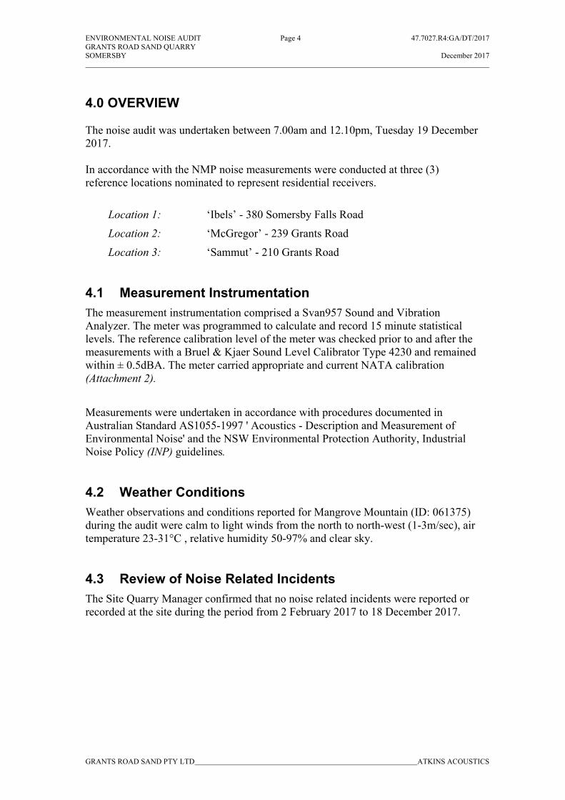
4.0 OVERVIEW
The noise audit was undertaken between 7.00am and 12.10pm, Tuesday 19 December2017.
In accordance with the NMP noise measurements were conducted at three (3)reference locations nominated to represent residential receivers.
Location 1: ‘Ibels’ - 380 Somersby Falls Road
Location 2: ‘McGregor’ - 239 Grants Road
Location 3: ‘Sammut’ - 210 Grants Road
4.1 Measurement InstrumentationThe measurement instrumentation comprised a Svan957 Sound and VibrationAnalyzer. The meter was programmed to calculate and record 15 minute statisticallevels. The reference calibration level of the meter was checked prior to and after themeasurements with a Bruel & Kjaer Sound Level Calibrator Type 4230 and remainedwithin ± 0.5dBA. The meter carried appropriate and current NATA calibration(Attachment 2).
Measurements were undertaken in accordance with procedures documented inAustralian Standard AS1055-1997 ' Acoustics - Description and Measurement ofEnvironmental Noise' and the NSW Environmental Protection Authority, IndustrialNoise Policy (INP) guidelines.
4.2 Weather ConditionsWeather observations and conditions reported for Mangrove Mountain (ID: 061375)during the audit were calm to light winds from the north to north-west (1-3m/sec), airtemperature 23-31°C , relative humidity 50-97% and clear sky.
4.3 Review of Noise Related IncidentsThe Site Quarry Manager confirmed that no noise related incidents were reported orrecorded at the site during the period from 2 February 2017 to 18 December 2017.

ENVIRONMENTAL NOISE AUDIT Page 5 47.7027.R4:GA/DT/2017GRANTS ROAD SAND QUARRYSOMERSBY December 2017
GRANTS ROAD SAND PTY LTD ATKINS ACOUSTICS
5.0 MEASUREMENT RESULTS
5.1 Off-site Measurement ResultsAttended measurements during the audit where appropriate were used to assess sourcenoise contributions associated with Grants Road Sand Quarry operations. A summaryof the measurement results and calculated contributions is presented in Table 1.Measurements at all reference assessment locations was dominated by cicada andinsect noise
Table 1: Audit Measurement ResultsdBA re: 20 x 10–6 Pa
Measured Ambient SoundPressure Levels
dBA
LAeq LA10 LA90 LA1
EstimatedGrants Road
SandContribution
LAeq, 15min
Comments
Location 1: Ibels Residence – 380 Somersby Falls Road
54.9 55.8 54.0 56.9 <40 Cicadas, aircraft, birds, distant road traffic, insects,GRS inaudible.
55.2 55.9 54.2 57.6 <40 Cicadas, birds, distant road traffic, insects, GRSinaudible
Location 2: McGregor Residence – 239 Grants Road
60.2 61.4 59.8 61.9 <40 Cicadas, distant road traffic, insects, GRS onsite trucks,loaders audible at times.
61.8 62.7 61.0 62.9 <40Cicadas, distant road traffic, insects, GRS onsite trucks,loaders, excavators, water pump, wash plant andMcClosky (Tricon) screen audible at times.
Location 3: Sammut Residence – 210 Grants Road
67.1 67.8 64.4 68.8 <40 Cicadas, distant road traffic, insects, GRS onsite trucks,loaders and McClosky (Tricon) screen audible at times.
65.7 66.5 65.0 66.9 <40Cicadas, distant road traffic, insects, GRS onsite trucks,loaders, excavators, water pump, wash plant andMcClosky (Tricon) screen audible at times.
Location 4: National Park
60.9 62.2 59.6 63.8 <50 Cicadas, GRS onsite trucks (LAmax 58/9dBA),loaders, water pump, wash plant and McClosky(Tricon) screen audible at times.
60.7 61.0 59.2 62.7 <50Cicadas, GRS onsite trucks, loaders (LAmax55/8dBA), water pump, wash plant and McClosky(Tricon) screen audible at times.

ENVIRONMENTAL NOISE AUDIT Page 6 47.7027.R4:GA/DT/2017GRANTS ROAD SAND QUARRYSOMERSBY December 2017
GRANTS ROAD SAND PTY LTD ATKINS ACOUSTICS
5.2 Site Audit ResultsIn addition to the offsite noise measurements Table 2 presents a summary of soundpower levels for the operating site plant and equipment.
Table 2: Quarry Plant and Equipment Sound Power LevelsdBA re: 10-12 Watts
Sound Power LeveldB 10-12 WattsPlant Description
dBA 31.5 63 125 250 500 1k 2k 4k 8kCat Loader 980G 105 92 119 103 100 99 101 95 90 89Cat Excavator 336D 103 94 103 95 98 96 90 87 83 75Cat Loader 980D 107 101 107 104 101 100 103 101 95 85Water Pump 107 94 122 107 95 99 102 100 93 88Wash Plant 107 103 106 105 98 97 96 98 90 85McClosky (Tricon) Screen 110 98 102 95 101 101 102 97 93 83Cat Excavator 365C - Saw Cutting 106 98 104 105 97 97 96 98 94 92
5.3 Compliance StatusThe results summarised in Table 1 show that noise from Grants Road Sand Quarryactivities complied with the Approval 08_0099 dated July 2014 noise goal LAeq, 15min40dBA and the NMP recommended goal for the National Park LAeq,15min 50-55.
5.4 Noise TrendsA review of the measurement results (Table 1) and previous reported levels has shownthat noise contributions from Grant Road Sand Quarry have remained steady.
5.5 Noise Mitigation PlanningNoise mitigation options planned for the next calendar year, include the continuationof the earth mounding/bunding on the north-eastern, northern and western siteboundaries. Additionally and dependent on product demand, it is expected that thedepths of the working platforms (Areas A and B) could increase by 2-6 metres.
ENVIRONMENTAL NOISE AUDIT Page 7 47.7027.R4:GA/DT/2017GRANTS ROAD SAND QUARRYSOMERSBY December 2017
GRANTS ROAD SAND PTY LTD ATKINS ACOUSTICS
6.0 CONCLUSION
Atkins Acoustics was retained by Grants Road Sand Pty Ltd to conduct anenvironmental noise audit for the Somersby Quarry.
The quarry currently operates under approval from DoPE dated 25 July 2014(Approval 08_0099).
The noise audit was conducted between 7.00am and 12.10pm, Tuesday 19 December2017.
The findings of the survey show that noise from Grants Road Sand Quarry compliedwith the (Approval 08_0099) dated 25 July 2014 project noise goal LAeq, 15min 40dBAand the NMP recommended goal for the National Park LAeq,15min 50-55.
No noise related incidents were reported or recorded at the site for the period between2 February and 18 December 2017.
A review of the measurement results (Table 1) and previous reported levels has shownthat noise contributions from Grant Road Sand Quarry have remained steady
Noise mitigation options planned for the next calendar year, include the continuationof the earth mounding/bunding on the site boundaries and dependent on productdemand, the depths of working platforms in Areas A and B, could increase by 2-6metres.
ATKINS ACOUSTICS & ASSOCIATES PTY LTD.
Graham Atkins

ENVIRONMENTAL NOISE AUDIT ATTACHMENT 1 47.7027.R4:GA/DT/2017GRANTS ROAD SAND QUARRYSOMERSBY December 2017
GRANTS ROAD SAND PTY LTD ATKINS ACOUSTICS
ATTACHMENT 1: ASSESSMENT MONITORING LOCATIONS
Ibels
McGregor
Sammut
Grants Road Sand Quarry
National Park

ENVIRONMENTAL NOISE AUDIT ATTACHMENT 2 47.7027.R4:GA/DT/2017GRANTS ROAD SAND QUARRYSOMERSBY December 2017
GRANTS ROAD SAND PTY LTD ATKINS ACOUSTICS
ATTACHMENT 2: Svan Certificate of Calibration.

DRAFTDRAFT
Grants Road Sand Quarry – Annual Report Reporting period 1 January to 31 December 2017
Peter Andrews + Associates Pty Ltd March 2017
paa.design.architecture.planning.urban design.landscape architecture
Appendix 5 BASELINE AIR QUALITY MONITORING
Pacific Environmental Limited

www.pacific-environment.com
Report
Baseline monitoring annual report – 2017 Grants Road Sand
Document control number: AQU-NW-002-0447733
Date: 27 March 2018

Grants Road Sand
Document control number: AQU-NW-002-0447733
0447733 Grants Road Quarry Air Quality Baseline Annual Report 2017
Proprietary information for Grants Road Sand only. Property of Pacific Environment Limited.
i
Project name: Baseline monitoring annual report – 2017
Grants Road Sand
Document control number: AQU-NW-002-0447733
Prepared for: Grants Road Sand
Approved for release by: Jane Barnett
Disclaimer & copyright: This report is subject to the copyright
statement located at www.pacific-
environment.com © Pacific Environment
Operations Pty Ltd ABN 86 127 101 642
Version Date Comment Prepared by Reviewed by
Draft 01 26.02.2018 First draft Calum Phillips Jane Barnett
Final 27.03.2018 Final Calum Phillips Jane Barnett
Adelaide
5 Peel Street
Adelaide SA 5000
Ph: +61 8 8332 0960
Brisbane
Level 4, 201 Leichardt Street
Brisbane Qld 4000
Ph: +61 7 3839 8393
Melbourne
Level 9, 99 King Street
Melbourne Vic 3000
Ph: +61 3 9696 8011
Perth
Level 18, 140 St Georges Terrace
Perth WA 6000
Ph: +61 8 6467 1600
Sydney
Level 15, 309 Kent Street
Sydney NSW 2000
Ph: +61 2 8584 8888

Grants Road Sand
Document control number: AQU-NW-002-0447733
0447733 Grants Road Quarry Air Quality Baseline Annual Report 2017
Proprietary information for Grants Road Sand only. Property of Pacific Environment Limited.
ii
Disclaimer Pacific Environment acts in all professional matters as a faithful advisor to the Client and
exercises all reasonable skill and care in the provision of its professional services.
Reports are commissioned by and prepared for the exclusive use of the Client. They are
subject to and issued in accordance with the agreement between the Client and Pacific
Environment. Pacific Environment is not responsible for any liability and accepts no
responsibility whatsoever arising from the misapplication or misinterpretation by third parties
of the contents of its reports.
Except where expressly stated, Pacific Environment does not attempt to verify the accuracy,
validity or comprehensiveness of any information supplied to Pacific Environment for its
reports.
Reports cannot be copied or reproduced in whole or part for any purpose without the prior
written agreement of Pacific Environment.
Where site inspections, testing or fieldwork have taken place, the report is based on the
information made available by the client or their nominees during the visit, visual observations
and any subsequent discussions with regulatory authorities. The validity and
comprehensiveness of supplied information has not been independently verified and, for the
purposes of this report, it is assumed that the information provided to Pacific Environment is
both complete and accurate. It is further assumed that normal activities were being
undertaken at the site on the day of the site visit(s), unless explicitly stated otherwise.
Grants Road Sand
Document control number: AQU-NW-002-0447733
0447733 Grants Road Quarry Air Quality Baseline Annual Report 2017
Proprietary information for Grants Road Sand only. Property of Pacific Environment Limited.
iii
Table of contents Disclaimer ........................................................................................................ ii
1 Introduction ................................................................................................... 1
2 Relevant monitoring guidelines and standards ............................................. 1
2.1 Air quality monitoring guidelines ..................................................................................... 1 2.1.1 General siting requirements .................................................................................... 1 2.1.2 Meteorological monitoring ....................................................................................... 1 2.1.3 Particulate matter monitoring .................................................................................. 2 2.1.4 Dust deposition monitoring ...................................................................................... 2
2.2 Air quality criteria ............................................................................................................ 3
3 Monitoring locations ...................................................................................... 4
4 Air quality monitoring results ......................................................................... 5
4.1 Meteorological monitoring .............................................................................................. 5 4.1.1 Wind data ................................................................................................................ 7 4.1.2 Temperature ............................................................................................................ 8 4.1.3 Rainfall..................................................................................................................... 8
4.2 Particulate matter (PM10) .............................................................................................. 12 4.2.1 Measured results ................................................................................................... 12 4.2.2 Comparison to environmental assessment predictions ........................................ 13
4.3 Dust deposition ............................................................................................................. 13 4.3.1 Measured results ................................................................................................... 13 4.3.2 Comparison to environmental assessment predictions ........................................ 14
4.4 Respirable crystalline silica .......................................................................................... 14 4.4.1 Comparison to environmental assessment predictions ........................................ 14
5 References .................................................................................................. 15

Grants Road Sand
Document control number: AQU-NW-002-0447733
0447733 Grants Road Quarry Air Quality Baseline Annual Report 2017
Proprietary information for Grants Road Sand only. Property of Pacific Environment Limited.
iv
List of Figures
Figure 3-1: Monitoring Locations at Grants Rd. Quarry ............................................................. 4 Figure 4-1: Grants Road Sand Wind Rose, 2017 ....................................................................... 7 Figure 4-2: Temperature Daily Temperature 2017 ..................................................................... 9 Figure 4-3: Daily Rainfall, 2017 ................................................................................................ 10 Figure 4-4: Monthly Rainfall Total, 2017. ................................................................................. 11 Figure 4-5: HVAS Monitoring Results for PM10, 2017 ............................................................... 12 Figure 4-6: Dust deposition monitoring results for 2017........................................................... 14
List of Tables
Table 2-1: Weather Station Parameters ..................................................................................... 2 Table 2-2: Air Quality Standards / Goals for Particulate Matter. ................................................ 3 Table 2-3: Air Quality Standards / Goals for Deposited Dust. .................................................... 3 Table 4-1: Valid Data Recovery Rates - AWS ............................................................................ 5 Table 4-2: Summary statistics .................................................................................................... 6 Table 4-3: Monthly Average Temperature, 2017 ........................................................................ 8
Grants Road Sand
Document control number: AQU-NW-002-0447733
0447733 Grants Road Quarry Air Quality Baseline Annual Report 2017
Proprietary information for Grants Road Sand only. Property of Pacific Environment Limited.
1
1 Introduction Pacific Environment has been commissioned by Grants Road Sand to undertake baseline air
quality and meteorological reporting for the Grants Road Sand Quarry, located in the NSW
Central Coast at Somersby, NSW.
The results of the monitoring programs are provided on an annual basis. This report
summarises the data collected during the January to December 2016 period.
2 Relevant monitoring guidelines and standards
2.1 Air quality monitoring guidelines All monitoring for air quality is conducted in accordance with the NSW Environmental
Protection Agency (EPA)1 “Approved methods for the sampling and analysis of air pollutants
in NSW” (NSW DEC 2005).
Specifically, the approved methods relevant to this monitoring plan are:
AM-1 – Guide for the siting of sampling equipment.
AM-2 – Guide for measurement of horizontal wind for air quality applications.
AM-4 – Meteorological monitoring guidance for regulatory modelling applications.
AM-18 – Particulate matter – PM10 – high volume sampler with size-selective inlet.
AM-19 – Particulates – deposited matter – gravimetric method.
2.1.1 General siting requirements AM-1 refers to the Australian Standard (AS) 2922 – 1987, however this has been superseded
by AS/NZS 3580.1.1:2007 Methods for sampling and analysis of ambient air - Guide to siting
air monitoring equipment.
The siting of all instrumentation is undertaken in accordance with the requirements set out in
both AS 2922 - 1987 and AS 3580.1.1: 2007. Where conflicts arise, preference will be given
to the more recent standard.
2.1.2 Meteorological monitoring AM-2 refers to the Australian Standard AS 2923 – 1987 “Ambient Air – Guide for
Measurement of Horizontal Wind for Air Quality Applications”. AS 2923 applies to the
determination of wind speed and direction for the purpose of air quality applications and sets
out requirements for apparatus, calibration and maintenance, siting and installation and data
recording and processing (including appropriate methods for wind averaging). A monitoring
site for the meteorological station (met station) was chosen in accordance with AS 2923 –
1 The NSW EPA exists as a legal entity operated within the Office of Environment and Heritage (OEH) which came into existence in April 2011. OEH was previously part of the Department of Environment, Climate Change and Water (DECCW). The DECCW was also recently known as the Department of Environment and Climate Change (DECC), and prior to that the Department of Environment and Conservation (DEC). The terms NSW EPA, OEH, DECCW, DECC and DEC are interchangeable in this report.

Grants Road Sand
Document control number: AQU-NW-002-0447733
0447733 Grants Road Quarry Air Quality Baseline Annual Report 2017
Proprietary information for Grants Road Sand only. Property of Pacific Environment Limited.
2
1987. The location is away from buildings or other obstructions that would otherwise impact
on the prevailing wind flow.
A summary of the parameters measured is shown in Table 2-1.
Table 2-1: Weather Station Parameters
Parameter Unit Frequency Averaging Period Sampling Method
Rainfall mm
Continuous
1 Hour AM-4
Temperature @ 2 m °C
10 Minute
AM-4
Temperature @ 10 m °C AM-2 and AM-4
Wind Speed @ 10 m m/s AM-2 and AM-4
Wind Direction @ 10 m Degrees AM-2 and AM-4
Sigma Theta Degrees AM-2 and AM-4
Relative Humidity % AM-4
Solar Radiation W/m2 AM-4
2.1.3 Particulate matter monitoring AM-18 refers to the Australian Standard (AS) 3580.9.6:1990, however this has been
superseded by AS/NZS 3580.9.6:2015 Methods for sampling and analysis of ambient air –
Determination of suspended particulate matter – PM10 high volume sampler with size elective inlet – Gravimetric method.
PM10 refers to all particles with equivalent aerodynamic diameters of less than 10 µm, that is,
all particles that behave aerodynamically in the same way as spherical particles with a unit
density.
The HVAS PM10 data is collected at the Grants Road Quarry site (Figure 3-1) before analysis
is completed by ALS Environmental. These results are provided to Pacific Environment for
presentation in the air quality baseline report.
2.1.4 Dust deposition monitoring AM-19 refers to the Australian Standard (AS) 3580.10.1-1991, however this has been
superseded by AS/NZS 3580.10.1:2003 Methods for sampling and analysis of ambient air –
Method 10.1: Determination of particulate matter – Deposited matter – Gravimetric method.
The deposition data is collected at the Grants Road Quarry site (Figure 3-1) and analysis is
completed by ALS Environmental. These results are provided to Pacific Environment for
presentation in the air quality baseline report.

Grants Road Sand
Document control number: AQU-NW-002-0447733
0447733 Grants Road Quarry Air Quality Baseline Annual Report 2017
Proprietary information for Grants Road Sand only. Property of Pacific Environment Limited.
3
2.2 Air quality criteria The NSW EPA specifies air quality assessment criteria relevant for assessing impacts from
air pollution (NSW DEC, 2005). These criteria are health-based (i.e. they are set at levels to
reduce the risk of adverse health effects). The EPA criteria are consistent with the National
Environment Protection Measures for Ambient Air Quality (referred to as the Ambient Air-
NEPM) (NEPC, 1998, NEPC, 2003). In January 2017, the NSW EPA released their updated
Approved Methods (EPA, 2016) to amend the annual average PM10 criterion from 30 µg/m3
down to 25 µg/m3. The 2016 data in this report however, is referenced to the 30 µg/m3
criterion. Future reports will reference the 25 µg/m3 criterion and assess compliance
accordingly.
Table 2-2 and Table 2-3 summarise the air quality criteria for concentrations of particulate
matter and deposited dust levels that are relevant to this study. That is, the criteria stated
form the basis for the standards to be achieved at the quarry.
Table 2-2: Air Quality Standards / Goals for Particulate Matter.
Pollutant Averaging
Period Standard /
Goal Agency
Particulate matter with an equivalent aerodynamic diameter less than 10 µm (PM10)
24-hour maximum 50 µg/m3
EPA impact assessment criteria;
NEPM reporting goal (allows five exceedances per year for bushfires)
Annual mean 30 µg/m3 EPA impact assessment criteria
Notes: µg/m3 – micrograms per cubic metre, µm – micrometre.
Table 2-3: Air Quality Standards / Goals for Deposited Dust.
Pollutant Averaging Period Standard / Goal Agency
Deposited dust (insoluble solids)
Annual mean 2 g/m2/month (Incremental) EPA impact assessment criteria
Annual mean 4 g/m2/month (Cumulative) EPA impact assessment criteria
Notes: g/m2/month – grams per square metre per month.
NSW has not set any impact assessment criteria for crystalline silica but references the
Victorian EPA ambient assessment criterion for mining and extractive industries of 3 µg/m3
(annual average as PM2.5) (VEPA, 2007).

Grants Road Sand
Document control number: AQU-NW-002-0447733
0447733 Grants Road Quarry Air Quality Baseline Annual Report 2017
Proprietary information for Grants Road Sand only. Property of Pacific Environment Limited.
4
3 Monitoring locations The Grants Road Sand Quarry baseline monitoring locations are shown in Figure 3-1.
Featured are the automatic weather station (AWS), the High Volume Air Sampler (HVAS) and
two dust deposition gauges (R1 and R4).
Figure 3-1: Monitoring Locations at Grants Rd. Quarry

Grants Road Sand
Document control number: AQU-NW-002-0447733
0447733 Grants Road Quarry Air Quality Baseline Annual Report 2017
Proprietary information for Grants Road Sand only. Property of Pacific Environment Limited.
5
4 Air quality monitoring results
4.1 Meteorological monitoring Meteorological data collected during 2017 are summarised in Table 4-1 and Table 4-2.
The valid data recovery rate after all data validation processes is presented in Table 4-1.
There were problems with birds damaging the wiring from the sensors to the logger which
caused a loss of data.
There were also two incidents of lightning strikes which damaged some of the equipment
beyond repair. It took time to send this equipment overseas for assessment, order
replacement instruments, ship them and install them which is why there are significant data
gaps in 2017.
Table 4-1: Valid Data Recovery Rates - AWS
Parameter Valid Data Recovery Rate
Wind Speed 25%
Wind Direction 25%
Temperature – 2 m 78%
Temperature – 10 m 25%
Relative Humidity 25%
Pressure 25%
Solar Radiation 59%
Rainfall 78%

Grants Road Sand
Document control number: AQU-NW-002-0447733
0447733 Grants Road Quarry Air Quality Baseline Annual Report 2017
Proprietary information for Grants Road Sand only. Property of Pacific Environment Limited.
6
Table 4-2: Summary statistics
Parameter (units) Statistical measure
Jan-17 Feb-17 Mar-17 Apr-17 May-17 Jun-17 Jul-17 Aug-17 Sep-17 Oct-17 Nov-17 Dec-17
Wind Speed (m/s)
Mean
2.0 - - - 1.5 2.1 - - 2.5 1.7 - -
Temperature (°C) – 2m
23.9 22.3 19.8 16.0 13.9 5.5 - - 16.9 17.7 17.7 22.1
Temperature (°C) – 10m
23.7 - - - 14.1 11.2 - - 17.0 17.2 - -
RH (%) 68.1 - - - 73.9 74.2 - - 43.5 74.2 - -
Barometric pressure (hPa)
983.5 - - - 993.4 996.7 - - 986.5 989.4 - -
Wind Speed (m/s)
Median
1.9 - - - 1.3 1.9 - - 2.1 1.6 - -
Temperature (°C) – 2m
22.4 21.2 19.5 15.4 13.7 11.1 - - 16.7 17.0 17.6 20.9
Temperature (°C) – 10m
22.1 - - - 14.1 11.2 - - 16.7 16.6 - -
RH (%) 71.8 - - - 75.2 71.7 - - 40.3 77.0 - -
Barometric pressure (hPa)
984.0 - - - 993.7 996.6 - - 987.5 990.7 - -
Wind Speed (m/s)
Standard Deviation
1.1 - - - 0.8 1.0 - - 1.5 0.9 - -
Temperature (°C) – 2m
5.5 5.0 3.1 3.4 3.4 12.2 - - 6.1 4.4 3.8 5.1
Temperature (°C) – 10m
5.3 - - - 2.9 2.1 - - 5.8 3.7 - -
RH (%) 19.0 - - - 14.4 13.9 - - 19.8 15.6 - -
Barometric pressure (hPa)
4.9 - - - 4.1 4.9 - - 5.7 4.2 - -
Rainfall (mm) Monthly
Total 28.4 121.6 385.4 53.6 12.4 76 - - 1.2 57.8 13.2 40.2

Grants Road Sand
Document control number: AQU-NW-002-0447733
0447733 Grants Road Quarry Air Quality Baseline Annual Report 2017
Proprietary information for Grants Road Sand only. Property of Pacific Environment Limited.
7
4.1.1 Wind data A wind rose for the annual period 2017 is presented in Figure 4-1. The wind rose indicates that
winds from the west are dominant. The average wind speed for the period was 1.9 m/s and the
percentage occurrence of calm wind conditions (less than or equal to 0.5 m/s) was 2.4 %.
Figure 4-1: Grants Road Sand Wind Rose, 2017

Grants Road Sand
Document control number: AQU-NW-002-0447733
0447733 Grants Road Quarry Air Quality Baseline Annual Report 2017
Proprietary information for Grants Road Sand only. Property of Pacific Environment Limited.
8
4.1.2 Temperature A plot of the hourly average temperature, recorded at 2 m and 10 m, is shown in Figure 4-2.
June was the coldest recorded month on average and January was the hottest month on
average. The maximum daily average of 31°C was recorded on 05 February 2017.The
monthly average temperature is shown in Table 4-3.
Table 4-3: Monthly Average Temperature, 2017
Month Monthly Average Temperature at 2m (°C)
Monthly Average Temperature at 10m (°C)
January 23.9 23.7
February 22.3 -
March 19.8 -
April 16.0 -
May 13.9 14.1
June 5.5 11.2
July - -
August - -
September 16.9 17.0
October 17.7 17.2
November 17.7 -
December 22.1 -
4.1.3 Rainfall A plot of the daily average rainfall is shown in Figure 4-3 and the monthly average rainfall is
shown in Figure 4-4. March recorded the highest monthly rainfall of 385 mm.

Grants Road Sand
Document control number: AQU-NW-002-0447733
0447733 Grants Road Quarry Air Quality Baseline Annual Report 2017
Proprietary information for Grants Road Sand only. Property of Pacific Environment Limited.
9
Figure 4-2: Temperature Daily Temperature 2017

Grants Road Sand
Document control number: AQU-NW-002-0447733
0447733 Grants Road Quarry Air Quality Baseline Annual Report 2017
Proprietary information for Grants Road Sand only. Property of Pacific Environment Limited.
10
Figure 4-3: Daily Rainfall, 2017

Grants Road Sand
Document control number: AQU-NW-002-0447733
0447733 Grants Road Quarry Air Quality Baseline Annual Report 2017
Proprietary information for Grants Road Sand only. Property of Pacific Environment Limited.
11
Figure 4-4: Monthly Rainfall Total, 2017.

Grants Road Sand
Document control number: AQU-NW-002-0447733
0447733 Grants Road Quarry Air Quality Baseline Annual Report 2017
Proprietary information for Grants Road Sand only. Property of Pacific Environment Limited.
12
4.2 Particulate matter (PM10)
4.2.1 Measured results The results for the available PM10 data are presented in Figure 4-5. Of a possible 60 samples
(over approximately 12 months), thirty eight samples are reported, resulting in a data recovery
rate of approximately 71%. The average PM10 concentration over the recorded 1-year period
was 6.8 µg/m3, which is well below the annual EPA impact assessment criterion of 25 µg/m3.
All reported results are well within the EPA maximum 24-hour average criterion of 50 µg/m3
for PM10, with a maximum 24-hour average of 21.2 µg/m3 recorded on 17 February 2017.
The dust sample collected by the HVAS monitor includes both dust generated by site
activities (incremental dust impact) and dust from all other local sources (background dust
levels). However as stated previously, even with the background levels accounted for, the
PM10 levels are considerably below their respective 24-hour and annual criterion.
Figure 4-5: HVAS Monitoring Results for PM10, 2017
0
5
10
15
20
25
1/0
1/20
17
15/0
1/20
17
29/0
1/20
17
12/0
2/20
17
26/0
2/20
17
12/0
3/20
17
26/0
3/20
17
9/0
4/20
17
23/0
4/20
17
7/0
5/20
17
21/0
5/20
17
4/0
6/20
17
18/0
6/20
17
2/0
7/20
17
16/0
7/20
17
30/0
7/20
17
13/0
8/20
17
27/0
8/20
17
10/0
9/20
17
24/0
9/20
17
8/1
0/20
17
22/1
0/20
17
5/1
1/20
17
19/1
1/20
17
3/1
2/20
17
17/1
2/20
17
31/1
2/20
17
24-h
our
aver
age
PM
10
conc
entr
atio
n -
µg/
m3

Grants Road Sand
Document control number: AQU-NW-002-0447733
0447733 Grants Road Quarry Air Quality Baseline Annual Report 2017
Proprietary information for Grants Road Sand only. Property of Pacific Environment Limited.
13
4.2.2 Comparison to environmental assessment predictions The Air Quality Assessment (AQA) for the Grants Road Sand Quarry Extension was
completed by PAEHolmes in 2013, Air Quality Impact Assessment – Extension of Grants
Road Quarry (PAEHolmes, 2013). The cumulative results predicted in the assessment
indicate that the 24-hour PM10 ground level concentrations at the current location of the HVAS
would be in the order of 70 µg/m3. The highest measured cumulative 24-hour PM10
concentration was 21.2 µg/m3 in 2017) a value considerably lower than the conservative
predictions made in the air quality assessment.
The predicted annual average PM10 concentration in the AQA was approximately 30 µg/m3 at
the HVAS location, however an annual average concentration of 6.8 µg/m3 was measured in
2017. This is consistent with the 24-hour results, where the actual concentration has been
established to constitute 50% or less than the predicted concentration at the same location.
Given the results of the data during the monitoring period, currently no action is required to
control environmental performance. Rather it is recommended that current mitigation
processes are sustained.
4.3 Dust deposition
4.3.1 Measured results Dust deposition is measured at two locations, R1 and R4, as shown in Figure 3-1. The
results for the available dust deposition data are presented in Figure 4-5. Of a possible 12
samples, 12 samples are reported. The average dust deposition level over the recorded
period was 0.6 g/m2/month at R1 and 0.9 g/m2/month at R4, which are well below the EPA
cumulative annual average criterion of 4 µg/m3. The maximum level of 4 g/m2/month was
recorded in February at R4 but all other recorded levels were below 2 g/m2/month.
The dust sample collected by the deposition gauges includes both dust generated by site
activities (incremental dust impact) and dust from all other local sources (background dust
levels). Even with the background levels accounted for, the deposition levels are
considerably below both the incremental and cumulative annual criteria.

Grants Road Sand
Document control number: AQU-NW-002-0447733
0447733 Grants Road Quarry Air Quality Baseline Annual Report 2017
Proprietary information for Grants Road Sand only. Property of Pacific Environment Limited.
14
Figure 4-6: Dust deposition monitoring results for 2017
4.3.2 Comparison to environmental assessment predictions The Air Quality Assessment (AQA) for the Grants Road Sand Quarry Extension was
completed by PAEHolmes in 2013, Air Quality Impact Assessment – Extension of Grants
Road Quarry (PAEHolmes, 2013). The cumulative results predicted in the assessment
indicate that the annual dust deposition level at the locations of the deposition gauges would
be in the order of 1.7 g/m2/month at R1 and 1.9 g/m2/month at R4.
Given the results of the data during the monitoring period, currently no action is required to
control environmental performance. Rather it is recommended that current mitigation
processes are sustained.
4.4 Respirable crystalline silica There have been no on-site measurements yet of respirable crystalline silica, but this will be
carried out during a period of maximum throughput. In lieu of direct measurements,
Section 4.4.1 provides some discussion around some inferences made using the measured
PM10 data.
4.4.1 Comparison to environmental assessment predictions A crystalline silica content of 17% of PM10 was used for the air quality assessment in 2013
(PAEHolmes, 2013). The measured annual average PM10 concentration of 6.8 µg/m3 would
therefore contain approximately 1.2 µg/m3 of crystalline silica. However, it is noted that only
the respirable fraction of PM10 is relevant for assessing respirable crystalline silica, that is,
PM4 or lower. If it is conservatively assumed that 50% of PM10 is PM2.5, then the inferred
annual average respirable crystalline silica concentration might be approximately 0.6 µg/m3,
significantly below the annual criterion of 3 µg/m3. These low levels would need to be
confirmed through monitoring.

Grants Road Sand
Document control number: AQU-NW-002-0447733
0447733 Grants Road Quarry Air Quality Baseline Annual Report 2017
Proprietary information for Grants Road Sand only. Property of Pacific Environment Limited.
15
5 References Australian Standard / New Zealand Standard (2015). Methods for sampling and analysis of
ambient air - Determination of suspended particulate matter - PM10 high volume sampler with
size-selective inlet - Gravimetric method. AS 3580.9.6:2015.
Australian Standard / New Zealand Standard (2007). Methods for sampling and analysis of
ambient air - Guide to siting air monitoring equipment. AS 3580.1.1:2007
NEPC (1998, 2003). “National Environment Protection (Ambient Air Quality) Measure”
NSW DEC (2005). “Approved Methods for the Sampling and Analysis of Air Pollutants in New
South Wales”. New South Wales EPA 59-61 Goulburn Street, Sydney, NSW August 2005.
NSW EPA (2016). “Approved Methods for the Modelling and Assessment of Air Pollutants in
New South Wales”. NSW Environment Protection Authority. December 2016.
PAEHolmes (2013). “Air Quality Impact Assessment – Extension of Grants Road Quarry”.
VEPA (2007). “Protocol for Environmental Management: Mining and Extractive Industries”,
Prepared by the Victorian EPA, December 2007.

DRAFTDRAFT
Grants Road Sand Quarry – Annual Report Reporting period 1 January to 31 December 2017
Peter Andrews + Associates Pty Ltd March 2017
paa.design.architecture.planning.urban design.landscape architecture
Appendix 6 GROUNDWATER DEPENDENT ECOSYSTEM
Conacher Consulting
THIRD ANNUAL MONITORING REPORT
FOR
GROUNDWATER DEPENDANT ECOSYSTEM 2017 MONITORING PROGRAM
GRANTS ROAD SAND QUARRY EXTENSION
MARCH 2018 REF: 8016

PREFACE
This report has been prepared by Conacher Consulting to address the 2017 annual reporting requirements for Groundwater Dependant Ecosystems for the approved extension to the Grants Road Sand Quarry at Somersby.
REPORT PREPARED BY:
PHILLIP ANTHONY CONACHER B.Sc.(Hons), Dip.Urb Reg Planning, M.Nat.Res. NPWS Scientific Licence Number: SL100361 Project Director
JACOB MANNERS B.Sc.MWldMgt NPWS Scientific Licence Number: SL100361 Senior Ecological Consultant / Project Manager

TABLE OF CONTENTS
1. INTRODUCTION & BACKGROUND ......................................................................................... 1 1.1 Document Intent .......................................................................................................... 1 1.2 Monitoring Methodology .............................................................................................. 1 1.3 Groundwater Dependant Ecosystem Details .............................................................. 1 2. PROJECT DETAILS ................................................................................................................... 3 2.1 Quantitative Floristic Monitoring Results..................................................................... 3 2.2 Qualitative Monitoring Results .................................................................................... 6 3. COMPLIANCE WITH PERFORMANCE MEASURES ............................................................... 9 3.1 Erosion ........................................................................................................................ 9 3.2 Sedimentation ............................................................................................................. 9 3.3 Groundwater Dependant Ecosystem Extent ............................................................... 9 3.4 Groundwater Dependant Ecosystem Species Composition and Distribution ............. 9 3.3 Mitigation and Response Measures .......................................................................... 10 4. CONCLUDING COMMENTS AND RECOMMENDATIONS .................................................... 11 4.1 Conclusions ............................................................................................................... 11 4.2 Recommendations .................................................................................................... 11 5. REFERENCES ......................................................................................................................... 12

Groundwater Dependant Ecosystem Monitoring Report – Grant Road Sand Quarry, Somersby (Ref: 8016) © Conacher Consulting Ph: (02) 4324 7888 1
SECTION 1
INTRODUCTION & METHODS
1.1 DOCUMENT INTENT This report has been prepared by Conacher Consulting for the Grants Road Sand Quarry Extension Project to provide details on the results of Groundwater Dependant Ecosystem (GDE) monitoring during the 2017 monitoring period. 1.2 MONITORING METHODOLOGY
Three monitoring quadrats were surveyed at each of the locations shown in Figure 1.1. Groundwater dependant ecosystem condition was monitored through sampling of both qualitative and quantitative variables. The following variables were measured: i. Native Plant Composition The dominant native flora species and projected foliage cover for each vegetation stratum (upper, mid and lower) were recorded for each plot. The dominant native flora species in each vegetation stratum were recorded. ii. Exotic Plant Composition The dominant exotic flora species and total cover of exotic flora species for each vegetation stratum (upper, mid and lower) was recorded for each plot. iii. GDE Extent and Distribution Mapping of each GDE was undertaken from a recent aerial photograph from 8 August 2017 (Nearmap 2017). iv. Vegetation Photo Point Monitoring Photographs were taken for each monitoring quadrat from each cardinal point from the centre point of each monitoring plot. v. Surface Erosion and Sedimentation Monitoring A visual inspection of each of three identified GDE patches to the west of the site was undertaken. vi. Comparison with Groundwater Monitoring Data The Larry Cook Consulting P/L (2018) results for the groundwater monitoring levels for the current monitoring period were reviewed.

Groundwater Dependant Ecosystem Monitoring Report – Grant Road Sand Quarry, Somersby (Ref: 8016) © Conacher Consulting Ph: (02) 4324 7888 2

Groundwater Dependant Ecosystem Monitoring Report – Grant Road Sand Quarry, Somersby (Ref: 8016) © Conacher Consulting Ph: (02) 4324 7888 3
SECTION 2
MONITORING RESULTS 2.1 QUANTITATIVE FLORISTIC MONITORING RESULTS The following vegetation types mapped within one kilometre of the site by Bell (2009), have been identified in the Water Sharing Plan for the Kulnura Mangrove Mountain Groundwater Source (Dept. of Infrastructure, Planning and Natural Resources 2006) as high priority groundwater dependant ecosystems:
Hawkesbury Coastal Banksia Woodland
Sandstone Hanging Swamp Previous site investigations have identified that areas mapped by Bell (2013) as Hawkesbury Coastal Banksia Woodland are located on shallow well drained sandstone soils and mostly do not contain obligate GDE flora species. However a coral fern understorey variant to this community occurs where upslope man-made drainage diversions have altered natural run-off patterns and resulted in increased soil moisture. These moister areas of Hawkesbury Coastal Banksia Woodland are considered to be potentially partially groundwater dependant and two monitoring quadrats have been located in these areas (Monitoring Points 1 & 2). One patch of Sandstone Hanging Swamp was also located offsite downslope of the quarry operations. A monitoring quadrat was located within this patch (Monitoring Point 3). Monitoring quadrat locations are shown in Figure 1.1. The patch size for each area of GDE vegetation is mapped in Figure 1.1.
TABLE 2.1 GROUNDWATER DEPENDANT ECOSYSTEM PATCH SIZES
Patch Description 2016 Patch Size
Hawkesbury Coastal Banksia Woodland (Coral Fern Understorey) – Patch 1
0.22 ha
Hawkesbury Coastal Banksia Woodland (Coral Fern Understorey) – Patch 2
0.04 ha
Sandstone Hanging Swamp – Patch 4 0.24 ha
The results for the 2017 floristic monitoring surveys for groundwater dependant ecosystems are provided in Table 2.2.

Groundwater Dependant Ecosystem Monitoring Report – Grant Road Sand Quarry, Somersby (Ref: 8016) © Conacher Consulting Ph: (02) 4324 7888 4
TABLE 2.2 GROUNDWATER DEPENDANT ECOSYSTEM
FLORISTIC MONITORING RESULTS
Monitoring Point 1 Monitoring Point 2 Monitoring Point 3
Vegetation Type
Hawkesbury Banksia Scrub Woodland with Coral Fern Understorey (Somersby Plateau Fernland Woodland)
Hawkesbury Banksia Scrub Woodland with Coral Fern Understorey (Somersby Plateau Fernland Woodland)
Sandstone Hanging Swamp
Native Vegetation Structure
Canopy Layer Species
Eucalyptus piperita Eucalyptus haemastoma Eucalyptus scias
Eucalyptus piperita Eucalyptus haemastoma Allocasuarina littoralis
Eucalyptus piperita
Canopy Layer Structure
Height: 8m PFC: 20%
Height: 15m PFC: 5%
Height: 25m PFC: 10%
Shrub Layer Species
Acacia suaveolens Acacia parramattensis Callistemon citrinus Viminaria juncea Acacia oxycedrus Grevillea speciosa (Several burnt dead Banksia ericifolia observed)
Banksia ericifolia Callicoma serratifolia Cyathea australis Gahnia sp. Doryanthes excelsa
Shrub Layer Structure
Height: 2m PFC: 5-25%
Height: 8m PFC: 20%
Height: 7m PFC: 5%
Groundcover Layer Species
Gleichenia microphylla Entolasia marginata Gonocarpus tetragynus Chorizandra sphaerocephala
Gleichenia dicarpa Pteridium esculentum Entolasia marginata Isolepis nodosa Bauera rubioides Actinotus minor Eurychorda complanata Juncus usitatus Dampiera stricta Xyris bracteata
Gleichenia dicarpa Hypolepis mullerii Oplismenus imbecillus Pteridium esculentum
Groundcover Layer Structure
Height: 0.5m PFC: 80%
Height: 2.5m PFC: 60%
Height: 0.5m PFC: 5-90%
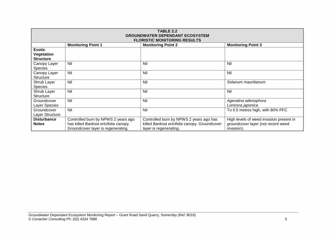
Groundwater Dependant Ecosystem Monitoring Report – Grant Road Sand Quarry, Somersby (Ref: 8016) © Conacher Consulting Ph: (02) 4324 7888 5
TABLE 2.2 GROUNDWATER DEPENDANT ECOSYSTEM
FLORISTIC MONITORING RESULTS
Monitoring Point 1 Monitoring Point 2 Monitoring Point 3
Exotic Vegetation Structure
Canopy Layer Species
Nil Nil Nil
Canopy Layer Structure
Nil Nil Nil
Shrub Layer Species
Nil Nil Solanum mauritianum
Shrub Layer Structure
Nil Nil Nil
Groundcover Layer Species
Nil Nil Ageratina adenophora Lonicera japonica
Groundcover Layer Structure
Nil Nil To 0.5 metres high, with 80% PFC
Disturbance Notes
Controlled burn by NPWS 2 years ago has killed Banksia ericifolia canopy. Groundcover layer is regenerating.
Controlled burn by NPWS 2 years ago has killed Banksia ericifolia canopy. Groundcover layer is regenerating.
High levels of weed invasion present in groundcover layer (not recent weed invasion).
Groundwater Dependant Ecosystem Monitoring Report – Grant Road Sand Quarry, Somersby (Ref: 8016) © Conacher Consulting Ph: (02) 4324 7888 6
2.2 QUALITATIVE MONITORING RESULTS i. GDE Surface Erosion and Sedimentation Results No surface erosion attributable to the quarry operations was observed within any of the GDE areas shown in Figure 1.1 during the monitoring surveys. ii. Assessment of Groundwater Monitoring Data The Water Monitoring Report prepared by Larry Cook and Associates (2018) has identified no potential impacts from approved quarrying activities on the aquifer system underlying the site for the 2017 monitoring period. iii. GDE Photo Point Results The results of the photo point surveys are provided in Table 2.3.

Groundwater Dependant Ecosystem Monitoring Report – Grant Road Sand Quarry, Somersby (Ref: 8016) © Conacher Consulting Ph: (02) 4324 7888 7
TABLE 2.3 GROUNDWATER DEPENDANT ECOSYSTEM COMPARITIVE QUADRAT MONITORING PHOTOGRAPHS
Northern Aspect Eastern Aspect Southern Aspect Western Aspect
MQ1 2016
MQ1 2017
MQ2 2016

Groundwater Dependant Ecosystem Monitoring Report – Grant Road Sand Quarry, Somersby (Ref: 8016) © Conacher Consulting Ph: (02) 4324 7888 8
TABLE 2.3 GROUNDWATER DEPENDANT ECOSYSTEM COMPARITIVE QUADRAT MONITORING PHOTOGRAPHS
Northern Aspect Eastern Aspect Southern Aspect Western Aspect
MQ2 2017
MQ3 2016
MQ3 2017

Groundwater Dependant Ecosystem Monitoring Report – Grant Road Sand Quarry, Somersby (Ref: 8016) © Conacher Consulting Ph: (02) 4324 7888 9
SECTION 3
COMPLIANCE WITH PERFORMANCE MEASURES 3.1 EROSION The performance target for erosion is that negligible erosion of the surface within the GDEs occurs as a result of adverse impact attributable to the quarry operations authorised under the project approval. The trigger level for management intervention is observable erosion of the surface within the GDEs, directly attributable to the quarry operations authorised under the project approval. No surface erosion within GDE areas attributable to the quarry operations was observed and no management intervention is required. 3.2 SEDIMENTATION The performance target for sedimentation is that negligible sedimentation within the GDEs occurs as a result of adverse impact attributable to the quarry operations authorised under the project approval. The trigger level for management intervention is observable sedimentation within the GDEs, directly attributable to the quarry operations authorised under the project approval. No sedimentation within GDE areas attributable to the quarry operations was observed and no management intervention is required. 3.3 GROUND WATER DEPENDANT ECOSYSTEM EXTENT The performance target for GDE size is for only minor changes in the sizes of the GDEs as a result of adverse impact attributable to the quarry operations authorised under the project approval. The trigger level for management intervention is adverse change in size of the GDEs of greater than 20% mappable extent, directly attributable to the quarry operations authorised under the project approval. The GDE areas were burnt prior to site inspections undertaken in 2015 and are currently regenerating. The extent of the GDEs determined from the current air photo has identified no change in general extent. 3.4 GROUND WATER DEPENDANT ECOSYSTEM SPECIES COMPOSITION & DISTRIBUTION The performance target for species composition and distribution is for no significant change to the composition or distribution of species within the GDEs as a result of adverse impact attributable to the quarry operations authorised under the project approval. The trigger level for management intervention is adverse change in composition or distribution of the dominant species, directly attributable to the quarry operations authorised under the project approval. The GDE areas were burnt prior to site inspections undertaken in 2015 and are currently regenerating. Incidental observations have identified that the northern-most patches of GDE vegetation are still regenerating with flora species more characteristic of dry environments typical of the adjoining vegetation communities. Further changes between monitoring events are expected as these areas continue to regenerate, these changes should not be related to the quarry operations at the subject site. The GDE species composition and distribution is to be surveyed during the 2018 monitoring period to further inform determination of any adverse changes attributable to the quarry operations.

Groundwater Dependant Ecosystem Monitoring Report – Grant Road Sand Quarry, Somersby (Ref: 8016) © Conacher Consulting Ph: (02) 4324 7888 10
3.5 MITIGATION AND RESPONSE MEASURES Monitoring has identified that all performance targets have been met for GDEs and requirement for mitigation or response measures has not been triggered in relation to 2017 site operations.

Groundwater Dependant Ecosystem Monitoring Report – Grant Road Sand Quarry, Somersby (Ref: 8016) © Conacher Consulting Ph: (02) 4324 7888 11
SECTION 4
CONCLUSIONS & RECOMMENDATIONS 4.1 CONCLUSIONS The quarry operations for the 2017 monitoring period have not exceeded the compliance and performance measures for Groundwater Dependant Ecosystems. 4.2 RECOMMENDATIONS The implementation of mitigation and response measures in relation to the 2017 quarry operations is considered not necessary.

Groundwater Dependant Ecosystem Monitoring Report – Grant Road Sand Quarry, Somersby (Ref: 8016) © Conacher Consulting Ph: (02) 4324 7888 12
5. REFERENCES Bell (2007) Review of Flora and Fauna Information for Grants Road Sands, Gosford LGA. Bell, S.A.J. 2009. The natural vegetation of the Gosford Local Government Area, Central Coast, New
South Wales: Revised and Updated. Report to Gosford City Council. Eastcoast Flora Survey. Bell, S.A.J. (2013) Review of vegetation mapping, Gosford LGA: addressing vegetation loss since
2004. Unpublished Report to Gosford City Council. November 2013. Eastcoast Flora Survey. Larry Cook Consulting P/L (2018) Water Monitoring Period 1.1.17-21.12.18 Grants Road Sand
Quarry. Unpublished Report prepared for Grants Road Sand. NSW Scientific Committee 2012, Coastal Upland Swamp in the Sydney Basin Bioregion –
endangered ecological community listing, NSW Scientific Committee Final Determination. Available Online: http://www.environment.nsw.gov.au/determinations/coastaluplandswampfd.htm
Water Sharing Plan for the Kulnura Mangrove Mountain Groundwater Sources 2003. New South
Wales Government.
DRAFTDRAFT
Grants Road Sand Quarry – Annual Report Reporting period 1 January to 31 December 2017
Peter Andrews + Associates Pty Ltd March 2017
paa.design.architecture.planning.urban design.landscape architecture
Appendix 7 BIODIVERSITY SOMERSBY MINTBUSH
Conacher Consulting

THIRD ANNUAL MONITORING REPORT
FOR
SOMERSBY MINTBUSH 2017 MONITORING PROGRAM
GRANTS ROAD SAND QUARRY EXTENSION
MARCH 2018 REF: 8016

PREFACE This report has been prepared by Conacher Consulting to address the 2017 annual monitoring and reporting requirements for Somersby Mintbush for the approved extension to the Grants Road Sand Quarry at Somersby. REPORT PREPARED BY: PHILLIP ANTHONY CONACHER B.Sc.(Hons), Dip.Urb Reg Planning, M.Nat.Res. NPWS Scientific Licence Number: SL100361 Project Director JACOB MANNERS B.Sc., MWldMgt. NPWS Scientific Licence Number: SL100361 Senior Ecological Consultant / Project Manager

TABLE OF CONTENTS
1. INTRODUCTION & BACKGROUND .......................................................................... 1
1.1 Document Intent ........................................................................................... 1
1.2 Project Site Details ........................................................................................ 1
1.3 Previous Monitoring Results ......................................................................... 1
2. 2017 MONITORING RESULTS .................................................................................. 2
2.1 Somersby Mintbush 2017 Count Results ...................................................... 2
2.2 Qualitative Monitoring Results ....................................................................... 2
2.3 Details of Non-compliance Matters ............................................................... 5
2.4 Monitoring Trends ......................................................................................... 5
2.5 Project Impact Discrepancies ........................................................................ 5
2.6 Measures to Improve Project Performance ................................................... 5
3. Concluding Comments ............................................................................................. 6
4. REFERENCES ........................................................................................................... 7

Somersby Mintbush 2017 Monitoring Report – Grants Road Sand Quarry, Somersby (Ref: 8016) 1 © Conacher Consulting Ph: (02) 4324 7888
SECTION 1
INTRODUCTION
1.1 DOCUMENT INTENT This report has been prepared by Conacher Consulting to address the monitoring requirements of Condition 22 “Somersby Mintbush Monitoring and Management Program” of the Schedule 3 Environmental Performance Conditions specified within the Project Approval issued under Section 75J of the Environmental Planning and Assessment Act (1979) for the Grants Road Sand Quarry Extension project. 1.2 PROJECT SITE DETAILS
The project site is located within Lot 1 DP 358717, 270 Grants Road Somersby. 1.3 PREVIOUS MONITORING RESULTS 2015 Monitoring Surveys A baseline assessment of the Prostanthera junonis locations previously identified adjacent to the site and described as Population 7 Reservoir Road Brisbane Water National Park was undertaken on 23 October 2015 and 7 November 2015. No specimens of P. junonis were observed during the baseline surveys as the locations where this species was previously identified had been subject to a controlled burn undertaken by NPWS. Previous contact with the National Parks and Wildlife Service confirmed that a hazard reduction burn was undertaken on 8-11 October with very high to extreme fuel loads which burnt very well over the three days emitting large smoke plumes. NPWS identified that the fire was limited to within 100m of the subject site, however field surveys identified that the burn was directly adjacent to the site and in some places burnt vegetation within the offset area on the site. Review of the Somersby Mintbush Recovery Plan has identified that the time of the previous fire in this location was 1994. The previous location of P. junonis identified along the Great North Walk track showed noticeable signs of erosion caused by inadequate track maintenance and poor design. 2016 Monitoring Surveys Regrowth of P. junonis was observed at subpopulations 3 and 4. Two flowering plants were detected at sub-population 3 where none were detected in recent years, several juvenile non-flowering plants were also recorded. No flowering plants and several juvenile non-flowering plants were observed at the location of sub-population 4. The low numbers of flowering plants detected and evidence of regrowth plants was considered to be a result of the NPWS hazard reduction burn undertaken during October 2015.

Somersby Mintbush 2017 Monitoring Report – Grants Road Sand Quarry, Somersby (Ref: 8016) 2 © Conacher Consulting Ph: (02) 4324 7888
SECTION 2
2017 MONITORING RESULTS
2.1 SOMERSBY MINTBUSH 2017 COUNT RESULTS Counts of flowering P. junonis plants were undertaken on 13 November 2017 and 27 November 2017 and at each of the Somersby Mintbush subpopulation locations adjacent to the quarry allotment identified by NSW NPWS (2000). Plant clumps were identified and counted as any flowering P. junonis plants in a patch with a separation distance of ≤30cm from the nearest P. junonis plant. The results of the counts are provided in Table 2.1 and the locations of the sub-populations are shown in Figure 2.1.
TABLE 2.1 SOMERSBY MINT BUSH CUMULATIVE COUNT RESULTS
Sub-Population Number
2015 Count Results
2016 Count Results 2017 Count Results
1 0 0 0
2 0 0 0
3 0 2 flowering plants (several non-flowering
juvenile regrowth plants observed)
3 clumps containing 18 flowering plants
4 0 No flowering plants several non-flowering
juvenile plants observed
12 clumps containing 34
flowering plants
2.2 QUALITATIVE MONITORING RESULTS The following performance indicators have been developed with regard to P. junonis.
Prevention of any erosion of the surface of areas containing Somersby Mintbush as a result of actions associated with the approved extraction operations
Prevention of sedimentation within areas containing Somersby Mintbush as a result of actions associated with the approved extraction operations
Prevention of reduction in the area of the sites containing Somersby Mintbush as a result of actions associated with the approved extraction operations.
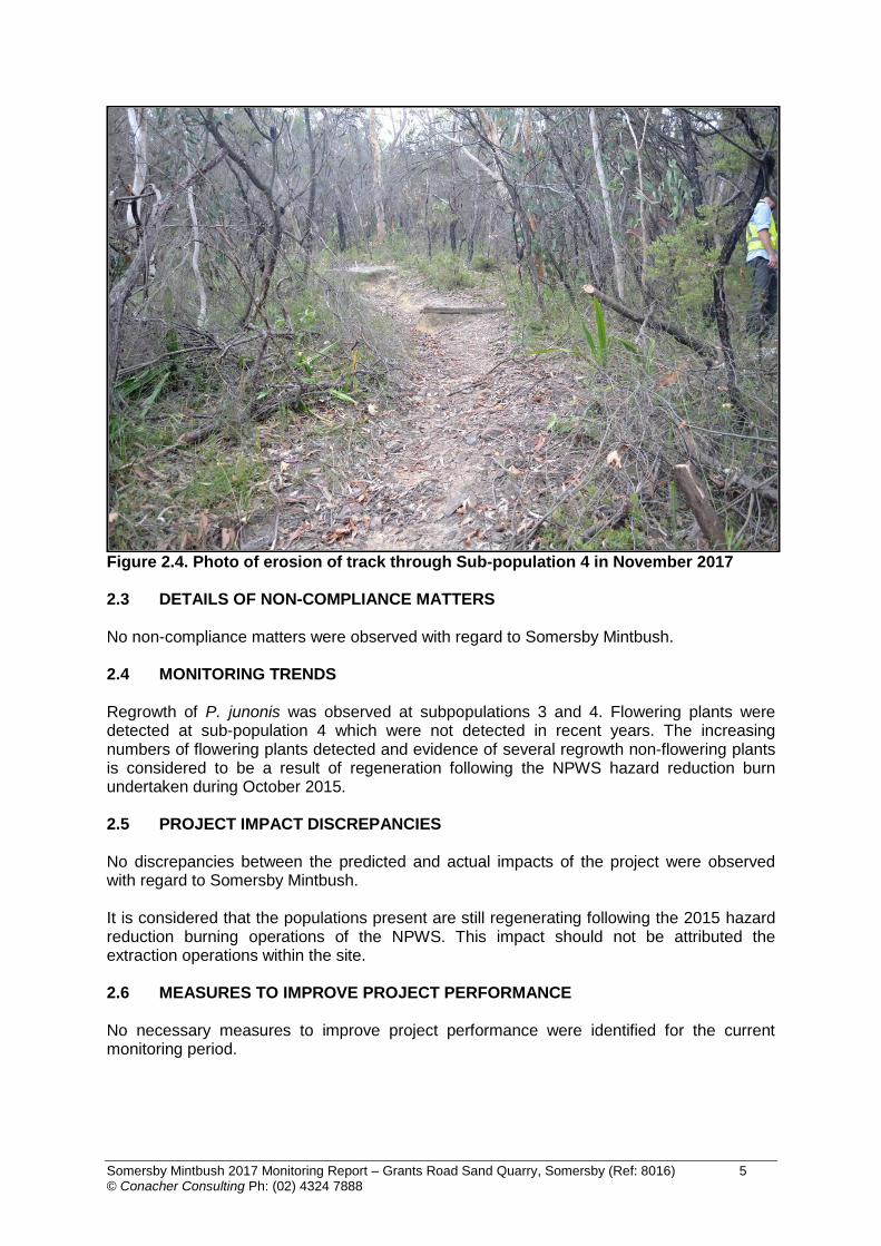
No visible signs of disturbance to P. junonis or its habitats as a result of quarry activities were observed. Photographs of the habitats at subpopulations 3 and 4 during the 2017 monitoring period are provided in Figures 2.2 to 2.4. Erosion of the track through subpopulation 4 was observed in previous years. No noticeable NPWS maintenance of this track within the Brisbane Water National Park has occurred since the commencement of monitoring.

Somersby Mintbush 2017 Monitoring Report – Grants Road Sand Quarry, Somersby (Ref: 8016) 3 © Conacher Consulting Ph: (02) 4324 7888

Somersby Mintbush 2017 Monitoring Report – Grants Road Sand Quarry, Somersby (Ref: 8016) 4 © Conacher Consulting Ph: (02) 4324 7888
Figure 2.2 Photo Point 1 Sub-population 3 habitat in November 2017
Figure 2.3 Photo Point 2 Sub-population 4 habitat in November 2017
Somersby Mintbush 2017 Monitoring Report – Grants Road Sand Quarry, Somersby (Ref: 8016) 5 © Conacher Consulting Ph: (02) 4324 7888
Figure 2.4. Photo of erosion of track through Sub-population 4 in November 2017 2.3 DETAILS OF NON-COMPLIANCE MATTERS No non-compliance matters were observed with regard to Somersby Mintbush. 2.4 MONITORING TRENDS
Regrowth of P. junonis was observed at subpopulations 3 and 4. Flowering plants were detected at sub-population 4 which were not detected in recent years. The increasing numbers of flowering plants detected and evidence of several regrowth non-flowering plants is considered to be a result of regeneration following the NPWS hazard reduction burn undertaken during October 2015.
2.5 PROJECT IMPACT DISCREPANCIES No discrepancies between the predicted and actual impacts of the project were observed with regard to Somersby Mintbush. It is considered that the populations present are still regenerating following the 2015 hazard reduction burning operations of the NPWS. This impact should not be attributed the extraction operations within the site. 2.6 MEASURES TO IMPROVE PROJECT PERFORMANCE No necessary measures to improve project performance were identified for the current monitoring period.
Somersby Mintbush 2017 Monitoring Report – Grants Road Sand Quarry, Somersby (Ref: 8016) 6 © Conacher Consulting Ph: (02) 4324 7888
SECTION 3
CONCLUDING COMMENTS
3.1 CONCLUDING COMMENTS The following concluding comments are provided:
i. Further counts of the previously identified locations of P. junonis should be undertaken during the 2018 monitoring period.
ii. Suitable erosion and sedimentation controls should continue to be maintained for the
site.
iii. The plants and associated habitats present are continuing to regenerate following the 2015 hazard reduction burning operations of the NPWS.

Somersby Mintbush 2017 Monitoring Report – Grants Road Sand Quarry, Somersby (Ref: 8016) 7 © Conacher Consulting Ph: (02) 4324 7888
4. REFERENCES
Conacher Consulting (2016) Somersby Mintbush 2015 Monitoring Report, Grants Road
Sand Quarry Extension Lot 1 DP 358717 270 Grants Road Somersby. Conacher Consulting (2017) Somersby Mintbush 2016 Monitoring Report, Grants Road
Sand Quarry Extension Lot 1 DP 358717 270 Grants Road Somersby. NSW National Parks and Wildlife Service (2000) Somersby Mintbush Prostanthera junonis
Recovery Plan. NSW NPWS. Hurstville NSW.

DRAFTDRAFT
Grants Road Sand Quarry – Annual Report Reporting period 1 January to 31 December 2017
Peter Andrews + Associates Pty Ltd March 2017
paa.design.architecture.planning.urban design.landscape architecture
Appendix 8 LANDSCAPE & REHABILITATION MONITORING
Conacher Consulting

2017 MONITORING REPORT FOR
LANDSCAPE AND REHABILITATION MANAGEMENT PLAN &
BIODIVERSITY OFFSET MANAGEMENT PLAN
GRANTS ROAD SAND QUARRY
MARCH 2018 REF: 0816/3

2017 Monitoring Report - Landscape & Rehabilitation Management Plan Grants Rd Sand Quarry (Ref: 8016/3)
© Conacher Consulting Pty Ltd Ph: (02) 4324 7888 1
1 INTRODUCTION This Report has been prepared by Conacher Consulting to outline the implementation and monitoring requirements of Project Approval Condition No. 27 (Landscape and Rehabilitation Management Plan) for the Grants Road Quarry Extension (Application No. 08-0099) The Landscape and Rehabilitation Management Plan (LRMP) for the Grants Road Sand Quarry (Conacher Consulting November 2015) was approved by the Department of Planning and Environment in December 2015. The LRMP separated the management and rehabilitation of the site into the following three distinct components:
- Biodiversity Offset Area Management Plan - Buffer Area Landscape Management Plan - Quarry Rehabilitation Plan.
Reporting on actions undertaken and monitoring of actions for each of the above Plans are provided in in the following sections of this Report. The implementation of some of the actions required in the offset area have been delayed during the 2017/2018 reporting period due to a proposal to modify the location and size of the offset area. This proposed modification includes the incorporation of mature growth eucalypt forest located on land to the south that has recently been purchased by the owners of the quarry. Recent advice from the Department of Planning and Environment is that the application to amend and extend the offset area is in its final stages. 2 BIODIVERSITY OFFSET AREA MANAGEMENT PLAN The Biodiversity Offset Area Management Plan is required to be implemented in conjunction with the extension of the quarry area into the Stage 2 areas. Notwithstanding this requirement, several actions have been implemented over the reporting period. This will provide some baseline data for evaluating future management actions within the Biodiversity Offset Area. The works implemented or underway in relation to the Biodiversity Offset Area are noted in Table 1. Continued monitoring of these actions will be undertaken in the 2018 reporting period.
TABLE 1 (cont.) ACTIONS IMPLEMENTED IN THE BIODIVERSITY OFFSET AREA
ACTIONS
COMMENTS
SIT
E R
ES
OU
RC
E
MA
PP
ING
A1 Complete micro habitat/site features mapping
Microhabitat / site features mapping completed and field checked
A2 Identify and analyse soil erosion/sediment problems
Inspections completed – No issues arising
A3 Identify surface drainage features Completed in association with A1 above
A4 Identify habitat enhancement needs
Commenced, ongoing

2017 Monitoring Report - Landscape & Rehabilitation Management Plan Grants Rd Sand Quarry (Ref: 8016/3)
© Conacher Consulting Pty Ltd Ph: (02) 4324 7888 2
TABLE 1 (cont.) ACTIONS IMPLEMENTED IN THE BIODIVERSITY OFFSET AREA
ACTIONS
COMMENTS
VE
GE
TA
TIO
N A
ND
WE
ED
MA
NA
GE
ME
NT
B1 Collect soil samples for nutrient testing
Placed on hold pending results of amendment to offset areas
B2 Map main weed occurrences Weed Plan completed
B3 Develop weed management strategy
Weed Management Strategy commenced – to be finalised after offset
amendment completed
B4 Prepare revegetation strategy Not commenced. Awaiting outcome of offset area amendment.
B5 Collect suitable seeds for revegetation
Awaiting outcome of offset area amendment.
B6 Implement revegetation strategy Awaiting outcome of offset area amendment.
FE
NC
ING
C1 Identify deer exclusion fencing requirements
Underway
C2 Construct deer exclusion fencing
Awaiting outcome of offset area amendment.
C3 Maintain deer exclusion fencing Not commenced
HA
BIT
AT
EN
HA
NC
EM
EN
T D1 Implement habitat
enhancement Underway, awaiting outcome of offset
area amendment.
D2 Install 36 nest boxes, record locations
36 Nest boxes installed. Tree locations to be recorded
D3 Salvage environmental/habitat resources
Clearing not commenced as yet
D4 Undertake pre-clearance surveys Not required as yet
RE
PO
RT
ING
/MO
NIT
OR
ING
E1 Re-assess risks to implementation of action
Not required as yet
E2 Implement adaptive response strategies
Not required as yet
E3 Implement monitoring and reporting strategy to cover:
- Nestboxes Nest boxes monitored in 2017. 2 boxes fallen and some in need of repairs.
- Weed control Weed control underway in north-east offset area.
- Vegetation growth/condition
Not required as yet
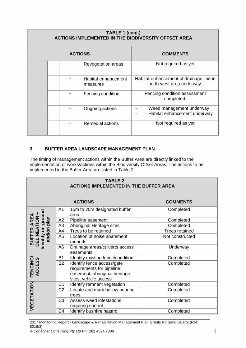
2017 Monitoring Report - Landscape & Rehabilitation Management Plan Grants Rd Sand Quarry (Ref: 8016/3)
© Conacher Consulting Pty Ltd Ph: (02) 4324 7888 3
TABLE 1 (cont.) ACTIONS IMPLEMENTED IN THE BIODIVERSITY OFFSET AREA
ACTIONS
COMMENTS
- Revegetation areas Not required as yet
- Habitat enhancement measures
Habitat enhancement of drainage line in north-west area underway.
- Fencing condition Fencing condition assessment completed.
- Ongoing actions - Weed management underway - Habitat enhancement underway
- Remedial actions Not required as yet
3 BUFFER AREA LANDSCAPE MANAGEMENT PLAN The timing of management actions within the Buffer Area are directly linked to the implementation of works/actions within the Biodiversity Offset Areas. The actions to be implemented in the Buffer Area are listed in Table 2.
TABLE 2 (cont.) ACTIONS IMPLEMENTED IN THE BUFFER AREA
ACTIONS
COMMENTS
BU
FF
ER
AR
EA
DE
LIN
EA
TIO
N –
Iden
tify
on
-gro
un
d
an
d/o
n p
lan
A1 15m to 20m designated buffer area
Completed
A2 Pipeline easement Completed
A3 Aboriginal Heritage sites Completed
A4 Trees to be retained Trees retained
A5 Location of noise abatement mounds
Not constructed
A6 Drainage areas/culverts access easements
Underway
FE
NC
ING
/
AC
CE
SS
B1 Identify existing fence/condition Completed
B2 Identify fence access/gate requirements for pipeline easement, aboriginal heritage sites, vehicle access
Completed
VE
GE
TA
TIO
N
C1 Identify remnant vegetation Completed
C2 Locate and mark hollow bearing trees
Completed
C3 Assess weed infestations requiring control
Completed
C4 Identify bushfire hazard Completed

2017 Monitoring Report - Landscape & Rehabilitation Management Plan Grants Rd Sand Quarry (Ref: 8016/3)
© Conacher Consulting Pty Ltd Ph: (02) 4324 7888 4
TABLE 2 (cont.) ACTIONS IMPLEMENTED IN THE BUFFER AREA
ACTIONS
COMMENTS
management needs by machinery slashing or stock grazing
C5 Summarise vegetation management in aboriginal heritage sites
Not commenced yet
C6 Identify vegetation management for noise abatement mounds
Locations identified but not constructed yet.
DR
AIN
AG
E A
ND
LA
ND
MA
NA
GE
ME
NT
D1 Identify through drainage from quarry area and pipeline easement
Completed
D2 Inspect for soil erosion or sediment accumulations
Completed
D3 Maintain area free of rubbish accumulations
No rubbish accumulated
4 QUARRY AREA REHABILITATION Resource extraction continued within the existing quarry pit in 2016. Rehabilitation of the Precinct A area is to be undertaken on a progressive basis after the extraction level for the resource is reached in this Stage, as identified in the approved Quarry Rehabilitation Plan. 5 CALCULATIONS FOR REHABILITATION BOND The Conservation and Rehabilitation Bond Calculation Report (Conacher Consulting December 2016 Ref: 4143/6) was prepared to address Condition No. 28 of Schedule 3 of the approval. This Report calculated that the Conservation and Rehabilitation Bond be set at $306,000.00. This figure has been accepted by the Department of Planning and Environment. The financial arrangements for the rehabilitation bond have been finalised. 6 MONITORING AND COMPLIANCE Details of Non-compliance Matters No non-compliance matters have been observed Monitoring Trends No monitoring trends have been observed Project Impact Discrepancies No discrepancies between the predicted and actual impacts of the project were observed with regard to Landscape and Rehabilitation matters.

2017 Monitoring Report - Landscape & Rehabilitation Management Plan Grants Rd Sand Quarry (Ref: 8016/3)
© Conacher Consulting Pty Ltd Ph: (02) 4324 7888 5
Measures to Improve Project Performance Discussions have identified that quarterly meetings and inspections between the operators and project consultants to be undertaken during the 2018 reporting period. 7 RECOMMENDATIONS No changes to the Landscape and Rehabilitation Management Plan are considered necessary at this stage. The Biodiversity Offset Management Plan will require amendments to accommodate changes resulting from the proposed modifications to the offset areas.