Appendix 3: City and Town Centre Health Checks · Retailer Representation and Retailer Demand ......
93
Stoke Retail & Leisure Study A081961 10/02/2014 Appendix 3: City and Town Centre Health Checks
Transcript of Appendix 3: City and Town Centre Health Checks · Retailer Representation and Retailer Demand ......

4
Stoke Retail & Leisure Study
A081961 10/02/2014
Appendix 3: City and Town Centre Health Checks

1
CITY OF STOKE-ON-TRENT - HEALTH CHECK ASSESSMENTS
Introduction
Set out in this Appendix is WYG’s assessment of the vitality and viability of the key centres in the City of Stoke-on-Trent, namely Stoke City centre, Burslem, Fenton,
Longton, Meir, Stoke Town and Tunstall town centres. A comprehensive and detailed evidence base is outlined in the following sections for these centres, with original
survey work undertaken at the centres in order to determine the diversity of use and overall provision of services in these locations. WYG has also drawn on the findings
from the previous North Staffordshire Retail and Leisure Study (2005 – 2021) of August 2005 and, where possible, have made comparisons with the previous data to
identify any historic changes in the centres.
The Importance of Town Centres
The National Planning Policy Framework (NPPF, March 2012) emphasises the need for local authorities to monitor the health of their town centres and determine how
they are changing over time. Indeed, vital and viable town centres help to foster civic pride, promote local identity and contribute towards the aims of sustainable
development. The NPPF states that local authorities should set out policies for the management and growth of centres over the plan period. The Framework requires local
authorities to recognise town centres as the heart of their communities and to pursue policies to support their vitality and viability. It is recognised that competitive town
centre environments should be promoted in order to ensure customer choice, a diverse retail offer and to reflect the individuality of town centres.
Town centres have an important role to play in serving the needs of the local community. They form a focal point for the area and provide a wide range of services that
are accessible to the population, including retail, employment, leisure and education facilities.
Since the turn of the century, town centres nationally have witnessed high levels of vitality and viability with strong retail sales growth and the implementation of major
town centre redevelopment schemes. Therefore, despite the growth of out-of-centre retail development, development activity has been focused within established
centres primarily linked to the ambitious expansion plans of national department stores and key retailers such as Debenhams, Primark and Next. However, the recent
recession has had an impact on consumer spending which in turn has had a negative impact on the vitality of the high street nationally. This has led to an increase in
vacancy rates within many town centres, as retailers attempt to compete in a challenging market and landowners struggle to let their stores to operators.

2
Purpose of the Health Check
It is important that these centres therefore remain competitive in light of increased competition and continue to attract shoppers, visitors and businesses. To achieve this,
they must continually strive to build on their strengths, alleviate their weaknesses and improve the facilities they provide to the community.
Town Centre Health Check Indicators
The NPPF recognises the importance of local authorities preparing an up-to-date and sound evidence base to plan positively for town centre uses. In particular, it is noted
that this evidence base should be used to assess the role and function of town centres and the relationship between them, including any trends in the performance of the
centres. Although the Framework does not provide a list of indicators which should be used to assess the health of a centre, the former Planning Policy Statement (PPS) 4:
Planning For Sustainable Economic Growth (December 2009) had set out a number of key indicators which should be monitored on a regular basis in order to judge the
health of a centre and its performance over time. The performance indicators outlined in PPS4 comprised the following:
Diversity of Main Town Centre Uses
The indicator makes reference to the need to review the diversity of main town centre uses (by number, type and amount of floorspace). This will include reviewing the
different function of each unit to determine whether it represents a convenience, comparison, retail service, leisure service or financial and business service use. This
information is obtained from Experian Goad, though it should be noted that smaller centres are less likely to have been surveyed by Experian. The analysis by WYG compares
the proportion of different uses in each centre against the UK national average rates.
The Amount of Retail, Leisure and Office Floorspace in Edge-of-Centre and Out-of-Centre Locations
In addition to reviewing the diversity of retail, leisure and office uses in a town centre, there is also a requirement to review the quantum of floorspace which exists in edge-
of-centre and out-of-centre locations. The NPPF defines that retail units at edge-of-centre locations are defined as being well connected and up to 300 metres from the
Primary Shopping Area of the town centre, and that for all other main town centre uses, it should be within 300 metres of a town centre boundary.
Potential Capacity for Growth or Change
This indicator involves a review of the opportunities available for the centre to expand or consolidate, with this information typically measured in the amount of land available
for new or more intensive forms of town centre development. The indicator also requires the review of any extant or emerging planning permissions for new town centre
uses, both within and out of the centre. In addition, land which has been allocated within the development plan for town centre uses and which may have not come forward
and/or which may be vacant will also be identified to assess any potential new development sites for town centre uses.

3
Retailer Representation and Retailer Demand
This indicator should be used to determine the existing retailer representation in a given centre and intentions to change representation within centres, including the
demand of retailers wanting to come into a centre. The Estates Gazette database (EGI) is used to identify commercial demand and retailer requirements for floorspace in
town centres, whilst also recognising that this source only represents a limited number of operators. WYG note that such requirement searches will also not identify
independent retailers considering premises in the area. In addition, it should be noted that retailer demand can also be strongly influenced by the provision of new
schemes being made available and effectively marketed. The analysis can also include a review of the number of national or independent retailers which are present
within a centre, recognising that multiple retailers (such as Boots, Marks & Spencer and Debenhams) can act as anchor tenants in the centre, thus adding to its appeal
and attracting a greater number of shoppers. Venuescore’s UK Shopping Venue Rankings (2013) is used to identify the retail hierarchy of the centres, using a weighted
scoring system which takes account of the presence in each location of multiple retailers.
Shopping Rents
An analysis of the rate of Zone A shopping rental patterns in the primary shopping area of a town centre can provide an important indication of the overall strength and
competitiveness of the centre. It is also important to review the movement of rental patterns over a few years and compare the figures with other nearby centres. Zone A
rents is defined as the value for the first six metres of floorspace in retail units from the shop window. The data can be obtained from Estates Gazette, which uses Colliers
CRE’s data in respect of open market Zone A rents.
Vacant Street-Level Property
The number of vacant units within a centre can provide a good indication of how a shopping centre is performing. However, care should be taken when interpreting
figures. Vacancies can occur for positive as well as negative reasons; for example, the opening of a new retail centre elsewhere in a town may draw retailers from older
properties or more peripheral areas of the city. Vacant units will therefore be found in even the strongest of town centres. For example, some properties may lay vacant
because they are poorly maintained, unsuited to modern retailing requirements or are simply not being actively marketed. However, they can be a useful indicator of the
level of demand. Conversely, a low vacancy rate does not necessarily mean that a centre is performing well. For example, if there is a proliferation of charity shops and
other uses not usually associated with a town centre it may be a sign of decline, particularly where these uses are located in prime locations.

4
Commercial Yields
The commercial yield on non-domestic property data is obtained from the Valuation Office Agency (July 2008) and is deemed a reliable indicator of general health as it
reflects investor confidence in a centre. The yield value is calculated by determining the open market rent of a unit as a percentage of its capital value. A low yield
generally indicates that a town is considered to be attractive and, as a result, be more likely to attract investment than a town with high yields. The data can also
demonstrate the confidence of investors in the long-term profitability of the centre for retail, office and other commercial developments. It should be noted that the 2008
data is the most up-to-date information from the Agency as no further updates have been produced.
Land Values
The land value of a site and the length of time it may have remained undeveloped can provide an important indication as to how flexible the planning policies on the site
can be and can help to inform planning decisions. However, it should be recognised that each parcel of land is often subject to a unique set of circumstances, for example
physical or ownership constraints, which could affect the likelihood of the land being developed.
Pedestrian Footfall
The analysis of the pedestrian footfall of a town centre is deemed as a key indicator of the vitality of the area. It is measured by recording the number and movement of
people in different areas of a centre.
Accessibility
The accessibility of a centre is a key measure of its vitality and viability, noting that this will be determined by the ease and convenience of access by a choice of means of
travel (including the quality, quantity and type of car parking; the frequency and quality of public transport services; and the range of customer origins served), quality of
provision for pedestrians, cyclists and disabled people and the ease of access from the main arrival points to the main attractions in the centre.
Customer and Residents’ Views and Behaviour
Regular surveys are often used by local authorities to obtain the views of customers and residents in their area, with the findings often helpful for monitoring and
evaluating the effectiveness of town centre improvements and for identifying future priorities. The survey can either be undertaken in the town centre or at home, with
WYG regularly appointing survey companies to determine the pattern of retail and leisure expenditure patterns in the local area and to establish the degree of linked trips.

5
Perception of Safety and Occurrence of Crime
The perception of the safety and security of a town centre can include a number of indicators, for example: the number of CCTV systems in operation; the crime levels;
the police presence in the street; whether there is a Pub Watch/Street Watch scheme in operation; and any other issues associated with the night-time economy.
Town Centre Environmental Quality
The final indicator requires a review of the quality of the town centre environment, including an assessment of the positive and negative factors affecting environmental
quality, such as the provision of trees, open spaces and landscapes, as well as potential problems, including noise, clutter, litter and graffiti.

6
Health Check Indicator – Overall Diversity of Main Town Centre Uses
Table 1: Diversity of Use Figures of the Centres
August 2013 Convenience Comparison Retail Service Leisure Service Financial/Business Service Vacant
No. % No. % No. % No. % No. % No. %
Stoke City Centre 23 4.1% 192 34.0% 69 12.2% 105 18.6% 64 11.3% 111 19.7%
Burslem Town Centre 7 4.0% 39 22.2% 17 9.7% 43 24.4% 24 13.6% 46 26.1%
Fenton Town Centre 5 12.8% 10 25.6% 4 10.3% 7 17.9% 2 5.1% 11 28.2%
Longton Town Centre 20 8.8% 69 30.3% 32 14.0% 26 11.4% 29 12.7% 52 22.8%
Meir Town Centre 9 12.9% 18 25.7% 13 18.6% 18 25.7% 5 7.1% 7 10.0%
Stoke Town Centre 15 8.0% 39 20.9% 15 8.0% 38 20.3% 22 11.8% 58 31.0%
Tunstall Town Centre 14 6.8% 56 27.2% 27 13.1% 41 19.9% 20 9.7% 48 23.3%
Centres Average 13 6.1% 60 28.6% 25 11.9% 40 19.0% 24 11.4% 48 22.8%
UK Average* - 8.1% - 33.1% - 13.8% - 22.1% - 11.0% - 11.5%
Source: Site Visit, August 2013, *UK Average Figure, Goad, July 2013 (taken from Full Category Report averages)
Table 2: Floorspace Figures of the Centres
August 2013 Convenience Comparison Retail Service Leisure Service Financial/Business Service Vacant
Sq.m % Sq.m % Sq.m % Sq.m % Sq.m % Sq.m %
Stoke City Centre 8,740 5.6% 79,230 50.5% 6,880 4.4% 27,610 17.6% 11,100 7.1% 23,330 14.9%
Burslem Town Centre 1,110 3.2% 8,240 23.4% 1,710 4.9% 11,190 31.8% 3,750 10.7% 9,180 26.1%
Fenton Town Centre 886 9.2% 2,639 27.4% 429 4.5% 1,169 12.2% 244 2.5% 4,251 44.2%
Longton Town Centre 15,520 25.9% 20,000 33.3% 3,460 5.8% 5,620 9.4% 4,680 7.8% 10,740 17.9%
Meir Town Centre 1,656 19.8% 2,277 27.2% 986 11.8% 1,744 20.8% 483 5.8% 1,220 14.6%
Stoke Town Centre 12,310 26.8% 8,120 17.7% 1,720 3.7% 10,800 23.5% 3,660 8.0% 9,340 20.3%
Tunstall Town Centre 11,270 23.3% 16,460 34.1% 2,440 5.1% 7,610 15.8% 3,170 6.6% 7,340 15.2%
Centres Average 7,356 14.1% 19,567 37.6% 2,518 4.8% 9,392 18.0% 3,870 7.4% 9,343 21.9%
UK Average* - 14.6% - 36.6% - 7.4% - 23.0% - 8.4% - 9.3%
Source: Site Visit, August 2013, *UK Average Figure, Goad, July 2013 (taken from Full Category Report averages)

7
National and Independent Retailers - Top Retailers (Experian Goad)
Table 3: Top Comparison Retailers in the Centres
Retailer Stoke
City
Burslem Fenton Longton Meir Stoke
Town
Tunstall Crewe Stafford Newcastle-under-Lyme Congleton
Argos ���� - - ���� - - ���� ���� ���� ���� ����
BHS ���� - - - - - - ���� - - - Boots ���� ���� - ���� ���� - - ���� ���� ���� ����
Burton ���� - - ���� - - ���� ���� ���� - - Carphone Warehouse ���� - - ���� - - - ���� ���� ���� ����
Clarks ���� - - - - - - ���� ���� ���� - Clintons ���� - - - - - - ���� ���� ���� ����
Debenhams ���� - - - - - - - - - - Dorothy Perkins ���� - - ���� - - ���� ���� ���� ���� ����
H&M - - - - - - - - - - - HMV ���� - - - - - - - - - -
House of Fraser - - - - - - - - - - - John Lewis - - - - - - - - - - -
Marks & Spencer ���� - - - - - - ���� ���� - ����
New Look ���� - - - - - - ���� ���� ���� - Next ���� - - ���� - - ���� ���� ���� ���� - O2 ���� - - - - - - ���� ���� ���� -
Phones 4U ���� - - - - - - ���� ���� ���� - Primark ���� - - - - - - - - - -
River Island ���� - - - - - - ���� ���� - - Superdrug ���� - - ���� - - ���� ���� ���� ���� ����
TK Maxx ���� - - - - - - ���� ���� - - Topman/Topshop ���� - - - - - - ���� ���� - -
Vodafone ���� - - - - - - ���� ���� - - Waterstones ���� - - - - - - ���� ���� - - WHSmith ���� - - - - - - ���� ���� ���� ����
Wilkinson ���� - - ���� - - - ���� ���� ���� - Total 24 1 0 8 1 0 5 21 20 13 8
Source: Experian Goad Key Major Retailers List and WYG research via store finders search

8
Health Check Indicator – Retailer Requirements
There are a total of 152 retail and leisure operators seeking to locate within the City of Stoke-on-Trent authority area (data from EGi, 4th November 2013), including 43
clothing stores, 28 restaurants and cafes, 20 take aways outlets and 12 sports operators. In particular, EGi identified that there are requirements from several high street
chains such as B&M Bargains (which is seeking a store with a size area of 929 – 2,787 sq.m), Farmfoods (557 – 743 sq.m) and River Island (650 – 1,394 sq.m).
Health Check Indicator – Vacant Street – Level Property
Table 4 indicates the number of vacant units in each of the centres. It is evident that all of the centres (with the exception of Meir) have an above average proportion of
vacant units compared to the overall UK figure, with acute vacancies identified in Burslem, Fenton and Stoke Town. Similarly, the amount of vacant floorspace in each of
the centres is significant, with the overall centre average more than double the national figure.
Table 4: Vacant Units
Centre Total No. of Vacant Outlets % of Outlets Total Amount of Vacant Floorspace (Sq.m) % of Floorspace
Stoke City Centre 111 19.7% 23,330 14.9%
Burslem Town Centre 46 26.1% 9,180 26.1%
Fenton Town Centre 11 28.2% 4,251 44.2%
Longton Town Centre 52 22.8% 10,740 17.9%
Meir Town Centre 7 10.0% 1,220 14.6%
Stoke Town Centre 58 31.0% 9,340 20.3%
Tunstall Town Centre 48 23.3% 7,340 15.2%
Centres Average 48 22.8% 9,343 21.9%
UK Average* - 11.5% - 9.3%
Source: Site Visit, August 2013, *UK Average Figure, Goad, July 2013 (taken from Full Category Report averages)

1
Centre Overview
Stoke City centre is the principal economic and social centre in the administration area. It performs a regional role in the shopping hierarchy, with the adopted Core
Strategy identifying that it is the largest retail destination in North Staffordshire and South Cheshire. The centre is also an important leisure and business location, acting
as the main focus for economic, educational and cultural activities within the local area.
The main focus of retailing is concentrated along the pedestrianised routes of Lamb Street, Market Square and Tontine Street. These are designated as being within the
Core Strategy-defined primary shopping area, with the indoor Intu Potteries Centre also acting as the key anchor destination for shoppers within the city centre. The
secondary shopping areas of the city include Stafford Street, Piccadilly and Pall Mall, with these streets tending to accommodate a higher proportion of independent
traders. To the west of the city centre are several large out-of-centre retail and leisure parks off Etruria Road and Corbridge Road, namely Century Retail Park, Octagon
Retail Park, Festival Retail Park and Festival Heights Retail Park.
As Experian’s latest Goad survey of the centre was completed in November 2012, a site visit of Stoke City has been undertaken to update the health check analysis to
ensure it is compiled using the most up-to-date diversity of use and floorspace figures. This information has then been used to compare the relevant data with the
national average figures and, where necessary, to identify any potential issues with the centre. The survey identified that there was a total of 564 units within Experian
Goad’s defined city centre boundary, comprising a total gross floorspace of 156,890 sq.m. We have utilised the centre boundary as identified by Experian Goad for our
analysis in order to consider an extensive area and to allow a direct comparison with the national average figures (which are calculated using Experian Goad’s assessment
of the boundary of each centre).
STOKE CITY CENTRE HEALTH CHECK ASSESSMENT
2
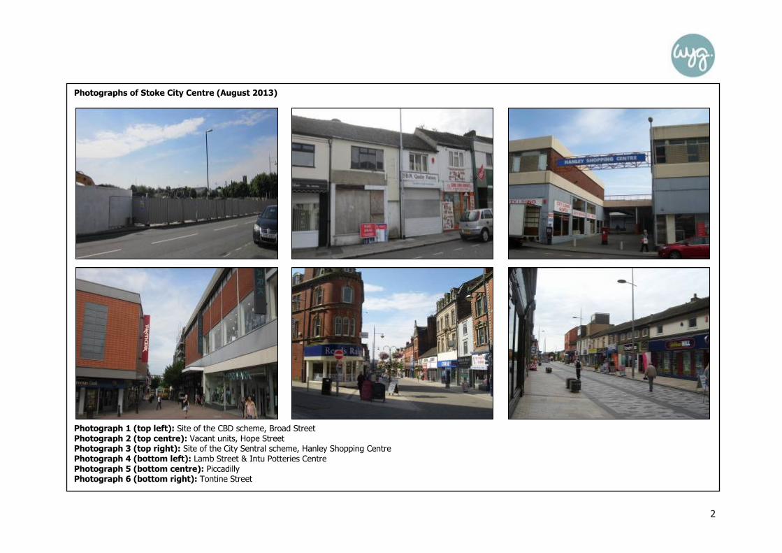
Photographs of Stoke City Centre (August 2013)
Photograph 1 (top left): Site of the CBD scheme, Broad Street
Photograph 2 (top centre): Vacant units, Hope Street Photograph 3 (top right): Site of the City Sentral scheme, Hanley Shopping Centre
Photograph 4 (bottom left): Lamb Street & Intu Potteries Centre
Photograph 5 (bottom centre): Piccadilly Photograph 6 (bottom right): Tontine Street

3
Figure 1: Land Use Plan for Stoke City Centre (August 2013)

4
Figure 2: Land Use Plan for Stoke City Centre (August 2013)

5
Table 1: Previous Number of Units in Stoke City centre (2005)
Previous Number of Units
No. Stoke City centre UK
Convenience 26 4.7% 9.2%
Comparison 282 50.8% 48.0%
Services 138 24.9% 31.1%
Vacant 100 18.0% 10.3%
Total 555 100% 100% Source: North Staffordshire Retail and Leisure Study 2005 Nb. Excluding miscellaneous
Table 3: Existing Number of Units in Stoke City centre (August 2013)
Existing Number of Units
No. Stoke City centre UK
Convenience 23 4.1% 8.1%
Comparison 192 34.0% 33.1%
Retail Service 69 12.2% 13.8%
Leisure Service 105 18.6% 22.1%
Financial and Business Service 64 11.3% 11.0%
Vacant 111 19.7% 11.5%
Total 564 100.0% 100% Source: Site Survey & Experian Goad Data – August 2013 and UK average from the Experian Goad Category Report (July 2013) Nb. This table is based on the Experian Goad city centre boundary
Table 2: Previous Floorspace in Stoke City centre (2005)
Previous Floorspace
Sq.m Stoke City centre UK
Convenience - 12.0% 17.0%
Comparison - 64.2% 53.1%
Services - 12.8% 20.8%
Vacant - 9.7% 7.8%
Total 100% 100% Source: North Staffordshire Retail and Leisure Study 2005, Floorspace figures based on Experian Goad data (January 2005), Nb. Excluding miscellaneous
Table 4: Existing Floorspace in Stoke City centre (August 2013)
Existing Floorspace
Sq.m Stoke City centre UK
Convenience 8,740 5.6% 14.6%
Comparison 79,230 50.5% 36.6%
Retail Service 6,880 4.4% 7.4%
Leisure Service 27,610 17.6% 23.0%
Financial and Business Service 11,100 7.1% 8.4%
Vacant 23,330 14.9% 9.3%
Total 156,890 100.0% 100% Source: Site Survey & Experian Goad Data – August 2013 and UK average from the Experian Goad Category Report (July 2013) Nb. This table is based on the Experian Goad city centre boundary
Health Check Indicator – Diversity of main town centre uses

6
Health Check Indicator – Diversity of main town centre uses
Convenience Goods Units
The level of convenience goods provision in Stoke city centre is below the national average, both in terms of the number of units and the quantum of floorspace. The previous
2005 North Staffordshire Study had identified that there were only 26 stores selling principally convenience goods in Stoke City, with a particular shortfall in the number of
greengrocers and butchers. Since then, the number of convenience goods businesses has declined even further, with the site visit in August 2013 identifying that there was a
total of just 23 units. There are no major foodstores within the centre boundary, with the exception of the M&S foodhall and the Iceland store on Charles Street. The remaining
convenience goods provision is generally provided for by local independent convenience traders which tend to be small in scale and are more likely to meet the everyday top-up
needs of shoppers in the area, rather than provide adequate provision for residents to undertake their main food shopping. The permanent indoor market at the Intu Potteries
Centre is the largest convenience unit in Stoke City centre (but it also sells a large proportion of comparison goods) and again although it comprises only local traders, the
Centre is a popular resource, with the in-street survey identifying that 43% of the respondents intended to visit the market on the day of their visit.
The lack of any large foodstore in Stoke City contrasts with the provision outside the centre boundary, at the out-of-centre retail parks, including the Sainsbury’s on Etruria Road
and the Morrisons store at Festival Park. The Tesco unit on New Hall Street, for example, was formerly the only major foodstore operator within the centre boundary, though
the operator is now located in a new Extra store on Clough Street to the west of the city and the remaining unit now operates as a Go Outdoors.
Comparison Goods Units
The amount of comparison goods floorspace in Stoke City reflects its city centre status and the level is significantly above the national average (50.5% compared to 36.6%).
The centre accommodates a high proportion of national retailers which tend to operate from the largest units within the primary shopping area, including BHS, Debenhams,
Marks and Spencer, Primark and TKMaxx. This provision is also complemented by a variety of independent retail traders, with a number operating within the indoor and outdoor
markets at Market Square, Fountain Square and Hinde Street car park. However, it is evident that there has been a reduction in the amount of comparison goods floorspace (by
2,870 sq.m) in the 10 months since the previous Experian Goad survey in November 2012, with several stores now vacant, including the Disney and Schuh stores at the Intu
Potteries Centre. The former Blacks outdoor store in Hanley Shopping Centre on Old Hall Street is also due to be demolished as part of the City Sentral scheme, though the
Argos and B&M Bargains stores in this location remain open for trading for the time being. The extensive retail parks (Century, Octagon, Festival and Festival Heights) to the
west and north-west of Stoke City (and outside of the centre boundary) also accommodate numerous bulky goods national operators, including B&Q, Currys and Next Home.

7
Service Units
There is an under-provision of retail services in Stoke City compared to the national average, with the 69 units comprising a total floorspace of 6,880 sq.m. Notwithstanding this,
the health and beauty sector is particularly dominant in the centre and, with the exception of two units, all of the 47 businesses are operated by local independent traders.
There are also five opticians (including Specsavers and Vision Express) and five travel agents (including Co-op Travel and Thomas Cook) in the city, with a Post Office located in
the Intu Potteries Shopping Centre.
The leisure services in the centre includes restaurants, cafes, bookmakers and public houses which are within Use Classes A3, A4, A5, C1 and D2. The sector is under
represented in Stoke City compared to the national average and there has also been a decline more recently, both in terms of the number of units and amount of floorspace,
with the closure of several cafes and bars since the previous Experian Goad survey in November 2012. Despite this, there is still a particular cluster of evening economy uses,
notably bars and nightclubs, on Foundry Street and Stafford Street. The cultural quarter area of the city also includes the Ambassador Theatres on Bagnall Street and Piccadilly,
with the Core Strategy noting that whilst the development of this hub has been a success, it needs to be further developed and its appeal widened to embrace other creative
activities.
The proportion of financial and business service units and floorspace in the centre reflects the respective national average figures, with the 64 units comprising a variety of Class
A2 uses including 15 retail banks, 13 legal firms and 13 financial advisors.
Non-Retail Units
The centre also accommodates a mix of other administrative and tourist uses which reflects its role as an important regional centre in the local area and complements its
existing retail and service offer. There are 19 offices and six government buildings in Stoke, as well as four medical services, three churches, two educational institutions, a
museum and an art gallery.

8
Health Check Indicator
The Amount of Retail, Leisure and Office Floorspace in Edge-of-Centre and Out-of-Centre Locations
In addition to the retail and service provision in Stoke City, there is also a significant amount of large warehouse units which are located in out-of-centre locations to the west of
the city centre off Etruria Road and Corbridge Road. These facilities act as key standalone destinations for shoppers in the local area, with the Core Strategy recognising that
they accommodate a type of service which could not reasonably be accommodated within the traditional city centre core, notably bulky goods retailers.
Century Retail Park is located on Etruria Road (A5010) and although it is the closest retail park to the city centre, WYG noted that there appeared to be a lack of linked trips
between the two destinations. This may be attributable to the lack of operators which are located there, with the retail park currently only comprising a Staples, Burger King and
two vacant units. A Sainsbury’s foodstore and petrol filling station are located adjacent to the retail park. A Premier Inn is also currently being developed on the opposite side of
Etruria Road, with the Tesco Extra store on Clough Street within walking distance. It has a total floorspace of approximately 3,939 sq.m (gross).
Octagon Retail Park is slightly further out from the city centre along Etruria Road and is located adjacent to the Century Retail Park. It appeared to be trading well on the day
of the site visit by WYG, with its mix of retail and leisure units, namely a BHS, CSL, DFS, Mammas and Pappas, Mecca Bingo, Next Home and Starplan bedroom furniture store,
likely to attract shoppers from a wide catchment area. The former JJB Stores unit is now vacant, with the retail park having a total floorspace (excluding the Mecca Bingo) of
approximately 10,909 sq.m (gross).
Festival Park off Cobridge Road (A53) is the largest retail and leisure park in the local area, with the 16 units offering a variety of traditionally high street operators in the
clothing and footwear sector (including New Look, Next and Outfit), household goods (Argos, B&Q and Carpet Right) and several leisure service outlets (including McDonalds
and Pizza Hut). The former Comet store is now vacant. The location of the Morrisons foodstore and petrol filling station to the north of the retail park is also likely to attract
additional shoppers and encourage them to make linked trips between the two facilities. The retail park has a total goods floorspace (excluding the leisure outlets) of
approximately 13,956 sq.m (gross).
The Festival Heights Retail Park is located to the north of Festival Park and comprises six commercial units, namely a Currys, Halfords, Harveys, KFC, M Club gym and Pets
at Home store. The retail park includes 424 customer car parking spaces and appeared to be performing well on the day of the site visit. It has a total goods floorspace
(excluding the KFC and M Club gym) of approximately 4,881 sq.m (gross).

9
Photographs of the Retail Parks (August 2013)
Photograph 7 (top left): Vacant unit (former Apollo 2000), Century Retail Park
Photograph 8 (top centre): Currys, Festival Heights Retail Park Photograph 9 (top right): Festival Heights Retail Park
Photograph 10 (bottom left): Festival Retail Park Photograph 11 (bottom centre): Morrisons, adjacent to Festival Retail Park
Photograph 12 (bottom right): Octagon Retail Park
10
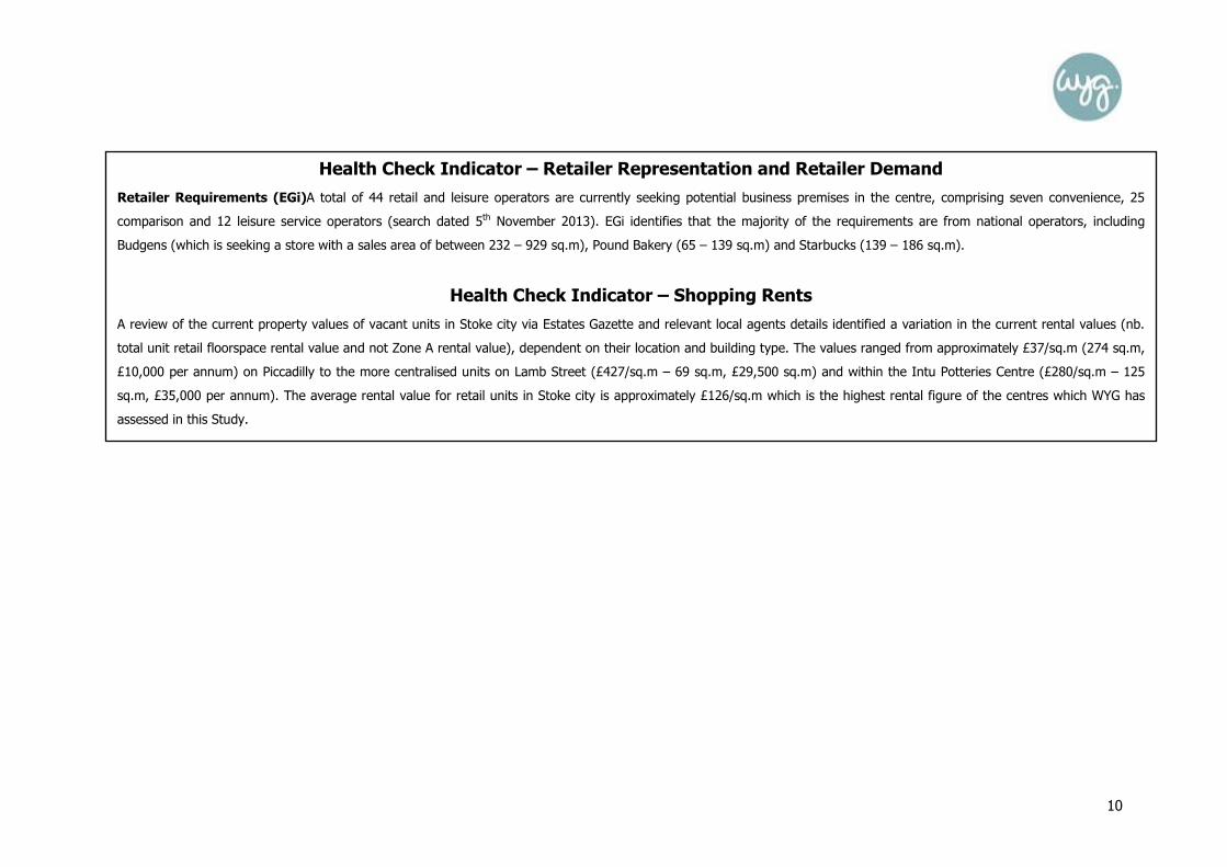
Health Check Indicator – Retailer Representation and Retailer Demand
Retailer Requirements (EGi)A total of 44 retail and leisure operators are currently seeking potential business premises in the centre, comprising seven convenience, 25
comparison and 12 leisure service operators (search dated 5th November 2013). EGi identifies that the majority of the requirements are from national operators, including
Budgens (which is seeking a store with a sales area of between 232 – 929 sq.m), Pound Bakery (65 – 139 sq.m) and Starbucks (139 – 186 sq.m).
Health Check Indicator – Shopping Rents
A review of the current property values of vacant units in Stoke city via Estates Gazette and relevant local agents details identified a variation in the current rental values (nb.
total unit retail floorspace rental value and not Zone A rental value), dependent on their location and building type. The values ranged from approximately £37/sq.m (274 sq.m,
£10,000 per annum) on Piccadilly to the more centralised units on Lamb Street (£427/sq.m – 69 sq.m, £29,500 sq.m) and within the Intu Potteries Centre (£280/sq.m – 125
sq.m, £35,000 per annum). The average rental value for retail units in Stoke city is approximately £126/sq.m which is the highest rental figure of the centres which WYG has
assessed in this Study.

11
Health Check Indicator – Vacant Street-Level Property
In August 2013, WYG identified that the 111 vacant units in Stoke city accounted for 23,330 sq.m of the total floorspace. The number of vacant outlets (19.7%) is significantly
above the national average (11.5%), with the proportion of vacant floorspace (14.9%) also well above the UK average figure (9.3%). Whilst there are very few vacant units
within the defined primary shopping area, there are particular parts in the centre where vacancies are concentred, notably along Piccadilly (a secondary shopping area) and in
the smaller units within the peripheral areas on Hope Street, New Hall Street and Marsh Street South. Although there has been a slight improvement in the level of vacancies
since November 2012 when there was 116 vacancies, there has also been the recent closure of several national retailers in the city centre, including the Republic and Disney
Store in the Intu Potteries Centre and the Blacks outdoor shop on Old Hall Street. It should be noted that the 20 vacant units which are located within the Hanley Shopping
Centre (with a floorspace of 5,060 sq.m) will be demolished as part of the City Sentral scheme, including the Blacks store. If these units are removed the proportion of vacant
units in the centre is reduced to 17.0% and the amount of vacant floorspace is lowered to 11.8%, though these figures still remain above the national average.
Photograph 13: Vacant units on Piccadilly Photograph 14: Former Blacks outdoor shop, Old Hall Street Photograph 15: Vacant unit, Pall Mall

12
Figure 3: Vacancies in Stoke City Centre (August 2013)

13
Figure 4: Vacancies in Stoke City Centre (August 2013)
14
Health Check Indicator – Pedestrian Footfall
An assessment of the general pedestrian flows in the city centre was noted during the site visit on Wednesday the 7th August 2013. It was evident that the greatest levels of
activity were within the Intu Potteries Shopping Centre and surrounding streets, notably along the pedestrianised areas of Market Square and Piccadilly, with lower levels
recorded on the more peripheral streets and to the north. Intu Potteries has provided details of pedestrian footfall in the centre and these levels have declined from a peak of
approximately 14 million in 2010 to a figure of 10.9 million for 2013 (as predicted).
Health Check Indicator – Accessibility
Road Access: The city centre boundary broadly follows the route of Potteries Way (the A50) and this provides direct access to the A53 and the A500 (Queensway). Stoke City
is located approximately 4.5km to the south east of Tunstall, 6.5km to the north west of Longton and 4.5km to the east of Newcastle-under-Lyme town centre.
Car Parking: The main city centre car parks are located within the multi-storey facilities at the Intu Potteries Centre (1,200 spaces), Bethesda Street (625 spaces), Burton Place
(457 spaces) and New Hall Street (approximately 200 spaces), with Park and Ride facilities also located on Broad Street (105 spaces) and Hinde Street (457 spaces).
Additional surface level car parking is also located at Sampson Street (220 spaces), Clough Street (170 spaces), Glass Street (90 spaces), Huntbach Street (75 spaces) and Pall
Mall (28 spaces). The parking charges (off-street) range from £0.90 for up to an hour, £2.00 for up to two hours and between £3.00 to £7.50 for all day parking, on street
parking is more expensive. The Tesco Extra customer car park is located out of the centre boundary and provides free customer parking for a maximum of two hours.
Public transport: The new bus station off Lichfield Street was opened in March 2013, with the former bus facility to be demolished as part of the later phases of the City
Sentral scheme. The nearest railway station is located off Leek Road, approximately 3km to the south west of Stoke City centre. Both offer services to the wider sub-region,
including to Newcastle-under-Lyme, Stafford and Crewe, and the wider national network.
An in-street survey was undertaken in the city centre by NEMS Market Research Limited in July 2013. The results of the survey help to provide an understanding of customer
and residents’ views and behaviours. It identified that a total of 47% of the visitors to the city centre had travelled there by car, with 37% using either a bus, minibus or coach
and 12% walked into the centre. The Intu Potteries car park was the most popular place to park, followed by the Tesco Extra customer car park on Clough Street and the on-
street spaces in the centre. Whilst most of the respondents identified that the cost of car parking was too expensive (40%), a high proportion (27%) also identified that they
parked for free and 24% stated that they were satisfied with the cost.
15
Health Check Indicator – Customer and Residents’ Views and Behaviour
The in-street visitors and household survey results identify that Stoke City scores positively on a number of the indicators. When asked what was the main reason why they
were in Stoke city, 41% of the respondents stated that they were there to go clothes or shoes shopping, (which unsurprisingly is the highest response of those interviewed in
the authority area by a significant margin), 16% were there to access financial services and 10% were there to browse. In addition, 80% of the respondents stated that it was
their first choice destination for clothing and other non-food goods shopping. This reflects its range of high street operators, including Debenhams, Primark and TKMaxx. In
contrast, a significant majority (92%) of the respondents stated that they did not intend to undertake their main food and grocery shop whilst in Stoke City that day, with 57%
stating that they would never visit the centre to undertake this type of shopping. This was the highest proportion of any of the in-centre surveys and may be attributed to the
location of many of the largest foodstores outside of the city centre boundary.
Since 2005, the average time that visitors spend in Stoke City has reduced, with the majority of respondents in 2013 (51%) intending to stay for between one and two hours,
followed by 25% of visitors stating that they intended to stay for less than an hour. In contrast, the 2005 Study had identified that 58% of the visitors were to stay for between
two and four hours, 31% were to stay for between one and two hours and only 3% were visiting for less than half an hour. In terms of the frequency of their visit however,
most of the respondents (41%) stated that they visited Stoke city about as frequently as five years ago, 21% stated that they visited more frequently and 14% visited less
frequently.
When asked how they would compare Stoke city to other undefined centres, it was rated ‘better’ or ‘much better’ by a significant proportion of the respondents, notably in terms
of the choice of high street names (64%), the choice of shops (62%) and the range of financial services (58%). One aspect where Stoke City scored less favourably was in
terms of car parking prices, with 19% of the respondents stating that they thought that cheaper parking would improve Stoke City and make it more attractive. Overall however,
37% of the respondents did not mention any particular type of shops or services they would like to see more of in Stoke City, which is the highest proportion of those
interviewed in any of the centres by a significant margin. The survey identified that 43% of the respondents intended to visit the indoor market at the Intu Potteries Centre, with
17% planning to visit the outdoor markets at Market Square and Fountain Square (8%).
The household survey (of the overall study area) identified that, unsurprisingly, Stoke City was the most popular centre for the respondents to visit (82%), with 21% of the
individuals stating that they visited the city as least once a month and 17% visited at least once a week. When asked why they do not visit the city centre, 12% of the
respondents referred to the inconveniently located car parking, with other popular responses identifying the environmental quality of the centre (10%) and the lack of choice
and range of shops (9%).

16
Health Check Indicator – Perception of Safety and Occurrence of Crime
In June 2013, there were 146 incidences of reported crime in the city centre (an improvement from 184 in May 2013 and 155 in April 2013), with 48 reports of anti-social
behaviour and 32 incidents of shoplifting (information via www.police.uk). CCTV operates in the city centre, with the 39 cameras monitored 24 hours a day. A high proportion of
the respondents to the in-street survey (26%) identified that they felt that the day time safety of Stoke City was ‘much better,’ or ‘better’ than other centres, though this
reduced to 17% when they were asked about the evening/night safety in the centre.
Health Check Indicator – Town Centre Environmental Quality
Stoke City contains a variety of modern and traditional buildings, with the majority of the southern part of the centre, which includes Albion Street and Percy Street, located
within the conservation area boundary. This historic core has a very distinctive and mixed architectural character, with many of the key landmark Edwardian and Victorian
buildings located next to units which have a more modest façade.
Overall, the standard of cleanliness in the centre is good, with little evidence of litter, graffiti or fly-posting. Several of the streets in the centre, including along Piccadilly and
Tontine Street, have also recently undergone public realm works by the Council as part of a £7.2m scheme to improve the overall environmental quality of the city. This has
enabled the installation of new paving slabs and seating areas which have made these areas appear more pedestrian-friendly. However, despite these enhancements, several
areas of the centre do still appear neglected. This is a particular issue in the peripheral parts of the city, notably in the northern areas on Hope Street and in numerous other
locations outside the primary and secondary shopping areas which have a high concentration of vacancies. In addition, many of the shops have installed roller shutters which
make these units look abandoned when the store is closed. These areas would therefore benefit from additional investment to their frontages and surrounding public spaces.
Despite this, the overall physical condition of the centre is evident having regard to the in-street survey results, with 53% of the visitors interviewed stating that they believed
that the centre environment was ‘better’ or ‘much better’ than other assessed centres. In addition, 46% of the respondents stated that they felt that the cleanliness, and 26%
considered that public art, in Stoke City was superior to the other centres.
17
Summary
On the basis of the above analysis, it is clear that Stoke city plays an important role as the key commercial and leisure centre in the region. It has many strengths and
weaknesses, as summarised below:
• It contains a high proportion of multiple retailers which attract shoppers from a wide catchment area, with the retail and leisure parks to the west of the centre
also providing some bulky goods provision;
• There is a shortfall in the amount of convenience retailers within the city centre boundary, though additional national multiple provision to cater for main food
shopping needs is available at the Morrisons, Sainsbury’s and Tesco stores which are located outside the centre boundary, to the west of the city;
• There is a strong level of public and private sector-led confidence in the centre, as demonstrated by the emerging City Sentral, Central Business District and Intu
Potteries (leisure-led) schemes;
• The environmental quality of the centre is good, though it is evident that many of the peripheral areas require additional investment to improve their overall
physical condition;
• The centre is currently ranked 70th in the national retail hierarchy and has experienced a fall of 17 places between 2006 and 2013;
• The level of vacancies is significantly above the national average, with particular concentrations recorded in several of the secondary and outlying areas of the
centre;
• The in-street visitors survey identified that visitors to the city intended to spend far less time there than in 2005; and
• The surveys also indicate that overall, there is good level of satisfaction with the facilities in the city centre, with the cost location of car parking identified as the
main issue which needed to be addressed.
In summary, Stoke City displays several strong vitality and viability indicators and it compares extremely favourably with the other key centres in the authority area. It is evident
that the main strength of the centre is the quality and quantity of the national operators which are accommodated there, with the City Sentral scheme also set to attract
additional high street retail and leisure operators if it is implemented. The main weakness is the high level of vacancies in the secondary locations of the centre and the poor
environmental quality of several of the peripheral areas. The key opportunities for Stoke City are the three new leisure, retail and office-led developments, whilst the main threat
is that vacancies could increase as operators may choose to relocate to the southern areas of the centre towards the City Sentral scheme.

18
Centre Overview
Burslem town centre is located approximately 2.5km to the north of Stoke City centre and 2km to the south of Tunstall town centre. The adopted Core Strategy identifies
that Burslem is the fifth largest centre in the City of Stoke-on-Trent and is ranked above Fenton and Meir within the centres hierarchy. Burslem was historically at the
heart of the local region’s ceramic industry, though many of these factories have since closed and have either been demolished or remain vacant. Despite this, the Core
Strategy identifies that the town centre still plays a key role as a historic and cultural destination, in addition to providing local convenience shopping and services.
The main focus for retail and service activities in Burslem is along the primary and secondary shopping areas on Queen Street, St John’s Square and Market Place.
Additional retail provision is available at the B&M Bargains on Waterloo Road and the Home Bargains store on Wycliffe Street which are both located outside of the
defined town centre boundary. Burslem also accommodates the Queens Theatre on Wedgwood Street and a Council office on Brick House Street.
A site visit to Burslem identified that there was a total of 176 units within Experian Goad’s defined town centre boundary, comprising a total gross floorspace of 35,180
sq.m. WYG have utilised the centre boundary as identified by Experian Goad rather than previous plan boundaries.
BURSLEM TOWN CENTRE HEALTH CHECK ASSESSMENT

19
Photographs of Burslem Town Centre (August 2013)
Photograph 16 (top left): Queen Street/Waterloo Road
Photograph 17 (top centre): Queen Street Photograph 18 (top right): St John’s Square
Photograph 19 (bottom left): B&M Bargains, Waterloo Road Photograph 20 (bottom centre): Burslem local centre office, Brick House Street
Photograph 21 (bottom right): Market Place

20
Figure 5: Land Use Plan for Burslem Town Centre (August 2013)

21
Table 5: Previous Number of Units in Burslem town centre (2005)
Previous Number of Units
No. Burslem UK
Convenience 10 7.3% 9.2%
Comparison 48 34.8% 48.0%
Services 41 29.7% 31.1%
Vacant 36 26.1% 10.3%
Total 138 100% 100% Source: North Staffordshire Retail and Leisure Study 2005 Nb. Excluding miscellaneous
Table 7: Existing Number of Units in Burslem town centre (August 2013)
Existing Number of Units
No. Burslem UK
Convenience 7 4.0% 8.1%
Comparison 39 22.2% 33.1%
Retail Service 17 9.7% 13.8%
Leisure Service 43 24.4% 22.1%
Financial and Business Service 24 13.6% 11.0%
Vacant 46 26.1% 11.5%
Total 176 100.0% 100% Source: Site Survey & Experian Goad Data – August 2013 and UK average from the Experian Goad Category Report (July 2013) Nb. This table is based on the Experian Goad town centre boundary
Table 6: Previous Floorspace in Burslem town centre (2005)
Previous Floorspace
Sq.m Burslem UK
Convenience - 18.0% 17.0%
Comparison - 36.9% 53.1%
Services - 21.6% 20.8%
Vacant - 22.0% 7.8%
Total - 100% 100% Source: North Staffordshire Retail and Leisure Study 2005, Floorspace figures based on Experian Goad data (January 2005), Nb. Excluding miscellaneous
Table 8: Existing Floorspace in Burslem town centre (August 2013)
Existing Floorspace
Sq.m Burslem UK
Convenience 1,110 3.2% 14.6%
Comparison 8,240 23.4% 36.6%
Retail Service 1,710 4.9% 7.4%
Leisure Service 11,190 31.8% 23.0%
Financial and Business Service 3,750 10.7% 8.4%
Vacant 9,180 26.1% 9.3%
Total 35,180 100% 100% Source: Site Survey & Experian Goad Data – August 2013 and UK average from the Experian Goad Category Report (July 2013) Nb. This table is based on the Experian Goad town centre boundary

22
Health Check Indicator – Diversity of main town centre uses
Convenience Goods Units
There is a clear shortfall in terms of the proportion of convenience goods outlets (4.0% against a national average of 8.1%) and floorspace (3.2% compared to 14.6%) in
Burslem, with the seven stores accounting for only 1,110 sq.m of the total floorspace. There is no large-scale provision of facilities in the centre, with the existing stores
(including a Lifestyle Express, a bakers, butchers, Farmfoods frozen goods store and greengrocers) only likely to perform a top-up role for residents within a local catchment
area. The B&M Bargains and Home Bargains stores also sell a limited range of food goods, though they are classed as comparison retailers by Experian Goad for the purposes of
this analysis.
Comparison Goods Units
The comparison goods sector only accounts for 22.2% of the outlets and 23.4% of the floorspace in Burslem, with both figures below the national average rates. Despite this, it
is noted that the town centre does accommodate a diverse range of businesses including six hardware and household goods retailers, four gift shops, four ladies clothing stores
and three pharmacies. There are also several national high street chains in Burslem, including Boots and Poundstretcher, though the majority of units are operated by local
independent retailers. The largest stores (the B&M Bargains and Home Bargains) are not included within the town centre boundary.
Service Units
There is an under-provision of retail service facilities in Burslem, with the 17 units accounting for only 1,710 sq.m of the floorspace in the town centre. In addition, following the
closure of the Co-operative Travel unit on Market Place, all of the retail service outlets (with the exception of the Post Office) are occupied by local independent traders
including seven health and beauty units, two opticians, a travel agents and a dry cleaners.
The 43 leisure services in Burslem town centre occupy 11,190 sq.m of the floorspace and include 13 public houses, 12 take away outlets, 7 restaurants and the Queens Theatre
on Wedgwood Street. The proportion of both leisure service units (24.4%) and the amount of floorspace (31.8%) are above the respective national average figures of 22.1%
and 23.0%. There has been a slight increase in the provision of leisure facilities since the previous Experian Goad survey in November 2011, from 41 units and 9,590 sq.m of
floorspace.
In terms of financial and business services in Burslem, the proportion of outlets occupied by such uses (13.6%) is above the national average figure (11.0%), whilst the
proportion of floorspace (10.7%) is also above the national average level (8.4%). The majority of units are operated by insurance and legal businesses, with several high street
banks in the town centre, including Lloyds TSB, Nationwide and Nat West.

23
Non-Retail Units
In addition to the retail and service provision on offer within the centre, there are a number of non-retail uses, including seven offices and the Burslem local centre Council office
on Brick House Street. There are two churches which are located on Moorland Road and Chapel Lane.
Health Check Indicator
The Amount of Retail, Leisure and Office Floorspace in Edge-of-Centre and Out-of-Centre Locations
The Home Bargains and B&M Bargains stores are both classed as being edge-of-centre units. They are located outside of the defined town centre boundary though, in
accordance with the Experian Goad boundaries, they have been included in the centre for the purposes of the analysis by WYG.
Health Check Indicator – Retailer Representation and Retailer Demand
National and Independent Retailers (Goad)
The majority of outlets are operated by independent local traders, with Burslem accommodating only one of the top 27 national comparison goods retailers as defined by
Experian Goad, namely the Boots store on Queen Street. The centre also contains some other national high street chains including Coral bookmakers, Farmfoods and
Poundstretcher.
Retailer Requirements (EGi)
A review of EGi confirmed that there were no retail or leisure operators seeking potential business premises in Burslem (search dated 5th November 2013).
Health Check Indicator – Shopping Rents
A review of the current property values of vacant units in Burslem via Estates Gazette and relevant local agents details identified a variation in the current rental values (nb. total
unit retail floorspace rental value and not Zone A rental value), dependent on their location and building type. The values ranged from approximately £80/sq.m (50 sq.m, £4,000
per annum) on Moorland Road to the more centralised units on Queen Street (£100/sq.m, 60 sq.m, £9,750 per annum) and Market Place (£146/sq.m – 67 sq.m, £9,750 per
annum). The average rental value for the units in Burslem is approximately £100/sq.m, which WYG compared to the £126/sq.m rental figure for Stoke City centre and the
£86/sq.m average for Longton town centre. WYG consider that the average rental figure is high and may be a reason for Burslem having such poor levels of vacancies.

24
Health Check Indicator – Vacant Street-Level Property
The level of vacancies in Burslem is significantly above the national average level, both in terms of the rate of vacant outlets (26.1%) and the proportion of vacant floorspace
(26.1%), with the 46 vacant units accounting for 9,180 sq.m of the total floorspace. Although there has been a slight improvement in the level of vacancies since the previous
Experian Goad survey in November 2011 (with a reduction of 3 vacant units), vacancy levels in Burslem still remain extremely high. There is a particular clustering of large
vacant buildings in the centre, notably within the primary and secondary shopping areas along William Clowes Street, Queen Street and Brick House Street. It was also evident
from the site visit that a high proportion of the vacant buildings are in a poor state of repair, with many of the units appearing to have been vacant for a number of years. The
former Ceramica tourist attraction on Market Place, for example, closed in 2011 (due to a lack of funds) and has remained empty.
Photograph 22 (left): Former Mark One unit, Queen Street
Photograph 23 (centre): Former Ceramica Centre, Market Place Photograph 24 (right): Former Co-operative travel agents, Market Place

25
Health Check Indicator – Vacant Street-Level Property
Figure 6: Vacancies in Burslem town centre (August 2013)

26
Health Check Indicator – Pedestrian Footfall
An assessment of the general pedestrian flows in Burslem was noted during the site visit to the centre on Wednesday, the 7th August 2013. It was evident that the town
appeared to be extremely quiet and although the greatest levels of activity were noted along Market Place and Waterloo Road, these areas still seemed to have low levels of
footfall.
Health Check Indicator – Accessibility
Road Access: The B5051 is located to the west of the town and provides direct access onto the A500. The A50 runs directly through the centre along Swan Square and
Waterloo Road, with Stoke City centre only 2.5km to the south along this route.
Car Parking: The Council operates two off-street long stay car parking facilities in the town centre, namely at Chapel Lane (61 spaces) and on Navigation Road (94 spaces),
with additional spaces available via the on street parking bays which allow a maximum stay of three hours. The average cost for up to an hour is approximately £0.80, rising to
£1.60 for up to two hours, £2.50 for up to three hours and £4.00 for all day parking. The B&M Bargains store on Waterloo Road also provides 135 customer spaces, whilst the
Home Bargains unit on Wycliffe Street also has 82 spaces. The car parking costs are only slightly lower than the charges at Stoke City and appear significant given that Burslem
offers a far more reduced retail and service offer.
Public transport: There is no bus or train station in Burslem, though there are several bus stops in the town, including on Market Place and Moorland Road, with regular
services to the other key nearby centres including Stoke city centre and Tunstall.
The in-street survey by NEMS Market Research Limited identified that the majority of respondents (41%) had walked into Burslem, with 35% arriving via a car and 15% using
either a bus, minibus or coach to visit the town centre. Of those that had driven, most had parked in the metered and unmetered on-street car parking spaces, with the highest
proportion stating that they were either satisfied with the cost of the car parking or that it was free.

27
Health Check Indicator – Customer and Residents’ Views and Behaviour
The in-street survey results clearly demonstrate that many of the visitors to the centre had a number of issues with Burslem. In particular, when asked how often they visit the
town centre compared with five years ago, although 46% of the respondents stated that they visited about as frequently, 26% identified that they went either ‘less frequently’
or ‘much less frequently’ than before. In addition, 56% of the respondents (the second highest figure after Stoke city) identified that they never visited the town centre for their
main food and grocery shopping, which reflects its shortfall in the provision of convenience stores. Instead, the Tesco Extra at Longton (17%) and the Asda at Tunstall (13%)
were identified as popular destinations where the majority of respondents undertake their main food shopping. Also, when asked to compare Burslem with other centres, the
key issues which were identified as being ‘worse’ or ‘much worse’ were the choice of shops (67%) and the choice of high street names (66%).
In order to improve Burslem, the majority of respondents would like to see more clothing stores, high street names and department stores, as well as additional parks/gardens
and entertainment/activities for young people. In terms of the other measures which could help to make the centre more attractive, particular reference was made to the need
to give Burslem a general face lift, fill the empty shops and to improve the quality of the shops.
In terms of other indicators, Burslem broadly compared with the performance of the other key centres, for example the majority of the visitors (35%) to Burslem intended to
stay for between an hour and an hour and a half, with 22% of the respondents stating that they intended to stay for less than 30 minutes. The main reason why visitors were
visiting Burslem was to go to the Farmfoods on Moorlands Road (19%), with other popular responses being to undertake non-food shopping (excluding clothes/shoes shopping,
15%), to access financial services (13%) and to browse (13%).
The household survey (of the overall Study Area) identified that Burslem is the fifth most visited centre in the authority area (out of the seven key centres), with 18.3% of the
respondents confirming that they go to the town centre. When asked what measures would encourage them to visit the centre more often, the most popular response was the
need to increase the choice and range of the shops and to improve the existing leisure facilities.

28
Health Check Indicator – Perception of Safety and Occurrence of Crime
In June 2013, there were 19 incidences of reported crime in the town centre (a decrease from 26 in May 2013 and 41 in April 2013), with the most reported crimes relating to
violence and anti-social behaviour (information via www.police.uk). Burslem police station is located on Jackson Street outside the town boundary, with the centre covered by
the Burslem Central Neighbourhood Policing Team. The town had the lowest proportion of respondents in the in-street survey (9.3%) stating that they felt the day time safety in
Burslem was ‘better’ or ‘much better’ than other centres, with 72% identifying that it was ‘about the same.’ In terms of their perception of night safety in the town, 46% stated
that it was ‘about the same’, 9% identified that it was ‘worse’ and 6% felt that it was ‘better’ than other centres.
Health Check Indicator – Town Centre Environmental Quality
The majority of the centre is within a defined Conservation Area and whilst many of the early 19th Century buildings make a positive contribution to the character and
appearance of Burslem, a high proportion of these are boarded-up and not in active use. To address this, the Burslem Townscape Heritage Initiative has received £8m of
funding to help renovate some of the historic buildings including the former Mark One building on Queen Street. The unit recently received planning permission to sub-divide the
ground floor to create four commercial stores for Use Classes A1 and B1 (LPA Ref. 55088/FUL).
The high level of vacancies does detract from the historic character of the town and a wider review of the other environmental indicators for Burslem suggests that the overall
quality of the centre is mixed. That said, the primary and shopping areas appear to be well maintained, with little evidence of litter or graffiti, though the more peripheral areas
appear neglected and poorly managed. There are double yellow lines and bollards in operation to prevent vehicles from parking along the main pedestrian routes.
The in-street survey results indicated that, whilst 60% of the respondents identified that the town centre environment was ‘about the same’ as other centres, a quarter of
visitors noted that it was either ‘worse’ or ‘much worse.’

29
Summary
It is evident that Burslem has a number of both positive and negative attributes which can be summarised as follows:
• There is also a clear shortage in the provision of convenience goods stores in the town centre, with a high proportion of the respondents to the in-street survey
stating that they never undertake their main food and grocery shopping in Burslem;
• The majority of units are operated by local traders, though the presence of the B&M Bargains, Boots and Home Bargains stores is likely to attract additional
shoppers to Burslem;
• The level of vacancies is significantly above the national average rate, with many of these units concentrated on Market Place and Queen Street;
• The Burslem Townscape Heritage Initiative will hopefully improve the quality of some of the historic buildings, though it is evident that significant levels of
investment will still be needed to successfully regenerate the wider town centre; and
• The in-street survey identified that the majority of respondents would like to see a wider choice of shops, as well as more clothing stores and high street names.
Based on these findings, WYG considers that Burslem is a vulnerable centre and only performs the role of a lower order centre. We therefore recommend that the Council
should consider re-defining the centre during the Local Plan process.

30
Centre Overview
Fenton town centre is located approximately 2.5km to the south of Stoke City centre and 1km from Stoke Town centre. It has a limited amount of retail and service units
and floorspace, with the adopted Core Strategy recognising that it derives its town centre designation because of its historic role, rather than its retailing provision which
is more characteristic of a local centre.
The main shopping area in Fenton is concentrated along City Road, Christchurch Street and Baker Street, with the Fenton Health Centre and a Lloyds pharmacy unit
located outside the centre boundary on Glebedale Road. The Ravenside and Victoria Road Retail Parks are located approximately 1.5km to the north of Fenton and
accommodate a variety of high street chains and bulky goods provision, including Aldi, Asda, Dunelm Mill, Gala Bingo, Poundstretcher, Pure Gym and Wickes.
As Experian Goad have not produced a map of Fenton, WYG undertook a site visit of the town centre to ensure that the health check analysis could be compiled using the
most up-to-date diversity of use and GIS floorspace figures. This information has then been used to compare the relevant data for Fenton with the national average
figures and, where necessary, to identify any potential issues with the centre. The site visit in August 2013 identified that there was a total of 39 units within Fenton town
centre, comprising a total gross floorspace of 9,619 sq.m (based on GIS floorspace data).
FENTON TOWN CENTRE HEALTH CHECK ASSESSMENT

31
Photographs of Fenton Town Centre (August 2013)
Photograph 25 (top left): City Road Photograph 26 (top centre): Post Office, Christchurch Street
Photograph 27 (top right): Co-operative Food, Christchurch Street Photograph 28 (bottom left): Christchurch Street
Photograph 29 (bottom centre): City Road
Photograph 30 (bottom right): City Road

32
Figure 7: Land Use Plan for Fenton Town Centre (August 2013)
Based upon the Ordnance Survey map with the permission of
The Controller of Her Majesty's Stationery Office, © Crown copyright.
WYG Environment Planning Transport Limited 2012, licence no: AR 1000 17603

33
Table 9: Previous Number of Units in Fenton town centre (2005)
Previous Number of Units
No. Fenton UK
Convenience 4 11.4% 9.2%
Comparison 11 31.4% 48.0%
Services 18 51.4% 31.1%
Vacant 3 8.6% 10.3%
Total 36 100% 100% Source: North Staffordshire Retail and Leisure Study 2005 Nb. Excluding miscellaneous
Table 11: Existing Number of Units in Fenton town centre (August 2013)
Existing Number of Units
No. Fenton UK
Convenience 5 12.8% 8.1%
Comparison 10 25.6% 33.1%
Retail Service 4 10.3% 13.8%
Leisure Service 7 17.9% 22.1%
Financial and Business Service 2 5.1% 11.0%
Vacant 11 28.2% 11.5%
Total 39 100.0% 100% Source: Site Survey – August 2013 and UK average from the Experian Goad Category Report (July 2013)
Table 10: Previous Floorspace in Fenton town centre (2005)
Previous Floorspace
Sq.m Fenton UK
Convenience - - 17.0%
Comparison - - 53.1%
Services - - 20.8%
Vacant - - 7.8%
Total - 100% 100% Source: North Staffordshire Retail and Leisure Study 2005, Nb. Excluding miscellaneous
Table 12: Existing Floorspace in Fenton town centre (August 2013)
Existing Floorspace
Sq.m Fenton UK
Convenience 886 9.2% 14.6%
Comparison 2,639 27.4% 36.6%
Retail Service 429 4.5% 7.4%
Leisure Service 1,169 12.2% 23.0%
Financial and Business Service 244 2.5% 8.4%
Vacant 4,251 44.2% 9.3%
Total 9,619 100.0% 100% Source: Site Survey – August 2013 (GIS Data) and UK average from the Experian Goad Category Report (July 2013)
Health Check Indicator – Diversity of main town centre uses
34
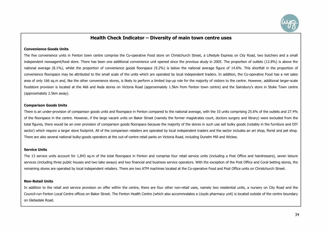
Health Check Indicator – Diversity of main town centre uses
Convenience Goods Units
The five convenience units in Fenton town centre comprise the Co-operative Food store on Christchurch Street, a Lifestyle Express on City Road, two butchers and a small
independent newsagent/food store. There has been one additional convenience unit opened since the previous study in 2005. The proportion of outlets (12.8%) is above the
national average (8.1%), whilst the proportion of convenience goods floorspace (9.2%) is below the national average figure of 14.6%. This shortfall in the proportion of
convenience floorspace may be attributed to the small scale of the units which are operated by local independent traders. In addition, the Co-operative Food has a net sales
area of only 166 sq.m and, like the other convenience stores, is likely to perform a limited top-up role for the majority of visitors to the centre. However, additional larger-scale
foodstore provision is located at the Aldi and Asda stores on Victoria Road (approximately 1.5km from Fenton town centre) and the Sainsbury’s store in Stoke Town centre
(approximately 2.5km away).
Comparison Goods Units
There is an under-provision of comparison goods units and floorspace in Fenton compared to the national average, with the 10 units comprising 25.6% of the outlets and 27.4%
of the floorspace in the centre. However, if the large vacant units on Baker Street (namely the former magistrates court, doctors surgery and library) were excluded from the
total figures, there would be an over provision of comparison goods floorspace because the majority of the stores in such use sell bulky goods (notably in the furniture and DIY
sector) which require a larger store footprint. All of the comparison retailers are operated by local independent traders and the sector includes an art shop, florist and pet shop.
There are also several national bulky-goods operators at the out-of-centre retail parks on Victoria Road, including Dunelm Mill and Wickes.
Service Units
The 13 service units account for 1,843 sq.m of the total floorspace in Fenton and comprise four retail service units (including a Post Office and hairdressers), seven leisure
services (including three public houses and two take aways) and two financial and business service operators. With the exception of the Post Office and Coral betting stores, the
remaining stores are operated by local independent retailers. There are two ATM machines located at the Co-operative Food and Post Office units on Christchurch Street.
Non-Retail Units
In addition to the retail and service provision on offer within the centre, there are four other non-retail uses, namely two residential units, a nursery on City Road and the
Council-run Fenton Local Centre offices on Baker Street. The Fenton Health Centre (which also accommodates a Lloyds pharmacy unit) is located outside of the centre boundary
on Glebedale Road.

35
Health Check Indicator
The Amount of Retail, Leisure and Office Floorspace in Edge-of-Centre and Out-of-Centre Locations
The Ravenside Retail Park, Victoria Road Retail Park and Victoria Road local centre are located approximately 1.5km to the north of Fenton, along the A50 (Victoria Road). These
facilities accommodate a variety of national food, bulky goods and leisure operators, including Aldi, Asda, Dunelm Mill, Gala Bingo, Poundstretcher, Pure Gym and Wickes.
Fenton Health Centre and a Lloyds Pharmacy unit are also located immediately adjacent to the town centre boundary on Glebedale Road.
Health Check Indicator – Retailer Representation and Retailer Demand
Fenton does not accommodate any of the top 27 national comparison retailers, though it does include a Co-operative Food and Coral betting shop. The remaining businesses
are operated by local independent traders. A review of EGi also confirmed that there are no retail or leisure operators currently seeking potential business premises in Fenton
(search dated 5th November 2013).
Health Check Indicator – Vacant Street-Level Property
WYG identified that the 11 vacant units in Fenton accounted for 4,251 sq.m of the total floorspace in the centre, compared to the three units which were recorded as being
vacant in the 2005 Study. The level of vacancies is also significantly above the national average rate, both in terms of the proportion of outlets (28.2% compared to 11.5%) and
floorspace (44.2% compared to 9.3%). The site visit also identified that there were several vacancies in some of the smallest units along City Road (5 units) and Christchurch
Street (3 units). The largest vacant units are the doctor’s surgery, library and magistrates court on Baker Street which all closed between 2011 and 2012. If these units are
excluded from the overall figure (given their last non-retail use), there would be a total of just 519 sq.m of vacant floorspace which would account for 8.8% of the floorspace.
Photograph 31 - Former magistrates Court, Baker Street Photograph 32 & 33 - Vacant units, City Road

36
Health Check Indicator – Pedestrian Footfall
An assessment of the general pedestrian flows in the town was noted during the site visit to Fenton, with a limited level of activity recorded throughout the centre on Monday,
the 19th August 2013. The Co-operative Food store and Post Office on Christchurch Street appeared to be the most visited stores but overall the centre appeared to be
extremely quiet with limited activity.
Health Check Indicator –Accessibility
The Council-operated car park on City Road is located to the rear of the Co-operative Food store and accommodates 93 spaces. The off street car parking charging is 60p for up
to an hour and £1.20 for up to two hours, with all day parking costing £3.50. There is no bus or train station in Fenton, with the nearest train station located to the north of
Stoke town centre. There are three bus stops located within the town centre boundary, with bus services also operating approximately every 20 minutes to the key centres in
the local area, including to Longton and Stoke city centre.
The majority of visitors responding to the in-street survey identified that they walked into Fenton (43%), with 34% stating that they used a car to access the town centre. The
on-street (non metered) spaces were identified as being the most popular location to park, followed by the Victoria Road Retail Park customer car park.
Health Check Indicator – Customer and Residents’ Views and Behaviour
The majority of the respondents to the in-street survey identified that the main reason why they were in Fenton was to access its financial service facilities (19%), with other
popular responses including the clothes/shoe shops (presumably at the out-of-centre retail parks on Victoria Road) and to visit specialist shops. Fenton had the second highest
level of visitors (after Meir town centre) stating that they intended to stay for less than 30 minutes (44%), with 22% also intending to stay for up to an hour.
When asked to compare Fenton with other centres, the key issues identified were that the town was worse or much worse in terms of the choice of shops and the choice of high
street names (both 67%). The highest proportion of respondents (24%) stated that they would like to see more clothing stores in Fenton, with other popular responses
including the need for large supermarkets (9%), more independent and specialist shops, more footwear stores and more high street names. Other measures which were
identified as offering the potential to improve the town and make it more attractive were to give it a general facelift (19%) and reduce traffic congestion (9%)..
The household survey (of the overall study area) identified that Fenton is the second least visited centre (after Meir) in the authority area, with only 1% of the respondents
stating that it is the centre which they visited the most. When asked why they do not visit Fenton, 45% stated that they had no reason to visit and 27% identified that it was
because there was a lack of choice and range of shops.

37
Health Check Indicator – Perception of Safety and Occurrence of Crime
The two CCTV cameras in Fenton are operated 24 hours a day. In June 2013, there were only four incidences of reported crime within the town centre boundary (from only two
in May 2013 and one in April 2013), with three reports of shop lifting and one of burglary (information via www.police.uk). Despite this, the in-street survey identified that a
high proportion of the respondents identified that the day (26%) and night time (24%) safety levels in the town were ‘worse’ than other centres, with 17% and 13% stating
that they were ‘better’ than other centres.
Health Check Indicator – Town Centre Environmental Quality
The southern area of Fenton town centre, along Baker Street and part of Christchurch Street, is located within the Albert Square Conservation Area, with several of the buildings
(including the former magistrates court) locally listed. Given this area’s status, the buildings and public garden appear to be well maintained and are of a high quality. In
contrast, the majority of the commercial units in the northern area of the centre are in a poor state of repair, with the high level of boarded-up units in the centre also making
Fenton appear to be run down and neglected. Although City Road (the A5007) is a busy arterial route which provides direct access between Stoke Town and Longton, it was
noted that pedestrian movement in Fenton is not greatly impeded by the high levels of traffic through the centre, with a pedestrian crossing located at the junction of City Road
and Christchurch Street. There was little evidence of graffiti, vandalism or litter on the day of the site visit. Despite this, it is evident that the level of vacancies does adversely
affect the overall environmental quality of the centre and Fenton would therefore benefit from additional investment. The town centre environment was identified by 43% of the
respondents as being ‘worse’ or ‘much worse’ in Fenton compared to other centres, with 41% stating that it was ‘about the same.’ Fenton also scored poorly when ranked in
terms of its cleanliness, layout and general environment.

38
Summary
It is evident that Fenton performs a limited role as a commercial and service centre. The key findings from the vitality and viability assessments are as follows:
• The centre does have a good level of convenience stores (including a Co-operative Food unit), though these are only likely to perform a top-up role for residents;
• The majority of the businesses are operated by local independent retailers, with the exception of the Co-operative Food, Coral betting shop and Post Office, with
additional retail and leisure facilities located at the out-of-centre retail parks on Victoria Road;
• There is a high level of vacancies in the centre, with the largest units comprising the former magistrates court, library and doctors surgery which have been
vacant since 2011/2012; and
• The overall environmental quality of the centre is poor, notably in the northern areas along City Road and low levels of pedestrian activity were recorded on the
day of the site visit.
WYG believe that due to the small scale of Fenton, its current provision of facilities and our perception of its current status as a vulnerable centre, the Council should consider
re-defining the centre during the Local Plan process.

39
Centre Overview
Longton is located in the south-eastern part of the City of Stoke-on-Trent authority area and is situated 2.5km to the north west of Meir, 2.5km to the south east of
Fenton, 4km to the south east of Stoke Town and 5.5km to the south east of Stoke City. The adopted Core Strategy describes Longton as the third largest retail centre in
North Staffordshire serving the southern part of the conurbation, behind Stoke City centre and Newcastle-under-Lyme.
The main shopping area of Longton is focused on The Strand, Market Street and the Longton Exchange, a pedestrianised shopping precinct which sits between The
Strand and Market Street. Further retail development is present to the west of the centre at Longton Retail Park, including a Tesco Extra store located off Baths Road
which has pedestrian links to The Strand. There is a mix of retail units present in the centre including both small scale traditional terrace shopping units and large format
retail warehouses. The majority of the smaller units present in the centre are occupied by independent retailers. However, there are also a number of national multiple
retailers present.
The convenience goods offer in the centre is anchored by the Tesco Extra store, with other convenience goods retailers including Lidl, Farmfoods and Iceland. The largest
comparison goods units present in the centre are the Matalan (2,680 sq.m) at Heathcote Road and the Wilkinson (2,060 sq.m) at Kingscross Road.
The Phoenix Retail Park is located approximately 350m to the west of the town centre boundary off Sidlings Place. The retail park comprises four comparison goods units
and one leisure service unit, including Currys and Pets at Home.
As Experian’s latest Goad survey of Longton was completed in December 2011, a site visit of the centre has been undertaken to ensure that the health check analysis
could be compiled using the most up-to-date diversity of use and floorspace figures. The site visit in August 2013 identified that there was a total of 228 units within
Longton town centre, comprising a total gross floorspace of 60,020 sq.m. These figures are based upon the town centre as defined by GOAD.
LONGTON TOWN CENTRE HEALTH CHECK ASSESSMENT

40
Photographs of Longton Town Centre (August 2013)
Photograph 34 (top left): Longton Retail Park
Photograph 35 (top centre): Longton Exchange Shopping Precinct Photograph 36 (top right): Units on The Strand
Photograph 37 (bottom left): B&M Bargains, The Strand Photograph 38 (bottom centre): Lidl, Edensor Road Photograph 39 (bottom right): Longton Bus Exchange

41
Figure 8: Land Use Plan for Longton Town Centre (August 2013)
Health Check Indicator – Diversity of main town centre uses

42
Table 13: Previous Number of Units in Longton Town Centre (2005)
Previous Number of Units
Number Longton UK
Convenience 15 7.4% 9.2%
Comparison 97 47.8% 48.0%
Services 54 26.6% 31.1%
Vacant 37 18.2% 10.3%
Total 203 100% 100% Source: North Staffordshire Retail and Leisure Study 2005 and Longton Retail and Leisure Study 2010
Table 15: Existing Number of Units in Longton Town Centre (August 2013)
Existing Number of Units
Number Longton UK
Convenience 20 8.8% 8.1%
Comparison 69 30.3% 33.1%
Retail Service 32 14.0% 13.8%
Leisure Service 26 11.4% 22.1%
Financial and Business Service 29 12.7% 11.0%
Vacant 52 22.8% 11.5%
Total 228 100.0% 100% Source: Site Survey & Experian Goad Data – August 2013 and UK average from the Experian Goad Category Report (July 2013) Nb. This table is based on the Experian Goad town centre boundary
Table 14: Previous Floorspace in Longton Town Centre (2005)
Previous Floorspace
Sq.m Longton UK
Convenience - 22.6% 17.0%
Comparison - 43.5% 53.1%
Services - 19.0% 20.8%
Vacant - 14.1% 7.8%
Total - 100% 100% Source: North Staffordshire Retail and Leisure Study 2005 and Longton Retail and Leisure Study 2010
Table 16: Existing Floorspace in Longton Town Centre (August 2013)
Existing Floorspace
Sq.m Longton UK
Convenience 15,520 25.9% 14.6%
Comparison 20,000 33.3% 36.6%
Retail Service 3,460 5.8% 7.4%
Leisure Service 5,620 9.4% 23.0%
Financial and Business Service 4,680 7.8% 8.4%
Vacant 10,740 17.9% 9.3%
Total 60,020 100.0% 100% Source: Site Survey & Experian Goad Data – August 2013 and UK average from the Experian Goad Category Report (July 2013) Nb. This table is based on the Experian Goad town centre boundary

43
Health Check Indicator – Diversity of main town centre uses
Convenience Goods Units
Table 15 shows the diversity of uses in Longton town centre in August 2013. 20 convenience goods units account for 15,520 sq.m of floorspace. The proportion of units (8.8%)
in use for the sale of convenience goods is comparable to the national average figure of 8.1%. However, the proportion of convenience goods floorspace (25.9%) is
substantially above the national average figure of 14.6%. This can be accounted for due to the substantial amount of floorspace provided by the Tesco Extra. In addition to the
anchor Tesco Extra store, the convenience goods units in the town centre include Longton Market at Times Square, a Lidl and a Farmfoods on Edensor Road and an Iceland at
Longton Exchange. Independent convenience goods retailers in the town centre include a bakery, butchers and greengrocers. There is a relatively equal split of national multiple
and independent convenience goods retailers in the centre.
Since 2005, the proportion of convenience goods units and floorspace in Longton has increased. In 2005, 7.4% of units were occupied by convenience goods retailers which was
below the national average figure. By 2013, 8.8% of units were occupied by convenience goods retailers, which is above the national average figure. Similarly, in 2005, the
proportion of convenience goods floorspace in the centre was 22.6%. This has increased to 25.9% at 2013. Since the previous Experian Goad survey of the centre in 2011,
there has been an increase of three convenience goods units and 1,470 sq.m floorspace in the town.
Comparison Goods Units
Comparison traders in Longton occupy 30.3% of all outlets and 33.3% of floorspace in the centre, which is below the respective national average rates of 33.1% and 36.6%.
The 69 comparison goods units in the centre account for 20,000 sq.m of floorspace. The largest comparison goods units in the centre include the Matalan, Wilkinson and B&M
Bargains. The majority of comparison goods units in the centre are occupied by independent operators. However, a number of national multiple retailers are present particularly
within the Longton Exchange and at Longton Retail Park. Comparison goods units in the town centre include eight charity shops, seven ladies wear units, six electrical retailers
and six hardware and household goods units.
Since 2005, the proportion of comparison goods units in Longton town centre has decreased from 47.8% to 30.3% at 2013. The proportion of comparison goods floorspace has
also decreased from 43.5% in 2005 to 36.6% in 2013. The number of comparison goods units in the centre has decreased by seven units since the previous Experian Goad
survey in 2011, while the amount of comparison goods floorspace has decreased by 450 sq.m.

44
Services
Retail services account for 14.0% of outlets (32 units) in Longton town centre which is comparable to the national average figure of 13.8%. The proportion of retail service
floorspace (5.8%) is slightly below the national average of 7.4%. Retail services in the centre include 15 health and beauty retailers, six opticians and four travel agents. A Post
Office is located within the Longton Exchange. The majority of retail service units in the town centre are occupied by independent retailers. However, national multiple retail
service operators in the town centre include Boots Opticians, Co-operative Travel, Specsavers, Thomas Cook and Thomson. The majority of retail service uses operate from
small to medium sized units, with the floorspace of such units ranging from 20 sq.m to 390 sq.m. Since the previous Experian Goad survey in 2011, the number of retail service
units has increased from 30 units to 32 units (an increase of two units) and the amount of retail service floorspace has increased from 3,120 sq.m to 3,460 sq.m.
The 26 leisure service units in Longton town centre occupy 5,620 sq.m floorspace. The proportion of both leisure service units (11.4%) and leisure service floorspace (9.4%) is
significantly below the respective national average figures of 22.1% and 23.0%. The most common types of leisure service in the centre are fast food and take away restaurants
which occupy 11 units, with other key services including cafes (four), public houses (three) and restaurants (three). The majority of leisure service units are occupied by
independent operators. Since 2011, the number of leisure service units in the centre has increased from 24 to 26 units, and the amount of leisure service floorspace has
increased by 320 sq.m.
In terms of financial and business services in Longton, the proportion of outlets occupied by such uses (11.7%) is slightly above the national average figure (10.9%). The
proportion of floorspace occupied by such uses (7.5%) is slightly below the national average level (8.4%). There are a total of eight retail banks in the centre, including two
Lloyds TSBs, a Barclays, HSBC, NatWest, and Halifax, as well as a Cheque Centre and Cash Converters. There are also seven property service units and five financial services
units. The number of financial and business service units in Longton town centre has increased since 2011, from 27 units to 29 units. The amount of floorspace occupied by
such uses has increased by 170 sq.m.
Non-Retail Units
In addition to the retail and services uses on offer within Longton town centre, there are a number of non-retail uses, including three government and municipal buildings
including the Jobcentre Plus, a tuition centre and the Longton Central Hub community use.

45
Health Check Indicator
The Amount of Retail, Leisure and Office Floorspace in Edge-of-Centre and Out-of-Centre Locations
Phoenix Park Retail Park is located approximately 350m to the west of Longton’s town centre boundary. The Retail Park is occupied by four comparison goods units, namely a
Currys, Smyths Toys, Pets at Home and Brantano. There is also one leisure service unit, namely a McDonalds.
Photo 40: Currys, Phoenix Retail Park Photo 41: Pets at Home, Phoenix Retail Park Photo 42: McDonalds, Phoenix Retail Park
Health Check Indicator – Potential Capacity for Growth or Change
A hybrid planning application (LPA ref: 55414/HYB) was submitted to Stoke City Council on the 17th June 2013 for full planning permissions for the demolition of existing units at
Spring Garden Road and the erection of an Asda food store (Use Class A1) and surgery (Use Class D1) with associated access, car parking, landscaping, highways and public
realm works, and for outline permission for two industrial units (Use Class B2 and B8). The application had not been determined at the time of reporting.
Health Check Indicator – Retailer Representation and Retailer Demand
Regional Retail Hierarchy (Venuescore)
Longton is classed as a Major District Centre by Venuescore (2013). Since 2006, Longton’s ranking within the Venuescore (2013) shopping hierarchy has declined by 46 places
from 336th in 2006 to 382nd in 2013. However, the town centre’s ranking has increased in recent years after having reached a low of 404th in 2010.

46
National and Independent Retailers (Goad)
Longton accommodates eight of the top 27 national comparison retailers, including Argos, Boots and Next.
Retailer Requirements (EGi)
A total of 36 retail and leisure operators are currently seeking potential business premises in Longton, comprising seven convenience, 19 comparison and 10 leisure service
operators (search dated 5th November 2013). The profile of the businesses is similar to the type of operators which are also looking to move to Stoke City and includes a
number of national operators, such as Bodycare (which is seeking a store with a sales area of between 139 – 279 sq.m) and Poundland (465 – 929 sq.m). However, we
should advise that some of the requirements are blanket requirements across large sub regions and may not necessarily reflect a desire to locate in this specific location.
Health Check Indicator – Shopping Rents
A review of the properties to rent in Longton town centre via Estates Gazette (EGi, August 2013) and local agents identified a variation in the current rental values (nb. total
unit retail floorspace rental value and not Zone A rental value), dependent on their location and building type. These units included: 11-15 Market Street which is seeking to
achieve a rent of £94/sq.m (1,312 sq.m, £124,000) and Unit 14 Longton Exchange Shopping Centre at £117/sq.m (107 sq.m, £12,500). The average rental value of retail
units in Longton (£86/sq.m) which is broadly comparable to the other rates in Stoke Town (£85/sq.m) and Meir (£82/sq.m).
Health Check Indicator – Vacant Street-Level Property
In August 2013 WYG found that the 52 vacant units in Longton accounted for 10,740 sq.m of the total floorspace in the town centre. The proportion of vacant outlets
(22.8%) and the proportion of total vacant floorspace (17.9%) is substantially above the respective national average figures of 11.5% and 9.3%. The vacant units in the town
centre vary in size from 30 sq.m to 2,310 sq.m, with 63% of the vacant units having a floorspace of less than 100 sq.m. The largest vacant unit in the town centre is located
at the corner of Strand Street and Commercial Street (2,310 sq.m) and appears to have previously been occupied by a business use. The second largest vacant building is
located at 28-32 Longton Exchange (1,290 sq.m). This unit was formerly occupied by Woolworths. Both of these units were also vacant at December 2011, demonstrating
they are longer-term vacancies.
Since 2005, the proportion of vacant units in Longton has increased from 18.2% to 22.8% at August 2013. Similarly the proportion of vacant floorspace has increased from
14.1% in 2005 to 17.9% at August 2013. However, in the shorter term the amount of vacant units and floorspace in Longton has decreased. Since 2011, the number of
vacant units has decreased by four units (from 56 to 52 units) and the amount of vacant floorspace has decreased by 1,820 sq.m (from 12,560 to 10,740 sq.m).

47
Health Check Indicator – Vacant Street-Level Property
Photographs of vacant units in Longton Town Centre (August 2013)
Photograph 43 (left): Vacant units at 28-32 Market Street (former Woolworths) Photograph 44 (centre): Vacant unit at Longton Exchange
Photograph 45 (right): Vacant unit at Longton Retail Park

48
Health Check Indicator – Vacant Street-Level Property
Figure 9: Vacancies in Longton Town Centre (August 2013)

49
Health Check Indicator – Pedestrian Footfall
An observation of the general pedestrian flow was noted during the site visit of Longton on Monday, the 19th August 2013 in order to identify those areas of movement with a
high or low pedestrian footfall. Good levels of footfall were witnessed in the western part of the Longton Exchange, along the Strand and at Longton Retail Park. However, low
levels of footfall were witnessed along Market Street and at the peripheral areas of the centre including Uttoxeter Road and Commerce Street.
Health Check Indicator – Accessibility
Road Access: Longton is located in the south easterly part of Stoke-on-Trent, to the north of the A50 which leads to junction 15 of the M6 to the east. The town is situated
2.5km to the north west of Meir, 2.5km to the south east of Fenton, 4km to the south east of Stoke Town and 5.5km to the south east of Stoke City.
Car Parking: Council operated car parking is provided to the south of the Longton Exchange (213 spaces), off Chancery Lane (31 spaces) and off Commerce Street (94
spaces). These off street car parking charges range from £0.80 for an hour up to £5.00 for all day parking. On street parking is noteably higher. A further customer car park
(approximately 850 spaces) is located adjacent to the Tesco Extra store, with pedestrian links connecting the car park to The Strand. A car park is also situated off Gold Street
(approximately 180 spaces) adjacent to Matalan and Sports Direct. On-street parking bays are located in the centre along Market Street and Kingscross Street, with prices
ranging from £0.25 for 15 minutes up to £2.70 for the maximum 3 hour stay.
Public transport: Longton Transport Interchange is located at the northern end of the town centre off Baths Road. The Transport Interchange includes Longton Bus Station to
the south of Baths Road and Longton railway station to the north. Regular bus services are available from Longton bus station to the surrounding area including to Stoke City,
Stoke Town, Meir and Blythe Bridge. Longton is situated on the Derby to Crewe railway line with regular services available to these centres along with Stoke Town, Uttoxeter,
Kidsgrove, Alsager and access to the wider rail network.
The in-street survey found that 44% of respondents had travelled to Longton by car/van, 28% had travelled by bus, minibus or coach and 22% had walked to the centre. Of
those who had driven, most had parked at Longton Exchange Shopping Centre (42%) and Tesco Extra Car Park (38%). The majority of respondents were satisfied with the cost
of parking (96%) and did not have any difficulties obtaining a space (96%).

50
Health Check Indicator – Customer and Residents’ Views and Behaviour
The results of the in-street survey help to provide an understanding of customer and residents’ views and behaviours. The most common reasons for the respondents being in
the centre were non-food shopping (other than clothes) (18.2%), financial services (12.7%) and the Tesco Extra (10.9%). Most of the respondents stated that they thought
they would stay in Longton for 1-1.30 hours (24%) or 1.30-1.59 hours (26%). Most respondents (33%) stated that they travelled to Longton 2-3 times a week for their main
food and grocery shopping, with most (44%) stating that they normally visited the Tesco Extra for their main food shopping. The majority of respondents (52%) stated that
Stoke City is their usual first choice destination for clothing and other non-food shopping. Of those who stated Stoke City wasn’t their first choice, the majority (54%) stated that
the Longton Exchange Shopping Centre was their first choice. Most respondents stated that they visited Longton about as frequently today as they did five years ago. When
asked to compare Longton with other centres, the majority (60%) considered the choice of shops in Longton to be worse or much worse, the majority (73%) considered the
choice of high street names to be worse or much worse, the majority (55%) considered the choice of independent and specialist shops to be worse or much worse and the
majority (75%) considered leisure facilities to be worse or much worse. However, the majority considered the town centre environment, the cleanliness and the day time safety
of Longton to be about the same as other centres. 31% of respondents would like to see more clothing stores in Longton and 20% would like to see more swimming pools.
When asked what measures could improve Longton, the majority of respondents stated filling the empty shops, with the same proportion of respondents considering this to be
the centre’s biggest weakness.
The household survey indicated that Longton is the second most visited centre (after Stoke City) with 18% of the respondents from the overall study area going there, with the
choice and range of the shops and services the primary reasons why they visited the town.
Health Check Indicator – Perception of Safety and Occurrence of Crime
In June 2013, in accordance with www.police.uk, 45 incidences of crime were reported in Longton town centre, including 21 incidences of shoplifting and 7 incidences of anti-
social behaviour (a decrease from 52 in May 2013). Longton town centre is covered by the Broadway and Longton West Neighbourhood Policing Team who undertake regular
meetings in the local area to discuss any issues of concern. The in-street survey results indicate that the respondents felt that Longton has a ‘better’ day and night time safety
level than other centres, with 28% stating that it was ‘better’ in the day and 17% identified that it was ‘better’ than other centres during the night, with 50% and 37% stating
that it was ‘about the same’ as other centres.

51
Health Check Indicator – Town Centre Environmental Quality
Longton’s environmental quality is varied. There is a mix of both modern and traditional buildings present in the town centre, including Victorian terraced properties along the
Strand, the 1960s Longton Shopping Exchange and the modern units at Longton Retail Park. The majority of the town centre is designated as a Conservation Area including the
area along Market Street and The Strand. Several listed buildings are present in the centre including the Town Hall and Market. Many of the retail and service units in the town
centre are well maintained, however there are also a number of units in need of refurbishment. The Longton Exchange Shopping Centre appears outdated and in need of
modernisation. Although the pedestrianised nature of the Shopping Centre aids pedestrian movement, the appearance of the Shopping Centre is unattractive. In those areas of
the town centre where there are a high proportion of vacant units, particular where large scale vacant units are present, the units detract from the quality of the centre. This is
particularly the case along parts of Market Street and in the eastern portion of the Longton Exchange Shopping Centre, where the vacant units coupled with a lack of footfall
means these areas of the centre are lacking in activity and environmental quality. Public spaces in the town centre are limited, with the main area of public space being located
at the central point of the Longton Exchange.
Summary
The overall health of Longton town centre can be summarised as follows:
• It is well provided for in terms of its convenience goods offer, with this sector dominated by the Tesco Extra store;
• The comparison goods sector is less well provided for and, although some national multiple retailers are present in the town centre, the majority of comparison
goods units are occupied by independent operators;
• The vacancy rate in Longton is substantially above the national average figure and concentrations of vacant units are present in some areas of the town centre,
such as the eastern extent of the Longton Exchange Shopping Centre;
• The high level of vacancies also detracts from the environmental quality of the town centre;
• Longton’s ranking within the Venuescore (2013) shopping hierarchy has increased in recent years after having reached a low of 404th in 2010; and
• The Longton Exchange Shopping Centre is outdated and in need of modernisation.
Longton provides an important role in catering for local shopping needs, as evidenced by the shopper surveys and this health check. The town centre was found to be
reasonably busy during WYG’s visits, though the high level of vacancies in the Exchange Shopping Centre does need to be carefully monitored, particularly due to the current
proposals for a new foodstore to the south of the town. Although Longton does show signs of vitality and viability (mainly due to the levels of activity created by the Tesco
Extra), it is vulnerable and requires improvements and intervention to ensure it does not decline further.

52
Centre Overview
Meir town centre is located within the eastern gateway of City of Stoke-on-Trent, approximately 10.5km to the south east of Stoke City centre and 2.5km from Longton
town centre. The Core Strategy identifies that it is the lowest ranked of the seven largest centres in the authority area and serves a small localised catchment from the
surrounding communities.
The primary and secondary shopping area in Meir is concentrated around the junction of the A50 (Uttoxeter Road) and the A520 (Sandon Road and Weston Road), with
the majority of the retail and service stores located within terraced units along these key arterial routes. The Co-operative Food store on Weston Road (within the primary
shopping area) is the largest retail unit in the centre, with a net sales area of 654 sq.m (IGD data source). Additional provision is also available approximately 1km to the
east of the town centre at the Aldi and Tesco Superstore at Meir Park. Meir also accommodates several community facilities, including the Primary Care Centre which
opened in 2011, a public library and a community centre on Uttoxeter Road.
As Experian Goad has not produced a map of Meir, WYG undertook a site visit of the town centre to ensure that the health check analysis could be compiled using the
most up-to-date diversity of use and GIS floorspace figures. The site visit in August 2013 identified that there was a total of 70 units within Meir town centre, comprising
a total gross floorspace of 8,366 sq.m (based on GIS floorspace data).
MEIR TOWN CENTRE HEALTH CHECK ASSESSMENT
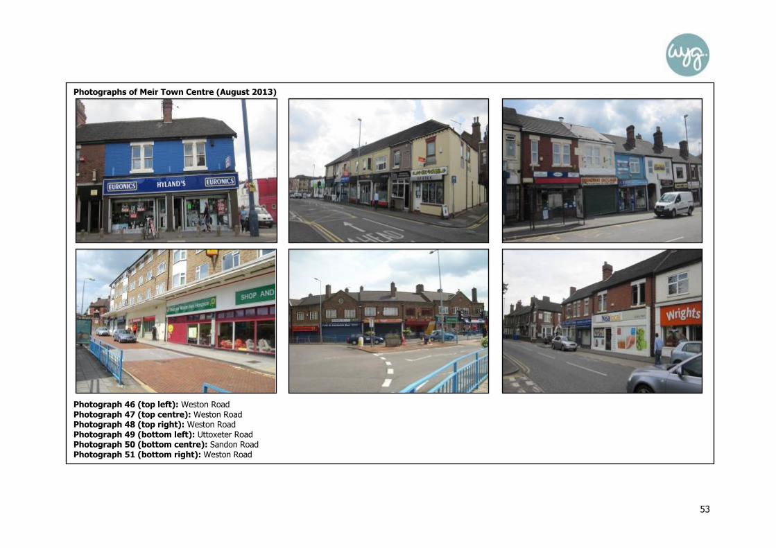
53
Photographs of Meir Town Centre (August 2013)
Photograph 46 (top left): Weston Road
Photograph 47 (top centre): Weston Road Photograph 48 (top right): Weston Road
Photograph 49 (bottom left): Uttoxeter Road Photograph 50 (bottom centre): Sandon Road
Photograph 51 (bottom right): Weston Road

54
Figure 10: Land Use Plan for Meir Town Centre (August 2013)
Based upon the Ordnance Survey map with the permission of
The Controller of Her Majesty's Stationery Office, © Crown copyright. WYG Environment Planning Transport Limited 2012, licence no: AR 1000 17603

55
Table 17: Previous Number of Units in Meir town centre (2005)
Previous Number of Units
No. Meir UK
Convenience 4 5.6% 9.2%
Comparison 39 54.9% 48.0%
Services 16 22.5% 31.1%
Vacant 12 16.9% 10.3%
Total 71 100% 100% Source: North Staffordshire Retail and Leisure Study 2005 Nb. Excluding miscellaneous
Table 19: Existing Number of Units in Meir town centre (August 2013)
Existing Number of Units
No. Meir UK
Convenience 9 12.9% (13.0%) 8.1%
Comparison 18 25.7% (26.1) 33.1%
Retail Service 13 18.6% (18.8%) 13.8%
Leisure Service 18 25.7% (26.1%) 22.1%
Financial and Business Service 5 7.1% (7.2%) 11.0%
Vacant 7 10.0% (8.7%) 11.5%
Total 70 100.0% 100% Source: Site Survey – August 2013 and UK average from the Experian Goad Category Report (July 2013) Nb. The figures in brackets indicate the proportion of units if the former Health Centre on Saracen Way is excluded from the analysis
Table 18: Previous Floorspace in Meir town centre (2005)
Previous Floorspace
Sq.m Meir UK
Convenience - - 17.0%
Comparison - - 53.1%
Services - - 20.8%
Vacant - - 7.8%
Total - 100% 100% Source: North Staffordshire Retail and Leisure Study 2005 Nb. Excluding miscellaneous
Table 20: Existing Floorspace in Meir town centre (August 2013)
Existing Floorspace
Sq.m Meir UK
Convenience 1,656 19.5% (21.8%) 14.6%
Comparison 2,277 27.2% (30.0%) 36.6%
Retail Service 986 11.8% (13.0%) 7.4%
Leisure Service 1,744 20.8% (22.9%) 23.0%
Financial and Business Service 483 5.8% (6.4%) 8.4%
Vacant 1,220 14.6% (6.0%) 9.3%
Total 8,366 100.0% 100% Source: Site Survey – August 2013 (GIS Data) and UK average from the Experian Goad Category Report (July 2013) Nb. The figures in brackets indicate the proportion of floorspace if the former Health Centre on Saracen Way is excluded from the analysis
Health Check Indicator – Diversity of main town centre uses
It should be noted that a direct comparison cannot be made between the 2005 Study data and the information obtained from the site visit by WYG in August 2013 as the categories adopted by the 2005 Study do not match the Experian Goad defined categories which WYG have adopted.

56
Health Check Indicator – Diversity of main town centre uses
Convenience Goods Units
Meir accommodates an above average provision of convenience stores, with the nine units comprising a total floorspace of 1,656 sq.m. The largest foodstore in the centre is the
Co-operative Food unit (with a net sales area of 654 sq.m) on West Road, with the additional facilities comprising four small foodstores/newsagents, two bakers, an off-licence
and a Nisa Local convenience store. The stores in Meir principally provide top-up goods to serve the needs of local residents, with the household and in-street surveys also
indicating that the Co-operative Food does not act as a main food shopping destination. In addition, the Aldi and Tesco Superstore are located in an out-of-centre location,
approximately 1km to the east of the town centre.
Comparison Goods Units
Comparison traders in Meir occupy 25.7% of the outlets and 27.2% of the floorspace in the centre, with both figures well below the respective national average rates of 33.1%
and 36.6%. The shortfall in the amount of comparison goods facilities may be attributable to the small scale of many of the terraced units in Meir which may not be sufficiently
sized to accommodate the floorspace requirements of many comparison goods retailers. Despite this, there are several large comparison stores, including the Douglas Macmillan
charity shop on Uttoxeter Road, the new HBS Pharmacy unit, Boots Pharmacy and Euronics Electricals on Weston Road.
Service Units
There are an above average proportion of retail service stores in Meir, with health and beauty traders particularly dominant in this sector, with a total of nine such businesses,
followed by a Post Office, undertakers, a clothing alterations firm and dog grooming business. The 18 leisure service units comprise 14 take aways, three cafes/restaurants and
a Coral betting store on Weston Road, with a KFC fast food restaurant having opened in 2012 on the former car park site on Pickford Place. There is a slight shortfall in the
provision of financial and business services in comparison with the national average, with the five units located within a total floorspace of 483 sq.m. The services are
concentrated in the northern area of the centre and comprise two solicitor firms, an accountant, Britannia bank and a security firm. The majority of the service outlets are
operated by local independent traders, with the five national operators comprising Britannia bank, Co-operative Funeral Care, Coral betting shop, the new KFC unit on Pickford
Place and Post Office on Sandon Road.
Non-Retail Units
In addition to the retail and service provision on offer within the centre, there are a number of non-retail uses, including several residential properties, four offices (including the
Council-operated Meir Local Centre office on Uttoxeter Road), a community centre, public library and a new Primary Care Centre.

57
Health Check Indicator
The Amount of Retail, Leisure and Office Floorspace in Edge-of-Centre and Out-of-Centre Locations
Meir Park is located approximately 1km to the east of Meir town centre, with access to the commercial units via the A50 (Uttoxeter Road). It is located adjacent to an industrial
and warehouse estate and includes a number of retail and leisure outlets. The largest units comprise the B&Q, Tesco Superstore and Aldi outlets, with additional facilities
including a McDonalds, a hotel, Hungry Horse restaurant and Westridge furniture factory shop.
Photograph 52: Tesco, Meir Park Photograph 53: B&Q, Meir Park
Health Check Indicator – Retailer Representation and Retailer Demand
Meir town centre accommodates only one of the top 27 national comparison retailers (a Boots pharmacy), though there are several other multiples in the town centre, including
Britannia Bank and KFC. A review of EGi also confirms that there were no retail or leisure operators currently seeking representation in Meir on the 5th November 2013.
Health Check Indicator – Shopping Rents
A review of the properties to rent in Meir town centre via Estates Gazette (EGi, August 2013) and local agents identified a variation in the current rental values (nb. total unit
retail floorspace rental value and not Zone A rental value), dependent on their location and building type. These units included: 729 Uttoxeter Road which is seeking to achieve
a rent of £107/sq.m (84 sq.m, £9,000 per annum) and 51 Weston Road at £56/sq.m (107 sq.m, £6,000 per annum). The average rental figure is approximately £82/sq.m and
this compares to respective average values of approximately £85/sq.m in Stoke Town centre and £86/sq.m in Longton. The former health centre is being advertised for sale at
£350,000.

58
Health Check Indicator – Vacant Street-Level Property
The site visit in August 2013 identified that the seven vacant units in Meir town centre accounted for 1,220 sq.m of floorspace, with the town having the lowest level of
vacancies of the seven largest centres within the City of Stoke-on-Trent authority area. The rate of vacant outlets (10.0%) is marginally below the national average rate of
11.5%, whilst the proportion of vacant floorspace (14.6%) is above the UK average figure (9.3%). The largest vacant unit is the former health centre on Saracen Way which
has closed as a result of the opening of the new Primary Care Centre facility on Weston Road, and if this unit was removed from the list (as it has a D1 Use Class), the
proportion of vacant floorspace would reduce to 6.0%. There is also a concentration of vacancies in the units directly adjacent to the Co-operative Food store on Weston Road.
Photographs 54 & 55: Vacant units, Weston Road
Health Check Indicator – Pedestrian Footfall
An assessment of the general pedestrian flows in the town centre was noted during the site visit to Meir on Thursday, the 8th August 2013. The greatest levels of activity were
unsurprisingly identified as being at the Co-operative Food unit and the new Primary Care Centre on Weston Road. The A50 is a busy arterial route which effectively splits the
northern and southern areas of the town and, although pedestrian crossings are in place to ensure that visitors to the centre can safely cross between the two shopping areas,
there is a lack of connectivity in the centre.

59
Health Check Indicator – Accessibility
Road Access: Uttoxeter Road (the A50) runs directly through Meir town centre, with the retail and service units located on both sides of the carriageway. The town is located
approximately 10km to the south east of Stoke City centre and 2.5km to the east of Longton.
Car Parking: A pay and display (off street) car park with 29 spaces is operated by the Council and is located on Weston Road, with the day time charges ranging from £0.60
for up to an hour, £1.20 for up to two hours and £3.50 for all day. The additional on street parking bays which are located on Uttoxeter Road have a maximum stay of three
hours. The day time charge rate is £0.25 for up to 15 minutes, £0.45 for up to 30 minutes, £0.90 for up to an hour, £1.80 for up to two hours and £2.70 for up to three hours.
WYG consider that such levels are disproportionate to the scale and function of the centre as on street parking levels are comparable to larger centres (Tunstall, Longton).
Public transport: Meir does not have a train or bus station, though bus services are available at least every 10 minutes during the weekday to the nearby larger centres,
including Stoke City and Longton.
A total of 22% of the respondents to the in-street survey identified that they had travelled to Meir via a car, with the majority (50%) walking to the town centre or getting a
bus, minibus or coach (24%). Of those that parked in the centre, a high proportion parked for free in the on-street parking bays.
Health Check Indicator – Customer and Residents’ Views and Behaviour
The in-street survey of Meir identified that a high proportion of the respondents felt that there was a number of issues with the town. In particular, it had the highest proportion
of respondents (out of the seven centres) who stated that they would not undertake their main food and grocery shop in the centre (96%). This is unsurprising as despite the
presence of the Co-operative Food store in the town, the survey identified that the respondents were most likely to go the large Aldi and Tesco Superstore units at Meir Park, as
well as the Tesco Extra at Longton. In addition, the respondents also identified that, in comparison with other centres, Meir compared ‘worse’ or ‘much worse’ on a number of
key issues, notably the choice of high street names (73%), the choice of shops (67%), the choice of independent/specialist shops (65%), the range and choice of
pubs/restaurants (64%), the range of financial businesses (62%) and leisure facilities (60%). It should be noted that a number of these figures are the highest out of the seven
centres, which again indicates that many of the respondents had a poor perception of Meir. It is also apparent that most of the visitors to Meir tended to stay for only a short
time, with the survey indicating that 52% of those surveyed stated that they intended to stay for less than 30 minutes, the highest proportion of the seven centres. The lack of
non-food shops was identified as being the biggest weakness of Meir, with other key issues including the empty shops and the foodstore provision. The majority of respondents
stated that they would like to see more clothing stores in Meir (35%), with other popular responses referring to the need for more high street names (16%), more
independent/specialist shops (16%) and more footwear stores (13%).

60
Health Check Indicator – Perception of Safety and Occurrence of Crime
In June 2013, there were 25 incidences of reported crime within the town centre (down from 26 in May 2013 and up from 15 in April 2013), with 11 reports of anti-social
behaviour and two incidents of shoplifting (information via www.police.uk). The in-street survey asked the respondents to compare Meir with other centres, with 48% of the
respondents stating that they felt that the day time safety of Meir was about the same as other centres, though 28% identified that it was ‘much worse.’
Health Check Indicator – Town Centre Environmental Quality
The overall physical condition of Meir is good, though the concentration of several vacant units on Weston Road does make this area of the town appear neglected and run-
down. The centre also includes a variety of building types and styles, and with the majority of the 1960s terraced commercial units accommodating residential properties on the
upper floors. The new health care centre at the Uttoxeter Road and Weston Road roundabout replaced a former public house and is a modern and purpose built facility, with
well-maintained planting schemes located in this area. In terms of pedestrian and vehicular access, there are bollards and fences in place throughout the centre to prevent cars
from parking in front of many of the shops. The A50 does effectively split the centre into two distinct areas, though pedestrian crossings are in place to enable safe and
convenient access points for visitors to the town.
Summary
It is evident that Meir performs an important retail and service role in the local area, with the Primary Care Trust unit also likely to attract residents from further afield. The key
issues of relevance from the health check are as follows:
• It has a good provision of convenience and retail service operators, with a slight shortfall in the amount of comparison, leisure service and financial and business
service facilities;
• There are a number of national operators in the town, including the Co-operative Food and KFC units, with Meir Park also accommodating several multiple
retailers;
• The town has the lowest level of vacancies of the seven centres, both in terms of the proportion of units and floorspace; and
• The in-street survey identified that a high proportion of the respondents felt that Meir lacked high street names and a variety of shops, with the average visitor
spending less than 30 minutes in the town.
WYG considers that overall, Meir shows good signs of vitality and viability but there is scope for improvement. Due to the small scale of Meir and its current small provision of
facilities, it only performs a district centre role and WYG believe that the Council should therefore consider re-defining the centre during the Local Plan process.

61
Centre Overview
Stoke Town centre is described in the adopted Core Strategy as playing a number of key roles. It is also described in the Core Strategy as the city’s administrative centre,
a university town, a nationally important destination for ceramics factory shopping, as well as providing local convenience shopping and the conurbation’s primary railway
station. Stoke Town is located 3km to the south of Stoke City centre, 4km to the north west of Longton and 4km to the west of Newcastle-under-Lyme.
The main shopping area in Stoke Town centre is focused on Church Street, Campbell Place and London Road. A Sainsbury’s store is located off London Road and forms
the anchor convenience goods unit serving the town centre. A Lidl store and Iceland store are located to the south of the Sainsbury’s store off London Road. Stoke
market is located off South Wolfe Street. The majority of comparison goods units in the town centre are small to medium in scale. The largest comparison goods unit in
the town centre is the Bargain Buys (920 sq.m) on Campbell Place. The majority of units in the town centre are occupied by independent operators. The town hall and
Council offices are located off Glebe Street in the northern part of the town centre. The former Spode factory buildings are also located in the northern part of the centre
off Elenora Street. A visitor centre now operates from the former factory buildings.
As Experian’s latest Goad survey of Stoke Town was completed in December 2011, a site visit of the centre has been undertaken to ensure that the health check analysis
could be compiled using the most up-to-date diversity of use and floorspace figures. The site visit in August 2013 identified that there was a total of 187 units within
Stoke Town centre, comprising a total gross floorspace of 45,950 sq.m. These figures are based upon the town centre as defined by GOAD.
STOKE TOWN CENTRE HEALTH CHECK ASSESSMENT

62
Photographs of Stoke Town Centre (August 2013)
Photograph 56 (top left): Sainsbury’s store, London Road Photograph 57 (top centre): Stoke Market, South Wolfe Street
Photograph 58 (top right): Units on Church Street
Photograph 59 (bottom left): Units on Campbell Place Photograph 60 (bottom centre): Lidl store, London Road
Photograph 61 (bottom right): Units on London Road

63
Figure 11: Land Use Plan for Stoke Town Centre (August 2013)
Health Check Indicator – Diversity of main town centre uses

64
Table 21: Previous Number of Units in Stoke Town Centre (2005)
Previous Number of Units
Number Stoke UK
Convenience 12 7.2% 9.2%
Comparison 60 36.1% 48.0%
Services 45 27.1% 31.1%
Vacant 49 29.5% 10.3%
Miscellaneous 9 1.6% 1.4%
Total 166 100% 100% Source: North Staffordshire Retail Study (2005)
Table 23: Existing Number of Units in Stoke Town Centre (August 2013)
Existing Number of Units
Number Stoke UK
Convenience 15 8.0% 8.1%
Comparison 39 20.9% 33.1%
Retail Service 15 8.0% 13.8%
Leisure Service 38 20.3% 22.1%
Financial and Business Service 22 11.8% 11.0%
Vacant 58 31.0% 11.5%
Total 187 100.0% 100% Source: Site Survey & Experian Goad Data– August 2013 and UK average from the Experian Goad Category Report (July 2013) Nb. This table is based on the Experian Goad town centre boundary
Table 22: Previous Floorspace in Stoke Town Centre (2005)
Previous Floorspace
Sq.m Stoke UK
Convenience - 10.6% 17.0%
Comparison - 50.0% 53.1%
Services - 21.1% 20.8%
Vacant - 17.3% 7.8%
Miscellaneous - 1.3% 1.3%
Total - 100% 100% Source: North Staffordshire Retail Study (2005)
Table 24: Existing Floorspace in Stoke Town Centre (August 2013)
Existing Floorspace
Sq.m Stoke UK
Convenience 12,310 26.8% 14.6%
Comparison 8,120 17.7% 36.6%
Retail Service 1,720 3.7% 7.4%
Leisure Service 10,800 23.5% 23.0%
Financial and Business Service 3,660 8.0% 8.4%
Vacant 9,340 20.3% 9.3%
Total 45,950 100.0% 100% Source: Site Survey & Experian Goad Data– August 2013 and UK average from the Experian Goad Category Report (July 2013) Nb. This table is based on the Experian Goad town centre boundary

65
Health Check Indicator – Diversity of main town centre uses
Convenience Goods Units
Table 23 shows the diversity of use in Stoke Town centre in August 2013. The 15 convenience goods units account for 12,310 sq.m of floorspace. The proportion of units
(8.0%) in use for the sale of convenience goods is comparable to the national average figure of 8.1%. However, the proportion of convenience goods floorspace (26.8%) is
substantially above the national average figure of 14.6%. The convenience goods sector in the town centre is dominated by the Sainsbury’s supermarket off London Road, with
additional provision provided by the Lidl and Iceland at Boothen Park. Stoke Market which is located off South Wolfe Street also makes a significant contribution to the
convenience goods offer in Stoke Town. However, it should be noted that, although in line with the GOAD categories the market is identified as a wholly convenience goods
unit, comparison goods stalls are also present in the market. Other convenience retailers include five bakers and confectioners, two convenience stores, a butchers,
greengrocers and shoe repair unit.
Since 2005, the proportion of convenience goods units and floorspace has increased in Stoke Town centre. There has been a substantial increase in the proportion of
convenience goods floorspace from 10.6% in 2005 to 26.8% in 2013. The number of convenience goods units has increased by two units since the previous Experian Goad
survey in 2011 (from 13 to 15 units). During this time, the amount of convenience goods floorspace in the town centre has also increased by 340 sq.m.
Comparison Goods Units
Comparison goods traders in Stoke Town occupy 20.9% of all outlets and 17.7% of floorspace in the centre, which is substantially below the respective national average rates of
33.1% and 36.6%. The 39 comparison goods units in the centre account for 8,120 sq.m of floorspace. The majority of comparison goods units in the centre are small to
medium in scale and range from 30 to 920 sq.m. The largest comparison goods units in the town centre are occupied by Bargain Buys and Poundstretcher. The majority of such
units are occupied by independent retailers.
The proportion of comparison goods units and floorspace in Stoke Town centre has decreased since 2005. The proportion of units has decreased from 36.1% at 2005 to 20.9%
at 2013, while the proportion of floorspace has decreased from 50.0% at 2005 to 17.7% at 2013. Since the previous Experian Goad survey in 2011, the number of comparison
goods units has decreased by three units (from 42 to 39 units) and the amount of comparison goods floorspace has decreased by 990 sq.m.
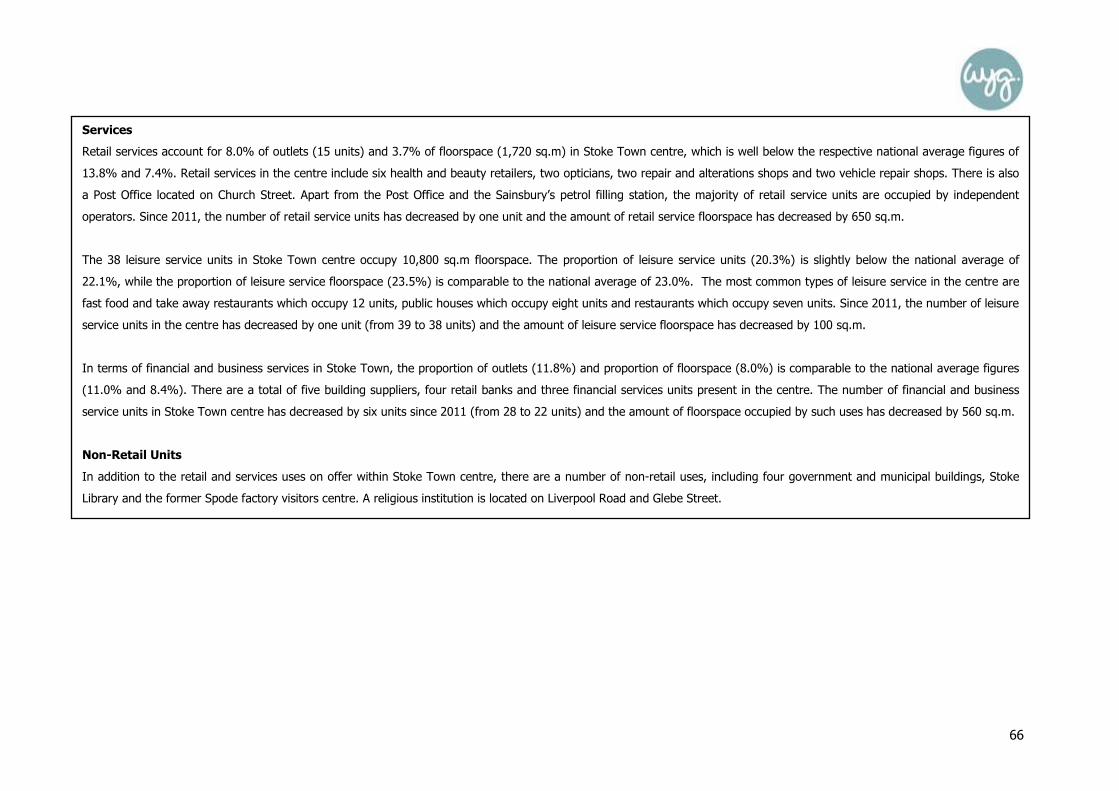
66
Services
Retail services account for 8.0% of outlets (15 units) and 3.7% of floorspace (1,720 sq.m) in Stoke Town centre, which is well below the respective national average figures of
13.8% and 7.4%. Retail services in the centre include six health and beauty retailers, two opticians, two repair and alterations shops and two vehicle repair shops. There is also
a Post Office located on Church Street. Apart from the Post Office and the Sainsbury’s petrol filling station, the majority of retail service units are occupied by independent
operators. Since 2011, the number of retail service units has decreased by one unit and the amount of retail service floorspace has decreased by 650 sq.m.
The 38 leisure service units in Stoke Town centre occupy 10,800 sq.m floorspace. The proportion of leisure service units (20.3%) is slightly below the national average of
22.1%, while the proportion of leisure service floorspace (23.5%) is comparable to the national average of 23.0%. The most common types of leisure service in the centre are
fast food and take away restaurants which occupy 12 units, public houses which occupy eight units and restaurants which occupy seven units. Since 2011, the number of leisure
service units in the centre has decreased by one unit (from 39 to 38 units) and the amount of leisure service floorspace has decreased by 100 sq.m.
In terms of financial and business services in Stoke Town, the proportion of outlets (11.8%) and proportion of floorspace (8.0%) is comparable to the national average figures
(11.0% and 8.4%). There are a total of five building suppliers, four retail banks and three financial services units present in the centre. The number of financial and business
service units in Stoke Town centre has decreased by six units since 2011 (from 28 to 22 units) and the amount of floorspace occupied by such uses has decreased by 560 sq.m.
Non-Retail Units
In addition to the retail and services uses on offer within Stoke Town centre, there are a number of non-retail uses, including four government and municipal buildings, Stoke
Library and the former Spode factory visitors centre. A religious institution is located on Liverpool Road and Glebe Street.

67
Health Check Indicator – Potential Capacity for Growth or Change
On the 13th August 2013, Morrisons submitted an application for consent to display adverts (LPA ref: 55643/AD) at 95 Church Street, the former Blockbuster Video unit, in
order that the unit could be used as a convenience store with a retail area of 205 sq.m. There may also be additional office units available to let/purchase as a result of the
re-location of Stoke-on-Trent Council from their existing administrative headquarters in Stoke Town centre to the Central Business District scheme in Stoke City centre.
Health Check Indicator – Retailer Representation and Retailer Demand
National and Independent Retailers (Goad)
Stoke Town accommodates none of the Experian-Goad defined top 27 national comparison retailers.
Retailer Requirements (EGi)
According to EGi, there are no retail or leisure operators which are currently seeking representation in Stoke Town (5th November 2013).
Health Check Indicator – Shopping Rents
A review of the properties to rent in Stoke Town centre via Estates Gazette (EGi, August 2013) and local agents identified a variation in the current rental values (nb. total unit
retail floorspace rental value and not Zone A rental value), dependent on their location and building type. These units included: 68 Church Street which is seeking to achieve a
rent of £90/sq.m (200 sq.m, £18,000 per annum) and 52 Church Street at £59/sq.m (145 sq.m, £8,500 per annum). The centre has an average rental value of £85/sq.m
which is comparable to the other nearby centres of Longton (£86/sq.m) and Meir (£82/sq.m).
Health Check Indicator – Vacant Street-Level Property
The site visit in August 2013 found that the 58 vacant units in Stoke Town accounted for 9,340 sq.m of the total floorspace in the town centre. The rate of vacant outlets
(31.0%) and the vacant floorspace (20.3%) is substantially above the respective national average figures of 11.5% and 9.3%. The vacant units in the town centre vary in size
from 30 sq.m to 680 sq.m, with 40% of the vacant units having a floorspace of less than 100 sq.m. The largest vacant unit (680 sq.m) in the town centre is 93-95 Church
Street which was formerly occupied by Blockbusters. 33% of the vacant units were previously occupied in 2011 and have since become vacant. A high proportion of the
vacant units were also vacant in 2011, demonstrating that there are several longer-term vacancies in the town centre. Vacant units are present throughout the town centre.
However, there is a particular concentration in the north western part of the town centre, along Liverpool Road. Since 2005, the proportion of vacant units in the town centre
has increased from 29.5% to 31.0%, and the proportion of vacant floorspace has increased from 17.3% to 20.3%. Since 2011, the number of vacant units in the town centre
has also increased by 12 units (from 46 to 58 units) and the amount of vacant floorspace has increased by 2,800 sq.m, which indicates that the centre is clearly failing.
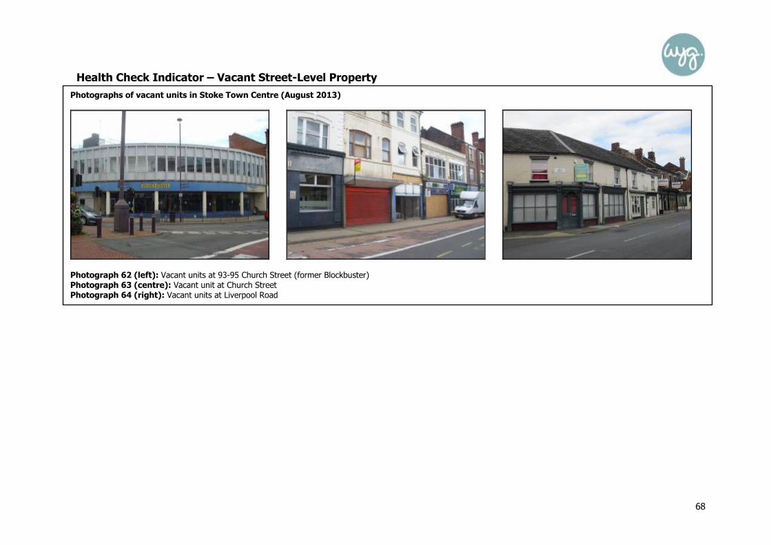
68
Health Check Indicator – Vacant Street-Level Property
Photographs of vacant units in Stoke Town Centre (August 2013)
Photograph 62 (left): Vacant units at 93-95 Church Street (former Blockbuster)
Photograph 63 (centre): Vacant unit at Church Street
Photograph 64 (right): Vacant units at Liverpool Road

69
Health Check Indicator – Vacant Street-Level Property
Figure 12: Vacancies in Stoke Town Centre (August 2013)

70
Health Check Indicator – Pedestrian Footfall
An observation of the general pedestrian flow was noted during the site visit of Stoke Town on Monday, the 19th August 2013 in order to identify those areas of movement with
a high or low pedestrian footfall. Reasonable levels of footfall were witnessed along London Road, Campbell Place and Church Street. However, at the northern extent of the
town centre, pedestrian footfall was low, with only limited pedestrian activity witnessed along Liverpool Road and Hartshill Road.
Health Check Indicator – Accessibility
Road Access: Stoke Town is located immediately to the west of the A500, which links to the M6 to the west. Stoke Town is located 3km to the south of Stoke City, 4km to the
north west of Longton and 4km to the west of Newcastle-under-Lyme.
Car Parking: There are a number of Council owned car parks present in Stoke Town centre including at Acquinas Street (39 spaces), Copeland Street (39 spaces), Elenora
Street (30 spaces), Hide Street (73 spaces), Kingsway (195 spaces), South Wolfe Street (66 spaces), Spark Street (74 spaces) and Vale Street (61 spaces). Car parking (off
street) charges range from £0.80 for an hour, up to £4.50 for all day parking. There are also a number of private car parks in the centre, including the car park associated with
the Sainsbury’s store (approximately 400 spaces) and a car park associated with the Lidl and Iceland stores (approximately 150 spaces). On-street car parking is also available
in the centre, with charges ranging from £0.25 for 15 minutes up to £2.70 for a maximum three hour stay. The parking charges (off street) are comparable to Stoke City (the
‘regional centre’) and therefore appear disproportionate to the scale and function of Stoke Town and may want to be reconsidered in the future.
Public transport: Stoke-on-Trent railway station is located on Station Road to the north east of the town centre. The station is located on the Birmingham to Manchester
branch of the West Coast Main Line. Direct trains are available to destinations such as Birmingham, Stafford and London, as well as to local areas including Longton, Kidsgrove,
Alsager, Blythe Bridge and Uttoxeter. A number of bus stops are present in the centre located on Church Street and Campbell Street. Access to Church Street and Campbell
Place is restricted to pedestrians, buses, cycles and taxis with a dedicated bus lane provided.
The in-street survey found that 45% of respondents had travelled to Stoke Town by car, 32% had travelled by bus and 22% had walked to the centre. The majority of
respondents (91%) were satisfied with the cost of parking in the centre and no respondents stated that they had difficulty parking.

71
Health Check Indicator – Customer and Residents’ Views and Behaviour
The results of the in-survey undertaken in Stoke Town centre help to provide an understanding of customer and residents’ views and behaviours. The most popular reasons for
being in Stoke Town were to browse (26%), clothes shopping (13%), eating and drinking (13%) and to visit the Sainsbury’s store (13%). Most people (35%) thought that they
would stay in Stoke Town for 1 to 1.5 hours. The majority of respondents (76%) intended to undertake their main food shopping while in Stoke Town, with most respondents
(32%) normally visiting the Sainsbury’s store on London Road to undertake their main food shop. In relation to clothing and non-food shopping, the majority of respondents
(59%) stated that Stoke City would be their usual first choice destination for such goods. The majority of respondents (56%) stated that they visited Stoke Town centre about
as frequently as they did about five years ago. When respondents were asked to compare Stoke Town to other centres, most people (33%) thought the choice of shops was
about the same as other centres, most (26%) thought the choice of independent shops was about the same as other centres and most (26%) thought the choice of high street
names was much worse than other centres. Most people also felt that Stoke Town centre performed about the same as other centres in relation to accessibility to public
transport, public information, entertainment and day time safety. When asked what shops or services they would like to see more of in Stoke, most (22%) stated clothing shops.
In relation to leisure facilities most respondents stated that they would like to see more children’s activity centres, parks and swimming pools (11% each). Most respondents
(24%) felt that Stoke Town centre could be improved by giving the town a general facelift. Empty shops were most often (30%) stated as the biggest weakness of the town
centre.
Health Check Indicator – Perception of Safety and Occurrence of Crime
In June 2013, in accordance with www.police.uk, 47 incidences of crime were reported within Stoke Town centre, compared to 48 in May 2013 and 50 in April 2013. The most
common crime reported was anti-social behaviour (18 incidents), followed by shoplifting (6 incidents) and other theft (6 incidents). The in-street survey identified that overall,
the respondents felt safe during both the day and night in Stoke Town, with 46% stating that the day time safety was ‘about the same’ as other centres, whilst 22% felt that it
was ‘better.’
Health Check Indicator – Town Centre Environmental Quality
The town centre includes a variety of building types including both historic terraced properties and more modern development. The northern part of the town centre is
designated as a Conservation Area. The Conservation Area includes Church Street, Glebe Street, the western side of Liverpool Road, the Civic Centre and the surrounding
landscaped areas, along with the former Spode factory buildings. The north western part of the town centre suffers from a high proportion of vacant units, several of which

72
Summary
The overall vitality and viability of Stoke town centre can be summarised as follows:
• It is reasonably well provided for in terms of the convenience goods offer, leisure and financial and business service provision, though the centre is lacking in
terms of its comparison goods and retail service offer;
• The majority of units in the town centre are operated by independent retailers, with a limited number of national multiple retailers;
• Stoke is particularly vulnerable as it suffers from a high proportion of vacant units which act to detract from the environmental quality of the town centre – this is
also likely to increase following the relocation of the Council offices;
• Vacancies are dispersed throughout the town centre, but there is a particular concentration of vacancies at the northern periphery of the town; and
• Notwithstanding this, the centre has favourable accessibility, with Stoke mainline railway station located to the east of the centre and a number of car parks in the
centre meaning that the centre is accessible by those travelling by car, though WYG consider that the car parking charges are disproportionate to the scale and
function of the centre.
WYG believe that Stoke Town is currently in a vulnerable position, notably due to the high level of vacancies which are evident there. However, despite this, we recognise that it
does still play an important role for shoppers and visitors in the local area and should remain allocated as a town centre during the Local Plan process.

73
Centre Overview
Tunstall is located in the north western part of City of Stoke-on-Trent authority area and is situated approximately 2km to the north west of Burslem, 4.5km to the north
west of Stoke City and 4.5km to the south east of Kidsgrove. Tunstall is described in the adopted Core Strategy as serving a wide catchment to the north of the urban
area, with an expanding offer by virtue of large scale retail developments to the south and east of the town centre.
The main shopping area in Tunstall is focused on High Street, which forms a traditional linear shopping street, and around Tower Square. A number of large format
stores are situated at the south eastern extent of the town centre to the rear of the retail units on High Street, including at Jasper Square.
The Asda store located at Scotia Road is the anchor convenience goods unit in the town centre, with additional convenience goods provision including the Aldi store at
Brownhills Road. Tunstall Market is also present in the centre off High Street. The largest comparison goods retailers in the centre are the Matalan and the Next at Jasper
Square.
As Experian’s latest Goad survey of Tunstall was completed in November 2011, a site visit of the town centre has been undertaken in order to ensure that the health
check analysis could be compiled using the most up-to-date diversity of use and floorspace figures. The data from August 2013 identified that there was a total of 206
units within Tunstall town centre, comprising a total floorspace of 48,290 sq.m. These figures are based upon the town centre as defined by GOAD.
TUNSTALL TOWN CENTRE HEALTH CHECK ASSESSMENT

74
Photographs of Tunstall Town Centre (August 2013)
Photograph 65 (top left): Argos and Next at Jasper Square
Photograph 66 (top centre): Units along southern part of High Street Photograph 67 (top right): Units at Tower Square
Photograph 68 (bottom left): Aldi store, Brownshill Road Photograph 69 (bottom centre): Asda store, Scotia Road
Photograph 70 (bottom right): Units along northern part of High Street

75
Figure 13: Land Use Plan for Tunstall Town Centre (August 2013)
Source: Site Visit (August 2013)
Health Check Indicator – Diversity of main town centre uses

76
Health Check Indicator – Diversity of main town centre uses
Table 25: Previous Number of Units in Tunstall Town Centre (2005)
Previous Number of Units
Number Tunstall UK *
Convenience 18 10.1% 9.2%
Comparison 72 40.2% 48.0%
Service 46 25.7% 31.1%
Vacant 39 21.8% 10.3%
Total 179 100% 100% Source: North Staffordshire Retail Study 2005
Table 27: Existing Number of Units in Tunstall Town Centre (August 2013)
Number of Units
Number Tunstall UK*
Convenience 14 6.8% 8.1%
Comparison 56 27.2% 33.1%
Retail Service 27 13.1% 13.8%
Leisure Service 41 19.9% 22.1%
Financial and Business Service 20 9.7% 11.0%
Vacant 48 23.3% 11.5%
Total 206 100% 100% Source: Site Visit, March 2013 * UK Average Figure, Goad, July 2013 (taken from Full Category Report averages) Nb. All of the diversity of use figures are based on Tunstall town centre as defined by Goad.
Table 26: Previous Floorspace in Tunstall Town Centre (2005)
Previous Floorspace
Sq.m Tunstall UK*
Convenience - 25.8% 17.0%
Comparison - 40.3% 53.1%
Service - 14.0% 20.8%
Vacant - 18.9% 7.8%
Total - 100% 100% Source: North Staffordshire Retail Study 2005
Table 28: Existing Floorspace in Tunstall Town Centre (August 2013)
Existing Floorspace
Sq.m Tunstall UK*
Convenience 11,270 23.3% 14.6%
Comparison 16,460 34.1% 36.6%
Retail Service 2,440 5.1% 7.4%
Leisure Service 7,610 15.8% 23.0%
Financial and Business Service 3,170 6.6% 8.4%
Vacant 7,340 15.2% 9.3%
Total 48,290 100.0% 100.0% Source: March 2013 * UK Average Figure, Goad, July 2013 (taken from Full Category Report averages) Nb. All of the floorspace figures are based on Tunstall town centre as defined by Goad.
77
Health Check Indicator – Diversity of main town centre uses
Convenience Goods Units
Table 27 shows the diversity of uses in Tunstall town centre in August 2013, with the 15 convenience goods units accounting for 11,330 sq.m of floorspace. Although the
proportion of convenience goods units (6.8%) is below the national average figure (8.1%), the proportion of convenience goods floorspace (23.3%) is substantially above the
national average figure (14.6%). The majority of this floorspace is accounted for by the Asda store on Scotia Road. Tunstall Market on High Street also makes a significant
contribution to the convenience goods floorspace total. However, it should be noted that, although in line with the GOAD categories, the market is identified as a wholly
convenience goods unit, comparison goods stalls are also present in the market.
Since 2005, the proportion of convenience goods units has decreased from 10.1% in 2005 to 6.8% in 2013. Similarly, the proportion of convenience goods floorspace has
decreased from 25.8% in 2005 to 23.3% in 2013. Since November 2011, the amount of convenience goods units and floorspace has remained relatively stable, with the number
of convenience units decreasing by one unit and the amount of floorspace decreasing by 60 sq.m.
Comparison Goods Units
Comparison goods traders in Tunstall occupy 27.2% of all outlets and 34.1% of all floorspace in the town centre, which is below the respective national average figures of
33.1% and 36.6%. The majority of comparison goods units are occupied by independent operators, however there are a number of national multiple comparison goods retailers
present in the centre including Burton, Dorothy Perkins, Next and Superdrug. The comparison goods units present in Tunstall town centre vary in size from 30 sq.m to 4,530
sq.m. 38% of the comparison goods units have a floorspace of less than 100 sq.m. The largest comparison goods units in the centre are Matalan and Next.
Since 2005, there has been a decline in the proportion of comparison goods units and floorspace. The proportion of comparison goods floorspace has decreased from 40.2% in
2005 to 27.2% in 2013, while the proportion of comparison goods floorspace has decreased from 40.3% in 2005 to 34.1% in 2013. Since November 2011, the number of
comparison goods units in the centre has decreased by seven units (from 63 units to 56 units) and the amount of comparison goods floorspace has decreased by 1,030 sq.m
(from 17,490 to 16,460 sq.m), with several of the stores now vacant.

78
Health Check Indicator – Diversity of main town centre uses (Continued…)
Services
Retail services account for 13.1% of outlets (27 units) in the town centre which is comparable to the national average figure of 13.8%. The 5.1% retail service floorspace
(2,440 sq.m) is below the national average figure of 7.4%. ‘Health and beauty’ traders are particularly dominant in this sector, with a total of 13 such businesses, followed by
opticians (four). There is a Post Office located at 118 High Street. Since November 2011, the number of retail service units has remained stable at 27 units, while the amount
of retail service floorspace has decreased by 120 sq.m.
Tunstall is under-provided for in terms of the proportion of leisure service outlets in comparison to the national average (19.9% compared to 22.1%). Similarly, the
proportion of floorspace occupied by leisure service uses (15.8%) is below the respective national average figure of 23.0%. The most common types of leisure service uses in
the centre are fast food units which occupy 17 units and a total floorspace of 1,120 sq.m, with other key services including public houses (eight units), restaurants (four units)
and bingo/amusements (four units). Since November 2011, the amount of leisure service units and floorspace in Tunstall has remained relatively stable, with the number of
leisure service units increasing by one unit (from 40 to 41 units), while the amount of leisure service floorspace has decreased by 50 sq.m.
In terms of financial and business services in Tunstall, the proportion of outlets (9.7%) and the proportion of floorspace (6.6%) occupied by such uses is below the respective
national average figures of 11.0% and 8.4%. There are a total of five property services and four retail banks in the town centre. The national financial and business service
operators in Tunstall comprise Barclays, Lloyds and NatWest. Since November 2011, the number of financial and business service units has decreased by five units (from 25 to
20 units) and the amount of floorspace in such use has decreased by 1,450 sq.m.
Non-Retail Units
In addition to the retail and service uses on offer within the town centre, there are a number of non-retail uses, including Tunstall Library at The Boulevard, Tunstall
Community Centre on High Street, two medical service units, an emergency service unit and an educational establishment.

79
Health Check Indicator
The Amount of Retail, Leisure and Office Floorspace in Edge-of-Centre and Out-of-Centre Locations Alexandra Park is located adjacent to the eastern extent of Tunstall’s town centre boundary on the eastern side of Scotia Road. The development includes a Primary Care Trust,
Boots Pharmacy, Carphone Warehouse, Subway, DW Sports Fitness Centre and a beauty centre. Five further retail units will also be delivered as part of the ongoing
development of Alexandra Park, which are due to be completed in November 2013, with Iceland due to occupy a 570 sq.m unit.
Health Check Indicator – Potential Capacity for Growth or Change
Planning permission (LPA ref: 40048/FUL) has been granted for the development of Highgate Retail Park to the south-west of Tunstall town centre, off Brownhills Road. The
Retail Park will provide 10 units in total, providing 12,110 sq.m floorspace and will be anchored by a Morrisons foodstore (6,689 sq.m). Four units are to be occupied by Class A1
Non-Food Retail uses and five units are to be occupied by A3, A4 and A5 uses. The development will provide 660 car parking spaces. The available units are being marketed by
Savills. In August 2013, the development site was cleared, but no visible works had commenced on the site.
Health Check Indicator – Retailer Representation and Retailer Demand
Regional Retail Hierarchy (Venuescore)
Tunstall is classed as a Local Centre by Venuescore, with the centre experiencing a substantial decline in its ranking from 618th in 2006, 1,176th in 2010 to 1,263rd in 2013.
National and Independent Retailers (Goad)
Tunstall accommodates five of the top 27 national comparison retailers, namely an Argos, Burton, Dorothy Perkins, Next and Superdrug.
Retailer Requirements (EGi)
A review of EGi confirmed that there are currently 34 retail and leisure operators seeking representation in Tunstall town centre (via an EGi search, 5th November 2013), namely
seven convenience stores (including One Stop), 17 comparison outlets (including River Island) and 10 leisure service stores (including Domino’s). However, we should advise
that some of the requirements are blanket requirements across large sub regions and may not necessarily reflect a desire to locate in this specific location.

80
Health Check Indicator – Shopping Rents
A review of the properties to rent in the Tunstall town centre via Estates Gazette and relevant local agents details identified a variation in the current rental values (nb. total
unit retail floorspace rental value and not Zone A rental value), dependent on their location and building type. These units included: 48-50 Roundwell Street which is
seeking to achieve a rent of £59/sq.m (102 sq.m, £6,000 per annum) and 28 Tower Square at £116/sq.m (45 sq.m, £5,200 per annum). The average rental value of retail
units in Tunstall (£73/sq.m) is below the average rental values of businesses in the other six centres, including Longton (£86/sq.m) and Stoke Town (£85/sq.m).
Health Check Indicator – Vacant Street-Level Property
The site visit in August 2013 found that the 48 vacant units in Tunstall accounted for 7,340 sq.m of the total floorspace in the town centre. Both the proportion of vacancies
(23.3%) and vacant floorspace (15.2%) are above the respective national average figures of 11.5% and 9.3%. The vacant units in the centre vary in size from 20 sq.m to
810 sq.m. 38% of the vacant units have a floorspace of less than 100 sq.m. A high proportion of the vacant units (60%) were also vacant at 2011, while 40% of the units
were occupied in 2011 and have since become vacant.
Since 2005, there has been an increase to the proportion of vacant units in the centre, which has increased from 21.8% in 2005 to 23.3% at 2013. However, during this
period the proportion of vacant floorspace has decreased from 18.9% in 2005 to 15.2% in 2013. In the shorter term, since 2011, the number of vacant units in the town
centre has increased by 11 units (from 37 to 48 units) and the amount of vacant floorspace has increased by 2,790 sq.m (from 4,550 to 7,340 sq.m). Vacant units are
dispersed throughout the town centre.
Photograph 71 (left): Vacant units at 89-91 High Street (former Peacocks) Photograph 72 (centre): Vacant unit at 31 High Street
Photograph 73 (right): Vacant unit at 166 High Street

81
Figure 14: Vacancies in Tunstall Town Centre (August 2013)

82
Health Check Indicator – Pedestrian Footfall
Observations of general pedestrian flows were noted during the site visit to Tunstall town centre on Wednesday, the 7th August 2013 in order to identify those areas of
movement with a high or low pedestrian footfall. Reasonable levels of footfall were witnessed in the central areas of the town centre, including along the central section of High
Street and at Tower Square, as well as in the vicinity of the larger format retail units in the eastern part of the centre. Lower levels of footfall were witnessed at the peripheral
areas of the centre, including at the northern and southern ends of High Street, Roundwell Street, The Boulevard and Brownhills Road.
Health Check Indicator – Accessibility
Road Access: The A50 runs through Tunstall town centre and leads to Stoke city to the south and Kidsgrove to the north. Tunstall town centre is situated approximately 2km
to the east of the A500 which links to the M6 to the west. Tunstall is situated approximately 2km to the north west of Burslem, 4.5km to the north west of Stoke city and 4.5km
to the south east of Kidsgrove.
Car Parking: There are four Council owned car parks which serve Tunstall town centre at Butterfield Place (19 spaces), Farndale Street (26 spaces), Hunt Street (33 spaces)
and Woodland Street (39 spaces). Parking (off street) prices range from £0.20 for 15 minutes up to £4.50 for all day parking. On street parking bays are also available at Tower
Square, with prices ranging from £0.25 for up to 15 minutes to £2.70 for up to three hours. A number of privately managed car parks are also present in the town centre,
including at the Asda store and at Jasper Square. The parking charges are comparable to that charged at Longton and Stoke Town and not to dissimilar to that charged in Stoke
City and therefore do not appear to reflect the more limited role and function and therefore may require review to encourage more visitors to the centre.
Public transport: Several bus stops are located in Tunstall town centre, with a dedicated bus lane present along High Street. There are regular bus services to Stoke City and
the surrounding areas, as well as to Congleton, Biddulph and Newcastle-under-Lyme. There is no railway station in Tunstall, with the nearest stations located at Longport and
Stoke.
The in-street survey found that most respondents (38.9%) had travelled to Tunstall by car, 33.3% had walked and 18.5% had travelled by bus. Most people who had travelled
to the centre by car had parked at the Woodland Street car park (47.6%) and 28.6% had parked in the Asda store customer car park. The majority of respondents (95.2%)
were satisfied with the cost of car parking and no respondents had difficulty finding a parking space.

83
Health Check Indicator – Customer and Residents’ Views and Behaviour
The in-street survey identified that the most common (33%) reason for respondents being in Tunstall on the day of the survey was to visit the Asda store at Scotia Road, with
17% visiting for the financial services and 11% visiting for clothes/shoe shopping. Most respondents (35%) intended to stay in Tunstall for between 30-59 minutes. The majority
of respondents (56%) intended to undertake their main food and grocery shopping while in Tunstall, with 44% of respondents visiting Tunstall once a week to undertake their
main food and grocery shopping. Most respondents (46%) stated that they chose to use Tunstall for their main food shopping as it was close to home. In terms of clothing and
other non-food shopping, the majority (56%) of respondents stated that Stoke City was their usual first choice destination. For those who stated Stoke City was not their usual
first choice, the majority (78%) stated that Tunstall town centre was their first choice destination. Most respondents (39%) considered that they visited Tunstall as frequently as
they did five years ago, though a significant proportion (28% and 19%) stated that they either visited ‘much more frequently’ or ‘more frequently than before.’ When
respondents were asked to compare Tunstall to other centres, views were divided in terms of the choice of shops, choice of High Street names, choice of independent shops
and quality of shops. The majority thought that Tunstall was worse than other centres in terms of leisure facilities (57%), entertainment (80%) and tourist facilities (69%). The
majority of respondents thought that Tunstall was about the same as other centres in relation to accessibility by public transport, public information, day time safety and layout.
When asked what shops or services they would like to see more of, most respondents (32%) stated clothing stores. In terms of leisure facilities, most respondents (35%) would
like to see more cinemas. When asked what measures would improve Tunstall, most respondents (44%) stated fill the empty shops, with the majority of respondents (70%)
viewing empty shops as Tunstall’s biggest weakness.
Health Check Indicator – Perception of Safety and Occurrence of Crime
In June 2013, www.police.uk recorded 30 occurrences of crime were reported in Tunstall town centre, compared to 47 in May 2013 and 33 in April 2013. Most of these crimes
(18 incidents) related to anti-social behaviour. Tunstall has a Neighbourhood Policing Team which aims to work with the local community to improve safety in the local area.
Community Action Days have taken place in Tunstall in order to tackle environmental crime such as dog fouling and fly tipping. The majority of respondents to the in-street
survey (72%) stated that they felt that the day time safety in Tunstall was ‘about the same’ as other centres, with 9% identifying that it was ‘better.’ In comparison, a high
proportion (22%) of respondents felt that the night safety levels in the town were ‘worse’ than other centres, with 37% stating that it was ‘about the same.’
Health Check Indicator – Town Centre Environmental Quality
The environmental quality of Tunstall is mixed. There are a variety of building types present in the town centre, including both traditional terraced properties and large format
retail units. The central area of the town centre at Town Square is designated as a Conservation Area. This part of the town centre has a better environmental quality due to the
presence of attractive historic buildings, street furniture and planting. Elsewhere in the town centre, vacant units detract from Tunstall’s environment quality. There are some
long term vacant units dispersed throughout the centre which are in a state of disrepair, are in need of refurbishment and require some form of intervention.

84
Summary
The overall health of Tunstall town centre can be summarised as follows:
• The centre is reasonably well provided for in terms of its convenience goods offer, with the in-street survey identifying that the Asda store was the key reason
why the respondents were visiting Tunstall;
• The proportion of comparison goods and services units and floorspace are below the national average figures;
• The Alexandra Park and Highgate Retail Parks indicate that there is a strong level of private-sector led investment in the centre;
• The in-street survey indicated that a high proportion of respondents visit the town more frequently than five years ago which may reflect the additional high street
chains which are located there;
• There is a high proportion of vacant units present in the town centre and many of the long term vacant units appear run down which detracts from the overall
environmental quality of the town centre; and
• There has been a substantial decline in Tunstall’s ranking within the shopping hierarchy.
WYG believe that Tunstall is an important retail and service destination for residents in the areas and it should therefore remain allocated as a town centre during the Local Plan
process.