
APPENDIX 2.4-2 - TYPICAL SOIL SERIES PEDON...
37
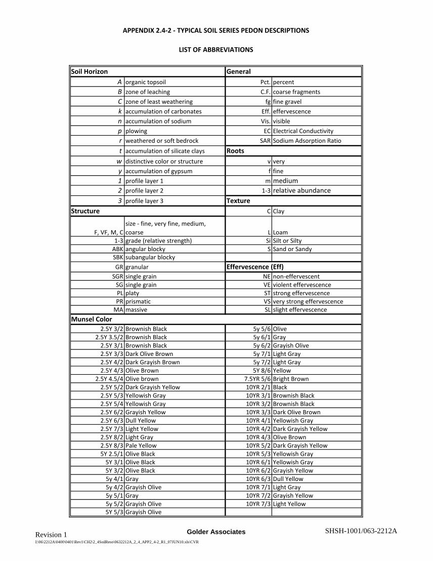
Revision 1 I:\06\2212A\0400\0401\Rev1\CH2\2_4SoilReso\0632212A_2_4_APP2_4-2_R1_07JUN10.xls\CVR Golder Associates SHSH-1001/063-2212A Soil Horizon A organic topsoil Pct. percent B zone of leaching C.F. coarse fragments C zone of least weathering fg fine gravel k accumulation of carbonates Eff. effervescence n accumulation of sodium Vis. visible p plowing EC Electrical Conductivity r weathered or soft bedrock SAR Sodium Adsorption Ratio t accumulation of silicate clays w distinctive color or structure v very y accumulation of gypsum f fine 1 profile layer 1 m medium 2 profile layer 2 1-3 relative abundance 3 profile layer 3 C Clay F, VF, M, C size - fine, very fine, medium, coarse L Loam 1-3 grade (relative strength) Si Silt or Silty ABK angular blocky S Sand or Sandy SBK subangular blocky GR granular SGR single grain NE non-effervescent SG single grain VE violent effervescence PL platy ST strong effervescence PR prismatic VS very strong effervescence MA massive SL slight effervescence 2.5Y 3/2 Brownish Black 5y 5/6 Olive 2.5Y 3.5/2 Brownish Black 5y 6/1 Gray 2.5Y 3/1 Brownish Black 5y 6/2 Grayish Olive 2.5Y 3/3 Dark Olive Brown 5y 7/1 Light Gray 2.5Y 4/2 Dark Grayish Brown 5y 7/2 Light Gray 2.5Y 4/3 Olive Brown 5Y 8/6 Yellow 2.5Y 4.5/4 Olive brown 7.5YR 5/6 Bright Brown 2.5Y 5/2 Dark Grayish Yellow 10YR 2/1 Black 2.5Y 5/3 Yellowish Gray 10YR 3/1 Brownish Black 2.5Y 5/4 Yellowish Gray 10YR 3/2 Brownish Black 2.5Y 6/2 Grayish Yellow 10YR 3/3 Dark Olive Brown 2.5Y 6/3 Dull Yellow 10YR 4/1 Yellowish Gray 2.5Y 7/3 Light Yellow 10YR 4/2 Dark Grayish Yellow 2.5Y 8/2 Light Gray 10YR 4/3 Olive Brown 2.5Y 8/3 Pale Yellow 10YR 5/2 Dark Grayish Yellow 5Y 2.5/1 Olive Black 10YR 5/3 Yellowish Gray 5Y 3/1 Olive Black 10YR 6/1 Yellowish Gray 5Y 3/2 Olive Black 10YR 6/2 Grayish Yellow 5y 4/1 Gray 10YR 6/3 Dull Yellow 5y 4/2 Grayish Olive 10YR 7/1 Light Gray 5y 5/1 Gray 10YR 7/2 Grayish Yellow 5y 5/2 Grayish Olive 10YR 7/3 Light Yellow 5Y 5/3 Grayish Olive Munsel Color APPENDIX 2.4-2 - TYPICAL SOIL SERIES PEDON DESCRIPTIONS LIST OF ABBREVIATIONS General Roots Texture Structure Effervescence (Eff)
-
Upload
trannguyet -
Category
Documents
-
view
213 -
download
0
Transcript of APPENDIX 2.4-2 - TYPICAL SOIL SERIES PEDON...
Revision 1I:\06\2212A\0400\0401\Rev1\CH2\2_4SoilReso\0632212A_2_4_APP2_4-2_R1_07JUN10.xls\CVR
Golder Associates SHSH-1001/063-2212A
Soil HorizonA organic topsoil Pct. percentB zone of leaching C.F. coarse fragmentsC zone of least weathering fg fine gravelk accumulation of carbonates Eff. effervescencen accumulation of sodium Vis. visiblep plowing EC Electrical Conductivityr weathered or soft bedrock SAR Sodium Adsorption Ratiot accumulation of silicate clays
w distinctive color or structure v veryy accumulation of gypsum f fine1 profile layer 1 m medium2 profile layer 2 1-3 relative abundance3 profile layer 3
C Clay
F, VF, M, Csize - fine, very fine, medium, coarse L Loam
1-3 grade (relative strength) Si Silt or SiltyABK angular blocky S Sand or SandySBK subangular blockyGR granular
SGR single grain NE non-effervescentSG single grain VE violent effervescencePL platy ST strong effervescencePR prismatic VS very strong effervescence
MA massive SL slight effervescence
2.5Y 3/2 Brownish Black 5y 5/6 Olive2.5Y 3.5/2 Brownish Black 5y 6/1 Gray
2.5Y 3/1 Brownish Black 5y 6/2 Grayish Olive2.5Y 3/3 Dark Olive Brown 5y 7/1 Light Gray2.5Y 4/2 Dark Grayish Brown 5y 7/2 Light Gray2.5Y 4/3 Olive Brown 5Y 8/6 Yellow
2.5Y 4.5/4 Olive brown 7.5YR 5/6 Bright Brown2.5Y 5/2 Dark Grayish Yellow 10YR 2/1 Black2.5Y 5/3 Yellowish Gray 10YR 3/1 Brownish Black2.5Y 5/4 Yellowish Gray 10YR 3/2 Brownish Black2.5Y 6/2 Grayish Yellow 10YR 3/3 Dark Olive Brown2.5Y 6/3 Dull Yellow 10YR 4/1 Yellowish Gray2.5Y 7/3 Light Yellow 10YR 4/2 Dark Grayish Yellow2.5Y 8/2 Light Gray 10YR 4/3 Olive Brown2.5Y 8/3 Pale Yellow 10YR 5/2 Dark Grayish Yellow5Y 2.5/1 Olive Black 10YR 5/3 Yellowish Gray
5Y 3/1 Olive Black 10YR 6/1 Yellowish Gray5Y 3/2 Olive Black 10YR 6/2 Grayish Yellow5y 4/1 Gray 10YR 6/3 Dull Yellow5y 4/2 Grayish Olive 10YR 7/1 Light Gray5y 5/1 Gray 10YR 7/2 Grayish Yellow5y 5/2 Grayish Olive 10YR 7/3 Light Yellow5Y 5/3 Grayish Olive
Munsel Color
APPENDIX 2.4-2 - TYPICAL SOIL SERIES PEDON DESCRIPTIONS
LIST OF ABBREVIATIONS
General
Roots
TextureStructure
Effervescence (Eff)

Revision 1I:\06\2212A\0400\0401\Rev1\CH2\2_4SoilReso\0632212A_2_4_APP2_4-2_R1_07JUN10.xls\AMOR
Golder Associates SHSH-1001/063-2212A
Site ID: SERIES:
Landform: Epipedon
Biota: Control Texture:
Landuse: Parent Material:
Dry Matrix/Mottles
Moist Matrix
1 Ap 0 - 6 1vfmoist in
field10YR3/2
L26.3
N M1SBK < 1% NE NEC 1.12
SAR 0.37
2 Bw 6 - 13 1vf --10YR3/3
CL27.5
N M2PR < 1% NE NEC 0.52
SAR 0.25
3 Bk 13 - 24 1vf --10YR5/2
SiL26.3
N M1SBK < 1% VE NEC 0.33
SAR 0.37
4 Cr 24 - 60 -- -- --SiL
17.5N MA < 1% VE N
Soft BedrockEC 0.66
SAR 1.44
5 -
6 -
TYPICAL PEDON DESCRIPTION
060926-T02 AMOR
UTM NAD 83 Zone 13 North RESIDUAL HILLSLOPE MOLLIC
Northing: 5,190,223 CROP SHALE/SILTSTONE
Easting: 650,552 WHEAT
Vis.Salt
C.F.% by Vol [note size and %]
ColorClay Films [Y / N]
GeneralComment
FINE-LOAMY
Other Comments: This profile has a fine-loamy control section bordering on fine-silty (Sen series). These borderline soils may have been
misclassified as the very similar Sen series during the field survey. The organic matter is very low in the A-horizon of this profile.
Horizon Depth [inches]
RootsTexture
&Pct. Clay
Structure [size, grade,
class]Eff.
SOUTH HEART LIGNITE MINE

Revision 1I:\06\2212A\0400\0401\Rev1\CH2\2_4SoilReso\0632212A_2_4_APP2_4-2_R1_07JUN10.xls\ARNEGARD
Golder Associates SHSH-1001/063-2212A
Site ID: SERIES:
Landform: Epipedon
Biota: Control Texture:
Landuse: Parent Material:
Dry Matrix/Mottles
Moist Matrix
1 Ap 0 - 7 1f Mollic10YR3/1
CL31.3
N F-M1SBK 0 - 1% fg NE N --
2 Bw (Bt) 7 - 17 1fMoist in
field2.5Y3/2
CL33.8
YM1-2SBK
ABK0 - 1% fg NE N
Very slight clay increase is detectable.
3 Bk1 17 - 37 1f --2.5Y4/2
CL31.3
N M2SBK 1-3% fg ST N --
4 Bk2 37 - 58 -- -- --SiC
41.3N MA 0-1% fg SL N --
5 - --
6 - --
TYPICAL PEDON DESCRIPTION
061016-S29 ARNEGARD
UTM NAD 83 Zone 13 North MID-TOE SLOPE PACHIC MOLLIC
Northing: 5,188,242 CROPLAND ALLUVIUM
Easting: 650,883 HARVESTED SAFFLOWER
Vis.Salt
C.F.% by Vol [note size and %]
ColorClay Films [Y / N]
GeneralComment
FINE
Other Comments: This soil is not argillic, although a slight clay increase was noted in the subsoil. This profile's texture is slightly more fine than
the OSD for this series. The EC and SAR are very low in all horizons. The top two horizons have 2.5 - 3.0 % Organic Matter.
Horizon Depth [inches]
RootsTexture
&Pct. Clay
Structure [size, grade,
class]Eff.
SOUTH HEART LIGNITE MINE

Revision 1I:\06\2212A\0400\0401\Rev1\CH2\2_4SoilReso\0632212A_2_4_APP2_4-2_R1_07JUN10.xls\CABBA
Golder Associates SHSH-1001/063-2212A
Site ID: SERIES:
Landform: Epipedon
Biota: Control Texture:
Landuse: Parent Material:
Dry Matrix/Mottles
Moist Matrix
1 Ap 0 - 6 1f10YR7/3
10YR5/3
SiL25
N F1SBK < 1% VE N --
2 Bk 6 - 12 1f2.5Y8/3
2.5Y7/3
SiL27
N F1PR < 1% VE N --
3 Cr1 12 - 33 1vf2.5Y8/2
2.5Y6/2
-- N -- < 1% ST N Soft Siltstone
4 Cr2 33 - 60 --5Y8/6
5Y5/6
-- N -- < 1% ST N Soft Siltstone
5 -
6 -
RESIDUUM (SILTSTONE)
Structure [size, grade,
class]
Other Comments: Depth to soft siltstone ranges from 5 -17 inches in most profiles near this typical pedon.
Horizon Depth [inches]
Texture&
Pct. Clay
Easting:
Eff.
646,470
Vis.Salt
Northing: 5,190,725
CROP LOAMY
C.F.% by Vol [note size and %]
CROP
ColorClay Films [Y / N]
TYPICAL PEDON DESCRIPTION
060822-T08 CABBA
UTM NAD 83 Zone 13 North RESIDUAL HILLSLOPE OCHRIC
RootsGeneral
Comment
SOUTH HEART LIGNITE MINE

Revision 1I:\06\2212A\0400\0401\Rev1\CH2\2_4SoilReso\0632212A_2_4_APP2_4-2_R1_07JUN10.xls\CHAMA
Golder Associates SHSH-1001/063-2212A
Site ID: SERIES:
Landform: Epipedon
Biota: Control Texture:
Landuse: Parent Material:
Dry Matrix/Mottles
Moist Matrix
1 Ap 0 - 7 3vf10YR4/2
10YR3/2
SiCL30
N VF1SBK < 1% ST N --
2 Bk1 7 - 18 2vf10YR6/2
10YR4/2
SiCL31.3
N V1PR < 1% VE N --
3 Bk2 18 - 24 1vf10YR7/1
10YR4/1
SiCL36.3
N F1PR < 1% VE N --
4 Cr 24 - 60 -- -- --SiCL32.5
N -- < 1% -- N Soft Siltstone
5 -
6 -
Clay Films [Y / N]
TYPICAL PEDON DESCRIPTION
070425-T01 CHAMA
UTM NAD 83 Zone 13 North UPLAND MOLLIC
Depth [inches]
GeneralComment
Northing: 5,190,290 WEATHERED SILTSTONE
Structure [size, grade,
class]
C.F.% by Vol [note size and %]
Eff.Vis.Salt
Roots
ColorTexture
&Pct. Clay
Easting: 646,155 CROP
CROP
FINE SILTY
Other Comments: Chama occurs infrequently. This occurrence is located in a delineation of the similar Sen series.
Horizon
SOUTH HEART LIGNITE MINE

Revision 1I:\06\2212A\0400\0401\Rev1\CH2\2_4SoilReso\0632212A_2_4_APP2_4-2_R1_07JUN10.xls\DAGLUM
Golder Associates SHSH-1001/063-2212A
Site ID: SERIES:
Landform: Epipedon
Biota: Control Texture:
Landuse: Parent Material:
Dry Matrix/Mottles
Moist Matrix
1 A1 0 - 6 3f10YR4/2
10YR3/2
SiCL30
N VF1GR < 1% NE N --
2 Bt 6 - 10 1f10YR4/2
10YR4/2
SiC48
N F3ABK < 1% NE N Large masses CaCo3
3 Btn 10 - 17 1f10YR5/2
10YR3/2
SiC50
N F3ABK < 1% ST N SAR 11
4 Bkn1 17 - 30 1vf10YR4/2
10YR3/2
SiC50
N M3PR < 1% ST NSAR 16.4EC 16.1
5 Bkn2 30 - 43 1vf10YR4/2
10YR3/2
SiC50
N M1SBK < 1% ST NSAR 18.5 EC 22.1
Large masses CaCo3
6 C 43 - 60 --2.5Y6/2
2.5Y4/2
SiCL N -- < 1% ST NSAR 18.5 EC 22.1
Few small masses CaCo3
GeneralComment
Other Comments: This profile is a Daglum taxadjunct. The profile physically appears to have a natric horizon, but the SAR of the argillic horizon
is slightly less than 13. Such profiles are common. This profile is an inclusion in a Rhoades unit commonly with salts at <16 in.
Structure [size, grade,
class]
C.F.% by Vol [note size and %]
Eff.Vis.Salt
MOLLIC
Horizon Depth [inches]
Roots
ColorTexture
&Pct. Clay
Northing: 5,190,445 PASTURE
Clay Films [Y / N]
CLAYEY ALLUVIUM
Easting: 647,485 NATIVE FINE
TYPICAL PEDON DESCRIPTION
060822-T02 DAGLUM t.
UTM NAD 83 Zone 13 North LEVEL PLAIN
SOUTH HEART LIGNITE MINE

Revision 1I:\06\2212A\0400\0401\Rev1\CH2\2_4SoilReso\0632212A_2_4_APP2_4-2_R1_07JUN10.xls\DOGTOOTH
Golder Associates SHSH-1001/063-2212A
Site ID: SERIES:
Landform: Epipedon
Biota: Control Texture:
Landuse: Parent Material:
Dry Matrix/Mottles
Moist Matrix
1 E 0 - 1 1f2.5Y6/2
2.5Y4/2
SiC47
N F2PL < 1% NE N
2 Btn1 1 - 10 1f2.5Y6/2
2.5Y5/2
SiC50
N F1SBK < 1% NE Y
3 Btn2 10 - 22 1f5Y5/1
5Y4/1
SiC53
N F1SBK < 1% NE YSAR 16.1
EC 8.9
4 Cr1 22 - 40 -- --5Y4/2
SiC N -- SHALE -- NSAR 22.1EC 8.98
5 Cr2 40 - 60 -- --5Y5/3
SiC N -- SHALE -- N --
6 - --
Clay Films [Y / N]
C.F.% by Vol [note size and %]
FINE
Northing: 5,190,261 PASTURE RESIDUUM - SOFT SHALE
Easting: 647,504 NATIVE GRASS
Depth [inches]
Roots
ColorTexture
&Pct. Clay
Other Comments: This profile is located in a large area with very little vegetative cover and a light colored surface typical of this series.
This profile is entirely unsuitable for salvage.
HorizonStructure [size, grade,
class]Eff.
Vis.Salt
GeneralComment
SAR 12.6EC 7.02
TYPICAL PEDON DESCRIPTION
060822-T03 DOGTOOTH
UTM NAD 83 Zone 13 North RESIDUAL UPLAND OCHRIC
SOUTH HEART LIGNITE MINE

Revision 1I:\06\2212A\0400\0401\Rev1\CH2\2_4SoilReso\0632212A_2_4_APP2_4-2_R1_07JUN10.xls\FLASHER
Golder Associates SHSH-1001/063-2212A
Site ID: SERIES:
Landform: Epipedon
Biota: Control Texture:
Landuse: Parent Material:
Dry Matrix/Mottles
Moist Matrix
1 Ap 0 - 7 3f10YR5/2
10YR4/2
SL11.3
N SGR < 1% NE N --
2 Bw 7 - 14 2vf10YR7/2
10YR5/2
SL11.3
N SGR < 1% SL N --
3 Cr 14 - 60 -- -- -- -- -- -- -- NE NSandstone
bedrock
4 -
5 -
6 -
Depth [inches]
COARSE LOAMY BORDERING SANDY
Northing: 5,191,812 WHEAT WEATHERED SANDSTONE
Easting: 650,953 CROP
Other Comments: This profile occurs in a Flasher delineation. The entire profile is suitable for salvage to the depth of bedrock contact (14 in).
The texture may be slightly more fine than normal for Flasher, but it is much more coarse than Cabba. No samples collected.
HorizonStructure [size, grade,
class]Eff.C.F.% by Vol
[note size and %]Vis.Salt
Roots
ColorClay Films [Y / N]
Texture&
Pct. Clay
TYPICAL PEDON DESCRIPTION
070504-T01 FLASHER
UTM NAD 83 Zone 13 North UPLAND RIDGE MOLLIC
GeneralComment
SOUTH HEART LIGNITE MINE

Revision 1I:\06\2212A\0400\0401\Rev1\CH2\2_4SoilReso\0632212A_2_4_APP2_4-2_R1_07JUN10.xls\GRAIL
Golder Associates SHSH-1001/063-2212A
Site ID: SERIES:
Landform: Epipedon
Biota: Control Texture:
Landuse: Parent Material:
Dry Matrix/Mottles
Moist Matrix
1 Ap 0 - 7 f1Moist in
Field2.5Y3/2
SiCL30
N F2GR < 1% NE N --
2 A2 7 - 14 f2 --2.5Y3/2
SiCL31.3
N F2GR < 1% NE N --
3 AB 14 - 24 f3 --2.5Y3/2
SiCL33.8
N F1SBK < 1% NE N SAR 1.91
4 Bt 24 - 34 none --2.5Y3/2
SiC42.5
YM2SBKM2PR
< 1% NE N SAR 5.07
5 Bky 34 - 49 none --2.5Y3.5/2
C43.8
N MA < 1% SL YSAR 8.26 Carb/Gypsum
filaments
6 Cy 49 - 60 none --2.5Y4/2
SiC41.3
N MA < 1% SL YSAR 13.9 Carb/Gypsum
filaments
TYPICAL PEDON DESCRIPTION
070516-S01 GRAIL
UTM NAD 83 Zone 13 North SWALE / DRAINAGE BOTTOM PACHIC MOLLIC
Northing: 5,186,062 CRP ALLUVIUM
Easting: 649,358 ALFALFA - CRESTED WHEATGRASS
Vis.Salt
C.F.% by Vol [note size and %]
ColorClay Films [Y / N]
GeneralComment
FINE
Other Comments: This profile is unsuitable for salvage below a depth of 49 inches. High sodium and salt content limits salvage in more than
half of the profiles of this series, often at depths from 30 to 50 inches.
Horizon Depth [inches]
RootsTexture
&Pct. Clay
Structure [size, grade,
class]Eff.
SOUTH HEART LIGNITE MINE

Revision 1I:\06\2212A\0400\0401\Rev1\CH2\2_4SoilReso\0632212A_2_4_APP2_4-2_R1_07JUN10.xls\HARRIET
Golder Associates SHSH-1001/063-2212A
Site ID: SERIES:
Landform: Epipedon
Biota: Control Texture:
Landuse: Parent Material:
Dry Matrix/Mottles
Moist Matrix
1 A 0 - 7 3vf2.5Y6/2
2.5Y4/2
SiCl35
N MA < 1% NE YSAR 42.6EC 32.4
2 Bt 7 - 21 1vf2.5Y6/3
2.5Y4/3
SiCL40
N MA < 1% VS YSAR 51.1EC 52.9
3 Cg1 21 - 34 1vf5Y6/3
5Y4/3
C50
N MA < 1% VS YSAR 36.1EC 22.3
4 Cg2 34 - 47 none5Y6/3
5Y4/3
C48.8
N MA < 1% VS YSAR 34.7EC 18.2
5 Cg3 47 - 60 none5Y7/1
5Y5/1
SiC45
N MA < 1% VS YSAR 27.7EC 14.4
6 -
GeneralComment
Other Comments: This entire profile is unsuitable for salvage.
Structure [size, grade,
class]
C.F.% by Vol [note size and %]
Eff.Vis.Salt
OCHRIC
Horizon Depth [inches]
Roots
ColorTexture
&Pct. Clay
Northing: 5,191,518 PASTURE
Clay Films [Y / N]
ALLUVIUM
Easting: 646,360 SALT GRASS FINE
TYPICAL PEDON DESCRIPTION
070425-T02 HARRIET
UTM NAD 83 Zone 13 North SWALE - SALINE LOWLAND
SOUTH HEART LIGNITE MINE

Revision 1I:\06\2212A\0400\0401\Rev1\CH2\2_4SoilReso\0632212A_2_4_APP2_4-2_R1_07JUN10.xls\HAVRELON
Golder Associates SHSH-1001/063-2212A
Site ID: SERIES:
Landform: Epipedon
Biota: Control Texture:
Landuse: Parent Material:
Dry Matrix/Mottles
Moist Matrix
1 A 0 - 92f
2mMoist in
Field2.5Y4/2
SiL18.8
N F2GR < 1% VS N Very Moist
2 Bk(n) 9 - 23 1f --2.5Y5/2
SiCL40
N M1SBK < 1% SL NEC 1.89
SAR 19.8
3 C 23 - 60 none --2.5Y5/2
SiL23.8
N SGR < 1% ST NEC 5.0 SAR 34.9
No sample collectedbelow 47 in
4 -
5 -
6 -
TYPICAL PEDON DESCRIPTION
070511-S32 HAVRELON t. (sodic subsoil)
UTM NAD 83 Zone 13 North FIRST TERRACE ABOVE CHANNEL OCHRIC
Northing: 5,185,523 GRASSLAND ALLUVIUM
Easting: 650,473 SMOOTH BROME AND SNOWBERRY
Vis.Salt
C.F.% by Vol [note size and %]
ColorClay Films [Y / N]
GeneralComment
FINE-LOAMY
Other Comments: This profile represents the lower terrace and is chemically and physically very similar to the higher terrace at 070511-S32.
This profile is typical of the the s/s map units. The substratum is unsuitable for salvage. Lift 1 may be salvaged to a depth of 9 in.
Horizon Depth [inches]
RootsTexture
&Pct. Clay
Structure [size, grade,
class]Eff.
SOUTH HEART LIGNITE MINE
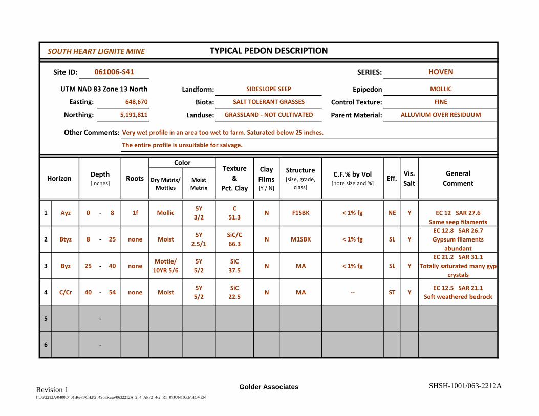
Revision 1I:\06\2212A\0400\0401\Rev1\CH2\2_4SoilReso\0632212A_2_4_APP2_4-2_R1_07JUN10.xls\HOVEN
Golder Associates SHSH-1001/063-2212A
Site ID: SERIES:
Landform: Epipedon
Biota: Control Texture:
Landuse: Parent Material:
Dry Matrix/Mottles
Moist Matrix
1 Ayz 0 - 8 1f Mollic5Y3/2
C51.3
N F1SBK < 1% fg NE Y EC 12 SAR 27.6Same seep filaments
2 Btyz 8 - 25 none Moist5Y
2.5/1SiC/C66.3
N M1SBK < 1% fg SL YEC 12.8 SAR 26.7Gypsum filaments
abundant
3 Byz 25 - 40 noneMottle/
10YR 5/65Y5/2
SiC 37.5
N MA < 1% fg SL YEC 21.2 SAR 31.1
Totally saturated many gyp crystals
4 C/Cr 40 - 54 none Moist5Y5/2
SiC22.5
N MA -- ST YEC 12.5 SAR 21.1
Soft weathered bedrock
5 -
6 -
TYPICAL PEDON DESCRIPTION
061006-S41 HOVEN
UTM NAD 83 Zone 13 North SIDESLOPE SEEP MOLLIC
Northing: 5,191,811 GRASSLAND - NOT CULTIVATED ALLUVIUM OVER RESIDUUM
Easting: 648,670 SALT TOLERANT GRASSES
Vis.Salt
C.F.% by Vol [note size and %]
ColorClay Films [Y / N]
GeneralComment
FINE
Other Comments: Very wet profile in an area too wet to farm. Saturated below 25 inches.
The entire profile is unsuitable for salvage.
Horizon Depth [inches]
RootsTexture
&Pct. Clay
Structure [size, grade,
class]Eff.
SOUTH HEART LIGNITE MINE

Revision 1I:\06\2212A\0400\0401\Rev1\CH2\2_4SoilReso\0632212A_2_4_APP2_4-2_R1_07JUN10.xls\JANESBURG
Golder Associates SHSH-1001/063-2212A
Site ID: SERIES:
Landform: Epipedon
Biota: Control Texture:
Landuse: Parent Material:
Dry Matrix/Mottles
Moist Matrix
1 Ap 0 - 6 2F2.5Y5/2
2.5Y4/2
SiC48
N M1SBK < 1% NE NSAR 1.51EC 0.91
2 Bt 6 - 20 2F2.5Y5/2
2.5Y4/2
SiC52
Y M-C2PR < 1% ST NSAR 9.54EC 0.78
3 Bkn 20 - 36 1F2.5Y6/2
2.5Y4/2
SiC52
N M1SBK < 1% ST NSAR 14.9EC 7.68
4 Cr 36 - 60 none --5Y5/2
SHALE -- -- -- ST ySAR 17EC 10.1Gypsum
5 - --
6 - --
RESIDUUM WEATHERED FROM SHALE
Structure [size, grade,
class]
Other Comments: This profile does not quite meet the SAR requirements for natric (>13 in Bt) but does exhibit many other typical characteristics.
While technically a taxadjunct, this profile is very typical of this series as it occurs in the survey area.
Horizon Depth [inches]
Texture&
Pct. Clay
Easting:
Eff.
646,633
Vis.Salt
Northing: 5,190,830
CROP FINE
C.F.% by Vol [note size and %]
WHEAT
ColorClay Films [Y / N]
TYPICAL PEDON DESCRIPTION
060822-T07 JANESBURG t.
UTM NAD 83 Zone 13 North RESIDUAL PLAIN MOLLIC
RootsGeneral
Comment
SOUTH HEART LIGNITE MINE

Revision 1I:\06\2212A\0400\0401\Rev1\CH2\2_4SoilReso\0632212A_2_4_APP2_4-2_R1_07JUN10.xls\KORELL
Golder Associates SHSH-1001/063-2212A
Site ID: SERIES:
Landform: Epipedon
Biota: Control Texture:
Landuse: Parent Material:
Dry Matrix/Mottles
Moist Matrix
1 A 0 - 9 2f2.5Y5/2
2.5Y3/3
CL30
N M1SBK < 1% NE N --
2 AB 9 - 18 2f --2.5Y4/3
CL30
N M1SBK < 1% NE N --
3 Bk 18 - 29 1f --2.5Y5/4
L25
N M1SBK < 1% ST N --
4 C 29 - 60 1f --2.5Y5/4
L25
N MA < 1% ST N small carbonate nodules
5 -
6 -
C.F.% by Vol [note size and %]
Eff.Vis.Salt
GeneralComment
Other Comments: This site was not fully described in the precise location of the site noted and is more appropriately a composite of similar
adjacent profiles. This site was not sampled for chemical analysis. Some evidence of stratification is noticable.
Horizon Depth [inches]
TYPICAL PEDON DESCRIPTION
070515-S08 KORELL
UTM NAD 83 Zone 13 North TERRACE
Roots
ColorTexture
&Pct. Clay
Clay Films [Y / N]
Structure [size, grade,
class]
MOLLIC
ALLUVIUM
Easting: 649,183 GRAIN FALLOW FINE-LOAMY
Northing: 5,192,279 CROPLAND
SOUTH HEART LIGNITE MINE

Revision 1I:\06\2212A\0400\0401\Rev1\CH2\2_4SoilReso\0632212A_2_4_APP2_4-2_R1_07JUN10.xls\LALLIE
Golder Associates SHSH-1001/063-2212A
Site ID: SERIES:
Landform: Epipedon
Biota: Control Texture:
Landuse: Parent Material:
Dry Matrix/Mottles
Moist Matrix
1 A 0 - 9 1vf5Y5/2
2.5Y 4/27.5YR 5/6
C58.8
N M2SBK < 1% NE N --
2 Bt 9 - 19 1vf5Y 4/1 &
5Y 6/15Y 3/1 &
5Y 5/1SiC
56.3Y M3SBK < 1% NE N mottled
3 2Cg 19 - 27 1vf5Y 5/2 &
5Y 7/25Y 4/2 &
5Y 6/2SiCL38.8
N M1SBK < 1% NE N mottled
4 2C1 27 - 43 none5Y4/2
5Y3/2
SiC46.3
N M3SBK < 1% NE N mottled
5 2C2 43 - 60 none5Y5/2
5Y4/2
SiC42.5
N M1SBK < 1% NE N mottled
6 - --
Depth [inches]
FINE
Northing: 5,188,875 PASTURE ALLUVIUM
Easting: 651,089 NATIVE
Other Comments: This profile developed in a channel bottom filled with local alluvium but adjacent to river terraces. The entire profile is suitable
for salvage, but wet conditions may limit salvage operations.
HorizonStructure [size, grade,
class]Eff.C.F.% by Vol
[note size and %]Vis.Salt
Roots
ColorClay Films [Y / N]
Texture&
Pct. Clay
TYPICAL PEDON DESCRIPTION
060929-T04 LALLIE
UTM NAD 83 Zone 13 North OLD CHANNEL / SWALE OCHRIC
GeneralComment
SOUTH HEART LIGNITE MINE

Revision 1I:\06\2212A\0400\0401\Rev1\CH2\2_4SoilReso\0632212A_2_4_APP2_4-2_R1_07JUN10.xls\LAWTHER
Golder Associates SHSH-1001/063-2212A
Site ID: SERIES:
Landform: Epipedon
Biota: Control Texture:
Landuse: Parent Material:
Dry Matrix/Mottles
Moist Matrix
1 Ap 0 - 6 1vf10YR4/2
10YR2/2
CL27.5
N M2SBK < 1% NE N --
2 Bt 6 - 13 1vf10YR5/2
10YR3/2
C 46.3
Y M3SBK < 1% NE N --
3 Bk 13 - 28 1vf2.5Y6/2
2.5Y4/2
C50
Y M2SBK < 1% ST N Segregated line
4 Bky 28 - 41 1vf2.5Y6/2
2.5Y4/2
C50
Y M1SBK < 1% ST NSlickenslides are evident
at 30 in.
5 C 41 - 60 none2.5Y6/3
2.5Y4/3
C50
N MASSIVE < 1% ST YEC 7.27
SAR 6.67
6 - --
GeneralComment
Other Comments: This series commonly has high SAR and/or EC in the lower horizons (30-60 inches). This profile is unsuitable for salvage below
a depth of 41 inches due to elevated EC.
Structure [size, grade,
class]
C.F.% by Vol [note size and %]
Eff.Vis.Salt
PACHIC MOLLIC
Horizon Depth [inches]
Roots
ColorTexture
&Pct. Clay
Northing: 5,188,939 CROPLAND
Clay Films [Y / N]
LOCAL ALLUVIUM
Easting: 648,862 WHEAT FINE
TYPICAL PEDON DESCRIPTION
060926-T01 LAWTHER
UTM NAD 83 Zone 13 North SWALE
SOUTH HEART LIGNITE MINE

Revision 1I:\06\2212A\0400\0401\Rev1\CH2\2_4SoilReso\0632212A_2_4_APP2_4-2_R1_07JUN10.xls\LOHLER
Golder Associates SHSH-1001/063-2212A
Site ID: SERIES:
Landform: Epipedon
Biota: Control Texture:
Landuse: Parent Material:
Dry Matrix/Mottles
Moist Matrix
1 A1 0 - 7 3m10YR6/1
10YR4/1
SiC40
N M3BSK < 1% NE N Suitable
2 C1 7 - 37 2f10YR8/1
10YR6/1
STRATFIEDSiL 51
N MA < 1% SL N Likely elevated EC and SAR
3 C2 37 - 60 1f10YR6/3
10YR4/3
SiC N MA < 1% SL N Likely elevated EC and SAR
4 -
5 -
6 -
GeneralComment
Other Comments: This site was not sampled, but is assumed to have unsuitable C-horizon materials due to elevated EC and SAR. The light colored
materials elsewhere in the valley bottom have been found to be unsuitable where massive and calcareous.
Structure [size, grade,
class]
C.F.% by Vol [note size and %]
Eff.Vis.Salt
OCHRIO
Horizon Depth [inches]
Roots
ColorTexture
&Pct. Clay
Northing: 5,188,243 PASTURE
Clay Films [Y / N]
ALLUVIUM
Easting: 649,988 MIXED TREES AND GRASS FINE
TYPICAL PEDON DESCRIPTION
061025-T01 LOHLER
UTM NAD 83 Zone 13 North LOW TERRACE
SOUTH HEART LIGNITE MINE

Revision 1I:\06\2212A\0400\0401\Rev1\CH2\2_4SoilReso\0632212A_2_4_APP2_4-2_R1_07JUN10.xls\MANNING
Golder Associates SHSH-1001/063-2212A
Site ID: SERIES:
Landform: Epipedon
Biota: Control Texture:
Landuse: Parent Material:
Dry Matrix/Mottles
Moist Matrix
1 Ap 0 - 6 2fmoist in
field10YR3/2
SL18
N F1SBK < 1 % NE N --
2 A2 6 - 18 2f --10YR3/3
SL18
N F2SBK 1 - 5 % FG NE N --
3 Bw 18 - 27 1f --10YR4/3
SL16
N F1SBK 1 - 5 % FG NE N --
4 2Bk 32 - 40+ -- --very light
carbGr. L
17N
StructurelessGravelly
40+ % F-M Grav ST NFree carbonates. Difficult
to auger.
5 -
6 -
5,189,948 CROPLAND ALLUVIUM
TYPICAL PEDON DESCRIPTION
061005-S12 MANNING
UTM NAD 83 Zone 13 North HIGH TERRACE REMNANT MOLLIC (PACHIC)
RootsGeneral
Comment
Structure [size, grade,
class]
ColorTexture
&Pct. Clay
Easting: 651,535 GRAIN STUBBLE COARSE-LOAMY
Northing:
Clay Films [Y / N]
C.F.% by Vol [note size and %]
Eff.Vis.Salt
Other Comments: This profile has a slightly thicker mollic epipedon (18 in) than the official series description. The Manning series occurs
infrequently and is well drained. It is likely leached of salts and sodium and, therefore, was not sampled.
Horizon Depth [inches]
SOUTH HEART LIGNITE MINE

Revision 1I:\06\2212A\0400\0401\Rev1\CH2\2_4SoilReso\0632212A_2_4_APP2_4-2_R1_07JUN10.xls\MOREAU
Golder Associates SHSH-1001/063-2212A
Site ID: SERIES:
Landform: Epipedon
Biota: Control Texture:
Landuse: Parent Material:
Dry Matrix/Mottles
Moist Matrix
1 Ap 0 - 6 1vfmoist in
field10YR
(3) 4/2SiCL32.5
N M2SBK < 1% NE N --
2 Bk1 6 - 14 1vf --2.5Y5/2
CL35
YM1PR to M1SBK
< 1% VE N --
3 Bk2 14 - 27 1vf --2.5Y5/3
L26.3
N M2SBK < 1% VE N EC 0.38 SAR 2.76Small masses CaCO3
4 Cr1 27 - 36 vfvf --2.5Y6/3
L25
N PL < 1% ST NEC 1.27SAR 10
5 Cr2 36 - 60 0 --2.5Y6/3
L20
N PL < 1% SL NEC 7.63
SAR 10.5
6 -
TYPICAL PEDON DESCRIPTION
060921-T01 MOREAU
UTM NAD 83 Zone 13 North UPLAND MOLLIC (borderline)
Northing: 5,190,642 CROPLAND WEATHERED SHALE
Easting: 649,765 WHEAT FALLOW
Vis.Salt
C.F.% by Vol [note size and %]
ColorClay Films [Y / N]
GeneralComment
FINE
Other Comments: Calcareous A and Bk are common in the Moreau Map Units.
This profile may be slightly too light to be Mollic, but is otherwise very typical of the Moreau series.
Horizon Depth [inches]
RootsTexture
&Pct. Clay
Structure [size, grade,
class]Eff.
SOUTH HEART LIGNITE MINE

Revision 1I:\06\2212A\0400\0401\Rev1\CH2\2_4SoilReso\0632212A_2_4_APP2_4-2_R1_07JUN10.xls\MORTON
Golder Associates SHSH-1001/063-2212A
Site ID: SERIES:
Landform: Epipedon
Biota: Control Texture:
Landuse: Parent Material:
Dry Matrix/Mottles
Moist Matrix
1 Ap 0 - 7 1vf10YR4/2
10YR3/2
SiCL30
N M2SBK < 0.1% NE N --
2 Bt1 7 - 15 1vf10YR4/2
10Y 3/2
SiCL30
N M3PR < 0.1% NE N --
3 Bt2 15 - 31 1vf10YR5/2
10YR4/2
SiCL30
N M2SBK < 0.1% NE NEC 2.16
SAR 6.96
4 Bk 31 - 38 1vf10YR6/2
10YR5/2
SiCL30
N M2SBK < 0.1% ST NEC 1.71
SAR 5.31
5 Cr 38 - 60 none2.5Y6/3
2.5Y6/3
-- -- -- -- ST NSiltstone Beds
EC 2.11SAR 16
6 - --
TYPICAL PEDON DESCRIPTION
060929-T03 MORTON
UTM NAD 83 Zone 13 North UPLAND SLOPE/SWALE MOLLIC
Northing: 5,189,303 CROPLAND RESIDUUM (SILTSTONE)
Easting: 649,854 WHEAT
Vis.Salt
C.F.% by Vol [note size and %]
ColorClay Films [Y / N]
GeneralComment
FINE-SILTY
Other Comments: This profile is suitable for salvage to the depth of bedrock contact (38 in).
The epipedon is nearly pachic (15 in mollic).
Horizon Depth [inches]
RootsTexture
&Pct. Clay
Structure [size, grade,
class]Eff.
SOUTH HEART LIGNITE MINE

Revision 1I:\06\2212A\0400\0401\Rev1\CH2\2_4SoilReso\0632212A_2_4_APP2_4-2_R1_07JUN10.xls\PARSHALL
Golder Associates SHSH-1001/063-2212A
Site ID: SERIES:
Landform: Epipedon
Biota: Control Texture:
Landuse: Parent Material:
Dry Matrix/Mottles
Moist Matrix
1 A1 0 - 72f
2mMoist in
Situ Mollic2.5Y3/2
SL13.8
N F1SBK < 1% NE N --
2 A2 7 - 162f
2m--
2.5Y3/2
SL15
N M1PR < 1% NE N --
3 Bw 16 - 25 1f --2.5Y3.5/2
SL15
N M1SBK < 1% NE N --
4 Bk1 25 - 33 1f --2.5Y4/2
SL15
N MA 1-2% fg ST N --
5 Bk2 33 - 41 1f --2.5Y4/2
SL18.8
N MA < 1% ST N --
6 C 41 53 none --2.5Y4/2
SL18.8
N MA < 1% ST N Many carbonate filaments
7 Ab 53 - 60 none --2.5Y3/2
SL20
N MA < 1% ST N Few carbonate filaments
TYPICAL PEDON DESCRIPTION
060920-S19 PARSHALL
UTM NAD 83 Zone 13 North MID SLOPE PACHIC MOLLIC
Northing: 5,191,478 GRASSLAND - RANGELAND AEOLIAN DEPOSITS
Easting: 647,873 GRASSES - DENSE MAT
Vis.Salt
C.F.% by Vol [note size and %]
ColorClay Films [Y / N]
GeneralComment
COARSE LOAMY
Other Comments: This site is located in a typical leeward deposit on a steep east-facing slope. The lower horizon is slightly darker than overlying
horizons, suggesting perhaps it is a buried A-horizon. The entire profile is suitable for salvage.
Horizon Depth [inches]
RootsTexture
&Pct. Clay
Structure [size, grade,
class]Eff.
SOUTH HEART LIGNITE MINE
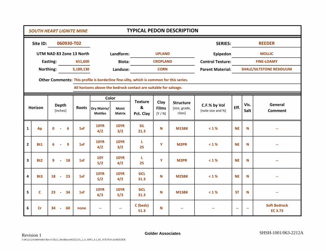
Revision 1I:\06\2212A\0400\0401\Rev1\CH2\2_4SoilReso\0632212A_2_4_APP2_4-2_R1_07JUN10.xls\REEDER
Golder Associates SHSH-1001/063-2212A
Site ID: SERIES:
Landform: Epipedon
Biota: Control Texture:
Landuse: Parent Material:
Dry Matrix/Mottles
Moist Matrix
1 Ap 0 - 6 1vf10YR4/2
10YR3/2
SiL21.3
N M1SBK < 1 % NE N --
2 Bt1 6 - 9 1vf10YR4/2
10YR3/2
L25
Y M2PR < 1 % NE N --
3 Bt2 9 - 18 1vf10Y 5/2
10YR4/2
L25
Y M2PR < 1 % NE N --
4 Bt3 18 - 23 1vf10YR5/2
10YR4/2
SiCL31.3
N M2SBK < 1 % NE N --
5 C 23 - 34 1vf10YR6/3
10YR5/3
SiCL31.3
N M1SBK < 1 % ST N --
6 Cr 34 - 60 none -- --C (beds)
51.3N -- -- -- --
Soft BedrockEC 3.73
TYPICAL PEDON DESCRIPTION
060930-T02 REEDER
UTM NAD 83 Zone 13 North UPLAND MOLLIC
Northing: 5,189,130 CORN SHALE/SILTSTONE RESIDUUM
Easting: 651,600 CROPLAND
Vis.Salt
C.F.% by Vol [note size and %]
ColorClay Films [Y / N]
GeneralComment
FINE-LOAMY
Other Comments: This profile is borderline fine-silty, which is common for this series.
All horizons above the bedrock contact are suitable for salvage.
Horizon Depth [inches]
RootsTexture
&Pct. Clay
Structure [size, grade,
class]Eff.
SOUTH HEART LIGNITE MINE

Revision 1I:\06\2212A\0400\0401\Rev1\CH2\2_4SoilReso\0632212A_2_4_APP2_4-2_R1_07JUN10.xls\REGENT
Golder Associates SHSH-1001/063-2212A
Site ID: SERIES:
Landform: Epipedon
Biota: Control Texture:
Landuse: Parent Material:
Dry Matrix/Mottles
Moist Matrix
1 A 0 - 9 2fmoist in
field10YR3/2
L22.5
N M1SBK < 1% NE N --
2 Bt 9 - 16 2f --10YR3/3
CL30
yM2PR to M3ABK
< 1% NE N --
3 Bky 16 - 28 2f --2.5Y5/2
SCL32.5
N M3PR-SBK < 1% ST Y Gypsum
4 Cr1 28 - 37 1f --2.5Y5/2
CL32.5
N MA < 1% VE YGypsum and
masses CaCO3
5 Cr2 37 - 60 1f -- --L
25N -- < 1% -- -- Soft Shale/Siltstone
6 -
TYPICAL PEDON DESCRIPTION
060823-T02 REGENT
UTM NAD 83 Zone 13 North RESIDUAL UPLANDS MOLLIC (nearly pachic)
Northing: 5,190,754 PASTURE SHALE RESIDUUM
Easting: 647,967 NATIVE
Vis.Salt
C.F.% by Vol [note size and %]
ColorClay Films [Y / N]
GeneralComment
FINE
Other Comments: Mollic colors of this series are slightly deeper than most profiles, but the profile is otherwise representative.
The entire profile is chemically suitable for salvage based on chemistry, but the contact with soft bedrock limits salvage depth.
Horizon Depth [inches]
RootsTexture
&Pct. Clay
Structure [size, grade,
class]Eff.
SOUTH HEART LIGNITE MINE

Revision 1I:\06\2212A\0400\0401\Rev1\CH2\2_4SoilReso\0632212A_2_4_APP2_4-2_R1_07JUN10.xls\RHOADES
Golder Associates SHSH-1001/063-2212A
Site ID: SERIES:
Landform: Epipedon
Biota: Control Texture:
Landuse: Parent Material:
Dry Matrix/Mottles
Moist Matrix
1 A 0 - 4 3vf2.5Y4/2
2.5Y3/2
SiC N M2SBK < 1% NE NSAR 11.2EC 6.34
2 Btn 4 - 11 3vf2.5Y4/2
2.5Y3/2
SiC Y M3PR < 1% NE NSAR 15.3 EC 16.5 T
Thin E materials on top of peds
3 Bkyn1 11 - 28 1vf2.5Y5/2
2.5Y4/2
SiC Y M3SBK < 1% VE YSAR 16.5EC 17.9
4 Bkyn2 28 - 40 none10YR6/2
10YR4/2
CL N M1SBK < 1% ST YSAR 19.8EC 20.7
5 C1 40 - 50 none5Y6/2
5Y4/2
SiC N MA < 1% ST NSAR 20.8EC 19.2
6 - --
GeneralComment
Other Comments: This profile is typical of the Rhoades series. Taxadjuncts may not have SAR above 13 in the Bt, but will are notably sodium
affected at depth. This entire profile is unsuitable for salvage due to elevated EC and SAR.
Structure [size, grade,
class]
C.F.% by Vol [note size and %]
Eff.Vis.Salt
MOLLIC
Horizon Depth [inches]
Roots
Color
Texture
Northing: 5,188,854 FALL PASTURE
Clay Films [Y / N]
LOCAL ALLUVIUM
Easting: 652,425 NATIVE FINE
TYPICAL PEDON DESCRIPTION
060930-T04 RHOADES
UTM NAD 83 Zone 13 North ALLUVIAL PLAIN
SOUTH HEART LIGNITE MINE

Revision 1I:\06\2212A\0400\0401\Rev1\CH2\2_4SoilReso\0632212A_2_4_APP2_4-2_R1_07JUN10.xls\SAVAGE
Golder Associates SHSH-1001/063-2212A
Site ID: SERIES:
Landform: Epipedon
Biota: Control Texture:
Landuse: Parent Material:
Dry Matrix/Mottles
Moist Matrix
1 Ap 0 - 6 1fmoist in
field2.5Y3/1
SiCL33.8
N M1SBK < 1% fg NE N --
2 Bt 6 - 14 1f --2.5Y3/1
SiC43.8
YM2SBK
ABK< 1% fg NE N --
3 Btk 14 - 30 1f --2.5Y3.5/2
SiC45
Y M2ABK < 1% fg ST N EC 0.76 SAR 5.43
4 Bky 30 - 48 none --2.5Y3.5/2
SiC41.3
N M1SBK 3% fg ST YGypsum crystals and
filaments on ped facesEC 6.62 SAR 6.74
5 C 48 - 58 none --2.5Y4/2
SiC42.5
N MA < 1% fg ST Y EC 5.21 SAR 8.94
6 - --
TYPICAL PEDON DESCRIPTION
061006-S38 SAVAGE
UTM NAD 83 Zone 13 North MIDSLOPE UPLAND MOLLIC
Northing: 5,192,053 CROPLAND ALLUVIUM
Easting: 648,589 HARVESTED WHEAT
Vis.Salt
C.F.% by Vol [note size and %]
ColorClay Films [Y / N]
GeneralComment
FINE
Other Comments: This profile is typical of the Savage profiles with elevated EC / SAR at depth.
Salvage is limited to a maximum of 30 inches.
Horizon Depth [inches]
RootsTexture
&Pct. Clay
Structure [size, grade,
class]Eff.
SOUTH HEART LIGNITE MINE

Revision 1I:\06\2212A\0400\0401\Rev1\CH2\2_4SoilReso\0632212A_2_4_APP2_4-2_R1_07JUN10.xls\SEN
Golder Associates SHSH-1001/063-2212A
Site ID: SERIES:
Landform: Epipedon
Biota: Control Texture:
Landuse: Parent Material:
Dry Matrix/Mottles
Moist Matrix
1 Ap 0 - 7 2vf10YR4/2
10YR3/2
SiL N M1SBK < .1% NE N --
2 Bw 7 - 12 1vf10YR4/2
10YR3/2
SiL N M1PR < .1% NE N --
3 Bk 12 - 23 1vf10YR5/2
10YR4/2
SiL N M2SBK < .1% ST N --
4 Cr 23 - 60 -- -- -- -- -- -- -- -- -- Bedrock contact
5 -
6 -
TYPICAL PEDON DESCRIPTION
061007-T03A SEN
UTM NAD 83 Zone 13 North FOOT SLOPE MOLLIC
Northing: 5,190,220 WHEAT SILTSTONE RESIDUUM
Easting: 652,655 CROP
Vis.Salt
C.F.% by Vol [note size and %]
ColorClay Films [Y / N]
GeneralComment
FINE-SILTY
Other Comments: This site was not sampled, but is representative of the Sen Series. The typical pedon for Amor is very similar, but slightly
coarser textured. The entire profile is suitable for salvage to the depth of bedrock contact. No visible salts are present.
Horizon Depth [inches]
RootsTexture
&Pct. Clay
Structure [size, grade,
class]Eff.
SOUTH HEART LIGNITE MINE

Revision 1I:\06\2212A\0400\0401\Rev1\CH2\2_4SoilReso\0632212A_2_4_APP2_4-2_R1_07JUN10.xls\SHAMBO
Golder Associates SHSH-1001/063-2212A
Site ID: SERIES:
Landform: Epipedon
Biota: Control Texture:
Landuse: Parent Material:
Dry Matrix/Mottles
Moist Matrix
1 Ap 0 - 13 2fMoist but
Mollic2.5Y3/2
L21.3
N M1SBK < 1% fg NE N --
2 BA 13 - 22 1f --2.5Y4/2
FSL15
N M2ABK < 1% fg NE N --
3 Bw 22 - 29 1f --2.5Y4/3
FSL17.5
N M1SBK < 1% fg NE N --
4 Btk 29 - 41 1f --2.5Y4/3
L22.5
Y M1SBK < 1% fg SL Nslight indication of argillic properties not common to
most profiles
5 Bk 41 - 63 none --2.5Y4.5/4
L22.5
N M1SBK < 1% fg SL --
6 C 63 - + none --2.5Y4.5/4
L18
N MA < 1% fg ST N --
TYPICAL PEDON DESCRIPTION
060919-S32 SHAMBO
UTM NAD 83 Zone 13 North UPLAND SWALE MOLLIC
Northing: 5,191,181 CROPLAND AEOLIAN DEPOSITS AND ALLUVIUM
Easting: 647,753 WHEAT - NON-HARVESTED
Vis.Salt
C.F.% by Vol [note size and %]
ColorClay Films [Y / N]
GeneralComment
COARSE LOAMY
Other Comments: This profile is typical of the Shambo series in most upland (non-terrace) positions. The entire profile is suitable for salvage.
The weak argillic horizon is not typical and may instead reflect stratification of aeolian deposits common in this area.
Horizon Depth [inches]
RootsTexture
&Pct. Clay
Structure [size, grade,
class]Eff.
SOUTH HEART LIGNITE MINE

Revision 1I:\06\2212A\0400\0401\Rev1\CH2\2_4SoilReso\0632212A_2_4_APP2_4-2_R1_07JUN10.xls\SHAMBO v.
Golder Associates SHSH-1001/063-2212A
Site ID: SERIES:
Landform: Epipedon
Biota: Control Texture:
Landuse: Parent Material:
Dry Matrix/Mottles
Moist Matrix
1 Ap 0 - 6 2fMoist in
Field2.5Y3/1
SiL18.8
N F1GR < 1% NE NEC 0.89
SAR 0.66
2 Bw 6 - 10 1f --2.5Y4/2
SiCL36.3
N M1GR < 1% NE NEC 1.05
SAR 9.34
3 Bk(n)1 10 - 19 1f --2.5Y5/3
SiCL38.8
N M1SBK < 1% SL NEC 1.18
SAR 17.8
4 Bk(n)2 19 - 30 1f --2.5Y5/2
SiL20
N M2SBK < 1% ST NEC 4.81
SAR 45.1
5 C 30 - 49 -- --2.5Y5/2
SiL16.3
N MA < 1% ST NEC 14.5
SAR 45.4
6 -
TYPICAL PEDON DESCRIPTION
070511-S33 SHAMBO v. (saline / sodic)
UTM NAD 83 Zone 13 North 2ND TERRACE MOLLIC
Northing: 5,186,124 CRP ALLUVIUM
Easting: 650,489 CRESTED WHEATGRASS
Vis.Salt
C.F.% by Vol [note size and %]
ColorClay Films [Y / N]
GeneralComment
FINE SILTY
Other Comments: This profile is typical of the Shambo variants with saline / sodic substratum and silty textures.
Only the top two horizons are suitable for salvage. Deep light-colored materials are highly sodic.
Horizon Depth [inches]
RootsTexture
&Pct. Clay
Structure [size, grade,
class]Eff.
SOUTH HEART LIGNITE MINE

Revision 1I:\06\2212A\0400\0401\Rev1\CH2\2_4SoilReso\0632212A_2_4_APP2_4-2_R1_07JUN10.xls\STADY
Golder Associates SHSH-1001/063-2212A
Site ID: SERIES:
Landform: Epipedon
Biota: Control Texture:
Landuse: Parent Material:
Dry Matrix/Mottles
Moist Matrix
1 Ap 0 - 7 2vf10YR4/2
10YR3/2
L23.8
N M2SBK < 1% NE N --
2 Bw1 7 - 12 2vf10YR5/2
10YR3/2
L21.3
N M2SBK < 1% NE N --
3 Bw2 12 - 20 2vf10YR6/3
LL
26.3N M2SBK < 1% NE N --
4 2C 20 - 60 -- -- --GR. SCL
23.8-- -- 40% Medium Gravel -- --
Very high gravel content made it difficult to
describe fully.
5 -
6 -
Depth [inches]
FINE LOAMY OVER SAND & GRAVEL
Northing: 5,188,524 CROPLAND LOCAL ALLUVIUM
Easting: 649,669 WHEAT
Other Comments: Included in mapping are areas of moderately fine and fine subsoil and areas where the gravel is at less than 20 inches.
This profile occurs in a delineation almost entirely composed of similar soils, but identified as the more common Manning unit.
HorizonStructure [size, grade,
class]Eff.C.F.% by Vol
[note size and %]Vis.Salt
Roots
ColorClay Films [Y / N]
Texture&
Pct. Clay
TYPICAL PEDON DESCRIPTION
060926-T04 STADY
UTM NAD 83 Zone 13 North ANCIENT STREAM TERRACE MOLLIC
GeneralComment
SOUTH HEART LIGNITE MINE

Revision 1I:\06\2212A\0400\0401\Rev1\CH2\2_4SoilReso\0632212A_2_4_APP2_4-2_R1_07JUN10.xls\TALLY
Golder Associates SHSH-1001/063-2212A
Site ID: SERIES:
Landform: Epipedon
Biota: Control Texture:
Landuse: Parent Material:
Dry Matrix/Mottles
Moist Matrix
1 Ap 0 - 7 2vf10YR4/2
10YR3/2
L16.3
N SGR < 1% NE N
2 Bw1 7 - 16 1vf10YR4/2
10YR3/2
L15
N SGR < 1% NE N
3 Bw2 16 - 25 1vf10YR6/3
10YR4/3
SL15
N SGR < 1% NE N --
4 Bk 25 - 34 --10YR7/3
10YR5/3
SL18.8
N SGR < 1% VE N --
5 C 34 - 60 --10YR7/2
10YR6/2
LS8.8
N SGR < 1% ST N --
6 -
Clay Films [Y / N]
C.F.% by Vol [note size and %]
COARSE-LOAMY
Northing: 5,191,411 CROPLAND ALLUVIUM
Easting: 650,996 WHEAT
Depth [inches]
Roots
ColorTexture
&Pct. Clay
Other Comments: This profile is typical of Tally with non-limiting materials found to a depth of 60 inches. The near-pachic A horizon is not typical
of all profiles. The Ap and Bw textures are borderline Sandy Loam (51.3% Sand), which is more common for this series.
HorizonStructure [size, grade,
class]Eff.
Vis.Salt
GeneralComment
Adjacent profiles are not consistently pachic.
TYPICAL PEDON DESCRIPTION
070501-T03 TALLY
UTM NAD 83 Zone 13 North HIGH RIVER TERRACE REMNANT MOLLIC
SOUTH HEART LIGNITE MINE

Revision 1I:\06\2212A\0400\0401\Rev1\CH2\2_4SoilReso\0632212A_2_4_APP2_4-2_R1_07JUN10.xls\TREMBLES
Golder Associates SHSH-1001/063-2212A
Site ID: SERIES:
Landform: Epipedon
Biota: Control Texture:
Landuse: Parent Material:
Dry Matrix/Mottles
Moist Matrix
1 Ap 0 - 4 1fMoist in
Field2.5Y3/2
SiL23
N M1SBK < 1 fg NE N
2 Bt 4 6 2mMoist in
Field2.5Y3.5/2
SiL27
YF1SBKF1GR
< 1 fg NE N
3 C 6 - 60 1f2.5Y6/3
2.5Y4/2
L13.8
N MA < 1 fgNE/ST
NPatchy strong Eff. Sample represents materials to 30
in.
4 -
5 -
6 -
TYPICAL PEDON DESCRIPTION
060928-S30 TREMBLES
UTM NAD 83 Zone 13 North TERRACE OCHRIC
COARSE-LOAMY
Northing: 5,188,515 CROPLAND/HAYLAND ALLUVIUM
Easting: 650,130 ALFALFA AND GRASSES
C.F.% by Vol [note size and %]
GeneralComment
Sampled together.
ColorClay Films [Y / N]
Other Comments: This profile is similar to the Shambo and Havrelon sodic profiles nearby, but with slightly coarser texture. This difference likely
accounts for the suitable chemistry. Variable texture in the Fluvent units limit salvage where sodic materials may occur.
Horizon Depth [inches]
RootsTexture
&Pct. Clay
Structure [size, grade,
class]Eff.
Vis.Salt
SOUTH HEART LIGNITE MINE

Revision 1I:\06\2212A\0400\0401\Rev1\CH2\2_4SoilReso\0632212A_2_4_APP2_4-2_R1_07JUN10.xls\VEBAR
Golder Associates SHSH-1001/063-2212A
Site ID: SERIES:
Landform: Epipedon
Biota: Control Texture:
Landuse: Parent Material:
Dry Matrix/Mottles
Moist Matrix
1 Ap 0 - 9 2fMoist in
field10YR3/3
L20
N F1SBK < 1 % ST N --
2 Bw 9 - 20 1f --10YR4/2
FSL17
N M1SBK < 1 % NE N --
3 Bk 20 - 34 1f --10YR5/2
FSL15
N SGR < 1 % ST N --
4 Cr 34 - 40 none -- -- -- -- -- -- -- -- Sandstone Bedrock
5 - --
6 - --
5,189,805 CROPLAND RESIDUAL SANDSTONE
TYPICAL PEDON DESCRIPTION
060926-S19 VEBAR
UTM NAD 83 Zone 13 North UPLAND HILLSLOPE MOLLIC
RootsGeneral
Comment
Structure [size, grade,
class]
ColorTexture
&Pct. Clay
Easting: 649,037 FALLOW COARSE-LOAMY
Northing:
Clay Films [Y / N]
C.F.% by Vol [note size and %]
Eff.Vis.Salt
Other Comments: Salts generally not observed in these well drained profiles. Soil is suitable for salvage to a depth of 34 in. This profile was not
sampled as the very similar Parshall (deep pachic) and Flasher (shallower) series did not exhibit limiting chemical characteristics.
Horizon Depth [inches]
SOUTH HEART LIGNITE MINE

Revision 1I:\06\2212A\0400\0401\Rev1\CH2\2_4SoilReso\0632212A_2_4_APP2_4-2_R1_07JUN10.xls\VELVA
Golder Associates SHSH-1001/063-2212A
Site ID: SERIES:
Landform: Epipedon
Biota: Control Texture:
Landuse: Parent Material:
Dry Matrix/Mottles
Moist Matrix
1 Ap 0 - 11 2fmoist in
field2.5Y3/2
FSl15
N F1SBK to SGR < 1 % NE N --
2 AC 11 - 25 1f --2.5Y4/2
FSL16
N M1SBK-ABK < 1 % SL N --
3 Ab 25 - 31 1f --2.5Y3/3
FSL17
N M2SBK < 1 % SL+ NThis dark horizon was very
difficult to penetrate.
4 C 31 - 60 -- --2.5Y
4-5/2FSL17
N MA < 1 % ST NLight colored substrata may have high sodium.
5 - --
6 - --
C.F.% by Vol [note size and %]
Eff.Vis.Salt
GeneralComment
Other Comments: This site was not fully described or sampled in the field and is more appropriately considered a composite of adjacent profiles.
This soil occurs to a very limited extent in the study area. It is very similar to Havrelon, but with Mollic colors.
Horizon Depth [inches]
TYPICAL PEDON DESCRIPTION
060930-S05 VELVA
UTM NAD 83 Zone 13 North TERRACE
Roots
ColorTexture
&Pct. Clay
Clay Films [Y / N]
Structure [size, grade,
class]
MOLLIC
ALLUVIUM
Easting: 651,049 GRAIN STUBBLE COARSE-LOAMY
Northing: 5,189,373 CROPLAND
SOUTH HEART LIGNITE MINE

Revision 1I:\06\2212A\0400\0401\Rev1\CH2\2_4SoilReso\0632212A_2_4_APP2_4-2_R1_07JUN10.xls\WAYDEN
Golder Associates SHSH-1001/063-2212A
Site ID: SERIES:
Landform: Epipedon
Biota: Control Texture:
Landuse: Parent Material:
Dry Matrix/Mottles
Moist Matrix
1 Ap 0 - 5 1vf10YR5/2
10YR3/2
SiC41.3
N M1SBK < 1% NE N --
2 Bk 5 - 14 1vf2.5Y6/2
2.5Y4/2
C56.3
N M2SBK < 1% ST N --
3 Cr 14 - 60 none -- --SiC
43.8N -- SOFT SHALE -- N
EC 15.1SAR 15.6
4 - --
5 - --
6 - --
Depth [inches]
CLAYEY/FINE
Northing: 5,189,180 CROPLAND SHALE RESIDUUM
Easting: 648,435 WHEAT
Other Comments: The shale at the base of this profile is saline and sodic. All soil materials above the bedrock contact are suitable for salvage.
HorizonStructure [size, grade,
class]Eff.C.F.% by Vol
[note size and %]Vis.Salt
Roots
ColorClay Films [Y / N]
Texture&
Pct. Clay
TYPICAL PEDON DESCRIPTION
060927-T02 WAYDEN
UTM NAD 83 Zone 13 North RESIDUAL UPLAND SLOPE OCHRIC
GeneralComment
SOUTH HEART LIGNITE MINE

Revision 1I:\06\2212A\0400\0401\Rev1\CH2\2_4SoilReso\0632212A_2_4_APP2_4-2_R1_07JUN10.xls\STRAWxxx
Golder Associates SHSH-1001/063-2212A
Site ID: SERIES:
Landform: Epipedon
Biota: Control Texture:
Landuse: Parent Material:
Dry Matrix/Mottles
Moist Matrix
1 A 0 - 81f
2m2.5Y5/2
2.5Y3/2
SiCL27.5
N F2GR 0 - < 1% fg NE N --
2 Bw 8 - 18 2m2.5Y
5-6/22.5Y3/2
SiCL27.5
N M2SBK 0 - < 1% fg NE N Barely pachic dry colors.
3 Bk 18 - 27 1m --2.5Y4/2
SiL21.3
NM-C2SBKTO ABK
0 - < 1% fg SL N --
4 Ck 27 - 55 1f --2.5Y3.5/2
SiCL30
NMA
(HARD)0 - < 1% fg
SLTST
NCarb Nodules/Threads
EC 1.83 SAR 2.82
5 -
6 -
TYPICAL PEDON DESCRIPTION
061015-S05 STRAW
UTM NAD 83 Zone 13 North TERRACE/FP MOLLIC
Northing: 5,192,624 PASTURE ALLUVIUM
Easting: 647,859 POA GRASSLAND
Vis.Salt
C.F.% by Vol [note size and %]
ColorClay Films [Y / N]
GeneralComment
FINE-LOAMY
Other Comments: Hard and difficult to penetrate below 27 inches. C material is stratified w/some evidence of buried horizons/profile deep.
The EC/SAR are low in all horizons, but slightly more elevated in the Ck horizon. This profile is an inclusion of an Arnegard unit.
Horizon Depth [inches]
RootsTexture
&Pct. Clay
Structure [size, grade,
class]Eff.
SOUTH HEART LIGNITE MINE

Revision 1I:\06\2212A\0400\0401\Rev1\CH2\2_4SoilReso\0632212A_2_4_APP2_4-2_R1_07JUN10.xls\WABEKxxx
Golder Associates SHSH-1001/063-2212A
Site ID: SERIES:
Landform: Epipedon
Biota: Control Texture:
Landuse: Parent Material:
Dry Matrix/Mottles
Moist Matrix
1 Ap 0 - 6 2f10YR4/2
10YR3/2
L N M2SBK 10 % gr NE N --
2 Bw 6 - 12 1f10YR6/2
10YR4/2
GRL N M2SBK 10 % gr NE N --
3 C 12 - 60 1vf -- -- -- N SGR 40 % gr NE NHigh gravel content limited
further description.
4 -
5 -
6 -
ALLUVIUM
Structure [size, grade,
class]
Other Comments: Some areas have a gravel substratum overlying weathered shale or siltstone at various depths.
This series occurs infrequently, therefore, the samples from this site were not analyzed.
Horizon Depth [inches]
Texture&
Pct. Clay
Easting:
Eff.
649,507
Vis.Salt
Northing: 5,188,604
WHEAT SANDY SKELETAL
C.F.% by Vol [note size and %]
CROPLAND
ColorClay Films [Y / N]
TYPICAL PEDON DESCRIPTION
060926-T08 WABEK
UTM NAD 83 Zone 13 North STEEP SIDE SLOPE OF A DRAW MOLLIC
RootsGeneral
Comment
SOUTH HEART LIGNITE MINE
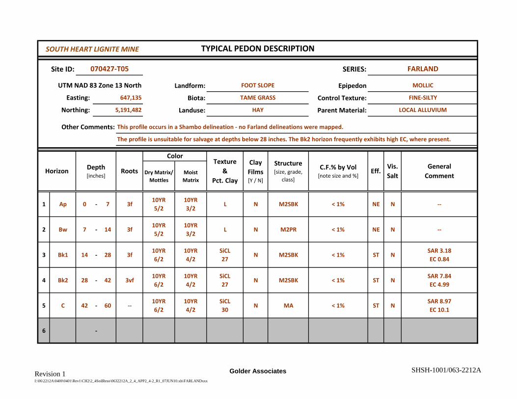
Revision 1I:\06\2212A\0400\0401\Rev1\CH2\2_4SoilReso\0632212A_2_4_APP2_4-2_R1_07JUN10.xls\FARLANDxxx
Golder Associates SHSH-1001/063-2212A
Site ID: SERIES:
Landform: Epipedon
Biota: Control Texture:
Landuse: Parent Material:
Dry Matrix/Mottles
Moist Matrix
1 Ap 0 - 7 3f10YR5/2
10YR3/2
L N M2SBK < 1% NE N --
2 Bw 7 - 14 3f10YR5/2
10YR3/2
L N M2PR < 1% NE N --
3 Bk1 14 - 28 3f10YR6/2
10YR4/2
SiCL27
N M2SBK < 1% ST NSAR 3.18EC 0.84
4 Bk2 28 - 42 3vf10YR6/2
10YR4/2
SiCL27
N M2SBK < 1% ST NSAR 7.84EC 4.99
5 C 42 - 60 --10YR6/2
10YR4/2
SiCL30
N MA < 1% ST NSAR 8.97EC 10.1
6 -
Clay Films [Y / N]
TYPICAL PEDON DESCRIPTION
070427-T05 FARLAND
UTM NAD 83 Zone 13 North FOOT SLOPE MOLLIC
Depth [inches]
GeneralComment
Northing: 5,191,482 LOCAL ALLUVIUM
Structure [size, grade,
class]
C.F.% by Vol [note size and %]
Eff.Vis.Salt
Roots
ColorTexture
&Pct. Clay
Easting: 647,135 TAME GRASS
HAY
FINE-SILTY
Other Comments: This profile occurs in a Shambo delineation - no Farland delineations were mapped.
The profile is unsuitable for salvage at depths below 28 inches. The Bk2 horizon frequently exhibits high EC, where present.
Horizon
SOUTH HEART LIGNITE MINE


![blog. · Web viewANSWER: B ANSWER: C [CI`(H2O)4C1(NO2)]CI COON HOOC-CH2\N_CCH~_CH___N/H Ml ` | ` \' ' CH2 CH2 -COOH HOOC' HOOC`.."CHZ CH2"COOH \ I /N-CH2-CH2-N\ HOOC""CH2 CH2-COOH](https://static.fdocuments.in/doc/165x107/5ab561c67f8b9a0f058cbd1a/blog-viewanswer-b-answer-c-cih2o4c1no2ci-coon-hooc-ch2ncchchnh.jpg)