Appendix 22 a
27
Primary 4/Unit 2: Water PART III: Water in the World Appendix_22A THE AMAZON RIVER Fact File about the Amazon The Amazon River is 6,280km long and its source is located in Calillona, Peru. The mouth is located in North Eastern Brazil (South America). It is the world's second longest river. Only the Nile, in Africa, is longer. But, if you measure a river by the volume of water that flows along it, the Amazon is the biggest river in the world. It collects water from over 1,000 tributaries, 17 of which are over 1600 kilometres long. From Iquitos in Peru all the way across Brazil to the Atlantic, the Amazon is between six and ten kilometres wide. The first European who found the Amazon noticed he was sailing in fresh water when he was 321 km out to sea. Eusko Jaurlaritza. Hezkuntza Saila. Ingelesa Edukien Bitartez. LMHko 4. Maila. 2004-05 ikasturtea 1
Transcript of Appendix 22 a

Primary 4/Unit 2: Water PART III: Water in the World Appendix_22A
THE AMAZON RIVER
Fact File about the Amazon
The Amazon River is 6,280km long and its source is located in Calillona, Peru. The mouth is
located in North Eastern Brazil (South America).It is the world's second longest river. Only the Nile, in Africa, is longer. But, if you measure a river by the volume of water that flows along it, the Amazon is the biggest river in the world.It collects water from over 1,000 tributaries, 17 of which are over 1600 kilometres long.From Iquitos in Peru all the way across Brazil to the Atlantic, the Amazon is between six and ten kilometres wide.The first European who found the Amazon noticed he was sailing in fresh water when he was 321 km out to sea.
Eusko Jaurlaritza. Hezkuntza Saila. Ingelesa Edukien Bitartez. LMHko 4. Maila. 2004-05 ikasturtea 1
Primary 4/Unit 2: Water PART III: Water in the World Appendix_22A
Eusko Jaurlaritza. Hezkuntza Saila. Ingelesa Edukien Bitartez. LMHko 4. Maila. 2004-05 ikasturtea 2
The Danube is the second longest river in Europe behind the Volga and the only major European river to flow from West to East.It takes its source in the Black Forest Mountains of Germany, and empties after 2850 km in the Black Sea on the Romanian coast. Along its way, the Danube flows through nine countries (Germany, Austria, Slovakia, Hungary, Croatia, Serbia, Bulgaria, Romania, and Ukraine).Among the important cities on the river, three are national capitals: Vienna (Austria), Budapest (Hungary), and Belgrade (Serbia).

Primary 4/Unit 2: Water PART III: Water in the World Appendix_22A
The Nile River
The Nile River is the longest river in the world.
The two main rivers that feed the Nile are the Blue Nile (which begins at Lake Tana, in Ethiopia) and the White Nile (which begins at Lake Victoria, in Uganda).
These two rivers join at Khartoum, the capital of Sudan, before crossing into Egypt. Finally, after 6,670 kilometres the Nile flows into the Mediterranean Sea.
The Nile is the longest river in the world.
Eusko Jaurlaritza. Hezkuntza Saila. Ingelesa Edukien Bitartez. LMHko 4. Maila. 2004-05 ikasturtea 3

Primary 4/Unit 2: Water PART III: Water in the World Appendix_22A
The Volga RiverThe Volga River is the longest river in Europe, about 3,700 km. It
originates at an elevation of only 225 m in the Valday Hills northwest of
Moscow and flows into the Caspian Sea in a wide delta near
Astrakhan.
It is navigable for about 3200 km and large numbers of ships transport
cargo and passengers. The Volga has more than 200 tributaries (about
70 of which are navigable). Many canals connect the river with the
Baltic Sea and other rivers. The river is known in Russian folklore as
Mother Volga.
Eusko Jaurlaritza. Hezkuntza Saila. Ingelesa Edukien Bitartez. LMHko 4. Maila. 2004-05 ikasturtea 4

Primary 4/Unit 2: Water PART III: Water in the World Appendix_22A
Highest waterfall
ANGEL FALLS
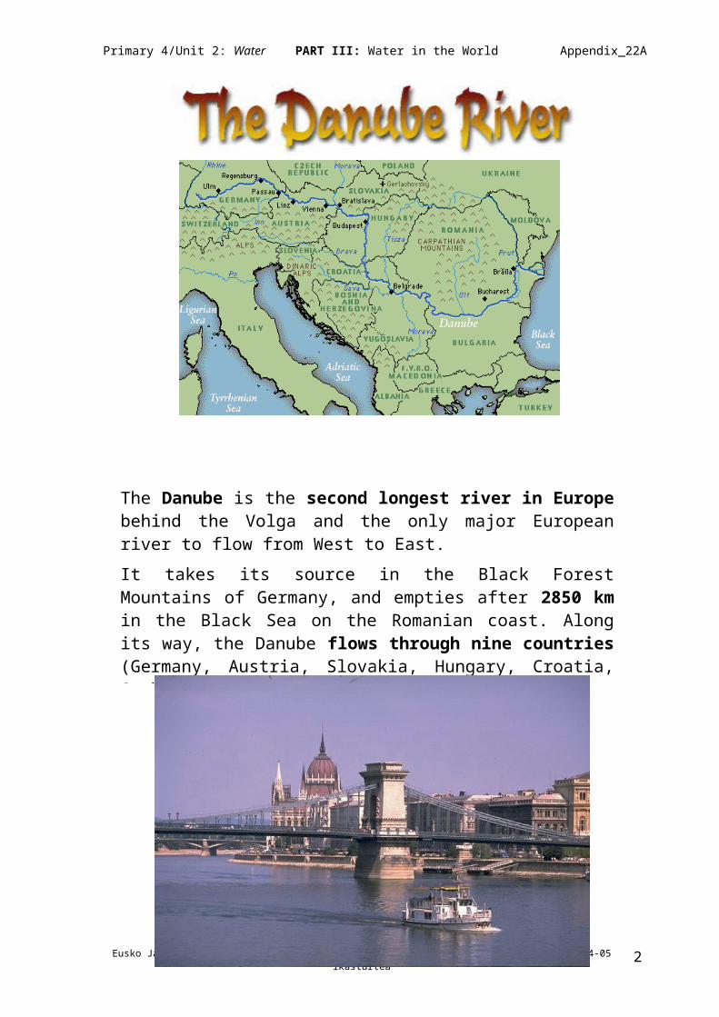
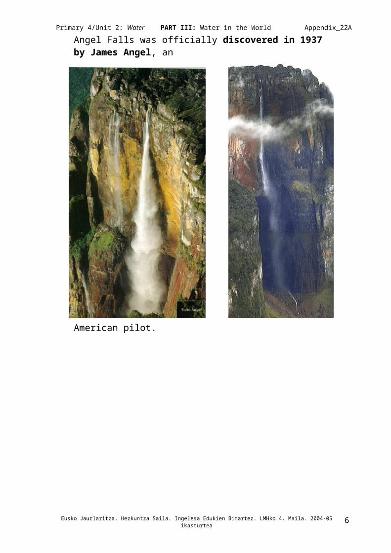
Angel Falls (“Salto Angel”) is the highest waterfall in the world. It is in Venezuela (South America), in the Churun river, a branch of the main river, Carrao.The Angel Falls is 1,002 metres high. It is the world’s highest uninterrupted waterfall, fifteen times higher than Niagara falls.The Angel Falls is called by the natives “Kerepakupai-Merú”, which means "jump from the deepest place".Angel Falls was officially discovered in 1937 by James Angel, an American pilot.
Eusko Jaurlaritza. Hezkuntza Saila. Ingelesa Edukien Bitartez. LMHko 4. Maila. 2004-05 ikasturtea 5
Primary 4/Unit 2: Water PART III: Water in the World Appendix_22A
VICTORIA FALLS
One of the world's mightiest waterfalls is in east-central Africa, on the border
between Zambia and Zimbabwe, in the Zambezi River.
There is a steel-arch railway and highway bridge 200 meters long and 128 meters
above high-water level. When it was opened in 1905, the Falls Bridge was the
highest in the world. Also in the area are Victoria Falls National Park in Zimbabwe
and Livingstone Game Park in Zambia.
Victoria Falls is about twice as wide and twice as high as Niagara Falls in North
America. It is divided by islands into four main cataracts, or waterfalls. The mist
from the falling water is especially dense during the rainy first half of the year and is
visible for miles.
In 1855 British explorer David Livingstone was the first European to see Victoria
Falls. He named it after Queen Victoria of Great Britain.
Eusko Jaurlaritza. Hezkuntza Saila. Ingelesa Edukien Bitartez. LMHko 4. Maila. 2004-05 ikasturtea 6
Victoria Falls was named for Queen Victoria of Great Britain, after British explorer David Livingstone became the first European to see it in 1855.
Victoria Falls, on the Zambezi River is twice as wide as Niagara Falls. More than 33,000 cubic feet of water flow per second.

Primary 4/Unit 2: Water PART III: Water in the World Appendix_22A
NIAGARA FALLSOrigin of the name Niagara. The word "Onguiaahra" appears on
documents in 1641, and a little later "Ongiara" . Both are Indian words
meaning "The Straight". A more
romantic meaning
"Thunder of Waters "
is also given
Measures. The Niagara River links Lake Erie and Lake
Ontario. It is 56 kilometres long. Elevation between the two lakes is 99 metres.
The first human to jump and survive the Falls.
In October 1829, Sam Patch jumped twice from a platform on Goat
Island, 33.50 metres. He survived but killed himself the following year at
the Genesee Falls, Rochester, in a similar attempt.
Annie Telson Taylor is the first person who went over the tumultuous
Canadian Falls in a wooden barrel and survived, on 24th October 1901.
The f irst tightrope walker, Jean Francois Blondin .
Jean Francois Gravelet was the first of many tightrope walkers to
appear at Niagara Falls on June 30, 1859.
He crossed his rope on a bicycle, walked blindfolded, pushed a
wheelbarrow, cooked an omelette in the centre and made the trip with
his hands and feet manacled.
Eusko Jaurlaritza. Hezkuntza Saila. Ingelesa Edukien Bitartez. LMHko 4. Maila. 2004-05 ikasturtea 7

Primary 4/Unit 2: Water PART III: Water in the World Appendix_22A
IGUAZU FALLS
The falls are located in the northwest extreme of Misiones province,
1400 km from Buenos Aires. These spectacular falls, just east of the
confluence of the Iguazu and Paraná rivers carry at least 5000 cubic
metres of water per second. They are 70 metres high.
"Iguazu" means "Great Waters" in the language of the Guarani Indians
that lived in this region.
A few kilometres from the falls stands the Itaipu Dam. This dam is 8 km
long and can pour 60,000 m2 per second. It has a channel and a lake
with a surface of 1350 km.
The area is also famous for its historic ruins of Jesuit missions which
also draw many visitors. San Ignacio Miní, built in a style of architecture
known as 'Guaraní baroque', is especially popular.
Eusko Jaurlaritza. Hezkuntza Saila. Ingelesa Edukien Bitartez. LMHko 3. Maila. 2003-04 ikasturtea. 8

Primary 4/Unit 2: Water PART III: Water in the World Appendix_22A
HOOVER DAM DID YOU KNOW THAT . . . . ?
1. Hoover Dam is 221 m. tall.2. At its base, Hoover Dam is as
thick (201 m.) as two football fields measured end-to-end.
3. As many as 20,000 vehicles a day drive across the 13,7 m. wide top of the dam between Nevada and Arizona.
4. During peak electricity periods, enough water runs through the generators to fill 15 average
sized swimming pools (75,708 litres each) in 1 second. 5. Hoover Dam is shaped like a huge curved axe head, 13,7
m. wide at the top and 201 m. thick at the bottom.6. If you drink water from the tap at Disneyland, Anaheim or
Sea World in San Diego -- that water is coming from the Colorado River and Lake Mead, 482 km away.
7. It can supply electricity to 1,700,000 houses.8. It has 17 generators. Each generator weights 1,814,369
kg.9. More than 3,855,535 kg. of dynamite was used to blast
the foundation for the dam and 12,8 km. of tunnels through the canyon walls.
Eusko Jaurlaritza. Hezkuntza Saila. Ingelesa Edukien Bitartez. LMHko 3. Maila. 2003-04 ikasturtea. 9

Primary 4/Unit 2: Water PART III: Water in the World Appendix_22A
LAKE ARGYLE and ORD RIVER DAM
Lake Argyle is situated in the Kimberly
Region of Western Australia. It is located on
the Ord River, 50 km upstream from
Kununurra. The Lake is man-made and was
made primarily to supply irrigation water.
There are a small number of hydro-electric
power stations operating within Western
Australia, but the largest is located at the Ord
River Dam on Lake Argyle, 80 km south of
Kununurra in the north of Western Australia.
In 1972, the Ord River Dam was built on Lake Argyle with the idea of
producing hydro power.
Ord Dam, in the north of
Western Australia, retains
Australia's second largest
reservoir, Lake Argyle
Eusko Jaurlaritza. Hezkuntza Saila. Ingelesa Edukien Bitartez. LMHko 3. Maila. 2003-04 ikasturtea. 10

Primary 4/Unit 2: Water PART III: Water in the World Appendix_22A
ASWAN DAM & LAKE NASSER
The Aswan High Dam is found at Aswan in Egypt. Egypt is in the continent of Africa.
Facts The Aswan High Dam is 3600 metres
long and 111 metres high. Construction started on the dam in
1960 and it was completed in 1971. The Aswan High Dam took 11 years to
build. 30 000 Egyptian people worked day
and night to build the Aswan High Dam.
Lake Nasser was created behind the Aswan High Dam. It is the largest artificial lake in the World (310 miles in length). It is named after Gamal Abdul Nasser, the former President of Egypt.
Advantages of the Aswan High Dam1- The Aswan Dam is a hydro-electric power station.2- Water from Lake Nasser is pumped into people's homes
all over Egypt and is used for washing and drinking. 3- Factories also use the water for cooling and for making
things.4- Big boats can now travel down the River Nile. 5- Farmers use water from the River Nile to irrigate their
crops.
Disadvantages of the Aswan High Dam1- The land of Nubia was flooded to create the reservoir.
Religious buildings, homes and cemeteries were lost. 2- 10 000 people had to move from their homes in Nubia to
other places in Egypt. 3- Sometimes the Aswan High Dam gets blocked by mud. It
has to be cleaned, which is expensive. 4- The Nile delta is becoming smaller and wildlife (animals
and plants) is losing its home.
Eusko Jaurlaritza. Hezkuntza Saila. Ingelesa Edukien Bitartez. LMHko 3. Maila. 2003-04 ikasturtea. 11

Primary 4/Unit 2: Water PART III: Water in the World Appendix_22A
Atlantic Ocean
It is the second largest of the earth's four
oceans and the most heavily travelled.
Only the Pacific Ocean is larger. The
Atlantic is divided into two nominal
sections: The northern part of the equator
is called the North Atlantic; the southern
part of the equator, the South Atlantic.
The ocean's name is derived from Atlas,
one of the Titans of Greek mythology.
Size
The Atlantic Ocean extends from the Arctic Ocean in the north to the
Antarctic continent in the south and is situated between America and
Europe and Africa.
The Atlantic Ocean has a surface area of about 82 million square km.
Islands
The largest islands of the Atlantic
Ocean are Newfoundland, the British
Isles, the Antilles (including Puerto
Rico, Hispaniola, Jamaica, and
Cuba), Iceland, Bermuda, the Azores
and Canaries.
Eusko Jaurlaritza. Hezkuntza Saila. Ingelesa Edukien Bitartez. LMHko 3. Maila. 2003-04 ikasturtea. 12

Primary 4/Unit 2: Water PART III: Water in the World Appendix_22A
Pacific Ocean
It is the largest and deepest of the world's
oceans, covering more than a third of the
earth's surface. It is divided into two sections:
the northern part of the equator is called the
North Pacific; the southern part of the equator,
the South Pacific. The name Pacific, which
means peaceful, was given to it by the
Portuguese navigator Ferdinand Magellan in
1520.
Size
The Pacific Ocean is bounded on the east by America; on the west by Asia, and
Australia; and on the south by Antarctica.
It has an area of about 165 million square km,
larger than the entire land surface of the globe. Its
maximum length is about 15,500 km from the
Bering Strait to Antarctica, and its greatest width is
about 17,700 km from Panama to the Malay
Peninsula. Its average depth is 4282 m. The
greatest known depth s 11,033 m in the Mariana
Trench.
Islands
The Pacific Ocean contains more than 30,000 islands. The largest islands include
Japan, Taiwan, the Philippines, Indonesia, New Guinea, and New Zealand.
Eusko Jaurlaritza. Hezkuntza Saila. Ingelesa Edukien Bitartez. LMHko 3. Maila. 2003-04 ikasturtea. 13

Primary 4/Unit 2: Water PART III: Water in the World Appendix_22A
Indian Ocean
It is the smallest of the earth's three great
oceans.
Size
It is bounded on the west by Africa, on the
north by Asia, on the east by Australia and
on the south by Antarctica.
The total area of the Indian Ocean is about 73.4 million square km. The ocean is
divided by the Indian peninsula into the Bay of Bengal on the east and the Arabian
Sea on the west. The average depth of the Indian Ocean is about 4210 m and the
deepest known point is about 7725 m.
Islands
The Indian Ocean contains numerous
islands, the largest of which are
Madagascar and Sri Lanka.
This ocean is notable for seasonal winds
called monsoons.
Eusko Jaurlaritza. Hezkuntza Saila. Ingelesa Edukien Bitartez. LMHko 3. Maila. 2003-04 ikasturtea. 14

Primary 4/Unit 2: Water PART III: Water in the World Appendix_22A
Grand Canyon
It is a very deep canyon in north Arizona, excavated by the Colorado River. The
Grand Canyon is about 446 km long, up to 29 km wide, and more than 1500 m
deep. The entire canyon is extremely beautiful and spectacular. The Grand Canyon
National Park receives about four million visitors a year.
The Grand Canyon has been sculpted by the Colorado River, which flows through
the canyon's lowest portions.
Geology
The Grand Canyon is of relatively recent origin; apparently the river began its work
of erosion about six million years ago.
History
The first Europeans to see the canyon were members of a group headed by the
Spanish explorer Francisco Vazquez de Coronado in February 1540.
Eusko Jaurlaritza. Hezkuntza Saila. Ingelesa Edukien Bitartez. LMHko 3. Maila. 2003-04 ikasturtea. 15

Primary 4/Unit 2: Water PART III: Water in the World Appendix_22A
Mediterranean Sea
It is an inland sea of Europe, Asia, and Africa, linked
to the Atlantic Ocean at its western end by the Strait
of Gibraltar. Known to the Romans as Mare
Nostrum (our sea), the Mediterranean is almost
landlocked.
The Mediterranean Sea covers an area of about 2,510,000 sq km. It has an eastern
to western extent of some 3860 km and a maximum width of about 1600 km. It
reaches a maximum depth of 5150 m off the southern coast of Greece.
The Mediterranean was squeezed almost shut in the Oligocene Epoch, 30 million
years ago. There are islands with volcanoes such as Etna, Vesuvius, and Stromboli,
all in Italy.
Islands
Important islands are Malta, Sicily, the Balearic Islands (Spain), Corsica (France),
Sardinia (Italy), Cyprus, and the Ionian, Cyclades, Dodecanese, and Aegean islands
(Greece).
Genoa, Trieste, and Haifa are important seaports in the region. Major rivers entering
the Mediterranean are the Ebro, Rhône, Po, and Nile.
Eusko Jaurlaritza. Hezkuntza Saila. Ingelesa Edukien Bitartez. LMHko 3. Maila. 2003-04 ikasturtea. 16

Primary 4/Unit 2: Water PART III: Water in the World Appendix_22A
Caribbean Sea
It is on the Atlantic Ocean, partially enclosed on the
north and east by the islands of the West Indies,
and bounded on the south by South America and
Panama, and on the west by Central America.
The name of the sea is derived from the Carib people, who inhabited the area when
Spanish explorers arrived there in the 15th century. The Caribbean is approximately
2415 km long east and west and between about 640 and 1450 km wide.
It has an area of about 1,942,500 sq km. At the northwestern extremity it is
connected with the Gulf of Mexico by the Yucatán Channel.
Important islands are Cuba, Jamaica and Puerto Rico.
Large areas of the sea exceed 3660 m in depth; the greatest depth measured thus
far is Cayman Trench (7535 m). Navigation is open and clear, making the Caribbean
a major trade route for Latin American countries.
The Caribbean Sea is noted for its mild tropical climate.
Eusko Jaurlaritza. Hezkuntza Saila. Ingelesa Edukien Bitartez. LMHko 3. Maila. 2003-04 ikasturtea. 17

Primary 4/Unit 2: Water PART III: Water in the World Appendix_22A
Dead Sea
It is a salt lake in southwestern Asia. Bounded on
the west by Israel and on the east by Jordan, the
Dead Sea forms part of the Israeli-Jordanian
border.
The surface of the Dead Sea, at 400 m below sea
level, is the lowest water surface on earth. The
lake is 76 km long and has a maximum width of
about 16 km ; its area is about 1049 sq km.
To the south the lake is shallow, less than 6 m deep; in the north it reaches its
greatest depth of 399 m below surface level, and 799 m below sea level.
The Dead Sea has no outlet, and the heavy inflow of fresh water is carried off solely
by evaporation, which is rapid in the hot desert climate.
Nearly seven times as salty as the ocean, the Dead Sea contains many solid
substances: sodium chloride (common salt), magnesium chloride, calcium chloride,
potassium chloride, magnesium bromide, and many other substances. Because of
the density of solids in the water, the human body easily floats on the surface. The
lake contains no life of any sort except for a few kinds of microbes; sea fish put into
its waters soon die.
Eusko Jaurlaritza. Hezkuntza Saila. Ingelesa Edukien Bitartez. LMHko 3. Maila. 2003-04 ikasturtea. 18